bonnie 2009 - cadastres, misconceptions and northern gaul
DESCRIPTION
In Cadastres, Misconceptions and Northern Gaul Rick Bonnie argues that during the Middle-Roman period a cadastre was implemented by the Romans around the provincial Roman city of Tongres. In contrast to general beliefs, Bonnie demonstrates that it is possible, using aerial photographs and maps, to reconstruct a landscape outside the Mediterranean region that was overlain by a Roman cadastre.TRANSCRIPT
rick bonnie
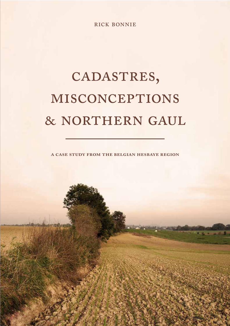
cadastres,misconceptions
& northern gaul
a case study from the belgian hesbaye region

Sidestone PressA new generation of Publishing*You are reading a full version of this book, for free!
This book is part of the Sidestone e-library where most of our publications are fully accessible for free. For access to more free books visit: www.sidestone.com/library
Download Full PDFVisit the Sidestone e-library to download most of our e-books for only € 4,50. For this minimal fee you will receive a fully functional PDF and by doing so, you help to keep our library running.
www.sidestone.com/library

cadastres,misconceptions
& northern gaul
Sidestone Press


rick bonnie
a case study from the belgian hesbaye region
cadastres,misconceptions
& northern gaul
Copyright 2009 by Rick Bonnie
Published by Sidestone Press, Leidenwww.sidestone.comSidestone registration number: SSP41920001
ISBN 978-90-8890-024-2
Cover illustration: A talus from the Belgian Hesbaye regionCover design: Daniëlle MirtenbaumPhotography: Tim Vanderbeken (courtesy of the Zuid-Oost-Limburgse Archeologische Dienst)
Layout:Rick BonnieDaniëlle Mirtenbaum
in loving memory of my mother
Maria Bonnie-van Hautem
(-)


Contents
List of Illustrations v
Abbreviations ix
Acknowledgements xi
Maps xiii
1 Introduction 1
A static concept? 2
Evidence for surveyors 6
Structure of book 7
2 Setting and Physical Geography 9
Physical Geography 10
3 Historical and Archaeological Framework 13
Late Iron Age (250 - 57 BC) 13
Early Roman period (57 BC - 70 AD) 19
Middle Roman period (70 - 270 AD) 23
Late Roman period (270 - 450 AD) 29
4 Studying Roman Cadastres 33
Aerial photography and maps 34
Regional research 37
5 Talus and Site Orientation 41
Theory 41
Methodology 44
Orientation of talus and Roman structures 45
iii
6 Site Distribution and Land Sizes 59
Site distribution 59
Calculating hypothetical land sizes 74
7 Ownership of Land and Villas 77
Cadastres and the supposed settlement of new people 77
Relationship between villas and cadastres 82
Development of the villa landscape 84
8 Conclusions 87
A Roman cadastre in the Tongres-Maastricht area 88
Socio-cultural impact 95
Notes 99
Bibliography 103
Catalogue 119
iv
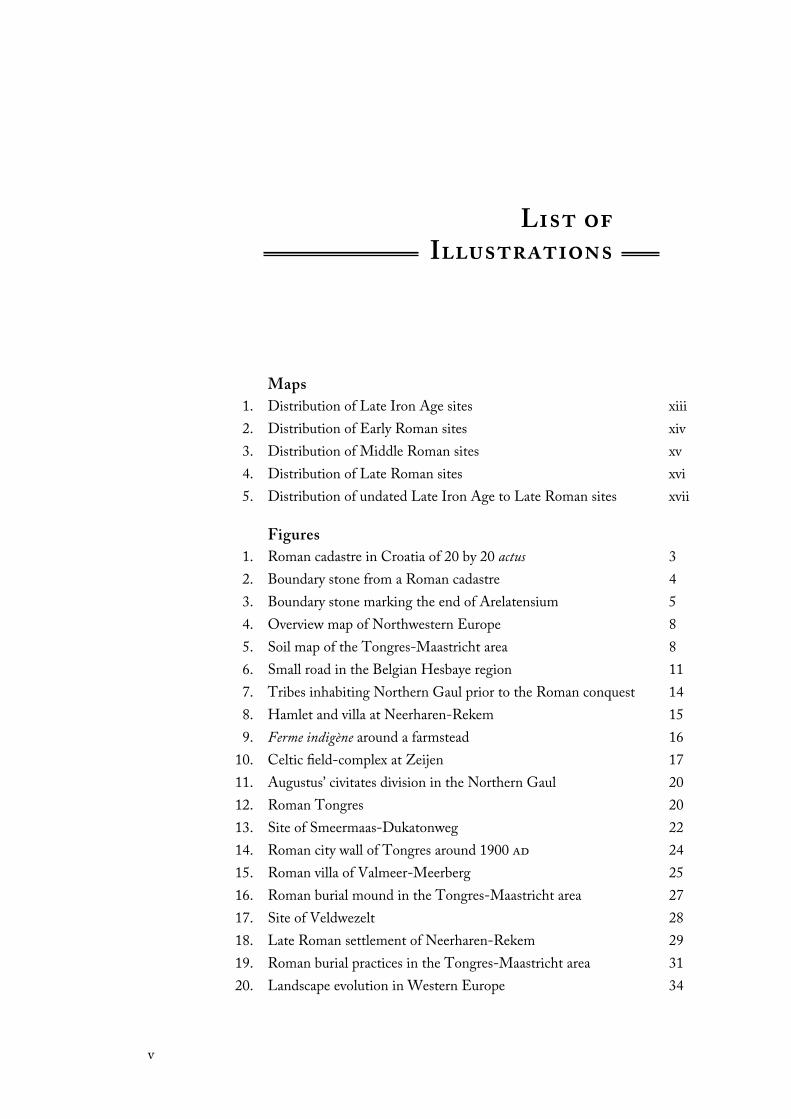
Maps
1. Distribution of Late Iron Age sites xiii
2. Distribution of Early Roman sites xiv
3. Distribution of Middle Roman sites xv
4. Distribution of Late Roman sites xvi
5. Distribution of undated Late Iron Age to Late Roman sites xvii
Figures
1. Roman cadastre in Croatia of 20 by 20 actus 3
2. Boundary stone from a Roman cadastre 4
3. Boundary stone marking the end of Arelatensium 5
4. Overview map of Northwestern Europe 8
5. Soil map of the Tongres-Maastricht area 8
6. Small road in the Belgian Hesbaye region 11
7. Tribes inhabiting Northern Gaul prior to the Roman conquest 14
8. Hamlet and villa at Neerharen-Rekem 15
9. Ferme indigène around a farmstead 16
10. Celtic field-complex at Zeijen 17
11. Augustus’ civitates division in the Northern Gaul 20
12. Roman Tongres 20
13. Site of Smeermaas-Dukatonweg 22
14. Roman city wall of Tongres around 1900 ad 24
15. Roman villa of Valmeer-Meerberg 25
16. Roman burial mound in the Tongres-Maastricht area 27
17. Site of Veldwezelt 28
18. Late Roman settlement of Neerharen-Rekem 29
19. Roman burial practices in the Tongres-Maastricht area 31
20. Landscape evolution in Western Europe 34
List of Illustrations
v

21. Cadastre to the east of Tongres as proposed by Mertens 38
22. Formation of a talus 42
23. Steepness of slopes in the Tongres-Maastricht area 43
24. Sources, input and analysis 43
25. Talus along the valley of the Geer on different maps 46
26. Distribution of talus 47
27. Frequency of talus 48
28. Frequency of talus on the Depôt de la Guerre map 48
29. Ager collatinus at Collatia 50
30. Frequency of archaeological features from the Tongres-
Maastricht area
51
31. Archaeological sites from which orientations have been measured 51
32. Castles, castle ruins and strongholds in the Tongres-Maastricht
area
53
33. Castle of Alden Biesen 54
34. Expectation for distribution of distances of random points 59
35. Overlain 18 actus cadastre and the Middle Roman sites 63
36. Churches in and near the Tongres-Maastricht area 68
37. Lines of the field boundaries from the Atlas der Buurtwegen 72
38. Orientation of the Middle Roman sites in the 45˚-56,25˚ class 73
39. Thiessen-polygon around the Middle Roman settlements 75
40. Ring buffers around sites representing an 18 and 20 actus grid 75
41. 18 and 20 actus ring buffer around Valmeer-Meerberg and
Valmeer-Boven het Kruis 76
42. Extents of Caesarian cadastre around Corinth 78
43. Veteran distribution in Roman Cologne and its hinterland 79
44. Theoretical division of a 20 by 20 actus cadastre 83
45. Roman villa of Haccourt 84
46. Modern talus in the Tongres-Maastricht area 89
47. Proposed Roman cadastre of 18 actus and 50,625˚ orientation 90
48. Negotiation between Romans and Julius Civilis 94
Tables
1. Conversion table Roman surveyors’ measurement units 2
2. Periodization 13
3. Factors theoretically affecting the orientation of Roman cadastres 36
4. Maps used in the GIS 46
5. Orientation classes 49
6. Orientation and construction date of castles, castle ruins and
strongholds in and near the Tongres-Maastricht area
54
vi
7. Site and archaeological feature distribution per period of the
Tongres-Maastricht area
57
8. Numerator values for calculating significance levels of D 62
9. Site distribution test of Middle Roman features 63
10. Site distribution test of Early Roman features 64
11. Site distribution test of Late Roman features 64
12. Comparison of certainty of precision of a site and its effect on site
distribution
66
13. Comparison of continuing and new archaeological sites and its
effect on site distribution
66
14. Site distribution test of all Middle Roman features corresponding
to Mertens’ proposed cadastre
67
15. Spatial difference and effect of Middle Roman site on site
distribution
67
16. Construction date of churches in and near the Tongres-
Maastricht area
68
17. Site distribution test of churches 71
18. Sites with evidence of Roman weaponry 82
vii

AAL Acta Archaeologica Lovaniensia
AAS Amsterdam Archaeological Studies
AB Archaeologia Belgica
AD Archaeological Dialogues
ANRW Temporini, H. and W. Haase (1972 – present), eds., Aufstieg
und Niedergang der römischen Welt. Berlin.
BABesch Bulletin Antieke Beschaving
BAR British Archaeological Reports (“IS” = International
Supplements)
BG Caesar, De Bello Gallico, in H.J. Edwards (1930) The Gallic
War. Loeb Classical Library. London.
BJ Bonner Jahrbücher
CAI Centrale Archeologische Inventaris, Belgium
Germ. Tacitus, Germania, in M. Hutton et al. (1970) Tacitus:
Five volumes. Loeb Classical Library. London.
JRA Journal of Roman Archaeology
JRS Journal of Roman Studies
Jul. Suetonius, Divus Julius, in D. Hurley and J.C. Rolfe (1997)
Suetonius. Loeb Classical Library. Cambridge.
KJ Kölner Jahrbuch
MEFRA Mélanges de l'École Française de Rome Antiquité
OJA Oxford Journal of Archaeology
OLL het Oude Land van Loon
PGRM Provinciaal Gallo-Romeins Museum, Tongres
PPGRM Publikaties van het Provinciaal Gallo-Romeins Museum
ROB Rijksdienst voor het Oudheidkundig Bodemonderzoek
RR Columella, Res Rustica, in H.B. Ash et al. 1977. On
Agriculture. Loeb Classical Library. London.
Abbreviations
ix

SAR Scottish Archaeological Review
WA World Archaeology
ZOLAD Zuid-Oost-Limburgse Archeologische Dienst
x
This book is a somewhat adapted version of my master’s thesis, which I wrote
while studying Classical Archaeology at Leiden University. During the course of
preparing and finishing this thesis I have had help of various people and institutions
who have (often unconsciously) given me many new ideas and directions in
developing this thesis. Not only archaeologists, but also friends and family. The
person to whom I am indebted the most gratitude is Tim Vanderbeken, who
works at ZOLAD, as he first introduced me to the topic of Roman cadastres and
to his hypothesis of a possible cadastre in the region around Tongres. I would
also like to thank him for his enthusiasm, his helpful comments, the numerous
photographs he sent me, the several informal meetings at Riemst, Belgium, and
for showing me around in the Hesbaye region.
In addition, I would like to thank first of all my two supervisors at Leiden,
John Bintliff and Jasper de Bruin, for their critical but helpful comments.
Furthermore, I am indebted many thanks to the following persons for their
help, comments, ideas and using their archives/libraries/inventories: Linda
Bogaert, Guido Creemers, Wim Dijkman, Tessa de Groot, Karen Jeneson,
Erwin Meyleman, John Peterson, Nico Roymans, Guido Schaepenbeek, Gilbert
Soeters, Alain Vanderhoeven, Frank Vermeulen, Miguel John Versluys. Finally,
I thank my girlfriend Daniëlle, for help, support and forbearance at all stages of
the thesis and the publishing of this book.
I want to dedicate this book to my mother, Maria Bonnie-van Hautem.
After a battle of more than ten years against breast cancer, she sadly lost the fight
on June 12th 2007. This is for you, mom!
Rick Bonnie, May 2009
Acknowledgements
xi


Map 1. Distribution of Late Iron Age sites in the Tongres-Maastricht area. Open symbols are tentative interpretations (numbers correspond to catalogue).
xiii

Map 2. Distribution of Early Roman sites in the Tongres-Maastricht area. Open symbols are tentative interpretations (numbers correspond to catalogue).
xiv
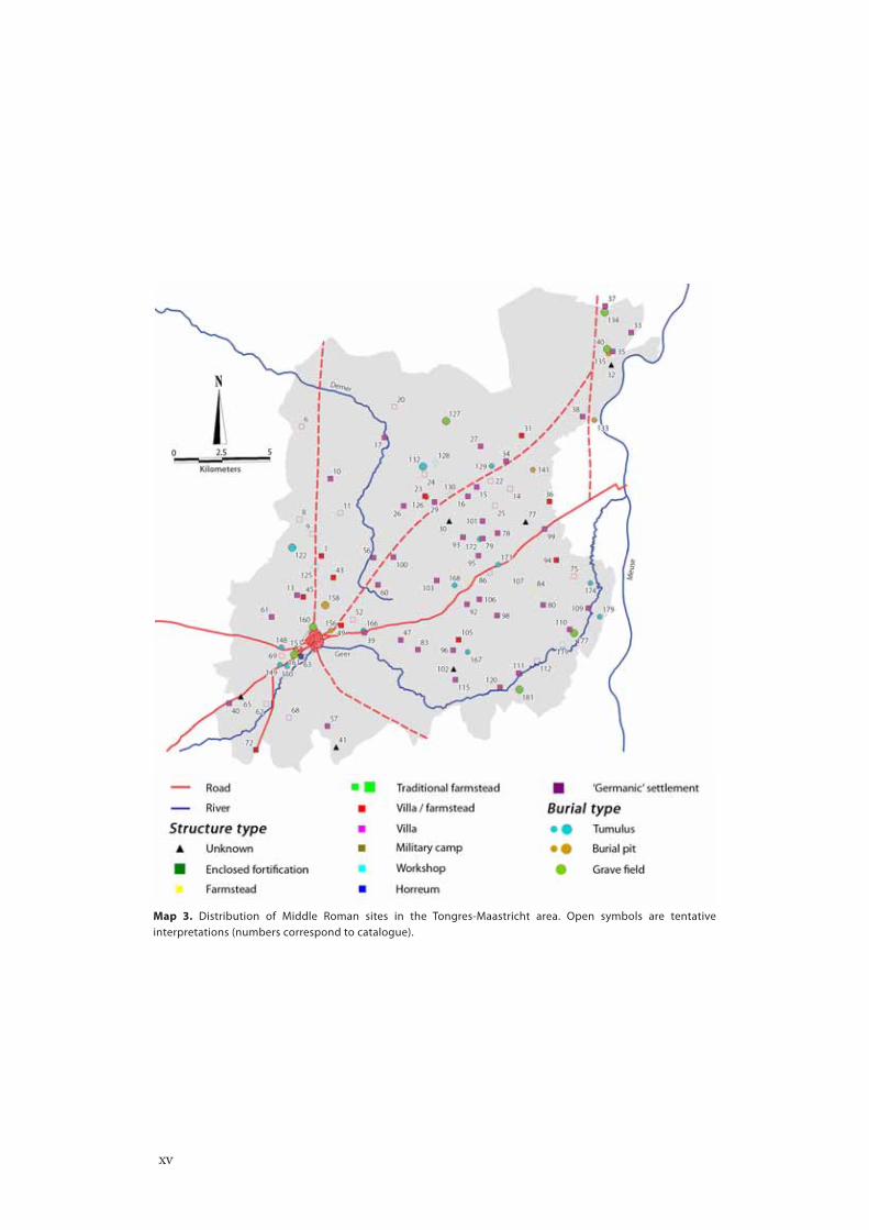
Map 3. Distribution of Middle Roman sites in the Tongres-Maastricht area. Open symbols are tentative interpretations (numbers correspond to catalogue).
xv
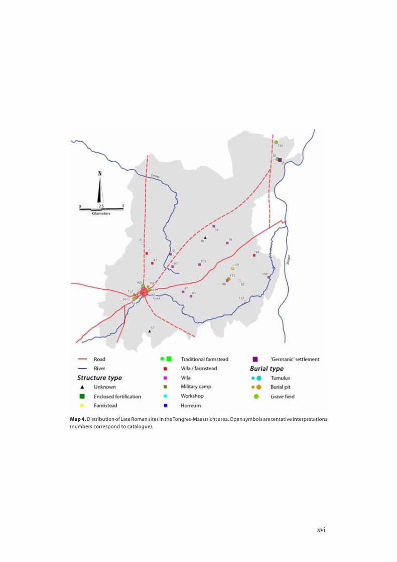
Map 4. Distribution of Late Roman sites in the Tongres-Maastricht area. Open symbols are tentative interpretations (numbers correspond to catalogue).
xvi
xvii
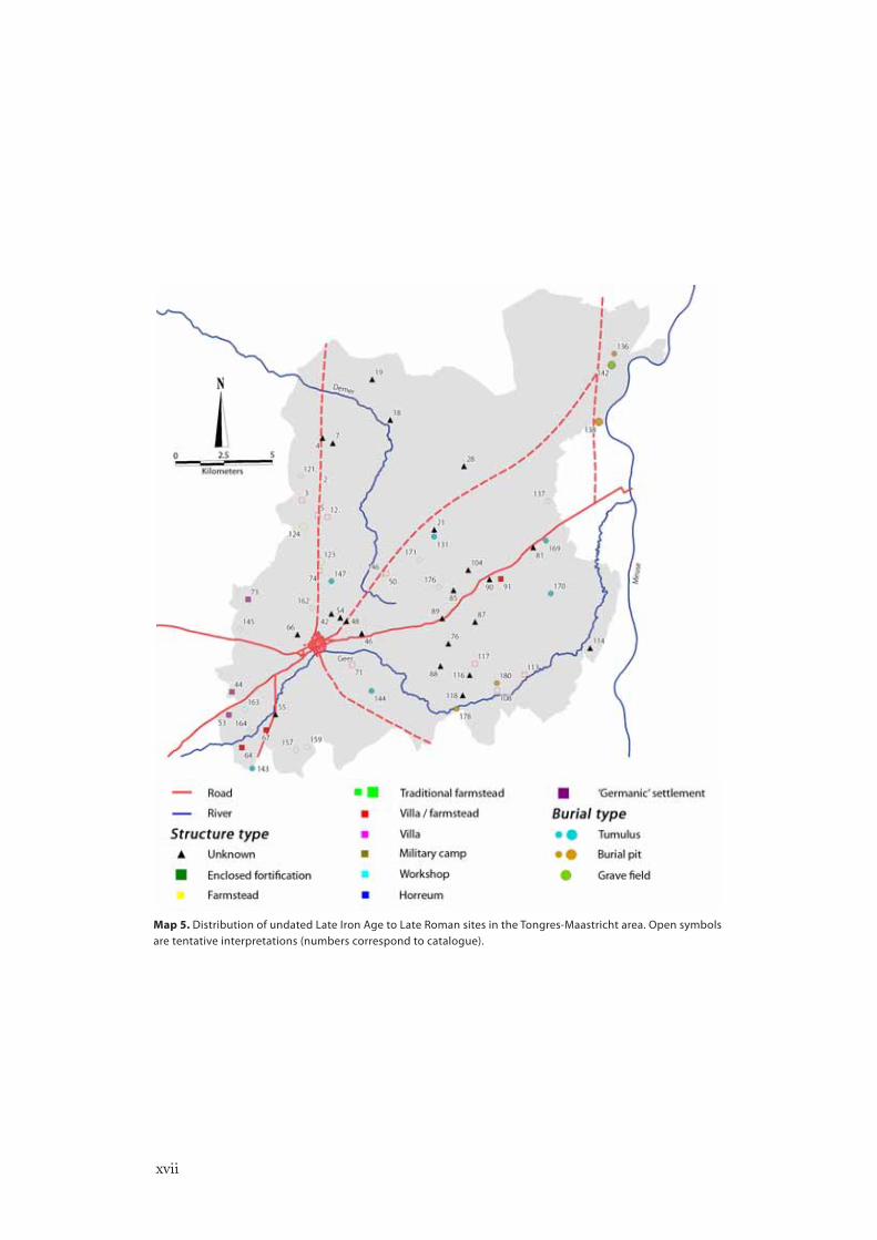
Map 5. Distribution of undated Late Iron Age to Late Roman sites in the Tongres-Maastricht area. Open symbols are tentative interpretations (numbers correspond to catalogue).

Introduction
“Contemporary beliefs, visions and myths can and often do lead
to metaphorical and physical (re)construction of the archaeological
record, and constructed landscapes are particularly susceptible to such
‘freezing’ of meaning.”
Knapp and Ashmore 1999: 10
In the 1950s, two Belgian scholars believed to have found evidence for what is
called a centuriatio around the Roman provincial city of Tongres (Mertens 1958;
Ulrix 1959).1 That both publications appeared around the same time seems not
remarkable; the subject of Roman cadastration was quite a popular topic. All this
gradually changed after the late 1970s. While some scholars, chiefly French and
Italian, still focus on Roman cadastres, this seems more an exception than the rule.
Due to several reasons, interest and believe in the existence of Roman cadastres
outside the Mediterranean sphere gradually abandoned scholarly thinking.2 This
led to the many reservations about the possible existence of Roman cadastres
in the Northwestern provinces, we might even say dispute their existence (e.g.
Willems 1987: 50; Jones 1989: 129; Hart 1998: 112-113; Heimberg 2003: 127;
van Enckevort et al. 2005: 3; Mattingly 2006b).
Several studies in the past 40 years, however, have demonstrated that Roman
cadastres outside of the Mediterranean were not that uncommon as one might
think (e.g. Legros 1970; Chouquer and Favory 1980; Peterson 1993; Chouquer
1996b). In continuation of this work, the aim of this book is to study the possibility
of a Roman cadastre around Tongres, the capital of the civitas Tungrorum and
one of Northern Gaul’s most important cities.3 As aforementioned, some have
preceded this work (Mertens 1958; Ulrix 1959; Melard 1986). However, it
appears that these studies are based on a methodological fallacy. The historical
and spatial association of historical-geographical features like roads, ditches and
other modern boundaries have been viewed as a pre-given here, while in fact this
has to be determined. This results in the association of modern linear features
with Roman boundaries without any evidence for it except for the conclusion
1

itself. As the direct relation between the Roman cadastre and the linear features
in the modern landscape is not clearly present due to changes in this landscape or
other means, the conclusion does not hold. This, therefore, asks for a new analysis
in the case of Tongres. By associating historical-geographical evidence with the
archaeological evidence from the region, I hope to find out if there is evidence for
a cadastre in this area during the Roman period.
In addition to the analysis, attention will be paid to the consequences of
the existence or non-existence of a cadastre on a socio-cultural level. The impact
of Rome’s conquest changed the landscape quite dramatically. Not only in
environmental and economic terms, but also in socio-cultural spheres. Of course,
cadastre’s primal goal as a tax instrument assumingly would have been Rome’s
foremost conscious reason to implement cadastres. Yet, the act of socio-cultural
change caused the native people to gradually integrate into the Empire. Some have
stressed therefore more attention on cadastres as a socio-cultural actor (Clavel-
Lévêque 1988; Purcell 1990; Campbell 1995; 1996; Cuomo 2000; Alcock 2002:
40-50). As studies on cultural interaction – whether termed Romanization or
not – point out there was a constant negotiation between natives and Romans,
which often is inscribed in their material culture. In light of this, it seems naïve
to imply that cadastres were not affected by this negotiation (cf. Chouquer
1989: 96). Indeed, as described in the Dutch Research Agenda for Archaeology
(NOaA), changes in agricultural systems can be used to analyse the nature of
cultural interaction in a region (van Enckevort et al. 2005: 12; see also Roymans
1996: 100).
Here, we might add the concept of continuity. Recently, more emphasis has
been placed on a more social, ideational and dynamical explanation of landscapes
(Ingold 1993; Schama 1995; Lemaire 1997; Kolen 2005) and have shown that
memory, often inscribed in landscapes, can play a large role in
the transmission of culture, as well as in an eventual change
(Rowlands 1993; Witcher 1998; Alcock 2002). That cadastres
can show continuity can be deduced from evidence of the Orange
cadastre and those in the French Saône plain. In the Orange
cadastre (Southern France) large areas of land were given back
to the Tricastini, an indigenous group of people inhabiting this
area prior to the Romans (Piganiol 1962: 54-55, 139; Woolf
1998: 145). In the Saône plain traces of fields considered to
be native, were after Roman conquest implemented within a Roman cadastre
(Chouquer and De Klijn 1989: 282). As more factors affect the negotiation of
cultural change in the case of Roman cadastration (see below), this example serves
only as an illustration that the implementation of cadastres was affected (in some
degree) by negotiation. Hence, playing a role in the transmission of culture.
A static concept?Studies on Roman land-surveying have extensively been published in the last 40
years.4 Scholars have on the basis of historical evidence examined how surveys
Roman name Length / Surface
Pes 0,2957 m
Actus 35,48 m (= 120 pedes)
Centuria 709,60 m (= 20 actus)
Iugerum 0,2518 ha
Heredium 0,5036 ha (= 2 iugera)
Centuria 50,3532 ha (= 200 iugera)
Table 1. Conversion table of Roman survey measurement units.
INTRODUCTION
2

were actually carried out in the field, what were the procedures and instruments
involved and what the mathematical knowledge of the surveyors amounted to.
They have speculated on their training, on the influence of Greek mathematics,
on how the role of the surveyors changed over time and on their social
composition. Therefore, we will not going to repeat all the basics here. However,
the aforementioned lack of interest of other scholars in Roman cadastration is
not without a reason, but seems to be based on several misconceptions regarding
these basics. As will be explained below, this false idea lies within both its history
of research and the Roman historical sources like the Corpus Agrimensorum.5
It has formed and still forms, in the words of Peterson (1993: 6), “a conceptual
barrier to the progress of research”.
The earliest known discovery of a Roman cadastre was by the Danish naval
Captain C. Falbe, who in 1833 noticed that the squares round ancient Carthage
had sides of 708 m. He was the first to associate this with the 20 by 20 actus
square known as a centuria. It was the first ever found centuriatio of the Roman
world. Some years later, in respectively 1846 and 1848, the Italian E. Legnazzi
and the German P. Kandler too identified a Roman centuriation. This time it
was in the Italian Po valley and the area around Trieste. The reason why Falbe,
Legnazzi and Kandler could identify these cadastres was because their boundaries
were preserved in the form of roads, paths and stone walls. After these initial
discoveries, also in other parts of the Mediterranean world – like Syria, Croatia
and other parts of Northern Africa and Italy – such remains were identified as
part of a Roman centuriation.6
But was a Roman cadastre always a visible and obvious chequerboard of
squares within the landscape which even in our days was physically identifiable?
Figure 1. An obvious Roman cadastre in Croatia of 20 by 20 actus(Bradford 1957: 175).
INTRODUCTION
3
The fact that the study of Roman cadastres to a large extend is based on the notion
of physical boundaries has caused that modern scholars only tend to associate the
obvious traces as clear proof for cadastres. All seem to have remained seated in
their static notion on similarities and obviousness (e.g. Jones 1989: 129). Aerial
photographs like those of Bradford (1957) may have strengthened this view, since
his clearest examples tend to make the strongest impression (see figure 1). This
assumption that cadastres were always obvious, however, is not true and has led
to ignore the less obvious (and perhaps more typical) ones. Roman cadastres like
those at Orange and Lacimurga (Spain) were, for instance, not known to us and
not visible until numerous fragments of administrative tablets were discovered on
which these cadastres were drawn (see Piganiol 1962; Clavel-Lévêque 1993).
In the same year Kandler found traces around Trieste, the first translation
of the Corpus Agrimensorum, a (now fragmentary) collection of Roman land-
surveyors’ manuals, was published under the title Die Schriften der römischen
Feldmesser (Blume et al. 1848). With this source the second problem of the
obviousness of cadastres arises: the translation of the Latin concept of limites.
Scholars oversimplified this concept by often translating the term with a ‘road’ or
‘path’, even when a limes signified a ‘boundary’ (e.g. Dilke 1971: 134; Chevallier
2001). As a result, a Roman cadastre would have been a visible orthogonal street
network. Isaac (1988: 128) however noted that there are two different meanings
for limes: ‘military road’ or ‘boundary’. The latter meaning, a boundary, derives
from surveyors’ vocabulary and was in most cases used as a purely conceptual line
(Isaac 1988). Thus, boundaries do not have to be necessarily associated with roads.
This is also shown by writings in the Corpus Agrimensorum. Siculus Flaccus, for
example, talks of cases in which villas may be placed on top of limites (Blume et
al. 1848: 158). This could of course not been the case were these limites visible
in the sense of a road. Furthermore, Faustus and Valerius mention that some
limites were roads or walls, while on others they “put nothing but caused deep
ditches to be dug” (Blume et al. 1848: 307-308). It seems as if the word ‘nothing’
in this sentence reveals the attitudes of these surveyors, since it were the symbols
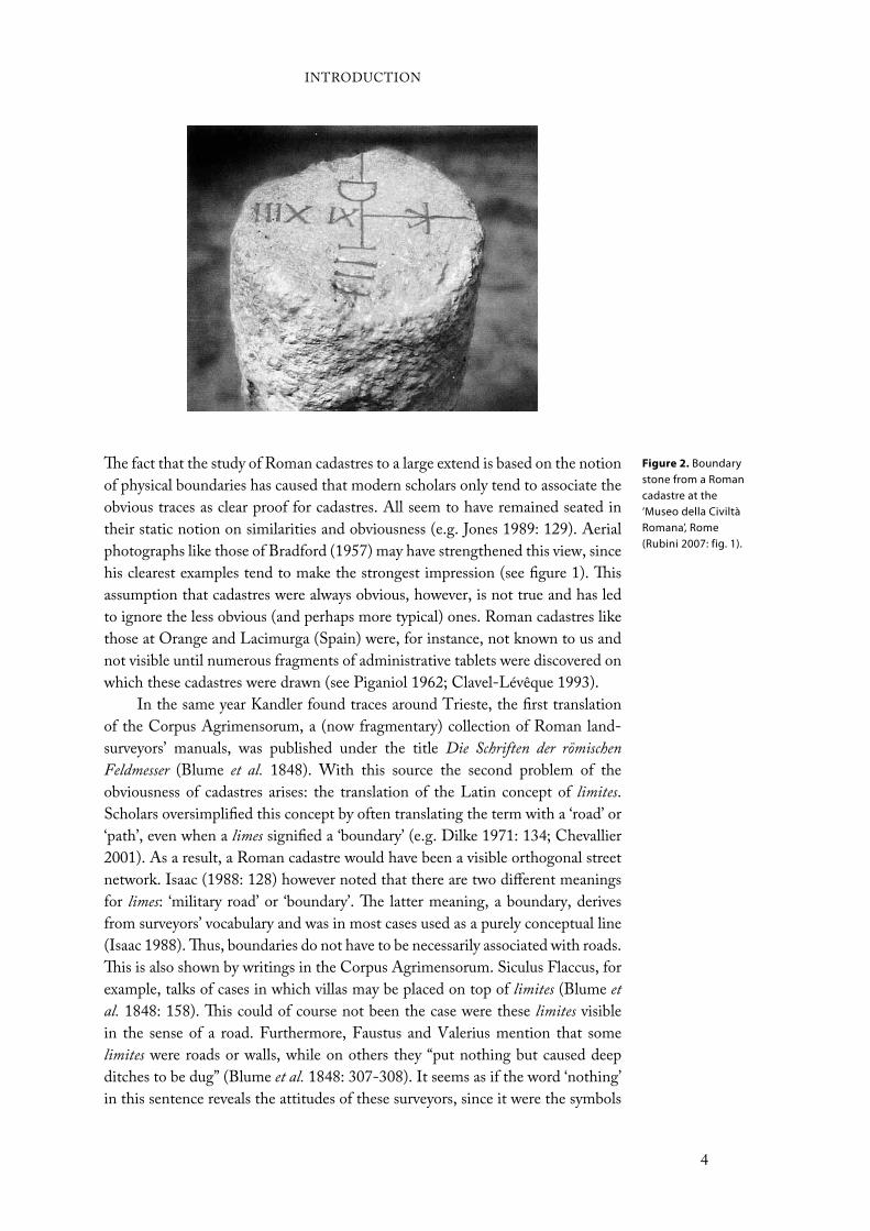
Figure 2. Boundary stone from a Roman cadastre at the ‘Museo della Civiltà Romana’, Rome (Rubini 2007: fig. 1).
INTRODUCTION
4
of the cadastre that interested them and only very scanty physical structures were
needed to symbolise its borders like stones, trees, or (small) mounds of earth
(Peterson 1993: 13). A limes is therefore thought to be a conceptual boundary,
which in some cases is made visible by, for instance, walls or roads, yet in others
remained invisible (see Terrenato 2007: 153). This is of course troublesome for
scholars studying material remains as archaeologists do, since immediate visibility
cannot be used as the criterion for existence. It may explain therefore the refusal
by some.
A false reading of the Corpus Agrimensorum also contributed to the
oversimplification that centuriatio only was implemented around coloniae (e.g.
Heimberg 2003: 127). On the first page of Frontinus’ De agrorum qualitate in the
Corpus Agrimensorum was written that “if the land is ‘divided and assigned’ (i.e.
centuriated) it is the land of a colonia” (Peterson 1993: 7). However, as some have
shown, Frontinus’ phrase must be interpreted as a simplified statement (Dilke
1971: 88, 178; Peterson 1993: 7-8). Hinrichs (1974: 172-173) has argued that
the Corpus Agrimensorum was a training manual for civilian land-surveyors
who also had a quasi-judicial role. This makes it reasonable to assume that the
more elementary texts were simplified, where detail was supplemented later by
examples from real life, which could introduce apparent contradictions. We
know, for example, of a Roman surveyor Hyginus, who reports in a later passage
on centuriated, but non-colonial, land in the Roman province of Pannonia,
present day Hungary (cf. Favory 1983: 126, n. 263). As Dilke (1971: 178) puts
it: “the territory centuriated could be that of a municipium, a town incorporated
into the Roman state with or without Roman citizenship”.7 This illustrates that
centuriation would have not only been applied around coloniae.
Lastly, scholars seem to use the Latin term centuriatio signifying all regular
Roman land planning (e.g. Ando 2006: 127; Mattingly 2006a: 288). However,
as several scholars have argued not all Roman surveys had
to be centuriations, but could also be of a different kind
(e.g. Dilke 1971). It thus seems that scholars have pictured
Roman cadastres too static by ignoring the less obvious and
overlooking several important passages in and aspects of
the Corpus Agrimensorum. Dilke’s (1971) The Roman land
surveyors, the sole general English publication on this topic, as well as the fact
that the first English translation of the Corpus Agrimensorum was published
only very recently (Campbell 2000), might in some way have contributed to these
misconceptions.8
As an example from the Northwestern provinces this has created the tendency
to confuse parcellation with cadastration (e.g. Renes 1988: 38-39; Van Londen
2006). The former is the division of land plots between different owners, while
the latter means the surveying of land as aid for tax collection and the allocation
of land. One does therefore not rule out the other. That Renes (1988: 39) views
the parcellation found in the German Eiffel region and in England as evidence
against the existence of Roman cadastres in these regions seems therefore a false
conclusion, possibly created by the aforementioned misconceptions. Indeed,
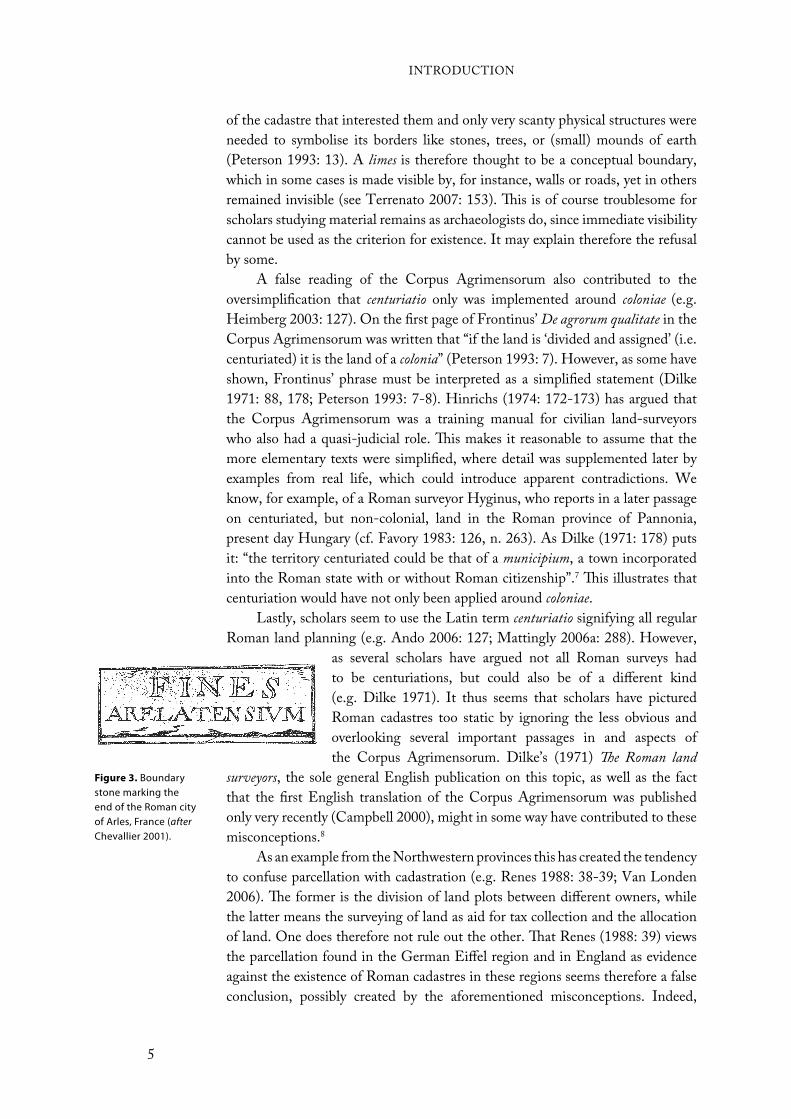
Figure 3. Boundary stone marking the end of the Roman city of Arles, France (afterChevallier 2001).
INTRODUCTION
5
when we take a closer look at the material evidence, we see that both could
have operated together. For instance, in the Hambacher Forst in the German
Rhineland, the land holdings all show a curtilage between three and ten iugera,
which conforms to the size of a parcel as mentioned by Renes. Yet, if we look
at the size of the land belonging to the land holdings by measuring the distance
between these land holdings than it conforms to a size of 50 ha, e.g. one century
of 20 by 20 actus (Gaitzsch 1986: 406-410; see also Compatangelo 1989: 170).
Evidence for surveyorsWhat is of importance when studying the possibility of a Roman cadastre are
the questions why such attempts have been made by scholars and why others
object to the notion of cadastres. In addition to the general aforementioned
misconceptions, there is some regional criticism towards the possibility of
Roman cadastres in the loess region of Northern Gaul. A recent study of Roman
villas in Southern Limburg (the Netherlands) has argued that their location was
influenced by the presence of water and favoured a location on top of the plateaus
(Zandboer 2006). Some seem to have equated this evidence with the dismissal of
the possibility for Roman cadastres (T. de Groot, pers. comm.), while others have
viewed the region’s hilly character as a reason for dismissal (Willems 1987). Both
objections however are unfounded. The first is based on a false reasoning, since
the influence of location does not rule out the possibility of a Roman cadastre.
The second seems also unsubstantial, since many regions with prove of Roman
cadastres like those around Florence, Valence and Orange share the same natural
characteristics as Southern Limburg.
Is there then evidence other than the cadastres themselves for Roman land-
surveyors in Northern Gaul? The Mediterranean region has given us boundary
stones indicating a particular cadastral boundary (see figure 2), as well as tablets,
grave stones and instruments that relate to land-surveyors. No boundary stones,
however, have so far been found in Northern Gaul. But near the town of Rindern
(Germany), close to Nijmegen, a stone was found on which was inscribed fines vici,
meaning ‘end of the vicus’ (for a possible resembling stone from Arles, see figure
3). Furthermore, also evidence for the tools of a land-surveyor has been found.
Recently, in the Roman settlement of Schiedam-Polderweg (the Netherlands),
which lays in the northern frontier zone, a pair of dividers has been found that
is dated to the second or third century ad (Van Londen 2006: 187). This pair
of dividers closely resembles the bronze ones found in an excavated Pompeian
surveyor workshop. More to the south, in the Bavarian village of Pfünz, another
survey instrument has been found. This so-called groma was the principal survey
instrument for the Romans and is one of the most complete examples found in
the Empire (Dilke 1971: 69). These finds show that land-surveyors, which would
have arrived together with the Roman army, seem to have been present in the
region (Mattingly 2006b).
INTRODUCTION
6

Structure of bookWe will start in chapter 2 by introducing our study area, the Tongres-Maastricht
area, with a focus on its setting and physical geography. The following chapter
(3) sets the region into a broader framework of the history and archaeology of the
Roman Empire, most notably the Northwestern provinces. The Roman period
finds and sites around Tongres have in the past been synthesized by several people
(Bauwens-Lesenne 1968; Lux 1970; A. Claassen 1973; Duurland 2000; Knaepen
2001). However, to my knowledge few have tried to put them in a broader
framework and discussion concerning Roman cultural interaction in Northern
Gaul. Moreover, of the three studies that try to put the region into a broader
framework of the Northwestern provinces (Mertens 1964; A. Vanderhoeven
1996; 2002), the two most recent ones focus predominantly on Tongres’ Early
Roman period. Therefore, this chapter is larger in size than might have been
expected.
Chapter 4 focuses its attention upon the methods and techniques applied to
identify Roman cadastres, most notably aerial photography and maps. A lot of
criticism has been given towards these techniques. However, in the last 20 to 30
years many new methods and techniques have been introduced, what makes the
criticism nowadays unfounded. After this, we will briefly set out earlier proposals
for a Roman cadastre in the Tongres-Maastricht area and adjacent regions and
explain in detail the methodological fallacies on which the arguments are based
that support the proposals.
Chapters 5 and 6 are the focal points of this book, where we will examine
the possibility of a Roman cadastre in the Tongres-Maastricht area. In chapter 5,
the theory and methodology of the analysis will be explained and a relationship
between the modern and Roman features will be established. In chapter 6, the
latter analysis will be tested and it will be tried to define the size of the squares
within the cadastre, as well as the size of the cadastre itself.
The next chapter (7) will use the proposed Roman cadastre from chapters
5 and 6 and will study the socio-political ownership of the rural landscape of
the Tongres-Maastricht area. Stated differently, who owned the rural settlement
sites and its land and how does it seem to develop during the Roman period?
The conclusion (chapter 8), finally, will repeat the general conclusions and, in
addition, will set the proposed cadastre against a socio-cultural development of
the area. The main question that will be considered here is to what extend an
imposed cadastre could have contributed to socio-cultural changes in the region.
INTRODUCTION
7
8

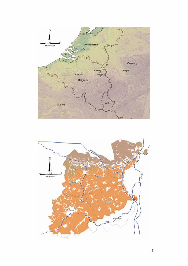
The Tongres-Maastricht area is situated in the east of modern Belgium covering an
area of approximately 350 km2. It follows mainly the route of the most prominent
Roman road in Northwestern Europe, which stretched from Boulogne-sur-Mer
on the Atlantic coast to Cologne in the German Rhineland. Except for Tongres,
also the municipalities of Bilzen, Hoeselt, Lanaken, Riemst (all prov. of Limburg)
and Bassenge (prov. of Liege) are included in this study (see figure 4). The study
area follows municipal boundaries rather than natural ones for three reasons: (1)
due to problems with overlapping national maps and different coordinate systems,
an integration of a Belgian and Dutch area within the Tongres-Maastricht area
was not possible; (2) the study area falls almost entirely within one specific natural
region, the Hesbaye; (3) the most southern municipality, Bassenge, is included
because it follows the course of the river Geer, which can act as a southern
border between the Hesbaye and the Condroz (see below). Of course, present
day national and communal borders need to be overlooked when studying the
Roman period. Therefore, comparisons with and examples of other neighbouring
areas will be implemented in this study.
In Roman days, the Hesbaye was part of the so-called ‘villa landscape’, a belt
to the south of the Roman frontier zone that stretched from Northern France
to the German Rhineland (see figure 4). The belt’s name is because of its shared
characteristics of house architecture, type of soil and economic subsistence. In the
past, this ‘villa landscape’ has been the subject of several discussions regarding the
possibility of Roman cadastres (see chapter 4). Yet, the choice for the Tongres-
Maastricht area above other adjacent areas is because of several reasons. First, in
contrast to certain neighbouring ‘villa’ areas (see Van Enckevort et al. 2005), there
is a relatively loose discussion on cultural interaction and the Rome’s influence.
Its discussion seems to be mostly focused on the Early Roman development and
the city of Tongres (e.g. Vanvinckenroye 1996; Nouwen 1997; A. Vanderhoeven
1996; 2001; 2002). The countryside, on the other hand, seems often forgotten
(exceptions are Duurland 2000; Knaepen 2001), although its abundant Roman
findings. Secondly, while land allocation in the 1950s and ‘60s also changed this
area’s landscape, it seems that the rapid urbanization, industrialization and land
allocation changing the West’s landscape during the 19th and 20th centuries
Setting and Physical Geography
Figure 4 (previous
page; above). Overview map of Northwestern Europe. The dotted square represents the Tongres-Maastricht area.
Figure 5 (previous
page; below). Soil map of the Tongres-Maastricht area.
9
had less impact here as in other ‘villa’ areas (see chapters 3 and 4). For example,
compared to the southeastern part of the Dutch province of Limburg, it becomes
clear that, although in terms of geography and pre-industrial landscape it may
have closely resembled each other, this landscape has suffered much more from
these changes.
Physical geographyThe most prominent river running through and connecting this area with Roman
settlements like Nijmegen, Xanten and Voorburg and military camps along the
northern Limes is the river Meuse. It practically follows the eastern border of the
Tongres-Maastricht area from south to north with only a minor interruption at
Maastricht, where the river runs through the city centre rather than following
the Dutch-Belgian border (see figure 5). At Ketsingen (municipality of Tongres)
the river Demer, a sub-river of the river Scheldt, rises and flows in a southeast-
northwest direction out of the study area. Lastly, just south of Tongres a smaller
river, the Geer, flows along the southern border of the Tongres-Maastricht area
in the direction of Maastricht where it flows into the river Meuse. It rises at Lens-
Saint-Servais, from where it flows in a mostly southwest-northeast direction. Like
the river Meuse, the Demer and Geer could have been used as trade routes during
Roman times (see Eckholdt 1980). Although the Geer is now a fast-flowing
river which is unnavigable, it is known that until the 17th century this river was
still navigable for ships (Vanvinckenroye 1985: 50-52). The watershed between
the rivers Scheldt and Meuse appears to run in a linear line from Tongres to
Maastricht. It has been proposed that the Roman road between Tongres and
Maastricht on purpose followed this watershed in order to cross no unnecessary
rivers (Mertens 1987: 16). Apart from these larger rivers, there are several smaller
ones that would have been unsuitable for navigation.
Geomorphologically, three distinctive zones within the Tongres-Maastricht
area can be separated using the rivers Demer and Meuse as guidelines; the
Campine region, the Hesbaye and the Meuse valley. North of the river Demer,
if we draw an imaginable line from where the river leaves the study area to the
Meuse, the gently undulating sandy plateau of the Campine region forms the
most northern part of the Tongres-Maastricht area. The Campine plateau is part
of a chain of sandy plateaus situated along the southern part of the North Sea.
This chain is separated from the sea by a belt of Holocene peat and clay areas. It
developed in the Late Pleistocene, under the relatively dry conditions of the Late
Glacial period, when a layer of fine sands was deposited by the wind covering the
older fluvial deposits. Due to several constraints concerning physical conditions of
soil and climate, this area “is dominated in all phases by mixed agrarian strategies,
often with an emphasis on extensive animal husbandry” (Roymans and Theuws
1999: 4). Intensive cereal production was not realized here until the introduction
of artificial fertilizer in the 19th century. This and the fact that it was not part of
the active Roman frontier zone caused the region to be seemingly less interesting
for the Romans (see Slofstra 1991; Roymans 1996: 58-88; Roymans and Theuws
SETTING AND PHYSICAL GEOGRAPHY
10

1999: 2-5). Only some sites like Hoogeloon developed into Roman villas (Slofstra
1991: 161-165). Moreover, this development happened only during the third
century ad, what is later as in the adjoining ‘villa landscape’ to the south.
South of the imaginable line of the river Demer starts the Hesbaye. The
Tongres-Maastricht area lies for 80 to 90 percent within this sloping landscape that
stretches out over the entire southern part of the province of Limburg, the eastern
part of the provinces of Flemish and Walloon Brabant and the northwestern part
of the province of Liege (see figure 6). The height in general is remarkably higher
than the Campine region and varies between 50 m in the east up to 220 meters
on the plateaus in the southwest. Its name derived from the Carolingian shire
Haspinga situated here during the late-ninth and tenth century ad. In addition
to the Campine in the north, the region borders off to the Dutch province of
Limburg and the Herve region in the east, the sandy Flemish lowlands in the
west and the Condroz in the south.
The Hesbaye, as the rest of the ‘villa landscape’, derives its suitability as
a farming region by its geomorphologic characteristics. Loess, which covers
this region, stands out as a soil because of its fertility. As with the coversand
region of the Campine, it was formed during the Late Glacial period of the Late
Pleistocene. The very fine, light material was swept from bare regions on the edges
of the glaciers and deposited in regions with denser vegetation like Northwestern
Europe (Lebret and Lautridou 1991: 152). Loess consists largely of quartz grains
and lime. The very fine grains ensure good aeration, water storage and mineral
levels, which creates the loess’ fertility (Mücher 1973; Haase et al. 2007). As a
result of this fertility, the region has attracted farming communities for several
millennia starting with the so-called Linearbandkeramik people around 5000
bc. Yet, loess is also particularly susceptible to erosion (see Bouten et al. 1985;
Berendsen 1998: 23-24; Rommens et al. 2005). The development of farming land
aggravates the erosion of the soil even more. It seems not strange, therefore, that
Figure 6. Painting by Charles Wellens (ca. 1900) of a small road in the Belgian Hesbaye region (courtesy of Genootschap Charles Wellens).
SETTING AND PHYSICAL GEOGRAPHY
11

farmers in the area create ways to stop this erosion by planting trees and bushes
which results in the creation of talus (Breteler and van den Broek 1968: 119-121;
see chapter 5).
Within the Hesbaye the loess deposition can be divided into two distinct zones:
the ‘dry Hesbaye’ and ‘wet Hesbaye’ (see Dudal and Baeyens 1957; 1958; Baeyens
1968). The first zone is the largest and stretches out over most of the study area. It
is characteristic for its open fields and an almost total absence of wooded terrain.
It is, moreover, more suitable for agriculture than the ‘wet Hesbaye’. The fact that
the ‘dry Hesbaye’ exists out of one large loess plateau slanting in a northeastern
direction, causes that most of the valleys and streams also flow in this direction. In
order to improve the agricultural structure, a large-scale land reallotment during
the 1950s and ‘60s has taken place here (Anonymous 2000: esp. 7). Due to this,
many traces of the historical landscape and archaeological sites have gone lost
(Spits 1963; Breteler and van den Broek 1968: 127; Anonymous 2000: 20-23;
Duurland 2000: 4). The ‘wet Hesbaye’ is located in the north of the study area, in
the north of Hoeselt. It forms a transitional zone from the Campine coversand to
the ‘dry Hesbaye’. This is a result of along-track size sorting by northerly winds
(see Dudal and Baeyens 1957; Schwan 1986). It is more wooded and less fertile
than the ‘dry Hesbaye’ because it is even more susceptible to erosion than loess
soils in general. This is caused by the impermeability of the tertiary clay and grind
layers underneath the loess, as well as the thinner loess deposition.
The last geomorphologic region is the Meuse valley, a riverine sediment
only found along the river Meuse in the municipality of Lanaken (see Paulissen
1973; Heeren 1976; Vleeshouwer and Damoiseaux 1990: 51-54, 79-90). Its
soil has in general a good drainage quality and is, therefore, suited for all sorts
of cultivation. One needs to be precautious, however, with floods caused by an
increase of water in the river Meuse. There are two sorts of depositions, occurring in
different periods, that need to be distinguished. First, old riverine clay is deposited
in the Late Pleistocene, what causes a coarse deposition of sand, grind and boulders.
Much more important, however, is the younger riverine clay deposited during
or after the Roman period, which is much finer than the older clay (Duurland
2000: 4; Vleeshouwer and Damoiseaux 1990: 79-90). In most areas the younger is
deposited on top of the older clay. Yet, old riverine depositions can still be visible
above ground.
SETTING AND PHYSICAL GEOGRAPHY
12

Historical and Archaeological
Framework
The previous chapter focused on the setting and physical geography of the Tongres-
Maastricht area. We have seen that especially the loess zone was a favourable
region to settle. This chapter will give a historical and archaeological overview of
the Tongres-Maastricht area starting from the Late Iron Age to the Late Roman
period (see table 2). The overview will be set in a context of the development of the
Northwestern provinces.Attention will particularly be paid to the development of
house types, its surroundings and the socio-cultural interaction. Furthermore,
we want to examine how the favourable condition of the fertile soil, in
addition to the closeness of trade routes like the route from Bavay to
Cologne and the Meuse, was exploited during the Roman period.
It is chosen to include the period prior to Caesar’s arrival in the
discussion for several reasons. First, the Tongres-Maastricht area does
not provide a precise chronology for the Late Iron Age as in other
areas like the German Rhineland, Northern France and the Trier area
(Roymans 1990: 5-7; see also Haselgrove 1996: 135-138). Especially
the Late Iron Age-Early Roman transitional phase is a matter of debate. This
causes difficulties with the dating of sites. Secondly, because a study focusing
on socio-cultural interaction enhanced by the Romans requires background
knowledge of the pre-Conquest situation in the region.
Late Iron Age (250 - 57 BC)9
According to Caesar (BG 2.3.4; 2.4.10; 6.2.3; 6.32.1) the Tongres-Maastricht
area was part of the land of the Germani Cisrhenani. They were a Germanic group
of people “living on this side of the Rhine”, which could be subdivided into
five smaller tribes (i.e. Caesar and Tacitus’ civitates): the Eburones, Aduatuci,
Condrusi, Paemani and Segni (see figure 7). Later Roman historians adopted
Caesar’s stance. Only Tacitus (Germ. 28) considered Caesar’s commentary as
doubtful and viewed the name Germani Cisrhenani as a fabrication that later was
adopted by the people themselves.
Caesar seemed right in concluding that the five ‘Germanic’ tribes were
different from the ‘Celtic’ to the South. They probably did not belong to the actual
Table 2. Periodization discussed in this book.
Period Date
Middle Iron Age 475 - 250 BC
Late Iron Age 250 - 57 BC
Early Roman 57 BC - 70 AD
Middle Roman 70 - 270 AD
Late Roman 270 - 450 AD
Merovingian 450 - 800 AD
13
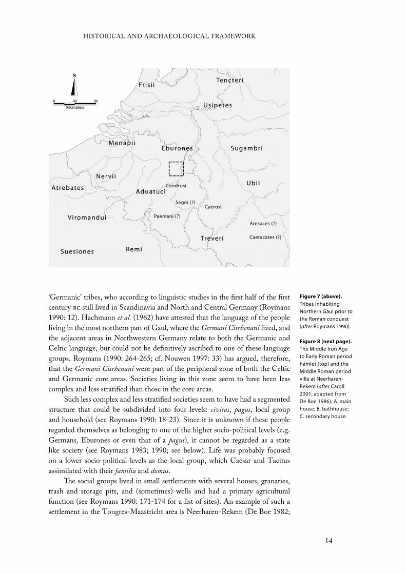
‘Germanic’ tribes, who according to linguistic studies in the first half of the first
century bc still lived in Scandinavia and North and Central Germany (Roymans
1990: 12). Hachmann et al. (1962) have attested that the language of the people
living in the most northern part of Gaul, where the Germani Cisrhenani lived, and
the adjacent areas in Northwestern Germany relate to both the Germanic and
Celtic language, but could not be definitively ascribed to one of these language
groups. Roymans (1990: 264-265; cf. Nouwen 1997: 33) has argued, therefore,
that the Germani Cisrhenani were part of the peripheral zone of both the Celtic
and Germanic core areas. Societies living in this zone seem to have been less
complex and less stratified than those in the core areas.
Such less complex and less stratified societies seem to have had a segmented
structure that could be subdivided into four levels: civitas, pagus, local group
and household (see Roymans 1990: 18-23). Since it is unknown if these people
regarded themselves as belonging to one of the higher socio-political levels (e.g.
Germans, Eburones or even that of a pagus), it cannot be regarded as a state
like society (see Roymans 1983; 1990; see below). Life was probably focused
on a lower socio-political levels as the local group, which Caesar and Tacitus
assimilated with their familia and domus.
The social groups lived in small settlements with several houses, granaries,
trash and storage pits, and (sometimes) wells and had a primary agricultural
function (see Roymans 1990: 171-174 for a list of sites). An example of such a
settlement in the Tongres-Maastricht area is Neerharen-Rekem (De Boe 1982;
Figure 7 (above).
Tribes inhabiting Northern Gaul prior to the Roman conquest (after Roymans 1990).
Figure 8 (next page).
The Middle Iron Age to Early Roman period hamlet (top) and the Middle Roman period villa at Neerharen-Rekem (after Caroll 2001; adapted from De Boe 1986). A. main house; B. bathhouse; C. secondary house.
HISTORICAL AND ARCHAEOLOGICAL FRAMEWORK
14
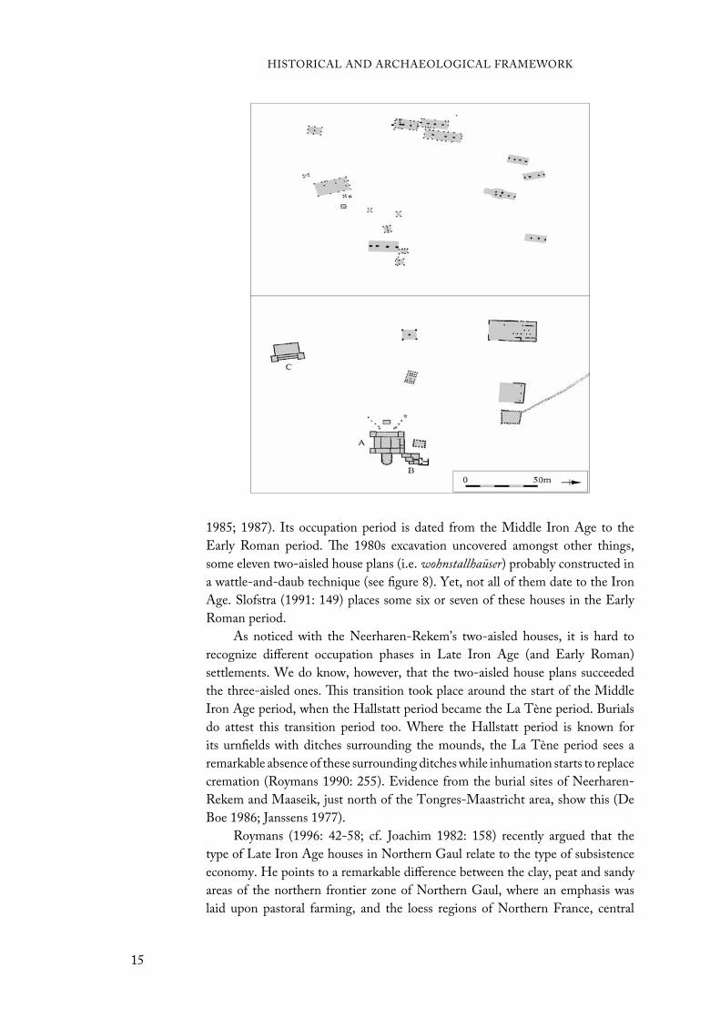
1985; 1987). Its occupation period is dated from the Middle Iron Age to the
Early Roman period. The 1980s excavation uncovered amongst other things,
some eleven two-aisled house plans (i.e. wohnstallhaüser) probably constructed in
a wattle-and-daub technique (see figure 8). Yet, not all of them date to the Iron
Age. Slofstra (1991: 149) places some six or seven of these houses in the Early
Roman period.
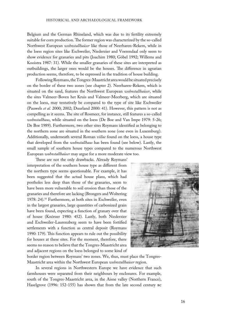
As noticed with the Neerharen-Rekem’s two-aisled houses, it is hard to
recognize different occupation phases in Late Iron Age (and Early Roman)
settlements. We do know, however, that the two-aisled house plans succeeded
the three-aisled ones. This transition took place around the start of the Middle
Iron Age period, when the Hallstatt period became the La Tène period. Burials
do attest this transition period too. Where the Hallstatt period is known for
its urnfields with ditches surrounding the mounds, the La Tène period sees a
remarkable absence of these surrounding ditches while inhumation starts to replace
cremation (Roymans 1990: 255). Evidence from the burial sites of Neerharen-
Rekem and Maaseik, just north of the Tongres-Maastricht area, show this (De
Boe 1986; Janssens 1977).
Roymans (1996: 42-58; cf. Joachim 1982: 158) recently argued that the
type of Late Iron Age houses in Northern Gaul relate to the type of subsistence
economy. He points to a remarkable difference between the clay, peat and sandy
areas of the northern frontier zone of Northern Gaul, where an emphasis was
laid upon pastoral farming, and the loess regions of Northern France, central
HISTORICAL AND ARCHAEOLOGICAL FRAMEWORK
15
Belgium and the German Rhineland, which was due to its fertility extremely
suitable for corn production. The former region was characterized by the so-called
Northwest European wohnstallhaüser like those of Neerharen-Rekem, while in
the loess region sites like Eschweiler, Niederzier and Voerendaal only seem to
show evidence for granaries and pits (Joachim 1980; Göbel 1992; Willems and
Kooistra 1987: 31). While the smaller granaries of these sites are interpreted as
outbuildings, the larger ones would be the houses. The difference in agrarian
production seems, therefore, to be expressed in the tradition of house building.
Following Roymans, the Tongres-Maastricht area would be situated precisely
on the border of these two zones (see chapter 2). Neerharen-Rekem, which is
situated on the sand, features the Northwest European wohnstallhaüser, while
the sites Valmeer-Boven het Kruis and Valmeer-Meerberg, which are situated
on the loess, may tentatively be compared to the type of site like Eschweiler
(Pauwels et al. 2000; 2002; Duurland 2000: 41). However, this pattern is not as
compelling as it seems. The site of Rosmeer, for instance, still features a so-called
wohnstallhaus, while situated on the loess (De Boe and Van Impe 1979: 5-26;
De Boe 1989). Furthermore, two other sites Roymans identified as belonging to
the northern zone are situated in the southern zone (one even in Luxemburg).
Additionally, underneath several Roman villae found on the loess, a house type
that developed from the wohnstallhaus has been found (see below). Lastly, the
small sample of southern house types compared to the numerous Northwest
European wohnstallhaüser may argue for a more moderate view too.
These are not the only drawbacks. Already Roymans’
interpretation of the southern house type as different from
the northern type seems questionable. For example, it has
been suggested that the actual house plans, which had
postholes less deep than those of the granaries, seem to
have been more vulnerable to soil erosion than those of the
granaries and therefore are lacking (Brongers and Woltering
1978: 24).10 Furthermore, at both sites in Eschweiler, even
in the largest granaries, large quantities of carbonized grain
have been found, expecting a function of granary over that
of house (Knörzer 1980: 452). Lastly, both Niederzier
and Eschweiler-Laurenzberg seem to have been fortified
settlements with a function as central deposit (Roymans
1990: 179). This function appears to rule out the possibility
for houses at these sites. For the moment, therefore, there
seems no reason to believe that the Tongres-Maastricht area
and adjacent regions on the loess belonged to some kind of
border region between Roymans’ two zones. We, thus, must place the Tongres-
Maastricht area within the Northwest European wohnstallhaüser region.
In several regions in Northwestern Europe we have evidence that such
farmhouses were separated from their neighbours by enclosures. For example,
south of the Tongres-Maastricht area, in the Aisne valley (Northern France),
Haselgrove (1996: 152-155) has shown that from the late second century bc
HISTORICAL AND ARCHAEOLOGICAL FRAMEWORK
16
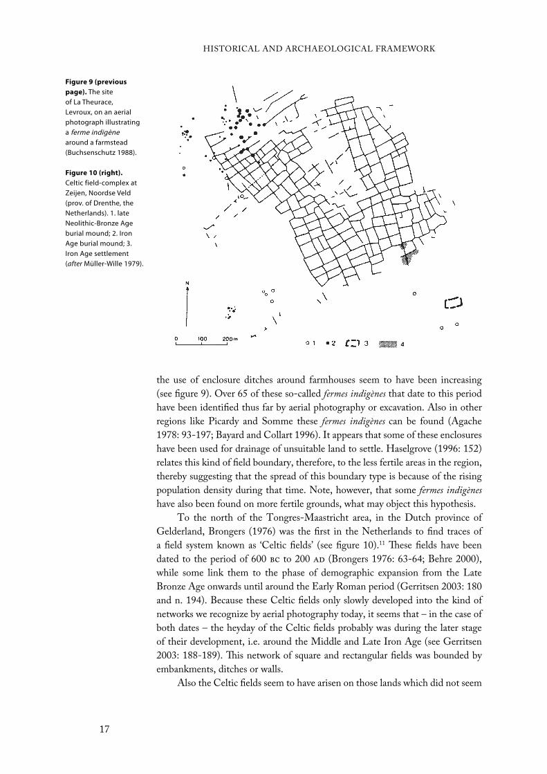
the use of enclosure ditches around farmhouses seem to have been increasing
(see figure 9). Over 65 of these so-called fermes indigènes that date to this period
have been identified thus far by aerial photography or excavation. Also in other
regions like Picardy and Somme these fermes indigènes can be found (Agache
1978: 93-197; Bayard and Collart 1996). It appears that some of these enclosures
have been used for drainage of unsuitable land to settle. Haselgrove (1996: 152)
relates this kind of field boundary, therefore, to the less fertile areas in the region,
thereby suggesting that the spread of this boundary type is because of the rising
population density during that time. Note, however, that some fermes indigènes
have also been found on more fertile grounds, what may object this hypothesis.
To the north of the Tongres-Maastricht area, in the Dutch province of
Gelderland, Brongers (1976) was the first in the Netherlands to find traces of
a field system known as ‘Celtic fields’ (see figure 10).11 These fields have been
dated to the period of 600 bc to 200 ad (Brongers 1976: 63-64; Behre 2000),
while some link them to the phase of demographic expansion from the Late
Bronze Age onwards until around the Early Roman period (Gerritsen 2003: 180
and n. 194). Because these Celtic fields only slowly developed into the kind of
networks we recognize by aerial photography today, it seems that – in the case of
both dates – the heyday of the Celtic fields probably was during the later stage
of their development, i.e. around the Middle and Late Iron Age (see Gerritsen
2003: 188-189). This network of square and rectangular fields was bounded by
embankments, ditches or walls.
Also the Celtic fields seem to have arisen on those lands which did not seem
Figure 9 (previous
page). The site of La Theurace, Levroux, on an aerial photograph illustrating a ferme indigènearound a farmstead (Buchsenschutz 1988).
Figure 10 (right).
Celtic field-complex at Zeijen, Noordse Veld (prov. of Drenthe, the Netherlands). 1. late Neolithic-Bronze Age burial mound; 2. Iron Age burial mound; 3. Iron Age settlement (after Müller-Wille 1979).
HISTORICAL AND ARCHAEOLOGICAL FRAMEWORK
17

very fruitful for agriculture (see Gerritsen 2003: 246). Not only in the province of
Gelderland, but also in many other peat and sandy areas throughout Northwestern
Europe these kinds of field systems have been found (e.g. Müller-Wille 1979).
The closest to the Tongres-Maastricht area are found in the Campine region
(Van Impe 1977; Milikowski 1985; Vandekerckhove 1996; Gerritsen 2003: table
4.11).
If the Celtic fields can be related to the fermes indigènes of Northern France
seems doubtful. First, although some of the fermes indigènes found in Northern
France are connected to one another, most remain separate. Secondly, the fermes
indigènes show different types of enclosures like a double ditch-system, and
differed in shape (see Haselgrove 1996: 152-153). Lastly, fermes indigènes have
an occupation site within the enclosed area, while in the case of Celtic fields the
occupation sites were situated outside of the Celtic field. However, that they have
something in common seems evident from the fact that both have been related
to the less fertile lands (see Brongers 1976; Haselgrove 1996: 152). This may also
explain why in the Tongres-Maastricht area and adjacent areas on the fertile loess
thus far show no traces of Late Iron Age field systems. Only Neerharen-Rekem
has ditches. Yet, when compared to other sites like Hoogeloon, it may be argued
that these ditches more likely date to the Roman period than to the Late Iron
Age (see Slofstra 1987; 1991: 148-150).
Another argument in favour of no Late Iron Age field system in the
Tongres-Maastricht area would be that this area was part of the larger zone
Roymans identified as a less complex and less stratified society (see above). Field
systems like the Celtic fields and fermes indigènes suggest a development of social
stratification (see Hingley 1984; 1990; Gerritsen 2003: 192). Since the Tongres-
Maastricht area belonged to the less stratified and complex peripheral zones of
the Celtic and Germanic heartlands, we may assume that a development of field
systems would have occurred later than in other, less marginal regions. It seems
likely that the idea of field systems would have slowly spread from the heartlands
to its peripheries. Since – as will be shown below – Roman intervention changed
the development of these communities considerably, it might even be that there
never came such a particular field system.
That Iron Age communities in Western Europe were gradually becoming
more stratified – in some areas maybe more than in others (see above) – is
attested by the genesis of large enclosed fortifications around the third century
bc throughout present day Belgium, Germany and France (see Nash 1976: fig.
1; Roymans 1990: fig. 8.12). The rise of these earthworks, or oppida, marks
the start of urban development in Western Europe. However, what their exact
function was seems to be a difficult matter. Due to the oppida’s differences, many
different functions have been ascribed to these sites (Brunaux 1986: 9-11; Woolf
1993). Were they hiding places in times of unrest or places where commercial
transactions took place? Nevertheless, despite the uncertainty if these pre-Roman
communities identified themselves with cultural groups, states or individual
smaller chiefdoms (see above), at least, these oppida seem to suggest a developing
centralization (Brun 1995; Derks 1998: 183-185).
HISTORICAL AND ARCHAEOLOGICAL FRAMEWORK
18

The largest enclosed fortification found in the surroundings of the Tongres-
Maastricht area was Kanne-Caster, situated on the eastern flank. It is ca. 20 ha
large and is situated between the rivers Meuse and Geer. The site has brought
up some discussion on the fact if it is actually a pre-Roman fortification. Both
Vanvinckenroye (1994a: 63-64; 2001) and Panhuysen (1996: 30) identified it as a
Roman military camp. This is based on the dendrochronological dating around the
time of the Roman conquest and on indications of Roman occupation at nearby
fortifications as Trier-Petrisberg, Lamadelaine-Titelberg and La Chaussée-
Tirancourt-Camp César (Binsfeld 1984: 174; Metzler 1984: 76-78; Brunaux et al.
1990).12 Yet, Duurland’s (2000: 11) proposition to view it as a native fortification
seems more plausible. First, its setting close to the Meuse and Geer is something
common for Late Iron Age fortifications (cf. Nash 1976: 99). Secondly, the site
lacks Roman finds, while pre-Roman finds have been attested here (H. Roosens
1975: 36). Lastly, the dendrochronological dating is highly uncertain, since it is
unknown from which construction phase the dated material came from.
In sum, it seems that during the course of the Iron Age, the communities
inhabiting Northwestern Europe gradually were developing into a more complex,
stratified and urbanized society (cf. Roymans 1983). The distinct La Tène bracelets
found in the Tongres-Maastricht area (Duurland 2000: 15), as well as the Celtic
coin hoards like recently found at Beringen, Echt and Heers, may serve as another
illustration for these phenomena. However, Rome’s contribution to this region’s
development by trade links must not be underestimated as seen in, for instance,
the Roman republican pottery and bronze finds throughout Gaul (Fulford 1985;
Roymans 1990: 147-168). Although these Roman finds did not seem to have
reached the Tongres-Maastricht area during the pre-Roman period, the fact that
more southern-based communities were accustomed to these imports serves as
an indication for Rome’s spreading power. During the Early Roman period, this
power also reached the Tongres-Maastricht area.
Early Roman Period (57 BC - 70 AD)Julius Caesar’s march of conquest through Western Europe brought him
eventually to the Tongres-Maastricht area. After some severe troubles with the
Eburones in particular, the Roman army fought back in 53 and 51 bc. During
these battles, the Eburones were not only defeated; they seem to have been
virtually annihilated. In the aftermath of the conquest, a new name appears: the
Tungri, a tribe supposedly consisting of ‘remnants’ of the Eburones, Aduatuci,
Condrusi and others (Drinkwater 1983: 94; cf. Timpe 1993).
Despite Rome’s conquest, the people from Northern Gaul were relatively
autonomous until well into the first century ad, as shown by client treaties
between Rome and several tribes (Slofstra 1991: 135; see also Tacitus, Germ. 29;
Will 1987). Still, the Early Roman period in Gaul was a turbulent period with a
lot of unrest, revolts and conquests from both sides; particularly during the first
decades after the conquest, when Rome was in a civil war. Among the numerous
revolts and conquests we may name, for example, the intruding Germanic tribes
HISTORICAL AND ARCHAEOLOGICAL FRAMEWORK
19
20

around 39/38 bc and a revolt of ca. 30/29 bc by the Suebi tribe along the banks
of the Rhine (Nouwen 1997: 45-52, esp. 46; Drinkwater 1983: 5-53). To stop
the unrest, Augustus introduced after the civil war a formal, Roman-style type
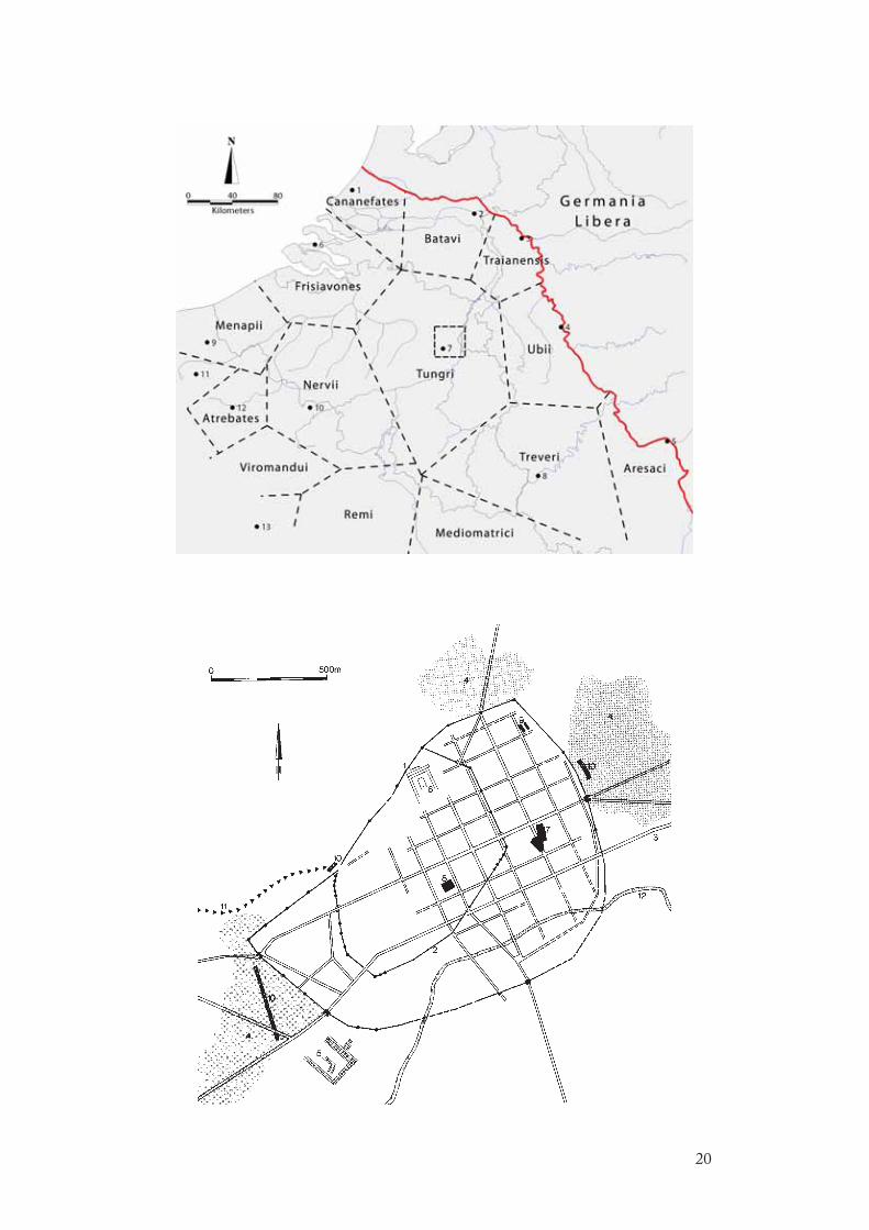
of administration in Gaul (ca. 27-12 bc). He divided Gaul into three provinces
that, in turn, were subdivided into several civitates, to be administered from a new
urban centre.13 The civitas in which the Tongres-Maastricht area was located, the
civitas Tungrorum, adopted the Tungri’s name (see figure 11). Rome, furthermore,
began to place several armies along the northern frontier zone to stabilize the
region like at Xanten, Neuss, Cologne and Mainz. Also in the hinterland Roman
forces guaranteed the relative peace as the site of Trier-Petrisberg shows (Binsfeld
1984).
In and near Tongres there are indications as well that a military site was set
up around the transition from the first century bc to ad. First, part of its Roman
name, ‘Atuatuca’, meaning fortification, supposes some sort of fortification at this
site (Vanvinckenroye 1985: 15-22). Second, archaeological findings of ditches,
trash pits, postholes and Roman artefacts from the Augustan period strengthen
this suggestion. Recent excavations at Tongres-Kielenstraat and Tongres-
Hondsstraat (see figure 12) have given new insights on the dating and Early
Roman development of Tongres (A. Vanderhoeven 1996: 193-215). Ditches,
Roman coins and Samian ware date the earliest occupation phase to ca. 10 bc .
The wealth of the import finds and the long distance from its manufacturing spot
supposes a Roman military camp.
Following the road from Tongres to Maastricht, which was constructed
in the last decades bc or the early-first century ad (Mertens 1983; 1987;
Vanvinckenroye 1985: 35), other indications for military occupation can be found.
Just east of Tongres, at Berg-Tomveld, a lot of Early Roman import material
(Samian ware and republican coins) has been found. Also at the nearby site of
Berg-Trappenberg, with a perfect outlook over Tongres, many republican coins
were found. This evidence suggests some kind of Roman occupation here, most
probably of a military nature. However, if these sites still belonged to the camp at
Tongres or indicate some military outlook post cannot be attested.
The Roman army seems to have brought some stability to the region in the
first decades ad, which led to the first signs of urbanization at Atuatuca Tungrorum.
Under emperor Tiberius, there appears to have been a military decampment at
Tongres. Where these soldiers went to is however unknown. Some suggested to
the Rhine zone to defend the still unstable northern frontier. Yet, also Maastricht,
only 20 km from Tongres, could have been a possible residing place for, at least,
some of the soldiers from Tongres. Maastricht is strategically located where the
road to Cologne crossed the river Meuse. The first signs of military activity was
around 40 ad, which relates to the decampment at Tongres, after which the site
gradually expanded until ca. 70 ad (Panhuysen 1996: 32-33).
At Tongres, after the military left, several two-aisled farmhouses dating to
the Tiberian and early-Claudian period show up in the archaeological record
(see Vanvinckenroye 1985: 26-27; A. Vanderhoeven et al. 1991: 109-110; A.
Vanderhoeven 1996). They are oriented towards the still existing orthogonal
HISTORICAL AND ARCHAEOLOGICAL FRAMEWORK
21
Figure 11 (previous
page; above). Polygon reconstruction of Augustus’ civitates division in Northern Gaul (after Bloemers 1983). Note that they do not represent the actual civitates. 1. Forum Hadriani; 2. Ulpia Noviomagus Batavorum; 3. Colonia Ulpia Traiana; 4. Colonia Claudia Ara Agrippinensium; 5. Mogontiacum; 6. Ganuenta; 7. Atuatuca Tungrorum; 8. Colonia Augusta Treverorum; 9. Castellum Menapiorum; 10. Bagacum; 11. Tarvanna; 12. Nemetacum; 13. Augusta Suessionum.
Figure 12 (previous
page; below).
Roman Tongres (afterVanderhoeven 1996). 1. second-century town wall; 2. fourth-century town wall; 3. Bavay-Cologne road; 4. cemeteries; 5. horreum; 6. temple; 7. Kielenstraat; 8. Hondsstraat; 9. Sacramentstraat; 10. early first-century V-shaped ditches; 11. aqueduct; 12. Geer.

street plan laid out by the army. That a town like Tongres still
depended upon its agrarian function is shown by the marks
of hoofprints inside one of these farmhouses that indicate
the presence of cattle (A. Vanderhoeven (A. Vanderhoeven et al. 1991; Slofstra
1991: 141, 157). Already during this period, the period of
Tiberius and Claudius, Tongres was the civitas capital of
the civitas Tungrorum. This, however, is not shown by the
archaeological material; it was a town in the making, or as
Bloemers (1990: esp. 83) has argued, a proto-urban centre.
Farmhouses like those at Tongres also existed in the
surrounding countryside, as well as the Campine region (see
Slofstra 1991). In the Tongres-Maastricht area, sites like
Smeermaas-Dukatonweg (Pauwels and Creemers 2006) and(Pauwels and Creemers 2006) and and
Neerharen-Rekem (De Boe 1985) illustrate this, while other
sites, though no house plans, also show evidence for Early
Roman occupation (see figures 8 and 13). Exact occupation
dates of these so-called Alphen-Ekeren type of houses could
not be deduced from the findings. Yet, the first house plans
of this type, which is characterized by a row of three or more
heavy, square, central posts, already appear around the first
half of the first century bc (Van der Sanden 1987: 58-59).
The Alphen-Ekeren type seems to supersede the earlier Oss-
Ussen type, which was a transition type between the Iron
Age Haps house and Alphen-Ekeren house (De Boe 1988;(De Boe 1988;
see also Slofstra 1991: fig. 7a). Like Tongres, these Early
Roman settlements in the countryside seem to have been
associated with an agrarian function. Crop cultivation was
the most likely source of food and income, though probably
also some cattle was kept. It is unknown if during this period
there was enough cultivation for a surplus that could be sold on the local markets
or transported to the northern frontier, where most legions were stationed.
In the Roman town of Tongres, already very soon, around the time of
Claudius and Nero, these farmhouses were replaced by larger courtyard houses (A.(A.
Vanderhoeven et al. 1991: 110-111; A. Vanderhoeven 1996). This illustrates the
town’s gradual developing urbanization. Additionally, the adoption of a Roman- gradual developing urbanization. Additionally, the adoption of a Roman-
style courtyard house, painted wall plaster, and the increasing Gallo-Belgic and
Samian ware suggests a developing Roman influence (see A. Vanderhoeven
2001: fig. 2). Scholars have argued that this Early Roman cultural transition was
initialized by native elites (Brandt and Slofstra 1983; Millett 1990; Woolf 1998).
The courtyard houses, therefore, could have been the elites’ home. However, since
some decades earlier Roman military was stationed here, this does not necessarily
have to be the case. Nevertheless, this change seems to be a first start in the
transition to the Middle Roman period.
It thus seems as if the Early Roman period can be defined as one in which
the influence of Rome and the development to a Roman style was only marginally
HISTORICAL AND ARCHAEOLOGICAL FRAMEWORK
22
Figure 13. The site of Smeermaas-Dukatonweg (afterPauwels and Creemers 2006, fig. 3).
felt in Northern Gaul. Until the end of the Early Roman period no evidence for
a large influx of Roman people and material has been found. Slofstra (1991; see
also 1995: 87) has argued for the sandy Campine region that tribal traditions
continued after the Roman conquest, well into the first century (certainly until the
Batavian revolt), what explains, amongst other things, the specific development
of the settlement system. This continuing of traditions, as Slofstra argued, may
also be assumed for the Tongres-Maastricht area, because it is not really different
from the sandy Campine region. This is also shown in the burial evidence from
Northern Gaul (and the Tongres-Maastricht area in particular), which shows
continuation with the previous Late Iron Age (see Hiddink 2003: 1-76). In the(see Hiddink 2003: 1-76). In the
Tongres-Maastricht area, only the suggested burials at Berg stand out for their
differences compared to the other burials. These, however, seem to have been
related to the aforementioned, nearby military presence. This Roman military (and
later civilian) occupation in and near Tongres causes the only cultural difference
with the Campine region.
Those inhabiting Tongres’ courtyard houses did not enjoy the house for long.
Only one generation after the first houses were built, destruction hit. The date, ca.
69 ad, concurs with the year the Batavian revolt struck large parts of Northern
Gaul. Not only the courtyard houses were doomed; all over Tongres a layer of
ashes can be found that dates to 69 ad (Vanvinckenroye 1985: 40). It thus seems
that this revolt also spread into the Tongres-Maastricht area and its central place
Tongres. It marks the transition from the Early to the Middle Roman period.
Middle Roman Period (70 - 270 AD)During the Middle Roman period, a Pax Romana was established in Northern
Gaul under which prosperity, growth and cultural integration arose. This is
evident from the archaeological material from that period. The heavily debated
architectural form of the Roman villa is to be seen everywhere in the fertile region.
Additionally, the northern frontier zone gets an official civitates division (Slofstra
1991: 137). Because of this, a new province was established in this zone, Germania
Inferior. While some still doubt it (Nouwen 1997; Bérard 1999), scholars now
seem to agree that the civitas Tungrorum from the Middle Roman period onwards
becomes part of this new province (Vanvinckenroye 1994b; Raepsaet-Charlier
1995; 1999; 2003; A. Vanderhoeven 2001; 2002).
After the Batavian revolt, there is a rapid urbanization spreading across the
loess region of Northwestern Europe. The number of sites seem to rise enormously
in this period compared to the Early Roman occupation phase (cf. maps 2 and
3). This has also been argued by Duurland (2000: 26-27), who in addition has
tried to give a more detailed development and eventual decline during the Middle
Roman period. Following his work, there was a gradual growth in sites until
around the mid-second century ad. After ca. 190 ad, the number of sites seems
to decline, caused by the economic and military crisis that culminated into the
Frankish invasions during the late-third century ad. Other Regions on the loess
adjoining the Tongres-Maastricht area like the German Rhineland show this
HISTORICAL AND ARCHAEOLOGICAL FRAMEWORK
23
same development (see Gechter and Kunow 1986; Lenz 1999: 71-74).
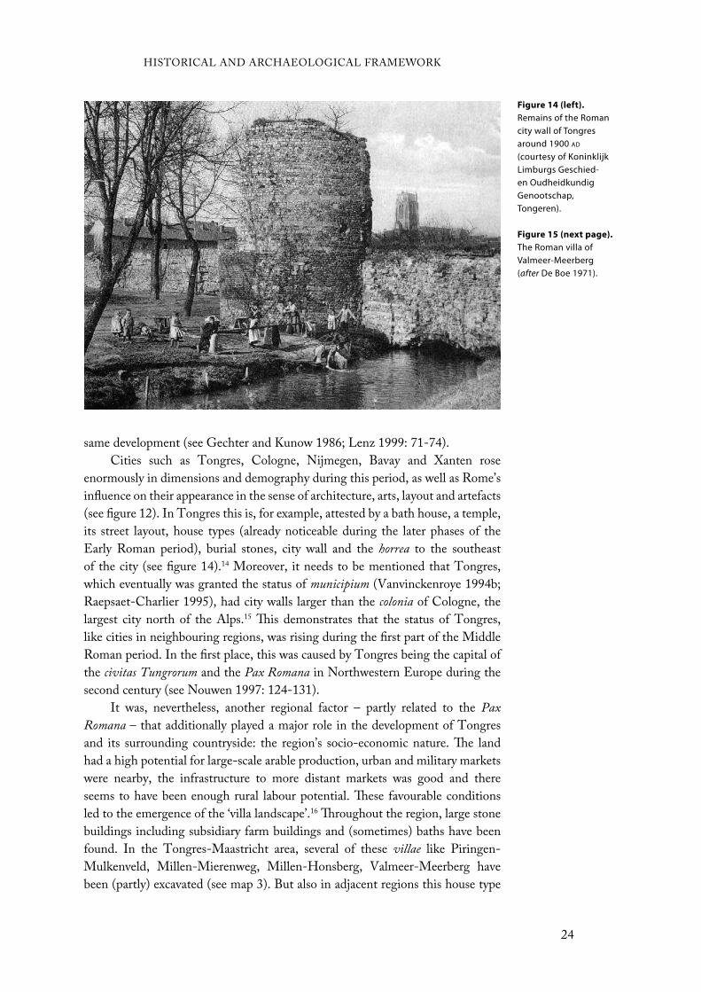
Cities such as Tongres, Cologne, Nijmegen, Bavay and Xanten rose
enormously in dimensions and demography during this period, as well as Rome’s
influence on their appearance in the sense of architecture, arts, layout and artefacts
(see figure 12). In Tongres this is, for example, attested by a bath house, a temple,
its street layout, house types (already noticeable during the later phases of the
Early Roman period), burial stones, city wall and the horrea to the southeast
of the city (see figure 14).14 Moreover, it needs to be mentioned that Tongres,
which eventually was granted the status of municipium (Vanvinckenroye 1994b;
Raepsaet-Charlier 1995), had city walls larger than the colonia of Cologne, the
largest city north of the Alps.15 This demonstrates that the status of Tongres,
like cities in neighbouring regions, was rising during the first part of the Middle
Roman period. In the first place, this was caused by Tongres being the capital of
the civitas Tungrorum and the Pax Romana in Northwestern Europe during the
second century (see Nouwen 1997: 124-131).
It was, nevertheless, another regional factor – partly related to the Pax
Romana – that additionally played a major role in the development of Tongres
and its surrounding countryside: the region’s socio-economic nature. The land
had a high potential for large-scale arable production, urban and military markets
were nearby, the infrastructure to more distant markets was good and there
seems to have been enough rural labour potential. These favourable conditions
led to the emergence of the ‘villa landscape’.16 Throughout the region, large stone
buildings including subsidiary farm buildings and (sometimes) baths have been
found. In the Tongres-Maastricht area, several of these villae like Piringen-
Mulkenveld, Millen-Mierenweg, Millen-Honsberg, Valmeer-Meerberg have
been (partly) excavated (see map 3). But also in adjacent regions this house type
HISTORICAL AND ARCHAEOLOGICAL FRAMEWORK
24
Figure 14 (left).
Remains of the Roman city wall of Tongres around 1900 AD
(courtesy of Koninklijk Limburgs Geschied- en Oudheidkundig Genootschap, Tongeren).
Figure 15 (next page).
The Roman villa of Valmeer-Meerberg (after De Boe 1971).

began to dominate the landscape during this time (e.g. De Boe 1976; Willems
1987; Vanvinckenroye 1988a; Opsteyn and Lodewijckx 2001; Heimberg 2003;
Tichelman 2005).
The most common type of villa was the winged corridor house which
had a portico and two projecting wings on the front (see figure 15). The villa
of Valmeer-Meerberg may serve as an example of this type (De Boe 1971a).
The Northwest European villae seem to have had a stone foundation with walls
half-timbered with daub between the timbers. Most, furthermore, had plastered
and painted walls, window glass and tiled roofs (see Heimberg 2003: 109-110).
Subsidiary buildings were mostly timber-built of which only postholes remain in
the archaeological record, although examples entirely out of stone have also been
found.
This type of house architecture had a very distinctive character. It was the
first time that stone was used in house construction, as well as the first evidence
of Roman architectural forms in the Northwest European countryside. In the
past, these villae therefore have often been associated with the settling of Roman
veteran soldiers in the region, gradually forcing the natives out (see De Maeyer
1937). However, from around the 1950s scholars detected Late Iron Age/Early
Roman postholes underneath Roman villas that were ‘invisible’ before (De Boe
1971b; Woolf 1998: 151; Heimberg 2003: 64-77).17 This association between
Late Iron Age/Early Roman ‘native’ building style and the Roman villas led to a
consideration of continuation in the community’s occupation. This continuation
has also been attested by the finds relating to the matronae, an ancestral mother
goddesses cult of which well over 500 votive altars have been found in the German
Rhineland. Altars belonging to this cult were often mounted in niches within
villas. The epithets on some of these altars mention Celtic and Germanic names,
HISTORICAL AND ARCHAEOLOGICAL FRAMEWORK
25
thereby linking it to pre-Conquest roots of its inhabitants (Derks 1998: 119-130;
Carroll 2001: 117-119). On the other hand however, the way the altars were
shaped, the conventional epigraphic Latin being used and the time of appearance
(second century ad), argue at the same time for a view of integration with Roman
social forms and practices (Woolf 2003). Consequently, scholars are nowadays of
the opinion that the process of cultural interaction between natives and Romans
together with economic motives led to the gradual development and introduction
of the villas (e.g. Slofstra 1983).
This may also have played a role in the differences in shape and size of the
villae; not only between regions, but also within one. It has been demonstrated,
for example, that the northern sandy region developed slower than the loess zone.
This can be illustrated by the development of the small settlement of Hoogeloon
(the Netherlands), where it has been attested that the most central building
developed and expanded into a villa only in the third century ad (Slofstra 1987;
1991). Most villae on the loess existed by that time already more than a century.
The difference within one region is demonstrated through a comparison of
the second century ad villae of Valmeer-Meerberg (ca. 472,5 m2), a more common
size, with that of Haccourt (ca. 5.000 m2), just south of the Tongres-Maastricht
area, or that of Voerendaal (ca. 540-3.000 m2).18 What caused this size difference
mostly has been explained in terms of wealth and power; the larger villae would
have dominated the smaller ones in the neighbourhood. Archaeological nor
historical sources, nonetheless, have thus far demonstrated this. Size has also been
related to the rank of a person owning the villa. Three inscriptions found at the
villa Ravensbosch (the Netherlands), however, seem to object this assumption. All
mention the person Titus Tertinius, a high-ranked person from Xanten, which
could be considered as the owner of the villa (Remouchamps 1925; Slofstra 1983:
93-94). The fact that this villa was of a normal size, while the person probably
owning the villa seems rather powerful, may suggest that the size of a villa is not
related to a person’s status (see also chapter 7).
Size calculations of the land belonging to a villa tend to a remarkable
correspondence between the villas in this region.19 On the basis of the distances
between villa-complexes in the region between the rivers Rhine and Meuse,
scholars have calculated that most complexes would have had around 50 ha of
arable land (Gaitzsch 1986: 407-408; Heimberg 2003: 127-129).20 This size
corresponds to observations in the Somme basin (France), which would “have
been heavily exploited for their grain-bearing propensities” (Wightman 1975:
639). Remarkably, a land size of 50 ha equals the size of one Roman century
(50,12 ha). Though, it also seems that some of the larger villa-complexes were
surrounded by larger land plots. Heimberg (2003: 129) therefore has argued that
a villa’s land size could relate to the size of the villa itself. None of the villae
in the Northwestern provinces, however, come close to villa sizes observed in,
for example, Switzerland, Southern Germany and France of 3.000 to 6.000 ha
(Heimberg 2003: 129).
The villas on the Northwest European loess zone were probably mixed farms
where people lived of agriculture and animal husbandry. In order to make a surplus
HISTORICAL AND ARCHAEOLOGICAL FRAMEWORK
26

production that could be sold on the market, it needed to lay its focus on the
production of cereals (Kooistra 1996: 85-116; Kreuz 1999: 95). Kooistra (1996:
63-72) doubts if these villae on the loess would have supplied the markets of the
northern frontier along the Rhine, since evidence from the ‘Kromme Rijn’ also
suggests some possibilities for surplus production in the northern frontier zone.
However, the study by Pals and Hakbijl (1992: 298) of botanical remains from
a grain cargo found at Woerden demonstrates that the ship’s grain originated
from the Belgian loess area. Furthermore, evidence from Tongres shows that
grain becomes more important as a food source
during the the Roman period (A. Vanderhoeven
et al. 1991: 117-118). Lastly, Kreuz (1999: 91-94)
has shown that an area within the ‘villa landscape’
could easily produce enough food to feed the
Roman army. Thus, it seems that, although it not
directly has been attested at villa sites, these villae
did seem to have produced a surplus of cereals to
supply – at least, partly – the cities and the Roman
legions in the frontier zone.
Who, then, were the inhabitants of these
villae? Inscriptions from the villa Ravensbosch
have shown that relatively high-ranked persons
might have lived here (see above). In the past,
scholars assumed that it were mostly Romans retired from nearby military camps
who settled in villae throughout this region. Lenz (2006), nevertheless, has
recently demonstrated by archaeological traces of these retired soldiers that they
mainly remained in central towns like Cologne or in its immediate hinterland,
a day’s ride to the nearest central town. This suggests that mostly ‘native’ people
would have occupied the villae away from the central towns. Yet, while the above
and the aforementioned continuation from ‘native’ house types to Roman villae
strengthen this view, these people gradually would have become more familiar
with Roman cultural forms in terms of material and architecture during the course
of the Roman period. This development in style becomes more obvious from the
evidence of new, imported, exotic food, of which the numbers rise during the
Middle Roman period, especially at Roman villae (Bakels and Jacomet 2003).
Burials, too, seem to demonstrate a gradual socio-cultural change in
Northwestern Europe. During the Middle Roman period, all over the area large
burial mounds, i.e. tumuli, are set up in the vicinity of villae. In the Tongres-
Maastricht area, amongst others, some of these mounds are still visible (see figure
16).21 Based on continuity with the Bronze and Iron Age burial mounds, some
have argued that these tumuli were cultural signs of pre-Conquest indigenous
people (Ferdière 2004). However, it not necessarily reflects this continuation of
pre-Roman habits, since also in Roman Italy and other areas burial mounds are
found. Therefore, most scholars argue that these burial mounds reflect a change
towards Roman values and customs of the native inhabitants of the countryside
(most recently Massart 2007). This has been concluded from grave goods buried
HISTORICAL AND ARCHAEOLOGICAL FRAMEWORK
27
Figure 16. Still visible Roman burial mound in the Tongres-Maastricht area (photo by T. Vanderbeken, courtesy of ZOLAD).

along with the deceased’s body, which conforms to the
Roman standard of burying. Thus, it seems to be a regional
adoption of Roman cultural praxis.
However, arguing against a ‘Romanization’ of the
countryside, in recent years a remarkable discovery has
been found on the loess. At the sites Kerkrade-Winckelen
(the Netherlands) and Veldwezelt (Tongres-Maastricht
area; see figure 17), several ‘native’ farmsteads (Alphen-
Ekeren type) have been found which, in contrast to all
other, did not disappear after the first century ad, but
remained inhabited until the third century ad (Dijkstra
1997; Wesemael 2006).22 This dating has been based on
the extending size of ‘native’ farmsteads through time.
Some even attained lengths of ca. 26 m in the third century
ad (Slofstra 1991: 137-145). Before Kerkrade-Winckelen(Slofstra 1991: 137-145). Before Kerkrade-Winckelen
and Veldwezelt were discovered, such second and third
century farmsteads only were found in the northern sandy
region like at Hoogeloon and Oss-Ussen. It has been
thought for a long time that these farmsteads were indications of the ‘lack’ of
cultural interaction between Romans and natives. However, the fact that on the
loess these farmsteads co-existed with the Roman villae, which had a totally
different repertoire of material culture, seems not to support this thought. More
remarkably so, is that at Veldwezelt, the excavators have found evidence for twot Veldwezelt, the excavators have found evidence for two
drink pools for animals, while it has been thought that this region would have
had a predominant agricultural basis. Animal husbandry was thought to have
had only a minor role (see above). The implications of these finds on our view
of this region is something that based on only two sites is difficult, maybe even
impossible, to predict, however.
In sum, the Middle Roman period in the Tongres-Maastricht area – like
in adjacent areas – is a period of development towards a picture that conforms
to Roman values, customs and style. This is evident from architecture, art, city
planning, artefacts, burials and maybe even habits. On the latter, we already
have mentioned the Roman temple and the votive altar dedicated to Jupiter at
Tongres. However, also indications in Tongres’ hinterland show evidence for
Roman praxis. For example, at Hoeselt a Mercurius statue with inscription has
been found and at Zichen-Zussen-Bolder two fragments belonging to a statue
depicting a seated Roman goddess Iuno have been found (Capenberghs 1985:
149-150; Nouwen 1991; see also Mertens 1964: 28-34; Vanvinckenroye 1985:
69-75; De Beenhouwer 1991: 62, for other examples from the region). However,
at the beginning of the third century ad things again seem to change for the
Tongres-Maastricht area.
HISTORICAL AND ARCHAEOLOGICAL FRAMEWORK
28
Figure 17 (above).
The site of Veldwezelt (after Wesemael 2006).
Figure 18 (next
page). The Late Roman settlement of Neerharen-Rekem; Germanic longhouses (grey) and sunken huts (black) (afterCarroll 2001; adopted from De Boe 1985).
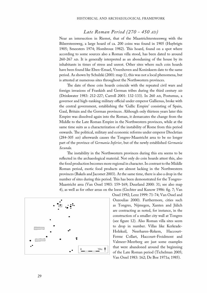
Late Roman Period (270 - 450 AD)Near an intersection in Riemst, that of the Maastrichtersteenweg with the
Bilzersteenweg, a large hoard of ca. 200 coins was found in 1905 (Huybrigts
1905; Smeesters 1974; Hombroux 1982). This hoard, found on a spot where
according to some sources also a Roman villa stood, has been dated to around
260-267 ad. It is generally interpreted as an abondaning of the house by its
inhabitants in times of stress and unrest. Other sites where such coin hoards
have been found like Eben-Emael, Vroenhoven and Koninksem date to the same
period. As shown by Schulzki (2001: map 1), this was not a local phenomena, but
is attested at numerous sites throughout the Northwestern provinces.
The date of these coin hoards coincide with the repeated civil wars and
foreign invasions of Frankish and German tribes during the third century ad
(Drinkwater 1983: 212-227; Carroll 2001: 132-133). In 260 ad, Postumus, a
governor and high-ranking military official under emperor Gallienus, broke with
the central government, establishing the ‘Gallic Empire’ consisting of Spain,
Gaul, Britain and the German provinces. Although only thirteen years later this
Empire was dissolved again into the Roman, it demarcates the change from the
Middle to the Late Roman Empire in the Northwestern provinces, while at the
same time suits as a characterization of the instability of Rome from this period
onwards. The political, military and economic reforms under emperor Diocletian
(284-305 ad) afterwards causes the Tongres-Maastricht area to be no longer
part of the province of Germania Inferior, but of the newly established Germania
Secunda.
The instability in the Northwestern provinces during this era seems to be
reflected in the archaeological material. Not only do coin hoards attest this, also
the food production becomes more regional in character. In contrast to the Middle
Roman period, exotic food products are almost lacking in the Northwestern
provinces (Bakels and Jacomet 2003). At the same time, there is also a drop in the
number of sites during this period. This has been demonstrated for the Tongres-
Maastricht area (Van Ossel 1983: 159-169; Duurland 2000: 31; see also map
4), as well as for other areas on the loess (Gechter and Kunow 1986: fig. 7; Van
Ossel 1992; Lenz 1999: 71-74; Van Ossel and
Ouzoulias 2000). Furthermore, cities such
as Tongres, Nijmegen, Xanten and Jülich
are contracting as noted, for instance, in the
construction of a smaller city wall at Tongres
(see figure 12). Also Roman villa sites seem
to drop in number. Villas like Kerkrade-
Holzkuil, Neerharen-Rekem, Haccourt-
Ferme Collart, Haccourt-Froidmont and
Valmeer-Meerberg are just some examples
that were abandoned around the beginning
of the Late Roman period (Tichelman 2005;
Van Ossel 1983: 162; De Boe 1971a; 1985).
HISTORICAL AND ARCHAEOLOGICAL FRAMEWORK
29

This ‘degrading’ landscape has been equated to a ‘third century crisis’ caused
by an economic decline and an instable society due to consequent invading tribes.
This so-called ‘third century crisis’ not only appeared in the Northwest, also in
Italy, Spain and the rest of Gaul villae were abandoned (see Lewit 2003; Marzano
2007: fig. 19). The term ‘crisis’, however, has in the last 15 years heavily been
criticized (Van Ossel 1992; Van Ossel and Ouzoulias 2000; Lewit 2003; Marzano
2007: 199-222).
First, not all sites perished. In Italy, Germany and Belgium only some 50
percent disappear at first during the ‘crisis’ period (see Van Ossel 1992: table 3;
Lenz 1999: 71-74; Duurland 2000: 31; Marzano 2007: fig. 19). At several sites in
(or near) the Tongres-Maastricht area, for instance, continuity in occupation has
been shown. The villa Wange-Damekot (west of the Tongres-Maastricht area),
after a third century fire, remained occupied into the fourth century ad, during
which also two sunken huts (grubenhaus) were built (Opsteyn and Lodewijckx
2001: 223-226). The sites of Lixhe and Herstal, just south of the Tongres-
Maastricht area, also demonstrate this continuity (Van Ossel 1983: 167). Lastly,
at Neerharen-Rekem an entire settlement appears during the fourth century ad
consisting out of 25 grubenhäuser (De Boe 1985: 60-62; fig. 18).
Secondly, scholars assimilate abandoned villas with abandoned lands.
However, as Ward-Perkins (2000: 324-325) stated in the case of the apparent
lack of site occupation in Italy in the seventh and eighth century ad, this is “self
evidently nonsense: there must have been people living in these areas, and we just
cannot find them.” In the case of the Northwest this seems to have been caused
by a lack of coins and friable, often undatable local pottery (Lewit 2003: 268),
while also the gradual replacement of stone as building material must not be
neglected. This lack of material for this period sets scholars in a strong position to
speculate about how many people would have lived here and, consequently, can
easily create a view of ‘crisis’.
It seems more reasonable to view the major transformation in the Later
Roman Empire not as ‘crisis’ but as a cause of the changed social, political and
religious conditions in this part of the Empire (Lewit 2003: 270-271; Marzano
2007: 222). Germanic and Frankish tribes, which by now penetrated into the
northern frontier region, would have (socio-culturally) influenced the people living
on Roman territory considerably just as this was the case when the Romans took
over control in this region some three hundred years before. It has been argued that
the second ‘cultural revolution’ appeared around the fifth-sixth century ad (Lewit
2003: 270-271; see Woolf 1995, for the term ‘cultural revolution’). However, in
the Northwestern provinces this ‘cultural revolution’ happened earlier than, for
example, in Italy and Southern Gaul, just as it was the other way around during
the first ‘cultural revolution’ (see Woolf 1995). Moreover, such a socio-cultural
transform would not appear out of nowhere and was probably already felt in the
period before, though not as strongly.
Due to military reforms under Diocletian and Constantine, the Roman
legion’s strength declined considerably in the Northwestern provinces (from
6.000 to 1.000 men each). This and the fluctuating border of the Empire may
HISTORICAL AND ARCHAEOLOGICAL FRAMEWORK
30

Figure 19. Roman burial practices in the Tongres-Maastricht area.
have cost the frontier zone’s fertile hinterland, thus also the Tongres-Maastricht
area, a considerable amount of its surplus market. As Marzano (2007: 210) noted
for Central Italy, “product distribution patterns [changed] from provincial to
regional markets”. The study by Bakels and Jacomet (2003) seems to agree to this
notion.
Lastly, Christianity seems to have influenced the reshaping of Late Antique
attitudes in the Tongres-Maastricht area, where Saint Servatius was bishop
during the mid-fourth century ad. A result of this reform was that villa buildings
were transformed to serve new Christian functions. During recent excavations
underneath Tongres’ basilica, the excavators have found evidence for a fourth
century ad predecessor bearing a tentative relationship with Christianity (A.
Vanderhoeven, pers. comm.). The fact that earlier an urban villa stood on that
spot may reflect a transformation in cultural circumstances. Also in the burial
HISTORICAL AND ARCHAEOLOGICAL FRAMEWORK
31
evidence, this transformation is noticeable. No new burial mounds, which were
interpreted as a local adaptation to Roman customs, were erected in the Late
Roman period. Moreover, cremation gradually made way for inhumation during
the Late Roman period in the Tongres-Maastricht area (see figure 19).
In conclusion, the Late Roman period was a time of change from a Roman
style of material culture and customs to a new style and consequently customs. The
Roman landscape, shaped in the Early Roman and matured during the Middle
Roman period, seems to have transformed again into a new one. Burial practices,
architecture and artefacts demonstrate this. However, the (non-melancholic)
memory of the Romans remained inscribed into the landscape, though partially.
Remains of once occupied, but now deserted, houses were stil part of the
Merovingian landscape. This can be illustrated by the Merovingian burial site
Rosmeer-Diepestraat, dated around ca. 550-700 ad, which lay partly on top of
the remains of an older villa (H. Roosens and Janssens 1978). This was not a
specific feature for the Tongres-Maastricht area, but something which happened
throughout the Empire during its aftermath (see Lewit 2003: 262, esp. n. 6).

As Raymond Chevallier has put it quite well, boundaries can be a difficult concept
to grasp. Larger territories like vici, pagi, civitates and provinciae seem to have not
been surrounded by visible boundaries such as hedges, roads, fences or ditches.
As mentioned before, with certain Roman cadastres this was the opposite. People
like Falbe, Legnazzi and Bradford easily recognized cadastres in the landscape
because of their visibility and material remains. Chevallier’s quote does not refer
to this. What he meant were the ‘invisible’ lines in the modern landscape, often
disappeared due to transformations of the landscape or which never even existed
in the sense of concrete boundaries.
In the case of the ones that perished due to transformations of the landscape,
the best method of study is of course excavation. When boundaries are attested at
several spots on the same line this may suggest a boundary during some period in
history. When, furthermore, dateable material is found related to that boundary,
it provides a firm date for the period of the actual boundary. In several cases
this method of enquiry has been used with success (Chouquer and Favory 1991;
Berger and Jung 1999; Vermeulen and Antrop 2001; van der Leeuw et al. 2003).
In general, excavations give clear evidence and a precise date for boundaries and
seem therefore well accepted by scholars. There, however, are certain problems
regarding the scale of cadastres, which could extend over more than 200 km as
attested around Carthage. Applying the methodology of excavation to define all
boundaries would seem as an impossible task.
In the case of boundaries that never have existed in a concrete form,
excavation seems useless. Scholars therefore have been in need of new methods
and techniques. Dating cadastres by these methods and techniques seems harder
than in the case of excavation. As a result, many scholars have been doubtful
“La definition des limites de tous orders (propriétés privées, vici,
pagi, civitates, provinciae) est un des principaux problèmes poses à la
topographie historique.”
Chevallier 2001: 13
Studying Roman Cadastres
33
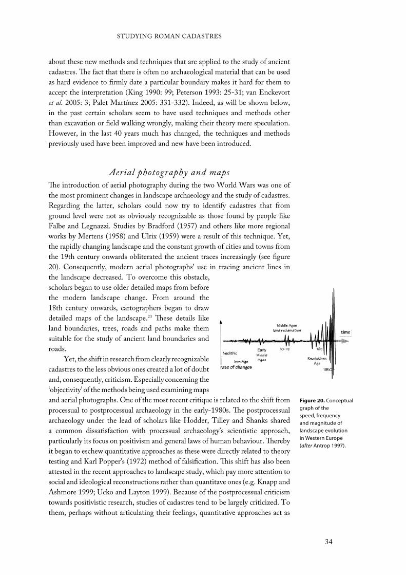
about these new methods and techniques that are applied to the study of ancient
cadastres. The fact that there is often no archaeological material that can be used
as hard evidence to firmly date a particular boundary makes it hard for them to
accept the interpretation (King 1990: 99; Peterson 1993: 25-31; van Enckevort
et al. 2005: 3; Palet Martínez 2005: 331-332). Indeed, as will be shown below,
in the past certain scholars seem to have used techniques and methods other
than excavation or field walking wrongly, making their theory mere speculation.
However, in the last 40 years much has changed, the techniques and methods
previously used have been improved and new have been introduced.
Aerial photography and mapsThe introduction of aerial photography during the two World Wars was one of
the most prominent changes in landscape archaeology and the study of cadastres.
Regarding the latter, scholars could now try to identify cadastres that from
ground level were not as obviously recognizable as those found by people like
Falbe and Legnazzi. Studies by Bradford (1957) and others like more regional
works by Mertens (1958) and Ulrix (1959) were a result of this technique. Yet,
the rapidly changing landscape and the constant growth of cities and towns from
the 19th century onwards obliterated the ancient traces increasingly (see figure
20). Consequently, modern aerial photographs’ use in tracing ancient lines in
the landscape decreased. To overcome this obstacle,
scholars began to use older detailed maps from before
the modern landscape change. From around the
18th century onwards, cartographers began to draw
detailed maps of the landscape.23 These details like
land boundaries, trees, roads and paths make them
suitable for the study of ancient land boundaries and
roads.
Yet, the shift in research from clearly recognizable
cadastres to the less obvious ones created a lot of doubt
and, consequently, criticism. Especially concerning the
‘objectivity’ of the methods being used examining maps
and aerial photographs. One of the most recent critique is related to the shift from
processual to postprocessual archaeology in the early-1980s. The postprocessual
archaeology under the lead of scholars like Hodder, Tilley and Shanks shared
a common dissatisfaction with processual archaeology’s scientistic approach,
particularly its focus on positivism and general laws of human behaviour. Thereby
it began to eschew quantitative approaches as these were directly related to theory
testing and Karl Popper’s (1972) method of falsification. This shift has also been
attested in the recent approaches to landscape study, which pay more attention to
social and ideological reconstructions rather than quantitave ones (e.g. Knapp and
Ashmore 1999; Ucko and Layton 1999). Because of the postprocessual criticism
towards positivistic research, studies of cadastres tend to be largely criticized. To
them, perhaps without articulating their feelings, quantitative approaches act as
Figure 20. Conceptual graph of the speed, frequency and magnitude of landscape evolution in Western Europe (after Antrop 1997).
STUDYING ROMAN CADASTRES
34

barriers, since they view the world as a place that is too complex to be quantified.
Due to mostly this association, quantitative approaches may therefore not aid the
acceptance of a piece of work.
However, it is the interpretation of the aerial photographs and maps that has
been criticized the most.Some argue that the orientation of the cadastres was always
determined either astronomically or by main roads. Rackham (1986: 159) claims,
for example, that centuriation is “oriented exactly north and south (occasionally
at 45°)”. And Van Londen (2006: 188) recently mentioned that “centuriation
was absolute and not affected by local topography”. These misconceptions seem
to have been caused by several factors. For example, the drawings in the Corpus
Agrimensorum and other tablets almost always appear as straight horizontal and
vertical lines, easily assumed to relate to east-west and north-south (Peterson
1993: 8-10). Furthermore, Frontinus and Varro stated that the art of surveying
originated from the Etruscan haruspices, who orientated the sides of a temple in
the direction of the four cardinal points (Cuomo 2000: 191). The two main lines
of a cadastre, the decumanus and cardo, are therefore commonly associated with
their general orientation, respectively east-west and north-south. Others have
viewed roads, chiefly the main road through a region, as a determinant for the
orientation (Mertens 1958; Potter 1987: 121; Caravello and Michieletto 1999:
45). The Via Aemilia, the main road through the Po valley, may serve here as an
example.
Chouquer (1981), however, has shown that not all cadastres around this
road were aligned to the Via Aemilia. Furthermore, concerning the astronomical
orientation, the orientation in the Corpus Agrimensorum and other tablets does
not correspond with their actual orientation in the landscape. The cadastres of
Orange, of which the tablets are displayed in a north-south/east-west manner
for readability purposes, are in reality of a different orientation than this display
assumes. Consequently, this ‘static’ view of scholars leads to the problem that
other possibilities of orientations are excluded, what may result in a dismissal of
certain traces of cadastres.
Despite the probability that some cadastres were based on main roads
or astronomically determined, it is clear that not all were. In the Corpus
Agrimensorum, one can find nine different factors that could determine the
orientation of a cadastre (see table 3). Which factor the surveyors used would
vary from case to case, and maybe even from time to time. They could stress
emphasis on the geography in regions where this was helpful. Furthermore,
different surveyors working in a region already surveyed before could stress other
factors as more important as their predecessors did. Although Le Gall (1975:
301-308) argued that only one factor determined the orientation of a cadastre,
in reality this might not always have been the case. Roman land-surveyors could
use different factors together, combining for example cultural and natural ones
(Peterson 1993: 12).
Nevertheless, as mentioned in the introduction, still the most often heard
critique is that the scholars who study cadastres base their identification on a
biased interpretation. The critics wonder how to identify a two millennia old
STUDYING ROMAN CADASTRES
35

cadastre seemingly without any traces in the modern landscape. In their eyes,
interpretations are biased towards a finding of such cadastres, i.e. ‘optimistic
proposals’ (King 1990: 99). They argue that a landscape left far more traces of past
human occupation than the features the scholars use to reconstruct the cadastre.
The historical and spatial association of modern linear features like roads, ditches
and other modern boundaries with Roman cadastres has been adopted as a pre-
given, while in fact this has to be determined. Since the direct relation between
the cadastre and the modern features in the landscape is often not clearly present
due to changes in this landscape or due to other means, its conclusions do not
hold according to these critics.
Since these first so-called ‘optimistic proposals’ though, many methodological
developments have been introduced that challenge the critics’ view on the methods
by which scholars have studied cadastres. Already in the 1960s a technique called
‘optical filtering’ was used to establish a more secure and objective interpretation
of aerial photographs (see Chevallier et al. 1970). This technique uses negatives
of photos to construct a spectral image generated by laser light. Features in the
spectrum will reflect the organisation of features in the original photograph.
Parallel features will be shown by a line at right angles to the orientation of
the original features. The clearer the line, the clearer the parallel features are.
From the space between these lines, an interval can be calculated. By adding a
special opaque filter, only features within a limited range of angles will be made
visible, thereby enhancing the way of interpreting these aerial photographs. This
technique, however, still favours theoretical, cultural and/or personal reasons; the
choice why these features and lines are part of a Roman cadastre still has to be
made clear.
To go beyond these constraints, the technique of ‘directional filtering’ has
been applied to the identification of ancient cadastres. This technique identifies
automatically those directions in which the greatest number of similarly orientated
traces appear (Favory 1980: 373-382). It has been used in several cases, whether
to detect Roman or medieval cadastres (Chouquer and Favory 1980; Clavel-
Lévêque 1983b; Chouquer 1985). The technique introduces a greater degree of
STUDYING ROMAN CADASTRES
36
Environmental factors
1. The sea, parallel and perpendicular to the coast
2. Relief, the general direction of drainage
3. The maximum extent of the territory
4. A via consularis, i.e. main road
5. An orientation different to that of the cadastre of a neighbouring territory, to avoid confusion
Astronomical factors
1. Orientation towards the rising sun
2. Orientation of kardines due north-south
3. As 1, but with the decumani and cardines inverted
4. As 2, but with the decumani and cardines inverted
Table 3. Factors theoretically affecting the orientation of Roman cadastres (after Peterson 1993: fig. 1.2 adapted from Le Gall 1975).
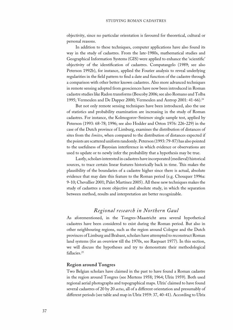
objectivity, since no particular orientation is favoured for theoretical, cultural or
personal reasons.
In addition to these techniques, computer applications have also found its
way in the study of cadastres. From the late-1980s, mathematical studies and
Geographical Information Systems (GIS) were applied to enhance the ‘scientific’
objectivity of the identification of cadastres. Compatangelo (1989; see also
Peterson 1992b), for instance, applied the Fourier analysis to reveal underlying
regularities in the field pattern to find a date and function of the cadastre through
a comparison with other better known cadastres. Also more advanced techniques
in remote sensing adopted from geosciences have now been introduced in Roman
cadastre studies like Radon transforms (Bescoby 2006; see also Romano and Tolba
1995; Vermeulen and De Dapper 2000; Vermeulen and Antrop 2001: 41-66).24
But not only remote sensing techniques have been introduced, also the use
of statistics and probability examination are increasing in the study of Roman
cadastres. For instance, the Kolmogorov-Smirnov single sample test, applied by
Peterson (1993: 68-78; 1996; see also Hodder and Orton 1976: 226-229) in the
case of the Dutch province of Limburg, examines the distribution of distances of
sites from the limites, when compared to the distribution of distances expected if
the points are scattered uniform randomly. Peterson (1993: 79-87) has also pointed
to the usefulness of Bayesian interference in which evidence or observations are
used to update or to newly infer the probability that a hypothesis may be true.
Lastly, scholars interested in cadastres have incorporated (medieval) historical
sources, to trace certain linear features historically back in time. This makes the
plausibility of the boundaries of a cadastre higher since there is actual, absolute
evidence that may date this feature to the Roman period (e.g. Chouquer 1996a:
9-10; Chevallier 2001; Palet Martínez 2005). All these new techniques makes the
study of cadastres a more objective and absolute study, in which the separation
between method, results and interpretation are better recognizable.
Regional research in Northern GaulAs aforementioned, in the Tongres-Maastricht area several hypothetical
cadastres have been considered to exist during the Roman period. But also in
other neighbouring regions, such as the region around Cologne and the Dutch
provinces of Limburg and Brabant, scholars have attempted to reconstruct Roman
land systems (for an overview till the 1970s, see Raepsaet 1977). In this section,
we will discuss the hypotheses and try to demonstrate their methodological
fallacies.25
Region around Tongres
Two Belgian scholars have claimed in the past to have found a Roman cadastre
in the region around Tongres (see Mertens 1958; 1964; Ulrix 1959). Both used
regional aerial photographs and topographical maps. Ulrix’ claimed to have found
several cadastres of 20 by 20 actus, all of a different orientation and presumably of
different periods (see table and map in Ulrix 1959: 37, 40-41). According to Ulrix
STUDYING ROMAN CADASTRES
37
(1959: 39, 42-43), all cadastres ran through one central point on the modern
‘Eeuwfeestwal’, where one of Tongres’ Roman gates is thought to have been
located. He argued, therefore, that this was the point from which all cadastres
were surveyed and laid out.
His claim for several differing orientations that dated to different periods
of surveying in Roman times could have been plausible considering the cadastres
from Orange and Béziers, where this also has been attested. However, in light of
Ulrix’ methodology, his suggestion seems very unlikely. Ulrix (1959: 36) used a
transparent sheet of paper on which he had drawn a scaled 20 by 20 actus cadastre
that he pushed over a map in order to correspond the centuriae with lines on the
map (roads, land boundaries etc.). By doing this for the entire area, he was able to
identify several blocks of centuriae, which he consequently associated with different
Roman cadastres. However, Ulrix clarified nowhere the reason behind the using
of these specific lines on the map as boundaries of the proposed cadastres; there
is no relation between these ‘boundaries’ and a possible Roman date. Following
this method, one could probably find Roman cadastres all over the world, even in
China and the United States.
Mertens’ first identified a cadastre to the east of Tongres that was aligned to
the Roman road running from Tongres to Maastricht (see figure 21). This cadastre,
of which the size of the different land plots was unknown, had an orientation of
ca. 60˚ northeast (Mertens 1958: 259). He even related this cadastre to the one
suggested for Cologne, which had almost the same orientation, 59˚ northeast
(Klinkenberg 1936; see below). Later, he also found evidence for several other
Figure 21. The proposed cadastre to the east of Tongres (after Mertens 1958). 1. Roman roads; 2. limites;3. villae (unknown or known localisation); 4. Roman finds; 5. tumuli (unknown or known localisation); 6. modern village; 7. grave fields.
STUDYING ROMAN CADASTRES
38
cadastres near the earlier proposed cadastre – for instance, to the west of Tongres
along the road to Bavay (Mertens 1964: afb. 14).
Mertens’ proposal has gained more regional recognition than that of Ulrix
(see Dilke 1971: 150; De Boe 1971b; 1973; Raepsaet 1977: 152; Vanvinckenroye
1985; 1988a). However, also Mertens can be accused of several methodological
fallacies. The roads and other lines on the maps and aerial photographs he views as
limites of the cadastres are actually just a guess in the sense that they are randomly
picked. Although he aligns the cadastre to the Roman road running 60˚ northeast
(Mertens 1958: 257), he does not substantiate why he leaves certain possible
limites with the same orientation, as well as those with a different one, out of the
sketch. Moreover, as stated above, cadastres not necessarily had to be aligned to a
road. The fact that his cadastre does not correspond to any Roman measurement
unit may reject an alignment with the road, since this was the only argument on
which this alignment could have been based. Furthermore, the road between
Tongres and Maastricht was an important connection throughout the region’s
history, not only the Roman. Hence, aligning the cadastre to the road does not a
priori suggest a Roman date for the cadastre; it could just as well be medieval or
modern.
Dutch province of Limburg
This region is situated to the east of the Tongres-Maastricht area. Edelman and
Eeuwens (1959) have argued to have found evidence for a Roman cadastre of 710
by 710 m (one centuria, i.e. 20 by 20 actus) with an orientation of 42˚ northeast.
This was based on the evidence of straight, still existing, roads running parallel or
perpendicular of each other. In order to date the cadastre, they related it to old
churches that were located near the intersections. It is known that post-Roman
sites with religious significance could line up along the limites, most notably the
cardo (Anonymous 1954; Dodinet et al. 1990). In Damascus, for example, mosques
were aligned to the Roman limites of a long ‘forgotten’ cadastre. In Northwestern
Europe these post-Roman sites would most likely then be churches. Yet, Edelman
and Eeuwens did not found enough churches for their argument. Therefore,
they moved consequently to excavated Roman sites that could be related to the
grid. But as most of these remains were not well-documented, this too did not
succeed (Edelman and Eeuwens 1959: 53). However, their initial methodology
of studying straight, still existing, roads seems already doubtful. As with Mertens
and Ulrix’ proposal, in order to make fields of ca. 710 m they had to make a
selection. However, like Mertens and Ulrix, nowhere were the reasons for using
these lines, and neglecting others, clarified.
Many scholars, though, accepted the proposal at first (Huygen 1960;
Müller-Wille 1970: 29; Dilke 1971: 149-150; Lambert 1971). Yet, due to
the methodological fallacies, scholars gradually became more sceptic about
it.26 Peterson (1996), however, re-examined Edelman and Eeuwens’ proposal
and concluded that those sceptics too soon had abandoned the proposal for
its methodological fallacies. He demonstrated using a Kolmogorov-Smirnov
test that the distribution of Roman sites’ distances to the proposed limites was
STUDYING ROMAN CADASTRES
39

significant. The sites seem to have been distributed near the limites as would be
expected in a cadastre, as will be shown in chapter 5. Peterson, however, still
only demonstrated that the proposed cadastre by Edelman and Eeuwens could
have existed. Thereby he incorporated one major drawback, namely the unproven
assumption of Edelman and Eeuwens that the roads they identified as limites
were the Roman boundaries belonging to the centuriae, while the rest of the roads
that had the same orientation were just internal boundaries within the centuriae.
Recently, Zandboer (2006) has argued that the Roman villas in Dutch
Southern Limburg were oriented towards the valleys, streams and rivers, thereby
implying no orderly pattern of a cadastre (T. de Groot, pers. comm.). However,
her conclusions have some drawbacks too. Firstly, they are drawn from a GIS
analysis of the ‘protected’ villa sites by the Dutch government. With regard to
some of these ‘protected’ sites, it remains uncertain if a Roman villa actually
stood here. Moreover, most Roman villas in this region are not ‘protexted’ – and
therefore not examined in this study. The second drawback is that her conclusions
do not interfere with the possibility of a Roman cadastre. This may be evident
from the fact that both Peterson and Zandboer in general made use of the same
pool of Roman villa remains, yet based on their research question both draw
different conclusions. This may suggest that the choice of a villa location could
have been based on both conclusions, near a possible limes as well as towards the
valleys, streams and rivers.
German Rhineland
East of the Dutch province of Limburg, lays the German part of the loess zone,
the German Rhineland. Here lies along the Rhine the colonia of Cologne, the
largest Roman city of Northwestern Europe. Despite its size, importance and the
fact that it was a colonia, only few scholars have attempted to reveal evidence for
a Roman cadastre. Actually thus far only Klinkenberg (1936: 268-285) seems to
have tried this. He argued not to have found evidence of a normal 20 by 20 actus
(2.400 by 2.400 pedes) cadastre, but one of 1.600 by 1.600 pedes (473,6 m) When
tripled (4.800 by 4.800 pedes) this would give exactly four centuriae. Furthermore,
he argued that there were three different cadastres with all different orientations
(see Klinkenberg 1936: 277).
Klinkenberg based his proposal on certain streets like the Venloer straße and
Subbelratherstraße, which could be traced back to at least the medieval period.
Furthermore, he looked at villages that were distributed near the limites and
the intersections of the cadastre. However, in his examination he left out many
villages seemingly for no reason; perhaps they did not corresponded well with his
findings. Moreover, as for Edelman and Eeuwens, Mertens and Ulrix, he seems
to cannot explain why the roads he identified as limites were used as such. Lastly,
according to historical sources, Roman land-surveyors used only integer actus
when calculating cadastres. Klinkenberg’s cadastre of 1.600 by 1.600 pedes, or
13,33 by 13,33 actus, could therefore not be surveyed by Roman land-surveyors.
Due to these objections, few scholars accepted his interpretation (Edelman and
Eeuwens 1959: 51; Müller-Wille 1970: 26; Hinz 1972: 14; Heimberg 2003).
STUDYING ROMAN CADASTRES
40
As noted in previous chapters, the earlier proposals for Roman cadastres in
Northwestern Europe were largely dominated by preconceived associations of
modern roads with ancient boundaries. The proposals, furthermore, were in most
cases instigated by a general assumption of the existence of Roman cadastres
all across the Empire, which was created by the clear visibility of some of these
cadastres from the air. It, however, is important to keep in mind the issue of
the relationship of these detected linear patterns with a Roman cadastre. How
does one know that the linear patterns are Roman in date? And, is one able to
identify the boundaries of these cadastres? The previous chapter already has given
some ideas of how to overcome methodological fallacies that result in optimistic
proposals. When excavation is not an option and one has to fall back on historical-
geographical features, statistical analyses and historical and archaeological data is
able to back the historical weaknesses of these features up. In this chapter, we will
start with creating a hypothetical relationship between a historical-geographical
linear pattern and the archaeological data by studying the orientation of both
data.
TheoryA landscape can be defined as a kind of palimpsest with a complex ‘cultural
biography’. This has been acknowledged by many (e.g. Roymans 1995; Kolen
1995; 2005). All modern landscape features bear with them a narrative that
adds to this biography and, hence, can tell us something about past cultural
events. A building, for example, shows traces of earlier modifications, a cityscape
tells us things about its planning, and bridges and roads can give evidence for
intercultural networks. In the case of a Roman cadastre, one has to search for
landscape elements that could have related to boundaries of the different regular
land plots. This can and has been done by scholars through the study of (hollow)
roads, ditches, hedges and modern field boundaries. All give evidence for linear
patterns that can be studied for their regularity and conformity with a supposed
Roman cadastre.
Talus and Site Orientation
41
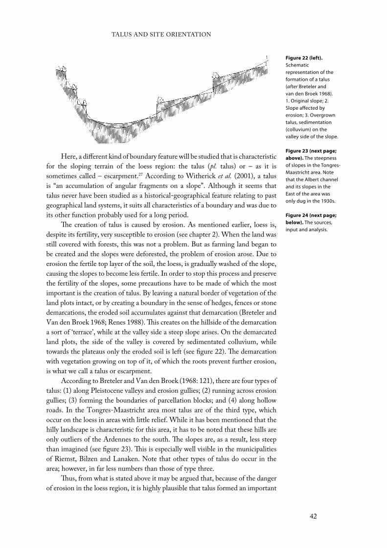
Here, a different kind of boundary feature will be studied that is characteristic
for the sloping terrain of the loess region: the talus (pl. talus) or – as it is
sometimes called – escarpment.27 According to Witherick et al. (2001), a talus
is “an accumulation of angular fragments on a slope”. Although it seems that
talus never have been studied as a historical-geographical feature relating to past
geographical land systems, it suits all characteristics of a boundary and was due to
its other function probably used for a long period.
The creation of talus is caused by erosion. As mentioned earlier, loess is,
despite its fertility, very susceptible to erosion (see chapter 2). When the land was
still covered with forests, this was not a problem. But as farming land began to
be created and the slopes were deforested, the problem of erosion arose. Due to
erosion the fertile top layer of the soil, the loess, is gradually washed of the slope,
causing the slopes to become less fertile. In order to stop this process and preserve
the fertility of the slopes, some precautions have to be made of which the most
important is the creation of talus. By leaving a natural border of vegetation of the
land plots intact, or by creating a boundary in the sense of hedges, fences or stone
demarcations, the eroded soil accumulates against that demarcation (Breteler and
Van den Broek 1968; Renes 1988). This creates on the hillside of the demarcation
a sort of ‘terrace’, while at the valley side a steep slope arises. On the demarcated
land plots, the side of the valley is covered by sedimentated colluvium, while
towards the plateaus only the eroded soil is left (see figure 22). The demarcation
with vegetation growing on top of it, of which the roots prevent further erosion,
is what we call a talus or escarpment.
According to Breteler and Van den Broek (1968: 121), there are four types of
talus: (1) along Pleistocene valleys and erosion gullies; (2) running across erosion
gullies; (3) forming the boundaries of parcellation blocks; and (4) along hollow
roads. In the Tongres-Maastricht area most talus are of the third type, which
occur on the loess in areas with little relief. While it has been mentioned that the
hilly landscape is characteristic for this area, it has to be noted that these hills are
only outliers of the Ardennes to the south. The slopes are, as a result, less steep
than imagined (see figure 23). This is especially well visible in the municipalities
of Riemst, Bilzen and Lanaken. Note that other types of talus do occur in the
area; however, in far less numbers than those of type three.
Thus, from what is stated above it may be argued that, because of the danger
of erosion in the loess region, it is highly plausible that talus formed an important
Figure 22 (left).
Schematic representation of the formation of a talus (after Breteler and van den Broek 1968). 1. Original slope; 2. Slope affected by erosion; 3. Overgrown talus, sedimentation (colluvium) on the valley side of the slope.
Figure 23 (next page;
above). The steepness of slopes in the Tongres-Maastricht area. Note that the Albert channel and its slopes in the East of the area was only dug in the 1930s.
Figure 24 (next page;
below). The sources, input and analysis.
TALUS AND SITE ORIENTATION
42

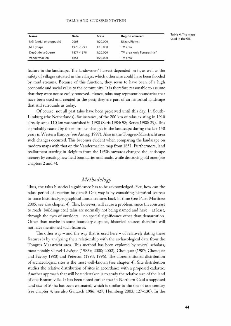
feature in the landscape. The landowners’ harvest depended on it, as well as the
safety of villages situated in the valleys, which otherwise could have been flooded
by mud streams. Because of this function, they seem to have been of a high
economic and social value to the community. It is therefore reasonable to assume
that they were not so easily removed. Hence, talus may represent boundaries that
have been used and created in the past; they are part of an historical landscape
that still surrounds us today.
Of course, not all past talus have been preserved until this day. In South-
Limburg (the Netherlands), for instance, of the 200 km of talus existing in 1910
already some 110 km was vanished in 1980 (Saris 1984: 98; Renes 1988: 29). This
is probably caused by the enormous changes in the landscape during the last 150
years in Western Europe (see Antrop 1997). Also in the Tongres-Maastricht area
such changes occurred. This becomes evident when comparing the landscape on
modern maps with that on the Vandermaelen map from 1851. Furthermore, land
reallotment starting in Belgium from the 1950s onwards changed the landscape
scenery by creating new field boundaries and roads, while destroying old ones (see
chapters 2 and 4).
MethodologyThus, the talus historical significance has to be acknowledged. Yet, how can the
talus’ period of creation be dated? One way is by consulting historical sources
to trace historical-geographical linear features back in time (see Palet Martínez
2005; see also chapter 4). This, however, will cause a problem, since (in constrast
to roads, buildings etc.) talus are normally not being named and have – at least,
through the eyes of outsiders – no special significance other than demarcation.
Other than maybe in some boundary disputes, historical sources therefore will
not have mentioned such features.
The other way – and the way that is used here – of relatively dating these
features is by analyzing their relationship with the archaeological data from the
Tongres-Maastricht area. This method has been explored by several scholars,
most notably Clavel-Lévêque (1983a; 2000; 2002), Chouquer (1987; Chouquer
and Favory 1980) and Peterson (1993; 1996). The aforementioned distribution
of archaeological sites is the most well-known (see chapter 4). Site distribution
studies the relative distribution of sites in accordance with a proposed cadastre.
Another approach that will be undertaken is to study the relative size of the land
of one Roman villa. It has been noted earlier that in Northern Gaul a supposed
land size of 50 ha has been estimated, which is similar to the size of one century
(see chapter 4; see also Gaitzsch 1986: 427; Heimberg 2003: 127-130). In the
Name Date Scale Region covered
NGI (aerial photograph) 2003 1:20.000 Bilzen/Riemst
NGI (map) 1978 -1993 1:10.000 TM area
Depôt de la Guerre 1877 -1878 1:20.000 TM area, only Tongres half
Vandermaelen 1851 1:20.000 TM area
Table 4. The maps used in the GIS.
TALUS AND SITE ORIENTATION
44
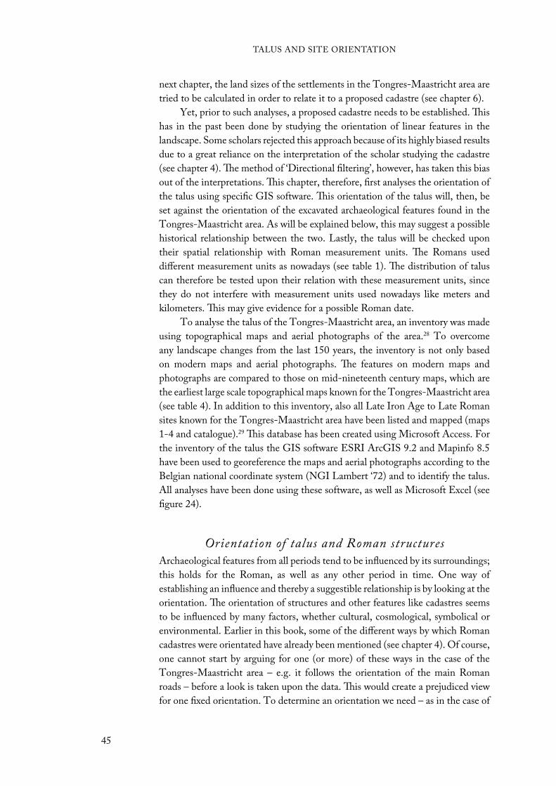
next chapter, the land sizes of the settlements in the Tongres-Maastricht area are
tried to be calculated in order to relate it to a proposed cadastre (see chapter 6).
Yet, prior to such analyses, a proposed cadastre needs to be established. This
has in the past been done by studying the orientation of linear features in the
landscape. Some scholars rejected this approach because of its highly biased results
due to a great reliance on the interpretation of the scholar studying the cadastre
(see chapter 4). The method of ‘Directional filtering’, however, has taken this bias
out of the interpretations. This chapter, therefore, first analyses the orientation of
the talus using specific GIS software. This orientation of the talus will, then, be
set against the orientation of the excavated archaeological features found in the
Tongres-Maastricht area. As will be explained below, this may suggest a possible
historical relationship between the two. Lastly, the talus will be checked upon
their spatial relationship with Roman measurement units. The Romans used
different measurement units as nowadays (see table 1). The distribution of talus
can therefore be tested upon their relation with these measurement units, since
they do not interfere with measurement units used nowadays like meters and
kilometers. This may give evidence for a possible Roman date.
To analyse the talus of the Tongres-Maastricht area, an inventory was made
using topographical maps and aerial photographs of the area.28 To overcome
any landscape changes from the last 150 years, the inventory is not only based
on modern maps and aerial photographs. The features on modern maps and
photographs are compared to those on mid-nineteenth century maps, which are
the earliest large scale topographical maps known for the Tongres-Maastricht area
(see table 4). In addition to this inventory, also all Late Iron Age to Late Roman
sites known for the Tongres-Maastricht area have been listed and mapped (maps
1-4 and catalogue).29 This database has been created using Microsoft Access. For
the inventory of the talus the GIS software ESRI ArcGIS 9.2 and Mapinfo 8.5
have been used to georeference the maps and aerial photographs according to the
Belgian national coordinate system (NGI Lambert ‘72) and to identify the talus.
All analyses have been done using these software, as well as Microsoft Excel (see
figure 24).
Orientation of talus and Roman structuresArchaeological features from all periods tend to be influenced by its surroundings;
this holds for the Roman, as well as any other period in time. One way of
establishing an influence and thereby a suggestible relationship is by looking at the
orientation. The orientation of structures and other features like cadastres seems
to be influenced by many factors, whether cultural, cosmological, symbolical or
environmental. Earlier in this book, some of the different ways by which Roman
cadastres were orientated have already been mentioned (see chapter 4). Of course,
one cannot start by arguing for one (or more) of these ways in the case of the
Tongres-Maastricht area – e.g. it follows the orientation of the main Roman
roads – before a look is taken upon the data. This would create a prejudiced view
for one fixed orientation. To determine an orientation we need – as in the case of
TALUS AND SITE ORIENTATION
45
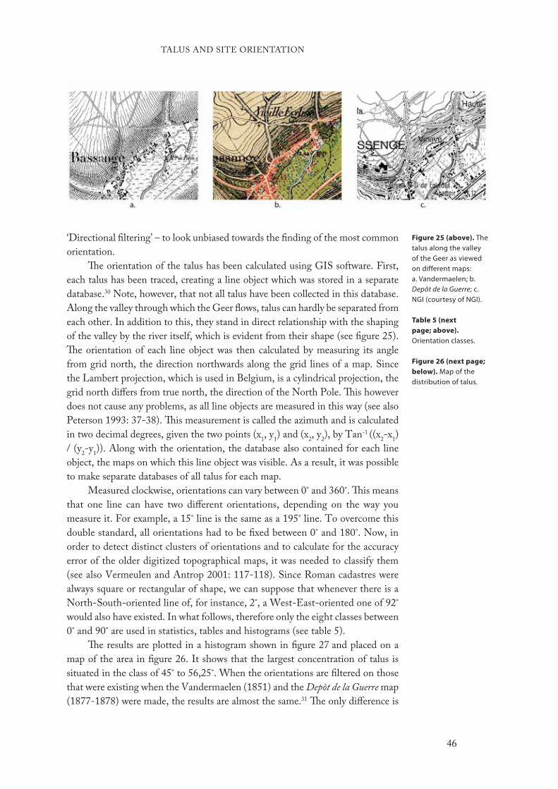
‘Directional filtering’ – to look unbiased towards the finding of the most common
orientation.
The orientation of the talus has been calculated using GIS software. First,
each talus has been traced, creating a line object which was stored in a separate
database.30 Note, however, that not all talus have been collected in this database.
Along the valley through which the Geer flows, talus can hardly be separated from
each other. In addition to this, they stand in direct relationship with the shaping
of the valley by the river itself, which is evident from their shape (see figure 25).
The orientation of each line object was then calculated by measuring its angle
from grid north, the direction northwards along the grid lines of a map. Since
the Lambert projection, which is used in Belgium, is a cylindrical projection, the
grid north differs from true north, the direction of the North Pole. This however
does not cause any problems, as all line objects are measured in this way (see also
Peterson 1993: 37-38). This measurement is called the azimuth and is calculated
in two decimal degrees, given the two points (x1, y
1) and (x
2, y
2), by Tan-1 ((x
2-x
1)
/ (y2-y
1)). Along with the orientation, the database also contained for each line
object, the maps on which this line object was visible. As a result, it was possible
to make separate databases of all talus for each map.
Measured clockwise, orientations can vary between 0˚ and 360˚. This means
that one line can have two different orientations, depending on the way you
measure it. For example, a 15˚ line is the same as a 195˚ line. To overcome this
double standard, all orientations had to be fixed between 0˚ and 180˚. Now, in
order to detect distinct clusters of orientations and to calculate for the accuracy
error of the older digitized topographical maps, it was needed to classify them
(see also Vermeulen and Antrop 2001: 117-118). Since Roman cadastres were
always square or rectangular of shape, we can suppose that whenever there is a
North-South-oriented line of, for instance, 2˚, a West-East-oriented one of 92˚
would also have existed. In what follows, therefore only the eight classes between
0˚ and 90˚ are used in statistics, tables and histograms (see table 5).
The results are plotted in a histogram shown in figure 27 and placed on a
map of the area in figure 26. It shows that the largest concentration of talus is
situated in the class of 45˚ to 56,25˚. When the orientations are filtered on those
that were existing when the Vandermaelen (1851) and the Depôt de la Guerre map
(1877-1878) were made, the results are almost the same.31 The only difference is
Figure 25 (above). The talus along the valley of the Geer as viewed on different maps: a. Vandermaelen; b. Depôt de la Guerre; c. NGI (courtesy of NGI).
Table 5 (next
page; above).
Orientation classes.
Figure 26 (next page;
below). Map of the distribution of talus.
TALUS AND SITE ORIENTATION
46
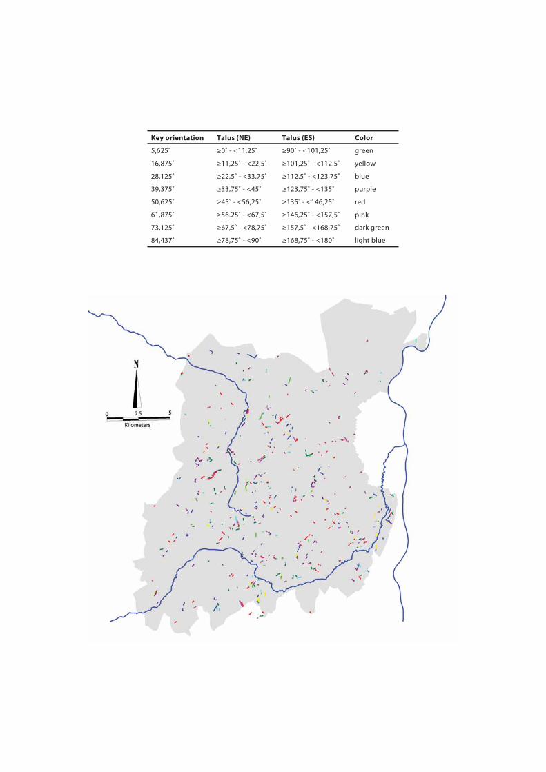
Key orientation Talus (NE) Talus (ES) Color
5,625˚ ≥0˚ - <11,25˚ ≥90˚ - <101,25˚ green
16,875˚ ≥11,25˚ - <22,5˚ ≥101,25˚ - <112.5˚ yellow
28,125˚ ≥22,5˚ - <33,75˚ ≥112,5˚ - <123,75˚ blue
39,375˚ ≥33,75˚ - <45˚ ≥123,75˚ - <135˚ purple
50,625˚ ≥45˚ - <56,25˚ ≥135˚ - <146,25˚ red
61,875˚ ≥56.25˚ - <67,5˚ ≥146,25˚ - <157,5˚ pink
73,125˚ ≥67,5˚ - <78,75˚ ≥157,5˚ - <168,75˚ dark green
84,437˚ ≥78,75˚ - <90˚ ≥168,75˚ - <180˚ light blue
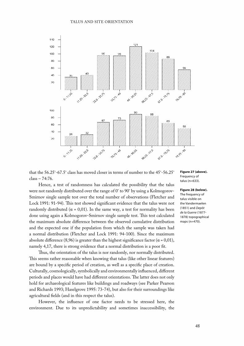
that the 56.25˚-67.5˚ class has moved closer in terms of number to the 45˚-56.25˚
class – 74:76.
Hence, a test of randomness has calculated the possibility that the talus
were not randomly distributed over the range of 0˚ to 90˚ by using a Kolmogorov-
Smirnov single sample test over the total number of observations (Fletcher and
Lock 1991: 91-94). This test showed significant evidence that the talus were not
randomly distributed ( = 0,01). In the same way, a test for normality has been
done using again a Kolmogorov-Smirnov single sample test. This test calculated
the maximum absolute difference between the observed cumulative distribution
and the expected one if the population from which the sample was taken had
a normal distribution (Fletcher and Lock 1991: 94-100). Since the maximum
absolute difference (8,96) is greater than the highest significance factor ( = 0,01),
namely 4,17, there is strong evidence that a normal distribution is a poor fit.
Thus, the orientation of the talus is nor randomly, nor normally distributed.
This seems rather reasonable when knowing that talus (like other linear features)
are bound by a specific period of creation, as well as a specific place of creation.
Culturally, cosmologically, symbolically and environmentally influenced, different
periods and places would have had different orientations. The latter does not only
hold for archaeological features like buildings and roadways (see Parker Pearson
and Richards 1993; Haselgrove 1995: 73-74), but also for their surroundings like
agricultural fields (and in this respect the talus).
However, the influence of one factor needs to be stressed here, the
environment. Due to its unpredictability and sometimes inaccessibility, the
Figure 27 (above).
Frequency of talus (n=633).
Figure 28 (below).
The frequency of talus visible on the Vandermaelen (1851) and Depôt de la Guerre (1877-1878) topographical maps (n=470).
TALUS AND SITE ORIENTATION
48
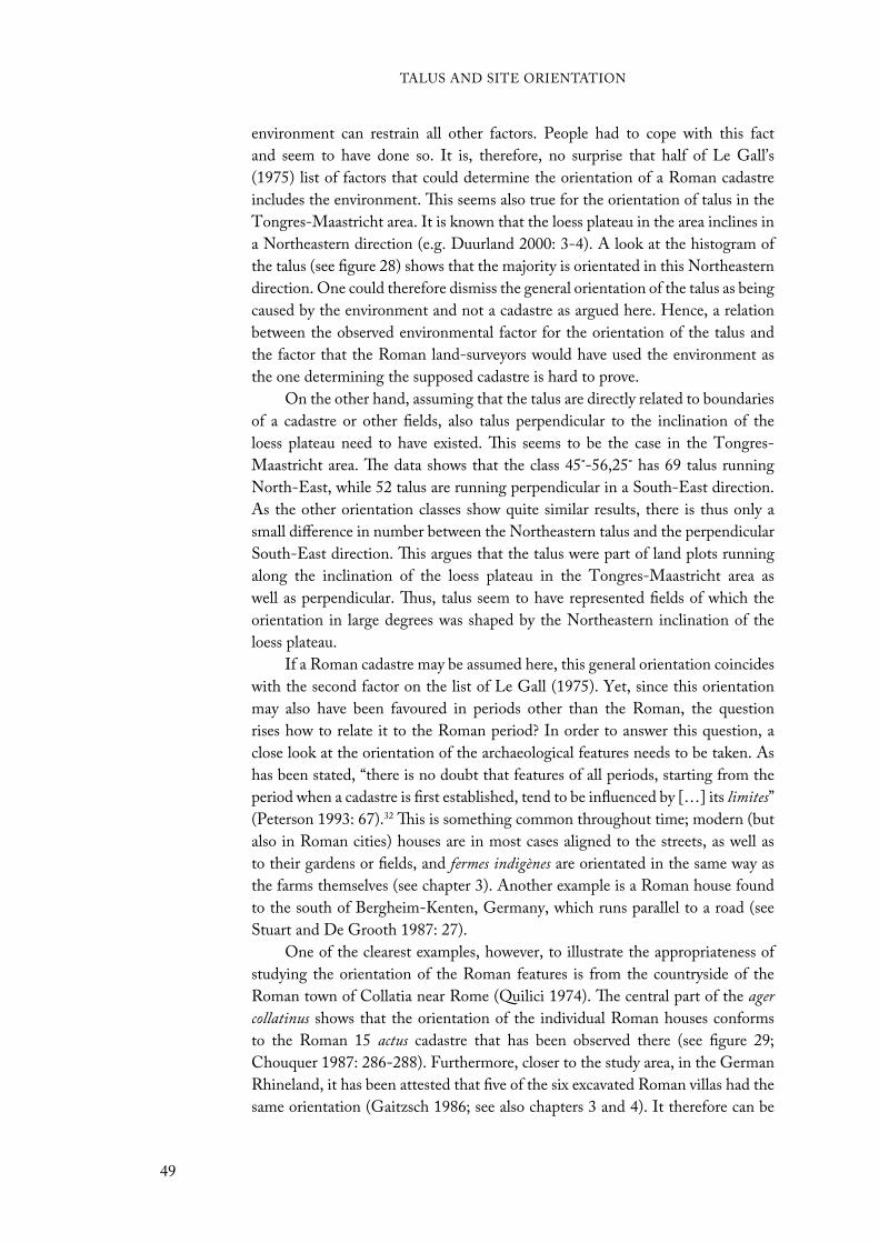
environment can restrain all other factors. People had to cope with this fact
and seem to have done so. It is, therefore, no surprise that half of Le Gall’s
(1975) list of factors that could determine the orientation of a Roman cadastre
includes the environment. This seems also true for the orientation of talus in the
Tongres-Maastricht area. It is known that the loess plateau in the area inclines in
a Northeastern direction (e.g. Duurland 2000: 3-4). A look at the histogram of
the talus (see figure 28) shows that the majority is orientated in this Northeastern
direction. One could therefore dismiss the general orientation of the talus as being
caused by the environment and not a cadastre as argued here. Hence, a relation
between the observed environmental factor for the orientation of the talus and
the factor that the Roman land-surveyors would have used the environment as
the one determining the supposed cadastre is hard to prove.
On the other hand, assuming that the talus are directly related to boundaries
of a cadastre or other fields, also talus perpendicular to the inclination of the
loess plateau need to have existed. This seems to be the case in the Tongres-
Maastricht area. The data shows that the class 45˚-56,25˚ has 69 talus running
North-East, while 52 talus are running perpendicular in a South-East direction.
As the other orientation classes show quite similar results, there is thus only a
small difference in number between the Northeastern talus and the perpendicular
South-East direction. This argues that the talus were part of land plots running
along the inclination of the loess plateau in the Tongres-Maastricht area as
well as perpendicular. Thus, talus seem to have represented fields of which the
orientation in large degrees was shaped by the Northeastern inclination of the
loess plateau.
If a Roman cadastre may be assumed here, this general orientation coincides
with the second factor on the list of Le Gall (1975). Yet, since this orientation
may also have been favoured in periods other than the Roman, the question
rises how to relate it to the Roman period? In order to answer this question, a
close look at the orientation of the archaeological features needs to be taken. As
has been stated, “there is no doubt that features of all periods, starting from the
period when a cadastre is first established, tend to be influenced by […] its limites”
(Peterson 1993: 67).32 This is something common throughout time; modern (but
also in Roman cities) houses are in most cases aligned to the streets, as well as
to their gardens or fields, and fermes indigènes are orientated in the same way as
the farms themselves (see chapter 3). Another example is a Roman house found
to the south of Bergheim-Kenten, Germany, which runs parallel to a road (see
Stuart and De Grooth 1987: 27).
One of the clearest examples, however, to illustrate the appropriateness of
studying the orientation of the Roman features is from the countryside of the
Roman town of Collatia near Rome (Quilici 1974). The central part of the ager
collatinus shows that the orientation of the individual Roman houses conforms
to the Roman 15 actus cadastre that has been observed there (see figure 29;
Chouquer 1987: 286-288). Furthermore, closer to the study area, in the German
Rhineland, it has been attested that five of the six excavated Roman villas had the
same orientation (Gaitzsch 1986; see also chapters 3 and 4). It therefore can be
TALUS AND SITE ORIENTATION
49
expected that Roman archaeological features show the same orientation as the
cadastre in which they are placed.
As a result, the archaeological features in the Tongres-Maastricht area show
through time – from Late Iron Age to Late Roman – a remarkable change in
orientation (see figures 30 and 31). The result of a Spearman’s rank correlation
coefficient between the period of a structure and its orientation gives significant
evidence (>99,5%) for a correlation between the two.33 Comparing the different
periods, it can be noticed that the Middle Roman period has more features (45,95%)
agreeing to the orientation class 45˚-56,25˚ than any other period (LIA = 0%; ER
= 3,85%; LR = 6,25%). This orientation class, hence, corresponds to the most
occurring orientation of the talus in this area and thereby assumes a relationship
between this period and the talus.
Some people may not be persuaded by this, since structures (and their
orientation) from periods beyond that of the Romans are not included in
it. Therefore, in addition to the Late Iron Age to Late Roman features, the
construction date and orientation of all medieval castles and strongholds in and
near the Tongres-Maastricht area have been assembled to see if there may have
been a correlation between the orientation of post-Roman structures and that of
the talus (see figure 32 and table 6). During the medieval period, many castles and
strongholds have been constructed and maintained in the Belgian Hesbayen. A
good example of this is the castle Alden Biesen at Rijkhoven (see figure 33).
The orientation of the castles in the Tongres-Maastricht area does not
suggest a strong relation with the orientation of the talus, as it did with the Middle
Figure 29 (left). The ager collatinus at Collatia (after Chouquer 1987). 1. sites whose boundary is known; 2. sites whose boundary is not known; 3. ancient roads and lines; 4. burial; 5. small rural deposit; A. sites orientated accord-ing to the cadastre; B. sites not orientated.
Figure 30 (next page;
above). The frequency of archaeological features (incl. houses, ditches, fences) from the Tongres-Maastricht area. (a) All periods (n=113); (b) Late Iron Age (n=19); (c) Early Roman (n=52); (d) Middle Roman (n=37); (e) Late Roman (n=32).
Figure 31 (next page;
below). Sites from which orientations have been measured. The number corresponds to that of the catalogue. The pie-chart indicates the number of observations per period (LIA = blue; ER = green; MR = red; LR = yellow).
TALUS AND SITE ORIENTATION
50
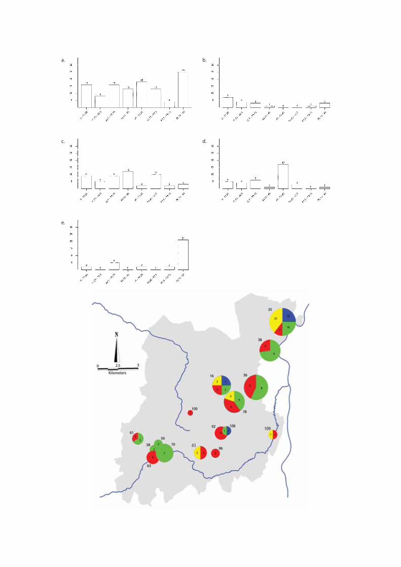
a.
c.
e.
b.
d.
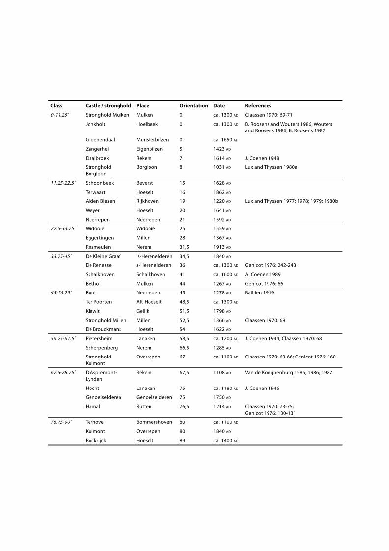
Class Castle / stronghold Place Orientation Date References
0-11.25˚ Stronghold Mulken Mulken 0 ca. 1300 AD Claassen 1970: 69-71
Jonkholt Hoelbeek 0 ca. 1300 AD B. Roosens and Wouters 1986; Wouters and Roosens 1986; B. Roosens 1987
Groenendaal Munsterbilzen 0 ca. 1650 AD
Zangerhei Eigenbilzen 5 1423 AD
Daalbroek Rekem 7 1614 AD J. Coenen 1948
Stronghold Borgloon
Borgloon 8 1031 AD Lux and Thyssen 1980a
11.25-22.5˚ Schoonbeek Beverst 15 1628 AD
Terwaart Hoeselt 16 1862 AD
Alden Biesen Rijkhoven 19 1220 AD Lux and Thyssen 1977; 1978; 1979; 1980b
Weyer Hoeselt 20 1641 AD
Neerrepen Neerrepen 21 1592 AD
22.5-33.75˚ Widooie Widooie 25 1559 AD
Eggertingen Millen 28 1367 AD
Rosmeulen Nerem 31,5 1913 AD
33.75-45˚ De Kleine Graaf 's-Herenelderen 34,5 1840 AD
De Renesse s-Herenelderen 36 ca. 1300 AD Genicot 1976: 242-243
Schalkhoven Schalkhoven 41 ca. 1600 AD A. Coenen 1989
Betho Mulken 44 1267 AD Genicot 1976: 66
45-56.25˚ Rooi Neerrepen 45 1278 AD Baillien 1949
Ter Poorten Alt-Hoeselt 48,5 ca. 1300 AD
Kiewit Gellik 51,5 1798 AD
Stronghold Millen Millen 52,5 1366 AD Claassen 1970: 69
De Brouckmans Hoeselt 54 1622 AD
56.25-67.5˚ Pietersheim Lanaken 58,5 ca. 1200 AD J. Coenen 1944; Claassen 1970: 68
Scherpenberg Nerem 66,5 1285 AD
Stronghold Kolmont
Overrepen 67 ca. 1100 AD Claassen 1970: 63-66; Genicot 1976: 160
67.5-78.75˚ D'Aspremont-Lynden
Rekem 67,5 1108 AD Van de Konijnenburg 1985; 1986; 1987
Hocht Lanaken 75 ca. 1180 AD J. Coenen 1946
Genoelselderen Genoelselderen 75 1750 AD
Hamal Rutten 76,5 1214 AD Claassen 1970: 73-75; Genicot 1976: 130-131
78.75-90˚ Terhove Bommershoven 80 ca. 1100 AD
Kolmont Overrepen 80 1840 AD
Bockrijck Hoeselt 89 ca. 1400 AD

Table 6 (previous
page). Orientation and construction date of castles, castle ruins and strongholds in and near the Tongres-Maastricht area.
Figure 32 (above).
Castles, castle ruins and strongholds in the Tongres-Maastricht area.
Roman features. The castles’ orientation seems rather randomly distributed and
cannot be related to time or place. Even when the castles build after 1500 ad are
excluded, this seems to be the case. This shows that, at least, certain post-Roman
features, since castles would have not been the sole structure-type that would
have been build in the medieval Tongres-Maastricht area, do not correspond to
the general orientation of the talus. Castles or strongholds are, however, often
associated with surrounding land plots belonging to the castle’s owner. Hence,
some type of boundary markers would be expected. Since the castles appear not to
be all directed in a similar orientation, their boundary markers most likely would
not either. Thus, as the talus do show a general orientation, the talus seem not to
be related to the castles’ boundary markers. A relationship between the talus and
post-Roman features seems therefore weaker than with Roman features.
Going back to the Roman period, except for the relationship between the
talus and Middle Roman period regarding orientation, are there more signs that
could support the idea of the implementation of a Roman cadastre during this
time. In other words, what may have been the context in which the cadastre was
set up? In the last 20 years scholars have emphasized the continuity of Northern
Gallic society from the Late Iron Age through the Roman period (e.g. Walthew
TALUS AND SITE ORIENTATION
53
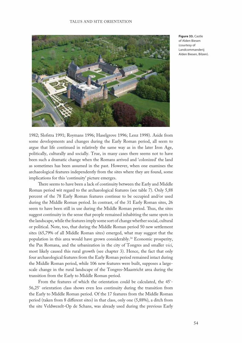
1982; Slofstra 1991; Roymans 1996; Haselgrove 1996; Lenz 1998). Aside from
some developments and changes during the Early Roman period, all seem to
argue that life continued in relatively the same way as in the later Iron Age,
politically, culturally and socially. True, in many cases there seems not to have
been such a dramatic change when the Romans arrived and ‘colonized’ the land
as sometimes has been assumed in the past. However, when one examines the
archaeological features independently from the sites where they are found, some
implications for this ‘continuity’ picture emerges.
There seems to have been a lack of continuity between the Early and Middle
Roman period wit regard to the archaeological features (see table 7). Only 5,88
percent of the 78 Early Roman features continue to be occupied and/or used
during the Middle Roman period. In contrast, of the 31 Early Roman sites, 26
seem to have been still in use during the Middle Roman period. Thus, the sites
suggest continuity in the sense that people remained inhabiting the same spots in
the landscape, while the features imply some sort of change whether social, cultural
or political. Note, too, that during the Middle Roman period 50 new settlement
sites (65,79% of all Middle Roman sites) emerged, what may suggest that the
population in this area would have grown considerably.34 Economic prosperity,
the Pax Romana, and the urbanization in the city of Tongres and smaller vici,
most likely caused this rural growth (see chapter 3). Hence, the fact that only
four archaeological features from the Early Roman period remained intact during
the Middle Roman period, while 106 new features were built, supposes a large-
scale change in the rural landscape of the Tongres-Maastricht area during the
transition from the Early to Middle Roman period.
From the features of which the orientation could be calculated, the 45˚-
56,25˚ orientation class shows even less continuity during the transition from
the Early to Middle Roman period. Of the 17 features from the Middle Roman
period (taken from 8 different sites) in that class, only one (5,88%), a ditch from
the site Veldwezelt-Op de Schans, was already used during the previous Early
Figure 33. Castle of Alden Biesen (courtesy ofLandcommanderij Alden Biesen, Bilzen).
TALUS AND SITE ORIENTATION
54
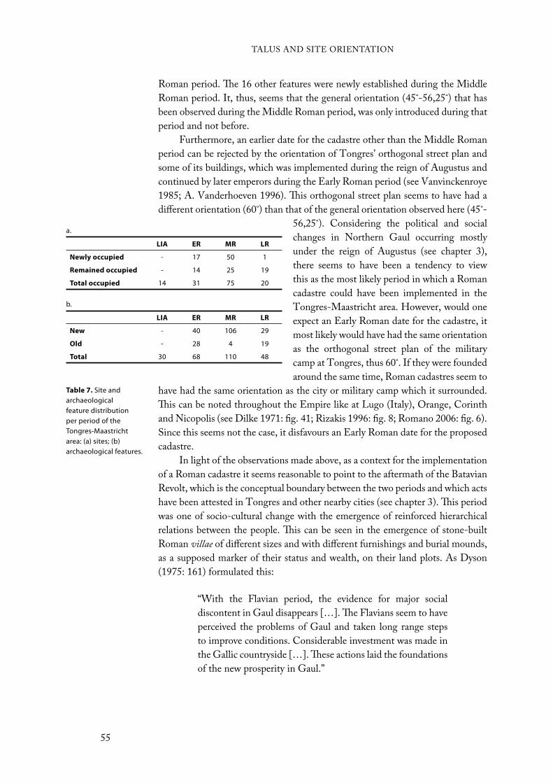
Roman period. The 16 other features were newly established during the Middle
Roman period. It, thus, seems that the general orientation (45˚-56,25˚) that has
been observed during the Middle Roman period, was only introduced during that
period and not before.
Furthermore, an earlier date for the cadastre other than the Middle Roman
period can be rejected by the orientation of Tongres’ orthogonal street plan and
some of its buildings, which was implemented during the reign of Augustus and
continued by later emperors during the Early Roman period (see Vanvinckenroye
1985; A. Vanderhoeven 1996). This orthogonal street plan seems to have had a
different orientation (60˚) than that of the general orientation observed here (45˚-
56,25˚). Considering the political and social
changes in Northern Gaul occurring mostly
under the reign of Augustus (see chapter 3),
there seems to have been a tendency to view
this as the most likely period in which a Roman
cadastre could have been implemented in the
Tongres-Maastricht area. However, would one
expect an Early Roman date for the cadastre, it
most likely would have had the same orientation
as the orthogonal street plan of the military
camp at Tongres, thus 60˚. If they were founded
around the same time, Roman cadastres seem to
have had the same orientation as the city or military camp which it surrounded.
This can be noted throughout the Empire like at Lugo (Italy), Orange, Corinth
and Nicopolis (see Dilke 1971: fig. 41; Rizakis 1996: fig. 8; Romano 2006: fig. 6).
Since this seems not the case, it disfavours an Early Roman date for the proposed
cadastre.
In light of the observations made above, as a context for the implementation
of a Roman cadastre it seems reasonable to point to the aftermath of the Batavian
Revolt, which is the conceptual boundary between the two periods and which acts
have been attested in Tongres and other nearby cities (see chapter 3). This period
was one of socio-cultural change with the emergence of reinforced hierarchical
relations between the people. This can be seen in the emergence of stone-built
Roman villae of different sizes and with different furnishings and burial mounds,
as a supposed marker of their status and wealth, on their land plots. As Dyson
(1975: 161) formulated this:
“With the Flavian period, the evidence for major social
discontent in Gaul disappears […]. The Flavians seem to have
perceived the problems of Gaul and taken long range steps
to improve conditions. Considerable investment was made in
the Gallic countryside […]. These actions laid the foundations
of the new prosperity in Gaul.”
a.
LIA ER MR LR
Newly occupied - 17 50 1
Remained occupied - 14 25 19
Total occupied 14 31 75 20
b.
LIA ER MR LR
New - 40 106 29
Old - 28 4 19
Total 30 68 110 48
Table 7. Site and archaeological feature distribution per period of the Tongres-Maastricht area: (a) sites; (b) archaeological features.
TALUS AND SITE ORIENTATION
55
In light of this, it must be noted that during the Flavian period also many Roman
cadastres were either resurveyed and newly established (often with a different
orientation) or newly founded. This has been accounted, for instance, at Corinth,
Orange, Béziers and for those in North Africa (Piganiol 1962: 77-90; Clavel-
Lévêque 1989: 276-278; Peterson 1993: 239; Romano 2006: 71-81). The
establishment of a Roman cadastre in the Tongres-Maastricht area during the
Flavian period as proposed here coincides perfectly with these other cadastres.
It can be argued, therefore, to be a matter of Rome interfering in local affairs
in order to reshape order and loyalty in a region. In the case of the Tongres-
Maastricht area, all this may have happened just after the Batavian revolt, during
which this loyalty and order had to be reshaped and economic activity needed a
new boost.
Still, one can see nonetheless remarkable changes, too, during other periods
and transitions from one period to another. As an example of this, observe the
Late Iron Age-Early Roman transition (see table 7). During the Early Roman
period, 40 new features and 17 new sites have been attested in the Tongres-
Maastricht area, which is respectively 58,82 percent of all features and 54,84
percent of all sites during that period. Considering the political and social changes
under Augustus, pointed out above (see also chapter 3), these numbers seem not
out of place.
However, more importantly, these numbers seem not that compelling as
for the aforementioned Early Roman-Middle Roman period transition. There
are some drawbacks to the Late Iron Age/Early Roman and Late Roman period
numbers as presented here, which prevents the drawing of conclusions from
this data. First, the Late Iron Age and Early Roman periods can often not be
distinguished very clearly by the dating of artefacts and features and is therefore
often taken as one period (e.g. Slofstra 1991; Duurland 2000: 20). Secondly,
these two periods and the Late Roman period suffered much from a past scholarly
focus on archaeological features from the Middle Roman period like villae, burial
mounds and Roman-styled artefacts.35 The result is that there is a smaller sample
of sites and features for these periods. Hence, in the Tongres-Maastricht area,
the number of features from the Late Iron Age/Early Roman and Late Roman
period weighs heavily on the site Neerharen-Rekem. There, 16 features have been
found for the Late Iron Age/Early Roman period, and even 25 features for the
Late Roman period (see table 7 and figure 30).
In sum, there seems to be particular changes during the Roman period
in the Tongres-Maastricht area that can be associated to the most common
orientation of the talus (45˚-56,25˚) in this area and, therefore, may be seen as
evidence for the implementation of a Roman cadastre. First, there is a significant
correlation between the period of an archaeological feature and its orientation.
Secondly, compared to other periods, the Middle Roman period has by far the
most archaeological features running in the same direction, namely 45˚-56,25˚.
Moreover, this 45˚-56,25˚ orientation class is by far the most common class
among all Middle Roman features of which the orientation has been measured.
Furthermore, archaeological features show no continuity between the Early and
TALUS AND SITE ORIENTATION
56
Middle Roman period, whether in general or specifically for the 45˚-56,25˚ class.
Lastly, the orientation of the Early Roman orthogonal street plan of Tongres
and some of its buildings does not correlate to that of the general orientation of
the talus. All this may support the idea of changes in the landscape made after
the Batavian revolt in the Tongres-Maastricht area. Most remarkable is, in this
case, the fact that the most common orientation of the Middle Roman period’s
features agrees exactly to the most common orientation of the talus. Hence, was
there a Roman cadastre implemented in the aftermath of the Batavian revolt in
order to control native society? This will be explored in the next chapter.
TALUS AND SITE ORIENTATION
57

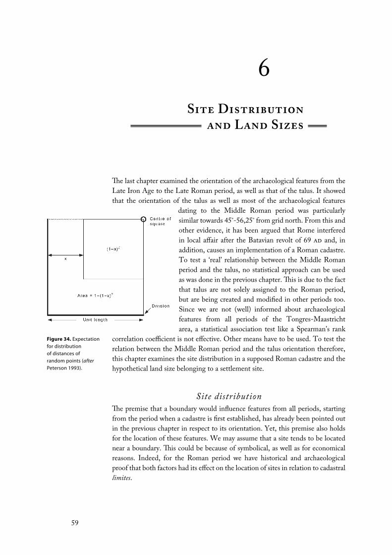
The last chapter examined the orientation of the archaeological features from the
Late Iron Age to the Late Roman period, as well as that of the talus. It showed
that the orientation of the talus as well as most of the archaeological features
dating to the Middle Roman period was particularly
similar towards 45˚-56,25˚ from grid north. From this and
other evidence, it has been argued that Rome interfered
in local affair after the Batavian revolt of 69 ad and, in
addition, causes an implementation of a Roman cadastre.
To test a ‘real’ relationship between the Middle Roman
period and the talus, no statistical approach can be used
as was done in the previous chapter. This is due to the fact
that talus are not solely assigned to the Roman period,
but are being created and modified in other periods too.
Since we are not (well) informed about archaeological
features from all periods of the Tongres-Maastricht
area, a statistical association test like a Spearman’s rank
correlation coefficient is not effective. Other means have to be used. To test the
relation between the Middle Roman period and the talus orientation therefore,
this chapter examines the site distribution in a supposed Roman cadastre and the
hypothetical land size belonging to a settlement site.
Site distributionThe premise that a boundary would influence features from all periods, starting
from the period when a cadastre is first established, has already been pointed out
in the previous chapter in respect to its orientation. Yet, this premise also holds
for the location of these features. We may assume that a site tends to be located
near a boundary. This could be because of symbolical, as well as for economical
reasons. Indeed, for the Roman period we have historical and archaeological
proof that both factors had its effect on the location of sites in relation to cadastral
limites.
Figure 34. Expectation for distribution of distances of random points (afterPeterson 1993).
Site Distributionand Land Sizes
59

First, boundaries had certain religious and symbolical connections for the
Romans. Particular gods like Terminus and Silvanus were worshiped for their
association with boundaries. Therefore, feasts, ceremonies and animal sacrifices
were often held when a particular boundary was formally being established. For
example, of the woodland god Silvanus we know that every estate had “three
Silvani, one to guard the house, one for the country as shepherd’s god and one
called orientalis (eastern), who had a grove on the boundary” (Dilke 1971: 98-99).
In light of this religious connotation, a boundary or crossing seemed also to be
the perfect spot for an altar or temple. At Beaune (France), for instance, a Roman
temple seems to have stood on the axis of a cadastre and, just east of the Tongres-
Maastricht area, at Valkenburg maybe also a Roman temple would have stood
near a boundary (see Peterson 1993: fig. 3.10 and 3.8).
Burials in most cases also belong to this symbolic world. It has, therefore,
been argued by many scholars that some, most notably visible ones like tumuli,
tend to be located near a boundary to demarcate a social space (Alcock 1993;
Buikstra and Charles 1999; Parker Pearson 1999: 137; Hiddink 2003). This has
also been argued for Northern Gaul (Wightman 1975: 649-650) and for the
Tongres-Maastricht area specifically (Duurland 2000: 26). Post-Roman sites with
religious and/or symbolic significance, too, could line up along the limites, most
notably the cardo. This has been noted, for instance, in Tunisia and Damascus in
the case of mosques that were aligned to the limites of a long forgotten cadastre
(Anonymous 1954; Dodinet et al. 1990). In the case of Europe, this would most
likely then be churches, chapels or other features related to the Catholic Church
(see below). Peterson (1993: 42) noted in this respect that on the quintarius of
one of the centuries of the Orange B cadastre at St. Gervais (Bel and Benoit
1986) modern crosses were situated.36
The economic reason is particularly liable when the limites of a cadastre
are materialised as means of communication, i.e. roads, paths or canals. So, for
example, sites in the northern Ager Cosanus dated to the 2nd century bc have been
found “only on the major axes of the centuriation” (Attolini et al. 1990: 145).
Also in the aforementioned Italian region of Collatia the sites seem to have been
located near the boundaries of the 15 actus cadastre (Quilici 1974; Chouquer
1987: 287; Peterson 1993: 84-85).
However, as Peterson (1993: 75) has argued, some sites always would have
been deliberately placed away from limites. Columella (RR I,v,7), for example,
while admitting the value of access roads, advised gentlemen not to locate their
dwelling near a busy main road, for fear of having to offer accommodation to
passers-by. Also the often found curtilage of a Roman villa could be larger than
normal, what would imply that even if the curtilage abutted a boundary the villa
Probability of rejection (α) 0,1 0,05 0,025 0,01 0,005 0,0025 0,001 0,0005
Numerator value 1,07 1,22 1,36 1,52 1,63 1,73 1,86 1,95
n = 29 0,1987 0,2265 0,2525 0,2823 0,3027 0,3213 0,3454 0,3621
n = 35 0,1809 0,2062 0,2299 0,2569 0,2755 0,2924 0,3144 0,3296
n = 105 0,1044 0,1190 0,1327 0,1483 0,1591 0,1688 0,1815 0,1903
Table 8 (above).
Numerator values for calculating significance levels of D and the significance levels of D calculated for 29, 35 and 105 (afterPeterson 1996).
Table 9 (next page).
Tests for site distribution of all Middle Roman features (n=105) in a cadastre with an orientation of 50,625˚.
SITE DISTRIBUTION AND LAND SIZES
60

Cadastre Test no. D Near % Significance level
15 actus 1 0,0382 46,67 n/s
2 0,0796 44,76 n/s
3 0,0644 49,52 n/s
4 0,0376 48,57 n/s
5 0,0421 46,67 n/s
16 actus 1 0,1268 51,43 0,05
2 0,0515 44,76 n/s
3 0,0735 51,43 n/s
4 0,0737 44,76 n/s
5 0,0591 49,52 n/s
17 actus 1 0,0818 52,38 n/s
2 0,1097 57,14 0,1
3 0,0936 54,29 n/s
4 0,0732 42,86 n/s
5 0,0977 47,62 n/s
18 actus 1 0,1029 42,86 n/s
2 0,1645 62,86 0,005
3 0,1184 60 0,1
4 0,1444 62,86 0,025
5 0,1578 63,8 0,01
19 actus 1 0,049 49,52 n/s
2 0,072 53,33 n/s
3 0,0666 53,33 n/s
4 0,0685 51,43 n/s
5 0,0789 43,81 n/s
20 actus 1 0,0608 44,8 n/s
2 0,1431 43,8 0,025
3 0,0534 46,7 n/s
4 0,1040 39 n/s
5 0,1204 41,9 0,05
21 actus 1 0,0711 50,48 n/s
2 0,0720 44,76 n/s
3 0,1103 55,24 0,1
4 0,0836 49,52 n/s
5 0,1072 43,81 0,1
22 actus 1 0,0555 50,48 n/s
2 0,0992 58,09 n/s
3 0,0625 49,52 n/s
4 0,0537 52,38 n/s
5 0,0352 50,48 n/s
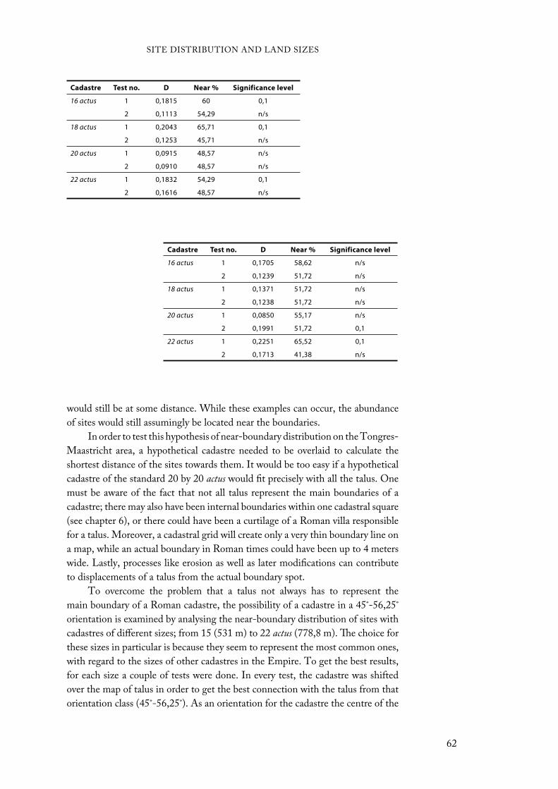
would still be at some distance. While these examples can occur, the abundance
of sites would still assumingly be located near the boundaries.
In order to test this hypothesis of near-boundary distribution on the Tongres-
Maastricht area, a hypothetical cadastre needed to be overlaid to calculate the
shortest distance of the sites towards them. It would be too easy if a hypothetical
cadastre of the standard 20 by 20 actus would fit precisely with all the talus. One
must be aware of the fact that not all talus represent the main boundaries of a
cadastre; there may also have been internal boundaries within one cadastral square
(see chapter 6), or there could have been a curtilage of a Roman villa responsible
for a talus. Moreover, a cadastral grid will create only a very thin boundary line on
a map, while an actual boundary in Roman times could have been up to 4 meters
wide. Lastly, processes like erosion as well as later modifications can contribute
to displacements of a talus from the actual boundary spot.
To overcome the problem that a talus not always has to represent the
main boundary of a Roman cadastre, the possibility of a cadastre in a 45˚-56,25˚
orientation is examined by analysing the near-boundary distribution of sites with
cadastres of different sizes; from 15 (531 m) to 22 actus (778,8 m). The choice for
these sizes in particular is because they seem to represent the most common ones,
with regard to the sizes of other cadastres in the Empire. To get the best results,
for each size a couple of tests were done. In every test, the cadastre was shifted
over the map of talus in order to get the best connection with the talus from that
orientation class (45˚-56,25˚). As an orientation for the cadastre the centre of the
Cadastre Test no. D Near % Significance level
16 actus 1 0,1815 60 0,1
2 0,1113 54,29 n/s
18 actus 1 0,2043 65,71 0,1
2 0,1253 45,71 n/s
20 actus 1 0,0915 48,57 n/s
2 0,0910 48,57 n/s
22 actus 1 0,1832 54,29 0,1
2 0,1616 48,57 n/s
Cadastre Test no. D Near % Significance level
16 actus 1 0,1705 58,62 n/s
2 0,1239 51,72 n/s
18 actus 1 0,1371 51,72 n/s
2 0,1238 51,72 n/s
20 actus 1 0,0850 55,17 n/s
2 0,1991 51,72 0,1
22 actus 1 0,2251 65,52 0,1
2 0,1713 41,38 n/s
SITE DISTRIBUTION AND LAND SIZES
62

Table 10 (previous
page; above). Tests for site distribution of all Early Roman features (n=35) in a cadastre with an orientation of 50,625˚.
Table 11 (previous
page; below). Tests for site distribution of all Late Roman features (n=29) in a cadastre with an orientation of 50,625˚.
Figure 35 (right).
The overlain 18 actuscadastre and the Middle Roman sites.
orientation class was taken, 50,625˚ from grid north. It remains unknown if an
actual cadastre would have had precisely this orientation. If an orientation was
chosen more to the edges of the class, i.e. 45˚ or 56,25˚, the results of the analyses
could be profoundly different. Yet, as 50,625˚ is the average orientation of the
class, the results from the analyses will have the least possible margin of error with
regard to an actual cadastre in the Tongres-Maastricht area.
The sites are examined by its closeness (in meters) to the nearest boundary
in the following way.37 To collect all half the grid distances between 0 (or 0%)
and 1 (or 100%), the formula x / (0,5c) is used, where ‘x’ is the nearest distance
and ‘c’ is the size of one cadastral square (all in meters). For example, x = 50 and
c = 708 (i.e. 20 actus) gives 50 / (354) or 0,14124. This shows that the particular
site lies on a 14,12 percent distance from the boundary (0% or 0 m) and 85,88
percent distance from the centre of the grid (100% or 354). This number is then
examined for its uniform random scatter within a square grid, which calculates
how many sites will fall within an outer band of x wide when scattered at random.
This is calculated by a continuous cumulative distribution, 1 - (1 - x)2, where x is
the number that was calculated just above (see figure 34). “For example, for x =
0,5 we have the expectation that 1 - (1 - 0,5)2 or 75 percent of points scattered at
random in any grid square will fall within the band so defined, i.e. at distances up
to a quarter of the grid distance from a grid line” (Peterson 1993: 69). It is certain
that any point will fall within half the grid distance, since the formula gives the
expectation for this distance as 1 (or 100%). The list that these calculations will
SITE DISTRIBUTION AND LAND SIZES
63
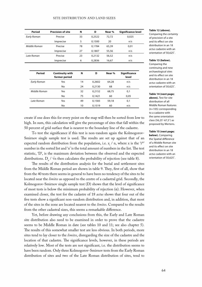
create if one does this for every point on the map will then be sorted from low to
high. In sum, this calculation will give the percentage of sites that fall within the
50 percent of grid surface that is nearest to the boundary line of the cadastre.
To test the significance if this test is non-random again the Kolmogorov-
Smirnov single sample test is used. The results are set up against that of an
expected random distribution from the population, i.e. xi / n, where x is the ‘ith’
number in the sorted list and ‘n’ is the total amount of numbers in the list. The test
statistic, ‘D’, is the maximum deviation between the observed and the expected
distributions. D / √n then calculates the probability of rejection (see table 8).
The results of the distribution analysis for the burial and settlement sites
from the Middle Roman period are shown in table 9. They, first of all, show that
from the 40 tests there seems in general to have been no tendency of the sites to be
located near the limites as opposed to the centre of a cadastral grid. Secondly, the
Kolmogorov-Smirnov single sample test (D) shows that the level of significance
of most tests is below the minimum probability of rejection ( ). However, when
examined closer, the test for the cadastre of 18 actus shows that four out of the
five tests show a significant non-random distribution and, in addition, that most
of the sites in the zone are located nearest to the limites. Compared to the results
from the other cadastral sizes, this seems a remarkable difference.
Yet, before drawing any conclusions from this, the Early and Late Roman
site distribution also need to be examined in order to prove that the cadastre
seems to be Middle Roman in date (see tables 10 and 11; see also chapter 5).
The results of this somewhat smaller test are less obvious. In both periods, more
sites tend to lay closer to the limites, disregarding the size of the cadastre and the
location of that cadastre. The significance levels, however, in these periods are
relatively low. Most of the tests are not significant, i.e. the distribution seems to
have been random. Only three Kolmogorov-Smirnov tests from the Early Roman
distribution of sites and two of the Late Roman distribution of sites, tend to
Period Precision of site N D Near % Significance level
Early Roman Precise 33 0,2522 72,72 0,025
Imprecise 5 0,1500 20 n/s
Middle Roman Precise 78 0,1784 65,39 0,01
Imprecise 27 0,1807 55,56 n/s
Late Roman Precise 23 0,2132 56,52 n/s
Imprecise 6 0,2836 16,67 n/s
Table 12 (above).
Comparing the certainty of precision of a site and its effect on site distribution in an 18 actus cadastre with an orientation of 50,625˚.
Table 13 (below).
Comparing the continuing and new archaeological sites and its effect on site distribution in an 18 actus cadastre with an orientation of 50,625˚.
Table 14 (next page;
above). Test for site distribution of all Middle Roman features (n=105) corresponding to a cadastre with the same orientation class (56,25˚-67,5˚) as proposed by Mertens.
Table 15 (next page;
below). Comparing the Spatial difference of a Middle Roman site and its effect on site distribution in an 18 actus cadastre with an orientation of 50,625˚.
Period Continuity with
former period
N D Near % Significance
level
Early Roman Yes 14 0,2602 64,28 n/s
No 24 0,2130 68 n/s
Middle Roman Yes 32 0,2152 68,75 0,1
No 75 0,1421 60 0,05
Late Roman Yes 49 0,1583 59,18 0,1
No 10 0,1519 60 n/s
SITE DISTRIBUTION AND LAND SIZES
64
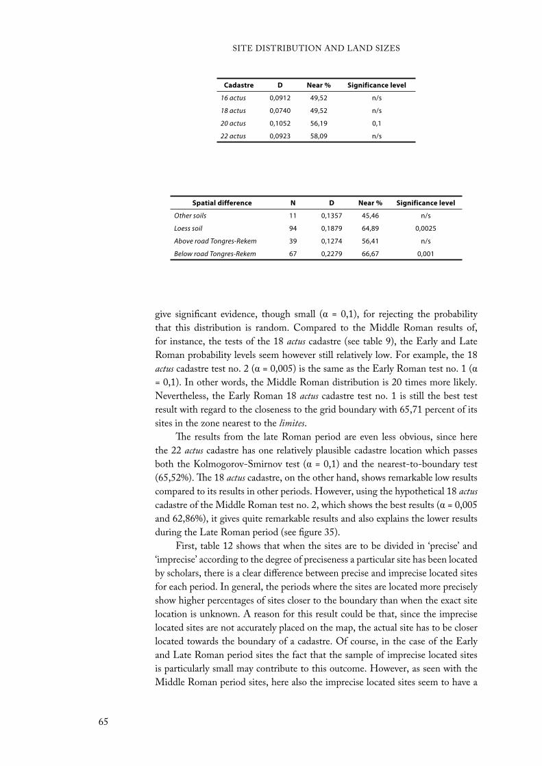
give significant evidence, though small ( = 0,1), for rejecting the probability
that this distribution is random. Compared to the Middle Roman results of,
for instance, the tests of the 18 actus cadastre (see table 9), the Early and Late
Roman probability levels seem however still relatively low. For example, the 18
actus cadastre test no. 2 ( = 0,005) is the same as the Early Roman test no. 1 (
= 0,1). In other words, the Middle Roman distribution is 20 times more likely.
Nevertheless, the Early Roman 18 actus cadastre test no. 1 is still the best test
result with regard to the closeness to the grid boundary with 65,71 percent of its
sites in the zone nearest to the limites.
The results from the late Roman period are even less obvious, since here
the 22 actus cadastre has one relatively plausible cadastre location which passes
both the Kolmogorov-Smirnov test ( = 0,1) and the nearest-to-boundary test
(65,52%). The 18 actus cadastre, on the other hand, shows remarkable low results
compared to its results in other periods. However, using the hypothetical 18 actus
cadastre of the Middle Roman test no. 2, which shows the best results ( = 0,005
and 62,86%), it gives quite remarkable results and also explains the lower results
during the Late Roman period (see figure 35).
First, table 12 shows that when the sites are to be divided in ‘precise’ and
‘imprecise’ according to the degree of preciseness a particular site has been located
by scholars, there is a clear difference between precise and imprecise located sites
for each period. In general, the periods where the sites are located more precisely
show higher percentages of sites closer to the boundary than when the exact site
location is unknown. A reason for this result could be that, since the imprecise
located sites are not accurately placed on the map, the actual site has to be closer
located towards the boundary of a cadastre. Of course, in the case of the Early
and Late Roman period sites the fact that the sample of imprecise located sites
is particularly small may contribute to this outcome. However, as seen with the
Middle Roman period sites, here also the imprecise located sites seem to have a
Cadastre D Near % Significance level
16 actus 0,0912 49,52 n/s
18 actus 0,0740 49,52 n/s
20 actus 0,1052 56,19 0,1
22 actus 0,0923 58,09 n/s
Spatial difference N D Near % Significance level
Other soils 11 0,1357 45,46 n/s
Loess soil 94 0,1879 64,89 0,0025
Above road Tongres-Rekem 39 0,1274 56,41 n/s
Below road Tongres-Rekem 67 0,2279 66,67 0,001
SITE DISTRIBUTION AND LAND SIZES
65
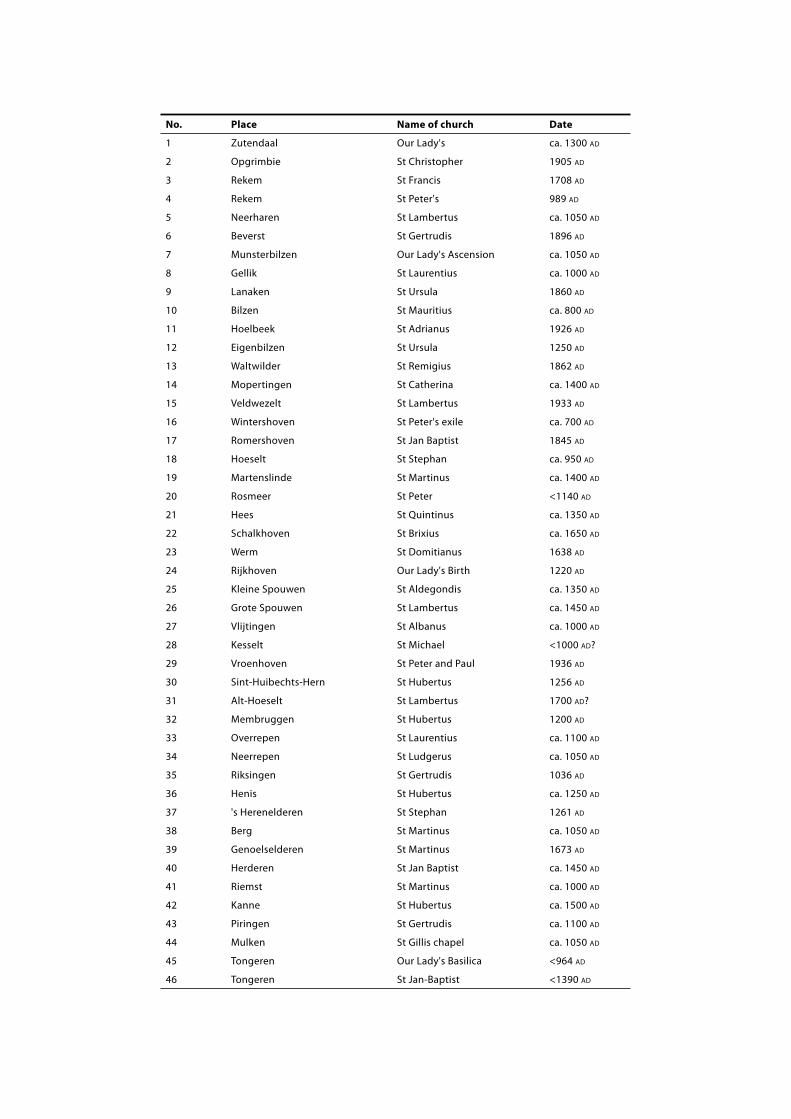
No. Place Name of church Date
1 Zutendaal Our Lady's ca. 1300 AD
2 Opgrimbie St Christopher 1905 AD
3 Rekem St Francis 1708 AD
4 Rekem St Peter's 989 AD
5 Neerharen St Lambertus ca. 1050 AD
6 Beverst St Gertrudis 1896 AD
7 Munsterbilzen Our Lady's Ascension ca. 1050 AD
8 Gellik St Laurentius ca. 1000 AD
9 Lanaken St Ursula 1860 AD
10 Bilzen St Mauritius ca. 800 AD
11 Hoelbeek St Adrianus 1926 AD
12 Eigenbilzen St Ursula 1250 AD
13 Waltwilder St Remigius 1862 AD
14 Mopertingen St Catherina ca. 1400 AD
15 Veldwezelt St Lambertus 1933 AD
16 Wintershoven St Peter's exile ca. 700 AD
17 Romershoven St Jan Baptist 1845 AD
18 Hoeselt St Stephan ca. 950 AD
19 Martenslinde St Martinus ca. 1400 AD
20 Rosmeer St Peter <1140 AD
21 Hees St Quintinus ca. 1350 AD
22 Schalkhoven St Brixius ca. 1650 AD
23 Werm St Domitianus 1638 AD
24 Rijkhoven Our Lady's Birth 1220 AD
25 Kleine Spouwen St Aldegondis ca. 1350 AD
26 Grote Spouwen St Lambertus ca. 1450 AD
27 Vlijtingen St Albanus ca. 1000 AD
28 Kesselt St Michael <1000 AD?
29 Vroenhoven St Peter and Paul 1936 AD
30 Sint-Huibechts-Hern St Hubertus 1256 AD
31 Alt-Hoeselt St Lambertus 1700 AD?
32 Membruggen St Hubertus 1200 AD
33 Overrepen St Laurentius ca. 1100 AD
34 Neerrepen St Ludgerus ca. 1050 AD
35 Riksingen St Gertrudis 1036 AD
36 Henis St Hubertus ca. 1250 AD
37 's Herenelderen St Stephan 1261 AD
38 Berg St Martinus ca. 1050 AD
39 Genoelselderen St Martinus 1673 AD
40 Herderen St Jan Baptist ca. 1450 AD
41 Riemst St Martinus ca. 1000 AD
42 Kanne St Hubertus ca. 1500 AD
43 Piringen St Gertrudis ca. 1100 AD
44 Mulken St Gillis chapel ca. 1050 AD
45 Tongeren Our Lady's Basilica <964 AD
46 Tongeren St Jan-Baptist <1390 AD
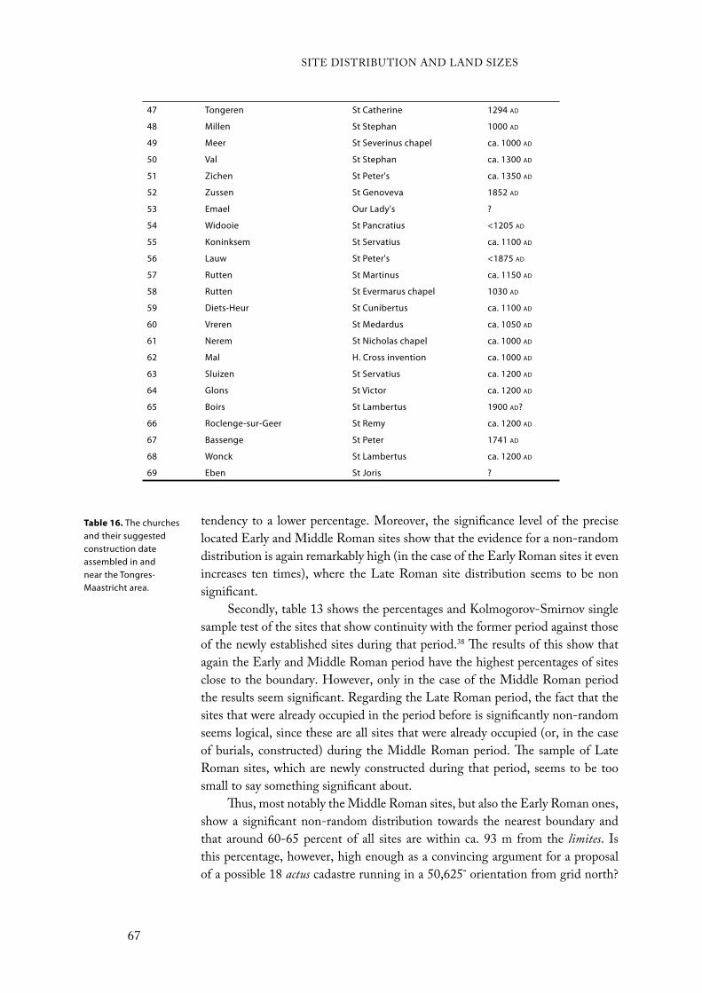
Table 16. The churches and their suggested construction date assembled in and near the Tongres-Maastricht area.
47 Tongeren St Catherine 1294 AD
48 Millen St Stephan 1000 AD
49 Meer St Severinus chapel ca. 1000 AD
50 Val St Stephan ca. 1300 AD
51 Zichen St Peter's ca. 1350 AD
52 Zussen St Genoveva 1852 AD
53 Emael Our Lady's ?
54 Widooie St Pancratius <1205 AD
55 Koninksem St Servatius ca. 1100 AD
56 Lauw St Peter's <1875 AD
57 Rutten St Martinus ca. 1150 AD
58 Rutten St Evermarus chapel 1030 AD
59 Diets-Heur St Cunibertus ca. 1100 AD
60 Vreren St Medardus ca. 1050 AD
61 Nerem St Nicholas chapel ca. 1000 AD
62 Mal H. Cross invention ca. 1000 AD
63 Sluizen St Servatius ca. 1200 AD
64 Glons St Victor ca. 1200 AD
65 Boirs St Lambertus 1900 AD?
66 Roclenge-sur-Geer St Remy ca. 1200 AD
67 Bassenge St Peter 1741 AD
68 Wonck St Lambertus ca. 1200 AD
69 Eben St Joris ?
tendency to a lower percentage. Moreover, the significance level of the precise
located Early and Middle Roman sites show that the evidence for a non-random
distribution is again remarkably high (in the case of the Early Roman sites it even
increases ten times), where the Late Roman site distribution seems to be non
significant.
Secondly, table 13 shows the percentages and Kolmogorov-Smirnov single
sample test of the sites that show continuity with the former period against those
of the newly established sites during that period.38 The results of this show that
again the Early and Middle Roman period have the highest percentages of sites
close to the boundary. However, only in the case of the Middle Roman period
the results seem significant. Regarding the Late Roman period, the fact that the
sites that were already occupied in the period before is significantly non-random
seems logical, since these are all sites that were already occupied (or, in the case
of burials, constructed) during the Middle Roman period. The sample of Late
Roman sites, which are newly constructed during that period, seems to be too
small to say something significant about.
Thus, most notably the Middle Roman sites, but also the Early Roman ones,
show a significant non-random distribution towards the nearest boundary and
that around 60-65 percent of all sites are within ca. 93 m from the limites. Is
this percentage, however, high enough as a convincing argument for a proposal
of a possible 18 actus cadastre running in a 50,625˚ orientation from grid north?
SITE DISTRIBUTION AND LAND SIZES
67

Why is the Early and Middle Roman site distribution relatively the same, while
the Late Roman site distribution tends to have lower results? And would a site
distribution test on the proposed cadastre by Mertens not give similar results?
Starting with the first question, this seems to be the most important and
difficult one. Only from experience “a plausible value for the proportion of the
sites which are likely to lie ‘near’ the limites” can be determined (Peterson 1993:
84). Therefore, Peterson has calculated that for the cadastre in Dutch southern
Limburg around 55-60 percent of all sites would fall in the outer band of a
cadastral grid. As aforementioned, the ager collatinus in Collatia has around the
same percentage. That the percentage presented here is around 5 percent higher
seems thus only to be a more convincing argument for a cadastre proposal, as the
significance factors show relatively similar results of non-randomness.
The fact that the Early and Middle Roman site distribution is relatively
the same and the Late Roman is not, seems because of site continuity. As table
13 shows, 32 of the 38 Early Roman sites remained to be occupied during the
Middle Roman period. In light of the results of this site distribution, some may
therefore suggest that the cadastre would have been surveyed during the Early
Roman period, possibly when Augustus modified the socio-political structure in
Northern Gaul. However, site continuity is different from feature continuity. The
latter has shown that there is a clear demarcation between the Early and Middle
Roman period (see chapter 4). In addition, there were in total (settlements and
burials) 75 new sites established during the Middle Roman period, far more
Figure 36. Churches in and near the Tongres-Maastricht area. The numbers on the map correspond to the numbers in table 16 (see previous page).
SITE DISTRIBUTION AND LAND SIZES
68

than in any other period. This and the analyses from the previous chapter argue,
therefore, that these changes in the landscape of the Tongres-Maastricht area are
caused by the socio-political changes in the aftermath of the Batavian revolt.
Late Roman sites, on the other hand, have the tendency to have lower results.
Only sites that demonstrate continuity with the former, Middle Roman period,
tend to increase that percentage towards a level ca. 10-15 percent below that of
the Middle Roman period. A possible reason for this difference seems historical
as well as due to past scholarship. The historical reason is that the Late Roman
period is seen as one of decline in which society – as with the period before the
Romans – more tends to lean on local economy and characteristics (see chapter 3).
It seems reasonable to assume that the Roman tax system and system of surplus
production, therefore, would gradually decline in the Northwestern provinces.
The Romans therefore no longer had a reason to maintain the cadastres. Yet, as
argued in an earlier chapter, past scholarship has partly created this view of Late
Roman decline and crisis due to the lack of finds from this period (see chapter
4). This lack of finds and, hence, sites may have contributed to the lower results
compared to the Early and Middle Roman period.
Of course, this site distribution test is thus far only done for a cadastre based
on a 50,625˚ orientation, corresponding to the 45˚-56,25˚ orientation class. We
remain ignorant of the site distribution if the suggested cadastre had a different
orientation. To test if the same results could be obtained from a different
orientation, the orientation class was used which corresponds to the proposed
cadastre by Mertens (1958). This resulted in a cadastre with a 61,875˚ orientation,
corresponding to the 56,25˚-67,5˚ orientation class. The results for the Middle
Roman sites show that only one cadastral size, 20 actus, shows evidence for non-
randomness of the site distribution and which percentage of sites closest to the
limites is above 50 percent (see table 14). However, the likelihood of 10:1 that
this cadastre could have existed compared to the 200:1 likelihood that the 18
actus cadastre with a 50,625˚ orientation would have existed, favours the 18 actus
cadastre as proposed above over that proposed by Mertens.
One of the most difficult tasks when analysing the possibility of a cadastre
seems to be the establishing of a spatial layout: where does the cadastre begin and
where does it end. In my opinion, the non-destructive methods used here and in
other studies are not applicable in analysing the spatial layout of the cadastral plan.
This has to do with the fact that historical-geographical lines in the landscape are
not in a one-on-one relation with the boundaries belonging to a cadastre from
a certain period as already mentioned above. It, hence, would remain unknown
how far a cadastre would extend. Site distribution could calculate, however, the
probability that a cadastre is associated with a particular soil type or part of the
land under question. By doing this, the extension of a cadastre can be more or
less demonstrated.
Consequently, the Middle Roman sites were divided into two groups: the
ones on the loess soil and the ones on the sandy and riverine clay soils in the north
of the Tongres-Maastricht area. For both groups a distribution test was done and
the results were compared to one another. In this analysis, the loess soil should
SITE DISTRIBUTION AND LAND SIZES
69

Period Churches N D Near % Significance
level
All All churches 69 0,1568 56,52 0,05
Above road Tongres-Rekem 29 0,1949 55,17 n/s
Below road Tongres-Rekem 40 0,1670 57,5 n/s
Other soils 9 0,1321 44,44 n/s
Loess soil 60 0,1641 58,33 0,05
≤1500 AD All churches 50 0,2562 64 0,0025
Above road Tongres-Rekem 20 0,3578 70 0,01
Below road Tongres-Rekem 30 0,2139 60 0,1
Other soils 5 0,3974 60 n/s
Loess soil 45 0,2518 64,44 0,005
≤1300 AD All churches 41 0,2468 63,41 0,01
Above road Tongres-Rekem 17 0,4137 76,47 0,005
Below road Tongres-Rekem 24 0,1841 54,17 n/s
Other soils 5 0,3974 60 n/s
Loess soil 36 0,2356 63,89 0,025
≤1200 AD All churches 32 0,2078 62,5 0,1
Above road Tongres-Rekem 10 0,3078 70 n/s
Below road Tongres-Rekem 22 0,2257 59,09 n/s
Other soils 4 0,2974 50 n/s
Loess soil 28 0,2566 64,28 0,05
≤1100 AD All churches 25 0,2049 64 n/s
Above road Tongres-Rekem 10 0,3078 70 n/s
Below road Tongres-Rekem 15 0,2257 60 n/s
Other soils 4 0,2974 50 n/s
Loess soil 21 0,2501 66,67 0,1
≤1050 AD All churches 21 0,2786 71,42 0,05
Above road Tongres-Rekem 8 0,3328 75,00 n/s
Below road Tongres-Rekem 13 0,2665 69,23 n/s
Other soils 4 0,2974 50 n/s
Loess soil 17 0,3289 76,47 0,05
≤1000 AD All churches 13 0,3604 76,92 0,05
Above road Tongres-Rekem 4 0,5634 75 0,1
Below road Tongres-Rekem 9 0,3520 77,78 n/s
Other soils 2 0,7974 100 0,1
Loess soil 11 0,3015 72,72 n/s
reveal highest results, as it seems to have been more favourable for a cadastre since
it is a more fertile soil type and therefore better to use for agriculture and surplus
production. Furthermore, another test splits the Tongres-Maastricht area in two
at the line of the suggested road from Tongres to Rekem (which probably ran
to Nijmegen). Such a road would be a good constructed upper boundary for a
cadastre, since the favourable loess soil would lay to the south of this road, while
the sandy soil of the Campine area is situated north of this road.
Table 15 indicates a spatial difference in site distribution regarding the loess
soil and the sandy and riverine clay soils in the north of the Tongres-Maastricht
area. Not only is the percentage of sites closest to the boundary particularly
different (64,89% against 45,46%), also shows the loess soil significant evidence
for non-randomness, while the sites on the other soils seem to have been randomly
placed. The latter can be the result of the low number of sites on the sandy and
riverine clay area. However, the results from the other distribution test reject this.
The results from this test with regard to the road Tongres-Rekem as a dividing
line are remarkable. Although the percentage of sites closest to the limites is
closer to one another (66,67% against 56,41%), the significance level is now more
reliable because of the higher frequency of sites. The 39 sites located to the north
of the road give no significant evidence for non-randomness, while the 67 sites to
the south give even higher significance level for non-randomness with a chance
of 1000:1 that the sites are randomly distributed. This result is higher than the
test with the different soil types as well as with the cadastral plan in general as
shown in table 9.
In addition to the site distribution test of all Roman settlement sites in the
Tongres-Maastricht area, also a site distribution has been calculated for later
Catholic churches in the area. As mentioned above and in chapter 4, later post-
Roman sites with religious and/or symbolic significance could line up along the
limites of a Roman cadastre. Therefore, all churches in the area have been mapped.
In addition, they have been dated according to the oldest construction markers and
textual evidence mentioning its existence to get a chronological view of the rise of
the churches in the area (see table 16 and figure 36). The site distribution test has
been calculated for the closeness of the churches to the 18 actus cadastre proposed
above. Furthermore, just as done for the Roman sites above, the churches have
been divided between those located on the loess and those on other soils, and
between those located north of the Tongres-Rekem road and those located south
of it (see table 17).
The results seem to be very diverse, but show still some remarkable results
that can be related to the cadastre. First, the result from all churches shows that
there is a 95 percent chance that their distribution is non-random and that 56,52
percent are located close to the cadastral limites. The churches on the sandy and
riverine clay soil, as well as the other churches north of the Tongres-Rekem road,
have, in contrast, lower results qua percentage closest to the limites and seem to
have been randomly distributed. Those on the loess, however, have even a higher
percentage (58,33%) and are – as in the case of all churches – non-randomly
distributed ( = 0,05).
Table 17 (previous
page). Test for site distribution of the churches in the Tongres-Maastricht area in an 18 actus cadastre with an orientation of 50,625˚.
SITE DISTRIBUTION AND LAND SIZES
71

When the focus shifts to the construction date of each church, it can be
observed that the results of the distribution test changes through time. Of all
churches constructed before 1500 ad, 64 percent was located close to the limites
of the earlier Roman cadastre and the significance level for non-randomness
increases (99,75% or = 0,0025). As one can see, the significance factor for non-
randomness, as well as the percentage close to the earlier Roman cadastre, seems
to increase too for the other results for churches before 1500 ad. Note, however,
that the number of churches on the sand and riverine clay is too low for drawing
conclusions on its result. Yet, regarding the churches before 1500 ad north of the
Tongres-Rekem road, it seems remarkable that the significance level for non-
randomness is relatively high (99%) and that the percentage close to the limites is
even higher than those for the loess (70% against 64,44%).
When moving back in time, these results seem to persist. While not focusing
on the results from the sand and riverine clay group because of the small number
of observations, it seems remarkable that the results belonging to the group of
churches north of the Tongres-Rekem road are rather similar and sometimes even
higher than for the group of churches on the loess and the other two groups.
Moreover, note that the percentage belonging to the group of all churches and
that of churches on the loess that are close to the limites is gradually rising when
setting the construction date back in time. It must be remembered hereby that
the results for the churches’ construction date before 1000 ad must be left out of
Figure 37 (above). Lines of the field boundaries from the Atlas der Buurtwegen (1842-1845) plotted on several maps (courtesy of ZOLAD). Clockwise: 1. Soil map showing the different soil types. The field boundaries to the north are on the sand, while those to the south are located on the loess; 2. The Digital Height Model (DHM) shows that the cadastre disregards the change in relief; 3. Aerial photograph; 4. Detail of the loess part.
SITE DISTRIBUTION AND LAND SIZES
72
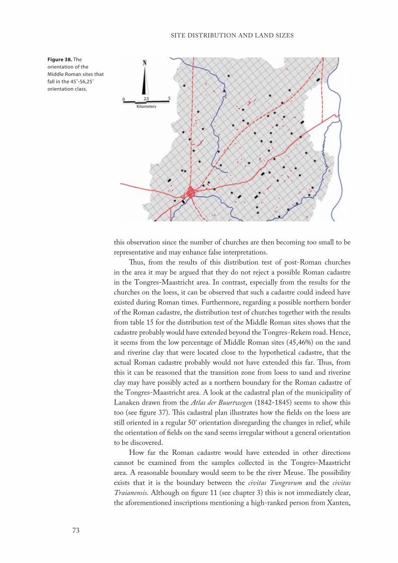
this observation since the number of churches are then becoming too small to be
representative and may enhance false interpretations.
Thus, from the results of this distribution test of post-Roman churches
in the area it may be argued that they do not reject a possible Roman cadastre
in the Tongres-Maastricht area. In contrast, especially from the results for the
churches on the loess, it can be observed that such a cadastre could indeed have
existed during Roman times. Furthermore, regarding a possible northern border
of the Roman cadastre, the distribution test of churches together with the results
from table 15 for the distribution test of the Middle Roman sites shows that the
cadastre probably would have extended beyond the Tongres-Rekem road. Hence,
it seems from the low percentage of Middle Roman sites (45,46%) on the sand
and riverine clay that were located close to the hypothetical cadastre, that the
actual Roman cadastre probably would not have extended this far. Thus, from
this it can be reasoned that the transition zone from loess to sand and riverine
clay may have possibly acted as a northern boundary for the Roman cadastre of
the Tongres-Maastricht area. A look at the cadastral plan of the municipality of
Lanaken drawn from the Atlas der Buurtwegen (1842-1845) seems to show this
too (see figure 37). This cadastral plan illustrates how the fields on the loess are
still oriented in a regular 50˚ orientation disregarding the changes in relief, while
the orientation of fields on the sand seems irregular without a general orientation
to be discovered.
How far the Roman cadastre would have extended in other directions
cannot be examined from the samples collected in the Tongres-Maastricht
area. A reasonable boundary would seem to be the river Meuse. The possibility
exists that it is the boundary between the civitas Tungrorum and the civitas
Traianensis. Although on figure 11 (see chapter 3) this is not immediately clear,
the aforementioned inscriptions mentioning a high-ranked person from Xanten,
Figure 38. The orientation of the Middle Roman sites that fall in the 45˚-56,25˚ orientation class.
SITE DISTRIBUTION AND LAND SIZES
73
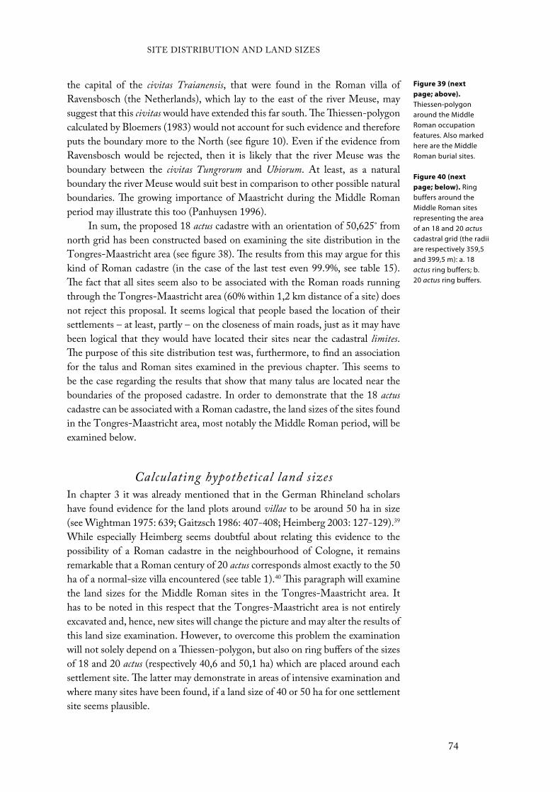
the capital of the civitas Traianensis, that were found in the Roman villa of
Ravensbosch (the Netherlands), which lay to the east of the river Meuse, may
suggest that this civitas would have extended this far south. The Thiessen-polygon
calculated by Bloemers (1983) would not account for such evidence and therefore
puts the boundary more to the North (see figure 10). Even if the evidence from
Ravensbosch would be rejected, then it is likely that the river Meuse was the
boundary between the civitas Tungrorum and Ubiorum. At least, as a natural
boundary the river Meuse would suit best in comparison to other possible natural
boundaries. The growing importance of Maastricht during the Middle Roman
period may illustrate this too (Panhuysen 1996).
In sum, the proposed 18 actus cadastre with an orientation of 50,625˚ from
north grid has been constructed based on examining the site distribution in the
Tongres-Maastricht area (see figure 38). The results from this may argue for this
kind of Roman cadastre (in the case of the last test even 99.9%, see table 15).
The fact that all sites seem also to be associated with the Roman roads running
through the Tongres-Maastricht area (60% within 1,2 km distance of a site) does
not reject this proposal. It seems logical that people based the location of their
settlements – at least, partly – on the closeness of main roads, just as it may have
been logical that they would have located their sites near the cadastral limites.
The purpose of this site distribution test was, furthermore, to find an association
for the talus and Roman sites examined in the previous chapter. This seems to
be the case regarding the results that show that many talus are located near the
boundaries of the proposed cadastre. In order to demonstrate that the 18 actus
cadastre can be associated with a Roman cadastre, the land sizes of the sites found
in the Tongres-Maastricht area, most notably the Middle Roman period, will be
examined below.
Calculating hypothetical land sizesIn chapter 3 it was already mentioned that in the German Rhineland scholars
have found evidence for the land plots around villae to be around 50 ha in size
(see Wightman 1975: 639; Gaitzsch 1986: 407-408; Heimberg 2003: 127-129).39
While especially Heimberg seems doubtful about relating this evidence to the
possibility of a Roman cadastre in the neighbourhood of Cologne, it remains
remarkable that a Roman century of 20 actus corresponds almost exactly to the 50
ha of a normal-size villa encountered (see table 1).40 This paragraph will examine
the land sizes for the Middle Roman sites in the Tongres-Maastricht area. It
has to be noted in this respect that the Tongres-Maastricht area is not entirely
excavated and, hence, new sites will change the picture and may alter the results of
this land size examination. However, to overcome this problem the examination
will not solely depend on a Thiessen-polygon, but also on ring buffers of the sizes
of 18 and 20 actus (respectively 40,6 and 50,1 ha) which are placed around each
settlement site. The latter may demonstrate in areas of intensive examination and
where many sites have been found, if a land size of 40 or 50 ha for one settlement
site seems plausible.
Figure 39 (next
page; above).
Thiessen-polygon around the Middle Roman occupation features. Also marked here are the Middle Roman burial sites.
Figure 40 (next
page; below). Ring buffers around the Middle Roman sites representing the area of an 18 and 20 actuscadastral grid (the radii are respectively 359,5 and 399,5 m): a. 18 actus ring buffers; b. 20 actus ring buffers.
SITE DISTRIBUTION AND LAND SIZES
74
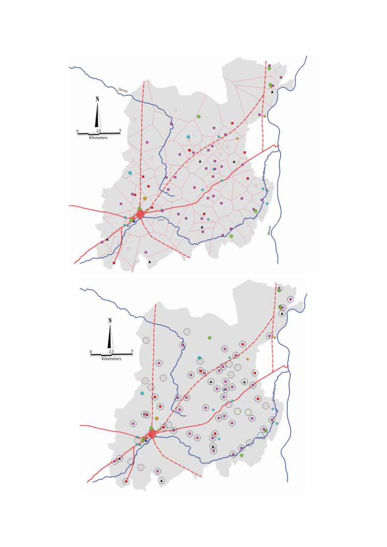
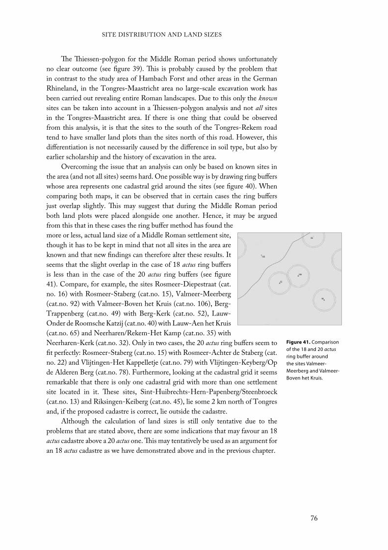
The Thiessen-polygon for the Middle Roman period shows unfortunately
no clear outcome (see figure 39). This is probably caused by the problem that
in contrast to the study area of Hambach Forst and other areas in the German
Rhineland, in the Tongres-Maastricht area no large-scale excavation work has
been carried out revealing entire Roman landscapes. Due to this only the known
sites can be taken into account in a Thiessen-polygon analysis and not all sites
in the Tongres-Maastricht area. If there is one thing that could be observed
from this analysis, it is that the sites to the south of the Tongres-Rekem road
tend to have smaller land plots than the sites north of this road. However, this
differentiation is not necessarily caused by the difference in soil type, but also by
earlier scholarship and the history of excavation in the area.
Overcoming the issue that an analysis can only be based on known sites in
the area (and not all sites) seems hard. One possible way is by drawing ring buffers
whose area represents one cadastral grid around the sites (see figure 40). When
comparing both maps, it can be observed that in certain cases the ring buffers
just overlap slightly. This may suggest that during the Middle Roman period
both land plots were placed alongside one another. Hence, it may be argued
from this that in these cases the ring buffer method has found the
more or less, actual land size of a Middle Roman settlement site,
though it has to be kept in mind that not all sites in the area are
known and that new findings can therefore alter these results. It
seems that the slight overlap in the case of 18 actus ring buffers
is less than in the case of the 20 actus ring buffers (see figure
41). Compare, for example, the sites Rosmeer-Diepestraat (cat.
no. 16) with Rosmeer-Staberg (cat.no. 15), Valmeer-Meerberg
(cat.no. 92) with Valmeer-Boven het Kruis (cat.no. 106), Berg-
Trappenberg (cat.no. 49) with Berg-Kerk (cat.no. 52), Lauw-
Onder de Roomsche Katzij (cat.no. 40) with Lauw-Aen het Kruis
(cat.no. 65) and Neerharen/Rekem-Het Kamp (cat.no. 35) with
Neerharen-Kerk (cat.no. 32). Only in two cases, the 20 actus ring buffers seem to
fit perfectly: Rosmeer-Staberg (cat.no. 15) with Rosmeer-Achter de Staberg (cat.
no. 22) and Vlijtingen-Het Kappelletje (cat.no. 79) with Vlijtingen-Keyberg/Op
de Alderen Berg (cat.no. 78). Furthermore, looking at the cadastral grid it seems
remarkable that there is only one cadastral grid with more than one settlement
site located in it. These sites, Sint-Huibrechts-Hern-Papenberg/Steenbroeck
(cat.no. 13) and Riksingen-Keiberg (cat.no. 45), lie some 2 km north of Tongres
and, if the proposed cadastre is correct, lie outside the cadastre.
Although the calculation of land sizes is still only tentative due to the
problems that are stated above, there are some indications that may favour an 18
actus cadastre above a 20 actus one. This may tentatively be used as an argument for
an 18 actus cadastre as we have demonstrated above and in the previous chapter.
Figure 41. Comparison of the 18 and 20 actusring buffer around the sites Valmeer-Meerberg and Valmeer-Boven het Kruis.
SITE DISTRIBUTION AND LAND SIZES
76
In the introduction, it has been stressed already that scholars often seem to have
had a tendency to relate Roman cadastration to the establishment of coloniae. The
fact that the Latin word colonia lies at the heart of the modern words ‘colony’
and ‘colonialism’ (see Gosden 2004: 1-2), seems to have linked Roman cadastres
to this idea too. The view of cadastres as being a rigid and visible chequerboard
of squares has boosted this impression.41 The same applies to Roman villas. The
(what has been though of as a sudden) introduction of stone-building and the
adoption of Roman styles has been seen as the creation of a dominant power,
the Romans. However, as Gosden (2004: 2) already noted, in the last decades
scholars have given the native people more agency. This dichotomy between these
two views raises the question which will be explored in this chapter: how can
one define the socio-political ownership of the rural land and settlement sites
in the Tongres-Maastricht area. In other words, after the Romans conquered
the region, who were the people settling in the rural settlements and owning
the land? This question instigates new questions like the relationship between
cadastres and Roman villas and the specific development of the villa-landscape
during the Roman period, which will be explored later on in this chapter.
Cadastres and the supposed settlement of new peopleThe Greek city of Corinth was an important city in ntiquity due to its strategic
geographical location. During the second century bc, as the head of the Achaean
League, it led the opposition to the Roman takeover of Greece. As a result,
the city was sacked by the consul Lucius Mummius in 146 bc, after which the
city was left largely uninhabited without civic, commercial, or political activity
(Romano 2006: 65). In 44 bc, 102 years after the sack, a new colony was founded
at Corinth under Julius Caesar. However, prior to the foundation of this colony,
Roman land-surveyors had been busy with dividing up the land of the countryside
around Corinth. The lex agraria of 111 bc indicates that some parts of Corinthian
territory were measured out for sale, and boundary stones were erected (Romano
2006: 71). Thus, after Corinth was deserted for some time, a Roman cadastre was
eventually laid out of 16 by 24 actus at the same orientation as the new colony
Ownership of Land and Villas
77
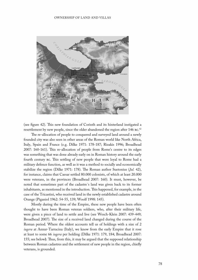
(see figure 42). This new foundation of Corinth and its hinterland instigated a
resettlement by new people, since the older abandoned the region after 146 bc.42
The re-allocation of people to conquered and surveyed land around a newly
founded city was also seen in other areas of the Roman world like North Africa,
Italy, Spain and France (e.g. Dilke 1971: 178-187; Rizakis 1996; Broadhead
2007: 160-161). This re-allocation of people from Rome’s centre to its edges
was something that was done already early on in Roman history around the early
fourth century bc. This settling of new people that were loyal to Rome had a
military defence function, as well as it was a method to socially and economically
stabilize the region (Dilke 1971: 178). The Roman author Suetonius (Jul. 42),
for instance, claims that Caesar settled 80.000 colonists, of which at least 20.000
were veterans, in the provinces (Broadhead 2007: 160). It must, however, be
noted that sometimes part of the cadastre´s land was given back to its former
inhabitants, as mentioned in the introduction. This happened, for example, in the
case of the Tricastini, who received land in the newly established cadastre around
Orange (Piganiol 1962: 54-55, 139; Woolf 1998: 145).
Mostly during the time of the Empire, these new people have been often
thought to have been Roman veteran soldiers, who, after their military life,
were given a piece of land to settle and live (see Wesch-Klein 2007: 439-449;
Broadhead 2007). The size of a received land changed during the course of the
Roman period. Where the oldest accounts tell us of holdings with a size of 2
iugera at Anxur-Tarracina (Italy), we know from the early Empire that it rose
at least to some 66 iugera per holding (Dilke 1971: 179, 184; Broadhead 2007:
155; see below). Thus, from this, it may be argued that the supposed relationship
between Roman cadastres and the settlement of new people in the region, chiefly
veterans, is grounded.
OWNERSHIP OF LAND AND VILLAS
78
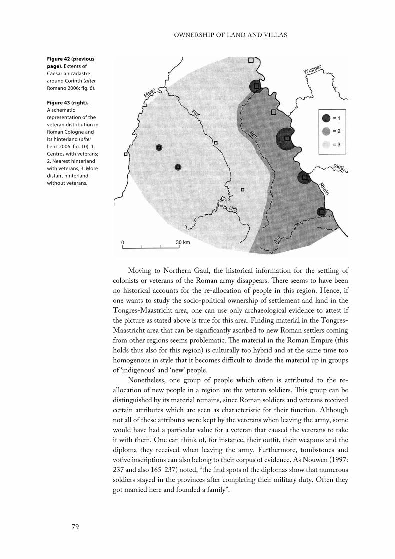
Moving to Northern Gaul, the historical information for the settling of
colonists or veterans of the Roman army disappears. There seems to have been
no historical accounts for the re-allocation of people in this region. Hence, if
one wants to study the socio-political ownership of settlement and land in the
Tongres-Maastricht area, one can use only archaeological evidence to attest if
the picture as stated above is true for this area. Finding material in the Tongres-
Maastricht area that can be significantly ascribed to new Roman settlers coming
from other regions seems problematic. The material in the Roman Empire (this
holds thus also for this region) is culturally too hybrid and at the same time too
homogenous in style that it becomes difficult to divide the material up in groups
of ‘indigenous’ and ‘new’ people.
Nonetheless, one group of people which often is attributed to the re-
allocation of new people in a region are the veteran soldiers. This group can be
distinguished by its material remains, since Roman soldiers and veterans received
certain attributes which are seen as characteristic for their function. Although
not all of these attributes were kept by the veterans when leaving the army, some
would have had a particular value for a veteran that caused the veterans to take
it with them. One can think of, for instance, their outfit, their weapons and the
diploma they received when leaving the army. Furthermore, tombstones and
votive inscriptions can also belong to their corpus of evidence. As Nouwen (1997:
237 and also 165-237) noted, “the find spots of the diplomas show that numerous
soldiers stayed in the provinces after completing their military duty. Often they
got married here and founded a family”.
Figure 42 (previous
page). Extents of Caesarian cadastre around Corinth (afterRomano 2006: fig. 6).
Figure 43 (right).
A schematic representation of the veteran distribution in Roman Cologne and its hinterland (afterLenz 2006: fig. 10). 1. Centres with veterans; 2. Nearest hinterland with veterans; 3. More distant hinterland without veterans.
OWNERSHIP OF LAND AND VILLAS
79
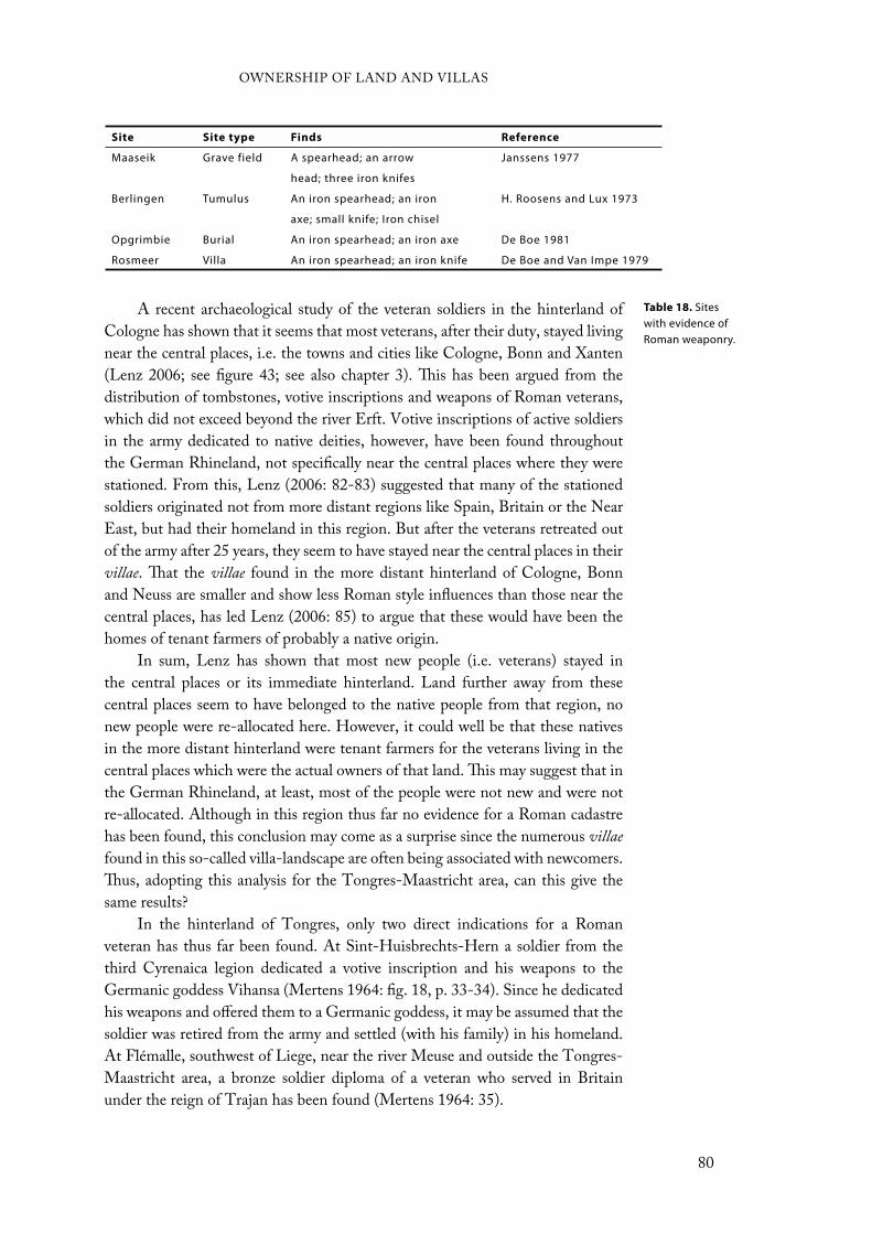
A recent archaeological study of the veteran soldiers in the hinterland of
Cologne has shown that it seems that most veterans, after their duty, stayed living
near the central places, i.e. the towns and cities like Cologne, Bonn and Xanten
(Lenz 2006; see figure 43; see also chapter 3). This has been argued from the
distribution of tombstones, votive inscriptions and weapons of Roman veterans,
which did not exceed beyond the river Erft. Votive inscriptions of active soldiers
in the army dedicated to native deities, however, have been found throughout
the German Rhineland, not specifically near the central places where they were
stationed. From this, Lenz (2006: 82-83) suggested that many of the stationed
soldiers originated not from more distant regions like Spain, Britain or the Near
East, but had their homeland in this region. But after the veterans retreated out
of the army after 25 years, they seem to have stayed near the central places in their
villae. That the villae found in the more distant hinterland of Cologne, Bonn
and Neuss are smaller and show less Roman style influences than those near the
central places, has led Lenz (2006: 85) to argue that these would have been the
homes of tenant farmers of probably a native origin.
In sum, Lenz has shown that most new people (i.e. veterans) stayed in
the central places or its immediate hinterland. Land further away from these
central places seem to have belonged to the native people from that region, no
new people were re-allocated here. However, it could well be that these natives
in the more distant hinterland were tenant farmers for the veterans living in the
central places which were the actual owners of that land. This may suggest that in
the German Rhineland, at least, most of the people were not new and were not
re-allocated. Although in this region thus far no evidence for a Roman cadastre
has been found, this conclusion may come as a surprise since the numerous villae
found in this so-called villa-landscape are often being associated with newcomers.
Thus, adopting this analysis for the Tongres-Maastricht area, can this give the
same results?
In the hinterland of Tongres, only two direct indications for a Roman
veteran has thus far been found. At Sint-Huisbrechts-Hern a soldier from the
third Cyrenaica legion dedicated a votive inscription and his weapons to the
Germanic goddess Vihansa (Mertens 1964: fig. 18, p. 33-34). Since he dedicated
his weapons and offered them to a Germanic goddess, it may be assumed that the
soldier was retired from the army and settled (with his family) in his homeland.
At Flémalle, southwest of Liege, near the river Meuse and outside the Tongres-
Maastricht area, a bronze soldier diploma of a veteran who served in Britain
under the reign of Trajan has been found (Mertens 1964: 35).
Site Site type Finds Reference
Maaseik Grave field A spearhead; an arrow
head; three iron knifes
Janssens 1977
Berlingen Tumulus An iron spearhead; an iron
axe; small knife; Iron chisel
H. Roosens and Lux 1973
Opgrimbie Burial An iron spearhead; an iron axe De Boe 1981
Rosmeer Villa An iron spearhead; an iron knife De Boe and Van Impe 1979
Table 18. Sites with evidence of Roman weaponry.
OWNERSHIP OF LAND AND VILLAS
80
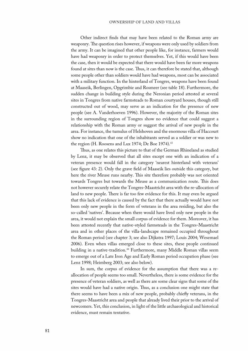
Other indirect finds that may have been related to the Roman army are
weaponry. The question rises however, if weapons were only used by soldiers from
the army. It can be imagined that other people like, for instance, farmers would
have had weaponry in order to protect themselves. Yet, if this would have been
the case, then it would be expected that there would have been far more weapons
found at sites than now is the case. Thus, it can therefore be stated that, although
some people other than soldiers would have had weapons, most can be associated
with a military function. In the hinterland of Tongres, weapons have been found
at Maaseik, Berlingen, Opgrimbie and Rosmeer (see table 18). Furthermore, the
sudden change in building style during the Neronian period attested at several
sites in Tongres from native farmsteads to Roman courtyard houses, though still
constructed out of wood, may serve as an indication for the presence of new
people (see A. Vanderhoeven 1996). However, the majority of the Roman sites
in the surrounding region of Tongres show no evidence that could suggest a
relationship with the Roman army or suggest the arrival of new people in the
area. For instance, the tumulus of Helshoven and the enormous villa of Haccourt
show no indication that one of the inhabitants served as a soldier or was new to
the region (H. Roosens and Lux 1974; De Boe 1974).43
Thus, as one relates this picture to that of the German Rhineland as studied
by Lenz, it may be observed that all sites except one with an indication of a
veteran presence would fall in the category ‘nearest hinterland with veterans’
(see figure 43: 2). Only the grave field of Maaseik lies outside this category, but
here the river Meuse runs nearby. This site therefore probably was not oriented
towards Tongres but towards the Meuse as a communication route. This does
not however securely relate the Tongres-Maastricht area with the re-allocation of
land to new people. There is far too few evidence for this. It may even be argued
that this lack of evidence is caused by the fact that there actually would have not
been only new people in the form of veterans in the area residing, but also the
so-called ‘natives’. Because when there would have lived only new people in the
area, it would not explain the small corpus of evidence for them. Moreover, it has
been attested recently that native-styled farmsteads in the Tongres-Maastricht
area and in other places of the villa-landscape remained occupied throughout
the Roman period (see chapter 3; see also Dijkstra 1997; Louis 2004; Wesemael
2006). Even when villas emerged close to these sites, these people continued
building in a native-tradition.44 Furthermore, many Middle Roman villas seem
to emerge out of a Late Iron Age and Early Roman period occupation phase (see
Lenz 1998; Heimberg 2003; see also below).
In sum, the corpus of evidence for the assumption that there was a re-
allocation of people seems too small. Nevertheless, there is some evidence for the
presence of veteran soldiers, as well as there are some clear signs that some of the
sites would have had a native origin. Thus, as a conclusion one might state that
there seems to have been a mix of new people, probably chiefly veterans, in the
Tongres-Maastricht area and people that already lived their prior to the arrival of
newcomers. Yet, this conclusion, in light of the little archaeological and historical
evidence, must remain tentative.
OWNERSHIP OF LAND AND VILLAS
81

Relationship between villas and cadastresThe piece of land from a Roman cadastre which veterans and other new people
transported to an area received was not as straightforward as it might seem. The
number of cells a regular spaced chequerboard contained was not similar to the
number of families that lived in a cadastre. Put differently, a veteran or other
people did not receive one 20 by 20 actus plot (or in our case a 18 by 18 actus plot)
to live on. At least in theory this seems to have been much smaller, as already has
been stated above. For instance, the Latin word centuria or ‘century’ in English
stands actually for the number of plots which one 20 by 20 actus square was
divided into. Such a 20 by 20 actus square contained 200 iugera. Since the early
republican size of a smallholding given to the new people was 2 iugera, a centuria
could – hence its name – contain 100 plots (Dilke 1971: 15).
The confusion that could result by ignoring this difference, has created a
tendency among some scholars to confuse parcellation with cadastration as
mentioned before in the introduction (e.g. Renes 1988: 38-39; Van Londen
2006). The existence of the former does not however exclude the existence of the
latter (see figure 44). The parcellation Renes (1988: 39) has found in the German
Eiffel region and in England could, in light of this, just as well have been part
of a Roman cadastre. Although in the Eiffel region there seems thus far to be
no reason to suggest such a Roman cadastre, from other countries like Italy and
France it is known that small landholdings were part of a larger cadastral system
(see Dilke 1971: 178-187).
The size of a landholding, though, was not fixed through time. During the
late-fourth century bc, when the first colonies with cadastres surrounding them
were being established, a size of 2 iugera per settler was normal. In later colonies
the size of the plots in certain cases became larger to attract settlers to the region.
For instance, lands taken from the Bruttii, had sizes of 15 to 20 iugera each. In
Cisalpine Gaul, Bononia (Bologna) was founded in 189 bc with allotments of
50 iugera. And during the late-second century bc in Northern Africa plots of up
to 200 iugera (one century) were given to each immigrant, although the largest
sizes were only given to equites, i.e. cavalry (Dilke 1971: 179-182). In general, it
can thus be stated that the first allotments were pretty small but that during the
course of the Roman Empire the plots provided to the settlers got larger.
Nonetheless, these settlers, once settled, could expand their landholding by
incorporating or buying other surrounding land from other people. Thereby they
created vast estates called latifundia in Italy and which can be related to the villa
development in Northern Gaul (see below). Yet, to keep the expansion of estates
under control, as Dilke (1971: 181-182) mentions, “Tiberius Gracchus, tribune
in 133 bc, passed an agrarian law limiting the extent of state domains which
could be held by a possessor [owner] to 500 iugera, with 250 extra for each of two
children”.
The size of one landholding in the Tongres-Maastricht area has not been
investigated thoroughly and seems to be a difficult task due to the fact that not
all villae are known for the area. However, like Gaitzsch (1986) has studied for
OWNERSHIP OF LAND AND VILLAS
82
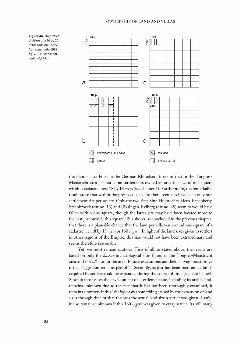
the Hambacher Forst in the German Rhineland, it seems that in the Tongres-
Maastricht area at least some settlements owned an area the size of one square
within a cadastre, here 18 by 18 actus (see chapter 5). Furthermore, the remarkable
result arose that within the proposed cadastre there seems to have been only one
settlement site per square. Only the two sites Sint-Huibrechts-Hern-Papenberg/
Steenbroeck (cat.no. 13) and Riksingen-Keiberg (cat.no. 45) seem to would have
fallen within one square, though the latter site may have been located more to
the east just outside this square. This shows, as concluded in the previous chapter,
that there is a plausible chance that the land per villa was around one square of a
cadastre, i.e. 18 by 18 actus or 160 iugera. In light of the land sizes given to settlers
in other regions of the Empire, this size would not have been extraordinary and
seems therefore reasonable.
Yet, we must remain cautious. First of all, as stated above, the results are
based on only the known archaeological sites found in the Tongres-Maastricht
area and not all sites in the area. Future excavations and field surveys must prove
if this suggestion remains plausible. Secondly, as just has been mentioned, lands
acquired by settlers could be expanded during the course of time (see also below).
Since in most cases the development of a settlement site, including its arable land,
remains unknown due to the fact that it has not been thoroughly examined, it
remains a mystery if this 160 iugera was something caused by the expansion of land
sizes through time or that this was the actual land size a settler was given. Lastly,
it also remains unknown if this 160 iugera was given to every settler. As still many
Figure 44. Theoretical division of a 20 by 20 actus cadastre (afterCompatangelo 1989: fig. 20). ‘P’ stands for pedes (0,295 m).
OWNERSHIP OF LAND AND VILLAS
83
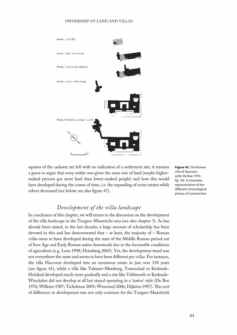
squares of the cadastre are left with no indication of a settlement site, it remains
a guess to argue that every settler was given the same size of land (maybe higher-
ranked persons got more land than lower-ranked people) and how this would
have developed during the course of time, i.e. the expanding of some estates while
others decreased (see below; see also figure 47).
Development of the villa landscapeIn conclusion of this chapter, we will return to the discussion on the development
of the villa landscape in the Tongres-Maastricht area (see also chapter 3). As has
already been stated, in the last decades a large amount of scholarship has been
devoted to this and has demonstrated that – at least, the majority of – Roman
villae seem to have developed during the start of the Middle Roman period out
of Iron Age and Early Roman native farmsteads due to the favourable conditions
of agriculture (e.g. Lenz 1998; Heimberg 2003). Yet, the development trend was
not everywhere the same and seems to have been different per villae. For instance,
the villa Haccourt developed into an enormous estate in just over 150 years
(see figure 45), while a villa like Valmeer-Meerberg, Voerendaal or Kerkrade-
Holzkuil developed much more gradually and a site like Veldwezelt or Kerkrade-
Winckelen did not develop at all but stayed operating in a ‘native’ style (De Boe
1976; Willems 1987; Tichelman 2005; Wesemael 2006; Dijkstra 1997). This sort
of difference in development was not only common for the Tongres-Maastricht
Figure 45. The Roman villa of Haccourt (after De Boe 1976: fig. 18). A schematic representation of the different chronological phases of construction.
OWNERSHIP OF LAND AND VILLAS
84
area, but can be found in other areas too (see Heimberg 2003; Louis 2004: fig. 2).
A good explanation for this has however not been given thus far.
There could be a difference in hierarchical ranking between people which
could result in a difference in size. Besides the inscriptions at Ravensbosch (see
chapter 3), there is one other indication of a high-ranked person in the hinterland
of Tongres. At Gors-Opleeuw, just to the west of the Tongres-Maastricht area, an
inscription has been found in a burial on his landholding of one Caius Gracileius
Similis. His function seem to have been Aedil(is) C(ivitatis) Tungrorum, what was a
public function as police in the civitas (Vanvinckenroye 1985; CIL XIII, 3599). As
stated above, such high-ranked persons may have been given more lands or could
buy more lands than others. This difference in size due to the status of people,
though, would have not been a precondition (see chapter 3). Some people with
allure would not have been given more land or choose not to make an economic
profit to expand their estate. On the other hand, ’normal’ people which did not
belong to the so-called ‘elites’ still had a chance to be economically successful; the
so-called ‘American dream’.
Thus, although ‘status’ could play a role, the answer on the question what
caused the difference in sizes of villae mostly needs to be sought in terms of
wealth, which was the result of a difference in production and distribution
capacity of goods. Some landholders probably could and wanted to expand their
landholdings during time in order to make more profit (which hence could
result in a more prosperous villa), while others did not have the will, money,
time, network of people, location, luck or effort to accomplish this. As Tiberius
Gracchus law suggests, this was not something characteristic for this area, but
was seen in other regions of the Empire too (see above). These different choices
and chances hence resulted in a diverse landscape of house types (not only villae),
burials and landholdings of different sizes.
For instance, the possible villa site of Smeermaas-Dukatonweg is situated close
to the river Meuse, probably one of the most important trade routes in the area.
At this site ‘CISSI’ tile stamps have been found (Pauwels and Creemers 2006: 82).
Thus far these have mostly been attested at villa sites more to the south between
Liege and Namur (De Poorter and Claeys 1989). Since this is the only site in
the Tongres-Maastricht area where these stamps have been found, it may suggest
that its owners took part in a trade network which resulted out of their favourable
location near the river Meuse. This was a benefit other people would not have from
which the inhabitants of Smeermaas-Dukatonweg could have profited in terms of
wealth and expansion.
On the other hand, the site of Veldwezelt, at some distance from the river
Meuse, was a settlement site that continued to be constructed in a ‘native’ style
during the Middle Roman period (Wesemael 2006). An actual explanation for
the occurrence of this type of settlement (it is the first actual non-villa site attested
in the Tongres-Maastricht area, see chapter 3) during the Middle Roman period
cannot be given at the moment. It was located only ca. 1 km from the main road
to Cologne. Thus, a lack of communication could not be the cause. A tentative
explanation which has been heard is that it were actual ‘native’ people living here,
OWNERSHIP OF LAND AND VILLAS
85

while the villa-owners were settlers who came from other regions of the Empire.
This however is quite hard to prove from the archaeological remains as mentioned
above. For now, it may therefore serve as an illustration of the different choices
and chances of a person leading to an expansion to a villa estate or, as in this case,
could prevent it.
Lastly, except for the economic prosperity of an inhabitant, there is also a
different factor that could result in an expansion of the land and the accompanied
growth of the villa. It seems reasonable that with a lifespan of around 200 years,
villae (at least, some) would have not been inhabited by the same family during its
entire history. There is reason to believe that some families moved out, while others
moved in. For instance, compare Haccourt’s earliest three phases of construction
with the later two (see figure 45). It may be noticed that the mid-second century
villa does not look anything like the early-second century ad villa. Not only is the
villa in ca. 40-50 years grown twice as large, also the orientation changed quite
dramatically, as well as its layout. If one would expect the same inhabitants or
family, one would not expect the development to be such a dramatic break with
the past, but rather a development continuing more in line with the earlier visual
appearance of the villa. This may show that change of inhabitants of a site could
cause growth as well as it could cause decline in certain cases.
In sum, the development of the Roman villa landscape in the Tongres-
Maastricht area seems to have been caused by several factors. Most notably is the
factor of an individual’s choice and chance to become economically prosperous
and show this in the style and size of his/her house, burial and land. Although the
status of an individual could contribute to the chance to be economically successful,
this was (and still is) not self evident; there is always a choice. Furthermore,
changes in the social sphere of a house like, for instance, new owners in the
form of a different family probably led to developments not related to earlier
construction phases. Lastly, as already stated above, a difference between new
settlers and socio-culturally ‘Romanized’ old inhabitants is still difficult to spot.
Hence, finding a relationship between this discussion and the development of the
so-called ‘villa landscape’ seemed impossible.
OWNERSHIP OF LAND AND VILLAS
86
“The imposition of order is a dialectic, dynamic process through
which a model of administrative control is applied to the specific
nature of a place.”
Cuomo 2000: 198
The subject of Roman cadastres is a heavily discussed issue within the study
of the Roman Empire, both for its research methodology – whether historical
or archaeological –, its nature and the implications it may have had upon the
interaction between locals and Romans. It is also a subject in which processual
and postprocessual viewpoints seem to merge; on the one hand the square-ordered
cadastral plan serves a processual methodology of statistics, while on the other
the outcome of such a square-ordered cadastre must not be seen, as Cuomo’s
quote above illustrates, as an evident imposition of order from the Roman side
with a passive local influence. In the case of, for instance, Northern Gaul, these
discussions appear to have contributed to the notion of an absence of cadastres.
Scholars seem to follow the thought that only around the Mediterranean Sea
cadastres would have existed. Examples of such can be found in Tunisia, Croatia,
Syria, Spain and Italy itself.
In this book, I have tried to argue that this reasoning is largely based on
prevailing misconceptions regarding the nature of Roman cadastres as static
squares whose boundaries would have been visible lines in the landscape separating
one plot from another which orientation is mainly determined by astronomy and
main roads (see chapters 1 and 4). Or, as Van Londen (2006: 188) recently put
it: “centuriation was absolute and not affected by local topography”. Moreover, I
have tried to show that its research methodology developed extensively after the
first big wave of Roman cadastre-studies during the 1950s, most notably caused by
the evolution of computer applications. The implementation of such applications,
as well as an awareness of the historical nature of modern landscape features and
their relationship with the past, created more advanced methods for studying the
cadastres (see chapter 4). Therefore, opposing the view held by others (e.g. Jones
1989: 129; Hart 1998: 112-113; Heimberg 2003: 127), some scholars already
Conclusions
87

have shown that in the case of Northern Gaul, Roman land-surveyors seem to
have visited the region and ‘shaped’ certain land into cadastral plans (e.g. Legros
1970; Chouquer and Favory 1980; Peterson 1993; Chouquer 1996b).
The Hesbaye region, situated in modern East-Belgium, is part of the loess
belt which runs through Northwestern Europe. Among other regions in this
belt, the soil of this region stands out for its fertility. Because of this, a so-called
villa landscape developed here during the Roman period. In addition, this villa
landscape and the fertile soil on which it was built served as background for the
growing believe of the existence of a Roman cadastre (see Mertens 1958; Ulrix
1959; De Boe 1971b; 1973; Raepsaet 1977; Vanvinckenroye 1985; Melard 1986).
Therefore, an area within the Belgian Hesbaye region, the Tongres-Maastricht
area served in this book as a case study, for which I have tried to examine the
possibility of the existence of a Roman cadastre.
A Roman cadastre in the Tongres-Maastricht areaStarting point for the examination was the hypothesis that certain linear features
in the modern landscape could have evolved from Roman limites (see chapter
5). As shown in, for instance, Italy, Croatia and Tunisia this hypothesis was in
certain cases very evident. And even in cases like Orange (France) and Lacimurga
(Spain), where on first sight it not seemed so evident, the hypothesis was true.
In the hinterland of the city of Orange, for instance, one had never thought
the existence of a Roman cadastre could be demonstrated from a look upon the
modern landscape until the finding of the famous tablets of Orange in the 1950s.
A detailed comparison of these tablets with the modern landscape showed that
certain linear features could be traced back to the times of the Roman cadastre
(Chouquer 1983a; 1983b; Bel and Benoit 1986; Peterson 1992a).
In our examination, talus, which are seen all over the Tongres-Maastricht
area because of its rugged nature, were used (see figure 46). Several maps and one
aerial photograph of the area were used to identify them. From the dominant
orientation of these talus it could, then, be suggested that this may have been
the orientation on which the Roman cadastre was aligned. This makes sense in
the fact that this was also the general inclination of the valleys of the Tongres-
Maastricht area (Duurland 2000: 3-4), which corresponds to on of the list of
theoretical factors determining the orientation of a Roman cadastre (Le Gall
1975; see chapter 4). In order to relate this evidence to the Roman occupation
phase also the orientation of Roman structures found in the area was determined.
The gained results were rather similar as for the talus. The most striking result
was that the structures during the Middle Roman period showed a dominant
inclination in the direction of 45˚-56,25˚ from north grid, while the structures
from the Late Iron Age and the Early and Late Roman period showed a different
dominant orientation.
Since no correlation can be calculated statistically between the talus and
Roman structures due to the fact that the talus’ construction date cannot be fixed
to any particular period while the structures construction date is fixed within
CONCLUSIONS
88
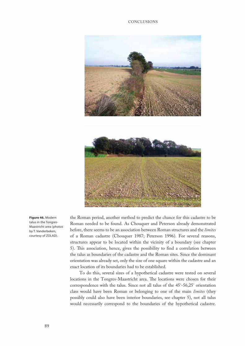
the Roman period, another method to predict the chance for this cadastre to be
Roman needed to be found. As Chouquer and Peterson already demonstrated
before, there seems to be an association between Roman structures and the limites
of a Roman cadastre (Chouquer 1987; Peterson 1996). For several reasons,
structures appear to be located within the vicinity of a boundary (see chapter
5). This association, hence, gives the possibility to find a correlation between
the talus as boundaries of the cadastre and the Roman sites. Since the dominant
orientation was already set, only the size of one square within the cadastre and an
exact location of its boundaries had to be established.
To do this, several sizes of a hypothetical cadastre were tested on several
locations in the Tongres-Maastricht area. The locations were chosen for their
correspondence with the talus. Since not all talus of the 45˚-56,25˚ orientation
class would have been Roman or belonging to one of the main limites (they
possibly could also have been interior boundaries, see chapter 5), not all talus
would necessarily correspond to the boundaries of the hypothetical cadastre.
Figure 46. Modern talus in the Tongres-Maastricht area (photos by T. Vanderbeken, courtesy of ZOLAD).
CONCLUSIONS
89
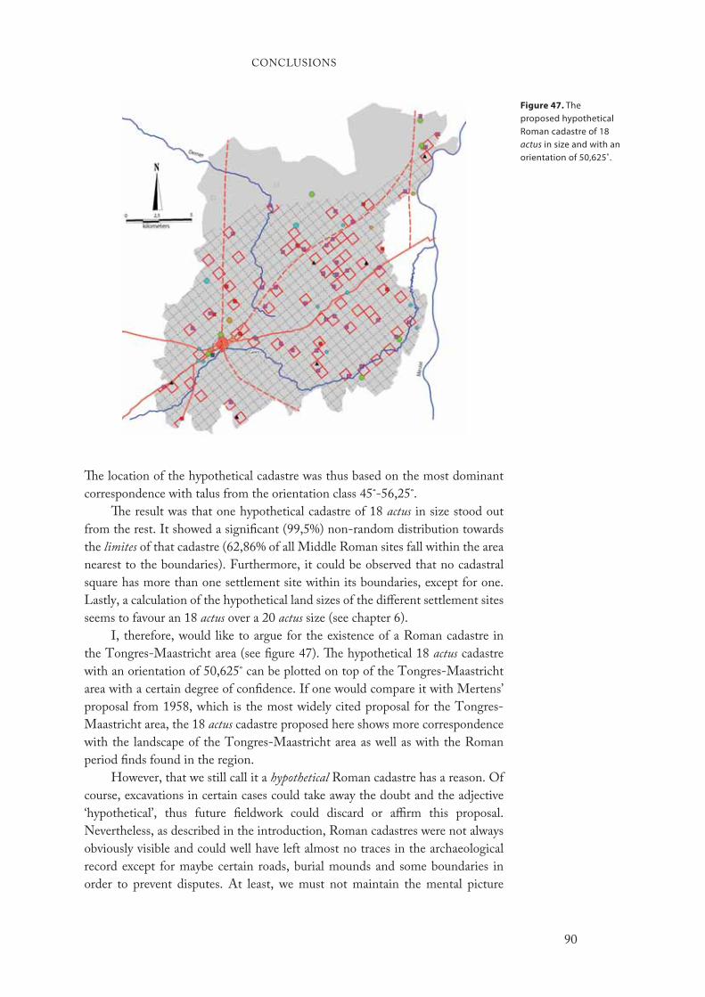
Figure 47. The proposed hypothetical Roman cadastre of 18 actus in size and with an orientation of 50,625˚.
The location of the hypothetical cadastre was thus based on the most dominant
correspondence with talus from the orientation class 45˚-56,25˚.
The result was that one hypothetical cadastre of 18 actus in size stood out
from the rest. It showed a significant (99,5%) non-random distribution towards
the limites of that cadastre (62,86% of all Middle Roman sites fall within the area
nearest to the boundaries). Furthermore, it could be observed that no cadastral
square has more than one settlement site within its boundaries, except for one.
Lastly, a calculation of the hypothetical land sizes of the different settlement sites
seems to favour an 18 actus over a 20 actus size (see chapter 6).
I, therefore, would like to argue for the existence of a Roman cadastre in
the Tongres-Maastricht area (see figure 47). The hypothetical 18 actus cadastre
with an orientation of 50,625˚ can be plotted on top of the Tongres-Maastricht
area with a certain degree of confidence. If one would compare it with Mertens’
proposal from 1958, which is the most widely cited proposal for the Tongres-
Maastricht area, the 18 actus cadastre proposed here shows more correspondence
with the landscape of the Tongres-Maastricht area as well as with the Roman
period finds found in the region.
However, that we still call it a hypothetical Roman cadastre has a reason. Of
course, excavations in certain cases could take away the doubt and the adjective
‘hypothetical’, thus future fieldwork could discard or affirm this proposal.
Nevertheless, as described in the introduction, Roman cadastres were not always
obviously visible and could well have left almost no traces in the archaeological
record except for maybe certain roads, burial mounds and some boundaries in
order to prevent disputes. At least, we must not maintain the mental picture
CONCLUSIONS
90

of a superimposed chequerboard of squares stretching out over the landscape.
That archaeological studies have found such squared, visible squares bounded
off from their adjoining squares in parts of Tunisia, Italy and Croatia, does not
imply that everywhere across the Empire cadastres had to be like that. Cadastres
were regulated by the Roman Empire, as governments nowadays still do. Most
countries have a certain cadastre that registers which land belongs to who. In
many cases, this cadastre leaves no traces in the modern landscape (see Peterson
1993: 242-243). Therefore, I assume (as it is hard to prove) that in the Tongres-
Maastricht area, and probably in other region of Northern Gaul and the rest of the
Empire too, the Romans would have had cadastres that were not obviously visible
within that landscape but which were registered and kept within the institutions
for reasons of tax collection, disputes and land allocation. Therefore, the proposed
cadastre is shown by a dotted line rather than a continuous one (see figure 47).
This invisibility also implies that the orientation of 50,625˚ must not be
taken at face value. After all, it is just the middle of the orientation class with the
highest value of talus and Middle Roman structures. Nor must the location of the
cadastre be viewed as exact. In both cases there might have been a slight change in
its orientation and the exact location. However, in light of the invisibility it seems
almost impossible to reveal its exact location and orientation. Even excavations
will not help here, I think. Nevertheless, the proposed 18 actus cadastre serves as
a general idea of the Roman cadastre that would have existed in the Tongres-
Maastricht area.
Dating the cadastre
Finding a possible starting, as well as ending, date for a Roman cadastre is hard.
As seen in the introduction, a cadastre was for a long time seen as a static, not
changing grid of squares. Contemporary scholarship has shown the contrary, the
same land would have been surveyed for several times throughout the Roman
period. This new insight leaves us with numerous questions when a cadastre is being
identified. How do we know, for instance, if there were more than one cadastre?
And if there were more, which one have we identified? All these questions seem
difficult to answer in light of the sparse remains left to identify a cadastre. In light
of this, in this study it has not been tried to identify several cadastres and thereby
proving the dynamic nature of cadastres during 400 years of Roman occupation in
some regions. What, however, has been tried to do is to show the period in which
a Roman cadastre is most plausible. In light of the evidence, this would have been
the Middle Roman period which, following modern conventional dating, dates
from 70 to 270 ad.
During the transition from the Early to Middle Roman period, many of the
features found on the Early Roman sites that continued to be occupied during
the Middle Roman period show a discontinuity or, put differently, a break with
the past. Moreover, during the Middle Roman period 50 new settlement and
burial sites seem to emerge (see chapter 5). For the Late Roman period evidence
is marginal as there seems to be a lack of good sites. However, still some evidence
suggests that there probably was a gradual abandonment of the cadastral system by
CONCLUSIONS
91
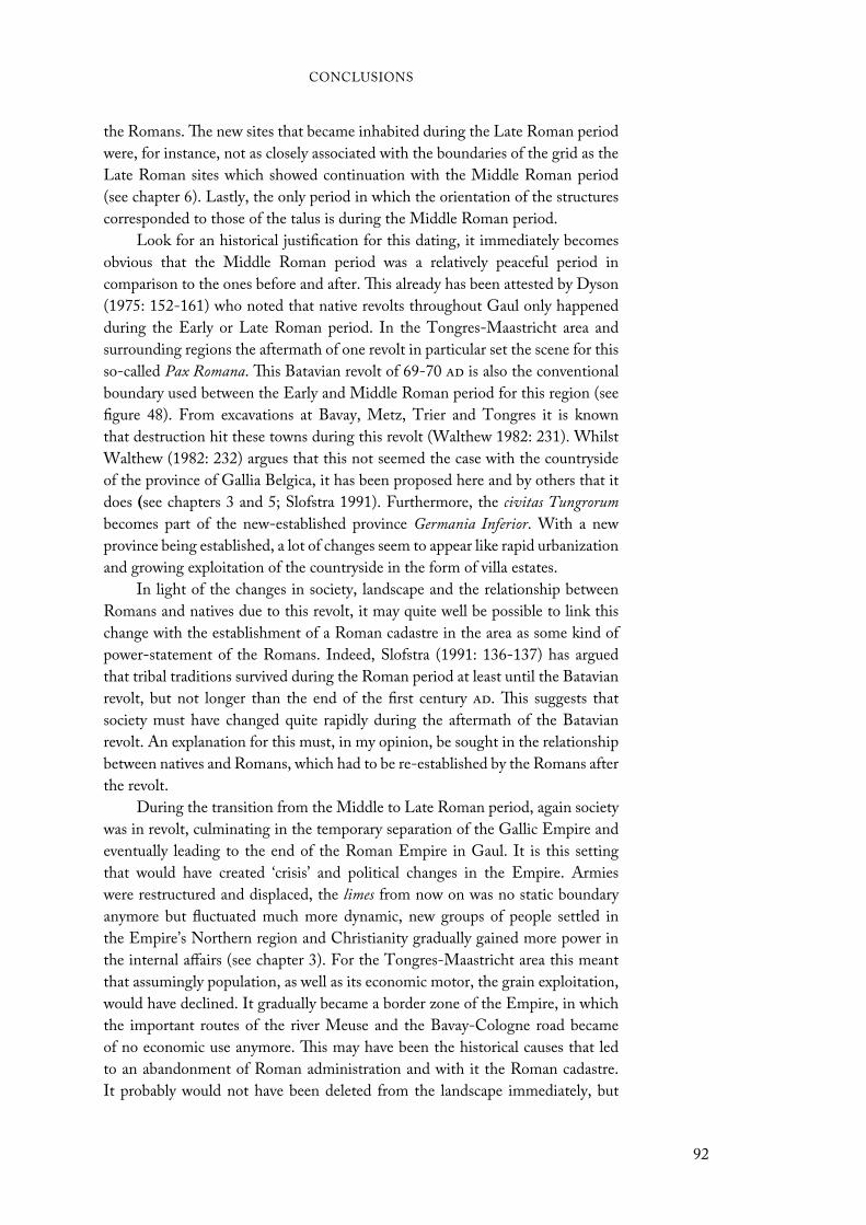
the Romans. The new sites that became inhabited during the Late Roman period
were, for instance, not as closely associated with the boundaries of the grid as the
Late Roman sites which showed continuation with the Middle Roman period
(see chapter 6). Lastly, the only period in which the orientation of the structures
corresponded to those of the talus is during the Middle Roman period.
Look for an historical justification for this dating, it immediately becomes
obvious that the Middle Roman period was a relatively peaceful period in
comparison to the ones before and after. This already has been attested by Dyson
(1975: 152-161) who noted that native revolts throughout Gaul only happened
during the Early or Late Roman period. In the Tongres-Maastricht area and
surrounding regions the aftermath of one revolt in particular set the scene for this
so-called Pax Romana. This Batavian revolt of 69-70 ad is also the conventional
boundary used between the Early and Middle Roman period for this region (see
figure 48). From excavations at Bavay, Metz, Trier and Tongres it is known
that destruction hit these towns during this revolt (Walthew 1982: 231). Whilst
Walthew (1982: 232) argues that this not seemed the case with the countryside
of the province of Gallia Belgica, it has been proposed here and by others that it
does (see chapters 3 and 5; Slofstra 1991). Furthermore, the civitas Tungrorum
becomes part of the new-established province Germania Inferior. With a new
province being established, a lot of changes seem to appear like rapid urbanization
and growing exploitation of the countryside in the form of villa estates.
In light of the changes in society, landscape and the relationship between
Romans and natives due to this revolt, it may quite well be possible to link this
change with the establishment of a Roman cadastre in the area as some kind of
power-statement of the Romans. Indeed, Slofstra (1991: 136-137) has argued
that tribal traditions survived during the Roman period at least until the Batavian
revolt, but not longer than the end of the first century ad. This suggests that
society must have changed quite rapidly during the aftermath of the Batavian
revolt. An explanation for this must, in my opinion, be sought in the relationship
between natives and Romans, which had to be re-established by the Romans after
the revolt.
During the transition from the Middle to Late Roman period, again society
was in revolt, culminating in the temporary separation of the Gallic Empire and
eventually leading to the end of the Roman Empire in Gaul. It is this setting
that would have created ‘crisis’ and political changes in the Empire. Armies
were restructured and displaced, the limes from now on was no static boundary
anymore but fluctuated much more dynamic, new groups of people settled in
the Empire’s Northern region and Christianity gradually gained more power in
the internal affairs (see chapter 3). For the Tongres-Maastricht area this meant
that assumingly population, as well as its economic motor, the grain exploitation,
would have declined. It gradually became a border zone of the Empire, in which
the important routes of the river Meuse and the Bavay-Cologne road became
of no economic use anymore. This may have been the historical causes that led
to an abandonment of Roman administration and with it the Roman cadastre.
It probably would not have been deleted from the landscape immediately, but
CONCLUSIONS
92
during the course of decades, maybe centuries, when other Empires incorporated
the region. All with their own way of dealing with newly embodied groups of
people.
This historical shift may also be detected from the material and examinations
in chapters 4 and 5. Different settlement systems were adopted as seen in the Late
Roman ‘Germanic’ settlement of Neerharen-Rekem and the strong association
with the limites of the 18 actus cadastre during the Middle Roman period gradually
diminished.
The cadastre’s size
The extent to which a cadastre would have spread out over the Tongres-Maastricht
area and surrounding regions is maybe even more difficult to examine than the
date of that cadastre. At least, in the case when the size of a cadastre falls outside
the region under study it cannot be demonstrated. This seems to be the case in
regard to several directions of the cadastre.
A cadastre’s size could have stretched out for hundreds of kilometres as has
been shown in Tunisia (Trousset 1977). The fact that this size is only known
because boundary stones have been found on which the number of a particular
cadastral square more than hundred kilometres away from the point where a
land-surveyor started with surveying, does suggest that in cases where cadastres
have been studied by their visibility in the modern landscapes, the size could
well have been larger than previously thought (see chapter 1). Yet, this faces no
problem in our case where only a small region has been studied, but should make
us aware of the fact that there is a good reason to believe that the cadastre would
have extended beyond the Tongres-Maastricht area.
Rivers played often the role as natural boundary for a cadastre as it would
also do for a pagus, civitas and even provinces. Nevertheless, in some cases a river
would have been incorporated within a cadastre. The river Meuse in regard to this
may have also played this role. Yet, since the Tongres-Maastricht area is situated
west of this river, this could not be examined. But in light of the importance as
transport route and as the possible administrative border of the civitas Tungrorum
it can be assumed.
Another boundary of the cadastre in the Tongres-Maastricht area could be
the change in soil type and with it the change in economic exploitation of that
soil. As mentioned in chapter 1, the Tongres-Maastricht area has a predominant
loess soil with only in the North the beginning of the less-fertile sandy soil. Since
both types of soil fall within the study area, we could examine the possibility
that the cadastre would have ended here by calculating the significance of the
association of sites with the limites of the cadastre for each soil type. The results
were remarkably different. The sandy soil type showed no significant evidence for
the sites to be non-randomly distributed, while those on the loess soil did show
this. Furthermore, the percentage of sites closest to the limites was remarkably
lower in the case of sites on the sandy soil of the Campine region. This seems to
argue that the sandy soil would fall outside the Roman cadastre as proposed here
(see figure 47). Thus, as Roymans (1996: 100) already has argued, “even within
CONCLUSIONS
93

one civitas (such as that of the Tungri) there are sometimes considerable regional
differences in [cultural interaction] which may be easily understood when seen
against the background of landscape variations”. This may be considered as one
of them.
Socio-cultural impactIn the introduction it already was mentioned that we would return to the question
of the socio-cultural impact of a cadastre. It was mentioned there that many
scholars nowadays are stressing more attention on cadastres as a social and cultural
actor within the landscape because of the ‘obviousness’ of the implementation of
it within the landscape. Alcock (2002: 46), for example, stated that “land division
was a pragmatic economic step, but one that simultaneously packed a substantial
symbolic punch through its fundamental reordering of territory”. Purcell (1990:
16), in addition, argues that “doing this to a landscape is a spectacular display of
the conqueror’s power […] the former inhabitants remain, demoted, humiliated
and dependent”. Peterson seems to go even further with this statement by
suggesting that scholars doubt the existence of cadastres in regions where they
are not obviously recognizable (see chapter 1) is due to the fact that it “would
probably entail a revision of views about major characteristics of the province,
such as the nature of relationships between its native and ‘foreign’ inhabitants”
(Peterson 1993: 237-238).
Of course, as these scholars stated, an administrative decision to implement
a cadastre in a region would have caused certain changes within the socio-
cultural sphere. The question remains however in which degree things would
have changed. As Gosden (2004: 2) mentioned, “older views of colonies saw
the colonists as dominant; now, of course, we are more inclined to credit local
people with agency”. However, from the quotes above one may assume that the
socio-cultural effect of the implementation of a cadastre would have been one-
way, directed by the Romans against the ‘natives’, and particularly large. But does
this hold in every case? Would, as Peterson argues, a relatively unrecognizable
cadastre that is more administrative in its nature (e.g. the Orange cadastre, the
one in Tunisia or the Tongres-Maastricht area) have had the same effect as one
regular chequerboard of squares recognizable by its parallel and perpendicular
routes leading to a main axis? And would as in certain historically known cases,
the migration of a people into a newly created cadastre like in Corinthia was
the case have had the same effect as when the cadastre was implemented upon a
landscape without moving groups of people (see chapter 7)?
Surely the answer must be ‘no’ in both cases. Different events, periods,
people and implementation would most likely have caused different sorts of
changes and reactions. This however does not imply that the implementation
of cadastres would not have caused any change. Whether directly recognizable
or not, cadastres would have created controlled space to reinforce hierarchical
relationships between the Empire and its people. In the case of cadastres, this
would after a while cause a competition for hegemony among certain landowners,
Figure 48 (previous
page). Painting by Ferdinand Bol (1658) depicting the negotiation between Romans and Claudius Civilis (courtesy of Rijksmuseum).
CONCLUSIONS
95

which would explain the re-surveying of cadastres by land-surveyors in certain
cases or an abandonment of the ordered structure of cadastres (Kealhofer 1999).
The Tongres-Maastricht area might tentatively have suffered the latter during the
Late Roman period. For instance, villae like Haccourt show a constant, though
not within a single flow (see chapter 7), expansion through the Middle Roman
period that seems to stop during the later period (De Boe 1976). This is something
which is common throughout the villa landscape where some villae would remain
small and others expanded to enormous proportions (see chapter 7). It can be
argued therefore that there seems to have been some sort of competition for
hegemony between certain economically successful landowners, which may have
resulted in the abandonment of order and perhaps the start of ‘crisis’ during the
third century ad.
To what extend then could these imposed cadastres which newly defined the
hierarchical relationships in the area have contributed to socio-cultural changes?
“That what is significant about the adoption of alien objects
– as of alien ideas – is not the fact that they are adopted, but
the way they are culturally redefined and put to use.”
Kopytoff 1986: 67
In some sense Kopytoff’s quote fits here quite well. In regard to cadastres, it
is not the fact that these chequerboards of squares are imposed, but the way
people would – physically and mentally – see them and adapted themselves to
this circumstance. The ‘controlled power’ what these cadastres suppose must not
be seen as the outcome of a one-way process by the Romans, as the above quotes
from Alcock, Purcell and Peterson seem to imply. This view may have been
partially shaped by an influential definition of power.
Max Weber (1978 [1919]: 53) defined power as “the probability that one
actor within a […] relationship will be in a position to carry out his own will despite
resistance, regardless of the basis on which this probability rests”. The problem
with this definition is that its primary focus on institutional forms creates a wide
conceptual gap between the larger structures and the actual individuals interacting
within them. It implies that larger social structures, where a dominating (elite)
group of society consciously authors the ideological conditions and institutions,
affect individual behaviour.45 Thereby, these larger social structures control the
power relation and, with it, the manner and direction of socio-cultural change
(Sweely 1999: 2). However, this does not acknowledge individual behaviour, what
seems necessary if one is willing to understand how power among Romans and
natives would have worked. Furthermore, it stereotypes individuals as passive,
unthinking machines (see Given 2004).
To best describe this balancing of power, then, without marginalizing
the ones with supposed ‘least’ power and yet acknowledges power’s craving to
unilateralism, we may use the concept of ‘negotiation’ (see figure 48). Cultural
power is a constant dynamic process along a continuum of negotiated relations
between the parties involved, whether through institutional or individual actions.
CONCLUSIONS
96
Nevertheless, we must keep in mind that although power almost always operates
reciprocally, in the end it usually is without equal reciprocity.
In light of this theoretical outline, cadastres are not as static symbol of power
as some might have thought. In the case of the Tongres-Maastricht area it seems
that it was predominantly the economic reason, the fertility of the land and the
good connection with the armies on the northern frontier zone which may have
led to the establishment of a cadastre in the area. Still, in the aftermath of the
Batavian revolt, socio-cultural change would have been necessary in order to
sustain control and peace, as Dyson’s (1975: 161) aforementioned quote quite
good captures.
Of course the cadastration may have contributed to this age of Pax Romana.
However, it seems not to have had an effect on the socio-cultural development
of the people in a short-term vision. The fact that the cadastre seems to have not
been immediately physically recognizable as such diminished the effect on people
in forms of physically separating the past from present. Certain older ideologies
stayed with the people (Roymans 1996), while a large-scale detachment with
the previous period was also not visible in the area. The people rather continued
to live on the same location as sites like Neerharen-Rekem, Haccourt and a
rebuilding of the town of Tongres illustrates. Furthermore, Roman material and
the fact that native building styles mixed with some Roman elements already in
the course of the Early Roman period, prior to the revolt, as seen for instance in
the occupation development of Tongres-Hondsstraat and Tongres-Kielenstraat,
suggests that socio-cultural change in the Tongres-Maastricht area was already
begun before the revolt (see A. Vanderhoeven 1996; 2001; 2002).
Rather the long-term reinforced hierarchical relationships caused by the
implementation of this cadastre (see above) seem to have given rise to some new
developments within the socio-cultural sphere. The local economy flourished,
leading to the emergence of Roman villae that seem to have competed against
one another. Furthermore, towns as Tongres developed into cities and new forms
of showing your wealth and status by burial mounds came to existence. In the
case of the Tongres-Maastricht area, it is thus my idea that not so much socio-
cultural order led to an implementation of a cadastre, but rather its location within
the Empire as grain-supplier for the armies. The flourishing economy together
with the new relationships which this cadastre created led to a new socio-cultural
development.
CONCLUSIONS
97


Chapter One1 Centuriatio means a form of surveying in which the limites divide the surveyed land into
squares or, occasionally, rectangles. Centuriations are known of various sizes, but during the
late republic and Empire the 20 by 20 actus size appears to have become the standard.
2 A ‘cadastre’ means a land information system and, in the case of ancient landscapes, its
physical remains. The establishment of a formal Roman cadastre was preceded by surveying
and the establishment of survey markers. As will be seen below, not all Roman surveys were
centuriations. It is thus technically incorrect to use that word to signify all types of Roman
land planning and allotment. For this reason, and because it embraces all aspects of the
system, the term ‘cadastre’ is to be preferred.
3 This research question was instigated by a hypothesis of Tim Vanderbeken, city-archaeologist
of Bilzen, Lanaken and Riemst (ZOLAD).
4 For instance, Dilke 1971; Hinrichs 1974; Behrends and Capogrossi Colognesi 1992;
Chouquer and Favory 1992; 2001; Campbell 2000: xx-lxi.
5 For more information on the history of research on Roman cadastres, as well as on the
historical sources, see Dilke 1971; Chouquer and Favory 1992; 2001.
6 Croatia: Bradford 1957: 178-193; Chevallier 1961. Italy: Castagnoli 1958; Dilke 1971: 142-
149; Compatangelo 1989. Northern Africa, chiefly Tunisia and Algeria: Anonymous 1954;
Chevallier 1958; Soyer 1976. Syria: Dodinet et al. 1990; Tate 1992: 235.
7 Note that Tongres was granted the status ofNote that Tongres was granted the status of municipium in the second century ad (see chapter
3).
8 Dilke (1971: 86) argued, for instance, that after Augustus the size of one cadastre became
so standard that exceptions to it are virtually non-existent. Note that a book review of the
Corpus Agrimensorum’s English edition expresses the same issues and misconceptions in
modern scholarship as described here (Cuomo 2002: 200-201).
Chapter Three9 Needless to say, as the above expresses the concern about dating the Late Iron Age-Early
Roman transitional phase, the precise dates mentioned here are not as precise as they seem.
10 As mentioned in chapter 2, loess was particularly susceptible to soil erosion.
11 The name ‘Celtic fields’ is founded in the 1920s by British archaeologists. Although we
now know that these particular kind of field systems is not specific for the Celtic region, its
name as a terminus technicus has remained to prevent confusion (Roymans 1990: 131, n. 12;
Brongers 1976: 18ff.).
12 Some give a date around 31 bc (Duurland 2000: 10), while others date it around 57 bc
(Hollstein 1976). Which date is correct – if they actually are correct at all – remains unknown.
Maybe new light will be shed on this matter in 2008 since new excavations at the site are
scheduled (T. Vanderbeken, pers. comm.).
13 The administrative organisation, however, did not extend further than the civitas Tungrorum
with Atuatuca Tungrorum (Tongres) as the most northerly civitas capital. There is no evidence
Notes
99

that shows that the region north of the river Demer was divided officially into civitates during
that time. The same applies to the region immediately bordering the Rhine (Slofstra 1991:
135-136). Note, too, that these new civitates probably do not represent the Late Iron Age
civitates.
14 The Middle Roman development of the city of Tongres has been abundantly discussed by
other scholars (see Vanvinckenroye 1985; 1994a; Nouwen 1997: 89-152).
15 Tongres’ second century city wall was 4.544 m, while that of Cologne was 3.911 m. This
does however not mean that Tongres was larger than Cologne, since large parts within the
city walls often were left uninhabited. It, nonetheless, still suggests that Tongres might not
have been inferior to cities as Cologne that were given the status of colonia. Note, in this
respect, that there is often been thought to have been a difference between municipia and
coloniae regarding their size. This, though, does not have to be the actual case, but was due to
historical reasons (see Galsterer-Kroll 1973: 280).
16 The Roman villa, its origin and implications have been extensively discussed in modern
scholarship. See, for instance, De Maeyer 1937; 1940; De Boe 1971b; 1973; Slofstra 1983:
84-89; 1995; Woolf 1998: 148-157; Heimberg 2003; Marzano 2007: 154-198; Terrenato
2007: 139-152.
17 In the Tongres-Maastricht area this thus far has been attested at several sites: Neerharen-
Rekem (De Boe 1986); Valmeer-Meerberg (Pauwels et al. 2002); Vlijtingen-Keyberg/Op de
Alderen Berg (M. Vanderhoeven 1978); Smeermaas-Dukatonweg (Pauwels and Creemers
2006).
18 Calculations are based on plans taken from (De Boe 1971a; 1976; Willems 1987). Note
that in the case of Valmeer-Meerberg the calculation is based on only the main building,
since this is the only building thus far excavated, while at both Voerendaal and Haccourt
the entire villa with accompanying structures has been excavated. This may explain the
size difference, yet note that at Valmeer-Meerberg no indications have been found which
assume that the main building was linked to other buildings during the second century ad
as happened at Voerendaal and Haccourt. Indeed, Heimberg (2003: 93-95) has shown that
the size of Valmeer-Meerberg corresponds with most other villae in this region (52 of 80
calculated villae).
19 There are some objections to the method of land size calculation as stated here (see chapter
6).These objections, however, do not count for Gaitzsch’s observation at the Hambacher
Forst, since this is based on a large area that was entirely excavated due to mining.
20 For calculations of the land size for villae in the Tongres-Maastricht area, see chapter 5.
21 In chapter 6 the position of these burial mounds in the landscape in relationship to the villas
will be examined. Burials, especially burial mounds, often take in an important position in the
landscape and therefore seem often to be used as a demarcation of land plots (e.g. Hiddink
2003: 1-76).
22 In the past, archaeologists concentrating on the loess region focused their attention
predominantly on the stone remains conforming to Roman cultural forms. As already
mentioned above, this caused the neglecting of earlier occupation phases underneath Roman
villas. However, as these new finds might illustrate, it also may have caused a false view of
what thus far has been viewed as the ‘villa landscape’, since it shows that during the Middle
Roman period not only villas occupied the landscape but also native-styled farmhouses.
Maybe our view of the ‘villa-landscape’ must be transformed into one more corresponding
to the one Louis (2004) proposed for the Scarpe Valley (France) during the Middle Roman
period.
Chapter Four23 Maps from earlier periods with less detail (like the famous Peutinger map) are still very
helpful regarding the study of toponyms and ancient roads.
24 In the journal Computers & Geosciences many of these remote sensing techniques are published
and their computer programs can be downloaded. Though not all are applicable to the study
of Roman cadastres, for archaeologists it seems promising to keep an eye on this journal
considering these techniques’ usefulness.
NOTES
100
25 Also in other regions in Northern Gaul such attempts have been made (see Vermeulen and
Antrop 2001: 117-175, for attempts around Roman Cassel, i.e. Castellum Menapiorum).
However, in this section, the focus lies on those regions that had a similar geographical
setting as the Tongres-Maastricht area.
26 Except for Willems (1987) and Van Enckevort et al. (2005), it seems striking that recent
syntheses on the Roman period in this region do not mention this proposal and neglect
even the possibility of a cadastre. This is most notably in the study of Kooistra (1996) on the
possibilities of farming in the Roman period in this region.
Chapter Five27 There seems to be no difference in the meaning of both words. However, Belgian literature
speaks of a talus, while the Dutch literature calls it an escarpment. Because the Tongres-
Maastricht area is situated in Belgium, the word ‘talus’ will be used in this book.
28 All digital maps and aerial photographs of the Tongres-Maastricht area that are used were
given with the kind permission of T. Vanderbeken (ZOLAD). The digital NGI, Depôt de la
Guerre and Vandermaelen maps and the digital NGI aerial photographs are courtesy of GIS-
Vlaanderen.
29 L. Bogaert, G. Schaepenbeek (both prov. of Limburg), T. Vanderbeken (ZOLAD), E.
Meylemans and A. Vanderhoeven (both VIOE) kindly offered their help with the inventory
of the archaeological sites.
30 The orientation of the linear features was calculated by each line object, i.e. ‘arc’. This object
can consist out of more than one segment (i.e. the line between two nodes), in the case the
orientation of a talus is not fixed to a straight line (see Vermeulen and Antrop 2001: 64). In
such cases where that happened, more than one line object was used to trace the talus in order
to capture the different orientations of one talus.
31 Although it is the oldest topographical map, we did not make use of the Vandermaelen map
(1851). The number of talus on this map was too small (n=153) compared to the total number
of talus on all maps. The Depôt de la Guerre map on the other hand depicted enough talus
(n=425).
32 Of course, we have to bear in mind that as factors as culture, cosmology and symbols change
after, for example, the Roman period this also had its influence on the nature of the general
orientation of houses, roads and agricultural fields. Compare, for example, agricultural fields
of the Roman period with periods before (see chapter 3) or after (see Ferdière et al. 2006;
Slicher van Bath 1963). In the course of the Roman period, of course, things would have
changed also. Surveyors, for instance, probably did not survey a particular area only once
during the Roman period, but several times. This has already been attested in several areas in
Southern Gaul (Piganiol 1962; Clavel-Lévêque and Laubenheimer 1984).
33 The Spearman’s rank correlation coefficient (rs) is calculated by r
s = 1 - 6 d2 / (n3-n) (see
Fletcher and Lock 1991: 110-113). The correlation between the period of the archaeological
features and their orientation gave rs = 1 - 6(96.246,25) / (1133-113) = 0,60. Since the number
of observations is more than 100, what is the highest number shown in most significance
tables, a student’s t-test had to be used (t = rs / √(1-r
s2) / (n-2)) (Zar 1972: 578). This gave t
= 0,60 / √(1-0,602) / (113-2) = 0,0035. This shows that there is 99,65 percent evidence for a
correlation between the period of an archaeological feature in the Tongres-Maastricht area
and its orientation.
34 Duurland (2000: 20) supposes that the Late Iron Age/Early Roman period would have had
more settlements as thus far has been found in the Tongres-Maastricht area. According to
him, it could well be around 70 to 100 settlements. However, since this is just an assumption
based on other regions, it cannot be taken into account.
35 In chapter 3, this already has been pointed out in the case of the lack of material evidence for
the Late Roman period.
Chapter Six36 A quintarius is the name of the fifth axis counted from the main axis of a century. It was
within a century the most important axis.
NOTES
101

37 For methodological problems and more detailed information, see Hodder and Orton 1976:
226-229; Peterson 1993: 67-71; 1996.
38 This test was calculated by grouping the settlements and burials into groups of ‘continuation
with former period’ and ‘new’. In the case of burials this instigated a problem, since they are
not occupied throughout a period but build only in a certain time of that period. Therefore,
burials will not show any continuation with the former period, except that they still exist and
may still act as visible marks in the landscape. The latter, the visibility, is an important factor
when calculating the continuation of sites. Think, for example, of cultural heritage sites in our
modern landscape which try to bridge the past with the modern-day landscape. Furthermore,
sites related to earlier periods have also an effect on our perception of the landscape and
shape our identity (e.g. Alcock 2002: 1-25). Therefore, burials that have been constructed
in the period before are included in the case of ‘sites with continuation’, while those burials
constructed in the period that is being calculated have not.
39 Heimberg lists also villa plots in the Northwestern provinces in which the land size would
have been larger than 50 ha. Yet, she did not note for the possibility of other yet unidentified
sites situated between these excavated villa sites. This remains a difficult factor to grasp.
Gaitzsch’s land sizes on the other hand are calculated in an area, the Hambacher forst,
entirely excavated due to the brown coal quarries there. Therefore, these results tend to be
more reliable.
40 The fact that no scholar has yet tried to investigate the possibility of a Roman cadastre in the
German Rhineland seems with respect to the encountered land sizes remarkable.
Chapter Seven41 The supposed relationship of colonialism and Roman cadastres will be explored in the
conclusion.
42 Later on in time, during the reign of Vespasian, the hinterland of Corinth seems to have been
newly surveyed leading to the establishment of new cadastres (see Romano 2006: 71-81; see
also chapter 5).
43 However, at both sites and at the Tumulus of Berlingen a compass was found. In addition,
at Berlingen also a bronze ruler has been found (De Boe 1974: p. 42, no. 113; H. Roosens
1976a: 155). Although these artefacts can be associated to other professions (blacksmith,
carpenter, stone mason), it seems remarkable that all can also be attributed to land-surveyors
as seen, for instance, in the Pompeian workshop (see Dilke 1971: 73).
44 If this ongoing tradition was a choice of the owners or that this was due to necessity is not
clear (see below).
Chapter Eight45 If the Romans had a deliberate, conscious policy of ‘Romanizing’ their subjects remains still
an open question (see Woolf 1998: 22, n. 74). In the case of cadastres, it is argued that there
would not have been such a deliberate policy, but rather a choice based on more economical
grounds (e.g. Purcell 1990; Cuomo 2000; Alcock 2002). This, for example, can be seen in
the choice for the fertile loess soil as a location for such a cadastre in the Tongres-Maastricht
area.
NOTES
102

Agache, R. (1978) La Somme pre-Romaine et Romaine. d’après les prospections aériennes à
basse altitude. Memoires de la Société des Antiquaires de Picardie 24. Amiens.
Alcock, S.E. (1993) Graecia Capta. The Landscapes of Roman Greece. Cambridge.
(2002) Archaeologies of the Greek Past. Landscape, Monuments, and Memories.
Cambridge.
Amand, M. and Nouwen, R. (1989) Gallo-Romeinse tumuli in de Civitas Tungrorum.
PPGRM 40. Hasselt.
Ando, C. (2006) The Administration of the Provinces, in D.S. Potter, ed., A Companion
to the Roman Empire. Blackwell Companions to the Ancient World. Oxford, 177-
192.
Anonymous (1954) Atlas des centuriations romaines de Tunisie. Paris.Paris.
Anonymous (1962) Bij de ontdekking van drie Romeinse villa’s te Millen. Tastbare bewijzen
aangaande een kadastrale landindeling ten tijde der Romeinen, Belang van Limburg,
19-11-1962.
Anonymous (1998) Opgravingen naar Romeinse villa’s, Belang van Limburg, 20-5-1998.
Anonymous (2000) Ruilverkaveling. Veel meer dan kavels ruilen. Brussel.Brussel.
Antrop, M. (1997) The concept of traditional landscapes as a base for landscape evaluation
and planning. The example of Flanders Region, Landscape and Urban Planning 38,
105-117.
Attolini, I., Cambi, F., Castagna, M., Celuzza, M., Fentress, E., Perkins, P. and Regoli,
E. (1990) Political geography and productive geography between the valleys of the
Albegna and the Fiora in northern Etruria, in G. Barker and J. Lloyd, eds., Roman
Landscapes: Field Survey in the Mediterranean. Rome, 142-151.Rome, 142-151.
Baeyens, L. (1968) Bodemkaart van België. Verklarende tekst bij het kaartblad Bilzen 93W.
Gent.
Baillien, H. (1949) Het kasteel van Rooi en zijn bezitters, OLL 4, 33-44.
Bakels, C. and Jacomet, S. (2003) Access to luxury foods in Central Europe during the
Roman period: the archaeobotanical evidence, WA 34, 542-557.
Bauwens-Lesenne, M. (1968) Bibliografische repertorium van de oudheidkundige vondsten in
Limburg, behoudens Tongeren-Koninksem (vanaf de vroegste tijden tot de Noormannen).
Oudheidkundige Repertoria Reeks A: Bibliografische repertoria 8. Brussel.
Bayard, D. and Collart, J.-L., eds. (1996)(1996) De la ferme indigène à la villa romaine. La
romanisation des campagnes de la Gaule. Actes du deuxième colloque de l’association
Ager, Amiens (23 au 25 septembre 1993). Revue Archéologique de Picardie Numéro
Spécial 11. Amiens.
Behre, K.-E. (2000) Frühe Ackersysteme, Düngemethoden und die Entstehung der
nordwestdeutschen Heiden, Archäologisches Korrespondenzblatt 30, 135-151.
Bibliography
103
Behrends, O. and Capogrossi Colognesi, L., eds. (1992) Die Römische Feldmesskunst.
Interdisziplinäre Beiträge zu ihrer Bedeutung für die Zivilationsgeschichte Roms.
Göttingen.
Bel, V. and Benoit, J. (1986) Les limites du cadastre B d’Orange, Revue Archéologique de
Narbonnaise 19, 79-99.
Bellens, J. (2001) Inventaris van de actuele toestand van de tumuli (Juli-Augustus). InternIntern
rapport van Regionaal Landschap Haspengouw. Tongeren.
Bérard, F. (1999) Organisation municipale et hiérarchies sociales dans les provinces
gauloises et alpines d’après la documentation épigraphique, in, XI Congresso
Internazionale di Epigrafia Greca et Latina, Roma, 18-24 settembre 1997. Roma, 39-Roma, 39-
54.
Berendsen, H.J.A. (1998) De vorming van het land. Inleiding in de geologie en geomorfologie.
Fysische geografie van Nederland. Assen.
Berger, J.-F. and Jung, C. (1999) Developing a Methodological Approach to the
Evolution of Field Systems in the Middle Rhône Valley, in P. Leveau et al.,
eds., Environmental Reconstruction in Mediterranean Landscape Archaeology. The
Archaeology of Mediterranean Landscapes 2. Oxford, 155-167.
Bescoby, D.J. (2006) Detecting Roman land boundaries in aerial photographs using
Radon transforms, Journal of Archaeological Science 33, 735-743.
Binsfeld, W. (1984) Die früheste römische Keramik aus Trier, in, Trier: Augustusstadt der
Treverer Stadt und Land in vor- und frührömischer Zeit. Mainz am Rhein, 174-179.Mainz am Rhein, 174-179.
Bloemers, J.H.F. (1983) Acculturation in the Rhine/Meuse basin in the Roman period:
A preliminary survey, in R. Brandt and J. Slofstra, eds., 159-210.
(1990) Lower Germany: plura consilio quam vi: Proto-urban settlement developments
and the integration of native society, in T.F.C. Blagg and M.J. Millett, eds., The
early Roman empire in the West. Oxford, 72-86.
Blume, F., Lachmann, K.K.F.W. and Rudorf, A. (1848) Die Schriften der römischen
Feldmesser. Berlin.
Bouten, W., van Eijsden, G., Imeson, A.C., Kwaad, F.J.P.M., Mücher, H.J. and Tiktak,
A. (1985) Ontstaan en erosie van de lössleemgronden in Zuid-Limburg, KNAG
Geografisch Tijdschrift 19, 192-208.
Bradford, J.D. (1957) Ancient Landscapes. Studies in Field Archaeology. London.
Brandt, R. and Slofstra, J., eds. (1983) Roman and Native in the Low Countries. Spheres of
interaction. BARIS 184. Oxford.
Breteler, H.G.M. and van den Broek, J.M.M. (1968) Graften in Zuid-Limburg, Boor en
spade 16, 119-130.
Broadhead, W. (2007) Colonization, Land Distribution and Veteran Settlement, in P.
Erdkamp, ed., A Companion to the Roman Army. Blackwell Companions to the
Ancient World. Malden, 148-163.
Brongers, J.A. (1976) Air photography and celtic field research in the Netherlands. NederlandseNederlandse
Oudheden 6. Amersfoort.
Brongers, J.A. and Woltering, P.J. (1978) De prehistorie van Nederland. EconomischEconomisch
technologisch. Haarlem.
Brun, P. (1995) From chiefdom to state. organization in Celtic Europe, in B. Arnold
and D.B. Gibson, eds., Celtic chiefdom, Celtic state. New Directions in Archaeology.
Cambridge, 13-25.
Brunaux, J.L. (1986) Les Gaulois. Santuaires et ritesSantuaires et rites. Collection des Hésperides. Paris.
Brunaux, J.L., Fichtl, S. and Marchand, C. (1990) Die ausgrabungen am Haupttor des
«Camp César» bei La Chaussée-Tirancourt (Dép. Somme, Frankreich), Saalburg
Jahrbuch 45, 5-23.
Buchsenschutz, O. (1988) Levroux: L’evolution du Canton de Levroux d’apres les prospections
et les sondages archeologiques. Levroux.Levroux.
BIBLIOGRAPHY
104
Buikstra, J.E. and Charles, D.K. (1999) Centering the Ancestors: Cemeteries, Mounds,
and Sacred Landscapes of the Ancient North American Midcontinent, in W.
Ashmore and A.B. Knapp, eds., Archaeologies of Landscape. Contemporary Perspective.
Malden, 201-228.
Campbell, B. (1995) Sharing Out Land: Two Passages in the Corpus Agrimensorum
Romanorum, Classical Quarterly 45, 540-546.
(1996) Shaping the Rural Environment: Surveyors in Ancient Rome, JRS 86, 74-99.
(2000) The writings of the Roman Land Surveyors. Introduction, Text, Translation and
Commentary. Journal of Roman Studies Monograph 9. London.
Capenberghs, J. (1985) De begraafplaatsen uit de Romeinse tijd in het Limburgse Haspengouw.
Een topografische, chronologische en methodologische studie. Unpublished M.A. thesis.
Leuven.
Caravello, G.U. and Michieletto, P. (1999) Cultural Landscape: trace Yesterday, Presence
Today, Perspective Tomorrow For “Roman Centuriation” in Rural Venetian
Territory, Human Ecology Review 6, 45-50.
Carroll, M. (2001) Romans, Celts & Germans. The German Provinces of Rome. Stroud.Stroud.
Castagnoli, F. (1958) Le ricerche sui resti della centuriazione. Note e discussioni erudite 7.
Roma.
Chevallier, R. (1958) Essai de Chronologie des centuriations romaines de Tunisie,
MEFRA 52, 61-128.
(1961) La centuriazione romana dell’Istria e della Dalmazia, Atti e memorie dalla Societá
istriana di archeologia e storia patria 9, 11-23.
(2001) À la recherche des anciennes limites, L’exemple de la Gaule, in M. Lodewijckx,
ed., Belgian archaeology in a European setting II. AAL 12. Leuven, 13-21.AAL 12. Leuven, 13-21.
Chevallier, R., Fontanel, A., Grau, G. and Guy, M. (1970) Aplication of Optical Filtering
to the study of Aerial Photographs, Photogrammetria 26, 17-35.
Chouquer, G. (1981) Les centuriations de Romagne orientale. Etude morphologique,
MEFRA 93, 823-868.
(1983a) Localisation et extension géographique des cadastres affichés à Orange, in M.
Clavel-Lévêque, ed., 275-296.
(1983b) Photographie aérienne et épigraphie: le cadastre A affiché à Orange (France),
Photo-interpretation 15, 1-7.
(1985) Traitements d’images et paysages médiévaux, Archéologie Médiévale 15, 7-30.
ed. (1987) Structures agraires en Italie centro-méridionale cadastres et paysages ruraux.
Collection de l’Ecole française de Rome 100. Rome.
(1989) La Klee des champs: Structures mentales et histoire des paysages, in M.-M.
Mactoux and E. Geny, eds., Mélanges P Lévêque, vol 2. Annales Litteraires de
l’université de Besançon 377. Paris, 95-135.
(1996a) Introduction, in G. Chouquer, ed., Les formes du paysage Tome 1 - Etudes sur
les parcellaires. Paris, 7-10.
ed. (1996b) Les formes du paysage. Tome 1 - Etudes sur les parcellaires. Paris.
Chouquer, G. and De Klijn, H. (1989) Le Finage antique et médiéval, Gallia 46, 261-
299.
Chouquer, G. and Favory, F. (1980) Contribution à la recherche des cadastres antiques.
Annales littéraires de l’Université de Besançon 236. Paris.
(1991) Les paysages de l’Antiquité. Terres et cadastres de l’Occident romain (IVe s. avant J.-
C. / IIIe s. après J.-C.). Collection des Hespérides. Paris.
(1992) Les arpenteurs romains. Théorie et pratique. Archéologie d’aujourd’hui. Paris.
(2001) L’arpentage romain histoire des textes, droit, techniques. Paris.Paris.
Claassen, A. (1964) Romeins te Hoeselt, Limburg 43, 249.
(1965) De vondsten van Eigenbilzen, Limburg 44, 98-125.
(1970) Van mottoren tot kasteel. PPGRM 14. Tongeren.
BIBLIOGRAPHY
105
(1973) Romeinse vondsten in de Limburgse Maasvallei, OLL 28, 9-23.
Clavel-Lévêque, M., ed. (1983a) Cadastres et Espace Rural. Approches et réalités antiques
(table ronde de Besançon mai 1980). Paris.
(1983b) Cadastres, Centuriations et problèmes d’occupation du sol dans le Bitterrois,
in M. Clavel-Lévêque, ed., 207-258.
(1988) Résistance, révoltes et cadastres: problemes du contrôle de la terre en Gaule
transalpine, in T. Yuge and M. Doi, eds., Forms of Control and Subordination in
Antiquity. Leiden/New York, 177-208.
(1989) Puzzle gaulois: les Gaules en mémoire. Paris.
(1993) Un plan cadastral à l’echelle. La forma de Lacimurga, Estudios de la Antigüedad
6/7, 175-182.
Clavel-Lévêque, M. and Laubenheimer, F. (1984) Cadastres et ateliers d’amphores en
Languedoc méditerranéan, in, Actes du LVIIe Congrès de la Fédération historique du
Languedoc méditerranéen et du Rousillon. Beziers.
Clavel-Lévêque, M. and Orejas, A., eds. (2002) Atlas Historique des cadastres d’Europe II.
Action COST G2 «Paysages anciens et structures rurales». Bruxelles.
Clavel-Lévêque, M., Vassilopoulos, A., Evelpidou, N. and Tirologos, G. (2000) An
Example from Béziers to Demonstrate a GIS-based Methodology on Selecting
Possible Roman Cadastre Grids, in F. Vermeulen and M. De Dapper, eds., 15-22.
Close, F. (1997a) D’occupation romaine á Bassenge, in J.-P. Lensen, ed., Richesses
archéologiques de la Basse-Meuse Liégeoise. Visé, 30-40.Visé, 30-40.
(1997b) D’occupation romaine á Eben-Emael, in J.-P. Lensen, ed., Richesses
archéologiques de la Basse-Meuse Liégeoise. Visé, 50-60.
(1997c) D’occupation romaine á Wonck, in J.-P. Lensen, ed., Richesses archéologiques
de la Basse-Meuse Liégeoise. Visé, 110-120.
Close, F. and Marcolungo, D. (1985a) Le cimetière gallo-romain d’Eben, «Sur les
jardins», Vie Archéologique 17, 101-201.
(1985b) Vestiges d’occupation romaine à Eben «Sol’Pireu», Vie Archéologique 17, 28-
98.
(1986) Traces d’occupation romaine à Wonk Basse-Cour, SOS Fouilles 4, 45-52.
Coenen, A. (1989) Het kasteel van Schalkhoven, de geschiedenis van Schalkhoven in een
notedop. Hoeselt.
Coenen, J. (1944) Het slot Pietersheim, Limburg 25, 14-27, 29-37.
(1946) Het kasteel en de ruïne van Hocht, Limburg 26, 147-158.
(1948) Het kasteel Daalbroek, Limburg 27, 190-195.
Compatangelo, R. (1989) Un Cadastre de Pierre le Salento Romain. Paysage et structures
agraires. Centre de Recherches d’Histoire Ancienne 90. Paris.
Creemers, G. (1991) Gallo-Romeinse vondsten in prive-bezit. Tongeren.
(2006) Hoeselt: romeins bronzen laarsje, in G. Creemers and A. Vanderhoeven, eds.,
Archeologische kroniek Limburg 2001, Limburg - OLL 85, 34-39.
Creemers, G. and Vanderhoeven, A. (2005) Archeologische kroniek van Limburg 2000,
Limburg - OLL 84, 339-356.
Cuomo, S. (2000) Divide and Rule: Frontinus and Roman Land-Surveying, Studies in
History and Philosophy of Science 31, 189-202.
(2002) Review of Campbell, B. 2000. The Writings of the Roman Land Surveyors.
Introduction, Text, Translation and Commentary, JRS 92, 200-201.
De Beenhouwer, J. (1991) Roman terracotta statuettes from a closed find at Tongeren
and their relation to the Köln, Trier and Central-Rhine production centres, AAL
30, 61-93.
De Boe, G. (1971a) De Romeinse villa op de Meerberg te Val-Meer. AAL 4. Leuven.
(1971b) De stand van het onderzoek der Romeinse villa’s in België. AB 132. Brussel.
(1973) De landelijke bewoning in de Romeinse tijd, OLL 28, 85-114.
BIBLIOGRAPHY
106

(1974) Haccourt I. Vestiges d’habitat pré-romain et premières périodes de la villa romaine.
AB 168. Brussel.
(1976) Haccourt III. Les bains de la grande villa. AB 182. Brussel.AB 182. Brussel.
(1981a) Noodopgravingen te Neerharen (Belgisch Limburg), Archeologie in Limburg
12, 5-7.
(1981b) Romeinse grafvondsten te Opgrimbie, in, Conspectus MCMLXXX. AB 238.
Brussel, 42-46.
(1982) Meer dan 1500 jaar bewoning rond de Romeinse villa te Neerharen-Rekem, in,
Conspectus MCMLXXXI. AB 247. Brussel, 71-74.
(1983) De Laat-Romeinse “Germaanse” nederzetting te Neerharen-Rekem, in,
Conspectus MCMLXXXII. AB 253. Brussel, 70-73.
(1985) De opgravingscampagne 1984 te Neerharen-Rekem, AB 1, 53-62.
(1986) De opgravingscampagne 1985 te Neerharen-Rekem, AB 2, 23-26.
(1987) Bewoning rond de villa te Neerharen-Rekem (B), in P. Stuart and M.E.T. De
Grooth, eds., 51-54.
(1988) De inheems-Romeinse houtbouw in de Antwerpse Kempen, in F. Brenders
and G. Cuyt, eds., Van beschaving tot opgraving 25 jaar archeologisch onderzoek rond
Antwerpen. Antwerpen, 47-62.
(1989) Onder Romeinse heerschappij, in M. Gorissen and B. Roosens, eds.,
Bodemschatten Archeologisch onderzoek in Groot-Bilzen van de bandceramiek tot de
Merovingers. Bilzen, 39-49.
De Boe, G. and Van Impe, L. (1979) Nederzetting uit de IJzertijd en de Romeinse villa te
Rosmeer. AB 216. Brussel.
De Maeyer, R. (1937) De Romeinsche Villa’s in België. Een archeologische studie.
Antwerpen.
(1940) De overblijfselen der Romeinsche villa’s in België. De archeologische inventaris, eerste
deel. Antwerpen.Antwerpen.
De Poorter, A. and Claeys, P. (1989) Les sigles sur matériaux de construction romains en
terre cuite en Belgique. AAL 1. Leuven.
Defize-Lejeune, A.M. (1964) Répertoire bibliographique des trouvailles archéologiques
de la province de Liège (depuis l’âge du bronze jusqu’aux Normands. Répertoires
archéologiques Série A: répertoires bibliographiques 5. Bruxelles.
Derks, T. (1998) Gods, Temples and Ritual Practices. The transformation of religious ideas
and values in Roman Gaul. AAS 2. Amsterdam.AAS 2. Amsterdam.
Dijkstra, Y. (1997) Aanvullend Archeologisch Onderzoek (AAO), vindplaats Kerkrade-
Winckelen, verkaveling Maar-West. Rapportage Archeologische Monumentenzorg
51. Amersfoort.
Dilke, O.A.W. (1971) The Roman Land Surveyors. An Introduction to the AgrimensoresAn Introduction to the Agrimensores.
London.
Dodinet, M., Leblanc, J., Vallat, J.-P. and Villeneuve, F. (1990) Le paysage antique en
Syrie: l’exemple de Damas, Syria 67, 339-367.
van Doorselaer, A. (1964) Repertorium van de Begraafplaatsen uit de Romeinse tijd in
Noord-Gallië. I. België. Brussel.
Driesen, P. and Borgers, K. (2006) Rapport 13. Archeologisch onderzoek aan de Onderwijsstraat
te Munsterbilzen (gem. Bilzen), in opdracht van P&A Construct nv. Sint-Truiden.Sint-Truiden.
Drinkwater, J.D. (1983) Roman Gaul. The three provinces, 58 BC-AD 260. London.London.
Dudal, R. and Baeyens, L. (1957) Bodemkaart van België. Verklarende tekst bij het kaartblad
Tongeren 107W. Gent.
(1958) Bodemkaart van België. Verklarende tekst bij het kaartblad Herderen 107E. Gent.
Duurland, M. (2000) Romeinse vindplaatsen in het landelijke gebied tussen Tongeren
en Maastricht. Een inventarisatie en periodisering. Unpublished M.A. Thesis.
Amsterdam.
BIBLIOGRAPHY
107
Dyson, S.L. (1975) Native revolt patterns in the western Empire, ANRW II.3, 138-175.
Eckholdt, M. (1980) Schiffahrt auf kleinen Flüssen Mitteleuropas in Römerzeit und
Mittelalter. München.
Edelman, C.H. and Eeuwens, B.E.P. (1959) Sporen van een Romeinse landindeling in
Zuid-Limburg, Berichten van de ROB 9, 49-56.
Eerman, H. (2002) IJzertijdceramiek van 2 Distrigas-sites in Zuid-Limburg (Lafelt en
Valmeer). Unpublished M.A. Thesis. Leuven.
van Enckevort, H., de Groot, T., Hiddink, H.A. and Vos, W. (2005) De Romeinse tijd in
het Midden-Nederlandse rivierengebied en het Zuid-Nederlands dekzand- en lössgebied.
NOaA hoofdstuk 18 (versie 1.0), (www.noaa.nl).
Faider-Feytmans, G. (1956) Tongres, L’Antiquité Classique 25, 136.
Favory, F. (1980) Détection des cadastres antiques par filtrage optique: Gaule et
Campanie, MEFRA 92, 347-386.
(1983) Propositions pour une modélisation des cadastres ruraux antiques, in M. Clavel-
Lévêque, ed., 51-135.
Ferdière, A. (2004) Indigènes et «romanisation» à travers la tombe privilégiée en Gaule,
Latomus 63, 35-57.
Ferdière, A., Malrain, F., Matterne, V., Méniel, P. and Jaubert, A.N. (2006) Histoire de
l’agriculture en Gaule. 500 av. J.-C. - 1000 apr. J.-C.500 av. J.-C. - 1000 apr. J.-C. Paris.
Fletcher, M. and Lock, G.R. (1991) Digging Numbers. Elementary Statistics for
Archaeologists. Oxford University Committee for Archaeology 33. Oxford.
Fulford, M.G. (1985) Roman material in barbarian society c.200 B.C.-c.A.D. 400, in
T.C. Champion and J.V.S. Megaw, eds., Settlement and Society: aspects of West
European prehistory in the first millenium BC. Leicester, 91-108.
Gaitzsch, W. (1986) Grundformen römischer Landsiedlungen im Westen der CCAA,
BJ 186, 397-427.
Galsterer-Kroll, B. (1973) Zum ius Latii in den Keltischen Provinzen des Imperium
Romanum, Chiron 3, 277-306.
Gechter, M. and Kunow, J. (1986) Zur ländlichen Besiedlung des Rheinlandes in
römischer Zeit, BJ 186, 377-396.
Genicot, L.F., ed. (1976) Het groot kastelenboek van België. Kastelen en buitenplaatsen.
Brusse.
Gerritsen, F.A. (2003) Local identities: Landscape and community in the late prehistoric
Meuse-Demer-Scheldt region. AAS 9. Amsterdam.
Given, M. (2004) The Archaeology of the Colonized. London.London.
Göbel, J. (1992) Ein Blick in die Eisenzeit. Das Modell der spätlatènezeitlichen befestigten
Siedlung Niederzier, in, Spurensicherung Archäologische Denkmalpflege in der Euregio
Maas-Rhein. Mainz am Rhein, 438-446.Mainz am Rhein, 438-446.
Gorissen, M. and Roosens, B., eds. (1989)(1989) Bodemschatten. Archeologisch onderzoek in
Groot-Bulzen van de bandceramiek tot de Merovingers. Bilzen.Bilzen.
Gosden, C. (2004) Archaeology and Colonialism. Cultural contact from 5000 BC to the present.
Topics in contemporary archaeology 2. Cambridge.
Haase, D., Fink, J., Haase, G., Ruske, R., Pecsi, M., Richter, H., Altermann, M. and
Jäger, K.D. (2007) Loess in Europe - its spatial distribution based on a European
Loess Map, scale 1:2,500,000, Quaternary Science Reviews 26, 1301-1312.
Hachmann, R., Kossack, G. and Kuhn, H. (1962) Völker zwischen Germanen und Kelten.
Neumünster.
Hart, J.F. (1998) The Rural Landscape. Baltimore.
Haselgrove, C.C. (1995) Social and Symbolic order in the origins and layout of Roman
villas, in J. Metzler et al., eds., Integration in the Early Roman West. The role of Culture
and Ideology. Dossiers d’Archéologie du Musée National d’Histoire et d’Art 4.Dossiers d’Archéologie du Musée National d’Histoire et d’Art 4.
Luxembourg, 65-76.
BIBLIOGRAPHY
108
(1996) Roman impact on rural settlement in southern Picardy, in N. Roymans, ed.,
From the Sword to the Plough Three studies on the earliest Romanisation of Northern
Gaul. AAS 1. Amsterdam, 127-188.AAS 1. Amsterdam, 127-188.
Heeren, A.M. (1976) De topografie van de noordelijke Maasvallei in de Romeinse tijd.
Unpublished M.A. Thesis. Leuven.
Heimberg, U. (2003) Römische Villen an Rhein und Maas, BJ 203, 57-148.
Heymans, H. (1977) De topografie van de Merovingische grafvelden in Belgisch-Limburg en
Maastricht. Unpublished M.A. Thesis. Leuven.
Hiddink, H.A. (2003) Het grafritueel in de Late IJzertijd en Romeinse tijd in het Maas-
Demer-Scheldegebied, in het bijzonder van twee grafvelden bij Weert. Zuidnederlandse
Archeologische Rapporten 11. Amsterdam.Amsterdam.
Hingley, R. (1984) The Archaeology of Settlement and the Social Significance of Space,
SAR 3, 22-27.
(1990) Boundaries surrounding Iron Age and Romano-British Settlements, SAR 7,
96-103.
Hinrichs, F.T. (1974) Die Geschichte der gromatischen Institutionen. Wiesbaden.
Hinz, H. (1972) Die Landwirtschaft im römischen Rheinland, Rheinsches Vierteljahresblatt
36, 1-27.
Hodder, I. and Orton, C. (1976) Spatial analysis on archaeology. New studies in archaeology
1. Cambridge.
Hollstein, E. (1976) Dendrochronologische datierung von Hölzern aus der wallanlage
von Kanne, Caster, in, Conspectus MCMLXXV. AB 186. Brussel, 59-61.AB 186. Brussel, 59-61.
Hombroux, C. (1982) De muntschat van Riemst: antoniniani van Gordianus III tot
Postumus, Limburg 61, 112-122.
Huybrigts, F. (1904) Etude comparative des Occupations Romaines et Franques de la
Hesbaye et des contrées au Sud de la Meuse et de la Sambre dans la province de
Namur et dans le Hainaut, Bulletin de la Société Scientifique et Littéraire du Limbourg
22, 17-41, 279-316.
(1905) Trouvaille de Monnaies, Bulletin de la Société Scientifique et Littéraire du
Limbourg 23, 307-320.
Huygen, C.A. (1960) Romeinse landindeling en Romeinse wegen in Zuid Limburg, Der
Bronk 7, 353-355.
In ‘t Ven, I. and De Clercq, W., eds. (2005) Een lijn door het landschap. Archeologie en het
VTN-project 1997-1998. Archeologie in Vlaanderen Monografie 5. Brussel.
Ingold, T. (1993) The temporality of the landscape, WA 25, 152-174.
Isaac, B. (1988) The meaning of the Terms Limes and Limitanei, JRS 78, 125-147.
Janssen, L. (1978) Sporen van Romeinse bewoning langs de oude Maasbedding te Rekem,
Limburg 57, 62-76.
Janssen, L. and Vanderhoeven, M. (1962) De Archeologische verzameling Smeets uit
Rekem, Limburg 41, 123-132.
Janssens, D. (1977) Een Gallo-Romeins grafveld te Maaseik. AB 198. Brussel.
Joachim, H.-E. (1980) Jüngerlatènezeitliche Siedlungen bei Eschweiler, Kr. Aachen, BJ
180, 355-441.
(1982) Ländliche Siedlungen der vorrömischen Eisenzeit im rheinischen Raum, Offa
39.
Jones, M. (1989) Agriculture in Roman Britain: The Dynamics of Change, in M. Todd,
ed., Research on Roman Britain: 1960-89. Britannia monograph 11. London, 127-
134.
Kealhofer, L. (1999) Creating Social Identity in the Landscape: Tidewater, Virginia,
1600-1750, in W. Ashmore and A.B. Knapp, eds., Archaeologies of Landscape:
Contemporary Perspectives. Malden, 58-82.
King, A. (1990) Roman Gaul and Germany. London.
BIBLIOGRAPHY
109
Klinkenberg, J. (1936) Die Stadtanlage der römischen Köln und die Limitation des
Ubierlandes, BJ 140-141, 259-298.
Knaepen, E. (2001) De landelijke bewoning in de Gallo-Romeinse periode in Zuid-Limburgs
Haspengouw. Unpublished M.A. thesis. Leuven.Unpublished M.A. thesis. Leuven.
Knapp, A.B. and Ashmore, W. (1999) Archaeological Landscapes: Constructed,
Conceptualized, Ideational, in W. Ashmore and A.B. Knapp, eds., Archaeologies of
Landscape: Contemporary Perspectives. Malden, 1-30.
Knörzer, K.-H. (1980) Subfossile Pflanzenreste aus der jünglatènezeitlichen Siedlung bei
Laurenzberg, Gem Eschweiler, Kr. Aachen, BJ 180, 441-457.
Kolen, J. (1995) Recreating (in) nature, visiting history, AD 2, 127-159.
(2005) De Biografie van het Landschap. Drie Essays over Landschap, Geschiedenis en
Erfgoed. Unpublished Ph.D. thesis. Amsterdam.
van de Konijnenburg, R. (1985) Het kasteel d’Aspremont-Lynden te Rekem, AB 1, 99-
102.
(1986) Het kasteel d’Aspremont - Lynden te Rekem (gem. Lanaken), AB 2, 117-
120.
(1987) Het kasteel d’Aspremont - Lynden te Rekem (gem. Lanaken). InterimverslagInterimverslag
1986, AB 3, 237-239.
Kooistra, L.I. (1996) Borderland farming. Possibilities and limitations of farming in the
Roman Period and Early Middle Ages between the Rhine and Meuse. Assen.
Kopytoff, I. (1986) The cultural biography of things: commoditization as process, in A.
Appadurai, ed., The social life of things Commodities in cultural perspective. Cambridge,
64-91.
Kreuz, A. (1999) Becoming a Roman farmer: preliminary report on the environmental
evidence from the Romanization project, in J.D. Creighton and R.J.A. Wilson, eds.,
Roman Germany. Studies in cultural interaction. JRA Supplement 32. Portsmouth,
71-98.
Lambert, A.M. (1971) The Making of the Dutch Landscape. London.London.
Le Gall, J. (1975) Les Romains et l’orientation solaire, MEFRA 87, 287-320.
Lebret, P. and Lautridou, J.-P. (1991) The Loess of West Europe, GeoJournal 24, 151-
156.
van der Leeuw, S., Favory, F. and Fiches, J.-L. (2003) Archéologie et systèmes socio-
environnementaux. Études multiscalaires sur la vallée du Rhône dans le programme
ARCHAEOMEDES. CRA monographies 27. Paris.
Legros, R. (1970) Structures agraires gallo-romaines près de Reims, Photo-Interpretation
2, 38-42.
Lemaire, T. (1997) Archaeology between the invention and the destruction of the
landscape, AD 4, 5-21.
Lenz, K.H. (1998) Villae Rusticae: Zur Entstehung dieser Siedlungsform in den
Nordwestprovinzen des römischen Reiches, KJ 31, 49-70.
(1999) Siedlungen der Römischen Kaiserzeit auf der Aldenhover Platte. Rheinsche
Ausgrabungen 45. Köln.
(2006) Veteranen der römischen Armee im Siedlungsbild einer früh- und
mittelkaiserzeitlichen Koloniestadt und deren Hinterland. Das Beispiel derDas Beispiel der Colonia
Claudia Ara Agrippinensium (Köln), Germania 84, 61-91.
Lewit, T. (2003) ‘Vanishing villas’: what happened to élite rural habitation in the West in
the 5th-6th c?, JRA 16, 260-274.
Lodewijckx, M. (1976) De La Tène periode in het gebied tussen Dijle, Demer en Maas.
Unpublished M.A. thesis. Leuven.Leuven.
Louis, E. (2004) A De-romanised Landscape in Northern Gaul: The Scarpe Valley from
the 4th to the 9th century A.D, in W. Bowden et al., eds., Recent Research on the Late
Antique Countryside. Late Antique Archaeology 2. Leiden, 479-504.Late Antique Archaeology 2. Leiden, 479-504.
BIBLIOGRAPHY
110
Lux, G.V. (1957) De vroegste geschiedenis van Rosmeer, OLL 22, 19.
(1970) De Romeinse overblijfselen tussen Tongeren en Maastricht, in H. Roosens
and G.V. Lux, eds., Een Gallo-Romeinse tumulus te Eben-Emael-Kanne. AB 121.
Brussel, 21-28.
Lux, G.V. and Roosens, H. (1972) Een ronde hut uit de IJzertijd en andere vondsten te Grote
Spouwen (Gem. Spouwen). AB 141. Brussel.
Lux, G.V. and Thyssen, W. (1977) Oudheidkundig bodemonderzoek te Alden Biesen,
in, Conspectus MCMLXXVI. AB 196. Brussel, 107-110.
(1978) De voormalige kerk van Alden-Biesen, in, Conspectus MCMLXXVII. AB 206.
Brussel, 119-121.
(1979) De voormalige kerk van Alden-Biesen, in, Conspectus MCMLXXVIII. AB 213.
Brussel, 164-167.
(1980a) De grondvesten van de burcht te Borgloon, in, Conspectus MCMLXXIX. AB
223. Brussel, 98-101.
(1980b) De voormailge kerk van Alden-Biesen, in, Conspectus MCMLXXIX. AB 223.
Brussel, 123-127.
Marzano, A. (2007) Roman Villas in Central Italy. A Social and Economic HistoryA Social and Economic History. ColumbiaColumbia
Studies in the Classical Tradition. Leiden.
Massart, C. (1994) De bewaarde Gallo-Romeinse tumuli van Haspengouw. Musées royaux
d’art et d’histoire 9. Brussel.
(2007) Caractérisation des tumulus gallo-romains de Hesbaye (cité des Tongres);
structures architecturales, funéraires et rituelles, Latomus 66, 41-66.
Mattingly, D.J. (2006a) The Imperial Economy, in D.S. Potter, ed., A Companion to the
Roman World. Blackwell Companions to the Ancient World. Oxford, 283-297.
(2006b) An Imperial Possession: Britain in the Roman Empire, 54 BC - AD 409. The
Penguin history of Britain 1. London.
Melard, L. (1986) Millen. Van natuurlandschap tot cultuurlandschap,Van natuurlandschap tot cultuurlandschap, Volkskunde 87,
262-345.
Mertens, J.R. (1954) Membruggen (Germania Inferior, Belgium: Limbourg), Fasti
Archaeologici 7, 352.
(1958) Sporen van een Romeins kadaster in Limburg?, Limburg 37, 253-260.
(1964) Enkele beschouwingen over Limburg in de Romeinse tijd. AB 75. Brussel.AB 75. Brussel.
(1983) Quelques aspects chronologiques du reseauroutier Romain en Belgique,
Caesarodunum 18, 329-337.
(1987) De weg Boulogne-Keulen op Belgisch grondgebied, in P. Stuart and M.E.T.
De Grooth, eds., 16-21.
Mertens, J.R. and Vanvinckenroye, W. (1975) Een Romeins gebouwencomplex extra-muros
te Tongeren. AB 180. Brussel.
Metzler, J. (1984) Das treverische Oppidum auf dem Titelberg (Luxemburg), in, Trier:
Augustusstadt der Treverer Stadt und Land in vor- und frührömischer Zeit. Mainz am
Rhein, 68-78.
Milikowski, E. (1985) Archeologische luchtkartering van het gebied Eersel-Riethoven-
Bergeijk, in J. Slofstra et al., eds., Het Kempenproject 2. Een regionaal-archeologisch
onderzoek in uitvoering. Bijdragen tot de studie van het Brabantse Heem 27. Waalre,
79-85.
Millett, M.J. (1990) The Romanization of Britain. An essay in archaeological interpretation.
Cambridge.
Mücher, H.J. (1973) Enkele aspekten van de loess en zijn noordelijke begrenzing, in het
bijzonder in Belgisch en Nederlands Limburg en in het daaraangrenzende gebied in
Duitsland, KNAG Geografisch Tijdschrift 7, 259-276.
Müller-Wille, M. (1970) Die landwirtschaftliche Grundlage der Villae Rusticae,
Gymnasium Beihefte 7, 26-42.
BIBLIOGRAPHY
111

(1979) Flursysteme der Bronze- und Eisenzeit in den Nordseegebieten, in H. Beck
et al., eds., Untersuchungen zur eisenzeitlichen und frühmittelalterlichen Flur in
Mitteleuropa und ihrer Nutzung. Abhandlungen der Akademie der Wissenschaften
in Göttingen, Phil.-Hist. Klasse, Folge 3, nr. 115. Göttingen, 196-239.
Nales, T. and Bink, M. (2005) Tongeren Plangebied De Locht-Hasseltsesteenweg-Mulkerweg,
fase 1. ‘s-Hertogenbosch.‘s-Hertogenbosch.
Nash, D. (1976) The growth of urban society in France, in B. Cunliffe and T. Rowley,
eds., Oppida in Barbarian Europe. Papers presented to a Conference at Oxford, October
1975. BAR Supplementary Series II. Oxford, 95-134.BAR Supplementary Series II. Oxford, 95-134.
Nouwen, R. (1991) Oude collectiestukken van het Provinciaal Gallo-Romeins Museum
in een nieuw licht. Het zogenaamde Junobeeld van Tongeren, Limburg 70, 13-18.
(1997) Tongeren en het land van de Tungri (31 v.Chr. – 284 n.Chr.). Maaslandse
Monografiën 59. Leeuwarden.
Opsteyn, L. and Lodewijckx, M. (2001) Wange-Damekot revisited. New perspectives inNew perspectives in
Roman habitation history, in M. Lodewijckx, ed., Belgian archaeology in a European
setting II. AAL 13. Leuven, 217-230.AAL 13. Leuven, 217-230.
Palet Martínez, J.M. (2005) Apports de l’archéologie du paysage à l’étude des systèmes
agropécuaires anciens, Cahier de recherches de l’Institut de la papyrologie et égyptologie
de Lille 25, 329-348.
Pals, J.P. and Hakbijl, T. (1992) Weed and insect infestication of a grain cargo in a ship
at the Roman fort of Laurium in Woerden (Province of Zuid-Holland), Review of
Palaeobotany and Palynology 73, 287-300.
Panhuysen, T.A.S.M. (1996) Romeins Maastricht en zijn beelden. Assen.Assen.
Parker Pearson, M. (1999) The Archaeology of Death and Burial. Stroud.
Parker Pearson, M. and Richards, C. (1993) Architecture and order: spatial representation
and archaeology, in M. Parker Pearson and C. Richards, eds., Architecture and order:
approaches to social space. London, 38-72.London, 38-72.
Paulissen, E. (1973) Het landschap van de Romeinse Maasvallei in Belgisch Limburg,
OLL 28, 25-55.
Pauwels, D. and Creemers, G. (2006) Een Romeinse landelijke nederzetting te Smeermaas
(Lanaken, prov. Limburg), Relicta 2, 49-118.
Pauwels, D., Vanderhoeven, A. and Vynckier, G. (2000) Een streep Ijzertijd tussen
Tongeren en Maastricht: Distrigas in zuid-Limburg, Lunula Archaeologia
Protohistorica VIII, 48.
(2002) Val-Meer (Riemst): sporen uit de IJzertijd, Romeinse nederzetting en
laatromeinse graven op het Distrigas-traject, in G. Creemers and A. Vanderhoeven,
eds., Archeologische kroniek van Limburg 1999, Limburg - OLL 81, 310-313.
Pauwels, D., Vanderhoeven, A., Vynckier, G. and Wesemael, E. (2003) Een inheems-
Romeinse nederzetting te Veldwezelt (L.), in M. Lodewijckx, ed., Romeinendag
- Journée d’archéologie romaine Leuven - 8-2-2003. Leuven, 59-60.Leuven, 59-60.
Peterson, J.W.M. (1992a) Computer-aided projection of part of the Orange B cadastre
to the Cèze valley, Dialogues d’Histoire Ancienne 18, 169-176.
(1992b) Fourier analysis of field boundaries, in G. Lock and J. Moffett, eds.,
CAA91: Computer Applications and Quantative Methods in Archaeology 1991. BAR
International Series S577. Oxford, 149-156.
(1993) Computer-aided investigation of ancient cadastres. Unpublished Ph.D. thesis.
Norwich.
(1996) A computer model of Roman landscape in South Limburg, in H. Kamermans
and K. Fennema, eds., Interfacing the Past Computer Applications and Quantitative
Methods in Archaeology CAA 1995. Analecta Praehistorica Leidensia 28. Leiden,Analecta Praehistorica Leidensia 28. Leiden,
185-194.
Peuskens, N. (1974) Bilan de 15 ans de recherches et fouilles dans la région Basse-Meuse
BIBLIOGRAPHY
112

Bas-Geer, in, Handelingen van het archeologisch congres, gehouden te Tongeren van 11
tot 14 november 1971. PPGRM 19. Hasselt.
Piganiol, A. (1962) Les documents cadastraux de la colonie romaine d’Orange. 16e supplément
à Gallia. Paris.
Popper, K.R. (1972) Conjectures and Refutations. London: Routledge/Kegan Paul.London: Routledge/Kegan Paul.
Potter, T.W. (1987) Roman Italy. London.
Purcell, N. (1990) The Creation of Provincial Landscape: the Roman Impact on Cisalpine
Gaul, in T.F.C. Blagg and M.J. Millett, eds., The early Roman empire in the West.
Oxford, 6-29.
Quilici, L. (1974) Collatia. Forma Italiae, Regio I, volumen 10. Roma.
Rackham, O. (1986) The history of the countryside. London.
Raepsaet-Charlier, M.-T. (1995) Municipium Tungrorum, Latomus 54, 361-369.
(1999) Les institutions municipales dans les Germanies sous le Haut Empire: bilan et
questions, in M. Dondin-Payre and M.-T. Raepsaet-Charlier, eds., Cités, municipes,
colonies Les processus de municipalisation en Gaule et en Germanie sous le Haut Empire
romain. Paris, 271-352.
(2003) Vielfalt und kultureller Reichtum in den civitates Niedergermaniens, BJ 203,
35-56.
Raepsaet, G. (1977) Quelques aspects de la division du sol en Pays Tongres, in D. Haupt
and H.G. Horn, eds., Studien zu den Militärgrenzen Roms II. Beiheft der BJ 38.Beiheft der BJ 38.
Köln, 147-157.
Remouchamps, A.E. (1925) Opgraving van een Romeinsche villa in het Ravensbosch
(L.), Oudheidkundige Mededelingen van het Rijksmuseum van Oudheden te Leiden 6,
40-77.
Renes, J. (1988) De Geschiedenis van het Zuidlimburgse Cultuurlandschap. MaaslandseMaaslandse
Monografieën 6. Assen.
Rizakis, A. (1996) Les colonies Romaines des côtes occidentales Grecques. PopulationsPopulations
et territoires, Dialogues d’Histoire Ancienne 22, 255-324.
Romano, D.G. (2006) Roman Surveyors in Corinth, Proceedings of the American
Philosophical Society 150, 62-85.
Romano, D.G. and Tolba, O. (1995) Remote Sensing, GIS and Electronic Surveying:
Reconstructing the City Plan and Landscape of Roman Corinth, in J. Huggett
and N. Ryan, eds., CAA94: Computer Applications and Quantitative Methods in
Archaeology 1994. BARIS 600. Oxford, 163-174.
Rommens, T., Verstraeten, G., Poesen, J., Govers, G., Van Rompaey, A., Peeters, I.
and Lang, A. (2005) Soil erosion and sediment deposition in the Belgian loess
belt during the Holocene: establishing a sediment budget for a small agricultural
catchment, The Holocene 15, 1032-1043.
Roosens, B. (1987) Het kasteel “Jonkholt” te Hoelbeek (gem. Bilzen). Interimverslag
1986, AB 3, 241-246.
Roosens, B. and Wouters, W. (1986) Eerste opgravingscampagne van het kasteel
“Jonkholt” te Hoelbeek (gem. Bilzen), AB 2, 113-116.
Roosens, H. (1960) Vlijtingen (Limburg), L’Antiquité Classique 29, 420.
(1975) Oude versterking te Kanne-Caster, in, Conspectus MCMLXXIV. AB 177.
Brussel, 32-36.
(1976a) Bestattungsritual und Grabinhalt einiger Tumuli im Limburger Haspengouw,
Helinium 16, 139-155.
(1976b) De oude versterking te Caster, in, Conspectus MCMLXXV. AB 186. Brussel,
54-58.
Roosens, H. and Janssens, P. (1978) Het Merovingisch grafveld van Rosmeer. II De
merovinger van Rosmeer: zijn fysiek en zijn pathologie. AB 204. Brussel.
Roosens, H. and Lux, G.V. (1969) Een nederzetting uit de IJzertijd op de Staberg te Rosmeer.
BIBLIOGRAPHY
113
AB 109. Brussel.
(1970) Een Gallo-Romeinse tumulus te Eben-Emael-Kanne. AB 121. Brussel.
(1973) Grafveld met Gallo-Romeinse tumulus te Berlingen. AB 147. Brussel.
(1974) Gallo-Romeinse tumulus te Helshoven onder Hoepertingen. AB 164. Brussel.
Roosens, H. and Vanderhoeven, M. (1952) Een Merovingisch grafveld in Romeins puin
te Rosmeer, OLL 7, 110-119.
(1955) Een verdwenen tumulus te Rosmeer. AB 24. Brussel.
Rowlands, M. (1993) The role of memory in the transmission of culture, WA 25, 141-
151.
Roymans, N. (1983) The North Belgic tribes in the 1st century B.C.: a historical-
anthropological perspective, in R. Brandt and J. Slofstra, eds., 43-70.
(1990) Tribal societies in Northern Gaul. An anthropological perspective. Cingula 12.
Amsterdam.
(1995) The cultural biography of urnfields and the long-term history of a mythical
landscape, AD 2, 2-24.
(1996) The sword or the plough. Regional dynamics in the romanisation of Belgic
Gaul and the Rhineland area, in N. Roymans, ed., From the Sword to the Plough
Three studies on the earliest Romanisation of Northern Gaul. AAS 1. Amsterdam, 9-
126.
Roymans, N. and Theuws, F. (1999) Long-term perspectives on land and people in the
Meuse-Demer-Scheldt region (1100 bc-1500 ad). An introduction, in F. Theuws
and N. Roymans, eds., Land and Ancestors. Cultural dynamics in the Urnfield period
and the Middle Ages in the Southern Netherlands. AAS 4. Amsterdam, 1-32.AAS 4. Amsterdam, 1-32.
Rubini, J. (2007) La borne de Cantabrie, Histoire et mesure 19, 41-93.
van der Sanden, W.A.B. (1987) Oss-Ussen: de nederzettingen, in W.A.B. van der Sanden
and P.W. van den Broeke, eds., Getekend Zand. Tien jaar archeologisch onderzoek in
Oss-Ussen. Bijdragen tot de studie van het Brabantse Heem 31. Waalre, 53-69.
Saris, F.J.A. (1984) Lijnvormige landschapselementen, belangrijke onderdelen van een
ecologische infrastructuur, Landschap 1, 91-108.
Savenay, J. (1969) Afvalkuilen van een Romeins Landhuis ontdekt te Zichen-Zussen-
Bolder, Limburg 48, 205-206.
de Schaetzen, P. (1950) La Tombe Belgo-Romaine de Riempst, Bulletin de L’Institut
Archéologique Liégeois 47, 37-60.
de Schaetzen, P. and Vanderhoeven, M. (1955) Twee Romeinse graven uit Tongeren,
OLL 10, 101-113.
Schama, S. (1995) Landscape and memory. London.London.
Schulzki, H.-J. (2001) Der Katastrophenhorizont der zweiten Hälfte des 3. JahrhundertsJahrhunderts
auf dem Territorium der CCAA. Historisches Phänomen und numismatischer
Befund, KJ 34, 7-88.
Schwan, J. (1986) The origin of horizontal alternating bedding in Weichselian aeolian
sands in northwestern Europe, Sedimentary Geology 49, 73-108.
Slicher van Bath, B.H. (1963) The agrarian history of Western Europe. A.D. 500-1850.
London.
Slofstra, J. (1983) An anthropological approach to the study of romanization processes, in
R. Brandt and J. Slofstra, eds., 71-104., 71-104.
(1987) Een nederzetting uit de Romeinse tijd bij Hoogeloon, in W.C.M. van Nuenen,
ed., Drie dorpen een gemeente. Een bijdrage tot de geschiedenis van Hoogeloon, Hapert
en Casteren. Hapert, 51-86.Hapert, 51-86.
(1991) Changing settlement systems in the Meuse-Demer-Scheldt area during the
Early Roman period, in N. Roymans and F. Theuws, eds., Images of the past Studies
on ancient societies in Northwestern Europe. Studies in Pre- en Protohistorie 7.
Amsterdam, 131-200.
BIBLIOGRAPHY
114

(1995) The villa in the Roman West: space, decoration and ideology, in J. Metzler et
al., eds., Integration in the Early Roman West. The role of culture and ideology. DossiersDossiers
d’Archéologie du Musée National d’Histoire et d’Art 4. Luxembourg.
Smeesters, J. (1974) Schat te Riemst, Limburg 53, 134-136.
Soyer, J. (1976) Les centuriations romaines en Algérie orientale, Antiquités Africaines 10,
107-180.
Spits, J. (1963) Bodemkartering en Archeologie, Limburg 42, 14-16.
Stuart, P. and De Grooth, M.E.T., eds. (1987) Langs de Weg. De Romeinse weg van
Boulogne-sur-Mer naar Keulen. Maastricht.Maastricht.
Sweely, T.L. (1999) Introduction, in T.L. Sweely, ed., Manifesting Power. Gender and the
Interpretation of power in archaeology. London, 1-14.London, 1-14.
Tate, G. (1992) Les campagnes de la Syrie du Nord du IIe au VIIe siècle: Un exemple d’expansion
démographique et économique à la fin de l’Antiquité. Paris.Paris.
Terrenato, N. (2007) The Essential Countryside: The Roman World, in S.E. Alcock and
R. Osborne, eds., Classical Archaeology. Blackwell Studies in Global Archaeology 10.
Oxford, 139-161.
Tichelman, G. (2005) Het villacomplex Kerkrade-Holzkuil. ADC Rapport 155.ADC Rapport 155.
Amersfoort.
Timpe, D. (1993) Der Namensatz der taciteischen Germania, Chiron 23, 323-352.
Trips, E. (1954) De villa van Membrugge, L’Antiquité Classique 23, 181.
Trousset, P. (1977) Nouvelles observations sur la centuriation romaine à l’Est d’El Jem,
Antiquités Africaines 11, 175-207.
Ucko, P.J. and Layton, R., eds. (1999) The Archaeology and Anthropology of Landscape.
Shaping your landscape. One World Archaeology 30. London.
Ulrix, F. (1959) Centuriatio in de omstreken van Tongeren, Limburg 38, 34-44.
Van Crombruggen, H. (1962) Les nécropoles Gallo-Romaines de Tongres, Helinium 2,
36-50.
Van Impe, L. (1977) Sporen van oude akkersystemen in de Limburgse Kempen, in N.
Roymans et al., eds., Brabantse Oudheden. Bijdragen tot de studie van het Brabantse
Heem 16. Eindhoven, 101-109.
Van Londen, H. (2006) Midden-Delfland. The Roman Native Landscape. Past and PresentThe Roman Native Landscape. Past and Present.
Unpublished Ph.D. thesis. Amsterdam.
Van Ossel, P. (1979) Les établissements ruraux au Bas-Empire dans la partie méridionale
de la Civitas Tungrorum, Revue des Archéologues et Historiens d’Art de Louvain 12,
9-27.
(1983) Létablissement Romain de Loën a Lixhe et l’occupation rurale au Bas-Empire
dans la Hesbaye Liégoise, Helinium 23, 143-169.
(1992) Etablissements ruraux de l’Antiquité tardive dans le nord de la Gaule. Supplément
à Gallia 51. Paris.
Van Ossel, P. and Ouzoulias, P. (2000) Rural settlement economy in Northern Gaul in
the Late Empire: an overview, JRA 13, 133-160.
Vandekerckhove, V. (1996) Celtic field research in the Belgian Campine, in M.
Lodewijckx, ed., Archaeological and hostirical apsects of West-European societies. Album
amicorum André van Doorselaer. AAL 8. Leuven, 67-76.
Vanderhoeven, A. (1996) The earliest urbanisation in Northern Gaul. Some implications
of recent research in Tongres, in N. Roymans, ed., From the Sword to the Plough
Three studies on the earliest romanisation of Northern Gaul. AAS 1. Amsterdam, 189-AAS 1. Amsterdam, 189-
260.
(2001) Das vorflavische Tongeren: Die früheste Entwicklung der Stadt anhand von
funden und befunden, in G. Precht, ed., Genese, Struktur und Entwicklung römischer
Städte im 1 jahrhundert n Chr in Nieder- und Obergermanien. Xantener Berichte 9.
Mainz am Rhein, 157-176.
BIBLIOGRAPHY
115

(2002) Aspekte der frühesten Romanisierung Tongerens und des zentralen Teiles
der civitas Tungrorum, in T. Grünewald and S. Seibel, eds., Kontinuität und
Diskontinuität. Germania inferior am Beginn und am Ende der römischen Herrschaft
Reallexikon der Germanischen Altertumskunde 35. Berlin, 119-144.
Vanderhoeven, A. and Vynckier, G. (2002) Tongeren: Romeinse Kassei, Limburg - OLL
81, 245-250.
(2003) Een rijk laat-Romeins graf aan de Darenbergstraat te Tongeren, in M.
Lodewijckx, ed., Romeinendag - Journée d’archéologie romaine Leuven - 8-2-2003.
Leuven, 77.
(2006) Opgraving Darenbergstraat, Tongeren, in G. Creemers and A. Vanderhoeven,
eds., Archeologische kroniek Limburg 2002, Limburg - OLL 85, 170-173.
Vanderhoeven, A., Vynckier, G. and Vynckier, P. (1991) Het oudheidkundig
bodemonderzoek aan de Kielenstraat te Tongeren. Interimverslag 1987, Archeologie
in Vlaanderen 1, 107-124.
Vanderhoeven, M. (1976) De Gallo-Romeinse tumulus van Riemst, Limburg 55, 3-29.
(1978) Sporen van een nederzetting uit de IJzertijd op de Kayberg te Vlijtingen. PPGRM
24. Tongeren.
Vanderhoeven, M. and Janssen, L. (1974) De archeologische verzameling Coenegracht
uit Rekem, OLL 29, 141-163.
Vanvinckenroye, W. (1981) Bronzen bustebalsamarium gevonden te Vlijtingen, Limburg
60, 264-265.
(1984) De Romeinse zuidwest-begraafplaats van Tongeren (Opgraving 1972-1981).
PPGRM 29. Tongeren.
(1985) Tongeren. Romeinse stad. Tielt.
(1988a) De Romeinse villa op de Sassenbroekberg te Broekom. PPGRM 38. Tongeren.
(1988b) Middeleeuwse kerk onder de St.-Evermaruskapel te Rutten, Limburg 66, 5-
9.
(1990) De Romeinse villa’s van Piringen (“Mulkenveld”) en Vechmaal (“Walenveld”).
PPGRM 42. Hasselt.
(1994a) Een bijdrage tot het stadskernonderzoek van Romeins Tongeren. PPGRM 46.
Hasselt.
(1994b) Een Romeins votiefaltaar te Tongeren, Limburg 73, 225-228.
(1996) Some reflections on Tongeren (prov. Limburg) in the augustan era, in M.
Lodewijckx, ed., Archaeological and historical aspects of West-European societies. Album
amicorum André Van Doorselaer. AAL 8. Leuven, 109-121.
(2001) Über Atuatuca, Cäsar und Ambiorix, in M. Lodewijckx, ed., Belgian archaeology
in a European setting II. AAL 12. Leuven, 63-67.
Vermeulen, F. and Antrop, M., eds. (2001) Ancient Lines in the Landscape. A Geo-
Archaeological Study of Protohistoric and Roman Roads and Field Systems in Northwestern
Gaul. BABesch Supplements 7. Leuven.BABesch Supplements 7. Leuven.
Vermeulen, F. and De Dapper, M., eds. (2000)(2000) Geoarchaeology of the Landscapes of Classical
Antiquity. International Colloquium Ghent 23-24 October 1998. BABesch Annual
Papers on Classical Archaeology 5. Leiden.Leiden.
Vleeshouwer, J.J. and Damoiseaux, J.H. (1990) Bodemkaart van Nederland. 1:50.000.1:50.000.
Blad 61-62 West en Oost. Maastricht - Heerlen. Wageningen.
Walthew, C.V. (1982) Early Roman town development in Gallia Belgica: a review of
some problems, OJA 1, 225-236.
Ward-Perkins, B. (2000) Land, labour and settlement, in A. Cameron et al., eds., the
Cambridge Ancient History vol XIII, Late Antiquity: empire and successors, AD 425-600.
Cambridge, 315-345.
Weber, M. (1978 [1919]) Economy and Society: An Outline of Interpretive Sociology.
Berkeley.
BIBLIOGRAPHY
116
Wesch-Klein, G. (2007) Recruits and Veterans, in P. Erdkamp, ed., A Companion to the
Roman Army. Blackwell Companions to the Ancient World. Malden, 435-450.Blackwell Companions to the Ancient World. Malden, 435-450.
Wesemael, E. (2006) Veldwezelt (Lanaken): vondsten uit het midden paleolithicum,
de ijzertijd en de Romeinse periode, in G. Creemers and A. Vanderhoeven, eds.,
Archeologische kroniek van Limburg 2001, Limburg - OLL 85, 60-63.
Wightman, E.M. (1975) Rural settlement in Roman Gaul, ANRW II.4, 568-657.
Will, W. (1987) Römische ‘Klientel-Randstaaten’ am Rhein? Eine Bestandsaufnahme,
BJ 187, 1-61.
Willems, W.J.H. (1987) De grote villa van Voerendaal, in P. Stuart and M.E.T. De
Grooth, eds., 46-51.
Willems, W.J.H. and Kooistra, L.I. (1987) De Romeinse villa te Voerendaal. OpgravingOpgraving
1986, Archeologie in Limburg 32, 29-38.
Witcher, R. (1998) Roman Roads: phenomenological perspectives on roads in the
landscape, in C. Forcey et al., eds., TRAC 97. Proceedings of the Seventh Annual
Theoretical Roman Archaeology Conference, Nottingham 1997. Oxford, 60-70.
Witherick, M., Small, J. and Ross, S. (2001) A Modern Dictionary of Geography. Oxford.
Woolf, G.D. (1993) Rethinking the Oppida, OJA 12, 223-234.
(1995) Beyong Romans and Natives, WA 28, 339-350.
(1998) Becoming Roman. The origins of provincial civilization in Gaul. Cambridge.
(2003) Local Cult in Imperial Context: the Matronae revisited, in P. Noelke, ed.,
Romanisation und Resistenz in Plastik, Architektur und Inschriften der Provinzen des
Imperium Romanum Neue Funde und Forschungen. Mainz am Rhein, 131-138.Mainz am Rhein, 131-138.
Wouters, W. and Roosens, B. (1986) Oude vondsten van het kasteel Jonkholt te Hoelbeek
(gem. Bilzen), AB 2, 227-240.
Zandboer, S. (2006) De locatiekeuze van Romeinse villa’s in Zuid-Limburg. UnpublishedUnpublished
M.A. thesis. Amsterdam.
Zar, J.H. (1972) Significance Testing of the Spearman’s Rank Correlation Coefficient,
Journal of American Statistical Association 67, 578-580.
BIBLIOGRAPHY
117


1.
Site: Sint-Huibrechts-Hern - Vrijhern
Examination: Field survey
References: Duurland 2000: 38
Coordinates: 227647 / 168332
Occupation phases: MR; LR (?)
Interpretation: Villa / farmstead
Material: T; Br; Pt
Notes: Nearby Roman burial (CAI
700566)
2.
Site: Hoeselt - Goos
Examination: Field survey
Coordinates: 227492 / 172094
CAI: 700820; 700868
Occupation phase: (?)
Interpretation: Farmstead (?)
Material: T (?); C
Notes: Location of coin (CAI 700868) is
some 250 m. S of CAI 700820
3.
Site: Schalkhoven - Teugelveld
Examination: Field survey
References: Archéologie 1970: 21
Coordinates: 226516 / 171394
CAI: 700817
Occupation phase: (?)
Interpretation: Villa (?)
Material: T; Si; Br
4.
Site: Hoeselt - Den Vlikker Berg
Examination: Unknown
Coordinates: 227572 / 174609
CAI: 700548
Occupation phase: (?)
Interpretation: Unknown
This catalogue lists 181 sites that are examined within the Tongres-Maastricht area.
The catalogue numbers used here correspond to the numbers on maps 1-5 and on some
other figures. With regard to the coordinates given here, when the location of a site
is not precisely known the coordinates will be given in italics. The dating of the sites
and occupation phases is based on the stratigraphy (only in the case of excavations) and
pottery and metal finds as found in the publications or as given by the experts of the
VIOE. The publication of Duurland (2000) has been a major contribution in the dating
of most of the surveyed sites. For details and problems with the dating of survey finds in
this region, I therefore refer to his publication.
The archaeological material is abbreviated in the following way: F = Foundation;
W = Wall remain; Wo = Wood; Ph = Posthole(s); Br = Brick; T = Tile; Si = Silex; Ht =
Hypocaust tile; Tu = Tubulus; Os = Opus Signinum; Gl = Window glass; St = Stone; Pt =
Pottery; C = Coin(s); Fi = Fibula(e); Gl = Glass; Mt = Metal (unspecified); Ab = Animal
bone; Hb = Human bone; Tf = Tefryt (volcanic stone used as grinder); Phl = Phyllite
(wetstone); Tp = Trash pit(s); O = Other finds.
Catalogue
119
5.
Site: Hoeselt - Het Achterste
Teugelenveld
Examination: Field survey
Coordinates: 227322 / 170629
CAI: 700554
Occupation phase: (?)
Interpretation: Villa (?)
Notes: Probably a villa, yet no finds listed
6.
Site: Hoeselt - Paneel
Examination: Field survey
Coordinates: 226617 / 175069
CAI: 700555
Occupation phase: MR
Interpretation: Villa (?)
Material: Si; Gl; C
7.
Site: Hoeselt - Nederstraat
Examination: Unknown
Coordinates: 228106 / 174349
CAI: 700549
Occupation phase: (?)
Interpretation: Unknown
8.
Site: Schalkhoven - Steenbergveld
Examination: Chance find
References: A. Coenen 1989: 3
Coordinates: 226513 / 170230
CAI: 700563
Occupation phase: MR (?)
Interpretation: Villa (?)
Notes: examination of site in 1866
9.
Site: Sint-Huibrechts-Hern - Hardelingen
Examination: Field survey
References: Duurland 2000: 38
Coordinates: 227194 / 169481
CAI: 700558
Occupation phases: MR; LR (?)
Interpretation: Villa (?)
Material: T; Pt
10.
Site: Hoeselt - Hombroek
Examination: Excavation
References: A. Claassen 1964; Archéologie
1964: 23-24
Coordinates: 228125 / 172349
CAI: 700547
Occupation phase: MR
Interpretation: Villa
Material: T; Br; Si; W; Pt; Tf
Notes: Also a burned layer found
11.
Site: Hoeselt - Op het groot Wilder
Examination: Field survey
References: Duurland 2000: 38; Creemers
2006: 34-39
Coordinates: 228651 / 170569
CAI: 700537; 700550
Occupation phase: MR (?)
Interpretation: Villa (?)
Material: T; Pt; Mt; Gl
Notes: Wilder is an indicative Roman
toponym
12.
Site: Hoeselt - Twee kruisen
Examination: Field survey
Coordinates: 227834 / 170524
CAI: 700818
Occupation phase: (?)
Interpretation: Villa / farmstead (?)
Material: Pt; C
Notes: Among the pottery also Samian
ware
13.
Site: Sint-Huibrechts-Hern - Papenberg /
Steenbroeck
Examination: Field survey
References: De Maeyer 1940: 118;
Bauwens-Lesenne 1968: 337; Duurland
2000: 38
Coordinates: 226388 / 166284
CAI: 51562; 700538
Occupation phase: MR (?)
Interpretation: Villa
Material: Br; T; F; Pt
Notes: Tiles show burning marks,
suggesting a fire
14.
Site: Hees - Grote Steen
Examination: Field survey
References: Lux 1970: no. 20; A. Claassen
1973: 12; Duurland 2000: 40; Creemers
and Vanderhoeven 2005
Coordinates: 237478 / 171828
CAI: 55083; 52357
Occupation phase: MR
Exact date: 2nd h. 1st - 3rd (?) c. ad
CATALOGUE
120

Interpretation: Villa (?)
Material: T; Br; Pt
Notes: CAI 52357 mentions a church where
Roman material (maybe spolia from another
location) has been found
15.
Site: Rosmeer - Staberg
Examination: Excavation and Field survey
References: Lux 1957; De Boe 1989;
Duurland 2000: 39
Coordinates: 235743 / 171918
CAI: 50117
Occupation phase: MR
Interpretation: Villa (villa (?); well)
Material: F; Br; Pt; T; Si
16.
Site: Rosmeer - Diepestraat
Examination: Excavation
References: H. Roosens and Vanderhoeven
1952: 111; H. Roosens and Lux 1969: 7-8;
Heymans 1977: 112-115; De Boe and Van
Impe 1979; De Boe 1989; Duurland 2000:
39
Coordinates: 235280 / 171438
CAI: 50116
Occupation phases: LIA; ER
Interpretation: Traditional farmstead (2)
Material: Ph; Pt; Gl (La Tène bracelet)
Notes: Exact plans of structures could not
be deduced from postholes
Occupation phases: MR; LR
Exact date: 2nd h. 1st - late-4th c. ad
Interpretation: Villa (villa; well; ditch)
Material: Br; T; Si; F; Fi; C; Pt; Tp; Ab;
Gl; Mt; Tf
Notes: Also rectangular pit (1.7 x 2.4 m)
found
17.
Site: Bilzen - Schureveld / Klooster
Examination: Excavation
References: De Standaard 1981
Coordinates: 230949 / 174502
CAI: 55080
Occupation phase: MR (?)
Interpretation: Villa
Material: T; W; Br; Pt; Tf; C; Mt
18.
Site: Munsterbilzen - Broekem
Examination: Field survey
Coordinates: 231070 / 175545
CAI: 915041
Occupation phase: (?)
Interpretation: Unknown
Material: Pt
19.
Site: Beverst - Heesveld-Eik
Examination: Chance find
Coordinates: 230143 / 177638
CAI: 915042
Occupation phase: (?)
Interpretation: Unknown
Material: Pt
Notes: Marked by T. Vanderbeken
20.
Site: Munsterbilzen - Centrum
Examination: Excavation
References: Driesen and Borgers 2006
Coordinates: 231455 / 176088
CAI: 915031; 915034
Occupation phase: ER (?)
Interpretation: Traditional farmstead
Material: Ph; Pt
Occupation phase: MR (?)
Interpretation: Villa (?)
Material: T; Pt
Notes: No structures found, only
epiphenomenon
21.
Site: Grote-Spouwen - Dorp
Examination: Excavation and Field survey
References: Lux and Roosens 1972
Coordinates: 233343 / 169879
CAI: 50109
Occupation phase: (?)
Interpretation: Ditch
Material: Pt
Notes: Roman pottery found in ditch
22.
Site: Rosmeer - Achter de Staberg
Examination: Field survey
References: H. Roosens and Janssens 1978;
Duurland 2000
Coordinates: 236461 / 172244
CAI: 700515
Occupation phases: LIA; ER
Interpretation: Unknown
Material: Pt
Occupation phase: MR
Interpretation: Villa (?)
Material: T; Pt
CATALOGUE
121

23.
Site: Kleine-Spouwen - Berg
Examination: Field survey
References: H. Roosens and Vanderhoeven
1955: fig. 3; Bauwens-Lesenne 1968: 158-
159; Lux 1970: no. 12; Duurland 2000: 39
Coordinates: 233049 / 171442
CAI: 55249
Occupation phase: MR
Exact date: 161-180 ad (?)
Interpretation: Villa / farmstead
Material: T; Pt; C
Notes: Coins of Marcus Aurelius
24.
Site: Waltwilder - Sulken Dael
Examination: Field survey
References: Lux 1970: no. 10; Duurland
2000: 39
Coordinates: 233022 / 172575
CAI: 700489
Occupation phases: LIA; ER
Interpretation: Unknown
Material: Pt
Occupation phase: MR (?)
Interpretation: Villa (?)
Material: T; Br; Pt
25.
Site: Hees - Lippenberg
Examination: Field survey
References: H. Roosens and Vanderhoeven
1955: fig. 3; Archéologie 1964: 8-10;
Duurland 2000: 39
Coordinates: 236692 / 170948
CAI: 50382
Occupation phase: MR (?)
Interpretation: Villa (?)
Material: T; Si; Pt
26.
Site: Rijkhoven - Ouden Biezen veld
Examination: Field survey
References: Duurland 2000: 38
Coordinates: 231936 / 170936
CAI: 700509; 700511; 700516
Occupation phase: ER
Interpretation: Unknown
Material: Pt; Fi
Notes: Two fibulae from 1st c. bc
Occupation phase: MR
Exact date: 81 - 238 ad (?)
Interpretation: Villa
Material: T; Br; Pt; C; Gl (bracelet); Mt
Notes: Two coins of Commodus/Gordian
and one of Domitian (some 800 m NW)
27.
Site: Eigenbilzen - Groot Steenbergerveld
Examination: Field survey
References: De Maeyer 1940: 106; A.
Claassen 1965: 99; 1973: 12; Lux 1970:
no. 2; Gorissen and Roosens 1989: 73;
Duurland 2000: 40
Coordinates: 235953 / 174041
CAI: 50837; 700497
Occupation phase: MR
Interpretation: Villa
Material: T; Os; Br; Pt
28.
Site: Mopertingen - Dorp
Examination: Unknown
References: Bauwens-Lesenne 1968: 237;
A. Claassen 1973: 14
Coordinates: 234872 / 173158
CAI: 50856
Occupation phase: (?)
Interpretation: Unknown
29.
Site: Kleine-Spouwen - Dries
Examination: Field survey
References: Lux 1970: no. 13; H. Roosens
and Janssens 1978: fig. 9; Duurland 2000:
39
Coordinates: 233547 / 171146
CAI: 700491
Occupation phase: MR
Exact date: late-1st - late-3rd c. ad
Interpretation: Villa (villa; outbuilding)
Material: T; Si; Br; Pt; Phl; Gl
Notes: Finds relate to this site; CAI
700518 is located 100 m W from CAI
700491
30.
Site: Grote-Spouwen - Op grens met
Vlijtingen
Examination: Field survey
References: Archéologie 1964, 8-10; Lux
1970: no. 22; 1972: 5-19; Duurland 2000:
38
Coordinates: 234309 / 170141
CAI: 50383; 700495
Occupation phases: MR; LR (?)
CATALOGUE
122

Interpretation: Stone building (?)
Material: T
31.
Site: Gellik - Komveld
Examination: Field survey
References: Lux 1970: no. 4; A. Claassen
1973: 12; Heeren 1976; Duurland 2000:
40
Coordinates: 238075 / 174601
CAI: 50838
Occupation phase: MR (?)
Interpretation: Villa / farmstead
Material: T; Br; Si
32.
Site: Neerharen - Kerk
Examination: Chance find
References: Bauwens-Lesenne 1968: 247; A.
Claassen 1973: 14
Coordinates: 242755 / 178270
CAI: 51267
Occupation phase: MR (?)
Interpretation: Unknown
Material: Pt
Notes: Large amount of different types of
pottery
33.
Site: Rekem - Dorp
Examination: Field survey
References: Janssen 1978
Coordinates: 243782 / 179957
CAI: 51290
Occupation phase: MR (?)
Interpretation: Villa
Material: T; Mt; Ab; Pt
Notes: Large amount of tiles
34.
Site: Veldwezelt - Heerbaan
Examination: Excavation
References: Lux 1970: no. 5; Duurland
2000: 40
Coordinates: 237271 / 173272
CAI: 51579; 52422; 915052
Occupation phase: MR
Interpretation: Villa
Material: T; Pt; Mt (gold)
Notes: Duurland views ‘Heerbaan’ as
indication for Roman road
35.
Site: Neerharen / Rekem - Het kamp
Examination: Excavation
References: De Maeyer 1940: 111-116; A.
Claassen 1973: 14; Heymans 1977: 66;
De Boe 1981a; 1982; 1983; 1985; 1986
Coordinates: 242822 / 178972
CAI: 51812; 51929; 50859
Occupation phases: LIA; ER
Interpretation: Traditional farmsteads
(two-aisled houses (9); double ditches (2);
ditches (2))
Material: Ph; Pt; C
Notes: One of the double ditches is maybe
a road
Occupation phase: MR
Interpretation: Villa (villa (2); outbuilding
(4); ditch)
Material: F; T; Br; W; Si; Os; Tu; Ht; Pt;
C; Fi; Mt; Gl; Ab
Occupation phase: LR
Interpretation: ‘Germanic’ settlement
(‘Germanic’ longhouse (2); sunken hut
(23))
Material: Ph; Pt
36.
Site: Veldwezelt - Op de Schans
Examination: Excavation
References: Bauwens-Lesenne 1968: 358;
Pauwels et al. 2003; Wesemael 2006: 60-
63
Coordinates: 239535 / 171170
CAI: 51381; 50708
Occupation phase: ER
Exact date: 1st c. ad
Interpretation: Traditional farmsteads
(two-aisled houses (5); road; ditches (2))
Material: Ph; Pt
Notes: Burned down in the mid-1st
century ad; road located on the south of
excavation
Occupation phase: MR
Exact date: 2nd - 3rd c. ad
Interpretation: Villa / farmstead (two-
aisled houses (3); kilns (2); cellar; road;
ditches (2))
Material: Ph; W; F; Br; Mt (e.g. metal
slags); Pt; Wo
Notes: Also two drinking pools for cattle
and a small fenced enclosure found;
CATALOGUE
123
kilns probably used for metallurgy; cellar
burned down in 3rd century ad
37.
Site: Rekem - Tombos
Examination: Field survey
Coordinates: 242428 / 181340
CAI: 700192
Occupation phase: MR (?)
Interpretation: Villa
Material: T; Br; Si; Gl; Pt; C
38.
Site: Lanaken - Smeermaas / Dukatonweg
Examination: Excavation
References: Lux 1970: no. 6; A. Claassen
1973: 13; Duurland 2000: 40; Pauwels
and Creemers 2006
Coordinates: 241262 / 175584
CAI: 55505; 55219
Occupation phase: ER
Interpretation: Traditional farmsteads
(two-aisled houses (4); fences (3); road)
Material: Ph; Pt
Occupation phase: MR
Interpretation: Villa (cellar; hypocaust
room; road)
Material: T; W; Br; Si; Tu; Ht; Pt; C; Fi;
Gl; Mt
Notes: Rest of villa probably outside
excavation; already excavated in 19th
century
39.
Site: Berg - Tomveld
Examination: Field survey
References: Bauwens-Lesenne 1968;
Duurland 2000: 47
Coordinates: 229900 / 164341
CAI: 700850; 700473; 51819; 51890;
51889
Occupation phase: ER
Exact date: Augustan
Interpretation: Military camp (?) (military
camp; ditches)
Material: Pt; C
Notes: Rich of ER import material from
other regions
Occupation phase: MR
Exact date: 2nd - late-3rd c. ad
Interpretation: Villa
Material: T; Si; Br; Pt; C; Mt
Notes: Most coins and metal finds related
to military usage
40.
Site: Lauw - Aen het Kruis
Examination: Unknown
Coordinates: 222857 / 160662
CAI: 700475
Occupation phase: MR
Interpretation: Villa
Material: Br; T; Fi; C
Notes: One coin of Hadrian
41.
Site: Vreren - Aan de drie Hagen
Examination: Excavation
References: In ‘t Ven and De Clercq 2005
Coordinates: 228433 / 158375
CAI: 700047; 700877
Occupation phase: MR (?)
Interpretation: Ditch
Material: T; C
Notes: Ditch was filled with tiles; coin of
Faustina found in vicinity
42.
Site: Henis - Bouberg
Examination: Field survey
References: Lux and Thyssen 1979
Coordinates: 228033 / 165531
CAI: 700026
Occupation phase: (?)
Interpretation: Unknown
Material: Pt; Mt; C
43.
Site: Henis - Verhenis
Examination: Field survey
References: Duurland 2000: 37
Coordinates: 228281 / 167204
CAI: 700362
Occupation phases: MR (?); LR (?)
Interpretation: Villa / farmstead
Material: T; Br; Si; Pt
Notes: Located near burial mound; asked
for archaeological protection by Roosens
44.
Site: Widooie - Hoogveld
Examination: Field survey
Coordinates: 222903 / 161506
CAI: 700852; 700853
Occupation phase: (?)
Interpretation: Villa
CATALOGUE
124
Material: Br; Si; T; Pt; C; Fi
Notes: One sestertius and a silver
ornamental disc found
45.
Site: Riksingen - Keiberg
Examination: Field survey
References: De Maeyer 1940: 117;
Duurland 2000: 37
Coordinates: 226709 / 166202
CAI: 700438; 700856; 50542; 700441
Occupation phase: ER (?)
Interpretation: Traditional farmstead (?)
Material: Pt; Fi
Occupation phase: MR (?)
Interpretation: Villa / farmstead
Material: T; Si; F; Pt; Fi
Notes: CAI 700441 locates Roman coins
and metal finds in vicinity
46.
Site: Berg - Den Eggerman
Examination: Unknown
Coordinates: 229600 / 164521
CAI: 700474
Occupation phase: (?)
Interpretation: Unknown
Notes: Mentioned by A. Vanderhoeven
47.
Site: Mal - Klein-Mal
Examination: Field survey
References: Duurland 2000: 37
Coordinates: 231791 / 163953
Occupation phases: MR; LR
Exact date: late-1st - early-5th c. ad
Interpretation: Villa
Material: T; Si; Os; Br; Pt; Tf
48.
Site: Berg - Molenweg
Examination: Field survey
Coordinates: 228810 / 165155
CAI: 700827
Occupation phase: (?)
Interpretation: Unknown
Material: C
Notes: One coin of Gallia Audacia (12 bc);
probably related to site no. 54
49.
Site: Berg - Trappenberg
Examination: Field survey
References: Duurland 2000: 37
Coordinates: 228689 / 164716
CAI: 700822; 51895
Occupation phase: ER
Interpretation: Military camp (?)
Material: C; Pt
Notes: some Celtic coins; large amount of
Roman republican coins; good outlook
over Tongres
Occupation phase: MR (?)
Interpretation: Villa / farmstead
Material: F; T; Si
50.
Site: ‘s Herenelderen - Bosch Veld
Examination: Field survey
References: Duurland 2000: 38
Coordinates: 230851 / 167607
CAI: 700444
Occupation phase: (?)
Interpretation: Villa / farmstead (?)
Material: T
Notes: Asked for archaeological protection
by Roosens; site presumably lost due to
construction of an highway
51.
Site: Tongres - Paspoel
Examination: Excavation
References: Archéologie 1963: 68; 1964: 76;
1976: 20; Vanvinckenroye 1985: 27-31
Coordinates: 226345 / 163258
CAI: 50545
Occupation phase: ER
Interpretation: Military camp (?) (ditches)
52.
Site: Berg - Kerk
Examination: Field survey
References: De Maeyer 1940: 105;
Archéologie 1959: 136; Bauwens-Lesenne
1968: 20; Duurland 2000: 37
Coordinates: 229282 / 165032
CAI: 50351
Occupation phase: MR (?)
Interpretation: Villa (?)
Material: T; St
Notes: Four-deity stone found (of a Jupiter
column?) in 1869
53.
Site: Lauw - SP173 / D48
Examination: Excavation
References: In ‘t Ven and De Clercq 2005
Coordinates: 222738 / 160321
CATALOGUE
125

CAI: 701520
Occupation phase: (?)
Interpretation: Villa
Material: W; Br; Si; T
54.
Site: Berg - Sint Antoniusveld
Examination: Field survey
Coordinates: 228491 / 165334
CAI: 700600; 700068; 700072
Occupation phase: (?)
Interpretation: Stone building (?)
Material: T; Pt; Mt; C
Notes: One Roman denarius (130 bc) and
a gilded rainbow cup
55.
Site: Rutten - Wilkuilen
Examination: Unknown
Coordinates: 225157 / 160339
CAI: 700458
Occupation phases: (?)
Interpretation: Unknown
56.
Site: ‘s Herenelderen - Rijcker Veld
Examination: Field survey
References: Duurland 2000: 37
Coordinates: 230370 / 168237
CAI: 700445; 700858; 52414
Occupation phase: LIA
Interpretation: Unknown
Material: C; Mt
Notes: One Celtic wheel; couple of coins
in the vicinity
Occupation phase: ER
Interpretation: Unknown
Material: Fi; C; Pt
Notes: Two characteristic ER fibulae
Occupation phases: MR; LR (?)
Exact date: late-1st - late-4th c. ad
Interpretation: Villa
Material: Br; T; Si; Tu; Gl; Os ; C; Ir; Pt;
Phl; Fi
Notes: Remains of a Roman key
57.
Site: Vreren - Lange Akker
Examination: Field survey
References: Van Ossel 1979: 23
Coordinates: 227966 / 159472
CAI: 700876; 700877
Occupation phase: ER (?)
Interpretation: Unknown
Material: Fi
Notes: Two characteristic ER fibulae
Occupation phase: MR (?)
Interpretation: Villa
Material: T; Br; Si ; Fi; C
Notes: Two characteristic MR fibulae
Occupation phase: LR
Exact date: Constantine (?)
Interpretation: Unknown
Material: Pt; O
Notes: Late Roman Samian ware and
other material from the period of
Constantine
58.
Site: Tongres - Hondsstraat
Examination: Excavation
References: A. Vanderhoeven 1996: 212-
215
Coordinates: 227076 / 163808
CAI: 700396
Occupation phase: ER1
Exact date: Augustan (10 bc)
Interpretation: Military camp
Material: Ph; Pt
Notes: Vanderhoeven interprets the site as a
military camp
Occupation phase: ER2
Exact date: Tiberian (first decades ad)
Interpretation: Traditional farmstead (two-
aisled houses (2))
Material: Ph; Pt, C
Occupation phase: ER3
Exact date: Claudian and Neronian
Interpretation: Roman courtyard house
Material: W; Ph; Pt; C; Mt
Notes: Destroyed by Batavian revolt
59.
Site: Tongres - Sacramentstraat
Examination: Excavation
References: A. Vanderhoeven 1996: 215-
218
Coordinates: 227434 / 164456
CAI: 51935
Occupation phase: ER1
Exact date: pre-Claudian
Interpretation: Military camp (?) (ditches)
Notes: In 1963 already some pre-70 ad
ditches have been found 50 m N
Occupation phase: ER2
Exact date: Claudian
Interpretation: Traditional farmstead
CATALOGUE
126
Material: Ph; Pt; C
Notes: Ditches surrounded the house
Occupation phase: ER3
Exact date: Neronian
Interpretation: Traditional farmstead
Material: Ph; Pt; C
Notes: On top of the older traditional
farmstead
60.
Site: ‘s Herenelderen - Hommelenberg
Examination: Field survey
References: Duurland 2000: 37
Coordinates: 230595 / 166827
CAI: 700446
Occupation phases: MR; LR
Exact date: late-1st - early-5th c. ad
Interpretation: Villa
Material: T; Si; Br; Os; Pt; Tf
Notes: Asked for archaeological protection
by Roosens
61.
Site: Piringen - Mulkenveld
Examination: Excavation
References: Vanvinckenroye 1990: 11-20
Coordinates: 225060 / 165150
CAI: 52390; 52391
Occupation phase: ER (?)
Interpretation: Traditional farmsteads (two-
aisled houses (2))
Material: Ph
Occupation phase: MR
Exact date: Flavian period - 3rd c. ad (?)
Interpretation: Villa (villa; outbuilding (2);
well)
Material: Br; T; F; Pt
Notes: ca. 100 m from rest of the buildings
62.
Site: Lauw - Sleiberg / Oude molen
Examination: Excavation
References: De Maeyer 1940: 117; In ‘t
Ven and De Clercq 2005
Coordinates: 224800 / 160620
CAI: 51952
Occupation phase: ER (?)
Interpretation: Unknown
Material: C
Notes: one Celtic coin
Occupation phase: MR (?)
Interpretation: Villa (?)
Material: W; F; Br; T; Pt; Fi; Mt; C
Notes: A wall fragment of the NE-SW
side found and a little bronze deity statue
63.
Site: Tongres - Linder Veld
Examination: Excavation
References: Mertens and Vanvinckenroye
1975
Coordinates: 226596 / 163081
CAI: 700413; see also 50544
Occupation phase: MR
Exact date: early-2nd - mid-3rd c. ad
Interpretation: Horreum (horreum; public
buildings (?) (3))
Material: F; Br; T; Pt; Mt; C
64.
Site: Lauw - Tillerweg
Examination: Unknown
Coordinates: 223416 / 158626
CAI: 700466
Occupation phase: (?)
Interpretation: Villa / farmstead
Notes: Illegal excavation; some unspecified
building remains have been recorded
65.
Site: Lauw - Onder de Roomsche Katzij
Examination: Unknown
Coordinates: 223460 / 161000
CAI: 700476
Occupation phase: MR (?)
Interpretation: Unknown
Notes: marked by Vanvinckenroye
66.
Site: Tongres - Plinius
Examination: Excavation and Field survey
References: Nales and Bink 2005
Coordinates: 226290 / 164469
CAI: 700595; 52370
Occupation phase: (?)
Interpretation: Unknown
Material: Pt; C; Mt; Fi
Notes: ca. 30 finds
67.
Site: Lauw - In de Louwer Zouw
Examination: Excavation and Field survey
Coordinates: 224667 / 159543
CAI: 700455; 700000
Occupation phase: (?)
Interpretation: Villa / farmstead
Material: F; Br; T; Mt
CATALOGUE
127
Notes: Illegal excavation; some unspecified
building remains have been recorded
68.
Site: Rutten - De Nieuwe Weide
Examination: Excavation
References: Vanvinckenroye 1988b;
Knaepen 2001: 166
Coordinates: 225974 / 159925
CAI: 51810; 700457
Occupation phase: MR
Exact date: mid-2nd c. ad (?)
Interpretation: Villa (?)
Material: W; Si; Br; T
69.
Site: Koninksem - Tongers Veld
Examination: Excavation and Field survey
References: Van Ossel 1979: 25
Coordinates: 225590 / 163140
CAI: 700429
Occupation phases: MR (?); LR
Interpretation: Villa / farmstead (?)
Material: Si; Pt; O
Notes: Material dates to period of Crispus
70.
Site: Tongres - Kielenstraat
Examination: Excavation
References: A. Vanderhoeven 1996: 193-
212
Coordinates: 227481 / 164008
CAI: 50009
Occupation phase: ER1
Exact date: Augustan (10 bc)
Interpretation: Military camp (ditches)
Notes: V-shaped
Occupation phase: ER2
Exact date: Tiberian (first decades ad)
Interpretation: Traditional farmsteads (two-
aisled houses (4))
Material: Ph; Pt; C
Notes: Also two small cellars (2 x 2 x 2 m);
offering in central posthole in one of the
houses; small coin hoard (nine denarii)
Occupation phase: ER3
Exact date: Claudian and Neronian
Interpretation: Roman courtyard house
(Roman courtyard house; road)
Material: W; F; Ph; Pt; C
Notes: painted plasterwork; destroyed by
Batavian revolt; road was made of gravel
71.
Site: Nerem - Kevie Landschapspark
Examination: Field survey
Coordinates: 229123 / 162905
CAI: 700414
Occupation phase: (?)
Interpretation: Villa / farmstead (?)
Material: T; Pt; Mt; Fi; C
72.
Site: Lauw - Bosch veld
Examination: Excavation and Field survey
References: De Maeyer 1940: 109;
Knaepen 2001: 149
Coordinates: 224240 / 158236
CAI: 700467; 700854
Occupation phase: MR (?)
Interpretation: Villa / farmstead
Material: W; F; Br; T; Mt; Pt
Notes: illegal excavation; some unspecified
building remains have been recorded
73.
Site: Overrepen - Kolmont
Examination: Excavation and Field survey
References: Archeologie 1970: 21
Coordinates: 223737 / 166282
CAI: 700598; 50541; 700596
Occupation phase: (?)
Interpretation: Villa
Material: T; Br; Si; C; Mt
74.
Site: Henis - Aen de Vier Linden
Examination: Chance find
References: Capenberghs 1985: 258-259;
Knaepen 2001: 138
Coordinates: 227438 / 167764
CAI: 700360
Occupation phase: (?)
Interpretation: Villa / farmstead (?)
Material: T; Pt
Notes: Capenberghs identifies it as grave
field, but Knaepen suggests a villa
75.
Site: Kanne - Stichelveld
Examination: Field survey
References: Lux 1970: no. 41; Duurland
2000: 44
Coordinates: 240830 / 167277
CAI: 700004
Occupation phases: LIA; ER
Interpretation: Unknown
CATALOGUE
128
Material: Pt
Notes: one LIA / ER pottery sherd found
Occupation phase: MR
Interpretation: Villa / farmstead (?)
Material: T; Pt; Tf
76.
Site: Millen - Dorp
Examination: Unknown
References: De Boe 1976: pl. 1
Coordinates: 234077 / 163996
CAI: 700069
Occupation phase: (?)
Interpretation: Unknown
77.
Site: Vlijtingen - Klein Lafelt
Examination: Field survey
References: Lux 1970: no. 27; Duurland
2000: 44
Coordinates: 238300 / 170103
CAI: 700104
Occupation phase: MR (?)
Interpretation: Stone building (?)
Material: T
78.
Site: Vlijtingen - Keyberg / Op de Alderen
Berg
Examination: Excavation
References: Lux 1970: no. 28; M.
Vanderhoeven 1978: fig. 3; Duurland 2000:
44; Eerman 2002: 139
Coordinates: 236832 / 169516
CAI: 50173; 51744; 700105; 700107;
915056
Occupation phase: ER
Exact date: 1st c. ad
Interpretation: Traditional farmsteads (two-
aisled houses (4))
Material: Ph; Pt; Gl
Occupation phase: MR
Exact date: late-1st - 3rd c. ad
Interpretation: Villa (villa; outbuildings
(3); ritual pit)
Material: Br; F; T; Si ; Pt; Mt; Ab; Gl
Notes: ritual pit is rectangular shaped (1.6
x 2.5 m) with on the bottom several jars,
an oil lamp, light-blue glass paste and
many animal bones
Occupation phase: LR
Exact date: 4th c. ad
Interpretation: Villa (ditches (2))
Notes: V-shaped
79.
Site: Vlijtingen - Het kapelletje
Examination: Field survey
References: Duurland 2000: 43
Coordinates: 236058 / 169232
Occupation phase: MR
Exact date: 1st h. 2nd - 3rd c. ad
Interpretation: Villa
Material: Br; Si; T; Pt; Mt
80.
Site: Zichen-Zussen-Bolder - Mons
Trudo Janstraat
Examination: Field survey
References: Archéologie 1969: 97; Savenay
1969: 205-206; De Boe 1976: pl. 1;
Heeren 1976: 52
Coordinates: 239200 / 165780
CAI: 50535; 700015
Occupation phase: MR
Exact date: Trajan/Hadrian
Interpretation: Villa
Material: T; Si; Br; Wo; Tp; Ab; Pt; Fi;
C; Mt; Gl
Notes: Knife; ca. 20 animal bones; bronze
pins; three iron keys; Trajan coin; Samian
ware
81.
Site: Vroenhoven - Op het Roof
Examination: Unknown
References: De Boe 1976: pl. 1
Coordinates: 238450 / 168960
CAI: 700054
Occupation phase: (?)
Interpretation: Unknown
82.
Site: Zichen-Zussen-Bolder - Pitsjesberg
Examination: Chance find
References: Duurland 2000: 43
Coordinates: 238241 / 165204
CAI: 700005
Occupation phase: LR
Interpretation: Villa / farmstead (?)
Material: T; Pt; C
Notes: Only a few finds
83.
Site: Millen - Honsberg
Examination: Excavation and Field survey
CATALOGUE
129

References: Anonymous 1962; Bauwens-
Lesenne 1968: 364; Duurland 2000: 40
Coordinates: 232686 / 163456
CAI: 700075; 915035
Occupation phases: MR; LR
Exact date: early-2nd - late-5th c. ad
Interpretation: Villa (cellar; other wall
fragments)
Material: T; Si; Br; W; F; Pt
Notes: 500 m NE another concentration of
tiles and pottery has been found in 2006
84.
Site: Zichen-Zussen-Bolder - Coutenberg
Examination: Field survey
References: Lux 1970: no. 50; Duurland
2000: 43
Coordinates: 238740 / 166510
CAI: 700014
Occupation phase: MR (?)
Interpretation: Farmstead (?)
Material: T; Pt
85.
Site: Herderen - Dorp
Examination: Field survey
References: Mertens 1964: fig. 13; Lux
1970: no. 38; Duurland 2000: 42
Coordinates: 234341 / 166752
CAI: 700085
Occupation phase: (?)
Interpretation: Unknown
86.
Site: Riemst - Maastrichtersteenweg
Examination: Chance find
References: Huybrigts 1905; Smeesters
1974; Hombroux 1982; Duurland 2000:
42
Coordinates: 236422 / 167460
CAI: 700119
Occupation phase: MR
Exact date: End date is 268 ad
Interpretation: Villa (?)
Material: C
Notes: A coin hoard; according to some
sources, also remains of a Roman building
must have been found here of which
nothing is left anymore today
87.
Site: Millen - Achter Meerhoven
Examination: Unknown
References: De Boe 1976: pl. 1
Coordinates: 235445 / 165111
CAI: 700067
Occupation phase: (?)
Interpretation: Unknown
88.
Site: Millen - Elst
Examination: Unknown
References: Lux 1970: no. 43 (wrongly
located); De Boe 1976: pl. 1; Duurland
2000: 41
Coordinates: 233668 / 162832
CAI: 700076
Occupation phase: (?)
Interpretation: Unknown
89.
Site: Millen - Dries
Examination: Field survey
References: De Boe 1976: pl. 1
Coordinates: 233750 / 165290
CAI: 700077; 9150366
Occupation phase: (?)
Interpretation: Stone building (?)
Material: T; Pt
Notes: Only one piece of tile and two
pottery finds by Vanderbeken some 150 m
SEE from spot De Boe marked
90.
Site: Riemst - Tongersesteenweg
Examination: Unknown
References: De Boe 1976: pl. 1
Coordinates: 236186 / 167317
CAI: 700115
Occupation phase: (?)
Interpretation: Unknown
91.
Site: Riemst - Dorp
Examination: Field survey
Coordinates: 236780 / 167337
Occupation phase: (?)
Interpretation: Villa / farmstead
Material: T; Si; Pt
92.
Site: Valmeer - Meerberg
Examination: Excavation
References: Archéologie 1966: 69; 1972: 96;
Bauwens-Lesenne 1968: 355; Lux 1970:
no. 46; De Boe 1971a; Duurland 2000: 41
Coordinates: 235237 / 165820
CAI: 50124
CATALOGUE
130
Occupation phases: LIA; ER
Interpretation: Traditional farmstead (?)
Material: Ph; Tp
Notes: no structure could be deduced from
postholes
Occupation phase: MR
Exact date: 2nd - 3rd century ad
Interpretation: Villa (villa; ditches (2))
Material: F; Br; Si; T; Tu; Ht; Pt; Mt; Gl;
Tf; Ab
Notes: One ditch makes a 40˚-corner and
goes along in a 70˚-direction
93.
Site: Vlijtingen - Op de Merkskens
Examination: Field survey
References: Lux 1970: no. 29; Duurland
2000: 42
Coordinates: 235027 / 169308
CAI: 700112
Occupation phase: ER (?)
Interpretation: Unknown
Material: Pt
Occupation phase: MR (?)
Exact date: 1st - 2nd century ad
Interpretation: Villa
Material: T; Si; Pt; Tf
Notes: Samian ware with stamp
94.
Site: Vroenhoven - Aan den Muizen
gracht
Examination: Field survey
References: Lux 1970: no. 33; Duurland
2000: 44
Coordinates: 239890 / 168111
CAI: 700055
Occupation phases: LIA (?); ER (?)
Interpretation: Unknown
Material: Gl (La Tène bracelet)
Occupation phases: MR; LR
Exact date: late-1st - early-5th c. ad
Interpretation: Villa / farmstead
Material: T; Si; Pt; Tf
95.
Site: Vlijtingen - Zuidelijk van
Vrouwenkapel
Examination: Field survey
References: Lux 1957: 19; 1970: no. 30;
Duurland 2000: 42
Coordinates: 235831 / 168340
CAI: 50972; 700110
Occupation phase: MR
Exact date: 2nd h. 1st - 3rd c. ad
Interpretation: Villa
Material: T; Br; Si; Os; Gl; Pt; Tf
96.
Site: Millen - Mierenweg
Examination: Excavation
References: Anonymous 1962; Bauwens-
Lesenne 1968: 364; Lux 1970: no. 44; De
Boe 1976: pl. 1; Duurland 2000: 41
Coordinates: 234514 / 163434
CAI: 700071
Occupation phase: MR
Exact date: 2nd c. ad
Interpretation: Villa
Material: F; Br; W; T; Pt
97.
Site: Kanne - Caster
Examination: Excavation
References: H. Roosens 1975; 1976b;
Hollstein 1976; Duurland 2000: 10-11
Coordinates: 242850 / 167000
CAI: 50122
Occupation phase: LIA
Interpretation: Enclosed fortification
(fortification wall)
Material: Wo; Pt; Mt; C
Occupation phase: ER
Exact date: 1st c. bc
Interpretation: Enclosed fortification
(fortification wall; ditches)
Material: Wo
Notes: Dating uncertain (see chapter 2);
ditches are V-shaped (14 m wide and 4 m
deep)
98.
Site: Zichen-Zussen-Bolder - Bolderstraat
Examination: Field survey
References: Lux 1970: no. 49; Creemers
1991: 32-33; Duurland 2000: 41
Coordinates: 236800 / 165230
CAI: 700007
Occupation phases: MR; LR
Exact date: 2nd h. 1st - 1st h. 4th c. ad
Interpretation: Villa
Material: T; Si; Os; Br; Pt; Fi; O; Ab
(hairpins); Gl; Mt
Notes: Samian ware; amphora; mortarium;
glass ribbowl; iron arrow
CATALOGUE
131

99.
Site: Vroenhoven - Tommendal
Examination: Field survey
References: Huybrigts 1904: 26; H.
Roosens and Vanderhoeven 1955: no.
14; Bauwens-Lesenne 1968: 372; Heeren
1976: 51; Duurland 2000: 44
Coordinates: 239279 / 169736
CAI: 50977; 700056; 700676; 700677;
700681; 700686
Occupation phase: MR
Exact date: late-1st - 3rd c. ad
Interpretation: Villa
Material: T; Br; Si; Os; Ht; C; Pt; Mt; Gl
Notes: Large amount of coins (e.g.
Domitian, Commodus, republican [90
bc]), Dolia, Samian ware, iron ring
100.
Site: Membruggen - Steenakker
Examination: Excavation and Field survey
References: Trips 1954: 181; Mertens
1954; H. Roosens and Vanderhoeven
1955: fig. 3; Bauwens-Lesenne 1968: 223-
225; Duurland 2000: 42
Coordinates: 231411 / 168269
CAI: 700094
Occupation phase: MR
Exact date: 2nd - early-3rd c. ad
Interpretation: Villa (cellar; outbuilding
(?))
Material: Br; T; W; F; Si; Pt
Notes: Outbuilding found in 1995, less
than 100 m from the examined cellar from
1952; tiles with stamps AAF
101.
Site: Vlijtingen - Centrum
Examination: Excavation
References: H. Roosens 1960; Bauwens-
Lesenne 1968: 364; Lux 1970: no. 26;
Duurland 2000: 43
Coordinates: 236048 / 170147
CAI: 50372; 700098
Occupation phase: MR (?)
Interpretation: Villa
Material: T; Br; Pt
Notes: Large amount of jars
102.
Site: Millen - Klein Veldje
Examination: Excavation
References: Archéologie 1963: 65;
Anonymous 1962; Lux 1970: no. 43; De
Boe 1976: pl. 1; Duurland 2000: 41
Coordinates: 234540 / 162453
CAI: 700070
Occupation phase: MR (?)
Interpretation: Stone building (?)
Material: T
103.
Site: Herderen - Watertoren
Examination: Field survey
References: Lux 1970: no. 36; Anonymous
1998; Duurland 2000: 42
Coordinates: 233668 / 167061
CAI: 52346; 52395; 52421; 700088;
700090; 700732
Occupation phases: LIA; ER
Interpretation: Unknown
Material: Pt
Occupation phases: MR; LR (?)
Exact date: late-1st - early-4th c. ad
Interpretation: Villa
Material: T; Si; Tu; Br; Pt; Ab; C; Mt
Notes: Piece of quartz-breccia; piece of
hairpin; bronze grapes
104.
Site: Herderen - Sieberg
Examination: Field survey
References: Lux 1970: no. 34; Duurland
2000: 42
Coordinates: 235089 / 167798
CAI: 700084; 52426; 915037
Occupation phases: LIA; ER
Interpretation: Unknown
Material: Gl (bracelet)
Occupation phase: (?)
Interpretation: Stone building (?)
Material: T
Notes: Only one tile found; Lux marks
here a villa, while Duurland said to have
found no material
105.
Site: Millen - Percelen
Examination: Field survey
Coordinates: 234806 / 163963
CAI: 915050; 915051; 700859
Occupation phase: MR (?)
Interpretation: Villa / farmstead
Material: T; Br; Si; Mt
Notes: Vanderbeken found several spots
CATALOGUE
132
with building material, while Schuermans
found a celtic wheel 100 m from site
106.
Site: Valmeer - Boven het Kruis
Examination: Excavation and Field survey
References: Lux 1970: no. 47; Duurland
2000: 41; Pauwels et al. 2000: 48; 2002;
Eerman 2002: 139
Coordinates: 235890 / 166070
CAI: 51743; 700081
Occupation phases: LIA; ER
Interpretation: Traditional farmstead (?)
Material: Ph; Tp; Gl (two La Tène
bracelets)
Notes: No structures could be deduced
from postholes
Occupation phase: MR
Interpretation: Villa
Material: T; Si; Br; Pt; Mt
107.
Site: Riemst - Visésteenweg
Examination: Field survey
References: Duurland 2000: 43
Coordinates: 237456 / 166631
CAI: 51241
Occupation phases: MR (?); LR
Exact date: 4th c. ad
Interpretation: Farmstead (?)
Material: T; Pt
Notes: One LR tile (with stamp); large
amount of pottery
108.
Site: Roclenge-sur-Geer - Eglise
Examination: Unknown
References: Peuskens 1974: 157, no. 45; De
Boe 1976: pl. 1
Coordinates: 236585 / 161577
Occupation phase: (?)
Interpretation: Villa (?)
Material: Pt (Samian ware)
109.
Site: Eben-Emael - Guizette
Examination: Excavation
References: Lux 1970: no. 53; Close and
Marcolungo 1985b; Van Ossel 1992: 289-
290
Coordinates: 241554 / 165611
Occupation phases: MR; LR
Interpretation: Villa
Material: Br; Si; T; F; W; Os; Pt; C; Ab
Notes: Tiles stamped with “CTEC”
110.
Site: Eben-Emael - Sol’ Pireû / Int’les
deux voyes
Examination: Excavation
References: Close and Marcolungo 1985b;
Close 1997b: 54-56
Coordinates: 240576 / 164499
Occupation phase: ER
Interpretation: Unknown
Material: Pt (one amphora)
Occupation phase: MR
Interpretation: Villa
Material: T; Si; Br; F; W; Ht; Tu; Si; Pt;
Mt; Gl; Tf
111.
Site: Bassenge - Vieille eglise
Examination: Excavation
References: Archéologie 1946: 372;
Bauwens-Lesenne 1968: 411-416: Close
and Marcolungo 1985: no. 11; Close
1997a: 38; Duurland 2000: 45
Coordinates: 237930 / 162234
Occupation phases: LIA (?); ER (?)
Interpretation: Unknown
Material: Pt; Gl
Notes: La Tène bracelets; LIA pottery
Occupation phase: MR
Interpretation: Villa
Material: T; Br; F; W; Ht; Pt
Notes: In 1994-1995 latrines and bath
building excavated
112.
Site: Wonck - Basse Cour
Examination: Excavation
References: Mertens 1958: 258; Lux 1970:
no. 52; Close and Marcolungo 1986;
Close 1997c: 117; Duurland 2000: 45
Coordinates: 238887 / 162865
Occupation phases: MR; LR
Exact date: late-1st - early-4th c. ad
Interpretation: Villa (?)
Notes: No finds are mentioned, but still
scholars date the site to the MR period
113.
Site: Bassenge - Haut-du-Thier
Examination: Chance find
References: De Maeyer 1940: 105;
Bauwens-Lesenne 1968: 411-416; De Boe
CATALOGUE
133
1976: pl. 1; Close and Marcolungo 1985b:
no. 12; Duurland 2000: 45
Coordinates: 237995 / 162397
Occupation phase: (?)
Interpretation: Villa / farmstead (?)
Material: Gl; Pt; Tf; Mt
Notes: A sundial found
114.
Site: Eben-Emael - Robinthier
Examination: Field survey
References: Lux 1970: no. 55; Duurland
2000: 45
Coordinates: 241384 / 163758
Occupation phase: (?)
Interpretation: Stone building (?)
Material: T
115.
Site: Boirs - Arbre du Gibet
Examination: Chance find
References: Defize-Lejeune 1964; Peuskens
1974: no. 47; De Boe 1976: pl. 1;
Duurland 2000: 44
Coordinates: 234635 / 161890
Occupation phase: MR
Exact date: 2nd c. ad
Interpretation: Villa
Material: T; Br; W; Pt
Notes: One tile stamped with ‘MHF’;
apsidal brickwork found
116.
Site: Roclenge-sur-Geer - Sur les Coteaux
Examination: Unknown
References: Lux 1970: no. 48; De Boe
1976: pl. 1; Duurland 2000: 44
Coordinates: 235170 / 162376
Occupation phase: (?)
Interpretation: Unknown
117.
Site: Roclenge-sur-Geer - Roclenge-sur-
Geer
Examination: Field survey
References: Lux 1970: no 48; De Boe 1976:
pl. 1; Duurland 2000: 44-45
Coordinates: 235440 / 162962
Occupation phase: (?)
Interpretation: Villa / farmstead (?)
Material: T; Pt; Mt
118.
Site: Boirs - Brouck à l’Abê
Examination: Unknown
References: De Boe 1976: pl. 1; Duurland
2000: 44
Coordinates: 234815 / 161325
Occupation phase: (?)
Interpretation: Unknown
119.
Site: Eben-Emael - Steny
Examination: Excavation
References: Close and Marcolungo 1985b;
Duurland 2000: 45
Coordinates: 240218 / 163731
Occupation phases: LIA; ER; MR (?)
Interpretation: Workshop (?) (Kiln)
Material: Br; Pt; Mt (metal slags); Gl
Notes: Probably used for metallurgy
120.
Site: Roclenge-sur-Geer - La Ville
Examination: Field survey
References: Peuskens 1974: 157, no. 44; De
Boe 1976: pl. 1
Coordinates: 236953 / 161495
Occupation phase: MR (?)
Interpretation: Villa
Material: Br; Pt
Notes: Painted plaster fragments
121.
Site: Romershoven - Kamp Veld
Examination: Literary evidence and Aerial
photography
References: Capenberghs 1985: 153-154
Coordinates: 226450 / 172634
CAI: 700562
Occupation phase: (?)
Type: Tumulus (?)
Way of Burying: Unknown
122.
Site: Sint-Huibrechts-Hern - Tombosch
Examination: Excavation
References: Van Doorselaer 1964: 144;
Bauwens-Lesenne 1968: 331-337;
Capenberghs 1985: 157-161; Amand
and Nouwen 1989: 33-34; Duurland
2000: 38
Coordinates: 226131 / 168762
CAI: 700557
Occupation phases: MR
Exact date: late-2nd - early-3rd c. ad
CATALOGUE
134
Type: Tumuli (tumulus (1); tumulus (1);
tumulus (4))
Way of Burying: Inhu- and cremation
Finds: Fi; Mt; Gl; Pt
Notes: First two are 16 x 30 m and sparsely
studied; one of 19 x 40 m with large
amount of pottery
123.
Site: Sint-Huibrechts-Hern - Het Bosch
Veldje
Examination: Excavation and Field survey
References: Bauwens-Lesenne 1968: 314-
315; Capenberghs 1985: 151-152
Coordinates: 227504 / 168220
CAI: 700566
Occupation phase: (?)
Type: Grave field (?) (burial pits)
Way of Burying: Unknown
Finds: Pt
Notes: Little information
124.
Site: Schalkhoven - Steenberg Veld
Examination: Excavation
References: Van Doorselaer 1964: 143;
Capenberghs 1985: 155-156
Coordinates: 226574 / 170055
CAI: 700564
Occupation phase: (?)
Type: Grave field (?) (burial pits)
Way of Burying: Unknown
Notes: In 1866 excavated but never
published
125.
Site: Hoeselt - De Houtem
Examination: Excavation and Field survey
References: Van Doorselaer 1964: 142-
143; Bauwens-Lesenne 1968: 314-315;
Capenberghs 1985: 162-164
Coordinates: 227318 / 167727
CAI: 700559
Occupation phase: MR
Exact date: mid- to late-2nd c. ad
Type: Tumuli (?) (tumulus (?); tumulus
(?); tumulus (?))
Way of Burying: Inhumation (1); unknown
(2)
Finds: C; Pt; Os; Gl
Notes: First is a rich burial, other two are
only known from literary evidence
126.
Site: Kleine-Spouwen - Berg
Examination: Excavation (?)
References: Van Doorselaer 1964: 134;
Heymans 1977: 32-34; Capenberghs 1985:
56-58; Duurland 2000: 39
Coordinates: 233126 / 171386
CAI: 55249
Occupation phase: MR
Exact date: 2nd h. 2nd - 1st q. 3rd c. ad
Type: Burial pit (1)
Way of Burying: Cremation
Finds: Pt; C (?)
Notes: Huybrigts identifies the site as
grave field, but mentions only one grave
127.
Site: Eigenbilzen - Hommelenberg
Examination: Excavation and Field survey
References: A. Claassen 1965: 100; Heymans
1977: 17-19; Capenberghs 1985: 45-47;
Gorissen and Roosens 1989: 73
Coordinates: 234150 / 175355
CAI: 51921
Occupation phase: ER
Exact date: early-1st century ad
Type: Grave field (urns; burial pits)
Way of Burying: Inhu- and cremation
Finds: Pt; Mt; Wo
Occupation phase: MR
Exact date: till 3rd c. ad
Type: Grave field (urns; burial pits)
Way of Burying: Inhu- and cremation
Finds: Pt; Wo; Mt; Fi (?)
Notes: Many inhu- and cremation burials;
one 2nd century ad grave
128.
Site: Hoelbeek - Ketelveld
Examination: Chance find
References: Capenberghs 1985: 54-55
Coordinates: 233586 / 173177
CAI: 50111
Occupation phase: MR
Exact date: 2nd c. ad
Type: Tumulus (?) (1)
Way of Burying: Cremation
Finds: Pt
Notes: Capenberghs doubts the amateur-
archaeologist G.V. Lux’ interpretation of the
site as being a tumulus
CATALOGUE
135

129.
Site: Hees - Aen de Tombe
Examination: Excavation
References: H. Roosens and Vanderhoeven
1955: no. 1; Van Doorselaer 1964: 139;
Capenberghs 1985: 50-53; Gorissen and
Roosens 1989: 74; Duurland 2000: 40
Coordinates: 236526 / 173000
CAI: 55084; 55077
Occupation phase: MR
Exact date: late-2nd - early-3rd c. ad
Type: Tumulus (1)
Way of Burying: Cremation
Finds: C; Pt; Mt
Notes: Near border with Mopertingen; 12
x 25 m
130.
Site: Rosmeer - Op den Boelhof /
Hinnedoak
Examination: Chance find
References: H. Roosens and Vanderhoeven
1955; Van Doorselaer 1964: 143;
Capenberghs 1985: 62-65; Duurland
2000: 39
Coordinates: 234339 / 171542
CAI: 700514; 51571
Occupation phase: MR
Exact date: 2nd q. 2nd c. ad
Type: Tumulus (?) (1)
Way of Burying: Cremation
Finds: Pt; C; Mt; Wo
Notes: Wooden burial chamber;
Capenberghs doubts if it is a leveled
tumulus
131.
Site: Grote-Spouwen - Aen Paemen
Examination: Unknown
References: Van Doorselaer 1964: 131; Lux
and Roosens 1972; Capenberghs 1985:
48-49
Coordinates: 233326 / 169520
CAI: 700494
Occupation phase: (?)
Type: Tumulus
Way of Burying: Unknown
Notes: Leveled
132.
Site: Waltwilder - De Bek
Examination: Excavation
References: Archéologie 1965: 115; Lux
1970: no. 9; Capenberghs 1985: 66-69;
Duurland 2000: 39
Coordinates: 232950 / 172980
CAI: 50168
Occupation phase: MR
Exact date: 3rd q. 2nd c. ad
Type: Tumuli (tumulus (1); tumulus (1);
tumulus (1))
Way of Burying: Cremation
Finds: Pt; Wo; Mt; C
133.
Site: Lanaken - Smeermaas
Examination: Excavation
References: Archéologie 1965: 15; Bauwens-
Lesenne 1968: 172; Lux 1970: no. 7;
Heeren 1976: 20; Capenberghs 1985;
Duurland 2000: 40
Coordinates: 241872 / 175386
CAI: 50174; 50011
Occupation phase: MR
Exact date: late-2nd - early-3rd c. ad
Type: Burial pit (1)
Way of Burying: Cremation
Finds: Pt; Gl; C
134.
Site: Rekem - Tombos
Examination: Excavation
References: Janssen and Vanderhoeven
1962: 123-129; Bauwens-Lesenne 1968:
308; M. Vanderhoeven and Janssen 1974
Coordinates: 242412 / 181009
CAI: 60417
Occupation phase: ER
Exact date: mid-1st c. ad
Type: Grave field (urns (4))
Way of Burying: Cremation
Finds: Pt; Mt; Fi
Occupation phase: MR
Exact date: late-1st - 2nd century ad
Type: Grave field (urns (2))
Way of Burying: Cremation
Finds: Mt; Pt
Occupation phase: LR
Exact date: 4th century ad
Type: Grave field (urns (1))
Way of Burying: Cremation
Finds: Pt
Notes: Continuity from LIA to the
Merovingian period
CATALOGUE
136

135.
Site: Neerharen - Ladderstraat
Examination: Chance find
References: A. Claassen 1973: 167-172
Coordinates: 242609 / 178867
CAI: 51268; 50862
Occupation phase: MR
Type: Burial pit (1)
Way of Burying: Inhumation
Finds: Gl; Pt; Mt
136.
Site: Rekem - Grens Neerharen
Examination: Chance find
References: Bauwens-Lesenne 1968: 309
Coordinates: 242624 / 178963
CAI: 50579
Occupation phase: (?)
Type: Burial pit (1)
Way of Burying: Unknown
Finds: Pt; Gl
137.
Site: Veldwezelt - Kesselt
Examination: Literary evidence
References: Heeren 1976: 49; Archéologie
1983: 125; Capenberghs 1985
Coordinates: 239198 / 171356
CAI: 55367; 51353
Occupation phase: (?)
Type: Tumulus (?)
Way of Burying: Unknown
Notes: Leveled
138.
Site: Lanaken - Brugstraat
Examination: Excavation
References: Bauwens-Lesenne 1968: 174;
Lux 1970: no. 8; A. Claassen 1973: 13;
Heeren 1976: 20; Capenberghs 1985
Coordinates: 241832 / 175447
CAI: 51328; 50012; 50846
Occupation phase: (?)
Type: Burial pits (4)
Way of Burying: Cremation
Finds: Gl; Pt; C
139.
Site: Neerharen - Kasteelderweide
Examination: Excavation
References: Capenberghs 1985: 174-177
Coordinates: 243007 / 178495
CAI: 700204
Occupation phase: ER
Type: Burial pit (1)
Way of Burying: Unknown
140.
Site: Rekem - Aan Sint-Petronellakapel
Examination: Chance find
References: Janssen and Vanderhoeven
1962: 129-131; Heeren 1976: 41; De Boe
1981a: 37-41; Capenberghs 1985: 185-
187
Coordinates: 242531 / 179092
CAI: 51642
Occupation phase: MR
Exact date: 2nd - 3rd century ad
Type: Grave field (burial pits (ca. 20))
Way of Burying: Cremation
Finds: Pt; Gl
Occupation phase: LR
Exact date: 4th c. ad
Type: Grave field (burial pits (ca. 2))
Way of Burying: Inhumation
Finds: Pt
141.
Site: Veldwezelt - Op den Meulen Weg
Examination: Excavation
References: Archéologie 1974: 85;
Capenberghs 1985: 188-189
Coordinates: 238661 / 172812
CAI: 50120
Occupation phases: MR
Type: Burial pit (1)
Way of Burying: Cremation
142.
Site: Neerharen - Aan de Heerebaan
Examination: Chance find
References: Bauwens-Lesenne 1968: 245;
A. Claassen 1973: 14; Heeren 1976: 33;
Capenberghs 1985: 171-173
Coordinates: 242497 / 178372
CAI: 700202; 50216; 51641; 50860;
50356
Occupation phase: (?)
Type: Grave field (urns (ca. 3))
Way of Burying: Cremation
Finds: Pt; C; Mt; Gl
143.
Site: Lauw - Het Tom Veld
Examination: Excavation
References: Van Doorselaer 1964: 137;
Capenberghs 1985: 266-268; Massart 1994:
99-100; Knaepen 2001: 146-147
CATALOGUE
137
Coordinates: 223955 / 157542
CAI: 700469
Occupation phase: (?)
Type: Tumulus
Way of Burying: Unknown
144.
Site: Nerem - Aen het Tomken
Examination: Chance find
References: Capenberghs 1985: 273-274
Coordinates: 230106 / 161556
Occupation phase: (?)
Type: Tumulus (20)
Way of Burying: Inhumation
Notes: Capenberghs suggests also
secondary burials
145.
Site: Piringen - Tom Veld
Examination: Literary evidence
References: Capenberghs 1985: 276-278
Coordinates: 223309 / 164750
CAI: 50104
Occupation phase: (?)
Type: Tumulus (?)
Way of Burying: Unknown
Notes: Leveled
146.
Site: ‘s Herenelderen - Op den Flikken
Berg
Examination: Literary evidence
References: Archéologie 1970: 21;
Capenberghs 1985: 288-289; Knaepen
2001: 124-125
Coordinates: 230646 / 167573
CAI: 700444; 50543
Occupation phase: (?)
Type: Tumulus (?)
Way of Burying: Unknown
Notes: Leveled (?)
147.
Site: Henis - Het Tom Veld
Examination: Literary evidence
References: Van Doorselaer 1964: 132;
Capenberghs 1985: 260-261; Knaepen
2001: 137
Coordinates: 228037 / 167222
CAI: 700359
Occupation phase: (?)
Type: Tumulus
Way of Burying: Unknown
Notes: Leveled
148.
Site: Tongres - Beukenberg
Examination: Visible
References: Van Doorselaer 1964: 135;
Massart 1994: 101-102
Coordinates: 225566 / 163567
CAI: 700408
Occupation phase: MR (?)
Type: Tumulus
Way of Burying: Cremation
Finds: Pt; Gl
149.
Site: Koninksem - Romeinse Kalsijde
Examination: Visible
References: Van Doorselaer 1964: 135;
Massart 1994: 103-105; Knaepen 2001:
141
Coordinates: 225500 / 162668
CAI: 700426
Occupation phase: MR (?)
Type: Tumulus
Way of Burying: Cremation
150.
Site: Koninksem - Binnenveldje
Examination: Visible
References: Van Doorselaer 1964: 135;
Massart 1994: 103-105
Coordinates: 225878 / 162593
CAI: 700427
Occupation phase: MR (?)
Type: Tumulus (1)
Way of Burying: Cremation
Finds: Pt; Gl; C; Mt
151.
Site: Tongres - Jaminéstraat
Examination: Excavation
References: Vanvinckenroye 1990
Coordinates: 227859 / 164172
CAI: 700417; 50468
Occupation phase: LR
Exact date: mid-4th - mid-5th c. ad
Type: Grave field (burial pits (184))
Way of Burying: Inhumation
Finds: Pt; Mt
Notes: part of Tongres’ grave field; early-
Christian grave field
Type: Grave field (burial pits (16))
Way of Burying: Inhumation
Finds: Pt; Mt
Notes: part of Tongres’ grave field;
CATALOGUE
138
northern zone of grave field and most
finds found here
152.
Site: Tongres - Aan de Zeedijken
Examination: Excavation
References: Archéologie 1947: 130
Coordinates: 226225 / 163645
CAI: 50546
Occupation phase: LR
Exact date: 4th c. ad
Type: Burial pit (1)
Way of Burying: Inhumation
Finds: Pt; Mt
Notes: part of Tongres’ grave field; bones
in situ
153.
Site: Tongres - Paspoel
Examination: Excavation
References: Archéologie 1976: 19-20
Coordinates: 226337 / 163413
CAI: 50415
Occupation phase: MR
Exact date: ca. 80-110 ad
Type: Burial pit (1)
Way of Burying: Inhumation
Finds: Pt
Notes: part of Tongres’ grave field; many
trash pits in the vicinity
154.
Site: Tongres - Darenbergstraat
Examination: Excavation
References: A. Vanderhoeven and Vynckier
2003; 2006
Coordinates: 227799 / 164543
CAI: 51943
Occupation phase: LR
Exact date: mid-4th c. ad
Type: Burial pit (1)
Way of Burying: Inhumation
Finds: Gl; Pt; Mt; Wo
Notes: part of Tongres’ grave field
155.
Site: Tongres - St. Antonius Veld
Examination: Excavation
References: De Schaetzen and
Vanderhoeven 1955: 101-106; Faider-
Feytmans 1956
Coordinates: 228363 / 164564
CAI: 51977
Occupation phase: ER
Exact date: Claudian/Neronian
Type: Burial pit (1)
Way of Burying: Unknown
Finds: Pt; Gl
Notes: part of Tongres’ grave field
156.
Site: Tongres - Elderseweg
Examination: Excavation
References: De Schaetzen and
Vanderhoeven 1955: 107-113; Faider-
Feytmans 1956
Coordinates: 228153 / 164449
CAI: 51978; 51647
Occupation phase: MR
Exact date: late-2nd - early-3rd c. ad
Type: Burial pit (1)
Way of Burying: Cremation
Finds: Pt; Gl
Notes: part of Tongres’ grave field
157.
Site: Rutten - Op de Tomkens
Examination: Literary evidence
References: Capenberghs 1985: 282-283;
Knaepen 2001: 165
Coordinates: 226205 / 158519
CAI: 700452
Occupation phase: (?)
Type: Tumulus (?)
Way of Burying: Unknown
Notes: Leveled
158.
Site: Henis - Het dorp
Examination: Excavation
References: Capenberghs 1985: 256-257;
Knaepen 2001: 135
Coordinates: 227862 / 165766
CAI: 700361
Occupation phase: MR (?)
Type: Burial pits (2)
Way of Burying: Unknown
Finds: Pt; Gl
Notes: Little information
159.
Site: Rutten - Plat Tom
Examination: Literary evidence
References: Capenberghs 1985: 284-285;
Knaepen 2001: 164
Coordinates: 226784 / 158664
CAI: 700453
Occupation phase: (?)
CATALOGUE
139
Type: Tumulus (?)
Way of Burying: Unknown
Notes: Leveled (?)
160.
Site: Tongres - Ijzerenborn
Examination: Excavation
References: Van Crombruggen 1962: 36-
50; Archéologie 1973: 76-77
Coordinates: 227213 / 164635
CAI: 50397; 700424
Occupation phase: MR
Exact date: < 250 ad
Type: Grave field (burial pits (67))
Way of Burying: Cremation
Occupation phase: LR
Exact date: > 3rd c. ad
Type: Grave field (burial pits (33))
Way of Burying: Inhumation
Notes: Part of Tongres’ grave field
161.
Site: Tongres - SE Grave Field
Examination: Excavation
References: Archéologie 1942: 302; 1967:
31; Van Crombruggen 1962: 38-39;
H. Roosens and Lux 1970; Mertens
and Vanvinckenroye 1975: 7-9;
Vanvinckenroye 1984; A. Vanderhoeven
and Vynckier 2002: 245-250
Coordinates: 226241 / 163188
CAI: 51419; 52246; 51643; 51674; 52245;
52244; 700430; 50544; 700416
Occupation phase: ER
Exact date: mid-1st c. ad
Type: Grave field (burial pits (100))
Way of Burying: Cremation
Finds: Pt; C; Gl
Occupation phase: MR
Exact date: late-1st - early-3rd c. ad
Type: Grave field (burial pits (202))
Way of Burying: Inhu- and cremation
Finds: Pt; C; Gl; Mt
Occupation phase: LR
Exact date: late-3rd - 5th c. ad
Type: Grave field (burial pits (101))
Way of Burying: Inhu- and cremation
Finds: Pt; C; Gl
Notes: Part of Tongres’ grave field
162.
Site: Riksingen - Het Krikelere Veld
Examination: Literary evidence
References: Archéologie 1970: 21;
Capenberghs 1985: 278-279
Coordinates: 227041 / 165827
CAI: 50547
Occupation phase: (?)
Type: Tumulus (?)
Way of Burying: Unknown
Notes: Leveled
163.
Site: Lauw - Onder de Gerens Gracht
Examination: Literary evidence
References: Capenberghs 1985: 269-270;
Knaepen 2001: 147-148
Coordinates: 223572 / 160600
CAI: 700471; 700470
Occupation phase: (?)
Type: Tumulus (?)
Way of Burying: Unknown
Notes: Leveled
164.
Site: Lauw - Het dorp
Examination: Literary evidence
References: Capenberghs 1985: 264-265;
Knaepen 2001: 148
Coordinates: 223819 / 159501
CAI: 700472
Occupation phase: (?)
Type: Tumulus (?)
Way of Burying: Unknown
165.
Site: Tongres - Cercle Veld
Examination: Excavation
References: Archéologie 1963: 12, pl. 2a
Coordinates: 227888 / 164028
CAI: 50467
Occupation phase: LR
Type: Burial pit (1)
Way of Burying: Inhumation
166.
Site: Berg - In het Tomveld
Examination: Excavation
References: Van Doorselaer 1964:
127; Bauwens-Lesenne 1968: 14;
Capenberghs 1985: 252-255; Knaepen
2001: 125-126
Coordinates: 229849 / 164446
CAI: 700448; 51893; 51892; 51631
Occupation phase: ER
Exact date: 1st/2nd c. ad
Type: Grave field (burial pits (10))
CATALOGUE
140

Way of Burying: Unknown
Finds: C; Pt
Notes: Gallic-Nervian coin
Occupation phase: MR
Exact date: 2nd c. ad
Type: Tumulus (1)
Way of Burying: Cremation
Finds: Pt; Gl; C; Mt
Notes: Uncertainty about information of
old excavation
167.
Site: Millen - Aen het Tomken
Examination: Visible
References: Van Doorselaer 1964: 147-
148; Bauwens-Lesenne 1968: 355-356;
Capenberghs 1985: 232-234; Duurland
2000: 41
Coordinates: 235277 / 163327
CAI: 700425; 50967
Occupation phase: MR
Exact date: 3rd c. ad
Type: Tumulus (1)
Way of Burying: Inhumation
Finds: Pt; Mt; Gl
Notes: Capenbergh’s claim that the burial
is a later addition to a burial mound is
unwarranted
168.
Site: Herderen - Gentombe
Examination: Visible
References: Van Doorselaer 1964: 132;
Lux 1970: no. 37; Capenberghs 1985:
221-222; Massart 1994: 96-97; Duurland
2000: 42
Coordinates: 234599 / 166802
CAI: 700086; 915009
Occupation phase: MR (?)
Type: Tumulus
Notes: Maybe one or two other burial
mounds in the vicinity
169.
Site: Vroenhoven - Tommendael
Examination: Literary evidence
References: H. Roosens and Vanderhoeven
1955: 59; Van Doorselaer 1964: 149;
Capenberghs 1985: 237-238; Duurland
2000: 44
Coordinates: 239100 / 169318
CAI: 700058; 50975
Occupation phase: (?)
Type: Tumulus
Way of Burying: Unknown
Notes: Leveled in 1804
170.
Site: Zichen-Zussen-Bolder - Op Sicher
Weegsken
Examination: Visible
References: Van Doorselaer 1964: 150;
Bauwens-Lesenne 1968: 388; Heeren
1976: 53; Capenberghs 1985: 239-240;
Duurland 2000: 43
Coordinates: 239358 / 166588
CAI: 700012; 50980; 50973
Occupation phase: (?)
Type: Tumulus
Way of Burying: Unknown
171.
Site: Membruggen - Op de Tombe
Examination: Field survey
References: Van Doorselaer 1964: 131;
Capenberghs 1985: 229-230; Duurland
2000: 38
Coordinates: 232574 / 168328
CAI: 700093
Occupation phase: (?)
Type: Tumulus (?)
Way of Burying: Unknown
172.
Site: Vlijtingen - Dorp
Examination: Chance find
References: Heymans 1977: 112-115;
Vanvinckenroye 1981; Capenberghs 1985:
235-236; Duurland 2000: 43
Coordinates: 235893 / 169198
CAI: 50115
Occupation phase: MR
Exact date: 2nd-3rd century ad
Type: Tumulus (tumulus (1); burial pits)
Way of Burying: Unknown; cremation (?)
Finds: Mt
Notes: Burial pits interpreted as secondary
burial (?)
173.
Site: Riemst - Maastrichtersteenweg
Examination: Chance find
References: De Schaetzen 1950; Van
Doorselaer 1964: 142; M. Vanderhoeven
1976: 3-19; Capenberghs 1985: 215-218;
Duurland 2000: 42-43
Coordinates: 236853 / 167869
CATALOGUE
141
CAI: 50121
Occupation phase: MR
Exact date: mid-2nd c. ad
Type: Tumulus (1)
Way of Burying: Cremation
Finds: Wo; Mt; Pt; Gl
Notes: Some scholars interpret it as
woman’s burial due to the necklace
174.
Site: Kanne - De Heijse
Examination: Excavation
References: H. Roosens and Lux 1970;
Capenberghs 1985: 225-228; Duurland
2000: 46
Coordinates: 241666 / 166910
CAI: 50123
Occupation phase: MR
Exact date: ca. 90 - 100 ad
Type: Tumulus (1)
Way of Burying: Cremation
Finds: Pt; C; Mt; Gl
Notes: 30 m (diameter)
175.
Site: Valmeer - Bolderstraat
Examination: Excavation
References: Pauwels et al. 2002
Coordinates: 236979 / 165410
CAI: 51965
Occupation phase: LR
Exact date: 4th - 5th c. ad
Type: Burial pits (burial pit (1); burial pit
(1); burial pit (1))
Way of Burying: Inhu- and cremation
Finds: Gl; Pt; C; Mt
176.
Site: Herderen - Over den Bilzerweg
Examination: Literary evidence
References: Van Doorselaer 1964: 132; Lux
1970: no. 35; Capenberghs 1985: 223-
224; Duurland 2000: 42
Coordinates: 233581 / 166913
CAI: 700091
Occupation phase: (?)
Type: Tumulus (?)
Way of Burying: Unknown
Notes: Possibly not Roman according to
Capenberghs; next to it many pottery
finds
177.
Site: Eben-Emael - Sur-les-Jardins
Examination: Excavation
References: Close and Marcolungo 1985a;
Duurland 2000: 45
Coordinates: 240817 / 164308
Occupation phase: ER (?)
Exact date: 1st h. 1st c. ad
Type: Grave field (urn (1))
Way of Burying: Cremation
Finds: Fi; Pt
Occupation phase: MR
Exact date: late-1st - early-3rd c. ad
Type: Grave field (urns (ca. 20))
Way of Burying: Cremation
Finds: Pt; Fi; Gl; C; Mt
178.
Site: Glons - Limite de Boirs
Examination: Literary evidence
References: Van Doorselaer 1964: 106
Coordinates: 234497 / 160642
Occupation phase: (?)
Type: Burial pit
Way of Burying: Unknown
179.
Site: Eben-Emael - Thier-de-la-Tombe
Examination: Visible
References: Van Doorselaer 1964:
105; Lux 1970: no. 54; Close and
Marcolungo1985a: no. 4
Coordinates: 242154 / 165168
Occupation phase: MR (?)
Type: Tumulus
Way of Burying: Unknown
180.
Site: Roclenge-sur-Geer - Carrière
Communale
Examination: Chance find
References: Van Doorselaer 1964: 117;
Bauwens-Lesenne 1968: 424-426
Coordinates: 236572 / 161959
Occupation phase: (?)
Type: Burial pit
Way of Burying: Cremation
Finds: Pt
181.
Site: Bassenge - Colline
Examination: Excavation
References: Van Doorselaer 1964: 99;
Bauwens-Lesenne 1968: 412-416
CATALOGUE
142

Coordinates: 237959 / 161372
Occupation phase: MR
Exact date: 1st h. 2nd c. ad
Type: Grave field (burial pits (ca. 10))
Way of Burying: Cremation
Finds: Gl; Mt; Pt; C
143
CATALOGUE


9 789088 900242
ISBN: 978-90-8890-024-2
Sidestone Press
69373302
Bestelnummer: SSP41920001
A Roman cadastre is a particular form of land allotment which looks like
a chequerboard. It was implemented by the Romans in regions throughout
the Empire, from Syria to Gaul. Yet, how did a Roman cadastre exactly
look like? What has Roman cadastration in common with centuriatio and
parcellation, and what not? Are aerial photographs and maps a reliable source
to reveal traces of a Roman cadastre? Did Roman cadastres exist outside the
Mediterranean region, and if so, what are the consequences of its existence
on a socio-cultural level? Behind these apparently straightforward questions
are for most scholars simple definitive answers. On the basis of these answers
scholars have regarded the archaeological study of Roman cadastres often as
optimistic, biased and even unscientific.
In Cadastres, Misconceptions & Northern Gaul Rick Bonnie argues that during
the Middle-Roman period a cadastre was implemented by the Romans
around the provincial Roman city of Tongres. In contrast to general beliefs,
Bonnie demonstrates that it is possible, using aerial photographs and maps,
to reconstruct a landscape outside the Mediterranean region that was overlain
by a Roman cadastre. It furthermore discusses and examines the history of
research, historical and archaeological sources on Roman cadastres, as well as
the Roman period of the Belgian Hesbaye region.
Rick Bonnie studied Classical Archaeology at Leiden University (MA cum
laude 2008). His thesis was awarded the W.A. van Es-prize by the Dutch
Institute for Cultural Heritage and was nominated for the Leiden University
thesis prize 2007-2008.