boosting green energy and resources efficiency through ... · pdf fileboosting green energy...
TRANSCRIPT
Boosting Green Energy and Resources Efficiency
through Trans-nationally Concerted Geo-potential
Assessment – the Project GeoMol
Dr. Gerold Diepolder
Bavarian Environment Agency (LfU)
GeoMol coordination and lead
&
the GeoMol Team:
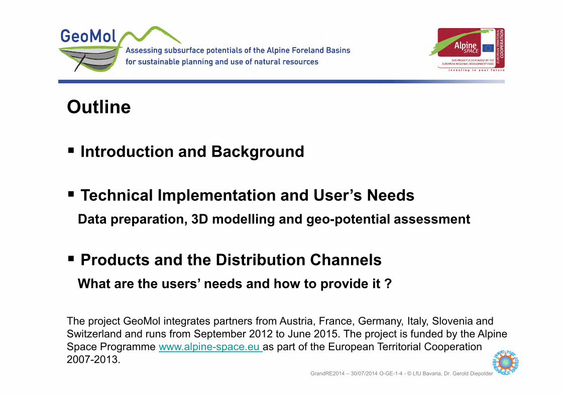
Outline
� Introduction and Background
� Technical Implementation and User’s Needs
Data preparation, 3D modelling and geo-potential assessment
� Products and the Distribution Channels
What are the users’ needs and how to provide it ?
The project GeoMol integrates partners from Austria, France, Germany, Italy, Slovenia and
Switzerland and runs from September 2012 to June 2015. The project is funded by the Alpine
Space Programme www.alpine-space.eu as part of the European Territorial Cooperation
2007-2013. GrandRE2014 – 30/07/2014 O-GE-1-4 - © LfU Bavaria, Dr. Gerold Diepolder

What are Geo-potentials ?
Geo-potential is the capability of the Earth as related to the human use.
geogenic Geo-potential anthropogenic
Geo-potentialusable Geo-potential Geohazard
Earth‘s surface Volcanism Landfill
Soil Earthquakes / Seismicity Caverns
Building ground Mass movement (Landslides) Contamination etc.
Ground water Flooding
Geothermal energy Salinization
Mineral deposits Sand & soil drift
Oil and gas
Storage formations
Karst as a storage Karstification (Sinkholes)
(from Manhenke 1999, modified)
GrandRE2014 – 30/07/2014 O-GE-1-4 - © LfU Bavaria, Dr. Gerold Diepolder Introduction and Background: Definitions

What are Geo-potentials ?
GeoMol considers only deep geo-potentials.
geogenic Geo-potential anthropogenic
Geo-potentialusable Geo-potential Geohazard
Earth‘s surface Volcanism Landfill
Soil Earthquakes / Seismicity Caverns
Building ground Mass movement (Landslides) Contamination etc.
Ground water Flooding
Geothermal energy Salinization
Mineral deposits Sand & soil drift
Oil and gas
Storage formations
Karst as a storage Karstification (Sinkholes)
(from Manhenke 1999, modified)
Introduction and Background: Definitions GrandRE2014 – 30/07/2014 O-GE-1-4 - © LfU Bavaria, Dr. Gerold Diepolder

What are Alpine Foreland Basins ?
Introduction and Background: Definitions GrandRE2014 – 30/07/2014 O-GE-1-4 - © LfU Bavaria, Dr. Gerold Diepolder
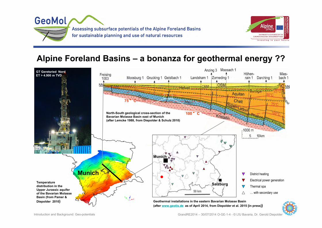
Oil and gas deposits:
100 �� �� C
75 �� �� C
fjsäfjäf
fjsäfjäf
fjsäfjäf
Munich
Temperature
distribution in the
Upper Jurassic aquifer
of the Bavarian Molasse
Basin (from Pamer &
Diepolder 2010)
Alpine Foreland Basins – a bonanza for geothermal energy ??
District heating
Electrical power generation
Thermal spa
… with secondary use
Munich
Salzburg
50 km
Geothermal installations in the eastern Bavarian Molasse Basin
(after www.geotis.de as of April 2014, from Diepolder et al. 2015 [in press])
North-South geological cross-section of the
Bavarian Molasse Basin east of Munich
(after Lemcke 1988, from Diepolder & Schulz 2010)
GT Geretsried Nord
ET > 4.900 m TVD
●
GrandRE2014 – 30/07/2014 O-GE-1-4 - © LfU Bavaria, Dr. Gerold Diepolder Introduction and Background: Geo-potentials

Alpine Foreland Basins – space of many geo-potentials
Gas storage Breitbrunn-Eggstätt , © LBEG
Oil field Hebertshausen
e.g. oil and gas, and after-use for underground storage
GrandRE2014 – 30/07/2014 O-GE-1-4 - © LfU Bavaria, Dr. Gerold Diepolder Introduction and Background: Geo-potentials

Alpine Foreland Basins – space of many geo-potentials
Factors defining geo-potentials
or: why geology is most important
� rock properties (lithology)
� rock permeability (e.g. reservoir rock vs. barrier rock)
� structure (fractures and faults, structural traps)
� temperature at depth
GrandRE2014 – 30/07/2014 O-GE-1-4 - © LfU Bavaria, Dr. Gerold Diepolder Introduction and Background: Geo-potentials

Alpine Foreland Basins – space of competing demands
GrandRE2014 – 30/07/2014 O-GE-1-4 - © LfU Bavaria, Dr. Gerold Diepolder Introduction and Background: Competing Demands

Courtesy of P. di Manna, ISPRA
May 2012 Po Basin earthquake
Earthquakes < Mw 3.5 in the years 1900–2006 as related to the Alpine Foreland Basins,
(after Grünthal & Wahlström (2012): The European-Mediterranean Earthquake Catalogue
(EMEC) for the last millennium).
Courtesy of Pio di Manna, ISPRA
Alpine Foreland Basins – space comprising areas at risk
GrandRE2014 – 30/07/2014 O-GE-1-4 - © LfU Bavaria, Dr. Gerold Diepolder Introduction and Background: No-go areas

Alpine Foreland Basins call for subsurface land use planning
GrandRE2014 – 30/07/2014 O-GE-1-4 - © LfU Bavaria, Dr. Gerold Diepolder Introduction and Background: Subsurface Planning
From unlimited depth licensing
“from soil to hell” to
vertically zoned licensing
� allowing multipurpose use
thus boosting green energy
� improved claim manage-
ment ensuring resources
efficiency
prerequisite:
holistic 3-dimensional
subsurface information

Dwindling societal acceptance for subsurface uses
���� Addressing public concerns
ss
GrandRE2014 – 30/07/2014 O-GE-1-4 - © LfU Bavaria, Dr. Gerold Diepolder Introduction and Background: Addressing Public Concerns

Courtesy of P. di Manna, ISPRA
Geothermal energy
Seismic
risk Storage of gas &
compressed air
Oil & gas
Groundwater
Competing
demands
& public
concerns
Principal targets
of GeoMol:
GrandRE2014 – 30/07/2014 O-GE-1-4 - © LfU Bavaria, Dr. Gerold Diepolder Introduction and Background: Summary

� Geology and the resources and risks connected with it do
not respect political boundaries � transnational
� Geology is inherently a three-dimensional issue � in 3D
� Geology must be made understandable for non-geologists
� for the users‘ needs
Basic requirements for assessing deep geo-potentials
GrandRE2014 – 30/07/2014 O-GE-1-4 - © LfU Bavaria, Dr. Gerold Diepolder Technical Implementation: Basic Requirements

The GeoMol project area: working trans-nationally
GrandRE2014 – 30/07/2014 O-GE-1-4 - © LfU Bavaria, Dr. Gerold Diepolder Technical Implementation: Transnational Approach
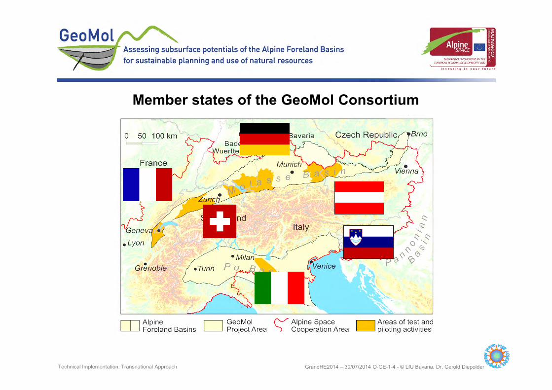
Member states of the GeoMol Consortium
GrandRE2014 – 30/07/2014 O-GE-1-4 - © LfU Bavaria, Dr. Gerold Diepolder Technical Implementation: Transnational Approach
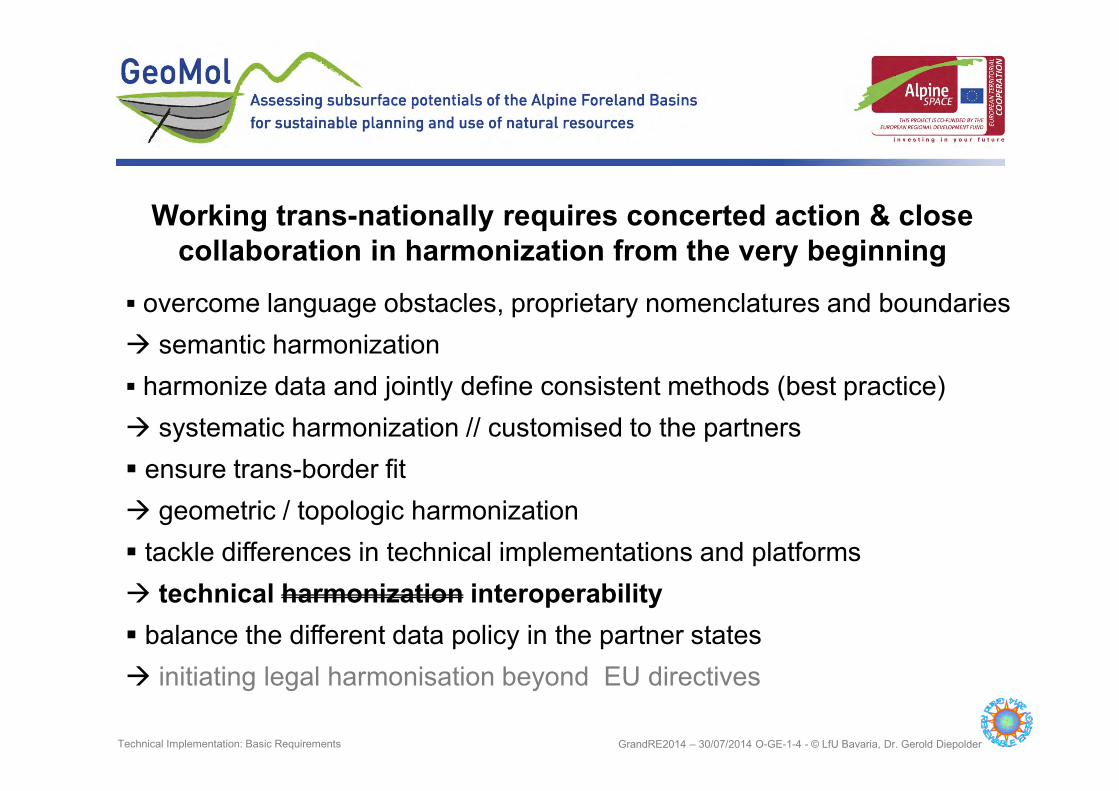
� overcome language obstacles, proprietary nomenclatures and boundaries
� semantic harmonization
� harmonize data and jointly define consistent methods (best practice)
� systematic harmonization // customised to the partners
� ensure trans-border fit
� geometric / topologic harmonization
� tackle differences in technical implementations and platforms
� technical harmonization interoperability
� balance the different data policy in the partner states
� initiating legal harmonisation beyond EU directives
Working trans-nationally requires concerted action & close
collaboration in harmonization from the very beginning
GrandRE2014 – 30/07/2014 O-GE-1-4 - © LfU Bavaria, Dr. Gerold Diepolder Technical Implementation: Basic Requirements

Merger of existing 3D geological models by just filling the
gaps in between is not feasible !!
GrandRE2014 – 30/07/2014 O-GE-1-4 - © LfU Bavaria, Dr. Gerold Diepolder Technical Implementation: Basic Requirements
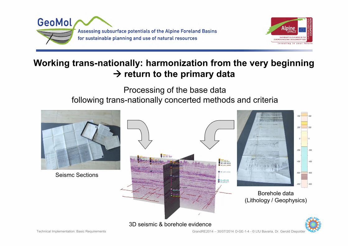
Seismc Sections
Borehole data
(Lithology / Geophysics)
3D seismic & borehole evidence
Processing of the base data
following trans-nationally concerted methods and criteria
Working trans-nationally: harmonization from the very beginning
���� return to the primary data
GrandRE2014 – 30/07/2014 O-GE-1-4 - © LfU Bavaria, Dr. Gerold Diepolder Technical Implementation: Basic Requirements

> 300 – 500 m
> 500 – 1000 m
> 1000 – 1500 m
> 1500 – 2000 m
> 2000 – 2500 m
> 2500 - 3000
> 3000 m
Well Depth
Modelling the space in
between hard data requires a
sound geological expertise:
� Geological Survey
Organizations
Borehole data at great depth: scattered and clustered
?
?
??
GrandRE2014 – 30/07/2014 O-GE-1-4 - © LfU Bavaria, Dr. Gerold Diepolder Technical Implementation: Heterogeneous Distribution of Base Data

Primary data available: summing up the national data policy
GrandRE2014 – 30/07/2014 O-GE-1-4 - © LfU Bavaria, Dr. Gerold Diepolder Technical Implementation: Heterogeneous Distribution of Base Data

Primary data are mostly classified data from oil & gas or geothermal industries
which can be exploited by the legally mandated authorities only and may be
provided as generalized and anonymized syntheses.
From primary data to spatial information
GrandRE2014 – 30/07/2014 O-GE-1-4 - © LfU Bavaria, Dr. Gerold Diepolder Technical Implementation: Combing Seismic and Borehole Data
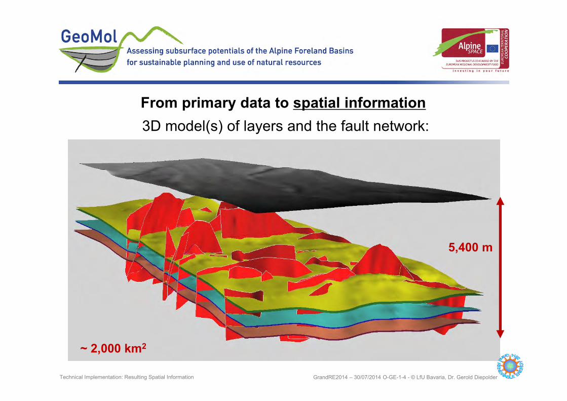
~ 2,000 km2
5,400 m
3D model(s) of layers and the fault network:
From primary data to spatial information
GrandRE2014 – 30/07/2014 O-GE-1-4 - © LfU Bavaria, Dr. Gerold Diepolder Technical Implementation: Resulting Spatial Information

� Planning and licensing authorities
� Decision makers
� Geoscientific academia
� Consultants, planner, project developer- deep geothermal energy
- underground storage / deep repositories
- groundwater management
- primary industries / economic geology
- infrastructural measures
� Insurance underwriters
� Geological Survey Organizations
� NGOs & the general public
Users of GeoMol’s results according to the stakeholder survey
GrandRE2014 – 30/07/2014 O-GE-1-4 - © LfU Bavaria, Dr. Gerold Diepolder Products and Distribution Channels: Who needs it?

� Digital map sets (GIS) of geometries & parameters
� Ready to use 3D models (populated, incl. temperature model)
� Meta data catalogue (Incl. availability & restrictions)
� Guidelines and Best Practice Manuals for the sustainable planning and
management of geo-potentials & hard facts for the citizens dialogue
Three channels of dissemination will be provided
� A map viewer and meta data catalogue (WMS) providing 3D derived
2D information
� A geo data infrastructure to ensure full interoperability among all
entitled users/stakeholders and the data providers
� An interactive 3D viewer linked to www.geomol.eu providing easy
access to the declassified GeoMol products for the general public
“What do users need?” as revealed by the stakeholder survey
GrandRE2014 – 30/07/2014 O-GE-1-4 - © LfU Bavaria, Dr. Gerold Diepolder Products and Distribution Channels: What’s needed?

Distributed organized data storage & data merger/visualization via WWW
Transnational harmonization vs. national data policy
GrandRE2014 – 30/07/2014 O-GE-1-4 - © LfU Bavaria, Dr. Gerold Diepolder Products and Distribution Channels: GeoMol’s Web-based 3D Explorer

Role based access to 3D data via WWW
Map viewer and meta data
catalogue (WMS) providing 3D
derived 2D information
GrandRE2014 – 30/07/2014 O-GE-1-4 - © LfU Bavaria, Dr. Gerold Diepolder Products and Distribution Channels: GeoMol Data Portals
GeoMol data portals
based on “GST” developments

Thank you for your attention
Find more on www.geomol.eu
GrandRE2014 – 30/07/2014 O-GE-1-4 - © LfU Bavaria, Dr. Gerold Diepolder