brs engineering technical m january 31, 2003...
TRANSCRIPT
Page 1 of 17
BRS ENGINEERINGTECHNICAL MEMORANDUM
January 31, 2003
Environmental and Recreational Uses
This memorandum discusses present environmental and recreational uses of water in theWind/Big Horn Basin (WBHB). Environmental and recreational uses are for the most part non-consumptive uses. Environmental and recreational uses are very important in the Basin withrespect to socioeconomic impacts and general contribution to Wyoming �s quality of life.
This memorandum contains the following sections:
Section 1 - Introduction . . . . . . . . . . . . . . . . . . . . . . . . . . . . . . . . . . . . . . . . . . . . . . . . . . . . . 1Section 2 - Institutional and Unique Environmental Considerations . . . . . . . . . . . . . . . . . . 2
2.1 Land Ownership and Management . . . . . . . . . . . . . . . . . . . . . . . . . . . . . . . . . . . 22.2 Threatened, Endangered and Candidate Taxa: . . . . . . . . . . . . . . . . . . . . . . . . . . 32.3 Wild and Scenic Rivers: . . . . . . . . . . . . . . . . . . . . . . . . . . . . . . . . . . . . . . . . . . . 42.4 Glaciers . . . . . . . . . . . . . . . . . . . . . . . . . . . . . . . . . . . . . . . . . . . . . . . . . . . . . . . 42.5 Yellowstone National Park . . . . . . . . . . . . . . . . . . . . . . . . . . . . . . . . . . . . . . . . . 52.6 Wind River Indian Reservation . . . . . . . . . . . . . . . . . . . . . . . . . . . . . . . . . . . . . . 62.7 Reservoir-allocated Conservation Pools and Recreation Permits . . . . . . . . . . . . . 62.8 Instream and Maintenance Flows and Bypasses . . . . . . . . . . . . . . . . . . . . . . . . . . 82.9 Wetlands and Riparian Areas . . . . . . . . . . . . . . . . . . . . . . . . . . . . . . . . . . . . . . . 92.10 Waterbodies with Water Quality Impairments . . . . . . . . . . . . . . . . . . . . . . . . . . 10
Section 3 - Summary of Consumptive Use . . . . . . . . . . . . . . . . . . . . . . . . . . . . . . . . . . . . . . 113.1 Evaporation . . . . . . . . . . . . . . . . . . . . . . . . . . . . . . . . . . . . . . . . . . . . . . . . . . . 113.2 Direct Wildlife Consumption . . . . . . . . . . . . . . . . . . . . . . . . . . . . . . . . . . . . . . 11
Section 4 - Recreational Demands . . . . . . . . . . . . . . . . . . . . . . . . . . . . . . . . . . . . . . . . . . . . 124.1 State Parks . . . . . . . . . . . . . . . . . . . . . . . . . . . . . . . . . . . . . . . . . . . . . . . . . . . . 124.2 Fishing . . . . . . . . . . . . . . . . . . . . . . . . . . . . . . . . . . . . . . . . . . . . . . . . . . . . . . . 134.3 Waterfowl . . . . . . . . . . . . . . . . . . . . . . . . . . . . . . . . . . . . . . . . . . . . . . . . . . . . 154.4 Adequacy of Present Resources . . . . . . . . . . . . . . . . . . . . . . . . . . . . . . . . . . . . 15
Appendix A - In Stream Flow ApplicationsAppendix B - Water Quality Impairments 1. Introduction:
Environmental and recreational water needs are closely related, and are often, in the current socialand regulatory climate, controversial. Institutional factors play a large role in the management ofwater for these needs, part icularly in the WBHB, where nearly eleven million acres are publicland. Recreational uses of water, such as fishing and boating, are usually non-consumptive, butdedication of water to environmental purposes can at times exclude other uses. The quality and
1Equality State Almanac 2000, Wyoming Economic Analysis Division, p. 105 (cit ing Wyoming Game &Fish Department).
Page 2 of 17
quantity of good recreational opportunities, however, are highly dependent on water quality andquantity � the two uses are closely interrelated.
Recreation, including tourism, is one of Wyoming �s three major industries. Hunters and anglersalone spent $700,588,360 in the state in the year 2000.1 Major recreational activities dependenton water are fishing, boating, waterfowl hunting, and swimming. Other recreational activities,such as big-game and upland game bird hunt ing, snowmobiling, skiing, sight-seeing, photography,camping, and golfing are also more or less sensitive to water quantity and quality.
It is often difficult to gather quantitat ive data for specific locales in regard to recreational andenvironmental activities and needs, but agencies such as Wyoming �s Game and Fish Department,Department of State Parks and Cultural Resources, and Business Council, as well as federalagencies such as the Forest Service, Fish and Wildlife Service, Bureau of Land Management,Bureau of Reclamation, Natural Resource Conservation Service, Bureau of Reclamation, andNational Park Service gather and analyze data relevant to recreational water management. TheWind River Indian Reservation also collects some data, as do some counties and municipalities.
2. Institutional Considerations
Institutional variables are very important in assessing current and future uses, both environmentaland recreational. Management of land, water, wildlife and associated resources occurs within amultifaceted context of institutional constraints.
Federal legislation relevant to water development includes the National Environmental Policy Act(NEPA), the Clean Water Act, the Endangered Species Act, and the Historic Preservation Act. Execut ive Orders, such as EO11988 (Flood Plain Management) and 11990 (Wetlands Protection)also apply.
However, perhaps the most basic institutional constraint is fragmented ownership and control ofnatural resources. This is the case in Wyoming in general, where about half the land is owned andmanaged by federal agencies, and management and ownership of the other half is divided amongstate, county, local, and private entities. Given that the headwaters of most Wyoming streams arelocated on federal lands, federal involvement in water development and management is inevitable.
2.1 Land Ownership and Management
An important factor in managing lands and waters for recreational and environmental purposes isthe fractured nature of land ownership and control in the WBHB. Nearly 71% of the Basin �s 15.2million acres land is publically owned, with management divided among numerous governmentalagencies at local, state and national levels. National policy trends, particularly in regard to the

2Although portions of Teton, Natrona, Sheridan and Johnson Counties are physically within the Wind/BigHorn drainage, they are very small in area and population and do not include major water bodies. Therefore thesecounties are for the most part ignored in the WBHB Plan.
Page 3 of 17
environment and to economics, probably influence how Federal lands within the Basin aremanaged more than do state or local preferences. Table 1 reveals the diverse nature of landmanagement in the WBHB.
Table 1: Land Ownership in the WBHB2
County TotalAcres
Private State Federal TotalPublic
%
Public
%
Federal
%
PrivateUSFS
acreageBLM
acreage
Big Horn 2,022,912 405,621 220,041 1,534,089 1,754,130 86.7 75.8 20.1 351,153 1,096,000
Fremont 5,928,882 868,716 295,841 3,201,621 3,497,462 59.0 54.0 14.7 987,109 2,097,697
Hot
Springs
1,294,080 399,183 425,259 568,005 993,264 76.8 43.9 30.8 48,640 518,000
Park 4,469,312 698,094 229,802 3,591,220 3,821,022 85.5 80.4 15.6 1,699,791 561,566
Washa kie 1,447,680 578,857 212,559 459,994 672,553 46.5 31.8 40.0 36,003 922,836
WBHB 15,162,866 2,950,471 1,383,502 9,354,929 10,738,431 70.8 61.7 19.5 3,122,696 5,196,099
Another variable that cannot be ignored is that the Wind River Indian Reservation incorporatesabout 2.2 million acres in Fremont and Hot Springs Counties. Demographic, economic, socialand political factors within the Reservation can influence resource management in the whole ofthe WBHB.
2.2 Threatened, Endangered and Candidate Taxa:
The presence of threatened or endangered species of plants and animals, or of species that mightbe considered for such listing, can make water management and development more complex. Anumber of taxa in Wyoming are so listed. Section 2 (c)(2) of the Endangered Species Actrequires state and local agencies to cooperate with federal agencies in issues involving such taxa. Particularly in cases in which federal land is involved, such cooperation means conducting wildlifeand plant studies of the targeted area. Some of the listed animal and plant taxa are found in theWBHB.
Animal species listed include the grizzly bear, whooping crane, Kendall Warm Springs dace, baldeagle, black-footed ferret, lynx, Preble �s meadow mouse, Pike minnow (squawfish), razorbacksucker, Wyoming toad, and gray wolf. Listed plant species are Colorado butterfly plant, blowoutpenstemon, Ute ladies � tress, and desert yellowhead. There are also other taxa that have beenproposed for addition to the Threatened list, and a long list of Candidates (258 species) forendangered or threatened status.
3U.S. Department of the Interior, U. S. Fish and Wildlife Service, 50 CFR Part 17: Notice of Review: Endangered and Threatened Wildli fe and Plants; Animal Candidate Review for Listing as Endangered Species.
4U.S. National Park Service, Nationwide Rivers Inventory, 1982.
5State of Wyoming, Water Development Commission, Big Horn Basin, Clarks Fork Level II, April, 1986.
Page 4 of 17
Efforts are ongoing to protect and restore populat ions of the Yellowstone Cutthroat Trout in theWBHB, particularly in the drainages of the Greybull, Wood, and South Fork of the Shoshonerivers. Shovelnose Sturgeon have been released in the Big Horn River in an effort to restorethose populations.
In regard to threatened and endangered species, however, the U. S. Fish and Wildlife Servicestates that � While it is prudent to take candidate taxa into account during environmental planning,neither the substantive nor procedural provisions of the Act apply to a taxon that is designated asa candidate. � 3 Nonetheless, as a practical matter, the presence or possible presence ofThreatened, Endangered, Proposed or Candidate taxa in locales that could be affected by waterprojects must be considered by developers. Wildlife and plant (and cultural) studies are routinelydone early on in most projects, particularly if public lands are involved.
2.3 Wild and Scenic Rivers:
Wyoming �s only Congressionally designated �Wild and Scenic River � is a twenty-mile stretch ofthe Clarks Fork River, in Park County. Other WBHB streams have been suggested as deservingprotective status, including the Porcupine drainage in Big Horn County, the Middle Fork ofPowder River (which heads in Washakie County but flows eastward into the Powder RiverBasin), and Wiggins Fork in Fremont County. 4
The Clarks Fork heads in Montana �s Beartooth Mountains, flows into Yellowstone Park and ParkCounty, and then north to Montana again. The River provides wilderness-type fishing andkayaking, especially in its spectacular canyon. Fishing pressure is higher outside the Park, in thelower reaches of the River. The possibility of damming the River for purposes of storage, powergeneration, bringing new land under irrigation, and perhaps transferring Clarks Fork water intothe Shoshone River Basin, has been investigated.5
2.4 Glaciers
The Wind River Mountains are home to the largest glacier field in the lower forty-eight States. The field covers about 17 square miles, and seven of the ten largest glaciers in the lower 48 are inthis field. The melt waters from these glaciers contribute to the flow of the Wind/Big Horn River,and are thought to be particularly important in maintaining fisheries and irrigation water in latesummer and early fall (July through October).
6Harold J. Hutson, P.E., P.G., BRS Engineering, �Wind River Range Glaciers, � TechnicalMemorandum, Wind/Big Horn Basin Plan, December, 2002.
7Jan Curtis, Wyoming State Climatologist, Personal correspondence to Harold Hutson,BRS Engineering, July 12, 2002.
8Hutson, op. cit.
9Yellowstone National Park, Visitation Statistics, http://165.83.32.34/stats/yellmaster.htm.
Page 5 of 17
Total water runoff from these glaciers is estimated at approximately 56,756 acre-feet annually,about three quarters of which probably goes into the Wind River drainage, providing some eightpercent of the total flow of the Wind River during the runoff period. Glacial melting is importantcontribution to the flows of Bull Lake Creek and Dinwoody Creek. It is estimated that up to athird of the September and October flows of these streams is of glacial origin.6
Recent observations indicate that the glaciers are receding rapidly. This recession may be duemore to lack of precipitation than to climatic warming, since decadal temperature trends (since1931) � shows no appreciable change . . . � 7
Should current climatological conditions remain, Hutson suggests, it is likely that � overall streamflows would not vary significantly. The overall impact would be minimal to irrigators and otherstream uses � although if drought conditions persist, they could cause � the disappearance of theglaciers within 20 years � and reduce the late summer/early fall flow of the Wind River � byapproximately 8%, creating or exacerbating shortages for irrigators and in-stream flow demands. � In a third scenario, a period of cool and wet years could reverse the shrinkage of the glaciers andincrease the flow.8
2.5 Yellowstone National Park:
Yellowstone, the nation �s and the world �s oldest national park, is a World Heritage Site. Although management of the Park is the province of the U. S. National Park Service, Wyomingtakes the position that the Park Service needs permitting from the State to use the water. Withinthe portion of Yellowstone in the WBHB drainage, the Park Service has received permits fromthe State to drill wells for the purpose of monitoring water levels and condition, and has a surfacewater right to one acre-foot per year for domestic use at its East Entrance facilities. Fishing insideYellowstone National Park does not require a Wyoming (or any state) license. Recreational andenvironmental management within the Park is done by the Park Service.
Visitors to Yellowstone National Park provide the bulk of the WBHB �s tourism. From 1990through 2000 recreational visitors to the Park averaged nearly three million per year, but the EastEntrance, west of Cody, averaged fewer than 400,000 per year during the 1992-98 period.9 TheSouth Entrance, reached through Fremont and Teton Counties (as well as from the west and
10Office of the Tribal Water Engineer, � Wind River Reservation Tour, � p.5, August, 2000.
11Wind River Water Code, Wind River Reservation, adopted 1991.
12Office of the Tribal Water Engineer, � Wind River Reservation Tour, � p. 4, August, 2000.
13Cooperative Extension Service, College of Agriculture, Universi ty of Wyoming, � Residen t OutdoorRecreation for Fremont County, WY � , July, 1999.
Page 6 of 17
south) averaged more than 800,000 per year during the same period. These numbers suggest thatperhaps 500,000 to 600,000 people bound for Yellowstone pass through the WBHB each year. The percentage who stop to recreate in the Basin is probably best suggested by sales of short-termnon-resident fishing licenses.
2.6 Wind River Indian Reservation:
The Wind River Reservation, home of the Eastern Shoshone and Northern Arapaho Tribes,covers more than two million acres of Fremont and Hot Springs Counties. Within the boundariesof the Reservation are extensive private lands, and the Reservation operates within a context oftribal, federal, state and local authority and activity. Natural resources on the Reservation are ingeneral jointly owned by the two Tribes. Tribal water rights date from the 1868 Treaty betweenthe United States and the Shoshone Tribe. Water is managed under the Wind River Water Code,jointly adopted in 1991 by the Tribes.10
A Water Resources Control Board is the �primary enforcement and management agencyresponsible for controlling water resources on the Reservation. � 11 Lengthy legal proceedingsbetween the State of Wyoming and the Tribes awarded the right to 500,000 acre-feet of water tothe Tribes, of which 290,000 acre feet are reserved for future use. The Tribes sought water rightsfor such environmental/recreational purposes as wildlife usage or instream flows in litigation, butfailed in court to receive such rights.12
Within the Reservation are more than 200 lakes and over 1000 miles of streams. Fishing on theReservation requires a Tribal license. The Tribes reported selling 2,472 permits in 1998, and3,577 in 1999. About sixty percent of these sales were to non-residents.13 There is significantpotential for further development of recreational opportunities, including water-based activities,on the Reservation.
2.7 Reservoir-allocated Conservation Pools and Recreation Permits:
In Wyoming uses of water that are recognized as beneficial uses include irrigation, municipal,industrial, power generation, recreat ional, stock, domestic, pollution control, instream flows, andmiscellaneous.
Page 7 of 17
The U. S. Bureau of Reclamation (USBR) has designated storage for particular uses in fiveWBHB reservoirs: Big Horn Lake and Boysen, Buffalo Bill, Bull Lake, and Pilot ButteReservoirs. "Conservation storage" describes all of the storage capacity allocated for beneficialpurposes, and is usually divided into active and inactive areas or pools.
"Active storage," or � Active Conservation Pool, � refer to the reservoir space that can actually beused to store water for beneficial purposes. Each reservoir has an allocation for an ActiveConservation Pool which holds reservoir inflow for such uses as irrigation, power, municipal andindustrial, fish and wildlife, navigation, recreation, water quality, and other purposes.
� Inactive storage" refers to water needed to increase the efficiency of hydro power production, toareas beneath the lowest outlet structures, where water can't be released by gravity, and to areasexpected to fill up with sediments.
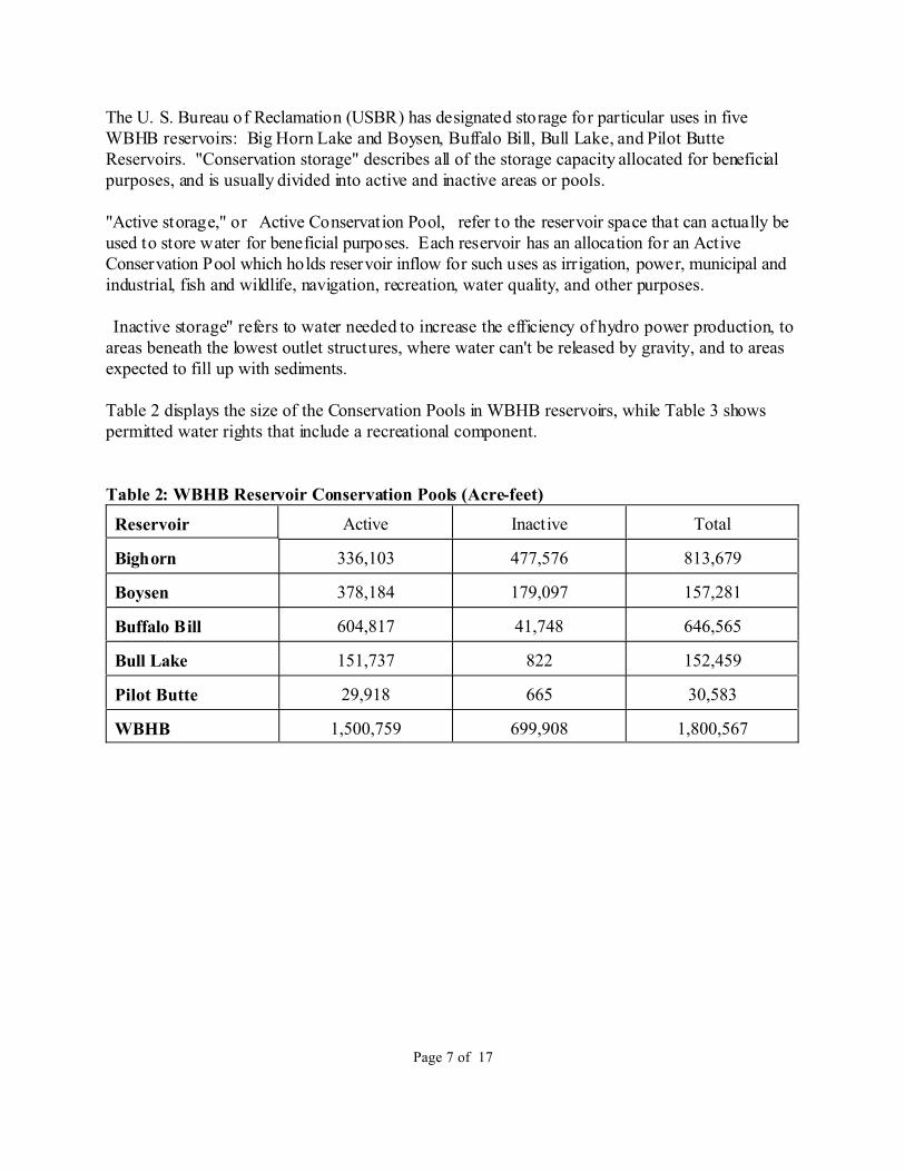
Table 2 displays the size of the Conservation Pools in WBHB reservoirs, while Table 3 showspermitted water rights that include a recreational component.
Table 2: WBHB Reservoir Conservation Pools (Acre-feet)
Reservoir Active Inactive Total
Bighorn 336,103 477,576 813,679
Boysen 378,184 179,097 157,281
Buffalo Bill 604,817 41,748 646,565
Bull Lake 151,737 822 152,459
Pilot Butte 29,918 665 30,583
WBHB 1,500,759 699,908 1,800,567

14Tabulation of Adjudicated Sur face Water Rights of the State of Wyoming, Water Division NumberThree, October - 1999.
15Sue Lowry, Interstate Streams Administrator, Wyoming State Engineer �s Office, personalcommunication, August, 2002.
Page 8 of 17
Table 3: Permitted Water Rightsÿÿ in the WBHB with Recreation Component14
Permit # Source Appropria tor Priority Use Amount (a.f.)
492R Buffalo Bill Res. US Sec Interior 3/05/1904 D,I,Mun.,Fish,Ind.,Rec.,Wildlife
159,500.00
751R Buffalo Bill Res. US Sec Interior 9/07/1905 D,I,Mun.,Fish,Ind.,Rec., Fish
279,100.00
9797R Deaver Res. USDI, BureauReclamation
6/18/1991 Fish,I,Min.,Rec.,Wildlife
719.50
4923R Tensleep Res. USDA, ForestService
1/31/1938 D,FC,Fire,Fish,I,Power,Rec.,S
3,508.94
7354R Green Hills Res. City of Worland 1/14/1971 I,Rec 50.71
7493R Cottonwood Res. USDI, BureauReclamation
1/29/1973 Fish,I,S,Wildlife,Rec
193.75
7494R Middle Cottonwood Res USDI, BureauReclamation
1/29/1973 Fish,I,S,Wildlife,Rec
612.26
7495R Lake Cameahwait USDI, BureauReclamation
1/29/1973 Fish,I,S,Wildlife,Rec
6683.10
24211 Sinks Canyon VisitorCenter
WyomingRecreation
Commission
9/20/1973 Rec 0.6
ÿÿRecognized beneficial uses include: irrigation, municipal, industrial, power generation, recreational, stock,
domestic, pollution control, instream flows, and miscellaneous.
2.8 Instream and Maintenance Flows and Bypasses:
In Wyoming, Instream Flow Water Rights cannot be issued to private interests � only the Statecan hold them. The Wyoming Board of Control has interpreted the use of instream flowsnarrowly � they are for fisheries protection only.15 However, maintenance of instream flows canalso benefit water quality, riparian and flood plain management, ground water recharge, andaesthetic considerations.
The Wyoming Game and Fish Department has since 1994 taken action to identify streams forwhich the filing of applications for instream flow water rights were appropriate. The Department
16Annear , T. C., and Dey, P. D., Wyoming Game an d Fish Department, � Instream Flow Program five-year Plan; 2001 to 2005, � 2001, p. 4.
17Annear, T. C., Wyoming Game and Fish Department, personal communication, July 2, 2001.
18Wyoming State Engineer �s Office, Wyoming Instream Flow Applications, 2002.
19Lacustrine wetlands lie in lowland channels, similar to but smaller than lakes. Palustrine systems aresmall, shallow water bodies, generally with lots of tree or shrub cover, and Riverine wetlands lie along streams.
Page 9 of 17
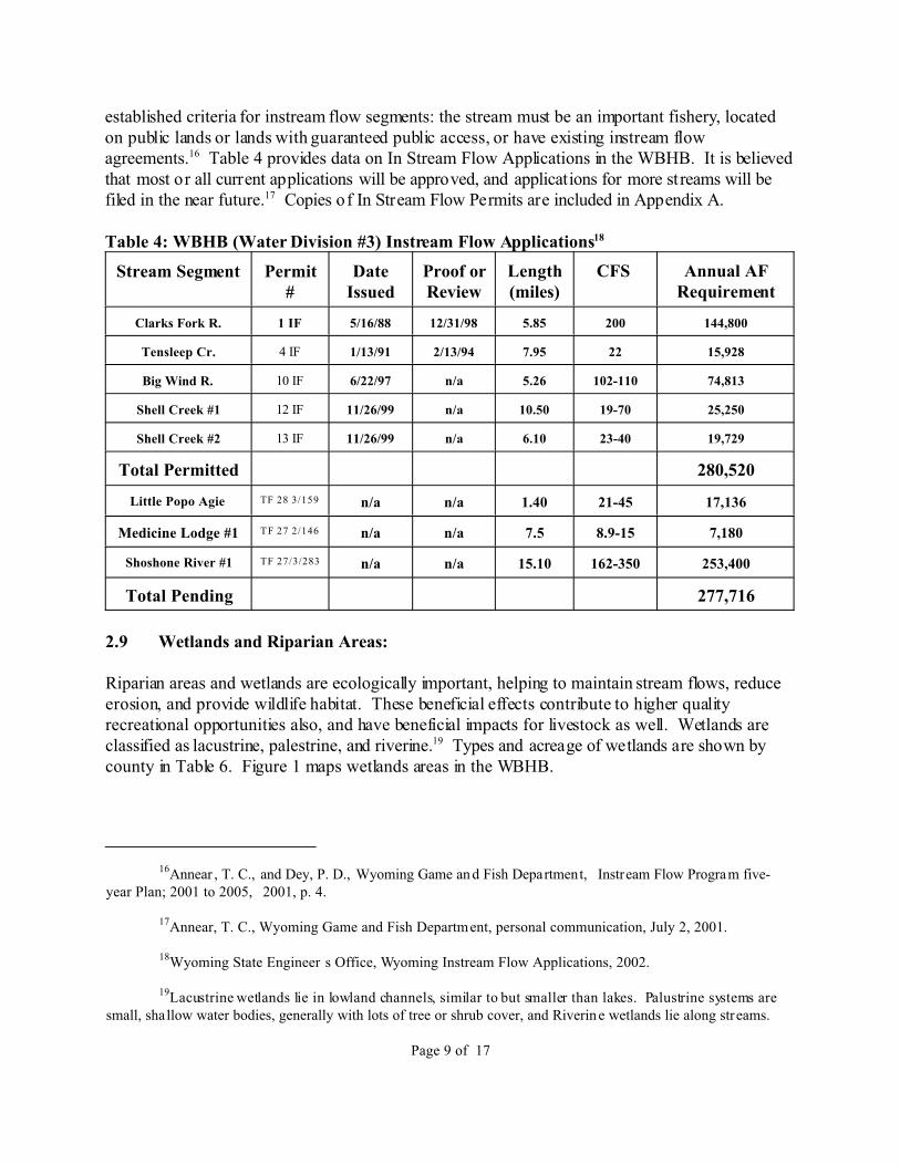
established criteria for instream flow segments: the stream must be an important fishery, locatedon public lands or lands with guaranteed public access, or have existing instream flowagreements.16 Table 4 provides data on In Stream Flow Applications in the WBHB. It is believedthat most or all current applications will be approved, and applications for more streams will befiled in the near future.17 Copies of In Stream Flow Permits are included in Appendix A.
Table 4: WBHB (Water Division #3) Instream Flow Applications18
Stream Segment Permit#
DateIssued
Proof orReview
Length(miles)
CFS Annual AFRequirement
Clarks Fork R. 1 IF 5/16/88 12/31/98 5.85 200 144,800
Tensleep Cr. 4 IF 1/13/91 2/13/94 7.95 22 15,928
Big Wind R. 10 IF 6/22/97 n/a 5.26 102-110 74,813
Shell Creek #1 12 IF 11/26/99 n/a 10.50 19-70 25,250
Shell Creek #2 13 IF 11/26/99 n/a 6.10 23-40 19,729
Total Permitted 280,520
Little Popo Agie TF 28 3/159 n/a n/a 1.40 21-45 17,136
Medicine Lodge #1 TF 27 2/146 n/a n/a 7.5 8.9-15 7,180
Shoshone River #1 TF 27/3/283 n/a n/a 15.10 162-350 253,400
Total Pending 277,716
2.9 Wetlands and Riparian Areas:
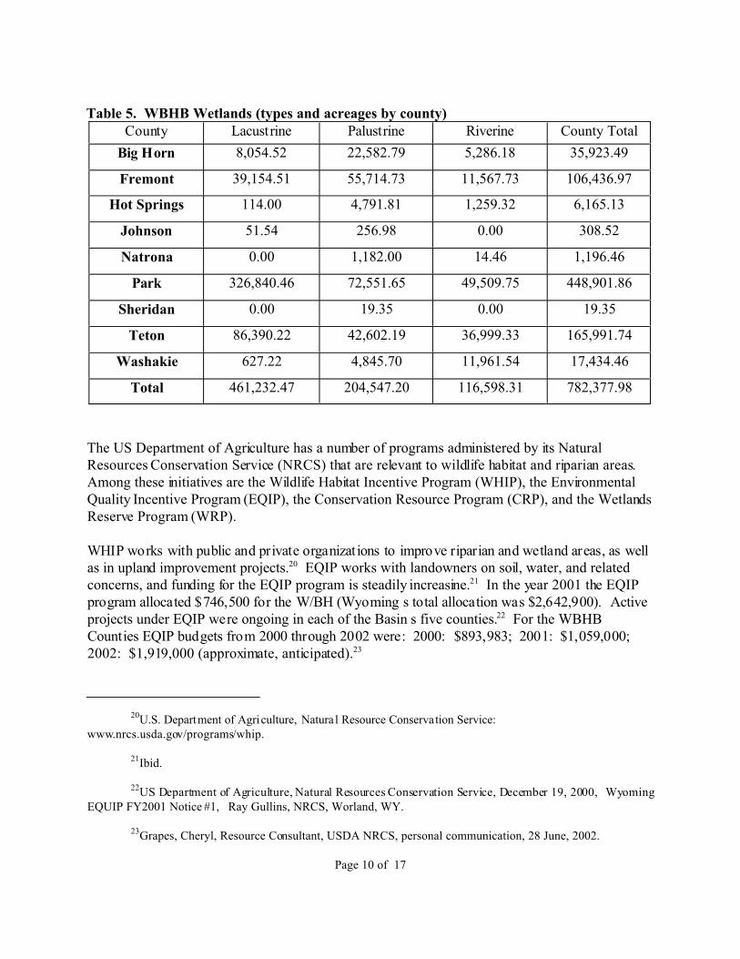
Riparian areas and wetlands are ecologically important, helping to maintain stream flows, reduceerosion, and provide wildlife habitat. These beneficial effects contribute to higher qualityrecreational opportunities also, and have beneficial impacts for livestock as well. Wetlands areclassified as lacustrine, palestrine, and riverine.19 Types and acreage of wetlands are shown bycounty in Table 6. Figure 1 maps wetlands areas in the WBHB.
20U.S. Department of Agriculture, Natural Resource Conservation Service:www.nrcs.usda.gov/programs/whip.
21Ibid.
22US Department of Agriculture, Natural Resources Conservation Service, December 19, 2000, �WyomingEQUIP FY2001 Notice #1, � Ray Gullins, NRCS, Worland, WY.
23Grapes, Cheryl, Resource Consultant, USDA NRCS, personal communication, 28 June, 2002.
Page 10 of 17
Table 5. WBHB Wetlands (types and acreages by county)County Lacustrine Palustrine Riverine County Total
Big Horn 8,054.52 22,582.79 5,286.18 35,923.49
Fremont 39,154.51 55,714.73 11,567.73 106,436.97
Hot Springs 114.00 4,791.81 1,259.32 6,165.13
Johnson 51.54 256.98 0.00 308.52
Natrona 0.00 1,182.00 14.46 1,196.46
Park 326,840.46 72,551.65 49,509.75 448,901.86
Sheridan 0.00 19.35 0.00 19.35
Teton 86,390.22 42,602.19 36,999.33 165,991.74
Washakie 627.22 4,845.70 11,961.54 17,434.46
Total 461,232.47 204,547.20 116,598.31 782,377.98
The US Department of Agriculture has a number of programs administered by its NaturalResources Conservation Service (NRCS) that are relevant to wildlife habitat and riparian areas. Among these initiatives are the Wildlife Habitat Incentive Program (WHIP), the EnvironmentalQuality Incentive Program (EQIP), the Conservation Resource Program (CRP), and the WetlandsReserve Program (WRP).
WHIP works with public and private organizat ions to improve riparian and wetland areas, as wellas in upland improvement projects.20 EQIP works with landowners on soil, water, and relatedconcerns, and funding for the EQIP program is steadily increasine.21 In the year 2001 the EQIPprogram allocated $746,500 for the W/BH (Wyoming �s total allocation was $2,642,900). Activeprojects under EQIP were ongoing in each of the Basin �s five counties.22 For the WBHBCounties EQIP budgets from 2000 through 2002 were: 2000: $893,983; 2001: $1,059,000; 2002: $1,919,000 (approximate, anticipated).23
24Sue Lowry, Director of Policy, Wyoming State Engineers � Office, personal communication, 28 June,2002.
25Tyrell, Pat, December, 2000, � Green River Basin Plan: Environmental Uses, � p. 6.
26Wyoming Agricultural Statistics Service, http://www.nass.usda.gov, August, 2001.
Page 11 of 17
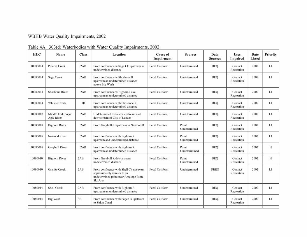
2.10 Waterbodies with Water Quality Impairments:
Waters are declared � impaired � when they fail to support their designated uses after fullimplementation of the National Pollution Discharge Elimination System permits and "bestmanagement practices." Under the Clean Water Act, every state must update its � 303(d) � list ofimpaired waters every two years after reviewing "all readily available data and information." Appendix B provides listing information on waterbodies in the WBHB that are considered qualityimpaired under section 303(d) of the Clean Water Act.
3.0 Summary of Consumptive Uses
3.1 Evaporation:
In the Basin �s dry climate, evaporation losses are significant, particularly from the largerreservoirs. The Wind/Big Horn River, of course, t raverses the lowest port ions of the basins,where warmer weather increases evaporat ion rates. Evaporat ive losses are not specificallymentioned in the Yellowstone River compact between Wyoming and Montana, but are accountedfor in the gauge readings used to calculate each state � s allocation.24 Refer to TechnicalMemorandum - Water Use From Storage, Chapter 2, Tab 10, for evaporative losses from sotage.
3.2 Direct Wildlife Consumption:
There is no easy way to quantitatively estimate the amount of water required by wildlife in theWBHB. Differences in species, terrain, food sources, weather and climate are all relevant to thewater needs of wildlife. Moose, for instance, are far more dependant on riparian areas than arepronghorns. Waterfowl and upland game birds have differing needs. The more moisture in thefeed sources, the less water most wildlife consume directly. In times of drought, most herbivoresrequire more drinking water.
Tyrell, in a review of the topic in the Green River Basin plan, noted that estimates of wildlife useof surface water in that Basin ranged from 100 to 400 acre-feet per year. Tyrell concluded that � while some uncertainty exists in the exact consumption value, its probable magnitude is not sohigh as to materially affect the water plan. � 25 This conclusion seems reasonable, since beef cattle,on average, consume something like 8 to 10 gallons of water per day, and sheep about onegallon.26 The consumptive water needs of wildlife would be much lower than those of domesticlivestock. If, in the case of the WBHB we double the estimated amount of water consumed bywildlife in the Green River Basin, it would be 200 to 800 acre feet � still not a large amount.
27US Departmen t of the Inter ior, Bureau of Land Management, Worland District Office, � Bighorn RiverHabitat & Recreation Management Plan, � 1986, p. 25.
Page 12 of 17
It seems likely that if Tyrell �s conclusion errs, it is on the high side. If there were 250,000 animalsin the WBHB each drinking a gallon a day the total consumption would only be .76 acre-feet perday, or 280 acre-feet per year. Distribut ion of water on ranges is probably a more significantproblem than quantity. Forage is not as fully utilized by livestock or wildlife when it is too farfrom water.
4.0 Recreational Demands:
Water is important in both outdoor and indoor recreation. Although in terms of volume the waterdemand for � indoor � (in the present context meaning such facilities as swimming pools and waterparks) is not high, such facilities are significant socially, and can be economic assets. School,municipal, private and commercial swimming facilities exist in most of the Basin �s larger towns. The water demand of such facilities is for the most part captured as part of municipal waterdemand.
Outdoor recreation is an integral part of the Basin �s culture. The larger reservoirs in particular,Buffalo Bill, Boysen, and Big Horn, are major water-based recreation destinations. Fishing,boating, and picnicking are popular pastimes at these reservoirs. The drainages of the Shoshone,the Clark �s Fork, the upper Wind, and the Big Horn all attract anglers, as do many reaches of therivers themselves. Rafting and boating is carried on in all the rivers, with kayaking andwhitewater rafting available in canyon reaches of the rivers. Water is an important amenity in allthe state parks in the Basin. In addition to public waters, there are a few small private fishingreservoirs.
There are about 95 river miles along the Wind/Big Horn River from Boysen Dam to Big HornCanyon. A 1986 Bureau of Land Management (BLM) report, prepared with the cooperation ofthe Wyoming Game and Fish Department, estimated that most recreationists on this reach of theriver were residents, with heavy use areas receiving around 1200 visitor days per year, mediumuse areas averaging perhaps 600 to 800 user days, and low use areas fewer than 500. The heavieruse areas were mostly around the larger towns situated on the River � Thermopolis, Worland,Basin, Greybull and Lovell. Water quality is best through the southern reach of the river, nearThermopolis. In this vicinity the stream is fairly rapid, seldom freezes over, the water is usuallyclear, and there are good populations of fish and waterfowl. The BLM report noted that on theRiver there are limited opportunities for river recreation and flatboating.27 There appears to havebeen no major change in these patterns.
4.1 State Parks:
There are five state parks in the Basin: Medicine Lodge in Big Horn County, Hot Springs in HotSprings County, Sinks Canyon and Boysen in Fremont County, and Buffalo Bill in Park County.
28Calculated from Wyoming State Parks and Historic Sites Fee Program, Appendix C, � VisitationStatistics, � 2001. State Parks and Historical Sites defines �Visitors � as � the total number of persons entering apark or si te to car ry on one or more recreation activi ties, � while � A visitor day is 12 visitor hours that may beaccumulated continuously or simultaneously by one or more visitors. �
29Annear, Tom, Wyoming Game and Fish Department, personal communication, June 2002.
30Robert Wiley, Wyoming Game & Fish Department, personal communication, December, 2001.
31American Sportfishing Assn, http://www.asafishing.org/content/statistics/license/fsl_license2001.cfm.
32Robert Wiley, Ibid.
Page 13 of 17
The Basin �s State Parks are estimated to attract more than a million visitor-days per year.28 Wateris an attraction at all of these parks. Boysen and Buffalo Bill are located at large reservoirs, HotSprings (which hosts the most visitors) and Sinks Canyon State Parks are located at unique waterresources, and Medicine Lodge Creek adds significantly to the attractiveness of its namesakepark. In addition to the State Parks, there is a state-designated historical site, at Legend Rock inHot Springs County.
4.2 Fishing:
Fishing is probably the Basin �s major water-based outdoor recreational activity, although pleasureboating and waterfowl hunting are popular also. The major source of data collected on fishing isthe Wyoming Game and Fish Department �s license sales and creel censuses, but these dataprovide only a rough indication of fishing pressure. The available quantitative data on fishing arenot readily adaptable to individual waters because angler surveys are usually conducted on majorwaters, in response to specific needs.29
In the year 2000, 20,942 resident and 30,372 non-resident licenses were sold in the five countiesof the WHBH.30 A comparison of fishing license sales in 1995 and 2000 indicates that during thatperiod resident license sales dropped by about 8% in the Basin as a whole, while non-residentsales increased by about 20%. There were about 25% more non-resident licenses than residentsold in 2000. This is a notable change from 1995, when the difference was less than 10%. Onlyabout 5% of non-resident licenses sold are annual permits, however. Again, sales of Wyomingfishing licenses in 2001 declined by more than eight percent compared to sales in 2000.31 It seemclear that fewer than half of the Basin �s residents fish.
The majority of fishing licenses sold in the Basin, both resident and non-resident, are sold inFremont and Park Counties.32 This suggests that the drainages of the upper Wind and theShoshone see the heaviest stream fishing pressure. The Clark � s Fork is another important fishery,and there are many popular streams and mountain lakes on the west side of the Big HornMountains. Boysen and Buffalo Bill Reservoirs are particularly popular fishing venues. WindRiver Canyon itself is on the Reservation, and both state and reservation licenses are required. Fishing pressure in the canyon is probably decreased by this requirement, but the stretch remains a
33Joe Deromedi, Wyoming Game and Fish Department, Basin Advisory Group Presentation, Lander, 11June 2002, and personal communication, 14 June 2002.
34Annear, Tom, Wyoming Game and Fish Department, Personal Commun ication, June, 2002.
35Ibid.
Page 14 of 17
fairly popular venue. Several miles of the Big Horn River below (north) of Wind River Canyon,in the Thermopolis area, provide good fishing also.
Among the reservoirs, Boysen and Buffalo Bill are particularly important fisheries. Otherimportant reservoirs for fishing (and other water sports) are Deaver Reservoir, Lake Cameahwait,Newton Lakes, Ocean Lake, and Pilot Butte and Ralston Reservoirs. Many of the fishing streamsare in the mountains, on the National Forests (Bighorn and Shoshone), or in YellowstoneNational Park. Fishing pressure varies with ease of access, and high mountain lakes and streamsare quite fragile ecologically. Both the National Forests include sizable wilderness areas. TheWGFD manages wildlife and fisheries on the National Forests, but not in the National Park. About half of each National Forest is within the Wind/Big Horn drainage.
The Wyoming Game and Fish Department (WGFD) manages fisheries with the objectives ofproviding angling diversity, sustaining enough catchable fish, and establishing and maintainingareas which boast trophy fish, wild fish, and unique fish. Threats to fisheries include habitat lossesdue to erosion (both natural and man-made), inadequate instream flow, barriers to fish migrationand spawning (such as dams and dewatered channels) fish losses due to diversions or non-pointpollution, and competition to native species from non-native species or algae with produceoxygen deficits.
The WGFD has established a �walk-in-fishing � program to enable public access to waterssurrounded by private lands. Landowners cooperate with the Department to allow such access. There are 20 such areas below (north of) Boysen Reservoir. This program provides access pointsto fishing on the Big Horn, Greybull, and Shoshone Rivers, and Nowood and Paintrock Creeks. In the Wind River area the Department has not been as successful in securing walk-in access,although it has secured a half-mile fishing easement near Dubois.33
Anticipating continuing growth in demand for stream fishing venues, the WGFD notes thatensuring an adequate supply of good fishing spots � is dependent on maintaining adequate streamflows in existing good segments and restoring stream flows in streams that have the potential tosupport good recreational fisheries. � 34 An available opportunity for public input in fisheriesmanagement and development lies in helping to identify potential fisheries, and suggesting ways toimprove or maintain them.35 Opportunities to maintain adequate water flows to support all uses,wildlife and human, do exist. Cooperative water use agreements can often be worked out, andconservation of water may enable stream flows in some segments to be maintained or evenincreased.
36Wyoming Game and Fish Department, Annual Report of Upland Game & Furbearer Harvest 2000,Tables 1 and 2, July 2, 2001.
37Tom Annear, Wyoming Game and Fish Department, personal communication, June, 2002.
Page 15 of 17
4.3 Waterfowl:
Wyoming straddles two migratory waterfowl flyways, the Pacific (west of the Continental Divide)and the Central. All of the WBHB is east of the Divide, within the Central flyway. Hunting ofmigratory waterfowl is largely controlled by guidelines issued by the US Fish & Wildlife Service.
The WBHB is divided by the WGFD into two waterfowl management areas. The Wind RiverBasin (essentially Fremont County) is area 4C, while the Big Horn River Basin (the other fourcounties) is designated 4A. The vast majority of waterfowl hunting in Wyoming is for ducks andgeese, although coot, snipe, rail and sandhill crane are also hunted, but in the W/BH Basin ducksand geese account for nearly all the waterfowl harvest.
While data on specific locations are unavailable, the Game and Fish Department estimated that in2000 WBHB Basin duck hunter days totaled 13,395, with a harvest of 19,333 ducks [Ibid., Table5]. The WBHB is second only to the North Plat te drainage in volume of duck hunting inWyoming. Goose hunter-days in the W/BH Basin were estimated to be 7,730, with a harvest of5,331 birds. The heaviest duck and goose hunting occurs after the middle of November,extending into early February for geese.
Ducks Unlimited, which has over 4,000 members in Wyoming, reports that during the 1999-2000hunting season 11,062 federal duck stamps were sold in the state. The WGFD reports that in theyear 2000 a total of 36,208 bird licenses were sold in the state. From 1995 through 2000 anaverage of 24,647 geese and 54,187 ducks were harvested per year. License sales for bothresident and non-resident bird licenses have increased sharply over the past five years, and theharvest trend is upward.36
Maintenance and improvement of existing wetlands and riparian areas, and establishment of newones will be helpful in maintaining and improving habitat for waterfowl. This is a good exampleof the interrelationship of recreational and environmental considerat ions. Agricultural croppingpatterns are also a factor in waterfowl populations.
4.4 Adequacy of Present Recreational Resources:
It seems likely that most WBHB recreational resources are lightly used relative to nationalstandards. The trend in resident fishing permit sales in the WBHB has been slightly down, whichmight be expected given the aging of the population and the out-migration of many youngerWyomingites. There seems at the same time to be a trend toward higher sales of non-residentlicenses, although only about five percent of these are annual permits.37
38Ibid.
39Sterling Hansen, Member, Wind/Big Horn Advisory Group, August, 2002.
Page 16 of 17
However, the WGFD "anticipates continuing increases in demand for stream and river angling,"and notes that satisfying this demand "is dependent on maintaining adequate stream flows inexisting good segments and restoring stream flows in streams that have the potential to supportgood recreational fisheries." The Department notes that public help in identifying where thesesegments are or might be and hints on how such waters might be better managed "is an importantopportunity for participants in the water planning process."38
Other strategies that can be useful in increasing the supply of fishing opportunities in the WBHBare designated � catch and release � areas, increased planting of catchable fish and/or fry, andmanipulation of size limits and catch limits.
A number of projects to diversify and add to water-based recreational opportunities have beensuggested. Among them are improved signage to identify waterbodies, improved access forusers, provision of more handicap access, and development and promotion of eco-tourism atwater-based recreation areas. Whitewater recreation parks might be established as well. Boatingand skiing, of course, are also water-based activities, as are snowmobiling, sled dogging,skijoring, and the like. There is potential to increase the number of venues and of participants insuch activities.39 Most of these activities, of course, are non-consumptive. However, fundingmechanisms and project sponsors are not clear. Other projects can be designed to providerecreational opportunities as multiple-use components.
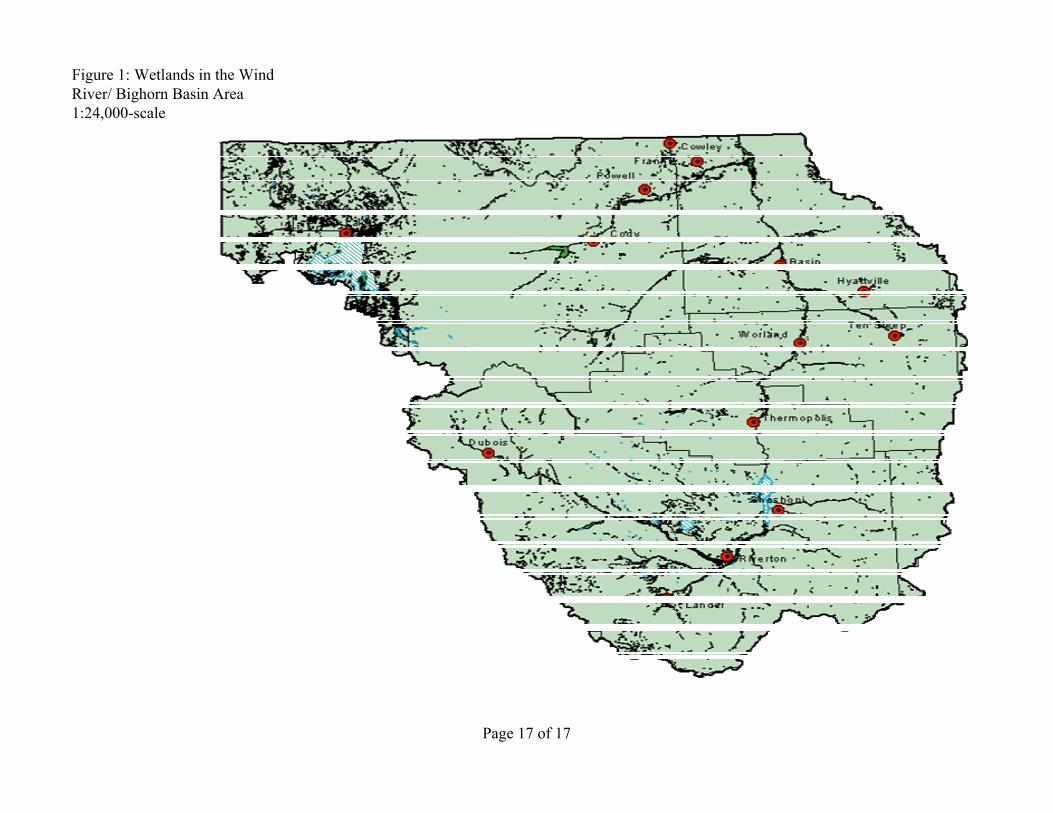
Figure 1: Wetlands in the Wind River/ Bighorn Basin Area1:24,000-scale
Page 17 of 17
WBHB Water Quality Impairments, 2002 Table 4A. 303(d) Waterbodies with Water Quality Impairments, 2002
HUC
Name
Class
Location
Cause of
Impairment
Sources
Data
Sources
Uses
Impaired
Date
Listed
Priority
10080014
Polecat Creek
2AB
From confluence w/Sage Ck upstream an undetermined distance
Fecal Coliform
Undetermined
DEQ
Contact
Recreation
2002
L1
10080014
Sage Creek
2AB
From confluence w/Shoshone R upstream an undetermined distance above Big Wash
Fecal Coliform
Undetermined
DEQ
Contact
Recreation
2002
L1
10080014
Shoshone River
2AB
From confluence w/Bighorn Lake upstream an undetermined distance
Fecal Coliform
Undetermined
DEQ
Contact
Recreation
2002
L1
10080014
Whistle Creek
3B
From confluence with Shoshone R upstream an undetermined distance
Fecal Coliform
Undetermined
DEQ
Contact
Recreation
2002
L1
10080003
Middle Fork Popo Agie River
2AB
Undetermined distances upstream and downstream of City of Lander
Fecal Coliform
Undetermined
DEQ
Contact
Recreation
2002
L1
10080007
Bighorn River
2AB
From Greybull R upstream to Nowood R
Fecal Coliform
Point Undetermined
DEQ
Contact
Recreation
2002
L1
10080008
Nowood River
2AB
From confluence with Bighorn R upstream and undetermined distance
Fecal Coliform
Point Undetermined
DEQ
Contact
Recreation
2002
L1
10080009
Greybull River
2AB
From confluence with Bighorn R upstream an undetermined distance
Fecal Coliform
Point Undeterimined
DEQ
Contact
Recreation
2002
H
10080010
Bighorn River
2AB
From Greybull R downstream undetermined distance
Fecal Coliform
Point Undetermined
DEQ
Contact
Recreation
2002
H
10080010
Granite Creek
2AB
From confluence with Shell Ck upstream approximately 4 miles to an undetermined point near Antelope Butte Ski Area
Fecal Coliform
Undetermined
DEEQ
Contact
Recreation
2002
L1
10080014
Shell Creek
2AB
From confluence with Bighorn R upstream an undetermined distance
Fecal Coliform
Undetermined
DEQ
Contact
Recreation
2002
L1
10080014
Big Wash
3B
From confluence with Sage Ck upstream to Sidon Canal
Fecal Coliform
Undetermined
DEQ
Contact
Recreation
2002
L1

10080014 Bitter Creek 2AB From Shoshone R up an undetermined distance above Powell
Frecal Coliform Point Undetermined
DEQ ContactRecreation
2002 L1
10070006
Clarks Fork Yellowstone R
1
Exceedences measured at Montana border. Impairment undetermined distance below
Cadmium
Undetermined
USGS
06205450
Cold Fish,
Aquatic Life
2000
L1
10070006
Clarks Fork Yellowstone R
1
Exceedences measured at Montana border. Impairment undetermined distance below
Silver
Undetermined
USGS
06205450
Cold Fish,
Aquatic Life
2000
L1
10070006
Clarks Fork Yellowstone R
1
Exceedences measured at Montana border. Impairment undetermined distance below
Copper
Undetermined
USGS
06205450
Cold Fish,
Aquatic Life
1998
L1
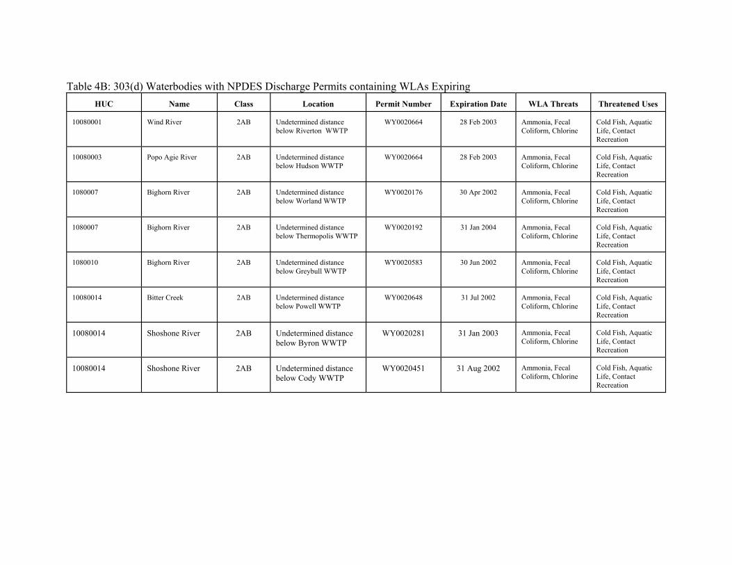
Table 4B: 303(d) Waterbodies with NPDES Discharge Permits containing WLAs Expiring
HUC
Name
Class
Location Permit Number
Expiration Date
WLA Threats
Threatened Uses
10080001
Wind River
2AB
Undetermined distance below Riverton WWTP
WY0020664
28 Feb 2003
Ammonia, Fecal Coliform, Chlorine
Cold Fish, Aquatic Life, Contact Recreation
10080003
Popo Agie River
2AB
Undetermined distance below Hudson WWTP
WY0020664
28 Feb 2003
Ammonia, Fecal Coliform, Chlorine
Cold Fish, Aquatic Life, Contact Recreation
1080007
Bighorn River
2AB
Undetermined distance below Worland WWTP
WY0020176
30 Apr 2002
Ammonia, Fecal Coliform, Chlorine
Cold Fish, Aquatic Life, Contact Recreation
1080007
Bighorn River
2AB
Undetermined distance below Thermopolis WWTP
WY0020192
31 Jan 2004
Ammonia, Fecal Coliform, Chlorine
Cold Fish, Aquatic Life, Contact Recreation
1080010
Bighorn River
2AB
Undetermined distance below Greybull WWTP
WY0020583
30 Jun 2002
Ammonia, Fecal Coliform, Chlorine
Cold Fish, Aquatic Life, Contact Recreation
10080014
Bitter Creek
2AB
Undetermined distance below Powell WWTP
WY0020648
31 Jul 2002
Ammonia, Fecal Coliform, Chlorine
Cold Fish, Aquatic Life, Contact Recreation
10080014
Shoshone River
2AB
Undetermined distance below Byron WWTP
WY0020281
31 Jan 2003
Ammonia, Fecal Coliform, Chlorine
Cold Fish, Aquatic Life, Contact Recreation
10080014
Shoshone River
2AB
Undetermined distance below Cody WWTP
WY0020451
31 Aug 2002
Ammonia, Fecal Coliform, Chlorine
Cold Fish, Aquatic Life, Contact Recreation

Table 4C: 303(d) Waterbodies with Water Quality Threats
HUC
Name
Class
Location
Cause of WQ
Threat
Sources
Data sources
Threatened
Uses
Date
Listed
Priority
10080005
Ocean Lake
2ABWW
Ocean Lake
Habitat Degradation
Non-point
Lower Wind River NRD
Warm Fish, Aquatic Life
2002
H
10080005
Poison Creek
2AB
From Boysen Reservoir upstream an undetermined distance
Fecal Coliform
Point Undetermined
USGS 06255500
Contact Recreation
1996
L2
10080005
Muddy Creek
2AB
From Boysen Reservoir upstream an undetermined distance
Fecal Coliform
Point Undetermined
USGS 6258000
Contact Recreation
2002
H
10080007
Bighorn River
2AB
Confluence with Nowood River upstream an undetermined distance above the City of Worland
Fecal Coliform
Undetermined
USGS 06268600, 441138107545501, 06269500, DEQ
Contact Recreation
2002
H
10080007
Fifteen Mile Creek
3B
Confluence with Bighorn River upstream an undetermined distance
Fecal Coliform
Undetermined
USGS 440044107584301
Contact Recreation
2002
H
10080007
Nowater Creek
3B
Confluence with Bighorn River upstream an undetermined distance
Fecal Coliform
Undetermined
USGS 06267420
Contact Recreation
2002
H
10080007
Owl Creek
2AB
Confluence with Bighorn River upstream an undetermined distance
Fecal Coliform
Undetermined
USGS 06264500, DEQ
Contact Recreation
2002
H
10080007
Sage Creek
3B
Confluence with Bighorn River upstream an undetermined distance
Fecal Coliform
Undetermined
USGS 440045107581401
Contact Recreation
2002
H
10080007
Slick Creek
3B
Confluence with Bighorn River upstream an undetermined distance
Fecal Coliform
Undetermined
USGS 062686600
Contact Recreation
2002
H
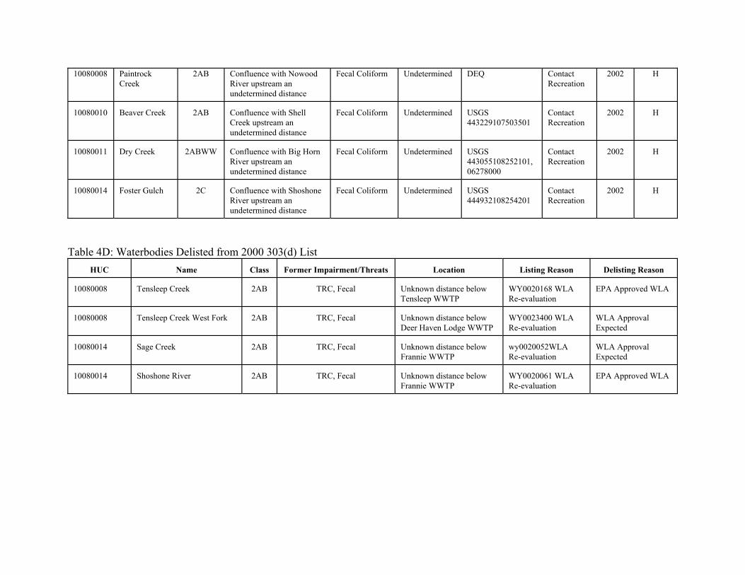
10080008 PaintrockCreek
2AB Confluence with Nowood River upstream an undetermined distance
Fecal Coliform Undetermined DEQ Contact Recreation
2002 H
10080010
Beaver Creek
2AB
Confluence with Shell Creek upstream an undetermined distance
Fecal Coliform
Undetermined
USGS 443229107503501
Contact Recreation
2002
H
10080011
Dry Creek
2ABWW
Confluence with Big Horn River upstream an undetermined distance
Fecal Coliform
Undetermined
USGS 443055108252101, 06278000
Contact Recreation
2002
H
10080014
Foster Gulch
2C
Confluence with Shoshone River upstream an undetermined distance
Fecal Coliform
Undetermined
USGS 444932108254201
Contact Recreation
2002
H
Table 4D: Waterbodies Delisted from 2000 303(d) List
HUC
Name
Class
Former Impairment/Threats
Location
Listing Reason
Delisting Reason
10080008
Tensleep Creek
2AB
TRC, Fecal
Unknown distance below Tensleep WWTP
WY0020168 WLA Re-evaluation
EPA Approved WLA
10080008
Tensleep Creek West Fork
2AB
TRC, Fecal
Unknown distance below Deer Haven Lodge WWTP
WY0023400 WLA Re-evaluation
WLA Approval Expected
10080014
Sage Creek
2AB
TRC, Fecal
Unknown distance below Frannie WWTP
wy0020052WLA Re-evaluation
WLA Approval Expected
10080014
Shoshone River
2AB
TRC, Fecal
Unknown distance below Frannie WWTP
WY0020061 WLA Re-evaluation
EPA Approved WLA