building a new research environment request for...
TRANSCRIPT

Cataloging Hidden Special Collections and Archives:
Building a New Research Environment
Request for Proposal: Outline
General Information
Cover Sheet File is uploaded.
Application ID: 704
Name of Institution: University of Florida, George A. Smathers Library
Address: Department of Special & Area Studies Collections, 208 Smathers Library, P.O. Box 117007
Gainesville, FL. 32611-7007
United States
Point of Contact: Mr. James Cusick / Curator, P.K. Yonge Library of Florida History / 352-273-2778
Eligibility Requirements
Is the applicant institution a not-for-profit organization, as defined in CLIR's Proposal Application Guidelines?
Yes
1.
Is the collection owned or held in the U.S.?
Yes
2.
Do you wish to apply for funding?
Yes
3.
Provide proof of applicant organization's non-profit status (.pdf): File Uploaded4.
For those institutions which are not colleges or universities, upload a list of board or trustee members (.pdf): File not
Uploaded
5.

SECTION I:
PUBLIC INFORMATION
Collection Identification
Collection/Project Title:
Discovering Florida in Maps: A Partnership to Catalog the State's Historic Cartography
1.
Approximate amount of materials to be cataloged during the course of the proposed project (you must answer at
least one; you may fill in all that apply):
Boxes: _____a.
Cubic Feet: _____b.
Linear Feet: _____c.
Number of objects: 5335d.
2.
If the materials are listed in a directory (e.g., Archive Finder, ArchivesUSA, the National Union Catalog of
Manuscript Collections (NUCMC), OCLC WorldCat, etc.), please list the directory name(s) below:
3.
Collections do not have to be registered in a directory to be eligible for this grant.
REMINDER: The descriptive information that you provide on this tab will be disclosed as part of the overall cataloging effort.

Description of Content
Provide a brief description of the material (e.g., topic, period covered, geographic scope, relevance to individuals,
etc.) (max 1500 characters)
This project’s focus is historic cartographic collections of Florida held in Special Collections of four major institutions:
University of Florida (UF); University of Miami (UM); History Miami/Historical Museum of Southern Florida (HM); and
Florida Historical Society (FHS). Collectively, the 5,335 maps in this project cover Florida from the time when it comprised
most of the American South to its current status as a leading Sun Belt State. These collections represent 500 years of
cartography and chart the region's development, its drastically altered topography, and its changing relationship with
adjacent areas such as the Caribbean. Languages in collections include English, Spanish, French, Latin, Italian, Dutch, and
Portuguese. These maps provide data on early European exploration of North America, the colonial rivalries of Spain,
France, and Britain, Indian Removal in the 1830s, and 20th century environmental dilemmas. Topics overlap across
collections but in general have a unique perspective on Florida and will complement each other. As primary sources, they
support research in colonial and US history, anthropology, archaeology, historic preservation, Native American studies,
historical geography, urban planning, water management, travel and tourism, agriculture, and maritime and environmental
studies. They will be of great use in ecology for establishing historic baselines of marsh areas, habitats and coastlines.
1.
From what period do the materials date?
1502 AD - 1975 AD
2.
What is the geographic scope of the project? (max 150 characters)
The collection covers the cartographic history of Florida and encompasses the American Southeast, Gulf of Mexico, and
Caribbean.
3.
What is the format? Check all that apply:4.
Text (including electronic texts): __X___ a.
Image (including photographs, moving images, drawings, etc.): __X___ b.
Audio (including speech and music): _____ c.
Book (including serials): __X___ d.
Manuscript: __X___ e.
Specimen (botanical, geological, medical, etc.): _____ f.
Data Set (paper-based or electronic): __X___ g.
Work of Art (including original paintings, prints, sculpture, etc.): _____ h.
Artifact (including archaeological objects, weapons, machinery, instruments, costumes, textiles, ceramics, glass,
furniture, etc.): _____
i.
Other; Please Specify: Copper plates for printing maps j.
Is there a preliminary finding aid or description of this collection/project?
Yes
5.
If a preliminary finding aid or description does exist, provide a brief description. If there is a URL for the
collection/project, please provide that URL. (max 600 characters)
6.
The institutions in this project have accession lists to help curators locate maps and pull them for use. These lists contain
minimum data and were created for internal control. Formats consist of: (FHS) Excel spreadsheet on local hard drive; (UM)
and (HM), card files, lists, plus descriptive overviews for a few named collections; (UF), card file converted to a web
database giving abbreviated information (http://web.uflib.ufl.edu/fhmaps/basic.htm).
REMINDER: The descriptive information that you provide on this tab will be disclosed as part of the overall cataloging effort.

SECTION II:
CONFIDENTIAL INFORMATION
Description of Content (cont.)
Are the contents of the collection(s) in any way at risk or endangered?
Yes
If yes, please explain briefly the nature of the threat. (max 1500 characters)
There are two potential risks to the maps in this project. The first is from theft, since the collections include a
wide range of different types of maps, including rare prints by well-known cartographers that carry a significant
market value. For reasons of security, all the project collections are considered "special collections" and are
maintained within secure areas, both for storage and for use. Descriptive cataloging, provided through this
project, will have a side benefit of improving basic control over inventory.
In addition, like most map collections, many items in these collections can suffer from overuse or hard use. In
the absence of description of the maps, users often request all maps likely to address a research question. This
causes considerable wear and tear. Better description will assist users in narrowing their search for material.
Literature in map librarianship and curation recommends full description for minimizing this "trial and error"
method of finding maps and is considered an important method for maintaining map collections in good
condition.
7.
Does the holding institution have a conservation plan for these materials?
Yes
8.
Are there physical or artifactual characteristics of the materials that would inhibit either the cataloging effort or
future digitization?
No
If applicable, describe your institution’s approach to conservation of these materials. Also explain any
physical or artifactual characteristics of the materials that would affect either the cataloging effort or
future digitization. NOTE: No funds under this request may be directed toward conservation,
stabilization or digitization activities. (max 1500 characters)
The UF Library employs a conservator who manages the library conservation lab to assess and treat items in
need of attention or repair. The historical Florida map collection at UF, kept in the Special Collections Room,
was reviewed in 2000 and 2001 by library conservator John Freund. Rare maps and maps in need of attention
were treated at this time. Treatment consisted of relaxing folds, neutralizing the effects of acidic paper, and
encapsulation. The University of Miami has a preservation coordinator and is working to set up a conservation
lab. Repair of materials is done on an as-needed basis. All the institutions involved in this project maintain their
collections in standard flat or rolled storage. All materials are kept in secure and temperature controlled
environments. There are no physical characteristics that would prevent cataloging or future digitization.
9.
Does the institution hold the rights to these materials, including the rights or permission to digitize the materials at a
future date?
No
Please explain any limitation, embargoes, or other restrictions. (max 1500 characters)
The goal of the current project is to create cataloging records for the map collections at the four project
institutions. There are no restrictions on doing this. The four institutions view this work as a first step towards
digitization, indeed as the crucial step of generating contextual notes and metadata to accompany the maps.
Future digitization may require copyright release in some cases, notably for published maps printed after the
1920s. This is a minor issue, as 80% of holdings predate 1923. A second consideration for UF is its especially
strong holdings of reproductions of colonial maps that are not generally available in this country. The originals
and the rights to them are held overseas by the British National Archives (London)and the Archivo General de
Indias (Seville). Maps collected at UF also include copies of items housed at the National Archives and
Records Administration (College Park, MD). In all these cases, the acquisition of reproductions served the same
purpose: to obtain good copies of important manuscript maps for research into the colonial and territorial
periods, allowing faculty at UF to make close study of these materials at their home institution. Requests for
10.

permission to digitize these reproductions, or replace them with new digital images from the owning institutions,
are underway.
What is the current access policy with respect to the use of these materials? Might this change as a result of this
project, or subsequent to other future initiatives (e.g. digitization)? (max 1500 characters)
The project institutions have reputations for outstanding research materials on Florida and attract scholars interested not just
in maps but in books and manuscripts. UF, UM, HM, and FHS are open to the public and encourage faculty, students,
visiting scholars, and the public to make use of materials. However, use of historic maps as primary sources currently
requires lengthy sessions with curators and relies on their knowledge of holdings to direct researchers to relevant materials.
Collections are regarded as Special Collections and are maintained as closed stack, non-circulating materials. Researchers
usually schedule appointments in advance to work with the maps. Because the maps are uncataloged, it can take several
visits before researchers are familiar enough with holdings to find what they need.
Cataloging of the maps will immediately facilitate on-site use and is viewed as a first step towards digitizing them and
making them freely accessible through the Web. Interest in the map collections is expected to rise steadily. Florida is going
through a decade of major anniversaries (2013, naming of the state, 500 years; 2015, founding of St. Augustine,450 years;
2021, U.S. acquires Florida, 200 years). These occasions always prompt a flood of new research and publishing efforts, as
was true for the Columbian Quincentennial in 1992. All four institutions will mark the state anniversary in 2013 with
exhibitions that feature their map collections.
11.

Value and Significance
Upload three letters of support for your project. These letters must come from individuals knowledgeable about the collections or
some other aspect of the project, but may not come from those who are directly affiliated with the project. It is strongly
recommended that applicants obtain these letters of support from scholars outside their home institution. Reviewers may look
more favorably upon external letters as representative of the materials' value to the wider scholarly community. (.pdf)
Provide three reference letters, in PDF format:
Reference Letter 1 Uploaded, Reference Letter 2 Uploaded, Reference Letter 3 Uploaded
1.
Institutional Support Letter: Institutional Support Letter Uploaded2.
Describe the value of the collection(s) to scholarship and the ways that scholarship would be enriched by greater
access to these materials. (max 3000 characters)
“We have perhaps as little knowledge of the interior of Florida, as of the interior of China.” This statement, made by
General Thomas S. Jesup in 1837 in the middle of the Second Seminole War, was both true and untrue at the time. In fact,
by 1837, Spanish and British map makers had already charted much of Florida. General Jesup just didn’t know it. Because
of the area’s turbulent history (depopulated and repopulated four times between 1700 and 1850) Jesup had no access to
maps made by his many predecessors. Florida had to be mapped over again from scratch.
This is not true today. The four institutions in this project have rich collections representing some 500 years of Florida’s
cartographic history. Yet many of today’s researchers are in the same situation as General Jesup. They are likely unaware
the maps exist.
Florida map collections in this project have a proven record as primary sources. In the 1990s, archaeologists used them to
pinpoint the locations of long vanished 17th century Spanish missions and of Fort Mose, the first free black town in the US.
For those who have discovered Florida‘s incredible historic cartography, the knowledge has been rewarding. Letters of
support attest to how information from project maps has fueled research in history and archaeology. Historians Paul
Hoffman and Amy Turner Bushnell have made extensive use of them, as has archaeologist Jerald T. Milanich (letters on
file). Dr. Loren McClenachan with the Scripps Oceanographic Institute has used them in historical ecology to establish
pre-modern baseline data about the Keys and the Gulf. Notes McClenachan of her work: “Historical maps have helped me
discover locations of historical populations of animals . . ., the extent and distribution of different types of habitat (for
example, coral and mangroves), and the location of productive fishing grounds” (email on file).
Encompassing a variety of maps (e.g. rare, manuscript, modern tourist), the collections offer a wealth of primary source
material. UF holdings, including four original 18th century copper plates, document all early exploration of Florida, the
intensive military surveying of the peninsula during the Second Seminole War, and the pre-Disney era of tourist attractions.
HM has collections dealing with the drainage of the Everglades, the rise of metropolitan Miami and its port (Deedmeyer,
McMichen, and Chardon Collections), settlement of the Florida Keys (D.D. Rogers Collection), and the urban design of
Coral Gables (Bliss/Jones and Pace Collections). These are complemented by collections at UM on the growth of Dade
County, its immigrant neighborhoods, and relation to the Caribbean. Holdings at FHS cover the maritime history of the
Gulf (Ware Collection), Florida’s 1920s Land Boom (C.M. Rogers Collection), and communities near the Kennedy Space
Center. Together, these cartographic resources chart the rise of Florida and its problems from Spanish Conquest to Sun Belt
State.
3.
Related Collections
Identify other collections (if any), not held by the applicant institution(s), whose value would be enriched as a result
of improved access to these materials. If there are no such collections, please denote this by entering "N/A" in the
space below. (max 1500 characters)
Several institutions have most of their Florida map collections uncataloged, including Tampa Bay History Center,
Jacksonville Public Library and John C. Pace Library at the University of West Florida (Pensacola). All were invited to
participate in this project but declined due to prior commitments. Other map collections are held at the State Library of
Florida, Florida State University, University of South Florida, and the St. Augustine Historical Society. Research in these
collections will be supported and enhanced by the discoverability of holdings at the four project institutions. For the first
time, as a result of this project, librarians and scholars will have catalog information about the extensive historic maps of
Florida held at the state historical society, a major South Florida museum, and two of the state's major university libraries.
This project will provide indirect benefits by illustrating methods for describing historic maps, disseminating cataloging
tools, and creating the Historic Florida Maps online catalog that will incorporate the holdings of institutions statewide.
1.

Cataloging completed during this project will be useful to other interested institutions in creating records for their own
maps.
Innovation
Describe innovative aspects of the project (e.g. cataloging, archival descriptions, dissemination). (max 3000
characters)
This project features innovative methods and opportunities for collaboration; original and replicable cataloging
methodology for libraries, archives and museums with uncataloged historic map collections; online instructional materials;
and potential for spatial layering of information. New developments in information technology highlight the importance of
spatial analysis. This exciting frontier brings significant opportunities to advance research using spatial information that
maps provide.
Collaboration: The project team believes this is the first statewide collaboration to catalog hidden historic maps. It is built
on an asset-based community development approach which leverages existing strengths to benefit multiple institutions with
similar goals and challenges. It will share the knowledge and technical expertise of UF’s curator of Florida history, map
librarian, and senior catalogers with three partners that are each unique in their holdings, size, staffing and organizational
type (private university library, nonprofit museum and nonprofit archive). Due to its reputation in cataloging maps, UF is
one of only 11 libraries internationally and two in the eastern US with permission to enhance map cataloging records in
OCLC.
Original Methodology: Team members will develop, document, and disseminate new methods for organizing historic map
collections into manageable Map Types (see “Technical Approach”), and practical tools to describe different maps.
Collections of historic maps are complex and diverse, containing various types of maps from every era. This creates
challenges since most institutions lack expertise and resources for cataloging maps. Other institutions will be able to
mobilize personnel to address different map types and reduce backlogs. The online catalog, Historic Florida Maps, will
demonstrate a new way to expose combined print map holdings through an online portal.
Online Education for Cataloging Maps: Online resources created and provided will address a need for instruction on map
cataloging, as documented in two studies (see “Maps and Related Cartographic Materials,“ Haworth Information Press,
N.Y., 1999, 17-22 and “Spatial Data Collections & Services,“ ARL Spec Kit 291, 2005). It will meet core competency
needs for map cataloging developed by MAGIRT, ALA’s map round table. Online access will give libraries, museums,
archives and academic programs new, freely available educational resources.
Spatial Layering: New cataloging records will consistently include geographic coordinates, even when lacking or obscure
on maps cataloged. Spatial layering made possible by providing coordinates will facilitate future scholarly analysis and
research leading to new place-related discoveries. UF’s historic aerial photographic collection (http://ufdc.ufl.edu/aerials)
contains 160,000 images documenting dramatic changes in Florida’s land use between 1937 and 1990 also will facilitate
this type of spatially integrated research.
1.
Impact
Describe your approach to expanding the impact of your project through outreach and professional activities. (max
3000 characters)
Maps are among the most difficult primary resources to use and lack of available cataloged records exacerbates the
problem. According to Spatial Data Collections & Services (ARL Spec Kit 291, 2005), 72 research libraries reported heavy
use of maps by researchers in architecture, geography, geology, urban planning, and environmental programs. At the same
time, 40% noted that demands for spatial data were increasing at a time when cataloging staff was decreasing.
This project provides several approaches for outreach. Three workshops, hosted at project institutions, will promote
discussion of state cartographic resources and their scholarly use. Besides teaching cataloging procedures, these workshops
will develop skills in reading, interpreting, and describing maps. Each will be open to as many as 30 participants so that
those from institutions not directly involved in the CLIR project can attend. Project personnel will disseminate methods for
cataloging collections of historic maps, as developed during the project, at state and national venues that draw map
enthusiasts, faculty, students, and map librarians. Included are the annual Miami International Map Fair (hosted by History
Miami), the Florida Historical Society Annual Meeting and Symposium, the Map & Geospatial Information Round Table
(MAGIRT), and the annual meeting of the Cartographic Users Advisory Council (CUAC). Both MAGIRT and CUAC have
missions to improve intellectual access to cartographic materials and to promote their use. FHS will feature the CLIR
project in its radio program, Florida Frontiers, which airs on PBS stations in 80% of the state's media markets. Major map
exhibits planned at UM and at the Tampa Bay History Center, to coincide with the 500th anniversary of the naming of
Florida in 2013, offer additional venues for information. Project team members will co-author an article describing the
1.

project and collections for publication in the Journal of Map and Geography Libraries, and other related publications. Other
direct outreach and the creation and use of online documentation and videos on map cataloging are deliverables of the
project (see "Project Plan").
Project institutions are well equipped to carry through outreach. UF, the country's sixth largest university, serves more than
50,000 students and faculty, and hosts two major museums and a PBS station. Its library is a major voice in ARL and ALA,
with library faculty on state and national boards and committees. The FHS, the state's oldest cultural entity, sponsors the
largest state history conference. UM, with 15,000 students and an international focus, is Florida's preeminent private
university and a hub of research in South Florida. HM, dedicated to promoting Miami as a crossroads of culture, regularly
sponsors museum exhibits, city tours, and educational programs for the public. All four institutions have worked
collaboratively in the past on conferences, exhibits, broadcasts, and other projects.
Initiatives
Describe any initiatives that might be triggered by availability of access to these materials. (max 1500 characters)
Traditional Exhibits
U. of Miami and History Miami already have plans underway to feature their map collections in a major 2013 exhibit,
together with talks about the history of Florida's cartography. The P.K. Yonge Library of Florida History at UF will be
lending maps to the Tampa Bay History Center for a similarly themed exhibit, in 2013.
Digital Projects
The ultimate goal of cataloging in this project is to prep maps for use as digital products. All four institutions are seeking
funds to digitize their collections. In particular, they seek to integrate the online use of historic maps with the 160,000 aerial
images of Florida already made available by UF [http://ufdc.ufl.edu/aerials/map]. Deriving geographical coordinates for
historic maps (a component of this project) will provide the metadata to key older maps to modern index maps, aerial
photography, and satellite images for comparison of features. Resulting digital archives of maps will be robust sources of
data.
Video
UF map cataloger Jorge Gonzalez holds seminars in map cataloging and has produced a webinar
https://sas.elluminate.com/p.jnlp?psid=2011-03-31.1132.M.BD059926592E2A1CBDC74789BD37DF.vcr&sid=2009453.
The project will generate video and training materials for web-based instruction. UF, as part of its cost share will create a
video tutorial on how maps can be used in research to create new information and synthesize historical events that cannot be
discerned through other means.
1.

Technical Approach, Management, Staffing and Training
Provide a short summary of your technical approach. (max 1500 characters)
Products resulting from the cataloging process during the project will be 1) completion of catalog records in OCLC and in
partner catalogs for 5,335 items held by partnership members: UF, UM, HM, and FHS; 2) online catalog, Historic Florida
Maps (HFM) describing these collections with options for expansion by existing and future partners and 3) creation of
methodologies for efficiently cataloging backlogs of large and diverse map collections, particularly in a statewide
partnership.
The project basic schema will utilize MARC and EAD in a hybrid-approach for managing varied cartographic resources.
Cataloging will use Connexion software at UF and UM, and the Past Perfect Platform at FHS and HM. Maps will be
searched to confirm lack of available records in OCLC by interns. This will provide interns with practical experience
working with OCLC map records. Once maps have been searched in OCLC and the team has contributed records for those
not found, maps having usable OCLC records may be considered for enhancement. Maps without any OCLC record will
move to the next phase. This will establish project cataloging queues. A project inventory will be developed by project
curators in collaboration with UF Libraries’ IT personnel. During the project this will allow for tracking of holdings from
each participating institution with location and cataloging completion status tags, to be updated throughout the project. Full
level descriptive records will be loaded into the HFM catalog.
Upload a PDF document with details.
Technical Approach Uploaded
1.
Who will serve as the Principal Investigator(s) for the duration of this project?
(Please enter at least one investigator. You may enter up to three investigators.)
Name: James G. Cusick (Ph.D.)
Title: Curator, P.K. Yonge Library of Florida History
Organization: George A. Smathers Library, University of Florida
Email: [email protected]
Phone: 352-273-2778
Address: P.O. Box 117004, Special & Area Studies Collections, George A. Smathers Library, University of Florida,
Gainesville, FL 32611
Name: Jimmie Lundgren
Title: Associate Chair, Cataloging & Metadata
Organization: UF Libraries
Email: [email protected]
Phone: 352-273-2725
Address: P.O. Box 117004, Special & Area Studies Collections, George A. Smathers Library, University of Florida,
Gainesville, FL 32611
Name: Carol Mcauliffe
Title: Head, Map & Imagery Library
Organization: UF Libraries
Email: [email protected]
Phone: 352-273-2825
Address: P.O. Box 117004, Special & Area Studies Collections, George A. Smathers Library, University of Florida,
Gainesville, FL 32611
2.
Project Plan
Upload a document that details the project plan, including staffing, milestones, and deliverables. The project plan
should also address plans to insure the long-term sustainability of the project at the institution(s), and any plans to
promote the use of the targeted collections.
Project Plan Uploaded
1.
How many staff will be assigned to this project? Complete all that apply:
Current Professional Staff: Full Time - 9 Part Time - NAa.
2.

New Hire Professional Staff: Full Time - 3 Part Time - NAb.
Current Non-Professional Staff: Full Time - NA Part Time - NAc.
New Hire Non-Professional Staff: Full Time - NA Part Time - NAd.
Students: Full Time - NA Part Time - 8e.
Volunteers: Full Time - NA Part Time - NAf.
Total: Full Time - 12 Part Time - 8g.
Qualifications
Resumes for up to three key personnel on this project may be provided below. Resumes are required for Principal
Investigators listed on the Technical Approach, Management, Staffing and Training tab. Resumes must not exceed 2 pages
each. Failure to adhere to these guidelines will automatically disqualify the application from consideration.
Upload resume(s) for up to three key personnel. (max. 3 resumes; max. 2 pages each):
Resume 1 Uploaded
Resume 2 Uploaded
Resume 3 Uploaded
1.
Describe the relevant qualifications of the Principal Investigator, project manager, supervisory personnel and/or
technical specialists, e.g. experience with special collections, cataloging projects, and/or work with students or
volunteers. (max 1500 characters)
UF: James Cusick (PhD UF 1993), Curator, P.K. Yonge Library of Florida History, PI, authority on Florida, oversees
historic map collection, 14 years. Carol McAuliffe (MLIS FSU 2003), Head, Map & Imagery Library, 5 years, Co-PI, in
charge of the largest map library in the Southeast; member, education committee, ALA Map & Geospatial Information
Round Table (MAGIRT). Jimmie Lundgren (MLS FSU 1993), Assoc. Chair, Cataloging & Metadata, Co-PI, 33 years
experience; member, Subject Analysis Committee of the ALA ALCTS Cataloging and Classification Section; member,
Task Group to develop a BIBCO Standard Record for Cartographic Materials. Jorge Gonzalez (MA UF 2007), Map
Cataloger, 16 years experience in cataloging, 12 with atlases and maps, runs UF map cataloging seminars. Mil Willis (BA
UF 1974, JD West. New England 1981), Public Services Coordinator, Special Collections, 10 years with Map Library,
senior archivist.
HM: Rebecca Smith (MLS FSU), Head, Special Collections, 36 years experience in cataloging with 10 in map cataloging.
UM: Cristina Favretto (MLS U Pittsburgh), Head, Special Collections, formerly head of Special Collections (San Diego
State) and curator of rare books (UCLA). S. Michael Kim (MLS Missouri), Head, Cataloging & Metadata, chair, Technical
Standard Committee, Special Libraries Assoc.
FHS: Ben DiBiase (BA UCF 2009; MA in progress, Public History, UCF), Educational Resources Coordinator, archivist
for the library, coordinator of intern programs.
2.
Training
Will training be required?
Yes
If yes, please describe. (max 1500 characters)
The project will hold orientation workshops at History Miami (south Florida), the Florida Historical Society
(central), and UF (north) open to all project team members and invitees from other institutions. Each workshop
will provide (1) an overview of Florida’s historic cartography and how to describe maps and (2) instructional
sessions in map cataloging. A Project Advisory Board includes Dr. Joe Knetsch, the state expert on land
survey, Maps and Survey, Division of State Lands, FDEP; Arthur Dunkelman, curator of maps for the Jay I.
Kislak Foundation; and Dr. Joseph Fitzgerald, founder of the Miami International Map Fair. Resources on
cataloging include Dr. Fitzgerald's website on "Old Florida Maps"; the text "Borders of Paradise: A History of
Florida through New World Maps" (U. Press of Fla., 1997); Nancy A. Kandoian, "Cataloging Early Printed
Maps," Cataloging & Classification Quarterly 27:3/4 (1999) pp. 229-264. Rare, Antiquarian, or Just Plain Old:
Cataloging Pre-Twentieth Century Cartographic Resources, MAGERT, Library of Congress, 2007; and
additional resources and manuals held by the project institutions. Online documentation on map cataloging will
be developed. UF map cataloging expert Jorge Gonzalez will make six site visits to project institutions during
the project to answer questions and train. in addition, group email and Skype will be used to share information
during cataloging. For a list of lead project staff, please see "Qualifications."
1.


Institutional Capacity
Describe the institutional strengths that justify undertaking this project, including infrastructure, experience, access
to local expertise (including volunteers or students), resources, professional leadership, etc. (max 3000 characters)
A major goal of this project is to share expertise on Florida maps, as developed at the University of Florida, through
outreach and partnership with other repositories. UF ranks among the state’s most important centers for the study of
Florida’s past. The P.K. Yonge Library of Florida History at UF has an unmatched microfilm collection in colonial
documents, manuscript collections rivaling the State Archives in size, 35,000 books, a 10,000 piece brochure collection on
modern Florida, and 3000+ historic maps. It serves as a center of research for graduate students, faculty, professional
writers, documentary makers, and exhibition designers, with a curator, Dr. James Cusick, who is a published author in
Florida history and a recognized educator with 14 years experience. The University of Florida Digital Library Center,
another major agency of the UF Library, is now the state’s acknowledged digital repository for Florida newspapers as well
as a digital archive for millions of documents in state history.
UF also has outstanding resources on cartography. Carol McAuliffe, Head of the Map & Imagery Library, oversees more
than 497,800 maps, 266,500 aerial photographs, 2,250 remote sensing images, and 7,215 atlases and reference books. UF
has the largest academic map collection in the Southeast, and is among the top five academic map collections in the United
States. Specialties of the collection include Florida, Latin America, the United States, Africa, and the Holy Land.
McAuliffe was responsible for bringing together her staff and lead catalogers from UF Cataloging and Metadata Dept. in
2007 to conduct seminars in map cataloging. These seminars were led by UF’s emeritus map librarian Dr. Helen Jane
Armstrong. As a result of this training, and of previous experience, UF has two highly qualified catalogers in cartographic
materials, the Associate Head of Cataloging & Metadata Jimmie Lundgren and map cataloger and cataloging trainer Jorge
Gonzalez. The high professional standards of the Cataloging & Metadata Dept. at UF is recognized nationally. It has been a
national level enhance member of OCLC for books for decades and in 2010 it was approved to be among the small group of
libraries accorded cartographic cataloging enhance status for its entries into OCLC. It is also a long-standing member of
CONSER, BIBCO, SACO and NACO components of the Library of Congress Program for Cooperative Cataloging,
reporting annually on bibliographic and authority records contributed. Collection statistics are reported annually to ARL.
UF is thus well positioned to draw on its own experts in assisting and training in map cataloging and can also draw on the
expertise of scholars who regularly use its map collections, including those associated with Maps & Survey at the Florida
Department of Environmental Protection, faculty at various Florida studies programs around the state, and holders of other
historic map collections.
1.
Will funds from the grant be applied to current staff salaries, infrastructure or other elements of technical support?
No
If so, justify the need to cover such costs with external funds and their relevance to the proposed
cataloging effort. (max 1500 characters)
2.
Would your institution be willing to participate in an ongoing CLIR study focusing on innovative aspects of hidden
collections cataloging projects, and/or in a post-project evaluation? NOTE: Participation in these activities is
encouraged, but not required, and your answer will not affect consideration of your application in any way.
Yes
3.
Prior Collaborations
Provide up to three examples of prior collaborations, particularly those that resulted in shared data or federated
information programs. (max 600 characters each)
Digital Library of the Caribbean (dLOC) http://dloc.com. UF in partnership with Florida International University and the
University of the Virgin Islands works to preserve valuable cultural, historical and scientific materials that are at risk due to
natural disasters and/or a lack of funding to provide adequate preservation. UF has provided site specific training in
scanning and metadata creation as well as global digital access to over 30 universities, libraries, and publishers in the
Caribbean. Currently: 10,417 titles, 67,200 items, 1,343,813 pages.
Florida Digital Newspaper Library (FDNL) http://ufdc.ufl.edu/fdnl1. UF is the digital repository for Florida's historic
newspapers, currently numbering 70 titles, in partnership with Florida universities, county governments, municipalities,
publishers, public libraries and historical organizations. FDNL exists to provide access to the news and history of Florida.
Currently: 696 titles, 76,968 items, 1,113,663 pages.
VIVO Enabling National Network of Scientists – Funded in 2009 by NIH
at $12 million, UF Bioinformatics and Libraries are the lead institution in partnership with Cornell to implement this
1.

national information network that will connect researchers and their projects and publications, including Indiana University,
Washington University, The Scripps Research Institute, and Ponce Medical School. The Libraries initiated the project with
Cornell through a pilot project to connect faculty and their research in UF's Institute of Food & Agricultural Sciences.
Cataloging Backlog
Does the institution (or, in the case of joint or consortia projects, institutions) have a cataloging backlog?
Yes
If Yes, how large is the cataloging backlog? Is there a strategic plan to address the backlog? (max 1500
characters)
All institutions in this project have cataloging backlogs, of which maps form a major part. At the University of
Miami, Special Collections holds some 5,000 maps, including the historical maps of Florida that are
incorporated into this project. Cataloging efforts currently focus on rare books, although the map collection
remains a priority. History Miami has an experienced cataloger in its head of special collections and has
cataloged some of its historic maps. The bulk, however, are part of its cataloging backlog, due to the museum's
small staff size. The Florida Historical Society, also with a small staff, has concentrated on cataloging its
backlog of books, and now wants to turn attention to its 1400+ uncataloged maps. The map collection at the
P.K. Yonge Library of Florida History is also uncataloged. Priority in cataloging in recent years has been on
other materials, including the extensive microfilm collection of primary source materials, which are being made
available through InterLibrary Loan and require tracking.
The resources requested in this proposal, both in training and project personnel, will effectively overcome the
backlogs in cartographic materials at all four project institutions and equip each institution to keep its map
cataloging current in future. The project will establish knowledgeable catalogers at each institution and allow
the institutions to draw on their mutual resources and expertise in future.
1.
Institutional Priorities
Describe institutional priorities for cataloging, including addressing the backlog, if applicable, and explain how this
project addresses one or more of these priorities. (max 1500 characters)
This question was partially addressed in the previous section. As noted, all institutions in this project are aware of the
significance of their map collections and have placed a high priority on cataloging the materials. However, they all need
additional resources to carry-out the proposed project. This project is therefore key to assisting the four project institutions,
both in overcoming backlogs and establishing good cataloging practices for the future. It will train permanent staff,
including curators, familiarize them with the issues involved in map cataloging, and develop procedures to create cataloging
records that meet the needs of scholars likely to use them. It will establish a network across the institutions so that each can
draw, in future, on the map expertise available at UF. It will also employ an economy of scale to catalog as many items as
possible using both interns and catalogers.
1.

Funding
CLIR requires all applicants to complete and upload two budget documents.
The Budget Narrative should include a full description of the budget, explaining the need for each budget line and the
method(s) used to compute the projected costs. If software or equipment is being purchased or work is being
outsourced, the vendors being considered should be mentioned. A brief explanation of how the grantee institution
would manage the grant funds should also be included in this section.
1.
The Budget Detail must provide a detailed budget broken out by year. The Budget Detail must be submitted using
CLIR's form, which may be downloaded here. The form must be re-saved into PDF format prior to upload, with any
subcontracts appended to the end of the document.
2.
Budget Narrative Uploaded
Budget Detail Uploaded
1.
What is the size of the request (in whole dollars)?
$323,825.00
2.
How large is the institutional cost share? (Cost sharing is encouraged, but is not required.)
$251,710.00
3.
Total value of the project, including requested and cost sharing funds?
$575,535.00
4.
Have other sources of funding been considered?
Yes
Describe prior efforts, if any, to identify other sources of funding for this project, and explain why this
project is uniquely suited to this funding program. (max 1500 characters):
Funds for cataloging collections, as opposed to digitizing materials, have always been scarce. In prior years, the
University of Florida considered applying for grants to catalog the Florida Historical Map Collection; however,
library priorities usually directed attention towards digital projects or towards work on other important and
poorly-cataloged collections in Special Collections. In 2010 UF applied to CLIR as a single institution to
catalog its maps. Based on feedback from reviewers, it broadened and restructured its proposed cataloging
project to encompass a group of map repositories.
The University of Miami, the Florida Historical Society, and History Miami/Historical Museum of Southern
Florida have not previously applied specifically for funds to catalog their map collections.
This project offers multiple benefits if funded effort. It will build a solid cooperative relationship among four
significant institutions in Florida and increase scholars' familiarity with the important cartographic resources that
they hold. It will establish expertise in maps at the project institutions and promote knowledge of Florida's
cartographic heritage to a broader audience.
5.
Do you agree to participate in periodic meetings with other applicants to be held up to twice a year? Yes
Note: CLIR will reimburse participant travel for up to two representatives from each funded project.
6.

Council on Library and Information Resources Cataloging Hidden Special Collections and Archives Program Proposal Cover Sheet
Please complete this sheet (or the institution's equivalent) and attach it to the institution's final proposal submission.
Date of Submission (mmiddlyyyy) 0712112011
University of FloridaLegal Name of Grantee
Proposed Project: Discovering Florida in Maps: APartnership to Catalog the State's Project Title Historic Cartography
Request Amount :$323,825
Proposed Grant Tenn (#ofmonths) 18
Proposed Start Date (mmiddlyyyy) 0110112012
Proposed End Date (mm/ddlyyyy) 06/3012013
Internal Reference Number
Principal Investigator(s) and Title(s): James Cusick, Curator, Florida History; Jimmie Lundgren, Associate Name(s) Chair, Cataloging & Metadata; Carol Mcauliffe, Head, Map Library
UF LibrariesAddress( es) PO Box 117000 Gainesville, FL 32611-7000
Signature(s)
Financial Administrator for Grant: Name
Address
Signature


/\mu I urner jj>usrme!l1 9/4 Division Road, ELast (jreenwich, Kl O28 1 8
home (4-01) 884-5885, ceil (4O1) -
A m j ) u s n [email protected]
July 15, 2011
Council on Library and Information Resources1752 N Street NW, Suite 800Washington, DC 20036
Dear Readers:
I am writing to you in support of "Discovering Florida in Maps: A Partnership to Catalogthe State's Historic Cartography," a project intended to produce an online catalog describing indetail four collections of Florida maps, those of the P.K. Yonge Library of Florida History at theUniversity of Florida, of the Florida Historical Society, of History Miami, formerly the HistoricalMuseum of Southern Florida, and of the University of Miami.
This is a most important project, particularly timely because of the soon-to-comequincentenary of Juan Ponce de Leon's accidental discovery of the North American mainland in1513. Five hundred subsequent years of description have generated rich caches of maps, whoseunique hydrographic, geographic, historical, and cultural features document change in the naturaland built environments, yet descriptive cataloging records of these valuable maps are rare. The P.K.Yonge Library has a small card file that sat for years behind the desk of former curator LibAlexander. The Florida Historical Society keeps its map information on a spreadsheet. HistoryMiami's map information resides in a person, curator Becky Smith. The University of Miami has nofinding aid for its map collection whatever. These lacunae in the catalogs of respected Floridainstitutions can only be explained by a shortage of map librarians.
Years ago, when I was research historian at the Historic St. Augustine Preservation Board, Iobtained a grant from the Institute of Museum Services for the purpose of cataloging our largeresearch collection of books, reports, and images, including maps and architectural drawings. Aprevious historian, Dr. Overton Ganong, had made trips to the major Spanish archives and to theLibrary of Congress for the purpose of copying every available historical map of the city and itsenvirons—and there were surprisingly many. But without a catalog to establish control over thematerials, the map collection was difficult to use, and items in it had a tendency to wander off. Dr.Rosamaria Weaver, whom I hired to catalog the flat files, taught herself the art of map cataloging,but having little in the way of guidelines, she was chagrined at how long it took her to do anaccurate and thorough job.
As a historian of Colonial Latin America with a field in Historical Geography, as a long-timemember of the Society for the History of Discoveries and the Forum on European Expansion andGlobal Interaction, and as the author of two monographs on Spanish Florida, I can attest to thevalue that historians and archaeologists place on the various map collections that we consult andhow vividly we recall those maps yielding information that existed nowhere else. My own favoritemaps include Alvaro Mejia's 1605 derrotero of the coastal waterway below St. Augustine,

Council on Libraries and Information Resources 2 July 15, 2011
Alonso Solana's 1683 map of Florida showing the locations of Indian towns, Governor Diego deQuiroga y Losada's 1691 plan for a fortified mission compound, a map drawn in 1763 of ranchesabandoned half a century earlier, and, for documenting the survival of colonial buildings, the serialSanborn insurance maps, giving the location and composition of every structure in town.
For one of my current projects, editing the journal of Quaker Jonathan Dickinson [London,1700], I will need to learn how the advent of dredging affected the inlets of the inland waterwayand will resort to maps made by the U.S. Corps of Engineers. If I were a 19th-century historianrecounting the story of Anglo-American settlement, I would go to the excellent maps of roads,ports, and waterways produced by the U.S. military's cartographers during the Seminole Wars. Allof these irreplaceable maps must be professionally cataloged before they can proceed to the nextstep, digitization.
A survey of the proposals that the CLIR has recommended to the Mellon Foundation since2008 shows that, out of forty-four successful applications, only one has been for the purpose of mapcataloging: a three-year project at the Library of Congress. This is understandable. The professionof Information Sciences has long struggled with the problem of establishing global conventions formap cataloging of the kind that exist for the cataloging of books, and until such conventions were inplace, it was difficult to make a case for the kind of in-depth cataloging for maps that other printedand manuscript materials received as a matter of course. Most library schools did not even teachmap cataloging, for the good reason that conventions for the subdiscipline did not exist.Fortunately, in the past three years much progress has been made toward establishing standards forthe cataloging of maps, partly thanks to the aforesaid project, and the profession is now ready toadvance to the stage of pilot programs.
Two of the best features about the Florida project are its provision to offer a minimum ofeight internships for library science graduate students that will allow them to receive credit forhands-on training at one of the project institutions, and its provision to offer three workshopsaround the state for persons interested in learning map cataloging. This is public service of thefinest kind, whose effects will be multiplied as librarians and curators return to their homeinstitutions to care for their own holdings and to build bridges between collections and researchers.
I give the project, "Discovering Florida in Maps. A Project to Catalog the State's HistoricCartography," my enthusiastic support. Arguably, all of the proposals that the Council on Librariesand Information Resources receives will be worthy. This project goes beyond worthy to beinnovative, practical, and model-ready. It will do CLIR and the Mellon Foundation credit.
Cordially yours,
Amy Turner Bushnell
Brown University andThe John Carter Brown Library


LSULOUISIANA STATE UNIVERSITY j 79 701 1
College of Arts & Sciences
Department of History-
Louisiana State University224 Himes HallBaton Rouge, LA 70803
0225-578-4471F 225-578-4909
Council on Library and Information Resources
Re: "Discovering Florida in Maps: A Partnership to Catalog the State's HistoricCartography."
I strongly support this multi-institutional proposal anchored in the P. K. Yonge Library ofFlorida History.
In 1994 I had the pleasure of spending a sabbatical semester in the Yonge Library andusing its collection of colonial era and early national maps, among other resources. Asboth a senior scholar and alum of the collection, I had free range of the stacks and mapcases, which was how I discovered many of the maps that I studied as part of my researchfor what became a prize-winning book, Florida's Frontiers (Indiana University Press,2002) and, in some cases, incorporated as figures in that book (see Florida's Frontiers,figures 10.1, 11.1, 11.2, 11.3 (redrawn using an LSU copy of a map first seen at theYonge Library), 11.4,11.5).
Of particular value were unfolded and flattened copies of maps from the Annual Reportsof the [US] Surveyor General that showed the progress of surveys laying out thetownship, range, and section system during the antebellum era, but also includinginformation on some topographic features. In most libraries, these maps remain in theoriginal volumes, making them difficult to study without damaging them. The Yongecopies, already removed from the original publications and flattened, did not present thisdifficulty. Similarly maps from early 19th century atlases provided information such asthe notation "good land" on the Madison Hills area, Spanish era land grants (some butnot all), the limits of the various Seminole reservations etc. In most instances, as I recall,these were separate maps, not part of the original atlases, although the Yonge has a goodcollection of those works.
I also used the Yonge's extensive collection of reproductions of various Europeancolonial maps, most in the same size as the originals. Some led me to seek reproductionsfrom their holders (Figures 8.1, 9.1, 9.2) while in another case I used the Yonge's copy asa basis for redrawing a map so that it would reproduce with clarity (Figure 7.1).
My point in recounting my experience with the Yonge's cartographic resources is toindicate how rich they are, and how little they were cataloged at the time, and, as I take it,

still largely are (the point of the grant). As the proposal notes, finding them required (andrequires) "intensive on-site browsing" - a luxury that not everyone will have! I can wellimagine that other Florida libraries and museums have similar largely uncataloged /undercataloged but valuable collections of reproduced and original maps for all eras ofthe state's long history.
The four institutions that will participate in this project appear to have largelycomplementary special interests as well as a certain body of maps in common, whichshould result in a much richer understanding of the state's publicly held cartographicholdings. Creating a common on-line catalog of these holdings will be an importantaddition to the resources that scholars and the general public have for studying all mannerof historical-geographic topics.
The plan of work outlined for the grant is solid, producing not only descriptive catalogingbut also training in how to do that for cartographic resources, which differ from mostlibrary materials in the need for more comprehensive descriptions of the history of theitem and its notable features and its relationship to other maps, if evidently drawn fromthem or a basis for them. Done at the same level of specificity (or even more detail?) asWilliam P. Gumming's The Southeast in Early Maps (3rd Ed., Revised and enlarged byLouis De Vorsey, Jr; University of North Carolina Press, 1998) (and hopefully correlatedwith maps shown in that work when appropriate), the resulting union catalog will go along way toward an eventual on-line digital archive.
In sum, I strongly support the proposed union catalog and training outlined in thisproposal. It will meet a need and open "hidden" resources for study. It is the first steptoward an eventual on-line digital archive. By training staff and student interns, it willpave the way for the continued expansion of the catalog using the resources at yet otherFlorida institutions.
Sincerely Yours,
Paul E. HoffmanPaul W. and Nancy W. Murrill Distinguished Professsor
And Professor of History

UNIVERSITY ofu FLORIDA George A. Smathers Libraries 535 Library We t
Office of the Dean of University Ubrarie PO Box 117000 Gainesville, FL32611-7000 352-273-2505 352-392-7251 Fax www.uflib.ufl.edu
July 15,2011
Ms. Amy Lucko Program Officer Council on Library and Information Resources Cataloging Hidden Special Collections and Archives Program 1752 N Street NW, Suite 800 Washington, DC 20036
Dear Ms. Lucko and Reviewers,
Please accept this letter respectfully requesting $323,825, and confirming the George A. Smathers Libraries ' commitment to carryout our proposed project: Discovering Florida in Maps: A Partnership to Catalog the State 's Historic Cartography, as described in the application and budget. Specifically, we are committed to 1) contributing cost share of $234, 111 in UF Libraries ' salaries and benefits for key personnel required to successfully execute the proposed project; and, 2) ensuring that no awarded funds will be used for infrastructure or overhead costs at UF or any of the partnering institutions. Additionally, we have written commitments on file from the Florida Historical Society (committing $11,109 in cost share), and History Miami (committing $6,489). The University of Miami Library'S Special Collections also is committed to participating although it cannot contribute cost share at this time. All three partner institutions have participated in the budgeting and planning of this proposal and are equally committed to carrying out proposed activities.
If awarded, the project will add to national acknowledgement received from OCLC of the high quality of map cataloging performed by our librarians. Earlier in 2010, UF Libraries cataloging department applied for and was awarded the status ofOCLC Enhance for Maps. We now join only 10 other libraries with this status.
T his project is critical to serving scholars who are increasingly drawn to the hidden historic map collections held by the four participating institutions. The timing of this project, vis-a-vis Florida's upcoming anniversaries, provides unlimited opportunities for promoting these unique collections. Discovering Florida in Maps has the potential for creating broad impact on researchers who will finally have knowledge of their existence and content, and access to metadata and geographic coordinates for improving research results.
Many thanks for your time and review.
Respectfully,!JJ./! e. ~~ Judith C. Russell Dean of University Libraries
The Foul1dation for The Gator Nation An [qu,,1Oppurlunil) Institution
1
Discovering Florida in Maps: A Partnership to Catalog the State’s Historic Cartography
Technical Approach
Products resulting from the cataloging process during the project will be 1) completion of catalog
records in OCLC and in partner catalogs for 5,335 items held by partnership members:
University of Florida (UF), University of Miami, (UM), History Miami (HM), and the Florida
Historical Society (FHS); 2) online catalog, Historic Florida Maps (HFM) describing these
collections with options for expansion by existing and future partners and 3) creation of
methodologies for efficiently cataloging backlogs of large and diverse map collections,
particularly in a statewide partnership.
Staffing and Management: UF will manage the project and contribute the services of its curator
for Florida history, associate chair of cataloging and metadata, map librarian, two map
catalogers, and a public services staff member. The depth of the UF team will be sufficient to
support all project institutions throughout the project. This team will train and assist all project
personnel, including two project catalogers (one at UF, one to be shared between UM and HM,
and one library assistant at FHS) to be hired with CLIR proposed funding, along with eight
interns to be recruited through Florida State University and University of South Florida Masters
of Library and Information Services programs. Two interns will be hired by each participating
institution for the duration of the project (projecting 15 hours per week). In addition, the heads of
special collections at UM and HM, the head of cataloging at UM, and the archivist at FHS will
contribute cost share by supervising and assisting interns, providing quality control review, and
coordinating with UF to manage priorities, workload and workflow. CLIR funded professionals
and interns will use existing workstations or laptops at host institutions throughout the project.
Training: Initial technical training for participants will include: introduction to basics of map
cataloging, frequently used terms for rare materials description, general cataloging principles for
name and subject heading usages, handling of map sheets and rare materials, their needs for
conservation treatment and storage, and basic training in database entry and management. Interns
will be trained to search OCLC for records. A variety of training approaches and media will
ensure future education in the field for reducing map collection backlogs. Ongoing training, with
expert catalogers and curators, will focus on learning to address unusual characteristics found in
maps, and to bring new interns up to speed (see “Project Plan” for training details).
Technical approach: The project basic schema will utilize MARC and EAD in a highly flexible
hybrid-approach for managing varied cartographic resources. Cataloging will be completed using
Connexion software at UF and UM, and the Past Perfect Platform at FHS and HM. Maps will be
searched to confirm lack of available records in OCLC by interns. This will provide interns with
practical experience working with OCLC map records. Once maps have been searched in OCLC
and the project team has contributed original records for those not found, maps having usable
OCLC records may be considered for enhancement or upgrade (through project cost share
contributions). Maps will be sorted into two groups at each location. Those without any OCLC
record will move to the next phase. This will establish project cataloging queues. A project
inventory will be developed by project curators in collaboration with UF Libraries’ IT personnel.
During the project this will allow for tracking of holdings from each participating institution with
location and cataloging completion status tags, to be updated throughout the project. Full level

2
descriptive records will be loaded into the Florida Historic Maps catalog, a native interface
focused on scholarly cartographic resources that will provide and enhance discoverability to
these print map collections for the first time.
Initial stage: For project maps, the original cataloging of records will include the following
general steps. Initially, the descriptive cataloging of an original record in OCLC will be created
by a librarian or expert who will include all standard map fields/elements related to each map:
cartographer(s), title, scale, geographical coordinates, publisher(s) and date(s), subject headings,
and class number. In addition to the above, catalogers will complete all required metadata based
on AACR2 standards in MARC format. The original record will provide full descriptive data.
Notes using established vocabulary will be captured by expert catalogers as constant data and
text strings for each map type. These will be documented for future training purposes and project
sustainability. Partner curators and catalogers will work collaboratively to resolve or refine
descriptive notes. In many cases, interns will be able to use this record to produce records for
similar maps or sets. When needed EAD will be used to describe parts of maps sets. Curators
will contribute desired information and supplementary notes with the desired emphasis for each
map category, thus documenting a plan for customizing metadata creation.
Prioritization for map collections at each participating institution will be based on type of map,
curatorial prerequisites for metadata, cataloging time and level of expertise requirements. Map
collection curators will support prioritization, workflows and personnel assignments using the
following map types: 1) manuscript maps, 2) map serials and sets, 3) atlas maps, 4) census maps,
and 5) antique and rare maps. The following describes catalog processing methods for each map
group.
Manuscript maps: Each map is unique, and resulting original record creations often require
professional cataloging judgments. Detailed descriptions may require many notes. Lack of
reliable information due the unpublished nature of materials may require provenance from
curators and information from other primary sources to complete the records. This category
includes many Second Seminole War maps which were originally produced for specific purposes
during that war. These are planned to be managed using collection level group records with sheet
level management using EAD. The procedure created to handle these maps will be adaptable to
handle some other disparate collections of maps by various cartographers all relating to one
subject.
Map serials and sets: These maps contain many subcategories including survey maps, railroad
maps, sectional maps, and tourism maps, and require expert cataloging oversight to determine
individualized treatment (i.e., whether treated as a serial, a set or an individual map). They also
will be very note dependent identifying who, where or why the maps were produced; interesting
or unique elements about maps, and the timeframe of production. Descriptions will be dependent
on topic, genre, and subject entries. Once a resource has been described as a set by a professional
cataloger, interns will apply uniform data for recording the sheets in the set.
Atlas maps: These map sheets were originally issued in various atlases. Templates will be used
to efficiently record data for each sheet. Interns will search OCLC for a similar record, and create

3
a new record for each sheet. Curators will determine elements and notes for enhancements
necessary for scholars to successfully identify this type of map or information on the map.
Census maps: These maps are based on census tracts. Like atlas maps these will be cataloged by
interns due to the uniformity of information in each map. Expert catalogers will consult, review
accuracy of geographical data, etc.
Rare and antique maps: These original record creations require higher level processing similar to
those described for manuscript maps. After a search in OCLC performed by an intern, a
professional cataloger may search again to confirm whether a record is a true match due to the
variables in the creation and manifestation of each map. Some of these maps may contain or lack
watermarks, colorization by hand, may have been copied and credited to another cartographer, or
were published in different sources, etc. Certain identifiers known to catalogers and rare book
librarians will give clues about the map that an untrained eye will miss, but that an expert can
discern. Creating original cataloging for these maps requires consulting and citing sources which
reveal map origin and other important details. This map group will be cataloged primarily by UF
and contributed as cost share to the project.
Quality Control: Curators and catalogers will develop a checklist for each map category above
itemizing the elements expected to be found in the fully cataloged records. Quality control
methods will be carried out to ensure each of the records have been accurately and completely
entered. This will be performed by regular cataloging staff at the institutions, with leadership and
trouble-shooting provided by UF.
Discoverability: Finished records will be added to OCLC, to online catalogs in the holding
institutions, and to a common portal created during this project known as the Historic Florida
Maps catalog. This will allow concurrent searching of all four repositories using SobekCM open
source software. The latter catalog will be designed and maintained by UF through its Digital
Library Center. The inclusion of geographic coordinate information in particular will allow
scholars to layer map information in geographic information systems and to relate the
information to other map-based resources such as the Historical Aerial Photography Collection
of Florida at UF.
Standards: The project’s cataloging standard will be Anglo-American Cataloging Rules
(AACR2). Heading used will be consistent with Library of Congress (LC) authority records, and
catalogers will establish or propose new headings for names and places as needed through Name
Authority Cooperative (NACO) and Subject Authority Cooperative (SACO) programs. Library
of Congress Genre/Form Thesaurus (LCGFT) terms will be used to record the type of map being
described, thus allowing users to select map types as facets in the catalog. When coordinates are
not available on the item, they will be obtained from the US Board of Geographic Names (BGN),
or existing authority records.
Sustainability: Staff at each partner institution will apply skills developed during the project in
future efforts to catalog growth in Florida map collections. The UF Digital Library Center will
develop a self-submittal tool to facilitate the transfer metadata into the HFM catalog, allowing
project continuation and expansion by new participating institutions.

1
Discovering Florida in Maps: A Partnership to Catalog the State’s Historic Cartography
Project Plan
Four major institutions in Florida will develop and employ methods for describing diverse contents of collections encompassing 500
years of the state’s cartography. Project deliverables include: 1) complete catalog records for 5,335 cartographic items; 2) expandable
online portal, Historic Florida Maps (HFM) catalog; 3) online instructional resources that promote use of collections and support map
cataloging core competencies; 4) a minimum of eight MLIS internship students trained in map cataloging; and 5) a minimum 50
statewide trained professionals in map cataloging.
Jan/Feb 2012 Mar/Apr 2012 May/June 2012 July/Aug 2012 Sept/Oct 2012 Nov/Dec 2012 Jan/Feb 2013 Mar/Apr 2013 May/June 2013
Stage 1
Stage 2
Stage 3
Stage 4
Stage 1 Collection Preparation and Prioritization will focus on creating an online project inventory of maps held by the four
institutions and develop a taxonomy of map types, with related methods for description, to be used by all institutions. Progress will be
tracked via the inventory.
Stage 2 Team Building and Education: (January/February 2012) recruit, hire and provide initial orientation to two librarian level
project catalogers (UF and UM/HM); an additional staff cataloger (FHS); and MLS student interns. Other project team members
include: curator of Florida history, map librarian, associate chair of cataloging, two map catalogers, special collections manager (UF);
head of special collections (HM); educational resources coordinator (FHS); and members of special collections (UM). UF team
members will organize and lead training of participants. Three regional on-site workshops will be scheduled for March 2012, for
HM/UM, for the FHS, and at UF. Sessions will focus on Florida’s various eras of map-making, how to interpret and describe maps,
and the cataloging methodology for this project. Statewide museum and library professionals will be invited to participate in these
workshops (see “Impact”). In addition, the workshop held at UF will be video recorded to allow for training of new hires and interns
throughout the project. Online instructional resources will be developed and used for training of project team, and produced from
January through April 2012. Examples include History of Cartography in Florida, Tools for Map and Rare Material Cataloging,
Handling and Conservation of Map Sheets and Rare Materials, and video tutorials for each Map Type (described in “Technical
Approach”); other video tutorials are described in Stage 4. Beginning in January 2012, monthly virtual meetings through Skype, group
email, or conference calls will facilitate problem solving and decision-making. Work flow will be adjusted as needed based on
participant information about average cataloging time requirements for each Map Type. A UF map cataloger and the UF collection
curator will visit each partner institution in May 2012, October 2012, and March 2013 to train, review work, and trouble-shoot.

2
Stage 3 Creation of Cataloging Records and Quality Control will be ongoing from February 2012 until the end of the project on
June 30, 2013 with these specific benchmarks: 1,400 item records will be completed by May 2012; an additional 1,900 records by
November 2012; and the remaining 2,035 records by May 2013. Within one month of creation of each record, quality control
activities will be performed by experienced catalogers. Quality Control of records consists of reviewing the created records for
accuracy and inclusion in OCLC. Benchmarks are based on cumulative experience and documentation of map cataloging projects at
UF. Cataloging output over the 18 months of the project is estimated at 3,249 maps plus map sets totaling 2,086 additional map sheets
(see “Appendix” for description of holdings by institution). Experienced catalogers will concentrate on the most complex cataloging
tasks and will instruct and oversee student interns. Map sets, the simplest items to catalog, will be processed by interns working under
supervision; interns also will do more in-depth cataloging as their training and experience allows.
Stage 4 Outreach activities include 1) promoting collections uncovered during the project and brought together by the Historic
Florida Maps (HFM) catalog, 2) creating online tutorials that promote the use of collections, and 3) promoting the methodology
developed and training tools created during the project. Beginning in January 2013, promoting the collections and the HFM catalog
will occur using targeted promotional materials via listserves such as Maps and Air Photo Systems Forum (MAPS-L) and H-Florida,
Study of Florida History and Culture. Promotional materials will be sent to more than 250 historical societies, genealogical societies
and historical museums as well as academic history departments in Florida. In February 2013, collections will be promoted at the
Miami International Map Fair hosted by HM, and at the FHS Annual Meeting and Symposium in May 2013. A PBS radio program
produced by FHS in May/June 2013 will feature collections on "Florida Frontiers." Online instructional materials will be created to
assist with outreach such as Using Maps as Primary Source Materials, How to Search for Maps in the Historic Florida Maps Catalog,
and for sustainability, How to Load Map Records in the Historic Florida Maps Catalog. Production of these will begin July 2012 and
end December 2012. All online instructional materials will be promoted and used to further the education of library students and map
catalogers beginning in January 2013. Video tutorials will be made freely available through UF Libraries’ YouTube presence. Online
resources will be promoted on the MAPS-L listserve and the listserve for the Map and Geospatial Information Round Table
(MAGIRT) of the American Library Association. Video tutorials and online resources will be featured in MAGIRT’s educational
resources’ webpage which follows the core competencies in map librarianship and map cataloging.
Sustainability: Procedures, training and tutorial instructional videos, and other aids will be digitally archived in UF Digital
Collections (UFDC), hosting 300 outstanding digital collections containing over seven million pages, for free global access and use in
future training in map cataloging. (It should be noted that during the month of June 2011, UFDC attracted and served over two million
users.) New acquisitions will be cataloged using resources and expertise developed during the project at each participating institution
and will be included in the Historic Florida Maps catalog. The catalog will be expanded to include other map collections held by
Florida institutions which want to reveal their map records (see “Technical Approach” for details).

3
Project Plan Appendix: List of Participating Institutions and Collection Titles
Name of Applicant (Institution): University of Florida George A. Smathers Library Project Title: Discovering Florida in Maps: A Partnership to Catalog the State’s Historic Cartography Participating Institutions: 1. P.K. Yonge Library of Florida History, George A. Smathers Library, University of Florida, Gainesville, Fla. (http://www.uflib.ufl.edu/spec/ ) 2. Research Center, History Miami/Historical Museum of Southern Florida, Miami, Fla. (http://www.hmsf.org/ ) 3. Research Library, Florida Historical Society, Cocoa, Fla. (http://www.myfloridahistory.org ) 4. Special Collections, Otto G. Richter Library, University of Miami, Coral Gables, Fla. (http://www.library.miami.edu/specialcollections/ ) 5. (School of Library and Information Studies, Florida State University, Tallahassee, and University of South Florida, Tampa)
Institution Collection Title Collection Format
Collection Size
Finding Aid/URL
University of Florida (UF)
Florida Historical Map Collection maps & drawings
1,700 accession list at http://web.uflib.ufl.edu/fhmaps/basic.htm
Second Seminole War Military Map Collection (1835-1842)
maps 124 none
J.F.W. DesBarres Copper Plate Collection copper plates
4 none
State Surveys Map Collection, Department of Agriculture Map Collection
maps 300 http://web.uflib.ufl.edu/fhmaps/basic.htm
City/County Map Collection maps 400 none
Subtotal 2,528
History Miami (HM)/ (Historical Museum of Southern Florida)
General Print Maps 365 paper list
Johnson Pace Collection maps 150 paper list
Roland Chardon Collection maps 414 paper list
P.C. McMichen Collection bound maps
104
David Dunham Rogers Collection drawings 87 paper list
U.S. Geodetic Survey Maps maps 26 paper list
Bliss/Jones Collection maps 30 paper list
Deedmeyer Collection maps 61

4
Subtotal 1,237
Running Total 3,765
Florida Historical Society (FHS)
Atlantic Coast Line Railroad Collection, Caloosahatchee Improvement District Collection, Florida Power and Light Transmission Collections
maps 250 Excel file
John D. Ware Collection maps 93 Excel file
Clarence Mord Rogers Collection drawings and
blueprints
40 Excel file
A.M.Taylor Collection maps 7 Excel file
Florida Historical Society Map Collection maps 660 Excel file
Subtotal 1,050
Running Total 4,815
University of Miami (UM)
University of Miami Florida Map Collection maps 350 index cards
Florida Maps Sets and Serials Collection maps 170 none
Subtotal 520
Total 5,335

i
Curriculum Vitae of
James G. Cusick
Curator, P.K. Yonge Library of Florida History Department of Special & Area Studies Collections, George A. Smathers Libraries University of Florida, Gainesville, Fla. 32611-7007 (352) 273-2778 Email: [email protected] Web Site: http://www.uflib.ufl.edu/spec/pkyonge/index.html Work Experience 1998 to Present University of Florida, George A. Smathers Library
Curator, P.K. Yonge Library of Florida History Education
B.S. in Journalism Northwestern 1981 M.A. in Anthropology UF 1989 Ph.D. in Anthropology UF 1993
Honors 2004 James J. Horgan Book Award, Florida Historical Society
Languages
English / Spanish (reading) Most Recent Books/Book Chapters 2011 “King Payne and his Policies: A Framework for the Seminoles of La Chua, 1784-
1812,” in America’s Hundred Years War: U.S. Expansion to the Gulf Coat and the Fate of the Seminoles, 1763-1858 edited by Steven Belko, pp. 26-41. University Press of Florida, Gainesville.
2003 The Other War of 1812: The Patriot War and the American Invasion of Spanish
East Florida. University Press of Florida, Gainesville. Reissued 2006 by the University of Georgia Press, Athens.
2000 “Spanish East Florida in the Atlantic Economy of the Late Eighteenth Century,” in Colonial Plantations and Economy in Florida, edited by Jane G. Landers, pp. 168-87. University Press of Florida, Gainesville.
Most Recent Conference Papers 2010 “’All colored people for no whites would go:’ Slaves and free blacks in the
defense of Florida during the War of 1812,” 108th Annual Meeting of the Florida
Historical Society, St. Augustine, Fla., May 27-29. 2009 “How to make enemies and influence people: Slander in colonial St. Augustine,”
Gulf South History and Humanities Conference, Pensacola, Fla., Oct. 15-17.

ii
2007 “King Payne and his Policies: A Framework for the Seminoles of La Chua, 1784-1812,” Southern Historical Association 73
rd Annual Meeting, Richmond, Va., Oct.
31 - Nov. 3.
“The Difficulties in this Quarter: The Life and Death of Captain Joseph Van Swearingen in the Second Seminole War.” 105
th Annual Meeting of the Florida
Historical Society, Clearwater, Fla., May 24 - 26. Grants
Funded, January 2005. Florida Humanities Council “Landmarks of American History” award from NEH for teacher workshops in Florida history and supporting web resources. $11,000 subcontract from NEH/Florida Humanities Council to the Digital Library Center, U.F. Funded, January 2004. Florida Humanities Council “Landmarks of American History” award from NEH for teacher workshops in Florida history and supporting web resources. $12,000 subcontract from NEH/Florida Humanities Council to the Digital Library Center, U.F.
Funded, November 2003. East Florida Papers Calendar Project, grant awarded by the St. Augustine Foundation, Flagler College, to digitize the card calendar index to this Spanish colonial collection and to convert it into a searchable online database. Grant writer and project manager, $5000.
Teaching
Lead Instructor, Summer Teacher Workshops, “Spanish St. Augustine,” NEH/Florida Humanities Council Landmarks of America program (July 2004, 2005, 2006, 2007); Florida Humanities Council program (July 2008, 2009, 2010, 2011). (www.flahum.org/Teachers/Summer_Seminars) HIS 4944 Preserving History: An Internship in the Archives (3 credits), University of Florida. (2006-current)
Professional Organizations and Service (Current)
Florida Historical Society (myfloridahistory.org/society/board) Board of Directors, 2006-current; President Elect (current); Program Chair,
Annual Meeting, Pensacola (2009), St. Augustine (2010), Jacksonville (2011); (Host) Annual Meeting President’s Reception, 2003; Member 1998-current
State of Florida Book Awards (floridabookawards.lib.fsu.edu/juries.html) Judge, Youth Literature Category, 2008-2010 Judge, Florida Non-Fiction, 2011-2013 St. Augustine Historical Society Member, 1998-current, Research Associate. Member, Library Committee. Historic St. Augustine Research Institute (www.flagler.edu/hsari/) Member, Research Associate, 2002-present.

VITA
Jimmie Harrell Lundgren, University Librarian
P.O. Box 117004, University of Florida
Gainesville, FL 32611
Work Experience:
University of Florida, George A. Smathers Libraries, Gainesville, FL, 1979-
Cataloging and Metadata Department: Associate Chair and Head of
Contributed Cataloging Unit, supervising 10 FTE; 2009-
Cataloging and Metadata Department: Head of Science and Social Science
Cataloging Units, supervising 3-6 FTE; 1997-2009.
Catalog Department: Science Documents Catalog Coordinator, 1995-97.
Education:
MS in Library Science, Florida State University, 1993.
EdS and MEd in Counselor Education, University of Florida, 1975.
BA in Psychology, University of Florida, 1973.
Honors:
Sabbatical, Fall Term 2009.
Best of Cataloging and Classification Quarterly Award for, “Cataloging
Aerial Photographs and Other Remote-Sensing Materials (co-recipient
with H.J. Armstrong), 1999.
New Members Round Table’s Shirley Olofson Memorial Award, 1997.
Samuel Lazerow Fellowship for Research in Acquisitions or Technical
Services (co-recipient with E. Simpson), 1996.
Refereed Publications:
Carrie Newsom, Jimmie Lundgren and Nancy Mitchell Poehlmann, “Not Just for
Literature Anymore: Genre Terms for Chemistry and Engineering,” Cataloging &
Classification Quarterly, v.46 no.4, 2008, p. 412-424.
Betsy Simpson, Jimmie Lundgren, Tatiana Barr, “Linking Print and Electronic
Books: One Approach,” Library Resources & Technical Services, v.51, no.2 (April
2007), p.146-152.
Priscilla Williams, Tatiana Barr, Daniel Cromwell, Jimmie Lundgren, Betsy
Simpson, “Relocation or Dislocation: Optimizing Change in Technical Services,”
Technical Services Quarterly, v.20 n.1, 2002, p.13-27.
HelenJane Armstrong and Jimmie Lundgren, “Cataloging Aerial Photographs and
Other Remote-Sensing Materials,” Cataloging & Classification Quarterly, v.27, n.1/2,
1999, p.165-227 (Invited article)
Jimmie Lundgren and Betsy Simpson, “Looking Through Users’ Eyes: What Do
Graduate Students Need to Know about Internet Resources?” Journal of Internet
Cataloging, v.1, n.4, 1999, p.31-44.

Jimmie Lundgren and Betsy Simpson, “Cataloging Needs Survey for Faculty at
the University of Florida,” Cataloging & Classification Quarterly, v.23, n.3/4, Spring
1997, p.47-63.
Non-refereed Publications:
Jimmie Lundgren, “2010, The Year of Cataloging Research,” Bulletin of
the American Society for Information Science and Technology, v.37, n.5,
June/July 2011, p.36-40 (Invited article).
Carrie Newsom and Jimmie Lundgren, “Simplifying Property Data
Subject Guides with Catalog Enhancements and New Technology,” Issues in
Science and Technology Librarianship, no. 49 (Winter 2007), p.2-7.
Jimmie Lundgren, “Report of the Cataloging & Classification Research
Discussion Group Meeting, American Library Association Midwinter Meeting,
Boston, January 2005,” Technical Services Quarterly, v.23, n.2, 2005, p.78-83
Priscilla Williams and Jimmie Lundgren, “Subjects for Voters,” Florida Libraries,
v.47, n.1, Spring 2004, p.12-13, 24.
Jimmie Lundgren, [et al.], “SACO Program Development: Final Report of a PCC
Task Group,” October 2003, p.1-9 (http://www.loc.gov/catdir/pcc/saco/tgsaco_final.pdf )
Jimmie Lundgren and Denise Beaubien Bennett, “The Art of Electronic Service,”
Florida Libraries, v.41, n.6, September/October 1998, p.120-122.
Jimmie Lundgren and Betsy Simpson, “Lazerow Research on Cataloging Needs,”
College & Research Libraries News, v.58, n.7, July/August 1997, p.463.
Current Activities in National Organizations:
Subject Authorities Cooperative Program (SACO); Coordinator for UF,
1996-1998; 2006 to present and Mentor for Southern US, 2005-
American Library Association
Association for Library Collections and Technical Services, Cataloging &
Classification Section, Faceting Subject Access Interest Group, Chair, 2011-2012.
Association for Library Collections and Technical Services, Esther J.
Piercy Award Jury, Member, 2011-2012.
Special Projects
Geographic Coordinates in Authorities Project. Developed proposal to
include a specific data field for geographic coordinates in authority records for
place names, “Definition of Field 034 for Geographic Coordinates in the MARC
21 Authority Format,” MARC Proposal, 2006-06. Co-sponsored by Smathers
Libraries of the University of Florida and the Maps and Geography Round Table,
that proposal was approved June 2006 and is now part of the MARC 21 Format
for Authority Data. LC Name authority records for places now include geographic
coordinates, and the way is paved for linking between catalogs and tools such as
GoogleMaps. http://www.loc.gov/marc/marbi/2006/2006-06.html
Storage Documents Cataloging Project. Leading collaborative project to
retrospectively catalog ca. 300,000 older federal documents housed in a storage
facility. Cataloging will enable access for patrons who may then request retrieval.
It will also prepare them for relocation to a planned high density storage facility to
be built for the 11 libraries in Florida’s state universities.

Vita of: Carol McAuliffe Head, Map & Imagery Library Map Librarian Assistant University Librarian Work Experience: 2006 to Present Head, Map and Imagery Library, Map Librarian, Assistant University
Librarian, George A. Smathers Libraries, University of Florida, FL. 2001 to 2006 Senior Library Technical Assistant, Map & Imagery Library,
George A. Smathers Libraries, University of Florida, FL 2000 to 2001 Library Technical Assistant, Interlibrary Loan, George A. Smathers
Libraries, University of Florida, FL Education: Florida State University Library and Information Sciences MLIS 2003 University of Florida Wildlife Ecology and Conservation BS 2000 Grants:
Funded Internally Primary Investigator, University of Florida Libraries Minigrant, “Accessing our Cartographic Past”, $5,000 budget, November 1, 2006- October 31, 2007.
Project to create complete and accurate records for the Map & Imagery Library's antique map collection. Hired an Antique Map Cataloging Consultant and helped to develop an Antique Map Cataloging Workshop that utilized our current map cataloging conventions. Coordinated the training of an Antique Map Cataloger as well as other map catalogers within the library. After the workshop, supervised the process and cataloging of antique maps and review of records.
Funded Externally
Primary Investigator, State of Florida Library Service and Technology Act Grant, “From the Air: the photographic record of Florida’s lands”, $67,008 budget, October 1, 2009- September 30, 2010.
The University of Florida Libraries will digitize and make available via the Internet the U.S. Department of Agriculture aerial photographs of Florida from 1971 to 1990, expanding the existing 1938-1970 coverage. The storage and serving capacity of the system will upgraded and enhanced to support the additional 13,418 images and a new user-friendly mapping interface developed using Google maps API. Keyword and place name searching will be available. Additionally, users will be able to freely download images of interest in a jpg2000 format. School focus groups and user surveys will direct the design of the new mapping interface. Educational resources from the previous phases will be revised and expanded to assist collection use by researchers and the public. This project will make a total of 100,000 historic aerial images available freely for public use and will provide the infrastructure for future development of a state-wide repository of Florida historic aerials.

Publications: Weimer, K. (lead editor), “Map, GIS, and Cataloging / Metadata Librarian Core Competencies” ALA MAGERT Electronic Publication Series No. 7. http://www.ala.org/ala/mgrps/rts/magert/publicationsab/MAGERTCoreComp2008.pdf 2008.
- McAuliffe, C. (Sub-committee Chair) “Map Librarian Section” National Presentations: “Mapping Career Opportunities: A Place for Geographic Information Librarianship”.
January 23, 2009, University of Denver, Denver, CO and June 24, 2010, University of Maryland, College Park, MD.
Continuing presentation series in coordination with the Map and Geography Round Table (ALA): Presentation and discussion on how recent developments in technology have affected the handling of spatial information and how users access this information. Discussion topics include job roles in the field of geographic information, from traditional printed maps to the world of geographic information systems (GIS).
Upcoming “Improving online access to historic aerial photographs of Florida: Development and implementation of the final phase of "From the Air"”. October 14, 2010, North American Cartographic Information Society 2010 Annual Conference - Practical Map Librarian Day, St. Petersburg, FL.
Related Service to the Library: Appointed Member, Grants Management Committee, July 2009 to Present. The charge of this committee is to facilitate a positive and open culture that encourages and supports grantsmanship within the Libraries, to define the components for a successful grants and contracts program, and to establish a procedure for periodic review of grants that allows the Grants Management Committee to remain informed of progress on projects. Service to the Profession: American Library Association (ALA), member, 2006-present
o ALA Education Assembly, MAGERT representative, 2008-present ALA Government Documents Round Table (GODORT), member, 2007-present ALA Association of College and Resource Libraries (ACRL), member, 2007-present ALA Map and Geography Round Table (MAGERT), Member
o MAGERT Education Committee, Chair, 2008 to present (member, 2007 to present) MAGERT Sub-committee on Map Librarianship Core Competencies,
Chair, 2007 to 2008 o MAGERT Geo-tech Committee, member, 2009 to present
Lead, MAGERT Sub-Group 2011 Program “Geographic Tools for Every Librarian”, 2009 to present
Member, MAGERT Sub-Group 2010 Program “GIS in Every Library”, 2009 to 2010
o MAGERT Program Planning Committee, member, 2008 to present.
University of Florida
George A. Smathers Libraries
Discovering Florida in Maps: A Partnership to Catalog the State’s Historic Cartography
Budget Narrative
This project proposal to the Council on Library and Information Resources respectfully requests
$323,825 to support collaborative map cataloging for a four institution consortium of Florida
libraries and museums. Participating institutions are contributing a cost share of an additional
$251,710 (77% match). CLIR funds are requested to: 1) hire three full time project catalogers;
2) support a minimum of eight library science internships for students from Florida State
University and the University of South Florida; and 3) present three map and cataloging
workshops around the state. The grant period is proposed to be a total of 18 months, beginning
January 1, 2012 and ending June 30, 2013. The cataloging work proposed in Discovering Florida
in Maps will directly open access to uncataloged collections at four major repositories located in
three distinct regions of Florida.
In establishing a budget for this project, the four project institutions (University of Florida,
University of Miami, History Miami, and the Florida Historical Society) designed a plan to
leverage experience and skills of current staff while adding new project hires, and Master of
Library and Information School (MLIS) program students. The multi-institutional project team
will control costs by sharing effort and using MLIS students.
The staffing needs of the project are listed below. Internships provide an opportunity to acquire
skills not ordinarily offered in the curriculum of Florida's library schools. Also, support for
training workshops is requested to: 1) provide all project participants with a basic expertise in
reading, interpreting, and describing cartographic materials; 2) prepare MLIS interns for hands-
on experience in map cataloging; and 3) provide invitees from other institutions an opportunity
for professional development in building their knowledge about Florida's cartography.
The workshops sessions are a key element in training personnel and also will provide
opportunities for map experts to impart and share their expertise with others.
With this in mind, the proposal budget requests:
Eighteen months funding for three project catalogers ($215,537): Visiting Associate
University Librarian – UF Libraries (1 FTE, total salary and benefits for 18 months is
$79,947). Visiting Associate University Librarian – University of Miami/History Miami (1
FTE, total salary and benefits for 18 months is $91,152). Visiting Library Assistant – Florida
Historical Society (1 FTE, total salary and benefits is $44,438) Responsibilities of these
positions will include original map cataloging at the rate of two to three records per day, plus
responsibilities to train interns, and to assist with quality control review of cataloging
records. At UF Libraries, the project cataloger will work closely with the map cataloger, and
the curator for Florida History, and will be responsible for generating the cataloging records
of the Florida Historical Map Collection. In South Florida, the University of Miami and
History Miami will share a project cataloger. This reflects their needs for a professional.
University of Miami currently lacks a cataloger trained in map cataloging. The project hire
will assist in cataloging the collection, and supervising interns. History Miami has a trained
map cataloger who needs greater assistance due to small staff and workload. These
institutions regularly work together and see a benefit to having a common liaison for this

University of Florida
George A. Smathers Libraries
project. Florida Historical Society, due to small staff size, needs an onsite professional during
this project. The budget request for FHS is slightly less than those for the other institutions
because FHS staff are confident that they can make use of a retired librarian, with cataloging
experience, to be hired locally. Overall, the project team is confident that all these positions
can be filled by advertising through the Florida Library Jobs network and alumni listservs for
Florida State University and University of South Florida Library Schools, and by drawing
from active retired librarians in the local area. If awarded, the project team will advertise the
position using provisional hiring processes in October/November 2011 to ensure the new hire
is ready to start in January 2011.
Eight Masters of Library & Information Sciences Internships (total for eight interns
including benefits is $96,280 or $12,035 per intern). This is calculated based on having
eight interns per year throughout the project with interns working an average of 15 hours per
week at $10/hour in all semesters. Internships will provide training to MLIS students from
Florida State University and University of South Florida Library Programs in the basics of
map librarianship and cataloging. Hands-on fieldwork is the best means for effectively
learning map cataloging, and this training is very specialized thus providing one of the only
means of learning these skills in the state of Florida. Each institution will hire two interns
throughout the project.
Three, two-day seminar workshops, at no cost to participants, to train staff and interns
participating in this project. These workshops also will introduce attendees from other
institutions to the history of mapmaking and Florida cartography, the conventions used in the
creation and interpretation of maps, and training in map cataloging. Included in this request
is:
o Speaker fees for the three map experts who will cover the history of mapmaking
and Florida cartography ($400 for each presenter per workshop, plus travel
stipends depending on distance traveled per workshop, totals $4,967) Arthur
Dunkelman, curator, Jay I. Kislak Foundation, Miami Lakes, FL; three workshop
presentations; Dr. Joe Knetsch, Division of Maps and Survey, State of Florida; two
workshop presentations; and Dr. Joe Fitzgerald, originator of the Miami International
Map Fair and consultant/creator of the online resource “Old Florida Maps,” one
workshop presentation.
o Travel expenses for three key UF personnel for workshops in Miami ($900 hotel,
$302 gas, $324 meals, totals $1,526) and Cocoa ($900 hotel, $122 gas, $324 meals,
totals $1,346) when travelling from Gainesville to conduct the training sessions in
cataloging at the workshops (totals $2,871)
Travel for UF Libraries’ Map Cataloger, Jorge Gonzalez ($4,168) for providing
onsite technical assistance to catalogers and students at the Florida Historical Society
(FHS), Cocoa; University of Miami, and History Miami. Gonzalez will travel to FHS
twice in year-one and once in year-two for two days each visit, for total mileage, meals
and lodging ($1,554). He also will travel to Miami twice in year-one and once in year-
two for seven days each visit, for total mileage, meals and lodging ($2,614).

University of Florida
George A. Smathers Libraries
The UF Libraries, Florida Historical Society and History Miami will contribute the following
cost share:
James Cusick, Ph.D., PI and Associate University Librarian/Curator of the PK Yonge
Library of Florida History (.40 FTE plus benefits over 18 months, totals $46,541) will assist
in the hiring of project staff (January-February 2012) and in reviewing interns for acceptance
into the internship program (Summer 2012–Spring 2013). He will oversee the set up, promotion
and coordination of all workshops (Spring 2012). Upon receiving training in cataloging, he will
assist the UF cataloging team with processing of maps and will serve as a subject specialist for
the project. For cataloging at UF, Cusick will oversee physical handling of materials, noting
aspects of condition or marginalia; provide summary notes on features of each map significant to
Florida history; suggest subject headings; review items for conservation concerns; and track
maps through the process.
Jimmie Lundgren, Co-PI and University Librarian/Associate Chair of Cataloging and
Metadata/University Librarian (.05 FTE plus benefits over 18 months, totals $6,454), will
supervise hiring of the project staff (January-February 2012), evaluate interns for acceptance to
the project (Summer 2012-Spring 2013), share in training responsibilities for staff and interns,
oversee cataloging (March 2012-June 2013), and share responsibility for coordinating and
presenting the training sessions of the workshop program (Spring 2012). She will oversee quality
control review on cataloging records and advise catalogers on corrections. Lundgren will
evaluate interns for their grades.
Carol McAuliffe, Co-PI and Assistant University Librarian/Map Librarian (.05 FTE plus
benefits over 18 months, totals $4,700), will assist in hiring project staff (January-February
2012) and evaluating interns, assist in orienting staff and interns to map cataloging (as needed,
duration of project) and share responsibility for coordinating and presenting the training sessions
of the workshop program (Spring 2012).
Jorge Gonzalez, Library Associate 2/Supervising Cataloger (.20 FTE plus benefits over 18
months, totals $15,614) will assist in the hiring of project staff (January-February 2011), share
in training project staff and interns in map cataloging, assist in supervising and overseeing
cataloging work (March 2012-June 2013), and share responsibility for coordinating and
presenting the training sessions of the workshop program (Spring 2012). He will provide
additional training and advice at project institutions throughout the project. Gonzalez will review
cataloging records for quality control as necessary.
Milford Willis, Library Associate 2/Special Collections Manager (.05 FTE plus benefits for
year-one, totals $2,603) will assist in preparing UF maps for cataloging and returning them to
the collection after cataloging.
Shelley Arlen, Associate University Librarian, (.05 FTE plus benefits during year-one,
totals $3,563) assigned to U.S. and British History Librarian in the Humanities & Social
Sciences Department, will be responsible for creation of an online video tutorial for users of
digitized primary source material from the St. Augustine Digital Collection; she will participate

University of Florida
George A. Smathers Libraries
in instruction sessions for UF students and the subsequent evaluation of the tutorial’s
effectiveness.
Susan Duser, Library Associate I/Cataloging and Metadata Department, (.20 FTE plus
benefits over 18 months, totals $13,595) an experienced map cataloger, will assist in cataloging
maps and working as part of the UF team as needed throughout the project.
Ben DiBiase, Educational Resources Coordinator, Florida Historical Society (.25 FTE plus
benefits over 18 months, totaling $11,109), the FHS archivist, will receive training in map
cataloging, will work with the project cataloger at FHS, and oversee the cataloging of maps.
Rebecca Smith, Head of Special Collections, History Miami (.05 FTE plus benefits over 18
months, totals $6,489) will receive training in map cataloging, will work with the project
cataloger at HM, and oversee the cataloging of maps.
Foregone indirect fees for UF Libraries:
Year 1: 33.6%, the indirect/overhead rate, of project expenses is $94,980.
Year 2: 33.6%, the indirect/overhead rate, of project expenses is $46,061.
The grand total of year one and year two indirect fees/overhead is $141,041.
Management of CLIR Award Funds: The University of Florida will receive funding for the
consortium and develop individual subcontract agreements with each of its three partner
institutions according to standard procedures established by the UF Division of Sponsored
Projects. Each institution will execute agreements, provide necessary invoicing for project funds
within the grant period. Committed cost share will be validated by each institution in reports
provided to UF Contracts and Grants Office.

Cataloging Hidden Special Collections and Archives
Application Budget Form
Name of Applicant (Institution):
Collection Title:
Project Period:
Save this form as a PDF before uploading to the online application system.
Requested Funds Cost Sharing Total
$266,340.00 $87,482.00 $353,822.00
$45,477.00 $23,187.00 $68,664.00
$4,967.00 $0.00 $4,967.00
$0.00 $0.00 $0.00
$0.00 $0.00 $0.00
$7,041.00 $141,041.00 $148,082.00
TOTAL $323,825.00 $251,710.00 $575,535.00
NOTE: The Budget Summary section is populated from information provided in the Budget Detail sections that follow. Please do not attempt to enter figures into
the Budget Summary.
Supplies and Materials
Services
Other Costs
January 1, 2012 through June 30, 2013
BUDGET SUMMARY
Salaries and Wages
Fringe Benefits
Consultant and Training Fees
University of Florida
Discovering Florida in Maps: A Partnership to Catalog the State's Historic Cartography
Form last updated 1/17/2011 Page 1 of 7

Cataloging Hidden Special Collections and Archives
Application Budget Form
Name of Applicant (Institution):
Collection Title:
Project Period: January 1, 2012 through June 30, 2013
University of Florida
Discovering Florida in Maps: A Partnership to Catalog the State's Historic Cartography
Budget detail for the period
FROM (mm/yyyy):
TO (mm/yyyy):
1. Salaries and Wages
No. Method of Cost Computation Requested Funds Cost Sharing Total
1 100% of $42,000 $42,000.00 $42,000.00
1 100% of $48,000 $48,000.00 $48,000.00
1 100% of $25,000 $25,000.00 $25,000.00
8 100% of $7,830 $62,640.00 $62,640.00
1 40% of $61,124 $24,450.00 $24,450.00
1 5% of $49,381 $2,469.00 $2,469.00
1 5% of $67,819 $3,391.00 $3,391.00
Shelly Arlen/Aso Univ Librarian 1 5% fo $56,165 $2,808.00 $2,808.00
1 20% of $40,037 $8,007.00 $8,007.00
1 5% of $40,037 $2,002.00 $2,002.00
Susan Duser/Library Aso 1 1 20% of $34,861 $6,972.00 $6,972.00
1 25% of 25,000 $6,250.00 $6,250.00
1 5% of $71,500 $3,575.00 $3,575.00
SUBTOTAL $177,640.00 $59,924.00 $237,564.00
2. Fringe Benefits
If more than one rate is used, list each rate and salary base.
Rate Salary Base Requested Funds Cost Sharing Total
26.9 % of $11,298.00 $8,909.00 $20,207.00
30 % of $5,094.00 $5,094.00
2.6 % of $1,629.00 $1,629.00
26.6 % of $12,768.00 $12,768.00
18.5 % of $4,625.00 $1,156.00 $5,781.00
21 % of $751.00 $751.00
SUBTOTAL $30,320.00 $15,910.00 $46,230.00
3. Consultant and Training Fees
Include payments for professional or technical consultants.
No. Method of Cost Computation Requested Funds Cost Sharing Total
1 $400 fee $400.00 $400.00
1 $1,200 fee plus $1,373 travel exp $2,573.00 $2,573.00
1 $800 fee plus $1,194 travel exp $1,994.00 $1,994.00
$0.00
$0.00
$0.00
$0.00
SUBTOTAL $4,967.00 $0.00 $4,967.00
4. Supplies and materials
Include consumable supplies, materials to be used in the project and items of expendable equipment (i.e., equipment items costing
less than $5,000 and with an estimated useful life of less than a year). The proposed purchase of software which is both essential and
will be dedicated to the project may be included here.
Requested Funds Cost Sharing Total
$31,250.00
Jorge Gonzalez/Library Aso 2
BUDGET DETAIL: YEAR ONE
Provide the names and titles of the principal project personnel. For support staff, include the title of each position and indicate the number of persons who will be
employed in that capacity. Unpaid volunteers should not be included.
Item Basis/Method of Cost Computation
Ben DiBiase(FL Hist Soc.)/Ed.Resource Coord
Rebecca Smith(Hist.Miami)/Head, Spec.Collec
Arthur Dunkelman
Dr. Joe Knetsch/FL Maps & Surveys
Name or type of consultant or training
Joe Fitzgerald
TBA(UofMiami)/VstgAsoUnivLib
TBA(Cataloger)/Visiting Aso Univ Librarian
TBA(FL Historical Society)/Library Asst 3
$75,118.00
$16,981.00
TBA-Internship Students
James Cusick/Aso Univ Librarian
Jimmie Lundgren/Aso Chair-Univ Librarian
Carol Mcauliffe/Ast Univ Librarian
Milford Willis/Library Aso 2
$3,575.00
$62,640.00
$48,000.00
Name/Title of Position
01/2012
01/2013
Form last updated 1/17/2011 Page 2 of 7

Cataloging Hidden Special Collections and Archives
Application Budget Form
Name of Applicant (Institution):
Collection Title:
Project Period: January 1, 2012 through June 30, 2013
University of Florida
Discovering Florida in Maps: A Partnership to Catalog the State's Historic Cartography
$0.00
$0.00
$0.00
$0.00
$0.00
$0.00
$0.00
SUBTOTAL $0.00 $0.00 $0.00
5. Services
Include the cost of other services (e.g. equipment rental, server time, backup charges) related to project objectives that are not included under
other budget categories. For subcontracts, append an itemization of subcontract costs to the end of this form.
Requested Funds Cost Sharing Total
$0.00
$0.00
$0.00
$0.00
$0.00
$0.00
$0.00
$0.00
SUBTOTAL $0.00 $0.00 $0.00
6. Other costs
Include any items not previously listed. Please note that "miscellaneous" and "contingency" are not acceptable budget categories.
Funds to cover indirect costs may not be requested.
Requested Funds Cost Sharing Total
$1,743.00 $1,743.00
$1,036.00 $1,036.00
$0.00
$94,980.00 $94,980.00
$0.00
$1,526.00 $1,526.00
$1,346.00 $1,346.00
$0.00
SUBTOTAL $5,651.00 $94,980.00 $100,631.00
7. Total costs Requested Funds Cost Sharing Total
(Subtotals of items 1 through 6) $218,578.00 $170,814.00 $389,392.00
Foregone indirect fees 33.6% X $282,679
2 Round-trip to Cocoa FHS/2 days each
(3) UF Librarians Travel for (2) Seminars/Miami 2 nights lodging/Mileage and Meals
(3) UF Librarians Travel for (2) Seminars/Cocoa 2 nights lodging/Mileage and Meals
Item Basis/Method of Cost Computation
Catalog Trainer Site Visits 2 Round-trip to Miami/7 days each
Catalog Trainer Site Visits
Item Basis/Method of Cost Computation
Form last updated 1/17/2011 Page 3 of 7
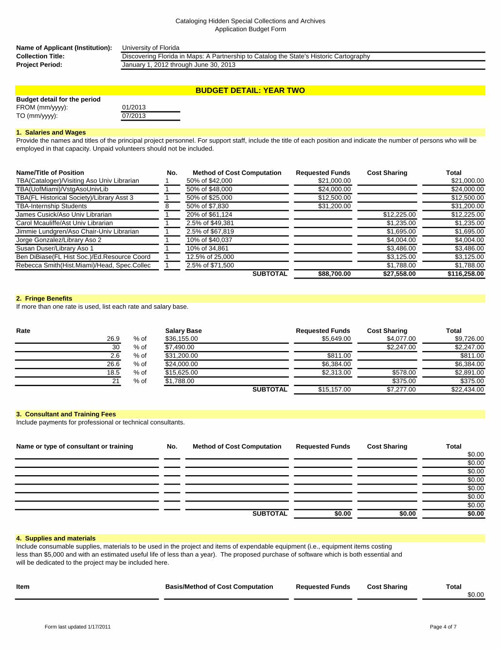
Cataloging Hidden Special Collections and Archives
Application Budget Form
Name of Applicant (Institution):
Collection Title:
Project Period: January 1, 2012 through June 30, 2013
University of Florida
Discovering Florida in Maps: A Partnership to Catalog the State's Historic Cartography
Budget detail for the period
FROM (mm/yyyy):
TO (mm/yyyy):
1. Salaries and Wages
No. Method of Cost Computation Requested Funds Cost Sharing Total
1 50% of $42,000 $21,000.00 $21,000.00
1 50% of $48,000 $24,000.00 $24,000.00
1 50% of $25,000 $12,500.00 $12,500.00
8 50% of $7,830 $31,200.00 $31,200.00
1 20% of $61,124 $12,225.00 $12,225.00
1 2.5% of $49,381 $1,235.00 $1,235.00
1 2.5% of $67,819 $1,695.00 $1,695.00
1 10% of $40,037 $4,004.00 $4,004.00
Susan Duser/Library Aso 1 1 10% of 34,861 $3,486.00 $3,486.00
1 12.5% of 25,000 $3,125.00 $3,125.00
1 2.5% of $71,500 $1,788.00 $1,788.00
SUBTOTAL $88,700.00 $27,558.00 $116,258.00
2. Fringe Benefits
If more than one rate is used, list each rate and salary base.
Rate Salary Base Requested Funds Cost Sharing Total
26.9 % of $5,649.00 $4,077.00 $9,726.00
30 % of $2,247.00 $2,247.00
2.6 % of $811.00 $811.00
26.6 % of $6,384.00 $6,384.00
18.5 % of $2,313.00 $578.00 $2,891.00
21 % of $375.00 $375.00
SUBTOTAL $15,157.00 $7,277.00 $22,434.00
3. Consultant and Training Fees
Include payments for professional or technical consultants.
No. Method of Cost Computation Requested Funds Cost Sharing Total
$0.00
$0.00
$0.00
$0.00
$0.00
$0.00
$0.00
SUBTOTAL $0.00 $0.00 $0.00
4. Supplies and materials
Include consumable supplies, materials to be used in the project and items of expendable equipment (i.e., equipment items costing
less than $5,000 and with an estimated useful life of less than a year). The proposed purchase of software which is both essential and
will be dedicated to the project may be included here.
Requested Funds Cost Sharing Total
$0.00
Jorge Gonzalez/Library Aso 2
Ben DiBiase(FL Hist Soc.)/Ed.Resource Coord
$15,625.00
Item Basis/Method of Cost Computation
$31,200.00
$24,000.00
Name or type of consultant or training
TBA-Internship Students
James Cusick/Aso Univ Librarian
Carol Mcauliffe/Ast Univ Librarian
Jimmie Lundgren/Aso Chair-Univ Librarian
$36,155.00
$7,490.00
07/2013
Provide the names and titles of the principal project personnel. For support staff, include the title of each position and indicate the number of persons who will be
employed in that capacity. Unpaid volunteers should not be included.
Name/Title of Position
TBA(Cataloger)/Visiting Aso Univ Librarian
TBA(UofMiami)/VstgAsoUnivLib
TBA(FL Historical Society)/Library Asst 3
BUDGET DETAIL: YEAR TWO
01/2013
Rebecca Smith(Hist.Miami)/Head, Spec.Collec
$1,788.00
Form last updated 1/17/2011 Page 4 of 7

Cataloging Hidden Special Collections and Archives
Application Budget Form
Name of Applicant (Institution):
Collection Title:
Project Period: January 1, 2012 through June 30, 2013
University of Florida
Discovering Florida in Maps: A Partnership to Catalog the State's Historic Cartography
$0.00
$0.00
$0.00
$0.00
$0.00
$0.00
SUBTOTAL $0.00 $0.00 $0.00
5. Services
Include the cost of other services (e.g. equipment rental, server time, backup charges) related to project objectives that are not included under
other budget categories. For subcontracts, append an itemization of subcontract costs to the end of this form.
Requested Funds Cost Sharing Total
$0.00
$0.00
$0.00
$0.00
$0.00
$0.00
$0.00
$0.00
SUBTOTAL $0.00 $0.00 $0.00
6. Other costs
Include any items not previously listed. Please note that "miscellaneous" and "contingency" are not acceptable budget categories.
Funds to cover indirect costs may not be requested.
Requested Funds Cost Sharing Total
$0.00
$0.00
$872.00 $872.00
$518.00 $518.00
$0.00
$46,061.00 $46,061.00
$0.00
$0.00
SUBTOTAL $1,390.00 $46,061.00 $47,451.00
7. Total costs Requested Funds Cost Sharing Total
(Subtotals of items 1 through 6) $105,247.00 $80,896.00 $186,143.00
Foregone indirect fees 33.6% X $137,085
Catalog Trainer Site Visits 1 Round-trip to Miami/7 days each
Catalog Trainer Site Visits 1 Round-trip to Cocoa FHS/2 days each
Item Basis/Method of Cost Computation
Item Basis/Method of Cost Computation
Form last updated 1/17/2011 Page 5 of 7

Cataloging Hidden Special Collections and Archives
Application Budget Form
Name of Applicant (Institution):
Collection Title:
Project Period: January 1, 2012 through June 30, 2013
University of Florida
Discovering Florida in Maps: A Partnership to Catalog the State's Historic Cartography
Budget detail for the period
FROM (mm/yyyy):
TO (mm/yyyy):
1. Salaries and Wages
No. Method of Cost Computation Requested Funds Cost Sharing Total
$0.00
$0.00
$0.00
$0.00
$0.00
$0.00
$0.00
SUBTOTAL $0.00 $0.00 $0.00
2. Fringe Benefits
If more than one rate is used, list each rate and salary base.
Rate Salary Base Requested Funds Cost Sharing Total
% of $0.00
% of $0.00
% of $0.00
% of $0.00
SUBTOTAL $0.00 $0.00 $0.00
3. Consultant and Training Fees
Include payments for professional or technical consultants.
No. Method of Cost Computation Requested Funds Cost Sharing Total
$0.00
$0.00
$0.00
$0.00
$0.00
$0.00
$0.00
SUBTOTAL $0.00 $0.00 $0.00
4. Supplies and materials
Include consumable supplies, materials to be used in the project and items of expendable equipment (i.e., equipment items costing
less than $5,000 and with an estimated useful life of less than a year). The proposed purchase of software which is both essential and
will be dedicated to the project may be included here.
Requested Funds Cost Sharing Total
$0.00
$0.00
$0.00
$0.00
$0.00
$0.00
Item Basis/Method of Cost Computation
Name or type of consultant or training
BUDGET DETAIL: YEAR THREE
Name/Title of Position
Provide the names and titles of the principal project personnel. For support staff, include the title of each position and indicate the number of persons who will be
employed in that capacity. Unpaid volunteers should not be included.
Form last updated 1/17/2011 Page 6 of 7

Cataloging Hidden Special Collections and Archives
Application Budget Form
Name of Applicant (Institution):
Collection Title:
Project Period: January 1, 2012 through June 30, 2013
University of Florida
Discovering Florida in Maps: A Partnership to Catalog the State's Historic Cartography
$0.00
SUBTOTAL $0.00 $0.00 $0.00
5. Services
Include the cost of other services (e.g. equipment rental, server time, backup charges) related to project objectives that are not included under
other budget categories. For subcontracts, append an itemization of subcontract costs to the end of this form.
Requested Funds Cost Sharing Total
$0.00
$0.00
$0.00
$0.00
$0.00
$0.00
$0.00
$0.00
SUBTOTAL $0.00 $0.00 $0.00
6. Other costs
Include any items not previously listed. Please note that "miscellaneous" and "contingency" are not acceptable budget categories.
Funds to cover indirect costs may not be requested.
Requested Funds Cost Sharing Total
$0.00
$0.00
$0.00
$0.00
$0.00
$0.00
$0.00
$0.00
SUBTOTAL $0.00 $0.00 $0.00
7. Total costs Requested Funds Cost Sharing Total
(Subtotals of items 1 through 6) $0.00 $0.00 $0.00
Item Basis/Method of Cost Computation
Item Basis/Method of Cost Computation
Form last updated 1/17/2011 Page 7 of 7