bulletin 122: contributions to late cretaceous ... · contributions to late cretaceous ....
TRANSCRIPT

New Mexico Bureau of Mines & Mineral Resources
A DIVISION OF NEW MEXICO INSTITUTE OF MINING & TECHNOLOGY
Contributions to Late Cretaceous paleontology and stratigraphy
of New Mexico Part III
Compiled by Donald L. Wolberg New Mexico Bureau of Mines & Mineral Resources
Socorro, New Mexico 87801
SOCORRO 1988

11
NEW MEXICO INSTITUTE OF MINING & TECHNOLOGY Laurence H. Lattman, President
NEW MEXICO BUREAU OF MINES & MINERAL RESOURCES Frank E. Kottlowski, Director
James M. Robertson, Deputy Director
BOARD OF REGENTS Ex Officio
Garrey E. Carruthers, Governor of New Mexico Alan Morgan, Superintendent of Public Instruction
Appointed Lenton Malry, President, 1985-1991, Albuquerque
Robert 0. Anderson, Sec./Treas., 1987-1993, Roswell Gilbert L. Cano, 1985-1989, Albuquerque
Donald W. Morris, 1983-1989, Los Alamos Steve Torres, 1967-1991, Albuquerque
BUREAU STAFF Full Time
ORIN J. ANDERSON, Geologist RICHARD R. CHAVEZ, Assistant Head, Petroleum Section IREAN L. RAE, Head, Drafting Section RUBEN ARCHULETA, Technician II RUBEN A. CRESPIN, Garage Supervisor MARSHALL A. REITER, Senior Geophysicist AUGUSTUS K. ARMSTRONG, USGS Geologist DARRELL DAUDE, Computer Operator/Geologic Tech. JACQUES R. RENAULT, Senior Geologist GEORGE S. Austin, Senior Industrial Minerals Geologist Lois M. DEVLIN, Director, Bus./Pub. Office ELIZABETH M. REYNOLDS, Geotech. Info. Ctr. Tech. AL BACA, Crafts Technician ROBERT W. EVELETH, Senior Mining Engineer JAMES M. ROBERTSON, Senior Economic Geologist JAMES M. BARKER, Industrial Minerals Geologist JOHN W. HAWLEY, Senior Env. Geologist GRETCHEN H. ROYBAL, Coal Geologist PAUL W. BAUER, Field Economic Geologist CAROL A. HJELLMING, Assistant Editor WILLIAM J. STONE, Senior Hydrogeologist ROBERT A. BIEBERMAN, Emeritus Sr. Petroleum Geologist ANNABELLE LOPEZ, Petroleum Records Clerk SAMUEL THOMPSON III, Senior Petrol. Geologist JENNIFER R. BORYTA, Assistant Editor THERESA L. LOPEZ, Receptionist/Staff Secretary REBECCA J. TITUS, Drafter LYNN A. BRANDVOLD, Senior Chemist DAVID W. LOVE, Environmental Geologist JUDY M. VAIZA, Executive Secretary RON BROADHEAD, Petrol. Geologist, Head, Petroleum Section JANE A. CALVERT LOVE, Associate Editor MANUEL J. VASQUEZ, Mechanic MONTE M. BROWN, Drafter CECILIA ROSACKER MCCORD, Technician I JEANNE M. VERPLOEGH, Chem. Tech. FRANK CAMPBELL, Coal Geologist CHRISTOPHER G. MCKEE, X-ray Laboratory Technician ROBERT H. WEBER, Emeritus Senior Geologist ANN= G. CARROLL, Admin. Secretary I VIRGINIA MCLEMORE, Geologist DONALD WOLBERG, Vertebrate Paleontologist STEVEN M. CATHER, Field Economic Geologist LYNNE McNeil., Technical Secretary MICHAEL W. WOOLDRIDGE, Scientific Illustrator RICHARD CHAMBERLIN, Economic Geologist NORMA J. MEEKS, Accounting Clerk—Bureau JIRI ZIDEK, Chief Editor-Geologist CHARLES E. CHAPIN, Senior Geologist BARBARA R. POPP, Biotechnologist
Research Associates CHRISTINA L. BALK, NMT JEFFREY A. GRAMBLING, UNM HOWARD B. NICKELSON, Carlsbad WILLIAM L. CHENOWETH, Grand Junction, CO JOSEPH HARTMAN, Univ. Minn. LLOYD C. PRAY, Univ. Wisc. PAIGE W. CHRISTIANSEN, Kitty Hawk, NC DONALD E. HATIIN, Ind. Univ. ALLAN R. SANFORD, NMT RUSSELL E. CLEMONS, NMSU ALONZO D. JACKA, Texas Tech. Univ. JOHN H. SCHILLING, Nev. Bur. Mines & Geology WILLIAM A. COBBAN, USGS DAVID B. JOHNSON, NMT WILLIAM R. SEAGER, NMSU AUREAL T. CROSS, Mich. St. Univ. WILLIAM E. KING, NMSU RICHARD H. TEDFORD, Amer. Mus. Nat. Hist. MARIAN GALUSHA, Amer. Mus. Nat. Hist. DAVID V. LEMONS, UTEP JORGE C. TOVAR R., Petroleos Mexicans LELAND H. GILE, Las Cruces JOHN R. MACMILLAN, NMT
Graduate Students MARGARET BARROLL TIM HOBBS WILLIAM MCINTOSH DIANE BELLIS DAVID L. JORDAN
Plus abou t 50 underg radua te a s s i s tants
Original Printing 1988
Published by Authority of State of New Mexico, NMSA 1953 Sec. 63-1-4 Printed by University of New Mexico Printing Services, September 1988 Available from New Mexico Bureau of Mines & Mineral Resources, Socorro, NM 87801
iii
Contents
Regional historic, stratigraphic, and paleontologic framework of the Late Cretaceous (Campanian—Maastrichtian) Fossil Forest locality near Split Lip Flats, San Juan Basin, San Juan County, New Mexico
D. L. WOLBERG, J. P. HALL, D. BELLIS, W. X. CHAVEZ, 0. ANDERSON, R. MORO & A. GIL 7-21
Dinosaur-skin impressions from the Fruitland Formation (Campanian-Maastrichtian) of the Fossil Forest, San Juan Basin, San Juan County,
New Mexico J. P. HALL, D. L. WOLBERG & S. WEST 23-27
Probable caddisfly (Trichoptera: Insecta) larval cases from the Fruitland Formation (Campanian—Maastrichtian) of the Fossil Forest, San Juan Basin, San Juan County, New Mexico D. L. WOLBERG, S. WEST, J. P. HALL & J. ZIDEK 29-31
First record of dinosaur footprints from the Fruitland Formation, San Juan Basin, San Juan County, New Mexico D. L. WOLBERG, J. P. HALL & D. BELLIS 33-34
Facies, paleoecology, and paleoenvironment of a Crassostrea soleniscus (Meek) reef complex, Cretaceous, San Juan Basin, New Mexico T. J. BROWN 35-47
Some Late Cretaceous reptiles from New Mexico S. G. LUCAS, A. P. HUNT & R. PENCE 49-60


V
Preface
This is the third part of this series dealing with the Cretaceous of New Mexico. The pace of Cretaceous research in New Mexico has not slowed, and the favorable reception of the first two parts encouraged us to proceed; indeed, the receipt of additional studies will probably require a fourth part in the near future. Once again, we have attempted to blend diverse contributions in an effort to reach as many readers as possible. Also once again, we extend our appreciation to F. E. Kottlowski for his continued support of these reports; to J. Zidek, for his skilled editorial hand; and to the NMBMMR drafting staff.
Donald L. Wolberg


New Mexico Bureau of Mines & Mineral Resources Bulletin 122, September 1988 7
Regional historic, stratigraphic, and paleontologic framework of the Late Cretaceous (Campanian-
Maastrichtian) Fossil Forest locality near Split Lip Flats, San Juan Basin, San Juan County, New Mexico
Donald L. Wolberg,' Jean P. Hall,' Diane BeHis,' William X. Chavez,3
Orin Anderson,' Robert Moro,' and April Gil1 'New Mexico Bureau of Mines & Mineral Resources, Socorro, New Mexico 87801;
'Department of Geology, University of Kansas, Lawrence, Kansas 66045; 'Department of Mining & Geological Engineering, New Mexico Institute of Mining & Technology, Socorro, New Mexico 87801;
'640 San Pablo SE, Albuquerque, New Mexico 87108
Abstract—The Fossil Forest study area is located in portions of secs. 14, 15, 23, and 24, T23N, R12W, north of Chaco Canyon and south of Farmington. The area takes its name from the presence of numerous in-situ fossil tree stumps that occur at three stratigraphic levels in the exposed strata, and has been designated a Research Natural Area (RNA) by the U.S. Bureau of Land Management as part of the Wilderness Act of 1984. The badlands exposed in the Fossil Forest consist largely of Fruitland Formation coals, shales, mudstones, and sandstones that represent the upper part of the Fruitland. Isolated, thin remnants of the overlying Kirtland Shale occur in the study area. Fossil leaf, invertebrate, and vertebrate localities are restricted to the middle portions of the stratigraphic sequence in the Fossil Forest, above the highest coal and below the highest sandstone sequence. A number of quarry sites occur throughout the Fossil Forest that predate the initiation of our studies (1979); these can be historically grouped and the likely collectors identified once an understanding of the regional history, closely tied to the development of trading posts and early federal coal studies, is accomplished. This regional history is of use to geologists, paleontologists, historians, and land-use planners working in the San Juan Basin.
Introduction
The Fossil Forest has been designated a Research Natural Area (RNA) by federal actions contained in the San Juan Basin Wilderness Protection Act of 1984; final rules were published in the Federal Register (50 FR 42122, Appendix A) and became effective on November 17, 1985. The Fossil Forest RNA contains a total of 2770 acres and includes all or portions of secs. 13, 14, 22, 23, 24, and 26, T23N, R12W. A substantial portion of this area has little or no paleon-tologic interest, but was included as a buffer around the fossil-bearing rocks. Those areas of the Fossil Forest RNA with fossils actually are encompassed within portions of secs. 13, 14, 23, and 24, T23N, R12W, including an area of slightly more than 1000 acres.
The Fossil Forest study area is located north of Chaco Canyon and south of Farmington, in the west-central portion of the San Juan Basin (Fig. 1). The Fossil Forest lies within the east-central portion of the Navajo Section of the Colorado Plateau (Hunt, 1956). It is included on the U.S. Geological Survey 1:24,000 Pretty Rock Quadrangle and consists largely of public lands managed by the U.S. Bureau of Land Management. The NE1/4 sec. 14 is private land as is the N1/2 sec. 13, while the S'/2 sec. 13 is state land.
Travel to the area is possible via NM 44 and then west from Huerfano or via NM 370 and east on San Juan County 7500, providing access to Split Lip Flats.
The Fossil Forest lies at an altitude of between 5980 and 6100 ft and is drained by Coal Creek and its tributaries, eventually joining the De-na-zin drainage to the southwest. De-na-zin is a name derived from the Navajo term deli naazini, referring to Navajo pictoglyphs found about 2 mi east of Tanner Lake (York, 1984). Historically, De-na-zin Wash was known to local residents and paleontologists as Coal Creek. A northeastern tributary of Coal Creek was previously known as Barrel Springs Arroyo, a name that fell out of favor during the late 1920s except among pa-leontologists. The name De-na-zin replaced Coal Creek for the main Chaco tributary, and Coal Creek replaced Barrel
Springs and is now used as the name of the main De-nazin tributary.
Although climatological data in the area are poorly doc-umented, 35 years of record at Chaco Canyon National Monument indicate a mean annual precipitation of slightly less than 9 inches, most of which falls between July and October (Gabin & Lesperance, 1977). Although infrequent, storms traversing the area may be intense.
Badlands development in the Chaco drainage basin is the result of Holocene climatic fluctuations, and occurred rap-idly in response to base-level lowering (Welles, 1983). However, the geomorphology of the landscape of the central basin Coal Creek area may have developed more in response to drainage-basin processes independent of lithology. Eolian mantling of the Fossil Forest hilltops and mesas shows dune orientations that trend northeast—southwest and parallel drainage orientations (Smith, 1983).

8
The Fossil Forest takes its name from the presence of numerous in-situ fossilized tree stumps and isolated logs. Geomorphologically, the area is characterized by the pres-ence of well-developed badlands exposures of the Fruitland Formation. In addition to fossilized tree stumps and logs, the Fossil Forest also contains leaf-producing sites and in-vertebrate and vertebrate sites that have been studied by the New Mexico Bureau of Mines & Mineral Resources (NMBMMR) since 1979, first in cooperation with staff of the U.S. Bureau of Land Management (BLM) (until 1981) and then solely by the NMBMMR. In 1987 an agreement was entered into between the NMBMMR and BLM, by which the NMBMMR would provide BLM with technical data describing the paleontology of the Fossil Forest required as part of a congressional mandate related to the final disposition of the area.
Because of the Wilderness Act, access to public lands such as the De-na-zin, Ah-sli-sle-pah, and Bisti has been seri-ously impeded for collecting purposes. The importance of areas such as the Fossil Forest is artificially increased be-cause it is among the ever-shrinking areas characterized by an abundance of fossils, has historically been collected by paleontologists from many institutions, and is still available for collecting. Land-use issues in the San Juan Basin are certainly not a recent development and continue to impact paleontology, development of coal resources, wilderness and recreational use concerns, and Native American issues (see Wolberg & Kottlowski, 1980; Wolberg, 1982).
Acknowledgments Since 1979, many people have worked with us in the
Fossil Forest, too many to list them all. However, our sincere appreciation is extended to the many students of the MST Field Paleontology courses through the years, especially Jim Baldwin, Hal Brown, Barin Beard, Gloria Green, Kay Green, Kathy Arterburn, Carol Horton, Sue Laux, Brad Triplehorn, Mike De Young, Sue McKinney, Sharon Ellis, and Sue Crumm. Special thanks to J. Hartman, C. Robison, J. Menack, N. Mateer, B. am Ende, and A. Hunt for much assistance over the years. A very special debt of gratitude is owed to J. Hartman and M. O'Neill.
The Fossil Forest project continues to be supported by the NMBMMR, F. E. Kottlowski, Director. Additional support has been received from the New Mexico Institute of Mining & Technology and the U.S. Bureau of Land Management. Our appreciation is extended to Sunbelt Mining Company, especially to Robert Jackson, Ned Elkins, and John Ferriullo, for the cooperation shown throughout the years. We also thank the personnel of the Gateway Mine for getting us "unstuck" on more than one occasion. Our appreciation is extended to Lance Grande, Field Museum of Natural History, and Charles Carroll, BLM, for providing data.
This report was read by W. J. Stone, F. Campbell, J. Zidek, and C. Carroll. Their comments and suggestions are ap-preciated.
Recent history of the immediate vicinity
As noted below, several old quarries are found in the Fossil Forest study area. Some of these quarries are very large and large specimens, probably dinosaurs, were col-lected from them. To date, we have no information other than circumstantial evidence to indicate who collected what, where, or when in the study area. Because of this, a review of the recent history of the region is of some importance in order to develop a line of reasoning which may indicate the disposition of the previously collected material from the Fossil Forest.
In 1868 Navajos returned to the San Juan Basin after four
years of internment at Bosque Redondo following the dev-astating campaign against them and the Apaches led by Kit Carson. At some time after the return, probably in the early 1870s, a Navajo band was camped on Split Lip Flats at the confluence of Coal Creek and De-na-zin Wash, near the Fossil Forest. They were attacked and massacred by a large force of Indians, possibly including Utes, Apaches, Jemez, and Taos (Carroll, 1983). York (1984) spoke to two residents of Lake Valley, south of Coal Creek, who were relatives of survivors of the raid. These people told York that the Navajos had established a settlement atthe Coal Creek—Dena-zin confluence and that the raiders were Beehai (Jicarilla Apaches). The raiders killed all the men and scalped many, and took women and children as captives, as well as horses and sheep. Some of the captives were sold as slaves.
At some time around 1878 the De-na-zin (Tiz-na-tzin) Trading Post was built on Coal Creek (Carroll, 1983). The trading post "was first operated by Old Man Swires, of whom practically nothing is known" (McNitt, 1962: 339). By 1895 it was incorporated into a chain of eight trading posts (Fig. 2) operated by the Hyde Exploring Expedition, a project that developed between Richard Wetherill and Talbot and Frederick Hyde, and which financed archaeo-logical collection at Grand Gulch, Utah, and Pueblo Bonito, in Chaco Canyon (Brugge, 1980). The Hydes inherited their wealth from their grandfather Benjamin Babbitt and the Babbitt Soap Company (York, 1984). York (1984) places the De-na-zin Trading Post on De-na-zin Wash proper, 6 mi west of Tanner Lake. Shortly after its incorporation into the Hyde trading post network, the store was abandoned before being rebuilt and operated for a time by Harvey Shawver, who had also rebuilt the Tsaya Trading Post described be-low. After Shawver the store was finally operated by Bert McJunkins (McNitt, 1962). Thus, by 1920 the De-na-zin Trading Post had changed hands several times and was finally deserted and in ruins (Brugge, 1980; Bauer & Ree-side, 1920).
Of some interest is the fact that a coal mine was developed at the De-na-zin Trading Post, exploiting the surface and shallow coals present. Shaler (1906) called these coals Mesa-verde, and this view is supported by Bauer & Reeside (1920, pl. XXXI). Shaler notes that the coal workings had been opened in 1901 and that a slope had been driven about 25 ft before being subsequently abandoned. The surface workings were apparently still ongoing as of 1906. A problem is created, however, if York's (1984) siting of the De-na-zin Trading Post is accurate; this area is mapped as Lewis Shale overlain by Pictured Cliffs Sandstone (O'Sullivan et a1.,1986). Yet, we know that coal was mined at the trading post; Shaler (1906) describes a measured section, and Bauer & Reeside (1920) show the by then abandoned ruins at the site to lie within their Mesaverde outcrop belt and also describe a measured section of Mesaverde coal at the Tiznatzin mine, which must have been abandoned at the time. Bauer (1916) does show the area as lying on the Lewis—Mesaverde contact, as does Reeside (1924). The upper 30 ft of sand described by Shaler (1906) must then represent the Cliff House Sandstone and the most parsimonious explanation is that O'Sullivan et al. (1986) simply mapped the area incorrectly. The coal mined at the trading post must have been Menefee coal, using current terminology.
By 1898 Wetherill established a trading post at Pueblo Bonito (Fig. 2). Pueblo Bonito and the store assume some importance, as will be discussed below, because it was also the site of Putnam and the reference point for citations of fossil and other occurrences in the area (Foster, 1913). Put-nam was actually the name of the U.S. Post Office estab-lished at Pueblo Bonito, and was named for Dr. Frederick W. Putnam, an archaeologist from the American Museum of Natural History (Brugge, 1980). The Pueblo Bonito or

Putnam Trading Post functioned sporadically until the late 1950s or 1960s (York, 1984). However, Brugge (1980) notes that by 1915 the trading post at Putnam was closed. The name Putnam appears on Schrader's (1905) map and Shaler's (1906) map, not Pueblo Bonito. The name "Pueblo Bonito (Putnam)" appears on Bauer & Reeside's (1920) map. Pierce (1965) notes that Putnam was a U.S. Post Office during the 1901-1911 period.
The Bisti Trading Post was located on the north side of Hunter Wash, just east of a Navajo missionary center built rather late in the history of the trading store. Once on the
9
main N—S unpaved county road, the area is now east of paved NM 371. The date of the establishment of the trading post is uncertain. According to McNitt (1962) and York (1984), it was probably established in 1900-1901 by a man named Hunter, but this early date may be in error. D. H. Hunter operated a trading post west of Shiprock in 1918 (Brugge, 1980), while Billy Hunter built and operated a trading post at Beclabito, near the Carrizo Mountains at about the same time (McNitt, 1962). Apparently, the Hunter who built and first operated the trading post at Bisti also ran cattle in the area (York, 1984). Hunter's Store does not appear on

10
Schrader's (1905) and Shaler's (1906) maps of the area. It is probable that the trading post at Bisti had not yet been established. Hunter's Store first appears on Bauer's (1916) map, and is shown again on maps by Bauer & Reeside (1920) and Reeside (1924). Hunter's Store had a long list of owners until it was destroyed by fire in 1971; the ruins of the store were finally bulldozed in 1981. At one time the store was part of the network of 20 trading posts owned or operated by the Foutz family as part of the Progressive Mercantile Company (McNitt, 1962). The store was also owned by the Ashcroft family of Kirtland and Tsaysa (York, 1984), a name that also emerges when considering the history of the Fossil Forest.
The Ojo Alamo Trading Post, located on a major N—S wagon road at the head of Alamo Wash, opened in the 1890s and by 1900 was incorporated into the chain of Hyde Ex-ploring Expedition stores. A brother of Richard Wetherill, John, operated the store with his wife Louise, but probably abandoned it by 1906. The store was then reopened by 1909 by Joe Hatch and 0. S. Thurston (Brugge, 1980). The store was deserted by 1921, a fact noted by Sternberg (1932), who collected in the area that year and found only an empty building.
Brugge (1980) and York (1984) note that Royal Davis op-erated the Ojo Alamo store as late as 1917. However, they probably confused the Ojo Alamo store with the Davis Store to the northwest of Ojo Alamo. The site of the Davis Store does not appear on any map until Reeside (1924). Brugge and York were dependent on Bauer & Reeside's map of 1920. Sternberg (1932) makes a clear distinction between the old abandoned Ojo Alamo store and the Royal Davis Store, which he knew about and visited in 1921.
Tsaya Trading Post, named for Tsaya Canyon on current maps, has an interesting and important history as well. Originally, Tsaya Canyon was named Black Lake Canyon, and takes its current name from the Navajo Tsaya-chas-kesi, meaning "Dark under the rock," which according to McNitt (1962) refers to a shaded spring near the old Tsaya Trading Post. However, as will be developed below, the Navajo term may actually refer to an unusual geologic deposit of uncertain composition and origin, noted by Foster (1913), Bauer & Reeside (1920), and York (1984).
The old Tsaya Trading Post, situated at the southwestern mouth of Black Lake Canyon and northeast of the Chaco, was among the oldest of trading posts in the region. The clearest clue to its origin can actually be found in an in-scription carved in a cliff wall immediately north of Pueblo Bonito, an early form of advertisement, which indicates that the store was operated in 1887 by H. L. Haines. In 1895 Richard Wetherill led a family named Palmer to Pueblo Bonito, and the old Tsaya Trading Post was on their route; they found the store abandoned (Brugge, 1980) and in ruins; what became of Haines is unknown.
In 1906 Harvey Shawver rebuilt the trading post and eventually took George Blake on as a partner. In 1910 Shaw-ver sold his interest to George's brother, Albert (McNitt, 1962). The old Tsaya store operated until 1961 (York, 1984). Interestingly, Sternberg (1932) notes hiring a Navajo field assistant named "Ned Shouver" at Pueblo Bonito in 1921. Shaler's map (1906) shows Shawver's Store, and Bauer's map (1916) shows Blake's Store. In 1918 Roy Burnham purchased the store from the Blake brothers, in turn selling it to his brother-in-law, Corliss Stolworthy, in 1927 when he opened the Burnham Trading Post on Brimhall Wash, about 15 mi northwest of Hunter Wash (McNitt, 1962). By 1929 Stolworthy was in partnership at Tsaya with R. L. "Chunky" Tanner (York, 1984), who later constructed Tanner Lake in the Split Lip Flats area. In 1939 Karl Ashcroft purchased the Tsaya Trading Post and ranched between there and De-na
zin (York, 1984). Ashcroft actually ranched within the Fossil Forest area, as described below.
The new Tsaya Trading Post was established in 1961 at a site southwest of the old store and south of Chaco Wash, on New Mexico Highway 371; it is still in operation today.
Tanner Lake (secs. 17 and 18, T23N, R12W) and numerous associated ranch buildings and structures were constructed by R. L. Tanner, his family, and hired workers during the 1935-1937 period. The Tanners operated a ranch and the Tanner Lake Trading Post (York, 1984). One impressive series of masonry and adobe structures still present as a linear set of foundation ruins can be found in the NE1/4 SW1/4 sec. 17, T23N, R12W. These ruins consist of a series of eight adjoining room-like structures that York (1984) suggests were used for storage of grain, feed, and agricultural equipment. These sorts of uses were certainly in effect as late as 1976, when the preparers of the EMRIA report on Bisti West (EM-RIA, 1976) interviewed the then current Navajo lease holder of the ranch. York discounts the suggestion that this structure was built and used by a unit of Afro-American cavalry troops late in the 19th or early in the 20th century. However, we would suggest that the structure appears much too substantial to be the remains of storage bins or tool sheds. A great deal of effort went into their construction, much more than would be justified for such casual use as storage. The enclosures appear to be about the correct size for use as stables or sleeping quarters for people. The uniformity of each enclosure would be in keeping with a military architectural plan. Finally, the Afro-American cavalry origin of the structure seems to be widely enough known to merit further attention.
The Tanners closed the trading post and sold the ranch to a Navajo man, Eli Smith, by 1960. Smith in turn sold the property to the Navajo Tribe in 1962. The Tribe periodically leased the ranch to Navajo ranchers as the Eli Smith Tribal Ranch (York, 1984).
Several other trading posts existed in the region that are of importance in interpreting the history of early paleon-tological expeditions in this part of the San Juan Basin. For example, Brookings Store existed on Meyer's Creek (Ahsli-sla-pah Wash) and was centrally located on a main N-S route between Pueblo Bonito and Ojo Alamo. This route also connected with a major E-W route in Black Lake Can-yon. Brookings Store is shown on a map drawn in 1912 by S. F. Stacher, Superintendent of the Pueblo Bonito Indian Agency, but is not shown on Shaler's map of 1906, thus giving a likely date of its establishment. The store appears on Bauer & Reeside's map (1920) and on Reeside's 1924 map. Given the history of the region, it is likely that some-one named Meyers operated a store at the site before Brookings, but we can find no additional information about Meyers or Brookings.
Kimbetoh was a major center of trading, Navajo, and government operations quite early; by 1902 the Kimbetoh Store was part of the network operated by the Hyde Ex-pedition (Brugge, 1980). Sinclair & Granger (1914) show the Kimbetoh Store was operated by someone named Winters. Sternberg (1932) reports that he purchased supplies from the store, and that in 1921 it was operated by a Mr. Tyler. However, Sternberg may have actually been referring to John C. Tyler, a U.S. Government livestock superintendent in the region at the time (Brugge, 1980); Kimbetoh functioned as a regional livestock center.
Recent history of the Fossil Forest
York (1984) documents a Navajo campsite in the SE1/4 NE 1/4 NW1/4 sec. 14, T23N, R12W, periodically used by Mr. Many Horses and his family around 1900. Mr. Many Horses

lived between 1847-1922. McNitt (1962) notes that Ganado Mucho ("Many Herds"), sub-chief of all western Navajos and head of the Big Water Clan, had a son, Many Horses, who saved Lorenzo Hubbell's life. Whether this is the same Many Horses who camped in the Fossil Forest is unknown.
The Bureau of Indian Affairs documents various allotments in the immediate Fossil Forest area; these were recorded by York (1984). In T23N, R12W allotments were made for secs. 10, 11, 14, and 15. These allotments were approved in 1908 and all have been subsequently relinquished.
York (1984) reconstructed the land holdings in the region of the Fossil Forest from BIA and BLM data. The following is extrapolated from his findings (Fig. 3): By 1939, as noted above, Karl Ashcroft was ranching in the Fossil Forest area while also operating the Old Tsaya Trading Post. Ashcroft holdings included all or portions of secs. 15, 22, and 23 in the immediate Fossil Forest area. Frank Wood's ranch included most of sec. 14 and the eastern 1/2 of sec. 15. "Tabby" Brimhall's Black Lake Ranch included parts of secs. 14 and 23 and all of sec. 24. To the east, the Tanner holdings extended into sec. 17.
By 1958 the land holdings had been consolidated (Fig. 4). Karl Ashcroft died in 1953 or 1954, and his son, Kaye Ash-croft, then ranched on most of secs. 14, 15, 22, and 23. The
11
Wood Ranch occupied the northern 1/4 of secs. 13, 14, and 15 and was operated by Frank Wood's son, Dewey (York, 1984). The Wood Ranch headquarters is located on New Mexico Highway Department maps in the NW 1/4 sec. 36, T24N, R12W. Brimhall sold the Black Lake Ranch to M. Elkins and it then occupied most of sec. 13 and all of sec. 24. Brugge (1980) notes that a Mark Elkins attended a stock-man's meeting in Gallup on March 25, 1926, and that Elkins was a rancher from the public domain east of the Navajo Reservation. Mark Elkins eventually retired and moved to Utah (N. Elkins, pers. comm.).
Two prominent fencelines, trending just off N-S and E-W, are present in the Fossil Forest; we are now in a position to determine their origin. The N-S fenceline is slightly west of north in the Fossil Forest area and originates from a section corner at the junction of secs. 35 and 36, T23N, R12W and secs. 1 and 2, T22N, R12W on the Tsaya Canyon (Black Lake Canyon) road. It is likely that when this fence-line was surveyed, an effort was made to run the line N-S; it actually runs less than 3° west of north. This fenceline separates "Tabby" Brimhall's Black Lake Ranch from Karl Ashcroft's ranch ca 1940. York (1984) notes that the Taylor Grazing Act was implemented in the area in 1939, and following that implementation ranchers built fences.

The E-W fenceline was surveyed perpendicular to the N-S line, but actually trends slightly south of north because of the offset of the N-S line. This line separates the 1940 Ashcroft Ranch from the Wood Ranch to the northeast and the Tanner Ranch to the northwest. The fencelines thus are of relatively recent origin, certainly not older than 1939 (York suggests that they were built during World War II), and with the consolidation of the ranch holdings in the 1950s, the old fencelines became superfluous and more trouble to tear down or replace than to leave standing. It is possible that the N-S line was still used to separate the Ashcroft and Elkins holdings, however. Finally, all of the Fossil Forest holdings were incorporated into the Paragon Ranch (Wood, Black Lake, and Ashcroft), owned by the Public Service Company of New Mexico or the Eli Smith Ranch (Tanner Ranch).
Previous studies
Storrs (1902) described the Rocky Mountain coal fields including coal-producing areas of the time throughout New Mexico. His pl. XXIX, a map of the coal fields in Utah, Colorado, and New Mexico, is significant for what it does not show: no documented coal resources in the central por
tions of the San Juan Basin. This region, including the Fossil Forest area, was still poorly known.
Schrader (1905) shows Coal Creek on his map, but is certainly referring to De-na-zin Wash. The crudeness of Schrader's map is in sharp contrast to Shaler's (1906) map, covering much the same area but with a wealth of detail. The Laramie Formation constituted Shaler's coal-bearing Cretaceous rock unit and this was overlain by Puerco and Wasatch Tertiary-age rocks. Shaler shows the Tiz-Natzin Store and its coal mine, and his Coal Creek is De-na-zin, but of particular interest are his descriptions of outcrops at localities 69, 70, and 71.
Shaler's Laramie included a basal sandstone followed by coal-bearing strata that alternate with sandstones and shales. This is roughly the Pictured Cliffs—Fruitland—Kirtland se-quence of current terminology. Closing the discussion of locality 68, Shaler notes that northeast of Shawver's Store (Tsaya or Black Lake Trading Post) Laramie coals appear at a number of places between the Chaco and Coal Creek (De-na-zin Wash). Shaler describes locality 69 as being 5 mi northeast of Shawver's store and ". . . about 3 miles north of the wagon road leading northeastward from Shawver's store" (p. 404). The wagon road referred to was the road in Black Lake Canyon that farther east connected to a N-S

wagon road connecting Putnam (Pueblo Bonito) and the Ojo Alamo Store, operated at the time that Shaler wrote (but soon to be abandoned) by John Wetherill.
Using Bauer & Reeside's pls. XXXIII and XXXIV, it is evident that the old Black Lake road was situated about 1 mi south of its present location, in the area of secs. 10 and 11, T22N, R12W. A trail still exists in this position on current topographic maps of the area, although the modern Tsaya Canyon road crosses through secs. 2 and 3. Tracking ap-proximately north from this point, Shaler would have seen coal approximately 2.5-3 mi from his turnoff, somewhere in secs. 34 or 35, T23N, R12W, where thin coals are con-spicuously exposed. This is the area of the "Big Badlands" just south of the Fossil Forest.
Shaler's locality 70 is "two miles north of locality No. 69 and stratigraphically above the coal bed just described." Tracking approximately 2 mi north would have placed Shaler in sec. 23, T23N, R12W, in the Fossil Forest study area proper. Here too coals are present and formed the basis of Bauer & Reeside's (1920) coal sections at localities 511 and 510.
Shaler's locality 71 is approximately 1 mi farther north of locality 70 "and on a branch of Coal Creek." This locality must represent the coal seen in sec. 15, very near the sec. 14 line, T23N, R12W, and in the vicinity of Bauer & Reeside's (1920) localities 508 or 509. These localities are on the mod-ern Coal Creek. The evidence indicates that Shaler was probably the first geologist to visit the Fossil Forest area.
Foster (1913) described a still poorly understood carbo-naceous deposit found ". . . about fifteen miles northwest of Putnam" (p. 361), ". . . on a broad, flat wash having a drainage towards the northwest and into Chaco Canyon. This was between Coal Creek and Chaco Canyon" (p. 362). Foster was actually referring to two separate localities, ". . . each distant from each other about four miles" (p. 361). The deposit noted by Foster is at times caramel-like, or gelatinous, or greaselike and dries to a black powder. This material has not been sampled for analytical chemistry since Foster described it, and the tests performed for Foster are inconclusive. Bauer & Reeside (1920) place the deposit in the vicinity of Black Lake and intermittent lakes or ponds in Black Lake Canyon. They suggest that the material ". . . is a peat and may represent a period when these lakes were permanent throughout the year" (p. 230). However, it is our view that Foster (1913) was actually referring to at least two deposits, one in the Black Lake area and another about 4 mi north of Black Lake. Foster notes that S. J. Holsinger actually visited the deposits. Brugge (1980) notes that J. S. Holsinger was a Special Agent of the U.S. General Land Office sent to New Mexico in 1901 to investigate the need for preservation of archaeology of the Chaco Canyon area. As part of his report to the Land Office, Holsinger proposed that the land included in T20-21N, R11-13W and T22-24N, R11-13W be made a new national park. In his report he noted that the Navajos would not tamper with archaeological materials or fossil remains.
In sec. 9, T23N, R12W, York (1984) documents a seep locality where a black, greasy fluid periodically occurs and is known to the Navajos as "leejin." It is gathered by the Navajos for special ceremonial purposes. This locality is approximately 5 mi north of Black Lake. In his correspond-ence with Holsinger, Foster cites Holsinger's description of vertebrate fossils 8-10 mi north of the deposit, but does not distinguish which deposit. Holsinger could have been re-ferring to almost any of the badland areas between the Fossil Forest and Hunter Wash. The area of one of the deposits is described as having extensive deposits of clinker; the Big Badlands to the south of the Fossil Forest have such deposits. Thus, although we cannot positively place Holsinger in the Fossil Forest proper, he was certainly familiar with
13
the area "between the Chaco and Coal Creek"; and given his sensitivity to archaeological and paleontological mate-rials, it is very likely that he traversed the Fossil Forest study area.
Foster notes that he obtained the black material from a Mr. Barringer, who in turn obtained the samples from a Mr. McCullough "who made the expedition to secure the sam- ples" (p. 362). McCullough obviously knew well where to go to obtain the samples. Very importantly, in his corre- spondence with Barringer, McCullough notes that ". . . there are many petrified trees lying on the surface" (Foster, 1913: 362) and that "fossil remains (heavy bones, etc.) are abun- dant in the near neighborhood in the shales" (Foster, 1913: 363). This information suggests that McCullough very likely traversed the Fossil Forest area.
We are still uncertain of the nature of the black material noted and will attempt to obtain samples for analysis. At the known localities the substance seems to lie beneath surficial deposits but above bedrock. It does not appear to be associated directly with coal deposits.
By 1916 Bauer named the Fruitland Formation and the Kirtland Shale, after settlements of the same names in the vicinity of exposures along the San Juan River. The Fruitland Formation overlies the Pictured Cliffs Sandstone and in-cludes a sequence of interbedded coals, mudstones, poorly fissile shales, and sandstones. The Fruitland Formation con-tains the preponderance of New Mexico's coal reserves, and these are concentrated in the lower part of the formation. Development of these reserves has been cyclic and dependent on a variety of factors (Anderson & Wolberg, 1987).
The Kirtland Shale overlying the Fruitland Formation has been divided into three generally recognized members: an unnamed lower shale member, the Farmington Sandstone, and an unnamed upper shale member. Various boundaries have been proposed to separate the Fruitland and Kirtland, and none are satisfactory (see Fassett & Hinds, 1971; Hunt, 1984). It is likely that the Fruitland/Kirtland will be even-tually recognized as a single unit, perhaps of formational status, with member divisions.
Bauer & Reeside (1920), as part of their study of coal in the middle and eastern parts of the San Juan Basin, pro- vided the first clearly documented report dealing with the Fossil Forest. They note the lack of adequate land surveys in the area included in T21N—T24N, R12W (among others) at the time of their field studies in the area. It is likely that they had access to Shaler's report and unpublished field notes, and were thus encouraged to expand on Shaler's coal studies in the Fossil Forest. They could not locate any marked corners, and details on official plats were grossly in error. They had to relocate points in the Fossil Forest area with local surveyors and Bureau of Indian Affairs per- sonnel. This lack of geographic certainty regarding the area is very evident in both earlier and later efforts in the region. Bauer & Reeside do not give any indication that fences existed in the area; as discussed above, it is likely that no fences existed until implementation of the Taylor Grazing Act just before or during World War II.
Bauer & Reeside (1920, pl. XXXIII) must have entered the Fossil Forest from the northwest and Split Lip Flats. Their coal sections are sequentially numbered NW-SE. There is a problem in matching their maps of adjoining areas (pls. XXXI and XXXIII); wagon roads shown on pl. XXXI ter- minate abruptly at the eastern edge and do not continue on pl. XXXIII. Reeside (1924) published a geologic map of part of the San Juan Basin which shows a road from Hunt- er's Store south past the De-na-zin Store (then abandoned) before turning east and traversing the northern part of T23N, R12W through secs. 18, 8, 9, 10, and 11, where it joins the Split Lip Flats road, finally terminating at the road juncture to the Ojo Alamo Store. Bauer & Reeside (1920, pl. XXXI)

14
show this road terminating within sec. 18, at the edge of the plate, and it is not continued within sec. 18 on pl. )(XXXIII. A second road, south of the first road noted above, is shown on Reeside's (1924) map as traversing T23N, R12W in a SW-NE direction. It crosses secs. 31, 30, 20, 16, 15, and 11, where it merges with the northern road. Bauer & Reeside (1920, pl. XXXI) show this road terminating in sec. 31, again at the edge of the plate, and not continuing onto pl. XXXIII. Interestingly, the Pretty Rock 1:24,000 topographic map and the Alamo Mesa East quadrangle to the north of Pretty Rock show a trail extending northwestward from secs. 11, 2, and 1 and then north to the old Ojo Alamo Store. There can be little doubt that this is basically the route of the old road shown on Reeside's 1924 map. Thus, a rather significant road or wagon trail traversed the Fossil Forest study area; the modern Split Lip Flats road has shifted to the north and west. It is likely that Bauer & Reeside entered the area from this old road, an interpretation in keeping with their numbering of localities. They must have worked south and east through the area, intending to tie up with the Black Lake Canyon road to the south. Their numbering of coal sections indicates that they then worked towards the head of Meyer's Creek (Ah-sli-sla-pah Wash), following the then south fork of the Black Lake Canyon road which intersected a N-S trending road connecting the Ojo Alamo Trading Post and Pueblo Bonito via Brookings Store on Meyer's Creek. They were working down-section, although their description of coal exposures is organized up-section. It should also be stressed that they were less interested in discussing the fine details of the rocks they encountered than in providing a good appraisal of the coal resources over a very large area, of which the Fossil Forest, described by them as part of the area "between Black Lake Canyon and Splitlip Flat" (Bauer & Reeside, 1920: 230), was but a minor component.
We are certain that Bauer & Reeside actually entered, and were familiar with, the main part of the Fossil Forest RNA, in contrast to the earlier views of Hunt (1984) and Rigby & Wolberg (1987). In actuality, the Fossil Forest occupied a central location between other areas of interest to them, and they could not help but traverse it with some frequency.
During the 1987 field season we remeasured Bauer & Reeside's sections 507, 508, 509, and 510. Additionally, we measured a section A101 and a reference section for the "Big Badlands" area to the south. The locations of these sections are shown in Fig. 5. Sufficient detail is present on Bauer & Reeside's pl. XXXIII and in their section descrip-tions to reasonably relocate their sections on the modern USGS topographic map of the Pretty Rock Quadrangle. The results of this remeasurement are discussed below, but in general we were able to verify Bauer & Reeside's interpre-tations of the number of coal beds present in the area and their location. We do not agree with their interpretation of the placement of the Fruitland—Kirtland boundary, how-ever.
Bauer & Reeside do not note the presence of tree stumps
in the area, in fact they do not mention fossils at all. Again, their main purpose was to map coals. The content and style of most USGS coal studies of the period generally restricted the inclusion of non-pertinent data, so the lack of paleontological content is really not so unusual. Although there is no substantive information to support the notion, it is possible that Bauer & Reeside may have intended to hold information of any significant fossil finds in the Fossil Forest area in confidence, intending to direct USGS or Smithsonian paleontologists to the area to collect material. The period during which they worked in the San Juan Basin was one of intense paleontological collecting by a variety of people, and some competition between institutions may have resulted.
Of some interest is the fact that Sternberg (1932) describes meeting J. B. Reeside in 1921, possibly at the site of the Ojo Alamo Trading Post, and receiving from him information about ". . . the type localities from which he had secured many fine turtles of the Cretaceous and Tertiary" (p. 207). Thus, despite the lack of paleontological data in Bauer & Reeside (1920), Reeside was certainly accumulating infor-mation and specimens as evidenced in much of the relevant literature of the period.
Sternberg's writing style is very straightforward but dis-jointed in the sense that nonsequitors frequently occur. This style and the shifting of place names in current usage pose difficulties in trying to follow his collecting activities. Sev-eral passages are very suggestive of the Fossil Forest area, but almost always contain a contradictory element as well. Very early in the NMBMMR efforts in the Fossil Forest these suggestive passages colored our interpretations of Stern-berg's activities, and these views were forcefully stated in Hunt (1984) and Rigby & Wolberg (1987). For example, in a passage discussing the Kirtland shales (p. 210) Sternberg notes that "In one place I counted more than thirty large tree trunks to the acre," but then he says "There are many different levels through the one hundred and more feet of this formation exposed on Meyers Creek." Is he really saying that the thirty tree trunks/acre are on Meyers Creek, or are they somewhere else and he is actually confusing two separate localities? Later (pp. 210-211), in discussing how this tree-laden terrain bode well for the discovery of vertebrates, Sternberg says: "Although it took many weary miles of travel, my best specimen, a Pentaceratops skull seven and one-half feet long, and the complete skeleton of a duckbilled dinosaur, were discovered in this formation. This is the only formation where the stumps of trees attached to their own roots stood erect among all the evidences of their past history around them." Were these specimens recovered from an area with in-situ stumps? Some confusion of what he did and saw in New Mexico must have entered his mind by 1932, because he places the coal-bearing Fruitland Formation above, not beneath, the Kirtland Shale.
In July 1921, "acting on information received from Mr. Reeside" (p. 214), Sternberg was at Kimbeto, and by July 26 was exploring the head of Escavada Wash. Then he was back at Kimbeto by July 28, 1921, having been forced to return because of poor weather. He then decided to explore the Kimbeto area and found the 7.5 ft long Pentaceratops skull, probably the skull noted above. However, he does not mention in-situ stumps. The Kimbeto skull was sold by Sternberg to Wiman in Upsala, Sweden, who described it as Pentaceratops fenestratus (Wiman, 1930); this skull came from a locality 1 mi south of the Kimbeto Wash Store, on the south branch of Meyers Creek (Wiman, 1930: 216).
A second skull, collected in 1922, was sold to the American Museum of Natural History and described as Pentaceratops sternbergi by Osborn (1923). The locality for this skull was recorded as: ". . . nine miles northeast of Tsaya, New Mexico, in the Cretaceous formation described in 1916 by

Bauer as the Fruitland Beds" (Osborn, 1923: 1). Rowe et al. (1981) document two other Pentaceratops skulls collected in 1922 and 1923 from near Tsaya. George Sternberg collected a portion of a P. sternbergi skull from the SW1/4, T24N, R13W in 1929 (Gilmore, 1935).
In 1923 Sternberg collected fossil material described as the crested dinosaur Parasaurolophus cyrtocristatus by Ostrom (1961, 1963). Ostrom (1961: 575, 1965: 146) identified the locality as "Fruitland formation (Maestrichtian?) near Coal Creek, eight miles southeast of Tsaya, McKinley County, New Mexico. (This locality is not to be confused with a "Coal Creek" ten miles north of Tsaya in San Juan County.)" There are difficulties with these locality data, however. The region so designated has no Coal Creek and the rock outcrops are simply wrong. Most importantly, Sternberg makes no mention of working the area. Available records at the Field Museum of Natural History, Chicago, include a transcribed "box list" and correspondence from and to Sternberg. Specimen no. 49 was listed as being found at a locality in "San Juan Co., New Mexico, Coal Creek, 8 miles S. E. of Tsaya." A quarry diagram accompanied the list and marginal notations included the remark that "Sternberg's scrawl is practically illegible." Thus, the specimen was found in San Juan County, not McKinley County (the change in counties is only needed if the direction from Tsaya is read as southeast), and a direction northeast rather than southeast of Tsaya was intended by Sternberg. Sternberg's difficult handwriting could easily account for mistaking SE for NE. This would put the locality in the proper geographic and geologic contexts, in keeping with other documented fossil occurrences noted by Sternberg, in the Coal Creek (De-na-zin) area, 8-9 mi northeast of Tsaya.
Lull & Wright (1942) list a Kritosaurus? ischium and me-tapodial in the American Museum of Natural History col-lections as originating from a Sternberg locality 9 mi northeast of Tsaya. They also list a U.S. National Museum trachodont locality noted by Gilmore (1916) as 30 mi south of Farmington and 4 mi east of the Navajo Reservation lines. This locality would also be about 8-9 mi northeast of Tsaya. It is important to note that the Reservation boundary noted by Gilmore has since been adjusted westward, a fact not generally considered when trying to reconstruct locality in-formation.
Initially, Sternberg seems to have relied heavily on the locality data provided by Reeside & Bauer's (1916) paper. He spent a great deal of time and effort journeying between Hunter Wash, Tsaya, Ojo Alamo, and Kimbetoh, using the then wagon roads as his main routes, and exploring every wash and outcrop. There can be little doubt that this won-derfully energetic collector traversed the Fossil Forest area; as discussed above, a rather significant wagon road crossed the area. It is likely that his son George literally followed in many of his father's footsteps a few years later. Yet, it is not possible to ascribe any particular specimen as having originated in the Fossil Forest, or any of the Fossil Forest quarries that predate our activities there to the collecting activities of the Sternbergs. At best, the localities 8-9 mi northeast of Tsaya are certainly suggestive and, in any case, would place Sternberg very close to the Fossil Forest.
It seems reasonable to suppose that the locality 8-9 mi northeast of Tsaya is a real locality designation, just as much so as Sternberg's localities in and around Hunter Wash, Kimbetoh, or Ojo Alamo. The designations are real reference points. Again, although we are no longer as certain as conveyed in Hunt (1984) and restated in Rigby & Wolberg (1987) that Sternberg did in fact collect in the Fossil Forest, and there is good evidence that one or more additional episodes of collecting occurred in the area, it is at least probable that one or the other Sternbergs knew of the Fossil Forest and collected there. Those collections may be rep-
15
resented in part by the material from the "8 or nine miles northeast of Tsaya" locality.
During various field seasons we have found actual evi-dence of quarrying tools and assorted detritus at various collecting sites. At one site we found the broken head of an old Marsh pick; at another a broken hand-wrought chisel and soldered cans; and at a third site the remnants of a campsite and pieces of a broken wagon. As it develops, the wagon material was along the old wagon trail that traverses the area and should be dismissed. Finally, the several quar- rying sites can be classed into three age groups based on the amount of erosion that has occurred and the extent to which they have been obscured. Not surprisingly, old, in- termediate-age, and relatively recent quarrying sites emerge from this analysis after factoring in such components as rock type involved or the location of the quarrying site.
It seems probable that the oldest quarries, involving at least three and possibly five quarrying sites, still evident, date from the period of intensive coal-resource studies and the activities of the earliest collectors in the area of the Fossil Forest, 1915-1930. C. H. Sternberg and possibly his son George are the likeliest candidates for these activities. U.S. Geological Survey parties under Shaler, Bauer or Reeside would have left more of a documented imprint in terms of locality data attached to specimens that would most likely have been included in Gilmore's papers.
A second group of perhaps two or three quarrying sites seems to postdate the earlier group, but predates the most recent, non-NMBMMR quarrying activities. Two of these sites still retain some traces of rotted burlap and plaster and some camping debris. The most likely group responsible for these quarries is that of J. W. Stovall, University of Oklahoma, with one or both of his students, Wann Langston and D. E. Savage, who collected in the area in 1940-41. One of Stovall's localities is described as being about 5 mi south of the Wood Ranch headquarters (Kenneth Carpenter, pers. comm.).
As described above, the Wood Ranch property included part of the Fossil Forest. The ranch headquarters were located in the SE1/4 NW1/4 sec. 36, T24N, R12W, about 4 mi (in a straight line) almost due north from the corner between secs. 13, 14, 23, and 24, T23N, R12W, as documented on the Bisti Trading Post Quadrangle (not to be confused with the U.S. Geological Survey Bisti topographic quadrangle) published by the New Mexico State Highway Department Planning Division. This map, Quadrangle 14, includes an inventory of roads completed in 1955, a time when the Wood holdings were still in operation. The material collected seems to have included at least ceratopsian remains (Kenneth Carpenter, pers. comm.), but may well have in- cluded additional vertebrate material. This ceratopsian material is different from the ceratopsian collection made in the vicinity of Ojo Alamo by the Stovall group. It appears that the entire collection still resides at the Stovall Museum in Norman, Oklahoma.
The third group of sites includes at least four quarries that are of much more recent origin; the cuts are still rel- atively fresh; evidence of rock debris thrown from the quar- ries still remains on the slopes and weathered burlap and plaster are relatively abundant. Uncollected bone fragments may be present in some abundance. These quarry sites are most interesting, and, until our recent work, represented the largest quarries in the Fossil Forest. Many cubic yards of rock, largely well-indurated sandstones, have been moved. The time and resources committed to these efforts were substantive to say the least. At the most, these quarries probably date from the early to mid-1970s. To our knowledge, no institution has documented collections from this group of quarries.
During the course of a large-scale, BLM-funded paleon-

16
tological survey (Kues et al., 1977), the Fossil Forest was noted as a significant paleontological area and recommended "200 + days" of federally funded salvage. This study also suggested that the area be "preserved indefinitely from significant land use, as such use would destroy or disturb many of the in situ relationships of the biota" (p. 208).
NMBMMR has been working in the Fossil Forest since 1979. During this span, a host of individuals have worked with us, and for the last four field seasons work in the area has been carried out in part as a field school for secondary-school science teachers. The Fossil Forest served as the study area for a Master's thesis dealing with the geology (Hunt, 1984), and is now the subject of a PhD dissertation by Hall, dealing with the lower vertebrates. Joseph Hartman continues to study the mollusks from the area, and Rigby & Wolberg (1987) dealt with the therian mammals from Quarry I.
Fossil Forest stratigraphy
The Fossil Forest is dominated by a sequence of inter-bedded coals, mudstones, poorly fissile shales that are fre-quently carbonaceous, and sandstones. The sandstones frequently contain a basal clay-pebble conglomerate. All sandstones except the highest sandstone unit, which is present in the area only locally as an erosional remnant, have calcitic cement. The highest sandstone unit is char-acterized by siliceous sement. Sideritic concretions are common in the sandstones, generally at particular levels.
Two coal beds are exposed in the area and contain ton-
steins. A single carbonaceous-shale layer occurs throughout the area, not two layers as previously thought. Coal dom-inates the lower portion of a coarsening upward sequence. In general, beds dip 1-3° to the NNE, although locally dips as great as 12-18° have been noted. Superficially, the area is structurally simple, but more detailed examination of ex-posures reveals substantial faulting and repetition of ex-posed section. These details and a failure to take into account the effects of even moderate dips might lead one to suggest, for instance, that two or more carbonaceous shales are present in the area.
Hunt (1984) measured a number of sections largely along, and parallel to, the main wash in the Fossil Forest in secs. 23 and 24. A review of his measured sections and of the stratigraphic relationships observed during the 1986 field season led to a number of questions that required additional work. To this end, we remeasured Bauer & Reeside (1920) sections 507, 508, 509, and 510. In addition, the section A101 and a reference section were measured in the "Big Badlands" area to the south. The locations of these sections are shown in Fig. 5 and descriptions of the sections appear in Appendix 1. Fig. 6A shows the individual sections as mea-sured by us. When considered together with the Big Bad-lands reference section (Fig. 7) and Bauer & Reeside's sections in the area of the Big Badlands, extending Fossil Forest correlations to the south is possible.
Recently, Sunbelt Mining Company provided drilling data that has enabled us to more precisely determine the se-quence of rocks, surface and subsurface, in the area. Other Sunbelt data have allowed us to correlate units between the

Fossil Forest and Hunter Wash. These data are being pro-cessed with a newly acquired software package.
Hunt (1984) completed a paleomagnetic section in the Fossil Forest. His section included a basal normal interval followed by a thin and brief reversed interval, which in turn was succeeded by a longer normal interval. The magneto-stratigraphic column figured in Rigby & Wolberg (1987), which illustrates the position of Quarry I therians, is in-correct and does not correspond to Hunt's (1984) column. An additional reversal was introduced into this figure above the longer of the two normals. This error vitiates the sig-nificance of the paleomagnetic/geochronologic discussion in Ribgy & Wolberg (1987). Additionally, the magnetostra-tigraphy illustrated in Hunt (1984) as well as Rigby & Wol-berg (1987) becomes moot because Hunt indicated the presence of more carbonaceous-shale marker beds than are in fact present, and probably repeated the section. Thus, the section should only contain a basal reversed zone followed by a normal interval. Such a constricted section is of a very limited utility.
Finally, sampling of a section at Raton Park by Wolberg, D. Bobrow, and N. Johnson, and magnetostratigraphic analysis by N. Johnson, raised questions regarding the techniques and analysis used by Hunt (1984). Additional work is needed, and a more complete magnetostratigraphic section should be obtained from the Big Badlands. A Big Badlands section should be checked against the Fossil Forest section.
Fig. 6B illustrates our composite section for the Fossil Forest, based only on exposures; it indicates a maximum thickness of about 73 ft, of which approximately 6 ft of the lower portion are covered. Two main coal zones are present, separated at most by ca 22 ft. The higher of these coal zones is exposed in sections 508, 509, and 510. The continuation
17
of Bauer & Reeside's section 509, our section 5091/2, has a relatively thick coal section beginning about 20 ft below the higher coal. We correlate this coal to the coal in Bauer & Reeside's sections 511 and 521, placed by them about 25 ft below the coal at 508, 509, and 510.
Bauer & Reeside (1920) note the presence of a thin (18 inches) coal in their section 507, and correlate this with the coal in their sections 511 and 521, further to the south. We measured coal in 507 and found it to vary in thickness between 6 and 30 inches. However, section 507 is actually downfaulted and is correlated to sections 508 and 509. The "coal" in 507 is the carbonaceous-shale marker bed found higher in the section.
Distribution of fossil trees
The Fossil Forest takes its name from the presence of in situ fossilized stumps and some incomplete logs. Wolberg, Robison, and Hunt mapped the distribution of approxi-mately 40 of the best preserved stumps and 11 logs in the area known as the "main stump field" (portions of sec. 14 and 23 parallel to the EW fenceline; these data were pre-sented in Hunt, 1984). It was our assumption at the time that a single forest floor was represented.
During the 1987 field season we became interested in the actual density of stump distribution and in stratigraphic distribution of the stumps. A detailed, large-scale mapping effort was undertaken to plot as many stumps as we could find. In some areas, although the actual stump no longer remains, fossilized root systems that radiate from where the stump should be can be discerned. The positions of several hundred stumps and more than 40 logs were plotted using compass and pace or compass and tape. Based on that work, we now know that three forest levels are present: 1) the highest level just above the carbonaceous shale; 2) an intermediate level 4-8 ft below the carbonaceous shale; and 3) the lowest level 12-18 ft below the carbonaceous shale. Fig. 6B shows the position of the three forest levels. Fig. 8 shows the density and distribution of the plotted stumps and logs. Compass bearings of the orientations of the long axes of the logs are also indicated in Fig. 8. Most of the logs are associated with the intermediate level of stumps. The long axes of the majority of these logs trend NE-SW. Logs with NW-SE bearings show high angles (>60° west of north). Those comparatively few logs associated with the lowest and highest levels show a preferential NE-SW orientation of their long axes as well, although some exceptions are noted.
C. Robison noted that almost all of the trees and logs are taxodiaceous. We have observed isolated pieces of palm wood. Thus, the stumps and logs are essentially monotypic and differ greatly from the varied flora known from leaf fossils found in the area. Preservation of the wood in the stumps and logs varies greatly, but is at best only moderately good. It is of some interest to note that tree rings are present in some but not all stumps; this is true even for specimens from the same stratigraphic level. Some stumps and logs show evidence of rotted cores, indicating different times of death. Few, if any, logs can be associated with in situ stumps, indicating transport of virtually all logs, a conclusion reinforced by the preferential orientation of the log long axes.
Fossil leaves
Until the 1986 field season, productive fossil-leaf sites were lacking in the area. Leaves were occasionally found as carbonaceous stains in various lithologies, but these were almost always poorly preserved. The first reasonably sig-nificant site was discovered in 1986 near the "toadstool" area just west of our permanent campsite. The leaves at

this site occur in some abundance as fair to poor carbonaceous, occasionally limonitic, impressions in a fine- to medium-grained sandstone.
In 1987 a second leaf locality was discovered in the drainage where stratigraphic section 5091/2 was measured. The flora at this site is very abundant and preserved mainly as carbonaceous compressions, frequently with a good deal of morphological detail. The leaf floras are currently being photographed and identified.
Invertebrate fossils Invertebrates known from the area include mollusks (bi-
valves and gastropods) and, discovered during the 1987 field season, possible caddisfly cases (Wolberg, West, Hall & Zidek, this volume). The bivalves include several unionid taxa presently studied by J. Hartman. At least one new unionid species is present; its distribution is now known to include the Fossil Forest area and Upper Fruitland localities at Bisti.
Of some importance is the fact that the molluscan faunas of the Pictured Cliffs, Fruitland, and lower Kirtland Shale have paleoenvironmental value (Hartman, 1981). Brackish forms dominate the Pictured Cliffs—Lower Fruitland se-quence, but beginning in the lower Fruitland fresh-water forms become progressively more important and are dom-inant by the upper Fruitland.
Distribution of vertebrate fossils
Vertebrate fossils are best represented in approximately the middle one-third of the stratigraphic section exposed in the Fossil Forest (Fig. 6B). The lower portion of the section is dominated by coals, and it has been our experience in New Mexico that coal swamps did not provide a favorable environment for preserving vertebrates. The upper part of the section is dominated by sandstones that differ in char-acter from the sands in the middle of the section; again, conditions do not seem to have been favorable for preserv-ing vertebrates.
Bone is not uncommon in the middle sands, although the preponderance of vertebrate material consists of isolated elements. Articulated material occurs, but generally consists of incomplete skeletons or portions of skeletons. Jaw elements are generally edentulous. Long bones found in these sands are generally uncrushed. Unfortunately, the sands are very well indurated, making collection difficult.
Sporadically occurring mudstones have yielded the most complete fossil material to date, an incomplete Pentaceratops skeleton. The mudstone fades is comparatively easy to work, although the fossil material tends to be crushed. At the Pentaceratops quarry site, sediments begin as a silty sand and sand that fines upwards into muds.
Mammal sites discovered to date all occur in a facies dom-inated by clay pebbles supported by a silty-sand matrix.

Mammals are largely known from isolated teeth, although edentulous jaws and at least one postcranial element have been discovered. The mammals from Quarry I are reported in Rigby & Wolberg (1987). Lower vertebrates are also known from the mammal sites and are reported in the list below. When they occur with mammals, the lower vertebrates are represented mainly by isolated teeth or postcranial ele- ments. An incomplete and partially articulated new amiid has been found and will be described elsewhere by Hall and Wolberg.
A preliminary list of fossil vertebrates includes the fol- lowing taxa: Chondrichthyes
Selachii Hybodontidae
Lissodus sp. Batoidea
Dasyatidae Myledaphus bipartitus
Rajiformes Sclerorhynchidae
Ischyrhiza avonicola Ptychotrygon sp.
Osteichthyes Amiiformes
Amiidae n. gen. et sp. Lepisosteiformes
Lepisosteidae Lepisosteus sp.
Elopiformes Phyllodontidae
Paralbula casei Amphibia
Urodela gen. indet. Reptilia
Testudines Baenidae
Baena sp. Dermatemydidae
Adocus sp. Trionychidae
Aspiderites sp. Trionyx sp.
Sauria Teiidae
?Chamops sp. Crocodilia
Goniopholidae Goniopholis sp.
Crocodylidae Brachychampsa sp. Crocodylus sp.
Saurischia Theropoda
Coeluridae gen. indet. Tyrannosauridae
Albertosaurus sp. Sauropodomorpha
Sauropoda Titanosauridae n. gen. et sp.
Ornithischia Ornithopoda
Hadrosauridae Hadrosaurus navajovius ?gen. indet.
Ankylosauria Ankylosauridae gen. indet.
Ceratopsia Ceratopsidae
Pentaceratops cf . fenestratus
19
Mammalia Theria
Metatheria Didelphidae
Didelphinae Alphadon halleyi A. parapraesaqus A. cf . wilsoni
Ectocentrocristinae Ectocentrocristus foxi
Pediomyidae Pediomys fassetti Aquiladelphis paraminor ?Pediomyidae indet.
Stagodontidae cf. Eodelphis
Eutheria Insectivora
Leptictoidea Leptictidae
Gypsonictops clemensi G. cf. lewisi
Palaeoryctoidea Palaeoryctidea
Cimolestes lucasi Erinaceoidea
Nyctitheriidae Paranyctoides cf. sternbergi
Measured sections Section A101 Along south side of Coal Creek tributary, east of N—S fenceline, in NE1/4 SW1/4 NE1/4 NE1/4
sec. 23, T23N, R12W. Thickness Fruit land Formation
Concretions: layer of sideritic concretions, purple to black on freshly broken surfaces, weathering to reddish brown .................................. 3-6" Mudstone: grayish-green mudstone with disseminated carbonaceous plant material; poorly bedded slope-former ................................................................. 6'11" Shale: grayish-black to black carbonaceous shale with disseminated plant material; gypsum and anhydrite concentrations on weathered surfaces ...................................... 6" Mudstone: "gold" mudstone; yellowish to yellowish-orange weathering; unbedded to poorly bedded ................................................................ 5'8" Concretions: layer of sideritic concretions ........... 3-6" Mudstone: "gold" mudstone .......................................... 4'6"-10'9" Coal ............................................................................................. 2'4" Ash: grayish-white to white ashy bed; soft, greasy texture with micaceous and glassy phenocr ysts .................................................................... 0.5-3" Coal ................................................................................................... 2" Grayish-white to white ash ......................................... 1.5" Coal ................................................................................................... 6" Ash: purplish-gray ash .................................................. 1.5" Coal ................................................................. 4'(+)
Section 507 (Bauer & Reeside, 1920) In wash on south side of Coal Creek, in NE1/4
SW1/4 SW1/4 sec. 15, T24N, R12W. Sandstone: reddish-weathering, well-indurated, unbedded capping sandstone ................................... 3' Coal: weathered coal ................................................. 2-2'6" Mudstone: yellowish mudstone, unbedded to poorly bedded ................................................................ 4'6" Concretions: concretionary layer ............................. 3-6"

20
Mudstone: grayish-green mudstone ...................... 1'6" Concretions: concretionary layer ............................ 3-6" Mudstone: yellowish mudstone ............................. 2'6" Concretionary layer ................................................. 2-4" Mudstone: reddish-gray weathering mudstone with abundant disseminated plant material ......... 3'( + )
Section 508 (Bauer & Reeside, 1920) On Coal Creek near termination of old wagon road that
traversed the area; in NW1/4 NW1/4 SW1/4 NW1/4 sec. 1 4 , T 2 4 N , R 1 2 W . K i r t l a n d F o r m a t i o n S a n d s t o n e : y e l l o w i s h , w e l l - i n d u r a t e d , w e a k l y bedded sandstone .................................................... 2' Fruitland Formation Sandstone: white, well-indurated, massive channel sandstone .................................................... 5' Sandstone: dark brown, well-indurated sandstone .............................................................. 5' Concretions: concretionary layer .......................... 3-6" Mudstone: grayish-green mudstone ...................... 9'2" Carbonaceous shale ................................................. 6" Siltstone: yellowish to whitish sandy siltstone ... 3'9" Concretions: concretionary layer .......................... 3-6" Mudstone: yellowish, silty mudstone .................... 2'3" Mudstone: grey-green mudstone .......................... 6'6" Coal ................................................................. 3'(+)
Section 509 (Bauer & Reeside, 1920) On north side of southern tributary of Coal Creek, midway
between NW and SW1/4 NW1/4 SE1/4 SE1/4 sec. 1 5 , T24N, R12W, and continued with our Section 5091/2 in NE1/4 SE1/4 SW1/4 5E1/4 sec. 15, T24N, R12W. Coal ........................................................................ 6" Ash: gray to grayish-white ash .................................... 1" Coal ........................................................................ 6" Ash: gray to grayish-white ash .................................... 1" Coal ............................................................................ 2'4" Coal: weathered coal/lignite grading downward into coal ..................................................................... 2'10" Mudstone: grayish mudstone ......................................... 6"( + ) Covered interval ........................................................ 10-12'
Section 5091/2 1987 plant locality and lower coal.
Coal: weathered coal/lignite .................................. 6" Coal ........................................................................ 3'2" Siltstone: fossiliferous siltstone, abundant plant material ................................................................................. 1.5" Coal ............................................................................................. 1'2" Ash: discontinuous whitish ash ............................. 0.5" Coal ............................................................................................. 1'3" Ash: purplish-gray to purplish-white ash ............... 1" Coal ............................................................................................. 1'4" Mudstone: grayish mudstone .............................. 1' Coal: weathered coal/lignite .................................. 2-4" Coal ........................................................................ 2'7" Ash: purplish-gray to purplish-white ash ............. 1-2" Coal: weathered coal/lignite ..................................
Section 510 (Bauer & Reeside, 1920) Along south side of wash in NW1/4 SE1/4 NE1/4
NW1/4 sec. 23, T24N, R12W. Holocene eolian deposits ........................................ Mudstone: grayish-green mudstone; poorly indurated, some disseminated carbonaceous plant material ............................................................ 5'2" Sandstone: medium-grained, buff-colored sandstone with calcareous cement ........................ 7'2" Mudstone: gray mudstone with abundant
carbonaceous plant debris; micaceous and increasingly indurated downward; iron-stained where planty .......................................................... 5'2" Coal: reddish-brown weathered coal/lignite ....... 11" Coal ........................................................................ 1-3" Ash: grayish-white to whitish ash ........................ 1" Coal .................................................................... 4-5" Ash: highly altered, very clayey grayish ash ......... 1" Coal ........................................................................ 2'4" Coal/lignite: weathered, very planty .................. 4'(+)
"Big Badlands" reference section South of Fossil Forest in SE1/4 SW1/4 sec. 26, T23N,
R12W; section begins on east side of small drainage at south edge of prominent clinker bed of fused sandstone and shale. Kirtland Formation Silty sandstone: very fine-grained, dark yellowish-orange, moderately well-sorted silty sandstone; faint cross-stratification; relatively resistent unit forming top of section locally.......... 6' Fruitland Formation Shale, mudstone, and silty shale: light grayish-brown and buff weathering; scattered ironstone concretions; a slope-former ........................... 13' Sandy siltstone; very fine-grained silty sandstone: buff-colored to pale yellowish- brown; plant fragments at base ............................... 5' Mudstone and siltstone: buff and light gray; ironstone concretions; slope-forming unit ............ 17' Carbonaceous shale: badly weathered, grayish- black to black ..................................................... Shale and sandy shale: buff gray, with very thin lenses and beds of well-indurated, very fine-grained silty sandstone; ironstone concretions present, are moderate to dusky brown; upper part with scattered petrified- wood fragments ......................................................... 17'1" Sandstone: very fine-grained, weathers to light gray or light olive gray; slightly fining upwards; ironstone and sandstone concretions present; petrified wood at base ................... 16'6" Sandy shale and mudstone: light gray and buff-weathering, with thin, lenticular, very fine-grained sandstone beds up to 1'6" thick. Zone of dark brown-weathering ironstone concretions 18' above base; moderate slope- former ............................................................................. 37'8" Coal: weathered, badly cracked, with amber ......... 2'3" Mudstone: gray and light gray, with limonitic staining; carbonaceous shale zone near middle . 4' Sandy shale and mudstone: slightly carbonaceous zones in lower part; partially baked and fused 3' thick reddish zone appears 22' above base ........................................................... 38'6" Sandstone: light olive gray and very pale orange weathering to light gray and yellowish gray; ironstone and sandstone concretions ........... 9' Sandy claystone: partially fused and baked; terra cotta or moderate red ............................. 4' Collapse ash: fine-grained, low-density material; variegated black, orange, gray; section below covered ............................................................... 2'( + )
References Anderson, 0. J. & Wolberg, D. L., 1987, The economics of coal
production cycles in New Mexico: New Mexico Geology, 9(3): 45-49.
Bauer, C. M., 1961, Contributions to the geology and paleontology

of San Juan County. 1. Stratigraphy of a part of the Chaco River valley: U.S. Geological Survey, Professional Paper 98: 271-278.
Bauer, C. M. & Reeside, J. B., 1920, Coal in the middle and eastern parts of San Juan County, New Mexico: U.S. Geological Survey, Bulletin 716: 155-237.
Brugge, D. M., 1980, A history of the Chaco Navajos: Reports of the Chaco Center, no. 4: 542 pp.
Carroll, C. H., 1983, Ute Mountain land exchange ethnographic study: Public Service Company of New Mexico, 100 pp.
EMRIA—Energy Mineral Rehabilitation Inventory and Analysis, 1976, Resource and potential reclamation evaluation, Bisti West Study Site, Bisti Coal Field; Report 5-1976: U.S. Department of the Interior, 108 pp. and 6 appendices.
Fassett, J. E. & Hinds, J. S., 1971, Geology and fuel resources of the Fruitland Formation and the Kirtland Shale of the San Juan Basin, New Mexico and Colorado: U.S. Geological Survey, Professional Paper 676: 76 pp.
Flores, R. M. & Erpenbeck, M. F., 1982, Stratigraphic framework and coal correlation of the Upper Cretaceous Fruitland Forma-tion, Bisti—Ah-shi-sle-pah area, San Juan Basin, New Mexico: U.S. Geological Survey, Miscellaneous Field Studies Map MF-1390.
Foster, W., 1913, A remarkable carbonaceous deposit near Putnam, New Mexico: Economic Geology, 8: 360-368.
Cabin, V. L. & Lesperance, L. E., 1977, New Mexico climatological data: W. K. Summers and Associates, Socorro, New Mexico, 367 pp.
Gilmore, C. W., 1935, On the Reptilia of the Kirtland Formation of New Mexico, with descriptions of new species of fossil turtles: United States National Museum, Proceedings, 83(2978): 159-188.
Hartman, J. H., 1981, Mollusca from the Upper Cretaceous Fruit-land and Kirtland Formations, western San Juan Basin, New Mexico: American Association of Petroleum Geologists, Bulletin, 92(3): 560.
Hunt, C. B., 1956, Cenozoic geology of the Colorado Plateau: U.S. Geological Survey, Professional Paper 279: 99 pp.
Hunt, A. P., 1984, Stratigraphy, sedimentology, taphonomy and magnetostratigraphy of the Fossil Forest area, San Juan County, New Mexico: Unpublished MS thesis, New Mexico Institute of Mining & Technology, Socorro, 338 pp.
Kues, B. S., Froelich, J. W., Schiebout, J. A. & Lucas, S. G., 1977, Paleontological survey, resource assessment, and mitigation plan for the Bisti—Star Lake area, northwestern New Mexico: U.S. Bureau of Land Management, Albuquerque District Office, 398 PP-
McNiff, 1962, The Indian traders: University of Oklahoma Press, Norman, 393 pp.
Osborn, H. F., 1923, A new genus and species of Ceratopsia from New Mexico: American Museum Novitates, no. 93: 3 pp.
Ostrom, J. H., 1961, A new species of hadrosaurian dinosaur from the Cretaceous of New Mexico: Journal of Paleontology, 35(3): 575-577.
Ostrom, J. H., 1963, Parasaurolophus cyrtocristatus, a crested had-rosaurian dinosaur from New Mexico: Fieldiana, Geology, 14(8): 143-168.
O'Sullivan, R. B., Mytton, J. W., Strobell, J. D., Scott, G. R. & Erpenbeck, M. F., 1986, Preliminary geologic map of the Tanner Lake Quadrangle, San Juan County, New Mexico: U.S. Geolog-ical Survey, Miscellaneous Field Studies Map MF-1864, 1:24,000.
Pierce, T. M., 1965, New Mexico place names: University of New Mexico Press, Albuquerque, 187 pp.
Reeside, J. B., Jr., 1924, Upper Cretaceous and Tertiary formations of the western part of the San Juan Basin Colorado and New
21
Mexico: U.S. Geological Survey, Professional Paper 134: 70 pp. Rigby, J. K. & Wolberg, D. L., 1987, The therian mammalian fauna
(Campanian) of Quarry 1, Fossil Forest study area, San Juan Basin, New Mexico; in Fassett, J. E. & Rigby, J. K., Jr. (eds.), The Cretaceous—Tertiary boundary in the San Juan and Raton Basins, New Mexico and Colorado: Geological Society of America, Spe-cial Paper 209: 51-80.
Rowe, T., Colbert, E. H. & Nations, J. D., 1981, The occurrence of Pentaceratops (Ornithischia: Ceratopsia) with a description of its frill; in Lucas, S. G., Rigby, J. K., Jr. & Kues, B. S. (eds.), Advances in San Juan Basin paleontology: University of New Mexico Press, Albuquerque, pp. 29-48.
Shaler, M. K., 1906, A reconnaissance survey of the western part of the Durango—Gallup coal field of Colorado and New Mexico: U.S. Geological Survey, Bulletin 316: 376-426.
Sinclair, W. J. & Granger, W., 1914, Paleocene deposits of the San Juan Basin: American Museum of Natural History Bulletin, 33 (art. 22): 297-316.
Smith, L. N., 1983, Quaternary history and fluvial evolution of some tributary drainage basins north of the Chaco River; in Wells, S. G., Love, D. W. & Gardner, T. W. (eds.), Chaco Canyon country: American Geomorphological Field Group, 1983 Field Trip Guidebook, pp. 149-158.
Sternberg, C. H., 1932, Hunting dinosaurs in the bad lands of the Red Deer River, Alberta, Canada: Privately published, 261 pp.
Storrs, L. S., 1902, The Rocky Mountain coal fields: U.S. Geological Survey, Twenty-second Annual Report, pp. 421-472.
Strobell, J. D., Jr., O'Sullivan, R. B., Mytton, J. W. & Erpenbeck, M. F., 1985, Preliminary geologic map of the Pretty Rock Quadrangle, San Juan County, New Mexico: U.S. Geological Survey, Miscellaneous Field Studies Map MF-1788, 1:24,000.
Wells, S. G., 1983, Regional badland development and a model of late Quaternary evolution of badland watersheds, San Juan Basin, New Mexico; in Wells, S. G., Love, D. W. & Gardner, T. W. (eds.), Chaco Canyon country: American Geomorphical Field Group, 1983 Field Trip Guidebook, pp. 121-132.
Wiman, C., 1930, Über Ceratopsia aus der oberen Kreide in New Mexico: Nova Acta Regiae Societatis Scientarium Upsaliensis (4), 7(2): 1-19.
Wolberg, D. L., 1982, Report of a coal/paleontology workshop—conference held in Farmington, New Mexico: New Mexico Bu-reau of Mines & Mineral Resources, Annual Report for 19801982, pp. 49-53.
Wolberg, D. L. & Kottlowski, F. E., 1980, Dinosaurs, turtles, bad-lands and coal in northwest New Mexico: New Mexico Bureau of Mines & Mineral Resources, Annual Report for 1978-1979, pp. 55-57.
Wolberg, D. L. & Rigby, J. K., Jr., 1981, Paleontology of the "Fossil Forest"; an interesting Late Cretaceous fossil assemblage, San Juan Basin, New Mexico (abs.): American Association of Petroleum Geologists, Bulletin, 65: 582.
Wolberg, D. L., Hunt, A. P., Rigby, J. K., Jr. & Menack, J., 1981, Geology and stratigraphy of a Late Cretaceous "Fossil Forest" near Split Lip Flats, San Juan Basin, New Mexico (abs.): American Association of Petroleum Geologists, Bulletin, 65: 574.
Wolberg, D. L., West, S., Hall, J. P. & Zidek, J., 1988, Probable caddisfly (Trichoptera: Insecta) larval cases from the Fruitland Formation (Campanian—Maastrichtian) of the Fossil Forest, San Juan County, New Mexico: This volume.
York, F. F., 1984, Historic cultural resources in the Arch joint ven-ture project area along the De-na-zin Wash: University of New Mexico, Office of Contract Archeology, Project no. 185-147A: 113 pp.


New Mexico Bureau of Mines & Mineral Resources Bulletin 122, September 1988 23
Dinosaur-skin impressions from the Fruitland Formation (Campanian—Maastrichtian) of the Fossil Forest, San Juan Basin, San Juan County, New Mexico
Jean P. Hall,' Donald L. Wolberg,2 and Stephen West3 'Department of Geology, University of Kansas, Lawrence, Kansas 66045;
2New Mexico Bureau of Mines & Mineral Resources, Socorro, New Mexico 87801; 3P.O. Box 2489, Carlsbad, New Mexico 88220
Abstract—Evidence of vertebrate soft tissues is unusual in the fossil record. The dinosaur-skin impressions in a Fruitland Formation quarry in the Fossil Forest are the first such occurrence in New Mexico. The quarry was originally developed to remove a hadrosaur skeleton, but is now known to also contain a partial titanosaurid skeleton. The fossil-bearing lithology is a medium- to fine-grained, very well-indurated sandstone. The sandstone is overlain by shaly mudstone and a thin carbonaceous shale that persists laterally throughout the area. The skin impressions occur in a zone of fine-grained sands and silts near the top of the fossiliferous sandstone and consist of a series of layers preserved as external casts. The layered pattern suggests folding over in sheets, probably by current action. The skin is not associated with a skeleton but appears to have been transported to the site of deposition. The best explanation for the occurrence is that the skin was shed in or near a stream, rather than having been attached to a carcass. Shedding of large patches of skin would appear to be a reptilian trait more in keeping with an ectothermic organism. The skin consists of tightly packed polygons; some are pentagonal or hexagonal, but never square or rectan-gular. In form, the impressions are most similar to known skin impressions of hadrosaurs.
Introduction
The area known as the Fossil Forest is situated in portions of secs. 13, 14, 23, and 24, T23N, R13W (Fig. 1) and takes its name from the presence of numerous in-situ fossilized
tree stumps and isolated logs. The Fossil Forest also contains an abundance of vertebrate and invertebrate sites that have been investigated by the New Mexico Bureau of Mines & Mineral Resources since 1979. Most recently these studies

24
became part of a cooperative effort in conjunction with the U.S. Bureau of Land Management, in an attempt to evaluate the paleontology of the area as part of a Congressional mandate, the Wilderness Act of 1984.
During the 1986 field season, Carol Horton, a member of our field crew, discovered a site that has come to be known as Carol's Quarry (Fig. 2). This quarry, located in the SE1/4 NE1/4 sec. 23, T23N, R12W, was thought to contain a reasonably complete hadrosaur skeleton. Work in the quarry during the 1987 field season concentrated on exposing the fossil-bearing horizon. Removal of additional rock was greatly facilitated by the use of a Wacker gasoline powered jack-hammer. Portions of a second, partial skeleton, apparently representing a new titanosaurid, were quickly discovered by the field crew. Additionally, while removing overburden from the site, a zone of layered impressions of dinosaur skin was encountered high in the bone-bearing unit. These skin impressions are the subject of this paper.
Acknowledgments
We thank M. Lockley, University of Colorado, Denver, and K. Carpenter, Oklahoma Museum of Natural History, Norman, for reading this paper and making many helpful suggestions. However, the views expressed are our own.
The University of Kansas Department of Geology, Chevron Oil Company, and Sun Gas Company provided financial support.
Geology of Carol's Quarry
Carol's Quarry is located in a massive, gray, medium-grained, poorly sorted, very well-indurated, crevasse-splay sandstone more than 10 ft thick. The sandstone underlies a plant-rich, brownish-gray mudstone about 4 ft thick, which in turn underlies a thin carbonaceous shale (Fig. 3). The carbonaceous shale can be traced throughout the area and
thus serves as a useful marker bed in the Fossil Forest. As developed elsewhere (Wolberg et al., this volume), fossil-bearing rocks in the Fossil Forest are now considered to be within the Fruitland Formation. Carol's Quarry stratigraph-ically lies within the "horseshoe channel" at about the me-dial forest level identified by Wolberg et al.
The skin impressions were discovered near and at the top of the sandstone. They occurred as a layered zone with some parting along individual layers.
Description of the skin impressions
The skin impressions are preserved as external casts and were removed as blocks. The massive bedding of the sand-stone together with a tendency to fracture along vertical joints prevented removal of broad, horizontal slabs with the impressions intact. The largest blocks measure about 18 by 12 inches. The impressions consist of a series of layers of skin loosely or tightly folded over themselves, either horizontally or at various angles; separation of some layers occurred naturally in the field (Figs. 4, 5).
The skin consists of tightly packed polyhedrons, var-iously rhomboid, pentagonal, or hexagonal, but never square or rectangular (Fig. 6). The polyhedrons range from approximately 4 to 6 mm at their widest dimension. The squamation was tubercular and apparently non-imbricated. Sculpturing or other ornamentation is not preserved nor indicated. In cross section, a very thin, dark band is present, possibly indicative of a cornified layer external to the ec-toderm.
The skin impressions are not directly associated with skel-etal material; a hadrosaur and a titanosaurid occur in the same quarry, but below the zone of impressions. However, the impressions agree well with descriptions of integument referred to hadrosaurs (Parks, 1920; Gilmore, 1924; Lull & Wright, 1942).

Discussion
This is the first record of dinosaur-skin impressions from New Mexico. Although rare in the fossil record, several occurrences of dinosaur skin have been documented (Os-born, 1911, 1912; Lambe, 1913; Brown, 1917; Parks, 1920; Gilmore, 1924; Lull & Wright, 1942). To date, the record is dominated by hadrosaur and ceratopsian integument, al-though sauropod, stegosaur, and ankylosaur occurrences are known. The differing relative abundance of integument may reflect differences in relative abundances of individual taxa and/or habitats and depositional environments. It is important to note that all previous occurrences of dinosaur skin have been associated with body fossils, representing skin that was adhering to a carcass.
The concentration of skin layers suggests that the skin was multiply folded over, probably by current action during deposition of the crevasse-splay sands and silts. The skin is not associated with bones, which are found much lower in the quarry, and the discrete nature of the skin would seem to preclude a primary association with underlying soft tissue if it had originated from a decaying carcass. The skin appears to represent the externalmost cornified layer of the epidermis, preserved as the dark band seen in Fig. 7, and portions of the uncornified epidermis itself. If the skin had been part of a decaying carcass, it would be expected that some evidence of underlying tissue (dermis and deeper tissue) would remain. One would not expect to see the complex folding and discrete character of the skin sheets. One would expect to see a closer association with bone or relatively substantial interlayers of fine sediment filling the voids left by decayed soft tissue. No such association is evident. Thus, it appears that the skin originated as a sloughed off sheet or sheets of shed skin from a dinosaur in or near the channel. Given the relatively uniform size of the polyhedrons, and the fact that those of hadrosaurs are known to vary in size over different parts of the body (Lull & Wright, 1942), the preserved skin probably came from a relatively small portion of the animal. The skin was trans-ported in the crevasse-splay evulsion, no doubt in a sus-pension of sand, silt, and clay, and repeatedly folded over. Apparently, a coating of clay adhered to the surface of the
skin; this coating now delineates the fossil surface (Fig. 8). The cornified layer remained intact and was altered to a dark, carbonaceous stain as volatiles were released. In modern reptiles the epidermis typically consists of an outer cornified layer that in turn overlies a transitional layer and a germative layer. Generally, epidermal glands are ab- sent and pigment may diffuse into the cornified layer. The epidermis overlies the dermis, which is thin and closely associated with muscular layers. Epidermal scales occur as either flat plates or as imbricated structures. The epidermal scales are produced by cornification of the uppermost cells of the transitional layer and separate from the transitional layer as keratinized plates. They are replaced by the gen-eration of new scales from below and are either sloughed off in continuous sheets of varying size or as individual plates (Patt & Patt, 1969). This shedding of sheets or patches of skin is seen mainly in ectotherms. In fact, ecdysis is a most ectothermic characteristic. Given the nature of this discovery, the "warmbloodedness" of at least some dinosaurs must be questioned.
References
Brown, B., 1917, A complete skeleton of the horned dinosaur Mon-oclonius, and description of a second skeleton showing skin
27
impressions: American Museum of Natural History, Bulletin, 37: 281-306.
Gilmore, C. W., 1924, Contributions to vertebrate paleontology: Geological Survey of Canada, Geological Series no. 43, Bulletin no. 38: 61 pp.
Lambe, L. M., 1913, The manus in a specimen of Trachodon from the Edmonton Formation of Alberta: Ottawa Naturalist, 27: 2125.
Lull, R. S., 1933, A revision of the Ceratopsia: Yale Peabody Museum of Natural History, Memoir, 3(3): 471-477.
Lull, R. W. & Wright, N. E., 1942, Hadrosaurian dinosaurs of North America: Geological Society of America, Special Paper 40: 242 pp.
Osborn, H. F., 1911, A dinosaur mummy: American Museum Jour-nal, 2: 7-11.
Osborn, H. F., 1912, Integument of the iguanodont dinosaur Trach-odon: American Museum of Natural History, Memoirs (n.s.), 1(1): 1-30.
Parks, W. A., 1920, The osteology of the trachodont dinosaur Kri-tosaurus incurvimanus: University of Toronto, Studies in Geology, no. 11: 74 pp.
Patt, D. I. & Patt, G. R., 1969, Comparative vertebrate histology: Harper & Row, New York, 438 pp.
Wolberg, D. L., Hall, J. P., Bellis, D., Chavez, W. X., Anderson, 0., Morrow, R. & Gil, A., 1988, Regional historic, stratigraphic, and paleontologic framework of the Late Cretaceous (Campanian—Maastrichtian) Fossil Forest locality near Split Lip Flats, San Juan Basin, New Mexico: This volume.


New Mexico Bureau of Mines & Mineral Resources Bulletin 122, September 1988 29
Probable caddisfly (Trichoptera: Insecta) larval cases from the Fruitland Formation (Campanian-Maastrichtian) of the
Fossil Forest, San Juan County, New Mexico Donald L. Wolberg,1 Stephen West,2 Jean P. Hall³, and Jiri Zidek¹
'New Mexico Bureau of Mines & Mineral Resources, Socorro, New Mexico 87801; ²P.O. Box 2489, Carlsbad, New Mexico 88220;
'Department of Geology, University of Kansas, Lawrence, Kansas 66045
Abstract—Two larval cases have been found in a fossil tree stump of Campanian—Maastrichtian age in the Fossil Forest area of the San Juan Basin, New Mexico. They represent the first record of Cretaceous insects in New Mexico. Caddisfly larvae are completely aquatic and construct protective cases that have systematic and environmental significance. The Fossil Forest specimens are fixed rather than portable cases that resemble those of the Recent trichopteran family Psychomyiidae. However, other groups of insects, and even some isopod crustaceans, are known to construct larval cases, and the Fossil Forest material is too limited for a conclusive identification. The specimens are tentatively identified as Trichoptera primarily because of the paleoenvironment in which they have been found.
Introduction
The Fossil Forest locality occupies portions of secs. 13, 14, 23, and 24 of T23N, R12W on the U.S. Geological Survey Pretty Rock 1:24,000 topographic map (Fig. 1). The Fossil Forest takes its name from the presence of numerous in-situ fossilized tree stumps and isolated logs; the area also contains numerous invertebrate, vertebrate, and plant sites that have been collected by the New Mexico Bureau of Mines & Mineral Resources field parties since 1979. During the 1987 field season it was discovered that the Fossil Forest documents the existence of at least three separate tree ho-rizons, and a census of the fossilized stumps and logs was completed for a large portion of the area. The results of this census are currently being compiled and will be the subject of another paper. The badlands of the Fossil Forest area are composed largely of coals, shales, mudstones, and sand-stones, and are considered by us to belong to the Fruitland Formation. Exposures of the overlying Kirtland Formation are limited to isolated exposures of yellowish-brown sand-stones with siliceous cement. Fruitland sandstones appear to be mostly characterized by carbonate cement.
Many of the stumps show evidence of rapid burial, but some exhibit rotted cores, indicating a period of exposure and tissue decomposition. Some have sediment fillings that appear identical to the surrounding lithology and must be the entombing sediments that covered the area. During the 1987 field season we decided to remove some of the fillings for analysis by washing, screening, and picking.
Bulk samples of sediment fillings were excavated from three rotted stumps using hand tools. These samples, con-sisting of silty mudstone, were immersed in a solution of water and a proprietary detergent, Alconox, to break down the sediments. The resulting residue was poured through standard sieves and the captured material air-dried. The dried material was examined under a low-power binocular microscope. The only fossil material detected included three isolated gar scales and the two larval cases discussed below. The specimens are deposited in the New Mexico Bureau of Mines & Mineral Resources paleontology collection.
Description
The better preserved larval case is shown in lateral and top views (Fig. 2a and b, respectively.) Cylindrical in form, the case is 8 mm in length and 5.5 mm in maximum width at about midway along the length, and wider anteriorly than posteriorly. A single circular opening is present anteriorly; the posterior end is closed. The case is constructed
of sand-sized grains, mostly quartz but also plagioclase and sodic feldspar. The grains are tightly packed in an encrusting and overlapping fashion. The case was filled with matrix of clay and silt that was washed out during the soaking process; fortunately, this case was well cemented and did not disintegrate.
The second specimen (Fig. 2c) is the posterior portion of a case 5 mm long and 6.5 mm wide. This case was also closed posteriorly. Except for the slightly large size, it is very similar in form to the better preserved case. The sand-size grains comprising this case are more angular, however, and siderite has overgrown some of the original material.
Discussion
Caddisflies are commonly found near streams, ponds, or lakes. They lay eggs in water or near a body of water so that the emerging larvae can find their way into the aquatic environment (Comstock, 1930). All caddisfly larvae are aquatic and are an important component of benthic communities in lotic (flowing water) or lentic (standing water) habitats. They are most common in shallow, well-oxygenated environments (Chamberlain, 1975), although some forms are common in eutrophic environments (McCafferty, 1981). They occur in all substrates (McCafferty, 1981).
The particles used to form the larval cases are cemented with silk and a silk lining is made to protect the soft ab-domen (Comstock, 1930). Some forms build their cases en-tirely of silk. Dobbs & Hisaw (1925) correlated caddisfly-case form and distribution in lotic and lentic habitats. They found that heavy cases occur in swift lotic environments, while plant cases dominate lentic habitats. McCafferty (1981) correlated the composition and form of caddisfly cases with families.
Caddisfly taxa are very selective in the materials that they incorporate into their cases. Some families will utilize pre-dominantly plant material of particular form or size. Others will utilize mainly rock particles, again of certain form and size. One family, the Limnephilidae, will only use small snail shells to construct the protective case. Borror & Delong (1954) suggested that each caddisfly species builds a dis-tinctive sort of case, although McCafferty (1981) noted that cases are best used for identification only to family level, but are consistent at the generic level.
In general, tubular or cylindrical cases prevail and these are open at both ends; the head and legs protrude through the openings to allow movement. Some forms construct fixed, immovable cases closed posteriorly. Those forms with


fixed cases are generally carnivorous and ensnare prey in silken nets, while vagile forms feed on decaying organic matter (Powell & Hogue, 1979).
Fossil records of trichopterans are fairly well documented in the literature. Scudder (1890) documented a large assem-blage of caddisflies from the Florissant beds of Colorado. However, he described only body fossils and noted that larval cases were oddly lacking. Scudder also described, but did not illustrate, Cretaceous occurrences of larval cases from a number of localities in the U.S. and elsewhere, as-signing them to the Limnophilidae (actually the Limne-philidae). Bradley (1924) described, but did not illustrate, caddisfly larval cases from the Green River Formation of Wyoming (Eocene) as two different species. One of these, Chilostigma(?) ostracoderma, used only ostracod valves to construct its case.
The Fossil Forest specimens are characterized by their cylindrical form, sand-size lining, and closed posterior end. They were not portable cases but rather fixed retreats. They resemble forms referred by McCafferty (1981) to the Psy-chomyiidae, the nettube caddisflies. These forms inhabit a diversity of aquatic environments, including streams, rivers, and lakes, and construct rigid cases on firm substrates, frequently in crevices (Borror & Delong, 1954; McCafferty, 1981). The Dobbs & Hisaw (1925) analysis of caddisfly larval-case morphology correlated to environment suggests that the Fossil Forest forms inhabited streams or portions of streams with slow to moderate flow rates. Extant species are 4-11 mm in length, a size range that brackets the Fossil Forest specimens. The rotted-tree-stump environment and the form and composition are in keeping with this assign-ment.
It has been pointed out to us (C. J. Durden, pers. comm.) that other groups of insects (Hymenoptera, Lepidoptera, etc.), and even some isopod crustaceans, are known to con-
31
struct larval cases whose gross morphology is not dissimilar to the Fossil Forest specimens, and that isopod and ground-dwelling bee cases have been reported from Cretaceous—early Tertiary rocks. However, the isopod-case occurrences appear to be restricted to shallow-marine deposits, and the ground-dwelling bee cases obviously can occur only in ter-restrial deposits. The Fossil Forest record is fresh-water, and we are not aware of any other group whose larval cases would be compatible with this depositional environment. Therefore, we identify the Fossil Forest larval cases as tri-chopteran, but with the understanding that this is only a tentative assignment. An unequivocal identification would require breaking up the specimens and performing a mi-croscopic study of the method of accretion of the individual grains, which we do not wish to attempt due to the paucity and uniqueness of the material.
References Borror, D. J. & Delong, D. M., 1954, An introduction to the study of
insects: Holt, Rinehart & Winston, New York, 1030 pp. Bradley, W. H., 1924, Fossil caddisfly cases from the Green River
Formation of Wyoming: American Journal of Science, 7: 310-312. Chamberlain, C. K., 1975, Recent lebenspuren in nonmarine aquatic
environments; in Frey, R. W. (ed.), The study of trace fossils: Springer Verlag, New York, pp. 431-438.
Comstock, J. H., 1930, An introduction to entomology: Comstock Publ. Co., Ithaca, New York, 1044 pp.
Dobbs, G. S. & Hisaw, F. L., 1925, Ecological studies on aquatic insects. III. Adaptations of caddisfly larvae to swift streams: Ecol-ogy, 6: 123-137.
McCafferty, W. P., 1981, Aquatic entomology: Science Books Inter-national, Boston, 448 pp.
Powell, J. A. & Hogue, C. L., 1979, California insects: University of California Press, Berkeley, 388 pp.
Scudder, S. H., 1890, The Tertiary insects of North America: Report of the U.S. Geological Survey of the Territories, XIII: 734 pp.


New Mexico Bureau of Mines & Mineral Resources Bulletin 122, September 1988 33
First record of dinosaur footprints from the Fruitland Formation, San Juan Basin, San Juan County,
New Mexico Donald L. Wolberg,1 Jean P. Hall,2 and Diane Bellis¹
`New Mexico Bureau of Mines & Mineral Resources, Socorro, New Mexico 87801; 'Department of Geology, University of Kansas, Lawrence, Kansas 66045
Abstract—One well-preserved and two poorly preserved footprints have been discovered in a coal and mudstone sequence near the Bisti Badlands. They appear to be most similar to documented footprints found elsewhere in Cretaceous deposits of the Western Interior and referred to large hadrosaurine dinosaurs. It is the first occurrence of dinosaur footprints in the Fruitland Formation of the San Juan Basin, New Mexico.
Introduction
It has long been known that vertebrate ichnofossils such as tracks, trails, and burrows can contribute to our under-standing of life habits, depositional environments, and pa-leoecology, a view recently reaffirmed by Padian (1986). This report documents the first discovery of dinosaur tracks in the Upper Cretaceous (Campanian—Maastrichtian) Fruit-land Formation of New Mexico. In June 1987 the authors were informed of the presence of a possible dinosaur foot-print near the site of the old Bisti Trading Post (Barbara am Ende, pers. comm.). Inspection of the feature confirmed that it indeed was a footprint. Additionally, two other poorly preserved footprints were recognized in the immediate vi-cinity.
Acknowledgments
We thank M. Lockley, University of Colorado, Denver, and K. Carpenter, Oklahoma Museum of Natural History, Norman, for reading drafts of this paper and for their sug-gestions.
Location and geology
The footprints are located in the SW1/4 sec. 5, T24N, R13W (Fig. 1), in a gray-weathering mudstone between a series of coal horizons and clinker deposits (Fig. 2). The geology
of the area is described in O'Sullivan et al. (1979) and Scott et al. (1979). Proprietary industry drilling data available to us confirm that the stratigraphic sequence lies low in the Fruitland Formation.
Description
One well-preserved footprint (Fig. 3a—c) and two incom-plete footprints (one is shown in Fig. 3d) are present and appear to be in situ. All are tridactyl; the poor condition of the incomplete footprints is due to erosion.
The footprints are preserved as fine-grained sandstone casts. They are large. The complete footprint is 71.1 cm long and 61 cm at its greatest width perpendicular to the medial digit, which is 30.5 cm in length. The footprint was made in wet mud and shortly thereafter filled with sand. This in turn was covered by mud.
Orientation and affinities
The mid-toe of the complete footprint is directed N63°E, while the mid-toe of one of the incomplete footprints, 30 ft southeast of the first, is directed S63°E. The third footprint, located about 20 ft almost due west of the second, was too

poorly preserved to measure orientation. No inferences re-garding stride can be made. However, the footprints cer-tainly represent a single dinosaur taxon and may even have been produced by the same individual.
The animal must have been very large. The footprints strongly resemble those described by Lockley et al. (1983) from the Campanian Mesaverde Formation of Colorado in having a broad, U-shaped heel and wide, blunt toes.
References
Lockley, M. G., Young, B. H. & Carpenter, K., 1983, Hadrosaur
locomotion and herding behavior: evidence from footprints in the Mesaverde Formation, Grand Mesa Coal Field, Colorado: Mountain Geologist, 20(1): 5-14.
O'Sullivan, R. B., Scott, G. R. & Heller, J. S., 1979, Preliminary geologic map of the Bisti Trading Post quadrangle, San Juan County, New Mexico: U.S. Geological Survey, Miscellaneous Field Studies Map MF-1075, 1:24,000.
Padian, K., 1986, On the track of the dinosaurs: Palaios, 1(5): 519-520.
Scott, G. R., O'Sullivan, R. B. & Mytton, J. W., 1979, Reconnaissance geologic map of the Alamo Mesa West quadrangle, San Juan County, New Mexico: U.S. Geological Survey, Miscellaneous Field Studies Map MF-1074, 1:24,000.

New Mexico Bureau of Mines & Mineral Resources Bulletin 122, September 1988 35
Facies, paleoecology, and paleoenvironment of a Crassostrea soleniscus (Meek) reef complex, Cretaceous,
San Juan Basin, New Mexico Timothy J. Brown
37520 Palmar, Mt. Clemens, Michigan 48082
Abstract—The Borrego Pass Lentil, a member of the Upper Cretaceous Crevasse Canyon Formation, is a predominately well-sorted, fine-grained, littoral sandstone that crops out in the southern portion of the San Juan Basin, New Mexico. The unit was deposited during the Niobrara transgression of the Western Interior. It unconformably overlies the paludal sediments of the Dilco Coal Member of the Crevasse Canyon Formation and underlies the offshore marine, sandy shales of the Mulatto Tongue of the Mancos Shale.
Exposed within the Borrego Pass Lentil is a reef built by the elongate oyster Crassostrea soleniscus (Meek). The reef is up to 5 m thick, 20 m wide, and over 500 m long. It developed on interfingering lag and sand-bar deposits. The C. soleniscus reef is dissected by tidal-channel sequences and flanked by crossbedded, reef-margin sands. This reef complex developed in a brackish-water, intertidal, moderate- to high-energy environment exposed to open-ocean circulation. Although small C. soleniscus mounds are known elsewhere in the Western Interior Cretaceous, the size of this reef makes the Borrego Pass occurrence unusual. Individual C. soleniscus are elongate, averaging 28 cm in height. The various clusters of C. soleniscus in the reef exhibit a variety of growth patterns ranging from bouquet patterns of several attached individuals to picket-fence patterns of many densely packed individuals in a row. These growth patterns are determined by the degree of crowding. Orientations of the C. soleniscus commissures in the reef are approximately normal to the paleoshoreline and indicate tidal-current directions.
Introduction
A reef complex consisting of several facies, including a reef built by the oyster Crassostrea soleniscus (Meek), occurs in the Upper Cretaceous Borrego Pass Lentil at the base of San Mateo Mesa, San Juan Basin, New Mexico. This study is a detailed analysis of the facies, paleoecology, and pa-leoenvironment of this reef complex.
The Borrego Pass Lentil reef complex contains one of the largest in-situ accumulations of C. soleniscus studied and some of the largest individuals of C. soleniscus reported. The large size of the reef and of the individual oysters indicates an unusual environmental setting for this C. soleniscus as-semblage.
Although this Borrego Pass Lentil reef complex was briefly noted (Sears, Hunt & Hendricks, 1941), no paleoecological study has ever been completed. This report contributes in-formation concerning the evolution and ecology of oyster-reef communities.
Acknowledgments
This study was initiated as a thesis project at the Uni-versity of Arizona Department of Geosciences. I would like to thank Dr. Karl Flessa for his invaluable guidance during the course of my thesis work and for assistance in the field. I am grateful to Drs. Franz Fursich, Susan Kidwell, and Joseph Schreiber, Jr. for their helpful advice and comments. I am very thankful for the financial aid that was provided from the New Mexico Bureau of Mines & Mineral Re-sources, Chevron, U.S.A., and the American Association of Petroleum Geologists. I would like to express my appre-ciation to P. Heller, D. Pietenpol, and C. West-Pietenpol for their assistance in the field. Special thanks to my wife, Lau-rell, for field assistance and for her patient help in editing the drafts of my thesis.
Stratigraphic and geographic setting
The reef complex occurs in nearshore deposits of the Bor-rego Pass Lentil, a Member of the Crevasse Canyon For-mation. The Upper Coniacian Borrego Pass Lentil was deposited unconformably over the paludal shales of the
Dilco Coal, also a member of the Crevasse Canyon For-mation, during the Niobrara transgression. The subsequent southwestern advance of the transgression deposited sandy, pale yellow shales of the Mulatto Tongue of the Mancos Shale over the Borrego Pass Lentil (Fig. 1). The lentil is the result of either a discontinuous depositional transgression (Curray, 1964) or a progradational episode in an overall transgressive phase (Ryer, 1977).
The Borrego Pass Lentil was formally named and desig-nated a member of the Crevasse Canyon Formation by Cor-rea (1970b) for a basal Niobrara sandstone that crops out along an 80 km northwest—southeast-trending belt from Crownpoint to Grants, New Mexico (Fig. 2). The belt is approximately 8-24 km wide. Sears, Hunt & Hendricks (1941) referred to this lentil as the "Stray" sandstone, an informal stratigraphic unit. This term was used in the literature (e.g. Dane, 1960) until Correa proposed the formal name Borrego Pass Lentil.
The Borrego Pass is one of several basal Niobrara sand-stones deposited during the Niobrara transgression of the Western Interior, which occur as laterally discontinuous len-ses throughout the western half of the San Juan Basin (Mo-lenaar, 1973). In the northwest, they are excellent reservoir rocks; oil fields such as the Horseshoe, Cha Cha, Many Rocks, and Gallegos produce from these sandstones.
The Borrego Pass is a variable unit consisting of a variety of nearshore deposits. The type section for the Borrego Pass Lentil is located in sec. 21, T15N, R11W, 24 km to the northwest of the study area. At its type locality, the unit consists of abundantly trough crossbedded, predominately white, friable, well- to moderately sorted, fine- to medium-grained sandstone with occasional thalassinoid burrows and scattered layers of very coarse to conglomeratic sandstone (Correa, 1970a). To the northeast of the type locality, in the seaward part of the lentil, have been found the ammonite Stantonoceras and inoceramid shell fragments (Molenaar, 1973).
To the west of the study area (T14-15N, R1OW), the Bor-rego Pass Lentil consists of fine- to medium-grained, cross-to flat-bedded sandstone, which interfingers with the Dilco Coal to the southwest and the Mulatto Tongue to the northeast. Molds of such molluscs as Granocardium, Amauropsis,

Gyrodes, and Mactra have been found in this area (Flessa, 1981). A thin layer of coarse sandstone with pebbles up to six inches long is also present, overlying the Borrego Pass at the base of the Mulatto Tongue. This sandstone probably marks the advance of the Niobrara transgression that cov-ered the Borrego Pass (Molenaar, 1973). In the study area, T14N, R9W, a pebbly sandstone layer at the base of the Mulatto Tongue is absent, indicating a greater distance from the source area determined to have been to the northwest
(Molenaar, 1973: 104). In fact, the only sandstones found in the study area within the first 2 m of the base of the Mulatto Tongue are small channel sandstones representing the periodic influx of terrigenous nearshore sediment (Fig. 3).
In the study area, the Borrego Pass Lentil crops out for approximately 7.5 km along the base of the San Mateo Mesa, northeast of the town of Ambrosia Lake. The outcrop of the Borrego Pass Lentil is not laterally continuous but rather confined to the crest of small ridges and hills (Fig. 4). The lentil eventually pinches out to the northwest and southeast. The thickness of the lentil is extremely variable, attaining a maximum thickness of approximately 10 m. To the northwest the lentil thins to approximately 3 m and is over-lain not by the Mulatto Tongue, but by the Dilco Coal.
The main reef complex is located approximately midway along the extent of the Borrego Pass Lentil and is approx-imately 5 m thick, 20 m wide, and 500 m long. Compara-
tively large C. soleniscus reefs also occur in three other locations (Fig. 4):
(1) 0.8 km northwest along the strike of the Borrego Pass Lentil from the main reef complex. It is approximately 100 m in length, with a maximum height and width of 2 m and 10 m, respectively. This reef is situated on the flank of an unfossiliferous grayish-orange, fine- to coarse-grained sandstone body.
(2) 1.2 km southeast of the reef complex. It has the greatest length of the three minor C. soleniscus buildups recognized, 100 m, but is only 1-2 m in height. The C. soleniscus here occur in a silty sandstone.
(3) 0.4 km northwest of the reef complex. It is approxi-mately 60 m long, 6 m high, and 10 m wide. Whereas the other two reefs described appear to have developed on a stable sand surface, this buildup developed on a 0.5 m or thinner bed of C. soleniscus fragments.
The only other C. soleniscus in growth position apparent in the Borrego Pass Lentil at San Mateo Mesa occur as sol-itary individuals, in random clusters of several individuals, or small groups of clusters. Elsewhere, C. soleniscus is pres-ent as fragments found scattered throughout the lateral ex-tent of the Borrego Pass. Unusually extensive, thin (less than 0.5 m thick) beds of C. soleniscus fragments, occasion-ally exhibiting low- to medium-angle crossbedding, alter-nating with similar beds of unfossiliferous sandstone, are apparent southeast of the main reef complex.
Methods
A portion of the major reef complex exposed in the Bor-rego Pass Lentil was mapped in detail. Twenty-eight strati-graphic sections were measured with Jacob's staff and meter stick, from either the uppermost Dilco Coal unit or lower-most unit of the Borrego Pass to the top of the Borrego Pass Lentil (Brown, 1983, appendix). The rock type, texture, physical and biogenic sedimentary structures, bedding, fos-sils, and nature of contacts were determined for each mea
37
sured unit. These observations enabled the delineation of facies within the reef complex. Preliminary cross sections were drafted and subsequent correlations of these sections were done in the field. Because the scale of the sections was small and no adequate marker beds existed, the ele-vation of the top of the Borrego Pass at each section was determined using the plane table-alidade method to insure stratigraphic control. The extent of the Borrego Pass Lentil along the base of the San Mateo Mesa was traversed for reconnaissance purposes. The reefs of C. soleniscus were noted and their locations plotted on a topographic map.
A paleoecological analysis was conducted on the portion of the reef complex studied and mapped in detail. This analysis consisted of observations on the density, orienta-tion, and growth patterns of the C. soleniscus.
Facies of the reef complex
Five fades were delineated during the detailed study of a portion of the Borrego Pass Lentil reef complex. Each facies is a distinctive sedimentary-rock type reflecting a particular environment of deposition. These facies include interfingering lag and sand-bar deposits, reef-margin sands, tidal-channel sequences, and the reef body. Fig. 9 is a fence diagram of the portion of the reef complex studied. The map is based on 28 stratigraphic sections and shows the interrelationships among the five facies discussed below.
Lag facies and sand-bar deposits
The lag facies is a very friable, calcite-cemented, very poorly to moderately sorted, fine- to very coarse-grained sandstone with scattered pebbles up to 2 cm in length. The sandstone ranges from approximately 95% quartz to less than 70% quartz. Other rock constituents are feldspar and rock fragments, predominately chert. The pebbly sandstone of the lag facies contains rare, abraded shark teeth. Three species, Scapanorhynchus raphiodon (Agassiz), Squalicorax falcatus (Agassiz), and Ptychodus anonymous Williston, have been identified (Fig. 5). Also present in this fades are abun-dant C. soleniscus fragments that have been oxidized by weathering and appear red on the outcrop surface. Because

the pebbly sandstone is friable, the outcrop is usually pitted. Medium-scale crossbedding is also apparent in scattered areas of this facies (Fig. 6).
This facies was deposited during the initial transgressive pulse of the Niobrara transgression in this area. The sedi-ment was reworked, leaving thin beds of lag deposits. The presence of numerous Cliona borings indicates that the shells were not rapidly buried but remained exposed to the gradual infestation by Cliona.
This type of lag facies has been reported at the base of the Tocito Sandstone, another basal Niobrara sandstone located east of Shiprock, New Mexico, in the northern San Juan Basin (Lamb, 1973). This lag deposit consists of a glau-conitic-rich, conglomeratic sandstone with abraded shark teeth. Lag deposits have also been reported at the base of the Mulatto Tongue above the lower members of the Dalton Sandstone, near Pinedale, New Mexico, in the central San Juan Basin (Kirk & Zech, 1977), and at the base of the Cliff House Sandstone, Chaco Canyon, New Mexico (Siemers & King, 1974). Both formations are littoral sandstones depos-ited during the Late Cretaceous.
The lag fades is variable in thickness and pinches out and interfingers with sand-bar deposits. A friable, calcite-cemented, fine- to coarse-grained, moderately sorted sandstone characterizes the sand-bar deposits. The sand-bar fades, unlike the lag fades, contains scattered C. soleniscus fragments that lack numerous Cliona borings and superficial iron staining. Poorly preserved external and internal molds of the bivalve Mactra sp. are also present and occur as either sporadic individuals or well-defined layers (Fig. 7). Burrows
are present along a limited extent at the base of the sandbar facies (Fig. 8). Some of these burrows penetrate into the underlying Dilco Coal.
Rare shale clasts occur in the lower part of the sand-bar deposits near the Borrego Pass—Dilco Coal contact. These yellowish-green clasts appear to have been derived from the lower bluish-gray and purple shales of the Dilco Coal during the initial pulse of the Niobrara transgression. The clasts contain plant fragments identical to those found in the Dilco Coal shales. Oxidation is responsible for the marked difference in color between the clasts and Dilco Coal shales.
The lag and sand-bar deposits appear to be derived from the same source. The sand-bar deposits originated during periods of high sediment input and, unlike the lag fades, did not undergo reworking.
At the southeast end of the reef complex, from measured sections 24 to 25, the lag and sand-bar facies pinch out. Within 7 m of this pinchout, towards section 26, the reef body grades into the reef-margin sands (Fig. 9). This close concurrence of the disappearance of the lag and sand-bar fades and the reef body suggests that the lag and sand-bar facies may have provided a necessary base for the development of the C. soleniscus reef. This assumption is based on the development of recent oyster reefs (Bahr & Lanier, 1981). Recent oysters can only colonize an area where the substrate is firm, such as a non-shifting sand or shell-fragment layer. Apparently, the interfingering lag and sand-bar deposits were colonized because they provided this firm substrate.

40
Reef-margin sands
The reef-margin sands flank the southeast end of the reef body (Fig. 9). These sandstones are medium- to coarse-grained, moderately to well-sorted, extremely friable, and consist of over 90% quartz with lesser amounts of chert, feldspar, and calcite. Some beds contain medium-scale, low-angle crossbedding and/or abundant C. soleniscus fragments derived from the adjacent reef body (Fig. 10). Vertical burrows are present, but are rare in this facies. Some channeling, indicated by the lenticular beds, is apparent. The facies represents a system of coalescing sand shoal or bank deposits. Large ripples are represented as medium-scale, low-angle crossbedding. Shell debris and sand were periodically transported off the reef body, probably during ebb tides, and into the sand banks (Fig. 9). Within 200 m of the southeast end of the reef complex, the reef-margin sands overlie a lag deposit. Fifty meters further southeast, this facies thins to less than 2 m and consists of alternating beds of sandstone containing C. soleniscus debris and nonfossiliferous sandstone.
Tidal-channel sequences
Tidal-channel sequences fill channels that are perpendic-ular to the paleoshoreline. Tidal-channel deposits contain large-scale sets of cross-strata separated by thin silty-sand-stone layers. Rare silt and clay drapes, and occasional her-ringbone crossbedding are also apparent (Fig. 11).
Of the two tidal-channel sequences present in the Borrego Pass Lentil reef complex, one was measured and mapped in detail. It dissects the reef body and borders the northwest part of the reef complex studied (Figs. 9, 12). This tidal-channel sequence overlies, and interfingers with, the reef body. It consists of a stack of crossbedded sandstone beds of 0.17-1.40 m thick that are commonly separated by thin silty-sandstone layers. The crossbedded sandstone beds represent pulses of sediment deposited in either flood or ebb stages, with the finer-grained, silty-sandstone layers deposited during slack-water periods of the tidal cycles. The sandstone beds are composed of more than 90% quartz and commonly contain medium-scale, intermediate- to low-angle crossbeds produced by the migration of large ripples. Rare C. soleniscus fragments are apparent in some of the sandstone beds, but most of the beds are unfossiliferous.
Although herringbone crossbedding is apparent in these tidal-channel deposits, most crossbedding dips in one di-rection, NNW, toward the paleoshore. This indicates that deposition of most of the sand in the tidal channels occurred during the flood stages of the tidal cycles.
Other tidal-channel sequences in the stratigraphic record
are frequently characterized by migration features due to the lateral shifting of the channel (e.g. Hobday & Perkins, 1980; Reinson, 1979). The Borrego Pass tidal-channel se-quences, however, have no lateral accretion features. It is probable that migration did not occur because of the stable, well-supported structure of the surrounding in-situ C. so-leniscus that provided a constraint against lateral migration.
Reef-body facies
The major part of the reef-body facies consists of in-situ accumulations of C. soleniscus. This reef-building mollusc (Fig. 13) was identified by its elongate, narrow, thick, and straight shell (Stephenson, 1952; Sohl & Kauffman, 1964). In addition, C. soleniscus possesses a rounded dorsal end, numerous crowded concentric lamellae, no prominent au-ricle, and no sulcus or groove separating the fold from the auricle. These features allow the differentiation of C. solen-iscus from C. cusseta Sohl & Kauffman, the younger species of Crassostrea that most closely resembles C. soleniscus (Sohl & Kauffman, 1964).
Two other fossils, Anomia sp. and Cliona sp., are present but uncommon in the reef body. Anomia is an encrusting bivalve that frequently cements its right valve to C. soleniscus valves (Fig. 13). Borings, usually less than 0.6 mm in di-ameter, created by the commensal sponge Cliona, occur in the C. soleniscus valves (Fig. 14). Both of these fossils are common in Cretaceous rocks of the Western Interior.
The grayish-orange sandstone of the reef body is well sorted, well cemented with sparry calcite, fine-grained, and is predominately quartz (approximately 90%), with minor amounts of chert and other rock fragments, and feldspar.
In addition to the C. soleniscus accumulations, small
channel deposits are apparent in the reef body. The channel deposit at section 14 consists of a wedge-shaped, fine- to medium-grained, well-sorted, predominately unfossiliferous sandstone body approximately 5 m wide and 1 m high. The lower contact is abrupt and irregular and is marked by the absence of in-situ C. soleniscus. After the upper layer of the channel fill was deposited, C. soleniscus recolonized the area.
Even smaller channel deposits are recognized at five lo-cations along the reef body: sections 21 and 25, and near sections 10, 22, and 23. All of the deposits are less than 1 m high and 3 m wide and contain abundant C. soleniscus fragments. The deposits that are adjacent to sections 10 and 22 have distinct dish-shaped bedding (Fig. 15).
Thin layers or lenses of either C. soleniscus fragments, Anomia fragments, or both are also present in the reef body. These thin layers or lenses do not have the definite wedge-shaped geometry of the channel deposits. They are less than 0.5 m thick (the layers of Anomia fragments are never more than 1 cm thick) and extremely variable in length, sometimes extending for several meters along the reef-body surface. The shell fragments within these layers or lenses range from randomly oriented to roughly parallel to bed
ding. The upper and lower contacts of these shell layers or lenses range from poorly to well defined. These layers or lenses represent a spectrum of depositional settings from scattered accumulations of shell debris about C. soleniscus clusters to well-developed shell pavements that often served as a firm substrate for the subsequent setting of C. soleniscus (Fig. 16).
Reef development
The developmental sequence of the C. soleniscus reef body of the Borrego Pass Lentil is similar to that outlined for modern C. virginica (Gmelin) reefs by Bahr & Lanier (1981). They described four stages of development for an oyster reef.
The initial stage is the setting and colonization of pre-viously uninhabited ground by oyster spat. The substrate must be firm, such as a non-shifting sand or shell-fragment layer, for successful colonization to occur. The interfinger-ing lag and sand-bar facies provided this firm substrate in the Borrego Pass Lentil reef complex.
During the second stage, the cluster phase, new oyster spat settle and attach themselves to shells of live and dead oysters. In this stage of reef development, the reef consists of clusters of several individual oysters. The older, lower oysters may be killed by overcrowding and suffocation, but their shells remain to add support to the reef structure.

During the third stage, the accretionary stage, the clus-ters accrete laterally and vertically to form the reef body. The reef body tends to grow perpendicular to the tidal cur-rents. This orientation is apparent in the Borrego Pass Lentil reef body. It is the most effective orientation for taking advantage of currents for the removal of waste, sediment, and the replenishment of plankton and oxygen.
The final stage, the senescent stage, occurs when the reef can no longer accrete vertically. At this stage, the top of the reef is composed of shell fragments, shells, and sand. This layer is not present in the Borrego Pass Lentil reef complex, possibly because either the reef body was overridden by the Niobrara transgression before it reached the senescent stage, or the layer was removed from the record by erosion during the transgression.
Paleoenvironmental setting Recent Crassostrea reefs usually occur in shallow,
brackish-water estuarine environments such as coastal lagoons, sheltered bays, and river mouths, which have restricted marine circulation (Wiedemann, 1971). The Borrego Pass Lentil reefs, however, like Recent C. virginica reefs off the west coast of Florida (Grinnell, 1971), developed exposed to open-ocean circulation near the outlet of rivers without a barrier-beach system to restrict circulation. In the exposures of Borrego Pass immediately northeast of the C. soleniscus buildups, there is no evidence of beach, dune, or washover deposits characteristic of barrier-beach systems. According to Sears, Hunt & Hendricks (1941, pl. 26), the reef complex occurs on the northeastern seaward edge of the Borrego Pass Lentil. In addition, Molenaar (1973) reported that the offshore
shales of the Mulatto Tongue immediately overlie the pal-udal deposits of the Dilco Coal in sec. 1, T14N, R9W-approximately 1.5 km northeast of the San Mateo Mesa Borrego Pass outcrop.
The absence of a barrier-beach system is further indicated by the presence of the predominately fine- or coarser-grained terrigenous material of the reef complex rather than the fine silt–clay that would be expected in backbarrier lagoons or bays (Reinson, 1980; Shepard & Moore, 1960). In fact, Cras-sostrea assemblages of the Western Interior usually occur in silt–clay-sized sediments (F. Fursich, pers. comm.). The presence of fine or coarser sand suggests that the environ-mental setting for the Borrego Pass Lentil reefs is unusual and may explain why other large C. soleniscus reefs are not found elsewhere in the Western Interior.
The Borrego Pass Lentil reef complex developed in brackish water because C. soleniscus was probably well adapted to living in water with a salinity below 30 ppt (parts per thousand). The spat of C. virginica, the representative Recent Crassostrea species, can tolerate a wide range of salinities from 10 to 40 ppt (Stenzel, 1971). According to Churchill (cited in Wells & Gray, 1960), the optimum range for C. virginica is 14 to 28 ppt. The species grows best in brackish water with a salinity of 17.5 ppt (Stenzel, 1971). By analogy with Recent C. virginica, a similar range of salinities is as-sumed for C. soleniscus. The genus Crassostrea has adapted to brackish water because its predators, such as starfish and oyster drills, and commensal organisms such as clionid sponges and polyodra worms, are inhibited by water of reduced salinities (Wells, 1961). Except for the existence of rare Cliona indicated by borings, all of these organisms are absent in the Borrego Pass Lentil reef body.
The currents that existed during the development of the Borrego Pass reef complex were relatively strong. This is indicated by the predominately well- to moderately sorted, fine- to coarse-grained sandstone beds of the Borrego Pass, and the presence of tabular and trough, medium- to large-scale crossbedding formed by the lateral accretion of large ripples under moderate flow conditions (Harms et al., 1982).
Tidal-flow velocities of aproximately 35 cm per second occur in Recent West Florida C. virginica reefs. Because these reefs develop amid fine-grained sediment (Grinnell, 1971), the coarser sediment of the Borrego Pass Lentil reefs may indicate comparable or higher flow velocities.
Moderate- to high-flow conditions are also plausible on paleoecological grounds. Currents were needed that were strong enough to remove waste and sediment, bring in plankton, replenish the oxygen supply, and aid in the dispersal of oyster larvae.
Although the evidence is indirect, an intertidal environment of deposition is indicated by sedimentary structures and by analogy with living species of Crassostrea. Well-developed herringbone crossbedding indicative of opposing tidal currents is present in the tidal-channel deposits. In addition, C. virginica, a Recent species of Crassostrea, is typically an intertidal organism.
Laterally shifting sand banks probably buried the reef body of the Borrego Pass Lentil. Sand banks off the west coast of Florida have episodically buried C. virginica reefs. These sand banks, which have 1 m of relief, were deter-mined to had moved 65 m in eight years, mainly during strong spring and storm tides (Grinnell, 1971). A similar dynamic setting of shifting sand banks could have resulted in the gradual burial of the Borrego Pass Lentil reef body.
Paleoecology of Crassostrea soleniscus Morphology
Individual specimens of C. soleniscus from the Borrego Pass Lentil are quite large. Twenty-seven C. soleniscus mea-

sured ranged from 15 to 45 cm in height, with a mean of 28 cm. One unusually elongate specimen is 54 cm in height (Fig. 17). These measurements are conservative because all of the specimens measured were broken at the ventral edge; complete specimens were rarely found.
Six records of heights of C. soleniscus are reported in the literature. Meek (cited by White, 1883) reported one spec-imen to be 45 cm in height. Two specimens were reported to have heights of 23.7 and 12.2 cm (Stephenson, 1952). Veatch (1907, measured from pl. X) showed two specimens, both broken, that have heights of 26 and 18 cm. Vernon (1973) stated that all of the C. soleniscus in his study area in the Arlington Member of the Woodbine Formation were less than 13 cm in height. From these few recorded mea-surements it is difficult to assess how unusually elongate the Borrego Pass C. soleniscus are, but they are certainly among the largest specimens on record.
The elongation of the C. soleniscus of the Borrego Pass Lentil is probably due to a combination of crowding and optimal environmental conditions. When crowding occurs, the feeding mechanism of an individual oyster may be clogged by the pseudofeces produced by surrounding, higher-standing oysters. In addition, the oyster may be grown over by these higher-standing oysters. Elongation helps alleviate these problems due to crowding by removing the oyster's feeding mechanism from water dense with pseudofeces and preventing the oyster from being overgrown.
Optimal environmental conditions may have also been a factor in the elongation of C. soleniscus. The brackish-water environment that was present excluded predators and may have permitted C. soleniscus to live longer and grow more elongate. Additional beneficial environmental factors that may have contributed to the longevity of C. soleniscus, such as stable salinity and temperature over long periods of time and/or the absence of disease and harmful parasites, can only be conjectured.
Growth patterns
C. soleniscus rarely occur as solitary individuals. The var-ious clusters of C. soleniscus result in a range of growth patterns that are observable throughout the reef body. These growth patterns are regulated by the degree of crowding. Growth patterns range from "bouquets" of several attached individuals to "picket fence" arrangements of many densely packed individuals in a row (Figs. 18, 20).
Bouquet growth patterns occur in locations where a single or several oyster larvae settled and grew from one attachment site. These initial oysters attached either to the stable sand bottom or each other. Due to their gregarious behavior
and a need to be in the less turbid part of the water column, subsequent C. soleniscus spat preferentially attached them-selves to already established oysters.
Bouquet patterns range from simple (Fig. 18) to complex (Fig. 19). Simple bouquets are the result of one event of spat settlement, whereas complex bouquets represent multiple settlement events. In simple bouquet patterns the number of individuals involved is small, usually from three to five. In scattered locations along the reef body, areas are present where the sand—shell bottom was stable enough for the development of several simple bouquet growth patterns.
With further crowding (but still sufficient space for out-ward growth), the bouquet patterns become complex. The growth pattern shown in Fig. 19 is one example. Initially, an estimated five to six oyster spat settled and grew from one attachment site. Subsequent oyster larvae preferentially cemented their left valves to the settled oysters. These spat were in turn later settled on by more oyster spat, and thus the cluster expanded. Fifty-two individual C. soleniscus are exposed in the resulting complex bouquet, which attained a width of at least 70 cm.
Because of a stable sea floor and abundant attachment sites, extreme crowding of the oysters can occur and a picket-fence growth pattern is the result (Fig. 20). In picket-fence arrangements, the crowding caused each individual to grow at the same angle as its neighbors. The orientation is usually vertical (Fig. 20). When the alignment of the oysters is not vertical, the angle is usually 45° or less from the vertical
axis. Fig. 21 shows one example of a picket-fence arrangement with non-vertical alignment.
Intermediate types of growth patterns, with character-istics of both the bouquet and picket fence patterns, can also occur.
The different growth patterns appear to be randomly dis-tributed throughout the reef body. The lack of a systematic distribution is probably due to the many factors that affected the settling and survival of C. soleniscus.
Oyster spat exhibit gregarious behavior by settling in an area inhabited by other oysters. This gregarious response is stimulated by oyster shell liquor, the fluid that is continually released from the shell cavity of mature oysters. This fluid acts as a pheromone and stimulates the setting of spat (Keck et al., 1971). The end result is a crowded accumulation of oysters in a small area. This adaptive strategy aids in the reproductive success of the oyster community by limiting the area over which sperm and eggs have to be dispersed. In addition, the crowding resulting from gregarious behavior provides mutual support and mutal shading that prevent desiccation (Bahr & Lanier, 1981).
Other factors that affect the setting and survival of oyster spat are variations in light intensities, bottom conditions, sedimentation rates, current velocities and directions, sa-linities, and temperatures.
Initially, oyster spat are photopositive. The attraction to light brings the spat to the well-lit upper layer of water where currents are fastest, and allows for an adequate dis-persal of spat (Thorson, 1964). Later in their pelagic stage, the spat become photonegative and settle.
In addition, in order for spat to set, the bottom must be firm. Oyster spat will not settle on shifting sand or on a bottom covered with loose sediment several millimeters thick (Galtsoff, 1964). Closely related to bottom conditions is the sedimentation rate. A high sedimentation rate may not directly affect the setting of oyster larvae except by contrib-uting to a shifting bottom condition. However, high sedimentation can affect the survival of the settled oyster spat by clogging the feeding apparatus and/or burying the oyster. Thus, certain areas of the reef that are sparsely pop-ulated or devoid of C. soleniscus may have been areas where the sedimentation rate was locally high.
Current directions and velocities also affect the setting of oyster larvae. A change in the current velocity from high to low can cause the oyster spat to drop from suspension (Hidu & Haskin, 1971). A decrease in salinity or an increase in temperature can also stimulate oyster spat to set (Hidu & Haskin, 1971).
Commissure orientation
Lawrence (1971) suggested that oysters that grow in crowded settings are likely to orient their commissures par-allel to the direction of current flow. Lawrence recorded compass directions of commissures in oyster clusters from both Recent C. virginica accumulations off the coast of Charleston County, South Carolina, and a mid-Tertiary C. gigantissima (Finch) reef at Belgrade, North Carolina. The orientations of the commissures in both reefs were deter-mined not to have a uniform distribution of directions, but a definite direction of orientation. The preferred direction of the oyster commissures in both Recent and mid-Tertiary reefs was within 30° of tidal-flow directions. Lawrence concluded that oyster orientation studies may provide a cri-terion for establishing local flow patterns in fossil reefs.
Bahr & Lanier (1981) pointed out that preferred alignment of the oyster commissures will only be evident in areas with strong tidal (bidirectional) or unidirectional currents. No preferred orientation of the commissures will exist in areas with multidirectional currents.
Lawrence (1971: 348) demonstrated that strong orientation of oysters occurred at localities where individuals are:
. . both crowded and clustered, showing two or more levels or oysters growing upward with the uppermost in-dividuals attached to subadjacent individuals."
This type of growth is apparent throughout the C. solen-iscus reef body. Large areas of the top of the reef body are exposed, allowing for measurement of the orientation of oyster commissures (Fig. 22). Therefore, the reef body pre-sented an ideal opportunity to determine if strong uni- or bidirectional currents existed.

Five sites, selected for accessibility and comprehensive coverage of the reef, were chosen along the lateral extent of the C. soleniscus reef body. One meter grids were plotted at each site and a Brunton compass used to determine the orientation of every commissure within each meter plot. For each site, a data set was created containing the number of oysters with compass directions within each 20° interval from 0 to 179°. Because there is no anterior—posterior dis-tinction, a N45°W orientation of a commissure is the same as S45°E. Therefore, the data needed to be considered only with a 180° distribution.
A chi-square test of orientation (see Runsak, 1957) was performed on each of the five data sets and on all the data combined. These tests indicated whether each data set had a significantly different distribution from a uniform distri-bution (i.e. a distribution having an equal number of com-missure measurements within each 20° interval). If the distribution was statistically non-uniform, the preferred di-rection of the data set was calculated.
For example, site 5 had a calculated chi-square value of 14.0 (Table 1). Since this value is higher than 13.8 (the chi-square value with two degrees of freedom at the 99.9% confidence level), the orientation of the C. soleniscus commissures at site 5 is non-uniform at at least the 99.9% confidence level. In other words, there is at most a 0.1% probability that the commissure orientations at site 5 are uniform.
All the data sets, including the one with all the data combined, had confidence levels greater than 98.3% (Table 1). Four of the six data sets had confidence levels greater than 99.9%, indicating strong uni- or bidirectional currents during the development of the C. soleniscus reef. The con-clusion that these currents were bidirectional rather than unidirectional is supported by the presence of well-defined, herringbone crossbedding in a tidal-channel sequence adjacent to the reef body.
Because every distribution was non-uniform, a preferred direction of the oyster commissures at each site was cal
culated. Each data set was plotted on a rose diagram with its calculated preferred direction (Fig. 23).
For each site, except site 3, the preferred direction is within 30° of the N-S bearing. The preferred direction of site 3 is 51° from the N-S bearing.
The five preferred directions within 30° of the N-S axis coincide with the predicted range of tidal-flow directions according to the strike of the crossbedding in the two tidal-channel sequences. These predicted flow directions from the crossbedding, N4°E, S6°E, N14°E, N25°E, S19°E, and S8°E, are all within 30° of the N-S bearing, indicating that the orientation of the C. soleniscus commissures in this reef reflects tidal currents that existed during the development of the Borrego Pass Lentil reef complex.
Summary and conclusions
(1) The Borrego Pass Lentil at the base of the San Mateo Mesa contains a large reef built by the oyster Crassostrea soleniscus. This reef is up to 5 m high, 20 m wide, and over 500 m long. Smaller C. soleniscus reefs occur in three other locations along the extent of the Borrego Pass outcrop.
(2) The reef complex consists of five facies: the reef body,

46
the sand-bar deposits, the lag fades, the reef-margin sands, and the tidal-channel sequences.
Abundant specimens of in-situ C. soleniscus of the reef body are preserved in a grayish-orange, predominately fine-grained sandstone. Rare Anomia shells and Cliona borings are present. In addition, the reef body contains channel deposits and layers or lenses of shell debris. A major part of the reef body is developed on the interfingering lag and sand-bar deposits. The lag facies is a pebbly sandstone con-taining abraded shark teeth and intensely bored, iron-stained C. soleniscus fragments. The fine- to coarse-grained sandbar deposits contain C. soleniscus fragments and molds of mactrid bivalves. Rare shale clasts derived from the lower Dilco Coal are present in the lower part of this facies. The reef body is dissected and flanked by tidal-channel se-quences. These sequences have sandstone beds that were deposited primarily during tidal-flood stages. The southeast end of the reef body is flanked by moderately to well-sorted, medium- to coarse-grained, occasionally cross-bedded reef-margin sands. This facies represents a system of coalesced sand shoals or banks.
(3) Three of the four stages Bahr & Lanier (1981) described for the development of Recent C. virginica reefs—the initial, cluster, and accretionary—can be recognized in the development of the Borrego Pass Lentil reef body. The fourth, senescent phase is not present.
(4) The Borrego Pass Lentil reef complex developed in a brackish water, intertidal, moderate- to high-energy envi-ronment exposed to open-ocean circulation. Burial of the reef body was probably due to migrating sand banks.
(5) Individual specimens of C. soleniscus are unusually elongate, averaging 28 cm in height. Their elongation is due to crowding and an optimal environmental setting.
(6) The various clusters of C. soleniscus in the reef body exhibit a variety of growth patterns ranging from bouquet patterns of several attached individuals to picket-fence pat-terns of many densely packed individuals in a row. These patterns reflect the degree of crowding of C. soleniscus in a particular location. The degree of crowding is dependent upon a variety of environmental factors that affect the set-tlement and survival of oyster spat.
(7) The orientation of C. soleniscus commissures in the reef complex can be used as a paleocurrent indicator. An analysis of the orientation of the commissures, supported by paleocurrent data from crossbedding in the tidal-channel sequences, shows that strong bidirectional currents existed during the development of the reef complex.
References Bahr, L. M. & Lanier, W. P., 1981, The ecology of intertidal oyster
reefs of the South Atlantic Coast: a community profile: U.S. Fish and Wildlife Service, Office of Biology Service, FWS/OBS-81/15, Washington, D.C., 105 pp.
Brown, T. J., 1983, Facies, paleoecology, and paleoenvironment of a Crassostrea soleniscus (Meek) reef complex, Cretaceous, San Juan Basin, New Mexico: Unpublished MS thesis, University of Arizona, 167 pp.
Correa, A. C., 1970a, Geology of the southern half of Casamero Lake (7.5 min.) Quadrangle, McKinley County, New Mexico: Unpublished MS thesis, Colorado School of Mines, 187 pp.
Correa, A. C., 1970b, Borrego Pass Lentil, a new member of the Crevasse Canyon Formation, southern San Juan Basin, New Mexico: The Mountain Geologist, 7(2): 99-102.
Curray, J. R., 1964, Transgressions and regressions; in Miller, R. L. (ed.), Papers in marine geology: MacMillan, New York, pp. 175203.
Dane, C. H., 1960, The boundary between rocks of Carlile and Niobrara age in San Juan Basin, New Mexico and Colorado: American Journal of Science, Bradley Volume, 258-A: 46-56.
Flessa, K. W., 1981, Paleontological survey, south portion of Chaco Planning Unit, New Mexico-Literature survey and field results,
vol. 1: Report submitted to Albuquerque District, Bureau of Land Management, 131 pp.
Galtsoff, P. S., 1964, The American oyster Crassostrea virginica (Gmelin): U.S. Fisheries and Wildlife Service, Fishery Bulletin, 64: 480 pp.
Grinnell, R. S., Jr., 1971, Structure and development of oyster reefs on the Suwannee River Delta, Florida: Unpublished PhD dis-sertation, State University of New York at Binghamton, 186 pp.
Harms, J. C., Southard, J. B. & Walker, R. G., 1982, Structures and sequences in elastic rocks: Tulsa, SEPM Short Course no. 9: 249 pp.
Hidu, H. & Haskin, H. H., 1971, Setting of the American oyster related to environmental factors and larval behavior: National Shellfish Association, Proceedings, 61: 35-50.
Hobday, D. K. & Perkins, B. F., 1980, Paleoenvironments and trace fossils of a large aggrading delta margin embayment: Upper Woodbine Formation of northeastern Texas: Gulf Coast Association, Transactions, 30: 131-142.
Keck, R., Maurer, D., Kauer, J. C. & Sheppard, W. A., 1971, Chemical stimulants affecting larval settlement in the American oyster: National Shellfish Association, Proceedings, 61: 24-48.
Kirk, A. R. & Zech, R. S., 1977, The transgressive and regressive relationships between the Upper Cretaceous Mulatto Tongue of the Mancos Shale and the Dalton Sandstone Member of the Cre-vasse Canyon Formation, Gallup-Pinedale area, New Mexico: New Mexico Geological Society, Guidebook 28: 185-192.
Lamb, G. M., 1973, The Lower Mancos Shale in northern San Juan Basin; in Fassett, J. E. (ed.), Cretaceous and Tertiary rocks of the Southern Colorado Plateau: Durango, Four Corners Geological Society, Memoir 1: 72-77.
Lawrence, D. R., 1971, Shell orientation in Recent and fossil oyster communities from the Carolinas: Journal of Paleontology, 45(2): 347-349.
Molenaar, C. M., 1973, Sedimentary fades and correlation of the Gallup Sandstone and associated formations, northwestern New Mexico; in Fassett, J. E. (ed.), Cretaceous and Tertiary rocks of the Southern Colorado Plateau: Durango, Four Corners Geological Society, Memoir 1: 85-110.
Molenaar, C. M., 1977, Stratigraphy and depositional history of Upper Cretaceous rocks of the San Juan Basin area, New Mexico and Colorado, with a note on economic resources: New Mexico Geological Society, Guidebook 28: 159-166.
Peterson, F. & Kirk, A. R., 1977, Correlation of the Cretaceous rocks in the San Juan, Black Mesa, Kaiparowits and Henry Basins, Southern Colorado Plateau: New Mexico Geological Society, Guidebook 28: 167-175.
Reinson, G. E., 1979, Facies models 6—Barrier island systems; in Walker, R. G. (ed.), Fades models: Geological Association of Canada, Toronto, pp. 57-74.
Runsak, G. A., 1957, A fabric and petrologic study of the Pleas-antview Sandstone: Journal of Sedimentary Petrology, 27: 41-55.
Ryer, T. A., 1977, Patterns of Cretaceous shallow-marine sedimentation, Coalville and Rockport areas, Utah: Geological Society of America Bulletin, 88: 177-188.
Santos, E. S. & Thaden, R. E., 1966, Geologic map of the Ambrosia Lake Quadrangle, McKinley County, New Mexico: U.S. Geological Survey, Geological Quadrangle Map GQ-515.
Sears, J. D., Hunt, C. B. & Hendricks, T. A., 1941, Transgressive and regressive Cretaceous deposits in southern San Juan Basin, New Mexico: U.S. Geological Survey, Professional Paper 193-F: 101-121.
Shepard, F. P. & Moore, D. G., 1960, Bays of central Texas coast; in Shepard, F. P. et al. (eds.), Recent sediments, northwest Gulf of Mexico: American Association of Petroleum Geologists, Tulsa, pp. 117-152.
Siemers, C. T. & King, N. R., 1974, Macroinvertebrate paleoecology of a transgressive marine sandstone Cliff House Sandstone (Up-per Cretaceous), Chaco Canyon, northwestern New Mexico: New Mexico Geological Society, Guidebook 25: 267-277.
Sohl, N. F. & Kauffman, E. G., 1964, Giant Upper Cretaceous oysters from the Gulf Coast and Carribbean: U.S. Geological Survey, Professional Paper 483-H: 22 pp.
Stenzel, H. B., 1971, Oysters; in Moore, K. C. (ed.), Treatise on invertebrate paleontology, pt. N, vol. 3 (of 3), Mollusca 6: Geo-logical Society of America and University of Kansas, pp. 953-1224.
Stephenson, L. W., 1952, Larger invertebrate fossils of the Wood-

bine Formation (Cenomanian) of Texas: U.S. Geological Survey, Professional Paper 242: 226 pp.
Thorson, G., 1964, Light as an ecological factor in the dispersal and settlement of larvae of marine bottom invertebrates: Ophelia, 1: 167-208.
Veatch, A. C., 1907, Geography and geology of a portion of southwestern Wyoming with special reference to coal and oil: U.S. Geological Survey, Professional Paper 56: 178 pp.
Vernon, G. F., 1973, Depositional environment and paleoecological setting of a Cretaceous oyster biostrome: Unpublished MS thesis, Texas Christian University, 50 pp.
47
Wells, H. W., 1961, The fauna of oyster beds with special reference to the salinity factor: Ecological Monographs 31: 239-266.
Wells, H. W. & Gray, I. E., 1960, Some oceanic sub-tidal oyster populations: Nautilus, 73(4): 139-147.
White, C. A., 1883, Contributions to invertebrate paleontology, no. 2, Cretaceous fossils of the western states and territories: U.S. Geological and Geographical Survey of the Territories, 12th Annual Report, pp. 5-39.
Wiedemann, H. V., 1971, Shell deposits and shell preservation in Quaternary and Tertiary estuarine sediments of Georgia, U.S.A.: Sedimentary Geology, 7(2): 103-125.


New Mexico Bureau of Mines & Mineral Resources Bulletin 122, September 1988 49
Some Late Cretaceous reptiles from New Mexico Spencer G. Lucas, Adrian P. Hunt, and Randy Pence
Department of Geology, University of New Mexico, Albuquerque, New Mexico 87131
Abstract—This paper reviews the Cretaceous plesiosaurs of New Mexico, describes Santonian reptiles from a locality in central New Mexico, and reports a Santonian hadrosaur from another New Mexico locality.
The four occurrences of Cretaceous plesiosaurs in New Mexico are of elasmosaurids from: (1) the Campanian Lewis Shale and/or Pictured Cliffs Sandstone in the San Juan Basin; (2) the Cenomanian-Turonian "Colorado Shale" in the Big Burro Mountains, Grant County; (3) the Turonian Atarque Sandstone Member of the Tres Hermanos Formation on the Sevilleta Grant, Socorro County; and (4) the Santonian Hosta Tongue of the Point Lookout Sandstone west of the Rio Puerco, Bemalillo County. Cope's four taxa of New Mexico plesiosaurs—Piptomerus megaloporus, P. microporus, P. hexagonus, and Orophosaurus pauciporus—are nomina vans.
Fossil reptiles from the Santonian Hosta Tongue of the Point Lookout Sandstone in the SE1/4 NE 1/4 SE1/4 sec. 9, T11N, R2W (Bernalillo County) are: Trionychidae, ?Baenidae, cf. Platecarpus sp., Elasmosauridae, Crocodilia, Dromaeosauridae, Tyrannosauridae, and Hadrosauridae. This is the first Cretaceous reptile fauna based on body fossils of pre-Campanian age described from New Mexico. Its similarity to late Campanian faunas from northwestern New Mexico may suggest similar terrestrial vertebrate paleoecology during the Santonian.
UNM MV-800 is the right maxillary and left coronoid process of the dentary of a generically indeterminate hadrosaurid dinosaur from the Santonian Gibson Coal Member of the Crevasse Canyon Formation near Correo, New Mexico. This specimen is the oldest well-preserved cranial bones of a hadrosaurid from North America and the oldest hadrosaurid from New Mexico. It is also the first vertebrate fossil described from the Crevasse Canyon Formation.
Introduction
Until recently, Late Cretaceous fossil vertebrates from New Mexico were known almost exclusively from the San Juan Basin. However, recent collecting has considerably broadened the geographic and stratigraphic range of New Mexico's record of Cretaceous vertebrates. This paper is an initial report of some of the results of this recent collecting. Divided into three parts, it reviews the Cretaceous plesiosaurs of New Mexico, describes recently collected reptiles of Santonian age from a locality in central New Mexico, and documents parts of a hadrosaur skull, also of Santonian age.
Acknowledgments
We thank J. Cunningham, C. P. Tsentas, and D. L. Wol-berg for providing unpublished information on Cretaceous plesiosaurs. E. S. Gaffney and C. Holton permitted exam-ination of Cope's holotypes of New Mexico plesiosaurs in the American Museum of Natural History. Comments on an earlier version of this paper by B. S. Kues and W. Oakes improved its content and clarity.
Cretaceous plesiosaurs
Introduction
The sauropterygian order Plesiosauria consists of Mesozoic reptiles that were highly adapted for a marine predaceous existence (Brown, 1981). Known from the Late Triassic(?) to Late Cretaceous, plesiosaurs are well represented in the marine Cretaceous of the western United States by the Elasmosauridae, "spectacular long-necked forms" (Romer, 1956: 667). Elasmosaurid fossils are especially abundant in California, Colorado, Texas, and the northern Great Plains states (Welles, 1943, 1949, 1952, 1962). However, the fossil record of plesiosaurs in New Mexico is sparse (Lucas & Reser, 1981), and no published review of it has been attempted. Here we present such a review, and thereby document a limited plesiosaur record from the Turonian-Campanian of New Mexico.
San Juan Basin
Cope (1887) named four taxa of plesiosaurs from what he termed the "Fox Hills Cretaceous" of New Mexico. As Lucas & Reser (1981) explained, these fossils almost certainly were derived from the late Campanian Lewis Shale and/or Pictured Cliffs Sandstone in the San Juan Basin (Figs. 1, 2). However, more precise stratigraphic and geographic provenance is not available.

The four taxa named by Cope (1887)—Piptomerus mega-loporus, P. microporus, P. hexagonus, and Orophosaurus pau-ciporus—were listed by Williston (1903: 11), who also summarized their supposed diagnostic features. These fea-tures were minor differences in vertebral morphology that have no diagnostic utility in plesiosaur taxonomy, a tax-onomy based primarily on cranial and girdle characters (e.g. Welles, 1952; Romer, 1956; Brown, 1981). Thus, Welles (1952: 114, 118) considered Cope's taxa to be based on indeterminate type material and declared them nomina vana, a conclusion with which we concur.
We have located the holotypes of three of Cope's (1887) plesiosaur taxa in the American Museum of Natural History (AMNH). The holotype of Piptomerus megaloporus, AMNH 5690, consists of five cervical vertebral centra (Fig. 3A-D) and limb-bone fragments that represent a small (juvenile?) elasmosaurid. That of P. hexagonus, AMNH 5691, consists of a similarly small cervical centrum (Fig. 3E-F) and isolated limb bones (Fig. 3G). These also pertain to a small elasmosaurid, probably a juvenile. AMNH 5692, the holotype of Orophosaurus pauciporus, consists of three incomplete cervical centra (Fig. 3H-I), apparently of a small elasmosaurid. It is likely that the holotype of Piptomerus microporus, vertebral centra (Cope, 1887) apparently not in the AMNH collection, is similar to AMNH 5690, 5691, and 5692 in quality of preservation and morphology.
Cope (1887: 566) drew attention to the small size of the New Mexico plesiosaurs he named to support his propo-sition that the necks of Cretaceous plesiosaurs "grew shorter with lapse of geological time, and as the sea shallowed." Although this proposition has been refuted (Welles, 1962), Cope's (1887) San Juan Basin plesiosaurs demonstrate that these reptiles inhabited the seaway that covered northwestern New Mexico during the late Campanian.
Big Burro Mountains In November 1964, eight vertebrae, 12 rib fragments, and
part of a limb bone of a plesiosaur were collected from the "Colorado Shale" ( = Mancos Shale: Molenaar, 1983: 213) in the Big Burro Mountains of Grant County (Figs. 1, 2). Cun-ningham (1966) and Lucas & Reser (1981) briefly noted this specimen. It was collected in the NW1/4 NE1/4 sec. 11, T18S, R17W from dark gray shale of the upper part of the "Colorado Shale" (Fig. 4). Marine invertebrates collected in association with the plesiosaur were tentatively identified by W. A. Cobban of the U.S. Geological Survey (written comm. to J. Cunningham, 1970) as "Inoceramus" labiatus, Inoceramus cf. pictus, Kanabiceras sp., Nigericeras sp., Watinoceras sp., and Calycoceras sp. These inoceramids and ammonoids in
dicate a "Greenhorn age" near the Cenomanian-Turonian boundary (see Molenaar, 1983, fig. 4).
Since 1964 most of the bones of the plesiosaur from the Big Burro Mountains have been lost. Three remaining ver-tebrae (Fig. 3J), housed at Western New Mexico University in Silver City, are typical elasmosaurid dorsals, but no more precise identification of this plesiosaur can be made.
Sevilleta Grant Two plesiosaur teeth, in the collection of the New Mexico
Bureau of Mines & Mineral Resources (NMBMMR), were collected from the Atarque Sandstone Member of the Tres Hermanos Formation (Turonian) on the Sevilleta Grant in Socorro County (Figs. 1, 2). Baker (1981), Baker & Wolberg (1981), and Wolberg (1985a, b) reported on the stratigraphy and extensive selachian fauna of the locality that yielded the plesiosaur teeth.
The two teeth from the Sevilleta Grant (Fig. 3K-L) have slightly curved crowns, are circular in cross section, and bear numerous longitudinal ridges. These features are char-acteristic of plesiosaur teeth (Brown, 1981), but do not allow a more precise identification.
West of the Rio Puerco Plesiosaur material (incomplete left femur, two vertebral
centra, and numerous isolated teeth) found west of the Rio Puerco in the NE1/4 SE1/4 sec. 9, T11N, R2W (Figs. 1, 2) is described later in this article. These elasmosaurid speci-mens are from the Santonian Hosta Tongue of the Point Lookout Sandstone (Fig. 2).
Conclusions Four occurrences of Cretaceous plesiosaurs are known
from New Mexico in rocks ranging in age from latest Cen-omanian or earliest Turonian to late Campanian (Fig. 2). These four occurrences are of fragmentary material of elas-mosaurids, but more precise identifications are impossible. Welles' (1952) conclusion that the four taxa of New Mexican plesiosaurs named by Cope (1887) are nomina vana is incontrovertible. Although the Cretaceous record of plesiosaurs in New Mexico is sparse and based largely on fragmentary specimens, it indicates that these reptiles were present in the seaways that inundated New Mexico throughout the Late Cretaceous.
Santonian reptiles from the Hosta Tongue of the Point Lookout Sandstone
Introduction Little is known of the pre-Campanian record of Cretaceous
terrestrial reptiles in New Mexico. This is mainly because most of the pre-Campanian Cretaceous strata in the state are marine. However, a thick sequence of continental rocks of Turonian-Santonian age, the Crevasse Canyon Formation, is present in New Mexico; its vertebrate paleontology remains essentially unstudied (see below). At present, the only well-documented pre-Campanian record of Cretaceous terrestrial reptiles in New Mexico is the dinosaurian ichnofauna from the Dakota Sandstone (Cenomanian: Lucas & Kues, 1985) at Clayton Lake, Union County (Gillette & Thomas, 1983, 1985; Thomas & Gillette, 1985). Here, we document reptilian body fossils (mostly isolated teeth) from the Santonian Hosta Tongue of the Point Lookout Sandstone in central New Mexico. These fossils thus represent the first pre-Campanian fauna of Cretaceous terrestrial reptiles described from body fossils in New Mexico.

Geological context
The reptilian fossils described in this paper are from Uni-versity of New Mexico (UNM) locality V-602 in the SE1/4 NE 1/4 SE1/4 sec. 9, T11N, R2W (Fig. 5). This locality is just west of the Ojito fault (Figs. 5, 6), a Laramide strike—slip fault that is part of the generally southwest—northeast-trending system of faults known as the Rio Puerco fault zone (Slack & Campbell, 1976). Hunt (1936, pl. 19) mapped the geology of the area around UNM locality V-602 at a scale of 1:63,360 and identified four rock-stratigraphic units (ascending): (1) gray and tan shale and thin, bioturbated sandstone of the Mulatto Tongue of the Mancos Shale; (2) buff, laminated to massive sandstone of the Dalton Sandstone Member of the Crevasse Canyon Formation ("Mesaverde Formation" of Hunt, 1936); (3) crossbedded sandstone, shale, carbonaceous shale, and coal of the Gibson Coal Member of the
Crevasse Canyon Formation ("Mesaverde Formation" of Hunt, 1936); and (4) buff sandstone of the Hosta Tongue of Point Lookout Sandstone ("Hosta Sandstone Member of Mesaverde Formation": Hunt, 1936). Hunt (1936, pl. 33) also measured two stratigraphic sections (his sections 245 and 246) in the Gibson Coal Member near UNM locality V-602. The units in the area around UNM locality V-602 are of Coniacian (Mulatto, Dalton) and Santonian (Gibson, Hosta) age (Molenaar, 1983).
Our measured stratigraphic section in the vicinity of UNM locality V-602 (Fig. 7) identifies the same stratigraphic units recognized by Hunt (1936, pl. 19). More than 10 m of yel-lowish-gray shale and thin sandstone of the Mulatto Tongue of the Mancos Shale are overlain by 10 m of cliff-forming sandstone of the Dalton Sandstone Member of the Crevasse Canyon Formation.
An apparently fluvial sand body (unit 5 of Fig. 7) is chosen as the base of the Gibson Coal Member. The top of this unit contains UNM locality V-601 in the SW1/4 SE1/4 NE'/4 sec. 9, T11N, R2W (Fig. 5). Vertebrate fossils from this locality include Lamna sp., Squalicorax sp., Scapanorhynchus sp., Trionychidae, and indeterminate crocodilian and dinosaur remains. More extensive study of this locality is planned. Almost 90 m of the Gibson Coal Member are present near UNM locality V-602. The two coal beds we identify (units 9 and 12 of Fig. 7) are the same two coal beds identified by Hunt (1936, pl. 33) in his section 245.
Light gray and yellowish-gray sandstone of the Hosta Tongue of the Point Lookout Sandstone overlies the Gibson Coal Member. Near the local top of the Hosta Tongue is UNM locality V-602. This locality, discovered and primarily collected by one of us (RP), has yielded a large fish fauna, chiefly of selachian teeth. Fish taxa represented include: Scapanorhynchus raphiodon, Cretolamna sp., Ischyrhiza mira, Squalicorax falcatus, Ptychodus whipplei, Hybodus sp., Ptychotrygon triangularis, Pseudocorax sp., and indeterminate batoid, gar, and bowfin. This fish fauna is similar to that described from the Turonian Atarque Sandstone Member of the Tres Hermanos Formation in Socorro County by Wolberg (1985). The fish fauna from UNM locality V-602 is currently under study and will be described elsewhere.
At UNM locality V-602, fossil vertebrate remains are concentrated in a thin interval (0.5 m), but are randomly distributed throughout this interval (Fig. 8). Collection of this locality was mostly by surface picking. However, wet screening through a 30-per-inch grid of about 500 pounds of eroded sandstone yielded some of the material in the UNM collection.
Systematic paleontology
Class REPTILIA Linnaeus, 1758 Order TESTUDINES Linnaeus, 1758 Family TRIONYCHIDAE Bell, 1828
TRIONYCHIDAE indet. Referred specimens—UNM MV-652 (Fig. 9B), MV-654,
MV-654A (Fig. 9C), MV-670, carapace and/or plastron frag-ments.
Description—These turtle shell fragments have shallow ridge-and-pit sculpturing.
Discussion—The sculpturing of these shell fragments is typical of trionychids (Gaffney & Bartholomai, 1979), but more precise identification is impossible.


54
Family BAENIDAE Cope, 1872
?BAENIDAE indet. Referred specimen—UNM MV-653 (Fig. 9A), carapace
fragment. Description—This shell fragment is relatively thick, due to
fusion with the underlying rib, and unsculptured. Discussion—Among Late Cretaceous turtles, baenids
typically have little or no sculpturing of the carapace (Hay, 1908), and for this reason UNM MV-563 is tentatively as-signed to the Baenidae.
TESTUDINES indet. Referred specimen—UNM MV-699 (Fig. 9D-E), phalanx. Description—This small phalanx (length = 1.2 cm) is
slightly flexed and relatively wide at its proximal and distal ends.
Discussion—Although UNM MV-699 is readily recognized as the phalanx of a turtle (Hay, 1908), a more precise identification cannot be made.
Order PLESIOSAURIA DeBlainville, 1835 Family ELASMOSAURIDAE Cope, 1869
ELASMOSAURIDAE indet. Referred specimens—UNM MV-671, MV-672 (Fig. 10A-
B), 673, 676 (Fig. 10C-D), isolated teeth; MV-656 (Fig. 10E-G), incomplete dorsal vertebral centra; MV-655 (Fig. 10H-I), incomplete left femur.
Description—The 20 isolated teeth referred here have circular to oval cross sections at their bases, are slightly curved and pointed, and bear numerous longitudinal ridges around their crowns. The vertebral centra are amphiplatyan and slightly constricted near the center of their bodies. Paired nutritive foramina are present, and centrum breadth is greater than height. No transverse or dorsal processes are preserved. The femur is dorso-ventrally flattened, wide distally and narrow and tubular proximally.
Discussion—The teeth referred here are typical of ple-siosaurs (Brown, 1981), but are not diagnostic of any par
ticular taxon. The two centra and partial femur are similar to those of "Dolichorhynchops" osborni (Williston, 1903, pl. 20) from the Niobrara Formation of Kansas. Because all North American Cretaceous plesiosaurs are elasmosaurids (Brown, 1981), and because the specimens described here are morphologically indistinguishable from members of this family, the plesiosaur material from UNM locality V-602 is assigned to the Elasmosauridae.
Order SAURIA MacCartney, 1802 Family MOSASAURIDAE Gervais, 1853
cf. PLATECARPUS Referred specimens—UNM MV-660, MV-667 (Fig. 9I-J),
isolated teeth. Description—These teeth have circular basal cross sec-
tions, are slightly recurved, and have faint longitudinal striations on their concave aspects and more widely spaced ridges on their convex aspects.
Discussion—These teeth are essentially identical to the tooth of cf. Platecarpus sp. from the Campanian Lewis Shale illustrated by Lucas & Reser (1981, fig. 3A-B).
Order CROCODILIA Gmelin, 1788 CROCODILIA indet.
Referred specimens—UNM MV-664, 665, 666 (Fig. 9H), 667, isolated teeth; MV-658 (Fig. 9G), 659 (Fig. 9F), scute fragments.
Description—UNM MV-665 has a circular basal cross sec-tion, is conical, and bears numerous longitudinal striations over the entire crown. UNM MV-664 and 666 are identical teeth, except that MV-666 is recurved. UNM MV-659 is a thin bony plate with small foramina sparsely distributed over both flat surfaces, whereas MV-658 has large circular pits on one flat surface and is thicker than MV-659.
Discussion—These teeth and scute fragments are un-questionably crocodilian. UNM MV-658 has a sculpture pat-tern normally associated with Leidyosuchus (Erickson, 1976), but we believe the specimens reported here are too frag-
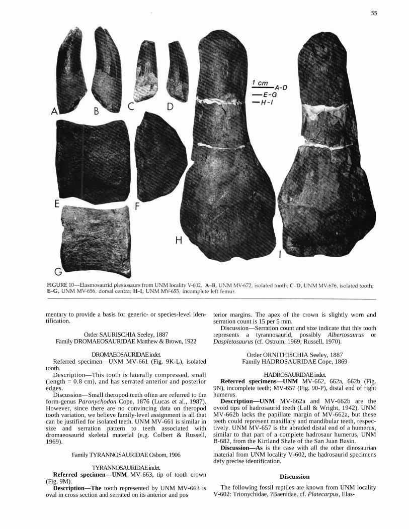
mentary to provide a basis for generic- or species-level iden-tification.
Order SAURISCHIA Seeley, 1887 Family DROMAEOSAURIDAE Matthew & Brown, 1922
DROMAEOSAURIDAE indet. Referred specimen—UNM MV-661 (Fig. 9K-L), isolated
tooth. Description—This tooth is laterally compressed, small
(length = 0.8 cm), and has serrated anterior and posterior edges.
Discussion—Small theropod teeth often are referred to the form-genus Paronychodon Cope, 1876 (Lucas et al., 1987). However, since there are no convincing data on theropod tooth variation, we believe family-level assignment is all that can be justified for isolated teeth. UNM MV-661 is similar in size and serration pattern to teeth associated with dromaeosaurid skeletal material (e.g. Colbert & Russell, 1969).
Family TYRANNOSAURIDAE Osborn, 1906
TYRANNOSAURIDAE indet. Referred specimen—UNM MV-663, tip of tooth crown
(Fig. 9M). Description—The tooth represented by UNM MV-663 is
oval in cross section and serrated on its anterior and pos
terior margins. The apex of the crown is slightly worn and serration count is 15 per 5 mm.
Discussion—Serration count and size indicate that this tooth represents a tyrannosaurid, possibly Albertosaurus or Daspletosaurus (cf. Ostrom, 1969; Russell, 1970).
Order ORNITHISCHIA Seeley, 1887 Family HADROSAURIDAE Cope, 1869
HADROSAURIDAE indet. Referred specimens—UNM MV-662, 662a, 662b (Fig.
9N), incomplete teeth; MV-657 (Fig. 90-P), distal end of right humerus.
Description—UNM MV-662a and MV-662b are the ovoid tips of hadrosaurid teeth (Lull & Wright, 1942). UNM MV-662b lacks the papillate margin of MV-662a, but these teeth could represent maxillary and mandibular teeth, respec-tively. UNM MV-657 is the abraded distal end of a humerus, similar to that part of a complete hadrosaur humerus, UNM B-682, from the Kirtland Shale of the San Juan Basin.
Discussion—As is the case with all the other dinosaurian material from UNM locality V-602, the hadrosaurid specimens defy precise identification.
Discussion
The following fossil reptiles are known from UNM locality V-602: Trionychidae, ?Baenidae, cf. Platecarpus, Elas-
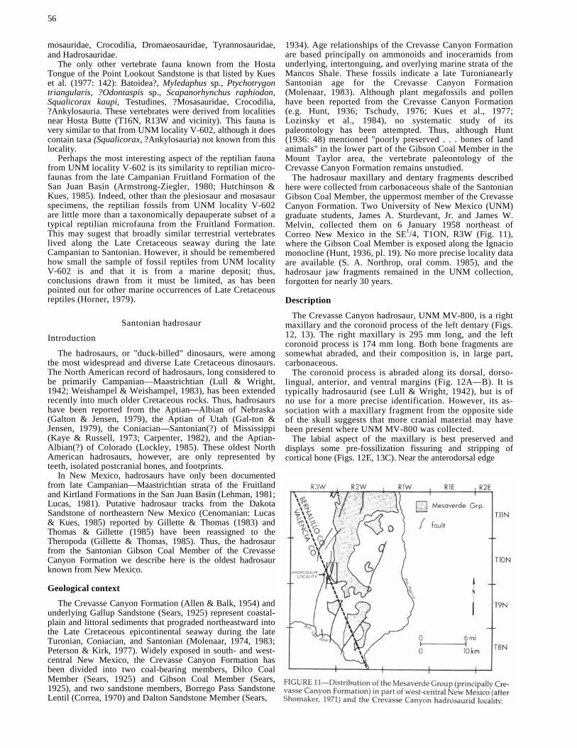
56
mosauridae, Crocodilia, Dromaeosauridae, Tyrannosauridae, and Hadrosauridae.
The only other vertebrate fauna known from the Hosta Tongue of the Point Lookout Sandstone is that listed by Kues et al. (1977: 142): Batoidea?, Myledaphus sp., Ptychotrygon triangularis, ?Odontaspis sp., Scapanorhynchus raphiodon, Squalicorax kaupi, Testudines, ?Mosasauridae, Crocodilia, ?Ankylosauria. These vertebrates were derived from localities near Hosta Butte (T16N, R13W and vicinity). This fauna is very similar to that from UNM locality V-602, although it does contain taxa (Squalicorax, ?Ankylosauria) not known from this locality.
Perhaps the most interesting aspect of the reptilian fauna from UNM locality V-602 is its similarity to reptilian micro-faunas from the late Campanian Fruitland Formation of the San Juan Basin (Armstrong-Ziegler, 1980; Hutchinson & Kues, 1985). Indeed, other than the plesiosaur and mosasaur specimens, the reptilian fossils from UNM locality V-602 are little more than a taxonomically depauperate subset of a typical reptilian microfauna from the Fruitland Formation. This may sugest that broadly similar terrestrial vertebrates lived along the Late Cretaceous seaway during the late Campanian to Santonian. However, it should be remembered how small the sample of fossil reptiles from UNM locality V-602 is and that it is from a marine deposit; thus, conclusions drawn from it must be limited, as has been pointed out for other marine occurrences of Late Cretaceous reptiles (Horner, 1979).
Santonian hadrosaur
Introduction
The hadrosaurs, or "duck-billed" dinosaurs, were among the most widespread and diverse Late Cretaceous dinosaurs. The North American record of hadrosaurs, long considered to be primarily Campanian—Maastrichtian (Lull & Wright, 1942; Weishampel & Weishampel, 1983), has been extended recently into much older Cretaceous rocks. Thus, hadrosaurs have been reported from the Aptian—Albian of Nebraska (Galton & Jensen, 1979), the Aptian of Utah (Gal-ton & Jensen, 1979), the Coniacian—Santonian(?) of Mississippi (Kaye & Russell, 1973; Carpenter, 1982), and the Aptian-Albian(?) of Colorado (Lockley, 1985). These oldest North American hadrosaurs, however, are only represented by teeth, isolated postcranial bones, and footprints.
In New Mexico, hadrosaurs have only been documented from late Campanian—Maastrichtian strata of the Fruitland and Kirtland Formations in the San Juan Basin (Lehman, 1981; Lucas, 1981). Putative hadrosaur tracks from the Dakota Sandstone of northeastern New Mexico (Cenomanian: Lucas & Kues, 1985) reported by Gillette & Thomas (1983) and Thomas & Gillette (1985) have been reassigned to the Theropoda (Gillette & Thomas, 1985). Thus, the hadrosaur from the Santonian Gibson Coal Member of the Crevasse Canyon Formation we describe here is the oldest hadrosaur known from New Mexico.
Geological context
The Crevasse Canyon Formation (Allen & Balk, 1954) and underlying Gallup Sandstone (Sears, 1925) represent coastal-plain and littoral sediments that prograded northeastward into the Late Cretaceous epicontinental seaway during the late Turonian, Coniacian, and Santonian (Molenaar, 1974, 1983; Peterson & Kirk, 1977). Widely exposed in south- and west-central New Mexico, the Crevasse Canyon Formation has been divided into two coal-bearing members, Dilco Coal Member (Sears, 1925) and Gibson Coal Member (Sears, 1925), and two sandstone members, Borrego Pass Sandstone Lentil (Correa, 1970) and Dalton Sandstone Member (Sears,
1934). Age relationships of the Crevasse Canyon Formation are based principally on ammonoids and inoceramids from underlying, intertonguing, and overlying marine strata of the Mancos Shale. These fossils indicate a late Turonianearly Santonian age for the Crevasse Canyon Formation (Molenaar, 1983). Although plant megafossils and pollen have been reported from the Crevasse Canyon Formation (e.g. Hunt, 1936; Tschudy, 1976; Kues et al., 1977; Lozinsky et al., 1984), no systematic study of its paleontology has been attempted. Thus, although Hunt (1936: 48) mentioned "poorly preserved . . . bones of land animals" in the lower part of the Gibson Coal Member in the Mount Taylor area, the vertebrate paleontology of the Crevasse Canyon Formation remains unstudied.
The hadrosaur maxillary and dentary fragments described here were collected from carbonaceous shale of the Santonian Gibson Coal Member, the uppermost member of the Crevasse Canyon Formation. Two University of New Mexico (UNM) graduate students, James A. Sturdevant, Jr. and James W. Melvin, collected them on 6 January 1958 northeast of Correo New Mexico in the SE1/4, T1ON, R3W (Fig. 11), where the Gibson Coal Member is exposed along the Ignacio monocline (Hunt, 1936, pl. 19). No more precise locality data are available (S. A. Northrop, oral comm. 1985), and the hadrosaur jaw fragments remained in the UNM collection, forgotten for nearly 30 years.
Description
The Crevasse Canyon hadrosaur, UNM MV-800, is a right maxillary and the coronoid process of the left dentary (Figs. 12, 13). The right maxillary is 295 mm long, and the left coronoid process is 174 mm long. Both bone fragments are somewhat abraded, and their composition is, in large part, carbonaceous.
The coronoid process is abraded along its dorsal, dorso-lingual, anterior, and ventral margins (Fig. 12A—B). It is typically hadrosaurid (see Lull & Wright, 1942), but is of no use for a more precise identification. However, its as-sociation with a maxillary fragment from the opposite side of the skull suggests that more cranial material may have been present where UNM MV-800 was collected.
The labial aspect of the maxillary is best preserved and displays some pre-fossilization fissuring and stripping of cortical bone (Figs. 12E, 13C). Near the anterodorsal edge

of the maxillary, the articular surface for the premaxillary is a long, broad, and shallow depression (Figs. 12E, 13C). The occlusal aspect of the maxillary (Figs. 12D, 13B) reveals the labial half of the functional dental battery. The lingual aspect (Figs. 12C, 13A) has been largely stripped of bone so that typically hadrosaurid rows of replacement teeth (mostly broken) are visible.
The number of tooth rows present in UNM MV-800 is 45, probably very close to the original number (Lull & Wright, 1942). Dorsal to each tooth row is a dental foramen (Figs. 12C, 13A). The dental foramina follow the gentle, labially directed flexure of the dorsal margin of the maxillary and decrease in size anteriorly and posteriorly, following trends in foramen size typical in hadrosaurids (Ostrom, 1961). No foramina are present on the labial aspect of the maxillary (Figs. 12E, 13C). There are three or, at most, four teeth in each tooth row, and tooth morphology is typically hadro-saurid (e.g. Lull & Wright, 1942, figs. 9-11).
Discussion Although it is not possible to identify UNM MV-800 more
precisely than Hadrosauridae indet., some features of its maxillary may prove to be of evolutionary significance. UNM MV-800 has a relatively large number of tooth rows for a hadrosaurid, indicating that it represents an adult animal (Gilmore, 1933; Davies, 1983). So large a number of tooth rows is typical of Campanian—Maastrichtian hadrosaurids, not of earlier (Cenomanian) hadrosaurids known princi-

58
pally from Asia (Gilmore, 1933). In addition, the length of the maxillary of UNM MV-800 is within the range of Cam-panian-Maastrichtian hadrosaurids (Lull & Wright, 1942, tables 4-8) and somewhat larger than that of Cenomanian hadrosaurids (Gilmore, 1933: 43, 59). However, the number of teeth in each tooth row of UNM MV-800 is only three or four, like that of Cenomanian hadrosaurids (Gilmore, 1933; Lull & Wright, 1942; Davies, 1983) and in contrast to the larger number, five or six, found in Campanian-Maastrich-tian hadrosaurids. This suggests that increase in adult max-illary size and increase in number of teeth per tooth row may not be correlated in hadrosaurid evolution. Neverthe-less, this suggestion needs to be verified by a more exten-sive record of pre-Campanian hadrosaurids from western North America.
In addition to its possible evolutionary significance, UNM MV-800 is of importance for three reasons: (1) it is the oldest reasonably well-preserved cranial material of a hadrosaurid from North America; (2) it is the oldest hadrosaurid now known from New Mexico; and (3) it suggests that additional vertebrate fossils are present in the Gibson Coal Member of the Crevasse Canyon Formation in New Mexico.
Appendix The measured stratigraphic section in Fig. 7 (see Fig. 5 for
location) is described here. Colors are those of Goddard et al. (1979). Strata measured strike N10°E and dip 8° SE. Thicknesses in meters.
Hosta Tongue, Point Lookout Sandstone: 23 Sandstone, fine-grained, quartzose, very light 34.0
gray (N8) to yellowish gray (5 Y 7/2), friable. Bedding is complex and includes massive (bio-turbated), laminar and planar-crossbedded in-tervals. No effort was made to record the exact sequence of bedforms, and their representation in Fig. 7 is schematic. The base of this unit is ferruginous, and UNM locality V-602 is 1.5 m below the top of this unit. Unit forms a ridge.
Gibson Coal Member, Crevasse Canyon Formation: 22 Carbonaceous shale, dark yellowish brown 4.0
(10 YR 4/2) to yellowish gray (5 Y 7/2), with abundant ferruginous concretions. Unit forms a slope.
21 Sandstone, fine-grained, quartzose, very pale 6.0 orange (10 YR 8/2) to yellowish gray (5 Y 7/2), friable, planar crossbeds, unit forms a bench.
20 Carbonaceous shale, dark yellowish brown 1.7 (10 YR 4/2) to yellowish gray (5 Y 7/2). Unit forms a slope.
19 Sandstone, fine-grained, quartzose, very light 4.9 gray (N8) to yellowish gray (5 Y 7/2), friable, massive, unit forms a bench.
18 Carbonaceous shale, dark yellowish brown 18.3 (10 YR 4/2) to yellowish gray (5 Y 7/2). Some thin (less than 0.5 m thick) lignite and clay beds throughout this unit. Unit forms a slope.
17 Sandstone, fine-grained, quartzose, yellowish 0.9 gray (5 Y 7/2) to grayish orange (10 YR 7/4), well indurated, laminar. Unit forms a bench.
16 Carbonaceous shale, dark yellowish brown 9.0 (10 YR 4/2) to yellowish gray (5 Y 7/2). Unit forms a slope.
15 Sandstone, fine-grained, quartzose, grayish or- 0.3 ange (10 YR 7/4) to dark yellowish orange (10 YR 6/6), well indurated, laminar. Unit forms a bench.
14 Carbonaceous shale, dark yellowish brown 10.4 (10 YR 4/2) to yellowish gray (5 Y 7/2). Some thin (less than 0.5 m thick) coal and friable, very light gray (N8) sandstone beds throughout this unit. Unit forms a slope.
13 Sandstone, fine-grained, quartzose, yellowish 3.0 gray (5 Y 7/2), well indurated, planar crossbeds. Some ferruginous concretions. Unit forms a bench.
12 Lignite, brownish gray (5 YR 4/1) and sub-bitu- 3.8 minous/bituminous coal, brownish black (5 YR 2/1). Coal is 0.9 m at base of unit, which forms a slope.
11 Carbonaceous shale, brownish gray (5 YR 4/1) 3.5 to dark yellowish brown (10 YR 4/2). Near top of unit is 0.6 m thick, yellowish gray (5 Y 7/2), massive sandstone.
10 Sandstone, medium- to coarse-grained, quartz- 1.5 ose, grayish orange (10 YR 7/4), friable, planar crossbeds. Unit forms a bench.
9 Coal, brownish black (5 YR 2/1) and grayish black 1.7 (N2), sub-bituminous to bituminous, split by 0.3 m thick light gray (N7) clay (tonstein).
8 Carbonaceous shale, brownish gray (5 YR 4/1) 2.1 with thin (less than 0.2 m thick) grayish-orange (10 YR 7/4) sandstones.
7 Sandstone, medium- to coarse-grained, quartz- 4.6 ose, grayish orange (10 YR 7/4), planar crossbeds, friable. Unit forms a bench.
6 Shale, mostly covered, but exposed portions are 7.0 light gray (N7). Unit forms a valley.
5 Sandstone, medium- to coarse-grained, quartz- 5.2 ose, very pale orange (10 YR 8/2) to grayish yellow (5 Y 8/4), friable. Gravelly layers up to 0.15 m thick occur as lenses in this unit and at its base. Some pieces of petrified wood, up to 0.30 m long and 0.10 m in diameter. Generally massive, but with small scale trough cross-stratification in places. UNM locality V-601 at top of unit.
(Total thickness of Gibson Coal Member = 87.9 m.)
Dalton Sandstone Member, Crevasse Canyon Formation: 4 Sandstone, fine- to medium-grained, subarkosic 5.5 and in places clayey, very pale orange (10 YR 8/2), grayish orange (10 YR 7/4) and dark yellowish orange (10 YR 6/6), indurated, laminar, forms a bench.
3 Sandstone, fine- to medium-grained, dark yel- 1.5 lowish orange (10 YR 6/6), laminar with ferru-ginous concretions. Lower part has thin intercalations of yellowish-gray (5 Y 7/2) shale.
2 Sandstone, fine- to medium-grained, grayish or- 3.0 ange (10 YR 7/4), massive. (Total thickness of Dalton Sandstone Member = 10 m.)
Mulatto Tongue, Mancos Shale: 1 Shale, yellowish gray (5 YR 7/2), with a few thin 10
+ beds of fine-grained, quartzose and clayey, gray-ish-orange (10 YR 7/4) to dark yellowish-orange (10 YR 6/6) sandstone.
References
Allen, J. E. & Balk, R., 1954, Mineral resources of the Fort Defiance and Tohatchi quadrangles, Arizona and New Mexico: New Mex-

ico Bureau of Mines & Mineral Resources, Bulletin 36: 192 pp. Armstrong-Ziegler, J. G., 1980, Amphibia and Reptilia from the
Campanian of New Mexico: Fieldiana: Geology (n.s.), 4: 1-39. Baker, B. W., 1981, Geology and depositional environments of Up-
per Cretaceous rocks, Sevilleta Grant, Socorro County, New Mex-ico: Unpublished MS thesis, New Mexico Institute of Mining & Technology, Socorro, 159 pp.
Baker, B. & Wolberg, D. L., 1981, Upper Cretaceous stratigraphy and paleontology, lower Tres Hermanos Sandstone, Sevilleta Grant near La Joya, Socorro County, New Mexico (abs.): American Association of Petroleum Geologists, Bulletin, 65: 554.
Brown, D. S., 1981, The English Upper Jurassic Plesiosauroidea (Reptilia) and a review of the phylogeny and classification of the Plesiosauria: British Museum (Natural History) Bulletin, Geology, 35: 253-347.
Carpenter, K., 1982, The oldest Late Cretaceous dinosaurs in North America?: Mississippi Geology, 3: 11-17.
Colbert, E. H. & Russell, D. A., 1969, The small Cretaceous di-nosaur Dromaeosaurus: American Museum Novitates, no. 2380: 1-49.
Cope, E. D., 1887, The sea-saurians of the Fox Hills Cretaceous: The American Naturalist, 21: 563-566.
Correa, A. C., 1970, Borrego Pass Lentil, a new member of the Crevasse Canyon Formation, southern San Juan Basin, New Mexico: The Mountain Geologist, 7: 99-102.
Cunningham, J. E., 1966, A Cretaceous vertebrate from the Big Burro Mountains, Grant County, New Mexico: New Mexico Geo-logical Society, Guidebook 17: 119.
Davies, K. L., 1983, Hadrosaurian dinosaurs of Big Bend National Park, Brewster County, Texas: Unpublished MS thesis, University of Texas, Austin, 235 pp.
Erickson, B. R., 1976, Osteology of the early eusuchian crocodile Leidyosuchus formidabilis, sp. nov.: Science Museum of Minnesota, Monographs, 2: 61 pp.
Gaffney, E. S. & Bartholomai, A., 1979, Fossil trionychids of Aus-tralia: Journal of Paleontology, 53: 1354-1360.
Galton, P. M. & Jensen, J. A., 1979, Remains of ornithopod dino-saurs from the Lower Cretaceous of North America: Brigham Young University, Geology Series 25: 1-10.
Gillette, D. D. & Thomas, D. A., 1983, Dinosaur footprints in the Dakota Sandstone (Cretaceous) of northeastern New Mexico: Ab-stracts of the Annual Symposium on Southwestern Geology and Paleontology, Museum of Northern Arizona, Flagstaff, p. 7.
Gillette, D. D. & Thomas, D. A., 1985, Dinosaur tracks in the Dakota Formation (Aptian—Albian) at Clayton Lake State Park, Union County, New Mexico: New Mexico Geological Society, Guidebook 36: 283-288.
Gilmore, C. W., 1933, On the dinosaurian fauna of the Iren Dabasu Formation: American Museum of Natural History, Bulletin 67: 23-78.
Goddard, E. N., Trask, P. D., DeFord, R. K., Rove, 0. N., Singe-wald, J. T., Jr. & Overbeck, R. M., 1979, Rock-color chart: Boul-der, Geological Society of America.
Hay, 0. P., 1908, The fossil turtles of North America: Carnegie Institute of Washington, Publication 75: 568 pp.
Horner, J. R., 1979, Upper Cretaceous dinosaurs from the Bearpaw Shale (marine) of south-central Montana with a checklist of Upper Cretaceous dinosaur remains from marine sediments in North America: Journal of Paleontology, 53: 566-577.
Hunt, C. B., 1936, Geology and fuel resources of the southern part of the San Juan Basin, New Mexico, pt. 2. The Mount Taylor coal field: U.S. Geological Survey, Bulletin 860-B: 31-80.
Hutchinson, P. J. & Kues, B. S., 1985, Depositional environments and paleontology of Lewis Shale to lower Kirtland Shale Se-quence (Upper Cretaceous), Bisti area, northwestern New Mex-ico: New Mexico Bureau of Mines & Mineral Resources, Circular 195: 25-54.
Kaye, J. & Russell, D., 1973, The oldest hadrosaurian dinosaurs in North America: Journal of Paleontology, 47: 91-93.
Kues, B. S., Froehlich, J. W., Schiebout, J. A. & Lucas, S. G., 1977, Paleontologic survey, resource assessment, and mitigation plan for the Bisti—Star Lake area, northwestern New Mexico: Open-file Report, U.S. Bureau of Land Management, Albuquerque, New Mexico, 1525 pp.
Lehman, T. M., 1981, The Alamo Wash local fauna: a new look at the old Ojo Alamo fauna; in Lucas, S. G., Rigby, J. K., Jr. & Kues, B. S. (eds.), Advances in San Juan Basin paleontology: University of New Mexico Press, Albuquerque, pp. 189-221.
59
Lockley, M. G., 1985, Dinosaur footprints from the Dakota Group of Colorado and implications for iguanodontid—hadrosaurid ev-olution (abs.): Geological Society of America, Abstracts with Pro-grams, 17: 252.
Lozinsky, R. P., Hunt, A. P., Wolberg, D. L. & Lucas, S. G., 1984, Late Cretaceous (Lancian) dinosaurs from the McRae Formation, Sierra County, New Mexico: New Mexico Geology, 6: 72-77.
Lucas, S. G., 1981, Dinosaur communities of the San Juan Basin: a case for lateral variations in the composition of Late Cretaceous dinosaur communities; in Lucas, S. G., Rigby, J. K., Jr. & Kues, B. S. (eds.), Advances in San Juan Basin paleontology: University of New Mexico Press, Albuquerque, pp. 337-393.
Lucas, S. G. & Kues, B. S., 1985, Stratigraphic nomenclature and correlation chart for east-central New Mexico: New Mexico Geo-logical Society, Guidebook 36: 341-344.
Lucas, S. G. & Reser, P. K., 1981, A mosasaur from the Lewis Shale (Upper Cretaceous), northwestern New Mexico: New Mexico Geology, 3: 37-40.
Lucas, S. G., Mateer, N. J., Hunt, A. P. & O'Neill, F. M., 1987, Dinosaurs, the age of the Fruitland and Kirtland Formations, and the Cretaceous—Tertiary boundary in the San Juan Basin, New Mexico: Geological Society of America, Special Paper 209: 35-50.
Lull, R. & Wright, N., 1942, Hadrosaurian dinosaurs of North America: Geological Society of America, Special Paper 40: 242 pp.
Molenaar, C. M., 1974, Correlation of the Gallup Sandstone and associated formations, Upper Cretaceous, eastern San Juan and Acoma basins, New Mexico: New Mexico Geological Society, Guidebook 25: 251-258.
Molenaar, C. M., 1983, Major depositional cycles and regional cor-relations of Upper Cretaceous rocks, southern Colorado Plateau and adjacent areas; in Reynolds, M. W. & Dolly, E. D. (eds.), Mesozoic paleogeography of the west-central United States: Rocky Mountain Symposium 2, The Rocky Mountain Section, Society of Economic Paleontologists and Mineralogists, Denver, Colorado, pp. 201-223.
Ostrom, J. H., 1961, Cranial morphology of the hadrosaurian di-nosaurs of North America: American Museum of Natural History, Bulletin 122: 35-186.
Ostrom, J. H., 1969, Osteology of Deinonychus antirrhopus, an unusual theropod from the Lower Cretaceous of Montana: Peabody Museum of Natural History, Bulletin 30: 165 pp.
Peterson, F. & Kirk, A. R., 1977, Correlation of the Cretaceous rocks in the San Juan, Black Mesa, Kaiparowits and Henry basins, southern Colorado Plateau: New Mexico Geological Society, Guidebook 28: 167-178.
Romer, A. S., 1956, Osteology of the reptiles: University of Chicago Press, Chicago, 772 pp.
Russell, D. A., 1970, Tyrannosaurs from the Late Cretaceous of western Canada: National Museum of Natural Sciences, Publi-cations in Palaeontology, no. 1: 1-34.
Sears, J. D., 1925, Geology and coal resources of the Gallup—Zuni basin, New Mexico: U.S. Geological Survey, Bulletin 767: 53 pp.
Sears, J. D., 1934, Geology and fuel resources of the southern part of the San Juan Basin, New Mexico. Part I. The coal field from Gallup eastward to Mount Taylor, with a measured section of pre-Dakota(?) rocks near Navajo Church: U.S. Geological Survey, Bulletin 860-A: 29 pp.
Shomaker, J. W., 1971, Rio Puerco Mesaverde area; in Shomaker, J. W., Beaumont, E. C. & Kottlowski, F. E. (eds.), Strippable low-sulfur coal resources of the San Juan Basin in New Mexico and Colorado: New Mexico Bureau of Mines & Mineral Resources, Memoir 25: 92-94.
Slack, P. A. & Campbell, J. A., 1976, Structural geology of the Rio Puerco fault zone and its relationship to central New Mexico tectonics: New Mexico Geological Society, Special Publication 6: 46-52.
Thomas, D. A. & Gillette, D. D., 1985, Ornithopod ichnofauna in the Dakota Formation, Clayton Lake State Park, northeastern New Mexico (abs.): Geological Society of America, Abstracts with Programs, 17: 267.
Tschudy, R. H., 1976, Palynology of Crevasse Canyon and Menefee Formations of San Juan Basin, New Mexico: New Mexico Bureau of Mines & Mineral Resources, Circular 154: 48-54.
Weishampel, D. B. & Weishampel, J. B., 1983, Annotated localities of ornithopod dinosaurs: implications to Mesozoic paleobiogeog-raphy: The Mosasaur, 1: 43-87.

60
Welles, S. P., 1943, Elasmosaurid plesiosaurs with a description of new material from California and Colorado: University of California, Memoir 13: 125-215.
Welles, S. P., 1949, A new elasmosaur from the Eagle Ford Shale of Texas: Fondren Scientific Series, 1: 1-28.
Welles, S. P., 1952, A review of the North American Cretaceous elasmosaurs: University of California, Publications in Geology, 29: 47-144.
Welles, S. P., 1962, A new species of elasmosaur from the Aptian of Columbia, and a review of the Cretaceous plesiosaurs: Uni-versity of California, Publications in Geology, 44: 1-96.
Williston, S. W., 1903, North American plesiosaurs, pt. 1: Field Columbian Museum, Geological Series, 2 (1): 1-77.
Wolberg, D. L., 1985a, Selachians from the Late Cretaceous (Tu-ronian) Atarque Sandstone Member, Tres Hermanos Formation, Sevilleta Grant, Socorro County, New Mexico: New Mexico Geology, 7: 1-7.
Wolberg, D. L., 1985b, Selachians from the Atarque Sandstone Member of the Tres Hermanos Formation (Upper Cretaceous: Turonian), Sevilleta Grant near La Joya, Socorro County, New Mexico: New Mexico Bureau of Mines & Mineral Resources, Circular 195: 7-19.

Editor: Jiri Zidek
Drafters: Kathy Campbell, Michael Woolridge
Typeface: Palatino
Presswork: Miehle Single Color Offset Harris Single Color Offset
Binding: Saddlestitched with softbound cover
Paper: Cover on 12-pt. Kivar Text on 70-lb White Matte
Ink: Cover—PMS 320 Text—Black
Quantity: 900