bullita cave system, judbarra / gregory karst, tropical ... · el lapiaz (figuras 7, 8);...
TRANSCRIPT

21
Grimes, K. G. and Martini, J. E. J., 2016. Bullita cave system, Judbarra / Gregory Karst, tropical Australia. Boletín Geológico y Minero, 127 (1): 21-44ISSN: 0366-0176
Bullita cave system, Judbarra / Gregory Karst, tropical AustraliaK.G. Grimes(1) and J.E.J. Martini(2)
(1) Environmental Geoscience, La Trobe University. RRN 795 Morgiana Rd., Hamilton, Vic. 3300, [email protected]
(2) Rue du Perbet, Saint Remèze 07700, [email protected]
ABSTRACT
In the monsoon tropics of northern Australia, Bullita Cave is the largest (123 km) of a group of extensive, horizontal, joint-controlled, dense network maze caves which are epikarst systems lying at shallow depth beneath a well-developed karrenfield. The Judbarra / Gregory Karst and its caves are restricted to the out-crop belt of the thin, sub-horizontal, Proterozoic Supplejack Dolostone. Karst is further restricted to those parts of the Supplejack that have escaped a secondary dolomitisation event. The karrenfield and underlying cave system are intimately related and have developed in step as the Supplejack surface was exposed by slope retreat. Both show a lateral zonation of development grading from youth to old age. Small cave pas-sages originate under the recently exposed surface, and the older passages at the trailing edge become un-roofed or destroyed as the, by then deeply-incised, karrenfield breaks up into isolated ruiniform blocks and pinnacles. Vertical development of the cave has been generally restricted to the epikarst zone by a 3m bed of impermeable and incompetent shale beneath the Supplejack which first perched the water-table, forming incipient phreatic passages above it, and later was eroded by vadose flow to form an extensive horizontal system of passages 10-20m below the karren surface. Some lower cave levels in underlying dolostone oc-cur adjacent to recently incised surface gorges. Speleogenesis is also influenced by the rapid, diffuse, ver-tical inflow of storm water through the karrenfield, and by ponding of the still-aggressive water within the cave during the wet season – dammed up by “levees” of sediment that accumulate beneath the degraded trailing edge of the karrenfield. The soil, and much biological activity, is not at the bare karren surface, but down on the cave floors, which aids epikarstic solution at depth rather than on the surface.
Key words: cave, epikarst, karren, maze, shale.
Sistemas de cuevas de Bullita, Judbarra / Gregory Karst, Australia tropical
RESUMEN
En los trópicos monzónicos del norte de Australia, la cueva Bullita es el más grande (123 km) de un grupo de densos laberintos de cuevas que forman una extensa red horizontal, controlada por diaclasas y que son sistemas de epikarst a poca profundidad, por debajo de un campo de lapiaz bien desarrollado. El Judbarra / Gregory Karst y sus cuevas están restringidos a un cinturón de afloramiento de la dolomía proterozoica sub-horizontal de la unidad Supplejack. El karst se limita además a aquellas partes de la unidad de Supplejack que han escapado a un evento de dolomitización secundario. El campo de lapiaz y el sistema de cavernas subyacentes están íntimamente relacionados y se han desarrollado en sincronía conforme la superficie de Supplejack se expuso por retroceso de las laderas. Ambos muestran una zonación lateral de desarrollo que va de más antiguo a más reciente. Pequeños pasajes de cuevas se originan debajo de la superficie reciente-mente expuesta, mientras los pasajes más antiguos en el borde están destechados o están destruidos por la incisión del lapiaz, a la vez que se divide en bloques ruiniformes y pináculos aislados. El desarrollo vertical de la cueva está limitado generalmente a la zona de epikarst por un lecho de 3 m de pizarra impermeable debajo de la Supplejack, que primero cuelga el nivel freático formando pasajes freáticos incipientes por encima de ella y más tarde fue erosionada por el flujo vadoso para formar un extenso sistema horizontal de pasajes 10-20 m por debajo de la superficie de lapiaz. Algunos niveles más bajos de la cueva en dolomías

Grimes, K.G. and Martini, J.E.J., 2016. Bullita cave system, Judbarra / Gregory Karst... Boletín Geológico y Minero, 127 (1): 21-44
22
subyacentes se han desarrollado recientemente por la incisión de gargantas en superficies adyacentes. La espeleogénesis también está influenciada por la entrada rápida, difusa y vertical de agua de lluvia a través del campo de lapiaz y por encharcamiento dentro de la cueva del agua todavía agresiva durante la estación lluviosa - represada por diques de sedimentos que se acumulan debajo del borde posterior del campo de lapiaz. El suelo y la gran actividad biológica no tienen lugar donde aflora la roca desnuda, sino en el suelo de la cueva, lo cual facilita la disolución del epikarstic en profundidad en lugar de en la superficie.
Palabras clave: cueva, epikarst, lapiaz, laberinto, pizarra.
VERSIÓN ABREVIADA EN CASTELLANO
Introducción
La cueva de Bullita es el más grande de una serie de laberintos de cuevas epikársticas superficiales dentro del Judbarra-Gregory Karst, ubicado a 16° de latitud sur, en el territorio norte de Australia (figuras 1 y 2). La exploración seria de la cueva comenzó en 1990 y está todavía en curso (Kershaw, 2012 a). El sistema de la cueva de Bullita actualmente tiene 122 km de pasajes topografiados, dentro de una extensión total de cuatro kilómetros (Figura 7). El área en su conjunto tiene un total de 254 km de pasajes de cueva cartografiados en 2013. Este trabajo resume un grupo de seis ponencias que aparecieron en una edición especial de Helictite en 2012, pero concentrándose en la geomorfología del sistema (Grimes, 2012b; Martini y Grimes, 2012). El clima es tropical monzónico semiárido (Figura 3). Las precipitaciones tienen un pronunciado carácter esta-cional (entre la estación húmeda y la seca) y tienen poca duración pero son torrenciales. La vegetación es de sabana abierta con algunos bosques de ribera a lo largo de los cauces principales. El karst se desarrolla en una formación muy plana del Proterozoico (1.6 Ga) con una sucesión de dolomías, calizas y lutitas de la Formación Skull Creek (Figura 8a). Dentro de ésta, las cuevas se limitan al cinturón aflorante de la unidad carbonatada Supplejack de 20 m de potencia y restringidas además a la parte que ha escapado a un evento de dolomitización secundaria (figuras 2, 6). Por debajo del Supplejack hay una capa de 3 m de pizarras de gran importancia para la espeleogénesis (figuras 4, 8).
Descripción del karst y las cuevas
Zonación lateral del campo de lapiaz y las cuevas
El lapiaz y los sistemas de cuevas subyacentes están íntimamente relacionados y se han desarrollado en sin-cronía conforme la superficie de Supplejack se exponía a medida que se erosionaba por retroceso de las la-deras. Ambos muestran una zonación de desarrollo lateral de edad más moderna a más antigua (figura, 8a, 20). Como resultado de la denudación lateral, las zonas están migrando para seguir el retroceso del contacto con la formación superior pizarrosa Upper Skull Creek (Figura 20). En la zona 1, expuesta recientemente por debajo de la cubierta impermeable, el lapiaz inicial es superficial (Figura 5), y hay sólo pequeños pasajes incipientes de cuevas, en su mayoría impenetrables. Las zonas 2 y 3 muestran la disección progresivamente más profunda del lapiaz y el correspondiente crecimiento de los pasajes de cuevas dentro de la formación Supplejack y en el estrato de pizarras subyacente. Numerosas conexiones se desarrollan entre los grikes en superficie y los conductos de cuevas subyacentes y permiten la infiltración rápida del agua de lluvia. En la zona 4, el karst está degradado, tanto el lapiaz como los sistemas de cuevas, se descomponen en grikes gigantes y bloques ruíniformes (figuras 9,10) debido al ensanchamiento y encajamiento de los grikes así como al colapso del techo de las cuevas en algunos pasajes.
Descripción de las cavidades
Las cuevas forman densas redes de laberintos de pasajes controlados y desarrolladas exclusivamente bajo el lapiaz (figuras 7, 8); principalmente bajo las zonas 2 y 3 de lapiaz. Como los pasajes están a poca profun-didad (de 5 a 20 m), las conexiones con la superficie a través de los grikes son numerosas. La consecuencia es que la luz y las raíces penetran en la cueva en muchos lugares (figuras 16, 19). Los pasajes dentro de la unidad Supplejack (figuras 8a, 11) incluyen conductos tubulares freáticos, que están intersectados por pa-sajes verticales de fracturas a lo largo de las diaclasas. Pueden estar conectados a los grikes de superficie y también extenderse en profundidad, y en algunos lugares muestran techos biselados. Estos pasajes son

Grimes, K.G. and Martini, J.E.J., 2016. Bullita cave system, Judbarra / Gregory Karst... Boletín Geológico y Minero, 127 (1): 21-44
23
más comunes en el tercio inferior de la Supplejack e incluyen los tubos en forma de herradura inmediata-mente por encima de la capa de pizarras que ahora aflora en los techos de las cámaras de las cuevas (figuras 8a, 11, 12, 13, 14). El desarrollo de la cueva principal se ha producido a lo largo del estrato de pizarras (figuras 4, 11e). Este nivel queda inundado de modo extensivo durante cada temporada de lluvias. Los pasajes en la Supplejack se han extendido horizontalmente más que en profundidad para desarrollar secciones con formas distintivas en tienda de campaña o T invertida, con techos planos o socavados en el contacto entre la pizarra incompetente y la base de la Supplejack (figuras 4D, 11, 14, 15). Localmente se observan grandes cámaras con pilares de pizarra que soportan el techo (Figura 16). En algunos lugares, generalmente cerca de las gargantas encajadas de los cauces principales, los niveles más bajos de la cueva se han desarrollado hasta 20 m por debajo de la capa de pizarra principal, dentro de las dolomías del Lower Skull Creek y una segunda capa de pizarras (figuras 8 c, 17, 18). Hay volúmenes considerables de sedimento en los pasajes entre las pizarras, tanto procedentes localmente de las pizarras como procedentes de la parte superior. Esto incluye mucha materia orgánica y raíces activas. La zona de suelo-epikarst está aquí, en la cueva, más que sobre las superficies de roca desnuda del campo de lapiaz.
Biología
Moulds and Bannink (2012) documenta la fauna de invertebrados de la cueva. Los numerosos agujeros del techo implican que la mayoría de los pasajes están bien ventilados y las zonas de crepúsculo y transi-ción son considerables. Las humedades son generalmente menores que en otros karst tropicales del norte de Australia, donde la humedad está saturada, o casi, a unos pocos metros de la entradas de la cuevas. Numerosas raíces de los árboles, desechos de hojas y charcos dejados por las avenidas estacionales, pro-porcionan hábitats adicionales (Figura 19).
Factores que controlan el desarrollo de cuevas y karst
Marco geológico
Las influencias estructurales son unos buzamientos suaves y un sistema de diaclasado bien desarrollado. Los niveles de la cueva están controlados por la litología y la hidrología que está controlada por la litología: en particular la capa de pizarras impermeable e incompetente debajo de la Supplejack, que limita en gran medida el desarrollo de la cueva a la zona del epikarst. Esta capa de pizarras colgó inicialmente el nivel freá-tico, formando pasajes freáticos dentro de la Supplejack, y más tarde fue fácilmente erosionada por corrien-tes vadosas para formar un sistema de drenaje principal subhorizontal. La composición y la textura de los carbonatos han influido en la tasa y la naturaleza de la disolución. La presencia de finas intercalaciones de dolomicrita y caliza micrítica calcítica dentro de la Supplejack pueden haber favorecido el desarrollo kárstico en esta unidad. Los carbonatos en el Lower Skull Creek son principalmente dolomías, y en la Upper Skull Creek son principalmente pizarras con solo finas capas de carbonato. El karst es inhibido por dolomitización secundaria de la Supplejack.
La geomorfología en superfice
El retroceso horizontal de las laderas ha expuesto progresivamente la parte superior de la Supplejack, provocando el desarrollo secuencial tanto del lapiaz como de la cueva subyacente, proceso que sigue en la actualidad. La superficie rocosa desnuda del lapiaz provoca que el agua se infiltre rápidamente a las cuevas; y la falta de suelo superficial implica que la zona de suelo del epikarst esté ahora dentro de la cueva. Las gargantas encajadas pueden haber promovido el desarrollo localizado de niveles inferiores en las cuevas.
Hidrología
El clima tiene una precipitación fuertemente estacional caracterizada por breves tormentas torrenciales. La mayor parte del actual flujo de agua y la espeleogénesis se producen durante la estación lluviosa, cuando la zona es prácticamente inaccesible. Hay una importante necesidad de monitorizar los procesos durante la estación húmeda mediante el uso de sensores a prueba de inundaciones. La entrada rápida, vertical, difusa
Grimes, K.G. and Martini, J.E.J., 2016. Bullita cave system, Judbarra / Gregory Karst... Boletín Geológico y Minero, 127 (1): 21-44
24
y autogénica de agua de lluvia se produce por las numerosas fisuras del campo de lapiaz. Durante el corto tiempo de tránsito sólo se produce una disolución limitada, de modo que el agua es todavía agresiva a su llegada dentro de la cueva. Además hay entradas alogénicas de menor cuantía en el borde principal de la zona 1 de lapiaz donde el agua de escorrentía canalizada y procedente de las pizarras suprayacentes, entre el campo de lapiaz a través de numerosas fisuras (Figura 20). Dentro de los sistemas de cuevas hay una eta-pa temprana de un acuífero colgado por encima del nivel de pizarras, con el subsecuente ensanchamiento de las diaclasas dentro de la Supplejack por flujo vertical vadoso y ampliación de sus partes inferiores por agua encharcada de modo estacional. En el borde posterior del campo de lapiaz degradado, la acumulación de material derruido y de material de grano más fino facilita la formación de diques (figuras 9, 20) que re-presa agua de lluvia de la estación húmeda dentro de la cueva. Este agua forma tanto charcos como arroyos dentro de la cueva y también absorbe en la cueva sedimentos y material derruido. Es asimismo responsable de la ampliación por disolución de las partes bajas de las fisuras dentro de la Supplejack, del material car-bonatado dentro de las capas de pizarras y del carbonato de derrubios y sedimentos que han ocupado los pasajes de la cueva en los diques. Tanto las inundaciones estacionales como la disolución en el contacto suelo-roca pueden explicar algunos de los patrones de tipo freático vistos en las paredes de la cueva. El flujo vadoso de corrientes horizontales a través de los sistemas de cuevas durante la temporada de lluvias ha erosionado la capa de pizarras, socavando la roca caliza suprayacente y contribuyendo al colapso en la zona 4.
Otros modelos
Mientras que existe la posibilidad de que pudiera haber habido algo de actividad espeleogenética anterior en una fase hipogénica, o por lo menos condiciones de un acuífero confinado, no existe evidencia de que eso haya contribuido a los sistemas de laberintos de cuevas conocidos.
Edad del sistema de cuevas
La edad de formación del sistema de cuevas es discutida por Martini y Grimes (2012). Está limitada a la del campo de lapiaz después de que ha sido erosionada su cubierta, y las partes más antiguas son probable-mente inferiores a 2 millones de años.
Introduction
Bullita Cave is the largest of a series of epikarstic maze caves within the Judbarra / Gregory Karst, which lies at 16° south latitude within the Judbarra / Gregory National Park in the Northern Territory of Australia (Fig. 1). The caves underlie a belt of well developed karrenfields at least 30 km long (Fig. 2).
Serious cave exploration began in 1990 with an Operation Raleigh Expedition (Storm and Smith, 1991). Parts of Bullita Cave were first discovered in 1992 (Kershaw, 2012a). The Bullita Cave System cur-rently comprises 123 km of surveyed passages, con-tained within an overall extent of four kilometres. Other caves to the north and south of the Bullita Cave System, including the Dingo Cave System (38.5 km) and the Prometheus Cave System (46.5 km), are of a comparable nature, and the area as a whole had 282 km of mapped cave passage in 2015 (Kershaw, 2012a,b and pers comm 2015).
This paper is a summary of a series of six papers that appeared in a special issue of Helictite volume 41 (Grimes (ed), 2012a, and see http://helictite.caves.org.au/contents4.html), in particular the report by
Martini and Grimes (2012). Earlier descriptions and speleogenetic models had been presented in several short papers (Storm and Smith, 1991; Dunkley, 1993; Bannink et al., 1995; White and White, 2009) and were incorporated into the Martini and Grimes model.
Climate and paleoclimates
The present climate is tropical monsoon with strong seasonal contrasts (Fig. 3; BOM, 2014a): very dry most of the year, but with a wet season from November to April. The annual rainfall at Bullita homestead is about 830 mm, falling in heavy bursts. Annual areal potential evapotranspiration is about 2000 mm (BOM, 2014b). Consequently, the vegetation is a parkland savanna type, with narrow gallery forests along the main streams.
When considering the effect of climate on karst development one must allow for variations during the Pliocene and Quaternary. For the recent past, a study of the tufa deposits in Limestone Gorge indicat-ed that drier and wetter periods alternated (Canaris, 1993), and a wetter climate may have prevailed 8-10

Grimes, K.G. and Martini, J.E.J., 2016. Bullita cave system, Judbarra / Gregory Karst... Boletín Geológico y Minero, 127 (1): 21-44
25
ka. During the last 2 million years the glacial-intergla-cial cycles caused an alternation of humid (interglaci-al) and dry (glacial) periods throughout the monsoon tropics of Australia (Kershaw et al., 2003).
Geology
The Judbarra / Gregory Karst area is developed in the 150-170 m thick, gently dipping, unmetamorphosed Proterozoic (1.6 Ga) Skull Creek Formation (Sweet 1973; Beier et al., 2002; Fig. 1). It mainly consists of centimetric to decimetric platy layers of carbonate and calcareous siltstone, with millimetric shale in-ter-beds. Thicker beds (typically 1 m) of massive car-bonate are inter-stratified at regular intervals of a few metres, a setting typical in the upper part of the for-mation. One of these carbonate beds is much thicker (15-20 m) and constitutes the Supplejack Dolostone Member, which, together with an underlying 3 m shale bed, controls the formation of the Bullita Cave System.
Figure 1. Geology of the Bullita Basin, Judbarra Karst area. Based on the Auvergne and Waterloo geological sheets (Dunster et al., 2000 and Sweet, 1973).Figura 1. Geología de la Cuenca Bullita, área Judbarra Karst. Basado en las hojas geológicas Auvergne y Waterloo (Dunster et al., 2000 y Sweet, 1973).
Figure 2. Location of the currently known extent of the Judbarra Karst, with named sub-areas. Based on air-photography and satel-lite imagery.Figura 2. Localización de la extensión (conocida hasta la actualidad) de la Judbarra Karst, con los nombres de las subáreas. Están basa-das en la fotografía aérea e imágenes de satélite.
Grimes, K.G. and Martini, J.E.J., 2016. Bullita cave system, Judbarra / Gregory Karst... Boletín Geológico y Minero, 127 (1): 21-44
26
Lower Skull Creek Formation
The Lower Skull Creek is about 120 m thick, but of main interest here is the top 20-30 m, which immedi-ately underlie the Supplejack Dolostone Member, and which consists mainly of very-fine-grained, well-bed-ded dolomicrite.
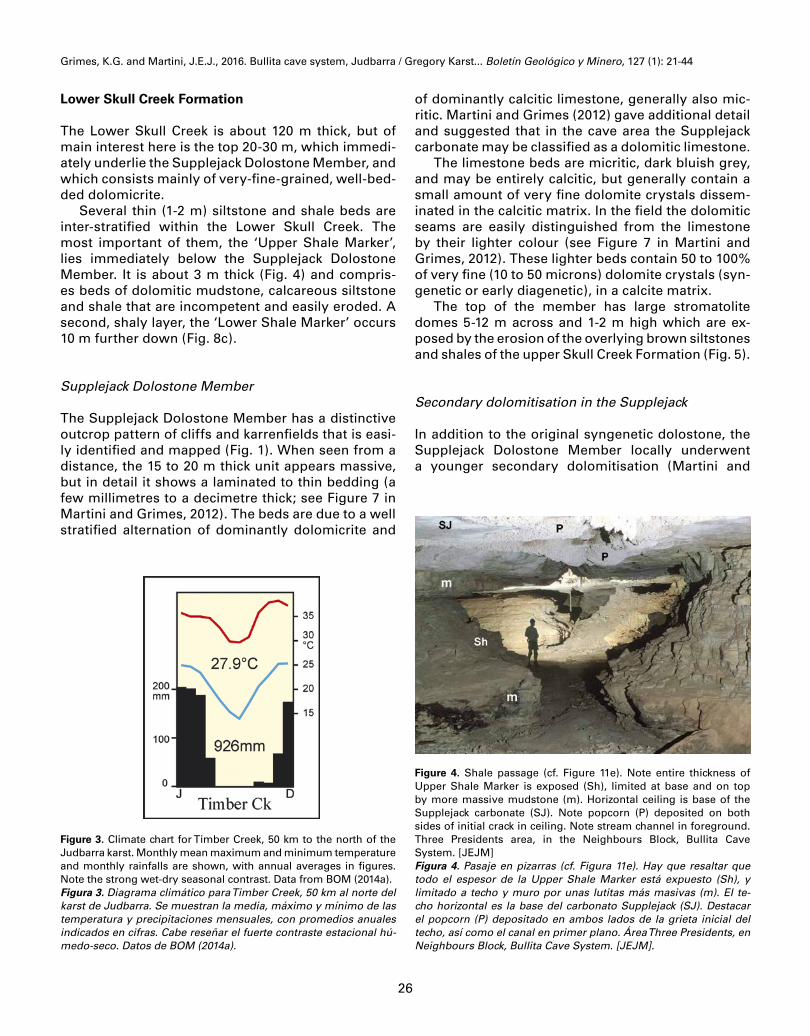
Several thin (1-2 m) siltstone and shale beds are inter-stratified within the Lower Skull Creek. The most important of them, the ‘Upper Shale Marker’, lies immediately below the Supplejack Dolostone Member. It is about 3 m thick (Fig. 4) and compris-es beds of dolomitic mudstone, calcareous siltstone and shale that are incompetent and easily eroded. A second, shaly layer, the ‘Lower Shale Marker’ occurs 10 m further down (Fig. 8c).
Supplejack Dolostone Member
The Supplejack Dolostone Member has a distinctive outcrop pattern of cliffs and karrenfields that is easi-ly identified and mapped (Fig. 1). When seen from a distance, the 15 to 20 m thick unit appears massive, but in detail it shows a laminated to thin bedding (a few millimetres to a decimetre thick; see Figure 7 in Martini and Grimes, 2012). The beds are due to a well stratified alternation of dominantly dolomicrite and
of dominantly calcitic limestone, generally also mic-ritic. Martini and Grimes (2012) gave additional detail and suggested that in the cave area the Supplejack carbonate may be classified as a dolomitic limestone.
The limestone beds are micritic, dark bluish grey, and may be entirely calcitic, but generally contain a small amount of very fine dolomite crystals dissem-inated in the calcitic matrix. In the field the dolomitic seams are easily distinguished from the limestone by their lighter colour (see Figure 7 in Martini and Grimes, 2012). These lighter beds contain 50 to 100% of very fine (10 to 50 microns) dolomite crystals (syn-genetic or early diagenetic), in a calcite matrix.
The top of the member has large stromatolite domes 5-12 m across and 1-2 m high which are ex-posed by the erosion of the overlying brown siltstones and shales of the upper Skull Creek Formation (Fig. 5).
Secondary dolomitisation in the Supplejack
In addition to the original syngenetic dolostone, the Supplejack Dolostone Member locally underwent a younger secondary dolomitisation (Martini and
Figure 3. Climate chart for Timber Creek, 50 km to the north of the Judbarra karst. Monthly mean maximum and minimum temperature and monthly rainfalls are shown, with annual averages in figures. Note the strong wet-dry seasonal contrast. Data from BOM (2014a).Figura 3. Diagrama climático para Timber Creek, 50 km al norte del karst de Judbarra. Se muestran la media, máximo y mínimo de las temperatura y precipitaciones mensuales, con promedios anuales indicados en cifras. Cabe reseñar el fuerte contraste estacional hú-medo-seco. Datos de BOM (2014a).
Figure 4. Shale passage (cf. Figure 11e). Note entire thickness of Upper Shale Marker is exposed (Sh), limited at base and on top by more massive mudstone (m). Horizontal ceiling is base of the Supplejack carbonate (SJ). Note popcorn (P) deposited on both sides of initial crack in ceiling. Note stream channel in foreground. Three Presidents area, in the Neighbours Block, Bullita Cave System. [JEJM]Figura 4. Pasaje en pizarras (cf. Figura 11e). Hay que resaltar que todo el espesor de la Upper Shale Marker está expuesto (Sh), y limitado a techo y muro por unas lutitas más masivas (m). El te-cho horizontal es la base del carbonato Supplejack (SJ). Destacar el popcorn (P) depositado en ambos lados de la grieta inicial del techo, así como el canal en primer plano. Área Three Presidents, en Neighbours Block, Bullita Cave System. [JEJM].

Grimes, K.G. and Martini, J.E.J., 2016. Bullita cave system, Judbarra / Gregory Karst... Boletín Geológico y Minero, 127 (1): 21-44
27
Grimes, 2012), which cuts across the stratification and irregularly invades the member. This secondary dolomitisation seems extensive elsewhere in the re-gion, but in the Judbarra Karst it is only locally pres-ent, and its absence seems an essential requirement for the formation of strong karst landforms: the kar-renfields and cave systems.
Upper Skull Creek Formation
The Upper Skull Creek, 30-40 m thick consists of a rhythmic alternation of metre thick beds of slightly dolomitic limestone (10-35% dolomite), and 3 m thick beds of calcareous siltstone and shale which are gen-erally poorly exposed. Microkarren are common on the limestone beds (Grimes, 2012b).
Paleokarst sandstone breccia
In the Far North area (Figs. 2, 6), belts of loose, brec-ciated quartz sandstone fill linear trenches which are unconformably inset into undisturbed outcrops of the Skull Creek Formation (Grimes, 2012c). They are interpreted by Grimes (2012c) as a paleokarst brec-cia, derived from deposits of the overlying Jasper Gorge Sandstone that subsided into structurally controlled solutional cavities in the Supplejack. This breccia must postdate the Jasper Gorge Sandstone (about 850 Ma, Dunster et al., 2000), and the loose nature of the breccia suggests a relatively young age. However, it must pre-date the present erosional cy-cle, and the Judbarra Karst, as the modern valleys are cutting across the paleokarst belts.
Structure
At a regional scale the Supplejack Member lies within a N-S elongated structural basin (the Bullita
Figure 5. Large stromatolite domes on top of the Supplejack Member have been recently exposed by erosion of the soft shale of the Upper Skull Creek Formation. Note there is only incipient karren development here, at the leading edge of karren zone 1. [KGG]Figura 5. Las grandes cúpulas de estromatolitos en la parte superior del Supplejack Member se han expuesto recientemente por la sua-ve erosión de la pizarra de la Formación Superior Skull Creek. Hay que resaltar que hay sólo un desarrollo incipiente del lapiaz, en el borde frontal de la zona 1 de lapiaz. [KGG].
Figure 6. Schematic profile showing relationships between old land surfaces, stratigraphy and cave development in the Judbarra / Gregory Karst.Figura 6. Perfil esquemático que muestra las relaciones entre antiguas superficies del terreno, estratigrafía y el desarrollo de la cueva en el Judbarra / Gregory Karst.
Grimes, K.G. and Martini, J.E.J., 2016. Bullita cave system, Judbarra / Gregory Karst... Boletín Geológico y Minero, 127 (1): 21-44
28
Basin, Fig. 1), about 50 km long, and 30 km wide. The main karst areas are on the western side of this ba-sin, where dips are gentle, generally less than 2 de-grees, except in the Far North area where dips are up to 4 degrees and there are several broad anticlines and synclines along NE-SW axes (Figure 2). On the eastern side of the basin the Supplejack has steeper dips.
A well-developed joint set guides both the grikes in the karrenfield of the Supplejack and the cave pas-sages beneath them. Some prominent lineaments visible on aerial photographs may be faults, but with displacements of not more than a few meters.
The land surface, present and past
The present topography results from the dissection of an older, subdued land surface by an integrated network of valleys. It is flat to hilly, except for steeper slopes and cliffs along the incised East Baines River and some of its most important tributaries such as Limestone Creek and the creek south of SOGS (Fig. 7), but this incision does not extend more than a few kilometres upstream along the river. Next to the Bullita Cave System the East Baines River flows northward at an altitude of about 100 m above sea level. The Bullita Cave and karrenfield are developed between the altitudes of 110 m and 145 m (Figure 6, and Figure 4 in Grimes, 2012b has contours).
At a smaller scale, the strata resistant to erosion are the carbonate beds, which form small stepwise escarpments. These scarps are moderately promi-nent in the Lower Skull Creek. The most spectacular one, however, is formed by the Supplejack Dolostone Member. The thin limestone beds of the Upper Skull Creek protrude as obvious regularly-spaced scarplets (Figure 4 in Martini and Grimes, 2012).
At a broader scale, there are several old land sur-faces which Martini and Grimes (2012) referred to in interpreting the denudation history of the area (Fig. 6). The current erosional phase, which produced the karst, postdates a Pliocene surface. The present gorges of the river and Limestone Creek suggest that there has been a recent phase of channel incision to a depth of ~50m that might not have had a great deal of associated valley widening. ‘Recent’ must, howev-er, considerably predate the 8-10,000 BP dates on the older tufa deposits within Limestone Gorge (Canaris, 1993).
DESCRIPTION OF THE KARST AND CAVES
Overview of the Judbarra / Gregory Karst
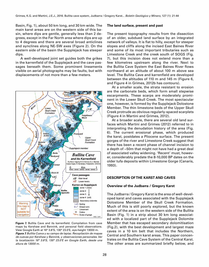
The Judbarra / Gregory Karst is the area of well-devel-oped karst and caves associated with the Supplejack Dolostone Member of the Skull Creek Formation. Much of this is still poorly explored, but the known extent of the area is on the western side of the Bullita Basin (Fig. 1) in a strip about 30 km long associat-ed with a localized part of the Supplejack Dolomite Member that has escaped secondary dolomitisation (Fig.2), with the best development and largest maze caves in a 10 km belt that includes the Northern, Central and Southern karst areas. This paper concen-trates on the Bullita Cave System of the Central Karst. The other areas are summarized briefly below, and
Figure 7. Bullita Cave and its karrenfield. Compilation from cave maps by Kershaw and Bannink, and personal field observations. View Google Earth at 16° 3.8’S, 130° 23.0’E, eye-height 13000 m.Figura 7. Bullita Cueva y su campo de lapiaz. Recopilación de mapas de cuevas por Kershaw y Bannink, y observaciones personales. Ver la localización 16° 3.8’S, 130° 23.0’E en Google Earth, desde una altura de 13000 m.

Grimes, K.G. and Martini, J.E.J., 2016. Bullita cave system, Judbarra / Gregory Karst... Boletín Geológico y Minero, 127 (1): 21-44
29
the most informative ones are described in more de-tail in Martini and Grimes (2012).
The Far North
This terrain has stronger relief than to the south, with a more complex drainage pattern, so the outcrop belt of the Supplejack is narrow and forms a convoluted and discontinuous karrenfield (Figure 2). Karrenfields are reasonably well developed, but the narrow belts of exposed limestone reduce the potential for large maze caves. Nonetheless, several caves have been found on reconnaissance trips to the south-east of the area. Paleokarst breccias in this area are described in the geology section and Grimes (2012c).
The Northern Karst area
A three kilometre long belt of meandering but con-tinuous karrenfield lies to the north of Limestone Gorge (Fig. 2). The karren are well developed (Figure 4 in Grimes, 2012b) and overlie a set of large maze caves with 53 km of mapped passage length (Storm and Smith, 1991; Bannink et al., 1995; Kershaw, pers comm., 2015). The Dingo Cave system (38.5 km) is of particular interest as it has four levels of develop-ment, and these are much more extensively devel-oped than in Bullita Cave (Bannink et al., 1995). The northern part is still partly unexplored.
The Central Karst area
This central part of the belt, the main topic of this ar-ticle, runs for five kilometres south from Limestone Gorge (Fig. 7). In the gorge of Limestone Creek the Supplejack forms vertical limestone cliffs, and to the west the East Baines River is also incised into a gorge with intermittent cliffs. The land surface is a gently undulating plateau, possibly a part of an old Pliocene surface (Fig. 6), which lies 50-60 m above the stream-beds of the East Baines River and Limestone Creek. The karrenfield is broad and well-developed and underlain by the Bullita Cave maze system, with about 123 km of surveyed passages in 2015, and several smaller caves that are not connected to the main system.
The Southern Karst area
A four kilometre long karrenfield runs south-west from the East Baines River (Fig. 2). This area is still
incompletely explored but has several significant maze caves totalling 63 km of surveyed passage in 2014 (Kershaw, 2012a; pers comm., 2015). These included the connected Atlantis-Prometheus-Two Fishes Cave System (46.5 km, Kershaw, pers comm, 2015). M. Sefton (pers. comm. 2013) reports that much of Prometheus section is deeply incised be-low the Supplejack dolomite. The south-western end of the area is the point where well developed karst ceases as a result of secondary dolomitisation (see Martini and Grimes, 2012, p. 42).
The Spring Creek area
Much of this section of the Supplejack has only poor karst development as a result of secondary dolomi-tisation, but a few areas of unaltered limestone oc-cur with better quality karren and cave systems (Fig. 2). There are several clusters of maze caves totaling 40 km, with the largest being Lost in Space at 14 km (Kershaw, 2012a; pers. comm. 2015). The cave char-acter shows some differences from that seen further north, as described briefly by Martini and Grimes (2012, p.53).
Surface karst morphology
Karrenfields are widespread in the Judbarra Karst (Grimes, 2012b), but larger surface features such as dolines are absent or rare. At a large scale the morphol-ogy is characteristic of a fluvio-karst with an integrat-ed surface drainage (Dunkley, 1993). The distinction between mesokarren, megakarren and microkarren is important as these have different distributions in the area (Grimes, 2012b). The best mesokarren by far are developed on the dolomitic limestone of the Supplejack Dolostone Member and megakarren are restricted to this unit. Outside the Supplejack there are well-developed microkarren in the upper part of the Skull Creek Formation, but little mesokarren ex-cept on the occasional thicker bed mentioned above. The karren of the Judbarra / Gregory Karst are dis-cussed in more detail elsewhere (Grimes, 2012b), so here we will concentrate mainly on the relationship between the karrenfield and the cave development.
The karrenfield forms a contorted and irregular band with a width between 100 m and 900 m. The section hosting the Bullita Cave System is 4 km long and roughly oriented north-south (Fig.7), being in-terrupted in the north by the gorge of Limestone Creek and in the south by the East Baines River, but continues for several kilometers beyond to both the
Grimes, K.G. and Martini, J.E.J., 2016. Bullita cave system, Judbarra / Gregory Karst... Boletín Geológico y Minero, 127 (1): 21-44
30
north and the south-west (Fig. 2, and see Figure 4 in Grimes, 2012b). The Supplejack is more mechan-ically resistant to erosion than the Upper Skull Creek Formation and as the very gentle dip of the Skull Creek is eastwards and as the general slope of the land is westwards, the denudation of the Supplejack from beneath its Upper Skull Creek cover proceeds eastwards (Figs. 8 and 20).
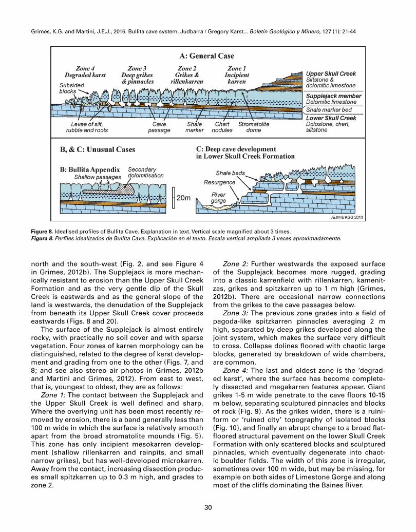
The surface of the Supplejack is almost entirely rocky, with practically no soil cover and with sparse vegetation. Four zones of karren morphology can be distinguished, related to the degree of karst develop-ment and grading from one to the other (Figs. 7, and 8; and see also stereo air photos in Grimes, 2012b and Martini and Grimes, 2012). From east to west, that is, youngest to oldest, they are as follows:
Zone 1: The contact between the Supplejack and the Upper Skull Creek is well defined and sharp. Where the overlying unit has been most recently re-moved by erosion, there is a band generally less than 100 m wide in which the surface is relatively smooth apart from the broad stromatolite mounds (Fig. 5). This zone has only incipient mesokarren develop-ment (shallow rillenkarren and rainpits, and small narrow grikes), but has well-developed microkarren. Away from the contact, increasing dissection produc-es small spitzkarren up to 0.3 m high, and grades to zone 2.
Zone 2: Further westwards the exposed surface of the Supplejack becomes more rugged, grading into a classic karrenfield with rillenkarren, kamenit-zas, grikes and spitzkarren up to 1 m high (Grimes, 2012b). There are occasional narrow connections from the grikes to the cave passages below.
Zone 3: The previous zone grades into a field of pagoda-like spitzkarren pinnacles averaging 2 m high, separated by deep grikes developed along the joint system, which makes the surface very difficult to cross. Collapse dolines floored with chaotic large blocks, generated by breakdown of wide chambers, are common.
Zone 4: The last and oldest zone is the ‘degrad-ed karst’, where the surface has become complete-ly dissected and megakarren features appear. Giant grikes 1-5 m wide penetrate to the cave floors 10-15 m below, separating sculptured pinnacles and blocks of rock (Fig. 9). As the grikes widen, there is a ruini-form or ‘ruined city’ topography of isolated blocks (Fig. 10), and finally an abrupt change to a broad flat-floored structural pavement on the lower Skull Creek Formation with only scattered blocks and sculptured pinnacles, which eventually degenerate into chaot-ic boulder fields. The width of this zone is irregular, sometimes over 100 m wide, but may be missing, for example on both sides of Limestone Gorge and along most of the cliffs dominating the Baines River.
Figure 8. Idealised profiles of Bullita Cave. Explanation in text. Vertical scale magnified about 3 times.Figura 8. Perfiles idealizados de Bullita Cave. Explicación en el texto. Escala vertical ampliada 3 veces aproximadamente.

Grimes, K.G. and Martini, J.E.J., 2016. Bullita cave system, Judbarra / Gregory Karst... Boletín Geológico y Minero, 127 (1): 21-44
31
Figure 9. Partly unroofed cave passage forms a giant grike in de-graded karst (zone 4). Mound at rear is the ‘levee’ material. Golden Arches, Berks Backyard, Bullita Cave System. [KGG]Figura 9. Pasaje de la cueva parcialmente destechado y que forma un grike gigante en un karst degradado (zona 4). El montículo en la parte de atrás es de un dique. Golden Arches, Berks Backyard, Bullita Cave System. [KGG]
At the outer edge of the degraded karst, there are Supplejack blocks showing dips tilted in all direc-tions, but resting on structurally undisturbed Lower Skull Creek carbonates (Fig. 10). This suggests that the latter formation was little or not at all affected by karstification.
Description of the caves
The following description concentrates mainly on the Bullita Cave System (Fig.7), which is the largest studied in the Judbarra / Gregory Karst (Martini and Grimes, 2012). However, it applies equally to the oth-er maze caves in the area.
This system consists of an intricate and dense maze of joint-controlled passages developed exclu-sively under the karrenfield: primarily under karren zones 2 and 3, with only incipient small passages un-der zone 1, and becoming unroofed or destroyed by roof breakdown under zone 4 (the degraded karst). As the passages develop at shallow depth (about 5 to 20 m), the connections to the surface through grikes are very numerous. The consequence is that the daylight penetrates into the cave in many places, to such an extent that the twilight zone ecosystem is widespread (see Biology section, and Moulds and Bannink, 2012)
The general layout of the Bullita Cave System is irregular, as the cave consists of a chain of discrete
Figure 10. Degraded karst (zone 4). Note rotated blocks resting on undisturbed Lower Skull Creek dolostone (light coloured) in foreground. NW of the Golden Arches, Bullita Cave System. [KGG]Figura 10. Karst degradado (zona 4). Remarcar los bloques girados descansando sobre la dolomía inalterada del Lower Skull Creek (colo-reado claro) en primer plano. NO de los Golden Arches, Bullita Cave System. [KGG]

Grimes, K.G. and Martini, J.E.J., 2016. Bullita cave system, Judbarra / Gregory Karst... Boletín Geológico y Minero, 127 (1): 21-44
32
sectors of maze that are connected by just a few passages (Fig. 7). Each sector has its own distinctive character. At the surface, the narrow links between the sectors generally correspond to the ends of large grikes and minor valleys, that is, to constrictions of the karrenfield.
The main passage types
There are three broad types of passages that have a morphology closely controlled by the stratigraphy of the host rock (Bannink et al., 1995; Martini and Grimes, 2012):1. The type developed in the lower strata of the
Supplejack Dolostone Member, above the shale bed;
2. The type due to excavation within the 2-3 m thick Upper Shale Marker;
3. The type developed stratigraphically deeper in the well bedded dolostone and in the Lower Shale Marker of the Lower Skull Creek Formation (Figure 8c); these lower levels are best developed in Dingo Cave (Bannink, et al, 1995) and in the SOGS sec-tion of the Bullita system.
Supplejack Passages (type 1): In this first type, the passages are mostly concentrated at the base of the Supplejack, even within the incipient zone 1 (Fig. 8). However, some passages are observed at higher levels.
The passages generally form fissures developed along joints, and these display triangular sections which vary from narrow fissures tapering upwards (the ‘A-type’, Figs. 11b, 12) to the ‘tented passages’ of Bannink et al., (1995) that widen significantly towards the base where they intersect the top of the shale bed (Figures 11c, 13).
Figure 11. Types of passage sections: A: phreatic passages;B: Ledgy A-form passage that widens downward (c.f. Figure 12); C: Tented pas-sage showing marked widening above shale bed (c.f. Figure 13); D: Inverted-T form resulting from erosional expansion in the shale bed (c.f. Figure 15); E: rectangular shale passage (c.f. Figure 4). Lithology: 1: dolostone, more or less cherty; 2: dolomitic mudstone; 3: dolomitic siltstone and shale; 4: dolomitic limestone; 5: cherty dolomitic limestone; 6: popcorn; 7: alluvial and residual filling; 8: ‘omega’ tube (c.f. Figure 14); 9: bevel at old water table; 10: stream bed.Figura 11. Tipos de secciones de pasajes: A: pasajes freáticos B: pasaje con salientes y en forma de A que se ensancha hacia abajo (ver figura 12); C: Pasaje con forma de tienda mostrando marcado un ensanchamiento sobre una capa de pizarra (ver figura 13); D: Forma de T invertida, resultado de la expansión erosional en la capa de pizarra (ver Figura 15); E: pasaje rectangular en pizarras (ver figura 4). Litología: 1: dolomía más o menos silícea; 2: lutita dolomítica; 3: limolita dolomítica y pizarra; 4: caliza dolomítica; 5: caliza dolomítica silícea; 6: “pop-corn”; 7: relleno aluvial y residual; 8: tubo con forma de omega; 9: bisel en antiguo nivel freático; 10: cauce.

Grimes, K.G. and Martini, J.E.J., 2016. Bullita cave system, Judbarra / Gregory Karst... Boletín Geológico y Minero, 127 (1): 21-44
33
A typical phreatic morphology is frequently ob-served, particularly in the Frontyard and in the Golden Arches sectors, and is characterized by wider passages with roof pendants, solution bells and el-lipsoidal horizontal tubes not controlled by jointing (Fig. 11a). Some horizontal ‘phreatic’ tubes run just above the contact with the underlying Shale Bed and suggest a perched water-table at that level. Later erosion of these down into the shale bed has left ceiling half-tubes with a distinctive ‘omega-shaped’ cross-section (Fig. 14). Typically the best develop-ment of this phreatic morphology occurs in the 3-4 basal meters of the Supplejack. At this level, the walls generally display a horizontally corrugated surface: the thin dolomite-rich layers are more corroded than the limestone ones, which project up to 3 cm. In the most common type the passages are simply A-form with walls exhibiting ledges developed at decimetric intervals and projecting horizontally for up to half a meter (Figs. 11b, 12).
Figure 13. ‘Tented’ type passage that widens downward towards the floor, just above the shale bed (c.f. Figure 11c). Atlantis Cave, Southern Karst. [A. Pryke] Figura 13. Pasaje de tipo tienda que se ensancha hacia abajo en di-rección del suelo, justo por encima de la capa de pizarra (ver Figure 11c). Atlantis Cave, Southern Karst. [A. Pryke]
Figure 12. A-fissure passage, with ledges developed by differential corrosion of limestone and dolomite beds (c.f. Figure 11b). Odyssey area in Bullita Cave System. [KGG]Figura 12. Passge en forma de A, con salientes desarrollados por co-rrosión diferencial de la caliza y dolomía (ver Figura 11b). Odyssey area in Bullita Cave System. [KGG]
Figure 14. ‘Omega’ type of tube at the very base of the Supplejack Member – perched above the shale bed, which was later eroded away. Berks Backyard, Bullita Cave. [KGG]Figura 14. Tubo del tipo en forma de omega en la misma base de la Supplejack Member – colgada sobre la capa de pizarra, que pos-teriormente desapareció por erosión. Berks Backyard, Bullita Cave. [KGG]
Grimes, K.G. and Martini, J.E.J., 2016. Bullita cave system, Judbarra / Gregory Karst... Boletín Geológico y Minero, 127 (1): 21-44
34
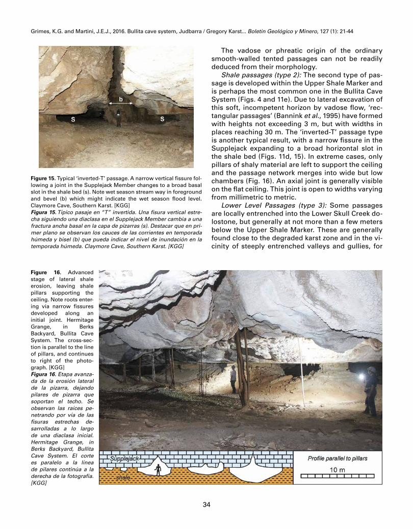
Figure 15. Typical ‘inverted-T’ passage. A narrow vertical fissure fol-lowing a joint in the Supplejack Member changes to a broad basal slot in the shale bed (s). Note wet season stream way in foreground and bevel (b) which might indicate the wet season flood level. Claymore Cave, Southern Karst. [KGG]Figura 15. Típico pasaje en “T” invertida. Una fisura vertical estre-cha siguiendo una diaclasa en el Supplejack Member cambia a una fractura ancha basal en la capa de pizarras (s). Destacar que en pri-mer plano se observan los cauces de las corrientes en temporada húmeda y bisel (b) que pueda indicar el nivel de inundación en la temporada húmeda. Claymore Cave, Southern Karst. [KGG]
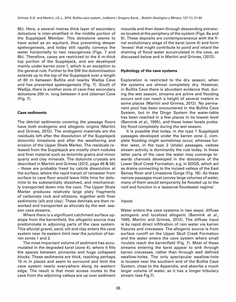
Figure 16. Advanced stage of lateral shale erosion, leaving shale pillars supporting the ceiling. Note roots enter-ing via narrow fissures developed along an initial joint. Hermitage Grange, in Berks Backyard, Bullita Cave System. The cross-sec-tion is parallel to the line of pillars, and continues to right of the photo-graph. [KGG]Figura 16. Etapa avanza-da de la erosión lateral de la pizarra, dejando pilares de pizarra que soportan el techo. Se observan las raíces pe-netrando por vía de las fisuras estrechas de-sarrolladas a lo largo de una diaclasa inicial. Hermitage Grange, in Berks Backyard, Bullita Cave System. El corte es paralelo a la línea de pilares continúa a la derecha de la fotografía. [KGG]
The vadose or phreatic origin of the ordinary smooth-walled tented passages can not be readily deduced from their morphology.
Shale passages (type 2): The second type of pas-sage is developed within the Upper Shale Marker and is perhaps the most common one in the Bullita Cave System (Figs. 4 and 11e). Due to lateral excavation of this soft, incompetent horizon by vadose flow, ‘rec-tangular passages’ (Bannink et al., 1995) have formed with heights not exceeding 3 m, but with widths in places reaching 30 m. The ‘inverted-T’ passage type is another typical result, with a narrow fissure in the Supplejack expanding to a broad horizontal slot in the shale bed (Figs. 11d, 15). In extreme cases, only pillars of shaly material are left to support the ceiling and the passage network merges into wide but low chambers (Fig. 16). An axial joint is generally visible on the flat ceiling. This joint is open to widths varying from millimetric to metric.
Lower Level Passages (type 3): Some passages are locally entrenched into the Lower Skull Creek do-lostone, but generally at not more than a few meters below the Upper Shale Marker. These are generally found close to the degraded karst zone and in the vi-cinity of steeply entrenched valleys and gullies, for

Grimes, K.G. and Martini, J.E.J., 2016. Bullita cave system, Judbarra / Gregory Karst... Boletín Geológico y Minero, 127 (1): 21-44
35
instance in the Neighbors Block, in the Skeleton Key and in the northern reaches of Mike’s sector (Fig. 7). In these parts of the system the development is gen-erally of shallow trenches extending down from the floor of broad shale passages which are poorly inter-connected horizontally.
Only in the southern section of the Bullita Cave System (SOGS, Fig. 7) is the Lower Skull Creek more deeply affected by karst dissolution (Figs. 8c, 17, 18). In the Dingo Cave System (Fig.7), they play a more im-portant role (Bannink et al., 1995) and up to four cave levels are recorded there. The access to these lower levels is via trenches and pits. The passages differ from those of type 1 and 2 in being smaller, narrow-er and forming simpler networks (Fig. 18) and do not seem to develop at stratigraphic depths much greater than about 20 m below the floor of the upper shale passages, that is the East Baines River level. These passages in the Lower Skull Creek have been observed only under presently karstified Supplejack. They have not been found in the areas beyond zone 4 where the Supplejack has been almost entirely eroded.
The three types of passage are partly related to the surface karst morphology. As a general rule, type 1
passages are developed under karren zone 2, but end eastwards more or less against zone 1 (Fig. 8a). In the close vicinity of zone 1, the passages get smaller and eventually become impenetrable. In a few cases these crawlways end against very narrow chimneys connected to the surface. The type 2 shale passages are developed further westwards, mostly under kar-ren zone 3. Still further west the boundary of the cave system coincides with the start of the degraded karst (zone 4). Close to this limit the shale passages get very wide, tend to collapse due to lack of roof support (Figs. 8a, 9 and 10) and often degenerate into a chaos of huge blocks.
Other cave styles
The Bullita Appendix: An unusual case of cave de-velopment is observed at the south-east end of the Bullita cave system, in the ‘Bullita Appendix’ (Fig.
Figure 17. Cave development in Lower Skull Creek Formation. Note from top down: the horizontal ceiling formed at the base of the Supplejack Member; the Upper Shale Marker (S) forming a wide slot immediately under the ceiling; then a 6-7 m deep trench in Lower Skull Creek dolostone; underlain in turn by the Lower Shale Marker forming an undercut behind the distant caver. The central group of hanging roots is about 10 m long. SOGS section, southern Bullita Cave System. [JEJM]Figura 17. Desarrollo de cuevas en Lower Skull Creek Formation. Es de destacar de arriba hacia abajo: el techo horizontal formado en la base del Supplejack Member; La Upper Shale Marker (S) formán-dose una ranura ancha inmediatamente debajo del techo; a conti-nuación, una zanja profunda de 6-7 m en la dolomía del Lower Skull Creek; subyacente a su vez a la Lower Shale Marker formando una contrasalida detrás del espeleólogo. El grupo central de raíces col-gantes es de 10 m de largo aproximadamente. Sección SOGS, sur del Bullita Cave System. [JEJM] Figure 18. Different passage styles in the upper and lower levels of
the SW part of SOGS, Bullita Cave System. From maps compiled by R. Kershaw, GKSIG.Figura 18. Diferentes estilos de pasajes en los niveles superiores e inferiores de la parte SO del SOGS, Bullita Cave System. De los mapas compilados por R. Kershaw, GKSIG.
Grimes, K.G. and Martini, J.E.J., 2016. Bullita cave system, Judbarra / Gregory Karst... Boletín Geológico y Minero, 127 (1): 21-44
36
8b). Here, a several metres thick layer of secondary dolostone is inter-stratified in the middle portion of the Supplejack Member. This dolostone seems to have acted as an aquitard, thus preventing deeper speleogenesis, and today still rapidly conveys the water horizontally to two resurgences (Figs. 7 and 8b). Therefore, caves are restricted to the 6 m-thick top portion of the Supplejack, and are developed mainly under karren zone 1, which is an exception to the general rule. Further to the SW the dolomitisation extends up to the top of the Supplejack over a length of 60 m between Bullita and nearby Wadija Cave and has prevented speleogenesis (Fig. 7). South of Wadija, there is another zone of cave-free secondary dolostone 200 m. long between it and Jalaman Cave (Fig. 7).
Cave sediments
The detrital sediments covering the passage floors have both endogenic and allogenic origins (Martini and Grimes, 2012). The endogenic materials are the residuals left after the dissolution of the Supplejack dolomitic limestone and after the weathering and erosion of the Upper Shale Marker. The residuals re-leased from the Supplejack are mostly chert nodules and finer material such as dolomite grains and minor quartz and clay minerals. The dolomite crystals are described in Martini and Grimes (2012, page 46 & 56) – these are probably freed by calcite dissolution at the surface, where the rapid transit of rainwater from surface to cave floor would leave little time for dolo-mite to be substantially dissolved, and mechanical-ly transported down into the cave. The Upper Shale Marker produces relatively large platy fragments of carbonate rock and siltstone, together with finer sediments (silt and clay). These detritals are then re-worked and transported as alluvials by the wet- sea-son cave streams.
Where there is a significant catchment surface up-slope from the karrenfield, the allogenic source may predominate in adjoining parts of the cave system. This alluvial gravel, sand, silt and clay enters the cave system near its eastern limit near the junction of kar-ren zones 1 and 2.
The most important volume of sediment has accu-mulated in the degraded karst (zone 4), where it fills the spaces between pinnacles and huge collapsed blocks. These sediments are thick, reaching perhaps 10 m in places and seem to surround and limit the cave system nearly everywhere along its western edge. The result is that most access routes to the cave from the adjoining valleys are up over sediment
mounds and then down through descending entranc-es located at the periphery of the system (Figs. 8a and 9). These deposits are contemporaneous with the fi-nal evolutionary stage of the karst (zone 4) and form ‘levees’ that might contribute to pond and retard the draining of flood water accumulated in the cave, as discussed below and in Martini and Grimes, (2012).
Hydrology of the cave systems
Exploration is restricted to the dry season, when the systems are almost completely dry. However, in Bullita Cave there is abundant evidence that, dur-ing the wet season, streams are active and flooding occurs and can reach a height of several meters in some places (Martini and Grimes, 2012). No perma-nent pool has been encountered in the Bullita Cave System, but in the Dingo System the water-table has been reached in a few places in its lowest level (Bannink et al., 1995), and these lower levels proba-bly flood completely during the wet season.
It is possible that today, in the type 1 Supplejack passages developed under the karren zone 2, com-plete flooding might sometimes occur, whereas fur-ther west, in the type 2 (shale) passages, vadose stream activity is dominantly the rule today. In these latter parts of the cave the water may converge to-wards channels developed in the dolostone of the Lower Skull Creek Formation, e.g. in SOGS, which act as drains connecting to the incised valleys of the East Baines River and Limestone Gorge (Fig. 18). As these narrow passages must convey large volumes of water, many of them would temporarily be flooded up to the roof and function in a ‘seasonal floodwater regime’.
Inputs
Water enters the cave systems in two ways: diffuse autogenic and localized allogenic (Bannink et al., 1995; Martini and Grimes, 2012). The diffuse input is by rapid direct infiltration of rain water via karren fissures and crevasses. The allogenic source is from surface runoff on the Upper Skull Creek Formation and the water enters the cave system where small rivulets reach the karrenfield (Fig. 7). Most of these streams entering the karst appear to sink through karren crevasses, rather than through well defined swallow-holes. The only spectacular swallow-hole is located near the southern end of the Bullita Cave System, close to the Appendix, and absorbs a much larger volume of water, as it has a longer tributary stream (see Fig.7).

Grimes, K.G. and Martini, J.E.J., 2016. Bullita cave system, Judbarra / Gregory Karst... Boletín Geológico y Minero, 127 (1): 21-44
37
Although the surface area of the non-karstic al-logenic catchment for the system is slightly great-er than that of the karrenfield, Martini and Grimes, (2012) concluded that at present the diffuse auto-genic input from the karrenfield is quantitatively the most important.
Outputs
The most important resurgence of the Bullita Cave System, the Efflux, is located at its southern end (Figs. 7, 8c, 18). The spring is relatively deeply entrenched (20-25 m) into the Lower Skull Creek, and has cave pas-sages connecting it to the main part of the system. At Skeleton Key (Fig. 7), a long passage heading north is entrenched into the Lower Skull Creek, but only a few meters below the Upper Shale Marker. That might be a drain leading to an, as yet, unfound resurgence. Similar trenches occur in the Neighbors Block, adjacent to Limestone Gorge. It is also likely that numerous minor, cryptic resurgences drain the system during the wet season. Two of these can be observed at the north-east-ernmost end of the Bullita system, in Limestone Gorge at the base of the Supplejack Dolostone Member (Fig. 7). At the opposite end of the system, two resurgences occur south of the Bullita Appendix (Fig. 7). The Dingo system has a major spring rising on the north side of Limestone Creek (Fig. 7).
Storage
One might expect the Bullita Cave to be well-drained in a vadose environment, given its proximity to the in-cised channels of the East Baines River and Limestone Creek and the intersection of the karrenfield and cave system at regular intervals by valleys that cut down to the base of the Supplejack member and drain to the river. However, this is not entirely so, and there is ample evidence for flooding to several metres depth during the wet season. The accumulation of sedi-ments at the edge of the degraded karst (zone 4), as described above, could act as ‘levees’ that would dam floodwater in the cave for weeks to months during the wet season. The sediment has also filled some major grikes and this could function as dykes, partitioning the cave into hydrologically separate compartments. The water-tightness of these ‘dykes’ and ‘levees’ may be variable from one sector to another, which means that some compartments remain flooded for a longer time than for the others. This might explain the dif-ference of passage morphology seen between sectors (Martini and Grimes, 2012).
Speleothems
In the Bullita System, the most common speleothems are coralloids (popcorn, cave coral) as moonmilk-like crusts on the ceiling and walls (Fig. 4). A distinctive style is seen on the ceiling of the rectangular shale passages, where popcorn occurs symmetrically on both sides of the crevasse developed along the axial joint (Figs. 4, 11c). Close to the joint it may reach sev-eral decimetres in thickness, but tapers further away. This popcorn has been deposited by evaporation to dryness of a thin film of water creeping from the joint across the walls. However, close to the plane of the crevasse the popcorn may be corroded, in places very sharply cut with vertical striations in continui-ty with the runnels on the crevasse wall. This sug-gests that initially the water might have been more supersaturated, when the narrow crack was trans-mitting the flow more slowly than at present, and that dissolution prevailed later when the fissure had been more widely opened. Alternatively, the strong, less-saturated, wet season flows might be eroding material deposited by slower more-saturated seep-age between storms.
Martini and Grimes (2012) describe several oth-er distinctive speleothem types and note that, com-pared to most caves in the world, classic dripstone, and flowstone type speleothems are relatively un-common and volumetrically small. This is probably a consequence of the lack of surface soil, which nor-mally produces CO2 and solutions supersaturated in calcite and aragonite when they enter a cave.
Martini and Grimes (2012) discuss the mineralogy of the speleothems, which seem to consist almost ex-clusively of calcite. They suggest that the preponder-ance of calcite in the evaporative speleothems (corra-loids) can be explained by the generally rapid transit of rainwater from surface to cave floor, leaving little time for the dolomite to be substantially dissolved.
Cave biology
Moulds and Bannink (2012) document the invertebrate cave fauna. Because of the numerous ceiling holes, most of the passages are well-ventilated and the twi-light and transition zones are extensive. Humidities are commonly lower than in other tropical karsts of north-ern Australia, where humidity is saturated, or nearly so, within a few metres of cave entrances. However, high humidity does occur near the sumps of the lower levels. Tree roots, mainly from fig-trees, are ubiquitous in the passages developed in the Supplejack Dolostone Member and in the Upper Shale Marker, but are less

Grimes, K.G. and Martini, J.E.J., 2016. Bullita cave system, Judbarra / Gregory Karst... Boletín Geológico y Minero, 127 (1): 21-44
38
common in the lower levels. The roots hang free from the ceiling to the floor, then penetrate the cave soil or creep horizontally in search of moisture, sometimes over long distances The numerous tree roots and leaf litter beneath the ceiling holes mean that the biolog-ically active “soil” is on the cave floors, not the bare karren surface (Fig. 19). This and pools left from the seasonal flooding provide additional habitat.
Sampling in the caves yielded 56 species, most of which did not exhibit any troglomorphisms and were found near cave entrances and in twilight zones (Moulds and Bannink, 2012). The highest diversity of species was from the transition zone, which forms most of the dark zone.
Seven potential troglobiontic and stygobion-tic species were collected by Moulds and Bannink (2012). This is a significant number, given the limited collecting, and systematic collecting will undoubted-ly reveal additional species.
Discussion
Distinctive features of the karst and caves
Karst and cave development is mainly restricted to the outcrop belt of the flat to gently dipping, 20 m thick,
Supplejack Dolostone Member (Figs. 1 and 2). The outcrop belt has a well-developed karrenfield and as-sociated underlying horizontal maze caves. The cave system is restricted to the width of the karrenfield (100-900 m), and is mainly developed at shallow depth in the lower part of the Supplejack limestone and with-in an underlying 3 m shale bed, with localized deeper levels in the Lower Skull Creek Formation (Fig. 8).
Lateral zonation of both the karrenfield and the caves
The karst zones (Figs. 7 and 8a) show a progressive evolution over time, and it is deduced that, as a re-sult of lateral denudation, the zones are migrating eastward to follow the retreating contact with the overlying shaly Upper Skull Creek (Fig. 20). In zone 1, recently exposed from under the impervious cover, the initial karren are shallow, and beneath the surface there are only incipient small cave passages, most-ly impenetrable. Zones 2 and 3 show progressively deeper dissection of the karrenfield and correspond-ing growth of the cave passages within the Supplejack and in the underlying shale bed. Numerous visible connections appear between the surface grikes and the underlying cave passages and allow rapid entry of rain water. In zone 4, the degraded karst, both the karrenfield and the cave system break up into giant grikes and ruiniform blocks, more or less chaotic, as a consequence of widening and downward cutting of the grikes as well as ceiling breakdown in cave pas-sages developed by erosion in the shale bed. In this degraded karst zone, accumulation of rubble and fin-er-grained material in the space within grikes, in relict caves and in chaotic zones, form ‘levees’ which im-pound wet season rainwater within the cave system.
The Caves
The caves are extensive, shallow, sub-horizontal, dense network maze systems (Figs. 7 and 8). In plan, they show joint control and a lateral evolution in pas-sage style that is linked to the development of the overlying karrenfield (see above). In depth, the cave levels are controlled by lithology and lithology-con-trolled hydrology: in particular the impermeable and incompetent shale bed beneath the Supplejack, which largely confines cave development to the epi-karst zone. High-level passages within the Supplejack include ‘phreatic’ style tubular passages which are intersected by vertical fissure passages along the joints. The latter may connect to the surface grikes and also widen downwards, in places displaying beveled
Figure 19. Tree roots and leaf litter beneath a daylight hole provide important ecosystems. Frontyard, Bullita Cave. [A. Pryke]Figura 19. Raíces de árboles y hojarasca debajo de un agujero por el que entra la luz que permite la existencia de importantes ecosis-temas. Patio delantero, Bullita Cave. [A. Pryke]
Grimes, K.G. and Martini, J.E.J., 2016. Bullita cave system, Judbarra / Gregory Karst... Boletín Geológico y Minero, 127 (1): 21-44
39
ceilings. These passages are most common in the lower third of the Supplejack, and include the ‘ome-ga’ tubes immediately above the shale bed which are now exposed in the ceilings of the cave chambers. The main cave development has been along the shale bed. There is evidence that this level floods exten-sively during each wet season. The Supplejack and Shale passages have expanded horizontally rather than in depth to form distinctive tented or inverted-T cross-section shapes, with flat ceilings or undercuts at the contact between the soft shale and the base of the Supplejack. Locally, large chambers occur with scattered shale pillars supporting the roof.
In some places, generally near the incised gorges of the East Baines River and Limestone Creek, lower cave levels have developed down to 20 m below the main shale bed, within the Lower Skull Creek dolos-tones and a second shale bed (Fig. 8c).
There is considerable sediment in the shale-bed passages, both locally derived from the shale, and entering from above. This includes much organic ma-terial and active roots. The epikarst ‘soil’ zone is here, in the cave, rather than on the bare rock surfaces of the karrenfield.
Speleogenesis
The genesis and evolution of the karst and caves was first discussed by Dunkley (1993) and Bannink et al. (1995). Martini and Grimes (2012) expanded on the earlier work, and discussed several other possible processes and controls.
The broad style of the cave networks of the Judbarra Karst is very reminiscent of joint-controlled phreatic mazes. However, what makes the Judbarra maze caves distinctive is:1. The close relationship to the surface karrenfield –
epikarstic influences and progressive evolution of both the surface and the caves.
2. The influence of the shale bed at shallow depth – both as an aquiclude and as an easily eroded lay-er.
3. The monsoon climate: seasonal rainfall and flood-ing of the caves.
4. The speleogenetic effect of the “soil” at the cave floor.
These factors are discussed by Martini and Grimes, (2012) and are summarized below.
Figure 20. Speleogenetic model. Vertical scale magnified about 5 times. WT = water table.Figura 20. Modelo espeleogenético. Escala vertical ampliada 5 veces. WT = nivel freático.

Grimes, K.G. and Martini, J.E.J., 2016. Bullita cave system, Judbarra / Gregory Karst... Boletín Geológico y Minero, 127 (1): 21-44
40
Influence of the karrenfield
Most of the cave development is less than 20m be-neath the surface karrenfield. Even in the early re-ports on Bullita Cave (Dunkley, 1993) and Dingo Cave north of Limestone Gorge (Bannink et al., 1995), the authors perceived that the direct, vertical influx of water plays an important speleogenetic role, since cave development occurs almost exclusively where the surface karrenfield is well developed. They also noted the correlation between the zones of the sur-face karrenfield and the character of the underly-ing cave, and visualized an ongoing speleogenetic process, evolving at the rate of surface denudation, meaning that the youngest stage (narrow passages in the base of the Supplejack Dolostone Member) and the senile stage (sinking of the underground streams into deeper drains developed in the Lower Skull Creek Formation) have been active simultane-ously in different parts of the cave system. The de-gree of maturity of the cave passages coincides with the degree of evolution of the karst surface as it mi-grates eastwards; both being related to the length of time the Supplejack was exposed to weathering after the removal of its cover by slope retreat (Figs. 8, 20).
Influence of the shale bed at shallow depth
The shale bed immediately underlying the Supplejack is important both as an aquitard and as an easily-eroded incompetent bed. The bed would produce a perched water-table and its shallow depth is important in constraining speleogenesis with-in the decompression zone, which is the epikarst. Indeed, in thicker limestone, the passages would develop in the hypokarst where, due to a higher de-gree of hierarchicalisation (Klimchouk, 2000), the channel network would not be as dense as in the case of Bullita.
The perched water-table above the shale bed may have controlled the level of initial phreatic speleogenesis. The omega-shaped tubes in the roof of the larger chambers may have formed at that stage (Fig. 14). Once these initial tubes, fis-sures and tented channels become large enough to carry strong flows, physical erosion by wet season flood waters would have cut down into the incom-petent shale bed and then sideways to create larg-er passages, which follow the pattern of the initial joint-controlled channels in the overlying dolomite. Evidence for this physical erosion is given by the stream channels on the passage floors and their
bed-load of angular shale fragments (Figs. 4 and 13).
This influence of the shale bed has strong analo-gies with the essentially vadose caves of the Sorbas gypsum karst in Spain (Calaforra and Pulido-Bosch, 2000) and with the ‘Contact caves’ of West Virginia, USA (Palmer, 2009, and see also p.235 & 240 in Palmer, 2007). Both those areas have a first stage of phreatic evolution of proto-conduits just above a shale bed, followed by a second stage in which the predominant process has become vadose mechani-cal erosion of the soft shale.
The monsoon climate and seasonal flooding
The monsoon rainfall regime which prevails in the Judbarra region fosters slow surface dissolution. Once the joints are sufficiently enlarged and once the surface is free of soil cover, rainwater rapidly sinks underground, where it retains much of its dis-solution potential. As the rain events are mostly tor-rential and of short duration, coupled with a strong evapo-transpiration, the karren should remain wet only for a limited number of days a year: conditions that measurably slow surface lowering (Dreybrodt, 2004). As the caves remain flooded for longer times, most of the dissolution has occurred at that level.
In addition to the seasonal and torrential rainfall, the ‘levees’ and sediment-filled grikes could keep floodwater within the caves for weeks to months during the wet season. This could explain the devel-opment of larger scale seasonal phreatic conditions, and would be a better alternative to a deep seated phreatic model. This seasonal flooding means that there is an annual alternation of phreatic and vadose conditions, with a period of minimal activity during the dry season.
Effect of cave soil on speleogenesis
For a better understanding of the speleogenesis, Martini and Grimes (2012) discussed the role of car-bonate dissolution under soil cover. With the excep-tion of the lower levels of Dingo cave and the deep passages in the SOGS sector of the Bullita Cave System (Fig. 8c), the bulk of the cave systems are de-veloped within the epikarst. Compared with the rest of the world, this is unusual. Moreover, the soil does not cover the surface, as in most cases, but the cave floors. At the surface and in the cave system, which is well ventilated, the solubility of calcite and dolomite should be controlled by CO2 values, which cannot

Grimes, K.G. and Martini, J.E.J., 2016. Bullita cave system, Judbarra / Gregory Karst... Boletín Geológico y Minero, 127 (1): 21-44
41
be far above the atmospheric level (0.03%, Palmer, 1991). In contrast, the CO2 level must be much higher (1-10%) in the organic-rich cave soil. There the car-bonate minerals’ solubility can be much greater.
The contrast in potential dissolution between the two environments is even greater if one considers the residence times of the solutions. On the sur-face and in the largely open cracks connecting to the cave, the residence time of water must be very short during torrential monsoon rainfalls. The water would reach the cave still under-saturated in calcite, and very largely so for dolomite, as suggested by the corrosion of popcorn described in the speleo-them section. In contrast the cave soil would remain wet for a much longer time, all of which suggests that the amount of calcite and dolomite dissolved in the cave soil environment could be at least one magnitude higher than the amount in the open cave above.
However, Martini and Grimes (2012) noted that the higher potential for dissolution enlargement of the channels filled with soil or alluvials is partly re-duced by several factors: the dissolution of alluvial fragments of carbonate rock and fine dolomite grains released by dolomicrite weathering; the recycling of the calcium pumped to the surface by the vegetation; the reduction of the active surface area of water in contact with the filled cavity wall, due to detrital par-ticles; and to the slow movement of ground water, which makes the dissolution dominantly diffusion controlled.
Other models and processes
Martini and Grimes (2012) discussed several other possible processes. They discarded the possibility of deep seated phreatic influences as being unlikely, and incompatible with the passage morphology and the unvarying restriction of cave development to the area of the modern karrenfield. They also suggested that while pre-karstic widening of joints by mixing of solutions was a hypothetical possibility, it lacked field evidence.
Age of the cave system
The age of the formation of the caves is discussed by Martini and Grimes (2012). One must recognize the concurrent timing of cave and surface karst evo-lution. The age of the cave systems is limited to that of the karrenfield after it has been stripped bare of its cover (Figs. 7, 8a, 20). Also, the age of both the cave
and the karrenfield is diachronous in that new pas-sages and karren are being initiated at the advancing eastern edge (zone 1) at the same time as the karren-field collapses, and old passages are being unroofed and destroyed at the trailing western edge (zone 4). What we are discussing is the maximum time taken for a cave passage to go from youth to old age and destruction. This is equivalent to the time necessary for the original Supplejack – Upper Skull Creek con-tact line to have advanced from the degraded karst boundary to its present day position (a maximum of 900 m).
There is no direct evidence of the age of the cave systems. Martini and Grimes (2012) discuss age de-ductions from chemical denudation rates, and con-clude that these suggest that the age of the oldest pas-sages are between 0.5 and 2 Ma, that is Pleistocene. This conclusion can be updated only when more field observation becomes available, but can be taken as a working hypothesis.
Martini and Grimes (2012) also discuss age de-ductions from the regional denudation history, in-cluding suggested ages for old land surfaces in the area, which suggests a maximum age that agrees with the value of 2 Ma suggested by chemical denudation.
Conclusions
The setting of the karst and caves
The Judbarra karst comprises a group of extensive, horizontal, joint-controlled, dense network maze caves which are epikarst systems lying at shallow depth beneath a well-developed karrenfield. The kar-renfield and caves are both restricted to the outcrop belt of the thin sub-horizontal Supplejack Dolostone Member.
The karrenfield and underlying cave system are intimately related and have developed in step as the Supplejack surface was exposed by slope retreat. Both show a lateral zonation of development grading from youth to old age.
Vertical development of the cave has been gen-erally restricted to the epikarst zone by a 3m bed of impermeable and incompetent shale beneath the Supplejack. Cave passages have formed both in the lower part of the Supplejack, and by physical ero-sion of the underlying shale bed, to form an exten-sive horizontal system of passages 10-20m below the karren surface. Some lower cave levels in underlying dolostone occur adjacent to recently incised surface gorges.

Grimes, K.G. and Martini, J.E.J., 2016. Bullita cave system, Judbarra / Gregory Karst... Boletín Geológico y Minero, 127 (1): 21-44
42
Controlling factors on the karst development
The geological setting
Structural influences are the shallow dips and the well-developed jointing. The most important lith-ological factor is an impermeable and incompetent sub-horizontal shale bed, 20 m below the karren sur-face, which has restricted development of the cave to the shallow epikarst zone. The shale bed initially perched the water-table, forming phreatic passages within the Supplejack, and later was easily eroded by vadose streams to form a major sub-horizontal drain-age system.
The composition and the texture of the carbonates have influenced the rate and nature of dissolution. The presence of thinly interbedded dolomicrite and micritic calcite limestone within the Supplejack may be a factor in restricting the main karst development to that unit. The carbonates in the Lower Skull Creek are mainly dolostones, and the Upper Skull Creek is mainly siltstone and shale with only thin beds of car-bonate. Within the Supplejack belt, karst is further restricted to those beds that have not been modified by secondary dolomitisation (Fig. 2).
The surface geomorphology
The present terrain is a result of long-term vertical erosion and shorter-term horizontal slope retreat with progressive exposure of the top of the Supplejack, and subsequent sequential development of both the karrenfield and the underlying cave – this is ongoing at present.
The bare rocky surface of the karrenfield has an important influence on fast water input to the caves and the lack of surface soil means that the epikarst soil zone is now within the cave. The incised gorg-es have provided a greater potential gradient for the nearby water-tables, which may have promoted the localized development of lower levels in the caves.
The hydrology
The present tropical monsoon climate has a strong-ly seasonal rainfall characterised by brief torrential storms. Most of the present water flow and speleo-genesis occurs during the wet season, when the area is practically inaccessible. Thus, most of the follow-ing is deduced rather than observed.
There is a strong need to monitor the wet season processes, possibly by using flood-proof data-loggers
that would be installed and recovered during the dry season.
Fast, vertical, diffuse, autogenic input of rainwater occurs through the numerous fissures of the karren-field. Only limited solution occurs during the short transit time, so the water is still aggressive on arrival within the cave. Lesser allogenic inputs occur at the leading edge of karren zone 1, where channelled runoff from the impermeable beds of the Upper Skull Creek enters the karrenfield via numerous small fissures.
Within the cave systems there is an early stage of a perched aquifer above the shale bed, with sub-sequent enlargement of joints within the Supplejack by vertical vadose flow and widening of their lower parts by seasonally ponded water. The rubble and sediment ‘levees’ at the trailing edge of the degrad-ed karrenfield cause seasonal ponding of aggressive rain water within the cave. This water forms both open pools and cave streams and also soaks into the cave sediments and rubble. It would be responsible for solutional enlargement of the lower parts of the fissures within the Supplejack, of the carbonate ma-terial within the shale beds, and of the carbonate rub-ble and sediments that have occupied the cave pas-sages in the ‘levees’. Organic activity within the cave sediments may make the ‘soil’ water more aggres-sive, but the diffuse flow through the sediment would also somewhat slow the rate of solution of the cave walls in contact with the sediments. Both the sea-sonal flooding and the solution at the soil-rock con-tact may explain some of the ‘phreatic-like’ patterns seen on the cave walls. Horizontal vadose stream flow through the cave systems during the wet season has eroded the shale bed, undermining the overlying limestone to contribute to the collapse in zone 4.
Apart from the Efflux and the Dingo Cave spring, which are major, but seasonal, springs beside the riv-er, fed from low-level passage systems (Fig.7); out-flows from the system are mostly cryptic and only active during the wet season.
Other models
While it is possible that there may have been earlier minor speleogenetic activity in a hypogenic, or at least a confined aquifer setting, there is no evidence of this having contributed to the known maze cave systems.
Acknowledgments
The authors are in debt to the management of the Judbarra / Gregory National Park who granted
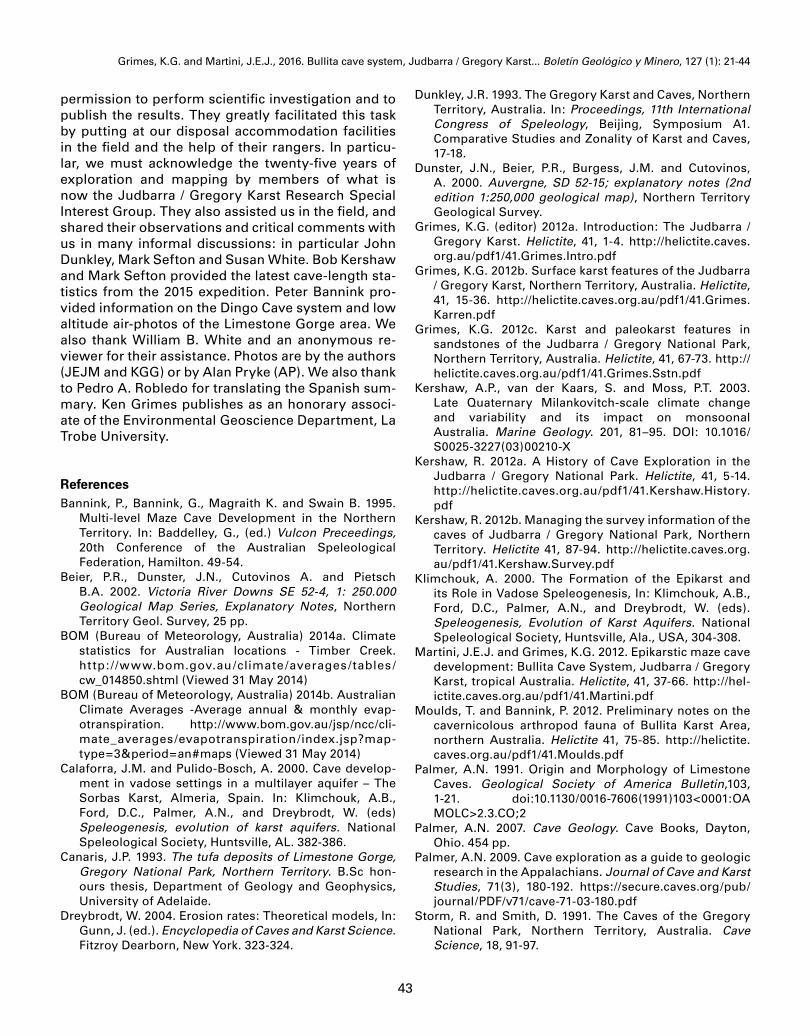
Grimes, K.G. and Martini, J.E.J., 2016. Bullita cave system, Judbarra / Gregory Karst... Boletín Geológico y Minero, 127 (1): 21-44
43
permission to perform scientific investigation and to publish the results. They greatly facilitated this task by putting at our disposal accommodation facilities in the field and the help of their rangers. In particu-lar, we must acknowledge the twenty-five years of exploration and mapping by members of what is now the Judbarra / Gregory Karst Research Special Interest Group. They also assisted us in the field, and shared their observations and critical comments with us in many informal discussions: in particular John Dunkley, Mark Sefton and Susan White. Bob Kershaw and Mark Sefton provided the latest cave-length sta-tistics from the 2015 expedition. Peter Bannink pro-vided information on the Dingo Cave system and low altitude air-photos of the Limestone Gorge area. We also thank William B. White and an anonymous re-viewer for their assistance. Photos are by the authors (JEJM and KGG) or by Alan Pryke (AP). We also thank to Pedro A. Robledo for translating the Spanish sum-mary. Ken Grimes publishes as an honorary associ-ate of the Environmental Geoscience Department, La Trobe University.
ReferencesBannink, P., Bannink, G., Magraith K. and Swain B. 1995.
Multi-level Maze Cave Development in the Northern Territory. In: Baddelley, G., (ed.) Vulcon Preceedings, 20th Conference of the Australian Speleological Federation, Hamilton. 49-54.
Beier, P.R., Dunster, J.N., Cutovinos A. and Pietsch B.A. 2002. Victoria River Downs SE 52-4, 1: 250.000 Geological Map Series, Explanatory Notes, Northern Territory Geol. Survey, 25 pp.
BOM (Bureau of Meteorology, Australia) 2014a. Climate statistics for Australian locations - Timber Creek. http: / /www.bom.gov.au/climate /averages /tables /cw_014850.shtml (Viewed 31 May 2014)
BOM (Bureau of Meteorology, Australia) 2014b. Australian Climate Averages -Average annual & monthly evap-otranspiration. http://www.bom.gov.au/jsp/ncc/cli-mate_averages/evapotranspiration/index.jsp?map-type=3&period=an#maps (Viewed 31 May 2014)
Calaforra, J.M. and Pulido-Bosch, A. 2000. Cave develop-ment in vadose settings in a multilayer aquifer – The Sorbas Karst, Almeria, Spain. In: Klimchouk, A.B., Ford, D.C., Palmer, A.N., and Dreybrodt, W. (eds) Speleogenesis, evolution of karst aquifers. National Speleological Society, Huntsville, AL. 382-386.
Canaris, J.P. 1993. The tufa deposits of Limestone Gorge, Gregory National Park, Northern Territory. B.Sc hon-ours thesis, Department of Geology and Geophysics, University of Adelaide.
Dreybrodt, W. 2004. Erosion rates: Theoretical models, In: Gunn, J. (ed.). Encyclopedia of Caves and Karst Science. Fitzroy Dearborn, New York. 323-324.
Dunkley, J.R. 1993. The Gregory Karst and Caves, Northern Territory, Australia. In: Proceedings, 11th International Congress of Speleology, Beijing, Symposium A1. Comparative Studies and Zonality of Karst and Caves, 17-18.
Dunster, J.N., Beier, P.R., Burgess, J.M. and Cutovinos, A. 2000. Auvergne, SD 52-15; explanatory notes (2nd edition 1:250,000 geological map), Northern Territory Geological Survey.
Grimes, K.G. (editor) 2012a. Introduction: The Judbarra / Gregory Karst. Helictite, 41, 1-4. http://helictite.caves.org.au/pdf1/41.Grimes.Intro.pdf
Grimes, K.G. 2012b. Surface karst features of the Judbarra / Gregory Karst, Northern Territory, Australia. Helictite, 41, 15-36. http://helictite.caves.org.au/pdf1/41.Grimes.Karren.pdf
Grimes, K.G. 2012c. Karst and paleokarst features in sandstones of the Judbarra / Gregory National Park, Northern Territory, Australia. Helictite, 41, 67-73. http://helictite.caves.org.au/pdf1/41.Grimes.Sstn.pdf
Kershaw, A.P., van der Kaars, S. and Moss, P.T. 2003. Late Quaternary Milankovitch-scale climate change and variability and its impact on monsoonal Australia. Marine Geology. 201, 81–95. DOI: 10.1016/S0025-3227(03)00210-X
Kershaw, R. 2012a. A History of Cave Exploration in the Judbarra / Gregory National Park. Helictite, 41, 5-14. http://helictite.caves.org.au/pdf1/41.Kershaw.History.pdf
Kershaw, R. 2012b. Managing the survey information of the caves of Judbarra / Gregory National Park, Northern Territory. Helictite 41, 87-94. http://helictite.caves.org.au/pdf1/41.Kershaw.Survey.pdf
Klimchouk, A. 2000. The Formation of the Epikarst and its Role in Vadose Speleogenesis, In: Klimchouk, A.B., Ford, D.C., Palmer, A.N., and Dreybrodt, W. (eds). Speleogenesis, Evolution of Karst Aquifers. National Speleological Society, Huntsville, Ala., USA, 304-308.
Martini, J.E.J. and Grimes, K.G. 2012. Epikarstic maze cave development: Bullita Cave System, Judbarra / Gregory Karst, tropical Australia. Helictite, 41, 37-66. http://hel-ictite.caves.org.au/pdf1/41.Martini.pdf
Moulds, T. and Bannink, P. 2012. Preliminary notes on the cavernicolous arthropod fauna of Bullita Karst Area, northern Australia. Helictite 41, 75-85. http://helictite.caves.org.au/pdf1/41.Moulds.pdf
Palmer, A.N. 1991. Origin and Morphology of Limestone Caves. Geological Society of America Bulletin,103, 1-21. doi:10.1130/0016-7606(1991)103<0001:OAMOLC>2.3.CO;2
Palmer, A.N. 2007. Cave Geology. Cave Books, Dayton, Ohio. 454 pp.
Palmer, A.N. 2009. Cave exploration as a guide to geologic research in the Appalachians. Journal of Cave and Karst Studies, 71(3), 180-192. https://secure.caves.org/pub/journal/PDF/v71/cave-71-03-180.pdf
Storm, R. and Smith, D. 1991. The Caves of the Gregory National Park, Northern Territory, Australia. Cave Science, 18, 91-97.

Grimes, K.G. and Martini, J.E.J., 2016. Bullita cave system, Judbarra / Gregory Karst... Boletín Geológico y Minero, 127 (1): 21-44
44
Sweet, I.P. 1973. Waterloo, NT. 1:250,000 Geological Sheet. Australian Bureau Mineral Resources and Geophysics, explanatory notes SE/52-3.
White, S. and White, N. 2009. Bullita Cave, Gregory Karst, N.T. Australia: A Maze Cave in Proterozoic Dolomite.
In: White, W.B., (ed.) Proceedings, 15th International Congress of Speleology, Kerrville, Texas. Volume 2, 1010-1013. http://arrow.latrobe.edu.au:8080/vital/access/HandleResolver/1959.9/107401
Recibido: febrero 2015Revisado: marzo 2015Aceptado: abril 2015Publicado: marzo 2016