burbage neighbourhood plan 2015 2026 · burbage neighbourhood plan 2015 – 2026 ... during the...
TRANSCRIPT

BURBAGE NEIGHBOURHOOD
PLAN
2015 – 2026
Our Village – Our Choice
PRE-SUBMISSION DRAFT
Produced by: Burbage Neighbourhood Plan Group On behalf of: Burbage Parish Council
Page 2 of 70
Contents
Page
1. Introduction from Chairman, Burbage Neighbourhood Plan Group 4
2. Historic Burbage 6
3. What is a Neighbourhood Plan and why is it important? 7
4. Why we need a Neighbourhood Plan in Burbage 9
5. How the Neighbourhood Plan was prepared 10
6. What should a Neighbourhood Plan achieve? 12
7. Vision for Burbage 13
8. Meeting the requirement for sustainable development 13
9. Neighbourhood Plan policies 14
10. Settlement boundary 15
11. Housing and the built environment 16
12. Housing demand 17
13. Windfall sites 17
14. Housing mix 19
15. Housing design 21
16. Burbage Village Design Statement 2006 21
17. Landscape impact 21
18. Rain and flood water management 22
19. Trees in the built environment 22
20. New open spaces 22
21. Development layout and scale 23
22. Housing layout and style 23
23. Street furniture 24
24. National Planning Policy Framework and Building for Life 12 24
25. Parking 25
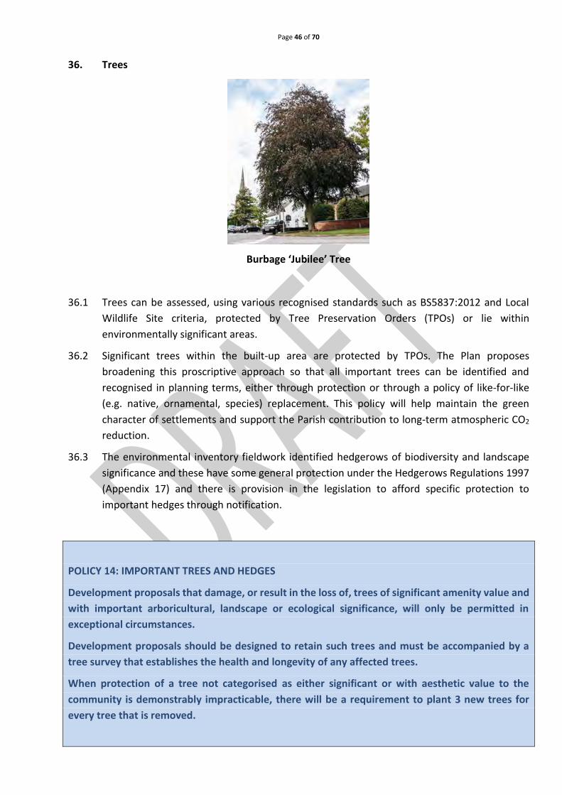
26. Heritage assets 27
27. Environment 31
28. Protecting Burbage’s significant sites 35
29. Other important green spaces 36
30. Ridge and furrow 38
31. Biodiversity 39
32. Burbage in its historic and cultural landscape 42
33. Protected open countryside 43
34. Public open spaces 43
35. Footpaths and cycleways 43

Page 3 of 70
36. Trees 46
37. Allotments 47
38. Community and leisure facilities 48
39. Formal parks 49
40. Burbage Common – natural and semi-natural open space 53
41. Amenity green space 55
42. Community facilities
(a) Schools 58
(b) Health care 59
(c) Other community facilities 60
43. Business and economic growth 63
44. Transport and access 66
This space has deliberately been left blank

Page 4 of 70
Introduction from the Chair of Burbage Neighbourhood Plan Group and the Chair of
Burbage Parish Council
Stanley Rooney Richard Flemming
1. Introduction
1.1 Burbage is a large Parish bordering the town of Hinckley and considered to be a desirable place to live and work.
1.2 It has seen considerable growth over recent years, increasing pressure on roads, parks,
schools, community and healthcare facilities. 1.3 This is our Neighbourhood Plan (the Plan) for the next 10 years. It has been driven by the
Burbage Neighbourhood Plan Group (BNPG), reporting to the Parish Council. The Plan reflects community aspirations to make Burbage a better place to live and work. It will be monitored and updated when required, during the period to 2026.
1.4 We would like to thank everyone who responded to our questionnaire, public consultations
and those who involved themselves in the preparation of the Plan. The NPAC could not have created the Plan without your input.
1.5 We have consulted residents through Theme Groups, workshops, open events and surveys, to engender a positive attitude towards future change, and emphasise the importance of retaining our heritage, culture, identity and sense of place.
1.6 We are particularly grateful to the Theme Group Chairs who led specific topics in the Plan.
They are:
Page 5 of 70
Chris Nichols & Philip Crowfoot - housing and the built environment John Hayes – Environment Julie Harding and Debbie Shaw - Community and Leisure Facilities Richard Flemming - Business and Economic Growth Noel Robinson - Transport and Access.
1.7 Also recognition and a special thank you to volunteer photographer Sarah Wyatt-Sherwin. 1.8 Residents and interested parties, are invited to read the Draft Plan and make comments.
There will be a six-week period in which to do this from 9th October 2017 until 20th November 2017.
1.9 Should you wish to comment please complete the on-line Pre-submission Consultation
Comments Form and return to [email protected] or in writing to: Richard Flemming, Burbage Neighbourhood Plan Group, c/o Burbage Parish Council, Millennium Hall, Britannia Road, Burbage, Leicestershire, LE10 2HF.
1.10 Completed forms can also be handed in at the Parish Office, Mon to Fri 9am – 12 pm. marking
the envelope “Neighbourhood Plan”. 1.11 We would like to thank Officers from Hinckley and Bosworth Borough Council (HBBC) for their
support with this work and the grant funding received from Locality (UK), without which the preparation of the Plan would not have been possible.
Richard Flemming Stanley Rooney Cllr Mr. Richard Flemming, Chair, Burbage Neighbourhood Plan Group
Cllr Mr. Stanley Rooney, Chair, Burbage Parish Council
This space has been deliberately left blank

Page 6 of 70
2. Historic Burbage
Old view along Church Street
2.1 The Plan covers the Parish of Burbage, a large area of approximately 1225ha, comprising the
historical settlements of Burbage and Sketchley, including associated open fields and woods.
2.2 Burbage is thought to have derived its name from Burr, a unique species of thistle and Bach,
a small tributary of a main stream which is one source of the River Soar, creating Burbach.
The thistle and blue streams are depicted on the Parish Council logo.
2.3 Sketchley was combined with Burbage in 1837 and both remained small and rural, well into
the nineteenth century. The census of 1801 showed that there were 1098 inhabitants
(Burbage Heritage Group) and it was not until the census of 1901 that the population of
Burbage exceeded 2000 persons. By 1953, the population had risen to 3,983, rising to 5000
inhabitants by 1958 due to the expansion of Sketchley Hill housing estate. The 2011 census
(Appendix 1) showed 14,568 inhabitants, with an estimated 17,000 by 2017, largely due to
the rapid housing developments within Burbage on both brown and greenfield sites.
2.4 Burbage and Sketchley have combined to become a sub-centre of Hinckley, only separated
by a narrow strip of partly open land and railway line.
2.5 Land to the East and South of the village has
remained largely un-developed. Consequently, the
area retains an attractive landscape quality, forming
an important vista towards the centre of The Village
Conservation Area, and the significant landmark of St
Catherine’s Church. There is strong local resistance to
any further destruction of the visual and ambient
relationship between Burbage and its historic
landscape, as it merges with the Green Wedges
designated by HBBC.
Burbage St Catherine’s Church in the distance

Page 7 of 70
3. What is a Neighbourhood Plan and why is it important?
3.1 A Plan is an opportunity for local people to create a framework for delivering a sustainable
future for the benefit of all who live, work and visit our area.
3.2 The right for communities to prepare Plans was established through the Localism Act 2011
and rules governing their preparation were published in 2012. The National Planning Policy
Framework (NPPF) (Appendix 2) sets the national planning strategy and has replaced over a
thousand pages of national policy with much simpler and clearer text. This document states,
a Plan gives the community “direct power to develop a shared vision for their Neighbourhood
and deliver the sustainable development they need” (NPPF, para. 183). It enables us to ensure
we get the right types of development in the right locations and sets planning policies to be
used in determining decisions on planning applications across the Parish.
3.3 A Plan, once given statutory force, becomes part of the Development Plan (DP) for the area
and this statutory status gives Plans more force and weight than other local documents such
as parish plans or village design statements.
3.4 A Plan must comply with European and National legislation and be in general conformity with
existing strategic planning policy.
3.5 Whilst every effort has been made to make the main body of the Plan easy to read and
understand, the wording of the actual policies is necessarily more formal, to comply with
statutory requirements.
3.6 Robust evidence is the foundation on which a Plan must be based, including community
engagement, consultations and evidence of the views, aspirations, wants and needs of local
people having been considered, with stakeholder comment and statistical information to
justify the policies contained within the Plan.
3.7 A detailed ‘Statement of Consultation’ and a comprehensive ‘Statement of Compliance with
the Basic Conditions’ will be produced to support the Plan and be part of the final submission
to HBBC.
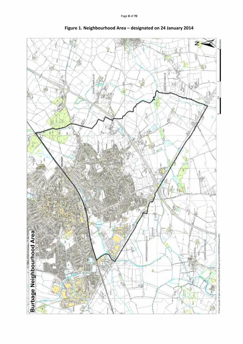
3.8 This is the Plan for Burbage. It covers the whole of the Parish as shown on the map of the
designated area (Figure 1 Page 8).
This space has been deliberately left blank
Page 8 of 70
Figure 1. Neighbourhood Area – designated on 24 January 2014

Page 9 of 70
4. Why do we need a Neighbourhood Plan for Burbage?
4.1 The Parish Council is very keen to influence planning matters within Burbage, on behalf of its
residents. It will take decisions locally that will serve the best interests of the community
and reflect residents’ wishes in the forthcoming years.
4.2 There is recognition that sustainable development is not only necessary but desirable,
because without it, our villages and economies will stagnate. We want to be able to
constructively influence the nature and place within our Plan area, as it evolves.
4.3 The impact of new residential development was highlighted as a major concern during the
Plan consultation process. However, we have been very clear from the outset, we are obliged
to work within the broad housing requirements specified by Hinckley & Bosworth Borough
Council (HBBC). Having a Plan gives us the opportunity to identify the best ways to deliver
development. By directing it towards the needs and requirements of the community, we can
protect our natural environment and community assets, to ensure a more sustainable future
for ourselves and future generations.
4.4 Other issues of importance to residents have emerged through the consultation process.
These include, protection of important environmental spaces, safeguarding buildings of
significant and architectural interest, addressing traffic and transport concerns, protecting
and shaping economic development and safeguarding important community facilities. All are
referenced and addressed within the Plan. Identification of infrastructure requirements
remains a priority, as the Plan consultation indicates, it is impacting on the quality of life.
4.5 The Plan has been prepared by members of the community in partnership with Burbage Parish
Council. With these goals in mind we have embraced the NPPF’s core principle of, “The
presumption in favour of sustainable development” and approached our task as “a creative
exercise in finding ways to enhance and improve the places in which people live their lives”
(NPPF page 3, paragraph 17).
This space has been deliberately left blank.
Page 10 of 70
5. How the Plan was prepared
5.1 This Plan was prepared for the Parish Council through the BHPG and supported by
professional neighbourhood planning consultants Yourlocale and Planning With People.
5.2 The Group’s mandate was to drive the Plan process, consult with the local community, gather
evidence to support emerging policies and deliver the Plan.
5.3 Statistical information was gathered about the Parish, from a range of sources, providing a
growing amount of evidence upon which to base emerging policies.
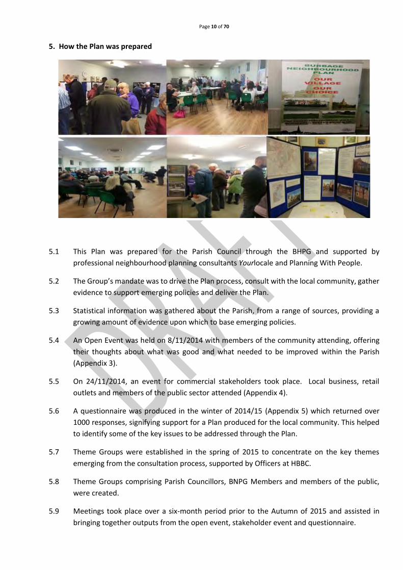
5.4 An Open Event was held on 8/11/2014 with members of the community attending, offering
their thoughts about what was good and what needed to be improved within the Parish
(Appendix 3).
5.5 On 24/11/2014, an event for commercial stakeholders took place. Local business, retail
outlets and members of the public sector attended (Appendix 4).
5.6 A questionnaire was produced in the winter of 2014/15 (Appendix 5) which returned over
1000 responses, signifying support for a Plan produced for the local community. This helped
to identify some of the key issues to be addressed through the Plan.
5.7 Theme Groups were established in the spring of 2015 to concentrate on the key themes
emerging from the consultation process, supported by Officers at HBBC.
5.8 Theme Groups comprising Parish Councillors, BNPG Members and members of the public,
were created.
5.9 Meetings took place over a six-month period prior to the Autumn of 2015 and assisted in
bringing together outputs from the open event, stakeholder event and questionnaire.

Page 11 of 70
5.10 A further public consultation event took place on 13/2/2016 (Appendix 6) when emerging
policies were shared with the community. Over 130 people attended, to view the proposals,
make comments and talk to those involved in its preparation.
5.11 Throughout the Plan’s development, liaison has taken place with Officers at HBBC, to ensure
that policies are in general conformity with the existing HBBC Core Strategy (Appendix 7), as
required by law.
5.12 The various consultation initiatives are separately documented in a ‘Statement of Community
Consultation’ to be appended to the Submission version of this Plan.
5.13 The draft Plan will now be put forward to the public and to statutory bodies for a six-week
consultation period. Agreed amendments will be incorporated into the draft Plan prior to
being submitted to HBBC.
5.14 HBBC will then check the legal processes have been undertaken appropriately. This will be
publicised for a further six weeks and the draft plan forwarded, with accompanying
documents and all representations made during the publicity period, to an Independent
Examiner. The Examiner will review it and check it meets the ‘Basic Conditions’.
5.15 If the Plan passes this stage, with any necessary modifications, it will be put forward for
Referendum.
5.16 The Referendum question will be a straight “yes” or “no” on the entire Plan, as set out by
Neighbourhood Planning Regulations. A vote of 50% or more will enable it to become part of
the local authority’s planning policy.
5.17 It is important to note, not having a Plan does not mean development will not happen.
Development will still take place, but decisions will be based on Borough policies rather than
locally formulated criteria.
This space has been deliberately left blank

Page 12 of 70
6. What should the Neighbourhood Plan achieve?
6.1 This Neighbourhood Plan provides locally focused policies and actions to address issues
identified as important to the local community, especially where it perceived that these
policies are not adequately addressed through current planning policies.
6.2 When using the Plan, the local planning authority will form a view of the development
proposal, or policy issue, the whole Plan, and the policies contained within it, must be
considered.
6.3 When the Plan is adopted (“Made”), every planning decision taken by HBBC will refer to it.
6.4 The Plan also takes into consideration national planning guidelines.
This space has been deliberately left blank

Page 13 of 70
7. Vision for Burbage
7.1 The BNPG agreed a vision for Burbage based on input received from the community as
follows:
The Plan and the Vision for Burbage
Now classed as an urban centre, the village of Burbage in Leicestershire still retains a strong rural
atmosphere and retains its village identity to its community.
The Plan aims to protect, create and enhance our open spaces and the historic elements of the
village by encouraging sympathetic and sustainable designs in any future housing developments.
The Plan also aims to improve and develop the physical environment, developing an inclusive
community and enhancing work and leisure opportunities.
7.2 The Plan includes several elements to help achieve this vision:
o Protection of important community assets including schools and health care facilities.
o Incorporation of housing design guidelines into the Plan.
o Listing those buildings and structures seen as being of local importance.
o Protecting businesses and supporting business expansion in appropriate locations.
o Designation of Local Green Spaces which identify and protect those special important
areas from development.
7.3 The Plan is a live document which will be reviewed and change over time in response to new
and changing needs and priorities.
8. Meeting the requirement of the NPPF for sustainable development
8.1 The NPPF states there are three dimensions to sustainable development: social,
environmental and economic. The Plan seeks to contribute to achieving sustainable
development by:
8.2 Social
• To support existing community, school and healthcare facilities within Burbage.
• Delivering a mix of housing types to meet the community’s needs.
• Maintaining parks and amenity spaces within Burbage.

Page 14 of 70
8.3 Environmental
• Housing development is of the right type in the right location and positively reflects the
existing historic character of the Parish.
• Protect important open spaces within the Parish of Burbage from development.
• Protect and improve biodiversity and important habitats within Burbage.
• Developing better pedestrian and cycling facilities within Burbage.
8.4 Economy
• Protecting existing employment sites within Burbage.
• Supporting small scale business development and expansion within Burbage.
• Encouraging start-up businesses and home working.
• Enhancing the retail choice within Burbage.
• Ensuring transport and parking issues improve accessibility.
9. Neighbourhood plan policies: a presumption in favour of sustainable development 9.1 The purpose of the UK Planning System as set out in the NPPF is to achieve sustainable
development.
9.2 This is defined in the NPPF as ensuring that providing for the needs of the current generation
does not make life worse for future generations.
9.3 This Plan is a key part of securing sustainable development. The NPPF states that all plans
should be based on and reflect the presumption of sustainable development and
neighbourhoods should plan positively to support local development. Burbage has already
exceeded its minimum housing target and the Plan does not allocate any further development
sites. It supports windfall housing development and business growth in appropriate locations
that do not impact on residential amenity. The Plan outlines how new housing should be
designed and supports improvement to infrastructure needed to meet the requirements of
new development.
9.4 The Parish Council will take a positive approach when considering proposals that contribute
to sustainable development. This includes working with the Borough Council, County Council,
local community, developers and other stakeholders, to encourage the formulation of
development proposals that clearly demonstrate sustainable development has been
considered and addressed.
9.5 This Plan is not intended to replace the policies contained in HBBC’s Core Strategy and the
NPPF, but has additional Burbage specific policies helping to achieve the Community’s vision.
Page 15 of 70
10. Settlement boundaries
10.1 The purpose of a Settlement boundary is to ensure sufficient housing and economic activity
is available in appropriate locations to avoid overloading transport infrastructure and
impinging on local countryside.
10.2 The Plan proposes to designate a Settlement Boundary in line with the settlement boundary
as identified by HBBC (see Fig 2 page 16). This is correct as of October 2016 and includes a site
with outline planning approval for up to 80 dwellings. This will update and supersede the
Settlement boundary previously defined by HBBC.
10.3 Within the defined Settlement boundary an appropriate amount of suitably designed and
located development will be acceptable in principle. However, some areas within the
Settlement boundary are protected from development activity.
10.4 Focusing development within the agreed Settlement boundary will help support existing
services and facilities. It will also help protect the countryside and the remainder of the Plan
area from inappropriate development.
POLICY 1: SETTLEMENT BOUNDARY
Development proposals within the Settlement Boundary, as identified in Figure 2, page 16, will be
supported provided it complies with any policy outlined in this Plan.
In the open countryside, outside the Settlement Boundary, any new development will only be
permitted in exceptional circumstances, including the re-use or extension of an existing building
for sport or recreation, where the proposed scheme cannot be provided within the Settlement
boundary.
This space has been deliberately left blank

Page 16 of 70
Figure 2 – Limits to development Map to be A3 size folded
Please see A3 size map for more detail
11. Housing and the built environment
Archer Cottage
11.1 Burbage is a desirable place to live, enhanced by its geographical location adjacent to the motorway network.
11.2 It has experienced rapid housing growth in recent decades. Based on Census data, the number of dwellings in the Parish grew from 6059 in 2001 to 6393 in 2011, a 5.5% increase.

Page 17 of 70
12. Housing demand
12.1 Impact from the high rate of housing growth was highlighted as a major concern by residents
during the public consultation undertaken in the preparation of the Plan. Various questions
were asked about the type of housing required and where this should go and many residents
just replied, “No more”.
12.2 Evidence from the response to the consultation showed that residents were opposed to
further house building and were concerned about the scale of new housing development
already taken place and could take place in the future. In particular, there is concern that the
current rate of development is not sustainable without significant infrastructure
enhancements. It is placing significant pressure on already stretched facilities such as health,
education, access to countryside and open spaces and perhaps most notably, the road
network. In addition, it is adding to the already high levels of commuting away from the Parish
for jobs and services. There is also concern that the scale and pace of development is having
an adverse impact on the character of the Parish.
12.3 The Core Strategy (2009) set out that the Council would allocate land for a total of 295
dwellings in Burbage over the Plan period (2006-2026). As of the 1st April 2016 there were
496 net completions in Burbage between 2006 and April 2016 (total additional dwellings
minus demolitions) and a further 238 existing dwellings with planning permission yet to be
built. In addition, there are 51 dwellings which are allocated in the Site Allocations DPD but
whose owners have not yet submitted planning applications.
12.4 On this basis, the Neighbourhood Plan does not allocate any further sites for housing
development (HBBC Site Allocations and Development Management Policies DPD-adopted
July 2016) (Appendix 8) unless there is an increase in housing demand across the borough, at
which point the Plan will be reviewed.
13. Windfall sites
13.1 Not all future housing land is allocated in forward planning documents such as Local Plans and
Neighbourhood Plans. 'Windfall' sites will come forward on an ad hoc basis.
13.2 They have not been specifically identified for new housing in a planning document. These sites
often comprise redundant/under-utilised buildings, or a restricted gap in the continuity of
existing frontage of buildings and are sites of three or fewer dwellings.
13.3 Inevitably, these sites cannot be identified, but it is reasonable to expect they will continue to
provide a reliable source of housing supply. They need to be sensitively undertaken and
designed to enhance the character of the area.
13.4 The NPPF (paragraph 53) states “Local planning authorities should consider the case for
setting out policies to resist inappropriate development of residential gardens, for example
where development would cause harm to the local area”.

Page 18 of 70
13.5 This Plan supports this policy position. Residential development of back gardens will only be
permitted where it is not detrimental to the character of the local area.
13.6 Proposals for ‘Windfall’ sites, not allocated in this plan, will only be supported if they are on
brownfield land which has limited environmental or ecological value.
POLICY 2: WINDFALL SITES
Residential development proposals will be supported, subject to those proposals being well
designed, meeting all relevant Neighbourhood Plan and Borough wide planning policies where
such a development:
a) Comprises a development within the continuity of existing frontage buildings, or on other
sites within the built-up area of Burbage, or where the site is closely surrounded by buildings.
b) Any development between two adjacent properties should be comparable in size and scale
to the plots of adjoining properties and should be of a size, scale and mass to accommodate
the number of units proposed.
c) Utilises brownfield land or demonstrates that such sites are not available. In this instance,
land with the least environmental or ecological value should be utilised.
d) Retains existing important natural boundaries such as trees, hedges and streams.
e) Does not causes an adverse impact on the character of the area, the amenity of neighbours,
existing and future occupiers, or has a significant detrimental heritage or environmental
impact.
This space has been deliberately left blank

Page 19 of 70
14. New housing mix
14.1 When asked through the Community Questionnaire, “What type of housing was needed in
Burbage?”, the majority expressed a preference for more small or medium sized housing,
rather than large houses.
14.2 The results were as follows:
Table 1 - Questionnaire table on housing mix
14.3 Census data from 2011 (see Table 2 over) confirms an under-provision of 2 and 3 bedroomed
homes within Burbage and an over provision of larger homes (4+ bedrooms) when compared
to Hinckley and Bosworth.
This space has been deliberately left blank

Page 20 of 70
Table 2 - Housing – bedrooms per household
Burbage Parish Hinckley and Bosworth
1 bedroom 8% 1 bedroom 6%
2 bedrooms 23% 2 bedrooms 27%
3 bedrooms 43% 3 bedrooms 45%
4 bedrooms 21% 4 bedrooms 17%
5 or more bedrooms 5% 5 or more bedrooms 4%
14.4 The population of Burbage is ageing; both in real terms and relative to the population of the
Borough. The 2011 Census data shows 10.53% of the population of Burbage was aged 75 and
over, compared to 8.3% in the Borough of Hinckley and Bosworth. In 2001 only 8.3% of
Burbage residents were aged 75 and over.
14.5 The aim of HBBC Core Strategy Policy 16 is to achieve a mix of housing types that reflect
current and future requirements. This Plan supports this aim in relation to Burbage’s housing
needs. A detailed report into housing mix within Burbage is provided as per Appendix 7.
Census data and Land Registry information is available as Appendix 8.
14.6 This Plan takes into consideration the Housing and Economic Development Needs Assessment
(HEDNA) (Appendix 9), which identifies the appropriate mix of housing, considering the
proposed demographic changes for the period 2011 – 2031 and then up to 2036.
POLICY 3: HOUSING MIX
Developments for dwellings of more than three bedrooms will only be supported to meet housing
needs of residents, for example to enable caring for dependent relative(s) or to cater for a large
family, in line with the latest assessment of housing needs within the Parish.
This space has been deliberately left blank

Page 21 of 70
15. Housing design
15.1 Burbage has a rich and generally attractively built environment. It is an important ingredient
in the distinctive character of the Parish and our consultations has shown that it is important
to local people.
15.2 The Plan expects all development to contribute to the attractive environment, through the
creation of well-designed buildings and spaces.
15.3 To promote best practice in the design of new residential developments, the Plan has
identified the following issues and design guides to support its aspirations. All development
should demonstrate, where appropriate, that they have considered the guidance set out
within the guidelines.
16. Burbage Village Design Statement 2006
16.1 In 2006 the Parish Council produced a Village Design Statement (VDS) (Appendix10). The aim,
was to guide new development to be sympathetic with the existing village and enhance its
special identity and character (Appendix 5).
16.2 The VDS was adopted by HBBC on 28 June 2006 as a supplementary planning document and
should be considered when determining planning applications. The relevant sections of the
VDS have been reviewed and incorporated into the commentary below. It is recognised, by
incorporating the relevant sections of the VDS into the Plan, it gives added importance and
‘weight’ in planning terms.
17. Landscape impact
17.1 Prior to any residential development taking place, consideration will be given to the impact
and influence of the landscape starting from the initial planning stages.
17.2 It will include the retention of valuable natural features and the creation of new additions
within housing developments.

Page 22 of 70
17.3 Developments, creating or enhancing a network of natural features or access to countryside
will be welcomed. Applications for large developments on the edge of the village must be
supported by a Landscape & Visual Impact Assessment that must clearly set out the
consequences of the development on the landscape and put forward proposals for mitigation
and enhancement.
18. Rain and flood water management
18.1 Climate change and increased development in vulnerable areas may lead to an increase risk
of flooding.
18.2 New developments will utilise the implementation of sustainable drainage systems to reduce
the incidence of flooding, improve quantity of ground water in the natural environment and
improve bio-diversity.
18.3 The plan will support developments that recognise sustainable drainage systems and their
potential to be incorporated into good overall design.
19. Trees in the built environment
19.1 Trees are important visually and form part of the landscape character of the village. They add
a sense of place, as well as being important for mental well-
being. They are also an important element in maintaining bio-
diversity, absorbing CO2 and combating climate change, as well
as reducing the risk of flash flooding. Developments will
recognise the importance of trees within the urban landscape,
seek to protect existing trees, plant new native and parkland
type trees, providing future ‘statement trees’ reflecting the
character of existing specimens in the village. In general, trees
should only be removed to facilitate development where they
are dead, diseased, of limited life expectancy, or are of low
amenity or arboricultural value.
20. New open space
20.1 Open spaces encourage community cohesion and are more likely to make new developments
more socially sustainable. New developments providing new community space or enhance
facilities elsewhere will be supported.
20.2 Open spaces must be accessible, safe and well connected to the local environment, support
local bio-diversity, provide economic maintenance and be well defined and designed in
consultation with local groups.

Page 23 of 70
21. Development layout and scale
21.1 The siting of new buildings should be examined from all directions.
21.2 Developers should follow HBBC's guidance on providing a design statement with planning
applications and ensure statements show how new developments, extensions and
conversions, would appear in relation to their overall surroundings and adjacent properties.
21.3 New buildings should respect established building lines.
21.4 Separation distances between buildings should also respect the separation distances which
characterise the immediate locality.
21.5 Native hedging plants, shrubs and trees should feature as boundaries to new houses and
hedge boundaries maintained around existing homes.
21.6 Panelled and closed boarded timber fences should be avoided wherever possible on street
frontages.
22. Housing layout and styles
22.1 Houses should be matched in terms of design and scale with neighbouring properties, but are
not required to copy or pastiche existing design styles in an area. Innovative and
contemporary designs, that respect their context, are encouraged. References to existing
architectural forms, fenestration, proportion of solid and void areas and external materials
will also be encouraged.
22.2 Off-the-shelf suburban housing designs, which are typically repeated throughout the country,
with no acknowledgement of local character and distinctiveness, will be resisted.
22.3 Extensions, conversions and alterations will use materials, design and scale compatible with
original buildings.
22.4 Encouragement of energy-saving features will be sensitively incorporated and designed into
new developments.
22.5 Garages should be of a scale compatible with the residences they serve and not visually
obtrusive. Their width will be sufficient to accommodate cars, ensuring access and egress
from within the garage. Detached garages will have pitched rather than flat roofs.
Page 24 of 70
23. Street Furniture
View at Burbage Millennium Tree and Archer Cottage
23.1 Wherever possible, an improvement in the quality and reduction in the quantity of street
furniture, e.g. telecommunication boxes, will be encouraged throughout the village.
23.2 The use of appropriate (vandal-resistant) materials and colours would help to blend these
items into the village environment.
23.3 Where telegraph poles and electricity pylons are not a feature of an area, developers should
arrange to have cables laid underground.
23.4 Furniture should only be placed on a footpath if it leaves a 2m space for pedestrians. If not, a
more suitable site should be found.
23.5 Where street lighting is required, a 2m width for pedestrians is needed. It should not cause
unnecessary light pollution and be in keeping with its surroundings. For example, in the
Conservation Area, street lighting should be of a design that enhances the street scene.
Where security lighting is installed, it should be sensitively designed and sited.
23.6 To help meet the above statements, the Plan supports the objectives and principles of the
following documents and new developments will demonstrate compliance with them.
24. National Planning Policy Framework and Building for Life 12
24.1 The Plan expects housing developments to conform to the National Planning Policy
Framework (2012) in that any future housing development will be attractive, functional and
sustainable, having regard design codes such as Building for Life 12 (2016 edition) - the
industry standard for well-designed homes (see Appendix 11).

Page 25 of 70
POLICY 4: DESIGN AND LAYOUT
Any future residential development within the Parish of Burbage must respect its surroundings and
result in the provision of high quality homes as per the National Planning Policy Framework (2012),
having consideration for design policies such as Building for Life 12 (2016 edition), and how the
requirements of the Village Design Statement have been met.
25. Parking
25.1 Parking and vehicle movements are two key issues identified through public consultation
within the Parish area.
25.2 It is evident that road and street patterns within Burbage have developed over centuries and
are not ideal for modern traffic with a detrimental effect to pedestrian and vehicular safety,
and to the ease the way general traffic, emergency and service vehicles are able to travel.
POLICY 5: PARKING
At least two off-street car parking spaces shall be provided within the curtilage for each new
dwelling developed within the Parish unless it is unachievable, for example in an infill plot in a row
of terraces, where such a parking space would disrupt the frontage pattern of the terrace.
Page 26 of 70
Figure 3: Burbage Conservation Area
Page 27 of 70
26. Heritage assets
26.1 The historic character of the Parish is one of its most important assets and the community
wishes to see it protected and enhanced.
26.2 The historical development of Burbage centred upon the Manor House and St Catherine’s
Church with occasional farmsteads and large houses on outlying roads. For centuries Burbage
remained a small farming community until the hosiery trade was introduced into the area and
this developed from domestic industry to the rise of the factory production by the end of the
19th century. Family run horticultural businesses were also established throughout the late
18th and 19th centuries which shaped the landscape west of the village centre towards
Sketchley. Commercial premises, family homes and housing for workers were constructed as
both the hosiery industry and horticultural industries thrived throughout these periods and
development gradually expanded beyond the historical core. Ribbon development in the
inter-war period lead to the construction of some grand dwellings set within large plots
surrounded by mature trees. Some fine old spaces within Old Sketchley Village remain despite
it being largely subsumed as a suburb of Burbage. Ashby Canal was constructed in the late
18th century to transport raw materials and goods from North West Leicestershire to a
junction with the Coventry Canal near Bedworth, and a small section of the canal travels along
the western boundary of the Parish.
26.3 Surviving buildings, structures and spaces related to the development of Burbage and
Sketchley provide a high quality and distinctive historic environment that is rich in character
and reinforces a sense of place. There are a number of existing designated heritage assets and
propose local heritage assets located within the Parish, identified in Figure 4 (Page 28).
26.4 In recognition of the special interests of the historic core of Burbage a conservation area was
designated in 1973. A conservation area covering Ashby Canal and significant surrounding
features was designated in 1990. The Plan recognises the importance of these Conservation
Areas and the statutory protection their designation brings. It supports proposals to preserve
and enhance the unique character of these areas.
26.5 In addition, there are 15 buildings and structures that have been granted ‘Listed Building’
status in recognition of their special historical or architectural interest. These are listed in
Table 3 (see Page 29). Their designation as a listed building gives them a statutory protection
beyond that of the Plan. However, it is important that they are highlighted to ensure that all
parties are aware of their significance to the Parish and the need to protect and enhance these
structures.
This space has been deliberately left blank

Page 28 of 70
Figure 4: Heritage assets – Listed Building

Page 29 of 70
Table 3– Listed buildings
129, Church Street Grade II
28 and 30, Church Street Grade II
66, Church Street Grade II
Archer Cottage, Church Street Grade II
Burbage Hall, Aston Lane Grade II
Cedar Lawns, No 78 Church Street Grade II
Church of St Catherine, Church Street Grade II
Former North Lodge to Burbage House, Lutterworth Road Grade II
Manor House, Church Street Grade II
Milepost at grid reference Sp 4540 9052, Lutterworth Road Grade II
Milestone at grid reference Sp 4412 9332, Hinckley Road Grade II
Former South Lodge to Burbage House, Lutterworth Road Grade II
The Constitutional Club, 64 Church Street Grade II
The Old Grange and Attached Stable Wing, Aston Lane Grade II*
Outwoods House, Elm Tree Drive Grade II
26.5 Beyond these designated heritage assets there are a wide range of other buildings and
structures considered to be locally important to Burbage’s heritage that also need to be
preserved and enhanced. These local heritage assets do not have statutory protection and
are referred to as ‘non-designated”, however the effect of a development proposal on the
significance of a local heritage asset should be taken into account.
26.6 The reasons why local heritage assets are significant is varied, often going beyond historical
or architectural interest, and demonstrating a range of values that contribute to the
distinctiveness and heritage of Burbage. The Borough Council has devised selection criteria to
identify assets of local interest and describe their significance which has formed the basis for
selecting local heritage assets in Burbage and Sketchley (see table 4) and described in
Appendix 12. These assets will be included within the adopted Local Heritage List currently
being developed by the Borough Council.
26.7 Other local heritage assets may come forward throughout the life time of this Plan.

Page 30 of 70
Table 4: Local heritage assets
Cheadle House, 49 Britannia Road
Intramark Building, Windsor Street
Framework Knitter Cottages, 25 & 27 Coventry Road
Grove House, Grove Road
Middle Orchard, Grove Road
4 & 6 Love Lane
The Chequers Inn, 30 Lutterworth Road
The Lodge, 46 Lutterworth Road
Bay Tree Cottage, 47 Lutterworth Road
Swallow Cottage, 53 Lutterworth Road
Austrey House, 65 Lutterworth Road
The Hollies, Lutterworth Road
Sketchley Manor Hall, Manor Road
Old Sketchley Garage, Rugby Road
Manor Farmhouse, Manor Cottage, Hall Lodge, Little Wheel Sketchley Old Village
Paddock View and Sketchley Hall Cottages, Sketchley Old Village
The Birches, 1 & 3 Sketchley Road
Sketchley House (Fern Lea House and Chapel House), Watling Street (Chapel Lane)
Stretton House, Watling Street
34 Windsor Street Restaurant, 34 Windsor Street
The Red Lion, Windsor Street
The Sycamores, 60 Windsor Street
POLICY 6: LOCAL HERITAGE ASSETS
The effect of a proposal on the significance of local heritage assets will be taken into account when
determining an application in order to minimise the conflict between the heritage assets’
conservation and any aspect of the proposal. Development proposals that conserve or enhance a
local heritage asset will be supported.
This space has been deliberately left blank
Page 31 of 70
27. Environment
27.1 The Core Strategy recognises the locally attractive environment as one of its key strengths. It
stresses the need to safeguard locally important sites such as those of geological, cultural or
landscape significance.
27.2 The identification, preservation, enhancement and creation of environmentally rich areas is
significant in developing the wellbeing of the community and provides a valuable asset for
education.
27.3 The natural environment provides a landscape for all members of the community to
understand the past, present and future of the area in which they live, work and play.
27.4 A shared positive understanding and experience of the local environment supports the
development of a healthy and united community across the generations.
27.5 The rapid 20th Century urbanisation of the Parish, together with intensification of farming, has
impoverished the Burbage environment – natural, historical and cultural – leaving only small
pockets of ecologically significant land and a few ‘fossils’ of its rich history.
27.6 The Plan area, outside the built-up area, was surveyed in 2013-14 by HBBC and again for the
Plan in 2015. The combined results form a comprehensive, site-by-site, ecological and
historical inventory (fieldwork and desk study).
27.7 Although much of Burbage is of modest environmental value, the Inventory work undertaken
identified 41 sites of potential environmental significance for the natural, historic
environment, or both.
27.8 See Figure 5: Burbage Environmental Inventory 2015 (Page 32) and Figure 6: Burbage
Environmental Sites Inventory (Page 33).
Larger versions of the maps are available as Appendix 13.
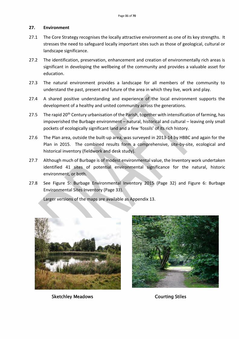
Sketchley Meadows Courting Stiles

Page 32 of 70
Figure 5 – Environmental Inventory
Page 33 of 70
Figure 6 - Environmental Sites Inventory

Page 34 of 70
27.9 These sites have been scored using the criteria for Local Green Space Designation in the
NPPF – which includes environmental importance but weighted towards community value –
to produce a shortlist of seven sites of highest environmental and community significance.
27.10 The Plan proposes designation of these sites for protection as Local Green Spaces.
27.11 Ridge and Furrow pattern of the medieval plough land are principal existing remnants of an
historic landscape surviving as earthworks today.
27.12 The 2015 survey confirmed that there are now 13 relatively well-preserved examples of this
feature that once covered most of the open land in the Parish. There is a recognised need to
preserve as much of this nationally rare and declining feature of the English landscape.
27.13 On sustainability, the Plan includes policies for extending good practice more widely in new
developments and future-proofing management of surface water run-off.
27.14 There is an element of urgency in resident’s aspirations for what survives of their community’s
relationship with the environment. Despite the combining of Burbage and Sketchley with
Hinckley, there are still pockets of biodiversity, and access on foot into the countryside
remains possible. This is valued by local people and deemed irreplaceable if lost
(Questionnaire responses).
27.15 This combination is highly valued by local people and deemed irreplaceable if lost.
27.16 Burbage Village and the surrounding countryside
is fortunate in having a small collection of open green
spaces, green corridors, 'nature corridors' for a diverse
collection of native species, footpaths and cycle paths.
Due to rapid residential development, the relatively
few surviving areas of environmental value have a
disproportionate importance for local biodiversity,
culture and recreational amenity and should be
protected.
View along the Courting Stiles
This space has been deliberately left blank
Page 35 of 70
27.17 Burbage Common and Woods is a prime example of an area of highly valued large green open
space, which includes areas of environmental biodiversity and protected Local Wildlife Sites.
27.18 The Plan includes a set of local policies to harmonise the residential development the village
has already seen, with the provision and creation of environmental assets which will best
serve and enhance the wellbeing and cohesion of the community and provide villagers with a
vision and space to breathe.
28. Protection of Burbage’s key environmentally significant sites
28.1 Conserving and enhancing the natural and historic environment of Burbage is important and
underpins health, wellbeing, sustainability and distinctive character of the community.
28.2 The NPPF enables a Local Plan or Neighbourhood Plan to identify, for protection, green areas
of local importance where they meet specified criteria as defined in NPPF (77) (2012).
28.3 An environmental inventory of all significant sites and features in the Parish was carried out
using fieldwork and desk study. The 41 sites so identified were scored using the NPPF criteria
for selecting Local Green Spaces. Using the criteria, seven key sites were identified as being
of outstanding significance, both for their Natural and Historical Environment features, and
as important, highly-valued community assets.
POLICY 7: PROTECTION OF LOCAL GREEN SPACES
Development proposals resulting in damage to identified Local Green Spaces will not be supported

Page 36 of 70
29. Other important green spaces
Sketchley Meadows
29.1 In addition to the proposed Local Green Space, the Plan also identifies a further 34 sites of
historic, ecological and nature conservation interest.
29.2 Although not ranking as highly, these sites have been identified via Burbage phase 1 habitat
survey, Leicestershire & Rutland Historic Environment Records (L&RERC) 2013-14) (Appendix
14) as candidates for listing as Local Wildlife Sites – whose role is to protect threatened species
and habitats by acting as buffers, stepping stones and corridors between nationally-
designated wildlife sites; or as sites of local historical and cultural significance.
POLICY 8: PROTECTION OF OTHER IMPORTANT GREEN SPACES
Other sites (see list in supporting information and Environmental Proposals (Figure 7, Page 37) have
been identified as being of local significance for history, archaeology or biodiversity, as having
extant features with visible expression, and as being special to the community. Development
proposals that affect these ‘other important green spaces’ should seek to protect or enhance their
features.

Page 37 of 70
Figure 7 – Environmental Proposals

Page 38 of 70
30. Ridge and furrow
30.1 Like most rural settlements in midland England (and widely across lowland northwest Europe)
Burbage was until the 18th century, nearly surrounded by ridge and furrow plough lands.
30.2 Reflecting the national picture regarding the loss from many English parishes of between 95-
100% of ridge and furrow fields (mostly since 1940), Burbage has seen a dramatic decline of
its own local ridge and furrow fields. Now only thirteen of the circa 140 fields (<10%) within
the Parish retain well-preserved traces of ridge and furrow. These surviving fields occupy an
area of approximately 23 hectares, which is 3% of the open land within Burbage.
30.3 In English legislation, except for a few that are classed as Scheduled Monuments, ridge and
furrow fields are not protected, despite recognition that “…as the open field system was once
commonplace in NW Europe, these [surviving] sites take on an international importance”
(English Heritage 2012) (see Appendix 15).
30.4 While it is not being suggested that individual fields within Burbage are of international or
national importance, they are an important part of the distinctive character of the Parish and
provides a link to its historic past.
30.5 This Plan seeks to protect the remaining ridge and furrow fields from development and
highlights their importance to the community, especially bearing in mind that many threats
to ridge and furrow fields often involve developments and practices that do not require
planning permission.
POLICY 9: RIDGE AND FURROW FIELDS
Development proposals that are damaging to an identified surviving area of ridge and furrow
earthworks will be resisted.
Page 39 of 70
31. Biodiversity
31.1 Over 40% of the Parish has developed due to its close proximity to Hinckley and 19th and 20th
century industrial and housing development.
31.2 The remaining area of ‘open country’ is predominantly improved grassland and arable,
providing a valuable green lung for the community. It has relatively few sites of biodiversity
value and the importance of gardens in maintaining biodiversity is recognised.
31.3 Those sites that do survive are therefore proportionately of high significance in the local
ecological context and help to define Burbage’s character. Through consultation it is evident
that the protection of the natural environment and the enhancement of biodiversity is very
important to the community.
31.4 The establishment of a wildlife green corridor is proposed. As the images below illustrate, the
area of land to the West and North of Burbage, comprising the old fields around Sketchley,
the landscaped Sketchley Brook and the Courting Stiles alongside the railway, provide
opportunities for a walk amongst countryside, man-made landscape and woodland,
ultimately joining with Burbage Common and
Woods. The courting stiles were created around
thirty years ago, and now form a mature woodland
walk. The flood basin behind Brookside sometimes
fills with water and provides a significant wildlife
habitat. This corridor has potential for further
enhancement as an amenity area.
Sketchley Brook
Sketchley grassland and Meadow area The Courting Stiles
Page 40 of 70
Figure 8 – Proposed Green Corridor

Page 41 of 70
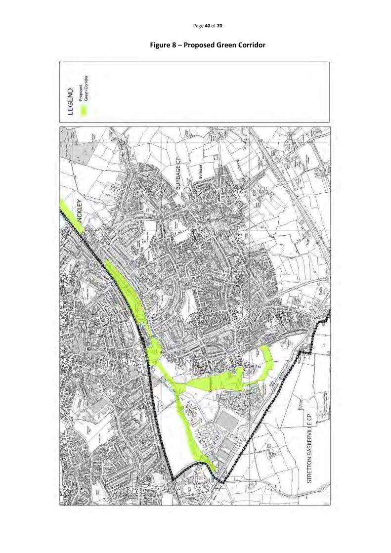
POLICY 10: BIODIVERSITY
Development proposals that result in the loss of, or have a significant adverse effect on, a site with
protected species or habitats of national biodiversity value will be resisted.
The Plan will protect from development:
a) A designated riparian wildlife corridor along the immediate valley of the Soar Brook, as shown
on the proposals map (Figure 7, Page 37).
b) A designated green corridor comprising undeveloped land and views south of the railway line,
from the Ashby Canal (Plan Area boundary) to Wood House Farm, as shown on the proposed
green corridor (Figure 8, Page 40).
c) Areas known for surface manifestation of aquifers (springs, which may also have other
ecological or historical significance), plus all scales of surface watercourses including
floodplains, flood Meadows, swamp land, ponds and lakes, associated landforms and features.
Community Action 1: Biodiversity
The NPDC will prepare and keep updated an environmental inventory list of known sites of
biodiversity interest:
a) The NPDC will actively encourage the biodiversity of the identified wildlife corridor.
b) The NPDC will actively encourage the biodiversity of (and access to) the identified green
corridor.
c) The NPDC will promote the importance of residential gardens in supporting biodiversity to
residents. An example of such a scheme can be found at
http://www.avonwildlifetrust.org.uk/mywildcity
This space has been deliberately left blank

Page 42 of 70
32. Burbage in its historic and cultural landscape
View of Burbage From Ashton Flamville
32.1 As noted previously, there is a desire within the Parish (Household Survey results) to protect
the geographic and cultural relationship between historic Burbage and its landscape setting.
The village hilltop situation is above the open country of the River Soar. The Eastern aspect of
Burbage is the one remaining direction where there are splendid views to and from the village
and towards Aston Flamville and M69 J2 (see above photograph).
POLICY 11: LANDSCAPE CHARACTER
The vista (see Figure 7, Page 37) to the east of Burbage, originating at the historic centre, will be
protected. Development that harms this important view or vista will be resisted.
Community Action 2: Burbage in its historic and cultural landscape
The NPDC will endeavour to collaborate with existing groups, such as the Landscape and Wildlife
Designation Working Party, a Working Party of the Parish Council, to identify and progress
initiatives to further protect Burbage’s landscape.
Page 43 of 70
33. Protecting Open Countryside
33.1 The area of fields, hedgerows, copses and old lanes immediately to the south of the 20th
century and modern housing developments, between Rugby Road and Lychgate Lane, is
highly valued by residents.
33.2 It provides open country, accessible on foot from homes, and assists in preserving the rural
setting of the settlement. The area is of environmental (biodiversity and historical)
significance, with parcels of land being potential classified as Local Wildlife Sites.
POLICY 12: PROTECTION OF DESIGNATED OPEN COUNTRYSIDE
AN AREA OF OPEN COUNTRYSIDE (see Figure 7, Page 37) will be designated in the area bounded by
the Settlement Boundary, namely Rugby Road, the M69 and Lychgate Lane. Development will only
be allowed within this area in exceptional circumstances for outdoor recreation so long as it
preserves the open countryside.
34. Public open space
34.1 The area of open land between Sketchley Old Village and Sketchley Lane Industrial Estate is
known as Old Sketchley Village paddock. It is important locally, an informal community asset
and visited regularly by the local Primary School as part of the outdoor curriculum (see
appendix 16). It contributes to the character of the surviving village ambience of the historic
centre of Sketchley.
35. Footways and Cycleways
35.1 Burbage has significant public rights of way and routes for walking and cycling. There has been
a recent increase in the network of cycleways, but they remain incomplete.
35.2 The footpath network, meanwhile, is a fragmented remainder of a pattern reflecting historic
use (old jitties, occupation lanes, etc.), instead of a community asset to enable residents to
connect with community assets such as shops, schools and work, or to access open
countryside for recreation and general health and wellbeing benefits.
35.3 Some segments of pavements in the village centre are too narrow for safe pedestrian access.
Similarly, poor and outdated road design and parking behaviours in the village centre
frequently restrict sections of walkway, inconveniencing disabled people.
35.4 The Plan supports further enhancements of the cycleway network and extension of the
footpath network, including the creation of a complete circular route around and with access
from the built-up area, taking into consideration the protected view of the historic
vista/prospect of Burbage centre (Figure 9, Page 45: Footpaths and Cycleways).

Page 44 of 70
View along Courting Stiles
POLICY 13: FOOTPATHS AND CYCLEWAYS
The protection and enhancement of Footpaths and Cycleways will be supported.
Community Action 3: Footpaths and Cycleways
The NPDC will actively seek to work with interested parties, authorities and landowners to achieve
enhancements and extensions to the present network of footpaths and cycleways, especially the
proposed routes (Figure 9, Page 45 - Footpaths and Cycleways) and to extend the network into the
countryside.
The NPDC will also consider the opportunities available to best promote footpaths and cycle ways,
for example:
a) Providing access to information on all paths within the village, detailing responsibility and links
to relevant information and fault reporting pages.
b) Running a public information scheme in its literature.
c) Promoting walking and cycling for its environmental and health benefits.

Page 45 of 70
Figure 9 – Footpaths and Cycleways
Page 46 of 70
36. Trees
Burbage ‘Jubilee’ Tree
36.1 Trees can be assessed, using various recognised standards such as BS5837:2012 and Local
Wildlife Site criteria, protected by Tree Preservation Orders (TPOs) or lie within
environmentally significant areas.
36.2 Significant trees within the built-up area are protected by TPOs. The Plan proposes
broadening this proscriptive approach so that all important trees can be identified and
recognised in planning terms, either through protection or through a policy of like-for-like
(e.g. native, ornamental, species) replacement. This policy will help maintain the green
character of settlements and support the Parish contribution to long-term atmospheric CO2
reduction.
36.3 The environmental inventory fieldwork identified hedgerows of biodiversity and landscape
significance and these have some general protection under the Hedgerows Regulations 1997
(Appendix 17) and there is provision in the legislation to afford specific protection to
important hedges through notification.
POLICY 14: IMPORTANT TREES AND HEDGES
Development proposals that damage, or result in the loss of, trees of significant amenity value and
with important arboricultural, landscape or ecological significance, will only be permitted in
exceptional circumstances.
Development proposals should be designed to retain such trees and must be accompanied by a
tree survey that establishes the health and longevity of any affected trees.
When protection of a tree not categorised as either significant or with aesthetic value to the
community is demonstrably impracticable, there will be a requirement to plant 3 new trees for
every tree that is removed.
Page 47 of 70
Community Action 4: Important Trees and Hedges
Through desk and fieldwork and TPO listings, the NPDC will aim to identify trees and species-rich
hedges (Figure 5, Page 32 - Environmental Inventory) of high historical and ecological importance
and submit them to the Local Planning Authority, either as potential candidates for Tree
Preservation Orders or to be considered as a material consideration for determining Planning
Applications.
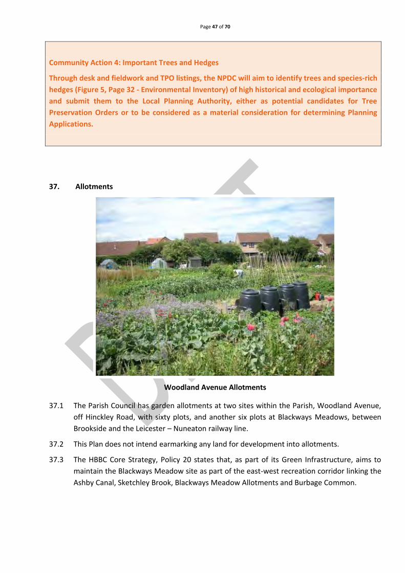
37. Allotments
Woodland Avenue Allotments
37.1 The Parish Council has garden allotments at two sites within the Parish, Woodland Avenue,
off Hinckley Road, with sixty plots, and another six plots at Blackways Meadows, between
Brookside and the Leicester – Nuneaton railway line.
37.2 This Plan does not intend earmarking any land for development into allotments.
37.3 The HBBC Core Strategy, Policy 20 states that, as part of its Green Infrastructure, aims to
maintain the Blackways Meadow site as part of the east-west recreation corridor linking the
Ashby Canal, Sketchley Brook, Blackways Meadow Allotments and Burbage Common.

Page 48 of 70
POLICY 15: ALLOTMENTS
Development which would result in the loss of allotment land, including land allocated for use as
an allotment in the Plan area, will not be permitted unless suitable land, of at least equivalent
quality and quantity, in a convenient location for the users, is provided fit for use prior to the loss
of the allotment land or any part of it.
Community and leisure facilities
38.1 Burbage hosts a number of activities that helps to provide a sense of community for residents,
including the annual Carnival, Firework display, Burbage Community Arts Festival (BCAF), a
monthly Farmers Market, Traders’ Christmas Shopping Evening and Burbage Gardening Club
Annual Show. These activities help to provide community cohesion and a sense of place for
the residents of the village.
38.2 A range of spaces are provided to meet community and leisure needs. Green spaces including
parks, sports fields, allotments and publicly accessible spaces, contribute towards the
character of the Parish providing areas of nature conservation, recreation, sporting and
community value. The community appreciate these spaces and the Plan seeks to ensure they
are protected.
38.3 Burbage has a secondary school, three primary schools, a special needs school and a range of
pre-school facilities. The growth of the village has led to some pressure on school provision,
particularly in primary education, and the Plan seeks to ensure the impact on educational
provision is assessed as part of new development proposals.
38.4 The health infrastructure supporting the local community is vital. The loss of any facilities
would have a detrimental effect on the health and wellbeing of local people.
This space has been deliberately left blank

Page 49 of 70
39. Formal parks
Brookside Park Hinckley Road Park
39.1 Formal parks usually contain a variety of facilities and may have one or more of the other
types of open space within them. Their primary purpose is informal recreation for the community (Ref: HBBC Open Space, Sport & Recreational Facilities Study 4: Formal Parks and Gardens, 4.30 – see Appendix 18).
39.2 Parks provide a sense of place for the local community and assist in addressing social inclusion
issues within a wider society.
39.3 The Hinckley and Bosworth Core Strategy spatial objective for a strong and vibrant
community, seeks to ensure the community has access to Parks and Open Spaces. It aims to
enhance and improve the sustainability, vibrancy and vitality of these areas, a priority for this
Plan. Policy 6 of HBBC Core Strategy references the need to retain open spaces within the
green wedge in Burbage.
39.4 The Leicestershire and Rutland Strategy for Physical Activity suggests that links between open
spaces and the built environment should be promoted and developed to encourage more
people to be active.
39.5 Current and expected travel patterns indicate residents expect to walk to access formal parks.
These results have set a standard of a 600m walk (circa 12 minutes’ walk time) (Ref. HBBC
Open Space, Sport & Recreational Facilities Study - 4. Formal Parks and Gardens 4.30 and 4.35
– see Appendix 18)
39.6 In line with the Core Strategy, HBBC has set a ‘local quality standard’ and targets set to obtain
Green Flag or Green Pennant awards. It encourages improvement and seeks to ensure the
continued standard of parks is maintained. It is indicated, parks achieving lower quality
scores, particularly those serving large populations, should be prioritised for action.
39.7 Despite the overall level of provision of parks in urban areas, application of the local quality
standard, on a settlement by settlement level, indicates the provision in Burbage falls below
the recommended minimum standard. HBBC’s Open Space, Sport & Recreational Facilities
Page 50 of 70
Study - 4. Formal Parks and Gardens recognises this shortfall. It states, “The greatest projected
shortfall within the individual settlements is found in Burbage...demand for formal parks
within the Urban Areas should therefore be monitored and new facilities provided if demand
is sufficient”. The document identifies the shortfall as 1.09 hectares per 1,000 people.
39.8 Evidence from the community consultation (Appendix 5, Q14) found 84% of those residents
who responded used the parks and recreational facilities; 44% agreed they needed improved
facilities; and 62% thought parks needed more furniture, with benches and bins being their
highest priority.
39.9 Important to residents is the need to get a better range of play equipment in parks, pathways
around the parks and better landscaping and signage. Over 600 residents indicated they used
parks elsewhere because they fulfilled more in the way of Formal Park Facilities than anything
Burbage had to offer.
39.10 Currently, there are 5 Parks and 2 areas of leased land (Colts Close and Rugby Road Recreation
Ground) which are considered as parks in HBBC’s Local Plan.
Table 5: Parks
Park Name Location in Burbage
Britannia Road Situated to the South of Burbage
Hinckley Road Situated to the East of Burbage
Sketchley Hill Farm Situated Centrally
Brookside Situated North West of Burbage
Woodland Avenue Situated to the East
Rugby Road Situated North West of Burbage
Colts Close Situated to the West of Burbage
39.11 The area covered by parks appears to be sufficient for the current population, and 55% of
respondents (See Community Questionnaire, Appendix 5) stated that no further parks and
recreational areas were required. However, there are still small areas of the community
outside the coverage area shown in Map 1 below. If Colts Close and Rugby Road Recreation
Ground, currently leased, are lost, it would cause a significant shortage in recreational land.
Page 51 of 70
Map 1: Parks covered by 600m (circa 12 minutes’ walk time)
39.12 Many natural and semi natural open spaces are located within the countryside, just outside
settlement boundaries. Access routes to these sites are therefore of importance.
39.13 Residents suggest no more parks are currently required, however 93% of respondents stated
they use the countryside around Burbage which suggest overall, the community relies heavily
on the parks and open spaces already available to them.
39.14 HBBC have recommended (HBBC PPG17: Study on Formal Parks) a local quality standard,
which was derived from the local needs consultation and audit of provision. Full justification
for the local standard is provided within the supporting information to the Plan (Appendix 19).
A key target is obtaining Green Flag or Green Pennant awards in line with HBBC’s Corporate
priority by improving the quality of parks and open spaces.
39.15 If new parks are created, they should aim to reach an 80% (Green Flag Criteria) score for the
quality of space, incorporating equipment and activities for all age ranges. In order to provide
optimum park use, adequate lighting, pathways, benches and bins would be preferred. These
measures will help to improve the formal parks and level of amenity.
39.16 Section 106 Planning Obligations, are legally binding agreements entered into by persons with
an interest in a piece of land (often a Developer) to mitigate for the impact on resources or
local infrastructure that will result from development. The obligations can require a developer
to deliver or contribute towards services or facilities by way of either physical works or
financial contributions. Any developer contribution secured for Open Space Provision and
Maintenance (on or off site) will be used to increase the range and quality of formal parks in
Burbage.

Page 52 of 70
POLICY 16: FORMAL PARKS
a) Proposals will not be supported that result in the loss of existing formal parks in Burbage,
except where:
(i) A replacement of an equivalent type is provided, as defined by the most recent Open
Space, Sport and Recreational Facilities Study, in an appropriate location serving the
local community.
(ii) It is demonstrated that there is a surplus of recreational land, facilities or open space of
the same type exceeding the needs of the local community.
(iii) The development of a small part of a larger site in recreational use would result in the
enhancement of recreational facilities on the remainder of the site, or on a nearby site
serving the same community.
b) The provision of new formal parks which include a footpath around the perimeter of the
park and provide a good standard of sustainable lighting along primary routes, durable play
equipment (expected to last for a minimum of 5 years without substantial maintenance) for
a range of ages will be supported.
c) A developer contribution will be sought for any new development within 600m of an
existing Formal Park to help bring the park up to an acceptable quality standard.
This space has been deliberately left blank

Page 53 of 70
40. Burbage Common natural and semi natural open space
40.1 Burbage Common and Woods are a particularly important natural open space within Hinckley
and Bosworth (although a part of the site falls outside of the designated plan area/Burbage)
and is maintained by HBBC. The area was gifted to the district in 1937 and 1951 in two phases,
as a recreational benefit to the community. This is marked today by a monument which can
be found at the entrance to the site on Smithy Lane, Burbage.

Page 54 of 70
40.2 The site is a Local Nature Reserve and falls within the Hinckley and Bosworth Green Wedge
Review 2011 (Appendix 20). It is the Borough Council’s largest countryside site and contains
a mix of semi natural and unspoilt grassland, picnic areas, horse riding trails and public
footpaths.
40.3 Significant parts of the 'impact zone', as identified in the Environmental Inventory map (Figure
5, Page 32), fall within the boundaries of the Plan. This is considered within the proposed
actions detailed in this Plan to provide continued protection to this important environmental
and recreational asset.
40.4 The site is of specific ecological interest and contains various species and wildflowers. It is also
a designated Site of Special Scientific Interest (SSSI) and is adjacent to Aston Firs SSSI. The
Hinckley and Bosworth Green Infrastructure Strategy (2008) (Appendix 21) identifies Burbage
Common as a key priority for future improvements, as well as investment around the access
routes, both to and within the site.
40.5 Although this area scored a quality standard of 75%, using the Green Flag Criteria, the Plan
identified, through consultation, that facilities on the site are not to the standard desired by
residents (Community Questionnaire: Appendix 5, Q14).
40.6 The biggest concerns were footpaths, inaccessible during winter months, lack of toilet
facilities, signage and insufficient car parking at the Burbage end of the site.
Community Action 5: Burbage Common and Woods
The NPDC will work in conjunction with HBBC to identify and implement the improvements to
Burbage Common and Woods including improved accessibility for pedestrians and cyclists from the
Parish and the creation of new native woodland exploring the option of compulsory purchase for
the sole purpose of extending the Burbage Woods for future generations.
The NPDC will work with HBBC to explore the potential to link the Green Wedge of the Borough to
the National Forest, thus creating a linear feed from our connected transport links i.e. Ashby Canal,
and by so doing help to promote cultural links and tourism.

Page 55 of 70
41. Amenity Green Space
41.1 This type of open space is most commonly found in residential areas. It includes informal
recreation spaces, green spaces and village greens in and around housing, with a primary
purpose of providing opportunities for informal activities close to home or work. Amenity
green space is also often used for landscaping purposes. This typology links with
incidental/amenity green space and casual/informal play space within the HBBC Core
Strategy.
41.2 Burbage has 34 pieces of Amenity Green Space. The majority are laid to lawn with minimum
furniture. Although most are owned by the Parish Council, some still have conditions on them
which restrict their use.
Pughes’ Paddock
Table 6 Amenity green space (continued page 55)
Key:
BPC Asset Register - Site Allocations and Development Plan
Area (Ha)
H&BBC REF
FP AG OS CP YP GC AL CC NS
OPEN SPACE
Abbotts Green 0.072384 BUR33 60
Armour Close 0.283481 BUR20 85
Aster Way 0.104900 BUR13 40
Azalea Walk 0.044295 BUR16 73
Blackaways Meadow/SB Private Allotments
2.494862 BUR10 25
Bowmans Green 0.051953 BUR34 67
FP Formal Park AG – Amenity Green Space OS – Outdoor Sports Facility
CP – Childrens Play Space YP – Young Persons Facility GC – Green Corridor
AL – Allotments CC – Cemeteries & Churchyards NS – Natural & Semi-Nat Open Space

Page 56 of 70
Burbage Constitutional Bowls
0.099934 BUR40 NA
Canberra Way 1.708416 BUR26 87
Colts Close/Play Area
0.921684 BUR21 75 87 0
De-la-Bere Crescent 0.111833 BUR48 75
Grange Drive 0.289821 BUR23 0
BPC Asset Register - Site Allocations and Development Plan
Area (Ha)
H&BBC REF
FP AG OS CP YP GC AL CC NS
Hyacinth Way 0.024794 BUR14 47
Lobelia Close/Iris Close
0.132635 BUR15 47
Lychgate Close 0.034634 BUR47 73
Lychgate Lane Cemetery
Data not available
Millers Green 0.145683 BUR30 53
Pennant Road 0.060000 BUR18 80
Primrose Drive/Lilac Close
0.020209 BUR17 53
Pughes Paddock 0.098469 BUR41 100
Sketchley Brook Green Corridor
1.441318 BUR08PP 40 0
St Catherine’s Churchyard
1.287294 BUR39 75
St Catherines/FarLash 1.193109 BUR27 70
Station Nature Gardens
0.099791 BUR49 35
Swains Green 0.224223 BUR31 67
The Horsepool 0.180401 BUR43 85
The Meadows 0.064851 BUR38 55
Troon Way Data not available
Troon Way Flood Basin 1.708416 BUR19 80
Twycross Road 0.079380 BUR32 67
War Memorial Garden
0.011718 BUR44 80
Westminster Drive/Alesworth
0.120775 BUR25 70
Willow Close/Maple Close
0.038593 BUR24 60
Woodland Avenue Allotments
1.422785 BUR29 75
Workhouse Lane Allotments
1.440201 BUR46 80
FP Formal Park AG – Amenity Green Space OS – Outdoor Sports Facility

Page 57 of 70
Key
41.3 During a Plan survey of the green space amenities available, it became apparent, few are used
by the community. Most spaces have “No Ball Game” signs due to their size and proximity to
housing. Many areas are laid to lawn with little or no landscaping and hold limited value as a
recreational facility to the surrounding community.
41.4 It is an aspiration of the Plan to enhance the green space amenities and increase their value
to the community.
41.5 The Plan proposes that any new green space amenity should be of ample size and landscaped
to reach a minimum score of 80% (using the Green Flag criteria) of the quality standard, using
materials requiring minimum maintenance.
POLICY 17: AMENITY GREEN SPACE
The recommended local accessibility standard for new amenity green space is 300m (equivalent to
a 7 minute’ walk). The provision of Amenity Green Space which achieves the target quality score
of 80% as defined by HBBC Open Space, Sport and Recreational Facilities Study (July 2011) will be
supported.
Any new Amenity Greenspace should use natural materials which are long lasting and requiring a
minimum of upkeep. The land should be landscaped to ensure minimum maintenance is required.
The retention and enhancement to the accessibility, biodiversity and recreational value of existing
Natural and Semi-Natural Open Spaces, referenced in Figure 7, page 37, will be supported.
Community Action 6:
The NPDC, in conjunction with the Open Space Development Working Party, will work with HBBC
to improve the Amenity Green Space and Parks.
CP – Childrens Play Space YP – Young Persons Facility GC – Green Corridor
AL – Allotments CC – Cemeteries & Churchyards NS – Natural & Semi-Nat Open Space

Page 58 of 70
42. Community facilities a) Schools
A detailed description of the schools in Burbage is attached in the supporting information
(Appendix 22).
Community Action 7:
The NPDC will work with the County Council to explore ways to make routes to school safer.
42.1 Although schools are well situated for Burbage residents in terms of distance to travel, their
location for parking and supporting infrastructure make expansion difficult without impacting
on the amenity of neighbouring properties.
42.2 It is expected that any new housing development will be accessed at the planning stage
regarding its potential impact upon current school capacity.
POLICY 18: SCHOOLS
Proposals for the expansion of existing schools in the Parish will be sympathetically supported
where it can be demonstrated that:
a) The development would not result in significant loss of amenity to residents or other adjacent
users,
b) Would not include the loss of land already used for recreation, unless it can be demonstrated
that any loss of recreational land is of a minimal nature and the benefits out-weight any loss
of this valuable health and educational resource.
c)
This space has been deliberately left blank

Page 59 of 70
b) Healthcare - Burbage surgery
42.3 Burbage Surgery is a group practice, situated in Tilton Road and purpose built with limited
parking. It has wheelchair access and WC facilities for the disabled, although Doctors have
identified this as a problem.
42.4 The Surgery is situated centrally, adjacent to the Sketchley Hill Farm Recreation Ground and
Boyslade Road/Tilton Road shopping area. The current building, erected in 1984, was
intended to serve approximately 4,200 patients. It currently serves approximately 11,000, of
whom, 8,500 live in Burbage.
42.5 Consequently, the current GP practice is experiencing issues with over-capacity. This was
evidenced by feedback received as part of the Plan consultation where lack of access to
healthcare facilities was frequently cited as an issue (see Community Consultation
Questionnaire (Appendix 5, Q44; Appendices 3 & 6 Open Events).
42.6 Surgery car parking is limited, with visitors having to use adjacent shopping areas and
recreation ground car parks.
42.7 Practice partners wish to redevelop the site so as to provide an improved range of services,
expressing a preference for a single, centrally located surgery, where a range of facilities can
be offered.
42.8 Any increase in Surgery usage will require additional parking.
42.9 HBBC’s Core Strategy Policy B4 states the council will “safeguard land to develop an extended
GP Surgery premises for the existing primary care provider in Burbage”.
42.10 Section 4.21 of HBBC’s Site Allocations DPD states that “land has been safeguarded adjacent
to the existing Surgery on Tilton Road Recreation Ground for a potential extension to the
practice. In addition, an extension to the existing doctor’s Surgery or a new build facility would
largely be supported in line with Policy DM25”. (Tilton Road Recreation Ground – known as
Sketchley Hill Farm Recreation Ground).

Page 60 of 70
POLICY 19: HEALTHCARE FACILITIES
The redevelopment of the surgery site for improved healthcare/parking provision on the adjoining
Parish Council owned land will be supported, providing that the development would not result in
significant loss of amenity to residents or other adjacent users.
c) Other community facilities
Millennium Hall
42.11 The Millennium Hall is situated in Britannia Road, on the southern perimeter of the village. It
has 45 parking spaces and 6 disabled spaces.
42.12 The Hall houses the Parish Council office and accommodates a small Police office. There is a
small meeting room and large hall as well as changing facilities for football and rugby teams.
However, due to an increasing demand for the hall and meeting room, there is a change of
use planned for the changing rooms to become community rooms. Toilet facilities (including
provision for disabled people and baby changing facilities) and a small kitchen are also
provided.
This space has been deliberately left blank
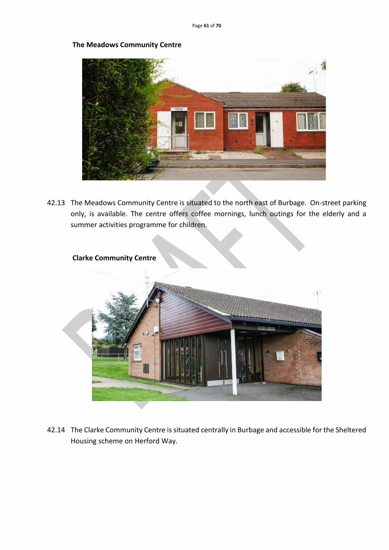
Page 61 of 70
The Meadows Community Centre
42.13 The Meadows Community Centre is situated to the north east of Burbage. On-street parking
only, is available. The centre offers coffee mornings, lunch outings for the elderly and a
summer activities programme for children.
Clarke Community Centre
42.14 The Clarke Community Centre is situated centrally in Burbage and accessible for the Sheltered
Housing scheme on Herford Way.

Page 62 of 70
POLICY 20: COMMUNITY FACILITIES
Retention of Existing Provision
The redevelopment or loss of community facilities such as community centres, sport and recreation
facilities, places of worship, healthcare facilities, allotments, libraries and public houses including
ancillary areas, will only be supported where it can be demonstrated that:
a) an equivalent range of replacement facilities will be provided in an appropriate location
within a reasonable distance of the local community; or
b) there is surplus of the facility type within Burbage which can be demonstrated to exceed
the needs of the community, or
c) the loss of a small portion of the site would result in wider community benefits on the
remainder of the site, or
d) there is no longer an identified need for the facility and an alternative use can be found.
Provision of New Facilities
The provision of new community facilities across the Parish will be supported where the facility:
a) Meets the needs of the community it intends to serve.
b) Is within a reasonable distance of the above community.
c) Is financially viable to provide and to run on an on-going basis.
This has been deliberately left blank
Page 63 of 70
43. Business and economic growth
Introduction
43.1 Employment and economic growth is important for dynamic and sustainable communities.
43.2 Burbage is significantly a ‘dormitory village’ with the majority of residents being of
employable age working and commuting to Hinckley, Nuneaton, Leicester, Coventry and
beyond (2011 Census) due to good communications from the A5 trunk road and M69
motorway.
43.3 The village has two significant areas of local employment, namely Sketchley Meadows
Industrial Estate and the Logix Business Park. Small industrial units can also be found off
Sapcote Road.
43.4 The village is predominantly residential but contains small business and retail facilities based
in key areas, namely: Three Pots, Boyslade Road/Tilton Road, Atkins Way, Brookside, Windsor
Street/Coventry Road and Hinckley Road/Church Street. They comprise of ladies/gents/unisex
hairdressers and beauty establishments, several convenience stores, newsagents, travel
agents and two florists. There is a chemist and bookmakers on Tilton Road and fast food
outlets can be found in Windsor Street, Tilton Road, Atkins Way and Brookside. Restaurants
are located on the A5 and Windsor Street. A ‘Farmers Market’ is held on the first Saturday of
each month except January.
43.5 Burbage also hosts ten public houses or public house/restaurant, which not only supports the
community through direct or indirect employment, but also supports the cultural well-being
of the village.
43.6 Overall, the Plan aims to assist in retaining these business and retail facilities as they are
valued by both residents of the village and further afield.
43.7 Although several of the business and retail facilities provide adequate parking within the
curtilage of their premises, car parking has been identified as a key issue and may affect
potential shopper’s access to facilities within the village.
43.8 The Plan will support applications generating new employment opportunities or retail
facilities which provide adequate parking for vehicles and cycles.
Business development
43.9 The Parish Council recognises the importance of Businesses in the Parish, providing
employment opportunities for local people, reducing reliance on commuting and enhancing
the sustainability of the Parish. It seeks to retain existing businesses and, supported by the
residents’ questionnaire, encourage new businesses and retail facilities to the village so as to
create further employment opportunities.

Page 64 of 70
43.10 The Plan supports the provision of additional floor space for offices or light industry through
new allocations or redeveloping existing and/or unoccupied premises where this meets the
criteria identified in Policy 21 below.
43.11 To ensure the vitality and viability of the Parish, proposals that seek a change of use of an
existing business or retail facility from a change of use for another purpose where planning
consent is required will be resisted, unless it can be demonstrated that reasonable efforts
have been made to secure continued usage of the business/facility.
This space has been left deliberately blank
POLICY 21: BUSINESS AND RETAIL
The policy particularly encourages proposals for suitable B1 business development in the
Parish, such as cottage business, home-based business and/or high-tech office units
providing the development:
a) Is in keeping with the scale, form and character of its surroundings
b) Does not significantly adversely affect the amenities of residents in the area
c) Does not significantly increase vehicular traffic flow within the built-up area of
Burbage
d) Does not have a detrimental impact upon the local environment
e) Has safe and suitable access to the site for all people
Proposals to develop B1 business use of less than 150 square metres through new build,
conversion or splitting up of existing employment space will be viewed favourably
provided conditions a-e listed above are met.
The policy protects existing A1 shop units from change of use for another purpose unless
it can be demonstrated that it is no longer required or viable.
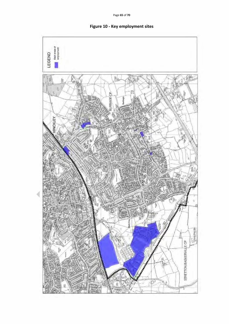
Page 65 of 70
Figure 10 - Key employment sites

Page 66 of 70
44. Transport and access
The Burbage road network
44.1 Burbage is situated to the south of Hinckley, on the western edge of the East Midlands area.
The Leicester to Nuneaton railway line provides the northern border, from The Outwoods to
the Ashby Canal. The Canal is the boundary to the A5. From the A5 canal bridge to
Smockington Hollow is the western boundary. The eastern boundary runs from The Outwoods
in a meandering line South to the A5 at Smockington Hollow, creating the triangular shape of
the Parish.
Figure 11 - The parish in relation to primary road links
Key:
Parish Boundary
Classified B Roads (Primary through routes)
Unclassified (main link roads)

Page 67 of 70
44.2 The M69 motorway crosses the Parish, creating 2 separate areas, north and south. The
northern area is approximately twice the size of the southern area and includes the village.
The southern area comprises the Jury Inn Hotel, farmland and scattered houses. The A5 links
the Logix Park and Sketchley Meadows to the M69.
44.3 Traffic using the B4109 Rugby Road to the west side of the Parish is height restricted by a low
rail bridge. The B4669 Burbage Road, to the east side enters the Parish by crossing the railway
line and continuing into Sapcote Road at the B578 junction. Brookside connects Burbage Road
with Rugby Road. The B4669 continues to the M69 J2, giving access to Leicester and M1, but
no access to the south of the village either on to or off the M69.
Figure 12 - Principle cross links in Burbage
Principal Cross-link roads
Over-height vehicle alternative route via Brookside
Transport related issues
44.4 The HBBC Core Strategy recognises the importance of Burbage, with other local centres,
remaining accessible through improvements to the road network.
44.5 The following transport related concerns were highlighted through the Open Events and
Questionnaire (See Table 7 page 68).
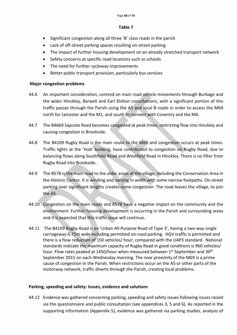
Page 68 of 70
Table 7
• Significant congestion along all three ‘B’ class roads in the parish
• Lack of off-street parking spaces resulting on-street parking
• The impact of further housing development on an already stretched transport network
• Safety concerns at specific road locations such as schools
• The need for further cycleway improvements
• Better public transport provision, particularly bus services
Major congestion problems
44.6 An important consideration, centred on main road vehicle movements through Burbage and
the wider Hinckley, Barwell and Earl Shilton conurbations, with a significant portion of this
traffic passes through the Parish using the A5 and local B roads in order to access the M69
north for Leicester and the M1, and south to connect with Coventry and the M6.
44.7 The B4669 Sapcote Road becomes congested at peak times, restricting flow into Hinckley and
causing congestion in Brookside.
44.8 The B4109 Rugby Road is the main route to the M69 and congestion occurs at peak times.
Traffic lights at the ‘Hub’ building, have contributed to congestion on Rugby Road, due to
balancing flows along Southfield Road and Westfield Road in Hinckley. There is no filter from
Rugby Road into Brookside.
44.9 The B578 is the main road to the older areas of the village, including the Conservation Area in
the Historic Centre. It is winding and varying in width with some narrow footpaths. On-street
parking over significant lengths creates some congestion. The road leaves the village, to join
the A5.
44.10 Congestion on the main roads and B578 have a negative impact on the community and the
environment. Further housing development is occurring in the Parish and surrounding areas
and it is expected that this traffic issue will continue.
44.11 The B4109 Rugby Road is an ‘Urban All-Purpose Road of Type 3’, having a two-way single carriageway 6.75m wide including permitted on-road parking. HGV traffic is permitted and there is a flow reduction of 150 vehicles/ hour, compared with the UAP3 standard. National standards indicate the maximum capacity of Rugby Road in good conditions is 960 vehicles/ hour. Flow rates peaked at 1450/hour when measured between 1st September and 30th September 2015 on each Wednesday morning. The near proximity of the M69 is a prime cause of congestion in the Parish. When restrictions occur on the A5 or other parts of the motorway network, traffic diverts through the Parish, creating local problems.
Parking, speeding and safety: Issues, evidence and solutions
44.12 Evidence was gathered concerning parking, speeding and safety issues following issues raised
via the questionnaire and public consultation (see appendices 3, 5 and 6). As reported in the
supporting information (Appendix 5), evidence was gathered via parking studies, analysis of

Page 69 of 70
public domain speeding data and conducting a safety audit. Emphasis was given to critical
points within the Parish, particularly older sections of the village where very little off street
parking is available for existing properties. In older areas of the village many footpaths and
roads are narrow, and congestion is caused by traffic negotiating parked vehicles.
44.13 Table 7 identifies key factors involved, pointing to supporting evidence gathered and
proposed traffic management improvements.
Projected impacts of developmental growth
44.14 In seeking to predict possible impacts of future housing growth on the transport network, the
theme group predicted that traffic volume is likely to increase due to the following factors:
• A general increase in vehicle ownership levels per established households, (+7% during
the 10 years 2001-2011) (see the supporting information “Transport and Burbage”,
Appendix 23)
• Increase in the number of occupants per household of ‘driving age’, resulting from
extensions and improvements to the established housing stock.
• New housing and industrial/business developments beyond the Parish in neighbouring
urban and Parish areas (approximately 2,375 residential properties approved/built
between 2006-2015 within 4½ miles of Burbage) generating greater traffic volumes
whose origins and destination fall outside the Parish.
• The existing traffic issues will be exacerbated as the stock of new homes is increased
across the Borough to meet the Core Strategy target.
Public transport
44.15 Through community consultation (Appendices 3 and 5), the community identified a need for
improvements in public transport provision, particularly the bus service. Currently public bus
services run to and from Hinckley, Nuneaton, Lutterworth, Leicester and Coventry. Therefore,
this Plan seeks to encourage improvements in bus services to and from the Parish, and an
increase in public usage of the service.
This space has been deliberately left blank

Page 70 of 70
Key transport and traffic management issues
44.16 Public consultation has highlighted key issues from points 44.1 – 44.15 above, namely:
• New housing development will inevitably increase traffic and transport issues;
• Speed and volume of traffic through the village;
• Lack of off-street parking spaces within the village, especially within the historic centre;
• Public transport to nearby population centres and facilities results in an increase use of private
car
• There is a need for safe routes to school to reduce the impact of the ‘school run’
Community Action 8: Transport and traffic management
The NPDC will:
a) Resist any further reduction in services.
b) Work with all relevant agencies to maintain current bus and rail services.
c) Promote the use of public transport as a better means of transport.
d) Ensure that any new housing development will show how they have considered the need for
safe, direct access to public transport in accordance with Section 3 of Building for Life 12 (or
equivalent).
e) Encourage ’safe routes to school’ schemes.
This space has been deliberately left blank