bushfire management plan tancy - blokk property … · the mitigation strategies contained in this...
TRANSCRIPT

1.0
BUSHFIRE MANAGEMENT PLAN State Planning Policy 3.7
(Subdivision Development)
Lot 8 (302) Hale Rd, Wattle Grove
BA
L A
SSESSM
EN
TS
| B
USH
FIR
E
MA
NA
GEM
EN
T P
LAN
S
| C
ON
SU
LTA
NC
Y
Version: 1.0 Reference: 5081 March 2016

BUSHFIRE MANAGEMENT PLAN
Lot 8 Hale Rd, Wattle Grove
RUIC Fire PERTH | BUSSELTON | MARGARET RIVER Page | 2
T: 1300 797 604 E: [email protected]
DISCLAIMER AND LIMITATION
This report is prepared solely for Vo Land Holdings Pty Ltd (the ‘proponent’) and any future landowners
of the subject lot(s)and is not for the benefit of any other person and may not be relied upon by any
other person.
The mitigation strategies contained in this Bushfire Management Plan are considered to be prudent
minimum standards only, based on the writer’s experience as well as standards prescribed by relevant
authorities. It is expressly stated that RUIC Fire and the writer do not guarantee that if such standards
are complied with or if a property owner exercises prudence, that a building or property will not be
damaged or that lives will not be lost in a bush fire.
Fire is an extremely unpredictable force of nature. Changing climatic factors (whether predictable or
otherwise) either before or at the time of a fire can also significantly affect the nature of a fire and in a
bushfire prone area it is not possible to completely guard against bushfire.
Further, the growth, planting or removal of vegetation; poor maintenance of any fire prevention
measures; addition of structures not included in this report; or other activity can and will change the
bushfire threat to all properties detailed in the report. Further, the achievement of the level of
implementation of fire precautions will depend on the actions of the landowner or occupiers of the
land, over which RUIC Fire has no control. If the proponent becomes concerned about changing factors
then a new Fire Risk Management Plan should be requested.
To the maximum extent permitted by the law, RUIC Fire, its employees, officers, agents and the writer
(“RUIC Fire”) excludes all liability whatsoever for:
1. claim, damage, loss or injury to any property and any person caused by fire or as a result of fire
or indeed howsoever caused;
2. errors or omissions in this report except where grossly negligent; and
the proponent expressly acknowledges that they have been made aware of this exclusion and that
such exclusion of liability is reasonable in all the circumstances.
If despite the provisions of the above disclaimer RUIC Fire is found liable then RUIC Fire limits its liability to
the lesser of the maximum extent permitted by the law and the proceeds paid out by RUIC Fire’s
professional or public liability insurance following the making of a successful claim against such insurer.
RUIC Fire accepts no liability or responsibility whatsoever for or in respect of any use or reliance upon this
report and its supporting material by any third party.
This report is valid for a period of three years only from the date of its issue. All BAL ratings identified in
this report are indicative and are required to be verified at the time of construction of individual buildings
to ensure appropriate setbacks identified in the proposed development have been achieved.
RUIC Fire is a trading name of
Rural Fire Risk Consultancy Pty Ltd
ABN: 48 151 451 713

BUSHFIRE MANAGEMENT PLAN
Lot 8 Hale Rd, Wattle Grove
RUIC Fire PERTH | BUSSELTON | MARGARET RIVER Page | 3
T: 1300 797 604 E: [email protected]
Contents Page
1.0 Document Details ................................................................................................................... 4
1.1 Background Information ............................................................................................................ 4
1.2 Development Description .......................................................................................................... 4
1.3 Vulnerable / High Risk Land Use ................................................................................................ 4
1.4 Unavoidable Development ....................................................................................................... 4
1.5 Minor Development .................................................................................................................... 5
1.6 Environmental Considerations ................................................................................................... 5
1.7 Risk Assessment ............................................................................................................................. 5
1.8 Bushfire Design Criteria: .............................................................................................................. 6
1.9 Specific Bushfire Planning requirements: ................................................................................. 6
2.0 Spatial consideration of bushfire threat ............................................................................... 9
2.1 Bushfire Fuels and Potential Bushfire Impact .......................................................................... 9
2.2 Access Considerations .............................................................................................................. 10
2.3 Water Supply ............................................................................................................................... 10
3.0 Proposal compliance and justification .............................................................................. 16
3.1 Compliance with the objectives of SPP 3.7 .......................................................................... 16
3.2 SPP 3.7 Policy Measures applicable to the proposal .......................................................... 17
3.3 Guidelines for Planning in Bushfire Prone Areas Compliance ........................................... 19
3.4 Areas of non-compliance with other relevant documents ............................................... 19
4.0 Bushfire Risk Management Measures ................................................................................ 20
4.1 Element 1 - Location.................................................................................................................. 20
4.2 Element 2 - Siting and design of Development ................................................................... 20
4.3 Element 3 - Vehicular Access .................................................................................................. 22
4.4 Element 4 – Water ...................................................................................................................... 23
5.0 Implementation and Enforcement ..................................................................................... 24
6.0 References ............................................................................................................................. 25

BUSHFIRE MANAGEMENT PLAN
Lot 8 Hale Rd, Wattle Grove
RUIC Fire PERTH | BUSSELTON | MARGARET RIVER Page | 4
T: 1300 797 604 E: [email protected]
1.0 Document Details
Project Number: 5081
Project Name: Lot 8 Hale
Author: Louisa Robertson (BPAD Level 1, Accreditation No. BPAD36748)
Approved By: Darrel Krammer (Grad. Cert. Bushfire Protection, BPAD Level 1,
Accreditation No. BPAD33412 )
Version: 1.0
Date of issue: 18th March 2016
_______________ _______________
Author: Approved By:
Date: 18/3/2016 Date: 18/3/2016
In the signing the above, the author declares that this Bushfire Management Plan meets the
requirements of State Planning Policy 3.7. This report supersedes all previous Bushfire Management Plans
for the site.
The development involves the subdivision at Lot 8 Hale Rd, Wattle Grove (the site), within the
municipality of the Shire of Kalamunda, into 19 individual lots and a Public Open Space (POS) area. The
site and overall development plan is illustrated in Figure 1A on page 7 of this report. The site is identified
as Bushfire Prone through the State Bushfire Prone Maps triggering the application of AS 3959 in
accordance with the Building Code of Australia.
The development does not contain any vulnerable or high risk land uses as defined in SPP 3.7.
The development is not considered unavoidable development as defined in SPP 3.7.

BUSHFIRE MANAGEMENT PLAN
Lot 8 Hale Rd, Wattle Grove
RUIC Fire PERTH | BUSSELTON | MARGARET RIVER Page | 5
T: 1300 797 604 E: [email protected]
The development is not considered minor development as defined in SPP 3.7.
The proponent has not identified any relevant environmental considerations (wetlands, foreshores, Bush
Forever sites, remnant vegetation, threatened species, ecological communities, nature reserves or
coastal reserves) within the site or being affected by the development.
Risk assessment was completed in accordance with ISO31000:2009 (Standards Australia, 2009) and
COAG’s National Inquiry on Bushfire Mitigation and Management (Ellis, Kanowski & Whelan, 2004) (Table
1A). The risk assessment demonstrates that after application of the risk management strategies
incorporated into the design of the development, the residual bushfire related risk post subdivision is
significantly reduced compared to the current state.
Table 1A: Risk assessment of development
Risk
Number
Risk Statement Impact
Category
Pre-
development
Risk Level
Prevention Controls
(Planning Specific)
Post-
development
Residual Risk
Level
1. There is the
potential that a
bushfire will impact
the proposed
development
which in turn will
cause death or
injury to persons.
People Moderate Enhanced
construction in
accordance with
AS 3959 to provide
shelter during
passage of the fire
front.
Multiple egress
routes for residents
to evacuate to
areas greater than
100m from the
vegetation
interface.
Reticulated
firefighting water
supply
Low
2. There is the
potential that a
bushfire will impact
the proposed
development,
which in turn will
cause destruction
of or damage to
the proposed
habitable buildings.
Infrastructure Moderate Enhanced
construction in
accordance with
AS 3959.
Dwelling setbacks
ensures maximum
BAL-19 rating.
Reticulated
firefighting water
supply
Low

BUSHFIRE MANAGEMENT PLAN
Lot 8 Hale Rd, Wattle Grove
RUIC Fire PERTH | BUSSELTON | MARGARET RIVER Page | 6
T: 1300 797 604 E: [email protected]
3. There is the
potential that a
bushfire will impact
the proposed
development,
which in turn will
cause destruction
of or damage to
environmental
assets.
Environment Low Development
does not include
the removal of any
environmentally
significant
vegetation.
Low
All bushfire related design criteria are addressed in Section 3 of this report. The Bushfire Management
Plan Strategies Map is illustrated in Figure 1B on page 8 of this report.
Acceptable Solutions applied: A1.1, A2.1, A3.1, A3.2, A4.1
Acceptable Solutions not applicable: A2.2, A3.3, A3.4, A3.5, A3.6, A3.7, A3.8, A4.2, A4.3
Non-compliances: Nil
Performance Based Solution Summary None
Required bushfire planning design requirements are summarised as:
(i) Future habitable buildings to be constructed in accordance with AS 3959;
(ii) A s70 notification on each Title stating: ‘This lot is subject to a Bushfire Management Plan’; and
(iii) POS to be landscaped and maintained to a low threat state in accordance with AS3959:2009
2.2.3.2 (f).

BUSHFIRE MANAGEMENT PLAN
Lot 8 Hale Rd, Wattle Grove
RUIC Fire PERTH | BUSSELTON | MARGARET RIVER Page | 7
T: 1300 797 604 E: [email protected]
Figure 1A: Site Map

BUSHFIRE MANAGEMENT PLAN
Lot 8 Hale Rd, Wattle Grove
RUIC Fire PERTH | BUSSELTON | MARGARET RIVER Page | 8
T: 1300 797 604 E: [email protected]
Figure 1B: Bushfire Management Strategies Map
Road
Closure
BUSHFIRE MANAGEMENT PLAN
Lot 8 Hale Rd, Wattle Grove
RUIC Fire PERTH | BUSSELTON | MARGARET RIVER Page | 9
T: 1300 797 604 E: [email protected]
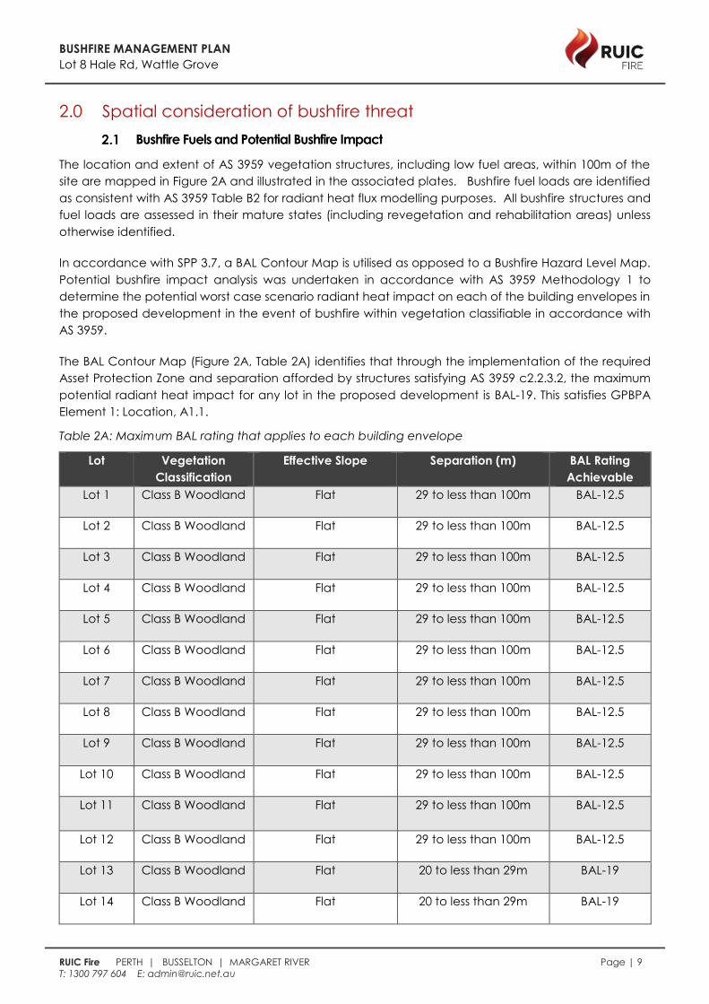
2.0 Spatial consideration of bushfire threat
The location and extent of AS 3959 vegetation structures, including low fuel areas, within 100m of the
site are mapped in Figure 2A and illustrated in the associated plates. Bushfire fuel loads are identified
as consistent with AS 3959 Table B2 for radiant heat flux modelling purposes. All bushfire structures and
fuel loads are assessed in their mature states (including revegetation and rehabilitation areas) unless
otherwise identified.
In accordance with SPP 3.7, a BAL Contour Map is utilised as opposed to a Bushfire Hazard Level Map.
Potential bushfire impact analysis was undertaken in accordance with AS 3959 Methodology 1 to
determine the potential worst case scenario radiant heat impact on each of the building envelopes in
the proposed development in the event of bushfire within vegetation classifiable in accordance with
AS 3959.
The BAL Contour Map (Figure 2A, Table 2A) identifies that through the implementation of the required
Asset Protection Zone and separation afforded by structures satisfying AS 3959 c2.2.3.2, the maximum
potential radiant heat impact for any lot in the proposed development is BAL-19. This satisfies GPBPA
Element 1: Location, A1.1.
Table 2A: Maximum BAL rating that applies to each building envelope
Lot Vegetation
Classification
Effective Slope Separation (m) BAL Rating
Achievable
Lot 1 Class B Woodland Flat 29 to less than 100m BAL-12.5
Lot 2 Class B Woodland Flat 29 to less than 100m BAL-12.5
Lot 3 Class B Woodland Flat 29 to less than 100m BAL-12.5
Lot 4 Class B Woodland Flat 29 to less than 100m BAL-12.5
Lot 5 Class B Woodland Flat 29 to less than 100m BAL-12.5
Lot 6 Class B Woodland Flat 29 to less than 100m BAL-12.5
Lot 7 Class B Woodland Flat 29 to less than 100m BAL-12.5
Lot 8 Class B Woodland Flat 29 to less than 100m BAL-12.5
Lot 9 Class B Woodland Flat 29 to less than 100m BAL-12.5
Lot 10 Class B Woodland Flat 29 to less than 100m BAL-12.5
Lot 11
Class B Woodland Flat 29 to less than 100m BAL-12.5
Lot 12 Class B Woodland Flat 29 to less than 100m BAL-12.5
Lot 13 Class B Woodland Flat 20 to less than 29m BAL-19
Lot 14 Class B Woodland Flat 20 to less than 29m BAL-19

BUSHFIRE MANAGEMENT PLAN
Lot 8 Hale Rd, Wattle Grove
RUIC Fire PERTH | BUSSELTON | MARGARET RIVER Page | 10
T: 1300 797 604 E: [email protected]
Lot 15 Class B Woodland Flat 29 to less than 100m BAL-12.5
Lot 16 Class B Woodland Flat 29 to less than 100m BAL-12.5
Lot 17 Class B Woodland Flat 29 to less than 100m BAL-12.5
Lot 18 Class B Woodland Flat 29 to less than 100m BAL-12.5
Lot 19 Class B Woodland Flat 29 to less than 100m BAL-12.5
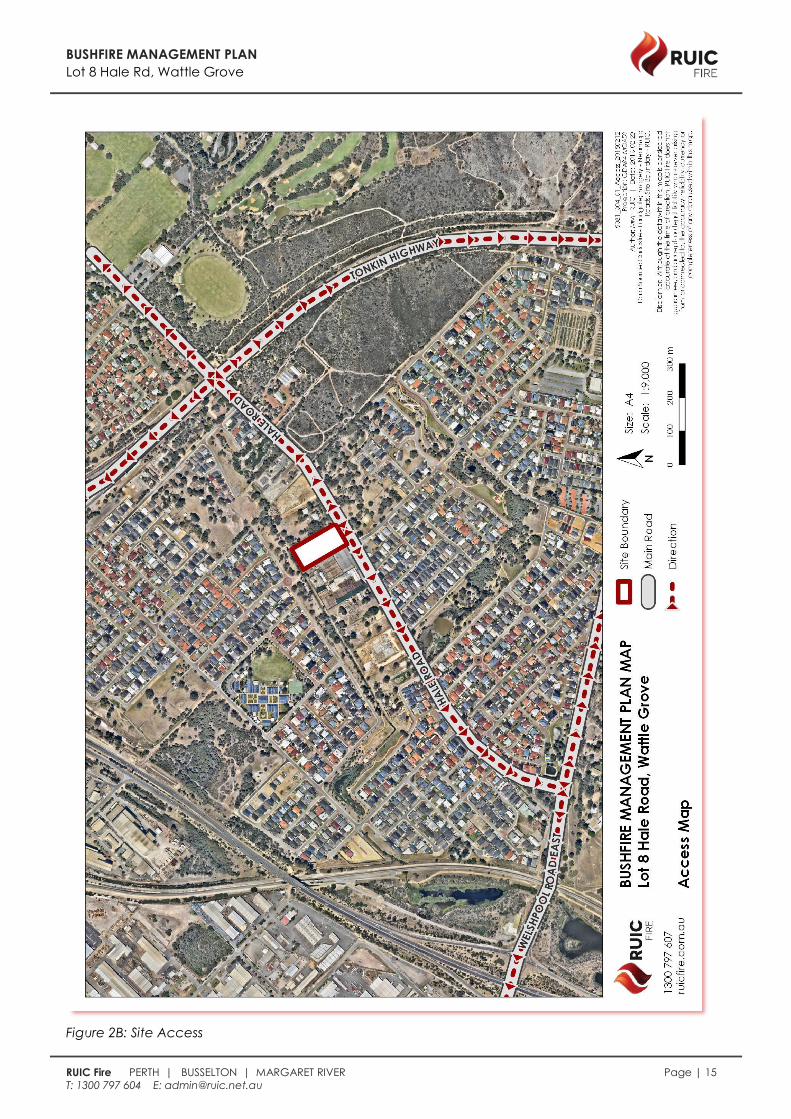
Two different vehicular access routes are provided to the development via Hale road and either Tonkin
Highway (north) or Welshpool Rd East (south) both of which connect to the greater public road network,
providing safe access and egress to two different destinations and are available to all residents/the
public at all times and under all weather conditions (Figure 2B).
The site shall be serviced by reticulated scheme water and firefighting hydrants that satisfy Acceptable
Solution A4.1.

BUSHFIRE MANAGEMENT PLAN
Lot 8 Hale Rd, Wattle Grove
RUIC Fire PERTH | BUSSELTON | MARGARET RIVER Page | 11
T: 1300 797 604 E: [email protected]
Figure 2A: BAL Contour Map

BUSHFIRE MANAGEMENT PLAN
Lot 8 Hale Rd, Wattle Grove
RUIC Fire PERTH | BUSSELTON | MARGARET RIVER Page | 12
T: 1300 797 604 E: [email protected]
Plate i: Plot 1 Class G Grassland (excluded
2.2.3.2 (c))
Plate ii: Plot 1 Class G Grassland(excluded
2.2.3.2 (c))
Plate iii: Plot 2 Class B Woodland(excluded
2.2.3.2 (c))
Plate iv: Plot 2 Class B Woodland(excluded
2.2.3.2 (c))
Plate v: Plot 3 Class B Woodland
Plate vi: Plot 3 Class B Woodland
BUSHFIRE MANAGEMENT PLAN
Lot 8 Hale Rd, Wattle Grove
RUIC Fire PERTH | BUSSELTON | MARGARET RIVER Page | 13
T: 1300 797 604 E: [email protected]
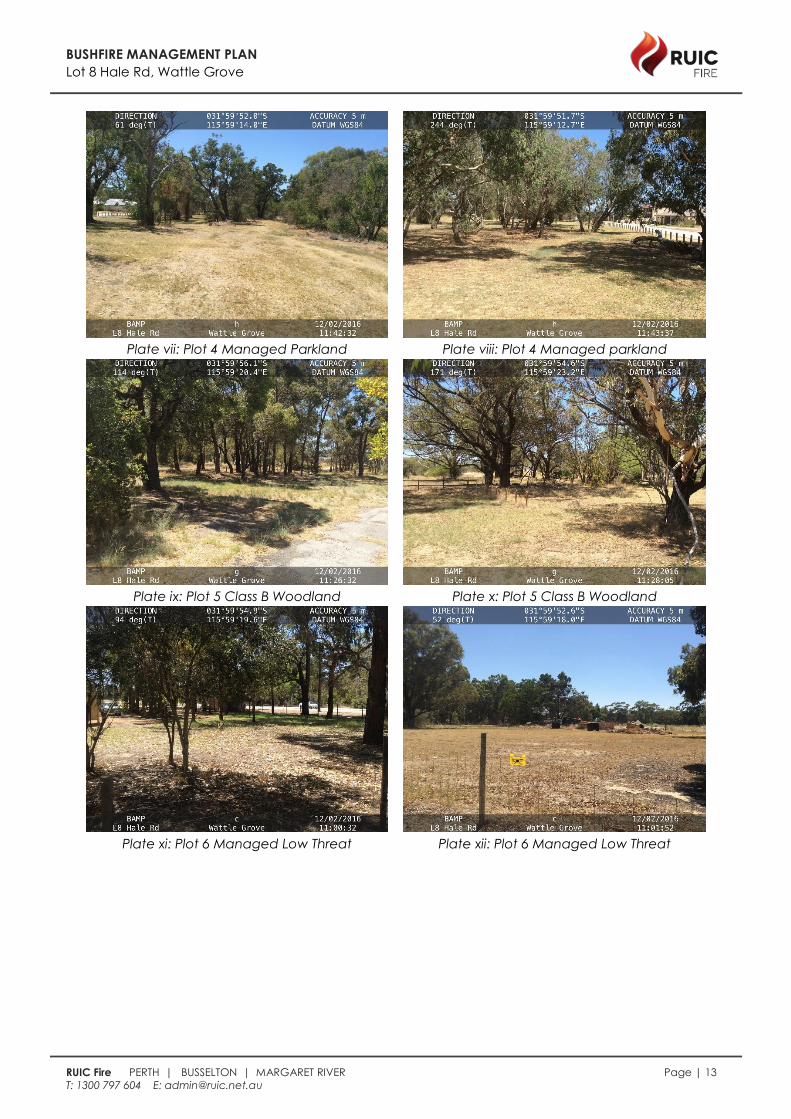
Plate vii: Plot 4 Managed Parkland
Plate viii: Plot 4 Managed parkland
Plate ix: Plot 5 Class B Woodland
Plate x: Plot 5 Class B Woodland
Plate xi: Plot 6 Managed Low Threat
Plate xii: Plot 6 Managed Low Threat

BUSHFIRE MANAGEMENT PLAN
Lot 8 Hale Rd, Wattle Grove
RUIC Fire PERTH | BUSSELTON | MARGARET RIVER Page | 14
T: 1300 797 604 E: [email protected]
Plate xiii: Plot 8 Class G Grassland(excluded
2.2.3.2 (c))
Plate xiv: Plot 8 Class G Grassland(excluded
2.2.3.2 (c))
Plate xv: Plot 9 Low Threat Nursery
Plate xvi: Plot 9 Low Threat Nursery
BUSHFIRE MANAGEMENT PLAN
Lot 8 Hale Rd, Wattle Grove
RUIC Fire PERTH | BUSSELTON | MARGARET RIVER Page | 15
T: 1300 797 604 E: [email protected]
Figure 2B: Site Access

BUSHFIRE MANAGEMENT PLAN
Lot 8 Hale Rd, Wattle Grove
RUIC Fire PERTH | BUSSELTON | MARGARET RIVER Page | 16
T: 1300 797 604 E: [email protected]
3.0 Proposal compliance and justification
Objective 1: Avoid increasing the threat of bushfire to people, property, and infrastructure. The
preservation of life and management of bushfire impact is paramount.
Objective 1 is satisfied through the compliance of the proposed development with all
required Policy Principles as detailed in Table 3A and all GPBPA Performance Principles
as detailed in section 4 of this report.
Objective 2: Reduce vulnerability of bushfire through the identification and assessment of bushfire
hazards in decision-making at all of stages of the planning and development process.
Objective 2 is satisfied through the appropriate identification and assessment of all
relevant bushfire hazards as detailed in section 2 of this report, specifically the BAL
Contour Mapping.
Objective 3: Ensure that planning proposals and development applications take into account
bushfire protection requirements and include specified bushfire protection measures
where land has or will have a moderate or extreme bushfire hazard level, and or where
a rating higher than Bushfire Attack Level (BAL)- LOW applies.
Objective 3 is satisfied through the compliance of the proposed development with all
required Policy Principles as detailed in Table 3A and all GPBPA Performance Principles
as detailed in section 4 of this report.
Objective 4: Achieve a responsible approach between bushfire management measures and
landscape amenity and biodiversity conservation values, with consideration of the
potential impacts of climate change.
Objective 4 is satisfied through the appropriate consideration of all biodiversity and
environmental assets as detailed in section 1 of this report in the development of bushfire
related risk mitigation strategies detailed in section 4 of this report.
BUSHFIRE MANAGEMENT PLAN
Lot 8 Hale Rd, Wattle Grove
RUIC Fire PERTH | BUSSELTON | MARGARET RIVER Page | 17
T: 1300 797 604 E: [email protected]
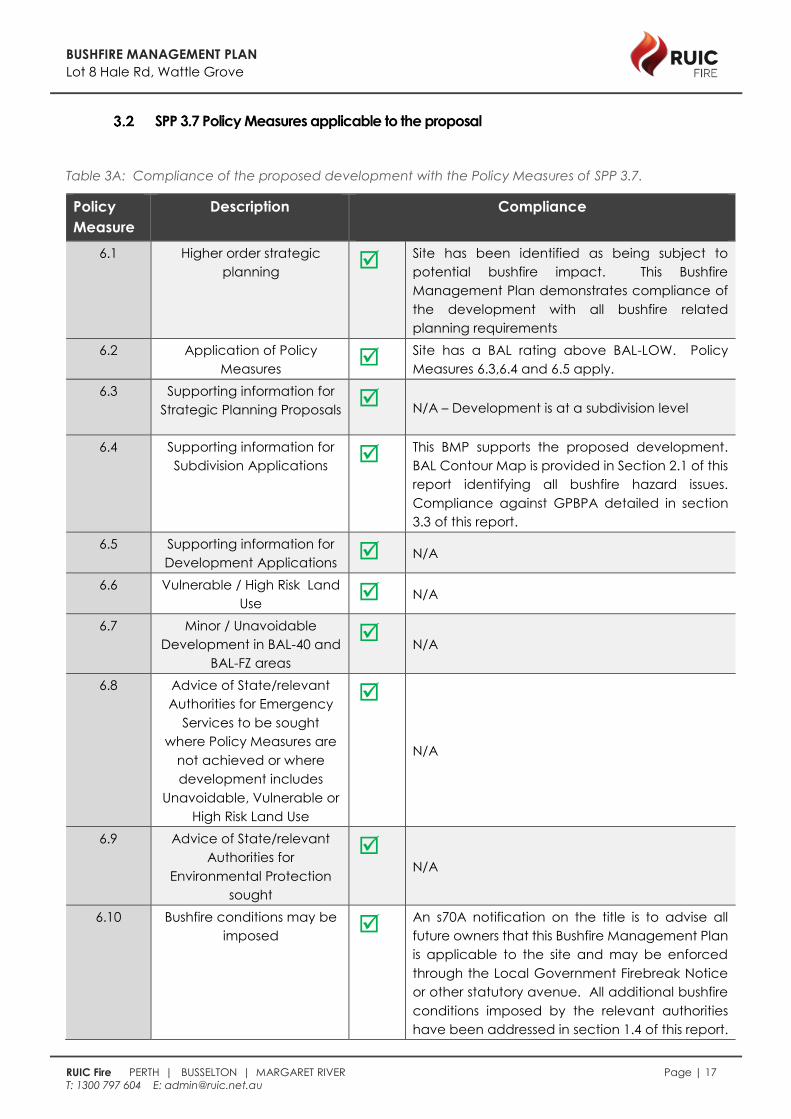
Table 3A: Compliance of the proposed development with the Policy Measures of SPP 3.7.
Policy
Measure
Description Compliance
6.1 Higher order strategic
planning Site has been identified as being subject to
potential bushfire impact. This Bushfire
Management Plan demonstrates compliance of
the development with all bushfire related
planning requirements
6.2 Application of Policy
Measures Site has a BAL rating above BAL-LOW. Policy
Measures 6.3,6.4 and 6.5 apply.
6.3 Supporting information for
Strategic Planning Proposals N/A – Development is at a subdivision level
6.4 Supporting information for
Subdivision Applications This BMP supports the proposed development.
BAL Contour Map is provided in Section 2.1 of this
report identifying all bushfire hazard issues.
Compliance against GPBPA detailed in section
3.3 of this report.
6.5 Supporting information for
Development Applications N/A
6.6 Vulnerable / High Risk Land
Use N/A
6.7 Minor / Unavoidable
Development in BAL-40 and
BAL-FZ areas
N/A
6.8 Advice of State/relevant
Authorities for Emergency
Services to be sought
where Policy Measures are
not achieved or where
development includes
Unavoidable, Vulnerable or
High Risk Land Use
N/A
6.9 Advice of State/relevant
Authorities for
Environmental Protection
sought
N/A
6.10 Bushfire conditions may be
imposed An s70A notification on the title is to advise all
future owners that this Bushfire Management Plan
is applicable to the site and may be enforced
through the Local Government Firebreak Notice
or other statutory avenue. All additional bushfire
conditions imposed by the relevant authorities
have been addressed in section 1.4 of this report.

BUSHFIRE MANAGEMENT PLAN
Lot 8 Hale Rd, Wattle Grove
RUIC Fire PERTH | BUSSELTON | MARGARET RIVER Page | 18
T: 1300 797 604 E: [email protected]
6.11 Precautionary Principle Precautionary principles have been adopted
throughout this report. The relevant decision
maker is encouraged to adopt an informed
precautionary approach in accordance with SPP
3.7

BUSHFIRE MANAGEMENT PLAN
Lot 8 Hale Rd, Wattle Grove
RUIC Fire PERTH | BUSSELTON | MARGARET RIVER Page | 19
T: 1300 797 604 E: [email protected]
Table 3B: Compliance with Guidelines for Planning in Bushfire Prone Areas (GPBPA)
Element BMP
section
Acceptable Solution (A) or
Performance Based (PB) Solution
Compliance Notes
1. Location 4.1 A1.1 Development location
Max. BAL rating is
BAL-19
2. Siting and
Design of
Development
4.2
A2.1 Asset Protection Zone (APZ) Entire subdivision
shall be low threat.
A2.2 Hazard Separation Zone
(HSZ)
Proposed new
dwellings to be
constructed to
applicable AS3959
construction
standard (if
applicable)
3. Vehicular
Access
4.3
A3.1 Two access routes Refer to Figure 2B
A3.2 Public road
Public Roads to be
constructed to
applicable standard
as detailed in
section 4 of this
report
A3.3 Cul-de-sac N/A
A3.4 Battle-axe N/A
A3.5 Private driveway longer
than 50m N/A
A3.6 Emergency access way N/A
A3.7 Fire service access routes N/A
A3.8 Firebreak width N/A
4. Water 4.4 A4.1 Reticulated areas
Fire hydrants shall be
installed
A4.2 Non-reticulated areas N/A
A4.3 Individual lots within non-
reticulated areas N/A
This report has also been developed in order to comply with the requirements of all referenced and
applicable documents. No non-compliances have been identified.
BUSHFIRE MANAGEMENT PLAN
Lot 8 Hale Rd, Wattle Grove
RUIC Fire PERTH | BUSSELTON | MARGARET RIVER Page | 20
T: 1300 797 604 E: [email protected]
4.0 Bushfire Risk Management Measures
The bush fire risk mitigation strategies detailed in this report are designed to comply with the Bushfire
Protection Criteria detailed in Guidelines for Planning in Bushfire Prone Areas (GPBPA) Appendix 4
(2015).
i. The notation (P3) refers to Performance Principle 3 of GPBPA Appendix 4. Where a
Performance Based Solution is offered detailed justification is provided in Appendix 1 of this
report.
ii. The notation (A3.1) refers to Acceptable Solution 3.1 of GPBPA Appendix 4.
iii. The notation (E3.1) refers to Explanatory Note 3.1 of GPBPA Appendix 4.
iv. Where discrepancy occurs between State and Local bushfire planning provisions the higher
standard of mitigation has been selected.
Intent: To ensure that the subdivision, development or land use is located in areas with the least possible
risk of bushfire, to facilitate the protection of people, property and infrastructure.
Performance Principle (P1): The subdivision, development or land use is located in an area where the
bushfire hazard assessment is or will, on completion, be moderate or low, or a BAL–29 or below, and the
risk can be managed. For minor or unavoidable development in areas where BAL–40 or BAL–FZ applies,
demonstrating that the risk can be managed to the satisfaction of the Department of Fire and
Emergency Services and the decision-maker.
Acceptable Solution A1.1 Development location
The strategic planning proposal, subdivision and development application is located in an area
that on completion will be subject to a BAL–29 or below for all habitable buildings.
The highest identified BAL rating is BAL-19 for Lots 13 and 14.
Intent: To ensure that the siting of development minimises the level of bushfire impact.
Performance Principle (P2): The siting and design of the strategic planning proposal, subdivision or
development application, including roads, paths and landscaping, is appropriate to the level of
bushfire threat that applies to the site. That it minimises the bushfire risk to people, property and
infrastructure, including compliance with AS 3959 if appropriate.
Acceptable Solution A2.1 Asset protection zone (APZ)
The asset protection zone (APZ) is a low fuel area immediately surrounding a building and is
designed to minimise the likelihood of flame contact with buildings.
Features such as driveways, footpaths, roads, vegetable patches, lawn or landscaped garden
(including deciduous trees and fire resistant plant species) may form part of asset protection zones.
Areas of vegetation deemed Low Threat Vegetation and managed in a reduced fuel state
inclusive of Public Open Space (POS) and nature strips may form part of a buildings defendable
space. Isolated shrubs and trees may be retained within asset protection zones.

BUSHFIRE MANAGEMENT PLAN
Lot 8 Hale Rd, Wattle Grove
RUIC Fire PERTH | BUSSELTON | MARGARET RIVER Page | 21
T: 1300 797 604 E: [email protected]
The POS area of land within the development is to be parkland cleared and permanently managed
in a low threat state, in accordance with AS3959:2009 c2.2.3.2 (f) as per clause ii & iii below.
a) Standard:
i. Location: within the boundaries of the lot on which the building is situated. Where a
full 20 metre APZ is not possible within the lot boundaries, the APZ should be sufficient
enough to ensure the potential radiant heat impact of a fire does not exceed 29
kW/m2 ;
ii. Fine fuel load: reduced to and maintained at 2 tonnes per hectare and maintained
in accordance with AS 3959-2009 s2.2.3.2 (f) stated here as:
“Including grassland managed in a minimal fuel condition, maintained lawns, golf
courses, maintained public reserves and parklands, vineyards, orchards, cultivated
gardens, commercial nurseries, nature strips and windbreaks. NOTE: Minimal fuel
condition means there is insufficient fuel available to significantly increase the
severity of the bushfire attack (recognizable as short-cropped grass for example, to
a nominal height of 100 mm.”;
iii. Trees (crowns) are a minimum distance of ten metres apart. A small group of trees
within close proximity to one another may be treated as one crown provided the
combined crowns do not exceed the area of a large or mature crown size for that
species;
iv. No tall shrubs or trees located within 2 metres of a building;
v. No tree crowns overhanging the building;
vi. Fences and sheds within APZ are constructed using non-combustible materials (eg.
iron, brick, limestone, metal post and wire); and
vii. Shed within the APZ should not contain flammable materials.
b) Specific considerations
i. To be implemented prior to clearance of the BMP conditions.
ii. It is the responsibility of the developer to ensure the APZ standard is established.
iii. It is the responsibility of the individual property owner to ensure the APZ standard
continues to be achieved post completion of the construction.
Acceptable Solution A2.2 Hazard separation zone (HSZ)
Hazard separation zones assist in reducing fire intensity when a bushfire impacts on buildings within
a subdivision. Separation may be necessary on the perimeter of a subdivision but may also be
needed where bushfire hazards exist within a subdivision. This separation reduces the overall
vulnerability of a subdivision and related development and assists with fire control operations. A
HSZ may not be required if the proposed construction meets the standard appropriate to the BAL
for that location, and does not exceed BAL-29.
All new habitable buildings within 100m of bushfire prone vegetation will be constructed in
accordance with AS 3959 to facilitate the reduced separation distance, therefore complying with
A2.2.
BUSHFIRE MANAGEMENT PLAN
Lot 8 Hale Rd, Wattle Grove
RUIC Fire PERTH | BUSSELTON | MARGARET RIVER Page | 22
T: 1300 797 604 E: [email protected]
Intent: To ensure that the vehicular access serving a subdivision/ development is safe in the event of a
bush fire occurring.
Performance Principle (P3): The internal layout, design and construction of public and private vehicular
access in the subdivision/development allows emergency and other vehicles to move through it easily
and safely at all times.
Acceptable Solution A3.1 Two access routes
As detailed in Figure 2B, two different vehicular access routes are provided, both of which connect
to the public road network, provide safe access and egress to two different destinations and are
available to all residents/the public at all times and under all weather conditions.
Two different vehicular access routes are provided to the development via Hale road and either
Tonkin Highway (north) or Welshpool Rd East (south) both of which connect to the greater public
road network, providing safe access and egress to two different destinations and are available to
all residents/the public at all times and under all weather conditions (Figure 2B).
Acceptable Solution A3.2 Public roads
All new public roads meet the minimum requirements of Acceptable Solution A3.2 as detailed in
Table 4A, Column 1.
a) Specific Considerations
i. Construction is required prior to the habitation of the any habitable buildings
serviced by the public road.
ii. It is the responsibility of the developer to ensure the public road standard is
established.
iii. It is the responsibility of Local and State Government (as appropriate) to ensure
the maintenance of public roads vested within their jurisdiction

BUSHFIRE MANAGEMENT PLAN
Lot 8 Hale Rd, Wattle Grove
RUIC Fire PERTH | BUSSELTON | MARGARET RIVER Page | 23
T: 1300 797 604 E: [email protected]
Table 4A: Vehicular access technical requirements
Technical
Requirement
Public road Cul-de-sac
(N/A)
Private
driveway
(N/A)
Emergency
access way
(N/A)
Fire service
access
routes
(N/A)
Minimum trafficable
surface (m)
6 6 4 6 6
Horizontal clearance
(m)
6 6 6 6 6
Vertical clearance
(m)
4 N/A 4.5 4.5 4.5
Maximum grade
over <50m
1 in 10 1 in 10 1 in 10 1 in 10 1 in 10
Minimum weight
capacity (t)
15 15 15 15 15
Maximum crossfall
1 in 33 1 in 33 1 in 33 1 in 33 1 in 33
Curves minimum
inner radius (m)
8.5 8.5 8.5 8.5 8.5
Intent: To ensure that water is available to the subdivision, development or land use to enable people,
property and infrastructure to be defended from bushfire.
Performance Principle (P4): The subdivision, development or land use is provided with a permanent and
secure water supply that is sufficient for firefighting purposes.
Acceptable Solution A4.1 Reticulated areas
The site shall be serviced by reticulated scheme water and firefighting hydrants, in accordance with the
Water Corporation and DFES standards, satisfying Acceptable Solution A4.1. One existing firefighting
hydrant is located on the verge along Hale Rd, adjacent to Karda St, approx. 120m from the site
boundary.
BUSHFIRE MANAGEMENT PLAN
Lot 8 Hale Rd, Wattle Grove
RUIC Fire PERTH | BUSSELTON | MARGARET RIVER Page | 24
T: 1300 797 604 E: [email protected]
5.0 Implementation and Enforcement
Table 5A summarises the responsible party for each mitigation strategy and the time frame in which it
must be completed.
Table 5A: Developer Schedule of Works
Strategy Implementation Maintenance
Responsible Time Frame Responsible Time Frame
Amendments to
BMP
Any amendments to this BMP shall be approved by the relevant Jurisdiction
Having Authority.
Asset Protection
Zone
Developer Prior to
subdivision
clearance
Individual Land
Owners
Ongoing
Hazard Separation
Zone
Developer Prior to
clearance
Individual Land
Owners
Ongoing
Construction to AS
3959
Individual Land
Owners & Local
Government
On construction
of all habitable
buildings
Individual Land
Owners
Ongoing
Cul-de-sacs NA NA NA NA
Battle Axes NA NA NA NA
Private Driveways NA NA NA NA
Emergency Access
Ways
NA NA NA NA
Firebreaks NA NA NA NA
Firefighting Water
(hydrants)
Developer Prior to
subdivision
clearance
Water
Corporation
Ongoing
Firefighting Water
(private tanks)
NA NA NA NA
Firefighting
Services &
Response
DFES and Local
Government
Ongoing DFES and Local
Government
Ongoing
Fuel Load
Reduction and Fire
Break Notice
Local
Government
Annually Local
Government
Annually
Inspection and
Issue of Works
Orders or Fines.
Local
Government
Ongoing Local
Government
Ongoing
BUSHFIRE MANAGEMENT PLAN
Lot 8 Hale Rd, Wattle Grove
RUIC Fire PERTH | BUSSELTON | MARGARET RIVER Page | 25
T: 1300 797 604 E: [email protected]
6.0 References
Ellis, S., Kanowski, P., & Whelan, R. (2004). National Inquiry on Bushfire Mitigation and Management.
Council of Australian Governments.
Keelty, M. J. (2011). A Shared Responsibility: The Report of the Perth Hills Bushfire February 2011 Review.
Government of Western Australia, Perth.
Standards Australia. (2009). AS 3959:2009 Construction of buildings in bushfire prone areas: SAI Global.
Standards Australia. (2009). ISO AS 31000:2009 Risk management principles and guidelines: SAI Global.
Standards Australia. (2013). HB89:2013 Risk management - Guidelines on risk assessment techniques
(Vol. HB 89:2013). Sydney: SAI Global.
Standards Australia. (2013). HB 436:2013 Risk management guidelines - Companion to AS/NZS ISO
31000:2009 (Vol. HB436:2013). Sydney: SAI Global.
WAPC. (2006). State Planning Policy 3.4 Natural Hazards and Disasters. State Law Publisher.
WAPC. (2015a). State Planning Policy 3.7 Planning in Bushfire Prone Areas. Western Australian Planning
Commission & Department of Planning.
WAPC. (2015b). Guidelines for Planning in Bushfire Prone Areas. Western Australian Planning
Commission, Department of Planning & Department of Fire and Emergency Services.
WAPC. (2015c). Guidelines for Planning in Bushfire Prone Areas Appendices. Western Australian
Planning Commission, Department of Planning & Department of Fire and Emergency Services.
WAPC. (2015d). Planning Bulletin 111/2015 Planning in Bushfire Prone Areas. Western Australian
Planning Commission.