butte county habitat conservation plan/natural - state of california
TRANSCRIPT

Report of Independent Science Advisors
for Butte County
Habitat Conservation Plan / Natural Community Conservation Plan (HCP/NCCP)
Prepared For Butte County Association of Governments
Prepared By The Independent Science Advisors:
Wayne Spencer Raymond Bogiatto
Sharon Collinge Tag Engstrom Geoff Geupel
Lynn Huntsinger Michael Marchetti
Jaymee Marty Mark Schwartz
With Assistance From Jonah Piovia-Scott
Revised November 2007
Produced by the Conservation Biology Institute. CBI is a 501(c)3 tax-exempt organization that works collaboratively to conserve biological diversity in its natural state through applied research, education, planning, and community service.

Table of Contents Executive Summary………………………………………………………………………………iii 1 Introduction............................................................................................................................ 1 2 Review of Draft Ecological Baseline Report and Recommendations for Future Documents2
2.1 Information Sources........................................................................................................ 2 2.2 Citations, Justifications, and Scientific Uncertainties..................................................... 5 2.3 Maps................................................................................................................................ 7 2.4 Tables.............................................................................................................................. 9
3 Scope of the Plan ................................................................................................................. 10 3.1 Biological Goals............................................................................................................ 10 3.2 Geographic Extent of Plan Area ................................................................................... 10 3.3 Plan Duration ................................................................................................................ 11 3.4 Species Addressed ........................................................................................................ 12 3.5 Natural Communities .................................................................................................... 17 3.6 Environmental Gradients .............................................................................................. 18 3.7 Covered Actions............................................................................................................ 18
4 Addressing Information Gaps .............................................................................................. 20 4.1 Species Habitat Suitability and Distribution Models.................................................... 20 4.2 Current Conservation Status of Lands in the Plan Area ............................................... 22 4.3 Restoration Potential..................................................................................................... 23 4.4 Grazing Management.................................................................................................... 23
5 Conservation Design Approach ........................................................................................... 25 5.1 Reserve Design Principles ............................................................................................ 25 5.2 Steps to Follow in Designing a Reserve System .......................................................... 28 5.3 Use of Reserve-Selection Algorithms........................................................................... 29 5.4 Conservation Design Principles for Riparian/Riverine Corridors ................................ 29
6 Principles for Conserving Select Target Species ................................................................. 33 6.1 Plants............................................................................................................................. 33 6.2 Invertebrates.................................................................................................................. 33 6.3 Fish................................................................................................................................ 33 6.4 Reptiles and amphibians ............................................................................................... 33 6.5 Birds.............................................................................................................................. 35
7 Conservation Analyses......................................................................................................... 43 7.1 Conservation and Take of Covered Species ................................................................. 43 7.2 Effects on Ecological Processes.................................................................................... 45 7.3 Representation Analyses............................................................................................... 46 7.4 Effects of Climate Change ............................................................................................ 46
8 Adaptive Management and Monitoring ............................................................................... 48 8.1 Management and Monitoring Recommendations for Select Natural Communities..... 48 8.2 Fire Management .......................................................................................................... 57 8.3 Control of Yellow Starthistle and Other Weeds ........................................................... 58 8.4 Monitoring Recommendations for Select Covered Species ......................................... 59
Literature Cited ............................................................................................................................. 62

Appendix A - Biographies of Advisors ........................................................................................ 74 Appendix B - Initial Questions for Science Advisors................................................................... 76 Appendix C - Suggested Edits to Ecological Baseline Report From Jay Bogiatto ...................... 79 Appendix D - Species Information for Northern Pintail (Anas acuta) ......................................... 83 Appendix E – Additional Information on Select Reptiles and Amphibians................................. 85 Appendix F – Grazing Management............................................................................................. 88

iii
Executive Summary This report summarizes recommendations from a group of independent science advisors for the Butte County Habitat Conservation Plan/Natural Community Conservation Plan (HCP/NCCP). This statutorily required scientific input is provided early in the planning process to help the plan proceed with best available science. The advisors operate independent of the entities involved in planning or implementing the HCP/NCCP. Our recommendations are advisory only and not binding on HCP/NCCP participants. They are organized by the following major topics: (1) review of the Draft Ecological Baseline Report (SAIC 2007), (2) scope of the plan, (3) information gaps, (4) conservation design, (5) conservation analyses, and (6) adaptive management and monitoring. This Executive Summary briefly highlights important recommendations. See the full report for additional details.
Review of Draft Ecological Baseline Report The Draft Ecological Baseline Report (SAIC, May 2007) is intended to serve as a foundation for planning. This section summarizes some recommendations concerning the general content and format of the report and future plan documents.
Information Sources The advisors recommend incorporating additional information sources in the document and database. We also recommend including more explicit justification for assumptions and conclusions, and explicit disclosure of uncertainties about information sources and decisions based on them.
• Additional sources of species location data include museum records, California Bird Species of Special Concern maps, predictive maps of bird species distribution available at the California Avian Data Center (http://www.prbo.org/cadc/), a predictive model for 96 vernal pool species prepared by Dr. Robert Holland, and the U.S Fish & Wildlife Service’s annual mid-winter waterfowl survey (USGS Migratory Bird Data Center).
• We recommend investigating other plans and documents relevant to conservation planning in Butte County, such as HCP/NCCP plans in adjoining counties, the California Department of Conservation Important Farmland Mapping and Monitoring Program [http://www.consrv.ca.gov/DLRP/fmmp/index.htm], the California Wildlife Action Plan (Bunn et al. 2005), relevant working groups of the North American Bird Conservation Initiative (NABCI, http://www.nabci-us.org/), the Central Valley Joint Venture 2006 Implementation Plan (CVJV 2006; http://www.centralvalleyjointventure.org/plans/), the California Invasive Plant Council (CAL-IPC) (http://www.cal-ipc.org /ip/inventory/index.php), the California Department of Food and Agriculture’s Integrated Pest Control Branch (http://www.cdfa.ca.gov/phpps/ipc/), and priority rangeland protection areas as identified by the California Rangeland Conservation Coalition.

Butte County HCP/NCCP Science Advisors’ Report
iv
• We recommend citing references or other justification for all key assumptions and assertions. Advisors noted a number of unsupported assertions in SAIC (2007), including some that appear counter to published literature (examples included in Section 2.2 of our report).
• Please indicate the degree of certainty, accuracy, and relevancy for various data sources used for planning and analysis. For example, color-code species location points on maps to indicate which sources they came from, whether the species is likely still present or not, or whether the points are associated with an estimate of population size versus simple presence.
Maps We recommend adding some maps to those already in the document, such as the following:
• Land ownership and management status, including conservation status.
• Restoration potential for different natural community types.
• Concentrations of exotic species, especially for riparian communities. This map could help with identifying restoration and management opportunities.
• A floodplain and flood basin map, showing multiple zones (e.g., 50, 100, and 500-year floodplains).
We also recommend improving some existing map coverages and clarifying cartography on some maps to ease their interpretation:
• Consider using helicopter surveys, aerial photographs, or LIDAR images from wet months to maximize detection of small or seasonal wetlands and to error-check land-cover maps.
• Wherever possible, show continuous map coverages beyond planning area boundaries to illustrate the plan’s geographic context (e.g., how land covers, species distributions, or other features connect into adjoining areas). Where detailed coverages are not available outside plan boundaries, substitute the best available, comparable coverages or aerial imagery there to aid map interpretation.
• Add more geographic references (e.g., cities, major roads and streams, existing reserves) to some maps to aid in locating and interpreting mapped information.
• Seek review of species distribution maps by other local experts, such as the local chapter of the California Native Plant Society (CNPS) for plants.
Scope of the Plan The scope of an HCP/NCCP includes its geographic area, plan duration, species to be addressed, and actions to be permitted.
Geographic Extent The advisors recognize the rationale for limiting the plan area to lower elevation portions of the county (valley floor and foothills), where development threats to biological resources are greatest. However, we believe the plan’s name should reflect this limitation in the geographic area covered, and suggest that the current plan be considered an initial phase of a larger effort to eventually encompass the entire county.
Butte County HCP/NCCP Science Advisors’ Report
v
Although the advisors appreciate the attempt to derive an ecologically relevant eastern boundary to define the current plan area (approximately at the upper limit of oak woodlands), we note that this vegetation-based transition line will change over time, is subject to differing interpretations, may be difficult to locate in the field, and could lead to unnecessary complications during planning and implementation. We therefore recommend using less subjective lines to define the eastern boundary, such as legal boundary lines or roads in the vicinity of the line defined using oak prevalence.
We agree with using the County’s jurisdictional boundaries for the other plan boundaries, but urge planners to consider resource distributions in adjoining jurisdictions, such as the location of nesting habitat for bank swallows on the western side of the Sacramento River.
Plan Duration The 30- or 50-year permit durations under consideration are fairly standard and appropriate for an HCP/NCCP. However, we urge recognition that environmental conditions, species distributions, and other factors can change dramatically over 30 or 50 years, and therefore stress the importance of an effective monitoring and adaptive management program to ensure that plan goals are being met within this permit duration. Science-informed management intervention will be required to address changing conditions, including climate change, within and beyond this permit horizon.
Species Addressed The advisors generally concur with the process used to identify species to be covered by take authorizations (permits), although we were concerned with using a species’ current or potential legal status (listed or likely to be listed as threatened or endangered) as a criterion for inclusion or exclusion. We note that NCCPs are not strictly endangered-species permitting plans, but are required to sustain and enhance the state’s natural communities. We therefore recommend supplementing the list of covered species with some planning species to help achieve these broader goals.
Covered Species
The list of proposed covered species is generally reasonable and defensible. However advisors urge caution in omitting species from the covered species list based on the criterion that they are not listed, nor likely to become listed, as threatened or endangered. In the interest of caution, we recommend reconsidering a number of species (mostly plants; see Table 1 in the full report) that were deleted from the potential covered species list based on this criterion to make sure omitting them is justified on biological grounds. In addition to reconsidering the list of species discussed above, we strongly recommend adding the following species to the covered species list:
• Windowpane monardella (Monardella douglasii ssp. venosa). This rare endemic plant is known from only six locations, all in Butte County.
We also recommend further researching whether the following species deserve inclusion on the covered species list:

Butte County HCP/NCCP Science Advisors’ Report
vi
• Northern California black walnut (Juglans hindsii). This California endemic is considered seriously endangered by CNPS and likely occurs in riparian forests and woodlands within Butte County.
• Sacramento perch (Archoplites interruptus). Although this species no longer occurs in the planning area, it was formerly a major component of the natural fish assemblage in the Central Valley, is likely to be proposed for listing in the near future, and may respond well to reintroduction or restoration efforts.
• Hitch (Lavinia exilicauda). This native minnow is endemic to the Central Valley and is declining throughout its range. Hitch are good indicators of habitat integrity and connectivity in tributary streams.
• Hardhead (Mylopharodon conocephalus). This native minnow is also endemic to the Central Valley and declining throughout its range, although populations are doing well in the planning area. Hardhead are good indicators of relatively undisturbed low elevation/foothill stream conditions and intact native fish assemblages.
• Tule perch (Hysterocarpus traskii). This Central Valley endemic is also declining across its range and populations in the Sacramento River watershed are becoming increasingly fragmented. Tule perch is an indicator of good water quality and intact low-elevation native fish assemblages.
Planning Species
In addition to covered species (for which take permits are requested), we recommend selecting some additional “planning” species to help guide plan development. Planning species may include indicators of healthy environmental conditions or ecological processes that benefit many species in common; they may be particularly sensitive to certain threats, such as roadkill, pollution, or habitat fragmentation; or they may be economically or recreationally important in the plan area. We recommend reviewing the list of potentially covered species to see how well it represents the variety of natural communities and ecological threats of concern in the planning area, and then select some additional planning species to address any gaps in this representation. Examples of planning species to consider include the following:
• American badger (Taxidea taxus), which requires large, unfragmented grassland areas and is subject to extirpation by roadkill and human disturbances. If the reserve system can support badgers, it will likely benefit many additional species of concern.
• Northern pintail (Anas acuta), because managed wetlands in Butte County are very important to the overall population status of this locally common, but continentally declining, duck species.
• Native fishes, including the four species mentioned above as potential covered species (hitch, Sacramento perch, hardhead, and tule perch). Even if these are not addressed as covered species, these native fishes are indicators of high quality, intact aquatic communities.
• Native snakes, such as Northern Pacific rattlesnake (Crotalus oreganus), California kingsnake (Lampropeltus getula), and gopher snake (Pituophis catenifer) are important components of natural communities and are highly susceptible to road mortality and other human impacts.
Butte County HCP/NCCP Science Advisors’ Report
vii
• Freshwater marsh plants, such as Atriplex depressa, Hibiscus lasiocarpus, Rhynchospora californica, Rhynchospora capitella, Sagittaria sanfordii, or Wolffia brasilensis are indicators of natural marshland conditions, which benefit many additional wildlife species.
Natural Communities The advisors recommend refining the definitions of some natural communities to follow recognized community definitions more closely and to account for variation due to geological substrates, ecological gradients, and management status. Specifically, we recommend
• Treating vernal pools as a separate community, rather than as a subset of annual grasslands, and subdividing vernal pools based on the major geological substrates they are found on.
• Differentiating between leveed and natural or unleveed riparian stretches.
• Revising names of marshland communities from “managed wetlands” and “emergent wetlands” to “managed marshlands” and “unmanaged marshlands.”
• Categorizing aquatic communities as (1) large river (greater than stream order 4), (2) high gradient creek, (3) low gradient creek, (4) seasonal/temporary creek, (5) aqueduct/canal (i.e., lined or paved water conveyances), (6) ditch/unlined canal, (7) pond, (8) lake, (9) spring, and (10) small impoundment. Also, where possible, (11) stock ponds (actually used for livestock watering) should be distinguished from other small ponds and impoundments.
Environmental Gradients The Advisors were pleased that SAIC (2007) addressed environmental gradients in the Baseline Report, but recommend further developing and using this concept in the plan and analyses. For example, we recommend analyzing how gradients in elevation, moisture, and geological substrates can be used to better define or subdivide natural communities and species distributions, and we recommend analyzing how well different reserve design alternatives represent the range of variability in these gradients.
Covered Actions The advisors reviewed the potential effects on biological resources of development and other actions to be permitted via the plan, with a focus on indirect impacts that might otherwise be overlooked during planning and analysis.
Urban Development
In addition to direct removal and fragmentation of natural habitats, urban development increases impervious surfaces and runoff, which adversely affects aquatic habitats and species via increased erosion, sedimentation, and pollution. The plan should analyze and mitigate for these effects.
Rural Development
Low-density rural development fragments habitats and introduces adverse “edge effects” into adjoining natural areas, such as weeds, house pets, irrigation runoff, pesticides, and fertilizers. The plan should account for these reductions in habitat value within a zone of influence around developments—based on the approximate distance the most detrimental effects are expected to penetrate habitat areas—and counter them with appropriate mitigation measures. We also recommend that the plan fully consider the increased risks of fire when houses or other
Butte County HCP/NCCP Science Advisors’ Report
viii
developments are scattered within fire-prone landscapes, thus expanding the wildland-urban interface.
Where new roads or road improvements cross natural areas, we recommend incorporating Before-After-Control-Impact studies of wildlife movement and roadkill to identify where wildlife crossing structures (e.g., underpasses or overpasses coupled with wildlife fencing) may benefit ecological connectivity and reduce roadkill.
Addressing Information Gaps Species Habitat Suitability and Distribution Models Since comprehensive survey coverage is not feasible for most species, we recommend judicious use of habitat suitability models. Empirical (statistical) models are preferred if there is sufficient unbiased species location data to support them. However, we recognize this is seldom the case, especially for rare or endangered species, and therefore endorse using “expert opinion” models so long as the models are carefully constructed based on the species’ literature, and that uncertainties in model predictions are clearly disclosed and factored into decisions.
In creating habitat models, we recommend considering all environmental variables that may affect a species’ distribution, as well as the interactions between these factors. Note that many biologically relevant variables can be derived from existing GIS data layers. For example, distance from water or other habitat features can be derived from land cover maps, and insolation indices can be derived from digital elevation data. Seek expert review of all models to ensure they are as biologically justified and accurate as possible.
Land Conservation Status The plan should map, and use to help guide conservation priorities, all existing conservation areas, including agricultural easements to benefit wildlife. This can reveal conservation opportunities, such as locations where linking or buffering existing conservation areas can yield biological benefits. We recommend seeking information on existing conservation agreements from the County Recorder’s Office, The Nature Conservancy, and The California Rangeland Conservation Coalition.
Restoration Potential The advisors recommend investigating whether GIS analyses can be used to identify areas of high restoration potential based on such attributes as soils, topography, land cover, land use, and water availability. The Nature Conservancy has used this approach to identify freshwater wetland restoration opportunities in the Central Valley.
The advisors do not advocate vernal pool creation or restoration as a mitigation option for loss of vernal pool habitat, except as a last resort. In that case, vernal pool restoration should be treated as experimental, with intensive and long-term monitoring of effectiveness. Vernal pool creation should not be performed at sites with existing vernal pool habitat due to potential impacts on site hydrology and upland habitat for target species. Instead, sites with degraded vernal pool habitat should be targeted for vernal pool restoration.
Butte County HCP/NCCP Science Advisors’ Report
ix
Conservation Design Approach Reserve Design Principles The advisors reviewed the basic principles of reserve design and discussed how best to tailor them for this plan, with the following recommendations:
• Make reserves as large and connected as possible, to capture broad ecological gradients, allow for continued ecosystem functions (e.g., migration, fire, flooding), and facilitate use of such management tools as grazing and prescribed fire.
• Include smaller reserves where necessary to conserve particular covered species, such as where no other options exist for maintaining populations of endemic species.
• Prioritize conservation of habitat mosaics, as opposed to isolated samples of particular vegetation communities. Examples of priority habitat mosaics include wetland/upland, marshland/agriculture, and grassland/oak woodland.
• Strive to conserve as much of entire watersheds as possible to maintain natural hydrological connectivity and water quality from tributaries to mainstem rivers, and from wetlands to uplands. Conserve the full array of flow regimes, from intermittent seasonal streams to low-gradient perennial flows.
• Choose vernal pool reserves carefully to ensure hydrological integrity and to facilitate management using grazing and fire. Ensure that vernal pool preserves capture the range of variability (gradients, geological substrates) on which they occur in the plan area, and include sufficient upland habitat around vernal pools for hydrological function and maintenance of associated species (e.g., amphibians and pollinators).
• Conserve the range of geological and hydrological conditions in the study area, including areas of high geological complexity (e.g., Tuscan formation, Sierra/Cascade interface) and especially areas supporting numerous springs and seeps.
• Buffer aquatic habitats with sufficient upland habitat to maintain water quality and ecological integrity. Develop science-based buffer zones based on stream size and order, adjacent vegetation types, and the needs of associated species.
• Manage some wetlands in the agricultural areas of the valley floor for a broader array of species than the waterfowl that have been the traditional targets of marshland management there.
• Avoid human-wildland intermixes by minimizing sprawl development, such as low- to mid-density housing sprinkled in wildland areas in the foothills. Such intermixes reduce habitat quality in adjoining areas and greatly increase fire risks to homes as well as native habitats.
• Consider establishing a “gold line” to limit growth east of Chico (comparable to the western “green line”) to recognize and increase awareness of the importance of grazing lands, migratory deer habitat, rare plants, and other values of open space in the foothills.
• Strive to maintain a viable agricultural community in the plan area, because sustainable agriculture (including ranching) is better for maintaining biological diversity than conversion and fragmentation of agricultural lands by urban development.
Butte County HCP/NCCP Science Advisors’ Report
x
Reserve Design Steps The advisors recommend applying the above principles in a semi-systematic, step-wise process for delineating reserve areas, as follows:
1. Identify the highest priority vernal pool/grassland landscapes to protect, especially those in large, contiguous blocks and those supporting the greatest number of covered species. Include sufficient area on each of the major geological substrates for vernal pools in the plan area to maintain their natural physical and hydrological connectivity and to ensure continued use by species that require the pools as well as adjacent uplands (e.g., amphibians, pollinators).
2. Connect the priority vernal pool/grassland preserves with broad landscape linkages, both upslope to forested habitats and downslope to management wetlands and major riparian corridors. Include sufficient oak woodland and savannah to accommodate the migratory and wintering requirements of the Tehama deer herd.
3. Conserve, widen, enhance, and restore natural communities along major river corridors (especially along the Sacramento River) and strive to improve the habitat mosaic (riverine to upland gradient). Restore wide nodes of native vegetation adjacent to rivers, where possible, especially at river confluences.
4. Restore riparian corridors along tributaries through agricultural areas, and buffer them sufficiently to protect water quality and ecological functionality.
5. Analyze the resultant reserve design to ensure that all covered species, planning species, covered communities, and key ecological processes are adequately captured (represented). Add lands as needed to account for any shortfalls (e.g., additional buffers or small reserves that support key species populations), and repeat the analysis as necessary.
Use of Reserve-Selection Algorithms The advisors discussed use of computer modeling approaches to reserve selection, such as the programs SITES or MARXAN. Although these programs have a number of advantages (including transparency, repeatability, and efficiency) they also have disadvantages (including a steep learning curve). We recommend that the planning team discuss pros and cons of these programs to decide whether they would benefit plan goals (e.g., by assisting in identifying the highest-priority vernal pool complexes). In so doing, recognize that no reserve-selection algorithm can completely design a reserve system. Rather, they are decision-support tools that must be used in concert with reserve-design guidelines (see above) to ensure that the selected reserves are sufficiently large, connected, and buffered to sustain each covered (and planning) species, and to allow for the relatively natural function of ecological processes.
Conservation Analyses The HCP/NCCP documents should fully analyze the plan’s likely effects on populations of covered species, which often requires assessing plan effects on physical or ecological processes. It also requires addressing such uncertainties as the effects of global climate change, or how land uses are likely to change over the permit duration (30 or 50 years), with or without plan implementation. The HCP/NCCP should comprehensively analyze the likely spatial patterns of future development and infrastructure, and how this will affect habitat fragmentation, wildlife

Butte County HCP/NCCP Science Advisors’ Report
xi
movement, and ability of reserves to support covered species. The plan should also specifically analyze likely effects of future road improvements on wildlife movements, roadkill, and ecological connectivity. Finally, the plan should analyze how well the reserve system captures (or “represents”) the range of environmental variability in the plan area.
Conservation and Take of Covered Species The plan should predict, as best possible with available knowledge and models, whether plan implementation will increase, decrease, or have no measurable effect on the population size, sustainability, and recovery of each covered species. We don’t advocate formal, quantitative, population viability analyses (PVA) for most covered species, because the necessary data are usually lacking. One exception to this may be Butte County meadowfoam, and we recommend investigating whether a formal PVA would decrease uncertainty about how best to design a reserve for this species.
For most species, we recommend using a systematic, limiting-factor analysis to predict plan effects, with full and transparent disclosure of the assumptions and logic used to make the findings. Thus, for each species (1) identify the key factors limiting its population size and recovery; (2) assess (quantitatively if possible) how each limiting factor will change with implementation of the plan or alternatives; (3) carefully weigh the relative contribution of each change to overall population size, persistence, and recovery; (4) determine the likely net cumulative effect of all these changes, considered together, on population size, persistence, and recovery.
For example, a slight decrease in habitat acreage may be more than compensated by increased carrying capacity of the remaining habitat, due to improved habitat management or restoration of some limiting factor (e.g., nesting sites, migration corridors, or water temperature). On the other hand, improvements in certain limiting factors may be moot if one or more other factors are lacking (e.g., enhancing habitat value for a species in an area it cannot reach due to movement barriers). The evidence used to make these decisions should be carefully documented, along with all key uncertainties. These uncertainties should become foci of the monitoring program.
Effects on Ecological Processes In addition to species-by-species analyses, the plan should assess how implementation will affect important ecological processes that affect many species or natural communities in common, such as flooding, stream flows, fire, and exotic species invasions. We recommend analyzing changes in those ecological processes that are most influential in shaping and maintaining natural communities. For each natural community and process of interest, we recommend estimating its natural or historic range of variability and assessing how the plan will likely affect this range (i.e., will plan implementation move the process closer to or farther from its natural range of variability?). These process analyses should also serve as inputs to the covered species analyses described above. Finally, these analyses should guide development of the adaptive management program, with monitoring designed to test the hypothesized changes and management actions to move processes closer to desired ranges.
Representation Analysis A representation analysis evaluates how well a reserve system represents, or samples, the range of variation within an area of interest, such as whether it includes significant examples of all

Butte County HCP/NCCP Science Advisors’ Report
xii
vegetation types, species habitats, or geological substrates in the plan area. We recommend a representation analysis of physical (abiotic) habitats and natural vegetation, assessing to what degree each type is represented in existing or potential reserves. Physical attributes to be evaluated include elevation, moisture gradients, and geological substrates.
Effects of Climate Change Global climate change is projected to [summarize expectations and provide citations]. Warmer (and possibly drier) conditions may also alter the length of the fire season and increase wildland fire risks, which will be especially problematic if development moves more into rural hillsides.
Since the nature of these changes is somewhat predictable, they should be considered “changed circumstances” that are reasonably foreseeable over the plan duration and therefore accommodated by the adaptive management program. Effects on covered species should be considered in the conservation analysis, with management and monitoring contingencies built into the plan. Uncertainty about the magnitude of effects, and interactions between multiple effects, will require considerable attention in the adaptive management and monitoring program.
Adaptive Management and Monitoring Adaptive management is a systematic process for continually improving management practices by learning from outcomes of previous actions. The adaptive management plan should contain feedback loops to inform land managers and those overseeing plan implementation. If possible, specific a priori management thresholds should be developed for each plan objective. Management thresholds tell managers when a change in management action is needed.
Management and Monitoring Recommendations for Select Natural Communities Although it is too early in planning to identify all necessary and sufficient management guidelines, we offer some preliminary recommendations for select natural communities.
• Vernal Pools. Gazing and burning are the primary tools for managing vernal pool habitats. Management of vegetation using a combination of these tools should be conservatively based on the latest research as well as monitoring results.
• Grasslands. Grazing management is key to maintaining grasslands and associated species. Changes to ongoing grazing management should be considered with caution, especially where persistence of native species suggests that the existing management programs are working. Management based on residual dry matter (RDM) is a useful approach, although it has some limitations and should not be considered a universal remedy for all species. Varying the timing and intensity of grazing on a landscape scale may better enhance native plant diversity than uniform grazing patterns or elimination of grazing. Other management tools, such as burning, mowing, herbicides, and seeding should also be considered cautiously, and should be applied only to address specific goals with due consideration of specific site conditions.
• Oak Woodlands and Savannahs. Management and monitoring considerations in this community are similar to those in grasslands, with the addition of oak recruitment. Current research is calling into question the assumption that oak recruitment is a problem in California, and monitoring should be used to better understand the situation and to remedy any problems.

Butte County HCP/NCCP Science Advisors’ Report
xiii
• Stock Ponds. These may be managed to increase habitat suitability for wildlife and covered species. Year-round ponds benefit many species of wildlife, but also harbor non-native species like bullfrogs that harm native species. Managing some ponds as seasonal ponds may benefit such species as red-legged frogs. Livestock use of ponds may have both positive and negative effects on covered species habitat, and it has been suggested that fencing livestock out of portions of ponds (but not the entire pond) may satisfy a range of wildlife habitat values. Research into the effectiveness of this practice is needed.
• Other Aquatic Communities. Decisions about management of aquatic communities should be based on the latest research and on site-specific and species-specific considerations. For example, although livestock grazing can adversely affect aquatic habitats and species, totally removing grazing won’t necessarily improve conditions for all species. In some cases, seasonal grazing restrictions may be recommended.
Monitoring Recommendations for Select Covered Species We recommend a tiered approach to prioritizing monitoring efforts. Although all covered species should receive some monitoring effort, the effort should be allocated to answer critical questions, track those species or issues of greatest concern, and best inform management actions.
In general, monitoring should be sufficient to understand relative population status, trends, threats, and responses to management at reasonable levels of precision for all covered species. However, it is not essential to obtain precise estimates of population size for all species. In general, the rarest species require the most intensive monitoring, but be aware that intensive population monitoring can actually harm some species, and may be unnecessary to achieve plan goals for many of them.
Monitoring schemes should be revisited every 5 years to determine whether adjustments are necessary. Additional monitoring can be project specific, such as monitoring establishment of native freshwater plants following wetland restoration projects.
Plants
For most annual plants, an annual visual count can be made over a representative sample of the known populations. Biennial or less frequent counts may suffice for perennial plants.
We recommend a quantitative monitoring program for select species, such as Butte County checkerbloom (Sidalcea robusta), lesser saltscale (Atriplex miniscula), and Ferris’ milkvetch (Astragalus tener ferrisae) to better understand how threats and management actions affect their populations. Monitoring of vernal pool plant species should focus on understanding how populations fluctuate with environmental conditions and management actions (e.g., grazing, fire, nutrient loading, and exotic species).
Butte County HCP/NCCP Science Advisors’ Report
xiv
Animals
Relative indices of distribution and abundance probably suffice for most animal species, such as indices derived from simple presence-absence surveys, periodically sampled throughout reserves, and corrected using detection probabilities. If, after ~5 years, populations show a high degree of interannual variability or a net decline in population size, then more detailed demographic monitoring may be necessary.
We recommend some specific monitoring efforts for select animal species, as determined based on the conservation analyses and need to reduce uncertainties during plan implementation. For example, we recommend considering the following specific monitoring studies:
• Systematic survey work to better document distribution of giant garter snakes.
• Detailed demographic studies of western pond turtles to determine if populations are male-biased (indicating high female mortality) and adequately recruiting juveniles.
• Monitoring changes in distribution of native and non-native amphibian species.
• Road kill surveys of snake populations in areas affected by increased vehicle traffic.
• Consider supplementing fish monitoring programs carried out by CDFG and Department of Water Resources for hitch, hardhead, and tule perch. These should cover elevation gradients for each major tributary and river in the plan area, if this is not already being done.
• Use standardized protocols already developed for birds to measure population parameters relative to habitat conditions. At a minimum, we recommend repeated surveys (2 to 3 replicates per season) to detect presence and absence of multiple species during the breeding season (May to June) and winter (November to March). The data obtained may be used to develop better species predictive models and evaluate effectiveness of conservation actions.
• Develop and implement species-specific protocols as needed for black rails, burrowing owls, bank swallows, and yellow-billed cuckoos, as these species are not normally detected using the multi-species surveys described above.

1 Introduction This report summarizes recommendations from a group of independent science advisors for the Butte County Habitat Conservation Plan/Natural Community Conservation Plan (HCP/NCCP). This statutorily required scientific input is provided early in the planning process, before preparation of a draft plan, to help ensure that the plan is developed using best available science. To ensure objectivity, the advisors operate independent of the plan applicants, their consultants, and other entities involved in the HCP/NCCP. Appendix A provides brief biographies of the advisors. Contents of this report reflect the advisors’ review of information prepared by the HCP/NCCP consultants (SAIC 2007), results of a two-day science advisors’ workshop, and subsequent research and discussions amongst the advisors. The science advisors met June 11-12, 2007, to review information gathered for the HCP/NCCP planning process, hear the concerns of plan participants, tour portions of the planning area, and begin formulating recommendations for plan development and implementation. Advisors were also encouraged to seek expert input from other scientists. General questions addressed by advisors during their deliberations are included in Appendix B. These questions served as guidance only, to ensure that advisors addressed the full scope of issues pertinent to an HCP/NCCP. No attempt was made to format this report to explicitly answer each question, although answers are implicit in the contents. The Science Advisors recognize that our recommendations are advisory only and are not binding on HCP/NCCP participants. However, we would appreciate receiving feedback on which recommendations were followed or not, and why. We also recommend that science advice be sought at appropriate plan milestones in the future. For example, further scientific input or review (whether from this or a different body of advisors) would be useful during preparation of the adaptive management and monitoring plan, once a draft conservation plan is available.

Butte County HCP/NCCP Science Advisors’ Report
2
2 Review of Draft Ecological Baseline Report and Recommendations for Future Documents
The advisors reviewed a Draft Ecological Baseline Report (SAIC, May 2007) which is intended to serve as a foundation for planning and eventually to become Chapter 3 of the HCP/NCCP document. This section summarizes some recommendations concerning the general content of the report and how the information is presented. More detailed recommendations concerning technical topics covered in the Baseline Report (e.g., geographic scope, covered species, and covered communities) are found in later sections. Appendix C provides some editorial comments from one advisor (R. Bogiatto).
Overall, the advisors found the format and contents of the Ecological Baseline Report relatively useful, clear, and informative. We were especially pleased with the upfront discussion of the planning areas’ physical environment (SAIC 2007 Section 3.3), which aids understanding of the distribution of species and communities and can be helpful in designing an ecosystem reserve for the area.
The following recommendations are intended to ensure that the Ecological Baseline Report and future plan documents are as transparent and credible as possible.
22..11 IInnffoorrmmaattiioonn SSoouurrcceess
Our biggest concern with the draft document, which we understand is shared by the plan consultants and agencies, is the need to improve on the biological database as a foundation for planning. Some approaches for filling such data gaps are addressed in Section 4. Here we list some additional information sources to consider.
The Ecological Baseline Report relies heavily on species distribution information from the California Natural Diversity Database (CNDDB), which is unfortunately not very complete or accurate for some taxa. For example, CNDDB is not widely used in the herpetological community, and many species considered in the plan (even those that are relatively widespread and common in the planning area) have very few records in the database. We recommend incorporating the following additional data sources for information on the distribution and ecology of species and communities in the area:
• Museum records. Distribution data from museum records have the advantage of being linked to verifiable specimens, and many museums are rapidly making these data available in searchable, georeferenced, databases. The CSU-Chico Vertebrate Museum has data for over 10,000 vertebrate specimens collected over the past century. Data for fishes, amphibians, reptiles, birds, and mammals have recently been logged into Excel and other file formats, and will eventually be entered into a more sophisticated database which will cover all CSUC natural history collections. In addition, both the Museum of Vertebrate Zoology at UC Berkeley and the California Academy of Sciences have extensive collections of California species and maintain up-to-date, searchable, online databases:
o http://mvzarctos.berkeley.edu/SpecimenSearch.cfm
o http://www.calacademy.org/research/herpetology/catalog/index.asp.

Butte County HCP/NCCP Science Advisors’ Report
3
• Bird species of Special Concern maps. The California Department of Fish and Game’s (CDFG) Bird Species of Special Concern (BSSC) was first published in 1978 and has been revised several times since, with substantial documentation, revision, and updated ranges maps in 2006 (Shuford and Gardali in press). This most recent update used scientifically defensible and repeatable standards for including birds on the list and assigning them to different levels of conservation priority and research priority. The revision also incorporated over twenty years of data to identify declining or vulnerable birds that may warrant listing as state threatened or endangered. In this document (Section 5.4.5), we provide management recommendations derived from the 2006 BSSC for species occurring in Butte or neighboring counties, based on range maps published by Shuford and Gardali (in press).
• The California Avian Data Center (CADC) (http://www.prbo.org/cadc/) is a regional access node to the Avian Knowledge Network (AKN), an international organization of government and non-government institutions focused on understanding the patterns and dynamics of bird populations across the Western Hemisphere. CADC provides links to maps that predict bird species distribution in California’s Central Valley, summary data from bird surveys, and selected shorebird migration patterns in the valley. The predicted bird species distributions were built using a modeling algorithm called Maxent (Phillips et al. 2006, http://www.cs.princeton.edu/~schapire/maxent/). We present more information on the species distribution models in Section 4.1.
• Dr. Robert Holland developed a predictive model for 96 vernal pool species as part of a project for the CDFG. This model can be used to roughly predict where various species might be found on lands that are not able to be surveyed. This model could be used for Butte County meadowfoam and other vernal pool species suspected to occur in the planning area to define area of potential occurrence, and require surveys and avoidance/minimization guidelines for projects on areas where don’t yet have surveys or access. We recommend contacting Dr. Holland or CDFG to inquire about obtaining this information.
• The best source for current data on all fish distributions (native and exotic) in the Northern Sacramento Valley (including Butte County) is Peter Moyle’s (2002) book “Inland Fishes of California.” This should be used as the primary source for all fish data for the county. It provides detailed information on taxonomy, distribution, life history, and conservation status. Much (but not all) of the distributional information is contained in maps freely available on the Information Center for the Environment’s (ICE) website (http://ice.ucdavis.edu/ aquadiv/fishcovs/fishmaps.html).
• The Aquatic Bioassessment Laboratory of the CDFG has the best and most up to date information regarding aquatic invertebrate distribution and abundance for the county (http://www.dfg.ca.gov/cabw/cabwhome.html).
• Agency Data. Some of the major watersheds in the County have one or more regulatory agencies (CDFG, DWR, USFWS, NMFS etc) monitoring and gathering fisheries and aquatic ecological data and may be important sources of additional information.
• The Annual Mid-winter Waterfowl Survey (1952 to present), administered by the U.S. Fish and Wildlife Service (USFWS), Division of Migratory Bird Management, and USGS Migratory Bird Data Center is designed to survey and census waterfowl populations in areas of high concentration, such as the Central Valley.

Butte County HCP/NCCP Science Advisors’ Report
4
• For recent information on valley elderberry longhorn beetle (VELB) abundance and distribution, and factors affecting VELB persistence, consider the following references: Collinge et al. (2001), Talley et al. (2006), Talley (2007), and Talley et al. (2007).
The following sources should be consulted for additional information that may be useful to conservation planning in the area:
• The California Department of Conservation Important Farmland Mapping and Monitoring Program [http://www.consrv.ca.gov/DLRP/fmmp/index.htm] tracks the conversion of farm and rangeland throughout the state. Available at their FTP site is an excellent, highly detailed map of land uses in 2004. The map differentiates grazing, farming, and other types of land uses. Farmland of local and unique importance is identified. These classifications should be considered in the selection of conservation lands. The Butte county map is at: ftp://ftp.consrv.ca.gov/pub/dlrp/fmmp/pdf/2004/. Conversion rates of land in the county are also reported.
• The California Wildlife Action Plan (Bunn et al. 2005) should be consulted to ensure that the HCP/NCCP is consistent with goals established for the Central Valley in that comprehensive document.
• Regional working groups of the North American Bird Conservation Initiative (NABCI, http://www.nabci-us.org/) have produced numerous planning documents related to the conservation of birds and their habitats in the Central Valley. California Partners in Flight Bird Conservation Plans are based on the biological needs of a suite of focal species for major habitat types in California (Chase and Geupel 2005). The grassland plan (CPIF 2000), oak woodland plan (CPIF 2004) and riparian plan (RHJV 2004) would all be applicable to Butte County and contain recommendations for management and monitoring. The Southern Pacific Shorebird Working Group has produced a similar document on conservation strategies for shorebird in the Central Valley (Hickey et al 2003)
• Private conservation organizations such as Ducks Unlimited (DU) and the California Waterfowl Association (CWA) should also be considered as sources of information on local wetland habitats and waterfowl populations. We recommend that DU and CWA biologists and managers be consulted regarding wetland habitat issues, such as land acquisition, habitat restoration, and wetland management. These organizations also generate valuable data on annual wetland conditions, as well as local waterfowl (e.g., mallard, wood duck) production.
• Central Valley Joint Venture 2006 Implementation Plan, a collaborative partnership of conservation organizations, public agencies, private landowners and other partners interested in the conservation of bird habitat within California’s Central Valley, recently completed an implementation plan to guide conservation actions for the next 10 years (CVJV 2006; http://www.centralvalleyjointventure.org/plans/). The 2006 Plan addresses and integrates the habitat and water needs of six bird groups, including wintering waterfowl, breeding waterfowl, wintering shorebirds, breeding shorebirds, waterbirds, and riparian songbirds. The Plan was a collaborative effort using the best available science and identifies specific habitat objectives in the 12 basins of the valley, including Butte. The advisors encourage cooperation and integration with the joint venture to assist in meeting these habitat objectives.

Butte County HCP/NCCP Science Advisors’ Report
5
• A statewide conservation plan for burrowing owls is currently under development under contract with CDFG and is expected to be completed by September 2008.
• The California Invasive Plant Council (CAL-IPC) (http://www.cal-ipc.org /ip/inventory/index.php) and the California Department of Food and Agriculture’s Integrated Pest Control Branch (http://www.cdfa.ca.gov/phpps/ipc/) (especially the Noxious Weed Information Project) provide extensive data and information dealing with invasive species, including maps for selected species.
• The California Rangeland Conservation Coalition is a partnership between environmentalists, agriculture and government agencies established in 2004 in recognition of a common interest in preserving and protecting private rangelands. The Coalition includes more than 46 organizations bonded by a resolution to protect and preserve California's working landscapes (http://www.calcattlemen.org/Rangeland%20Resolution%20Home.htm) to affirm their commitment to protecting 28 million acres of California’s rangelands. A subcommittee of the signatory groups was formed in 2006 to define a series of priority rangeland protection areas. The goal of this prioritization process was to identify areas of privately-owned rangelands that have high biodiversity value and require conservation action in the next 2-10 years. The group assembled the most current and complete locational data for species and vegetation systems representative of rangeland ecosystems. The approach is not solely driven by GIS data, as much critical information on the status, condition and economic viability of rangelands has not been formally captured in databases.
• Evett (1994) produced a dissertation using gradient analysis to model future distributions of six species of oaks in California. Under a climate change scenario of rising temperatures, the models predicted an expansion of Quercus wislizenii in Butte County. Quercus douglasii and Quercus chrysolepsis would suffer a reduced, more upslope range. However, this model did not take into account changes in precipitation or other factors, and is a “first approximation” attempt at such modeling. Nevertheless, if offers a cautionary note about setting aside reserves. Together with the reports of the Grinnell Re-survey (http://sciencereview.berkeley.edu/articles.php?issue=10&article=backtonature), it would seem prudent to conserve upper ranges whenever possible.
22..22 CCiittaattiioonnss,, JJuussttiiffiiccaattiioonnss,, aanndd SScciieennttiiffiicc UUnncceerrttaaiinnttiieess
Here we address how information sources, data gaps, and uncertainties are dealt with in documents. In general, we recommend more explicit disclosure of information sources, more detailed justification for key assumptions and assertions in the documents, and more explicit discussion of scientific uncertainties and how they affect planning decisions.
Please identify, where appropriate in the document and on maps, which information sources are most relevant or are being relied on in specific circumstances. For example,
• Species location points should be color-coded on maps to indicate the different data sources, especially where sources may differ in the reliability, age, or nature of the data they represent (e.g., quantitative population data vs. incidental observations, or historic vs. recent observations).
• To the degree feasible, indicate sizes of populations and whether or not each is secure or threatened. Although we recognize that population size estimates are lacking for most
Butte County HCP/NCCP Science Advisors’ Report
6
species and points, some indication of which points represent relatively large and secure populations, versus small or at-risk populations, would be helpful in prioritizing conservation areas.
Please provide citations or other justification for all key assumptions and assertions made in this and future plan documents. Advisors noted a number of unsupported assertions that require citations or other justification. For example:
• Page 3.5-15. The document states that valley grasslands are heavily invaded by non–native species, but that the “native component typically includes the majority of plant species diversity.” A citation or data support for this statement should be supplied. For example, transects reported in Keeley et al. (2003) contradict this statement. Further, although the advisors agree that grasslands with a high proportion of native species should be conservation priorities, the statement that they have “higher resource values” is too vague, given that numerous native wildlife species currently rely on naturalized but largely nonnative vegetation communities.
• Page 3.5-20. The advisors are not sure they agree with the implication that typical residual dry matter standards for grasslands “facilitate conservation of native species within grasslands.” Moreover, this assertion was not addressed in the paper cited in this paragraph (Bartolome et al. 2002). The intent of minimum RDM standards set out in the cited article is to ensure that sites are not grazed so heavily that soil becomes unstable. Little if any literature exists that relates RDM levels to native biodiversity in grasslands (see section 7.1.2 for more information).
• Page 3.8-3. Statements about effects of houses with dogs on migratory deer are interesting (e.g., “Deer generally do not come within 1,000 or more feet of an occupied dwelling with dogs.”), but advisors would like to know the source. Are these personal observations? By whom? Please cite some justification for such statements.
• Habitat description and requirements for red-legged frog seems outdated and does not reflect Fish and Wildlife Service descriptions or recent research (DiDonato 2007; USFWS 2006).
• The text states that invasive species may be locally abundant “particularly in areas with past or current inappropriate livestock management practices.” While grazing and cultivation were no doubt responsible for the introduction of many invasive species, the link to recent or current grazing depends on species and is somewhat equivocal. Fire is also linked to the presence of non-native species (Keeley et al. 2003).
Please use consistent scientific citation formats and standards throughout the documents, and provide sufficient citations, even of “gray literature” where necessary, to indicate the source for assumptions, statements, and conclusions:
• Please cite primary literature sources, rather than secondary or summary sources, where appropriate. For example, in presenting information on vernal pool species, SAIC (2007) frequently cites the vernal pool recovery plan (USFWS 2005), rather than the original published references cited by USFWS (2005). Websites cited in section 3.5.8 of the Ecological Baseline Report (“Future Conditions with Climate Change”) provide additional examples.
Butte County HCP/NCCP Science Advisors’ Report
7
• Include appropriate and sufficiently detailed citations for “gray literature” sources, including personal communications or unpublished data, as necessary to support important assumptions or conclusions (see above example concerning deer and dogs). If statements are based on expert opinion or personal observations, it is useful to know who provided the expertise and on what basis (e.g., E. Fudd, unpublished observations of species X over the period xxxs through xxxx).
• Currently, formats in the References section are inconsistent, perhaps due to use of EndNote software. For example, the reference for Marty (2005) substitutes Blackwell Synergy for Conservation Biology as the publishing journal, and the publication year format is inconsistent among references (with or without parentheses).
The advisors recommend explicit assessment and disclosure of any scientific uncertainties concerning data sources, model results, and analyses used in the plan. Evaluating uncertainties throughout the planning process is essential to informing policy decisions and to structuring a monitoring and management program that can reduce uncertainties over time.
• Report the spatial precision and accuracy of location data. Points with poor spatial precision can add uncertainty to models or decisions based on them. CNDDB records, and most digital records of museum specimens, include estimates of spatial precision.
• Uncertainties associated with model outputs or analyses of plan effects should be explicitly documented with error bars (for quantitative values) or at least qualitative assessments (e.g., high, medium, or low confidence in predicted outcomes).
22..33 MMaappss
Overall, the mapping provided in SAIC (2007) is useful and well presented. We offer some recommendations for additional maps, improving the mapping of land cover types and special habitat features (like small wetlands), and adding some additional cartographic references to improve map interpretation.
• All maps should show, to the degree possible, continuous coverage beyond planning area boundaries to illustrate the plan’s geographic context. Map coverages “clipped” to planning area or political boundaries constrain the ability to judge how biotic communities, species distributions, or other features connect across boundaries into adjoining areas. For example, locations of occupied and potential bank swallow colonies on the west bank of the Sacramento River (outside the plan area) are important to know relative to restoration or management decisions for the east bank (within the plan area). Where comparable map layers are not available outside planning boundaries (e.g., detailed vegetation maps), other existing map layers may be substituted outside the boundaries to at least show the spatial context of the planning area.
• Please add some additional features and callouts to all maps to aid interpretation, including city boundaries and names, major roadways (e.g., highway 32), stream names, and major conservation and management areas (e.g., wildlife refuges).
• Add a floodplain map, showing multiple flood zones (e.g., flood basin, 50-year, 100-year, 250-year floodplains).

Butte County HCP/NCCP Science Advisors’ Report
8
• Compare the land cover map with other existing land cover maps for the area as a form of cross validation, and pull in more refined mapping where available. We recommend contacting Dr. Steve Greco at UC Davis, Department of Environmental Design, about potential alternative landcover maps for the area.
• Consider revising the mapping of wetland community types, replacing the types “managed wetlands” and “emergent wetlands” with “managed marshlands” and “unmanaged marshlands.” Note that marshes are, by definition, shallow, lentic wetland communities dominated by emergent vegetation. If possible, consider finer subdivisions of the “managed marshland” category to reflect how they are managed (e.g., as semipermanent marsh, seasonally flooded marsh, or moist soil impoundments). These finer distinctions may not be useful however, as most managed marshlands in the area are managed in a rotational fashion, with particular fields serving as semipermanent marshland, seasonally flooded marshland, or moist soil impoundments in different years. We provide more information on this in Section 3.5.
• Map individual vernal pools as a separate data layer, rather than as one or more “vernal pool grassland” community types. In order to develop vernal pool conservation priorities and calculate mitigation criteria, the plan should address actual acreage of vernal pool habitat across the various geologic landforms. The South Sacramento County Habitat Conservation Plan presents a good example of how this should be done (http://www.planning.saccounty.net/habitat-conservation/docs/habitat/Vernal-Pool-Habitat.pdf). The vernal pool map should show the perimeter of each vernal pool in the planning area. This data layer can then be overlaid on the map of “covered natural communities” so that the distribution and abundance of vernal pools in each covered natural community is clearly visible. The “wetted acres” comprised of vernal pools can be calculated for the entire planning area as well as for each natural community within the planning area.
• The stockpond map that was provided with the document was not referenced in the text. It also includes impoundments that are not used by stock (including fish ponds and irrigation ponds). It has obvious errors such as ponds mapped within reservoirs. The title should be changed to “small impoundments” unless it is possible to differentiate stock ponds from other types of ponds.
• Prepare one or more maps showing the known or potential distribution of threats to species and communities, including development, invasive species, dams, etc. Map concentrations of exotic species, especially for riparian communities, to assist with identifying restoration and management opportunities. It should be possible to map concentrations of Arundo donax and other key exotics using remotely sensed imagery. Additional information on invasive species distributions can be obtained through the websites mentioned in section 2.1.
• Provide map(s) of land in conservation ownership and management status to serve as a better basis for conservation planning. Understanding current and future management and conservation status is essential to prioritizing additional conservation lands. The Important Farmland Mapping Program has mapped farmland of local and state importance, and lands suitable for grazing.

Butte County HCP/NCCP Science Advisors’ Report
9
22..44 TTaabblleess
The advisors believe that the document would benefit from additional tables, which can be used to summarize voluminous or complex information in a format where readers can see patterns, commonalities, etc. For example we recommend adding a table summarizing species-habitat relationships by showing which proposed covered species are found in which vegetation communities, “natural communities” (see Section 3.5), and soil types (or geological substrates). This would be helpful in summarizing commonalities among species, and identifying gaps in which community types are not represented by the current list of species (see Sections 3.4 and 3.5).

Butte County HCP/NCCP Science Advisors’ Report
10
3 Scope of the Plan The scope of an HCP/NCCP includes its biological goals, geographic extent, plan duration, species and communities to be addressed, and actions to be permitted.
33..11 BBiioollooggiiccaall GGooaallss
The delineation of clear objectives with measurable outcomes is central to the success of conservation planning. Objectives should guide the selection of conservation targets or goals, the structure of impact analyses, and the targets and measures selected for monitoring. The NCCP Act (Sher 2001, Senate Bill No. 107) states that the purpose of NCCP planning is “to sustain and restore those species and their habitat… that are necessary to maintain the continued viability of those biological communities impacted by human changes to the landscape” and that “it is the policy of the state to conserve, protect, restore, and enhance natural communities.” Thus, while one objective of NCCPs and HCPs is to obtain authorizations (or permits) to “take” some habitat or individuals of listed or otherwise sensitive species, the broader goals are to sustain, restore, and enhance biological diversity and ecological functionality in general. To create a plan that meets the goals of the NCCP Act, the advisors recommend that the plan (1) include explicit, hierarchical goals for the maintenance of biological diversity and ecosystem function in addition to goals for listed or sensitive species intended for permit coverage; (2) evaluate the impact of various planning scenarios on those biodiversity and ecosystem function goals, in addition to evaluating impacts on covered species; and (3) choose conservation strategies and policies that best satisfy this suite of biological goals. A hierarchical framework of goals and objectives should provide a transparent and logical format for planning, implementing, and monitoring an HCP/NCCP, as well as for adjusting management over time to reflect knowledge gained via monitoring (adaptive management). The commonly used “coarse filter - fine filter” approach has proven very useful for setting conservation goals (Noss 1987). It focuses on conserving representative samples of ecosystems or ecological communities (the coarse filter) as well as individual species or other resources (fine filter) that might fall through the cracks of coarse-filter protection.
33..22 GGeeooggrraapphhiicc EExxtteenntt ooff PPllaann AArreeaa
The advisors are concerned that the plan is excluding upper elevation portions of the county, which precludes planning for entire watersheds or other units of ecological significance. Land-use activities in upper watersheds could seriously compromise the ecological integrity of lower elevation areas covered by the plan. That said, we do recognize the motivation to plan first for the highest priority areas (e.g., vernal pool grasslands under near-term development pressures) and to create a politically tenable plan. We therefore suggest that this plan be considered a first phase of planning for the entire county, and that it be renamed to reflect that it does not currently cover the entire county (for example, something like “Butte Regional Habitat Conservation / Natural Community Conservation Plan I: Valley – Oak Woodland Phase”).

Butte County HCP/NCCP Science Advisors’ Report
11
Regardless of the above recommendation, the advisors understand and agree in general with using county boundaries on the north, south, and west borders, and with using a vegetation transition to roughly define the eastern boundary (for this phase of planning). However, we recommend the following adjustments to make planning and implementation easier and more defensible:
• Using the current eastern boundary (defined using the 50% oak woodland coverage criterion) as an approximation, adjust the eastern boundary to align with clearly defined land ownership or land management boundaries, road alignments, or other stable or legally defined boundaries. While we appreciate the ecological rationale for using a vegetation transition to define the eastern boundary, we point out that this biologically defined line is ephemeral (vegetation communities shift over time), its definition is resolution-dependent and somewhat subjective (different observers might select different lines), and its highly convoluted nature makes it difficult to precisely locate in the field. Perhaps most important, the current line may be difficult to explain to landowners affected by the plan and could lead to unnecessary disagreements over whether a project or property should be “in or out.” Examples of where clearer, more practical boundaries could be used to define the eastern planning border:
o Lake Oroville (currently partially used) makes sense as a boundary. We recommend pushing the eastern boundary upslope to meet Lake Oroville further north, up to highway 70.
o Exclude the sphere of influence of Paradise, which falls close to the 50% oak line.
o Include all of the Chico sphere of influence.
o Use property boundaries for several large, contiguous land holdings in the northern portion of the planning area.
• As for the western boundary, we recognize that river channels can migrate, but that county boundaries do not. Despite these constraints, it makes sense to include as much of the river bank as possible within the plan to ensure proper context for conservation and management decisions along the river. For example, it is important to consider locations of bank swallow colonies and potential nesting habitat along both sides of the river.
33..33 PPllaann DDuurraattiioonn
The proposed permit term of 30 or 50 years is common for regional conservation plans (Rahn et al. 2006) and it seems a reasonable and ecologically relevant period over which to implement this plan1. However, we urge recognition that environmental conditions can change dramatically over 30 or 50 years. We therefore stress the importance of an effective monitoring and adaptive management program to ensure that plan goals are being met within this permit duration. Science-informed management intervention will be required to address changing conditions, including climate change, within and beyond this permit horizon.
1 Note, however, that protections offered to biological resources by the plan (e.g., reserve areas and their management) are expected to continue in perpetuity.

Butte County HCP/NCCP Science Advisors’ Report
12
33..44 SSppeecciieess AAddddrreesssseedd
The advisors generally agree with the process used to identify species intended to be covered by take authorizations (permits), although we have some questions and concerns concerning how the selection criteria (SAIC 2007, page 3.6-2) were defined and applied, and we recommend adding at least a few additional species. We also note that NCCPs are not strictly endangered-species permitting plans, but are required to sustain and enhance the state’s natural communities and their constituent species. This may entail selecting “focal species” or “planning species” that may not be listed or likely to be listed as threatened or endangered, but that are sensitive indicators of habitat conditions, ecological processes, populations of more difficult to monitor species, or of biodiversity in general. Thus, we recommend supplementing the list of species to be analyzed for coverage under state and federal take authorizations (including listed or likely to be listed species) with additional planning species that may otherwise help achieve the plan’s biological goals. We expand on these general recommendations below.
3.4.1 Covered Species
The list of proposed covered species (SAIC 2007) is generally reasonable and defensible, although we suggest adding some species (see below). Also, the advisors would like further elaboration on the selection criteria that were used to identify these species, especially their potential for being listed as threatened or endangered. How exactly was this determination made? Are any species excluded from the covered species list on the federal “warranted but precluded” list? Are there any taxa that are considered taxonomically uncertain, for which coverage decisions would be different depending on how this taxonomic uncertainty is resolved? In general, we are skeptical about using this partly political criterion (listing potential) as a basis for excluding species and suggest that a more biologically functional criterion should be used. It appears that the species listed in Table 1 were excluded exclusively based on their lack of listing potential (other inclusion criteria were met). Many of these taxa are state species of concern, and we recommend reconsidering them for inclusion in the plan, whether as potentially covered species or as additional “planning species” (see section 3.4.2). This list includes a substantial number of freshwater marsh species (marked by *), which highlights the importance of this habitat in the plan area (something that might not otherwise be highlighted). In addition, several species are found in chaparral (marked by †), another vegetation community deserving of conservation attention in the county.

Butte County HCP/NCCP Science Advisors’ Report
13
Table 1. Species meeting three criteria (occurrence in the plan areas, potential to be affected, sufficient information), but lacking listing potential. Marsh species are marked with * and chaparral species are marked with †. Scientific Name Common Name Branta canadensis ssp. leucopareia Aleutian Canada goose2 Circus cyaneus northern harrier Aquila chrysaetos golden eagle Pandion haliaetus osprey Falco columbarius merlin Rana cascadae Cascades frog Atriplex depressa brittlescale Atriplex subtilis subtle orache Balsamorhiza macrolepis var. macrolepis big-scaled balsamroot† Botrychium crenulatum scalloped moonwort Carex vulpinoidea fox sedge* Castilleja rubicundula ssp. rubicundula pink creamsacs† Clarkia biloba ssp. brandegeeae Brandegee's clarkia† Clarkia gracilis white-stemmed clarkia† Eleocharis quadrangulata four-angled spikerush* Erodium macrophyllum round-leaved filaree† Fritillaria pluriflora adobe lily Hibiscus sp. rosemallow* Juncus leiospermus Red Bluff dwarf rush Monardella douglasii veiny monardella Paronychia ahartii Ahart's paronychia Penstemon personatus closethroat beardtongue† ??? California beak rush* Sagittaris sanfordii Sanford's arrowhead* Wolffia columbiana Columbian watermeal* Whether or not any of the above species are included in the plan, we strongly recommend adding the following species to the covered species list:
• Windowpane monardella (Monardella douglasii ssp. venosa). This species is listed by the Center for Plant Conservation as a single county endemic that was thought to be extinct until 1992. Since 1992, a total of six populations have been discovered within the county (Castro and Janeway 1993). The California Native Plant Society lists occurrences outside Butte County, but includes this species on its list of most threatened taxa (List 1B.1). The species has a Natural Heritage Rank of G1/S1, also putting it on the list of most threatened taxa.
2 Note that Aleution Canada goose (Branta canadensis ssp. Leucopareia) has been recently reclassified as the Aleutian cackling goose (Branta hutchinsii leucopareia). It was also delisted. Advisors believe there is little or no use of habitat within Butte County.

Butte County HCP/NCCP Science Advisors’ Report
14
We also recommend further researching whether the following species should be included on the covered species list:
• Northern California black walnut (Juglans hindsii). This California endemic is a CNPS list 1B.1 species (seriously endangered in California) and has a Natural Heritage Rank of G1/S1.1. It likely occurs in riparian forests and woodlands within Butte County, but is known to hybridize with other species of walnuts. Although it has been widely planted and used for root stock, natural occurrences are limited, with only one confirmed natural stand that appeared viable as of 2003 (http://cnps.web.aplus.net/cgi-bin/inv/inventory.cgi). We therefore recommend reconsidering covered status for this species if there are natural populations in the plan area that could benefit from conservation, management, and monitoring actions.
• Sacramento perch (Archoplites interruptus). Although it is currently extinct in the planning area, this species was a major contributor to the natural fish assemblage in the Central Valley in the relatively recent past (Moyle 2002, Schulz 1994, Vanicek 1980). This species responds negatively to non-native sunfish (Centrarchidae) (Marchetti 1999) and is likely to be proposed as a candidate for listing in the near future (P. B. Moyle pers. com.). This species would likely respond well to reintroduction or restoration efforts in areas lacking non-native competitors.
• Hitch (Lavinia exilicauda). This is a species of native minnow (family Cyprinidae), endemic to the Central Valley that is showing severe widespread decline throughout the state and is listed as a species of special concern (Moyle 2002). They reside in low elevation tributaries which are increasingly degraded and are therefore good indicators of habitat integrity and connectivity (Marchetti and Moyle 2001).
• Hardhead (Mylopharodon conocephalus). This is a species of native minnow (family Cyprinidae), endemic to the Central Valley that is showing decline throughout the state, although they have populations that are doing well in the planning area (Big Chico Creek) (Moyle 2002). Hardhead are good indicators of relatively undisturbed low elevation/foothill stream conditions (Moyle 2002) and an intact native fish assemblage (Marchetti and Moyle 2001).
• Tule perch (Hysterocarpus traskii). This is the only species of surfperch (family Embiotocidae) found exclusively in freshwater and is endemic to the Central Valley (Moyle 2002). The species is showing declines across its range and the populations in the Sacramento River watershed are becoming increasingly fragmented (Moyle 2002). The species is an indicator of good water quality (Moyle 2002) and an intact low elevation native fish assemblage (Marchetti and Moyle 2001).
3.4.2 Additional Planning Species
The advisors recommend supplementing the list of covered species with additional planning species that can assist with meeting plan goals3. Specifically, we propose a method modified
3 We note that SAIC (2007) included a “working list” of additional non-covered special-status species of local concern. This working list, which included only birds but is intended to be expanded to other taxa, may partially

Butte County HCP/NCCP Science Advisors’ Report
15
from Lambeck (1997), who suggested that conservationists identify groups of species whose vulnerability can be attributed to a common cause, such as loss of habitat area or alteration of a natural disturbance regime. Species in each group can then be ranked in terms of their vulnerability to those threats, and the most vulnerable members may be used as indicators for the group. Often, but not always, such indicator species are listed as threatened or endangered or likely to be listed in the future. This process has been used in California to select focal bird species for seven of the eight habitat-based bird conservation plans, as described by Chase and Geupel (2005). Lambeck identified four functional categories of focal species. For each group the focal species are those most demanding for the attribute that defines that group and which therefore serve as the umbrella species for that group. Together, these species tell us what patterns and processes in the landscape must be sustained in order to sustain biodiversity. Their collective needs define conditions and thresholds—such as patch size, connectivity, fire frequency, etc.—that must be met if the native biota is to be maintained (Lambeck 1997).
• Area-limited species have large home ranges, occur at low densities, or otherwise require large areas to maintain viable populations. Examples include large mammals (especially carnivores) and large raptors.
• Dispersal-limited species are limited in their dispersal capacity, sensitive to particular movement barriers such as highways, or are vulnerable to mortality when trying to move through a human-dominated landscape. Examples include amphibians, turtles, snakes, flightless insects, large-seeded herbaceous plants, and species sensitive to roadkill.
• Resource-limited species require resources that are at least occasionally in critically short supply. Classic examples are nectarivores, some frugivores, mast-dependent birds and mammals, cavity-nesting birds, cliff-nesting birds, and plants or burrowing animals dependent on particular substrates or soils.
• Process-limited species are sensitive to details of the disturbance regime (e.g., the frequency, severity, or seasonality of floods or fires) or other manifestations of natural processes, such as hydroperiod, fire-return intervals, or the flow velocity of streams. Examples include fire-dependent animals and plants, stream fishes, and riparian plants like sycamores that establish following floods.
To this list we add one category:
• Keystone species exert a disproportionately strong influence on community structure or function due to their physical or biological effects on ecosystems and their interactions with other species (Soulé et al. 2003). Examples include top carnivores (like cougar) that may provide top-down regulation of food webs (Soulé and Terborgh 1999), and burrowing animals (like ground squirrels) that provide microhabitats and homes for numerous other species.
meet the need to address additional planning species. However, we recommend considering whether other species, even if not locally rare or declining, may also benefit plan goals.
Butte County HCP/NCCP Science Advisors’ Report
16
We suggest that the consultants review the list of potentially covered species to see whether they adequately represent this range of functional categories for each natural community defined by the plan (See Section 3.5 for recommended natural communities to use). A table or matrix that categorizes species by functional category and community type could be used for this purpose. For categories or communities not adequately represented by the existing covered species list, consider supplementing the list with additional planning species to ensure that all communities and essential processes are addressed. Regardless of whether the plan uses this structured approach to adding planning species, we recommend considering the needs of at least the following species in designing the reserve and developing mitigation, management, and monitoring plans:
• American badger (Taxidea taxus). Although not likely to be listed as threatened or endangered, badgers are uncommon and declining indicators of grassland integrity in California (Williams 1986). They require very large landscapes and are highly sensitive to habitat fragmentation and roadkill (Tanya Diamond and Jessica Quinn, unpublished data).
• Northern pintail (Anas acuta). Although the northern pintail is common and not considered a Species of Special Concern, it is of local concern due to the importance of managed habitats in the plan area to overall species population status. Fall-winter habitat conditions in the Central Valley are extremely important to winter survival and conditioning prior to spring migration and reproduction. The North American pintail population has dipped in recent decades for complex reasons, including habitat loss and changing agricultural practices. Appendix D provides additional biological information on northern pintail.
• The four species of fish discussed above as potential additions to the covered species list (Sacramento perch, hitch, hardhead, and tule perch) should be considered as planning species if they are not added to the covered species list, for reasons provided on page 14.
• Three species of snakes -- Northern Pacific rattlesnake (Crotalus oreganus), California kingsnake (Lampropeltus getula), and gopher snake (Pituophis catenifer) -- are important and beneficial members of natural communities as they are both predators on small mammals, and prey for raptors. Snake populations can be good indicators of human impact on natural communities as they are particularly susceptible to road mortality (Bonnet et al 1999) and are often intentionally killed in areas where they encounter humans. The kingsnake and gopher snake are common in most non-urban habitats in the planning area, while the rattlesnake is found only in the foothill elevations. Long term monitoring of changes in snake communities in the planning area via roadkill surveys, trapping or other methods should be considered.
• Freshwater marsh plants. With most of the freshwater wetland habitat in the county being managed for rice and waterfowl, managing some freshwater wetlands for natural plant community composition would likely benefit a range of native wildlife species, including frogs, turtles, snakes and a variety of invertebrates for which we have little or no direct threat information. Consider selecting one or more of the following species to serve as indicators of natural marshland communities: Atriplex depressa, Hibiscus lasiocarpus, Rhynchospora californica, Rhynchospora capitella, Sagittaria sanfordii, Wolffia brasilensis and possibly Botrychium crenulatu.

Butte County HCP/NCCP Science Advisors’ Report
17
• Invertebrates. Only four of the 28 covered animals are invertebrates, and three of these are vernal pool species. We recognize this reflects a paucity of information on invertebrates and their lack of listing potential, but point out that invertebrates constitute important components of natural communities. We recommend increased consideration of invertebrates whose known distributions are limited or that could serve as indicators of habitat integrity. For example, Proceratium californicum is a rare, endemic Californian ant that inhabits Valley Oak woodlands. Two other rare, endemic ant species – Pyramica reliquia and Messor chicoensis – may also be present in the plan area.
33..55 NNaattuurraall CCoommmmuunniittiieess
The advisors recommend refining the definitions of some natural communities to follow recognized community definitions more closely and to account for variation due to geological substrates, ecological gradients, and management status.
• Grasslands and Vernal Pool Grasslands. Separate vernal pool grasslands into their own category rather than being a subset of annual grasslands, and subdivide vernal pool grasslands by the major geological substrates they are found on. There are three main types of vernal pools in the planning area, on six different geologic substrates (see section 3.5.2.2 of the Ecological Baseline Report). These three distinct types of vernal pools should be clearly distinguished and designated as such, since any mitigation for take should occur within the same type of vernal pool, rather than across vernal pool types.
• Riparian. Differentiate between leveed and natural/unleveed riparian stretches. This distinction has important implications for conservation, restoration, and management actions.
• Wetlands: Revise the current designations of “managed wetlands” and “emergent wetlands” to be “managed marshlands” and “unmanaged marshlands,” as most emergent-dominated Central Valley (CV) wetlands (i.e., marshes) are managed and most CV wetland habitats are dominated by emergent vegetation. The primary wetland types in the area are (1) marshes managed primarily for waterfowl and other waterbirds (e.g., semipermanent marsh and seasonally flooded marsh, including moist soil impoundments); and (2) small patches of unmanaged marshy communities associated with creeks, rivers, sloughs, and agricultural areas. Distinguishing between wetlands managed for waterfowl and those managed for natural vegetation is useful, because wetlands managed for natural vegetation are likely to support a greater diversity of native species.
Most managed marshes are maintained as seasonally flooded marshlands; including moist soil impoundments. These managed wetland complexes generally comprise multiple units (fields) that are managed for different purposes, often on a rotational basis. A unit managed as a seasonally flooded marsh one year may be switched over to a semipermanent marsh the following year. Therefore, making these finer distinctions on maps may not make sense. The advisors therefore recommend a discussion of the various management strategies employed within “managed marshland” habitats.
Moist soil impoundments are managed for plant species that require moist soil for seed germination, and in some cases, summer irrigation. These moist soil plants, such as watergrass (Echinochloa crus-galli), smartweeds (Polygonum spp.), and swamp timothy (Crypsis schoenoides) are not aquatic plants (macrophytes), so when the units are flooded in

Butte County HCP/NCCP Science Advisors’ Report
18
the fall these plants die off. Nevertheless, these plants provide important cover, and their fruits and seeds are important food plants for waterfowl, such as the northern pintail. Interestingly, many of these moist soil plants are exotic to the US.
• Aquatic. Refine the aquatic community definitions to reflect the overwhelming importance of predictable annual flow variation in Mediterranean climate aquatic systems (Gasith and Resh 1999) and the importance of stream gradient on the distribution of aquatic biodiversity (Moyle 2002). Aquatic systems in the county should be broken down into the following basic categories: 1) large river (greater than stream order 4), 2) high gradient creek, 3) low gradient creek, 4) seasonal/temporary creek, 5) aqueduct/canal (i.e., lined or paved water conveyances), 6) ditch/unlined canal, 7) pond, 8) lake, 9) spring, and 10) small impoundment. These categories should be reflected in future plan documents due to the great differences in the wildlife communities theses types of aquatic habitat support, the ability of the plan to affect management on them, and the specific nature of management actions that would be recommended. Stock ponds that are part of livestock ranches should be distinguished from other small impoundments, or the report should call all of these waters small impoundments.
33..66 EEnnvviirroonnmmeennttaall GGrraaddiieennttss
We were pleased that SAIC (2007) discussed some important physical and ecological gradients that affect species, communities, and ecological processes in the plan area. However, we note that this discussion of gradients was primarily organized by natural communities (e.g., how grassland communities vary with gradients in elevation, slope, or soil depths). The advisors recommend a more thorough analysis of how environmental gradients affect the distribution, abundance, or function of communities and species in the area, with the objective of determining how environmental gradients can be used in refining natural community definitions, modeling species distributions, and guiding the conservation design approach. For example, moisture gradients, elevation gradients, or soil-type gradients could be used to subdivide some natural communities for use in setting representation goals for natural communities (see Section 6.3). Moreover, explicitly considering elevation and moisture gradients during reserve design can be important to ensuring the plan will accommodate shifts in species distributions with changing climate regimes (Section 6.4).
33..77 CCoovveerreedd AAccttiioonnss
We understand that the plan has not yet identified the full range of potential projects or actions that are expected to be “covered” by take authorizations for covered species and communities. We are aware of some actions that will likely be covered, especially additional urban or exurban development. Here we offer some preliminary observations on impacts to be expected from these actions and how to address them in the plan. We focus on less obvious effects that we believe should be considered in the analysis of plan impacts and that should be countered with conservation and mitigation policies built into the plan. It is common knowledge that urban development can remove and fragment terrestrial habitats required by covered species, which we assume will be analyzed in the plan. In addition to these obvious adverse effects, the advisors urge recognition that the impacts of developments,
Butte County HCP/NCCP Science Advisors’ Report
19
especially low-density or dispersed estate-style housing, generally extend well beyond the actual development footprint (e.g., the area to be cleared, grubbed, or graded) due to increases in weedy exotic species, house pets, irrigation runoff, pesticides, fertilizers, fires, traffic, and other development-associated effects. Subsidized predators such as raccoons, crows, ravens, and domestic pets have major effects on many wildlife species including amphibians, reptiles, birds, mammals, fish, and invertebrates. Cats in particular can exert a heavy toll on small vertebrates. The effect of highly mobile subsidized predators can often extend well beyond the urban boundary (e.g., Boarman et al. 2006). In California, fires are most frequent in areas with intermediate population densities (~35-45 people/km2), a high proportion of wildland-urban intermix, and a high proportion of low-density housing (Syphard et al. 2007). This puts structures within such intermix areas at elevated risk of destruction by wildfire, while also maximizing adverse effects of development on natural communities and covered species due to unnaturally high fire frequencies and other edge effects. Finally, management practices, such as prescribed burning, can be precluded by development that is scattered within natural areas. Roads also bring adverse ecological effects (Forman et al. 2003). They serve as mortality sources and barriers to animal movement and they increase spread of invasive species, among other effects. The plan should analyze possible effects of planned or potential road improvements on wildlife movements and incorporate restoration and enhancement actions as mitigation. These can include, for example, inclusion of wildlife underpasses (or overpasses) in strategic locations to accommodate movements by large mammals, reptiles, and amphibians with new or upgraded highways. Where new roads or road improvements are in areas of likely wildlife movement corridors, we recommend incorporating Before-After/Control-Impact studies of wildlife movement and roadkill to identify whether and where wildlife crossing structures will be beneficial to restoring ecological connectivity and to monitor success of the improvements (Forman et al. 2003, Hardy et al. 2003, Orth and Riley 2005, Clevenger and Kociolek 2006). The analysis of plan effects should review the range of possible edge effects and appropriately account for reduced habitat value for covered species within a zone of influence around proposed developments and roads. This zone of influence should be determined based on the approximate distance the most detrimental effects are expected to penetrate habitat areas (see Environmental Law Institute 2003 for a review of edge-effect distances for different species and contexts, and Forman 2000 and Forman and Deblinger 2000 for examples of estimated road-effect zones). The size of this zone could vary with habitat type, the nature of the development, and other factors. To the degree possible, the plan should also analyze likely effects of rural developments on ground and surface waters, and incorporate appropriate mitigation actions. Increased well pumping due to conversion of rural areas to home sites can substantially reduce summer stream flows in headwater streams, which have naturally low summer flows. Streamside wells have especially severe effects on stream flow because the groundwater can be hydrologically connected to surface waters.

Butte County HCP/NCCP Science Advisors’ Report
20
4 Addressing Information Gaps Gaps in available information on biological resources are always among the biggest sources of uncertainty for regional conservation plans. Here we address some approaches for filling these data gaps and dealing with scientific uncertainty.
44..11 SSppeecciieess HHaabbiittaatt SSuuiittaabbiilliittyy aanndd DDiissttrriibbuuttiioonn MMooddeellss
Since comprehensive survey coverage is not feasible for most species, we recommend judicious use of habitat suitability models. However, there are better approaches than the simple GIS overlay or “query” models often used in conservation plans for mapping habitat values or predicting species distributions. Although this method is useful for exploring which factors, of those available in the GIS, seem to be associated with species occurrences (e.g., they are most useful as exploratory rather than forecasting models; O’Connor 2002), the resulting maps inevitably contain significant errors of commission (false positives) in that species do not occur in every site within the broad predicted distribution. They may also contain errors of omission, for example, if the species actually occurs in cover types not contained in the model.
Ideally, species distribution models should be built using empirical, statistical methods, such as generalized additive models (GAM) or hierarchical regression models (see Scott et al. 2002, Guisan and Thuiller 2005, Beissinger et al. 2006, and Stockwell 2006 for recent reviews)4. Many statistical models produce continuous gradients of a species’ probability of occurrence, or at least multiple categories of habitat value, which can be more revealing for conservation planning than discrete suitable/unsuitable habitat maps. Statistical models have the added benefit of specifically quantifying uncertainties in model predictions. Many methods can also accommodate non-linear and complex relationships between environmental variables and species habitat quality that are difficult to address using GIS query models. Unfortunately, statistical models often require more species location points than are available (especially for rare and endangered species), and they work best using data are collected locally and systematically, with no spatial bias in surveyed vs. unsurveyed areas (which is rarely possible). Recognizing these limitations to applying statistical models, we endorse using “expert opinion” models, so long as they adhere to some guidelines to be as reliable as possible:
• Base the models as much as possible on peer-reviewed literature, and obtain expert review of models.
• Carefully think through all environmental factors most likely to affect each species’ distribution, and how these factors may interact. Avoid combining redundant (highly correlated) factors within a model, and select those variables most likely to explain variations in habitat quality. In doing this, recognize that there are many useful environmental variables
4 A number of sophisticated software packages for analyzing species distribution data are now freely available, such as: BioMapper (www.unil.ch/biomapper); MaxEnt (www.cs.princeton. edu/ ~schapire/maxent); or GARP (www.lifemapper.org/desktopgarp).

Butte County HCP/NCCP Science Advisors’ Report
21
that can be derived from existing GIS layers, such as indices of habitat patch size, fragmentation, distance from water, primary productivity, insolation, or road densities.
Insolation (solar radiation) indices, in particular, can be powerful predictors. They integrate various landscape attributes (e.g., elevation, slope, and aspect) derived from digital elevation models (DEM) into indices reflecting the exposure of land surface to solar radiation (Gustafson et al. 2003, Pierce et al. 2005). Because the amount of solar radiation striking the land surface strongly affects vegetation growth (Pierce et al. 2005), models incorporating insolation indices appear to “capture” a lot of meaningful variation in conditions affecting species distributions. For example, the Conservation Biology Institute (CBI unpublished) found that landscape models combining elevation, insolation index, and one or two measures of forest condition outperformed hundreds of competing GAM models in predicting the distribution of fishers (Martes pennanti) in the Sierra Nevada. Figure 1 illustrates how probability of fisher occupancy varies with the four variables comprising one such model.
Figure 1. Example of partial response curves for a GAM model for fishers (Martes pennanti) in the southern Sierra Nevada. The curves show the relationship between each variable (in context with all variables in the model) and modeled habitat value for the species, and are helpful in interpreting model predictions.
A. Mean Maximum Forest Age
B. Total Tree Biomass
C. Adjusted Elevation
D. Insolation Index

Butte County HCP/NCCP Science Advisors’ Report
22
• Use model logic to capture how environmental variables interact to affect habitat value. Most GIS query models use simple Boolean “and” logic (i.e., a species may occur if a site has the right soil AND vegetation AND elevation, etc.). However, other logical interactions (e.g., using Boolean “or” logic) may also apply (i.e., a species may occur in vegetation type A at low elevation, OR type B at higher elevation, etc.). A full review of these concepts is beyond the scope of this report, but we recommend reviewing Scott et al. (2002), Guisan and Thuiller (2005), Beissinger et al. (2006) or other recent reviews of habitat modeling for ideas.
• Regardless of what model approach and variables are used, uncertainties in model predictions should be clearly articulated and considered in any decisions based on them.
The advisors also recommend investigating existing species occurrence or habitat value models for particular species or communities. For example:
• Dr. Robert Holland developed a predictive model for 96 vernal pool species as part of a project for the Department of Fish and Game. This model can be used to roughly predict where various species (including Butte County meadowfoam) might be found on lands for which survey data cannot be obtained.
• As mentioned in Section 2.1, PRBO Conservation Sciences has created predictive models of species distribution for 19 different bird species using a machine learning algorithm called Maxent (Phillips et al. 2006, http://www.cs.princeton.edu/~schapire/maxent/). The models predict distributions based on species occurrence locations and GIS-based environmental data layers. This approach can significantly improve predictive ability over simple habitat suitability index (HSI) or wildlife habitat relationship (WHR) models, which are often based on broad-scale habitat associations that are not necessarily applicable throughout a species’ range. CADC (http://www.prbo.org/cadc/) provides links to maps for 19 species of land birds in the valley, including California Bird Species of Special Concern and California Partners in Fight (http://www.prbo.org/cms/258) focal species. For more information on modeling methods (see http://data.prbo.org/cadc/tools/lip/background.php). The advisors recommend reviewing and using these models and perhaps developing similar models for additional species.
44..22 CCuurrrreenntt CCoonnsseerrvvaattiioonn SSttaattuuss ooff LLaannddss iinn tthhee PPllaann AArreeaa
It is difficult to prioritize lands for conservation without a thorough picture of what lands are currently conserved and managed for biological values. Lands on which there are conservation easements or other permanent protections in place should be mapped. By targeting areas adjacent to or near where such protections exist, larger areas of habitat can be conserved. The advisors suggest that the County Recorder’s Office, The Nature Conservancy, and The California Rangeland Conservation Coalition might be able to help locate this information. In developing models for selecting conservation lands, the characteristic of adjacency to a conserved parcel might be a positive attribute. Working ranches with conservation easements, for example, can be a valuable buffer to reserved lands. Additionally, it would be useful to provide a more explicit consideration of activities in the study area that may not be covered in the plan, but would influence the conservation status of covered
Butte County HCP/NCCP Science Advisors’ Report
23
species and protected areas. Example of such activities include: regulation of flows in major rivers in, or adjacent to, the plan area; wetland management in both federal wildlife reserves and farmlands; and ongoing efforts to control or eradicate invasive pests in the study area.
44..33 RReessttoorraattiioonn PPootteennttiiaall
Large-scale GIS analyses can be successfully used to map sites with restoration potential for some habitat types. Typically, these projects utilize available GIS data layers of soils, topography, existing land cover or land use, and other pertinent information for the type of habitat being restored. In essence, this type of analysis attempts to identify those areas that have the in-situ physical characteristics necessary to be restorable to a functioning system. The Nature Conservancy has done this for freshwater wetland restoration in the Central Valley. They incorporated factors related to the feasibility or relative ease of restoration by looking at current and adjacent land uses, current water sources, and potential for creation of future water sources. In addition, the conservation context of wetland distribution and management was assessed at the landscape scale. This helped the project focus on distributing potential restoration sites to complement the existing pattern of protection. In general, the advisors do not advocate vernal pool creation or restoration as a mitigation option for loss of vernal pool habitat, except as a last resort. Given the rarity of vernal pool habitat and species, and uncertainties about creating or recreating functional ecological communities, avoidance and minimization of impacts to vernal pools should be high priority. If vernal pool restoration is used as a mitigation option, it should be treated as experimental, with intensive and long-term monitoring used to assess effectiveness in an adaptive management context. Vernal pool creation should not be allowed at sites with existing natural vernal pool habitat due to the negative impacts it can have on site hydrology and upland habitat for some of the vernal pool target species. Instead, sites with degraded vernal pool habitat (e.g. graded or previously dryland farmed) should be used for vernal pool restoration and mitigation, if necessary.
44..44 GGrraazziinngg MMaannaaggeemmeenntt
As grazing is a dominant land use in Butte County, an understanding of how grazing supports or impacts biodiversity and special-status species is needed. Unfortunately the effects of prescribed grazing plans and practices on overall native species diversity, as well as special-status species conservation, are not well researched. In developing prescribed grazing plans for rangeland habitat, it is important to (1) establish clear goals and objectives, and (2) implement a monitoring plan that helps with adaptive management decisions. It is important to recognize that any management changes implemented to promote a given species may have negative consequences for others and the monitoring plan should be designed to detect these collateral impacts. With the long history of grazing in California grasslands and oak woodlands, and the concurrent co-existence of a diverse array of flora and fauna in these habitats, we recommend caution in altering existing grazing regimes. California grasslands today are largely occupied by non-native species, and grazing has come to be a tool for maintaining the native biodiversity of many areas. The linkages between patterns of grazing and the various native species that have persisted in the

Butte County HCP/NCCP Science Advisors’ Report
24
grazed landscape are not fully understood, but anecdotes abound connecting presence of one species or another with grazing; and the removal of grazing has been found to have unanticipated negative consequences in some cases (Barry 2007, DiDonato 2007, Marty 2005, Hayes and Holl 2003, Weiss 1999). In areas where alteration of grazing is considered, careful testing of alternative regimes can be used. Grazing regimes include intensity, duration, and season of grazing, all of which can affect outcomes. Season-long grazing at moderate levels using residue management guidelines (see Appendix F) would result in a diverse array of grazing impacts and floristic conditions. It would thereby minimize risks in the absence of specific information about the best timing and intensity of grazing to achieve management goals. Even in riparian areas, rather than the full exclusion that is coming to be the “default management” for such areas, testing of exclusion in some areas where grazing has been an ongoing activity would seem a more conservative and risk-minimizing approach than complete exclusion, particularly as some of the covered species prefer grassy streambanks to brushy streambanks.

Butte County HCP/NCCP Science Advisors’ Report
25
5 Conservation Design Approach This section recommends approaches for designing an ecological reserve network in the planning area to meet NCCP and HCP goals. The advisors discussed a wide variety of issues that need to be addressed to design a preserve that will adequately cover the range of species, communities, and processes at stake. We start (Section 5.1) with some general principles to consider while designing the preserve system. Section 5.2 then presents general steps to follow while applying these principles. Section 5.3 briefly discusses pros and cons of applying computer-assisted reserve-design algorithms to assist with this overall approach to designing a reserve system; and Section 5.4 provides additional detail to consider for conserving riparian/riverine corridors. Section 6 provides additional principles for conserving and managing to sustain select target species.
55..11 RReesseerrvvee DDeessiiggnn PPrriinncciipplleess
• Include large reserves. The reserve system should contain large, interconnected, and sustainable examples of all natural communities within the plan area, and it should capture entire ecological gradients, such as elevation gradients (to allow for migration, dispersal, and shifts in response to climate change, for example). Soil-moisture gradients and gradients from aquatic to upland habitats are also critical to a large number of species. Larger and more connected land areas are easier and less costly to manage for biological resources than smaller and disconnected areas. Prescribed burning is most easily conducted in large contiguous areas away from housing. The division and fragmentation of ranching communities can increase labor and infrastructure costs and block cattle trails, making it more difficult to maintain livestock grazing regimes.
• Include small reserves where necessary. Although it is best to concentrate reserves into large, contiguous blocks to accommodate ecological and physical processes and efficient land management, smaller reserve areas cannot be ignored, because some small areas may be essential to sustaining certain species (especially narrow endemic plants) where options for larger, more contiguous reserves are lacking.
• Prioritize habitat mosaics. Habitat mosaics should be a higher priority than individual or isolated samples of particular vegetation communities. Avoid “hard edges” to natural communities, such as the sharp demarcation between riparian vegetation and agricultural areas that occurs along artificial levees. Natural community mosaics should be conserved and restored where possible. Examples:
o Riparian vegetation adjacent to oak woodlands or other upland habitats is important for supporting yellow-billed cuckoos and other species, so restoration of appropriate upland habitats along riparian corridors (e.g., the Sacramento River) should be a conservation priority.
o Managed marshlands adjacent to rice fields (e.g., for waterfowl and other water birds).
o Wetlands/grasslands mosaics (e.g., for amphibians).
o Grassland/oak woodland mosaics (e.g., for diverse bird species and wintering deer).
Butte County HCP/NCCP Science Advisors’ Report
26
o Marsh/agriculture mosaics (e.g., for tricolored blackbirds).
• Pay attention to watersheds. Hydrological connectivity within watersheds is vitally important for aquatic and riparian biota and processes (Mount 1995). This is true for intermittent tributaries, main-stem rivers, and creeks, as well as for ponds, lakes, seeps, springs, marshes, and riparian areas. This hydrological connectivity means that the processes and impacts in the upper portion of a watershed are directly linked to the ecological systems downstream, even though they may seem disconnected or remote. This spatial connectivity is also bi-directional in nature, as there are important upstream transport mechanisms (spawning runs, dispersal, etc.) that have large impacts in addition to pervasive downstream transports. In the planning area, much of the upper watersheds of Butte and Chico Creeks are owned and managed for timber by Sierra Pacific Industries. Activities in upper watersheds can have enormous impacts on lower watersheds.
• Conserve aquatic systems with a diversity of flow regimes. This is particularly important in the Mediterranean climate of Northern California (Mount 1995, Gasith and Resh 1999), where highly seasonal rainfall patterns lead to highly seasonal flows. These patterns produce intermittent seasonal streams that are very important to the biological diversity and productivity of the aquatic systems in the region (Maslin et al. 1997, Richter and Richter 2000), including Mud Creek, Stony Creek, Little Chico Creek, and others.
• Choose vernal pool preserves carefully. Several factors need to be considered for vernal pool preserves, including the maintenance of hydrologic integrity as well as the ability to implement necessary management actions (grazing and fire). Therefore, the landscape context of small vernal pool preserves needs to be carefully considered. The plan area has three major geological substrate types that support vernal pools and associated species. These different substrates can affect hydrologic and other processes and may support different suites of species, so the plan should attempt to capture (represent) the range of variability in substrates. Vernal pools should be thought of as communities that include both aquatic and terrestrial organisms, rather than a collection of endangered species. The conservation design approach for vernal pools should strive to protect and restore entire, functioning vernal pool ecosystems, with intact substrates, hydrologic flows, and biological communities.
• Focus on geological heterogeneity. The plan area is rich in geological heterogeneity, which is a primary driver of plant biodiversity in California (Axelrod and Raven 1985, Kruckeberg 2006). Given the lack of sufficient distribution information on plants and invertebrates, it is prudent to use environmental heterogeneity as a proxy for unknown biological diversity by prioritizing potential reserve sites that contain high geological heterogeneity. Such sites may support undiscovered diversity in plants and invertebrates. Example areas of high geological and diversity include:
o The “tattered flag of the Tuscan Formation”
o The Cascade/Sierra intermix zone
o Sierran foothills with high geological complexity
o Table Mountain

Butte County HCP/NCCP Science Advisors’ Report
27
• Consider springs and seeps. The complex hydrogeology of the planning area has also produced large numbers of small freshwater springs and seeps that are not mapped. These small water bodies are likely hotspots of aquatic insect diversity and endemism (Erman 1996). Aquatic invertebrates are a major source of food for both terrestrial and aquatic organisms and should receive conservation consideration and protection.
• Terrestrial buffers around aquatic habitats are important. Riparian and aquatic buffers (including seasonal streams and springs) are important for maintaining the integrity and connectivity of aquatic systems (Naiman and Decamps 1997). The advisors recommend developing conservative, science-based buffer zones sufficient to ensure maintenance of ecological integrity, based on such considerations as stream size and order, vegetation types adjacent to riparian and aquatic zones, and the species and ecological functions to be protected. For example, see Semlitsch and Bodie (2003) for buffer recommendations for reptiles and amphibians, and Environmental Law Institute (2003; http://elistore.org/reports_detail.asp?ID=10839) for general recommendations on defining adequate wetland buffers.
• Take advantage of recent changes in riceland management toward waterfowl-friendly practices. This shift has reduced the dependence of waterfowl on wildlife management areas managed by state and federal game officials. The consequence is that these agencies should be more open to managing wetlands for a broader array of species than the waterfowl that have been their traditional charge. This plan could be used to help leverage changes in land management to facilitate a broader array of wetland species.
• Avoid human-wildland intermixes. Dispersed, low to mid-density housing developments (e.g., “estate-style” housing) greatly increase adverse edge effects in the wildland habitats (increased weeds, pets, fires, etc.) while placing the homes at increased risk of fire. In California, the number of fires is highest in areas with intermediate population densities (~35-45 people/km2), a high proportion of wildland-urban intermix, and a high proportion of low-density housing (Syphard et al. 2007). Densely clustered developments and large, unfragmented wildland areas, with little intermix between the two, is preferable for human safety as well as habitat conservation.
• Establish a “gold line” for Chico. The city of Chico has implemented a “green line” approach to urban expansion to preserve agricultural land west of town. This has a secondary effect of driving development toward the foothills to the east. The advisors suggest that a similar “gold line” could be used to limit urban growth on the east to minimize loss and fragmentation of the vernal pool grasslands and oak woodlands. The success of the “green line” in limiting agricultural losses may rest on a general community consensus concerning the importance of protecting agricultural land. Similarly, a campaign to establish a “gold line” to recognize the importance of grazing lands, migratory deer, rare plants, and other values of open space in the foothills could be an important contribution of the plan.
• Incorporate existing conservation efforts. These include wildlife reserves, easements, and other activities. Although some of these activities may fall outside of the scope of the plan, they influence the conservation status of covered species and natural communities in the plan area and should be taken into account whenever possible.

Butte County HCP/NCCP Science Advisors’ Report
28
• Consider the needs of a viable agricultural community. Farming and grazing activities that contribute to plan goals should be facilitated. For example, unnecessary restriction of grazing reduces forage available to the ranching community, potentially reducing its overall sustainability and increasing the propensity of owners to sell their properties for alternative uses.
55..22 SStteeppss ttoo FFoollllooww iinn DDeessiiggnniinngg aa RReesseerrvvee SSyysstteemm
A systematic, transparent, and repeatable approach to reserve design is a major benefit for regional conservation planning (Margules and Pressey 2000). Considering the principles discussed above, the advisors recommend following a semi-systematic, step-wise approach that combines a representational strategy of reserve selection (i.e., ensuring that representative samples of all species, natural communities, and major environmental gradients are “captured” in the reserve system) with broad, functional principles of reserve design to ensure that essential ecological processes are accommodated. The approach we recommend also takes into account some key priorities for the plan, such as the immediate need to identify vernal pool landscapes in the vicinity of Chico most critical to conserve. General steps in the approach are as follows:
1. Identify the highest priority vernal pool/grassland landscapes to protect, with a high percentage of the conserved areas in large, contiguous blocks. Ensure sufficient representation of the three major vernal pool community types based on geological substrates (see Section 3.5). Use the Holland species richness maps and the known and likely distribution of priority special status species (e.g., Butte County meadowfoam) to prioritize areas to be conserved, stratified by geological substrate. Include sufficient watershed and buffer area around pool reserves to maintain their natural physical and hydrological connectivity and ensure that species that use pools as well as adjacent uplands can be sustained (e.g., amphibians). Maintaining connectivity among vernal pool systems and providing support habitats for vernal pool pollinators may be critical for the maintenance of vernal pool endemics.
2. Connect the priority grassland and vernal pool preserves with broad, landscape linkages, both upslope to forested habitats and downslope to managed wetlands and major riparian corridors. Include sufficient area and connectivity of the oak woodlands and savannahs to accommodate winter habitat requirements and movements of the Tehama deer herd. Simultaneously look to opportunistically link and buffer existing reserve areas into the system.
3. Conserve, widen, enhance, and restore natural communities along major river corridors (especially along the Sacramento River) and strive to improve the habitat mosaic (riverine to upland gradient). Plan to restore wide nodes of vegetation, or core reserve areas, where possible, especially at river confluences. (Section 5.3 expands on this step with additional details on conservation and management of riverine corridors.)
4. Restore riparian corridors through agricultural areas along the major tributaries and buffer them sufficiently to protect water quality and ecological functionality (Environmental Law Institute 2003).
5. Do a retrospective analysis of the resultant reserve design to ensure that all covered species, planning species, covered communities, and key ecological processes are adequately

Butte County HCP/NCCP Science Advisors’ Report
29
captured (represented). Add more lands as needed to account for any shortfalls (e.g., additional small reserves that support key species populations), and repeat the analysis as necessary.
We also recommend developing some alternative reserve designs early in plan development, as variations on the preferred reserve-design. Developing alternative designs can be useful by revealing potential tradeoffs and conservation opportunities. Too often, alternatives to a preferred HCP/NCCP plan are developed as afterthoughts, as part of the mandatory NEPA/CEQA process rather than as an integral part of plan development. This can result in overlooking viable alternatives to meeting plan goals until too late in the planning process.
55..33 UUssee ooff RReesseerrvvee--SSeelleeccttiioonn AAllggoorriitthhmmss
The advisors discussed whether or not to recommend using objective computer modeling approaches to reserve selection, such as the programs SITES or MARXAN. Although these programs have a number of strong advantages, they also have some disadvantages (including a steep learning curve) and we do not strongly advocate their use for this particular plan. We recommend that the planning team discuss pros and cons before deciding whether using such a program would benefit plan goals. Advantages of systematic reserve-selection algorithms include transparency (goals, objectives, and assumptions are explicit), repeatability (goals and assumptions can be altered, and the program rerun), ability to integrate complex goals and inputs, and efficiency (they strive to achieve conservation goals within as small an area as possible) (Margules and Pressey 2000). However, these models are “data hungry” and may entail a steep learning curve to run effectively. Implementing these programs can also become as much art as science as they are rerun with adjustments to assumptions, goals, etc. Finally, these reserve-selection models don’t actually “design” a reserve system as much as select a set of individual sites that should be included within the reserve system in order to “represent” the full suite of species or communities of interest. Because these models don’t explicitly account for ecosystem processes, a proper reserve design requires additional ad hoc work to ensure that the selected sites are sufficiently large, connected, buffered, etc., to maintain biological integrity and ecosystem functions.
55..44 CCoonnsseerrvvaattiioonn DDeessiiggnn PPrriinncciipplleess ffoorr RRiippaarriiaann//RRiivveerriinnee CCoorrrriiddoorrss
This section provides more detail concerning principles for conserving and managing riparian/riverine corridors to consider while applying the general approach presented above. Conserving species and ecosystem functions within riparian/riverine corridors depends on implementing potentially complex management solutions. Include all major riparian corridors within biological reserves and use them as “backbones” to connect other reserve areas, to the degree feasible. In general, the conservation design should strive to ensure protection, restoration, and management of broad greenbelts along important tributaries, including Rock Creek, Mud Creek, Big Chico Creek, Little Chico Creek, Butte Creek, the Feather River and the Sacramento River, and should use restoration of native
Butte County HCP/NCCP Science Advisors’ Report
30
vegetation and hydrological functions to broaden existing riparian vegetation and floodplains where feasible. The following types of locations deserve special attention in conservation and restoration planning in riparian areas:
• Confluences of riparian/riverine systems (i.e., junctions of tributaries with larger streams or rivers, because riparian junctions often serve as biodiversity hotspots).
• Mature riparian forest, or areas with potential to become mature forests over time, especially along the Sacramento River.
• Existing riparian restoration areas, especially along the Sacramento River.
• Wide (>100 m) riparian areas.
• Functional or potentially restorable floodplain riparian areas (e.g., land laying between old or degraded levees near the stream and newer set-back levees, where breaching or removal of the older levee can restore some natural flooding processes, river meanders, and wide riparian vegetation).
• Seasonally inundated or intermittent tributaries to the main rivers and streams.
• Springs and seeps in the valley foothills. Create continuous riparian corridors with wide nodes in key locations. The advisors strongly recommend that conservation, restoration, and enhancement of riverine corridors strive to create continuous riparian vegetation corridors along major streams and tributaries through the plan area, with major “nodes” of wider riparian vegetation at strategic locations, including at riverine junctions, stream confluences, and other locations scattered along river corridors. All else being equal, if the amount of riparian vegetation that can be maintained and restored is limited, it should be distributed according to the conceptual design in Figure 2A. Provide habitat continuity and connectivity, including for fish passage. Maintaining and/or improving fish passage in streams and floodplains would benefit aquatic species in Butte County, and should be incorporated into the plan if possible. Improving fish passage may be a mitigation measure to consider if projects approved under the NCCP/HCP are expected to have adverse effects on aquatic resources. Create self-sustaining riparian corridors. Creating self-sustaining riparian corridors for habitat and for water temperature would benefit a variety of terrestrial, riparian, and aquatic species. For example, a carefully restored riparian corridor connecting the Mud Creek, Lindo Channel, Big Chico Creek and Little Chico Creek sub-drainages could not only increase habitat connectivity for numerous species, but would also provide for extensive spawning and rearing grounds for native anadromous and non-anadromous fishes. Caution should be exercised when there is danger of genetic pollution or spread of invasives using riparian corridors.

Butte County HCP/NCCP Science Advisors’ Report
31
Protect and enhance entire watersheds. The watershed of Big Chico Creek encompasses many unique open space natural areas that provide important habitat for native plant and animal species. These areas should be protected and enlarged to provide dependable long-term refugia for native species. Provide upland buffers adjacent to wetlands to sustain their ecological viability. Regulations by the state of California establish minimum requirements for riparian buffers along perennial streams. Federal forest lands require even more protective buffer dimensions and activities within riparian areas (Gregory 1996). Such protection is not required for urban, residential, or agricultural lands, despite evidence that pollution and sediment from urban runoff are major sources of water pollution (EPA 2000). Much of the future land use change in the area will occur in these non-regulated land types. A recent review of riparian management by the National Research Council concluded that more consistent frameworks for riparian management
Figure 2. Three reserve design alternatives along a riparian corridor. The three reserves enclose roughly the same acreage, but in differing arrangements. A. Superior design combining wide biodiversity “nodes” (large enough to support nesting yellow-billed cuckoos) as well as continuous lateral corridors sufficiently wide to shade the stream and provide habitat and movement cover for multiple species. B. Less suitable design that provides wider shading and movement cover, but no biodiversity nodes (won’t support cuckoos). C. Less suitable design with biodiversity nodes but insufficient lateral corridors (reduced shading, multi-species habitat, and movement).

Butte County HCP/NCCP Science Advisors’ Report
32
were needed across all land use types (NRC 2002). The NCCP/HCP should develop consistent and scientifically sound buffer requirements that include best management practices for use of forested buffers, grass buffers, flow detention basins, interception swales, and other forms of riparian management and protection.
• Increase the amount of naturally inundated floodplain in the planning area by restoring natural topography, hydrology, and vegetation where possible. Restore and enhance riparian vegetation with appropriate composition of native trees and shrubs that help shade and cool aquatic habitats, and control exotic vegetation.
• Improve water quality by controlling runoff from human-modified landscapes, especially impervious landscapes associated with urbanization.
• Best management practices for grazing are recommended (George 1996; Tate et al. 2000). Grass can be an effective buffer for pathogens on grazed lands (Tate et al. 2007; Tate et al. 2007).
• Maintain upstream water quality by controlling logging, grazing, and development activities in the upper portions of watersheds in the planning areas, to the degree this is within the power of plan participants.
Maintain and improve aquatic connectivity. Connectivity is one of the major organizing principles for conserving and protecting aquatic biodiversity. Maintaining or improving on hydrological and terrestrial riparian connection will help protect much of the region’s aquatic biodiversity.
Butte County HCP/NCCP Science Advisors’ Report
33
6 Principles for Conserving Select Target Species This section provides some additional information on conserving and managing particular species or groups of species, over and above the general conservation design approach discussed in Section 5.
66..11 PPllaannttss
Ensuring persistence of covered plant species may require management agreements or conservation/agricultural easements on private lands in addition to public reserves. There is little scientific understanding of how covered plant species respond to various land-management actions like fire, grazing, and invasive species control protocols. We therefore recommend dedicating some conservation resources to improving the knowledge base for management of covered species, including monitoring of how they are affected by grazing, fire, invasive species control, and other land management actions. To the degree feasible, each covered species should be conserved and managed in as many populations as possible, to hedge against losses.
66..22 IInnvveerrtteebbrraatteess
The invertebrates proposed for coverage are all vernal pool species except for valley elderberry longhorn beetle, Desmocerus californicus dimorphus (see section 7.1.1 for recommendations for management and monitoring of vernal pools). Elderberries are palatable to livestock, and browsing could reduce habitat. Monitoring should be used to determine if grazing should be excluded from potential habitat if elderberries are being browsed.
66..33 FFiisshh
Maintaining or restoring natural flow regimes (NFR) plays an important role in determining the plant and animal life that will exist and thrive in and along aquatic systems. The NFR includes daily, seasonal, and multi-year variations and patterns in a watershed’s flow (i.e., stream flow in a Mediterranean climate mirrors rainfall patterns and therefore have a seasonal period of increased discharge in the winter and spring with a decreasing discharge in the summer and fall). Disruptions to the NFR through human activities (dams, diversions, inter-basin transfers etc) cause long-term changes to the ecology of flowing waters such as increased exotic species establishment and spread. Maintaining a stream’s NFR is one of the most effective ways to preserve and protect aquatic and riparian biodiversity.
66..44 RReeppttiilleess aanndd aammpphhiibbiiaannss
Appendix E provides specific biological information on several reptiles and amphibians of concern. Here we briefly summarize some important species-specific recommendations for conserving and managing these species.
Western pond turtles (Emys [Actinemys] marmorata) require both aquatic and terrestrial habitats, and conservation and management must maintain the integrity and connectivity of both. Western pond turtles are threatened by introduced species (both predators and competitors),

Butte County HCP/NCCP Science Advisors’ Report
34
predation by subsidized predators, and road kill. Male-biased populations have been observed in western pond turtle populations in Butte County, presumably because adult females are more susceptible to some sources of mortality (e.g., roadkill and attack by subsidized predators) during overland nesting migrations (D. Kelly unpublished data). Monitoring efforts must consider sex-ratio and evidence of active recruitment to inform management actions. If monitoring detects demographic problems in the populations, appropriate mitigation actions may include providing road undercrossings at key locations and control of exotic species.
California horned lizard (Phrynosoma coronatum). The Ecological Baseline has identified the main threats to the California horned lizard, including limited distribution within the planning area, specific habitat requirements and food requirements, and the threat of introduced ants replacing their primary food. Phrynosoma coronatum is known on Table Mountain, which is heavily used for recreation. Assessment of the potential effects of recreational use on this population should be a priority.
Giant garter snakes (Thamnophis gigas) use many components of the agricultural landscape, so it is important that agricultural practices maintain appropriate habitat and minimize mortality through appropriate timing of certain activities, such as avoiding disking or plowing fields or dredging canals when snakes are using those areas. It may be appropriate to recognize and reward agriculturalists who use practices that create and maintain appropriate snake habitats.
Foothills yellow-legged frog (Rana boylii) has few distribution records in the planning area. Reference to museum databases will hopefully fill this data gap. This species is threatened by predation and competition with non-native species, including bullfrogs and non-native centrarchid fishes. Maintaining natural flow regimes may tip the competitive balance in favor of native aquatic species such as this. Anecdotal evidence suggests that years with high flow favor native ranid frogs (such as R. boylii), while years with low precipitation and low flow favor establishment and spread of non-native ranids (such as bullfrogs) (K. Hartwigsen and J. Nelson unpublished data). Monitoring the distribution of non-native and native ranids relative to flow would be informative.
California tiger salamander (Ambystoma californiense) is currently unknown in the planning area, but could potentially respond well to reintroduction or restoration efforts in appropriate vernal pool habitats. Stock ponds have been shown to be refugia for this species in other California counties with appropriate management (EPA 2003, 2005; USDI-FWS 2006).
Western spadefoot toad (Spea hammondii) has a poorly documented distribution in the plan area, primarily due to lack of survey effort. Additional surveys, perhaps guided by ecological niche modeling of potential habitat distribution are recommended to guide conservation efforts. These toads are explosive breeders with high variation in reproductive success; therefore populations are expected to vary greatly over time. Persistence of populations may require survival between occasional boom years with high recruitment or may depend on migration from other populations in a local metapopulation. Little is known about terrestrial habitat use, distance moved from breeding habitats, movement among breeding habitats and susceptibility to disturbance during non-breeding season. Monitoring efforts should focus on these life history data gaps.
California red-legged frog (Rana draytonii) is not recorded in the plan area, although it is known from nearby Hughes Pond in Plumas National Forest, and other undiscovered populations may exist in or near the planning area. This species could potentially respond well to

Butte County HCP/NCCP Science Advisors’ Report
35
reintroduction or restoration efforts in appropriate habitats. Habitat requirements stipulated in the baseline document need review and revision (see Appendix E for details). Stock ponds have been shown to be refugia for this species in other California counties with appropriate management (EPA 2003, 2005; USDI-FWS 2006).
66..55 BBiirrddss
Except where noted, all species below listed are California Bird Species of Special Concern (BSSC), and management recommendations are derived from the California BSSC species accounts (Shuford and Gardali in press).
Tule Greater White-fronted Goose (Anser albifrons tule)
• Protect or enhance relatively deep marshes dominated by tules and bulrushes (Scirpus spp.) and cattails (Typha spp.) in the current known range in the Sacramento Valley, which includes southwest Butte County. Protect areas with a mosaic of harvested rice fields, used early in fall and during hunting season (late Oct-late Jan), and winter-flooded uplands and marshes with an abundance of alkali bulrush (Scirpus robustus) and some open water, used later in the season.
• Provide some open water ponds with some emergent vegetation where tule geese can roost and loaf.
• Identify additional habitat outside the federal and state refuges for possible protection. • Continue restrictive hunting regulations in the core wintering range with mid-December
closures until the population levels and trends are better known.
Redhead (Aythya Americana)
• Where feasible, increase the extent of permanent and semi-permanent, deep-water (>1 m) marshes to provide suitable redhead breeding habitat. Optimally, such wetlands should be >0.4 ha in extent and offer a mosaic of about 75% open water interspersed with dense emergent vegetation.
• Work for allocation of adequate water supplies to allow for management of suitable wetlands, use state and federal incentive programs to promote permanent and semi-permanent wetlands on private lands.
American White Pelican (Pelecanus erythrorhynchos). Because this species has not bred in the Central Valley since the early 1950s, it would take extraordinary efforts to restore isolated, fish-productive wetlands of sufficient size to reestablish a nesting colony in this region. Still, restoration or enhancement of large wetlands might benefit pelicans in the region during winter and migration. Least Bittern (Ixobrychus exilis)
• Preserve, protect, and improve shallow marshes (>10 ha in size) with dense emergent vegetation.
Butte County HCP/NCCP Science Advisors’ Report
36
• Protect existing patches of habitat used by least bitterns at sites identified as occupied habitat on the basis of recent records or future monitoring efforts.
• Manage summer wetlands to increase the availability of suitable bittern habitat by extending, where feasible, the current four-year cycle for refuge marsh management to one of about seven years.
• Minimize disturbance to least bitterns during their nesting season.
California black rail (Laterallus jamicensis coturniculus). The California black rail is currently listed as Threatened the by the state and has recently detected in isolated wetlands in the valley and Butte County.
• The species requires wetland cover in late spring and summer. Therefore habitats where this species occurs (or may occur) probably need protection from summer grazing.
Black Tern (Anous minutus)
• Focus on restoring, enhancing, and providing long-term protection for suitable early successional wetlands and on maintaining isolation of colonies from humans and ground predators.
• Consider eliminating early-season draw downs in rice fields to reduce the likelihood of predation of tern nests.
• Consider enhancing tern habitat primarily in years of exceptional runoff, when it will do the most good, thereby exploiting the tendency of seabirds to exhibit boom and bust cycles of productivity.
• When possible, flood fields containing residual vegetation or crop stubble for use as breeding habitat. Explore retiring fields with marginal crop yields and putting them in a conservation bank to be flooded when water is available. Weigh such flooding against possible mortality of waterbirds from botulism disease outbreaks, which might be reduced by rotating fields to be flooded and choosing areas with no prior evidence of disease.
Modesto Song Sparrow (Melospiza melodia mailliardi). Protect and create suitable emergent freshwater marshes dominated by tules (Scirpus spp.) and cattails (Typha spp.), early successional riparian willow (Salix spp.) thickets, young valley oak (Quercus lobata) forests with a sufficient understory of blackberry (Rubus spp.), and vegetated irrigation canals and levees.
• To counteract the sparrows’ low dispersal capabilities, create new habitat close to currently occupied habitat.
• If possible, implement measures to reduce predation and parasitism of nests. • Focus management and restoration efforts primarily on identifying and maintaining source
populations capable of producing young in excess of adult mortality.
Yellow-headed Blackbird (Xanthocephalus xanthocephalus)
• Protect large, deep-water marshes, particularly those managed with water depth of at least 30 cm under emergent stands of Typha or Scirpus.
• Focus on the enhancement and restoration of suitable wetlands for breeding, particularly

Butte County HCP/NCCP Science Advisors’ Report
37
within important historical nesting areas. • Manage deepwater marshes to increase or maintain sufficient habitat edges and patchiness
important for nest sites.
Northern Harrier (Circus cyaneus)
• Maintain a mosaic of large undisturbed habitats for nesting and foraging, particularly those with an abundant prey base, e.g., freshwater marshes, abandoned fields, active alfalfa fields, wet grasslands, and fields with dense green and residual vegetation.
• Minimize human disturbance near nesting areas, restricting public access as necessary during the breeding season.
• Reduce livestock impacts on nesting success by limiting their access to harrier nesting areas, especially during the breeding season.
• Practice rotational grassland management, leaving some sections idle each year. • Delay haying and plowing when possible until after nestlings have fledged (~ mid July). • Avoid raising wetland water levels during the nesting season to prevent flooding nests of
harriers and other ground-nesting species.
Lesser Sandhill Crane (Grus canadensis canadensis). The following recommendations will also benefit the greater sandhill crane (G. c. tabida), a state threatened species. However, greaters are more constrained by distance of foraging sites from their roost sites (Ivey and Herziger 2003) - on average traveling less than 2 miles to forage. For specific locations of conservation priority in regions of the Central Valley, see Ivey 2005. Additionally, CDFG is required to implement a Greater Sandhill Crane Recovery Strategy and Pilot Program by 2009.
• Protect and enhance favorable grain crops and provide unharvested corn and milo plots on federal, state, and other conservation lands used by lesser sandhill cranes in the Central Valley. Consider purchase or easements on major feeding areas in counties where major crane use areas are discovered or established.
• Encourage farmers to delay discing grain crop stubble until after February, as deep discing buries waste grains.
• Similarly, encourage farmers and wildlife agency personnel to delay burning or flooding of grain stubble until late February.
• Encourage management of row crops to provide nut sedge, a highly desired weed in row crops, as a food resource in the fall and winter.
• Protect and enhance shallow, sparsely vegetated wetlands within 2-4 km of major crane feeding areas to provide favorable roosting and loafing sites.
• Minimize disturbance to crane roosting and foraging habitats and prioritize sites with minimal or no disturbance for conservation efforts.
• Limit all hunting activities within 0.4 km of crane roost sites and other use areas, and, where possible, restrict human access.
• Manage 20%-40% of grasslands in major crane use areas with cattle grazing to provide foraging sites for cranes.
• To avoid collisions, reroute any utility corridor proposed through crane use areas.

Butte County HCP/NCCP Science Advisors’ Report
38
Short-eared Owl (Asio flammeus). Management for voles or other cyclic prey needed by these owls may take experimentation and hence may be difficult to implement on private lands in the short term.
• Protect freshwater marshes and grasslands. • Implement and monitor management practices on wildlife refuges and agricultural lands that
are conducive to both vole and short-eared owl productivity, realizing that, because of the cycles of both, that obvious benefits may not be realized every year.
• Maintain a mosaic of habitats with lush herbaceous vegetation, including a sufficient areas of weedy abandoned fields and wet grasslands, as appropriate, leave some areas ungrazed.
• Implement predator control programs where necessary, particularly to eliminate non-native ground predators such as the red fox.
• Avoid flooding fields or wetlands where owls are known or suspected to be nesting. • Encourage rotational schemes on cattle-grazed or agricultural fields that leave some land in
lush herbaceous vegetation each spring. • Minimize hay mowing and crop harvesting during the breeding season (particularly March-
May) in fields that have sufficient cover (30-60 cm high) to support breeding owls, or mow around known nests if they are found.
Tricolored Blackbird (Agelaius tricolor). A “Conservation Strategy for the Tricolored Blackbird” has been produced by the Tricolored Blackbird Working Group and is under final review (as of April, 2007). More detailed recommendations are included in that report which should be consulted to direct conservation action. The few management recommendation bullets included in the tricolored blackbird species account in the BSSC document are below:
• Restore habitat by promoting the growth of secure nesting substrates (e.g., nettles, thistles, and other naturally armored native plants) near productive foraging habitats to increase the potential carrying capacity for this species. Restored nesting habitats should be situated on protected public and private lands, especially in agricultural areas of the Central Valley and surrounding foothills.
• On refuges and other public lands that support tricolored blackbird colonies in irrigated pastures, manage irrigation to permit a sequential flooding regime in adjacent land parcels at the time they are breeding to enhance insect productivity. Incorporate carefully managed grazing of these parcels to maintain an average vegetation height of 15 cm to provide optimal tricolored blackbird foraging habitat.
• Lure nesting tricolored blackbirds, when possible, away from dairies and other agricultural operations to secure habitats where they are more likely to succeed, where colonies establish, defer harvest of grain and silage crops, if feasible, until after the breeding season.
Mountain Plover (Charadrius montanus)
• Protect traditional wintering sites and high-quality wintering habitat from urban development and other incompatible land use changes by securing conservation easements and property acquisition as part of regional conservation planning efforts. Prime sites are short-grass prairie habitats, or their equivalents, that are flat and nearly devoid of vegetation, in winter these include fallow, heavily grazed, or recently burned sites.

Butte County HCP/NCCP Science Advisors’ Report
39
• Manage grassland habitat, where possible, to maintain low stature and cover of grass. Time controlled burns to accommodate mid-winter mountain plover use.
Burrowing Owl (Athene cunicularia hypugea). Management to maintain or improve the open qualities of the grasslands and minimize encroachment of shrubs would benefit this grassland-dependent species. Open flat lands might also be mowed. Grazing to relatively low residue levels has been shown to improve habitat (Barry 2007). Poisoning of ground squirrels has contributed to owl population declines (Zeiner, et al. 1988-90).
• Place sizeable tracts of grassland under conservation easements or agreements with agricultural (grazing) operations to maintain populations through best management practices, such as the elimination or restriction of small mammal poisoning.
• Conservation agreements should also be sought with land owners of row crop agriculture, to encourage appropriate management of water conveyance structures, roadsides, and field margins. It will be necessary to work closely with landowners to alleviate concerns that maintaining owls on their property is a liability in terms of flexibility in land management practices necessary to maintain economic viability.
• Maintain suitable vegetation structure through mowing, revegetation with low-growing and less dense native plants, or controlled grazing, as appropriate.
• Where nesting burrows are lacking, enhance habitat by using artificial burrows or encouraging the presence of ground squirrels.
• Control off-road vehicles and unleashed pets within occupied burrowing owl habitat. • Develop prescriptions that mimic natural processes and that preferably do not require
ongoing management for maintaining burrowing owls.
Oregon Vesper Sparrow (Pooecetes gramineus oregon)
• Preserve grassland areas known to support high numbers of vesper sparrows in winter, using purchase, easements, and incentives as necessary or possible. Prime areas typically have open ground with little vegetation or are grown to short grass and low annuals, such as stubble fields, meadows, and road edges.
Grasshopper Sparrow (Ammodramus savannarum). Because this species is extirpated as a breeding bird in the southern San Joaquin Valley, and generally is a very rare and local breeder in grasslands in the rest of the Central Valley, it likely will be difficult to manage for in California until future research can identify the characteristics of grassland that are needed to support this species in this region.
• Protect or restore large tracts of short to middle-height, moderately open grasslands with scattered shrubs.
• Negotiate conservation agreements (allowing limited grazing, for example, but preserving grassland) or favorable zoning on private land.
• Redirect urbanization away from native and non-native grasslands. • Manage as native grassland significant tracts of grasshopper sparrow habitat that come into
public ownership.
Butte County HCP/NCCP Science Advisors’ Report
40
• Minimize or prevent disturbance of the ground surface in native grassland, as this favors exotic weeds at the expense of native grasses. Develop means for restoring native grassland.
Swainson’s Hawk (Buteo swainsoni). The Swainson’s hawk is currently listed as Threatened by the state. The primary management issues currently facing this .species in California are 1) loss of preferred nesting habitat in mature riparian forest, 2) loss or adverse modification of high-quality foraging habitat to development or conversion to incompatible crop types, and 3) high mortality due to pesticide use on migration route and wintering areas. Over 95% of the known nest sites are on private lands and are vulnerable to changes in the agricultural environment and development. There exists a Swainson’s Hawk Technical Advisory Committee (SWTAC) that has been particularly active in the three primary Swainson’s hawk population centers in the Central Valley – Sacramento, San Joaquin, and Yolo counties. The SWTAC is currently developing a recovery plan for the species and that document should provide more specific habitat management recommendations for the Valley. In the interim general recommendations (from Woodbridge 1998) include:
• Ensure the availability of suitable nesting and foraging habitat through preservation of riparian systems and groves of and lone mature trees in agricultural fields.
• Maintain compatible agricultural practices in grasslands, pastures, and croplands. • Optimize adjacency of the above two elements. • Protection and restoration of riparian forests may provide nesting habitat superior to other
sources of trees such as roadsides and field margins. • Protection and restoration of riparian systems even along smaller drainages. • Provide incentives for Swainson’s hawk friendly agricultural practices (e.g., maintain fallow
lands, lightly grazed pastures) or to grow specific crops (e.g., alfalfa and other hay crops) vs. unsuitable crops (e.g., vineyards, orchards, and cotton).
Yellow-breasted Chat (Icteria virens)
• Preserve existing, and restore degraded, riparian habitat, particularly early successional habitats, with a well-developed shrub layer and an open canopy, that are restricted to the narrow border of streams, creeks, sloughs, and rivers.
• Manage riparian habitat to maintain and/or promote a dense shrub layer, install a shrub layer in the early stages of restoration projects.
• Time removal of exotic plants from riparian areas used by nesting chats to avoid disturbance during breeding, and proceed only after careful assessment and mitigation for any potential detrimental effects to chats.
Yellow Warbler (Dendroica petechia morcomi )
• Protect, manage, and restore dynamic riparian systems that provide the mechanisms (e.g., seasonal flooding) to create early successional as well as more structurally complex vegetative components (e.g., herbaceous cover, shrub cover, and riparian tree canopy).
• Eliminate or manage cowbird feeding sites near yellow warbler breeding habitat. • Cowbird trapping may be a viable option to aid warblers in some areas, but criteria outlined
by experts (Smith 1999, NACAC 2003) should be met prior to the initiation of any trapping
Butte County HCP/NCCP Science Advisors’ Report
41
program.
Yellow-billed Cuckoo (Coccyzus americanus occidentalis). The Yellow-billed cuckoo is currently listed as Endangered by the state with a recent estimate of 60 to 100 pairs statewide (Halterman et al. 2001). The only population increase recorded in the western United States is in the Sacramento Valley (M. Halterman et al 2003). This increase is likely due to new sampling methodology and the recent discovery that the species will nest in restored riparian habitat as young as 8 years old (Small et al 1999). Populations in Butte and Colusa basin may continue to increase with current restoration efforts (CVJV 2006). The following are recommendations are from Laymon (1998).
• All existing habitat should be preserved regardless of present habitat quality and low quality habitat needs to be upgraded to suitable or optimal.
• Sites capable of producing optimal habitat should receive highest priority for restoration.
• The best habitats for nesting are at large sites with high canopy cover and foliage volume, and moderately large and tall trees. Specifically:
o Sites >80 ha in extent and wider than 600 m are optimal habitat. Sites 41-80 ha in extent and wider than 200 m are suitable, and sites 20-40 ha and 100-200 m-wide are marginal.
o Sites with greater than 65% canopy closure are optimal. Sites with 40-65% are marginal to suitable.
o Sites with foliage volume from 30,000 m3/ha to 90,000 m3/ha are optimal. Sites with 20,000 m3/ha to 30,000 m3/ha, and over 90,000 m3/ha are suitable.
o Sites with mean canopy height 7-10 m may be optimal. Sites with mean canopy height from 4-7 m and from 10-15 m appear to be suitable.
o Nest sites with basal area between 5 m2/ha and 20 m2/ha appear to be optimal. Sites with basal area 20 m2/ha to 55 m2/ha are suitable. Sites with basal area less than 5 m2/ha and greater than 55 m2/ha are marginal.
• Restoration efforts should be concentrated in areas adjacent to existing habitat patches, or in areas of sufficient extent to create comparatively large tracts of habitat.
• Restore and protect adjacent upland refugia habitats for foraging in wet years, as primary prey species hibernate underground and are not available in wet years with late spring flooding.
Bank Swallow (Riparia riparia). The bank swallow is currently listed as Threatened by the state. A recovery plan has been written for the bank swallow in California (Schlorff 1992). The most significant management issue affecting the species in California is the direct loss of suitable colony sites through bank protection (riprap) and flood control projects, particularly on the Sacramento River (Garrison et al. 1998) as exemplified by the recent loss of a major colony by riprap on the banks of Sacramento River in Butte County. The following recommendations are from Garrison (1998). • Conservation of extensive amounts of suitable nesting sites throughout large areas is
important for success.

Butte County HCP/NCCP Science Advisors’ Report
42
• Integrating bank swallow habitat protection with larger scale riparian ecosystem conservation efforts is promising.
• Cycles of flooding and erosion should be allowed to continue in as natural cycle as possible.
• Local breeding populations benefit greatly from annual erosion and maintenance of the suitability of banks, cliffs, and bluffs where nesting colonies occur.
• Artificial habitat enhancement is not very cost-effective and may not be necessary in areas where considerable amounts of suitable habitat exist.
Long-eared Owl (Asio otus). This species has declined and is now a very scarce and irregular breeder in the Central Valley. As with short-eared owls, management for voles or other cyclic prey needed by long-eared owls may take experimentation and hence may be difficult to implement.
• Protect and enhance riparian forests and oak woodlands adjacent to grasslands, meadows, or shrublands, particularly areas of known breeding occurrence with suitable adjacent foraging habitat giving special attention to appropriate vegetative cover and configuration and considering the surrounding landscape out to 3 km from core nesting areas.
Purple Martin (Progne subis). Before the arrival and increase of European starlings, fierce competitors for nest holes, purple martins formerly nested in buildings and riparian habitats from Stockton in the Delta north through the Sacramento Valley. Martins now breed in this region only in the city of Sacramento, where they have persisted by nesting in hollow-box bridges. Hence, management for martins in this region is likely to be effective only by protecting, enhancing, or creating artificial nesting sites.
• Protect occupied and suitable bridge sites from uses that restrict air space and martin access or that cause excessive human disturbance.
• Establish nest box programs to diversify nesting habitats where nest-site competition threatens or has eliminated martins and where commitment to long-term management is certain. Do not foster complete conversion to nest boxes for populations that are successfully nesting in trees, bridges, or power poles.
Loggerhead Shrike (Lanius ludovicianus)
• Maintain and increase suitable breeding habitat of shrublands or open woodlands with tall shrubs or trees (also fences or power lines) for hunting perches, open areas of short grasses, forbs, or bare ground for prey capture, and large shrubs or trees for nest placement.
• Continue efforts to curb conversion of native shrub habitats to exotic plant communities or agricultural fields.

Butte County HCP/NCCP Science Advisors’ Report
43
7 Conservation Analyses Predicting effects of a conservation plan on target resources is one of the most important yet underdeveloped tasks in most HCP/NCCPs. At a minimum, the plan must fully analyze its likely effects on populations of covered species, which often requires assessing plan effects on physical or ecological processes. It also requires addressing such uncertainties as the effects of global climate change, or how land uses are likely to change over the permit duration (30 or 50 years), with or without plan implementation.
The plan should comprehensively analyze the likely spatial patterns of future development and infrastructure, and how this will affect habitat fragmentation, wildlife movement, and ability of reserves to support covered species. The plan should specifically analyze effects of future road improvements on wildlife movements, roadkill, and ecological connectivity. Finally, the plan should analyze how well the reserve system captures (or “represents”) the range of environmental variability in the plan area.
77..11 CCoonnsseerrvvaattiioonn aanndd TTaakkee ooff CCoovveerreedd SSppeecciieess
Analyzing effects on target species populations is required for any HCP or NCCP, yet “conservation and take” analyses remain weak and scientifically indefensible for many regional conservation plans. HCP and NCCP guidelines essentially require a plan to assess its net effects on populations of covered species. In other words, the plan should predict, as best possible with available knowledge and models, whether plan implementation will increase, decrease, or have no measurable effect on a species’ population size, sustainability, or recovery. This is not easy; and due to insufficient time, money, expertise, data, or precedence, many conservation plans have done little to analyze plan effects beyond tallying species location points or habitat acreages falling inside or outside of preserve boundaries. Recognize that these tallies are poor metrics for representing population sizes or effects on viability. Sometimes, vegetation community types are used as proxies to represent a species “habitat,” which is a poor way to model habitat value for nearly any species. Clearly, the best possible habitat and distribution models that have been devised for a species should always be used in the quantitative analysis of conservation and take. This quantification must be supplemented with a systematic assessment of plan effects on the physical and ecological processes affecting the species’ habitat quality and population dynamics. Ideally, an HCP/NCCP should perform quantitative Population Viability Analyses (PVA) on each covered species to determine the likely impacts of the plan on species populations. However, formal PVAs are not possible for most species due to insufficient data on species life histories, genetics, and other factors. Consequently, we do not recommend performing PVAs for this plan except, perhaps, for Butte County meadowfoam.

Butte County HCP/NCCP Science Advisors’ Report
44
For most species, we recommend applying a systematic, species-specific, limiting-factor analysis, as follows:
1. Identify the key factors limiting population size and recovery (e.g., available habitat area, availability of nest sites, competition from exotic species, or disruption of movement corridors).
2. Assess (quantitatively if possible) how each limiting factor will change with implementation of the plan or alternatives (increase, decrease, or no measurable effect).
3. Carefully weigh the relative contribution of each change to overall population size and recovery.
4. Determine the likely net cumulative effect of all these changes, considered together, on population size and recovery.
Although not fully quantitative, this approach forces thorough consideration of each known limiting factor and how the plan is likely to affect it (increase, decrease, or no measurable effect on its influence on the species’ population). The strength of each factor should be weighed relative to the others in determining the overall, cumulative effects on species’ populations. For example, a plan alternative may slightly decrease the acreage of potential habitat for a species, but with improved quality of that habitat to support the species (due to improved management or habitat connectivity, for example). The assessment should carefully weigh whether the combined effect of all positive and negative changes will most likely increase, decrease, or not measurably affect the species’ population size and sustainability. The evidence used to make these decisions, and any accompanying uncertainties, should be carefully documented. The uncertainties should become monitoring targets in the adaptive management program to reduce uncertainty over time, test whether the hypothesized net effect was correct, and define management actions to counter adverse effects. The following example demonstrates how the proposed analytical approach might work for hypothetical species and plan scenario. The consultants should adapt and modify this structure as needed to best reflect those threats, limiting processes, or other factors influencing a particular species (e.g., migration barriers, invasive exotics, limiting resources).

Butte County HCP/NCCP Science Advisors’ Report
45
Hypothetical Example – Species Conservation Analysis
Limiting Factors Net Effect Explanation Habitat Area Slight (10%)
decline The plan will reduce acreage of suitable habitat by about 10%. This decrease in habitat acreage will be at least partially offset by improved management and spatial configuration of the remaining habitat, such that the species’ carrying capacity will be reduced by less than 10%.
Dispersal Slight improvement
The plan will not degrade or remove existing movement corridors, and improved road-crossing structures may increase demographic and genetic connectivity across roads.
Resources Slight improvement
Improved management, habitat restoration, and project-specific mitigation measures are expected to increase availability of favored prey and nest substrates.
Other Processes Slight improvement
Plan implementation is expected to improve hydrological conditions for the species in at least some locations.
Threats Slight improvement
Habitat management should decrease incidence of exotic plant species and thereby increase carrying capacity within reserves.
Uncertainties Moderate Current population size is unknown. Connectivity to populations outside planning area is uncertain. Whether habitat restoration efforts will increase prey availability is an untested hypothesis.
Net Population Effect
No net effect or slight increase
Over the long term, improved habitat management in reserve areas is likely to offset negative effects of habitat take. Monitoring to verify population responses and to reduce uncertainties about restoration actions should be undertaken.
77..22 EEffffeeccttss oonn EEccoollooggiiccaall PPrroocceesssseess
In addition to species-by-species analyses, the plan should assess how implementation will affect important ecological processes that affect many species or natural communities in common, such as flooding, stream flows, fire, atmospheric nitrogen deposition, and exotic species invasions. Because myriad ecosystem processes affect many species in different ways, we don’t recommend a comprehensive assessment of all natural and anthropogenic processes operating within the planning region and how they might be affected by plan actions. Rather, we recommend analyzing changes in those ecological processes that are most influential in shaping and maintaining natural communities. For each natural community and process of interest, we recommend estimating the natural or historic range of variability (Landres et al. 1999) and assessing how the plan will likely affect this range (i.e., will plan implementation move the process closer to or farther from its natural range of variability?). Characterizing the natural or historic range of variability (NRV or HRV, respectively) in a thorough and scientifically defensible manner can be very difficult, time-consuming, and

Butte County HCP/NCCP Science Advisors’ Report
46
controversial. However, an approximation of NRV or HRV that relies on existing knowledge (e.g., from the scientific literature and historical documents) of particular natural communities is feasible. Characterizing NRV or HRV requires knowledge of reference conditions, which may be contemporary (e.g., relatively large and unaltered examples of natural communities where natural processes still operate much as they have for centuries) or historical (e.g., from dendrochronology, pollen/charcoal analysis, notes of early land surveyors or naturalists, historical photographs and vegetation maps). Importantly, because the objective is to determine an acceptable range of variability that meets conservation goals, reference conditions should span multiple sites across the region and period of time, measured in at least decades. Characterizing NRV or HRV for water-flow regimes is critical for assessing effects on aquatic and riparian species (Richter and Richter 2000). The results of this analysis of ecological process changes should also provide inputs to the covered species analyses described in Section 6.1. The analyses of ecological process changes should also be used to help guide development of the adaptive management program, with monitoring tasks designed to answer questions about the current or desired range of variability and management actions designed to remedy those situations where ecological processes are operating outside of the desired ranges.
77..33 RReepprreesseennttaattiioonn AAnnaallyysseess
Representation analysis involves evaluating how well a reserve system represents, or samples, the range of variation within an area of interest, such as whether it includes significant examples of all vegetation types, aquatic community types, species habitats, and geological substrates in the area. We recommend a representation analysis of physical (abiotic) habitats and natural vegetation within the plan area, assessing to what degree each type is represented in existing or potential reserves or special management areas, and hence which features or combinations of features are underrepresented and hence should be priorities for enhanced conservation in the plan. Physical attributes that should be considered in the representation analysis include watershed attributes, climate variables, geological substrates, elevation zones, and topographic features (e.g., ridgetops, foothills, or valley bottoms).
77..44 EEffffeeccttss ooff CClliimmaattee CChhaannggee
Global climate change (Oreskes 2004) is projected to continue increasing temperatures in the study area, and will likely affect precipitation patterns, although the amount and direction of these changes are uncertain (Hayhoe et al, 2004). The inclusion of a section in the Ecological Baseline Report (Section 3.5.8) to address these concerns is laudable, but we found some statements in this section to lack adequate support. For example, what scientific support is there for the suggestion that drier conditions will result in the gradual loss of oak woodlands and chaparral? Why would riparian areas be reduced if there is increased flooding? What support is there for predicting that water supplies will increase or decrease in Butte County under climate change, given the myriad factors affecting this? For example, whether a watershed is primarily rain fed or snow fed strongly influences what future biotic changes might be expected for rivers in the plan area. Most scenarios predict increased rainfall and decreased snow fall in the Sierra Nevada and Cascades (Hamlet et al. 2005, Snyder and Sloan 2005,

Butte County HCP/NCCP Science Advisors’ Report
47
Maurer 2007), resulting in increased flooding along primarily rain-fed rivers, and decreased summer flows along primarily snow-fed rivers. The plan should therefore consider the nature of each major watershed in the planning region and how each is likely to be affected by climate change. It is our understanding that the rivers flowing into the valley are a combination of rain-fed and snow-fed, but can this be quantified to better anticipate changing conditions for aquatic and other stream-dependent resources? Warmer (and possibly drier) conditions may also alter the length of the fire season and increase fire risks in forests (Westerling, et al. 2006), brushlands, and grasslands. Coping with increased fire risk will be especially hard as development moves into rural hillsides. Warmer, drier conditions would also alter flow regimes in aquatic systems. Lower flow may have numerous ecological consequences for native aquatic species adapted to occasional high flows. Since the nature of these changes is somewhat predictable (although their magnitudes and interactions may be uncertain) they should be considered as “changed circumstances” that are reasonably foreseeable over the 50-year plan duration. Likely effects on covered species should be considered in the conservation analysis, and management and monitoring contingencies should be built into the plan to counter adverse effects, to the degree possible. The great uncertainty about the magnitude of some effects, and the interactions between multiple effects, will require considerable attention in the long-term monitoring program.

Butte County HCP/NCCP Science Advisors’ Report
48
8 Adaptive Management and Monitoring Adaptive management is a systematic process for continually improving management policies and practices by learning from their outcomes. Adaptive management treats management actions as experiments designed to compare the efficacy of various alternatives (Walters and Green 1997). Management actions need to have “controls” under this scenario. This plan’s adaptive management strategy should be based on plan goals and objectives (as recommended in Section 2.1), yet be flexible and contain direct feedback loops to inform land managers and those overseeing HCP/NCCP implementation. If possible, specific a priori management thresholds should be developed under each plan objective. Management thresholds would tell the land manager when a change or action needs to take place (Noss and Cooperrider 1994). Therefore, plan objectives and action plans should evolve as more is learned about the system being monitored. We recommend using the approach presented in Atkinson et al. (2004) to guide development of the monitoring program. Development of management-oriented conceptual models, as presented in Atkinson et al. (2004), is especially useful for relating plan goals to management actions within an adaptive management program. Although it is too early in the planning process to identify all necessary and sufficient management and monitoring guidelines, we offer some preliminary recommendations for select natural communities, covered species, and issues of concern in the planning area. These should be considered for inclusion in the required Adaptive Management and Monitoring Plan. Additional scientific input should be sought during preparation of that plan, and during plan implementation.
88..11 MMaannaaggeemmeenntt aanndd MMoonniittoorriinngg RReeccoommmmeennddaattiioonnss ffoorr SSeelleecctt NNaattuurraall CCoommmmuunniittiieess
The advisors provide some background information and management recommendations for select natural communities and management issues in the plan area. These recommendations focus on commonly available management options in Butte County, such as grazing, controlled burning, and herbicide use (see Appendix G for additional information on grazing). Grazing is the most widespread land use in county natural areas.
8.1.1 Vernal Pools
Management of vernal pool grassland areas should be informed by the latest land-management research for these systems. Currently, this research reveals that managed grazing and fire are valuable tools for controlling the impacts of non-native annual grasses and thatch buildup on natural ecological processes and native species. California’s annual grasslands are typically dominated by non-native species of grasses and forbs. However, native species persist and remain dominant in areas where extreme edaphic or hydrologic conditions exclude the non-native competitors. The hydrologic conditions in vernal pools help maintain the dominance of native species in this system, but recent research suggests

Butte County HCP/NCCP Science Advisors’ Report
49
that land management practices such as fire and grazing are necessary in some areas to maintain the native diversity of the plants and animals that inhabit the vernal pools. Marty (2005) found that grazing in particular plays a critical role in maintaining vernal pool hydrology in Northern hardpan and volcanic mudflow vernal pools occurring in Sacramento County. When cattle were removed from the vernal pool habitat, the ungrazed pools remained inundated 50 days less than pools grazed at historic levels. Increased evapotranspiration in the ungrazed pools due to a much higher abundance of grasses was the likely reason for this altered inundation period. Grazing removal also decreased native plant and aquatic invertebrate species richness in the vernal pools. Shortened inundation periods in vernal pools may eliminate suitable habitat for several of the vernal pool species considered in this HCP/NCCP including California tiger salamander (Ambystoma californiense), vernal pool tadpole shrimp (Lepidurus packardi), Conservancy fairy shrimp (Branchinecta conservatio) and western spadefoot toad (Spea hammondii). Fire, in conjunction with grazing, can also help to maintain native plant species diversity in these vernal pool and grassland habitats. At four vernal pool sites in the Sacramento Valley (Vina Plains Preserve, Jepson Prairie Preserve, Cosumnes River Preserve, Howard Ranch), Marty (in prep) found that late spring burning significantly reduced the cover of non-native annual grasses across all sites in the Valley but also increased the cover of non-native forbs. Native diversity was consistently higher in burned pastures at all sites studied one year following the fire. All of these effects were only significant in the first year following fire and all sites except the Jepson Prairie site returned to their pre-burn community composition by the second year following the fire. One of the study sites, the Vina Plains Preserve in Tehama County, is just outside the Butte County HCP/NCCP study area. This site has a long history of grazing and burning management and harbors many of the species that are being considered in this HCP/NCCP. California Department of Forestry and Fire Protection (CDF) personnel manage all prescribed burns on that property and have been working with The Nature Conservancy (TNC) for over a decade to develop a long-term fire management plan for the area under CDF’s Vegetation Management Program (VMP). Land managers in Butte County should contact local CDF and TNC staff to determine whether their land can be included in this program if fire is determined to be an important management tool. These studies show that burning and grazing are important management tools in vernal pool grasslands, and are likely to have the most significant effects when used in combination. In general, we recommend a conservative approach to management changes in that they should only be undertaken when there is a strong science-based reason for doing so. In vernal pool sites with viable populations of rare species and high community diversity (regardless of current management regime), management changes should be particularly scrutinized and preferably tested in an experimental way before applying across an entire site. A robust monitoring program should be implemented in conjunction with any management changes in order to determine whether sensitive species are responding positively to the management changes. Certain very rare species such as Butte County meadow foam (Limnanthes floccosa ssp. californica), Hoover’s spurge (Chamaesyce hooveri), and hairy orcutt grass (Orcuttia pilosa) may require the development of specific management regimes to find the combination of

Butte County HCP/NCCP Science Advisors’ Report
50
grazing, fire and/or mowing that maintains or increases the populations at the sites where it occurs. An adaptive management approach is essential in these cases. Monitoring under and adaptive management approach for these species should include measurement of both the effects of the management regimes on the populations in question as well as the community as a whole. If possible, monitoring the functional quality of the vernal pools (e.g., hydrology) would help land managers understand any trade-offs associated with their management changes.
8.1.2 Grasslands
California’s grasslands have been irreparably changed, but in most cases still have a vital native component. An increase in the proportion of native species is sometimes desired (though not often achievable on a large scale), and protection of threatened or endangered species is essential. Grassland management should be conservative, and site-specific. Conservative in the sense that the influence of current management should be understood before any large changes are attempted, and site-specific in that site characteristics such as soils, slope, aspect, and history have a large effect on management strategy. Assumptions about how current management is influencing populations of species of interest should be avoided, and an iterative, adaptive approach to change should be used. Consultation with a state-certified Rangeland Manager and biologists with experience in grasslands and the species of interest, on a site specific basis, is desirable (see Appendix F for additional information on grassland management). Monitoring protocols will vary based on a number of factors and should be designed to answer specific questions. In general, managers seeking to protect the baseline productivity of the grassland may focus on monitoring soil conditions over time, while managers seeking to enhance or protect particular species will use species-specific monitoring techniques over a period of several years. Year to year monitoring can be misleading because of the tremendous inter-annual variation in the grassland. If possible, it is often helpful to establish a control plot or pasture for comparison when making management changes. The manager is then able to tease apart the changes that may be a result of interannual climatic variability and changes that are a result of the management regime employed. Composition, density, and productivity of California annual grasslands is highly influenced by the annual pattern and amount of rainfall, with production varying by orders of magnitude among years. Heterogeneous soils, and in Butte County there are at least three major substrate types, also create a heterogeneous grassland, with high variation in species composition from one site to another. California grassland scientists have developed methods for managing the grassland that recognize the overwhelming role of abiotic factors and high levels of variation in conditions (Huntsinger et al. 2007). Management and monitoring programs that are based on a conceptual model of long term, competition-driven vegetation shifts in a relatively consistent environment (e.g. equilibrium based theory or deterministic succession models) have limited application in California grasslands, particularly for the annual-dominated sites that predominate. Management goals for grasslands in the plan area may include protection or restoration of native flora and fauna, fire hazard reduction, control of woody vegetation, and habitat enhancement. Common practices used by grassland managers include grazing, prescribed burning, mowing, herbicide treatment and seeding (Chadden et al. 2004), with grazing as the most common use of privately-owned grasslands in Butte County. Because grazing is so prevalent, and therefore the
Butte County HCP/NCCP Science Advisors’ Report
51
most commonly available and often least expensive management option, this discussion emphasizes grazing management in grasslands. Section 8.3 provides additional information on managing noxious weeds, such as yellow starthistle. Grazing. The literature on the effects of the manageable variables associated with livestock grazing (timing, severity, and patchiness) is limited and sometimes conflicting. This reflects a relatively recent recognition of particular management challenges, a shortage of appropriately focused research, different scales of approach, and in some cases, the specific site and weather conditions during the study (D’Antonio et al. unpublished manuscript, Huntsinger et al. 2007). However, publications on the results of California research are available and may be particularly useful for the control of high priority non-native invasive plants (Bossard et al. 2000), and the protection of water quality from sediment and pathogen pollution (George 1996; Tate et al. 2000; Tate et al. 2006; Tate et al. 2007). There is still very little information on the influence of prescribed grazing plans and practices on the conservation of special-status species. The most common grazing management measure used for California annual grasslands is “residual dry matter” (RDM) or “mulch” monitoring to protect future productivity in annual grasslands (Bartolome et al. 2002). Research has shown that RDM can protect the soil from erosive forces (Bartolome et al. 2002, Tate et al. 2006) and create seed-bank conditions that, depending on the depth and characteristics of the RDM layer, influence the likelihood of germination of different grassland species (Heady 1956, Bartolome 1979). It can also influence soil characteristics by returning organic matter to the soil, and can be an indicator of impacts to soil bulk density (Tate et al. 2004). Though not accepted by everyone, monitoring RDM has become the most widely recommended approach to California annual grassland grazing management. The amount of RDM recommended for protecting soils and forage quality varies with rainfall, slope, soil characteristics and other factors, and is specified by Bartolome et al. (2002). Mapping of RDM has been applied to evaluate patterns of animal foraging and to identify distributional issues. Because of the high variability in rainfall, managers do not expect to meet RDM targets every year, but seek to achieve an average RDM level over many years. While RDM is a popular and relatively easy to apply measure in rangelands, it should not be the only measure taken. Little information currently exists on how different RDM levels correlate with biodiversity or specific species abundance. Additionally, the fact that it is measured at the end of the grazing season makes it of limited use for determining how to stock a pasture within that season. In grasslands with little slope the soil erosion issue may not be as important. Finally, RDM measures alone tell the manager nothing about species composition. In this sense, a pasture may have ideal RDM levels but be completely infested with an invasive species like yellow starthistle or medusahead. A clear relationship between current livestock grazing and California’s native grassland plants is difficult to establish. Although an extensive literature documents the impact of grazing in annual grasslands dominated by introduced species (e.g. Heady 1956, 1958, Pitt and Heady 1979, Rosiere 1987, Bartolome and McClaran 1992), relatively few studies have quantified the impact of grazing on a range of native plants (either annual or perennial species). The existing data show that the interactions among livestock, exotic plants and native plants are variable across regions and years (Huntsinger et al. 2007). Grazing can benefit some native plant populations,

Butte County HCP/NCCP Science Advisors’ Report
52
but a positive response is not universal even across locales for any one species, as demonstrated by the variable response of Nassella pulchra to grazing (Huntsinger et al. 2007). Grazing can negatively impact some native plant species, but responses again are not universal across species or sites. No amount of grazing or specialized grazing regime will enhance native perennial grasses if they have been completely eliminated from the site and no nearby seed sources are available. If livestock grazing management and the restoration of native grassland diversity are to be compatible goals, sources of variation in the relationship between grazing regime and native plant abundance need to be better understood to provide site-specific guidelines for the development of grazing prescriptions. It is clear that there is no single approach to grazing management, including not grazing, that will benefit all native species. A management plan that varies the timing and intensity of grazing on a landscape scale may better enhance native plant diversity than the uniform application or the uniform elimination of grazing (Huntsinger et al. 2007; Fuhlendorf and Engle 2001). Grazing by sheep, cattle, horses, goats, can reduce shrub encroachment and fuel loads in California grasslands (Tsoiuvaras et al. 1989). Regrowth has also been controlled by grazing sheep and goats in areas where mature plants have been removed. Many chaparral species are highly palatable to goats, and goats have long been used to maintain firebreaks in California or to reduce brush in areas that have been type converted from shrubland to grassland. Grazing must be maintained over the long term to control shrub encroachment since in some areas grasslands tend to convert to shrubland without fire or grazing. The ultimate effectiveness of grazing on fire behavior has not at this point been quantified. In order to monitor grazing effects, exclosures can be used to compare grazed and ungrazed areas. In any monitoring effort, the timing and intensity of use, and the kind(s) of animal used to do the grazing, are crucial variables to track every year. In Butte County, distinguishing livestock grazing versus grazing by deer and other wildlife is also important when trying to understand grazing-habitat dynamics. Burning. Some of the major factors that differentiate the effects of burning from those of grazing are:
• Burning is limited to times of year when the grassland is dry enough to burn and occurs in a complex regulatory environment.
• Fire is not as “selective” as a grazing animal—while an animal looks for things that “taste” good and are easy to eat, fire burns things that are flammable and where contiguous dry fuels allow it to reach.
• Fire releases mineral nutrients as ash and volatilizes nitrogen and other organic nutrients, whereas grazing animals redistribute them in the form of manure and urine.
• Fire consumes woody species, while grazing animals generally do not consume highly woody plant parts.
• Fire does not trample vegetation, concentrate around water, or attract flies. However, it does concentrate on drier slopes and more flammable fuels, and escapes may have far more costly consequences than renegade livestock.

Butte County HCP/NCCP Science Advisors’ Report
53
The “aselectivity” of burning means that the suggested benefits of grazing in reducing the amount of some species and not others does not apply, unless the timing of the burning means that some species are affected more than others. A review of burning and native grassland restoration studies concluded that the long term effect of fire on the abundance of native grasses is small (D’Antonio et al. unpublished manuscript). Native California ecosystems were exposed to anthropogenic and natural fire on a regular basis, and fire is considered a native ecosystem process. On this basis, it is often recommended that fire be re-introduced into California ecosystems to restore a more native plant composition. Fire is particularly useful in restricting invasion of woody species in grasslands, and many native plant species are fire-adapted. However, managers report frustrations with burning because of the risks to nearby developments, complaints from the public, the complications of coordinating with regulatory and fire protection agencies, and air quality and other regulations that sometimes prevent burning even when all other preparations have been made (Chadden et al. 2004). Prescribed burning is in general more expensive than grazing as a management practice. However, with large, contiguous areas of grassland remaining in Butte County, it is one of the easier places to conduct burning. Mowing. Some of the major factors that differentiate the effects of mowing from those of grazing are:
• Mowing is not selective, but control of the location, timing, and intensity of moving is absolute.
• Plant materials and nutrients are not removed or redistributed.
• Mowing requires relatively flat terrain.
• Mowing does not trample vegetation, concentrate around water, or attract flies. It may create vehicle tracks.
Exotic annual grasses make seeds each year that fall to the ground and germinate the next spring, but if they are left in the ground for two or more years, they decompose and do not germinate (Stromberg and Kephart 2007). One way that is proposed to promote perennial plants is to let the annuals grow up and, before seeds are viable, mow them to about 4 inches. It is suggested that it is best if the annual seeds are formed but soft, before they are mature enough to germinate but after the annual is capable of putting out another crop. After a few years of mowing the annual seeds before they mature, viable seeds in the soil are not replaced and the annual species become less prevalent. Mowing also keeps any invading brush down to a few inches in height, and so those plants also fail to reproduce, leaving more resources for the native perennials (Stromberg and Kephart 2007). However, mowing regularly can also harm native annuals, keeping them from forming seed, and there is some evidence that depending on the timing of mowing, some species of native perennial grasses may be inhibited. Mowing should be tested before it is applied in Butte County. Mowing is unlikely to be useful on any but very select areas because of the terrain characteristic of Butte County.
Herbicides. Herbicides can be used to control some non-native plants. They can be quite selective. On a large scale, herbicides are costly. Evidence also indicates that herbicides like

Butte County HCP/NCCP Science Advisors’ Report
54
Round-Up (Glyphosate) can harm amphibians and aquatic species at some concentrations (Relyea 2005). However, they may be one of the few potential ways to control some exotic species like purple and yellow starthistle. Transline (Clopyralid) is relatively (but not completely) specific for yellow starthistle. Careful consideration of impacts on non-target species is essential. Timing, season, and intensity of application influence impacts on target and non-target species. Research is needed on the effectiveness of herbicides in native plant restoration, and effects on native flora and fauna. California grasslands often encompass sensitive habitats like vernal pools, seeps, springs, small marshes, and intermittent streams. Section 8.4 provides additional details on use of herbicides or other methods of controlling yellow starthistle and other invasive weeds. Planting and seeding. Planting and seeding have been successfully used to restore native grasses and forbs to grasslands. Without continuous control, exotic annuals will re-invade any planted site. However, seeding may increase the native component, particularly in moister areas, and if natives have been extirpated by cultivation (Seabloom et al. 2003a and 2003b). Planting and seeding can also be done in conjunction with burning or herbicides that temporarily reduce the exotic component. It is costly and untested on most Butte County grasslands, but may be useful in localized areas where erosion is of concern, or when retiring cultivated areas. Seed stock should be local, to preserve local genetic diversity.
8.1.3 Oak Woodlands and Savannahs
Oak woodlands and savannahs have an understory dominated by exotic annual grasses, and share many management considerations with those discussed above for grasslands. Woodlands integrate with grasslands throughout Butte County. As with grasslands, it is recommended that management be conservative, and site specific. A given oak species may be more common or behave differently in moist swales, or on volcanic soils. Consultation with a state-certified Rangeland Manager, on a site specific basis, is desirable. Because the oak woodland understory shares most management considerations with grasslands, this discussion focuses on the oak component of these vegetation communities. There has long been concern expressed about oak recruitment by the public and within the scientific community. Oaks are long-lived trees, and the pre-contact pattern of regeneration is little understood, making it difficult to discern present divergence from the “normal” pattern. In addition, oaks are highly valued by California’s indigenous populations and benefited from some pro-active management (Anderson 2006). Concerns about oak regeneration are in need of scientific validation, and vary by site. A recent review of the demography of three prominent oak species reported that “the vast majority of studies have been of short duration (less than three years), focused on the acorn and seedling life stages, and conducted at few locations within each species' geographic range…The oak "regeneration problem" has largely been inferred from current stand structure rather than by demographic analyses, which in part reflects the short-term nature of most oak research” (Tyler et al. 2006). When viewed over longer periods of time using field surveys or historical photos, the evidence for a regeneration problem in foothill oaks is mixed: “Q douglasii [Blue oak] shows very limited seedling or sapling recruitment at present, but longer term studies do not suggest a decline in tree density, presumably because rare recruitment is sufficient to offset low rates of mortality of overstory individuals. Q. agrifolia [Coast live oak] appears to be stable or increasing in some areas, but decreasing in areas recently

Butte County HCP/NCCP Science Advisors’ Report
55
impacted by the disease Phytophthora ramorum. Evidence from the few available studies is more consistent in suggesting long-term declines in foothill populations of Q. lobata [Valley oak]. Long term monitoring, age structure analysis, and population models, are needed to resolve the current uncertainty over the sustainability of oak woodlands in California” (Tyler et al. 2006). Livestock, particularly goats, will graze oak seedlings and consume acorns, as will a variety of insects and wildlife. Exclusion of livestock has not been shown to consistently promote oak recruitment, nor has livestock grazing been shown to consistently suppress it. Absent evidence that it will work, exclusion of livestock will increase thatch, rodents, biomass of exotic species, and fire hazard, all of which can negatively impact seedling success and put the woodlands at risk. If oak recruitment appears to be a problem, nested exclosures that restrict: 1) livestock, 2) deer and livestock, 3) deer, livestock, and rodents, should be put in place to evaluate potential management options. As mentioned above, the timing and intensity of grazing is an important concern: grazing is not a binary, yes or no proposition. Invasive species may also pose a threat to oaks. Some research suggests that exotic annual grasses and forbs (including yellow starthistle) may compete with oak seedlings for water and light, or may harm them indirectly through subsidizing high densities of small mammals (Gordon and Rice 2000). However, yellow starthistle does not appear to grow under the canopy of mature oaks. Where more oaks are deemed desirable, using volunteer labor, local acorns, and known regeneration techniques can result in successful recruitment into the oak population. Planting acorns is attractive to volunteers, and methods are well-established for encouraging oak success (McCreary, 2001). To preserve genetic diversity, any such efforts should use site specific acorn sources.
8.1.4 Stock Ponds
Stock ponds are small impoundments created by livestock producers to improve the distribution of water on the landscape scale, allowing ranchers to improve the distribution of grazing, and extend the availability of water for stock into or through the summer when creeks may have dried up. The baseline map includes stock ponds, as well as impoundments created for other purposes including fishing, recreation, and irrigation, without differentiating among them. This discussion is restricted to ponds created and used for livestock watering. Stock ponds constructed by ranchers are recognized to provide refugia for aquatic species like red-legged frog and tiger salamander, especially as vernal pools are lost to urbanization and vineyard production (EPA 2003, 2005; USDI-FWS 2006). Their quality as habitat depends on the inundation period, timing of livestock use, and whether or not predators like bullfrogs or introduced fish are present. Stock ponds can be managed to improve habitat quality. For the purposes of habitat management, stock ponds can be divided into two different categories: 1) stock ponds that contain springs within them, and thus hold water year round, and 2) stock ponds that impound water from outside sources, including permanent or intermittent streams, and ephemeral water flows.

Butte County HCP/NCCP Science Advisors’ Report
56
Stock ponds in the first category maintain water year round, providing drinking water for a variety of wildlife species, and habitat for water-dependent riparian species. In some cases, due to habitat fragmentation, deer and other species may have lost access to natural water sources, and stock ponds provide a crucial alternative source. However, because they provide a continuous, year-round water supply, they are also good habitat for a variety of non-native species, including various species of fish and bullfrogs. Fish and bullfrogs prey on native red and yellow-legged frogs, tiger salamanders, and other species (USDI-FWS 2006). The establishment of new stock ponds along streams used by yellow-legged frogs will reduce habitat quality for them, and if bullfrogs colonize the ponds, there will be increased predation on native frogs and salamanders, as well as other pond life forms. On the other hand, stock ponds that can be drained (category 2) can be managed to provide habitat for drought-adapted native species like spadefoot toads, red-legged frogs, tiger salamanders, and native plants, mimicking ephemeral aquatic habitats that have been lost or damaged. Control of bullfrogs will also reduce their impact on nearby yellow-legged frogs and other stream species. The ability to control the timing of the inundation period provides an excellent opportunity for habitat enhancement. Making sure stock ponds maintain water though a sufficient period (around 20 weeks for red-legged frog) allows development of amphibians, while allowing ponds to dry out, or draining them in the late summer, eliminates predator fish and bullfrogs (USDI-FWS 2006). Alameda county has a stock pond program for ranchers that helps them obtain funds through WHIP and EQIP programs to maintain and improve stock ponds as habitat (http://www.acrcd.org/hbtEnhancement.html; http://www.environmentaldefense.org/ article.cfm?contentID=6295). In this program ranchers manage for wildlife in exchange for access to funds for maintenance. If there are stock ponds in a conserved area, encouraging management of the ponds to improve habitat quality is recommended. Research from the San Francisco Bay Region indicates that fencing stock ponds to exclude grazing degrades habitat for tiger salamander and red-legged frogs (USDI-FWS 2006; DiDonato 2007), as their presence was inversely related to emergent vegetation in East Bay grasslands (DiDonato 2007). Grazing is associated with ground squirrels that create burrows used by these amphibians to estivate, hibernate, or shelter from dry periods. In addition, research in the East Bay Regional Parks found tiger salamanders, red-legged frogs, and ground squirrels to be negatively associated with the presence of emergent vegetation (DiDonato 2007). It is believed that red-legged frogs need open habitat areas as well as some emergent vegetation (USDI-FWS 2006). One compromise that managers are making is to fence half of a pond, but it is not known if that is better than simply allowing grazing, and research is needed in this area.
8.1.5 Other Aquatic Habitats
Factors to consider for periodic monitoring along streams include bank stability, geomorphology (down cutting), substrate quality (for insect production and fish spawning), turbidity, temperature, escape cover (overhanging vegetation, woody structures, undercut banks), amount and type of shading, and stream flow. The CDFG’s Aquatic Bioassessment Laboratory has an on-going aquatic monitoring program in the Sacramento Valley (http://www.dfg.ca.gov/cabw/cabwhome.html). Some of their biomonitoring sites are and will
Butte County HCP/NCCP Science Advisors’ Report
57
be in the planning region and the long-term and yearly trends in these systems should be examined. Roads and urban runoff can significantly increase sediment and pollutants entering streams and ponds. In addition, domestic cats are known to prey on amphibious and bird species that use riparian areas. The potential impacts of nearby development should be an important consideration in reserve design and management. There is widespread concern about the impacts of grazing on riparian areas in the western United States (Belsky 1999) but it has been a difficult area to study for logistical and experimental reasons. Two experimental studies of grazing around small grassland streams in California grasslands showed little to no impact of a light to moderate grazing regime on channel morphology (Allen-Diaz et al. 1998, George et al. 2002). However, it has been observed that heavy grazing can reduce vegetation cover and decrease the slope of streambanks, resulting in bank erosion and degraded aquatic habitat (Larsen et al. 1998). Studies of irrigated pastures in California showed little impact on water quality for sediment and nutrients, and mixed results for pathogen transfer, including bacterial reductions and increases in streams flowing through pastures (Becchetti et. al. 2007). To avoid possible problems, best Management Practices for protection of water quality should be followed (George 1996; Tate et al. 2000; Tate et al. 2007; Tate et al. 2006) unless otherwise indicated, which it may be in the case of tiger salamanders, because of a possible preference for muddy water. Small spring-fed wetlands, or seeps, are found in many annual grassland areas. A 10-year study of different levels of grazing in these wetlands showed that plant diversity was not affected by grazing regime in and around the springs, but diversity increased under moderate levels of grazing along the small creeks flowing from the springs (Allen-Diaz and Jackson 2006). Grassland soils act as natural nitrogen sources to springs. Removal of livestock grazing from these wetlands resulted in a reduced capacity for the system to take up nitrogen and hence increased nitrates were found in the springs (Jackson et al. 2006). Jackson et al. (2006) determined with a paired-plot grazing removal experiment that nitrate concentrations in surface waters where grazing was removed for only two years were as much as five times greater than grazed counterparts, far exceeding EPA standards for surface waters. The authors of this study hypothesized that the build up of litter in the absence of grazing reduced herbaceous production and therefore nitrogen sequestration by the vegetation (Typha, rushes, sedges) in and immediately around these springs. On the other hand, direct inputs of animal excrement into ponds and wetlands have been found to increase levels of ammonia and nitrite in small ponds in intensively grazed areas (Clausnitzer and Huddleston, 2002; Knutson et al. 2004). In summer, livestock and wildlife will be attracted to seeps and springs. For species like the California black rail, that need marshy habitat with good cover in the summer, grazing needs to be excluded in summer or managed to leave good cover (S. Beissinger, personal communication).
88..22 FFiirree MMaannaaggeemmeenntt
Native California ecosystems were exposed to anthropogenic and natural fire on a regular basis, and fire is considered a native ecosystem process. However, how to measure or describe the “natural” fire regime, and whether or how best to manage fire to benefit native communities and

Butte County HCP/NCCP Science Advisors’ Report
58
species, are complex and contentious issues. We urge careful review of new and emerging fire science as it applies to this region. Livestock grazing, prescribed burning, clearing, mowing, and herbicides can reduce fuel loads at two different temporal scales. The within-season, immediate effect of grazing, mowing, or burning is reduction of flammable biomass. The dry grasses left on annual rangelands in summer and fall are fine fuels that promote rapid fire spread. Over the longer term, grazing can suppress the growth of woody species that would eventually create heavier fuels. Burning and clearing can remove or reduce woody vegetation and if done repeatedly or if followed by grazing, can suppress regrowth. This may conflict with wildlife habitat goals that seek to increase the brushy component of the habitat, but can also be used to create habitat mosaics that maximize habitat diversity. Burning is risky where woody vegetation already is dense, as is the case in many chaparral areas. Preliminary clearing of fuel breaks is often necessary to prevent fire escape. With the constant encroachment of high value housing into wildland areas, prescribed burning is becoming more costly and difficult to implement. Mowing and hand or mechanized clearing can be very effective where feasible, but costly at a large scale and in rough terrain. Grazing can vary in cost, with goat grazers grazing to prescription charging hundreds of dollars per acre, and cattle grazing paying to graze areas with adequate herbaceous forage. It is often recommended that fire be re-introduced into California ecosystems to restore a more native plant composition, although whether this is really beneficial or necessary is highly contentious. Fire management must be specifically tailored to local conditions and goals, avoiding “one-size-fits-all” approaches. For example, fire may be useful in restricting invasion of woody species into grasslands, but frequent burning in chaparral increases in invasion by alien herbs (Keeley et al. 2003). Fire management plans should never be based on “prevailing wisdom,” but on carefully considered and researched scientific information.
88..33 CCoonnttrrooll ooff YYeellllooww SSttaarrtthhiissttllee55 aanndd OOtthheerr WWeeeeddss
Grazing can be used to manage noxious weeds in many rangeland settings (DiTomaso 2000, 2005). Intensive grazing will counteract inherent dietary preferences of livestock, resulting in equal impacts on all forage species including weeds but can potentially cause damage to native species and soils. Moderate grazing intensity can minimize the impact on native plants and soil disturbance. Multispecies grazing distributes the impact more uniformly among desirable and undesirable plant species: whether or not this is desired must be decided in advance by the manager (Olson 1999; Walker 1994). “Undergrazing” can benefit common pest species like medusahead (Taeniatherum caput-medusae) (Bartolome, personal communication). Herbicides can be useful, particularly when they are highly specific and on a small scale, but they should not be used in the presence of amphibians or aquatic species. Burning has also been used in some cases, with mixed results. Mowing and hand pulling can be effective for some species.
5 Much of the following discussion is developed from a website entitled “Star-thistle information,” maintained at the University of California (DiTomaso 2005; http://wric.ucdavis.edu/yst/).

Butte County HCP/NCCP Science Advisors’ Report
59
In the case of yellow star thistle, a widespread noxious weed in California grasslands, grazing, burning, mowing, and herbicides are all used. Burning must be done repeatedly, as a single burn usually results in an increase in yellow star thistle. Managers at Sugarloaf Ridge State Park in Sonoma County found that burning for two years in a row resulted in an 85% reduction in star thistle plants coupled with an increase in native plants. After the third year of burning there was 96% less star thistle. Following three years of burning, one year without fire allowed the star thistle to rebound. The persistence of yellow star thistle seed in the soil has been reported as being up to 10 years (Kyser and DiTomaso 2002). Mowing in the early flowering stage can be very effective if done annually for several years, preventing seed set. Mowing too late, after the flowers have faded and seeds have been produced, removes the spines, but does not diminish the seed bank and may actually aid in seed dispersal. Mowing too early, before flowering, stimulates starthistle growth. Cutting the starthistle plant below any branches on the plant will increase control. Tall grass or litter will force the branching to occur above the normal cutting height, enhancing control by mowing (CBARCD 2000). A highly specific herbicide, transline (Clopyralid), is available, but it does affect some native forbs and it is costly. It has both pre-emergent and post-emergence effects, and is the only pre-emergence herbicide registered for use on rangelands and pastures. Yellow star thistle is difficult to control with postemergence herbicides, and where enhancement of native diversity is the objective, most herbicides may be too broadly effective. Risks to amphibians and aquatic species in rangeland applications are little understood. Research is needed in this area. In California grasslands, Himalayan blackberry (Rhubus discolor) and broom species (Cytisus scoparius and Genista monspessulana) are common invasive species and can be managed using grazing, burning, or herbicides (Examples are Garlon, Round-up, and Crossbow). Each type of herbicide behaves differently and must be applied at the correct rate and at the right time. Sheep, cattle, horses, goats, as well as burning and clearing, can reduce the spread of Himalayan blackberry (Amor 1974), especially when plants are small or when the desire is to control spread. Crouchley (1980) mentions that blackberry is readily eaten by goats throughout the year, even when there is an abundant supply of other plants. In many areas the use of angora and Spanish goats is showing promise in controlling Himalayan blackberry (Daar 1983). Brooms such as scotch broom (Cytissus scoparius) appear to be more resistant to grazing, even by goats. In one study goats had a major impact when broom density was low (4% ground cover) but no impact when broom density was at 10% ground cover. Goats stripped bark from broom stems during winter, reducing broom vigor in pastures. Both sheep and goats removed stem and flowering parts, preventing seed production within browse reach and removing new broom shoots over summer. When broom seeds were fed to goats, 8% of the seeds remained viable following ingestion (Holst et al. 2004.) so at least some viable seeds could be transported among sites by goats.
88..44 MMoonniittoorriinngg RReeccoommmmeennddaattiioonnss ffoorr SSeelleecctt CCoovveerreedd SSppeecciieess
We recommend a tiered approach to prioritizing monitoring efforts. Although all covered species should receive some monitoring effort, the effort should be allocated to answer critical questions, track those species or issues of greatest concern, and best inform management actions. In general, monitoring should be sufficient to understand relative population status, trends, threats, and responses to management at reasonable levels of precision for all covered species.
Butte County HCP/NCCP Science Advisors’ Report
60
However, it is not essential to obtain precise estimates of population size for all species, and limitations of time, money, expertise, and access make obtaining such estimates unreasonable. Although in general, the rarest species require the most intensive monitoring, be aware that intensive population monitoring can actually harm some species, and it is unnecessary to achieve plan goals for many of them. Monitoring schemes should be revisited every 5 years to determine whether adjustments are necessary. Additional monitoring can be project specific. For example, we recommend attention be paid to establishing freshwater emergent wetland reserves within the matrix of habitat currently managed for rice or waterfowl production. If these reserves were created, monitoring could track establishment or trends for freshwater plants of concern (e.g., Carex vulpinoidea, Eleocharis quadrangualata, Rhynchospora californica).
8.4.1 Plants
For some annual plant species, an annual visual count can be made over a representative sample of the known populations. Biennial or less frequent counts may suffice for perennial plants.
Among the plant taxa, we particularly recommend establishing a quantitative monitoring program for the Sidalcea robusta (Butte County checkerbloom). Variation in oak woodland and savanna habitats can strongly influence the performance of herbaceous species. This plan represents an opportunity to better understand how oak woodland management affects this species of concern through a monitoring program. Because Sidalcea is a long-lived perennial, monitoring doesn’t necessarily need to be conducted annually.
The lack of information on the status of alkaline wetlands and their constituent species in the county suggests that these deserve close monitoring. The two alkaline sink species (Atriplex miniscula, Astragalus tener ferrisae) are both annuals. Monitoring should focus on general attributes of population performance (increasing, stable, or decreasing populations) as well as how management regime (associated agricultural runoff, nutrient loading, exotic species invasion) appear to affect population performance.
Monitoring of the covered vernal pool plant species, all annuals, should focus on understanding how populations fluctuate with environmental conditions, general condition and trends of populations (increasing, stable, or decreasing) and how associated land management (grazing, fire, nutrient loading, exotic species) may affect population performance. Such information would help establish a threshold number of secured populations required to sustain the species and would improve understanding of the potential to conserve these taxa under agricultural land easements as opposed to the acquisition of reserves for the protection of the covered taxa.
8.4.2 Animals
For animals, relative indices of distribution and abundance probably suffice for most species, such as derived from simple presence-absence surveys, periodically sampled throughout reserves, and corrected using detection probabilities (Azuma et al. 1990, MacKenzie et al. 2002). We recommend reviewing Vojta (2005) and associated papers recently published as a Special Section of the Journal of Wildlife Management: “The value and utility of presence-absence data to wildlife monitoring and research.”

Butte County HCP/NCCP Science Advisors’ Report
61
If, after ~5 years, populations show a high degree of interannual variability (resulting in a relatively high predicted probability of extinction through a series of bad years) or a net decline in population size, then more detailed demographic monitoring can be planned in order to better understand these population fluctuations or declines.
Reptiles and Amphibians. Monitoring recommendations for many amphibian and reptile species are discussed in detail in individual species accounts in Section 5.4.3. Among those recommendations are:
• Further systematic survey work for giant garter snakes.
• Detailed demographic studies of western pond turtles to determine if populations are male-biased (indicating high female mortality) and to determine if populations support active recruitment of juveniles.
• Monitoring long-term population trends in terrestrial habitat use and migration among breeding sites of western spadefoot toads.
• Monitoring changes in distribution of native and non-native ranid species with the goal of detecting spread of non-natives if it is occurring.
• Road kill surveys of snake populations in areas affected by increased vehicle traffic.
Fish. Native fish community monitoring (particularly targeting hitch, hardhead, and tule perch) is recommended over an elevational gradient for each of the major permanent tributaries and rivers in the planning area. This activity may be accomplished through existing CDFG or Department of Water Resources monitoring programs. If that is the case, the data for the planning area should be collated and reviewed annually. If it is not covered by existing activities, we recommend developing a fish community monitoring program in the planning area.
Birds. Because birds are diurnal, vocal, and highly diverse, with many species occurring in the same habitat, bird monitoring is a cost effective approach that is now being implemented by numerous agencies to evaluate management and conservation actions in an adaptive management framework (Elliot et al. 2001). Accordingly, highly standardize protocols and analytic methodologies have been developed to measure both primary and secondary population parameters as well as related habitat variables (Ralph et al 1993, Nur et al 1998, Jones and Geupel 2007). At a minimum, we recommend a scheme using repeated surveys (2 to 3 replicates per season) that detect presence and absence of multiple species in the breeding season (May to June) and winter (November to March). Data from a such a monitoring programs that includes focal as well as rare and regulatory species may be used to develop species predictive models (as described above), map current distributions, and evaluate the effectiveness of conservation actions (Chase and Geupel 2005). We also recommend implementation of species-specific protocols as needed for black rails, burrowing owls, bank swallows, and yellow-billed cuckoos, as these species are not normally detected using the multi-species surveys described in Ralph et al. (1993).

Butte County HCP/NCCP Science Advisors’ Report
62
Literature Cited
Atkinson, A.J., P.C. Trenham, R.N. Fisher, S.A. Hathaway, B.S. Johnson, S.G. Torres, and Y.C. Moore. 2004. Designing monitoring programs in an adaptive management context for regional multiple species conservation plans. U.S. Geological Survey, Western Ecological Research Center, Sacramento, CA, in partnership with California Department of Fish and Game, Habitat Conservation Division, and U.S. Fish and Wildlife Service, Carlsbad, CA. 69pp.
Atwill, E.R., B. Hoar, M.D.C. Pereira, K.W. Tate, F. Rulofson, and G. Nader. 2003. Improved
quantitative estimates of low environmental loading and sporadic periparturient shedding of Cryptosporidium parvum in adult beef cattle. Applied and Environmental Microbiology 69 (8):4604-4610.
Atwill, E.R., L.L. Hou, B.A. Karle, T. Harter, K.W. Tate, and R.A. Dahlgren. 2002. Transport of
Cryptosporidium parvum oocysts through vegetated buffer strips and estimated filtration efficiency. Applied and Environmental Microbiology 68 (11):5517-5527.
Atwill, E.R., K.W. Tate, M.D.C. Pereira, J. Bartolome, and G. Nader. 2006. Efficacy of natural grassland
buffers for removal of Cryptosporidium parvum in rangeland runoff. Journal of Food Protection 69 (1):177-184.
Augustine, D.J., and S.J. McNaughton. 1998. Ungulate effects on the functional species composition of
plant communities: Herbivore selectivity and plant tolerance. Journal of Wildlife Management 62 (4):1165-1183.
Azuma, D.L., J.A. Baldwin, and B.R. Noon. 1990. Estimating the occupancy of spotted owl habitat
areas by sampling and adjusting for bias. General Technical Report PSW-124. U.S. Forest Service, Pacific Southwest Research Station.
Axelrod, D. I., and P. H. Raven. 1985. Origins of the Cordilleran Flora. Journal of Biogeography 12:21-
47. Barry, S. J., T.K. Schohr, and K. Sweet. 2007. The California rangeland coalition. Rangelands 29
(3):31-34. Bartolome, J.W. 1979. Germination and Seedling Establishment in California Annual Grassland.
Journal of Ecology 67 (1):273-281. Bartolome, J.W., W.E. Frost, N.K. McDougald, and J.M. Connor. 2002. California guidelines for
Residual Dry Matter (RDM) management on coastal and foothill annual rangelands. In Rangeland Management Series. Oakland, CA: University of California Division of Agriculture and Natural Resources
B.C. (British Columbia) Ministry of Forests. 2000. Definitions of adaptive management. British
Columbia Ministry of Forests, Forest Practices Branch: http://www.for.gov.bc.ca/hfp/archives/amhome/AMDEFS.HTM. Last accessed 11/26/05.

Butte County HCP/NCCP Science Advisors’ Report
63
Becchetti, T., Lile, D., George, H., Lancaster, D., Davy, J, Fulton, A., Forero, L., Doran, M. and H. Brown. 2007. Water quality update – survey of irrigated pastures and meadows. University of California Cooperative Extension Ranch Update 1(3): 1-3. http://cesutter.ucdavis.edu/newsletterfiles/newsletter476.htm
Beissinger, S.R., J.R. Walters, D.G. Catanzaro, K.G. Smith, J.B. Dunning, Jr., S.M. Haig, B.R. Noon, and B.M. Stith. 2006. Modeling approaches in avian conservation and the role of field biologists. Ornithological Monographs No. 59. American Ornithologists’ Union, Washington, D.C.
Belsky, A.J. 1986. Does Herbivory Benefit Plants - a Review of the Evidence. American Naturalist 127
(6):870-892. Boarman W.I., M.A. Patten, R.J. Camp, and S.J. Collis. 2006. Ecology of a population of subsidized
predators: Common ravens in the central Mojave Desert, California. Journal of Arid Environments. 67(supl. 1): 248-261
Bonnet, X., G. Naulleau, and R. Shine. 1999. The dangers of leaving home: dispersal and mortality in
snakes. Biological Conservation 89:39-50. Bossard, C.C., J.M. Randall, and M.C. Horshovsky, eds. 2000. Invasive plants of California's wildlands.
University of California Press. Bunn, D., A. Mummert, R. Anderson, K. Gilardi, M. Hoshovsky, S. Shanks, K. Stahle, and K. Kriese.
2005. California wildlife: Conservation challenges (comprehensive wildlife conservation strategy). A report of the California Department of Fish and Game. Prepared by The Wildlife Diversity Project, Wildlife Health Center, University of California, Davis. 496pp.
Bunn, S.E. and A.H. Arthington. 2002. Basic principles and ecological consequences of altered flow
regimes for aquatic biodiversity. Environmental Management 30(4):492-507. California Partners in Flight (B. Allen, lead author). 2000. The draft grassland bird conservation
plan: A strategy for protecting and managing grassland habitats and associated birds in California. Version 1.0. Point Reyes Bird Observatory, 4990 Shoreline Highway 1, Stinson Beach, CA 94970 (www.prbo.org/calpif/plans.html).
California Partners in Flight (S. Zack, lead author). 2002. The oak woodland bird conservation
plan: A strategy for protecting and managing oak woodland habitats and associated birds in California. Version 2.0. Point Reyes Bird Observatory, 4990 Shoreline Highway 1, Stinson Beach, CA 94970 (www.prbo.org/calpif/plans.html).
Callaway, R.M., N.M. Nadkarni, and B.E. Mahall. 1991. Facilitation and Interference of Quercus-
Douglasii on Understory Productivity in Central California. Ecology 72 (4):1484-1499. Castro, B.; and L. Janeway. 1993. Noteworthy collections. Madroño 40(4):270. Chase, M.K., and G.R. Geupel. 2005. The use of avian focal species for conservation planning in
California. In Proceedings of the Third International Partners in Flight conference, C.J. Ralph and T.D. Rich, eds. USDA Forest Service Gen. Tech. Report PSW-GTR-191.

Butte County HCP/NCCP Science Advisors’ Report
64
Central Valley Joint Venture. 2006. Central Valley Joint Venture Implementation Plan- Conserving Bird Habitat. U.S. Fish and Wildlife Service, Sacramento CA.
Clevenger, A.P., and A.V. Kociolek. 2006. Highway median impacts on wildlife movement: State of
the practice survey and gap analysis. Prepared for California Department of Transportation, Sacramento, California.
Collinge, S.K., M. Holyoak, C.B. Barr, and J.T. Marty. 2001. Riparian habitat fragmentation and
population persistence of the threatened valley elderberry longhorn beetle in central California. Biological Conservation 100:103-113.
Collins, S.L., A.K. Knapp, J.M. Briggs, J.M. Blair, and E.M. Steinauer. 1998. Modulation of diversity
by grazing and mowing in native tallgrass prairie. Science 280 (5364):745-747. D'Antonio, C., S. Bainbridge, C. Kennedy, J.W. Bartolome, and S. Reynolds. Unpublished MS. Ecology
and restoration of California grasslands with special emphasis on the influence of fire and grazing on native grassland species: University of California, Santa Barbara. http://www.elkhornsloughctp.org/uploads/1126128955CROWNGrassReview.pdf
DiDonato, J. 2007. Endangered amphibian research within grazed grasslands. Keeping Landscapes
Working, Univ. California Cooperative Extension Newsletter for Rangeland Managers (Winter):4-6. http://cesantaclara.ucdavis.edu/newsletterfiles/Keeping_Landscapes_Working10641.pdf
DiTomaso, J.M. 1997. Risk analysis of various weed control methods. Paper read at California Exotic
Pest Plant Council Symposium, October 2-4, 1997, at Sheraton Concord Hotel, Concord, CA. DiTomaso, J.M., J.R. Miller, G.B. Kyser, A.W. Hazebrook, J. Trumbo, D. Valcore, and V.F. Carrithers.
2004. Aerial application of clopyralid demonstrates little drift potential and low toxicity to toads. California Agriculture 58 (3):3-7.
Doubledee, R.A., E.B. Muller, and R.M. Nisbet. 2003. Bullfrogs, disturbance regimes, and the
persistence of California red-legged frogs. Journal of Wildlife Management 67 (2):424-438. Dwire, K.A. 1984. What happens to native grasses when grazing stops? Fremontia 12:23-25. Dyer, A.R., H.C. Fossum, and J.W. Menke. 1996. Emergence and survival of Nasella pulchra in a
California grassland. Madroño 43 (2):316-333. Elliott, G., M. Chase, G. Geupel, and E. Cohen. 2001. Developing and implementing an adaptive
conservation strategy: A guide for improving adaptive management and sharing the learning among conservation practitioners. PRBO Publication, Petaluma, CA (available at http://www.prbo.org/cms/279).
Environmental Law Institute. 2003. Conservation thresholds for land use planners.
http://elistore.org/reports_detail.asp?ID=10839. Erman, N.A. 1996. Status of aquatic invertebrates. Chapter 35, Pages 987-1008 In, Sierra Nevada
Ecosystem Project: Final report to Congress, Vol. II. Assessments and scientific basis for management options. University of California, Davis, Centers for Water and Wildland Resources. http://pubs.usgs.gov/dds/dds-43/VOL_II/VII_C35.PDF).

Butte County HCP/NCCP Science Advisors’ Report
65
Evett, R.R. 1994. Determining environmental realized niches for six oak species in California through
direct gradient analysis and ecological response surface modeling. Ph.D. Dissertation, Environmental Science, Policy, and Management, University of California, Berkeley, CA.
Facelli, J.M., and S.T.A. Pickett. 1991. Plant litter - its dynamics and effects on plant community
structure. Botanical Review 57 (1):1-32. Fehmi, J.S., S.E. Russo, and J.W. Bartolome. 2005. The Effects of Livestock on California Ground
Squirrels (Spermophilus beecheyii). Rangeland Ecology & Management 58:352-359. Fleischner, T.L. 1994. Ecological costs of livestock grazing in western North America. Conservation
Biology 8 (3):629-644. Forman, R.T.T. 2000. Estimate of the area affected ecologically by the road system in the United States.
Conservation Biology 14:31-35. Forman, R.T.T., and R.D. Deblinger. 2000. The ecological road-effect zone of a Massachusetts (U.S.A)
suburban highway. Conservation Biology 14:36-46. Forman, R.T.T., D. Sperling, J. Bissonette, A. Clevenger, C. Cutshall, V. Dale, L. Fahrig, R. France, C.
Goldman, K. Heanue, J. Jones, F. Swanson, T. Turrentine, and T. Winter. 2003. Road ecology: science and solutions. Island Press, Washington, D.C.
Fuhlendorf, S.D., and D.M. Engle. 2001. Restoring heterogeneity on rangelands: Ecosystem
management based on evolutionary grazing patterns. Bioscience 51 (8):625-632. Garrison, B.A. 1998. Bank Swallow (Riparia riparia). In The Riparian Bird Conservation
Plan: A strategy for reversing the decline of riparian-associated birds in California. California Partners in Flight. http://prbo.org/calpif/htmldocs/riparian_v-2.html.
Garrison, B.A., J.M. Humphrey, and S.A. Laymon. 1987. Bank swallow distribution and
nesting ecology on the Sacramento River, California. Western Birds 18:71-76. Gasith A. and V.H. Resh. 1999. Streams in Mediterranean climate regions: abiotic influences and biotic
responses to predictable seasonal events. Annual Review of Ecology, Evolution and Systematics 30:51-81), the importance of stream gradient on the distribution of aquatic biodiversity (Moyle. P. B. 2002, Inland Fishes of California, UC Press.
Gelbard, J.L., and S. Harrison. 2003. Roadless habitats as refuges for native grasslands: Interactions with
soil, aspect, and grazing. Ecological Applications 13 (2):404-415. George, M.R., R.E. Larsen, N.K. McDougald, K.W. Tate, J.D. Gerlach, and K.O. Fulgham. 2002.
Influence of grazing on channel morphology of intermittent streams. Journal of Range Management 55 (6):551-557.
Gordon, A., and A.W. Sampson. 1939. Composition of common California foothill plants as a factor in
range management. In University of California Agricultural Experiment Station Bulletin. Berkeley, CA.

Butte County HCP/NCCP Science Advisors’ Report
66
Gordon, D.R., and K.J. Rice. 2000. Competitive suppression of Quercus douglasii seedling emergence and growth. American Journal of Botany 87(7):986-994.
Gripne, S.L. 2005. Grassbanks: bartering for conservation. Rangelands 27:24-28. Guisan, A., and W.T. Thuiller. 2005. Predicting species distribution: Offering more than simple habitat
models. Ecology Letters 8:993-1009. Gustafson, E.J., S.M. Lietz, and J.L. Wright. 2003. Predicting the spatial distribution of aspen growth
potential in the upper Great Lakes region. Forest Science 49(4):499-508. Halterman, M.D., D.S. Gilmer, S.A. Laymon, and G.A. Falxa. 2001. Status of the yellow-billed
cuckoo in California: 1999-2000. Report to the USGS-BRD Dixon Field Station, 6924 Tremont Rd, Dixon, CA 95620.
Halterman, M.D., D.S. Gilmer, S.A. Laymon, and G.A. Falxa. 2003. Status of yellow-billed
cuckoo in California. Paper presented at the 75th annual meeting of the Cooper Ornithological Society, April 2003, Flagstaff AZ.
Hamlet, A. F., P. W. Mote, M. P. Clark, and D. P. Lettenmaier. 2005. Effects of temperature and
precipitation variability on snowpack trends in the western United States. Journal of Climate 18:4545-4561.
Hardy, A., M. Huijser, A.P. Clevenger, and G. Neale. 2003. An overview of methods and approaches for
evaluating the effectiveness of wildlife crossing structures: Emphasizing the science in applied science. Proceedings of the International Conference on Ecology and Transportation, Lake Placid, New York.
Harrison, S. 1999. Native and alien species diversity at the local and regional scales in a grazed
California grassland. Oecologia 121 (1):99-106. Hayes, G.F., and K.D. Holl. 2007. Cattle grazing impacts on California coastal prairie and associated
wildflowers over a broad geographic range. Keeping Landscapes Working, Univ. California Cooperative Extension Newsletter for Rangeland Managers:6-7. http://cesantaclara.ucdavis.edu/newsletterfiles/Keeping_Landscapes_Working10641.pdf
Hayes, G.F., and K.D. Holl. 2003. Cattle grazing impacts on annual forbs and vegetation composition of
mesic grasslands in California. Conservation Biology 17 (6):1694-1702. Hayhoe, K., and 18 others. 2004. Emissions pathways, climate change, and impacts on California. Proc.
Nat. Acad. Sci. 101:12422-12427. Heady, H.F. 1956. Changes in a California Annual Plant Community Induced by Manipulation of
Natural Mulch. Ecology 37 (4):798-812. Heady, H.F. 1977. Valley Grassland. In Terrestrial Vegetation of California, edited by M. G. Barbour
and J. Major. Sacramento, CA: California Native Plant Society. Heady, H.F. 1984. Concepts and principles underlying grazing systems. In Developing strategies for
rangeland management: a report of the Committee on developing strategies for rangeland management of the National Research Council. Westview Press, Boulder, CO: National

Butte County HCP/NCCP Science Advisors’ Report
67
Academy of Sciences. Hickey, C., Shuford, W D., Page, G.W., and Warnock, S. 2003. The Southern Pacific Shorebird
Conservation Plan: A strategy for supporting California’s Central Valley and coastal shorebird populations. Version 1.1. PRBO Conservation Science, 4990 Shoreline Highway 1, Stinson Beach, CA (www.prbo.org/shorebirdconservation).
Huntsinger, L., J.W. Bartolome, and C.M. D’Antonio. 2007. Grassland management on California’s
Mediterranean grasslands. Chapter 20, Stromberg, M.R., J.D. Corbin and C. M. D'Antonio (eds). California Grasslands: Ecology and Management. University of California Press. 400 pgs.
Huntsinger, L., M.P. McClaran, A Dennis, and J.W. Bartolome. 1996. Defoliation response and growth
of Nassela pulchra (Hitch.) Barkworth from serpentine and non-serpentine soils. Madroño 43:46-57.
Ivey, G.L., and C.P. Herziger. 2003. Sandhill crane monitoring at Staten Island, San Joaquin
County, California, 2002-03. Unpublished report. The Nature Conservancy, Galt, California. http://www.consumnes.org/staten-cranes.pdf.
Jackson, R.D., and J.W. Bartolome. Grassland ecology of California grasslands. Chapter 13, Stromberg,
M.R., J.D. Corbin and C. M. D'Antonio (eds). California Grasslands: Ecology and Management. University of California Press. 400pp.
Jackson, R.D., and B. Allen-Diaz. 2006. Spring-fed wetland and riparian plant communities respond
differently to alter grazing intensity. Journal of Applied Ecology 43 (3):485-498. Jackson, R.D., B. Allen-Diaz, L. G. Oates, and K.W. Tate. 2006. Spring-water nitrate increased with
removal of livestock grazing in a California oak savanna. Ecosystems 9 (2):254-267. Jackson, R.D., and J.W. Bartolome. 2002. A state-transition approach to understanding nonequilibrium
plant community dynamics in Californian grasslands. Plant Ecology 162 (1):49-65. Jones S.L., and G.R Geupel (Assoc. Eds.). 2007. Beyond Mayfield: Measurements of nest-survival data.
Studies in Avian Biology No. 34. Keeley, J.E. 2006. Fire management impacts on invasive plants in the western United States.
Conservation Biology 20:375-384. Keeley, J.E., D. Lubin, and C.J. Fotheringham. 2003. Fire and grazing impacts on plant diversity and
alien plant invasions in the southern Sierra Nevada. Ecological Applications 13 (5):1355-1374. Kelt, D.A., E.S. Konno, and J.A. Wilson. 2005. Habitat management for the endangered Stephens'
kangaroo rat: The effect of mowing and grazing. Journal of Wildlife Management 69:424-429. Kimball, S., and P.M. Schiffman. 2003. Differing effects of cattle grazing on native and alien plants.
Conservation Biology 17:1681-1693. Kruckeberg, A.R. 2006. Introduction to California soils and plants; serpentine, vernal pools and other
geobotanical wonders. University of California Press. Berkeley.
Butte County HCP/NCCP Science Advisors’ Report
68
Kyser, G.B., and J.M. DiTomaso. 2002. Instability in a grassland community after the control of yellow starthistle (Centaurea solstitialis) with prescribed burning. Weed Science 50(5): 648-657.
Lambeck, R.J. 1997. Focal species: a multi-species umbrella for nature conservation. Conservation
Biology 11:849-865. Landres, P.B., P. Morgan, and F.J. Swanson. 1999. Overview of the use of natural variability concepts in
managing ecological systems. Ecological Applications 9:1179-1188. Langstroth, R.P. 1991. Fire and grazing ecology of Stipa pulchra grassland: a field study at Jepson
Prairie. Range and Wildland Science, University of California, Davis, CA. Laymon, S.A. 1998. Yellow-billed cuckoo (Coccycus americanus). In The Riparian Bird
Conservation Plan: a strategy for reversing the decline of riparian-associated birds in California. California Partners in Flight. http://prbo.org/calpif/htmldocs/riparian_v-2.html.
MacKenzie, D.I., J.D. Nichols, G.B. Lachman, S. Droege, J.A. Royle, and C.A. Langyimm. 2002.
Estimating site occupancy rates when detection probabilities are less than one. Ecology 83:2248-2255.
Maestas, J.D., R.L. Knight, and W.C. Gilgert. 2003. Biodiversity across a rural land-use gradient.
Conservation Biology 17 (5):1425-1434. Marchetti, M.P. 1999. An experimental study of competition between the native Sacramento perch
(Archoplites interruptus) and introduced bluegill (Lepomis macrochirus). Biological Invasions 1:55-65.
Marchetti, M.P. and P.B. Moyle. 2001. Effects of flow regime and habitat structure on fish assemblages
in a regulated California stream. Ecological Applications 11(2):530-539. Margules, C.R., and R.L. Pressey. 2000. Systematic conservation planning. Nature 405:243-253. Marty, J. 2005. Effects of cattle grazing on diversity in ephemeral wetlands. Conservation Biology
19:1626–1632. Maslin, P., M. Lennox, J. Kindopp, and W. McKinney. 1997. Intermittent streams as rearing habitat for
Sacramento River chinook salmon (Oncorhynchus tshawytscha). Unpublished report, California State University, Chico. (http://www.csuchico.edu/~pmaslin/rsrch/Salmon97/Abstrct.html)
Maurer, E. P. 2007. Uncertainty in hydrologic impacts of climate change in the Sierra Nevada,
California, under two emissions scenarios. Climatic Change 82:309-325. MBG [Malpai Borderlands Group]. 2006. Grassbanking.
http://www.malpaiborderlandsgroup.org/gb.asp (accessed August 9 2006). McNaughton, S.J., M. Oesterheld, D.A. Frank, and K.J. Williams. 1989. Ecosystem-level patterns of
primary productivity and herbivory in terrestrial habitats. Nature 341 (6238):142-144. Milchunas, D.G., and W.K. Lauenroth. 1993. Quantitative Effects of Grazing on Vegetation and Soils

Butte County HCP/NCCP Science Advisors’ Report
69
over a Global Range of Environments. Ecological Monographs 63 (4):327-366. Mount J.F. 1995. California Rivers and Streams: the conflict between fluvial processes and land use.
University of California Press Moyle. P.B. 2002. Inland Fishes of California. UC Press. Naiman R.J. and H. Decamps. 1997. The ecology of interfaces: riparian zones. Annual Review of
Ecology and Systematics 28:621-658. National Research Council. 2002. Riparian areas: functions and strategies for management. Committee
on riparian zone functioning and strategies for management. Water Science and Technology Board, Board on Environmental Studies and Toxicology, Division of Earth and Life Studies. National Academy Press. Washington, D.C.
North American Cowbird Advisory Council. 2003. Website of the North American Cowbird
Advisory Council (http://cowbird.lscf.ucsb.edu/). Noss, R.F. 1987. From plant communities to landscapes in conservation inventories: a look at The
Nature Conservancy (USA). Biological Conservation 41:11-37. Noss, R.F., and A. Cooperrider. 1994. Saving nature’s legacy: Protecting and restoring biodiversity.
Island Press, Washington, D.C. 416 pp. Noy-meir, I., M. Gutman, and Y. Kaplan. 1989. Responses of Mediterranean Grassland Plants to
Grazing and Protection. Journal of Ecology 77 (1):290-310. Nur N., S. Jones, and GR. Geupel. 1999. A statistical guide to data analysis of avian monitoring
programs. US Department of the Interior, Fish and Wildlife Service, Biological Technical Publication BTP-R6001-1999, Washington, D.C.
Nuzum, R.C. 2005. Using livestock grazing as a resource management tool in California. Contra Costa
Water District. www.ccwater.com/files/LivestockGrazingFinal72005.pdf (accessed August 9 2006).
O’Conner, R.J. 2002. The conceptual basis of species distribution modeling: Time for a paradigm shift?
Pages 25-33 in J.M. Scott, P.J. Heglund, and M.L. Morrison, et al. (Eds.). Predicting species occurrences: Issues of accuracy and scale. Island Press. Washington, DC. 868pp.
Opperman, J.J., and A.M. Merenlender. 2000. Deer herbivory as an ecological constraint to restoration
of degraded riparian corridors. Restoration Ecology 8 (1):41-47. Oreskes, N. 2004. The scientific consensus on climate change. Science 306:1686-1689. Orth, W., and E. Riley. 2005. Detecting shifts in wildlife movement patters associated with road
enhancement: the Wildcat Canyon Road before-after-control-impact study. Prepared for 2005 ESRI International User Conference.
Painter, E.L., and A.J. Belsky. 1993. Application of herbivore optimization theory to rangelands of the
western United States. Ecological Applications 3:2-9.

Butte County HCP/NCCP Science Advisors’ Report
70
Perevolotsky, A., and N.G. Seligman. 1998. Role of grazing in Mediterranean rangeland ecosystems -
Inversion of a paradigm. Bioscience 48 (12):1007-1017. Phillips, S.J., R.P. Anderson, and R.E. Schapire. 2006. Maximum entropy modeling of species
geographic distributions. Ecological Applications 190:231-259. Phillips, S.J., M. Dudik, and R.E. Shapire. 2004. A maximum entropy approach to species distribution
modeling. Proceedings of the 21st International Conference on Machine Learning, Banff, Canada, 2004.
Pierce, K.B., Jr., T. Lookingbill, and D. Urban. 2005. A simple method for estimating potential relative radiation (PRR) for landscape-scale vegetation analysis. Landscape Ecology 20:137-147.
Pitt, M.D., and H.F. Heady. 1979. Effects of Grazing Intensity on Annual Vegetation. Journal of Range
Management 32 (2):109-114. Poff N.L., J.D. Allan, M.B. Bain, J.R. Karr, K.L. Prestegaard, B. D. Richter, R.E. Sparks, J.C. Stromberg.
1997. The natural flow regime: a paradigm for river conservation and restoration. BioScience 47(11): 769-784.
Power, M.E., D. Tilman, J.A. Estes, B.A. Menge, W.J. Bond, L.S. Mills, D. Gretchen, J.C. Castilla, J.
Lubchenco, and R.T. Paine. 1996. Challenges in the quest for keystones. BioScience 46: 609-620.
Provenza, F.D., and D.F. Balph. 1988. Development of Dietary Choice in Livestock on Rangelands and
Its Implications for Management. Journal of Animal Science 66 (9):2356-2368. Pyke, C.R., and J. Marty. 2005. Cattle grazing mediates climate change impacts on ephemeral wetlands.
Conservation Biology 19 (5):1619-1625. Ralph, C.J., G.R. Geupel, P. Pyle, T.E. Martin, and. F. DeSante. 1993. Handbook of field methods for
monitoring landbirds. USDA Forest Service Publication PSW-GTR 144, Albany, CA. 41pp. Reiner, R.J. 2001. Protecting biodiversity on grazed grasslands in California, a presentation to the
Association for the Advancement of Science January 24 1999. Conserve Online. http://conserveonline.org/coldocs/2001/05/AAAS_Talk_1999.doc (accessed.
Relyea, R.A. 2005. The lethal impact of roundup on aquatic and terrestrial amphibians. Ecological
Applications 15 (4):1118-1124. Richter, B.D., and H.E. Richter. 2000. Prescribing flood regimes to sustain riparian ecosystems
along meandering rivers. Conservation Biology 14:1467-1478. Riparian Habitat Joint Venture. 2004. Version 2.0. The riparian bird conservation plan: A
strategy for reversing the decline of riparian-associated birds in California. Calif. Partners in Flight (www.prbo.org/calpif/plans.html).
Rosiere, R.E. 1987. An evaluation of grazing intensity influences on California annual range. Journal of
Range Management 40 (2):160-165.
Butte County HCP/NCCP Science Advisors’ Report
71
Schlorff, R.W. 1992. Recovery plan: Bank swallow (Riparia riparia). State of Calif.
Resources Agency, Dept. of Fish and Game, Sacramento, CA. Schulz, P.D. 1994. Fish remains from YOL-182: a prehistoric village in the lower Sacramento Valley.
Brienes, West and Schulz, Davis CA. Scott, J.M., P.J. Heglund, M.L. Morrison, et al. 2002. Predicting species occurrences: Issues of accuracy
and scale. Island Press. Washington, DC. 868pp. Seabloom, E.W., E.T. Borer, V.L. Boucher, R.S. Burton, K.L. Cottingham, L. Goldwasser, W.K. Gram,
B.E. Kendall, and F. Micheli. 2003a. Competition, seed limitation, disturbance, and reestablishment of California native annual forbs. Ecological Applications 13 (3):575-592.
Semlitsch, R.D., and J.R. Bodie. 2003. Biological criteria for buffer zones around wetlands and riparian
habitats for amphibians and reptiles. Conservation Biology 17:1219-1228. Shuford, W.D., and T. Gardali. In press. California Bird Species of Special Concern 2006: A
ranked assessment of species, subspecies, and distinct populations of birds of immediate conservation concern in California. Western Birds Monograph Series No.1.
Small, S., J. DeStaebler, G.R. Geupel, and A. King. 1999. Landbird response to riparian
restoration on the Sacramento River System: preliminary results of the 1997 and 1998 field season. A report of the Point Reyes Bird Observatory to The Nature Conservancy California and U.S. Fish and Wildlife Service. PRBO contribution # 909.
Smith, J.N.M. 1999. The basis for cowbird management: Host selection, impacts on hosts, and
criteria for taking management action. Studies Avian Biol. 18:104-108. Snyder, M. A., and L. C. Sloan. 2005. Transient future climate over the western United States using a
regional climate model. Earth Interactions 9. Soulé, M.E., J.A. Estes, J. Berger, and C.M. Del Rio. 2003. Ecological Effectiveness: Conservation
Goals for Interactive Species. Conservation Biology 17:1238–1250. Soulé, M.E., and J. Terborgh, editors. 1999. Continental conservation: scientific foundations of regional
reserve networks. Island Press. Stockwell, D. 2006. Niche Modeling: Predictions from statistical distributions. Chapman & Hall/Crc.
201pp. Stromberg, M.R., and J.R. Griffin. 1996. Long-term patterns in coastal California grasslands in relation
to cultivation, gophers, and grazing. Ecological Applications 6 (4):1189-1211. SWRCB [State Water Resources Control Board]. 1996. California rangeland water quality management
plan, Resolution no. 95-43: Division of Water Quality Nonpoint Source Program, Sacramento, CA.

Butte County HCP/NCCP Science Advisors’ Report
72
Syphard, A.D., V.C. Radeloff, J.E. Keeley, T.J. Hawbaker, M.K. Clayton, S.I. Stewart, and R.B. Hammer. 2007. Human influence on California fire regimes. Ecological Applications 16:1744-1756.
Talley, T.S., M. Holyoak, and D.A. Piechnik. 2006. The effects of dust on the federally threatened Valley
elderberry longhorn beetle. Environmental Management 37:647-658. Talley, T.S. 2007. Which spatial heterogeneity framework? Consequences for conclusions about patchy
population distributions. Ecology 88:1476-1489. Talley, T.S., E. Fleishman, M. Holyoak, D.D. Murphy, A. Ballard 2007. Rethinking a rare-species
conservation strategy in an urban landscape: The case of the valley elderberry longhorn beetle. Biological Conservation 135:21-32.
Tate, K.W., E.R. Atwill, J.W. Bartolome, and G. Nader. 2006. Significant Escherichia coli attenuation
by vegetative buffers on annual grasslands. Journal of Environmental Quality 35 (3):795-805. Tate, K. W., E.R. Atwill, M.R. George, M.K. McDougald, and R.E. Larsen. 2000. Cryptosporidium
parvum transport from cattle fecal deposits on California rangelands. Journal of Range Management 53 (3):295-299.
Tate, K.W., E.R. Atwill, N.K. McDougald, and M.R. George. 2003. Spatial and temporal patterns of
cattle feces deposition on rangeland. Journal of Range Management 56 (5):432-438. Tate, K.W., E.R. Atwill, N.K. McDougald, M.R. George, and D. Witt. 2000. A method for estimating
cattle fecal loading on rangeland watersheds. Journal of Range Management 53 (5):506-510. Tate, K. W., D.M. Dudley, N.K. McDougald, and M.R. George. 2004. Effect of canopy and grazing on
soil bulk density. Journal of Range Management 57 (4):411-417. Tate, K.W., G.A. Nader, D.J. Lewis, E.R. Atwill, and J.M. Connor. 2000. Evaluation of buffers to
improve the quality of runoff from irrigated pastures. Journal of Soil and Water Conservation 55 (4):473-478.
Tate, K.W., M.D.C. Pereira, and E.R. Atwill. 2004. Efficacy of vegetated buffer strips for retaining
Cryptosporidium parvum. Journal of Environmental Quality 33 (6):2243-2251. Terborgh, J., J.A. Estes, P. Paquet, K. Ralls, D. Boyd-Heigher, B.J. Miller, and R.F. Noss. 1999. The
role of top carnivores in regulating terrestrial ecosystems. Pages 39-64 in Soulé, ME, and J Terborgh, editors. Continental conservation: scientific foundations of regional reserve networks. Island Press, Washington, DC.
Tyler, C.M., B. Kuhn, and F.W. Davis. 2006. Demography and recruitment limitations of three oak
species in California. Quarterly Review of Biology 81 (2):127-152. US-EPA [Environmental Protection Agency]. 2000. National Water Quality Inventory.
(http://www.epa.gov/305b/2000report/) USFWS [United States Fish and Wildlife Service]. 2006. Designation of Critical Habitat for the
California Red-Legged Frog, and Special Rule Exemption Associated With Final Listing for Existing Routine Ranching Activities; Final Rule, FWS: Federal Register 71 FR 19243-19346

Butte County HCP/NCCP Science Advisors’ Report
73
(http://ecos.fws.gov/speciesProfile/ SpeciesReport.do?spcode=D02D) USFWS and Canadian Wildlife Service. 1986. North American Waterfowl Management Plan. U.S. Fish
and Wildlife Service, Washington D. C., USA, and Canadian Wildlife Service, Ottawa, Ontario, Canada.
Vanicek, D.C. 1980. Decline of the Lake Greenhaven Sacramento Perch population. California Fish and
Game 66:178-183. Vojta, C.D. 2005. Old dog, new tricks: innovations with presence-absence information. J. Wildl.
Manage. 69:845-848. WallisDe Vries, M.F., J.P. Bakker, and S.E. Van Wieren. 1998. Grazing and conservation management.
Kluwer Academic.. Dordrecht, The Netherlands:. Walters, C.J. and R. Green. 1997. Valuation of experimental options for ecological systems. Journal of
Wildlife Management 61: 987-1006. Weiss, S.B. 1999. Cars, cows, and checkerspot butterflies: Nitrogen deposition and management of
nutrient-poor grasslands for a threatened species. Conservation Biology 13 (6):1476-1486. Westerling, A. L., H. G. Hidalgo, D. R. Cayan, T. W. Swetnam. 2006. Warming and earlier spring
increase western U. S. Forest Wildfire Activity. Science 313: 940-943. White, C. and C. Conley. 2007. Grassbank 2.0. Rangelands 29 (3):27-30. Williams, D.F. 1986. Mammalian species of special concern in California. Prepared for California
Department of Fish and Game. Wildlife Management Division Administrative Report 86-1. June 1986.
Woodbridge, B. 1998. Swainson’s hawk (Buteo swainsoni). In The Riparian Bird Conservation
Plan: A strategy for reversing the decline of riparian-associated birds in California. California Partners in Flight. http://www.prbo.org/calpif/htmldocs/riparian_v-2.html.

Butte County HCP/NCCP Science Advisors’ Report
74
Appendix A - Biographies of Advisors Jay Bogiatto, M.S. Faculty, Department of Biological Sciences, CSU, Chico. Station Manager, Eagle Lake Field Station. Director, CSUC Vertebrate Museum. Mr. Bogiatto is a field biologist with expertise in avian ecology and natural history. His research interests focus on waterfowl and wetland ecology, as well as the foraging ecology of owls. He is currently studying the migration and pairing chronology of Eurasian wigeon in the Sacramento Valley, California. Tag Engstrom Ph.D. Assistant Professor of Biology, California State University, Chico. Dr. Engstrom is a conservation biologist and herpetologist with expertise in systematics, population genetics and population biology. Dr. Engstrom has conducted field work on marine and freshwater turtles around the globe and is involved in ongoing research on several listed species in Northern California including giant garter snakes, western pond turtles, foothill yellow legged frogs and Yosemite toads. Sharon Collinge, Ph.D. Associate Professor, Department of Ecology & Evolutionary Biology and Environmental Studies Program, University of Colorado, Boulder. Dr. Collinge is a conservation biologist whose research centers on the impacts of habitat loss, fragmentation, and restoration for the persistence of native species and communities. Dr. Collinge has expertise in vernal pool ecology and restoration, invertebrate conservation, landscape ecology, and disease ecology. Current research projects emphasize how urbanization affects disease dynamics in western grasslands and the use of ecological theory to guide efforts to restore vernal pool ecosystems. She is particularly interested in the interface between environmental science and policy regarding endangered species and habitat protection. Geoffrey R. Geupel, Director, Terrestrial Ecology Division, PRBO Conservation Science, Petaluma, CA. Geoff has over 26 years of experience in ornithological monitoring and conservation research in California. Recent publications and presentations have helped define bird monitoring protocols now used throughout North America. He has taught numerous technical workshops on bird monitoring and currently oversees more than 20 projects that use bird data to evaluate conservation actions. Current areas of interest include breeding and population biology, demographic monitoring, bird response to habitat restoration and management, and developing measurable populations metrics for conservation planning. He is currently: Co-chair of California Partners in Flight and is formally involved with five of the six habitat joint ventures in the state. Lynn Huntsinger, Ph.D. Associate Professor, Department of Environmental Science, Policy, and Management, University of California, Berkeley. Dr. Huntsinger is a rangeland ecologist whose work focuses on the conservation and management of rangelands. She has published on numerous topics including working landscapes, grazing ecology, ecosystem services, and the conservation and history of California oak woodlands and forests. Recently she has been involved in research on the management and use of oak woodlands in the Sierra foothills. Dr. Huntsinger is a Certified Rangeland Manager in the state of California.
Butte County HCP/NCCP Science Advisors’ Report
75
Michael P. Marchetti, Ph.D. Associate Professor of Biology, California State University, Chico. As an aquatic conservation ecologist Dr. Marchetti has over 17 years of experience working on stream ecosystems in California, primarily in the Central Valley. His research focuses on patterns and processes in species invasion, ecological effects of natural flow alteration, larval ecology of freshwater fishes, and the general conservation of aquatic systems. Jaymee T. Marty, Ph.D. Ecoregional Ecologist, The Nature Conservancy. Dr. Marty is a conservation biologist and restoration ecologist who has over 11 years of experience conducting research on how land management affects vegetation and invertebrates in riparian, grassland and vernal pool habitats. Dr. Marty’s current research focuses on the multi-trophic effects of management and restoration techniques including grazing and fire on vegetation and aquatic invertebrates in vernal pool and grassland ecosystems. Her work has received extensive national press and was recently published in Conservation Biology. Mark Schwartz, Ph.D. Professor, Department of Environmental Science and Policy, UC Davis. Chancellor’s Fellow. Chair, Graduate Group in Ecology. Dr. Schwartz is a plant ecologist and conservation biologist with expertise in plant community ecology, plant demography, and biogeography. His research focuses on assessing biogeographic and phylogenetic predictors of rarity; predicting responses of species distributions to global climate change (both native and invasive plant species), modeling mutualisms, and habitat assessment and viability modeling in rare plants. Wayne Spencer, Ph.D., Senior Conservation Biologist, Conservation Biology Institute, San Diego. Dr. Spencer is a conservation biologist and wildlife ecologist with expertise in conservation planning and endangered species recovery. He has worked on various regional NCCPs and HCPs in California as a consulting biologist, science advisor, and science facilitator. His research focuses primarily on rare and endangered mammal species, including the endangered Stephens’ kangaroo rat and Pacific pocket mouse. He is also a Research Associate with the San Diego Natural History Museum.

Butte County HCP/NCCP Science Advisors’ Report
76
Appendix B - Initial Questions for Science Advisors
June 2007
The following questions are intended to cover the breadth of relevant issues that science advisors should address for an HCP/NCCP. They should be viewed as general guides to spur discussion rather than as explicit questions needing point-by-point answers in the advisors’ report. Additional and more detailed questions will certainly arise during discussion and will be addressed to the extent feasible. We encourage plan participants or plan consultants to submit to the Science Facilitator any additional questions they want addressed, although the Facilitator retains discretion in determining which questions are appropriate for advisors to address. Species Addressed Is the current list of species to be addressed by the plan comprehensive enough to achieve the plan’s biological goals? Should any species be added to assist in reserve design (e.g., “planning” species with no special protection status but that may serve as useful reserve design or monitoring indicators)? Should any species be removed as highly unlikely to be found in the plan area or affected by the plan? Are there any new or pending taxonomic revisions or other scientific issues that would affect the list of species addressed? Are there effective ways of grouping species to assist in designing, managing, or monitoring a reserve (e.g., by species guilds or communities, landscape-level versus site-specific management requirements, narrow endemics versus wide-spread species)? Existing Information Do the documents you reviewed appropriately compile and interpret existing information, and do they present a firm scientific foundation for conservation planning? Are there additional data sources or literature pertaining to the resources of the plan area that should be incorporated into the database and considered during planning and analysis? Is the land cover map adequate for regional conservation planning? What improvements could be made during the planning process or during plan implementation? What gaps in existing information create the greatest uncertainties for planning, analyzing, managing, and monitoring an ecosystem reserve in this setting? What are the most effective methods for addressing these data gaps? Do you have or know of additional data on covered species occurrences or habitat suitability? What types of conceptual or analytical models might be used to address information gaps, assess plan effects, or otherwise inform plan development and implementation? What standards for formatting, parameterizing, or testing such models are recommended?

Butte County HCP/NCCP Science Advisors’ Report
77
Are the habitat or distribution models prepared or proposed by the plan consultants appropriate for their intended purposes? Are the existing data for input variables sufficiently accurate and precise to model species’ distributions for regional conservation planning? What if any models of physical or biological processes might be useful, such as ecological models of population or community dynamics, models of animal movements, or models of nutrient or water flows? Conservation Guidelines and Reserve Design Process What basic tenets of reserve design are pertinent to planning a reserve system in this area, and how should these tenets be translated into measurable standards and guidelines for reserve design? What theoretical or empirical support is available for designing necessary and sufficient biological core areas, linkages, wildlife movement corridors, buffers, or other components of reserve design? What objective methods are recommended for designing a necessary and sufficient reserve system to meet plan goals? Are explicit reserve selection algorithms (such as the SITES or MARXAN programs) recommended, and are existing data sufficient for their application? How can scientifically justifiable goals be set for such methods in this plan area? What physical or biological characteristics should be considered in defining reserve-design goals for the study area to ensure an adequately representative and robust reserve system (e.g., considering vegetation communities, species distributions, geological substrates, hydrological subdivisions, or climate regimes)? What ecosystem gradients are most important to consider (e.g., elevation, climate, disturbance regimes)? Does existing information reveal specific geographic locations that are critical to reserve design within the study area or that contribute to biological conservation in adjoining areas (e.g., biodiversity “hotspots,” habitat linkages, movement corridors, rare microhabitats, genetically unique population areas)? What ecological processes are most critical to maintaining ecosystem and species viability, and how can these ecological processes be effectively accommodated in designing an ecosystem reserve for this region? How can long-term processes or cycles (e.g., population dynamics, disturbance cycles, ecological migration) be effectively addressed? What effects might climate change have on this ecosystem and the target species, and how can these effects be effectively addressed? Conservation Analyses How should plan effects on target resources be assessed? What types of data can best be quantified (habitat acres, population sizes, species distributions, etc.) to analyze plan effects on target species and ecosystem processes? What other issues must be addressed to confidently

Butte County HCP/NCCP Science Advisors’ Report
78
assess plan effects on species or ecosystem viability (e.g., effects on symbionts, competitors, mutualists, predators, population genetics, etc.)? How are current or future land uses likely to directly or indirectly affect biological resources on reserve areas? How should uncertainties about plan effects be addressed in the conservation analysis? Management and Monitoring What mitigation or management actions are necessary and sufficient to meet the plan’s biological goals? How might adverse effects of plan implementation on target resources be minimized via the adaptive management program? What specific biological threats in the study area should be the targets of management? What specific management tools do you recommend to combat and minimize these threats to maintain and enhance populations of covered species? What are the expected benefits of ecological restoration or habitat creation in the study area? To what degree can restoration mitigate take of habitats or species, or restore ecological functionality within reserve areas? What specific management principles or hypotheses are most important to test via the adaptive management program? What specific aspects of the environment should be monitored (e.g., species distributions, population sizes or trends, community diversity, water quality or flow dynamics, disturbance factors, invasive species)? Can we define measurable thresholds or acceptable ranges for these monitoring metrics beyond which specific management or monitoring actions might be triggered in the adaptive management program? What specific monitoring protocols are necessary and sufficient to detect changes in species populations or processes? Are there good indicator or umbrella species that can be monitored as proxies for other species or aspects of ecosystem health that are more difficult or costly to monitor (e.g., the use of aquatic insect diversity as an index of aquatic biological integrity)?
Butte County HCP/NCCP Science Advisors’ Report
79
Appendix C - Suggested Edits to Ecological Baseline Report From Jay Bogiatto
Section 3.1 INTRODUCTION – OK Section 3.2 GEOGRAPHIC SCOPE – OK Section 3.3 PHYSICAL ENVIRONMENT - page 3.3-19, Lines 31-2: reference is made (or implied) as to appropriate marsh terminology (i.e., seasonally flooded and semipermanent marsh). - page 3.3-19, Line 34 – edit out term “waterfowl pond”; use managed wetlands. - page 3.3-19, line 40 – edit and insert “for wintering or migrating waterbirds, and for waterfowl hunting opportunities”.
- page 3.3-22; Agriculture (lines 39-40)….and the needs of waterfowl and other waterbirds.
Section 3.4 LAND COVER TYPE MAPPING Page 3.4 - 9, Lines 33-37 and Page 3.4 - 10, Lines 1-5 EMERGENT WETLANDS - land cover types “emergent wetland” and “managed wetland” are poorly named; i.e., most emergent wetlands (marshlands) are managed. As most CV wetlands, historic and other, are managed to some degree, I’d suggest something like this:
“Permanent/Semipermanent Marsh” o Unmanaged o Managed
“Seasonally Flooded Marsh (this would include Moist Soil Impoundments)” o Unmanaged o Managed (irrigated and non-irrigated)

Butte County HCP/NCCP Science Advisors’ Report
80
Good General Reference: Heitmeyer, M. E., D. P. Connelly, and R. L. Pederson. 1989. The Central, Imperial, and
Coachella Valleys of California. In Habitat management for migrating and wintering waterfowl in North America. L. M. Smith, R.L. Pederson, and R. M. Kaminski, eds. Texas Tech Univ. Press, Lubbock, Texas.
Page 3.4 – 9 Line 35; the term “tule” generally refers to hard-stemmed bulrush, Scirpus acutus; avoid confusion with other bulrushes.
Section 3.5 COVERED NATURAL COMMUNITIES Page 3.5 - 8 WILDLIFE Line 33 ……. Callipepla californica, not Lophortyx Page 3.5 - 9 BIRD POPULATIONS Lines 7-9 what species were selected? Which experienced declines, etc.? Also, “six experience(d) population…. (edit) 3.5.4 WETLANDS Page 3.5 – 29
Lines 3-4: The line “emergent wetlands, commonly called marshes, and managed wetlands” is in need of revision; see previous notes. Once again, most Central Valley marshlands are managed.
Lines 21-22:
- there is no Llano Seco NWR; only the Llano Seco Unit of the Sacramento River NWR - there is no mention of the Upper Butte Basin Wildlife Area, Llano Seco and Little Dry Creek Units? - edit and add “and private duck hunting clubs” (line 22). - wetland, not wetlands (line 22).
Line 28:- “are” associated .. edit out “occur”
Lines 30-32: I’d agree for permanent/semipermanent marshlands; (terminology once again)
Lines 35-6: Reword: e.g., most managed wetlands occur on refuges and duck clubs. Page 3.5 – 31 Vegetation: Line 8: Tules are bulrushes, so try “tules and other bulrushes”

Butte County HCP/NCCP Science Advisors’ Report
81
Lines 14-17: What about the Upper Butte Basin WA, Llano Seco and Little Dry Creek Units?
Lines 20-23: Food plants such as watergrass, smartweeds, swamp timothy etc., are managed for on refuges/hunt clubs, but there is little to no Ag crop on refuges. Modern rice cultivars are harvested much earlier now, prior to the onset of the fall migration.
There is some early crop depredation by greater white-fronted geese, northern pintails, local mallards, wood ducks, cinnamon teal, etc., but nothing like historic levels.
Lines 24-27:
- flooding ,,, to enhance foraging habitat for waterfowl, shorebirds, sandhill cranes, etc. - flooding also done to promote rice decomposition and to allow for waterfowl hunting. drawdown to promote decomposition of organic matter, and to promote the growth of moist soil plants.
Page 3.5 – 32 Wildlife:
Lines 3-4 There should be an emphasis on fall-winter habitat here.
Also, either use “Vertebrates” or add reptiles.
Lines 10-11: Gray Lodge is a State Facility; There should be some mention of the UBBWA Units, and should mention Sacramento River NWR as an example of a Federal refuge.
- edit out “are” and insert “occur” (Line 11)
Line 14-16: Huh? Millions of birds including more than 225 unique species? What’s unique about them??? Reword. Try this: Millions of birds from over 225 species, including over a million ducks,…
Line 17: Edit out the words “many” and “remaining” Line 20: More than birds and mammals; try “Wildlife”
Edit out: “Natural wetlands or emergent marsh wetlands” for reasons already covered. Insert the term “marshlands”
Line 25: hyphenate night-heron
Lines 26-33: Edit this passage; too general at times (e.g., “grebes” “rabbits” etc.)

Butte County HCP/NCCP Science Advisors’ Report
82
insert “Wildlife species associated with natural and managed wetlands are listed.” Appendices: - Taxa listed alphabetically? I’ve never seen this done! These lists should be done taxonomically, and should make some phylogenetic sense. - Many somewhat important plant taxa missing, e.g., watergrass, smartweeds, many bulrushes, etc. etc. Herp errors to be sure (if racer, then why not northern alligator lizard??) and Rana muscosa and boylii in Butte County marsh?? Many upland taxa seem to be included in “wetland”; some but not others however. Harlequin duck ?? No way!! Page 3.5 – 33 Line 3: Make it “streams and rivers” Lines 9-10: Llano Seco is not a NWR
Also, I’d include bullfrogs, sliders
Lines 27-28: Use terms such as anoxic or anaerobic rather than non-oxygen 3.5.6 AGRICULTURE Page 3.5 – 46 Rice Section
Lines 1-13: include at least some mention of rice decomposition as a purpose for flooding.
Page 3.5 – 47 Wildlife Line 23: Edit out “species”
Lines 11-26: Include something on the use of waste grain, other vegetation, as well as vertebrate and Invertebrate prey items. Emphasize the use of shallow flooded rice fields by waterfowl as well as migrating and wintering shorebirds.
Lines 27-42:mention / include bald eagles and peregrine falcons.

Butte County HCP/NCCP Science Advisors’ Report
83
Appendix D - Species Information for Northern Pintail (Anas acuta)
Jay Bogiatto
Status. No federal or state status. Current restrictions on harvest in California are significant. Description. The northern pintail is a long, relatively large duck with a long neck and narrow, high-speed wings (Bellrose 1980). Males average 25.2 inches in length with an average weight of 2.26 lbs. Females are smaller, averaging 21.4 inches in length and 1.91 lbs body weight (Bellrose 1980). Males in alternate plumage have a chocolate-brown head, a white neck and belly, and grayish sides and back; two spike-like extensions of their white neck extend up the back of the head. Females appear grayish-brown in color with a darker brown dorsal plumage (Bellrose 1980). Distribution and Abundance. Most North American pintails nest in tundra habitats of Alaska as well as grasslands and agricultural areas throughout the Prairie Pothole Region of the U.S. and Canada; most of California’s wintering pintails nest in Alaska and the prairies of Alberta (Bellrose 1980). Approximately 65% of North American pintails use habitats within the Pacific Flyway, with the majority of these birds remaining in the CV throughout the fall and winter. The continent-wide pintail population is well below the target (1970s duck population levels) set by the North American Waterfowl Management Plan (NAWMP) in 1986 (USFWS and CWS 1986). The North American pintail breeding population estimate was 3.4 + 0.2 million birds in 2006 as compared to the NAWMP target of 5.6 million breeders. Reasons for a population dip over the past several decades are complex, but seem to be due mostly to habitat loss and agricultural practices throughout the Prairie Pothole Region of the U.S. and Canada. Habitat Associations. Pintails use virtually all types of marshlands as well as many other aquatic habitats (e.g., vernal pools) during the fall and winter. However, they show a preference for shallow, open, seasonally flooded marshlands and moist soil impoundments, as well as flooded rice fields. Preferred dietary items include the fruits and seeds of moist-soil plants, waste grains (e.g., rice and barley), and aquatic invertebrates (Bellrose 1980). Habitat Availability in the Planning Area. Fall-winter habitat conditions in the Central Valley are extremely important to winter survival and conditioning prior to spring migration and reproduction within the Pacific Flyway. Seasonal and semi-permanent marshlands, vernal pools, and rice field flooded in the fall for waterfowl hunting and rice straw decomposition provide thousands of acres of habitat amd food for wintering pintails in the southwestern portion of the Planning Area. Wildlife refuges in the Planning Area such as the Gray Lodge Wildlife Area, the Llano Seco and Little Dry Creek Units of the Upper Butte Basin Wildlife Area, and the Llano Seco Unit of the Sacramento River National Wildlife Refuge provide some of the most well managed

Butte County HCP/NCCP Science Advisors’ Report
84
wetland complexes in North America. These marshlands, along with flooded rice, provide the necessary resources needed to get pintails and other waterbirds through this critical period in their annual energy cycle. Occurrence/Distribution in the Planning Area. Pintails are among the earliest fall migrants, with an initial influx into the CV during the month of August. Pintails use Planning Area wetlands throughout the fall and winter, with most birds departing for the breeding grounds during February and March. Although some individuals remain on area wetlands into April and May, the CV is not considered an important nesting area for pintails. Reference: Bellrose, F. C. 1980. Ducks, geese and swans of North America. Stackpole Books, Harrisburg, Pennsylvania. 540pp.

Butte County HCP/NCCP Science Advisors’ Report
85
Appendix E – Additional Information on Select Reptiles and Amphibians
Tag Engstrom
Western pond turtle, Emys (Actinemys) marmorata: Taxonomic issues: The scientific name of the Western Pond turtle is currently in a state of flux inspired by our better understanding of the evolutionary relationships of this species. As a result, the scientific literature may refer to this turtle as Clemmys marmorata prior to 2004, or as Actinemys marmorata or Emys marmorata after 2004. The name Clemmys marmorata has been rejected because it has been shown that this species is more closely related to the European pond turtle (Emys orbicularis) and Blandings turtle (Emydoidea blandingii) from northern North America, than to other turtles bearing the genus name Clemmys. Two taxonomic solutions have been proposed to reflect this novel evolutionary history. 1) Use of Actinemys marmorata as a monotypic genus for the western pond turtle to emphasize the differences in morphology between this turtle and all other closely related turtles. 2) Inclusion of western pond turtle and Blanding’s turtle in the genus Emys, to emphasize the shared ancestry and similarity of these three species. In some ways this is an academic/philosophical debate, which may seem to exist only for the purpose of to confusing managers, however the name can have many practical uses for planning management of the species. Specifically, there is extensive literature on biology, behavior and management of the European pond turtle. The use of the name Emys marmorata for the western pond turtle highlights the close relationship of our Western pond turtle to the European pond turtle. Recognition of this relationship can enlighten management of the western pond turtle by encouraging management based on biologically similar species. For this reason, I recommend use of the name Emys marmorata throughout this document, however any manager working with this species must recognize that not all biologists will agree with or use this taxonomy. Regardless of the name applied to the species, the habitat requirements of the western pond turtle include both aquatic and terrestrial habitats. Management of this species must maintain the integrity of both. Western pond turtles are threatened by predation by and competition with introduced species, predation by subsidized predators, and road kill. Turtle populations in close proximity to roads and urban habitats often show male-biased populations because the adult females are more susceptible to some sources of mortality (roadkill and attack by subsidized predators) during overland nesting migrations. Male-biased populations have been observed in western pond turtle populations in Butte County (D. Kelly unpublished data). Long-lived species have possibility of maintaining “ghost populations” which consist of a large number of adults but support no juvenile recruitment. As such, monitoring of western pond turtle populations by means of count

Butte County HCP/NCCP Science Advisors’ Report
86
or density estimate is not sufficient. Monitoring efforts must consider other aspects of demography of populations including for sex-ratio and evidence of active recruitment California horned lizard Phrynosoma coronatum The Ecological Baseline has identified the main threats to the California horned lizard. These include extremely limited distribution within the planning area, specific habitat requirements and food requirements, and the threat of introduced ants replacing their primary food. This species is another candidate for Ecological Niche Modeling, to identify other populations in the planning area. The one area in which Phrynosoma coronatum is found is on Table Mountain, which is heavily used for recreation. Assessment of the potential effects recreational use on this population should be a priority. Giant garter snake Thamnophis gigas The ecological baseline report has characterized habitat requirements and known distribution of the giant garter snake (GGS) in the planning area well. This distribution is based on very limited survey work and incidental observations. Given that appropriate habitat for GGS is found in much of the planning area it is safe to assume that much of this area could or does support GGS populations but further systematic survey work should be implemented. Habitat requirements of GGS can be compatible with many current agricultural practices and that snakes actively use many components of the agricultural landscape. However efforts it is essential that practices maintain appropriate habitat in aquatic and terrestrial environments and minimize mortality by appropriate timing of certain activities, such as disking or plowing fields, and dredging canals, to correspond to times when snakes are not likely to be using those components of habitats. It may be appropriate to recognize and reward agriculturalists who use practices that create and maintain appropriate snake habitats. Foothills yellow-legged frog Rana boylii The ecological baseline report has characterized habitat requirements of Rana boylii well but has little information on distribution in the planning area. Reference to museum databases will hopefully fill this data gap. Threats and management options for foothill yellow-legged frogs are similar to many of the native fishes in that this species is threatened by predation and competition with non-native species including Bullfrogs and non-native centrarchid fishes. As is the case with many native fishes, maintenance of natural flow regimes may tip the competitive balance in favor of native species. Anecdotal evidence suggests that years with high flow favor native ranid frogs while years with low precipitation and low flow favor establishment and spread of non-native ranids (K. Hartwigsen and J. Nelson unpublished data). Global Climate change models, which indicate decreased precipitation in the planning region would be predicted to favor the spread of non-native species. Monitoring of distribution of non-native and native ranids relative to flow would be informative.
Butte County HCP/NCCP Science Advisors’ Report
87
California tiger salamander Ambystoma californiense Although it is currently extinct in the planning area, this species could potentially respond well to reintroduction or restoration efforts in appropriate vernal pool habitats. Along with the western spadefoot toad, Spea hammondii, this species may be a candidate for ecological niche modeling to identify potentially appropriate habitats. Western spadefoot toad Spea hammondii The distribution of Spea hammondii is not well known, due to lack of survey effort. This species is a prime candidate for the use of ecological niche modeling to identify areas of potential habitat for focused survey and conservation efforts. These frogs are explosive breeders with high variation in reproductive success, therefore populations are expected to vary greatly over time. Persistence of populations may require survival between occasional boom years with high recruitment or may depend on migration from other populations in a local metapopulation. Little is known about terrestrial habitat use, distance moved from breeding habitats, movement among breeding habitats and susceptibility to disturbance during non-breeding season. Monitoring efforts should focus on these life history data gaps California red-legged frog Rana draytonii Locally this species is only known from Hughes Pond in Plumas National Forest outside planning area. Although not known to be present in the planning area, other undiscovered populations may exist in or near the planning area and this species could potentially respond well to reintroduction or restoration efforts in appropriate habitats. Along with the western spadefoot toad, Spea hammondii, this species may be a candidate for ecological niche modeling to identify potentially appropriate habitats.

Butte County HCP/NCCP Science Advisors’ Report
88
Appendix F – Grazing Management Lynn Huntsinger
Common management goals for California grasslands include forage production, fire hazard reduction, control of woody vegetation, habitat enhancement, and protection or restoration of native flora and fauna. Common practices used by managers include grazing, prescribed burning, mowing, herbicide treatment and seeding (Chadden et al. 2004), with grazing as the most common use of privately-owned grasslands in Butte County. Because livestock grazing is so prevalent, and therefore the most commonly available and often least expensive management option, this discussion emphasizes livestock grazing management in grasslands. Grazing by wildlife, including deer, elk, and birds, is a natural process in Butte County. Livestock can be used to meet specific prescribed grazing targets. The more information available about grazing outcomes under various conditions, the more likely it is that management actions using grazing will meet management goals. Using an adaptive management approach, by clearly defining management practices and monitoring the outcomes and the specific conditions under which particular outcomes were achieved, contributes to the ability to predict how management will affect the grassland or woodland. Controlled experimentation is one of the best ways to improve the information available for management decision-making, but the resources necessary for establishing large-scale grazing experiments are frequently outside of the purview of managers, and there are very few published results of such experiments. A primary research gap is the testing of prescribed grazing plans and practices for special-status species conservation. Another problem is that even when experimentation is possible, scientific results may be over-generalized by managers who think that results from one site apply more broadly. In planning documents, grazing is usually defined in vague terms. Grazing is often judged excessive (“over-grazed”) when the residual herbaceous foliage has not in fact exceeded the recognized optimum (Bartolome et al. 2002). “Moderate” livestock grazing is often predicted to be neutral or beneficial, but very limited guidance is offered to the grazing planner and manager in prescribing grazing methods to benefit specific species or to minimize specific negative effects. In contrast, publications on the results of California research are available and more useful on the control of many of the high priority non-native invasive plants (Bossard, Randall, and Hoshovosky 2000), and on the protection of water quality from sediment and pathogen pollution (George 1996; Tate et al. 2000; Tate et al. 2006; Tate et al. 2007). Because of the many sources of variation that influence grazing outcomes, including site history, slope, aspect, soils, weather, seed availability, variations in grazing regimes, and other factors, it is clear that there is no one approach to grazing management, including excluding grazing, that will benefit all native plant or animal species (Huntsinger et al. 2007; D’Antonio unpublished manuscript) or meet other management goals. A management plan that varies the timing and intensity of grazing on a landscape scale may

Butte County HCP/NCCP Science Advisors’ Report
89
better enhance native plant diversity than the uniform application or the uniform elimination of grazing (Huntsinger et al. 2007; Fuhlendorf and Engle 2001). Monitoring programs must target the specific goals of the grazing program, and need to be informed by knowledge of the inherent spatial and temporal variability of the grassland. By default, management of private rangelands is largely based on traditional knowledge and experience. It has the advantage of being site specific, time-tested, and based on long term observation. However, people see things different ways, and what looks like “good conditions” to one person may look degraded to another. In addition, ecosystems are changing, so what worked in the past may not work in the present or future. Further, laws and regulations for grasslands have changed. An adaptive management approach that draws on diverse forms of knowledge (local, traditional, scientific) to develop management experiments is one possible way to respond to all these changes and to help resolve differences of opinion. Too often, however, true, experiment-based adaptive management is beyond the resources of the manager. Monitoring, and iterative change, is a possible alternative. Components of Livestock Grazing Practice Livestock can be placed on particular rangelands at particular times in specified numbers for a specified period. The manager may also have the opportunity to select animals of a particular species or breed, experience, and specific age class and physiological state, depending on what local producers have available. All these choices affect the ultimate impact of the animals on grasslands and ecosystems. Using what we know about the ecosystem to be grazed, and the animal that is doing the grazing, we can develop grazing prescriptions. The following four grazing factors are widely considered to be important in determining grazing patterns, and can determined by fencing and herding (adapted from Heitschmidt and Stuth, 1991):
1. The kinds and classes of animals--are they young, old, pregnant, what species or breed?
2. The spatial distribution of the grazing animals--are they fenced and crowded in a small pasture or herd, or will they distribute themselves easily over a large pasture or site?
3. The temporal distribution of grazing--when and how long? 4. The density of animals--the number of grazing animals per unit area.
These factors, moderated by the environmental characteristics of a site, determine the intensity, timing, and frequency of the grazing of plants in a grazing area. Specific examples of their application to common management goals, including enhancing native species and managing invasives, are found later in this document. Theoretically, because plant species grow differently and develop at different times (e.g. early versus late-season annuals or annuals vs. perennials), the timing of grazing could

Butte County HCP/NCCP Science Advisors’ Report
90
suppress or promote different species by reducing competition from other species, or the ability of a species to reproduce (Augustine and McNaughton 1998). How often and how intense the grazing is also influences the rate of live biomass accumulation, and reduces the plant crowding that might suppress some plants (McNaughton 1968, Noy-Meir et al. 1989). The proportion of plant biomass removed increases with the number of livestock per unit area, and the number of times plants are grazed. Patterns of germination and seedling establishment are affected by the amount of plant litter or biomass removed by grazing (Heady 1956, Facelli and Pickett 1991), a particularly important consideration in annual grasslands where the grassland renews every year from seed. The physical and chemical properties of soils can be influenced by grazing, in turn affecting nutrient cycling, hydrology and plant composition (Weaver and Rowland 1952, Hobbs 1996, Jones 2000). The most common grazing management measure used for California annual grasslands is “residual dry matter” (RDM) or “mulch” monitoring to protect future productivity in annual grasslands (Bartolome et al. 2002). Key to this management approach is to use grazing to influence the following year’s germination. If grazing is managed to leave particular amounts and patterns of ungrazed plant matter behind at the conclusion of grazing for the year, the next year's germination can be influenced—though this will be strongly affected by weather as well. Of the major environmental characteristics that largely control forage productivity and species composition in California annual grasslands, including rainfall, temperature, soil characteristics, site history, and the amount of plant residue that remains un-grazed, un-grazed plant residue is the one that the manager can generally control. Research has shown that this residue, or residual dry matter (RDM), can protect the soil from erosive forces (Bartolome et al. 2002, Tate et al. 2006) and create seed-bank conditions that, depending on the depth and characteristics of the RDM layer, influence the likelihood of germination of different grassland species (Heady 1956, Bartolome 1979). It can also influence soil characteristics by returning organic matter to the soil, and can be an indicator of impacts to soil bulk density (Tate et al. 2004). Residual dry matter also has the advantage of being easy to measure. It can be monitored at specific spots to evaluate levels of use and to decide when livestock should be moved, and it can be mapped to allow for landscape scale evaluation of animal grazing patterns. Mapping makes it clear where fencing, herding, or distribution of feed and salt should be used to influence grazing patterns. Though of course not accepted by everyone, using RDM for monitoring has become the most widely recommended approach to California annual grassland grazing management. The amount of RDM recommended for protecting soils and forage quality varies with rainfall, slope, soil characteristics and other factors, and is specified in Bartolome et al. 2002. Because of the high variability in rainfall, managers do not expect to meet RDM targets every year, but seek to achieve an average RDM level over many years. While RDM is a popular measure in rangelands, it should not be the only measure taken. Little information currently exists on how different RDM levels correlate with biodiversity or specific species abundance. Additionally, the fact that it is measured at the end of the grazing season makes it of limited use for determining how to stock a

Butte County HCP/NCCP Science Advisors’ Report
91
pasture within that season. In grasslands with little slope the soil erosion issue may not be as important. Finally, RDM measures alone tell the manager nothing about species composition. In this sense, a pasture may have ideal RDM levels but be completely infested with an invasive species like yellow starthistle or medusahead. Grazing can influence species composition at the pasture scale directly because livestock pick and choose what they eat, and indirectly because some species are more sensitive to grazing than others (Belsky 1986, Augustine and McNaughton 1998, Kimball and Schiffman 2003). When there is plenty of forage compared to the number of livestock, the animals tend to be choosier about what they eat. When there is less to eat overall, grazers consume a broader variety of species. At the landscape scale, locations where the most plants are eaten are determined by the characteristics and habits of the livestock, and by things like topography and water supplies. Grazing prescriptions are developed based on the ecosystem, and the goals of the manager. A grazing prescription for California annual grasslands should specify each grazing factor for a particular setting, and in most cases should specify an acceptable range of RDM at the end of grazing. For example, “on this site of 300 acres, 25 mature female cattle will be grazed for three months from January to March, leaving 700-1500 lbs per acre of RDM.” The prescription should also include what will be monitored to determine if the grazing is meeting management goals. In this example, that might be measuring or mapping RDM each year. If there are other goals for the prescription, such as enhancing the proportion of a particular species, or reducing an undesirable species, monitoring should be established that will allow the manager to determine whether or not results are being achieved. For example, if the goal is to increase grassland structural diversity, continuous, year-long grazing may be appropriate. It has been shown to be effective in maintaining species diversity in vernal pool systems (J. Marty, pers. comm.). Season-long or year-long grazing, done to a light or intermediate intensity, will result in a patchy distribution of biomass removal. In another situation, rotational grazing or high intensity grazing may be used to achieve goals that can include a more even removal of biomass, specific timing for grazing, or reduction of targeted undesirable species. Vegetation characteristics themselves influence the potential of a site for grazing use. Some plant species are toxic to some or all herbivores. Some are more nutritious or attractive to grazers at particular times of the year. Others have spines, thick wood, or other features that make them inedible or less preferred during all of part of their life stages. The tendency of a plant to be consumed will also vary by what else grows in its locality: once the most preferred species are consumed, grazing animals, wild or domestic, will select the next most preferred species. In the past, grazing prescriptions often had the goal of creating an even utilization of species. Recently, as grazing has begun to be used to mimic “natural disturbance” or to increase species diversity (Noy-Meir et al. 1989, Collins et al. 1998, Perevolotsky and Seligman 1998, Harrison 1999, Maestas et al. 2000, Marty 2005) and the limited role of competitive interactions in disequilibrium systems like the California annual grasslands is

Butte County HCP/NCCP Science Advisors’ Report
92
more understood, using prescriptions that lead to uneven or patchy use, reflected in an uneven distribution of RDM, may be considered useful for various goals (Fuhlendorf and Engle 2001). In addition, in some cases grazing may be used to suppress undesirable vegetation, and the manager may want to achieve different patterns and intensities of grazing than would be typical for the goal of sustainable livestock production alone (Huntsinger, 1996). Table F-1. Grazing Impacts on Habitat (adapted from Ford and Huntsinger, 2003) . Grazing Factor Effects Notes A. Grazing Livestock Component: Trampling Soil compaction; suppress
development of shrubs; create bare areas and disturbance, effects depend on species. Can be very localized to feeding, salting, watering, trailing areas.
Can influence soil moisture regimes, erosion rates, structure of stream banks, creation of terracettes, species richness; may possibly increase wet period in stock ponds and vernal pools; can create habitat for insects and other species needing bare areas or disturbance.
Browsing of woody vegetation
Suppress development of shrubs and trees; increase light to herbaceous understory; reduce shading, keep grassy habitats open
Can enhance herbaceous understory development, reduce fire hazard, reduce stream shading, prevent shrub invasion, reduce structural diversity; specific impacts to plants and animals include changes in nest sites and cover; goats most likely to eat shrubs; create “resprouting” that attracts wildlife.
Grazing of herbaceous vegetation
Reduce height of vegetation; create mosaic of vegetation density and heights; selectivity may lead to differing effects on different species; reduce litter; create bare areas. Patchiness is thought to increase biodiversity, but the best scale of patches probably depends on target species: intermediate grazing leads to small
Reduced vegetation height may be desirable for some species; invasive non-natives or annuals may selectively grazed under certain grazing regimes; can influence composition of rodent populations, cover, soil moisture and temperature; reduce some aspects of fire hazard; increase species and structural diversity at

Butte County HCP/NCCP Science Advisors’ Report
93
Grazing Factor Effects Notes patches, season-long grazing leads to landscape level patchiness in grazing patterns, having ungrazed and grazed pastures intermixed creates another kind of patchiness; rotational grazing can create a temporal form of patchiness.
intermediate levels; bare areas can facilitate invasions of non-natives and increase erosion rates, support species that need bare areas; create “resprouting” that attracts wildlife; influence composition of next year’s germinated seed through residual dry matter interacting with environmental variables.
Nutrient redistribution and transformation
Concentrate some nutrients where feces and urine are deposited; volatilize nitrogen; reduce nitrogen inputs from decaying vegetation in springs/seeps.
Can reduce water quality, introduce pathogens; riparian buffers seem to prevent most impacts to water quality, research shows limited transport
Transport of seeds Feces or fur may carry seeds from one area to another.
Can spread invasive non-native plants; research limited in this area (note: cattle feeding using hay may be more likely to transport seeds).
B. Livestock Operations Component: Construction, maintenance, and use of fencing, watering, and other livestock facilities; vehicle traffic; manager presence
Similar to trampling on a more localized scale; some supervision of land may reduce vandalism, increase land oversight, including awareness of fires.
Additional potential impacts include ground disturbance; need to work with non-agency manager; potential for incentives for habitat improvement by rancher (WHIP, EQIP); ranchers differ in their ability and willingness to graze for wildlife; ranching community needs a “critical mass” to support ranching infrastructure..
Domestic Grazing Animals Cattle, sheep, goats and horses have different diet preferences and grazing behavior patterns--and these also vary by breed and even by individual. There is also evidence that experience and “learning” from parents and the herd can influence animal forage choice

Butte County HCP/NCCP Science Advisors’ Report
94
(Provenza and Balph 1988). Although most livestock have considerable dietary flexibility, depending on the goals of the manager, some animals are more likely to meet particular needs than others. Diet preferences of herbivores represent the priorities of the animal in selecting plants to eat (Table 1, Huntsinger et al. 2007). So goats, known as the archetypical brush eaters, will consume grass effectively if there is no edible brush available, for dietary variety, or if experience and training have caused them to favor grass. Within the broad generalities of species, various breeds of cattle, sheep, and goats may exhibit differences in behavior and forage preference. Cattle of Asian origin, like Brahma or Zebu cattle, are considered to be more likely to cover greater distances, use less water, and make better use of hilly, hot country than cattle of more common English breeds, like the almost ubiquitous Hereford and Angus, which are likely to congregate near water. Grazing two or more species together can result in more complete utilization of diverse vegetation. Because their species of concentration are different, in some vegetation types--for example in mixed shrub and grass areas-- you can add goats to a range grazed by cattle with no need to reduce the number of cattle. In California there are a number of enterprises offering “prescribed grazing” to landowners for the purpose of controlling invasive plants, reducing fire hazard, and creating a more aesthetic environment. Often these firms use goats, because their propensity to eat brush and forbs aids in fire control and complements the foraging of cattle. Grazing Systems Grazing systems are a set of specifications for grazing based on the grazing prescription factors listed above. Common systems include “rotational systems” that move grazing animals from one area to another over the year. Some systems also involve “rest,” where an area is not grazed every year but “rested” one year out of every few. The idea is that plants will have a chance to recover from grazing impacts during the rest period. “Deferment” is when an area is grazed later in the season, after the grasses have set seed, with the idea that this will cause less stress to particular plants. For managing annual grasses as a grazing resource, in terms of their physiology, there is little utility in rest, rotation, or deferment because grasses sprout from the soil in response to rain and the cycle begins anew each year. Research-based evidence has not shown a consistent response to rotational grazing in annual grasslands, and is not sufficient to broadly recommend this practice (Bartolome et al 2002). However it remains a tool available if rotational patterns of grazing are known to be more beneficial for a particular species or setting. Having more than one pasture for a herd also allows animals to be herded in ways that may cause them to consume plants they would not ordinarily consume, to avoid grazing some plants at certain times of year, to keep them from overusing an attractive area, to control weeds, or to benefit native perennials. “Holistic Resource Management” is a management system for livestock producers that emphasizes goal setting and mimicking “natural” grazing systems by manipulating herd grazing patterns, typically using a rotation-based system. Scientific evidence of the benefits of many of the grazing practices typically espoused by this system is lacking for

Butte County HCP/NCCP Science Advisors’ Report
95
California grasslands, but many ranchers and managers find the goal setting exercises helpful. Because today the major forage species on California’s Mediterranean grasslands are annual, this grassland has been relatively easy to manage solely for livestock production for a long time, although the recent spread of certain undesirable species challenges that management. Also, interest in using grazing for native species restoration and other goals has made it worthwhile to delve into more complex management practices. A grazing plan may include grazing prescriptions, specified grazing systems, and a year-round plan for the livestock herd or, from the agency perspective, for the grazing area. It should describe the facilities available, the productive capacity of the land, sources of water, minimizing conflict with other uses, and so forth. It may also describe how management could respond to the many vagaries of grazing California grasslands, including unpredictable drought, fire, noxious weed invasion, and so forth. In the grasslands, plan flexibility needs to somehow accommodate annual variations in weather that can cause magnitudes of difference in forage production. Livestock producer considerations The needs and constraints of livestock producers influence what kinds of prescriptions, systems, and plans can be implemented on a given site, whether on public or private land. These factors also influence the availability and flexibility of contract grazing. In general, the producer wants security and predictability, while the manager needs to meet specified targets and to be able to adapt quickly to changes in rainfall and other factors. As one management document for a water district states “the livestock owner/operator must be flexible enough to increase or decrease his herd to meet land management objectives within a very short window of opportunity following notification by the agency” (Nuzum 2005). Livestock producers, for their part, need to maintain their herd year round or for a certain number of months somehow, and to protect their income, they need to be able to control the costs of forage sources. When their animals are taken off grassland, they must resort to feeding expensive stored forages like hay or agricultural by products unless irrigated croplands are available. Most livestock producers in California are cow-calf producers, and must maintain a herd of brood cows through the year. They cannot easily alter the numbers of animals in their herds. It is difficult for them to cope with lots of variation in forage availability and unexpected events: to have a successful grazing program, it is useful to have alternatives available in case there is an unexpected need to reduce or remove livestock from an area for a period of time. Grass banks are one way to provide some insulation for the unexpected (Gripne 2005). Grass banks are rangeland areas that are set aside to provide forage during drought, or when improvements or rest is desirable in their usual grazing areas. For example, southern Arizona’s “Malpai Borderlands Group” provides access to grass on other ranches for local ranchers who agree to place a conservation easement preventing subdivision on their own land. Ranchers use the grass bank during drought or when prescribed burning is being carried out. This is considered a way to protect the
Butte County HCP/NCCP Science Advisors’ Report
96
traditional ranching community of the area (MBG 2006). The impacts of sporadic grazing on a grass bank flora would need to be assessed for California sites. Producers need grazing areas with certain characteristics during breeding, calving, kidding, or lambing periods and may not be able to match this with lessee needs. Markets, fuel costs, family needs and goals, and a host of other factors may also affect what a livestock producer is able to do in a given year. Producers must also be concerned with the safety of their animals and possible conflicts with other users, transportation costs, water supplies, fences, and work that they may need to put into improvements and maintenance. An increasingly common problem for public agencies is providing and maintaining the fences, troughs and other infrastructure that livestock producers need, especially when funds are available for acquisition but not for maintenance. Producers often make the improvements in exchange for rent reductions. In general, cow-calf and lamb producers have the greatest need for stability, and have the least flexibility in their operations. Yet their stability also means that they are likely to form a long-term connection with the leaser and land. Contract goat grazers face the continuous challenge of finding projects that fill out their year-round needs, and they must transport animals from site to site. Mobile contract goat grazers also usually need herders on site to protect the goats from dogs and predators and keep them confined—goats are notoriously difficult to fence securely, though technological advances in electric fencing have improved the situation and played a large role in enabling the entire nascent industry. Excluding livestock grazing Fencing can be used to exclude livestock from landscape features, pastures, and from grazing particular plants or small areas. When an area is fenced to preclude grazing in an otherwise grazed area it is called a “livestock exclosure.” In California annual grasslands, year-round exclusion has been shown to reduce diversity of herbaceous native and exotic plant species, in some cases to the detriment of threatened species that depend on non-grass species (Weiss 1999, Hayes and Holl 2003, Kelt et al. 2005, Marty 2005, Pyke and Marty 2005). Unnecessary restriction of grazing reduces forage available to the ranching community, potentially reducing its overall sustainability and increasing the propensity of owners to sell their properties for alternative uses (Sulak et al. 2006). Virtually all of the California grassland has been grazed by livestock at some point, hence there is no “pristine” grassland to serve as a baseline for comparison with grazed sites (Fleischner 1994). Exclosure studies compare the community composition of actively grazed plots to plots that had been previously grazed but subsequently protected from livestock for varying numbers of years. In California, many shortcomings limit generalization from existing exclosure studies (Huntsinger et al. 2007). Despite this, exclosure studies are one of the few practical approaches to evaluating the long-term impacts of releasing sites from grazing (Bock et al. 1993, Fleischner 1994).
A common conclusion of exclosure studies is that native plants do not become dominant

Butte County HCP/NCCP Science Advisors’ Report
97
after protection from livestock grazing. One hypothesis to account for this finding is that livestock grazing explains less of the variation in plant distribution than site-specific factors such as land use history, climate and soils. Stromberg and Griffin (1996) note that many native grassland plants were absent from previously cultivated sites, independent of livestock grazing and that land cultivation, elevation, soil texture and aspect all explained patterns of community composition more effectively than grazing (Stromberg and Griffin 1996). Similarly, Harrison (1999) found that soil type and aspect better accounted for patterns in plant species richness than did grazing. This does not mean that grazing has no impact, but rather that site specific factors are extremely important in controlling species composition. The importance of site-specific factors is consistent with the variation in the response of native plants to protection from grazing. On some sites, grazing exclusion will lead to an increase of woody plants over time. Fencing of riparian areas may lead to more willows and other trees. Opperman (2000) found that fencing woodland riparian areas from deer resulted in a dramatic increase in woody species. This can increase habitat structural diversity and shading, and reduce open grasslands and woodlands, benefiting some species and reducing habitat for others. Unfortunately in California on drier sites it can also substantially increase fire hazard, in turn increasing the likelihood of dramatic habitat disturbance. On the science panel field trip, for example, it was suggested that increased brush in the oak woodland would benefit various wildlife species, and that exclusion of grazing from some areas would facilitate woody species development. Planning for this must also consider how to prevent excessively dangerous fire conditions through shrub development and/or higher canopy density. Grazing and species proposed for listing The table below summarizes available information about many of the species proposed for listing, including the characteristics and habitat parameters related to livestock grazing, vulnerabilities to grazing, and the potential negative and beneficial impacts of grazing. A lack of information about grazing management for special status species has been identified in this report as a data gap overall, and this information is meant to serve as a beginning point for further, site-specific study through the adaptive management process. Additional information should be collected on a site-specific basis whenever possible. A conservative, adaptive program of iterative change should be followed if change in grazing practices is proposed. While there is a tendency to simply list grazing or “overgrazing” as a “threat,” in fact Butte County has been grazed for more than 100 years and many of these species have only declined in recent decades, coincident with a statewide steep decline in rangeland grazing. “Grazing” is also not a binary proposition. As is discussed later there are many different possible grazing regimes and numerous types of animals, each with particular impacts at multiple scales. There are also “scale” issues, both temporal and spatial, when we think about grazing and wildlife. For example, cattle may step on amphibians during the time of year when they are traveling overland. On the other hand, over time the habitat qualities that support the species may be significantly dependent on grazing’s
Butte County HCP/NCCP Science Advisors’ Report
98
influence on vegetation, particularly in the absence of burning. And at a larger scale, the semi-natural ranching landscape that is now home to many wildlife species may depend on the rancher’s ability to market livestock in order to be sustainable. There are potential opportunities for habitat improvement through grazing and stockpond management. All the covered fish, insects, and plants are not included in this table. Fish may be affected by reductions in woody cover near streams, by erosion, and by water quality impacts from grazing. Recent studies have shown nutrient transport across grasslands to be limited (Tate et al. 2006), however livestock will directly enter streams and creeks. Best Management Practices for protection of water quality should be followed (George 1996; Tate et al. 2000; Tate et al. 2007; Tate et al. 2006) unless otherwise indicated, which it may be in the case of tiger salamanders, because of a possible preference for muddy water. The invertebrates proposed for coverage are all vernal pool species except for Valley elderberry longhorn beetle, Desmocerus californicus dimorphus. Elderberries are palatable to livestock, and browsing could reduce habitat—grazing should be excluded from potential habitat if elderberries are being browsed. Recorded sightings are in riparian corridors for major creeks. Little is actually known about habitat requirements, aside from the need for elderberry plants. The plants proposed for coverage are all vernal pool species except for lesser saltscale (Atriplex miniscula), which seems to grow in weedy, alkaline sink areas and to be little understood but might need protection from browsing in some circumstances, and Butte County checkerbloom Sidalcea robusta. While checkerbloom seed production may be inhibited by livestock, deer, and rabbit grazing, checkerbloom seedling establishment may be improved by removal of thatch via grazing. Further study of both species in response to grazing and different types of grazing regimes is needed. The complex of species that inhabit vernal pools have been shown to benefit from certain types of grazing regimes in general (Marty 2005; Pyke and Marty 2005). Table F-2. Potential Effects of Livestock Grazing on Proposed Covered Animal Species, Excluding fish, Butte County (Sources include Baseline Ecological Report for Butte County, and Ford and Huntsinger 2003).
Species Habitat and Occurrence in Butte County1
Potential Effects of Livestock Grazing and Associated Threats
Significant Grazing Concern
Bald eagle, Haliaeetus leucocephalus
Coniferous forest, lakes, reservoirs, rivers, some rangelands and wetlands. Avoids human disturbance.
Probably unaffected by conventional livestock grazing, needs good fisheries, so water quality impacts could be an indirect issue. Sometimes eats dead livestock, patchy grazing may support rodent populations yet provide hunting opportunities (difficult to find
No

Butte County HCP/NCCP Science Advisors’ Report
99
Species Habitat and Occurrence in Butte County1
Potential Effects of Livestock Grazing and Associated Threats
Significant Grazing Concern
prey under heavy thatch but areas of thatch allow prey population to build). Will avoid associated human disturbance.
Swainson's hawk Buteo swainsoni
Grassland, oak savanna, riparian scrub, riparian woodland. Roosts in large trees in Butte county; typical habitat is open grassland containing scattered large trees or small groves; in Butte mostly found west of hwy 99 in treed corridors in cropland areas; cropland land use patterns are compatible with foraging requirements, esp. hay; forages in large fields with low vegetative cover; nests March to August, with peak May to July, forages in grasslands, irrigated pastures, and grainfields.
Little direct affect; patchy grazing (achieved by intermediate grazing levels managed to create areas of low and high vegetative cover) may support both rodent populations and opportunities to hunt (difficult to find prey under heavy thatch, but areas of thatch allow prey population to build). Management to maintain or improve the open qualities of the grasslands and minimize encroachment of shrubs would benefit this grassland dependent species; Ground squirrels are associated with grazing and low grassland residue levels.
Beneficial
White-tailed kite, Elanus Leucurus
Low foothills or valley areas with valley or live oaks, open grasslands, riparian areas, and marshes near open grasslands
Strongly correlated with meadow voles, so intermediate, patchy grazing could benefit, or patches of lightly grazed and more heavily grazed areas, maintaining vole reproduction and hunting areas; forages in hay crops, dry grasslands, irrigated pastures, and other crops with voles. Also eats ground squirrels which may be
No, may be beneficial if rodents encouraged

Butte County HCP/NCCP Science Advisors’ Report
100
Species Habitat and Occurrence in Butte County1
Potential Effects of Livestock Grazing and Associated Threats
Significant Grazing Concern
positively associated with grazing and low ground cover.
American peregrine falcon, Falco peregrinus anatum
Nests and roosts on protected ledges of high cliffs, usually adjacent to lakes, rivers, or marshes that support large prey populations.
Little direct affect; patchy grazing may support rodent populations and opportunities to hunt, though most prey is taken in flight.
No or beneficial
Greater sandhill crane, Grus, canadensis tabida
Open freshwater wetlands. Nests in wet meadows interspersed with emergent marsh habitat. Winters in agricultural croplands and agricultural pastures. In Butte, uses harvested rice fields and other croplands.
Typically nests in open grazed meadows however there are no breeding areas within the study area.
No
California black rail, Laterallus jamicensis coturniculus
Recently found in small wetlands and marshes in Sierra foothill woodlands and grasslands. Can inhabit saltwater, brackish, and freshwater marshes. Needs a dense canopy for protection from predators.
Requires good cover in marshy area (does not use the surrounding grasslands). Low levels of residual dry matter/cover in late spring and summer will cause the birds to abandon a site (S. Beissinger, pers. com). Grazing only when grassland is green can reduce pressure on small wetlands in the grassland matrix, and allow wetland to rebound before summer. Marsh water supply must last through summer, so diversions that lead to drying, or pollution that harms food supply or plants should be prevented. Black rails will abandon and return to sites depending on annual and seasonal conditions. Research is needed.
Yes. Need to manage for wetland cover in late spring and summer. Probably needs protection from summer grazing.
Western Wide, dense riparian Grazing can reduce understory Yes. Need to
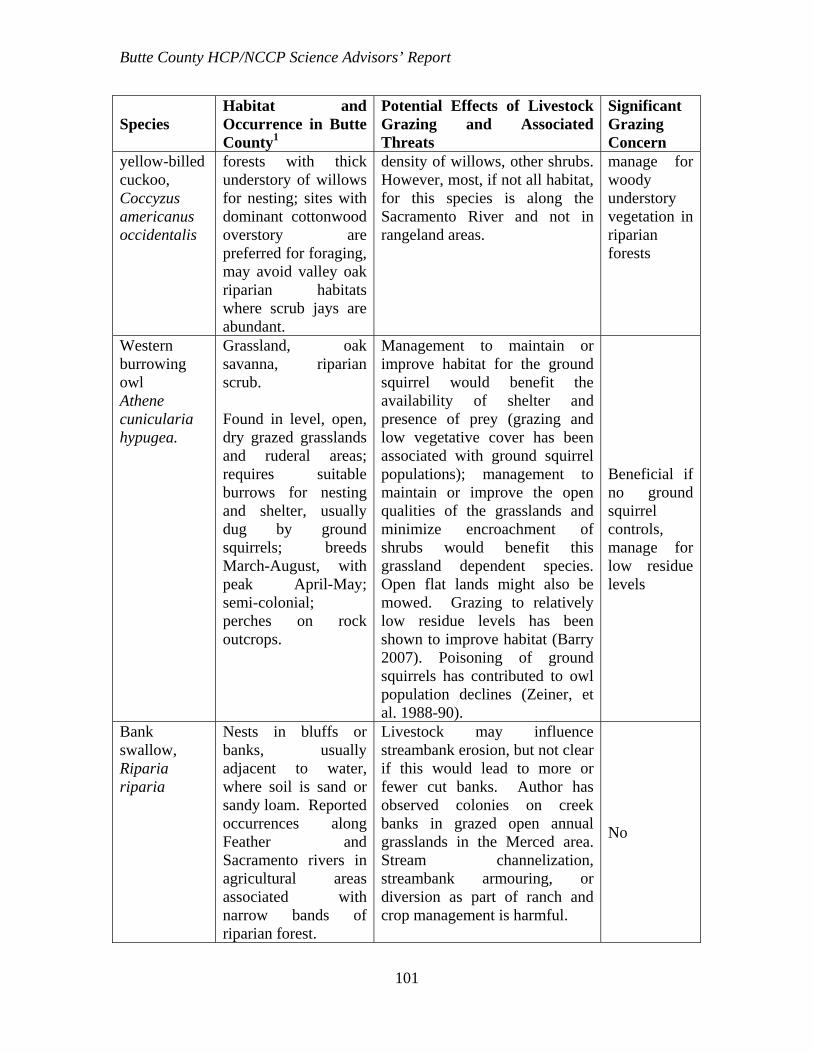
Butte County HCP/NCCP Science Advisors’ Report
101
Species Habitat and Occurrence in Butte County1
Potential Effects of Livestock Grazing and Associated Threats
Significant Grazing Concern
yellow-billed cuckoo, Coccyzus americanus occidentalis
forests with thick understory of willows for nesting; sites with dominant cottonwood overstory are preferred for foraging, may avoid valley oak riparian habitats where scrub jays are abundant.
density of willows, other shrubs. However, most, if not all habitat, for this species is along the Sacramento River and not in rangeland areas.
manage for woody understory vegetation in riparian forests
Western burrowing owl Athene cunicularia hypugea.
Grassland, oak savanna, riparian scrub. Found in level, open, dry grazed grasslands and ruderal areas; requires suitable burrows for nesting and shelter, usually dug by ground squirrels; breeds March-August, with peak April-May; semi-colonial; perches on rock outcrops.
Management to maintain or improve habitat for the ground squirrel would benefit the availability of shelter and presence of prey (grazing and low vegetative cover has been associated with ground squirrel populations); management to maintain or improve the open qualities of the grasslands and minimize encroachment of shrubs would benefit this grassland dependent species. Open flat lands might also be mowed. Grazing to relatively low residue levels has been shown to improve habitat (Barry 2007). Poisoning of ground squirrels has contributed to owl population declines (Zeiner, et al. 1988-90).
Beneficial if no ground squirrel controls, manage for low residue levels
Bank swallow, Riparia riparia
Nests in bluffs or banks, usually adjacent to water, where soil is sand or sandy loam. Reported occurrences along Feather and Sacramento rivers in agricultural areas associated with narrow bands of riparian forest.
Livestock may influence streambank erosion, but not clear if this would lead to more or fewer cut banks. Author has observed colonies on creek banks in grazed open annual grasslands in the Merced area. Stream channelization, streambank armouring, or diversion as part of ranch and crop management is harmful.
No
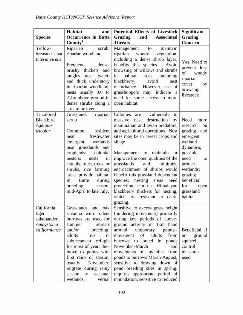
Butte County HCP/NCCP Science Advisors’ Report
102
Species Habitat and Occurrence in Butte County1
Potential Effects of Livestock Grazing and Associated Threats
Significant Grazing Concern
Yellow-breasted chat Icteria virens
Riparian scrub, riparian woodland Frequents dense, brushy thickets and tangles near water, and thick understory in riparian woodland; nests usually 0.6 to 2.4m above ground in dense shrubs along a stream or river
Management to maintain riparian woody vegetation, including a dense shrub layer, benefits this species. Avoid browsing of willows and shrubs in habitat areas, including blackberry, avoid nest disturbance. However, use of grasshoppers may indicate a need for some access to more open habitat.
Yes. Need to prevent loss of woody riparian cover by browsing livestock
Tricolored Blackbird Agelaius tricolor
Grassland, riparian scrub Common resident near freshwater emergent wetlands near grasslands and croplands; colonial nesters; nests in cattails, tules, trees, or shrubs, rice farming areas provide habitat, in Butte during breeding season, mid-April to late July.
Colonies are vulnerable to massive nest destruction by mammalian and avian predators, and agricultural operations. Nest sites may be in cereal crops and silage. Management to maintain or improve the open qualities of the grasslands and minimize encroachment of shrubs would benefit this grassland dependent species; nesting areas need protection, can use Himalayan blackberry thickets for nesting, which are resistant to cattle grazing.
Need more research on grazing and emergent wetland dynamics; possible need to protect wetlands; grazing beneficial for open grassland habitat
California tiger salamander, Ambystoma californiense
Grasslands and oak savanna with rodent burrows are used for summer retreats and/or breeding; adults live in subterranean refugia for most of year, then move to ponds with first rains of season, usually November; migrate during rainy season to seasonal wetlands, vernal
Sensitive to excess grass height (hindering movement) primarily during key periods of above-ground activity in 1km band around temporary ponds-- movement of adults from burrows to breed in ponds November-March and movements of juveniles from ponds to burrows March-August; sensitive to drawing down of pond breeding sites in spring, requires appropriate period of innundation; sensitive to reduced
Beneficial if no ground squirrel control measures used

Butte County HCP/NCCP Science Advisors’ Report
103
Species Habitat and Occurrence in Butte County1
Potential Effects of Livestock Grazing and Associated Threats
Significant Grazing Concern
pools, stock ponds, or slow streams that hold water through May (need 12 weeks of inundation); breeding occurs from December to early February; larvae transform in water by early July; post-metamorphic juveniles disperse from breeding sites in late spring to early summer.
populations of burrowing rodents; management to maintain or improve habitat for the ground squirrel which constructs burrows subsequently used for refuge (grazing is commonly associated with ground squirrels though published research is equivocal); requires access across the open grasslands, thus thatch buildup and shrub encroachment from lack of grazing would reduce habitat quality. Studies show low levels of emergent vegetation benefits this species, grazed ponds better habitat, stock ponds are refugia if non-native predators like bullfrogs and fish excluded (Didonato 2007). . Enhancement through incentive programs possible: http://www.environmentaldefense.org/article.cfm?contentID=6295
California red-legged frog, Rana draytonii2
Grassland, oak woodland, oak savanna, riparian scrub, riparian woodland Stillwater areas of streams, marshes, and stock ponds, also use ephemeral streams with pools with water March through July; prefer habitats with a mix of open habitat and emergent vegetation (USDI-FWS 2006); use upland grassland
Management to maintain or improve habitat for the ground squirrels and other burrowing rodents benefits this species as burrows may be used in hibernation or as refuge during dry periods; requires appropriate period of innundation; grazed ponds can help create mix of open and emergent habitat, can benefit the species (USDI-FWS 2006). Stock ponds are refugia if non-native predators like bullfrogs and fish excluded. Draining of ponds every 2 years eliminated bullfrog populations but did not harm red-legged frogs (Doubledee et al. 2003).
Beneficial if no ground squirrel control measures used

Butte County HCP/NCCP Science Advisors’ Report
104
Species Habitat and Occurrence in Butte County1
Potential Effects of Livestock Grazing and Associated Threats
Significant Grazing Concern
habitats and refuges of rodent burrows and woody litter up to one mile from breeding areas during movements prior to breeding or for post-metamorphic juvenile dispersal November-March and July-October. Needs 20 weeks of water, though not every year (USDI- FWS 2006)
Control of ground squirrels is not desirable. The relative frequency of occurrence of red-legged frogs and ground squirrel burrows were negatively related to the percent of emergent vegetation in ponds in the East Bay Regional Parks (USDI-FWS 2006; DiDonato 2007). Compaction may increase period of inundation; high levels of vegetation supports predatory insects. Enhancement through incentive programs possible: http://www.environmentaldefense.org/article.cfm?contentID=6295
Western Spadefoot Toad, Spea hammondii
Grasslands, open woodlands and shrublands with shallow temporary pools, washes, floodplains of rivers; sandy or gravelly soil with open vegetation and short grass; spends most time in burrows; surface movements from fall to early spring, needs more than 3 weeks of water for metamorphosis, better with longer period.
Management to maintain or improve the open qualities of the grasslands and minimize encroachment of shrubs benefits this grassland dependent species. Patterns of use of upland habitat not clear. Requires control of predatory fish, bullfrogs, crayfish. Does not need ground squirrels as it is a good burrower (?). Can use stock ponds with right substrate if predators controlled
Beneficial?
Foothill yellow-legged frog, Rana boylii
Creeks or rivers in woodlands or forests with rock and gravel substrate and low overhanging vegetation along the edge, 20-90% shading. Usually found near riffles with
If bullfrogs and predatory fish not controlled, or water diverted from habitat, construction of stock ponds can harm this species; protection of water quality through best management practices needed. Reservoir releases may harm. Likely to breed in main stems of
Possible. Management to protect vegetation and water quality, minimize trampling, control

Butte County HCP/NCCP Science Advisors’ Report
105
Species Habitat and Occurrence in Butte County1
Potential Effects of Livestock Grazing and Associated Threats
Significant Grazing Concern
rocks and sunny banks nearby. Clear, cool, springs.
rivers or creeks and overwinter in tributaries. May travel more then 50 m from water and be found underground. Predators a major factor.
predators
Western pond turtle Emys marmorata
Grassland, riparian scrub, riparian woodland; Open stagnant or slow-moving warm water (but less than 103 F) of streams and permanent ponds with rocks, floating vegetation, logs, or open mud banks for basking; muddy or rocky bottoms and with watercress, cattails, water lilies, in woodlands, grasslands, and open forests; females move overland into upland grasslands during spring to early summer or when waters dry; eggs laid March-August; incubation and hatchling movements June to November. Need warm open slopes with soil of high clay or silt content for nesting holes. Overwinters in upland sites.
Trampling may harm turtles when traveling overland; grazing can maintain the open, grassy areas needed by the species. Management to minimize trampling during travel times, and provide residue and shrub control, is recommended. Sensitive to hoof traffic around permanent waters where adults and juveniles move between water and nests; management to maintain open sunny banks or basking areas, shallow eutrophic waters can benefit, while too much woody vegetation lowers water temperatures and reduces basking areas. Management to maintain or improve habitat for the ground squirrel beneficial as burrows may be used by turtles as refugia. Requires access across the open grasslands, thus insufficient grazing, and associated grass height elevation and shrub encroachment, would reduce habitat quality. May use stock ponds but must be managed to control bullfrogs, which can prey on hatchlings. Water diversion harmful if it dries habitat. EBMUD 2001: Highly vulnerable to livestock impacts—trampling of nests and burrows and incubating eggs within one quarter mile of feeding habitat in waters;
Vulnerable to trampling; may use stock ponds, needs open grassy slopes, uses ground squirrel burrows.

Butte County HCP/NCCP Science Advisors’ Report
106
Species Habitat and Occurrence in Butte County1
Potential Effects of Livestock Grazing and Associated Threats
Significant Grazing Concern
optimal protection by complete exclusion of grazing from critical habitat from April-November. Research is needed3.
Giant garter snake, Thamnophis gigas
Sloughs, canals, marshes, and other small waterways; requires grassy banks and emergent vegetation for basking and areas of high ground protected from flooding in winter, adequate water early spring through mid-fall. Does not prefer developed riparian woodlands.
Summer grazing may reduce emergent vegetation, but winter grazing can keep grassy banks open; grazing exclusion may result in loss of grassy banks as woody vegetation grows in. Uses small mammal burrows so may benefit from management for ground squirrels (grazing is commonly associated with ground squirrels though published research is equivocal). Sensitive to water pollution.
Beneficial if water quality protected; manage to keep some grassy banks open and restrict invasion of woody species; allow emergent vegetation in summer.
California horned lizard, Phrynosoma coronatum frontale
Grasslands, brushlands, woodlands, and open coniferous forest with sandy or loose soil; requires abundant ant colonies for foraging
Research needed. However, other factors seem more important, like loss of alluvial fans and dunes, people, domestic cats.
Needs sandy or loose soil: this could be created, lost, or protected by mgt.
1 Most habitat information is from the Baseline Ecological Report 2 Fish and Wildlife Service and recent research (DiDonato 2007) descriptions of habitat diverged so far from the description in the Baseline Ecological Report that it was not used. 3 [Fidenci, Pierre. 2000. Relationship between cattle grazing and the western pond turtle Clemmys marmorata at Pt. Reyes National Seashore. Masters Thesis, University of San Francisco.]