camp cyprus · camp cyprus report diagnostic / feasibility report ... urban-rural population...
TRANSCRIPT
CAMP Cyprus Report Diagnostic / Feasibility Report
CAMP Cyprus
Diagnostic – Feasibility Report
Report prepared for MAP – PAP/RACby
Glafkos Constantinides
June, 2002

CAMP Cyprus Report Diagnostic / Feasibility Report
Table of ContentsList of BoxesList of FiguresList of TablesList of Acronyms
PrefaceExecutive Summary
1.0 COUNTRY BACKGROUND1.1 Size and Physical Characteristics1.2 Population1 3 Economic and Social Development1.4 Administrative Framework1.5 Main Development Trends
2.0 THE COASTAL ZONE2.1 A General Profile2.2 Sub-areas and their Characteristics
3.0 THE POLICY FRAMEWORK3.1 The Land Use Planning System3.2 Land Use Planning in Coastal Areas3.3 Coastal Protected Areas3.4 Natura 2000 Network3.5 Tourism Development and the Coastal Environment3.6 Environmental Policy3.7 The Administrative Framework of Environmental Policy3.8 Summary of the Legal Framework for the Coastal Areas3.9 Policies, Plans and Co-ordination Bodies
4.0 IMPACTS AND CONFLICTS, PROBLEMS AND CAUSES4.1 Specific Problems4.2 Underlying Causes4.3 Case Studies
5.0 NEED FOR CAMP CYPRUS5.1 Project Rationale5.2 Concepts and Principles of CAMP5.3 The CAMP Programme5.4 CAMP Procedure5.5 Goals and Objectives
6.0 CAMP AREA6.1 Which is the Coastal Area?6.2 CAMP Cyprus Area
7.0 THE CAMP CYPRUS PROJECT7.1 Project Activities7.2 Project Methodology7.3 Project Organisation
CAMP Cyprus Report Diagnostic / Feasibility Report
7.4 Project Resources7.4.1 Database7.4.2 Manpower7.4.3 The Role of MAP and RACs7.4.4 Budget
7.5 Project Timeframe
8.0 CONCLUSIONS – Project Feasibility and Expected Project Benefits
References
ANNEXES
Annex I Persons Interviewed
Annex II Cyprus Legislation concerning the Marine Environment and the CoastalArea
Annex III Responsibilities for Implementation and Enforcement of EnvironmentalLegislation in Cyprus
Annex IV Development Expenditure by Ministry and Department, 1996-2000
CAMP Cyprus Report Diagnostic / Feasibility Report
List of Boxes1. Extract from Habitat II National Report, Republic of Cyprus, 19962. Coastal Segments3. Protected Coastal Areas4. Natura 2000 sites5. Summary of the Legal Framework concerning the Coastal Zone6. Policies and Plans7. Tools and Co-ordination Bodies8. Co-ordination Bodies9. Evolution of CAMPs10. CAMP Cyprus – Project Summary
List of FiguresFig. 1 Map of Cyprus and Place NamesFig. 2 Development in the Coastal area
List of TablesTable 1 - Coastal Population Increase in Cyprus 1982-2002Table 2 - Urban-Rural Population Distribution by District 2002Table 3 - The Cyprus Economy: Gross Domestic Product,1996-2201Table 4 - Main demand and supply components of the economy, 1996-2000Table 5 - Types of Local GovernmentTable 6- Central and Municipal Level ResponsibilitiesTable 7 - Budget Expenditure of Coastal Municipalities 1997-2000Table 8 - Population growth and suburbanisation trends in CyprusTable 9 - Urban and Suburban Population growth by Area, 1982 - 2001Table 10 - Coastal and Non-coastal Population Distribution, 2001Table 11 - Coastal Population Increase in Cyprus 1982-2002Table 12 - Development along the Coast (length of coastal land in km)Table 13 – Number of Tourist Beds 1974-2001Table 14 - Regional Distribution of tourist accommodation capacity at 31.12.2001Table 15 - Population and No of tourist beds in coastal areas by District, 2001Table 16 – Coastal Length, Population and Tourist Beds in Selected Coastal Areas
List of AcronymsCTO Cyprus Tourism OrganisationCC Common CouncilCCC Cyprus Chamber of CommerceCU Coastal Unit (of the Ministry of Communications and Works)DF Department of ForestryDFMR Department of Fisheries and Marine ResearchDL Department of LabourDTPH Department of Town Planning and HousingES Environment ServiceETEK Technical Scientific Chamber of CyprusGSD Geological Survey DepartmentGF Game FundMANRE Ministry of Agriculture, Natural Resources and EnvironmentMCW Ministry of Communications and Works

CAMP Cyprus Report Diagnostic / Feasibility Report
MCIT Ministry of Commerce, Industry and TourismFEEO Federation of Environmental and Ecological OrganisationsMF Ministry of FinanceMLSI Ministry of Labour and Social InsuranceMI Ministry of InteriorMH Ministry of HealthPB Planning BoardPHS Public Health ServicesSGL State General LaboratoryTCPL Town and Country Planning LawWDD Water Development DepartmentUM Union of Municipalities
CAMP Coastal Area Management ProgrammeCCA Carrying capacity AssessmentEIA Environmental Impact AssessmentGIS Geographical Information SystemICAM Integrated Coastal Area ManagementRV Resource ValuationSEA Strategic Environmental Assessment
MAP Mediterranean Action PlanMEDU MAP Coordination UnitPAP/RAC Priority Actions Programme Regional Activity CentreRACs Regional Activity CentresUNEP United National Environment Programme

CAMP Cyprus – Executive Summary Diagnostic / Feasibility Report
1
PREFACE
This Report has been commissioned by the Priority Actions Programme Regional Activity Centre(PAP/RAC) of the Mediterranean Action Plan (MAP) – UNEP. Its purpose is to provide a focus to thepreparatory phase for the implementation of CAMP Cyprus that commenced with the visit to Cyprusof Mr. I. Trumbic, Director of MAP-PAP/RAC, in September 2001, and the subsequent approval byMAP of the application of the Cyprus Government in November 2001, at the 12th Ordinary Meeting ofthe Contracting Parties to the Barcelona Convention, to proceed with CAMP Cyprus.
The Report has been prepared within the following Terms of Reference:
• To inspect the existing strategic, policy and institutional context encompassing the areawhere the CAMP activities will be carried out;
• To define the area of CAMP;• To collect and present the available relevant information on the strategic, policy and
institutional context;• To define the activities from the point of view of the national and local interest;• To assess the international context in which CAMP Cyprus will be implemented;• To assess the possibilities for the implementation of CAMP Cyprus;• To assess the possibilities for a long-term sustainability of the project.
For the purpose of preparing this Report, consultations were held with the Director and Officers ofthe Environment Service (focal MAP agency), with representatives of all relevant GovernmentDepartments, Local Authorities and private sector organisations, including:
Environment ServiceDepartment of Town Planning and HousingPlanning BureauCyprus Tourism OrganisationMinistry of InteriorMinistry of Communications and Works (Coastal Unit)Water Development DepartmentForestry DepartmentDepartment of Fisheries and Marine ResearchGeological Survey DepartmentDepartment of Agriculture
Municipality of LarnacaMunicipality of PaphosMunicipality of LimassolMunicipality of PolisMunicipality of YeroskypouMunicipality of Ayia Napa
Federation of Environmental and Ecological OrganisationsCyprus Hotel AssociationCyprus Ports AuthorityCyprus Association of Tourism Establishments
CAMP Cyprus – Executive Summary Diagnostic / Feasibility Report
2
The Role of this Report in CAMP Procedure
This Feasibility – Diagnostic Report is the first step in the formulation of the CAMP CyprusProject. Its preparation follows the approval of the proposal put forward by Cyprus to MAP, and itspurpose is to provide the overall framework in which CAMP Cyprus will be implemented. Afterapproval of this Report by MAP and the Government of Cyprus, the second step envisages thedevelopment of a detailed programme in which the CAMP Activities will be specified in the form ofTerms of Reference which will constitute the basis of the Project Agreement to be signed betweenthe Government and MAP signifying the initiation of the CAMP Project. Following that, an InceptionReport will be prepared, containing concrete proposals about how CAMP Cyprus will beimplemented, which will be presented at the Inception Workshop, completing the overall Projectformulation phase.
Based on the conclusions of the Inception Workshop, further refinements will be made (if any) to theTerms of Reference to detail the Technical Specifications for the work programme of theimplementation of Project Activities, including the participation and contribution of the national andinternational experts. Finally, the results of Project Activities will be developed into Specific ActivityReports and a Final Integrated Report, which will be presented at a Final PresentationConference, highlighting also the need for and focus of follow-up actions.
In brief, the major outputs of the CAMP include 1:
Preparation / formulation stage• Feasibility – Diagnostic Analysis Report• Project Agreement and Terms of Reference• Inception Workshop• Technical Specifications (work programme) for the individual CAMP Activities
Implementation stage• Final Reports on individual Activities• Draft Integrated CAMP Report• Final Integrated CAMP Report• Final Presentation Conference• Report on the Presentation Conference
Follow-up stage• Follow-up proposals and Investment Portfolio
The Structure of the Report
The Report contains this Executive Summary and the Main Report. The Main Report includes twomain Parts: Part I comprises 4 Chapters covering the general policy and institutional context inCyprus, with particular emphasis on the coastal area, and Part II comprises another 4 Chapterscovering the need for CAMP Cyprus, its activities, methodology, organisation and management,resources and the expected benefits.
Acknowledgements
The author wishes to express his thanks to all the national experts and representatives of localauthorities and private sector organisations who provided information and advice for the purposes ofthis Report. Specifically, to Mr. Andreas Ashiotis of the Ministry of Interior, Mr. Stefos Papanicolaou, 1 UNEP/MAP: Formulation and Implementation of CAMP Projects, Operational Manual, 1999
CAMP Cyprus – Executive Summary Diagnostic / Feasibility Report
3
Mr. Ermis Klokkaris and George Hadjimichael of the Department of Town Planning and Housing, Mr.Michael Leptos, Ms. Erini Piki and Mr. George Georgiou of the Planning Bureau, Ms. PhoebeKatsouris, Ms. Athena Metaxa, Mr. Stelios Eleftheriou and Mr. Glafcos Cariolou of the CyprusTourism Organisation, Dr. Antonis Toumazis and Anthi Clerides of the Cyprus Ports Authority, Mr.Nicos Iacovou and Jason Sofos of the Ministry of Communications and Works (Coastal Unit), Mr.Takis Ioannou, Mr. Panicos Skordis, Mr. Nicos Tsourtis and Mr. Iacovos Iacovides of the WaterDevelopment Department, Ms. Lenia Morisseau and Mr. Chris Hadjigeorgiou of the GeologicalSurvey Department, Mr. Alecos Christodoulou and Andreas Kyriakou of the Forestry Department,Mr. Gabriel Gabrielides and Mr. Loizos Loizides of the Department of Fisheries and marineResearch. Also, Mr. Zacharis Ioannides of the Cyprus Hotel Association, Mr. Eleftherios Embedoklisof the Larnaca Municipality, Ms. Varvara Pericleous, Nicos Kallikas and Athos Georgiou of the AyiaNapa Municipality, Mr. Savas Savides of the Paphos Municipality, Mr. G. Gregoriou of theYeroskypou Municipality and Mr. Yerolemos of the Polis Municipality.
Particular acknowledgement is due to the Director of the Environment Service and focal person forMAP Mr. Nicos Georgiades and his colleagues Ms. Myroula Hadjichrostoforou and AndonisAndoniou.

CAMP Cyprus – Executive Summary Diagnostic / Feasibility Report
4
EXECUTIVE SUMMARY
General Country ProfileCyprus (excluding the occupied part) has a total population of 689,500, 474,500 urban (69%) and215,000 rural (31%). Between 1982-2001, the total population grew by 35%; the urban populationgrew by 45% and the rural population by 15%.
Cyprus has an open free-market economy, driven mainly by the tourist and service sectors asreflected in the contribution to the Gross National Product (GDP). GDP in constant 1995 prices hasreached in 2001 just over 5 billion Cyprus Pounds. The broad Service Sector accounts for 75% ofGDP. Cyprus’ main trading partner is the European Union accounting for about 55% of imports and40% of exports.
The main characteristics of the Cyprus economy include:• Continuous economic growth• A strong private sector• A large tourism sector• Openness to international trade
Cyprus is the 25th out of the 48 countries included in the “high human development” group with aHDI of 0.877, after Hong Kong with an index of 0.880 and before Singapore with an index of 0.876 2.Life expectance at birth stands at 77.9, adult literacy rate at 96.9 and GDP pr capita at US$19,000.The ratio of doctors to the population is 1:357 and that of nurses to the population 1:224 and there isone hospital/clinic bed for every 216 persons. 75% of the housing stock is owner-occupied and96.6% of all rural houses are connected to the electricity and water supply system (99.3% in theurban areas). There are 61 telephone lines per 100 persons and one private car for every 2.4persons.
The Republic of Cyprus was instituted as an independent sovereign country in 1960 with apresidential system of government. There are 11 Ministries each headed by a Minister. TheMinistries are: Foreign Affairs, Finance, Interior, Defence Education and Culture, Communicationsand Works, Commerce, Industry and Tourism, Agriculture, Natural Resources and Environment,Justice and Public Order, Labour and Social Insurance, and Health. Administratively, Cyprus isdivided into six Districts: Nicosia, Limassol, Larnaca, Paphos, Famagusta and Kyrenia (Fig. 1).
In 1974, the Republic of Cyprus was invaded by the Turkish Army imposing a division in the island,with the northern 38% of the territory (including the whole of Kyrenia District and the largest part ofFamagusta District), remaining since then inaccessible. This Report is therefore concernedthroughout with the territory under the control of the Government of Cyprus.
Main Development TrendsThe spatial development pattern in Cyprus is characterised by two dominant trends:
• Sub-urbanisation, and• Coastalisation
Suburbanisation takes the form of rapid population growth and development sprawl in the suburbslocated at the edges of the main urban areas. In this Report, the definition of “urban areas” followsthat used in the recent Population Censuses and the Local Plans, under the Town and CountryPlanning Law (TCPL), referring to the areas including the towns and the surrounding expandingsuburbs.
2 Human Development Report, UNDP, 2001
CAMP Cyprus – Executive Summary Diagnostic / Feasibility Report
5
The following figures showing the spatial distribution of population growth in the period 1982-2001clearly illustrate the suburbanisation trend:
• 35% total population growth• 46% urban population growth, of which the suburban population growth was more than twice
that of the core urban population growth (68% and 26% respectively).
“Coastalisation”, a consequence of the rapid and sprawling pattern of coastal tourism development,is equally dominant in Cyprus. As much as 95% of all licensed tourism hotel accommodationcapacity is on the coast (the rest is located in Nicosia and the mountain resorts). Of all coastaltourism accommodation capacity, 55% is concentrated in the suburban tourism centres around thetowns of Limassol, Larnaca and Paphos and as much as 40% is located in rapidly growing coastalvillage communities that have grown into tourism centres, notable in the settlements of Ayia Napaand Paralimni in the southern Famagusta District, which, unlike the rest of the rural areas of Cyprusthat remained dependent on agriculture, recorded in the period 1982-2001 a population growth of57%, higher than the growth of the coastal urban areas themselves.
The following figures for population growth in the period 1982-2001 clearly illustrate thecoastalisation trend:
• 35% total population growth• 46% total urban population growth
o 55% coastal urban growtho 35% inland urban growth
• 15% total rural population growtho 45% coastal rural growtho 8% inland rural growth
The Coastal ZoneIn Cyprus there is no single legal or functional (planning) definition of the “coastal zone” or “coastalarea”. There are three main widely used geographical definitions referring to “coastal zone / area”,each one related to the purposes of a different law and institutional context.
1. The Foreshore Protection Law defines the “foreshore” as “all lands within 100 yards of thehigh water mark”. The foreshore area is public property falling under the jurisdiction of thisLaw.
2. The New Tourist Policy of 1990 (under the Tourism Hotel Accommodation Law and theTCPL) designated a “zone” of 3 km. from the coastline for the purposes of control of tourismdevelopment.
3. The Coastal Protection Study of the Coastal Unit of the Ministry of Communications andWorks adopted for the purposes of the survey of coastal erosion problems a definition of the“coastal strip” as the area of 2 km. from the coastline.
The TCPL contains no specific definition of the coastal area. Local Plans and the Policy for theCountryside contain land use / development control zones that cover coastal and non-coastal areaswithin the same Plans.
Thus, in this Report, as in many other reports on Cyprus, the terms coastal area and coastal zoneare used interchangeably. The small size of Cyprus and the close proximity of all areas to the coast,combined with the dominance of coastal tourism in building development and the economy, create astrong functional overlapping between the coastal area and other areas, blurring the coastal /hinterland distinction. For Cyprus, and particularly for the purposes of CAMP Cyprus and itsintegrated approach to coastal area management, an issue-led approach to coastal problems isadopted rather than a legal or physical definition.
CAMP Cyprus – Executive Summary Diagnostic / Feasibility Report
6
The coastal zone that extends 2 km. inland from the coastline covers 23 percent of the country’stotal area, in which about 50% of the total population lives and works and 95% of the tourist industryis located generating by far the largest source of household income. The average population densityis about 17.5 persons per hectare.
The Island has a total of 772 km. of shoreline, of which:• 404 km. are in the occupied northern area (52%);• 72 km. are within the British Military Bases (10%); and• 296 km. are within the area under Government control (38%).
The shoreline overall is uneven and rocky (54%) with sandy beaches and many small coves (46%).The coastal zone is characterized by rich wildlife, long and small beaches, open areas, cliffs, capes,harbours, sand dunes, accumulations of pebbles, and, in general, marine and shore areas of primeecological and scientific value.
The EU Programme MEDSPA Study 3, carried out by the Coastal Unit of the Ministry ofCommunications and Works, that surveyed the physical characteristics of the whole length of thecoastline of Cyprus (under government control), identified 12 coastal segments with broadlycommon geomorphologic and hydrodynamic characteristics, including:
Paphos District • Tylliria Area• Kato Pyrgos Bay• Krysochou Bay• Akamas Area• North Paphos Area• South Paphos Area
Limassol District • Episkopi Bay• Akrotiri Area• Limassol Bay
Larnaca District • Ziyi-Kiti Area• Larnaca Bay
Famagusta District • Ayia Napa-Protaras Area
The Policy Framework
The Land Use Planning SystemLand use planning policy in Cyprus is carried out under the 1972 TCPL, which came into force onthe 1st of December 1990. The coordination of land use planning policy is the responsibility of theDepartment of Town Planning and Housing of the Ministry of Interior. The TCPL provides for thepreparation and enforcement of a hierarchy of Development Plans, the operation of a network ofPlanning Authorities with responsibilities for the exercise of Development Control through powers forissuing Planning Permissions on the basis of the provisions of the Development Plans. TheDevelopment Plans comprise a three-tier hierarchy, namely the Island Plan, the Local Plans and theArea Schemes:
(a) The Island Plan, the strategic spatial plan for the island that remains inactive since 1974 due tothe division of the Island. In view of that, under the TCPL a “replacement” Development Plan wasintroduced, the Statement of Policy for the Countryside, which cover all the (mostly rural) areasoutside the boundaries of Local Plans or Area Schemes.(b) The Local Plans, the middle ties of Development Plans, cover the main urban areas togetherwith their urbanised fringes experiencing pressures for expansion and population growth.
3 Coastal Protection in Cyprus (1993-96)
CAMP Cyprus – Executive Summary Diagnostic / Feasibility Report
7
(c) The Area Schemes, at the lower end of the hierarchy, cover specific smaller areas of particularinterest, either within or outside the framework of a Local Plan, and detail site-specific developmentproposals on the basis of the strategic guidelines and policies of the Local Plans or the Policy for theCountryside.
Land Use Planning in Coastal AreasThe coastal zone is not a unified planning area, there is no separate institutional or land useplanning framework specifically pertaining to the coastal areas. Coastal land use zones form parts ofseveral Development Plans applying to different local administrative areas. Each section of the coastis covered by land use zones together with those covering the wider inland planning area fallingunder either a Local Plan (such as Limassol, Larnaca and Paphos) or by the out-of-urban-areasStatement of Policy for the Countryside. The existing Development Plans are demarcated along theurban/rural rather than the coastal/inland dimension. Only a relatively small section of the coastalarea development is still controlled under the provisions of the old Streets and Buildings RegulationLaw (Cap. 96):(a) the area of Paralimni Municipality, including the Protaras tourism area, and(b) the parts of the coast that fall within the British Military Bases of Akrotiri, Episkopi and
Dekelia of approximately 72 km.
The extent of the land use planning zones in place along the coast is as follows:• The tourist zones cover approximately 103 km.• the open areas/protected archaeological zones approximately 125 km.• agricultural zones 36 km.• residential zones approximately 17 km., and• industrial approximately 9 km.
The greatest extent of coast under some form of protection is the Paphos District (62% of the coast)mainly due to the long stretch of the Akamas Peninsula, most of which is a national forest.
Coastal Protected AreasA hierarchy of Protected Areas, designated under the provisions of the Policy Statement for theCountryside, is in place in the coastal zone including the following categories and areas:
i) “Nature Protection Shores and Areas” • Cape Cavo Greco,• Makronissos,• Dasos Ranti and• Akamas Peninsula
(ii) “Protected Sites” • Pomos Cliff• Liopetri River Estuary• Cavo Greco Cliffs• Pissouri Cliffs
(iii) “Areas of Outstanding Natural Beauty” • Pegia• Kouklia• Pissouri• Maroni
(iv) “Archaeological Sites” • Nea Dimmata• Aghios Georgios Pegias• Kiti• Tombs of Kings, Kato Paphos• Castle of Kato Paphos - Antiquities
of Kato Paphos• Area of Maa - Paleokastro• Ancient Amathous• Kourio

CAMP Cyprus – Executive Summary Diagnostic / Feasibility Report
8
Tourism Development and PolicyTourism policy is formulated, promoted and co-ordinated by the Cyprus Tourism Organisation(CTO), a semi-Government Organisation under the Ministry of Commerce, Industry and Tourism.CTO has no spatial plan preparation and implementation powers but, through its involvement in themeetings of the Planning Board when discussing tourism issues, tourism policies are incorporated inthe Local Plans and the Policy for the Countryside under the TCPL. In 2000 a Strategy for Tourismwas prepared by the CTO containing the main strategic goals for Cyprus tourism up to the year2010. However, on the basis of CTO legislation, several policies and measures are in force for theregulation of tourism development and the operation of tourism establishments.
In 1987 a special provision was incorporated in the Hotels and Tourist Accommodations legislationgiving powers to the Council of Ministers to establish areas in which the type, class and degree ofallowable tourist development would be regulated.
In June 1989, the Government adopted a moratorium on tourist development in the coastal areas inorder to re-evaluate problems in tourist areas and allow the preparation of a new policy on tourism inconjunction with land use planning policy. The moratorium lasted for 18 months, for in December1990, the Government proceeded to the adoption of a new policy, by which the construction of newtourist accommodation in the coastal zone and at a distance of 3 km. from the shore came undercontrol. At the same time, the TCPL of 1972 was put into full effect.
Environmental PolicyThe overall responsibility for environmental policy (excluding land use planning) rests with theMinister of Agriculture, Natural Resources and Environment (MANRE) assisted by an inter-ministerial Environment Committee and a Consultative Environment Council, which includes privatesector representatives and NGOs. The Environment Service (ES) of the Ministry co-ordinatesprogrammes for the protection of the environment, advices on environmental policy formulation andits implementation, and is in charge of the environmental impact assessment process. Theenvironmental management framework is interlinked and co-ordinated both with the land use /physical as well as with the tourism planning frameworks.
Implementation and enforcement of sectoral aspects of the environment is carried out in accordancewith specific laws and regulations by a number of line Ministries, Departments and Servicescorresponding to the subject-matter areas of their respective responsibility. All line Ministries withexecutive responsibilities on environmental issues participate in the Environment Committee and theEnvironment Council. Environmental policy is focused on the alignment with the EU Acquis,and current work priorities and work effort are geared to the legal transposition of relevantEU Directives into Cypriot legislation.
Cyprus has accepted the environmental Acquis and declared to apply it by 1.1.2003 or at later dates in certainareas in which transitional periods were requested or for which the dates provided in the Acquis allow for laterdates for implementation. A concrete programme for transposing Community environmental legislation is inplace within the timeframe given to the Commission. The directives on Free Access to EnvironmentalInformation, Water Quality Intended for Human Consumption and on EIA have been fully transposed, while fulltransposition of the environmental Acquis will be effected through revisions to existing laws.
The draft comprehensive Bill for the Environment, prepared in 1997, has been subsequently decided to be splitinto a number of new bills, such as:
CAMP Cyprus – Executive Summary Diagnostic / Feasibility Report
9
• Environmental management framework, Fiscal Instruments, General Obligations, International Issues (newFramework Bill on the Environment)
• Protection of Species and Habitats, Trade in Species• Solid and Hazardous Waste Management• Packaging and Packaging Waste Management• Environmental Impact Assessment• Free Access to Information• Genetically Modified Organisms,• Noise, etc.
The Administrative Framework of Environmental PolicyAt the national level, the Council of Ministers has the overall responsibility for the formulation of environmentalpolicy. Environmental policy is co-ordinated through the MANRE, with the exception of land use / spatialplanning, for which responsibility rests with the Minister of Interior.
An important component in the environmental management mechanism is the Council for the Environment, witha wide representation, which advises the Minister and through him, the Council of Ministers, on environmentand sustainable development issues. To assist in the co-ordination and implementation of environmental policy,the government established an additional instrument, that of the Environment Committee, made up ofrepresentatives of all agencies involved in environmental issues. Competencies are divided among severalinstitutions, the competent authorities being primarily public bodies, Ministries, or Departments.
The Environment Service of the MANRE is mandated to advise on environmental policy, ensure implementationand co-ordinate (in close co-operation with the Planning Bureau) the process for the adoption of the EUenvironmental policy and legislation. It also heads the Technical Committee on environmental impactassessment, oversees the enforcement of the Law on the Control of Water Pollution, promotes environmentalawareness and training, and disseminates information on the environment. The Environment Service is also theadministrative arm of the Environment Committee and the Council for the Environment. In addition, it is theNational Focal Point for the CSD, MCSD, SMAP, INFOTERRA, UNEP and MAP, and the Conventions ofCITES, Bern, Basel, Vienna, Biological Diversity, Desertification, Ramsar, Climate Change and EnvironmentalImpact Assessment in a Transboundary Context.
Through its various Departments (mainly Agriculture, Forestry, Fisheries and Marine Research, WaterDevelopment and Geological Survey), the MANRE has a wide range of executive functions on environmentalissues: Protection of the quality of surface and ground waters and the sea, management of water resources,aquaculture, meteorology, protected areas, soil conservation, fertilisers and pesticides, reuse of treated effluent,hazardous waste management, mines and quarries, control/monitoring and combating marine pollution, marineecology, management of forests and public parks, herbaria and gene banks, organic farming, protection of floraand fauna, agricultural and animal husbandry waste, industrial waste treatment, rehabilitation of sites, healthand welfare of animals, etc.

CAMP Cyprus – Executive Summary Diagnostic / Feasibility Report
10
Agencies and other Ministries also have a wide range of executive responsibilities over various environmentalissues, as follows:
• the Planning Bureau, is in charge of the preparation of the National Strategic Economic DevelopmentPlans and has responsibility for the broader co-ordination of the EU accession process,
• the Ministry of Labour and Social Insurance, is the competent authority for the administration andenforcement of the Atmospheric Pollution Control Law, the Safety and Health at Work Law, theDangerous Substances Law, and the Asbestos (Safety and Health of Persons at Work) Law. It alsoadministers part of the Water Pollution Control Law and has been assigned responsibility for thebroader framework for radiation protection,
• the Department of Town Planning and Housing is responsible for the coordination of Land UsePlanning Policy and the implementation of the TCPL,
• the Ministry of Commerce, Industry and Tourism, is responsible for industrial estates, energyconservation, exploitation of new and renewable sources of energy, industrial pollution preventiontechniques and the management of a grants scheme which assists manufacturing industries ininstalling waste treatment systems,
• the Cyprus Tourism Organisation promotes tourism development, including agro-tourism and is theco-ordinator of the BLUE FLAGS scheme in Cyprus,
• the Ministry of Communications and Works, is responsible for shoreline defence, the implementationof International Civil Aviation standards on noise from aircraft, the regulations and internationalconventions on Merchant Shipping, motor vehicles inspection and Type Approval for vehicles,
• the Cyprus Ports Authority handles oily waters and refuse from ships in port areas,• the Ministry of Health inspects landfills and drainage systems, is responsible for the control of drinking
water and the microbiological monitoring of recreational waters and carries out research and analyticalwork on various aspects of pollution with its specialised laboratories in environmental chemistry,microbiology and virology, ecotoxicology and risk assessment, and
• the Game Fund is in charge of the enforcement of the Game and Wild Birds Law, which regulateshunting and game improvement.
Summary of the Legal Framework concerning the Coastal Zone (Laws & Regulations)
MARINE ENVIRONMENTLaw Concerning the Control of Water Pollution (No. 69/91)Responsible authority MANREConsolidated Amending Regulations of 1990 (No. 273/90) adopted on the basis of Article 6 of the FisheriesLaw.Responsible authority DFMR-MANREAmendment (No. 170 of 1990) of the Fisheries Law.Responsible authority DFMR-MANRE

CAMP Cyprus – Executive Summary Diagnostic / Feasibility Report
11
Ratification Law (No. 51 of 1979) of the Barcelona Convention regarding protection of the Mediterraneanfrom pollution as well as its two Protocols:
(a) Protocol for the protection against pollution of the Mediterranean by waste from ships or aircraft(Dumping Protocol),(b) Protocol for cooperation in the combating of pollution in the Mediterranean by petroleumproducts and other toxic substances (Emergency Protocol)
Responsible authority DFMR-MANRERatification Law (No. 266 of 1987). It ratifies another two Protocols of the Barcelona Convention:
(a) Protocol for the protection of the Mediterranean from land-based sources(b) Protocol concerning protected areas of the Mediterranean
Responsible authority MANREConsolidated Amending Regulations (No. 273/90) enacted under the Fisheries Law (Chapter 135)Responsible authority DFMR-MANRERatification Law (No. 57 of 1989). It ratified the International Convention regarding prevention of pollution ofthe sea by ships of 1973 and the relevant Protocol of 1978 and the Amendments of 1984.Responsible authority DFMR-MANRE, DMS-MCWRegulations concerning undersea pipelines for carrying oil and other products (No. 151/1995).Responsible authority MCWRatification Law (No. 63 of 1989),ratifying the International Convention concerning civil liability for damage from oil pollution of 1969, and itsprotocol of 1976 and provisions regarding related matters.Responsible authority DMS-MCWRatification Law (No. 14 (III) of 1997).Law Regarding the Ratification of the Protocol of 1992 which amends the international Convention regardingcivil liability for damages from pollution.Responsible authority MCWRatification Law (No. 109 of 1989).Ratifies the International Convention concerning the establishment of an international fund for compensationfor oil pollution of 1971 and its protocol of 1976 and provisions regarding related matters.Responsible authority MCWRatification Law (No. 9 (III) of 1995).Ratifies the Agreement related to the application of the part of the XI Convention for maritime justice ofDecember 10, 1982.Responsible authority MFA and MANRELAND USE – SPATIAL PLANNINGThe Town and Country Planning Law (No. 90/72, Amending Laws 56/82, 7/90, 28/91, 91(I)92, 55(I)/93).Responsible authority
MoI (except for the portion of the law related to the Island Plan)MI has transferred his responsibilities to the Director of DTPH, the Local Councils in the largeMunicipalities and the Town Planning Board.
The Foreshore Protection Law (No. 22/61, and Amending Laws 17 of 1964, 8 of 1972, 52 of 1975, 21 of1987, 126 of 1989, 11 of 1990, 251 of 1990, 40 of 1991, 87 of 1991, 234 of 1991, 15(I) of 1992, 41(I) of1992, 61(I) of 1992, 103(I) of 1992, 7(I) of 1993, 19(I) of 1993, 27(I) of 1993, 37(I) of 1993, 4(I) of 1994, 34(I)of 1994, 51(I) of 1994, 75(I) of 1994Responsible authority DO, CCB, LAThe Piers Law (No. 39/73, 36(I)/94).Responsible authority MIC. TOURISM DEVELOPMENT (Competent authority: Cyprus Tourism Organization)Laws of Hotels and Tourist Accommodations of 1969 to 1995 (No. 40/69, 52/70, 17/73, 28/85, 42(I)93,80(I)95).The (General) Regulations concerning Hotels and Tourist Accommodations (No. 192/85, 205/93).Regulations for Hotels and Tourist Accommodations (Organized apartments and tourist villages) (No.206/93).Regulations concerning Hotels and Tourist Accommodations (Groups of tourist villas regulations of 1993)(No. 207/93).Regulations concerning Hotels and Tourist Accommodations (Traditional buildings) (No. 208/93).
CAMP Cyprus – Executive Summary Diagnostic / Feasibility Report
12
Regulations concerning Hotels and Tourist Accommodations (Camping sites) (No. 155/77).Regulations concerning Hotels and Tourist Accommodations (Tourist apartments) (ARA 193/85).The Laws of 1985 and 1991 concerning recreational establishments (No. 29/85 and 214/91).Decisions of the Council of Ministers (based on Article 5 of the Law concerning Hotels and TouristAccommodation)
Existing Policies, Plans, Tools and Co-ordination Bodies for Coastal Development
(i) Policies and PlansIn Cyprus, as in many other countries, there is no specific Coastal Zone Management Policy as aseparate and self-contained document with a geographical focus on the coastal zone. Policies forthe coastal zone are included in various sectoral policies which cover other areas including thecoastal zone. The main policies include:
Policy FocusLand Use (Spatial) Policy Expressed in the Development Plans prepared and
implemented under the provisions of the TCPL (Local Plans,Area Schemes and Policy for the Countryside that regulate allforms of development residential, tourism, industrial,commercial, agricultural, infrastructure, etc.) and thedesignation of various categories of protected areas.
Tourism Policy Expressed in the Strategic Plan for Tourism 2000-2010prepared by the Cyprus Tourism Organisation. The TouristStrategy defines the long-term vision and strategic goalsguiding tourism development. Although it contains goalsspanning across all policy areas that influence tourismperformance, lacks its own spatial policy and implementationtools.
Environmental Protection Policy Expressed in sectoral policies for various resources (land,foreshore, fresh water, sea water and marine environment,forests, etc.) prepared and implemented by the variouscompetent authorities as outlined in 3.1.4 and in Annex I ofthis Report.
(ii) Management Tools and Co-ordination BodiesThe existing tools and institutions for the protection and management of the coastal environmentand the regulation of coastal development are likewise segmented in different sectoral policies anddepartments according to their specific sphere of competence.
Tools FocusLand use zones Designated by the Development Plans and implemented
through planning permissionsProtected areas Designated by the Development PlansPlanning permissions Issued on the basis of the provisions of the Development
Plans and implemented through planning permissionsNatura 2000 sites Identified by the provisions of EU Directive 92/43 expected to
be incorporated in the Development PlansEnvironmental Impact Assessment Established by Law 57(I) 2001 applying to a large category of
development projects in all areas including the coastal zone.Implemented by the Environment Service and enforced inrelation to concrete projects by the Department of TownPlanning and Housing through the issue of PlanningPermissions.
Tourism Strategy A broad strategic document approved by the Council ofMinisters; its goals and objectives are expected to be
CAMP Cyprus – Executive Summary Diagnostic / Feasibility Report
13
incorporated in sectoral policies, particularly land use zonesand the policies of the Development Plans.
Sectoral regulations Provided in different sectoral Laws and Regulations applyingto the protection of he coastal and marine environment frompollution, wastes, construction, etc. implemented by thevarious competent authorities as outlined in 3.1.4 and inAnnex I of this Report
Co-ordination Bodies FocusPlanning Board Exercising delegated powers, responsible for the approval of
Development Plans. It includes 10 members, 4 privatemembers, including the Chairman, and 6 representatives ofvarious key Ministries. Technical advice and coordinationprovided by the Director and Staff of the Town Planning andHousing. The Development Plans, as spatial plans, areexpected to reflect the policy priorities and objectives ofindustrial, agricultural, commercial and particularly tourismpolicy.
Common Councils Established by the TCPL and act as local advisory bodies tothe Planning Board. Before Development Plans are presentedto the Planning Board for adoption or change, are reviewed,and recommendations are made, by the relevant CommonCouncils. Participants include local municipal councillors andrepresentatives of expert NGOs.
Technical Environmental Committee onEIA
The Committee is chaired by the Director of the EnvironmentService and functions under the provisions of the EIA Law57(I) 2001. Reviews EIA studies submitted by applicants ofdevelopment projects. The Committee’s views andconclusions are addressed to the Environmental Service,which is the Environmental Authority, issuing statements tothe competent Government Department that have to be takenvery seriously into consideration prior to the issue of PlanningPermission for the development. The Committee comprisesrepresentatives of all key Ministries and Departments relatedto the environment, as well as representatives of civil society.
National and Local Committee onBeaches
A two-level ad hoc inter-departmental committee set up underthe Foreshore Protection Law advising on the use andmanagement of land within the protected “foreshore area”.The National Committee has 13 members, chaired by theChairman of the Union of Municipalities, plus representativesof relevant Ministries, and NGOs. The District Committee hasas similar role but at the local level, has 7 members, chairedby the respective District Officer and includes representativesof local authorities and relevant Ministries / Departments.
Conflicts, Problems and Causes
Specific Problems
Sea pollution. Cyprus has a very small industrial sector and therefore industrial production has beenof very limited importance in its economic development. Coastal population growth and tourism posea potential threat although actual impacts are limited due to the sewerage infrastructure in place inall coastal urban centres and coastal hotels. Sea pollution problems are limited andgeographically isolated. Within the framework of MAP pollution is monitored, including thequantities of pollutants that enter the sea and the concentration of various substances in water, fish
CAMP Cyprus – Executive Summary Diagnostic / Feasibility Report
14
and sediments. The central sewage systems (constructed and under way) will address the isolatedsea pollution “hot spots” problem, particularly in the area of the Limassol wineries.
The main industrial plants on the coast are:• The Limassol wineries,• The Moni and Vassilikos cement plants (near Limassol),• The Larnaca petrol refinery, and• The power plants of Moni and Dhekelia (near Larnaca).
Erosion. Beaches attract nearly 3 million millions tourists each year. Poorly controlled coastaldevelopment prior to the implementation of the TCPL in 1990 and the extensive coastaldevelopment zones, are responsible for alterations and erosion impacts at least in some of theheavily built coastal tourist areas, mainly in Limassol, Larnaca, parts of Pahos and Paramini.Immediate causes include construction of tourist projects, quarrying of gravel (prohibited by law afterthe 1970’s) and the construction of breakwaters.
The pressure on the coastal environment is indicated by the following figures that show populationand hotel beds in selected areas. The urban areas of Limassol and Larnaca have a large residentpopulation per km of coast (7,550 and 5,020 respectively), while Ayia Napa and Paralimni, beingrural municipalities, have a much lower resident population but twice as many tourist beds (1,352)per km of coast.
Area Length ofcoast (km)
Population No of beds Population perkm of coast
Beds per kmof coast
Limassol LPArea 20 151,000 15,500 7,550 775Larnaca LPA 15 75,300 8,200 5,020 547Ayia Napa – ParalimniMunicipalities
27 38,000 36,500 1,407 1,352
Note: LP = Local Plan Source: CAMP Cyprus Project Reasearch
Land use conflicts. Like in many other countries, the coastal is a fragile ecological system, while atthe same time is the backbone of the economy. Tourism and holiday housing development attractedby the quality of the coastal landscape imposes its footprint on the landscape degrading its qualitydue to either over-development or development too close to sensitive ecosystems. Developmentpressures and coastal urbanisation are not only confined to the coastal urban areas but typicallyexpend to the surrounding coastal urban-rural fringes or village areas included in the sprawlingtourist zones. In many such areas (Paralimni and Ayia Napa in Famagusta, Meneou, Linadhia andOroklini in Larnaca, Pissouri in Limassol, Yeroskipou, Kissonerga, Peyia and Neo Khorio, etc.)agricultural land is lost to building development, orchards and vegetable groves are rapidlyconverted into building land and in many cases agricultural land remains uncultivated. The mainproblems include:
• Loss of coastal landscape and degradation of the natural environment,• The mixture of incompatible uses, heavy traffic and lack of open spaces and parking facilities
for visitors,• Erosion of the shore in several areas,• Overuse of the beaches, often reaching the upper limit of the beach carrying capacity,• Problems of beach access due to private infringements, and aesthetic pollution,• Infrastructure deficiencies, poor landscaping and inadequate provision of basic facilities• High building densities in the urban coastal areas, particularly in Limassol, and also in the
villages that have been transformed into tourism centres, (Ayia Napa, Proraras, Oroklini, etc.)• Inadequate protection of the “Salt Lakes” of Akrotiri (Limassol) and Larnaca and lack of
adequate protection and management measures suitable to their “wetland’ status.
CAMP Cyprus – Executive Summary Diagnostic / Feasibility Report
15
• Inadequate protection, promotion and exposure of archaeological sites, often visuallyblocked by development.
Solid wastes. Population and income growth, tourism and construction activity increase the volumeof waste that needs to be disposed to landfill sites. The establishment of planned landfills is delayeddue to local reactions and in some cases refuse are disposed in temporary sites near the coast.There have been no reported cases of serious threats to the ground water system or the sea fromrunoff.
Social disparities and loss of rural heritage. Cyprus was manly rural until 1960. Village architectureand rural cultural heritage, being core characteristics of the social profile of rural Cyprus, are rapidlyoverwhelmed by urban sprawl and tourism facilities. Coastal urbanisation and coast-centredeconomic growth have overshadowed the importance of rural heritage and landscape as assets. Asocial transformation has occurred in the now economically prosperous tourist villagers that haveevolved into “dormitory communities”. Old family homes in the village cores have been changed intotourist apartments, restaurants and discos, displacing village life to new low-density housing areas(like in Ayia Napa). An equally sad experience of loss of rural heritage, but in the opposite direction,is experienced in the declining non-tourist coastal villages (like in Akamas) where lack of economicopportunities and limited income from agriculture have caused the emigration of young people totourism areas laving behind a growing stock of empty village houses.
Underlying CausesThere are many important economic facilities that compete for coastal locations relative to thelimited size of the coastal area. In addition to the settlements and the infrastructure that serversthem, other facilities include the Larnaca and Limassol Ports, the Larnaca and Paphos airports,marinas, hotels, holiday-homes, cement plants, several fishing shelters and the oil refinery inLarnaca (Fig. 2).
This coastal bias in the spatial distribution of population and activity reflects thedevelopment pattern prevailing since 1974, but more importantly the limitations of the policyresponses to influence the course of urbanisation and costalisation.
Despite the extensive maze of highly developed legislation and control provisions on coastaldevelopment, they present two main significant problems with several ramifications:
• They are sectoral in their scope, following from the fragmentation of powers of the differentagencies with responsibilities for regulating or initiating coastal development.
• They focus on protection rather than management, following from the lack of a proactivemanagement strategy responsive to the diverse pressures on the coastal environment.
Although existing land use planning policies and environmental protection regulations are adequatein preventing major impacts on the coastal environment, development pressures, triggered by forcesthat underlie the Cypriot economic and social structure, span right across development sectors anddepartmental responsibilities, rendering policy implementation ineffective, particularly in policy areaswhere coordination is vital.
Some of the most salient factors that underpin the development process and overwhelm the existingfragmented approach to coastal area management include the following:
(i) Land ownership. Private land ownership and its strong constitutional protection are among thestrongest social institutions in Cyprus. Land ownership is widely distributed among the population,carrying with it social expectations of future development, encouraged by past trends validated by
CAMP Cyprus – Executive Summary Diagnostic / Feasibility Report
16
the operation of the permissive planning system and the expansion of development zones intocountryside areas. The strong protection of land development rights by the constitution provides forthe payment of compensation for anything above the minimum planning restriction of developmentrights.
(ii) Local community interests. The almost continuous growth of the Cyprus economy based ontourism generates deeply rooted community expectation that practically all land will (sooner or later)become ripe for urban or tourism development. The post-1974 tourism expansion of the coastaltowns and many coastal villages (such as Ayia Napa, Paralimni, Kiti, Meneou, Pissouri, Peyia, etc.)have established a “development/growth culture” and an approach to local planning expected topursue, in addition to spatial and environmental objectives, local development objectives andinterests. As land ownership is a major element in local development, the notion of “social equity”underpins development pressures rather than resource conservation. Many coastal communities,notably the Akamas communities, point to the wealth created through coastal tourism in Ayia Napaand Paralimni as an argument for resisting coastal management and strict planning controls. Thedialogue with local communities on coastal conservation management is clouded and oftenfrustrated by local development ambitions and expectations for short-term income from landdevelopment, a conflict that the existing policy process straggles to reconcile.
(iii) National growth culture. Government decision-making is therefore sensitive (even vulnerable) todevelopment pressures conveyed through the political process. Local representations are a regularelement in the consultation process of policy-makers which, although necessary and useful inincorporating local concerns in the planning process, are often sympathetically received byGovernment due to the traditional growth-driven vision that continues to dominate economic andphysical development policy. Despite the general concern for the environment in Cyprus and theexposure to EU approaches to sustainable development, development opportunities attract moreattention than the longer-term consequences for the environment.
(iv) Limited environmental awareness. Concern for the environment is still a “minority opinion” inCypriot society, as in many other societies. There is a specific issue related to environmentalawareness that has concrete consequences for environmental policy. In the evaluation ofdevelopment projects or proposals, the perception and assessment of the potential threats to theenvironment are limited to the local and direct effects, blurring the focus on the cumulative and long-term impacts of development projects on the environment arising from future traffic and wastegeneration, induced land uses, the additional infrastructure requirements, resource capacitylimitations and other strategic considerations.
(v) Poor harmonisation of environmental and socio-economic objectives. The dual role of the coastalenvironment as an ecological and an economic system, although recognised as hard reality, is notintegrated in the existing policy and remains a source of conflicting priorities. Protection of theenvironment through controls on land uses is often unsuccessful because of the financial impacts onthe affected property owners are not balanced against the economic impacts of environmentaldegradation and the social benefits of conservation. Sustainable development requires that bothprivate and social costs and benefits should be taken into account in development / conservationoptions. Although private gains and losses from land development are, rightly, a major concern inplanning policy, social gains and losses and the economic value of the benefits of conservation arenot identified and articulated in decision-making. Since the quality of the coastal environment is aneconomic resource, its contribution (and value) to the various economic sectors (tourism, recreation,water resources, etc.) that depend for their productivity on the environment should also beevaluated. The lack of harmonisation of environmental and socio-economic objectives exaggeratesthe costs of conservation leaving the benefits outside the planning process. Decision-makers oftenreact against environmental policies because they perceive them as conflicting with economicdevelopment that Government is expected to promote.
CAMP Cyprus – Executive Summary Diagnostic / Feasibility Report
17
Need for CAMP Cyprus
Project Rationale
Cyprus has a well-developed planning legislation. There are powers for the preparation ofDevelopment Plans that cover all types of land uses (residential, commercial, tourism, industrial,open space, protected areas, etc.) and the exercise of development control in all (accessible) partsof the island through the requirement for planning permission. The same applies to theenvironmental legislation.
However, the overall planning and coastal management system is sectoral, site-specific.There is no integrated coastal management strategy or incorporated management tools forpro-active policies and sustainable use of resources.
The existing mechanisms for policy co-ordination at national level are fragmented by the segregationof responsibilities and focused on short-term targets rather than fostering common environmentalconcerns, long term goals and agreed priorities. As illustrated by the case studies outlined in thisReport, and many others, policy coordination across sectoral / departmental responsibility linesreflects conflicting objectives and divergent visions rather than a move towards a common direction.Particularly acute are the difficulty of reconciling local level development claims and expectationswith national level planning objectives. The recurrent controversies associated with the revision ofland use zones and density coefficients in coastal areas and around expanding villages are cases inpoint.
The late introduction of the TCPL (approved by the House of Representatives in 1972 butenforced in 1990) delayed also the development and incorporation of an integrated coastal areamanagement framework. Equally, the delay in the enforcement of the planning legislation equallymeant that key institutional and analytical aspects of coastal planning and environmentalmanagement continue to be in a stage of transition, lacking in the application of tools ofintegrated assessment and resource management. Coastal management remains tied to asectoral approach with emphasis placed on building controls, crippled by problems concerning the“inclusion” of local authorities in the planning system.
The introduction of Environmental Impact Assessment (EIA) in Cyprus in 1993 was an importantinstitutional mechanism for incorporating environmental considerations in development, introducedeven later that the TCPL. EIA is operated by the Environment Service of the MANRE as a secondarylegislation relying for its enforcement on the powers of two other main Ministries: the PlanningBureau, responsible for the budgets for public projects, and the Department of Town Planning andHousing, responsible for issuing planning permissions for private development, also calling upon theprovisions of other legislation - the TCPL, the Control of Water Pollution Law and the Control ofAtmospheric Pollution from Industrial Sources. Only in 2001 a new legislation was introduced(57(1)/2001) that made the EIA mandatory. However, the EIA system remains focused on projectlevel assessment. The Development Plans themselves that determine allowable development andprojects, fall outside the scope of EIA. Assessment of strategic environmental impacts, a specificrequirement in the new EU Directive, remains fragmented without a systematic review within thebroader planning process.
In summery the main problems that constrain effective coastal management include:
• Late introduction of planning legislation• Sectoral approach to land use planning and nature conservation

CAMP Cyprus – Executive Summary Diagnostic / Feasibility Report
18
• Fragmentation of responsibilities and difficulties in the operation of the existing policycoordination mechanisms
• Over-protected land development rights and compensation for development restrictions• Lack of harmonisation between development and conservation• Vulnerability of the planning system to local interests and the lack of a common national /
local level vision (or language)• Development-driven policies and low priority to conservation• Low valuation of the economic benefits from the protection of environmental assets and their
quality• Lack of tools for integrated policies (such as carrying capacity assessment, resource
valuation and strategic environmental assessment)
It is expected that Cyprus will join the EU during the next enlargement and will therefore need toclose the existing gaps in the policy process, adopt or strengthen policy implementation tools andmechanisms in order to make plans and policies more effective in addressing pressingenvironmental problems, particularly in coastal zone management.
The CAMP Cyprus initiative will introduce a methodology for Integrated Coastal Area Management(ICAM) and promote the application of planning and management tools, which will contribute to thestrengthening of the planning and coastal protection system at the policy level. It will not, by itself,solve all the problems. Its main contribution will be to initiate an on-going process of policy reviewbased on the principles of integrated coastal management and the objectives of sustainabledevelopment. This will be achieved primarily through the demonstration and future application oftools of integrated planning and management that emphasise strategic environmental assessment,carrying capacity considerations and the multiple benefits of coastal resource management.
The Concept and Principles of CAMPCAMP is a MAP initiative aiming to introduce Integrated Coastal Area Management (ICAM) at localand national level, and institutional strengthening including capacity-building. It is a collaborativeeffort between MAP and its Regional Activity Centres, notably the Priority Actions Centre (PAP),national and local authorities and international funding institutions. CAMP is based on the principlesof sustainable development and integrated planning and management of the Mediterranean coastalareas. Coastal areas are the focus of CAMP Projects; they recognise that coastal areas are areasof intense activity, areas of interchange within and between physical, biological, social, cultural andeconomic processes composed of multiple interacting systems: marine, terrestrial and riverine.Changes, at any point in any part of the systems can generate chain reactions far from their point oforigin.
Chapter 17 of Agenda 21 concluded that “the Marine environment – including the oceans and allseas and adjacent coastal areas – form an integrated whole that is an essential component of theglobal life-support system and a positive asset that presents opportunities for sustainabledevelopment” 4. It is now widely accepted that sectoral activities produce combined environmentalimpacts resulting in marine and fresh water pollution, loss of marine and natural land resources, landdegradation and destruction of historic sites, and that policies based on a sectoral approach toreduce or address coastal degradation or resolve conflicts of uses have failed, ignoring theunderlying causes of environmental degradation, transfer problems and conflicts to adjacentgeographical or policy-making areas.
4 Chapter 17 “Protection of the Oceans, all kinds of Seas, including Enclosed and Semi-enclosed Seas andCoastal Areas and the Protection, Rational Use and Development of their Living Resources”
CAMP Cyprus – Executive Summary Diagnostic / Feasibility Report
19
The main principles of ICAM 5 6include:• The coastal area is a unique resource system which requires special management and
planning approaches;• The land-water interface is an integrating force in coastal resource systems;• Land and sea uses, and their particular characteristics and requirements, should be planned
and managed in combination;• Coastal management and planning boundaries should be issue-based and adaptive;• Institutional responsibilities for coastal planning and management should involve all levels of
government;• Economic and social benefit evaluation, and public participation form important components
of coastal area management;• Conservation is an important goal in sustainable coastal development;• Multi-sectoral approaches are essential to the sustainable use of resources as they involve
multi-sectoral interactions;
The main objectives of CAMP are to:• Develop strategies for environmental protection and rational use of of coastal and marine
resources towards sustainable development of coastal areas;• Identify, adopt and test methodologies, tools, practices of sustainable coastal management;• Contribute towards the upgrading of relevant local / national institutional and human
capacities;• Secure a wider use of requirements contained in the Barcelona Convention and its protocols,
at national and regional levels, and create appropriate conditions for follow-up activities.
CAMP objectives are mainly achieved through the following:• Exchange of knowledge and experience;• Work with local and international experts;• Involvement of MAP RACs;• Integration of activities and policies on concrete problems in coastal areas• Application of integrating tools and methodologies cutting across institutional, thematic and
spatial levels
CAMP Cyprus AreaThe problems affecting the coastal environment in Cyprus exhibit an overriding uniformity due to thesmall size of the island and the dominance of tourism development. In a sense, the coastal area ofCyprus, understood as the “area affected by the proximity to the sea” is the whole of Cyprus. Theinfluence of the coastal environment is dominant in all of Cyprus. Not only the rapid pace of coastaldevelopment is the direct outcome of the proximity to the sea (which is obvious) but the economicand population decline of the hinterland areas are indirectly affected by the pull of resources to thecoastal areas that offer diverse economic opportunities. Also, the development pressures,implementation constraints and policy issues are common to all coastal areas and underliethe development / environment interactions and the multiple threats to the quality of the coast. Thepressures for the expansion of tourist zones, the loss of agricultural land, the transformation ofvillage settlements into tourist centres, or the local reactions against various levels of coastal 5 Guidelines for Integrated Management of Coastal and Marine Areas with Special Reference to theMediterranean Basin, UNEP, Regional Seas Reports and Studies No. 161, Split, Craotia, PAP/RAC (MAP-UNEP), 1995, based on Clark J.R. 1992, Integrated Management of Coastal Zones. FAO Fisheries TechnicalPaper No. 327, FAO, Rome
6 UNEP/MAP/PAP: White Paper Coastal Zone Management in the Mediterranean, Split, Priority ActionsProgramme, 2001

CAMP Cyprus – Executive Summary Diagnostic / Feasibility Report
20
protection are uniform and share a common relationship to the whole policy and institutionalframework.
Two possible options concerning the area of CAMP Cyprus are conceivable:
• To identify a particular geographical area (either a “hot spot” area or a newly developingarea, or even an area including both cases), or
• To address CAMP Cyprus to the whole island in view of the common issues and policychallenges that affect the future management of coastal areas.
The first choice is considered inappropriate, because it will confine CAMP Cyprus to a section of thecoastal environment and restrict its scope to only part of the wider development and policy issues.Most importantly, the proposal of the Government of Cyprus for the CAMP is based on the need toaddress existing gaps in the policy framework for coastal planning and management and toexplore and introduce tools of integrated coastal area management with a view to strengthening andharmonising the policy process.
The second choice is therefore proposed for adoption based on considerations that include thefollowing:
• Responding to the needs expressed in the proposal of the Cyprus Government to MAP• Following up on the discussions held with PAP/RAC mission to Cyprus in September 2001• Following the broad views and inclinations expressed by the national experts and
representatives met during the preparation of this ReportAlso,
• Ensuring greater relevance of CAMP Cyprus to the policy problems in Cyprus• Increasing participation of a wider group of national and local authorities, and other
stakeholders• Broadening the future applicability of the results to the whole area and policy spectrum in
Cyprus (including in the future the northern part of Cyprus)• Generating lessons for similar policy problems encountered in other countries in the
Mediterranean region• Contributing to the improvement of ICAM by highlighting the applicability of decision-making
tools pertaining to various spatial levels
Project ActivitiesThe activities proposed will concentrate on the elaboration and participatory application of threeimportant tools of costal zone management (Strategic Environmental Assessment, Carrying capacityAssessment and Resource Valuation) within the context of MAP’s Integrated Coastal AreaManagement (ICAM) methodological framework.
Two main core activities are proposed:
I. Integrated Coastal Zone Management, and
II. Tools of Integrated Coastal Zone Management, comprising(i) Strategic Environmental Assessment(ii) Carrying Capacity Assessment(iii) Resource valuation
CAMP Cyprus – Executive Summary Diagnostic / Feasibility Report
21
Project MethodologyProject methodology will follow the broad framework of the guidelines of the UNEP/MAP 7 and theaccumulated experience of the CAMP in several other Mediterranean countries 8 outlined earlier inthis Report. In addition, CAMP Cyprus will follow a methodology aiming to address the specificproblems in Cyprus, which will comprise the following main elements:
♦ Participation• Participation of public sector experts as key resource persons in the Project Activities• Active involvement of local authorities, private sector representatives and NGOs in the
workshops.♦ Demonstration
o Demonstration of the use, value and future development of tools of ICZM with reference toconcrete issues in Cyprus.
♦ Incorporationo Derivation of policy conclusions framed in terms of the requirements for incorporation into the
Cyprus policy and institutional framework.♦ Follow-up
o Formulation of future actions and proposals for immediate, medium term and longer termpriorities.
Project OrganisationThe implementation of CAMP Cyprus project will be the responsibility of the Environment Service ofthe Ministry of Agriculture, Natural Resources and Environment. The organisation of the project willinclude two main functions:
A. Project Management, andB. Work Tasks
A. Project ManagementThe management structure will include three main components:
♦♦♦♦ Overall implementation responsibility. Responsibility towards the executing agency (MAP-PAP/RAC) for the implementation of the project will be exercised by the Director of theEnvironment Service in his capacity as Project Director, assisted by his staff.
♦♦♦♦ Steering of project activities. Responsibility for the implementation of project activities will beexercised by a Steering Committee composed of representatives of the main participatingDepartments, Local Authorities and private organisations.
♦♦♦♦ Co-ordination of activities. Responsibility for co-ordination of project activities, links with theworking teams and MAP-PAP/RAC, will be exercised by the MAP-PAP/RAC Project Co-ordinator.
B. Work TasksWork tasks will be carried out by working teams comprising two elements:
7 PAP/RAC Guidelines for ICZM in the Mediterranean Basin, 1996, UNEP/MAP Formulation andImplementation of CAMP Projects, 19998 UNEO/MAP Good practice Guidelines for ICAM in the Mediterranean, 2001, UNEP/MAP/PAP White Paperon CZM in the Mediterranean, 2001
CAMP Cyprus – Executive Summary Diagnostic / Feasibility Report
22
• National experts drawn from the participating Departments / Organisations, and• PAP/RAC international experts
There will be three such Working Teams, one for each Activity, headed by a Team Leader. Foreach Activity there will be an international PAP/RAC Consultant guiding, advising and carrying outthe tasks assigned by the Project Director.
Project Resources
(i) DatabaseOn the basis of the research carried out for this Report, adequate relevant database exists and willbe drawn mainly from the following sources:
• Planning Bureau• Department of Town Planning and
Housing• Cyprus Tourism Organisation• Environmental Service• Coastal Unit of the Ministry of
Communications and Works
• Geological Survey Department• Forestry Department• Department of Fisheries and Marine
Research• Department of Lands & Surveys• Department of Statistics Services
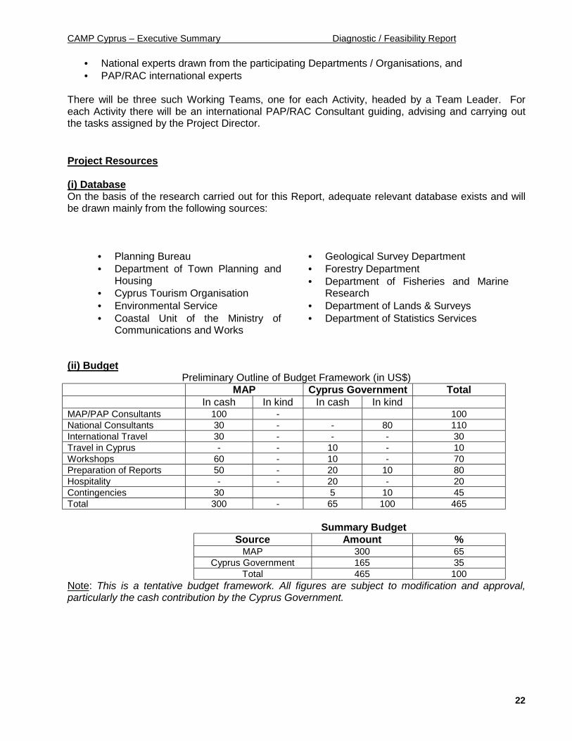
(ii) BudgetPreliminary Outline of Budget Framework (in US$)
MAP Cyprus Government TotalIn cash In kind In cash In kind
MAP/PAP Consultants 100 - 100National Consultants 30 - - 80 110International Travel 30 - - - 30Travel in Cyprus - - 10 - 10Workshops 60 - 10 - 70Preparation of Reports 50 - 20 10 80Hospitality - - 20 - 20Contingencies 30 5 10 45Total 300 - 65 100 465
Summary BudgetSource Amount %
MAP 300 65Cyprus Government 165 35
Total 465 100Note: This is a tentative budget framework. All figures are subject to modification and approval,particularly the cash contribution by the Cyprus Government.
CAMP Cyprus – Executive Summary Diagnostic / Feasibility Report
23
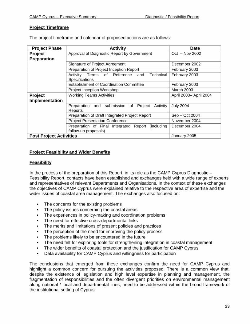
Project Timeframe
The project timeframe and calendar of proposed actions are as follows:
Project Phase Activity DateProjectPreparation
Approval of Diagnostic Report by Government Oct – Nov 2002
Signature of Project Agreement December 2002Preparation of Project Inception Report February 2003Activity Terms of Reference and TechnicalSpecifications
February 2003
Establishment of Coordination Committee February 2003Project Inception Workshop March 2003
ProjectImplementation
Working Teams Activities April 2003– April 2004
Preparation and submission of Project ActivityReports
July 2004
Preparation of Draft Integrated Project Report Sep – Oct 2004Project Presentation Conference November 2004Preparation of Final Integrated Report (includingfollow-up proposals)
December 2004
Post Project Activities January 2005
Project Feasibility and Wider Benefits
Feasibility
In the process of the preparation of this Report, in its role as the CAMP Cyprus Diagnostic –Feasibility Report, contacts have been established and exchanges held with a wide range of expertsand representatives of relevant Departments and Organisations. In the context of these exchangesthe objectives of CAMP Cyprus were explained relative to the respective area of expertise and thewider issues of coastal area management. The exchanges also focused on:
• The concerns for the existing problems• The policy issues concerning the coastal areas• The experiences in policy-making and coordination problems• The need for effective cross-departmental links• The merits and limitations of present policies and practices• The perception of the need for improving the policy process• The problems likely to be encountered in the future• The need felt for exploring tools for strengthening integration in coastal management• The wider benefits of coastal protection and the justification for CAMP Cyprus• Data availability for CAMP Cyprus and willingness for participation
The conclusions that emerged from these exchanges confirm the need for CAMP Cyprus andhighlight a common concern for pursuing the activities proposed. There is a common view that,despite the existence of legislation and high level expertise in planning and management, thefragmentation of responsibilities and the often divergent priorities on environmental managementalong national / local and departmental lines, need to be addressed within the broad framework ofthe institutional setting of Cyprus.

CAMP Cyprus – Executive Summary Diagnostic / Feasibility Report
24
It also emerged that CAMP Cyprus will help towards the implementation of key aspects of the EUEnvironmental Acquis bringing issues of sustainable development within the coastal managementprocess. In doing so, the results of CAMP Cyprus will be useful to other Mediterranean countriesthat share the concern for implementing sustainable development.
In addition, the key reflections and conclusions of this Report have been discussed with the Directorof the Environment Service and his colleagues, who provided valuable insights and comments.
Project Benefits
The launching and implementation of CAMP Cyprus achieve the following main benefits:
• Will fulfil the need for incorporating a policy direction for integrated coastal area managementwithin the Cyprus institutional framework, as expressed in the proposal of the CyprusGovernment to MAP;
• Will link Cyprus more closely to the network of CAMP in the Mediterranean and the activitiesof the MAP/RACs;
• Will respond to a widely felt need among national experts and private sector organisations tobetter manage and protect the coastal environment on which the economy of Cyprusdepends;
• Will contribute towards environmental awareness in development policy and particularly the“inclusion” of local perspectives on the environment/development interactions currentlymissing;
• Increasing appreciation of cross-cutting implications of development/conservations optionsrelative to capacity constraints, strategic considerations, long term benefits and theenvironment as a scarce resource;
• Will build up experience and readiness to apply tools of Integrated Coastal AreaManagement to all Cyprus, including in the future, when political circumstances will hopefullysoon permit, to the northern part of Cyprus;
• Will generate lessons for similar policy problems encountered in other countries in theMediterranean region;
• Will contribute to the improvement of ICAM by highlighting the applicability of decision-making tools pertaining to various spatial levels.
CAMP Cyprus Diagnostic / Feasibility Report
1
1.0 COUNTRY BACKGROUND
1.1 Size and physical characteristics
Cyprus is the third largest island in the Mediterranean with an area of 9,251 sq. km. It has amaximum length of 240 km from east to west and a maximum width of 100 km north south. It issituated at the north-western corner of the eastern Mediterranean basin at an equal distance of380 km north of Egypt and west of the Greek island of Rhodes, 105 km west of Syria and 75km from Turkey. The Greek mainland lies further at some 800 km to the west. Cyprus lies at thehub of three continents and close to the busy trade route linking Western Europe with the Arabworld and the Far East. The latitude of Cyprus is 34 33 north and its longitude 32 16 - 34 37east.
The island has two mountain ranges; the Pendadaktylos range which runs along the entirenorthern coast, and the Troodos massif in the central and south-western parts of the island.The coastline of Cyprus is indented and rocky in the north with long sandy beaches innumerous coves in the south. The northern coastal plain, covered with olive and carob trees, isbacked by the steep and narrow Pedadaktylos limestone mountain range rising to a height of1,042 m. In the south the extensive Troodos mountain massif is covered with pine, dwarf oak,cypress and cedar, culminating in the peak of Mount Olympus, 1,953 m. above sea level.Between the two mountain ranges the fertile Mesaoria plain (Fig. 1).
The island has a Mediterranean type of climate with a typical seasonal rhythm strongly markedby temperature, rainfall and other climatological characteristics.
The Republic of Cyprus was instituted as an independent sovereign country in 1960 with apresidential system of government. There are 11 Ministries each headed by a Minister. TheMinistries are: Foreign Affairs, Finance, Interior, Defence Education and Culture,Communications and Works, Commerce, Industry and Tourism, Agriculture, Natural Resourcesand Environment, Justice and Public Order, Labour and Social Insurance, and Health.Administratively, Cyprus is divided into six Districts: Nicosia, Limassol, Larnaca, Paphos,Famagusta and Kyrenia.
In 1974, the Republic of Cyprus was invaded by the Turkish Army imposing a division in theisland, with the northern 38% of the territory (including the whole of Kyrenia District and thelargest part of Famagusta District) remaining since then inaccessible (Fig. 1). This Report istherefore concerned throughout with the territory under the control of the Government ofCyprus.
1.2 Population
Cyprus (excluding the occupied northern part) has a total population of 689,471, 474,417 urban(69%) and 215,054 rural (31%). As shown in the following table, the total population has grownby 35% between 1982-2002, compared to 45% growth of the urban population and 15% growthof the rural population.
Table 1 - Coastal Population Increase in Cyprus 1982-2002Population 1982 1992 2002 1982-2002
IncreaseTotal 512,000 602,000 689,500 34.6%Urban 325,500 407,000 474,500 45.8%Rural 186,500 195,000 215,000 15.3%
Source: Population Census 1982, 1992 & 2002, Dept. of Statistical Services

CAMP Cyprus Diagnostic / Feasibility Report
2
Nicosia District, the only wholly inland District in Cyprus, has a population of 273,129representing 40% of the population of Cyprus. As shown in the table below, the remainingpopulation of 416,342 is distributed in the four coastal Districts of Limassol, Larnaca, Paphosand Famagusta, 66% in the urban areas and 34% in the rural areas.
Table 2 - Urban-Rural Population Distribution by District 2002District Total Urban Rural
Nicosia 273,129 200,459 72,670Limassol 197,300 157,494 39,806Larnaca 115,266 70,541 44,725Paphos 66,038 45,923 20,115Famagusta 37,738 0 37,738Total 689,471 474,417 215,054
Source: Population Census 1982, 1992 & 2002, Dept. of Statistical Services
1.3 Economic and Social Development
Cyprus has an open free-market economy, driven mainly by thriving tourist and service sectors.In terms of their contribution to the Gross National Product the three most important sectors ofthe economy are (a) trade, restaurants and hotels, (b) finance, insurance and businessservices, and (c) manufacturing. Cyprus’ main trading partner is the European Unionaccounting for about 55% of imports and 40% of exports.
Table 3 - The Cyprus Economy: Gross Domestic Product and Sectoral Distribution, 1996-2201 (inmillion Cy Pounds, constant 1995 prices)
Sector 1996 2000 2001Primary SectorAgricultureFisheriesMining & Quarrying
209 (5%)1881011
206 (5%)1781216
215 (5%)1871216
Secondary SectorManufacturingConstructionElectricity, etc.
883 (23%)46233487
910 (20%)489311110
935 (20%)502315118
Tertiary SectorTradeHotels & RestaurantsTransportBanking & FinanceProfessional ServicesPublic AdministrationEducationHealth & Social WelfareCommunity Services
2,731 (72%)530329331205526339184129158
3,407 (75%)612443427302642395225146215
3,562 (75%)631465457317674405234151228
Gross Value Added 3,823(100%) 4,523 (100%) 4,712 (100%)Minus Bank charges 131 186 199Plus value Added Tax 391 492 518Gross Domestic Product in marketprices
4,083 4,829 5,031
Source: Economic and Social Indicators and Economic Review, 2000, Planning Bureau.
A closer look at the main demand and supply components of the economy shows thedependence of the growth of private sector consumption on imports financed by tourismreceipts (since manufacturing and agriculture are small sectors).
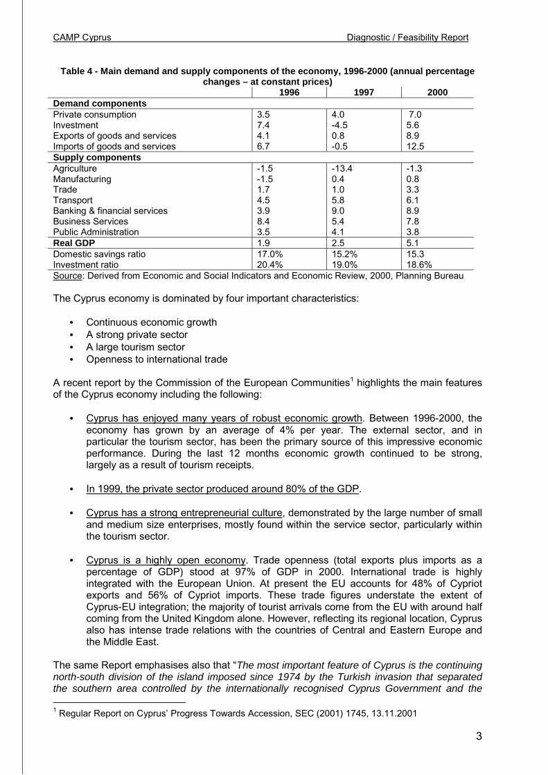
CAMP Cyprus Diagnostic / Feasibility Report
3
Table 4 - Main demand and supply components of the economy, 1996-2000 (annual percentagechanges – at constant prices)
1996 1997 2000Demand componentsPrivate consumptionInvestmentExports of goods and servicesImports of goods and services
3.57.44.16.7
4.0-4.50.8-0.5
7.05.68.912.5
Supply componentsAgricultureManufacturingTradeTransportBanking & financial servicesBusiness ServicesPublic Administration
-1.5-1.51.74.53.98.43.5
-13.40.41.05.89.05.44.1
-1.30.83.36.18.97.83.8
Real GDP 1.9 2.5 5.1Domestic savings ratioInvestment ratio
17.0%20.4%
15.2%19.0%
15.318.6%
Source: Derived from Economic and Social Indicators and Economic Review, 2000, Planning Bureau
The Cyprus economy is dominated by four important characteristics:
• Continuous economic growth• A strong private sector• A large tourism sector• Openness to international trade
A recent report by the Commission of the European Communities1 highlights the main featuresof the Cyprus economy including the following:
• Cyprus has enjoyed many years of robust economic growth. Between 1996-2000, theeconomy has grown by an average of 4% per year. The external sector, and inparticular the tourism sector, has been the primary source of this impressive economicperformance. During the last 12 months economic growth continued to be strong,largely as a result of tourism receipts.
• In 1999, the private sector produced around 80% of the GDP.
• Cyprus has a strong entrepreneurial culture, demonstrated by the large number of smalland medium size enterprises, mostly found within the service sector, particularly withinthe tourism sector.
• Cyprus is a highly open economy. Trade openness (total exports plus imports as apercentage of GDP) stood at 97% of GDP in 2000. International trade is highlyintegrated with the European Union. At present the EU accounts for 48% of Cypriotexports and 56% of Cypriot imports. These trade figures understate the extent ofCyprus-EU integration; the majority of tourist arrivals come from the EU with around halfcoming from the United Kingdom alone. However, reflecting its regional location, Cyprusalso has intense trade relations with the countries of Central and Eastern Europe andthe Middle East.
The same Report emphasises also that “The most important feature of Cyprus is the continuingnorth-south division of the island imposed since 1974 by the Turkish invasion that separatedthe southern area controlled by the internationally recognised Cyprus Government and the 1 Regular Report on Cyprus’ Progress Towards Accession, SEC (2001) 1745, 13.11.2001
CAMP Cyprus Diagnostic / Feasibility Report
4
northern Turkish-held area administered by a de facto Turkish-Cypriot administrationrecognised only by Turkey. The Turkish-held northern area has about one-fifth the populationand one-third the per capita GDP” 2.
Cyprus is the 25th out of the 48 countries included in the “high human development” group witha HDI of 0.877, after Hong Kong with an index of 0.880 and before Singapore with an index of0.876 3. Life expectance at birth stands at 77.9, adult literacy rate at 96.9 and GDP pr capita atUS$19,006. The ratio of doctors to the population is 1:357 and that of nurses to the population1:224 and there is one hospital/clinic bed for every 216 persons. 75% of the housing stock isowner-occupied and 96.6% of all rural houses are connected to the electricity and water supplysystem (99.3% in the urban areas). There are 61 telephone lines per 100 persons and oneprivate car for every 2.4 persons. The average annual consumption of electricity is 4,500 kw.
1.4 Administrative Framework
For administrative purposes, Cyprus is divided into six districts: Nicosia, Famagusta, Limassol,Larnaca, Paphos and Kyrenia. Nicosia is the capital city of Cyprus and the seat of Government.Each District is headed by an appointed District Officer who functions as the Districtrepresentative of central Government, co-ordinates the activities of all Ministries and liaisesbetween them at the district level. District Officers are part of the administrative structure of theMinistry of the Interior and report to the Minister and the Director-General.
The local administrative structure of Cyprus operates through a system of Municipalities,Improvement Boards and Village Commissions. These are elected and administrativelyindependent bodies responsible for strictly local affairs. Municipalities constitute the form oflocal government in the six main towns (the district capital towns) and in a number of smallertowns mostly around the main towns. Any community may become a Municipality by localreferendum, following an approval by the Council of Ministers, provided it has either apopulation of over 5,000 or a strong local economic base (like Ayia Napa, Paralimni, Athienou,Lefkara). Municipalities are headed by a Mayor. The remaining communities are administeredas Improvement Boards and Village Commissions. Improvement Boards are headed by therespective District Officer, while the members of both Improvement Boards and VillageCommissions are elected by the local population over the age of 18. Technical andadministrative support to these bodies is provided by central Government.
Table 5 - Types of Local GovernmentTotal Number In Turkish-held northern area
Municipalities 32 9Improvement Boards 85 15Village Commissions 352 151Source: National Report of the Republic of Cyprus, The Second U.N. Conference on Human Settlements- Habitat II, 1996, Prepared by the Dept. of Town Planning and Housing
The following Table shows in broad terms the distribution of responsibilities between local andcentral Government and Municipal Authorities in Cyprus. Municipal Authorities have strictlylocal responsibilities for local roads, refuse collection and disposal, public health inspection andinfrastructure improvements within their area. Development policy, education and infrastructureof national importance are determined by central Government.
2 Op.cit.3 Human Development Report, UNDP, 2001
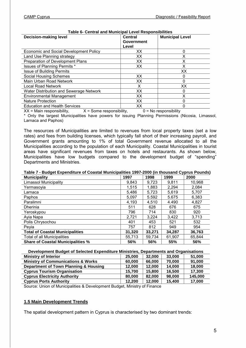
CAMP Cyprus Diagnostic / Feasibility Report
5
Table 6- Central and Municipal Level ResponsibilitiesDecision-making level Central
GovernmentLevel
Municipal Level
Economic and Social Development Policy XX 0Land Use Planning strategy XX XPreparation of Development Plans XX XIssues of Planning Permits * XX XIssue of Building Permits XXSocial Housing Schemes XX 0Main Urban Road Network XX 0Local Road Network X XXWater Distribution and Sewerage Network XX 0Environmental Management XX XNature Protection XX 0Education and Health Services XX 0XX = Main responsibility, X = Some responsibility, 0 = No responsibility* Only the largest Municipalities have powers for issuing Planning Permissions (Nicosia, Limassol,Larnaca and Paphos)
The resources of Municipalities are limited to revenues from local property taxes (set a lowrates) and fees from building licenses, which typically fall short of their increasing payroll, andGovernment grants amounting to 1% of total Government revenue allocated to all theMunicipalities according to the population of each Municipality. Coastal Municipalities in touristareas have significant revenues from taxes on hotels and restaurants. As shown below,Municipalities have low budgets compared to the development budget of “spending”Departments and Ministries.
Table 7 - Budget Expenditure of Coastal Municipalities 1997-2000 (in thousand Cyprus Pounds)Municipality 1997 1998 1999 2000Limassol Municipality 9,843 9,723 9,811 10,968Yermasoyia 1,515 1,883 2,294 2,084Larnaca 5,486 5,723 5,619 5,707Paphos 5,097 5.592 5.675 6,383Paralimni 4,193 4,510 4.490 4,827Dherinia 511 628 676 675Yeroskypou 796 714 830 920Ayia Napa 2,721 3,224 3,422 3,713Polis Chrysochou 401 453 521 532Peyia 757 812 949 954Total of Coastal Municipalities 31,320 33,271 34,287 36,763Total of all Municipalities 55,713 59,734 61,907 65,844Share of Coastal Municipalities % 56% 56% 55% 56%
Development Budget of Selected Expenditure Ministries, Departments and OrganisationsMinistry of Interior 25,000 32,000 33,000 51,000Ministry of Communications & Works 60,000 66,000 70,000 91,000Department of Town Planning & Housing 12,000 12,000 14,000 18,000Cyprus Tourism Organisation 15,700 15,800 16,500 17,300Cyprus Electricity Authority 80,000 82,000 98,000 145,000Cyprus Ports Authority 12,200 12,000 15,400 17,000Source: Union of Municipalities & Development Budget, Ministry of Finance
1.5 Main Development Trends
The spatial development pattern in Cyprus is characterised by two dominant trends:

CAMP Cyprus Diagnostic / Feasibility Report
6
• Sub-urbanisation, and• Coastalisation
Suburbanisation takes the form of rapid population growth and urban development sprawl inthe suburbs located at the edges of the main urban areas.
This pattern is typical of all urban areas in Cyprus, although particularly evident in Nicosia dueto Nicosia’s specific problems as a “divide city” following the division of the island along a north-south split right across Nicosia itself. The transformation of Nicosia into a “border city” triggereda major population shift to the southern suburbs and to the outlying settlements, accentuatingan earlier tendency for urban development sprawl. The growth of greater Limassol area, thesecond largest urban center, has followed a similar pattern partly resulting from in-migrationfrom its own rural hinterland compounded by the settlement of displaced population fromFamagusta town occupied since 1974.
Table 8 - Population growth and suburbanisation trends in Cyprus1982 1992 2002 Change 1982-2001
Total Population 512,000 602,000 689,500 34,6%Total Urban population 325,500
(100%)407,000(100%)
474,500(100%)
45.8%
Core urban population 171,500(53%)
196,500(48%)
215,300(45%)
25.5%
Suburban population 154,000(47%)
210,500(52%)
259,200(55%)
68.3%
Source: Population Census, 1982, 1992 & 2002, Nicosia, Limassol, Larnaca and Paphos Local Plans,1996 & 1999, Dept. of Town Planning and Housing & CAMP Cyprus Project Research
The table above (and the figures below) show in summary the main pattern for the period 1982-2001.
• 35% total population increase• 46% urban population increase, of which the suburban population increase was more
than twice the core urban population increase (68% and 26% respectively).
The trend towards suburbanisation is shared by all urban areas, with population growth beingmuch higher in the suburban settlements just outside the town boundaries compared with thegrowth rate in the towns themselves. The difference between Nicosia and the other urbanMunicipalities is that Nicosia loses population in absolute terms. As shown in the table below,Limassol Municipality increased its population by 26% since 1982, compared to a populationincrease in the Limassol Local Plan Area of 41% (which includes the suburbs) during the sameperiod. There is a uniform trend of a decrease in the population share of the urbanMunicipalities and a corresponding increase in the suburban population in all the main LocalPlan Areas. The tendency is roughly the same in all area, although stronger in Nicosia andLarnaca, and weaker in Limassol, and Paphos.
Table 9 - Urban and Suburban Population growth by Area, 1982 - 2001Area 1982 1992 2001
Nicosia Local Plan AreaNicosia Municipality
149,000 (100%)48,200 (32%)
177,400 (100%)47,000 (27%)
198,000 (100%)47800 (24%)
Limassol Local Plan AreaLimassol Municipality
107,200 (100%)74,800 (70%)
136,800 (100%)87,200 (64%)
151,000 (100%)94,600 (63%)
Larnaca Local Plan AreaLarnaca Municipality
48,400 (100%)35,400 (73%)
60,600 (100%)43,600 (72%)
75,300 (100%)46,700 (62%)
Paphos Local Plan AreaPaphos Municipality
22,200 (100%)13,100 (59%)
35,600 (100%)18,700 (53%)
46,500 (100%)26,252 (56%)
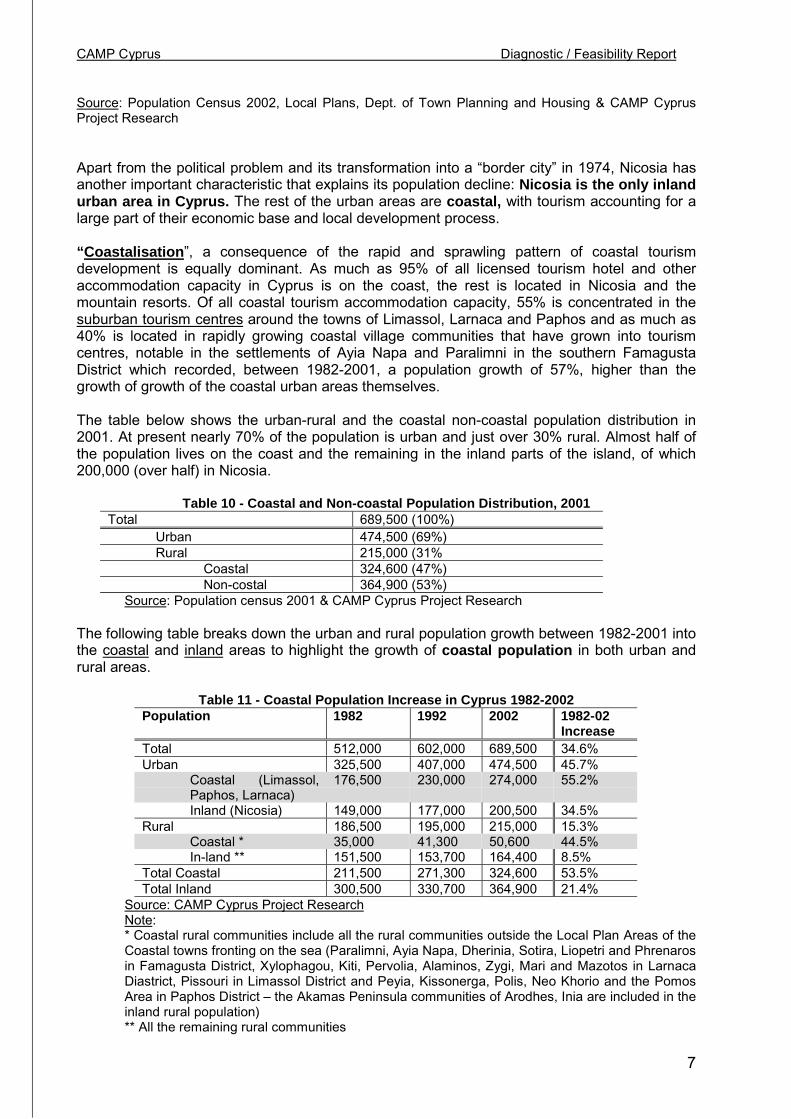
CAMP Cyprus Diagnostic / Feasibility Report
7
Source: Population Census 2002, Local Plans, Dept. of Town Planning and Housing & CAMP CyprusProject Research
Apart from the political problem and its transformation into a “border city” in 1974, Nicosia hasanother important characteristic that explains its population decline: Nicosia is the only inlandurban area in Cyprus. The rest of the urban areas are coastal, with tourism accounting for alarge part of their economic base and local development process.
“Coastalisation”, a consequence of the rapid and sprawling pattern of coastal tourismdevelopment is equally dominant. As much as 95% of all licensed tourism hotel and otheraccommodation capacity in Cyprus is on the coast, the rest is located in Nicosia and themountain resorts. Of all coastal tourism accommodation capacity, 55% is concentrated in thesuburban tourism centres around the towns of Limassol, Larnaca and Paphos and as much as40% is located in rapidly growing coastal village communities that have grown into tourismcentres, notable in the settlements of Ayia Napa and Paralimni in the southern FamagustaDistrict which recorded, between 1982-2001, a population growth of 57%, higher than thegrowth of growth of the coastal urban areas themselves.
The table below shows the urban-rural and the coastal non-coastal population distribution in2001. At present nearly 70% of the population is urban and just over 30% rural. Almost half ofthe population lives on the coast and the remaining in the inland parts of the island, of which200,000 (over half) in Nicosia.
Table 10 - Coastal and Non-coastal Population Distribution, 2001Total 689,500 (100%)
Urban 474,500 (69%)Rural 215,000 (31%
Coastal 324,600 (47%)Non-costal 364,900 (53%)
Source: Population census 2001 & CAMP Cyprus Project Research
The following table breaks down the urban and rural population growth between 1982-2001 intothe coastal and inland areas to highlight the growth of coastal population in both urban andrural areas.
Table 11 - Coastal Population Increase in Cyprus 1982-2002Population 1982 1992 2002 1982-02
IncreaseTotal 512,000 602,000 689,500 34.6%Urban 325,500 407,000 474,500 45.7%
Coastal (Limassol,Paphos, Larnaca)
176,500 230,000 274,000 55.2%
Inland (Nicosia) 149,000 177,000 200,500 34.5%Rural 186,500 195,000 215,000 15.3%
Coastal * 35,000 41,300 50,600 44.5%In-land ** 151,500 153,700 164,400 8.5%
Total Coastal 211,500 271,300 324,600 53.5%Total Inland 300,500 330,700 364,900 21.4%
Source: CAMP Cyprus Project ResearchNote:* Coastal rural communities include all the rural communities outside the Local Plan Areas of theCoastal towns fronting on the sea (Paralimni, Ayia Napa, Dherinia, Sotira, Liopetri and Phrenarosin Famagusta District, Xylophagou, Kiti, Pervolia, Alaminos, Zygi, Mari and Mazotos in LarnacaDiastrict, Pissouri in Limassol District and Peyia, Kissonerga, Polis, Neo Khorio and the PomosArea in Paphos District – the Akamas Peninsula communities of Arodhes, Inia are included in theinland rural population)** All the remaining rural communities

CAMP Cyprus Diagnostic / Feasibility Report
8
The following main growth indicators concerning population increase between 1982-2001 arestriking:
• Total population growth 35%• Total urban population growth 46%
o Coastal urban growth 55%o Inland urban growth 35%
• Total rural population growth 15%o Coastal rural growth 45%o Inland rural growth 8%
The coastal rural population growth is higher than the total population growth, nearly equal tothe total urban population growth, three times higher the average rural population growth, sixtimes the inland rural and as much as four fifths of the urban coastal population growth.
As has been illustrated by the above tables, urban and coastal sprawl has been for many yearsassociated with the spatial pattern of building development. As regards urban development, amajor part of each wave of development typically occurs at the fringes of the existingdevelopment boundary defined by land use plans, adding new neighbourhoods at the edges ofthe designated development zones served by infrastructure, leaving large stocks of vacantbuilding land within the existing development envelope.
Actual data on development sprawl are not available for the whole of Cyprus. Patchy figures forNicosia are perhaps indicative of the broad pattern. In 1963, the amount of vacant urban land inthe Nicosia urban area was as much as 30% of the then total developed area. In 1982, thesurvey conducted by the UNDP Nicosia Master Plan Project showed a similar percentage ofvacant urban land despite the expansion of the urban area by about 30%. An estimate carriedout for this Report on the basis of the 1999 Nicosia Local Plan shows that between 1982 and1999 the area zoned for urban development within the defined urban development boundaryhad increased between 60-66%, while the population increase was only about 38%. There aretwo main factors contributing to this:
• the tendency of the Planning Authority to over-zone for future development (muchbeyond projected development needs), and
• the social pressures exercised by local land-owners to include agricultural land in urbandevelopment for speculative gains. Despite the gross over-provision of urban andtourism development land, land prices continue to increase particularly in the fringes ofcore development areas due to the speculative demand for land, over and above thereal demand for development, in anticipation of future land use change from agricultureto housing and tourism. A recent report reflecting on this issue stresses:
Box. 1“The most important characteristics of land use change arising from haphazard urbanexpansion are the shrinking of agricultural land in favour of residential land; fragmentedsettlements and isolated buildings, uncontrolled growth often coupled with insufficientservices; and a spatial pattern of land use in the fringe areas that is heterogeneous andunstable. Parallel to rapid residential growth, the fringe areas have witnessed an influxof other urban uses such as industrial, commercial and institutional. All these have avery negative impact on the physical and human environment caused by industrialwastes, increased levels of traffic congestion, air and noise pollution, lack of openspace, lack of adequate facilities and infrastructure, loss of agricultural land and visualdeterioration”.National Report of the Republic of Cyprus, Habitat II, 1996.

CAMP Cyprus Diagnostic / Feasibility Report
9
A broad conclusion that should be underlined is that past and current development trendspose a threat to the environment, particularly in the coastal areas which are the main location ofdevelopment activity. Cyprus is a small country relative to the rest of Europe with limited naturalresources and coastline, yet the ratio of over 3 tourists per Cypriot citizen is the second highestin the Mediterranean (after Morocco, followed by Malta, Spain, Greece with less than 2 touristsper person).
Indicative of the pressures on the coastal environment is the almost continuous “developmentfootprint” along the coast, comprising tourism development, second homes, shopping centres,etc. The following table provides some broad figures of the change of land use on the coast.
Table 12 - Development along the coast (length of coastal land in km)Development type 1974 1991 2000
Undeveloped 150 (83%) 102 (56%) 72 (40%)Suburban 9 (5%) 48 (27%) 74 (41%)Urban 22 (12%) 31 (17%) 35 (19%)Total length(Government controlled area)
181 (100%) 181 (100%) 181 (100%)
Source: Based on “World Bank, Environmental Review and Recommendations, Republic ofCyprus”, 1992. Figures for 2000 are preliminary estimates based on a rough assessment of newcoastal development.
Tourism development. Government policy on development planning during the first yearsafter the invasion of 1974, which was disastrous for the tourist industry, emphasised economicdevelopment and the revitalisation of the tourism industry.
By 1980, tourist arrivals had greatly surpassed the 1973 levels. Tourist arrivals were 423,563 in1981, reached 1,561,479 in 1990 and 2,100,000 in 1995. The 1980’s are characterised by avery high rate of tourism development. The increased demand during that period led to newhotel beds, which from 12,524 in 1980 reached 84,259 in 1995, with an increase ofapproximately 20% per year. The pressures for development resulted in extensive buildingconstruction of buildings along the coast and evident deterioration of the visual and functionalrelationship between the coast and the inland area. The natural environment in the coastalareas, where tourist development has been concentrated, has been fundamentally transformed.
The lack of adequate building regulations and the absence of effective legislation on urbanplanning (until 1990), allowed rapid and poorly controlled development and a consequentdecline in the quality of the built environment. Existing zoning regulations allowed high buildingsand building densities on the coast and limited provision for organised open public spaces, witha resulting reduction of beach area in front of the buildings. The excessive populationconcentration in certain seaside areas increased sea pollution threats and pressures on thecapacity of the beaches to accommodate recreation activity.
The removal of sand and gravel from the beaches for use in the construction industry resultedin the acceleration of erosion and the deterioration of beaches. The building of dams on therivers resulted in the decrease of material carried to the coast, and therefore to a decreasedrate of creation of natural sand on the shore. The need to protect sand beaches and in generalthe coastal area from erosion, to improve or even establish sandy beaches, to ensure a betterquality of beaches and to increase their capacity in order to serve larger numbers of visitors,required the construction of breakwaters, either perpendicular or parallel to the shoreline,resulting in its alteration.
In June 1974, there were in Cyprus a total of 19,192 beds in tourist establishments (hotels,organised apartments, etc.). In 1975, a year after the 1974 invasion and the occupation of the

CAMP Cyprus Diagnostic / Feasibility Report
10
northern part of Cyprus, the number of beds in the southern part were only 5,445 beds. Sincethen, the total number of beds has been rapidly increasing, predominantly in the coastal areas.
Table 13 – Number of Tourist Beds 1974-2001Total No.of Beds
Coastal AreasNo. Beds Percent
Inland AreasNo. BedsPercent
30.6.74 (Pre-invasion all Cyprus) 19.192 15.006 78,19% 4.186 21,81%
31.12.75 5.445 1.919 35,08& 3.535 64,92%31.12.80 12.524 8.622 68,84% 3.902 31,16%31.12.85 30.375 26.191 86,23% 4.184 13,77%31.12.90 59.271 55.012 92,82% 4.259 7,18%31.12.95 78.427 73.715 94,00% 4.712 6,00%31.12.2001 88.302 83.944 95,06% 4.358 4,93%Source: Cyprus Tourism Organisation
The development of tourism concentrated in the coastal zone with a share of beds at 95% ofthe total, resulting in pressure on the coastal environment.
Table 14 - Regional Distribution of tourist accommodation capacity at 31.12.2001District No of tourist beds Share in %
Coastal AreasLimassol 15,499 17.5%Larnaca 8,222 9.3%Paphos 23,768 27.0%Famagusta (Paralimni & Ayia Napa) 36,455 41.3%Total Coastal Areas 83,944 95.1%
Inland AreasNicosia 2,237 2.5%Hill Resorts 2,121 2.4%Total Inland Areas 4,358 4.9%
Total 88,302 100%Source: Cyprus Tourism Organisation
CAMP Cyprus Diagnostic / Feasibility Report
11
2.0 THE COASTAL ZONE
2.1 General Profile
In Cyprus there is no specific legal or functional (planning) definition of the coastal zone orarea. There are three main geographical demarcations relating to the coastal zone / area, eachone for the purposes of different laws.
1. The Foreshore Protection Law defines the foreshore as all lands within 100 yards of thehigh water mark. The foreshore area is public property falling under the jurisdiction ofthis Law.
2. The New Tourist Policy of 1990 designated a zone of 3 km. from the coastline for thepurposes of control of tourism development.
3. The Coastal Protection Study of the Coastal Unit of the Ministry of Communications andWorks adopted for the purposes of the survey of coastal erosion problems a definition ofthe coastal strip as the area of 2 km. from the coastline.
The TCPL contains no specific definition of the coastal area. Local Plans and the Policy for theCountryside contain land use / development control zones that cover coastal and non-coastalareas within the same Plans. Thus, in this Report, as in many other reports on Cyprus, theterms coastal area and coastal zone are used interchangeably.
The small size of Cyprus and the close proximity of all areas to the coast, combined withthe dominance of coastal tourism in building development and the economy, create astrong functional overlapping between the coastal area and other areas, blurring thecoastal / hinterland distinction. For Cyprus, and particularly for the purposes of CAMPCyprus and its integrated approach to coastal area management, an issue-led approachto coastal area problems is adopted rather than a legal or physical definition.
The terrestrial width of the coastal zone (the area that extends 2 kilometres inland from thecoastline) covers 23 percent of the country’s total area. Its population density is 17.5 personsper hectare, and 47 percent of the total population lives and works in this zone, where 95% ofthe tourist industry is located, which is Cyprus’s major source of revenue.
The country has a total of 772 kilometres of shoreline, of which:
• 404 kilometres are in the occupied zone (52%);• 72 kilometres within the British military bases (10%); and• 296 kilometres within the area under Government control (38%).
The shoreline overall is uneven and rocky (54%) with sandy beaches and many small coves(46%). The coastal zone is characterized by rich wildlife, long and small beaches, open areas,cliffs, capes, harbours, sand dunes, accumulations of pebbles, and, in general, marine andshore areas of prime ecological and scientific value.
At the northwestern port of the island, the shoreline is approximately 63% rocky and containsmainly the undeveloped areas of Tylliria, the Akamas peninsula, and Chrisochou Bay, whichrecently has begun to develop at a rapid pace. In various parts of this area, there are beaches(which are breeding grounds for sea turtles), isolated shores, islets, and sea caves.
In the southwestern part, the ratio of beaches to rocky shores is approximately the same, andincludes Paphos, which is rapidly developing into an urban and tourist centre, as well asextensive shorelines with sea caves, rocky islets and sand dunes.
CAMP Cyprus Diagnostic / Feasibility Report
12
The southernmost (central) area includes the highly developed areas of Limassol and Larnaca,with 57 percent beaches, some isolated shores with cliffs, as well as the wetlands of the Akrotiriand Larnaca Salt Lakes ("Alikes").
The eastern part covers the most developed tourist areas of Ayia Napa and Protaras, of whichonly 23% of the shoreline consists of beaches.
Cyprus is characterized by rich and varied fauna, which includes land mammals, amphibiansand reptiles, birds, insects, sponges, decapods, etc. The island is a crossroads for millions ofbirds during their autumn and spring migrations between Europe and Africa.
Regarding the flora, many of the endemic flowering plants, which are rare and very rare, with avery limited expansion area, are present in the coastal zone.
The coastal ecosystems provide habitats for such critically important species as the sea plantangiosperms, Posidonia Oceanica and the sea turtles Chelonia mydas and Caretta caretta. Ithas been estimated that the coastal area protected in one manner or another coversapproximately 14% of the total.
The Akamas Peninsula in the northwest of Paphos is the most significant area of biodiversity inCyprus. It covers an area of approximately 250 square kilometres, and most of it has remaineduntouched by development activities, supporting a natural wealth which consists of rich floraand fauna with their habitats, beautiful beaches and landscapes, interesting archaeologicalsites, historic and cultural elements. A cluster of 7 village communities with a population ofabout 1,800 people comprise the most important resource in the area but derive no benefit frombeing part of Akamas. The Akamas beaches, remain among the few that provide matinggrounds for sea turtles, the green turtle (Chelonia mydas) and the Caretta (Caretta caretta),being species threatened by extinction in the Mediterranean. There are also reports ofMediterranean seals (Monk seals) in the sea of Akamas.
The only two extensive wetlands, those of the Akrotiri Lake (Salt Lake) which includes theFassouri Marsh (fresh water) (approximately 2.000 hectares) and Larnaca Lake (‘Alyki’) (1,100hectares) are of great importance for migrating birds, including the flamingos.
National forests are found near the shore along a length of 22 kilometres of the coastal zone(the coast of Akamas, Petra tou Romiou, between Cape Zevgari and Gata, near Akrotiri, Pila,and Cape Greco). Maquis forests and/or guarrigue, native species, predominate in non-cultivated regions, poorer and drier low coastal areas, at a length of shore of approximately 72kilometres.
2.2 Coastal Sub-areas and their Characteristics
A recent study 4 carried out by the Department of Public Works (Coastal Unit) of the Ministry ofCommunications and Works and other Government Services, in co-operation with a Dutch firm,within the framework of the EU Programme MEDSPA, surveyed the physical characteristics ofthe whole length of the coastline of Cyprus (under government control). The primary aim of thestudy was the establishment of criteria and methods both for the protection as well as for theimprovement of the beaches of the area under government control.
Within the framework of the study, the coastline was divided into 12 areas with broadly commongeomorphologic and hydrodynamic characteristics. The coastal classification has focusedmainly on coastal engineering parameters but has also taken into account other criteriaincluding location, shore geology, land use, construction activity, erosion etc. The study has, in 4 Coastal Protection in Cyprus (1993-96)

CAMP Cyprus Diagnostic / Feasibility Report
13
addition, prepared General Plans for the protection and improvement of the foreshore in threeareas: the Limassol Bay, Larnaca Bay, and the southern shore of Paphos. The General Plansare the first step in the effort to follow European objectives for the protection of the shoreline.
The 12 coastal segments identified by this study include:
Box 2Paphos District • Tylliria Area
• Kato Pyrgos Bay• Krysochou Bay• Akamas Area• North Paphos Area• South Paphos Area
Limassol District • Episkopi Bay• Akrotiri Area• Limassol Bay
Larnaca District • Ziyi-Kiti Area• Larnaca Bay
Famagusta District • Ayia Napa-Protaras Area
A general description of the 12 areas, as identified in the above-mentioned study, and thepresent state of the coastal zones is presented below:
1. Tylliria areaThe area of Tylliria is in the northern region of Cyprus. It has a total length of 18 kms. It isbound by the Cape of Pomos on the west and by Petra Tou Limniti on the east, where theisland’s present division line begins at the western end.
The general characteristic of the shore is the high and rocky slope with steep inclines that covermost of its length, creating small coves. At the base of the slope there are narrowaccumulations of pebbles and, more rarely, sand. The shore presents localised erosionproblems mostly around the Bay of Kato Pyrgos, while in general the greatest length ofshoreline appears to be in balance. Seasonally, on portions of the beach accumulations of deadPosidonia leaves can be found. The shore is exposed mostly to waves from the west, althoughduring the winter northeastern waves are quite frequent and large.
Until now, the development of tourism in the area had been limited; however, a recent trend forsuch development is evident. The number of tourists is increasing, along with the constructionof tourist facilities. There are two fishing harbours in the area, one at Pomos and the other atKato Pyrgos.
2. The Kato Pyrgos BayThe Kato Pyrgos Bay is at the eastern end of the Tylliria area. It has a length of about 3kilometres and is bound by two small promontories, each about 100 meters long. The centralportion of the bay faces north and consists of a straight shoreline with pebbles and fine gravel,which form successive, mobile, mounds. The bay presents severe erosion along its entirelength. The main cause of the erosion is the massive quarrying of shore material for use mainlyin the construction industry, which took place over the last 50 years. Even though quarryingfrom beaches has been prohibited since the 1970’s, some instances of illegal quarrying are stillnoted, especially in the eastern part of the bay. According to testimonies of local people, theshoreline has receded 20 to 30 meters over the last 40 years. Until the erosion appeared, thebeach was mostly sandy.

CAMP Cyprus Diagnostic / Feasibility Report
14
In 1988, a fishing shelter at the western edge of the bay was constructed. In the same year andadjacent to the eastern edge of the shelter, five perpendicular breakwaters in the form of a “T”were constructed, intended to control the erosion in that portion of the shoreline at a distance ofapproximately 90 meters one from the other. The rate of erosion increased, especially in theportions of the shore between them. As a result of the construction of breakwaters largevolumes of seaweed (dead Posidonia leaves) are trapped each year inside the fishing shelterand between the breakwaters. Thus, seaweeds were always present in the area, since fields ofPosidonia cover the seabed.
3. Chrysochous BayChrysochous Bay is located in the northern part of the Paphos District, has a total length ofapproximately 38 kilometres, and is bound by the Cape of Arnaouti to the west and the Cape ofPomos in the east. Along the length of the bay there are six seaside villages and the town ofChrysochou. The bay faces north. The beach in the central part of the bay is made up mainly ofdark-coloured gravel and pebbles, while at the two ends the shoreline is either rocky with high,steep slopes, or covered by a calcareous sandstone plaque with gentle slopes of the land. Theonly construction along the entire length of the bay consists of the breakwaters at the fishingharbour at Latshi. The portions of the shore adjacent to the refuge (east and west) are the onlyparts of the bay, which have demonstrated slight morphologic changes. Especially the portionof the shore east of the harbour periodically presents slight erosion. The rest of the bay appearsto be in balance.
The 10 kilometres of the western edge of the bay to the Cape of Arnaouti are part of theAkamas Peninsula, where no development is permitted. In the remaining 28 kilometres of thebay, intense housing and tourism development has taken place over the past ten years.Pressure is becoming more intense both by individual landowners and by the local authoritiesto improve the quality of the beach, increase its capacity and create facilities in order to satisfyincreased needs for recreational use.
4. The Akamas Peninsula AreaThe Akamas area begins at Cape Arnaouti and reaches Cape Drepano. Its length is 32kilometres and the area lies exclusively within the Akamas Peninsula.
5. North Paphos City AreaThe area of North of Paphos extends over 26 kilometres in length and begins at Cape Drepanoto the town of Paphos. The shore consists mainly of rocky hillocks, and in some places thereare pebbles and sand. The area lack beaches for use by bathers. The pressure for holidayhouses has been intensified in the past ten years due to the area’s rural landscape.
6. South Paphos City AreaThe area of South of Paphos covers the shore from the town of Paphos in the west to CapeAspro to the east and has a length of 35 kilometres. The area can be divided into three sub-areas:
(i) The first, begins from the town of Paphos up to the Ezousas River, has a length ofapproximately 5 kilometres, and is made up mainly of rocky beaches. In some places there arepebbles and sand. As a result of the rapid development of tourism, parallel and perpendicularbreakwaters were constructed for the creation of sandy beaches.
(ii) The next 15 kilometres constitute the second sub-area. Here, there are no largedevelopment projects, except for the Paphos International Airport. The Ezousa, Diarizos andXeropotamos rivers created small pebbly and sandy deltas at the shore. The remainder of theshore consists mostly of steep rocky hillocks. Due to the construction of many dams in the area,the enrichment of the shoreline with material has ceased or declined, resulting in erosion of theslopes at the shore.
CAMP Cyprus Diagnostic / Feasibility Report
15
(iii) For the last 15 kilometres up to Petra Tou Romiou, the shore is made up of steep rockyhillocks, and in some areas there are narrow pebbly beaches. As mentioned above, the mainproblem in this area is erosion due, mainly, to the lack of material from the rivers, as well as theremoval of sand and gravel from the shore. The accumulation of seaweed in certain beachesconstitutes the area’s second largest problem.
7. Episkopi Bay AreaThe area is under the administration of the British Bases.
8. Akrotiri AreaThe area is under the administration of the British Bases.
9. Limassol Bay AreaThe area covers the shore from Cape Gata to Cape Dolos and has a length of approximately35 kilometres. Beginning at Cape Gata, the first 9 kilometres are under the administration of theBritish Bases. The next 20 kilometres from the Limassol Port up to the Moni Power Stationcontain housing, industrial, and mainly tourist development. The last 7 kilometres are coveredmostly by rock where there has been no human intervention.
The coastal zone of Limassol is an area of over-development where all the serious problemsnoted in the other coastal areas of Cyprus can be observed. The volume of constructions in theinland portion of the coastal zone as well as at the seafront is exceedingly large. The 12kilometres of shoreline in Limassol contain 50 percent of the coastal construction in all ofCyprus. The construction of the Port is, as expected, a massive intervention in the area’s entiremorphodynamic system. The area has been constantly eroded, and thus the first perpendicularbreakwaters were constructed by private initiatives. Thereafter, due to the increase of tourism,the necessity arose to protect and improve the beaches, resulting in the continued constructionof illegal perpendicular breakwaters. In order to solve the problems of erosion and seawaterquality that arose, the Cypriot Government, in co-operation with local authorities, adopted apolicy for the construction of parallel breakwaters. Today, erosion problems are noted in certainareas, mainly those without parallel breakwaters. Many manmade interventions in the area ofLimassol (Port, other works, breakwaters), along with the disposal of waste, have resulted inthe alteration of the water quality and pollution risk in certain areas.
10. Zygi-KitiThe Zygi-Kiti area is located in the southern part of Cyprus, has a total length of 36 kilometres,and is bound by the Cape Dolos to the west and Cape Kiti to the east. The central portion of theshoreline, from Vassilikos to the Cape of Petounta, is relatively straight and faces south. Twobays are formed at the western and eastern edges of the area: the bay which includes‘Governors Beach’, 7 kilometres in length, and bound by Cape Dolos and Cape Vassilikos, andthe bay of Pervolia, 13 kilometres long, bound by Capes Petounta and Kiti.
The area is generally characterised by a low, loose, shore slope that demonstrates intenseerosion over the past 70 years. It has been estimated that the shoreline has receded byapproximately 25 meters over the period from 1920 to 1970, i.e. 0.5 meters per year (average),while after 1970 there appears to be a tendency toward a decreasing rate of erosion, to around0.1 meters per year, a fact which demonstrates that the shore is tending to recover its dynamicbalance. The main cause of erosion appears to be the massive quarrying of coastal materialsfor use in the construction industry. The bay of ‘Governors Beach’ is an exception to the erosionphenomenon. The cliffs in this area are rocky and very high, almost vertical, and at their basethere is a narrow sandy beach. This area is mainly agricultural with the exception of a part ofthe Bay of Pervolia, the area of Zygi and ‘Governors Beach’, where there is increased tourismdevelopment. The development of tourism and housing along the length of the region’sshoreline is foreseen in the near future. Already, the construction of small tourist developmentsscattered along the shoreline has been noted in the areas of Mazotos and Alaminos, and
CAMP Cyprus Diagnostic / Feasibility Report
16
pressure from individuals and local authorities to improve the quality of the shore and to restrainerosion has become more intense.
11. Larnaca Bay AreaThis area covers the entire Bay of Larnaca and extends for a length of 37 kilometres. The areacan be divided into seven sub-areas:
(i) The first, begins at Cape Kiti and ends at the runway of the Larnaca International Airport.Development in this area is found mostly in the inhabited area of the village of Meneou.
(ii) The second sub-area covers Cape McKenzie up to the fishing harbour of Larnaca, wherethere are many homes and restaurants.
(iii) The third sub-area covers the area from the fishing harbour to the Marina. This areacontains a flat sandy beach, which is the most popular tourist beach in Larnaca.
(iv) The fourth lies between the Marina and the new Port of Larnaca. This area has no naturalbeach and is almost undeveloped due to the above installations.
(v) The fifth area is between the Port of Larnaca and the Cyprus Petroleum Refinery. The areahas no natural beach and there is almost no development mainly due to the aboveconstructions/ industries.
(vi) The sixth sub-area begins after the Refinery and extends up to the area’s tourist resortswhere parallel breakwaters have been constructed. At certain locations there are erosionproblems.
(vii) The last sub-area begins after the tourist zone and continues within the boundaries of theMilitary Bases up to Cape Pyla.
In the Larnaca Bay area, all types of coastal works (vertical and parallel breakwaters, Marina,Port, fishing harbour, etc.) have been constructed. All these constructions affected the area’sentire morphodynamic system, and therefore the movement of sediment. In areas whereprotective coastal works were constructed, improvement and stabilisation of beaches wasnoted. In other areas where no protective works were undertaken erosion is noted. In LarnacaBay, particularly in the area of the fishing harbour, there are seaweed closes the entrance.
12. Ayia Napa – Protaras Area(i) Ayia Napa Area has a length of approximately 7 kilometres. After the 1974 invasion the areadeveloped at an intense rate with both housing and tourism facilities. It is one of the mostfavoured destinations of both local and foreign vacationers. The beach is mostly light-colouredsand, protected by natural islets and rocks that act as parallel breakwaters. As a result, there isno erosion problem in the area. Also, in the greater Ayia Napa Area, the shoreline is mostlyrocky. The only coastal project existing in the area is the small port of Ayios Georgios. Also, tothe southwest of Ayia Napa, in the area of Liopetri, there is inflow of seawater onto land,creating a natural harbour for fishing boats (Liopetri River). Mostly during the summer monthsand with the arrival of foreign visitors in some areas there is lack of space on the beaches.
(ii) The Paralimini-Protaras area lies at the southeastern coast of Cyprus. It covers the areafrom the cape of Cavo Greco up to the free parts of Famagusta and its total length isapproximately 20 kilometres. Generally, the area is characterised by rocky slopes that covermost of the length of the coast, creating pocket beaches. In certain locations, there are sandybeaches, which attract intense tourist activity.
At the mid-point of this area is Protaras beach (‘Fig Tree Bay’) that is considered the best andmost popular beach in Cyprus and is a continuation of the ‘golden sands’ of Famagusta.

CAMP Cyprus Diagnostic / Feasibility Report
17
Following the 1974 invasion, the area has undergone intense tourist development and isflooded every year by thousands of local and foreign tourists. The tourist industry is the largestsource of income, and for this reason efforts are being continually made to expand and improveit. Pressure for tourism development has created conflicts with agricultural and the protection ofthe natural coastal environment.
Table 15 - Population and No of tourist beds in coastal areas by District, 2001District Population Beds Ratio of population to beds
Limassol 197,300 15,499 12.7:1Larnaca 115,266 8,222 14.0:1Paphos 66,038 23,768 2.7:1Famagusta 37,738 36,455 1.03:1Total 416,342 83,944 4.95:1

CAMP Cyprus Diagnostic / Feasibility Report
18
3.0 THE POLICY FRAMEOWRK
3.1 The Land Use Planning System
Land use planning policy in Cyprus is carried out under the 1972 Town and Country PlanningLaw (TCPL), which came into force on the 1st of December 1990. The coordination of land useplanning policy is the responsibility of the Department of Town Planning and Housing. Prior to1990 land use control was exercised under the old Street and Buildings Regulation law of 1946.The TCPL provides for the preparation and enforcement of a hierarchy of Development Plans,the operation of a network of Planning Authorities with responsibilities for the exercise ofDevelopment Control through powers for issuing Planning Permissions relating to theprovisions of the Development Plans.
The Development Plans comprise a three-tier hierarchy, namely the Island Plan, the LocalPlans and the Area Schemes:
(a) The Island Plan, at the top of the hierarchy, covers, as the name implies, the whole territoryof the island. Its preparation is the responsibility of the Minister of Finance and its scope is todetermine the long-term strategy for the distribution of population, employment and the locationof the infrastructure of national importance, the utilisation of resources and the identification offuture development opportunities. It is intended to function as a comprehensive strategic plancontaining proposals for the overall direction of physical development, harmonised with theobjectives set out by the national economic development strategy, providing the strategiccontext for the preparation of the Local Plans. The Island Plan presents the Government’sintentions for the use and protection of land through policies including:
• The regional distribution of population;• Regional level locational policies for major land uses and major infrastructure relating to
economic and social policy (ports, airports, hospitals, etc.)• The designation of areas of special historical, social, architectural, cultural and
environmental value.• The national and regional transportation network.
The Island Plan has remained inactive as a strategic planning instrument for the whole islandsince 1974 due to the division of Cyprus. In view of that, under the TCPL a “replacement”Development Plan was introduced, the Statement of Policy for the Countryside, which coverall the (mostly rural) areas outside the boundaries of Local Plans or Area Schemes.
(b) The Local Plans, the middle ties of Development Plans, cover the main urban areastogether with their urbanised fringes subject to pressures for expansion and population growth.Local Plans are under periodic review, legally required at least every five years. They areprepared by the Department of Town Planning and Housing as adviser to the Minister but mayalso be prepared by the Municipalities (Local Authorities) for the area under their respectivejurisdiction. The purpose of Local Plans is to guide, control and organise the pattern of urbandevelopment within the defined urban development areas, to indicate the general principles onwhich urban development will be promoted and controlled, to protect buildings and areas ofhistorical and cultural interest, safeguard land for future major roads and other infrastructureand indicate phases of development. Local Plans comprise a Written Statement and a series ofMaps showing:
• The allocation of land for the main land uses (agriculture, housing, commerce, industry,public open space, education, health centres, public buildings, etc.)
CAMP Cyprus Diagnostic / Feasibility Report
19
• The designation of site-specific land use zones and the applicable building coefficients(plot ratio), height limitations and site coverage;
Five such Local Plans are currently in force for the main urban areas of Nicosia, Limassol,Larnaca, Paphos, Polis, while four additional Local Plans are in the process of approval by theMinister for smaller expanding rural towns (Lefkara, Derynia, Athienou and Palekhori).
(c) The Area Schemes, at the lower end of the hierarchy, cover specific smaller areas ofparticular interest, either within or outside the framework of a Local Plan, and detail site-specificdevelopment proposals on the basis of the strategic guidelines and policies of the Local Plansor the Policy for the Countryside. They are prepared by the Department of Town Planning andHousing as adviser to the Minister but may also be prepared by the Municipalities (LocalAuthorities) for the area under their respective jurisdiction.
Despite the needs for preparation and implementation of Area Schemes in many parts ofCyprus, particularly in the coastal areas, no such Plans have actually been published andlegally in force until now. However, two such Area Schemes have been prepared and approved(Central Area of Nicosia and Central Area of Limassol) while another four are under preparation(Central Area of Larnaca, the Area of the Old Village Core of the Nicosia suburb of Strovolos,the Area of Aglanjia around the University of Cyprus and the Area of the Paphos Seafront). TheNicosia Area Scheme is already being implemented piecemeal by the Nicosia Municipality,through specific interventions. The Nicosia Area Scheme has been prepared jointly by theMunicipality of Nicosia and the Department of Town Planning and Housing under the UNDP bi-communal Nicosia Master Plan Project, the Limassol and the Cyprus University Area Schemeby the Department of Town Planning and Housing, while the other three are being prepared bycommissioned planning consultants.
Planning Authority. The TCPL defines two planning authorities: the Minister of Finance asplanning authority for the Island Plan and the Minister of Interior as planning authority forpreparing, approving, publishing and amending the Local Plans, Area Schemes and theStatement of Policy for the Countryside, also exercising and enforcing Planning Control andissuing general Development Orders and Directives. Under the Law, the Council of Ministershas established the Planning Board to which the Minister of Interior, as Planning Authority, hasdelegated his power for preparing, approving and updating all levels of Development Plansexcept the Island Plan. The Board is composed of 10 members, 4 professionals form theprivate sector, 5 Director-Generals of relevant Ministries and the Director of the Department ofTown Planning and Housing acting as the Board’s technical adviser.
3.2 Land Use Planning in Coastal Areas
The coastal zone is not a unified planning area, there is no separate institutional or land useplanning framework specifically pertaining to the coastal areas. Coastal zone planning is part ofthe rest of the national and local land use planning system under which each section of thecoastal zone is part of the wider inland planning area covered either by an urban area LocalPlan (such as Limassol, Larnaca and Paphos) or by the out-of-urban-areas Statement of Policyfor the Countryside. In other words, related but separate plans exist for each section of thecoastal zone demarcated along the urban/rural rather than the coastal/hinterland dimension.Only a relatively small section of the coastal area development is still controlled under theprovisions of the old Streets and Buildings Regulation Law:
(a) the area of Paralimni Municipality, including the Protaras tourism area, and
(b) the parts of the coastal zone that fall within the British military bases of Akrotiri, Episkopiand Dekelia of approximately 72 kilometres.
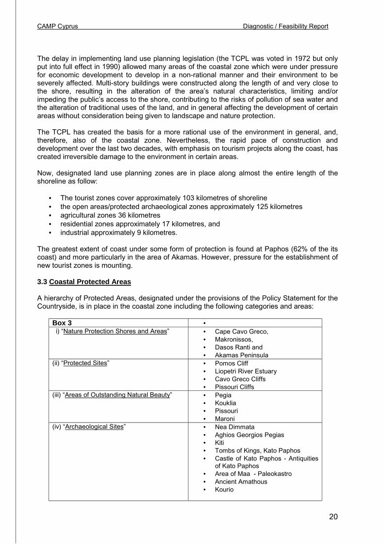
CAMP Cyprus Diagnostic / Feasibility Report
20
The delay in implementing land use planning legislation (the TCPL was voted in 1972 but onlyput into full effect in 1990) allowed many areas of the coastal zone which were under pressurefor economic development to develop in a non-rational manner and their environment to beseverely affected. Multi-story buildings were constructed along the length of and very close tothe shore, resulting in the alteration of the area’s natural characteristics, limiting and/orimpeding the public’s access to the shore, contributing to the risks of pollution of sea water andthe alteration of traditional uses of the land, and in general affecting the development of certainareas without consideration being given to landscape and nature protection.
The TCPL has created the basis for a more rational use of the environment in general, and,therefore, also of the coastal zone. Nevertheless, the rapid pace of construction anddevelopment over the last two decades, with emphasis on tourism projects along the coast, hascreated irreversible damage to the environment in certain areas.
Now, designated land use planning zones are in place along almost the entire length of theshoreline as follow:
• The tourist zones cover approximately 103 kilometres of shoreline• the open areas/protected archaeological zones approximately 125 kilometres• agricultural zones 36 kilometres• residential zones approximately 17 kilometres, and• industrial approximately 9 kilometres.
The greatest extent of coast under some form of protection is found at Paphos (62% of the itscoast) and more particularly in the area of Akamas. However, pressure for the establishment ofnew tourist zones is mounting.
3.3 Coastal Protected Areas
A hierarchy of Protected Areas, designated under the provisions of the Policy Statement for theCountryside, is in place in the coastal zone including the following categories and areas:
Box 3 • i) “Nature Protection Shores and Areas” • Cape Cavo Greco,
• Makronissos,• Dasos Ranti and• Akamas Peninsula
(ii) “Protected Sites” • Pomos Cliff• Liopetri River Estuary• Cavo Greco Cliffs• Pissouri Cliffs
(iii) “Areas of Outstanding Natural Beauty” • Pegia• Kouklia• Pissouri• Maroni
(iv) “Archaeological Sites” • Nea Dimmata• Aghios Georgios Pegias• Kiti• Tombs of Kings, Kato Paphos• Castle of Kato Paphos - Antiquities
of Kato Paphos• Area of Maa - Paleokastro• Ancient Amathous• Kourio
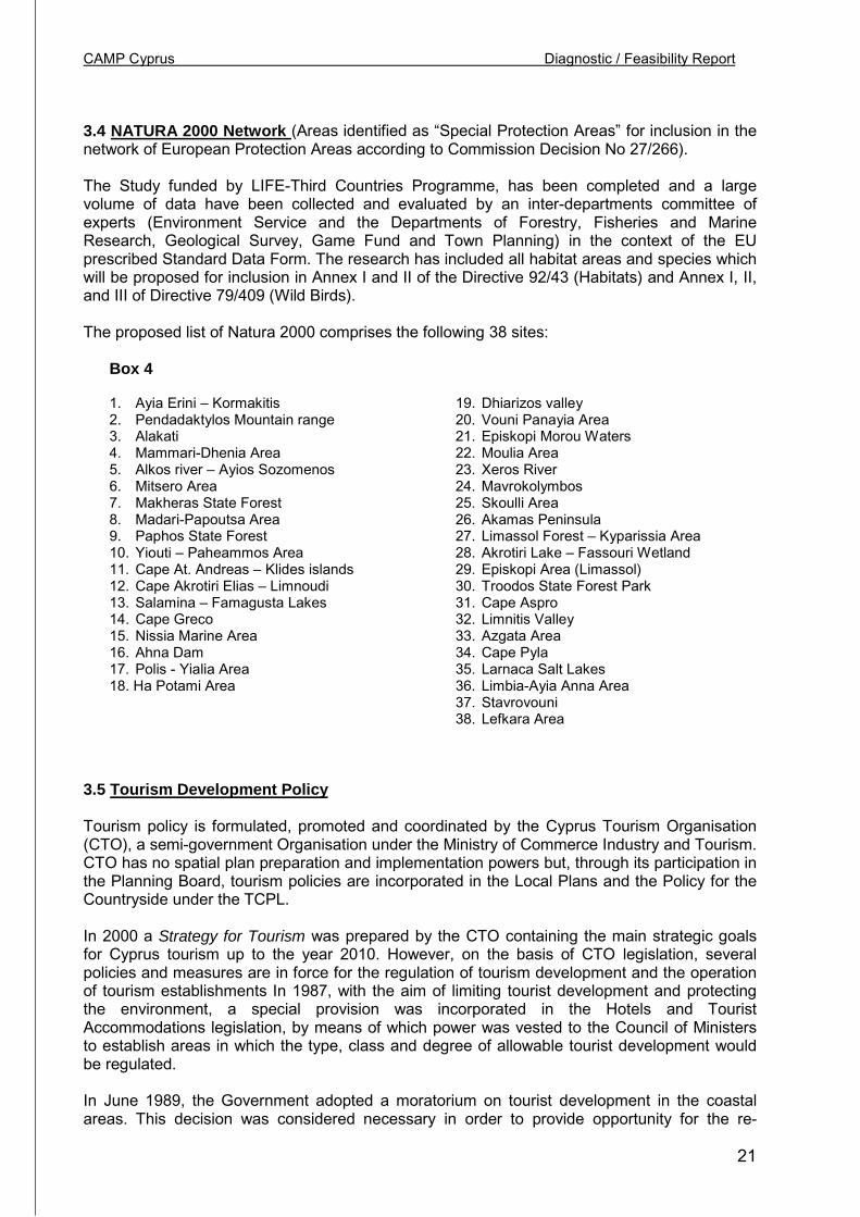
CAMP Cyprus Diagnostic / Feasibility Report
21
3.4 NATURA 2000 Network (Areas identified as “Special Protection Areas” for inclusion in thenetwork of European Protection Areas according to Commission Decision No 27/266).
The Study funded by LIFE-Third Countries Programme, has been completed and a largevolume of data have been collected and evaluated by an inter-departments committee ofexperts (Environment Service and the Departments of Forestry, Fisheries and MarineResearch, Geological Survey, Game Fund and Town Planning) in the context of the EUprescribed Standard Data Form. The research has included all habitat areas and species whichwill be proposed for inclusion in Annex Ι and ΙΙ of the Directive 92/43 (Habitats) and Annex Ι, ΙΙ,and ΙΙΙ of Directive 79/409 (Wild Birds).
The proposed list of Natura 2000 comprises the following 38 sites:
Box 4
1. Ayia Erini – Kormakitis2. Pendadaktylos Mountain range3. Alakati4. Mammari-Dhenia Area5. Alkos river – Ayios Sozomenos6. Mitsero Area7. Makheras State Forest8. Madari-Papoutsa Area9. Paphos State Forest10. Yiouti – Paheammos Area11. Cape At. Andreas – Klides islands12. Cape Akrotiri Elias – Limnoudi13. Salamina – Famagusta Lakes14. Cape Greco15. Nissia Marine Area16. Ahna Dam17. Polis - Yialia Area18. Ha Potami Area
19. Dhiarizos valley20. Vouni Panayia Area21. Episkopi Morou Waters22. Moulia Area23. Xeros River24. Mavrokolymbos25. Skoulli Area26. Akamas Peninsula27. Limassol Forest – Kyparissia Area28. Akrotiri Lake – Fassouri Wetland29. Episkopi Area (Limassol)30. Troodos State Forest Park31. Cape Aspro32. Limnitis Valley33. Azgata Area34. Cape Pyla35. Larnaca Salt Lakes36. Limbia-Ayia Anna Area37. Stavrovouni38. Lefkara Area
3.5 Tourism Development Policy
Tourism policy is formulated, promoted and coordinated by the Cyprus Tourism Organisation(CTO), a semi-government Organisation under the Ministry of Commerce Industry and Tourism.CTO has no spatial plan preparation and implementation powers but, through its participation inthe Planning Board, tourism policies are incorporated in the Local Plans and the Policy for theCountryside under the TCPL.
In 2000 a Strategy for Tourism was prepared by the CTO containing the main strategic goalsfor Cyprus tourism up to the year 2010. However, on the basis of CTO legislation, severalpolicies and measures are in force for the regulation of tourism development and the operationof tourism establishments In 1987, with the aim of limiting tourist development and protectingthe environment, a special provision was incorporated in the Hotels and TouristAccommodations legislation, by means of which power was vested to the Council of Ministersto establish areas in which the type, class and degree of allowable tourist development wouldbe regulated.
In June 1989, the Government adopted a moratorium on tourist development in the coastalareas. This decision was considered necessary in order to provide opportunity for the re-
CAMP Cyprus Diagnostic / Feasibility Report
22
evaluation of problems and the preparation of a new, integrated, policy on tourism and theadoption of a holistic urban planning policy.
The moratorium had a duration of 18 months. In December 1990, the Government proceededto the adoption of a new policy, by which the construction of new tourist accommodation in thecoastal zone and at a distance of 3 kilometres from the shore, came under control. At the sametime, all provisions of the Town and Country Planning Law of 1972 were put into effect.
During the preparation of this new policy regarding tourism, the following parameters weretaken into consideration:
• The need for the maintenance and protection of the natural environment.• The capacity of the coast.• The need to ensure a more balanced tourist development in all areas of Cyprus.• The improvement, upgrading, and enrichment of the tourist product, the improvement of
infrastructure, the launching of new forms of tourism and the adequate protection ofarchaeological sites.
Within this 3-kilometer wide coastal zone, designated by this new policy, the policy measuresincluded:
• No new hotel development would be permitted outside designated tourist zones.• The “freezing” of hotel development in the areas of the Municipalities of Paralimini and
Chrysochou, until Local Plans were prepared and approved.• Tourist development is permitted only for special categories of accommodation
establishments and under special provisions of approved Development Plans (LocalPlans and the Policy Statement for the Countryside) under the TCPL.
• In the inland region, agro-tourism is encouraged by the conversion of existing traditionalbuildings into tourist accommodation.
In June 1995, at the suggestion of the Cyprus Tourist Organization, the Council of Ministersapproved a new policy for the regulation of the establishment of new hotel beds. The newpolicy continued the controls and restrictions on hotel development due to the large supply ofbeds already existing in relation to the island’s limited natural and other resources, as well asthe pressures on the natural environment. In addition, with the new regulation an attempt wasmade to minimize the differences and discrepancies between the provisions of the TCPL, thetourism policy and the legislation concerning Hotels and Tourist Accommodations.
Tourist development is at a stage where environmental quality and its enrichment by means ofdiverse forms of tourism activities are given high priority. The importance of sustainabledevelopment has already been established. In parallel, various forms of tourism are beingencouraged in order to enrich Cyprus’ market position as a tourist destination, such as culturaltourism, agro-tourism, mild forms of tourism, athletic tourism, and convention tourism. Theencouragement of specialised forms of tourism aims at lessening pressures on the coast aswell as at making use of other activities or special features of the inland region.
In this context, the Cyprus Tourism Organisation has commissioned international consultants toprepare a Strategic Study for Tourism for the period 2000-2010. The Strategy was approved bythe Council of Ministers in 2001 which focuses on the strategic vision of turning Cyprus into aquality tourism destination to satisfy the needs of the visitors with diverse interests andconcerns and secure improvement in the quality of life of the population. This vision will beachieved by a sustainable development strategy capable of combining the protection of thenatural environment with the quality of tourism development. The main goals of the Strategyinclude the maximisation of the socio-economic benefits from tourism through:
CAMP Cyprus Diagnostic / Feasibility Report
23
• Increase in tourist expenditure• Improvement of the problem of seasonality• Increase in arrivals• Increase in the length of stay• Increase in the repeat arrivals
3.6 Environmental Policy
The overall responsibility for environmental policy, excluding land use planning, rests with theMinister of Agriculture, Natural Resources and Environment (MANRE), assisted by an inter-ministerial Environment Committee and a Consultative Environment Council, which includesprivate sector stakeholders (the business community, NGOs, etc.). The Environment Service ofthe Ministry co-ordinates programmes for the protection of the environment, advices onenvironmental policy formulation and its implementation, and is in charge of the environmentalimpact assessment process.
The environmental management framework is interlinked and co-ordinated both with thephysical as well as with the tourism planning frameworks. Implementation and enforcement ofsectoral aspects of the environment are carried out in accordance with specific laws andregulations by a number of line Ministries, Departments and Services corresponding to thesubject-matter areas of their respective responsibility. All line Ministries with executiveresponsibilities on environmental issues participate in the Environment Committee and theEnvironment Council.
Protection of the Sea and Coastal Ecosystems. The Foreshore Protection Law covers theforeshore (all lands within 100 yards of the high water mark), controlling activities, public accessand the use of the foreshore for the provision of services and facilities to bathers. Under theGame and Wild Birds Law permanent and temporary game reserves have been established,such as around the two large Salt Lakes (Akrotiri and Larnaca).
The State Forests are very well protected and managed under the Forests Law, whereassuccessful reforestation efforts are being undertaken. Coastal National Forest Parks have beendesignated at the Liopetri River (89 ha) and Cape Greco (325 ha) whereas the Akamas StateForest (7,140 ha.) is being managed as a National Forest Park, although not declared as such.The Compulsory Acquisition Law allows for the acquisition of land, with fair compensation, forpublic benefit purposes and it has been used to acquire land on the periphery of forests orenclaves within them either which are ecologically sensitive or indispensable for sustainableforest management.
The Akamas Peninsula has been accorded high priority for purposes of protection andconservation management. The most sensitive part in the south of the Peninsula remainsdesignated as a “White Zone”, where development is prohibited pending the implementation ofthe Akamas Conservation Management Plan, prepared in 1995 under METAP, aiming at theconservation and management of significant ecosystems, sites of cultural and landscape valueand creation of a sustainable future for the area's village population.
Successful measures were taken since 1981 to control operations of commercial fishing.Seagrass beds are protected from trawling operations under the Fisheries Law, which prohibitstrawling at less than 30 fathoms. The same law also protects a number of marine and riverinespecies and provides for the designation of marine and coastal protected areas. ManagementPlans as well as a monitoring system have been prepared for the two Salt Lakes (Larnaca andAkrotiri). The Lara Beach turtle protection and management area includes the nesting beachand a hatchery. Access is controlled in the summer and at night, at nesting, incubation andhatching. Fishing, sailing and driving on the foreshore are also controlled. The programme is
CAMP Cyprus Diagnostic / Feasibility Report
24
run by the Fisheries Department and is partly financed by the EU's MEDSPA. The hatcheryreleases between 6,000-7,000 hatchlings a year, adult females being tagged and recorded. Theprotected area where regulations apply extends along 9km. of the coast 20 m. into the sea and90 m. inland.
Water Resources. A number of major water development projects have been implemented bythe Water Development Department, in order to increase the availability of water. Particularemphasis has been given to the construction of dams, mostly in the mountainous area in thesouth and west of the island, and the conveyance of water to other parts of the island. TheSouthern Conveyor Project is a major trans-basin diversion that provides the facilities tobalance water supply and demand throughout the southern coastal part of Cyprus and optimisethe conjunctive use of surface and groundwater throughout the region. Two desalination plantsare in operation, (Dhekelia in 1997 and Meneou in 2001, both in Larnaca) producing a total of91,000 m3/day. A third is being planned for the production of an additional amount of 20,000m3/day.
Wastewater management. The size of the urban population served by central seweragesystems is 17%; within the next 5 years it will increase to 31%. Rural population served by asewerage system is only 2% and is expected to increase to 15% within the next 5 years.Limassol (the largest coastal town) and Larnaca are served by central sewerage systems andtertiary level treatment plants. Similar systems will soon operate to serve three important touristcentres of Paphos, Paralimni and Agia Napa. Practically all hotels, especially the new ones, inthe coastal area have their own biological sewage treatment plant, until the operation of thecentral sewerage systems to which they will connect. Hotels use the safely treated effluent fromtheir plants for watering lawns, trees and shrubs and other hotel amenity areas.
Almost all rural areas are served by traditional septic tanks/absorption pits. In a number ofvillages, central sewerage systems have been constructed. A comprehensive Rural SanitationStudy has recently been completed to provide comprehensive service coverage to allcountryside areas according to collection and disposal methods appropriate for each area. Atfull implementation, the programme for centralised sewerage schemes and sewage treatmentplants will produce treated effluent of high quality and the Government's policy is to use sucheffluent to irrigate agricultural crops, green spaces and sports grounds. Standards for treateddomestic sewage effluent for use in irrigation, accompanied by a relevant code of conduct, arenow in place.
Municipal solid wastes are managed by the various municipalities, which are responsible for thecollection, transport and disposal of waste in sanitary landfills. A study to address the domesticsolid waste problem, with a view to volume reduction and recycling has been commissionedand is now in its final stage.
Sea pollution. Under the Fisheries Regulations, standards have been adopted for effluentsubstances and the environmental quality of recipient seawaters. There are also prohibitions onthe disposal of lubricating and other oils and on the use of organotin-based anti-fouling paints inthe marine environment. In order to minimise local effects, aquaculture is now carried out "off-shore".
Under the Law for Water Pollution Control, industrial effluent standards are set, thus directlyencouraging the minimisation of the generation of waste, waste reuse, recycling and treatment.The final drafts were prepared for water quality standards and an Order for the protection of theunderground water resources from pollution was recently issued.
Pesticides are being registered according to the provisions of a comprehensive Pesticides Lawand relevant regulations, which provide for the control of the import, manufacture, marketing,quality, labelling, toxicity classification, use and storage of pesticides. The DangerousSubstances Law imposes requirements on the import, manufacturing, classification, labelling/
CAMP Cyprus Diagnostic / Feasibility Report
25
packaging, use, storage, transport and supply of dangerous substances and the furnishing ofrequired information.
To address problems of sea and beach pollution, Cyprus has introduced measures incompliance with MARPOL. An anti-pollution unit is in place, a national oil spill Contingency Planhas been implemented and regional oil combating arrangements has been established withEgypt and Israel.
Monitoring of pollution of the marine environment started in 1976, within the framework of theMediterranean Action Plan (MAP), and by 1984 it evolved into a full-scale national pollution-monitoring programme. It involves the monitoring of land-based sources, of the concentrationsof dissolved and dispersed petroleum hydrocarbons as well as of DDT, PCB's and otherpolychlorinated hydrocarbons in seawaters, of heavy metals in marine organisms, of pesticidesin sediments and of macrobiotic parameters, i.e. faecal coliforms.
Groundwater is also monitored and a programme for the preparation of hydrochemical chartshas been initiated.
Shoreline protection. There is currently a moratorium on breakwater construction while a studyfinanced under MEDSPA has recently been completed in order to address coastal erosionproblems. The study has made an assessment of current coastal problems and coastaldynamics and has built a body of knowledge for the design of effective and environmentallysustainable coastal protection and improvement measures, and proposed methods to protectthe coastline and improve the quality of the beach where necessary. A follow-up Study is nowunderway, jointly undertaken by the Coastal Unit of the Ministry of Communications and Worksand the University of Athens, covering three specific coastal strips: The Tylliria Area, theChrysochou Bay Area and the Zygi-Kiti Area.
Cultural preservation. The protection of archaeological sites, under the responsibility of theDepartment of Antiquities, has long been recognised a priority and the Antiquities Act whichprotects the architectural heritage and historic monuments has been in place since the 1960s.The Department is under-funded and protection is often partial. A significant proportion of sitesin the coastal area are identified as Ancient Monuments and they include a large number ofvaluable sites that are privately owned. Preservation Orders under the TCPL are also used toprotect buildings or areas of architectural, social or historical interest, and transferabledevelopment rights and fiscal incentives are being used to preserve listed buildings. Budgetallocations are not sufficient though to protect village heritage on a significant scale.
International Conventions. Cyprus has ratified all major environmental conventions with director indirect relevance to coastal areas such as the Barcelona Convention and its Protocols, theConvention on the Conservation of the European Wildlife and Natural Habitats and the GlobalConvention on the Control of Transboundary Movement of Hazardous Waste and theirDisposal. A ratification law for the Biological Diversity Convention was recently approved byParliament.
Environmental Impact Assessment. An Integrated System for Environmental ImpactAssessment was approved by the Council of Ministers in 1991, based on the relevant EuropeanUnion Directive and UNEP's methodology. In 2001 a new Law for EIA came into effect makingEIA bounding on the Planning Authority for purposes of Planning Permission. Projects for whichthe procedure is applicable include tourist installations, aquaculture projects, ports, marinas,fishing shelters and breakwaters, wastewater treatment plants, solid and liquid disposal areas,dams, major roads, quarries, industrial areas, airports, etc.
Alignment with the EU Acquis. Environmental policy in Cyprus is focused on the effort towardsalignment with the EU Acquis. Current priorities and work progress are geared to the legaltransposition of EU Directives into Cypriot legislation. Cyprus has accepted the environmental
CAMP Cyprus Diagnostic / Feasibility Report
26
Acquis and declared to apply it by 1.1.2003 or at later dates in certain areas in which transitional periodswere requested or for which the dates provided in the Acquis allow for later dates for implementation.Special arrangements have been requested in the following cases:
Reduction of sulphur content of fuels (a one-year transitional period).Habitats and Wild Birds (technical adjustments to the lists of habitats and species).Packaging and packaging waste (transitional period until end of 2005).Urban wastewater (transitional period for full implementation until end of 2012).
A concrete programme for transposing Community environmental legislation is in place within thetimeframe given to the Commission. The directives on Free Access to Environmental Information, WaterQuality Intended for Human Consumption and on EIA were fully transposed. Full transposition of theenvironmental Acquis will be effected through revisions to existing laws, the new law on waste, the newlaw for the environment, and the drafting of a number of other new laws.
The draft comprehensive Bill for the Environment, prepared in 1997, has been subsequently decided to besplit into a number of new bills, such as:
• Environmental management framework, Fiscal Instruments, General Obligations, International Issues(new Framework Bill on the Environment)
• Protection of Species and Habitats, Trade in Species• Solid and Hazardous Waste Management• Packaging and Packaging Waste Management• Environmental Impact Assessment• Free Access to Information• Genetically Modified Organisms,• Noise, etc.
The required amendments to the Water Pollution Control Law, the Atmospheric Pollution Control Law, theWaste Management Law and the ICPP Law are at an advance stage. By the end of 2002, the legislativeframework will be in full compliance with the EU requirements.
3.7 The Administrative Framework of Environmental Policy
At the national level, the Council of Ministers has the overall responsibility for the formulation ofenvironmental policy. Environmental policy is co-ordinated through the MANRE, with the exception of landuse planning, for which responsibility rests with the Minister of Interior.
An important component in the environmental management mechanism is the Council for theEnvironment, with a wide representation, which advises the Minister and through him, the Council ofMinisters, on environment and sustainable development issues.
CAMP Cyprus Diagnostic / Feasibility Report
27
To assist in the co-ordination and implementation of environmental policy, the government established anadditional instrument. This is the Environment Committee, made up of representatives of all agenciesinvolved in environmental issues.
Competencies are divided among several institutions, the competent authorities being primarilypublic bodies, Ministries, or Departments.
The Environment Service of the MANRE is mandated to advise on environmental policy, ensureimplementation and co-ordinate (in close co-operation with the Planning Bureau) the process for theadoption of the EU environmental policy and legislation. It also heads the Technical Committee onenvironmental impact assessment, oversees the enforcement of the larger part of the Law on the Controlof Water Pollution, promotes environmental awareness and training, and disseminates information on theenvironment. The Environment Service is also the administrative arm of the Environment Committee andthe Council for the Environment. In addition, it is the National Focal Point for the CSD, MCSD, SMAP,INFOTERRA, UNEP, MAP and the Conventions of CITES, Bern, Basel, Vienna, Biological Diversity,Desertification, Climate Change, Ramsar and Environmental Impact Assessment in a TransboundaryContext.
Through its various Departments (mainly Agriculture, Forestry, Fisheries and Marine Research, WaterDevelopment and Geological Survey), the MANRE has a wide range of executive functions onenvironmental issues. They concern the protection of the quality of surface and ground waters and thesea, management of water resources, aquaculture, meteorology, protected areas, soil conservation,fertilisers and pesticides, reuse of treated effluent, hazardous waste management, mines and quarries,control/monitoring and combating marine pollution, marine ecology, management of forests and publicparks, herbaria and gene banks, organic farming, protection of flora and fauna, agricultural and animalhusbandry waste, industrial waste treatment, rehabilitation of sites, health and welfare of animals, etc.
Agencies and other Ministries also have a wide range of executive responsibilities over variousenvironmental issues, as follows:
• the Planning Bureau, is in charge of the preparation of five-year Strategic Development Plans forthe national, regional and balanced development of the island's economy and has responsibilityfor the broader co-ordination of the accession process,
• the Department of Town Planning and Housing is responsible for the implementation of theTown and Country Planning Law, and
• the Ministry of Labour and Social Insurance, is the competent authority for the administrationand enforcement of the Atmospheric Pollution Control Law, the Safety and Health at Work Law,the Dangerous Substances Law, and the Asbestos (Safety and Health of Persons at Work) Law. Italso administers part of the Water Pollution Control Law and has been assigned responsibility forthe broader framework for radiation protection,
• the Ministry of Commerce, Industry and Tourism, deals with industrial estates, energyconservation, exploitation of new and renewable sources of energy, industrial pollution prevention
CAMP Cyprus Diagnostic / Feasibility Report
28
techniques and the management of a grants scheme which assists manufacturing industries ininstalling waste treatment systems,
• the Cyprus Tourism Organisation promotes agrotourism and is the co-ordinator of the BLUEFLAGS scheme in Cyprus,
• the Ministry of Communications and Works, is responsible for shoreline defence, theimplementation of International Civil Aviation standards on noise from aircraft, the regulations andinternational conventions on Merchant Shipping, motor vehicles inspection and Type Approval forvehicles,
• the Cyprus Ports Authority handles oily waters and refuse from ships in port areas,• the Ministry of Health inspects landfills and drainage systems, is responsible for the control of
drinking water and the microbiological monitoring of recreational waters and carries out researchand analytical work on various aspects of pollution with its specialised laboratories inenvironmental chemistry, microbiology and virology, ecotoxicology and risk assessment, and
• the Game Fund is in charge of the enforcement of the Game and Wild Birds Law, which regulateshunting and game improvement.
3.8 Summary of the Legal Framework concerning the Coastal Zone
Box 5A. MARINE ENVIRONMENT Laws & Regulations Basic ProvisionsLaw Concerning the Control of WaterPollution (No. 69/91).
Responsible authorityMANRE
- establishes quality targets for waters,including coastal waters- appoints pollution inspectors for checkingpermits- prepares and publishes general terms andconditions of discharge permits.
Consolidated Amending Regulations of1990 (No. 273/90) adopted on the basis ofArticle 6 of the Fisheries Law.Responsible authorityDFMR-MANRE
-Prohibition of the disposal of litter in themarine environment.- Maximum limits permitted for the disposalof a series of substances or compoundsinto the sea.
Amendment (No. 170 of 1990) of theFisheries Law.DFMR-MANRE
- Increased the fine for polluting the seafrom £3.000 to £30.000. The FisheriesDepartment may impose an extra judicialfine of up to £5.000.
Ratification Law (No. 51 of 1979) of theBarcelona Convention regarding protectionof the Mediterranean from pollution as wellas its two Protocols:
(a) Protocol for the protection againstpollution of the Mediterranean by wastefrom ships or aircraft (Dumping Protocol),
-General obligations of the signatory partiesfor the avoidance, reduction and combatingof pollution in the Mediterranean.- Operational arrangements andmechanisms.- Systems of pollution monitoring.
- Permit requirements for the dumping oflitter or other materials.- Establishment of competent authority forissuing permits and confidential file.-Record of substances whose disposal isprohibited
CAMP Cyprus Diagnostic / Feasibility Report
29
(b) Protocol for cooperation in thecombating of pollution in theMediterranean by petroleum products andother toxic substances (EmergencyProtocol)
Responsible authorityDFMR-MANRE
The Parties should maintain EmergencyPlans and methods for combating pollutionof the sea by petroleum products or otherharmful substances either individually orthrough bilateral or multilateral cooperation
Ratification Law (No. 266 of 1987). Itratifies another two Protocols of theBarcelona Convention:
(a) Protocol for the protection of theMediterranean from land-based sources
(b) Protocol concerning protected areas ofthe Mediterranean
Responsible authorityMANRE
- Establishment of the various types ofwaste covered by the Protocol.-Establishment of supplementarysubstances whose disposal must bediscontinued and the limits and conditionsgoverning those whose disposal ispermitted.
-Criteria for the establishment of protectedareas.
Consolidated Amending Regulations (No.273/90) enacted under the Fisheries Law(CHAPTER 135).
Responsible authorityDFMR-MANRE
They provide for the protection of turtles,seals, dolphins, as well as of the habitats ofsea turtles during their breeding period (1/6- 30/9 yearly).
Ratification Law (No. 57 of 1989). Itratified the International Conventionregarding prevention of pollution of the seaby ships of 1973 and the relevant Protocolof 1978 and the Amendments of 1984.
Responsible authorityDFMR-MANRE,DMS-MCW
- Prohibition of the disposal of pollutingsubstances from ships (wastes, sewage,litter).- Prohibition of the use of dispersants orother chemical detergents without a permitfrom the Fisheries Department.- Establishes the obligations of ships andtankers entering the Republic’s ports.- Establishes the obligation, in the event ofpollution, to report to the competentauthority and the Fisheries Department.- Establishes the penalties in case ofpollution.
Regulations concerning undersea pipelinesfor carrying oil and other products (No.151/1995).
Responsible authorityMCW
Establishment of specifications,maintenance, and operational conditions forundersea pipelines.
Ratification Law (No. 63 of 1989),ratifying the International Conventionconcerning civil liability for damage from oilpollution of 1969, and its protocol of 1976and provisions regarding related matters.
Responsible authorityDMS-MCW
- Establishment of the areas of application,i.e. Cypriot ships wherever they may be,and foreign ships sailing in Cypriot ports orterritorial waters.- Establishes penalties for breaking the law.- Adoption of judicial measures to collectpenalties.
Ratification Law (No. 14 (III) of 1997).Law Regarding the Ratification of the
Ratifies the amendments in the Protocol of1992.
CAMP Cyprus Diagnostic / Feasibility Report
30
Protocol of 1992 which amends theinternational Convention regarding civilliability for damages from pollution.
Responsible authorityMCWRatification Law (No. 109 of 1989).Ratifies the International Conventionconcerning the establishment of aninternational fund for compensation for oilpollution of 1971 and its protocol of 1976and provisions regarding related matters.Responsible authorityMCW
Establishes conditions for the creation ofthe Fund and the mechanisms for putting itinto effect.
Ratification Law (No. 9 (III) of 1995).Ratifies the Agreement related to theapplication of the part of the XI Conventionfor maritime justice of December 10, 1982.
Responsible authorityMFA and MANRE
The Agreement covers matters ofprotection and care of the marineenvironment.
B. LAND USE – SPATIAL PLANNINGThe Town and Country Planning Law (No.90/72, Amending Laws 56/82, 7/90, 28/91,91(I)92, 55(I)/93).
Responsible authorityMoI (except for the portion of the law relatedto the Island Plan)MI has transferred his responsibilities to theDirector of DTPH, the Local Councils in thelarge Municipalities and the Town PlanningBoard.
The Foreshore Protection Law (No. 22/61,and Amending Laws 17 of 1964, 8 of 1972,52 of 1975, 21 of 1987, 126 of 1989, 11 of1990, 251 of 1990, 40 of 1991, 87 of 1991,234 of 1991, 15(I) of 1992, 41(I) of 1992,61(I) of 1992, 103(I) of 1992, 7(I) of 1993,19(I) of 1993, 27(I) of 1993, 37(I) of 1993,4(I) of 1994, 34(I) of 1994, 51(I) of 1994,75(I) of 1994
Responsible authorityDO, CCB, LA
Preparation of Development Plans forregulation, control and promotion ofphysical development through planningpolicy instruments including the issue ofPlanning Permission.
Based on the provisions of this law, aforeshore protection zone has beenestablished in which it is prohibited toperform certain works, build or constructvarious structures and buildings, disposewaste, park vehicles or place articles onthe beach. It also regulates the provisionof services on the beach.
The Piers Law (No. 39/73, 36(I)/94).
Responsible authorityMI
Regulates the erection, extension, anduse of existing and new piers.
C. TOURISM DEVELOPMENT (Competent authority: Cyprus Tourism Organization)Laws of Hotels and Tourist Accommodationsof 1969 to 1995 (No. 40/69, 52/70, 17/73,28/85, 42(I)93, 80(I)95).
- Regulation of the establishment andoperation of hotels and other touristaccommodation.- Power given to the Council of Ministers
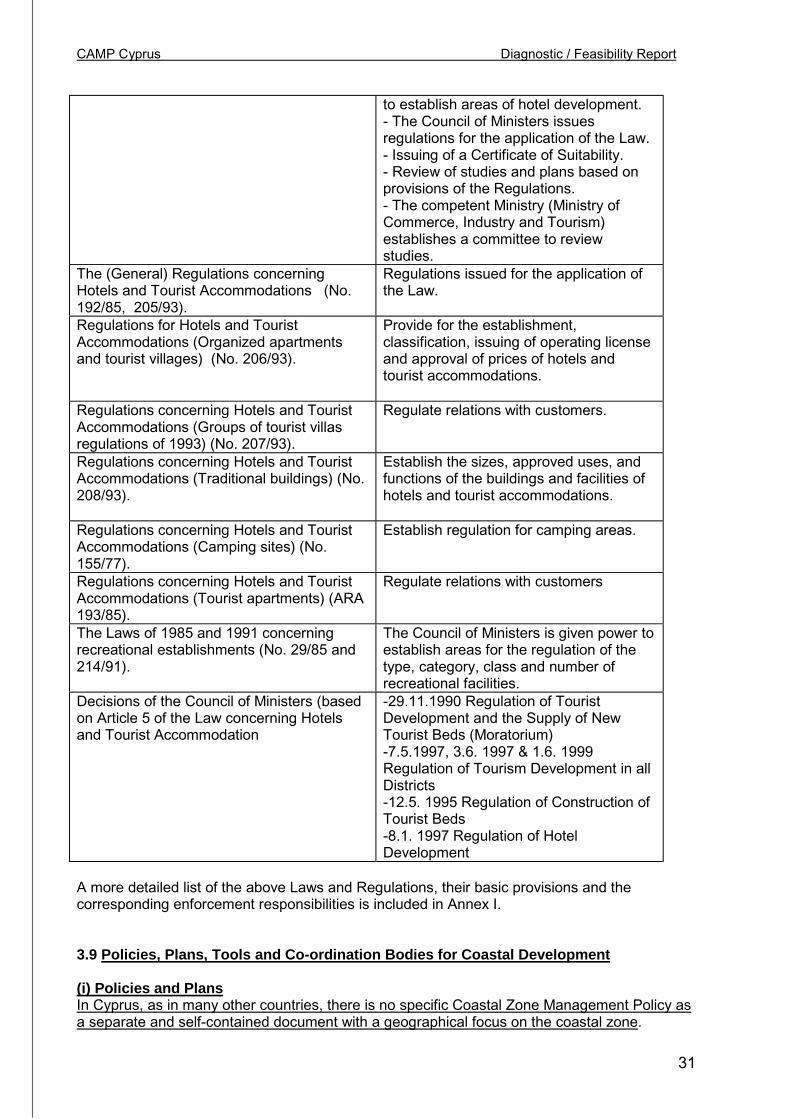
CAMP Cyprus Diagnostic / Feasibility Report
31
to establish areas of hotel development.- The Council of Ministers issuesregulations for the application of the Law.- Issuing of a Certificate of Suitability.- Review of studies and plans based onprovisions of the Regulations.- The competent Ministry (Ministry ofCommerce, Industry and Tourism)establishes a committee to reviewstudies.
The (General) Regulations concerningHotels and Tourist Accommodations (No.192/85, 205/93).
Regulations issued for the application ofthe Law.
Regulations for Hotels and TouristAccommodations (Organized apartmentsand tourist villages) (No. 206/93).
Provide for the establishment,classification, issuing of operating licenseand approval of prices of hotels andtourist accommodations.
Regulations concerning Hotels and TouristAccommodations (Groups of tourist villasregulations of 1993) (No. 207/93).
Regulate relations with customers.
Regulations concerning Hotels and TouristAccommodations (Traditional buildings) (No.208/93).
Establish the sizes, approved uses, andfunctions of the buildings and facilities ofhotels and tourist accommodations.
Regulations concerning Hotels and TouristAccommodations (Camping sites) (No.155/77).
Establish regulation for camping areas.
Regulations concerning Hotels and TouristAccommodations (Tourist apartments) (ARA193/85).
Regulate relations with customers
The Laws of 1985 and 1991 concerningrecreational establishments (No. 29/85 and214/91).
The Council of Ministers is given power toestablish areas for the regulation of thetype, category, class and number ofrecreational facilities.
Decisions of the Council of Ministers (basedon Article 5 of the Law concerning Hotelsand Tourist Accommodation
-29.11.1990 Regulation of TouristDevelopment and the Supply of NewTourist Beds (Moratorium)-7.5.1997, 3.6. 1997 & 1.6. 1999Regulation of Tourism Development in allDistricts-12.5. 1995 Regulation of Construction ofTourist Beds-8.1. 1997 Regulation of HotelDevelopment
A more detailed list of the above Laws and Regulations, their basic provisions and thecorresponding enforcement responsibilities is included in Annex I.
3.9 Policies, Plans, Tools and Co-ordination Bodies for Coastal Development
(i) Policies and PlansIn Cyprus, as in many other countries, there is no specific Coastal Zone Management Policy asa separate and self-contained document with a geographical focus on the coastal zone.

CAMP Cyprus Diagnostic / Feasibility Report
32
Policies for the coastal zone are included in various sectoral policies which cover other areasincluding the coastal zone. The main policies include:
Box 6Policy FocusLand Use (Spatial) Policy Expressed in the Development Plans prepared and
implemented under the provisions of the TCPL(Local Plans, Area Schemes and Policy for theCountryside). Spatial Development Plans regulateall forms of development (residential, tourism,industrial, commercial, agricultural, infrastructure,etc.) and the designation of various categories ofprotected areas. Coastal Local Plans include thoseof Limassol, Larnaca, Paphos, Polis and Dherinia.Other main coastal development areas such asAyia Napa, Sotera, Pissouri, Peyia, Oroklini, etc.are regulated by the Policy for the Countryside.Paralimni, a major coastal tourism area, remains a‘planning-excluded area’ in which the planninglegislation does not apply!
Tourism Policy Expressed in the Strategic Plan for Tourism 2000-2010 prepared by the Cyprus TourismOrganisation. The Tourist Strategy defines thelong-term vision and strategic goals which willguide tourism development over the next ten or soyears. Although it contains goals spanning acrossall policy areas that influence tourism performance(tourist expenditure, arrivals, quality, etc.) lacks itsown spatial policy and implementation tools, asmany of these policies are formulated andimplemented by Development Plans and land usezones under the TCPL, and other regulations inseveral environmental laws.
Environmental Protection Policy Expressed in sectoral policies for various resources(land, foreshore, fresh water, sea water and marineenvironment, forests, etc.) prepared andimplemented by the various competent authoritiesas outlined in 3.1.4 and in Annex I of this Report.
(ii) Tools and Co-ordination BodiesThe existing tools and institutions for the protection and management of the coastalenvironment and the regulation of coastal development are likewise segmented in differentsectoral policies and departments according to their specific sphere of competence.
Box 7Tools FocusLand use zones Designated by the Development Plans and
implemented through planning permissionsProtected areas Designated by the Development PlansPlanning permissions Issues on the basis of the provisions of the
Development Plans and implemented throughplanning permissions
Natura 2000 sites Identified by the provisions of EU Directive 92/43 to

CAMP Cyprus Diagnostic / Feasibility Report
33
be incorporated in the Development PlansEnvironmental Impact Assessment Established by Law 57(I) 2001 applying to a large
category of development in all areas including thecoastal zone implemented by the EnvironmentService and enforced through concrete projects bythe Dept of Town Planning & Housing through theissue of planning permissions.
Tourism Strategy As a broad strategic document approved by theCouncil of Ministers, its goals and objectives areexpected to be incorporated in sectoral policies,particularly land use zones and the policiescontained in the (Spatial) Development Plans.
Sectoral regulations Provided in different sectoral Laws and Regulationsapplying to the protection of he coastal and marineenvironment from pollution, wastes, construction,etc. implemented by the various competentauthorities as outlined in 3.1.4 and in Annex I ofthis Report
Box 8Co-ordination Bodies FocusPlanning Board Exercising delegated powers, responsible for the
approval of Spatial Development Plans. It includes10 members, 4 private members, including theChairman, and 6 representatives of various keyMinistries (Interior, Planning Bureau, Finance,Agriculture, Natural Resources and Environment,Commerce, Industry and Tourism, Communicationsand Works. Observers include representatives ofthe Cyprus Tourism Organisation, the EnvironmentService and others according to the agenda, whiletechnical advice is provided by the Director andStaff of the Town Planning and Housing. TheDevelopment Plans, as spatial plans, are expectedto reflect the policy priorities and objectives ofindustrial, agricultural, commercial and particularlytourism policy.
Common Councils They are established by the TCPL and act as localadvisory bodies to the Planning Board. Before aDevelopment Plan is presented to the PlanningBoard for adoption or change, proposedDevelopment Plans are reviewed by CommonCouncils. Participants include local municipalcouncillors and representatives of NGOs.
Technical EnvironmentalCommittee on EIA
The Committee is chaired by the Director of theEnvironment Service and functions under theprovisions of the EIA Law 57(I) 2001. It reviews EIAstudies submitted by applicants of developmentprojects. The Committee’s views and conclusionsare addressed to the Environment Service asEnvironment Authority that sends to the variouscompetent Departments its conclusions that haveto be taken very seriously into consideration prior tothe issue of Planning Permission for the
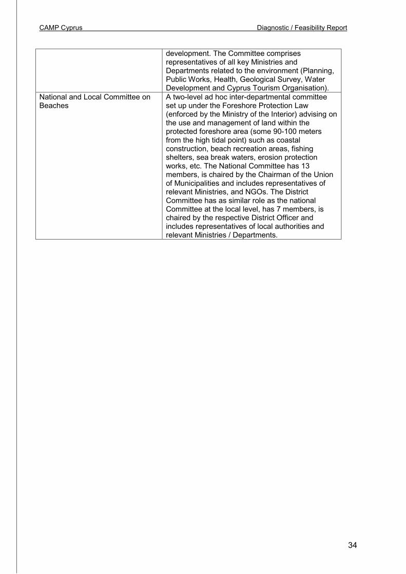
CAMP Cyprus Diagnostic / Feasibility Report
34
development. The Committee comprisesrepresentatives of all key Ministries andDepartments related to the environment (Planning,Public Works, Health, Geological Survey, WaterDevelopment and Cyprus Tourism Organisation).
National and Local Committee onBeaches
A two-level ad hoc inter-departmental committeeset up under the Foreshore Protection Law(enforced by the Ministry of the Interior) advising onthe use and management of land within theprotected foreshore area (some 90-100 metersfrom the high tidal point) such as coastalconstruction, beach recreation areas, fishingshelters, sea break waters, erosion protectionworks, etc. The National Committee has 13members, is chaired by the Chairman of the Unionof Municipalities and includes representatives ofrelevant Ministries, and NGOs. The DistrictCommittee has as similar role as the nationalCommittee at the local level, has 7 members, ischaired by the respective District Officer andincludes representatives of local authorities andrelevant Ministries / Departments.
CAMP Cyprus Diagnostic / Feasibility Report
35
4.0 PROBLEMS, CONFLICTS AND CAUSES
4.1 Specific Problems
Sea pollution. Unlike some other countries in the Mediterranean, Cyprus has a very smallindustrial sector and therefore industrial production has been of very limited importance in itseconomic development. Coastal population growth and tourism pose a potential threat althoughactual impacts are limited due to the sewerage infrastructure in place in all coastal urbancentres and hotels. This explains why sea pollution from land-based wastes is limited. InCyprus, sea pollution problems are limited and geographically isolated. Within theframework of the United Nations Mediterranean Action Plan, sea pollution in Cyprus ismonitored, including the quantities of pollutants that enter the sea and the concentration ofvarious substances in water, fish and sediments. The central sewage systems (constructed andunder way) will address the isolated sea pollution “hot spots” problem, particularly in the area ofthe Limassol wineries.
The main industrial plants on the coast are:
• The Limassol wineries,• The Moni and Vassilikos cement plants (near Limassol),• The Larnaca petrol refinery, and• The power plants of Moni and Dhekelia (near Larnaca).
Generally, no untreated sewage flows into the sea and the few industrial units that pollute thesea are located mainly in Limassol and Vassilikos. Four wineries and one brewery in Limassoldischarge their liquid wastes without any treatment in the sea between the old and the newports of Limassol. These facilities discharge in the area an organic load in the order of 1,200tons of BOD5, as well as airborne solids in the order of 350 tons per year. The contact betweenthese wastes and the processing and cooling waters results in the microbiological pollution ofthe water of the area, which has become unsuitable for swimming 5.
There are no liquid wastes from the two cement factories at Vassilikos and Moni. In addition tothe above liquid wastes, there are also airborne discharges. From the two power stations, thecement factories at Vassilikos and Moni, and the petroleum refinery at Larnaca, 9,000 tons ofNOx (NO), 31,000 tons of SO2, 1,000 tons of CO, and 3,500 tons of dust escape per year 6.The liquid wastes from the Larnaca petroleum refinery are discharged after processing togetherwith the cooling water into the marine environment of Larnaca. These wastes containsubstances, which for their chemical oxidation require app. 100 tons of oxygen (COD5). At thesame time, however, the accumulation of metals and hydrocarbons from petroleum are at lowlevels.
The liquid wastes from the two power stations at Moni and Dhekelia after chemical treatmentare used for irrigation. Cooling waters from these units are discharged at a rate of up to700.000 m2/day and 1.296.000 m2/day respectively, with a temperature 5-6 degrees Celsiushigher than that of the marine environment.
In addition to the above point sources, large amounts of nutrient minerals, especially nitrates,end up in the sea as a result of leaching through the water table, basically due to intensive
5 M. Hadjichristophorou and A. Demetropoulos, 1985 “Effects of pollutants on marine communities andecosystems in Limassol Bay”. MED-POL Research Project6 L. Loizides, 1996, ‘Hot Spots and Sensitive Areas in Cyprus’, GEF/UNEP Project.
CAMP Cyprus Diagnostic / Feasibility Report
36
fertilisation in agriculture. One such area is the coastal zone of Dhekelia to Ayia Napa. In thisarea, it has been calculated that from aquifers of a total extent of 8.5 kilometres, approximately150 tons of nitrates per year enter the sea 7.
Erosion. Beaches attract nearly 3 million millions tourists each year. The Cypriot economy’sdependence to a great extent on the tourist industry creates a constant and increasing pressurefor the exploitation and expansion of coastal tourism zone. Partly due to poorly controlledcoastal development in the past (since 1974 and prior to the implementation of the TCPL in1990) and partly due to the extensive coastal development zones immediately after 1990,coastal development has burdened and negatively altered the coastal environment to a largeextend. Erosion problems, as documented in the 1993 Study carried out by the Coastal Unit ofthe Department of Public Works of the Ministry of Communications and Works within theframework of the EU Programme 8, are most serious in the heavily built sections of the coast ofLimassol, Larnaca, parts of Pahos and Paramini. Major causes include construction of touristprojects, quarrying of gravel (prohibited by law after the 1970’s) and the construction ofbreakwaters.
Land use conflicts. In Cyprus, like in many other countries, the coast is a fragile ecologicalsystem and, at the same time, the backbone of the economy. This conflict between effectiveprotection and building development translates into pressures for tourism and associated landuses attracted by the coastal landscape that in term cause its quality to deteriorate due to over-development, and in some cases development too close to sensitive ecosystems. Developmentpressures and coastal urbanisation are not only confined to the coastal urban areas but expendto surrounding coastal urban-rural fringe areas which are included in the sprawling touristzones. In many such areas (Paralimni and Ayia Napa in Famagusta, Meneou, Linadhia, Kiti,and Oroklini in Larnaca, Pissouri in Limassol, Yeroskipou, Kissonerga, Peyia and Neo Khorio,and other villages) agricultural land is lost to building development, orchards and vegetablegroves are rapidly converted into building land and in many cases agricultural land remainsuncultivated. The main problems include:
• Loss of coastal landscape and degradation of the natural environment due to theintensity of development,
• The mixture of incompatible uses, heavy traffic and lack of open spaces and parkingfacilities for visitors.
• Erosion of the shore.• Overuse of the beaches, which in certain areas reach the upper limit of the beach
carrying capacity.• Problems of beach access due to private infringements and aesthetic pollution,• Deficiencies in infrastructure, landscaping and the provision of basic facilities• High building densities in the urban coastal areas, particularly in Limassol, and also in
the villages that have been transformed into tourism centres, (Ayia Napa, Proraras,Oroklini, etc.)
• Inadequate protection of the “Salt Lakes” of Akrotiri (Limassol) and Larnaca and lack ofadequate protection measures suitable to their “wetland’ status.
The protection of the wetlands from urban encroachment is a major issue as demonstrated bythe problems facing the Larnaca Salt Lake due to its proximity to the Larnaca InternationalAirport, new housing development and the shooting range. The Local Plan of Larnaca has
7 Baird J. & Muir J. 1990, “The Impact of the Telia Aqua Marine Fish Farm on the Coastal Environment atLiopetri in Cyprus”
8 Coastal Protection Study (1993-96)
CAMP Cyprus Diagnostic / Feasibility Report
37
adopted the proposals of the Plan for the ‘Protection and Management of the "Alikes" ofLarnaca’, which however remains unimplemented. There is also a proposed plan, but also notyet implemented, for the smaller wetland of Oroklini-Pyla (north of Larnaca town).
Solid wastes. Population and income growth, tourism and construction increase the volume ofwastes that need to be disposed to landfill sites. The establishment of planned landfills isdelayed due to local reactions and in some cases refuse are disposed in temporary sites nearthe coast. There have been no reported cases of serious threats to the ground water system orthe sea from runoff.
Social disparities and loss of rural heritageCyprus has been manly rural until 1960. Village architecture and rural cultural heritage, beingcore characteristics of the social profile of rural Cyprus, are rapidly overwhelmed by urbansprawl and tourism facilities. Coastal urbanisation and coast-centred economic growth haveminimised the importance and overshadowed the rural heritage and landscape of the islandwhich could have been significant resources for a unique quality-based Cypriot tourism sector.Market-driven tourism development has instead almost exclusively concentrated tourismaccommodation on expensive sections of the coast thus altering not only the coastal landscapeitself but also the social profile of the previously rural coastal areas.
Two important impacts should be noted: The social polarisation between tourist and non-touristcoastal villages, and the transformation of the social structure in the tourist villages themselves.
A socio-economic polarisation exists between the prosperous tourist villages in the outskirts ofPaphos, Limassol, Larnaca and in the Paralimni - Ayia Napa area (where tourism developmenthas been encouraged by the planning policy) and the declining coastal villages those coastalareas are now under a more strict planning regime like in Akamas and the eastern coast ofPaphos. A social transformation has occurred in the now economically prosperous touristvillagers that have evolved into “dormitory communities”, in which old family homes in thevillage cores have been changed into tourist apartments, restaurants and discos, displacing theclose-knit village housing area to new low density adjacent housing areas (like in Ayia Napa).An equally sad experience of loss of rural heritage, but in the opposite direction, is experiencedin the declining non-tourist coastal villages (like in Akamas) where lack of economicopportunities and limited income from agriculture have caused emigration of young people totourism areas and a growing stock of empty village houses.
4.2 Underlying Causes
By far the most important cause of the pressures on the coastal environment is the twinprocess of urbanisation and coastalisation. As mentioned earlier in this Report, the coastalareas concentrate about 50% of total population and employment, and 95% of the touristaccommodation sector. The only inland growth centre is Nicosia which is the capital of Cypruswith a strong business and commercial base. If Nicosia is excluded from the population figures,the population of the coastal areas reaches 66% of the total population.
The following table presents a few indicative figures of the pressure on the coastal areas. Theurban areas of Limassol and Larnaca have a large resident population per km of coast (7,550and 5,020 respectively), while Ayia Napa and Paralimni, being rural municipalities, have a muchlower resident population but twice as many tourist beds (1,352) per km of coast.
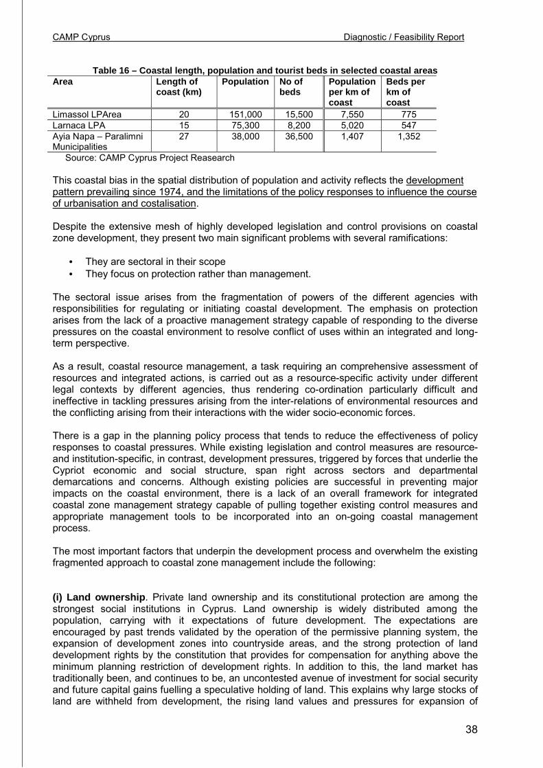
CAMP Cyprus Diagnostic / Feasibility Report
38
Table 16 – Coastal length, population and tourist beds in selected coastal areasArea Length of
coast (km)Population No of
bedsPopulationper km ofcoast
Beds perkm ofcoast
Limassol LPArea 20 151,000 15,500 7,550 775Larnaca LPA 15 75,300 8,200 5,020 547Ayia Napa – ParalimniMunicipalities
27 38,000 36,500 1,407 1,352
Source: CAMP Cyprus Project Reasearch
This coastal bias in the spatial distribution of population and activity reflects the developmentpattern prevailing since 1974, and the limitations of the policy responses to influence the courseof urbanisation and costalisation.
Despite the extensive mesh of highly developed legislation and control provisions on coastalzone development, they present two main significant problems with several ramifications:
• They are sectoral in their scope• They focus on protection rather than management.
The sectoral issue arises from the fragmentation of powers of the different agencies withresponsibilities for regulating or initiating coastal development. The emphasis on protectionarises from the lack of a proactive management strategy capable of responding to the diversepressures on the coastal environment to resolve conflict of uses within an integrated and long-term perspective.
As a result, coastal resource management, a task requiring an comprehensive assessment ofresources and integrated actions, is carried out as a resource-specific activity under differentlegal contexts by different agencies, thus rendering co-ordination particularly difficult andineffective in tackling pressures arising from the inter-relations of environmental resources andthe conflicting arising from their interactions with the wider socio-economic forces.
There is a gap in the planning policy process that tends to reduce the effectiveness of policyresponses to coastal pressures. While existing legislation and control measures are resource-and institution-specific, in contrast, development pressures, triggered by forces that underlie theCypriot economic and social structure, span right across sectors and departmentaldemarcations and concerns. Although existing policies are successful in preventing majorimpacts on the coastal environment, there is a lack of an overall framework for integratedcoastal zone management strategy capable of pulling together existing control measures andappropriate management tools to be incorporated into an on-going coastal managementprocess.
The most important factors that underpin the development process and overwhelm the existingfragmented approach to coastal zone management include the following:
(i) Land ownership. Private land ownership and its constitutional protection are among thestrongest social institutions in Cyprus. Land ownership is widely distributed among thepopulation, carrying with it expectations of future development. The expectations areencouraged by past trends validated by the operation of the permissive planning system, theexpansion of development zones into countryside areas, and the strong protection of landdevelopment rights by the constitution that provides for compensation for anything above theminimum planning restriction of development rights. In addition to this, the land market hastraditionally been, and continues to be, an uncontested avenue of investment for social securityand future capital gains fuelling a speculative holding of land. This explains why large stocks ofland are withheld from development, the rising land values and pressures for expansion of
CAMP Cyprus Diagnostic / Feasibility Report
39
development areas, and particularly the reactions against planning restrictions andconservation measures. All these compound the difficulties encountered by the PlanningAuthority in containing development and defining zones according to carrying capacity criteria,planning goals and resource protection objectives.
(ii) Local community concerns. The almost continuous growth of the Cyprus economy basedon tourism and the widespread expectation that practically all land will (sooner or later) becomeripe for urban or tourism development is deeply routed in local communities. The post-1974tourism expansion not only at the fringes of all the coastal towns but notably in coastal villages(such as Ayia Napa, Paralimni, Kiti, Meneou, Pissouri, Peyia, etc.) have established a“development/growth culture” and an approach to local planning based on a notion of “socialequity” supporting development rather than resource conservation. Many coastal communities,including the Akamas communities, point to the wealth created through coastal tourism in AyiaNapa and Paralimni as an argument, valid at the local level, for resisting coastal managementand strict planning controls. The dialogue held with local communities on the planningobjectives justifying the introduction of lower development densities, or land set aside, isclouded (and often frustrated) by local economic concerns associated with the socialdistribution of benefits from land development.
(iii) Growth culture. Government decision-making is therefore sensitive (even vulnerable) todevelopment pressures conveyed through the political process. Local representations are aregular element in the consultation process of Ministers and policy-makers which, althoughnecessary and useful in incorporating local concerns in the planning process, are oftensympathetically received by government due to the traditional growth-driven vision thatcontinues to dominate economic and physical development policy. Despite the general concernfor the environment in Cyprus and the exposure to EU approaches to sustainable development,development opportunities attract more attention than the longer-term consequences for theenvironment.
(iv) Limited environmental awareness. Concern for the environment is still a “minorityopinion” in Cypriot society, as in many other societies. There is a more specific issue related toenvironmental awareness that has concrete consequences for environmental policy. In theevaluation of development projects or proposals, the assessment of the potential threats to theenvironment is limited to the local and direct effects blurring the focus that deserves to bedirected to the cumulative and long-term impacts from traffic generation, induced future landuses, need for additional infrastructure capacity and other strategic considerations.
(v) Poor harmonisation of environmental and socio-economic objectives. An importantcause of environmental impacts is the fact that coastal resources are part of an active coastaleconomy, creating land use conflicts. The dual role of the coastal environment as an ecologicaland an economic system, although recognised as hard reality, is not integrated in the existingpolicy and remains a source of conflicting priorities. Protection of the environment throughcontrols on land uses is often unsuccessful because of the financial impacts on the affectedproperty owners are not balanced against the economic impacts of environmental degradationand the social benefits of conservation. Sustainable development requires that both private andsocial costs and benefits should be taken into account in development / conservation options.Although private gains and losses from land development are, rightly, a major concern inplanning policy, social gains and losses and the economic value of the benefits of conservationare not identified and articulated in decision-making. Since the quality of the coastalenvironment is an economic resource, its contribution (and value) to the various economicsectors (tourism, recreation, water resources, etc.) that depend for their productivity on theenvironment should also be evaluated. The lack of harmonisation of environmental and socio-

CAMP Cyprus Diagnostic / Feasibility Report
40
economic objectives exaggerates the costs of conservation leaving the benefits outside theplanning process. Decision-makers often react against environmental policies because theyperceive them as conflicting with economic development that Government is expected topromote.
4.3 Case Studies
(i) Larnaca Salt Lake – Aliki : Airport extension and the protection of the wetlandLarnaca Salt Lake, a Ramsar site, is one of the two main wetlands in Cyprus. It is adjacent tothe Larnaca International Airport forming a wedge between the southern urban fringe ofLarnaca and the northern edges of the expanding villages of Meneou and Dromolaxia. Themain Larnaca-Airport road passes through the Lake dividing it into two parts; the main body ofthe Lake (Great Lake) on the west side of the road, and the small parts of the Lake thatpractically merge with the area of the Airport. On the southwest bank of the lake there is anarchaeological Monument site (Um Harem) and a picnic site. To the north, it is surrounded bylow-density housing development, including a refugee housing state (Makarios III), and amilitary camp. To the west there is an animal husbandry estate and near it a wholesalevegetable market.
Land ownership around the Lake is mainly public and institutional. Most of the land belongs tothe Government, including forest land, with extensive areas around the Um Harem Mosquebelonging to the religious organisation Evkaf. There is also private land most of which issurrounded by public land.
Although the water quality of the Lake has not been affected by the surrounding land uses, theecological balance has been disrupted by the construction of the Airport which is sited on landthat was part of the Lake. The area taken by the Airport has isolated the small parts of the Laketo the south which constitute an integral part of the ecosystem that functions, among otherthings, as habitat for various types of birds. “The area has been environmentally degraded tothe greatest degree by the Airport and the coastal tourism development, and will be affectedeven more by the planned extension of the Airport” 9
A management plan and programme have been prepared by the Department of Town Planningand Housing in 1997 in co-operation with several Departments of the MANRE, includingForestry Department, Agriculture Department, Fisheries Department, Water DevelopmentDepartment, Geological Survey Department and the Environment Service, and Municipality ofLarnaca and the Larnaca District Administration. The plan has been approved “in principle” bythe Council of Ministers in 1997 but has not yet been implemented.
The Plan proposes a comprehensive programme for the development of appropriate recreationfacilities/leisure, infrastructure and management measures including proposal for theimplementation of the programme by the Ministry of Agriculture, Natural resources andEnvironment.
The Report 10 includes a number of observations and conclusions concerning the causes of theproblems in the area of the Lakes which are noted here as they depict a set of general issuesconstraining the effectiveness of planning policy and coastal zone management in particular.
• Indecision of the public sector to adopt and impose environmental protection measures.• The widespread approach that the area of the Lakes is an open access resource,
expendable and available for intrusion. 9 “Protection and Management Programme of Larnaca Lakes”, Department of Town Planning andHousing, 1997.
10 Op. cit.
CAMP Cyprus Diagnostic / Feasibility Report
41
Also,• Lack of an institutional framework specifically for the protection and management of the
Lakes (wetlands).• Lack of implementation tools, and• The lack of a specialised agency responsible for the protection and management of the
Lakes.
Recently, the debate about the Larnaca Salt Lake has been re-opened in response to theproposed reconstruction and extension of the Airport for which tenders have been invited byinterested contractors to submit proposals for a BOT project. The site of the project includespart of the area of the smaller sections of the Lakes proposed for protection by the 1997 Plan.The expansion of the Airport is of vital importance to the economy of Cyprus, while theprotection of the Lake is an issue of major environmental concern, posing a conflict of policies.The difficulty in resolving this policy conflict reveals the need for an integrated managementframework in which priorities may be assessed in light of long-term objectives. The sponsors ofthe project is the Ministry of Communications and Works promoting a policy which, on thisissue, is in conflict with the policy adopted by other Ministries in the context of the Larnaca SaltLake management plan.
(ii) Akamas Peninsula Conservation Plan: Conservation and Local DevelopmentThe Akamas Peninsula is located in the northwestern corner of Cyprus in Paphos District. It hasan area of about 250 sq. km. and it is among the very few remaining undeveloped areas ofbiodiversity and natural beauty in Cyprus. It is noted for its diverse environmental profilecombining coastal nesting areas for turtles (chelonia medas and caretta caretta), large forestareas, gorges, rock outcrops, extensive natural landscape areas and a cluster of 8 villagesettlements that remain isolated from the economic development process that generates theisland’s high-income level.
The Peninsula has been designated as Nature Protection Shore Area and remainedundeveloped due to the strict zoning restrictions introduced in 1990 by the Policy Statement forthe Countryside in the context of the TCPL. The local and other landowners in the area reactedstrongly to the restrictions imposed on land development rights in the area and created a lobbyto change the planning status through frequent representations to Ministers and GovernmentDepartments. In response to this and combined with the national and regional importance of thearea, the Government included the Akamas Peninsula in the list of projects to be carried outunder the World Bank/METAP programme. The Study 11 was completed in two stages in 1995and, reaffirming the high environmental quality and importance of the area, proposed asustainable management strategy combining environmental protection with an elaborateeconomic development programme to enable the local communities to participate and benefitfrom the proposed development opportunities based on the Peninsula’s unique natural quality.
While the proposed strategy was approved by the World Bank, the Government postponedtaking a decision to consult the local communities who objected to the management strategybecause of the consequences of the land development restrictions for their economic future.The long-term management of the Akamas Peninsula is still undecided. Several factorcontribute this: The Government’s sensitivity to local reactions, the protection of the forest areaby the Forestry Department and the existing zoning regime on private land development, andthe unclear policy commitment to environmental management. The difficulty in resolving thispolicy conflict between local development and conservation management reveals the need foran integrated management framework in which priorities may be assessed and reconciled inlight of long-term objectives. While the area is protected from building development, there is not
11 “Conservation Management Plan for the Akamas Peninsula”, Phase I & II, World Bank / METAP, 1992& 1995

CAMP Cyprus Diagnostic / Feasibility Report
42
as yet an integrated management process in place to safeguard sustainable development ofthe Peninsula as a whole based on the envisaged synergies of the environmental quality andcommunity-based development.
(iii) The Limni area in Polis-Paphos: Coastal habitat conservation and TourismDevelopment
The Limni area in Polis Chrysochou has been investigated and identified for inclusion in theNatura 2000 network of Special Conservation Areas on the basis of the EU Habitat Directive92/43 as part of the wider area of Polis-Yialias extending east of Polis. The Limni site is ahabitat for the Caretta caretta turtle falling into Annex II of the Directive and also the provisionsof the Berne Convention. However, the site also falls within the area of the existing Polis LocalPlan (under the TCPL) which designated Limni as a low density tourism development zone witha plot ratio of 1: 0.15.
At present the Polis Local Plan is in the process of being revised through a consultationprocess within the context of the Common Council under the provisions of the TCPL.Consultations involve several Government Departments and organisations represented in theCommon Council and the Planning Board.
The current debate about the revision of the Polis Local Plan includes as a main issue the levelof protection to be afforded to the Limni site, as plans are in preparation for the development ofthe site for tourism purposes. Differences emerged with regard to the proposals put before theCommon Council and the Planning Board for the level of protection of the site, illustrating theconflicts that exist between tourism development and coastal conservation. Different priority isgiven to these objectives with local representatives favouring greater scope for tourismdevelopment and only limited coastal protection. The existing protection of the site is based ontwo important elements: The existing Local Plan provisions that allows tourism development butat a low density (1:0.15) and the 100 yards wide coastal protection setback line. TheMunicipality of Polis demand a higher tourism development density for the site, while theproposal of the Environment Service submitted to the Planning Board (questioned by someother Ministries and Departments) favours, as a minimum measure, keeping the existingdevelopment density for tourism development (since the existence of the tourist zone in the firstplace is a commitment that cannot easily be changed) and widening of the coastal protectionsetback line to 200 yards.
The fact that the debate has excluded widely opposite views of either abolition of the tourismzone or increasing the development density to the levels prevailing in other coastal areas (suchas Paralimni and Ayia Napa), shows that there is some concern for the need for coastalprotection. Equally, the reactions of the local municipality and some Government Departmentsagainst further development restrictions to tourism development on the site, show that coastalprotection is accepted only to the extent that it does not conflict with immediate local economicconcerns and land development interests.
(iv) The lack of a Local Plan for Paralimni – Conflict of local and national planning goals
The Municipality of Paralimni with a resident population of 11,000 and some 20,000 tourist bedsremains outside the scope of the TCPL. It remains the only area in Cyprus, besides the BritishMilitary Bases, in which the TCPL is not enforced. The Municipality resisted the enforcement ofthe Law applied to the rest of Cyprus in 1990. It is now an ”island” in which building controlcontinues to be carried out on the basis of rudimentary zoning provisions under the old Streetsand Buildings Regulation Law. The existing zoning, designated in 1978 after long negotiationsbetween the Department of Town Planning and Housing and the Municipality, allows highbuilding density levels. When the TCPL was enforced in 1990, the Municipality demanded that

CAMP Cyprus Diagnostic / Feasibility Report
43
the Law should only be enforced after it drafts and adopts its own Local Plan, an exercise thatstarted before 1990 and still continues.The Ministry of Interior, the Department of Town Planning and Housing and the Planning Boardregularly express their concern to the Municipality pressing for the final submission of the LocalPlan which is now reported to be in its concluding stages. Underlying this irregularity, wherebya rapidly developing coastal Municipality chooses to delay the adoption of planning policy, is adivergence of visions between local and central Government concerning the development ofthe area and the exercise of powers of development control. Essentially, the Municipalitywishes to promote tourism and other development with the minimum of controls believing thatsuch development causes no real harm to the environment and at the same time promotes theeconomic interests of the local community and local landowners. This view is not shared by theDepartment of Town Planning and Housing, but there is no effective communication andcommon language to reconcile local/national conflicts over the use of land and the apparentdivergence of development goals.
The Paralimni Municipality case is an extreme example of a more general issue concerning thelack of an overall management framework reflecting equally national long term planningobjectives and local development concerns.
CAMP Cyprus Diagnostic / Feasibility Report
44
5.0 NEED FOR CAMP CYPRUS
5.1 Project Rationale
Cyprus has a well-developed planning legislation (TCPL) with powers for preparation ofDevelopment Plans and exercise of development control in all (accessible) parts of the island,including the coastal areas (with the exception of the area of Paralimni Municipality). Also, theDevelopment Plans cover all types of land uses (residential, commercial, tourism, industrial,open space, protected areas, etc.) whose development is controlled through the requirementfor planning permission.
However, the overall planning and coastal management system is sectoral, site-specificand without support from instituted management tools to allow it to be pro-active andintegrated.
The existing mechanisms for policy co-ordination at national level are fragmented by thesegregation of responsibilities and are focused on short-term targets rather than fosteringcommon environmental concerns, long term goals and agreed priorities. As illustrated by theCase Studies outlined earlier, and many other cases like them, the operation of the policycoordination mechanisms across sectoral / departmental responsibility lines reflects conflictingobjectives and divergent visions rather than a move towards a common direction. Particularlyacute are the difficulties in reconciling local level development claims and expectations withnational level planning objectives. The recurrent controversies associated with the revision ofland use zones and density coefficients in coastal areas and around expanding villages arecases in point.
Several constraints exists which are commonly accepted as problems that need to beaddressed.
The late introduction of the TCPL (approved by the House of Representatives in 1972 butenforced in 1990) meant that the zoning controls exercised under the basic building regulationswere inadequate to cope with the mounting urban and coastal development pressures,particularly during the economic reactivation period that followed the 1974 invasion. By 1990the main development pattern, characterised by the twin process of sub-urbanisation andcoastalisation, has already gained momentum and produced its footprint on the environment.The future management, quality and performance of coastal development will be at riskunless an integrated approach is established. The delay in the enforcement of the planninglegislation also means that key institutional and policy analysis aspects of planning continue tobe in a stage of transition, lacking in the application of tools of integrated assessment andresource management. The environmental and planning policy process remains tied to asectoral approach to coastal management, with emphasis placed on building controls in policyimplementation, crippled by the strong protection of land development rights, conflicts ofplanning measures with local development interests, and problems concerning the lack of locallevel commitment to environmental protection that constrain the “inclusion” of local authoritiesas stakeholders in a constructive participation process.
The fragmentation of responsibilities and the lack of effective policy integration tools forcoastal management contribute to recurrent difficulties in the operation of existing coordinationmechanisms. Specifically, although Development Plans are prepared by competentprofessionals following consultations with all other relevant Ministries and Departments, and areapproved by the Planning Board that includes representatives of all competent Ministries, plansand policies for areas that face cross-cutting management issues (such as the management ofthe Akamas Peninsula and the Larnaca Salt Lake) remain contentious and unimplemented.
CAMP Cyprus Diagnostic / Feasibility Report
45
Also, decisions concerning the management of environmentally sensitive areas (the Limni Lakesite in Polis, the use of forest or public land for the development of golf courses, the location ofthe Paralimni marina, the location of landfill, sewage, and desalination plant, etc.) are beset byconflicts that reveal the lack of harmonisation between development and conservationgoals. The imbalance that exists between the overpowering economic forces of buildingdevelopment, relative to the sectoral scope of land use policies, is not confined to the post-1974period or to any particular location, as illustrated by the experience of the high density buildingdevelopment on the coastline in Famagusta town before 1974 (now unanimously identified as agrave planning mistake), a pattern repeated after 1974 in Limassol and in parts of Paralimniand Ayia Napa.
Equally, the tendency of all Development Plans to over-zone areas for tourism and housingdevelopment in excess of carrying capacity limitations, and the controversies created byabortive proposals to reduce the areas of extensive tourist zones inherited from the past,demonstrate the vulnerability of the planning system to local interests and the lack of acommon national / local level vision (or language) for reconciling strategic planningobjectives with sometimes legitimate local socio-economic pressures.
The vision underlying spatial planning is predominantly development-driven, partly because ofhistoric and constitutional reasons, but also due to the insufficient incorporation ofenvironmental objectives in the policy process and the low valuation of environmental assetsand the benefits of protecting their quality. It is still not uncommon to consider protection ofmarine, coastal, forest or important public sites as a luxury rather than as an ecological prioritywith important long-term economic benefits.
The introduction of Environmental Impact Assessment (EIA) in Cyprus in 1993 (following thedecision of the Council of Ministers to apply EIA to certain public development projects, CMD33.485) was an important institutional mechanism for incorporating environmentalconsiderations in development. It operated by the Environment Service of the Ministry ofAgriculture, Natural Resources and Environment (MANRE) as a “secondary legislation” relyingfor its enforcement on the powers of two other main Ministries: the Planning Bureau,responsible for the budgets for public projects, and the Department of Town Planning andHousing, responsible for issuing Planning Permissions for private development. The EIAsystem also aimed to integrate, in addition to the TCPL, the Control of Water Pollution Law andthe Control of Atmospheric Pollution from Industrial Sources. For this reason, the TechnicalCommittee with members drawn from all relevant Ministries was set up to ensureimplementation of the EIA system in conjunction with these existing laws. A detailed review ofselected case studies (Development of the EIA process in Cyprus, Impact Assessment ProjectAppraisal, Vol. 19, No. 3, 2001) showed the difficulties and the progress in coordinatingenvironmental / development issues. In 2001 a new legislation was introduced (57(1)/2001) thatmade the EIA mandatory, the Environment Service an Environmental Authority with powers toissue statements on proposed projects that have to be taken very seriously by the competentDepartments.
However, the EIA system remains focused on project level assessment which means thatDevelopment Plans themselves, that designate areas and policy provisions for developmentand constitute the source of various categories of projects, fall outside the scope of present EIAsystem. Therefore, the assessment of strategic environmental impacts, that from part of therequirements of the new EU Directive, remains fragmented and without systematic review in thebroader planning process.
In summery, the main problems that constrain effective coastal management include:
• Late introduction of planning legislation• Sectoral approach to land use planning and nature conservation
CAMP Cyprus Diagnostic / Feasibility Report
46
• Fragmentation of responsibilities and difficulties in the operation of the existing policycoordination mechanisms
• Over-protected land development rights and compensation for development restrictions• Lack of harmonisation between development and conservation• Vulnerability of the planning system to local interests and the lack of a common national
/ local level vision (or language)• Development-driven policies and low priority to conservation• Low valuation of environmental assets and their quality• Lack of tools for integrated policies (such as carrying capacity assessment, resource
valuation and strategic environmental assessment)
It is expected that Cyprus will join the EU during the next enlargement and will therefore needto close the existing gaps in the policy process, adopt or strengthen policy implementation toolsand mechanisms in order to make plans and policies more effective in addressing pressingenvironmental problems, particularly in coastal zone management.
The CAMP Cyprus initiative will introduce a methodology for Integrated Coastal AreaManagement (ICAM) and promote the application of planning and management tools, which willcontribute to the strengthening of the planning and coastal protection system at the policylevel. It will not, by itself, solve all the problems. Its main contribution will be to initiate an on-going process of policy review based on the principles of integrated coastal management andthe objectives of sustainable development. This will be achieved primarily through thedemonstration and future application of tools of integrated planning and management thatemphasise strategic environmental assessment, carrying capacity considerations and themultiple benefits of coastal resource management.
5.2 The Concept and Principles of CAMP
What is CAMP? CAMP is a MAP initiative aiming to introduce Integrated Coastal AreaManagement (ICAM) at local and national level, and institutional strengthening includingcapacity-building. It is a collaborative effort between MAP and its Regional Activity Centres,notably the Priority Actions Centre (PAP), national and local authorities and internationalfunding institutions. CAMP is based on the principles of sustainable development andintegrated planning and management of the Mediterranean coastal areas.
Coastal areas are the focus of CAMPs as areas of intense activity, areas of interchangewithin and between physical, biological, social, cultural and economic processes. They arecomposed of multiple interacting systems: marine, terrestrial and riverine. Changes, at anypoint in any part of the systems can generate chain reactions far from their point of origin.CAMPs also recognise that coastal areas attract population and economic activities faster thaninland areas, experience competition for the allocation and use of coastal and marine resourcesand are subject to impacts due to their dual role as fragile ecosystems and economic systems.
Typical coastal development conflicts occur over:
• Access to the coastline for activities that require location on the sea-land interface, suchas ports, marinas, hotels, etc.;
• Incompatible uses which cannot exist and function in harmony;• Private land ownership that may prevent or restrict public uses or access to coastal
resources;• Long-term conservation goals inhibiting immediate economic interests;• Under-valuation of coastal ecology relative to building development;
CAMP Cyprus Diagnostic / Feasibility Report
47
• Site-specific and dispersed impacts of private activities that remain on the coastalenvironment affecting the quality of public spaces and resources requiring subsequentpublic investment;
• Infrastructure deficiencies relative to the pace and geographical distribution ofdevelopment.
Chapter 17 of Agenda 21 12 on Protection of the Oceans, all kinds of Seas, including Enclosedand Semi-enclosed Seas and Coastal Areas and the Protection, Rational Use andDevelopment of their Living Resources, concluded that “the Marine environment – including theoceans and all seas and adjacent coastal areas – form an integrated whole that is an essentialcomponent of the global life-support system and a positive asset that presents opportunities forsustainable development” 13.
It is now widely accepted that sectoral activities produce combined environmental impactsresulting in marine and fresh water pollution, loss of marine and natural land resources, landdegradation and destruction of historic sites, and that policies based on a sectoral approach toreduce or address coastal degradation or resolve conflicts of uses have failed, ignoring theunderlying causes of environmental degradation, transfer problems and conflicts to adjacentgeographical or policy-making areas.
Sectoral approaches to the planning and protection of natural resource and the planning ofdevelopment that stimulates resource utilisation levels and practices, can no longer meet therequirements of the management of complex systems such as coastal areas. It is within thiscontext that the process of Integrated Coastal Area Management (ICAM) emerged as aresponse to the need for a flexible, integrated and proactive coastal resource managementapproach.
The main principles of ICAM 14 15include:
• The coastal area is a unique resource system which requires special management andplanning approaches;
• The land-water interface is an integrating force in coastal resource systems;• Land and sea uses, and their particular characteristics and requirements, should be
planned and managed in combination;• Coastal management and planning boundaries should be issue-based and adaptive;• Institutional responsibilities for coastal planning and management should involve all
levels of government;• Economic and social benefit evaluation, and public participation form important
components of coastal area management;• Conservation is an important goal in sustainable coastal development;• Multi-sectoral approaches are essential to the sustainable use of resources as they
involve multi-sectoral interactions;
12 United Nations Conference on Environment and Development – Rio Conference, June 1992 -13 Chapter 17 “Protection of the Oceans, all kinds of Seas, including Enclosed and Semi-enclosed Seasand Coastal Areas and the Protection, Rational Use and Development of their Living Resources”14 Guidelines for Integrated Management of Coastal and Marine Areas with Special Reference to theMediterranean Basin, UNEP, Regional Seas Reports and Studies No. 161, Split, Craotia, PAP/RAC(MAP-UNEP), 1995, based on Clark J.R. 1992, Integrated Management of Coastal Zones. FAO FisheriesTechnical Paper No. 327, FAO, Rome
15 UNEP/MAP/PAP: White Paper Coastal Zone Management in the Mediterranean, Split, Priority ActionsProgramme, 2001

CAMP Cyprus Diagnostic / Feasibility Report
48
The main objectives of CAMP are to:
• Develop strategies for environmental protection and rational use of of coastal andmarine resources towards sustainable development of coastal areas;
• Identify, adopt and test methodologies, tools, practices of sustainable coastalmanagement;
• Contribute towards the upgrading of relevant local / national institutional and humancapacities;
• Secure a wider use of requirements contained in the Barcelona Convention and itsprotocols, at national and regional levels, and create appropriate conditions for follow-upactivities.
CAMP objectives are mainly achieved through the following:
• Exchange of knowledge and experience;• Work with local and international experts;• Involvement of MAP RACs;• Integration of activities and policies on concrete problems in coastal areas• Application of integrating tools and methodologies cutting across institutional, thematic
and spatial levels
5.3 The MAP CAMP Programme
The CAMP Programme was first introduced by the Mediterranean Action Plan (MAP) in 1985.MAP is one of the Regional Seas Programmes of the United Nations Environment Programme(UNEP) established in 1975. A year later, the Barcelona Convention (Convention for theProtection of the Mediterranean Sea against Pollution) was adopted by 20 counties fringing theMediterranean Sea as well as by the EU 16 17 18. MAP is co-ordinated by a Secretariat based inAthens. Its components are the MED POL Programme for the assessment and control ofpollution, and six Regional Activity Centres (RACs), each with its own area of environmentaland development expertise:
• Priority Actions Programme (PAP)• Blue Plan (BP)• Environmental Remote Sensing Centre (ERS)• Clean Production Centre (CP)• Specially protected Areas (SPA), and• Regional Marine Emergency Response Centre (REMPEC)
The PAP/RAC constitutes the “actions arm” of MAP. It was established in 1978 and is based inSplit – Croatia. The principle activity of PAP/RAC is Integrated Coastal Area Management(ICAM) within which a clear methodological approach, tools and analytical techniques havebeen developed. The multi-disciplinary nature of ICAM is carried out mainly through CAMPs
16 Coastal Area Management Projects: Improving Implementation, MAP/METAP Workshop, Malta,January 17-19, 2002 – Key Note Paper, PAP/RAC17 UNEP/MAP/PAP: White Paper Coastal Zone Management in the Mediterranean, Split, Priority ActionsProgramme, 200118 MAP Coastal Area Management Programme: Strategic Framework for the Future, PAP/RAC, Split,May 2001

CAMP Cyprus Diagnostic / Feasibility Report
49
and other projects dealing with specific natural resources. The wider CAMP Programme isshown in outline below:
Box 9CAMPs
CAMP Cycles Locations CharacteristicsCAMP Pilot Projects(1987-88
CroatiaTurkeyGreeceSyria
-Identification of problems, causesand impacts-Completion of data and informationIntroduction of methodology and tools-Training-Follow-up proposals
CAMP First Cycle(1989-93)
CroatiaGreeceSyriaTurkey
-Multi-sectoral projects-Integrated coastal management-Individual resource management-Application of ICAM, tools andtraining-Pollution monitoring and control
CAMP Second Cycle(1993-98)
AlbaniaEgyptTunisia
-Involvement of all MAP RACs-Multi-sectoral and integrated projects-In-depth sectoral and integratedmanagement actions-Follow-up plans and programmes
CAMP Third Cycle(1998-2001)
IsraelMaltaLebanon
-Integrated management andimplementation structures-Focus on sustainable development-Introduction of specific tools andactions-Post-project activities
CAMPs in preparation MoroccoAlgeriaSloveniaCyprus
Source: CAMP Rational and Benefits, PAP/RAC, Split, 2001
In the first period after it was established, MAP activities were mainly focused on marinepollution control and on actions defined by the MAP Contracting Parties. However, commonexperience confirmed that poor planning and management of development in coastal areas isthe cause of pollution and many related environmental problems, and that lasting environmentalprotection requires a strong linkage with socio-economic development and the processes thatunderpins it. Consequently, the focus of CAMP gradually shifted from a sectoral approach tointegrated coastal area management, including tools and methodologies that strengthen policylinkages and the incorporation of environmental concerns into the policy process. ICAM wasconfirmed as a key tool in seeking solutions for sustainable development.
5.4 CAMP Procedure – The Role of this Report
To qualify for a CAMP, selected areas need to face specific environmental problems whosestudy and solution is expressed by national or local government. Also, they must present typicalproblems or conflicts that also occur in other countries, so that the experience and lessonslearned could be transferred and shared to benefit a wider group of countries andcircumstances. Generally, CAMPs have succeeded in fulfilling their specific objectives.
CAMP Cyprus Diagnostic / Feasibility Report
50
After the proposal put forward by a country for the preparation of CAMP is accepted, aFeasibility – Diagnostic Report is prepared to:
• Inspect the existing strategic, policy and institutional context;• Define the area for the CAMP;• Collect and present the available relevant sources of information;• Define the activities to be carried out• Assess the opportunities and constraints for CAMP implementation• Assess the possibilities for a long-term sustainability of CAMP
The second step is to develop a detailed programme in which CAMP activities are specified(Terms of Reference) forming the basis for a Project Agreement signed between theGovernment and MAP. Following this CAMP initiation phase, an Inception Report is preparedpresented at the Inception Workshop, which completes the CAMP formulation phase.
After that, Technical Specifications are prepared concerning the concrete work and theparticipation of national and international experts in the proposed CAMP activities, and theirintegration within the institutional context of the country. Specific Activity Reports and a FinalIntegrated Report are produced on the results, finally presented at a Final PresentationConference.
In brief, the major outputs of the CAMP include 19:
• Feasibility – Diagnostic Analysis• Project Agreement and Terms of Reference• Inception Workshop• Technical Specifications for the individual CAMP activities• National Participation Programme• Final Reports on individual activities• Final Integrated CAMP Report• Follow-up proposals and Investment Portfolio• Final Presentation Conference• Report on the Presentation Conference
5.5 Goals and objectives
CAMP projects are country-driven initiatives. They are adaptable to national needs andpriorities relative to the broad framework of the UNEP/MAP mandate for sustainabledevelopment in the Mediterranean. Therefore, CAMP Cyprus will be an opportunity for Cyprusto draw upon and adapt MAP-PAP/RAC experience in coastal area management and a vehiclefor addressing pressing issues that relate to the constraints to the existing policy andinstitutional framework on coastal areas. It will also be an opportunity for Cyprus to contribute tothe enlargement of CAMP methodology and expertise in light of the Cyprus experience. Basedon the merits and limitations of present management practices, CAMP Cyprus will explorefuture policy directions and instruments for translating proposals for policy changes into useablecoastal planning and management tools. In other words, CAMP Cyprus will be designed toincorporate into the coastal policy process approaches and tools for improving the integration ofsectoral policies and the harmonisation of environmental considerations with developmentobjectives.
19 UNEP/MAP: Formulation and Implementation of CAMP Projects, Operational Manual, 1999

CAMP Cyprus Diagnostic / Feasibility Report
51
There is broad agreement among the national experts and NGOs in Cyprus that plans, policiesand programmes for coastal protection are set back by insufficient institutional and policycoordination and lack of consensus on priorities. While good quality plans and policies exist forall aspects of the coastal environment, they are sectorally focused, have priorities that conflictwith local visions or objectives for other sectors, and remain partially implemented or under longperiods of review due to the fragmentation of visions and departmental responsibilities. Workpressure of daily tasks is also a contributing factor. The Case Studies presented aboveillustrate some of the salient problems.
This preparatory diagnostic work for CAMP Cyprus records the growing awareness thatattention should be addressed to these problems. How to tackle these problems andwhich approaches will be most successful are priority questions shared by all expertsand representatives interviewed.
In summary, the key objectives of CAMP Cyprus will include:
• Increase awareness of the need for integrated coastal area management• Explore tools and approaches that strengthen the integration of policies on coastal
management• Expand the dialogue among national experts, local authorities and private sector
representatives• Identify institutional arrangements for establishing common coastal area management
objectives and priorities• Provide guidelines for incorporating in the policy framework tools for cross-sectoral
assessment of coastal resource protection and development.
CAMP Cyprus Diagnostic / Feasibility Report
52
6.0 PROJECT AREA
6.1 Which is the coastal area?
The term “coastal” is in synonymous with the land-sea interface, in other words where land andwater meet. A more widely accepted and most frequently used definition is the area thatincludes the land affected by its proximity to the sea and that part of the sea affected byits proximity to the land. 20 21
A few key conceptual issues should be clarified before going further to the identification of theCAMP Cyprus project area.
• A coastal area is primarily a planning / management rather than a geographical entity.Its definition and demarcation are intended to serve planning and managementobjectives.
• A coastal area is broader than a coastal zone or strip. A coastal area includes thecoastal strip or zone but is not limited to the physical / morphological characteristics ofthe land-sea interface or the legal definition of a particular land use zone (tourist zone orforeshore protection zone). A coastal area covers the sources of pressures that createchanges, problems and impacts on the land-sea interface resources.
• And more importantly, a coastal area is an issue-led policy component. The definitionof a coastal area is an operational instrument aiming to provide a focus on significantdevelopment and environmental issues that point to the need for policy responses.
Given the multi-sectoral nature and multi-use significance of coastal resources and theirproblems, the need for an integrated coastal area management process means that thedefinition of a coastal area cannot be confined to the characteristics of any one resource orproblem. The coastal area should be perceived in terms of the policy context for which it isdefined.
The ICAM methodology, which underlies CAMP, as well as other integrated coastal areaprojects, is flexible and adaptable to the coastal problems prevailing in each particular country.CAMP initiatives in the Mediterranean exhibit this diversity as reflected in the focus and contentof various projects, particularly with respect to the geographical, environmental, institutional andsocio-economic emphasis in each one. Some selected examples 22 highlighting this pointinclude the following:
• The National Master Plan for the Coast of Israel and CAMP Syria are initiatives atnational level, where the emphasis is placed on integrated planning, institutional andpolicy reforms and investment planning.
• SDAGE in France is a regional level initiative and addresses mainly pollution and waterresource management, relating coastal and river basin areas.
20 UNEP: Guidelines for Integrated Management of Coastal and marine Areas – with special reference tothe Mediterranean Basin, UNEP Regional Seas Report and Studies No. 161, Split, Croatia,MAP/PAP/RAC, 199521 EU Demonstration Programme on Integrated Management of Coastal Zones (Thematic Study F), byJ.P.Doody, C.F. Pamplin, C. Gilbert and L. Bridge, Dec. 199822 UNEP/MAP/PAP: Good Practice Guidelines for Integrated Coastal Area Management in theMediterranean, Split, PAP, 2001
CAMP Cyprus Diagnostic / Feasibility Report
53
• CAMP Malta and CAMP Rhodes are island level projects focusing on the complexity ofthe development / environment process that affects the whole territory and the wholepolicy spectrum.
• CAMP Kastella bay and CAMP Ismir are area-specific projects within a regional context,due to the linkages of the bays to the environmental threats from the hinterlandsettlements and economic activities.
• Venice Lagoon is a local level but multi-sectoral project due to the strong interactions ofecological, historical and tourism issues.
6.2 CAMP Cyprus Area
The problems affecting the coastal environment in Cyprus, notwithstanding local characteristicsand differences of degree, exhibit an overriding uniformity due to the small size of the islandand the dominance of tourism development that accounts for sub-urbanisation andcoastalisation of the island’s socio-economic development process. In a sense, the “areaaffected by the proximity to the sea” is the whole of Cyprus. Not only the rapid pace of coastaldevelopment is influenced directly by the presence of the sea, which is obvious, but also theeconomic and population decline of the hinterland areas are indirectly affected by the pull ofresources to the coastal areas that offer diverse coast-based economic opportunities.
Also, the development pressures, implementation constraints and policy issues in Cyprus arelargely common to all coastal areas and indeed underlie the development / environmentinteractions and the multiple threats to the quality of the coast. Despite occasionally differentlocal manifestations, the pressures for the expansion of tourist zones, the loss of agriculturalland, the transformation of village settlements into tourist centres, or the local reactions againstvarious levels of coastal protection are uniform and share a common relationship to the wholepolicy and institutional framework.
Two possible options concerning the area of CAMP Cyprus are conceivable:
• To identify a particular geographical area (either a “hot spot” area or a newly developingarea, or even an area including both cases), or
• To address CAMP Cyprus to the whole island in view of the common issues and policychallenges that affect current and particularly future management approaches to thecoastal areas.
The first choice is considered inappropriate because it would confine CAMP Cyprus to a sectionof the coastal environment, restricting its scope to only part of the wider development andpolicy issues. Also, the results derived from a local CAMP Cyprus would, at best, applyprimarily to the spatial context of the chosen area. Due to the small size of Cyprus, locallessons would be of limited regional (Mediterranean) importance however well studies anddocumented.
Most importantly, however, the proposal of the Government of Cyprus for the CAMP is basedon the need to address existing gaps in the policy framework for coastal planning andmanagement and to explore and introduce of tools of integrated coastal area management witha view to strengthening and harmonising the policy process. Therefore, notwithstanding theevident need to ensure a spatial component in CAMP Cyprus, through the structure of theproposed project activities, the selection of a specific CAMP Area would deviate from theproject objectives of focusing on policy tools.
CAMP Cyprus Diagnostic / Feasibility Report
54
The second choice is therefore proposed for adoption based on considerations that also includethe following:
• Responding to the needs expressed in the proposal of the Cyprus Government to MAP• Following up on the discussions held with PAP/RAC mission to Cyprus in September
2001• Following the broad views and inclinations expressed by the national experts and
representatives met during the preparation of this Report.
Also,
• Ensuring greater relevance of CAMP Cyprus to the policy problems in Cyprus• Increasing participation of a wider group of national and local authorities, and other
stakeholders• Expanding the future applicability of the results to the whole area and policy spectrum in
Cyprus (including in the future, when political circumstances permit, the northern part ofCyprus)
• Generating lessons for similar policy problems encountered in other countries in theMediterranean region
• Contributing to the improvement of ICAM by highlighting the applicability of decision-making tools pertaining to various spatial levels
CAMP Cyprus Diagnostic / Feasibility Report
55
7.0 THE CAMP CYPRUS PROJECT
7.1 Project Activities
The Activities proposed will concentrate on the elaboration and participatory application of threeimportant tools of costal zone management (Strategic Environmental Assessment, CarryingCapacity Assessment and Resource Valuation) within the context of MAP’s Integrated CoastalArea Management (ICAM) methodological framework.
Two main core Project Activities are proposed:
I. Integrated Coastal Zone Management, and
II. Tools of Integrated Coastal Zone Management, comprising(i) Strategic Environmental Assessment(ii) Carrying Capacity Assessment(iii) Resource valuation
All three tools have overlapping objectives and share common principles relating to policies andthe practice of planning and management of coastal resources.
I. Integrated Coastal Zone Management
This will be the core framework Activity aiming to draw upon and elaborate the existingknowledge and practice in coastal planning and protection in Cyprus, enriched and expandedwith reference to the UNEP-MAP and PAP/RAC cumulative experience in the Mediterranean.The primary aim of this activity is to provide a framework for presenting, analysing and criticallyevaluating the achievements and limitations of existing approaches, stimulating dialogue anddeepening an understanding for future policy directions.
The core element in this Activity will be the active participation of national experts, spokesmenof relevant private sector organisations, local authorities and NGOs reviewing variousconstraints, needs and opportunities and identifying major areas of common concerns andavenues for co-operation.
This Activity will provide a meaningful context in which to explore the uses and limitations ofexisting coastal zone management tools and highlight the scope for and the contributions ofadditional or new tools suitable for Cyprus, to be elaborated in the second Activity describedbelow, in light of the objectives for sustainable coastal zone management.
II. Tools for Integrated Coastal Zone Management
(i) Strategic Environmental AssessmentStrategic Environmental Assessment (SEA) is now a widely used tool for integratingenvironmental concerns into the preparation process of plans and programmes 23. Its distinctivecharacteristic is the application of environmental assessment at the first strategic stage ofpolicy-making, at the level of preparation of plans and programmes which form the context forsubsequent individual projects that are reviewed by conventional EIA. In this sense, SEA isdesigned to broaden and deepen the scope of environmental assessment to include within itsperspective the (strategic) choices and decisions associated with the early stage in the planningprocess (plans and programmes) that precedes proposals and designs of individual projects. 23 Riki Therival, et. al. Strategic Environmental Assessment. Earthscan, London, 1994

CAMP Cyprus Diagnostic / Feasibility Report
56
The main advantages of SEA include the following:
• It is pro-active seeking to inform the development of plans and programmes;• It identifies the environmental opportunities and constraints that should be reflected and
addressed in plans and programmes;• It highlights the environmental considerations and indicators consistent with sustainable
development;• It integrates cross-sectoral and cross-area problems;• It takes into account cumulative effects and long-term expected changes;
SEA has recently been adopted by the EU in Directive 2001/42/EC. The Commission adoptedin 1996 a Proposal on Environmental Assessment of certain plans and programmes. Theproposal was amended by the Commission in 1999 after the European Parliament had its firstreading, the amended text formed the basis for negotiations at Council level with the 15Member States and in December 1999 the Environment Ministers reached agreement on acommon text for the Directive adopted on 30/3/2000. The Directive states that “the purpose ofthe SEA Directive is to ensure that environmental consequences of certain plans andprogrammes are identified during the preparation and before their adoption. Public and privateauthorities can give their opinion and all results are integrated and taken into account in thecourse of the planning procedure….and the national decision making process” 24 .
Directive 2001/42/EC states in para 3 Contents: “This Directive supplements the environmentalimpact assessment system for projects introduced by Directive 85/337/EEC on the assessmentof the effects of certain public and private projects on the environment…. This new Directiveintroduces a system of prior environmental assessment at the planning stage”…The Directiveapplies to plans and programmes liable to have significant effects on the environment andwhich are prepared and adopted by means of a legislative act; it also applies to amendments tosuch plans and programmes. Environmental assessment is automatically required for plans andprogrammes which are prepared for town and country planning, land use, transport, energy,waste management, water management, industry, telecommunications, agriculture, forestry,fisheries and tourism and which provide the framework for subsequent consent for specificprojects listed in Annexes I and II to Directive 85/337/EEC. The same applies to the adoption ofplans and programmes liable to affect sites protected by Directive 92/43/EEC and for which asassessment is required under that Directive.”
Cyprus will have to adopt SEA within a period of two years of the publication of the Directiveand therefore better knowledge, deeper understanding and implementation of this Directive isimperative. CAMP Cyprus will thus streamline this tool into its Activities.
Activities will aim to improve understanding of the importance, scope, institutional arrangementsand expected results from the application of SEA and will include the following:
• Consultations of senior national experts and decision-makers in key public and privatesector organisations whose actions affect the formulation and implementation of plansand programmes relevant to coastal zone management. Consultations will involveworkshops at two levels: A workshop at the level of Departmental and Ministry experts,and two workshops at District level – one for Paphos and Limassol and one for Larnacaand Famagusta.
• Pilot application of SEA on a selected case study area by a group of national expertsguided by an expert MAP consultant reporting on the results, lessons and experiencesto the wider consultative group.
24 SEA-Proposal (COM (96) 511 Final English version
CAMP Cyprus Diagnostic / Feasibility Report
57
• Preparation of a Report containing the institutional arrangements, responsibilities andprocedures for instituting SEA in the planning process of Cyprus.
(ii) Carrying Capacity AssessmentCarrying Capacity Assessment (CCA) has become one of the main techniques of tourism andrecreational planning and management 25. Its aim is to determine the upper desirable limited ofdevelopment relative to defined planning objectives, i.e sustainable development. There arenumerous examples of tourism areas where the carrying capacity has been exceeded withconsequences for the quality of the natural, cultural and other resources that attract andsupport tourism activity 26. The incorporation of CCA in tourism and land use planning results ina set of guidelines and instructions for assessing alternative development options and patterns,highlighting qualitative and quantitative indicators for identifying development thresholds on thebasis of which to formulate and debate tourism and land use plans. The scope of CCA is ofconsiderable interest to public and private sector equally given that sustainable developmentaccording to the carrying capacity of coastal resources enables and justifies the implementationof sound public sector planning measures and protects the resources on which the profitabilityof present and future private sector investment depends. In CCA, an integrated framework isestablished for consideration of development options and constraints with reference to (i)physical and ecological parameters, (ii) socio-demographic parameters, and (iii) economic andpolitical parameters.
Activities will aim to improve understanding of the importance, scope, institutional arrangementsand expected results from the application of CCA and will include the following:
• Consultations of senior national experts and decision-makers in key public and privatesector organisations whose actions affect the formulation and implementation of plansand programmes affecting coastal zone management. Consultations will involveworkshops at two levels: A workshop at the level of Departmental and Ministry experts,and two workshops at District level – one for Paphos and Limassol and one for Larnacaand Famagusta.
• Pilot application of CCA on a selected case study area by a group of national expertsguided by an expert MAP consultant reporting the results, lessons and experiences tothe wider consultative group.
• Development of a Report containing the institutional arrangements, responsibilities andprocedures for instituting CCA in the planning process of Cyprus.
(iii) Resource ValuationThe fundamental principle that underlies the entire approach of CAMP to CZM is integration.Integration is not limited to an approach that assesses all the resources of the coastalenvironment and all the pressures on them as a whole system, but should include theintegration of the policies that are needed to address pressures and impacts. An area whereintegration is needed most is that between the physical environment and its components andthe market economy which is particularly active in the coastal areas of Cyprus.
Resource Valuation (RV) is a tool that places monetary values on resources to incorporate inmanagement decisions the main costs of environmental damage and the benefits of 25 PAP/RAC Guidelines for carrying Capacity Assessment for Tourism in Mediterranean Coastal Areas,PAP-9/1997, Split. (Also in French, Directives pour l’ evaluation de la capacite d’ accueil en matiere detourism dans les regions littorals mediterraneennes)Also, PAP/RAC Methodological Framework for Assessing Tourism Carrying Capacity in MediterraneanCoastal Zones, 199026 World Bank, Republic of Cyprus: Environmental Review and Recommendations, 1992

CAMP Cyprus Diagnostic / Feasibility Report
58
conservation. It contributes to a two-way closing of the gap between physical-environmentaland economic assessment: introduces the parameter of environmental quality in economicassessment and that of economic value in environmental assessment.
RV contributes to coastal management in two important ways:
• It generates economic information for the design of appropriate coastal managementpolicies taking into account the value of resources in conservation relative to thedevelopment value of resources so it will be possible to bring within the policy processthe gains and losses of policy options to society 27 28. Without such information it isdifficult to know if we are over-protecting or under-protecting the environment. Decision-makers often react against environmental policies because they perceive them asconflicting with economic development that Government is expected to promote.
• It increases awareness of the economic losses of existing practices and builds up publicsupport for implementation of coastal management measures designed to saveresources that are economically valuable beyond their intrinsic ecological value, thusdemonstrating national and local level benefits and justifying in economic termsincreased investment in coastal protection and management.
The EU has recently completed a study of the benefits to the EU accession candidate countries(including Cyprus) of compliance with the environmental Directives and other related elementsof the Acquis. The study was motivated by the need to identify, assess and measure thebenefits of harmonisation with EU Directives thus bringing a balanced assessment of theconsequences of harmonisation, which was previously focused on the costs of harmonisation29. Related recent EU initiatives show the increased emphasis of the EU on benefitsassessment of environmental policies, including CZM 30.
Activities will aim to improve understanding of the importance, scope, institutional arrangementsand expected results from the application of RV and will include the following:
• Consultations of senior national experts and decision-makers in key public and privatesector organisations whose actions affect the formulation and implementation of plansand programmes affecting coastal zone management. Consultations will involveworkshops at two levels: A workshop at the level of Departmental and Ministry experts,and two workshops at District level – one for Paphos and Limassol and one for Larnacaand Famagusta.
• Pilot application of RV on a selected case study by a group of national experts guidedby an expert MAP consultant reporting the results, lessons and experiences to the widerconsultative group.
• Development of a Report containing the institutional arrangements, responsibilities andprocedures that could be followed for instituting RV in the planning process of Cyprus.
27 Cost Benefit of measures for the reduction of degradation of the environment from land-based sourcesof pollution in coastal areas: Case Study of the Bay of Izmir, T.I. Balkas & F. Juhasz, Case Study of theIsland of Rhodes, Glafkos Constantinides, MAP Technical Reports Series No. 72, UNEP, 199328 Economic Report, National Forestry Action Programme, Cyprus Department of Forestry / FAO, 199829 DG Environment – Enlargement Unit & ECOTEC, Benefits of Compliance with the EnvironmentalAcquis for the Candidate Countries, 2001. A summary of this Report was presented to the Green Spider(European Environmental Communication Network) Annual meeting in Nicosia 7-11 November 200130 An Assessment of the Costs and Benefits of Integrated Coastal Zone Management, Final Report, EUDemonstration Programme on Integrated Coastal Zone Management, Nov. 2000

CAMP Cyprus Diagnostic / Feasibility Report
59
7.2 Project Methodology
Project methodology will follow the broad framework of the guidelines of the UNEP/MAP 31 andthe accumulated experience of the CAMP in several other Mediterranean countries 32 outlinedearlier in this Report. In addition, CAMP Cyprus will follow a methodology aiming to address thespecific problems in Cyprus, which will comprise the following main elements:
♦♦♦♦ Participation• Participation of public sector experts as key resource persons in the Project Activities• Active involvement of local authorities, private sector representatives and NGOs in the
workshops.
♦♦♦♦ Demonstrationo Demonstration of the use, value and future development of tools of ICZM with reference
to concrete issues in Cyprus.
♦♦♦♦ Incorporationo Derivation of policy conclusions on specific tools of CZM, framed in terms of the
requirements for their incorporation into the Cyprus policy and institutional framework.
♦♦♦♦ Follow-upo Formulation of future actions and proposals for immediate, medium term and longer-
term priorities.
7.3 Project Organisation
The implementation of CAMP Cyprus project will be the responsibility of the EnvironmentService of the Ministry of Agriculture, Natural Resources and Environment as focal agency forMAP. The organisation of the Project will include two main functions:
A. Project Management, andB. Work Tasks
A. Project Management
The management structure will include three main components:
Overall implementation responsibility: Responsibility towards the executing agency MAP-PAP/RAC for the implementation of CAMP Cyprus as a whole will be exercised by the Directorof the Environment Service in his capacity as Project Director, assisted by his staff. This willinclude:
• Approval of the Project Document and its contents• Approval and authorisation of Project Activities• Consultations with the Minister of Agriculture, Natural Resources and Environment• Consultations with the project executing agency MAP-PAP/RAC• Chairing the project Steering Committee
31 PAP/RAC Guidelines for ICZM in the Mediterranean Basin, 1996, UNEP/MAP Formulation andImplementation of CAMP Projects, 199932 UNEO/MAP Good practice Guidelines for ICAM in the Mediterranean, 2001, UNEP/MAP/PAP WhitePaper on CZM in the Mediterranean, 2001

CAMP Cyprus Diagnostic / Feasibility Report
60
Steering of project activities: Responsibility for the implementation of Project Activities will beexercised by a Steering Committee composed of representatives of the main participatingDepartments and Organisations (or “focal persons”). This will include:
• Advising the Project Director on all aspects of the Project• Submitting proposals for specific actions within the framework of the Project Document• Reviewing and commenting on work progress and project outputs• Facilitating the uninterrupted implementation of Project Activities• Providing technical information, experience and knowledge relevant to the project• Providing links with respective Departments / Organisations and ensuring closer contact
with their activities and concerns
Co-ordination of activities: Responsibility for co-ordination of Activities at the level of theworking teams will be exercised by the MAP-PAP/RAC Project Co-ordinator. This will include:
• Working closely with the Project Director and his staff on project activities andadministration
• Preparation of the Inception Report, Project Terms of Reference and TechnicalSpecifications
• Maintain regular contact with PAP/RAC as CAMP Cyprus executing agency• Providing technical support to the working teams• Co-ordinating the work of the PAP/RAC Consultants• Preparing Project progress reports• Ensuring delivery of project outputs (Activity Reports and Draft Final Project Report)• Participating in project activities and Steering Committee meetings
B. Work Tasks
Work tasks will be carried out by Working Teams composed of two elements:
• National experts drawn from the participating Departments / Organisations, and• MAP - PAP/RAC expert consultants.
There will be three such Working Teams, one for each Activity, headed by a Team Leaderdrawn from the staff of a relevant Department.
For each Activity there will be an international MAP - PAP/RAC consultant guiding, advisingand carrying out the tasks assigned by the Project Director.

CAMP Cyprus Diagnostic / Feasibility Report
61
7.4 Project Resources
7.4.1 Database
On the basis of the research carried out and the contacts established with the relevantMinistries / Departments in the context of this Report, information has been collectedconcerning the available database, including the following:
Planning Bureau (PB)• Current and recent National Accounts and Economic Indicators• Current Economic Review of all Economic Sectors• Current and recent Development Budgets• Social Accounting Matrix for the Cyprus Economy (Input-Output Norms)• GIS Socio-economic Database by village
Department of Town Planning and Housing (DTPH) Ministry of Interior (MI)• Town and Country Planning Law (Greek and English)• Local Plans for Nicosia, Limassol, Larnaca, Paphos, Polis, Dherinia• Local Plan Reports (in Greek)• Development Plans and Land Use-Density Zoning Plans for all Local Plan Areas (scale
1:25,000, 1:10,000, 1:5,000• Zoning Plans for all villages (scale 1:25,000, 1:5,000)• Zoning Map and Protected Areas (scale 1:100,000)• Register of Planning Applications (almost fully updated)• Analysis of development trends and planning data for all Local Plan Areas (in internal
departments documents)• Departmental Reports (including Cyprus National Report: Habitat - UN Conference on
Human Settlements, Vancouver 1976, Istanbul, 1996, Regional Planning in Cyprus,1997)
Cyprus Tourism Organisation (CTO)• National Laws on tourism, tourism accommodation and facilities• National Tourism Strategy 2000-2010 (in Greek and English)• Internal Reports on current and recent tourism policy issues• Annual Tourism Statistics (Accommodation capacity by category and location, Arrivals,
Expenditure, Receipts)
Environmental Service (ES) Ministry of Agriculture, Natural Resources and Environment(MANRE)
• Environmental data and GIS base maps for all the 31 Natura 2000 identified sites (7sites are in the north of Cyprus)
• Progress Reports on the Alignment of National Environmental Legislation to the EUAcquis
• EIA Reports (about 125) on proposed development submitted for evaluation (in Greek)• Draft Cyprus Framework Law for the Environment (in Greek)• Law on EIA, Protection of Nature, Public Access to Information, Waste Management (in
Greek)• Various internal progress and position Reports (in Greek)
Coastal Unit - Ministry of Communications & Works (CU – MCW)• Database on morphological conditions of the coastline of Cyprus (Coastal Protection
Study)• Detailed database of selected parts of the coastline (Tylliria bay, Chrysochou Bay and
Zygi-Kiti Area)

CAMP Cyprus Diagnostic / Feasibility Report
62
• Various specialised reports and maps for specific coastal strips
Geological Survey Department (MANRE)• Menoir Reports No. 1-9 (covering the geological profile of various areas of Cyprus)• Bulletins No. 1-9 (covering specific geological issues in various areas of Cyprus)• Geological Books No. 1-7 (covering various topics)• Geological Map of Cyprus (scale 1; 250,000)• Geological Maps for all areas of Cyprus (scale 1: 50,000, 1:25,000)• GIS base geological maps• Hydrological Map of Cyprus (scale 250,000)• Boreholes Map of all areas of Cyprus (1:50,000)• Mineral Resources Map of Cyprus (scale 1:250,000)
Forestry Department (MANRE)• Maps of all National Forest Areas• GIS maps of all Natura 2000 sites• Reports on aspects of Forestry Sector comprising the National Forestry Action Plan
Water Development Department (MANRE)• Hydrological Maps for all areas of Cyprus (scale 1: 50,000. 1: 25,000, 1:10,000)• Water Balance data for all coastal areas• Technical Reports for all dams in Cyprus• Comprehensive data and GIS maps to be released (September 2002) by the Cyprus
Government / FAO Project “Reassessment of the Island’s Water Resources andDemand”
• Updated water resource database supported by GIS software and hardware• Hydrological study examining trends in recorded rainfall• Rainfall/runoff model, linked to the undated database, applied for water
resources studies and user’s manual to provide tools for evaluating implicationsof future water management and infrastructure.
• Updated study of current and projected surface and groundwater resourceavailability.
• Water use study supported by GIS technology. This will include domestic,tourist, industrial and agricultural water use.
• Study of the performance and effectiveness of th existing water monitoringnetworks.
• The water sector legal framework• Technical documentation on current and projected water supply and demand
and management options
Department of Fisheries and Marine Research (MANRE)• Data on fish stock and marine resources diversification• Register on professional and sport fishing licenses• Legal framework on fisheries, aquaculture and fishing shelters construction• Seawater quality monitoring database• Databank on aquaculture development• Databank on marine ecology and biodiversity• Oceanographic databank• Satellite Vessel Monitoring System (VMS)• Maps and reports on fishing shelters and coastal construction schemes
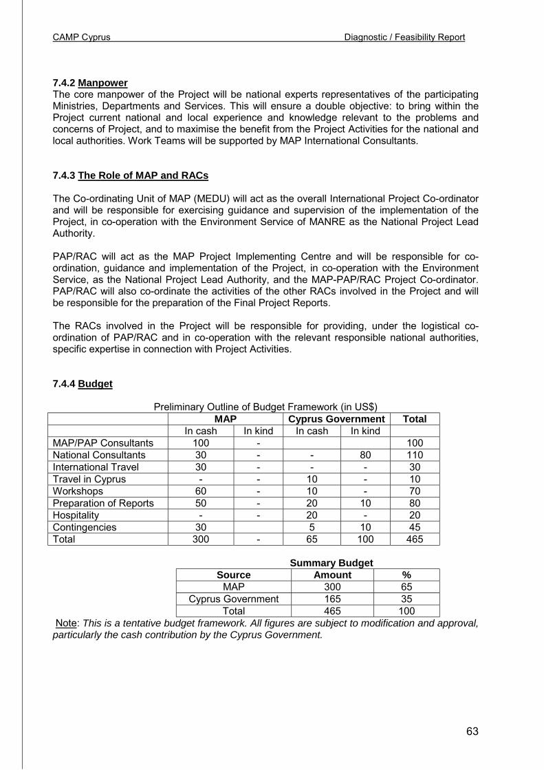
CAMP Cyprus Diagnostic / Feasibility Report
63
7.4.2 ManpowerThe core manpower of the Project will be national experts representatives of the participatingMinistries, Departments and Services. This will ensure a double objective: to bring within theProject current national and local experience and knowledge relevant to the problems andconcerns of Project, and to maximise the benefit from the Project Activities for the national andlocal authorities. Work Teams will be supported by MAP International Consultants.
7.4.3 The Role of MAP and RACs
The Co-ordinating Unit of MAP (MEDU) will act as the overall International Project Co-ordinatorand will be responsible for exercising guidance and supervision of the implementation of theProject, in co-operation with the Environment Service of MANRE as the National Project LeadAuthority.
PAP/RAC will act as the MAP Project Implementing Centre and will be responsible for co-ordination, guidance and implementation of the Project, in co-operation with the EnvironmentService, as the National Project Lead Authority, and the MAP-PAP/RAC Project Co-ordinator.PAP/RAC will also co-ordinate the activities of the other RACs involved in the Project and willbe responsible for the preparation of the Final Project Reports.
The RACs involved in the Project will be responsible for providing, under the logistical co-ordination of PAP/RAC and in co-operation with the relevant responsible national authorities,specific expertise in connection with Project Activities.
7.4.4 Budget
Preliminary Outline of Budget Framework (in US$)MAP Cyprus Government Total
In cash In kind In cash In kindMAP/PAP Consultants 100 - 100National Consultants 30 - - 80 110International Travel 30 - - - 30Travel in Cyprus - - 10 - 10Workshops 60 - 10 - 70Preparation of Reports 50 - 20 10 80Hospitality - - 20 - 20Contingencies 30 5 10 45Total 300 - 65 100 465
Summary BudgetSource Amount %
MAP 300 65Cyprus Government 165 35
Total 465 100 Note: This is a tentative budget framework. All figures are subject to modification and approval,particularly the cash contribution by the Cyprus Government.
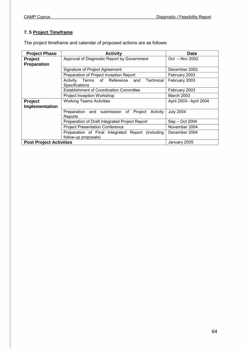
CAMP Cyprus Diagnostic / Feasibility Report
64
7. 5 Project Timeframe
The project timeframe and calendar of proposed actions are as follows:
Project Phase Activity DateProjectPreparation
Approval of Diagnostic Report by Government Oct – Nov 2002
Signature of Project Agreement December 2002Preparation of Project Inception Report February 2003Activity Terms of Reference and TechnicalSpecifications
February 2003
Establishment of Coordination Committee February 2003Project Inception Workshop March 2003
ProjectImplementation
Working Teams Activities April 2003– April 2004
Preparation and submission of Project ActivityReports
July 2004
Preparation of Draft Integrated Project Report Sep – Oct 2004Project Presentation Conference November 2004Preparation of Final Integrated Report (includingfollow-up proposals)
December 2004
Post Project Activities January 2005
CAMP Cyprus Diagnostic / Feasibility Report
65
8.0 PROJECT FEASIBILITY AND PROJECT BENEFITS
8.1 Feasibility
In the process of the preparation of this Report, in its role as the CAMP Cyprus Diagnostic –Feasibility Report, contacts have been established and exchanges held with a wide range ofexperts and representatives of relevant Departments and Organisations. In the context of theseexchanges the objectives of CAMP Cyprus were explained relative to the respective area ofexpertise and the wider issues of coastal area management. The exchanges also focused on:
• The concerns for the existing problems• The policy issues concerning the coastal areas• The experiences in policy-making and coordination problems• The need for effective cross-departmental links• The merits and limitations of present policies and practices• The perception of the need for improving the policy process• The problems likely to be encountered in the future• The need felt for exploring tools for strengthening integration in coastal management• The wider benefits of coastal protection and the justification for CAMP Cyprus• Data availability for CAMP Cyprus and willingness for participation
The conclusions that emerged from these exchanges confirm the need for CAMP Cyprus andhighlight a common concern for pursuing the activities proposed. There is a common view that,despite the existence of legislation and high level expertise in planning and management, thefragmentation of responsibilities and the often divergent priorities on environmentalmanagement along national / local and departmental lines, need to be addressed within thebroad framework of the institutional setting of Cyprus.
It also emerged that CAMP Cyprus will help towards the implementation of key aspects of theEU Environmental Acquis bringing issues of sustainable development within the coastalmanagement process. In doing so, the results of CAMP Cyprus will be useful to otherMediterranean countries that share the concern for implementing sustainable development.
In addition, the key reflections and conclusions of this Report have been discussed with theDirector of the Environment Service and his colleagues, who provided valuable insights andcomments.
8.2 Expected Project Benefits
The launching and implementation of CAMP Cyprus achieve the following main benefits:
• Will fulfil the need for incorporating a policy direction for integrated coastal areamanagement within the Cyprus institutional framework, as expressed in the proposal ofthe Cyprus Government to MAP;
• Will link Cyprus more closely to the network of CAMP in the Mediterranean and theactivities of the MAP/RACs;
• Will respond to a widely felt need among national experts and private sectororganisations to better manage and protect the coastal environment on which theeconomy of Cyprus depends;
• Will contribute towards environmental awareness in development policy and particularlythe “inclusion” of local perspectives on the environment/development interactionscurrently missing;

CAMP Cyprus Diagnostic / Feasibility Report
66
• Will increase appreciation of cross-cutting implications of development/conservationsoptions relative to capacity constraints, strategic considerations, long term benefits andthe environment as a scarce resource;
• Will build up experience and readiness to apply tools of Integrated Coastal AreaManagement to all Cyprus, including in the future, when political circumstances willhopefully soon permit, to the northern part of Cyprus;
• Will generate lessons for similar policy problems encountered in other countries in theMediterranean region;
• Will contribute to the improvement of ICAM by highlighting the applicability of decision-making tools pertaining to various spatial levels.
CAMP Cyprus Diagnostic / Feasibility Report
67
List of References
A. Government publications
-Ministry of Agriculture, Natural Resources & Environment, Adoption of the European UnionAcquis Communautaire, Environment – Current State, 2001
-Ministry of Agriculture, Natural Resources & Environment, Environment Service & University ofAthens, Marine Environment and Coastal Zones, MEDACT – Aphrodite Project, EU/LIFE-ThirdCountries, 1998
-Environment Service, Draft Framework Law for the Environment, 1995- Natura 2000, Programme for Special Protection Areas, 2001- Various internal policy review papers and information pamphlets, 1996-2001
-Environment Service & Dept. of Town Planning & Housing, Policies for SustainableDevelopment of Mediterranean Coastal Areas – Cyprus Report, (Paper presented atMAP/PAP/RAC Sandorini Workshop, 1996
-Dept. of Town Planning & Housing, Local Plans, Limassol, Larnaca, Paphos, Polis, 1996, 1999- Statement of Policy for the Countryside, 1996, 1999- National Report of the Republic of Cyprus, Habitat II + 5, 2001- National Report of the Republic of Cyprus, Habitat II, Second UN Conference on Human
Settlements, Istanbul, 1996- National Report of the Republic of Cyprus, Habitat I, 1976, First UN Conference on
Human Settlements- Town and Country Planning Law, 1972- Management Plan for the Larnaca Salt Lakes, 1997- Various Departmental policy review papers, 1990-2000- The Island Plan, Cyprus Planning Project, 1970- (& Prof. Robert KcKie) Compensation and Betterment in Cyprus, 1972- (& Prof. Robert MacKie) Land Values & The Cyprus Town Planning Law, 1973- (& UNDP) Nicosia Master Plan Report, 1984, 1985- (William Doebelle), Land Policy Measures – Nicosia Master Plan Review Report, 1994
-Ministry of Interior, Guidelines for the Revision of Local Plans, 2000- Annual Reports, 1996-2001
-Union of Municipalities, Local Authorities in Cyprus in view of the Accession to the EU, 2000- The Municipal Law of 1985 (Summary), 2000
-Planning Bureau, Economic Review, 2000- Economic and Social Indicators, 2000- Pre-Accession Economic Programme, 2001- GIS Database, 2002
-Cyprus Tourism Organisation, Annual Reports, 1996-2001- & Tourism & Leisure Partners, Preliminary Strategic Review, 1998- Strategy of Tourism, 2000- (Internal policy document) Nautical Tourism in Cyprus, 1998
-Dept. of Statistical Services, Population Censuses, 1982, 1992, 2002
-Forestry Dept. / FAO, National Forestry Action Programme, 1998
CAMP Cyprus Diagnostic / Feasibility Report
68
-Water Development Dept., Water Balance Reassessment Project Report, (forthcoming)
-Ministry of Communications and Works (Coastal Unit), Coastal Protection Study Report, 1996
-Inter-Departmental Report, Natura 2000 Sites, & Standard Data Forms, LIFE-Third Countries,2001
-Public Information Office, 2000, The Almanac of Cyprus
B. UNEP- PAP/RAC Publications
-Guidelines for Integrated Management of Coastal and Marine Areas with Special Reference tothe Mediterranean, Regional Seas Report and Studies No. 161, 1995
-Guidelines for Carrying Capacity Assessment in the Mediterranean, 1997
-Formulation and Implementation of CAMP Projects – Operational Manual, 1999
-Good Practices Guidelines for Integrated Coastal Area Management in the Mediterranean,2001
-White Paper: Coastal Zone Management in the Mediterranean, 2001
-Workshop Report on Policies for Sustainable Development of Mediterranean Coastal Areas,Technical Report Series No. 114
-CAMP: Improving the Implementation, Malta Workshop 2002 (Main Report forthcoming)Summary Reports on:
-CAMP Albania-CAMP Kastela Bay-Croatia-CAMP Fuka-Matruh-Egypt-CAMP Rhodes-CAMP Israel-CAMP Bay of Izmir-Turkey-CAMP Malta
-Th. Panayotou, 1994, Financing Mechanisms for Environmental Investment and SustainableDevelopment (Environment and Economics Unit)
C. METAP Programme
-Environmental Review and Recommendations, 1992
-Assessment of Integrated Coastal Area Management Initiatives in the Mediterranean –Experiences of METAP and MAP (1988-96), 1998
-(& Cyprus Government) Conservation Management Plan for the Akamas Peninsula, I & II,1993, 1995
D. EU-European Commission
-Lessons from the European Commission’s Demonstration Programme on Integrated CoastalArea Management 1997-99, 1999
CAMP Cyprus Diagnostic / Feasibility Report
69
-ESDP European Spatial Development perspective – Towards balanced and SustainableDevelopment of the territory of the EU, 1999
-(European Environment Agency – European Assessment Series No. 5) State and Pressures ofthe Marine and Coastal Mediterranean Environment, 1999
-(European Environment Agency – Domingo Jimenez-Beltran) Environment in the EU at theturn of the Century, 1999
-The EC Directive on The Assessment of the Effects of certain Public and PrivateProjects on the Environment (85/337/EEC)
-The EC Directive on The Assessment of the Effects of certain Public and PrivateProjects on the Environment (2001/42/EC- Strategic Environmental Assessment)
E. Other publications
-M. Attalides, Urbanisation in Cyprus, 1972, Cyprus Social Research Centre
-Gl. Constantinides, Costs and Benefits of measures for the Reduction of Degradationof the Environment from Land-Based sources of Pollution in Coastal Areas – CaseStudy of the Island of Rhodes, MAP Technical Reports and Series No. 72
-J. Clark, 1992, Integrated Management of Coastal Zones, FAO Technical Fisheries Paper327
-T.E. Chua et. al. (ed.), 1992, Integrative Framework and Methods of Coastal AreaManagement, ICLARM, Manila
-Gl. Constantinides, Cyprus Forestry Action Programme (Economic Report), Dept. ofForestry /FAO, 1998
-Gl. Constantinides, 2002, Economics in Coastal Area Management Programme, inCAMP Improving Implementation (forthcoming)
-Dept. of Environmental Affairs and Tourism, South Africa, 2000, Strategic EnvironmentalAssessment, Guideline Document
-B. Glass, Development Perspectives in the Mediterranean for the year 2025, Les Cahier duConservatoire du Littoral No. 10-J. Glasson et. al., Introduction to Environmental Impact Assessment, University CollegeLondon, 1994
-N. Hanley & C.L. Spash, 1995, Cost-Benefit Analysis and the Environment, London
-Imperial College London, 2001, SEA and Integration of the Environment into StrategicDecision-making, ICON Consultants
-F. Juhasz, Costs and Benefits of measures for the Reduction of Degradation of theEnvironment from Land-Based sources of Pollution in Coastal Areas – Case Study of the Bayof Izmir, MAP Technical Reports and Series No. 72-Robert Kay & Jacqueline Alder, 1998, Coastal Planning and Management, Spon Press
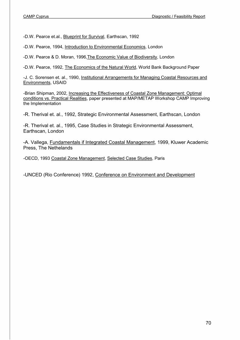
CAMP Cyprus Diagnostic / Feasibility Report
70
-D.W. Pearce et.al., Blueprint for Survival, Earthscan, 1992
-D.W. Pearce, 1994, Introduction to Environmental Economics, London
-D.W. Pearce & D. Moran, 1996,The Economic Value of Biodiversity, London
-D.W. Pearce, 1992, The Economics of the Natural World, World Bank Background Paper
-J. C. Sorensen et. al., 1990, Institutional Arrangements for Managing Coastal Resources andEnvironments, USAID
-Brian Shipman, 2002, Increasing the Effectiveness of Coastal Zone Management: Optimalconditions vs. Practical Realities, paper presented at MAP/METAP Workshop CAMP Improvingthe Implementation
-R. Therival et. al., 1992, Strategic Environmental Assessment, Earthscan, London
-R. Therival et. al., 1995, Case Studies in Strategic Environmental Assessment,Earthscan, London
-A. Vallega, Fundamentals if Integrated Coastal Management, 1999, Kluwer AcademicPress, The Nethelands
-OECD, 1993 Coastal Zone Management, Selected Case Studies, Paris
-UNCED (Rio Conference) 1992, Conference on Environment and Development

CAMP Cyprus Diagnostic / Feasibility Report
71
ANNEX I Persons interviewed
Environment ServiceMr. Nicos Georgiades, DirectorMr. Andonis Andoniou, Senior Environment OfficerMs. Myroula Hadjichtistofotou, Environment Officer
Department of Town Planning & HousingMr. Stefos Papanicolaou, First Planning OfficerMr. Ermis Klokkaris, Senior Planning OfficerMr. George Hadjimichael, Senior Planning Officer
Ministry of InteriorMr. Andreas Ashiotis, Kyrenia District Officer, (in charge of Town Planning affairs in the Ministryof Interior)
Planning BureauMr. Michael Leptos, Director, Planning DepartmentMr. George Georgiou, Senior Planning OfficerMr. Ninos Savvides, Director Coordination OfficerMs. Erine Piki, Planning Officer
Forestry DepartmentMr. Alecos Christodoulou, Chief Conservator of Forests
Public Works DepartmentNicos G. Iacovou, Head Coastal UnitMr. Jason Sofos, Engineering officer, Coastal Unit
Department of Fisheries and Marine ResearchMr. Zanettos LoucaidesMr. Liozos Liozides
Geological Survey DepartmentDr. Lenia Morisseau, Senior Geological OfficerMr. Chris Hadjigeorgiou, Geological Officer
Water Development DepartmentMr. Iacovos Iacovides, First Executive EngineerMr. Takis Ioannou, Senior Executive EngineerMr. Nicos Chourtis, Senior Water EngineerMr. Panicos Skordis, Executive Engineer
Cyprus Tourism OrganisationMs. Phoebe Katsouri, Director of PlanningMs. Athena Metaxa, Senior Tourism officerMs. Despo Symeou, Senior Tourism OfficerMr. Glafkos Katiolou, Tourism OfficerMr. Stelios Elaftheriou, Technical Officer
Cyprus Ports AuthorityMr. Andonis Toumazis, Director GeneralMs. Anthi Clerides
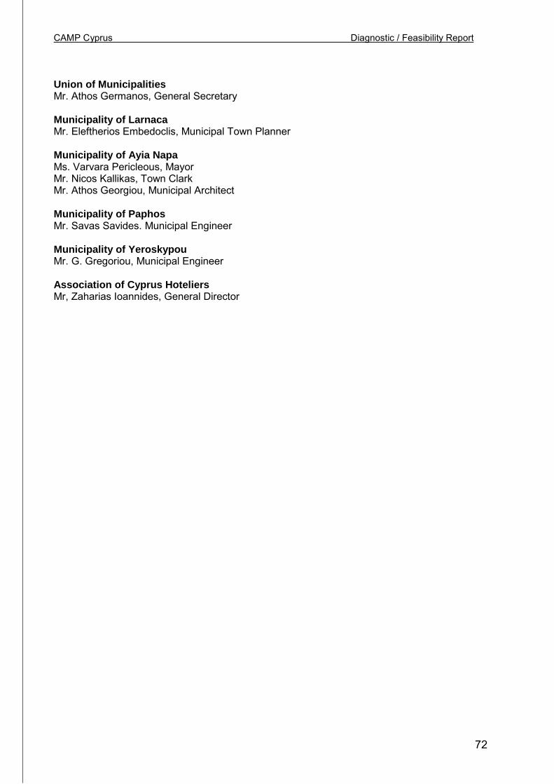
CAMP Cyprus Diagnostic / Feasibility Report
72
Union of MunicipalitiesMr. Athos Germanos, General Secretary
Municipality of LarnacaMr. Eleftherios Embedoclis, Municipal Town Planner
Municipality of Ayia NapaMs. Varvara Pericleous, MayorMr. Nicos Kallikas, Town ClarkMr. Athos Georgiou, Municipal Architect
Municipality of PaphosMr. Savas Savides. Municipal Engineer
Municipality of YeroskypouMr. G. Gregoriou, Municipal Engineer
Association of Cyprus HoteliersMr, Zaharias Ioannides, General Director
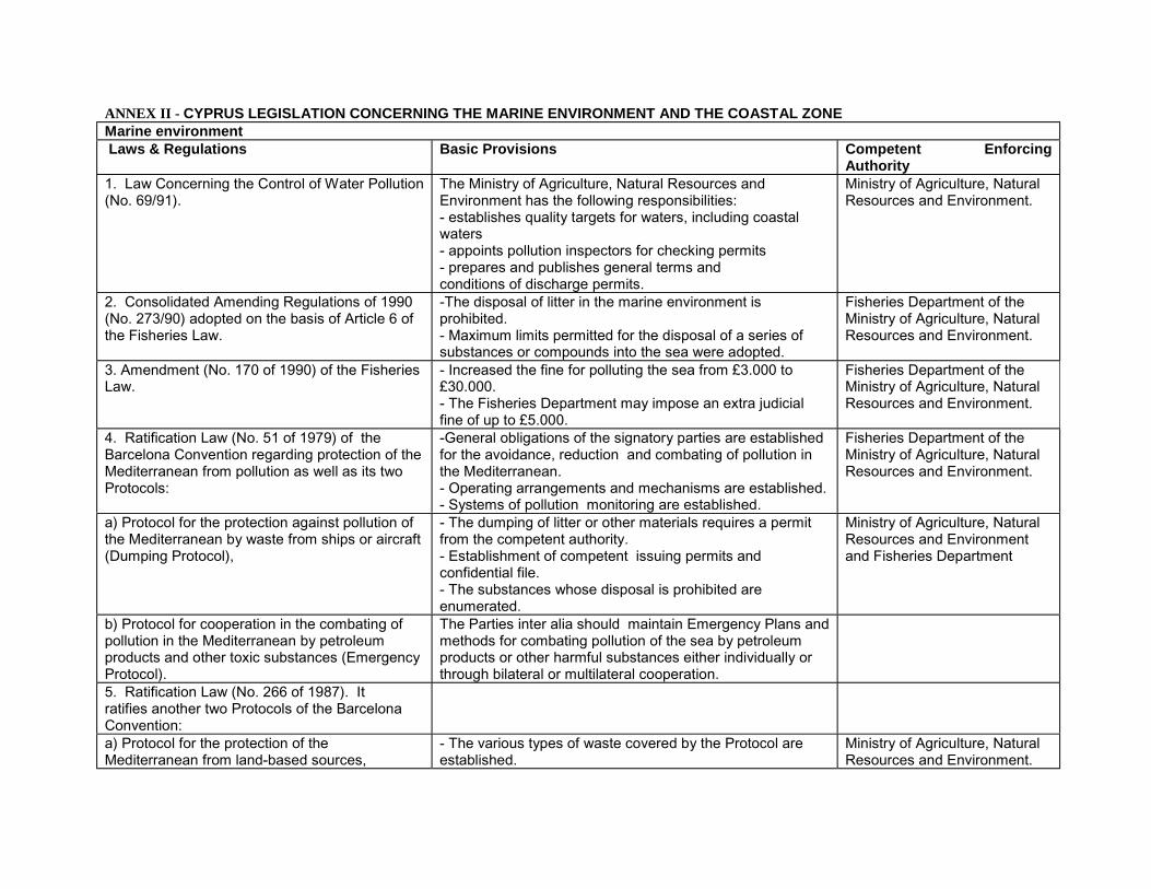
ANNEX II - CYPRUS LEGISLATION CONCERNING THE MARINE ENVIRONMENT AND THE COASTAL ZONEMarine environment Laws & Regulations Basic Provisions Competent Enforcing
Authority1. Law Concerning the Control of Water Pollution(No. 69/91).
The Ministry of Agriculture, Natural Resources andEnvironment has the following responsibilities:- establishes quality targets for waters, including coastalwaters- appoints pollution inspectors for checking permits- prepares and publishes general terms andconditions of discharge permits.
Ministry of Agriculture, NaturalResources and Environment.
2. Consolidated Amending Regulations of 1990(No. 273/90) adopted on the basis of Article 6 ofthe Fisheries Law.
-The disposal of litter in the marine environment isprohibited.- Maximum limits permitted for the disposal of a series ofsubstances or compounds into the sea were adοpted.
Fisheries Department of theMinistry of Agriculture, NaturalResources and Environment.
3. Amendment (No. 170 of 1990) of the FisheriesLaw.
- Increased the fine for polluting the sea from £3.000 to£30.000.- The Fisheries Department may impose an extra judicialfine of up to £5.000.
Fisheries Department of theMinistry of Agriculture, NaturalResources and Environment.
4. Ratification Law (No. 51 of 1979) of theBarcelona Convention regarding protection of theMediterranean from pollution as well as its twoProtocols:
-General obligations of the signatory parties are establishedfor the avoidance, reduction and combating of pollution inthe Mediterranean.- Operating arrangements and mechanisms are established.- Systems of pollution monitoring are established.
Fisheries Department of theMinistry of Agriculture, NaturalResources and Environment.
a) Protocol for the protection against pollution ofthe Mediterranean by waste from ships or aircraft(Dumping Protocol),
- The dumping of litter or other materials requires a permitfrom the competent authority.- Establishment of competent issuing permits andconfidential file.- The substances whose disposal is prohibited areenumerated.
Ministry of Agriculture, NaturalResources and Environmentand Fisheries Department
b) Protocol for cooperation in the combating ofpollution in the Mediterranean by petroleumproducts and other toxic substances (EmergencyProtocol).
The Parties inter alia should maintain Emergency Plans andmethods for combating pollution of the sea by petroleumproducts or other harmful substances either individually orthrough bilateral or multilateral cooperation.
5. Ratification Law (No. 266 of 1987). Itratifies another two Protocols of the BarcelonaConvention:a) Protocol for the protection of theMediterranean from land-based sources,
- The various types of waste covered by the Protocol areestablished.
Ministry of Agriculture, NaturalResources and Environment.
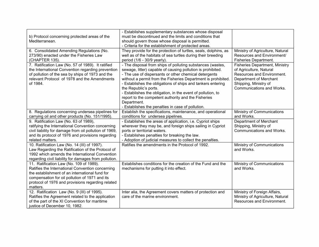
b) Protocol concerning protected areas of theMediterranean.
- Establishes supplementary substances whose disposalmust be discontinued and the limits and conditions thatshould govern those whose disposal is permitted.- Criteria for the establishment of protected areas.
6. Consolidated Amending Regulations (No.273/90) enacted under the Fisheries Law(CHAPTER 135).
They provide for the protection of turtles, seals, dolphins, aswell as of the habitats of sea turtles during their breedingperiod (1/6 - 30/9 yearly).
Ministry of Agriculture, NaturalResources and Environment/Fisheries Department.
7. Ratification Law (No. 57 of 1989). It ratifiedthe International Convention regarding preventionof pollution of the sea by ships of 1973 and therelevant Protocol of 1978 and the Amendmentsof 1984.
- The disposal from ships of polluting substances (wastes,sewage, litter) capable of causing pollution is prohibited.- The use of dispersants or other chemical detergentswithout a permit from the Fisheries Department is prohibited.- Establishes the obligations of ships and tankers enteringthe Republic’s ports.- Establishes the obligation, in the event of pollution, toreport to the competent authority and the FisheriesDepartment.- Establishes the penalties in case of pollution.
Fisheries Department, Ministryof Agriculture, NaturalResources and Environment.Department of MerchantShipping, Ministry ofCommunications and Works.
8. Regulations concerning undersea pipelines forcarrying oil and other products (No. 151/1995).
Establish the specifications, maintenance, and operationalconditions for undersea pipelines.
Ministry of Communicationsand Works.
9. Ratification Law (No. 63 of 1989),ratifying the International Convention concerningcivil liability for damage from oil pollution of 1969,and its protocol of 1976 and provisions regardingrelated matters.
- Establishes the areas of application, i.e. Cypriot shipswherever they may be, and foreign ships sailing in Cypriotports or territorial waters.- Establishes penalties for breaking the law.- Adoption of judicial measures to collect the penalties.
Department of MerchantShipping, Ministry ofCommunications and Works.
10. Ratification Law (No. 14 (III) of 1997).Law Regarding the Ratification of the Protocol of1992 which amends the International Conventionregarding civil liability for damages from pollution.
Ratifies the amendments in the Protocol of 1992. Ministry of Communicationsand Works.
11. Ratification Law (No. 109 of 1989).Ratifies the International Convention concerningthe establishment of an international fund forcompensation for oil pollution of 1971 and itsprotocol of 1976 and provisions regarding relatedmatters.
Establishes conditions for the creation of the Fund and themechanisms for putting it into effect.
Ministry of Communicationsand Works.
12. Ratification Law (No. 9 (III) of 1995).Ratifies the Agreement related to the applicationof the part of the XI Convention for maritimejustice of December 10, 1982.
Inter alia, the Agreement covers matters of protection andcare of the marine environment.
Ministry of Foreign Affairs,Ministry of Agriculture, NaturalResources and Environment.

City planning/Urban development and the coastal environment
Laws and Regulations Basic Provisions Competent/ EnforcingAuthority
1. The Town and Country Planning Law(No. 90/72, Amending Laws 56/82, 7/90,28/91, 91(I)92, 55(I)/93).
- The aim of the law is the regulation, controland promotion of physical development. ThePlanning Authority regarding the part of thelaw relating to the Island Plan is the FinanceMinistry, and regarding the remainingprovisions of the law the Ministry of theInterior or any other authority to whom theformers responsibilities have been entrusted.- The Finance Ministry should prepare anIsland Plan, establishing the policies to befollowed regarding the promotion and controlof development.- The Ministry of the Interior should prepare aPolicy Statement for the development of areaswhere Local Plans are not in force.- The Planning Authority studies applicationsfor any type of development and issues aPlanning Permit or rejects the application.- The law provides for the preservation ofbuildings or groups of buildings or areas ofspecial character, the preservation of treesand for the control of advertising.
The Minister of the Interior, except for the portion ofthe law related to the Island Plan. The Minister ofthe Interior has transferred his responsibilities to theDirector of the Department of Town Planning andHousing, the Local Councils in the largeMunicipalities and the Town Planning Board.
2. The Foreshore Protection Law (No.22/61, and Amending Laws 17 of 1964, 8of 1972, 52 of 1975, 21 of 1987, 126 of1989, 11 of 1990, 251 of 1990, 40 of 1991,87 of 1991, 234 of 1991, 15(I) of 1992,41(I) of 1992, 61(I) of 1992, 103(I) of 1992,7(I) of 1993, 19(I) of 1993, 27(I) of 1993,37(I) of 1993, 4(I) of 1994, 34(I) of 1994,51(I) of 1994, 75(I) of 1994).
Based on the provisions of this law, aforeshore protection zone has beenestablished in which it is prohibited to performcertain works, build or construct variousstructures and buildings, dispose waste, parkvehicles or place articles on the beach. It alsoregulates the provision of services on thebeach.
District Officers, Central Committee for theBeaches, Local Authorities.
The Piers Law (No. 39/73, 36(I)/94). Regulates the erection, extension, and use ofexisting and new piers.
Ministry of the Interior to which the relevant powershave been granted.
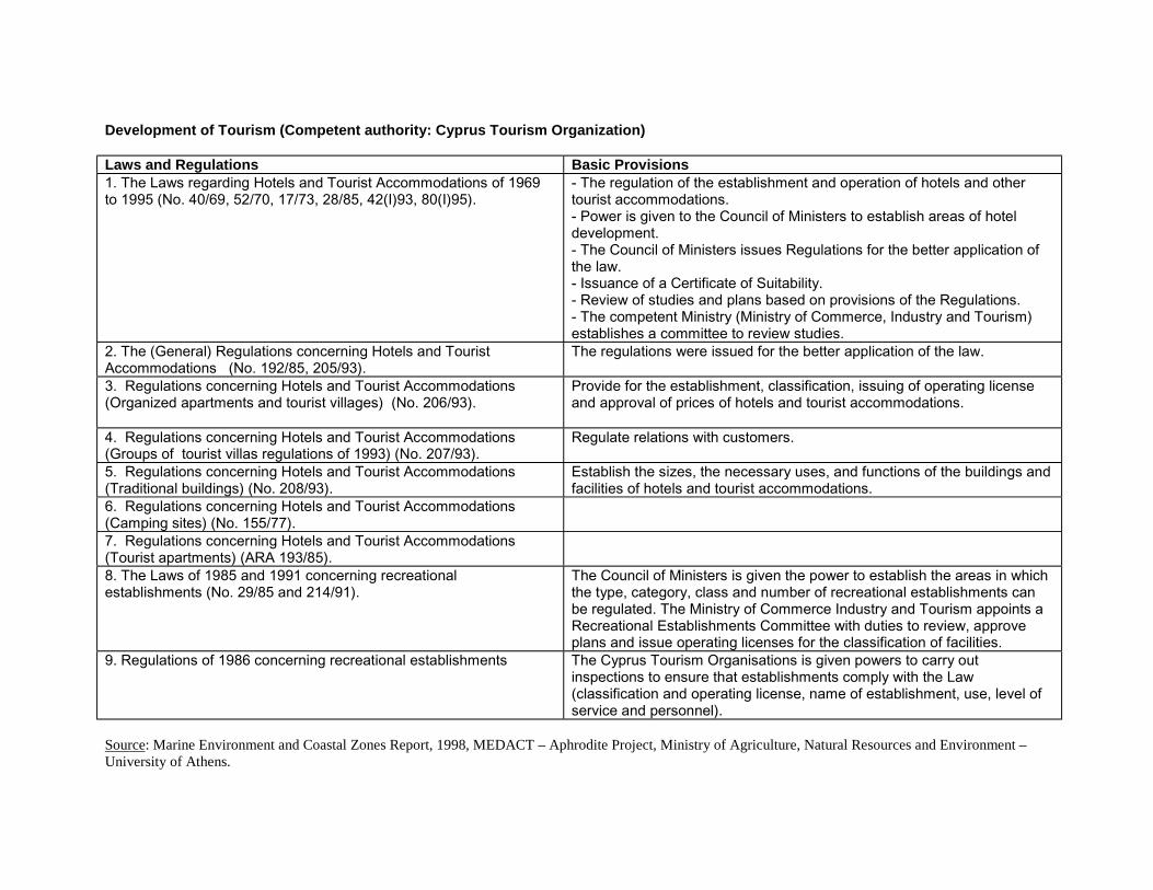
Development of Tourism (Competent authority: Cyprus Tourism Organization)
Laws and Regulations Basic Provisions1. The Laws regarding Hotels and Tourist Accommodations of 1969to 1995 (No. 40/69, 52/70, 17/73, 28/85, 42(I)93, 80(I)95).
- The regulation of the establishment and operation of hotels and othertourist accommodations.- Power is given to the Council of Ministers to establish areas of hoteldevelopment.- The Council of Ministers issues Regulations for the better application ofthe law.- Issuance of a Certificate of Suitability.- Review of studies and plans based on provisions of the Regulations.- The competent Ministry (Ministry of Commerce, Industry and Tourism)establishes a committee to review studies.
2. The (General) Regulations concerning Hotels and TouristAccommodations (No. 192/85, 205/93).
The regulations were issued for the better application of the law.
3. Regulations concerning Hotels and Tourist Accommodations(Organized apartments and tourist villages) (No. 206/93).
Provide for the establishment, classification, issuing of operating licenseand approval of prices of hotels and tourist accommodations.
4. Regulations concerning Hotels and Tourist Accommodations(Groups of tourist villas regulations of 1993) (No. 207/93).
Regulate relations with customers.
5. Regulations concerning Hotels and Tourist Accommodations(Traditional buildings) (No. 208/93).
Establish the sizes, the necessary uses, and functions of the buildings andfacilities of hotels and tourist accommodations.
6. Regulations concerning Hotels and Tourist Accommodations(Camping sites) (No. 155/77).7. Regulations concerning Hotels and Tourist Accommodations(Tourist apartments) (ARA 193/85).8. The Laws of 1985 and 1991 concerning recreationalestablishments (No. 29/85 and 214/91).
The Council of Ministers is given the power to establish the areas in whichthe type, category, class and number of recreational establishments canbe regulated. The Ministry of Commerce Industry and Tourism appoints aRecreational Establishments Committee with duties to review, approveplans and issue operating licenses for the classification of facilities.
9. Regulations of 1986 concerning recreational establishments The Cyprus Tourism Organisations is given powers to carry outinspections to ensure that establishments comply with the Law(classification and operating license, name of establishment, use, level ofservice and personnel).
Source: Marine Environment and Coastal Zones Report, 1998, MEDACT – Aphrodite Project, Ministry of Agriculture, Natural Resources and Environment –University of Athens.

ANNEX III - Responsibilities for Implementation and Enforcement of Environmental Legislation in Cyprus
Sector / Directive LegislativeDevelopment
StrategicPlanning
Permitting Monitoring Enforcement Reporting
Horizontal LegislationEnvironmental ImpactAssessment
MANRE (ES) MoI (DTPH) for private projectsMoF (PB) for public projects
MANRE (ES) through TechnicalCommittee
Access to Information MANRE (ES) Various responsible Ministries & Departments according to media (air,water, waste)
MANRE (ES)
European EnvironmentAgency
MANRE (ES) Not Applicable MANRE (ES)
LIFE MoF (PB) MoF (PB) and MANRE (ES) screen proposals jointlyCivil Protection(Marine Pollution)
MNRE (DFMR) MANRE (DFMR) responsible for implementation
C02 Monitoring MANRE (ES) MANRE (ES) is Focal Point Other agencies involved include MCIT and CEAWater QualityFramework MANRE (WDD) MANRE (ES)
MANRE (WDD)MoH (PHS)MoH (SGL)
MANRE (ES)
MANRE (WDD)MANRE (ES)
MANRE (ES)
Surface Water Quality MANRE (WDD) MANRE (ES)MANRE (WDD)
MoH (PHS)MoH (SGL)
MANRE (ES)
MANRE (WDD)MANRE (ES)
MANRE (ES)
Urban Waste Water MANRE(WDD)
MANRE (ES)
MoI (DTPH)MANRE (WDD)
MSBs
MANRE (WDD), MANRE (ES) for environmental issuesMoI (DTPH) for planning issues
MSBs for implementation in municipalities
MANRE (WDD)
Nitrate Pollution fromAgriculture
NANRE (DoA)MANRE (WDD)MANRE (GSD)MANRE (ES)
MANRE (DoA) MANRE (WDD)MANRE (ES)
MANRE (GSD)MANRE (DoA)
MANRE (DFMR)
MANRE (ES)
Drinking Water MoH (PHS)MANRE (WDD)
MoH (PHS)MoH (SGL)
MoH (PHS)MoH (SGL)
MoH (PHS)
Bathing Waters / FishWaters / ShellfishWaters
MANRE (ES)MANRE (DFMR)
MoH (PHS)MoH (SGL)
MANRE (DFMR)
MoH (PHS)MoH (SGL)
MANRE (DFMR)
MoH (PHS)MANRE (DFMR)
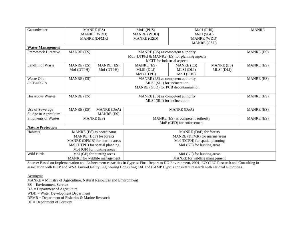
Groundwater MANRE (ES)MANRE (WDD)MANRE (DFMR)
MoH (PHS)MANRE (WDD)MANRE (GSD)
MoH (PHS)MoH (SGL)
MANRE (WDD)MANRE (GSD)
MANRE
Water ManagementFramework Directive MANRE (ES) MANRE (ES) as competent authority
MoI (DTPH) & MANRE (ES) for planning aspectsMCIT for industrial aspects
MANRE (ES)
Landfill of Waste MANRE (ES)MoI (DTPH)
MANRE (ES)MoI (DTPH)
MANRE (ES)MLSI (DLI)MoI (DTPH)
MANRE (ES)MLSI (DLI)MoH (PHS)
MANRE (ES)MLSI (DLI)
MANRE (ES)
Waste Oils/PCBs/PCTs
MANRE (ES) MANRE (ES) as competent authorityMLSI (SLI) for incineration
MANRE (GSD) for PCB decontamination
MANRE (ES)
Hazardous Wastes MANRE (ES) MANRE (ES) as competent authorityMLSI (SLI) for incineration
MANRE (ES)
Use of SewerageSludge in Agriculture
MANRE (ES) MANRE (DoA)MANRE (ES)
MANRE (DoA) MANRE (ES)
Shipments of Wastes MANRE (ES) MANRE (ES) as competent authorityMoF (CED) for enforcement
MANRE (ES)
Nature ProtectionHabitats MANRE (ES) as coordinator
MANRE (DoF) for forestsMANRE (DFMR) for marine areasMoI (DTPH) for spatial planning
MoI (GF) for hunting areas
MANRE (DoF) for forestsMANRE (DFMR) for marine areasMoI (DTPH) for spatial planning
MoI (GF) for hunting areas
Wild Birds MoI (GF) for hunting areasMANRE for wildlife management
MoI (GF) for hunting areasMANRE for wildlife management
Source: Based on Implementation and Enforcement capacities in Cyprus, Final Report to DG Environment, 2001, ECOTEC Research and Consulting inassociation with IEEP and WSA EnviroQuality Engineering Consulting Ltd. and CAMP Cyprus consultant research with national authorities.
AcronymsMANRE = Ministry of Agriculture, Natural Resources and EnvironmentES = Environment ServiceDA = Department of AgricultureWDD = Water Development DepartmentDFMR = Department of Fisheries & Marine ResearchDF = Department of Forestry

GSD = Geological Survey DepartmentMoL = Ministry of InteriorDTPH = Department of Town Planning & HousingGF = Game FundMH = Ministry of HealthPHS = Public Health ServicesSGL = State General LaboratoryMoCIT = Ministry of Commerce, Industry and TourismMLSI = Ministry of Labour & Social InsuranceMoF = Ministry of FinancePB = Planning Bureau

Box 10 CAMP Cyprus: Project Summary - Management, Activities and Project Work TeamsProject Management
Focal Agency for CAMP Cyprus: Environment Service (MAP Focal Agency)Project Steering Committee
Ministry of Interior (MI)Department of Town Planning and Housing (DTPH)Cyprus Tourism Organisation (CTO)Planning Bureau (PB)Ministry of Communications & Works - Coastal Unit (CU)Department of Fisheries and Marine Research (DFMR)Forestry Department (FD)
Water Development Department (WDD)Union of Municipalities (UM)Union of Rural Communities (URC)Federation of Environmental and Ecological Organisations (FEEO)Chamber of Commerce and Industry - Cyprus Hotel Association (CCC)Cyprus Scientific Technical Chamber (ETEK)MAP/ PAP Project Coordinator (PC)
Project ActivitiesActivities Main Objectives Lead Agencies and Project Teams
Integrated CoastalArea Management (ICAM)
To provide the methodological framework and thecontext for the issue-based project Activities
Lead Agency: Environment Service
National Project Work Team: All members of the SteeringCommitteeMAP/PAP International Project Consultant
Strategic EnvironmentalAssessment (SEA)
To explore, develop and propose guidelines for theapplication and institutionalization of SEA
Lead Agency: Environment Service
National Project Work Team: All members of the SteeringCommitteeMAP/PAP International Consultant
Carrying CapacityAssessment (CCA)
To explore, develop and propose guidelines for theapplication of SEA
Lead Agency: Department of Town Planning and Housing
National Project Work Team: MI, CTO, CU, FD, DFMR,WDD, DGS, DA, CCC, UM, URCMAP/PAP International Consultant
Resource Valuation (RV) To explore, develop and propose guidelines for theapplication of RV
Lead Agency: Planning Bureau
National Project Work Team: DTPH, CTO, FD, DFMR, WDD,UM, CCCMAP/PAP International Consultant
Note: Detailed Terms of Reference will be developed in the Inception Report

ANNEX IV Development Expenditure Budget 1999-2002 (in thousands of Cyprus Pounds)Ministry and Department 1999 2000 2001 2002����������������������������������������������������������������������������������������������������������������
����������������������������������������������������������������������������������������������������������������Agriculture, Natural Resources & EnvironmentDepartment of AgricultureVeterinary Services DepartmentForestry DepartmentWater Development DepartmentMeteorological DepartmentGeological Survey DepartmentLand Consolidation ServiceAgricultural Research InstituteFisheries and Marine Research Department
25,9177,916517
3,3519,768
571,121869
1,109727
������������������������������������33,7208,360832
3,55416,936
361,077509
1,246691
��������������������������������������33,7208,300750
4,00015,000
201,200900
1,3001,350
44,6759,1101,0615,553
22,78125
1,1211,1591,462999
Ministry of Commerce, Industry & Tourism 10,760 11,453 11,850 15,782���������������������������������������������������������������������������������������������������������������������������������������������������������������������������������������������������������������������������������������������������������������������������������������Ministry of Labour & Social Insurance
Department of LabourSocial Welfare ServicesProductivity CentreHigher Hotel InstituteHigher Technological InstituteDepartment of Labour Supervision
���������������������������������������������4,134
883,58010971
2720
4,09673
3,59110835
2370
4,720100
4,00015010025020
5,394127
4,46716510533186������������������������������������������������
������������������������������������������������Ministry of InteriorDistrict AdministrationDepartment of Town Planning and HousingDepartment of Lands & SurveysCivil DefenseOther Services
����������������������������������26,1875,8246,716
00
2,143
������������������������������������31,906
7,4689,523
00
2,246
��������������������������������������32,750
2,70010,000
500
2,500
50,9173,807
19,07750
1003,587
Ministry of Finance 20,928 19,606 19,350 14,005Planning Bureau 3,780 4,024 11,000 52,775Ministry of Education & CultureSchool AdministrationEducationCultural ServicesScience Research Centre
29.86515,92911,5062,429
0
31,92416,16112,9192,843
0
34,50016,50014,5003,500
0
47,08118,21621,9936,732140���������������������������������������������������������������������������������������������
���������������������������������������������������������������������������������������������Ministry of Communications & WorksAdministrationPublic WorksDevelopment of Road NetworkAirport DevelopmentPublic BuildingsAntiquities DepartmentCivil AviationCommercial Shipping DepartmentPostal ServicesRoad Transport DepartmentElectrical & Mechanical Services
����������������������������������63,9702,0801,094
43,2579,9345,5161,703
017021300
������������������������������������66,760
3,1731,171
42,3208,7477,9082,501
25136704700
��������������������������������������70,250
4,0001,700
40,0009,000
12,0003,000
015040000
��������������������������������������91,028
1,0102,366
50,9902,822
22,8853,847
70180538
1,1205,200
Ministry of Health 11,177 12,824 15,690 23,364Total Development Budget 197,556 217,578 234,560 347,622