caricoos: a regional coastal observing system for the northeastern caribbean
DESCRIPTION
CariCOOS: a regional coastal observing system for the Northeastern Caribbean. J. Morell , J. Corredor, J. Capella R. Watlington, J. Gonzalez, M. Canals, C. Anselmi, A. Mercado, and L. Aponte. IOOS MISSION: IMPROVE SAFETY – ENHANCE ECONOMY-PROTECT OUR ENVIRONMENT. - PowerPoint PPT PresentationTRANSCRIPT

CariCOOS: a regional coastal observing system for the Northeastern Caribbean
J. Morell, J. Corredor, J. CapellaR. Watlington, J. Gonzalez, M. Canals, C. Anselmi, A. Mercado, and L. Aponte
J. Morell, J. Corredor, J. CapellaR. Watlington, J. Gonzalez, M. Canals, C. Anselmi, A. Mercado, and L. Aponte
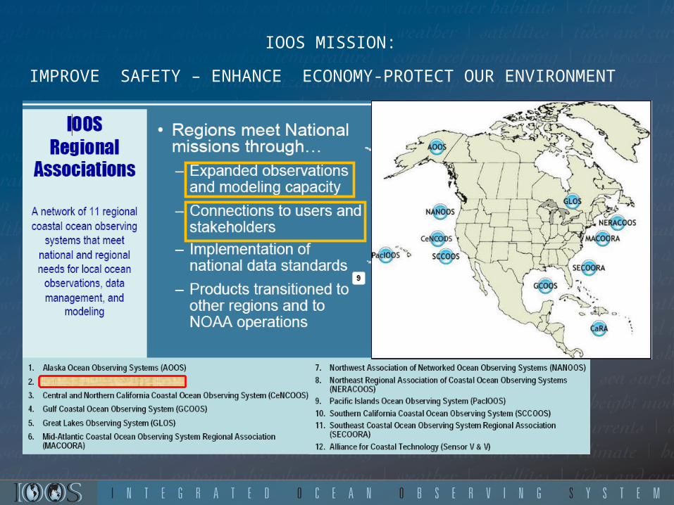
IOOS MISSION:
IMPROVE SAFETY – ENHANCE ECONOMY-PROTECT OUR ENVIRONMENT
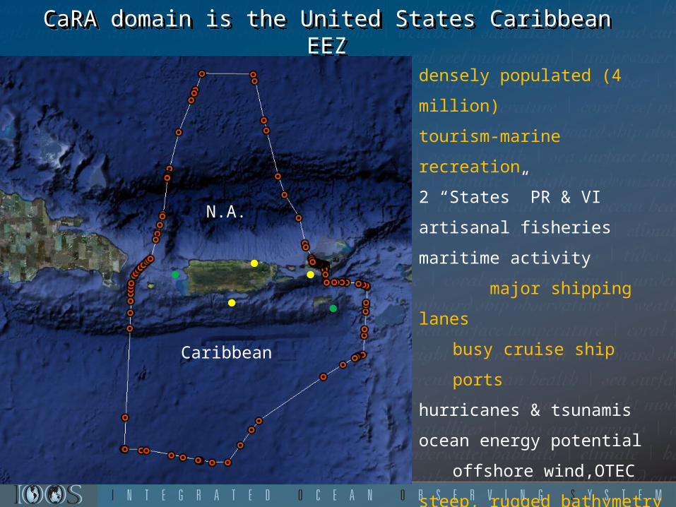
CaRACaRA domain is the United States Caribbean EEZCaRACaRA domain is the United States Caribbean EEZ
densely populated (4 million)
tourism-marine recreation
2 “States” PR & VI
artisanal fisheries
maritime activity
major shipping lanes
busy cruise ship ports
hurricanes & tsunamis
ocean energy potential
offshore wind,OTEC
steep, rugged bathymetry
multiple international
boundariesfragile marine ecosystems
N.A.
Caribbean
●
●
●
●●

Caribbean Regional Association for Ocean Observing
• Organizational structure :– Memorandum Of Agreement
(signed on Dec 4, 2007)
Membership: – 88 signatories
• Affiliations:– Academics 18%– Government agencies 12%– Private Sector 40%– Federal Agencies 9%– Self Signatories 21%
ASSURES A STAKEHOLDER-DRIVEN CariCOOS

High-Priority Observational and Forecast High-Priority Observational and Forecast NeedsNeeds
results from need assessments across all SH sectorsresults from need assessments across all SH sectors
– Coastal windsCoastal winds– Coastal waves Coastal waves – Coastal currentsCoastal currents– Coastal inundation Coastal inundation – Water qualityWater quality (pathogens, visibility, sediments & pollutant (pathogens, visibility, sediments & pollutant
plumes)plumes)– Bathymetry (navigation, inundation and wave models)Bathymetry (navigation, inundation and wave models)– Temperature & salinity (climate change, riverine input)Temperature & salinity (climate change, riverine input)– Benthic habitatsBenthic habitats

Data and modeling products users
Coastal Weather (Wind / Waves)Local NWS Weather Forecasting Office WRF and SWAN model setup, optimization/validationRecreational and Tourism Industry (*)
2010 XXI Central American and Caribbean GamesRip Curl Search Pro 2010
Support for safe maritime operations and decision making (Coast Guard, maritime interests)
Coastal Inundation/Sea LevelState Emergency Management Agencies at PR and USVI for shelter/storage site selectionMarine Transportation System Recovery (USCG)Planning Offices (zoning regulations)PR-DRNA Coastal Zone
Coastal CurrentsState and Federal Search and RescueFisheries and fishery managementPlanning / Response to Pollutant dispersionRecreational & Tourism sector
Water QualityWatershed management- Natural Resources Conservation Services, DRNA, EQBPark Service (beach monitoring)Research ScientistsRecreational & tourism sector

• CariCOOS Conceptual DesignOperate an optimum number of observing assets coupled to a strong modeling components:
GOMOOS type and Datawell wave buoys:
Atlantic, off San Juan: semi diurnal tidal forcing, exposed to Atlantic winter swells. San Juan is the busiest port in the NEC region
Caribbean, off Ponce: diurnal tidal forcing, Major transshipment port being implemented in Ponce
Mona Passage – Caribbean-Atlantic interconnection
South of Virgin and Anegada Passages Cruise ship approach to Charlotte Amalie,
●
●●●
●
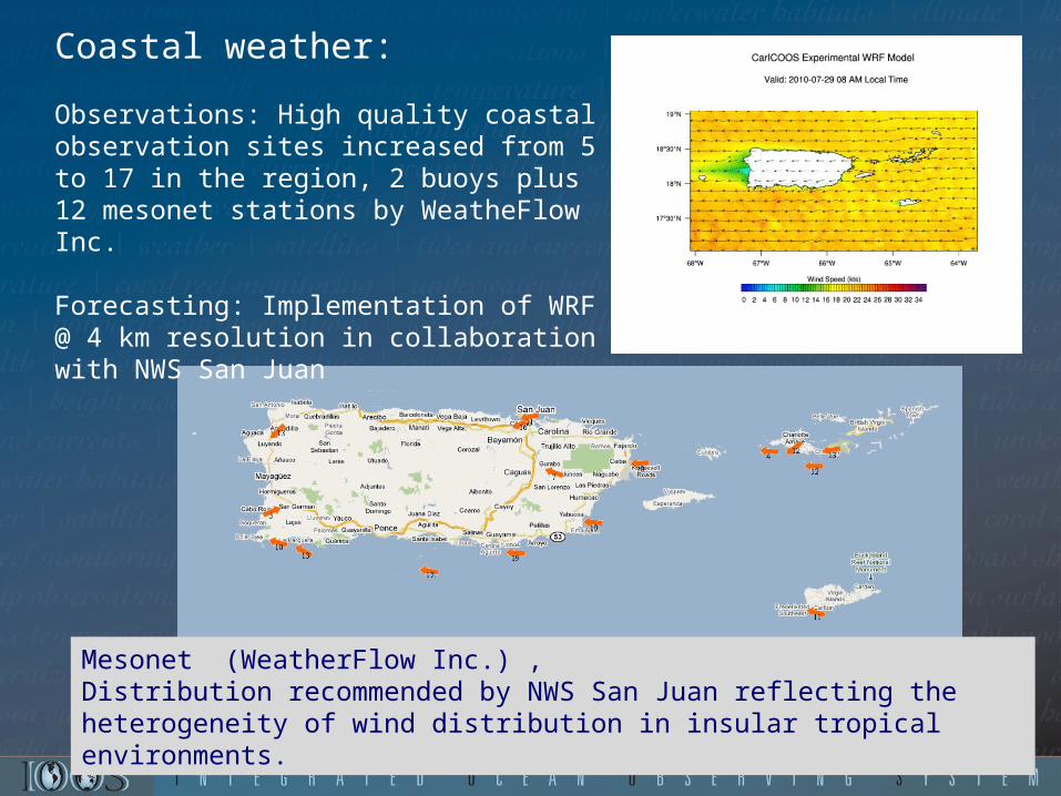
Coastal weather:
Observations: High quality coastal observation sites increased from 5 to 17 in the region, 2 buoys plus 12 mesonet stations by WeatheFlow Inc.
Forecasting: Implementation of WRF @ 4 km resolution in collaboration with NWS San Juan
Mesonet (WeatherFlow Inc.) ,Distribution recommended by NWS San Juan reflecting the heterogeneity of wind distribution in insular tropical environments.

Coastal waves: unprecedented coastal wave data at CariCOOS Buoys:(Triaxys sensors)
forecasts using SWAN (Simulating WAve Nearshore)• boundary conditions provided by NOAA WW 3• 500 meter resolution 50 meter resolution• GFS wind forcing
• outcome of validation experiments as criteria for adding observing assets
●
●●●
●

Coastal circulation:•In situ current profiles at CariCOOS buoys A & B•CODAR surface currents for the Mona Passage (CSR-Rutgers, C. Fuller, A&M)
Lagrangian & Eulerian validation of ADCIRC and CODAR products:
ADCIRC Forecasts for coastal zone

Coastal Inundation by Storm Surge
•Initial efforts loosely coupling ADCIRC and SWAN (structured)•Implementation and validation of PADCSWAN •Cat 1,2 and 5 available (5 approach bearings, 10nm between tracks)
San Felipe (aka Okeechobee) Cat 5 Hurricane 1928. 1836 deaths in Florida 312 in Puerto Rico.

Warne, A.G., Webb, R.M.T., and Larsen, M.C., 2005, Water, Sediment, and Nutrient Discharge Characteristics of Rivers in Puerto Rico, and their Potential Influence on Coral Reefs: U.S. Geological Survey Scientific Investigations Report 2005-5206, 58 p.
Major water quality issues in the region
•beach closures, eutrophication and sedimentation• frequently related to river and creeks discharge
reef status:
Development of WQ products based on remotely sensed optical properties for identifying watershed management deficiencies. In collaboration with:

Outreach and Education
Outreach and
Education
Committee
Data product dissemination and assessment : http://caricoos.org
EDUCATION PLAN •Informal education through web tutorials, •Inclusion into 7th- 8th grade curricula in collaboration with Editorial Norma and PR Dept. of Education


Where do we go from here?
INSHOREImplementation of observing/modeling tools and products for close to shore processes driving:
•runoff plume dispersal and•rip currents•beach erosion•port security and recuperation (NYHOPS)•spatial planning - MPA designation/validation
OFFSHOREObserving Caribbean structure, processes and variability and its
response to climate (incorporating serial glider observations
@CaTS??) REGIONALShare expertise and practical experience with neighbors

2 m. Hs (significant wave height)8s period, 7 m/s wind speed (June 2010)
Port of Las Americas, Ponce
San Juan Harbor
4.5 m. Hs (significant wave height)10s period, 9 m/s wind speed (Apr-08)
Inshore waves at 30m resolution:
nowcast - CarICOOS buoy dataforecasts - regional SWAN

• rip currents and nearshore•beach water quality•diver visibility
Marine Recreation
(a) Instantaneous surface elevation (m) at Jobos beach, one of the most dangerous beaches in PR. (b) Wave-induced currents from BOUSS2D depict, for the first time, the current patterns responsible for numerous drownings.
(a)

Coastal erosion: Hurricane Earle, Rincón, PR
Coastal erosion: Hurricane Earle, Rincón, PR
Erosion from Hurricane Earle at Rincón,
US Corp of Engineers

50 year projection for CaTS SST
SSTprojected = climatological T + 0.0233 *50
(Hoegh-Guldberg O (1999) Marine and Freshwater Research 50: 839-866.)
(Graham and Barnett, (1987 ) Science 238: 657-659)
0 60 120 180 240 300 360
26
27
28
29
30
"deep convection" (hurricane) threshold
coral bleaching threshold
CaTS climatology
Ca
TS
- S
ST
Julian day
50 year projection (+1.17 oC)
20
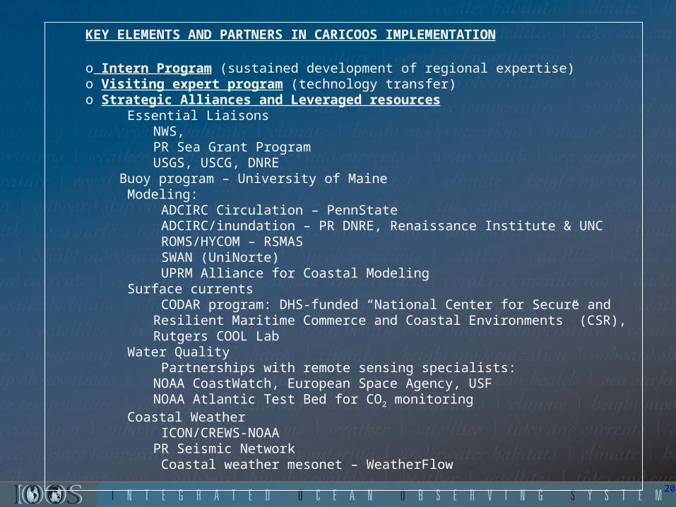
KEY ELEMENTS AND PARTNERS IN CARICOOS IMPLEMENTATION
o Intern Program (sustained development of regional expertise)o Visiting expert program (technology transfer)o Strategic Alliances and Leveraged resources
Essential LiaisonsNWS,PR Sea Grant ProgramUSGS, USCG, DNRE
Buoy program – University of Maine Modeling:
ADCIRC Circulation – PennState ADCIRC/inundation – PR DNRE, Renaissance Institute & UNC ROMS/HYCOM – RSMAS SWAN (UniNorte) UPRM Alliance for Coastal Modeling
Surface currents CODAR program: DHS-funded “National Center for Secure and Resilient Maritime Commerce and Coastal Environments” (CSR), Rutgers COOL Lab
Water Quality Partnerships with remote sensing specialists: NOAA CoastWatch, European Space Agency, USFNOAA Atlantic Test Bed for CO2 monitoring
Coastal Weather ICON/CREWS-NOAAPR Seismic Network Coastal weather mesonet – WeatherFlow

Questions?