carters grove appraisal may 31 2011
DESCRIPTION
Carters Grove Property Appraisal May 31, Showing Condition of MansionTRANSCRIPT

1445 East Rio Road, Suite 203 2807 North Parham Road, Suite 104 Charlottesville, VA 22901 Henrico, VA 23294 (434) 979-3393 · Fax (434) 979-2487 (804) 965-9900 · Fax (804) 965-9196 IVO ROMENESKO, MAI, SRA, CCIM
DATE OF MARKET VALUE “AS IS”
May 13, 2011
DATE OF REPORT
May 31, 2011
REAL PROPERTY APPRAISAL SELF-CONTAINED REPORT OF
CARTER’S GROVE
Historic Riverfront Estate 8797 Pocahontas Trail
Main Residence and Dependencies on 400.532 Acres And
76.104-Acres of Vacant Land Zoned R2 Williamsburg, James City County, Virginia 23185-6025
AGI File 1130075
PREPARED FOR
Ms. Debra Grassgreen
Pachulski Stang Ziehl & Jones LLP 150 California Street, 15th Floor San Francisco, CA 94111-4500
PREPARED BY
Appraisal Group, Inc.
1445 East Rio Road, Suite 203 Charlottesville, Virginia 22901
1445 East Rio Road, Suite 203 2807 North Parham Road, Suite 104 Charlottesville, VA 22901 Henrico, VA 23294 (434) 979-3393 · Fax (434) 979-2487 (804) 965-9900 · Fax (804) 965-9196 IVO ROMENESKO, MAI, SRA, CCIM
APPRAISAL GROUP, INC Real Estate Appraisers and Consultants
May 31, 2011 Ms. Debra Grassgreen Pachulski Stang Ziehl & Jones LLP 150 California Street, 15th Floor San Francisco, CA 94111-4500 RE: CARTER’S GROVE Historic Riverfront Estate
8797 Pocahontas Trail Main Residence and Dependencies on 400.532 Acres And 76.104-Acres of Vacant Land Zoned R2 Williamsburg, James City County, Virginia 23185-6025 AGI File 1130075
Dear Ms. Grassgreen: As requested, we have personally conducted a site visit, gathered necessary data, and analyzed the facts, which have enabled us to form an opinion of the market value “as is” of the fee simple estate in the subject property known as Carter’s Grove, which consists of the main residence and dependencies on 400.532-acres. Carter’s Grove, known as “one of Americas most significant homes,” was most recently a house museum for over 20-years with the Colonial Williamsburg Foundation. The market value “as is” of a vacant, 76.104-acre parcel currently zoned R2, is valued separately. This report is prepared in accordance with the Uniform Standards of Professional Appraisal Practice (USPAP). Based on the research and analysis, we conclude that the fee simple estate in the subject property, known as Carter’s Grove, subject to the assumptions and limiting conditions stated in the report, had a market value “as is”, as of May 13, 2011, of:
FIFTEEN MILLION DOLLARS . . . . . . . . $15,000,000

Based on the research and analysis, we conclude that the fee simple estate in the subject property, a vacant 76.104-acre parcel zoned R2, subject to the assumptions and limiting conditions stated in the report, had a market value “as is”, as of May 13, 2011, of:
EIGHT HUNDRED THOUSAND DOLLARS . . . . . . . . $800,000 The self-contained report that follows this letter includes the identification of the subject property, the assumptions and limiting conditions, pertinent facts about the subject property and market area, comparable data, and analysis which lead to the conclusion stated above. Accompanying this report is an addendum containing supplementary exhibits. Thank you for this opportunity to be of assistance. In the event that we may be of assistance to you in the future, please do not hesitate to call us.

Carter’s Grove
Description
View of Carter’s Grove from James River side
Photograph
Carter’s Grove
Description
View of Carter’s Grove from James River side
Photograph
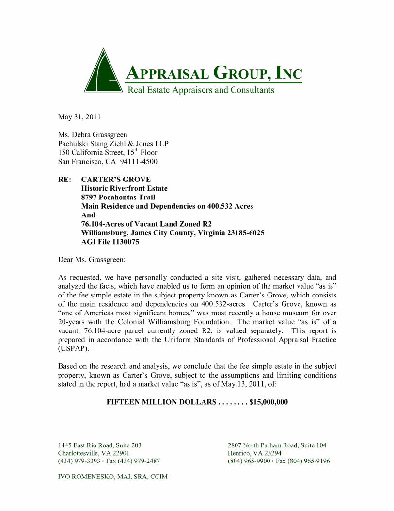
Carter’s Grove
Description
View of Carter’s Grove from main driveway
Photograph
Carter’s Grove
Description
View of James River Frontage looking
towards Kingsmill (west)
Photograph

Carter’s Grove
Description
View from Third Story of Carter’s Grove
looking towards Bunker and James River
Photograph
Carter’s Grove
Description
Front view of Tenant House
Photograph

Carter’s Grove
Description
Two Car Garage
Photograph
Carter’s Grove
Description
Stables
Photograph
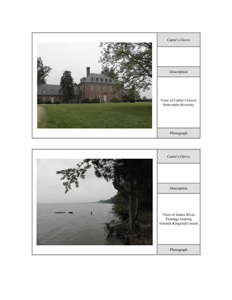
Carter’s Grove
Description
Office
Photograph
Carter’s Grove
Description
Barns
Photograph

Carter’s Grove
Description
Debris Pit
Photograph
Carter’s Grove
Description
Debris from Pit
Photograph

Carter’s Grove
Description
View of Rockefeller Museum Entrance
Photograph
Carter’s Grove
Description
Interior View of Rockefeller Museum
Photograph

Carter’s Grove
Description
View of Subject Land
Photograph
Carter’s Grove
Description
View of Pocahontas Trail with Subject on Left
Photograph

Carter’s Grove
Description
View of Subject’s Historical Marker at
Entrance
Photograph
Carter’s Grove
Description
View of Vacant Acreage
Photograph
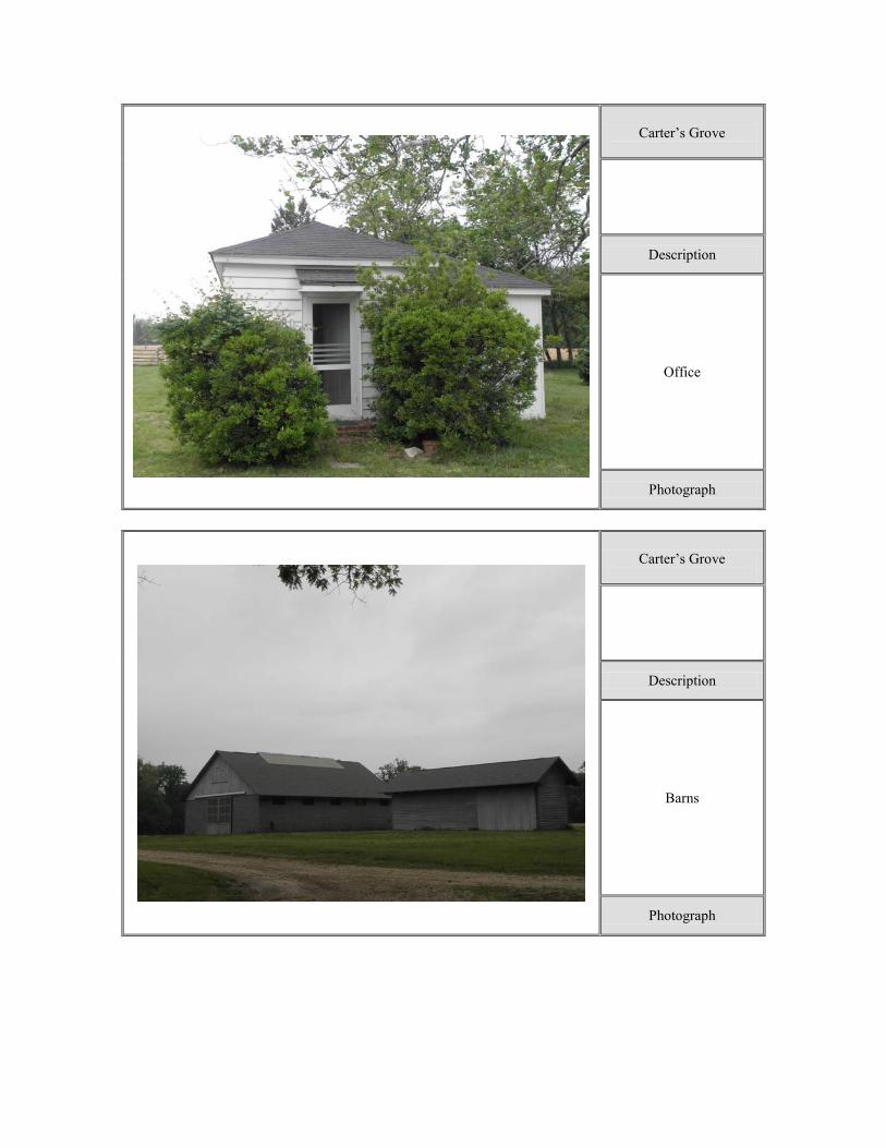
Carter’s Grove
Description
View of Ron Springs Drive with Vacant Acreage on Right
Photograph
Carter’s Grove
Description
View of Marsh Land on Vacant Acreage
Photograph
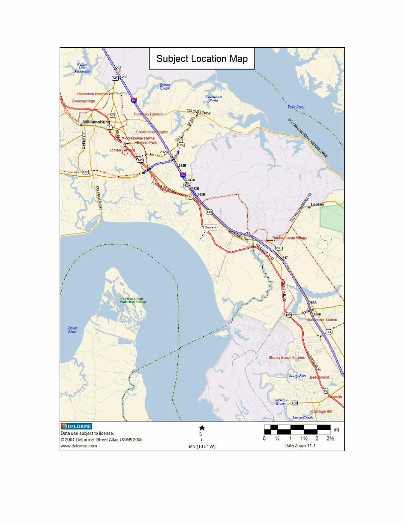

TABLE OF CONTENTS Letter of Transmittal .............................................................................................................. i Summary of Important Facts and Conclusions – Parcel 1 – Carters Grove ......................... 1 Summary of Important Facts and Conclusions – Parcel 2 – Vacant 76.104 Acres ............... 2 Purpose of the Appraisal ........................................................................................................ 3 Definition of Market Value ................................................................................................... 3 Property Rights Appraised ..................................................................................................... 3 Definitions.............................................................................................................................. 4 Intended Use .......................................................................................................................... 4 Intended User ......................................................................................................................... 4 Estimate of Exposure and Marketing Time ........................................................................... 5 Scope of the Appraisal ........................................................................................................... 5 Competency Provision ........................................................................................................... 6 Assumptions and Limiting Conditions .................................................................................. 7 Certification of Value ............................................................................................................ 9 Subject Neighborhood ........................................................................................................... 10 Brief Market Overview .......................................................................................................... 12 Parcel 1 – Carters Grove ....................................................................................................... 13 Site Description .................................................................................................................... 14 Description of the Improvements ......................................................................................... 23 Subject Recorded History ................................................................................................... 31 Analysis of Highest and Best Use ........................................................................................ 35 Valuation Section ................................................................................................................ 39 Land Valuation..................................................................................................................... 40 Cost Approach ..................................................................................................................... 46 Sales Comparison Approach ................................................................................................ 50 Reconciliation and Final Value ............................................................................................ 59 Parcel 2 – Vacant 76.104 Acres ............................................................................................ 61 Site Description ................................................................................................................... 62 Analysis of Highest and Best Use ....................................................................................... 68 Valuation Section ................................................................................................................ 70 Land Valuation .................................................................................................................... 71 Reconciliation and Final Value ........................................................................................... 78 Addendum - Qualifications of Appraiser and Firm - Legal Description - Survey - Zoning - Additional Subject Photographs - Client Engagement Letter

SUMMARY AND CONCLUSIONS Carter’s Grove, James City County, Virginia
1
SUMMARY OF IMPORTANT FACTS AND CONCLUSIONS
PARCEL 1 – CARTERS GROVE Type of Property: Historic farm and estate Location: The physical address of the main residence is 8797
Pocahontas Trail, Williamsburg, James City County, Virginia 23185-6025
Current Ownership: Carter’s Grove, LLC Current Use: Carter’s Grove - Historic estate, with agricultural
uses that is encumbered by conservation easement Purpose of Appraisal: Form an opinion of the market value “as is” of the
fee simple estate in the subject property for litigation purposes
Highest & Best Use as Though Vacant: Historic estate, with agricultural uses Highest & Best Use as Improved: Current use (current improvements) Land Size: 400.532 acres Main Residence Size: 18,709 square feet (finished above grade space) Secondary Structures: One tenant house, Rockefeller Museum, barns and
sheds Utilities: Public water, electricity and telephone. Three
private septic systems. Fire hydrants located throughout property.
Zoning: R8, Rural Residential Encumbered by Easements Date of Market Value “as is”: May 13, 2011 Date of Inspection: May 13, 2011 Date of Report: May 31, 2011 Market Value “as is”: $15,000,000

SUMMARY AND CONCLUSIONS Carter’s Grove, James City County, Virginia
2
SUMMARY OF IMPORTANT FACTS AND CONCLUSIONS
PARCEL 2 – VACANT 76.104 ACRES Type of Property: Vacant land Location: Along Ron Springs Drive, Williamsburg, James
City County, Virginia 23185-6025 Current Ownership: Carter’s Grove, LLC Current Use: Vacant land Purpose of Appraisal: Form an opinion of the market value “as is” of the
fee simple estate in the subject property for litigation purposes
Highest & Best Use as Though Vacant: Residential Highest & Best Use as Improved: Residential Land Size: 76.104 acres Utilities: Public water, electricity and telephone available Zoning: R2, General Residential Date of Market Value “as is”: May 13, 2011 Date of Inspection: May 13, 2011 Date of Report: May 31, 2011 Market Value “as is”: $800,000

INTRODUCTION Carter’s Grove, James City County, Virginia
3
PURPOSE OF THE APPRAISAL The purpose of this appraisal is to estimate the market value “as is” of the fee simple estate in the subject property for litigation purposes.
DEFINITION OF MARKET VALUE Market value, as defined herein, is defined by The Office of the Comptroller of the Currency (CFR 34.42f) as:
"The most probable price which a property should bring in a competitive and open market under all conditions requisite to a fair sale, the buyer and seller, each acting prudently and knowledgeably, and assuming the price is not affected by undue stimulus. Implicit in this definition is the consummation of a sale as of a specified date and the passing of title from seller to buyer under conditions whereby:
1. Buyer and seller are typically motivated; 2. Both parties are well informed or well advised, and acting in what they consider their own best interest; 3. A reasonable time is allowed for exposure in the open market; 4. Payment is made in terms of cash in US dollars or in terms of financial arrangements comparable thereto; and
5. The price represents the normal consideration for the property sold unaffected by special or creative financing or sales concessions granted by anyone associated with the sale.”
Market value does not account for the unpredictable buyer who will pay a price in excess of that which appears supportable and reasonable nor sales which are made under adverse conditions.
PROPERTY RIGHTS APPRAISED
The fee simple estate is appraised in this report and is defined by The Appraisal Institute as:
“Absolute ownership unencumbered by any other interest or estate, subject only to the limitations imposed by the governmental powers of taxation, eminent domain, police power, and escheat.”
Source: Appraisal Institute, The Dictionary of Real Estate Appraisal, 5th ed. (Chicago: Appraisal Institute, 2010).
Please note that the subject (Parcel 1 – Carters Grove) is encumbered by a conservation easement.

INTRODUCTION Carter’s Grove, James City County, Virginia
4
Restricted fee simple interest: The fee simple interest, subject to the conservation easement, is appraised in this report. In this case, a conservation easement limits the development potential of the property beyond that which is set by local zoning, as described in the body of this report. Conservation Easement: An easement is a non-possessory right to use or enjoy the land of another and may be created in a variety of ways. In the case of the subject property, the easement was created by express grant between the property owner and the beneficiaries, the Virginia Outdoors Foundation and Virginia Board of Historic Resources. The deed of easement is recorded with the Clerk of Circuit Court of James City County in instrument number 070034660. A copy of the easement document has been reviewed and its general provisions form the basis of this valuation, subject to its restrictions. As a qualifying preservation easement, it is required by law to be in gross: that is, not for the sole benefit of adjoining or accessory land, and to be given in perpetuity. It is both affirmative and negative in nature, in that it allows the Grantee specific rights in the affected property while restricting the Grantor of other rights. It is noted that when the conservation easement was initially executed the subject was zoned R-8, Rural Residential. This zoning, although agricultural in nature, allowed low density residential uses. Public water is available on the site and sewer is located along Pocahontas Trail near the subject and there was strong growth demand as evidenced by the residential waterfront development in Kingsmill. These facts suggested that a subdivision, perhaps in conjunction with Kingsmill, would be an economically feasible use, hence the protective preservation features of the easement were appealing to the land owner. The Chesapeake Bay Preservation Act and other water quality regulations places more restrictions on waterfront land. The higher land use restrictions imposed on wetlands by the Commonwealth of Virginia and the United States, have all acted to narrow the value gap between free and clear land, and land encumbered by a conservation easement in James City County.
DEFINITIONS
Market Value “As Is”
“The value of specific ownership rights to an identified parcel of real estate as of the effective date of the appraisal; relates to what physically exists and is legally permissible and excludes all assumptions concerning hypothetical market conditions or possible rezoning.” Source: Appraisal Institute, The Dictionary of Real Estate Appraisal, 5th ed. (Chicago: Appraisal Institute, 2010).
INTENDED USE The intended use of the appraisal is to aid the client, Ms. Debra Grassgreen, Esquire, for litigation purposes.

INTRODUCTION Carter’s Grove, James City County, Virginia
5
INTENDED USER The intended user of the appraisal is Ms. Debra Grassgreen, Esquire, for Carters Grove, LLC. This report is for sole use by the client and no other party may use or rely on this appraisal.
ESTIMATE OF EXPOSURE AND MARKETING TIME
Estimate of Exposure Time
Reasonable exposure time is defined as the estimated length of time that a property would have to have been offered on the market prior to the hypothetical sale at the estimated market value on the effective date of the appraisal. Based on the exposure periods for comparable properties in the area that have sold in recent years, as well as current market conditions, a reasonable exposure time of six to twelve months is estimated for the subject.
Estimate of Marketing Time
Marketing time is defined as the estimated length of time that it would take to sell a property at its market value occurring immediately after the effective date of the appraisal. A marketing time of six to twelve months is estimated for the subject.
SCOPE OF THE APPRAISAL
The subject property was inspected on May 24, 2011, by Mr. Ivo Romenesko, MAI. Mrs. Diana Svedics, Certified General Real Estate Appraiser, inspected the subject property on May 13, 2011. A thorough investigation of the surrounding neighborhood was made at that time and upon subsequent visits. Sales, cost and demographic information were gathered, confirmed, and analyzed by your appraiser. Local sources of information included, but were not limited to, area real estate brokers, property managers, property owners, and government officials. Published sources of information included various government and investment publications. Computer software utilized in the analysis and publication of the report included Microsoft Word and Excel. Due to access limitations on the subject property, as well as some of the comparables sales, we utilized Google Earth, county GIS mapping system, Bing, etc., for pictorial views. Appraisal Group, Inc., reserves the right to alter its opinion of value on the basis of information withheld or not discovered in the normal course of diligent investigation. Mr. Rob Mays, farm manager, and Mr. Alex Judson, owner representative, provided property specific information. Mr. Mays accompanied us on the site visit and provided information regarding the subject’s condition, maintenance and renovation history. Mr. Judson was questioned about any surveys and/or potential site plans completed on the vacant 76+ acres. According to Mr. Judson no survey/site plan was ever done; therefore we have relied on the James City County GIS website for an estimate of buildable area on the vacant 76+ acre site.

INTRODUCTION Carter’s Grove, James City County, Virginia
6
Because of the subject’s historic significance and limited sales of similar quality, we analyzed the subject and comparables via the methodology from the following Appraisal Institute articles: The Costs and Benefits of Historic Properties, by Judith Reynolds, MAI, 2006; The Appraisal of Designated Historic Properties, by David Listokin, 1982; and Historic Properties: Variable Valuation, by Sally G. Oldham, 1982. We searched the Richmond, Charlottesville, Northern Virginia and Williamsburg area MLS systems for potential sales. All approaches to value typically found relevant by those in the appraisal profession are completed in this appraisal. Less weight is placed on the Cost Approach due to the difficulty estimating cost and depreciation of the historic home over 250-years old. Availability of adequate sales in the Sales Comparison Approach made that approach more reliable. The value indicated by the Cost Approach supports the final value conclusion. The Sales Comparison Approach is a valid indication of value if there are a significant number of comparable improved sales. There were sufficient comparable sales to develop this approach; however, the volume of recent comparable transactions has been very low. The majority of the sales are recent and shared somewhat similar characteristics, but the comparables required substantial adjustments in order to adjust for the subject’s uniqueness. The Income Approach provides a reliable indication of value particularly for leased properties. This approach relates the projected income stream to an estimate of value based on the investor's return requirements. Estate properties, such as the subject, are not generally bought, sold, or used for income production. In such cases, the Income Approach cannot be accurately developed, nor would it provide a reliable indication of value. The Income Approach has not been developed in this analysis. The comparables used in this appraisal are located in James City, Henrico, and Albemarle Counties, VA; and Montgomery County, MD. The subject neighborhood was thoroughly researched and comparable sales from the subject neighborhood are used whenever possible.
COMPETENCY PROVISION
Prior to accepting an assignment or entering into an agreement to perform any assignment, an appraiser must properly identify the problem to be addressed and have the knowledge and experience to complete the assignment, or alternatively:
disclose the lack of knowledge and/or experience to the client before accepting the assignment and;
take all necessary or appropriate steps to complete the assignment competently; and
describe the lack of knowledge and/or experience and the steps taken to complete the assignment competently in the report.

INTRODUCTION Carter’s Grove, James City County, Virginia
7
Our experience appraising residential, historic farm and estate quality properties in Virginia for over thirty years, as well as our knowledge of the local market and the research conducted with regard to current sales, provides us with the ability to complete this assignment in adherence with the competency provision. We have also appraised numerous conservation easements throughout Virginia. In addition, Ivo H. Romenesko, MAI, is a Certified General Real Estate Appraiser of the Commonwealth of Virginia.

ASSUMPTIONS AND LIMITING CONDITIONS Carter’s Grove, James City County, Virginia
8
ASSUMPTIONS AND LIMITING CONDITIONS
General Assumptions and Limiting Conditions
1. No responsibility is assumed for the legal description provided or for matters pertaining to legal or title considerations. Title to the property is assumed to be good and marketable unless otherwise stated.
2. The property is appraised free and clear of any or all liens or encumbrances unless
otherwise stated. 3. Responsible ownership and competent property management are assumed. 4. The information furnished by others is believed to be reliable, but no warranty is given
for its accuracy. 5. All engineering studies are assumed to be correct. The plot plans and illustrative material
in this report are included only to help the reader visualize the property. 6. It is assumed that there are no hidden or unapparent conditions of the property, subsoil, or
structures that render it more or less valuable. No responsibility is assumed for such conditions or for obtaining the engineering studies that may be required to discover them.
7. It is assumed that the property is in full compliance with all applicable federal, state, and
local environmental regulations and laws unless the lack of compliance is stated, described, and considered in the appraisal report.
8. It is assumed that the property conforms to all applicable zoning and use regulations and
restrictions unless a nonconformity has been identified, described and considered in the appraisal report.
9. It is assumed that all required licenses, certificates of occupancy, consents, and other
legislative or administrative authority from any local, state, or national government or private entity or organization have been or can be obtained or renewed for any use on which the value estimate contained in this report is based.
10. It is assumed that the use of the land and improvements is confined within the boundaries
or property lines of the property described and that there is no encroachment or trespass unless noted in the report.
11. Unless otherwise stated in this report, the existence of hazardous materials, which may or
may not be present on the property, was not observed by the appraiser. The appraiser has no knowledge of the existence of such materials on or in the property. The appraiser, however, is not qualified to detect such substances. The presence of substances such as asbestos, urea-formaldehyde foam insulation, and other potentially hazardous materials may affect the value of the property. The value estimated is predicated on the assumption

ASSUMPTIONS AND LIMITING CONDITIONS Carter’s Grove, James City County, Virginia
9
that there is no such material on or in the property that would cause a loss in value. No responsibility is assumed for such conditions or for any experience or engineering knowledge required to discover them. The client is urged to retain an expert in this field, if desired.
12. Any allocation of the total value estimated in this report between the land and the
improvements applies only under the stated program of utilization. The separate values allocated to the land and buildings must not be used in conjunction with any other appraisal and are invalid if so used.
13. Possession of this report, or a copy thereof, does not carry with it the right of publication. 14. The appraiser, by reason of this appraisal, is not required to give further consultation or
testimony or to be in attendance in court with reference to the property in question unless arrangements have been previously made.
15. Neither all nor any part of the contents of this report (especially any conclusions as to
value, the identity of the appraiser, or the firm with which the appraiser is connected) shall be disseminated to the public through advertising, public relations, news, sales, or other media without the prior written consent and approval of the appraiser.
16. The Americans with Disabilities Act (ADA) became effective July 26, 1992. We have
not made a specific compliance survey and analysis of this property to determine whether or not it is in conformity with the various detailed requirements of the act. It is possible that a compliance survey of the property together with a detailed analysis of the requirements of the ADA could reveal that the property is not in compliance with one or more of the requirements of the act. If so, this fact could have a negative effect upon the value of the property. Since we have no direct evidence relating to this issue, we did not consider possible noncompliance with the requirements of ADA in estimating the value of the property.
17. This appraisal has been prepared for the exclusive benefit of the client. It may not be
used or relied upon by any other party. Any party who uses or relies upon any information in this report, without the appraiser’s written consent, does so at his own risk.

CERTIFICATION Carter’s Grove, James City County, Virginia
10
CERTIFICATION
I certify that, to the best of my knowledge and belief: 1. The statements of fact contained in this report are true and correct. 2. The reported analyses, opinions, and conclusions are limited only by the reported assumptions and limiting
conditions, and are my personal, impartial, and unbiased professional analyses, opinions, and conclusions. 3. I have no present or prospective interest in the property that is the subject of this report, and I have no
personal interest with respect to the parties involved. 4. I have no bias with respect to the property that is the subject of this report or to the parties involved with
this assignment. 5. My engagement in this assignment was not contingent upon developing or reporting predetermined results. 6. My compensation for completing this assignment is not contingent upon the developing or reporting of a
predetermined value or direction in value that favors the cause of the client, the amount of the value opinion, the attainment of a stipulated result, or the occurrence of a subsequent event directly related to the intended use of this appraisal.
7. My analyses, opinions, and conclusions were developed, and this report has been prepared, in conformity
with the requirements of the Code of Professional Ethics & Standards of Professional Practice of the Appraisal Institute, which include the Uniform Standards of Professional Appraisal Practice.
8. Diana Svedics provided significant real property appraisal assistance to the person(s) signing this report.
Other members of the staff of Appraisal Group, Inc., may have assisted in processing portions of the data used.
9. The use of this report is subject to the requirements of the Appraisal Institute relating to review by its duly
authorized representatives. 10. A personal inspection of the subject property was made as indicated below. 11. As of the date of this report, Ivo H. Romenesko, MAI, has completed the requirements of the continuing
education program of the Appraisal Institute. 12. The appraiser has performed within the context of the competency provision of the Uniform Standards of
Professional Appraisal Practice. 13. I currently hold an appropriate certification allowing the performance of real estate appraisals in connection
with federal transactions in the state in which the subject property is located. 14. Appraisal Group, Inc., has appraised the subject property within the last three years.

SUBJECT NEIGHBORHOOD Carter’s Grove, James City County, Virginia
11
SUBJECT NEIGHBORHOOD
The subject property is located eight miles east from Williamsburg, in the town of Grove, James City County, Virginia. Located along Route 60, the subject is near Kingsmill Resort and Busch Gardens Williamsburg theme park; each was developed by Anheuser Busch. Grove is bordered by the James River and separated from the Newport News city limits near Lee Hall by Skiffe's Creek. Interstate 64 is within a few miles of the subject property. Land uses in the area are predominately agricultural for the larger tracts and are mixed with small single family sites and commercial uses. Grove is located in almost the exact center of the Historic Triangle of Colonial Virginia, comprising Jamestown, Williamsburg and Yorktown, all linked by the Colonial Parkway. The area is one of the busiest tourist destinations in the world. The general neighborhood is considered to be very desirable and includes a number of estate properties dating to the 18th and 19th centuries. These properties, like the subject, were customarily located on navigable waterways which were originally used as transportation routes. Today, these waterfront locations are considered more for their amenity value than for their economic purpose. The subject is advantageously located within close proximity to shopping, employment, schools and services. Thus, Grove's specific location combines convenience while retaining a colonial atmosphere.

SUBJECT NEIGHBORHOOD Carter’s Grove, James City County, Virginia
12
During the two World Wars, Grove became home to hundreds of people, where land was taken by the Federal Government for military use. Those lands now comprise the Naval Weapons Station Yorktown, the Cheatham Annex supply complex, and Camp Peary. Grove currently includes residential areas, churches, neighborhood retail businesses, a nursing home, day care facilities, a modern community center and a magnet school of the Williamsburg-James City County Public Schools (WJC). Some new home construction is occurring within the neighborhood. Along the southeastern edge, many available sites and frontage on the James River and Skiffe's Creek are zoned for industrial purposes, and have been attractive to developers, where the expansion on vacant land was ongoing. We must mention the neighboring sites which are known to have had and/or have environmental issues. Adjacent BASF property, an industrial site, is known to have had environmental issues which have been remediated. Although a few miles from the subject property, the government has a facility in the James River known as the “Ghost Fleet,” where decommissioned military naval ships are stored until disposed. Recently, Congress along with the increase of steel prices, have diminished the supply. These ships are known to release PCB’s into the water systems. These facilities do not appear to have a negative impact on the subject’s value as we look to the other adjacent uses which include >$1,000,000 condominium units along the James River.

BRIEF MARKET OVERVIEW Carter’s Grove, James City County, Virginia
13
BRIEF MARKET OVERVIEW
The farm and estate market in Virginia have experienced a high level of demand over the past decade; however, demand for estate properties has declined due to the ongoing national recession. Values of farm and estate properties have experienced recent declines, which are likely to continue until the recession eases and financing becomes more readily available. Based on the history of listing prices and the days on market of the listings there appears to be a large spread between the bid/ask prices for estate properties. Currently the Multiple Listing from Williamsburg, Richmond, Northern Virginia and Charlottesville, have over 20+ properties listed for sale from $10,000,000 to +$20,000,000, which includes properties in Virginia, Washington, DC and Maryland. Agriculture is of minimal interest for most estate farm owners. In fact, many horse and cattle farms have few, if any, animals on the property. The properties are used as "gentleman farms" where the fields are hayed and often leased to other farmers. In the past several years purchasers have been renovating the homes with elaborate kitchens and additions. These upgrades range from several hundred thousand dollars to multiple millions of dollars. Some renovations cost as much as the purchase of the farm. The purchase prices are well beyond that which is affordable for agricultural uses. Higher price range properties, over seven million dollars, are often one of several homes owned by wealthy purchasers, while middle to lower price range estates are often the primary home of the purchaser. Conservation easements that restrict land development are often donated as a charitable contribution for which an income tax deduction is received. While the farm under easement can no longer be subdivided for residential use, the farms are becoming neighborhoods for large acreage properties that have appeal as exclusive private home sites. This trend is similar to other high land price areas such as Albemarle, Loudon and Fauquier Counties, Virginia.

SITE DESCRIPTION Carter’s Grove, James City County, Virginia
14
PARCEL 1 – CARTERS GROVE
SITE DESCRIPTION Carter’s Grove, James City County, Virginia
15
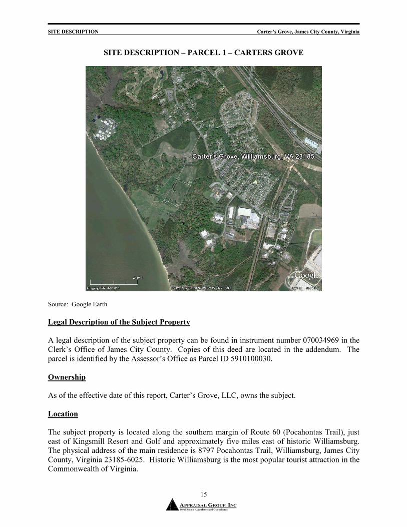
SITE DESCRIPTION – PARCEL 1 – CARTERS GROVE
Source: Google Earth
Legal Description of the Subject Property
A legal description of the subject property can be found in instrument number 070034969 in the Clerk’s Office of James City County. Copies of this deed are located in the addendum. The parcel is identified by the Assessor’s Office as Parcel ID 5910100030.
Ownership
As of the effective date of this report, Carter’s Grove, LLC, owns the subject.
Location
The subject property is located along the southern margin of Route 60 (Pocahontas Trail), just east of Kingsmill Resort and Golf and approximately five miles east of historic Williamsburg. The physical address of the main residence is 8797 Pocahontas Trail, Williamsburg, James City County, Virginia 23185-6025. Historic Williamsburg is the most popular tourist attraction in the Commonwealth of Virginia.
SITE DESCRIPTION Carter’s Grove, James City County, Virginia
16
Size, Shape, and Access
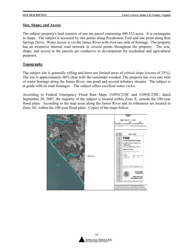
The subject property's land consists of one tax parcel containing 400.532-acres. It is rectangular in shape. The subject is accessed by two points along Pocahontas Trail and one point along Ron Springs Drive. Water access is via the James River with over one mile of frontage. The property has an extensive internal road network to several points throughout the property. The size, shape, and access to the parcels are conducive to development for residential and agricultural purposes.
Topography
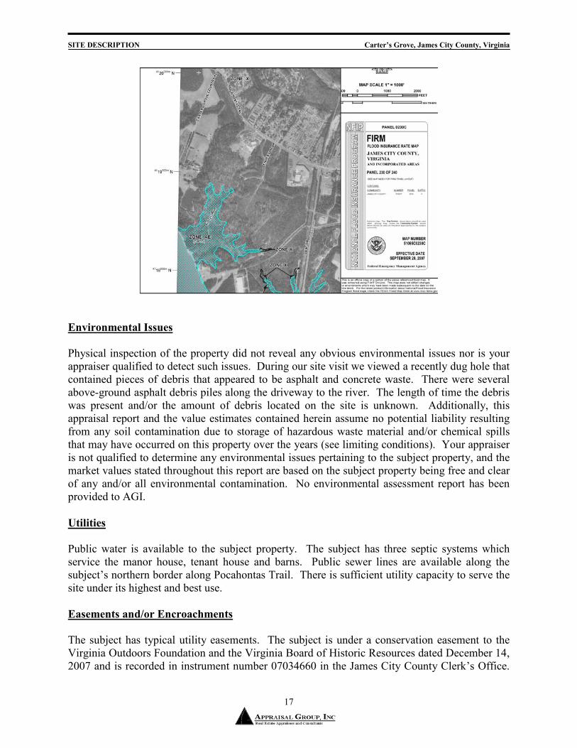
The subject site is generally rolling and there are limited areas of critical slope (excess of 25%). The site is approximately 60% clear with the remainder wooded. The property has over one mile of water frontage along the James River, one pond and several tributary streams. The subject is at grade with its road frontages. The subject offers excellent water views. According to Federal Emergency Flood Rate Maps 51095C210C and 51095C230C, dated September 28, 2007, the majority of the subject is located within Zone X, outside the 100-year flood plain. According to the map areas along the James River and its tributaries are located in Zone AE, within the 100-year flood plain. Copies of the maps follow.
SITE DESCRIPTION Carter’s Grove, James City County, Virginia
17
Environmental Issues
Physical inspection of the property did not reveal any obvious environmental issues nor is your appraiser qualified to detect such issues. During our site visit we viewed a recently dug hole that contained pieces of debris that appeared to be asphalt and concrete waste. There were several above-ground asphalt debris piles along the driveway to the river. The length of time the debris was present and/or the amount of debris located on the site is unknown. Additionally, this appraisal report and the value estimates contained herein assume no potential liability resulting from any soil contamination due to storage of hazardous waste material and/or chemical spills that may have occurred on this property over the years (see limiting conditions). Your appraiser is not qualified to determine any environmental issues pertaining to the subject property, and the market values stated throughout this report are based on the subject property being free and clear of any and/or all environmental contamination. No environmental assessment report has been provided to AGI.
Utilities
Public water is available to the subject property. The subject has three septic systems which service the manor house, tenant house and barns. Public sewer lines are available along the subject’s northern border along Pocahontas Trail. There is sufficient utility capacity to serve the site under its highest and best use.
Easements and/or Encroachments
The subject has typical utility easements. The subject is under a conservation easement to the Virginia Outdoors Foundation and the Virginia Board of Historic Resources dated December 14, 2007 and is recorded in instrument number 07034660 in the James City County Clerk’s Office.

SITE DESCRIPTION Carter’s Grove, James City County, Virginia
18
The conservation easement restricts potential division, but does allow for additional dwellings and farm buildings to be erected within certain areas of the property. The easement also restricts trash, signs, forestry management, riparian buffers, and grading/blasting/mining, and restrictions to renovations and/or additions to the Manor House. Carters Grove is also subject to an Archaeological Agreement with The Colonial Williamsburg Foundation, dated December 17, 2007 and is recorded in instrument number 070034971. This agreement ends January 1, 2033, and grants the exclusive right and profit for the purpose of recovering, removing, owning and possessing any and all artifacts or items whatsoever located or found in, over, under, through and across the “Artifact Sites.” Certain portions of the property are designated “artifact sites” which are recorded in the Deed of Gift of Easement.
Zoning
The subject is zoned R8, Rural Residential District. Land located within this district cannot be developed to a high density. The subject’s current use is a legally conforming use. The statement of intent is:
Generally, the Rural Residential District, R-8, is intended for application to rural areas of the county which remain inside the primary service area where utilities and urban services are planned but not yet fully available and where urban development may be expected in the near future. The district may also be applied to certain outlying areas where residences exist at similar densities or may be appropriate in view of housing needs. The district is intended to maintain a rural environment suitable for farming, forestry and low-density rural residence, together with certain recreational and public or semipublic and institutional uses, until such time as an orderly expansion of urban development is appropriate. Sec. 24-348. Permitted uses. In the Rural Residential District, R-8, structures to be erected or land to be used shall be for the following uses: Accessory apartments in accordance with section 24-32. Accessory buildings and structures. Accessory uses, as defined herein. Communication towers and tower mounted wireless communication facilities, up to a height of 35 feet. Farmers markets, limited in area to 2,500 square feet. General agriculture, dairying, forestry, general farming and specialized farming, excluding the raising of hogs, but not commercial livestock or poultry operations which require a special use permit in the General Agricultural District, A-1. Home occupations, as defined herein. Horse and pony farms of less than 50 animals (including the raising and keeping of horses), riding stables. House museums. Nurseries. Off-street parking as required by section 24-53.
SITE DESCRIPTION Carter’s Grove, James City County, Virginia
19
Petroleum storage on a farm as an accessory use and not for resale. Preserves and conservation areas for protection of natural features and wildlife. Rest homes for fewer than 15 adults. Site-built single-family detached dwellings and modular homes. Slaughter of animals for personal use but not for commercial purposes. Storage and repair of heavy equipment as accessory use to a farm. Timbering in accordance with section 24-43. Water impoundments, new or expansion of, less than 20 acres and with dam heights of less than 15 feet. Wayside stands for seasonal sale of agricultural products, limited in area to 500 square feet. Wineries, as herein defined, including a shop for retail sale of wine, but not including other commercial accessory uses. Wireless communications facilities that utilize alternative mounting structures, or are building mounted, or are camouflaged, and comply with division 6, Wireless Communications Facilities. (Ord. No. 31A-88, 20-36, 4-8-85; Ord. No. 31A-99, 10-6-86; Ord. No. 31A-114, 5-1-89; Ord. No. 31A-122, 6-18-90; Ord. No. 31A-131, 6-3-91; Ord. No. 31A-145, 7-6-92; Ord. No. 31A-167, 3-26-96; Ord. No. 31A-176, 5-26-98; Ord. No. 31A-202, 12-21-99) Sec. 24-349. Uses permitted by special use permit only. In the Rural Residential District, R-8, structures to be erected or land to be used for the following uses shall be permitted only after the issuance of a special use permit approved by the board of supervisors in accordance with the procedures, guides and standards of sections 24-9 and 24-10 and such other guides and standards as may be contained in this chapter: Adult day care centers. Airports and landing fields, helistops or heliports and accessory uses. Barber and beauty shops. Business, governmental, and professional offices. Campgrounds. Cemeteries and memorial gardens, not accessory to a church or other place of worship. Child day care centers. Commercial livestock or poultry operations for more than 100 slaughter or feeder cattle, 70 dairy cattle, 250 swine, 1,000 sheep, lambs, goats or similar animals, 50 horses, 10,000 chickens, or 5,500 turkeys or ducks. Communication towers over 35 feet in height. Community recreation facilities, public or private, including parks, playgrounds, clubhouses, boating facilities, swimming pools, ball fields, tennis courts, and other similar recreation facilities, but not those approved as a part of a planned unit development. Convenience stores; if fuel is sold, then in accordance with section 24-38. Drug stores. Electrical generation facilities (public or private), electrical substations with a capacity of 5,000 kilovolt amperes or more and electrical transmission lines capable of transmitting 69 kilovolts or more.

SITE DESCRIPTION Carter’s Grove, James City County, Virginia
20
Excavation or filling, borrow pits, extraction, processing and removal of sand and gravel and stripping of topsoil (but not farm pond construction, field leveling or stripping of sod for agricultural purposes and excavations in connection with development which has received subdivision or site plan approval, which activities do not require a special use permit). Family care homes, foster homes or group homes serving physically handicapped, mentally ill, mentally retarded or other developmentally disabled persons for more than five such persons. Farm equipment sales and service establishments. Farmers' markets over 2,500 square feet. Feed, seed and farm supplies. Fire stations or rescue squad stations, volunteer or otherwise. Fish farming and aquaculture. Flea markets, temporary or seasonal. Food processing and storage, but not the slaughter of animals. Food processing and storage in a residence. Gift shops, antique shops. Golf courses and country clubs. Greenhouses, commercial. Group quarters for agricultural workers. Home care facilities. Horse and pony farms with 50 or more animals. Horse show areas, polo fields. Hospitals. Hotels and motels. Houses of worship and cemeteries accessory thereto. Hunting clubs. Kennels. Lodges, civic clubs, fraternal organizations, and service clubs. Manufacture and sale of wood products. Manufactured home parks. Manufactured homes in accordance with section 24-107 and section 24-108 not located within the primary service area. Medical clinics or offices. Neighborhood Resource Centers. Nursing homes and facilities for the residence and/or care of the aged. Photography, artist and sculptor studios. Photography sales and arts and crafts shops. Post offices and public buildings generally. Radio and television stations or towers. Railroad facilities including tracks, bridges, switching yards and stations. However, spur lines, which are to serve and are accessory to existing or proposed development adjacent to existing railroad right-of-ways, and track and safety improvements in existing railroad right-of-ways, are permitted generally and shall not require a special use permit. Raising of hogs.

SITE DESCRIPTION Carter’s Grove, James City County, Virginia
21
Rental of rooms to a maximum of three rooms. Rest homes for 15 or more adults. Restaurants, taverns. Retail shops associated with community recreation facilities. Retreat facilities. Sanitary landfills in accordance with section 24-40, waste disposal or publicly owned solid waste container sites. Schools, libraries, museums and similar institutions. Seminaries. Telephone exchanges and telephone switching stations. Tourist homes. Tower mounted wireless communications facilities in accordance with division 6, Wireless Communications Facilities, over 35 feet in height. Transmission pipelines (public or private), including pumping stations and accessory storage, for natural gas, propane gas, petroleum products, chemicals, slurry coal and any other gases, liquids or solids. However, private extensions or connections to existing pipelines, which are intended to serve an individual residential or commercial customer and which are accessory to existing or proposed development, are permitted generally and shall not require a special use permit. Two-family dwellings. Utility substations. Veterinary hospitals. Water facilities (public or private), and sewer facilities (public), including, but not limited to, treatment plants, pumping stations, storage facilities and transmission mains, wells and associated equipment such as pumps to be owned and operated by political jurisdictions. However, the following are permitted generally and shall not require a special use permit: (a) private connections to existing mains that are intended to serve an individual customer and are accessory to existing or proposed development, with no additional connections to be made to the line; (b) distribution lines and local facilities within a development, including pump stations. Water impoundments, new or expansion of, 20 acres or more or with dam heights of 15 feet or more. Wayside stands for sale of agricultural products over 500 square feet in area. Yacht clubs and marinas and commercial and service facilities accessory thereto. Source: James City County Zoning Ordinance
A copy of the R8 zoning regulations is located in the addenda. Furthermore, a conservation easement placed on the property restricts potential division. Properties of this quality and land size typically have conservation easements placed on them from further development and as a way to protect the property for future generations.
SITE DESCRIPTION Carter’s Grove, James City County, Virginia
22
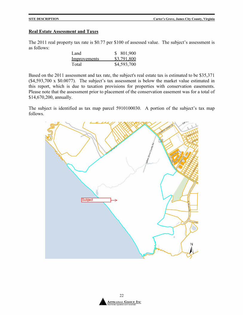
Real Estate Assessment and Taxes
The 2011 real property tax rate is $0.77 per $100 of assessed value. The subject’s assessment is as follows: Land $ 801,900 Improvements $3,791,800 Total $4,593,700 Based on the 2011 assessment and tax rate, the subject's real estate tax is estimated to be $35,371 ($4,593,700 x $0.0077). The subject’s tax assessment is below the market value estimated in this report, which is due to taxation provisions for properties with conservation easements. Please note that the assessment prior to placement of the conservation easement was for a total of $14,670,200, annually. The subject is identified as tax map parcel 5910100030. A portion of the subject’s tax map follows.

SITE DESCRIPTION Carter’s Grove, James City County, Virginia
23
History of the Subject Property
The subject property transferred on December 19, 2007 for a recorded price of $15,300,000 on instrument number 070034969 to Carter’s Grove, LLC, Grantor. Colonial Williamsburg, Grantee, had operated the subject property as a museum for over 20-years and had decided it no longer fit into its historical programs offered. Since Colonial Williamsburg has owned the property extensive renovations to the main house, archeological digs, the Rockefeller Museum - an earth sheltered bunker to house the artifacts, barns and land renovation have occurred over the years. According to the brokers for both parties, this was an arm’s-length transaction and current market terms. During negotiations and as part of the contract of purchase, the purchaser placed an open space easement on the entire property. The appraised value is within range of the purchase price. This property had a historic preservation, conservation, and open space easement placed on it by Colonial Williamsburg and given to the Virginia Outdoors Foundation and the Virginia Board of Historic Resources. Details of the easement are recorded in the James City Courthouse under Instrument # 07034660. This was the site of Wolstenholme, a historically significant 17th century English Settlement, part of Martin's Hundred community, a plantation of the Virginia Company, founded in 1619. A 25-year Archeological Agreement between Carters Grove, LLC and Colonial Williamsburg was recorded at time of sale. It detailed an exclusive easement of right and profit for purpose of recovering, removing, owning, and possessing any and all artifacts found on the property. It expires on January 1, 2033.

DESCRIPTION OF THE IMPROVEMENTS Carter’s Grove, James City County, Virginia
24
DESCRIPTION OF THE IMPROVEMENTS
Building Improvements
The subject property is currently improved with a historic residence, one tenant house, Rockefeller Museum, various barns, sheds, etc. The subject has a good paved and gravel road system for access to all structures. Property details for the subject’s improvements are based upon inspection, historical sketches and public records.
Historic Residence – Carter’s Grove The main residence is of historic construction consisting of three stories above grade and one level of unfinished basement space. The entire house has wide plank pine flooring, except in the bathrooms which have marble flooring. Building layout plans have been provided. Above Grade Finished Space: 18,709 square feet Basement Area: 5,496 square feet Finished Basement Area: 0 square feet Bedrooms: 12 Bathrooms: 7.5 (additional half bath in basement) Fireplaces: 17 Foundation: Brick Roof: Slate Exterior Walls: Brick Interior Walls: Plaster with extensive molding and raised panel two inch
thick heart pine wainscot Ceiling: Plaster, 12’ ceilings Windows: Triple-hung Insulation: Adequate Electrical: Adequate; back-up diesel generator Lighting: Adequate- mostly recessed lighting Plumbing: Unknown materials inside walls Fire Protection: Sprinkler in attic and basement HVAC: Multi-zone hot and cold chiller system Landscaping: Attractive landscaping Garage: None Security: Whole house alarm system – linked directly to Colonial
Williamsburg security Year Built: 1750, remodeled in 1920’s, renovated in 1970’s Effective Age: 40 years Comments: The subject is in very good condition and was last renovated approximately 50 years ago. The kitchen and upstairs bathrooms are dated, having been updated in the 1920’s renovations. We were not able to determine if the plumbing was functioning properly since the water has been turned off; but according to the Farm Manager, Rob, the plumbing is in need of
DESCRIPTION OF THE IMPROVEMENTS Carter’s Grove, James City County, Virginia
25
updating. There were several areas throughout the house where water damage and/or mold had occurred. Several areas of loose slate shingles were observed on the roof.
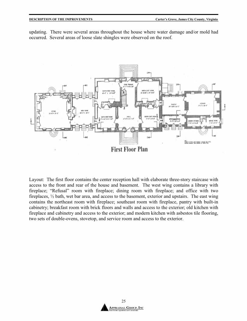
Layout: The first floor contains the center reception hall with elaborate three-story staircase with access to the front and rear of the house and basement. The west wing contains a library with fireplace; “Refusal” room with fireplace; dining room with fireplace; and office with two fireplaces, ½ bath, wet bar area, and access to the basement, exterior and upstairs. The east wing contains the northeast room with fireplace; southeast room with fireplace, pantry with built-in cabinetry; breakfast room with brick floors and walls and access to the exterior; old kitchen with fireplace and cabinetry and access to the exterior; and modern kitchen with asbestos tile flooring, two sets of double-ovens, stovetop, and service room and access to the exterior.

DESCRIPTION OF THE IMPROVEMENTS Carter’s Grove, James City County, Virginia
26
Layout: The second floor contains the center hall with access to a sitting room. The west wing contains a bedroom with fireplace; bedroom with fireplace and full bath with a toilet, sink, and shower; bedroom with fireplace and access to first floor; jack-n-jill full bath; and bedroom with fireplace and access to first floor. The east wing contains a bedroom with fireplace and full bath; bedroom with fireplace and full bath; bedroom with fireplace and access to first floor; jack-n-jill full bath; and bedroom with fireplace and access to first floor.

DESCRIPTION OF THE IMPROVEMENTS Carter’s Grove, James City County, Virginia
27
Layout: The third floor contains the center hall with access to the sitting room; bedroom; bedroom with full bath; bedroom; and bedroom; jack-n-jill full bath; and bedroom.

DESCRIPTION OF THE IMPROVEMENTS Carter’s Grove, James City County, Virginia
28
Layout: The basement contains the stair hall; laundry room with sink and exterior access; chiller room; boiler room; center room with ½ bath; northwest room and southwest room; storage room; and two vault rooms.
DESCRIPTION OF THE IMPROVEMENTS Carter’s Grove, James City County, Virginia
29
Furniture, Fixtures, & Equipment (FF&E) FF&E is not valued in this appraisal. Effective Age and Estimate of Depreciation According to public records, the subject property was constructed in 1750 and remodeled in the late-1920 with various renovations and additions. Its most recent renovation was during the 1970’s. The Marshall Valuation Service indicates that similar buildings have economic lives of 60 years, although the subject’s quality and character lie well beyond what conventional homes dictate. The house is over 250-years old, therefore beyond the recommended 60-year life by Marshall Valuation Service. Properties of this quality would typically possess an economic life of at least 100-years, which is what we utilize in the cost approach. The remaining economic life is estimated to be 100 years and the subject property is estimated to have an effective age of 40 years. Functional and External Obsolescence External obsolescence is the loss in value due to negative influences outside of the subject property. Functional obsolescence is an element of depreciation resulting from deficiencies or superadequacies in the structure. The subject’s neighborhood contains various commercial and residential uses, and no external obsolescence was observed. No functional obsolescence has been observed.
Secondary Structures and Improvements There is one tenant house of 2,000 square feet with brick exterior and slate roofing. The first floor contains a dining room with wood flooring, kitchen, pantry, and family room with fireplace and wood flooring. The second floor contains three bedrooms and 1 full bath. There is a partial basement with slab flooring and bath. The house has central HVAC. Near the tenant house are two 2-car garages with wood siding. One has slate roofing and the other has cedar roofing. A small office is also located between the main house and tenant house with wood siding and composition shingle roofing. There is an elaborate stable that contains approximately 2,100 square feet with arched colonnade and center breezeway carriage pass-through. The brick with slate roof stable has four stalls, tack room and bathroom. Water, electricity and septic system are present. The masonry block barn is 1,872 square feet and has seven stalls with automatic watering systems; bathroom with two toilets, sink and VCT tile; and laboratory room. The adjacent wood sided barn contains two rooms and is approximately 1,200 square feet. Water, electricity and septic system are present. The Rockefeller Museum is an earth sheltered museum bunker containing approximately 6,900 square feet. Constructed of masonry, the building has two double-door access points. The floor

DESCRIPTION OF THE IMPROVEMENTS Carter’s Grove, James City County, Virginia
30
plan is basically open except for two bathrooms, utility room and conference room. The interior flooring is 18” carpet tile; walls are painted drywall and ceiling is acoustical metal panel. The HVAC system is hot and cold water chiller system with a humidifier built-in for temperature control. Water, electricity and septic system are present. The museum had previously contained artifacts from the subject site and was part of the tour Colonial Williamsburg conducted on the site. Overall, the secondary structures are in average to good condition.
SUBJECT HISTORY Carter’s Grove, James City County, Virginia
31
SUBJECT RECORDED HISTORY The subject is listed in the National Register of Historic Places and the Virginia Historic Landmarks Register, and its history and architecture is recorded by several organizations. The National Register of Historic Places and Colonial Williamsburg have described the property extensively and a summary is presented below. Statement of Significance This is an excerpt of the 1968 application to the National Register of Historic Places:
One of the best documented of Virginia's colonial mansions, Carter's Grove was begun ca. 1750 for Carter Burwell, grandson of Robert ("King") Carter of Corotoman and son of Nathaniel Burwell of Fairfield, Gloucester County. According to the plantation's account book of 1751-53, the house was constructed by David Minitree of Williamsburg. The mansion's magnificent woodwork was apparently executed by Richard Bayliss, an English joiner whose passage to Virginia was paid for by Carter Burwell. After Burwell’s death Carter's Grove passed to his son, Carter Burwell, II, who sold the plantation about 1790 and moved to Clarke County where he built Carter Hall. Although Carter's Grove passed through the hands of several owners during the nineteenth and early-twentieth century’s the house stood until 1927 as perhaps the most perfectly preserved of Virginia's great plantation houses. However, in 1927-28 the exterior was radically altered and enlarged in an attempt to give the house a grandiose appearance. Before its alteration the exterior of Carter's Grove was considered to be a superlative and classically proportioned example of early-Georgian colonial house. Its interior woodwork, which fortunately has not been seriously altered, is regarded by many authorities as the most beautiful of the colonial period in America. While much of the architectural quality of Carter's Grove has been lost as a result of the 1927-28 changes, the house yet remains as one of the supreme examples of colonial craftsmanship.
National Register of Historic Places The following is the listing of the subject in the National Register.
Carter's Grove *** (added 1969 - Building - #69000249) Also known as Carter's Grove Plantation SE of jct. of Rte. 667 and U.S. 60, Williamsburg
Historic Significance: Architecture/Engineering Architect, builder, or engineer: Talieferro,Richard, Minitree,David
Architectural Style: Colonial, Other Area of Significance: Architecture
Period of Significance: 1750-1799 Owner: Private
Historic Function: Domestic

SUBJECT HISTORY Carter’s Grove, James City County, Virginia
32
Historic Sub-function: Secondary Structure, Single Dwelling Current Function: Domestic, Recreation And Culture
Current Sub-function: Museum, Single Dwelling Source: http://www.nationalregisterofhistoricplaces.com/VA/James+City/state.html Colonial Williamsburg History of Subject
Site of Wolstenholme Towne, a settlement founded ca.1620 by London Company of Virginia investors
Property purchased by Robert "King" Carter in 1709 to produce income for his daughter House built by Carter Burwell, grandson to Robert Carter Burwell family owned property until 1838 McCrea bought property in 1928 Rockefeller trust obtained property in 1964 Carter's Grove given to Colonial Williamsburg in 1969
Network of plantations located on banks of Tidewater rivers 18th-century Williamsburg was the hub in a network of plantations that ranged the banks of Tidewater's rivers – great farms like Carter's Grove eight miles southeast of the capital on the James River. House built by Carter Burwell Carter Burwell, whose first and last names combined the inheritance of two first families of Virginia, built the main house on 1,400 acres inherited from his grandfather, Robert "King" Carter of Corotoman in Lancaster County. Called "King" by his enemies for his haughtiness and by his friends for his wealth, at his death Robert Carter held 1,000 slaves, 300,000 acres, and £10,000. The will disposing of his possessions covered 53 sheets of paper. When Robert Carter's eldest daughter, Elizabeth, born in 1688, married Nathaniel Burwell of Fairfield in Gloucester County in 1709, Carter bought the James River acreage and designated the income it produced for Elizabeth, but he retained ownership of the property. By that time it seems that all traces of Wolstenholme Towne, a settlement founded on the tract by 1620 by London Company of Virginia investors, had vanished. Archaeologists began to unearth the town site in 1976, and part of it has been schematically reconstructed. Once the administrative center of Martin's Hundred plantation, Wolstenholme Towne was the Jamestown outpost hardest hit in the Uprising of 1622 – a Virginia-wide Indian uprising against the English settlers. The property was still known as Martin's Hundred – the name sometimes corrupted to "Merchant's Hundred" – when Robert Carter bought it.

SUBJECT HISTORY Carter’s Grove, James City County, Virginia
33
Carter supervised the farm's operations; Elizabeth lived with her husband at her father-in-law's home north of the York River. Colonel William Byrd saw her there and wrote, "Mrs. Burwell is a very pretty, good humored woman." Widowed in 1721 with four minor children, she married Dr. George Nicholas of Williamsburg in April 1724 and died in 1734. By Robert Carter's will, the plantation passed to Elizabeth's son Carter Burwell, born October 8, 1716, when he turned 21. Carter's will also provided that "This estate in all times to come to be called and to go by the name of Carter's Grove." Carter Burwell's farm grew foodstuffs instead of tobacco Carter Burwell moved to the property about 1737, the year before he married Lucy Grymes of Brandon in Middlesex County. She bore nine children, the first, Nathaniel, arriving April 15, 1750. Her husband served in the House of Burgesses and ran a farm that produced foodstuffs instead of tobacco. He counted among its customer’s royal governors and Williamsburg innkeepers. Soon after he moved there in 1737, Burwell began to build a two-and-one-half story, five-bay Georgian brick mansion between an earlier brick kitchen and brick office. Williamsburg bricklayer David Minitree was among the workmen and may be responsible for the rubbed brick around the doorways. English artisan came from London to finish home's interior Burwell brought artisan Richard Baylis, family and all, from London to do the interior woodwork. Baylis paneled the home in walnut and pine, providing its most distinctive features, particularly in the 28-foot-wide hall. A 20th-century admirer noted the grand stairway "in three runs with carved balusters and parquetry of light and dark wood on the half landings, the nail heads on the nosing’s covered by plugs of holly or box in three designs, the elliptical arch, the carved brackets, the Sienna marble mantled, fluted Ionic pilasters, and dentilled cornices." Part of the residence appears to have been modeled after illustrations in William Salmon's "Palladio Londinensis," an architecture book Burwell bought at the Virginia Gazette in December 1751. Carter Burwell only lived in house six months The house was completed around November of 1755, but Burwell lived to enjoy it for just six months. He died in May 1756 at age 41. Burwell's son Nathaniel inherited the property when he came of age on April 15, 1771. He graduated the next year from the College of William and Mary, where he won a prize for his scholarship, and married Susannah Grymes. By then the house was well known. Helen-Louise de Chastenay Maussion, a French traveler, visited in 1787, and wrote: "While on our journey, we stopped at a famous place called Carter Grove, near James River, one of the most elegant habitations in Virginia. It is really a beautiful house."

SUBJECT HISTORY Carter’s Grove, James City County, Virginia
34
Susannah Burwell bore seven children, five of whom survived infancy, before she died in 1788. Her husband married widow Lucy Page Taylor in 1789 and fathered eight more offspring. They moved to Carter Hall in Clarke County, where he died in 1814. Remained in Burwell family until 1838 Carter's Grove remained in the Burwell family until 1838, when it was sold to Thomas Wynne. For several years, Wynne operated a dock on the property at which riverboat passengers disembarked and rode to Williamsburg in Wynne's "hack." Archibald and Mollie McCrea bought home that had fallen on disrepair There were eight more owners before Archibald and Mollie McCrea of Lawrenceville, Virginia, bought the property from A. G. and Lucy M. Harwood on January 21, 1928. The home was in poor repair. One patriotic occupant had painted Baylis's paneling red, white, and blue. There were chickens in the basement and a hole in the hall ceiling. McCrea, the son of the president of the Pennsylvania Railroad, was the chairman of the board of the Union Spring and Manufacturing Company of Pittsburgh. Mollie McCrea, a Petersburg, Virginia, belle, was a collateral descendant of the Burwells. The McCreas had the means and the motivation to set things alright. Richmond architect and Williamsburg landscaper modernized the home and grounds The McCreas employed Richmond architect W. Duncan Lee to raise the ridge of the main roof to create room for a full third floor with dormers, rebuild the chimney stacks above the level of the second floor, connect the brick office and brick kitchen to the main house with hyphens, and make modernizations. Much of the work was inspired by William Byrd's Westover. Garden architect Arthur Shurcliff of the Williamsburg restoration did the landscaping. When they were done, Carter's Grove, standing more than 200 feet long in five sections beneath the shade of its enormous tulip poplars, was an example of architecture's Colonial Revival movement. It is in that form that the house is presented today. Many of the furnishings belonged to the McCreas, and, down to the telephones, the decor is appropriate to the 1930s. Rockefeller family trust obtained property following death of Mollie McCrea Obtained by the Rockefeller family's Sealantic Charitable Trust in 1964 after Mollie McCrea's death, Carter's Grove and 790 of its original acres became part of Colonial Williamsburg in 1969.

SUBJECT HISTORY Carter’s Grove, James City County, Virginia
35
Reconstructed on the site is the slave quarter, an exhibition of mud-chinked log buildings much like those that most ordinary colonial Virginians, black and white, called home. The complex interprets the culture developed by African Americans on the site, which dates to the 18th century.
Source: http://www.history.org/Almanack/places/hb/hbcgrove.cfm
HIGHEST AND BEST USE Carter’s Grove, James City County, Virginia
36
ANALYSIS OF HIGHEST AND BEST USE In order to estimate market value, it is first necessary to identify the most profitable, competitive use to which the property can be put. This concept, which is market driven, is known as highest and best use and is defined as:
"The reasonably probable and legal use of vacant land or an improved property, which is physically possible, appropriately supported, financially feasible, and which results in highest value."
Source: Appraisal Institute, The Dictionary of Real Estate Appraisal, 5th ed. (Chicago: Appraisal Institute, 2010). In analyzing the subject property's highest and best use four tests are considered: - physically possible - legally permissible - financially feasible - maximally productive
Highest and Best Use as Though Vacant Highest and best use of the land as though vacant assumes that a parcel of land is vacant and available to be developed to its highest economic use, considered in relation to its existing use and all potential uses. This use is the basis of the land valuation. Physically Possible The subject property land consists of 400.532 acres and the subject’s neighborhood is improved with numerous historic sites. The parcel is rectangular in shape. The subject is accessed by two points along Pocahontas Trail and one point along Ron Springs Drive. Water access is via the James River. The property has an extensive internal road network to several points throughout the property. The subject site is generally rolling and there are limited areas of critical slope (excess of 25%). The site is approximate 60% clear with the remainder wooded. The subject offers excellent views of the James River with over one mile of frontage. Public water is available to the subject property. The subject has three septic systems which service the manor house, tenant house and barns. Public sewer lines are available along the subject’s northern border along Pocahontas Trail. There is sufficient utility capacity to serve the site under its highest and best use. The subject’s size, shape, and available utilities would allow low-density residential or commercial uses. During inspection of the site, no obvious environmental problems were noted (see limiting conditions). Portions of the subject along the river are located within the 100-year flood plain. The subject's size, shape, and width allow for uses permitted by its zoning, easements, and other restrictions.

HIGHEST AND BEST USE Carter’s Grove, James City County, Virginia
37
Legally Permissible Legally permissible uses include those permitted by deed restrictions and zoning. A title search are not part of the appraisal process, as stated in the limiting conditions. Under the requirements of the R8 – Rural Residential zoning the subject could be improved with low-density residential uses that conform to the present zoning regulations. The subject is under conservation easement to the Virginia Outdoors Foundation and Virginia Board of Historic Resources, and subdivision of the subject is prohibited. Additional dwellings and farm buildings are, however, allowed within certain areas. Given the limitations and the subject’s location, the most likely development would be a high-end residence or estate property. A copy of the relevant zoning ordinance is in the addenda of the report. Financially Feasible Financially feasible uses, according to the thirteenth edition of The Appraisal of Real Estate, include those that meet the first two tests and are projected to produce a positive return, after satisfying operating expenses, financial obligations, and capital amortization. The most likely use for the subject, given its location, physical characteristics, and legally permissible use, is for a high-end residence or estate property. Agricultural uses would not be profitable considering the subject’s land value. No other uses are nearly as productive as a high-end residence or estate. Other than agricultural and low-density residential uses, there are no other known uses that are legally permissible. The specific type of development that maximizes the site potential is the next step in determining the subject's highest and best use as vacant. Maximally Productive The maximally productive use is the use that meets the previous three tests and provides a satisfactory return to the investor. Usually the most decisive factor influencing the highest and best use is the market demand for a particular use. Demand for residential properties in the subject neighborhood is considered good, as evidenced by the market’s desire for the neighborhood and prices for residential land (i.e. Kingsmill Condominium units along the river). As vacant, the highest and best use of the subject site would be for residential uses that comply with the applicable zoning and conservation easement. Adjacent uses are mostly residential properties, with some industrial uses. The subject’s maximally productive use, as if vacant, is for a high-end residence or estate. Conclusion The subject site has been analyzed to determine its highest and best use as vacant. The demand for residential land in the subject neighborhood is considered good, and the highest and best use for the subject property is for a high-end residence or estate type property, which is consistent with uses in the subject neighborhood and legally allowable uses.

HIGHEST AND BEST USE Carter’s Grove, James City County, Virginia
38
Highest and Best Use as Improved
The subject property has been analyzed to determine its highest and best use as improved. The subject is currently used as an estate, but more recently had been used as an interpretive museum for Colonial Williamsburg. The property has a fine manor house, tenant house, stable, earth sheltered bunker museum, barns, etc. All improvements are physically suited for their individual uses. The only one that might have an alternative use is the earth sheltered museum. This building could continue to be utilized as a private museum (i.e. art, cars, motorcycles, etc.). An alternative use for this building could possibly be a guest/tenant house, but would need interior renovation. It could also be converted to temperature controlled storage with minimal renovation costs. Demand for these uses is directly related to the owner’s personal desire. Since the owner and Colonial Williamsburg have a lease agreement for artifact storage in the earth sheltered bunker, they must be kept in a controlled environment, which, until recently, continued to be the bunker. The current use is allowed by zoning and the subject's improvements appear to meet all setback, yard, and parking requirements. The subject's main residence is in very good condition; however, the kitchen and select bathrooms are in need of renovation and the plumbing needs updating. The ancillary structures are functionally suited for their respective uses. Overall, the improvements make a very significant contribution to the value of the property as a whole. The demand for functioning estate properties in Virginia is adequate, as our improved sales indicate; however, the volume of estate property sales has decreased since its height in 2005 and 2006. We conclude that the highest and best use of the subject property as improved is continued use as an estate. The conservation easement restricts the subject’s subdivision potential.

VALUATION SECTION Carter’s Grove, James City County, Virginia
39
VALUATION SECTION Three distinct methods of estimating value for a property are traditionally used in the appraisal process; however, all three approaches are not applicable in every case:
The Cost Approach The Sales Comparison Approach
The Income Capitalization Approach The Cost Approach is the method in which the value of a property is derived by estimating the replacement cost of the improvements, including a provision for entrepreneurial incentive, deducting therefrom the estimated depreciation from all sources, and then adding the market value of the land. The valuation of vacant land is typically undertaken by direct sales comparison. This approach is based on the assumption that an informed purchaser would pay no more than the cost of producing a substitute property with the same utility as the subject. The Sales Comparison Approach involves the comparison of the subject property with similar properties which were recently sold to find evidence of the subject's value. This approach is most reliable when determinable similarities exist between the subject property and the comparable sales. When great variances between the subject property and the comparable sales exist, greater adjustments are required which tend to diminish the reliability of this approach. Comparisons using both physical and economic units of measure are reliable applications of the Sales Comparison Approach. The Income Capitalization Approach is the method whereby the value of the subject property is based upon the present value of its projected income stream. In accordance with the principle of anticipation, the income approach converts the anticipated benefits to be derived from ownership of a property into an estimate of value. This is the approach of the investor who considers the income stream which the property is capable of producing, as well as the potential for capital gain over a holding period. In essence, all approaches to value utilize sales comparison methods, particularly when the purpose of the appraisal is to estimate the property's market value. In applying each valuation approach, the highest and best use of the subject site in relation to its neighborhood and current economic conditions has been considered.

LAND VALUATION Carter’s Grove, James City County, Virginia
40
LAND VALUATION The valuation of vacant land is typically undertaken by direct sales comparisons (Sales Comparison Approach). The application of this approach produces a value estimate for land by comparing it with similar properties that have recently sold in the same or competitive neighborhoods. The sale price of these properties tends to set the range of value in which the subject property will fall when reduced to an appropriate unit of comparison (i.e., price per acre). Refinement of this data, by the comparative process, should lead to a logical estimate of value as of the date of appraisal. The reliability of this technique is dependent upon: (1) the degree of comparability of each sale to the subject, (2) market conditions at the time of sale, (3) verification of pertinent data, and (4) the absence of unusual conditions that influence the sale. Since land sales are extremely rare along the James River in James City County, additional surrounding counties were researched for the best possible comparable sales.
LAND VALUATION Carter’s Grove, James City County, Virginia
41
Land Sale 1: Location: 10201 Turkey Island Road, Henrico, Virginia Tax Map: 840-668-6040 Grantor: CRM Mid-Atlantic Properties, LLC Grantee: Turkey Island Farm, LLC Sale Date: August 25, 2010 Sale Price: $1,425,000 Land Size: 209.7 acres or 9,107,067 sf Useable Land Size: 150 acres or 6,534,000 sf Development Rights: Limited Water Frontage: James River Price per Gross Acre: $6,795 Price per Useable Acre: $9,500 Property Rights: Fee Simple Terms of Sale: Cash to seller Conditions of Sale: Atypical; foreclosure auction Deed Book/Page: 4795/565 Verification: Public records, reliable third party Public Utilities: None Zoning: A-1, Agricultural Topography: Rolling/Mostly Open Comments: Randolph Estates, LLC (Prospect Homes) purchased the property in 2006 for $2,500,000 with plans to develop the property with 120 lots. The property was never rezoned and development was further hindered since the soil type is difficult for well and septic and public utilities are not available. Prospect Homes went into Chapter 11 bankruptcy protection and the property was auctioned on March 25, 2010. The property has two ponds which were reclaimed gravel mines. There is approximately 1,585 feet of frontage along the James River.

LAND VALUATION Carter’s Grove, James City County, Virginia
42
Land Sale 2: Location: 2601 Little Creek Dam Road, James City County, Virginia Tax Map: 2140100046 Grantor: Douglas L. Hornsby Trust Grantee: Shepherds Landing Partnership Sale Date: January 2008 Sale Price: $1,414,500 Land Size: 205 acres or 8,929,800 sf Useable Land Size: 115 acres or 5,009,400 sf Development Rights: Limited Water Frontage: Yarmouth Creek Price per Gross Acre: $6,900 Price per Useable Acre: $12,300 Property Rights: Fee Simple Terms of Sale: Cash to seller Conditions of Sale: Typical Deed Book/Page: 070024542 Verification: Public records, reliable third party Public Utilities: All available Zoning: A-1, Agricultural Topography: Rolling/Wooded with slopes towards creek Comments: This is a transfer of a large tract of land with approximately 1.3 miles of frontage along Yarmouth Creek. Reportedly acquired as part of an assemblage for a future subdivision, but “as is” there is limited development/subdivision potential. Approximately 90-acres are in the Resource Protection Area (RPA). Useable land is based on county GIS mapping. Comprehensive Plan indicates that the future use is rural land. Heavily wooded site.

LAND VALUATION Carter’s Grove, James City County, Virginia
43
Land Sale 3: Location: Osborne Turnpike and Old Osborne Turnpike, Both Sides of Route
5, Henrico County, Virginia Tax Map: 797-706-5048 Grantor: See Remarks Grantee: Gray Land and Development Company – Tree Hill, LLC Sale Date: November 2006 Sale Price: $13,300,000 Land Size: 532.5 acres or 23,195,700 sf Useable Land Size: 402.4 acres or 17,528,544 sf Development Rights: Limited Water Frontage: James River Price per Gross Acre: $24,977 Price per Useable Acre: $33,052 Property Rights: Fee Simple Terms of Sale: Cash to seller Conditions of Sale: Typical Deed Book/Page: 4250/678 Verification: Public records, reliable third party Public Utilities: See Remarks Zoning: A-1, Agricultural and M-2, Industrial Topography: Rolling/Wooded with slopes towards river Comments: In December 2007, the property was rezoned to UMUC – Urban Mixed Use District Conditional. This new urbanism development will have up to 2,700 residential units and 1.16 million sf of commercial space. The master plan indicates six space areas or neighborhoods that will be phase developed over 10 or more years. The land has 130.1 acres of floodplain area. A large portion of the floodplain area will be made into public parking allowing community access to the James River. Public water is available. A City of Richmond public sewer line crosses the property and the developer is negotiating for access. The seller has potential for further income “kickers” based on a certain level of revenues during the first seven years (expires 2013). The buyer indicated that the seller reported offers that were 10-15% higher, but were subject to rezoning. The property was purchased unzoned. The property includes a historic 4,500 sf home that was built in 1775 and has been well preserved. The extensive list of rezoning conditions includes significant road improvements to Route 5.

LAND VALUATION Carter’s Grove, James City County, Virginia
44
Sales Data via Price per Acre
The comparable sales presented are analyzed and adjusted by comparing each to the subject property. Physical characteristics used for comparison include location, topography, zoning, public utilities, subdivision potential, and size. Timing and market conditions were also considered. The volume of comparable land sales has been very low and therefore recent comparable land sales in the subject neighborhood and surrounding counties with river access are applied. The sales examined occurred between 2006 and 2010.
Sale # Subject 1 2 3Sale Price $1,425,000 $1,414,500 $13,300,000 Price/Acre $6,795 $6,900 $24,977Property Rights Restricted Fee Simple Fee Simple Fee Simple Fee SimpleFinancing Cash Cash CashConditions of Sale Auction Sale Typical TypicalMarket Conditions 5/13/2011 8/25/2010 1/1/2008 11/1/2006Adjustments 0.0% -25.0% -25.0%Adjusted Price/Acre $6,795 $5,175 $18,732
Location James City County Henrico County James City County Henrico County
Comparison Similar Similar SimilarAdjustment 0.0% 0.0% 0.0%
Topography Rolling/Open/Wooded Rolling/Open Rolling/Wooded Rolling/Sloping/OpenComparison Similar Inferior SimilarAdjustment 0.0% 40.0% 0.0%
Water Feature James River James River Yarmouth Creek James RiverComparison Inferior Inferior InferiorAdjustment 10.0% 20.0% 10.0%
Zoning/Easement R8, Rural Res, Conservation A-1, Agricultural A-1, Agricultural A-1 and M-2Comparison Superior Superior SuperiorAdjustment -10.0% -10.0% -40.0%
Available Utilities W, S None All WComparison Inferior Similar SimilarAdjustment 10.0% 0.0% 0.0%
Land Size (Acreage) 400.532 209.70 205.00 532.50Comparison Smaller Smaller LargerAdjustment 0.0% 0.0% 0.0%
Adjusted Price/Acreage $7,475 $7,763 $13,113
LAND SALE COMPARISON GRIDCarter's Grove, James City County, VA - AS IS
* "Quality/Appeal" will not always coincide with the Marshall Valuation Service cost guidelines.
Property Rights Conveyed No adjustments were required, as all of the transactions involved fee simple interests. Financing The comparable sales were cash to seller or cash equivalent transactions.

LAND VALUATION Carter’s Grove, James City County, Virginia
45
Conditions of Sale Sales 2 and 3 were arms’-length transactions reflecting typical motivations of the buyer and seller or grantor and grantee. Although Sale 1 was sold at foreclosure auction, the broker reports that activity was good and the price was consistent with a conventional sale; therefore no adjustment is made for condition of sale. Market Conditions The sales occurred between 2006 and 2010. Market conditions generally change over time; therefore, the past sales must be examined in light of the direction of change between the sale date of the comparable and the valuation date of the subject. An estimated negative 10% annual rate is used in our analysis beginning in 2008; no adjustments are made for the year 2007. The local and national economies began deteriorating rapidly in the fourth quarter of 2008. Rural land values have declined between 30% and 50% over the past two years. Residential lot prices have fallen between 30% and 40% from 2006. The median home price has declined approximately +20% since 2007. The overall adjusted percentage can be found in the land sales chart. Location The subject is located along an estate corridor of historic properties along the James River. All the sales have similar locations either along the historic trail or within the subject’s neighborhood. Topography Each of the comparables had distinct topography, with comparables 1 and 3 being similar to the subject. Sale 2 had rolling and heavily wooded topography and is given a positive adjustment. Water Feature The subject has extensive frontage along the James River at one of its widest and deepest points. Comparable Sales 1 and 3 are considered similar. Sale 2 is inferior with creek frontage. A positive 20% adjustment is made to Sale 2. Zoning/Easement The subject and comparables 1 and 2 have similar agricultural/low-density residential zoning. Sale 3 had similar zoning, but was within a growth area which allows for rezoning to higher density uses. The subject is encumbered by a conservation easement which excludes possible development. All the sales are considered superior and given negative adjustments.

LAND VALUATION Carter’s Grove, James City County, Virginia
46
Public Utilities The subject and comparables 2 and 3 have access to similar public utilities and do not receive an adjustment for utilities. Sale 1 does not have access and is considered inferior; therefore a positive adjustment is made to this sale. Size The subject’s land size is similar to Sale 3. Sales 1 and 2 are smaller than the subject. Matched pair analysis indicates no land size adjustments.
Sale # Size (Acre) $/Acre1 209.70 $7,4752 205.00 $7,763
Subject 400.53 - -3 532.50 $13,113
Land Size Comparison Chart
Conclusion to Land Value
After adjustments, the price per acre indicated by the comparables ranges from $7,475 and $11,239, with a mean of $8,998 per acre. The subject and the comparables are unique properties and each of the comparables received a significant level of adjustment for their differences. Weight is placed on all the sales. A land value near the upper end of the range indicated by the comparables appears reasonable and supportable and takes into consideration the subject extensive river frontage and views.
Land Size (Acre) x Price per Acre = Land Value
400.532 acres x $10,000 = $4,005,320; $4,000,000 Rounded

COST APPROACH Carter’s Grove, James City County, Virginia
47
COST APPROACH TO VALUE The Cost Approach is the method in which the value of a property is derived by estimating the replacement cost, or reproduction cost new of the improvements, including a provision for entrepreneurial incentive, deducting there from the estimated depreciation from all sources, and then adding the market value of the land.
Cost New Estimate
The cost estimate in this analysis will be an estimate of the replacement cost based on the data found in the Marshall Valuation Service. The Marshall Valuation Service, a national cost-estimating manual compiled by the Marshall and Swift Publication Company, is utilized to arrive at various direct cost estimates to which indirect costs such as accounting, origination fees, and contingency costs are added. To estimate the replacement cost of the improvements by use of this valuation service, a comparison is made between the subject improvements and similar structures listed therein. The descriptions of a Type VI, Class C, High-Value Residence, found in Section 12, most accurately fits the description of the subject's main residence. But the construction of this historic house is above the highest value given within the manual. Our experience appraising properties of similar quality indicate up to 50% more than the quoted costs in the manual. Reproducing a similar product would require craftsmanship typically not found in today’s market. Along with the manual costs, we will also use our experience of costs associated with similar type properties. The subject's cost is found in the following pages.
Entrepreneurial Profit
Entrepreneurial incentive is a market-derived figure that reflects the amount an entrepreneur or developer expects to receive for his contribution to the development process. A typical rate mentioned by other area Realtors and developers ranges from a 10% to 15%. Entrepreneurial incentive of 5% is projected in this analysis, considering current market conditions.
Depreciation of Improvements All types of depreciation of the subject improvements are typically considered in determining accrued depreciation, which The Dictionary of Real Estate Appraisal, 5th Edition, defines as "the difference between replacement cost new as of the date of appraisal and the present contributory value of the improvements”. Because the subject has various structures, each is depreciated separately along with site improvements, indirect costs, and profit.

COST APPROACH Carter’s Grove, James City County, Virginia
48
Main Residence Base Price $900.00 0.9800.920
0.98
Units Price/Sq. Ft. CostMain Residence- Above Grade 18,709 $795.21 $14,877,606Main Residence- Below Grade 5,496 $46.57 $255,949Main Residence- Stoops, etc. 1 $0 $20,000Main Residence- Fireplaces 17 $14,500 $246,500Main Residence- Appliances, Security, Fire 1 $51,984 $51,984Tenant House 2,000 $96.75 $193,500Barns 3,072 $25.98 $79,811Garages 1,152 $28.67 $33,028Stable 2,100 $25.98 $54,558Earth Sheltered Bunker Museum 6,900 $240.70 $1,660,830Fencing $35,000
Sub Total, Main Structure $17,508,765
Site ImprovementsSite Improvements (roads, landscaping) 5.0% $875,438
Sub Total, Buildings & Site Improvements $18,384,204Indirect CostsArchitectural, Engineering, Permits in base Construction Interest in base Contractor's Profit in base RE Taxes, Insurance 1.0% $183,842Legal, Accounting, Appraisal 1.0% $183,842Loan Origination 1.0% $183,842Contingencies, Misc. 2.0% $367,684Sub Total, Indirect Costs 5.0% $919,210Total Cost New $19,303,414
Add Entrepreneurial Profit 5.0% $965,171Replacement Cost New $20,268,585Deferred Maintenance 10.0% $1,930,341Depreciated Cost Basis $18,338,243
Dep.Main Residence 40% $9,659,340Tenant House 33% $134,467Barn 10% $74,836Garages 33% $23,055Stable 20% $45,474Rockafeller Museum 15% $1,470,803Fencing 20% $29,172
Depreciated Value $11,437,148
Add Land Value $4,000,000
Value Via Cost Approach $15,437,148
Say; $15,400,000 RoundedNote: Numbers shown many not be exactly reproduced from the information above due to computer rounding
COST APPROACHCARTER'S GROVE
Class C, High-Value Residence (Main Residence)
Marshall Valuation
Marshall Valuation Service, Section 12, page 27 (08/10)Current Multiplier
Local MultiplierShape Multiplier- Main

COST APPROACH Carter’s Grove, James City County, Virginia
49
Conclusion to Market Value “as is” via the Cost Approach The value of the fee simple estate indicated by the Cost Approach is $15,400,000. The land value from the previous section (Land Valuation) is added to the improvements value estimated in this section.

SALES COMPARISON APPROACH Carter’s Grove, James City County, Virginia
50
SALES COMPARISON APPROACH TO VALUE The basic principle underlying the Sales Comparison Approach is the principle of substitution. This principle implies that an informed buyer will pay no more for a property than the cost of acquiring a satisfactory substitute property with the same utility as the subject property on the current market. The essence of this approach is to find what dollar amount competitive properties have brought on the local market and what they would have sold for if they had possessed all the basic and pertinent physical and economic characteristics of the subject property. The Sales Comparison Approach is the most applicable when an active market provides sufficient quantities of reliable data which can be verified from authoritative sources. The Sales Comparison Approach to value uses a very straightforward approach to estimate the current worth of the property. This approach involves the gathering of sales of property in the market place shown as comparable to the subject under analysis. Adjustments are made for the differences inherent in the sales as compared to the subject property. Where the comparable sales are superior to the subject property, a negative adjustment is provided. When the comparable sales are shown to be inferior to the subject property, a positive adjustment is made. The sales used in the Sales Comparison Approach are considered the most recent and most comparable properties transferred in this market. The volume of recent transactions is very low and comparable data is limited, especially for historic properties as the subject. Negative time adjustments are made for each comparable due to declining market conditions. Properties with and without conservation easements have been used on our analysis. Estimates of value based on the analyses are found on the following pages.
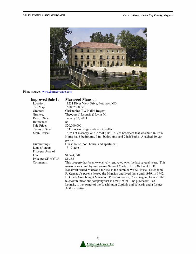
SALES COMPARISON APPROACH Carter’s Grove, James City County, Virginia
51
Photo source: www.barnesvanze.com
Improved Sale 1: Marwood Mansion Location: 11231 River View Drive, Potomac, MD Tax Map: 161002960050 Grantor: Christopher T & Nalini Rogers Grantee: Theodore J. Leonsis & Lynn M. Date of Sale: January 13, 2011 Reference: na Sale Price: $20,000,000 Terms of Sale: 1031 tax exchange and cash to seller Main House: 14,784 sf masonry w/ tile roof plus 3,717 sf basement that was built in 1926.
Home has 8 bedrooms, 9 full bathrooms, and 2 half baths. Attached 10-car garage.
Outbuildings: Guest house, pool house, and apartment Land (Acres): 13.12-acres Price per Acre of Land:
$1,524,390
Price per SF of GLA $1,353 Comments: This property has been extensively renovated over the last several years. This
mansion was built by millionaire Samuel Martin. In 1936, Franklin D. Roosevelt rented Marwood for use as the summer White House. Later John F. Kennedy`s parents leased the Mansion and lived there until 1939. In 1942, H. Grady Gore bought Marwood. Previous owner, Chris Rogers, founded the telecommunications company that is now Nextel. The purchaser, Ted Leonsis, is the owner of the Washington Capitals and Wizards and a former AOL executive.

SALES COMPARISON APPROACH Carter’s Grove, James City County, Virginia
52
Photo source: CAAR MLS
Improved Sale 2: Kinloch Location: 1205 Kinloch Farm, Keswick, Albemarle County, VA Tax Map: 65, Parcels 7, 7A and 8 Grantor: Robert or Janice C. Aron Grantee: Kinloch Properties, LLC Date of Sale: October 22, 2010 Reference: Deed Book 3946, Page 564 Sale Price: $14,500,000 Terms of Sale: Cash to Seller Main House: 7,400 sf frame construction with 3,045 sf basement space, built in 1740.
Home has 6 bedrooms, 5 full bathrooms, and 2 half baths. Outbuildings: There are three additional residences, carriage house, and 16 stall barn. Land (Acres): 514.424-acres Price per Acre of Land:
$28,187
Price per SF of GLA $1,450 Comments: An open space easement encumbers all of the property. The property has
good quality fencing and an internal road network. The dependencies are in good condition. This property was listed on the market for $18,000,000 and has been listed on the market since February 2008.
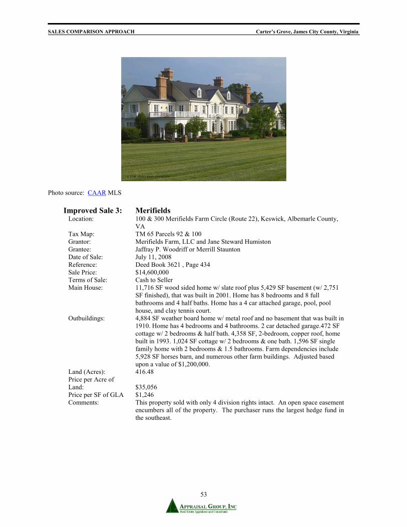
SALES COMPARISON APPROACH Carter’s Grove, James City County, Virginia
53
Photo source: CAAR MLS
Improved Sale 3: Merifields
Location: 100 & 300 Merifields Farm Circle (Route 22), Keswick, Albemarle County, VA
Tax Map: TM 65 Parcels 92 & 100 Grantor: Merifields Farm, LLC and Jane Steward Humiston Grantee: Jaffray P. Woodriff or Merrill Staunton Date of Sale: July 11, 2008 Reference: Deed Book 3621 , Page 434 Sale Price: $14,600,000 Terms of Sale: Cash to Seller Main House: 11,716 SF wood sided home w/ slate roof plus 5,429 SF basement (w/ 2,751
SF finished), that was built in 2001. Home has 8 bedrooms and 8 full bathrooms and 4 half baths. Home has a 4 car attached garage, pool, pool house, and clay tennis court.
Outbuildings: 4,884 SF weather board home w/ metal roof and no basement that was built in 1910. Home has 4 bedrooms and 4 bathrooms. 2 car detached garage.472 SF cottage w/ 2 bedrooms & half bath. 4,358 SF, 2-bedroom, copper roof, home built in 1993. 1,024 SF cottage w/ 2 bedrooms & one bath. 1,596 SF single family home with 2 bedrooms & 1.5 bathrooms. Farm dependencies include 5,928 SF horses barn, and numerous other farm buildings. Adjusted based upon a value of $1,200,000.
Land (Acres): 416.48 Price per Acre of Land:
$35,056
Price per SF of GLA $1,246 Comments: This property sold with only 4 division rights intact. An open space easement
encumbers all of the property. The purchaser runs the largest hedge fund in the southeast.

SALES COMPARISON APPROACH Carter’s Grove, James City County, Virginia
54
Photo source: Richmond MLS
Improved Sale 4: Evelynton
Location: 6701 John Tyler Memorial Highway, Charles City, Charles City County, Virginia 23030
Tax Map: 51-3 and 51-4 Grantor: Evelynton Associates, L.P. Grantee: John A and Jeanine S Hinson Recorded: April 23, 2008 Reference: 080000426 Sale Price: $5,100,000 Terms of Sale: Cash to seller Main House: Brick manor house built in 1925s. Includes 6,680 sf above grade. Has 4
bedrooms, 3.5 baths, and 4 fireplaces. The quality of construction is excellent and condition is good.
Outbuildings: Two tenant houses, boat house and garage. Land (Acres): 48.10 Price per Acre: $106,029 Verification: Public records, reliable third party Comments: An open space easement encumbers all of the property. The property is along
the historic James River Plantation tour.

SALES COMPARISON APPROACH Carter’s Grove, James City County, Virginia
55
Analysis of the Sales Data We selected recent sales of improved estate properties, with the majority encumbered by conservation easements to compare to the subject. Sales of similar type manor homes, with similar appeal have been selected. The volume of transactions has been low for historic properties as the subject, especially in the subject neighborhood, therefore sales from counties with similar amenities were chosen. Date of Sale: The selected sales occurred between 2008 and 2011. Location: The subject and comparables are considered to share similar location attributes and no adjustment is made to the sales. Property Rights: All improved sales transferred fee simple ownership, and no adjustments were made. All of the comparables, except sale 1, were encumbered by conservation easements at the time of sale. The value of the unencumbered property is adjusted in the land value. Land: The subject and the comparables have varying land sizes and the comparables are adjusted for differences in land sizes and differing prices per acre. Quality and Condition: The subject is an excellent quality residence in very good condition. All of the comparables are considered inferior in quality, but similar or superior in condition. Adjustments are made to each sale. Age: The subject was built in 1750 with various renovations and additions. The subject was last renovated in 1970’s. Experience tells us that chronological age is not a significant factor in the historic farm and estate market. The subject has an estimated effective age of 40 years. Gross Living Area: A factor of $250 per square foot of difference to adjust for the difference in gross living area of the main house. Basement Area: We use a factor of $15 per square foot to adjust for differences in basement area. Basement Finish: We used a factor of $25 per square foot to adjust for differences in basement finish. Functional Utility: Functional utility of the subject is good. All comparables were judged of similar utility and no adjustment was made in this category. Heating and Cooling: The subject is fully heated and cooled. All of the comparables have similar systems, and no adjustment was made in this category. Fireplaces: The subject has seventeen interior fireplaces. Adjustments were made at a rate of $6,500 per fireplace.

SALES COMPARISON APPROACH Carter’s Grove, James City County, Virginia
56
Garage: The subject has no garage space and the comparables are analyzed based on the difference in number of car garages and $10,000 per garage space. Historic Designation: The subject is one of only a few in the United States with such a vast historic significance in improvements and land. None of the comparable properties have such a designation. Properties as the subject are extremely rare, especially privately owned ones and market extraction is nearly non-existent. The Appraisal Journal has published several articles on historic properties indicating that adjustments can range up to 300%. We have not made an adjustment to the comparable sales. Although Sale 1 is most comparable to the subject’s historic designation, it is still far inferior in comparison. Secondary Structures: The subject has multiple ancillary structures. We evaluated the ancillary dwellings for each comparable sale and adjusted accordingly. Please see the adjustment grid on the following page for details.

SALES COMPARISON APPROACH Carters Grove, James City County, Virginia
57
Sales Comparison Analysis
ITEMLocationProximity to Subject 160 miles northwest 122 miles northest 122 miles northwest 38 miles westSale Price $20,000,000 $14,500,000 $14,600,000 $5,100,000Gross Living Area 18,709 14,784 7,400 11,716 6,680Price/SF Gross Living $1,353 $1,959 $1,246 $763Price/Acre $1,524,390 $28,187 $35,056 $106,029Verification Source MLS, Public Records, Broker MLS, Public Records, Broker MLS, Public Records MLS, Public Records
VALUE ADJUSTMENTS DESCRIPTION DESCRIPTION DESCRIPTION DESCRIPTION DESCRIPTION
0% 0% 0% 0%Typical 0% Typical 0% Typical 0% Typical 0%
Conditions of Sale Arms-Length 0% Arms-Length 0% Arms-Length 0% Arms-Length 0%0% 0% 0% 0%
$20,000,000 $14,500,000 $14,600,000 $5,100,000Montgomery MD $0 Albemarle $0 $0 $0
400.532 Acres 13.120 Acres ($2,554,680) 514.424 Acres ($3,711,040) 416.480 Acres ($2,241,880) 48.100 Acres $3,668,620Estate/Very Good Exceptional/Exceptional ($2,500,000) Excellent/Excellent $1,000,000 Excellent/Excellent $1,000,000 Good/Good $1,500,000
$0 1619/2000 1926/2000 10 $0 1740/1996 7 $0 2001/2001 7 $0 1937/1980's 17 $0Total Bdrms Baths Total Bdrms Baths Total Bdrms Baths Total Bdrms Baths Total Bdrms Baths
32 12 7.5 14 8 9.5.5 ($37,500) 12 6 5.5.5 $22,500 13 8 8.5.5.5.5 ($37,500) 8 4 3.5 $60,000$250 18,709 Sq.Ft. 14,784 Sq.Ft. $817,708 7,400 Sq.Ft. $2,497,404 11,716 Sq.Ft. $1,544,288 6,680 Sq.Ft. $2,155,196
$25 5,496 Sq.Ft. 3,717 Sq.Ft. $37,063 3,045 Sq.Ft. $54,126 5,429 Sq.Ft. $1,480 0 Sq.Ft. $98,470$15 0 Sq.Ft. 3,717 Sq.Ft. ($46,463) 2,726 Sq.Ft. ($36,120) 2,751 Sq.Ft. ($36,451) 0 Sq.Ft. $0
Good Similar $0 Similar $0 Similar $0 Similar $0Hot/Cold Chiller HVAC $0 Hot/Cold Chiller $25,000 HVAC $0 HVAC $25,000
6500 17 8 $58,500 4 $84,500 5 $78,000 4 $84,5000 Car 10 Car ($100,000) 1 Car ($10,000) 4 Car ($40,000) 0 Car $0Significant Good Limited Limited Limited
1756478 $506,478 $906,478 $556,478 $1,306,478($3,818,894) $832,849 $824,414 $8,898,264
Net: -19.09% $16,181,106 Net: 5.74% $15,332,849 Net: 5.65% $15,424,414 Net: 174.48% $13,998,264
3 Houses, carriage house, barns
Built/Renovation
4/23/2008
Charles City
2 Houses, barns, sheds
Gross Living AreaBasement
Quality / Condition
Historic Designation
COMPARABLE 4Evelynton
ADJUSTMENT
Fee Simple/Open Space Easement
4 Houses, Barns, Sheds
Above Grade
Adjusted Sale Price*Quality/Condition does not always equate with Marshall & Swift
Guest house, pool house, apartment
Basement Finish
Secondary Structures House, Stables, BunkerNet Adjustments
FireplacesGarage
Albemarle
Financing
Market Conditions/Date of Sale 5/13/2011
Land
Functional UtilityHeating/Cooling
Room Count
Property Rights Fee Simple/Open Space Easement Fee Simple Fee Simple/Open Space Easement
Adjusted Sale Price Location Williamsburg
ADJUSTMENT ADJUSTMENT ADJUSTMENT
10/22/2010
Fee Simple/Open Space Easement
7/11/20081/13/2011
Carters Grove Marwood Mansion Kinloch Merifields
SUBJECT COMPARABLE 1 COMPARABLE 2 COMPARABLE 3

SALES COMPARISON APPROACH Carter’s Grove, James City County, Virginia
58
Conclusion to Sales Comparison Approach The comparable sales indicate a narrow value range between $13,998,264 and $16,181,106, with a mean of $15,234,158. Each estate property is unique, with different degrees of manor house, dependencies, land and conservation easement. In this type of analysis, it is common to have substantial adjustments to account for the uniqueness of each property. Carter’s Grove is unique with the quality of manor house, history of the entire property and extensive river frontage along the James River. The subject is estimated to have a market value within the upper end of the range established by the comparable sales. Comparables 1 and 4 are historic properties. Sale 4 does not have a manor house such as the subject and is located in a somewhat inferior location. Comparables 1, 2 and 3 had excellent quality manor houses and are somewhat comparable to the subject. Our opinion of value for Historic Carter’s Grove via the Sales Comparison Method is estimated to be, as of May 13, 2011:
FIFTEEN MILLION DOLLARS . . . . . . $15,000,000 No personal property, fixtures, equipment, or intangibles are included in this value.

RECONCILIATION AND FINAL VALUE Carter’s Grove, James City County, Virginia
59
RECONCILIATION AND FINAL VALUE
PARCEL 1 – CARTERS GROVE The indications of the market value “as is’ of the fee simple estate in the subject property as of May 13, 2011 Cost Approach $15,400,000 Sales Comparison Approach $15,000,000 Income Capitalization Approach na The Cost Approach involves deriving the value of the land by comparing it with other properties in the general area. The depreciated estimate of replacement cost is derived and added to the value of the land. Less weight is placed on the Cost Approach due the availability of adequate sales in the Sales Comparison Approach. The value indicated by the Cost Approach supports the final value conclusion. The Sales Comparison Approach is a valid indication of value if there are a significant number of comparable improved sales. There were sufficient comparable sales to develop this approach; however, the volume of recent comparable transactions has been very low in the subject neighborhood and for historic estates as the subject. The sales are recent and shared somewhat similar characteristics, but the comparables required substantial adjustments in order to adjust for the subject’s uniqueness. Most weight is placed on the Sales Comparison Approach, while the Cost Approach supports the final value conclusion. The Income Approach provides a reliable indication of value particularly for leased properties. This approach relates the projected income stream to an estimate of value based on the investor's return requirements. Estate properties, such as the subject, are not generally bought, sold, or used for income production. In such cases, the Income Approach cannot be accurately developed, nor would it provide a reliable indication of value. The Income Approach has not been developed in this analysis. Based on the research and analysis, we conclude that the fee simple estate in the subject property, subject to the assumptions and limiting conditions stated in the report, had a market value “as is”, as of May 13, 2011, of:
FIFTEEN MILLION DOLLARS . . . . . . $15,000,000

RECONCILIATION AND FINAL VALUE Carter’s Grove, James City County, Virginia
60
Estimate of Exposure Time Reasonable exposure time is defined as the estimated length of time that a property would have to have been offered on the market prior to the hypothetical sale at the estimated market value on the effective date of the appraisal. Based on the exposure periods for comparable properties in the area that have sold in recent years, as well as current market conditions, a reasonable exposure time of six to twelve months is estimated for the subject. Estimate of Marketing Time Marketing time is defined as the estimated length of time that it would take to sell a property at its market value occurring immediately after the effective date of the appraisal. A marketing time of six to twelve months is estimated for the subject.

SITE DESCRIPTION Carter’s Grove, James City County, Virginia
61
PARCEL 2 – VACANT 76.104 ACRES

SITE DESCRIPTION Carter’s Grove, James City County, Virginia
62
SITE DESCRIPTION – PARCEL 2 – VACANT 76.104 ACRES
Source: http://property.jccegov.com/parcelviewer/Output/export_5d5e9bbf-9eaa-43f3-be6a-5b8239f30daf.pdf

SITE DESCRIPTION Carter’s Grove, James City County, Virginia
63
Legal Description of the Subject Property A legal description of the subject property can be found in instrument number 070034969 in the Clerk’s Office of James City County. Copies of this deed are located in the addendum. The parcel is identified by the Assessor’s Office as Parcel ID 5820100002. Ownership As of the effective date of this report, Carter’s Grove, LLC, owns the subject. Location The subject property is located along the southern margin of Route 60 (Pocahontas Trail), just east of Kingsmill Resort and Golf and approximately five miles east of historic Williamsburg. It has direct road frontage along Ron Springs Drive, Williamsburg, James City County, Virginia 23185-6025. Historic Williamsburg is the most popular tourist attraction in the Commonwealth of Virginia. Size, Shape, and Access The subject property's land consists of one tax parcel containing 76.104-acres. It is ring-shaped with a doughnut hole cut-out. The subject site surrounds the sanitary waste treatment plant for the county and is adjacent to Kingsmill development along the James River. The subject is accessed by one point along Ron Springs Drive. Water access is via the James River. The property has an internal road which was once utilized by visitors to and from Colonial Williamsburg. The size, shape, and access to the parcels are conducive to development for residential and agricultural purposes. Topography The subject site is generally rolling to sloping and there are limited areas of critical slope (excess of 25%). The site is mostly wooded. The property has water frontage along the James River and marsh land. The subject is at grade with its road frontages. The following map identifies the subject’s critical slope areas.
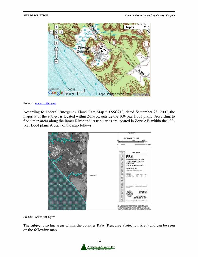
SITE DESCRIPTION Carter’s Grove, James City County, Virginia
64
Source: www.trails.com
According to Federal Emergency Flood Rate Map 51095C210, dated September 28, 2007, the majority of the subject is located within Zone X, outside the 100-year flood plain. According to flood map areas along the James River and its tributaries are located in Zone AE, within the 100-year flood plain. A copy of the map follows.
Source: www.fema.gov The subject also has areas within the counties RPA (Resource Protection Area) and can be seen on the following map.
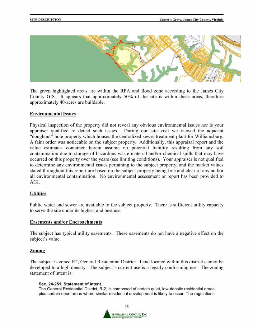
SITE DESCRIPTION Carter’s Grove, James City County, Virginia
65
The green highlighted areas are within the RPA and flood zone according to the James City County GIS. It appears that approximately 50% of the site is within these areas; therefore approximately 40-acres are buildable. Environmental Issues Physical inspection of the property did not reveal any obvious environmental issues nor is your appraiser qualified to detect such issues. During our site visit we viewed the adjacent “doughnut” hole property which houses the centralized sewer treatment plant for Williamsburg. A faint order was noticeable on the subject property. Additionally, this appraisal report and the value estimates contained herein assume no potential liability resulting from any soil contamination due to storage of hazardous waste material and/or chemical spills that may have occurred on this property over the years (see limiting conditions). Your appraiser is not qualified to determine any environmental issues pertaining to the subject property, and the market values stated throughout this report are based on the subject property being free and clear of any and/or all environmental contamination. No environmental assessment or report has been provided to AGI. Utilities Public water and sewer are available to the subject property. There is sufficient utility capacity to serve the site under its highest and best use. Easements and/or Encroachments The subject has typical utility easements. These easements do not have a negative effect on the subject’s value. Zoning The subject is zoned R2, General Residential District. Land located within this district cannot be developed to a high density. The subject’s current use is a legally conforming use. The zoning statement of intent is:
Sec. 24-251. Statement of intent. The General Residential District, R-2, is composed of certain quiet, low-density residential areas plus certain open areas where similar residential development is likely to occur. The regulations

SITE DESCRIPTION Carter’s Grove, James City County, Virginia
66
for this district are designed to stabilize and protect the essential characteristics of the district, to promote and encourage the clustering of residential developments to maximize shared and purposeful open space, to protect the natural environment and to promote a sense of community, to prohibit activities of a commercial nature and to implement the policies and designations of the Comprehensive Plan applicable to low-density residential areas. To these ends, development is limited to low-density residential and permitted uses are limited to dwellings designed to be occupied by one family or more than one family under certain conditions plus certain additional community-oriented uses that serve the residents of the district. (Ord. No. 31A-88, 20-50, 4-8-85; Ord. No. 31A-138, 2-18-92; Ord. No. 31A-196, 5-25-99) Sec. 24-252. Permitted uses. In the General Residential District, R-2, structures to be erected or land to be used, shall be for the following uses: Accessory apartments in accordance with section 24-32. Accessory buildings or structures as defined. Community recreation facilities, including parks, playgrounds, clubhouses, boating facilities, swimming pools, ball fields, tennis courts, and other similar recreation facilities. Four-family dwellings contained within a residential cluster development with a maximum gross density of one unit per acre in accordance with article VI, division 1 of this chapter. Home occupations, as defined. Off-street parking as required by section 24-53. Residential cluster development with a maximum gross density of one unit per acre in accordance with article VI, division 1 of this chapter. Retail shops associated with community recreation facilities. Single-family detached dwellings with a maximum gross density of one unit per acre in accordance with section 24-254(a). Sec. 24-252. Permitted uses. In the General Residential District, R-2, structures to be erected or land to be used, shall be for the following uses: Accessory apartments in accordance with section 24-32. Accessory buildings or structures as defined. Community recreation facilities, including parks, playgrounds, clubhouses, boating facilities, swimming pools, ball fields, tennis courts, and other similar recreation facilities. Four-family dwellings contained within a residential cluster development with a maximum gross density of one unit per acre in accordance with article VI, division 1 of this chapter. Home occupations, as defined. Off-street parking as required by section 24-53. Residential cluster development with a maximum gross density of one unit per acre in accordance with article VI, division 1 of this chapter. Retail shops associated with community recreation facilities. Single-family detached dwellings with a maximum gross density of one unit per acre in accordance with section 24-254(a). Three-family dwellings contained within a residential cluster development with a maximum gross density of one unit per acre in accordance with article VI, division 1 of this chapter. Timbering in accordance with section 24-43. Two-family dwellings contained within a residential cluster development with a maximum gross density of one unit per acre in accordance with article VI, division 1 of this chapter. Water impoundments, new or expansion of, less than 50 acres and with dam heights of less than 25 feet. Wireless communications facilities that utilize alternative mounting structures, or are building mounted, or are camouflaged, and comply with division 6, Wireless Communications Facilities.
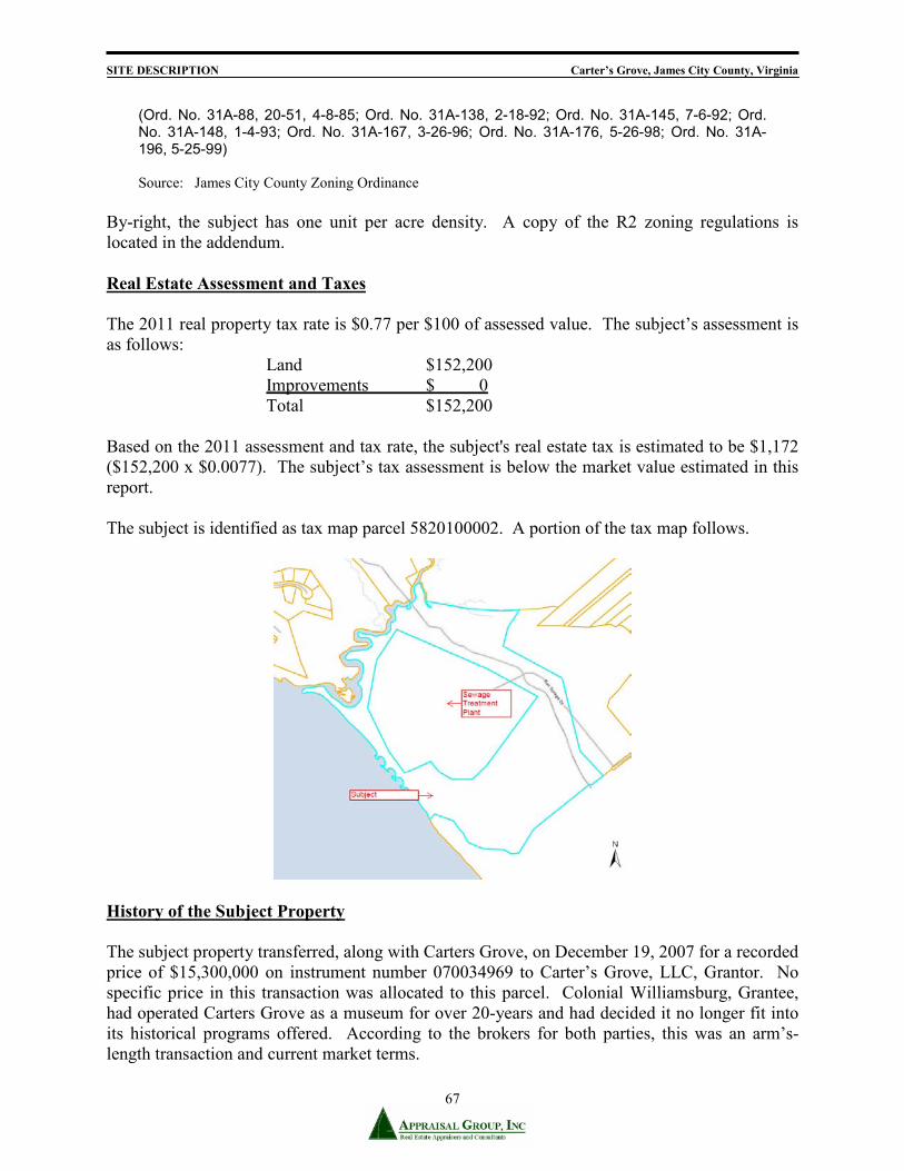
SITE DESCRIPTION Carter’s Grove, James City County, Virginia
67
(Ord. No. 31A-88, 20-51, 4-8-85; Ord. No. 31A-138, 2-18-92; Ord. No. 31A-145, 7-6-92; Ord. No. 31A-148, 1-4-93; Ord. No. 31A-167, 3-26-96; Ord. No. 31A-176, 5-26-98; Ord. No. 31A-196, 5-25-99) Source: James City County Zoning Ordinance
By-right, the subject has one unit per acre density. A copy of the R2 zoning regulations is located in the addendum. Real Estate Assessment and Taxes The 2011 real property tax rate is $0.77 per $100 of assessed value. The subject’s assessment is as follows: Land $152,200 Improvements $ 0 Total $152,200 Based on the 2011 assessment and tax rate, the subject's real estate tax is estimated to be $1,172 ($152,200 x $0.0077). The subject’s tax assessment is below the market value estimated in this report. The subject is identified as tax map parcel 5820100002. A portion of the tax map follows.
History of the Subject Property The subject property transferred, along with Carters Grove, on December 19, 2007 for a recorded price of $15,300,000 on instrument number 070034969 to Carter’s Grove, LLC, Grantor. No specific price in this transaction was allocated to this parcel. Colonial Williamsburg, Grantee, had operated Carters Grove as a museum for over 20-years and had decided it no longer fit into its historical programs offered. According to the brokers for both parties, this was an arm’s-length transaction and current market terms.

HIGHEST AND BEST USE Carter’s Grove, James City County, Virginia
68
ANALYSIS OF HIGHEST AND BEST USE In order to estimate market value, it is first necessary to identify the most profitable, competitive use to which the property can be put. This concept, which is market driven, is known as highest and best use and is defined as:
"The reasonably probable and legal use of vacant land or an improved property, which is physically possible, appropriately supported, financially feasible, and which results in highest value."
Source: Appraisal Institute, The Dictionary of Real Estate Appraisal, 5th ed. (Chicago: Appraisal Institute, 2010). In analyzing the subject property's highest and best use four tests are considered: - physically possible - legally permissible - financially feasible - maximally productive
Highest and Best Use as Though Vacant Highest and best use of the land as though vacant assumes that a parcel of land is vacant and available to be developed to its highest economic use, considered in relation to its existing use and all potential uses. This use is the basis of the land valuation. Physically Possible The subject property land consists of 76.104 acres and the subject’s neighborhood is improved with numerous historic sites. The parcel is ring-shaped. The subject is accessed by one point along Ron Springs Drive. Water access is via the James River. The property has an internal road through the property which was once utilized as a tourist road between Colonial Williamsburg and Carters Grove. The subject site is generally rolling and there are areas of critical slope (excess of 25%). The site is mostly wooded. The subject offers excellent views of the James River with direct frontage. Public utilities are available to the subject property, which is typical within the subject neighborhood. There is sufficient utility capacity to serve the site under its highest and best use. The subject’s size, shape, and available utilities would allow low-density residential or commercial uses. During inspection of the site, no obvious environmental problems were noted (see limiting conditions). Portions of the subject along the river are located within the 100-year flood plain and within the RPA. The subject's size, shape, and width allow for uses permitted by its zoning and other restrictions; however the shape and flood/RPA areas diminish the buildable area by up to 50%.

HIGHEST AND BEST USE Carter’s Grove, James City County, Virginia
69
Legally Permissible Legally permissible uses include those permitted by deed restrictions and zoning. A title search is not part of the appraisal process, as stated in the limiting conditions. Under the requirements of the R2 – General Residential zoning the subject could be improved with low-density residential uses that conform to the present zoning regulations. Given the physical limitations and the subject’s location, the most likely development would be a cluster development or estate property. A copy of the relevant zoning ordinance is in the addenda of the report. Financially Feasible Financially feasible uses, according to the thirteenth edition of The Appraisal of Real Estate, include those that meet the first two tests and are projected to produce a positive return, after satisfying operating expenses, financial obligations, and capital amortization. The most likely use for the subject, given its location, physical characteristics, and legally permissible use, is for a small cluster development (i.e. possibly three buildings with 12 condominiums each) or estate property. Agricultural uses would not be profitable considering the subject’s land value. No other uses are nearly as productive as a small cluster development or estate. Other than agricultural and low-density residential uses, there are no other known uses that are legally permissible. The specific type of development that maximizes the site potential is the next step in determining the subject's highest and best use as vacant. Maximally Productive The maximally productive use is the use that meets the previous three tests and provides a satisfactory return to the investor. Usually the most decisive factor influencing the highest and best use is the market demand for a particular use. Demand for residential properties in the subject neighborhood is considered good, as evidenced by the market’s desire for the neighborhood and prices for residential land (i.e. Kingsmill Condominium units along the river). As vacant, the highest and best use of the subject site would be for residential uses that comply with the applicable zoning. Adjacent uses are mostly high-end low-density residential properties. The subject’s maximally productive use, as if vacant, is for a small cluster development or estate. Conclusion The subject site has been analyzed to determine its highest and best use as vacant. The demand for residential land in the subject neighborhood is considered good, and the highest and best use for the subject property is for a small cluster development or estate type property, which is consistent with uses in the subject neighborhood and legally allowable uses.

VALUATION SECTION Carter’s Grove, James City County, Virginia
70
VALUATION SECTION
Three distinct methods of estimating value for a property are traditionally used in the appraisal process; however, all three approaches are not applicable in every case:
The Cost Approach The Sales Comparison Approach
The Income Capitalization Approach The Cost Approach is the method in which the value of a property is derived by estimating the replacement cost of the improvements, including a provision for entrepreneurial incentive, deducting there from the estimated depreciation from all sources, and then adding the market value of the land. The valuation of vacant land is typically undertaken by direct sales comparison. This approach is based on the assumption that an informed purchaser would pay no more than the cost of producing a substitute property with the same utility as the subject. The Sales Comparison Approach involves the comparison of the subject property with similar properties which were recently sold to find evidence of the subject's value. This approach is most reliable when determinable similarities exist between the subject property and the comparable sales. When great variances between the subject property and the comparable sales exist, greater adjustments are required which tend to diminish the reliability of this approach. Comparisons using both physical and economic units of measure are reliable applications of the Sales Comparison Approach. The Income Capitalization Approach is the method whereby the value of the subject property is based upon the present value of its projected income stream. In accordance with the principle of anticipation, the income approach converts the anticipated benefits to be derived from ownership of a property into an estimate of value. This is the approach of the investor who considers the income stream which the property is capable of producing, as well as the potential for capital gain over a holding period. In essence, all approaches to value utilize sales comparison methods, particularly when the purpose of the appraisal is to estimate the property's market value. In applying each valuation approach, the highest and best use of the subject site in relation to its neighborhood and current economic conditions has been considered.

SITE DESCRIPTION Carter’s Grove, James City County, Virginia
71
LAND VALUATION The valuation of vacant land is typically undertaken by direct sales comparisons (Sales Comparison Approach). The application of this approach produces a value estimate for land by comparing it with similar properties that have recently sold in the same or competitive neighborhoods. The sale price of these properties tends to set the range of value in which the subject property will fall when reduced to an appropriate unit of comparison (i.e., price per acre). Refinement of this data, by the comparative process, should lead to a logical estimate of value as of the date of appraisal. The reliability of this technique is dependent upon: (1) the degree of comparability of each sale to the subject, (2) market conditions at the time of sale, (3) verification of pertinent data, and (4) the absence of unusual conditions that influence the sale.
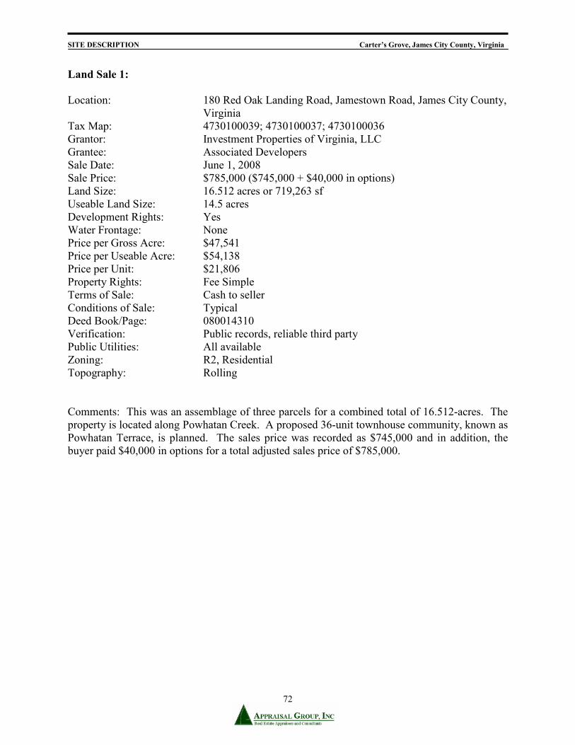
SITE DESCRIPTION Carter’s Grove, James City County, Virginia
72
Land Sale 1: Location: 180 Red Oak Landing Road, Jamestown Road, James City County,
Virginia Tax Map: 4730100039; 4730100037; 4730100036 Grantor: Investment Properties of Virginia, LLC Grantee: Associated Developers Sale Date: June 1, 2008 Sale Price: $785,000 ($745,000 + $40,000 in options) Land Size: 16.512 acres or 719,263 sf Useable Land Size: 14.5 acres Development Rights: Yes Water Frontage: None Price per Gross Acre: $47,541 Price per Useable Acre: $54,138 Price per Unit: $21,806 Property Rights: Fee Simple Terms of Sale: Cash to seller Conditions of Sale: Typical Deed Book/Page: 080014310 Verification: Public records, reliable third party Public Utilities: All available Zoning: R2, Residential Topography: Rolling Comments: This was an assemblage of three parcels for a combined total of 16.512-acres. The property is located along Powhatan Creek. A proposed 36-unit townhouse community, known as Powhatan Terrace, is planned. The sales price was recorded as $745,000 and in addition, the buyer paid $40,000 in options for a total adjusted sales price of $785,000.

SITE DESCRIPTION Carter’s Grove, James City County, Virginia
73
Land Sale 2: Location: 2601 Little Creek Dam Road, James City County, Virginia Tax Map: 2140100046 Grantor: Douglas L. Hornsby Trust Grantee: Shepherds Landing Partnership Sale Date: January 2008 Sale Price: $1,414,500 Land Size: 205 acres or 8,929,800 sf Useable Land Size: 115 acres or 5,009,400 sf Development Rights: Limited Water Frontage: Yarmouth Creek Price per Gross Acre: $6,900 Price per Useable Acre: $12,300 Property Rights: Fee Simple Terms of Sale: Cash to seller Conditions of Sale: Typical Deed Book/Page: 070024542 Verification: Public records, reliable third party Public Utilities: All available Zoning: A-1, Agricultural Topography: Rolling/Wooded with slopes towards creek Comments: This is a transfer of a large tract of land with approximately 1.3 miles of frontage along Yarmouth Creek. Reportedly acquired as part of an assemblage for a future subdivision, but “as is” there is limited development/subdivision potential. Approximately 90-acres are in the Resource Protection Area (RPA). Useable land is based on county GIS mapping. Comprehensive Plan indicates that the future use is rural land. Heavily wooded site.

SITE DESCRIPTION Carter’s Grove, James City County, Virginia
74
Land Sale 3: Location: 3889 News Road, James City County, Virginia Tax Map: 3730100004 Grantor: SWR-Hockday, LLC & McMurran Grantee: REALTEC, Inc. Ford’s Colony Sale Date: August 2007 Sale Price: $6,000,000 Land Size: 180.790 acres or 7,875,212 sf Useable Land Size: 100 acres or 4,356,000 sf Development Rights: Limited Water Frontage: None Price per Gross Acre: $33,188 Price per Useable Acre: $60,000 Property Rights: Fee Simple Terms of Sale: Cash to seller Conditions of Sale: Typical Deed Book/Page: 070024542 Verification: Public records, reliable third party Public Utilities: All available Zoning: R8, Rural Residential Topography: Rolling Comments: This is a transfer of a site to be developed with a continuing care retirement community. At the time of transfer the site was zoned R-8, Rural Residential. The Grantee is in the process of rezoning the property to R-4, Residential Planned Community, with proffers. It is reported that the original number of units has been scaled back by Realtec, Inc. from 944 to 739. Unit mix will include independent living units, townhouses, assisted living units and skilled care beds. The property has creek frontage.

SITE DESCRIPTION Carter’s Grove, James City County, Virginia
75
Sales Data via Price per Acre
The comparable sales presented are analyzed and adjusted by comparing each to the subject property. Physical characteristics used for comparison include location, topography, zoning, public utilities, subdivision potential, and size. Timing and market conditions were also considered. The volume of comparable land sales has been very low and therefore recent comparable land sales in the subject neighborhood without river access are also applied. The sales examined occurred between 2007 and 2008.
Sale # Subject 1 2 3Sale Price $785,000 $1,414,500 $6,000,000 Price/Acre $54,138 $12,300 $60,000Property Rights Fee Simple Fee Simple Fee Simple Fee SimpleFinancing Cash Cash CashConditions of Sale Typical Typical TypicalMarket Conditions 5/13/2011 6/1/2008 1/1/2008 8/1/2007Adjustments -15.0% -20.0% -20.0%Adjusted Price/Acre $54,138 $12,300 $57,000
Location James City County James City County James City County James City County
Comparison Superior Superior SuperiorAdjustment -35.0% -35.0% -35.0%
Topography Rolling/Open/Wooded Rolling/Wooded Rolling/Wooded Rolling/WoodedComparison Superior Similar SuperiorAdjustment -25.0% 0.0% -25.0%
Water Feature James River Powhatan Creek Yarmouth Creek Powhatan CreekComparison Inferior Inferior InferiorAdjustment 10.0% 10.0% 20.0%
Zoning R2 R2 A-1, Agricultural R8Comparison Similar Inferior SuperiorAdjustment 0.0% 20.0% -40.0%
Available Utilities All All All AllComparison Similar Similar SimilarAdjustment 0.0% 0.0% 0.0%
Useable Land Size (Acreage) 40.000 14.50 115.00 100.00Comparison Smaller Larger LargerAdjustment -12.8% 37.5% 30.0%
Adjusted Price/Acreage $20,166 $16,298 $28,500
LAND SALE COMPARISON GRIDVacant 76.104-Acres off Ron Springs Drive, James City County, VA - AS IS
* "Quality/Appeal" will not always coincide with the Marshall Valuation Service cost guidelines. Property Rights Conveyed No adjustments were required, as all of the transactions involved fee simple interests. Financing The comparable sales were cash to seller or cash equivalent transactions.
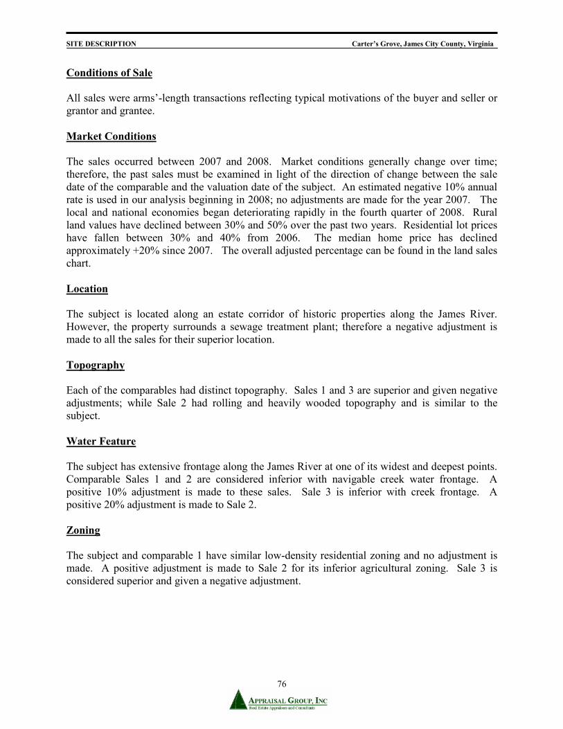
SITE DESCRIPTION Carter’s Grove, James City County, Virginia
76
Conditions of Sale All sales were arms’-length transactions reflecting typical motivations of the buyer and seller or grantor and grantee. Market Conditions The sales occurred between 2007 and 2008. Market conditions generally change over time; therefore, the past sales must be examined in light of the direction of change between the sale date of the comparable and the valuation date of the subject. An estimated negative 10% annual rate is used in our analysis beginning in 2008; no adjustments are made for the year 2007. The local and national economies began deteriorating rapidly in the fourth quarter of 2008. Rural land values have declined between 30% and 50% over the past two years. Residential lot prices have fallen between 30% and 40% from 2006. The median home price has declined approximately +20% since 2007. The overall adjusted percentage can be found in the land sales chart. Location The subject is located along an estate corridor of historic properties along the James River. However, the property surrounds a sewage treatment plant; therefore a negative adjustment is made to all the sales for their superior location. Topography Each of the comparables had distinct topography. Sales 1 and 3 are superior and given negative adjustments; while Sale 2 had rolling and heavily wooded topography and is similar to the subject. Water Feature The subject has extensive frontage along the James River at one of its widest and deepest points. Comparable Sales 1 and 2 are considered inferior with navigable creek water frontage. A positive 10% adjustment is made to these sales. Sale 3 is inferior with creek frontage. A positive 20% adjustment is made to Sale 2. Zoning The subject and comparable 1 have similar low-density residential zoning and no adjustment is made. A positive adjustment is made to Sale 2 for its inferior agricultural zoning. Sale 3 is considered superior and given a negative adjustment.
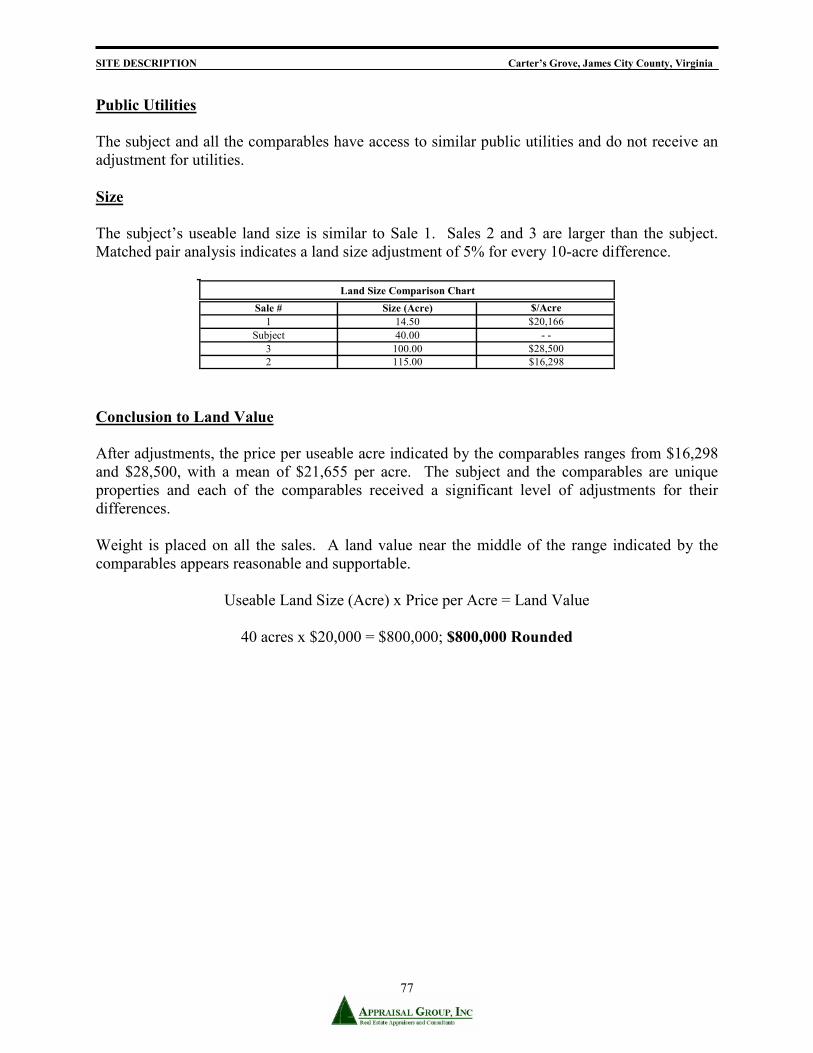
SITE DESCRIPTION Carter’s Grove, James City County, Virginia
77
Public Utilities The subject and all the comparables have access to similar public utilities and do not receive an adjustment for utilities. Size The subject’s useable land size is similar to Sale 1. Sales 2 and 3 are larger than the subject. Matched pair analysis indicates a land size adjustment of 5% for every 10-acre difference.
Sale # Size (Acre) $/Acre1 14.50 $20,166
Subject 40.00 - - 3 100.00 $28,5002 115.00 $16,298
Land Size Comparison Chart
Conclusion to Land Value
After adjustments, the price per useable acre indicated by the comparables ranges from $16,298 and $28,500, with a mean of $21,655 per acre. The subject and the comparables are unique properties and each of the comparables received a significant level of adjustments for their differences. Weight is placed on all the sales. A land value near the middle of the range indicated by the comparables appears reasonable and supportable.
Useable Land Size (Acre) x Price per Acre = Land Value
40 acres x $20,000 = $800,000; $800,000 Rounded

RECONCILIATION AND FINAL VALUE Carter’s Grove, James City County, Virginia
78
RECONCILIATION AND FINAL VALUE
PARCEL 2 – VACANT 76.104 ACRES The three indications of the market value “as is’ of the fee simple estate in the subject property as of May 13, 2011: Cost Approach na Sales Comparison Approach $800,000 Income Capitalization Approach na The subject is vacant land therefore the cost and income approaches are irrelevant. The sales comparison approach is applied to the land sales. Based on the research and analysis, we conclude that the fee simple estate in the subject property, subject to the assumptions and limiting conditions stated in the report, had a market value “as is”, as of May 13, 2011, of:
EIGHT HUNDRED THOUSAND DOLLARS . . . . . . $800,000