cascadia subduction - oregon · during a cascadia subduction zone event, an earthquake and tsunami...
TRANSCRIPT

Preparing for a Cascadia Subduction Zone Tsunami: A Land Use Guide for Oregon Coastal Communities
Prepared byThe Department of Land Conservation and Development
January 2014

January 2014 | Preparing for a Cascadia Subduction Zone Tsunami: A Land Use Guide for Oregon Coastal Communities
AcknowledgementsTechnical Advisory CommitteeMark Barnes, City of Cannon BeachRainmar Bartl, City of Cannon BeachLaura Barron, City of Coos BayJosh Bruce, Oregon Partnership for Disaster ResiliencePatrick Corcoran, Oregon Sea GrantMatthew Crall, Department of Land Conservation and DevelopmentKevin Cupples, City of SeasideJim Hossley, City of Coos BayLarry Lewis, Cities of Yachats, Waldport, and Depoe BaySteve Lucker, Department of Land Conservation and DevelopmentDebra Martzahn, Lincoln CityMarion Lahav, Department of Land Conservation and DevelopmentLisa Peffer, Department of Land Conservation and DevelopmentDave Perry, Department of Land Conservation and DevelopmentGeorge Priest, Department of Geology and Mineral IndustriesJill Rolfe, Coos CountyAlthea Rizzo, Office of Emergency ManagementChristine Shirley, Department of Land Conservation and DevelopmentPatty Snow, Department of Land Conservation and DevelopmentJerald Taylor, City of ManzanitaJeff Weber, Department of Land Conservation and DevelopmentPatrick Wingard, Department of Land Conservation and Development
Oregon Coastal Management Program Project ManagementLaren Woolley, Coastal Shorelands Specialist – Oregon Coastal Management Program Matt Spangler, Senior Coastal Policy Analyst – Oregon Coastal Management Program
Cogan Owens Cogan, LLCKirstin Greene, AICP, Managing PrincipalRobert Wise, Associate PrincipalSteve Faust, Senior PlannerEllen Wyoming, AssociateLaura Goodrich, Graduate Research AssociateNancy Marshall, Graphic DesignerAdvisors Dr. Harry Yeh and Sarah Henly-Shepard
FundingFinancial assistance provided by the Coastal Zone Management Act of 1972, as amended, administered by the Office of Ocean and Coastal Resource Management, National Oceanic and Atmospheric Administration.
Important NoticeThe Land Use Guide provides coastal communities examples of comprehensive plan language and development code provisions that can serve to help communities reduce their risk to tsunami hazards. These examples are intended to provide general guidance allowing communities to tailor land use policies and regulations appropriate to their individual circumstances. In developing the Guide, every effort has been made to provide examples which conform to Oregon land use law. However, as always when developing land use regulations or other related legislation for local adoption, local governments should consult with their legal counsel to ensure that such regulations comply with applicable state and local requirements.
Cover imaged modified from original art not in copyright done by Hokusai.

Prepared by the Oregon Department of Land Conservation and Development | January 2014
Table of Contents
Chapter 1: Introduction...................................................................................................................................... 1
Chapter 2: How to Use the Tsunami Land Use Guide .............................................................................. 9
Chapter 3: Comprehensive Plan Provisions ..............................................................................................17
Chapter 4: Development Code Provisions ................................................................................................27
Chapter 5: Tsunami Financing and Incentive Concepts .......................................................................39
Chapter 6: Tsunami Evacuation Planning Guidance ..............................................................................49
Chapter 7: Long Range Community Land Use Planning for Cascadia Event Tsunami ..............59
Chapter 8: Other Resources ............................................................................................................................65

January 2014 | Preparing for a Cascadia Subduction Zone Tsunami: A Land Use Guide for Oregon Coastal Communities
THIS PAGE INTENTIONALLY BLANK

1Prepared by the Oregon Department of Land Conservation and Development | January 2014
CHAPTER 1: Introduction

2 January 2014 | Preparing for a Cascadia Subduction Zone Tsunami: A Land Use Guide for Oregon Coastal Communities
3Prepared by the Oregon Department of Land Conservation and Development | January 2014
Chapter 1: Introduction The Oregon coast is well known for its spectacular scenery and natural resources. However, because the coast lies at the interface between land and the Pacific Ocean, it also is a zone of great instability and vulnerability. Over time, we are gaining a greater awareness of our coast’s geologic hazards and its risks to people and property there.
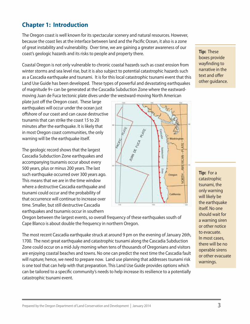
Coastal Oregon is not only vulnerable to chronic coastal hazards such as coast erosion from winter storms and sea level rise, but it is also subject to potential catastrophic hazards such as a Cascadia earthquake and tsunami. It is for this local catastrophic tsunami event that this Land Use Guide has been developed. These types of powerful and devastating earthquakes of magnitude 9+ can be generated at the Cascadia Subduction Zone where the eastward-moving Juan de Fuca tectonic plate dives under the westward-moving North American plate just off the Oregon coast. These large earthquakes will occur under the ocean just offshore of our coast and can cause destructive tsunamis that can strike the coast 15 to 20 minutes after the earthquake. It is likely that in most Oregon coast communities, the only warning will be the earthquake itself.
The geologic record shows that the largest Cascadia Subduction Zone earthquakes and accompanying tsunamis occur about every 500 years, plus or minus 200 years. The last such earthquake occurred over 300 years ago. This means that we are in the time window where a destructive Cascadia earthquake and tsunami could occur and the probability of that occurrence will continue to increase over time. Smaller, but still destructive Cascadia earthquakes and tsunamis occur in southern Oregon between the largest events, so overall frequency of these earthquakes south of Cape Blanco is about double the frequency in northern Oregon.
The most recent Cascadia earthquake struck at around 9 pm on the evening of January 26th, 1700. The next great earthquake and catastrophic tsunami along the Cascadia Subduction Zone could occur on a mid-July morning when tens of thousands of Oregonians and visitors are enjoying coastal beaches and towns. No one can predict the next time the Cascadia fault will rupture; hence, we need to prepare now. Land use planning that addresses tsunami risk is one tool that can help with that preparation. This Land Use Guide provides options which can be tailored to a specific community’s needs to help increase its resilience to a potentially catastrophic tsunami event.
Tip: These boxes provide wayfinding to narrative in the text and offer other guidance.
Tip: For a catastrophic tsunami, the only warning will likely be the earthquake itself. No one should wait for a warning siren or other notice to evacuate. In most cases, there will be no operable sirens or other evacuate warnings.

4 January 2014 | Preparing for a Cascadia Subduction Zone Tsunami: A Land Use Guide for Oregon Coastal Communities
Section 1.1 Scope of the Land Use GuideThe goal of this Land Use Guide is to help local coastal communities become more resilient to a catastrophic tsunami event through community land use options and strategies. The guide is focused on a local tsunami event as these events will likely be far more destructive to an entire community and much harder to prepare for. Generally, in preparing for a local event a community should also be well prepared for a distant event. The guide is focused on land use planning approaches to reduce tsunami hazard risk, and is not intended to address the full range of efforts needed for overall disaster preparedness. Adequately preparing for a catastrophic event, such as a Cascadia earthquake and tsunami, requires a comprehensive community effort and must include preparation in many areas including education, outreach, individuals and family, emergency services, evacuation, economic, and land use. This guide can be used to develop land use strategies and options as one part of a community’s comprehensive preparedness effort.
During a Cascadia Subduction Zone event, an earthquake and tsunami will occur in tandem. However, as noted, the primary focus of this guide is on the tsunami impacts of a Cascadia event, as land use options and strategies can be more directly applied to the locational hazards associated with tsunami. Although building code requirements address specific construction standards related to a seismic event, they do not include specific construction standards for tsunami. This Land Use Guide encourages building techniques and related land use options within tsunami inundation areas, to increase resilience to a tsunami.
The few tsunami land use overlay zones currently in existence are limited in scope, meeting the minimum requirements of ORS 455.446-7 as implemented through the building code. However, land use tsunami preparedness measures to be most effective should be coordinated with a community’s broader and more comprehensive hazard planning program efforts and be consistent with the community’s FEMA Natural Hazard Mitigation Plan. Comprehensive land use plan policies, development code provisions, financing and incentive concepts, and evacuation planning strategies set forth in this guide are focused on three main mitigation concepts: 1) helping people get out of harm’s way by improving evacuation planning and infrastructure; 2) reducing or restricting certain types of development in high risk areas; and 3) encouraging building techniques that would reduce building failure in a Cascadia earthquake and tsunami event.
Section 1.2 Benefits of the Land Use Guide Preparing a land use plan to increase resilience to a local tsunami event can lessen the impact of a tsunami in a way that not only decreases loss of life and property damage, but also increases the ability of the community to return to its pre-disaster function as quickly as possible. This resilience work should provide, at a minimum, the following benefits to your community:
z Improve life safety functions and protect life z Reduce social, emotional, and economic disruptions z Minimize damage to public and private buildings and infrastructure
Tip: Communities should consider their own strategies.

5Prepared by the Oregon Department of Land Conservation and Development | January 2014
z Decrease disruption to critical services z Increase access to funding sources for hazard mitigation projects z Improve ability to implement post-disaster recovery projects
The Tsunami Land Use Guide is intended to help local governments in their responsibility to address this potential catastrophic hazard and provide a user-friendly, flexible model code. Communities are encouraged to select the most applicable comprehensive plan policies, development code provisions and mitigation strategies based on the community’s geographic situation. This guide should also assist in developing land use strategies related to tsunami that have a solid nexus to increasing resilience, are transparent, and seek consensus among community residents in all phases.
Section 1.3 Lessons from the 2011 Japanese Tsunami EventThe 2011 Japan earthquake is not the largest, nor deadliest, earthquake and tsunami to strike this century; that distinction goes to the 2004 Sumatra tsunami with a magnitude 9 (Mw) earthquake, which killed more than 230,000 people. However, the 2011 Tohoku earthquake and tsunami is an event that all Oregonians need to pay attention to and learn from, especially those living along the coast. Scientists have indicated that the Tohoku Magnitude 9 (Mw) megathrust earthquake and tsunami are closely analogous to what can be expected any time now along the Oregon coast. This is a serious threat to our coast and we need to prepare now. There should be a sense of urgency. Preparation and context can be enhanced significantly not only by review of the impacts of this event in Japan but also by what the Japanese have done, and are doing, since to prepare for the next one. Scientists here have produced new tsunami inundation maps for Oregon that capture credibly the potential inundation areas along the Oregon coast. This information should be at the core of community preparation. Additionally, this land use guide will specifically address what communities should do, from an Oregon land use perspective, in creating more resilient communities.
Section 1.3.1 What HappenedOn March 11, 2011 at 2:46 local time, a magnitude 9 (Mw) earthquake violently shook northeastern Japan, unleashing a catastrophic tsunami. The earthquake struck offshore of Japan, along a subduction zone where two of Earth’s tectonic plates collide (the Pacific and the Honshu). The earthquake released centuries of built up stress between the two tectonic plates and the intense ground shaking lasted about six minutes. Japan has experienced over 1000 aftershocks since the initial earthquake; approximately 80 registering over magnitude 6 (Mw) and three over magnitude 7 (Mw).

6 January 2014 | Preparing for a Cascadia Subduction Zone Tsunami: A Land Use Guide for Oregon Coastal Communities
The first of many tsunami waves hit Japan’s coastline soon after the earthquake. The tsunami waves reached run-up heights (how far the wave surges inland above sea level) of up to 128 feet and surged inland great distances, especially up river channels and over low plains. Land subsidence along the northern Japan coast ranged from approximately 1.5 feet to approximately 4 feet. As a result, communities along this portion of Japan’s coastline are now more susceptible to flooding, even daily flooding during high tides, and significant coastal erosion as the ocean and land seek to find a new balance at a lower land elevation.
Nearly 20,000 people were killed in the disaster. Most died by drowning. The degree and extent of damage caused by the earthquake and resulting tsunami were enormous, with most of the damage being caused by the tsunami. Development within the most affected areas was nearly completely destroyed, leaving little more than piles of rubble, with few structures left standing. Two years after the quake, about 300,000 people who lost their homes were still living in temporary housing.
Section 1.3.2 What Should Oregon Coast Communities LearnMuch of the information and graphics presented here relating to Japan’s planning efforts have been provided by Jay Wilson, Hazard Mitigation Coordinator with Clackamas County Emergency Management. Jay has been instrumental in the development of the Oregon Resilience Plan and has visited Japan on multiple occasions to analyze the aftermath of this catastrophic event.
The Japan 2011 event is a close parallel to what the Oregon Coast will face in a Cascadia event, and impacts to the Oregon coast and its communities will be similarly devastating. Significant and prolonged ground shaking will occur which will damage and destroy
important transportation linkages, other critical services, and structures vulnerable to intense ground shaking, leaving coastal communities isolated and severely damaged. Development within tsunami inundation areas will be, for the most part, destroyed. Land subsidence will significantly increase coastal flooding and erosion.
As part of Japan’s recovery, communities and government entities are turning to land use planning options that will increase resilience to the next catastrophic event of this type.

7Prepared by the Oregon Department of Land Conservation and Development | January 2014
The Figure 1 graphic below represents Minamisanriku, a city which was destroyed by the tsunami as it was almost entirely within the inundation area. The community is using land use planning principles to re-create itself in a tsunami resilient way despite the necessity and challenges of its location. Although generalized, Figure 1 illustrates some key land use principles related to tsunami hazards being used in Minamisanriku. They are:
z Limit waterfront areas to water dependent uses that need to be adjacent to the ocean, and incorporate designs for structures that can better withstand tsunami forces.
z Develop other commercial and industrial uses in higher areas, which although still subject to larger tsunami events, are closer to high ground where good tsunami evacuation planning can be effective. Building design and construction practices which increase resilience to a tsunami event is also important in this area.
z Develop housing, tourism, and government facilities above tsunami inundation areas, designed and built to better withstand the severe ground shaking of a subduction zone earthquake event.
Figures 2 and 3 provide further spatial representations of how the concepts identified in Figure 1 would play out over time on the ground within Minamisanriku.
Clearly, there are a number of important differences between the circumstances of Japan’s post-event redevelopment and the current situation faced by communities on the Oregon coast. However, many of the concepts applied in this example can provide useful guidance to Oregon
communities for developing land use strategies to build increased resilience over time.
8 January 2014 | Preparing for a Cascadia Subduction Zone Tsunami: A Land Use Guide for Oregon Coastal Communities
Section 1.3.3 What Must Oregon Coast Communities DoAs indicated above, preparing for, and increasing resilience to, a catastrophic event such as a Cascadia earthquake and tsunami, requires a comprehensive community effort and must include preparation in many areas. Education and outreach, individual and family preparedness, along with planning for emergency services, evacuation, economic recovery, and land use are all critical components of community efforts to prepare. Preparation in communities along the Oregon coast is beginning to ramp up, especially since the Tohoku and Sumatra events. However, little has been done thus far to address land use planning within inundation areas.
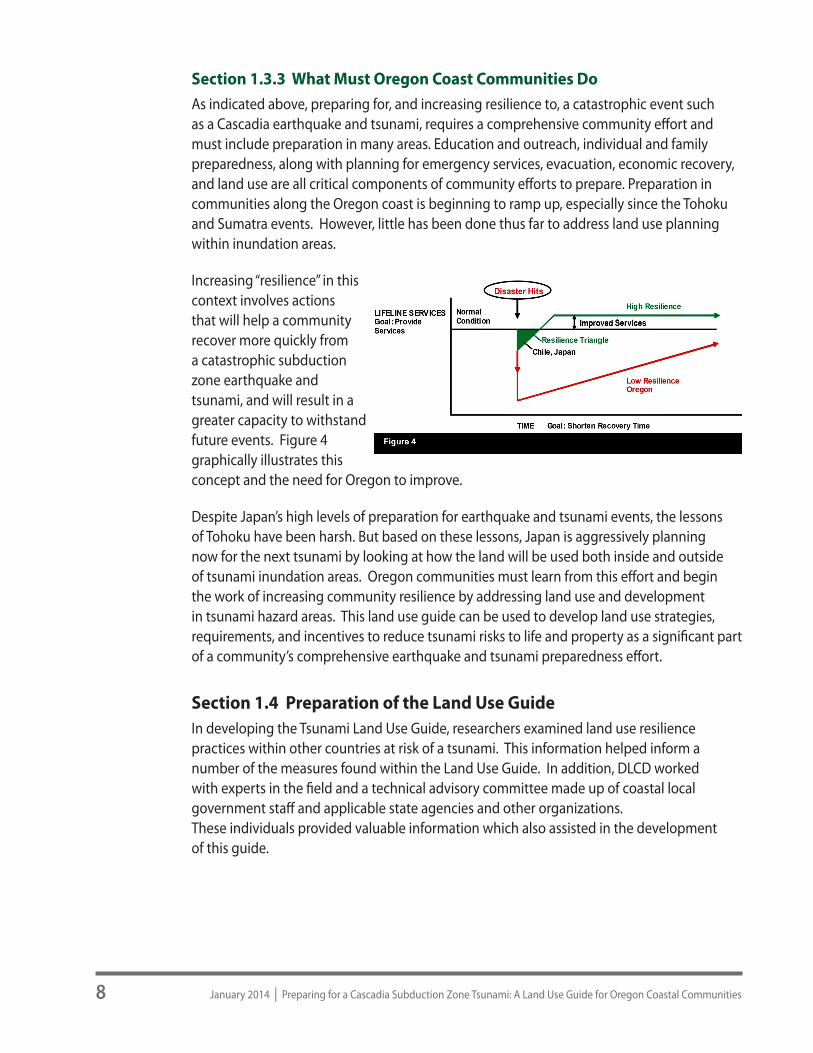
Increasing “resilience” in this context involves actions that will help a community recover more quickly from a catastrophic subduction zone earthquake and tsunami, and will result in a greater capacity to withstand future events. Figure 4 graphically illustrates this concept and the need for Oregon to improve.
Despite Japan’s high levels of preparation for earthquake and tsunami events, the lessons of Tohoku have been harsh. But based on these lessons, Japan is aggressively planning now for the next tsunami by looking at how the land will be used both inside and outside of tsunami inundation areas. Oregon communities must learn from this effort and begin the work of increasing community resilience by addressing land use and development in tsunami hazard areas. This land use guide can be used to develop land use strategies, requirements, and incentives to reduce tsunami risks to life and property as a significant part of a community’s comprehensive earthquake and tsunami preparedness effort.
Section 1.4 Preparation of the Land Use GuideIn developing the Tsunami Land Use Guide, researchers examined land use resilience practices within other countries at risk of a tsunami. This information helped inform a number of the measures found within the Land Use Guide. In addition, DLCD worked with experts in the field and a technical advisory committee made up of coastal local government staff and applicable state agencies and other organizations. These individuals provided valuable information which also assisted in the development of this guide.

9Prepared by the Oregon Department of Land Conservation and Development | January 2014
CHAPTER 2:How to Use the Tsunami Land Use Guide

10 January 2014 | Preparing for a Cascadia Subduction Zone Tsunami: A Land Use Guide for Oregon Coastal Communities

11Prepared by the Oregon Department of Land Conservation and Development | January 2014
Chapter 2: How to Use the Tsunami Land Use Guide This chapter provides assistance on how to get started and use the Guide. The “Getting Started” section concentrates on preparatory work, such as gathering pertinent information, developing a public process and forming an advisory committee. The “Initial Groundwork” section outlines steps for staff, advisory committees and the community to study the issue and make informed decisions about appropriate tsunami preparedness. The “Using This Guide” section describes how you can use this Guide to develop the various elements of a tsunami land use resiliency program. The remaining sections describe how to prepare resiliency program elements, including land use amendments to increase resilience to a local tsunami event.
Section 2.1 Getting Started Before using this Land Use Guide, community staff and citizen volunteers should have a good understanding of the community’s land use and development program and the specific tsunami risk for the area.
Land Use Guide authors recommend local government staff and administrators take the following steps in preparing this land use portion of a community’s overall program to address a local tsunami event:
Note: A DOGAMI advisory committee has recommended the adoption of the “Large” (L1) scenario for application of the ORS 455 development restrictions. This recommendation will be formally considered by the DOGAMI Governing Board following a series of meetings on the coast in early 2014 to solicit public comment.
z DOGAMI Tsunami Inundation Maps (TIMs): Staff should obtain and review the community’s TIMs to generally determine areas and key facilities at risk of tsunami inundation.
z Initial Risk/Exposure Evaluation: In reviewing the TIMs, staff should begin to evaluate relative risk and exposure in the community based on the various inundation scenarios and location of key community facilities in order to lead future community discussions on risk tolerance and what tools might be proposed in each of the inundation scenarios.
z Interview community members: Talk with citizens, all applicable city or county staff, hazard professionals, representatives for related technical fields, property owners, staff from hazard related agencies, and service providers. These individuals can provide important input and help in clarifying key issues related to potential tsunami impacts and preparation.
z Appoint an advisory committee: Appointed by the city council or county commission, the committee should include some of the stakeholders interviewed and representatives from the planning commission and at least one elected official. Ideally, the committee should include a mix of public and private sector stakeholders with demonstrated leadership abilities.
Tip: Step One: review the updated Tsunami Inundation Maps (TIMs) with others in your community.

12 January 2014 | Preparing for a Cascadia Subduction Zone Tsunami: A Land Use Guide for Oregon Coastal Communities
The business community should be well represented. The committee of approximately 8-15 members can effectively assist elected and appointed officials by:
z Ensuring that the proposed plan provisions and code language address important community goals related to increasing resilience to a local tsunami and include perspectives from a representative cross-section of the community;
z Reviewing and commenting on preliminary drafts of the new comprehensive plan and code provisions, and other related materials; and
z Supporting public involvement and education efforts during the code adoption and implementation process.
Note: Advisory committees are typically subject to public meeting laws.
Section 2.2 Initial GroundworkOnce the community has taken the steps in Section 2.1 to get started it is time to set the initial groundwork for this effort by working with the advisory committee on the following:
z Identify Resilience Land Use Goals and Objectives: “Goals” describe the desired outcomes or guiding principles of your effort and help to define what may be needed to achieve these goals. It is important to try to reach consensus, if possible, with the advisory committee on a few guiding goals and objectives that will help evaluate and inform proposed strategies and options.
Note: Staff should develop some draft goals and objectives to begin the discussion with the advisory committee. These do not have to be exhaustive but should provide initial guidance to the advisory committee in developing and understanding their purpose and role in this effort. Some examples of goals could be: to assist community members become more aware of risks in the community from a local tsunami event; to use this land use guide in developing strategies and options to increase resilience to a local tsunami event; and to adopt comprehensive plan and development code provisions to increase resilience to this potentially catastrophic event. Some example objectives could be to identify high risk areas within the community based on DOGAMI Inundation Maps (TIMs); to identify vulnerable uses, structures, and populations within these risk areas; to develop an evacuation route plan to adequately provide for evacuation to high ground; to develop land use incentives an limitations for encouraging migration of vulnerable uses to higher ground and limiting future uses in highest risk areas; and to adopt specific comprehensive plan policies and implementing measures related to various focus areas identified in the guide.
z Discuss with the advisory committee the community’s existing comprehensive plan and codes related to tsunami preparedness. After talking with stakeholders and identifying community risk to a local tsunami, compare the community’s existing tsunami regulations, if any, with the provisions in this Land Use Guide. As part of this process: 1)
Tip: TIMs and tsunami evacuation maps should be reviewed along with other resources, such as maps that display zoning designations and building locations and concentrations of population.

13Prepared by the Oregon Department of Land Conservation and Development | January 2014
review this Land Use Guide, 2) compare options and model language in the Guide with your existing comprehensive plan and development codes. It is likely that there will be few or no related land use provisions present within the existing plan and codes related to tsunami. Regardless of the condition of the community’s existing tsunami provisions this land use guide will help in developing resilience to this potentially catastrophic local tsunami event.
z Identify areas in the community’s land use documents which may need revision as a result of this process.
z Advisory Committee Work: z Review initial findings with the committee; discuss z Provide informational materials and training as needed, such as:
z DOGAMI Tsunami Inundation Maps (TIMs) for the Community z Oregon Resilience Plan for Cascadia event earthquake and tsunami (OSSPAC)
DOGAMI Clearinghouse Website z Tsunami Evacuation Route Planning: Chapter 6 z References for materials listed above, and other materials which may be needed, are
located in Chapter 8 “Other Resources” Chapter this Land Use Guide) z Tsunami Section of State and Local Natural Hazard Mitigation Plans z Applicable portion of the DLCD Hazard Planning Technical resource Guide
z Review tsunami inundation and evacuation maps with the committee and get initial feedback on location of key facilities, vulnerable uses and potential evacuation areas. This will assist staff in more detailed work later on.
z In consultation with committee members, develop an overall work program and tentative timeline for the effort. Explore some the big questions that your community will need to address in considering land use provisions relating to increasing resilience to a local tsunami event. While different for each community, they will likely include discussions about most at-risk areas of the community, what key facilities may need to be relocated, and status of evacuation routes and their current status.
z Develop an agenda and materials for community forum on this effort. As part of this effort, and with feedback from the advisory committee as needed, use this land use guide to identify as many options as possible to present to the community and gain their feedback.
z Community Meetings: As with any change in local land use regulations, Oregon law appropriately provides for minimum levels of community discussion and public involvement. Addressing this significant natural hazard should be accomplished through a robust public involvement effort. This effort could be included within a broader community discussion of what community members envision a resilient community to look like. Oregonians expect to be involved in land use planning and especially should be engaged in discussions around land use options related to tsunami resilience. Community staff and the advisory committee should engage community partners, leaders and service providers to maximize community awareness and dialog. It will be important to provide broad and varied opportunities for education and outreach and to explore with the community its options.
Tip: Initial discussions with the community should include as many resilience options and strategies as possible. The committee and public processes will serve to further refine what will be carried forward to adoption.

14 January 2014 | Preparing for a Cascadia Subduction Zone Tsunami: A Land Use Guide for Oregon Coastal Communities
Chapter 1 Section 1.3 of this guide provides context for Oregon communities in identifying the urgency of these resilience efforts and provides an opportunity to look forward and plan for tsunami resilient communities. The materials in Section 1.3 can be used to help in these important discussions.
Section 2.3 Using the Land Use GuideLocal governments can choose to use this Guide in whole or in part depending on the community’s exposure to tsunami inundation, and geographic situation. The work that a community will do relating to this Land Use Guide will result in comprehensive plan and development code amendments which will need to be adopted by the local jurisdiction and be administered within the local land use planning program.
The Tsunami Land Use Guide contains “Tips” comments in easily identifiable text boxes. The Tips are intended to guide the reader and assist in drafting or amending local regulations. In addition, Chapter 8 “Other Resources” contains a list of technical resources, for community staff to use in updating local codes. Users of this Guide should carefully consider the needs of their community and applicable law in tailoring the regulations.
The [italicized and bracketed text] within the regulations indicates a range of options or places where communities must customize the model code. For example, a reference to “[community official]” would need to be replaced with the appropriate title. Where the model code provides a range of numerical standards (e.g., setbacks, building heights, lots sizes), communities should tailor the standards based on community input and existing conditions. Where backslashes (“/”) separate two or more options, communities may choose an option or insert their own terminology (e.g., public hearing before the [Planning Commission / City Council]). The punctuation [?] provided is meant to support each option, but it too must be reviewed and edited as cities prepare their own codes.
z Comprehensive Plan Provisions: Chapter 3 includes not only a set of comprehensive plan policies related to tsunami preparedness and recovery but also a tsunami related text section that can be included within the Goal 7 (Natural Hazards) section of the comprehensive plan. The comprehensive plan text and policy sections can be used as it is or modified and tailored to meet the needs of a specific community. These policies should support development code provisions and/or other strategies.
z Development Code Provisions: Chapter 4 presents model Tsunami Hazards (TH) Overlay Zone language. This overlay zone is designed to be applied to tsunami inundation areas as determined by the DOGAMI Tsunami Inundation Maps. The provisions within the overlay zone may be modified as needed by the community. The overlay zone contains notes, tips, and options from which a community can choose.
z Tsunami Financing and Incentive Concepts: Chapter 5 includes financing and incentive concepts which can be used concurrently with land use regulations. This chapter contains an overview of these tools that communities can use to become more resilient to a catastrophic tsunami hazard event.
Tip: Customize strategies for your community.

15Prepared by the Oregon Department of Land Conservation and Development | January 2014
z Tsunami Evacuation Planning Guidance: Chapter 6 includes assistance in developing a tsunami evacuation plan. To be clear, this evacuation plan is not the DOGAMI Evacuation Route Maps, which include valuable route and assembly area information, but is a comprehensive and detailed tool integral to many comprehensive plan strategies and development code provisions including such things as evacuation route development and hardening, and purchase of land at elevations above tsunami inundation areas. The tsunami evacuation plan does not need to be complex but does need to include components necessary to meet the requirements of proposed funding mechanisms such as system development charges or development exactions.
z Pre-Disaster Community Planning For Cascadia Event Tsunami: Chapter 7 includes introductory information about both strategic urban growth boundary modifications if needed to move key community facilities/uses to high ground, and comprehensive pre-disaster community resilience land use planning.
z Other Resources: Chapter 8 includes additional resources that may be helpful in a community’s overall efforts to plan for a local tsunami event.
Section 2.4 Developing Your Tsunami Land Use Resilience Program While previous sections of this Chapter provide assistance in establishing a overall community resilience framework, context, community involvement, and vision, the remaining information in this chapter discusses development and adoption of a resilience program. These include such things as comprehensive plan text and policies, development code provisions, an evacuation route plan, and financing strategies as indicated below:
z Tsunami Evacuation Route Plan: Utilizing processes outlined in Section 2.1 above, we recommend that the first planning effort related to land use preparation for a local tsunami be the development of an initial tsunami evacuation route plan consistent with Chapter 6 of this guide. A number of land use strategies, route financing/incentive concepts, and land use regulations are tied directly to a comprehensive evacuation route plan. Having this completed first will facilitate use of these strategies and concepts.
Tsunami evacuation route plan components would include identification of both existing and needed evacuation routes and assembly areas, an evaluation of improvements needed in identified routes (including route hardening, bridge work, etc.), identification of specific projects and costs for route improvements, and other direction and policies necessary to implement effective evacuation route planning and development within the community. The evacuation route plan should address vertical evacuation routes, if appropriate, and could include an inventory of existing buildings within the community that could be considered as candidates for evacuation structures, if any. Transportation, park, and trail system plans can be used to help provide for pedestrian tsunami evacuation routes. The plan should be developed with enough detail to accommodate the requirements of specific community anticipated funding mechanisms such as system development charges (SDCs), local improvement districts, and legal exactions. The plan can be developed as a portion of an existing transportation systems plan if one is currently adopted by the local government.

16 January 2014 | Preparing for a Cascadia Subduction Zone Tsunami: A Land Use Guide for Oregon Coastal Communities
Longer term community decisions relating to comprehensive strategies to increase resilience, as referenced in Section 7.2 of this guide, may potentially alter some components and strategies within the initial evacuation route plan. However, if or when that occurs, this initial evacuation route plan can be modified to be consistent with those more comprehensive resilience strategies.
z All other draft materials consistent with this Land Use Guide: Community Planning staff should, based on work summarized in the Chapter sections above, develop draft materials consistent with the Guide, develop a tsunami evacuation plan if needed, work with other key stakeholders and legal counsel in development of any land use financing mechanisms, and otherwise complete a draft package of comprehensive plan, implementation code, and other provisions which will make up the community draft tsunami impact resilience program. Planning staff should seek help from other community staff experts, DLCD staff, and others as needed throughout development of these materials. Draft materials should be reviewed by the community in the agreed upon public involvement process.
Section 2.5 Comprehensive Plan and Development Code Adoption Once the proposed land use provisions, as developed or modified, have been vetted sufficiently with the advisory committee and the community the materials are ready to enter the formal adoption process via the “plan amendment” process. Planning staff should forward the advisory committee recommendations to the Planning Commission for review and recommendations. Once reviewed, the Planning Commission recommendations must be forward to the City Council or County Commission for adoption.
The process includes review and coordination with the Department of Land Conservation and Development (DLCD) and coordination with other applicable state agencies.

17Prepared by the Oregon Department of Land Conservation and Development | January 2014
CHAPTER 3:Comprehensive Plan Provisions

18 January 2014 | Preparing for a Cascadia Subduction Zone Tsunami: A Land Use Guide for Oregon Coastal Communities

19Prepared by the Oregon Department of Land Conservation and Development | January 2014
Chapter 3: Comprehensive Plan ProvisionsThis Chapter includes a set of sample (model) plan policies (Section 3.1) related to this effort and sample (model) tsunami related text section that can be included within the Goal 7 (Natural Hazards) section of the community’s comprehensive plan. The comprehensive plan text section can be used as it is or modified and tailored to better meet the needs of a specific community. The comprehensive set of draft plan policies can be reviewed, tailored, and used to support development code provisions identified for community use.
Section 3.1 Sample Comprehensive Plan Natural Hazards Chapter TextThis section includes sample tsunami related text that can be included as a tsunami-oriented subsection within the Goal 7 (Natural Hazards) section of the local comprehensive plan. Its intent is to provide general information related to community tsunami risk, preface the applicable tsunami plan policies, and support the community’s land use resilience program. This sample comprehensive plan text subsection can be used as it is or modified and tailored to meet the needs of a specific community. Sample text follows.
0.0 Tsunami0.01 Description of the Hazard: The Oregon coast is well known for its spectacular scenery and natural resources. However, because the coast lies at the interface between land and the Pacific Ocean, it also is a zone of great instability and vulnerability. Over time, we have gained a greater awareness of our coast’s geologic hazards and its risks to people and property.
Coastal Oregon is not only vulnerable to chronic coastal hazards such as coast erosion from winter storms and sea level rise, but it is also subject to the potentially catastrophic effects of a Cascadia earthquake event and related tsunami. These types of powerful and devastating earthquakes of magnitude 9+ are generated at the Cascadia Subduction Zone where the eastward-moving Juan de Fuca tectonic plate dives under the westward-moving North American plate just off the Oregon coast. These large earthquakes will occur under the ocean just offshore of our coast and will produce extremely destructive tsunamis that can strike the coast 15 and 20 minutes after the earthquake, leaving devastation in their path. It is likely that in most Oregon coast communities, including [insert jurisdiction name], the only warning of an approaching tsunami will be the earthquake itself.
The geologic record shows that the largest of these large Cascadia Subduction Zone earthquakes and accompanying tsunamis occur about every 500 years, plus or minus 200 years. The last such earthquake and tsunami occurred over 300 years ago, on the evening of January 26th, 1700. This means that we are in the time window where a destructive Cascadia earthquake and tsunami could occur and the probability of that occurrence will continue to increase over time. This time the stakes are much higher as the great earthquake and catastrophic tsunami could occur when tens of thousands of Oregonians and visitors are enjoying coastal beaches and towns. To address this increasing risk and
Tip: In preparing for tsunami resilience, update the Natural Hazards (Statewide Goal 7) section of your Comprehensive Plan. Goal 7 indicates that local governments shall adopt comprehensive plans (inventories, policiesand implementing measures) to reduce riskto people and property from natural hazards.Natural hazards for purposes ofthis goal are: floods (coastal and riverine),landslides, earthquakes and related hazards,tsunamis, coastal erosion, and wildfires.

20 January 2014 | Preparing for a Cascadia Subduction Zone Tsunami: A Land Use Guide for Oregon Coastal Communities
substantially increase resilience within our community, the [city/county] is proactively addressing tsunami preparedness and mitigation within its land use program. Land use planning that addresses tsunami risk is an essential tool to help increase resilience to a potentially catastrophic tsunami event within [City/County].
0.02 Tsunami Hazard Maps: The Department of Geology and Mineral Industries (DOGAMI) have developed Tsunami Inundation Maps (TIMs) which provide the essential information for defining tsunami risk along the Oregon coast. The [name of city of county] has adopted the TIM’s applicable to the [city/county], and its urban growth boundary, as a part of its comprehensive plan hazard inventory. These maps are also referenced within this natural hazards element of the comprehensive plan and are the basis for establishing the boundaries of the [City’s/County’s] Tsunami Hazard Overlay zone. The TIMs are referenced in the tsunami related plan policies and within the overlay zone for purposes of differentiating between areas of higher versus lower risk.
0.03 Tsunami Related Policies: The [City/County] has adopted a set of comprehensive plan policies related to tsunami preparedness and recovery that are included within this and other applicable sections of the comprehensive plan. These policies have been developed to address the resilience goals of the [city/county]. They are designed to support the [city’s/county’s] resilience efforts within the comprehensive plan and implementing codes.
0.04 Zoning: Tsunami Hazard Overlay Zone (THO): [City/County] has adopted an overlay zone which utilizes the applicable DOGAMI Tsunami Inundation Maps (TIMs). The overlay zone includes all areas identified as subject to inundation by the largest (XXL) local source tsunami event which ensures that life/safely and evacuation route planning and development are adequately addressed. Other land use resilience strategies and requirements included within the overlay zone, which are not life safety or evacuation related, are applied within a subset of the overlay to smaller inundation scenario areas. These measures are included within the overlay zone provisions and reflect the community’s risk tolerance, application of mitigation measures, and ORS 455.446-447 requirements. The overlay zone boundary has been adopted as an amendment to the official zoning map for the [City/County].
0.05 Evacuation Route Plan Maps: The [City/County], as part of its land use program for tsunami preparedness has also adopted a comprehensive evacuation route plan. The evacuation route plan identifies designated evacuation routes, assembly areas and other components of the local evacuation system. The plan is a key component of the [city’s/county’s] efforts to reduce risk to life safety by planning for a comprehensive evacuation system and developing the detailed information necessary to establish land use requirements to implement evacuation measures and improvements. This plan and associated map(s) have been incorporated into the [City/County] [comprehensive plan natural hazard element/transportation system plan].
Tip: Sample policies should be easily adjusted to fit your community’s plan.

21Prepared by the Oregon Department of Land Conservation and Development | January 2014
Section 3.2 Sample Comprehensive Plan Tsunami Related PoliciesThis section includes a set of sample comprehensive plan policies related to tsunami preparedness and recovery that can be included within the Goal 7 (Natural Hazards) section, and other applicable sections of the community’s comprehensive plan. The sample comprehensive plan policies should be used and tailored to meet the needs of a specific community. They are designed to be used with and support the sample development code provisions and/or other strategies within this Land Use Guide. The sample policies are as indicated below.
Goal 7: Areas Subject to Natural HazardsGeneral Policies
To protect life, minimize damage and facilitate rapid recovery from a local source Cascadia Subduction Zone earthquake and tsunami, the [City/County] will:1. Support tsunami preparedness and related resilience efforts.2. Take reasonable measures to protect life and property to the fullest extent feasible, from
the impact of a local source Cascadia tsunami.3. Use the Oregon Department of Geology and Mineral Industries (DOGAMI) Tsunami
Inundation Maps applicable to [City/County] to develop tsunami hazard resiliency measures.
4. Adopt a Tsunami Hazard Overlay Zone for identified tsunami hazard areas to implement land use measures addressing tsunami risk.
5. Enact design or performance implementing code components in identified tsunami hazard areas.
6. Implement land division provisions to further tsunami preparedness and related resilience efforts.
7. Consider potential land subsidence projections to plan for post Cascadia event earthquake and tsunami redevelopment.
8. Require a tsunami hazard acknowledgement and disclosure statement for new development in tsunami hazard areas.
9. Identify and secure the use of appropriate land above a tsunami inundation zone for temporary housing, business and community functions post event
10. As part of a comprehensive pre-disaster land use planning effort, consistent with applicable statewide planning goals, identify appropriate locations above the tsunami inundation for relocation of housing, business and community functions post event.(Note: Section 7.2 of this guide addresses this type of comprehensive pre-disaster land use planning effort.)
Evacuation Policy Concepts
To facilitate the orderly and expedient evacuation of residents and visitors in a tsunami event, the [City/County] will:1. Adopt a tsunami evacuation route plan that identifies current and projected evacuation
needs, designates routes and assembly areas, establishes system standards, and identifies needed improvements to the local evacuation system.
22 January 2014 | Preparing for a Cascadia Subduction Zone Tsunami: A Land Use Guide for Oregon Coastal Communities
2. Identify and secure the use of appropriate land above a tsunami inundation zone for evacuation, assembly, and emergency response.
3. Ensure zoning allows for adequate storage and shelter facilities.4. Provide development or other incentives to property owners that donate land for
evacuation routes, assembly areas, and potential shelters.5. Require needed evacuation route improvements, including improvements to
route demarcation (way finding in all weather and lighting conditions), vegetation management, for new development and substantial redevelopment in tsunami hazard areas.
6. Work with neighboring jurisdictions to identify inter-jurisdictional evacuation routes and assembly areas where necessary.
7. Provide for the development of vertical evacuation structures in areas where reaching high ground is impractical.
8. Evaluate multi-use paths and transportation policies for tsunami evacuation route planning.
9. Encourage suitable structures to incorporate vertical evacuation capacity in areas where evacuation to high ground is impractical.
10. Install signs to clearly mark evacuation routes and implement other way finding technologies (e.g., painting on pavement, power poles and other prominent features) to ensure that routes can be easily followed day or night and in all weather conditions.
11. Prepare informational materials related to tsunami evacuation routes and make them easily available to the public.
Policies Related to Reducing Development Risk in High Tsunami Risk Areas
The [City/County] will:1. Prohibit comprehensive plan or zone map amendments that would result in increased
residential densities or more intensive uses in tsunami hazard areas unless adequate mitigation is implemented. Mitigation shall address measures should focus on life safety and tsunami resistant structure design and construction.
2. Encourage open space, public and private recreation and other minimally developed uses within the tsunami inundation zone area.
3. Prohibit the development of those essential facilities and special occupancy structures identified in ORS 455.446 and ORS 455.447 within the [select L XL or XXL tsunami inundation area as determined by the community] tsunami inundation area.
Note: Currently, the area within which the limitation on the placement of new essential facilities and special occupancy structures is defined by the inundation line specified in ORS 455.446. The adoption of a new line for purposes of ORS 455.446 and ORS 455.447, based on the new TIMs, is being considered by the DOGAMI governing board. The jurisdiction can be more restrictive if it chooses.
Tip: ORS 455.446-447 identifies minimum restrictions. Jurisdictions should consider limiting other uses and/or extending restrictions for some uses to other risk zones.

23Prepared by the Oregon Department of Land Conservation and Development | January 2014
4. Consider the use of transferrable development credits as authorized by ORS 94-531-94.538 to facilitate development outside of tsunami inundation zones.
5. Encourage, through incentives, building techniques that address tsunami peak hydraulic forces which will minimize impacts and increase the likelihood that structures will remain in place.
6. Protect and enhance existing dune features and coastal vegetation to promote natural buffers and reduce erosion.
Hazard Mitigation Planning
The [City/County] will:1. Addresses tsunami hazards and associated resilience strategies within the community’s
FEMA approved hazard mitigation plan.2. Incorporate and adopt relevant sections of the hazard mitigation plan by reference into
the comprehensive plan.3. Ensure hazard mitigation plan action items related to land use are implemented
through the comprehensive plan and implementing ordinances.
Tsunami Awareness Education and Outreach
The [City/County] will:1. Encourage and support tsunami education and outreach, training, and practice.2. Implement a comprehensive and ongoing tsunami preparedness community education
and outreach program. (Note: Some communities have utilized Community Emergency Response Teams (CERT) or CERT-like organizations as a part of that ongoing community education and outreach. See also Chapter 6.10.
3. Collaborate with local, state and federal planners and emergency managers for the purpose of developing a culture of preparedness supporting evacuation route planning and other land use measures that minimize risk and maximize resilience from tsunami events.
Debris Management
The [City/County] will:1. Identify and work to secure the use of suitable areas within the Tsunami Inundation
Zone for short and long-term, post-disaster debris storage, sorting and management.2. Work with other public and private entities to establish mutual aid agreements for post-
disaster debris removal and otherwise plan for needed heavy equipment in areas which may become isolated due to earthquake and tsunami damage.
Hazardous Materials
The [City/County] will:1. Limit or prohibit new hazardous facilities as defined in ORS 455.447 within tsunami
inundation zones. Where limiting or prohibiting such facilities is not practical, require adequate mitigation measures consistent with state and federal requirements.
Tip: Dune enhancementis a coastal best practice and may aid long-term resiliency, but should not be relied on to protect against locally generated tsunami events.
24 January 2014 | Preparing for a Cascadia Subduction Zone Tsunami: A Land Use Guide for Oregon Coastal Communities
Goal 11: Public Facility and ServicesThe [City/County] will:1. Consider and address tsunami risks and evacuation routes and signage when planning,
developing, improving, or replacing public facilities and services.2. Update public facility plans to plan, fund, and locate future facilities outside of the
tsunami inundation zone, whenever possible.
Goal 12: TransportationThe [City/County] will:1. Develop multi-use paths that both enhance community livability and serve as tsunami
evacuation routes.2. Coordinate evacuation route and signage planning in conjunction with existing or
proposed transportation system plan pedestrian and bicycle route planning efforts.3. Locate new transportation facilities outside the tsunami inundation zones where
feasible.4. Where feasible design and construct new transportation facilities to withstand a
Cascadia event earthquake and be resistant to the associated tsunami.
Goal 14: UrbanizationThe [City/County] will:1. Limit the allowable uses on property in the tsunami hazard area vacated as the
result of an urban growth boundary expansion to relocate existing development. Such limitations shall include permitting only low risk uses, or requiring uses which implement adequate protection or mitigation measures for seismic and tsunami hazards.
2. Restrict the development of lodging facilities and higher density residential housing in tsunami inundation zones or require the implementation of protective measures.
3. Plan for the location or relocation of critical facilities outside of tsunami hazard area when conducting the land needs analysis.
4. Include pre- and post-tsunami disaster planning as part of urban reserve planning processes.
Section 3.3 Map AmendmentsThe comprehensive plan and development code text amendments developed using this Land Use Guide will need to be accompanied by associated map amendments. The following maps should be adopted or otherwise incorporated into the appropriate elements of the local comprehensive plan and implementing regulations:a. DOGAMI Tsunami Inundation Map (TIM): Communities should adopt the map, or maps
in the DOGAMI Tsunami Inundation Map (TIM) Series applicable to their jurisdiction as a part of the comprehensive plan inventory, as they provide the essential information for defining tsunami risk. The TIMs include five inundation scenario areas including small,
Tip: A DOGAMI advisory committee has recommended the adoption of the “Large” scenario for application ofthe ORS 455 development restrictions. This recommendation will be considered by the DOGAMI Governing Board who will make the final determination.

25Prepared by the Oregon Department of Land Conservation and Development | January 2014
medium, large, extra large, and extra extra large tsunami events. The TIMs will typically be referenced in the natural hazards element of the comprehensive plan, and will also be used as the basis for establishing the boundaries of a Tsunami Hazard Overlay zone. The TIMs may also be referenced in plan policies and/or the overlay zone for purposes of differentiating between areas of higher versus lower risk. For example, the official ORS 455 tsunami inundation zone (which is currently being considered for updating based on the current TIMs), will identify the area to which ORS 455 development restrictions will apply.
b. Tsunami Hazard Overlay Zone Map (THO): The overlay zone map(s) should be developed using the applicable DOGAMI Tsunami Inundation Maps or TIMs. In developing the overlay map it is recommended that the overlay area include all five inundation scenarios identified on the TIMs (S, M, L, XL, and XXL) which would ensure that life/safely and evacuation route planning and development are adequately addressed. Other land use resilience strategies and requirements included within the overlay zone, which are not life safety or evacuation related, may be applied within a subset of the overlay to smaller inundation scenario areas subject to the community’s risk tolerance, application of mitigation measures, and ORS 455.446-447 requirements. The map(s) should be adopted in the form of an amendment to the official zoning map for the community.A community may also coordinate with DOGAMI to develop water depth mapping associated with various tsunami inundation scenarios found on the TIMs which could be used to further define or clarify areas where land use provisions would apply.
c. Evacuation Route Plan Maps: The Evacuation Route Plan will typically include a map or maps that identify designated evacuation routes, assembly areas and other components of the local evacuation system. This map would be included in the adoption of the overall Evacuation Route Plan. The Evacuation Route Plan should, in turn, be incorporated into the community’s comprehensive plan or transportation system plan, as appropriate.
Tip: In adopting the applicable TIMs, communities should identify and make reference to the specific number and publication date of the map for their community.

26 January 2014 | Preparing for a Cascadia Subduction Zone Tsunami: A Land Use Guide for Oregon Coastal Communities

27Prepared by the Oregon Department of Land Conservation and Development | January 2014
CHAPTER 4:Development Code Provisions

28 January 2014 | Preparing for a Cascadia Subduction Zone Tsunami: A Land Use Guide for Oregon Coastal Communities

29Prepared by the Oregon Department of Land Conservation and Development | January 2014
Chapter 4: Development Code ProvisionsImplementation of comprehensive plan policies and other related community development goals is typically accomplished through the specific regulations of the development code. The model code sections of this chapter are intended to provide templates for communities to follow in incorporating land use regulations addressing tsunami risk in their local development codes. Most of the substantive provisions are incorporated into the Tsunami Hazard Overlay. The use of a tsunami-specific overlay provides a mechanism to apply standards within the defined tsunami hazard area. This approach thus provides an additional tier of regulations specifically addressing tsunami risk, which are applied to new development in conjunction with the standards of the underlying zone.
As with any model code, not all of the approaches or standards incorporated into the Land Use Guide will be suitable for use in every community. Local governments should carefully consider the community’s exposure to tsunami hazard, acceptable level of risk, and support for tsunami preparation in evaluating the appropriate use of the development code provisions. In general, most of the individual sections of the overlay zone are “severable”, that is they can be used on an individual basis, or in any combination, when being adapted for use in a community’s land use code.
4.1 Tsunami Hazard Overlay ZoneThe Tsunami Hazard Overlay zone is designed to serve as the principal implementation mechanism for land use measures addressing tsunami risk. As the name indicates, it is designed to be applied in the form of an overlay zone, i.e. in combination with underlying base zones. The boundaries of the overlay would correspond to the area of the jurisdiction subject to inundation from a local source tsunami as indicated in Section 4.1.2 below. In form and application, it is similar to the flood hazard overlay zones in place in most jurisdictions.
The model overlay focuses on three main approaches to reducing risk and increasing resilience:
z Placing restrictions and limitations on certain categories of uses. These limitations apply primarily to uses which present a high potential for life safety risk, or to uses which provide an essential function during and after a disaster event. ORS 455, which is implemented through the state building code, currently prohibits certain facilities and structures in the tsunami inundation zone as defined by the Oregon Department of Geology and Mineral Industries as indicated in Section 4.1.2 below. The model overlay incorporates these requirements, and also provides examples for local jurisdictions which may choose to limit other uses, or provide a higher margin of safety for some essential facilities.
z Integrating the development and improvement of evacuation infrastructure into the land use and development review process.
Tip: The model code sections of this chapter are intended to provide examples for communities to follow in incorporating land use regulations addressing tsunami risk into their local development codes.
Tip: See Chapter 6 for more information on evacuation route planning.

30 January 2014 | Preparing for a Cascadia Subduction Zone Tsunami: A Land Use Guide for Oregon Coastal Communities
Tip: A development overlay zone can provide incentives for development designs which reduce risk and increase resiliency.
These provisions establish requirements to incorporate appropriate evacuation measures and improvements in most new development, consistent with an overall evacuation plan for the community. It is important to note that effectiveness of this component of the overlay is largely dependent upon the development and adoption of an Evacuation Route Plan. This plan identifies evacuation needs, designates routes, establishes system standards, and identifies needed improvements to the local evacuation system. Such a plan is essential to the implementation of evacuation route development/improvement in conjunction with the land use review and approval process. Evacuation route plans may be simple or more complex, depending on the circumstances and needs of the jurisdiction. Every jurisdiction is urged to develop such a plan as a tool to enhance the development of evacuation infrastructure. Please see Chapter 6 of the guide for detailed guidance on the development of an Evacuation Route Plan.
z Providing incentives for development designs which reduce risk and increase resiliency. The overlay incorporates an optional development process which would permit modifications to many code standards when an overall design incorporates higher degrees of risk reduction. Similar in concept to a planned development, this approach permits deviation from the standard, prescriptive dimensional requirement of the code in order to encourage designs and development measures that achieve higher levels of risk reduction.
4.1.1 Tsunami Hazard (TH) Overlay Zone1.100 Definitions for Section 1.110
As used in Section 1.110:(1) “Essential Facilities” means:(a) Hospitals and other medical facilities having surgery and emergency treatment areas;(b) Fire and police stations;(c)Tanks or other structures containing, housing or supporting water or fire-suppression materials or equipment required for the protection of essential or hazardous facilities or special occupancy structures;(d) Emergency vehicle shelters and garages;(e) Structures and equipment in emergency preparedness centers;(f ) Standby power generating equipment for essential facilities; and (g) Structures and equipment in emergency preparedness centers.(2) “Hazardous facility” means structures housing, supporting or containing sufficient quantities of toxic or explosive substances to be of danger to the safety of the public if released.(3) “Special occupancy structures” means(a) Covered structures whose primary occupancy is public assembly with a capacity greater than 300 persons;(b) Buildings with a capacity of greater than 250 individuals for every public, private or parochial school through secondary level or child care centers;

31Prepared by the Oregon Department of Land Conservation and Development | January 2014
(c) Buildings for colleges or adult education schools with a capacity of greater than 500 persons;(d) Medical facilities with 50 or more resident, incapacitated persons not included subsection (a);(e) Jails and detention facilities; and(f ) All structures and occupancies with a capacity of greater than 5,000 persons.
(Note: The above definitions are taken from ORS 455.446)
(4) “Substantial improvement” means any repair, reconstruction, or improvement of a structure which exceeds 50 per cent of the real market value of the structure.(5) “Tsunami vertical evacuation structure” means a building or constructed earthen mound that is accessible to evacuees, has sufficient height to place evacuees above the level of tsunami inundation, and is designed and constructed with the strength and resiliency needed to withstand the effects of tsunami waves.(6) “Tsunami Inundation Maps (TIMs)” means the map, or maps in the DOGAMI Tsunami Inundation Map (TIM) Series, published by the Oregon Department of Geology and Mineral Industries, which cover(s) the area within [jurisdiction name].
4.1.2 Tsunami Hazard Overlay Zone(1) Purpose The purpose of the Tsunami Hazard Overlay Zone is to increase the resilience of the community to a local source (Cascadia Subduction Zone) tsunami by establishing standards, requirements, incentives, and other measures to be applied in the review and authorization of land use and development activities in areas subject to tsunami hazards. The standards established by this section are intended to limit, direct and encourage the development of land uses within areas subject to tsunami hazards in a manner that will:(a) Reduce loss of life; (b) Reduce damage to private and public property;(c) Reduce social, emotional, and economic disruptions; and(d) Increase the ability of the community to respond and recover.Significant public and private investment has been made in development in areas which are now known to be subject to tsunami hazards. It is not the intent or purpose of this section to require the relocation of or otherwise regulate existing development within the Tsunami Hazard Overlay Zone. However, it is the intent of this section to control, direct and encourage new development and redevelopment such that, over time, the community’s exposure to tsunami risk will be reduced.(2) Applicability of Tsunami Hazard Overlay ZoneAll lands identified as subject to inundation from the XXL magnitude local source tsunami event as set forth on the applicable Tsunami Inundation Map(s) (TIM) published by the Oregon Department of Geology and Mineral Industries (DOGAMI) are subject to the requirements of this section.
Tip: This section includes sample code provisions that may be customized for your community.

32 January 2014 | Preparing for a Cascadia Subduction Zone Tsunami: A Land Use Guide for Oregon Coastal Communities
Note: The overlay zone should include all of the area subject to inundation by the highest local source tsunami event, XXL, depicted on the DOGAMI TIMs. By using the limits of the XXL event, all of the area subject to tsunami risk will be included.
However, the regulatory and other standards may be applied differentially within the overlay, based on the different levels of risk for the five modeled events, the purpose of the standard, and overall community objectives.
(3) Tsunami Depth Information RequiredExcept for single family dwellings on existing lots and parcels, all applications for new development, substantial improvements and land divisions in areas subject to the requirements of this section shall include, in addition to the other information required by this chapter, data specifying the maximum depth of inundation on the subject property from the M, L, XL and XXL local source tsunami events as modeled on the applicable Tsunami Inundation Map (TIM) and other data products available from the Oregon Department of Geology and Mineral Industries (DOGAMI). (4) UsesIn the Tsunami Hazard Overlay Zone, except for the prohibited uses set forth in subsection (5), all uses permitted pursuant to the provisions of the underlying zone may be permitted, subject to the additional requirements and limitations of this section. (5) Prohibited UsesUnless authorized in accordance subsection (6), the following uses are prohibited in the specified portions of the Tsunami Hazard Overlay Zone:
Note: Under ORS 455.446, the uses listed in subsection (a) are prohibited within the tsunami inundation zone as adopted by the DOGAMI governing board, currently the “L” local source event. Based on individual circumstances and overall risk to the community, local governments may consider establishing further limits on uses based on the need to reduce exposure to tsunami risk. This could include extending the prohibition to include other important and/or high risk uses, expanding the area subject to the prohibition by specifying a larger (e.g. XXL) design event, or some combination of these methods. The provisions of subsection (b) provide one example of an approach to extending use limitations beyond the minimum prohibitions of ORS 455.446. In any case, use prohibitions and/or limitations beyond the minimum requirements of ORS 455.446 should be based on the risk tolerance, overall exposure to risk, and individual needs of the community.
(a) In areas identified as subject to inundation from the [specify design event; L is the minimum under ORS 455.446] magnitude local source tsunami event as set forth on the Tsunami Inundation Map (TIM), the following uses are prohibited:

33Prepared by the Oregon Department of Land Conservation and Development | January 2014
(A) Hospitals and other medical facilities having surgery and emergency treatment areas.(B) Fire and police stations.(C) Structures and equipment in government communication centers and other facilities required for emergency response.(D) Buildings with a capacity greater than 250 individuals for every public, private or parochial school through secondary level or child care centers.(E) Buildings for colleges or adult education schools with a capacity of greater than 500 persons.(F) Jails and detention facilities.
Note: The following Essential Facilities and Special Occupancy Structures are currently permitted in the tsunami inundation zone, subject to consultation with DOGAMI regarding mitigation for tsunami risks. See ORS 455.447 (4). It is recommended that local governments evaluate these uses and relative levels of risk to determine whether it is appropriate to place additional limitations on these uses in higher risk areas, as provided in the example below.
(b) In areas identified as subject to inundation from the [choose design event; recommend M] magnitude local source tsunami event as set forth on the Tsunami Inundation Map (TIM), the following uses are prohibited:(A) Tanks or other structures containing, housing or supporting water or fire-suppression materials or equipment required for the protection of essential or hazardous facilities or special occupancy structures.(B) Emergency vehicle shelters and garages.(C) Structures and equipment in emergency preparedness centers.(D) Standby power generating equipment for essential facilities. (E) Covered structures whose primary occupancy is public assembly with a capacity of greater than 300 persons. (F) Medical facilities with 50 or more resident, incapacitated patients.
Note: The following uses are not subject to regulation or review under ORS 455.446-447, but in adopting land use standards for tsunami risk reduction, it is suggested that local governments consider placing limitations on some or all of these uses, particularly in higher risk areas (e.g. M event), based on the overall needs of their community.
(G) Residential uses, including manufactured home parks, of a density exceeding 10 units per acre;(H) Hotels or motels with more than 50 units.(c) Notwithstanding the provisions of [cite non-conforming use section of code], the requirements of this subsection shall not have the effect of rendering any lawfully established use or structure nonconforming.

34 January 2014 | Preparing for a Cascadia Subduction Zone Tsunami: A Land Use Guide for Oregon Coastal Communities
Note: The Tsunami Hazard Overlay is, in general, not intended to apply to or regulate existing uses or development. A provision such as (c) is recommended to preclude the application of nonconforming use restrictions.
(6) Use ExceptionsA use listed in subsection (5) of this section may be permitted upon authorization of a Use Exception in accordance with the following requirements: (a) Public schools may be permitted upon findings that there is a need for the school to be within the boundaries of a school district and fulfilling that need cannot otherwise be accomplished.(b) Fire or police stations may be permitted upon findings that there is a need for a strategic location.(c) Other uses prohibited by subsection (4) of this section may be permitted upon the following findings:(A) There are no reasonable, lower-risk alternative sites available for the proposed use;(B) Adequate evacuation measures will be provided such that life safety risk to building occupants is minimized; and,(C) The buildings will be designed and constructed in a manner to minimize the risk of structural failure during the design earthquake and tsunami event.(d) Applications, review, decisions, and appeals for Use Exceptions authorized by this subsection shall be in accordance with the requirements for a Type III procedure as set forth in Section [cite administrative/procedural section of code]. (7) Evacuation Route Improvement Requirements
Note: The following provisions are largely dependent upon an adopted Evacuation Route Plan that identifies evacuation needs, designates routes, establishes system standards, and identifies needed improvements to the local evacuation system. Such a plan is essential to the implementation of evacuation route development/ improvement in conjunction with the land use review and approval process. Evacuation route plans may be simple or more complex, depending on the circumstances and needs of the community. Every jurisdiction is urged to develop such a plan as a tool to enhance the development of evacuation infrastructure. Please see Chapter 6 of the Guide for detailed guidance on the development of an Evacuation Route Plan.
Except single family dwellings on existing lots and parcels, all new development, substantial improvements and land divisions in the Tsunami Hazard Overlay Zone shall incorporate evacuation measures and improvements, including necessary vegetation management, which are consistent with and conform to the adopted Evacuation Route Plan. Such measures shall include:(a) On-site improvements:

35Prepared by the Oregon Department of Land Conservation and Development | January 2014
(A) Improvements necessary to ensure adequate pedestrian access from the development site to evacuation routes designated in the Evacuation Route Plan in all weather and lighting conditions. (B)Frontage improvements to designated evacuation routes that are located on or contiguous to the proposed development site, where such improvements are identified in the Evacuation Route Plan. Such improvements shall be proportional to the evacuation needs created by the proposed development.(C) Where identified in the Evacuation Route Plan as the only practicable means of evacuation, tsunami evacuation structure(s) of sufficient capacity to accommodate the evacuation needs of the proposed development.(b) Off-site improvements:Improvements to portions of designated evacuation routes that are needed to serve, but are not contiguous to, the proposed development site, where such improvements are identified in the Evacuation Route Plan. Such improvements shall be proportional to the evacuation needs created by the proposed development.(c) Evacuation route signage consistent with the standards set forth in the Evacuation Route Plan. Such signage shall be adequate to provide necessary evacuation information consistent with the proposed use of the site.(d) Evacuation route improvements and measures required by this subsection shall include, at a minimum, the following:(A) Improved streets and/or all-weather surface paths of sufficient width and grade to ensure pedestrian access to designated evacuation routes in all lighting conditions;(B) Improved streets and paths shall provide and maintain horizontal clearances sufficient to prevent the obstruction of such paths from downed trees and structure failures likely to occur during a Cascadia earthquake; and(C) Such other improvements and measures identified in the Evacuation Route Plan(e) When it is determined that improvements required by this subsection cannot be practicably accomplished at the time of development approval, payment in lieu of identified improvements shall be provided in accordance with [cite applicable section of code establishing standards and requirements for payment-in-lieu].(8) Tsunami Evacuation Structures(a) All tsunami evacuation structures shall be of sufficient height to place evacuees above the level of inundation for the XXL local source tsunami event.
Note: Depending on individual circumstances, some communities may find that building evacuation structures to the elevation of the XXL event is impracticable. In such cases, communities may choose to consider a case-by-case process to allow for exceptions to this elevation requirement. It is recommended that tsunami evacuation structures not be permitted to a standard lower than the L local source tsunami event and anything below XXL may be at some risk.
(b) Tsunami evacuation structures are not subject to the building height limitations of this chapter.

36 January 2014 | Preparing for a Cascadia Subduction Zone Tsunami: A Land Use Guide for Oregon Coastal Communities
(9) Flexible Development Option(a) The purpose of the Flexible Development Option is to provide incentives for, and to encourage and promote, site planning and development within the Tsunami Hazard Overlay Zone that results in lower risk exposure to tsunami hazard than would otherwise be achieved through the conventional application of the requirements of this chapter. The Flexible Development Option is intended to:(A) Allow for and encourage development designs that incorporate enhanced evacuation measures, appropriate building siting and design, and other features that reduce the risks to life and property from tsunami hazard; and(B) Permit greater flexibility in the siting of buildings and other physical improvements and in the creation of new lots and parcels in order to allow the full realization of permitted development while reducing risks to life and property from tsunami hazard.(b) The Flexible Development Option may be applied to the development of any lot, parcel, or tract of land that is wholly or partially within the Tsunami Hazard Overlay Zone.
Note: Subsection (c) is intended to provide maximum flexibility for development and for achieving risk reduction by permitting any type or mix of uses, notwithstanding the underlying zoning. Local governments should evaluate this allowance to determine if it is appropriate for application within their jurisdiction. The other provisions of this section may still be fully utilized without including this provision.
(c) The Flexible Development Option may include any uses permitted outright or conditionally in any zone, except for those uses prohibited pursuant to subsection (5) of this section.(d) Overall residential density shall be as set forth in the underlying zone or zones. Density shall be computed based on total gross land area of the subject property, excluding street right-of-way.(e) Yards, setbacks, lot area, lot width and depth, lot coverage, building height and similar dimensional requirements may be reduced, adjusted or otherwise modified as necessary to achieve the design objectives of the development and fulfill the purposes of this section.(f ) Applications, review, decisions, and appeals for the Flexible Development Option shall be in accordance with the requirements for a Type II [or Type III] procedure as set forth in Section [cite administrative/procedural section of code].(g) Approval of an application for a Flexible Development Option shall be based on findings that the following criteria are satisfied:(A) The applicable requirements of sub-paragraphs (b) and (d) of this subsection are met; and(B) The development will provide tsunami hazard mitigation and/or other risk reduction measures at a level greater than would otherwise be provided under conventional land development procedures. Such measures may include, but are not limited to:(i) Providing evacuation measures, improvements, way finding techniques and signage at a level greater than required by subsection (7) of this section;
37Prepared by the Oregon Department of Land Conservation and Development | January 2014
(ii) Providing tsunami evacuation structure(s) which are accessible to and provide capacity for evacuees from off-site;(iii) Incorporating building designs or techniques which exceed minimum structural specialty code requirements in a manner that increases the capacity of structures to withstand the forces of a local source tsunami; and(iv) Concentrating or clustering development in lower risk portions or areas of the subject property, and limiting or avoiding development in higher risk areas.(10) Hazard Acknowledgement and Disclosure Statement(a) All applications for new development or substantial improvements in the Tsunami Hazard Overlay Zone shall be accompanied by a Hazard Acknowledgement and Disclosure Statement, executed by the property owner, which sets forth the following:(A) A statement that the property is subject to inundation by a local source Cascadia event tsunami, including the DOGAMI scenarios (S, M, L, XL, or XXL) that could potentially flood the site, and that development thereon is subject to risk of damage from tsunami;(B) A statement that a local source tsunami poses a potential life safety threat to occupants of the property, and that the protection of life safety will require occupants to evacuate to high ground in the event of a local source tsunami; and(C) A statement acknowledging that the property owner accepts and assumes all risks of damage from tsunami associated with the development of the subject property.(b) Approval of new development or substantial improvements in the Tsunami Hazard Overlay Zone shall be conditioned to require the recording of the required Hazard Acknowledgement and Disclosure Statement in the deed records of [insert name of county].

38 January 2014 | Preparing for a Cascadia Subduction Zone Tsunami: A Land Use Guide for Oregon Coastal Communities

39Prepared by the Oregon Department of Land Conservation and Development | January 2014
CHAPTER 5:Tsunami Financing and Incentive Concepts

40 January 2014 | Preparing for a Cascadia Subduction Zone Tsunami: A Land Use Guide for Oregon Coastal Communities

41Prepared by the Oregon Department of Land Conservation and Development | January 2014
Chapter 5: Tsunami Financing and Incentive ConceptsA number of financing and incentive concepts can be used concurrently with land use regulations for use with tsunami mitigation and resilience efforts. These concepts may not be new. However, their application in tsunami mitigation may be new. This chapter contains an overview of some of the tools that communities can use to become more resilient to a catastrophic tsunami hazard event.
Several of these financing options can be directly linked to land use regulations in Chapter 4 related to tsunami evacuation route improvements. Evacuation route planning and development will likely provide the most initial value in a community’s resilience effort as it concentrates on life and safety. A community that is interested in making this a priority in its tsunami preparation efforts should emphasize development of a comprehensive evacuation route plan (see Chapter 6) that provides information to address specific funding requirements. Other financing may likely be helpful for other aspects of a community’s program to increase resilience to a Cascadia tsunami event.
With any of these potential financing options or tools, seek local assistance from expert community staff (e.g. legal counsel), and other qualified professionals (e.g., League of Oregon Cities), to assist in proper establishment, function and consistency with legal requirements.
5.1 FEMA’s Funding Programs
5.1.1 NFIP Flood Insurance Most homeowner, renter and business policies do not cover damage from flooding of any type. However, National Flood Insurance Program (NFIP) flood insurance covers losses due to flooding, including tsunami. Coastal communities, as part of their tsunami preparedness and resilience strategies should consider providing property owners with technical information about tsunami hazards and conducting outreach efforts to encourage the purchase of flood insurance for properties within the tsunami hazard area (but outside of the special flood hazard area outlined in NFIP Flood Insurance Rate Maps). Contact FEMA NFIP staff for further information.
5.1.2 NFIP Community Rating System The Community Rating System (CRS) is a component of the National Flood Insurance Program that provides incentives for communities to enhance floodplain management and other programs to reduce the risk of flood damage. By participating in the CRS, communities, through specific actions, receive credits that result in a reduction in flood insurance rates in their community. Actions to mitigate tsunami risk are eligible for CRS credits; guidance on eligible activities related to tsunami risk has recently been revised by FEMA in conjunction with the Insurance Services Office (ISO). The CRS includes 19 creditable activities organized under four categories: public information activities, mapping and regulations, flood damage reduction, and warning and response. Communities are also
Tip: This chapter gives some ideas for financing tsunami evaluation route improvements.
Tip: Actions to mitigate tsunami risk are eligible for CRS credits.
Tip: Some communities have indicated that the tools most likely to succeed for enhancing a community’s evacuation route system are 1) using existing right-of-ways, 2) negotiating/purchasing easements, and 3) purchasing new right-of-way. Some of the financing tools in this section may assist with obtaining new easements and right-a-ways.

42 January 2014 | Preparing for a Cascadia Subduction Zone Tsunami: A Land Use Guide for Oregon Coastal Communities
invited to propose alternative approaches to these activities. Please see Chapter 8 “Other Resources” for link to the 2013 CRS Coordinators manual and the 2006 FEMA CRS Credit for Mitigation of Tsunami Hazards manual. In addition, you can contact FEMA for information about the CRS tsunami program (CFM CRS Specialist, ISO Community Hazard Mitigation, 503-342-6138).
5.1.3 Pre-Disaster Mitigation, Hazard Mitigation, and Flood Mitigation Assistance Funding Programs
z The Pre-Disaster Mitigation (PDM) program provides funds to states, territories, Indian tribal governments, communities, and universities for hazard mitigation planning and the implementation of mitigation projects prior to a disaster event. Funding these plans and projects reduces overall risks to the population and structures, while also reducing reliance on funding from actual disaster declarations. PDM grants are to be awarded on a competitive basis and without reference to state allocations, quotas, or other formula-based allocation of funds. Eligible Applicants include States, local governments, and Indian tribes or other tribal organizations.
z The Hazard Mitigation Grant Program (HMGP) provides grants to states and local governments to implement long-term hazard mitigation measures after a major disaster declaration. The purpose of the HMGP is to reduce the loss of life and property due to natural disasters and to enable mitigation measures to be implemented during the immediate recovery from a disaster. Eligible Applicants include States, local governments, Indian tribes or other tribal organizations, and private non-profit organizations
z The Flood Mitigation Assistance (FMA) program was created as part of the National Flood Insurance Reform Act (NFIRA) of 1994 (42 U.S.C. 4101) with the goal of reducing or eliminating claims under the National Flood Insurance Program (NFIP). FEMA provides FMA funds to assist States and communities implement measures that reduce or eliminate the long-term risk of flood damage to buildings, manufactured homes, and other structures insured under NFIP. Eligible Applicants include states, local governments and Indian tribes or other tribal organizations.
5.2 Urban Renewal Urban renewal is a public financing tool to improve local infrastructure for tsunami evacuation and could facilitate new improvements or the redevelopment of existing improvements. It is a valuable tool for those with existing urban renewal programs and those contemplating developing one. The following are examples of how this financing tool has been used by two coastal communities, in tsunami mitigation planning efforts:
z In 2005, the City of Waldport used urban renewal to modernize public facilities and assist in relocation safety facilities out of tsunami hazard zones.
z In 2012, the City of Newport used urban renewal funds to match FEMA Hazard Mitigation Funds for the South Beach Tsunami Evacuation Route Enhancements.
Urban renewal is funded through a strategy called tax increment financing. When an urban renewal district is established, the county assessor determines the current assessed
Tip: Urban renewal can be an effective tool in creating needed infrastructure investments for tsunami preparedness.

43Prepared by the Oregon Department of Land Conservation and Development | January 2014
value of all property within the district, and freezes that tax base. Once the base is frozen, the property tax revenue local jurisdictions receive from all property within the district is likewise set at a fixed amount until the urban renewal area is terminated. Over time, as property values increase, all tax revenues generated by the “increment” between the frozen value and the current real market value of all properties in the district are directed to improvement projects within the urban renewal district. Assessed values can increase yearly at the 3% maximum allowed amount by state statute, or by more than this if new development occurs within the area. When the urban renewal area expires, the frozen base also expires, and the local taxing jurisdictions resume receiving taxes on the full assessed value of the area.
Tax increment financing can be used to fund a variety of improvement projects including projects that help mitigate tsunami risk. Projects such as multi-use paths and green spaces that can double as tsunami evacuation routes and assembly areas, infrastructure upgrades (water, sewer, and utility), and the relocation of critical facilities outside of tsunami hazard areas are examples of work that could be accomplished through urban renewal financing.
For more information about urban renewal visit the following websites: z State of Oregon - Urban Renewal Webpage
z http://www.oregon.gov/DOR/PTD/Pages/IC_504_623.aspx z Urban Renewal in Oregon: History, Case Studies, Policy Issues, and Latest Developments
z http://www.rockawaybeachor.us/Portals/56/urOregon.pdf z An Overview of Urban Renewal
z http://www.oregon.gov/oprd/HCD/PROGRAMS/docs/omsc_2011_ur101_main_street.pdf
5.3 System Development Charges System Development Charges (SDCs) are one-time charges on new development, and certain types of redevelopment, to help pay for existing and planned infrastructure to serve the development. SDCs are one means available to local governments for financing growth. State law creates a framework for local SDCs and specifies how, when, and for what improvements they can be imposed. Under ORS 223.297-223.314, SDCs may be used for capital improvements for:
z Water supply, treatment and distribution z Wastewater collection, transmission, treatment and disposal z Drainage and flood control z Transportation z Parks and recreation
System development charges may be charged to new development based on a fee to reimburse for unused infrastructure capacity and/or to make planned improvements that increase infrastructure capacity. System development charge revenues may only be used for capital costs. They cannot be used for ongoing system or facility maintenance or projects that fix existing system deficiencies or replace existing capacity.
Tip: Tsunami evacuation route investments may be financed by system development charges. Consult your legal counsel and other resources for assistance as needed.
44 January 2014 | Preparing for a Cascadia Subduction Zone Tsunami: A Land Use Guide for Oregon Coastal Communities
Local governments must establish their SDCs by ordinance. They must have a methodology to calculate a reimbursement fee and/or an improvement fee and provide credit if a developer finances a qualified capital improvement. Prior to imposing an SCD based on an improvement fee for capital facilities, the local government must have in place: 1) a capital improvement plan; 2) a public facilities plan or comparable plan that lists improvements to be funded with the improvement fee portion of the SDC; and 3) an estimate of the cost and timing for each improvement.
System development charges could be utilized for evacuation plan route component financing if those components are directly related to capital improvements that SDCs can legally fund (e.g., transportation, parks, and recreation) and the charges are developed consistent with ORS 223-297. These SDCs should be directly linked to the local government’s capital improvement plan and detailed evacuation route plan which has comparable components to a public facilities plan. The plan must include specific associated standards for evacuation route paths, bridges and other related improvements (i.e., size, width, seismic capacity, and cost for each listed improvement). As indicated in the applicable statute, development of a legal formula to apply system development charges to these improvements is required and addresses rough proportionality as necessary. Improvements may be evacuation route facilities associated with the transportation system (e.g., streets/bridges). They may also be associated with multi use paths or trails that would fall within the transportation, park, or recreation systems of the community.
The local government should seek guidance and direction from its legal counsel and other qualified professionals to assist in the use of this option and in potential development of this tool. Local government organizations (LOC, AOC) may also have information on this option.
For more information about system development charges visit the following websites: z ORS 223-297(SDCs): http://www.leg.state.or.us/ors/223.html z http://www.oregonlaws.org/ors/223.302
5.4 Legal Exactions The term “exactions” refers to a broad range of regulatory techniques used by local governments to require developers to contribute to the cost of community public facilities. Specifically, exactions require contributions toward public improvements that fall outside the boundary of the development (such as access roads or off-site drainage easements), or will serve larger segments of the community in addition to the specified development (such as new parks or a new evacuation route needed to adequately serve the area where the development is located).
The underlying and common legal issue with respect to fees, dedications, and exactions is the connection, also referred to as the “nexus,” to the impact of land development. Without this nexus, land development regulations that impose exactions may be deemed unconstitutional takings of property without just compensation. The United States Supreme Court has held that under limited circumstances, a government may have the right to limit
Tip: Exactions are one tool to consider for ensuring that evacuation improvements and other measures to reduce risk are implemented for new development.
45Prepared by the Oregon Department of Land Conservation and Development | January 2014
certain uses, and invoke certain permit conditions and exactions if they are necessary to limit or avoid specific public harms threatened by the development. The Court has set forth a three part test to determine whether an exaction results in an unconstitutional taking. To avoid resulting in a taking, an exaction must:
z Substantially advance a legitimate public purpose; z Be based on an essential nexus between that purpose and the harm threatened by the proposed use; and
z Be roughly proportional to the degree of threatened harm.
The public purpose advanced by exactions for tsunami evacuation improvements is to reduce life safety risk. New or intensified development within the tsunami hazard area will, by definition, place more people at risk from tsunami; thus the clear nexus for evacuation related exactions is to mitigate the harm presented by this increased risk. Proportionality can be addressed by establishing a process for evaluating the impacts of new development in terms of increased risk exposure, and identifying evacuation improvements or other measures that are roughly proportional to those impacts.
In adopting regulations that establish evacuation system related exactions, jurisdictions should incorporate findings that address these three requirements. Such findings should clearly articulate the purpose of the regulations, the essential nexus between new development and increased risk, and the process for determining proportionality. The evacuation route plan provides a key foundation for these findings and the establishment of regulation based exactions.
The local government should seek guidance and direction from its legal counsel and other qualified professionals to assist in development of this option. Local government organizations such as the League of Oregon Cities and Association of Oregon Counties also may have helpful information on this topic.
5.5 Local Improvement District Local improvement districts, or special assessment districts, function as mainstays of local improvement financing. A local improvement district is a geographic area in which real property is taxed to defray all or part of the cost of a public improvement. The distinctive feature of a special assessment is that its costs are apportioned according to the established benefit that will accrue to each property. In Oregon, local improvement districts are governed by local ordinances, but the Bancroft Bonding Act (ORS 223.205-295) addresses the means by which local governments may finance public improvements.
In the case of tsunami evacuation route improvements, a local government can use this financing mechanism to work with neighborhoods lacking needed route facilities to help them overcome those deficiencies in their portion of the evacuation route system. The costs of the needed evacuation route improvements would be apportioned to each property owner according to the direct benefit of the route improvement to the property.

46 January 2014 | Preparing for a Cascadia Subduction Zone Tsunami: A Land Use Guide for Oregon Coastal Communities
The local government should seek guidance and direction from its legal counsel and other qualified professionals to assist in development of this tool. Local government organizations (LOC, AOC) may also have information on this option.
5.6 Land Trusts A land trust is a nonprofit organization that, as all or part of its mission, actively works to conserve land by undertaking or assisting in land or conservation easement acquisition, or by its stewardship of such land or easements.
Land trusts work with landowners and the community to conserve land by accepting donations of land, purchasing land, negotiating private, voluntary conservation agreements on land, and stewarding conserved land through the generations to come.
Land trusts can be used in tsunami mitigation to: z Acquire developable land in high risk areas z Create buffer zones to protect urban development from tsunami impacts z Acquire open space for community assembly areas
z For more information go to the following site: https://www.landtrustalliance.org/land-trusts
For more information about land trusts, visit the following websites: z Oregon Land Trust Contacts
z http://www.opb.org/programs/oregonstory/land_trusts/resources/page_2.html z Land Trust Alliance
z http://www.landtrustalliance.org/
5.7 Conservation Easement A conservation easement, which is a legal agreement between a landowner and a land trust or government agency, can be used to permanently limit the use of land in order to protect its conservation value. It allows landowners to continue to own, use, or sell their land.
When a conservation easement is put in place by a landowner, some of the rights associated with the land are given up. For example, in high-risk inundation areas the right to build certain types of structures could be given up, while retaining some or all of the land as open space. Conservation easements are permanent, and future owners are also bound by the easement terms. The easement holder is responsible for making sure the easement’s terms are followed. Easement holders are typically a land trust or other conservation oriented NGO, but may also be governmental entities.
While conservation easement are typically focused on preserving important natural resource or open space values, as voluntary, non-regulatory mechanisms for limiting development, conservation easements may also serve to help reduce exposure to tsunami risk.

47Prepared by the Oregon Department of Land Conservation and Development | January 2014
For more information, see: z Conservation Easements Oregon
z http://www.nature.org/about-us/private-lands-conservation/conservation-easements/conservation-easements-oregon.pdf
z Southern Oregon Land Conservancy z http://www.landconserve.org/content/conservation-easements
z Cannon Beach Conservation Easement z http://www.ci.cannon-beach.or.us/News/EcolaCreek/OWEBease.pdf
z Land Trust Alliance – Conservation Easements Webpage z https://www.landtrustalliance.org/conservation/landowners/conservation-easements
z National Park Service z http://www.nps.gov/tps/tax-incentives/taxdocs/easements-historic-properties.pdf
5.8 Transferable Development Credits (TDC) This option is more widely known as “Transfer of Development Rights” or TDR. Currently this option has limited utility as current Oregon statute (ORS 94.531-538) on “TDR” sending areas is limited to “resource lands.” The term “resource lands” is defined in a way that would not allow sending areas to be designated based solely on tsunami hazard/risk; sending areas would have to possess other defined natural resource/conservation values in order to qualify. However, if a jurisdiction has an existing TDR program it may be able to provide secondary hazard mitigation value in addition to its primary purpose of conserving “resource lands.”
In cases where qualifying resource land sending areas are within a tsunami hazard area, Transfer Development Rights (TDR) would be another incentive-based approach that could be used to limit development in high risk inundation zones and encourage development outside of inundation zones.
For more information about this strategy visit the following website: z ORS 94.531-538
z http://www.leg.state.or.us/ors/094.html
5.9 ODOT Bicycle & Pedestrian Program GrantsMulti-use paths and transportation facilities can also serve a dual purpose as evacuation routes when these transportation facilities are also identified as necessary routes within the community’s evacuation route plan. Information for this funding source is located at:
z http://www.oregon.gov/ODOT/HWY/BIKEPED/pages/grants1.aspx
5.10 Recreation Related Funding Sources z Recreation District: ORS 198.010 and 198.335 authorizes 28 types of districts and includes “park and recreation” districts. Special Districts are financed through property taxes, fees

48 January 2014 | Preparing for a Cascadia Subduction Zone Tsunami: A Land Use Guide for Oregon Coastal Communities
for services, or a combination of these. Recreation districts in Oregon are directed by OAR 226 and may provide for a variety of recreational facilities. If the community has a recreation district, or is contemplating developing one, which includes or would include hiking and biking trails and other multi-use facilities it may be possible to utilize these funds to further develop evacuation routes if the primary purpose of these routes is recreation. The Special Districts Association of Oregon (SDAO) provides support services to member districts throughout the state in the areas of research and technical assistance, legislative representation, training programs, insurance services, information and reference materials, financing services, and employee benefits programs.
z OPRD Recreation Trails Program (RTP) Grants: These federally funded grants provide awards for recreation trail-related projects such as hiking, running, bicycling, off-road motorcycling and all-terrain vehicle riding. Information for this funding source is located at: www.oregon.gov/OPRD/GRANTS/pages/about_us.aspx.
5.11 Purchase StrategiesLocal governments can purchase property, through fee simple acquisitions for a variety of public purposes. A number of communities have implemented programs to acquire land to conserve critical ecosystems or natural features, as well as, to provide open space for recreational benefits to their communities. In some cases, such acquisitions may also serve to remove properties at risk from tsunami hazard from the private market; alternatively, a community could specifically identify tsunami hazard mitigation as an objective for a land acquisition program or strategy. Some communities have successfully used purchase strategies for negotiating/purchasing easements and acquiring new right-of-way. Other specific tools and strategies may include fee simple purchases, acquisition of development and easement rights, and relocation of existing structures in the hazardous areas pre-disaster. These programs can be costly for local government, although in certain cases, significant life safety benefits may be realized.
Local governments should seek guidance and direction from legal counsel and other qualified professionals to assist in development of this tool. Local government organizations (LOC, AOC) may also have information on this option.

49Prepared by the Oregon Department of Land Conservation and Development | January 2014
CHAPTER 6:Tsunami Evacuation Planning Guidance

50 January 2014 | Preparing for a Cascadia Subduction Zone Tsunami: A Land Use Guide for Oregon Coastal Communities
51Prepared by the Oregon Department of Land Conservation and Development | January 2014
Tip: Evacuation route planning and development will likely provide the most initial value in a community’s resilience effort as it concentrates on life and safety.
Chapter 6: Tsunami Evacuation Planning GuidanceEvacuation route planning and development will likely provide the most initial value in a community’s resilience effort as it concentrates on life safety. In this effort a community should emphasize development of a comprehensive evacuation route plan. This evacuation plan is not the DOGAMI Evacuation Route Maps, which include valuable route and assembly area information, but is a comprehensive and detailed tool integral to many comprehensive plan strategies and development code provisions. An evacuation route plan identifies evacuation needs, designates routes (existing and needed), establishes system standards, and identifies needed improvements (including route hardening, bridge work, way finding technologies, etc.) to the local evacuation system, and provides other direction and policies necessary to implement effective evacuation route planning and development within the community. Evacuation plans should address existing development conditions but should also accommodate changes in tsunami related land use strategies resulting from pre-disaster planning as outlined in Section 7.2 of this guide.
The process outlined in chapter 2 of this user’s guide provides suggestions for public involvement and community engagement for development of this evacuation route plan.
A comprehensive evacuation route plan is essential to the implementation of evacuation route development and improvement in conjunction with the land use review and approval process. The evacuation route plan should provide the detailed information necessary to utilize various potential funding mechanisms available to local governments, if those are proposed. The evacuation route plan should address vertical evacuation routes, if appropriate, and can include an inventory of any existing buildings within the community that could be considered as candidates for evacuation structures. The plan should be coordinated with transportation, park, and trail system plans that can help provide for pedestrian tsunami evacuation routes.
Evacuation route plans may be simple or more complex, depending on the circumstances and needs of the jurisdiction. Every jurisdiction is urged to develop such a plan as a tool to enhance the development of evacuation infrastructure. Following is suggested guidance on the development of an Evacuation Route Plan. As with every plan, this should be highly customized according to local conditions.
6.1 Community Engagement6.2 Hazard/Risk Identification6.3 Vulnerability Assessment6.4 Distances to Tsunami Evacuation Assembly Areas6.5 Tsunami Evacuation Assembly Area Demand Analysis6.6 Tsunami Evacuation Routes Identification6.7 Determine Tsunami Route status (current and needed improvements)6.8 Signage and Wayfinding6.9 Emergency Supplies Storage Facilities6.10 Continuing Education, Outreach and Training for Tsunami Evacuation

52 January 2014 | Preparing for a Cascadia Subduction Zone Tsunami: A Land Use Guide for Oregon Coastal Communities
6.1 Community Engagement z Step One: Develop a strategy to engage the community early and throughout the tsunami evacuation planning process.
The process outlined in Chapter 2 of this user’s guide provides suggestions for public involvement and community engagement for development of this evacuation route plan.
6.2 Hazard/Identification z Step Two: Determine which areas are most vulnerable to damage from a Cascadia Subduction Zone tsunami event by obtaining a copy of the DOGAMI tsunami evacuation map and tsunami inundation maps (TIM series map).
The purpose of hazard identification is to identify areas that are most vulnerable to damage from natural hazards such as earthquakes and tsunamis. Coastal communities need to know where damage from local and distant tsunami is most likely to take place in order to make informed planning/land use decisions.
DOGAMI has developed a new generation of tsunami evacuation and inundation maps (TIMs) to help residents and visitors along the entire Oregon coast prepare for the next Cascadia Subduction Zone (CSZ) earthquake and tsunami.
The portal for accessing evacuation maps which include existing evacuation routes that have been developed by local officials, and reviewed by the Oregon Department of Emergency Management, can be accessed by via the following link:
z www.oregongeology.org/tsuclearinghouse/pubs-evacbro.htm
TIMs can be obtained from the same tsunami clearing house site for a small fee.
This hazard information and associated evacuation information can be the basis or beginning for:
z Assessing potential tsunami inundation with your community z Beginning development of a detailed evacuation route plan and associated maps
The existing DOGAMI evacuation route maps are consistent with the National Tsunami Hazard Mitigation Program (NTHMP) mapping standards (http://nthmp.tsunami.gov/publications.html ). Any additional community evacuation/assembly area mapping should also be consistent with these standards.
6.3 Risk/Vulnerability Assessment z Step Three: Determine which key community facilities and uses are at risk to Cascadia Subduction Zone tsunami event by performing a vulnerability assessment.
Tip: In considering preparedness, think about your community’s most vulnerable populations.
Tip: Tsunami preparedness is a community activity.

53Prepared by the Oregon Department of Land Conservation and Development | January 2014
As part of the tsunami evacuation route plan it is important to determine which community facilities, uses, and population (who and what) are within the tsunami inundation zone areas and thus in harm’s way. In addition, it is important to work to determine how vulnerable those things are (injuries and damage) to a local Cascadia tsunami.
By necessity, initially, this may be a fairly simple process where a community identifies its core key facilities as comprehensively as possible (e.g., schools, hospitals, emergency service uses, care facilities, large gather facilities) which are within the inundation area as determined by the applicable DOGAMI Evacuation Map.
When resources are available a more detailed and comprehensive analysis can be done which assesses vulnerability of the following:
Vulnerable Population Groups z Impoverished/homeless z Non-English speakers z Hearing-impaired z Vision-impaired z People with mental disabilities z Low-income groups who may not have access to conventional media in their homes z People with low mobility (the elderly or infirm) z People who support special population groups (e.g., staff at schools, day care centers, hospitals, and retirement homes).
z Visitors unfamiliar with the community z Permanent and seasonal residents in hazard-prone areas
Critical/Essential Facilities z Group quarters such as schools, churches, nursing/convalescent homes, correctional facilities, and mobile home parks
z Hazardous materials storage and disposal facilities including those for radioactive materials, fuel storage, and active and inactive landfills
z Health-related facilities such as hospitals, clinics, emergency medical services, Red Cross, animal-related facilities
z Public facilities and infrastructure such as fire departments, highway patrol, police and sheriff departments, communication facilities, electric utilities, sewage treatment, sewage lift stations, water treatment, water lift stations, and well heads
z Major transportation facilities including airports, marinas, sea ports, bridges, traffic control facilities, mass transit facilities, evacuation routes, maintenance facilities
z Military bases z Emergency response facilities z Emergency shelters

54 January 2014 | Preparing for a Cascadia Subduction Zone Tsunami: A Land Use Guide for Oregon Coastal Communities
Vulnerability Assessment Analysis resources include: z FEMA 386-2 Understanding Your Risks: Identifying Hazards and Estimating Losses z Tsunami risk assessment and mitigation for the Indian Ocean; knowing your tsunami risk – and what to do about it IOC Manuals and Guides No. 52, Paris: UNESCO, 2009
z Wood, N., Burton, C., & Cutter, S. (2009). Community Variations in Social Vulnerability to Cascadia-Related Tsunamis in the U.S. Pacific. Natural Hazards , 52, 369-389.
6.4 Distances to Tsunami Evacuation Assembly Areas z Step Four: Determine the number and sites of horizontal and vertical evacuation assembly areas based on clearance time models.
Calculating the amount of time that it will take for community members to reach evacuation assembly areas is critical in determining both the number and location of horizontal or vertical evacuation assembly areas. Clearance time is the total time it will take to evacuate all anticipated evacuees from the vulnerable area following the cessation of ground shaking. Clearance time is calculated by adding the amount of time it takes residents of an area to prepare for an evacuation (mobilization response time) and the amount of time it takes them to leave the area (evacuation time). Note that evacuation to high ground is clearly recommended over vertical evacuation within an inundation area. However, this may not be possible in some areas of a community. If not, communities should plan for any viable alternative, including development of vertical evacuation structures in key locations.
The most practical way for coastal communities to estimate clearance times is by timing how long it takes to walk from several locations to designated evacuation areas or high ground. A series of walkthroughs should be conducted at each location to account for differences in the time of year, time of day, weather conditions, post-earthquake disturbances, etc. Estimates should be conservative to account for travel speeds of elderly and disabled citizens. Smartphone wayfinding applications, such as “Map My Tracks,” may be helpful in this work.
Aside from community tsunami evacuation drills and walking analyses, geographic information systems (GIS)-based evacuation models can be used to estimate clearance time. Several resources are available to coastal communities interested in evacuation modeling. The U.S. Geological Survey (USGS) is preparing regional evacuation models for the entire Oregon Coast that will be available in early 2014. USGS also has published several articles on how to prepare GIS evacuation models as noted in Chapter 8. USGS staff is available for consultation and can be contacted at (503) 251-3291. DOGAMI is another potential resource for communities seeking assistance with evacuation models and can be contacted at www.oregon.gov/dogami, 971-673-1555. DOGAMI conducts detailed analyses of individual cities along the Oregon coast and should be contacted to see if such a study has been done in the area of interest.

55Prepared by the Oregon Department of Land Conservation and Development | January 2014
6.5 Tsunami Evacuation Assembly Area Demand Assessment z Step Five: Determine the number and sites of horizontal and vertical evacuation assembly areas based on peak population estimates.
Tsunami evacuation and shelter demand analysis include current information on shelter locations, evacuation routes and shelter capacity. The community can start with the DOGAMI evacuation route maps where the community provided initial information related to these assembly areas. This information should be supplemented by information gleaned from processes identified in steps 1.2 to 1.7 of this section.
6.6 Tsunami Evacuation Routes Identification/Design Standards z Step Six: Determine all needed evacuation routes based on evacuation route plan analysis.
Plan evacuation routes that lead to higher ground or a vertical evacuation structure by using the DOGAMI evacuation route TIM series tsunami inundation zone map, risk analysis, vulnerability assessment, and clearance/evacuation time estimates. Work with local emergency responders, institutional managers and others. Keep in mind transportation corridors including roadways, multi-use pathways, and utility easements may be used to provide pedestrian tsunami evacuation routes.
As part of this process the jurisdiction will need to develop a set of design standards for evacuation routes including bridges (e.g., width of main and secondary routes, grade specifications, surfacing and other improvements, assembly area specifications), Local government transportation and public works staff may be able to assist in this work.
6.7 Determine Tsunami Route/Assembly Area status (current and needed improvements)
z Step Seven: Perform an evacuation route evaluation including current status and improvements needed.
After the primary and secondary routes are selected, an evaluation of improvements (route hardening, bridgework, vegetation removal, evacuation route and assembly area signage, etc.) along identified routes is needed. This analysis should identify specific projects and costs for route improvements, and provide other direction and policies necessary to implement effective evacuation route planning and development within the community. This information must be at a detail that can be used in development code funding mechanisms such as SDCs, legal exactions, LIDs, Urban renewal, etc., if development code requirements identify these route improvement strategies as part of the development permit process and are considered in annual budget and capital improvement planning.
This analysis should include, whenever possible, identification of dual use areas such as parking and park/recreation facilities, for efficiency of uses and to identify opportunities for obtaining easements and land donations for routes, assembly areas and shelters.
Tip: Plan evacuation routes that lead to higher ground.

56 January 2014 | Preparing for a Cascadia Subduction Zone Tsunami: A Land Use Guide for Oregon Coastal Communities
In addition, a community should identify structures within the community that could serve as interim or longer term tsunami evacuation structures. These must be analyzed structurally to determine if they will likely withstand a local Cascadia earthquake and tsunami event and also if they meet inundation height requirements. If the structures are privately owned, agreements must be developed and formalized with the owners before they can be relied upon as a tsunami evacuation structure.
6.8 Signage and Wayfinding z Step Eight: Perform an evacuation route evaluation including current status and improvements needed.
The most visible way to educate the public about escape routes and shelters is to post signs. Escape routes, safe sites, assembly points, etc. should be clearly marked within the Tsunami Evacuation Zone. Signage and wayfinding is not specifically controlled by state requirements but local communities can follow guidelines found in Chapter 8 in guiding this effort.
The tsunami hazard zone as a whole should be marked thus providing additional information to those entering and leaving the tsunami hazard zone. Thus any person, particularly those non-residents, can be warned properly. Additional signs should be placed within tsunami hazard areas, especially in places where many people congregate, such as beaches, parks and developed waterfronts.
Moreover, all identified evacuation shelters – horizontal and vertical shelters – should be marked accordingly. The horizontal shelters indicate a person running away from a wave toward a hill, platform, or berm; on the other hand, the vertical shelter signs indicate a person running away from a wave towards a building.
The evacuation route could be marked in its entire course by showing the evacuation sign (each with an arrow underneath) with the type of shelter an escaper may expect at the end of the evacuation route or even with the name of the location serving as shelter.
Some communities also post large evacuation map signs at common access points. This is not only potentially helpful in way finding but also as a form of education and outreach.
A tsunami evacuation route should be marked in such a way that its course is immediately visible, memorable and unmistakable in all weather and lighting conditions. Signs should
Tip: Additional signs should be placed within tsunami hazard areas, especially in places where many people congregate, such as beaches, parks and developed waterfronts.
Sample tsunami evacuation route sign
Sample tsunami evacuation route sign

57Prepared by the Oregon Department of Land Conservation and Development | January 2014
be placed along roads designated as tsunami evacuation routes. Once a person leaving a building reaches the escape course on the ground, they should immediately know in which direction to evacuate. In addition, it may be useful to indicate the locations of various signs on the tsunami evacuation map.
Source: Tsunami Sign Placement Guidelines 2003, DOGAMI Open-File Report OFR-03-06, Mark Darienzo, Oregon Emergency Management
6.9 Emergency Supplies Storage Facilities z Step Nine: Identify areas near tsunami evacuation assembly areas to place emergency supplies storage containers.
Based on information obtained from previous steps within this chapter, determine: z Locations at or near evacuation assembly areas where emergency supplies can be located; z General estimates of type and quantity of emergency supplies needed; z Options for easements or other use rights to store supplies in these locations. z Identification of funding options, which could include community fundraising, for these supplies.
There are some communities, including Cannon Beach and Seaside, which have made significant progress in this area. In addition, Oregon Office of Emergency Management staff and local responders may provide additional information.
6.10 Continuing Education, Outreach, and Training for Tsunami Evacuation
z Step Ten: Educate citizens to move to high ground as soon as prolonged ground shaking subsides, disseminate maps and procedures to the public; conduct evacuation drills and training exercises.
Although this component of the evacuation route plan is not typically associated with a community’s land use planning program, it is integral to the function of the plan. It is important through this process and within a community’s tsunami preparedness efforts in general to emphasize to individuals the need to assume responsibility for evacuation. In a local Cascadia event, no one should wait for a warning siren or other notice. In most cases there will be no operable sirens or other warnings. Severe ground shaking will likely be the only warning that a tsunami is on the way, and everyone in the community should be fully aware of the need to move to high ground immediately upon cessation of ground shaking.
It is important to ensure that maps and procedures are posted in assembly facilities and areas, schools, special facilities, and in other places such as local phone books. In addition, the community should encourage frequent trainings and evacuation drills. These efforts should be coordinated with the Oregon Office of Emergency Management staff, institutions and community organizations.

58 January 2014 | Preparing for a Cascadia Subduction Zone Tsunami: A Land Use Guide for Oregon Coastal Communities
All of these efforts should be part of a community’s comprehensive and ongoing tsunami preparedness education and outreach program. The community should seek assistance from agencies/organizations charged with assisting in hazard education such as the Oregon Department of Geology and Mineral Industries, Oregon Office of Emergency Management, Oregon Sea Grant, and The Oregon Partnership for Disaster Resilience in development of this critical program. In addition, some communities have utilized Community Emergency Response Teams (CERT) or CERT-like organizations as one aspect of their education and outreach program efforts.
The NOAA TsunamiReady program components may also be helpful in accomplishing portions of this task. Please see the link to this program within Chapter 8: Other Resources.

59Prepared by the Oregon Department of Land Conservation and Development | January 2014
CHAPTER 7:Long Range Community Land Use
Planning for Cascadia Event Tsunami

60 January 2014 | Preparing for a Cascadia Subduction Zone Tsunami: A Land Use Guide for Oregon Coastal Communities

61Prepared by the Oregon Department of Land Conservation and Development | January 2014
Chapter 7: Long Range Community Land Use Planning for Cascadia Event TsunamiAdequately preparing for a catastrophic event, such as a Cascadia event tsunami, will require a comprehensive effort by an at risk community and will include many aspects of preparation including such things as education, family, emergency services, evacuation, economic, and land use. As indicated previously, this Land Use Guide concentrates on one aspect of community preparedness to a Cascadia tsunami event: land use options and strategies. This Chapter of the Land Use Guide is focused on land use options related to efforts to relocate key community facilities as well as more comprehensively planning for relocating higher risk uses.
Section 7.1 Strategic Land Use Planning for Key Community Facilities/Uses (Goal 14 Urban Growth Boundary Modifications Relating to Tsunami Preparedness Planning for Key Community Facilities)
In the long term, communities should undertake a comprehensive risk-based approach to reducing exposure and vulnerability to all natural hazards that potentially affect the community. At the same time, it is recognized that additional resources are needed for such planning and may not be available within a community’s window of need or opportunity to plan for moving critical and essential facilities. With that in mind, this section addresses specific and targeted relocation of key community facilities when it is necessary to amend the community’s urban growth boundary (UGB) in order to accommodate relocation.
In 1995, the Oregon legislature established a statewide policy prohibiting the building of new schools, hospitals, fire and police stations and a number of other building types identified as “essential facilities” and “special occupancy structures” within the tsunami inundation zone; the inundation zone map establishing the area of this prohibition has been adopted by DOGAMI by rule (ORS 455.446-447). This prohibition has been implemented through the administration of the building code. However, to be consistent with local land use programs it is important to also address these limitations though the local comprehensive land use plan and implementing ordinances. This is particularly true when addressing planning for tsunami preparedness for key community facilities. As more and more communities work to increase their resiliency to tsunami risk, they will need to work through these land use siting issues, especially when suitable land is not available within the urban growth boundary which is outside the tsunami inundation areas. In these cases, OAR 660-024-0060 authorizes the establishment of site suitability criteria for key community facilities. These criteria would be applied at the time of a proposed UGB expansion and would function to limit the scope of the alternatives analysis for these new facility sites, required by Statewide Planning Goal 14, to locations above the tsunami zone. UGB amendments for the purpose of siting key community facilities would be required to develop findings which include the necessity of moving these facilities out of the tsunami hazard zone.
Tip: This Chapter of the Land Use Guide is focused on land use options related to efforts to relocate key community facilities as well as more comprehensively planning for relocating higher risk uses.
Tip: In 1995, the Oregon legislature established a statewide policy prohibiting the building of new schools, hospitals, fire and police stations and a number of other building types identified as “essential facilities” and “special occupancy structures” within the tsunami inundation zone.

62 January 2014 | Preparing for a Cascadia Subduction Zone Tsunami: A Land Use Guide for Oregon Coastal Communities
The initial emphasis of community development planning efforts for tsunami preparedness usually focuses on certain critical facilities. Generally, these are buildings or facilities which, due to their occupancy, pose significant life safety risks (e.g. schools, care facilities, high occupancy assembly buildings) or which must remain operational post-event to provide critical response services (e.g. hospitals, emergency operations centers, etc.). In some communities, relocation of these types of facilities to areas outside of the tsunami inundation zone may require bringing additional land into the urban growth boundary (UGB). Goal 14 provides for the specification of suitability characteristics for particular land uses for purposes of determining land need during the need analysis phase of the UGB amendment process. The reduction of risk exposure of critical facilities and key community facilities from catastrophic hazards can be a suitability characteristic which is sufficient to justify expansion of a UGB in order to accommodate relocation. The same suitability characteristics for specific land needs are to be applied both when the city reviews alternatives within the UGB (OAR 660-024-0050) and when the city considers alternative boundary locations (OAR-660-024-0060).
Vacated SitesExposure to tsunami hazard can be used as a basis for establishing a land need for the relocation of certain facilities under Goal 14 and OAR 660, Division 24, provided that this need is established within the context of overall risk reduction so that vacated sites are not redeveloped for other high risk exposure uses.
Although tsunami hazard mitigation may be a sufficient basis to establish a land need under Goal 14, a significant caveat to this is that the “vacated” sites resulting from relocation should be limited by the jurisdiction to uses that are low risk or that can be appropriately mitigated for seismic and tsunami risks. This limitation of future uses on vacated sites is based on the important principle that a hazard-based justification for new key community facility sites must be viewed as just part of an overall approach to reducing community risk. Obviously, allowing the redevelopment of vacated sites for new high-risk urban uses (e.g. hotels or high density residential) would be contrary to that principle. The types of land uses that should be precluded from establishment on vacated sites would be at least the same as those identified as appropriate to establish a Goal 14 land need for relocation. The list of uses set forth in ORS 455.446-447 provides a baseline for these uses in that it identifies uses that are prohibited in (and by inference, justified to be relocated from) the tsunami hazard area. Based on risk exposure, other uses that should be considered for this list include hotels or lodging facilities, and high density (e.g. greater than 10 units per acre) residential. In general, new higher density residential and lodging facilities should not be located in vacated site areas. However, it may be possible to allow these uses if they are of such a scale and built to such a standard as to include a tsunami evacuation structure constructed consistent with appropriate design requirements. In addition, redevelopment planned or proposed for vacated sites should be required to clearly demonstrate that proposed uses are consistent with—that is, will not reduce, or will improve—the capacity to effectively evacuate the site and adjacent areas in the event of a tsunami.
Tip: A hazard- based justification for new key community facility sites must be viewed as just part of an overall approach to reducing community risk.

63Prepared by the Oregon Department of Land Conservation and Development | January 2014
Certain community facilities such as police and fire facilities and hospitals should be “life safe” and fully operational immediately following a Cascadia event earthquake and tsunami. Other facilities such as schools and emergency shelter type facilities need to be “life safe” and usable during repairs immediately following a Cascadia event earthquake and tsunami. This means that communities should plan to site these types of facilities in a way to avoid any risk to life and should be sited in a way to avoid most if not all inundation risk.
Department of Land Conservation and Development (DLCD) staff can help communities working through these issues. Please do not hesitate to coordinate with the Department on any UGB issues relating to increasing community resilience to a catastrophic tsunami event.
Section 7.2 Comprehensive Pre-Disaster Land Use Planning for a Catastrophic Tsunami Event OAR 660, Division 21 (Urban Reserves) provides for a method for coastal communities to plan for long term reduction of exposure and vulnerability to natural hazard risks, especially tsunamis. Urban reserves may improve “post tsunami resiliency” of communities by helping to relocate existing community facilities exposed to tsunami risks. As part of this planning process a community will need to address “vacated” areas by limiting new uses allowed in those areas to low risk uses, or those uses that can be appropriately mitigated for seismic and tsunami risks. The Department of Land Conservation and Development (DLCD) will assist and support communities seeking to use urban reserve planning for post tsunami disaster resiliency.
In part, the purpose of urban reserves is to “…authorize planning for areas outside urban growth boundaries to be reserved for eventual inclusion in an urban growth boundary and to be protected from patterns of development that would impede urbanization.” This purpose is consistent with the critical need for coastal resiliency planning. Communities who wish to use this tool will be planning for efficiently “moving” portions of the community, over the long term, and to quickly and more comprehensively move portions of the community after a disaster.
In any urban reserve planning effort a community must address and meet all applicable requirements of Division 21. A community, for example, in determining the amount and location of land to be included in urban reserves, must follow general procedures used for determining a 20-year UGB under Statewide Planning Goal 14 and additional requirements of the Division. All farm and forest land protection requirements would remain applicable for land designated urban reserve – it is not “urban land” unless and until the UGB is amended and the land included.
Any community resiliency planning effort that results in the relocation of community land uses will need to plan for appropriate uses in “vacated” areas resulting from relocation. A community should only allow uses on these areas that are lower risk or that can be appropriately mitigated for seismic, tsunami, and other natural hazard risks. This limitation of future uses on vacated sites is based on the important principle that a hazard-based
Tip: Certain community facilities such as police and fire facilities and hospitals should be “life safe” and fully operational immediately following a Cascadia event earthquake and tsunami.
Tip: Any community resiliency planning effort that results in the relocation of community land uses will need to plan for appropriate uses in “vacated” areas resulting from relocation.

64 January 2014 | Preparing for a Cascadia Subduction Zone Tsunami: A Land Use Guide for Oregon Coastal Communities
urban reserve justification must be viewed as part of an overall approach to reducing risk in the community. Allowing the redevelopment of vacated sites for new high-risk urban uses (e.g. hotels or high density residential) without adequate mitigation would be contrary to that principle.
The land use processes within OAR 660, Division 21 are comprehensive in nature. They represent a significant potential effort with substantial citizen involvement and input. An effort of this type will likely need to utilize appropriate education and outreach efforts, and require cooperation and support from a large number of property owners. Although this type of effort will provide some high risk communities with the land use tools necessary to comprehensively address resilience to a local tsunami event it will likely include controversy and community debate.
Department of Land Conservation and Development (DLCD) staff can assist communities that wish to explore this comprehensive plan use option further. Please do not hesitate to coordinate with coastal Department staff on urban reserve planning relating to increasing community resilience to a catastrophic tsunami event.
Tip: An effort of this type will likely need to utilize appropriate education and outreach efforts, and require cooperation and support from a large number of property owners.

65Prepared by the Oregon Department of Land Conservation and Development | January 2014
CHAPTER 8:Other Resources

66 January 2014 | Preparing for a Cascadia Subduction Zone Tsunami: A Land Use Guide for Oregon Coastal Communities

67Prepared by the Oregon Department of Land Conservation and Development | January 2014
Chapter 8: Other ResourcesIn development of this Land Use Guide various additional resources were found from a variety of sources including internet research, interviews, and feedback from state agencies and local governments. The following list provides references to the most pertinent of these resources. Click on the links below for each resource to access the document or website. To view all the source documents in one location, go to http://www.oregonlandusetraining.info/tsunami-resources.
z Applied Technology Council. “Vertical Evacuation from Tsunamis: A Guide for Community Officials.” Federal Emergency Management Agency, National Oceanic and Atmospheric Administration,” June 2009. http://www.oregonlandusetraining.info/tsunami-resources/TsunamiVertical_EvacuationGuide_FEMA2009.pdf
z City and County of Honolulu. “Revised Ordinances Chapter 16, Article 11: Regulations within Flood Hazard Districts and Developments Adjacent to Drainage Facilities.” http://www.oregonlandusetraining.info/tsunami-resources/FloodproofingRequirement_Honolulu1990.pdf
z County of Hawaii. “County Code Chapter 27: Floodplain Management,” February 2011. http://www.oregonlandusetraining.info/tsunami-resources/FloodplainCoastalHazardStandards_CountyHawaii2008.pdf
z Connor, Darci. “Seaside Outreach Assessment — How to Implement an Effective Tsunami Preparedness Outreach Program.” The City of Seaside’s Tsunami Awareness Program, 2005. http://www.oregonlandusetraining.info/tsunami-resources/SeasideTsunamiOutreachStrategy_DOGAMI-ConnerOFR-O-05-10_2005.pdf
z Darienzo, Mark, Oregon Emergency Management. “Tsunami Sign Placement Guidelines,” DOGAMI Open-File Report OFR-03-06, 2003. http://www.oregonlandusetraining.info/tsunami-resources/TsunaiSignPlacementOFR0306_Darienzo2003.pdf
z Douglas County. “Natural Hazard Mitigation Plan (NHMP), Section 6: Tsunami.” http://www.oregonlandusetraining.info/tsunami-resources/TsunaiSignPlacementOFR0306_Darienzo2003.pdf
z Douglas County. “Land Use and Development Ordinance Section 3.35.960 Tsunami Inundation Overlay (TIO).” http://www.oregonlandusetraining.info/tsunami-resources/TsunamiInundationOverlay_DouglasCounty.pdf
z EA Engineering, Science and Technology, Inc., and Helber Hastert & Fee. “American Samoa Tsunami Study Working Paper #06: Land Use & Structural Design,” September 2011. http://www.oregonlandusetraining.info/tsunami-resources/AmericanSamoaTsunamiStudy_EA-HFF2011.pdf
z Federal Emergency Management Agency. “Community Rating System Manual,” 2007. http://www.oregonlandusetraining.info/tsunami-resources/CRSManual.pdf
z Federal Emergency Management Agency. “CRS Credit for Mitigation of Tsunami Hazards Manual,” 2013. http://www.oregonlandusetraining.info/tsunami-resources/CRSManual.pdf
68 January 2014 | Preparing for a Cascadia Subduction Zone Tsunami: A Land Use Guide for Oregon Coastal Communities
z Federal Emergency Management Agency. “Integrating Hazard Mitigation into Local Planning: Case Studies and Tools for Community Officials. http://www.oregonlandusetraining.info/tsunami-resources/IntegratingHazardMitigationIntoLocalPlanning_FEMA2013.pdf
z Federal Emergency Management Agency. “Local Mitigation Planning Handbook.” http://www.oregonlandusetraining.info/tsunami-resources/LocalMitigationHandbook_FEMA2013.pdf
z Federal Emergency Management Agency. “Understanding Your Risks: Identifying Hazards and Estimating Losses,” March 2009. http://www.oregonlandusetraining.info/tsunami-resources/MitigationPlanningHowTo_FEMA2001.pdf
z Intergovernmental Oceanographic Commission of UNESCO. “Manuals and Guides: 49Tsunami Preparedness: Information Guide for Disaster Planners,” January 2008. http://www.oregonlandusetraining.info/tsunami-resources/TsunamiPreparednessGuide_UNESCO2008.pdf
z Intergovernmental Oceanographic Commission of UNESCO. “Tsunami Risk Assessment and Mitigation for the Indian Ocean: Knowing Your Tsunami Risk – And What To Do About It.” IOC Manuals and Guides No. 52: Paris, 2009. http://www.oregonlandusetraining.info/tsunami-resources/TsunamiRiskAssessmentIndianOcean_UNESCO2009.pdf
z Kauai County. “Relating to Shoreline Setback and Coastal Protection,” A Bill for an Ordinance Establishing a New Article 27, Chapter 8, Kaua’i County Code 1987.” http://www.oregonlandusetraining.info/tsunami-resources/ShorelineSetbackCoastalProtection_KauaiHawaii1987.pdf
z Max_Glitch-Ltd. “Japan Tsunami 2011: Real Horror and Mind-boggling Mysteries…” (link coming soon)
z National Oceanic and Atmospheric Administration (NOAA). “TsunamiReady, National Weather Service.” http://www.tsunamiready.noaa.gov/
z National Tsunami Hazard Mitigation Program. “Designing for Tsunamis: Seven Principles for Planning and Designing for Tsunami Hazards,” March 2001. http://www.oregonlandusetraining.info/tsunami-resources/DesigningForTsunamis_NTHMP2001.pdf
z Olmstead, Dennis. “Development in Oregon’s Tsunami Inundation Zone: Information Guide for Developers and Local Government.” Oregon Department of Geology and Mineral Industries, 2003. http://www.oregongeology.org/pubs/ofr/O-03-05.pdf
z Oregon Office of Emergency Management Website. http://www.oregon.gov/OMD/OEM/Pages/index.aspx
z Oregon Seismic Safety Policy Advisory Commission. “The Oregon Resilience Plan, Reducing Risk and Improving Recovery for the Next Cascadia Earthquake and Tsunami, Report to the 77th Legislative Assembly,” February 2013. http://www.oregonlandusetraining.info/tsunami-resources/OregonResiliencePlan_OSSPAC2013.pdf

69Prepared by the Oregon Department of Land Conservation and Development | January 2014
z Owens, Tara M., Hwang, Dennis, Bohlander, Andrew, Benesovska, Anna, Buika, James and Morrison, Bethany. “Facing our Future: Adaptive Planning for Sea-level Rise in Maui and Hawaii Counties.” University of Hawaii Sea Grant College Program, School of Ocean and Earth Science and Technology, July 2012. http://www.oregonlandusetraining.info/tsunami-resources/AdaptivePlanningSeaLevelRise_HawaiiSeaGrant2012.pdf
z Scheer, S., Gardi, A., Guillande, R., Eftichidis, G., Varela, V., de Vanssay, B., and Colbeau-Justin, L. “Handbook of Tsunami Evacuation Planning.” Scenarios for Hazard-induced Emergencies Management (SCHEMA). Project n 030963, Specific Targeted Research Project, Space Priority, 2011. http://www.oregonlandusetraining.info/tsunami-resources/TsunamiEvacuationPlanningHandbook_SCHEMA2011.pdf
z State of Hawaii House of Representatives. “House Bill 2686: A Bill for an Act Relating to Civil Liability,” 2012. http://www.oregonlandusetraining.info/tsunami-resources/CivilLiabilityBill_Hawaii2012.pdf
z State of Oregon Department of Geology and Mineral Industries. Oregon Tsunami Information Clearinghouse. http://www.oregongeology.org/tsuclearinghouse/
z Topping, Kenneth C., FAICP. “Model Pre-Event Recovery Ordinance (Draft).” American Planning Association, 2013. http://www.oregonlandusetraining.info/tsunami-resources/ModelRecoveryOrdinance_APA2013.pdf
z US Indian Ocean Tsunami Warning System Program. “How Resilient Is Your Coastal Community? A Guide for Evaluating Coastal Community Resilience to Tsunamis and Other Hazards.” United States Agency for International Development, October 2007. http://www.oregonlandusetraining.info/tsunami-resources/ResilienceGuide_USAID-IOTWS-NOAA2007.pdf
z Wood, Nathan J., and Schmidtlein, Mathew C. Anisotropic Path Modeling to Assess Pedestrian Evacuation Potential from Cascadia-related Tsunamis in the US Pacific Northwest,“ September, 23 2011. http://www.oregonlandusetraining.info/tsunami-resources/TsunamiPedestrianEvacModel_Wood-Schmidtlein2011.pdf
z Wood, N., Burton, C., & Cutter, S. “Community Variations in Social Vulnerability to Cascadia-Related Tsunamis in the U.S. Pacific.” JRC Scientific and Technical Reports. Natural Hazards, 52, 369-389 (2009). http://www.oregonlandusetraining.info/tsunami-resources/SocialVulnerabilityToCascadiaTsunamiWood2009.pdf