celtic manor ryder cup course extension, little bulmore farm barn, newport: building survey
TRANSCRIPT

8/8/2019 Celtic Manor Ryder Cup course extension, Little Bulmore Farm barn, Newport: building survey
http://slidepdf.com/reader/full/celtic-manor-ryder-cup-course-extension-little-bulmore-farm-barn-newport 1/18

8/8/2019 Celtic Manor Ryder Cup course extension, Little Bulmore Farm barn, Newport: building survey
http://slidepdf.com/reader/full/celtic-manor-ryder-cup-course-extension-little-bulmore-farm-barn-newport 2/18
Celtic Manor Ryder Cup course extension, Little Bulmore Farm barn: building survey
Contents Page
Summary 2
Acknowledgments 2
Copyright notice 2
1 Introduction
1.1 Project background
1.2 Site location
1.3 Archaeological interest
1.4 Historic landscape
3
3
3
4
5
2 Methodology 7
3 Survey results 8
3.1 General description
3.2
External elevations3.3 Internal elevations
3.4 The internal division
3.5 Roof detail
8
810
11
11
4 Conclusions 13
Bibliography 14
Figures
Figure 1: Location mapFigure 2: Little Bulmore Farmhouse and surrounding buildings
Figure 3: Plan showing barn building and elevation locations
Figure 4: Northwest external elevation
Figure 5: Northwest internal elevation
Figure 6: Southeast external elevation
Figure 7: Southeast internal elevation
Figure 8: Northeast elevation
Figure 9: Southwest elevation
Plates
Plate 1: Northwest elevation
Plate 2: Southeast elevation
Plate 3: Southwest elevation
Plate 4: Northwest internal elevation
Plate 5: Southeast internal elevation and raised floor
Plate 6: Northeast internal elevation showing blocked doorway
Plate 7: Typical ventilation slit in southeast internal wall
Plate 8: Southwest elevation showing projecting sandstone
Plate 9: General view of the barn to the east
34
18
19
19
20
20
21
21
15
15
15
16
16
16
17
17
17
Summary
1
8/8/2019 Celtic Manor Ryder Cup course extension, Little Bulmore Farm barn, Newport: building survey
http://slidepdf.com/reader/full/celtic-manor-ryder-cup-course-extension-little-bulmore-farm-barn-newport 3/18
Celtic Manor Ryder Cup course extension, Little Bulmore Farm barn: building survey
Planning consent has been granted to Celtic Manor Resorts for an extension to an
existing golf course to accommodate the Ryder Cup tournament in 2010. A new
clubhouse will be constructed based around a 17th
-century farmhouse, Little Bulmore
Farm, which is a grade II listed building. A complex of associated historic buildings is
also located around the farm most of which will be demolished during construction
works. One such building to be demolished was a barn possibly contemporaneouswith the house. A scheme was prepared to record the barn to RCHME Level 3
standard before demolition. The Glamorgan-Gwent Archaeological Trust Contracts
Division (GGAT Contracts) was commissioned to undertake the building survey.
The survey recorded the original building as a small, single-storey threshing barn of
rectangular plan with one internal division and through-passage doorways constructed
of undressed roughly coursed local sandstones. Later modern modifications suggest
that the barn was utilised as a general-purpose building. No evidence to support a
17th-century foundation date was discovered. However, the original builders
incorporated stone and brick that almost certainly derived from nearby Roman
buildings.Recovery of the Roman stonework will add to existing knowledge of the settlement
and it is therefore recommended that an archaeologist is present during demolition
works. This will not only enable the Roman stonework to be assessed and recovered
but will also provide an archaeological watching brief during groundworks that may
elucidate or help determine the foundation date of the barn.
AcknowledgmentsThanks are due to the staff of Celtic Manor Resorts and Hugh Owen and Brian Hutton
of Griffiths, Civil Engineering Contractors. The project was managed by Kate Howell
BSc AIFA and the fieldwork was undertaken by John Burton BA and Martin Tuck of
GGAT Contracts. The report was written by Martin Tuck and the illustrations were
drawn by Paul Jones of the GGAT Illustration department.
Copyright The copyright of this report is held by the Glamorgan-Gwent Archaeological Trust
Ltd, which has granted an exclusive licence to Celtic Manor Resorts and their agents
to use and reproduce the information contained within. Ordnance Survey mapping is
reproduced under license AL10005976. Annotations are GGAT copyright.
AbbreviationsNumbers with a letter suffix are Primary Record Numbers (PRN) in the regional Sites
and Monuments record (SMR). Numbers without a suffix are National Primary
Record Numbers (NPRN) of the national monuments Record (NMR).
2
8/8/2019 Celtic Manor Ryder Cup course extension, Little Bulmore Farm barn, Newport: building survey
http://slidepdf.com/reader/full/celtic-manor-ryder-cup-course-extension-little-bulmore-farm-barn-newport 4/18
Celtic Manor Ryder Cup course extension, Little Bulmore Farm barn: building survey
1 Introduction
1.1 Project background
Planning consent, with attached conditions, has been granted to Celtic Manor Resorts
for an extension to an existing golf course to accommodate the Ryder Cup tournamentin 2010 (Application No. 01/0356). A new clubhouse will be constructed based
around Little Bulmore Farm, which has grade II listed building status. A complex of
associated buildings are also located around the farm; these will be demolished or
altered during construction works. One of the attached conditions (No. 17) states: 'No
site work shall be undertaken pursuant to this permission until the implementation of
an appropriate programme of building recording and analysis by a suitably qualified
person has been agreed in writing by the Local Planning Authority, and in accordance
with an agreed written brief and specification'. The building recording specification
(Howell 2004) was drawn up and agreed by the local planning authority. The
specification allowed for a programme of building recording to be carried out at Little
Bulmore Farm. This included a building survey, to RCHME Level 3 standard, of athreshing barn to the rear of the farmhouse (Howell 2004, building 1, Figure 2). The
Glamorgan-Gwent Archaeological Trust Contracts Division (GGAT Contracts)
carried out the survey between the 21st
and 25th
November 2004.
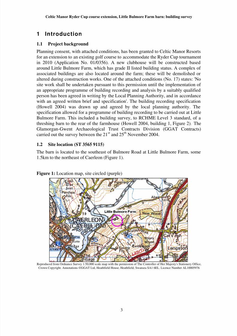
1.2 Site location (ST 3565 9115)
The barn is located to the southeast of Bulmore Road at Little Bulmore Farm, some
1.5km to the northeast of Caerleon (Figure 1).
Figure 1: Location map, site circled (purple)
Reproduced from Ordnance Survey 1:50,000 scale map with the permission of The Controller of Her Majesty's Stationery Office,
Crown Copyright. Annotations ©GGAT Ltd, Heathfield House, Heathfield, Swansea SA1 6EL. Licence Number AL10005976
3
8/8/2019 Celtic Manor Ryder Cup course extension, Little Bulmore Farm barn, Newport: building survey
http://slidepdf.com/reader/full/celtic-manor-ryder-cup-course-extension-little-bulmore-farm-barn-newport 5/18
Celtic Manor Ryder Cup course extension, Little Bulmore Farm barn: building survey
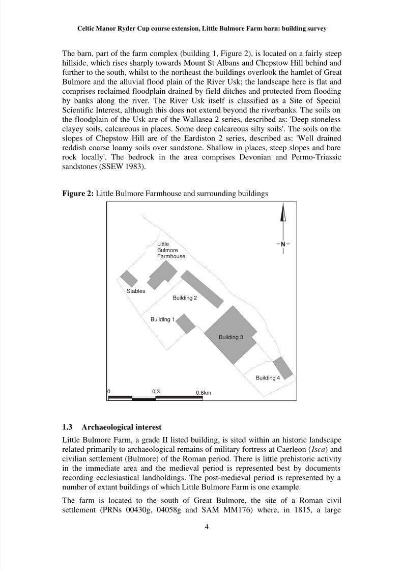
The barn, part of the farm complex (building 1, Figure 2), is located on a fairly steep
hillside, which rises sharply towards Mount St Albans and Chepstow Hill behind and
further to the south, whilst to the northeast the buildings overlook the hamlet of Great
Bulmore and the alluvial flood plain of the River Usk; the landscape here is flat and
comprises reclaimed floodplain drained by field ditches and protected from flooding
by banks along the river. The River Usk itself is classified as a Site of SpecialScientific Interest, although this does not extend beyond the riverbanks. The soils on
the floodplain of the Usk are of the Wallasea 2 series, described as: 'Deep stoneless
clayey soils, calcareous in places. Some deep calcareous silty soils'. The soils on the
slopes of Chepstow Hill are of the Eardiston 2 series, described as: 'Well drained
reddish coarse loamy soils over sandstone. Shallow in places, steep slopes and bare
rock locally'. The bedrock in the area comprises Devonian and Permo-Triassic
sandstones (SSEW 1983).
Figure 2: Little Bulmore Farmhouse and surrounding buildings
0 0.3 0.6km
LittleBulmoreFarmhouse
Building 1
Building 2
Building 3
Building 4
Stables
1.3 Archaeological interest
Little Bulmore Farm, a grade II listed building, is sited within an historic landscape
related primarily to archaeological remains of military fortress at Caerleon ( Isca) and
civilian settlement (Bulmore) of the Roman period. There is little prehistoric activity
in the immediate area and the medieval period is represented best by documents
recording ecclesiastical landholdings. The post-medieval period is represented by a
number of extant buildings of which Little Bulmore Farm is one example.
The farm is located to the south of Great Bulmore, the site of a Roman civilsettlement (PRNs 00430g, 04058g and SAM MM176) where, in 1815, a large
4

8/8/2019 Celtic Manor Ryder Cup course extension, Little Bulmore Farm barn, Newport: building survey
http://slidepdf.com/reader/full/celtic-manor-ryder-cup-course-extension-little-bulmore-farm-barn-newport 6/18
Celtic Manor Ryder Cup course extension, Little Bulmore Farm barn: building survey
masonry building (PRN 00430g) was discovered which incorporated re-used
tombstones. In 1975, excavations were conducted by GGAT to the north of Great
Bulmore, uncovering a substantial multi-phase masonry building, where the later
phases of which extended over the top of the Roman road from Usk to Caerleon
(Vyner 1978). Again the structure incorporated a re-used tombstone. Excavations
conducted by Caerleon Legionary Museum and GGAT in the early and mid 1980sdemonstrated that an extensive Roman settlement (PRN 04058g) existed at Great
Bulmore. Sixteen masonry buildings were identified as well as a number of stone cist
inhumations and some medieval features. A geophysical survey conducted in 1984
demonstrated that archaeological remains extended to the south of Great Bulmore,
although a small area surveyed immediately west of Little Bulmore Farm failed to
identify any archaeological features (Zienkiewicz 1984). Further extensive evaluation
trenching by Yates (1999) was designed to explore the limits of Roman settlement;
the results were categorised into three sections, the road, the buildings either side of
the road, and the funerary remains. Funerary remains reflected varying strata of
Romano-British society, ranging from simple unenclosed cremations to the remains of
substantial monumental tombs; no inhumations were discovered during this
evaluation. The road itself was a substantial structure, approximately 8m in width,
perhaps with side ditches, and with evidence for a series of surfaces. Roman remains
were also found immediately to the north of Little Bulmore Farm; these remains were
interpreted as working surface (Yates 1999).
Roman occupation is largely restricted to the terrace immediately above the
floodplain of the River Usk, and the site of Little Bulmore Farm itself has produced
finds of Roman date, mainly tile, from residual contexts, although no features of
Roman date were identified within the farm complex. However, an archaeological
evaluation (Yates 1999) did demonstrate the presence of remains of probable early
post-medieval date. This would tie in with the construction of the farmhouse in theearly 17th century (Yates 1999). The present structure of c
1.4 Historic landscape
Maps covering Little Bulmore Farm survive from the 18th
century onwards. The Van
Estate map of Little Bulmore Farm surveyed in 1758 shows the field pattern, to be
essentially the same as seen today with a few exceptions. The field names are
uninformative, being either descriptive of size (e.g. The Five Acres, the Long
Meadow), or position (the Field Below the House). The access to the farm was by a
trackway to the north of the farm buildings. The farm buildings themselves are not
shown, although the small enclosures shown at its location may imply terracing forbuilding platforms. No other features of archaeological interest were present.
The tithe map of Christchurch Parish dated 1840 shows only minor changes from the
1758 estate plan, the most significant being the replacement of the access to Little
Bulmore Farm with a new track still in use today. Land usage is mostly either arable
or pasture, with some areas of woodland. The buildings at Little Bulmore comprise a
central L-shaped range set in a yard, with smaller outbuildings to the south and west.
The 1st
Edition OS 6-inch map shows few changes from the tithe map. The
outbuildings of Little Bulmore Farm are more extensive and a well is shown to the
east of the farm complex. The majority of the surviving landscape features can be
traced back to before 1840 for the area as a whole, and to before 1758 for the area
around Little Bulmore Farm. The alluvial flood plain of the River Usk, in common
5

8/8/2019 Celtic Manor Ryder Cup course extension, Little Bulmore Farm barn, Newport: building survey
http://slidepdf.com/reader/full/celtic-manor-ryder-cup-course-extension-little-bulmore-farm-barn-newport 7/18
Celtic Manor Ryder Cup course extension, Little Bulmore Farm barn: building survey
with other similar landscapes in south Wales, is drained by a series of grips and reens,
and protected from inundation by a flood bank. This takes the form of a small earthen
bank, between 1m and 1.5m in height, and 2m wide. The fields on the slopes of
Mount St Albans are divided by hedges, which are often set on small earthen banks.
Deeply cut streams flow to the River Usk from the hillslopes.
6
8/8/2019 Celtic Manor Ryder Cup course extension, Little Bulmore Farm barn, Newport: building survey
http://slidepdf.com/reader/full/celtic-manor-ryder-cup-course-extension-little-bulmore-farm-barn-newport 8/18
Celtic Manor Ryder Cup course extension, Little Bulmore Farm barn: building survey
2 Methodology
The methodology for the building recording followed that set out by the RCHME
(1996) to Level 3 standard and that required within the building recording
specification (Howell 2004) based on The Institute of Field archaeologists' Standard
and Guidance for the archaeological investigation and recording of standingbuildings or structures 1996 (revised 1999). In order to place the site in its context a
limited desk-based assessment was undertaken based on previous archaeological
investigation in the area. Recording was by detailed measurement and hand drawing
to 1/20 scale of all elevations supplemented by written notes. A plan of the barn was
made at 1/100 scale. Levels are to Ordnance Datum based on a temporary benchmark
located in the access track to Little Bulmore Farm off the Bulmore Road, value
11.900m OD (information supplied Mr Hugh Owen of Griffiths Civil Engineering).
The building was photographed using colour transparency, black and white and
digital photography. The photographic survey included general shots of all elevations
and detailed shots of significant features. The Glamorgan-Gwent Archaeological
Trust Contracts Division (GGAT Contracts) carried out the survey between the 21st
and 25th
November 2004.
7

8/8/2019 Celtic Manor Ryder Cup course extension, Little Bulmore Farm barn, Newport: building survey
http://slidepdf.com/reader/full/celtic-manor-ryder-cup-course-extension-little-bulmore-farm-barn-newport 9/18
Celtic Manor Ryder Cup course extension, Little Bulmore Farm barn: building survey
3 Survey Results
3.1 General description
The building is a small, single-storey threshing barn of rectangular plan with one
internal division and through-passage doorways (Plate 9), a type common in this area(Wiliam 1986). It is constructed of undressed roughly coursed reddish-brown,
greenish-grey and grey local sandstones with quoins of the same stone but slightly
larger, bonded with soft pinkish grey and white mortar. Conglomerate blocks form the
foundation cornerstones on three sides. The cornerstones appeared to be laid directly
on clay or rock with little in the way of a foundation trench; it is effectively a building
of two separate halves joined by the roof and through-doors. The building appears to
be set out with all walls broadly at right angles to each other and with the long axis
orientated northwest/southeast (137 degrees National Grid bearing) to take account of
the prevailing southwesterly wind. Externally the barn measured around 11.5m
northwest/southeast and 6.9m northeast/southwest. Internally, whilst both individual
gable ends and wall lengths compared at around 5.66m and 10.23m respectively, thediagonal measurement differed by around 0.19m, therefore internally, the building
was out of true and the difference taken up in wall thickness. The barn was designed
to be of two levels and was deliberately sited over a rock outcrop on sloping ground
to achieve the difference in height. The rock provided the foundation for the higher
floor surface whilst the lower level was built on clay. The wall heights thus vary
depending on the slope of the ground; it stands at a maximum height of around 4.4m
to the eaves at the northeast corner and around 7m at the northeast gable.
The building is part ruinous, lacking most of the timberwork, a roof covering, and
some stonework. The pitch of the roof was determined from the gable to be around 45
degrees and evidence of its most recent roof, corrugated tin sheeting, lay strewn onthe ground. Broken pantiles were observed within mortar on the gables, which may
suggest they formed a former roof covering, but it is possible that slate or stone could
have been used. The barn also showed evidence of change of use from a threshing
barn to another unknown purpose. These changes consisted of blocked doorways and
the insertion of a metallic window frame and would appear to be mostly of modern
date. Rendering was absent on the external faces but the internal gables bore possible
traces of now weathered rendering.
3.2 Elevations
External elevations: northwest elevation (Plate 1, Figure 4)
The northwest elevation on the lowest part of the slope faced the floodplain of the
river Usk and had the highest surviving stonework. The height was around 7m and the
width around 6.9m. Two ventilation slits (vertical slits with splayed reveals, triangular
in plan) positioned broadly in the centre of the face were set one above the other. The
lower vent measured around 1.85m in height and the upper, in the gable apex, around
1m. All external face slits were generally 0.1m wide or less; the width was variable as
none of the outer slit faces had been carefully dressed; this led in most cases to the
stonework's having an off-vertical and slightly staggered appearance. The wall
thickness was measured at 0.63m through the vent slit. The gable slope was partially
demolished at the northeast but almost intact at the southwest. Two purlin positions
were evident on the intact part of the gable whilst traces of their correspondingpartners were suggested on the surviving stonework at similar level on the other side.
8

8/8/2019 Celtic Manor Ryder Cup course extension, Little Bulmore Farm barn, Newport: building survey
http://slidepdf.com/reader/full/celtic-manor-ryder-cup-course-extension-little-bulmore-farm-barn-newport 10/18
Celtic Manor Ryder Cup course extension, Little Bulmore Farm barn: building survey
Large foundation blocks of conglomerate form the cornerstones of the elevation and
occasional orange-coloured bricks were found within the wall structure; two blocks of
oolitic limestone were also observed in the face. It is probable that the conglomerate
and brick is re-used Roman stone from Roman buildings and the oolitic limestone is
from Roman monumental funerary sculpture. Modern cement rendering covered the
greater part of the basal course.
Northeast elevation (Figure 8)
The northeast elevation was around 11.45m long and around 4m high at the northwest
end and 3.4m at the southeast. The basic appearance is of the original build but with
more recent alterations. Two doorways were set into this wall both of which were
now blocked. The position once occupied by one of the barn through-doors
(measuring 3.5m high and 2.7m wide) was blocked by modern breeze-blocks, with a
basal course of bricks and cement render, and the other, a side door, was possibly
blocked at an earlier stage. The smaller doorway set close to the northwest corner was
around 1.8m high and 1m wide, and was blocked with neat courses of greenish-grey
sandstone bonded with pinkish-grey and white mortar; the mortar is similar to thatused for the main building. The threshold stone had also been removed prior to
blocking. There is a suggestion that the stonework forming the jam may have been
removed and reinserted (Plate 6), thus there is a possibility that this doorway was
inserted after construction of the barn. Greyish-white mortar with high coal content
was noted surrounding this side doorway and probably, as it is a different mortar,
represented later repairs. The wall thickness was around 0.55m measured at the door.
Two rectangular vents were located on either side of the through-door walls near the
eaves; the southeast vent was blocked. Wooden lintels were recorded over both
doorways. Another timber remained in place on top of the stonework at the northwest,
and this combined with the lintel over the main door were probably the remains of thewall-plate beams. Four quoins on either side of the through-doors had been replaced
by matching timbers. These timbers may have been to hold the door hinges. Recent
additions to this face included a spanner driven into the wall and an iron gate also
secured to the wall, both possibly tethering points. This elevation also had brick and
stone that probably derived from Roman remains including a possible brick (southeast
side) that may be part of a Roman floor support stack from a hypocaust system.
Southeast elevation (Plate 2, Figure 6)
The southeast elevation is constructed over a rock outcrop except at the northeast
corner where the rock finishes and the ground slopes steeply downward. The width is
similar to its opposite counterpart at around 7m and the height around 5.1m. Twoopenings, one above the other and central to the elevation were present in the face, a
lower ventilation slit and a window setting in the gable. The vent is typical of those in
the building at around 1.2m high but the window setting is seen as a recent addition. It
is likely that this elevation had two vertical slits similar to the northwest elevation and
that the upper slit was enlarged and replaced by a modern window, which retained
clear evidence of cement pointing surrounding the stonework particularly above the
frame. The lower slit of around 0.5m depth had been blocked with blocks and a
kerbstone. Both gable edges were for the most part dilapidated and purlin positions
not identifiable. Missing stone at the northeast corner presented a sectional view of
the northeast elevation. Underlying the cornerstone was a deposit of clay and
sandstone chips, which probably represented backfilled material placed between thevoid formed between the end of the natural rock face and the northeast wall. It was
9
8/8/2019 Celtic Manor Ryder Cup course extension, Little Bulmore Farm barn, Newport: building survey
http://slidepdf.com/reader/full/celtic-manor-ryder-cup-course-extension-little-bulmore-farm-barn-newport 11/18
Celtic Manor Ryder Cup course extension, Little Bulmore Farm barn: building survey
also likely that the corner of this infilling was faced with a quoin; the width of the
northeast wall is around 0.55m but the width of stone recorded at the corner was only
0.3m.
Southwest elevation (Plate 3, Figure 9)
This elevation of around 11.5m length is constructed over sloping ground andprovides access to the interior and is the only one where the door has not been
blocked. The walls vary in height to the eaves from around 2.3m at the southeast to
3.6m at the northwest. The through-doorway measured around 2.7m wide and was
centrally located along the elevation. Both walls had vertical ventilation slits of
similar height and both began at around 1.8m up from ground level but because of the
slope in the ground they do not have a common horizontal alignment; the southeast
vent was set almost to the eaves and the northwest 0.3m short of the eaves. A single
rectangular vent was located 0.3m below and 0.7m northwest of the slit on the
northwest section of the wall. No wooden lintels were recorded on this elevation,
although two timber blocks were observed in the end wall at the southeast side of the
through-door. The wall measured around 0.6m thick. These blocks correspond to thetimber quoins on the opposite elevation, however no evidence was seen for a
matching pair at the northwest; it is possible, as the wall had signs of cracking, that it
was rebuilt without timber blocks. Inserted into both end walls each side of the doors
were metal bars and nails, possibly for the attachment of a doorpost. As they occur on
either side it is assumed that the barn had double doors in each of the through-
doorways. An unusual feature occurred on the southeast wall section; a large flattish-
topped block of sandstone, supported by stonework, projected around 0.8m out from
the wall (Plate 8). It was unclear what its function was. As seen in the other faces of
the barn, some of the blocks of stone would appear to have been re-used Roman
stone. Modern cement rendering covered some of the lower courses on the northwestface.
3.3 Internal elevations
Internally there is little real difference in construction from that seen on the outside
except for the division marked by the split-level floor, traces of render on the gable
ends and chamfered corners to the ventilation slits. Evidence of flagstone flooring was
observed on both floor levels.
Northwest elevation (Plate 4, Figure 5)
The internal northwest elevation measured around 5.7m in width and around 6.6m in
height. Wooden lintels were emplaced over each vent, and further horizontal timbersslightly smaller in size but each over 1m in length, were observed projecting over the
sidewalls at eaves level. A series of blind voids of a size suitable to take the end of
beams were set into the wall mostly below the level of the lower vent sill, which may
suggest further internal divisions of timber construction.
Northeast elevation
The internal northeast elevation measured 10.24m with the step to the raised floor set
flush with and at a right angle to the southeast through-door wall. The wall was
around 3.5m high from the lower part and around 2.4m high above the step. The
blocked side door (Plate 6) had a wooden lintel with a metal fitting located directly
underneath it in the centre of the door. A hinge and another iron object were noted setinto the wall. A pair of wooden quoins were set almost at eaves level on either side of
10
8/8/2019 Celtic Manor Ryder Cup course extension, Little Bulmore Farm barn, Newport: building survey
http://slidepdf.com/reader/full/celtic-manor-ryder-cup-course-extension-little-bulmore-farm-barn-newport 12/18
Celtic Manor Ryder Cup course extension, Little Bulmore Farm barn: building survey
the through-doors; this differed from those on the exterior elevation where only two
sets were noted, both pairs at lower levels. Cracks were evident on the upper part of
the northeast wall end at the through-door. However, of particular note was that the
wall was not keyed to the southeast gable over the upper 1.2m of its height; this was
not evident on the external faces and did not occur in the northern half of the barn
walls. The reason for this apparent construction anomaly and possible weakness wasnot determined.
Southeast elevation (Plate 5, Figure 7)
This elevation was of similar width to the northwest internal elevation at 5.7m but in
comparison had a reduced height of around 5.4m because of the raised step. Wooden
lintels were present over both vent (Plate 7) and window and as noted on the opposite
gable, horizontal scantlings projected over the sidewalls at eaves level, with the
southwest one being badly weathered. Both gable edges were partially destroyed;
however the southeast edge and the upper part of the southwest edge retained enough
definition in the stonework to suggest former purlin positions; these match similar
positions observed in the northwest gable. A near vertical crack was noted extendingdownward from sill of the inserted window and slight traces of repair to the
stonework were noted above the weathered lintel. The elevation face retained traces
of render and contained probable re-used Roman bricks, also evident was a horseshoe
set into the wall.
Southwest elevation
The southwest elevation measured around 10.2m in length with each wall measuring
around 3.8m long. The height of the walls varied as before due to the raised floor. The
southeast was around 2m and the northwest 3.4m in height. Both ventilation slits had
wooden lintels and a continuation of the wooden blocks, first noted on the exterior
elevation (southeast through-door wall end), was also apparent. As observed on the
opposite elevation, the division was set flush and at a right angle to the wall. Again as
noted in the northeast elevation, the upper 1.2m of walling was not keyed to the
southeast gable.
3.4 The internal division (Plate 5)
This low wall extended for the width of the barn and was keyed to both southeast
through-door wall ends. As noted above the barn was designed to be of two levels and
advantage was taken of a rock outcrop to achieve the desired result with minimal
effort of materials and labour. The wall was built at this change in geology and only
facing stone was necessary to mask the rock behind and present a fair face; the styleof stonework was similar to that used in the blocked side door. The wall stood to a
height of 0.7m but it is probable that further stone and/or a timber rail have been
removed as rock was exposed behind the face. The original height of this wall is
suggested at around 1m, which would then bring it level with a flagstone observed in
situ further behind the face.
3.5 Roof detail
Evidence of roof construction was lacking and although tin sheeting was found on the
ground it can only be assumed that this was the most recent roof covering. The pitch
of the roof was measured at 45 degrees. The gables retained elements suggesting
former purlin positions (two pairs of purlins and a ridge purlin to support the roof).
11

8/8/2019 Celtic Manor Ryder Cup course extension, Little Bulmore Farm barn, Newport: building survey
http://slidepdf.com/reader/full/celtic-manor-ryder-cup-course-extension-little-bulmore-farm-barn-newport 13/18
Celtic Manor Ryder Cup course extension, Little Bulmore Farm barn: building survey
Further evidence of roofing was provided by the remains of timber wall plates and
horizontal timbers in the gable ends at eaves level. Broken pantiles were observed
within cement mortar on repairs at the gable ends of barn and these may suggest that
the roof was once clad in pantiles. At Abernant Farm to the north of Little Bulmore
Farm a barn retains its roof of pantiles. Building 2 (Figure 2) also had a similar but
differently coloured pantile roofing.
12

8/8/2019 Celtic Manor Ryder Cup course extension, Little Bulmore Farm barn, Newport: building survey
http://slidepdf.com/reader/full/celtic-manor-ryder-cup-course-extension-little-bulmore-farm-barn-newport 14/18
Celtic Manor Ryder Cup course extension, Little Bulmore Farm barn: building survey
4 Conclusions
It is almost certain that the original purpose of the barn was for production and
storage of grain. The building is not remarkable in terms of threshing barns found in
the former county of Monmouthshire. The barn is sited with the through-doors
aligned to take advantage of prevailing winds and uses both the natural geology andwind to ease the process of threshing and winnowing in production of grain.
Originally the barn doors would have opened outward so that the threshing floor was
formed between the passage and probable storage bays on either side. This passage
was often also used for winnowing and utilised the prevailing wind to separate the
chaff. In this style of barn the doors were usually intended to admit a cart, but this
cannot have been the case here because of the drop in ground level, unless there was a
ramp or the present ground level is lower than originally. The threshing floor was
likely to have been of flagstones some of which are still in place; flagstones were
readily available in the sandstone areas of southeast Wales. There was certainly one
division within the barn but more were suggested by the blind voids in the northwest
walls that may have accommodated timber beams to support partitions. These
partitions would have been for storage and to prevent threshed grain from mixing with
the unthreshed grain. Positive evidence to suggest different building phases other than
recent modifications was not forthcoming but it is possible that the blocked side door
was an earlier modification. The later modern modifications suggest that the barn was
utilised as a general-purpose building.
No evidence to support a 17th
-century foundation date came to light but this is not
unusual in a barn without identifiable architectural detail. Dating evidence however,
may be obtained when the building is demolished. It is possible that pottery or other
artefacts are buried beneath the floors or in the gaps between the walls and the rock.
Furthermore, the original builders have incorporated stone and brick probably fromRoman buildings and possibly funerary monuments; the Roman settlement and
cemeteries of Bulmore extends along the road at the base of the hill.
Recovery of the Roman stonework will add to existing knowledge of the settlement
and it is therefore recommended that an archaeologist is present during demolition
works. This will not only enable the Roman stonework to be assessed and recovered
but will also provide a watching brief during groundworks that may establish the
foundation date of the barn.
13

8/8/2019 Celtic Manor Ryder Cup course extension, Little Bulmore Farm barn, Newport: building survey
http://slidepdf.com/reader/full/celtic-manor-ryder-cup-course-extension-little-bulmore-farm-barn-newport 15/18
Celtic Manor Ryder Cup course extension, Little Bulmore Farm barn: building survey
Bibliography
Fox and Raglan 1954, Monmouthshire Houses: Part III: Renaissance Houses, 70.
NMW. Cardiff.
Howell, JK, 2004, Celtic Manor Ryder Cup course extension: Little Bulmore Farmbuilding recording specification. GGAT report 2004/101.
RCHME 1996, Recording Historic Buildings, A Descriptive Specification, (Third
Edition), Royal Commission on the Historical Monuments of England, Swindon.
Smith, P, 1975, Houses of the Welsh Countryside, map 29. RCAHMW. Aberystwyth.
Soil Survey of England and Wales, 1983, Soils of England and Wales. Sheet 2; Wales.
Harpenden, Herts.
Vyner, B G, 1978, Excavations at Great Bulmore, near Caerleon, in Boon (ed),
Cambrian Monographs and Collections Vol 1, 25-34.
Wiliam, E, 1986, The historical farm buildings of Wales, John Donald, Edinburgh.
Yates, A, 1999, WRU Centre of Excellence, Bulmore, Caerleon, Newport
Archaeological assessment, Stage 3: field evaluation. GGAT report 99/077.
Zienkiewicz, J D, 1984, Excavations at Caerleon and Great Bulmore, Glamorgan-
Gwent Archaeological Trust Ann Rep 1983-4: Part 2, 2-30.
14

8/8/2019 Celtic Manor Ryder Cup course extension, Little Bulmore Farm barn, Newport: building survey
http://slidepdf.com/reader/full/celtic-manor-ryder-cup-course-extension-little-bulmore-farm-barn-newport 16/18
Celtic Manor Ryder Cup course extension, Little Bulmore Farm barn: building survey
Plates
Plate 1: Northwest elevation. Scale in 0.5m divisions ©GGAT
Plate 2: Southeast elevation. Scale in 0.5m divisions. ©GGAT
Plate 3: Southwest elevation. Scale in 0.5m divisions. ©GGAT
15

8/8/2019 Celtic Manor Ryder Cup course extension, Little Bulmore Farm barn, Newport: building survey
http://slidepdf.com/reader/full/celtic-manor-ryder-cup-course-extension-little-bulmore-farm-barn-newport 17/18
Celtic Manor Ryder Cup course extension, Little Bulmore Farm barn: building survey
Plate 4: Northwest internal elevation. Scale in 0.5m divisions. ©GGAT
Plate 5: Southeast internal elevation and raised floor. Scale in 0.5m divisions. ©GGAT
Plate 6: Northeast internal elevation showing blocked doorway. Scale in 0.5m divisions.
©GGAT
16

8/8/2019 Celtic Manor Ryder Cup course extension, Little Bulmore Farm barn, Newport: building survey
http://slidepdf.com/reader/full/celtic-manor-ryder-cup-course-extension-little-bulmore-farm-barn-newport 18/18
Celtic Manor Ryder Cup course extension, Little Bulmore Farm barn: building survey
17
Plate 7: Typical ventilation slit in southeast internal wall. Scale in 0.5m divisions. ©GGAT
Plate 8: Southwest elevation showing projecting sandstone. Scale in 0.5m divisions. ©GGAT
Plate 9: General view of the barn to the east. Scales in 0.5m divisions. ©GGAT