centinela valley union high school district
TRANSCRIPT

P h a s e I I I n v e s t i g a t i o n
S o m e r v i l l e P r o p e r t y - H a w t h o r n e
P H A S E I I E N V I R O N M E N T A L S I T E A S S E S S M E N T
R E P O R T , “ S O M E R V I L L E P A R C E L ”
S O U T H E R N P O R T I O N O F A P N 4 1 4 9 - 0 0 1 - 1 4 5
( 1 4 7 0 1 I N G L E W O O D A V E N U E )
H A W T H O R N E , C A L I F O R N I A 9 0 2 5 0
Prepared for:
C e n t i n e l a V a l l e y U n i o n H i g h S c h o o l D i s t r i c t
14901 South Inglewood Avenue
Lawndale, California 90260
Prepared by:
S C S E N G I N E E R S
3900 Kilroy Airport Way, Suite 100
Long Beach, California 90806-6816
(562) 426-9544
May 2012
File No. 01211298.02

P h a s e I I I n v e s t i g a t i o n
S o m e r v i l l e P r o p e r t y - H a w t h o r n e
This Phase II Investigation Report dated May 2012 for an approximately 25-foot by 417.7-foot portion of land located along the southern portion of 14701 Inglewood Avenue, Hawthorne, California, was prepared and reviewed by the following: Jeffrey T. Sieg Project Geologist Kenneth H. Lister, Ph.D., C.E.G., C.Hg. Senior Technical Advisor Kevin W. Green, P.G., R.E.A. Project Director S C S E N G I N E E R S
P h a s e I I I n v e s t i g a t i o n
S o m e r v i l l e P r o p e r t y - H a w t h o r n e
i
T a b l e o f C o n t e n t s
Section Page
DISCLAIMER ....................................................................................................................................................... iii
1 INTRODUCTION ..................................................................................................................................... 1
Background ....................................................................................................................................... 1
Previous Site Investigation ......................................................................................................... 1
Historic Drainage Swale ............................................................................................................ 3
2 ENVIRONMENTAL SETTING ................................................................................................................. 3
Physiographic Setting ...................................................................................................................... 3
Geology and Soils ........................................................................................................................... 4
Groundwater .................................................................................................................................... 4
3 SITE INVESTIGATION............................................................................................................................. 4
Soil Sample Collection ..................................................................................................................... 4
Materials and Methods ................................................................................................................... 5
Soil Sampling ............................................................................................................................... 5
Decontamination Procedures ..................................................................................................... 6
4 ANALYTICAL RESULTS ........................................................................................................................... 6
Soil Samples ...................................................................................................................................... 6
5 REGULATORY GUIDANCE FOR CHEMICALS OF POTENTIAL CONCERN ................................... 7
Total Petroleum Hydrocarbons ...................................................................................................... 7
Volatile Organic Compounds ......................................................................................................... 8
Metals ................................................................................................................................................. 8
Disposal Requirements ..................................................................................................................... 8
Total Petroleum Hydrocarbons ................................................................................................. 8
Volatile Organic Compounds .................................................................................................... 8
Metals ............................................................................................................................................ 9
6 SUMMARY AND CONCLUSIONS ........................................................................................................ 9
Western Portion of the Property .............................................................................................. 9
Eastern Portion of the Property ............................................................................................. 10
Conclusions AND RECOMMENDATIONS ................................................................................... 10
7 REFERENCES ......................................................................................................................................... 12
P h a s e I I I n v e s t i g a t i o n
S o m e r v i l l e P r o p e r t y - H a w t h o r n e
i i
L i s t o f F i g u r e s , T a b l e s a n d A p p e n d i c e s
Figures
1 Project Site Location
2 Sample Location Map
Tables
1 Summary of Analytical Results TPH and VOCs in Soil
2 Summary of Analytical Results for Metals in Soil
Appendices
A Boring Logs
B Chemtek Laboratory Report
P h a s e I I I n v e s t i g a t i o n
S o m e r v i l l e P r o p e r t y - H a w t h o r n e
i i i
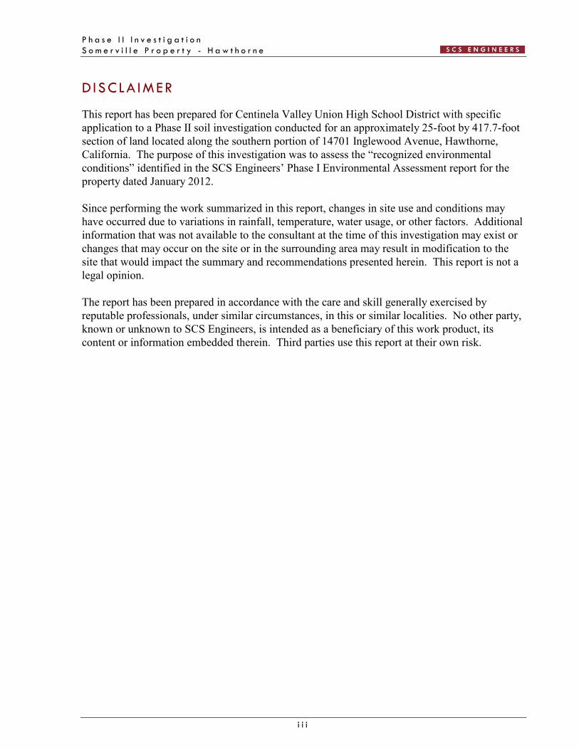
D ISCLA IMER
This report has been prepared for Centinela Valley Union High School District with specific application to a Phase II soil investigation conducted for an approximately 25-foot by 417.7-foot section of land located along the southern portion of 14701 Inglewood Avenue, Hawthorne, California. The purpose of this investigation was to assess the “recognized environmental conditions” identified in the SCS Engineers’ Phase I Environmental Assessment report for the property dated January 2012. Since performing the work summarized in this report, changes in site use and conditions may have occurred due to variations in rainfall, temperature, water usage, or other factors. Additional information that was not available to the consultant at the time of this investigation may exist or changes that may occur on the site or in the surrounding area may result in modification to the site that would impact the summary and recommendations presented herein. This report is not a legal opinion. The report has been prepared in accordance with the care and skill generally exercised by reputable professionals, under similar circumstances, in this or similar localities. No other party, known or unknown to SCS Engineers, is intended as a beneficiary of this work product, its content or information embedded therein. Third parties use this report at their own risk.

P h a s e I I I n v e s t i g a t i o n
S o m e r v i l l e P r o p e r t y - H a w t h o r n e
1
1 INTRODUCT ION
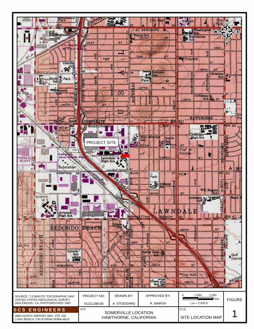
SCS Engineers (SCS) was retained by the Centinela Valley Union High School District to conduct a Phase II environmental site assessment for an approximately 25-foot by 417.7-foot section of land located along the southern portion of 14701 Inglewood Avenue, Hawthorne, California (the “Property”). The purpose of this assessment was to assess the “recognized environmental conditions” identified in the SCS’s Phase I Environmental Assessment report dated January 2012. The Property is a portion of a former railroad right-of-way that is currently undeveloped. A map showing the general location of the Property and surrounding area is provided as Figure 1. Assessment activities were conducted in accordance with SCS’s Workplan for Phase II Investigation – “Somerville Parcel,” dated February 9, 2012.
B A C K G R O U N D
The Phase I Environmental Assessment report, prepared by SCS and dated January 2012, identified two recognized environmental conditions (RECs) for the Property. These included:
Elevated lead concentrations in shallow soil along the eastern portion of the Property identified during a previous site investigation.
A historic drainage swale crossed the western portion of the Property, which may have
received oil field waste in storm water or other runoff. P r e v i o u s S i t e I n v e s t i g a t i o n
One previous site investigation report was provided to SCS for review:
Kleinfelder, Inc. Report of Analytical Results – Limited Environmental Sampling along Additional Burlington Northern Santa Fe Railroad Easement, Hawthorne Gateway Center, Hawthorne, California. Prepared for Costco Wholesale. October 24, 2000.
At the time the Kleinfelder investigation was conducted, Costco was considering purchase of the entire Burlington Northern Santa Fe (BNSF) easement from Inglewood Avenue to the I-405 Freeway as part of a proposed development. Costco wished to establish baseline soil conditions in the easement. The objective of the sampling was to assess whether substances, potentially released along the railroad tracks, had impacted soil beneath the easement. The investigation consisted of the collection of surface soil samples from 51 locations within the easement (typically at 50-foot intervals along the 2,550-foot length of the easement, on alternating sides of the railroad tracks) beginning 50 feet east of the middle of the Interstate 405 overpass with sample CRR-1. The last of the 50-foot interval samples, CCR-50, was collected approximately 33 feet west of the fence adjacent to the western side of Inglewood Avenue. Seven samples were collected within the Property – sample numbers CRR-44, 45, 46, 47, 48, 49, and 50. The surface soil samples were composited prior to analysis, two at a time, using adjacent

P h a s e I I I n v e s t i g a t i o n
S o m e r v i l l e P r o p e r t y - H a w t h o r n e
2
50-foot samples. However, the last of the 50-foot samples (CRR-50) was not composited because of the odd number (49) of regular 50-foot interval samples that were collected. The soil samples were analyzed for total petroleum hydrocarbons (TPH) with carbon chain identification, quantifying TPH as gasoline (TPH-g), kerosene (TPH-k), diesel (TPH-d), and motor oil (TPH-o). The samples were also analyzed for additional persistent constituents including polychlorinated biphenyls (PCBs), chlorinated herbicides, and California Title 22 metals. TPH-g, TPH-k, and TPH-d were not detected (practical quantitation limit [PQL] of 10 milligrams per kilogram [mg/kg]) in the analyzed soil samples. TPH-o was detected in one of the composite samples (CRR-44/CRR-45) at 181 mg/kg. PCBs and organochlorine herbicides were not detected above the PQLs in the analyzed soil samples.
Eleven of the California Title 22 metals were detected in one or more of the analyzed soil samples. The highest concentrations detected were in the following samples:
Arsenic – 1.54 mg/kg (CRR-50) Barium – 3,680 mg/kg (CRR-48/CRR-49) Beryllium –1.98 mg/kg (CRR-48/CRR-49) Cadmium –0.66 mg/kg (CRR-44/CRR-45) Chromium – 22.8 mg/kg (CRR-44/CRR-45) Copper – 16.2 mg/kg (CRR-44/CRR-45) Lead – 133 mg/kg (CRR-50) Molybdenum – 38.6 mg/kg (CRR-44/CRR-45) Nickel – 4.43 mg/kg (CRR-50) Vanadium – 11.3 mg/kg (CRR-44/CRR-45) Zinc – 126 mg/kg (CRR-50)
Most of these results are within natural background ranges for the metals in question. However, two of the sample results – barium in CRR-48/CRR-49 and lead in CRR-50 exceeded ten times the STLC (soluble threshold limit concentration), which could result in the soil being classified as a hazardous waste.
Kleinfelder recommended analyzing the discrete samples CRR-48 and CRR-49 in an effort to better determine the location of the elevated concentration of barium. The results were 75.1 mg/kg for CRR-48 and 106 mg/kg for CRR-49, both values within natural background ranges. No further analyses were done on these soil samples. Kleinfelder made no further recommendations or comments regarding these sample locations, suggesting that they dismissed the initial composite result as anomalous.
Sample CRR-50 was subjected to an extraction for analysis of the soluble lead fraction. Soluble lead was detected at 15.9 milligrams per liter (mg/L), above the STLC of 5 mg/L. Based on this result, soil from this area would be presumptively a hazardous waste if excavated. As this

P h a s e I I I n v e s t i g a t i o n
S o m e r v i l l e P r o p e r t y - H a w t h o r n e
3
sample was collected approximately 33 feet from Inglewood Avenue, Kleinfelder surmised that the elevated lead concentration could be related to street traffic. Until the mid-1980s, gasoline and other vehicular fuels contained tetraethyl lead. As vehicles traveled the streets, lead emissions from vehicle exhaust settled on surface soils near the streets. Because lead tends to not move very far or fast in the environment, lead build-up in soil along streets and highways can be significant.
Kleinfelder recommended remediation by excavation and offsite disposal of near surface soil at locations where the analytical results indicated contaminants exceeded the screening values discussed above. No information was found indicating that any such remediation was ever implemented. Based on these results, lead in shallow soil near Inglewood Avenue may be present at concentrations above the California Human Health Screening Level (CHHSL) for residential land use of 80 mg/kg. SCS concluded that potential lead-impacted soils represent a REC and recommended additional assessment of shallow soils within 40 feet of Inglewood Avenue to further characterize the nature and extent of lead in soil in this area. H i s t o r i c D r a i n a g e S w a l e
The western 100 to 125 feet of the Property is the location of a historic drainage swale, which from at least 1938 through at least 1956, originated in an oil production area to the north of 147th Street. Kleinfelder intended to investigate the possibility of contamination from the oil activities by placing two deeper (4 to 5 feet) borings in this area. However, it appears that their boring locations were just to the west of the historic swale (approximately 560 feet from Inglewood Avenue) and off-site of the Property to the west. On the other hand, in 1990, the Somerville parking lot to the north of the Property was paved. Excavations conducted in the parking lot area at that time extended into portions of this swale north of the Property, and no visual evidence of contamination was noted at that time. SCS concluded that the potential for historic runoff from oil field operations through this area may have resulted in contamination by petroleum hydrocarbons, volatile organic compounds (VOCs) and/or heavy metals, and therefore constitutes a REC. SCS recommended additional assessment of soil in this area to assess the potential for contamination. 2 ENV IRONMENTAL SETT ING
P H Y S I O G R A P H I C S E T T I N G
According to the U.S. Geological Survey (USGS), Inglewood (1964, photorevised 1981), California 7.5-minute topographic map, the Property is located on the Los Angeles Coastal Plain approximately 2.75 miles east of the Pacific Ocean at an elevation of approximately 65 feet above mean sea level. Local topography in the area slopes gently to the east-southeast towards Dominguez Channel, approximately 1.75 miles away. The topography of the Property is relatively flat with site runoff generally draining internally.

P h a s e I I I n v e s t i g a t i o n
S o m e r v i l l e P r o p e r t y - H a w t h o r n e
4
G E O L O G Y A N D S O I L S
Based on subsurface investigations conducted at the Fairchild site approximately 0.75 miles to the west of the Property, the Property is located on late Pleistocene-age sand hills and therefore the general vicinity consists of gently undulating topography, which is relatively flat in the immediate vicinity of the Property with a slight decrease in elevation to the east. The Older Dune Sand formation is part of a coastal belt of dunes and sand hills referred to as the El Segundo Sandhills that are about 11 miles long and parallel the shoreline from the Ballona Escarpment to the Palos Verdes Hills. These dunes and sand hills extend inland 3 to 6 miles from the Pacific Ocean to overlap the Torrance Plain. The Older Dune Sands are estimated to be about 60 feet thick in the vicinity of the Property.
Silts and silty clays occur from ground surface to 10 feet below ground surface (bgs) in much of this area. During this assessment, the upper 6- to 10-inches of soil was a mixture of sand, silt, and gravel (assumed to be fill), followed by predominately silts and clays from approximately 1 to 3 feet bgs, silt and silty sand from 3 to 7 feet bgs, and fine, well sorted, sand from 7 to 10 feet bgs.
G R O U N D W A T E R
The Property is located in the West Coast Basin of the Los Angeles Coastal Plain. The Property is underlain by approximately 1,500 feet of fresh water-bearing strata consisting of (from youngest to oldest) the Older Dune Sands, the upper Lakewood Formation (including the semi-perched aquifer and the Bellflower aquitard), the lower Lakewood Formation (including the Gage aquifer, the San Pedro Formation (including the Silverado aquifer), and the Upper Pico Formation. Groundwater was detected at 34 feet bgs during the removal of an underground storage tank at 14701 Inglewood Avenue. Based on several sites identified on the State Water Resource Control Board website ((http://geotracker.waterborads.ca.gov/[GeoTracker]), groundwater flow in this area is to the east southeast. 3 S I TE INVEST IGAT ION
Investigation activities were conducted on May 16, 2012. As required by law, SCS contacted Underground Service Alert (Dig Alert No A21291157) prior to conducting any subsurface work. In addition, Goldak Inc. of Glendale, California conducted a geophysical survey to clear boring locations of underground utilities and/or subsurface obstructions. Based on the geophysical survey, subsurface utilities/obstructions were not identified in the area of the proposed soil borings. Figure 2 shows soil sampling locations. S O I L S A M P L E C O L L E C T I O N
Under the direction of SCS, Kehoe Testing and Engineering (Kehoe) of Huntington Beach, California conducted soil sampling using a truck-mounted direct-push drill rig. A total of 10 soil borings, designated B1 through B10, were advanced along the western and eastern portions of the Property. Soil samples were collected from borings B1 through B5, located in the eastern portion of the Property, at depths of approximately 0.5 and 2 feet below ground surface (bgs). Soil

P h a s e I I I n v e s t i g a t i o n
S o m e r v i l l e P r o p e r t y - H a w t h o r n e
5
samples were collected from boring B6 through B10, located in the western portion of the Property, at depths of approximately 0.5 to 1, 5, and 10 feet bgs. Immediately following recovery, samples were prepared in the field as required by regulatory standards. All sample sleeves were covered, capped, and labeled; soil samples selected for VOC analysis were preserved using EPA Method 5035. All soil samples were placed in a chilled ice chest for later transportation to Chemtek Environmental Laboratories Inc. (Chemtek) of Santa Fe Springs, California. Chemtek is a certified by the California Department of Health Services to conduct the specified analyses. Samples were tracked from the point of collection through the laboratory using proper chain-of-custody protocol. Sample identification numbers are based on the boring number and depth of sample. For example, sample “B1-2” is from boring B1 at a depth of approximately 2 feet bgs. A portion of each sample was observed for lithologic determination and to screen samples for field indications of contamination, such as discoloration and odor. Soils encountered during drilling activities consisted predominantly fill soil in the upper 1-foot followed by predominately silts and clays from approximately 1 to 3 feet bgs, silt and silty sand from 3 to 7 feet bgs, and fine, well sorted, sand from 7 to 10 feet bgs. No obvious signs of contamination were observed. After sample collection the borings were backfilled with hydrated bentonite when possible. Several borings collapsed upon drill rod removal and presumably backfilled with native soils. Copies of boring logs are included in Appendix A.
Soil samples were selectively analyzed for TPH (gasoline, diesel and oil range) by EPA Method 8015M, VOCs by EPA Method 8260B, California Code of Regulations Title 22 metals by EPA Method 7000 series, total lead by EPA Method 7420, and soluble lead (Soluble Threshold Limit Concentration or STLC lead) using the California Waste Extraction Test (WET). M A T E R I A L S A N D M E T H O D S
S o i l S a m p l i n g
Each boring was advanced using a truck-mounted direct push drill rig, which employed a 2-foot long, 1.75 inch diameter split spoon sampler. A pointed steel tip was fixed to the head of the sampler and driven to the desired depth on a steel rod using a hydraulic hammer. Samples were collected by retracting the drive tip with an inner rod through the center of the sampler, and hydraulically hammering the sampler. The steel rods were retracted and soil samples were recovered in pre-cleaned acetate sample sleeves that had been placed within the sampler. Soil Sample Preparation
Following recovery of soil samples, a portion of each sleeve was retained and prepared for subsequent laboratory analysis as follows: Immediately following soil sample collection, a portion of each sample selected for VOC analysis was prepared in the field using EPA Method 5035, which includes the collection of three 5-gram aliquots of soil from each sample using a plunger/sub-sampler provided by the laboratory. The three aliquots of soil were placed in 40 milliliter VOA (volatile organic analysis)

P h a s e I I I n v e s t i g a t i o n
S o m e r v i l l e P r o p e r t y - H a w t h o r n e
6
vials as follows – two aliquots in VOAs with sodium bisulfate preservative and one in a VOA with methanol preservative. Each sample was labeled noting sample number, date, and time of collection. For samples collected in acetate sample sleeves the ends of the sample sleeves were covered with Teflon squares and capped with plastic end caps. A solvent-free label noting date and time of collection, sample number, and project number was affixed to each sample. Following labeling, samples were placed in a chilled ice chest for later transportation to a California Department of Health Services certified laboratory. New Nitrile gloves were frequently used in the handling of all soil samples. D e c o n t a m i n a t i o n P r o c e d u r e s
Standard three-stage decontamination procedures were used for all sampling equipment prior to and between each sample. Decontamination consisted of a wash in a solution of laboratory-grade detergent (Liquinox) and water followed by a double rinse in de-ionized water. 4 ANALYT ICAL R ESULTS
S O I L S A M P L E S
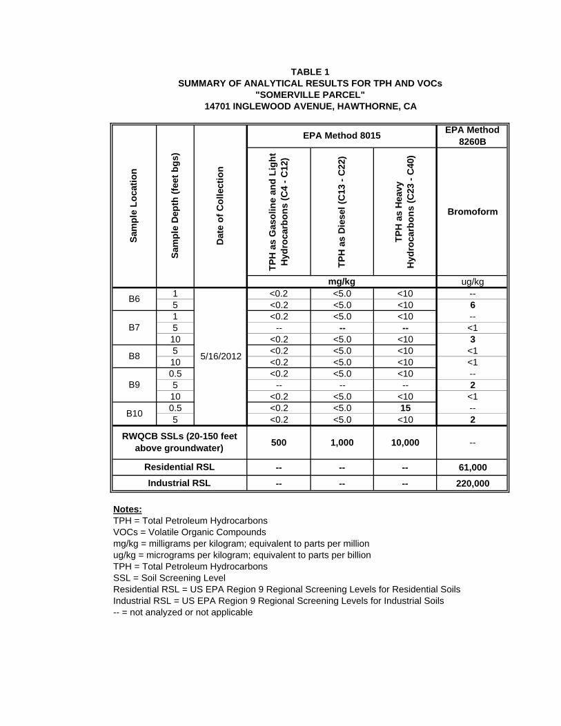
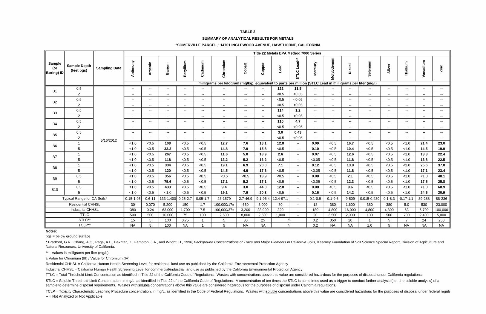
The Chemtek laboratory report, including chain-of-custody documentation and quality assurance/quality control (QA/QC) data, is provided in Appendix B. A summary of analytical results for TPH and VOCs is provided in Table 1. All of the soil samples selected for TPH and VOC analysis were collected from the western portion of the Property where the historic drainage swale was located. As shown in Table 1, with the exception of sample B10-0.5, none of the 10 soil samples selected for analysis contained detectable concentrations of TPH. Sample B10-0.5 (collected from a depth between approximately 0.5 and 1-foot bgs) contained TPH-o at a concentration of 15 mg/kg. With respect to VOCs, bromoform was the only species detected. Bromoform was detected in four of the eight soil samples selected for analysis at concentrations between 2 and 6 μg/kg and at depths between 5 and 10 feet bgs. A summary of analytical results for CCR Title 22 metals and soluble lead is provided in Table 2.
Soil samples collected from the western portion of the Property from depths between 0.5 and 5 feet bgs were analyzed for 17 heavy metals (CAM 17). All soil samples collected from the eastern portion of the Property from depths between 0.5 and 2 feet bgs were analyzed for total lead and their soluble fraction of lead. As shown in Table 2, in the ten soil samples selected for analysis of CAM 17, barium, chromium, cobalt, copper, lead, mercury, nickel, vanadium, and zinc were the only metals detected. Barium was detected in nine of ten soil samples at concentrations between 33.3 and 433 mg/kg. Chromium was detected in nine of ten soil samples at concentrations between 9.4 and 19.1 mg/kg. Cobalt was detected in nine of ten soil samples at concentrations between 3.0

P h a s e I I I n v e s t i g a t i o n
S o m e r v i l l e P r o p e r t y - H a w t h o r n e
7
and 7.9 mg/kg. Copper was detected in each sample at concentrations between 13.9 and 44.0 mg/kg. lead was detected in four of ten samples at concentrations between 2.6 and 12.8 mg/kg. Mercury was detected in seven of ten samples at concentrations between 0.07 and 0.16 mg/kg. Nickel was detected in each sample at concentrations between 2.1 and 16.7 mg/kg. Vanadium was detected in eight of ten samples at concentrations between 13.8 and 25.6 mg/kg. Zinc was detected in each sample at concentrations between 19.9 and 68.9 mg/kg. With respect to the soil samples analyzed for total and soluble lead (collected from the eastern portion of the Property), lead was detected in four of ten samples at concentrations between 3.0 and 122 mg/kg. Each of the four samples with detectable lead concentration was collected from ground surface to approximately 6-inches bgs. Soil samples collected from approximately 2 feet bgs from these same locations did not contained detectable concentrations of lead. Soluble lead was detected in each of the same four samples at concentrations between 0.43 and 11.5 milligrams per liter (mg/l). Analytical results show that sample B1-0.5 (collected closest to the southeast corner of the Property) contained the highest concentration of both total and soluble lead. 5 REGULATORY GU IDANCE FOR CHEM ICALS OF
POTENT IAL CONCERN
A discussion of regulatory guidance and screening limits for chemicals of potential concern (COPC) in soil is provided in the following narrative. T O T A L P E T R O L E U M H Y D R O C A R B O N S
The Los Angeles Regional Water Quality Control Board (RWQCB) has established Soil Screening Levels (SSLs) for TPH in soils above drinking water aquifers (Interim Site Assessment & Cleanup Guidebook, May 1996). The SSLs which may be applicable to the Property are as follows: SSLs for soils between 20 and 150 feet above groundwater:
TPH-g – 500 mg/kg TPH-d – 1,000 mg/kg TPH-h – 10,000 mg/kg
The analytical results for TPH are compared to the SSLs in Table 1. SCS has assumed the depth to groundwater to be approximately 34 feet bgs, based on observations made during a UST removal immediately north of the Property, as discussed above. With the exception of sample B10-0.5, none of the soil samples contained detected concentrations of TPH. Sample B10-0.5 contained TPH-o at a concentration of 15 mg/kg, well below its SSL of 10,000 mg/kg. Sample B10-5, collected in the same location at a depth of 5 feet bgs did not contain detectable concentrations of TPH.

P h a s e I I I n v e s t i g a t i o n
S o m e r v i l l e P r o p e r t y - H a w t h o r n e
8
V O L A T I L E O R G A N I C C O M P O U N D S
The US Environmental Protection Agency (EPA) Region IX has established Regional Screening
Levels (RSLs, formerly known as Preliminary Remediation Goals or PRGs) for various COPC in
soil for site screening and as initial cleanup goals, if applicable. The RSLs for VOCs in soil for
residential and industrial land use are presented in Table 1.
As shown in Table 2, the only VOC detected was bromoform. Bromoform was detected in 4 of
eight samples at concentrations between 2 and 6 μg/kg, below the RSL of 61,000 μg/kg for
residential soils.
M E T A L S
Regulatory guidance for metals in soil is based on an evaluation of both background and risk-based concentrations. The Kearney Foundation of Soil Science Special Report, Division of Agriculture and Natural Resources, University of California has published Background Concentrations of Trace and Major Elements in California Soils (Bradford, et al). The California EPA Office of Environmental Health Hazard Assessment (OEHHA) has published the Use of California Human Health Screening levels (CHSSLs) in Evaluation of Contaminated Properties, dated January 2005 (the "OEHHA Guidance"). Within this document, California Human Health Screening Levels, or CHHSLs, were developed for metals in soil for residential and industrial/commercial land use scenarios. Table 2 provides a summary of the analytical results for metals, typical background levels, and CHHSLs. As shown, with the exception of three out of twenty samples, all of the samples contained metals below or within the typical range for California soils. The three samples (BH1-0.5, BH3-0.5, and BH4-0.5) contained lead at concentrations above both typical background range and their CHHSL. The lead CHHSL for residential land use is 80 mg/kg. Samples B1-0.5, B3-0.5, B4-0.5, and B5-0.5 contained lead at concentrations of 122, 114, 110, and 3.0 mg/kg, respectively. D I S P O S A L R E Q U I R E M E N T S
T o t a l P e t r o l e u m H y d r o c a r b o n s
There are no specific requirements for the disposal of TPH impacted soil as a regulated hazardous waste; however, the presence of TPH in soils would require that soils be appropriately characterized and transported to an accepting disposal and/or treatment facility. V o l a t i l e O r g a n i c C o m p o u n d s
Bromoform was the only VOC detected soil samples. Bromoform is not listed with a total threshold limit concentration (TTLC) identified in the Title 22 CCR. Based on the limited number of soil samples, soil disposal would not require transport/removal as a regulated
P h a s e I I I n v e s t i g a t i o n
S o m e r v i l l e P r o p e r t y - H a w t h o r n e
9
hazardous waste; however, the presence of VOCs in soils would require that soils be appropriately characterized and transported to an accepting disposal and/or treatment facility. M e t a l s
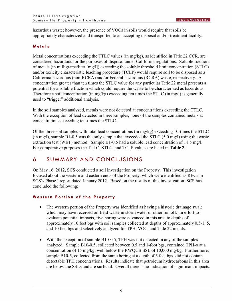
Metal concentrations exceeding the TTLC values (in mg/kg), as identified in Title 22 CCR, are considered hazardous for the purposes of disposal under California regulations. Soluble fractions of metals (in milligrams/liter [mg/l]) exceeding the soluble threshold limit concentration (STLC) and/or toxicity characteristic leaching procedure (TCLP) would require soil to be disposed as a California hazardous (non-RCRA) and/or Federal hazardous (RCRA) waste, respectively. A concentration greater than ten times the STLC value for any particular Title 22 metal presents a potential for a soluble fraction which could require the waste to be characterized as hazardous. Therefore a soil concentration (in mg/kg) exceeding ten times the STLC (in mg/l) is generally used to “trigger” additional analysis. In the soil samples analyzed, metals were not detected at concentrations exceeding the TTLC. With the exception of lead detected in three samples, none of the samples contained metals at concentrations exceeding ten-times the STLC. Of the three soil samples with total lead concentrations (in mg/kg) exceeding 10-times the STLC (in mg/l), sample B1-0.5 was the only sample that exceeded the STLC (5.0 mg/l) using the waste extraction test (WET) method. Sample B1-0.5 had a soluble lead concentration of 11.5 mg/l. For comparative purposes the TTLC, STLC, and TCLP values are listed in Table 2. 6 SUMMARY AND CONCLUS IONS
On May 16, 2012, SCS conducted a soil investigation on the Property. This investigation focused about the western and eastern ends of the Property, which were identified as RECs in SCS’s Phase I report dated January 2012. Based on the results of this investigation, SCS has concluded the following: W e s t e r n P o r t i o n o f t h e P r o p e r t y
The western portion of the Property was identified as having a historic drainage swale which may have received oil field waste in storm water or other run off. In effort to evaluate potential impacts, five boring were advanced in this area to depths of approximately 10 feet bgs with soil samples collected at depths of approximately 0.5-1, 5, and 10 feet bgs and selectively analyzed for TPH, VOC, and Title 22 metals.
With the exception of sample B10-0.5, TPH was not detected in any of the samples
analyzed. Sample B10-0.5, collected between 0.5 and 1-foot bgs, contained TPH-o at a concentration of 15 mg/kg, well below the RWQCB SSL of 10,000 mg/kg. Furthermore, sample B10-5, collected from the same boring at a depth of 5 feet bgs, did not contain detectable TPH concentrations. Results indicate that petroleum hydrocarbons in this area are below the SSLs and are surficial. Overall there is no indication of significant impacts.

P h a s e I I I n v e s t i g a t i o n
S o m e r v i l l e P r o p e r t y - H a w t h o r n e
1 0
With the exception of bromoform, VOCs were not detected in any of the samples analyzed. Bromoform was detected in four of eight samples, collected between 5 and 10 feet bgs, at concentrations between 2 and 6 μg/kg, well below the residential RSL of 61,000 μg/kg. Based on these results, there is no indication of significant impacts by VOCs to the Property.
Ten soil samples, collected between 0.5-1 and 5 feet bgs, were analyzed for Title 22
metals. Based on analytical results, metals were detected in all of the samples at concentrations below or within typical California ranges and below any level that would be of regulatory concern.
E a s t e r n P o r t i o n o f t h e P r o p e r t y
Previous investigations identified elevated lead concentrations in shallow soils approximately 33 feet west of Inglewood Avenue. It was concluded that this was the result of historic vehicle emissions due to the use of leaded fuels. In effort to delineate the lateral and vertical extent of lead impacts to shallow soils, soil samples were collected and analyzed from five borings at approximate depths of ground surface to 0.5 feet and from 1.5 to 2 feet bgs. All soil samples were analyzed for total lead and its soluble fraction (STLC).
Four samples collected from a depth of approximately 0.5 feet bgs contained lead at
concentrations between 3.0 and 122 mg/kg. Lead was not detected in any of the deeper samples. Three of the four samples with detectable lead concentrations exceeded their CHHSL of 80 mg/kg. One sample (B1-0.5) exceeded the STLC of 5.0 mg/l. None of the 2-foot depth samples contained detectable concentrations of lead. Results indicate that remediation of shallow soils in this area prior to redevelopment is appropriate. If remediation is conducted, results indicate that, without further characterization, excavated soils may be considered a California hazardous waste for disposal purposes.
C O N C L U S I O N S A N D R E C O M M E N D A T I O N S
Based on the results of this investigation:
There have been no significant impacts from petroleum hydrocarbons, VOCs, or metals to the western portion of the Property.
There appears to be a localized area of lead impacts to shallow soils in the eastern portion
of the Property, possibly from historic vehicle emissions due to use of of leaded fuels. As stated, these impacts appear to be shallow and localized near the eastern portion of the Property. A shallow/focused excavation is recommended for remediation of lead impacted soils.
The maximum quantity of soil to be excavated is anticipated to be approximately 50 cubic yards (75 tons) based on removal in contiguous areas of dimensions 50 by 15 feet and 15 by 10 feet, both to a depth of 1.5 feet. Cost for excavation, transport and disposal

P h a s e I I I n v e s t i g a t i o n
S o m e r v i l l e P r o p e r t y - H a w t h o r n e
1 1
of California hazardous soil, confirmatory sampling and analysis, backfill, oversight, and reporting is approximately estimated to be in the range of $25,000 to $40,000, depending on the effort involved with regulatory oversight.
In conclusion, once these remediation activities have been completed the Property would be acceptable for school use.

P h a s e I I I n v e s t i g a t i o n
S o m e r v i l l e P r o p e r t y - H a w t h o r n e
1 2
7 REFERENCES
Bradford, G.R., Chang, A.C., Page, A.L., Bakhtar, D., Frampton, J.A., and Wright, H., 1996, Background Concentrations of Trace and Major Elements in California Soils, Kearney Foundation of Soil Sciences Special Report, Division of Agriculture and Natural Resources, University of California.
California EPA Office of Environmental Health Hazard Assessment, January 2005. Use of
California Human Health Screening Levels (CHHSLs). Kleinfelder, Inc. October 24, 2000. Report of Analytical Results – Limited Environmental Sampling
along Additional Burlington Northern Santa Fe Railroad Easement, Hawthorne Gateway Center, Hawthorne, California.
RWQCB (Los Angeles Region). May 1996. Interim Site Assessment & Cleanup Guidebook SCS Engineers, January 2012. Phase I Environmental Assessment, Somerville Property, 25 by 400-
foot Former Railroad Right of Way, Hawthorne, California 90250.
P h a s e I I I n v e s t i g a t i o n
S o m e r v i l l e P r o p e r t y - H a w t h o r n e
F I G U R E S
0 2,0001,000Feet
1 in = 2,000 ftFIGURE
1SITE LOCATION MAP3900 KILROY AIRPORT WAY, STE 100LONG BEACH, CALIFORNIA 90806-6816
SOURCE: 7.5 MINUTE TOPOGRAPHIC MAPUNITED STATES GEOLOGICAL SURVEYINGLEWOOD, CA, PHOTOREVISED 1981
SOMERVILLE LOCATIONHAWTHORNE, CALIFORNIA
PROJECT NO:
01211298.00
DRAWN BY:
A. STODDARD
APPROVED BY:
R. MARSH
S C S E N G I N E E R S
4
TITLE:SITE:
PROJECT SITE


P h a s e I I I n v e s t i g a t i o n
S o m e r v i l l e P r o p e r t y - H a w t h o r n e
T A B L E S
TP
H a
s G
aso
lin
e an
d L
igh
t H
ydro
carb
on
s (C
4 -
C12
)
TP
H a
s D
iese
l (C
13 -
C22
)
TP
H a
s H
eavy
H
ydro
carb
on
s (C
23 -
C40
)
Bromoform
ug/kg1 <0.2 <5.0 <10 --5 <0.2 <5.0 <10 61 <0.2 <5.0 <10 --5 -- -- -- <110 <0.2 <5.0 <10 35 <0.2 <5.0 <10 <110 <0.2 <5.0 <10 <10.5 <0.2 <5.0 <10 --5 -- -- -- 210 <0.2 <5.0 <10 <10.5 <0.2 <5.0 15 --5 <0.2 <5.0 <10 2
500 1,000 10,000 --
-- -- -- 61,000
-- -- -- 220,000
Notes:TPH = Total Petroleum HydrocarbonsVOCs = Volatile Organic Compoundsmg/kg = milligrams per kilogram; equivalent to parts per millionug/kg = micrograms per kilogram; equivalent to parts per billionTPH = Total Petroleum HydrocarbonsSSL = Soil Screening LevelResidential RSL = US EPA Region 9 Regional Screening Levels for Residential SoilsIndustrial RSL = US EPA Region 9 Regional Screening Levels for Industrial Soils-- = not analyzed or not applicable
TABLE 1SUMMARY OF ANALYTICAL RESULTS FOR TPH AND VOCs
"SOMERVILLE PARCEL"14701 INGLEWOOD AVENUE, HAWTHORNE, CA
B6
B8
RWQCB SSLs (20-150 feet above groundwater)
Sam
ple
Lo
cati
on
Sam
ple
Dep
th (
feet
bg
s)
Dat
e o
f C
oll
ecti
on
B10
B7
B9
EPA Method 8260B
Residential RSL
Industrial RSL
5/16/2012
EPA Method 8015
mg/kg
An
tim
on
y
Ars
enic
Bar
ium
Ber
ylliu
m
Cad
miu
m
Ch
rom
ium
Co
bal
t
Co
pp
er
Lea
d
ST
LC
Lea
d**
Mer
cury
Mo
lyb
den
um
Nic
kel
Sel
eniu
m
Silv
er
Th
alliu
m
Van
adiu
m
Zin
c
0.5 -- -- -- -- -- -- -- -- 122 11.5 -- -- -- -- -- -- -- --
2 -- -- -- -- -- -- -- -- <0.5 <0.05 -- -- -- -- -- -- -- --
0.5 -- -- -- -- -- -- -- -- <0.5 <0.05 -- -- -- -- -- -- -- --
2 -- -- -- -- -- -- -- -- <0.5 <0.05 -- -- -- -- -- -- -- --
0.5 -- -- -- -- -- -- -- -- 114 1.2 -- -- -- -- -- -- -- --
2 -- -- -- -- -- -- -- -- <0.5 <0.05 -- -- -- -- -- -- -- --
0.5 -- -- -- -- -- -- -- -- 110 4.7 -- -- -- -- -- -- -- --
2 -- -- -- -- -- -- -- -- <0.5 <0.05 -- -- -- -- -- -- -- --
0.5 -- -- -- -- -- -- -- -- 3.0 0.43 -- -- -- -- -- -- -- --
2 -- -- -- -- -- -- -- -- <0.5 <0.05 -- -- -- -- -- -- -- --
1 <1.0 <0.5 108 <0.5 <0.5 12.7 7.6 18.1 12.8 -- 0.09 <0.5 16.7 <0.5 <0.5 <1.0 21.4 23.0
5 <1.0 <0.5 33.3 <0.5 <0.5 14.8 7.9 15.8 <0.5 -- 0.10 <0.5 10.4 <0.5 <0.5 <1.0 14.5 19.9
1 <1.0 <0.5 267 <0.5 <0.5 11.6 5.8 18.9 2.6 -- 0.07 <0.5 12.6 <0.5 <0.5 <1.0 18.8 22.4
5 <1.0 <0.5 118 <0.5 <0.5 13.2 5.2 16.2 <0.5 -- <0.05 <0.5 11.8 <0.5 <0.5 <1.0 13.8 22.5
1 <1.0 <0.5 334 <0.5 <0.5 19.1 6.9 20.0 7.1 -- 0.12 <0.5 13.8 <0.5 <0.5 <1.0 25.6 37.0
5 <1.0 <0.5 120 <0.5 <0.5 14.5 4.9 17.6 <0.5 -- <0.05 <0.5 11.8 <0.5 <0.5 <1.0 17.1 23.4
0.5 <1.0 <0.5 356 <0.5 <0.5 <0.5 <0.5 13.9 <0.5 -- 0.08 <0.5 2.1 <0.5 <0.5 <1.0 <1.0 48.1
5 <1.0 <0.5 75.6 <0.5 <0.5 17.1 5.2 17.1 <0.5 -- <0.05 <0.5 12.3 <0.5 <0.5 <1.0 17.5 25.8
0.5 <1.0 <0.5 433 <0.5 <0.5 9.4 3.0 44.0 12.8 -- 0.08 <0.5 9.6 <0.5 <0.5 <1.0 <1.0 68.9
5 <1.0 <0.5 <1.0 <0.5 <0.5 19.1 7.9 20.3 <0.5 -- 0.16 <0.5 14.2 <0.5 <0.5 <1.0 24.6 20.9
0.15-1.95 0.6-11 133-1,400 0.25-2.7 0.05-1.7 23-1579 2.7-46.9 9.1-96.4 12.4-97.1 -- 0.1-0.9 0.1-9.6 9-509 0.015-0.430 0.1-8.3 0.17-1.1 39-288 88-236
30 0.070 5,200 150 1.7 100,000/17± 660 3,000 80 -- 18 380 1,600 380 380 5.0 530 23,000
380 0.24 63,000 1,700 7.5 100,000/37± 3,200 38,000 320 -- 180 4,800 16,000 4,800 4,800 63 6,700 100,000
500 500 10,000 75 100 2,500 8,000 2,500 1,000 -- 20 3,500 2,000 100 500 700 2,400 5,000
15 5 100 0.75 1 5 80 25 0.2 350 20 1 5 7 24 250
NA 5 100 NA 1 5 NA NA 0.2 NA NA 1.0 5 NA NA NA
bgs = below ground surface
** - Values in milligrams per liter (mg/L)
± Value for Chromium (III) / Value for Chromium (IV)
Residential CHHSL = California Human Health Screening Level for residential land use as published by the California Environmental Protection Agency
Industrial CHHSL = California Human Health Screening Level for commercial/industrial land use as published by the California Environmental Protection Agency
TCLP = Toxicity Characteristic Leaching Procedure concentration, in mg/L, as identified in the Code of Federal Regulations. Wastes with soluble concentrations above this value are considered hazardous for the purposes of disposal under federal regula-- = Not Analyzed or Not Applicable
STLC**
TCLP**
Notes:
* Bradford, G.R., Chang, A.C., Page, A.L., Bakhtar, D., Fampton, J.A., and Wright, H., 1996, Background Concentrations of Trace and Major Elements in California Soils, Kearney Foundation of Soil Science Special Report, Division of Agriculture and Natural Resources, University of California.
TTLC = Total Threshold Limit Concentration as identified in Title 22 of the California Code of Regulations. Wastes with concentrations above this value are considered hazardous for the purposes of disposal under California regulations.
STLC = Soluble Threshold Limit Concentration, in mg/L, as identified in Title 22 of the California Code of Regulations. A concentration of ten times the STLC is sometimes used as a trigger to conduct further analysis (i.e., the soluble analysis) of a sample to determine disposal requirements. Wastes with soluble concentrations above this value are considered hazardous for the purposes of disposal under California regulations.
5
5
Typical Range for CA Soils*
Sample (or
Boring) ID
Sample Depth (feet bgs)
Sampling Date
B7
B8
B9
B2
B3
B4
B5
B6
Title 22 Metals EPA Method 7000 Series
milligrams per kilogram (mg/kg), equivalent to parts per million (STLC Lead in milligrams per liter (mg/l)
5/16/2012
B10
Residential CHHSL
Industrial CHHSL
TTLC
TABLE 2
SUMMARY OF ANALYTICAL RESULTS FOR METALS
"SOMERVILLE PARCEL," 14701 INGLEWOOD AVENUE, HAWTHORNE, CALIFORNIA
B1

P h a s e I I I n v e s t i g a t i o n
S o m e r v i l l e P r o p e r t y - H a w t h o r n e
A P P E N D I X A
B O R I N G L O G S

Native Slough, boringcollapsed uponremoval of drill rod
Brown, Silty Sand with Some Gravel
Dark Brown, Silty Clay, Soft, Slightly Moist
B1-0.5
B1-2
SM
CL
Date Started:
Date Ended:
Boring Diameter:
5/16/12
5/16/12
1.75-inch
Drilling Company:
Drilling Method:
Logged By:
Sampling Method:
Kehoe Testing and Engineering
Direct Push
J. Sieg
Solid Spoon
Total Depth: 2.0 ft.
Blo
wC
ount
s
OV
M(p
pm)
US
CS
Soi
lC
lass
.
feet
Sam
ple
Loca
tion
Gra
phic
Log
Depth
Description
Completion DetailSample Information
met
ers
Sam
ple
Num
ber
JOB NUMBER: 01211298.02
BORING LOGPage 1 of 1
Somerville Parcel14701 Inglewood AvenueHawthorne, CA
3900 Kilroy Airport Way, Suite 100Long Beach, California 90806-6816 BORING NUMBER: B1
REMARKS:
0
1
2
3
ST
AN
DA
RD
_LO
G 0
1211
298
.02.
GP
J S
TD
_LO
G.G
DT
5/2
1/1
2
0
1
2
3
4
5
6
7
8
9
10
11
12
0
5
10
Native Slough, boringcollapsed uponremoval of drill rod
Brown, Silty Medium to Fine Sand with Some Gravel,Slightly Moist
Brown, Silt, Slightly Moist
Orangish Brown, Fine Sand, Well Sorted, Slightly Moist
B10-0.5
B10-5
B10-10
SM
ML
SP
Date Started:
Date Ended:
Boring Diameter:
5/16/12
5/16/12
1.75-inch
Drilling Company:
Drilling Method:
Logged By:
Sampling Method:
Kehoe Testing and Engineering
Direct Push
J. Sieg
Solid Spoon
Total Depth: 10.0 ft.
Blo
wC
ount
s
OV
M(p
pm)
US
CS
Soi
lC
lass
.
feet
Sam
ple
Loca
tion
Gra
phic
Log
Depth
Description
Completion DetailSample Information
met
ers
Sam
ple
Num
ber
JOB NUMBER: 01211298.02
BORING LOGPage 1 of 1
Somerville Parcel14701 Inglewood AvenueHawthorne, CA
3900 Kilroy Airport Way, Suite 100Long Beach, California 90806-6816 BORING NUMBER: B10
REMARKS:
0
1
2
3
ST
AN
DA
RD
_LO
G 0
1211
298
.02.
GP
J S
TD
_LO
G.G
DT
5/2
1/1
2
0
1
2
3
4
5
6
7
8
9
10
11
12
0
5
10

Native Slough, boringcollapsed uponremoval of drill rod
Brown, Silty Sand with Some Gravel
Dark Brown, Silty Clay, Soft, Slightly Moist
B2-0.5
B2-5
SM
CL
Date Started:
Date Ended:
Boring Diameter:
5/16/12
5/16/12
1.75-inch
Drilling Company:
Drilling Method:
Logged By:
Sampling Method:
Kehoe Testing and Engineering
Direct Push
J. Sieg
Solid Spoon
Total Depth: 2.0 ft.
Blo
wC
ount
s
OV
M(p
pm)
US
CS
Soi
lC
lass
.
feet
Sam
ple
Loca
tion
Gra
phic
Log
Depth
Description
Completion DetailSample Information
met
ers
Sam
ple
Num
ber
JOB NUMBER: 01211298.02
BORING LOGPage 1 of 1
Somerville Parcel14701 Inglewood AvenueHawthorne, CA
3900 Kilroy Airport Way, Suite 100Long Beach, California 90806-6816 BORING NUMBER: B2
REMARKS:
0
1
2
3
ST
AN
DA
RD
_LO
G 0
1211
298
.02.
GP
J S
TD
_LO
G.G
DT
5/2
1/1
2
0
1
2
3
4
5
6
7
8
9
10
11
12
0
5
10

Hydrated Bentonite
Brown, Silty Sand with Some Gravel
Dark Brown, Silty Clay, Soft, Slightly Moist
B3-0.5
B3-2
SM
CL
Date Started:
Date Ended:
Boring Diameter:
5/16/12
5/16/12
1.75-inch
Drilling Company:
Drilling Method:
Logged By:
Sampling Method:
Kehoe Testing and Engineering
Direct Push
J. Sieg
Solid Spoon
Total Depth: 2.0 ft.
Blo
wC
ount
s
OV
M(p
pm)
US
CS
Soi
lC
lass
.
feet
Sam
ple
Loca
tion
Gra
phic
Log
Depth
Description
Completion DetailSample Information
met
ers
Sam
ple
Num
ber
JOB NUMBER: 01211298.02
BORING LOGPage 1 of 1
Somerville Parcel14701 Inglewood AvenueHawthorne, CA
3900 Kilroy Airport Way, Suite 100Long Beach, California 90806-6816 BORING NUMBER: B3
REMARKS:
0
1
2
3
ST
AN
DA
RD
_LO
G 0
1211
298
.02.
GP
J S
TD
_LO
G.G
DT
5/2
1/1
2
0
1
2
3
4
5
6
7
8
9
10
11
12
0
5
10

Native Slough, boringcollapsed uponremoval of drill rod
Brown, Silty Sand with Some Gravel
Dark Brown, Silty Clay, Soft, Slightly Moist
B4-0.5
B4-2
SM
CL
Date Started:
Date Ended:
Boring Diameter:
5/16/12
5/16/12
1.75-inch
Drilling Company:
Drilling Method:
Logged By:
Sampling Method:
Kehoe Testing and Engineering
Direct Push
J. Sieg
Solid Spoon
Total Depth: 2.0 ft.
Blo
wC
ount
s
OV
M(p
pm)
US
CS
Soi
lC
lass
.
feet
Sam
ple
Loca
tion
Gra
phic
Log
Depth
Description
Completion DetailSample Information
met
ers
Sam
ple
Num
ber
JOB NUMBER: 01211298.02
BORING LOGPage 1 of 1
Somerville Parcel14701 Inglewood AvenueHawthorne, CA
3900 Kilroy Airport Way, Suite 100Long Beach, California 90806-6816 BORING NUMBER: B4
REMARKS:
0
1
2
3
ST
AN
DA
RD
_LO
G 0
1211
298
.02.
GP
J S
TD
_LO
G.G
DT
5/2
1/1
2
0
1
2
3
4
5
6
7
8
9
10
11
12
0
5
10

Hydrated Bentonite
Brown, Silty Sand with Some Gravel
Gray Brown, Silty Clay, Soft, Slightly Moist
B5-0.5
B5-2
SM
CL
Date Started:
Date Ended:
Boring Diameter:
5/16/12
5/16/12
1.75-inch
Drilling Company:
Drilling Method:
Logged By:
Sampling Method:
Kehoe Testing and Engineering
Direct Push
J. Sieg
Solid Spoon
Total Depth: 2.0 ft.
Blo
wC
ount
s
OV
M(p
pm)
US
CS
Soi
lC
lass
.
feet
Sam
ple
Loca
tion
Gra
phic
Log
Depth
Description
Completion DetailSample Information
met
ers
Sam
ple
Num
ber
JOB NUMBER: 01211298.02
BORING LOGPage 1 of 1
Somerville Parcel14701 Inglewood AvenueHawthorne, CA
3900 Kilroy Airport Way, Suite 100Long Beach, California 90806-6816 BORING NUMBER: B5
REMARKS:
0
1
2
3
ST
AN
DA
RD
_LO
G 0
1211
298
.02.
GP
J S
TD
_LO
G.G
DT
5/2
1/1
2
0
1
2
3
4
5
6
7
8
9
10
11
12
0
5
10

Native Slough, boringcollapsed uponremoval of drill rod
Brown, Silty Fine Sand and Gravel
Dark Brown, Silty Clay, Soft, Slightly Moist
Orangish Brown, Silty Fine Sand, Well Sorted, SlightlyMoist
Orangish Brown, Fine Sand with Some Silt, Well SortedSlightly Moist
B6-1
B6-5
B6-10
CL
SM
SP
Date Started:
Date Ended:
Boring Diameter:
5/16/12
5/16/12
1.75-inch
Drilling Company:
Drilling Method:
Logged By:
Sampling Method:
Kehoe Testing and Engineering
Direct Push
J. Sieg
Solid Spoon
Total Depth: 10.0 ft.
Blo
wC
ount
s
OV
M(p
pm)
US
CS
Soi
lC
lass
.
feet
Sam
ple
Loca
tion
Gra
phic
Log
Depth
Description
Completion DetailSample Information
met
ers
Sam
ple
Num
ber
JOB NUMBER: 01211298.02
BORING LOGPage 1 of 1
Somerville Parcel14701 Inglewood AvenueHawthorne, CA
3900 Kilroy Airport Way, Suite 100Long Beach, California 90806-6816 BORING NUMBER: B6
REMARKS:
0
1
2
3
ST
AN
DA
RD
_LO
G 0
1211
298
.02.
GP
J S
TD
_LO
G.G
DT
5/2
1/1
2
0
1
2
3
4
5
6
7
8
9
10
11
12
0
5
10

Native Slough, boringcollapsed uponremoval of drill rod
Brown, Silty Sand Gravel Mixture
Dark Brown, Silty Clay, Slightly Moist
Orangish Brown, Silty Fine Sand, Well Sorted, SlightlyMoist
Orangish Brown, Fine Sand with Some Silt, Well Sorted
B7-1
B7-5
B7-10
CL
SM
SP
Date Started:
Date Ended:
Boring Diameter:
5/16/12
5/16/12
1.75-inch
Drilling Company:
Drilling Method:
Logged By:
Sampling Method:
Kehoe Testing and Engineering
Direct Push
J. Sieg
Solid Spoon
Total Depth: 10.0 ft.
Blo
wC
ount
s
OV
M(p
pm)
US
CS
Soi
lC
lass
.
feet
Sam
ple
Loca
tion
Gra
phic
Log
Depth
Description
Completion DetailSample Information
met
ers
Sam
ple
Num
ber
JOB NUMBER: 01211298.02
BORING LOGPage 1 of 1
Somerville Parcel14701 Inglewood AvenueHawthorne, CA
3900 Kilroy Airport Way, Suite 100Long Beach, California 90806-6816 BORING NUMBER: B7
REMARKS:
0
1
2
3
ST
AN
DA
RD
_LO
G 0
1211
298
.02.
GP
J S
TD
_LO
G.G
DT
5/2
1/1
2
0
1
2
3
4
5
6
7
8
9
10
11
12
0
5
10

Native Slough, boringcollapsed uponremoval of drill rod
Brown, Fine Sandy Silt with Some Gravel, Slightly Moist
Orangish Brown, Silty Fine Sand, Well Sorted, SlightlyMoist
Orangish Brown, Fine Sand with Some Silt, Well Sorted,Slightly Moist
B8-1
B8-5
B8-10
ML
SM
SP
Date Started:
Date Ended:
Boring Diameter:
5/16/12
5/16/12
1.75-inch
Drilling Company:
Drilling Method:
Logged By:
Sampling Method:
Kehoe Testing and Engineering
Direct Push
J. Sieg
Solid Spoon
Total Depth: 10.0 ft.
Blo
wC
ount
s
OV
M(p
pm)
US
CS
Soi
lC
lass
.
feet
Sam
ple
Loca
tion
Gra
phic
Log
Depth
Description
Completion DetailSample Information
met
ers
Sam
ple
Num
ber
JOB NUMBER: 01211298.02
BORING LOGPage 1 of 1
Somerville Parcel14701 Inglewood AvenueHawthorne, CA
3900 Kilroy Airport Way, Suite 100Long Beach, California 90806-6816 BORING NUMBER: B8
REMARKS:
0
1
2
3
ST
AN
DA
RD
_LO
G 0
1211
298
.02.
GP
J S
TD
_LO
G.G
DT
5/2
1/1
2
0
1
2
3
4
5
6
7
8
9
10
11
12
0
5
10

Native Slough, boringcollapsed uponremoval of drill rod
Brown, Silty Medium to Fine Sand with Some Gravel,Slightly Moist
Brown, Silt, Slightly Moist
Orangish Brown, Fine Sand, Well Sorted, Slightly Moist
B9-0.5
B9-5
B9-10
SM
ML
SP
Date Started:
Date Ended:
Boring Diameter:
5/16/12
5/16/12
1.75-inch
Drilling Company:
Drilling Method:
Logged By:
Sampling Method:
Kehoe Testing and Engineering
Direct Push
J. Sieg
Solid Spoon
Total Depth: 10.0 ft.
Blo
wC
ount
s
OV
M(p
pm)
US
CS
Soi
lC
lass
.
feet
Sam
ple
Loca
tion
Gra
phic
Log
Depth
Description
Completion DetailSample Information
met
ers
Sam
ple
Num
ber
JOB NUMBER: 01211298.02
BORING LOGPage 1 of 1
Somerville Parcel14701 Inglewood AvenueHawthorne, CA
3900 Kilroy Airport Way, Suite 100Long Beach, California 90806-6816 BORING NUMBER: B9
REMARKS:
0
1
2
3
ST
AN
DA
RD
_LO
G 0
1211
298
.02.
GP
J S
TD
_LO
G.G
DT
5/2
1/1
2
0
1
2
3
4
5
6
7
8
9
10
11
12
0
5
10

P h a s e I I I n v e s t i g a t i o n
S o m e r v i l l e P r o p e r t y - H a w t h o r n e
A P P E N D I X B
C H E M T E K L A B O R A T O R Y R E P O R T S
Page 1 of 15
CHEMTEK ENVIRONMENTAL LABORATORIES INC. "An environment-friendly company"
13554 Larwin Circle, Santa Fe Springs, CA 90670
Tel. (562) 926-9848 FAX (562) 926-8324
CA Dept of Health Accredited. (ELAP No. 1435) CERTIFICATE OF ANALYSIS Job No. 205061 Date 05-18-12 This is the Certificate of Analysis for the following samples:
Client : SCS Engineers Contact person : Jeff Sieg Project # : 01211298.02 Project Site : Somerville Parcel 14701 Inglewood Ave Date of sample : 05-16-12 Date received : 05-16-12 Number of samples : 25 Sample matrix : soil
Samples were labeled as follows
SAMPLE IDENTIFICATION DATE SAMPLED LABORATORY NUMBER B10—0.5 05/16/12 205061-01A B10—5 05/16/12 205061-02A B10—10 05/16/12 205061-03A B9-0.5 05/16/12 205061-04A B9-5 05/16/12 205061-05A B9-10 05/16/12 205061-06A B8-1 05/16/12 205061-07A B8-5 05/16/12 205061-08A B8-10 05/16/12 205061-09A B7-1 05/16/12 205061-10A B7-5 05/16/12 205061-11A B7-10 05/16/12 205061-12A B6-1 05/16/12 205061-13A B6-5 05/16/12 205061-14A B6-10 05/16/12 205061-15A B1-0.5 05/16/12 205061-16A B1-2 05/16/12 205061-17A B2-0.5 05/16/12 205061-18A B2-2 05/16/12 205061-19A B3-0.5 05/16/12 205061-20A B3-2 05/16/12 205061-21A B4-0.5 05/16/12 205061-22A B4-2 05/16/12 205061-23A B5-0.5 05/16/12 205061-24A B5-2 05/16/12 205061-25A Reviewed and Approved:
Michael C.C. Lu Laboratory Director
Page 2 of 15
CHEMTEK ENVIRONMENTAL LAB. LABORATORY ANALYSIS REPORT
Client : SCS Engineers Project : Somerville Parcel 14701 Inglewood Ave. Job No. : 205061 Date:05-18-12 Analysis: EPA 8260B(Volatile Organics by GC-MS) Unit: µg/kg or ppb Sample ID : B10-5 Sample date : 05-16-12 Sample matrix : soil Analysis date : 05-16-12 Dilution Factor : 0.8
Compound Result DLR Compound Result DLR
Benzene ND 0.8 trans-1,3-Dichloroproene ND 0.8 Bromobenzene ND 0.8 Ethylbenzene ND 0.8 Bromochloromethane ND 0.8 Hexachlorobutadiene ND 0.8 Bromoform 2 0.8 Isopropylbenzene ND 0.8 Bromomethane ND 0.8 4-Isopropyltoluene ND 0.8 n-Butylbenzene ND 0.8 Methylene Chloride ND 4 sec-Butylbenzene ND 0.8 Naphthalene ND 0.8 tert-Butylbenzene ND 0.8 n-propylbenzene ND 0.8 Carbon Tetrachloride ND 0.8 Styrene ND 0.8 Chlorobenzene ND 0.8 1,1,1,2-Tetrachloroethane ND 0.8 Chloroethane ND 0.8 1,1,2,2-Tetrachloroethane ND 0.8 Chloroform ND 0.8 Tetrachloroethene(PCE) ND 0.8 Chloromethane ND 0.8 Toluene ND 0.8 2-Chlorotoluene ND 0.8 1,2,3-Trichlorobenzene ND 0.8 4-Chlorotoluene ND 0.8 1,2,4-Trichlorobenzene ND 0.8 2-Chloroethyl vinyl ether ND 1.6 1,1,1-Trichloroethane ND 0.8 Dibromochloromethane ND 0.8 1,1,2-Trichloroethane ND 0.8 1,2-Dibromo-3-chloropropane ND 0.8 Trichloroethene(TCE) ND 0.8 1,2-Dibromoethane (EDB) ND 0.8 Trichlorofluoromethane ND 0.8 Dibromomethane ND 0.8 1,2,3-Trichloropropane ND 0.8 1,2-Dichlorobenzene ND 0.8 1,2,4-Trimethylbenzene ND 0.8 1,3-Dichlorobenzene ND 0.8 1,3,5-Trimethylbenzene ND 0.8 1,4-Dichlorobenzene ND 0.8 Vinyl Chloride ND 0.8 Dichlorodifluoromethane ND 0.8 Total Xylenes ND 1.6 1,1-Dichloroethane ND 0.8 Ethanol ND 200 1,2-Dichloroethane ND 0.8 MTBE ND 0.8 1,1-Dichloroethene ND 0.8 ETBE ND 0.8 cis-1,2 Dichloroethene ND 0.8 DIPE ND 0.8 Trans-1,2-Dichloroethene ND 0.8 TAME ND 0.8 1,2-Dichloropropane ND 0.8 TBA ND 16 1,3-Dichloropropane ND 0.8 MEK ND 8 2,2-Dichloropropane ND 0.8 MIBK ND 8 1,1-Dichloropropene ND 0.8 2-Hexanone ND 8 Cis-1,3-Dichloropropene ND 0.8 Acetone ND 32
ND : NOT DETECTED BELOW DLR DLR: DETECTION LIMIT FOR REPORTING PURPOSES * : Estimated Value only (j flag) - below the Reporting limit and above the Method Detection Limit

Page 3 of 15
CHEMTEK ENVIRONMENTAL LAB. LABORATORY ANALYSIS REPORT
Client : SCS Engineers Project : Somerville Parcel 14701 Inglewood Ave. Job No. : 205061 Date:05-18-12 Analysis: EPA 8260B(Volatile Organics by GC-MS) Unit: µg/kg or ppb Sample ID : B9-5 Sample date : 05-16-12 Sample matrix : soil Analysis date : 05-16-12 Dilution Factor : 1
Compound Result DLR Compound Result DLR
Benzene ND 1 trans-1,3-Dichloroproene ND 1 Bromobenzene ND 1 Ethylbenzene ND 1 Bromochloromethane ND 1 Hexachlorobutadiene ND 1 Bromoform 2 1 Isopropylbenzene ND 1 Bromomethane ND 1 4-Isopropyltoluene ND 1 n-Butylbenzene ND 1 Methylene Chloride ND 5 sec-Butylbenzene ND 1 Naphthalene ND 1 tert-Butylbenzene ND 1 n-propylbenzene ND 1 Carbon Tetrachloride ND 1 Styrene ND 1 Chlorobenzene ND 1 1,1,1,2-Tetrachloroethane ND 1 Chloroethane ND 1 1,1,2,2-Tetrachloroethane ND 1 Chloroform ND 1 Tetrachloroethene(PCE) ND 1 Chloromethane ND 1 Toluene ND 1 2-Chlorotoluene ND 1 1,2,3-Trichlorobenzene ND 1 4-Chlorotoluene ND 1 1,2,4-Trichlorobenzene ND 1 2-Chloroethyl vinyl ether ND 2 1,1,1-Trichloroethane ND 1 Dibromochloromethane ND 1 1,1,2-Trichloroethane ND 1 1,2-Dibromo-3-chloropropane ND 1 Trichloroethene(TCE) ND 1 1,2-Dibromoethane (EDB) ND 1 Trichlorofluoromethane ND 1 Dibromomethane ND 1 1,2,3-Trichloropropane ND 1 1,2-Dichlorobenzene ND 1 1,2,4-Trimethylbenzene ND 1 1,3-Dichlorobenzene ND 1 1,3,5-Trimethylbenzene ND 1 1,4-Dichlorobenzene ND 1 Vinyl Chloride ND 1 Dichlorodifluoromethane ND 1 Total Xylenes ND 2 1,1-Dichloroethane ND 1 Ethanol ND 250 1,2-Dichloroethane ND 1 MTBE ND 1 1,1-Dichloroethene ND 1 ETBE ND 1 cis-1,2 Dichloroethene ND 1 DIPE ND 1 Trans-1,2-Dichloroethene ND 1 TAME ND 1 1,2-Dichloropropane ND 1 TBA ND 10 1,3-Dichloropropane ND 1 MEK ND 10 2,2-Dichloropropane ND 1 MIBK ND 10 1,1-Dichloropropene ND 1 2-Hexanone ND 10 Cis-1,3-Dichloropropene ND 1 Acetone ND 40
ND : NOT DETECTED BELOW DLR DLR: DETECTION LIMIT FOR REPORTING PURPOSES * : Estimated Value only (j flag) - below the Reporting limit and above the Method Detection Limit

Page 4 of 15
CHEMTEK ENVIRONMENTAL LAB. LABORATORY ANALYSIS REPORT
Client : SCS Engineers Project : Somerville Parcel 14701 Inglewood Ave. Job No. : 205061 Date:05-18-12 Analysis: EPA 8260B(Volatile Organics by GC-MS) Unit: µg/kg or ppb Sample ID : B9-10 Sample date : 05-16-12 Sample matrix : soil Analysis date : 05-16-12 Dilution Factor : 1
Compound Result DLR Compound Result DLR
Benzene ND 1 trans-1,3-Dichloroproene ND 1 Bromobenzene ND 1 Ethylbenzene ND 1 Bromochloromethane ND 1 Hexachlorobutadiene ND 1 Bromoform ND 1 Isopropylbenzene ND 1 Bromomethane ND 1 4-Isopropyltoluene ND 1 n-Butylbenzene ND 1 Methylene Chloride ND 5 sec-Butylbenzene ND 1 Naphthalene ND 1 tert-Butylbenzene ND 1 n-propylbenzene ND 1 Carbon Tetrachloride ND 1 Styrene ND 1 Chlorobenzene ND 1 1,1,1,2-Tetrachloroethane ND 1 Chloroethane ND 1 1,1,2,2-Tetrachloroethane ND 1 Chloroform ND 1 Tetrachloroethene(PCE) ND 1 Chloromethane ND 1 Toluene ND 1 2-Chlorotoluene ND 1 1,2,3-Trichlorobenzene ND 1 4-Chlorotoluene ND 1 1,2,4-Trichlorobenzene ND 1 2-Chloroethyl vinyl ether ND 2 1,1,1-Trichloroethane ND 1 Dibromochloromethane ND 1 1,1,2-Trichloroethane ND 1 1,2-Dibromo-3-chloropropane ND 1 Trichloroethene(TCE) ND 1 1,2-Dibromoethane (EDB) ND 1 Trichlorofluoromethane ND 1 Dibromomethane ND 1 1,2,3-Trichloropropane ND 1 1,2-Dichlorobenzene ND 1 1,2,4-Trimethylbenzene ND 1 1,3-Dichlorobenzene ND 1 1,3,5-Trimethylbenzene ND 1 1,4-Dichlorobenzene ND 1 Vinyl Chloride ND 1 Dichlorodifluoromethane ND 1 Total Xylenes ND 2 1,1-Dichloroethane ND 1 Ethanol ND 250 1,2-Dichloroethane ND 1 MTBE ND 1 1,1-Dichloroethene ND 1 ETBE ND 1 cis-1,2 Dichloroethene ND 1 DIPE ND 1 Trans-1,2-Dichloroethene ND 1 TAME ND 1 1,2-Dichloropropane ND 1 TBA ND 10 1,3-Dichloropropane ND 1 MEK ND 10 2,2-Dichloropropane ND 1 MIBK ND 10 1,1-Dichloropropene ND 1 2-Hexanone ND 10 Cis-1,3-Dichloropropene ND 1 Acetone ND 40
ND : NOT DETECTED BELOW DLR DLR: DETECTION LIMIT FOR REPORTING PURPOSES * : Estimated Value only (j flag) - below the Reporting limit and above the Method Detection Limit

Page 5 of 15
CHEMTEK ENVIRONMENTAL LAB. LABORATORY ANALYSIS REPORT
Client : SCS Engineers Project : Somerville Parcel 14701 Inglewood Ave. Job No. : 205061 Date:05-18-12 Analysis: EPA 8260B(Volatile Organics by GC-MS) Unit: µg/kg or ppb Sample ID : B8-5 Sample date : 05-16-12 Sample matrix : soil Analysis date : 05-16-12 Dilution Factor : 1
Compound Result DLR Compound Result DLR
Benzene ND 1 trans-1,3-Dichloroproene ND 1 Bromobenzene ND 1 Ethylbenzene ND 1 Bromochloromethane ND 1 Hexachlorobutadiene ND 1 Bromoform ND 1 Isopropylbenzene ND 1 Bromomethane ND 1 4-Isopropyltoluene ND 1 n-Butylbenzene ND 1 Methylene Chloride ND 5 sec-Butylbenzene ND 1 Naphthalene ND 1 tert-Butylbenzene ND 1 n-propylbenzene ND 1 Carbon Tetrachloride ND 1 Styrene ND 1 Chlorobenzene ND 1 1,1,1,2-Tetrachloroethane ND 1 Chloroethane ND 1 1,1,2,2-Tetrachloroethane ND 1 Chloroform ND 1 Tetrachloroethene(PCE) ND 1 Chloromethane ND 1 Toluene ND 1 2-Chlorotoluene ND 1 1,2,3-Trichlorobenzene ND 1 4-Chlorotoluene ND 1 1,2,4-Trichlorobenzene ND 1 2-Chloroethyl vinyl ether ND 2 1,1,1-Trichloroethane ND 1 Dibromochloromethane ND 1 1,1,2-Trichloroethane ND 1 1,2-Dibromo-3-chloropropane ND 1 Trichloroethene(TCE) ND 1 1,2-Dibromoethane (EDB) ND 1 Trichlorofluoromethane ND 1 Dibromomethane ND 1 1,2,3-Trichloropropane ND 1 1,2-Dichlorobenzene ND 1 1,2,4-Trimethylbenzene ND 1 1,3-Dichlorobenzene ND 1 1,3,5-Trimethylbenzene ND 1 1,4-Dichlorobenzene ND 1 Vinyl Chloride ND 1 Dichlorodifluoromethane ND 1 Total Xylenes ND 2 1,1-Dichloroethane ND 1 Ethanol ND 250 1,2-Dichloroethane ND 1 MTBE ND 1 1,1-Dichloroethene ND 1 ETBE ND 1 cis-1,2 Dichloroethene ND 1 DIPE ND 1 Trans-1,2-Dichloroethene ND 1 TAME ND 1 1,2-Dichloropropane ND 1 TBA ND 10 1,3-Dichloropropane ND 1 MEK ND 10 2,2-Dichloropropane ND 1 MIBK ND 10 1,1-Dichloropropene ND 1 2-Hexanone ND 10 Cis-1,3-Dichloropropene ND 1 Acetone ND 40
ND : NOT DETECTED BELOW DLR DLR: DETECTION LIMIT FOR REPORTING PURPOSES * : Estimated Value only (j flag) - below the Reporting limit and above the Method Detection Limit

Page 6 of 15
CHEMTEK ENVIRONMENTAL LAB. LABORATORY ANALYSIS REPORT
Client : SCS Engineers Project : Somerville Parcel 14701 Inglewood Ave. Job No. : 205061 Date:05-18-12 Analysis: EPA 8260B(Volatile Organics by GC-MS) Unit: µg/kg or ppb Sample ID : B8-10 Sample date : 05-16-12 Sample matrix : soil Analysis date : 05-16-12 Dilution Factor : 1
Compound Result DLR Compound Result DLR
Benzene ND 1 trans-1,3-Dichloroproene ND 1 Bromobenzene ND 1 Ethylbenzene ND 1 Bromochloromethane ND 1 Hexachlorobutadiene ND 1 Bromoform ND 1 Isopropylbenzene ND 1 Bromomethane ND 1 4-Isopropyltoluene ND 1 n-Butylbenzene ND 1 Methylene Chloride ND 5 sec-Butylbenzene ND 1 Naphthalene ND 1 tert-Butylbenzene ND 1 n-propylbenzene ND 1 Carbon Tetrachloride ND 1 Styrene ND 1 Chlorobenzene ND 1 1,1,1,2-Tetrachloroethane ND 1 Chloroethane ND 1 1,1,2,2-Tetrachloroethane ND 1 Chloroform ND 1 Tetrachloroethene(PCE) ND 1 Chloromethane ND 1 Toluene ND 1 2-Chlorotoluene ND 1 1,2,3-Trichlorobenzene ND 1 4-Chlorotoluene ND 1 1,2,4-Trichlorobenzene ND 1 2-Chloroethyl vinyl ether ND 2 1,1,1-Trichloroethane ND 1 Dibromochloromethane ND 1 1,1,2-Trichloroethane ND 1 1,2-Dibromo-3-chloropropane ND 1 Trichloroethene(TCE) ND 1 1,2-Dibromoethane (EDB) ND 1 Trichlorofluoromethane ND 1 Dibromomethane ND 1 1,2,3-Trichloropropane ND 1 1,2-Dichlorobenzene ND 1 1,2,4-Trimethylbenzene ND 1 1,3-Dichlorobenzene ND 1 1,3,5-Trimethylbenzene ND 1 1,4-Dichlorobenzene ND 1 Vinyl Chloride ND 1 Dichlorodifluoromethane ND 1 Total Xylenes ND 2 1,1-Dichloroethane ND 1 Ethanol ND 250 1,2-Dichloroethane ND 1 MTBE ND 1 1,1-Dichloroethene ND 1 ETBE ND 1 cis-1,2 Dichloroethene ND 1 DIPE ND 1 Trans-1,2-Dichloroethene ND 1 TAME ND 1 1,2-Dichloropropane ND 1 TBA ND 10 1,3-Dichloropropane ND 1 MEK ND 10 2,2-Dichloropropane ND 1 MIBK ND 10 1,1-Dichloropropene ND 1 2-Hexanone ND 10 Cis-1,3-Dichloropropene ND 1 Acetone ND 40
ND : NOT DETECTED BELOW DLR DLR: DETECTION LIMIT FOR REPORTING PURPOSES * : Estimated Value only (j flag) - below the Reporting limit and above the Method Detection Limit

Page 7 of 15
CHEMTEK ENVIRONMENTAL LAB. LABORATORY ANALYSIS REPORT
Client : SCS Engineers Project : Somerville Parcel 14701 Inglewood Ave. Job No. : 205061 Date:05-18-12 Analysis: EPA 8260B(Volatile Organics by GC-MS) Unit: µg/kg or ppb Sample ID : B7-5 Sample date : 05-16-12 Sample matrix : soil Analysis date : 05-16-12 Dilution Factor : 1
Compound Result DLR Compound Result DLR
Benzene ND 1 trans-1,3-Dichloroproene ND 1 Bromobenzene ND 1 Ethylbenzene ND 1 Bromochloromethane ND 1 Hexachlorobutadiene ND 1 Bromoform ND 1 Isopropylbenzene ND 1 Bromomethane ND 1 4-Isopropyltoluene ND 1 n-Butylbenzene ND 1 Methylene Chloride ND 5 sec-Butylbenzene ND 1 Naphthalene ND 1 tert-Butylbenzene ND 1 n-propylbenzene ND 1 Carbon Tetrachloride ND 1 Styrene ND 1 Chlorobenzene ND 1 1,1,1,2-Tetrachloroethane ND 1 Chloroethane ND 1 1,1,2,2-Tetrachloroethane ND 1 Chloroform ND 1 Tetrachloroethene(PCE) ND 1 Chloromethane ND 1 Toluene ND 1 2-Chlorotoluene ND 1 1,2,3-Trichlorobenzene ND 1 4-Chlorotoluene ND 1 1,2,4-Trichlorobenzene ND 1 2-Chloroethyl vinyl ether ND 2 1,1,1-Trichloroethane ND 1 Dibromochloromethane ND 1 1,1,2-Trichloroethane ND 1 1,2-Dibromo-3-chloropropane ND 1 Trichloroethene(TCE) ND 1 1,2-Dibromoethane (EDB) ND 1 Trichlorofluoromethane ND 1 Dibromomethane ND 1 1,2,3-Trichloropropane ND 1 1,2-Dichlorobenzene ND 1 1,2,4-Trimethylbenzene ND 1 1,3-Dichlorobenzene ND 1 1,3,5-Trimethylbenzene ND 1 1,4-Dichlorobenzene ND 1 Vinyl Chloride ND 1 Dichlorodifluoromethane ND 1 Total Xylenes ND 2 1,1-Dichloroethane ND 1 Ethanol ND 250 1,2-Dichloroethane ND 1 MTBE ND 1 1,1-Dichloroethene ND 1 ETBE ND 1 cis-1,2 Dichloroethene ND 1 DIPE ND 1 Trans-1,2-Dichloroethene ND 1 TAME ND 1 1,2-Dichloropropane ND 1 TBA ND 10 1,3-Dichloropropane ND 1 MEK ND 10 2,2-Dichloropropane ND 1 MIBK ND 10 1,1-Dichloropropene ND 1 2-Hexanone ND 10 Cis-1,3-Dichloropropene ND 1 Acetone ND 40
ND : NOT DETECTED BELOW DLR DLR: DETECTION LIMIT FOR REPORTING PURPOSES * : Estimated Value only (j flag) - below the Reporting limit and above the Method Detection Limit
Page 8 of 15
CHEMTEK ENVIRONMENTAL LAB. LABORATORY ANALYSIS REPORT
Client : SCS Engineers Project : Somerville Parcel 14701 Inglewood Ave. Job No. : 205061 Date:05-18-12 Analysis: EPA 8260B(Volatile Organics by GC-MS) Unit: µg/kg or ppb Sample ID : B7-10 Sample date : 05-16-12 Sample matrix : soil Analysis date : 05-16-12 Dilution Factor : 1
Compound Result DLR Compound Result DLR
Benzene ND 1 trans-1,3-Dichloroproene ND 1 Bromobenzene ND 1 Ethylbenzene ND 1 Bromochloromethane ND 1 Hexachlorobutadiene ND 1 Bromoform 3 1 Isopropylbenzene ND 1 Bromomethane ND 1 4-Isopropyltoluene ND 1 n-Butylbenzene ND 1 Methylene Chloride ND 5 sec-Butylbenzene ND 1 Naphthalene ND 1 tert-Butylbenzene ND 1 n-propylbenzene ND 1 Carbon Tetrachloride ND 1 Styrene ND 1 Chlorobenzene ND 1 1,1,1,2-Tetrachloroethane ND 1 Chloroethane ND 1 1,1,2,2-Tetrachloroethane ND 1 Chloroform ND 1 Tetrachloroethene(PCE) ND 1 Chloromethane ND 1 Toluene ND 1 2-Chlorotoluene ND 1 1,2,3-Trichlorobenzene ND 1 4-Chlorotoluene ND 1 1,2,4-Trichlorobenzene ND 1 2-Chloroethyl vinyl ether ND 2 1,1,1-Trichloroethane ND 1 Dibromochloromethane ND 1 1,1,2-Trichloroethane ND 1 1,2-Dibromo-3-chloropropane ND 1 Trichloroethene(TCE) ND 1 1,2-Dibromoethane (EDB) ND 1 Trichlorofluoromethane ND 1 Dibromomethane ND 1 1,2,3-Trichloropropane ND 1 1,2-Dichlorobenzene ND 1 1,2,4-Trimethylbenzene ND 1 1,3-Dichlorobenzene ND 1 1,3,5-Trimethylbenzene ND 1 1,4-Dichlorobenzene ND 1 Vinyl Chloride ND 1 Dichlorodifluoromethane ND 1 Total Xylenes ND 2 1,1-Dichloroethane ND 1 Ethanol ND 250 1,2-Dichloroethane ND 1 MTBE ND 1 1,1-Dichloroethene ND 1 ETBE ND 1 cis-1,2 Dichloroethene ND 1 DIPE ND 1 Trans-1,2-Dichloroethene ND 1 TAME ND 1 1,2-Dichloropropane ND 1 TBA ND 10 1,3-Dichloropropane ND 1 MEK ND 10 2,2-Dichloropropane ND 1 MIBK ND 10 1,1-Dichloropropene ND 1 2-Hexanone ND 10 Cis-1,3-Dichloropropene ND 1 Acetone ND 40
ND : NOT DETECTED BELOW DLR DLR: DETECTION LIMIT FOR REPORTING PURPOSES * : Estimated Value only (j flag) - below the Reporting limit and above the Method Detection Limit

Page 9 of 15
CHEMTEK ENVIRONMENTAL LAB. LABORATORY ANALYSIS REPORT
Client : SCS Engineers Project : Somerville Parcel 14701 Inglewood Ave. Job No. : 205061 Date:05-18-12 Analysis: EPA 8260B(Volatile Organics by GC-MS) Unit: µg/kg or ppb Sample ID : B6-10 Sample date : 05-16-12 Sample matrix : soil Analysis date : 05-16-12 Dilution Factor : 1.2
Compound Result DLR Compound Result DLR
Benzene ND 1.2 trans-1,3-Dichloroproene ND 1.2 Bromobenzene ND 1.2 Ethylbenzene ND 1.2 Bromochloromethane ND 1.2 Hexachlorobutadiene ND 1.2 Bromoform 6 1.2 Isopropylbenzene ND 1.2 Bromomethane ND 1.2 4-Isopropyltoluene ND 1.2 n-Butylbenzene ND 1.2 Methylene Chloride ND 6 sec-Butylbenzene ND 1.2 Naphthalene ND 1.2 tert-Butylbenzene ND 1.2 n-propylbenzene ND 1.2 Carbon Tetrachloride ND 1.2 Styrene ND 1.2 Chlorobenzene ND 1.2 1,1,1,2-Tetrachloroethane ND 1.2 Chloroethane ND 1.2 1,1,2,2-Tetrachloroethane ND 1.2 Chloroform ND 1.2 Tetrachloroethene(PCE) ND 1.2 Chloromethane ND 1.2 Toluene ND 1.2 2-Chlorotoluene ND 1.2 1,2,3-Trichlorobenzene ND 1.2 4-Chlorotoluene ND 1.2 1,2,4-Trichlorobenzene ND 1.2 2-Chloroethyl vinyl ether ND 2.4 1,1,1-Trichloroethane ND 1.2 Dibromochloromethane ND 1.2 1,1,2-Trichloroethane ND 1.2 1,2-Dibromo-3-chloropropane ND 1.2 Trichloroethene(TCE) ND 1.2 1,2-Dibromoethane (EDB) ND 1.2 Trichlorofluoromethane ND 1.2 Dibromomethane ND 1.2 1,2,3-Trichloropropane ND 1.2 1,2-Dichlorobenzene ND 1.2 1,2,4-Trimethylbenzene ND 1.2 1,3-Dichlorobenzene ND 1.2 1,3,5-Trimethylbenzene ND 1.2 1,4-Dichlorobenzene ND 1.2 Vinyl Chloride ND 1.2 Dichlorodifluoromethane ND 1.2 Total Xylenes ND 2.4 1,1-Dichloroethane ND 1.2 Ethanol ND 300 1,2-Dichloroethane ND 1.2 MTBE ND 1.2 1,1-Dichloroethene ND 1.2 ETBE ND 1.2 cis-1,2 Dichloroethene ND 1.2 DIPE ND 1.2 Trans-1,2-Dichloroethene ND 1.2 TAME ND 1.2 1,2-Dichloropropane ND 1.2 TBA ND 12 1,3-Dichloropropane ND 1.2 MEK ND 12 2,2-Dichloropropane ND 1.2 MIBK ND 12 1,1-Dichloropropene ND 1.2 2-Hexanone ND 12 Cis-1,3-Dichloropropene ND 1.2 Acetone ND 48
ND : NOT DETECTED BELOW DLR DLR: DETECTION LIMIT FOR REPORTING PURPOSES * : Estimated Value only (j flag) - below the Reporting limit and above the Method Detection Limit

Page 10 of 15
CHEMTEK ENVIRONMENTAL LAB. LABORATORY ANALYSIS REPORT
Client : SCS Engineers Project : Somerville Parcel 14701 Inglewood Ave. Job No. : 205061 Date:05-18-12
Analysis:EPA 8015M (TPH Gas range,Diesel range, Oil range)Unit: mg/kg or ppm
Sample ID : See below Sample date : 05-16-12 Sample matrix : soil Analysis date : 05-16-12
Sample C4-C12 DF DLR C13-C22 DF DLR C23-C36 DF DLR
B10-0.5 ND 1 0.2 ND 1 5.0 15 1 10 B10-5 ND 1 0.2 ND 1 5.0 ND 1 10
B9-0.5 ND 1 0.2 ND 1 5.0 ND 1 10 B9-10 ND 1 0.2 ND 1 5.0 ND 1 10 B8-5 ND 1 0.2 ND 1 5.0 ND 1 10 B8-10 ND 1 0.2 ND 1 5.0 ND 1 10
B7-1 ND 1 0.2 ND 1 5.0 ND 1 10 B7-10 ND 1 0.2 ND 1 5.0 ND 1 10 B6-1 ND 1 0.2 ND 1 5.0 ND 1 10 B6-5 ND 1 0.2 ND 1 5.0 ND 1 10
ND : NOT DETECTED BELOW DLR DLR: DETECTION LIMIT FOR REPORTING PURPOSES

Page 11 of 15
CHEMTEK ENVIRONMENTAL LAB. LABORATORY ANALYSIS REPORT
Client : SCS Engineers Project : Somerville Parcel 14701 Inglewood Ave. Job No. : 205061 Date:05-18-12 Analysis : Lead (Pb) Method : EPA 7420 Reporting Unit: mg/Kg or ppm Sample ID : See below Sample Date : 05/16/12 Sample type : soil Analysis date: see below
Sample ID
Analysis Date
Lead (mg/Kg)
B1-0.5
05/18/12
122
B1-2 05/18/12 ND B2-0.5 05/18/12 ND
B2-2 05/18/12 ND B3-0.5 05/18/12 114 B3-2 05/18/12 ND B4-0.5 05/18/12 110 B4-2 05/18/12 ND B5-0.5 05/18/12 3.0
B5-2 05/18/12 ND Detection Limit
0.50
TTLC: Total Threshold Limit Concentration ND: Not detected at specified limit

Page 12 of 15
CHEMTEK ENVIRONMENTAL LAB. LABORATORY ANALYSIS REPORT
Client : SCS Engineers Project : Somerville Parcel 14701 Inglewood Ave. Job No. : 205061 Date: 05-18-12 Analysis : STLC Extract Lead Method : EPA 7420 Reporting Unit: mg/l or ppm Sample ID : See below Sample Date : 05/16/12 Sample type : soil Analysis date: see below
Sample ID
Analysis Date
Lead (mg/l)
B1-0.5
05/18/12
11.5
B1-2 05/18/12 ND B2-0.5 05/18/12 ND
B2-2 05/18/12 ND B3-0.5 05/18/12 1.2 B3-2 05/18/12 ND B4-0.5 05/18/12 4.7 B4-2 05/18/12 ND B5-0.5 05/18/12 0.43
B5-2 05/18/12 ND Detection Limit
0.05
ND: Not detected at specified limit

Page 13 of 15
CHEMTEK ENVIRONMENTAL LAB. LABORATORY ANALYSIS REPORT
Client : SCS Engineers Project : Somerville Parcel 14701 Inglewood Ave. Job No. : 205061 Date: 05-18-12 Analysis : TTLC Metals (Title 22) Method : AA Flame (EPA 7000 series) Reporting Unit: mg/Kg or ppm Sample ID : see below Sample type : soil Sample date : 05-16-12 Analysis date: 05-18-12
Sample ID Detection Limit
Element
B10-0.5 B10-5 B9-0.5 B9-5 mg/Kg
Antimony
ND
ND
ND
ND
1.00 Arsenic ND ND ND ND 0.50 Barium 433 102 356 75.6 1.00
Beryllium ND ND ND ND 0.50 Cadmium ND ND ND ND 0.50
Chromium 9.4 19.1 ND 17.1 0.50 Cobalt 3.0 7.9 ND 5.2 0.50 Copper 44.0 20.3 13.9 17.1 0.50
Lead 12.8 ND ND ND 0.50 Mercury 0.08 0.16 0.08 ND 0.05
Molybdenum ND ND ND ND 0.50 Nickel 9.6 14.2 2.1 12.3 0.50
Selenium ND ND ND ND 0.50
Silver ND ND ND ND 0.50
Thallium ND ND ND ND 1.00 Vanadium ND 24.6 ND 17.5 1.00
Zinc 68.9 20.9 48.1 25.8 5.00 TTLC: Total Threshold Limit Concentration ND : Not detected at specified limit

Page 14 of 15
CHEMTEK ENVIRONMENTAL LAB. LABORATORY ANALYSIS REPORT
Client : SCS Engineers Project : Somerville Parcel 14701 Inglewood Ave. Job No. : 205061 Date: 05-18-12 Analysis : TTLC Metals (Title 22) Method : AA Flame (EPA 7000 series) Reporting Unit: mg/Kg or ppm Sample ID : see below Sample type : soil Sample date : 05-16-12 Analysis date: 05-18-12
Sample ID Detection Limit
Element
B8-1 B8-5 B7-1 B7-5 mg/Kg
Antimony
ND
ND
ND
ND
1.00 Arsenic ND ND ND ND 0.50 Barium 334 120 267 118 1.00
Beryllium ND ND ND ND 0.50 Cadmium ND ND ND ND 0.50
Chromium 19.1 14.5 11.6 13.2 0.50 Cobalt 6.9 4.9 5.8 5.2 0.50 Copper 20.0 17.6 18.9 16.2 0.50
Lead 7.1 ND 2.6 ND 0.50
Mercury 0.12 ND 0.07 ND 0.05
Molybdenum ND ND ND ND 0.50 Nickel 13.8 11.8 12.6 11.8 0.50
Selenium ND ND ND ND 0.50
Silver ND ND ND ND 0.50
Thallium ND ND ND ND 1.00 Vanadium 25.6 17.1 18.8 13.8 1.00
Zinc 37.0 23.4 22.4 22.5 5.00 TTLC: Total Threshold Limit Concentration ND : Not detected at specified limit

Page 15 of 15
CHEMTEK ENVIRONMENTAL LAB. LABORATORY ANALYSIS REPORT
Client : SCS Engineers Project : Somerville Parcel 14701 Inglewood Ave. Job No. : 205061 Date: 05-18-12 Analysis : TTLC Metals (Title 22) Method : AA Flame (EPA 7000 series) Reporting Unit: mg/Kg or ppm Sample ID : see below Sample type : soil Sample date : 05-16-12 Analysis date: 05-18-12
Sample ID Detection Limit
Element
B6-1 B6-5 mg/Kg
Antimony
ND
ND
1.00 Arsenic ND ND 0.50 Barium 108 33.3 1.00
Beryllium ND ND 0.50 Cadmium ND ND 0.50
Chromium 12.7 14.8 0.50 Cobalt 7.6 7.9 0.50 Copper 18.1 15.8 0.50
Lead 12.8 ND 0.50 Mercury 0.09 0.10 0.05
Molybdenum ND ND 0.50 Nickel 16.7 10.4 0.50
Selenium ND ND 0.50
Silver ND ND 0.50
Thallium ND ND 1.00 Vanadium 21.4 14.5 1.00
Zinc 23.0 19.9 5.00 TTLC: Total Threshold Limit Concentration ND : Not detected at specified limit