central ground water board केरल क्षेत्र
TRANSCRIPT

TECHNICAL REPORTS: SERIES ‘D’ CONSERVE WATER – SAVE LIFE
भारत सरकार GOVERNMENT OF INDIA
जल संसाधन मंत्रालय
MINISTRY OF WATER RESOURCES
कें द्रीय भजूल बोर्ड CENTRAL GROUND WATER BOARD
केरल के्षत्र
KERALA REGION
भूजल सूचना पुस्तिका, मलप्पुरम स्जल्ला, केरल राज्य
GROUND WATER INFORMATION BOOKLET OF MALAPPURAM
DISTRICT, KERALA STATE
ततरुवनंतपुरम
Thiruvananthapuram
December 2013

GOVERNMENT OF INDIA
MINISTRY OF WATER RESOURCES
CENTRAL GROUND WATER BOARD
GROUND WATER INFORMATION BOOKLET
OF
MALAPPURAM DISTRICT, KERALA
जी श्रीनाथ
सहायक भूजल ववज्ञ
G. Sreenath
Asst Hydrogeologist
KERALA REGION BHUJAL BHAVAN
KEDARAM, KESAVADASAPURAM NH-IV, FARIDABAD
THIRUVANANTHAPURAM – 695 004 HARYANA- 121 001
TEL: 0471-2442175 TEL: 0129-12419075
FAX: 0471-2442191 FAX: 0129-2142524
GROUND WATER INFORMATION BOOKLET
OF
MALAPPURAM DISTRICT, KERALA
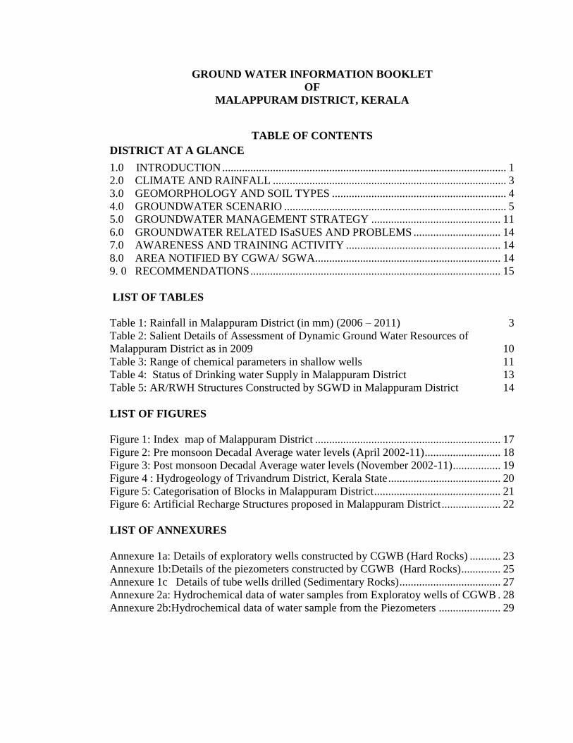
TABLE OF CONTENTS
DISTRICT AT A GLANCE
1.0 INTRODUCTION ..................................................................................................... 1
2.0 CLIMATE AND RAINFALL ................................................................................... 3 3.0 GEOMORPHOLOGY AND SOIL TYPES .............................................................. 4 4.0 GROUNDWATER SCENARIO ............................................................................... 5 5.0 GROUNDWATER MANAGEMENT STRATEGY .............................................. 11 6.0 GROUNDWATER RELATED ISaSUES AND PROBLEMS ............................... 14 7.0 AWARENESS AND TRAINING ACTIVITY ....................................................... 14
8.0 AREA NOTIFIED BY CGWA/ SGWA.................................................................. 14
9. 0 RECOMMENDATIONS ......................................................................................... 15
LIST OF TABLES
Table 1: Rainfall in Malappuram District (in mm) (2006 – 2011) 3
Table 2: Salient Details of Assessment of Dynamic Ground Water Resources of
Malappuram District as in 2009 10
Table 3: Range of chemical parameters in shallow wells 11 Table 4: Status of Drinking water Supply in Malappuram District 13
Table 5: AR/RWH Structures Constructed by SGWD in Malappuram District 14
LIST OF FIGURES
Figure 1: Index map of Malappuram District .................................................................. 17
Figure 2: Pre monsoon Decadal Average water levels (April 2002-11) ........................... 18 Figure 3: Post monsoon Decadal Average water levels (November 2002-11) ................. 19
Figure 4 : Hydrogeology of Trivandrum District, Kerala State ........................................ 20
Figure 5: Categorisation of Blocks in Malappuram District ............................................. 21 Figure 6: Artificial Recharge Structures proposed in Malappuram District ..................... 22
LIST OF ANNEXURES
Annexure 1a: Details of exploratory wells constructed by CGWB (Hard Rocks) ........... 23 Annexure 1b:Details of the piezometers constructed by CGWB (Hard Rocks) .............. 25 Annexure 1c Details of tube wells drilled (Sedimentary Rocks) .................................... 27
Annexure 2a: Hydrochemical data of water samples from Exploratoy wells of CGWB . 28 Annexure 2b:Hydrochemical data of water sample from the Piezometers ...................... 29

MALAPPURAM DISTRICT AT A GLANCE
Sl .No. ITEMS STATISTICS
1. GENERAL INFORMATION
Geographical area (Sq km) 3550
Administrative Divisions (as in 31-03-2011)
Number of Tehsil/Block
Number of Panchayats/Villages
6/15
100/150
2. GEOMORPHOLOGY
Major physiographic units Low land, Midland and
Highland
Major Drainages Bharathapuzha,
Kadalundipuzha and
Chaliyarpuzha
3. LAND USE (Hectares) as in 2009
Forest area 103417
Net area sown 181986
Area sown more than once 60011
Cultivable area 4760
Current Fallow 10609
Non agricultural Area 41377
4. MAJOR SOIL TYPES
Laterite Soil, Brown
hydromorphic Soil, Coastal
and river alluvium and Forest
loamy soil
5. AREA UNDER PRINCIPAL CROPS (Hectares) as in 2009-10
Rice 8838
Fruit crops 26414
Vegetables 4871
Pepper 6147
Cashew nut 4475
Tapioca 2196
Coconut 108380
Arecanut 19994
Rubber 38136
6. AREA IRRIGATED BY DIFFERENT SOURCES (Hectares) as in 2009-10
Wells (Dug wells &Tube wells / Bore wells) 11966
Tanks / Ponds 4840
Canals 3038
Other Sources 4819
Net Irrigated area 24663
7. NUMBER OF GROUNDWATER MONITORING WELLS
(as in 31-3-2011)
No. of Dug wells 66 (CGWB) + 28 (GWD)
No. of Piezometers 28 (CGWB) + 30 (GWD)
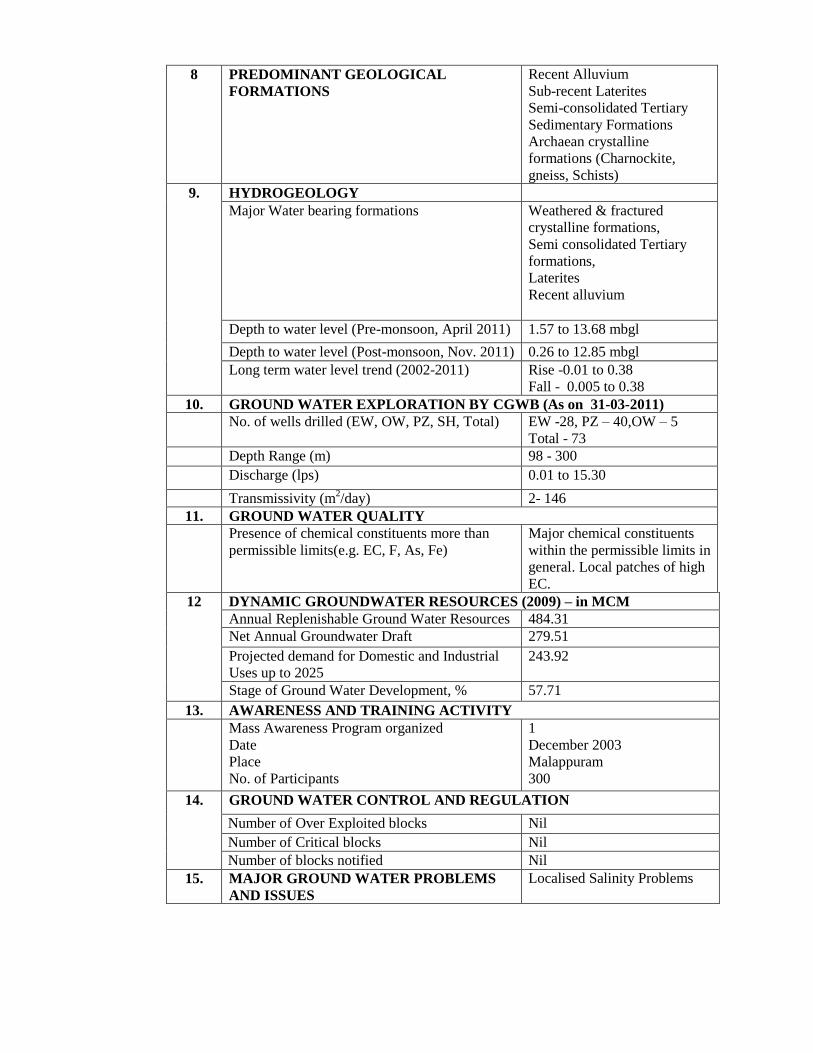
8 PREDOMINANT GEOLOGICAL
FORMATIONS
Recent Alluvium
Sub-recent Laterites
Semi-consolidated Tertiary
Sedimentary Formations
Archaean crystalline
formations (Charnockite,
gneiss, Schists)
9. HYDROGEOLOGY
Major Water bearing formations
Weathered & fractured
crystalline formations,
Semi consolidated Tertiary
formations,
Laterites
Recent alluvium
Depth to water level (Pre-monsoon, April 2011) 1.57 to 13.68 mbgl
Depth to water level (Post-monsoon, Nov. 2011) 0.26 to 12.85 mbgl
Long term water level trend (2002-2011)
Rise -0.01 to 0.38
Fall - 0.005 to 0.38
10. GROUND WATER EXPLORATION BY CGWB (As on 31-03-2011)
No. of wells drilled (EW, OW, PZ, SH, Total) EW -28, PZ – 40,OW – 5
Total - 73
Depth Range (m) 98 - 300
Discharge (lps) 0.01 to 15.30
Transmissivity (m2/day) 2- 146
11. GROUND WATER QUALITY
Presence of chemical constituents more than
permissible limits(e.g. EC, F, As, Fe)
Major chemical constituents
within the permissible limits in
general. Local patches of high
EC.
12 DYNAMIC GROUNDWATER RESOURCES (2009) – in MCM
Annual Replenishable Ground Water Resources 484.31
Net Annual Groundwater Draft 279.51
Projected demand for Domestic and Industrial
Uses up to 2025
243.92
Stage of Ground Water Development, % 57.71
13. AWARENESS AND TRAINING ACTIVITY
Mass Awareness Program organized
Date
Place
No. of Participants
1
December 2003
Malappuram
300
14. GROUND WATER CONTROL AND REGULATION
Number of Over Exploited blocks Nil
Number of Critical blocks Nil
Number of blocks notified Nil
15. MAJOR GROUND WATER PROBLEMS
AND ISSUES
Localised Salinity Problems

Ground Water Information Booklet of Malappuram District
1
GROUND WATER INFORMATION BOOKLET OF MALAPPURAM
DISTRICT, KERALA STATE
1.0 INTRODUCTION
Malappuram literally means an elevated place on the top of hills. The district has a
unique place in the geological history in view of the fact that Laterite, first identified in
the area near Angadippuram by Francis Buchanan is the type area of Laterite. The district
lies between North latitudes 10o
40’ and 11o
32’ and East longitude 75 o
50’ and 76 o
36’.
The Nilgiris of Tamil Nadu in the east and Lakshadweep Sea in the west provide natural
boundaries. In the north it is bounded by Kozhikode and Wayanad districts and in the
south by Palakkad and Trichur districts. The district has a geographical area of 3550
sq.km, which is 9.13 % of the total area of the State.
In 2011, Malappuram had population of 4,110,956 of which male and female were
1,961,014 and 2,149,942 respectively. There was an increase of 13.39 percent in the
population compared to population as per 2001. The initial provisional data suggest a
density of 1,158 in 2011 compared to 1,021 of 2001. Malappuram ranks 3rd
in the area
and first in the population of the State. Out of the total population 55.81% (2,294,473) is
in the rural area and the rest (1,816,483) is in the urban area. Malappuram contributes
12.31% of the total population of the state.
The district is accessible by air, rail and road. The Kozhikode airport is situated near
Kondotty in the district. The Kanyakumari-Mangalore-Mumbai broad gauge railway line
passes through the western parts of the district. There is another branch rail line to
Nilambur from Shornur (Palakkad district). The NH 17 which connects Cochin and
Mangalore passes through the western portion of the district.
The Headquarters of the district is at Malappuram. The district has two Revenue
Divisions with Headquarters at Perinthalmanna and Tirur. There are 6 taluks namely
Ernad (Headquarters at Manjeri), Perinthalmanna, Tirur, Ponnani, Nilambur and
Tirurangadi (Headquarters at Parappanangadi), 15 blocks, 100 panchayats and 150
villages. There are 7 Municipalities namely Malappuram, Kottakkal, Ponnani,
Perinthalmanna, Tirur, Manjeri and Nilambur.

Ground Water Information Booklet of Malappuram District
2
An index map of the district is given in Figure 1.
Drainage
Malappuram district is mainly drained by the Kadalundi River, Chaliyar River and
Bharathapuzha (locally known as Ponnani River). Of these rivers, only Chaliyar and
Bharathapuzha are perennial and all others get dried up in summer and hence
Malappuram district is highly drought prone. The Kadalundi River is formed by the
confluence of its two main tributaries viz; the Olipuzha and the Veliyar. The Olipuzha
takes its origin from 'the Cherakkobban Mala' (1160 m amsl) and the Veliyar originates
from the forest of the 'Erattakomban Mala' (1190 m amsl). The Kadalundi River is 130
km long with a drainage area of 1274 sq. km. The river joins the Lakshadweep Sea at
about 5 km south of the Chaliyar river mouth.
The Chaliyar River, one of the major rivers of the State, originates from the Ilambalari
Hills in Nilgiri district of Tamil Nadu (2066 m amsl). The river flows along the northern
boundary of Malappuram district through Nilambur, Mambad, Edavanna, Areakode and
Feroke. It joins the Lakshadweep Sea near Beypore. The river is 169 km long with a
drainage area of 2535 sq. km in Kerala State.
The Bharathapuzha or the Ponnani River is the second longest river of Kerala,
originating from the Anamalai Hills (1964 m amsl) in the Western Ghats. The river
below the confluence of Bharathapuzha and Gayathripuzha is called the Ponnani River.
It flows through the districts of Palakkad, Malappuram and Trichur and drains into the
Lakshadweep Sea near Ponnani town in Malappuram district.
The drainage pattern of the three rivers in the district is generally dendritic. Tidal effects
are experienced in places such as Vallikkunnu and Tirurangadi, which are 6 to 8 km
away from the coast. Analysis of the drainage characteristics of the two basins reveals
that Kadalundi river is a fourth order stream, the Ponnani river is fifth order stream and
the Chaliyar river is a seventh order stream.
Studies carried out by CGWB
Systematic hydrogeological surveys in the district were carried out during 1975 – 76.
Detailed water balance studies of Kadalundi and Ponnani river basins are carried out

Ground Water Information Booklet of Malappuram District
3
during the erstwhile SIDA assisted Coastal Kerala Groundwater Project (1983-88).
Subsequent reappraisal hydrogeological surveys were carried out during 1997 – 98 &
2002 – 03. First phase of groundwater exploration in the hard rock as well as in the
sedimentary formation of the district were carried out during the SIDA project from 1983
to 1987, in which 3 bore wells in hard rock area and 5 tube wells in sedimentary area
were drilled. Subsequently, during 1999-2001(Hydrology Project), 2003-04 and 2007-09,
20 bore wells and 40 piezometers were drilled in hard rock area. by Central Ground
Water Board.
2.0 CLIMATE AND RAINFALL
The district has more or less the same climatic conditions prevalent elsewhere in the State
viz. dry season from December to February and hot season from March to May, the
South-West monsoon from June to September and the North-East monsoon from October
to December. The normal rainfall of the district is 2793.3 mm. Out of this, major rainfall
contribution is from SW monsoon followed by the NE monsoon. The South West
monsoon is usually very heavy and nearly 73.5% of the rainfall is received during this
season. NE monsoon contributes nearly 16.4% and March to May summer rain
contributes nearly 9.9% and the balance 0.2% is accounted for during January and
February months.
The monthly rainfall for the Malappuram district during the period 2001 – 06 is tabulated
in Table 1.
Table 1: Rainfall in Malappuram District (in mm) (2006 – 2011)
Month 2006 2007 2008 2009 2010 2011
January 0.80 0 0 0 18.40 11.00 February 0 0 21.00 0 0 18.00 March 45.90 0 218.00 49.40 9.30 11.00 April 60.60 100.10 45.70 53.40 74.70 155.00 May 617.50 240.80 59.80 289.40 197.40 56.00 June 644.00 783.20 523.40 586.10 775.80 927.00 July 553.00 1170.20 437.70 972.10 601.50 472.00 August 516.00 533.30 260.20 385.10 236.60 478.00 September 588.00 660.30 345.50 361.40 308.00 403.00 October 371.60 413.30 384.70 156.90 539.60 274.00 November 176.50 48.60 9.00 206.30 332.60 142.00 December 0.70 4.50 5.00 29.70 20.50 7.00 Total 3574.60 3954.30 2301.00 3089.80 3114.40 2954.00

Ground Water Information Booklet of Malappuram District
4
Temperature
The climate is generally hot and humid. March and April months are the hottest and
January and February months are the coldest. The maximum temperatures ranges from
28.9 to 36.2°C and the minimum temperatures range from 17.0 to 23.4°C. The
temperature starts rising from January and reaches the peak in the month of March and
April and then decreases during the monsoon month and again rising from September
onwards.
Wind
The wind is predominant from east as well as west during morning and evening hours.
The wind speed is more during December to February months. It ranges from 2.9 to 7.2
km per hour.
Humidity
The relative humidity ranges from 84 to 94 % during morning hours. The humidity is
more during the peak monsoon months from June to September.
3.0 GEOMORPHOLOGY AND SOIL TYPES
Geomorphologically the district can be divided into three viz. coastal plain (less than 7.5 m
amsl) mid land (7.5 – 75 m amsl) and highland (above 75 m amsl). The coastal plains
extend as a narrow stretch of land lying along the coast from Kadalundi Nagaram in the
north to Ponnani in the south. It becomes very narrow towards north of Tirur and the
maximum width is seen along Chauravallam - Tirurangadi area. The area lying between
the coastal plain in the west and the high ranges in the east is occupied by midlands. This
is the most prominent physiographic unit of the district. This is characterized by flat
topped hillock with steep ‘U’ shaped valleys and ridges. The valley forms potential area
for agriculture including paddy, arecanut, vegetable, banana and coconut. The hill tops are
generally barren and covered by thick and compact laterite. The eastern parts of the district
are characterized by steep hills, gorges and escarpments. The elevation of the hill ranges
goes up to 1127 m amsl. Most of the high lands are occupied by forests.

Ground Water Information Booklet of Malappuram District
5
Soils
On the basis of morphological and physico-chemical properties, the Soil Survey Division
of Department of Agriculture, Govt. of Kerala has classified the soils of the district into
the following types
Soils of the low lands (Alluvial soil)
Those are mainly seen along the coastal plains and valleys. The soils range from
exclusively drained to moderately/well drained sand to sandy clay in nature.
Soils of Mid/Up lands (Lateritic soil)
These are mostly lateritic soil, and is seen along the mid land portion of the district. These
are deep to very deep, well drained, and gravelly to clayey.
Soils of Central Sahyadri (Hydromorphic soil)
These are deep moderate, well drained and clayey soils with high gravel content. Erosion is
moderate to severe. Hard laterites with rock out crops are present.
Soils of eastern part of Malappuram (Forest loamy soil)
These soils are deep or very deep and well drained with loamy to clayey textures and
having fairly high gravel content.
4.0 GROUNDWATER SCENARIO
Hydrogeology
Hydrogeologically, the aquifer system in the district can be broadly divided into Crystalline
aquifers (fractured basement rock aquifers), Laterite aquifers, Lateralized sedimentary
(Tertiary) aquifers and Alluvial aquifers. Crystalline and Laterite aquifers constitute major
part (85%) of the district.
Groundwater in crystalline formations
In the crystalline rocks of the area viz. Charnockite, Biotite gneiss and Migmatite, the
occurrence and movement of ground water are dominantly controlled by the nature and
extent of weathering and the presence of structural features like fractures, joints and shear
zones which generally varies from place to place. Ground water occurs in the secondary

Ground Water Information Booklet of Malappuram District
6
intergranular pores and voids, under unconfined conditions in the shallow weathered and
fractured rocks and under semi-confined to confined conditions in the deeper fractured
zones.
Weathered rock forms potential aquifers and the thickness of weathered rock ranges from
4 to 12 m below ground level. Along valley portions in the area ground water is
developed mostly by means of dug wells. The wells piercing the weathered zone vary
from 15 to 20 m and ranges in diameter from 2 to 5 m. Their depth varies from 3.5 to
21.2 m bgl. The yields of those wells are of the order of 6 to 12 m3/hrs and the specific
yield values ranges from 1-3%. The wells located in the hornblende biotite gneiss vary in
depth from 6 to 15 m bgl. The yield of these wells ranges from 4 to 5 m3/hrs. They can
sustain pumping for only few hours and recuperation rate is very poor.
Fractured aquifers in the crystalline areas form potential aquifers and ground water occurs
under semi-confined to confined conditions. The occurrence and movement of ground
water is controlled by the presence of lineaments, fractures and joint pattern. The studies
and exploration carried out in the district indicate the intersections of exploratory wells
fractures are most potential followed by NE – SW fractures. Ground water is developed by
means of bore well. In the case of deep crystalline aquifers the fractures are fairly deep and
inter connected.
CGWB has constructed 23 exploratory wells and 40 piezometers in this aquifer system and
the salient aspects of the bore wells are given in Annexure 1a. The wells tapping deep
crystalline aquifers range in depth from 90 to 300 m bgl. The yield of these wells ranges
from 0 to 920 lpm. The depth of over burden varies from 3 to 35 m. The water bearing
fractured zone were encountered at depth ranges of 20 to 30, 40 to 60, 70 to 80, 90 to 120
and 150 to 160 m bgl. The transmissivity values of the deep fractured confined aquifers
ranges from 30-15 m2/day (Charnockites) and 5-50 m
2/day (Hornblende biotite gneiss).
Groundwater in Laterites
This is the most widely distributed aquifer system in the district and occupies the midland
region. The laterite constitutes the potential aquifer because of the porous and highly
permeable nature. Ground water occurs under water table conditions. Due to this porosity,
the stored water escapes as sub-surface run-off from the elevated hills and slopes once the
Ground Water Information Booklet of Malappuram District
7
rain recedes. The laterite is derived from both the Tertiary formation and also from the
crystallines. The laterite mainly occupy the hill top areas as laterite capping. Also occupy
in low land areas where thickness is very meager.
The thickness of laterite overlying charnockites varies from 1 to 3 m and from 15 to 20 m
in hornblende gneiss. Dug wells are the main water abstraction structures in the aquifer and
the depth of these wells range from less than 5.0 m to 15 m bgl. Majority of well tapping
laterites dry up during summer months. The bottom part the wells are mainly of
lithomargic clay and becomes low yielding during peak summer periods. Subsequent rains
contribute little to the aquifer system and escapes as rejected recharge. However in the
lower attitudes especially in valley portions the water table is shallow and appreciable
thickness of saturated zone is available for ground water development. Yield ranges from
8 to 10 m3 per hour and the specific yield values ranges from 2-5%.
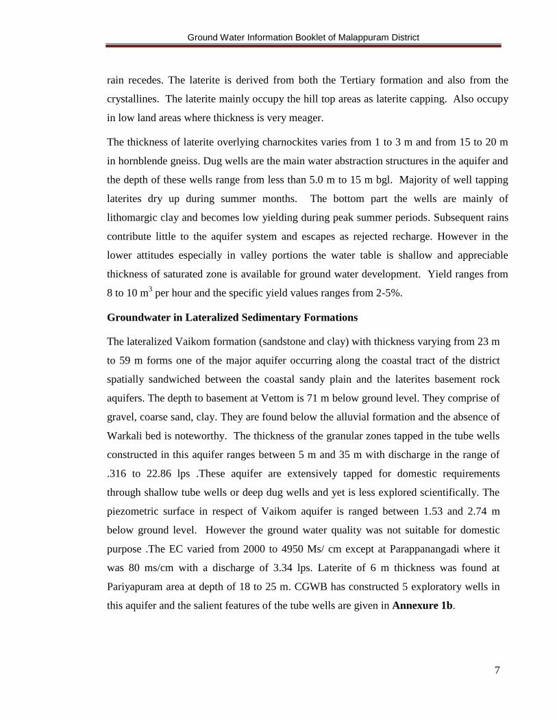
Groundwater in Lateralized Sedimentary Formations
The lateralized Vaikom formation (sandstone and clay) with thickness varying from 23 m
to 59 m forms one of the major aquifer occurring along the coastal tract of the district
spatially sandwiched between the coastal sandy plain and the laterites basement rock
aquifers. The depth to basement at Vettom is 71 m below ground level. They comprise of
gravel, coarse sand, clay. They are found below the alluvial formation and the absence of
Warkali bed is noteworthy. The thickness of the granular zones tapped in the tube wells
constructed in this aquifer ranges between 5 m and 35 m with discharge in the range of
.316 to 22.86 lps .These aquifer are extensively tapped for domestic requirements
through shallow tube wells or deep dug wells and yet is less explored scientifically. The
piezometric surface in respect of Vaikom aquifer is ranged between 1.53 and 2.74 m
below ground level. However the ground water quality was not suitable for domestic
purpose .The EC varied from 2000 to 4950 Ms/ cm except at Parappanangadi where it
was 80 ms/cm with a discharge of 3.34 lps. Laterite of 6 m thickness was found at
Pariyapuram area at depth of 18 to 25 m. CGWB has constructed 5 exploratory wells in
this aquifer and the salient features of the tube wells are given in Annexure 1b.

Ground Water Information Booklet of Malappuram District
8
Groundwater in Alluvial Formations
This is the most potential aquifer in the district. The coastal alluvium is essentially
composed of sand, silt and clay. The ground water occurs under water table conditions.
Large number of dug wells and filter point wells tap this aquifer to meet the domestic and
agricultural needs. The coastal alluvium can sustain medium to heavy duty pumping. Filter
point wells are feasible along the coast wherever the saturated sand thickness exceeds 5 m.
Such potential areas are seen around Ponnani, Chamravattom, Mangalam, B.P Angadi,
Tirur, Tanur, Parappanagadi and Kadalundi. Riverine alluvium of considerable thickness
is seen in and around Thirunavaya, Kuttipuram area along the northern side of
Bharatapuzha (Ponnani) river. Open dug wells and shallow tube wells are feasible in the
stretch.
Valley fill materials (colluviums) are seen along almost all major and minor valleys. The
formations form potential aquifers wherever the sandy portion is more. The specific yield
values of these aquifers ranges from 10-20%. Dug wells tapping this aquifer often meet
entire needs of minor irrigation schemes. The alluvial deposits are tapped by dug wells.
Shallow dug wells piercing alluvium over laying the lateritic horizon vary in depth from 15
to 20 m bgl. The water level ranges from 1.6 to 13.3 m bgl.
Water levels and their Long term behaviour
The Central Ground Water Board is having 94 Ground Water Monitoring Wells (GWMW) in
Malappuram district consisting of 66 dug wells and 28 piezometers. The dug wells are
established in the laterite aquifers (Phreatic aquifers) and piezometers are established in the
fractured basement rock aquifers (Confined/semiconfined). These stations are monitored for
ground water level and quality. The analysis data indicate that the depth to water level in the
wells taping weathered crystalline rock aquifers ranges from 6.46 to 8.79 m bgl during pre-
monsoon and from 4.21 to 5.88 m during Post-monsoon. The depth to water level in the
wells tapping laterites ranges from 2.08 to 12.47 m bgl during pre-monsoon and from 1.75 to
10.32 m bgl during post monsoon. The water level ranges from 3.4 to 8.85 m bgl during the
pre-monsoon and from 1.4 to 5.36 m bgl during post monsoon in alluvial aquifers. Depth to
water level in the lateralized sedimentary aquifers varies from 10.46 to 21. 22 mbgl during

Ground Water Information Booklet of Malappuram District
9
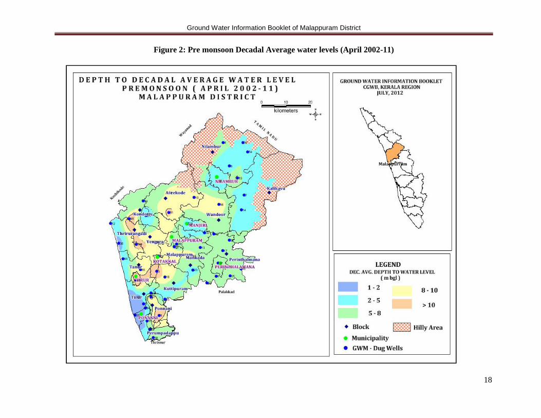
the premonsoon and from 7.0 to 10.11m bgl during the post monsoon. Depth to water level
maps during premonsoon and postmonsoon are shown in Figures 2 & 3 respectively. .
Long Term Water Level Trend
Long term trend of pre-monsoon and post-monsoon water level, between 1981and 2010
is analyzed. The water level Hydrograph depicting pre-monsoon trend and post monsoon
trend for select monitoring stations having continuous data for a considerable period
have been selected for the analyzes. The results of the analysis shows that data from 85%
of the hydrograph network stations in Malappuram show either rising trend or no trend
both in the pre monsoon and post monsoon phase. The maximum premonsoon rise
(0.70m/year) is shown in the data recorded at Thiruvali station in Wandur block where as
in the post monsoon phase the maximum rise is shown by the Cheruvannur station in
Kuttippuram block. The annual trend indicates that 95% of the network stations show
either rising trend or no trend.
Ground water Resources
Assessment of dynamic ground water resources of the district as in March 2009,
computed block-wise as per the norms of Ground Water Estimation Committee (GEC)
1997 indicate net annual ground water availability of 484.31 MCM. The gross ground
water draft for all uses is of the order of 279.51 MCM. The net availability of ground
water for future irrigation is of the order of 158.72 MCM. The stage of ground water
development for the district as a whole is about 58%, ranging from 35% in Nilambur
block to 92% in Tirurangadi block. Salient details of the computation of ground water
resources in the district are shown in Table 2.

Ground Water Information Booklet of Malappuram District
10
Table 2: Salient Details of Assessment of Dynamic Ground Water Resources of
Malappuram District as in 2009
Sl.
No
.
Ass
essm
en
t U
nit
/
Blo
ck
To
tal
An
nu
al
Gro
un
d
Wa
ter R
ech
arg
e
Pro
vis
ion
fo
r N
atu
ral
Dis
cha
rges
du
rin
g n
on
mo
nso
on
sea
son
Net
An
nu
al
Gro
un
d
Wa
ter A
va
ila
bil
ity
Ex
isti
ng
Gro
ss
Gro
un
d W
ate
r D
raft
for
All
use
s
Net
Gro
un
d W
ate
r
Av
ail
ab
ilit
y f
or
futu
re
irri
ga
tio
n
dev
elo
pm
ent
Sta
ge
of
Gro
un
d
Wa
ter D
evel
op
men
t
(%)
1 Areacode 5334.07 533.41 4800.67 2365.38 2013.96 49.27
2 Kondotty 3055.32 305.53 2749.79 1992.19 426.28 72.45
3 Kuttippuram 2722.56 272.26 2450.30 1676.65 521.60 68.43
4 Malappuram 3644.29 364.43 3279.86 1901.65 1029.08 57.98
5 Mankada 4036.03 403.60 3632.42 2305.77 980.41 63.48
6 Nilamboor 7441.40 744.14 6697.26 2327.12 3932.04 34.75
7 Perinthalmanna 4845.22 484.52 4360.69 1876.04 2157.15 43.02
8 Perumpadappu 2194.00 109.70 2084.30 1278.64 629.15 61.35
9 Ponnani 2576.09 257.61 2318.49 1436.21 606.95 61.95
10 Tanur 3694.67 184.73 3509.94 2533.92 550.63 72.19
11 Tirur 3976.45 198.82 3777.63 2418.07 986.69 64.01
12 Tirurangadi 2259.63 112.98 2146.65 1968.27 0.00 91.69
13 Vengara 2801.00 280.10 2520.90 1801.82 389.77 71.48
14 Wandoor 4557.97 455.80 4102.17 2069.40 1648.51 50.45
TOTAL (ha.m) 53138.69 4707.63 48431.05 27951.12 15872.22 57.71
TOTAL (MCM) 531.39 47.08 484.31 279.51 158.72 57.71
Based on the stage of ground water development and the long term trend of water levels,
3 blocks namely Kondotty, Tirurangadi and Vengara have been categorized as ‘Semi-
Critical’ and the remaining blocks are categorized as ‘Safe’( Figure 5).
Groundwater quality
The chemical quality of the ground water in the district is generally good. The shallow
groundwater from the alluvial formation has higher total dissolved solids and major ion
constituents than that of other formations. This is due to the proximity of the pond water
channels and tidal influence in the area occupied by coastal alluvium. In the coastal
alluvium the electrical conductivity ranges from 1360 – 2130 µS/cm at 25o C. In the other

Ground Water Information Booklet of Malappuram District
11
areas the EC is within permissible limit. Since the district is devoid of any major industries
the ground water pollution due to industrial pollution is not a major issue of concern. The
chemical analysis data of samples collected from exploratory bore wells and piezometers
are given in Annexures 2a and 2b respectively. The range of chemical constituents of
groundwater in the shallow phreatic aquifers of the district are summarized in Table 3.
Table 3: Range of chemical parameters in shallow wells
Sl.No Properties/
constituents
Maximum permissible limit as
per ISI (1983)
Range (NH stations)
April -2009
1 pH 6.5 - 9.2 7.1-9.5
2 Electrical
conductivity(in
µS/cm at 250 c)
- 50-974
3 Total hardness as
CaCO3 ppm
600 8-160
4 Ca " 200 2.4-32
5 Mg " 100 1-19
6 Na " 0.3-73
7 K " 0.3 – 2.5
8 C03 " 0-2.4
9 HC03 " 7 - 154
10 S04 ” 400 0.8-.245
11 Cl " 1000 5-124
12 N03 " 45 0.5-54
13 F " 1.5 0-0.4
5.0 GROUNDWATER MANAGEMENT STRATEGY
Malappuram district is the most populous district in the State with highest decadal
population growth rate. With the ever increasing population, to meet the demand of water
for various purposes, there is a growing stress on the ground water resources.
Management of ground water is becoming a deep concern for the scientists, planners and
administrators alike. Sustainable management of available ground water resources has
thus become vital for the prevention of over exploitation and contamination of
groundwater.
Though the district is endowed with an average annual rainfall about 3000mm spread
over both the southwest and northeast monsoons, the ground water availability during the
peak requirement period (Dec – May) has been found to be meager for domestic and
agricultural purposes. This is mainly on account of the large dependence on ground water

Ground Water Information Booklet of Malappuram District
12
in rural areas and the resultant high well density, where the spacing between pumping
wells often less than 50 m. Further, as the major part of the district is underlain by
crystalline rocks with very thin unconsolidated phreatic aquifer with steep hydraulic
gradient from east to west, the ground water runoff from the phreatic aquifer is
appreciable on account of the unique geomorphic and hydrogeological set up of the area .
Hence ground water management to ensure equity, efficiency and sustainability should
focus on suitable water harvesting and artificial recharge techniques. A strong ground
water legislation with strict regulation and control with mandatory registration of all new
pumping ground water extraction structures with the State Ground Water Authority
would aid in proper governance and ensure sustainability of this precious resource.
There is no major urban water supply scheme in the district. Major schemes are mostly river
based. However, majority of rural water supply schemes depend on ground water. The
status of drinking water supply schemes in the district is summarised in Table 4. About 32%
of the schemes depend on open wells and 36 % of the schemes are bore well based. About 2
% of the schemes are a combination of open and bore wells. Springs constitute for 1.5 % of
schemes. Only 21 % of the schemes depend on groundwater as their source.
The following areas have been suggested for further development of deeper fractured
aquifers in the hard crystalline basement rock.
(1) The Karipuzha and Chaliyar lineaments are potential zones for the development of
deeper aquifers in Chaliyar basin.
(2) The Olipuzha – Kadalundi lineament (ENE – WSW) is a potential area for the
development of deeper aquifers in Kadalundi basin.
(3) Minor lineaments trending E – W, WNW – ESE (Kottakkal, Kulattur) are also
potential in Kadalundi basin
(4) The EW and NNW - SSE trending minor lineaments are good for ground water
development potential in Ponnani basin
(5) The NW – SE trending major lineament is not always promising due to the local
filling of the aquifer with clay.

Ground Water Information Booklet of Malappuram District
13
(6) The intersection points of the major NW – SE lineaments with minor fractures are
having very good groundwater potential.
(7) The approximate casing depth will normally vary from 5 to 25 m. No formation
instability during drilling operation is expected in the district.
Table 4: Status of Drinking water Supply in Malappuram District
Sl.No Block Public Wells Public Tanks Hand Pumps Others Total Public Taps
W NW W NW W NW W NW W NW W NW
1 Perumpadappa 94 13 2 1 237 6 0 0 333 20 429 14
2 Areacode 171 40 33 3 36 12 6 0 246 55 497 39
3 Kondotty 159 14 18 2 50 3 8 0 235 19 368 0
4 Kuttipuram 66 11 9 8 88 5 45 0 208 24 219 18
5 Malappuram 136 24 17 4 42 7 0 0 195 35 513 0
6 Mankada 125 34 31 0 123 17 5 0 284 51 775 130
7 Nilambur 277 13 20 1 18 14 2 4 317 32 342 135
8 Perintalmanna 132 2 31 0 81 1 0 0 244 3 227 0
9 Ponnani 114 35 0 0 48 0 0 0 162 35 582 149
10 Tanur 85 11 25 4 52 9 0 0 162 24 372 44
11 Tirur 86 5 10 2 19 19 0 0 115 26 362 154
12 Tirurangadi 140 10 3 0 44 0 2 0 189 10 620 60
13 Vengada 242 0 5 0 110 0 0 0 357 0 124 0
14 Wandoor 188 12 93 2 55 15 0 0 336 29 504 85
Total 2015 224 297 27 1003 108 68 4 3383 363 5933 828
Water Conservation and Artificial Recharge
So far no large scale artificial recharge schemes have been implemented in the district so as
to augment the natural recharge to the aquifer system. Overall the district offers tremendous
scope for artificial recharge due to the highly porous and deep lateritic profile, especially at
places where the ground water is deep. Since the district is characterized by the presence of
table topped mountain and ridges covered by lateritized beds, construction of artificial
recharge by tapping surface run off is a feasible proposition. Abandoned lateritic quarry pits
can be used as percolation tanks for this purpose. The proposed Artificial Recharge
structures in Malappuram district are shown in Figure 6. Details of AR/RWH structures
constructed in the district by State Ground Water Department are furnished in Table 5.

Ground Water Information Booklet of Malappuram District
14
Table 5: AR/RWH Structures Constructed by SGWD in Malappuram District
Year Type of structure Location
2010 Check Dam
Chennaythodu in Thiruvali Grama Panchayat
Parappoduthodu-Kapradu in Tirurangadi Pt.
Karakkunnu in Trikkalangodu Grama Panchayat
2009 NIL
2008 Ferro cement tank &
over flow recharge to Open well
GLP School, Cherukulam, Thrikkalangode Pt.
GHS School, Karakkunnu, Thrikkalangode Pt.
2007 Recharge to Open well
1) AMLPS, Chemmala, Pulamanthole Pt.
2) Govt.H.S.S., Vettathur
3) GHS School, Pattikkad
4) Aided Mappila DS, Tirurkad
2006
Recharge to Open well
1) St.Joseph English medium school,
Puthanangadi
2) AUP School, Pulamanthole
2) Thirumandamkunnu Devaswam
Board building, Angadippuram
Recharge to Bore well 4) AUP School, Chemmala
Recharge to Open well
5) GHS Pulamanthole
6) Aided PTM HS School, Thazhekode
7) Govt.UP School, Panangangara
8) ALP School, Paloor
6.0 GROUNDWATER RELATED ISSUES AND PROBLEMS
In general the district is devoid of any serious ground water related issues in terms of
quantity and quality. However, the dug well in the lateritic aquifer goes dry immediately
after the monsoon season causing drinking water shortage to rural population.
7.0 AWARENESS AND TRAINING ACTIVITY
Mass awareness programme and Water Management Training Programme
CGWB has conducted a mass awareness programme on conservation and protection of
groundwater resources at Malappuram on December 2003. The programme got wide
publicity and was attended by about 300 participants.
8.0 AREA NOTIFIED BY CGWA/ SGWA
No blocks in the district has been notified by CGWA / SGWA.

Ground Water Information Booklet of Malappuram District
15
9. 0 RECOMMENDATIONS
There are no major irrigation projects in the district. An area of 24663 ha is being
irrigated using minor and lift irrigation schemes. Ground water irrigation is still
in the infant stage in the district and is confined to cash and garden crops. The
government should introduce more beneficial schemes to promote ground water
irrigation in the district
The deep fractures in the crystalline basement offers huge prospects for further
ground water development. The following areas have been identified for the
development of the above said resource.
o Karimpuzha and Chaliyar lineaments in the Chaliyar basin
o Olipuzha – Kadalundi lineaments (ENE – WSW) in Kadalundi basin
o Minor lineaments trending E- W, WNW- ESE (Kottakkal – Kulathur) in
Kadalundi basin.
o E-W and NNW – SSE trending minor lineaments in Ponnani basin.
o Intersection points of major NW – SE lineaments with minor
fracture/joints have very good ground water development potentials.
Abandoned laterite quarries can be developed as percolation tank for recharging
laterite/hard rock aquifer by tapping surface run off/rainfall.
Check dams are recommended for the recharge of the vast alluvial track in
Bharathapuzha basin.
The intersection of Palakkizhi lineament with Olipuzha lineament (at Kizhuttur,
about 3 km south of Melattur) is a potential area for development of deeper aquifer.
There are about 26 springs reported in the district. They emerge along the contact
between laterite and crystalline along topographic lower valleys. The yield of the
spring ranges from 1 to 500 lpm. These springs can be developed for planned rural
water supply schemes.
Some of the promising potential valleys where groundwater can be developed by
means of open wells are :
o Valley between Kolathur - Karuvambalam - Pookkatteri (58 B/1 - I B)
o Ramapuram Valley - (58 B/1, 1B)
o Palpatta Valley (EW), (58 B/5 - 2 C)

Ground Water Information Booklet of Malappuram District
16
o Valley running from Ponmala to Chappanangadi, (58 A/3,3A)
o Puttur - Irringalur valley - 58 A/3, 3 A)
o Vadakkangara Valley, (58 A/3, 3C)
o Valley running (WNW - ESE) between Karipur (south of Kondotty) and
Kunnamangalam on the Kondotty - Kuriyad road (49 M)
o The (E-W) valley between Kodavayur, Olakkara and Paravallur on the
Vallikunnu - Karipore road side (49 M/15, 3 C)
o Valley (WNW - ESE) running between Munniyur - Tirurangadi (49 M/15, 3
B)
o Valley (NW - SE/N-S) running between Ponmundam and Perumanna - (49
N, 1 C)
Dug well with diameters of 2.0 - 3.5 m is recommended in the area. The well should be
deep enough to tap the entire thickness of weathered rock, the thickness of which may
range from 6 - 13 m below ground level along the valley portion.
Management of any system should balance the demand and supply in a sustainable
manner. The stress on groundwater system is reflected in steep decline of water levels
and sharp deterioration of quality of water. A scientific development and management of
groundwater is the need of the time to avert any future crisis. The National Water Policy
and the State Water Policy lay down directives and principles for assessment,
development and management of water resources in the country which can be taken as
guidelines for evolving ground water management.

Ground Water Information Booklet of Malappuram District
17
Figure 1: Index map of Malappuram District
Ground Water Information Booklet of Malappuram District
18
Figure 2: Pre monsoon Decadal Average water levels (April 2002-11)
Ground Water Information Booklet of Malappuram District
19
Figure 3: Post monsoon Decadal Average water levels (November 2002-11)

Ground Water Information Booklet of Malappuram District
20
Figure 4: Hydrogeology of Malappuram District, Kerala State

Ground Water Information Booklet of Malappuram District
21
Figure 5: Categorization of Blocks in Malappuram District (2009)

Ground Water Information Booklet of Malappuram District
22
Figure 6: Artificial Recharge Structures proposed in Malappuram District

Ground Water Information Booklet of Malappuram District
23
Annexure 1a: Details of exploratory wells constructed by CGWB (Hard Rocks)
Sl.
No Location Block/Panchayath
Depth
drilled
(mbgl)
Lithology Thickness of
overburden
Depth
ranges of
Water
yielding
zones
SWL
(mbgl)
water yield
(lpm)
EC in
µS/cm
Cl-
ppm
1 Kottakkal Kottakkal
Municipality 229.01
Charnockite
gneiss 13.72
23-40,
54-61,
103-111,
114-119
1.97 920.00 890 18
2 Vallikkappatta Malappuram/
Koottilangadi 300.81
Charnockite
gneiss 7 Nil 4.53 nil 60 11
3 Koyappa Olakara Vengara/ A. R. Nagar 300.81 Charnockite
gneiss 14.95 Nil 7.3 Negligible 210 17
4 Malappuram-I M.S.P
Camp
Malappuram
Municipality 200 Charnockite 11.6 29.0-32.0 13.35 19.20 296 7.1
5 Urakom Malappuram/ Urakam 200 Charnockite 17.4 59.0-62.0 47.45 240.00 370 8.5
6 Malappuram-II
M.S.P staff quarters
Malappuram
Municipality 200 Charnockite 16.2 59.0-62.0 16.6 60.00 197 8.5
7 Padinjattumuri Mankada/
Koottilangadi 102
Charnockite
gneiss 15 32.0-44.0 10.8 840.00 217 5.7
8 Chirattamala Mankada/ Pulamanthol 200 Charnockite 15.5 46.0-49.0 28 360.00 265 2.8
9 Paloorkotta Mankada/
Puzhakkattery 200 Charnockite 16 47.5-49.5 38.75 30.00 247 4.3
10 Thevarparambu Perinthalmanna/
Elamkulam 200 Charnockite 3.7 108.0-111.0 17.12 60.00 459 9.9
11 Vengad Mankada/ Moorkkanad 172 Charnockite
gneiss 7.3
66.0-68.0
72.0-74.0
90.0-93.0
16.31 720.00 267 7.1
12 Edappal Ponnani/ Edappal 200 Charnockite 10 123.0-126.0 9.73 240.00 764 64
13 Thavanur Ponnani/ Thavanur 200 Charnockite 7.3 29.0-35.0 dry
14 Karippur Kondotty/
Pallikkal
200 Charnockite 18.5 54.0-72.0
154.0-157.0 23.8 30.00 272 9.9

Ground Water Information Booklet of Malappuram District
24
15 Klari Thanur/ Perummanna
Klari 200 Charnockite 13.1
16.0-26.0,
43.0-56.0,
78.0-85.0,
98.0-109.0
14.9 90.00 270 4.3
16 Thenhippalam Thirurangadi/
Thenhippalam 111.5
Charnockite
gneiss 14.4
48.0-55.0,
86.0-110.0 30.74 600.00 314 14
17 Perinthalmanna Perinthalmanna
Municipality 200
Charnockite
gneiss 13.4
75.0-78.0,
96.0-99.0,
120.0-124.0
Nil
18 Kolapparambu Wandur/ Pandikkad 200 Hornblende
Biotite Gneiss 22 48.0-51.0 11.8 30.00 175 4.3
19 Kolappuram Vengara/ A. R. nagar 187.3 Charnockite
gneiss 23
35.0-40.0,
156.0-165.0 14.4 150.00 175 4.3
20 Nilambur Nilambur Municipality 200 Hornblende
Biotite Gneiss 33.85 44.0-49.0 15.36 60.00 98 7.1
21 Thuvur Wandur/ Thuvur 200 Hornblende
Biotite Gneiss 7.3 Nil nil
22 Punnakkad Wandur/
Karuvarakundu 162.9
Hornblende
Biotite Gneiss 7.4
47.0-50.0,
69.0-73.0,
115.0-120
6.11 300.00 371 5.7
23 Valluvassery Nilambur/ Chungathara 89.7 Hornblende
Biotite Gneiss 24.6
29.0-35.0,
72.0-78.0 17.38 420.00 384 5.7
Ground Water Information Booklet of Malappuram District
25
Annexure 1b: Details of Piezometers constructed by CGWB (Hard Rocks)
Sl.
No Location Block/Panchayath
Depth
drilled
(mbgl)
Lithology Thickness of
overburden
Depth ranges of
Water yielding
zones
Discharge
(lpm)
EC in
µS/cm
Cl
(ppm)
1 Kolathur Mankada/ Moorkanad 101
Charnockite
/hornblende
biotite gneiss
6.6 37-49,
67-68 420.00 455 0.26
2 Puppallam Mankada/ Valumbram 101 Charnockite 6.6 67-68 Negligible 338 7.1
3 Thozhavannur Kuttippuram/
Kattiparuthi 101 Charnockite 7.4 32-33 30.00 403 21
4 Kizhakkumppuram Perinthalmanna/
Melattur 116.4 Charnockite 6.6 61-62 Negligible 443 8.5
5 Kalikkavu Nuilambur/ Kalikkavu 100 hornblende
biotite gneiss 15.2
20-22
42-43 120 60 258 9.9
6 Wandur Wandur/ Wandur 101 Granitic
gneiss 21.5 70-71 Negligible
7 Pandalur Malappuram/
Pandallur 101
Granitic
gneiss 10.6 NIL nil
8 Munduparamba Malappuram
Municipality 100
Granitic
gneiss 16.5 NIL nil
9 Karuvarakundu Wandur/
karuvarakundu 101
Hornblend
biotite gneiss 30.1 53-54 Negligible 321 4.3
10 Puthanangadi Mankada/
Andagipuram 101 Charnockite 8.6
13-14
56-58 120.00 344 13
11 Mankada Mankada/ Mankada 101 Charnockite 12.9 47-50 Negligible 109 11
12 Klarimoochikkal Thanur/ Perumanna 101 Charnockite 12.8 56-58 15.00 547 7.1
13 Pangh Mankada/ Ponmala 80 Charnockite 6.5 57-58 600.00 330 7.1
14 Nediyirippu Kondotty/
Nediyiruppu 101 Charnockite
12.4 NIL 218 7.1
15 Cherukulam Wandur/
Thrikkalangode
101 Charnockite 17.5 25-26 , 66-67 15.00 219 5.7
Ground Water Information Booklet of Malappuram District
26
16 Karuvambram Manjeri Municipality 113 Charnockite 18 73-74 Negligible
17 Narukara Manjeri Municipality 98 Charnockite 27 NIL 15.00 114 4.3
18 Anakkayam
Malappuram/
Anakkayam 116 Charnockite
6 64-65 nil
19 Pookkottur
Malappuram/
Pookkottur 101 Charnockite
13.2 17-17.5 negligible
20 Mankeri Kuttippuram/
Irimbiliyam 100
Charnockite
gneiss 11.9
19-20
31-32
41-42
47-48
1260.00 79 5.7
21
Amminikkad Perintahmanna /
Thazhekkode 100 Charnockite
gneiss 5.4
29-30
40-41
55-56
6.00 154` trace
22 Muthukurussi Perinthalmanna/
Elamkulam 100
Hornblende
Biotite
Gneiss
15.9 20-21 30-
31 30.00 350 8.5
23 Chemmalassery Mankada/
Pulamanthol 100
Charnockite
gneiss 7.5
24-25 53-
54 6.00 531 13
24 Pananganagara Mankada/
Puzhakkatteri 100
Charnockite
gneiss 7.8
29-30
55-56
65-66
71-72
240.00 400 7.1
25 Kurttippuram Kuttippuram/
Kuttippuram 92
Hornblende
Biotite
Gneiss
15.95
18-19
26-27
55-56
1200.00 159 8.5

Ground Water Information Booklet of Malappuram District
27
Annexure 1c Details of Tube Wells drilled (Sedimentary Rocks)
Sl.No.
Location,
Coordinates &
Toposheet No.
RL Depth
drilled
Depth
constructed Aquifer zones tapped
Depth to
basement Remarks
m
amsl (m bgl) (m bgl) Recent Laterite Warkalai Quilon Vaikom Alleppey (m bgl)
1
Purathoor
1.73 67.06 41.04 18.2 47.24 65.63
EC=4950
10°49’00” Cl=1716
75°55’40” SWL=1.53 m
bgl
49 N/13
2
Vettom
NA 73.25 57 12 0 0 0 59 0 71 10°52’30”
75°53’50”
49 N/13
3
Pariyapuram,
4.47 64.32 Nil 18.29 6.09 30.48 54.86
E.log
EC>3800
10°53’55” below 15 m
bgl
75°54’10”
49 N/13
4
Thanur
NA 65.75 32 NA NA NA NA NA NA NA 11°00’50”
75°52’05”
49 M/16
5
Parappanangadi
NA 46 44 14.75 7 0 0 23 0 44.75 11°03’30”
75°51’30”
48 M/16

Ground Water Information Booklet of Malappuram District
28
Annexure 2a: Hydrochemical data of water samples collected from Exploratory wells of CGWB in Malappuram district
Sl.
No LOCATION Source
Date of
sampling pH
EC in
µs/cm at
25°C
TH as
CaCO3 Ca Mg Na K CO3 H CO3 SO4 Cl F N O3
<-------------------------------------------------- in mg/l---------------------------->
1 Kottakkal EW 12.04.03 7.8 570 250 60 24 16 2.9 0 166 45 72 0.4 0.2
2 Urakom EW 24.06.03 7.98 370 154 33 18 12 3.1 0 149 57 8.5 0.3 0.8
3 Urakom OW 29.07.03 7.77 384 152 24 22 12 3.1 0 139 58 5.7 0.3 1.2
4 MSP Camp,
Malappuram EW 05.06.03 8.05 296 112 19 16 9.2 3.2 0 139 16 7.1 0.5 1
5 Padinjattumuri EW 12.08.03 7.6 217 86 14 13 6.7 2.4 0 120 3.7 5.7 0 0.6
6 Thevaraparmbu EW 30.08.03 7.76 459 194 47 18 11 2.8 0 264 21 9.9 0.4 0.2
7 MSP Staff Quarters EW 05.08.03 7.76 197 66 14 7.8 9.2 3.8 0 93 9.4 8.5 0.1 2
8 Tenhipalam EW 06.12.03 7.16 314 126 28 14 11 3.5 0 163 14 5.7 0.4 0.2
9 Klari EW 29.12.03 7.82 270 100 22 11 9.8 3.3 0 102 45 4.3 0.3 1.6
10 Karippur EW 19.12.03 7.96 272 102 19 13 13 3.7 0 146 11 9.9 0.2 0.2
11 Chirattamala EW 15.09.03 8.46 265 116 25 13 8.1 2.1 7.2 124 21 2.8 0.2 0.03
12 Chirattamala OW 20.09.03 8 712 200 46 21 71 4.1 0 110 258 14 0.5 0.4
13 Paloorkotta EW 30.09.03 8.48 247 106 18 15 8 4.1 7.2 124 17 4.3 0.4 1.6
14 Vengad EW 17.10.03 8.16 267 112 20 15 10 4.2 0 149 9.6 7.1 0.4 0.4
15 Vengad OW 08.11.03 8.55 326 146 28 18 11 4.8 14 159 16 7.1 0.3 0.2
16 Edappal EW 20.11.03 8.32 764 345 62 46 27 3.1 6 140 197 64 0.6 0.1
17 Kollaparambu EW 31.01.04 7.66 175 60 13 6.8 9.7 3.6 0 93 7 4.3 0.6 0.8
18 Karuvarakundu EW 19.03.04 7.74 371 132 33 12 18 8.2 0 227 0 5.7 0.2 0.3
19 Nilambur EW 03.03.04 7.06 98 26 5.6 2.9 7.5 2.6 0 41 1.9 7.1 0.1 2.6
20 Kollapuram EW 12.02.04 7.77 163 52 9.6 6.8 7.6 3.7 0 78 2.2 8.5 0.3 1
21 Valluvacherry EW 11.04.04 7.92 384 158 48 9.2 16 4.2 0 229 5.9 5.7 0.4 0.1

Ground Water Information Booklet of Malappuram District
29
Annexure 2b:Hydrochemical data of water sample collected from the piezometers in Malappuram district
Sl.No Location pH
EC in TH as Ca Mg Na K CO3 HCO3 SO4 Cl F NO3
us/cm at CaCO3
250C
<------------------------------------------------------------------------------------in mg/---------------------------------->
1 Mankeri 7.88 79 22 5.6 2 4.8 1.2 0 32 2 5.7 0 2
2 Amnikkad 8.32 154 58 14 5.4 6.2 5.3 7.2 54 1.5 traces 0.04 12
3 Mathukurissy 8.67 350 162 38 17 9.4 7.1 36 116 18 8.5 0.56 2.6
4 Chammalassery 8.27 531 255 60 26 13 9.8 0 262 72 13 0.54 0.6
5 Panangangara 8.56 400 210 38 28 9.7 3 36 201 7 7.1 0.17 0.5
6 Kuttipuram 8.29 159 55 12 6.1 10 3.6 0 79 4 8.5 0.4 3
7 Narukara 8.24 114 34 8 3.4 8.2 2.7 0 61 4 4.3 0.32 0
8 Cherukulam 8.34 219 82 20 7.8 12 3.9 3.6 129 3 5.7 0.36 0
9 Klarimoochikkal 7.89 547 225 54 22 24 2.8 0 226 150 7.1 0.47 1.5
10 Poopalam 8.48 328 130 18 21 14 11 24 177 5.5 7.1 0.22 1.5
11 Puthenangadi 8.45 344 160 42 13 9.4 2 24 104 56 13 0.35 0.4
12 Kolathur 8.52 455 205 42 24 14 2.4 24 146 113 7.1 0.38 0.26
13 Thozhuvannur 8.57 403 190 38 23 11 2.4 30 165 8.5 21 0.38 1
14 Kizhakkumpuram 8.32 443 165 40 16 19 18 24 207 29 8.5 0.68 0.74
15 Karuvarakund 8.33 321 90 22 8.5 24 7.4 24 159 0 4.3 0.22 0.09
16 Kalikavu 7.08 258 90 30 3.6 9 3.9 0 63 68 9.9 0 11
17 Pangh(GHSS) 8.58 330 155 28 21 8.4 2.7 24 128 45 7.1 0.34 0.98
18 Neeliyirippu 8.91 218 85 16 11 7.6 2.5 24 85 2.5 7.1 0.38 0.33
19 Klarimoochikkal 7.52 109 40 10 3.6 5.5 0.4 0 24 4.5 11 0.08 0.45