cenwits: a sensor-based loosely coupled search and rescue system using witnesses jyh-how huang saqib...
TRANSCRIPT

CenWits: A Sensor-Based Loosely Coupled Search and Rescue System Using Witnesses
Jyh-How Huang Saqib Amjad Shivakant MishraDept. of Computer Science, University of Colorado at Boulder
Presented by: Yi Zhang
Most slides taken from Jyh-How Huang’s slides athttp://csel.cs.colorado.edu/~huangjh/Cenwits/CenwitsSlides.ppt
IntroductionIntroduction
Goal: To build a search and rescue system that can pinpoint missing person’s last seen point in wilderness areas Lost hikers, stranded climbers, injured
skiers, … Difficult because of lack of timely
information about the current location “Last seen point” is critical for
search and rescue actions2
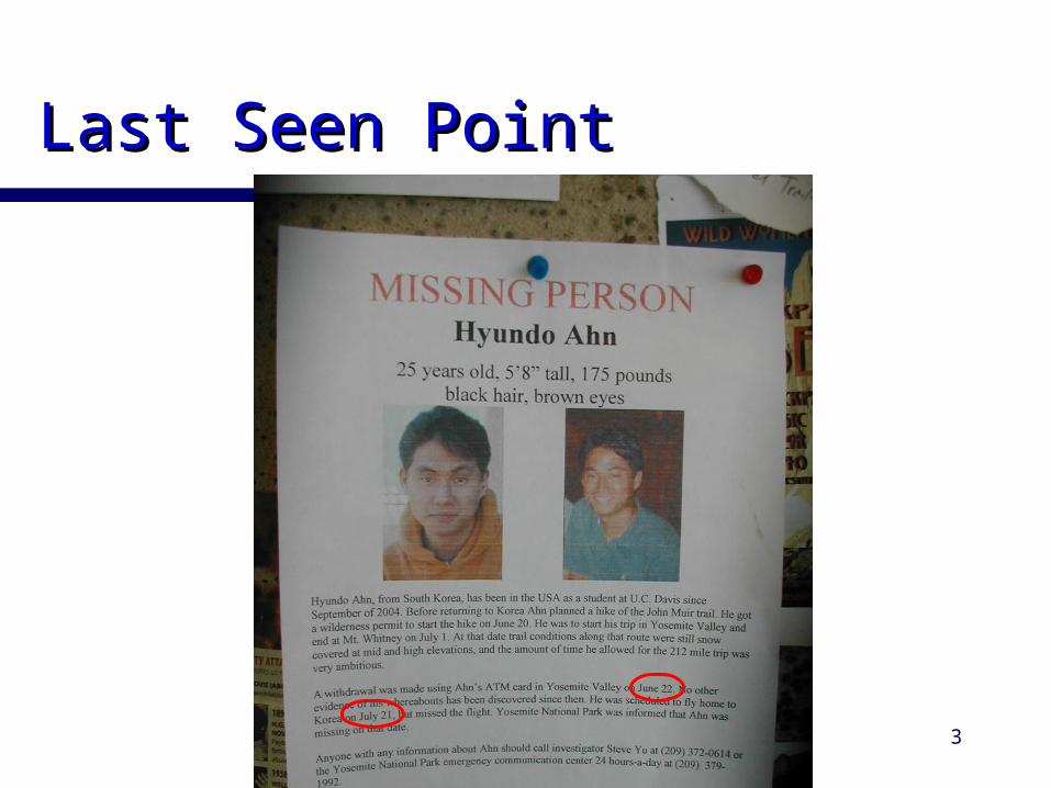
Last Seen PointLast Seen Point
3
Current Search and Rescue Current Search and Rescue Technologies Technologies
The Old School Way – Ask Personal GPS receiver and Satellite
transmitter – Power greedy; Must operate manually to send your location
Localization system and GSM transmitter – Need GSM network coverage
Avalanche beacon/RFID reflector – Limited usage
Need a better, cheaper, reliable system4

Design GoalsDesign Goals
Self-Operate, long life time Small and light weight Non intrusive; no infrastructure
needed Power and memory efficient Cheap($20~$50) Meets security and privacy
requirements5

CenWitsCenWits
A Connection-less Sensor-Based Tracking System Using Witnesses
Comprised of RF sensors GPS receivers Access points Location points Control center
6

How it Works (I)How it Works (I)
Node ID Coordinate Time
10
3
Node ID Coordinate Time
8
6
8
6
2
10
3
1
1 2
7

How it Works (II)How it Works (II)
Node ID Coordinate Time
10
3
8
6 x3, y3, z3 16:58
2
1
Node ID Coordinate Time
…
6 x1, y1, z1 12:31
…
…
6 x2, y2, z2 14:09
…
6 x3, y3, z3 16:58
8

How it Works (III)How it Works (III)
Hiker 6 is reported missing at23:59
Node ID Coordinate Time
…
6 x1, y1, z1 12:31
…
…
6 x2, y2, z2 14:09
…
6 x3, y3, z3 16:58
x1, y1, z1
x2, y2, z2
x3, y3, z3
Inferred location at 23:59
Hot Search Zone
9

System ArchitectureSystem Architecture
Witness
Witness
Search & Rescue Team Control Center10

Memory ManagementMemory Management
MAX RECORD COUNT Replace the old record with new one of the
same node and keep the total records # of a node less than MAX_RECORD_COUNT
MAX HOP COUNT Don’t forward a packet that has high
probability of reaching AP already MIN RECORD GAP
When 2 records are recorded in a time gap < MIN_RECORD_GAP, replace the old one with new one. 12

Power ManagementPower Management
Beacon frequency adjustment based on speed, time of day, etc.
4-phase hand shake protocol Only transmit as much as the
receiver is willing to take
13

Grouping to Save EnergyGrouping to Save Energy
One active leader at any time; others sleepLeadership time-multiplexed
14

More Memory More Memory ManagementManagement
Partitions: sub-groups containing >= 2 nodesEach of the K partitions receives/sends 1/K of total dataWhen nodes dies: split large partition or merge with small partition
15

Prototype ImplementationPrototype Implementation
MICA2 sensors 900 MHz; 4 KB SDRAM; 128 KB
flash; and 4-512 KB EEPROM Mantis OS 0.9.1b MTS420CA GPS module
Successfully conducted a number of experiments in a indoor environment
16

Experiment 1 (Direct Contact):Experiment 1 (Direct Contact): One hiker One hiker starts from A , goes to B and C, and returns to Astarts from A , goes to B and C, and returns to A
17

Experiment 2 (Indirect Inference):Experiment 2 (Indirect Inference): Hiker 1: A to B and beyondHiker 1: A to B and beyondHiker 2: Does not come in contact with any APHiker 2: Does not come in contact with any APHiker 3: C to B and beyondHiker 3: C to B and beyond
Path of hiker 2 is drawn successfully
18
1
3

Hiker 1 to 5 walk on designated trails while hiker 6 does a random walk. We successfully depict path of hiker 6
Experiment 3 (Identifying Experiment 3 (Identifying Hot Search Areas)Hot Search Areas)
19

ConclusionsConclusions
CenWits has several advantages over other search and rescue systems
No need for a connected network of any kind Power and storage efficiency Cost effective Non intrusive
Suitable for deployment in wilderness areas Applications: Hiking; skiing; wildlife
monitoring; vehicular network
20

Discussion (1)Discussion (1)
Simplistic approach to the resource/inference quality tradeoff How to set memory management
parameters? What’s the impact on inference quality? Ultimate goal is not to save
energy/memory, but lives!
21

Discussion (2)Discussion (2)
Energy really saved by transmitting as much as needed? 4-phase hand shake protocol itself is an
overhead Or maybe 3-phase? (piggyback)
Lack of analysis/quantification Transmission energy when changing
group/partition leader? Energy/memory costs in experiments?
Security and privacy issues22

Comments?Comments?
Thanks!
23