ch. 7 - baraboo river region - wisconsin department of...
TRANSCRIPT

7‐2
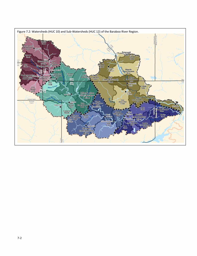
Figure 7.2: Watersheds (HUC 10) and Sub‐Watersheds (HUC 12) of the Baraboo River Region.

7‐3
1. OVERVIEW
a) Physical Environment The Baraboo River Region consists of three different landscapes. The western half is typical “driftless” topography
with narrow hilltops, steep hillsides, and winding valley floors. The northern portion, up into Adams and Juneau
counties and bisected by the Wisconsin River, is rolling to generally flat with deep glacial deposits. The
southeastern portion is dominated by the 25‐mile long Baraboo Range which contains the southernmost extensive
exposures of Precambrian rock in Wisconsin. The 1.5 km thick quartzite rises nearly 800 feet above the
surrounding plain and forms a complex doubly plunging syncline; the South Range consists of a steeply dipping
quartzite and the smaller, more discontinuous North Range consists of nearly vertical rock. In much of the western
half of the region, soils are two to several feet of loess or bedrock residuum. In the northern and eastern portions,
soils are a function of the end and ground moraines.
b) Land Cover and Use The three different landscapes of the region are
dominated by different land covers and uses. The
western portion is a mix of agricultural lands along
the ridge tops and valley floors and forested hillsides.
The few wetlands that occur here are found in the
valleys. The northern and eastern portions are
dominated by farmlands intermixed with wetlands.
The southeastern section is heavily forested. Indeed,
given the impracticality of farming here on much of
the Baraboo Range, it is the largest contiguous block
of forest cover in southern Wisconsin.
c) Terrestrial Habitats Common natural community types found in this
region include southern dry, dry‐mesic, and mesic forests, floodplain forest, emergent marsh, and dry cliff. Less
common to rare natural communities include moist cliff, hemlock relict, pine relict, shrub‐car, southern sedge
meadow, sand prairie, oak opening, and oak barrens. The Baraboo Hills are especially noteworthy for big block
forest opportunities for area sensitive species. High quality natural communities of Driftless Area study stream
properties can be found in Appendix C of the “Rapid Ecological Assessment for Driftless Area Streams.”
d) Aquatic habitats The Baraboo River Region drains to the Wisconsin River, the largest river in Wisconsin. There are five main
watersheds (HUC‐10) in the region, and four of these drain to the Baraboo River before it enters the Wisconsin
River. These include the Headwaters of the Baraboo River, Little Baraboo River, Narrows Creek, and Devil’s Lake
watersheds. The waters in the Dell Creek‐Wisconsin River watershed either drain directly to the Wisconsin River,
or to the river via Dell Creek. Portions of Monroe, Vernon, Richland, Juneau, Sauk, Adams, and Columbia counties
are drained by the streams and rivers in the region.
The trout streams of the region are located primarily higher in the watersheds, and are generally low order,
wadable streams. Some of the streams, particularly those draining the Baraboo Hills in the Devil’s Lake watershed,
harbor remnant native brook trout populations. A few trout populations across the region are entirely self‐
sustaining (Class I trout streams), but most trout streams in the region persist due to a combination of natural
Figure 7.3: Land cover of the Baraboo River Region.

7‐4
reproduction and stockings of hatchery reared trout (Class II streams). A small collection of trout streams are are
entirely supported by stocking (Class III).
The smallmouth bass waters of the region are found much lower in the watersheds; these waters are larger,
relatively warm, support ample forage, and offer silt‐free rock and gravel substrate with lots of interstitial spaces.
This includes the Wisconsin River, the Baraboo River, and to a lesser extent Cazenovia Branch and Narrows Creek.
The largest also offer water of sufficient depth to hold smallmouth bass over the winter.
The Baraboo River drops over 150 feet from its headwaters to its confluence with the Wisconsin River, about one‐
third of which occurs over an impressive a five mile stretch through the City of Baraboo. Seven dams had been
constructed to power a variety of mills and generate electricity converting a fast‐moving stream to a series of
impoundments. The last of these dams was removed in 2001 and now the Baraboo is believed to be the longest
restored free‐flowing river in the country. Following the removal of the dams in the Baraboo River, lake sturgeon,
catfish, walleye, sauger, smallmouth bass, freshwater drum and other fish now can move to the upper reaches of
the Baraboo River for spring spawning.
One very interesting feature of the Baraboo River occurs at the Narrows, which are located upstream of the City of
Baraboo near Rock Springs. Here the Baraboo River cut the three‐quarter mile long Ableman’s Gorge down
approximately 200 feet through layers of sandstone and Baraboo quartzite. Many interesting geologic formations
are visible here that offer insight into the ancient history of the area and how it was formed. The gorge is now a
State Natural Area.
Note: Detailed descriptions of the sport fishery can be found in the next section. A more complete discussion of
the aquatic features and water management goals can be found in the watershed basin reports developed by the
DNR.1
e) Threatened, Endangered, and Special Concern Species To date, there are 3 known rare species that occur within the study stream properties of this region. Included
within this list are 2 fish and 1 plant. Of these, 2 are state Threatened and 1 is Special Concern. For a complete list
of these species by property see in Appendix C. of the “Rapid Ecological Assessment for Driftless Area Streams.”
For an explanation of the state and global ranks, as well as state status, see Appendix A of the “Rapid Ecological
Assessment for Driftless Area Streams.”
In addition, the Baraboo Hills are noteworthy for extensive blocks of forest containing numerous rare forest
interior bird species.
Lake sturgeon historically utilized upper portions of the Baraboo River prior to the placement of dams, and the
removal of these dams has eliminated impediments to upstream fish passage. This allowed the Department the
opportunity to augment the existing lake sturgeon population of the river with stockings of juvenile sturgeon.
These sturgeon are produced from wild broodstock captured in spring below the Kilbourn Dam on the Wisconsin
River and reared at Wild Rose State Fish Hatchery. Over 6,000 small fingerling lake sturgeon were stocked in the
Baraboo River in 2010, and 490 large fingerlings were implanted with PIT tags and stocked in the fall of 2012. The
hope is that although these fish may live much of their life in the Wisconsin River, they will return to the Baraboo
River to attempt to spawn once mature. Stocking of juvenile lake sturgeon into the Baraboo River will continue in
the future.
1 Watershed Basin Reports are posted on the DNR’s web (dnr.wi.gov); search for “basins.”
7‐5
f) Invasive Species and Other Species of Management Concern Concern for Asian carp species migrating into the Baraboo River region is currently limited due to the massive
impediment to upstream fish passage provided by the Prairie du Sac dam on the Wisconsin River. A fish passage
system is currently being developed for the Prairie du Sac dam as part of the Federal Energy Regulatory
Commission (FERC) relicensing process, but safeguards against passage of aquatic invasive species are being
thoroughly researched and incorporated into the plans.
Zebra Mussels are present in the Wisconsin River system and have the potential to move upstream into connected
waters. Zebra Mussels feed by drawing water into their bodies and filtering out most of the suspended
microscopic plants, animals and debris for food. This process can lead to increased water clarity and a depleted
food supply for other aquatic organisms, including fish. The higher light penetration fosters growth of rooted
aquatic plants which, although creating more habitat for small fish, may inhibit the larger, predatory fish from
finding their food. This thicker plant growth can also interfere with boaters, anglers and swimmers. Zebra mussel
infestations may also promote the growth of blue‐green algae, since they avoid consuming this type of algae but
not others. Zebra mussels attach to the shells of native mussels in great masses, effectively smothering them and
this can lead to a substantial reduction in the diversity and density of native mussels.
g) Social and Recreation Issues The Baraboo River Region is easily accessible to residents of greater Madison, and is also heavily utilized by out of
state visitors who go there to enjoy attractions in the Wisconsin Dells area and Devil’s Lake State Park near
Baraboo. This includes anglers who are looking for quality fishing opportunities for trout, smallmouth bass, and
other species. The trout streams in the region have the potential to receive heavy fishing pressure. Canoeing and
kayaking are also increasingly popular in the larger systems, primarily the Baraboo River and the Wisconsin River.
Although some other minor recreational uses compatible with angling occur on some of the properties included in
this master plan (e.g., dog walking, bird watching, and geocaching), the size, shape, and soils of most properties
restrict their recreational potential. Further, lands on which the Department has acquired a fishing access
easement often do not allow other recreational uses. On some of the parcels that the Department owns, the
agency has entered into land use agreements with local clubs that allow snowmobiling on designated trails. One
such agreement exists for Hulburt Creek Fishery Area near Wisconsin Dells, WI.
h) Cultural Resources Archaeological sites representing all of the recognized prehistoric culture periods are found throughout the region,
from Paleo‐Indian (10,000‐8,000 BC), through Archaic (8,000‐500 BC), Woodland (500 BC‐1000 AD), and Oneota
(1000‐1650 AD). Associated sites include Native American camps, villages, burial mounds, rock art, garden beds,
and more. The area evidences numerous effigy mounds, shaped to resemble a variety of animal as well as human
forms; the remarkable “Man Mound” is located in a County park just east of the town of Baraboo, while bird, bear,
panther and non‐effigy mounds are found at Devil’s Lake State Park. Historic period archaeological sites (ca. 1650‐
present) include farmsteads, dams, sawmills, cemeteries, and others. The area’s river towns, villages, and rural
roads are dotted with historic residences, businesses, bridges, and other early structures, many used continuously
to this day. An especially interesting, National Register of Historic Places‐listed “structure” in the area is the (free!)
Merrimac Ferry.
Whether populated by ancient Indian peoples or more recent arrivals, the area’s numerous archaeological sites
and historic structures reflect a lengthy record of settlement, as well as intensive utilization of the diverse water,
mineral, plant, animal, and other resources characteristic of the region.


7‐8
b) Habitat management of DNR lands.
i) In‐stream management
A discussion of the goals and management strategies for in‐stream habitat and the riparian corridor can be found in Chapter 2.
ii) Backland habitat management
Given the scale limitations of available geospatial land cover data, it is not feasible to accurately describe the land
cover in most of the Department’s land holdings that are small and narrow. As such, the following section simply
lists the habitat types that are present on the properties in the Baraboo River Region that are covered in this
master plan and their approximate coverage, based on property managers’ estimates.
Habitats Present
Approx.
Coverage
Prairies, grasslands, and oak opening (savanna) habitats 3%
Wetlands (inc. lowland forests) 39%
Forests (upland) 49%
Agricultural lands 9%
100%
These habitats are managed following the strategies described in Chapter 2.4, unless noted below.
iii) Description of any unique management strategies/techniques/goals used in this region.
In many of the trout waters here, as well as other streams of the Driftless Area, the Department has shifted in‐
stream techniques to the use of root wads, backwaters, and vortex weirs in lieu of riprap and LUNKER structures.
In addition, management focuses more on removal of floodplain sediment rather than thin spreading of deposits.
The formerly accepted practice of grading and sloping of deposited sediments is now often replaced with sale and
removal of these high quality soils.
iv) Description of areas of special management interest in this region.
Primary Sites
These sites warrant high protection and/or restoration consideration during the development of the property
master plan. See Appendix G of the “Rapid Ecological Assessment for Driftless Area Streams” (Appendix 2) for
management considerations of the rare species and high‐quality natural communities by Primary Site.
Hulburt Creek Woods State Natural Area (within the Hulburt Creek Fishery Area in Sauk County. 179 acres).
Hulburt Creek Woods State Natural Area (SNA) contains a diverse complex of communities along a small Class I
trout stream. Hulbert Creek is a clear, cold, fast flowing stream with numerous springs and feeder streams.
Sandstone cliffs with Northern and Southern Dry‐mesic Forest relicts, bedrock exposures, and shaded cliffs are also
present. The Southern Dry‐mesic Forest is dominated by black, white, and red oaks with lesser amounts of
shagbark and bitternut hickory, jack pine, red maple, paper birch, aspen and black cherry. White pine dominates
the Northern Dry‐mesic Forest, though there are also substantial quantities of red maple, red pine and red oak.
Common ground layer plants include trailing arbutus, large‐leaved aster, American starflower, and Canada
mayflower. Impressive sandstone cliffs contain numerous seeps and cold air drainages where plants with more
northern affinities occur, including many ferns, liverworts, and mosses. Along the creek and its tributaries is a well‐
developed Alder Thicket, providing habitat for specialized cold water plants, including swamp saxifrage, marsh
pennywort, water‐starwort, and marsh purslane. Hulburt Creek Woods was designated a State Natural Area in
2002.

7‐9
State Natural Areas – Except for the SNA mentioned above, no other State Natural Areas in the Baraboo River
Region are part of this Master Plan.
c) Recreation facilities in this region. See Appendix 3.
d) Other issues and challenges in this region. One challenge to land management along trout streams in the region (specifically Dell Creek) has been conflicts
with beavers. Beavers construct dams from woody vegetation that impound creeks, trapping silt and warming the
stream temperature, which is detrimental to trout once stream temperatures surpass their thermal tolerances.
Intensive trapping and beaver dam removals have corrected the problem on DNR lands, but conflicts with beaver
can always resurface if new beavers move in to colonize vacant areas.
Encroachment of brushy vegetation into stream corridors is another challenge facing managers in this region. One
way to help prevent conflicts with beavers is to remove this woody vegetation from the stream corridor. This
eliminates available material that may be used for dam construction, and also opens up the stream corridor to
allow better light penetration into the stream, increasing productivity. Removal of woody vegetation from the
corridor also makes it more attractive for anglers looking for fishable sections of stream. Brush that has been cut
may also be bundled and placed in‐stream as fish habitat improvement structure.
Rapidly escalating commodity prices (corn and soybeans) present an entire suite of problems. Non‐agricultural
lands are being converted to row crop fields at an alarming rate. This increases sediment loads in runoff, and flash
floods are becoming more common as fields are networked with drain tiles in an effort to get all excess water out
of the fields as fast as possible. Floods occur more quickly and are more intense because the water reaches the
streams very fast, and all at once. Flash floods cause increased bank erosion and mobilization of sediments, and
can destroy structures placed in the stream during habitat improvement projects.
Pastured cattle cause problems by contributing significantly to stream bank erosion. Also, many large dairy
operations in the Baraboo River planning region and other regions of the Driftless Area are a challenge because of
excessive nutrient inputs to streams. Many of these farms are located along valley floors and manure runs directly
from barn yards into streams. Spreading of liquid manure onto farm fields becomes a problem when precipitation
or snow melt mobilizes the manure and it runs into the streams. This can lead to fish (and invertebrate) kills from
acute ammonia toxicity or lethal reductions in available dissolved oxygen.
One final challenge facing managers in this region is an unwillingness of private individuals to sell land to the
Department, either by easement or fee title ownership. One essential component of land stewardship by the
Department is having land available to work on, and acquiring this land cannot be accomplished without willing
sellers. We as managers must work to foster an attitude of cooperation and trust between public and private
interests to ensure our land stewardship goals are accomplished.


7‐27
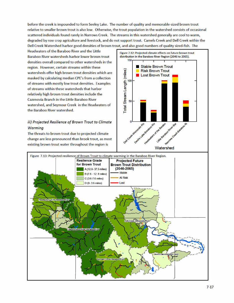
4. The Watersheds
Dell Creek – Wisconsin River
Dell Creek is Class II trout water for most of its length upstream of Mirror Lake. In its uppermost reaches in Juneau
County, Dell Creek is not classified trout water and supports a cool‐warm transitional fish assemblage. Classified
trout water begins at the Sauk County line and here the stream supports low density populations of brook and
brown trout. Brook trout densities remain low throughout length of Dell Creek, but brown trout densities
gradually increase from low to moderate to high in a downstream direction. Stocked rainbow trout are also
present in lower Dell Creek. The public has fishing access to over 10 miles of Dell Creek through Dell Creek Wildlife
Area. Trout habitat improvement measures that have been implemented in the past have been largely limited to
removal of woody vegetation from the stream corridor. Dell Creek is impounded in its lower reaches to form
Mirror Lake and Lake Delton before flowing into the Wisconsin River below the Kilbourn Dam. These lakes offer
quality fishing opportunities for bass, panfish, northern pike, and walleye.
Camels Creek is a tributary to Dell Creek and is Class II trout water for its entire length, supporting moderate
densities of brook trout and low densities of brown trout. Low level brook trout stockings have taken place
periodically since 1975, with none at all between 1994 and 2010; brown trout are not stocked into Camels Creek.
Camels Creek offers a quality brook trout fishing opportunity and the public has direct fishing access to 0.3 mile of
Camels Creek from Dell Creek Wildlife Area.
Beaver Creek is a tributary to Dell creek and is Class II trout water for its entire length, though survey data from
which the status of the trout fishery can be determined are lacking. Beaver Creek is a small stream that was
stocked with large fingerling brook trout from 1973 to 1994, and again in 2010.
Harrison Creek is Class II trout water for its entire length, supporting low densities of brook and brown trout;
however fish stockings in Harrison Creek include brook trout only. The brown trout that are present have moved
into Harrison Creek from Dell Creek. The public has access to 1.1 miles of lower Harrison Creek through Mirror
Lake State Park.
Hulburt Creek is Class I trout water supporting low to moderate densities of brown trout. The public has access to
approximately 2.6 miles of the stream through Hulburt Creek Fishery Area. There is also public access to two
unnamed tributaries to Hulburt Creek. One is Class I trout water with 0.4 miles of public access, but it is
intermittent and survey data is lacking. The other is a perennial stream with 0.7 miles of public access, and is Class
I trout water supporting very low densities of brown trout and moderate densities of brook trout.
Trout Creek and Shadduck Creek flow into the Kilbourn Flowage of the Wisconsin River from the east, and are not
classified trout water. Trout creek was noted as having white sucker, johnny darter, yellow bullhead, burbot and
northern pike present from a survey conducted in 1982. Shadduck creek was only noted as having miscellaneous
small forage species present from a waters inventory survey conducted in 1965. Fish survey data are lacking, and
there is no public access to these creeks via DNR easements or fee title land.
Corning Creek, Plainville Creek, and Gulch Creek are all Class I trout waters that flow into the Kilbourn Flowage of
the Wisconsin River along its eastern shore. All three creeks support low density brook trout populations. Corning
Creek is a small clear spring fed stream with a total length of 2.7 miles, brook and rainbow trout were stocked
intermittently between 1937 and 1949, no stocking has occurred since 1949. A survey of Corning Creek in 1998
found brook trout ranging in size from 2.8 to 9.4 inches with an estimated 900 trout per 100 feet. There is no
public access on Corning Creek via DNR easements or fee title land. Plainville Creek is a small spring fed stream
7‐28
with multiple springs throughout it’s length, brook, brown and rainbow trout were stocked intermittently between
1941 and 1951, no stocking has occurred since 1951. A fishery survey conducted in 2011 found brook trout, white
sucker, mottled sculpin and grass pickerel present. The brook trout ranged in size from 3.5 to 9.9 inches. There is
no public access to Plainville Creek via DNR easements of fee title land. Gulch Creek is a small spring and
groundwater fed stream, brook brown and rainbow trout were stocked intermittently between 1938 and 1953, no
stocking has occurred since 1953. A fishery survey conducted in 2011 found good numbers of brook trout
including good signs of successful natural reproduction, brook trout ranged in size from 2.9 to 9.4 inches. Other
fish species observed during the 2011 survey were mottled sculpin and the central mudminnow. There is public
access to 1.7 miles of lower Gulch Creek through the Dells of the Wisconsin River Natural Area, however there are
areas within this access that are not safe for stream access due to the steep nature of the stream banks.
Gilmore Creek flows into the Kilbourn Flowage from the west and is Class II trout water above Trout Lake and Class
I trout water below Trout Lake. Stocking records since 1938 indicate that Gilmore Creek has never been stocked.
The only recorded fish survey was conducted in 1964, this survey indicated that in the class 1 waters of Gilmore
creek there were large numbers of naturally reproduced brook trout, along with larger brook, brown and rainbow
trout. The 1964 survey also indicated that the class 2 waters of Gilmore Creek showed some evidence of brook
trout reproduction, however the habitat was not as good as the class 1 waters and no larger brook trout were
observed. Other species identified as present in the 1964 survey included black bullhead, common sucker,
bluntnose minnow, perch and largemouth shiner. There is no public fishing access to Gilmore Creek via DNR
easements or fee title land.
Lyndon Creek is Class III trout water that flows into the Kilbourn Flowage of the Wisconsin River from the west and
runs through the middle of Lyndon Station. Lyndon Creek was stocked consistently between 1936 and 1965 with
brook trout and with domestic brown trout from 1959 through 2011, though fish surveys show that very few
individuals hold over, a fishery survey in 2010 only produced one brown trout adult. Holtzlander Creek and Tracy
Creek are tributaries to Lyndon Creek that are Class III trout water. Holtzlander Creek was stocked between 1946
and 1965 with brook trout no stocking has occurred since 1965. Tracy Creek was stocked between 1946 and 1951
with brook trout no stocking has occurred since 1951. Both creeks hold their current classification due to their
connection to Lyndon Creek. There is no public fishing access to these creeks via DNR easements or fee title land.
Kilbourn Flowage is a 1,868 acre flowage of the Wisconsin River located between the Castle Rock and Kilbourn
dams. Above and below the flowage the system is very riverine .The fishery consists of walleye, northern pike,
largemouth bass, smallmouth bass, catfish and lake sturgeon. Survey data is lacking for the flowage, however with
the reintroduction efforts for muskellunge in upstream flowages and stretches of the Wisconsin River, there is
likely a small number of muskellunge present also. No recorded stocking has occurred into Kilbourn Flowage
between 1972 and 2012.
Below the Kilbourn Dam in Wisconsin Dells, WI, the Wisconsin River is characterized by copious amounts of rock
and gravel substrate, with occasional rapids. Anglers have good shore fishing access in the Wisconsin Dells area,
and have quality angling opportunities for smallmouth bass, walleye, sauger, northern pike, catfish, and lake
sturgeon. The area of large fractured bedrock immediately below the Kilbourn Dam serves as suitable spawning
habitat for the lake sturgeon population that lives in Lake Wisconsin and moves upriver to spawn in the spring.
The fish from this population serve as the broodstock for the State’s lake sturgeon rehabilitation efforts in the
Wisconsin River system.

7‐29
Devil’s Lake – Baraboo River
As it is for most of its length, the Baraboo River is sinuous and turbid in this final stretch before entering the
Wisconsin River. Several public access sites exist for launching small boats or canoes, and anglers have quality
opportunities to catch smallmouth bass, northern pike, walleye, sauger, and catfish.
Skillet Creek and Pine Creek are cool‐warm transitional streams that come together and flow north to the Baraboo
River as Skillet Creek. Past survey data show small numbers of largemouth and smallmouth bass present but not
enough to support a recreational fishery. There is public access to middle and upper Skillet Creek through a parcel
of Statewide Natural Area, and the Baraboo Hills Recreation Area, respectively.
Clark Creek (officially unnamed, also unofficially called Glenville Creek) originates in the Baraboo Hills in the
northeast corner of Devil’s Lake State Park and flows northwest to the Baraboo River on the southeast edge of the
City of Baraboo near the site of the now removed Glenville Dam. The Clark Creek watershed is a narrow, high
gradient watershed that experiences high‐intensity flash floods during major precipitation events that cause
severe erosion and downstream transport of sediment and large rock. The Clark Creek valley was impacted
significantly by the flooding events of 1993 and 2008, and a large scale stream restoration project is being
designed to help mitigate these impacts. It will also increase the ability of the watershed to handle future flood
events. Clark Creek is not classified trout water, but it is cold and was stocked with large fingerling feral brook
trout from 1998‐2009, excluding 2002 and 2003. Limited survey data suggest these stocked trout have not
persisted in any numbers. Surveys have been confined, however, to the lower end of the creek. Remnant native
brook trout persist in the upper reaches of Clark Creek, and future fish surveys should concentrate more on these
areas in order to assess and monitor the status of these remnant fish. Much of the upper end of the watershed is
part of Devil’s Lake State Park, and as such is protected. Anglers have public access to upper Clark Creek from
Devil’s Lake State Park, but the steep nature of the valley walls and relative difficulty of accessing the stream likely
limit fishing pressure.
Boulder Creek originates in the Baraboo Hills and flows north by northwest to the Baraboo River just upstream of
the Baraboo’s confluence with Rowley Creek. It is Class I trout water for its entire length, supporting a low density
remnant native brook trout population. The public has access to approximately 0.7 mile of Boulder Creek in the
Baraboo Hills Recreation Area.
Rowley Creek originates in the Baraboo Hills in Columbia County and is fed by several unnamed spring‐fed
tributaries that flow down from the Baraboo Hills as it flows west to the Baraboo River. Rowley Creek supports
low to moderate densities of brook trout and low to high densities of brown trout. In its upper reaches Rowley
Creek is nursery water for small trout, but trout size structure and particularly brown trout densities increase as
stream flows increase moving down the watershed. In its lower reaches, Rowley Creek offers angling
opportunities for brook and brown trout. However, public fishing access to the stream through DNR land is limited
to 0.7 miles of stream at the uppermost end of the watershed via Lost Lake Natural Area. The DNR also owns a
small easement on approximately 650 feet of the north bank of the creek upstream of CTH W. Several of the
unnamed tributaries to Rowley Creek support low density populations of remnant native brook trout, though
these streams do not support recreational fisheries themselves. Acquisition efforts would be well invested in the
Rowley Creek watershed as there is a good opportunity for successful resource protection and trout habitat
improvement here.
Leech Creek is Class II trout water for its entire length but stream flow is intermittent upstream of CTH T. Below
CTH T, Leech Creek flows eastward through an area rich with springs, causing the stream to dramatically increase
its flow over a very short distance. Mixed populations of brook and brown trout make a transition to all brown

7‐30
trout as Leech Creek reaches Paschen Road, supporting a modest recreational fishery. Brown trout natural
reproduction is occurring in Leech Creek, indicated by the presence of multiple year classes including young of year
brown trout when surveyed in 2012, despite no stockings of brown trout since 2009. Below Paschen Road Leech
Creek eventually enters a lowland muck farm where the stream is straightened and channelized, and is fed by a
series of canals and ditches before it finally enters the Baraboo River. This portion of the stream is not trout water.
The public has fishing access to approximately 2.5 miles of Leech Creek and 0.1 mile of an unnamed tributary
stream via DNR easements.
Headwaters of the Baraboo River
The Baraboo River is Class II trout water from its headwater downstream to where it becomes Class III trout water
approximately at the Monroe/Juneau County line between Kendall and Elroy, WI. The Class III trout water ends in
the city of Elroy. The river has supported low density populations of brook and brown trout, though recent survey
data are lacking. Fingerling or yearling brown trout were the primary trout stocked from 1933 through 2005, when
a shift to stockings of yearling feral brook trout occurred, continuing through the present time. Public access to
the Baraboo River in this watershed is limited to several scattered points along the Elroy‐Sparta State Trail.
Spring Valley Creek is Class I trout water in its upper reaches, and Class II trout water in its middle reaches,
supporting low densities of brook trout. There is no access to Spring Valley Creek via DNR easement or fee title
lands.
Lydon Valley Creek (or Fox River Valley Creek) is Class III trout water and it supports low densities of brook trout.
There is public access to a short stretch of stream near the mouth of the creek from the Elroy‐Sparta State Trail.
Hills Creek is not classified trout water but has been stocked with large fingerling or yearling brown trout in the
past, with a more recent shift to stockings of large fingerling feral brook trout. There is no public fishing access to
Hills Creek via DNR easement or fee title lands.
Seymour Creek is Class III trout water along portions of its length in Monroe and Juneau Counties, but is also
stocked with trout in Vernon County. Stockings in Monroe and Vernon Counties currently consist of yearling feral
brook trout. The Juneau County portion of Seymour Creek was stocked with yearling brown trout through 2011.
Seymour Creek supports low densities of brook and brown trout, but there is no public fishing access via DNR
easement or fee title lands.
West Branch Baraboo River is Class III trout water for much of its length upstream of Hillsboro, WI, where it is
impounded to form Field Veterans Memorial Lake. This stretch was stocked with fingerling or yearling brown trout
from 1972‐2006, but is no longer stocked. Recent fishery survey data are lacking, but it is unlikely that a significant
trout fishery exists. There is a public boat launch on Field Veterans Memorial Lake, and anglers have opportunities
to catch largemouth bass and panfish there. There is no public fishing access to West Branch Baraboo River via
DNR easement or fee title lands.
South Branch Creek, also known as South Branch Baraboo River is Class III trout water for most of its length before
joining with the West Branch Baraboo River at Hillsboro. South Branch Creek was stocked with fingerling or
yearling brook trout from 1972‐2006, but is no longer stocked. Extremely low numbers of remnant brown trout
from these stockings exist in the creek, but do not support a recreational fishery. There is no public fishing access
to South Branch Creek via DNR easement or fee title lands.

7‐31
Dilly Creek, Beaver Creek, Sherman Valley Creek, and Cleaver Creek are tributaries to the West Branch Baraboo
River, South Branch Creek, and the Baraboo River (Sherman and Cleaver), respectively. These creeks are not
classified trout water and do not support recreational fisheries.
Little Baraboo River – Baraboo River
The Baraboo River in southwestern Juneau County and northwestern Sauk County is very sinuous and the water is
generally turbid, with portions classified as wadable warmwater smallmouth bass habitat. There are numerous
access points where the public can launch small boats or canoes or fish from shore, and there are good angling
opportunities for smallmouth bass, panfish, northern pike, catfish, and the occasional walleye. Hemlock Slough is
a backwater adjacent to the Baraboo River that has had a decent bass and panfish fishery in the past, but has also
had problems with winter fish kills. Hemlock Park, part of the Sauk County Park system, surrounds the slough
offering shore fishing opportunities and a launch for small boats on Hemlock Slough.
Plum Creek, Gardner Creek, Crossman Creek, Ox Creek, Silver Creek, Babb Creek, and Twin Creek are all direct
tributaries to the Baraboo River. The fish communities in these streams consist of warmwater forage species, but
none support recreational fisheries.
Dutch Hollow Creek does not support a significant recreational fishery, but it is impounded to form Dutch Hollow
Lake, which has public access and offers quality angling opportunities for bass, panfish, walleye, and northern pike.
The Little Baraboo River and Mortimer Valley Creek converge in northwestern Sauk County. Mortimer Valley Creek
is Class II trout water for its entire length, supporting low densities of brook trout. The Little Baraboo River is Class
II trout water from the Sauk/Vernon County Line downstream to Rott Rd. (past the confluence with Mortimer
Valley Creek). The upper Little Baraboo River supports low to high densities of brook trout and offers a quality
angling opportunity. The Mortimer Valley/ upper Little Baraboo system is unique because it supports brook trout
in concert with a diverse warmwater forage community. A portion of the lower Little Baraboo River is listed as
coolwater wadable smallmouth bass habitat but survey data do not indicate the presence of a significant
recreational fishery.
Cazenovia Branch is Class I trout water in its upper reaches, supporting low densities of brook trout and low to
moderate densities of brown trout, and thus a modest recreational fishery. Cazenovia Branch is impounded to
form Lee Lake, which offers quality angling opportunities for bass and panfish. Below Lee Lake, Cazenovia Branch
is considered wadable nursery habitat for smallmouth bass, but does not support a recreational bass fishery.
Before reaching the Little Baraboo River west of Ironton, Cazenovia Branch is joined by Carr Valley Branch, a
warmwater stream that supports a warmwater forage fish community and does not offer a recreational fishery.
Bauer Creek and McGlynn Creek are Class II trout water for their entire lengths, and both flow into Cazenovia
Branch near Cazenovia. Bauer Creek supports low densities of brook and brown trout, with brook trout decreasing
in abundance relative to brown trout the further one moves downstream. McGlynn Creek supports low densities
of brown trout. There is no public fishing access to either creek via DNR easement or fee title lands.
Bundy Hollow Creek and Furnace Creek are warmwater tributaries to the Little Baraboo River that are not
classified as trout water or smallmouth bass habitat, and do not offer a significant recreational fishery.
Hay Creek is Class II trout water for its entire length, supporting an extremely low density brown trout population.
The stream has no public access via DNR easement or fee title lands. Hay Creek is very small and gets overgrown

7‐32
with reed canary grass in its upper reaches, while further down it flows through thick woods and has an extremely
soft sand/silt bottom; it is not easy to fish or survey.
East Branch and West Branch Big Creek are coolwater streams that flow into the upper end of Lake Redstone,
which at its outlet discharges to Big Creek which flows into the Baraboo River a short distance later. Lake Redstone
has public access and provides quality angling opportunities for bass, panfish, walleye, and muskellunge. The
creeks themselves above Lake Redstone do not support recreational fisheries.
Narrows Creek – Baraboo River
The Baraboo River in central Sauk County is generally non‐wadable, and portions are classified as smallmouth bass
habitat with fine substrates. Angling opportunities exist for smallmouth bass, panfish, northern pike, catfish, and
the occasional walleye or sauger. There are many access points for launching small boats or canoes.
Narrows Creek is one of the top smallmouth bass waters in Sauk County, offering quality angling opportunities for
smallmouth bass and rock bass. From 1998 through 2008, intensive smallmouth bass habitat work was completed
on approximately 5.7 miles of stream within a nine mile stretch, including 4.3 miles by WDNR and 1.4 miles by the
Sauk County Land and Water Conservation Department. Habitat improvement measures included sloping and
armoring the stream banks, insertion of vortex weirs, and log covers, and these measures helped to improve
smallmouth bass numbers and size structure in Narrows Creek. The removal of the last of the dams on the
Baraboo River opened up Narrows Creek for seasonal migrations of smallmouth bass from the Baraboo and
Wisconsin Rivers, and smallmouth bass tagged in the Baraboo River have already been noted in Narrows Creek.
The public has fishing access to approximately 4.5 miles of stream via DNR easements.
Ela Valley Creek and Spring Valley Creek are coolwater streams that flow north into Narrows Creek west of
Loganville. These creeks do not support recreational fisheries and are not classified as smallmouth bass habitat,
but survey data indicate that they serve as nursery water for smallmouth bass. There is no access via DNR
easements or fee title lands.
Hill Point Creek flows into Narrows Creek and is classified as wadable nursery water for smallmouth bass. Limited
survey data do not indicate the presence of a viable recreational fishery on Hill Point Creek and there is no access
via DNR easements or fee title lands.
Copper Creek is a coolwater stream that flows south to the Baraboo River east of Reedsburg. It does not support a
recreational fishery but survey data indicate it may serve as nursery water for northern pike. There is no access via
DNR easements or fee title lands.
Seeley Creek is Class I trout water in its upper reaches and Class II trout water in its middle stretch, supporting low
to moderate densities of brown trout. Lower Seeley Creek flows through Seeley Lake, which has public access and
offers quality fishing opportunities for bass, panfish, and northern pike. The middle stretch of Seeley Creek offers
a quality angling opportunity for brown trout but there is no public access via DNR easements or fee title lands.