chapter 1 purpose of and need for the proposed...
TRANSCRIPT

Guam and CNMI Military Relocation
(2012 Roadmap Adjustments) SEIS Final July 2015
1-1
CHAPTER 1
PURPOSE OF AND NEED FOR THE PROPOSED ACTION
This chapter provides background for the Supplemental Environmental Impact Statement (SEIS) for the
Guam and Commonwealth of the Northern Mariana Islands (CNMI) Military Relocation (2012 Roadmap
Adjustments) SEIS, and describes the purpose and need for the proposed action to develop a cantonment
area, family housing, a live-fire training range complex (LFTRC), and supporting infrastructure.
1.1 INTRODUCTION
In September 2010, the U.S. Department of the Navy (DON) signed a Record of Decision (ROD)
(75 Federal Register [FR] 60438, September 30, 2010) (DON and U.S. Department of the Army 2010)
regarding the 2010 Final Environmental Impact Statement (EIS) for the Guam and CNMI Military
Relocation; Relocating Marines from Okinawa, Visiting Aircraft Carrier Berthing, and Army Air and
Missile Defense Task Force (DON 2010). The ROD documented the DON’s decisions regarding the 2006
Roadmap for Realignment Implementation, including the selection of specific alternatives analyzed in the
2010 Final EIS for the main base (cantonment area), aviation, and waterfront operations to support
relocation of approximately 8,600 Marines and 9,000 dependents from Okinawa to Guam. The ROD
deferred a decision on the specific site for an LFTRC. Regarding the establishment of the cantonment
area, the ROD selected an area on federal lands under the custody and control of the Department of
Defense (DoD) located at the Naval Base Guam, Telecommunications Site at Finegayan4 (hereinafter
“Finegayan”) and the nearby South Finegayan Navy Housing site, as well as non-federal land known as
the “former Federal Aviation Administration (FAA) parcel.” The 2010 Final EIS identified this combined
area as the preferred alternative for establishment of the cantonment area, including family housing.
In the months following issuance of the ROD, the DON formally committed that if the Route 15A area
was selected for the LFTRC, the DON would provide for 24 hours a day, 7 days a week access to Pågat
Village and Pågat Cave historical sites, to include the existing trail from Route 15A leading to both (DoD
2011, DON 2011; and see Appendix A). The DON, to meet this commitment, applied a probabilistic
methodology to more precisely model the size of the surface danger zone (SDZ) associated with the
Multi-Purpose Machine Gun (MPMG) Range, which would be part of the LFTRC. Application of this
methodology reduced the size of the overall footprint and enabled the DON to take another look at
potential LFTRC locations on Guam, including those locations previously considered but not carried
forward for detailed analysis. This reevaluation resulted in the identification of additional LFTRC
preliminary alternatives.
In light of this information, the DON initially elected to prepare an SEIS limited solely to the evaluation
of potential impacts associated with the construction and operation of the LFTRC on Guam (hereinafter
“LFTRC SEIS”). The DON issued its Notice of Intent (NOI) to prepare the SEIS in February 2012 (77
FR 6787, February 9, 2012) (see Appendix B). In the NOI, the DON preliminarily identified five
potential alternatives for the range complex: two were adjacent to Route 15 in northeastern Guam, and
three were located at or immediately adjacent to the Naval Base Guam, Munitions Site in southern Guam
4 The names used throughout this SEIS for specific DoD properties on Guam were chosen to maintain consistency in planning
and environmental documents, and may not be the official site names.

Guam and CNMI Military Relocation
(2012 Roadmap Adjustments) SEIS Final July 2015
1-2
(hereinafter “Naval Magazine [NAVMAG]”). Public scoping meetings were conducted for the LFTRC
SEIS in March 2012, and the public scoping comment period closed on April 6, 2012.
After the close of the public scoping comment period, on April 27, 2012, the U.S.-Japan Security
Consultative Committee issued a joint statement announcing its decision to adjust the plans outlined in
the May 2006 Roadmap for Realignment Implementation. In accordance with these 2012 Roadmap
Adjustments, the DoD adopted a new force posture in the Pacific providing for a materially smaller and
reconfigured force on Guam. In conjunction with changes to the mix of personnel involved in the
relocation, the force adjustments would reduce the originally planned relocation of approximately 8,600
Marines with 9,000 dependents to a force of approximately 5,000 Marines with approximately 1,300
dependents. That decision prompted the DON’s review of the actions previously planned for Guam and
approved in the September 2010 ROD. This review concluded that while some actions remain unchanged
as a result of the smaller force size, others, such as the size and location of the cantonment and family
housing areas, could significantly change as a result of the modified force. Therefore, the DON published
a new NOI on October 11, 2012 (77 FR 61746, October 11, 2012) and amended the scope of the ongoing
LFTRC SEIS to add those actions that materially changed as a result of the new force posture (see
Appendix B, and available for review at: http://guambuildupeis.us).
1.2 SCOPE OF THIS SUPPLEMENTAL ENVIRONMENTAL IMPACT STATEMENT
The DON prepared this SEIS in accordance with the National Environmental Policy Act (NEPA) (42 U.S.
Code [USC] §§ 4321, et seq.) and the Council on Environmental Quality’s (CEQ’s) implementing
regulations (40 Code of Federal Regulations [CFR] Parts 1500-1508). Pursuant to 40 CFR § 1502.9, the
DON prepared this SEIS for the purpose of supplementing the portions of the 2010 Final EIS regarding
the establishment on Guam of an LFTRC, a cantonment area, family housing, and associated
infrastructure to support the relocation of a substantially reduced number of Marines and dependents than
was previously analyzed. By supplementing the 2010 Final EIS, this SEIS advances NEPA’s purpose of
informing decision-makers and the public about the environmental effects of the DON’s proposed action.
Pursuant to 40 CFR § 1502.21, this SEIS incorporates by reference the entire 2010 Final EIS and the
September 2010 ROD. Compared to the 2010 Final EIS, this SEIS evaluates the potential environmental
impacts of constructing and operating a smaller U.S. Marine Corps (hereinafter “Marine Corps”)
cantonment area, a smaller family housing area, a similarly sized LFTRC that has a smaller SDZ footprint
(based on SDZ reduction achieved by applying the probabilistic methodology to the design of the MPMG
Range), and infrastructure requirements to support a reduced number of relocating Marines and
dependents than originally planned. The following considerations allowed for the development and
evaluation of additional siting alternatives that were not considered feasible under the conditions
evaluated in the 2010 Final EIS:
Reduction in acreage requirements for the cantonment and family housing areas.
Reconfigured SDZ footprint for the required LFTRC.
Consideration of public input.
Refinement of range designs.
Reassessment of operational requirements, conflicts, and opportunities.
This Final SEIS evaluates five alternatives for the cantonment/family housing component of the proposed
action, all of which are entirely contained within federally owned land parcels and two of which include
locations on Guam other than Finegayan. In comparison, the 2010 Final EIS evaluated four site
alternatives for cantonment that all involved the use of Finegayan (plus various combinations of non-

Guam and CNMI Military Relocation
(2012 Roadmap Adjustments) SEIS Final July 2015
1-3
contiguous parcels to accommodate the needed family housing) and three of the four required the
acquisition of non-federal land.
This Final SEIS evaluates five alternatives for the proposed LFTRC, all of which include a proposed
stand-alone Hand Grenade (HG) Range at Andersen South. In comparison, the 2010 Final EIS evaluated
two site alternatives for the LFTRC, including a separate proposed location for an HG Range at each site
alternative.
The proposed change in size and composition of the new force structure and the reconsideration of the
LFTRC SDZ footprint did not affect all of the decisions that were made in the September 2010 ROD. For
example, the location of the Aviation Combat Element (ACE), the air embarkation facilities (Air Mobility
Command Complex), the development of the North Gate and access road at Andersen Air Force Base
(AAFB), the wharf improvements at the U.S. Navy (hereinafter “Navy”) base at Apra Harbor, and the
non-live fire and maneuver ranges on Andersen South remain unaffected by the changes in force structure
resulting from the April 2012 Roadmap Adjustments. These actions are not dependent on (and would not
be affected by) the ultimate locations of the cantonment/family housing areas and LFTRC on Guam. The
potential environmental effects of these actions were fully and accurately considered and analyzed in the
2010 Final EIS. For those decisions that are not affected by the new force structure, the September 2010
ROD stands as the final agency action for those actions. The expanded scope of this SEIS does not
include the transient aircraft carrier berthing in Apra Harbor or the U.S. Army (hereinafter “Army”) Air
and Missile Defense Task Force (AAMDTF).
The decision regarding training ranges on Tinian is not affected by the 2012 Roadmap Adjustments, and
remains final and is not subject to reanalysis in this SEIS. However, in April of 2015 the DON published
a combined Draft EIS and Overseas EIS (OEIS) for proposed CNMI Joint Military Training (CJMT)
(hereinafter “CJMT EIS”) on the islands of Tinian and Pagan. If implemented following completion of
the CJMT NEPA process, the decision regarding proposed training ranges as evaluated in the CJMT EIS
would supersede the 2010 ROD with regards to Tinian range projects. Consequently, the DON has
deferred any implementation of the Tinian training ranges from the 2010 ROD pending the outcome of
the CJMT EIS.
1.3 BACKGROUND
1.3.1 Overview of the 2010 Final Environmental Impact Statement
The 2010 Final EIS examined the environmental effects of a variety of complex multi-service actions,
including components involving the Marine Corps, Navy, and Army, as well as existing U.S. Air Force
(hereinafter “Air Force”) assets on Guam. Given their temporal and geographic proximity, these actions
were addressed in the same EIS. However, each component is based on a different national security
objective, has an independent need for and independent utility from each other, and decisions were
reached or will be reached on each component independently of the others. The three primary components
of the proposed actions addressed in the 2010 Final EIS are briefly described below for each service. A
detailed overview is contained in the 2010 Final EIS (Volume 1, Chapter 2: Overview of Proposed
Actions and Volume 6, Chapters 1 and 2: Related Actions - Utilities and Roadway Projects).
Marine Corps. The Marine Corps component of the 2010 Final EIS focused on the 2006 Roadmap for
Realignment Implementation to relocate Marine Corps forces, and included proposed development and
operations on Guam and on the island of Tinian in the CNMI. The action included construction and
operation of facilities and infrastructure to support approximately 8,600 Marines and their 9,000

Guam and CNMI Military Relocation
(2012 Roadmap Adjustments) SEIS Final July 2015
1-4
dependents to be relocated to Guam (including cantonment, family housing, community support, and base
support and administrative functions). These are the elements of the 2010 Final EIS that were revised in
the 2012 Roadmap Adjustments and are reanalyzed in this SEIS. The 2010 Final EIS also included
construction and operation of other required facilities and infrastructure to support the Marines’ relocation
to Guam (e.g., non-live fire and maneuver ranges, live-fire ranges on Tinian, aviation training areas, and
several waterfront functions). These components of the action were not affected by the 2012 Roadmap
Adjustments and are not reevaluated in this SEIS.
Navy. The Navy component of the 2010 Final EIS included construction of a new deep-draft wharf with
shoreside infrastructure improvements, creating the capability in Apra Harbor to support extended aircraft
carrier visits. This component of the 2010 Final EIS was not affected by the 2012 Roadmap Adjustments
and is not reevaluated in this SEIS.
Army. The Army component of the 2010 Final EIS included development of facilities and infrastructure
on Guam to establish and operate an AAMDTF to protect against the threat of ballistic missile attacks on
Guam. This component also included the relocation of approximately 600 military personnel and their
900 dependents. This component of the 2010 Final EIS was not affected by the 2012 Roadmap
Adjustments and is not reevaluated in this SEIS.
Related Actions - Utilities and Roadway Projects. The 2010 Final EIS (Volume 6: Related Actions -
Utilities and Roadway Projects) also evaluated a series of related actions associated with the infrastructure
requirements of the various action components. The EIS considered alternatives to satisfy both immediate
and long-term needs of the relocation and to mitigate the effects of the increased demand on existing
utilities and roadways systems on Guam. The 2010 Final EIS identified and evaluated the potential
environmental impacts of several alternatives within each of the above categories of main components
and related actions, and recommended preferred alternatives for possible inclusion in the ROD. In
some cases, the scope of these requirements changed as a function of the 2012 Roadmap Adjustments,
so utility and other infrastructure projects to support the Marine relocation are reevaluated in this
SEIS.
1.3.2 Overview of the 2010 Record of Decision
In September 2010, the Assistant Secretary of the Navy for Energy, Installations and Environment signed
the ROD documenting the DON’s decisions relative to the Marine Corps and Navy components of the
Proposed Action. The Commanding General for the 94th Army Air and Missile Defense Command also
signed the ROD on behalf of the Army relative to its project component. The results of the ROD are
described below and shown in Figure 1.3-1.
Marine Corps. In general, the ROD documented the DON’s overall decision to proceed with the Guam
and CNMI Military Relocation (2006 Roadmap for Realignment Implementation), as described in the
2010 Final EIS. Implementation of the relocation would include: (a) development and construction of
facilities and infrastructure to support approximately 8,600 Marines and approximately 9,000 dependents
being relocated from Okinawa to Guam; and (b) development and construction of facilities and
infrastructure to support training and operations on Guam and Tinian. For some elements of the proposed
action that did not require a choice of alternatives, such as the proposed training and maneuver facilities
and operations at the NAVMAG area and at AAFB-Andersen South (hereinafter “Andersen South”), the
ROD approved the proposed development and operations by virtue of their inclusion in the overall
proposed action analyzed in the 2010 Final EIS. The ROD focused more specifically on the elements of
the proposed action for which choices needed to be made from the range of alternatives presented in the
2010 Final EIS.

iiii
ii
i
i
iii
i
P h i l i p p i n e S e a
Finegayan
AAFB
NWF
South Finegayan
P a c i f i c O c e a n
Andersen South
Barrigada
NAVMAG
Apra Harbor
Wharf Improvements
Cantonment/Family Housing Alternative 2
Non-Live FireTraining Complex
Air Embarkation
Munitions StorageAlternative A
Munitions Storage Area-1
NAVMAG Access RoadAlternative B
Air Combat Element(ACE)
Military WorkingDog Kennel
Apra MedicalClinic Site
Former FAA
Harmon AnnexNorth Gate
Access Road
Maneuver Training Area
Figure 1.3-12010 Record of Decision: Marine Corps Relocation
Components Selected for Implementation ¤
LegendDoD PropertyFamily HousingCantonment
i Landing ZoneMunitions StorageAccess RoadAir Embarkation Element Air Combat ElementWharf ImprovementsNon-Live Fire Training Area
0 2 41Miles
0 2 41Kilometers
Source: NAVFAC Pacific 2013
1-5
Guam and CNMI Military Relocation
(2012 Roadmap Adjustments) SEIS Final July 2015
1-6
Specific ROD decisions for alternatives described in Volume 2 of the 2010 Final EIS included the
following: (1) selection of a cantonment area utilizing federal lands at Finegayan and South Finegayan
and acquisition of non-federal land known as the former FAA parcel; (2) access to the NAVMAG area
using the existing hiking trail as the access road; (3) use of Parsons Road for the location of additional
ammunition storage at NAVMAG area; (4) the beddown of the Marine Corps ACE and construction of
associated ACE facilities at AAFB North Ramp, construction of air embarkation facilities at AAFB South
Ramp, and construction of the North Gate and access road at AAFB; and (5) waterfront functions at Apra
Harbor to support embarkation, including wharf and utility upgrades, associated dredging and dredge
disposal management, relocation of military dog kennels, and construction of a medical/dental clinic. The
ROD deferred a decision on the location of the LFTRC on Guam.
Decisions made in the ROD relative to Volume 3 of the 2010 Final EIS (Marine Corps Relocation -
Training on Tinian) included the construction and operation of a Platoon Battle Course and Automated
Combat Pistol/Military Police Firearms Qualification Course, an Automated Field Firing Range, and a
Known Distance (KD) Rifle Range.
Decisions made in the ROD relative to Volume 6 of the 2010 Final EIS (Related Actions - Utilities and
Roadway Projects) and solutions to meet required utilities improvements necessary to support the
military buildup on Guam included the following: (1) power solutions, including reconditioning of up to
five existing Guam Power Authority (GPA) combustion turbine power generation units, upgrades to
power transmission and distribution lines to serve military needs at Apra Harbor, Finegayan, and
AAFB; (2) potable water solutions, including the provision of additional potable water capacity of
11.3 million gallons per day (MGd) via the development of up to 22 new DoD water wells at AAFB,
rehabilitation of existing wells, interconnects with the Guam Waterworks Authority (GWA) water
system, and construction of associated treatment, storage, and transmission systems; (3) wastewater
solutions, improvements to achieve secondary treatment standards, and expansion beyond the current
design capacity at the Northern District Wastewater Treatment Plant (WWTP), improvements to the
Northern and Central wastewater collection systems, and improvements to the Agana WWTP to
achieve secondary treatment standards; (4) solid waste solutions that would continue the use of the
existing Navy Apra Harbor landfill until completion of the new Government of Guam (GovGuam)
public landfill at Layon (since completed); and (5) roadway improvements, including roadway
widening, intersection improvements, bridge replacements, pavement strengthening at specific
locations island-wide, and military access points.
Navy. The DON elected to defer selection of a specific site for the construction and operation of a visiting
aircraft carrier berth within Apra Harbor. The DON decided that the analysis presented in the 2010 Final
EIS, including the marine resources impacts analysis, provided sufficient information to allow the DON
to make a programmatic decision to locate a visiting aircraft carrier berth generally within Apra Harbor,
which is the only deep draft harbor on Guam that could support such a berth. A final site selection would
not occur until a site-specific NEPA analysis is conducted. There are currently no plans to conduct such
an analysis.
Army. The Army selected the preferred alternative as described in the 2010 Final EIS (Volume 5:
AAMDTF) and determined that it best represented how the Army could implement the action on Guam if
the decision is made to assign the mission to the Army and if Guam is selected from those sites under
consideration for an AAMDTF location. Since the 2010 ROD, the Army has deployed a Terminal High
Altitude Area Defense (THAAD) Battalion, which would have been one of the three elements comprising
the AAMDTF, as part of an expeditionary force to strengthen defense capabilities for American citizens
Guam and CNMI Military Relocation
(2012 Roadmap Adjustments) SEIS Final July 2015
1-7
and U.S. Forces stationed on Guam. Any future plans to expand capabilities beyond the current
expeditionary status to a permanent stationing would require a separate NEPA analysis from this SEIS.
This separate NEPA analysis would be completed by the Army.
1.4 PURPOSE OF AND NEED FOR THE PROPOSED ACTION
The purpose of the proposed action evaluated in this SEIS is to ensure that the relocated Marines are
organized, trained, and equipped as mandated by 10 USC § 5063, to satisfy individual live-fire training
requirements as described in the 2010 Final EIS and associated ROD, and to establish an operational
Marine Corps presence on Guam in accordance with the April 2012 Roadmap Adjustments. The purpose
remains unchanged from the 2010 Final EIS, albeit to support a materially smaller relocating Marine
Corps force.
The proposed action is needed to ensure consistency with the new force posture adopted by the DoD in
accordance with the April 2012 Roadmap Adjustments, which provide for a materially smaller force on
Guam than was originally proposed in the 2010 Final EIS, while fulfilling U.S. national security
obligations to provide mutual defense, deter aggression, and dissuade coercion in the Western Pacific
Region.
1.5 NATIONAL ENVIRONMENTAL POLICY ACT COMPLIANCE
NEPA requires federal agencies to examine the environmental effects of the reasonable alternatives to
implement a proposed action. The DON prepared this SEIS to identify and assess the potential
environmental effects associated with the proposed construction and operation of an LFTRC on Guam
that allows for simultaneous use of all firing ranges to support training and operations of the relocated
Marines, a cantonment area of sufficient size and layout to provide military support functions, and family
housing. The DON is the lead agency for preparation of this SEIS. The Office of the Secretary of Defense
directed the DON to establish a Joint Guam Program Office (JGPO) to serve as the action proponent for
the proposed action.
As the lead agency, the DON is responsible for consultation with other agencies, for coordination of
appropriate environmental studies and evaluations, and for preparation of any NEPA-related
determinations or documents in cooperation with other federal agencies.
1.5.1 Cooperating Agencies - Consultation and Coordination
Per 40 CFR § 1508.5, a cooperating agency “means any federal agency other than a lead agency which
has jurisdiction by law or special expertise with respect to any environmental impact involved in a
proposal (or a reasonable alternative) for legislation or other major federal actions significantly affecting
the quality of the human environment.”
The following federal agencies accepted the DON’s invitation to participate as cooperating agencies for
this SEIS (see also Appendix C):
FAA
Federal Highway Administration (FHWA)
U.S. Department of the Air Force
U.S. Department of Agriculture (USDA)
U.S. Department of the Interior (DOI), Office of Insular Affairs
Guam and CNMI Military Relocation
(2012 Roadmap Adjustments) SEIS Final July 2015
1-8
U.S. Environmental Protection Agency (USEPA) Region 9
The cooperating agencies’ participation in the NEPA process includes: (1) participating in a timely and
effective manner; (2) advising JGPO on the scope of the proposal and analysis to be included in this
SEIS; (3) providing comments on working drafts of this SEIS in a timely manner; (4) responding to JGPO
requests for information; (5) participating, as necessary, in discussions on SEIS related issues; and (6)
adhering to the overall schedule as set forth by JGPO.
The FAA provided consultation and advice on matters related to airspace management during the
alternatives development process and provided comments on the Draft SEIS.
The USEPA commented extensively on the Draft SEIS and met with the DON in a series of meetings to
receive and comment on additional information to address concerns on water and wastewater
infrastructure, Northern Guam Lens Aquifer (NGLA) management, coordination with Guam Waterworks
Authority (GWA), and groundwater monitoring. The USEPA also provided advice and technical review
of the Northern District WWTP upgrades and associated impacts to the marine environment in support of
DON’s effects determination consultation with the National Marine Fisheries Service (NMFS) under the
Endangered Species Act (ESA) and Magnuson-Stevens Fishery Conservation and Management Act for
listed species and Essential Fish Habitat (EFH).
A similar process was undertaken with U.S. DOI agencies, including the National Park Service (NPS),
U.S. Geological Survey (USGS), U.S. Fish and Wildlife Service (USFWS) and Office of Insular Affairs
to address most major comments related to water and wastewater infrastructure, public services, terrestrial
and marine biological resources, Guam National Wildlife Refuge (NWR) mission and management
activities, and cultural resources, among others. These cooperating agency engagements occurred from
September 2014 through November 2014.
The USFWS declined the DON’s invitation to be a cooperating agency, but has continued to collaborate
with the DON with respect to the ESA section 7 consultation process, the National Wildlife Refuge
System Administration Act, and relevant interagency agreements. The section 7 formal consultation
involved the preparation of a Biological Assessment (BA) by the DON and will result in the issuance of a
Biological Opinion (BO) by the USFWS. The DON provided its BA to the USFWS on October 1, 2014,
and as of the publication of this Final SEIS continues to participate in the section 7 consultation process
with the USFWS.
The DON has also engaged and received information from GovGuam agencies and other local
organizations in conducting the studies necessary to develop this SEIS.
As described in Section 3.10, the 2011 Programmatic Agreement (PA) established a process for the
review and analysis of potential effects to historic properties and other cultural resources for all
alternative LFTRC locations. Beginning in October 2014, the DON consulted with the parties to the PA
and the public on the Training Ranges Review and Analysis (TRRA), which provided information on
potential adverse effects resulting from the construction and operation of the LFTRC alternatives to
support consultation with the PA parties and the public.
1.5.2 Notice of Intent and Public Scoping
40 CFR § 1501.7 defines scoping as “an early and open process for determining the scope of issues to
be addressed and for identifying the significant issues related to a proposed action.” Scoping is an
important aspect of the NEPA process. Scoping not only informs governmental agencies, interest groups,
and the general public about the proposed action, but also helps the lead agency identify the issues and

Guam and CNMI Military Relocation
(2012 Roadmap Adjustments) SEIS Final July 2015
1-9
concerns that are of particular interest to the affected populace. Noting the flexibility afforded by 40 CFR
§ 1502.9(c), the DON held public scoping periods for both the LFTRC SEIS and this SEIS for the 2012
Roadmap Adjustments due to the community’s interest in the military buildup and the recognition that
public input would be valuable in helping to shape the range of alternatives that would be analyzed in
this SEIS.
The DON published an NOI for the LFTRC SEIS on February 10, 2012 (77 FR 6787, February 9, 2012),
initiating a 56-day scoping period, which included three scoping meetings on Guam in March 2012. Over
300 people attended the three meetings and the DON received 151 comment letters (delineated into 348
unique comments) over the course of the scoping period. Of the 348 comments, approximately 24% of the
comments related to the proposed actions and preliminary alternatives, followed by 16% about concerns
with future recreational opportunities. Other concerns included potential impacts to real estate, historic
properties, terrestrial biology, noise, transportation, public health and safety, and socioeconomics. A
Scoping Summary Report was prepared and made available to the public following the February 2012
scoping period. It is included as an appendix to the Scoping Summary Report for the November 2012
scoping period for this SEIS (available on the project website at http://guambuildupeis.us).
After the scope of this SEIS was expanded to address the 2012 Roadmap Adjustments, scoping was
reinitiated with the publication of an NOI on October 11, 2012 (77 FR 61746, October 11, 2012). The
DON held three scoping meetings on Guam at the beginning of November 2012, which were attended by
a total of 241 people. During the 60-day scoping period, the DON received 398 comment letters,
including 10 duplicate comments, 131 identical form letters from members of the Community Advocates
of the Raceway, and 52 comments from Community Advocates of the Raceway that attached signed
petitions (collectively totaling over 13,000 signatures).
During scoping for this SEIS, comments were received from a variety of stakeholders and interest groups
focusing primarily on the preliminary alternatives and/or specific resource issues. The highest percentage
of comments (48%) related to concerns about the preliminary alternatives, with most comments focusing
on the LFTRC preliminary alternatives. Many commented on the location of the preliminary LFTRC
alternatives relative to populated areas. Some comments suggested that the LFTRC should be located on
federal land. Others noted the potential impacts associated with the Northwest Field (NWF) and Route 15
LFTRC preliminary alternatives to historic or cultural sites (including in particular Pågat near the Route
15 alternatives), and potential impacts to recreational and commercial boating, diving, and fishing areas.
Several commenters, including those associated with the Community Advocates of the Raceway,
commented on the possible loss of the Guam International Raceway if the Route 15A area were selected
for implementation and specifically identified the Finegayan and South Finegayan areas as preferred
locations for proposed cantonment and NWF as a preferred location for the proposed LFTRC. Several
comments suggested other alternatives, such as the CNMI, use of existing ranges on Guam, use of
existing off-island ranges, and an option to split the LFTRC into separate ranges that could be built on
existing federal land.
Comments regarding the cantonment area preliminary alternatives offered a variety of individual
preferences for a preferred alternative. Overall, the comments recommended the use of existing federal
land for the cantonment area. Other comments suggested the use of green buildings and renewable
energy.
A Scoping Summary Report was prepared and made available to the public on the project website for this
SEIS (http://guambuildupeis.us).

Guam and CNMI Military Relocation
(2012 Roadmap Adjustments) SEIS Final July 2015
1-10
1.5.3 Draft Supplemental Environmental Impact Statement
A Draft SEIS was prepared in accordance with NEPA and the CEQ’s implementing regulations and
distributed for public and agency review on April 18, 2014 Eastern Daylight Time (EDT) (April 19, 2014
Chamorro Standard Time [ChST]). Concurrently, a Notice of Availability of the Draft SEIS was
announced in the Federal Register (FR 79 21907, April 18, 2014 EDT) and local newspapers. The notice
indicated locations (e.g., public libraries) where the Draft EIS was available to be reviewed, the duration
of the public review and comment period, the available options for submitting comments, and the time
and location of three scheduled public information meetings and public hearings on Guam. The public
meetings/hearings provided an opportunity for interested parties to comment on the content of the Draft
SEIS, which formed the basis for making subsequent changes in the Final SEIS.
The Draft EIS evaluated the potential environmental impacts of four alternatives for constructing and
operating a cantonment area and family housing on Guam, five alternatives for constructing and operating
an LFTRC, related utilities and infrastructure, and the No-Action Alternative. Project alternatives
(including the No-Action Alternative) are described in Chapter 2.
The public comment period for the Draft SEIS was initially scheduled to last 60 days, with a published
end date of June 16, 2014 EDT (June 17, 2014 ChST). The Draft EIS was made available for review on
the SEIS website (http://guambuildupeis.us) and copies were sent to regulatory agencies, the Nieves M.
Flores Memorial Library (Hagåtña) and the University of Guam (UoG) Robert F. Kennedy Memorial
Library (Mangilao), elected officials (Governor, Legislature, and Mayors), and to individuals who
requested copies during scoping.
The DON held three open house style meetings combined with three public hearings to both inform the
public about the proposed action and identified impacts, and to receive written and verbal feedback about
the Draft SEIS from the public. Informational posters were displayed, fact sheets about the project
(including one translated into Chamorro) were handed out, and subject matter experts were available
during each open house to answer questions on the Draft SEIS. Comment forms, a stenographer, and a
Chamorro language translator were available during the open house portion of each meeting to receive
written and oral comments. Oral comments were recorded during the public hearing portion of each
meeting and transcripts of each hearing were later prepared for the record. The public meetings/hearings
took place between May 17 and May 20, 2014 ChST as follows:
Saturday, May 17, 2014 ChST at Okkodo High School in Dededo, with an open house from 1:00
p.m. to 3:00 p.m. and a public hearing from 3:00 p.m. to 5:00 p.m.
Monday, May 19, 2014 ChST at the Father Dueñas Memorial School Phoenix Center in Chalan
Pago, with the open house from 5:00 p.m. to 7:00 p.m. and the public hearing from 7:00 p.m. to
9:00 p.m.
Tuesday, May 20, 2014 ChST at the former McCool School Gymnasium (Naval Base Guam -
Santa Rita Annex, Naval Magazine Road, Santa Rita, with the open house from 5:00 p.m. to 7:00
p.m. and the public hearing from 7:00 p.m. to 9:00 p.m.
In addition to opportunities to submit either written or verbal comments during the three public
meetings/hearings, other options for submitting comments during the public comment period included
direct entry of written comments via the project website (including attachment of pre-written electronic
files) and submittal of comment letters via mail.
In response to public comments the DON extended the public comment period for the Draft SEIS by 15
days to July 2, 2014 (ChST). Following the end of the extended public comment period, the DON
Guam and CNMI Military Relocation
(2012 Roadmap Adjustments) SEIS Final July 2015
1-11
reviewed all written and verbal comments on the Draft SEIS and prepared responses to all comments (see
Appendix G, Responses to Public and Agency Comments on the Draft SEIS). A total of 906 comment
submissions were received from agencies and members of the public, including 286 via the project
website, 36 written and 123 verbal comments at the three public meetings/hearings, and 461 comment
letters via mail. An additional 20 comments were exact duplicates of comments already submitted by the
same person, and two comments were entered by DON to test the website database. These 22 comments
were not included in the total number of comments above. Of the total number of comments received (by
all methods and at all venues), three verbal comments were expressed in the Chamorro language. All three
of these comments were translated into English by a professional translator and responses are provided in
Appendix G.
1.5.4 Final Supplemental Environmental Impact Statement
The DON prepared this Final SEIS by incorporating responses to public and agency comments on the
Draft SEIS, refining and/or conducting additional project planning and analysis, and incorporating
updated information. The Final SEIS was circulated in the same manner as the Draft SEIS.
The following lists key changes implemented between the Draft SEIS and the Final SEIS:
Addition of a new cantonment/family housing Alternative E, which consists of a combination of
the main cantonment at Finegayan that was previously analyzed in the Draft SEIS under
Alternatives A and B, and the family housing at AAFB that that was analyzed in the Draft SEIS
under Alternative C.
Revisions to the description of the LFTRC Alternative 5 at NWF (and relevant analyses of
impacts as appropriate) to reflect additional or adjusted planning features:
o access to the beach and a vehicle access gate at the intersection of Beach Road and the SDZ;
o four groundwater monitoring wells with access roads;
o a third range observation tower and access road;
o additional water and wastewater utility lines within the project boundary; and
o removal of the existing USFWS facilities and a proposed water tank from the impacted area.
A small adjustment in the construction area footprint for the proposed HG Range, representing an
increase of one acre compared to the area considered in the Draft SEIS.
Expansion of the Land and Submerged Land Use sections to specifically address public access
restrictions as they relate to fishing and other recreational activities.
Addition of an analysis of potential impacts to the Guam Customs and Quarantine Agency’s key
professional staffing requirements at the Port of Guam in the Socioeconomics sections.
Revision of the impact assessment regarding the Northern District Wastewater Collection System
in light of newly available information from closed-circuit television footage on the sewer line
conditions from AAFB to the Northern District WWTP along Routes 3 and 9. This concrete
reinforced pipe is in a state of deterioration that requires rehabilitation or replacement. Thus, this
impact assessment has been revised to significant but mitigable.
Update to the potential layout of the proposed water well area at AAFB.
Addition of Appendix G to provide a record of all comments received during the Draft SEIS
public comment period and the DON’s response to each comment.
1.5.5 Record of Decision
The DON will prepare a ROD that reflects the final decisions on the proposed action, the rationale behind
those decisions, and any commitments to monitoring and mitigation. The DON will issue the ROD
Guam and CNMI Military Relocation
(2012 Roadmap Adjustments) SEIS Final July 2015
1-12
following the issuance of the Final SEIS and a 30-day waiting period. The ROD will be published in the
Federal Register, distributed to agencies and interested parties, and posted on the SEIS website. An
announcement regarding the availability of the ROD will also be published in local newspapers and the
project website.
1.6 ORGANIZATION OF THE SUPPLEMENTAL ENVIRONMENTAL IMPACT STATEMENT
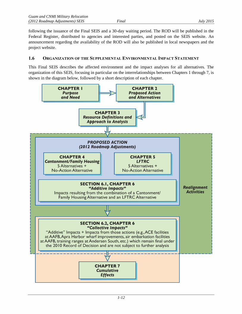
This Final SEIS describes the affected environment and the impact analyses for all alternatives. The
organization of this SEIS, focusing in particular on the interrelationships between Chapters 1 through 7, is
shown in the diagram below, followed by a short description of each chapter.

Guam and CNMI Military Relocation
(2012 Roadmap Adjustments) SEIS Final July 2015
1-13
Chapter 1 explains the background of the Guam and CNMI Military Relocation (2012 Roadmap
Adjustments) SEIS, and describes the purpose of and need for the proposed action to develop a
cantonment/family housing area, an LFTRC, and supporting infrastructure.
Chapter 2 identifies the alternatives that are carried forward for analysis in this SEIS, including the No-
Action Alternative, identifies the DON’s preferred alternative, and explains why certain alternatives were
considered but then eliminated from further analysis. This chapter also includes an overview of the Best
Management Practices (BMPs) that would be incorporated into the proposed action and that were factored
into the impact analyses in this SEIS.
Chapter 3 introduces each of the environmental resources on Guam that are evaluated in this SEIS. Each
resource is defined in terms of its key characteristics and relevant issues of concern given the nature of the
proposed action (e.g., facility construction, military base operations and training) and public input
provided during the scoping process. The regulatory framework that exists to preserve, protect, and
identify potential impacts to each resource is also described, followed by the approach and impact
assessment criteria that were applied in the analysis of potential effects on each resource.
Chapter 4 describes the affected environment and environmental consequences associated with the
implementation of each of the cantonment/family housing alternatives.
Chapter 5 describes the affected environment and environmental consequences associated with the
implementation of each of the LFTRC alternatives.
Chapter 6 evaluates the “additive” impacts (i.e., those in addition to the impacts described in Chapters 4
and 5) that would result when a particular cantonment/family housing site alternative is paired with a
particular LFTRC alternative (including the effects of installing communications infrastructure required
to connect a cantonment/family housing area to an LFTRC and to link both facilities to other DoD
facilities on Guam). Chapter 6 also addresses the “collective” impacts of combining the proposed actions
evaluated in this SEIS with those actions which remain final under the 2010 ROD and are not subject to
further analysis in this SEIS (e.g., ACE facilities at AAFB, Apra Harbor wharf improvements, air
embarkation facilities at AAFB, training ranges at Andersen South).
Chapter 7 discusses the cumulative effects of implementing the 2012 Roadmap Adjustments in
conjunction with those projects that remain final under the 2010 ROD and other past, present, and
reasonably foreseeable future projects on Guam. The DON acknowledges a general trend towards
incorporating the cumulative analysis into the discussion of direct and indirect impacts of an action.
However, because of the unique nature of this SEIS (i.e., it supplements a majority of the original 2010
action, presents numerous feasible combinations of cantonment and LFTRC alternatives, and
acknowledges relevant additive and collective impacts), the DON decided to address cumulative effects in
a separate chapter to facilitate readability.
Chapter 8 addresses additional considerations required by NEPA.
Chapter 9 provides a list of the references cited in this SEIS.
Chapter 10 provides a list of preparers of this SEIS.
Appendices cover public involvement, agency consultation, and select technical supporting
documentation. The appendices complement and expand upon the information provided in this SEIS.

Guam and CNMI Military Relocation
(2012 Roadmap Adjustments) SEIS Final July 2015
1-14
This page intentionally left blank.