guam and cnmi - denix et...list of tables table 1 summary information for the 31 vessels surveyed in...
TRANSCRIPT

Surveys of Abandoned Vessels: Guam and CNMI
National Oceanic and Atmospheric Administration • National Ocean Service • Office of Response and Restoration

SURVEYS OF ABANDONED VESSELS:
GUAM AND THE COMMONWEALTH OF THE NORTHERN MARIANA ISLANDS
Prepared by:
Christine Lord and Colin Plank Research Planning, Inc.
Columbia, South Carolina 29202
Ian Zelo and Doug Helton NOAA Damage Assessment Center (DAC) Northwest
Seattle, Washington 98115
October 2003
ACKNOWLEDGEMENTS
This study was supported by funds provided by the NOAA Coral Reef Conservation Program, through Contract No. 50ABNC700032 and 50ABNC200028, with Robert Pavia, Hazardous Materials Response Division, as the Contracting Officer’s Technical Representative, and Doug Helton, NOAA Damage Assessment Center, as the Project Manager. The Abandoned Vessel study is part of NOAA’s Coral Reef Conservation Program designed to protect and restore the Nation's Coral Reefs and assist conservation of reef ecosystems internationally. This program includes efforts to monitor and assess coral health, map coral reef ecosystems, conduct research to better understand biological, social and economic factors which effect coral reefs, partnerships to reduce the adverse affects of fishing, coastal development and pollution, and identify coral reef areas for special protection. The work could only have been accomplished with the support provided by many people who graciously provided their knowledge, agency resources, and personal time to assist us, including:
Gerry Davis, Guam Department of Agriculture Trina Lebrerer, Guam Department of Agriculture Edwin Aranza, Guam Environmental Protection Agency Captain Lorigan, U.S. Coast Guard (USCG) ENS Damian Yemma, USCG PO Johnny Pangelinan, USCG PO Tim Chargualaf, USCG PO Michael Lewis, USCG PO Jarrod Monnin, USCG LCDR Matthew Meilstrup, USCG ENS Gabriel Krug, USCG Jack Salas, CNMI Coastal Resources Management Martin Cabrera, CNMI Coastal Resources Management Clarence Igisiar, CNMI Coastal Resource Management Edwin Hofschneider, CNMI Coastal Resource Management Manases Manglona, CNMI Coastal Resource Management Antonio Cabrera, Commonwealth Port Authority, CNMI
At Research Planning, Inc., Jonathan Whitlock produced the graphics used in the report. Wendy Early and Joe Holmes provided graphic support.
i

TABLE OF CONTENTS
INTRODUCTION ..........................................................................................................................1
STUDY METHODS.......................................................................................................................2
SURVEY RESULTS AND COMMON GROUNDING SCENARIOS.........................................3
COMMON VESSEL SCENARIOS ...............................................................................................21
High Removal Priority for Local Management Agencies ..............................................................22 Plate 1: Seagull .....................................................................................................................23 Plate 2: Samala......................................................................................................................25 Plate 3: Charito .....................................................................................................................27 Plate 4: Nago No. 15.............................................................................................................29
Logistically Complex Removals because of Large Debris Fields ..................................................31 Plate 5: Sun Long No. 8........................................................................................................32 Plate 6: #62 Nam Sung .........................................................................................................34
Vessels with Historical Significance ..............................................................................................36 Plate 7: Barges ......................................................................................................................37 Plate 8: Unk1830, Unk1831 Unk2581, Unk2545 .................................................................39
Clusters of Derelict and Grounded Vessels. ...................................................................................41Plate 9: Piti Channel Vessel Cluster .....................................................................................42 Plate 10: Agana Boat Basin Vessel Cluster ..........................................................................44
Derelict Vessels Still Afloat............................................................................................................46 Plate 11: Mwaalil Saat and Lian Gi ......................................................................................47 Plate 12: Formerly Derelict Vessels ....................................................................................48
SUMMARY OF FINDINGS ..........................................................................................................50
COMPARISON OF U.S. PACIFIC FINDINGS TO U.S. CARIBBEAN SURVEY FINDINGS .....................................................................................................................50
ii
LIST OF TABLES
Table 1 Summary information for the 31 vessels surveyed in Guam. ....................................6
Table 2 Summary information for the 42 vessels surveyed in CNMI ....................................12
Table 3 Information on vessel type, habitat and potential threats for the 73 vessels surveyed in Guam and the CNMI ..............................................................................16
LIST OF FIGURES
Figure 1 Location map showing distribution of the 31 abandoned vessels surveyed in June 2003 in Guam (primary habitat) ....................................................................5
Figure 2 Location map showing the distribution of the 42 vessels surveyed in June 2003 in Saipan, CNMI (primary habitat) ............................................................................10
Figure 3 Location map showing the distribution of the 9 vessels surveyed in June 2003 in Tinian and Rota, CNMI (primary habitat) .............................................................11
Figure 4 Location map showing the distribution of the 31 vessels surveyed in June 2003 in Guam with insets for the priority regions (vessel type)................................18
Figure 5 Location map showing the distribution of the 33 vessels surveyed in June 2003 in Saipan, CNMI with insets for the priority regions (vessel type) ..................19
Figure 6 Location map showing the distribution of the 9 vessels surveyed in June 2003 in Tinian and Rota, CNMI with insets for the priority regions (vessel type) ...20
LIST OF ABBREVIATIONS
AVI Abandoned Vessel Inventory AVP Abandoned Vessel Program CNMI Commonwealth of the Northern Mariana Islands CRTF Coral Reef Task Force ft feet GPS Global positioning system NHPA National Historic Preservation Act NOAA National Oceanic and Atmospheric Administration USCG U.S. Coast Guard WWI World War I WWII World War II
iii
SURVEYS OF ABANDONED VESSELS: U.S. PACIFIC REGION
INTRODUCTION
Grounded and abandoned vessels are a problem in many coastal areas, and they are a significant threat for coral reef habitats. In addition to the physical crushing and smothering of habitats, grounded vessels pose a significant threat of oil spills and releases of other pollutants, may impede navigation, block public and private uses of intertidal and subtidal habitats such as aquaculture, become a site for illegal dumping of waste oils and hazardous materials, be a visual eyesore, and become a wildlife entrapment and public health hazard.
The National Oceanic and Atmospheric Administration (NOAA) has a long and diverse interest in grounded and abandoned vessels, but action to address these threats has been limited and focused on specific threats. NOAA cartographers note the location of wrecks on nautical charts to facilitate safe navigation. NOAA Office of Response and Restoration works on pollution threats from vessels. NOAA Fisheries works on entanglement hazards and debris removal from vessels. However, with the exception of vessels grounded in the National Marine Sanctuaries, no action is usually taken to address the vessel itself or restoration of the grounding site. This is because existing federal laws and regulations provide less than optimal authority to promptly remove grounded vessels or abandoned vessels that are causing harm to natural resources but which are not otherwise obstructing or threatening to obstruct navigation, or threatening a pollution discharge.
In 1999, the U.S. Coast Guard, NOAA, and the Commonwealth of American Samoa began a collaborative effort to address nine abandoned fishing vessels on a reef in Pago Pago, American Samoa. These vessels were a public nuisance and posed an array of threats, including pollution, public health, and physical crushing of coral habitats. Using the combined authorities of the three agencies, the vessels were cleaned, cut apart, and removed from the reef, and the grounding sites were restored. This experience, combined with increasing agency concerns about the decline of coral habitats from a variety of causes, led NOAA and others to inquire whether abandoned vessels may be causing significant harm to coral habitats elsewhere.
At the same time, the U.S. Coral Reef Task Force (CRTF) published their National Action Plan, and identified groundings as a significant factor in the loss of reef habitat.
"Every year hundreds of vessels strike U.S. coral reefs, causing significant damage that goes largely unrepaired and unrecovered. In the Florida Keys National Marine Sanctuary alone, approximately 500 small vessel groundings occur each year. Vessels striking shallow coral reefs can cause profound damage to the habitat by destroying the benthic community, displacing resident fishes, and eliminating critically important topographic complexity and habitat structure that is the result of thousands of years of growth."
1

In response to the National Action Plan, NOAA implemented the Abandoned Vessel Program (AVP) to investigate the problems posed by abandoned and derelict vessels on U.S. coral reef habitats. This effort has a number of elements:
1) Understanding the scope of the issue. NOAA’s efforts in this element are well established and include: development of an extensive database of abandoned vessels1 in U.S. waters and holding workshops with local stakeholders to help them identify local management challenges and to assist us in understanding local differences in the issue. This element also includes field surveys like those described in this document and the 2002 Caribbean survey report. This work is designed to develop new data and ground truth information gathered from other sources.
2) Removal assistance for local governments. This element is currently moving from planning stages to implementation. The majority of the support we will provide will be in the form of technical assistance. NOAA has already begun providing legal assistance on a limited basis and will soon add a suite of technical references and experienced salvage advice. Additionally, we plan to assist with planning and funding of specific vessel removals on a small scale.
3) General education. The educational element of the AVP includes general presentations on the issue to coastal managers and practitioners across the country. We hope to add education programs for the general public in the future as part of an effort to prevent groundings and derelict vessels.
A primary vehicle for both the removal assistance and education elements is the Abandoned Vessel Program website: http://response.restoration.noaa.gov/dac/vessels/.
The following report summarizes survey work conducted during June of 2003 in Guam and the Commonwealth of the Northern Mariana Islands (CNMI).
STUDY METHODS
The vessels included in this report are a subset of vessels in the Abandoned Vessel Inventory (AVI) database developed by NOAA's Office of Response and Restoration. The AVI database is a compilation of existing data from sources such as NOAA, the U.S. Coast Guard, U.S. Navy, States, Territories and the maritime industry, as well as original data from charts and interviews with local sources. Development of the database began in August 2001, and information is regularly being added and refined. While the database focuses on regions of the U.S. with coral, not all of the vessels are aground on coral or associated habitats. Because the database contains too many vessels to feasibly survey in the field, records were filtered to identify those vessels that were most likely to be located in sensitive habitats. This selection was based on their mapped location, vessel information, local knowledge of vessel locations, and IKONOS satellite imagery as provided by the NOAA National Ocean Service, Special Projects
1 The field surveys focused on derelict vessels that were aground, broken apart, sunken, showed no sign of maintenance, use, or were otherwise dilapidated in their condition. Some of these vessels may still have a concerned owner. Our use of the word "abandoned" in the text and tables of this report is not intended to connote any legal conclusions about the status of the titles of the vessels being addressed.
2
Office. The subset of vessels was then sorted based on logistical considerations; only nearshore vessels in the intertidal or shallow subtidal that were readily accessible by small boat or from shore were surveyed. As a result, this report should not be viewed as a complete inventory.
The information in the AVI database was derived from a number of sources. In some cases, the position information may be approximate, identifying numbers and names may be obscured or removed, and the description of the vessel may be vague or imprecise. Furthermore, new vessels continue to become abandoned while older vessels degrade, shift in position, or are occasionally removed. Therefore, some vessels in the database were flagged as potential duplicates with slightly different descriptions or positions. Effort was made to search all of the vessels using their reported positions, but in some cases no vessel was found, while in other instances, multiple vessels were found when only one was charted. Vessels found during the field surveys were photographed and position information was collected to help sort out duplicate records, but some duplicate records may persist in the database.
Two types of field surveys were conducted:
1. A full site assessment and completion of a detailed survey form, which was based on the following activities:
a. The current location of the vessel was determined using global positioning system (GPS) receivers;
b. The vessel was inspected to the extent possible, recording the vessel type, construction, dimensions, conditions, etc.;
c. A biologist conducted a snorkel survey of the benthic habitats and visual surveys of the adjacent intertidal habitats; and
d. The entire site, vessel footprint, and adjacent habitats were filmed using underwater video and digital photography following a set pattern.
2. A rapid assessment, conducted at vessels with low potential environmental impact or restoration value, consisting of the following activities:
a. The current location of the vessel was determined using GPS; b. The vessel type and dimensions were recorded; c. A biologist made a quick site assessment; and d. The site was photographed and videotaped.
The completed field forms and a photograph of each vessel are included in a separate document that contains two appendices: Appendix A for the Guam vessels and Appendix B for the CNMI vessels. This document is available from the NOAA Damage Assessment Center’s website http://response.restoration.noaa.gov/dac/vessels/documents.html.
SURVEY RESULTS
Along the coast of Guam there are 131 abandoned vessel sites recorded in the databases provided by NOAA and the U.S. Navy. Because the surveys were conducted rapidly using only snorkeling equipment, vessels deeper than approximately 40 feet (ft) were typically not
3

surveyed; 80 vessel sites were excluded due to depth. The remaining 51 sites were accounted for through field surveys and interviews with local Department of Agriculture staff and USCG personnel. Thirteen (13) vessels were identified as having been removed or pulled offshore and resunk. Three (3) vessels were found to be commercial dive sites and were hence not field checked. Four (4) vessels are known to have broken up and disintegrated to a state of low concern and 1 vessel is known to have been dry docked and is currently undergoing repairs. It was not possible to account for 18 of the vessels listed in the database. In several of these cases it is likely that the site in the database was visited and the vessel surveyed but lack of unique descriptors and/or latitude/longitude coordinates made true confirmation impossible. Twelve (12) of the vessels listed in the database were definitively surveyed. In addition, 19 new vessels were identified, surveyed and added to the database. Thirty-one (31) total vessels were located and field surveyed on Guam. Figure 1 shows the locations of these vessels with their general habitat type. Table 1 is a summary of information associated with each surveyed vessel.
Twenty-six (26) vessel sites were listed in the NOAA database for the islands of Saipan, Rota, and Tinian in the CNMI. Ten (10) vessels were considered too deep (> 40 ft) and were not surveyed for logistical reasons. Four (4) vessels have been salvaged, dry docked, or otherwise removed. One (1) record was a duplicate of another vessel already recorded in the database. It was not possible to survey 1 vessel undergoing Coast Guard investigation, and 2 vessels could not be found at the coordinates provided. Eight (8) of the 26 total vessels in the NOAA database for the CNMI were located in the field and surveyed. Thirty-four (34) new vessels were located, surveyed, and added to the database. Figures 2 and 3 show the locations of the surveyed vessels with their general habitat type in Saipan, Tinian, and Rota. Table 2 is a summary of information associated with each surveyed vessel.
4
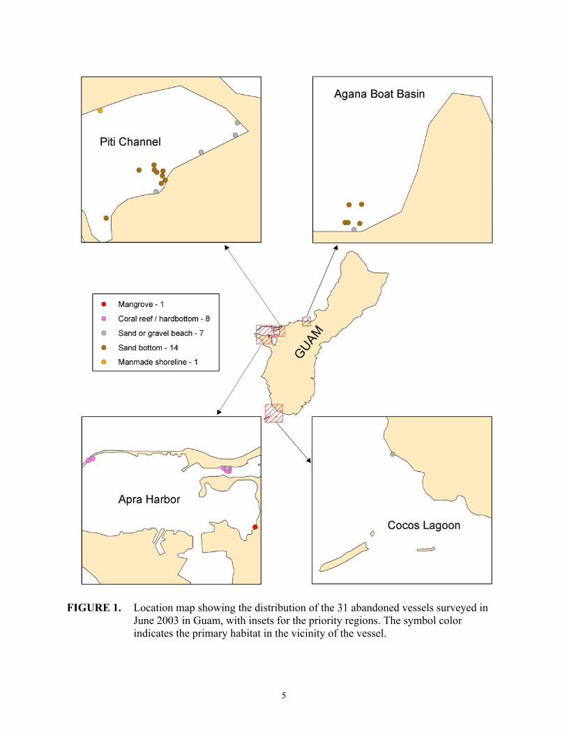
FIGURE 1. Location map showing the distribution of the 31 abandoned vessels surveyed in June 2003 in Guam, with insets for the priority regions. The symbol color indicates the primary habitat in the vicinity of the vessel.
5

TABLE 1. Summary information for the 31 vessels surveyed in Guam.
Vessel Name/Incident ID Location Description Threats Habitat
LadyKatherine/2522 Piti Channel, Guam
American longliner, fiberglass, 58 X 11 ft, ashore
Pollution: Batteries, other equipment Navigation: No Public Health: Yes,
Gravel beach
slip/fall hazard Unk2523 Piti Channel, Sailboat, Pollution: No Gravel beach
Guam fiberglass, 21 X 6.5 ft, ashore
Navigation: No Public Health: Yes, slip/fall hazard
Dolphin Dancer/2524
Piti Channel, Guam
Sailboat, 26 X 8 ft, at water
Pollution: No Navigation: Yes
Sand bottom
depth of 3- 7 ft, Public Health: No exposed at high tide
Unk1906 Piti Channel, Guam
Landing craft, steel, 55 X 13 ft,
Pollution: No Navigation: Yes
Sand bottom
large portions exposed at high
Public Health: No
tide Guahan 2/294 Piti Channel,
Guam YFU Landing Craft, steel, 115
Pollution: No Navigation: Yes
Sand bottom
X 32 ft, large portions
Public Health: Possible slip/fall or entrapment
exposed at high tide
hazard
Crystal Be – /2525 Piti Channel, Sailboat, Pollution: No Sand bottom Guam fiberglass, 16 X
10 ft, lying on side, exposed at
Navigation: Yes Public Health: Possible slip/fall or entrapment
high tide hazard Piti Dive Barge/1902
Piti Channel, Guam
Salvage tug/ barge, 39 X 15 ft, tied to seawall
Pollution: Possibility of oil onboard Navigation: Yes Public Health: Yes,
Manmade shoreline
slip/fall or entrapment hazard
Unk2526 Piti Channel, Guam
Barge, wooden, deck missing, 16 X 5X 1.5 ft,
Pollution: No Navigation: No Public Health: Possible
Sand beach
ashore slip/fall hazard
6

TABLE 1. Cont.
Unk2527 Piti Channel, Guam
Sloop, fiberglass, 35 X 9 ft, submerged, attached to
Pollution: No Navigation: Yes Public Health: No
Sand bottom
Guahan-2 on starboard side
Unk2528 Piti Channel, Ketch, Pollution: No Sand bottom Guam fiberglass, 53 X
14 ft, intact, Navigation: Yes Public Health: No
submerged Chammoro-1/292 Piti Channel,
Guam Longliner, fiberglass, 49 X 10.5 ft, upside down, exposed at high tide
Pollution: No Navigation: Yes Public Health: Yes, slip/fall hazard
Sand bottom
Unk2529 Piti Channel, Guam
Landing craft, steel, 50 X 14 ft, exposed at high tide
Pollution: No Navigation: No Public Health: Yes, slip/fall hazard
Sand bottom
Merlin/1903 Piti Channel, Guam
Ketch, fiberglass, 41 X 9 ft, ashore
Pollution: No Navigation: No Public Health: Yes,
Gravel beach
slip/fall hazard Unk2530 Outer Piti
Channel, Guam Barge, steel, 30 X 100 ft, partially ashore
Pollution: No Navigation: No Public Health: Yes slip/fall or entrapment hazard
Coral reef/ hardbottom, lagoonal fauna
Unk1909 Outer Piti Channel, Guam
Freighter, steel, 26 X 120 ft, exposed
Pollution: No Navigation: Yes Public Health: Yes
Coral reef/ hardbottom, lagoonal fauna
slip/fall or entrapment
Piti Crane Outer Piti Crane barge, Pollution: No Coral reef/ Barge/1910 Channel, Guam steel, 30 X 100
ft, exposed Navigation: Yes Public Health: Yes
hardbottom, lagoonal fauna
slip/fall or entrapment Guahan-1/293 Outer Piti
Channel, Guam Landing craft, steel, 115 X 32 ft, exposed
Pollution: No Navigation: Possible if moved during a storm Public Health: No
Coral reef/ hardbottom, lagoonal fauna
Unk2531 Outer Piti Vessel type Pollution: No Coral reef/ Channel, Guam unknown,
possible barge, 27 X 67 ft,
Navigation: No Public Health: Yes, slip/fall or entrapment
hardbottom, lagoonal fauna
rusting steel
7
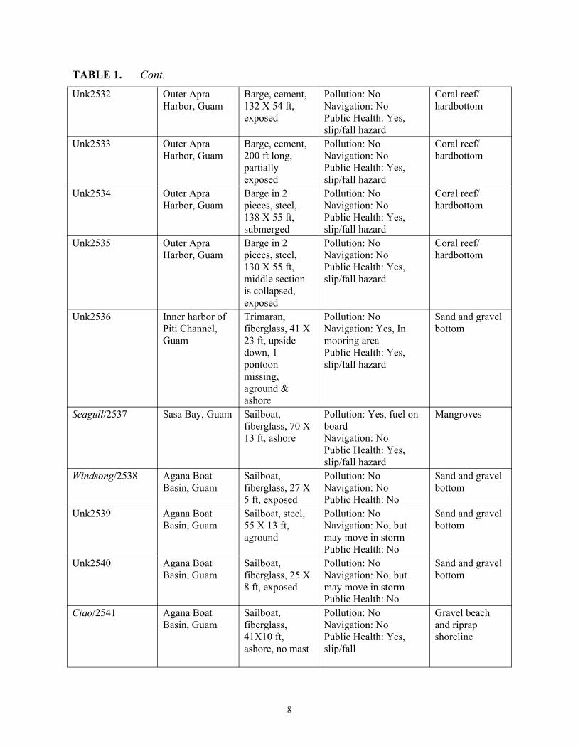
TABLE 1. Cont.
Unk2532 Outer Apra Harbor, Guam
Barge, cement, 132 X 54 ft, exposed
Pollution: No Navigation: No Public Health: Yes, slip/fall hazard
Coral reef/ hardbottom
Unk2533 Outer Apra Harbor, Guam
Barge, cement, 200 ft long, partially exposed
Pollution: No Navigation: No Public Health: Yes, slip/fall hazard
Coral reef/ hardbottom
Unk2534 Outer Apra Harbor, Guam
Barge in 2 pieces, steel, 138 X 55 ft, submerged
Pollution: No Navigation: No Public Health: Yes, slip/fall hazard
Coral reef/ hardbottom
Unk2535 Outer Apra Harbor, Guam
Barge in 2 pieces, steel, 130 X 55 ft, middle section is collapsed, exposed
Pollution: No Navigation: No Public Health: Yes, slip/fall hazard
Coral reef/ hardbottom
Unk2536 Inner harbor of Piti Channel, Guam
Trimaran, fiberglass, 41 X 23 ft, upside down, 1 pontoon missing, aground & ashore
Pollution: No Navigation: Yes, In mooring area Public Health: Yes, slip/fall hazard
Sand and gravel bottom
Seagull/2537 Sasa Bay, Guam Sailboat, fiberglass, 70 X 13 ft, ashore
Pollution: Yes, fuel on board Navigation: No Public Health: Yes, slip/fall hazard
Mangroves
Windsong/2538 Agana Boat Basin, Guam
Sailboat, fiberglass, 27 X 5 ft, exposed
Pollution: No Navigation: No Public Health: No
Sand and gravel bottom
Unk2539 Agana Boat Basin, Guam
Sailboat, steel, 55 X 13 ft, aground
Pollution: No Navigation: No, but may move in storm Public Health: No
Sand and gravel bottom
Unk2540 Agana Boat Basin, Guam
Sailboat, fiberglass, 25 X 8 ft, exposed
Pollution: No Navigation: No, but may move in storm Public Health: No
Sand and gravel bottom
Ciao/2541 Agana Boat Basin, Guam
Sailboat, fiberglass, 41X10 ft, ashore, no mast
Pollution: No Navigation: No Public Health: Yes, slip/fall
Gravel beach and riprap shoreline
8

TABLE 1. Cont.
Unk1900 Agana Boat Basin, Guam
Sloop, ferro-cement, 35 X 12 ft, partially exposed
Pollution: No Navigation: Yes Public Health: No
Sand bottom
Lion’s Den/1901 Agana Boat Basin, Guam
Ketch, steel, upside down, partially exposed
Pollution: Yes, batteries, engine block and fuel tank possibly still onboard Navigation: Yes Public Health: No
Sand bottom
Unk2542 Cocos Lagoon, Guam
Sloop, fiberglass, 20 X 7 ft, inverted and under dock
Pollution: No Navigation: No Public Health: Yes, slip/fall
Sand and gravel beach
*Threats are preliminary determinations and could change.
Table 3 presents information on the number of vessels by vessel type, primary habitat type in the immediate vicinity of the vessel, and whether there was a potential pollution, navigation, or public health hazard. Figures 4, 5, and 6 show the distribution for Guam and the islands of the CNMI by vessel type. In Guam, 45 percent of the vessels surveyed (14 of 31) were recreational sailboats. Six (6) of these vessels were ashore and 2 aground as the result of typhoons. Most had been stripped of all salvageable materials. Thirty-five (35) percent of vessels surveyed in Guam were commercial vessels of various types, including long-liners, barges, freighters, cargo vessels, charter boats, work boats, etc. In the CNMI, 76 percent of the vessels surveyed (32 of 42) were military or government owned, and 27 of these 32 were rusting WWII era barges. It is unknown when most of these went aground but several are deeply mired in the sediment or in some cases have corals and other organisms growing on them.
Table 3 also lists the habitats that are associated with coral reef ecosystems, which include coral reef/hardbottom habitats, mangroves, seagrasses, and mixed macroalgae/seagrass habitats. In Guam only 1 of the 31 vessels surveyed (the Seagull) was located in mangrove habitat. Most other vessels (72%) were associated with sand, gravel, or sand and gravel beaches and bottom sediments or manmade shorelines. Seven (7) vessels (23%) were associated with coral reef/hardbottom habitats. Live coral cover was typically not high where vessels were surveyed in Guam. In the CNMI, 11 of the 42 vessels (26%) were located on coral reef or hardbottom habitats, typically with higher live coral cover than was observed in Guam. Of the remaining 31 vessels surveyed, 7 vessels (17%) were located in mangrove habitats, 3 vessels (7%) were located in seagrass habitats (70-90% cover in some cases), 15 vessels (36%) were located in mixed macroalgae/seagrass habitats, and 6 vessels (15%) were located on beaches or engineered coastlines.
9

FIGURE 2. Location map showing the distribution of the 33 vessels surveyed in June 2003 in Saipan, CNMI, with insets for the priority regions. The symbol color indicates the primary habitat in the vicinity of the vessel.
10

FIGURE 3. Location map showing the distribution of the 9 vessels surveyed in June 2003 in Tinian and Rota, CNMI, with insets for the priority regions. The symbol color indicates the primary habitat in the vicinity of the vessel.
11
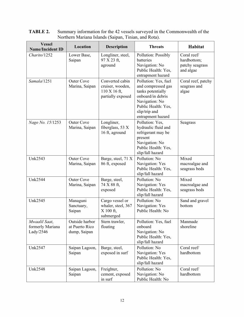
TABLE 2. Summary information for the 42 vessels surveyed in the Commonwealth of the Northern Mariana Islands (Saipan, Tinian, and Rota).
Vessel Name/Incident ID Location Description Threats Habitat
Charito/1252 Lower Base, Saipan
Longliner, steel, 97 X 23 ft, aground
Pollution: Possibly batteries Navigation: No Public Health: Yes, entrapment hazard
Coral reef/ hardbottom; patchy seagrass and algae
Samala/1251 Outer Cove Marina, Saipan
Converted cabin cruiser, wooden, 110 X 16 ft, partially exposed
Pollution: Yes, fuel and compressed gas tanks potentially onboard/in debris Navigation: No Public Health: Yes,
Coral reef, patchy seagrass and algae
slip/trip and entrapment hazard
Nago No. 15/1253 Outer Cove Marina, Saipan
Longliner, fiberglass, 53 X 16 ft, aground
Pollution: Yes, hydraulic fluid and refrigerant may be
Seagrass
present Navigation: No Public Health: Yes, slip/fall hazard
Unk2543 Outer Cove Marina, Saipan
Barge, steel, 71 X 86 ft, exposed
Pollution: No Navigation: Yes Public Health: Yes,
Mixed macroalgae and seagrass beds
slip/fall hazard Unk2544 Outer Cove
Marina, Saipan Barge, steel, 74 X 88 ft, exposed
Pollution: No Navigation: Yes Public Health: Yes, slip/fall hazard
Mixed macroalgae and seagrass beds
Unk2545 Managuni Cargo vessel or Pollution: No Sand and gravel Sanctuary, Saipan
whaler, steel, 367 X 100 ft,
Navigation: Yes Public Health: No
bottom
submerged Mwaalil Saat, Outside harbor Stern trawler, Pollution: Yes, fuel Manmade formerly Mariana at Puerto Rico floating onboard shoreline Lady/2546 dump, Saipan Navigation: No
Public Health: Yes, slip/fall hazard
Unk2547 Saipan Lagoon, Saipan
Barge, steel, exposed in surf
Pollution: No Navigation: Yes Public Health: Yes,
Coral reef/ hardbottom
slip/fall hazard Unk2548 Saipan Lagoon, Freighter, Pollution: No Coral reef/
Saipan cement, exposed Navigation: No hardbottom in surf Public Health: No
12
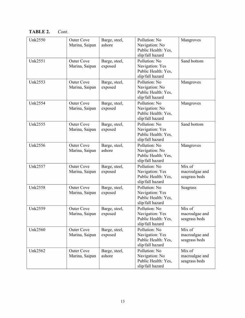
TABLE 2. Cont.
Unk2550 Outer Cove Marina, Saipan
Barge, steel, ashore
Pollution: No Navigation: No Public Health: Yes, slip/fall hazard
Mangroves
Unk2551 Outer Cove Marina, Saipan
Barge, steel, exposed
Pollution: No Navigation: Yes Public Health: Yes, slip/fall hazard
Sand bottom
Unk2553 Outer Cove Marina, Saipan
Barge, steel, exposed
Pollution: No Navigation: No Public Health: Yes, slip/fall hazard
Mangroves
Unk2554 Outer Cove Marina, Saipan
Barge, steel, exposed
Pollution: No Navigation: No Public Health: Yes, slip/fall hazard
Mangroves
Unk2555 Outer Cove Marina, Saipan
Barge, steel, exposed
Pollution: No Navigation: Yes Public Health: Yes, slip/fall hazard
Sand bottom
Unk2556 Outer Cove Marina, Saipan
Barge, steel, ashore
Pollution: No Navigation: No Public Health: Yes, slip/fall hazard
Mangroves
Unk2557 Outer Cove Marina, Saipan
Barge, steel, exposed
Pollution: No Navigation: Yes Public Health: Yes, slip/fall hazard
Mix of macroalgae and seagrass beds
Unk2558 Outer Cove Marina, Saipan
Barge, steel, exposed
Pollution: No Navigation: Yes Public Health: Yes, slip/fall hazard
Seagrass
Unk2559 Outer Cove Marina, Saipan
Barge, steel, exposed
Pollution: No Navigation: Yes Public Health: Yes, slip/fall hazard
Mix of macroalgae and seagrass beds
Unk2560 Outer Cove Marina, Saipan
Barge, steel, exposed
Pollution: No Navigation: Yes Public Health: Yes, slip/fall hazard
Mix of macroalgae and seagrass beds
Unk2562 Outer Cove Marina, Saipan
Barge, steel, ashore
Pollution: No Navigation: No Public Health: Yes, slip/fall hazard
Mix of macroalgae and seagrass beds
13

TABLE 2. Cont.
Unk2564 Outer Cove Marina, Saipan
Barge, steel, exposed
Pollution: No Navigation: Yes Public Health: Yes, slip/fall hazard
Mix of macroalgae and seagrass beds
Unk2565 Outer Cove Marina, Saipan
Barge, steel, exposed
Pollution: No Navigation: No Public Health: Yes, slip/fall hazard
Mix of macroalgae and seagrass beds
Unk2566 Outer Cove Marina, Saipan
Barge, steel, ashore
Pollution: No Navigation: No Public Health: Yes, slip/fall hazard
Mangroves
Unk2567 Outer Cove Marina, Saipan
Barge, steel, exposed
Pollution: No Navigation: No Public Health: Yes, slip/fall hazard
Sandy bottom
Unk2568 Outer Cove Marina, Saipan
Barge, steel, exposed
Pollution: No Navigation: Yes Public Health: Yes, slip/fall hazard
Mix of macroalgae and seagrass beds
Unk2569 Outer Cove Marina, Saipan
Barge, steel, exposed
Pollution: No Navigation: Yes Public Health: Yes, slip/fall hazard
Mix of macroalgae and seagrass beds
Unk2570 Outer Cove Marina, Saipan
Barge, steel, exposed
Pollution: No Navigation: Yes Public Health: Yes, slip/fall hazard
Mix of macroalgae and seagrass beds
Unk2571 Outer Cove Marina, Saipan
Barge, steel, exposed
Pollution: No Navigation: Yes Public Health: Yes, slip/fall hazard
Mix of macroalgae and seagrass beds
Unk2572 Outer Cove Marina, Saipan
Barge, steel, exposed
Pollution: No Navigation: No Public Health: Yes, slip/fall hazard
Mix of macroalgae and seagrass beds
Unk2573 Outer Cove Marina, Saipan
Barge, steel, exposed
Pollution: No Navigation: No Public Health: Yes, slip/fall hazard
Mangroves
Unk2574 Outer Cove Marina, Saipan
Barge, steel, exposed
Pollution: No Navigation: Yes Public Health: Yes, slip/fall hazard
Coral reef/ hardbottom, macroalgae
14
TABLE 2. Cont.
Unk2575 Outer Cove Barge, steel, Pollution: No Mix of Marina, Saipan exposed Navigation: Yes
Public Health: Yes, slip/fall hazard
macroalgae and seagrass beds
Unk2576 Outer Cove Marina, Saipan
Barge, steel, exposed
Pollution: No Navigation: Yes Public Health: Yes,
Seagrass
slip/fall hazard Lian Gi/2577 Tinian Harbor,
Tinian Freighter, steel, 44.5 X 129 ft,
Pollution: Yes, fuel and contaminated
Manmade shoreline
afloat ballast sediment Navigation: No Public Health: Yes, slip/fall and entrapment hazard
Unk2578 Tinian Harbor, Tinian
Fishing boat, ferro-cement, 55 X 16 ft, aground
Pollution: No Navigation: No Public Health: Yes, slip/fall and entrapment hazard
Sandy bottom
Unk2579 Tinian Harbor, Tinian
Yacht, steel, 38 X 13.5 ft,
Pollution: No Navigation: No
Sandy bottom
submerged Public Health: Yes, slip/fall and entrapment hazard
Sun Long No.8/1828
Tinian Harbor, Tinian
Freighter, steel, 325 ft bow to
Pollution: No Navigation: Yes
Coral reef/ hardbottom
stern, exposed Public Health: Yes, slip/fall and entrapment hazard
#62 Nam Sasanlago- Fishing vessel, Pollution: No Coral reef/ Sung/1832 Tatqua Beach, steel, 26.5 X 63 Navigation: No hardbottom
Rota ft, exposed Public Health: Yes, slip/fall and entrapment hazard
T.T. Gov’t 1/1830 Sasanlago, Rota
U.S. Military “M-boat”, steel, 106 X 29 ft,
Pollution: No Navigation: No Public Health: Yes,
Coral reef/ hardbottom
aground, exposed slip/fall and entrapment hazard
T.T. Gov’t 2/1831 Sasanlago, Rota
U.S. Military “M-boat”, steel, 106 X 29 ft,
Pollution: No Navigation: No Public Health: Yes,
Coral reef/ hardbottom
aground, exposed slip/fall and entrapment hazard
15

TABLE 2. Cont.
Unk2581 Sasanlago, Rota
U.S. military “M-Boat”, steel, 106 X 29 ft, aground, exposed
Pollution: No Navigation: No Public Health: Yes, slip/fall and entrapment hazard
Coral reef/ hardbottom
Rota Queen/1829 Sasanlago, Rota
Tugboat, steel, 65.5 X 11 ft, aground, exposed
Pollution: No Navigation: No Public Health: Yes, slip/fall and entrapment hazard
Coral reef/ hardbottom
*Threats are preliminary determinations and could change.
Information on potential pollution, navigational, and public health threats are also summarized in Table 3. It should be noted that the threat determination is preliminary and could change upon further investigation. The U.S. Coast Guard has been proactive in removing fuel and/or vessels that pose a significant pollution threat. Four (4) of the vessels in Guam were found to be potential pollution threats. The Seagull (Incident ID: 2537) is known to have 128 gallons of gasoline and 40 gallons of oil onboard. Other vessels such as the Piti Dive Barge (Incident ID: 1902) and the Lion’s Den (Incident ID: 1901) are suspected to have fuel on board but specific details remain unknown. Both the Lady Katherine (Incident ID: 2522) and Lion’s Den had batteries and other materials onboard. Of the vessels surveyed in the CNMI, 5 were found to be potential pollution threats. The Samala (Incident ID: 1251), a broken down wooden cabin cruiser, likely has fuel onboard and compressed gas tanks were observed on site. Two (2) vessels that remain afloat but are derelict, the Lian Gi (Incident ID: 2577) and Mwaalil Saat (Incident ID: 2546), have fuel on board. In the case of the Lian Gi, efforts have been made to remove portions of the fuel and fuel contaminated ballast sediment. The Nago No. 15 (Incident ID: 1253) contains unknown (possibly only minor) amounts of coolant and hydraulic fluid.
TABLE 3. Information on vessel type, habitat and potential threats for the 73 vessels surveyed in Guam (31 vessels), Rota, Saipan, and Tinian (42 vessels total) in the CNMI.
Area Vessel Type Coral Reef
Habitat
Seagrass Habitat
Mangrove Habitat
Macroalgae/ Seagrass
Mix
Potential Pollution Threat
Potential Navigation
Threat
Potential Public Health Threat
Guam Commercial: 11 Recreational: 14 Gov/Military: 6
8 0 1 0 4 14 15
U.S. CNMI
Commercial: 9 Recreational: 1 Gov/Military: 32
11 3 7 15 5 19 39
16
Fourteen (14) of the 31 vessels surveyed in Guam may be considered potential threats to navigation. All of these were associated with clusters of vessels found in Piti Channel and the Agana Boat Basin. Several vessels were grounded near the shoreline and are of lesser concern unless they are to move during a storm. Nine (9) vessels were located near the center of the channel or mooring area, and are a more immediate concern. Most vessels were visible at low tide, but some of the smaller recreational craft may not be visible at high tide. Nineteen (19) vessels in the CNMI islands surveyed are considered navigational threats. The majority of vessels considered to be navigational threats are WWII era barges located in sheltered coves and nearshore areas in Saipan.Unk2545, a submerged Japanese freighter (Incident ID: 2545) located southeast of Mañagha Island represents a navigational threat in deeper open water. The Sun Long No. 8 (Incident ID: 1828) is a large partially exposed steel freighter located in Tinian Harbor. It is poorly marked aside from the large kingposts still visible above the water.
17

FIGURE 4. Location map showing the distribution of the 31 vessels surveyed in June 2003 in Guam with insets for the priority regions. The symbol color indicates the vessel type.
18
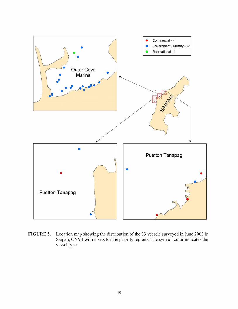
FIGURE 5. Location map showing the distribution of the 33 vessels surveyed in June 2003 in Saipan, CNMI with insets for the priority regions. The symbol color indicates the vessel type.
19

FIGURE 6. Location map showing the distribution of the 9 vessels surveyed in June 2003 in Tinian and Rota, CNMI with insets for the priority regions. The symbol color indicates the vessel type.
20
About one-half (15 of 31) of the vessels in Guam and almost all (39 of 42) of the vessels in the CNMI were classified as potential public health threats, mostly as slip and fall hazards because the decks were tilted or the metal deck and/or sides were rusted out. A large number of the vessels labeled as health threats are rusted out remnants of WWII era barges. On Guam, 3 vessels (Unk2525, Unk1909, and Unk1910) were noted as potential entrapment hazards to swimmers. Each of these is partially submerged or awash. On Saipan, the most notable entrapment threat is the Samala (Incident ID: 1252). Children have been reported playing and diving off of the wreck. In Tinian Harbor, 2 vessels (Unk2578 and Unk2579) are also entrapment threats. Both vessels are at least partially submerged and have open access to cabin space. Vessels located in industrial or restricted access areas were not classified as public health threats, based on the assumption that they were not areas where the public normally used for recreation.
COMMON VESSEL SCENARIOS
To date NOAA has reviewed and surveyed hundreds of derelict, abandoned, and wrecked vessels as part of the Abandoned Vessel Program. While each incident is unique in many ways and responding to any one of these vessels would require site specific planning and consideration, it has been noted that most vessels fall into a few broad categories. In the following pages, detailed descriptions of vessels surveyed in Guam and CNMI are organized into 5 categories in order to highlight the significant challenges in managing the vessels. The categories include:
• high removal priority for local management agencies; • logistically complex removals because of large debris fields; • vessels with historical significance; • clusters of derelict and grounded vessels; and • derelict vessels still afloat.
Each of these categories is described in detail, with an introductory page followed by plates including photos and descriptions of example vessels surveyed in Guam and CNMI. Each introductory page and set of plates is meant to be a stand-alone document, therefore some of the introductory page information is duplicated from category to category.
21
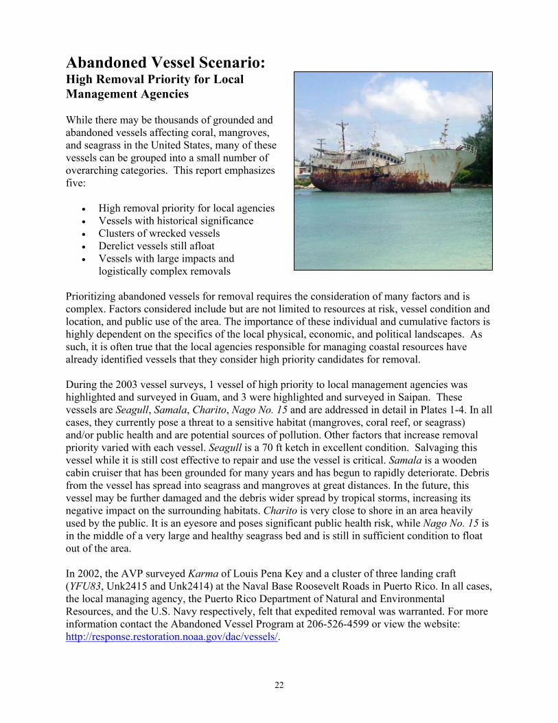
Abandoned Vessel Scenario:High Removal Priority for Local Management Agencies
While there may be thousands of grounded and abandoned vessels affecting coral, mangroves, and seagrass in the United States, many of these vessels can be grouped into a small number of overarching categories. This report emphasizes five:
• High removal priority for local agencies • Vessels with historical significance • Clusters of wrecked vessels • Derelict vessels still afloat • Vessels with large impacts and
logistically complex removals
Prioritizing abandoned vessels for removal requires the consideration of many factors and is complex. Factors considered include but are not limited to resources at risk, vessel condition and location, and public use of the area. The importance of these individual and cumulative factors is highly dependent on the specifics of the local physical, economic, and political landscapes. As such, it is often true that the local agencies responsible for managing coastal resources have already identified vessels that they consider high priority candidates for removal.
During the 2003 vessel surveys, 1 vessel of high priority to local management agencies was highlighted and surveyed in Guam, and 3 were highlighted and surveyed in Saipan. These vessels are Seagull, Samala, Charito, Nago No. 15 and are addressed in detail in Plates 1-4. In all cases, they currently pose a threat to a sensitive habitat (mangroves, coral reef, or seagrass) and/or public health and are potential sources of pollution. Other factors that increase removal priority varied with each vessel. Seagull is a 70 ft ketch in excellent condition. Salvaging this vessel while it is still cost effective to repair and use the vessel is critical. Samala is a wooden cabin cruiser that has been grounded for many years and has begun to rapidly deteriorate. Debris from the vessel has spread into seagrass and mangroves at great distances. In the future, this vessel may be further damaged and the debris wider spread by tropical storms, increasing its negative impact on the surrounding habitats. Charito is very close to shore in an area heavily used by the public. It is an eyesore and poses significant public health risk, while Nago No. 15 is in the middle of a very large and healthy seagrass bed and is still in sufficient condition to float out of the area.
In 2002, the AVP surveyed Karma of Louis Pena Key and a cluster of three landing craft (YFU83, Unk2415 and Unk2414) at the Naval Base Roosevelt Roads in Puerto Rico. In all cases, the local managing agency, the Puerto Rico Department of Natural and Environmental Resources, and the U.S. Navy respectively, felt that expedited removal was warranted. For more information contact the Abandoned Vessel Program at 206-526-4599 or view the website: http://response.restoration.noaa.gov/dac/vessels/.
22
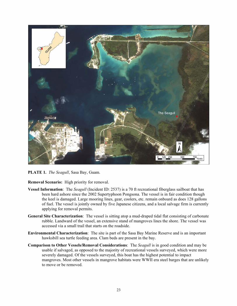
PLATE 1. The Seagull, Sasa Bay, Guam.
Removal Scenario: High priority for removal.
Vessel Information: The Seagull (Incident ID: 2537) is a 70 ft recreational fiberglass sailboat that has been hard ashore since the 2002 Supertyphoon Pongsona. The vessel is in fair condition though the keel is damaged. Large mooring lines, gear, coolers, etc. remain onboard as does 128 gallons of fuel. The vessel is jointly owned by five Japanese citizens, and a local salvage firm is currently applying for removal permits.
General Site Characterization: The vessel is sitting atop a mud-draped tidal flat consisting of carbonate rubble. Landward of the vessel, an extensive stand of mangroves lines the shore. The vessel was accessed via a small trail that starts on the roadside.
Environmental Characterization: The site is part of the Sasa Bay Marine Reserve and is an important hawksbill sea turtle feeding area. Clam beds are present in the bay.
Comparison to Other Vessels/Removal Considerations: The Seagull is in good condition and may be usable if salvaged, as opposed to the majority of recreational vessels surveyed, which were more severely damaged. Of the vessels surveyed, this boat has the highest potential to impact mangroves. Most other vessels in mangrove habitats were WWII era steel barges that are unlikely to move or be removed.
23
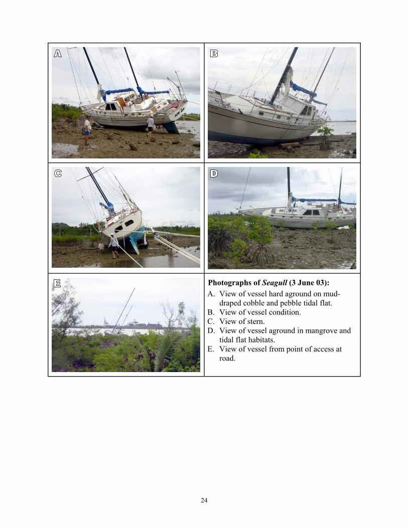
Photographs of Seagull (3 June 03):
draped cobble and pebble tidal flat.
road.
A. View of vessel hard aground on mud-
B. View of vessel condition. C. View of stern. D. View of vessel aground in mangrove and
tidal flat habitats. E. View of vessel from point of access at
24
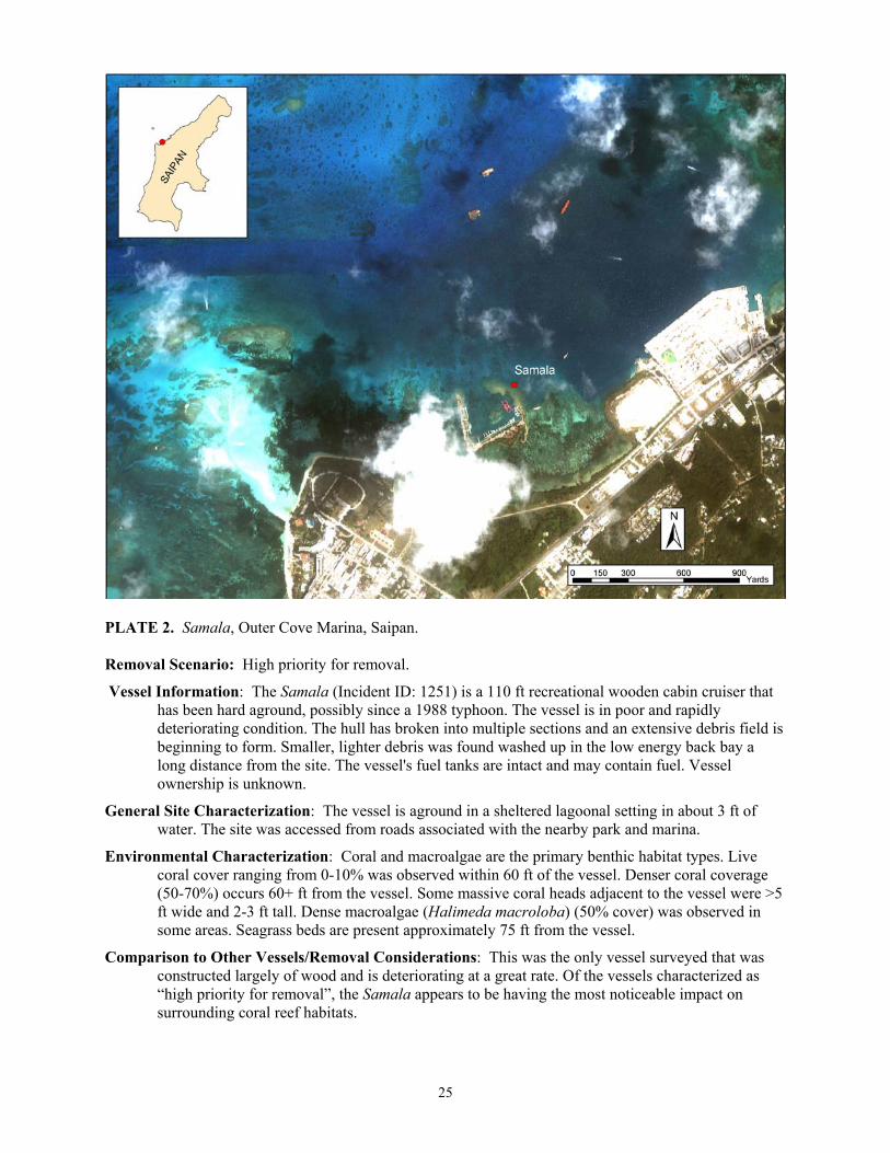
PLATE 2. Samala, Outer Cove Marina, Saipan.
Removal Scenario: High priority for removal.
Vessel Information: The Samala (Incident ID: 1251) is a 110 ft recreational wooden cabin cruiser that has been hard aground, possibly since a 1988 typhoon. The vessel is in poor and rapidly deteriorating condition. The hull has broken into multiple sections and an extensive debris field is beginning to form. Smaller, lighter debris was found washed up in the low energy back bay a long distance from the site. The vessel's fuel tanks are intact and may contain fuel. Vessel ownership is unknown.
General Site Characterization: The vessel is aground in a sheltered lagoonal setting in about 3 ft of water. The site was accessed from roads associated with the nearby park and marina.
Environmental Characterization: Coral and macroalgae are the primary benthic habitat types. Live coral cover ranging from 0-10% was observed within 60 ft of the vessel. Denser coral coverage (50-70%) occurs 60+ ft from the vessel. Some massive coral heads adjacent to the vessel were >5 ft wide and 2-3 ft tall. Dense macroalgae (Halimeda macroloba) (50% cover) was observed in some areas. Seagrass beds are present approximately 75 ft from the vessel.
Comparison to Other Vessels/Removal Considerations: This was the only vessel surveyed that was constructed largely of wood and is deteriorating at a great rate. Of the vessels characterized as “high priority for removal”, the Samala appears to be having the most noticeable impact on surrounding coral reef habitats.
25

Photographs of Samala (5 June 03):
Marina.
Porites
vessel.
A. View from access point at Outer Cove
B. View of wooden cabin deterioration. C. View of debris on coral head
immediately adjacent to vessel. D. Compressed gas tanks observed in debris. E. View of Acropora and damselfish near
26
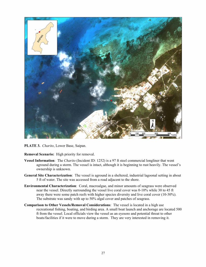
PLATE 3. Charito, Lower Base, Saipan.
Removal Scenario: High priority for removal.
Vessel Information: The Charito (Incident ID: 1252) is a 97 ft steel commercial longliner that went aground during a storm. The vessel is intact, although it is beginning to rust heavily. The vessel’s ownership is unknown.
General Site Characterization: The vessel is aground in a sheltered, industrial lagoonal setting in about 5 ft of water. The site was accessed from a road adjacent to the shore.
Environmental Characterization: Coral, macroalgae, and minor amounts of seagrass were observed near the vessel. Directly surrounding the vessel live coral cover was 0-10% while 30 to 45 ft away there were some patch reefs with higher species diversity and live coral cover (10-30%). The substrate was sandy with up to 50% algal cover and patches of seagrass.
Comparison to Other Vessels/Removal Considerations: The vessel is located in a high use recreational fishing, boating, and birding area. A small boat launch and anchorage are located 500 ft from the vessel. Local officials view the vessel as an eyesore and potential threat to other boats/facilities if it were to move during a storm. They are very interested in removing it.
27
Photographs of Charito (5 June 03):
and Acropora) and
and Caulerpa taxifolia) and seagrass ( near vessel.
A. View from shore of bow. B. View of coral (Porites
macroalgae at site. C. View of stern and proximity to shore. D. View of macroalgae (Halimeda macroloba
Enhalus macroroides)
28

PLATE 4. Nago No. 15, Saipan Lagoon, Saipan.
Removal Scenario: High priority for removal.
Vessel Information: The Nago No.15 (Incident ID: 1253) is a 53 ft fiberglass commercial longliner that grounded during a storm. The vessel is intact though the steel portions are beginning to rust. Ownership is unknown.
General Site Characterization: The vessel is aground in a shallow lagoonal setting in 3 to 5 ft of water. The site is accessible from a road adjacent to the shore or by boat.
Environmental Characterization: Dense seagrass, (>70% cover, 90-100% cover in some areas) and a sandy substrate. Scouring has occurred off of the port side (8 ft swath) and bow (20 ft swath).
Comparison to Other Vessels/Removal Considerations: Seagrass coverage surrounding the vessel was denser and covered a more extensive area than in all other areas surveyed in Guam and CNMI. Previous attempts to remove the vessel failed, but our survey assessment indicated that removal would probably be feasible if performed by experienced personnel.
29

Photographs of Nago No. 15 (6 June 03):
ft off of port side and bow.
vessel.
A. View of stern. B. View of bow. C. Unvegetated scour area that extends 8-20
D. Engine compartment in vessel. E. Dense seagrass habitat adjacent to the
30
Abandoned Vessel Scenario: Logistically Complex Removals because of Large Debris Fields.
While there may be thousands of grounded and abandoned vessels affecting coral, mangroves and seagrass in the United States, many of these vessels can be grouped into a small number of overarching categories. This report emphasizes five:
• High removal priority for local agencies • Vessels with historical significance • Clusters of wrecked vessels • Derelict vessels still afloat • Vessels with large impacts and logistically
complex removals
Vessels exposed to high-energy environments for long periods of time frequently break up into many pieces, creating large and potentially mobile debris fields. These vessels may pose an increased threat to coral and hardbottom habitats because the vessel fragments can roll across the bottom breaking corals, crushing benthic organisms, filling in gaps and generally reducing the structural complexity of the environment. This scattered wreckage also presents unique removal challenges since locating and removing all of the pieces requires increased man-hours and additional salvage equipment.
The vessels displayed in Plates 5 and Plate 6 (the Sun Long No. 8 and the #62 Nam Sung respectively) both fall into this category. The Sun Long No. 8 is a steel Korean freighter that was grounded in Tinian Harbor in 1987 by Supertyphoon Kim. Since the event, the vessel has broken into hundreds of pieces that now rest among corals. Initially, the reef was damaged in 1987 by the grounding event and salvage attempts. The rubble, however, continues to damage the reef 16 years later. For increased clarity, the plate has a debris field map in addition to photos of the wreckage. The #62 Nam Sum is a large Korean fishing vessel that grounded on Sasanlago-Tatqua Beach, Rota in 1982 and is similar to the Sun Long No. 8. This vessel rests on the reef crest of a pristine spur and groove reef with extensive coverage of large corals.
While these vessels are extreme examples, the cost and complexity of any removal increases as the vessel breaks up into many pieces. Much smaller vessels can present similar problems. The Samala (already addressed in Plate 2) is a prime example. Its debris field already stretches for many yards in every direction. Additionally, some of the more mobile fragments were located up to a half mile from the vessel, washed up in mangrove and seagrass habitat. The 2002 Caribbean surveys provide another smaller scale example. The sloop Karma was sunk in the waters off Luis Pena Key, PR within 75 ft of a healthy coral reef. When managing agencies first attempted to gain authority to remove the vessel, it was intact and the operation would have been brief and inexpensive. As legal issues interfered with determining clear authority and delayed action, the vessel has broken into many pieces that are more mobile, harder to locate, and more costly to remove.
For more information contact the Abandoned Vessel Program at 206-526-4599. http://response.restoration.noaa.gov/dac/vessels/.
31

PLATE 5. Sun Long No. 8, Tinian Harbor, Tinian.
Removal Scenario: Logistically complex due to extensive debris field.
Vessel Information: The Sun Long No. 8 (Incident ID: 1828) is a 325 ft Korean commercial steel freighter. It has been hard aground since Supertyphoon Kim in 1987. The vessel is largely broken up and parts are scattered throughout the reef from depths of 0 to 25 ft The kingposts and engine block protrude from the water and a large stern section remains on the beach, making the vessel clearly visible. Ownership of the vessel is unknown.
General Site Characterization: The vessel is in a moderately exposed portion of Tinian Harbor and is accessible via nearby roads and by boat. The adjacent shoreline is somewhat rocky with pocket beaches.
Environmental Characterization: The primary habitat type is coral reef/hardbottom. There is some rubble surrounding the vessel with live coral ranging from <10% to ~ 10-30% cover. The reef is very close to the bow (~20% live cover) but is ~45 ft off of the port and starboard sides.
Comparison to Other Vessels/Removal Considerations: This is one of two sites that had extensive debris fields over a range of depths. Sun Long No. 8 is one of the largest vessels surveyed at 325 ft.
32

Photographs of Sun Long No. 8 (9 June 03):
shore.
shoreline.
gravel.
A. Kingpost and large piece of debris on
B. View of large piece of debris on riprap
C. View of dense debris. D. Small portion of debris field and sand and
gravel substrate with coral rubble. E. Anchor among the debris atop sand and
33

PLATE 6. #62 Nam Sung, Sasanlago-Tatqua beach, Rota. Removal Scenario: Logistically complex due to extensive debris field. Vessel Information: The #62 Nam Sung (Incident ID: 1828) is a 63 ft Korean commercial steel fishing
vessel. Originally it was 42.5m (~140 ft) in length but is has since broken up. It has been hard aground since July of 1982. One large section of the hull rests on the reef, and debris is scattered from the edge of the reef to the beach. The vessel is owned by Nam Sung Fisheries Co., Ltd. of Busan, Korea.
General Site Characterization: Exposed reef flat with waves breaking on the reef and vessel. Adjacent shoreline consists of some rock but mostly extensive beaches.
Environmental Characterization: Vessel and majority of debris rest on shallow exposed reef flat with 0% live coral and some attached algae in surf zone. Seaward of reef flat ~60 ft from main vessel is an extensive spur and groove reef with 50-70% live coral or greater in some areas. Some debris lies among spur and groove reef. Dominant genuses include: Porites, Acropora, and Pocillopora with multiple species/forms observed for each genus. Additional genuses likely occur in the area. Reef fish and giant clams observed.
Comparison to Other Vessels/Removal Considerations: One of two sites that had extensive debris fields, this site has debris spread over the greatest area. Heavy surf in shallow area may impede removal. This area had the highest coral species diversity of all areas surveyed in the Pacific region.
34
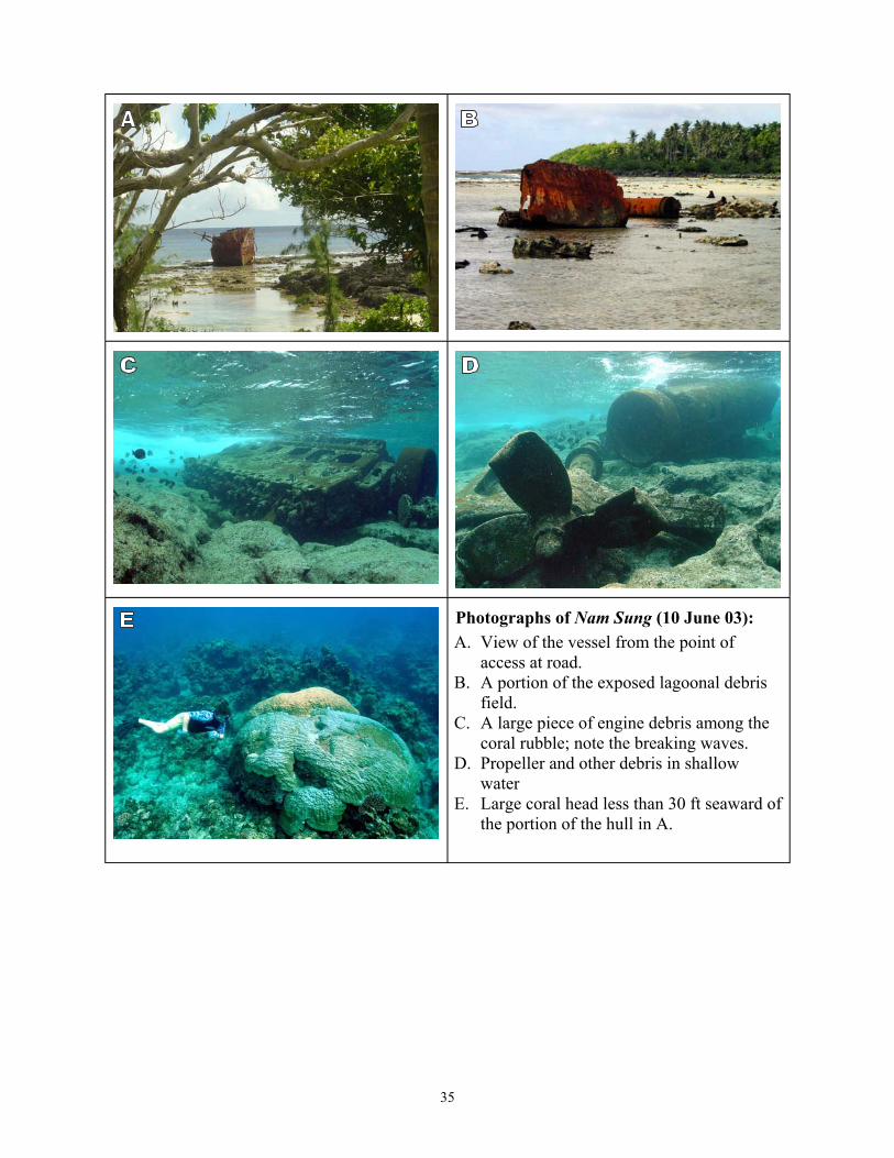
Photographs of Nam Sung (10 June 03):
field.
coral rubble; note the breaking waves.
water
A. View of the vessel from the point of access at road.
B. A portion of the exposed lagoonal debris
C. A large piece of engine debris among the
D. Propeller and other debris in shallow
E. Large coral head less than 30 ft seaward of the portion of the hull in A.
35
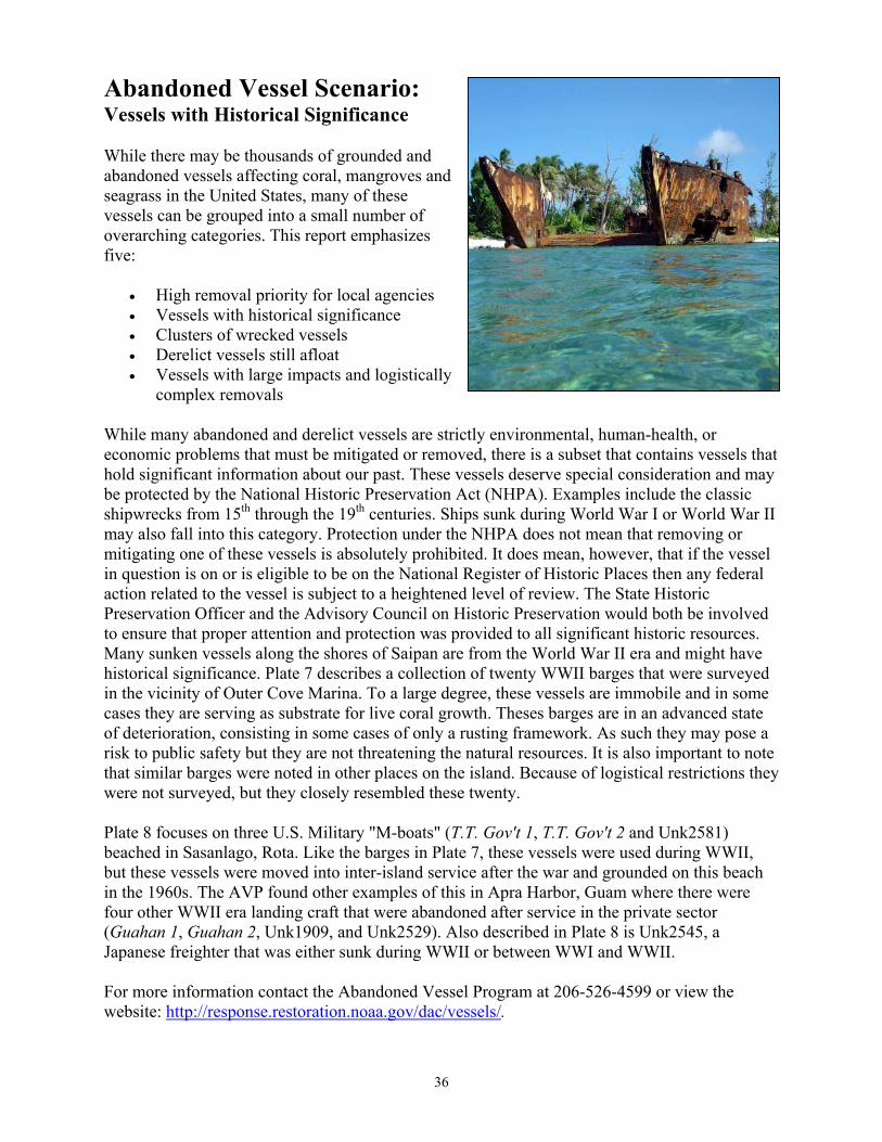
Abandoned Vessel Scenario: Vessels with Historical Significance
While there may be thousands of grounded and abandoned vessels affecting coral, mangroves and seagrass in the United States, many of these vessels can be grouped into a small number of overarching categories. This report emphasizes five:
• High removal priority for local agencies • Vessels with historical significance • Clusters of wrecked vessels • Derelict vessels still afloat • Vessels with large impacts and logistically
complex removals
While many abandoned and derelict vessels are strictly environmental, human-health, or economic problems that must be mitigated or removed, there is a subset that contains vessels that hold significant information about our past. These vessels deserve special consideration and may be protected by the National Historic Preservation Act (NHPA). Examples include the classic shipwrecks from 15th through the 19th centuries. Ships sunk during World War I or World War II may also fall into this category. Protection under the NHPA does not mean that removing or mitigating one of these vessels is absolutely prohibited. It does mean, however, that if the vessel in question is on or is eligible to be on the National Register of Historic Places then any federal action related to the vessel is subject to a heightened level of review. The State Historic Preservation Officer and the Advisory Council on Historic Preservation would both be involved to ensure that proper attention and protection was provided to all significant historic resources. Many sunken vessels along the shores of Saipan are from the World War II era and might have historical significance. Plate 7 describes a collection of twenty WWII barges that were surveyed in the vicinity of Outer Cove Marina. To a large degree, these vessels are immobile and in some cases they are serving as substrate for live coral growth. Theses barges are in an advanced state of deterioration, consisting in some cases of only a rusting framework. As such they may pose a risk to public safety but they are not threatening the natural resources. It is also important to note that similar barges were noted in other places on the island. Because of logistical restrictions they were not surveyed, but they closely resembled these twenty.
Plate 8 focuses on three U.S. Military "M-boats" (T.T. Gov't 1, T.T. Gov't 2 and Unk2581) beached in Sasanlago, Rota. Like the barges in Plate 7, these vessels were used during WWII, but these vessels were moved into inter-island service after the war and grounded on this beach in the 1960s. The AVP found other examples of this in Apra Harbor, Guam where there were four other WWII era landing craft that were abandoned after service in the private sector (Guahan 1, Guahan 2, Unk1909, and Unk2529). Also described in Plate 8 is Unk2545, a Japanese freighter that was either sunk during WWII or between WWI and WWII.
For more information contact the Abandoned Vessel Program at 206-526-4599 or view the website: http://response.restoration.noaa.gov/dac/vessels/.
36
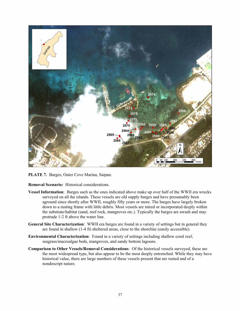
PLATE 7. Barges, Outer Cove Marina, Saipan.
Removal Scenario: Historical considerations.
Vessel Information: Barges such as the ones indicated above make up over half of the WWII era wrecks surveyed on all the islands. These vessels are old supply barges and have presumably been aground since shortly after WWII, roughly fifty years or more. The barges have largely broken down to a rusting frame with little debris. Most vessels are mired or incorporated deeply within the substrate/habitat (sand, reef rock, mangroves etc.). Typically the barges are awash and may protrude 1-2 ft above the water line.
General Site Characterization: WWII era barges are found in a variety of settings but in general they are found in shallow (1-4 ft) sheltered areas, close to the shoreline (easily accessible).
Environmental Characterization: Found in a variety of settings including shallow coral reef, seagrass/macroalgae beds, mangroves, and sandy bottom lagoons.
Comparison to Other Vessels/Removal Considerations: Of the historical vessels surveyed, these are the most widespread type, but also appear to be the most deeply entrenched. While they may have historical value, there are large numbers of these vessels present that are rusted and of a nondescript nature.
37
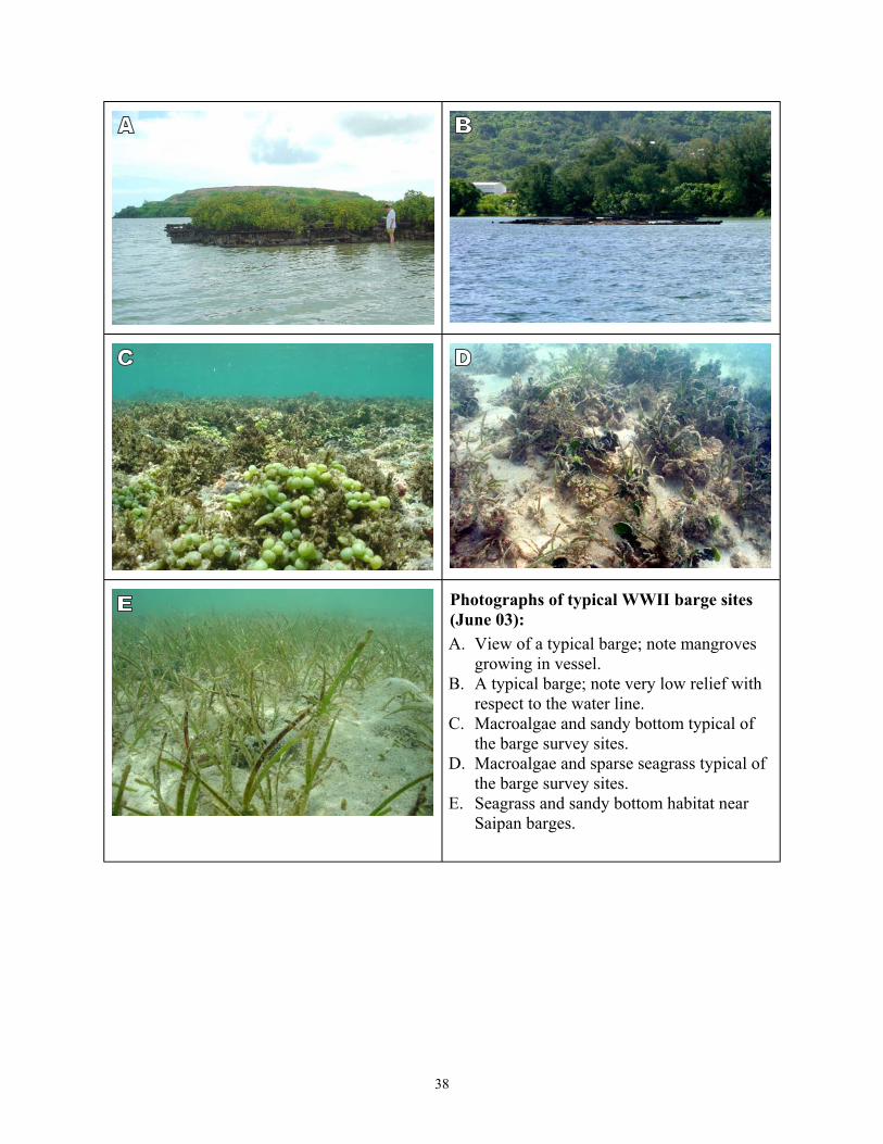
Photographs of typical WWII barge sites (June 03):
growing in vessel.
Saipan barges.
A. View of a typical barge; note mangroves
B. A typical barge; note very low relief with respect to the water line.
C. Macroalgae and sandy bottom typical of the barge survey sites.
D. Macroalgae and sparse seagrass typical of the barge survey sites.
E. Seagrass and sandy bottom habitat near
38
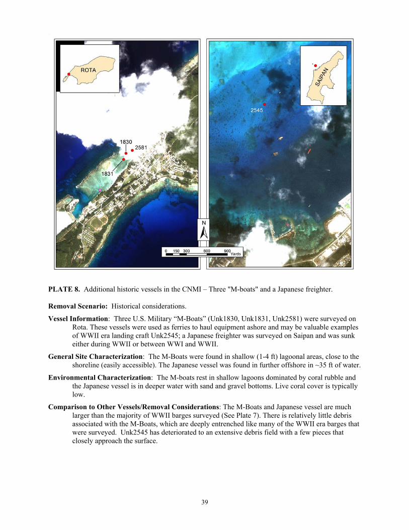
PLATE 8. Additional historic vessels in the CNMI – Three "M-boats" and a Japanese freighter.
Removal Scenario: Historical considerations.
Vessel Information: Three U.S. Military “M-Boats” (Unk1830, Unk1831, Unk2581) were surveyed on Rota. These vessels were used as ferries to haul equipment ashore and may be valuable examples of WWII era landing craft Unk2545; a Japanese freighter was surveyed on Saipan and was sunk either during WWII or between WWI and WWII.
General Site Characterization: The M-Boats were found in shallow (1-4 ft) lagoonal areas, close to the shoreline (easily accessible). The Japanese vessel was found in further offshore in ~35 ft of water.
Environmental Characterization: The M-boats rest in shallow lagoons dominated by coral rubble and the Japanese vessel is in deeper water with sand and gravel bottoms. Live coral cover is typically low.
Comparison to Other Vessels/Removal Considerations: The M-Boats and Japanese vessel are much larger than the majority of WWII barges surveyed (See Plate 7). There is relatively little debris associated with the M-Boats, which are deeply entrenched like many of the WWII era barges that were surveyed. Unk2545 has deteriorated to an extensive debris field with a few pieces that closely approach the surface.
39
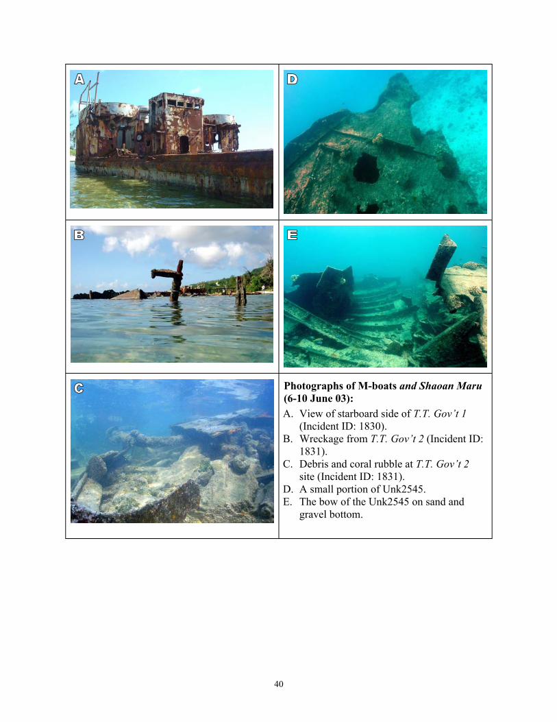
Photographs of M-boats and Shaoan Maru (6-10 June 03):
T.T. Gov’t 1 (Incident ID: 1830).
(1831).
T.T. Gov’t 2 site (Incident ID: 1831).
gravel bottom.
A. View of starboard side of
B. Wreckage from T.T. Gov’t 2 Incident ID:
C. Debris and coral rubble at
D. A small portion of Unk2545. E. The bow of the Unk2545 on sand and
40

Abandoned Vessel Scenario: Clusters of Derelict and Grounded Vessels.
While there may be thousands of grounded and abandoned vessels affecting coral, mangroves and seagrass in the United States, many of these vessels can be grouped into a small number of overarching categories. This report emphasizes five:
• High removal priority for local agencies • Vessels with historical significance • Clusters of wrecked vessels • Derelict vessels still afloat • Vessels with large impacts and
logistically complex removals
In 2002 and 2003 the Abandoned Vessel Program surveyed 11 islands and 176 vessels. As this work was performed, it was noted that wrecked and derelict vessels are not evenly distributed but often are concentrated in small areas. Plates 9 and 10 illustrate two such areas in Guam. Plate 9 depicts a cluster of thirteen vessels in close proximity in Piti Channel. These vessels range in size from Unk2523, a small 21 ft sailboat, to Guahan-1, a 100 ft landing craft. They are both commercial (3 landing crafts, 2 longliners, 1 barge and 1 salvage vessel) and recreational (6 sailboats). The threats posed by these vessels vary as well. In this case, a number of the boats pose navigation hazards, and at least 1 is a potential pollution threat. Additionally, of most interest in this context is the attraction to boat owners to continue to abandoned vessels at the site. With so many vessels in one place, some of which have obviously been there for a long period, there can be a perceived acceptance by local officials to allow vessel disposal in the area.
Plate 10 details 6 vessels that are currently grounded or sunk in Agana Boat Basin. These vessels, all recreational craft, were previously moored in the basin and were damaged and/or sunk by severe tropical weather. Three are addressed in greater detail in Plate 12 because they were identified as vessels at risk prior to grounding or sinking.
Puerto Rico and the USVI had more examples of these clusters. Three such groups that were surveyed are Boqueron Bay, PR (8 vessels), Benner Bay, St. Thomas (~20 vessels) and the Salt River Estuary, St. Croix (~20 vessels).
For more information contact the Abandoned Vessel Program at 206-526-4599 or view the website: http://response.restoration.noaa.gov/dac/vessels/.
41
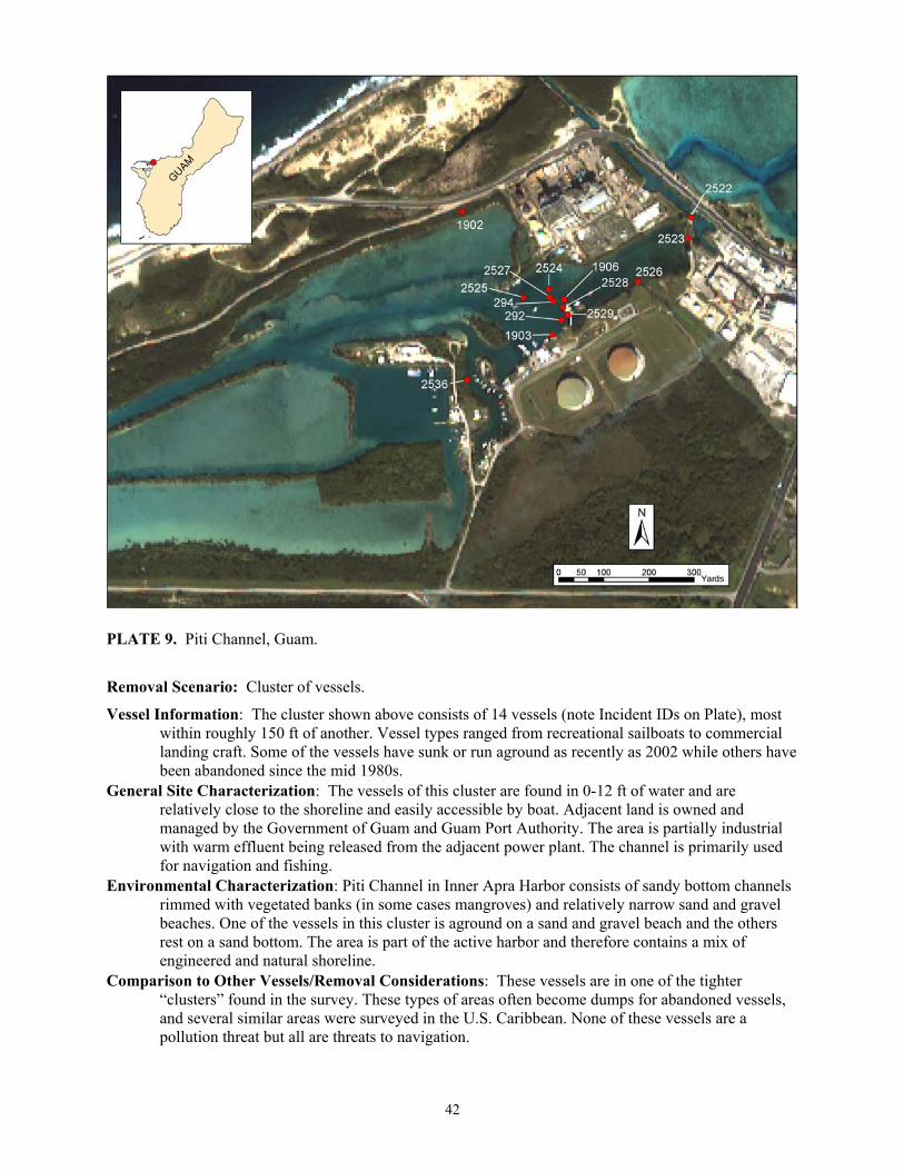
PLATE 9. Piti Channel, Guam.
Removal Scenario: Cluster of vessels.
Vessel Information: The cluster shown above consists of 14 vessels (note Incident IDs on Plate), most within roughly 150 ft of another. Vessel types ranged from recreational sailboats to commercial landing craft. Some of the vessels have sunk or run aground as recently as 2002 while others have been abandoned since the mid 1980s.
General Site Characterization: The vessels of this cluster are found in 0-12 ft of water and are relatively close to the shoreline and easily accessible by boat. Adjacent land is owned and managed by the Government of Guam and Guam Port Authority. The area is partially industrial with warm effluent being released from the adjacent power plant. The channel is primarily used for navigation and fishing.
Environmental Characterization: Piti Channel in Inner Apra Harbor consists of sandy bottom channels rimmed with vegetated banks (in some cases mangroves) and relatively narrow sand and gravel beaches. One of the vessels in this cluster is aground on a sand and gravel beach and the others rest on a sand bottom. The area is part of the active harbor and therefore contains a mix of engineered and natural shoreline.
Comparison to Other Vessels/Removal Considerations: These vessels are in one of the tighter “clusters” found in the survey. These types of areas often become dumps for abandoned vessels, and several similar areas were surveyed in the U.S. Caribbean. None of these vessels are a pollution threat but all are threats to navigation.
42
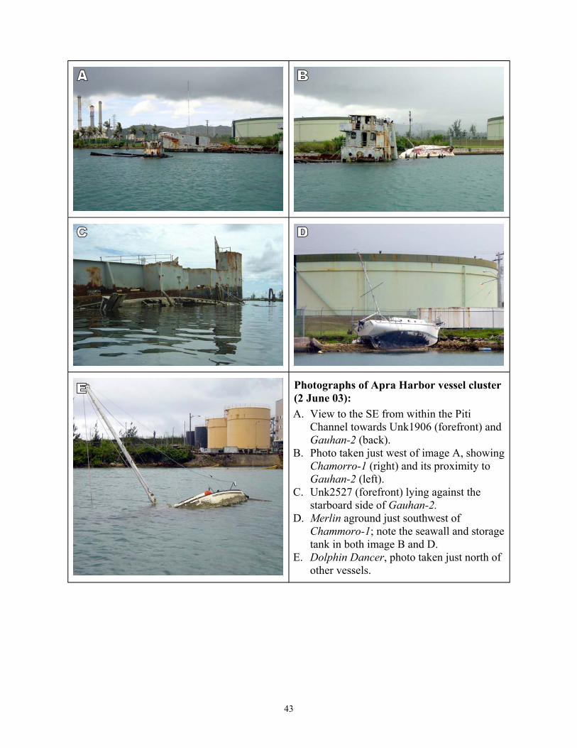
Photographs of Apra Harbor vessel cluster (2 June 03):
Gauhan-2 (back).
Chamorro-1Gauhan-2 (left).
starboard side of Gauhan-2. D. Merlin aground just southwest of
E. Dolphin Dancer, photo taken just north of other vessels.
A. View to the SE from within the Piti Channel towards Unk1906 (forefront) and
B. Photo taken just west of image A, showing (right) and its proximity to
C. Unk2527 (forefront) lying against the
Chammoro-1; note the seawall and storage tank in both image B and D.
43

PLATE 10. Agana Boat Basin, Guam.
Removal Scenario: Cluster of vessels.
Vessel Information: The cluster shown above consists of 6 vessels (note incident IDs on Plate) within an area no more than 230 ft across. All vessels were recreational or charter sailing boats and were casualties of the 2002 storm Pongsona. The vessels range from being grounded along the shoreline to sunk in the mooring field in >10 ft of water.
General Site Characterization: The site is a mooring area with an access road. The area is very sheltered. The shoreline has been engineered, using minor amounts of riprap. The rest of the shoreline is vegetated with a narrow gravel beach.
Environmental Characterization: Five vessels in this cluster rest on sand and gravel substrate. One is aground on a gravel beach. There were minor amounts of live coral and macroalgae observed at the site.
Comparison to Other Vessels: These vessels are in one of the tighter “clusters” found in the survey. One of these vessels (Lion’s Den, Incident ID: 1901) is a pollution threat and one (Unk1900) is a threat to navigation. These vessels could also threaten other vessels moored in the area if they were to move in a storm. Vessels clustered in mooring areas following hurricanes were also common in the U.S. Caribbean.
44
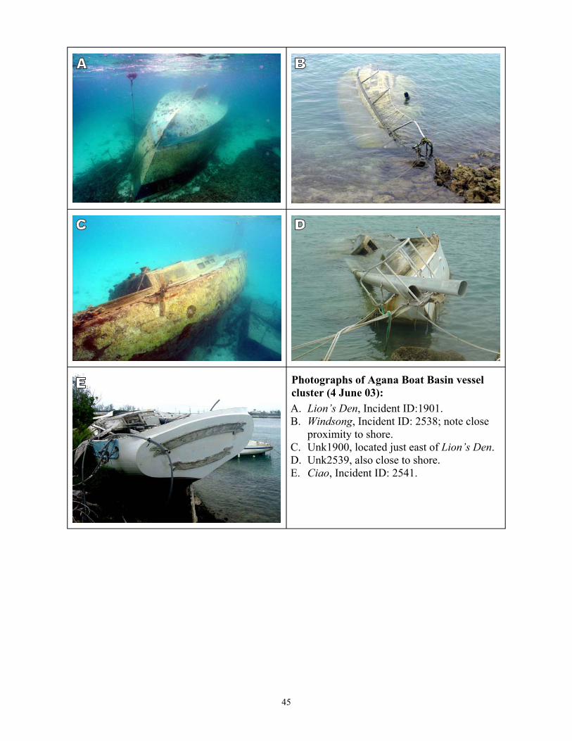
Photographs of Agana Boat Basin vessel
A. Lion’s Den, Incident ID:1901. B. Windsong, Incident ID: 2538; note close
Lion’s Den.
E. Ciao, Incident ID: 2541.
cluster (4 June 03):
proximity to shore. C. Unk1900, located just east of D. Unk2539, also close to shore.
45

Abandoned Vessel Scenario: Derelict Vessels Still Afloat
While there may be thousands of grounded and abandoned vessels affecting coral, mangroves and seagrass in the United States, many of these vessels can be grouped into a small number of overarching categories. This report emphasizes five:
• High removal priority for local agencies
• Vessels with historical significance • Clusters of wrecked vessels • Derelict vessels still afloat • Vessels with large impacts and
logistically complex removals
Derelict and abandoned vessels that remain afloat present a critical management challenge. In most cases these vessels have not yet impacted natural, recreational, or commercial resources. However, as they deteriorate, the likelihood increases that they may sink or break free from their moorings. At this point their impacts can become significant. Vessels may crush benthic habitats, leak fuel and other hazardous materials onboard, or break into pieces that are difficult to recover and continue to damage the bottom for years. Additionally, it is much more cost effective to remove a vessel that is still afloat. It can easily be towed to a marina to be removed from the water or to an appropriate in-water disposal site after it is cleaned.
Plate 11 describes the Mwaalil Saat and the Lian Gi, two vessels in the CNMI that are currently derelict, floating, and in need of removal. Both are secure currently. The owners of both vessels have shown limited interest, and both are in reasonable proximity to coral resources. The CNMI Office of Coastal Resource Management has identified both vessels as prime removal candidates.
Plate 12 highlights another aspect of this category. All three vessels pictured were floating derelicts in February of 2002. At that time, AVP staff visited Guam and identified them as vessels at risk, with a high chance of grounding or sinking. During the Guam survey in June 2003, it was noted that two of the vessels had sunk at their moorings, and two had broken free of their moorings and grounded on or near shore during the typhoon season of 2002. Before and after photos of each vessel are shown.
While many of the vessels in the Caribbean may have at one time fallen into this category, the AVP has only made one trip to this region so it was not possible to determine the condition of vessels before they were grounded and abandoned. Of the 103 vessels that were surveyed, only 4 were still afloat (Unk2402, Unk2453, Unk2474, and Unk2477).
For more information contact the Abandoned Vessel Program at 206-526-4599 or visit the website: http://response.restoration.noaa.gov/dac/vessels/.
46

PLATE 11. Mwaalil Saat (Incident ID: 2546) and Lian Gi (Incident ID: 2577).
Removal Scenario: Derelict vessels still afloat.
Vessel Information: These vessels are currently afloat but have been abandoned by their owners. The Lian Gi is afloat in Tinian Harbor, Tinian and the Mwaalil Saat is afloat outside of the harbor at the Puerto Rico dump, Saipan. Each vessel is fully intact but is a pollution and public health risk.
General Site Characterization/ Environmental Characterization: Both are currently moored along engineered coastlines (riprap and seawall) associated with active harbors and are floating above sandy bottoms deeper than 10 ft.
Comparison to Other Vessels/Removal Considerations: Each of these vessels is of note because they are pollution and health risks that can be eliminated prior to grounding or sinking. Vessels such these are in their last relatively easily manageable stage before becoming a much more logistically complex salvage and recovery project.
47

Photographs of currently (2003) derelict vessels still afloat: A. Mwaalil Saat, moored in Saipan, 2003. B. Mwaalil Saat viewed from the stern. C. Lian Gi, docked in Tinian Harbor, 2003. D. Lian Gi as viewed from the port side.
PLATE 12. (See Below) Formerly derelict, now grounded/sunken vessels in Agana Boat Basin, Guam.
Vessel Information: The vessels pictured below were described in Plate 10 as a cluster of sunken/grounded vessels observed during the 2003 surveys. Photos A, C, and E were taken prior to Supertyphoon Pongsona in 2002. The vessels were derelict and identified as risks for grounding/sinking at that time. Photos B, D, and F were taken following the storm during the 2003 surveys.
48

2002 2003
Photographs of past (2002) derelict vessels and their present (2003) condition: A& B. Lion’s Den, Incident ID: 1901. C&D. Unk1900, located just east of Lion’s Den. E&F. Ciao, Incident ID: 2541 (foreground) andUnk2539 (background). See Plate 10, photo D for present condition of Unk2539.
49

SUMMARY OF FINDINGS
• During the 2003 field surveys conducted in Guam and CNMI, 53 new vessels were identified, although a subset of these vessels may be in the AVI database but a lack of unique descriptors and/or latitude/longitude coordinates made confirmation impossible. There are also likely to be sites in the U.S. Pacific region that were not identified in the AVI database, and subsequently not surveyed. In particular, additional WWII era barges were sighted during surveys, but time and logistical constraints and the fact that these historical vessels have a low priority for removal did not permit field surveys of all barges.
• Fifty-seven (57) of 137 vessel sites identified in the AVI database for Guam and CNMI were accounted for through interviews with agency personnel and did not require field surveys because they were either removed, broken up, dry-docked, sunk as dive wrecks, etc.
• Multiple abandoned vessels were often clustered together, especially in sheltered channels, bays, and mooring areas. Typhoons, other storms, and abandonment following WWII and post-WWII operations were the cause of many of the groundings in these areas. Examples of sites with clustered distributions of vessels are: Piti Channel and Agana Boat Basin in Guam, and Outer Cove Marina in Saipan.
• Nine (9) of the 73 abandoned vessels surveyed in the U.S. Pacific region posed potential pollution threats, usually thought to be minor (small amount of fuel, marine batteries, compressed fuel tanks, contaminated ballast, coolant, hydraulic fluid, etc.).
• Thirty-three (33) vessels were determined to pose potential navigational threats. Most of these vessels were visible and in shallow water located close to marinas, mooring areas, or industrial areas. A submerged freighter (Unk2545) represented the greatest threat to navigation due to it being poorly marked, mostly submerged, and located in a heavily used recreational boating area near Managha Island.
• Fifty-four (54) vessels were considered some risk to public health, mostly from slips/falls and exposure to rusted, jagged steel by the public climbing on the vessels. A few submerged vessels were potential entrapment hazards for swimmers.
• Certainly 22 and possibly more of the surveyed vessels grounded or sunk during typhoons or other storms that passed over Guam and the CNMI, including two major storms in 2002: Typhoon Chata’an on 5 July, and Supertyphoon Pongsona on 8 December. The majority of vessels that grounded or sunk during storms were recreational sailboats, although several longliners and other commercial vessels also grounded, often in sensitive habitats (coral reef or seagrass).
• Vessels have been abandoned for periods ranging from several months to many years. Several have been abandoned for approximately 20 years, such as Sun Long No. 8 (Incident ID: 1828), and #62 Nam Sung (Incident ID: 1832).
• Of the 73 vessels surveyed, 19 vessels (26 percent) were located in areas where the primary habitat being affected or potentially at risk was coral reef/hardbottom. Fifteen (15) vessels (21 percent) were located in a mixture of macroalgae/seagrass habitat. Eight (8) vessels (11 percent) were aground in or near mangroves. Three (3) vessels (4%) were potentially impacting seagrass. The remaining 38 percent of the vessels were located on
50

sand and gravel beach habitats, sand bottom habitats, or on man-made shorelines in developed harbors.
• Of the 73 vessels surveyed, coral reef/hardbottom habitat was directly affected or potentially impacted by 8 vessels in Guam and 11 vessels in the CMNI. Of primary concern are the vessels that grounded directly on a shallow reef flat, mostly large commercial vessels, that have debris fields scattered great distances, often with pieces of debris resting on or near live coral. Examples of these vessels are: the Samala (Incident ID: 1251), Sun Long No. 8 (Incident ID: 1828), and #62 Nam Sung (Incident ID: 1832).
• Damage to seagrass habitat was significant for one large commercial longliner (Nago No. 15, Incident ID: 1253), which is high priority for removal according to local officials. Seagrass coverage surrounding the vessel was 90-100% in some areas, and seagrass was the predominant habitat type within a large distance around the vessel. A notable scour of 8-20 ft around the bow and port side was observed.
• Most vessels in mangrove habitats were stranded against or near the outer fringe. Most of these vessels were barges, several of which were several yards offshore and had mangroves growing in them. The only vessel with potential to cause additional damage to mangroves following a storm is the Seagull (Incident ID: 2537), which has a high priority for removal. It also rests in the Sasa Bay Marine Preserve, an important area for hawksbill sea turtles.
COMPARISON OF U.S. PACIFIC SURVEY FINDINGS TO U.S. CARIBBEAN SURVEY FINDINGS
Major Similarities
• In both the U.S. Caribbean and Pacific, the AVP identified many "new" vessels that were not correlated to incidents in our database.
• In both regions, there were many incidents in the database that could be verified or deleted without having to survey. Fifty-seven (57) of 137 vessel sites identified in the AVI database for Guam and CNMI were accounted for through interviews with agency personnel and did not require field surveys because they were either removed, broken up, dry-docked, sunk as dive wrecks, etc.
• In both the U.S. Caribbean and Pacific, a large number of vessels were clustered in mooring or other sheltered areas, and many were abandoned due to hurricanes and typhoons.
• In both the U.S. Caribbean and Pacific, a small percentage (6% and 12%, respectively) of vessels posed a pollution threat, and most threats were considered to be relatively minor.
• In both the U.S. Caribbean and the Pacific, a large percentage (46% and 74%, respectively) of vessels posed potential human health risks due to contact with rusting and otherwise damaged portions of easily accessible vessels.
Major Differences
• Depth appeared to be a more significant factor in the Pacific in terms of logistically being able to field survey vessel sites identified in the AVI database. It was not possible to
51

check 90 of 157 vessel sites (57%) listed due to their estimated depths of >40 ft. Yet, considering logistical constraints involving time and funding, it is likely that all priority vessels that were potentially causing damage to sensitive nearshore habitats were identified.
• A large percentage (63%) of vessels surveyed in the Pacific were abandoned or sunk during World War II, post-war operations, or following government/commercial use up until the 1960s. Government and military vessels were a small proportion of those surveyed in the Caribbean, and few vessels had been abandoned for such an extensive time period.
• The percentage of vessels surveyed potentially impacting coral reef/hardbottom habitats was much higher in the Pacific (26% of vessels surveyed) than in the Caribbean (3% of vessels surveyed).
• In contrast, the percentage of vessels surveyed potentially impacting seagrass habitats was higher in the Caribbean (22%) than the Pacific (4%), as was true for the percentage of vessels potentially impacting mangroves (28% in the Caribbean compared to 11% in the Pacific).
52
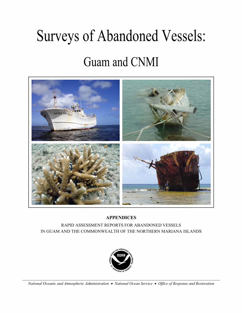
Surveys of Abandoned Vessels: Guam and CNMI
APPENDICES RAPID ASSESSMENT REPORTS FOR ABANDONED VESSELS
IN GUAM AND THE COMMONWEALTH OF THE NORTHERN MARIANA ISLANDS
National Oceanic and Atmospheric Administration • National Ocean Service • Office of Response and Restoration
APPENDIX A: RAPID ASSESSMENT REPORTS FOR
ABANDONED VESSELS IN GUAM
Prepared by:
Christine Lord and Colin Plank Research Planning, Inc.
Columbia, South Carolina 29202
Ian Zelo and Doug Helton NOAA Damage Assessment Center (DAC) Northwest
Seattle, Washington 98115
October 2003
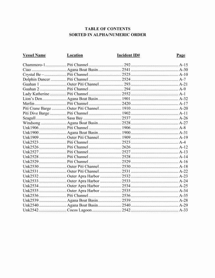
TABLE OF CONTENTS SORTED IN ALPHA/NUMERIC ORDER
Vessel Name Location Incident ID# Page
Chammoro-1.................... Piti Channel ................................. 292 ............................................. A-15Ciao A-30 ................................. Agana Boat Basin...................... 2541 ............................................. Crystal Be – ..................... Piti Channel ............................... 2525 ............................................. A-10 Dolphin Dancer ............... Piti Channel ............................... 2524 ............................................. A-7 Guahan 1 ......................... Outer Piti Channel ....................... 293 ............................................. A-21 Guahan 2 ......................... Piti Channel ................................. 294 ............................................. A-9 Lady Katherine ................ Piti Channel ............................... 2552 ............................................. A-1 Lion’s Den A-32....................... Agana Boat Basin...................... 1901 ............................................. Merlin .............................. Piti Channel ............................... 2420 ............................................. A-17 Piti Crane Barge .............. Outer Piti Channel ..................... 1910 ............................................. A-20 Piti Dive Barge ................ Piti Channel ............................... 1902 ............................................. A-11Seagull ............................. Sasa Bay .................................... 2537 ............................................. A-26 Windsong ........................ Agana Boat Basin...................... 2528 ............................................. A-27 Unk1906 .......................... Piti Channel ............................... 1906 ............................................. A-8 Unk1900 A-31.......................... Agana Boat Basin...................... 1900 ............................................. Unk1909 .......................... Outer Piti Channel ..................... 1909 ............................................. A-19 Unk2523 .......................... Piti Channel ............................... 2523 ............................................. A-4 Unk2526 .......................... Piti Channel ............................... 2626 ............................................. A-12 Unk2527 .......................... Piti Channel ............................... 2527 ............................................. A-13 Unk2528 .......................... Piti Channel ............................... 2528 ............................................. A-14 Unk2529 .......................... Piti Channel ............................... 2529 ............................................. A-16 Unk2530 .......................... Outer Piti Channel ..................... 2530 ............................................. A-18 Unk2531 .......................... Outer Piti Channel ..................... 2531 ............................................. A-22 Unk2532 A-23.......................... Outer Apra Harbor .................... 2532 ............................................. Unk2533 A-24.......................... Outer Apra Harbor .................... 2533 ............................................. Unk2534 A-25.......................... Outer Apra Harbor .................... 2534 ............................................. Unk2535 A-34.......................... Outer Apra Harbor .................... 2535 ............................................. Unk2536 .......................... Piti Channel ............................... 2536 ............................................. A-35 Unk2539 A-28.......................... Agana Boat Basin...................... 2539 ............................................. Unk2540 A-29.......................... Agana Boat Basin...................... 2540 ............................................. Unk2542 .......................... Cocos Lagoon............................ 2542 ............................................. A-33

INCIDENT ID: 2522 Rapid Assessment Report VESSEL NAME: Lady Katherine Page 1 of 3
1) Survey Information: a) Date and Location:
2 June 2003, Piti Channel, Guam.
b) Weather and tide conditions at time of survey: High tide. Overcast and some rain showers
c) Team Members: Lord, Plank (RPI), Helton, Zelo (NOAA), Davis (DAWR), Aranza (EPA)
d) GPS Location: Lat: 13.46395
Lon: 144.68770
e) Inspection Narrative: Condition of vessel was inspected on foot. Due to location on shore, no snorkel survey was conducted nor was videotaping of benthic habitats undertaken.
2) Grounding Site Logistics: a) Adjacent land ownership/land-use: Land is owned and managed by the Government of
Guam and Guam Port Authority. The area is industrial with warm effluent being released from the adjacent power plant.
b) Points of access: Vessel is directly adjacent to road access
c) Sea conditions and exposure to wave energy at site: Low energy and sheltered area.
d) Depth and nearby bathymetry: Vessel is ashore, nearby bathymetry gently drops off to about 1 m.
3) Vessel Information: a) Vessel name: LADY KATHERINE
b) Vessel type: American flagged commercial long-liner.
c) Construction materials: Fiberglass.
d) Principle dimensions: 58 ft. x 11 ft.
e) Registration numbers: Local government registration #: GU4726CF, vessel ID#: 1082266, additional registration #: 11291-38525.
f) Commercial vs. pleasure craft: Commercial fishing vessel.
g) Nationality/flag state/homeport: American flagged, home ported in Guam.
h) Builder, model, and year of construction: Unknown.
i) Vessel tonnage: Unknown.
j) Is the vessel “historic”? No.
Damage Assessment Center NOAA A-1
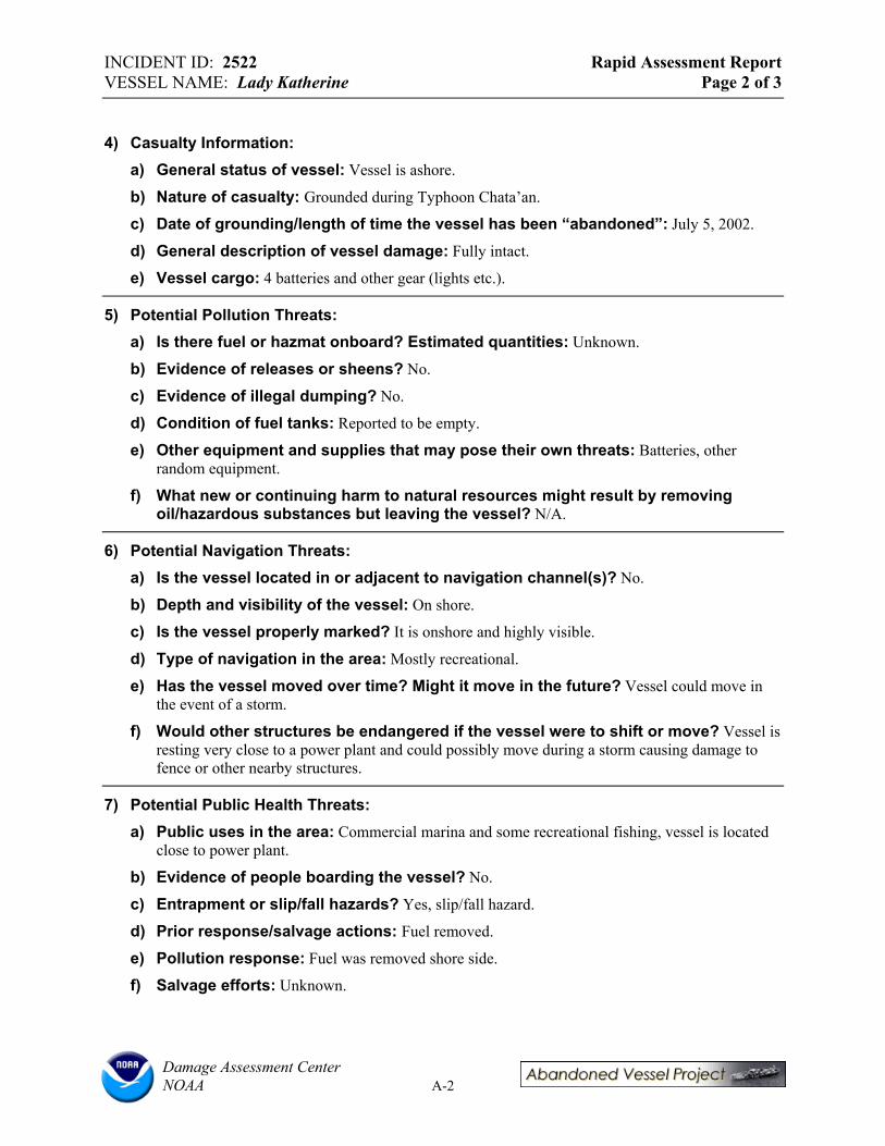
INCIDENT ID: 2522 Rapid Assessment Report VESSEL NAME: Lady Katherine Page 2 of 3
4) Casualty Information: a) General status of vessel: Vessel is ashore.
b) Nature of casualty: Grounded during Typhoon Chata’an.
c) Date of grounding/length of time the vessel has been “abandoned”: July 5, 2002.
d) General description of vessel damage: Fully intact.
e) Vessel cargo: 4 batteries and other gear (lights etc.).
5) Potential Pollution Threats: a) Is there fuel or hazmat onboard? Estimated quantities: Unknown.
b) Evidence of releases or sheens? No.
c) Evidence of illegal dumping? No.
d) Condition of fuel tanks: Reported to be empty.
e) Other equipment and supplies that may pose their own threats: Batteries, other random equipment.
f) What new or continuing harm to natural resources might result by removing oil/hazardous substances but leaving the vessel? N/A.
6) Potential Navigation Threats: a) Is the vessel located in or adjacent to navigation channel(s)? No.
b) Depth and visibility of the vessel: On shore.
c) Is the vessel properly marked? It is onshore and highly visible.
d) Type of navigation in the area: Mostly recreational.
e) Has the vessel moved over time? Might it move in the future? Vessel could move in the event of a storm.
f) Would other structures be endangered if the vessel were to shift or move? Vessel is resting very close to a power plant and could possibly move during a storm causing damage to fence or other nearby structures.
7) Potential Public Health Threats: a) Public uses in the area: Commercial marina and some recreational fishing, vessel is located
close to power plant.
b) Evidence of people boarding the vessel? No.
c) Entrapment or slip/fall hazards? Yes, slip/fall hazard.
d) Prior response/salvage actions: Fuel removed.
e) Pollution response: Fuel was removed shore side.
f) Salvage efforts: Unknown.
Damage Assessment Center NOAA A-2
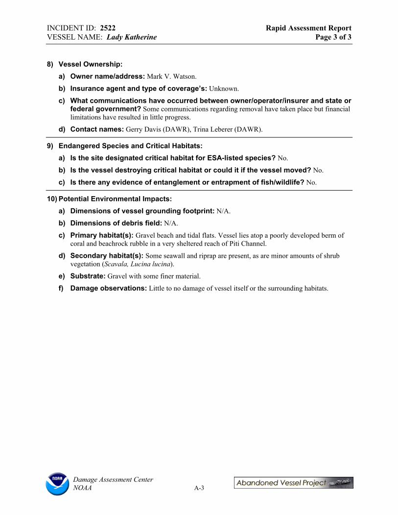
INCIDENT ID: 2522 Rapid Assessment Report VESSEL NAME: Lady Katherine Page 3 of 3
8) Vessel Ownership: a) Owner name/address: Mark V. Watson.
b) Insurance agent and type of coverage’s: Unknown.
c) What communications have occurred between owner/operator/insurer and state or federal government? Some communications regarding removal have taken place but financial limitations have resulted in little progress.
d) Contact names: Gerry Davis (DAWR), Trina Leberer (DAWR).
9) Endangered Species and Critical Habitats: a) Is the site designated critical habitat for ESA-listed species? No.
b) Is the vessel destroying critical habitat or could it if the vessel moved? No.
c) Is there any evidence of entanglement or entrapment of fish/wildlife? No.
10) Potential Environmental Impacts: a) Dimensions of vessel grounding footprint: N/A.
b) Dimensions of debris field: N/A.
c) Primary habitat(s): Gravel beach and tidal flats. Vessel lies atop a poorly developed berm of coral and beachrock rubble in a very sheltered reach of Piti Channel.
d) Secondary habitat(s): Some seawall and riprap are present, as are minor amounts of shrub vegetation (Scavala, Lucina lucina).
e) Substrate: Gravel with some finer material.
f) Damage observations: Little to no damage of vessel itself or the surrounding habitats.
Damage Assessment Center NOAA A-3
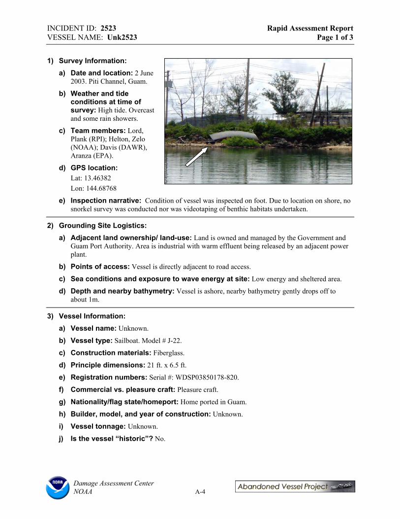
INCIDENT ID: 2523 Rapid Assessment Report VESSEL NAME: Unk2523 Page 1 of 3
1) Survey Information: a) Date and location: 2 June
2003. Piti Channel, Guam.
b) Weather and tide conditions at time of survey: High tide. Overcast and some rain showers.
c) Team members: Lord, Plank (RPI); Helton, Zelo (NOAA); Davis (DAWR), Aranza (EPA).
d) GPS location: Lat: 13.46382 Lon: 144.68768
e) Inspection narrative: Condition of vessel was inspected on foot. Due to location on shore, no snorkel survey was conducted nor was videotaping of benthic habitats undertaken.
2) Grounding Site Logistics: a) Adjacent land ownership/ land-use: Land is owned and managed by the Government and
Guam Port Authority. Area is industrial with warm effluent being released by an adjacent power plant.
b) Points of access: Vessel is directly adjacent to road access.
c) Sea conditions and exposure to wave energy at site: Low energy and sheltered area.
d) Depth and nearby bathymetry: Vessel is ashore, nearby bathymetry gently drops off to about 1m.
3) Vessel Information: a) Vessel name: Unknown.
b) Vessel type: Sailboat. Model # J-22.
c) Construction materials: Fiberglass.
d) Principle dimensions: 21 ft. x 6.5 ft.
e) Registration numbers: Serial #: WDSP03850178-820.
f) Commercial vs. pleasure craft: Pleasure craft.
g) Nationality/flag state/homeport: Home ported in Guam.
h) Builder, model, and year of construction: Unknown.
i) Vessel tonnage: Unknown.
j) Is the vessel “historic”? No.
Damage Assessment Center NOAA A-4

INCIDENT ID: 2523 Rapid Assessment Report VESSEL NAME: Unk2523 Page 2 of 3
4) Casualty information: a) General status of vessel: Vessel is ashore.
b) Nature of casualty: Grounded during Typhoon Chata’an.
c) Date of grounding/length of time the vessel has been “abandoned”: July 5, 2002.
d) General description of vessel damage: Ruptured hull, not serviceable, no mast.
e) Vessel cargo: None.
5) Potential Pollution Threats: a) Is there fuel or hazmat onboard? Estimated quantities: No.
b) Evidence of releases? Sheens? No.
c) Evidence of illegal dumping? No.
d) Condition of fuel tanks: Empty.
e) Other equipment and supplies that may pose their own threats: No.
f) What new or continuing harm to natural resources might result by removing oil/hazardous substances but leaving the vessel? N/A.
6) Potential Navigation Threats: a) Is the vessel located in or adjacent to navigation channel(s)? No.
b) Depth and visibility of the vessel: On shore.
c) Is the vessel properly marked? It is onshore and highly visible.
d) Type of navigation in the area: Mostly recreational.
e) Has the vessel moved over time? Might it move in the future? Has not moved. May move in a storm.
f) Would other structures be endangered if the vessel were to shift or move? No.
7) Potential Public Health Threats: a) Public uses in the area: Commercial marina and some recreational fishing, vessel is located
close to power plant.
b) Evidence of people boarding the vessel? No.
c) Entrapment or slip/fall hazards? Yes, slip/fall hazard.
8) Prior Response/Salvage Actions: a) Pollution response: None.
b) Salvage efforts: Unknown.
Damage Assessment Center NOAA A-5

INCIDENT ID: 2523 Rapid Assessment Report VESSEL NAME: Unk2523 Page 3 of 3
9) Vessel Ownership: a) Owner name/address: Unknown.
b) Insurance agent and type of coverage’s: Unknown.
c) What communications have occurred between owner/operator/insurer and state or federal government? Owner talked to government.
d) Contact names: Gerry Davis (DAWR), Trina Leberer (DAWR).
10) Endangered Species and Critical Habitats: a) Is the site designated critical habitat for ESA-listed species? No.
b) Is the vessel destroying critical habitat or could it if the vessel moved? No.
c) Is there any evidence of entanglement or entrapment of fish/wildlife? No.
11) Potential Environmental Impacts: a) Dimensions of vessel grounding footprint: N/A.
b) Dimensions of debris field: N/A.
c) Primary habitat(s): Gravel beach and tidal flats. Vessel lies atop a poorly developed berm of coral and beachrock rubble in a very sheltered reach of Piti Channel.
d) Secondary habitat(s): Some seawall and riprap are present, as are minor amounts of shrub vegetation (Scavala, Lucina lucina).
e) Substrate: Gravel with some finer material.
f) Damage observations: Little to no damage of the surrounding habitats.
Damage Assessment Center NOAA A-6
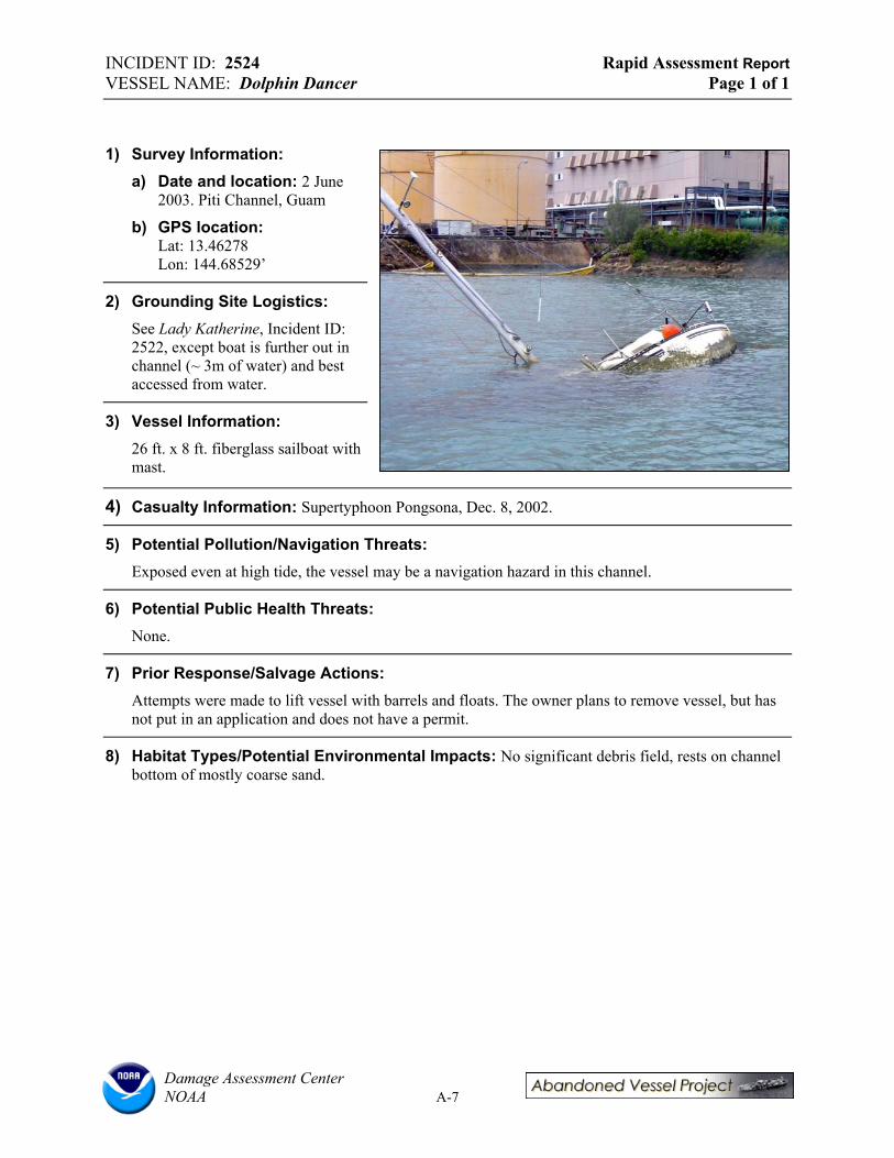
INCIDENT ID: 2524 Rapid Assessment Report VESSEL NAME: Dolphin Dancer Page 1 of 1
1) Survey Information: a) Date and location: 2 June
2003. Piti Channel, Guam
b) GPS location: Lat: 13.46278 Lon: 144.68529’
2) Grounding Site Logistics: See Lady Katherine, Incident ID: 2522, except boat is further out in channel (~ 3m of water) and best accessed from water.
3) Vessel Information: 26 ft. x 8 ft. fiberglass sailboat with mast.
4) Casualty Information: Supertyphoon Pongsona, Dec. 8, 2002.
5) Potential Pollution/Navigation Threats: Exposed even at high tide, the vessel may be a navigation hazard in this channel.
6) Potential Public Health Threats: None.
7) Prior Response/Salvage Actions: Attempts were made to lift vessel with barrels and floats. The owner plans to remove vessel, but has not put in an application and does not have a permit.
8) Habitat Types/Potential Environmental Impacts: No significant debris field, rests on channel bottom of mostly coarse sand.
Damage Assessment Center NOAA A-7

INCIDENT ID: 1906 Rapid Assessment Report VESSEL NAME: Unk1906 Page 1 of 1
1) Survey Information: a) Date and location: 2 June
2003. Piti Channel, Guam
b) GPS location: Lat: 13.46260 Lon: 144.68558’
2) Grounding Site Logistics: See Lady Katherine, Vessel ID: 2522, except boat is further out in channel and best accessed from water.
3) Vessel Information: 55 ft. x 13 ft. steel landing craft in ~8 ft of water, large portion exposed. Gov. Guam Reg. # (?): E6CMVB752.
4) Casualty Information: Abandoned at mooring in 1980’s.
5) Potential Pollution/Navigation Threats: Exposed even at high tide, the vessel may be a navigation hazard in this channel.
6) Potential Public Health Threats: Hull is rusted out, but unlikely to be many swimmers in channel.
7) Prior Response/Salvage Actions: None.
8) Habitat Types/Potential Environmental Impacts: No significant debris field, rests on channel bottom of coarse sand. Unlikely to move during a storm.
Damage Assessment Center NOAA A-8

INCIDENT ID: 294 Rapid Assessment Report VESSEL NAME: Guahan-2 Page 1 of 1
1) Survey Information: a) Date and location: 2 June 2003.
Piti Channel, Guam
b) GPS location: Lat: 13.46263 Lon: 144.6853’
2) Grounding Site Logistics: See Lady Katherine, Vessel ID: 2522 except boat is further out in channel and best accessed from water.
3) Vessel Information: 115 ft. x 32 ft. steel landing craft in ~7 ft of water, large portion exposed (about 10 ft above waterline).
4) Casualty Information: Vessel has been derelict since 1985.
3) Potential Pollution/Navigation Threats: Exposed even at high tide, the vessel may be a navigation hazard in this high traffic channel.
4) Potential Public Health Threats: Possible slip/fall or entrapment hazard, although not likely to be many swimmers in channel.
5) Prior Response/Salvage Actions: Unknown.
6) Habitat Types/Potential Environmental Impacts: Large debris field (barrels, tires, etc.) which remains mobile; vessel rests on channel bottom of coarse sand and rubble.
Damage Assessment Center NOAA A-9

INCIDENT ID: 2525 Rapid Assessment Report VESSEL NAME: Crystal Be--- Page 1 of 1
1) Survey Information: a) Date and location: 2 June
2003. Piti Channel, Guam
b) GPS location: Lat: 13.46262 Lon: 144.68481’
2) Grounding Site Logistics: See Lady Katherine, Incident ID: 2522, except boat is further out in channel and best accessed from water.
3) Vessel Information: 46 ft. x 10 ft. fiberglass ketch (pleasure craft). Leaning starboard and intact in ~10 ft. of water.
4) Casualty Information: None.
5) Potential Pollution/Navigation Threats: Exposed even at high tide, the vessel may be a navigation hazard in this high traffic channel.
6) Potential Public Health Threats: Possible slip/fall or entrapment hazard, although not likely to be many swimmers in channel.
7) Prior Response/Salvage Actions: Unknown.
8) Habitat Types/Potential Environmental Impacts: Vessel rests on channel bottom of coarse sand.
Damage Assessment Center NOAA A-10
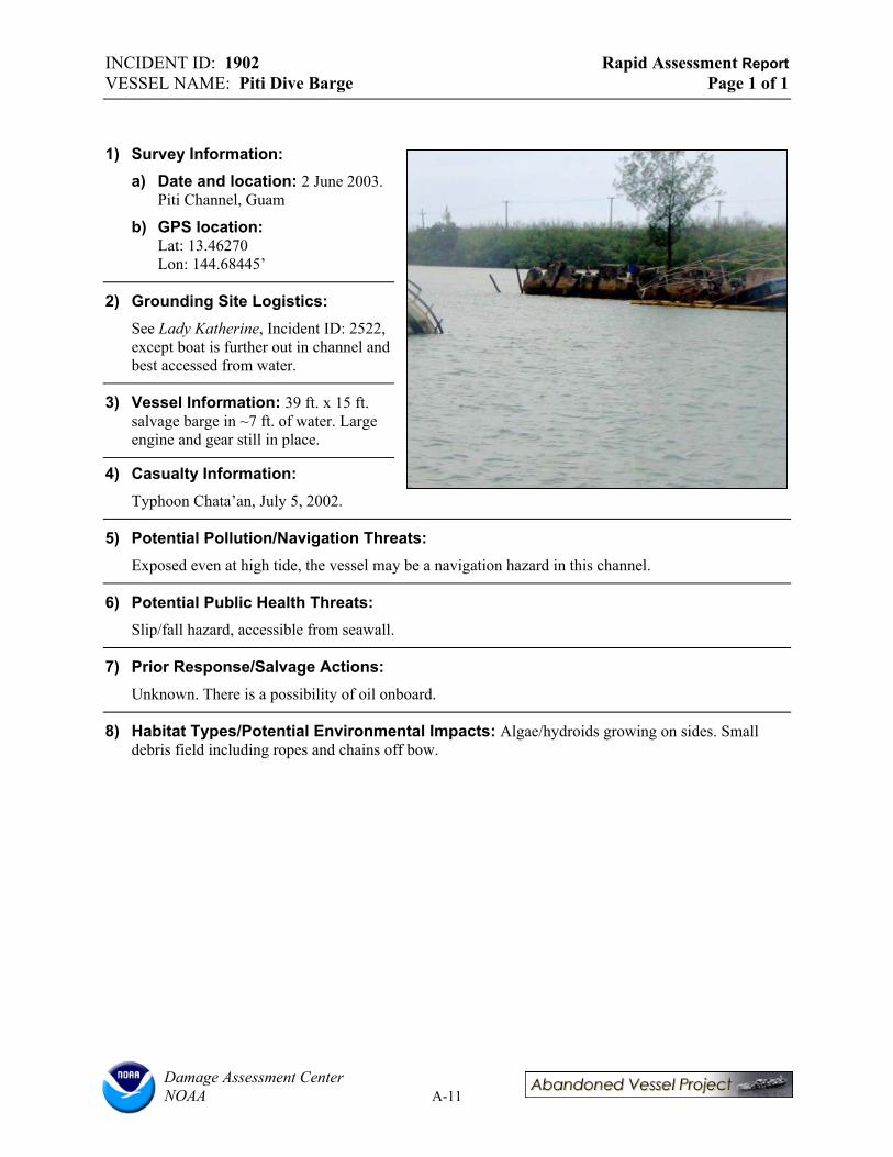
INCIDENT ID: 1902 Rapid Assessment Report VESSEL NAME: Piti Dive Barge Page 1 of 1
1) Survey Information: a) Date and location: 2 June 2003.
Piti Channel, Guam
b) GPS location: Lat: 13.46270 Lon: 144.68445’
2) Grounding Site Logistics: See Lady Katherine, Incident ID: 2522, except boat is further out in channel and best accessed from water.
3) Vessel Information: 39 ft. x 15 ft. salvage barge in ~7 ft. of water. Large engine and gear still in place.
4) Casualty Information: Typhoon Chata’an, July 5, 2002.
5) Potential Pollution/Navigation Threats: Exposed even at high tide, the vessel may be a navigation hazard in this channel.
6) Potential Public Health Threats: Slip/fall hazard, accessible from seawall.
7) Prior Response/Salvage Actions: Unknown. There is a possibility of oil onboard.
8) Habitat Types/Potential Environmental Impacts: Algae/hydroids growing on sides. Small debris field including ropes and chains off bow.
Damage Assessment Center NOAA A-11

INCIDENT ID: 2526 Rapid Assessment Report VESSEL NAME: Unk2526 Page 1 of 1
1) Survey Information: a) Date and location: 2 June
2003, Piti Channel, Guam.
b) GPS location: Lat: Lon:
2) Grounding Site Logistics: Similar to Lady Katherine, Vessel ID: 2522, but in a more industrial portion of the Piti Channel.
3) Vessel Information: 16 ft. x 5 x 1.5 ft., wooden barge on beach and barely awash in ~1 m deep water. No deck, only partial vessel remains.
4) Casualty Information: None.
5) Potential Pollution/Navigation Threats: None. Very close to shore.
6) Potential Public Health Threats: Potential slip/fall hazard.
7) Prior Response/Salvage Actions: Unknown.
8) Habitat Types/Potential Environmental Impacts: Vessel is aground on a muddy-sand substrate.
Damage Assessment Center NOAA A-12

INCIDENT ID: 2527 Rapid Assessment Report VESSEL NAME: Unk2527 Page 1 of 1
1) Survey Information: a) Date and location: 2
June 2003. Piti Channel, Guam.
b) GPS location: Lat: 13.46263 Lon: 144.6853’
2) Grounding Site Logistics: See Lady Katherine, Incident ID: 2522, except boat is further out in channel and best accessed from water.
3) Vessel Information: 35 ft. x 9 ft. fiberglass sloop resting against Guahan-2 on starboard side. Vessel is part of a cluster of multiple boats.
4) Casualty Information: Vessel is deteriorated. The deck is separating from the hull and is filled with debris.
5) Potential Pollution/Navigation Threats: The vessel may be a navigation hazard in this channel.
6) Potential Public Health Threats: None.
7) Prior Response/Salvage Actions: Unknown.
8) Habitat Types/Potential Environmental Impacts: Vessel is aground on a sandy substrate with a large debris field, much of which is associated with surrounding vessels.
Damage Assessment Center NOAA A-13
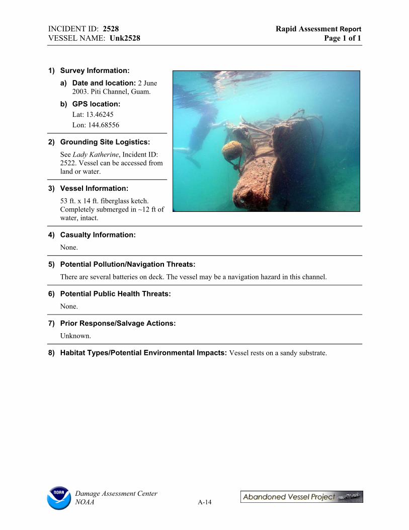
INCIDENT ID: 2528 Rapid Assessment Report VESSEL NAME: Unk2528 Page 1 of 1
1) Survey Information: a) Date and location: 2 June
2003. Piti Channel, Guam.
b) GPS location: Lat: 13.46245 Lon: 144.68556
2) Grounding Site Logistics: See Lady Katherine, Incident ID: 2522. Vessel can be accessed from land or water.
3) Vessel Information: 53 ft. x 14 ft. fiberglass ketch. Completely submerged in ~12 ft of water, intact.
4) Casualty Information: None.
5) Potential Pollution/Navigation Threats: There are several batteries on deck. The vessel may be a navigation hazard in this channel.
6) Potential Public Health Threats: None.
7) Prior Response/Salvage Actions: Unknown.
8) Habitat Types/Potential Environmental Impacts: Vessel rests on a sandy substrate.
Damage Assessment Center NOAA A-14
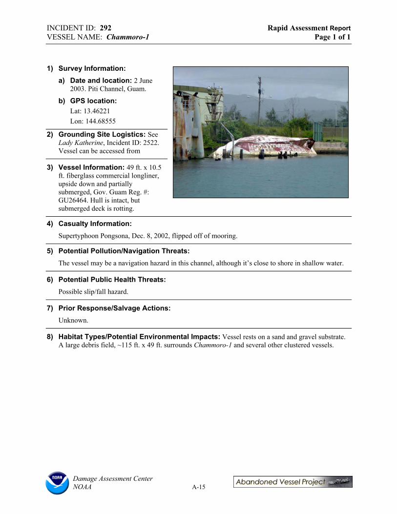
INCIDENT ID: 292 Rapid Assessment Report VESSEL NAME: Chammoro-1 Page 1 of 1
1) Survey Information: a) Date and location: 2 June
2003. Piti Channel, Guam.
b) GPS location: Lat: 13.46221 Lon: 144.68555
2) Grounding Site Logistics: See Lady Katherine, Incident ID: 2522. Vessel can be accessed from
3) Vessel Information: 49 ft. x 10.5 ft. fiberglass commercial longliner, upside down and partially submerged, Gov. Guam Reg. #: GU26464. Hull is intact, but submerged deck is rotting.
4) Casualty Information: Supertyphoon Pongsona, Dec. 8, 2002, flipped off of mooring.
5) Potential Pollution/Navigation Threats: The vessel may be a navigation hazard in this channel, although it’s close to shore in shallow water.
6) Potential Public Health Threats: Possible slip/fall hazard.
7) Prior Response/Salvage Actions: Unknown.
8) Habitat Types/Potential Environmental Impacts: Vessel rests on a sand and gravel substrate. A large debris field, ~115 ft. x 49 ft. surrounds Chammoro-1 and several other clustered vessels.
Damage Assessment Center NOAA A-15
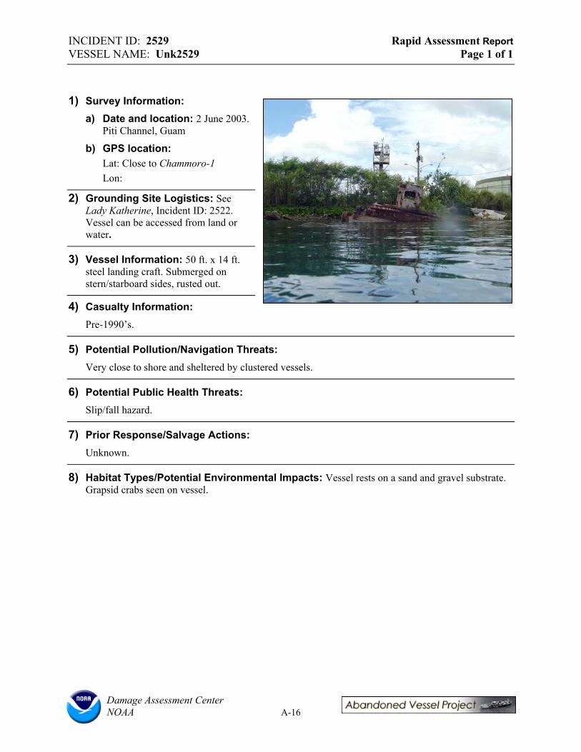
INCIDENT ID: 2529 Rapid Assessment Report VESSEL NAME: Unk2529 Page 1 of 1
1) Survey Information: a) Date and location: 2 June 2003.
Piti Channel, Guam
b) GPS location: Lat: Close to Chammoro-1 Lon:
2) Grounding Site Logistics: See Lady Katherine, Incident ID: 2522. Vessel can be accessed from land or water.
3) Vessel Information: 50 ft. x 14 ft. steel landing craft. Submerged on stern/starboard sides, rusted out.
4) Casualty Information: Pre-1990’s.
5) Potential Pollution/Navigation Threats: Very close to shore and sheltered by clustered vessels.
6) Potential Public Health Threats: Slip/fall hazard.
7) Prior Response/Salvage Actions: Unknown.
8) Habitat Types/Potential Environmental Impacts: Vessel rests on a sand and gravel substrate. Grapsid crabs seen on vessel.
Damage Assessment Center NOAA A-16

INCIDENT ID: 1903 Rapid Assessment Report VESSEL NAME: Merlin Page 1 of 1
1) Survey Information: a) Date and location: 2 June
2003. Piti Channel, Guam.
b) GPS location: Lat: 13.46197 Lon: 144.68536
2) Grounding Site Logistics: See Lady Katherine, Incident ID: 2522.
3) Vessel Information: 41 ft. x 9 ft. fiberglass ketch. Onshore.
4) Casualty Information: Vessel went aground during typhoon.
5) Potential Pollution/Navigation Threats: Vessel is ashore. Could move during a storm.
6) Potential Public Health Threats: Slip/fall hazard. People have boarded vessel.
7) Prior Response/Salvage Actions: Unknown.
8) Habitat Types/Potential Environmental Impacts: Vessel rests on a gravel beach, might move during storm. There is a lot of debris (barrels, tires, etc.) in the water offshore of the vessel, which may be related to Merlin or other nearby vessels in cluster.
Damage Assessment Center NOAA A-17

INCIDENT ID: 2530 Rapid Assessment Report VESSEL NAME: Unk2530 Page 1 of 1
1) Survey Information: a) Date and location: 2 June
2003. Outer Piti Channel, Guam.
b) GPS location: Lat: 13.46040 Lon: 144.67334
2) Grounding Site Logistics: Port Authority/Gov. Guam land. Unclear whether submerged land is territorial or federal. Channel mostly used for navigation and fishing.
3) Vessel Information: 30 ft. x 100 ft. steel barge very close to shore. Rusted out with riprap in it.
4) Potential Pollution/Navigation Threats: Highly visible and very close to the channel.
5) Potential Public Health Threats: Slip/fall or entrapment hazard. Rusty and accessible from shore.
6) Prior Response/Salvage Actions: None.
7) Habitat Types/Potential Environmental Impacts: Vessel rests in a lagoonal faunal habitat (shallow reef flat) and may move during storms. Coral observations around 4-vessel cluster included <5%percent cover of Porites spp. Some large coral heads, finger coral, remnant staghorn coral; low number of species. Some live red algae observed.
Damage Assessment Center NOAA A-18

INCIDENT ID: 1909 Rapid Assessment Report VESSEL NAME: Unk1909 Page 1 of 1
1) Survey Information: a) Date and Location:
2 June 2003, Outer Piti Channel, Guam
b) GPS Location: Lat: 13.46040
Lon: 144.67334
2) Grounding Site Logistics: Port Authority/Gov. Guam land. Unclear whether submerged land is territorial or federal. Channel mostly used for navigation and fishing.
3) Vessel Information: 26 ft. x 120 ft. commercial steel freighter. Somewhat intact, rusty. Almost ashore at bow, in ~9-15 ft. of water at stern.
4) Casualty Information: Was privately owned. Has been aground since 1970’s. Located in a cluster with Unk2530, Piti Crane Barge, and Unk2531.
5) Potential Pollution/Navigation Threats: Highly visible and very close to the channel.
6) Potential Public Health Threats: Slip/fall or entrapment hazard. Rusty and accessible from shore.
7) Prior Response/Salvage Actions: None.
8) Habitat Types/Potential Environmental Impacts: Vessel rests on a sand and gravel substrate near lagoonal faunal habitat (shallow reef flat). Coral observations around 4-vessel cluster included <5%percent cover of Porites spp. Some large coral heads, finger coral, remnant staghorn coral; low number of species. Some live red algae was observed.
Damage Assessment Center NOAA A-19

INCIDENT ID: 1910 Rapid Assessment Report VESSEL NAME: Piti Crane Barge Page 1 of 1
1) Survey Information: a) Date and Location:
2 June 2003, Outer Piti Channel, Guam.
b) GPS Location: Lat: 13.46040 Lon: 144.67334
2) Grounding Site Logistics: Port Authority/Gov. Guam land. Unclear whether submerged land is territorial or federal. Channel mostly used for navigation and fishing.
3) Vessel Information: 30 ft. x 100 ft. steel commercial crane barge. Rusted out.
4) Potential Pollution/Navigation Threats: Could possibly move during a storm and is very close to the channel.
5) Potential Public Health Threats: Slip/fall or entrapment hazard. Rusty and accessible from shore.
6) Prior Response/Salvage Actions: None.
7) Habitat Types/Potential Environmental Impacts: Vessel rests on sand and gravel substrate near lagoonal faunal habitat (shallow reef flat) and may move during storms. Coral observations around 4-vessel cluster included <5%percent cover of Porites spp. Some large coral heads, finger coral, remnant staghorn coral; low number of species. Some live red algae observed.
Damage Assessment Center NOAA A-20

INCIDENT ID: 293 Rapid Assessment Report VESSEL NAME: Guahan-1 Page 1 of 1
1) Survey Information: a) Date and Location:
2 June 2003, Outer Piti Channel, Guam
b) GPS Location: Lat: 13.46055 Lon: 144.67247
2) Grounding Site Logistics: Port Authority/Gov. Guam land. Unclear whether submerged land is territorial or federal. Channel mostly used for navigation and fishing.
3) Vessel Information: 115 ft. x 32 ft. steel landing craft, Gov. Guam owned. Partially exposed, partially submerged in 4-12 ft. of water.
4) Casualty Information: Went aground during 1992 storm, or possibly Supertyphoon Pongsona (Dec. 8,2002).
5) Potential Pollution/Navigation Threats: Possible navigation threat if it moved during a storm.
6) Potential Public Health Threats: None.
7) Prior Response/Salvage Actions: Noted in NOAA database that this vessel may be refloated.
8) Habitat Types/Potential Environmental Impacts: Vessel rests on sand and gravel substrate on port side, gravel beach (cobble to boulder sized sediments) and shrubby vegetation on starboard side. Observed patches of Porites rus, primarily off of stern.
Damage Assessment Center NOAA A-21

INCIDENT ID: 2531 Rapid Assessment Report VESSEL NAME: Unk2531 Page 1 of 1
1) Survey Information: a) Date and Location:
2 June 2003, Outer Piti Channel, Guam.
b) GPS Location: Lat: 13.46055
Lon: 144.67334
2) Grounding Site Logistics: Port Authority/Gov. Guam land. Unclear whether submerged land is territorial or federal. Channel mostly used for navigation and fishing.
3) Vessel Information: 27 ft. x 67 ft. rusted, broken down partial vessel. Type unknown, but in cluster with other barges.
4) Casualty Information: Was privately owned. Has been aground since 1970’s. Located in a cluster with Incident IDs: 2530, 1909, 1910 (Piti Crane Barge).
5) Potential Pollution/Navigation Threats: None.
6) Potential Public Health Threats: Slip/fall or entrapment hazard. Rusty and accessible from shore.
7) Prior Response/Salvage actions: None.
8) Habitat Types/Potential Environmental Impacts: Vessel rests on sand and gravel beach near lagoonal faunal habitat (shallow reef flat). Coral observations around 4-vessel cluster included <5%percent cover of Porites spp. Some large coral heads, finger coral, remnant staghorn coral; low number of species. Some live red algae observed.
Damage Assessment Center NOAA A-22

INCIDENT ID: 2532 Rapid Assessment Report VESSEL NAME: Unk2532 Page 1 of 1
1) Survey Information: a) Date and Location
2 June 2003, Outer Apra Harbor, Guam
b) GPS Location Lat: 13.46230 Lon: 144.634814
2) Grounding Site Logistics: Mooring area, sheltered except during storms.
3) Vessel Information: 132 ft. x 54 ft. commercial ferro-cement barge.
4) Casualty Information: Vessel has been aground since 1960’s. In cluster inside of jetty with Unk2533, Unk2534, Unk2535.
5) Potential Pollution/Navigation Threats: No, vessel is highly visible.
6) Potential Public Health Threats: Potential slip/fall hazard.
7) Prior Response/Salvage Actions: None.
8) Habitat Types/Potential Environmental Impacts: Partially aground on steep boulders/riprap covered with algae. Large Porites rus (table and finger forms) growing on vessel. Green/red algae and sponges were observed around vessel and debris. Partially submerged in 10-15 ft. of water. Habitat is similar for 4-vessel cluster. Bottom is sand and gravel with patchy coral cover (~10% live cover), mainly on boulders or attached to vessels. Maximum ~30% live cover in some areas. Coral species observed included: Porites rus, Pocillopora damicornis, Porites lutea, Sacrophyta sp., fire coral. Sea cucumbers and reef fish observed.
Damage Assessment Center NOAA A-23
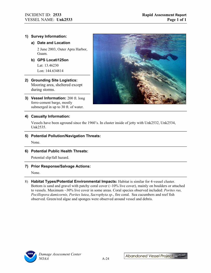
INCIDENT ID: 2533 Rapid Assessment Report VESSEL NAME: Unk2533 Page 1 of 1
1) Survey Information: a) Date and Location
2 June 2003, Outer Apra Harbor, Guam.
b) GPS Locati125on Lat: 13.46230 Lon: 144.634814
2) Grounding Site Logistics: Mooring area, sheltered except during storms.
3) Vessel Information: 200 ft. long ferro-cement barge, mostly submerged in up to 30 ft. of water.
4) Casualty Information: Vessels have been aground since the 1960’s. In cluster inside of jetty with Unk2532, Unk2534, Unk2535.
5) Potential Pollution/Navigation Threats: None.
6) Potential Public Health Threats: Potential slip/fall hazard.
7) Prior Response/Salvage Actions: None.
8) Habitat Types/Potential Environmental Impacts: Habitat is similar for 4-vessel cluster. Bottom is sand and gravel with patchy coral cover (~10% live cover), mainly on boulders or attached to vessels. Maximum ~30% live cover in some areas. Coral species observed included: Porites rus, Pocillopora damicornis, Porites lutea, Sacrophyta sp., fire coral. Sea cucumbers and reef fish observed. Green/red algae and sponges were observed around vessel and debris.
Damage Assessment Center NOAA A-24

INCIDENT ID: 2534 Rapid Assessment Report VESSEL NAME: Unk2534 Page 1 of 1
1) Survey Information: a) Date and Location
2 June 2003, Outer Apra Harbor, Guam.
b) GPS Location Lat: 13.46277
Lon: 144.63599
2) Grounding Site Logistics: Mooring area, sheltered except during storms.
3) Vessel Information: 138 ft. x 55 ft., steel barge in 2 pieces, middle section open, completely submerged and surrounded by submerged debris field.
4) Casualty Information: Vessel has been aground since the 1960’s. Is part of vessel cluster inside of jetty with Unk2532, Unk2533, and Unk2535.
5) Potential Pollution/Navigation Threats: None.
6) Potential Public Health Threats: Potential slip/fall hazard.
7) Prior Response/Salvage Actions (if any/ if known): None.
8) Potential Environmental Impacts: Habitat is similar for 4-vessel cluster. Bottom is sand and gravel with patchy coral cover (~10% live cover), mainly on boulders or attached to vessels. Maximum ~30% live cover in some areas. Coral species observed included: Porites rus, Pocillopora damicornis, Porites lutea, Sacrophyta sp., fire coral. Sea cucumbers and reef fish observed. Green/red algae and sponges were observed around vessel and debris.
Damage Assessment Center NOAA A-25

INCIDENT ID: 2537 Rapid Assessment Report VESSEL NAME: Seagull Page 1 of 1
1) Survey Information: a) Date and Location
3 June 2003, Sasa Bay, Guam.
b) GPS Location Lat: 13.44468 Lon: 144.68120
2) Grounding Site Logistics: Jurisdictional dispute between Navy and Gov. Guam over land ownership. Area is Sasa Bay Marine Preserve, a “no-take zone”.
3) Vessel Information: 70 ft. x 13 ft., fiberglass sailboat. Fairly intact, keel damaged, large mooring lines, gear, coolers, etc. onboard. Japanese owners. Gov. Guam Reg. #: GU4962PU.
4) Casualty Information: Sunk while moored during the 2002 Supertyphoon Pongsona.
5) Potential Pollution/Navigation Threats: Fuel on board (128 gal. gas, 40 gal. oil), engine intact.
6) Potential Public Health Threats: Potential slip/fall hazard. Access is limited.
7) Prior Response/Salvage Actions: Local salvage firm (Pearl Marine) going through permit process, < $10, 000 to remove.
8) Habitat Types/Potential Environmental Impacts: Resting on carbonate platform and tidal flat with thin veneer of mud and gravel; mangroves directly landward of vessel. Sasa Bay Marine Reserve is an important hawksbill sea turtle feeding area. Clam beds in bay.
Damage Assessment Center NOAA A-26

INCIDENT ID: 2538 Rapid Assessment Report VESSEL NAME: Windsong Page 1 of 1
1) Survey Information: a) Date and Location:
4 June 2003, Agana Boat Basin, Guam.
b) GPS Location: Lat: 13.47837 Lon: 144.75002
2) Grounding Site Logistics: Gov. Guam land and water. Mooring area with access road. Low energy, very sheltered unless there is a large storm.
3) Vessel Information: 27 ft. x 5 ft., privately owned fiberglass sailboat. Partially aground, partially submerged in 6-7 ft. water. ~10 ft wide debris field. Reg. # GM343A.
4) Casualty Information: Sunk during Supertyphoon Pongsona, 2002.
5) Potential Pollution/Navigation Threats: Could move into mooring field during storm and damage other boats.
6) Potential Public Health Threats: None.
7) Prior Response/Salvage Actions: Contact Gerry Davis (DA) for more information.
8) Habitat Types/Potential Environmental Impacts: Resting on sandy bottom. Observed minor coral and algae growth on coral rubble and a few sea cucumbers. Vessel could move during storm.
Damage Assessment Center NOAA A-27

INCIDENT ID: 2539 Rapid Assessment Report VESSEL NAME: Unk2539 Page 1 of 1
1) Survey Information: a) Date and Location:
4 June 2003, Agana Boat Basin, Guam.
b) GPS Location: Lat: 13.47834 Lon: 144.75046
2) Grounding Site Logistics: Gov. Guam land and water. Mooring area with access road. Low energy, very sheltered unless there is a large storm.
3) Vessel Information: 55 ft. x 13 ft., steel sailboat. Aground, hull intact but rusting, some debris. Partially submerged in 6-7 ft. of water.
4) Casualty Information: Sunk by supertyphoon Pongsona, 2002. This vessel was identified as a risk in 2002.
5) Potential Pollution/Navigation Threats: None currently, but vessel may move during storm and become a navigation threat in mooring area.
6) Potential Public Health Threats: None.
7) Prior Response/Salvage actions: None.
8) Habitat Types/Potential Environmental Impacts: Mixed sand and gravel shoreline with some riprap sloping to sandy bottom with some coral rubble and algae. Some debris, barrels, etc., surrounding vessel.
Damage Assessment Center NOAA A-28

INCIDENT ID: 2540 Rapid Assessment Report VESSEL NAME: Unk2540 Page 1 of 1
1) Survey Information: a) Date and Location:
4 June 2003, Agana Boat Basin, Guam.
b) GPS Location: Lat: 13.47837 Lon: 144.75006
2) Grounding Site Logistics: Gov. Guam land and water. Mooring area with access road. Low energy, very sheltered unless there is a large storm.
3) Vessel Information: 25 ft. x 8 ft., fiberglass sailboat. Hull intact, anchor present, mostly stripped. GU1995-96, Reg. #: 95361.
4) Casualty Information: Sunk during Supertyphoon Pongsona, 2002.
5) Potential Pollution/Navigation Threats: None currently, but vessel may move during storm and become a navigation threat in mooring area.
6) Potential Public Health Threats: None.
7) Prior Response/Salvage Actions: None.
8) Habitat Types/Potential Environmental Impacts: Mixed sand and gravel shoreline with some riprap sloping to sandy bottom with some coral rubble and algae.
Damage Assessment Center NOAA A-29

INCIDENT ID: 2541 Rapid Assessment Report VESSEL NAME: Ciao Page 1 of 1
1) Survey Information: a) Date and Location:
4 June 2003, Agana Boat Basin, Guam.
b) GPS Location Lat: 13.47834 Lon: 144.75024
2) Grounding Site Logistics: Gov. Guam land and water. Mooring area with access road. Low energy, very sheltered unless there is a large storm.
3) Vessel Information: 41 ft. x 10 ft. fiberglass sailboat, ashore, no mast.
4) Casualty Information: Casualty of Supertyphoon Pongsona, 2002. Vessel was identified as a risk in 2002.
3) Potential Pollution/Navigation Threats: Could move into mooring field and damage other boats during a storm.
4) Potential Public Health Threats: Slip/fall hazard.
5) Prior Response/Salvage Actions: None.
6) Habitat Types/Potential Environmental Impacts: Mixed sand and gravel shoreline with some riprap.
Damage Assessment Center NOAA A-30
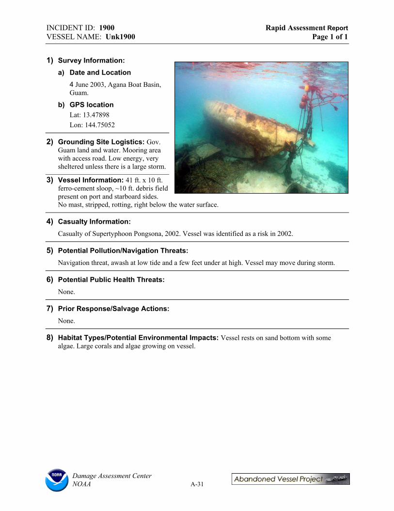
INCIDENT ID: 1900 Rapid Assessment Report VESSEL NAME: Unk1900 Page 1 of 1
1) Survey Information: a) Date and Location
4 June 2003, Agana Boat Basin, Guam.
b) GPS location Lat: 13.47898
Lon: 144.75052
2) Grounding Site Logistics: Gov. Guam land and water. Mooring area with access road. Low energy, very sheltered unless there is a large storm.
3) Vessel Information: 41 ft. x 10 ft. ferro-cement sloop, ~10 ft. debris field present on port and starboard sides. No mast, stripped, rotting, right below the water surface.
4) Casualty Information: Casualty of Supertyphoon Pongsona, 2002. Vessel was identified as a risk in 2002.
5) Potential Pollution/Navigation Threats: Navigation threat, awash at low tide and a few feet under at high. Vessel may move during storm.
6) Potential Public Health Threats: None.
7) Prior Response/Salvage Actions: None.
8) Habitat Types/Potential Environmental Impacts: Vessel rests on sand bottom with some algae. Large corals and algae growing on vessel.
Damage Assessment Center NOAA A-31

INCIDENT ID: 1901 Rapid Assessment Report VESSEL NAME: Lion’s Den Page 1 of 1
1) Survey Information: a) Date and Location
4 June 2003, Agana Boat Basin, Guam.
b) GPS Location: Lat: 13.47896 Lon: 144.75009
2) Grounding Site Logistics: Gov. Guam land and water. Mooring area with access road. Low energy, very sheltered unless there is a large storm.
3) Vessel Information: Steel charter boat, 2 masts, inverted, ~3 ft. below surface. In ~10. ft. of water.
4) Casualty Information: Casualty of Supertyphoon Pongsona, 2002.
5) Potential Pollution/Navigation Threats: Batteries, engine block and fuel tank possibly still on board; amount of fuel present is unknown. Submerged in center of mooring area.
6) Potential Public Health Threats: None.
7) Prior Response/Salvage Actions: Contact Gerry Davis (DA) for more information.
8) Habitat Types/Potential Environmental Impacts: Vessel rests on sand bottom.
Damage Assessment Center NOAA A-32
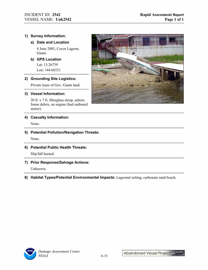
INCIDENT ID: 2542 Rapid Assessment Report VESSEL NAME: Unk2542 Page 1 of 1
1) Survey Information: a) Date and Location
4 June 2003, Cocos Lagoon, Guam.
b) GPS Location Lat: 13.26739 Lon: 144.66521
2) Grounding Site Logistics: Private lease of Gov. Guam land.
3) Vessel Information: 20 ft. x 7 ft. fiberglass sloop, ashore. Some debris, no engine (had outboard motor).
4) Casualty Information: None.
5) Potential Pollution/Navigation Threats: None.
6) Potential Public Health Threats: Slip/fall hazard.
7) Prior Response/Salvage Actions: Unknown.
8) Habitat Types/Potential Environmental Impacts: Lagoonal setting, carbonate sand beach.
Damage Assessment Center NOAA A-33
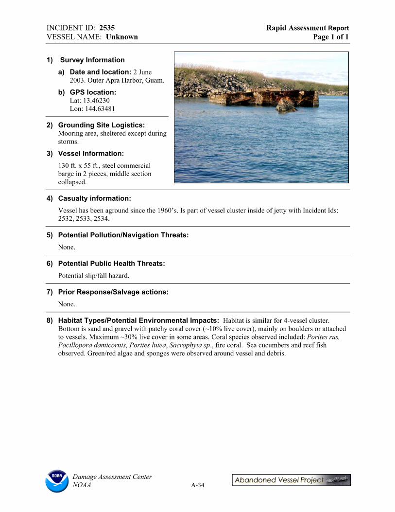
INCIDENT ID: 2535 Rapid Assessment Report VESSEL NAME: Unknown Page 1 of 1
1) Survey Information a) Date and location: 2 June
2003. Outer Apra Harbor, Guam.
b) GPS location: Lat: 13.46230 Lon: 144.63481
2) Grounding Site Logistics: Mooring area, sheltered except during storms.
3) Vessel Information: 130 ft. x 55 ft., steel commercial barge in 2 pieces, middle section collapsed.
4) Casualty information: Vessel has been aground since the 1960’s. Is part of vessel cluster inside of jetty with Incident Ids: 2532, 2533, 2534.
5) Potential Pollution/Navigation Threats: None.
6) Potential Public Health Threats: Potential slip/fall hazard.
7) Prior Response/Salvage actions: None.
8) Habitat Types/Potential Environmental Impacts: Habitat is similar for 4-vessel cluster. Bottom is sand and gravel with patchy coral cover (~10% live cover), mainly on boulders or attached to vessels. Maximum ~30% live cover in some areas. Coral species observed included: Porites rus, Pocillopora damicornis, Porites lutea, Sacrophyta sp., fire coral. Sea cucumbers and reef fish observed. Green/red algae and sponges were observed around vessel and debris.
Damage Assessment Center NOAA A-34
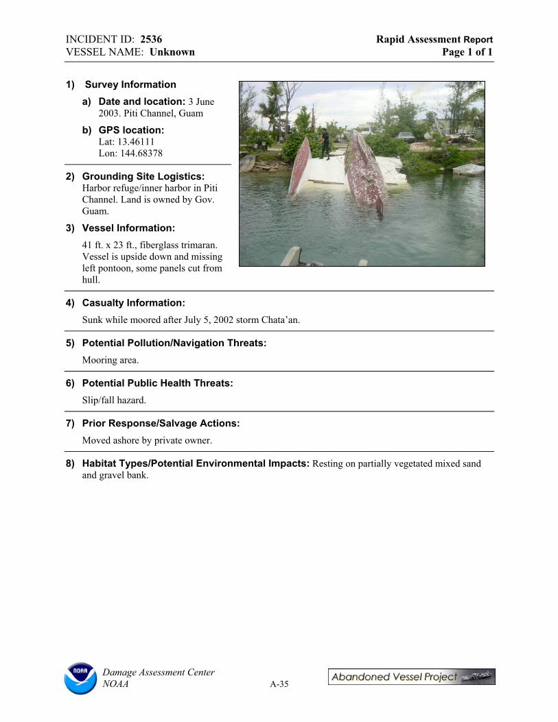
INCIDENT ID: 2536 Rapid Assessment Report VESSEL NAME: Unknown Page 1 of 1
1) Survey Information a) Date and location: 3 June
2003. Piti Channel, Guam
b) GPS location: Lat: 13.46111 Lon: 144.68378
2) Grounding Site Logistics: Harbor refuge/inner harbor in Piti Channel. Land is owned by Gov. Guam.
3) Vessel Information: 41 ft. x 23 ft., fiberglass trimaran. Vessel is upside down and missing left pontoon, some panels cut from hull.
4) Casualty Information: Sunk while moored after July 5, 2002 storm Chata’an.
5) Potential Pollution/Navigation Threats: Mooring area.
6) Potential Public Health Threats: Slip/fall hazard.
7) Prior Response/Salvage Actions: Moved ashore by private owner.
8) Habitat Types/Potential Environmental Impacts: Resting on partially vegetated mixed sand and gravel bank.
Damage Assessment Center NOAA A-35

APPENDIX B: RAPID ASSESSMENT REPORTS FOR
ABANDONED VESSELS IN COMMONWEALTH OF THE NORTHERN MARIANA ISLANDS
Prepared by:
Christine Lord and Colin Plank Research Planning, Inc.
Columbia, South Carolina 29202
Ian Zelo and Doug Helton NOAA Damage Assessment Center (DAC) Northwest
Seattle, Washington 98115
October 2003

TABLE OF CONTENTS SORTED IN ALPHA/NUMERIC ORDER
Vessel Name Location Incident ID# Page
#62 Nam Sung..................Rota .................................................................1832.........................B-54 Charito B-1..............................Lower Base, Saipan ........................................1252.........................Lian Gi .............................Tinian Harbor..................................................2577.........................B-42 Mwaalil Saat B-15....................Puerto Rico Dump, Saipan..............................2546.........................Nago No. 15 .....................Outer Cove Marina, Saipan.............................1253.........................B-7 Rota Queen.......................Rota .................................................................1829.........................B-66 Samala B-4..............................Outer Cove Marina, Saipan.............................1251.........................Sun Long No. 8 ................Tinian Harbor..................................................1828.........................B-51 T.T. Gov’t 1 .....................Rota .................................................................1830.........................B-57 T.T. Gov’t 2 .....................Rota .................................................................1831.........................B-60 Unk2543 B-10...........................Outer Cove Marina, Saipan.............................2543.........................Unk2544 B-11...........................Outer Cove Marina, Saipan.............................2544.........................Unk2545 B-12...........................Managaha Sanctuary, Saipan ..........................2545.........................Unk2547 B-16 ...........................Saipan Lagoon ................................................2547.........................Unk2548 B-17 ...........................Saipan Lagoon ................................................2548.........................Unk2550 B-18...........................Outer Cove Marina, Saipan.............................2550.........................Unk2551 B-19...........................Outer Cove Marina, Saipan.............................2551.........................Unk2553 B-20...........................Outer Cove Marina, Saipan.............................2553.........................Unk2554 B-21...........................Outer Cove Marina, Saipan.............................2554.........................Unk2555 B-22...........................Outer Cove Marina, Saipan.............................2555.........................Unk2556 B-23...........................Outer Cove Marina, Saipan.............................2556.........................Unk2557 B-24...........................Outer Cove Marina, Saipan.............................2557.........................Unk2558 B-25...........................Outer Cove Marina, Saipan.............................2558.........................Unk2559 B-26...........................Outer Cove Marina, Saipan.............................2559.........................Unk2560 B-27...........................Outer Cove Marina, Saipan.............................2660.........................Unk2562 B-28...........................Outer Cove Marina, Saipan.............................2562.........................Unk2564 B-29...........................Outer Cove Marina, Saipan.............................2564.........................Unk2565 B-30...........................Outer Cove Marina, Saipan.............................2565.........................Unk2566 B-31...........................Outer Cove Marina, Saipan.............................2566.........................Unk2567 B-32...........................Outer Cove Marina, Saipan.............................2567.........................Unk2568 B-33...........................Outer Cove Marina, Saipan.............................2568.........................Unk2569 B-34...........................Outer Cove Marina, Saipan.............................2569.........................Unk2570 B-35...........................Outer Cove Marina, Saipan.............................2570.........................Unk2571 B-36...........................Outer Cove Marina, Saipan.............................2571.........................Unk2572 B-37...........................Outer Cove Marina, Saipan.............................2572.........................Unk2573 B-38...........................Outer Cove Marina, Saipan.............................2573.........................Unk2574 B-39...........................Outer Cove Marina, Saipan.............................2574.........................Unk2575 B-40...........................Outer Cove Marina, Saipan.............................2575.........................Unk2576 B-41...........................Outer Cove Marina, Saipan.............................2576.........................Unk2578...........................Tinian Harbor..................................................2578.........................B-45 Unk2579...........................Tinian Harbor..................................................2579.........................B-48 Unk2581...........................Rota .................................................................2581.........................B-63

INCIDENT ID: 1252 Rapid Assessment Report VESSEL NAME: Charito Page 1 of 3
1) Survey Information: a) Date and location: 6 June, 2003,
Lower Base, Saipan.
b) Weather and tide conditions at time of survey: 80’s, high tide, clear, sunny.
c) Team members: Cabrera (CRM), Lord and Plank (RPI), Helton and Zelo (NOAA).
d) GPS location: Lat: 15.22814’ Lon: 145.73946’
e) Inspection narrative: A full survey, including underwater video, was conducted.
2) Grounding Site Logistics: a) Adjacent land ownership / land-use: CNMI owned land.
b) Points of access: Adjacent road access.
c) Sea conditions and exposure to wave energy at site: Relatively low wave energy, sheltered environment except during storms
d) Depth and nearby bathymetry: 0-5 ft.
3) Vessel Information: a) Vessel name: CHARITO.
b) Vessel type: Fishing vessel (long-liner).
c) Construction materials: Steel.
d) Principle dimensions: 97 ft. x 23 ft.
e) Registration numbers: CM-919-CF, N0999866.
f) Commercial vs. pleasure craft: Commercial/private fishing vessel.
g) Nationality/flag state/homeport: Home ported in Saipan.
h) Builder, model, and year of construction: Unknown.
i) Vessel tonnage: Unknown.
j) Is the vessel “historic”? No.
4) Casualty information a) General status of vessel: Aground.
b) Nature of casualty: Grounded during Typhoon Winnie.
Damage Assessment Center NOAA B-1

INCIDENT ID: 1252 Rapid Assessment Report VESSEL NAME: Charito Page 2 of 3
c) Date of grounding/length of time the vessel has been “abandoned”: August 12, 1997
d) General description of vessel damage: Mostly intact, but rusting.
e) Vessel Cargo: None.
5) Potential Pollution Threats: a) Is there fuel or hazmat onboard? Estimated quantities: Reported to be empty.
b) Evidence of releases? Sheens? No.
c) Evidence of illegal dumping? No.
d) Condition of fuel tanks: Not inspected. Vessel was not boarded.
e) Other equipment and supplies that may pose their own threats: Possibly batteries.
f) What new or continuing harm to natural resources might result by removing oil/hazardous substances but leaving the vessel? N/A.
6) Potential Navigation Threats: a) Is the vessel located in or adjacent to navigation channel(s)? No.
b) Depth and visibility of the vessel: 4 ft. at deepest, almost entire vessel exposed.
c) Is the vessel properly marked? No, but is highly visible
d) Type of navigation in the area: Recreational only.
e) Has the vessel moved over time? Might it move in the future? Vessel could move during a storm.
f) Would other structures be endangered if the vessel were to shift or move? During a large storm it is possible that it could impact the road or industrial area if it were to move or break up.
7) Potential Public Health Threats: a) Public uses in the area: High use recreational fishing, boating, and birding area. A small boat
launch and anchorage is located 500 ft from vessel.
b) Evidence of people boarding the vessel? No.
c) Entrapment or slip/fall hazards? Yes, potential entrapment hazard.
8) Prior Response/Salvage Actions: a) Pollution response: Unknown.
b) Salvage efforts: Unknown.
9) Vessel Ownership: a) Owner name/address: Unknown.
b) Insurance agent and type of coverages: Unknown.
Damage Assessment Center NOAA B-2
INCIDENT ID: 1252 Rapid Assessment Report VESSEL NAME: Charito Page 3 of 3
c) What communications have occurred between owner/operator/insurer and state or federal government? Effort made by CRM but no results from owner.
d) Contact names: Martin Cabrera (CRM).
10) Endangered Species and Critical Habitats: a) Is the site designated critical habitat for ESA-listed species? No.
b) Is the vessel destroying critical habitat or could it if the vessel moved? No.
c) Is there any evidence of entanglement or entrapment of fish/wildlife? No.
11) Potential Environmental Impacts: a) Dimensions of vessel grounding footprint: Roughly 10 to 20 ft. around vessel.
b) Dimensions of debris field: Debris primarily within area described above.
c) Primary habitat(s): Coral, 0-10% live coral cover directly surrounding vessel. Dominant species are Acropora and Porites (massive form). 10-15 yards away are patch reefs with some denser areas (10-30% live cover) with a few more species.
d) Secondary habitat(s): Up to 50% algal cover on sandy substrate and patches of seagrass. Dominant algal species are Halimeda macroloba and Caulerpa taxifolia.
e) Substrate: Sand.
f) Damage observations: Little visible damage, minor debris. Lower % live coral around vessel may be related to proximity to shore in high use area or due to presence of vessel.
Damage Assessment Center NOAA B-3

INCIDENT ID: 1251 Rapid Assessment Report VESSEL NAME: Samala Page 1 of 3
1) Survey Information: a) Date and location: 6 June, 2003,
Outer Cove Marina near American Memorial Park, Saipan.
b) Weather and tide conditions at time of survey: 80’s, high tide, clear, sunny.
c) Team members: Cabrera (CRM), Lord and Plank (RPI), Helton and Zelo (NOAA).
d) GPS Location: Lat: 15.22188’ Lon: 145.72720’
e) Inspection narrative: Full survey, including underwater video.
2) Grounding Site Logistics: a) Adjacent land ownership / land-use: Outer Cove Marina land and water is CNMI
government land, American Memorial Park is owned by National Park Service (NPS).
b) Points of access: There is road and boat ramp access via park and marina.
c) Sea conditions and exposure to wave energy at site: Relatively low energy lagoonal setting; sheltered except during storms.
d) Depth and nearby bathymetry: 0-3 ft.
3) Vessel Information: a) Vessel name: SAMALA.
b) Vessel type: Converted cabin cruiser.
c) Construction materials: Wooden hull.
d) Principle dimensions: 110 ft. x 16 ft.
e) Registration numbers: None.
f) Commercial vs. pleasure craft: Pleasure.
g) Nationality/flag state/homeport: Unknown, possibly Saipan.
h) Builder, model (if any), and year of construction: Unknown.
i) Vessel tonnage: Unknown.
j) Is the vessel “historic”? No.
4) Casualty information: a) General status of vessel: Aground.
b) Nature of casualty: Grounded during typhoon.
c) Date of grounding/length of time the vessel has been “abandoned”: Possibly 1988.
Damage Assessment Center NOAA B-4
INCIDENT ID: 1251 Rapid Assessment Report VESSEL NAME: Samala Page 2 of 3
d) General description of vessel damage: Hull has broken into multiple sections and there is an extensive field of debris
e) Vessel cargo: None.
5) Potential Pollution Threats: a) Is there fuel or hazmat onboard? Estimated quantities? Potential for fuel onboard.
b) Evidence of releases? Sheens? No.
c) Evidence of illegal dumping? No.
d) Condition of fuel tanks: Fuel tanks intact, also compressed fuel tanks observed in debris.
e) Other equipment and supplies that may pose their own threats: No.
f) What new or continuing harm to natural resources might result by removing oil/hazardous substances but leaving the vessel? Continuing expansion of debris field and continued break down in vessel condition may lead to damage of coral habitat.
6) Potential Navigation Threats: a) Is the vessel located in or adjacent to navigation channel(s)? No.
b) Depth and visibility of the vessel: 3 ft. at deepest, almost entire vessel exposed, 6ft. above water line at maximum.
c) Is the vessel properly marked? No, but is highly visible
d) Type of navigation in the area: Recreational.
e) Has the vessel moved over time? Might it move in the future? No movement on record but vessel could move in storm.
f) Would other structures be endangered if the vessel were to shift or move? No.
7) Potential Public Health Threats: a) Public uses in the area: Recreational fishing, boating, and swimming.
b) Evidence of people boarding the vessel? Children reported frequently diving off of wreck.
c) Entrapment or slip/fall hazards? Yes, slip/fall and entrapment hazard.
8) Prior Response/Salvage Actions: a) Pollution response: None.
b) Salvage efforts: Permits requested but no salvage effort to date.
9) Vessel Ownership: a) Owner Name/address: Unknown.
b) Insurance agent and type of coverages: Unknown.
c) What communications have occurred between owner/operator/insurer and state or federal government? Government getting ready to take enforcement and/or removal action.
Damage Assessment Center NOAA B-5

INCIDENT ID: 1251 Rapid Assessment Report VESSEL NAME: Samala Page 3 of 3
d) Contact names: Martin Cabrera (CRM).
10) Endangered Species and Critical Habitats: a) Is the site designated critical habitat for ESA-listed species? No.
b) Is the vessel destroying critical habitat or could it if the vessel moved? No.
c) Is there any evidence of entanglement or entrapment of fish/wildlife? No.
11) Potential Environmental Impacts: a) Dimensions of vessel grounding footprint: Roughly 20 ft wide scour around vessel.
b) Dimensions of debris field: Debris primarily within area described above, but some debris extends beyond 20 ft. zone. Some debris was scattered far into the cove.
c) Primary habitat(s): Coral and macroalgae. Observed 0-10% live coral cover within 20 yards of vessel. Dominant coral genuses are Acropora and Porites. Some massive coral heads are 5 ft. wide or greater and 2-3 ft. tall. Denser coral coverage (50-70%) occurs 20+ yards from vessel. Observed 50% macroalgae (Halimeda macroloba) cover in some areas. Typically approximately 20% cover and intermixed with live coral.
d) Secondary habitat(s): Patchy seagrass beds, mostly 25 yards or farther from vessel. Dominant species is Enhalus macroroides.
e) Substrate: Sand with coral rubble.
f) Damage observations: Scouring and destruction of coral heads due to large debris observed and photographed, nets and other floating debris present. Additional damage to seagrass beds or corals likely as debris field increases.
Damage Assessment Center NOAA B-6
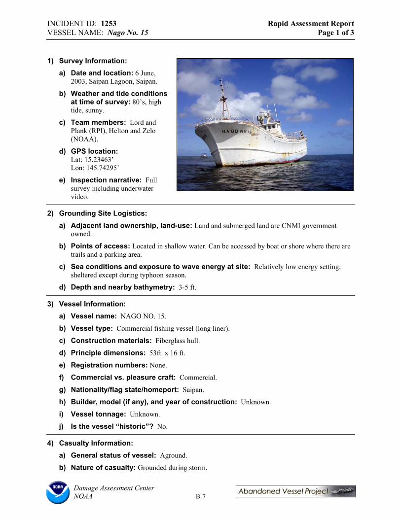
INCIDENT ID: 1253 Rapid Assessment Report VESSEL NAME: Nago No. 15 Page 1 of 3
1) Survey Information: a) Date and location: 6 June,
2003, Saipan Lagoon, Saipan.
b) Weather and tide conditions at time of survey: 80’s, high tide, sunny.
c) Team members: Lord and Plank (RPI), Helton and Zelo (NOAA).
d) GPS location: Lat: 15.23463’ Lon: 145.74295’
e) Inspection narrative: Full survey including underwater video.
2) Grounding Site Logistics: a) Adjacent land ownership, land-use: Land and submerged land are CNMI government
owned.
b) Points of access: Located in shallow water. Can be accessed by boat or shore where there are trails and a parking area.
c) Sea conditions and exposure to wave energy at site: Relatively low energy setting; sheltered except during typhoon season.
d) Depth and nearby bathymetry: 3-5 ft.
3) Vessel Information: a) Vessel name: NAGO NO. 15.
b) Vessel type: Commercial fishing vessel (long liner).
c) Construction materials: Fiberglass hull.
d) Principle dimensions: 53ft. x 16 ft.
e) Registration numbers: None.
f) Commercial vs. pleasure craft: Commercial.
g) Nationality/flag state/homeport: Saipan.
h) Builder, model (if any), and year of construction: Unknown.
i) Vessel tonnage: Unknown.
j) Is the vessel “historic”? No.
4) Casualty Information: a) General status of vessel: Aground.
b) Nature of casualty: Grounded during storm.
Damage Assessment Center NOAA B-7

INCIDENT ID: 1253 Rapid Assessment Report VESSEL NAME: Nago No. 15 Page 2 of 3
c) Date of grounding/length of time the vessel has been “abandoned”: Unknown
d) General description of vessel damage: Steel portions of deck are rusting
e) Vessel cargo: Engine, generator still on board and intact.
5) Potential Pollution Threats: a) Is there fuel or hazmat onboard? Estimated quantities: Fuel and oil have been removed.
Hydraulic hoses associated with engine likely still have fluid. Refrigerant possibly onboard.
b) Evidence of releases? Sheens? No.
c) Evidence of illegal dumping? No.
d) Condition of fuel tanks: Unknown.
e) Other equipment and supplies that may pose their own threats: Batteries probably still onboard.
f) What new or continuing harm to natural resources might result by removing oil/hazardous substances but leaving the vessel? Vessel may move in storm and impact seagrass.
6) Potential Navigation Threats: a) Is the vessel located in or adjacent to navigation channel(s)? No.
b) Depth and visibility of the vessel: Vessel is aground in shallow water and highly visible/mostly out of water.
c) Is the vessel properly marked? No, but is highly visible
d) Type of navigation in the area: Too shallow for navigation.
e) Has the vessel moved over time? Might it move in the future? Vessel could move in storm.
f) Would other structures be endangered if the vessel were to shift or move? No.
7) Potential Public Health Threats: a) Public uses in the area: Fishing.
b) Evidence of people boarding the vessel? No.
c) Entrapment or slip/fall hazards? Yes, slip/fall hazard.
8) Prior Response/Salvage Actions: a) Pollution response: Oil removed.
b) Salvage efforts: Attempt to remove failed.
9) Vessel Ownership: a) Owner name/address: Unknown.
b) Insurance agent and type of coverages: Unknown.
Damage Assessment Center NOAA B-8
INCIDENT ID: 1253 Rapid Assessment Report VESSEL NAME: Nago No. 15 Page 3 of 3
c) What communications have occurred between owner/operator/insurer and state or federal government? Shipping company sued owner, some enforcement taken.
d) Contact names: Martin Cabrera (CRM)
10) Endangered Species and Critical Habitats: a) Is the site designated critical habitat for ESA-listed species? No.
b) Is the vessel destroying critical habitat or could it if the vessel moved? No.
c) Is there any evidence of entanglement or entrapment of fish/wildlife? No.
11) Potential Environmental Impacts: a) Dimensions of vessel grounding footprint: 8ft wide on port side, 20 ft wide off bow.
b) Dimensions of debris field: Limited amount of debris primarily within area described above.
c) Primary habitat(s): Seagrass, >70% cover, 90-100% cover in some areas. Dominant species is Enhalus macroroides.
d) Secondary habitat(s): None.
e) Substrate: Sand
f) Damage observations: Scouring of seagrass in 8ft. wide swath on portside and 20 ft. swath off of bow.
Damage Assessment Center NOAA B-9
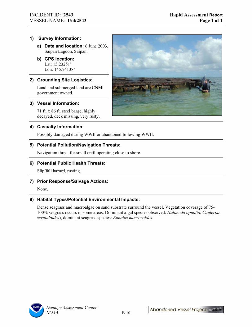
INCIDENT ID: 2543 Rapid Assessment Report VESSEL NAME: Unk2543 Page 1 of 1
1) Survey Information: a) Date and location: 6 June 2003.
Saipan Lagoon, Saipan.
b) GPS location: Lat: 15.23251’ Lon: 145.74138’
2) Grounding Site Logistics: Land and submerged land are CNMI government owned.
3) Vessel Information: 71 ft. x 86 ft. steel barge, highly decayed, deck missing, very rusty.
4) Casualty Information: Possibly damaged during WWII or abandoned following WWII.
5) Potential Pollution/Navigation Threats: Navigation threat for small craft operating close to shore.
6) Potential Public Health Threats: Slip/fall hazard, rusting.
7) Prior Response/Salvage Actions: None.
8) Habitat Types/Potential Environmental Impacts: Dense seagrass and macroalgae on sand substrate surround the vessel. Vegetation coverage of 75100% seagrass occurs in some areas. Dominant algal species observed: Halimeda opuntia, Caulerpa serutaloides), dominant seagrass species: Enhalus macroroides.
Damage Assessment Center NOAA B-10

INCIDENT ID: 2544 Rapid Assessment Report VESSEL NAME: Unk2544 Page 1 of 1
1) Survey Information: a) Date and location: 6 June
2003. Saipan Lagoon, Saipan.
b) GPS location: Lat: 15.23251’ Lon: 145.74138’
2) Grounding Site Logistics: Land and submerged land are CNMI government owned.
3) Vessel Information: 74 ft. x 88 ft. steel barge, highlydecayed, deck missing, very rusty.
4) Casualty information: Possibly damaged during WWII or abandoned following WWII.
5) Potential Pollution/Navigation Threats: Navigation threat for small craft operating close to shore.
6) Potential Public Health Threats: Slip/fall hazard, rusting.
7) Prior Response/Salvage Actions: None.
8) Habitat Types/Potential Environmental Impacts: Dense seagrass and macroalgae on sand substrate surround the vessel. Dominant algal species observed: Halimeda opuntia, Caulerpa serutaloides), dominant seagrass species: Enhalus macroroides.
Damage Assessment Center NOAA B-11

INCIDENT ID: 2545 Rapid Assessment Report VESSEL NAME: Unk2545 Page 1 of 3
1) Survey Information: a) Date and location: 6 June, 2003, Saipan.
b) Weather and tide conditions at time of survey: 80’s, high tide, sunny, breezy.
c) Team members: Lord and Plank (RPI), Helton and Zelo (NOAA).
d) GPS location: Lat: 15.23546’ Lon: 145.72389’
e) Inspection narrative: Full survey.
2) Grounding Site Logistics: a) Adjacent land ownership/ land-use: Land is CNMI
owned. Submerged lands are Managaha Sanctuary, owned by local Fish and Wildlife Service.
b) Points of access: Accessible by boat
c) Sea conditions and exposure to wave energy at site: Exposed and somewhat rough.
d) Depth and nearby bathymetry: 35 ft.
3) Vessel Information: a) Vessel name: Unk2545, possibly Shoan Maru
b) Vessel type: Cargo vessel or whaler.
c) Construction materials: Steel.
d) Principle dimensions: 367 ft. x 100 ft. See description # 331 in Micronesia Submerged Cultural Resource Assessment.
e) Registration numbers: None.
f) Commercial vs. pleasure craft: Japanese military vessel.
g) Nationality/flag state/homeport: Japan.
h) Builder, model, and year of construction: Unknown.
i) Vessel tonnage: Over 100 gross tons.
j) Is the vessel “historic”? Yes.
4) Casualty Information: a) General status of vessel: Submerged, partially awash.
b) Nature of casualty: Sunk during or before WWII.
c) Date of grounding/length of time the vessel has been “abandoned”: Unknown
d) General description of vessel damage: Mostly debris left, vessel may be identified by remaining kingposts as the Shoan Maru.
e) Vessel cargo: None.
Damage Assessment Center NOAA B-12
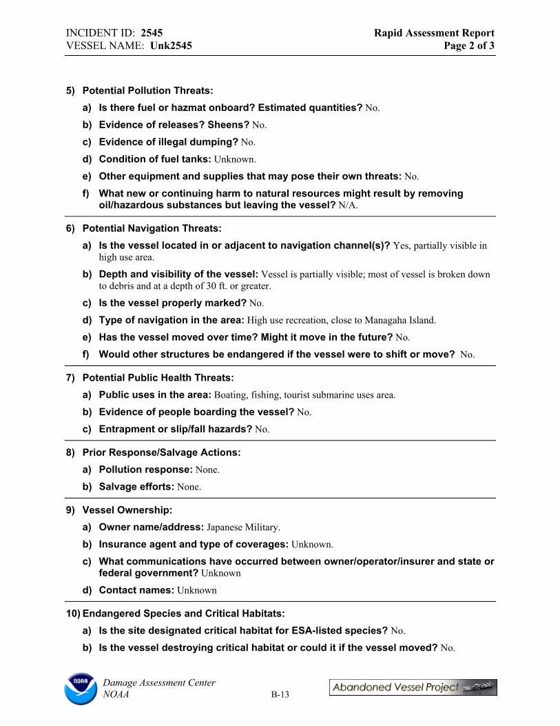
INCIDENT ID: 2545 Rapid Assessment Report VESSEL NAME: Unk2545 Page 2 of 3
5) Potential Pollution Threats: a) Is there fuel or hazmat onboard? Estimated quantities? No.
b) Evidence of releases? Sheens? No.
c) Evidence of illegal dumping? No.
d) Condition of fuel tanks: Unknown.
e) Other equipment and supplies that may pose their own threats: No.
f) What new or continuing harm to natural resources might result by removing oil/hazardous substances but leaving the vessel? N/A.
6) Potential Navigation Threats: a) Is the vessel located in or adjacent to navigation channel(s)? Yes, partially visible in
high use area.
b) Depth and visibility of the vessel: Vessel is partially visible; most of vessel is broken down to debris and at a depth of 30 ft. or greater.
c) Is the vessel properly marked? No.
d) Type of navigation in the area: High use recreation, close to Managaha Island.
e) Has the vessel moved over time? Might it move in the future? No.
f) Would other structures be endangered if the vessel were to shift or move? No.
7) Potential Public Health Threats: a) Public uses in the area: Boating, fishing, tourist submarine uses area.
b) Evidence of people boarding the vessel? No.
c) Entrapment or slip/fall hazards? No.
8) Prior Response/Salvage Actions: a) Pollution response: None.
b) Salvage efforts: None.
9) Vessel Ownership: a) Owner name/address: Japanese Military.
b) Insurance agent and type of coverages: Unknown.
c) What communications have occurred between owner/operator/insurer and state or federal government? Unknown
d) Contact names: Unknown
10) Endangered Species and Critical Habitats: a) Is the site designated critical habitat for ESA-listed species? No.
b) Is the vessel destroying critical habitat or could it if the vessel moved? No.
Damage Assessment Center NOAA B-13
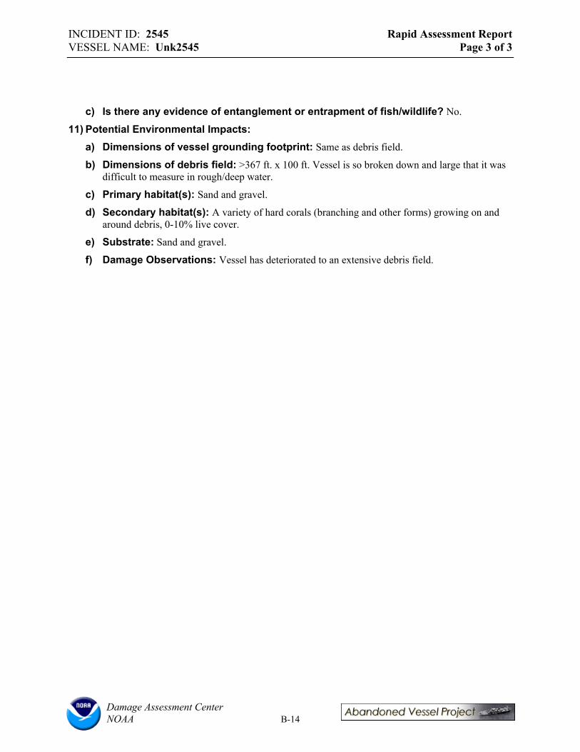
INCIDENT ID: 2545 Rapid Assessment Report VESSEL NAME: Unk2545 Page 3 of 3
c) Is there any evidence of entanglement or entrapment of fish/wildlife? No.
11) Potential Environmental Impacts: a) Dimensions of vessel grounding footprint: Same as debris field.
b) Dimensions of debris field: >367 ft. x 100 ft. Vessel is so broken down and large that it was difficult to measure in rough/deep water.
c) Primary habitat(s): Sand and gravel.
d) Secondary habitat(s): A variety of hard corals (branching and other forms) growing on and around debris, 0-10% live cover.
e) Substrate: Sand and gravel.
f) Damage Observations: Vessel has deteriorated to an extensive debris field.
Damage Assessment Center NOAA B-14

INCIDENT ID: 2546 Rapid Assessment Report VESSEL NAME: Mwaalil Saat Page 1 of 1
1) Survey Information: a) Date and location: 6 June
2003. Puerto Rico Dump, Saipan.
b) GPS location: Lat: 15.22417’ Lon: 145.73160’
2) Grounding Site Logistics: Docked outside harbor/marina.
3) Vessel Information: Commercial fishing vessel, stern trawler, steel. Homeport: Saipan, CNMI. Originally was the Mariana Lady. Vessel is tied up and rusting.
4) Casualty Information: Vessel was supposed to make a trip to Tonga but was taking on water and did not leave Saipan.
5) Potential Pollution/Navigation Threats: Everything is still on board, including 50,000 to 100,000 gallons of fuel.
6) Potential Public Health Threats: People seen on ship from time to time, possibly the owner. Potential slip/fall hazard.
7) Prior Response/Salvage Actions: None, but of high local concern.
8) Habitat Types/Potential Environmental Impacts: Shorelines in vicinity are riprap, bathymetry is roughly 20 ft.
Damage Assessment Center NOAA B-15
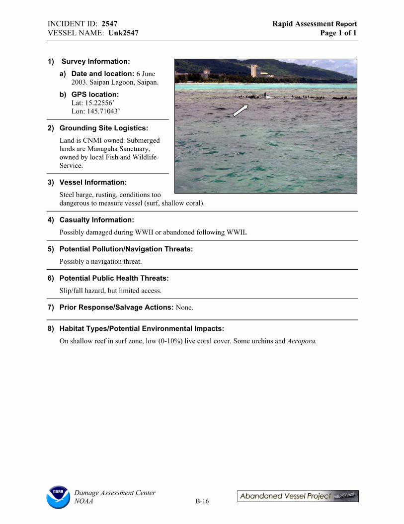
INCIDENT ID: 2547 Rapid Assessment Report VESSEL NAME: Unk2547 Page 1 of 1
1) Survey Information: a) Date and location: 6 June
2003. Saipan Lagoon, Saipan.
b) GPS location: Lat: 15.22556’ Lon: 145.71043’
2) Grounding Site Logistics: Land is CNMI owned. Submerged lands are Managaha Sanctuary,owned by local Fish and Wildlife Service.
3) Vessel Information: Steel barge, rusting, conditions too dangerous to measure vessel (surf, shallow coral).
4) Casualty Information:
Possibly damaged during WWII or abandoned following WWII.
5) Potential Pollution/Navigation Threats: Possibly a navigation threat.
6) Potential Public Health Threats: Slip/fall hazard, but limited access.
7) Prior Response/Salvage Actions: None.
8) Habitat Types/Potential Environmental Impacts: On shallow reef in surf zone, low (0-10%) live coral cover. Some urchins and Acropora.
Damage Assessment Center NOAA B-16

INCIDENT ID: 2548 Rapid Assessment Report VESSEL NAME: Unk2548 Page 1 of 1
1) Survey Information: a) Date and location: 6 June 2003.
Saipan Lagoon, Saipan.
b) GPS location: Lat: 15.21685’ Lon: 145.70363’
2) Grounding Site Logistics: Submerged lands and nearby shoreline are CNMI owned. Some fishing in the area, potential use by recreational divers, but conditions are generally rough.
3) Vessel Information: Cement freighter, war era.
4) Casualty Information: Possibly damaged during WWII or abandoned following WWII.
5) Potential Pollution/Navigation Threats: None.
6) Potential Public Health Threats: None.
7) Prior Response/Salvage Actions: None.
8) Habitat Types/Potential Environmental Impacts: Vessel rests on sand bottom and has a lot of attached hard corals, algae, and barnacles. 10-20 yards from vessel are fairly extensive patch reefs at 20-30 ft. depth with live coral on boulders with 50-75% cover in some areas. Dominant coral genuses: Porites, Acropora, fire coral, possibly others. Abundant reef fish observed.
Damage Assessment Center NOAA B-17
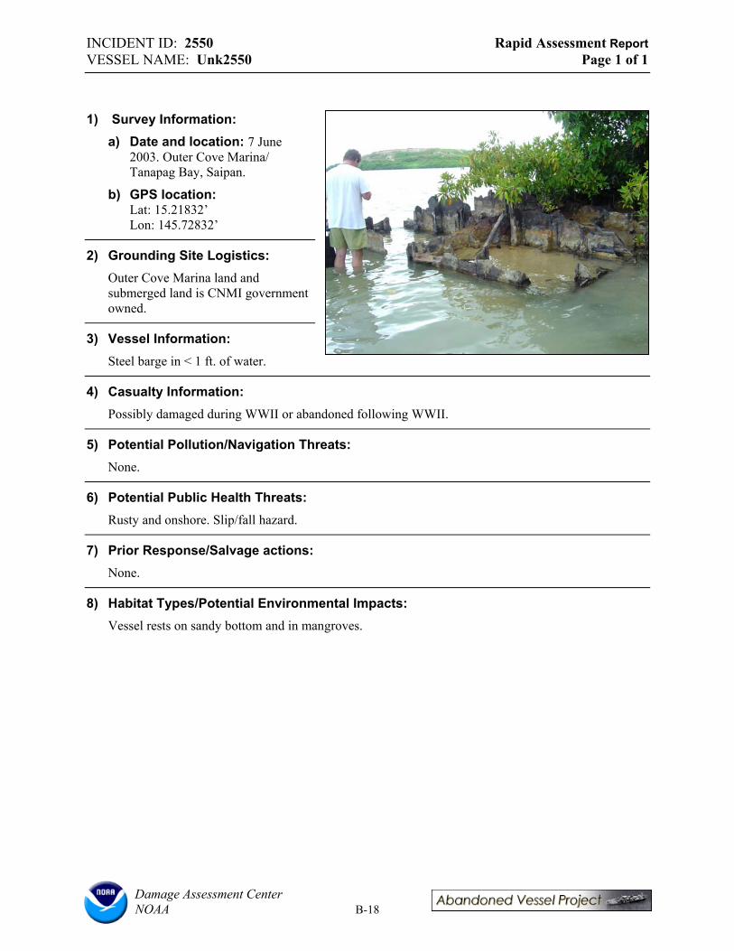
INCIDENT ID: 2550 Rapid Assessment Report VESSEL NAME: Unk2550 Page 1 of 1
1) Survey Information: a) Date and location: 7 June
2003. Outer Cove Marina/ Tanapag Bay, Saipan.
b) GPS location: Lat: 15.21832’ Lon: 145.72832’
2) Grounding Site Logistics: Outer Cove Marina land and submerged land is CNMI government owned.
3) Vessel Information: Steel barge in < 1 ft. of water.
4) Casualty Information: Possibly damaged during WWII or abandoned following WWII.
5) Potential Pollution/Navigation Threats: None.
6) Potential Public Health Threats: Rusty and onshore. Slip/fall hazard.
7) Prior Response/Salvage actions: None.
8) Habitat Types/Potential Environmental Impacts: Vessel rests on sandy bottom and in mangroves.
Damage Assessment Center NOAA B-18
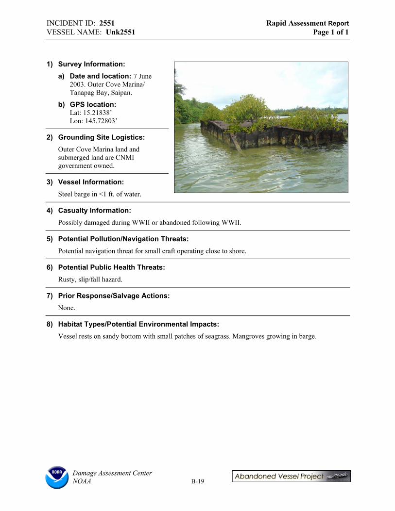
INCIDENT ID: 2551 Rapid Assessment Report VESSEL NAME: Unk2551 Page 1 of 1
1) Survey Information: a) Date and location: 7 June
2003. Outer Cove Marina/ Tanapag Bay, Saipan.
b) GPS location: Lat: 15.21838’ Lon: 145.72803’
2) Grounding Site Logistics: Outer Cove Marina land and submerged land are CNMI government owned.
3) Vessel Information: Steel barge in <1 ft. of water.
4) Casualty Information: Possibly damaged during WWII or abandoned following WWII.
5) Potential Pollution/Navigation Threats: Potential navigation threat for small craft operating close to shore.
6) Potential Public Health Threats: Rusty, slip/fall hazard.
7) Prior Response/Salvage Actions: None.
8) Habitat Types/Potential Environmental Impacts: Vessel rests on sandy bottom with small patches of seagrass. Mangroves growing in barge.
Damage Assessment Center NOAA B-19

INCIDENT ID: 2553 Rapid Assessment Report VESSEL NAME: Unk2553 Page 1 of 1
1) Survey Information: a) Date and location: 7 June 2003.
Outer Cove Marina/ Tanapag Bay, Saipan.
b) GPS location Lat: 15.21857’ Lon: 145.72876’
2) Grounding Site Logistics: Outer Cove Marina land and submerged land are CNMI government owned.
3) Vessel Information: Steel barge in 1 ft. of water.
4) Casualty Information: Possibly damaged during WWII or abandoned following WWII.
5) Potential Pollution/Navigation Threats: None.
6) Potential Public Health Threats: Slip/trip, rusting onshore.
7) Prior Response/Salvage Actions: None.
8) Habitat Types/Potential Environmental Impacts: Vessel rests on sandy bottom up against mangroves with mangroves growing in it.
Damage Assessment Center NOAA B-20
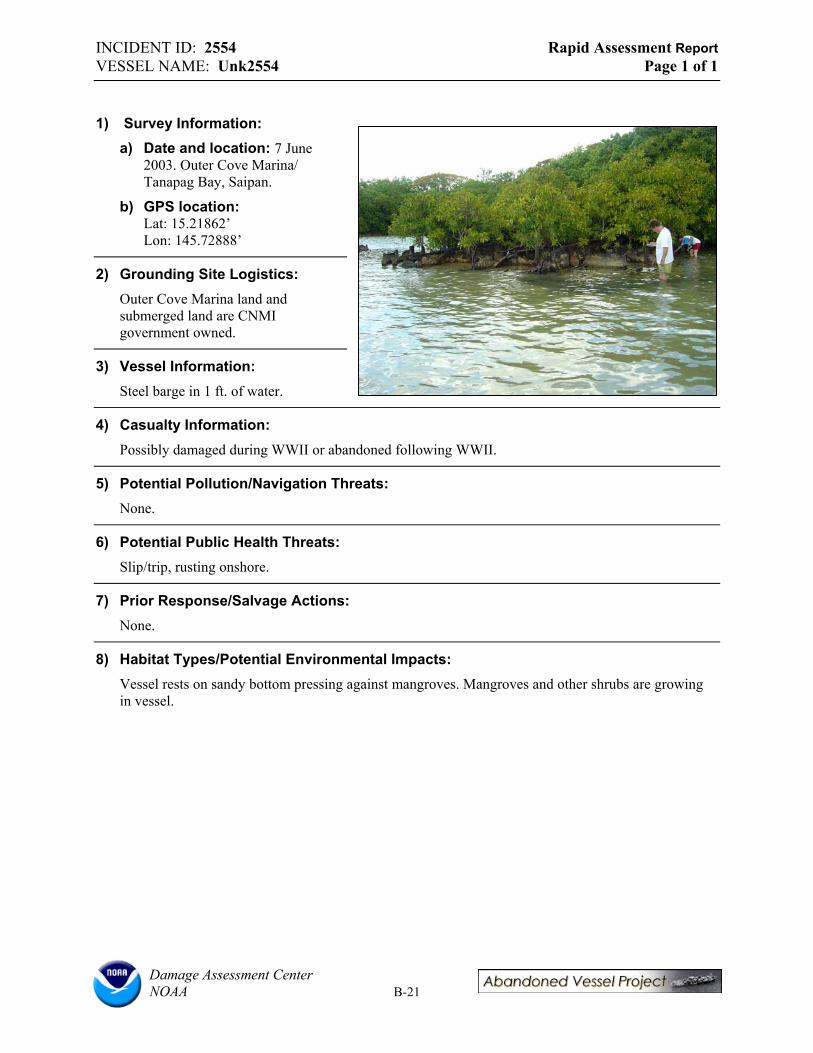
INCIDENT ID: 2554 Rapid Assessment Report VESSEL NAME: Unk2554 Page 1 of 1
1) Survey Information: a) Date and location: 7 June
2003. Outer Cove Marina/ Tanapag Bay, Saipan.
b) GPS location: Lat: 15.21862’ Lon: 145.72888’
2) Grounding Site Logistics: Outer Cove Marina land and submerged land are CNMI government owned.
3) Vessel Information: Steel barge in 1 ft. of water.
4) Casualty Information: Possibly damaged during WWII or abandoned following WWII.
5) Potential Pollution/Navigation Threats: None.
6) Potential Public Health Threats: Slip/trip, rusting onshore.
7) Prior Response/Salvage Actions: None.
8) Habitat Types/Potential Environmental Impacts: Vessel rests on sandy bottom pressing against mangroves. Mangroves and other shrubs are growing in vessel.
Damage Assessment Center NOAA B-21

INCIDENT ID: 2555 Rapid Assessment Report VESSEL NAME: Unk2555 Page 1 of 1
1) Survey Information: a) Date and location: 7 June 2003.
Outer Cove Marina/ Tanapag Bay, Saipan.
b) GPS location: Lat: 15.21878’ Lon: 145.72897’
2) Grounding Site Logistics: Outer Cove Marina land and submerged land are CNMI government owned.
3) Vessel Information: Steel barge roughly 25 m offshore in 1 ft. of water.
4) Casualty Information: Possible casualty of WWII or post-war operations.
5) Potential Pollution/Navigation Threats: Navigation threat.
6) Potential Public Health Threats: Rusty, possible slip/trip hazard.
7) Prior Response/Salvage Actions: None.
8) Habitat Types/Potential Environmental Impacts: Vessel resting on sand bottom with mangroves growing in it. No mangroves are growing in the water between the shore and the vessel.
Damage Assessment Center NOAA B-22

INCIDENT ID: 2556 Rapid Assessment Report VESSEL NAME: Unk2556 Page 1 of 1
1) Survey Information: a) Date and location: 7 June
2003. Outer Cove Marina/ Tanapag Bay, Saipan.
b) GPS location: Lat: 15.21875’ Lon: 145.72928’
2) Grounding Site Logistics: Outer Cove Marina land and submerged land are CNMI government owned.
3) Vessel Information: Steel barge in 1 ft. of water.
4) Casualty Information: Possibly damaged during WWII or following WWII.
5) Potential Pollution/Navigation Threats: None.
6) Potential Public Health Threats: Rusty, possible slip/trip hazard.
7) Prior Response/Salvage Actions: None.
8) Habitat Types/Potential Environmental Impacts: Vessel rests on sandy bottom in mangroves. Mangroves and other shrubs are growing in vessel.
Damage Assessment Center NOAA B-23
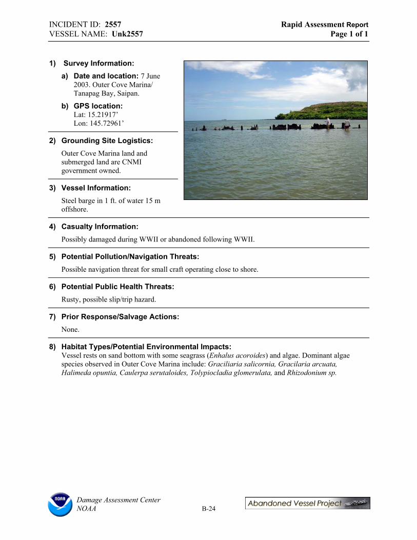
INCIDENT ID: 2557 Rapid Assessment Report VESSEL NAME: Unk2557 Page 1 of 1
1) Survey Information: a) Date and location: 7 June
2003. Outer Cove Marina/ Tanapag Bay, Saipan.
b) GPS location: Lat: 15.21917’ Lon: 145.72961’
2) Grounding Site Logistics: Outer Cove Marina land and submerged land are CNMI government owned.
3) Vessel Information: Steel barge in 1 ft. of water 15 m offshore.
4) Casualty Information: Possibly damaged during WWII or abandoned following WWII.
5) Potential Pollution/Navigation Threats: Possible navigation threat for small craft operating close to shore.
6) Potential Public Health Threats: Rusty, possible slip/trip hazard.
7) Prior Response/Salvage Actions: None.
8) Habitat Types/Potential Environmental Impacts: Vessel rests on sand bottom with some seagrass (Enhalus acoroides) and algae. Dominant algae species observed in Outer Cove Marina include: Graciliaria salicornia, Gracilaria arcuata, Halimeda opuntia, Caulerpa serutaloides, Tolypiocladia glomerulata, and Rhizodonium sp.
Damage Assessment Center NOAA B-24
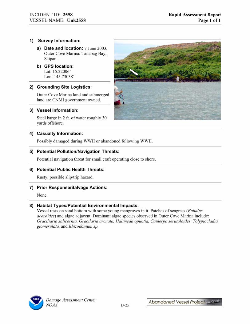
INCIDENT ID: 2558 Rapid Assessment Report VESSEL NAME: Unk2558 Page 1 of 1
1) Survey Information: a) Date and location: 7 June 2003.
Outer Cove Marina/ Tanapag Bay, Saipan.
b) GPS location: Lat: 15.22006’ Lon: 145.73038’
2) Grounding Site Logistics: Outer Cove Marina land and submerged land are CNMI government owned.
3) Vessel Information: Steel barge in 2 ft. of water roughly 30 yards offshore.
4) Casualty Information: Possibly damaged during WWII or abandoned following WWII.
5) Potential Pollution/Navigation Threats: Potential navigation threat for small craft operating close to shore.
6) Potential Public Health Threats: Rusty, possible slip/trip hazard.
7) Prior Response/Salvage Actions: None.
8) Habitat Types/Potential Environmental Impacts: Vessel rests on sand bottom with some young mangroves in it. Patches of seagrass (Enhalus acoroides) and algae adjacent. Dominant algae species observed in Outer Cove Marina include: Graciliaria salicornia, Gracilaria arcuata, Halimeda opuntia, Caulerpa serutaloides, Tolypiocladia glomerulata, and Rhizodonium sp.
Damage Assessment Center NOAA B-25
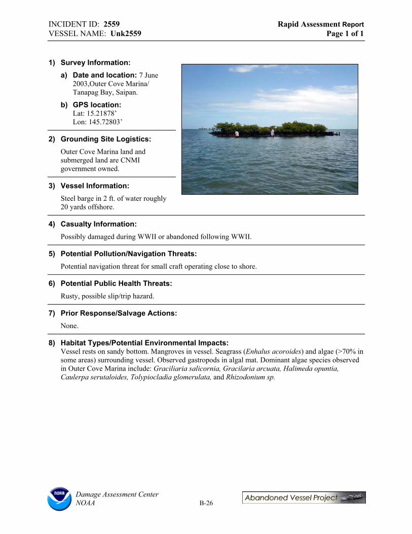
INCIDENT ID: 2559 Rapid Assessment Report VESSEL NAME: Unk2559 Page 1 of 1
1) Survey Information: a) Date and location: 7 June
2003,Outer Cove Marina/ Tanapag Bay, Saipan.
b) GPS location: Lat: 15.21878’ Lon: 145.72803’
2) Grounding Site Logistics: Outer Cove Marina land and submerged land are CNMI government owned.
3) Vessel Information: Steel barge in 2 ft. of water roughly 20 yards offshore.
4) Casualty Information: Possibly damaged during WWII or abandoned following WWII.
5) Potential Pollution/Navigation Threats: Potential navigation threat for small craft operating close to shore.
6) Potential Public Health Threats: Rusty, possible slip/trip hazard.
7) Prior Response/Salvage Actions: None.
8) Habitat Types/Potential Environmental Impacts: Vessel rests on sandy bottom. Mangroves in vessel. Seagrass (Enhalus acoroides) and algae (>70% in some areas) surrounding vessel. Observed gastropods in algal mat. Dominant algae species observed in Outer Cove Marina include: Graciliaria salicornia, Gracilaria arcuata, Halimeda opuntia, Caulerpa serutaloides, Tolypiocladia glomerulata, and Rhizodonium sp.
Damage Assessment Center NOAA B-26
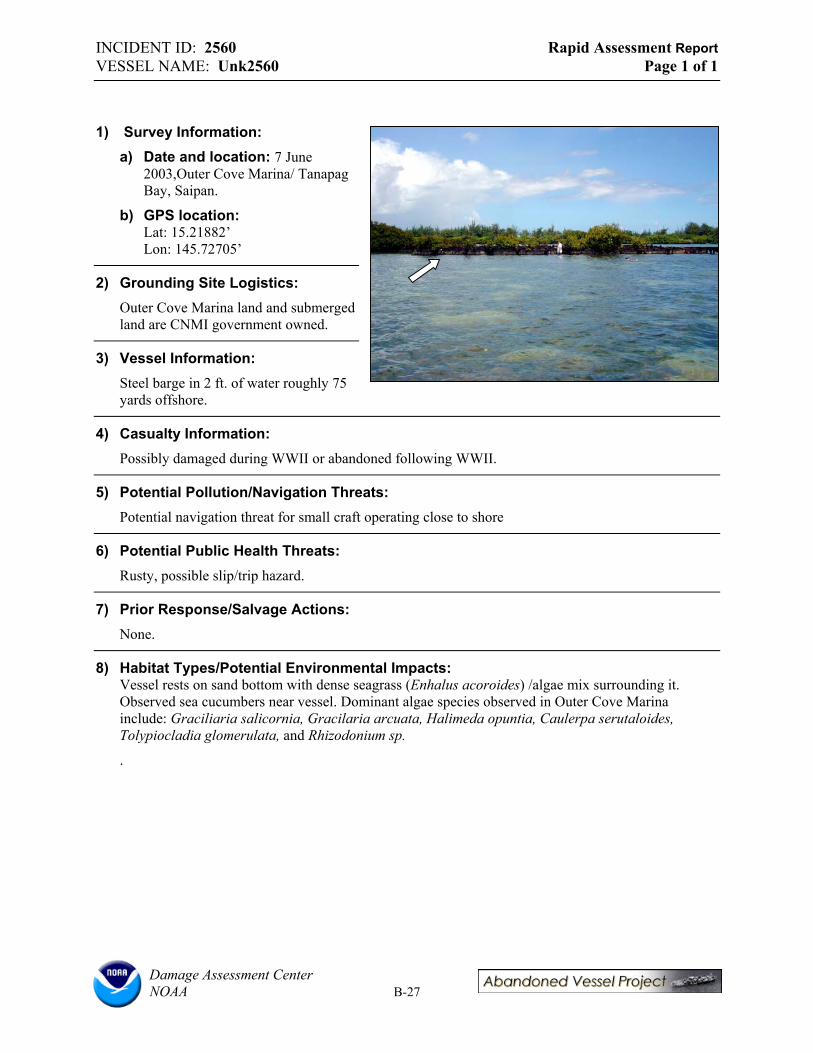
INCIDENT ID: 2560 Rapid Assessment Report VESSEL NAME: Unk2560 Page 1 of 1
1) Survey Information: a) Date and location: 7 June
2003,Outer Cove Marina/ Tanapag Bay, Saipan.
b) GPS location: Lat: 15.21882’ Lon: 145.72705’
2) Grounding Site Logistics: Outer Cove Marina land and submerged land are CNMI government owned.
3) Vessel Information: Steel barge in 2 ft. of water roughly 75 yards offshore.
4) Casualty Information: Possibly damaged during WWII or abandoned following WWII.
5) Potential Pollution/Navigation Threats: Potential navigation threat for small craft operating close to shore
6) Potential Public Health Threats: Rusty, possible slip/trip hazard.
7) Prior Response/Salvage Actions: None.
8) Habitat Types/Potential Environmental Impacts: Vessel rests on sand bottom with dense seagrass (Enhalus acoroides) /algae mix surrounding it. Observed sea cucumbers near vessel. Dominant algae species observed in Outer Cove Marina include: Graciliaria salicornia, Gracilaria arcuata, Halimeda opuntia, Caulerpa serutaloides, Tolypiocladia glomerulata, and Rhizodonium sp.
.
Damage Assessment Center NOAA B-27

INCIDENT ID: 2562 Rapid Assessment Report VESSEL NAME: Unk2562 Page 1 of 1
1) Survey Information: a) Date and location: 7 June
2003,Outer Cove Marina/ Tanapag Bay, Saipan.
b) GPS location: Lat: 15.21866’ Lon: 145.7269’
2) Grounding Site Logistics: Outer Cove Marina land and submerged land are CNMI government owned.
3) Vessel Information: Steel barge in 2 ft. of water in mangroves.
4) Casualty Information: Possibly damaged during WWII or abandoned following WWII.
5) Potential Pollution/Navigation Threats: None.
6) Potential Public Health Threats: Rusty, possible slip/trip hazard.
7) Prior Response/Salvage Actions: None.
8) Habitat Types/Potential Environmental Impacts: Vessel rests on sand bottom with patchy seagrass (Enhalus acoroides)/algae mix surrounding it, denser coverage in some areas. Dominant algae species observed in Outer Cove Marina include: Graciliaria salicornia, Gracilaria arcuata, Halimeda opuntia, Caulerpa serutaloides, Tolypiocladia glomerulata, and Rhizodonium sp.
Damage Assessment Center NOAA B-28
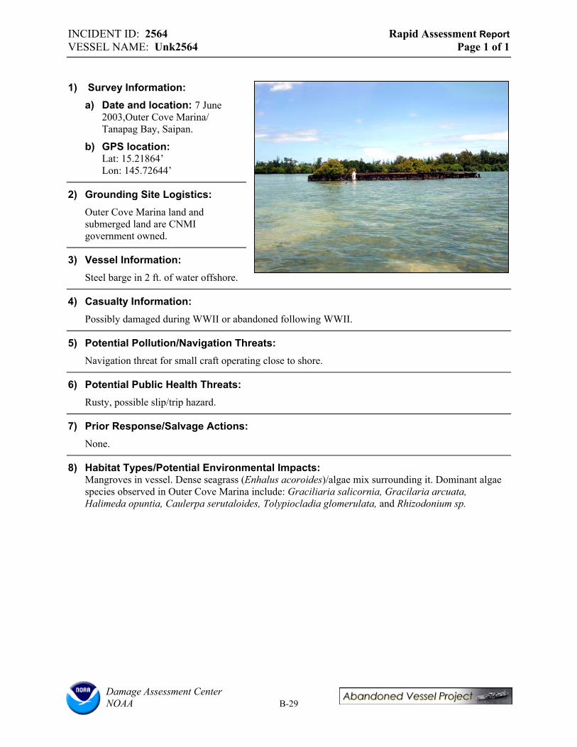
INCIDENT ID: 2564 Rapid Assessment Report VESSEL NAME: Unk2564 Page 1 of 1
1) Survey Information: a) Date and location: 7 June
2003,Outer Cove Marina/ Tanapag Bay, Saipan.
b) GPS location: Lat: 15.21864’ Lon: 145.72644’
2) Grounding Site Logistics: Outer Cove Marina land and submerged land are CNMI government owned.
3) Vessel Information: Steel barge in 2 ft. of water offshore.
4) Casualty Information: Possibly damaged during WWII or abandoned following WWII.
5) Potential Pollution/Navigation Threats: Navigation threat for small craft operating close to shore.
6) Potential Public Health Threats: Rusty, possible slip/trip hazard.
7) Prior Response/Salvage Actions: None.
8) Habitat Types/Potential Environmental Impacts: Mangroves in vessel. Dense seagrass (Enhalus acoroides)/algae mix surrounding it. Dominant algae species observed in Outer Cove Marina include: Graciliaria salicornia, Gracilaria arcuata, Halimeda opuntia, Caulerpa serutaloides, Tolypiocladia glomerulata, and Rhizodonium sp.
Damage Assessment Center NOAA B-29

INCIDENT ID: 2565 Rapid Assessment Report VESSEL NAME: Unk2565 Page 1 of 1
1) Survey Information: a) Date and location: 7 June
2003,Outer Cove Marina/ Tanapag Bay, Saipan.
b) GPS location: Lat: 15.21835’ Lon: 145.72604’
2) Grounding Site Logistics: Outer Cove Marina land and submerged land are CNMI government owned.
3) Vessel Information: Steel barge, partially ashore, partially in 2-3 ft. of water.
4) Casualty Information: Possibly damaged during WWII or abandoned following WWII.
5) Potential Pollution/Navigation Threats: None.
6) Potential Public Health Threats: Not very accessible, but rusty, possible slip/trip hazard.
7) Prior Response/Salvage Actions: None.
8) Habitat Types/Potential Environmental Impacts: Mangroves in vessel. Dense algae and some seagrass (Enhalus acoroides). Dominant algae species observed in Outer Cove Marina include: Graciliaria salicornia, Gracilaria arcuata, Halimeda opuntia, Caulerpa serutaloides, Tolypiocladia glomerulata, and Rhizodonium sp.
Damage Assessment Center NOAA B-30
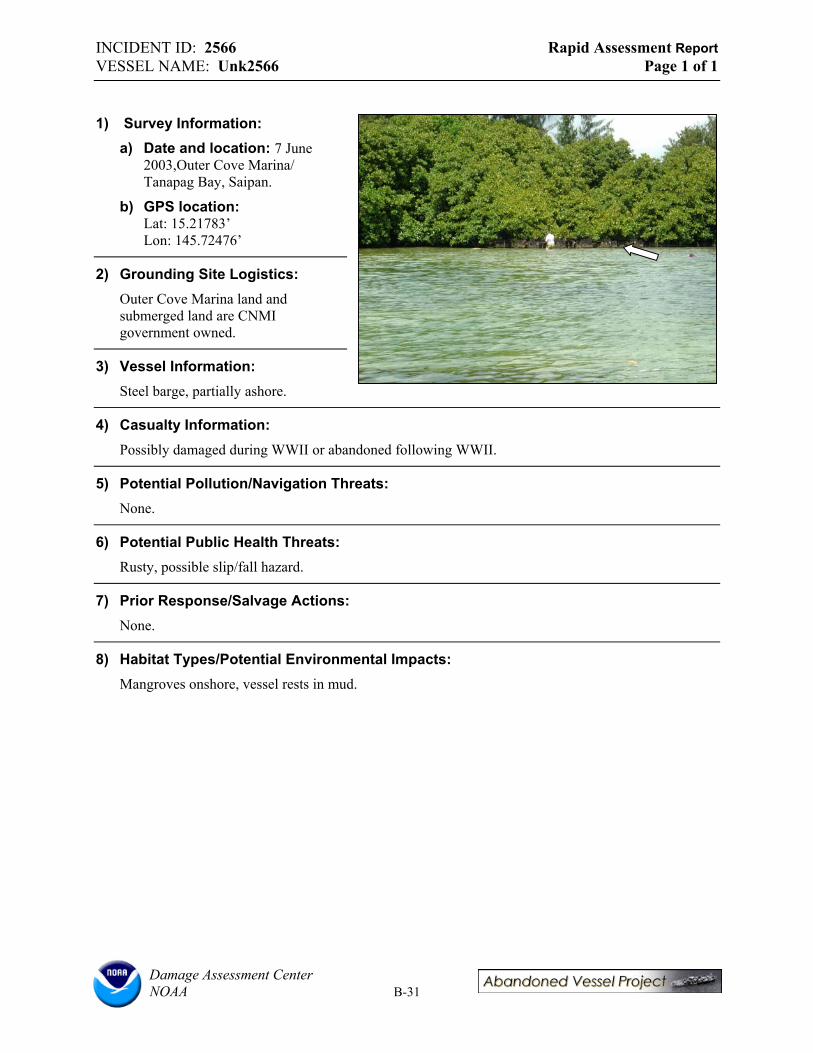
INCIDENT ID: 2566 Rapid Assessment Report VESSEL NAME: Unk2566 Page 1 of 1
1) Survey Information: a) Date and location: 7 June
2003,Outer Cove Marina/ Tanapag Bay, Saipan.
b) GPS location: Lat: 15.21783’ Lon: 145.72476’
2) Grounding Site Logistics: Outer Cove Marina land and submerged land are CNMI government owned.
3) Vessel Information: Steel barge, partially ashore.
4) Casualty Information: Possibly damaged during WWII or abandoned following WWII.
5) Potential Pollution/Navigation Threats: None.
6) Potential Public Health Threats: Rusty, possible slip/fall hazard.
7) Prior Response/Salvage Actions: None.
8) Habitat Types/Potential Environmental Impacts: Mangroves onshore, vessel rests in mud.
Damage Assessment Center NOAA B-31

INCIDENT ID: 2567 Rapid Assessment Report VESSEL NAME: Unk2567 Page 1 of 1
1) Survey Information: a) Date and location: 7 June
2003,Outer Cove Marina/ Tanapag Bay, Saipan.
b) GPS location: Lat: 15.21796’ Lon: 145.72498’
2) Grounding Site Logistics: Outer Cove Marina land and submerged land are CNMI government owned.
3) Vessel Information: Steel barge in 2-3 ft. of water close to shore.
4) Casualty Information: Possibly damaged during WWII or abandoned following WWII.
5) Potential Pollution/Navigation Threats: None.
6) Potential Public Health Threats:
Rusty, possible slip/fall hazard.
7) Prior Response/Salvage Actions: None.
8) Habitat Types/Potential Environmental Impacts: Vessel rests on sand bottom surrounded by patchy algae. Mangroves onshore and in vessel. Dominant algae species observed in Outer Cove Marina include: Graciliaria salicornia, Gracilaria arcuata, Halimeda opuntia, Caulerpa serutaloides, Tolypiocladia glomerulata, and Rhizodonium sp.
Damage Assessment Center NOAA B-32
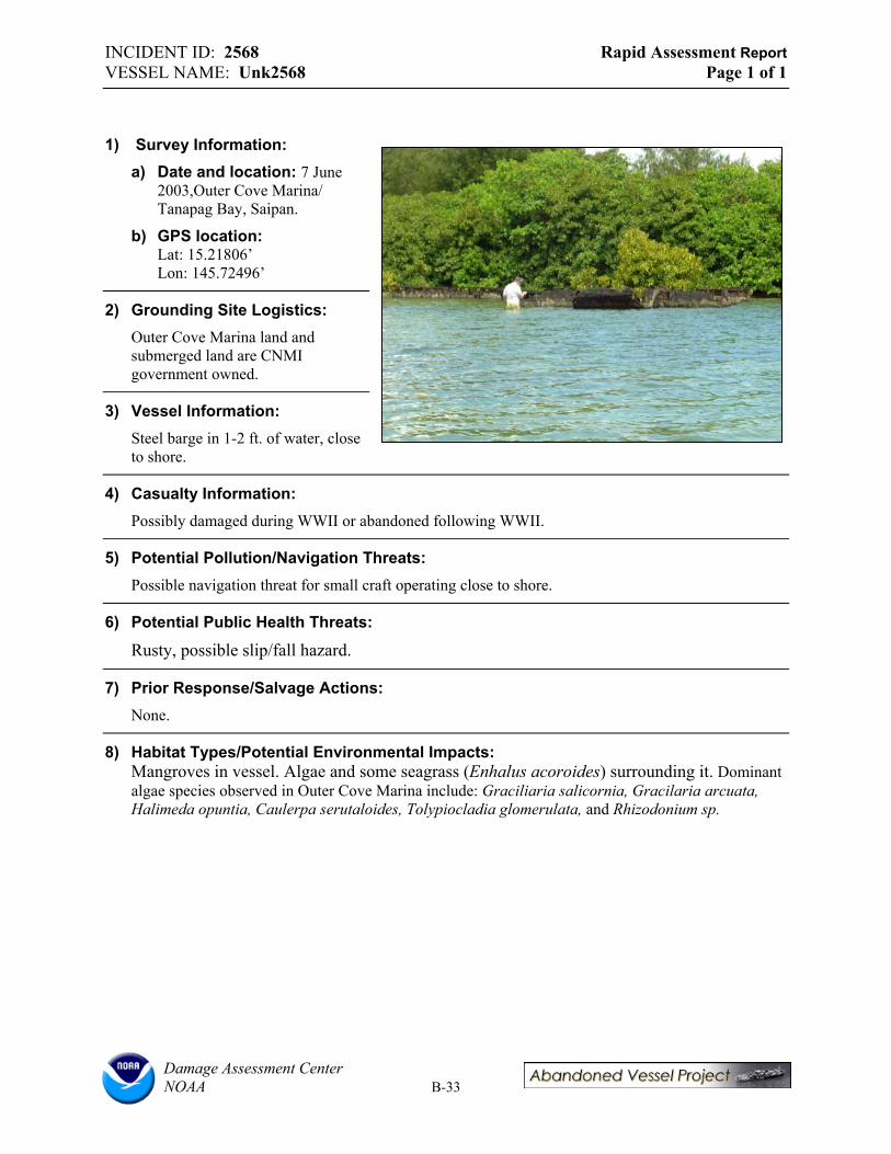
INCIDENT ID: 2568 Rapid Assessment Report VESSEL NAME: Unk2568 Page 1 of 1
1) Survey Information: a) Date and location: 7 June
2003,Outer Cove Marina/ Tanapag Bay, Saipan.
b) GPS location: Lat: 15.21806’ Lon: 145.72496’
2) Grounding Site Logistics: Outer Cove Marina land and submerged land are CNMI government owned.
3) Vessel Information: Steel barge in 1-2 ft. of water, close to shore.
4) Casualty Information: Possibly damaged during WWII or abandoned following WWII.
5) Potential Pollution/Navigation Threats: Possible navigation threat for small craft operating close to shore.
6) Potential Public Health Threats:
Rusty, possible slip/fall hazard.
7) Prior Response/Salvage Actions: None.
8) Habitat Types/Potential Environmental Impacts: Mangroves in vessel. Algae and some seagrass (Enhalus acoroides) surrounding it. Dominant algae species observed in Outer Cove Marina include: Graciliaria salicornia, Gracilaria arcuata, Halimeda opuntia, Caulerpa serutaloides, Tolypiocladia glomerulata, and Rhizodonium sp.
Damage Assessment Center NOAA B-33
INCIDENT ID: 2569 Rapid Assessment Report VESSEL NAME: Unk2569 Page 1 of 1
1) Survey Information: a) Date and location: 7 June 2003,Outer Cove Marina/ Tanapag Bay, Saipan. No Photo.
b) GPS location: Lat: 15.21806’ Lon: 145.72496’
2) Grounding Site Logistics: Outer Cove Marina land and submerged land are CNMI government owned.
3) Vessel Information: Steel barge in 1-2 ft. of water, close to shore.
4) Casualty Information: Possibly damaged during WWII or abandoned following WWII.
5) Potential Pollution/Navigation Threats: Possible navigation threat for small craft operating close to shore.
6) Potential Public Health Threats:
Rusty, possible slip/fall hazard.
7) Prior Response/Salvage Actions: None.
8) Habitat Types/Potential Environmental Impacts: Mangroves in vessel. Algae and some seagrass (Enhalus acoroides) surrounding it. Dominant algae species observed in Outer Cove Marina include: Graciliaria salicornia, Gracilaria arcuata, Halimeda opuntia, Caulerpa serutaloides, Tolypiocladia glomerulata, and Rhizodonium sp.
Damage Assessment Center NOAA B-34

INCIDENT ID: 2570 Rapid Assessment Report VESSEL NAME: Unk2570 Page 1 of 1
1) Survey Information a) Date and location: 7 June
2003,Outer Cove Marina/ Tanapag Bay, Saipan.
b) GPS location: Lat: 15.21919’ Lon: 145.72563’
2) Grounding Site Logistics: Outer Cove Marina land and submerged land are CNMI government owned.
3) Vessel Information: Steel barge in 3 ft. of water, 15 m offshore.
4) Casualty Information: Possibly damaged during WWII or abandoned following WWII.
5) Potential Pollution/Navigation Threats: Navigation threat.
6) Potential Public Health Threats:
Rusty, possible slip/fall hazard.
7) Prior Response/Salvage Actions: None.
8) Habitat Types/Potential Environmental Impacts: Vessels rests on sandy bottom. A few mangroves in vessel. Dense algae and some seagrass (Enhalus acoroides) surrounding it. Dominant algae species observed in Outer Cove Marina include: Graciliaria salicornia, Gracilaria arcuata, Halimeda opuntia, Caulerpa serutaloides, Tolypiocladia glomerulata, and Rhizodonium sp.
Damage Assessment Center NOAA B-35
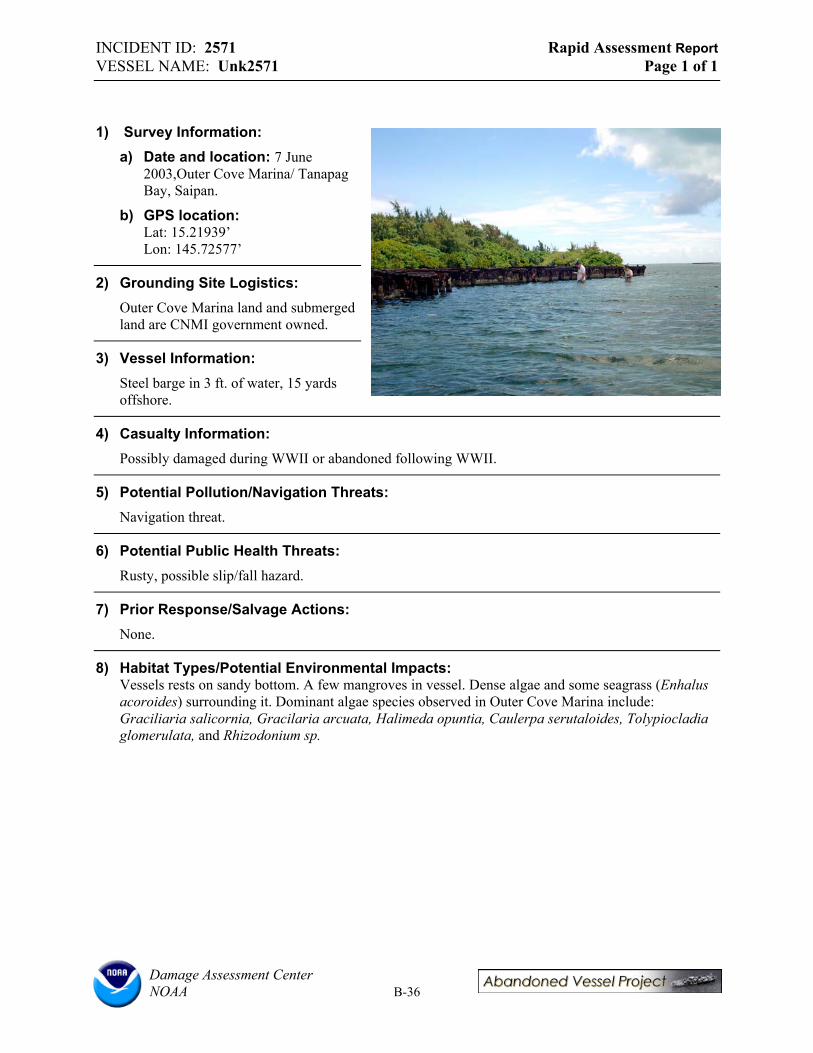
INCIDENT ID: 2571 Rapid Assessment Report VESSEL NAME: Unk2571 Page 1 of 1
1) Survey Information: a) Date and location: 7 June
2003,Outer Cove Marina/ Tanapag Bay, Saipan.
b) GPS location: Lat: 15.21939’ Lon: 145.72577’
2) Grounding Site Logistics: Outer Cove Marina land and submerged land are CNMI government owned.
3) Vessel Information: Steel barge in 3 ft. of water, 15 yards offshore.
4) Casualty Information: Possibly damaged during WWII or abandoned following WWII.
5) Potential Pollution/Navigation Threats: Navigation threat.
6) Potential Public Health Threats: Rusty, possible slip/fall hazard.
7) Prior Response/Salvage Actions: None.
8) Habitat Types/Potential Environmental Impacts: Vessels rests on sandy bottom. A few mangroves in vessel. Dense algae and some seagrass (Enhalus acoroides) surrounding it. Dominant algae species observed in Outer Cove Marina include: Graciliaria salicornia, Gracilaria arcuata, Halimeda opuntia, Caulerpa serutaloides, Tolypiocladia glomerulata, and Rhizodonium sp.
Damage Assessment Center NOAA B-36

INCIDENT ID: 2572 Rapid Assessment Report VESSEL NAME: Unk2572 Page 1 of 1
1) Survey Information: a) Date and location: 7 June
2003,Outer Cove Marina/ Tanapag Bay, Saipan.
b) GPS location: Lat: 15.21984’ Lon: 145.72588’
2) Grounding Site Logistics: Outer Cove Marina land and submerged land are CNMI government owned.
3) Vessel Information: Steel barge ashore.
4) Casualty Information: Possibly damaged during WWII or abandoned following WWII.
5) Potential Pollution/Navigation Threats: None.
6) Potential Public Health Threats: Rusty, possible slip/fall hazard.
7) Prior Response/Salvage Actions: None.
8) Habitat Types/Potential Environmental Impacts: Vessels rests in mangroves and shrubs onshore. Dense algae and some seagrass (Enhalus acoroides) surrounding it. Dominant algae species observed in Outer Cove Marina include: Graciliaria salicornia, Gracilaria arcuata, Halimeda opuntia, Caulerpa serutaloides, Tolypiocladia glomerulata, and Rhizodonium sp.
Damage Assessment Center NOAA B-37

INCIDENT ID: 2573 Rapid Assessment Report VESSEL NAME: Unk2573 Page 1 of 1
1) Survey Information: a) Date and location: 7 June 2003.
Outer Cove Marina/ Tanapag Bay, Saipan.
b) GPS location: Lat: 15.22051’ Lon: 145.72624’
2) Grounding Site Logistics: Outer Cove Marina land and submerged land are CNMI government owned.
3) Vessel Information: Steel barge near shore.
4) Casualty Information: Possibly damaged during WWII or abandoned following WWII.
5) Potential Pollution/Navigation Threats: None.
6) Potential Public Health Threats:
Rusty, possible slip/fall hazard.
7) Prior Response/Salvage Actions: None.
8) Habitat Types/Potential Environmental Impacts: Mangroves in vessel. Some algae and some seagrass (Enhalus acoroides) surrounding it. Dominant algae species observed in Outer Cove Marina include: Graciliaria salicornia, Gracilaria arcuata, Halimeda opuntia, Caulerpa serutaloides, Tolypiocladia glomerulata, and Rhizodonium sp.
Damage Assessment Center NOAA B-38
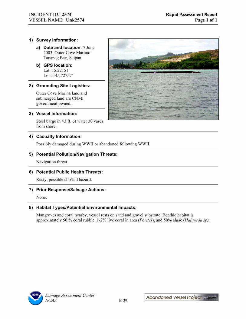
INCIDENT ID: 2574 Rapid Assessment Report VESSEL NAME: Unk2574 Page 1 of 1
1) Survey Information: a) Date and location: 7 June
2003. Outer Cove Marina/ Tanapag Bay, Saipan.
b) GPS location: Lat: 15.22151’ Lon: 145.72757’
2) Grounding Site Logistics: Outer Cove Marina land and submerged land are CNMI government owned.
3) Vessel Information: Steel barge in >3 ft. of water 30 yards from shore.
4) Casualty Information: Possibly damaged during WWII or abandoned following WWII.
5) Potential Pollution/Navigation Threats: Navigation threat.
6) Potential Public Health Threats: Rusty, possible slip/fall hazard.
7) Prior Response/Salvage Actions: None.
8) Habitat Types/Potential Environmental Impacts: Mangroves and coral nearby, vessel rests on sand and gravel substrate. Benthic habitat is approximately 50 % coral rubble, 1-2% live coral in area (Porites), and 50% algae (Halimeda sp).
Damage Assessment Center NOAA B-39

INCIDENT ID: 2575 Rapid Assessment Report VESSEL NAME: Unk2575 Page 1 of 1
1) Survey Information: a) Date and location: 7 June
2003. Outer Cove Marina/ Tanapag Bay, Saipan.
b) GPS location: Lat: None Lon: None
2) Grounding Site Logistics: Outer Cove Marina land and submerged land are CNMI government owned.
3) Vessel Information: Steel barge near Samala.
4) Casualty Information: Possibly damaged during WWII or abandoned following WWII.
5) Potential Pollution/Navigation Threats: Navigation threat for small craft operating close to shore.
6) Potential Public Health Threats: Rusty, possible slip/fall hazard.
7) Prior Response/Salvage Actions: None.
8) Habitat Types/Potential Environmental Impacts: Didn’t survey.
Damage Assessment Center NOAA B-40
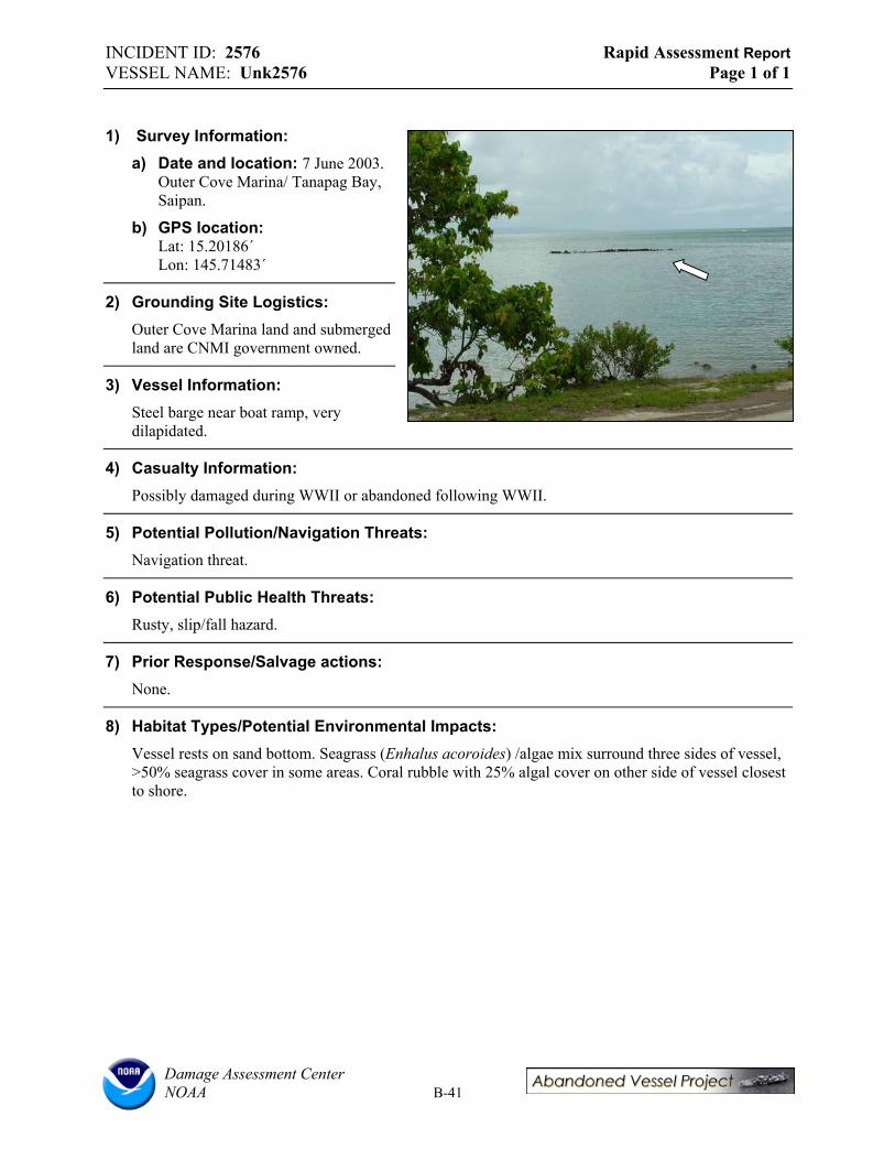
INCIDENT ID: 2576 Rapid Assessment Report VESSEL NAME: Unk2576 Page 1 of 1
1) Survey Information: a) Date and location: 7 June 2003.
Outer Cove Marina/ Tanapag Bay, Saipan.
b) GPS location: Lat: 15.20186΄Lon: 145.71483΄
2) Grounding Site Logistics: Outer Cove Marina land and submerged land are CNMI government owned.
3) Vessel Information: Steel barge near boat ramp, very dilapidated.
4) Casualty Information: Possibly damaged during WWII or abandoned following WWII.
5) Potential Pollution/Navigation Threats: Navigation threat.
6) Potential Public Health Threats: Rusty, slip/fall hazard.
7) Prior Response/Salvage actions: None.
8) Habitat Types/Potential Environmental Impacts: Vessel rests on sand bottom. Seagrass (Enhalus acoroides) /algae mix surround three sides of vessel, >50% seagrass cover in some areas. Coral rubble with 25% algal cover on other side of vessel closest to shore.
Damage Assessment Center NOAA B-41

INCIDENT ID: 2577 Rapid Assessment Report VESSEL NAME: Lian Gi Page 1 of 3
1) Survey Information: a) Date and location: 9 June 2003.
Tinian Harbor, Tinian.
b) Weather and tide conditions at time of survey: Sunny, 80’s, high tide.
c) Team members: Lord and Plank (RPI), Helton and Zelo (NOAA) Cabrera (CRM).
d) GPS location: Lat: 14.9650˚Lon: 146.61786˚
e) Inspection narrative: Boarded the vessel, full survey excluding underwater video.
2) Grounding Site Logistics: a) Adjacent land ownership / land-use: Adjacent and submerged lands are CNMI owned.
b) Points of access: Boat is currently accessible by dock at a public marina.
c) Sea conditions and exposure to wave energy at site: Low energy protected waters, sheltered except during storms.
d) Depth and nearby bathymetry: 30-35 ft.
3) Vessel Information: a) Vessel name: LIAN GI.
b) Vessel type: Freighter.
c) Construction materials: Steel.
d) Principle dimensions: 44.5 ft. x 129 ft.
e) Registration numbers: Unknown.
f) Commercial vs. pleasure craft: Commercial freighter.
g) Nationality/flag state/homeport: China.
h) Builder, model, and year of construction: Unknown.
i) Vessel tonnage: Unknown.
j) Is the vessel “historic”? No.
4) Casualty Information: a) General status of vessel: Afloat but derelict.
b) Nature of casualty: Intercepted by Coast Guard smuggling at least 100 Chinese refugees. Vessel was also taking on water at that time. Vessel then became derelict and has since been affected by several storms.
Damage Assessment Center NOAA B-42
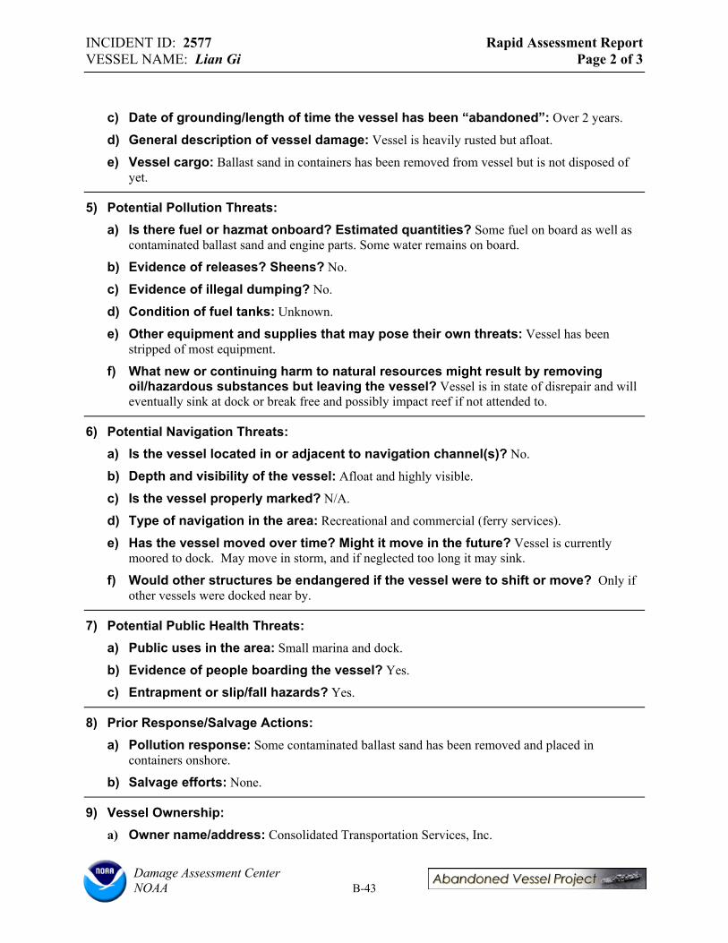
INCIDENT ID: 2577 Rapid Assessment Report VESSEL NAME: Lian Gi Page 2 of 3
c) Date of grounding/length of time the vessel has been “abandoned”: Over 2 years.
d) General description of vessel damage: Vessel is heavily rusted but afloat.
e) Vessel cargo: Ballast sand in containers has been removed from vessel but is not disposed of yet.
5) Potential Pollution Threats: a) Is there fuel or hazmat onboard? Estimated quantities? Some fuel on board as well as
contaminated ballast sand and engine parts. Some water remains on board.
b) Evidence of releases? Sheens? No.
c) Evidence of illegal dumping? No.
d) Condition of fuel tanks: Unknown.
e) Other equipment and supplies that may pose their own threats: Vessel has been stripped of most equipment.
f) What new or continuing harm to natural resources might result by removing oil/hazardous substances but leaving the vessel? Vessel is in state of disrepair and will eventually sink at dock or break free and possibly impact reef if not attended to.
6) Potential Navigation Threats: a) Is the vessel located in or adjacent to navigation channel(s)? No.
b) Depth and visibility of the vessel: Afloat and highly visible.
c) Is the vessel properly marked? N/A.
d) Type of navigation in the area: Recreational and commercial (ferry services).
e) Has the vessel moved over time? Might it move in the future? Vessel is currently moored to dock. May move in storm, and if neglected too long it may sink.
f) Would other structures be endangered if the vessel were to shift or move? Only if other vessels were docked near by.
7) Potential Public Health Threats: a) Public uses in the area: Small marina and dock.
b) Evidence of people boarding the vessel? Yes.
c) Entrapment or slip/fall hazards? Yes.
8) Prior Response/Salvage Actions: a) Pollution response: Some contaminated ballast sand has been removed and placed in
containers onshore.
b) Salvage efforts: None.
9) Vessel Ownership: a) Owner name/address: Consolidated Transportation Services, Inc.
Damage Assessment Center NOAA B-43

INCIDENT ID: 2577 Rapid Assessment Report VESSEL NAME: Lian Gi Page 3 of 3
b) Insurance agent and type of coverages: Unknown.
c) What communications have occurred between owner/operator/insurer and state or federal government? Some enforcement actions taken, salvage company hired for removal but process never got underway.
d) Contact names: Martin Cabrera (CNMI CRM).
10) Endangered Species and Critical Habitats: a) Is the site designated critical habitat for ESA-listed species? No.
b) Is the vessel destroying critical habitat or could it if the vessel moved? No.
c) Is there any evidence of entanglement or entrapment of fish/wildlife? No.
11) Potential Environmental Impacts: a) Dimensions of vessel grounding footprint: N/A.
b) Dimensions of debris field: N/A.
c) Primary habitat(s): Sandy bottom, highly engineered area surrounded by seawall.
d) Secondary habitat(s): e) Substrate: Sand.
f) Damage Observations: No observable damage at this time.
12) Vessel Update: This Vessel was towed offshore and scuttled in the Fall of 2003. A description of the operation and further details will be included on the Abandoned Vessel Program Website as a removal case study. This will be prepared in early 2004.
Damage Assessment Center NOAA B-44
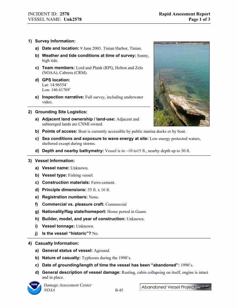
INCIDENT ID: 2578 Rapid Assessment Report VESSEL NAME: Unk2578 Page 1 of 3
1) Survey Information: a) Date and location: 9 June 2003. Tinian Harbor, Tinian.
b) Weather and tide conditions at time of survey: Sunny, high tide.
c) Team members: Lord and Plank (RPI), Helton and Zelo (NOAA), Cabrera (CRM).
d) GPS location: Lat: 14.96554˚Lon: 146.61769˚
e) Inspection narrative: Full survey, including underwater video.
2) Grounding Site Logistics: a) Adjacent land ownership / land-use: Adjacent and
submerged lands are CNMI owned.
b) Points of access: Boat is currently accessible by public marina docks or by boat.
c) Sea conditions and exposure to wave energy at site: Low energy protected waters, sheltered except during storms.
d) Depth and nearby bathymetry: Vessel is in ~10 to15 ft., nearby depth up to 30 ft.
3) Vessel Information: a) Vessel name: Unknown.
b) Vessel type: Fishing vessel.
c) Construction materials: Ferro-cement.
d) Principle dimensions: 55 ft. x 16 ft.
e) Registration numbers: None.
f) Commercial vs. pleasure craft: Commercial
g) Nationality/flag state/homeport: Home ported in Guam.
h) Builder, model, and year of construction: Unknown.
i) Vessel tonnage: Unknown.
j) Is the vessel “historic”? No.
4) Casualty Information: a) General status of vessel: Aground.
b) Nature of casualty: Typhoons during the 1990’s.
c) Date of grounding/length of time the vessel has been “abandoned”: 1990’s.
d) General description of vessel damage: Rusting, cabin collapsing on itself, engine is intact and in place.
Damage Assessment Center NOAA B-45

INCIDENT ID: 2578 Rapid Assessment Report VESSEL NAME: Unk2578 Page 2 of 3
e) Vessel cargo: All cargo is gone.
5) Potential Pollution Threats: a) Is there fuel or hazmat onboard? Estimated quantities? No.
b) Evidence of releases? Sheens? No.
c) Evidence of illegal dumping? No.
d) Condition of fuel tanks: Unknown.
e) Other equipment and supplies that may pose their own threats: Vessel has been stripped of most equipment.
f) What new or continuing harm to natural resources might result by removing oil/hazardous substances but leaving the vessel? N/A
6) Potential Navigation Threats: a) Is the vessel located in or adjacent to navigation channel(s)? Near boat ramp and
adjacent docks.
b) Depth and visibility of the vessel: Vessel is near water’s surface and only moderately visible.
c) Is the vessel properly marked? No.
d) Type of navigation in the area: Recreational and commercial (ferry services).
e) Has the vessel moved over time? Might it move in the future? Vessel is still moored to dock. Not likely to move in storm due to weight.
f) Would other structures be endangered if the vessel were to shift or move? Only if other vessels were docked near by.
7) Potential Public Health Threats: a) Public uses in the area: Small marina and dock.
b) Evidence of people boarding the vessel? No.
c) Entrapment or slip/fall hazards? Yes.
8) Prior Response/Salvage Actions: a) Pollution response: Unknown.
b) Salvage efforts: Salvage plan to lift vessel was abandoned due to weight.
9) Vessel Ownership: a) Owner name/address: Martin San Nicolas, Guam.
b) Insurance agent and type of coverages: Unknown.
c) What communications have occurred between owner/operator/insurer and state or federal government? Owners were told to salvage on their own.
d) Contact names: Edwin Hofscheneider (CRM Tinian).
Damage Assessment Center NOAA B-46

INCIDENT ID: 2578 Rapid Assessment Report VESSEL NAME: Unk2578 Page 3 of 3
10) Endangered Species and Critical Habitats: a) Is the site designated critical habitat for ESA-listed species? No.
b) Is the vessel destroying critical habitat or could it if the vessel moved? No.
c) Is there any evidence of entanglement or entrapment of fish/wildlife? No.
11) Potential Environmental Impacts: a) Dimensions of vessel grounding footprint: N/A
b) Dimensions of debris field: Minor amounts of debris.
c) Primary habitat(s): Sandy bottom, highly engineered area surrounded by seawall.
d) Secondary habitat(s): Some coral present (small Acropora) and low algal cover.
e) Substrate: Sand.
f) Damage observations: Minor amounts of debris, Unk2578 actually sits partially atop Incident Unk2579.
Damage Assessment Center NOAA B-47

INCIDENT ID: 2579 Rapid Assessment Report VESSEL NAME: Unk2579 Page 1 of 3
1) Survey Information a) Date and location: 9 June 2003.
Tinian Harbor, Tinian.
b) Weather and tide conditions at time of survey: Sunny, high tide.
c) Team members: Lord and Plank (RPI), Helton and Zelo (NOAA), Cabrera (CRM).
d) GPS location: Lat: 14.96573˚Lon: 146.61774˚
e) Inspection narrative: Full survey, including underwater video.
2) Grounding Site Logistics a) Adjacent land ownership / land-use: Adjacent and submerged lands are CNMI owned.
b) Points of access: Boat is currently accessible by marina docks or by boat.
c) Sea conditions and exposure to wave energy at site: Low energy protected waters, sheltered except during storms.
d) Depth and nearby bathymetry: Vessel is in ~10 to15 ft., nearby depth up to 30 ft.
3) Vessel Information a) Vessel name: Unknown.
b) Vessel type: Yacht/reportedly used for small cargo.
c) Construction materials: Steel.
d) Principle dimensions: 38 ft. x 13.5ft.
e) Registration numbers: None.
f) Commercial vs. pleasure craft: Commercial
g) Nationality/flag state/homeport: Home ported in Tinian.
h) Builder, model, and year of construction: Unknown.
i) Vessel tonnage: Unknown.
j) Is the vessel “historic”? No.
4) Casualty Information a) General status of vessel: Aground / Submerged – just under the surface.
b) Nature of casualty: Storms during the early 80’s.
c) Date of grounding/length of time the vessel has been “abandoned”: Early 1980’s.
Damage Assessment Center NOAA B-48

INCIDENT ID: 2579 Rapid Assessment Report VESSEL NAME: Unk2579 Page 2 of 3
d) General description of vessel damage: Rusting, cabin broken,
e) Vessel cargo: All cargo is gone.
5) Potential Pollution Threats a) Is there fuel or hazmat onboard? Estimated quantities? No.
b) Evidence of releases? Sheens? No.
c) Evidence of illegal dumping? No.
d) Condition of fuel tanks: Unknown.
e) Other equipment and supplies that may pose their own threats: Vessel has been stripped of most equipment.
f) What new or continuing harm to natural resources might result by removing oil/hazardous substances but leaving the vessel? N/A
6) Potential Navigation Threats a) Is the vessel located in or adjacent to navigation channel(s)? Near boat ramp and
adjacent docks.
b) Depth and visibility of the vessel: Vessel is near water’s surface and only moderately visible.
c) Is the vessel properly marked? No.
d) Type of navigation in the area: Recreational and commercial (ferry services).
e) Has the vessel moved over time? Might it move in the future? Vessel is still moored to dock. Not likely to move in storm due to weight.
f) Would other structures be endangered if the vessel were to shift or move? Only if other vessels were docked near by.
7) Potential Public Health Threats a) Public uses in the area: Small marina and dock.
b) Evidence of people boarding the vessel? No.
c) Entrapment or slip/fall hazards? Yes.
8) Prior Response/Salvage Actions a) Pollution response: Unknown.
b) Salvage efforts: Unknown.
9) Vessel Ownership a) Owner name/address: Municipality of Tinian.
b) Insurance agent and type of coverages: Unknown.
c) What communications have occurred between owner/operator/insurer and state or federal government? Unknown.
Damage Assessment Center NOAA B-49

INCIDENT ID: 2579 Rapid Assessment Report VESSEL NAME: Unk2579 Page 3 of 3
d) Contact names: Edwin Hofschneider (CRM Tinian).
10) Endangered Species and Critical Habitats a) Is the site designated critical habitat for ESA-listed species? No.
b) Is the vessel destroying critical habitat or could it if the vessel moved? No.
c) Is there any evidence of entanglement or entrapment of fish/wildlife? No.
11) Potential Environmental Impacts a) Dimensions of vessel grounding footprint: Approximately that of the vessel.
b) Dimensions of debris field: Minor amounts of debris.
c) Primary habitat(s): Sandy bottom, highly engineered area surrounded by seawall.
d) Secondary habitat(s): Some coral present (small Acropora) and low algal cover.
e) Substrate: Sand.
f) Damage Observations: Minor amounts of debris, Unk2578 actually sits partially atop Unk2579.
Damage Assessment Center NOAA B-50

INCIDENT ID: 1828 Rapid Assessment Report VESSEL NAME: Sun Long No.8 Page 1 of 3
1) Survey Information: a) Date and location: 9 June
2003. Tinian Harbor, Tinian.
b) Weather and tide conditions at time of survey: Sunny, hightide.
c) Team members: Lord and Plank (RPI), Helton and Zelo (NOAA), Cabrera (CRM).
d) GPS location: Lat: 14.96191˚Lon: 145.62639˚
e) Inspection narrative: Full survey, including underwater video. GPS location above is for bow of vessel. Positions also recorded for stern and transom.
2) Grounding Site Logistics: a) Adjacent land ownership / land-use: Adjacent and submerged lands are CNMI owned.
Small marina near by, area used recreationally. Vessel aground on shallow reef.
b) Points of access: Nearby roads and by boat.
c) Sea conditions and exposure to wave energy at site: Moderate wave energy, occasionally high energy
d) Depth and nearby bathymetry: Vessel is in ~0 to 25 ft of water, nearby it becomes much deeper.
3) Vessel Information: a) Vessel name: SUN LONG NO.8.
b) Vessel type: Freighter.
c) Construction materials: Steel.
d) Principle dimensions: 325 ft. bow to stern.
e) Registration numbers: None.
f) Commercial vs. pleasure craft: Commercial
g) Nationality/flag state/homeport: Korea.
h) Builder, model, and year of construction: Unknown.
i) Vessel tonnage: Over 100 gross tons.
j) Is the vessel “historic”? No.
4) Casualty Information: a) General status of vessel: Aground.
b) Nature of casualty: Supertyphoon Kim, December 1986.
Damage Assessment Center NOAA B-51
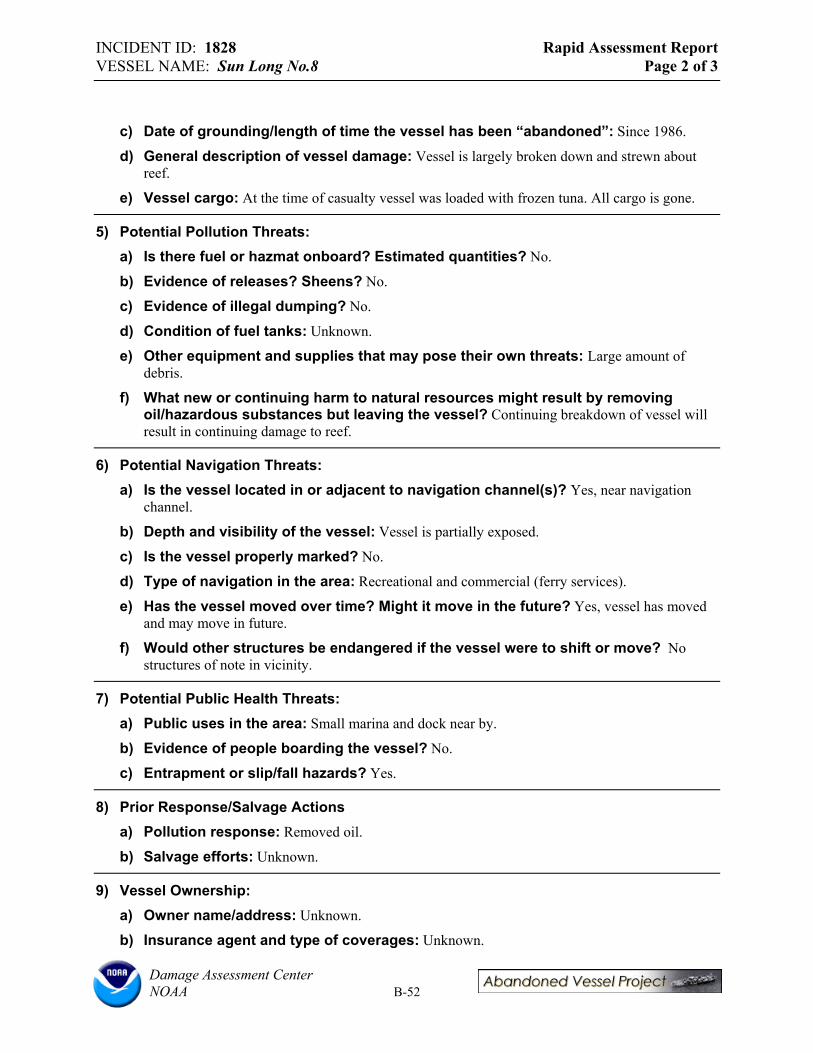
INCIDENT ID: 1828 Rapid Assessment Report VESSEL NAME: Sun Long No.8 Page 2 of 3
c) Date of grounding/length of time the vessel has been “abandoned”: Since 1986.
d) General description of vessel damage: Vessel is largely broken down and strewn about reef.
e) Vessel cargo: At the time of casualty vessel was loaded with frozen tuna. All cargo is gone.
5) Potential Pollution Threats: a) Is there fuel or hazmat onboard? Estimated quantities? No.
b) Evidence of releases? Sheens? No.
c) Evidence of illegal dumping? No.
d) Condition of fuel tanks: Unknown.
e) Other equipment and supplies that may pose their own threats: Large amount of debris.
f) What new or continuing harm to natural resources might result by removing oil/hazardous substances but leaving the vessel? Continuing breakdown of vessel will result in continuing damage to reef.
6) Potential Navigation Threats: a) Is the vessel located in or adjacent to navigation channel(s)? Yes, near navigation
channel.
b) Depth and visibility of the vessel: Vessel is partially exposed.
c) Is the vessel properly marked? No.
d) Type of navigation in the area: Recreational and commercial (ferry services).
e) Has the vessel moved over time? Might it move in the future? Yes, vessel has moved and may move in future.
f) Would other structures be endangered if the vessel were to shift or move? No structures of note in vicinity.
7) Potential Public Health Threats: a) Public uses in the area: Small marina and dock near by.
b) Evidence of people boarding the vessel? No.
c) Entrapment or slip/fall hazards? Yes.
8) Prior Response/Salvage Actions a) Pollution response: Removed oil.
b) Salvage efforts: Unknown.
9) Vessel Ownership: a) Owner name/address: Unknown.
b) Insurance agent and type of coverages: Unknown.
Damage Assessment Center NOAA B-52

INCIDENT ID: 1828 Rapid Assessment Report VESSEL NAME: Sun Long No.8 Page 3 of 3
c) What communications have occurred between owner/operator/insurer and state or federal government? Unknown.
d) Contact names: Edwin Hofschneider (CRM Tinian).
10) Endangered Species and Critical Habitats: a) Is the site designated critical habitat for ESA-listed species? No.
b) Is the vessel destroying critical habitat or could it if the vessel moved? No.
c) Is there any evidence of entanglement or entrapment of fish/wildlife? No.
11) Potential Environmental Impacts: a) Dimensions of vessel grounding footprint: b) Dimensions of debris field: Extensive debris field mapped with GPS, roughly 502 ft. wide.
c) Primary habitat(s): Coral reef. There is some rubble surrounding the vessel with live coral ranging from <10% to ~ 10-30% cover. Reef is very close to bow with areas of ~20% live cover. Reef lies ~ 15 yards off of port and starboard sides, and is similar to reef off of bow. Reef ~5 yards off of stern has very low live cover. Dominant genuses include Porites, Acropora, and possibly others. Encrusting and fleshy algae was also observed on the reefs.
d) Secondary habitat(s): Sand and gravel.
e) Substrate: Sand and gravel.
f) Damage Observations: Extensive amounts of debris spread through out coral reef. Areas where debris occurs appear to have lower % live coral cover than adjacent areas.
Damage Assessment Center NOAA B-53

INCIDENT ID: 1832 Rapid Assessment Report VESSEL NAME: #62 Nam Sung Page 1 of 3
1) Survey Information: a) Date and location: 10 and 11 June 2003.
Sasanlago-Tatqua beach, Rota.
b) Weather and tide conditions at time of survey: Sunny, breezy, high tide (10 June), low tide (11 June).
c) Team members: Lord and Plank (RPI), Helton and Zelo (NOAA), Manglona (CRM).
d) GPS location: Lat: 14.17690˚Lon: 145.20129˚
e) Inspection narrative: GPS location above is for bow of vessel. Position also recorded for stern (Lat: 14.17715˚, Lon: 145.20129).
2) Grounding site logistics: a) Adjacent land ownership / land-use: Privately owned land, public beach below high tide
line. Area used recreationally for swimming and fishing.
b) Points of access: Road.
c) Sea conditions and exposure to wave energy at site: Exposed, waves breaking on reef and vessel.
d) Depth and nearby bathymetry: Vessel is exposed atop reef in 1 ft. of water. Seaward the depth increases to 10-15 ft.
3) Vessel Information: a) Vessel name: #62 NAM SUNG.
b) Vessel type: Fishing vessel.
c) Construction materials: Steel.
d) Principle dimensions: 26.5 ft. x 63 ft. (measured). Official dimensions at time of launch: Length: 42.5 m, Breadth: 7.80 m, Depth: 3.65 m.
e) Registration numbers: Official number: BS-A-1615, Signal letters: 6 M.Y.C.
f) Commercial vs. pleasure craft: Commercial
g) If a fishing vessel, the type of fishery and gear aboard: None.
h) Nationality/flag state/homeport: Busan, Korea.
i) Builder, model, and year of construction: Sanbo Shipbuilding Co. Ltd., Japan.
j) Vessel tonnage: 287.06 gross tons.
k) Is the vessel “historic”? No.
Damage Assessment Center NOAA B-54
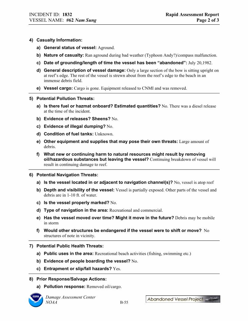
INCIDENT ID: 1832 Rapid Assessment Report VESSEL NAME: #62 Nam Sung Page 2 of 3
4) Casualty Information: a) General status of vessel: Aground.
b) Nature of casualty: Ran aground during bad weather (Typhoon Andy?)/compass malfunction.
c) Date of grounding/length of time the vessel has been “abandoned”: July 20,1982.
d) General description of vessel damage: Only a large section of the bow is sitting upright on at reef’s edge. The rest of the vessel is strewn about from the reef’s edge to the beach in an immense debris field.
e) Vessel cargo: Cargo is gone. Equipment released to CNMI and was removed.
5) Potential Pollution Threats: a) Is there fuel or hazmat onboard? Estimated quantities? No. There was a diesel release
at the time of the incident.
b) Evidence of releases? Sheens? No.
c) Evidence of illegal dumping? No.
d) Condition of fuel tanks: Unknown.
e) Other equipment and supplies that may pose their own threats: Large amount of debris.
f) What new or continuing harm to natural resources might result by removing oil/hazardous substances but leaving the vessel? Continuing breakdown of vessel will result in continuing damage to reef.
6) Potential Navigation Threats: a) Is the vessel located in or adjacent to navigation channel(s)? No, vessel is atop reef
b) Depth and visibility of the vessel: Vessel is partially exposed. Other parts of the vessel and debris are in 1-10 ft. of water.
c) Is the vessel properly marked? No.
d) Type of navigation in the area: Recreational and commercial.
e) Has the vessel moved over time? Might it move in the future? Debris may be mobile in storm
f) Would other structures be endangered if the vessel were to shift or move? No structures of note in vicinity.
7) Potential Public Health Threats: a) Public uses in the area: Recreational beach activities (fishing, swimming etc.)
b) Evidence of people boarding the vessel? No.
c) Entrapment or slip/fall hazards? Yes.
8) Prior Response/Salvage Actions: a) Pollution response: Removed oil/cargo.
Damage Assessment Center NOAA B-55

INCIDENT ID: 1832 Rapid Assessment Report VESSEL NAME: #62 Nam Sung Page 3 of 3
b) Salvage efforts: Unknown. Heavy surf, dangerous/difficult conditions.
9) Vessel Ownership: a) Owner name/address: Nam Sung Fisheries Co., Ltd. #391-1 Gamchun-dong, Su-gu, Busan,
Korea.
b) Insurance agent and type of coverages: Unknown.
c) What communications have occurred between owner/operator/insurer and state or federal government? Unknown.
d) Contact names: Nam Sung Fisheries Co., Ltd
10) Endangered Species and Critical Habitats: a) Is the site designated critical habitat for ESA-listed species? No.
b) Is the vessel destroying critical habitat or could it if the vessel moved? No.
c) Is there any evidence of entanglement or entrapment of fish/wildlife? No.
11) Potential Environmental Impacts: a) Dimensions of vessel grounding footprint: Extensive debris field mapped with GPS, 550
ft. wide.
b) Dimensions of debris field: Extensive debris field mapped with GPS, 550 ft. wide.
c) Primary habitat(s): Vessel and majority of debris rests on shallow exposed reef flat with 0% live coral and some attached algae in surf zone. Seaward of reef flat ~20 yards from main vessel is extensive spur and groove reef with 50-70% live coral or greater in some areas. Some debris lies among spur and groove reef. This area had the highest coral species diversity of all areas surveyed during Pacific trip. Dominant genuses include: Porites, Acropora, Pocillopora with multiple species/forms observed for each genus. Additional genuses likely occur in the area. Reef fish and giant clams observed.
d) Secondary habitat(s): None.
e) Substrate: Sand and gravel.
f) Damage Observations: Extensive amounts of debris spread through out coral reef. Further break-up of the vessel may cause additional damage.
Damage Assessment Center NOAA B-56
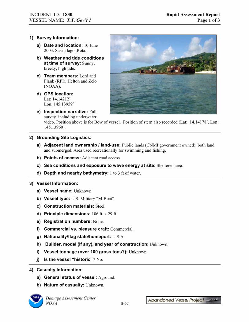
INCIDENT ID: 1830 Rapid Assessment Report VESSEL NAME: T.T. Gov’t 1 Page 1 of 3
1) Survey Information: a) Date and location: 10 June
2003. Sasan lago, Rota.
b) Weather and tide conditions at time of survey: Sunny, breezy, high tide.
c) Team members: Lord and Plank (RPI), Helton and Zelo (NOAA).
d) GPS location: Lat: 14.14212˚Lon: 145.13959˚
e) Inspection narrative: Full survey, including underwater video. Position above is for Bow of vessel. Position of stern also recorded (Lat: 14.14178˚, Lon: 145.13960).
2) Grounding Site Logistics: a) Adjacent land ownership / land-use: Public lands (CNMI government owned), both land
and submerged. Area used recreationally for swimming and fishing.
b) Points of access: Adjacent road access.
c) Sea conditions and exposure to wave energy at site: Sheltered area.
d) Depth and nearby bathymetry: 1 to 3 ft of water.
3) Vessel Information: a) Vessel name: Unknown
b) Vessel type: U.S. Military “M-Boat”.
c) Construction materials: Steel.
d) Principle dimensions: 106 ft. x 29 ft.
e) Registration numbers: None.
f) Commercial vs. pleasure craft: Commercial.
g) Nationality/flag state/homeport: U.S.A.
h) Builder, model (if any), and year of construction: Unknown.
i) Vessel tonnage (over 100 gross tons?): Unknown.
j) Is the vessel “historic”? No.
4) Casualty Information: a) General status of vessel: Aground.
b) Nature of casualty: Unknown.
Damage Assessment Center NOAA B-57

INCIDENT ID: 1830 Rapid Assessment Report VESSEL NAME: T.T. Gov’t 1 Page 2 of 3
c) Date of grounding/length of time the vessel has been “abandoned”: Post WWII.
d) General description of vessel damage: Relatively intact.
e) Vessel cargo: Cargo appears to be gone.
5) Potential Pollution Threats: a) Is there fuel or hazmat onboard? Estimated quantities? No.
b) Evidence of releases? Sheens? No.
c) Evidence of illegal dumping? No.
d) Condition of fuel tanks: Unknown.
e) Other equipment and supplies that may pose their own threats: Debris is a concern. Asbestos insulation noted on vessel.
f) What new or continuing harm to natural resources might result by removing oil/hazardous substances but leaving the vessel? Continuing breakdown of vessel may result in continuing damage to reef.
6) Potential Navigation Threats: a) Is the vessel located in or adjacent to navigation channel(s)? No, very shallow.
b) Depth and visibility of the vessel: Vessel is exposed and stands up to 20 ft. out of water. Is the vessel properly marked? No.
c) Type of navigation in the area: Recreational.
d) Has the vessel moved over time? Might it move in the future? No.
e) Would other structures be endangered if the vessel were to shift or move? No structures of note in vicinity.
7) Potential Public Health Threats a) Public uses in the area: Recreational beach activities (fishing, swimming etc.)
b) Evidence of people boarding the vessel? Yes.
c) Entrapment or slip/fall hazards? Yes.
8) Prior Response/Salvage Actions a) Pollution response: Unknown.
b) Salvage efforts: Unknown.
9) Vessel Ownership a) Owner name/address: Originally U.S. Military, then U.S. DOI.
b) Insurance agent and type of coverages: Unknown.
c) What communications have occurred between owner/operator/insurer and state or federal government? Unknown.
Damage Assessment Center NOAA B-58

INCIDENT ID: 1830 Rapid Assessment Report VESSEL NAME: T.T. Gov’t 1 Page 3 of 3
d) Contact names: Manases Manglona (CNMI CRM).
e) Endangered Species and Critical Habitats: f) Is the site designated critical habitat for ESA-listed species? No.
g) Is the vessel destroying critical habitat or could it if the vessel moved? No.
h) Is there any evidence of entanglement or entrapment of fish/wildlife? No.
10) Potential Environmental Impacts: a) Dimensions of vessel grounding footprint: Debris field. b) Dimensions of debris field: Approximate 300 ft. debris field between T.T. Gov’t 1 and T.T.
Gov’t 2. A lot of debris was corrugated/plastic roofing from storms and other sources.
c) Primary habitat(s): Sand lagoon with patch reef habitat. Mostly coral rubble, some large boulders, with low (<10%) live coral cover. Dominant genuses: Acropora, Porites, Pocillopora, possibly others.
d) Secondary habitat(s): 4 ft. x 15 ft. algal bed off of stern/port side of vessel. Fleshy algae on rubble.
e) Substrate: Sand.
f) Damage Observations: Debris is scattered widely. Low live coral cover may be attributed to a variety habitat features. Presence of vessels may have some negative impact.
Damage Assessment Center NOAA B-59
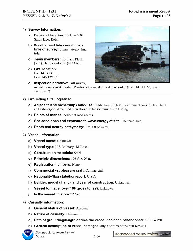
INCIDENT ID: 1831 Rapid Assessment Report VESSEL NAME: T.T. Gov’t 2 Page 1 of 3
1) Survey Information: a) Date and location: 10 June 2003.
Sasan lago, Rota.
b) Weather and tide conditions at time of survey: Sunny, breezy, high tide.
c) Team members: Lord and Plank (RPI), Helton and Zelo (NOAA).
d) GPS location: Lat: 14.14138˚Lon: 145.13930˚
e) Inspection narrative: Full survey, including underwater video. Position of some debris also recorded (Lat: 14.14116˚, Lon:145.13902).
2) Grounding Site Logistics: a) Adjacent land ownership / land-use: Public lands (CNMI government owned), both land
and submerged. Area used recreationally for swimming and fishing.
b) Points of access: Adjacent road access.
c) Sea conditions and exposure to wave energy at site: Sheltered area.
d) Depth and nearby bathymetry: 1 to 3 ft of water.
3) Vessel Information: a) Vessel name: Unknown.
b) Vessel type: U.S. Military “M-Boat”.
c) Construction materials: Steel.
d) Principle dimensions: 106 ft. x 29 ft.
e) Registration numbers: None.
f) Commercial vs. pleasure craft: Commercial.
g) Nationality/flag state/homeport: U.S.A.
h) Builder, model (if any), and year of construction: Unknown.
i) Vessel tonnage (over 100 gross tons?): Unknown.
j) Is the vessel “historic”? No.
4) Casualty information: a) General status of vessel: Aground.
b) Nature of casualty: Unknown.
c) Date of grounding/length of time the vessel has been “abandoned”: Post WWII.
d) General description of vessel damage: Only a portion of the hull remains.
Damage Assessment Center NOAA B-60
INCIDENT ID: 1831 Rapid Assessment Report VESSEL NAME: T.T. Gov’t 2 Page 2 of 3
e) Vessel cargo: None.
5) Potential Pollution Threats: a) Is there fuel or hazmat onboard? Estimated quantities? No.
b) Evidence of releases? Sheens? No.
c) Evidence of illegal dumping? No.
d) Condition of fuel tanks: Unknown.
e) Other equipment and supplies that may pose their own threats: Debris is a concern.
f) What new or continuing harm to natural resources might result by removing oil/hazardous substances but leaving the vessel? Continuing breakdown of vessel may result in continuing damage to reef.
6) Potential Navigation Threats: a) Is the vessel located in or adjacent to navigation channel(s)? No, very shallow.
b) Depth and visibility of the vessel: Vessel is exposed.
c) Is the vessel properly marked? No.
d) Type of navigation in the area: Recreational.
e) Has the vessel moved over time? Might it move in the future? No.
f) Would other structures be endangered if the vessel were to shift or move? No structures of note in vicinity.
7) Potential Public Health Threats: a) Public uses in the area: Recreational beach activities (fishing, swimming etc.)
b) Evidence of people boarding the vessel? Yes.
c) Entrapment or slip/fall hazards? Yes.
8) Prior Response/Salvage actions (if any/ if known): a) Pollution response: Unknown.
b) Salvage efforts: Unknown.
9) Vessel Ownership: a) Owner Name/address: Originally U.S. Military, then U.S. Dept. of Interior.
b) Insurance Agent and type of coverages: Unknown.
c) What communications have occurred between owner/operator/insurer and state or federal government? Unknown.
d) Contact names: Manases Manglona (CNMI CRM).
10) Endangered Species and Critical Habitats: a) Is the site designated critical habitat for ESA-listed species? No.
Damage Assessment Center NOAA B-61

INCIDENT ID: 1831 Rapid Assessment Report VESSEL NAME: T.T. Gov’t 2 Page 3 of 3
b) Is the vessel destroying critical habitat or could it if the vessel moved? No.
c) Is there any evidence of entanglement or entrapment of fish/wildlife? No.
11) Potential Environmental Impacts: a) Dimensions of vessel grounding footprint: Debris field. b) Dimensions of debris field: Approximate 300 ft. debris field between T.T. Gov’t 1 and T.T.
Gov’t 2.
c) Primary habitat(s): Sand lagoon with patch reef habitat. Mostly coral rubble, some large boulders, with low (<10%) live coral cover. Dominant genuses: Acropora, Porites, possibly others.
d) Secondary habitat(s): Some encrusting algae on boulders, and patches of fleshy algae on sand and boulders.
e) Substrate: Sand.
f) Damage Observations: Debris is scattered widely. Low live coral cover may be attributed to a variety habitat features. Presence of vessels may have some negative impact.
Damage Assessment Center NOAA B-62
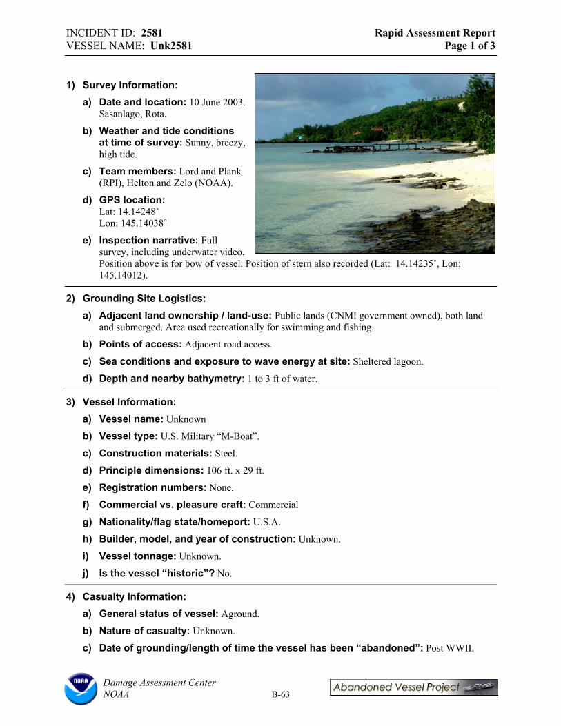
INCIDENT ID: 2581 Rapid Assessment Report VESSEL NAME: Unk2581 Page 1 of 3
1) Survey Information: a) Date and location: 10 June 2003.
Sasanlago, Rota.
b) Weather and tide conditions at time of survey: Sunny, breezy, high tide.
c) Team members: Lord and Plank (RPI), Helton and Zelo (NOAA).
d) GPS location: Lat: 14.14248˚Lon: 145.14038˚
e) Inspection narrative: Full survey, including underwater video. Position above is for bow of vessel. Position of stern also recorded (Lat: 14.14235˚, Lon:145.14012).
2) Grounding Site Logistics: a) Adjacent land ownership / land-use: Public lands (CNMI government owned), both land
and submerged. Area used recreationally for swimming and fishing.
b) Points of access: Adjacent road access.
c) Sea conditions and exposure to wave energy at site: Sheltered lagoon.
d) Depth and nearby bathymetry: 1 to 3 ft of water.
3) Vessel Information: a) Vessel name: Unknown
b) Vessel type: U.S. Military “M-Boat”.
c) Construction materials: Steel.
d) Principle dimensions: 106 ft. x 29 ft.
e) Registration numbers: None.
f) Commercial vs. pleasure craft: Commercial
g) Nationality/flag state/homeport: U.S.A.
h) Builder, model, and year of construction: Unknown.
i) Vessel tonnage: Unknown.
j) Is the vessel “historic”? No.
4) Casualty Information: a) General status of vessel: Aground.
b) Nature of casualty: Unknown.
c) Date of grounding/length of time the vessel has been “abandoned”: Post WWII.
Damage Assessment Center NOAA B-63

INCIDENT ID: 2581 Rapid Assessment Report VESSEL NAME: Unk2581 Page 2 of 3
d) General description of vessel damage: Partial hull remains, dilapidated.
e) Vessel cargo: None.
5) Potential Pollution Threats: a) Is there fuel or hazmat onboard? Estimated quantities? No.
b) Evidence of releases? Sheens? No.
c) Evidence of illegal dumping? No.
d) Condition of fuel tanks: Unknown.
e) Other equipment and supplies that may pose their own threats: Debris is a concern.
f) What new or continuing harm to natural resources might result by removing oil/hazardous substances but leaving the vessel? Continuing breakdown of vessel may result in continuing damage to reef.
6) Potential Navigation Threats: a) Is the vessel located in or adjacent to navigation channel(s)? No, very shallow
b) Depth and visibility of the vessel: Vessel is exposed.
c) Is the vessel properly marked? No.
d) Type of navigation in the area: Recreational.
e) Has the vessel moved over time? Might it move in the future? No.
f) Would other structures be endangered if the vessel were to shift or move? No structures of note in vicinity.
7) Potential Public Health Threats: a) Public uses in the area: Recreational beach activities (fishing, swimming etc.)
b) Evidence of people boarding the vessel? Yes.
c) Entrapment or slip/fall hazards? Yes.
8) Prior Response/Salvage Actions: a) Pollution response: Unknown.
b) Salvage efforts: Unknown.
9) Vessel Ownership: a) Owner name/address: Originally U.S. Military, then U.S. Dept. of Interior.
b) Insurance agent and type of coverages: Unknown.
c) What communications have occurred between owner/operator/insurer and state or federal government? Unknown.
d) Contact names: Manases Manglona (CNMI CRM)
Damage Assessment Center NOAA B-64

INCIDENT ID: 2581 Rapid Assessment Report VESSEL NAME: Unk2581 Page 3 of 3
10) Endangered Species and Critical Habitats: a) Is the site designated critical habitat for ESA-listed species? No.
b) Is the vessel destroying critical habitat or could it if the vessel moved? No.
c) Is there any evidence of entanglement or entrapment of fish/wildlife? No.
11) Potential Environmental Impacts: a) Dimensions of vessel grounding footprint: N/A
b) Dimensions of debris field: Debris on beach and in water, but mostly corrugated roofing/plastic roofing from storms and other sources.
c) Primary habitat(s): Sand lagoon with patch reef habitat. Mostly sand with a few patches of coral, < 10% live cover.
d) Secondary habitat(s): Sand bottom.
e) Substrate: Sand.
f) Damage Observations: Low live coral cover may be attributed to a variety habitat features. Presence of vessels may have some negative impact.
Damage Assessment Center NOAA B-65

INCIDENT ID: 1829 Rapid Assessment Report VESSEL NAME: Rota Queen Page 1 of 3
1) Survey Information: a) Date and location: 10 June 2003.
Sasan lago, Rota.
b) Weather and tide conditions at time of survey: Sunny, breezy, high tide.
c) Team members: Lord and Plank (RPI), Helton and Zelo (NOAA).
d) GPS location: Lat: 14.13787˚Lon: 145.13588˚
e) Inspection narrative: Full survey, including underwater video. Position above is for bow of vessel. Position of stern also recorded (Lat: 14.13781˚, Lon: 145.13570).
2) Grounding Site Logistics: a) Adjacent land ownership / land-use: Land owned by the port. Near the power plant.
b) Points of access: Adjacent road access.
c) Sea conditions and exposure to wave energy at site: Sheltered lagoon.
d) Depth and nearby bathymetry: 1 to 4 ft of water.
3) Vessel Information: a) Vessel name: ROTA QUEEN.
b) Vessel type: Tugboat.
c) Construction materials: Steel.
d) Principle dimensions: 65.5 ft. x 11 ft.
e) Registration numbers: None.
f) Commercial vs. pleasure craft: Commercial but possibly used as pleasure craft at one time.
g) Nationality/flag state/homeport: CNMI.
h) Builder, model, and year of construction: Unknown.
i) Vessel tonnage: Unknown.
j) Is the vessel “historic” No.
4) Casualty Information: a) General status of vessel: Aground.
b) Nature of casualty: Damage to hull caused boat to take on water.
c) Date of grounding/length of time the vessel has been “abandoned”: Early 1980’s.
d) General description of vessel damage: Hull intact, all else stripped and rusting.
Damage Assessment Center NOAA B-66

INCIDENT ID: 1829 Rapid Assessment Report VESSEL NAME: Rota Queen Page 2 of 3
e) Vessel cargo: None.
5) Potential Pollution Threats: a) Is there fuel or hazmat onboard? Estimated quantities? No.
b) Evidence of releases? Sheens? No.
c) Evidence of illegal dumping? No.
d) Condition of fuel tanks: Unknown.
e) Other equipment and supplies that may pose their own threats: None.
f) What new or continuing harm to natural resources might result by removing oil/hazardous substances but leaving the vessel? N/A.
6) Potential Navigation Threats: a) Is the vessel located in or adjacent to navigation channel(s)? Vessel is located in Rota
West Harbor near the port near where a channel has been blasted through the reef to create a safe harbor. The port is planning an expansion of facilities soon.
b) Depth and visibility of the vessel: Vessel sits in 1 to 4 ft. of water and is fully exposed.
c) Is the vessel properly marked? No.
d) Type of navigation in the area: Recreational and commercial.
e) Has the vessel moved over time? Might it move in the future? Yes, in storms.
f) Would other structures be endangered if the vessel were to shift or move? The port may possibly be affected.
7) Potential Public Health Threats: a) Public uses in the area: Recreation (fishing), and port facility
b) Evidence of people boarding the vessel? No, but possible.
c) Entrapment or slip/fall hazards? Yes.
8) Prior Response/Salvage Actions: a) Pollution response: Unknown
b) Salvage efforts: CRM talked to them but no movement. Sinking the vessel to create a reef was discussed in the 1990’s.
9) Vessel Ownership: a) Owner name/address: Originally U.S. Military, then CNMI.
b) Insurance Agent and type of coverages: Unknown.
c) What communications have occurred between owner/operator/insurer and state or federal government? Unknown.
d) Contact names: Manases Manglona (CNMI CRM).
Damage Assessment Center NOAA B-67
INCIDENT ID: 1829 Rapid Assessment Report VESSEL NAME: Rota Queen Page 3 of 3
10) Endangered Species and Critical Habitats: a) Is the site designated critical habitat for ESA-listed species? No.
b) Is the vessel destroying critical habitat or could it if the vessel moved? No.
c) Is there any evidence of entanglement or entrapment of fish/wildlife? No.
11) Potential Environmental Impacts a) Dimensions of vessel grounding footprint: N/A.
b) Dimensions of debris field: No substantial debris.
c) Primary habitat(s): Sand lagoon with patch reef habitat. Low live coral cover (0-10%), mostly coral rubble. Observed a few Acropora.
d) Secondary habitat(s): Small patches of fleshy algae, encrusting algae observed on coral rubble.
e) Substrate: Sand and gravel.
f) Damage Observations: Low live coral cover may be attributed to a variety of habitat features. Presence of vessels may have some negative impact.
Damage Assessment Center NOAA B-68