chapter 11 ground conditions - dppukltd.comenvironmental statement – ground conditions 11.13 the...
TRANSCRIPT

CHAPTER 11
GROUND CONDITIONS

Castell Y Mynach Estate
11-1
11.0 GROUND CONDITIONS
Introduction
11.1 This chapter of the Environmental Statement (ES) has been prepared by Hydrock Consultants
Limited (Cardiff) and reports the findings of an assessment of the likely significant effects on ground
conditions of Land South of Creigiau, Site E (the ‘Development’). Potential significant effects
associated with construction activities and the completed devolvement are identified and where
necessary mitigation measures are outlined.
11.2 This Chapter is supported by the following reports and technical appendices:
• Appendix 11.1: Hydrock Consultants Limited. September 2018. Ground Conditions Desk
Study Site E. CRE-HYD-E-XX-RP-G-0001_S2_P1 (C-07676-C); and
• Appendix 11.2: Summary of relevant Acts and Policies.
Regulatory and Policy Context
Legislation Context
11.3 The relevant legislation is listed below with summary description presented in Appendix 11.2:
• Town and Country Planning Act 1990;
• Part 2A of the Environmental Protection Act 1990;
• Environment Agency Groundwater Protection Policy (GP3);
• Water Resources Act 1991; and
• Planning (Wales) Act 2015.
National Planning Policy
11.4 Planning Policy Wales Edition 10 December 2018 (PPW) sets out the land use planning policies of
the Welsh Government. Chapter 3 relates to ‘Strategic and Spatial Choices’; Chapter 5 relates to
‘Productive and Enterprising Places’ and Chapter 6 relates ‘Distinctive and Natural Places in Places’.
11.5 The Welsh Government’s Objectives are to:
• To ensure that the planning system contributes towards the delivery of sustainable
development and improves the social, economic, environmental well-being of Wales.
• Maximise environmental protection for people, natural and cultural resources, property
and infrastructure; and

Environmental Statement – Ground Conditions
• Prevent and manage pollution and promote good environmental practice.
11.6 Chapter 3.30 of the policy outlines how Sustainable Management of Natural Resources is
undertaken. The Environment (Wales) Act 2016 introduces the Sustainable Management of
Natural Resources (SMNR) and sets out a framework to achieve this. The objective of the SMNR is
to maintain and enhance the resilience of ecosystems and the benefits they provide.
11.7 The Welsh Government is required to prepare, publish and implement a statutory Natural
Resource Policy setting out is priorities in relation to the SMNR while Natural Resource Wales
(NRW) is required to produce a ‘State of Natural Resources Report’ and prepare ‘Area Statements’
to inform place-based action. The Natural Resources Policy and Area Statements are a key piece of
evidence which must be taken into account in development plan preparation.
11.8 Chapter 5.13 of the policy outlines how Sustainable Waste Management Facilities are implemented
to:
• minimise adverse environmental impacts and avoiding risks to human health;
• protection areas of designated landscape and nature conservation from inappropriate
development; and
• protecting the amenity of residents of other land uses and users affected by existing or
proposed waste management facilities.
11.9 Chapter 6.9 of the policy outlines how the risk from land instability and land contamination should
be taken into account in development plans. This is to ensure that new development is not
undertaken without an understanding of the risk, and consideration is given to the potential
impacts any remedial works will have on the natural or historic environment.
11.10 The aim of the PPW is not to prevent development, but to ensure it is suitable and the physical
constraints at the site are taken into account. The responsibility for determining this remains with
the developer.
The PPW document is supplement by Technical Advice Notes (TANs) and procedural advice is given
in circulars and policy clarification letters. None relate to land contamination.
Local Planning Policy
11.11 The Local Development Plan (LDP) for Cardiff was adopted on the 28th January 2016 and runs until
2026. The LDP became operative on its adoption and now forms the development plan and will be
the basis for decisions on land use planning in Cardiff.
11.12 Brownfield sites are stated in the LDP to contribute over half of the provision for new homes in
Cardiff, supplemented by greenfield sites. Evidence suggests that site viability factors make it
difficult for brownfield sites to consistently provide high levels of affordable housing.

Environmental Statement – Ground Conditions
11.13 The plan aims to help support the development of Cardiff as a world-class European Capital City.
One way is by ‘promoting the efficient use of land, developing at highest practicable densities and
where appropriate achieving the remediation of land contamination’.
11.14 Developers will be required to demonstrate that any actual or potential contamination can be
overcome, thereby ensuring that the land is suitable for the development proposed and that there
is no unacceptable harm to human health or the environment. If contamination cannot be
overcome satisfactorily the authority may refuse planning permission.
Guidance
11.15 This assessment has been undertaken with due reference to the following key guidance and
standards:
• ALLEN, D. L., BREWERTON, L. J., COLEBY, L. M., GIBBS, B. R., LEWIS, M. A., MACDONALD, A.
M., WAGSTAFF, S. J. and WILLIAMS, A.T. 1997. The physical properties of major aquifers in
England and Wales. British Geological Survey Technical Report WD/97/34. 312pp.
Environment Agency R&D Publication 8.
• BRITISH STANDARDS INSTITUTION. 2011. Code of Practice for Investigation of Potentially
Contaminated sites. BS 10175 Incorporating Amendment No.1:2013. BSI, London.
• BRITISH STANDARDS INSTITUTION. 2015. Code of practice for the design of protective
measures for methane and carbon dioxide ground gases for new buildings. BS 8485. BSI,
London.
• BRITISH STANDARDS INSTITUTION. 2015. Code of practice for ground investigations. BS
5930. BSI, London.
• DCLG. March 2012. National Planning Policy Framework. DCLG, London.
• DCLG. March 2012. Technical Guidance to the National Planning Policy Framework. DCLG,
London.
• ENVIRONMENT AGENCY. 2004. Model procedures for the management of land
contamination. Contaminated Land Report 11. The Environment Agency.
• JONES, H. K., MORRIS, B. L., CHENEY, C. S., BREWERTON, L. J., MERRIN, P. D., LEWIS, M. A.,
MACDONALD, A. M., COLEBY, L. M., TALBOT, J. C., MCKENZIE, A. A., BIRD, M. J.,
CUNNINGHAM, J. and ROBINSON, V. K. 2000. The physical properties of minor aquifers in
England and Wales. British Geological Survey Technical Report WD/00/04. 234pp.
Environment Agency R&D Publication 68.
• RAWLINS, B. G., McGRATH, S. P., SCHEIB, A. J., CAVE, N., LISTER, T. R., INGHAM, M.,
GOWING, C. and CARTER, S. 2012. The advanced geochemical atlas of England and Wales.
British Geological Survey, Keyworth.

Environmental Statement – Ground Conditions
• SCIVYER, C. 2015. Radon: Guidance on protective measures for new buildings. Building
Research Establishment Report BR 211. BRE, Garston.
• STONE, K., MURRAY, A., COOKE, S., FORAN, J. and GOODERHAM, L. 2009. Unexploded
ordnance (UXO), a guide to the construction industry. CIRIA Report C681. CIRIA, London.
141 pp.
• WELSH ASSEMBLY GOVERNMENT. July 2004. Development and flood risk. Planning Policy
Wales, Technical Advice Note 15.
• WILSON, S., OLIVER, S., MALLETT, H., HUTCHINGS, H. and CARD, G. 2007. Assessing risks
posed by hazardous ground gases to buildings. CIRIA Report C665. CIRIA, London. 182pp.
11.16 It is noted that the Environment Agency’s Pollution Prevention Guidelinesi were revoked on 14th
December 2015. However, they are still considered to represent good practice and have not been
replaced. Therefore, they are referenced within this ES chapter.
Consultations
11.17 An EIA Scoping Report outlining the scope of this ground conditions ES chapter and the proposed
methodology for assessment was submitted to the City of Cardiff Council (CoCC) in December
2018. CoCC issued their Scoping Opinion in February 2019. The comments within the Scoping
Opinion were made on behalf of the Shared Regulatory Services (SRS) Environment Team. No
comments were received from Natural Resource Wales (NRW).
11.18 The EIA Scoping report referred to the Hydrock Consultants Limited Ground Conditions Desk Study
(Appendix 11.1), however that report was not submitted with the Scoping Report.
11.19 However, the general comments within the Ground Conditions Section of the Scoping Report
indicated that CoCC were happy that an appropriate Phase II ground investigation was proposed.
11.20 The standard geo-environmental conditions were included in the Scoping Opinion and should be
easily covered and assessed with a robust Phase II ground investigation. These conditions are:
• PC13. GROUND GAS PROTECTION
• PC14A. CONTAMINATED LAND MEASURES – ASSESSMENT
• PC14B. CONTAMINATED LAND MEASURES – REMEDIATION & VERIFICATION PLAN
• PC14C. CONTAMINATED LAND MEASURES – REMEDIATION & VERIFICATION
• PC14D. CONTAMINATED LAND MEASURES – UNFORSEEN CONTAMINATION
• PC15A. IMPORTED SOIL
Environmental Statement – Ground Conditions
• PC15B. IMPORTED AGGREGATES
• PC15C. USE OF SITE WON MATERIALS.
Scope
11.21 This assessment involves desk-based consideration of the naturally occurring geological conditions
and any man-made deposits, known as Made Ground. Consideration is given to the physical nature
of the rocks, soils and Made Ground, together with information on chemical contamination and
geotechnical features arising from the former and existing uses of the Site. The hydrogeological
regime, comprising the groundwater in any permeable deposits (rock, soil or Made Ground)
beneath the Site, and the hydrological regime (surface water), are described in so much as they
interact with ground conditions
Methodology
11.22 Environmental issues related to land contamination are considered by risk assessment of
contaminant linkages. The risk assessment is then used to inform the impact assessment
completed as part of the ES.
11.23 A contaminant linkage is said to exist where three conditions are satisfied:
• There is a source of chemical contaminant with the potential to cause harm to human
health, property (including buildings) or the wider environment;
• There is a receptor (e.g. people, property, the environment) which might be harmed by
the source of contamination; and
• There is a pathway by which the source can reach the receptor, so that harm can be
caused.
11.24 On a particular site, there may be multiple sources, pathways and receptors and each source-
pathway-receptor contaminant linkage must be examined and the risk assessed. This is usually
done in a series of stages or tiers starting with a general, more conservative approach, but
becoming more in-depth and site-specific if a more detailed approach is warranted (usually where
the issues are very complex to resolve). The stages of assessment are listed in Table 11-1.
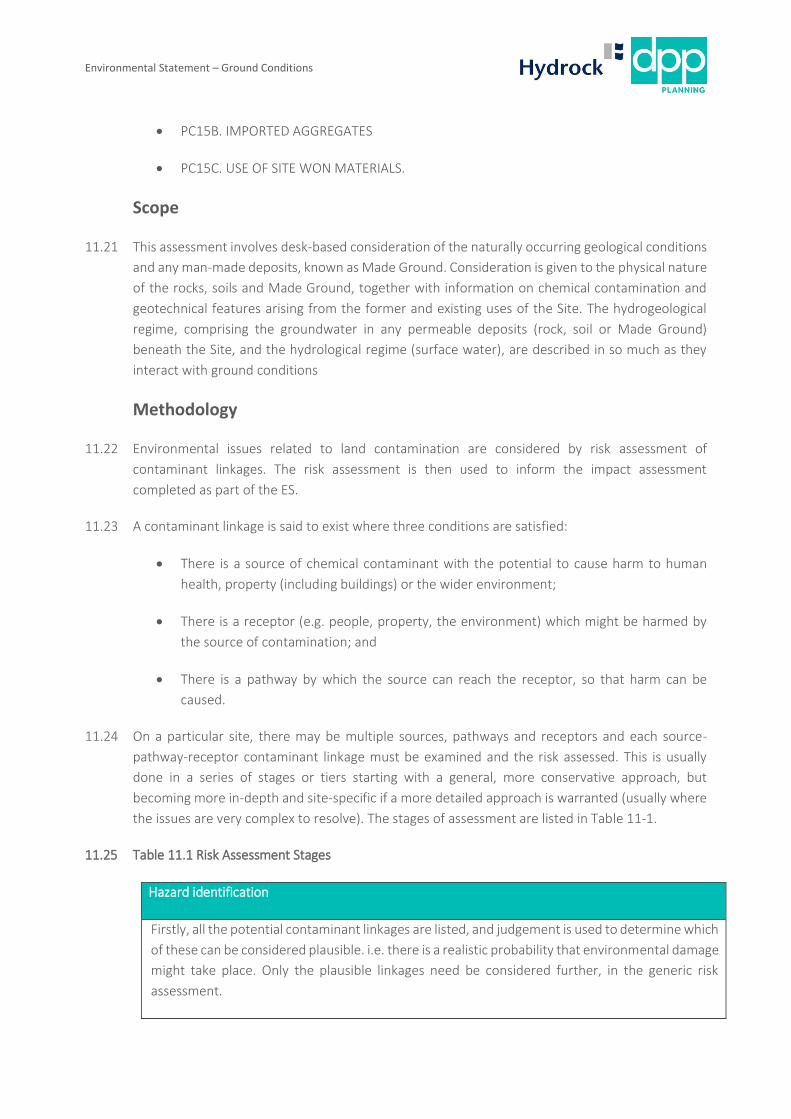
11.25 Table 11.1 Risk Assessment Stages
Hazard identification
Firstly, all the potential contaminant linkages are listed, and judgement is used to determine which
of these can be considered plausible. i.e. there is a realistic probability that environmental damage
might take place. Only the plausible linkages need be considered further, in the generic risk
assessment.
Environmental Statement – Ground Conditions
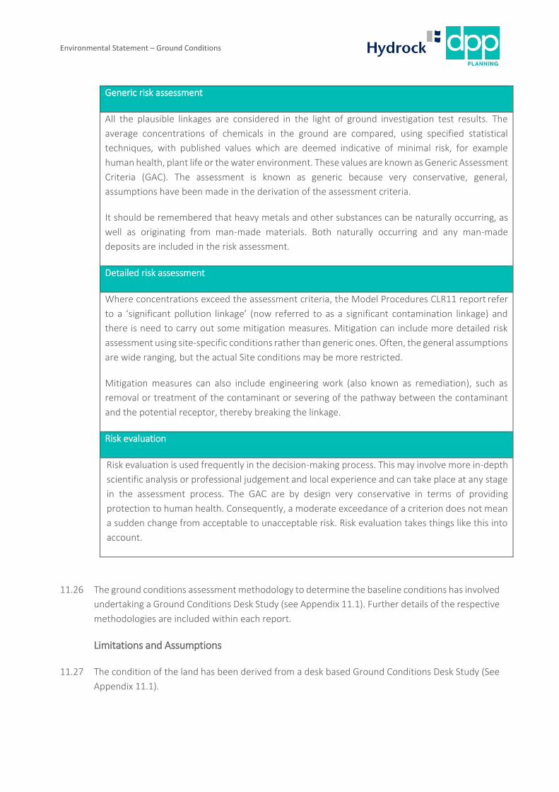
Generic risk assessment
All the plausible linkages are considered in the light of ground investigation test results. The
average concentrations of chemicals in the ground are compared, using specified statistical
techniques, with published values which are deemed indicative of minimal risk, for example
human health, plant life or the water environment. These values are known as Generic Assessment
Criteria (GAC). The assessment is known as generic because very conservative, general,
assumptions have been made in the derivation of the assessment criteria.
It should be remembered that heavy metals and other substances can be naturally occurring, as
well as originating from man-made materials. Both naturally occurring and any man-made
deposits are included in the risk assessment.
Detailed risk assessment
Where concentrations exceed the assessment criteria, the Model Procedures CLR11 report refer
to a ‘significant pollution linkage’ (now referred to as a significant contamination linkage) and
there is need to carry out some mitigation measures. Mitigation can include more detailed risk
assessment using site-specific conditions rather than generic ones. Often, the general assumptions
are wide ranging, but the actual Site conditions may be more restricted.
Mitigation measures can also include engineering work (also known as remediation), such as
removal or treatment of the contaminant or severing of the pathway between the contaminant
and the potential receptor, thereby breaking the linkage.
Risk evaluation
Risk evaluation is used frequently in the decision-making process. This may involve more in-depth
scientific analysis or professional judgement and local experience and can take place at any stage
in the assessment process. The GAC are by design very conservative in terms of providing
protection to human health. Consequently, a moderate exceedance of a criterion does not mean
a sudden change from acceptable to unacceptable risk. Risk evaluation takes things like this into
account.
11.26 The ground conditions assessment methodology to determine the baseline conditions has involved
undertaking a Ground Conditions Desk Study (see Appendix 11.1). Further details of the respective
methodologies are included within each report.
Limitations and Assumptions
11.27 The condition of the land has been derived from a desk based Ground Conditions Desk Study (See
Appendix 11.1).
Environmental Statement – Ground Conditions
11.28 The subsurface geological profiles, and any suspected contamination are generalised by necessity
and have been based on the information identified and procured during the Ground Conditions
Desk Study.
11.29 It is assumed that the construction phase and completion and occupation of the development will
be undertaken in compliance with all relevant environmental regulations and the implementation
of standard good Health, Safety and Environmental (HS&E) practice working methods employed
on UK development sites. Further investigation and remediation of the site should be undertaken
in line with the appropriate guidance and following further consultation with the City of Cardiff
Council (CoCC) and National Resource Wales (NRW) to agree details of scope.
Significance Criteria
11.30 The assessment of likely significant effects as a result of the development has taken into account
both the enabling works, construction phase and once the development is completed and
occupied. The significance level attributed to each effect has been assessed based on the
magnitude of change due to the development and the sensitivity or value of the affected
receptor/resource to change, as well as a number of other factors that are outlined in more detail
in Chapter 2: EIA methodology and are assessed on a scale of high, medium, low and very low.
Value and /or Sensitivity of Receptor
11.31 The sensitivity of the receptor is a matter of professional judgement. Definitions of the categories
of value and/or sensitivity that will be used in the assessment are given in Table 11.2. Where a
receptor could reasonably be placed within more than one value and sensitivity rating, professional
judgement has been used to determine which rating would be most applicable.
11.32 With respect to contamination and human population, the methodology of the model procedures
for the management of land contamination (CLR11) has been followed. The most sensitive
receptors within a particular group are required to be protected.
11.33 The sensitivity of the water environment depends on whether it is used for human consumption
or provides support for aquatic ecosystems.
11.34 The sensitivity of other geological receptors where the proposed development has the potential to
destroy or deplete the amenity value, such as mineral resource or a site of geological interest is
judge according to the criteria in Table 11-2 sensitivity of receptors.
11.35 The risk from Radon has been assessed by reference to the radon atlas and other guidance
produced by the former Health Protection Agency, British Geological Survey and Building Research
Establishment.
11.36 The geotechnical risks assessed in this chapter relate to any abnormal ground conditions that might
exist.
Environmental Statement – Ground Conditions
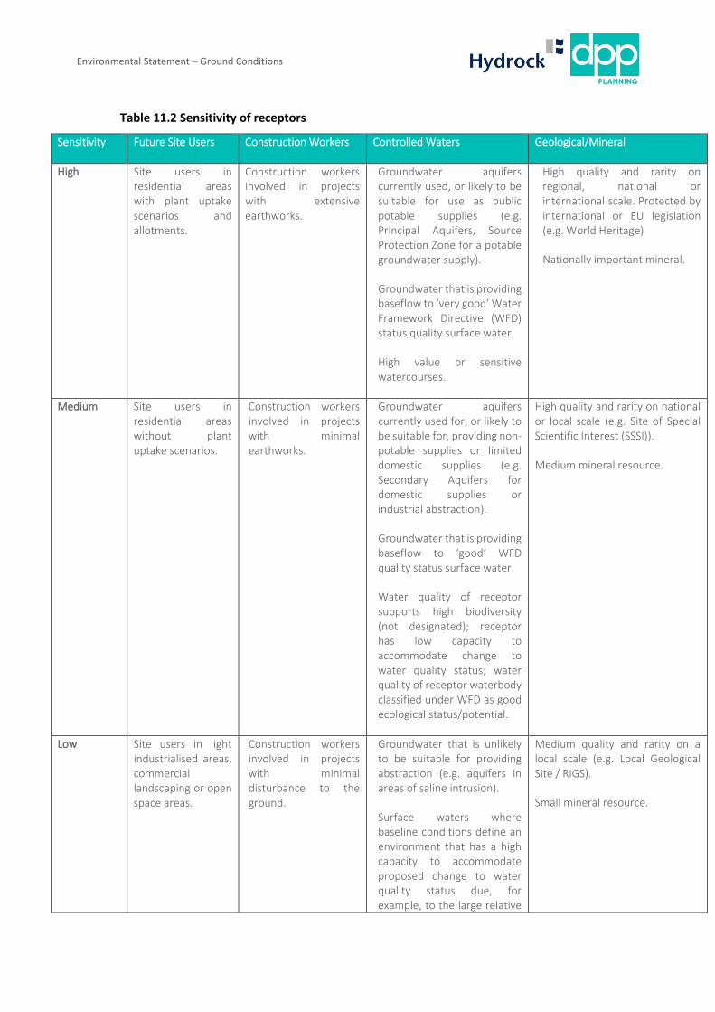
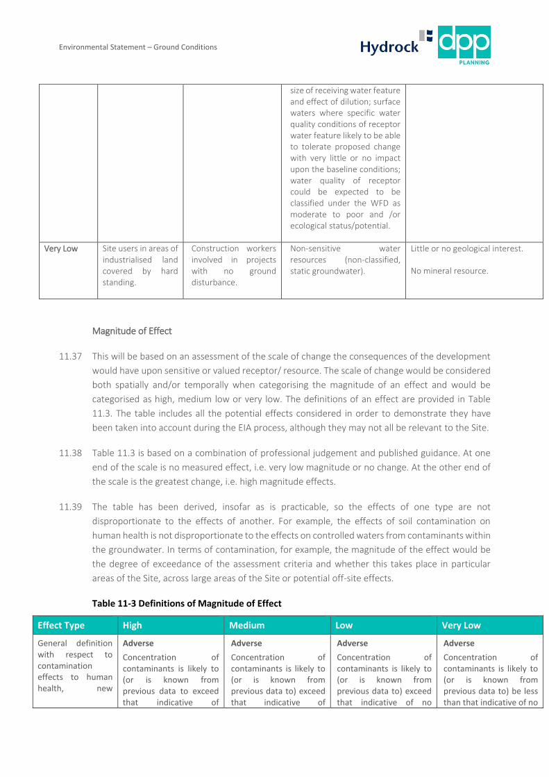
Table 11.2 Sensitivity of receptors
Sensitivity Future Site Users Construction Workers Controlled Waters Geological/Mineral
High Site users in residential areas with plant uptake scenarios and allotments.
Construction workers involved in projects with extensive earthworks.
Groundwater aquifers currently used, or likely to be suitable for use as public potable supplies (e.g. Principal Aquifers, Source Protection Zone for a potable groundwater supply).
Groundwater that is providing baseflow to ‘very good’ Water Framework Directive (WFD) status quality surface water.
High value or sensitive watercourses.
High quality and rarity on regional, national or international scale. Protected by international or EU legislation (e.g. World Heritage)
Nationally important mineral.
Medium Site users in residential areas without plant uptake scenarios.
Construction workers involved in projects with minimal earthworks.
Groundwater aquifers currently used for, or likely to be suitable for, providing non-potable supplies or limited domestic supplies (e.g. Secondary Aquifers for domestic supplies or industrial abstraction).
Groundwater that is providing baseflow to ‘good’ WFD quality status surface water.
Water quality of receptor supports high biodiversity (not designated); receptor has low capacity to accommodate change to water quality status; water quality of receptor waterbody classified under WFD as good ecological status/potential.
High quality and rarity on national or local scale (e.g. Site of Special Scientific Interest (SSSI)).
Medium mineral resource.
Low Site users in light industrialised areas, commercial landscaping or open space areas.
Construction workers involved in projects with minimal disturbance to the ground.
Groundwater that is unlikely to be suitable for providing abstraction (e.g. aquifers in areas of saline intrusion).
Surface waters where baseline conditions define an environment that has a high capacity to accommodate proposed change to water quality status due, for example, to the large relative
Medium quality and rarity on a local scale (e.g. Local Geological Site / RIGS).
Small mineral resource.
Environmental Statement – Ground Conditions
size of receiving water feature and effect of dilution; surface waters where specific water quality conditions of receptor water feature likely to be able to tolerate proposed change with very little or no impact upon the baseline conditions; water quality of receptor could be expected to be classified under the WFD as moderate to poor and /or ecological status/potential.
Very Low Site users in areas of industrialised land covered by hard standing.
Construction workers involved in projects with no ground disturbance.
Non-sensitive water resources (non-classified, static groundwater).
Little or no geological interest.
No mineral resource.
Magnitude of Effect
11.37 This will be based on an assessment of the scale of change the consequences of the development
would have upon sensitive or valued receptor/ resource. The scale of change would be considered
both spatially and/or temporally when categorising the magnitude of an effect and would be
categorised as high, medium low or very low. The definitions of an effect are provided in Table
11.3. The table includes all the potential effects considered in order to demonstrate they have
been taken into account during the EIA process, although they may not all be relevant to the Site.
11.38 Table 11.3 is based on a combination of professional judgement and published guidance. At one
end of the scale is no measured effect, i.e. very low magnitude or no change. At the other end of
the scale is the greatest change, i.e. high magnitude effects.
11.39 The table has been derived, insofar as is practicable, so the effects of one type are not
disproportionate to the effects of another. For example, the effects of soil contamination on
human health is not disproportionate to the effects on controlled waters from contaminants within
the groundwater. In terms of contamination, for example, the magnitude of the effect would be
the degree of exceedance of the assessment criteria and whether this takes place in particular
areas of the Site, across large areas of the Site or potential off-site effects.
Table 11-3 Definitions of Magnitude of Effect
Effect Type High Medium Low Very Low
General definition with respect to contamination effects to human health, new
Adverse
Concentration of contaminants is likely to (or is known from previous data to exceed that indicative of
Adverse
Concentration of contaminants is likely to (or is known from previous data to) exceed that indicative of
Adverse
Concentration of contaminants is likely to (or is known from previous data to) exceed that indicative of no
Adverse
Concentration of contaminants is likely to (or is known from previous data to) be less than that indicative of no
Environmental Statement – Ground Conditions
Effect Type High Medium Low Very Low
planting and Controlled Waters
unacceptable intake or contact), i.e. much greater than required for “significant harm of the significant possibility of significant harm” under EPA 1990 Part 2A. Concentrations are high enough to cause acute (short term) effects.
Beneficial
Removal of all identified contaminant linkages that pose a risk to receptors.
unacceptable intake or contact, i.e. greater than required for “significant harm or the significant possibility of significant harm” under EPA 1990 Part 2A.
Beneficial
Removal of the majority of contaminant linkages that pose a risk to receptors.
harm but not unacceptable intake or contact, i.e. greater than the GAC screening value but less than that required for “significant harm or the significant possibility of significant harm” under EPA 1990 Part 2A.
Beneficial
N/A
harm, i.e. less than the GAC screening value.
Beneficial
N/A
Future site users’ human health effects from chemicals in the ground.
Adverse
Short-term (acute) effects likely to result in significant harm e.g. high conc. of cyanide on the surface of an informal recreational area.
Beneficial
Removal of all identified contaminant linkages that pose a risk to receptors.
Adverse
Long-term (chronic) effects likely to result in significant harm e.g. high conc. of contaminants close to the surface of a development site.
Beneficial
Removal of the majority of contaminant linkages that pose a risk to receptors.
Adverse
Harm but probably not significant harm unless particularly sensitive individual within the receptor group. May be aesthetic/olfactory effects.
Beneficial
N/A
Adverse
No measurable effects.
Beneficial
N/A
Site workers’ effects from chemicals in the ground.
Adverse
Risk assessment required to determine required personal protective equipment (PPE) and this may involve high level of protection similar to United States Environmental Protection Agency (USEPA) Level A, B or C.
Beneficial
Removal of all identified contaminant linkages that pose a risk to receptors.
Adverse
Risk assessment required to determine required personal protective equipment (PPE) and this may involve high level of protection similar to USEPA Level B, C or D.
Beneficial
Removal of the majority of contaminant linkages that pose a risk to receptors.
Adverse
Risk assessment required to determine required personal protective equipment (PPE) and this may involve moderate level of protection similar to USEPA Level C or D.
Beneficial
N/A
Adverse
No measurable effects, but simple personal protective equipment (PPE) required (similar to USEPA Level D protection, i.e. overalls, boots, goggles, hard hat).
Beneficial
N/A
Human health effect from ground gases, such as radon and landfill gas where exceedance of a risk-based
Adverse
Contaminant linkage identified over a large area.
Beneficial
Adverse
Contaminant linkage identified in limited areas.
Beneficial
Adverse
Contaminant linkage uncertain.
Beneficial
N/A
Adverse
Plausible contaminant linkage not established.
Beneficial
N/A

Environmental Statement – Ground Conditions
Effect Type High Medium Low Very Low
trigger indicates the potential for harm.
Removal of all identified contaminant linkages that pose a risk to receptors.
Removal of the majority of contaminant linkages that pose a risk to receptors.
Controlled Waters effects from chemicals in the ground.
Adverse
Short-term pollution, e.g. major spillage into controlled water.
Substances leaching from contaminated soil cause receiving waters to exceed surface water and groundwater quality indicators (EQS/DWS) over a large area.
Beneficial
Removal of all identified contaminant linkages that pose a risk to receptors.
Adverse
Substances leaching from contaminated soil cause receiving waters to exceed surface water and groundwater quality indicators (EQS/DWS) in limited areas.
Beneficial
Removal of the majority of contaminant linkages that pose a risk to receptors.
Adverse
Substances leaching from contaminated soil cause receiving waters to slightly exceed surface water and groundwater quality indicators (EQS/DWS) (based on professional judgement).
Beneficial
N/A
Adverse
No measurable effects.
Substances leaching from contaminated soil do not cause receiving waters to exceed surface water and groundwater quality indicators (EQS/DWS).
Beneficial
N/A
Landscaping planting and private gardens effects from chemicals in the ground.
Adverse
Complete and rapid die-back of landscaped areas.
Beneficial
N/A
Removal of all identified contaminant linkages that pose a risk to receptors.
Adverse
Stressed or dead plants in landscaped areas.
Beneficial
N/A
Removal of the majority of contaminant linkages that pose a risk to receptors.
Adverse
Damage to plants in landscaped areas, e.g. stunted growth, discoloration.
Beneficial
N/A
Adverse
No measurable effects.
Beneficial
N/A
Ecosystems effects from chemicals in the ground.
Adverse
Major damage to aquatic or other ecosystems, which is likely to result in a substantial adverse change in its functioning or harm to a species of special interest that endangers the long-term maintenance of the population.
Damage to a protected area of international significance (e.g. Ramsar site).
Beneficial
Removal of all identified contaminant linkages that pose a risk to receptors.
Adverse
Significant damage to aquatic or other ecosystems, which may result in a substantial adverse change in its functioning or harm to a species of special interest that may endanger the long-term maintenance of the population.
Damage to a protected area of national significance (e.g. Site of Special Scientific Interest)
Beneficial
Removal of the majority of contaminant linkages that pose a risk to receptors.
Adverse
Minor or short-lived damage to aquatic or other ecosystems, which is unlikely to result in a substantial adverse change in its functioning or harm to a species of special interest that would endanger the long-term maintenance of the population.
Damage to a locally important area.
Beneficial
N/A
Adverse
No measurable effects.
Plausible contaminant linkage but no important or protected area.
Beneficial
N/A

Environmental Statement – Ground Conditions
Effect Type High Medium Low Very Low
Buildings etc. effects from flammable ground gas.
Adverse
Catastrophic damage, e.g. gas explosion causing collapse.
Beneficial
Removal of all identified contaminant linkages that pose a risk to receptors.
Adverse
Damage renders unsafe to occupy.
Beneficial
Removal of the majority of contaminant linkages that pose a risk to receptors.
Adverse
Buildings etc. effects from flammable ground gas.
Beneficial
N/A
Adverse
No measurable effects.
Beneficial
N/A
Damage to building products form chemicals in the ground (e.g. sulfate attack of concrete, organic solvent decay of plastics).
Adverse
Maximum soil concentration exceeds industry accepted trigger value over a large area.
Beneficial
N/A
Removal of all identified contaminant linkages that pose a risk to receptors.
Adverse
Maximum soil concentration exceeds industry accepted trigger value in limited areas.
Beneficial
N/A
Removal of the majority of contaminant linkages that pose a risk to receptors.
Adverse
Maximum soil concentration slightly exceeds industry accepted trigger value in limited areas.
Beneficial
N/A
Adverse
Maximum soil concentration less than industry accepted trigger value.
Beneficial
N/A
Impacts to people, property, infrastructure or water courses caused by excessive ground movements (e.g. subsidence, settlement, slope failure).
Adverse
Major damage involving destruction of buildings or infrastructure, blocking of river courses and major flooding or loss of life.
Beneficial
Removal of all identified contaminant linkages that pose a risk to receptors.
Adverse
Significant damage to property or infrastructure, minor damage to river channels, injury to people.
Beneficial
Removal of the majority of contaminant linkages that pose a risk to receptors.
Adverse
Minor damage to property or infrastructure, minor blocking of river channels.
Beneficial
N/A
Adverse
Minor ground movements but no significant damage to property, infrastructure, river channels or human health.
Beneficial
N/A
Loss of, or damage to, a strategic geological site (e.g. protected areas).
Adverse
Loss of the resource and/or quality and integrity of resource; severe damage to key characteristics, features or elements.
Beneficial
Removal of all identified contaminant linkages that pose a risk to receptors.
Adverse
Loss or damage to key characteristics, features or attributes, but integrity not affected.
Beneficial
Removal of the majority of contaminant linkages that pose a risk to receptors.
Adverse
Measurable, minor effect on key characteristics, features or attributes.
Beneficial
N/A
Adverse
Minor alteration to one or more characteristics, features or elements or no measurable effect.
Beneficial
N/A

Environmental Statement – Ground Conditions
Effect Type
11.40 Effects are judged to be adverse or beneficial, temporary or permanent, direct or indirect and
primary, secondary or cumulative.
11.41 An adverse effect is a negative or unfavourable effect. Any adverse effect will then be considered
with mitigation measures applied and any residual effect noted. The opposite is a beneficial effect,
a positive or favourable effect.
11.42 A short-term temporary effect relates to an activity whose duration is estimated to be several
weeks to a few months, a medium-term temporary effect relates to a duration estimated to be
several months to a year, and a long-term temporary effect relates to a duration estimated to be
several years, a permanent effect is non-reversible.
11.43 A direct effect occurs through direct interaction of an activity with an environmental impact, for
example, contamination of soil on site due to a fuel leak from a machine on site. An indirect effect
is those which are not a direct result of the project, they are often the result of complex pathways,
for example, the opening of a landfill in close proximity to the site leads to ground gases migrating
onto site and into buildings on site.
11.44 A primary effect is one which can be directly attributed to the proposed Development/action. A
secondary effect is one which is indirect or induces changes.
Significance of Effect
11.45 For Ground conditions, the significance of the effect is determined in accordance with the
methodology detailed in the Environment Agency/Defra CLR 11 Report – Model Procedures for
Land Contamination. This is in addition to the process outlined in CIRIA Report C552 which Hydrock
has updated in line with current practice and revisions presented in R&D Publication 66, Annex 4.
11.46 The significance of a potential effect is based on the combination of the magnitude of the effect
and the receptor sensitivity as given in the matrix in Table 11.4.
Table 11-4 Definitions of Significance
Magnitude of
Change
Sensitivity of Receptor
High Medium Low Very Low
High Major Major Moderate Negligible
Medium Major Moderate Minor Negligible
Low Moderate Minor Minor Negligible
Very Low Minor Negligible Negligible Negligible
Environmental Statement – Ground Conditions
11.47 Note that the degree of ‘significance’ in EIA terms is not the same as the legal definition of
‘significant harm’ as defined by the Environmental Protection Act 1990.
11.48 Any potential effects rated as ‘moderate significance’ or higher is considered significant in EIA
terms.
Baseline Conditions
11.49 The site covers an area approximately 37.57ha in size and is located south of the Village of Creigiau.
It comprises twelve fields which are largely used for grazing sheep with three fields in the centre
of the site densely overgrown woodland marked as ancient woodland. The following describes the
findings of the baseline conditions and has been used to determine the likely contaminant linkages
which could give rise to unmitigated environmental effects. Further details are provided in the
Ground Conditions Desk Study (Appendix 11.1).
Site History
11.50 Historical maps show that the site has generally remained undeveloped as farmland with a
woodland in the centre. The Barry Railway line was constructed through the east of the site by
1898; this was built to link collieries in the Rhondda Valley to Barry Docks. It was subsequently
dismantled by 1974. A small quarry was shown on First Edition (1875) mapping but not thereafter,
though Google Earth aerial images indicated it is not likely to have been infilled to the present day.
Multiple drains are shown to cross the site, which generally flow in a southerly direction.
11.51 First edition mapping indicates two old quarries are present 250m northwest of the site and a large
quarry has been present approximately 1km to the north; this was partially labelled as a tip. Maps
and historical Google Earth aerial images suggest this ceased operation during the early to mid-
2010s.
11.52 A pumping station is present immediately north of the site, which discharges into the drain on-site.
It is suspected that this pumping station was installed around the late 1980’s/early 1990’s to
discharge surface water from the adjacent residential development into the drain. Anecdotal
information from residents suggests the filter discharging into the drain is know to block leading to
localised ponding in this area on site.
Geology
11.53 The general geology of the site area is shown on the 1:50,000 geological maps of Bridgend and
Cardiff (Sheets 262 and 263).
11.54 The site is blanketed by superficial deposits of Glacial Till and underlain by a Jurassic/Triassic
sequence of bedrock geology, comprising the Blue Lias Formation (interbedded limestone and
mudstone), the Penarth Group (interbedded limestone and mudstone), Blue Anchor Formation
(mudstone) and the Mercia Mudstone Group (conglomerate/mudstone) with associated marginal
facies lying unconformable over Carboniferous/Devonian strata.
Environmental Statement – Ground Conditions
11.55 Some Made Ground is anticipated along the alignment of the railway crossing the site. Soft
silty/clayey deposits are expected where drains and streams have been located on site. Superficial
alluvium is mapped approximately 50m west of the site and this might encroach onto the site in
this area.
Quarries
11.56 First Edition (1878) mapping and the show a small quarry was present in the southeast of the site
which may have been for the surface extraction of superficial deposits. The walkover survey
identified a depression in this area. No hummocky ground or discolouration in vegetation was
observed and it is therefore suspected that the quarry has not been infilled to a significant extent
11.57 There are at least three quarries noted within 1000m of the site on historical mapping. Two were
labelled as disused on 1898 edition maps. The quarry to the north was predominantly used as an
aggregate quarry extracting local limestone.
Metalliferous Mining
11.58 The Geo insight report indicates that the Taff’s Well and Llanharry Orefield is present 25m north
of the site, which is understood to have been historically mined by surface and underground
working on a localised and small-scale.
11.59 There is no evidence to suggest significant mining of this deposit has occurred on or within the
vicinity of the site that would impact the proposed development and no further assessment is
considered necessary.
Hydrology
11.60 There are two on site surface water features within the site boundary labelled as a ‘drain’ and ‘Nant
Henstaff’. There are two surface water features within 300m of the site which are the ’Nant
Coslech’ and ’Nant Y Glaswg’.
11.61 There are two surface water abstractions within 1km of the site associated with the Creigiau Golf
Club and are used for irrigation of the golf course.
11.62 The site is located within Flood Zone A (with little or no risk of flooding) indicating that a justification
test is not applicable. Specialist Flood risk advice should be sought with regards to drainage and
flooding.
Hydrogeology
11.63 The Glacial Till is classified as an unproductive stratum due to the high clay content.
11.64 The Blue Lias Formation is classified as a Secondary A aquifer. Fracture flow is likely to be the most
dominant groundwater pathway.
Environmental Statement – Ground Conditions
11.65 The Penarth Group, Blue Anchor Formation and Mercia Mudstone Group are classified as
Secondary B aquifers and are considered less permeable than the Blue Lias above.
11.66 The majority of the site is covered by soils of intermediate leaching potential.
11.67 The site is not within a groundwater Source Protection Zone (SPZ) and there are no licensed
groundwater abstractions within 1km of the site.
Ground Gases
11.68 The site is in a Radon Affected Area where between 10% and 30% of homes are above the action
level and therefore full radon protection measures are required for new buildings at this location
in line with current guidance.
Waste Management and Hazardous Substances
11.69 There are no waste management sites recorded within 250m of the site.
11.70 There are no records relating to the storage of radioactive materials within 1000m of the site.
11.71 There are no records of prosecutions relating to authorised processes in the vicinity of the site.
11.72 There are no Local Authority Pollution Prevention and Controls, COMAH sites, NIHHS sites, or
Planning Hazardous Substance consents or enforcements within 500m of the site.
Site Sensitivity
11.73 An ancient woodland is located in the centre of the site. It was unclear during the walkover whether
this ancient woodland also encroaches into field six as major trees were only noted on the field
boundary. An ancient woodland is located immediately offsite to the west. There are multiple other
ancient woodlands recorded in the surrounding area. Brofiscin Quarry, which is a Site of Special
Scientific Interest (SSSI), is located 782m to the west. (Refer to drawing CRE-HYD-E-DS-DR-G-1001-
S2-P1 within the Site E desk study for field numbering)
Unexploded Ordnance (UXO)
11.74 In general accordance with CIRIA Report C681 (Stone et al 2009) a non-specialist unexploded
ordnance (UXO) screening exercise has been carried out for the site. There is no indication of
former military use from the desk study. Screening against the Zetica regional bomb risk map
(Glamorgan) indicates the site to be in an area where the bomb risk is moderate.
11.75 A Pre-Desk Study Assessment has been undertaken by Zetica, and has reported that the mainline
railway running through the site was a strategic target in both World War I and II, it has also noted
Anti-Invasion Defences within 5km of the site.
11.76 However, they have not found any readily available records of bombing or other significant military
activity on the site and conclude that the site is likely to have a low UXO hazard level.

Environmental Statement – Ground Conditions
Preliminary Site Conceptual Model
11.77 The preliminary exposure model is used for geo-environmental hazard identification and
establishing potential contaminant linkages based on the contaminant-pathway-receptor
approach.
Potential Contaminants
11.78 For the purpose of this assessment the potential contaminants have been separated according to
whether they are likely to have originated from on-site or off-site sources.
Potential On-Site Sources of Contamination
• Made Ground possibly including metals, metalloids, asbestos, polycyclic aromatic
hydrocarbons (PAH) and petroleum hydrocarbons associated with the construction and use of
the railway line.
• Atmospheric fallout of coal dust from colliery trains along the alignment of the railway line,
resulting in metals, metalloids and PAH contamination of near-surface soils.
• The site is in a Radon Affected Area where greater than 10% of homes are above the action
level.
Potential Off-Site Sources of Contamination
• None identified.
Discounted Sources of Contamination
• There are no recorded landfill sites within 250m of the site and the nearest potentially infilled
quarry is 250m northwest of the site. Landfill sites and infilled quarries are potential sources
of ground gas (carbon dioxide and methane) due to the degradation of biogenic inclusions
within backfill materials. However, given the age, small size and distance from the site, the
infilled quarries to the northwest are unlikely to be generating significant quantities of ground
gas that would affect the site and no further assessment is deemed necessary at this stage.
Potential Receptors
The following potential receptors have been identified.
• Humans (neighbours, site end users).
• Development end use (buildings, utilities and landscaping).
• Groundwater: Secondary A aquifer status of the Blue Lias Formation,
• Surface water: on-site drainage and Nant Henstaff.
Environmental Statement – Ground Conditions
It should be noted that health and safety risks to site contractors and maintenance workers have
not been assessed during these works and will need to be considered separately.
Potential Pathways
The following potential pathways have been identified.
• Humans: ingestion, skin contact, inhalation of dust and outdoor air.
• Buildings: direct contact with substances deleterious to building materials.
• Buildings: methane and radon ingress via permeable soils and/or construction gaps.
• Plant life: root uptake.
• Underlying groundwater: migration of contaminant into the Blue Lias aquifer.
• Surface water: overland flow.
• Surface water: drainage discharge.
Environmental Statement – Ground Conditions
Assessment without Mitigation
Construction Phase
11.79 The enabling and construction activities that could potentially affect land or water quality include:
• Site clearance and site set up;
• Fuel storage and refuelling activities for site vehicles;
• Excavation of contaminated soils;
• Installation of foundations resulting in the creation of preferential migration pathways; and
• Importation of potentially contaminated materials from off-site in areas requiring fill or soft
landscaping.
Human Health – Soil Contamination
11.80 During site clearance it is anticipated that areas around the potentially infilled pond and the
historical railway may be excavated. This will expose soils which are potentially contaminated to
site workers and off-site residents.
11.81 The potential Made Ground on site and atmospheric fallout of coal dust could cause minor impact
to the workers during excavation of foundation trenches and construction of service trenches, or
during earthworks on site.
11.82 Off-site residents are likely to be potentially exposed to contaminants in the soil through inhalation
of soil dust that leaves the site. It is unlikely off-site residents will come into contact with the soil
and be ingested via hand to mouth action.
11.83 The impact on off-site residents from inhalation of asbestos fibres within the air mobilised by
excavation of soils around the historical railway is considered to be direct, adverse, permanent and
primary.
11.84 The inhalation of asbestos fibres can lead to permanent damage of the lungs and can lead to death.
The concentration of asbestos is unknown, however as it can result in long-term chronic effects,
the impact on human health during construction most be considered to be moderate significance.
Controlled Waters
11.85 Groundwater is expected to be present at shallow depth within the Till.
11.86 With respect to the underlying unproductive (Till), Secondary A Aquifer (Blue Lias Formation) and
Secondary B Aquifer (Penarth Group, Blue Anchor Formation and Mercia Mudstone Group)
beneath the site, the following effects could potentially occur as a result of construction activities:

Environmental Statement – Ground Conditions
• Surface run off into the Nant Henstaff, and drains on site during construction phase;
• The pollution of groundwater and surface water from fuel, oil and chemical spills from mobile
plant and refuelling/storage areas;
• Surface water or groundwater pollution from the discharge of silt laden waters from
excavations;
• The creation of preferential pathways for the leaching and/or migration of contaminants e.g.
casting foundations.
• The leaching of contaminants from mobile contaminants associated with imported materials
such as: crushed stone for construction compounds and road construction; sub-base materials
placed beneath the hardstanding and capping materials for soft landscaping areas.
11.87 The impact on the underlying aquifers is considered to be direct, adverse, temporary and primary.
The significance of the impact is considered to be low to moderate as groundwater is only likely to
be transmitted in limited quantities through the Till and the site is not in a SPZ.
11.88 The impact of the surface water within the Nant Henstaff is considered to be direct, adverse,
temporary and primary. Any surface water run off during construction phase is likely to enter the
Nant Henstaff. Due to the size of this stream high silt levels could block it and adversely impact on
the water quality.
Ground Gases
11.89 The ground conditions desk study has not identified any significant sources of Carbon Dioxide or
Methane on site, the site is however located within a radon affected area where between 10% and
30% of house are above the action level.
11.90 During enabling and construction the impact of ground gases is from depleted oxygen and high
concentrations of carbon dioxide and methane (which can lead to asphyxiation) within confined
spaces. The impact is considered to be direct, very low, temporary and permanent.
11.91 The impact of Radon during construction is likely be very low and will only cause issues in confined
spaces where it can accumulate. This impact is direct, adverse, permanent and primary. This is
because radon may attach to atmospheric dust and water droplets and can be breathed in and
become lodge in the airways and lungs. Radon is now recognised to be the largest cause of lung
cancer in the UK after smoking.
Unexploded Ordnance
11.92 It was highlighted within the desk study that the historical railway that runs through the site was a
strategic target in both WW1 and WW2. However, no readily available records of bombing or other
significant military activity on the site conclude that the site is likely to have a low UXO hazard level.

Environmental Statement – Ground Conditions
Operational Phase
11.93 Potential on site Made Ground associated with the railway, possible including metals, metalloids,
asbestos, PAH and petroleum hydrocarbons could affect: end users of the site; surface water and
groundwater; and aquatic systems within the on-site drains and Nant Henstaff.
11.94 On-site atmospheric fallout of coal dust along the railway alignment, possibly including metals
metalloids and PAH could affect: end users of the site; surface water and groundwater; and aquatic
systems within the on-site drains and Nant Henstaff.
11.95 Radon could affect end users of the site through migration through soils and or groundwater into
indoor air.

Environmental Statement – Ground Conditions
Proposed Mitigation and Residual Impacts
Operational Phase
11.96 The railway line running through the site is only a running rail, with no sidings, stations or
maintenance yards in the vicinity of the site. It was dismantled by 1974 and has remained disused
since. No die-back or other adverse impact on surrounding vegetation was noted and it is likely to
be a low risk to the site.
11.97 The railway line linked collieries in the Rhondda Valley, to the north, to Barry and Cardiff Docks, to
the south. Coal dust may have emanated from carriages and settled on surrounding soil. This may
have been worked downwards beneath topsoil by animal trampling/ploughing but is unlikely to
have penetrated to much greater depths than the topsoil.
11.98 BR 211 (2007) radon advice indicates full radon protections measures required.
11.99 It is considered a ground investigation is required to fully assess the level of contamination on site
caused by the railway running through the site. Which will fully identify the level of mitigation
required on-site.
Constructional Phase
11.100 A number of environmental design and management measures are expected to be implemented
to minimise the effects to receptors / resources from the proposed Development.
11.101 These environmental design and management measures are being considered at this early stage
in this chapter to avoid the consideration of assessment scenarios that are unlikely and are covered
by industry standard construction management practises. It should be noted that a number of the
measures included are to be implemented at the enabling and construction phase but are to
mitigate effects that would be realised during the completed and occupied Development.
11.102 An assumption is in place that contractors will adhere to a Construction Environmental
Management Plan (CEMP) during enabling and construction activities, which would be secured by
planning condition(s). Effective implementation of the CEMP will include good practice mitigation
and would be in line with industry standards, good practice and guidance, such as the Considerate
Constructors Scheme. This would include, for example, a plan for handling excavation arisings and
groundwater, controlling airborne dust emissions and ensuring the health and safety of site users
and the general public.
11.103 Government guidance on pollution prevention for businesses were published in July 2016. This
guidance should be used to inform a CEMP or similar. There is guidance on polluting substances,
activities that produce contaminated water, correct use of drains, storing materials, products and
waste, unloading and moving potential pollutants, and setting up an environmental management
system. In addition, the withdrawn PPG11 are still considered good practice and should also be
referred to.
Environmental Statement – Ground Conditions
11.104 Construction workers should adhere to a good site management, Control of Substances Hazardous
to Health (COSHH) assessments, good standards of hygiene and appropriate health and safety on
site, with personal protection equipment (PPE) and dust suppression where appropriate
Residual Impacts
11.105 The enabling and construction activities that could potentially affect land or water quality include:
• Site clearance and site set up;
• Fuel storage and refuelling activities for site vehicles;
• Excavation of contaminated soils;
• Installation of foundations resulting in the creation of preferential migration pathways. Piled
foundations will be utilised which can create a potential pollution pathway for contaminated
soils to be drive into the natural geology beneath the site which are classified as Secondary B
and Secondary A aquifers; and
• Importation of potentially contaminated materials from off-site to provide a cover system in
areas of soft landscaping.

Environmental Statement – Ground Conditions
Cumulative Assessment
11.106 A search on the Cardiff Planning Portal has found no major developments within the post code
search of the site that are on-going or planned for the future. However, using google earth imagery
there are some developments that are being undertaken in the vicinity and are listed below:
• a site measuring approximately 6 hectares in size located 50m south has undergone a topsoil
strip, it is unclear whether a future development is planned or whether this is acting as a
topsoil donor site.
• There are 3 residential developments along the A4119 out of Cardiff before Creigiau. The
nearest one is being run by Redrow and is 3.3km southeast of the site.
11.107 During the construction process, there may be cumulative effects from soil and dust from the one
development 50m south of the site if developments care carried out at the same time. However,
if standard good practice is implemented with damping down and wheel washing facilities, it is
unlikely to result in any negative impact.
11.108 During construction, when the ground consists primarily of bare soil, surface water runoff may
result in silt and contaminants entering the Nant Henstaff. However, if good practice is followed
with silt traps and other measures implemented to prevent surface water runoff, there is unlikely
to be any negative impacts.
Environmental Statement – Ground Conditions
Summary and Conclusion
11.109 In order to confirm the actual risks to receptors and confirm the ground conditions with respect to
potential geotechnical and geo-environmental risks, an appropriate intrusive ground investigation
will need to be undertaken. Based on the current data, this site investigation is likely to comprise:
• The excavation of trial pits to allow collection of samples for geotechnical and chemical
analysis, to assess trench stability, over break potential and “diggability” and allow soil
infiltration rate testing to be undertaken. Trial pits should be positioned to provide general
coverage and to target potential areas of uncertainty, i.e. suspected areas of Made Ground;
• The undertaking of soil infiltration testing;
• TRL Dynamic Cone Penetration tests to correlate to CBRs for pavement design;
• Geotechnical testing of soils and rock; and
• Contamination analyses of soil and groundwater.
• Boreholes and groundwater monitoring may also be necessary to provide suitable
geotechnical recommendations for retaining wall design.
• Targeted investigation is recommended in the east of the site to determine if there is
significant contamination from the historical railway line that could affect the development.
• Excavation should also be carried out in the area of the former quarry in the southeast of the
site to confirm the suspected absence of significant infill materials.

Environmental Statement – Ground Conditions
Reference List
11.110 ALLEN, D. L., BREWERTON, L. J., COLEBY, L. M., GIBBS, B. R., LEWIS, M. A., MACDONALD, A. M.,
WAGSTAFF, S. J. and WILLIAMS, A.T. 1997. The physical properties of major aquifers in England and
Wales. British Geological Survey Technical Report WD/97/34. 312pp. Environment Agency R&D
Publication 8.
11.111 BRITISH STANDARDS INSTITUTION. 2011. Code of Practice for Investigation of Potentially
Contaminated sites. BS 10175 Incorporating Amendment No.1:2013. BSI, London.
11.112 BRITISH STANDARDS INSTITUTION. 2015. Code of practice for the design of protective measures
for methane and carbon dioxide ground gases for new buildings. BS 8485. BSI, London.
11.113 BRITISH STANDARDS INSTITUTION. 2015. Code of practice for ground investigations. BS 5930. BSI,
London.
11.114 DCLG. March 2012. National Planning Policy Framework. DCLG, London.
11.115 DCLG. March 2012. Technical Guidance to the National Planning Policy Framework. DCLG, London.
11.116 ENVIRONMENT AGENCY. 2004. Model procedures for the management of land contamination.
Contaminated Land Report 11. The Environment Agency.
11.117 JONES, H. K., MORRIS, B. L., CHENEY, C. S., BREWERTON, L. J., MERRIN, P. D., LEWIS, M. A.,
MACDONALD, A. M., COLEBY, L. M., TALBOT, J. C., MCKENZIE, A. A., BIRD, M. J., CUNNINGHAM, J.
and ROBINSON, V. K. 2000. The physical properties of minor aquifers in England and Wales. British
Geological Survey Technical Report WD/00/04. 234pp. Environment Agency R&D Publication 68.
11.118 RAWLINS, B. G., McGRATH, S. P., SCHEIB, A. J., CAVE, N., LISTER, T. R., INGHAM, M., GOWING, C.
and CARTER, S. 2012 .The advanced geochemical atlas of England and Wales. British Geological
Survey, Keyworth.
11.119 SCIVYER, C. 2015. Radon: Guidance on protective measures for new buildings. Building Research
Establishment Report BR 211. BRE, Garston.
11.120 STONE, K., MURRAY, A., COOKE, S., FORAN, J. and GOODERHAM, L. 2009. Unexploded ordnance
(UXO), a guide to the construction industry. CIRIA Report C681. CIRIA, London. 141 pp.
11.121 WELSH ASSEMBLY GOVERNMENT. July 2004. Development and flood risk. Planning Policy Wales,
Technical Advice Note 15.
11.122 WILSON, S., OLIVER, S., MALLETT, H., HUTCHINGS, H. and CARD, G. 2007. Assessing risks posed by
hazardous ground gases to buildings. CIRIA Report C665. CIRIA, London. 182pp.

Environmental Statement – Ground Conditions
i Environment Agency, (Various). Pollution Prevention Guidelines. [Online]. Available from: http://webarchive.nationalarchives.gov.uk/20140328084622/http://www.environment-agency.gov.uk/business/topics/pollution/39083.aspx . [Accessed 27th February 2017].