chapter 12: village land use & commercial subareas ... · pdf filechapter 12: village land...
TRANSCRIPT
1 | P a g e C h a p t e r 1 2 : L o n g G r o v e C o m p r e h e n s i v e P l a n
Chapter 12: Village Land Use & Commercial SubAreas Subareas Plan
Introduction
Historically, Ccommercial development has not played a major role in the evolution of the Village of Long Grove. The stated goals of this Comprehensive Plan seek to preserve a strong sense of rural character, protect the natural and environmental features of the area, and express a commitment to residential neighborhoods and traditional and historic styles. (1991)
The Village of Long Grove has sought to preserve its rural and early 1900s legacy through 60 years of consistent adherence to low density and open space preservation principles that have been embodied in the Village’s current Comprehensive Plan, which was first created in 1956 and last updated in 2000. As noted in the current Plan:
“Preserving Long Grove’s semi-rural charm (or countryside character), while still permitting quality development, is the most important goal of this Comprehensive Plan.”
This 2017 Comprehensive Plan Update reaffirms this primary goal as it seeks to balance new development and preservation opportunities within the limited areas of the Village that remain largely undeveloped. To this end, the following observations, sensitivities and considerations since this plan’s last update would include:
• While limited and controlled future commercial development in Long Grove is largely viewed by its residents strategically as a useful method to achieving key objectives of continuing its long tradition of no municipal tax, small government and non-home rule status, a majority of property in Long Grove including most “common” or “community” areas are privately owned creating additional challenges in managing and balancing land use objectives for multiple stakeholders: property owners, merchants, tenants, regulators and residents of the Village at-large.
• Continuing to add to the Long Grove population with primary focus on residential development including potential consideration of increasing housing density beyond historical trends (as with recent trends in senior housing facilities, clustered housing products, etc.) without a strategy to create offsetting revenue sources (i.e. limited
2 | P a g e C h a p t e r 1 2 : L o n g G r o v e C o m p r e h e n s i v e P l a n
• commercial/retail expansion) will only serve to further stress already stretched infrastructural resources (school, fire, police, utilities, etc.) as applicable.
• With a large portion of existing non-historically significant residential housing inventory
nearing its statistical end-of-life without major renovation investment, the Village may anticipate increasing opportunities for repurposing of existing land from residential to other purposes and/or requests for rezoning from original use zoning
Therefore, this comprehensive plan has necessarily needed to fully contemplate these land use trends and characteristics in order to strategically guide toward favorable outcomes, avoid largely reactionary and/or ill-prepared responses to petitioner’s requests and enable clear communication to the developer markets in attempts to attract and guide development ideas appropriate to each parcel under consideration. In addition, moving forward with a more definitive land use strategy as outlined in this plan should improve the Village’s efficiency in processing any developer petitioner’s requests toward achieving mutually beneficial outcomes into the near term and foreseeable future (next 20 years).
Now, 16 years later since the last Plan update and in consideration of the above noted trends, the Village has sought to access emerging priorities, while maintaining the original vision of Long Grove. This comprehensive planning process is intended to be both reflective of land use traditions and responsive to many changes, both locally and nationally, that affect the long-term viability of Long Grove.
Recognizing the need to address pressures for new revenue sources to maintain the quality-of-life and limited Village services, leaders of Long Grove, through public strategic planning and community input through a survey, determined that a renewed focus of the Plan should be to reevaluate the economic development opportunities described in the current 2000 Comprehensive Plan. This Plan update explores development potential of several largely vacant areas of the Village to provide commercial and supporting residential uses that fit within the existing character and land uses of the Village. (2017)
General Development Pattern
In addition to the historic and rural/countryside character associated with an open space community, development in Long Grove is naturally constrained and defined by the reliance on very limited and environmentally vulnerable groundwater supply, and restrictions placed on preserving natural areas and systems. Although the community has experienced new residential and limited commercial development, the overall rural/countryside community character of Long Grove remains largely intact and distinct
from its neighbors. Large and protected open spaces and tree-lined corridors are the hallmarks of the community since its inception. The 2000 Comprehensive Plan refers to this approach to development
3 | P a g e C h a p t e r 1 2 : L o n g G r o v e C o m p r e h e n s i v e P l a n
as promoting a “green community” concept, or what is now more commonly referred to as a sustainable approach to community development. The emphasis on preserving open spaces is supported by the importance of maintaining large lots and limits on residential house size. The Village’s commitment to open space and preserving character by addressing building scale in relation to its surroundings and nature was recently reinforced by the recent denial of the proposed increase in the maximum house size limit of 13,000 sq. ft.
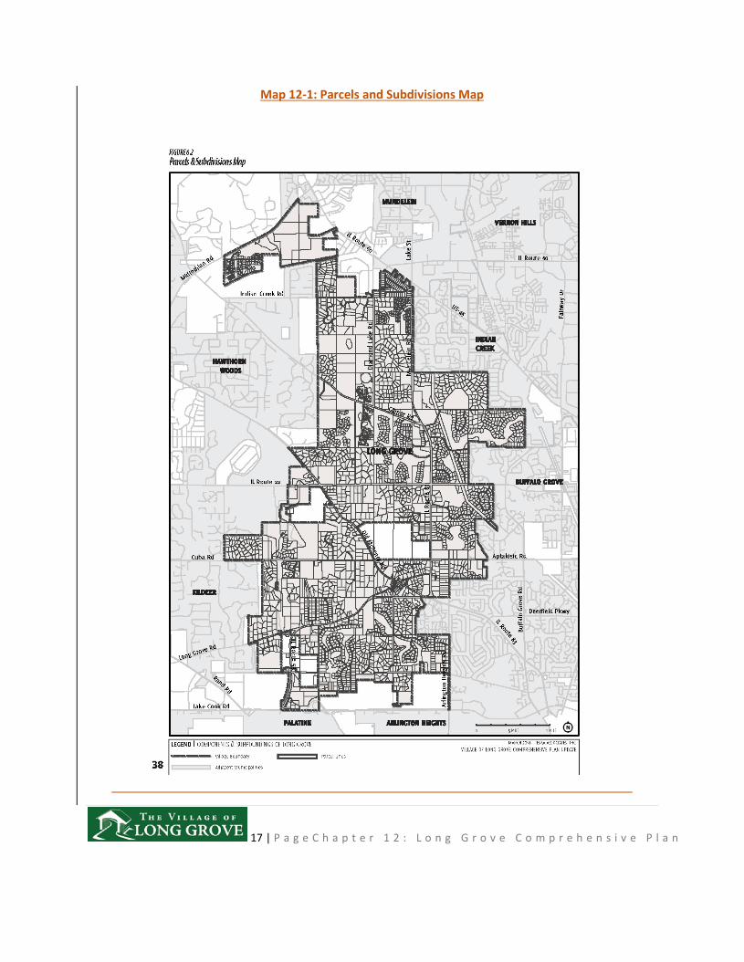
As shown on the Parcels and Subdivisions Map (Map 12-1), indicating residential development as of 2010, the majority of the Village has been developed with few remaining original tracks of land or homesteads. Some of these lands will remain as parks, conservancy areas, or other open space, leaving the remainder subject to development. As a result, there are very limited threats to character through new development, as limited opportunities exist to significantly change or influence character. The maintenance of both low-density zoning and consideration of cluster subdivisions may help balance future development to ensure that the community character is preserved. The 2000 Comprehensive Plan introduced the potential use of cluster subdivisions that provide for smaller lot sizes in return for more preserved open spaces in compliance with underlying zoning. Cluster subdivisions do not necessarily increase the number of dwelling units (density) that would be allowed on the property if the development complied with all Village zoning and development codes. This is generally important for heavily wooded areas, wetlands, conversancy soils, acquifer recharge areas where Village zoning permits lots at one acre or less. (2017)
Impact of Local and Regional Planning Efforts
Plans of adjacent communities and those of regional agencies can have a direct or indirect influence on Long Grove’s planning efforts. Below is a summary of the relevant planning documents.
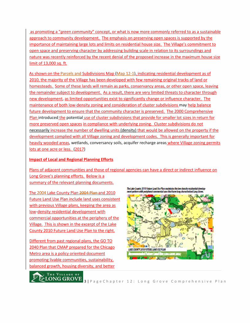
The 2004 Lake County Plan 2004 Plan and 2010 Future Land Use Plan include land uses consistent with previous Village plans, keeping the area as low-density residential development with commercial opportunities at the periphery of the Village. This is shown in the excerpt of the Lake County 2010 Future Land Use Plan to the right.
Different from past regional plans, the GO TO 2040 Plan that CMAP prepared for the Chicago Metro area is a policy oriented document promoting livable communities, sustainability, balanced growth, housing diversity, and better
4 | P a g e C h a p t e r 1 2 : L o n g G r o v e C o m p r e h e n s i v e P l a n
government policies. Of importance for Long Grove is CMAP’s policies articulating the importance of preserving open space, habitats, conservation and sustainable efforts, and adoption of an Open Space Plan/Green Infrastructure Plan. Long Grove continues to play an important role in fulfilling regional open space plans, providing a break from suburban sprawl, and promoting habitat and ground water protection. CMAP recently launched a three-year process to provide a plan update entitled ON TO 2050.
Local community plans are also available for adjacent municipalities including Buffalo Grove, Kildeer, Mundelein, Palatine, Vernon Hills, and Hawthorn Woods. As shown on the Village Limits & Boundary Agreement Map (Map H-1 in Appendix H), very limited areas remain that are unincorporated and may impact Long Grove’s planning area. (2017)
Economic & Market Opportunities
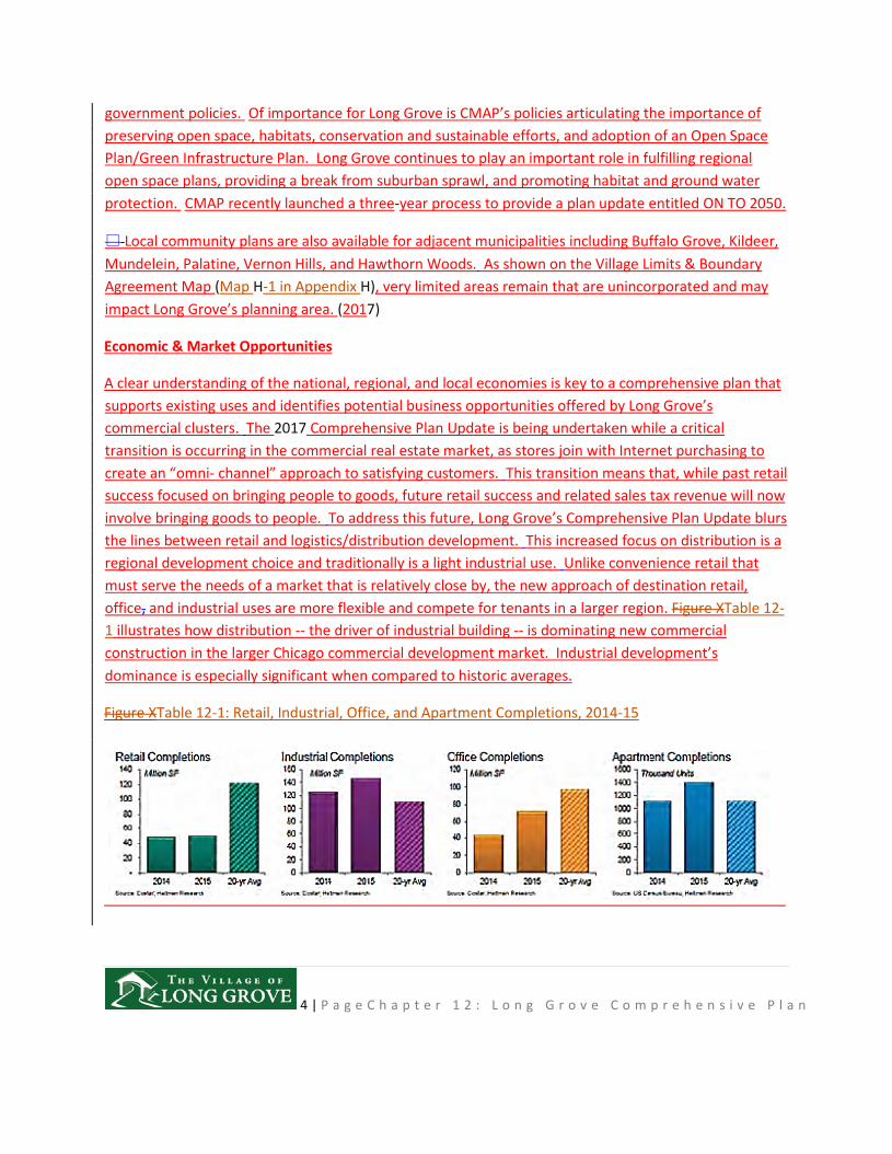
A clear understanding of the national, regional, and local economies is key to a comprehensive plan that supports existing uses and identifies potential business opportunities offered by Long Grove’s commercial clusters. The 2017 Comprehensive Plan Update is being undertaken while a critical transition is occurring in the commercial real estate market, as stores join with Internet purchasing to create an “omni- channel” approach to satisfying customers. This transition means that, while past retail success focused on bringing people to goods, future retail success and related sales tax revenue will now involve bringing goods to people. To address this future, Long Grove’s Comprehensive Plan Update blurs the lines between retail and logistics/distribution development. This increased focus on distribution is a regional development choice and traditionally is a light industrial use. Unlike convenience retail that must serve the needs of a market that is relatively close by, the new approach of destination retail, office, and industrial uses are more flexible and compete for tenants in a larger region. Figure XTable 12-1 illustrates how distribution -- the driver of industrial building -- is dominating new commercial construction in the larger Chicago commercial development market. Industrial development’s dominance is especially significant when compared to historic averages.
Figure XTable 12-1: Retail, Industrial, Office, and Apartment Completions, 2014-15
5 | P a g e C h a p t e r 1 2 : L o n g G r o v e C o m p r e h e n s i v e P l a n
The limited, exclusively retail development will infill existing strong environments, not create new retail clusters. Well-designed logistics/distribution development will likely attract some tenants generating retail sales tax in buildings that combine a showroom with offices and wharehouseswarehouses. For large format retailers, the internet purchasing trend translates into having smaller and fewer stores, because the consumer has made the purchase decision at home and will travel to obtain those goods. , Ddisplay areas on a large sales floor are no longer needed. For smaller, often independent retailers, this change means having an Internet presence and increasing sales by attracting business from a larger market. Easy access for UPS and FedEx delivery and pickup, as well as for customers, promises to make tomorrow’s retail businesses more successful.
While smaller and fewer anchor stores means new retail clusters will continue to be rare, the Rand Road corridor, near but not in Long Grove, is one of the few Chicago suburban sub- regions attracting high volume retailers. As Long Grove’s very successful Menards illustrates, high volume destination businesses, especially those mixing a showroom with office and distribution, could locate along Long Grove’s high volume streets and be destinations that capitalize on the sub-region’s strength.
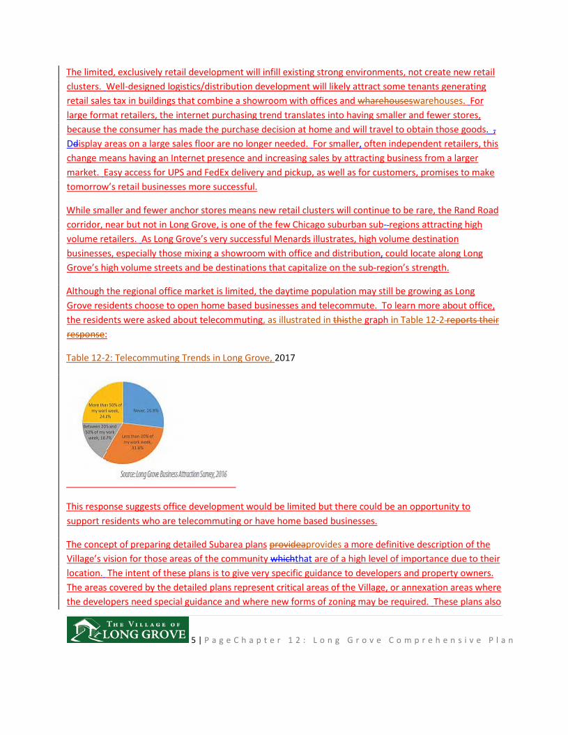
Although the regional office market is limited, the daytime population may still be growing as Long Grove residents choose to open home based businesses and telecommute. To learn more about office, the residents were asked about telecommuting, as illustrated in thisthe graph in Table 12-2 reports their response:
Table 12-2: Telecommuting Trends in Long Grove, 2017
This response suggests office development would be limited but there could be an opportunity to support residents who are telecommuting or have home based businesses.
The concept of preparing detailed Subarea plans provideaprovides a more definitive description of the Village’s vision for those areas of the community whichthat are of a high level of importance due to their location. The intent of these plans is to give very specific guidance to developers and property owners. The areas covered by the detailed plans represent critical areas of the Village, or annexation areas where the developers need special guidance and where new forms of zoning may be required. These plans also
6 | P a g e C h a p t e r 1 2 : L o n g G r o v e C o m p r e h e n s i v e P l a n
reflect the severe environmental constraints present on many of the remaining undeveloped, privately owned sites in and around the Village. The visual aspects of the character of development and desired uses which the Village expects is portrayed to provide guidance to developers and their architects and avoid lost time in reviewing and revising plans. As part of the 2017 Update, residents were asked for detailed information on desirable commercial uses. These were the most desired uses:
• Restaurants: Adding casual dining restaurants would have the greatest impact on spending in Long Grove’s commercial areas. White table cloth restaurants also garnered strong support.
• Retail goods businesses: Residents stated they would spend more money in Long Grove’s commercial areas if more general merchandise, home accessories, apparel, and fine wine and spirits businesses were offered in the Village.
• Service businesses: Residents indicated that they would spend more money in Long Grove’s commercial areas if more personal exercise, hair salon/spa, business service, and medical spa businesses were offered in the Village.
Within the context of the Village Comprehensive Plan, tThese subarea plans further refine the Village Comprehensive Plan and, indeed, become a part of that Plan. These special subarea plans shall also shall serve as a guide for the future development of such important Village areas. (1991, 2017)
Future Land Use
The Future Land Use element of the Comprehensive Plan is a tangible expression of Long Grove’s vision, identifying the character and type of improvements consistent with the Village’s rural character, and desire for a balanced, sustainable community. The Future Land Use Plan is a long-range guide for determining the preferred uses for land consistent with and supported by an multimodal transportation network that serves the entire community. This Plan identifies locations within the Village for new land uses, improvements to existing properties that will ensure Long Grove remains a vitalprosperous, growing and attractive place to live, work, and play.
Because Long Grove is predominately a built-out community, there are limited areas within the Village’s planning area that will undergo significant land use changes or significant major transportation route improvements. However, even with limited changes, this Plan provides a blueprint for public and private decisions about how particular areas should develop in coordination with other land uses and a multimodal transportation network. The principal aim of the Future Land Use Plan is to reinforce Long Grove’s vision as a community that provides a high quality of life in a rural setting, by establishing a balanced arrangement of land uses for residential, commercial, employment, civic, and recreational opportunities.
7 | P a g e C h a p t e r 1 2 : L o n g G r o v e C o m p r e h e n s i v e P l a n
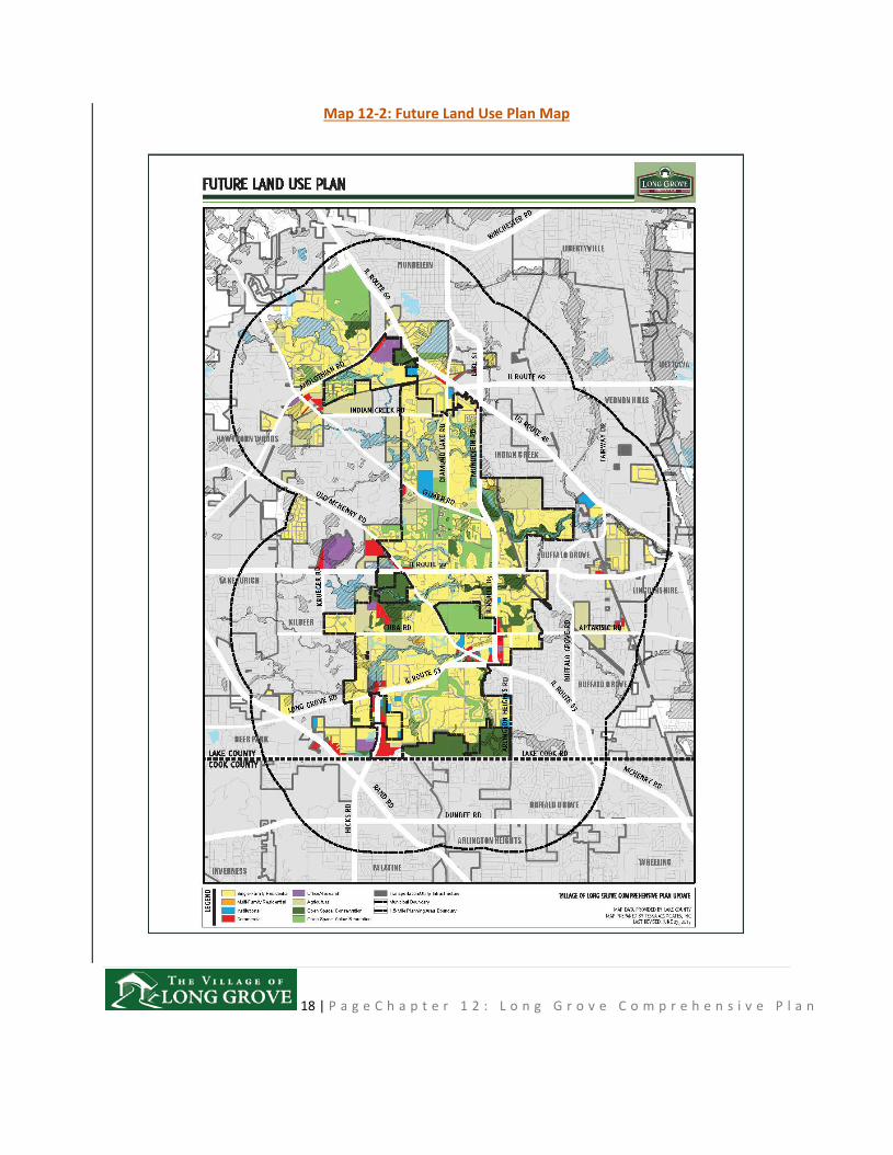
The future land use recommendations for Long Grove are illustrated on the Future Land Use Plan Map on Map 12-2. The recommendations reflect the Village’s desired physical layout consistent with the Goals and Objectives outlined in Chapter XX3. The Future Land Use Plan Map is a guide and is not intended to indicate precise boundaries between uses. Actual uses may vary from the land uses on the Plan depending on how a specific proposal relates to existing uses and property boundaries. The Village will give fair consideration to proposals for land development that varies from the Plan.
The Future Land Use Plan reinforces the historic and existing land use patterns, while targeting the following areas for change, to expand economic and residential opportunities, and therefore creating a sustainable, balanced future for Long Grove. Key recommendations include:
• Concentration of retail development within nodes or intersections of arterial roads, while preserving uses and Village character between key nodes along road corridors.
• Establishment of a unique ecologically oriented development associated with the historic farm at Route 22 and Old McHenry Road.
• Establishment of mixed-use communitydevelopment in the northern portion of the Village, with potential access to future commuter rail service, providing greater diversity of housing options, office and commercial uses within a walkable development that preserves natural resources.
• Improvement and expansion of the Downtown, consistent with the recommendations of the 2008 Downtown Master Plan, with enhanced linkages, and wayfinding, and identity signage. (2017)
Land Use Definitions
The land use categories described below reflect the existing, historic land use pattern of the Village, and offer new land use categories that respond to market opportunities and housing needs discussed in the Community Assessment Report (See Appendix K), and the development guidelines further detailed in the Subarea Plans section (Chapter XX)provided later in this chapter.
The proposed land uses below describe the use of land but not size, density, lot coverage, or any other bulk restrictions. Recommended changes to such bulk restrictions should be addressed in an updated zoning code. The following land use descriptions indicate the intent of the Village with regard to all land uses recommended and depicted on the Future Land Use plan mapPlan Map:
Agriculture: The agriculturalThis land use category is intended to provide opportunities for larger scale commercial or local farming operations to provide fresh foolfood options to support Long Grove’s healthy living goal and farm-to-table opportunities, . In cases where the property owner is willing to
8 | P a g e C h a p t e r 1 2 : L o n g G r o v e C o m p r e h e n s i v e P l a n
participate in developing their land, parcels marked as agricultural may also provide opportunities for larger scale commercial.
Single-Family Residential: This land use category is intended for detached single-family residential dwellings on large lots, on smaller lots in cluster subdivisions (grouping of homes), and in the historic center of the Village of generally one to two stories in height. This classification encompasses most of the Village’s subdivisions.
Attached Single-Family Residential: This land use category is intended for alternative housing types, including townhomes and condominiums ,buildings of between two and three stories in height.
Institutional: This land use category recognizes public or quasi-public uses which provide governmental, educational, religious, medical, cultural, or social services. The Institutional land use category encompasses lands whichthat benefit the public including properties owned by the federal, state, or local governments.
Commercial: This land use category includes lands planned for primarily commercial use predominantly of a retail or service nature at commercial nodes (located at key intersections along major arterial roads). While these areas are primarily for the sale of goods or provisions of commercial services, they may include office uses.
Office-/Research: This land use category is intended for office, high-tech manufacturing, and research facilities.
Open Space: : -Conservation: This land use category identifies lands owned by the Illinois Department of Natural Resources, conservancy and park districts, private homeowners and associations, or other public agencies dedicated to protecting lands that are sensitive to development. These lands contain unique or sensitive environmental characteristics that should be preserved. These characteristics include: wetlands, floodplains, creek and stream drainage-ways, woodlands, and prairies. In addition to their sensitive nature, these areas provide the Village with such natural functions as flood storage and conveyance, pollution control, and wildlife habitat areas. It should be noted that the precise boundaries of the floodplains, wetlands, and soils whichthat might limit development are imprecise. A trained wetlands conservationist or soil specialist needs to be consulted to determine the particular constraints for specific sites.
Open Space: – Active Recreation: This land use category includes Ppublic and private lands that hashave been permanently dedicated for recreational open space uses, including land owned or operated by the
9 | P a g e C h a p t e r 1 2 : L o n g G r o v e C o m p r e h e n s i v e P l a n
Long Grove Park District and the Village of Long Grove falls into this land use category. Private recreational spaces, such as golf courses or private parks located in residential developments, are also included in this category. The purpose of this category is to pre serve and provide for permanent open space used for active and passive recreational purposes.
Transportation and Utility Infrastructure: This land use category includes Aareas identified as transportation uses or public and private utility areas, includinge the facilities and transmission corridors of Commonwealth Edison, Lake County, and the Illinois Department of Transportation.
SubAreaSubarea Planning Recommendations
The concept of preparing detailed subarea plans, as used in the Long Grove Plan, is based upon the community's need to prepare more definitive plans for those areas of the Village which are of a community level of importance due to their location and the potential economic role they have in the Village. The intent of these plans is to give very specific guidance to developers on the type of plan development that will gain Village approvalbe consistent with Village goals.
The areas covered by the detailed subarea plans represent critical economic opportunity areas of within the Village, or areas that may be annexed. Their purpose is to provide ation areas where the developers with need special guidance, and where to identify land uses whichthat may require new forms of zoning in order may be requiredto implement plan recommendations. These plans also reflect the severe environmental constraints of many of the remaining vacant sites in and around the Village. The visual aspects of the character of development which the Village expects is portrayed to provide guidance to developers and their architects and avoid lost time in reviewing and revising plans. Within the context of the Village Comprehensive Plan, these subarea plans further refine the Village Comprehensive Plan and, indeed, become a part of that Plan. These special subarea plans also shall serve as a guide for the future development of such important Village areas. (1991, 2017)
Subarea Planning Factors
Although the current 2000 Comprehensive Plan mades it clear that commercial development has not played a major role in the evolution of the Village, the 2000 Plan does advance detailed subarea plans for five commercial opportunity areas and a new neighborhood, identified as:
• Historic Business District • Route 22 & Old McHenry Road • Lake Cook Road & Route 53
10 | P a g e C h a p t e r 1 2 : L o n g G r o v e C o m p r e h e n s i v e P l a n
• Long Grove Station (mixed-use neighborhood oriented around a potential new Metra station)
• Commercial node at the intersection of Routes 45, 60 &, and 83
As most subareas of Long Grove are largely located on the periphery of the Village, or part of established commercial areas, they offer the greatest opportunity for future economic development without substantially impacting the character of the community. The subareas that will have a prominent role in the future are shown on Subareas Map (Map in Map 12-3).
Development ideas/opportunities for each subarea are summarized in Maps 12-4 through 12-8, with the exception of the commercial area at the intersection of Routes 45, 60, and 83, as this area has very little development potential due to a few remaining infill properties. However, the redevelopment potential of the Route 45/60/83 subarea could improve by establishing a boundary agreement could be achieved with the Village of Mundelein, thatwhich would result in all the properties on the south side of Route 45 being transferred to Long Grove. The land use summary for each subarea describes the configuration and location of the subareas, proposed land use, access recommendations, and zoning issues that may influence development potential. The analysis of existing conditions for each subarea can be found in Section 6 of the Community Assessment Report, which is provided in Appendix K.
Relationship of Detailed Subarea Plan Preparation to the Community Goals and Objectives
Since planning is a rational process, plans including detailed subarea plans should be based upon community produced and accepted goals and objectives. This will ensure that the plans are realistic, able to gain public support and are, consequently, implemented. The goals and objectives set forth in this Long Grove Plan were developed by the Village Plan Commission and interested citizens and are presented in greater detail in Chapter 3 4 of this Comprehensive Plan. These long-range goals and their supporting short-range objectives have important implications for detailed subarea analyses and planning in the Village. (1991)
Four commercially-oriented planning subareas and a new neighborhood identified by the Village Plan Commission include the Historic Business District, Route 22/0ld McHenry Road, Routes 45/60/83, Lake Cook Road/Route 53, and Long Grove Station planning subareas. Subarea plans can be found in Appendix J. (1996]
SubAreaSubarea Land Use & Development Policies
A key element of Long Grove’s Comprehensive Plan Update is the establishment of the land use, design, and transportation policies that will direct the development of the several large undeveloped tracks of land within the Village. Each of the SubAreasubarea conceptual plans summarized below incorporate the results of the Community Assessment Report (CAR) (Appendix K), and the results of input received at
11 | P a g e C h a p t e r 1 2 : L o n g G r o v e C o m p r e h e n s i v e P l a n
the EnVision Long Grove Workshop in April, 2016. Provided below is a summary of the key features of each subarea development concept. For each of the land use types illustrated on the maps and discussed below, the image preference survey results provided in Appendix L will serve as the guidelines for the desired character of each type of use.
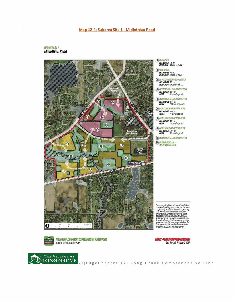
Subarea Site 1: Midlothian Road
Over 401 acres of this subarea was originally approved as a planned unit development in 1990. In 1995, 300 acres were condemned and acquired by the Illinois Department of Transportation (IDOT) for the FAP 342 (Route 53 extension). The Village of Long Grove has long opposed extending Route 53. Long Grove's opposition to extending Route 53 has always been grounded -in environmental and land use concerns. Opening a new highway corridor would create increased growth and urban sprawl in an area that currently is planned for low density or is in a holding zone. (1996, 1999)
Alternatively, the Village has considered how to take advantage of future commuter rail service provided by the Wisconsin Central Railroad serviceMetra’s North Central Service (NCS) commuter rail line from Antioch to O'Hare with connections to Chicago's lLoop. Long Grove residents have commuter rail access from two stations along the NCS line: the Prairie View Station near Route 22 and the Vernon Hills Station on Route 45. Although no longer a priority of Metra’s long-range plans, continued consideration should be given to providing opportunities to extend commuter rail service on the E.J. &E. Railroad and a potential station in this subarea. (1996, 1999, 2017)
The focus of this Subarea is to capitalize on the existing Mundelein Meadows retail node at the intersection of Midlothian Road and IL Route 60, by expanding commercial and office uses. The balance of the property is heavily influenced by extensive floodplains and wetlands, thereby providing an opportunity for a planned residential development that both takes advantage of and orients residential uses to open spaces and associated trail opportunities. The plan integrates both the Diamond Lake Sports cComplex and the West Oak Middle School by providing road connections that will improve access to these facilities by Long Grove residents, and improve overall walkability.
• Land Use Plan
o Residential: Residential land use options provide a transition from the existing rural residential subdivisions to the west and north, andas well as to commercial development to the north.
o Commercial: Expansion of neighborhood oriented retail along Midlothian Road, and professional office opportunity as a complimentary use to the existing retail and services uses in the existing Mundelein Meadows retail center.
• Transportation Access
12 | P a g e C h a p t e r 1 2 : L o n g G r o v e C o m p r e h e n s i v e P l a n
o Three full access roads are proposed along Midlothian Road, with interconnections to the existing access road serving the retail center on the north and the sports complex and school on the east.
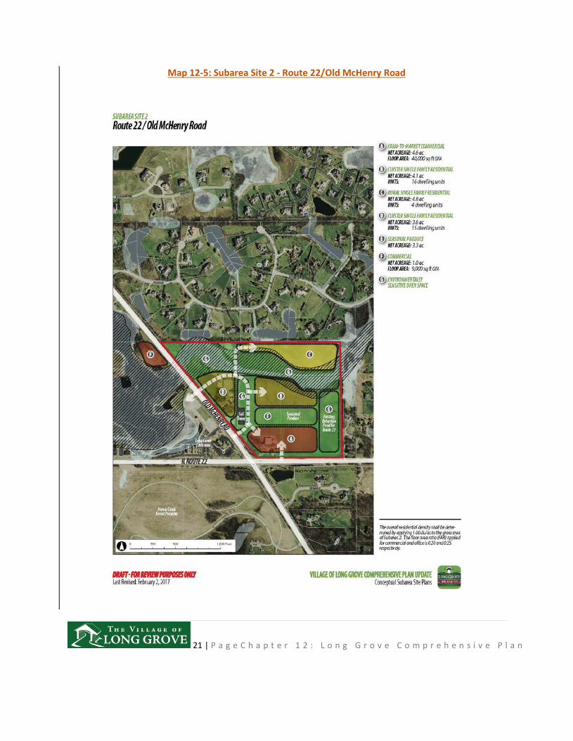
Subarea Site 2: Route 22/Old McHenry Road
The presence of the existing agricultural use provides an opportunity to build on the farming community history of the area by promoting the development of a Farm-to-Market commercial enterprise, and associated seasonal produce garden area. The seasonal produce garden could not only provide not only produce, but native plants and seed for Long Grove residents and organizations to use in restoring conservation areas. The garden area could also be supported by the new residential neighborhood providing healthy living choices, similar to arrangements provided residents in the Prairie Crossings, a conservation oriented community in Grayslake IL.
• Land Use Plan
o Residential: Three residential land use types provide a transition from the existing rural residential subdivisions to the north, and to commercial development along Route 22.
o Commercial: Farm-to-Market specialty commercial and associated seasonal produce garden area along Route 22. Another commercial site is also proposed in a small enclave along the west side of Old McHenry Road.
• Transportation Access
o IDOT Strategic Regional Arterial plans for Route 22 will permit only one full access to Route 22, with a secondary right-in and /right-out access.
o Access to Old McHenry Road takes advantage of two existing access points to the family day camp.
o Connection to the rural single-family areas on the north end of the site would be provided by a private road due to the cost of crossing the floodplain and the limited number of developable lots.
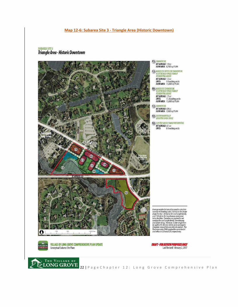
Subarea Site 3: Triangle Area (Historic Downtown)
Although not containing historically significant uses, the ‘triangle area’ is an important part of Long Grove’s Hhistoric Ddowntown center, as discussed in the 2008 Downtown Master Plan. As recommended in the Downtown Plan, it represents an opportunity to both expand Long Grove’s unique
13 | P a g e C h a p t e r 1 2 : L o n g G r o v e C o m p r e h e n s i v e P l a n
district and to provide supportive land uses that provide a walk-in market for local businesses, and attractive location for younger and older home buyers.
• Land Use Plan
o Residential: Attached single-family dwellings serve to provide a market for Long Grove residents and serve as a transitional use to the Downtown commercial area. The intent is that each group of units will be designed to represent the similar scale of other historic buildings in the area.
o Commercial: As provided for in the Downtown Plan, limited expansion of Downtown retail is proposed as an extension of the alignment of Archer Road, with a signature, high-quality retail use at the gateway to Downtown at Old McHenry Road and Route 53. All new commercial uses should be subject to the architectural guidelines for the Downtown to ensure Long Grove’s brand image is maintained.
• Transportation Access
o Extension of Archer Road to the south to improve circulation to align with existing streets, connect with public parking areas, and to provide more parking via on on-street spaces. The extension of Archer Road also provides greater connectivity to the Historic Downtown area northward to the uses north of Old McHenry Road.
o The additional of a minor access roads toare proposed to serve the attached single-family uses and provide access to Old McHenry Road.
Subarea Site 4: Sunset Grove/Ballybunion
In terms of long term economic opportunity, both from direct impact of potential new sales, and indirect impact to expand the residential base to support businesses in the larger Downtown area, this sub-area is a high priority development opportunity site. The overall plan capitalizes on the access and visibility to Route 83, a high volume regional arterial road, by establishing a mixed-use district providing opportunities to expand commercial and supportive residential uses, while maintaining scenic corridors and conservancy areas.
• Land Use Plan
14 | P a g e C h a p t e r 1 2 : L o n g G r o v e C o m p r e h e n s i v e P l a n
o Residential: Potentially higher density forms of residential use (i.e. less than one acre lot housing) are opportunities north of Aptakisic Road to serve as a walk-in market for commercial uses, provide new housing options, and to create a transition between commercial and residential areas.
o Commercial: Commercial expansion consists of both smaller scale shopping centers, similar to the Sunset Grove development, office uses, and opportunities for ‘mid-sized’ retail stores ranging from 30,000 to 50,000 sq. ft. While most commercial expansion is proposed along Route 83, some extend eastward to Arlington Heights Road for greater coverage and integration with the existing Sunset Grove development.the plan identifies potential development opportunity to the east, provided that property owners are open to exploring such options. Until such development options materialize, existing property uses will remain as is. Office/hospitality uses are proposed at the northeast corner of Aptakisic Road and Arlington Heights Road.
• Transportation Access
o Access to the largest commercial concentration on the southern ’15 acres’ is dependent on IDOT granting of complete, full access at the current signal at the extension of Route 53, at which point a private access drive cwould, with Village approval, extend northeast to serve the proposed commercial sites.
o One full access road serving the property north of Aptakisic Road to align with the access to Sunset Grove. Other access to properties from Aptakisic are likely to be limited to right -in/ and right-out due to the planned median as part of Lake County’s improvements plans.
o Access to the proposed uses on the Ballybunion and nursery sites north of Aptakisic Road take advantage of existing curb-cuts, which will likely need to be accepted by IDOT as part of new development proposals. The current design of the median in Route 83 provides for full access to these properties.
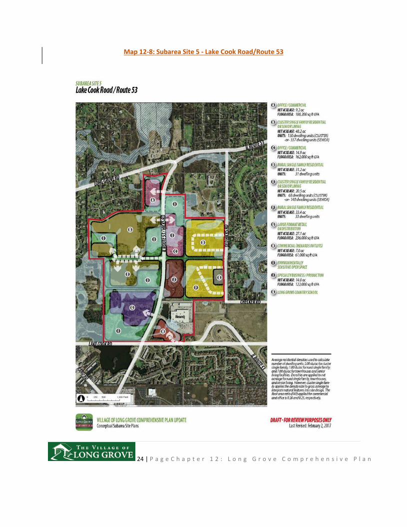
Subarea Site 5: Lake Cook Road/Route 53
This subarea is impacted by the proposed right-of-way for FAP 342, and extensive wetlands, floodplain or conservancy soils. To the east of the right-of-way is residential development. If the FAP 342 right-of-way were to be abandoned or relocated, in the future, this area has potential for significant commercial, and limited residential uses. The west side of Route 53 is more buildable. This subarea’s convenient access to major regional road corridors and the IL 53 expressway, combined with large trackstracts of
15 | P a g e C h a p t e r 1 2 : L o n g G r o v e C o m p r e h e n s i v e P l a n
available land for development (exclusive of wetlands), continues to be the Village’s opportunity for expansion of its sales tax base. The area can support a large-box retail use similar to Menards. (1999, 2017)
Assets and Liabilities
Assets:
• The location at an interchange with an expressway and major urban arterial is a major asset. (1999)
• A Long Grove address is desirable for most businesses. (1999)
• The site size is large enough to support several users and large scale activities. (1999)
• Long Grove has no Village real estate tax, which is a desirable incentive for potential developers. (1999)
Liabilities:
• Access to the site is limited to the Route 53 frontage. (1999)
• Uncertainty on future of FAP 342 and valuable land held by the Illinois Department of Transportation (Route 53 extension). (1999)
• The residential density isin the area is quite low, even with apartments nearby in Arlington Heights. This will be a deterrent to some commercial developers. (1999)
• The west portion of-the site abuts two large ADID wetlands which will require special protection and mitigation. (1999)
Land Use Plan
• Residential: Rural residential uses are maintained along the Hicks Road corridor, with both senior and cluster housing options for properties west of Route 53. The type of senior housing contemplated at this location would be different from other recently approved assisteding living communities, with homes consisting of smaller lot, independent living development in a maintenance free environment with high quality recreational and social amenities, all connected with an extensive trail system.
16 | P a g e C h a p t e r 1 2 : L o n g G r o v e C o m p r e h e n s i v e P l a n
• Commercial: Large box retail use is proposed at the southern end of the sub-area, with office/commercial and specialty business/manufacturing use opportunities along Route 53.
Transportation Access
• Access to the large-box retail sSite G at the southwestern section of the subarea should be coordinated with the Menard’s existing signalized intersection serving Menards.
• An additional fully signalized access to be coordinated with the existing access to site (Site J), to provide access to residential development to the west and east.
• Secondary road access to the large residential area to the west of IL 53 and the office use area on Site C provides both improved options for egress and enhances development potential.
17 | P a g e C h a p t e r 1 2 : L o n g G r o v e C o m p r e h e n s i v e P l a n
Map 12-1: Parcels and Subdivisions Map
18 | P a g e C h a p t e r 1 2 : L o n g G r o v e C o m p r e h e n s i v e P l a n
Map 12-2: Future Land Use Plan Map

19 | P a g e C h a p t e r 1 2 : L o n g G r o v e C o m p r e h e n s i v e P l a n
Map 12-3: Subareas Map
20 | P a g e C h a p t e r 1 2 : L o n g G r o v e C o m p r e h e n s i v e P l a n
Map 12-4: Subarea Site 1 - Midlothian Road
21 | P a g e C h a p t e r 1 2 : L o n g G r o v e C o m p r e h e n s i v e P l a n
Map 12-5: Subarea Site 2 - Route 22/Old McHenry Road
22 | P a g e C h a p t e r 1 2 : L o n g G r o v e C o m p r e h e n s i v e P l a n
Map 12-6: Subarea Site 3 - Triangle Area (Historic Downtown)

23 | P a g e C h a p t e r 1 2 : L o n g G r o v e C o m p r e h e n s i v e P l a n
Map 12-7: Subarea Site 4 - Sunset Grove/Ballybunion
24 | P a g e C h a p t e r 1 2 : L o n g G r o v e C o m p r e h e n s i v e P l a n
Map 12-8: Subarea Site 5 - Lake Cook Road/Route 53