chapter 2 cape fear river subbasin 03-06-02 quality/planning/bpu/bpu/cape_fea… · chapter 2 cape...
TRANSCRIPT

Chapter 2 Cape Fear River Subbasin 03-06-02
Including: Haw River, Buffalo Creek, Reedy Fork Creek and Greensboro Reservoirs
2.1 Subbasin Overview
Subbasin 03-06-02 is an outer piedmont watershed characterized by highly erodible soils. Most of the watershed is forested or in agriculture, with increasing urban development that can have negative water quality impacts. Development is occurring along the I-85/40 corridor in Greensboro and Burlington. Population is expected to grow by 165,000 people in counties with portions or all of their areas in this subbasin by 2020. There are 30 individual NPDES wastewater discharge permits in this subbasin with a permitted flow of 76.6 MGD (Figure 5). The largest are Burlington Eastside WWTP (12.0 MGD), Graham WWTP (3.5 MGD), Mebane WWTP (2.5 MGD), North Buffalo WWTP (16 MGD) and T.Z. Osborne WWTP (40 MGD). Refer to Appendix VI and Chapter 30 for more information on NPDES permit holders. Issues related to compliance with NPDES permit conditions are discussed below in Section 2.3 for Impaired waters. In this subbasin, Burlington, Graham, Greensboro, Haw River and Mebane are required to develop stormwater programs (Chapter 31). There is one registered swine operation, one registered cattle operation and five registered dairy operations in this subbasin. Issues related to agricultural activities are
discussed below in Section 2.3 for Impaired waters.
Land and Water Area Total area: 562 mi2 Land area: 555 mi2 Water area: 7 mi2 Population Statistics 2000 Est. Pop.: 247,449 people Pop. Density: 441 persons/mi2 Land Cover (percent) Forest/Wetland: 58.9% Surface Water: 2.5% Urban: 8.5% Cultivated Crop: 2.3% Pasture/ Managed Herbaceous: 27.9% Counties Alamance, Caswell, Forsyth, Guilford and Orange
Municipalities Burlington, Graham, Green Level, Greensboro, Haw River and Mebane
Subbasin 03-06-02 at a Glance
There were 22 benthic macroinvertebrate community samples and 13 fish community samples (Figure 5 and Table 5) collected during this assessment period. Data were also collected from 34 ambient monitoring stations including four DWQ stations, nine UCFRBA (Appendix V) stations, four shared ambient stations, and 16 City of Greensboro (Appendix V) stations. Three DWQ bacterial special study stations were also sampled as well as six reservoirs. Refer to the 2003 Cape Fear River Basinwide Assessment Report at http://www.esb.enr.state.nc.us/bar.html and Appendix IV for more information on monitoring.
Chapter 2 – Cape Fear River Subbasin 03-06-02 12

� �� ��
��� ����
��� ��� �
�
��
����� ��� ���� ��� ���� � �
� ��� �� �
� ���
�� �� �
��
��
����
���
�
�
�
�� ��
��
�
����
����
��
����
��
��
��
��
��
��
�� ��
��
��
��
������
��
��
��
��
������
�� ��
�� ��
��
�
�
��
���
�
�
�
�
�
�
��
�
�
���
��
�
��
�
� ���
��
��
�
�
�����
�
� �
�
��
���
��
��
���
�
�
�
� ��
����
�
�
��
�
���
�
�
��
����
����
��������
��
����
������
������������������������������������������
������������������
����
��
��������������
������
������ ����
����������������
��������
����
����������������
������
��������
������������������
�� ����
����
��������������
������
������������������
����
����������������
������
��
����
��
����
����
��
�� ��������
����
��� ��
�������
���������
������
����������
���������� � �
���������� ��� ���������� ������
������������������
����
���� ����
��������
����
����
����
����
����
��������
���
�����
�����
�����
����
�����
�����
�����
����������
�����
����
�����
���������
�����
�����
����
�����
�����
����
���
������
����
���
����
���
����
����
����
����
����
����
����
�����
�����
�����
�����
�����
��
���
����
���
��������
����
����
����
��������
���
���
����
��������
����� ����
��������
����
����
�����
����
�����
�����
����
����
������
������
����
����
����
������
����
����
�����
�����
���� !�"#$
�����%&"'�"#
�%($)
(**�+%
�,�"--�!�
�!���
%!$)
(**�+%
�!���
���#,
�!���
���� (!+."/$%"
0%!#�"
�!���
��
��1�
�%&"- !�"2)
�$%",
�!���
1�!"�+'
�!���
�!�)�3���4�"���'�!5%.!
�
��
�
�� � �� �.+�'������������� ������ ��� ��� ��! �����!���� �"������#$�%&&'
(��� ������� ��
����������� ��
"���������������(� ����������)�(� ����*������������(� �����
�����������������(�++�����,�+ �� ����� �� ���� �
!�� ����� �
���)+ ��
��/�"#
��������� !������� � -��
������
����������"�����������#�����$$������%��%��

AU NumberDescription
Length/AreaClassification
CAPE FEAR 03-06-02
AL Rating REC RatingStationYear/ParameterResult % Exc
Aquatic Life Assessment
ResultStation
Recreation Assessment
Stressors Sources
SubbasinTable 5
Back Creek16-18-(6)
From dam at Graham-Mebane Reservoir to Haw River
6.2 FW MilesC NSW NR NDBB340 /1999NR
Back Creek (Graham-Mebane Reservoir)16-18-(1.5)
From .3 mile upstream of NC Hwy 119 to dam at Graham-Mebane Res
693.3 FW AcresWS-II HQ NR NDBL7 NCE Chlor a 33 Chlorophyll a Unknown
Blackwood Creek16-11-14-2-4
From source to Buffalo Creek
5.6 FW MilesC NSW S NR*BA755 NCE BA755 NCE Fecal Coliform Bacteria MS4 NPDES
Brush Creek16-11-4-(1)a1
From source to UT at SR 2085
2.4 FW MilesWS-III NS NR NDBB93 /2003NR
16-11-4-(1)a2
From UT at SR 2085 to UT 0.3 miles downstream fo SR 3820
1.8 FW MilesWS-III NS S NDBF69 /1999G
16-11-4-(1)a3
From UT 0.3 miles downstream of SR 3820 to a point 0.5 mile downstream of Guilford County SR 2190
1.6 FW MilesWS-III NS I NR*BA761 NCE Turbidity 10
BB364 /2003F
BA761 NCE Fecal Coliform Bacteria MS4 NPDES
Habitat Degradation MS4 NPDES
Turbidity MS4 NPDES
Brush Creek(Lake Higgins)16-11-4-(2)
From a point 0.5 mile downstream of Guilford SR 2190 to Lake Brandt, Reedy Fork
79.2 FW AcresWS-III NS S NDBL4 NCE
Haw Creek16-20-(4)
From N.C. Hwy. 54 to Haw River
3.8 FW MilesC NSW S NDBB374 /2003GF
BB374 /1999NR
BF55 /2003G
CAPE FEAR Subbasin 03-06-02

AU NumberDescription
Length/AreaClassification
CAPE FEAR 03-06-02
AL Rating REC RatingStationYear/ParameterResult % Exc
Aquatic Life Assessment
ResultStation
Recreation Assessment
Stressors Sources
SubbasinTable 5
HAW RIVER16-(1)d2
From Subbasin 01/02 boundary to Service Creek
10.1 FW MilesC NSW S SBA59 NCE Turbidity 9.8 BA59 NCEBA59 NCEBA746 NCE
Turbidity Impervious Surface
Turbidity MS4 NPDES
Turbidity Agriculture
16-(1)d3
From Service Creek to a NC 49
2.1 FW MilesC NSW S IBA74 NCE Turbidity 9.6 BA74 CEBA74 NCE
Fecal Coliform Bacteria Unknown
Turbidity Unknown
16-(1)e
From NC 49 to a point 0.4 mile downstream of Cane Creek (South side of Haw River)
18.5 FW MilesC NSW S NR*BA117 NCEBA118 NCEBA76 NCE Turbidity 9.8BA90 NCE Turbidity 7.3
BB220 /2002GF
BB220 /1998GF
BA118 NCEBA76 NCEBA90 NCE
Fecal Coliform Bacteria Unknown
Turbidity Unknown
Horsepen Creek16-11-5-(0.5)a
From source to Ballinger Road
1.8 FW MilesWS-III NS NR NDBB205 /2001NR
BB205 /2000NR
BB369 /2001NR
BB369 /2000NR
Habitat Degradation MS4 NPDES
16-11-5-(0.5)b
From Ballinger Road to U.S. Hwy 220
3.2 FW MilesWS-III NS I NR*BB61 /2000P
BA762 NCE Fecal Coliform Bacteria Unknown
Habitat Degradation MS4 NPDES
16-11-5-(2)
From U.S. Hwy 220 to Lake Brandt, Reedy Fork
1.8 FW MilesWS-III NS I NR*BB427 /2003P
BB427 /2001NR
BB427 /2000F
BF71 /1999GF
BA759 NCE Fecal Coliform Bacteria Unknown
Habitat Degradation MS4 NPDES
CAPE FEAR Subbasin 03-06-02

AU NumberDescription
Length/AreaClassification
CAPE FEAR 03-06-02
AL Rating REC RatingStationYear/ParameterResult % Exc
Aquatic Life Assessment
ResultStation
Recreation Assessment
Stressors Sources
SubbasinTable 5
Jordan Creek16-14-6-(0.5)
From source to a point 0.7 mile upstream of mouth
10.6 FW MilesWs-II HQW S SBA70 NCE
BB214 /2003GF
BF46 /2003GF
BA70 NCE
Moadams Creek (Latham Lake)16-18-7
From source to Back Creek
4.6 FW MilesC NSW NR NR*BA87 NCEBA88 NCE
BB342 /1999NR
BB9 /1999NR
BA87 NCEBA88 NCE
Muddy Creek16-11-14-1-3
From source to North Buffalo Creek
3.7 FW MilesC NSW S NR*BA748 NCE BA748 NCE Fecal Coliform Bacteria Unknown
North Buffalo Creek16-11-14-1a1
From source to Philadelphia Lake
7.5 FW MilesC NSW I NR*
BF36 /1999P
BF64 /1999P
BA750 NCEBA751 NCE
Habitat Degradation Unknown
16-11-14-1a2
From Philadelphia Lake to North Buffalo Creek WWTP
1.6 FW MilesC NSW S I
BF11 /1999P
BF11 /2003GF
BA42 NCEBA742 CE
Fecal Coliform Bacteria MS4 NPDES
16-11-14-1b
From North Buffalo Creek WWTP to Buffalo Creek
8.1 FW MilesC NSW I NR*BA44 NCE Turbidity 7.4BA45 NCE
BB407 /2003P
BA44 NCEBA45 NCEBA747 NCE
Habitat Degradation MS4 NPDES
Fecal Coliform Bacteria MS4 NPDES
Turbidity MS4 NPDES
Philadelphia Lake (Buffalo lake, and White Oak Lake)16-11-14-1-2b
White Oak Lake
18.0 FW AcresC NSW S NR*BA749 NCE Turbidity 10 BA749 NCE Fecal Coliform Bacteria MS4 NPDES
Turbidity MS4 NPDES
CAPE FEAR Subbasin 03-06-02

AU NumberDescription
Length/AreaClassification
CAPE FEAR 03-06-02
AL Rating REC RatingStationYear/ParameterResult % Exc
Aquatic Life Assessment
ResultStation
Recreation Assessment
Stressors Sources
SubbasinTable 5
Reedy Creek16-11-(1)a
From source to UT 0.7 miles downstream of SR 2128
8.1 FW MilesWS-III NS S SBA760 NCE
BB362 /2003GF
BB362 /2001G
BB386 /2003GF
BA760 NCE Habitat Degradation Impervious Surface
16-11-(1)b
From SR 2128 to a point 0.4 mile downstream of Moores Creek
4.2 FW MilesWS-III NS I NDBF54 /1999F
Habitat Degradation Impervious Surface
Reedy Fork (Hardys Mill Pond)16-11-(9)a1
From Lake Townsend Dam to UT at SR 2782
6.7 FW MilesC NSW S SBA757 NCE BA757 NCE
16-11-(9)a2
From UT at SR 2782 to UT at SR 2778
2.2 FW MilesC NSW I NDBB404 /2003F
BF65 /2003G
16-11-(9)a3
From Ut at SR 2778 to Buffalo Creek
3.0 FW MilesC NSW S SBA38 NCE BA38 NCE
16-11-(9)b
From Buffalo Creek to Haw River
8.6 FW MilesC NSW S IBA58 NCE BA58 CEBA58 NCE
Fecal Coliform Bacteria Unknown
Reedy Fork(including Lake Brandt and Lake Townsend below nor16-11-(3.5)a
Lake Brandt
760.0 FW AcresWS-III NS S NDBL2 NCE
16-11-(3.5)b
Lake Townsend
1,404.7 FW AcresWS-III NS S NDBL3 NCE
Richland Creek (Richland Lake)16-11-7-(1)a
From source to backwaters of Richland Lake
3.1 FW MilesWS-III NS S NR*BA758 NCE BA758 NCE Fecal Coliform Bacteria Unknown
Ryan Creek16-11-14-2-3
From source to South Buffalo Creek
4.2 FW MilesC NSW I NR*BA754 CE Turbidity 14 BA754 NCE Fecal Coliform Bacteria MS4 NPDES
Turbidity MS4 NPDES
CAPE FEAR Subbasin 03-06-02
AU NumberDescription
Length/AreaClassification
CAPE FEAR 03-06-02
AL Rating REC RatingStationYear/ParameterResult % Exc
Aquatic Life Assessment
ResultStation
Recreation Assessment
Stressors Sources
SubbasinTable 5
South Buffalo Creek16-11-14-2a
From source to McConnell Rd
15.4 FW MilesC NSW I NR*BA50 NCE Turbidity 7.3BA752 CE Turbidity 14BA756 NCE
BB406 /2003P
BA50 NCEBA752 NCEBA753 NCE
Habitat Degradation MS4 NPDES
Fecal Coliform Bacteria MS4 NPDES
Turbidity MS4 NPDES
16-11-14-2b
From McConnell Rd to US 70
4.7 FW MilesC NSW I NDBF73 /2003P
Habitat Degradation MS4 NPDES
16-11-14-2c
From US 70 to Buffalo Creek
4.8 FW MilesC NSW I NDBA54 CE Turbidity 10.5 BA54 NCE Turbidity MS4 NPDES
Stony Creek (Lake Burlington)16-14-(1)a
From source to Benton Branch
4.3 FW MilesWs-II HQW S NDBF26 /2003GF
Habitat Degradation
16-14-(1)b
From Benton Branch to backwaters of Lake Burlington
2.7 FW MilesWs-II HQW S NDBB231 /2003GF
Habitat Degradation
16-14-(1)c
Lake Burlington
738.0 FW AcresWs-II HQW NR NDBL5 NCE Chlor a 33 Chlorophyll a Agriculture
Stony Creek (Stony Creek Reservoir)16-14-(5.5)
From Buttermilk Creek to dam at Stony Creek Reservoir
118.0 FW AcresWS-II HQ S NDBL6 NCE
Town Branch16-17
From source to Haw River
4.2 FW MilesC NSW S IBA78 NCE BA78 NCEBA78 CE
Fecal Coliform Bacteria MS4 NPDES
Unnamed Tributary at Guilford College16-11-5-1-(2)
From dam at Guilford College bathing lake to Horsepen Creek
1.3 FW MilesWS-III NS I NDBB68 /2001P
CAPE FEAR Subbasin 03-06-02

AU NumberDescription
Length/AreaClassification
CAPE FEAR 03-06-02
AL Rating REC RatingStationYear/ParameterResult % Exc
Aquatic Life Assessment
ResultStation
Recreation Assessment
Stressors Sources
SubbasinTable 5
Varnals Creek16-21a
From source to Rock Creek
4.6 FW MilesC NSW I NDBB390 /2000F
16-21b
From Rock Creek to Haw River
2.8 FW MilesC NSW S NDBB359 /2000G
AL - Aquatic Life BF - Fish Community Survey E - Excellent S - Supporting, I - ImpairedREC - Recreation BB - Benthic Community Survey G - Good NR - Not Rated
BA - Ambient Monitoring Site GF - Good-Fair NR*- Not Rated for Recreation (screening criteria exceeded)BL- Lake Monitoring F - Fair ND-No Data Collected to make assessmentS- DEH RECMON P - Poor
NI - Not Impaired CE-Criteria Exceeded > 10% and more than 10 samplesMiles/Acres S- Severe Stress NCE-No Criteria ExceededFW- Fresh Water M-Moderate StressS- Salt Water N- Natural
Results
Aquatic Life Rating SummaryS 101.3 FW Milesm
NR 15.0 FW Milesm
I 63.5 FW Milesm
S 2,379.9 FW Acresm
NR 1,431.3 FW Acresm
ND 213.4 FW Miles
ND 498.0 FW Acres
Recreation Rating Summary38.5 FW MilesS m
77.2 FW MilesNR* m
16.5 FW MilesI m
18.0 FW AcresNR* m
261.0 FW MilesND
4,291.2 FW AcresND
Fish Consumption Rating Summary393.2 FW MilesI e
4,309.2 FW AcresI e
CAPE FEAR Subbasin 03-06-02

Waters in the following sections are identified by assessment unit number (AU#). This number is used to track defined segments in the water quality assessment database, 303(d) Impaired waters list and the various tables in this basin plan. The assessment unit number is a subset of the DWQ index number (classification identification number). A letter attached to the end of the AU# indicates that the assessment is smaller than the DWQ index segment. No letter indicates that the assessment unit and the DWQ index segment are the same. 2.2 Use Support Assessment Summary Use support ratings were assigned for waters in subbasin 03-06-02 in the aquatic life, recreation, fish consumption and water supply categories. All waters are Impaired on an evaluated basis in the fish consumption category because of fish consumption advice that applies to the entire basin. In the water supply category, all WS classified waters (4,201.1 acres and 182.3 miles) are Supporting on an evaluated basis based on reports from DEH regional water treatment plant consultants. Refer to Appendix X for a complete list of monitored waters and more information on Supporting monitored waters. There were 179.8 stream miles (45.7 percent) and 3,811.2 freshwater acres (88.4 percent) monitored during this assessment period in the aquatic life category. There were 63.5 miles (16.2 percent) of Impaired waters in this category. There were also 16.5 stream miles (4.2 percent) Impaired for recreation in this subbasin. 2.3 Status and Recommendations of Previously and Newly Impaired
Waters The following waters were either identified as Impaired in the previous basin plan (2000) or are newly Impaired based on recent data. If previously identified as Impaired, the water will either remain on the state’s 303(d) list or will be delisted based on recent data showing water quality improvements. If the water is newly Impaired, it will likely be placed on the 2006 303(d) list. The current status and recommendations for addressing these waters are presented below, and each is identified by an assessment unit number (AU#). Refer to the overview for more information on AUs. Information regarding 303(d) listing and reporting methodology is presented in Appendix VII. 2.3.1 Brush Creek [AU# 16-11-4-(1)a1, a2 and a3] 2000 Recommendations The 2000 basin plan recommended that Brush Creek be resampled and that DWQ work with the City of Greensboro to improve water quality where possible. Current Status Brush Creek [16-11-4-(1)a1] from source to SR 2085 (2.4 miles) is Not Rated for aquatic life because a benthic community rating could not be assigned at site BB93 because of the small size of the stream. Brush Creek [16-11-4-(1)a2] from SR 2085 to 0.3 miles downstream of SR 3820 (1.8 miles) is Supporting aquatic life because of a Good fish community rating at site BF69.
Chapter 2 – Cape Fear River Subbasin 03-06-02 20

Brush Creek [16-11-4-(1)a3] from SR 3820 to 0.5 miles downstream of SR 2190 (1.6 miles) is Impaired for aquatic life because of a Fair benthic community rating at site BB364. Turbidity also exceeded the water quality standard in 10 percent of samples at site BA761. This segment is Not Rated for recreation because fecal coliform bacteria screening criteria were exceeded at site BA761. The Brush Creek watershed drains large impervious areas from the Piedmont Triad International Airport as well as residential areas west of the airport. Road construction along the I-85 corridor has also impacted water quality in Brush Creek. DWQ staff noted several storm sewers draining directly into the creek and evidence of very high storm flows. There is no riparian area on Brush Creek as it flows through a golf course. A stressor survey conducted in 2003 found habitat degradation caused by modified watershed hydrology resulting in streambank erosion and sedimentation continues to stress the benthic community in Brush Creek. 2005 Recommendations DWQ will continue to monitor water quality in the Brush Creek watershed. DWQ recommends that the City of Greensboro (Appendix V) continue to monitor water quality at site BA761 and submit these data to DWQ. Construction of the FEDEX project should use and maintain BMPs to minimize further disturbance to the Brush Creek watershed. DWQ will determine if intensive sampling is needed to assess the fecal coliform bacteria standard in this creek (Appendix X). Further recommendations to protect streams in urbanizing areas and to restore streams in existing urban areas are discussed in Chapter 31. Segments 16-11-4-(1)a1 and a3 will remain on the 303(d) list of Impaired waters. Segment 16-11-4-(1)a2 will be removed from the 303(d) list because of the Good fish community rating. TMDLs (Chapter 35) will be developed for identified stressors within 8-13 years of listing. 2.3.2 Haw River [AU# 16-(1)d2, d3 and e] 2000 Recommendations The 2000 basin plan recommended that a TMDL be developed for turbidity and fecal coliform bacteria in this segment of the Haw River. The plan also noted that improvements to the Buffalo/Reedy Fork watersheds were also needed. Current Status The Haw River [16-(1)d2] from the subbasin boundary to Service Creek (10.1 miles) is Supporting aquatic life because no criteria were exceeded at sites BA59 and BA746, although turbidity exceeded the standard in 9.8 percent of samples collected at site BA59. The fecal coliform bacteria screening criteria were exceeded during the assessment period, but bacteria levels were below the standard during resamples the following summer at sites BA59 and BA746. This segment is Supporting recreation. The Haw River [16-(1)d3] from Service Creek to NC 49 (2.1 miles) is Impaired for recreation because the fecal coliform bacteria standard was violated at site BA74. Although this segment is Supporting aquatic life, the turbidity standard was exceeded in 10 percent of samples collected at site BA74. Turbidity violated the standard in two storm events monitored by DWQ.
Chapter 2 – Cape Fear River Subbasin 03-06-02 21

A TMDL, completed in 2004 and approved in January 2005, recommended a 61 percent reduction in Total Suspended Solids and a 77 percent reduction in fecal coliform bacteria from both point and nonpoint sources to meet the turbidity and fecal coliform bacteria standards in these two segments of the Haw River (Chapter 35). The Haw River [16-(1)e] from NC 49 to Cane Creek (18.5 miles) is Supporting aquatic life because of a Good-Fair benthic community rating at site BB220; however, the turbidity standard was exceeded in 7 and 10 percent of samples collected at site BA76 and BA90. This segment is Not Rated for recreation because the fecal coliform bacteria screening criteria were exceeded at sites BA76, BA90 and BA118. 2005 Recommendations DWQ will work with nonpoint source agencies and local governments to identify funding sources and BMP opportunities to implement reductions in TSS and fecal coliform bacteria as recommended in the TMDL. DWQ will continue to monitor the Haw River. Segment 16-(1)d2 will be removed from the 303(d) list of Impaired waters because the fecal coliform bacteria and turbidity standards were not violated. Segment 16-(1)d3 will remain on the 303(d) until water quality standards for fecal coliform bacteria are met, although turbidity will be removed as a cause of impairment based on data from site BA74. TMDLs (Chapter 35) will be developed for identified stressors within 8-13 years of listing. Water Quality Initiatives The Ag Sediment initiative estimates that $650,000 is needed to install field agriculture BMPs and livestock exclusion to reduce agriculture loading of turbidity and fecal coliform bacteria to this segment of the Haw River. The survey also noted urban development, impervious surfaces, and streambank erosion in addition to agriculture as sources of sediment. In 1999, Graham received a $20,000 CWMTF (Chapter 34) grant to study the feasibility of a greenway between I-85 and NC 54 along the Haw River [16-(1)e]. In 2001, Graham received a $140,000 CWMTF grant to purchase 22 acres along the Haw River as part of the greenway system. In 2001, Piedmont Triad COG (Chapter 34) received a $65,000 CWMTF grant to develop a riparian corridor plan targeting 214 parcels along the Haw River. 2.3.3 Horsepen Creek [AU# 16-11-5-(0.5)a and b and 16-11-5-(2)] and Unnamed
Tributary at Guilford College [AU#16-11-5-1-(2)] 2000 Recommendations The 2000 basinwide plan recommended that Horsepen Creek be resampled and that DWQ work with the City of Greensboro to improve water quality where possible. DWQ, with the CWMTF, conducted a detailed study of the watershed as part of WARP project to identify stressors and recommend solutions to water quality problems. Current Status Horsepen Creek [16-11-5-(0.5)a] from source to Ballinger Road (1.8 miles) is Not Rated for aquatic life because benthic community ratings could not be assigned at sites BB369 and BB205. Amoco Greensboro Terminal (NC0003671) had significant violations of phenolics permit limits
Chapter 2 – Cape Fear River Subbasin 03-06-02 22

during the last two years of the assessment period. The problem has been remedied and there were no violations in 2004. The unnamed tributary [16-11-5-1-(2)] from dam at Guilford College Bathing Lake to Horsepen Creek (1.3 miles) is Impaired for aquatic life because of a Poor benthic community rating at site BB68. Horsepen Creek [16-11-5-(0.5)b] from Ballinger Road to US 220 (3.2 miles) is currently Impaired for aquatic life because of a Poor benthic community rating at site BB61. This segment is Not Rated for recreation because fecal coliform bacteria screening criteria were exceeded at site BA762. Horsepen Creek [16-11-5-(2)] from US 220 to Lake Brandt (1.8 miles) is currently Impaired for aquatic life because of Poor and Fair benthic community ratings at site BB427. This segment is Not Rated for recreation because fecal coliform bacteria screening criteria were exceeded at site BA759. A WARP study was completed in December 2002 in the Horsepen Creek watershed. The study identified potential toxicity, organic enrichment and habitat degradation from scour, channel modification, culverting and impervious surface runoff as stressors to the benthic community. To view the entire report and recommendations to restore water quality in the Horsepen Creek watershed visit http://h2o.enr.state.nc.us/swpu/. 2005 Recommendations DWQ will work with nonpoint source agencies and the City of Greensboro Stormwater Program to identify funding sources for restoration projects and BMP implementation recommended in the WARP study. DWQ recommends that the City of Greensboro (Appendix V) continue to monitor water quality at sites BA762 and BA759 on Horsepen Creek and submit these data to DWQ. DWQ will determine if intensive sampling is needed to assess the fecal coliform bacteria standard in this creek (Appendix X). Further recommendations to protect streams in urbanizing areas and to restore streams in existing urban areas are discussed in Chapter 31. All three segments of Horsepen Creek will remain on the 303(d) list of Impaired waters and the Unnamed Tributary at Guilford College Bathing Lake will be added to the 303(d) list. TMDLs (Chapter 35) will be developed for identified stressors within 8-13 years of listing. Water Quality Initiatives In 2000, Greensboro received a $6,000 Section 319 grant (Chapter 34) to convert two retention ponds to bioretention BMPs as part of an urban BMP demonstration project. The bioretention BMPs are located on Downwind Road and Terrault Drive. The NCEEP completed 1.77 acres of riverine restoration in this watershed (Chapter 34).
Chapter 2 – Cape Fear River Subbasin 03-06-02 23

2.3.4 North Buffalo Creek [AU# 16-11-14-1a1, a2 and 1b] 2000 Recommendations The 2000 basin plan recommended that North Buffalo Creek be resampled and that TMDLs be developed for identified stressors. DWQ also recommended that no new discharges be permitted to North Buffalo Creek and that Cone Mills connect to the Greensboro Metro WWTP as soon as possible. Current Status North Buffalo Creek [16-11-14-1a1] from source to Philadelphia Lake (7.5 miles) is Impaired for aquatic life because of Poor fish community ratings at sites BF36 and BF64. This segment is Not Rated for recreation because fecal coliform bacteria screening criteria were exceeded at sites BA751 and BA750. North Buffalo Creek [16-11-14-1a2] from Philadelphia Lake to North Buffalo WWTP (1.6 miles) is Supporting for aquatic life because of a Good-Fair fish community rating at site BF11. The fish community rating improved after the Cone Mills discharge was removed and connected to the Metro WWTP on South Buffalo Creek in January 2001. This segment is Impaired for recreation because the fecal coliform bacteria standard was violated at site BA742. Fecal coliform bacteria screening criteria were also exceeded at site BA42. North Buffalo Creek [16-11-14-1b] from North Buffalo WWTP to Buffalo Creek (8.1 miles) is Impaired for aquatic life because of a Poor fish community rating at sites BF66 and a Poor benthic community rating at site BB407. Prolific algal growths were noted at site BB407. Turbidity also exceeded the water quality standard in 7 percent of samples collected at site BA44. The North Buffalo Creek WWTP (NC0024325) had significant violations of the cyanide permit limits and three whole effluent toxicity test failures during the last two years of the assessment period. The facility is conducting a cyanide study to determine the source of the violations. The smell of treated effluent has been noted at site BF66, 8.5 miles downstream of the WWTP. There have been odor problems reported and sanitary sewer overflows in the watershed as well. This segment is Not Rated for recreation because fecal coliform screening criteria were exceeded at sites BA747, BA44 and BA45. A fecal coliform bacteria TMDL was completed for North Buffalo Creek in 2004. The Piedmont-Triad COG and partners completed a fecal coliform bacteria source-tracking project to assist in TMDL development. The TMDL recommended reductions of 60 to 100 percent depending on the source and climatic conditions. Exfiltrating sewers, sanitary sewer overflows, pets and illicit discharges were identified as sources of fecal coliform bacteria. 2005 Recommendations DWQ recommends that the reductions called for in the TMDL be implemented by the various sources to reduce fecal coliform bacteria loading to North Buffalo Creek. The NPDES compliance process will be used to address the significant permit violations noted above. DWQ recommends that the City of Greensboro (Appendix V) continue to monitor water quality at sites on North Buffalo Creek and submit these data to DWQ. These data will be helpful in measuring the success of TMDL implementation. DWQ will continue to monitor North Buffalo Creek to identify stressors to the biological community. Further recommendations to protect streams in urbanizing areas and to restore streams in existing urban areas are discussed in Chapter 31.
Chapter 2 – Cape Fear River Subbasin 03-06-02 24

Segments 16-11-14-1a1 and 1b will remain on the 303(d) list of Impaired waters. Segment 16-11-14-1a2 may be removed from the list, although any restoration efforts or TMDLs for stressors to the biological community will target the entire watershed. This segment will remain on the 303(d) list for the recreation impairment. TMDLs (Chapter 35) will be developed for identified stressors within 8-13 years of listing. Water Quality Initiatives The City of Greensboro is pursuing funding to rehabilitate the wastewater collection system to reduce exfiltration and sanitary sewer overflows. 2.3.5 Reedy Creek [AU# 16-11-(1)a and b] Current Status Reedy Creek was Fully Supporting in the 2000 basin plan and no recommendations were made. Reedy Creek [16-11-(1)b] from SR 2128 to 0.4 miles downstream of Moores Creek (4.2 miles) is Impaired for aquatic life because of a Fair fish community rating at site BF54. Habitat degradation was noted by eroding streambanks and few pools and riffles. 2005 Recommendations DWQ will continue to monitor this segment of Reedy Creek to identify stressors to the fish community. This portion of the watershed could experience growth in the next few years. Every effort should be made to minimize impacts to Reedy Creek. Further recommendations to protect streams in urbanizing areas and to restore streams in existing urban areas are discussed in Chapter 31. This segment of Reedy Creek will be added to the 303(d) list of Impaired waters. TMDLs (Chapter 35) will be developed for identified stressors within 8-13 years of listing. 2.3.6 Reedy Fork (Hardys Mill Pond) [AU# 16-11-(9)a1, a2, a3 and b] 2000 Recommendations The 2000 basin plan recommended that DWQ work with Greensboro to reduce impacts to Reedy Fork. Reedy Fork [16-11-(9)b] was Partially Supporting in the 2000 plan. Current Status Reedy Fork [16-11-(9)a1] from Lake Townsend Dam to UT at SR 2782 (6.7 miles) is Supporting recreation because no criteria were exceeded at site BA757. Although Autumn Forest Manufactured Homes (NC0022691) had significant violations of fecal coliform bacteria permit limits during the last two years of the assessment period, the facility had no violations of bacteria limits in 2004. This segment is Supporting aquatic life because no criteria were exceeded at site BA757, although Lake Townsend WTP (NC0081617) had significant violations of solids permit limits. Reedy Fork [16-11-(9)a2] from the UT at SR 2782 to SR 2778 (2.2 miles) is Impaired for aquatic life because of a Fair benthic community rating at site BB404. The benthic community may have been adversely impacted by low dissolved oxygen releases from Lake Townsend dam during drought conditions. Northeast Middle and Senior High School (NC0038156) discharges into an unnamed tributary in this segment and had significant violations of ammonia permit
Chapter 2 – Cape Fear River Subbasin 03-06-02 25

limits during the last two years of the assessment period as well. The schools are under a special order of consent (SOC# S91039) that expires in June 2005. The schools are expected to be connected to the City of Greensboro collection system and cease discharging by March 2005. Segment 16-11-(9)a3 is Supporting aquatic life because no criteria were exceeded at site BA38. Reedy Fork [16-11-(9)b] from Buffalo Creek to the Haw River (8.6 miles) is Impaired for recreation because the fecal coliform bacteria standard was violated at site BA58. This segment is Supporting aquatic life because no criteria were exceeded at site BA58. 2005 Recommendations DWQ will continue to monitor this segment of Reedy Fork to identify stressors to the fish community. This portion of the watershed could experience growth in the next few years. Every effort should be made to minimize impacts to Reedy Fork. Flow conditions should be maintained below Lake Townsend to minimize adverse impacts to the downstream benthic community (Chapter 32). DWQ recommends that the City of Greensboro (Appendix V) continue to monitor water quality at sites on Reedy Fork. The NPDES compliance process will be used to address the significant permit violations noted above. Further recommendations to protect streams in urbanizing areas and to restore streams in existing urban areas are discussed in Chapter 31. Segments 16-11-(9)a2 will be added to the 303(d) list of Impaired waters and 16-11-(9)b will remain on the list because of the recreation impairment and because of past biological impairment. TMDLs (Chapter 35) will be developed for identified stressors within 8-13 years of listing. 2.3.7 Ryan Creek [AU # 16-11-14-2-3] Current Status Ryan Creek was Not Rated in the 2000 basin plan; however, Ryan Creek [16-11-14-2-3] from source to South Buffalo Creek (4.2 miles) is currently Impaired for aquatic life because the turbidity standard was violated at site BA754 in 14 percent of samples. Ryan Creek is Not Rated for recreation because fecal coliform bacteria screening criteria were exceeded at site BA754. 2005 Recommendations DWQ recommends that the City of Greensboro (Appendix V) continue to monitor water quality in Ryan Creek and submit these data to DWQ. DWQ will determine if intensive sampling is needed to assess the fecal coliform bacteria standard in this creek (Appendix X). Further recommendations to protect streams in urbanizing areas and to restore streams in existing urban areas are discussed in Chapter 31. Ryan Creek will be added to the 303(d) list of Impaired waters because of the turbidity violations. TMDLs (Chapter 35) will be developed for identified stressors within 8-13 years of listing.
Chapter 2 – Cape Fear River Subbasin 03-06-02 26

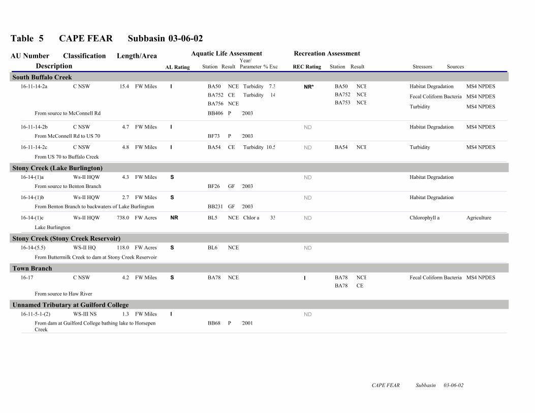
2.3.8 South Buffalo Creek [AU# 16-11-14-2a, b and c] 2000 Recommendations The 2000 basin plan recommended that South Buffalo Creek be resampled and that TMDLs be developed for identified stressors, and that the City of Greensboro stormwater program work to improve water quality in this creek. Current Status South Buffalo Creek [all segments] from source to Buffalo Creek (24.9 miles) is Impaired for aquatic life because the turbidity standard was violated in 14 and 11 percent of samples at sites BA752 and BA54, Fair and Poor benthic community ratings at sites BB444 and BB406, and Fair and Poor fish community ratings at sites BF18 and BF73. The stream is filled with debris and has undercut banks. Periphyton covered rocks at the site below the Metro WWTP. The Metro WWTP (NC0047384) also had significant violations of cyanide permit limits, which could have adversely impacted aquatic life in the creek. The facility is conducting a cyanide study to determine the source of the violations. South Buffalo Creek is Not Rated for recreation because fecal coliform bacteria screening criteria were exceeded at sites BA50, BA752 and BA753. 2005 Recommendations DWQ recommends that the City of Greensboro (Appendix V) continue to monitor water quality on South Buffalo Creek and submit these data to DWQ. DWQ will continue to work with the City of Greensboro to identify measures that can be used to reduce stormwater impacts to the creek. The NPDES compliance process will be used to address the significant permit violations noted above. DWQ will determine if intensive sampling is needed to assess the fecal coliform bacteria standard in this creek (Appendix X). Further recommendations to protect streams in urbanizing areas and to restore streams in existing urban areas are discussed in Chapter 31. All three segments will remain on the 303(d) list of Impaired waters. TMDLs (Chapter 35) will be developed for identified stressors within 8-13 years of listing. Water Quality Initiatives In 1997, Greensboro received a $800,000 CWMTF (Chapter 34) grant to acquire 40 acres to construct a stormwater wetland along South Buffalo Creek. In 2002, Greensboro received a $570,000 CWMTF grant to construct a 20-acre stormwater wetland along South Buffalo Creek treating runoff from 13 square miles of urban land. NCEEP has completed 1,752 linear feet of stream restoration in Benbow Park, 2,748 linear feet in Brown Park, 5,963 linear feet in Hillsdale Park and 1,776 linear feet in Price Park. Also completed were 5,963 linear feet of stream restoration and 1,200 linear feet of stream enhancement at Gillespie Golf Course (Chapter 34). 2.3.9 Town Branch [AU# 16-17] 2000 Recommendations Town Branch was Impaired in the 1996 basin plan, but limited sampling resulted in a Not Rated status in the 2000 basin plan. The 2000 plan recommended that Town Branch be resampled.
Chapter 2 – Cape Fear River Subbasin 03-06-02 27

Current Status Town Branch from source to the Haw River (4.2 miles) is Impaired for recreation because the fecal coliform bacteria standard was violated at site BA78. The stream is Supporting aquatic life because no criteria were exceeded at site BA78. A TMDL for fecal coliform bacteria was approved for Town Branch in September 2002. The TMDL called for 70 percent reduction in bacteria loading from urban areas in Burlington and Graham. The TMDL also indicated leaking sewer systems, sanitary sewer overflows and failing septic systems in the lower portion of the watershed as a source of bacteria. 2005 Recommendations DWQ will continue to monitor Town Branch. DWQ recommends that Burlington and Graham reduce fecal coliform bacteria loading as called for in the TMDL. It is also recommended that Graham annex homes in the lower portion of the watershed and connect them to municipal sewer system. The towns should also pursue funding to upgrade the wastewater collection system to reduce leaking lines and sanitary sewer overflows. DWQ will determine if intensive sampling is needed to assess the fecal coliform bacteria standard in this creek (Appendix X). Further recommendations to protect streams in urbanizing areas and to restore streams in existing urban areas are discussed in Chapter 31. This segment will remain on the 303(d) list of Impaired waters. TMDLs (Chapter 35) will be developed for identified stressors other than fecal coliform bacteria within 8-13 years of listing. 2.3.10 Varnals Creek [AU#16-21a and b] Current Status Varnals Creek was Fully Supporting in the 2000 basin plan; however, Varnals Creek [16-21a] from source to Rock Creek (4.6 miles) is currently Impaired for aquatic life because of a Fair benthic community rating at site BB390. Varnals Creek was studied in 2000 to determine if it would qualify for a supplemental HQW classification. Because of the Impaired benthic community, the creek did not qualify for the HQW classification. Varnals Creek [16-21b] from Rock Creek to the Haw River (2.8 miles) is Supporting based on a Good benthic community rating at site BB359. 2005 Recommendations DWQ will continue to monitor Varnals Creek to identify stressors to the biological community in the upper watershed. This watershed is predominately agriculture and DWQ will work with DSWC staff to further implement BMPs to reduce the impacts of agriculture in this watershed. This segment will be added to the 303(d) list of Impaired waters. TMDLs (Chapter 35) will be developed for identified stressors within 8-13 years of listing. 2.4 Status and Recommendations for Waters with Noted Impacts The surface waters discussed in this section are not Impaired. However, notable water quality problems and concerns have been documented for some waters based on this assessment. While
Chapter 2 – Cape Fear River Subbasin 03-06-02 28

these waters are not Impaired, attention and resources should be focused on these waters to prevent additional degradation or facilitate water quality improvement. Waters in the following section are identified by assessment unit number (AU#). See overview for more information on AU#s. 2.4.1 Back Creek (Graham-Mebane Reservoir) [AU# 16-18-(1.5)] Current Status and 2005 Recommendations Graham Mebane Reservoir (693.3 acres) is Not Rated for aquatic life because 33 percent of chlorophyll a samples exceeded the water quality criterion; however, not enough samples were collected to assign a use support rating. Nutrient levels in the reservoir were higher than in previous years and nuisance algal blooms were present in summer months. DWQ will determine if increased monitoring efforts in this lake are warranted to better assess water quality. 2.4.2 Blackwood Creek [AU# 16-11-14-2-4] Current Status and 2005 Recommendations Blackwood Creek from source to Buffalo Creek (5.6 miles) is Not Rated for recreation because the fecal coliform bacteria screening criteria were exceeded at site BA755. DWQ recommends that the City of Greensboro (Appendix V) continue to monitor water quality at sites in Blackwood Creek. DWQ will determine if intensive sampling is needed to assess the fecal coliform bacteria standard in this creek (Appendix X). 2.4.3 MoAdams Creek (Latham Lake) [AU# 16-18-7] Current Status and 2005 Recommendations MoAdams Creek from source to Back Creek (4.6 miles) is Not Rated for recreation because the fecal coliform bacteria screening criteria were exceeded at sites BA87 and BA88. DWQ will determine if intensive sampling is needed to assess the fecal coliform bacteria standard in this creek (Appendix X). 2.4.4 Muddy Creek [AU# 16-11-14-1-3] Current Status and 2005 Recommendations Muddy Creek from source to North Buffalo Creek (3.7 miles) is Not Rated for recreation because the fecal coliform bacteria screening criteria were exceeded at sites BA748. DWQ recommends that the City of Greensboro (Appendix V) continue to monitor water quality at sites in Muddy Creek. DWQ will determine if intensive sampling is needed to assess the fecal coliform bacteria standard in this creek (Appendix methods). 2.4.5 Philadelphia Lake (Buffalo Lake and White Oak Lake) [AU# 16-11-14-1-2b] Current Status and 2005 Recommendations Philadelphia Lake (18 acres) is Not Rated for recreation because the fecal coliform bacteria screening criteria were exceeded at site BA749. Turbidity also exceeded the standard in 10 percent of samples at site BA749. DWQ recommends that the City of Greensboro (Appendix V) continue to monitor water quality at sites in Philadelphia Lake. DWQ will determine if intensive sampling is needed to assess the fecal coliform bacteria standard in this lake (Appendix X).
Chapter 2 – Cape Fear River Subbasin 03-06-02 29

2.4.6 Richland Creek [AU# 16-11-7-(1)a] Current Status and 2005 Recommendations Richland Creek from source to Richland Lake (3.1 miles) is Not Rated for recreation because the fecal coliform bacteria screening criteria were exceeded at sites BA758. DWQ recommends that the City of Greensboro (Appendix V) continue to monitor water quality at sites in Philadelphia Lake. DWQ will determine if intensive sampling is needed to assess the fecal coliform bacteria standard in this lake (Appendix X). 2.4.7 Stony Creek (Lake Burlington) [AU# 16-14-(1)a, b and c] Current Status and 2005 Recommendations Stony Creek [16-14-(1)a] from source to Benton Branch (4.3 miles) is Supporting aquatic life because of a Good-Fair fish community rating at site BF26; however, this is a lower rating than the Excellent rating from 1994. There was evidence of past streambank erosion at the site. Stony Creek [16-14-(1)b] from Benton Branch to backwaters of Lake Burlington (2.7 miles) is Not Rated because a benthic community rating could not be assigned at site BB231 due to small size stream. There were indications of increased sedimentation, and only one small riffle area was found. Drought conditions in 2001 and 2002 likely have had impacts on these communities. DWQ will continue to monitor water quality in this watershed and contact DSWC staff to determine if noted habitat impacts are from agricultural activities or from development in the area. Lake Burlington [16-14-(1)c] (738 acres) is Not Rated for aquatic life because 33 percent of chlorophyll a samples exceeded the water quality standard; however, not enough samples were collected to assign a use support rating. Nutrient levels in the reservoir were higher than in previous years and nuisance algal blooms that can cause taste and odor problems in treated drinking water were present. DWQ will determine if increased monitoring efforts in this lake are warranted to better assess water quality. 2.5 Additional Water Quality Issues within Subbasin 03-06-02 The following section discusses issues that may threaten water quality in the subbasin that are not specific to particular streams, lakes or reservoirs. The issues discussed may be related to waters near certain land use activities or within proximity to different pollution sources. 2.5.1 Jordan Haw River Watershed Nutrient Sensitive Waters Strategy All land uses and discharges of wastewater and stormwater in subbasin 03-06-02 potentially contribute nutrients to Jordan Reservoir in subbasins 03-06-04 and 03-06-05. The reservoir is Impaired for aquatic life because chlorophyll a violated the standard in all segments of the reservoir. Refer to Chapter 36 for more information on this strategy.
Chapter 2 – Cape Fear River Subbasin 03-06-02 30
2.5.2 Greensboro Collection System SOC The City of Greensboro collection system (WQCS00006) is currently under a special order of consent (SOC) because the North Buffalo WWTP is hydraulically overloaded, causing sanitary sewer overflows (SSOs) in the WWTP service area that includes the North Buffalo Creek watershed and portions of the Reedy Fork watershed. The SOC (WQS04012) was issued because Greensboro was unable to comply with collection system permit conditions which prohibit SSOs. The SOC contains dates by which specific actions must be accomplished. The SSOs are occurring most often from Hill Street to the WWTP. Greensboro will be building new pump stations to divert wastewater out of the North Buffalo Creek watershed and enlarging the primary outfall. Greensboro must build one of the new pump stations in the Reedy Fork watershed by March 2005. The SOC also provides for payment of penalties for any SSOs between Hill Street and the WWTP during anything less than a 10-year 24-hour storm event. DWQ will continue to work with Greensboro or ensure timely compliance with the conditions in the SOC.
Chapter 2 – Cape Fear River Subbasin 03-06-02 31