chapter 4 space operations and tactical ... - …space.au.af.mil/primer/army_space.pdf · the first...
TRANSCRIPT

Chapter 4
SPACE OPERATIONS AND TACTICAL APPLICATION - U.S. ARMY
On Oct. 1, 1997, the Department of the Army created its newest major command, the U.S. Army Space and Missile Defense Com-mand (SMDC) (Fig. 4-1). Composed of five primary components, the SMDC is a global organization. These components are the SMDC Headquarters and the Force Development Integration Center in Arlington, Va.; the U.S. Army Space Command (Forward) lo-
cated in Colorado Springs, Colo.; and, the Space and Missile Defense Technical Center (SMDTC), the Space and Missile Defense Battle Lab (SMDBL) and the Space and Mis-sile Defense Acquisition Center (SMDAC) based in Huntsville, Ala. Included in the SMDAC are the High Energy Laser Systems Test Facility (HELSTF), at White Sands Missile Range, N.M., the U.S. Army Kwajalein Atoll/Kwajalein Missile Range (USAKA/KMR), in the Republic of the Marshall Islands, the Army Space Program Of-fice (ASPO) in Alexandria, Va., and the Joint Land Attack Cruise Missile Defense Ele-vated Netted Sensors Project Office (JLENS) and the Ballistic Missile Targets Joint Project Office (BMTJPO) which are both in Huntsville.
Fig. 4-1. SMDC
BACKGROUND
The SMDC commander is a dual-hatted leader. In addition to the duties of SMDC commander, he also serves as the commander of the U.S. Army Space Command (ARSPACE). The creation of the new major command and its organi-zation are designed to align the command to reflect the importance of space and missile defense to the Army and the joint warfighter. The basic missions of the command are twofold. The SMDC en-sures that the soldier in the field has ac-cess to space assets and their products. The command also seeks to provide ef-fective missile defense for the nation and deployed forces.
Although a new organization, the SMDC is building on more than 40 years of achievement and progress in the space and missile defense arena. The command began in 1957, when the Army created the first program office for ballistic mis-
sile defense. With the Nike-Zeus, the Army explored the feasibility of nuclear intercepts of inter-continental missiles. On July 19, 1962, the command made history with the first successful intercept of an intercontinental ballistic missile. This feat was repeated at the next level in 1984, when the Homing Overly Experi-ment performed the first non-nuclear, ki-netic-kill intercept of a reentry vehicle, proving it was possible to hit a "bullet with a bullet." In 1967, having proved the interceptor’s capabilities, the com-mand moved toward the next phase – de-ployment – with the Sentinel defense system. Redirected in 1969, the program was assigned to defend of the U.S. land-based ICBM's. On Oct. 1, 1975, the Safeguard Complex in North Dakota be-came operational. Congress inactivated the site almost immediately, because of
AU Space Primer Fourth Edition, 10/00
4 - 1

concerns over the budget and the influ-ence of the Anti-Ballistic Missile Treaty. President Ronald Reagan announced a new approach to strategic planning, the Strategic Defense Initiative, in March 1983. This concept urged an active de-fense rather than the traditional offensive deterrence. To address this change, ele-ments of the Ballistic Missile Defense Organization were merged in July 1985, creating the U.S. Army Strategic Defense Command (USASDC). At the same time, efforts by the command expanded to incorporate new avenues of research. In addition to radars and interceptors, the USASDC expanded its exploration of anti-satellite systems, lasers, neutral par-ticle beams and innovative sensors. With the new decade, the command be-gan to move in new directions. In Octo-ber 1990, as part of an effort to centralize laser research, the HELSTF transferred to the command from the Army Materiel Command. The USASDC mission was further enhanced in January 1991, when the command was assigned all Theater Missile Defense functions and again in June 1994, the USASSDC commanding general was made the Theater Missile Defense advocate.
In 1992, the Army reorganized the USASDC to focus elements upon specific needs and missions. As part of this deci-sion, several missile and radar projects were transferred from the USASDC to the newly created Program Executive Of-fice for Global Protection Against Lim-ited Strikes (subsequently renamed Air and Missile Defense). Among the pro-jects leaving the command were the Ground Based Interceptor, the High En-doatmospheric Defense Interceptor, the Theater High Altitude Area Defense, the Extended Range Interceptor (which be-came the Patriot Advanced Capability-3
interceptor), the ARROW, and the Ground Based Radar. The Program Ex-ecutive Office was assigned the mission to develop and deploy viable national missile defense and theater missile de-fense systems.
The Army’s renewed interest in space technology was reflected in Department of the Army’s decision to create the U.S. Army Space and Strategic Defense Command (USASSDC), on Aug. 24, 1992. Under this directive, the Army Space Command became a subordinate command to the USASSDC. Other Army space interests were incorporated into the new organization in later years. The Army Space Technology Research Office transferred to the command in 1993, fol-lowed by the Army Space Program Of-fice in 1994. Based on these changes and the years of experience, the USASSDC was named the Army's advocate for Space, Theater Missile Defense and Na-tional Missile Defense. As outlined in the General Order, dated July 1, 1993, the USASSDC was to serve as the "focal point for space and strategic defense mat-ters, … responsible for [the] exploitation of space and strategic assets for use by warfighting [Commanders in Chief]."
With this consolidated approach, the Army had teamed all of its space-related organizations. Since 1973, the Army Space Program Office has overseen the tactical exploitation of national capabili-ties program, or TENCAP. The TENCAP program seeks to assess the tactical potential of current abilities and integrate them into the Army system. The Army Space Technology Research Office, established in 1988, managed near and possible far-term space R&D programs. It became the core of the new Space Applications Technology Program.
AU Space Primer Fourth Edition, 10/00
4 - 2

The Army Space Command, created in 1986, serves as the Army component of the U.S. Space Command and is respon-sible for operational space planning. This command also oversees the Defense Satellite Communications System Opera-tions Centers and the Army Space Dem-onstration Program, which explores the feasibility of off-the-shelf technology in the space program. One successful ex-ample of this effort is the Small Light-weight Global Positioning System (SLGR) (Fig. 4-2) receiver (commonly called the "slugger") used during Opera-tion Desert Shield/Desert Storm.
It is with this substantial background that the SMDC advances the Army’s space and missile defense efforts towards the 21st century.
OVERVIEW
The U.S. Army Space and Missile Defense Command, a MACOM, serves as the Army’s proponent for Space and National Missile Defense, and as the Army integrator for Theater Missile Defense. The command ensures that Army warfighters have access to space assets and products to win decisively with minimum casualties and effective missile defense to protect our nation as well as our deployed forces and those of our friends and allies. From its headquarters in Arlington, Va., U.S. Army SMDC oversees a number of Army
elements around the globe to accomplish its challenging and diverse mission:
The U.S. Army Space Command, or ARSPACE, in Colorado Springs, Colo., serves as the Army component to the U.S. Space Command, and supports the warfighter through the 1st Satellite Control Battalion and the 1st Space Battalion. The former provides worldwide long-haul satellite communications to the warfighter through the defense satellite communications system, while the 1st Space Battalion’s Army Space Support Company provides units deploying on exercises and contingency, and humanitarian operations with intelligence, planning, and operational expertise and products.
Fig. 4-2. SLGR
The 1st Space Battalion’s Theater Missile Warning Company uses the Joint Tactical Ground Stations to provide theater CINCs with the only in-theater tactical ballistic missile warning capability on the battlefield. The ARSPACE also manages the Army’s astronaut detachment at the Johnson Space Center, Houston, Texas.
The Space and Missile Defense Technical Center, or SMDTC, located in Huntsville, Ala., is the research and development element of the command. The center executes space and missile defense and directed energy research and development programs. As executive agent for DOD’s Ballistic Missile Defense Organization, the center provides cost, schedule, and technical oversight for national and theater missile defense technology, and provides technical matrix support to PEO Air and Missile Defense and the National Missile Defense Joint Program Office. The Space and Missile Defense Battle Lab, or SMDBL, in Huntsville, Ala., and Colorado Springs, Colo., links the technologist and the warfighter through experiments simulating modern “battlefield” conditions, often using sophisticated computer simulations, interfaces, and networks.
AU Space Primer Fourth Edition, 10/00
4 - 3
The National Missile Defense TRADOC System Manager, or TSM, in
Arlington, Va., performs the function of integrating and managing NMD user activities within the Army. It serves as a single Army user representative and advocate in the development of the land-based NMD system.
The command’s Force Development and Integration Center, or FDIC, in Arlington, Va., develops the Army’s space and missile defense concepts, validates requirements, and ensures Army-wide solution integration.
The Space and Missile Defense Acquisition Center in Huntsville, Ala., centralizes the command’s materiel development, targets, and test facility management into one overarching organization that includes the following facilities and program offices:
The Army Space Program Office, or
ASPO, at Fort Belvoir, Va., is responsible for the Army Tactical Exploitation of National Capabilities Program – TENCAP. The program focuses on exploiting current and future tactical potential of national systems and integrating the capabilities into the Army’s tactical decision-making process. The ASPO has successfully fielded more than 60 systems and currently supports 41 systems at 23 sites around the world.
The High Energy Laser Systems Test Facility, or HELSTF, at White Sands Missile Range, N.M., serves as a national center for high-energy laser research, development, testing, and evaluation. It is the only laser facility capable of placing continuous wave megawatt laser light on a variety of targets.
The Kwajalein Missile Range’s unit geographical location in the central Pacific Ocean and unmatched suite of radars, instrumentation, and test support facilities offer extensive flexibility for ballistic missile testing and space-object tracking.
The Ballistic Missile Targets Joint Program Office in Huntsville, Ala., provides the BMDO community with both strategic and theater missile
targets for BMD weapon system developmental testing.
The Joint Land Attack Cruise Missile Defense Elevated Netted Sensor System Project Office, or JLENS, Project Office in Huntsville, Ala., is developing advanced radar sensors that will provide over-the-horizon coverage from cost-effective aerostat platforms. The sensors are crucial for providing early warning, surveillance, and precision track/elimination of threat cruise missiles.
SPECIFIC ELEMENTS PROVIDING
SPACE SUPPORT TO ARMY OPERATIONS
ARMY SPACE COMMAND
(ARSPACE)
The mission of the Army Space Com-mand, or ARSPACE (Fig. 4-3), is to sup-port Army, Joint, and Coalition warfighters with space-based ex-pertise, advice, capa-
bilities, and products. ARSPACE is also involved in the development of techno-logical solutions to warfighter require-ments through its Technical Support Office.
Fig. 4-3. ARSPACE
Missions Support the Commander-in-Chief,
U.S. Space Command. The Com-mander of the Army Space Command is the Army component to the unified U.S. Space Command. ARSPACE ensures that the Army’s requirements are met at the joint level, while bring-ing the CINC’s views and concerns to the Army staff. ARSPACE supports CINCSPACE in the development of Joint space doctrine, as well as the development of plans, policies, and
AU Space Primer Fourth Edition, 10/00
4 - 4

requirements for space support to Army operations.
Operate and Manage the Defense Satellite Communications System (DSCS). This system spans the globe to provide super-high-frequency communications to all U.S. warfight-ing forces — anywhere, anytime. Management, planning, and control of the payloads on DSCS satellites is ARSPACE’s largest mission. ARSPACE operates and maintains five DSCS control facilities located around the world, one Ground Mobile Forces Control Center (AN-MSQ-114), and the DSCS Certification Fa-cility, or DCF, at Schriever Air Force Base in Colorado. These facilities control the satellite links for tactical warfighter communications and stra-tegic communications networks. They also provide payload control to the satellite and technical training and troubleshooting assistance required to ensure maximum support to the user. In addition, the DCF provides plat-form control, monitoring the health and welfare of the payloads for se-lected satellites in the DSCS constel-lation. Three Regional Space Support Centers perform DSCS planning and authorize warfighter use of DSCS ca-pabilities.
Current Operations. ARSPACE sup-port of the Army, Joint, and Coalition warfighter spans the globe. Army Space Support Teams, or ARSST, provide expertise and advice and op-erate equipment which provides the warfighter support in the planning and conduct of the complete spectrum of today’s military operations. Each of the five teams is aligned with a Corps and provides communications, weather, terrain analysis and 3-D
visualization, mapping, and satellite coverage analysis capabilities to the Corps commander. ARSST are de-ployable to exercises and contingency operations and have supported every contingency operation since Opera-tion Desert Storm. They are capable of sustained operation of the equip-ment, or they can train designated soldiers to operate the equipment.
Joint Tactical Ground Stations (JTAGS). The JTAGS capability sup-ports forward deployed CINCs with direct downlink, from satellite to theater, of early warning of ballistic missile launches. The five JTAGS systems are a key part of CINCSPACE’s Tactical Event Sys-tem, are operated by joint Army-Navy crews, and provide continuous, all-weather threat monitoring. The design, development, and fielding of the JTAGS systems is an example of the Army’s capability to fast track vi-tal equipment procurement to support soldiers with the best equipment for mission accomplishment.
Missile Defense. Working through USSPACECOM, the Ballistic Missile Defense Organization Joint Project Office, and the Army National Guard, ARSPACE is the operator representa-tive on the team developing a system of defense for the homeland from a proliferating missile threat. As the eventual user and operator of the ground based portion of a National Missile Defense system, ARSPACE is playing a key role in planning and designing the requirements, Concept of Operations, and support required for such a system. ARSPACE and the Program Manager for Air Defense Command and Control Systems re-cently developed the overarching pro-
AU Space Primer Fourth Edition, 10/00
4 - 5

totype Theater Missile Defense, or TMD capability, the Army Theater Missile Defense Element, which ARSPACE fielded. This system syn-chronizes the four pillars of TMD: Passive Defense, Active Defense, At-tack Operations, and Battle Manage-ment/Command, Control, Communications, and Intelligence. After three years of exercising and development, it was passed to the Army Air and Missile Defense Com-mand, the system’s user, at Ft. Bliss, Texas.
Human Exploration and Development of Space. The Army Astronaut De-tachment at the Johnson Space Center in Houston, Texas supports NASA’s Space Shuttle and International Space Station Programs.
KEY ARSPACE SUPPORT
ELEMENTS ARMY SPACE SUPPORT TEAM (ARSST)
Such fundamental requirements as force projection, space intelligence analy-sis, communications, command and control are today dependent upon our ca-pabilities in space. The ARSST is an element of ARSPACE task organized and resourced to support the commanders and staffs of land forces to orchestrate the employment of a complex array of dy-namic battlefield resources. An ARSST complements the operational space based capabilities accessed by corps or divi-sions, such as TENCAP, SATRAN, to-pographic products, etc, used to obtain a relevant common picture of the battle-field. The team supports the commander and staff in the planning and integration of space assets into their training or mili-tary decision making process; obtains,
processes and delivers space products to the supported unit; and assesses the op-erational impact of friendly and adver-sary space based capabilities. The ARSST manages these complex tasks from staff planning and the estimate process through contingency or opera-tions execution, assisting the command and staff to integrate and focus space support on mission accomplishment. The team typically supports at the corps, and when resources are available, at the divi-sion level. Each team consists of 4-6 offi-cers and NCOs, is equipped with a suite of unique hardware and software, pos-sesses expertise in space applications and operational planning, and remains ready to deploy, when necessary, to the war-fighter's location.
Support to the Corps staff and or Divi-sion staff is available at all times, by vir-tue of the habitual relationship that is maintained between each of the four ARSST and the four US Army corps. Requests for assistance from other or-ganizations will also be met by ARSPACE as on-going missions permit. By employing state-of-the-art sensor and terrain modeling, as well as access to various web sites, ARSST can assist the staff in answering the commander's criti-cal information requirements as well as providing input to assist in the prepara-tion of staff estimates and OPLANs. The teams rely on the supported unit for logistical support.
ARSST Support Functions: Satellite Advance Notice. The team
can aid staffs in making optimal use of Satellite Reconnaissance Advance Notice (SATRAN) data, which pro-
AU Space Primer Fourth Edition, 10/00
4 - 6

vides information on potential threat satellites and their capabilities to monitor friendly operations.
Position/Navigation. The Global Po-sitioning System is an essential com-bat multiplier, whether in the form of a PLGR in the hands of an infantry-man or as a component in a weapon system. ARSST obtains and provides data on the fluctuating degree of GPS accuracy at specific locations for a designated time that will be available to friendly forces during planned op-erations (Fig. 4-4). The team can also provide advice on counter measures to enemy efforts to jam or spoof GPS.
Space Weather. There are a number of phenomena that occur on the sur-face of the Sun, which can have a dramatic effect on UHF and SATCOM communications, GPS sig-nal reception and radars. The ARSST complements the efforts of the SWO by obtaining advance forecasts of these events and assessing which friendly systems will be degraded, the degree of degradation and when.
Imagery. The ARSST deploys with a state-of-the-art automated data proc-essing package to provide command-ers and staffs imagery products beyond those provided by internal to-pographic units.
These products include: fly-throughs, 3-D images, perspective views and image
maps (Fig. 4-5), all in various levels of resolution. Image maps provide staffs and soldiers up-to-date maps of areas where no maps exist or are out of date.
Fig. 4-5. Image Map
The ARSST can reach back to its Multi-spectral Imagery (MSI) Lab in Colorado Springs, which can fulfill shortfalls in additional imagery requirements, scene rectification and hard and soft copy pro-duction. These enhanced products from the lab can be shipped to the team by multiple means, such as SIPRNET, GBS, and overnight mail.
Fig. 4-4. GPS Assistance
Intelligence Support. ARSPACE DCSINT members provide space in-telligence analysis to the ARSST. The DCSINT focus is to conduct Space Intelligence Preparation of the Battle-field, respond to space related RFI, provide assessments of how the en-emy will use it's space systems, and to provide expertise on friendly force space-based intelligence capabilities. The DCSINT has a SIPRNET home page with detailed listings of threat space capabilities. Finally, the intelli-gence element assists the supported staff's planning effort by providing expertise on enemy and friendly availability to employ commercial satellites, enemy/friendly space vul-nerabilities, and recommendations to support the targeting process.
SATCOM. The team provides a limited supplement (Fig. 4-6) to the unit's early entry communications
AU Space Primer Fourth Edition, 10/00
4 - 7

connectivity using non-secure Iridium handsets, and International Maritime Satellite (INMARSAT) hand-carried terminals providing secure fax, data, telex, and voice.
provides alert notification to command level staffs, who disseminate the alert message to units in the threatened area. JTAGS also supports active defense by cueing air defense assets to the missile track. Data is also provided on launch location to deep attack assets to aid in attack operation.
Fig. 4-6. SATCOM Commercial Supplements
The key in JTAGS theater support is its relatively direct connectivity and dis-tribution architecture, via a variety of voice and dam networks. By its in-theater location, JTAGS provides timely, assured early warning. ARSPACE operates two JTAGS sections indefinitely forward de-
ployed by CINCSPACE to Korea and Germany, and maintains deployable sec-tions in CONUS for contingencies, train-ing and exercise support.
Fig. 4-7. JTAGS
JOINT TACTICAL GROUND
STATION (JTAGS)
JTAGS is the transportable in-theater element (Fig. 4-7) of the U.S. Space Command's Theater Event System and provides Theater Commander's a con-tinuous 24-hour capability to receive and process in-theater, direct down-linked data from space-based sensors. JTAGS ties directly to worldwide and theater communications system to immediately disseminate critical information. JTAGS supports all Theater Missile Defense pil-lars and provides worldwide warning and alerting as well as in-theater voice warn-ing and cueing information on tactical ballistic missiles and other tactical events of interest.
1ST SATELLITE CONTROL
BATTALION
The Defense Satellite Communica-tions System (DSCS) provides reliable, robust, worldwide, continuous communi-cations support to US warfighting forces, strategic military users, the US intelli-gence community and the National Command Authority. Customers can communicate via the DSCS using large, fixed earth terminal ground stations, transportable ground stations, and highly mobile, tactical ground stations.
The JTAGS processes data from up to three DSP satellites to determine launch points and time, azimuth of flight, pre-dicted ground impact point and time for TBMs. JTAGS supports passive defense by providing in-theater early warning of enemy ballistic missile launch events, and
AU Space Primer Fourth Edition, 10/00
4 - 8

The 1st SATCON Battalion is respon-sible for the daily C2 of the DSCS satel-lite and communications networks supported by these satellites (Fig. 4-8). The battalion operates the DSCS Opera-tions Centers (OC), at five SATCOM lo-cations around the world to oversee all use of the DSCS, ensuring that users re-ceive the optimal SATCOM support au-thorized. On a typical day, the DSCS OCs control nearly 1,000 links providing vital com-munications support to deployed war-fighters, strategic users, and the intelligence community around the world.
REGIONAL SATCOM SUPPORT
CENTERS (RSSC)
RSSCs provide the joint warfighter with a single focal point for select satel-lite communications use within a region. RSSCs coordinate and ensure that ground mobile forces obtain necessary access to DSCS SHF-band, MILSTAR EHF, and limited commercial satellite resources. Additionally, they provide tactical com-munications satellite network planning and management support for CINCs and
DOD agencies. The RSSCs are located at Wheeler Army Air Field, Hawaii; Patch Barracks, Germany; Arlington, Virginia; and Tampa, Florida for focused support to CINCs. In the future, the RSSCs will be one-stop-shops for all CINC and DOD SATCOM requirements- EHF, SHF, UHF, GBS and commercial.
SPACE AND MISSILE DEFENSE BATTLE LAB (SMDBL)
The U.S. Army
Space and Missile Defense Battle Lab (SMDBL) (Fig. 4-9) was activated on Oc-tober 1, 1997. The SMDBL is the result
of the Army’s commitment to provide space and missile defense capabilities to the warfighter as rapidly as possible. The SMDBL joins the other Army, Navy, Air Force, and Joint Battle Labs that focus on quick delivery of innovations and future technologies to today’s warfighter. It was formed from elements of the former Missile Defense Battle Integration Center and the Army Space Command (For-ward).
Fig. 4-9. SMDBL
Fig. 4-8. DSCS Comms
Core Competencies Concepts and Initiatives. The Battle
Lab identifies and examines candi-date concepts, initiatives, and tech-nologies for near-term infusion into Army space and missile defense pro-grams or for experimentation on ap-proved future operational capabilities. To focus military science and tech-nology research, the SMDBL will also coordinate with Missile Defense and Space Technology Center and other materiel development activities. Additionally, this area will provide forward-looking wargaming activities to the command, including participat-
AU Space Primer Fourth Edition, 10/00
4 - 9

ing in the Army After Next series of long-range Army wargames.
Experiments, Exercises, and Train-ing. The SMDBL coordinates, con-ducts, and participates in efforts focused on bringing space and missile defense capabilities to the warfighter, including support to joint and service Commander-in-Chief exercises, Ad-vanced Warfighting Experiments, Army Experiments, and unit training activities. Products generated by the Battle Lab through experimentation include insights, impacts, validated requirements, concepts, and leave-behind solutions, as well as changes to doctrine, training, and materiel.
Simulation. Leveraging the growth and maturation of computer-based models and simulations, the Battle Lab is expanding the use of its mod-els and simulations beyond the mate-riel development and analysis domain to provide sophisticated capabilities to the warfighter. Through innova-tive techniques, the Battle Lab has developed an interface capability to link existing simulations directly to Army Tactical Command and Control systems, so the warfighter can be di-rectly simulated at the actual worksta-tions in realistic environments.
Analysis. The Battle Lab supports experimentation, conducts analyses in support of materiel development ac-tivities and requirements determina-tion, performs science and technology reviews, assesses advanced concepts, and analytically supports the defini-tion of future space and missile de-fense architectures.
Current Capabilities/Products Synthetic Battlefield Environment, or
SBE, has been developed to provide
computer simulation technologies to the warfighter in realistic formats. The SBE consists of computer-based models and simulations, simulation to tactical system interface units, and communications and network tech-nologies, linked in a modular envi-ronment. The SBE provides the ability to stimulate Army and joint tactical command and control systems with simulations, allowing the war-fighter to train on go-to-war equip-ment. The SBE is also suited for use by the analysis and materiel devel-opment communities, lending an operational validation to off-line simulations. The Battle Lab has suc-cessfully used the SBE in various war-fighting experiments, CINC ex-ercises, and training events, including Roving Sands, Ulchi Focus Lens, and Coherent Defense.
The Extended Air Defense Testbed, or EADTB, and Extended Air Defense Simulation, or EADSIM, form the core of the SBE computer simula-tions. The user friendly, flexible EADTB offers a high-fidelity model-ing capability to operational com-manders and combat and materiel developers. EADSIM, used in Desert Storm operations to plan air and air defense campaigns, is a low-to-medium fidelity comprehensive air and missile defense simulation that has widespread acceptance through-out the DOD, all three services, and most allied countries.
The Synthetic Battlefield Center, or SBC, and Hardware/Software Inte-gration Center, or HSIC, are labora-tory environments for the Battle Lab to conduct experiments and support exercise and training activities. The SBC and HSIC combine the SBE with operational command and con-trol workstations to allow the Battle Lab to provide interactive stimulation
AU Space Primer Fourth Edition, 10/00
4 - 10

Use of space-based capabilities en-ables the force to dominate the battle-field.
to the warfighter through tactical workstations and equipment.
ARMY SPACE EXPLOITATION DEMONSTRATION PROGRAM
(ASEDP)
Space capabilities significantly in-crease combat effectiveness.
ASEDP Objectives The genesis of the ASEDP was an
Army Space Council meeting in April 1987. During this meeting the Vice Chief of Staff of the Army, LTG Max-well Thurmond, gave guidance from which the goal, philosophy, and objec-tives of the ASEDP are derived: "En-hance Air-land Battle execution by demonstrating how space based assets could support tactical commanders." This quote was historically significant, because it gave the Army Space Agency, and then the US Army Space Command, the command guidance needed to initiate the program which would eventually be-come the ASEDP. Responsibility for the Army Space Exploitation Demonstration Program (ASEDP) was assigned to the SMDBL Directorate located in Colorado Springs, Colorado.
Educate commanders on the use of
space-based assets for Army opera-tions.
Assist in defining requirements for Army development.
Demonstrate new technology for pos-sible future development.
Influence the design and use of future space systems.
Conduct rapid prototyping in support of contingency operations.
Assist the integration of mature space enhancements into Army Battle Command Systems
ASEDP FY00
All of SMDBL’s ASEDP experiments for FY 00 are planned for integration into the Joint Contingency Force Advanced Warfighting Experiment (JCF AWE). The focus of the JCF AWE is to incorpo-rate new warfighting concepts and infor-mation age technologies with the Army’s light forces. They will continue to be expected to operate in Military Opera-tions in Urban Terrain (MOUT) and re-stricted terrain environments. JCF AWE is the light force early entry portion of the Force XXI series of experiments. By utilizing JCF AWE, a cost effective venue became available for the SMDBL to exercise ASEDP experiments. The SMDBL JCF AWE- related initiatives are:
The SMDBL continues to investigate and demonstrate space-related technolo-gies and support space requirements documentation to maintain the US Army’s preeminence on the battlefield through the ASEDP.
ASEDP Goal
Demonstrate to the field commander the latest relevant space technology from the commercial and government research and development communities.
ASEDP Philosophy Space-based capabilities are critical
to rapid force projection operations and smaller scale contingencies.
Force Warning
AU Space Primer Fourth Edition, 10/00
4 - 11
Mobile Satellite Service (MSS) and Hand-held Command and Control Wireless Communications
Enroute Planning and Rehearsal Sys-tem (EMPRS)
Tactical Weather Precision SIGINT Targeting System
(PSTS) Eagle Vision II (EVII)
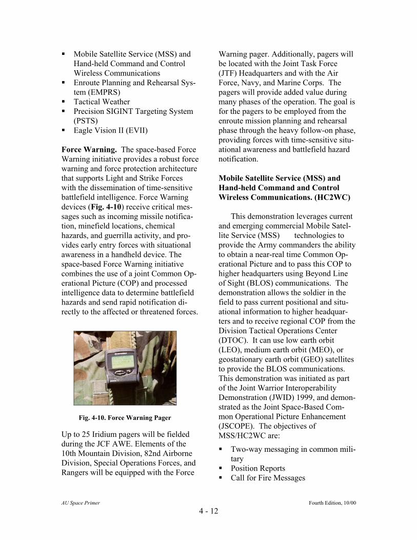
Force Warning. The space-based Force Warning initiative provides a robust force warning and force protection architecture that supports Light and Strike Forces with the dissemination of time-sensitive battlefield intelligence. Force Warning devices (Fig. 4-10) receive critical mes-sages such as incoming missile notifica-tion, minefield locations, chemical hazards, and guerrilla activity, and pro-vides early entry forces with situational awareness in a handheld device. The space-based Force Warning initiative combines the use of a joint Common Op-erational Picture (COP) and processed intelligence data to determine battlefield hazards and send rapid notification di-rectly to the affected or threatened forces.
Up to 25 Iridium pagers will be fielded during the JCF AWE. Elements of the 10th Mountain Division, 82nd Airborne Division, Special Operations Forces, and Rangers will be equipped with the Force
Warning pager. Additionally, pagers will be located with the Joint Task Force (JTF) Headquarters and with the Air Force, Navy, and Marine Corps. The pagers will provide added value during many phases of the operation. The goal is for the pagers to be employed from the enroute mission planning and rehearsal phase through the heavy follow-on phase, providing forces with time-sensitive situ-ational awareness and battlefield hazard notification. Mobile Satellite Service (MSS) and Hand-held Command and Control Wireless Communications. (HC2WC)
This demonstration leverages current and emerging commercial Mobile Satel-lite Service (MSS) technologies to provide the Army commanders the ability to obtain a near-real time Common Op-erational Picture and to pass this COP to higher headquarters using Beyond Line of Sight (BLOS) communications. The demonstration allows the soldier in the field to pass current positional and situ-ational information to higher headquar-ters and to receive regional COP from the Division Tactical Operations Center (DTOC). It can use low earth orbit (LEO), medium earth orbit (MEO), or geostationary earth orbit (GEO) satellites to provide the BLOS communications. This demonstration was initiated as part of the Joint Warrior Interoperability Demonstration (JWID) 1999, and demon-strated as the Joint Space-Based Com-mon Operational Picture Enhancement (JSCOPE). The objectives of MSS/HC2WC are:
Fig. 4-10. Force Warning Pager
Two-way messaging in common mili-tary
Position Reports Call for Fire Messages
AU Space Primer Fourth Edition, 10/00
4 - 12

Battlefield Situation Messages Self-contained device
Enroute Planning and Rehearsal Sys-tem (EMPRS). The Enroute Mission Planning and Rehearsal System (EMPRS) (Fig. 4-11) provides com-manders the capability to receive opera-tions and intelligence updates while in flight, conduct collaborative planning with headquarters and forward elements, and disseminate and rehearse mission changes among the combat forces en-route to the objective area.
EMPRS is a collaborative effort with SMDBL, the Dismounted Battlespace Battle Lab, ASEDP, and Team Mon-mouth to provide the aeronautical satel-lite communications connectivity for EMPRS. This communications segment exploits the growing commercial market in MSS. Through the use of SMDBL's Advanced Research Center Telecommu-nications Interface Console (ARCTIC), several satellite channels can be com-bined to give an overall data throughput sufficient to support collaborative plan-ning functions such as chat, file transfer, whiteboarding, and teleconferencing. Tactical Weather. For years, Army Commanders have been forced to cope with or avoid the weather. The Tactical Weather capability gives the Army
Commander weather products that can change "cope or avoid" to "anticipate and exploit." This is accomplished through mission-focused weather products em-bedded in common Army Battle Com-mand Systems (ABCS) applications. SMDBL is currently experimenting with two weather systems that will greatly en-hance the commander's focus on the bat-tlefield: the Deployable Weather Satellite Workstation (DWSW) and the Meteoro-logical Automated Sensor and Trans-ceiver (MAST). DSWS provides timely and accurate weather data that is critical to the battle plan. As a tactical terminal located in a tactical operations center (TOC), the DWSW will acquire, process, and distribute real-time high, resolution weather imagery and tailored products to users. This capability allows Staff Weather Officers (SWOs) to build a more complete weather database tailored to the commander's needs. DWSW is a com-mercial "off-the-shelf' system consisting of two 18-inch diameter flat-tracking an-tenna, a modular geostationary antenna seven feet in diameter, a computer work-station with color monitor, and a software package that provides zoom, imagery animation, and color enhancement. This entire package is transportable in the Army's High Mobility Multipurpose Wheeled Vehicle (HMMWV), or it can be palletized for air transport. DWSW served as the weather satellite receiver DWSW provides timely and accurate weather data during Task Force XXI and Division XXI AWEs. With SMDBL as the initiative proponent, DWSW will again be linked with the Army's Inte-grated Meteorological System to partici-pate in the JCF AWE.
Fig. 4-11. EMPRS
Utilizing satellite visual, infrared, and microwave sensors, the DWSW system
AU Space Primer Fourth Edition, 10/00
4 - 13
provides weather data for the battlefield, day or night: Cloud imagery with resolution to 0.55
km for overlay on the ABCS. Cloud imagery for situational aware-
ness and precipitation for mobility as-sessment.
Three-dimensional atmospheric wind, temperature, and moisture fields.
Surface temperature, soil moisture,
snow and ice areas, and land classifi-cation.
MAST (Fig. 4-12) integrates surface
weather sensors (visibility, wind, tem-perature, barometric pressure, and humid-ity) with a LEO satellite transceiver relaying the information instantaneously. The man-portable MAST can be programmed to transmit surface weather observations hourly, or as often as needed, to the Divi-sion SWO. The MAST observations can
become another digital layer of weather information for the ABCS.
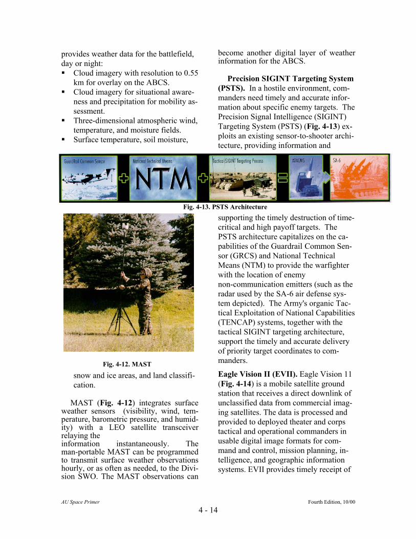
Precision SIGINT Targeting System (PSTS). In a hostile environment, com-manders need timely and accurate infor-mation about specific enemy targets. The Precision Signal Intelligence (SIGINT) Targeting System (PSTS) (Fig. 4-13) ex-ploits an existing sensor-to-shooter archi-tecture, providing information and
supporting the timely destruction of time-critical and high payoff targets. The PSTS architecture capitalizes on the ca-pabilities of the Guardrail Common Sen-sor (GRCS) and National Technical Means (NTM) to provide the warfighter with the location of enemy non-communication emitters (such as the radar used by the SA-6 air defense sys-tem depicted). The Army's organic Tac-tical Exploitation of National Capabilities (TENCAP) systems, together with the tactical SIGINT targeting architecture, support the timely and accurate delivery of priority target coordinates to com-manders.
Fig. 4-13. PSTS Architecture
Fig. 4-12. MAST
Eagle Vision II (EVII). Eagle Vision 11 (Fig. 4-14) is a mobile satellite ground station that receives a direct downlink of unclassified data from commercial imag-ing satellites. The data is processed and provided to deployed theater and corps tactical and operational commanders in usable digital image formats for com-mand and control, mission planning, in-telligence, and geographic information systems. EVII provides timely receipt of
AU Space Primer Fourth Edition, 10/00
4 - 14
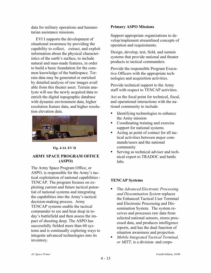
Primary ASPO Missions data for military operations and humani-tarian assistance missions.
Support appropriate organizations to de-velop/implement streamlined concepts of operation and requirements.
EVI I supports the development of situational awareness by providing the capability to collect, extract, and exploit information about the physical character-istics of the earth’s surface, to include natural and man-made features, in order to build a basic foundation for the com-mon knowledge of the battlespace. Ter-rain data may be generated or enriched by detailed analysis of raw images avail able from this theater asset. Terrain ana-lysts will use the newly acquired data to enrich the digital topographic database with dynamic environment data, higher resolution feature data, and higher resolu-tion elevation data.
Design, develop, test, field, and sustain systems that provide national and theater products to tactical commanders.
Provide the responsible Program Execu-tive Officers with the appropriate tech-nologies and acquisition activities.
Provide technical support to the Army staff with respect to TENCAP activities.
Act as the focal point for technical, fiscal, and operational interactions with the na-tional community to include:
Identifying technologies to enhance the Army mission
Fig. 4-14. EV II
Coordinating training and exercise support for national systems
Acting as point of contact for all tac-tical activities between major com-mands/users and the national community
Serving as technical adviser and tnical expert to TRADOC and battle labs.
ech-ARMY SPACE PROGRAM OFFICE
(ASPO) The Army Space Program Office, or
ASPO, is responsible for the Army’s tac-tical exploitation of national capabilities - TENCAP. The program focuses on ex-ploiting current and future tactical poten-tial of national systems and integrating the capabilities into the Army’s tactical decision-making process. Army TENCAP systems enable the tactical commander to see and hear deep in to-day’s battlefield and then assess the im-pact of shooting deep. The ASPO has successfully fielded more than 60 sys-tems and is continually exploring ways to integrate advanced technologies into its inventory.
TENCAP Systems The Advanced Electronic Processing
and Dissemination System replaces the Enhanced Tactical User Terminal and Electronic Processing and Dis-semination System. The system re-ceives and processes raw data from selected national sensors, stores proc-essed data, and produces intelligence reports, and has the dual function of situation awareness and projection.
AU Space Primer Fourth Edition, 10/00
4 - 15
Mobile Integrated Tactical Terminal, or MITT, is a division- and corps-

level truck-mounted system capable of providing multiple source intelli-gence and secondary imagery to the tactical commander. It provides ETUT functionality in a smaller and more mobile configuration which re-ceives, processes, and disseminates multi-disciplined information.
Forward Area Support Terminal was developed to provide a downsized functional equivalent of the MITT, offering the same capabilities in a modular, portable system. This single position unit, weighing 1,200 pounds, is easily transportable.
The Tactical Exploitation System, or TES, is the next generation TENCAP system. It combines total TENCAP functionality in an integrated, down-sized, scalable system designed for split-base operations and can receive, process, exploit, and disseminate data. As a replacement for the Ad-vanced Electronic Processing and Dissemination System, Modernized Imagery Exploitation System, and Enhanced Tactical Radar Correlator, the TES will be smaller, lighter, and more powerful than current systems. Enhanced Tactical Radar Correlator, or ETRAC, is the latest generation TENCAP system. It provides real-time radar imagery data to the corps commander and has the capability to receive direct downlinks from the U-2. The ETRAC is a highly mobile system that can drive on and off a C-130 aircraft, making it easy to pro-vide direct support to early entry oerations. The ETRAC is an enhversion of the TRAC van used in Desert Storm to downlink U-2 imagery.
p-anced
-
Modernized Imagery Exploitation System, or MIES, was developed to support imagery operational areas, in-
telligence development for indication and warning, situation assessment, order of battle, targeting, and tactical operations. The MIES is a modern-ized version of the system deployed to Saudi Arabia to provide imagery support to CENTCOM during Desert Storm. MIES provides for the receipt, processing, exploitation, storage, and dissemination of imagery intelligence from national and selected theater collectors. Planned upgrades include interfaces to planned national capa-bilities and migration to Common Imagery Ground/Surface System standards.
CONCLUSIONS
The Army’s dedication to maintaining a tactically relevant presence in the space community was demonstrated by General Gordon R. Sullivan (Retired), then Chief of Staff of the Army, when he stated:
“Aggressive exploitation of space
capabilities and products normalized in concepts, doctrine, training, operations, and modernization will ensure that the Army is able to maintain land force domination well into the 21st century. The Army’s future is inextricably tied to space.”
Success on the future battlefield requires exploitation of the Army's five doctrinal tenets:
• initiative, • agility, • depth, • synchronization, • and versatility. The extension of that battlefield into
space provides commanders with an en-hanced capability to exploit and advance these tenets across all Army operations. Combining near-continuous, global cov-erage, real-time and near-real-time capa-bilities for communications, positioning/
AU Space Primer Fourth Edition, 10/00
4 - 16

navigation, surveillance, environmental monitoring, warning and target acquisi-tion allows commanders to anticipate en-emy actions; strike at vulnerable points faster than the enemy can react; and win the land battle. Likewise, these same ca-pabilities allow the commanders to have success in operations other than war.
As the Army moves into the 21st cen-tury, it’s imperative that it remains in-
volved in space and fully exploit space capabilities. The Army will continue to define its role, identify requirements and plan strategies for involvement. It will also participate more in the joint, com-bined, civil and commercial enviroments to optimize its use of this fourth medium of warfare.
REFERENCES “Army Space Exploitation Demonstration Program FY 00” booklet, 1 October 99. FM 100-18, “Space Doctrine, Education and Functional Area” http://www.smdc.army.mil Home page of the U.S. Army Space & Missile Defense Command. Numerous links for space related information. Information Sheet, “US Army Space Command Space-Based Combat/ Force Multiplier Capabilities for the Warfighter”, June 1999. http://www.smdc.army.mil/FactSheets/FactsIndx.html “U.S. Army Space Command Overview” http://www.armyspace.army.mil/ArspaceHQ.htm
TOCTOC
AU Space Primer Fourth Edition, 10/00
4 - 17