chapter volume 3 - nola
TRANSCRIPT

plan for the 21st century: new orleans 2030, aDopteD auGust 2010 | 3.1
3chapter The ConTexT: Previous Planning and The CharTer amendmenT
This 2009–2030 New Orleans Plan for the 21st Century builds on a strong foundation of previous planning and a new commitment to strong linkage between planning and land use decision making. City Planning Commission initiatives in the 1990s, the pre-Hurricane Katrina years, and the neighborhood-based recovery plans created after Hurricane Katrina inform this long-term
plan. Moreover, the City entered a new era in November 2008 when voters approved an amendment to the City Charter that strengthened the relationship between the city’s master plan, the comprehensive zoning ordinance and the city’s capital improvement plan, and mandated creation of a system for neighborhood participation in land use and development decision-making—popularly described as giving planning “the force of law.”
A Planning DistrictsFor planning purposes, the City began using a map in 1970 designating the boundaries and names of 73 neighborhoods. When creating the 1999 Land Use Plan, the CPC decided to group those 73 neighborhoods into 13 planning districts, using census tract or census block group boundaries for statistical purposes. In the post-Hurricane Katrina era, the planning districts continue to be useful, while the neighborhood identity designations, though still found in many publications, are often contested by residents. This
9
3
6
5
4
12
7
2
11
10
13
8
1a
1b
Lake Pontchartrain
Mississippi River
Intracoastal Waterway
Inner Harbor N
av Canal
Michoud Canal
Bayou Bienvenue
Mississippi River Gulf Outlet
Bayo
u S
t Joh
n
Lake No 1
Lagoon Number 14
Municipal Yacht Harbor
Bayou Michoud
Lake No 3
Lake No 2
Lagoon No 2
Lake Willow
Harvey C
anal
Spring Lake
Inne
r H
arbo
r Nav
al C
anal
Lake Barrington
(New Orleans Marina)
Planning DistrictsSource: City of New Orleans
11
910
6
¯0 0.9 1.8 2.7 3.60.45
Miles
Planning Districts
mAp 3.1: plAnning Districts
Volume 3

Volume 3 | chapter 3 | the context: preVious planninG anD the charter amenDment
3.2 | plan for the 21st century: new orleans 2030, aDopteD auGust 2010
master plan uses the 13 planning districts as delineated by the CPC. When neighborhoods are under discussion, the plan will indicate whether the CPC neighborhood boundaries are being used or some other method of neighborhood identification.
B Recent Planning InitiativesThe pre-Hurricane Katrina master plan and area plans, and post-Hurricane Katrina recovery plans are described briefly below, along with an analysis of issues that attracted consensus. All of the plans described below were reviewed as part of the planning process for this master plan. This master plan also takes into account functional master plans prepared to guide specific boards and departments, such as the sewer and water master plan, district and corridor plans like the Lafitte Corridor Plan, and various neighborhood plans.
1. new century new Orleans plan and 2002 cZO projectThe most recent master planning effort in New Orleans before this master plan was the New Century New Orleans Master Plan, which was started in 1990 under Mayor Sidney Barthelmy. A Vision document for that plan was issued in 1992 and the planning process was re-energized again in 1997 under Mayor Marc Morial. The major themes of the plan, as described in the vision document, were:
• Protect the unique environment and culture of New Orleans.
• Revitalize neighborhoods.
• Restore the economy of the city.
• Reduce the economic, social and physical isolation of the poor.
• Improve the performance and credibility of city government.
• Build a stronger commitment to long term planning in New Orleans, and to the effective functioning of the City Planning Commission.
• Build partnerships to solve problems.
• Empower citizens to participate in the planning and government of New Orleans.
tABle 3.1: lAnD AreA Of plAnning Districts
Planning District
lanD area (acres)
% of city lanD area
1 927 0.8
2 2,841 2.4
3 4,800 4.1
4 4,432 3.8
5 4,763 4.1
6 5,071 4.4
7 3,708 3.2
8 1,437 1.2
9 12,772 11
10 23,025 19.8
11 41,577 35.8
12 6,362 5.5
13 4,461 3.8
Total 116,176 100

Volume 3 | chapter 3 | the context: preVious planninG anD the charter amenDment
plan for the 21st century: new orleans 2030, aDopteD auGust 2010 | 3.3
Between 1992 and 2005, the CPC approved seven out of a projected 14 elements of the plan, each one in the form of a stand-alone document of several hundred pages that included general policy statements and a list of project recommendations for each planning district. All of these documents have been consulted during the preparation of this master plan. The approved elements were:
• Land Use (1999)
• Parks and Recreation (2002)
• Arts & Culture (2002)
• Tourism (2002)
• Historic Preservation (2002)
• Economic Development (2002)
• Transportation (2004)
Projected plan elements that had not been completed by the time of Hurricane Katrina were Community Facilities and Infrastructure; Critical and Natural Hazards; Environmental Quality; Energy; Housing; Human Services; and Citizen Participation.
In the 2000s, the CPC also commissioned a new Comprehensive Zoning Ordinance (CZO). Although there were a number of public meetings on the proposed ordinance and many residents participated, the business and development community did not participate to the same degree and later voiced opposition to it. The Planning Commission and Mayor shelved the draft in 2002 due to community opposition and perceived conflicts between it and the then—current Master Plan.
In returning to the master plan project in 2007, the CPC determined that a master plan created through a protracted, multi-year process was not in the best interests of the Commission or the city, particularly in the post-Hurricane Katrina environment of continuing recovery and the long time elapsed since the completion of some of the elements of the New Century New Orleans Plan. The Commission therefore resolved to commission this new master plan along with a new CZO.
2. pre-Hurricane Katrina renaissance plansIn 1994, the City Planning Commission adopted the Local Renaissance District Administration Policy. Under the policy, CPC staff would work with neighborhood residents to create a Strategic Neighborhood Renaissance Plan. The Plan would be submitted to the CPC and the City Council for adoption and ultimately, for creation of a “Local Renaissance District.” The Lower Garden District and New Orleans East completed Renaissance Plans before Hurricane Katrina.
A. lOwer gArDen District renAissAnce plAnAdopted in 1997, the Lower Garden District Strategic Renaissance Plan was prepared just before the redevelopment of the St. Thomas public housing project began. With a mixture of residential, commercial, light industrial, and tourism land uses, the Lower Garden district, with fewer than 8,000 residents, had seen a decline in population and neighborhood-serving businesses in the postwar period. The Renaissance Plan focused on zoning, transportation and capital improvements.

Volume 3 | chapter 3 | the context: preVious planninG anD the charter amenDment
3.4 | plan for the 21st century: new orleans 2030, aDopteD auGust 2010
B. new OrleAns eAst renAissAnce plAnThe New Orleans East community, sponsored by the New Orleans East Economic Development Foundation, created the New Orleans East Renaissance Plan, which was adopted in 2004. The area, home to some 90,000 people, had been experiencing commercial disinvestment since the mid-1980s, as well as an influx of poor-quality and poorly-managed multifamily development. The Renaissance Plan served as the foundation for New Orleans East recovery plans post Hurricane Katrina, and for the planning for that area that is included in this plan.
3. post-Hurricane Katrina recovery plansThere were three rounds of multi-neighborhood planning in the aftermath of Hurricane Katrina. The City charter specifically provides that the City Planning Commission is to prepare post-disaster recovery plans, but the CPC’s staff was severely cut after of the storm, leaving it without the resources to carry out or oversee the recovery planning process.
A. Bring new OrleAns BAcK cOmmissiOn AnD UrBAn lAnD institUteIn September 2005—one month after Hurricane Katrina—Mayor Nagin appointed the Bring New Orleans Back (BNOB) Commission to prepare a recovery plan by the end of 2005. As part of the planning process, the Urban Land Institute (ULI) was invited to send in a team of experts for a one-week evaluation. The ULI team projected slower rebuilding in the most devastated neighborhoods, and proposed a phased restoration of infrastructure and city services given undetermined city resources and the extent of the flooding damage. The BNOB committee further recommended pausing the issuing of permits while FEMA analyzed new flood stage data, and creating new green spaces for increased water storage in the most heavily flooded areas. Some residents feared that these recommendations signalled that residents would be prevented from returning to their homes and rebuilding in some of the hardest-hit areas. This perception led to vocal public opposition to the recovery plan proposals, particularly in harder-hit neighborhoods.
In January, 2006, the BNOB Commission submitted to the mayor a final Action Plan accompanied by separate topical plans written by committees of local and national experts in the various topical areas, including: culture; economic development; education; government effectiveness; health and social services;
infrastructure; and land use. The Mayor’s office then issued a final summary plan that proposed a neighborhood planning process to be funded by $7.5M in FEMA funds. By statute, however, FEMA was not allowed to fund local planning, and the BNOB process came to an end. However, the BNOB committee reports continue to provide a basis for citywide planning for their respective topical areas.
B. tHe neigHBOrHOOD reBUilDing plAn (“lAmBert plAn”)The City Council in late 2005 decided to fund its own plan
for the neighborhoods that experienced flooding. An existing contract for housing services was extended, with a $2.97M budget to create plans for the flooded neighborhoods. Forty-nine neighborhood plans were prepared between March and September 2006, and focused on lists of desired neighborhood projects. This plan was not submitted to the
Desire Area
Neighborhood
Planning District 7
Rebuilding Plan

Volume 3 | chapter 3 | the context: preVious planninG anD the charter amenDment
plan for the 21st century: new orleans 2030, aDopteD auGust 2010 | 3.5
CPC for adoption or approval and did not meet the requirements for recovery funding established by the Louisiana Recovery Authority, a state agency set up to receive and disburse federal recovery funds. However, in a number of neighborhoods that participated in this process, these neighborhood plans are still viewed as representative of community consensus and serve as the basis for any subsequent planning.
c. UnifieD new OrleAns plAn (UnOp)The Mayor requested that foundations provide the $7.5M that FEMA was not able to provide for neighborhood level plans. The Rockefeller Foundation, the Greater New Orleans Foundation, and the Bush-Clinton Hurricane Katrina Fund provided the planning funds, and America Speaks provided an additional $3M to design and conduct three citywide community meetings.
UNOP included the following:• Recovery plans for each planning district including a post-disaster assessment; recovery scenario
preferences; and a list of recovery projects.
• A citywide plan that identified $14B in priority recovery projects not already covered by other funding sources over the next 10 years.
The UNOP recovery citywide plan was submitted to the CPC for review in January 2007 and underwent several months of comment. In May 2007, the UNOP citywide plan was approved by vote of the CPC, and the individual District Plans were officially “accepted.” (“Acceptance”generally does not require an official vote by the CPC, but indicates the commission’s willingness to use the plans as a reference for future planning purposes.) Approval of the citywide UNOP plan made New Orleans eligible for recovery funding because it met LRA planning requirements.
4. independent District and neighborhood plansIn addition to the official recovery plans, individual neighborhoods and groups sought out universities, foundations, and other sources of assistance to help them prepare neighborhood plans, most of which also focused on rebuilding and recovery. The initial impetus came immediately after the BNOB/ULI proposal was rejected by the Mayor, who said that the viability of neighborhoods would be proven by the return of the citizens themselves to their neighborhoods. Neighborhood plans created outside the official process were also reviewed for this 2009–2030 Master Plan, including:
• Algiers Riverview Plan
• Broadmoor Plan
• Carrollton Renaissance Plan ( in development 2008–2009)
• Central Business District Zoning Plan
• Central City Neighborhood Plan (in development 2008–2009)
• Lafayette Square Conservancy Master Plan
• Lafitte Greenway Plan
• Lower Ninth Ward (ACORN) Plan
• Mid-City Plan
• Tunisberg Plan
• West End Redevelopment Land Use and Site Plan Analysis (May 2006)—New Orleans Regional Planning Commission

Volume 3 | chapter 3 | the context: preVious planninG anD the charter amenDment
3.6 | plan for the 21st century: new orleans 2030, aDopteD auGust 2010
5. District, sector, and Agency plansRecently prepared district, sector and agency plans have also been consulted for this master plan including:
• Reinventing the Crescent (New Orleans Building Commission)
• Library Master Plan
• School Facilities Master Plan
• Sewerage and Water Board Plans
• Medical District Strategic Integration Plan (New Orleans Regional Planning Commission)
• 2005 New Orleans Bike Plan (New Orleans Regional Planning Commission)
• Gaining Momentum: New Orleans 2010 Campaign for Active Transportation (New Orleans Regional Planning Commission)
• Metropolitan Planning Organization transportation plans (New Orleans Regional Planning Commission)
• Army Corps of Engineers plans
• Orleans Parish Coastal Management Plan (1985)
• Riverfront Vision (2005)
• Hazard Mitigation Plan (2005)
Some of these plans are more technical in nature and tended to have limited public participation in their development.
6. Other planning initiatives and DocumentsThe preparation of this master plan also included consultation of a number of documents with planning content and direction, such as: the Capital Improvement Plan; annual budget plans; plans from agencies such as the New Orleans Redevelopment Authority and the Office of Recovery Development and Administration; state coastal improvement plan; and many other documents. The GreenNOLA plan, a plan for citywide sustainability, was adopted by the City Council in 2008 and was also heavily consulted during the preparation of this master plan.
c Themes From Previous Plans1. new century new OrleansThe New Century New Orleans plans shed light on the fact that many of the most important issues facing New Orleans after Hurricane Katrina were in fact pressing issues well before then. For instance, as early as the mid-1990s, these plans raised the issues of preserving neighborhood character and preventing vacancy and blight, which were becoming problems in several areas of the city. Improving the quality of life in neighborhoods was also of primary concern, including expanding and improving parks and open space, increasing the availability of neighborhood-serving retail and amenities, and increasing the mixed-use and walkable character of neighborhoods throughout the city. Expanding affordable housing opportunities and historic preservation initiatives were also recognized as important priorities, the latter threatened by rising vacancy rates.

Volume 3 | chapter 3 | the context: preVious planninG anD the charter amenDment
plan for the 21st century: new orleans 2030, aDopteD auGust 2010 | 3.7
Protection of the coastal environment of New Orleans and the Gulf Coast was also recognized as an important priority in these plans. Recognition of the need to improve environmental quality within the city was also evident, particularly the need to mitigate the negative effects of commercial and industrial land uses in neighborhoods and residential areas and the need to remediate brownfields and contaminated sites.
2. Bring new Orleans Back (BnOB)With respect to neighborhoods and quality of life, the BNOB plan stressed the importance of addressing vacancy and blight, ensuring affordable housing, improving access to health care, preserving historic and cultural assets, creating jobs and expanding economic opportunity, expanding public transportation, and improving public safety and safety from flooding and hurricanes. With respect to community facilities and services, the plan stressed the importance of providing high-quality schools, improving commercial centers and corridors, and improving access to recreational facilities and open space. The plan’s land use priorities included increased density in key locations, mitigation of hazardous land uses,
retention of industrial land in key locations, and protecting open and natural space, including coastal wetlands.
3. neighborhood rebuilding plansOverwhelmingly, the Neighborhood Rebuilding Plans placed the preservation of existing neighborhood character at the top of their list of priorities. Most neighborhoods expressed the need to preserve their physical character during rebuilding, including addressing vacancy and blight and preserving historic buildings and the overall historic fabric. Many neighborhoods also expressed their desire to preserve their social and cultural character, including rehabilitation of social and cultural facilities and ensuring the availability of a broad diversity of housing choices. Other important priorities for many neighborhoods included ensuring public safety and resistance to flooding, developing local leadership and ensuring public participation in future development decisions, improving and expanding parks and open space, and enhancing neighborhood-serving retail and amenities.
4. Unified new Orleans plan (UnOp)The UNOP plans expressed some priorities nearly unanimously as being of primary importance. These included improving flood resistance and safety from future hurricanes, addressing vacancy and blight, improving public safety, and repairing basic infrastructure such as streets, sidewalks and utilities. Also of primary importance in nearly all UNOP plans was the development of local leadership and the need to ensure resident participation in future development and other decision-making processes. Other priorities expressed in the majority of the UNOP plans included improving and expanding parks and open space, expanding affordable housing opportunities (particularly for seniors), rehabilitating social and cultural centers, improving access to health care, ensuring high-quality construction that fits in with existing neighborhood character, and historic preservation.
Volume 3 | chapter 3 | the context: preVious planninG anD the charter amenDment
3.8 | plan for the 21st century: new orleans 2030, aDopteD auGust 2010
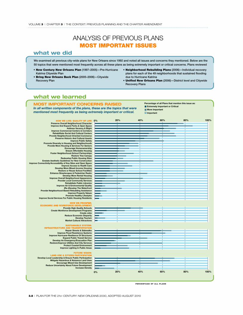
AnAlysIs oF PRevIous PlAnsmOst impOrtAnt issUes
HOw we live: QUAlity Of lifePreserve Overall Neighborhood CharacterImprove And Expand Parks & Open Space
Address Vacancy & BlightImprove Commercial Centers & Corridors
Rehabilitate Social And Cultural CentersProvide Neighborhood-Oriented Commerce
Preserve Historic And Cultural Assets Improve Public Safety
Promote Diversity in Housing and NeighborhoodsProvide More Housing & Services For Seniors
Encourage HomeownershipEnsure Affordable Housing
Foster Neighborhood-School PartnershipsRestore Tree Canopy
Redevelop Public Housing SitesEnstate Aesthetic Guidelines for New Construction
Improve Connectivity/Accessibility of Key Sites and Open SpaceImprove Access to Health Care
Develop More Mixed-Income Housing Restore or Reuse School Facilities
Enhance Streetscapes & Pedestrian RealmDevelop More Rental Housing
Improve Overall Neighborhood AppearanceProvide Local Community Services
Rehabiliate Public LibrariesImprove Air & Environmental Quality
(Re-)Develop The Waterfront Provide Neighborhood-Based Rebuilding Assistance
Improve Property ValuesPromote Healthy Lifestyles
Improve Social Services For Public Housing Residents
HOw we prOsper:ecOnOmic AnD wOrKfOrce DevelOpment
Provide High-Quality SchoolsCreate Workforce Development Programs
Create JobsReduce Economic Disparity
Develop TourismMarket Cultural Attractions
sUstAinABle system:infrAstrUctUre AnD trAnspOrtAtiOn
Repair Streets & SidewalksImprove Flood Resistence Systems
Improve Hurricane-Resilience Of StructuresExpand Public Transit Service
Develop An Emergency/Evacuation PlanRestore/Improve Utilities And City Services
Protect Coastal EnvironmentImprove Lighting In Public Areas
fUtUre visiOn:lAnD Use & citiZen pArticipAtiOn
Develop Local Leadership & Ensure Public ParticipationMitigate Hazardous & Nuisance Land Uses
Encourage Mixed-Use DevelopmentReduce Uncertainty About Future Development
Increase Density
0% 20% 40% 60% 80% 100%
0% 20% 40% 60% 80% 100%
most important concerns raisedIn all written components of the plans, these are the topics that were mentioned most frequently as being extremely important or critical.
Extremely Important or CriticalMore Important
Important
Percentage of all Plans that mention this issue as:
We examined all previous city-wide plans for New Orleans since 1992 and noted all issues and concerns they mentioned. Below are the 50 topics that were mentioned most frequently across all these plans as being extremely important or critical concerns. Plans reviewed
• new century new Orleans plan (1997–2005)—Pre-Hurricane Katrina Citywide Plan
• Bring new Orleans Back plan (2005–2006)—Citywide Recovery Plan
• neighborhood rebuilding plans (2006)—Individual recovery plans for each of the 49 neighborhoods that sustained flooding due to Hurricane Katrina
• Unified new Orleans plan (2006)—District level and Citywide Recovery Plans
what we did
what we learned
p e r c e n tA g e O f A l l p l A n s

Volume 3 | chapter 3 | the context: preVious planninG anD the charter amenDment
plan for the 21st century: new orleans 2030, aDopteD auGust 2010 | 3.9
D Recovery ImplementationAs this plan is being written, implementation of the city’s recovery plans is the responsibility of the Office of Recovery Development and Administration (ORDA), the New Orleans Redevelopment Authority, and specific city departments. ORDA will cease to exist in fall 2009 and its responsibilities will be taken over by a Community Development Agency and a separate Project Delivery Unit to manage recovery projects. According to the 2009 ORDA budget message, the agency’s mission was to “retool government procedures for recovery; secure funds; and develop programs and projects for implementation.” A number of city departments were organized under the umbrella of ORDA in three categories:
• PPP (Public-Private Partnership for economic development)—Economic development initiatives, incentives and programs; arts and entertainment; environmental affairs
• Development Services—City Planning Commission; Safety and Permits; Code Enforcement; Environmental Health; Workforce Development (Job 1); historic district regulatory commissions; redevelopment corporations for specific areas; supplier diversity; public investment
• Neighborhood Stabilization—Affordable Housing; Neighborhood Services and Facilities; Environmental Compliance; Planning and Resource Development
In addition, there are offices of strategic planning, housing policy, and federal-state reimbursement.
Organizing for repair and rehabilitation of critical infrastructure and public safety buildings was the initial emphasis of ORDA’s work, so that all neighborhoods would have basic services. The city then put into place a recovery strategy to focus on 17 Target Areas based on the following criteria:
• High potential to attract investment
• High visibility
• Strong demonstration of cluster model
• Sufficient land and other assets
• Adequate resources to catalyze development, such as schools or libraries
• Consistent with development approach in planning documents
• Leverages other city development opportunities
The purpose of the 17 Target Areas was to identify focal points for the investment of recovery dollars. Planning experience in recent decades has demonstrated the value of concentrating resources to revitalize a target area and then expand from that area of improvement. This strategy has also been much more successful in attracting private investment than spreading funds thinly across a broader area. The targeted approach produces visible change which then attracts further investment. In addition, ten Housing Opportunity Zones, mostly located near Target Areas, were designated as areas for homeownership programs.
ORDA focused in four program areas:
• Medical facilities and economic development
• Housing and neighborhood renewal
• Code enforcement and blight reduction
• Enhanced public assets and infrastructure
ORDA planned and facilitated recovery projects, designed programs, and administered programs. Design and construction of capital projects is performed by the Department of Capital Projects Administration

Volume 3 | chapter 3 | the context: preVious planninG anD the charter amenDment
3.10 | plan for the 21st century: new orleans 2030, aDopteD auGust 2010
with consultant assistance. Most of the funding for ORDA and capital improvement activities came from federal sources. The 2009 capital budget of $181.5M was over half composed of federal disaster Community Development Block Grant (D-CDBG) funds and FEMA Public Assistance funds (for restoration of publicly-owned facilities). By 2009, ORDA had allocated most of the total $411 million in D-CDBG funds to agencies and recovery projects.
e The 2008 Planning Charter AmendmentVoters approved a City Charter amendment in November 2008 that specifies the type of city master plan that the City Planning Commission must create, the plan’s legal relationship to the zoning ordinance and to the city’s capital improvement plan, and creation of a neighborhood participation system for land use decision making.
The sections of the charter that were modified, and the new content is as follows:
section 5-402. functionsThe City Planning Commission must prepare, adopt, amend, and recommend to the Council a twenty year Master Plan for the physical development of the City. The Master Plan at a minimum must include:• A statement of development goals, objectives, and policies for the physical growth and development of
the City
mAp 3.2: OrDA tArget recOvery AreAs, HOUsing OppOrtUnity ZOnes, AnD pUBlic investments, 2009
Source: cIty of New orleaNS, orDa 2009

Volume 3 | chapter 3 | the context: preVious planninG anD the charter amenDment
plan for the 21st century: new orleans 2030, aDopteD auGust 2010 | 3.11
• Maps and a text setting forth principles, standards, and proposals
• Six interrelated elements providing overall guidance for city policy and priorities:
> Vision, Goals, and Policy
> Land Use, including issues and policies and a Future Land Use Map with allowable uses and densities
> Transportation
> Housing
> Community Facilities and Infrastructure
> Historic Preservation
The City Planning Commission will prepare and recommend to the Council plats, the Official Map, and the zoning ordinance that are consistent with the Master Plan.
• The zoning ordinance will have as one of its purposes the implementation of the Master Plan.
• The zoning ordinance and map may be amended by the City Council as long as amendments are consistent with the Master Plan.
• The text, diagrams and maps in the Land Use Element of the Master Plan that address the location and extent of future land uses, and the zoning ordinance that implements those provisions, may also address urban form and design. They may differentiate neighborhoods, districts, and corridors, provide for a mixture of land uses and building types within each, and provide specific measures for regulating relationships between buildings, and between buildings and outdoor public areas, including streets, sidewalks, and other right of ways.
The City Planning Commission will prepare the capital improvement plan and assist the Chief Administrative Officer in the preparation of the annual capital budget. The capital improvement plan and the capital budget shall be consistent with the Master Plan.
section 5-404. master plan Public participation in preparation of the Master Plan will include at a minimum:
• One public meeting for each planning district or other designated neighborhood planning unit.
• One public hearing to solicit the opinions of citizens from throughout the community.
• Affirmative steps to involve neighborhoods in master planning activities and comply with the requirements of any neighborhood participation program that the City, pursuant to Section 5-411, shall adopt by ordinance.
• Each public hearing or meeting shall be duly advertised in a newspaper of general circulation at least fifteen (15) but not more than (45) forty-five days in advance.
Adoption of the plan:• The Commission adopts the plan by resolution.
• After adoption, the Commission sends the plan to the City Council for adoption by ordinance.
• Within 90 days, the Council must adopt, reject or propose modification in the plan.
• If the plan is rejected or modifications proposed, the plan is referred back to the Commission for a public hearing and comment.
• Within 60 days, the Commission must provide a recommendation to the Council on the rejection or modification.

Volume 3 | chapter 3 | the context: preVious planninG anD the charter amenDment
3.12 | plan for the 21st century: new orleans 2030, aDopteD auGust 2010
• Within 45 days, the Council will adopt the plan with or without modification.
Legal effects of the Master Plan:• New and significantly altered public projects and public utilities must conform to the adopted
Master Plan.
• The Land Use Element must include a table specifying the relationship between the land use designation on the Future Land Use Map and zoning classifications.
• The Zoning Ordinance will also include this table and will be amended or updated to accommodate amendments or revisions to the zoning ordinance or the Land Use element of the Master Plan.
• All land development regulations and amendments and all land use actions must be consistent with the goals, policies, and strategies of the Land Use Element of the Master Plan. Land use actions include zoning; subdivision plans; site plans; planned unit developments or similar site specific plans; conditional uses; variances; or local government capital improvements, land or facility acquisition, including transportation facilities.
Land use action consistency with the Master Plan means:• The land use action furthers or does not interfere with goals, policies, and guidelines in the Land Use
Element of the Master Plan.
• The land use action is compatible with proposed future land uses, densities and intensities designated in the Land Use Element.
Mandatory review of the Master Plan by the Commission:• At least once every five years but not more than once a year.
• Any time in response to disaster or declared emergency.
• Public hearings to determine if the plan needs amendments or comprehensive revision.
• If amendments or comprehensive revision are required, the Commission will go through the preparation, public meeting, and adoption process.
Adoption by the City Council:• Adoption of amendments or a comprehensive revision to take place with the same procedures as for
initial adoption of the Master Plan.
Resources for master planning:• The City shall make adequate appropriations to the Commission to implement the mandate to prepare
and adopt the Master Plan; update the Master Plan; and for activities designed to ensure consistency between the plan and zoning, land use actions, and capital plans and budgets.
section 5-405. planned street lines and the Official map.• Adoption and amendment of plats and the Official Map must be consistent with the Master Plan.
section 5-406. Zoning Ordinance.• All zoning ordinances and amendments must be consistent with the Master Plan.
• When the Commission amends the Master Plan, it will review the zoning ordinance for potential revision and amendment, with one or more public hearings.
section 5-409. Orientation and continuous education training for planning commission and Board of Zoning Adjustments members. • Six hours of training on duties and responsibilities for Commission and Board members within one

Volume 3 | chapter 3 | the context: preVious planninG anD the charter amenDment
plan for the 21st century: new orleans 2030, aDopteD auGust 2010 | 3.13
year of taking office.
• Six hours of training annually for Commission and Board members on topics such as land use, land use planning, land use law, zoning, transportation, community facilities, historic preservation, ethics, public utilities, parliamentary procedure, public hearing procedure, economic development, housing, public buildings, land subdivision, and powers and duties of the Planning Commission and Board of Zoning Adjustments.
section 5-411. neighborhood participation• Establishment of a system for organized and effective neighborhood participation in land use decisions
and other issues that affect quality of life.
• Timely notification to a neighborhood of any proposed Land Use Action affecting the neighborhood.
• Meaningful neighborhood review of and comment on such proposals.
• Meaningful neighborhood participation in the formulation of the Master Plan or Master Plan amendment.
f local GovernmentThe City of New Orleans and Orleans Parish were consolidated under the 1954 home rule charter. In addition to city responsibilities, government also has the responsibilities and constraints of parish government: the costs of the state criminal justice system and inability to pass ad valorem taxes1 without being subject to a homestead exemption that is controlled by the state. In addition, there are a number of public agencies independent or semi-independent of city government that have been established by state legislation.2 Among the most important are:
• Sewerage and Water Board—state created, independent of city government, but with members appointed by the Mayor and the Mayor serving as Board president. The Sewerage and Water Board raises its own funds through rates and bonds. The City Council does not approve the Board’s budget but it does approve rate increases. It is responsible for drinking water, waste water, and drainage.
• Board of Liquidation—State created, independent of city government, issues bonds and manages the general obligation debt
• Aviation Board—independent but with a budget approved by the City Council
• New Orleans Redevelopment Authority
• School Districts
• Orleans Parish Board of Assessors
• Orleans Parish Levee Board
• City Park
• Audubon Commission
• Orleans Criminal Justice District (Sheriff’s Office)
• Orleans Parish Civil Sheriff
There are seven “unattached boards and commissions” within city government:
1 “Ad valorem” taxes are based on a percentage of value.
2 The former Inspector-General stated that his office had identified 142 city agencies and nonprofits, many of which are likely empty shells.

Volume 3 | chapter 3 | the context: preVious planninG anD the charter amenDment
3.14 | plan for the 21st century: new orleans 2030, aDopteD auGust 2010
• New Orleans Public Library
• Historic District and Landmarks Commission
• Vieux Carré Commission
• Alcoholic Beverage Control Board
• City Planning Commission
• Mosquito Control Board
• New Orleans Museum of Art
Ten enterprise funds are part of city government with budgets approved by the City Council, but raise their funds from property or operations:
• New Orleans Aviation Board
• Delgado-Albania Plantation Commission
• French Market Corporation
• Upper Pontalba Restoration Corporation
• Municipal Yacht Harbor Corporation
• Orleans Parish Communication District
• New Orleans Building Corporation
• Rivergate Development Corporation
• Canal Street Development Corporation
• Piazza d’Italia Corporation
In addition to city and parish agencies, there are a number of special taxing districts in New Orleans, as well as neighborhood security and improvement districts that collect a fee for each improved lot in the district. The neighborhood security districts began to appear in the late 1990s and the years before Hurricane Katrina, and they have proliferated since the storm. Each one has required special state legislation.
Special taxing districts (ad valorem assessments):
• Algiers Development District
• Downtown Development District
• Garden District Security District (a neighborhood security district with an ad valorem assessment)
• New Orleans Business and Industrial District (industrial park in New Orleans East)
Neighborhood security and improvement districts (fee assessments):
• Audubon Area Security District
• Huntington Park Improvement District
• Hurstville District
• Kenilworth/District
• Kingswood District
• Lake Bullard Improvement District

Volume 3 | chapter 3 | the context: preVious planninG anD the charter amenDment
plan for the 21st century: new orleans 2030, aDopteD auGust 2010 | 3.15
• Lake Carmel Improvement District
• Lake Forest Estates District
• Lake Oaks Improvement District
• Lakeshore Crime Prevention District
• Lake Terrace Crime Prevention District
• Lakeview Crime Prevention District
• Lakewood Crime Prevention District
• Lakewood East Security and Neighborhood Improvement District
• Maple Area Residential Security Tax District
• McKendall Estates Improvement District
• Mid-City Security District
• Oak Island Neighborhood Improvement District
• Spring Lake Improvement District
• Tamaron Subdivision Improvement District
• Twinbrook Security District
• Upper Audubon Security District
• Upper Hurstville Security District
The security and improvement districts indicate neighborhoods’ lack of confidence in local government to protect them or provide improvements. However, those neighborhoods that cannot afford to tax themselves for extra security and amenities may feel that they have a lesser quality of life. Understandable as the desire for these districts may be among those who can afford them, the increasing numbers of such districts may exacerbate divisions within the city.
fragmentation of local governmentThe fragmentation of New Orleans’ municipal government is very noticeable. The proliferation of quasi-governmental authorities and special districts of various types drains power and accountability from elected and appointed officials in city government—and new organizations of this type seem to be proposed regularly, from the Southeast Regional Airport Authority, a proposed Park and Recreation Commission as a special state district, to the economic development public-private partnership. Authorities and special districts are typically created in order to achieve some special purposes and are given powers that regular government agencies do not have. The primary argument for these entities is that to achieve the public purpose, it is necessary to have more flexibility to operate like a business. This means that they also avoid some of the requirements to share information with the public and be accountable to them. Most are governed by appointed or ex officio board members.
According to the Mayor’s office, there are 142 boards and commissions with 900 members in New Orleans. Although this might imply a highly participatory governmental structure, citizen reports and advocacy for more communication and transparency imply that these many boards and commissions do not function to enhance a sense of participation.
Some of the many special districts and authorities in New Orleans, existing and proposed, are undoubtedly good vehicles to accomplish their purposes. However, critics of these kinds of entities see them as weakening government’s ability to perform its duties and making it difficult to ascertain responsibility for protecting the public interest. In New Orleans, the large number of these entities also contributes to a lack of cross-agency information sharing to solve problems that lie within the

Volume 3 | chapter 3 | the context: preVious planninG anD the charter amenDment
3.16 | plan for the 21st century: new orleans 2030, aDopteD auGust 2010
jurisdiction of multiple agencies; exacerbates an already problematic and weak governmental culture around citizen participation and information; may result in unnecessary additional expenditure of funds for redundant administrative functions; and contributes to public cynicism about government and political divisiveness. One of the threads found throughout this plan is the need for both the perception and the reality of more communication and information-sharing with citizens and more accountability for government performance. Fragmentation of government does not promote those goals. Local government in New Orleans needs to be stronger, rather than weaker, in order to achieve the goals of this plan.