citizens for sanitas statement of 311 mapleton os-o ... · staff’s proposal to remove the os-o...
TRANSCRIPT
Page 1 of 10
City of Boulder Open Space Board of Trustees July 10, 2017 [email protected] cc: [email protected] cc: Planning Board of Directors [email protected] [email protected] [email protected] [email protected]
[email protected] Regarding:
Citizens for Sanitas Statement of 311 Mapleton OS-O Designation Research Facts
Rebuttal to City Staff Memorandum:
“Boulder Valley Comprehensive Plan (BVCP) Land Use Designation Correction for 311 Mapleton Avenue”, as contained in OSBT Packet Written Materials July 12, 2017 Dear Open Space Board of Trustees, Following our review and research of Staff’s Memorandum to the OSBT dated July 12, we find several factual errors and misleading recommendations regarding the “mapping error” assertions made by City Staff in the memorandum (“Memo”). Summary of our research findings: 1. BVCP land use maps that have been extensively reviewed and ratified by the City and
County over several decades. The OS-O at 311 Mapleton has been correctly mapped as a distinct 4 acre designation, not as a border. BVCP maps are legally governing documents. They are not subordinated to erroneous old county parcel maps.
2. Staff’s assertion of a “mapping error” and their legal claim to correct it without OSBT review and public hearing is in violation of the OSBT charter and BRC 1981 civil procedure requirements. OSBT should assert their rights and relevant responsibilities.
3. Staff’s “mapping error” claim regarding the open space designation is inaccurate conjecture. It chooses to ignore the documented BVCP record before and after the 1979 parcel map submitted. It is inconsistent with current City GIS mapping data.
An OSBT public hearing, which allows public review of the facts and considerations in removing or maintaining the OS-O designation at 311 Mapleton is requested. We respectfully request that the OSBT Chairperson schedule such a public review at her earliest opportunity on the Board’s calendar. Section 5 of the BVCP defines “Errors” as follows. “If a discrepancy is found to exist with the Boulder Valley Comprehensive Plan that is clearly a drafting or clerical mistake, either the city or the county, after a referral request to the other agency, may correct such error.” In the summary of research findings by Citizens for Sanitas following, we provide evidence and analysis that concludes that the OS-O designation at 311 Mapleton has been consistently and accurately mapped and ratified by governing bodies over many years. It is not a “drafting or clerical mistake.” Staff’s asserted treatment as such is incorrect. Factual evidence and analysis are provided here for the Board’s information and deliberations on this matter.

Page 2 of 10
July 12, 2017 Staff Memo, page 1 quotation: “To better understand the origin of this error, following the OSBT discussion of this project at the study session, PHS and OSBTR staff conducted additional research in the portion of the site designated Open Space – Other (OS-O), and found information that concluded that it was an error in the boundary of the designation. The boundary error is a result of incorrect mapping of the location of the Silver Lake Ditch, first evidenced in the 1970s BVCP maps.” Citizen’s research findings: A. Did the 1977 BVCP and subsequent BVCP maps identify the Open Space and Silver Lake Ditch in their correct geographic locations? Yes. The 1977 BVCP map (see Figure 1), ratified in June 1978, clearly identifies the 311 Mapleton OS-O acreage in its current location as “Proposed” Open Space. Note that the Silver Lake Ditch location is correctly drawn in this 1977 map. Proposed open space is drawn to include both the east and west surroundings of the Ditch. The current 311 Mapleton OS-O designation protects a portion of the east side of the Ditch. City Open Space Acquired protects the west side of the ditch today.
Figure11977BVCPOpenSpaceMapshowingproposed311Mapletonopenspaceindark
Page 3 of 10
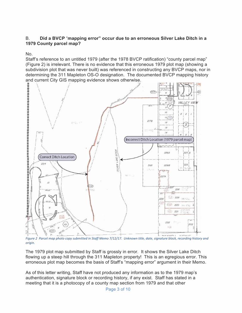
B. Did a BVCP “mapping error” occur due to an erroneous Silver Lake Ditch in a 1979 County parcel map? No. Staff’s reference to an untitled 1979 (after the 1978 BVCP ratification) “county parcel map” (Figure 2) is irrelevant. There is no evidence that this erroneous 1979 plot map (showing a subdivision plot that was never built) was referenced in constructing any BVCP maps, nor in determining the 311 Mapleton OS-O designation. The documented BVCP mapping history and current City GIS mapping evidence shows otherwise.
Figure2ParcelmapphotocopysubmittedinStaffMemo7/12/17.Unknowntitle,date,signatureblock,recordinghistoryandorigin.
The 1979 plot map submitted by Staff is grossly in error. It shows the Silver Lake Ditch flowing up a steep hill through the 311 Mapleton property! This is an egregious error. This erroneous plot map becomes the basis of Staff’s “mapping error” argument in their Memo. As of this letter writing, Staff have not produced any information as to the 1979 map’s authentication, signature block or recording history, if any exist. Staff has stated in a meeting that it is a photocopy of a county map section from 1979 and that other

Page 4 of 10
surrounding year maps have not been reviewed. Is it an anomaly? We believe that the unidentified map copy provided by Staff does not meet the criteria of submissible evidence by any governing body. Both the Open Space and Geological Hazard maps in the 1977 BVCP binder show the Silver Lake Ditch in the correct location on the property, prior to the untitled 1979 plot map submitted by Staff. BVCP maps of this period correctly place the Silver Lake Ditch and proposed open space over it. See Figure 1. They did not change location after 1979. The 1979 photocopy map submitted by Staff as evidence is spurious. Note under the letter “C” in the 1979 plot map submitted by Staff, a subdivision is plotted on the Sanitas Valley Trail. This subdivision was never developed. The area is now preserved. An OS-O designation now overlays the proposed subdivision roads, according to May 2017 City “Sanitarium” GIS mapping. C. Does the erroneous 1979 County parcel map of Silver Lake Ditch define the OS-O boundaries? No. Staff asserts on page 2 of their Memo that, “The incorrect ditch location shown on the parcel map directly corresponds with the existing OS-O boundary.” This is a false statement, based on the City’s May 2017 GIS map records. The OS-O mapping from City GIS records follows discrete segmented survey lines, not the mistaken uphill flowing Silver Lake Ditch route drawn on the erroneous 1979 parcel map. Please reference City of Boulder “Sanitarium” GIS map in Figure 3. City GIS map of 311 Mapleton OS-O Designation analysis: The 311 Mapleton OS-O south and east boundaries consist of seven straight line segments. Table 1 below shows the details on each of these segments. The segment intersect points are obvious locations for surveyor’s instruments. Segment seven follows the east side of the road. The curvature at the north end follows the road curvature. The City GIS data for the 311 Mapleton OS-O designation follows the existing road, not an erroneous 1979 county plot map of Silver Lake Ditch, as asserted by Staff in their 7/12/17 memo.
Table1SouthandeastOS-Oboundarysegments
Segment
Startheightft
Endheightft
Heightdifference
ft
Directionwrtnorth
Lengthft
Averageslope
degrees1 5585 5550 35 113 141 -13.92 5550 5530 20 78 76 -14.73 5530 5525 5 26 139 -2.14 5525 5530 -5 35 76 3.75 5530 5531 -1 315 114 0.56 5531 5531 0 3 139 0.07 5531 5543 -12 348 245 2.8

Page 5 of 10
D. Does the BVCP contain the governing maps that are legally ratified by City and County officials? Yes. BVCP ratified land use maps are not legally subordinated to various generations and changes of Boulder County parcel maps or developer plot map submissions. BVCP land use maps are governing documents. They have been extensively reviewed by the public, property owners, and City Staff for over 40 years, and are ratified by City and County elected officials (reference Boulder County planning library binders since 1960s). Staff have informed us in meeting that the OS-O designation at 311 Mapleton (and others) was formally documented in ratification by Boulder Council in the 2001 BVCP revision. The 2001 mapping designation appears in Figure 3.
Figure3“Sanitarium”GISmapdigitalcopypurchasedfromCityofBoulderPlanning&DevelopmentServices,May16,2017

Page 6 of 10
Citizens have relied on the authenticity and validity of the BVCP maps for many years in Boulder. The placement and protection of Open Space designations is a critical factor in family decisions to acquire or improve residential properties. Staff’s proposal to remove the OS-O designation at 311 Mapleton, without the public due-process required under BRC 1981, would cause a serious breach of confidence and trust in our local government and officials. The BVCP Land Use map has, and continues to, designate the OS-O and the Silver Lake Ditch geography at 311 Mapleton consistently and correctly for many years. Please see examples in Figures 4 and 5 following.
Figure4:Decade2000BVCPmapsshowing311MapletonOS-Odesignationconsistently
BVCPRatifiedMap2010 BVCPProposed2017220172017Map2017
BVCPMap2004 BVCPMap2001
Figure5CurrentdecadeBVCPmapsshowing311MapletonOS-Odesignation

Page 7 of 10
E. Is the 311 Mapleton OS-O a boundary definition issue? No. This OS-O designation is, and has been, a defined acreage mapped in the BVCP and on Boulder’s GIS data base. The 4+ acres OS-O designation in question is not an “error in the boundary of the designation,” as asserted in Staff’s 7/12/17 Memo. It is an OS-O designation in its entirety, as shown on this BVCP map examples of Figure 4 and Figure 5. The City has adopted the BVCP and this OS-O designation by resolution, including its maps of land use designations. There are no ambiguities in the boundaries of the Boulder GIS mapping of this OS-O designation.
F. Were there any known mapping objections or disputes regarding the location of the 311 Mapleton Open Space designation in the BVCP? No. There are no known mapping disputes regarding the OS-O designation at 311 Mapleton over the BVCP ratification history - by property owners, citizens, public interest groups, County staff, or the City. Currently, a developer desires that the City remove the historic 311 Mapleton OS-O designation, to enable their development of a large commercial complex on the designated OS-O land. If permitted, they would place new buildings and private roads on public Mount Sanitas trail access and natural hazard designations, which the current OS-O protects. The area surrounding the Sanitarium site was surveyed by the City in 1998 as part of a commissioned report on the natural and cultural history of the site. See figure 6. The survey marks the Silver Lake Ditch in the correct location. The report is extensively referenced. No actions were taken by the City or property owners subsequently to propose modification or
Figure6:1998MountSanitasSurveyandReportcommissionedbytheCityofBoulder

Page 8 of 10
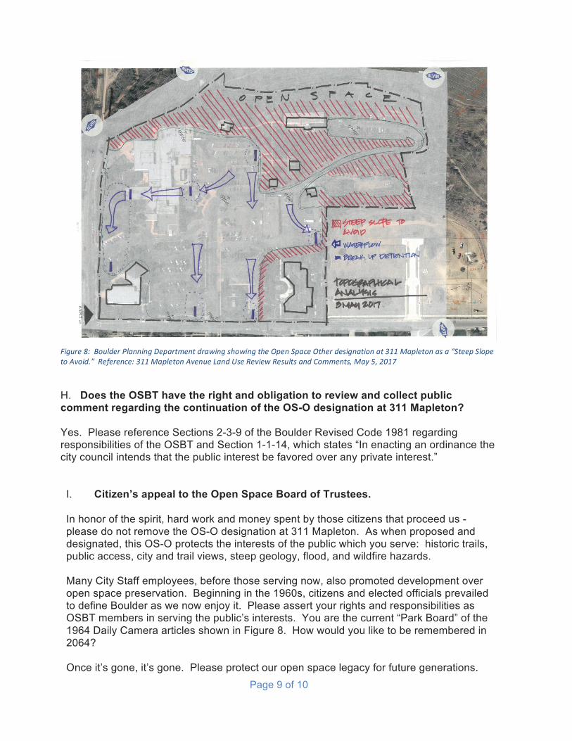
removal of the Open Space designation at 311 Mapleton as result of the survey or report. This 1998 city commissioned survey has not found to be in error. G. Does the 311 Mapleton OS-O designation conform with BVCP policies regarding environmental protection and natural hazard mitigation? Yes. The 311 Mapleton site was identified as a geological mass movement hazard in the 1977 and subsequent BVCP revisions. Please see the photo excerpt of the 1977 BVCP map in Figure 7. This may have been a contributing factor in the decision to propose and designate the 311 Mapleton Open Space, following 1977 BVCP written policy regarding the use of Open Space designations for natural hazard considerations. The OS-O is on an extremely steep hill with flood drainage into an historic Boulder neighborhood. The site is subject to frequent wildfire evacuations and is located on Boulder’s Urban Wildfire Interface. In May 2017, Planning Staff rejected the developer’s latest development proposal, citing the destruction of the steep grade geology and constraints of building on the natural hazards of the site. Planning staff’s drawing from their comments to the applicant appears in Figure 7. Continuing the 311 Mapleton OS-O designation will prevent the proposed environmental destruction of the hazardous slope (landslide, wildfire, flood) which the designation protects in perpetuity.
Figure7:Excerptfrom1977BVCPGeologyHazardMapshowingMassMovementHazardinredcolorover311Mapletonproperty.
Page 9 of 10
H. Does the OSBT have the right and obligation to review and collect public comment regarding the continuation of the OS-O designation at 311 Mapleton? Yes. Please reference Sections 2-3-9 of the Boulder Revised Code 1981 regarding responsibilities of the OSBT and Section 1-1-14, which states “In enacting an ordinance the city council intends that the public interest be favored over any private interest.”
I. Citizen’s appeal to the Open Space Board of Trustees. In honor of the spirit, hard work and money spent by those citizens that proceed us - please do not remove the OS-O designation at 311 Mapleton. As when proposed and designated, this OS-O protects the interests of the public which you serve: historic trails, public access, city and trail views, steep geology, flood, and wildfire hazards. Many City Staff employees, before those serving now, also promoted development over open space preservation. Beginning in the 1960s, citizens and elected officials prevailed to define Boulder as we now enjoy it. Please assert your rights and responsibilities as OSBT members in serving the public’s interests. You are the current “Park Board” of the 1964 Daily Camera articles shown in Figure 8. How would you like to be remembered in 2064? Once it’s gone, it’s gone. Please protect our open space legacy for future generations.
Figure8:BoulderPlanningDepartmentdrawingshowingtheOpenSpaceOtherdesignationat311Mapletonasa“SteepSlopetoAvoid.”Reference:311MapletonAvenueLandUseReviewResultsandComments,May5,2017

Page 10 of 10
Sincerely, Citizens for Sanitas, A Colorado Non-Profit Roger Koenig Alan Delamere Russell Henriksen Randi Stroh Betsey Jay
Figure9:1964ClippingsfromTheDailyCameraregardingthelongcitizencampaigntoacquireandprotectEnchantedMesaopenspace.