city of gardiner maine comprehensive plan 2014
TRANSCRIPT

The University of MaineDigitalCommons@UMaine
Maine Town Documents Maine Government Documents
2014
City of Gardiner Maine Comprehensive Plan 2014Gardiner, Me.
Follow this and additional works at: https://digitalcommons.library.umaine.edu/towndocs
This Plan is brought to you for free and open access by DigitalCommons@UMaine. It has been accepted for inclusion in Maine Town Documents by anauthorized administrator of DigitalCommons@UMaine. For more information, please contact [email protected].
Repository CitationGardiner, Me., "City of Gardiner Maine Comprehensive Plan 2014" (2014). Maine Town Documents. 7315.https://digitalcommons.library.umaine.edu/towndocs/7315


Gardiner Comprehensive Plan 2014 Prepared by the Gardiner Comprehensive Plan Committee Patricia Hart, Chair Debby Willis Tracy Farrell Ron Trahan Kirk Mohney Pam Mitchel Dorothy Washburn With assistance from Scott Morelli, City Manager Nate Rudy, Director of Economic and Community Development Gardiner Office of Planning and Development
Dot Morang, Administrative Assistant Richard Dolby, Interim Code Enforcement Officer
Curt Lebel, City Assessor Meaghan Carlson, Gardiner Heart & Soul Coordinator Planning Decisions, Inc
Mark Eyerman Katie List
This plan was prepared as part of the Gardiner Heart & Soul planning process. Gardiner Heart & Soul is a partnership of the City of Gardiner, the Gardiner Board of Trade, the Gardiner Main Street Program, and the Orton Family Foundation.


Table of Contents Executive Summary .............................................................................................................................................................................................................. 1 Part One | Background Information ............................................................................................................................................................................... 11
Chapter 1: Past Planning Activities .............................................................................................................................................................................. 13 Chapter 2: Recent Development Profile .................................................................................................................................................................... 25 Chapter 3: Overview of Updated Inventories ........................................................................................................................................................... 33
Part Two | Goals & Policies ............................................................................................................................................................................................... 55 Chapter 4: Community Vision ....................................................................................................................................................................................... 57 Chapter 5: Community Goals and Policies ............................................................................................................................................................... 61 Chapter 6: Land Use Goals and Policies .................................................................................................................................................................... 89
Part Three | Implementation Strategies ....................................................................................................................................................................... 105 Chapter 7: Regional Coordination ............................................................................................................................................................................ 107 Chapter 8: Implementation Strategy ........................................................................................................................................................................ 109 Chapter 9: Capital Investment Strategy .................................................................................................................................................................. 119
Appendix I | Inventories .................................................................................................................................................................................................. 121 Appendix II | Capital Improvements Program ........................................................................................................................................................... 211 Appendix III | Community Action Program ................................................................................................................................................................. 213 Appendix IV | Overview of Public Involvement ......................................................................................................................................................... 245


EXECUTIVE SUMMARY
1
EXECUTIVE SUMMARY This executive summary provides an overview of the entire Comprehensive Plan including a summary of the policy recommendations.
A. The Role of the Comprehensive Plan The Comprehensive Plan is intended to guide the many different decisions that the City and the larger community will need to make over the coming decade to guide the future of the city. Its scope is comprehensive and it addresses the wide range of issues facing Gardiner. A major focus of the Plan is on land use and establishing a framework for future redevelopment and growth and development in the community. By state law, the Future Land Use Plan (see Chapter 6) serves as the basis for the City’s zoning and the City’s zoning requirements must be consistent with the Comprehensive Plan. The role and content of comprehensive plans is guided by state law which establishes guidelines for local comprehensive plans. This Comprehensive Plan is intended to conform to the requirements of the State’s Growth Management Law for comprehensive plans. The guidelines call for the plan to be developed through the active participation of the community. The guidelines lay out the recommended contents of a plan including inventories of a wide range of factors about the community, goal and policies to address these various topics, a Future Land Use Plan to manage the anticipated growth and development in the community, and an implementation strategy setting out how the proposals will be carried out along with consideration of regional concerns and the capital spending necessary to implement the plan. The table of contents for this Plan and the related content reflects these requirements.
While state approval of the City’s Comprehensive Plan is not required, there is a process for the voluntary review of the plan by the state. If the City’s plan is found to be consistent with the state guidelines, there are some benefits for the City including preferential treatment for some state grant programs.
B. The Organization of the Comprehensive Plan The 2014 Gardiner Comprehensive Plan is divided into three parts. Part 1 presents background information. Chapter One summarizes the key elements of the 1997 Comprehensive Plan and outlines many of the community planning activities since the adoption of that plan. Chapter Two contains a detailed profile of the past twelve years of residential and commercial development activity in Gardiner. Chapter Three offers summaries of the Plan’s inventory sections. Full versions of the inventories are contained in Appendix I. Part 2 of the Plan sets out the Comprehensive Plan’s vision, goals, and policy recommendations. Chapter Four lays out the community’s vision for its future – what we want our City to be in ten or so years. Chapter Five presents goals and policies for addressing issues facing the community related to all plan elements including some aspects of land use. Chapter Six contains detailed goals and policies for land use, including a Future Land Use Plan and detailed summaries of preferred use and development patterns for each land use designation identified in the Future Land Use Plan. Part 3 lays out the actions needed to achieve the goals and policies proposed in Part 2. Chapter Seven addresses how Gardiner should coordinate its planning activities with neighboring municipalities and regional organizations. Chapter Eight sets out a detailed program for carrying out the various actions, and assigns responsibility for the implementation of each action to a particular department, board, or agency. Chapter Nine identifies the capital

EXECUTIVE SUMMARY
2
investments needed to both support future growth and development and to enhance the community’s quality of life. The appendices to the Plan include the full inventories for the various Plan elements, the City’s capital spending plan, the Heart & Soul Community Action Plan, a summary of a livability study conducted by the communitiy’s youth, and a summary of public participation in the development of the Plan
C. The Commuity Vision Chapter 4 lays out a vision for what the community wants Gardiner to bein 2025. It is a forward looking statement that establishes key goals for the future of Gardiner. The Vision for Gardiner in 2025 is based on the community values developed as part of the Gardiner Heart and Soul (H&S) project. The values were initially distilled from over one hundred in-depth one-on-one interviews in which a broad spectrum of our community were asked to share their stories about Gardiner and what makes it special. The initial values from this “storytelling” phase were then refined at the We Are Gardiner community event. The statement of community values that resulted from that work by approximately one hundred residents became the basis for the Community Vision. The Vision is an attempt to describe what we want Gardiner to be in 2025. It establishes the goals that we are working toward and that the Comprehensive Plan is trying to achieve. The Community Vision addresses each of the eleven H&S values in addition to an over-arching desire to see the City grow and prosper. The Community Vision addresses the following areas:
Fostering a growing, prosperous community Creating a strong local economy Maintaining a quality educational system Promoting history, arts and culture
Enhancing the livability of the city Nurturing a sense of community and belonging Encouraging community involvement and volunteerism Reinforcing the city’s connections to nature Maintaining an inclusive, responsive government Capitalizing on the community’s unique physical assets Providing quality infrastructure and services Celebating Gardiner’s family friendliness
D. Community Goals and Policies Chapter 5 addresses the policy issues facing the City as it plans for the future. The policies are organized around two overarching goals that emerged from the Heart & Soul planning process:
Goal #1 – Expand the total value of taxable real estate in the City on an on-going basis
This goal is quite simple in concept – the City’s property tax base or total assessed valuation should grow every year to provide the ability to reduce the tax burden on property owners and to invest in facilities and services necessary to accomplish the second goal of making Gardiner better. This increase in the assessed valuation should be the result of private investments in real estate (both new construction and improvements/expansions of existing buildings) or public actions that result in the increase in property values rather than inflationary increases resulting from general real estate valuation trends. At the same time, this goal does not envision growth and development at any cost or without regard to the consequences. Rather it seeks increased valuation as a result of well-planned growth and development that maintains and enhances the essential character of Gardiner and is in harmony with the environment. Or in other words, growth and development that has long-term economic and community value, not short-term fixes.

EXECUTIVE SUMMARY
3
Goal #2 – Enhance the desirability of Gardiner as a place to live, work, shop, invest, and have fun
This goal is also quite simple in concept – the community should build on the city’s “good bones” to make Gardiner a location of choice, a place where people want to live and invest. Implicit in this goal is the concept that Gardiner should be true to its historical roots and focus on offering residents, businesses, investors, and visitors an “urban village” that is compact, walkable, friendly, and exciting. The city should offer an alternative to an auto-centric, suburban lifestyle. Gardiner should be an attractive place to live for people of all ages with a focus on assuring that the community meets the needs of younger people and families. The community should provide facilities and services that reinforce the idea of an “urban village”. In doing this, the City should look to the future and ask what do the next generations of Gardiner residents and families want and how can we continue to meet the needs of younger people. The Comprehensive Plan sets out a series of objectives for moving the City in the direction of these two broad goals. For each objective, it identifies actions that the City or larger community should undertake to achieve that objective. The following sections provide a summary of those objectives and actions. I. Objectives and Actions to Expand the Tax Base Growing the City’s tax base on an ongoing basis will require a comprehensive strategy that addresses a wide range of issues. Making progress towards this goal is dependent on the decisions of individual property owners, businesses, and investors. The role of the City and the larger Gardiner community in achieving this goal is largely in the area of creating the environment that influences those private decisions to invest in the community. Therefore many of the
objectives and actions laid out in the following section address creating a positive environment in Gardiner and establishing a regulatory framework that facilitates good quality development that maintains and enhances the essential character of Gardiner and is in harmony with the environment. Objective 1.1 Increase the awareness of Gardiner as a great place to do business and invest The recommended actions to achieve this objective include continuing to fund an active economic development program and establishing “community ambassadors” in the business community to promote Gardiner as a place to have a business, Objective 1.2 Increase the awareness of Gardiner as a great place to live The recommended actions to achieve this objective include working with the real estate community, using the City’s website to market Gardiner as a great place to live, recruiting “community ambassadors” who are willing to provide testimonials about living in Gardiner, and establishing a welcome committee for new residents. Objective 1.3 Increase the development in the Libby Hill Business Park The recommended actions to achieve this objective include maintaining an active, aggressive marketing program and exploring creative financing mechanisms to encourage interest in the park. Objective 1.4 Promote high quality development in the outer Brunswick Avenue corridor The recommended actions to achieve this objective include revising the zoning to manage development along outer

EXECUTIVE SUMMARY
4
Brunswick Avenue as three distinct “character areas” – a Mixed-Use Village Area for the area from the Armory out to the four-way Old Brunswick Road intersection just west of Ainslie’s Market (see FLUP map), a Planned Development Area for the area from the four-way Old Brunswick Road intersection out to the Blueberry Hill area, and a Planned Highway Development Area for the portion of the corridor from Blueberry Hill to I-295 excluding the existing business park PIC districts – together with revising the commercial design standards to include area specific standards as well as developing a streetscape plan for the corridor that is tied to and reflects the various character areas. Objective 1.5 Facilitate the potential for redevelopment in the Cobbossee Corridor The recommended actions to achieve this objective include continuing to implement the Cobbossee Corridor Master Plan, working to resolve the Brownfields issues, exploring establishing the corridor as a “green” district, undertaking a design study for the corridor, and exploring the feasibility of the creation a destination recreation use utilizing the stream.
Objective 1.6 Increase the level of investment in Downtown The recommended actions to achieve this objective include maintaining an active Main Street program, creating a new zoning district for the traditional downtown that includes only the traditional downtown area with appropriate standards, updating the floodplain management requirements for the historic district, improving access to upper floors of buildings, improving Downtown traffic flow, improving the use of available public parking, increasing the amount of public use parking available in Downtown, improving access to the Arcade Parking Lot, improving Downtown signage as proposed in the City-Wide Signage Plan, and promoting the use of historic rehabilitation tax credits.
Objective 1.7 Encourage the reuse and/or redevelopment of the South Gardiner industrial complex The recommended actions to achieve this objective include investigating the possible reuse of these buildings in cooperation with the property owner and providing redevelopment financing if the property owner is willing to undertake a renovation and/or redevelopment program. Objective 1.8 Expand the opportunities for home businesses and home occupations The recommended actions to achieve this objective include revising the standards for “home occupations” to clarify the treatment of “independent contractors” and allowing Accessory Business Uses that would permit the use of the part of a residential building along major streets for limited business use but without tying the ownership of the business activity to the occupants of the property.
Objective 1.9 Expand the opportunities for infill housing in established residential neighborhoods The recommended actions to achieve this objective include allowing accessory dwelling units in single-family homes and treating townhouses as a separate use with different standards than other multifamily housing. Objective 1.10 Maintain and enhance the livability of existing residential neighborhoods The recommended actions to achieve this objective include supporting the creation of neighborhood associations, establishing a neighborhood improvementprogram, maintaining and enhancing the sidewalk system, providing opportunities for the creative reuse of large, older buildings, adopting and enforcing a housing code for multifamily buildings, and addressing nuisance situations through a
EXECUTIVE SUMMARY
5
“disorderly house” ordinance that allows the City to take action against a property owner if there are repeated problems at his/her property. Objective 1.11 Facilitate the construction of good-quality residential development The recommended actions to achieve this objective include establishing a Cobbossee Planned Development District in a portion of the area between outer Brunswick Avenue and the Cobbossee Stream to allow well-planned, higher-density residential development that establishes a “village character” and updating the City’s residential development standards. Objective 1.12 Establish Route 24 as a destination scenic corridor The recommended actions to achieve this objective include promoting the corridor as a scenic attraction, seeking designation of the Route 24 corridor as a state scenic byway, and exploring the creation of a scenic overlook.
Objective 1.13 Encourage reinvestment in historic properties The recommended actions to achieve this objective include documenting the historic status of older properties, publicizing the availability of historic rehabilitation tax credits, and managing the demolition of historic structures. Objective 1.14 Encourage the development of elder care and retirement housing The recommended actions to achieve this objective include providing density bonuses for senior housing and eldercare facilities and reviewing and adjusting other zoning requirements for senior housing.
II. Objectives and Actions to Enhance the Quality of Life Enhancing the quality of life in Gardiner will require a comprehensive strategy that addresses a wide range of issues. Making progress towards this goal is dependent on the actions of many groups and organizations in the community. Some of these activities fall within the purview of existing City departments and committees. Others can be undertaken by existing organizations such as Gardiner Main Street and the Boys and Girls Club. Others will need to be done by volunteers and other community groups. The Heart & Soul Community Action Plan which is a companion document to this Comprehensive Plan addresses how some of these activities can be accomplished. Objective 2.1 Enhance facilities for walking and biking The recommended actions to achieve this objective include updating the City’s sidewalk plan, funding improvements to the sidewalk system on an ongoing basis, enhancing the pedestrian environment in Downtown, connecting the downtown by trail, developing the Cobbossee Corridor Trail, and exploring the feasibility of extending the rail trail to the Richmond town line. Objective 2.2 Establish a coordinated system to program, plan, and carryout recreational activities The recommended actions to achieve this objective include designating the Parks and Recreation Committee as the responsible group for coordinating recreational activities, developing, through an inclusive, public process, a short and long-range plan for recreational facility improvements and expanded recreational programming, developing and implementing a coordinated system and calendar of recreational activities, improving coordination with the school district for the use of school facilities for community recreation use, and continuing to provide ongoing funding to the Boys

EXECUTIVE SUMMARY
6
and Girls Club to provide recreational and after-school programs. Objective 2.3 Expand the range of recreational/sports and educational activities available for people of all ages The recommended actions to achieve this objective include investigating possible opportunities and costs for providing a public, outdoor swimming facility, exploring modifying the restrictions on the Sunday use of Quimby Field for organized recreation, providing additional informal recreational programs for people of all ages, exploring the construction of a skateboarding facility, exploring the feasibility of establishing a teen center, and expanding community and adult education. Objective 2.4 Improve the short-term appearance and usability of the Cobbossee Corridor for recreational activities The recommended actions to achieve this objective include establishing a “Cobbossee Corridor Action Committee”, undertaking private fundraising for the local share of the state grant for construction of the corridor trail, exploring the possibility of developing a small park at New Mills possibly in conjunction with the Water District, and developing a volunteer program to maintain and improve the existing trails and access along the corridor. Objective 2.5 Enhance the usability of Waterfront Park as an active, family-focused destination The recommended actions to achieve this objective include developing a short-term plan for making additional improvements at the park and holding more activities in the park. Objective 2.6 Continue to enhance Gardiner’s image as a child-friendly community
The recommended actions to achieve this objective include supporting continued improvement in the quality of the local school system and working to change negative perceptions about the school district, expanding the availability and variety of after-school school programs, and investigating possible opportunities and costs for providing a public, outdoor swimming facility. Objective 2.7 Increase the amount of foot traffic and activity in Downtown The recommended actions to achieve this objective include undertaking a coordinated marketing campaign that focuses on the businesses that are in Downtown and the types of goods and services that one can obtain in Downtown Gardiner, focusing business recruitment activities on local, independent businesses, continuing to support Johnson Hall and leveraging the increased activity there to support Downtown, increasing the number and type of special events, and increasing the level of private investment in Downtown. (See Objective 1.6 and related actions). Objective 2.8 Make “local” a focus of the community The recommended actions to achieve this objective include making local, independent businesses a focus of business recruitment activities in Downtown and throughout the city, establishing a formal “Buy Local” program, and undertaking marketing programs that focus on what you can buy locally. Objective 2.9 Establish a local food policy The recommended actions to achieve this objective include developing and adopting a formal local food policy, making businesses that produce, process, package, distribute, and/or sell local food products a focus of the City’s business

EXECUTIVE SUMMARY
7
development efforts, and assuring that the City’s regulations do not inhibit local agricultural production. Objective 2.10 Promote the maintenance and improved energy efficiency of older homes The recommended actions to achieve this objective include providing assistance to homeowners to understand and apply for available funding for weatherization and energy improvements, establishing a neighborhood improvement program, and exploring using payments to the City from natural gas suppliers to assist homeowners in improving the energy efficiency of their homes including converting their heating systems to more efficient and greener alternatives.
E. Land Use Goals and Policies Chapter 6 addresses the land use policy issues facing the City as it plans for the future. The recommendations of this part of the Plan are intended to guide future revisions to the Land Use Ordinance which governs the way property in the city can be used and developed. Land Use Objectives The land use policies and recommendations for the City’s land use regulations and related programs are based on a set of interrelated objectives. These objectives represent the core of the City’s land use planning program. The land use objectives are: 1. Encourage new development as well as the expansion and improvement of existing development in accordance with the following objectives and the Future Land Use Plan. 2. Encourage the majority of new development to occur in designated growth areas, and to a lesser extent, in limited
growth areas as identified in the Future Land Use Plan. Generally, this is the portion of the City that is adjacent to the existing built-up area of the community and in the Cobbossee and outer Brunswick Avenue corridors (see Figure 6.1). 3. Discourage significant development in the designated rural and resource areas to preserve the rural nature of these parts of the community where there are large contiguous areas of agricultural or undeveloped land or significant natural resources. Generally, this is the portion of the community that is south and west of the built-up area of the City and south of the outer Brunswick Avenue corridor (see Figure 6.1). 4. Reinforce the traditional Downtown’s role as the community and retail/service center for the City and assure that outlying development does not detract from or diminish this role. 5. Enhance the desirability and livability of the older residential neighborhoods while allowing for some infill development that maintains the character of these neighborhoods. 6. Provide for the construction of new housing that is compatible with the established development patterns of the older residential neighborhoods in the area on the fringe of the built-up area along the Cobbossee Stream. 7. Foster the growth and development of the outer Brunswick Avenue corridor as an attractive gateway to the City while creating distinctive development patterns and environments along different portions of the corridor. 8. Promote continuing industrial/business park development in the outer Brunswick Avenue corridor area including assuring that there is an adequate supply of appropriately zoned and serviced land to accommodate anticipated growth. 9. Reinforce South Gardiner’s role as a desirable riverfront community including accommodating the reuse or

EXECUTIVE SUMMARY
8
redevelopment of the large warehouse buildings for a range of possible uses. 10. Require that new development meet high standards for both site and building design that are tailored to the desired development patterns in various areas to assure that this development is a positive addition to the community. 11. Further policies that enhance Gardiner as a livable, walkable community that provides a viable alternative to suburban-style, auto-centric living. Future Land Use Plan The Future Land Use Plan (see Figure 6.2) shows graphically how the City’s land use policies apply to the land area of the City of Gardiner and where and how growth should be accommodated over the next decade. The Future Land Use Plan embodies the concept that the City should identify and designate “growth areas” or areas in which most of the anticipated non-residential and residential growth will be accommodated, “limited growth areas” or areas in which intensive development will be discouraged but modest infill development and redevelopment will be accommodated, “rural areas” where intensive development will be discouraged, and “resource conservation areas” where most development will be prohibited or carefully managed to preserve natural resource values. The Future Land Use Plan (see Figure 6.2 in the Plan) takes the parts of Gardiner that are within these four broad categories and divides them into “land use designations”. These land use designations cover the entire city and incorporate the concepts set forth for the land use objectives discussed in Section A above. The Future Land Use Plan does not show the shoreland overlay districts which are intended to remain unchanged. As noted in the introduction to this section, the
land use designations are not intended to be “zoning districts” per se. Rather they form the broad basis that must be reflected in the City’s land use regulations including the zoning map. In the preparation of the revised zoning provisions, some of the designations may be combined or re-arranged or divided to create a workable number of zoning districts. The following provides an outline of the various land use designations organized by growth designation:
A. Growth Areas 1. Residential Growth Areas
i. Residential Growth Area ii. Cobbossee Planned Development Area
2. Mixed-Use Growth Areas iii. Cobbossee Corridor Area iv. Mixed Use Village Area v. Planned Development Areas
3. Nonresidential Growth Areas vi. Planned Highway Development Area vii. Planned Industrial Commercial Area
B. Limited Growth Areas 1. Residential Limited Growth Areas
viii. High Density Residential Area 2. Mixed-Use Limited Growth Areas
ix. Professional Residential Area x. Traditional Downtown Area
3. Nonresidential Growth Areas xi. Downtown Fringe Area xii. Educational Community Recreation
Area
C. Rural Areas xiii. Rural Areas

EXECUTIVE SUMMARY
9
D. Resource Conservation Areas i. Shoreland Area ii. Resource Protection Area
A description each of these land use designations is included
in Chapter 6.
Land Use Plan Policies The Future Land Use Plan includes a number of significant policy proposals. Some of these proposals involve possible changes in City programs and land use regulations including the zoning ordinance. The Future Land Use Plan and the related descriptions of the various land use designations will guide future revisions to the City’s zoning requirements. The following items highlight areas where there are significant differences between what is proposed in the Future Land Use Plan and the City’s current zoning provisions:
Designate the outer Highland Ave. area west of West Hill Road as a Rural Area. This would encourage this area to remain rural. This area is currently zoned Residential Growth.
In conjunction with the prior proposal, designate the lots on the west side of West Hill Road as High Density Residential. This is the same designation as the other side of West Hill Road. This area is currently zoned Residential Growth.
Designate the state office building off Northern Avenue as High Density Residential to match the surrounding neighborhood. This would limit future reuse or redevelopment of this property to uses that are compatible with the neighborhood. This building is currently zoned Planned Development (PD).
Extend the Cobbossee Corridor designation downstream to Bridge Street. This will put all of the stream corridor upstream of Bridge Street to New Mills in the same designation. Some of the lots near Bridge Street are now in the Central Business (CB) Zone.
Divide the current Central Business zone into two land use designations – the Traditional Downtown Area and the Downtown Fringe – and have separate standards for the two areas that reflect the current and desired pattern of development.

EXECUTIVE SUMMARY
10
Allow “accessory business uses” in homes in the High Density Residential area that are on Brunswick Ave. Church Street, Highland Avenue and Water Street west of downtown.
Designate the largely undeveloped area between Old Brunswick Ave. and the Cobbossee Stream west of West Street as the Cobbossee Planned Development Area that allows new housing on smaller lots if it is designed to be compatible with the established residential neighborhoods to the east.
In conjunction with the prior proposal, designate the developed lots on the west side of West Street as High Density Residential to match the other side of the street.
Designate the portion of the outer Brunswick Ave. corridor from the armory area out to Ainslie’s Market as a Mixed Use Village Area that allows smaller scale commercial uses along with residential uses. This area is currently zoned primarily Planned Development and Residential Growth.
Extend the Planned Development designation on the south side of Outer Brunswick Avenue to include the Blueberry Hill area.
Designate the portion of the outer Brunswick Avenue corridor near I-295 as a Planned Highway Development Area to accommodate activities that might benefit from a location adjacent to I-295.
In addition, the Future Land Use Plan proposes minor revisions to some of the exisitng zoning districts.

PART ONE | BACKGROUND INFORMATION
11
PART ONE | BACKGROUND INFORMATION

PART ONE | BACKGROUND INFORMATION
12

CHAPTER 1 | PAST PLANNING ACTIVITIES
13
CHAPTER 1: PAST PLANNING ACTIVITIES The City of Gardiner has had an active, ongoing planning program for at least the past twenty-five years. The City prepared a comprehensive plan in 1988. In 1997, the City adopted an updated Comprehensive Plan that built on the 1988 plan. Since 1997, the City has undertaken a number of topical or special studies addressing specific issues or areas of the community. This chapter provides an overview of those past planning efforts with a focus on identifying the portions of that work that are still relevant as well as implementation strategies that still need to be carried out.
A. The 1997 Comprehensive Plan The City adopted the current comprehensive plan in 1997. That plan has served to guide development and investment in the City over the past 17 years. The Plan is organized by topic and covers a wide range of issues. For each topic the Plan sets out broad goals, provides an analysis of the topic, establishes recommended policies, and lays out an implementation strategy to achieve the recommended policies.
1. 1997 Planning Issues In the introduction to the 1997 Comprehensive Plan (Section 1), there is a list of “some of the key issues” facing the City. With the exception of item 11, these seem to continue to be important issues facing the City in 2014:
1. Rapid residential growth in the rural sections of the City. (2014 NOTE: But the rate of all residential development has slowed significantly in recent years).
2. A stable population base compared to rising population in neighboring towns. (2014 NOTE: The City’s population has been slowly declining over the past 15-20 years).
3. The rising cost of City services.
4. The rising tax rate in the City. (2014 NOTE: The tax rate has stabilized but is higher than surrounding communities).
5. The need to explore regional solutions for providing some City services.
6. The recreational needs of the City in particular for the young and the elderly.
7. A concern for the quality of education. 8. The desire for economic development and job
creation. 9. The desire to expand the City’s industrial and
commercial tax base. 10. An interest in a mixed use residential and commercial
area. 11. A renewed interest in expanding the sewer along
Brunswick Avenue. (2014 NOTE: This has been accomplished).
12. Continued protection of the City’s residential neighborhoods.
13. The increased protection of the City’s natural resources. 14. Improved planning for infrastructure improvements.
2. 1997 Community Goals Section 4 of the 1997 Plan lays out a set of “community goals”. The Plan defines goals as broad and open statements which establish a tone and general direction for the City to follow. The goals included in the 1997 Plan were a blend of new goals that came out of the 1997 planning effort, goals carried over from the 1988 Plan, and the goals set out in the State’s Growth Management Program. The goals attempted to give voice to what we wanted our community to be as we looked to the future. The following goals were established in the Plan – most of these appear to still be relevant in 2014 but provide limited specific guidance in planning for the future of Gardiner:
1. Encourage orderly growth and development in appropriate areas of the City while protecting the

CHAPTER 1 | PAST PLANNING ACTIVITIES
14
City’s rural character, making efficient use of public services and preventing sprawl development.
2. Plan for, finance and develop an efficient system of public facilities and services to accommodate anticipated growth and economic development.
3. Promote a diverse economic climate while preserving its historical and natural resources.
4. Invest in infrastructure and public facilities that provide the needed capacity for business development.
5. Promote and communicate the City’s assets through aggressive economic development efforts.
6. Protect existing businesses within the City through comprehensive retention programs and expansion programs and assistance.
7. Actively pursue new industrial and commercial businesses to locate within the City.
8. Support through a system of programs and information outreach new business startup efforts within the City.
9. Develop and utilize regional services and progressive technologies to enhance business development opportunities within the City.
10. Encourage and promote affordable, decent housing opportunities for all City residents.
11. Provide a variety of types and densities of housing available to households of different sizes and incomes.
12. Promote programs and opportunities that improve the City’s housing stock and neighborhoods.
13. Protect the quality and manage the quantity of the City’s water resources, including streams, aquifers, ponds and rivers.
14. Protect the City’s natural resources including wetlands, wildlife, fisheries, plant habitat, shorelands, scenic vistas, steep slopes and unique natural areas.
15. Promote and preserve the Kennebec River frontage for open space and recreational uses.
16. Safeguard agriculture and forest resources from development which threatens those resources.
17. Preserve the City’s historic and archaeological resources.
18. Promote and protect the City’s marine resources including, boating, fishing and harbor fronts.
19. Promote and protect the availability of outdoor recreation opportunities for City residents, including access to surface waters.
20. Promote a variety of recreational and cultural activities and opportunities throughout the City.
21. Promote and protect the distinct characters of Gardiner’s Downtown, Residential Neighborhoods, and Rural areas.
22. Match the density and type of development with the natural carrying capacity of the land to support development without environmental damage.
23. Manage growth so that it enhances the vitality of Gardiner without exceeding the City’s ability to provide municipal services and educational facilities and without degrading the environment.
24. Plan for growth, administer land use ordinances and carry out development decisions in an orderly, appropriate and consistent fashion.
25. Provide the public resources necessary to implement the goals, policies and recommendations of this comprehensive plan.
26. Encourage new development requiring public water and sewer to locations adjacent to existing service areas.
27. Maintain the City in sound fiscal condition by means of long range planning and a capital improvement program.
28. Promote an investment and planning program that improves and maintains the City’s infrastructure.
29. Promote regional solutions for common concerns, problems and issues among neighboring communities.
30. Encourage and explore various regional and/or interlocal municipal service delivery programs that will

CHAPTER 1 | PAST PLANNING ACTIVITIES
15
be cost effective and maintain or improve the City’s current level of services.
31. Promote municipal and community programs which minimize the generation of solid waste and recycling programs.
32. Promote increased educational opportunities for all City residents.
33. Promote activities that improve and beautify the City’s public buildings, parks, street landscape, trails, and bike paths.
34. Maintain and enhance public health, safety and welfare through the provision of adequate and efficient fire, police and rescue services.
3. Land Use Proposals A major element of the 1997 Comprehensive Plan is the land use section. The land use plan essentially shapes the City’s zoning and development regulations since state law required the City’s zoning to be consistent with the adopted comprehensive plan. The 1997 Plan contains a land use section (Section 6) with a number of recommendations for restructuring the City’s zoning and land use requirements. A review of the land use recommendations in the 1997 Comprehensive Plan and the City’s current Zoning Ordinance suggests that many/most of the proposals were incorporated into the ordinance. Here is an overview of the implementation of the Plan proposals:
a. The High Density Residential District is largely as envisioned in the Plan. The current minimum lot size is 10,000 square feet and multifamily housing requires 10,000 square feet of lot area per dwelling unit. Some of the existing lots in this district may be non-conforming and lots that are developed with multifamily buildings may exceed the 4 units/acre density.
b. The City deleted the Moderate Density Residential District as proposed in the Plan and created a new Residential Growth District. However, the new district
currently allows a lower density for sewered development than envisioned in the Comprehensive Plan – 15,000 square foot minimum lot size vs. 10,000 square feet in the Plan.
c. The Plan envisioned limiting residential development in the rural areas of the City by creating a Rural District. This was done but the intent of the Comprehensive Plan was not fully met. The Plan called for a 1.5 acre lot size minimum (the current Rural requirement is 60,000/80,000 square feet). The Plan also proposed that all subdivisions had to be planned developments (or PUDs) – there currently is a requirement that all subdivisions have to meet the Open Space standards. The Plan also proposed additional requirements to develop a lot in the Rural District (a point system) but that concept was not incorporated into the ordinance. This system would have required a lot to have a combination of a larger lot size or more road frontage or bigger setbacks to be developed (see page 6-6 in the Plan). This proposal would have reduced the effective density of development in the Rural District but was not adopted.
d. The Planned Industrial/Commercial District proposed in the Plan is similar to the current zoning and includes the Libby Hill and Market Street Business Parks.
e. The Planned Development District laid out in the Plan is reflected in the Zoning Ordinance and Map. The Plan envisioned a set of performance standards for new development in these areas. The ordinance includes a number of specific standards for lighting, exterior storage, buffering and screening, and parking lot landscaping. There are also additional performance standards for non-residential development that deal with design issues. The current ordinance meets the general direction of the Plan.
f. The Central Business (CB) District as envisioned in the Plan seems to be reflected in the Central Business zoning district to some extent. The current development standards in the CB District do not allow

CHAPTER 1 | PAST PLANNING ACTIVITIES
16
the type of development envisioned in the Plan (or that exists today in Downtown). The 7,500 square foot minimum lot size, front and side setback requirements, and coverage limits may preclude the existing Downtown development pattern.
g. The Plan doesn’t deal directly with the Professional/Residential, Cobbossee Corridor, or Education/Community Recreation zones found in the current zoning ordinance.
h. The 1997 Plan discusses the treatment of manufactured housing especially single-wide mobile homes. It suggested allowing them in the Residential Growth area. The current ordinance allows single-wide units in the Rural and Residential Growth zones.
The City did much of what the 1997 Comprehensive Plan recommended in terms of land use regulations. The City has gone beyond that with the creation of the Professional/Residential, Cobbossee Corridor, and Education/Community Recreation zones. However, the differences between what the 1997 Comprehensive Plan recommended and what was adopted in the Zoning Ordinance with respect to lot sizes and development density may have inadvertently undermined the desire to guide growth and development to designated Growth Areas while discouraging development in Rural areas.
4. Other Policy Areas In addition to land use, the 1997 Comprehensive Plan addressed demographic trends, fiscal issues, regional considerations, municipal services, infrastructure including the sewer and water systems, solid waste disposal and recycling, transportation, housing, economic development, historic and archaeological resources, recreation, agriculture, forestry, and open space, scenic resources, critical natural resources, floodplain management, and community resources. The following is an overview of some of the key policy
recommendations from the 1997 Plan with respect to these topics:
a. The Plan recognized that the population of the City would remain stable and this could create a financial burden on providing services. It proposed looking at regional or inter-municipal approaches to lower service costs.
b. The Plan proposed the extension of the public sewer system out Brunswick Avenue. This improvement was completed.
c. The Plan proposed working with the Water District to develop a Wellhead Protection program for the District’s supply wells. This was not done.
d. The Plan recommended working to increase the level of recycling of solid wastes.
e. The Transportation section of the Plan proposed developing a Road Surface Management System to coordinate road improvements.
f. A number of sections of the Plan included proposals for improving pedestrian and bicycle facilities including sidewalk improvements and trails.
g. The Plan prosed adopting a housing code for multifamily properties.
h. The Plan includes a number of suggestions for maintaining the existing character of residential neighborhoods and protecting them from undesirable influences.
i. The Plan relied on the Economic Development Committee and Director to develop an economic development program including strategies and funding.
j. The Plan includes a number of proposals for an active historic preservation program including researching the City’s historic resources, creating a Common Historic District, and seeking Certified Local Government status from the Maine Historic Preservation Commission.

CHAPTER 1 | PAST PLANNING ACTIVITIES
17
k. The Plan proposed that the Recreation Committee develop a comprehensive recreation plan for the City.
l. The Plan recommended that the City create a Conservation Commission to be responsible for developing ways to preserve the City’s rural character.
m. The Plan recommended promoting the use of current use taxation programs by rural land owners.
n. The Plan recommended incorporating scenic review standards into the site and subdivision review process.
o. The Plan recommended adopting improved stormwater management and erosion control regulations.
p. The Plan proposed improved management of the 100 Year Floodplain including prohibiting the construction of new buildings within the floodplain and working to remove existing buildings that are located in the floodplain.
q. The Plan proposed supporting efforts to complete the renovation of Johnson Hall.
C. Other Plans and Studies Subsequent to the adoption of the current Comprehensive Plan in 1997, the City has undertaken a number of other planning studies. This section provides an overview of a number of those efforts and includes a focus on activities that remain to be completed to implement the plans.
1. The City of Gardiner’s Downtown Revitalization Plan Part I Design and Redevelopment Strategies (1999) Kent Associates in association with Casey & Godfrey Consulting Engineers Part II Marketing and Management Strategies PA Strategies
The City developed a comprehensive revitalization plan for the entire Downtown area. The recommendations of the Plan included improving the Arcade/Harvey’s parking area,
upgrading sidewalks, providing façade grants for the backs of Water Street buildings, working with Shop’n Save (now Hannaford’s) to improve the Bridge/Main Avenue area, establishing a Business Enterprise Center, constructing a Waterfront Park Gateway, improving signage, developing a downtown program, improving the use of the upper floors of Downtown buildings, building a trail along the Cobbosseecontee (Cobbossee) Stream, and redeveloping the Summer Street (T.W. Dick) area. The Plan was adopted by Council and became the basis for the City’s successful $400,000 CDBG grant for Arcade Parking Lot improvements and a façade grant program. Some of the other recommendations of the Plan were not implemented.
CHAPTER 1 | PAST PLANNING ACTIVITIES
18
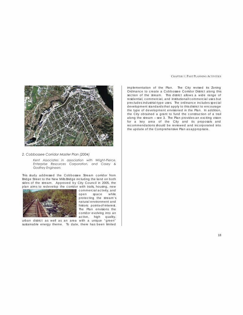
2. Cobbossee Corridor Master Plan (2004) Kent Associates in association with Wright-Pierce, Enterprise Resources Corporation, and Casey & Godfrey Engineers
This study addressed the Cobbossee Stream corridor from Bridge Street to the New Mills Bridge including the land on both sides of the stream. Approved by City Council in 2005, the plan aims to redevelop the corridor with trails, housing, new
commercial activity, and open space while protecting the stream’s natural environment and historic points-of-interest. The Plan envisions the corridor evolving into an active, high quality,
urban district as well as an area with a unique “green” sustainable energy theme. To date, there has been limited
implementation of the Plan. The City revised its Zoning Ordinance to create a Cobbossee Corridor District along this section of the stream. This district allows a wide range of residential, commercial, and institutional/commercial uses but precludes industrial-type uses. The ordinance includes special development standards that apply to this district to encourage the type of development envisioned in the Plan. In addition, the City obtained a grant to fund the construction of a trail along the stream – see 3. The Plan provides an exciting vision for a key area of the City and its proposals and recommendations should be reviewed and incorporated into the update of the Comprehensive Plan as appropriate.

CHAPTER 1 | PAST PLANNING ACTIVITIES
19

CHAPTER 1 | PAST PLANNING ACTIVITIES
20
3. Preliminary Design Report: Cobbosseee Stream Trail (2009) Milone and MacBroom, Inc. The City hired Milone and MacBroom to perform preliminary engineerng on the design of the propsed Cobbossee Stream Trail. They evaluated two alternative routes for the construction of the trail. Both routes begin at the terminus of the Kennebec River Rail Trail at the north end of the Hannaford parking lot and ending adjacent to Water Street (Route 126) near the intersection of Maple Street. Based on the preliminary analysis, Alternative A was selected for preliminary design. This route extends along the Hannaford parking lot parallel to Main Avenue, crosses the stream on a pre-engineered pedestrian bridge, then follows the stream along the rear of the Arcade Parking Lot to the Winter Street Bridge, and then across the bridge to Summer Street. The trail then continues along the stream and back across the stream in the vicinity of the railroad trestle. The estimated total cost for the project based on this route is $1,350,000 (2009).
4. Application for Funds, MDOT Transportation Enhancement Program for FY 2006-2007 (July 2004) The City applied for and received funding for the construction of the main pedestrian/bike trail along the Cobbossee Stream as proposed in the Cobbossee Corridor Master Plan as part of the Cobbossee Corridor Revitalization Program. The initial proposal in the Plan was that the trail would extend from the terminus of the Kennebec River Rail Trail up Summer Street and the former rail bed to the trestle and then on to a trailhead at Route 126. During preliminary design, the location of the trail was modified to run along Maine Street to the Arcade parking lot and then along the downtown side of the stream through the parking lot and then continuing upstream to the vicinity of the trestle. To date, the project has not been completed due
to the City’s inability to raise the local funding necessary to match the state funding. Discussions were recently held (January 2012) with the Maine Department of Transportation that confirmed that the state still considers this to be an active project and is willing to fund it if and when the City comes up with its local share. The concept of the trail remains an important project for the City and its imlementation should be considered in the update of the Comprehensive Plan.
5. Gardiner Services Relocation & Consolidation Study (2004)
Kent Associates in association with Wright-Pierce This study assesses the potential for relocating and/or consolidating City services to reduce and share costs. It looked at Public Works, the Wastewater Treatment facility, and the Water District. The recommendations included:
Co-locating the Public Works (DPW) and Wastewater Treatment facilities at the River Road treatment plant.
Consolidating all Water District (GWD) operations at their New Mills site.
Purchasing the GWD’s downtown building for the relocation of the Police Department.
No action has been taken on implementing these recommendations and it appears that the study will not be implemented.
6. Plan for the Gardiner Common (2008) Kent Associates in association with Wright-Pierce
The Plan focused on public safety/crosswalk improvements, siting a new playground, pathway improvements, and siting for the farmers’ market. The plan was approved by the City Council in 2008. Some progress has been made in

CHAPTER 1 | PAST PLANNING ACTIVITIES
21
implementing the proposals but the following activities remain to be accomplished:
Hiring a professional arborist to evaluate trees and prepare a maintenance, replacement, and care and pruning schedule.
Providing lighting at the Gazebo (for security purposes) and working to replace it with a historic, shingle-style gazebo. (2014 Note: The gazebo has been replaced).
Improving the muddy existing paths and entrance aprons and creating new paths as recommended in the Master Plan.
Replacing benches, picnic tables, and trash receptacles to match the style of downtown.
Reclaiming the “O. C. Woodman” parking area as lawn, installing fencing along the roadside, providing benches, tables, etc., and considering adding community gardens.
Continuing to encourage appropriate community events on the Common.
Improving street crosswalks to the Common and making trail and sidewalk connections to it.
Considering a historic overlay district to protect the unique quality of the Common area.
The Plan provides a guide for upgrading a key area of the City and its proposals and recommendations should be reviewed and incorporated into the update of the Comprehensive Plan as appropriate.
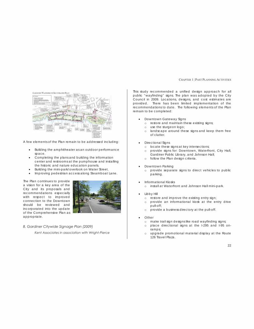
7. Gardiner Waterfront Plan (2008) Kent Associates in association with Wright-Pierce
The Plan included recommendations for expanding the waterfront park to include more parking for cars and trailers, more green space, an amphitheater, and information center. The core elements of the plan including expansion of the parking area, the gateway and pumphouse area improvements, and the improvement of the riverfront have been completed.
CHAPTER 1 | PAST PLANNING ACTIVITIES
22
A few elements of the Plan remain to be addressed including:
Building the amphitheater as an outdoor performance space.
Completing the plans and building the information center and restrooms at the pumphouse and installing the historic and nature education panels.
Building the mini-park/overlook on Water Street. Improving pedestrian access along Steamboat Lane.
The Plan continues to provide a vision for a key area of the City and its proposals and recommendations especially with respect to improved connection to the Downtown should be reviewed and incorporated into the update of the Comprehensive Plan as appropriate.
8. Gardiner Citywide Signage Plan (2009) Kent Associates in association with Wright-Pierce
This study recommended a unified design approach for all public “wayfinding” signs. The plan was adopted by the City Council in 2009. Locations, designs, and cost estimates are provided. There has been limited implementation of the recommendations to date. The following elements of the Plan remain to be completed:
Downtown Gateway Signs o restore and maintain these existing signs; o use the sturgeon logo; o landscape around these signs and keep them free
of clutter.
Directional Signs o locate these signs at key intersections; o provide signs for: Downtown, Waterfront, City Hall,
Gardiner Public Library, and Johnson Hall; o follow the Plan design criteria.
Downtown Parking
o provide separate signs to direct vehicles to public parking.
Informational Kiosks
o install at Waterfront and Johnson Hall mini-park.
Libby Hill o restore and improve the existing entry sign; o provide an informational kiosk at the entry drive
pull-off; o provide a business directory at the pull-off.
Other o make trail sign designs like road wayfinding signs; o place directional signs at the I-295 and I-95 on-
ramps; o upgrade promotional material display at the Route
126 Travel Plaza.

CHAPTER 1 | PAST PLANNING ACTIVITIES
23
The Plan’s recommendations should be reviewed and incorporated into the update of the Comprehensive Plan as appropriate.
9. Access/Egress for Water Street Buildings (2002-2003) Douglas Richmond Architects with Wright-Pierce
This study looked at: 1) improving the usability of the upper floors of Water Street buildings, 2) improving access to Water
Street from the Arcade parking lot, and 3) imroving the appearance of the rear of the buildings facing the Arcade parking lot. In addition, Wright-Pierce developed plans for improvements to the parking lot. The study developed proposals and costs to access improvements from the parking lot and within clusters of buildings. As part of the study meetings were held with many of the property owners. Due to the high cost of the improvements, little was done to implement the recommendations of the study. It does, however, provide baseline information about accessability that should be considered in the update of the Comprehensive Plan.
10. Building Envelope Assessment for Downtown Historic District – Gardiner, Maine (2002-2003)
Simpson Gumpertz & Heger Inc. for Douglas Richmond Architects with Wright-Pierce
This study looked at the exterior condition of the buildings in the Downtown Historic District. The assessment looked at each individual building and includes general findings and recommended rehabilitation concepts for the area. In addition, the assessment reviewed the then current Historic District provisions and recommended that the City consider augmenting the current reliance on the Secretary of the Interior’s Standards with local design guidelines. It identified the following areas for considerations:
Appropriate materials for roofs Appropriate methods of masonry repair, cleaning, and
repointing Means of rehabilitating exisitng wood windows and
installing appropriate screens and stormwindows Appropriate design and materials for storefronts Periodic maintenance items to avoid the need for
major repairs

CHAPTER 1 | PAST PLANNING ACTIVITIES
24
These recommendations should be reviewed in conjunction with any new proposals addressing historic preservation.
11. Merrymeeting Trail – Feasibility Study (2010) Vanasse Hangen Brustlin, Inc. The Midcoast Council of Governments in conjunction with the communities of Gardiner, Richmond, Bowdoinham, and Topsham and the Merrymeeting Trail Committee hired Vanasse Hangen Brustlin, Inc. (VHB) to assess the feasibility of developing a multi-use rail with trail facility along the state-owned rail corridor that extends approximately twenty-five miles from Topsham to Gardiner. The study also evaluated alternative routes should the use of the rail corridor be challenging or prohibitively costly. VHB evaluated the feasibility of establishing an unpaved shared use trail on the east side of the corridor. While this route offers spectacular views it also experiences significant physical challenges and environmental constraints. VHB estimated that the cost for constructing the East Side Trail would be approximately $50 million. Building the trail immediately to the west of the rail within the right-of-way would not result in significant savings. VHB alos studied a number of alternatives aimed at circumventing the most environmentally challenging and costly sections of the rail corridor while providing the user with a similar experience. The alternative route would reduce the cost to about $22 million.

CHAPTER 2 | RECENT DEVELOPMENT PROFILE
25
CHAPTER 2: RECENT DEVELOPMENT PROFILE Introduction The goal of this analysis is to identify where development has occurred in the last decade or so (2000-2012). For the purpose of this analysis, we divided Gardiner into two areas, Intown and Outlying Area (for a map, see Figure 2.3).
Intown: Older residential core and downtown Outlying Area: More rural development, including
newer subdivisions and the Libby Hill Business Park. This area includes all land not included in the Intown area.
In addition to the analysis of the two areas, the specific locations of new buildings are shown in Figure 2.5. The following analysis of residential and non-residential development is presented in three parts:
Part A documents the number and location of residential parcels developed between 2000 and 2012.
Part B documents the number and location of non-residential parcels developed between 2000 and 2012.
Part C outlines recent subdivision activity from 1990-2012.
All data is sourced to the City of Gardiner Assessor’s Office, October 2012.
A. Residential Total Residential Development Single-family development represented most of the residential development in Gardiner (85%) from 2000 to 2012. The majority of the residential development (68%) took place in the middle section of the decade, with recent trends mirroring development from 2000 to 2002 (Table 2.1). Residential development during this time weighed heavily toward Gardiner’s Outlying Area. (Figure 2.3). “Multi-unit” development includes both duplexes and larger multi-family units.
Table 2.1: Total New Residential Developed Parcels by 3-Year Periods,
2000-2012
Residential
2000-2002 27
2003-2005 58
2006-2008 57
2009-2012 26
Total 168
Table 2.2: Total New Residential Developed Parcels, 2000-2012
Number Acreage
Single-Family 137 819.6
Manufactured Home 25 110.2
Multi-Unit 6 128.1
Total 168 1,058.0

CHAPTER 2 | RECENT DEVELOPMENT PROFILE
26
Figure 2.1: Total Residential Developed Parcels, 2000-2012
Figure 2.2: New Residential Developed Parcels by Region, 2000-2012
Intown The Intown area of Gardiner (see Figure C.2) saw little residential development during this time.
Table 2.3: New Intown Residential Developed Parcels, 2000-2012
Number Acreage
Single-Family 15 15.8
Manufactured Home 1 4.4
Multi-Unit 4 1.5
Total 20 21.7
Outlying Area The Outlying Area of Gardiner (which is everything outside of the Intown area - see Figure 2.3) saw the bulk of development (88%) in Gardiner during this time period.
Table 2.4: New Outlying Area Residential Developed Parcels, 2000-2012
Number Acreage
Single-Family 122 803.8
Manufactured Home 24 105.9
Multi-Unit 2 126.7
Total 148 1,036.3
81%
15%
4%
Single Family
Manufactured Home
Multi-Unit
12%
88%
Intown
Outlying Area

CHAPTER 2 | RECENT DEVELOPMENT PROFILE
27
Figure 2.3: Map of Intown Area

CHAPTER 2 | RECENT DEVELOPMENT PROFILE
28
B. Non-Residential Total Non-Residential Development Gardiner had limited non-residential development during this time period, most of which was concentrated in the Outlying Area along outer Brunswick Avenue or in the Libby Hill Business Park (Figure 2.5).
Table 2.5: Total New Non-Residential Developed Parcels, 2000-2012
Number Acreage
Commercial Warehouse 4 84.7
Vacant Commercial 1 26.9
Office Building 3 39.9
Religious or Charitable 6 107.2
Industrial Warehouse 2 34.7
Retail 2 11.1
Car Wash 1 6.3
Total 19 310.8
Figure 2.4: Total New Non-Residential Developed Parcels, 2000-2012
Intown
Table 2.6: New Intown Non-Residential Developed Parcels, 2000-2012
Use Number Acreage
Religious or Charitable 1 0.3
Outlying Area
Table 2.7: New Outlying Area Non-Residential Developed Parcels, 2000-2012
Use Number Acreage
Commercial Warehouse 4 84.7
Vacant Commercial 1 26.9
Office Building 3 39.9
Religious or Charitable 5 106.9
Industrial Warehouse 2 34.7
Retail 2 11.1
Car Wash 1 6.3
Total 18 310.5
17%
4%
13%
44%
9%
9%
4% Commercial Warehouse
Vacant Commercial
Office Building
Religious or Charitable
Industrial Warehouse
Retail
Car Wash

CHAPTER 2 | RECENT DEVELOPMENT PROFILE
29
Figure 2.5: New Development in Gardiner, 2000-2012

CHAPTER 2 | RECENT DEVELOPMENT PROFILE
30
C. Subdivisions All of the subdivision lots created in Gardiner between 1990 and 2012 are in the Outlying Area, with several small clusters off outer Brunswick Ave. The industrial park lots (owned by the City of Gardiner) represent lots in the Libby Hill Business Park (Figure 2.6).
Table 2.8: Subdivision Lots Created, 1990-2012
Number Acreage
Residential 98 1,109.3
Commercial 8 195.8
Industrial Park/Civic 15 318.1
Vacant/Developable 6 30.4

CHAPTER 2 | RECENT DEVELOPMENT PROFILE
31
Figure 2.6: Subdivision Lots in Gardiner, 2000-2012

CHAPTER 3 | OVERVIEW OF UPDATED INVENTORIES
32

CHAPTER 3 | OVERVIEW OF UPDATED INVENTORIES
33
CHAPTER 3: OVERVIEW OF UPDATED INVENTORIES The process of updating the Comprehensive Plan began with the development of eleven separate inventories. This section summarizes the issues identified in each inventory and the implications of these findings for the Comprehensive Plan. The full inventory sections are found in the appendices.
A. Population and Demographics Gardiner’s overall population dropped 14% from 1990 to 2010, while the county as a whole increased by 5.4%. Most of the towns surrounding Gardiner experienced a steady increase in population from 1990 to 2010. However, while Gardiner’s under-45 population has experienced a significant decline, the population over 45 (45-70) has increased over the same time period reflecting the aging of the baby boom generation.
Figure 3.1: Gardiner General Age Distribution, 1990-2010
Source: US Census
From 2000 to 2010, Gardiner’s total population shifted slightly in location. The “Intown” area (downtown and older residential neighborhoods) saw a drop in both total population and its
share of the population; in 2000, 70.9% of Gardiner residents lived Intown, while only 67.6% did in 2010. From 1990 to 2010, Gardiner’s percent of families with children under 18 that are below the poverty line skyrocketed – at 22.4% in 2010, it was over 50% higher than the rate for both Kennebec County and Maine.
Figure 3.2: Families with Children Under 18 Below the Poverty Line in Gardiner, 1990-2010
Source: US Census, 2006-2010 ACS
As of 2010, Gardiner’s average household size of 2.30 people is very close to the average for both Kennebec County and Maine. However, Gardiner started with a slightly higher household size in 1990 than the county or the state. This decrease is consistent with national trends, and is consistent across all towns in the region. In 1990, Gardiner’s median household income matched closely with the surrounding towns of Hallowell and Richmond, Kennebec County and the State of Maine. Twenty years later, Gardiner still tracks with Kennebec County and Maine – but surrounding towns (including Hallowell and Richmond) have experienced substantially greater increases in household income.
29.1% 26.3%
30.2%
14.4%
0.0%
10.0%
20.0%
30.0%
40.0%
Under 25 25-44 45-64 65 and over
1990
2000
2010
22.4%
14.0% 14.7%
0.0%
5.0%
10.0%
15.0%
20.0%
25.0%
Gardiner Kennebec Co Maine
1990
2000
2010

CHAPTER 3 | OVERVIEW OF UPDATED INVENTORIES
34
Issues & Implications 1. Since 1990, the City’s year-round population has declined by over 14%. This decline was driven by net out-migration – more people moving out of the City than moving in. While some of this is probably the result of “children leaving the nest” and leaving Gardiner, making Gardiner a more attractive place to live will be important in the future. 2. As the baby boom generation ages, the City could see an increase in its older population. Over the last two decades it appears that the City has been losing households as they age. Keeping these households in Gardiner will be important. This may mean there will be a need for more housing appropriate for older households and support services for this group of residents as their needs change. 3. Over the last twenty years, the City has seen a small decrease in the number of households living in the City. If this trend continues it could have a negative impact on the housing stock if it results in an increase in the vacancy rate and/or disinvestment in housing. 4. The rate of poverty among households with children appears to have increased significantly since 1990 and is higher than Kennebec County as a whole. While the absolute numbers of lower-income households with children is small, this trend could impact the City and the demand for community services.

CHAPTER 3 | OVERVIEW OF UPDATED INVENTORIES
35
Figure 3.3: Geographic Population Distribution in Gardiner, 2000 and 2010

CHAPTER 3 | OVERVIEW OF UPDATED INVENTORIES
36
B. Economy Industry declined in Gardiner after World War II, and by the mid-1990s Gardiner was seen largely as a bedroom community for state government workers and employees of Bath Iron Works. In 1997, the top three employers in Gardiner were the local school district, the State of Maine, and Associated Grocers, followed by several paper mills and manufacturers. In 2011, both the local school district and the State of Maine remained near the top of the list, with the Pine State Trading distribution center and Maine General Health also occupying high spots. Manufacturers have fallen off the list, replaced by construction-related companies. Most employed Gardiner residents work in white collar and pink collar, retail and service occupations – and the share of people working in professional and other white collar occupations is growing, while employment in blue-collar occupations is dropping. The industry sectors with the greatest employment in 2011 were in wholesale trade, retail trade, and healthcare and social assistance. Gardiner functions both as a bedroom community and as a jobs center. Of the residents of Gardiner who are employed, the vast majority commute out of Gardiner to work. At the same time, the majority of jobs in Gardiner are filled by people who live outside of Gardiner and commute into the city to work. Only a relatively small percentage of the city’s labor force lives and works in Gardiner. With approximately 2,400 jobs in 2011, Gardiner serves as a regional employment center. Many of these jobs are located in businesses along outer Brunswick Avenue and in the Libby Hill Business Park. The City also functions as a local service and
retail center, primarily in downtown and along outer Brunswick Avenue.
Figure 3.4: Gardiner Commuting Patterns, 2002-2012
Source: US Census LED On The Map
Tax Increment Financing (TIF) A TIF is a public financing tool that uses future gains in taxes to pay for current improvements. As of 2012, Gardiner had seven active TIFs, with a total assessed value of over $58 million. The city has focused its TIF efforts on the Downtown area, the Libby Hill Business Park, and the State Street Business Park, but will consider new TIFs for all areas zoned for commercial development. Gardiner has a 100% capture rate for new value created in TIFs, so all new funds go toward an economic development fund controlled by the City, the original taxpayer, or a combination of the two. The City’s Libby Hill fund – which is supported by TIF financing and public funds – currently has a deficit of $700,000,1 in part because the City has been shifting $91,000 a year from the Libby Hill fund to the general fund to help cover other costs. In fiscal year 2013, the City ended the 1 Kennebec Journal, “Councilors Look at 1.5% Tax Increase”, April 24 2012. http://www.kjonline.com/news/councilors-look-at-1_5-percent-tax-rate-increase_2012-04-24.html
537
2261 2466
357
2,154 2378
0
500
1,000
1,500
2,000
2,500
3,000
Live in Gardiner, Workin Gardiner
Live in Gardiner, WorkElsewhere
Live Outside Gardiner,Work in Gardiner
2002
2010

CHAPTER 3 | OVERVIEW OF UPDATED INVENTORIES
37
practice of transferring funds from the Libby Hill TIF to the general fund.
Issues & Implications 1. The economy of Gardiner appears to be undergoing a subtle but significant shift away from traditional manufacturing to service and distribution functions. The City’s location with good access to both the Maine Turnpike and I-295 supports this pattern. This trend is likely to continue and needs to be reflected in the City’s economic development efforts. 2. While the City is the home to a number of large employers, the business community as a group plays only a limited role in community activities. Enhancing business involvement in all aspects of community affairs may be important to dealing with community issues especially in growing the economy.

CHAPTER 3 | OVERVIEW OF UPDATED INVENTORIES
38
Figure 3.5: Gardiner Tax Increment Finance Areas

CHAPTER 3 | OVERVIEW OF UPDATED INVENTORIES
39
C. Land Use The majority of commercial activity occurs in Gardiner’s Intown Area, with pockets along outer Brunswick Avenue and along River Avenue (on the far eastern edge of the city). Over 80% of the parcels in Gardiner are dedicated to single-family or duplex housing, with slightly more than half in the area outside of downtown. Almost all of the multifamily housing, however, is located in the Intown Area; only 14% of those parcels outside the Intown Area. In addition to the intensively developed Intown residential neighborhoods, there are several clusters of single-family subdivisions in the Outlying Area. These clusters are located near:
Eastern edge of Gardiner, along River Avenue Southeastern corner of the city, on Costello Road Southwestern corner of the city, along Libby Hill Road Western edge of Gardiner, between outer Brunswick
Avenue and the interstate Most of the city parks are located in the Intown area – and two of the three in the Outlying Area are directly adjacent to Intown. This means that there is little public recreation space in the Outlying Area, although the majority of land classified as woodlot is located in this part of the city.
Issues & Implications 1. While the City has experienced limited development since 2000, much of this has occurred outside of the traditional built-up area of the city in the outer Brunswick Avenue corridor or in the rural areas of the city. If this pattern of development continues, it could have an impact on City services, natural resources, and scenic areas. 2. The existing comprehensive plan proposed limiting rural development and encouraging development within the city’s
identified growth areas but when the Zoning Ordinance was amended, these proposals were not fully implemented. This may be contributing to the development pattern noted in 1. 3. The City has adopted design standards for commercial development as proposed in the existing Comprehensive Plan. Some of these standards may not be appropriate in areas such as the outer Brunswick Avenue corridor and should be reviewed. 4. Maintaining the desirability and livability of Intown residential neighborhoods is a key issue for the City. Reviewing the zoning requirements in these areas may be desirable to maintain these neighborhoods while promoting re-investment. 5. Providing for the appropriate reuse of nonconforming properties within the developed neighborhoods should be addressed.

CHAPTER 3 | OVERVIEW OF UPDATED INVENTORIES
40
Figure 3.6: Gardiner Current Land Use Map

CHAPTER 3 | OVERVIEW OF UPDATED INVENTORIES
41
D. Public Facilities City Hall In 2006, the City of Gardiner commissioned a City Hall Space Study which found that City Hall “suffers from a shortage of space and a layout of department areas that limit the ability of staff to improve the efficiency with which services are provided to citizens.” The study recommends either an addition or a relocation of services within the building (such as fire or police) to another place. Another issue is the lack of storage space for documents.2
Public Works The public works facility is located on Brunswick Avenue, southwest of downtown. The facility, which sits on a little over seven acres, consists of the public works garage, a cold storage building, and a 300-ton salt shed. Gardiner’s Wastewater Treatment Facility is located along River Avenue, and has been in operation since its construction in 1982. There are currently no targeted areas for expansion. A 2006 Combined Sewer Overflow (CSO) abatement project included a Wastewater Treatment Facilitiy upgrade that increased the capacity of the plant from 4.5 to 9.5 million gallons a day. In 2004, Wright-Pierce Engineering and Kent Associates Planning studied the impacts of relocating and consolidating several City services to a single site, and recommended 1) co-locating Gardiner Public Works and the Wastewater Treatment Facility, 2) consolidating Gardiner Water District operations at 2 Personal Communication, City of Gardiner, 2012.
the New Mills site, and 3) purchasing the Gardiner Water District downtown building for the relocation of the Gardiner Police Department. 3 As of 2012, none of these actions have been taken.
Law Enforcement & Fire Protection The Gardiner Police Department maintains twenty-four hour police protection on a year-round basis. The staff includes three sergeants, a detective, a school resource officer, a public safety officer and six patrol staff who work fixed shifts. There is no 311 or general hotline in Gardiner; the police department often fields calls from residents looking for social services or mental health assistance. As part of the same 2006 City Hall space study, the firm looked at the police department and found two major issues: lack of space, and the inability to separate public traffic from police business traffic. The Gardiner Fire department provides fire protection to the City of Gardiner, as well as mutual aid response to ten area fire departments. Large incidents are managed with mutual aid fire departments and a call force of 12 firefighters. The Gardiner Fire & Ambulance Department has 15 full-time firefighters who work three shifts - four people per shift, with two swing firefighter/EMT’s. Gardiner Fire Department provides ambulance service to seven communities: Gardiner, Farmingdale, Chelsea, Randolph, Pittston, Litchfield, and West Gardiner. The ambulance service responds to an average of 2,000 emergency medical service calls per year. The department has three ambulances. The 2006 City Hall space study found that the Fire Department had a “major impact” on site use
3 Accessed at http://www.gardinermaine.com/Public_Documents/GardinerMe_WebDocs/kentreport.pdf

CHAPTER 3 | OVERVIEW OF UPDATED INVENTORIES
42
(especially parking), and recommended that the Fire Department relocate to a new facility off site.4
Library The Gardiner Public Library is housed in an historic building on Water Street, just around the corner from City Hall. In addition to Gardiner, it offers library services to the towns of Litchfield, Pittston, Randolph and West Gardiner; the population of the service area is about 17,300. The Gardiner Public Library is a department of the City of Gardiner. However, the library building is owned and maintained by the Gardiner Library Association, which is a private, non-profit organization. The Gardiner Public Library has collected a substantial archive of town records, books, and other historic documents. Due to space constraints, the archive is kept in the basement. The Gardiner Library Association began a basement renovation project that was halted during the recession (photo, right). The library staff would like to be able to maintain archived documents in a safer, off-site facility.
Schools Gardiner is home to several schools and educational facilities. Four schools – Gardiner Area High School, Laura E. Richards School, Gardiner Regional Middle School, and River View Community School – are all located within city limits. These buildings are all owned and operated by the school district, which is a separate entity from the City of Gardiner.
4 Accessed at http://www.gardinermaine.com/Public_Documents/GardinerME_WebDocs/studies/GardinerCityHallSpaceStudy.pdf
Issues & Implications 1. The City has actively studied the need for additional/improved space for administrative functions and the police and fire departments for the last decade or so. While there have been a number of proposals for new or relocated facilities, it is unlikely that any major capital project will be undertaken in the near future. The City should therefore continue to explore ways to better utilize the existing City Hall facility including looking for off-site storage to free up space in the building. 2. The Library basement renovation project needs to be completed and off-site storage provided for archived documents.
E. Recreation & Open Space Gardiner has seven official parks; the newest, Waterfront Park, opened in 2010. Local public schools (both elementary schools, the middle school and the high school) in Gardiner have tracks open for community use, and indoor walking loops available between November 1 and April 1. In addition, the City has received an 80% grant to fund a new trail along the Cobbossee Corridor, just west of Downtown.5 The City of Gardiner does not have a community center or a designated parks and recreation department, although in 2012 it did reactivate the Parks & Recreation Committee. However, the Gardiner Boys and Girls club serves as a resource for Gardiner, providing child care, a teen center, tutoring, organized sports and other programs.
Issues & Implications 1. Development of the Cobbossee Corridor trail needs to be completed. 5 Personal Communication, City of Gardiner, 2012

CHAPTER 3 | OVERVIEW OF UPDATED INVENTORIES
43
2. Continuation of the Rail Trail to the south through the City should be a priority project. 3. While the Boys and Girls Club and the adult education program of the school district meet some of the community’s recreation needs, the lack of a City recreation program is an issue. The recent reactivation of the Parks and Recreation Committee may be the start of exploring this issue in more detail.
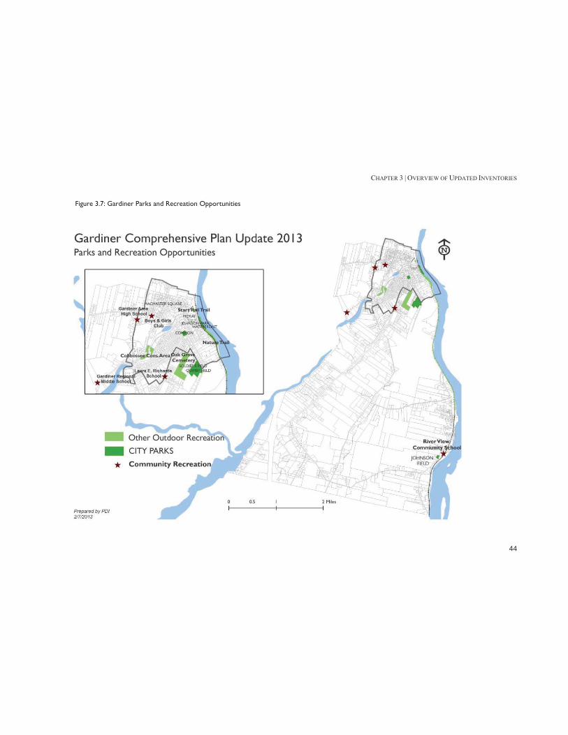
CHAPTER 3 | OVERVIEW OF UPDATED INVENTORIES
44
Figure 3.7: Gardiner Parks and Recreation Opportunities

CHAPTER 3 | OVERVIEW OF UPDATED INVENTORIES
45
F. Infrastructure Water The City’s public water system is run by the Gardiner Water District, a quasi-municipal organization. The Gardiner Water District owns and operates two wells in South Gardiner along the Kennebec River. The water feeding into the wells is vulnerable to contamination from vehicular traffic, railway traffic, and river contamination. Both wells discharge to a dedicated raw water transmission main to the treatment facility at Cobbosssee Avenue. The Gardiner Water District distribution system consists primarily of unlined 6-inch and 8-inch cast iron water mains. As the water system developed, service areas were created to serve higher elevations. The creation of the different service areas or pressure zones has created numerous dead-ends on the distribution system. In 2009, the Gardiner Water District and the Hallowell Water District developed a cooperative partnership to address the separate water districts’ needs and explore better opportunities for capacity and water service in their service areas. The District has experienced very slow growth in residential water-use over the past 25 years. From 2000-2007, only 35 new service connections were connected to the water system, an average of about 5 service connections per year.
Sewer Gardiner's wastewater collection system is operated and maintained by the Wastewater Department, under the direction of the Director of Wastewater. The Public Works staff also performs maintenance duties on the City’s wastewater system. The wastewater that is generated within the communities of Gardiner, Farmingdale and Randolph are
collected and conveyed to the City of Gardiner wastewater treatment facility located along River Road in South Gardiner. The City of Gardiner's collection system consists of approximately 18 miles of sanitary and combined or quasi-combined sewers. Approximately 80 percent of the Gardiner population is served by the collection system. Gardiner recently added five small pumping stations to serve the Libby Hill Business Park on Route 201. The City's sewer system, like the drainage system, is a combination of old clay pipes and new PVC sewer lines. The older sections of the City contain some of the old sewer lines that are a cause of constant maintenance and frequently require replacement. One problem with the older lines is the infiltration of ground water into the pipes, which contributes to overloading the treatment facility during large storm events. It is intended that over time the older lines will be replaced and this problem will be eliminated.
Solid Waste The City of Gardiner does not pick up household trash; residents can use the City website to find a list of trash haulers, or purchase a permit for the Hatch Hill landfill from the City of Augusta.6
Natural Gas Both Summit Natural Gas and Maine Natural Gas gave presentations to the Gardiner City Council in December 2012 about laying natural gas pipes in the area. Instalation of natural gas mains was started in 2013 and is anticipated to continue for a number of years based on the demand for service.
6 Accessed at http://www.gardinermaine.com/public_documents/gardinerme_FAQs/pubworks

CHAPTER 3 | OVERVIEW OF UPDATED INVENTORIES
46
Broadband Internet & Cell Coverage At least four carriers provide coverage in Gardiner, with varying degrees of reliability. Of the providers surveyed (via online coverage maps), Verizon had the most consistent coverage. In 2011, an engineering firm worked with the State of Maine to create maps of reported broadband speeds. Their speed data was based upon on survey responses, state agency data, community feedback and input from other broadband consumers.7 These maps show that Gardiner has reliable city-wide coverage up to Tier 3 (3 Mbps to 6 Mbps), but that higher speeds are mostly concentrated in the Downtown area. Figure 3.8: Tier 4 Internet Access (6 Mbps to 10 Mbps) in Gardiner, 2012
Green: Has T4; Red: Does Not
Source: Sewall Company, ConnectME Authority
7Developing Broadband in Maine. http://www.sewall.com/projects/project_connectme.php
Issues & Implications 1. The City should consider establishing a wellhead protection ordinance to “protect” the Water District’s supply wells from potential contamination. 2. The City needs to continue to invest in improvements to its combined sewer system to continue to reduce and ultimately eliminate the discharge of untreated combined sewer flows to the river. 3. The potential for providing natural gas service could make the City a more attractive location for business as well as reducing the cost of living in Gardiner. 4. Internet, broadband, and cell phone service in the City is not of the highest quality and therefore may be a limitation for business growth and an inconvenience for residents.

CHAPTER 3 | OVERVIEW OF UPDATED INVENTORIES
47
G. Housing Gardiner’s total housing units increased by 2.7% from 1990 to 2010. In contrast, the number of units in neighboring communities of West Gardiner and Litchfield increased by 48% and 40.1%, respectively. Kennebec County and the state of Maine both experienced significant increases in the total number of units during this time period.
Table 3.1: Total Housing Units, 1990-2010 1990 2000 2010 % Change 1990-2010
Maine 587,045 651,901 721,830 23.0%
Kennebec County 51,648 56,364 60,972 18.1%
Gardiner 2,705 2,702 2,778 2.7%
Farmingdale 1,237 1,273 1,374 11.1%
Hallowell 1,192 1,243 1,329 11.5%
Litchfield 1,328 1,595 1,861 40.1%
Manchester 1,003 1,181 1,255 25.1%
Pittston 933 1,070 1,202 28.8%
Readfield 1,003 1,148 1,293 28.9%
West Gardiner 1,051 1,308 1,556 48.0%
Winthrop 2,827 3,053 3,295 16.6%
Richmond 1,313 1,475 1,629 24.1% Source: US Census
Gardiner’s housing make-up has shifted slightly from 1990 to 2010. One-unit detached structures (single-family homes) increased in share from 51.2% to 55.2% of the total, while multiple units decreased from 39.4% to 36.4%. Over half of the housing units in Gardiner were built before 1939. In 2010, Gardiner had 4.7% of Kennebec County’s population – but 5.7% of the county’s rental units, and 6.5% of the renter-occupied units built before 1939. Gardiner also had a higher percentage of rental subsidy units than the county as a whole.
Vacancy rates for both homeowners and rental units have steadily increased in Gardiner from 1990-2010. The 2010 homeowner vacancy rate (3.0%) is higher than Kennebec County and Maine, but is still considered to be healthy. The rental vacancy rate (11%) is much higher than what is normally considered to be healthy (6 to 7%). From 2006-2011, Gardiner’s median home price (as reported by the Maine State Housing Authority) remained lower than both the county and the state – and, like the county and state, its median sale price decreased during the same time period. In 2011, Gardiner’s median income was $44,791, but the income needed to afford a median home price was only $30,463. The American Community Survey, however, showed the median home value in Gardiner in 2011 to be $151,200 – slightly above Kennebec County’s $151,000. The average rent for a two-bedroom apartment (with utilities) increased in Gardiner from 2006 to 2011. This increase in rental prices has led to an increase in the percentage of rental households who are unable to afford average rent. Gardiner’s full value tax rate is significantly higher than both the county and the state.
Issues & Implications 1. Over half of the City’s housing units are located in buildings that were constructed before the Second World War. Some of these structures are showing their age and need improvement. The City should consider its role in encouraging/assisting property owners to maintain and improve their properties. 2. The City has a comparatively large percentage of subsidized housing units compared to Kennebec County as a whole. The City should consider how it can work with the

CHAPTER 3 | OVERVIEW OF UPDATED INVENTORIES
48
larger region to assure that Gardiner does not shoulder an unfair share of the burden for meeting the housing needs of the area’s low and moderate income households. 3. As the City’s population ages (see Appendix A. Population and Demographics) this may mean there will be a need for more housing appropriate for older households.
H. Historic & Archaeological Resources Gardiner has five properties on the National Register of Historic places, one historic district (downtown Gardiner). The Maine Historic Preservation Commission has also identified a potential historic district centered on Brunswick Avenue that appears to be eligible for listing in the Register. The properties in Gardiner’s Downtown Historic District are eligible for both federal and state tax credits for historic rehabilitation.
Figure 3.9: Gardiner Historic District
To date, three historic archaeological sites are documented for the town – the Alexander Brown Trading Post, F.A. Plaisted Pottery, and Gardiner’s Dam #1. A limited area of the shore of Cobbossee Stream has been surveyed by professional archaeologists. Very limited professional archaeological surveying has been done along the banks of the Kennebec River. The Gardiner Main Street organization promotes “Heritage Tourism” on its website, suggesting a tour of the home of poet Edwin Arlington Robinson, buildings on the National Register of Historic Places, and the “Yellow House” that was home to poet Laura E. Richards.
Issues & Implications 1. The City needs to continue to work with appropriate historical interests to document both historic and archeological resources. 2. There has been discussion of creating a second local historic district in the Commons/Brunswick Avenue area. The City should consider this step. 3. State and Federal tax credit programs create financial incentives for the renovation of designated historic buildings. The City should promote the use of these programs within the National Register Historic District in the Downtown to encourage better utilization of those buildings.
I. Natural Resources A significant portion of downtown Gardiner and Route 24 are in the FEMA 100-year flood plain. Development in this area must meet strict standards to prevent future flooding.8 8 Floodplain Management. http://www.gardinermaine.com/Public_Documents/GardinerME_Pcode/New%20Sect%207?textPage=1

CHAPTER 3 | OVERVIEW OF UPDATED INVENTORIES
49
Although the rail bed prevents development directly along the river, there are many critical existing structures in the 100-year flood plain, including:
Downtown businesses along Water St, and the Arcade Parking Lot
Hannaford and parking lot Waterfront Park Rail Trail
Figure 3.10: Water St, 1987 Flood
Source: Maine Emergency Management Agency
Two developing areas of Gardiner face limited restraints on future development. The outer Brunswick Avenue Corridor (primarily commercial use) has some areas with wetlands, while the South Gardiner area must continue to be aware of the aquifer along the Kennebec River, as well as its Shoreland Overlay Limited Residential District. Development in the Cobbossee Corridor District (located along the Cobbossee stream in downtown Gardiner) needs to consider natural and visual resources, and the use of green building technologies.
There are two (known) rare animals with habitats in Gardiner: the Bald Eagle along the Kennebec River, and the Tidewater Mucket ( a freshwater mussel) along the Cobbossee Corridor. The stretch of Route 24 (River Road) along the Kennebec River is a striking visual resource – and due to the presence of train tracks between River Road and the river, is unlikely to be developed.
Issues & Implications 1. While the location of the Hannaford store within the 100 Year Floodplain is problematic, the presence of the store is a significant benefit to the entire Downtown area. 2. The River Road scenic corridor from Downtown to the Richmond border and beyond is a significant resource that might be able to be better capitalized on as a community asset.

CHAPTER 3 | OVERVIEW OF UPDATED INVENTORIES
50
Figure 3.11: Gardiner Shoreland Districts, Wetlands & Cobbossee Corridor

CHAPTER 3 | OVERVIEW OF UPDATED INVENTORIES
51
J. Fiscal For the most recent fiscal year, over 60 percent of Gardiner’s revenues came from property taxes, with an additional 18.4% coming from charges for services. The expenses reflect Gardiner’s position as a service center – after education, the largest expenses were public safety and wastewater. Gardiner’s state equalized mill rate is higher than other full service communities in Kennebec County, including Augusta and Waterville.
Table 3.2: Comparison Mill Rates, 2003-2010
2003 2004 2005 2006 2007 2008 2009 2010
GARDINER* 20.33 19.87 17.76 15.67 15.32 16.82 17.37 18.83 WATERVILLE* 24.72 24.98 22.37 19.49 18.14 18.24 18.23 18.74
AUGUSTA* 22.15 19.92 17.04 15.93 15.79 16.09 16.28 16.77
WINSLOW* 20.94 18.86 16.99 15.56 14.88 15.2 15.1 15.22
HALLOWELL* 22.55 20.66 16.73 15.12 14.28 14.4 15.19 15
RICHMOND 15.89 14.73 12.85 11.62 11.56 11.35 12.77 14.34
READFIELD 16.58 14.69 13.68 13.18 12.41 12.56 13.33 14.22
WINTHROP 16.7 16.03 13.58 12.96 12.42 11.94 12.46 13.38
MANCHESTER 13.56 12.88 10.85 11.16 11.02 12.23 12.52 12.71 OAKLAND* 16.40 14.47 12.78 11.42 11.81 11.68 11.6 12.2
LITCHFIELD 13.90 12.46 12.57 12.23 11.07 11.23 10.97 11.56
FARMINGDALE* 13.66 15.07 13.3 10.94 10.52 10.22 10.51 11.13
PITTSTON 13.10 11.93 10.95 9.49 9.50 9.70 9.90 10.55
WEST GARDINER 10.93 9.83 8.54 7.24 7.35 7.80 9.51 9.79 *service community
Source: Maine Revenue Service
Gardiner has a total bonded debt of $11,249,880, which is well shy of its stautory debt limitation of $51,217,500. However, debt
service costs limit the willingness of the community to take on additional debt. Of the existing bonds, approximately 54% are general obligation bonds, 30% are Rural Development, 10% are State Revolving loans, and 6% are for a ladder truck. The Libby Hill Business Park is a designated Gardiner Enterprise Zone, which means that it qualifies for Tax Increment Financing.9 The City’s Libby Hill fund – which is supported by TIF financing and public funds – currently has a deficit of $700,000,10 in part because the City has been shifting $91,000 a year from the Libby Hill fund to the general fund to help cover other costs. In the fiscal year 2013 budget cycle, the City ended this practice and no longer transfers funds from Libby Hill to the general fund.
Issues & Implications 1. The City’s tax rate may be a factor in residential development occurring outside of the City over the past 20 years. 2. While the City’s tax rate is reasonably comparable to other full-service, service-center communities in central Maine, it does not create an incentive for businesses or residential development to locate in the community. 3. The City’s existing bonded debt limits the community’s wiilingness to undertake major capital projects that are dependent on local funding until some of the current debt is repaid.
K. Transportation Gardiner is an “urban compact” city, which means that the City maintains state roads that go through a specific area of
9 Libby Hill Business Park website, http://libbyhillbusinesspark.com/pdfs/LibbyHill-Profile.pdf 10 Kennebec Journal, “Councilors Look at 1.5% Tax Increase”, April 24 2012. http://www.kjonline.com/news/councilors-look-at-1_5-percent-tax-rate-increase_2012-04-24.html

CHAPTER 3 | OVERVIEW OF UPDATED INVENTORIES
52
town. Gardiner has just over 60 miles of roads, over half of which are local, and two roads classified as arterials (Brunswick Avenue and Cobbossee/Water Street). Of the eleven bridges in Gardiner, only one (Capen Road) is owned by the City. Four bridges (including Capen Road) have a federal sufficiency rating under 80. Gardiner is served by one line of the Kennebec Explorer, a regional bus operated by the Kennebec Valley Community Action Program (KVCAP). The bus stops at the Hannaford store four times a day, and connects riders to Augusta, Randolph, and Hallowell and Waterville by extension. The fare for local travel is $1.00, while intercity travel is $1.25. The Kennebec River Rail Trail is a 6.5-mile public path that runs along the Kennebec River from Gardiner to Augusta. See Appendix E: Recreation & Open Space for walking facilities. In 2007, the Gardiner Sidewalk Committee inventoried all of the sidewalks in Gardiner on a scale of 1-5 (1: Low Attention, 5: High Attention), and created a recommended work list for all sidewalks that scored 3.5 or higher. The committee recommended a $628,000 bond to pay for these improvements, which, while proposed, failed to pass the Gardiner City Council. Of the 61 recommended sidewalk improvements, two have been addressed through Maine DOT projects:
Rte 126 – West Street to Middle School (in progress). New Mills Bridge to West Street Rte 126 (completed).11
Issues & Implications 1. The Kennebec Explorer provides very limited scheduled bus service for the community. With an aging population, increasing transit options may become an important issue. 11 Personal Communication, Gardiner Public Works. 1/21/13
2. The opportunity for people to walk within the older, built-up portion of the City exists but the overall “walkability” within this area needs to be improved.

CHAPTER 3 | OVERVIEW OF UPDATED INVENTORIES
53
Figure 3.12: Gardiner Transportation Overview

PART TWO | GOALS & POLICIES
54

PART TWO | GOALS & POLICIES
55
PART TWO | GOALS & POLICIES

CHAPTER 4 | COMMUNITY VISION
56

CHAPTER 4 | COMMUNITY VISION
57
CHAPTER 4: COMMUNITY VISION Our Heart and Soul Our Vision for Gardiner in 2025 is based on the community values developed as part of the Gardiner Heart and Soul (H&S) project. The values were initially distilled from over one hundred in-depth one-on-one interviews in which a broad spectrum of our community were asked to share their stories about Gardiner and what makes it special. The initial values from this “storytelling” phase were then refined at the We Are Gardiner community event. The statement of community values that resulted from that work by approximately one hundred residents became the basis for this Community Vision. The Vision is an attempt to describe what we want Gardiner to be in 2025. It establishes the goal that we are working toward and that the City’s Comprehensive Plan is trying to achieve. The Community Vision addresses each of the eleven H&S values in addition to an over-arching desire to see the City grow and prosper.
A Growing, Prosperous Community Gardiner’s population is growing. Thoughtful, well-planned development is welcomed by the community. New housing of all types is being built. Younger families choose to live in the City to take advantage of our livable, walkable neighborhoods. Older residents choose to stay in the community in housing designed to meet their needs. Our business community is expanding resulting in new jobs for area residents and additional tax revenue to support City operations. People do more and spend more in Gardiner. But our growth is done thoughtfully – it maintains the character of our community while creating new opportunities.
Strong Local Economy Gardiner’s “Main Street” is fully occupied with retail stores, restaurants, and local services. Downtown is a hub of civic and commercial activity from morning to night, both weekday and weekend. New businesses and entrepreneurs often hire directly from Gardiner’s well-educated workforce. The Libby Hill Business Park is fully occupied with businesses and organizations that have helped to expand employment opportunities for all Gardiner residents. A downtown farmer’s market operates twice a week during the growing season, giving both downtown workers and residents and weekend shoppers a chance to support local farmers.
Education Graduation rates are at an all-time high and students graduate from Gardiner’s high school well-prepared for the global environment that they face – although, after college, some choose to return to the City to work for (or start) a high-skill local business. Schools in Gardiner use district-wide standards for teacher curriculum and teacher quality, and offer a large number of advanced classes while ensuring that all students have the tools they need to succeed. Both traditional public schools and adult education prioritize experiential learning and community involvement through externships and volunteer opportunities, and the Gardiner Public Library offers mini-courses that all residents can access.

CHAPTER 4 | COMMUNITY VISION
58
History, Arts and Culture Gardiner’s historic homes and downtown buildings are preserved, well-maintained and contribute to the city’s character. Residents who own historic properties have a diverse array of affordable preservation options, which are overseen by a historic preservation officer in city government. Both local and national plays and cultural acts come to Johnson Hall, which – along with Water Street - is a regional cultural destination for the area. Arts programs in schools coordinate with community cultural organizations to provide events that appeal to residents of all ages.
Livability A community bike and ride-share program helps to make transportation affordable to Gardiner residents of all ages and incomes. Government services for people of all incomes are clearly presented on the City’s website, and an outreach officer helps residents navigate paperwork and service options. Adult education programs offer critical skills training to Gardiner residents that need them, and weekly, free community events are held in downtown public spaces, such as Water Street, Gardiner Common or Johnson Hall. Recreation opportunities and property re-investment have helped to revitalize established residential neighborhoods. A vigorous “local foods” program makes buying local an alternative for Gardiner consumers.
Sense of Community, Sense of Belonging Active, vibrant neighborhood organizations help represent Gardiner residents at city government meetings, where they are encouraged to contribute to decision-making processes related to city services and development. Residents connect with the City’s history, future and each other at neighborhood organization events, as well as larger annual civic events, festivals and public spaces that are well-publicized and open to all ages and income levels. Public spaces are vibrant and rarely empty, and residents feel safe in them.
Community Involvement, Volunteerism Gardiner has a wide range of both formal and informal volunteer activities, many of which are organized by and with young adults and students. Residents of all ages and income levels collaborate on events like the Gardiner Day of Caring and Greater Gardiner festival, and the City website serves as a gathering point for civic groups, non-profits, schools and city government community activities.
Connection to Nature Redevelopment of the Cobbossee Corridor occurred in harmony with nature with enhanced access to the corridor’s natural environment. Gardiner’s Parks and Recreation Committee conducts yearly outreach meetings to assess the status and needs of open space and

CHAPTER 4 | COMMUNITY VISION
59
recreational activities in the city. Highly publicized maps (both online and on paper) detail public access to well-marked natural assets for recreational activities like boating, walking, fishing, biking, hunting and swimming. The Gardiner Common and Waterfront Park serve as gathering places for community activities and festivals for residents of all ages and income levels, and the Rail Trail extends south from Waterfront Park, offering more public recreation access to South Gardiner.
Inclusive, Responsive Government Gardiner’s city government meetings are structured in an accessible, friendly way that helps residents of all ages understand the issues being addressed. City government activities are publicized across multiple platforms (including Facebook). The City regularly evaluates its operations and programs to assure an efficient, effective government and the results are made available to the public on the City website.
Unique Physical Assets Gardiner’s natural assets are linked by clearly marked and mapped walking trails that connect neighborhoods, downtown, and recreation activities. Gardiner’s historic industrial buildings (like the train station and the old mill) have been renovated and integrated into the City’s cultural character, serving as public spaces for community events, meetings, free classes and the arts. Local organizations, residents, schools and city government have collaborated to create a community garden space in Downtown Gardiner. Historic Downtown Gardiner is a regional destination, not only for cultural events at Johnson Hall, but for a vibrant street life that celebrates the
community’s historic character while promoting innovative business opportunities, retail and restaurants.
Infrastructure/City Services The City of Gardiner provides timely and high quality response to resident service requests, whether they are made online (through the City website), in person or over the phone. Average response times for fire, police, and other city services are published on the city website, and in an annual report. Gardiner’s sidewalk and road safety records are the envy of other cities in Maine; they provide clear connections across the city, are well-maintained, and consider the needs of drivers, bikers and pedestrians. Both sidewalks and roads are accessible in all seasons.
Family Friendliness Gardiner provides a safe walking environment for residents and families through its network of well-maintained sidewalks and well-marked trails. Everyday services such as the post office, library and neighborhood stores are in or near residential neighborhoods and easily accessible by walkers, bikers and drivers. Free weekly community events in Downtown Gardiner or the Riverfront Park draw residents of all ages, and are coordinated with larger events and festivals to prevent overlap and encourage maximum participation. Gardiner’s vibrant downtown stores, restaurants and services are open in the evening and on weekends, providing an opportunity for families who might be busy during the day. Gardiner’s high-quality public school system continues to attract families to the city, some of whom choose to stay for many generations.

CHAPTER 5 | COMMUNITY GOALS AND POLICIES
60

CHAPTER 5 | COMMUNITY GOALS AND POLICIES
61
CHAPTER 5: COMMUNITY GOALS AND POLICIES This chapter identifies the City’s goals, objectives, and actions that are necessary to move the city in the direction of the Community Vision laid out in Chapter 4. The chapter is organized into two parts; the first part addresses two key overarching goals that emerged from the Heart & Soul process. The second part addresses a wide range of lesser but still important topics facing the City as it plans for the next decade. While some land use issues are addressed in the first part of this chapter, some additional land use issues are addressed in Chapter 6, Land Use Goals, Objectives, and Actions which sets out a Future Land Use Plan for the City.
Part A. Two Overarching Goals for the City In the fact-finding part of the planning process, the Comprehensive Plan Committee developed a set of inventories that provide a factual, objective look at various aspects of the City. These inventories also look at how the City has been changing over the past couple of decades and how the City compares to neighboring communities. Out of this process came a number of key observations about the City including:
The City’s year-round population has been declining while the population of neighboring communities (many of whom are in the same school district) has been growing.
At the same time the City’s population has been getting older and the number of younger households has been declining.
The economy of the City and the larger region has been relatively stagnant and, as a result, the City has seen limited investment in both commercial and residential real estate.
As a service center, the City’s operating costs are higher than many surrounding communities resulting in a significantly greater property tax burden for City property owners vis-à-vis neighboring communities and even other central Maine service center communities.
As part of the Heart & Soul planning process, the Comprehensive Plan Committee and the Heart & Soul Community Advisory Team (CAT) conducted a series of seven focused discussions. Each discussion dealt with a theme or topic that was viewed as important to the future of the City. These discussions generated many very good and creative ideas for what the City should be doing in the future to make Gardiner a better community in which to live, work, own a business, invest, and have fun. More importantly, these seven discussions demonstrated that Gardiner is a special community that is treasured by its residents. Over and over, people who participated in the focused discussions expressed their vision for the City. Many of these comments clustered around a common theme – Gardiner is a gem. It offers the potential for people to live in established neighborhoods, to walk or bike to a glorious historic downtown, to enjoy a marvelous riverfront, to have a wonderful quality of life. And we heard people talk about how Gardiner offers the lifestyle that many young people are looking for. But at the same time we heard the voice of reality – Gardiner is a gem but is something of a “diamond in the rough” – it needs care and investment. It needs more housing options and more things for people to do to capitalize on its potential. Gardiner has good bones to build on. Given these two somewhat divergent but related perspectives on the city, the Comprehensive Plan is focused on two key goals or themes. One goal is to expand the City’s property tax base. The second goal is to make Gardiner a better place to live, work, play, and invest. The following sections elaborate on these goals.

CHAPTER 5 | COMMUNITY GOALS AND POLICIES
62
Goal #1 – Expand the total value of taxable real estate in the City on an on-going basis
This goal is quite simple in concept – the City’s property tax base or total assessed valuation should grow every year to provide the ability to reduce the tax burden on property owners and to invest in facilities and services necessary to accomplish the second goal of making Gardiner better. This increase in the assessed valuation should be the result of private investments in real estate (both new construction and improvements/expansions of existing buildings) or public actions that result in the increase in property values rather than inflationary increases resulting from general real estate valuation trends. At the same time, this goal does not envision growth and development at any cost or without regard to the consequences. Rather it seeks increased valuation as a result of well-planned growth and development that maintains and enhances the essential character of Gardiner and is in harmony with the environment. Or in other words, growth and development that has long-term economic and community value, not short-term fixes. Implicit in this goal is the recognition that real estate investments and changes in value do not occur uniformly over time and may vary significantly from year-to-year. Therefore progress in meeting this goal needs to be judged over time such as on a three-year moving average. The target for this effort should be to generate, on average, at least $1,500,000 to $2,000,000 of new valuation each year in addition to any increased valuation needed to compensate for inflation in base costs for staff, utilities, services, etc.
Goal #2 – Enhance the desirability of Gardiner as a place to live, work, shop, invest, and have fun
This goal is also quite simple in concept – the community should build on the city’s “good bones” to make Gardiner a location of choice, a place where people want to live and invest. Implicit in this goal is the concept that Gardiner should be true to its historical roots and focus on offering residents, businesses, investors, and visitors an “urban village” that is compact, walkable, friendly, and exciting. The City should offer an alternative to an auto-centric, suburban lifestyle. Gardiner should be an attractive place to live for people of all ages with a focus on assuring that the community meets the needs of younger people and families. The community should provide facilities and services that reinforce the idea of an “urban village”. In doing this, the City should look to the future and ask what do the next generations of Gardiner residents and families want and how can we continue to meet the needs of younger people. This is an ambitious goal that is made even more formidable in light of the City’s current financial situation. Therefore, the short-term focus of activities designed to address this goal needs to be on things that can be done with existing resources or through voluntary efforts or with philanthropy. Progress in meeting this goal in the short term may be limited. Targets for change would be that by the 2020 Census, the population of the City has stabilized and is at least as large as it was in 2010 and that the percentage of residents under thirty-five years of age in 2020 is greater than in 2010.

CHAPTER 5 | COMMUNITY GOALS AND POLICIES
63
I. Objectives and Actions to Expand the Tax Base Growing the City’s tax base on an ongoing basis will require a comprehensive strategy that addresses a wide range of issues. Making progress towards this goal is dependent on the decisions of individual property owners, businesses, and investors. The role of the City and the larger Gardiner community in achieving this goal is largely in the area of creating the environment that influences those private decisions to invest in the community. That can be a decision by a home-owner to expand or renovate their home, a decision by a developer to build in Gardiner, a decision by a business to expand or locate in Gardiner, etc. Therefore, many of the objectives and actions laid out in the following section address creating a positive environment in Gardiner and establishing a regulatory framework that facilitates good quality development that maintains and enhances the essential character of Gardiner and is in harmony with the environment. Objective 1.1 Increase the awareness of Gardiner as a great place to do business and invest The City has an active, ongoing program to make businesses and investors aware of Gardiner and the advantages the community offers as a business location. Through the work of City staff and the Board of Trade, many activities are already under way. Therefore, most of the actions relative to this objective involve continuing programs that are already in place:
Action 1.1-1. Continue to fund an active economic development program. The City, in conjunction with the Board of Trade, should continue to fund and carry out an active, aggressive economic development program to work with existing local businesses and to attract new businesses to the community.
Action 1.1-2. Establish “community ambassadors” in the business community. Business people in the community often are the best “recruiters” for making other business people aware of the advantages of locating in the community. While local business people are informally used in the economic development process, this role should be formalized. This could include providing people who are willing to be “ambassadors” with information packets about the City and business opportunities and having them use them in their professional and social circles to make their peers aware of Gardiner and its opportunities.
Objective 1.2 Increase the awareness of Gardiner as a great place to live
Outside of the immediate area, Gardiner is something of an unknown quantity to people who are looking for a place to live. Gardiner is seen as a “tough sell” by the real estate community because of its high
tax rate compared to the more rural surrounding communities. Gardiner needs to market itself as a wonderful place to live. While the City promotes Gardiner as a place to do business, less has been done to promote Gardiner as a place to live:
Action 1.2-1. Work with the real estate community. Real estate agents are often a major source of information for people looking for a community in which to live. The City and Heart & Soul should establish an ongoing relationship with the agents who are active in the region to assure that

CHAPTER 5 | COMMUNITY GOALS AND POLICIES
64
they have accurate, up-to-date information about Gardiner and the advantages of living here.
Action 1.2-2. Use the City’s website to market Gardiner as a great place to live. The community should identify and promote the City’s assets (schools, downtown, walkable neighborhoods, inclusive attitude, etc.) as a place to live on a separate portion of the City’s website that is easy to find and get to. This effort should focus on diverse segments of the population – families with children, younger singles, empty-nesters, retirees. The website should include video testimonials from a variety of types of residents about why Gardiner is a great place to live.
Action 1.2-3. Recruit “community ambassadors”. Heart & Soul should identify and recruit a pool of people who are willing to provide testimonials about living in Gardiner that can be used as part of the marketing program. These “community ambassadors” should be a diverse group of residents including a range of ages as well as both longer-term residents and people who have recently chosen to move to Gardiner. Heart & Soul should work with these ambassadors to present a consistent yet diverse message about the community and its assets.
Action 1.2-4. Establish a welcome committee. Although there is an existing “Welcome Wagon” program in the Gardiner area, new residents (especially people who do not have children) may have a hard time connecting with the community. Heart & Soul should explore working with “Welcome Wagon” to expand efforts for welcoming new residents to the community. This would include collecting/developing information about the City, various programs and activities for different segments of the population, and organizations that may be of interest to supplement the information provided by Welcome Wagon. Ideally, the program would match new residents with “welcomers” with similar characteristics.
Objective 1.3 Increase the development in the Libby Hill Business Park The City has made a significant investment in creating good quality lots that are served by public water and sewer to accommodate development of office, service, distribution, manufacturing, and similar types of business uses. There are currently a number of vacant lots that are ready for development available for sale in the park. The sale and development of these lots represent a major opportunity to increase the City’s tax base over the long-term.
Action 1.3-1. Maintain an active, aggressive marketing program. The City has an ongoing program to market the available lots in Libby Hill. The City should continue this effort and provide the funding needed to aggressively market this property including expanded outreach efforts.
Action 1.3-2. Explore creative financing mechanisms to encourage interest in the park. The conditions of the grants used by the City to develop Libby Hill require that the City sell the lots for fair market value. Within the constraints imposed by the grant conditions, the City should explore creative ways to encourage the purchase and development of lots in Libby Hill.
Objective 1.4 Promote high quality development in the outer Brunswick Avenue corridor The outer Brunswick Avenue corridor between Interstate 295 and the National Guard Armory offers significant potential for

CHAPTER 5 | COMMUNITY GOALS AND POLICIES
65
development that will expand the City’s property tax-base. While development in some areas of the corridor will be restricted by wetlands, the corridor is served by public water and sewerage and has good access to the Interstate highway system. Brunswick Avenue serves as both a state highway and as it moves toward the Downtown, as a city street. This transition from a highway to a street starts to occur within this portion of the corridor and needs to be recognized in planning for development along the corridor.
Action 1.4-1. Revise the zoning to manage development along outer Brunswick Avenue as three distinct “character areas”. The zoning and related land use regulations should be revised to reflect the following character areas. The Future Land Use Plan (FLUP) in Chapter Six provides additional details about the location and development standards appropriate to each of these areas.
Mixed-Use Village Area – This is the area from the
Armory out to the four-way Old Brunswick Road intersection just west of Ainslie’s Market (see FLUP map). The objective for this area is to evolve as a transition between the “urban village” character of inner Brunswick Avenue and the highway character of outer Brunswick Avenue. A mix of residential and non-residential uses would be allowed. Multifamily residential would be allowed at a density of 10-12 units per acre. Non-residential uses would be limited to reasonably small buildings – a maximum of a 10,000 square foot footprint with design standards that would require buildings to be located close to the road with a
landscaped street buffer in front and most parking located to the side or rear of the principal building. Buildings in this area would have to have a village character with a front wall facing the street, a pitched roof, and service and loading areas to the side or rear of the building and screened from the road.
Planned Development Area – This is the area from the four-way Old Brunswick Road intersection out to the Blueberry Hill area (see FLUP map). This area would allow both residential and non-residential uses with a density for 10-12 units per acre for multifamily housing. The development standards in this area would require buildings to be set back from the street with a significant landscaped buffer strip along the roadway. The design standards in this area would focus primarily on site design. Well-designed, larger buildings with flat roofs would be allowed in this area.
Planned Highway Development Area – This is the portion of the corridor from Blueberry Hill to the Interstate excluding the existing business park PIC districts (see FLUP map). The intention of this designation is to encourage non-residential uses that can take advantage of the I-295 exit such as hotels, truck stops, commercial uses, and office park type development. Residential uses would be allowed only as part of a mixed-use development. Buildings would have to be set back a significant distance from the road (100 feet) and a significant landscape buffer strip created along the edge of the road. The design standards would focus on site design and well-designed, large buildings with flat roofs would be allowed. The City should consider including this area in a TIF District to help pay for the cost of the infrastructure needed for the development and for the existing infrastructure in Brunswick Avenue and Libby Hill.

CHAPTER 5 | COMMUNITY GOALS AND POLICIES
66
Action 1.4-2. Revise the commercial design standards. The general commercial design standards would not apply in these areas and would be replaced by area specific standards to create the appropriate character of development. Action 1.4-3. Develop a streetscape plan for the corridor. The City should develop a “streetscape plan” for the corridor (including inner Brunswick Avenue) that is tied to and reflects the various character areas. In the Mixed-Use Village segment, the focus should be on establishing an entryway and transition to the Urban Village with a narrower roadway, provisions for pedestrians, and trees and landscaping. In the outer portion of the corridor, the focus should be on better defining the roadway with trees and landscaping while potentially providing for a separate pedestrian/bike path to link the business parks to the intown parts of the City.
Objective 1.5 Facilitate the potential for redevelopment in the Cobbossee Corridor The Cobbossee Corridor is the historic manufacturing center of Gardiner. Over the past decades much of the area’s economic role has decreased as the overall economy has evolved from manufacturing to a service economy. This has
resulted in the underutilization of the land and buildings within the corridor. Recognizing this fact and the potential for the redevelopment and transformation of the corridor, the City developed a Master Plan for the Cobbossee Corridor in 2004. This Plan was adopted by
the City Council and has served as a guide for City actions in
this area. The City has revised the Zoning Ordinance to create a Cobbossee Corridor District that reflects the concepts set out in the Master Plan. Since this area is a former manufacturing district, there have been lingering concerns about contamination and the possible impact this could have on the reuse and redevelopment of the district. The City has received a “Brownfields” grant to study this issue.
Action 1.5-1. Continue to implement the Cobbossee Corridor Master Plan. The City should continue to implement the recommendations of the Master Plan as funding permits.
Action 1.5-2. Work to resolve the Brownfields issues. The uncertainty about possible contamination in the corridor is a significant disincentive to private investment in the corridor. The City should work to expeditiously complete the Brownfields study. Should the study identify any significant issues with contamination, the City should work with the affected property owners to develop a program for mitigating these impacts. If necessary, the City should also revisit the recommendations of the Master Plan to adjust them consistent with the results of the Brownfields analysis.
Action 1.5-3. Explore establishing the corridor as a “green” district. During the focused discussions, it was suggested that the City explore making the Cobbossee Corridor into a “green” district in which all development and redevelopment would need to conform to standards for green buildings, energy efficiency, and carbon-neutrality. This approach would potentially create a draw for businesses and investors looking for this type of environment. The zoning requirements for the Cobbossee Corridor District encourage but do not currently require “green development.” The City should explore this concept in greater detail and, if deemed feasible, modify the requirements for the Corridor District to require “green

CHAPTER 5 | COMMUNITY GOALS AND POLICIES
67
development” and promote this area as a “green district”. The City should provide financial incentives including use of the downtown TIF revenue for this development as envisioned in the Master Plan.
Action 1.5-4. Undertake a design study for the corridor. The City should explore working with the property owners in the corridor and the architectural program at the University of Maine-Augusta to do a design study looking at how the sites and buildings within the corridor can be used, renovated, or redeveloped. The purpose of this exercise would be to create renewed interest in and focus on the corridor and to generate ideas for property owners and potential developers on the use of this area of the City.
Action 1.5-5. Explore the feasibility of the creation a destination recreation use. During the focused discussions it was suggested that the Cobbossee Stream may have the potential to be developed as a destination whitewater kayaking facility. This use is potentially compatible with the Cobbossee Corridor Master Plan. The City should explore the potential for this use of the stream and should seek outside funding for a feasibility study of such a use.
Objective 1.6 Increase the level of investment in Downtown
Action 1.6-1. Maintain an active Main Street program. Maintaining an active organization to promote and manage downtown is essential to encouraging investment in this part of the City. Therefore, the City should continue to fund Gardiner Main Street.
Action 1.6-2. Create a new zoning district for the traditional downtown. The current zoning ordinance includes the
traditional downtown along Water and Main Avenue and the newer fringe commercial areas along Bridge Street and Water Street in the Central Business (CB) District. The character and development pattern of these two areas is very different. The City has tried to address this difference by creating exceptions in the standards for development in the traditional downtown. In revising the Zoning Ordinance, the City should create a separate Downtown District that includes only the traditional downtown area (see the Future Land Use Plan in Chapter 6 for more details). The use standards in the new Downtown District should allow a wide-range of both residential and non-residential uses but should limit uses that do not generate customer traffic such as residential uses to floors that do not have street-level access from Water Street and Main Avenue. The development standards in the new district should allow the full use and occupancy of all floor area in existing buildings as long as safe and reasonable use of the building results. This should include allowing for limited expansions of existing buildings to permit modernization and improved access to upper floors provided that these changes are consistent with the historic character of the buildings. In addition, the standards should require that new or replacement buildings or significant alterations to existing buildings maintain the established character and development pattern of the downtown (see Chapter 6).

CHAPTER 5 | COMMUNITY GOALS AND POLICIES
68
Action 1.6-3. Update the floodplain management requirements for the historic district. Most of the downtown historic district is located within the identified floodplain that is subject to federal/state floodplain management requirements. The federal requirements allow for the exemption of historic buildings and contributing buildings in a designated historic district from some of the requirements. The City should review and revise, if appropriate, its floodplain management provisions relating to the historic district to provide the exemptions allowed by the federal requirements to encourage owners to invest in their properties. At the same time, the City should continue to encourage owners to undertake mitigation activities to minimize the impact of flooding on their buildings.
Action 1.6-4. Improve access to upper floors of buildings. Access to the upper floors of many buildings in the traditional downtown is limited making the space less marketable and compliance with universal accessibility requirements difficult. A number of years ago the Main Street program undertook a study to look at how access could be improved but little was done. The City and Gardiner Main Street should revisit this issue and work with property owners to explore ways to improve access and to provide funding for those improvements. The City should consider using the Downtown TIF to enter into “credit enhancement agreements” with property owners who make investments that increase the value of their property. These agreements would provide for returning a portion of the new property taxes resulting from the investments to
the property owner to offset part of the cost of the improvements. Action 1.6-5. Improve Downtown traffic flow. The one way traffic flow on Water Street between Brunswick Avenue and Church Street was identified in the focused discussions as an obstacle to retail use in the Downtown. Proposals range from returning this block to two-way traffic to closing Water Street and making it a pedestrian mall. Each of the possible traffic patterns has pros and cons including costs and impacts on parking. The City should retain the current one-way pattern and continue to periodically close this block of Water Street in conjunction with planned activities and/or promotions in Downtown. The impacts of these closures should be monitored to see how traffic patterns change for consideration in long-term planning. The City should investigate the potential for creating a way for southbound traffic on Water Street south of Church Street to make a “U-Turn” to return to the north to park or reach Main Avenue and Church Street.
Action 1.6-6. Improve the use of available public parking. Demand for parking in Downtown comes from three groups, customers/users, employees of downtown businesses, and downtown residents. Each of these groups has different parking needs. The City and Gardiner Main Street, in conjunction with Downtown property and business owners, should develop a “parking management strategy” to maximize the availability of well-located parking for customers/users of downtown businesses while still meeting the needs of employees and residents. This program should encourage long-term parkers such as employees and residents to use more remote spaces such as those on Mechanic Street and at Waterfront Park.
Action 1.6-7. Increase the amount of public use parking available in Downtown. A substantial percentage of the available off-street parking in Downtown is owned by

CHAPTER 5 | COMMUNITY GOALS AND POLICIES
69
private parties and its use by the public is restricted. The City should work with the owners of this private parking to make some of these spaces available for public use during times when they are not needed for employee parking. This may require the City to take on the liability for public use of these facilities. Action 1.6-8. Improve access to the Arcade Parking Lot. The current vehicular entrance to the Arcade Parking Lot from Main Avenue is poorly marked making it hard for people to know that public parking is available. The recently installed sign has improved this situation but more could be done. In addition, sight distance for exiting vehicles is poor. The entrance to the parking lot should be upgraded to improve the visibility.
Action 1.6-9. Improve Downtown signage. The Gardiner City-Wide Signage Plan includes proposals for a coordinated signage program in the downtown and waterfront area. This includes downtown gateway signs, wayfinding/directional signs, downtown parking and informational signs, and downtown informational kiosks. The City has implemented some of the recommendations and work on others is in progress (Fall 2013). The City should continue to implement the proposal in the Signage Plan as funding is available. In addition, the City should review existing signage and remove unneeded or redundant signs to improve the visual environment. Action 1.6-10. Promote the use of historic rehabilitation tax credits. Most of the traditional Downtown is located in the City’s designated historic district. The City should make property owners aware of the state and federal historic rehabilitation tax credit programs – see Objective 1.13.
Objective 1.7 Encourage the reuse and/or redevelopment of the South Gardiner industrial complex
There are large industrial warehouse buildings in the center of the village in South Gardiner. These buildings are currently underutilized and may have potential for reuse and redevelopment. At the same time, the historic use of these properties has generated issues with traffic and impacts on the surrounding, largely residential neighborhood. Increasing the value of these properties can be an important element in expanding the City’s tax base.
Action 1.7-1. Investigate the possible reuse of these buildings in cooperation with the property owner. The City should offer to work with the owner of these buildings to explore the creative re-use and redevelopment of this property to both expand the tax base and better integrate the buildings into the South Gardiner community. This could include seeking funding for market and feasibility studies of possible re-use options and working with the property owners and local universities including the Muskie School at the University of Southern Maine and the architectural program at the University of Maine-Augusta to do a design study looking at how the site and buildings can be used, renovated, or redeveloped.
Action 1.7-2. Provide redevelopment financing. The City should assist in the financing of redevelopment of this property if the property owner is willing to undertake a renovation and/or redevelopment program. This could include consideration of establishing a Tax Increment Financing District that includes the property. Under this program a portion of the incremental property taxes resulting from the increased property valuation would be made available to the property owner to offset some of the redevelopment costs.
Objective 1.8 Expand the opportunities for home businesses and home occupations

CHAPTER 5 | COMMUNITY GOALS AND POLICIES
70
Home-based businesses can have many potentially positive impacts on the community if they are carefully managed and regulated. These types of businesses often offer the lowest-cost point of entry in the business world by minimizing overhead costs. They can also attract creative, entrepreneurial people to the community. They can also result in investment in buildings especially larger, older homes. At the same time, these businesses have the potential to be disruptive in residential neighborhoods if not well-regulated. Therefore, the City should accommodate these types of uses while assuring that the integrity and character of the adjacent residential neighborhood is maintained.
Action 1.8-1. Revise the standards for “home occupations”. The City currently treats home occupations quite liberally and allows them subject to review in all districts where residential uses are permitted. The current standards allow a home occupation to have up to two on-site employees who do not reside in the home. The City revised the standards to address the issue of “independent contractors” but there still is confusion over how to apply this provision to “independent contractors” operating in conjunction with the home occupation. This standard should be revised to clarify the treatment of independent contractors or affiliated but independent business people who operate as part of the “home occupation” so they are treated the same as an “employee” and are included in the two outside people permitted.
Action 1.8-2. Allow Accessory Business Uses. The current provisions for a home occupation allow a portion of a residential building to be used for a business use as long as the business is operated by someone who lives in the residence. The City should expand this concept by creating an “accessory business use” category that would allow the use of the part of a residential building for limited
business use but without tying the ownership of the business activity to the residents of the property. The accessory business use would be limited to buildings in the High Density Residential District that front on Brunswick Avenue, Church Street, Highland Avenue, and Water Street (west of Downtown). The provisions for accessory business uses would require that the owner of the property live on the premises and that this be annually verified through a licensing system. Accessory business uses would be subject to standards that are at least as restrictive as the standards for home occupations. In addition, the standards should address off-street parking, lighting, hours of operation, type of business activity, noise and similar factors to assure that these activities remain “good neighbors” in otherwise residential areas. Signs for accessory business uses would be limited to the same requirements as signs for home occupations.
Objective 1.9 Expand the opportunities for infill housing in established residential neighborhoods The City’s current housing stock offers a limited range of housing options. Much of the current housing stock is either owner-occupied, single-family homes or rental apartments in older, multifamily buildings or larger apartment complexes for specific population groups. To broaden the appeal of Gardiner to a wide range of household types, the City should assure that its development regulations allow a wider range of housing in the developed residential neighborhoods while at

CHAPTER 5 | COMMUNITY GOALS AND POLICIES
71
the same time maintaining the livability of these neighborhoods. These types of uses have the potential for expanding the tax base without increasing the demand for public services.
Action 1.9-1. Allow accessory dwelling units in single-family homes. An accessory dwelling unit is a small apartment within a single-family home either in the main building or in an accessory building such as over a garage. These are sometimes called “in-law apartments”. Accessory dwelling units provide a way to expand and diversify the supply of housing while providing property owners with additional income. Typically, these units are not subject to density or lot size provisions and are considered to be part of the single-family home. The City currently allows two-family homes or duplexes where it allows single-family homes but some of the standards make it difficult to create true accessory apartments. The zoning standards for the residential districts should be revised to allow accessory dwelling units in single-family home but require them to meet reasonable standards to assure that they are compatible with the neighborhood. These standards should limit the size of the accessory unit, require that it be done in a manner that retains the residential character of the property, provides parking for the unit, and does not negatively impact adjacent properties.
Action 1.9-2. Treat townhouses as a separate use. The City’s Zoning Ordinance currently treats any structure with three or more dwelling units as multifamily housing. Multifamily housing is treated quite restrictively in the older residential neighborhoods probably as a reaction to the conversion of homes into apartment buildings in an earlier period. Townhouses or attached, single-family homes may offer a way to allow a limited amount of new residential development in older neighborhoods that is in keeping with the character of the neighborhood. The City should revise the zoning provisions to treat townhouses as a
separate use category and allow them to be constructed in the High Density Residential District at a density of 1 unit per 4,000 square feet of lot area. Townhouses would be subject to design standards to assure that they are visually and functionally compatible with the adjacent neighborhood including their location with respect to the street, scale and height, parking, and service provisions.
Objective 1.10 Maintain and enhance the livability of existing residential neighborhoods Gardiner is seen by many residents as a good place to live. The City’s older intown neighborhoods offer the opportunity for a livable, walkable lifestyle that is becoming increasingly popular both with younger people and empty-nesters. At the same time, there is a need for attention to these areas of the City to maintain and enhance their attractiveness especially for younger families and singles. Enhancing these neighborhoods will maintain and increase property values in them and encourage further investment in these areas.
Action 1.10-1. Support the creation of neighborhood associations. The City’s established residential neighborhoods are a major strength of the community. However, there is no formal mechanism for residents to be involved “as a neighborhood” in the affairs of the City and larger community. Heart & Soul, with support from the City, should encourage neighborhoods to establish neighborhood associations either as informal groups or as formal organizations to play a more active role in the community. This is particularly important in neighborhoods with a mix of owner-occupied and rental housing. When neighborhood associations are established, the City should recognize them in the appointment of committees, discussion of issues impacting the neighborhood, and in planning for the future of the neighborhood.

CHAPTER 5 | COMMUNITY GOALS AND POLICIES
72
Action 1.10-2. Establish a neighborhood improvement program. Much of the city’s housing stock especially in the older, established neighborhoods, dates to before World War Two. These homes require regular maintenance and, in some cases, have outdated and inefficient heating and utility systems. Assuring that homes are maintained and upgraded is important to assuring that these neighborhoods remain desirable places to live and to invest. The City should establish a neighborhood improvement program to provide assistance to elderly and lower-income households to maintain and improve their property. This program should include both technical assistance in helping people qualify for available programs and local loans and grants to homeowners to maintain/improve their homes if the City can obtain the necessary funding. As part of this effort, the City should aggressively pursue outside funding such as the Small Cities Community Development Program and foundation grants.
Action 1.10-3. Maintain and enhance the sidewalk system. A key benefit (and competitive advantage) of the City’s established neighborhoods is their walkability both within the neighborhood and to community activity centers. Maintaining and expanding the City’s sidewalk system is important to maintaining the livability of these neighborhoods. The City should revisit the work of the City’s Sidewalk Committee from 2007 and develop a phased, long-term plan for improving these facilities. A focus of this plan should be on improving the linkages between the older neighborhoods and key activity centers such as Downtown, public buildings and schools, major community centers, and recreation areas. To carry out this program, the City Council should create and regularly fund a sidewalk improvement account within the City’s operating budget.
Action 1.10-4. Provide opportunities for the creative reuse of large older buildings. There are a number of existing
large buildings within the City’s residential neighborhoods that are no longer being used for the designed purpose. Finding appropriate uses for these buildings that are both economically viable and suitable for the neighborhood can be problematic. The City should revise its zoning to create a mechanism to allow the creative reuse of these buildings on a case-by-case basis as long as they maintain the character of the neighborhood. This could be done through the creation of an overlay district or the use of contract zoning that would allow the specifics of each redevelopment proposal to be carefully reviewed and negotiated. Where the building is historic, the City should work with the property owner to explore designating the property as a historic resource and using historic rehabilitation tax credits in the renovation of the property.
Action 1.10-5. Adopt and enforce a housing code for multifamily buildings. A sizeable percentage of the City’s housing units are located in older multifamily buildings. While these buildings provide an important supply of rental housing for both Gardiner and the region, some of these properties are not well maintained. To address this issue, the City should adopt a basic property maintenance code for non-owner occupied multifamily buildings. This code would require that the building and individual units meet basic standards for maintenance and livability in addition to meeting life safety requirements.
Action 1.10-6. Address nuisance situations. The behavior of the occupants of housing can influence the livability of a neighborhood. Disruptive behavior impacts neighboring properties and can influence the entire neighborhood. The City should adopt an aggressive policy toward nuisance behavior. This should include making this an enforcement priority for the police department. In addition, the City should explore the adoption of a “disorderly house” ordinance that allows the City to take action against a

CHAPTER 5 | COMMUNITY GOALS AND POLICIES
73
property owner if there are repeated problems at his/her property.
Objective 1.11 Facilitate the construction of good-quality residential development Over the past decade, the City has experienced limited residential development. While residential development may increase the City’s service costs over the long-term, there are opportunities to create a framework that may entice the private development community to undertake residential projects in Gardiner.
Action 1.11-1. Establish a Cobbossee Planned Development District. The area between outer Brunswick Avenue and the Cobbossee Stream offers the potential for the development of good quality housing that is consistent with the established development pattern of the City. This area has access to the public sewer and water systems, good access to the Interstate highway system, and proximity to the Cobbossee. The City should create a special development district for this area that would allow well-planned, higher density residential development that establishes a “village character”. While the primary use would be residential, low-intensity non-residential uses such as offices and professional services could be included as part of the development. Development would have to occur in accordance with an approved master development plan that sets out the overall utilization and character of the site. Single-family development would be allowed on lots as small as 7,500 square feet while townhouse and multifamily housing would be allowed at a density of up to 5,000 square feet per unit. The development would have to be served by public water and sewer, preserve significant open space, and create a village-style of development.
Action 1.11-2. Update the City’s residential development standards. The City should update the subdivision regulations and other standards that govern residential development in the City to assure that new residential development is a positive addition to the community. The updated regulations should require that subdivisions be designed to reflect the natural character and development constraints and opportunities of the site based on a detailed site analysis. The regulations should discourage the creation of new lots that front on major roads and encourage open space development that preserves a portion of the site as permanent open space.
Objective 1.12 Establish Route 24 as a destination scenic corridor The Route 24 corridor between Downtown Gardiner and South Gardiner offers outstanding views of the Kennebec River in a substantially undeveloped environment. This corridor has the potential to attract people to Gardiner who will spend money in local businesses or even consider living here or having their business here. It is truly an outstanding, but underappreciated resource.

CHAPTER 5 | COMMUNITY GOALS AND POLICIES
74
Action 1.12-1. Promote the corridor as a scenic attraction. The City in conjunction with other groups should promote Route 24 as a scenic corridor. The City should include information and pictures of the corridor on its Grow With Gardiner website including possible bicycle loops and tours.
Action 1.12-2. Seek designation of the Route 24 corridor as a state scenic byway. The state designates and promotes “scenic byways” throughout Maine. The Route 24 corridor study from Richmond to Harpswell proposes that Route 24 be designated as a scenic byway. Gardiner should work with the other Route 24 communities to seek this designation including the portion of the corridor in Gardiner. Action 1.12-3. Explore the creation of a scenic overlook. The corridor contains magnificent views of the Kennebec River and adjacent land from Route 24. While there are shoulders on Route 24, stopping along this section of highway can be problematic. The City should initiate discussions with the Maine Department of Transportation about the possibility of jointly developing a simple overlook on the riverside of the road.
Objective 1.13 Encourage reinvestment in historic properties Many of the older homes and commercial buildings in the City may qualify as “historic properties” under state and federal criteria. While there is a designated historic district in the Downtown, many of the City’s historic buildings are not within the existing district. Both the state and federal government have programs that provide
historic rehabilitation tax credits for the qualified renovation of designated historic properties for income-producing purposes. These programs can encourage the renovation of qualifying properties.
Action 1.13-1. Document the historic status of older properties. The City should work with the Maine Historic Preservation Commission, local historical interests, and interested property owners to document the historical significance of older buildings outside of the established historic district. If a property owner is interested in seeking listing in the National Register of Historic Places, the City should assist them in that effort.
Action 1.13-2. Publicize the availability of tax credits. The City should work with the Maine State Historic Preservation Commission to make the owners of older historic properties aware of the tax credit programs and how those programs can be used to offset part of the costs of renovating qualifying structures. If a property owner is interested in seeking tax credits as part of a renovation project, the City should assist them in that effort.
Action 1.13-3. Manage the demolition of historic structures. The City’s current provisions for historic districts require a certificate of appropriateness for the demolition of a building within a historic district but provide no guidance for when this is appropriate. The City should revise these provisions to establish standards and procedures for the demolition of buildings including provisions for a demolition delay to allow time for the exploration of alternatives to demolition.
Objective 1.14 Encourage the development of elder care and retirement housing The City has an aging population and a limited supply of housing and care facilities that cater to the needs of older

CHAPTER 5 | COMMUNITY GOALS AND POLICIES
75
residents. This type of housing offers the potential to expand the tax base while creating limited demand on City services. The City should create a regulatory environment that encourages the construction of new housing designed for senior citizens such as retirement communities and eldercare facilities.
Action 1.14-1. Provide density bonuses for senior housing and eldercare facilities. Senior housing and other facilities for senior citizens typically have fewer community impacts than other types of housing. Most dwelling units are occupied by one or, at most, two people. Automobile ownership and use is often limited. Therefore, the zoning requirements in the intown districts should allow age-restricted housing for seniors to be built or used at a significantly higher density than other types of housing. This could allow up to twice the number of senior units to be located on a parcel as would be permitted for other types of housing.
Action 1.14-2. Review and adjust other requirements for senior housing. Other requirements of the zoning ordinance such as parking and open space requirements should be reviewed and revised to be appropriate for the lesser impacts associated with senior housing. While elderly housing currently has a reduced parking standard, further reductions should be considered based on the anticipated occupancy of the project
II. Objectives and Actions to Enhance the Quality of Life Enhancing the quality of life in Gardiner will require a comprehensive strategy that addresses a wide range of issues. Making progress towards this goal is dependent on the actions of many groups and organizations in the community. Some of these activities fall within the purview of existing City departments and committees. Others can be undertaken by existing organizations such as Gardiner Main Street and the
Boys and Girls Club. Others will need to be done by volunteers and other community groups. The Heart & Soul Community Action Plan which is a companion document to this Comprehensive Plan addresses how these activities can be accomplished. Objective 2.1 Enhance facilities for walking and biking One of Gardiner’s primary strengths is its walkability especially in the older, built-up portion of the City. In addition, many areas of the community are very bikeable as well. During the Heart & Soul process, participants repeatedly identified these strengths while suggesting that the City do more to both maintain existing pedestrian and bicycle facilities and to improve the connections between various parts of the City by expanding these networks.
Action 2.1-1. Update the City’s sidewalk plan. In 2007, the Gardiner Sidewalk Committee prepared a report setting out a comprehensive program for maintaining and improving the City’s sidewalks. The City should revisit the committee’s recommendations together with subsequent work done by Wright-Pierce, and develop a realistic plan for sidewalk improvements that recognizes the City’s current financial condition.
Action 2.1-2. Fund improvements to the sidewalk system on an ongoing basis. The City should establish a policy of funding the sidewalk improvement account in the annual budget on a regular, on-going basis to allow for the maintenance and improvement of the sidewalk network.
Action 2.1-3. Enhance the pedestrian environment in Downtown. The historic Downtown is reasonably pedestrian-friendly but could use some upgrades. The City in conjunction with the Gardiner Main Street program should develop a program of pedestrian improvements for this area and the City should provide funding as part of its

CHAPTER 5 | COMMUNITY GOALS AND POLICIES
76
sidewalk improvement program. This effort should focus on maintaining and improving the existing sidewalks, upgrading the pedestrian crosswalks along Water Street, Maine Avenue, and Church Street and improving the pedestrian connections between the core of Downtown and the fringe areas such as Mechanic Street, the Arcade parking lot, and Waterfront Park.
Action 2.1-4. Connect the downtown by trail. The Kennebec River Rail Trail currently terminates in the Hannaford parking lot adjacent to the tradional downtown. Extension of trails into Downtown and Waterfront Park creates the opportunity for bringing additional people to the core of Downtown and to the waterfront. The Parks and Recreation Committee should work to advance the construction of the Cobbossee Stream Trail as presently planned. This extension will link the Downtown with the with Kennebec River Rail Trail and the Cobbossee Corridor and provide a link to the natural beauty and recreational opportunities in the corridor. The committee should also explore linking the Cobbossee Stream Trail to Waterfront Park through the use of exisitng sidewalks, signage, and other options as well as exploring how the Rail Trail can be extended to Waterfront Park along the rail line.
Action 2.1-5. Develop the Cobbossee Corridor Trail. The Master Plan for the Cobbossee Corridor adopted by the City in 2004 calls for the construction of a recreational trail from the Kennebec River to the New Mills area. The City applied to the Maine Department of Transportation for a
grant to construct the trail and the State is holding approximately $1,000,000 for this project for which there is a 20% local match requirement. The City shoul move forward with the construction of this facility as funding allows (see Objectives 1.5 and 2.4 for related actions).
Action 2.1-6. Explore the feasibility of extending the rail trail to the Richmond town line. The concept of extending the Kennebec River Rail Trail from its current terminus near downtown Gardiner south to South Gardiner and to Richmond was suggested in the focused discussions and has been proposed by regional trail groups. A feasibility study for a rail-with-trail project along this corridor was completed through the Merrymeeting Trail Initiative. Concern was also expressed during the process about retaining the ability to use the rail line for future rail service. The City should work with the Maine Department of Transportation and the Recreational Trails Program of the Maine Department of Conservation to evaluate the best use of this corridor and the feasibility of extending the rail trail to the Richmond line.
Objective 2.2 Establish a coordinated system to program, plan, and carryout recreational activities The City does not operate a formal recreation program. The City has provided some funding to the Boys and Girls Club to support its recreational and after-school programs. A number of other groups, both formal and informal, operate various recreational activities in the community mostly focused on

CHAPTER 5 | COMMUNITY GOALS AND POLICIES
77
children. In 2012, the City reactivated the Parks and Recreation Commission to increase the City’s role in this area. During the focused discussions, there was concern expressed about the fragmented nature of recreational programs, the lack of coordination, and the limited availability of activities for older youths and adults.
Action 2.2-1. Designate the Parks and Recreation Committee as the responsible group for coordinating recreational activities. The City Council should charge the Parks and Recreation Committee with the responsibility for coordinating recreational activities and programming in the City.
Action 2.2-2. Develop, through an inclusive, public process, a short and long-range plan for recreational facility improvements and expanded recreational programming. During the Heart & Soul process, participants offered a wide range of ideas for expanding the range of recreational programs in Gardiner for people of all ages and for improvements to recreational facilities. The Parks and Recreation Committee should take all of these ideas, as well as other information and suggestions, and prepare a short and long-term plan for improvements to the community’s recreational facilities and expanded recreational programming. This plan should be submitted to the City Council for adoption to guide future decisions and funding of recreational activities.
Action 2.2-3. Develop and implement a coordinated system and calendar of recreational activities. A common concern that emerged during the Heart & Soul process is the difficulty of knowing what is going on when in the community since each group and organization tends to do its own publicity. The Parks and Recreation Committee should work with both formal organizations and informal groups that offer recreational activities to develop a system for coordinating the various activities, for creating a
common community calendar, and for making this information easily available to the public including the use of social media and similar electronic means.
Action 2.2-4. Improve coordination with the school district for the use of school facilities for community recreation use. Many of the indoor and outdoor recreational facilities used by the community are school facilities. The Parks and Recreation Committee should work with the school district to better coordinate the use of school facilities by community recreational programs.
Action 2.2-5. Continue to provide ongoing funding to the Boys and Girls Club to provide recreational and after-school programs. The City does not have a recreation department nor does it operate any recreation programs on its own. The City has provided funding to the Boys and Girls Club for this purpose and should continue to do so. The recently created Parks and Recreation Commission should develop a plan for how recreation will be provided for in the City in the future (see Action 2.2-2).
Objective 2.3 Expand the range of recreational/sports and educational activities available for people of all ages Most of the current formal recreational activities are focused on children. During the Heart & Soul process, there were many suggestions about the need to expand the range of recreational and learning activities available to people of all ages.
Action 2.3-1. Investigate possible opportunities and costs for providing a public, outdoor swimming facility. During the Heart & Soul process, the lack of an outdoor swimming facility was identified as an important issue. A number of possible approaches were suggested for providing a swimming facility. The City Council should direct the Parks and Recreation Commission to undertake a preliminary

CHAPTER 5 | COMMUNITY GOALS AND POLICIES
78
assessment to investigate the possible approaches for providing a swimming facility. If the preliminary assessment is positive, the City should undertake a more detailed study to evaluate the alternatives and determine the costs and possible funding associated with the most realistic alternative.
Action 2.3-2. Explore modifying the restrictions on the Sunday use of Quimby Field for organized recreation. The City’s title to Quimby Field contains a restriction on its use on Sundays for organized activities. This limit creates problems for the use of the fields for events that stretch over a weekend. The City should explore the possibility of legally modifying these Sunday use limitations to allow better use of Quimby Field.
Action 2.3-3. Provide additional informal recreational programs for people of all ages. During the Heart & Soul process, participants observed that there is limited opportunity in Gardiner for people of all ages to participate in less formal recreational programs that do not involve making a commitment to a team or program. This was noted as a particular gap for young adults. The Parks and Recreation Committee as part of its short and long range recreation plan (see Action 2.2-2) should explore the potential for offering some less formal recreational programs.
Action 2.3-4. Explore the construction of a skateboarding facility. The Parks and Recreation Committee should organize a “task force” that includes young people to explore the pros and cons of establishing a skateboarding facility including investigating the experience of other communities with this type of facility. This “task force” should be charged with making a recommendation to the Committee as to whether the City/community should pursue the construction of such a facility.
Action 2.3-5. Explore the feasibility of establishing a teen center. Heart & Soul should convene a working group that includes young people to explore the concept of developing a teen center in the community. This group should look at the experience of other communities and centers and determine if such a center could be supported here.
Action 2.3-6. Expand community and adult education. The City should work with the school district, the Boys and Girls Club, and other community groups to enhance and expand the range of educational programs available to residents of Gardiner and the surrounding communities. These programs should address the needs of all age groups from children through seniors.
Objective 2.4 Improve the short-term appearance and usability of the Cobbossee Corridor for recreational activities
In 2004, the City adopted a Master Plan for the Cobbossee Corridor which sets out a comprehensive program for the use, development, and redevelopment of the corridor (also see Objectives 1.5 and 2.4 for related actions). The City has put in place the land use regulations called for in the Master Plan, but most of the other activities have not occurred due to lack of City resources. During the Heart & Soul process, participants suggested that there is a lot of community interest in the corridor and that some of the activities suggested in Master Plan could be done by volunteers or through marshaling community resources.

CHAPTER 5 | COMMUNITY GOALS AND POLICIES
79
Action 2.4-1. Establish a “Cobbossee Corridor Action Committee” group”. The Cobbossee Corridor Master Plan identifies a range of activities that should be undertaken to implement the recommendations of the plan. During the Heart & Soul process, the idea of starting to work on implementing the plan through volunteers emerged. To oversee this effort, the City should encourage interested people to form a formal “Cobbossee Corridor Action Committee” organization to spearhead this effort and should formally recognize this group when it is created.
Action 2.4-2. Undertake private fundraising for the local share of the state grant for construction of the corridor trail. The City applied to the Maine Department of Transportation for a grant to construct a trail along the Cobbossee extending from the terminus of the Kennebec River Rail Trail to New Mills. The state has approved this project and is “reserving funding” for the City. The City must provide a twenty percent match or approximately $200,000 to obtain the state funding. It is unlikely that the City will be able to fund this project in the foreseeable future given the City’s current budgetary limitations. Therefore, the “Cobbossee Corridor Action Committee” should undertake an effort to privately raise the local match from foundations, the community, local businesses, and potential benefactors.
Action 2.4-3. Explore the possibility of developing a small park at New Mills possibly in conjunction with the Water District. The City should explore the feasibility of developing a small park adjacent to the stream in New Mills to both increase the visibility of the stream as a resource and to upgrade the visual quality of this significant “gateway” to the City.
Action 2.4-4. Develop a volunteer program to maintain and improve the existing trails and access along the corridor.
The corridor is currently being used for recreational purposes but is not well-maintained. The Parks and Recreation Committee in conjunction with the new “Friends” group should develop a program for maintaining and improving the existing trails along the corridor as well as the access points through a volunteer program.
Objective 2.5 Enhance the usability of Waterfront Park as an active, family-focused destination The City has made a substantial investment in the development of Waterfront Park. During the Heart & Soul process, participants saw this as a tremendous resource for the community but one that is somewhat underutilized and “not quite there”. The sense was that some minor improvements to “finish” the park combined with use of the park for more programmed activities would capitalize on the park’s enormous potential to be a destination for the community and entire region.
Action 2.5-1. Develop a short-term plan for making additional improvements at the park. As part of its overall planning for the City’s recreational facilities (see Action 2.2-2), the Parks and Recreation Committee should develop a plan and program for making short term improvements at the park to increase its attractiveness to the broader community and to enhance its usability.
Action 2.5-2. Hold more activities in the park. Waterfront Park offers a marvelous venue for many types of community activities and events. The City and Gardiner

CHAPTER 5 | COMMUNITY GOALS AND POLICIES
80
Main Street should explore what additional uses can be made of the park.
Objective 2.6 Continue to enhance Gardiner’s image as a child-friendly community The population of the City is aging and the number of younger households living in Gardiner has been declining. Maintaining a balance in the age distribution of the community’s population will be important in future years. While Gardiner has traditionally been a good place for families with children to live, the sense of the Heart & Soul focused discussions was that the City and larger community need to do more to make the City an attractive place for families with children to live. While many of the objectives and actions that focus on making Gardiner better will also make it more child-friendly, the following specific actions are highlighted for consideration.
Action 2.6-1. Support continued improvement in the quality of the local school system and work to change negative perceptions about the school district. The quality of the school system is a key factor in the locational decision of families with children. Offering a high-quality education is essential to retaining and attracting young families. The City and the broader community should support school improvement efforts by the regional school district. In addition, the City should actively work with the district to celebrate and publicize the district’s academic achievements to increase the public’s perception of the educational system.
Action 2.6-2. Expand the availability and variety of after-school school programs. While the Boys and Girls Club and
other organizations offer some after school activities, Heart & Soul should work with the community to expand the range of after-school opportunities available to Gardiner children especially in areas other than sports such as music, art, dance, drama, science, robotics, and similar creative activities.
Action 2.6-3. Investigate possible opportunities and costs for providing a public, outdoor swimming facility. Providing a public, outdoor swimming venue is seen as a key element in making Gardiner more attractive to families with children. See Action 2.3-1 for more details.
Objective 2.7 Increase the amount of foot traffic and activity in Downtown
Action 2.7-1. Undertake a coordinated marketing campaign. Gardiner Main Street does a wonderful job in promoting Downtown. As one of its promotional activities, it should consider developing and carrying-out a coordinated marketing campaign that focuses on the businesses that are in Downtown and the types of goods and services that one can obtain in Downtown Gardiner. Elements of this program could include the following:
Creation of a “gateway” to Downtown at the intersection of Water Street and Brunswick Avenue including better directional signage that indicates the types of goods and services available in Downtown.

CHAPTER 5 | COMMUNITY GOALS AND POLICIES
81
The preparation and distribution of a Downtown map (in both a paper and electronic format) identifying the businesses in Downtown and the types of goods and services they offer.
Coordinated promotions focusing on what you can do or buy in Downtown in conjunction with specific holidays or events (i.e. 50 things you can get your Valentine in Downtown Gardiner)
Action 2.7-2. Focus business recruitment activities on local, independent businesses. Most businesses in the historic Downtown are locally-owned, independent businesses while many of the businesses on the fringe of Downtown are part of regional or national chains. In recruiting efforts, the City and Gardiner Main Street should focus primarily on attracting additional locally-owned businesses. As part of this effort, the City should publicize the greater economic benefit of locally-owned to the larger Gardiner economy.
Action 2.7-3. Continue to support Johnson Hall and leverage the increased activity there to support Downtown. Johnson Hall plays a major role as a cultural and arts center for the city and larger region. It attracts people to Gardiner and the Downtown that might not otherwise come to the city. The City should continue to support Johnson Hall both financially and through operational assistance and work with Gardiner Main Street to leverage the activity at Johnson Hall to support businesses and other activities in Downtown.
Action 2.7-4. Increase the number and type of special events. The City and Gardiner Main Street currently hold a number of major events in Downtown throughout the year. Two themes emerged during the focused discussions that merit further consideration:
Holding a winter carnival in Downtown and the riverfront
Having more musical events in Downtown and/or Waterfront Park to bring people Downtown during the evening and on weekends
Action 2.7-5. Increase the level of private investment in Downtown. (See Objective 1.6 and related actions).
Objective 2.8 Make “local” a focus of the community Most businesses in Gardiner are “local” businesses including many of the occupants of the Libby Hill Business Park. As part of the effort to “brand” Gardiner and the Downtown as special places, “local” should be a focus. Gardiner should be seen as the “local alternative”, the place where you can locate or grow your local business and where you can shop at and support local businesses and find unique goods and services.
Action 2.8-1. Make local, independent businesses a focus of business recruitment activities in Downtown and throughout the City. While the City should welcome and continue to work to attract all businesses, a focus of recruitment efforts should be on locally-owned, independent businesses.
Action 2.8-2. Establish a formal “Buy Local” program. A number of efforts exist to encourage people to do a larger share of their shopping within the community. Heart & Soul should take the lead in establishing a formal “Buy Local” program that promotes locally-owned businesses and encourages consumers to consider shopping at these businesses. This program could be modeled on successful Buy Local programs in Portland and other communities in Maine.
Action 2.8-3. Undertake marketing programs that focus on what you can buy locally. Helping consumers understand

CHAPTER 5 | COMMUNITY GOALS AND POLICIES
82
what goods and services are available in Gardiner and encouraging them to look locally before going out-of-town for a purchase should be a focus of efforts by Gardiner Main Street and the City in its promotion activities (see Action 2.7-1). While this concept is typically applied to Downtown retail activity, it should be expanded to include all types of Gardiner businesses (professional services, automotive services, contractors, etc.).
Objective 2.9 Establish a local food policy Gardiner has the beginnings of a local food industry. The farmers market and stores selling locally produced food products provide a foundation on which to build.
Action 2.9-1. Develop and adopt a formal local food policy. The City should develop and adopt a formal City policy on local food. This policy should include encouraging governmental bodies including the City and school department, various community organizations, and local businesses to use locally-sourced food products where feasible.
Action 2.9-2. Make businesses that produce, process, package, distribute, and/or sell local food products a focus of the City’s business development efforts. The City should consider branding itself as a local food center and seek out local and regional businesses to expand or locate in Gardiner to reinforce this position.
Action 2.9-3. Assure that the City’s regulations do not inhibit local agricultural production. The City should review its land use regulations and other ordinances to assure that they are “friendly” to the production of local foods. This should include assuring that commercial agricultural and animal husbandry uses are allowed in rural areas of the community along with facilities for the sale and processing of agricultural products. In addition, the land use
regulations should allow for “rural business” uses such as feed and equipment supply stores in outlying rural areas.
Objective 2.10 Promote the maintenance and improved energy efficiency of older homes Gardiner’s housing stock is old. Much of it was constructed more than fifty years ago when energy efficiency was less of an issue than it is today. So while the City’s older homes are one of its more significant resources and a key element in its attractiveness these homes can also be a liability. Encouraging the modernization of these homes is a key element in continuing the attractiveness of the established neighborhoods.
Action 2.10-1. Provide assistance to homeowners to understand and apply for available funding for weatherization and energy improvements. Some limited financial assistance is available to property owners for weatherization, heating system conversions, and other energy improvements. The programs have limited funding and formal application requirements and processes which create barriers to participation by some households such as senior citizens and lower-income families. The City should provide assistance to property owners in understanding the funding that is available and how to apply for it and to assist homeowners with the application process where that is appropriate.
Action 2.10-2. (Also Action 1.10-2). Establish a neighborhood improvement program. Much of the City’s housing stock especially in the older, established neighborhoods, dates to before World War Two. These homes require regular maintenance and, in some cases, have outdated and inefficient heating and utility systems. Assuring that homes are maintained and upgraded is important to assuring that these neighborhoods remain desirable places to live and to invest. The City should

CHAPTER 5 | COMMUNITY GOALS AND POLICIES
83
establish a neighborhood improvement program to provide assistance to elderly and lower-income households to maintain and improve their property. This program should include both technical assistance in helping people qualify for available programs and local loans and grants to homeowners to maintain/improve their homes if the City can obtain the necessary funding. As part of this effort, the City should aggressively pursue outside funding such as the Small Cities Community Development Program and foundation grants.
Action 2.10-3. Explore using payments to the City from natural gas suppliers to assist homeowners in improving the energy efficiency of their homes including converting their heating systems to more efficient and greener alternatives. The City will receive property tax payments on the natural gas lines that have been and will continue to be laid in the road rights-of-way. The City should study the possibility of using some or all of these funds, possibly through the creation of a TIF district, to establish a program to provide property owners with energy conservation assistance including loans for weatherization and similar energy conservation programs and the conversion of heating systems to a cheaper/greener energy system of their choice. This could include natural gas, solar, wood pellets, geothermal, or other fuels. Such improvements are not only better for the environment but can also save residents and business owners significant amounts on their energy bills, freeing up money to be spent in the regional economy.

CHAPTER 5 | COMMUNITY GOALS AND POLICIES
84
Part B. Other Policies for the City The state’s Growth Management Program establishes standards for local Comprehensive Plans. One of the state requirements is that a local Comprehensive Plan has to provide policy guidance in the following topical areas:
Historic and Archaeological Resources Water Resources Natural Resources Agricultural and Forestry Resources Marine Resources Population and Demographics Economy Housing Recreation Transportation Public Facilities and Services Fiscal Capacity and Capital Investment Plan Land Use
The City’s land use policies are addressed in Chapter 6 including a Future Land Use Plan. Many of the state required areas are addressed in the two overarching goals and the related objectives and actions set out in Part A of this chapter. The following sections supplement the objectives and actions identified in Part A. For each topical area, the relevant state goal from the Growth Management Act is provided along with any additional local actions not covered in Part A. In some topical areas, no additional actions are identified.
1. Historic and Archaeological Resources State Goal: To preserve the State's historic and archaeological resources. Part A of this chapter identifies a number of objectives and actions relating to the City’s historic buildings and the Downtown historic district. In addition to those initiatives, the
community should undertake the following actions with respect to the City’s historic and archaeological resources:
Action B.1-1. Consider historic and archaeological resources in development review. The City shall review and revise, if necessary, its subdivision and site plan review regulations to require applicants for development approval to provide information on all historic and archaeological resources on or immediately adjacent to the development site. In addition, these regulations should require the applicant to demonstrate how the presence of the resource was taken into account in the development planning and how negative impacts on the resources will be minimized and mitigated.
2. Water Resources State Goal: To protect the quality and manage the quantity of the State's water resources, including lakes, aquifers, great ponds, estuaries, rivers, and coastal areas. In addition to the objectives and actions set out in Part A of this chapter, the community should undertake the following actions with respect to water resources:
Action B.2-1. Improve the protection of the water district’s supply wells. The City should work with the Water District to develop and adopt “wellhead protection” provisions around the District’s two supply wells.
Action B.2-2. Improve the water quality of the Kennebec River. The City should continue to invest on a regular, on-going basis in improvements to the City’s sewer system and work with Randolph and Farmingdale to reduce their peak flows into the sewer system to continue to reduce the volume of combined sewer overflows to the river.

CHAPTER 5 | COMMUNITY GOALS AND POLICIES
85
3. Natural Resources State Goal: To protect the State's other critical natural resources, including without limitation, wetlands, wildlife and fisheries habitat, sand dunes, shorelands, scenic vistas, and unique natural areas. In addition to the objectives and actions set out in Part A of this chapter, the community should undertake the following actions with respect to natural resources:
Action B.3-1. Maintain up-to-date floodplain management requirements. The City should periodically review its floodplain management requirements to assure that they are consistent with state and federal requirements while minimizing the impact of these provisions on continued investment and use of property in and around Downtown that is located within the 100 Year Floodplain.
Action B.3-2. Consider natural resources in development review. The City should review and revise its subdivision and site plan review regulation to assure that the review procedures require that natural resources be identified as part of all subdivision and other development proposals and that reasonable measures are taken to minimize the impact of development activities on these resources.
4. Agricultural and Forestry Resources State Goal: To safeguard the State's agricultural and forest resources from development which threatens those resources. In addition to the proposals dealing with a local foods policy in Part A of this chapter, the City should continue to designate large areas of the community that are not served by public water or sewerage as rural in which large-scale residential development is discouraged (see the Future Land Use Plan in Chapter 6). In addition to the objectives and actions set out in Part A of this chapter, the community should undertake the
following actions with respect to agricultural and forestry resources:
Action B.4-1. Encourage the use of “current use assessment” programs. The City should undertake a program to provide the owners of rural land with information about the state’s Tree Growth and Farm and Open Space Tax laws that allow land to be assessed at non-development values and to encourage them to consider the potential benefits of enrolling their land in these programs.
5. Marine Resources State Goal: To protect the State's marine resources industry, ports and harbors from incompatible development and to promote access to the shore for commercial fishermen and the public. Part A includes a number of proposals for improving access to the Cobbossee Stream as well as the Kennebec River. No additional actions are proposed.
6. Population and Demographics State Goal: None A major focus of Part A of this chapter is on reversing the population decline in the City and encouraging more younger people and households to live in Gardiner. Therefore, no additional activities are proposed in this section.
7. Economy State Goal: Promote an economic climate that increases job opportunities and overall economic well-being.

CHAPTER 5 | COMMUNITY GOALS AND POLICIES
86
A major focus of Part A is on expanding the City’s tax base through a variety of economic development activities. Therefore no additional activities are proposed in this section.
8. Housing State Goal: To encourage and promote affordable, decent housing opportunities for all Maine citizens. Part A of this chapter includes a number of proposals to improve the quality of the City’s housing stock and to create opportunities for the construction of new housing. In addition, Chapter 6 incorporates these development concepts. Therefore no additional activities are proposed in this section.
9. Recreation State Goal: To promote and protect the availability of outdoor recreation opportunities for all Maine citizens, including access to surface waters. The second overarching goal in Part A of this chapter focuses on making Gardiner a better place to live. Many of the proposed objectives and actions address improvements in the City’s recreational opportunities. Therefore no additional activities are proposed in this section.
10. Transportation State Goal: To plan for, finance and develop an efficient system of public facilities and services to accommodate anticipated growth and economic development. In addition to the objectives and actions relating to transportation, pedestrian and bicycle facilities, and parking set out in Part A of this chapter, the community should undertake the following additional actions:
Action B.10-1. Improve City Hall parking. The City should explore ways to improve parking for City Hall in conjunction with nearby businesses and property owners.
Action B.10-2. Improve access management along major roads. The City should review, and improve as necessary, the City’s access controls along Brunswick Avenue, Bridge Street, Maine Avenue, and Route 24 (especially in South Gardiner) to limit the number of access points onto these major roads by managing the number of curb cuts and requiring interconnection of parking lots and shared access as part of new development or redevelopment where possible.
11. Public Facilities and Services State Goal: To plan for, finance and develop an efficient system of public facilities and services to accommodate anticipated growth and economic development. In addition to the objectives and actions relating to transportation, pedestrian and bicycle facilities, and parking set out in Part A of this chapter, the community should undertake the following additional actions:
Action B.11-1. Improve the usability of City Hall. While past studies have recommended various proposals for upgrading the City’s administrative and public safety
facilities, current economic conditions make this unlikely for the foreseeable future. Therefore, the focus of the City should be on increasing the usability of the existing space in City Hall. This should include developing and implementing a plan for improved
utilization of the available space in City Hall. In addition, the City should arrange for off-site storage for City Hall and Police Department records to free up space in City Hall for other uses.

CHAPTER 5 | COMMUNITY GOALS AND POLICIES
87
Action B.11-2. Improve the library’s facilities. The City should support efforts by the Library to complete renovations of the basement and to obtain appropriate off-site storage for archival materials.
12. Fiscal Capacity State Goal: To plan for, finance and develop an efficient system of public facilities and services to accommodate anticipated growth and economic development. Many of the activities set out under Goal #1 in Part A of this chapter address the City’s fiscal capacity and ways to enhance the City’s tax base so that it is able to address the needs for public facilities and services. In addition to the objectives and actions set out in Part A, the community should undertake the following additional actions;
Action B.12-1. Explore regional services and facilities. The City should continue to explore regional approaches for service delivery and shared facilities and equipment to reduce the City’s costs.
Action B.12-2. Plan for capital investments. As part of its annual budget process, the City should continue to develop a long term capital improvement plan that assesses the need for investments in capital equipment and facilities (including the projects identified in Part A of this chapter), establishes spending priorities, and develops a program for meeting the City’s capital investment needs.

CHAPTER 5 | COMMUNITY GOALS AND POLICIES
88

CHAPTER 6 | LAND USE GOALS AND POLICIES
89
CHAPTER 6: LAND USE GOALS AND POLICIES The City’s land use policies and related programs and regulations will play a major role in shaping the future of Gardiner and our progress in achieving many aspects of our vision for the city. While Chapter 5 addresses some land use policies in general terms, this chapter lays out the City’s land use policies in detail and outlines the land use regulations and programs that will be needed to carry out those policies. These policies generally reflect a ten- to fifteen-year timeframe recognizing that many of the desired changes will take time to occur.
A. Land Use Objectives The land use policies and recommendations for the City’s land use regulations and related programs are based on a set of interrelated objectives. These objectives represent the core of the City’s land use planning program. The land use objectives are: 1. Encourage new development as well as the expansion and improvement of existing development in accordance with the following objectives and the Future Land Use Plan. 2. Encourage the majority of new development to occur in designated growth areas, and to a lesser extent, in limited growth areas as identified in the Future Land Use Plan. Generally, this is the portion of the City that is adjacent to the existing built-up area of the community and in the Cobbossee and outer Brunswick Avenue corridors (see Figure 6.1). 3. Discourage significant development in the designated rural and resource areas to preserve the rural nature of these parts of the community where there are large contiguous areas of agricultural or undeveloped land or significant natural resources. Generally, this is the portion of the community that is south and west of the built-up area of the City and south of the outer Brunswick Avenue corridor (see Figure 6.1).
4. Reinforce the traditional Downtown’s role as the community and retail/service center for the city and assure that outlying development does not detract from or diminish this role. 5. Enhance the desirability and livability of the older residential neighborhoods while allowing for some infill development that maintains the character of these neighborhoods. 6. Provide for the construction of new housing that is compatible with the established development patterns of the older residential neighborhoods in the area on the fringe of the built-up area along the Cobbossee Stream. 7. Foster the growth and development of the outer Brunswick Avenue corridor as an attractive gateway to the City while creating distinctive development patterns and environments along different portions of the corridor. 8. Promote continuing industrial/business park development in the outer Brunswick Avenue corridor area including assuring that there is an adequate supply of appropriately zoned and serviced land to accommodate anticipated growth. 9. Reinforce South Gardiner’s role as a desirable riverfront community including accommodating the reuse or redevelopment of the large warehouse buildings for a range of possible uses. 10. Require that new development meet high standards for both site and building design that are tailored to the desired development patterns in various areas to assure that this development is a positive addition to the community. 11. Further policies that enhance Gardiner as a livable, walkable community that provides a viable alternative to suburban-style, auto-centric living.
CHAPTER 6 | LAND USE GOALS AND POLICIES
90
B. Future Land Use Plan The Future Land Use Plan (see Figure 6.2) shows graphically how the City’s land use policies apply to the land area of the City of Gardiner and where and how growth should be accommodated over the next decade. The Future Land Use Plan builds on the current Land Use Ordinance and reflects many of the concepts embodied in that ordinance. The Future Land Use Plan is not a zoning map. It is intended to show, in a general sense, the desired pattern of future land use and development. The intention is that this Future Land Use Plan will guide revisions to the City’s Land Use Ordinance and related zoning maps to assure that the land use regulations are consistent with the policies set forth in this Comprehensive Plan. The boundaries shown on the Future Land Use Plan are general. The boundaries of each land use designation should serve as guidelines as the zoning ordinance and map are reviewed and revised.
1. Concept of Growth Areas, Limited Growth Areas, Rural Areas, and Resource Conservation Areas The Future Land Use Plan embodies the concept that the City should identify and designate “growth areas” or areas in which most of the anticipated non-residential and residential growth will be accommodated, “limited growth areas” or areas in which intensive development will be discouraged but modest infill development and redevelopment will be accommodated, “rural areas” where intensive development will be discouraged, and “resource conservation areas” where most development will be prohibited or carefully managed to preserve natural resource values. These four types of areas are defined as follows:
Growth Areas – These are areas where the City wants growth and development to occur. The anticipation is that most residential and non-residential development over the next ten years will occur in these growth areas. Growth Areas include the areas with undeveloped land that is
appropriate for development as well as developed areas where redevelopment or significant intensification of use is desired. Public sewer and water is available in many of the growth areas or can be provided. For example, the designated Growth Area includes the Cobbossee Corridor and the outer Brunswick Avenue corridor.
Limited Growth Areas – These are areas that are either essentially fully developed and, therefore, have limited development potential or that have vacant or under-utilized land where the City desires a limited amount of growth and development over the next ten years. Limited Growth Areas include the established neighborhoods where the City’s objective is to maintain the current development pattern while allowing limited infill or redevelopment that is in character with the adjacent neighborhood.
Rural Areas – These are areas that are predominantly undeveloped, have large contiguous areas of open land with some commercial agriculture and forestry activity, and are not serviced or likely to be serviced by public water and/or sewerage in the foreseeable future. Therefore, these areas are considered appropriate for small-scale, very low-density development that is compatible with the rural landscape along with a continuation of traditional rural uses. Resource Conservation Areas – These are areas that have significant natural resource value or that are subject to state-imposed development limitations and, therefore, are not appropriate for development.

CHAPTER 6 | LAND USE GOALS AND POLICIES
91

CHAPTER 6 | LAND USE GOALS AND POLICIES
92
2. Land Use Designations The Future Land Use Plan (see Figure 6.2) takes the parts of Gardiner that are within these four broad categories and divides them into “land use designations”. These land use designations cover the entire city and incorporate the concepts set forth for the land use objectives discussed in Section A above. The Future Land Use Plan does not show the shoreland overlay districts which are intended to remain unchanged. As noted in the introduction to this section, the land use designations are not intended to be “zoning districts” per se. Rather they form the broad basis that must be reflected in the City’s land use regulations including the zoning map. In the preparation of the revised zoning provisions, some of the designations may be combined or re-arranged or divided to create a workable number of zoning districts. The following provides an outline of the various land use designations organized by growth designation:
A. Growth Areas 1. Residential Growth Areas
iii. Residential Growth Area iv. Cobbossee Planned Development
Area 2. Mixed-Use Growth Areas
v. Cobbossee Corridor Area vi. Mixed Use Village Area vii. Planned Development Areas
3. Nonresidential Growth Areas viii. Planned Highway Development Area ix. Planned Industrial Commercial Area
B. Limited Growth Areas 1. Residential Limited Growth Areas
x. High Density Residential Area 2. Mixed-Use Limited Growth Areas
xi. Professional Residential Area
xii. Traditional Downtown Area 3. Nonresidential Growth Areas
xiii. Downtown Fringe Area xiv. Educational Community Recreation
Area
C. Rural Areas xv. Rural Areas
D. Resource Conservation Areas xvi. Shoreland Area xvii. Resource Protection Area
The following sections provide a description of each of the land use designations. For each designation, the general area to which it applies is identified while the Future Land Use Plan shows the location in more detail. The general types of land uses that are appropriate in each designation are identified (but this is not intended to be a complete list of allowed uses as would be found in the land use ordinance). In those cases where the land use designation reflects an existing zoning district, the focus is on changes to the current requirements. The general development standards that are appropriate for each designation are also provided including the density of residential development and design considerations. Again these development standards are intended to be illustrative and are not specific ordinance provisions. The order in which the land use designations are discussed matches the order in the outline above.

CHAPTER 6 | LAND USE GOALS AND POLICIES
93

CHAPTER 6 | LAND USE GOALS AND POLICIES
94

CHAPTER 6 | LAND USE GOALS AND POLICIES
95
Residential Growth Area o Location – The Residential Growth Area is located in
the outer Brunswick Avenue corridor where public water and sewer is available.
o Allowed Uses – The allowed uses in the current Residential Growth zoning district should continue to be allowed in these areas. Provisions should be included to allow for accessory apartments in single-family homes and for town-house style buildings.
o Development Standards – The development standards for these areas should be similar to the standards in the current Residential Growth zoning district while allowing for higher density residential development if served by the public sewerage system. The minimum lot size for sewered single-family homes should be reduced to 10,000 square feet with a minimum of 75 feet of rood frontage. The minimum lot area per unit for townhouses and multifamily units should continue to be 7,500 square feet with public sewerage with provisions for reduced lot area per unit requirements for dwelling units with one or two bedrooms (see discussion of small dwelling units below). The maximum lot coverage for sewered development should be increased to 35%. Special development provisions should be included for congregate care facilities, senior housing, and other forms of age-restricted housing to allow development at a density of up to twenty units per acre with reduced requirements for parking.
Cobbossee Planned Development Area
o Location – The Cobbossee Planned Development Area includes the land between Old Brunswick Avenue and the Cobbossee Stream west of West Street.
o Allowed Uses – The allowed uses in the Cobbossee Planned Development Area should be similar to the uses allowed in the Residential Growth Area with provisions for small-scale (<2,000 square feet) office and services uses as part of a mixed-use building.
o Development Standards – The basic development standards in the Cobbossee Planned Development Area should be similar to the standards for the Residential Growth Area. The standards for this area should include alternate provisions for residential developments that conform to traditional neighborhood development standards that require the lots and buildings be developed in a pedestrian-focused manner that is compatible with the pattern of older, established neighborhoods. These alternate standards should allow single-family lots as small as 6,000 square feet with a density of 5,000 square feet per unit for townhouses and multifamily units with provisions for reduced lot area per unit requirements for dwelling units with one or two bedrooms (see discussion of small dwelling units below).
Cobbossee Corridor Area
o Location – The Cobbossee Corridor Area includes the land on both sides of the Cobbossee Stream from the Bridge Street area upstream to the Water Street/Routes 126 & 9 Bridge at New Mills.
o Allowed Uses – The allowed uses in this area should continue to be the uses currently allowed in the Cobbossee Corridor zoning district with the addition of fully enclosed light manufacturing uses. The provisions for the Shoreland Overlay Limited Residential zoning district should also remain unchanged.
o Development Standards – The development standards in this area should continue to be the standards created by the current Cobbossee

CHAPTER 6 | LAND USE GOALS AND POLICIES
96
Corridor zoning district. The provisions for the Shoreland Overlay Limited Residential zoning district should also remain unchanged.
Mixed Use Village Area
o Location – The Mixed-Use Village Area includes the portion of the outer Brunswick Avenue corridor from the armory area to the four way intersection with Old Brunswick Road.
o Allowed Uses – The allowed uses in the Mixed-Use Village Area should be similar to the uses currently allowed in the Planned Development zoning district but nonresidential uses such as retail, service, shopping center, and light manufacturing should be limited to a maximum of 10,000 square feet per use.
o Development Standards – The development standards for this area would limit single and two-family dwellings to low density similar to the current Planned Development standards but multifamily housing would be allowed at a density of 6,000-7,500 square feet per unit with provisions for reduced lot area per unit requirements for dwelling units with one or two bedrooms (see discussion of small dwelling units below). Special development provisions should be included for congregate care facilities, senior housing, and other forms of age-restricted housing to allow development at a density of up to twenty units per acre with reduced requirements for parking.
The development standards in this area would encourage new or expanded buildings to have an “urban village” character with buildings located close to the street (within 25-50 feet of the edge of the right-of-way) with most parking located to the side or rear of the principal building. A landscaped street buffer should be required along the front
property line to separate the building from the street. Buildings would have to have a village character with the front wall of the building facing the street, a pitched roof, and all service and loading areas located to the side or rear of the building and screened from view from the street. Overhead doors, loading docks, and similar service facilities should not be allowed on the wall facing the primary street (typically Brunswick Avenue).
Planned Development Area
o Location – The Planned Development Area includes the portion of the outer Brunswick Avenue corridor from the four way- intersection with Old Brunswick Road to the Blueberry Hill area.
o Allowed Uses – The allowed uses in the Planned Development Area should be the same as the uses currently allowed in the Planned Development zoning district.
o Development Standards – The development standards for the density of residential development in this area would limit single and two-family dwellings to low density similar to the current Planned Development standards but multifamily housing would be allowed at a density of 6,000-7,500 square feet per unit with provisions for reduced lot area per unit requirements for dwelling units with one or two bedrooms (see discussion of small dwelling units below). Special development provisions should be included for congregate care facilities, senior housing, and other forms of age-restricted housing to allow development at a density of up to twenty units per acre with reduced requirements for parking.
The development standards in the Planned Development Area should be similar to the standards of the current Planned Development

CHAPTER 6 | LAND USE GOALS AND POLICIES
97
zoning district but the front or road setback should be reduced to 50 feet from the right-of-way to allow buildings to be located somewhat closer than currently permitted. The design standards should require a 15-25 foot wide landscaped buffer along the front property line and should require that loading and service areas be screened from view from the street. The building design standards should allow flat-roofed buildings in this area as long as the front façade is designed to create the appearance of a pitched roof.
Planned Highway Development Area
o Location – The Planned Highway Development Area includes portions of the outer Brunswick Avenue corridor from Blueberry Hill to I-295.
o Allowed Uses – A wide range of nonresidential uses including uses that cater to traffic on I-295 should be allowed in this area including hotels, truck stops and service stations, business and office parks, and similar uses. Residential uses should be limited to units that are created as part of a mixed-use development. New residential only uses (other than single-family homes on existing lots) should not be allowed in this area.
o Development Standards – The development standards for this area would allow multifamily housing that is part of a mixed-use development at a density of 6,000-7,500 square feet per unit with provisions for reduced lot area per unit requirements for dwelling units with one or two bedrooms (see discussion of small dwelling units below).
The development standards in the Planned Highway Development Area should be similar to the standards of the current Planned Development zoning district. The design standards should require a 25 foot wide
landscaped buffer along the front property line and should require that loading and service areas be screened from view from the street. The building design standards should allow flat-roofed buildings in this area as long as the front façade is designed to create the appearance of a pitched roof.
Planned Industrial Commercial Area o Location – The Planned Industrial Commercial Area
is the current PIC District including the Libby Hill and State Street Business Parks.
o Allowed Uses – The allowed use should be the same as the current PIC zoning district.
o Development Standards – The development standards should be the same as the current PIC zoning district.
High Density Residential Area
o Location – The High Density Residential Area includes the City’s older established neighborhoods in the built-up area of the community as well as South Gardiner village.
o Allowed Uses – The allowed uses in the High Density Residential Area should be similar to the current standards in the HDR zoning district. Provisions should be included to allow for accessory apartments in single-family homes and for town-house style buildings. In addition accessory business uses (see Action 1.8-2 in Chapter 5) should be allowed on lots that front on major streets subject to standards for off-street parking, lighting, hours of operation, types of allowed business activity, noise and similar factors that assure that these uses remain “good neighbors”.
o Development Standards – The development standards for the High Density Residential Areas should be similar to the current HDR standards but the road frontage requirement should be reduced

CHAPTER 6 | LAND USE GOALS AND POLICIES
98
to 75 feet for lots served by public sewerage. The minimum lot size for townhouses should be 5,000 square feet per dwelling unit.
Professional Residential Area
o Location – The Professional Residential Area includes the portion of the Brunswick Avenue corridor between Water Street and the Common that is currently zoned PR.
o Allowed Uses – The allowed uses in the area should continue to be the uses allowed in the current PR zoning district.
o Development Standards – The development standards in this area should continue to be the standards for the current PR zoning district with the addition of provisions for reduced lot area per unit requirements for dwelling units with one or two bedrooms (see discussion of small dwelling units below).
Traditional Downtown Area
o Location – The Traditional Downtown area includes the portion of the downtown that retains the historic development pattern including the Water Street, Mechanic Street, and Main Avenue area south of the Cobbossee.
o Allowed Uses – The allowed uses in the Traditional Downtown should include a wide range of residential and nonresidential uses that are compatible with a predominantly pedestrian character. Multifamily housing and senior housing should be allowed but should not be permitted on floors that have access from Water Street or Main Avenue. A wide-range of nonresidential uses including retail and restaurant uses, office, financial, and service uses, overnight accommodations, entertainment and recreational facilities, community uses, and similar activities should be
allowed. Light manufacturing uses that operate entirely within a building and do not generate heavy truck traffic should also be allowed. New automotive service uses and uses that rely on drive-up traffic should not be permitted in this area but existing uses should be allowed to continue and to modernize and upgrade. The occupancy of floors that have access directly from Water Street or Main Avenue should be limited to uses and activities that generate customer or user traffic.
o Development Standards – Since most of the Traditional Downtown area is within the City’s Historic District, most development activity will also be subject to those requirements. The development standards in this area should therefore focus primarily on encouraging the full utilization of existing buildings while assuring that any new development, especially development outside of the Historic District, is consistent with the character of this key area of the City. The development standards should allow for the full utilization of lots in this area, with allowance for coverage of up to 100% of the parcel. Similarly, the standards should allow for the full utilization of the existing floor area within buildings without density considerations as well as expansions or alterations to existing buildings to improve their usability or access.
The development standards for new or replacement buildings in the Traditional Downtown area as well as significant expansions of existing buildings should focus on the design of the building and require that the building be consistent with the established development pattern of the area. Therefore, the height of buildings should be compatible with the height of adjacent buildings and buildings across the street. Buildings should be located to maintain the

CHAPTER 6 | LAND USE GOALS AND POLICIES
99
established relationship of buildings to sidewalks and the street. There should be no requirements for minimum lot sizes or street frontage and setbacks should be required only when that is the established pattern adjacent to the development site. Both new and existing buildings should be exempt from off-street parking requirements.
Downtown Fringe Area o Location – The Downtown Fringe area includes the
portion of the downtown area west and north of the Traditional Downtown that is characterized by post-war, auto-serviced development pattern including a portion of Water Street and the Bridge Street corridor.
o Allowed Uses – The allowed uses in the Downtown Fringe Area should include a wide-range of residential and nonresidential uses similar to the uses currently allowed in the Central Business zoning district.
o Development Standards – The focus of the development standards in the Downtown Fringe Area should be on improving the visual environment and the management of traffic flow and safety. The standards should allow but not require buildings to be located close to the street. A landscaped buffer strip should be required along the right-of-way of streets and along the boundary with the HDR District. The number of curb cuts per lot should be limited and provisions for the interconnection of parking lots required. The density requirements for residential uses should be similar to those in the High Density Residential Areas but special provisions for reducing off-street parking requirements for residential uses on the upper floors of a mixed-use building should be provided.
Educational Community Recreation Area
o Location – This area includes the high school and Boys and Girls Club.
o Allowed Uses – The exiting provisions of the Educational Community Recreational zoning district should continue to apply in this area.
o Development Standards – The exiting provisions of the Educational Community Recreational zoning district should continue to apply in this area.
Rural Area
o Location –.The Rural Area encompasses much of the city south and west of the built-up area excluding South Gardiner village. This includes the Marston Road, Costello Road, and Capen Road areas.
o Allowed Uses – The allowed uses in the Rural Area should be similar to the current Rural zoning district. This includes a range of residential uses (single-family, two-family, and multifamily), manufactured housing parks, municipal and community uses, institutional uses, automotive and construction services, and bed and breakfast establishments. In addition, this area should accommodate rural entrepreneurial uses that support a rural economy, accessory apartments, traditional rural and agricultural uses including the reuse of agricultural buildings, sawmills, mineral extraction, and agriculturally related businesses including the processing and sales of agricultural products. The size of nonresidential buildings other than those involving agricultural activities should be limited and should be related to the size of the lot on which it is located.
o Development Standards - The development standards in the Rural Area should allow for low-density residential development with somewhat higher densities for residential developments that utilize conservation or open space subdivision

CHAPTER 6 | LAND USE GOALS AND POLICIES
100
design principles. The standards should require good quality development that maintains the rural character of this area. The base density for residential uses should be set at one unit per 80,000 square feet without public sewer service. While the maximum density requirement for subdivisions should be 80,000 square feet per unit, individual lots in a subdivision should be allowed to be as small as 40,000 square feet as long as the overall maximum density is met for the entire subdivision. In conservation or open space subdivisions that preserve a substantial portion of the site (at least 40 percent) as permanent open space, the maximum density should increase to one unit per 60,000 square feet. Lots in a conservation or open space subdivision may be as small as 20,000 square feet as long as the maximum density requirement is met for the entire subdivision. The base minimum lot frontage requirement should be at least 200 feet for lots that front on a state numbered highway or on Libby Hill Road, Weeks Road, Capen Road, Marston Road, Costello Road, or Highland Avenue and 150 feet for lots that front on other streets. In conservation subdivisions, the minimum required frontage on interior local streets should be reduced to 75 feet. To discourage development with multiple access points along existing roads, parcels of land with more than three hundred feet of road frontage along an existing public road should be limited to one access (either a new road or driveway) for every six hundred feet of road frontage unless there are special circumstances that make direct access
from the existing road necessary because of the natural condition of the land. The standards for open space or conservation subdivisions should encourage lots to be located on interior streets. The standards should require that residential lots and subdivisions that are located along a state numbered highway or an identified major collector road maintain a landscaped buffer strip along the edge of the road right-of-way. The ordinance should include right-to-farm provisions requiring that any new residential lot or subdivision abutting a commercial agricultural use maintain a vegetated buffer at least fifty feet in width along the property line with the agricultural use and that no structures or active use areas be located within this buffer. The ordinance should include standards for nonresidential buildings and uses other than agriculturally related activities. The size of the building and the percentage of the lot that can be covered by impervious surface should be limited to maintain the rural character and should be tied to the size of the parcel. The development standards for nonresidential uses should require that buildings and service/storage areas be set back from the road, that a vegetated buffer be established along the road frontage, that buffers be established to screen the building and service and storage areas, and that a substantial vegetated buffer be established and maintained along all property lines with residential lots.
Shoreland Area
o Location – The Shoreland Area includes those areas that are currently included in the Shoreland zoning

CHAPTER 6 | LAND USE GOALS AND POLICIES
101
district adjacent to the Cobbossee Stream upstream of the built-up area of the City.
o Allowed Uses – Uses in these areas should be the same as the allowed uses in the existing Shoreland zoning district.
o Development Standards – The development standards in these areas should be the same as currently allowed in the Shoreland zoning district.
Resource Protection Area
o Location – The Resource Protection Area includes those areas that are currently zoned Resource Protection.
o Allowed Uses – Uses in these areas should be limited to the uses currently allowed in the Resource Protection zoning district.
o Development Standards – The development standards in these areas should be the same as currently allowed in the Resource Protection zoning district.
C. Other Land Use Policies Section B addresses, on a geographic basis, most of the major land use policy issues facing the City. There are a number of important land use issues that do not fit into this format and, therefore, are addressed in this section.
1. Urban Agriculture/Backyard Farming There is a growing interest in urban agriculture or the growing of crops or the raising of “farm animals” within residential neighborhoods that goes beyond what has traditionally been thought of as a “vegetable garden”. The City has adopted provisions governing the keeping of chickens on residential lots in the High Density Residential District. The City should review its provisions dealing with the topic of “urban agriculture.” This review should address the following issues:
The growing of plants and crops on residential lots including the sale of produce or similar items
The appropriateness of small-scale greenhouses and similar structures for the cultivation of plants including their location and the use of artificial lighting
The keeping of “farm animals” other than chickens on residential lots including where such other “farm” animals may be kept and under what conditions and whether any standards for animal husbandry should tie the type, number, and size of animals that may be kept to the size of the lot.
2. Manufactured Housing State law requires that all Maine municipalities provide for mobile home parks and the location of manufactured housing units on individual residential lots. The City currently allows manufactured housing parks in various residential zones. Many of these sub-districts include existing parks. It also allows for the placement of manufactured housing units on individual residential lots in designated zoning districts subject to performance standards. The City intends to continue to treat manufactured housing as it is presently treated.
3. Green Development An objective of the Plan is to reduce the negative impacts of the built environment on the natural environment. This includes consideration of where and how development occurs in the community. Green development includes green building standards, encouragement of mixed-use development, encouragement of compact development in areas that can be served by pubic sewers, and the reduction in stormwater discharges.
Green building standards – The City should encourage
all new construction of non-residential and multi-family residential structures including redevelopment projects to meet nationally recognized and third-party verified,

CHAPTER 6 | LAND USE GOALS AND POLICIES
102
green building standards. The development regulations should provide incentives for projects that meet these standards.
Mixed-use development – The land use policies and the Future Land Use Plan encourage a development pattern that mixes residential and non-residential uses within geographic areas and/or within specific projects or buildings to reduce the need for people to travel long distances. The development regulations should encourage the addition of residential units in those areas that are within close proximity of existing services and retail uses.
Compact development – The City’s development requirements should encourage more intense, compact development in those areas that are able to be serviced by the public sewer system. These areas include the fringes of the built-up area where extension of the sewer system may be feasible.
Stormwater management – A major impact of development on the environment is stormwater runoff. The City should consider the use of watershed-based stormwater management for the watersheds in the community to reduce the impact of runoff on surface waters. The City should support regional watershed based approaches where feasible.
4. Quality Design A fundamental objective of this Plan is to assure that new development, redevelopment, or substantial expansions to existing buildings are designed so that they are attractive additions to the community and do not detract from the character of established neighborhoods. To assure that this objective is achieved, the City should undertake the following:
Infill development in established residential
neighborhoods – The City’s development standards should require that all new residential construction,
including single-family homes, in established residential neighborhoods be designed and constructed so that they are compatible with the character of the immediate neighborhood where they will be located. In general, the level of design considerations should vary so that development of smaller lots or in areas with a well-defined development pattern is subject to more intensive design considerations. This can take a variety of approaches including the use of a “form based code”, design standards administered by staff, or a mini-site plan review process.
Traditional Downtown – The development standards for the Traditional Downtown should require that any new or replacement buildings or substantial modifications to existing buildings maintain the current pattern of development and general style of architecture. While the current Historic District provisions address many of these issues, the provisions of the Traditional Downtown District should include appropriate design standards to assure that this objective is met. As an alternative, the City could consider using a form based code approach for this district that would provide greater attention to design considerations than the traditional zoning requirements.
Commercial design standards – The City should revise the commercial design standards for new development in commercial areas outside of the Traditional Downtown to assure that the sites and buildings are designed in a manner that is consistent with the vision and objectives of this plan. The revised standards should vary somewhat from district to district to assure that the objectives for each area are achieved. These standards should address both site design and building design considerations with a focus on encouraging more pedestrian-friendly and attractive development.

CHAPTER 6 | LAND USE GOALS AND POLICIES
103
5. Small Dwelling Units Historically, the City has treated all dwelling units the same way for density purposes. As a result a small one-bedroom apartment requires the same lot area as a large 4- or 5- bedroom single-family home. However, the impacts of different size dwelling units on the community and the environment vary. This difference is recognized, for example, in the sizing of on-site sewage disposal systems. Therefore, the City should consider treating different size dwelling units differently to reflect their typical occupancy, traffic generation, sewage generation, and similar factors. For density purposes in those land use designations where higher intensity development is desired, the code should treat a small one-bedroom unit as a half of a dwelling unit and a small two-bedroom unit as 2/3s of a dwelling unit. This “variable density” provision should be incorporated into the land use designations and resulting ordinance requirements.
6. Outer Brunswick Avenue Corridor Streetscape Improvements The Future Land Use Plan incorporates the concept that the character of the outer Brunswick Avenue corridor will change from a state highway to a City street as it moves from the Interstate to Downtown. This pattern is reflected in the land use designations outlined above. As a companion to these land use requirements, the City should develop a streetscape plan for the corridor that is tied to and reflects the various character areas (see Action 1.4-3 in Chapter 5).

CHAPTER 6 | LAND USE GOALS AND POLICIES
104

PART 3 | IMPLEMENTATION STRATEGIES
105
PART THREE | IMPLEMENTATION STRATEGIES

PART 3 | IMPLEMENTATION STRATEGIES
106
CHAPTER 7 | REGIONAL COORDINATION
107
CHAPTER 7: REGIONAL COORDINATION The City of Gardiner is part of the Greater Augusta and Central Maine region. While the focus of this Comprehensive Plan is on the City of Gardiner, this chapter looks at the regional issues facing Gardiner and how those may be able to be addressed. The City, in its capacity as a service center, is currently involved in a wide variety of shared services and facilities. The following is an overview of some of those activities:
The City’s wastewater treatment plant treats sewage from the Towns of Randolph and Farmingdale in addition to the City’s sewage.
The City’s library is also used by residents of Pittston, Randolph, West Gardiner, and Litchfield.
The City provides ambulance service to the Towns of Pittston, Randolph, West Gardiner, Litchfield, Farmingdale and Chelsea.
The City’s Public Works Department shares equipment with the Water District and the Hallowell Public Works Department.
The City has mutual aid agreements with nearby communities for police and fire services.
The City participates in the regional dispatch center in Augusta for police, fire, and EMS calls. Public education for students in the City is provided by RSU (formerly MSAD) #11 that includes the Towns of Pittston, Randolph, and West Gardiner in addition to the City. The City is actively involved in regional planning and economic development organizations.
A. Shared Services and Facilities The City participates in a number of efforts to share services and facilities with surrounding communities as outlined above. The City is committed to continuing to explore additional ways in which area communities can cooperate to increase the quality or efficiency of municipal operations and reduce costs.
Action B.12-1 in Chapter 5 promotes the concept of continuing to explore regional approaches for service delivery and shared facilities and equipment.
B. Kennebec River Rail Trail The “rail trail” extends from the Hannaford parking lot in Gardiner to Augusta. A major recommendation of the plan is to extend this trail from its current terminus in the parking lot into the traditional downtown area by way of the planned Cobbossee Stream Trail. The Cobbossee Stream Trail could also connect to Waterfront Park by use of signage and existing sidewalks (see Action 2.1-4 in Chapter 5). The feasibility of the potential extension of the rail trail south to South Gardiner and the Richmond town line should continue to be explored (See Action 2.1-6 in Chapter 5).
C. Merrymeeting Trail Initiative The Initiative is a regional effort to explore the development of a trail along the Kennebec River from Topsham to Gardiner linking with the existing Kennebec River Rail Trail in Gardiner. The City should continue to work with the Initiative to explore the best use of the existing rail corridor and the feasibility of a longer regional trail that could become part of the Eastern Trail in the future.
D. Route 24 Scenic Corridor The potential for capitalizing on the scenic beauty of the Route 24 corridor is recognized in Objective 1.12 in Chapter 5. Actions 1.12-1 and 1.12-2 propose that the City work with other groups and communities in the corridor to promote Route 24 as a scenic corridor and to seek its designation as a state scenic byway.
E. Kennebec River Water Quality The City has a program in place to reduce inflows and infiltration into the City’s sewerage system to reduce the volume of combined sewer overflows into the river. Sewage

CHAPTER 7 | REGIONAL COORDINATION
108
from the Towns of Randolph and Farmingdale enters the City’s sewer system and is treated at the sewage treatment plant in South Gardiner. The City needs to continue to work with those communities to reduce their peak flows into the sewer system (see Action B.2-2 in Chapter 5) to further reduce the potential for combined sewer overflows.
F. Johnson Hall While it is located in Downtown Gardiner, Johnson Hall serves as a regional cultural and arts center that is used by residents of the surrounding region as well as by City residents. The potential for Johnson Hall playing an even larger role in the region exists. The City of Gardiner actively supports the growth of Johnson Hall (see Action 2.7-3 in Chapter 5) as a regional center.
G. Recreational Facilities A major focus of the Plan as expressed in Goal #2 in Chapter 5 is enhancing the desirability of Gardiner as a place to live, work, shop, invest, and have fun. Objectives 2.2 and 2.3 focus on improving and expanding the range of recreational/sports and educational activities available in the community. As a result of Gardiner’s role as a service center and the location of the SAD’s middle school and high school in Gardiner, these recreational facilities and programs serve both Gardiner residents and residents of the surrounding communities. The City should work to involve those communities in efforts to provided expanded recreational opportunities that serve the larger region.
H. Cobbossee Watershed The Cobbossee Stream links Gardiner to the communities to the west and creates the identity for the sub-region. The City should work with the other communities in the watershed to use this resource and the resulting identity to market and promote the area and Gardiner’s role as the hub for this sub-region.

CHAPTER 8 | IMPLEMENTATION STRATEGY
109
CHAPTER 8: IMPLEMENTATION STRATEGY A. Management of the Implementation Process Successful implementation of the recommendations of the Comprehensive Plan will require that there be ongoing oversight of, and responsibility for, the implementation of the Plan. In simple terms, some body or group must “own” the plan and be accountable for the progress in implementing the Plan. While the ultimate responsibility for implementing the Plan’s recommendations lies with the City Council and City Manager, it is unreasonable to expect that the Council and Manager will manage the implementation of the various proposals. The City staff will play a major role in implementing the Plan but it is strongly recommended that the City Council designate a committee or board to have overall responsibility for the implementation process. Therefore, a key implementation strategy is for the City Council to designate the board or committee that will have this responsibility. The recommended option is to create an ad hoc Comprehensive Plan Implementation Committee appointed by the City Council consisting of Council and Planning Board representatives together with interested citizens. An alternative would be to assign this responsibility to the Planning Board or another group. This “implementation group” should have the following responsibilities:
Coordinating the submission of the Plan to the State for review including consideration of any feedback from the state on the plan. If the State finds that changes in the Plan will be necessary for the state to find the Plan consistent with the State Growth Management Program, the City should consider whether changes should be made, and if so, the group should recommend revisions to the City Council to bring the plan into conformance with the state standards.
Coordinating the efforts of the City staff and other boards and commissions in conjunction with the City Manager to implement the recommendations.
Providing the City Council with periodic reports on the
progress of implementing the Plan together with proposals for revising the implementation strategy and/or amending the Plan if necessary.
Conducting periodic evaluations in conjunction with
the City Manager and City Council to review the progress in implementing the Plan and to identify implementation priorities for the coming year.
B. Policy References The Implementation Strategy that follows in Section C lays out a strategy for implementing the proposals set out in Chapter 5, Community Goals, Objectives and Actions, and Chapter 6, Land Use Objectives and Policies. Section C is indexed to the action numbers for each plan element in Chapter 5 so the full language and context of the proposal can be easily referenced. References to the appropriate plan element and policy are indicated in the first column by a listing such as Action 1.3-1. All actions from Chapter 6, Land Use Objectives and Policies, are identified in the first column by FLUP. This means that the proposed action relates to the Future Land Use Plan in Chapter 6. As a note, not all policies are referenced in the Implementation Strategy. Some policies in the Plan simply direct and encourage the City to maintain current regulations, programs, and partnerships. These ongoing activities are only included in the Implementation Strategy if they require active participation by the City in the future, and not simply leaving current programs, ordinances or guidelines in place.

CHAPTER 8 | IMPLEMENTATION STRATEGY
110
C. Implementation Strategy The Implementation Strategy lays out a program for carrying out the various actions that are set forth in this Plan. The various strategies are assigned to a time frame for implementation as follows: Ongoing Activities – These are actions that the City routinely does on an on-going or annual basis or that are already in progress. Short-Term Activities – These are actions that should be completed within two years of the adoption of the Plan. This includes the zoning amendments necessary to bring the ordinance into conformance with the Future Land Use Plan. Longer-Term Activities – These are actions that will take more than two years to complete. In some cases these are initiatives that cannot be undertaken under present circumstances, and will need to be put aside for a number of years. For each action, the Implementation Strategy identifies the person, group, or organization that should have primary responsibility for carrying out that activity. The strategy recognizes that other people, committees, or organizations in addition to the designated primary implementer will be involved in many of the actions. The intent is to set out the person, group or organization that will be the “mover” for that activity and will be responsible for seeing that it is carried out. The Implementation Strategy is presented as a multi-page matrix:

CHAPTER 8 | IMPLEMENTATION STRATEGY
111
Capital Projects and Funding
Action 1.6-1 Continue support for the Gardiner Main Street Program City Manager and City Council
Action 1.6-8 Improve access to Arcade Parking Lot City Manager, Public Works Director, and Gardiner Main Street
Action 1.6-9 Improve downtown signage City Manager, Public Works Director, and Gardiner Main Street
Action 1.10-3 Maintain and enhance sidewalk system City Manager, Public Works Director, and City Council
Action 2.1-2 Fund sidewalk improvements on an ongoing basis City Manager, Public Works Director, and City Council
Action 2.2-5 Continue to provide funding for the Boys and Girls Club City Manager and City Council
Action 2.7-3 Continue support for Johnson Hall City Manager and City Council
Action B.2-2 Continue to invest in improvements to the sewer system
City Manager, WW Superintendent, WW Advisory Board, and City Council
Action B.11-1 Improve the usability of City Hall City Manager
Policy Reference Activity Primary Responsibility
Ongoing Activities
Regulatory Issues
Action 1.10-4 Provide for the creative reuse of large, older buildings
Economic Development Director and Ordinance Review Committee
Action 1.10-6 Address nuisance situations City Manager, Code Enforcement Officer, and Police Chief
Action B.3-1 Periodically review the floodplain management requirements
Ordinance Review Committee and Code Enforcement Officer
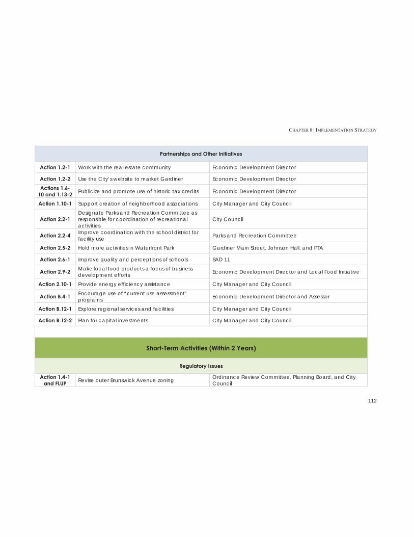
CHAPTER 8 | IMPLEMENTATION STRATEGY
112
Partnerships and Other Initiatives
Action 1.2-1 Work with the real estate community Economic Development Director
Action 1.2-2 Use the City’s website to market Gardiner Economic Development Director
Actions 1.6-10 and 1.13-2 Publicize and promote use of historic tax credits Economic Development Director
Action 1.10-1 Support creation of neighborhood associations City Manager and City Council
Action 2.2-1 Designate Parks and Recreation Committee as responsible for coordination of recreational activities
City Council
Action 2.2-4 Improve coordination with the school district for facility use Parks and Recreation Committee
Action 2.5-2 Hold more activities in Waterfront Park Gardiner Main Street, Johnson Hall, and PTA
Action 2.6-1 Improve quality and perceptions of schools SAD 11
Action 2.9-2 Make local food products a focus of business development efforts Economic Development Director and Local Food Initiative
Action 2.10-1 Provide energy efficiency assistance City Manager and City Council
Action B.4-1 Encourage use of “current use assessment” programs Economic Development Director and Assessor
Action B.12-1 Explore regional services and facilities City Manager and City Council
Action B.12-2 Plan for capital investments City Manager and City Council
Short-Term Activities (Within 2 Years)
Regulatory Issues
Action 1.4-1 and FLUP Revise outer Brunswick Avenue zoning Ordinance Review Committee, Planning Board, and City
Council

CHAPTER 8 | IMPLEMENTATION STRATEGY
113
Action 1.4-2 Revise commercial design standards Ordinance Review Committee and Planning Board
Action 1.6-2 and FLUP
Create new zoning districts for the traditional downtown and the adjacent downtown fringe Ordinance Review Committee and Planning Board
Action 1.6-3 Update Floodplain Management provisions in downtown Ordinance Review Committee, and Planning Board
Action 1.8-1 Revise “home occupation” standards Ordinance Review Committee and Planning Board
Action 1.8-2 Create provisions for “accessory business uses” Ordinance Review Committee and Planning Board
Action 1.9-1 and FLUP Create provisions for “accessory dwelling units” Ordinance Review Committee and Planning Board
Action 1.9-2 Create provisions for “townhouses” in the HDR District Ordinance Review Committee and Planning Board
Action 1.11-1 and FLUP
Establish a Cobbossee Planned Development District Ordinance Review Committee and Planning Board
Action 1.11-2 Update residential development standards Ordinance Review Committee and Planning Board
Action 1.13-3 Manage the demolition of historic structures Historic Preservation Commission
Action 1.14-1 Provide density bonuses for senior housing and eldercare facilities Ordinance Review Committee and Planning Board
Action 1.14-2 Revise other zoning requirements for senior housing Ordinance Review Committee and Planning Board
Action 2.9-3 Assure that regulations do not inhibit local agricultural production in Rural areas Ordinance Review Committee and Planning Board
Action B.1-1 Review and revise development review requirements relative to historic and archaeological resources
Ordinance Review Committee and Historic Preservation Commission
Action B.2-1 Develop wellhead protection provisions Ordinance Review Committee and Water District
Action B.3-2 Review and revise development review requirements relative to natural resources Ordinance Review Committee and Planning Board
Action B.10-2 Improve access management along major roads Ordinance Review Committee and Planning Board
FLUP Revised the standards for the Residential Growth District
Ordinance Review Committee and Planning Board
FLUP Update the standards for the Cobbossee Corridor District
Ordinance Review Committee and Planning Board

CHAPTER 8 | IMPLEMENTATION STRATEGY
114
FLUP Revise the standards for the High Density Residential District
Ordinance Review Committee and Planning Board
FLUP Revise the standards for the Professional Residential District
Ordinance Review Committee and Planning Board
FLUP Revise the standards for the Rural District Ordinance Review Committee and Planning Board
FLUP Update the Zoning Map to reflect the FLUP Ordinance Review Committee and Planning Board
Land Use 1 Update the standards for urban agriculture/backyard farming
Ordinance Review Committee and Planning Board
Land Use 3 Update the stormwater management provisions WW Superintendent, Ordinance Review Committee, and Planning Board
Land Use 5 Consider treating small dwelling units differently for lot size and density requirements
Ordinance Review Committee and Planning Board
Studies and Plans
Action 1.5-2 Work to resolve brownfields issues Economic Development Director and Brownfields Advisory Committee
Action 1.7-1 Investigate possible reuse of South Gardiner industrial buildings Economic Development Director
Action 2.1-1 Update the sidewalk plan Sidewalk Committee and PW Director
Actions 2.3-1 and 2.6-3
Investigate possible opportunities for outdoor swimming facility Parks and Recreation Committee
Action 2.5-1 Develop plan for improvements at Waterfront Park Parks and Recreation Committee
Capital Projects and Funding
Action 1.3-2 Explore creative financing for Libby Hill Economic Development Director and Finance Director
Action 2.1-3 Enhance the Downtown pedestrian environment City Manager and Gardiner Main Street
Action 2.1-4 Extend the rail trail into downtown City Manager, PW Director, and Gardiner Main Street
Action 2.1-5 Develop the Cobbossee Corridor trail City Manager, PW Director, and the Cobbossee Corridor Action Committee
Action B.11-2 Improve the library’s facilities Library Association and Library Director

CHAPTER 8 | IMPLEMENTATION STRATEGY
115
Partnerships and Other Initiatives
Action 1.1-2 Establish “community ambassadors” Economic Development Director
Action 1.2-3 Recruit “community ambassadors” Economic Development Director
Action 1.2-4 Establish a welcome committee Duct Tape Council
Action 1.6-6 Improve use of public parking City Manager and Gardiner Main Street
Action 1.6-7 Increase amount of public use parking in downtown City Manager and Gardiner Main Street
Action 1.7-2 Provide redevelopment financing for South Gardiner industrial buildings City Manager and Economic Development Director
Action 2.3-2 Explore modifying Quimby Field use restrictions City Manager, Quimby Trustees, and Parks and Recreation Committee
Action 2.3-3 Provide additional informal recreational programs Parks and Recreation Committee
Action 2.3-5 Explore establishing a teen cafe Jobs for ME Grads, RSU (MSAD) 11 and Food Initiative
Action 2.3-6 Expand community and adult education RSU (MSAD) 11 and Boys and Girls Club
Action 2.4-1 Establish a Cobbossee Corridor Action Committee group City Manager and City Council
Action 2.4-2 Undertake fundraising for Cobbossee Stream Trail Cobbossee Corridor Action Committee
Action 2.6-2 Expand after-school programs Boys and Girls Club
Action 2.7-1 Undertake coordinated downtown marketing campaign Gardiner Main Street and Economic Development Director
Action 2.7-4 Increase number and type of downtown events Gardiner Main Street
Action 2.8-2 Establish a formal “Buy Local” program Food Initiative, Board of Trade, Economic Development Director, and Gardiner Main Street
Action 2.9-1 Adopt a local food policy City Manager, Economic Development Director, and City Council
Action 2.10-3 Explore creation of energy efficiency program City Manager

CHAPTER 8 | IMPLEMENTATION STRATEGY
116
Action B.10-1 Improve City Hall parking City Manager and PW Director
Longer-Term Activities (Beyond 2 Years)
Regulatory Issues
Action 1.10-5 Adopt and enforce a housing code for multifamily buildings City Manager and Housing Committee
Studies and Plans
Action 1.4-3 Develop a streetscape plan for the Brunswick Ave corridor Economic Development Director
Action 1.5-3 Explore establishing the Cobbossee Corridor as a “green” district Economic Development Director
Action 1.5-4 Undertake a design study for the Cobbossee Corridor Economic Development Director
Action 1.5-5 Explore the feasibility of a destination recreation use in the Cobbossee Economic Development Director
Action 1.13-1 Document historic status of older properties Historic Preservation Commission
Action 2.2-2 Develop a plan for recreation improvements Parks and Recreation Committee
Action 2.2-3 Develop a coordinated community calendar Duct Tape Council
Capital Projects and Funding
Action 1.6-5 Improve Downtown traffic flow City Manager, PW Director, and Police Chief
Actions 1.10-2 and 2.10-2 Establish a neighborhood improvement program Economic Development Director
Action 1.12-3 Explore creation of a Route 24 scenic overlook Economic Development Director
Action 2.3-4 Explore construction of a skateboarding facility Skateboard Park Coalition and Parks and Recreation Committee

CHAPTER 8 | IMPLEMENTATION STRATEGY
117
Partnerships and Other Initiatives
Action 1.6-4 Improve access to upper floors of downtown buildings Gardiner Main Street and Economic Development Director
Action 1.12-1 Promote Route 24 corridor as a scenic attraction Economic Development Director
Action 1.12-2 Seek scenic byway designation for Route 24 PW Director and Economic Development Director
Action 2.4-3 Explore possibility of park at New Mills Parks and Recreation Committee and Water District
Action 2.4-4 Develop Cobbossee Corridor volunteers Cobbossee Corridor Action Committee

CHAPTER 8 | IMPLEMENTATION STRATEGY
118

CHAPTER 9 | CAPITAL INVESTMENT STRATEGY
119
CHAPTER 9: CAPITAL INVESTMENT STRATEGY The capital investment strategy is intended to assist the City of Gardiner in planning for the capital investments needed to service the anticipated growth and development in the community and to implement the policies of the Comprehensive Plan in a manner that manages the fiscal impacts of those projects. The City has an ongoing capital planning and budgeting system that addresses the community’s on-going needs for capital equipment and facilities. The City’s current capital planning process serves as the basis for this capital investment strategy.
A. Capital Improvement Plan In 2012, the City Manager and Finance Director instituted a formal capital planning and budgeting process. The annual process results in a proposed capital budget for the upcoming fiscal year and a five-year capital improvements program (CIP) which looks at the City’s longer term capital needs. The first CIP developed under this process was competed as part of the FY 2014 budget. Under the new process, the Manager solicits proposed capital projects from the various operating departments. The Manager and Finance Director then score the proposed projects using a scoring system. The Manager uses the results of this process in selecting the projects to be included in the capital budget and to develop the CIP. The CIP covers all aspects of the City’s operation including cultural and recreational facilities, environmental protection, general government, parks and open space, public safety, and public works and transportation. Excerpts from the adopted 2014 CIP are included in Appendix B. The ongoing capital planning process and the current CIP address many of the investments needed to implement the goals and policies of this Comprehensive Plan. Some, such as downtown signage, have been funded while others, such as
the Cobbossee Trail project and Waterfront Park improvements, are on a list to be considered for funding in future fiscal years.
B. Capital Projects Necessary for Implementation This Comprehensive Plan calls for capital investments in a number of projects that involve improving the delivery of community services and enhancement of the quality of life in the community. While funding for some of these projects is contemplated in the 5-Year CIP, there are some projects that are not currently addressed that the City will need to consider to implement the goals and policies set forth in Chapters 5 and 6. The following is an overview of the projects needed to implement the recommendations of this Plan that are not currently addressed in the CIP – these are not listed in priority order:
1. Brunswick Avenue Streetscape – As part of the effort to upgrade Brunswick Avenue as the gateway to the City, the Plan recommends conducting a streetscape study for the corridor to create distinctive visual environments in the various segments of the corridor. The City may be able to obtain outside funding for part of the cost of such a study but it is likely that the City will need to fund a portion of this cost.
2. Arcade Parking Lot Access – The Plan proposes that the
City work to improve the access to the Arcade Parking Lot. This project will need to be funded by the City. At this point, the scope of this project is unknown.
3. Sidewalk Improvements – A major focus of the Plan is
on improving pedestrian facilities in the City. While the City has started to budget a limited amount for sidewalk maintenance, improving and expanding the sidewalk system will require an increased financial commitment on the part of the community. The City

CHAPTER 9 | CAPITAL INVESTMENT STRATEGY
120
has successfully used Maine Department of Transportation (MeDOT) programs to extend sidewalks to schools. Additional funding and/or improvements may be possible through MeDOT assistance programs, road improvement projects, and community development funding.
4. Route 24 Scenic and Recreational Improvements – The
Plan envisions that the Route 24 corridor will evolve into a more formal recreational and scenic asset for the community and larger region. While it is likely that much of the funding for major improvements would come from the State, the City will likely need to bear a share of the costs.
5. Rail Trail Extensions – The Plan proposes that the
Kennebec River Rail Trail be linked from its current terminus in the Hannaford parking lot to the traditional Downtown and/or Waterfront Park by the Cobbossee Stream Trail. These extensions will be part of the Cobbossee Stream Trail project if that project moves forward. If not, the City may need to fund these trail extensions as an independent project.
6. Outdoor Swimming Facility – The Plan envisions that the
City will explore the feasibility and costs for developing an outdoor swimming facility. While the initial phase of this work may be able to be completed by the Parks and Recreation Commission and volunteers, the City may need to hire some professional expertise to complete this project.
7. Skateboard Facility – The Plan proposes that the
community explore developing a skateboard facility. This is a high priority project in the Heart & Soul Community Action Plan. While the expectation is that this project will primarily be a “community project”, the City may need to fund some of the costs.
8. New Mills Park – The Plan proposes that the City explore
the creation of a small park at New Mills in conjunction with the Water District. While the hope is that much of this could be done by volunteers in association with the Water District, the City may need to fund some of this work.
9. Library Facilities – The Plan recognizes the deficiencies
with the library facility and the need for improvements. While the Library Association has the primary responsibility for the library building, the City will need to work with the Association to develop a plan for funding these improvements.
10. City Hall Improvements – The Plan also recognizes the
need for improvements to City Hall including developing off-site records storage for both the municipal and library records and reconfiguring the space freed up from moving the records out of City Hall to increase the usability of the building. These improvements will need to be addressed in the City’s capital budget and CIP.

APPENDIX I | INVENTORIES
121
APPENDIX I | INVENTORIES
Note: The information in the following inventories was assembled in 2012-2013. Therefore some of the information in the inventories has changed and some activites discussed have been undertaken.

APPENDIX I | INVENTORIES
122

APPENDIX I | INVENTORIES
123
APPENDIX A: POPULATION & DEMOGRAPHICS Population Change Gardiner experienced a slight decline in year-round population from 1960 to 1980, with a brief uptick from 1980 to 1990. From 1990 to 2010, however, the City saw a fairly dramatic decrease in population, especially when compared to surrounding towns and Kennebec County. Gardiner’s overall population dropped 14% from 1990 to 2010, while the county as a whole increased by 5.4% (Table A.1). The primary cause of this drop appears to be out-migration – even with a declining population, the number of births to Gardiner residents was greater than the number of deaths of Gardiner residents during this period (Table A.2).
Regional Trends Most of the towns surrounding Gardiner experienced a steady increase in population from 1990 to 2010. West Gardiner’s population increased at a faster rate than others (37.3%), but the only other town to see a decrease in population was Hallowell – and at a much lower rate than Gardiner.
Table A.1: Population Change, 1990-2010
Total Population 1990 2000 2010 % Change 1990-2010
West Gardiner 2,531 2,902 3,474 37.3%
Litchfield 2,650 3,110 3,624 36.8%
Readfield 2,033 2,360 2,598 27.8%
Manchester 2,099 2,465 2,580 22.9%
Richmond 3,072 3,298 3,411 11.0%
Pittston 2,444 2,548 2,666 9.1%
Winthrop 5,968 6,232 6,092 2.1%
Farmingdale 2,918 2,804 2,956 1.3%
Hallowell 2,534 2,467 2,381 -6.0%
Gardiner 6,746 6,198 5,800 -14.0%
Kennebec Co. 115,904 117,114 122,151 5.4%
Maine 1,222,000 1,266,848 1,328,361 8.7%
Source: US Census
Table A.2: Gardiner Natural Increase and Net Migration, 1990-2009
Population Change Natural Increase Net Migration
1990-1999 -548 187 -735
2000-2009 -398 121 -519
1990-2009 -946 308 -1,254
Source: US Census, Maine Department of Health & Human Services
Population by Age Group Like many cities in Maine, Gardiner has seen its younger working-age population decrease over the past twenty years. However, while the City’s under-45 population has experienced a significant decline, the population over 45 (45-70) has increased over the same time period (Table A.3) reflecting the aging of the baby boom generation.

APPENDIX I | INVENTORIES
124
Table A.4 provides a more detailed breakdown of the population by 5-year age cohorts for 1990, 2000 and 2010. The highlighted cells show the 20-year aging of four groups (people in Gardiner aged 20-24, 30-34, 40-44 and 50-54 in 1990) from 1990-2010. While all four groups experienced a decline (indicating either death or more people of that age leaving than coming into the city), the 40-44 year-old group in 1990 saw the steepest decline as they aged over this 20-year period.
Table A.3: Gardiner General Age Distribution, 1990-2010
1990 2000 2010 % Change 1990
to 2000 % Change 2000-2010
% Change 1990-2010
Under 25 2,394 2,017 1,690 -15.7% -16.2% -29.4% 25-44 2,180 1,839 1,526 -15.6% -17.0% -30.0% 45-64 1,173 1,499 1,749 27.8% 16.7% 49.1% 65 and over 999 843 835 -15.6% -0.9% -16.4%
Source: US Census
Figure A.1: Gardiner General Age Distribution, 1990-2010
Source: US Census
Table A.4: Gardiner Detailed Age Distribution, 1990-2010
1990 2000 2010 % Change 1990
to 2000 % Change 2000
to 2010 % Change 1990-2010
Under 5 508 355 318 -30.1% -10.4% -37.4%
5 to 9 493 428 333 -13.2% -22.2% -32.5%
10 to 14 509 473 364 -7.1% -23.0% -28.5%
15 to 19 482 440 345 -8.7% -21.6% -28.4%
20 to 24 402 321 330 -20.1% 2.8% -17.9%
25 to 29 556 350 383 -37.1% 9.4% -31.1%
30 to 34 609 419 332 -31.2% -20.8% -45.5%
35 to 39 516 537 423 4.1% -21.2% -18.0%
40 to 44 499 533 388 6.8% -27.2% -22.2%
45 to 49 369 468 464 26.8% -0.9% 25.7%
50 to 54 252 460 493 82.5% 7.2% 95.6%
55 to 59 284 357 419 25.7% 17.4% 47.5%
60 to 64 268 214 373 -20.1% 74.3% 39.2%
65 to 69 263 226 272 -14.1% 20.4% 3.4%
70 to 74 213 205 178 -3.8% -13.2% -16.4%
75 to 79 204 154 157 -24.5% 1.9% -23.0%
80 to 84 136 126 137 -7.4% 8.7% 0.7%
85 and over 183 132 91 -27.9% -31.1% -50.3%
Total 6,746 6,198 5,800 -8.1% -6.4% -14.0%
Source: US Census
Population by Location From 2000 to 2010, Gardiner’s total population shifted slightly in location. The “Intown” area (downtown and older residential neighborhoods) saw a drop in both total population and its
29.1% 26.3%
30.2%
14.4%
0.0%
10.0%
20.0%
30.0%
40.0%
Under 25 25-44 45-64 65 andover
1990
2000
2010

APPENDIX I | INVENTORIES
125
share of the population; in 2000, 70.9% of Gardiner residents lived Intown, while only 67.6% did in 2010. This suggests a slight move away from Intown to more rural outlying areas (see map on next page). These changes can be seen in the Census Tracts, as well – Census Tract 109 (which roughly corresponds with the Intown area) lost over 11 percent of its population from 2000 to 2010, while Census Tract 110 only lost a little over four percent. (Table A.5, Figure A.3).

APPENDIX I | INVENTORIES
126
Figure A.2: Geographic Population Distribution in Gardiner, 2000 and 2010

APPENDIX I | INVENTORIES
127
Table A.5: Population by Census Tract, 1990-2010
1990 2000 2010 % Change 2000-2010
Census Tract 109 1,918 1,797 1,587 -11.7%
Census Tract 110 4,835 4,401 4,213 -4.3% Source: US Census
Figure A.3: Census Tract Boundaries, 2010
Poverty In 1990, Gardiner’s percent of families below the poverty line was slightly higher than in Kennebec County and Maine. However, the rate increased to more than 11% in 2000, and
remained at that rate in 2010 (Figure A.4). During the same time, Gardiner’s percent of families with children under 18 that are below the poverty line skyrocketed – at 22.4% in 2010, it was over 50% higher than the rate for both Kennebec County and Maine (Figure A.5).
Figure A.4: Families Below the Poverty Line in Gardiner, 1990-2010
Source: US Census, ACS 2006-2010
Families below the poverty line in Gardiner appear to be concentrated in Census Tract 109, based on data from the 2000 US Census and the 2006-2010 American Community Survey (Table A.6). Caution must be applied in using this data, since the 2006-2010 ACS has a much higher sampling margin of error than the census, especially in smaller areas such as census tracts.
Table A.6: Percent of Families in Gardiner below the Poverty Line by Census Tract, 2000-2010
2000 2010
Census Tract 109 18.5% 31.7%
Census Tract 110 8.7% 2.1%
Source: US Census, ACS 2006-2010
11.3%
7.8% 8.4%
0.0%2.0%4.0%6.0%8.0%
10.0%12.0%
Gardiner Kennebec Co Maine
1990
2000
2010

APPENDIX I | INVENTORIES
128
Figure A.5: Families with Children Under 18 Below the Poverty Line in Gardiner, 1990-2010
Source: US Census, 2006-2010 ACS
Gardiner’s racial makeup has remained fairly steady; the population of people who checked “white alone” on the census box was 98.9% in 1990, 96.9% in 2000, and 94.9% in 2010. The largest increase over the twenty-year time period came from those who checked “two or more races” in 2000 and 2010 - an option that was not available in 1990.
Table A.7: Population by Race, 1990-2010 1990 2000 2010 Total 6,746 6,198 5,800 Population of one race 6,746 6,111 5,609 White alone 6,669 6,006 5,508 Black or African American alone 23 24 17 American Indian and Alaska Native alone 21 41 38 Asian alone 21 22 41 Native Hawaiian and Other Pacific Islander alone n/a 3 0 Some Other Race alone 12 15 5
Two or More Races not a category in 1990
census 87 132
Source: US Census
Education Gardiner’s percentage of residents with high school diplomas and bachelor’s degrees tracks closely with both Kennebec County and Maine. As of 2010, over 9 in 10 Gardiner adults are a high school graduate while almost 30% have a bachelor’s degree or higher.
Figure A.6: High School Diploma or Higher
Source: US Census, ACS 2006-2010
Figure A.7: Bachelor’s Degree or Higher
Source: US Census, ACS 2006-2010
22.4%
14.0% 14.7%
0.0%
5.0%
10.0%
15.0%
20.0%
25.0%
Gardiner KennebecCo
Maine
1990
2000
2010
80.2% 78.9% 78.8%
83.9% 85.2% 85.4%
91.8% 90.3% 89.8%
70.0%
75.0%
80.0%
85.0%
90.0%
95.0%
Gardiner Kennebec Co. Maine
1990
2000
2010
14.4% 18.1% 18.8% 17.9%
20.7% 22.9%
28.9%
24.1% 26.5%
0.0%5.0%
10.0%15.0%20.0%25.0%30.0%35.0%
Gardiner Kennebec Co. Maine
1990
2000
2010

APPENDIX I | INVENTORIES
129
Household Size and Composition As of 2010, Gardiner’s average household size of 2.30 people is very close to the average for both Kennebec County and Maine. However, Gardiner started with a slightly higher household size in 1990 than the county or the state (Table A.8). This decrease is consistent with national trends as a result of fewer children per family, people living longer, and more divorced and non-traditional households. This trend plays out across all towns in the region (Table A.8). Gardiner’s decline in household size coincides with an increase in 2-person households during the same time period – and a decrease in all other household composition types (Table A.9). Again this probably can be attributed to the aging of the baby boomers as they moved into “empty nester” status over the past decade.
Table A.8: Average Household Size, 1990-2010
1990 2000 2010 % Change 1990-2010
Manchester 2.61 2.52 2.47 -5.4%
Farmingdale 2.48 2.3 2.3 -7.3%
Readfield 2.82 2.72 2.56 -9.2%
Gardiner 2.58 2.41 2.3 -10.9%
West Gardiner 2.85 2.6 2.53 -11.2%
Richmond 2.7 2.54 2.39 -11.5%
Winthrop 2.61 2.42 2.31 -11.5%
Pittston 2.76 2.52 2.42 -12.0%
Litchfield 2.86 2.61 2.5 -12.6%
Hallowell 2.24 2.06 1.89 -15.6%
Source: US Census
Table A.9: Gardiner Household Composition, 1990-2010 1990 2000 2010 % change 2000-2010 Total HH 2,513 2,510 2,487 -0.9% 1-person HH 638 737 736 -0.1% 2-person HH 784 824 928 12.6% 3-4 person HH 856 771 670 -13.1% 5+ person HH 235 178 153 -14.0%
Source: US Census
Gardiner saw a slight decrease in the number of households in the city from 1990-2010 (Table A.10). While small, this decrease is notable because the region, county and state as a whole saw the number of households increase during this same time period.
Table A.10: Total Households, Regional Comparison, 1990-2010
1990 2000 2010 % Change 1990-2010
Litchfield 926 1,190 1,441 55.6%
West Gardiner 888 1,115 1,368 54.1%
Readfield 722 867 998 38.2%
Manchester 804 977 1,044 29.9%
Pittston 877 1,010 1,103 25.8%
Richmond 1,138 1,290 1,420 24.8%
Winthrop 2,245 2,495 2,598 15.7%
Hallowell 1,080 1,145 1,193 10.5%
Farmingdale 1,168 1,202 1,259 7.8%
Gardiner 2,513 2,510 2,487 -1.0%
Kennebec Co. 43,889 47,683 51,128 16.5%
Maine 465,312 518,200 557,219 19.8%
Source: US Census

APPENDIX I | INVENTORIES
130
Median Household Income In 1990, Gardiner’s median household income matched closely with the surrounding towns of Hallowell and Richmond, Kennebec County and the State of Maine. Twenty years later, Gardiner still tracks with Kennebec County and Maine – but surrounding towns (Hallowell and Richmond) have experienced substantially greater increases in household income (Table 9).
Table A.11: Median Household Income, 1990-2010
1990 2000 2010 % Change 1990 to
2000 % Change 2000 to
2010 Gardiner $27,330 $35,103 $47,654 28.4% 35.8% Hallowell $31,161 $36,058 $59,500 15.7% 65.0% Richmond $27,639 $36,654 $55,917 32.6% 52.6% Kennebec Co. $28,616 $36,498 $45,973 27.5% 26.0% Maine $27,854 $37,240 $46,933 33.7% 26.0%
Source: US Census, ACS 2006-2010
Figure A.8: Gardiner Median Household Income, 1990-2010
Source: US Census, ACS 2006-2010
As with the incidence of family poverty, household income appears to be significantly different when broken down by census tract. Caution should be used when looking at this
data, as the 2000 median household income comes from the 2000 Census, while the 2010 number comes from the 2006-2010 American Community Survey – which has a higher margin of error, especially for small areas such as census tracts. Still, both sets of data indicate that the median household income in Census Tract 110 is significantly higher than in Census Tract 109.
Table A.12: Median Household Income by Census Tract, 2000-2010
2000 2010 Percent Change
Census Tract 109 $30,100 $37,820 25.6%
Census Tract 110 $36,856 $55,217 49.8%
Source: US Census, ACS 2006-2010
Implications 1. Since 1990, the City’s year-round population has declined by over 14%. This decline was driven by net out-migration – more people moving out of the City than moving in. While some of this is probably the result of “children leaving the nest” and leaving Gardiner, making Gardiner a more attractive place to live will be important in the future. 2. As the baby boom generation ages, the City could see an increase in its older population. Over the last two decades it appears that the City has been losing households as they age. Keeping these households in Gardiner will be important. This may mean there will be a need for more housing appropriate for older households and support services for this group of residents as their needs change. 3. Over the last twenty years, the City has seen a small decrease in the number of households living in the City. If this trend continues it could have a negative impact on the housing stock if it results in an increase in the vacancy rate and/or disinvestment in housing.
$47,654 $59,500 $55,917
$45,973 $46,933
$0$10,000$20,000$30,000$40,000$50,000$60,000$70,000
1990
2000
2010

APPENDIX I | INVENTORIES
131
4. The rate of poverty among households with children appears to have increased significantly since 1990 and is higher than in Kennebec County as a whole. While the absolute numbers of lower-income households with children is small, this trend could impact the City and the demand for community services.

APPENDIX I | INVENTORIES
132
APPENDIX B: LOCAL ECONOMY Economic History
Note: The following information about the economic history of Gardiner was taken from “A Brief History of Gardiner”, written by Danny D. Smith on behalf of the Gardiner Historic Preservation Commission
Gardiner’s namesake, Robert Hallowell Gardiner, inherited the land on which the City now sits from his grandfather in the early 19th century. After breaking the estate so it could be legally divided, Gardiner invested his own capital to build Main Street and start several stores. In 1834, he chartered the Gardiner Savings Institute. Gardiner also built the large stone church at the summit of Church Hill, helped to establish the Gardiner Lyceum (a vocational college), and built the “Oaklands” stone mansion. By 1849, the newly chartered City of Gardiner boasted at least two shipyards, with ten large wharves for lumber shipments. These shipyards brought business to Water Street, which was lined with two rows of stores. In the 1860s, the Warren Copesook Paper Mill opened, and was soon followed by the Hodgkins Paper Company, Richards Paper Company, and the Hollingsworth and Whitney paper mill. Although paper was king, several smaller industries took hold during the late 19th and early 20th centuries, including the ice industry and shoe manufacturing (including Commonwealth Shoe and Leather Company and R.P. Hazzard Shoe Company). Industry declined in Gardiner after World War II, and by the mid-1990s Gardiner was seen largely as a bedroom community for state government workers and employees of Bath Iron Works.
Major Employers In 1997, the top three employers in Gardiner were the local school district, the State of Maine, and Associated Grocers, followed by several paper mills and manufacturers (Table B.1). In 2011, both the local school district and the State of Maine remained near the top of the list, with the Pine State Trading distribution center and MaineGeneral Health also occupying high spots (Table B.2). Manufacturers have fallen off the list, replaced by construction-related companies.
Table B.1: Major Employers in Gardiner, 1997 Name of Business Business Type Employees RSU (MSAD) #11 Government/Education 435 State of Maine Government 266 Associated Grocers Grocery Co-op 200 Hannaford Bros. Co. Groceries 135 Williams Construction Construction 125 Carleton Woolen Mills Textile Manufacturer 100 Yorktowne Paper Mill Paperboard Manufacturer 65 City of Gardiner Government 60 Gardiner Savings Bank Bank 55 Reny’s Department Store 21 Mercer Paper Tube Corp. Paper Tube Manufacturer 17
Source: Gardiner 1997 Comprehensive Plan
Table B.2: Major Employers in Gardiner, 2011
Name of Business Business Type Employees RSU (MSAD) #11 Education 450 Pine State Trading Distribution Center 275 State of Maine Insurance & Financial Regulation 190 Associated Grocers* Distribution Center 168 MaineGeneral Health Health Services 163 EJ Prescott Wholesale Distributor 82 City of Gardiner Government 69 Maine Drilling & Blasting Construction 65 On Target Locating Services Construction 40
*closed in 2011 Source: City of Gardiner Assessing, City Clerk, Planning & Development

APPENDIX I | INVENTORIES
133
The industry sectors with the greatest employment in 2011 were in wholesale trade, retail trade, and healthcare and social assistance (Table B.3).
Table B.3: Establishments, Employment and Wages in Gardiner, 2011
NAICS Title Establishments Average Employment
Total Wages
Total, All Industries 183 2,396 $84,156,565
Wholesale Trade 20 473 $22,685,860
Retail Trade 25 328 $7,370,871 Health Care and Social Assistance 17 254 $6,477,771
Finance and Insurance 8 194 $10,718,933
Construction 20 184 $8,655,495 Accommodation and Food Services 17 166 $2,318,220 Professional and Technical Services 20 108 $4,305,037 Other Services, Except Public Administration 19 45 $1,116,978
Information 4 39 $1,450,171
Manufacturing 3 30 $503,780 Administrative and Waste Services 11 23 $611,733
Source: Maine Department of Labor Quarterly Census on Earnings and Wages
Labor Force Most employed Gardiner residents work in white-collar and pink-collar occupations. The share of people working in professional and other white-collar occupations is growing while employment in blue-collar occupations is dropping (Table B.4 and Figure B.1). The percent of Gardiner residents employed in management/professional positions increased from 2000-2010, while sales and office occupations and construction saw a decrease. Compared to both the State of
Maine and Kennebec County, Gardiner has a higher percentage of its residents in management/professional positions, and a slightly lower percent in service occupations, construction trades and production (Table B.4). The dip in construction employment could be attributed to the recession’s impact on building activity.
Table B.4: Gardiner Labor Force, 2000-2010
2000 % of Total 2010
% of Total
Total 3,079 3,062 Management, professional, and related occupations 997 32.4% 1,173 38.3%
Service occupations 403 13.1% 394 12.9%
Sales and office occupations 977 31.7% 865 28.2% Farming, fishing, and forestry occupations 6 0.2% 9 0.3% Construction, extraction, and maintenance occupations 376 12.2% 284 9.3% Production, transportation, and material moving occupations 320 10.4% 299 9.8%
Source: US Census
Figure B.1: Gardiner Occupation Profile, 2000-2010
Source: US Census
0.0%5.0%
10.0%15.0%20.0%25.0%30.0%35.0%40.0%45.0%
Management,professional,and relatedoccupations
Serviceoccupations
Sales and officeoccupations
Farming,fishing, and
forestryoccupations
Construction,extraction, andmaintenanceoccupations
Production,transportation,and material
movingoccupations
2000
2010

APPENDIX I | INVENTORIES
134
Table B.5 gives a general breakdown of self-reported occupations from the 2006-2010 American Community Survey, while Table B.6 goes into greater detail.
Table B.5: Gardiner Occupation Profile Maine Kennebec Co. Gardiner Management, business, science, and arts occupations 34.2% 34.6% 38.3%
Service occupations 17.5% 16.8% 12.9%
Sales and office occupations 24.5% 25.6% 28.2% Natural resources, construction, and maintenance occupations 11.6% 10.6% 9.6%
Production, transportation, and material moving occupations 12.2% 12.4% 9.8%
Source: ACS 5-Year Estimates, 2006-2010
Table B.6: Gardiner Labor Force INDUSTRY Maine Kennebec Co. Gardiner
Civilian employed population 16 years and over 657,556 59,595 3,062
Agriculture, forestry, fishing and hunting, and mining 2.5% 1.5% 0.0%
Construction 7.7% 7.9% 9.7%
Manufacturing 10.1% 8.0% 5.9%
Wholesale trade 2.7% 2.8% 3.5%
Retail trade 13.6% 14.0% 13.9%
Transportation and warehousing, and utilities 4.0% 4.8% 5.4%
Information 2.1% 2.4% 1.8%
Finance and insurance, and real estate and rental and leasing 6.1% 4.6% 4.1%
Professional, scientific, and management, and administrative and waste management services
8.3% 7.9% 8.7%
Educational services, and health care and social assistance 26.1% 27.4% 28.4%
Arts, entertainment, and recreation, and accommodation and food services 8.1% 6.2% 4.8%
Other services, except public administration 4.5% 5.0% 4.6%
Public administration 4.2% 7.6% 9.2%
Source: ACS 5-Year Estimates, 2006-2010

APPENDIX I | INVENTORIES
135
Table B.7: Gardiner Annual Unemployment Rate, 2002-2011
Year Annual
Unemployment Rate*
2002 5.3%
2003 5.9%
2004 5.9%
2005 6.3%
2006 5.1%
2007 4.7%
2008 5.3%
2009 7.5%
2010 8.2%
2011 7.7% *not seasonally adjusted/Source: Bureau of Labor and Statistics
Commuting Patterns Gardiner functions both as a bedroom community and as a jobs center. Of the residents of Gardiner who are employed, the vast majority commute out of Gardiner to work. At the same time, a large number of jobs in Gardiner are filled predominantly by people who live outside of Gardiner and commute into the City to work. These two commuter flows are closely balanced with slightly more people commuting into Gardiner to work than commute from Gardiner to jobs in other communities. Only a relatively small percentage of the City’s labor force lives and works in Gardiner.
Figure B.2: Gardiner Commuting Patterns, 2002-2012
Source: US Census LED On The Map
Regional Economic Role With approximately 2,400 jobs in 2011, Gardiner serves as a regional employment center. Many of these jobs are located in businesses along outer Brunswick Avenue and in the Libby Hill Business Park. The City also functions as a local service and retail center, primarily in downtown and along outer Brunswick Avenue.
Retail Sales Gardiner’s retail sales account for about 5% of all retail sales in the Augusta Economic Summary Area (ESA), which includes 24 towns and cities in the Augusta region (Table B.8). While most categories have remained steady over the last five years, Gardiner’s percentage of “business operating”-related retail sales dropped by almost three percentage points from 2007 to 2011. “Business operating” retail sales are mostly purchases by
537
2261 2466
357
2,154 2378
0
500
1,000
1,500
2,000
2,500
3,000
Live in Gardiner, Workin Gardiner
Live in Gardiner, WorkElsewhere
Live Outside Gardiner,Work in Gardiner
2002
2010

APPENDIX I | INVENTORIES
136
Maine businesses12 where the tax is paid directly by the buyer (such as commercial or industrial heating oil purchases).13 Total retail sales in Gardiner decreased by 9.1% from 2007 to 2011 (Table B.9). In comparison, total retail sales for the Augusta ESA decreased by 4.4% during the same time period, and total retail sales for the State of Maine decreased by 2.3%.
Table B.8: Gardiner Retail Sales as a Percentage of Augusta ESA
2007 2008 2009 2010 2011
Total 5.2% 5.1% 5.2% 5.2% 5.0%
Personal 5.1% 5.1% 5.3% 5.3% 5.0%
Business Operating 7.1% 5.1% 4.1% 4.6% 4.3%
Building 4.7% 5.7% 5.7% 5.5% 4.9%
Food Store 16.7% 16.5% 16.0% 15.8% 15.8%
General 2.0% 1.8% 2.0% 2.1% 2.0%
Other 7.0% 6.1% 4.9% 5.4% 5.3%
Auto Trans 2.7% 2.9% 3.0% 3.0% 2.6%
Rest. and Lodging 7.7% 7.7% 7.5% 7.3% 7.0% Source: Maine State Planning Office, Maine Revenue Service
12 Accessed at http://www.maine.gov/tools/whatsnew/index.php?topic=Economics+and+Demographics+News&id=325208&v=article2011 13 Accessed at http://www.maine.gov/spo/economics/retail/defs_retail.pdf
Table B.9: Total Gardiner Retail Sales, 2007-2011 (in thousands of dollars)
2007 2008 2009 2010 2011
Total $50,761 $48,935 $47,117 $47,790 $46,161
Personal $46,279 $45,831 $44,845 $45,407 $43,786
Business Operating $4,482 $3,104 $2,272 $2,383 $2,375
Building $4,773 $5,824 $5,369 $5,165 $4,527
Food Store $14,827 $14,824 $15,094 $15,157 $15,185
General $4,609 $4,179 $4,628 $4,704 $4,449
Other $5,247 $4,466 $3,607 $4,112 $4,081
Auto Trans $8,107 $7,724 $7,371 $7,463 $7,036
Rest and Lodging $8,715 $8,814 $8,776 $8,806 $8,508 Source: Maine Revenue Service
Organizational Capacity and Tools The City of Gardiner Planning and Development office (often referred to as the Department of Economic and Community Development) has three full-time staff – a director, a code enforcement officer, and assistant – as well as one part-time community planning assistant, one contract historic preservation program manager, and the assessor’s office. Gardiner’s Director of Economic and Community Development is also a licensed real estate sales agent. Gardiner is home to a United State Department of Agriculture Rural Development Intermediary Relending Program (a revolving loan fund), which provides secondary financing for Gardiner business development, and an Agricultural Development Program, which allows pass-through of private donations to for-profit businesses with qualifying social missions. Both programs are administered with assistance from the Kennebec Valley Council of Governments (KVCOG). City committees that deal with economic development include the Economic Development Committee, the

APPENDIX I | INVENTORIES
137
Waterfront Park and Marina Task Force, the Planning Board, the Ordinance Review Committee, the Appeals Board and the Historic Preservation Commission. Local organizations that promote community development include Gardiner Main Street, the Gardiner Board of Trade (composed of business leaders in the community), and the Rotary Club of Gardiner.
Regional Economic Development Gardiner officials hold membership in the Economic Development Council of Maine, the New England Development Association and the Maine Real Estate and Development Association. Gardiner’s City Manager is on the steering committee for KVCOG, and both the City Manager and the Economic Development Director attend KVCOG meetings. Gardiner officials also serve on the Kennebec River Rail Trail board, the Merrymeeting Trail committee, the board of the Maine Craft Association, and the Kennebec Valley Entrepreneurial Alliance board. Economic activity in Gardiner is part of KVCOG’s annual Comprehensive Economic Development Strategy annual report for the region.
Incentive Districts Tax Increment Financing (TIF) A TIF is a public financing tool that uses future gains in taxes to pay for current improvements. As of 2012, Gardiner had seven active TIFs, with a total assessed value of over $58 million (Table B.10). The City has focused its TIF efforts on the Downtown area, the Libby Hill Business Park, and the Associated Grocers (now State Street) Business Park, but will consider new TIFs for all areas zoned for commercial development.14
14 City of Gardiner website, accessed 10/19/12. http://www.gardinermaine.com/public_documents/gardinerme_ecdev/tif

APPENDIX I | INVENTORIES
138
Table B.10: Gardiner TIFs, 2012
District TIF Year
2011 Assessment
Original Value
Incremental Value
Capture Rate
Approved Capture
TIF Payment CEA %
CEA Disbursement
Economic Development Funds
HARPER’S 12 $2,833,400 $0 $2,833,400 1.00 $2,833,400 $56,385 34% $19,171 $37,214
PINE STATE TRADING 9 $8,098,500 $202,100 $7,896,400 1.00 $7,896,400 $157,138 50% $78,569 $78,569
DOWNTOWN 9 $36,472,300 $23,582,600 $12,889,700 1.00 $12,889,700 $256,505 0% $0 $256,505
EJ PRESCOTT 8 $5,296,200 $68,600 $5,227,600 1.00 $5,227,600 $104,029 50% $52,015 $52,015
EJ PRESCOTT 8 $168,800 $65,500 $103,300 1.00 $103,300 $2,056 50% $1,028 $1,028 ASSOCIATED GROCERS (now PINE STATE) 7 $3,249,300 $26,400 $3,222,900 1.00 $3,222,900 $64,136 0% $0 $64,136
LIBBY HILL AREA TIF 4 $2,597,300 $145,400 $2,451,900 1.00 $2,451,900 $48,793 various $8,280 $40,513
Total 57 $58,715,800 $24,090,600 $34,625,200 $34,625,200 $689,041 $159,062 $529,979 Source: City of Gardiner, 2012
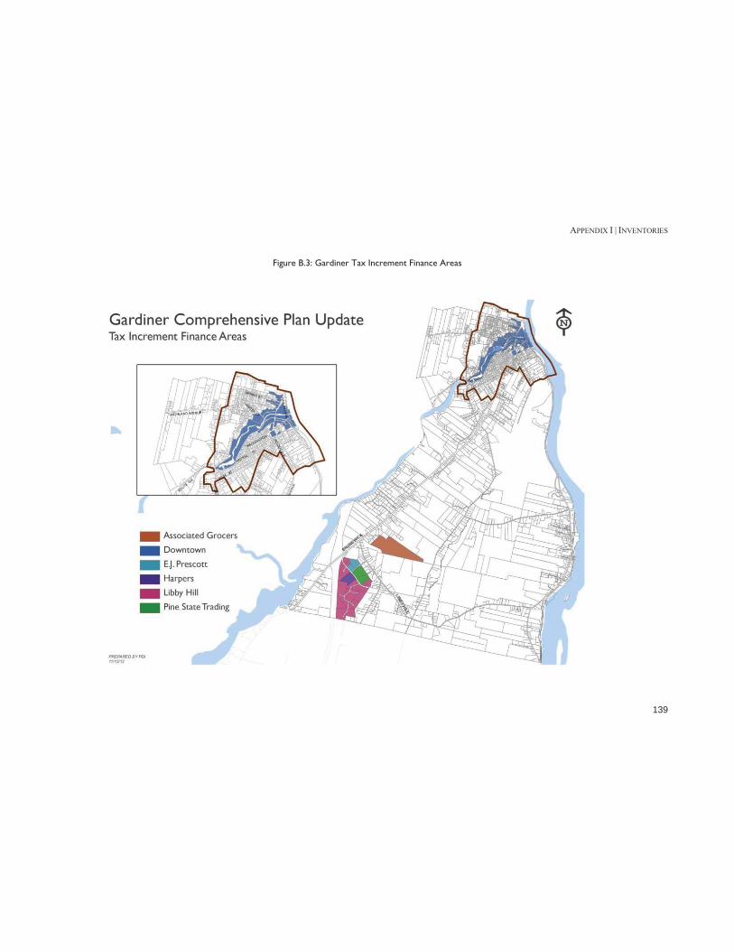
APPENDIX I | INVENTORIES
139
Figure B.3: Gardiner Tax Increment Finance Areas

APPENDIX I | INVENTORIES
140
Gardiner has a 100% capture rate for new value created in TIFs, so all new funds go toward an economic development fund controlled by the City, the original taxpayer, or a combination of the two. The Credit Enhancement Agreement (CEA) is the rate at which the newly created funds go back to the original taxpayer (Table B.10). The Downtown Gardiner TIF stretches along the Cobbossee Stream until it meets the Kennebec River. The revenue from the new valuation in the Downtown Gardiner TIF is dedicated to economic development, and it was refinanced in 2011. The Libby Hill Business Park was built in 2000 (with a second phase in 2008) as a 260-acre business park on the southern edge of Gardiner, near I-295. Fifteen of the twenty-eight total available lots were listed as for sale in October 2012.15 In 2010, the City of Gardiner hired a marketing firm to help attract businesses to the location. The Libby Hill Business Park is a designated Gardiner Enterprise Zone, which means that is qualifies for Tax Increment Financing.16 The City’s Libby Hill fund – which is supported by TIF financing and public funds – currently has a deficit of $700,000,17 in part because the City has been shifting $91,000 a year from the Libby Hill fund to the general fund to help cover other costs. Current tenants of the Libby Hill Business Park include: EJ Prescott, Inc., Pine State Trading Co., PMP Realty LLC, Capital Investments LLC, NRT Properties, Harper’s II LLC, Black Diamond Consultants Inc., and the Oak Grove Cemetery Association. 18
15 Commercialiq.com, Commercial Property for Sale or Lease (search term: Libby Hill, 10/17/12). http://www.commercialiq.com 16 Libby Hill Business Park website, http://libbyhillbusinesspark.com/pdfs/LibbyHill-Profile.pdf 17 Kennebec Journal, “Councilors Look at 1.5% Tax Increase”, April 24 2012. http://www.kjonline.com/news/councilors-look-at-1_5-percent-tax-rate-increase_2012-04-24.html 18 City of Gardiner GIS Assessing Data, 2012
Pine Tree Development Zones Both the Libby Hill Business Park and Downtown Gardiner are designated as State of Maine Pine Tree Zones, which allows eligible businesses to reduce or eliminate state taxes for up to ten years.19
Revolving Loan Fund The City recently expanded its revolving loan fund, which provides loans to: 1) help businesses locate in Gardiner, 2) help downtown property owners rehab their businesses, and 3) help existing businesses locate in areas better suited for light industrial use. While the fund has traditionally offered small, high-risk loans of up to $10,000, the expansion allows for larger, 15-year loans with a limit of $100,000. The loan fund has four target areas20:
The T.W. Dick site on Summer Street, Brunswick Avenue and Highland Avenue
Water Street Buildings The Gardiner Railroad Station The Libby Hill Business Park
Downtown Storefronts In October 2012, the City of Gardiner made a small media splash when it announced it would offer several downtown storefronts free of charge to merchants during the holiday season.21 The City hopes that the pop-up businesses will stay
19 Maine Department of Economic and Community Development, “Pine Tree Zones.”, http://www.maine.gov/decd/mainebiz/pine_tree_zones/index.shtml 20 Gardiner Maine Revolving Loan Fund Guidelines, http://www.gardinermaine.com/Public_Documents/GardinerME_EcDev/rlfpolicy?textPage=1 21 “Downtown Gardiner shops rent-free through holidays,” Maine Biz, October 4, 2012. http://www.mainebiz.biz/apps/pbcs.dll/article?AID=/20121004/NEWS/121009966/1092&utm_source=enews&utm_medium=Daily%2BReport&utm_campaign=Thursday

APPENDIX I | INVENTORIES
141
open and pay rent in 2013. As of November 2012, four businesses had moved into the storefronts.22
Implications 1. The economy of Gardiner appears to be undergoing a subtle but significant shift away from traditional manufacturing to service and distribution functions. The City’s location with good access to both the Maine Turnpike and I-295 supports this pattern. This trend is likely to continue and needs to be reflected in the City’s economic development efforts. 2. While the City is the home to a number of large employers, the business community as a group plays only a limited role in community activities. Enhancing business involvement in all aspects of community affairs may be important to dealing with community issues especially in growing the economy. 22 Accessed at http://www.kjonline.com/news/new-businesses-pop-up-for-holidays_2012-11-10.html

APPENDIX I | INVENTORIES
142
APPENDIX C: LAND USE General Pattern of Land Use The City of Gardiner is 15.65 square miles. It is situated along the Kennebec River and partially divided by the Cobbossee Stream, which runs through the City’s downtown. The majority of commercial activity occurs in the Intown Area, with pockets along outer Brunswick Avenue and along River Avenue (on the far eastern edge of the City). Over 80% of the parcels in Gardiner are dedicated to single-family or duplex housing, with slightly more than half in the Outlying Area. Almost all of the multifamily housing, however, is located in the Intown Area; only 14% of those parcels are located in the Outlying Area. Figure C.1 shows the existing pattern of land use in the City as of 2012 based on the City’s assessment records.
Table C.1: Land Use by Parcels, City of Gardiner
Entire City Parcels Percentage
Single-Family or Duplex 2,150 81.8%
Commercial 165 6.3%
Municipal /Charity/Education/Healthcare 158 6.0%
Multifamily (3 or more units) 104 4.0%
Vacant 24 0.9%
Industrial 10 0.4%
City Parks 10 0.4%
Woodlots 7 0.3%
TOTAL 2,628 100% Source: Gardiner City Assessor Data, 2012
Table C.2: Land Use by Parcels, Intown Area
Intown Parcels Percentage
Single-Family or Duplex 904 75.5%
Commercial 110 9.2%
Multifamily (3 or more units) 90 7.5%
Municipal/Charity/Education/Healthcare 78 6.5%
City Parks 7 0.6%
Vacant 6 0.5%
Industrial 2 0.2%
Woodlots 1 0.1%
TOTAL 1,198 100% Source: Gardiner City Assessor Data, 2012
Table C.3: Land Use by Parcels, Outlying Area
Outlying Area Parcels Percentage
Single-Family or Duplex 1,246 87.1%
Municipal/Charity/Education/Healthcare 80 5.6%
Commercial 55 3.8%
Vacant 18 1.3%
Multifamily (3 or more units) 14 1.0%
Industrial 8 0.6%
Woodlots 6 0.4%
City Parks 3 0.2%
TOTAL 1,430 100% Source: Gardiner City Assessor Data, 2012
Residential In addition to the intensively developed Intown residential neighborhoods, there are several clusters of single-family subdivisions in the Outlying Area. These clusters are located near:

APPENDIX I | INVENTORIES
143
Eastern edge of Gardiner, along River Avenue Southeastern corner of the City, on Costello Road Southwestern corner of the City, along Libby Hill Road Western edge of Gardiner, between outer Brunswick
Avenue and the interstate Almost all multifamily parcels are in the Intown area (Table C.4).
Table C.4: Residential Land Use by Parcel Intown Outlying Area Total Single-Family or Duplex 904 1,246 2,150 Multifamily 90 14 104 City Total 994 1,260 2,254
Source: Gardiner City Assessor Data, 2012
Non-Residential The two primary clusters of commercial development are located in downtown Gardiner (near and on the waterfront), and along outer Brunswick Avenue. Most of the city parks are located in the Intown area – and two of the three in the Outlying Area are directly adjacent to Intown. This means that there is little public recreation space in the Outlying Area, although the majority of land classified as woodlot is located in this part of the City.
Table C.5: Non-Residential Land Use by Parcel
Entire City Intown Outlying Area Total
Commercial 110 55 165
Municipal/Charity/Education/Healthcare 78 80 158
Vacant 6 18 24
Industrial 2 8 10
City Parks 7 3 10
Woodlots 1 6 7
TOTAL 204 170 374 Source: Gardiner City Assessor Data, 2012
Farmland, Tree Growth & Open Space Current Use Tax Programs The State of Maine has four "current use" programs which offer the property owner a reduction in their assessed value: Tree Growth, Farm Land, Open Space and Working Waterfront. These programs provide the property owner with a lower assessed value for land, creating lower property taxes while the land is enrolled in the program. While these programs provide an incentive to property owners to keep land undeveloped, they do not provide long-term or permanent protection of the land, nor do they provide for any public access. All four programs are available to the property owner through an application process with the local municipality. Gardiner has 24 parcels in current use tax programs: twelve in farmland, ten in tree growth, and two in open space. Almost all of this land is located in the Outlying Area. The bulk of the land in the Farmland program belongs to the Oakland Farm (Figure C.1).
Program Descriptions Farm Land: In the farmland program, the property owner is required to have at least 5 contiguous acres in their tract of land. The land must be used for farming, agriculture, or horticulture and can include woodland and wasteland. Additionally, the tract must contribute at least $2,000 gross income from farming activities, each year. Open Space: The tract must be preserved or restricted in use to provide a public benefit. Benefits recognized include public recreation, scenic resources, game management or wildlife habitat. Tree Growth: This program allows a land owner with at least 10 acres of forested land used for commercial harvesting to be

APPENDIX I | INVENTORIES
144
taxed at “current use” value. A Forest Management and Harvest Plan must be prepared to participate in the program.23
Table C.6: Land in Current Use Taxation Programs in Gardiner Number Acres
Farmland 12 2,686
Tree Growth 10 679
Open Space 2 42 Source: City of Gardiner Assessor
23 Accessed at http://www.maine.gov/revenue/propertytax/propertytaxbenefits/CurrentUseLandPrograms.htm

APPENDIX I | INVENTORIES
145
Figure C.1: Land in Current Use Taxation Programs Map

APPENDIX I | INVENTORIES
146
Figure C.2: Gardiner Current Land Use Map

APPENDIX I | INVENTORIES
147
Figure C.3: Gardiner Current Zoning Map

APPENDIX I | INVENTORIES
148
Implications 1. While the City has experienced limited development since 2000, much of this has occurred outside of the traditional built-up area of the City in the outer Brunswick Avenue corridor or in the rural areas of the City. If this pattern of development continues, it could have an impact on City services, natural resources, and scenic areas. 2. The existing comprehensive plan proposed limiting rural development and encouraging development within the City’s identified growth areas but when the Zoning Ordinance was amended, these proposals were not fully implemented. This may be contributing to the development pattern noted in 1. 3. The City has adopted design standards for commercial development as proposed in the existing comprehensive plan. Some of these standards may not be appropriate in areas such as the outer Brunswick Avenue corridor and should be reviewed. 4. Maintaining the desirability and livability of Intown residential neighborhoods is a key issue for the City. Reviewing the zoning requirements in these areas may be desirable to maintain these neighborhoods while promoting re-investment. 5. Providing for the appropriate reuse of nonconforming uses within the developed neighborhoods should be addressed.

APPENDIX I | INVENTORIES
149
APPENDIX D: PUBLIC FACILITIES City Hall The current City Hall (photo, right) was built in 1969, and is set back just behind where the former City Hall stood. The previous structure stood for just over 100 years.24 The following departments are located in City Hall: City Manager, Assessing, City Clerk, Code Enforcement, Planning & Development, Finance, Police Chief, Fire Chief, Tax Collection, and General Assistance. The Police Department and Fire Departments are also housed in the building, but with separate entrances along the side. The entire structure is 14,331 square feet, and sits on 1.2 acres (a good section of which is used for parking). The City Council, Planning Board, and other various committees hold meetings at City Hall in the Council Chambers. In 2006, the City commissioned a City Hall Space Study from Smith Reuter Lull Architects. The study found that City Hall “suffers from a shortage of space and a layout of department areas that limit the ability of staff to improve the efficiency with which services are provided to citizens.” The study recommends either an addition or a relocation of services within the building (such as fire or police) to another place. In addition, the architects found a “universal dislike for the visual
24 City of Gardiner Library Archives, Personal Communication Nov. 2, 2012
appearance of the City Hall building.”25 Another issue is the lack of storage space for documents.26
Public Works Services The Wastewater & Public Works Director of Gardiner oversees Wastewater Treatment (four employees), Public Works (eight employees), and Buildings & Grounds (four employees)27. The fiscal year 2013 budget totaled $1,550,398 for Wastewater, $1,184,331 for Public Works, and $477,578 for Buildings & Grounds. The major services provided are: building maintenance, road maintenance, parks maintenance, snow removal, cemetery maintenance, and wastewater treatment. Gardiner Public Works also maintains the sewer mains and piping to the edge of the roadway (or inside of a sidewalk).28
Facilities The public works facility is located on Brunswick Avenue, south of downtown. The facility, which sits on a little over seven acres, consists of the public works garage, a cold storage building, and a 300-ton salt shed. The public works garage was built in 1960 and consists of masonry walls with metal siding. As of 2010, the building is now heated with two wood pellet boilers. It is currently adequate to house the City’s public works staff and maintain the heavy truck and equipment fleet. The garage will need upgrades –
25 City of Gardiner City Hall Space Study, 2006. http://www.gardinermaine.com/Public_Documents/GardinerME_WebDocs/studies/GardinerCityHallSpaceStudy.pdf 26 Personal Communication, City of Gardiner, 2012. 27 In 2013, the director position will be split in two, with the Director of Wastewater solely overseeing the wastewater operations and a Public Works Director overseeing public works and buildings & grounds 28 Accessed at http://www.gardinermaine.com/Public_Documents/GardinerME_PublicWorks/sewer

APPENDIX I | INVENTORIES
150
such as doors, roofing, and crew quarters – in the upcoming years. The cold storage building is a one-story wood framed building that was constructed in the 1970s.29 It houses additional supplies and equipment. It has been roofed and sided in recent years, and the doors have also been replaced. The salt shed is five years old, and should be adequate into the future.30 There are currently no plans to expand the public works facilities.
Wastewater Treatment Facility Located at 570 River Avenue, the WWTF has been in operation since its construction in 1982. The plant operates at 55% capacity in dry weather, with combined sewer overflow for wet weather. There are currently no targeted areas for expansion. A 2006 Combined Sewer Overflow (CSO) abatement project included a concurrent WWTF upgrade that increased the capacity of the plant from 4.5 to 9.5 million gallons a day (mgd), with 4.5 mgd secondary treatment fill-time, and an additional 5 mgd primary treatment during CSO events).31
Consolidation In 2004, Wright-Pierce Engineering and Kent Associates Planning studied the impacts of relocating and consolidating
29 Accessed at http://www.gardinermaine.com/Public_Documents/GardinerMe_WebDocs/kentreport.pdf 30 Personal Communication, City of Gardiner, 2012 31 Combined Sewer Overflow Master Plan Update for City of Gardiner, Maine, 2009 (Wright-Pierce Engineering)
several City services to a single site.32 The consultants and participants concluded that:
the City’s Public Works (DPW) & Sewer/Wastewater facilities (WWTF) should be co-located on Route 24 (River Road) at the existing wastewater treatment plant;
the Water District (GWD) should consolidate operations at their New Mills site; and
the City should purchase the GWD’s downtown building for the relocation of the Gardiner Police Department
As of 2012, none of these actions have been taken.
Police Department Services The Gardiner Police Department maintains twenty-four hour police protection on a year-round basis. The staff includes three sergeants, a detective, a school resource officer, a public safety officer and six patrol staff who work fixed shifts. There is a minimum of one patrol officer on duty between the hours of 7 a.m. to 3 p.m., and a minimum of two patrol officers on duty from 3 pm to 7 am. Over the last several years, the Gardiner Police Department has responded to, on average, 8,200 calls for service per year. In 2011, these calls included: 112 felonies (burglary, sex offenses, robbery, arson, aggravated assault, etc.); 375 crime related incidents (assault, theft, bad checks, OUI, etc.); and 83 non-violent crimes (disorderly conduct, criminal trespass, liquor law violations, etc.). The Gardiner Police Department has issued 420 arrests/summons, on average, over the last several years, with a total of over 400 in 2011. Several security cameras
32 Accessed at http://www.gardinermaine.com/Public_Documents/GardinerMe_WebDocs/kentreport.pdf

APPENDIX I | INVENTORIES
151
have been installed at the waterfront area to help increase security. There is no 311 or general hotline in Gardiner; the police department often fields calls from residents looking for social services or mental health assistance.
Facilities As part of the same 2006 City Hall space study, the firm looked at the police department and found two major issues: lack of space, and the inability to separate public traffic from police business traffic. Prisoners and members of the public enter and leave through the same lobby. “There is no proper sequence of spaces for booking, holding and interrogation. There is no secure storage for evidence. The locker room is a converted holding cell, and there is no separate facility for female officers. There is one toilet room that is shared by staff and prisoners.” The department was able to annex the city clerk’s former office due to a modest office reorganization in 2010. However there are currently no upgrade plans.33 There is no secure parking space for impounded vehicles or officer’s cars. The study suggests that by relocating the Fire Department (also attached to city hall), adequate space would become available to solve the most pressing needs of the Police Department.34 A 2004 consolidation study by Wright-Pierce (the same one noted above) suggested that, after consolidating the Gardiner Water District operations, the City should purchase the Water District’s downtown building for the relocation of the Gardiner Police Department. This would provide the Fire Department
33 Personal Communication, City of Gardiner, 2012. 34 Accessed at http://www.gardinermaine.com/Public_Documents/GardinerME_WebDocs/studies/GardinerCityHallSpaceStudy.pdf
and other City departments with expansion room and alleviate the need for a building expansion at City Hall.
Fire Department Services The department provides fire protection to the City of Gardiner, as well as mutual aid response to ten area fire departments. Approximately 250 fire calls are received annually. Large incidents are managed with mutual aid fire departments and a call force of 12 firefighters. The Gardiner Fire & Ambulance Department has 15 full-time firefighters who work three shifts - four people per shift, with two swing firefighter/EMT’s. Gardiner Fire Department provides ambulance service to seven communities: Gardiner, Farmingdale, Chelsea, Randolph, Pittston, Litchfield, and West Gardiner. This area is about 163 square miles and has 24,000 residents. The ambulance service responds to an average of 2,000 emergency medical service calls per year. The department has three ambulances.
Facilities The firefighters work in the main station, which is also attached to City Hall. An older station in South Gardiner is no longer active, but is used for equipment storage. The department has two pumpers, an aerial ladder and a rescue boat. The 2006 City Hall space study found that the Fire Department had a “major impact” on site use (especially parking), and recommended that the Fire Department relocate to a new facility off site.35
35 Accessed at http://www.gardinermaine.com/Public_Documents/GardinerME_WebDocs/studies/GardinerCityHallSpaceStudy.pdf

APPENDIX I | INVENTORIES
152
Library The Gardiner Public Library is housed in an historic building on Water Street, just around the corner from City Hall. In addition to Gardiner, it offers library services to the towns of Litchfield, Pittston, Randolph and West Gardiner; the population of the service area is about 17,300. The Gardiner Public Library is a department of the City of Gardiner, with a FY2013 budget of $297,694. However, the library building is owned and maintained by a private, non-profit organization called the Gardiner Library Association. The library receives enthusiastic support from the community, and many organizations use one of the library rooms as a meeting location. However, given the space constraints, this room also houses several walls of books, so the space must double as a meeting location and a library. In addition, the Gardiner Public Library – which was built in 1881 – does not have the capacity to handle the recent uptick in digital devices that patrons want to plug into the walls. The Gardiner Public Library has collected a substantial archive of town records, books, and other historic documents. Due to space constraints, the archive is kept in the basement – which is not ideal for fragile paper archives due to moisture and the possibility of flooding. The Gardiner Library Association began a basement renovation project that was halted during the recession (photo, right). The library staff would like to be able to maintain archived documents in a safer, off-site facility. The main library is opened 40.5 hours a week from Monday through Saturday, and the Gardiner Public Library also maintains a satellite library at the Gardiner Boys and Girls Club.
The library staff is comprised of five full time librarians and five part-time librarians, and over 1,500 hours of volunteer time. In 2011, the library circulated over 131,000 items, sponsored more than 100 programs, and saw over 58,000 visitors. Gardiner Public Library users have access to a program that allows them to upload audio books onto their own MP3 players. Gardiner Public Library belongs to the Minerva Library System, a group of over 90 libraries in Maine that ncludes Bates, Bowdoin, Colby and the University of Maine System.
Education Gardiner is home to several schools and educational facilities. The RSU (formerly MSAD) 11 Superintendent’s Office is located at 150 Highland Avenue. RSU (MSAD) 11 consists of the towns of Gardiner, Pittston, Randolph and West Gardiner. Four schools – Gardiner Area High School, Laura E. Richards School, Gardiner Regional Middle School, and River View Community School – are all located within city limits. These buildings are all owned and operated by the school district, which is a separate entity from the City of Gardiner. Except for the high school, all of the schools are less than 25 years old. In addition to public schools, the City is also home to two Head Start programs operated by the Southern Kennebec Child Development Corporation (SKCDC). SKCDC leases two buildings from the City for this program, including the old Plummer Street school building and a building on River Road in South Gardiner.
Schools Laura E. Richards - Pre-k through 2nd Grade Riverview Community School: 3rd - 5th Grade Gardiner Middle School: 6th – 8th Grade Gardiner High School: 9th – 12th Grade

APPENDIX I | INVENTORIES
153
Table D.1: Gardiner Schools, 2012
Name Address Enrollment & Capacity
Const. Code Yr Built
# of Stories
Square Footage Acres
Laura E. Richards
279 Brunswick Ave. 269/310
Brick & Steel 1990 2 37,000 5.5
Riverview Community School
815 River Road 190/210
Brick & Steel 1990 2 33,000 7
Gardiner Regional Middle School
161 Cobbossee Ave. 502/750
Concrete/Brick 1973 2 88,828 18.3
6th Grade addition
Brick & Block 1995 2 11,172
Roof sq/ft 59,000
Gardiner Area High School
40 West Hill Road 733/1100
Steel & Block 1962 2 132,375 37
Tech wing addition
Steel & Block 1997 2 17,625
Roof sq/ft 97,000
Source: RSU (MSAD) 11, 2012
Healthcare Gardiner is served by the MaineGeneral Medical Center’ Alfond Center for Health in Augusta. The MaineGeneral Health system also has a facility in Gardiner that houses homecare, hospice, and administrative offices.
Implications 1. The City has actively studied the need for additional/improved space for administrative functions and the police and fire departments for the last decade or so. While there have been a number of proposals for new or relocated facilities, it is unlikely that any major capital project will be undertaken in the near future. The City should therefore continue to explore ways to better utilize the existing City Hall facility including looking for off-site storage to free up space in the building. 2. The Library basement renovation project needs to be completed and off-site storage provided for archived documents.

APPENDIX I | INVENTORIES
154
APPENDIX E: RECREATION & OPEN SPACE Outdoor Recreation Facilities City Parks The following areas are designated city parks:
Gardiner Common Johnson Field MacMaster's Square McKay Park (also called the Water Street New Park) Dearborn Park (also called Water Street Mini Park and
Johnson Park) the Rail Trail Head (Hannaford Parking Lot), and Waterfront Park, opened in 2010.36
Soldier’s Field and Quimby Field (just south of the Intown Area) are also owned by the City. The majority of these parks are located in the Intown Area (see map). The City has received an 80% grant to fund a new trail along the Cobbossee Corridor, just west of Downtown.37 A more detailed list of outdoor recreation facilities is in Table E.1, and mapped in Figure F.1. Local public schools (both elementary schools, the middle school and the high school) in Gardiner have faciliites open for community use, and indoor walking loops available between November 1 and April 1. In addition, both the Laura E. Richards Elementary School and River View Community Elementary School have public playgrounds. The Gardiner Conservation Committee was organized in 2007, and runs a yearly program of planting flowers in Gardiner
36 Accessed at http://www.gardinermaine.com/Public_Documents/GardinerME_Code/t11c3s1130 37 Personal Communication, City of Gardiner, 2012
Common and downtown. They also maintain McKay and Johnson Hall Parks, and helped in the development of the Steamboat Lane Nature trail in the waterfront park.
Other Recreation Facilities Gardiner Boys and Girls Club The City of Gardiner does not have a community center or a designated parks and recreation department, although in 2012 it did reactivate the Parks & Recreation Committee. However, the Gardiner Boys and Girls club serves as a resource for Gardiner, providing child care, a teen center, tutoring, organized sports and other programs. The organization also provides rooms for voting, community meetings, and civic organizations like the Gardiner Rotary. In 2011, the organizations served 1,191 individual children, 594 of whom were from Gardiner. The City of Gardiner pays about 5% of the Gardiner Boys and Girls Club’s operating budget. In 2011, this was $51,572, which was about $19.08 for each tax bill.
Performing Arts The Johnson Hall Performing Arts is a twenty-two year-old non-profit theatre organization in Gardiner that provides theatrical programming and space for recitals, arts education, day camps and community meetings. Located in a historic theatre building in downtown Gardiner, they are currently seeking donors for a plan to install storefront windows on Water Street, and to renovate the 360 seat theatre. The organization has a $150,000/year budget, which comes from a combination of donations, ticket sales, sponsorships, rentals, and state grants, as well as $25,000 from the City of Gardiner’s downtown Tax Increment Finance (TIF) district.

APPENDIX I | INVENTORIES
155
Table E.1: Outdoor Recreation Activities in Gardiner
Name* Location Description Activities
Cobbossee Stream Conservation Area
The access point is at a road barrier on Harrison Avenue. 15 acres with one easy, short trail Leashed dogs allowed
Gardiner Common Brunswick Ave 2.6 Acres. Paved path; Some swings, benches, Gazebo
Farmers Market Weds. From May to October; leashed dogs allowed
Gardiner Waterfront Park Off Main Ave
Steamboat Lane Trail starts at the end of the new boardwalk; go north along river to connect to Kennebec River Rail Trail in the Hannaford Parking Lot
Boat landing; several benches, picnic tables, boardwalk along the river, grassy area
Kennebec River Rail Trail
Park in Hannaford’s parking lot off routes 126/9/201 in Gardiner Paved path extends north to Augusta
Walking, running, jogging, rollerblading, biking; leashed dogs allowed, wheelchair accessible
Johnson Park/Water Street Mini Park/Dearborn Park
Water Street between Johnson Hall and Yankee Title
.12 Acres. Small grassy area with several benches and stairs from Water Street to Mechanic Street
McKay Mini Park/Water Street New Park Water Street
.033 Acres. Sitting space with benches and small grassy area, steps from Water Street to parking lot below
Johnson Field
The only City Park in South Gardiner, Johnson Field is located on River Road, near River View Community Elementary School. 2.19 Acres
MacMaster Square
MacMaster Square is a triangle park located at the intersection of Highland, Winter and Harrison Avenues. .075 Acres
Gardiner High School 40 West Hill Road
Track open at all times Gardiner Schools have indoor walking loops available between Nov. 1 and April 1
Gardiner Regional Middle School 161 Cobbossee Avenue See above Laura E. Richards School 279 Brunswick Avenue See above
Riverview Community School 821 River Rd, South Gardiner See above
Greater Gardiner Boys and Girls Club
14 Pray St (the Old Pray Street School)
Source: Healthy Maine, City of Gardiner, Gardiner Main Street Downtown Map *Several parks have multiple names

APPENDIX I | INVENTORIES
156
Figure E.1: Parks and Recreation Opportunities

APPENDIX I | INVENTORIES
157
Open Space Current Use Tax Programs Gardiner has 24 parcels in current use tax programs: twelve in farmland, ten in tree growth, and two in open space. These programs provide the property owner with a lower assessed value for land, creating lower property taxes while the land is enrolled in the program. Penalties must be paid when land is removed from the programs, but those decrease over time. While these programs provide an incentive to property owners to keep land undeveloped, they do not provide long-term or permanent protection of the land, nor do they provide for any public access. Almost all of this land is located in the Outlying Area. The bulk of the land in the Farmland program belongs to the Oakland Farm (Figure F.2).
Table E.2: Land in Current Use Taxation Programs
Number Acres
Farmland 12 2,686
Tree Growth 10 679
Open Space 2 42 Source: City of Gardiner Assessor

APPENDIX I | INVENTORIES
158
Table E.2: Open Space and Tree Growth

APPENDIX I | INVENTORIES
159
Implications 1. Development of the Cobbossee Corridor trail needs to be completed. 2. Continuation of the Rail Trail to the south through the City should be a priority project. 3. While the Boys and Girls Club and the adult education program of the school district meet some of the community’s recreation needs, the lack of a City recreation program is an issue. The recent reactivation of the Parks and Recreation Committee may be the start of exploring this issue in more detail.

APPENDIX I | INVENTORIES
160
APPENDIX F: INFRASTRUCTURE Public Water System Unless otherwise noted, information in this section is from the 2007 Master Plan for the Gardiner Water District (Wright-Pierce).
Overview The City’s public water system is run by the Gardiner Water District, a quasi-municipal organization. The Gardiner Water District is managed by a board of trustees composed of three members chosen by the Mayor and City Council.38 The Gardiner Water District (GWD) operates a municipal drinking water treatment plant on the east shore of Cobbossee Stream in Gardiner, Maine. GWD provides the communities of Gardiner, Randolph, Farmingdale and Pittston with drinking water. Service Areas in Gardiner (see Figure F.1)
High Service Area (Northwest of Downtown, Southwest of Downtown): Water from the high service pumps at the water treatment facility supplies the high service area. The IronMine Hill standpipe and the Highland Avenue standpipe provide distribution storage in the high service area.
Low Service Area (Downtown, along Kennebec River): The low service area is supplied water from the low service pumps at the water treatment facility. The low service area covers most of downtown Gardiner, Randolph, Pittston and Farmingdale, excluding the Hayford Heights area. The hydraulic gradeline in the low service area is controlled by two storage tanks, the
38 Accessed at http://www.gardinermaine.com/Public_Documents/GardinerME_Code/t27c1s2801
Cobbossee Avenue Reservoir in Gardiner and the Windsor Street Tanks in Randolph.
Libby Hill Service Area (Libby Hill): The Libby Hill Service area supplies water to the outer Brunswick Road area, the Libby Hill Industrial Park, and the Libby Hill area. The service area has a maximum hydraulic gradeline of El. 470 feet controlled by the Libby Hill standpipe. Water is supplied to the Libby Hill Service Area by the Brunswick Avenue Booster Pumping Station. The Brunswick Avenue station draws suction from the High Service Area.
Capen Road Service Area (South Gardiner, along the Kennebec River): The Capen Road service area operates off the same hydraulic gradeline as the low service area. The Capen Road service area serves South Gardiner. The service area is separated from the low service area with a check valve on River Road. The watermain on River Road was installed in 1914 and has a significantly reduced hydraulic capacity. As the water system developed in South Gardiner, a booster station and storage tank on Capen Road were constructed to improve fire flows in South Gardiner.

APPENDIX I | INVENTORIES
161
Figure F.1: Gardiner Water Distribution Map

APPENDIX I | INVENTORIES
162
Supply The Gardiner Water District owns and operates two wells in South Gardiner (Figure F.2). The wells are located in the Kennebec River Aquifer esker (a glacial deposit) within two separate and distinct recharge areas. The esker is narrow and close to the Kennebec River, which makes the esker vulnerable to contamination from vehicular traffic, railway traffic, or river contamination. For well supplies, the safe yield is determined by aquifer modeling using a projected simulation of expected recharge under drought conditions. The District has not completed such an analysis, but it is expected that the safe yield is far in excess of what the District's needs will be. The projected average-day demand in Year 2017 is projected to be 1.01 million gallons per day (mgd). From a safe yield basis, the Kennebec aquifer will provide sufficient yield to meet the District's needs far into the future.
Capacity The safe pumping capacity of the Gardiner well system would be based on the largest mechanical unit off-line, Well No. 1, for well cleaning, maintenance or if the well is lost to contamination. Under a loss of Well No. 1, the available mechanical capacity of the Gardiner system would be about 0.57 mgd, if Well No. 2 is pumped only 16 hours per day. Pumping a well greater than 16-18 hours per day is not recommended and limits recovery of the well on a routine basis. The maximum-day demand in the system is projected to be 1.4 mgd in 2017. Therefore, the safe pumping capacity of the system results in a deficit of 0.75 mgd.
Table F.1: Pumping Capacity of Wells
Figure F.2: Gardiner Well Locations
In 1999, the District replaced the water treatment facility with a modern, greensand filtration system using vertical filters. The new treatment facility is located adjacent to the old treatment facility at Cobbossee Stream. This facility continues to perform well and provide quality treated water which meets state and federal public health standards.

APPENDIX I | INVENTORIES
163
Updates to the 2007 Master Plan39 In 2009, the Gardiner Water District and the Hallowell Water District developed a cooperative partnership to address the separate water districts’ needs and explore better opportunities for capacity and water service in their service areas. The following summarizes the results of a Utility Cooperation Study completed jointly by the two Districts. 1. Background and Scope of Study The Gardiner Water District (GWD) and Hallowell Water District (HWD) provide public water service to the Cities of Gardiner and Hallowell as well as portions of the surrounding communities of Farmingdale, Pittston, Chelsea and Randolph. Each utility is a quasi-municipal water district, governed by independent, appointed Boards of Trustees and regulated by the Maine Public Utilities Commission (MPUC). The two water systems have evolved distinct from one another, and are interconnected near the intersection of Maple Street and US Route 201 in Farmingdale for emergency use only. This area of the two water systems will be a key focus area of improving service to customers in both systems. 2. Findings and Conclusions The existing Hallowell Water District well and aquifer site in Chelsea has surplus supply capacity to supplement water supply in Farmingdale at a very low cost. This supply will ease the need for the Gardiner Water District to develop additional supply in South Gardiner, which will likely require filtration, treatment, and replacement of the transmission main. Water can be delivered to the Gardiner distribution system by the Hallowell Water District at a lower cost than through an expansion of the Gardiner Water District supply; the Gardiner
39 This section based on the 2009 Utility Cooperation Study for the Gardiner and Hallowell Water Districts.
Water District produces treated water at a cost of approximately $468/million gallons, while the Hallowell Water District produces treated water at a cost of approximately $310/million gallons. Additional supply capacity can be developed in Chelsea in the future to meet additional needs in Gardiner. A phased, multi-year implementation plan has been developed to better integrate operations of the two Districts in the Farmingdale area. The plan will include several low risk, initial steps which will require minimal investment in new infrastructure. 3. Recommendations and Implementation Phase 1 (2009-2011): The goal of Phase I is to reduce the stress on the Gardiner supply by wheeling water from the Hallowell system into Farmingdale. This would include changing service pressures in Farmingdale, relocating the Greenville Street Booster Pumping Station, and creating a mutual aid agreement between the two utilities - an estimate of 100,000 gallons would be exchanged on a daily basis between the two systems. The estimated savings in operation costs in Gardiner is about $5,700 per year. Phase 2 (2012-2013): The goal of Phase II is to expand cooperation in Farmingdale by supplying the high service area in the Gardiner system from Hallowell. Phase II continues incremental low cost changes in operations from Phase I. This would including constructing a connection between Hallowell and Gardiner high service areas at Blaine Road, supplying high serve territory in Farmingdale from the Hallowell system, constructing a new gravel-packed well in Chelsea, and changing the hydraulic gradeline in the high service zone in Farmingdale to isolate it from the Gardiner high service zone. These additional measures should fit into both Districts’ annual depreciation account funding without rate impacts.

APPENDIX I | INVENTORIES
164
Phase 3 (2013-2015): Phase III would begin a period with more substantial investment. The existing Hayford Heights tank would be removed and replaced with a low maintenance, concrete tank. These investments will dovetail with long-term planning objectives that the Gardiner Water District has identified in its master plan for this area of the system, including demolition and removal of the Hayford Heights standpipe, constructing a new concrete tank near Almar Road, and repainting the Hall-Dale High School standpipe. Phase III would also include planning for an eventual new well and river crossing to the Gardiner system to supplement the South Gardiner wells. The eventual capital project would be timed with the retirement of the treatment facility bond payments to mitigate rate impacts.
Transmission The River Road transmission system is a limiting factor on delivery of flows to the water treatment facility. Both wells discharge to a dedicated raw water transmission main to the treatment facility at Cobbosssee Avenue. The transmission main is 12-inch-diameter asbestos cement (AC) piping between Well No. 1 and the treatment facility, and the piping between the two wells is 10-inch-diameter piping. The capacity of the transmission main will be limited by allowable pressure - asbestos cement piping can soften over time in aggressive waters and from high, sustained pipe velocities. The condition of this piping should be monitored and cataloged by distribution staff when repairs are made. If a new well is constructed between the two wells, improvement to the 10-inch transmission main may be required.
Distribution The Gardiner Water District distribution system consists primarily of unlined 6-inch and 8-inch cast iron water mains. The earliest mains date back to 1885, when the original water system was constructed. Larger 10-inch and 12-inch transmission mains have been installed between the distribution storage facilities and pumping facilities. The largest main in the system is 16-inch in the vicinity of the treatment facility in the low service area.
The original distribution system served the downtown Gardiner area using the original earthen Cobbossee Reservoir for storage. As the system expanded, the high service area was created in 1905 to serve higher elevations of outlying Gardiner. The oldest piping still in service is in downtown Gardiner and Randolph. As the water system developed, service areas were created to serve higher elevations. The creation of the different service areas or pressure zones has created numerous dead-ends on the distribution system. Since completion of the 1994 master plan, the District has completed several major main replacement projects. The District has also participated jointly with the City of Gardiner to improve several streets, water mains and sewers in the northwest quadrant of the City of Gardiner.
Storage The District operates 7 storage facilities. (Figure G.1) Finished drinking water is distributed to the following water storage tanks: 1) the Iron Mine tank in Gardiner; 2) the Highland Avenue tank in Gardiner; 3) the Libby Hill tank in Gardiner; 4) the Cobbossee Avenue tank in Gardiner; 5) the Capen Road tank in South Gardiner; 6) the Windsor tank in Randolph; and 7) the Hayford Heights tank in Farmingdale.
Extension The District has experienced very slow growth in residential water use over the past 25 years. From 2000-2007, only 35 new service connections were connected to the water system, an average of about 5 service connections per year. Two new commercial developments are planned in the Gardiner service area: (1) The expanded Libby Hill Industrial Park and (2) West Gardiner Service Interstate I-95 Area. Water use projections were not available from either development.

APPENDIX I | INVENTORIES
165
Both have potential to increase water use beyond the current 0.13 mgd system-wide commercial water-use demand. Existing commercial land use zones within the existing service territory are fully serviced by the current water system and expansion of water-use in these areas will be limited. Prudent planning would suggest a projection that doubles the current commercial water use to about 0.26 mgd in 2017 to account for these two new areas of commercial expansion.
Fire Flow The GWD water system does not meet required fire flows in most of the distribution system. Of the flow locations tested by ISO during the last survey (2004), only 5 of 26 fire flow test locations met the required ISO fire flows for the specific test locations (Table F.2). Only four of the locations are projected to meet maximum demands in 2017. (Table F.3) The Gardiner distribution system has many dead-ends at closed valves which separate the low and high service areas. This type of configuration has presented a challenge for proper flushing and has created stagnant, poor water quality at many of the dead-ends. These dead-ends are not easily changed unless the District chose an expensive approach of installing PRVs at some of the interconnection locations.
Table F.2: ISO Fire Protection Flow Test Results, 2004

APPENDIX I | INVENTORIES
166
Table F.3: Available Fire Flows at ISO Test Locations In Gardiner Under Projected Year 2017 Maximum-Day Demands Gardiner Water District
Flow Location Zone
Available Fire Flows Year 2002
Estimated Available Fire Flow (gpm) 1,2
Required Fire Flow (gpm) Adequate
River Road @Sawyer Road Capen Road 650 150 1,500 No
Libby Hill Road near Weeks Road Libby Hill 1,900 1,250 4,000 No
Libby Hill Road near Weeks Road Libby Hill 1,900 1,250 500 Yes Old Brunswick Road @ West Street High 400 450 2,000 No Commonwealth Street @ Griffin Street High 3,100 5,500 2,000 Yes Brunswick Avenue @ Plummer Street High 350 1,400 1,000 Yes Dresden Avenue Near Danforth Street Low 450 350 1,000 No
Water Street @ Church Street Low 950 1,350 3,000 No Mechanic Street near Church Street Low 1,800 1,350 3,000 No
Water Street @ Oak Street Low 2,500 1,800 2,500 No
Highland Avenue, Adams Street Low 1,300 3,100 1,250 Yes
Maine Avenue near Water Street High 1,600 1,350 2,000 No
Winter Street @ Summer Street Low 3,300 500 2,500 No
Winter Street @ Summer Street Low 700 500 2,500 No 1 Flow capacity based on minimum system pressure of 20 psi. Model results rounded to the
nearest 50 gpm. 2 Simulated available fire flows are based on a projected Year 2005 maximum-day demand water levels in the all storage tanks at 5' below overflow elevation, and water treatment
facility operational at projected average-day demand 3 Flows greater than 3,500 gpm are not considered in evaluating system compliance with ISO
fire suppressant rate schedule.
Recommended Improvements The 2007 Plan recommended six short-term improvements.
(2009) Mechanical Improvements for both wells TBD
(2010) Replace the water main on Maine Avenue $344,000
(2011) New emergency generator for the Brunswick Avenue Booster Pumping Station $240,000
(2012) Dive inspection of Cobbossee Reservoir $25,000 (2012) New interior and exterior coating systems for
Libby Hill Standpipe $175,000 – Completed. The 2007 plan recommended five long-term improvements.
(2014) New Interior and Exterior Coating Systems for Highland Avenue Standpipe $175,000
(2015) Replace Water Main on Water Street (Phase I - 3,000 feet) $400,000
(2016) Replace Water Main on Water Street (Phase II - 2,500 feet) $370,000
(2017) Replace Water Main on Bridge Street (Phase II - 1,200 feet) $180,000
A subsequent plan, the 2009 Utility Cooperation Study for the Gardiner and Hallowell Water Districts, resulted in a new set of recommended actions to meet both water districts’ needs: Phase I, 2009-2011
Lower operating level in Hayford Heights Zone by 20 feet to operating level in Hallowell (Gardiner System) – COMPLETED
Relocate Greenville Street pumping station (Hallowell System) – COMPLETED
Begin supplying water to Gardiner Hayford Heights Zone from Hallowell – COMPLETED
Execute a Mutual Aid Agreement – COMPLETED Phase II, 2011-2013
Construct interconnection between Blaine Road (HWD) and Dale Street (GWD) – COMPLETED

APPENDIX I | INVENTORIES
167
Begin supplying water to Gardiner High Service Zone from Hallowell – COMPLETED
Construct a new gravel-packed well in Chelsea Phase III, 2013-2015
Replace Hayford Heights tank in Farmingdale with new concrete tank (PENDING)
Rehabilitate Hall-Dale High School Tank in Hallowell Phase IV, beyond 2015 Develop new source of supply in Chelsea to service the
GWD
State Assessment Table F.4: Maine DEP Risk Assessment for Well #1 and Well #2
Well #1 Reason Well #2 Reason Existing risk of contamination based on well type & site geology Moderate
No wellhead protection ordinance Moderate
No wellhead protection ordinance
Existing risk of acute contamination Low Low
Future risk of acute contamination Moderate
No legal control of all land within at least a 300-foot radius of property around the well Moderate
No legal control of all land within at least a 300-foot radius of property around the well
Existing risk of chronic contamination Moderate
11 potential sources of contamination within well-head protection area; underground oil storage tank is 300 feet away Low
1 potential source of contamination within well-head protection area; sewer lines are 20 feet away
Future risk of chronic contamination High
No legal control of entire wellhead protection area; no legal control of 2500 Phase II/V Waiver Radius High
No legal control of entire wellhead protection area; no legal control of 2500 Phase II/V Waiver Radius
Source: Maine Department of Environmental Protection, 2003
Sewer Unless otherwise noted, the information in this section is provided by Wright-Pierce.
Management Gardiner's wastewater collection system is operated and maintained by the Public Works Department under the direction of the Director of Wastewater; the wastewater treatment facility and in-city pumping stations are operated by the Wastewater Department under the direction of the Director of Wastewater & Public Works. The Public Works Department has a full-time staff dedicated to operation and maintenance of the collection system. Both Departments work closely together on collection system-related matters, such as the historic and on-going sewer rehabilitation projects.40
Wastewater Treatment Facility The wastewater that is generated within the communities of Gardiner, Farmingdale and Randolph is collected and conveyed to the City of Gardiner wastewater treatment facility (WWTF) located along River Road in South Gardiner. Located at 570 River Avenue, the WWTF has been in operation since its construction in 1982. A 2006 Combined Sewer Overflow (CSO) abatement project included a concurrent WWTF upgrade that increased the capacity of the plant from 4.5 to 9.5 mgd (4.5 mgd secondary treatment fill-time, and an additional 5 mgd primary treatment during CSO events).41 The facility operates at 55% capacity in dry weather, with Combined Sewer Overflow for wet weather. There are currently no targeted areas for expansion.42
40 Personal Communication, City of Gardiner, 2012. 41 Combined Sewer Overflow Master Plan Update for City of Gardiner, Maine, 2009 (Wright-Pierce) 42 Personal Communication, Gardiner Public Works (2012)

APPENDIX I | INVENTORIES
168
Transmission The Gardiner Collection System includes nine pump stations that transport the wastewater to the WWTF. Seven pump stations and the entire pipe in the Gardiner System are operated by Gardiner Public Works. The two main pump stations are operated and maintained by the WWTF staff.43 The City of Gardiner's collection system consists of approximately 18 miles of sanitary and combined or quasi-combined sewers. Approximately 80 percent of the Gardiner population is served by the collection system. The vast majority of the wastewater generated within Gardiner flows by gravity to the Maine Avenue Pumping Station, where it is pumped to a receiving manhole on the Kennebec Interceptor. A limited number of gravity sewers discharge directly to the Interceptor at the receiving manhole. The Kennebec Interceptor flows by gravity directly to the WWTF. A triple siphon passes flow through the Kennebec River Interceptor under Rolling Dam Brook. The majority of the wastewater from South Gardiner is pumped to the wastewater treatment facility by the South Gardiner Pumping Station. The pumping station discharges to the South Gardiner Interceptor which flows by gravity to the wastewater treatment facility. Additional wastewater is collected directly into the Interceptor. The South Gardiner collection system is primarily separated; however, sources of significant, infiltration/inflow are suspected. Gardiner recently added five small pumping stations to serve the Libby Hill Business Park on Route 201.
43 Accessed at http://www.gardinermaine.com/Public_Documents/GardinerME_PublicWorks/wastewater
Transmission The City's sewer system, like the drainage system, is a combination of old clay pipes and new PVC sewer lines. The older sections of the City contain some of the old sewer lines that are a cause of constant maintenance and frequently require replacement. One problem with the older lines is the infiltration of ground water into the pipes, which contributes to overloading the treatment facility during large storm events. It is intended that over time the older lines will be replaced and this problem will be eliminated.
Administration In 2012, the City of Gardiner changed the way in which it bills for sewage discharge into its wastewater system, switching from the Equivalent User Rating (EUR) model to a new formula that charges all users a base fee, which allows them to contribute 1,200 cubic feet of sewage into the system per quarter, and then a premium fee for any sewage introduced into the system beyond the base amount. This formula was adopted after a study by a consultant, an informational mailing sent to all Gardiner sewer customers in November, and several public hearings in front of both the Wastewater Advisory Board and City Council.

APPENDIX I | INVENTORIES
169
Figure F.3: Gardiner Sewer System Map
Source: Wright-Pierce

APPENDIX I | INVENTORIES
170
Stormwater System Unless otherwise noted, information in this section comes from the 2009 Combined Sewer Overflow Master Plan Update (Wright-Pierce).
Combined Sewer Overflows (CSOs) The facilities recommended in the 2002 Combined Sewer Overflow Master Plan update were completed in 2006. The project included:
Constructing new pumps to increase the capacity of the Maine Avenue Pump Station from 4.2 to 7 million gallons per day (mgd)
A relief interceptor to increase the capacity of the Kennebec Interceptor from 6.5 to 9 mgd, and
A primary clarifier and disinfection facilities to increase the capacity of the WWTF from 4.5 to 9.5 mgd (4.5 mgd secondary treatment fill-time and an additional 5 mgd primary treatment during CSO events).
The total cost of the 2006 project, which also included a WWTF upgrade constructed concurrently with the CSO abatement project, was $7.2 million. The cost of the CSO abatement facilities alone was approximately $4.3 million. Following completion of the abatement project in June 2006, untreated CSO flows were reduced from an annual average of 15.5 million gallons during the previous six years to an annual average of 2.2 million gallons between July 2006 and the end of 2007. Gardiner’s overall long-term CSO abatement goal is to eliminate all untreated CSO flows from the system. The City’s updated CSO abatement goals are:
Optimize the influent screw pump operating level and maximize the influent pumping capacity (estimated cost: $100,000)
Maximize the storage in the influent interceptors sewer prior to the automatic switchover to CSO mode at the WWTF (estimated cost: $100,000)
Construct an infrastructure improvement project, including sewer main replacement intended to reduce infiltration/inflow (estimated cost: $1,000,000)
Construct an off-line underground storage tank at the Maine Avenue Pump Station to hold the floodwaters for gradual introduction to the wastewater system (estimated cost: $1,000,000)
Following construction of the underground storage tank, it is the intent of the City’s CSO abatement project that all CSOs be eliminated. The master plan will be updated again in December 2018. The present average annual residential user charge in Gardiner is $588. The city’s 2012 wastewater budget is $1.5 million, including debt service requirements. Future CSO abatement goals include a storage tank in the arcade parking lot area and are projected to increase sewer user bills approximately 8 percent or to $635 for the average sewer user in year 2016.

APPENDIX I | INVENTORIES
171
Solid Waste Disposal The City of Gardiner does not pick up household trash; residents can use the City website to find a list of trash haulers, or purchase a permit for the Hatch Hill landfill from the City of Augusta.44
Consolidation In 2004, Wright-Pierce and Kent Associates Planning studied the impacts of relocating and consolidating several City services to a single site.45 The consultants and participants concluded that: (a) the City’s Public Works (DPW) & Sewer/Wastewater facilities (WWT) should be co-located on Route 24 (River Road) at the existing wastewater treatment plant; (b) the Water District (GWD) should consolidate operations at their New Mills site; and (c) the City should purchase the GWD’s downtown building for the relocation of the Gardiner Police Department As of 2012, these recommendations had not been implemented. There have also been ongoing discussions between the City and the Water District about consolidating billing and back office operations for the water and wastewater operations.
Natural Gas Both Summit Natural Gas and Maine Natural Gas gave presentations to the Gardiner City Council in December 2012
44 Accessed at http://www.gardinermaine.com/public_documents/gardinerme_FAQs/pubworks 45 Accessed at http://www.gardinermaine.com/Public_Documents/GardinerMe_WebDocs/kentreport.pdf
about laying natural gas pipes in the area. While the City is working to ensure that as much pipe as possible is laid in Gardiner, the earliest natural gas access would be for the winter 2014 heating season.4647
Broadband Internet and Cell Coverage Cell Coverage At least four carriers provide coverage in Gardiner, with varying degrees of reliability. Of the providers surveyed, Verizon had the most consistent coverage. Information below is gathered from provider coverage maps:
Figure F.4: Verizon Voice Coverage in Gardiner, 2013
46 Personal Communication, Gardiner City Hall. 1/11/13. 47 Kennebec Journal. “New mayor, city council take office in Gardiner.” 1/6/13. http://www.kjonline.com/news/new-mayor-city-council-take-office_2013-01-06.html?searchterm=natural+gas+gardiner

APPENDIX I | INVENTORIES
172
Figure F.5: Sprint Voice Coverage in Gardiner, 2013
Figure F.6: AT&T Voice Coverage in Gardiner, 2013
Figure F.7: T-Mobile Voice Coverage in Gardiner, 2013
Broadband Internet An engineering firm worked with the ConnectME Authority (the State of Maine’s broadband advocacy organization) to create maps of reported broadband speeds in Maine, basing their data on survey responses, state agency data, community feedback and input from other broadband consumers.48 These maps show that Gardiner has reliable city-wide coverage up to Tier 3 (3 Mbps to 6 Mbps), but that higher speeds are mostly concentrated in the Downtown area (Figure G.8). Table G.5 shows the provider maximum advertised speeds in 2011. 48 Developing Broadband in Maine. http://www.sewall.com/projects/project_connectme.php

APPENDIX I | INVENTORIES
173
Table F.5: Maximum Advertised Broadband Speeds, 2011
Provider Type
Maximum Download Speed
Maximum Upload Speed Coverage
Axion Technologies
Asymmetric xDSL 6mbps-10mbps
768 kbps-1.5mbps Entire City
GWI (Biddeford Internet Corporation)
Asymmetric xDSL, Symmetric xDSL
1.5mbps-25 mbps
1.5 mbps-25mbps
Speeds vary, but everything except the Libby Hill Area and Southeast Gardiner
Fairpoint (Northern New England Telecom)
Asymmetric xDSL
100 mbps-1gbps
768 kpbs-1.5kbps Entire City
Time Warner Cable 10 mps-25 mpbs
768 kbps-1.5 mbps Entire City
Source: NTIA National Broadband Map Data, December 2011
Figure F.8: Tier 4 Internet Access (6 Mbps to 10 Mbps) in Gardiner, 2012
Green: Has T4; Red: Does Not
Source: Sewall Company, ConnectME Authority
Implications 1. The City should consider establishing a wellhead protection ordinance to “protect” the Water District’s supply wells from potential contamination. 2. The City needs to continue to invest in improvements to its combined sewer system to continue to reduce and ultimately eliminate the discharge of untreated combined sewer flows to the river. 3. The potential for providing natural gas service could make the City a more attractive location for business as well as reducing the cost of living in Gardiner. 4. Internet, broadband, and cell phone service in the City is not of the highest quality and therefore may be a limitation for business growth and an inconvenience for residents.

APPENDIX I | INVENTORIES
174
APPENDIX G: HOUSING Current Housing Stock Number of Units Gardiner’s total housing units increased by 2.7% from 1990 to 2010. In contrast, the number of units in neighboring communities of West Gardiner and Litchfield increased by 48% and 40.1%, respectively. Kennebec County and the state of Maine both experienced significant increases in the total number of units during this time period. (Table G.1). Gardiner’s seasonal units have decreased slightly during this time period (Table G.3).
Table G.1: Total Housing Units, 1990-2010
1990 2000 2010 % Change 1990-2010
Maine 587,045 651,901 721,830 23.0%
Kennebec County 51,648 56,364 60,972 18.1%
Gardiner 2,705 2,702 2,778 2.7%
Farmingdale 1,237 1,273 1,374 11.1%
Hallowell 1,192 1,243 1,329 11.5%
Litchfield 1,328 1,595 1,861 40.1%
Manchester 1,003 1,181 1,255 25.1%
Pittston 933 1,070 1,202 28.8%
Readfield 1,003 1,148 1,293 28.9%
West Gardiner 1,051 1,308 1,556 48.0%
Winthrop 2,827 3,053 3,295 16.6%
Richmond 1,313 1,475 1,629 24.1% Source: US Census
Table G.2: Year-Round Housing Units
1990 2000 2010 % Change 1990-2010
Maine 499,006 550,431 603,520 20.9%
Kennebec County 46,398 50,594 54,784 18.1%
Gardiner 2,660 2,672 2,738 2.9%
Farmingdale 1,222 1,260 1,352 10.6%
Hallowell 1,185 1,223 1,308 10.4%
Litchfield 966 1,244 1,517 57.0%
Manchester 840 1,013 1,098 30.7%
Pittston 925 1,053 1,174 26.9%
Readfield 765 900 1,033 35.0%
West Gardiner 916 1,151 1,416 54.6%
Winthrop 2,413 2,602 2,772 14.9%
Richmond 1,225 1,377 1,546 26.2% Source: US Census
Table G.3: Seasonal Units
1990 2000 2010 % Change 1990-2010
Maine 88,039 101,470 118,310 34.4%
Kennebec County 5,250 5,770 6,188 17.9%
Gardiner 45 30 40 -11.1%
Farmingdale 15 13 22 46.7%
Hallowell 7 20 21 200.0%
Litchfield 362 351 344 -5.0%
Manchester 163 168 157 -3.7%
Pittston 8 17 28 250.0%
Readfield 238 248 260 9.2%
West Gardiner 135 157 140 3.7%
Winthrop 414 451 523 26.3%
Richmond 88 98 83 -5.7% Source: US Census

APPENDIX I | INVENTORIES
175
Tenure The housing tenure (owner vs. renter) makeup of housing units in Gardiner has held relatively steady since 1990 (Table G.4). Gardiner has a higher percentage of renter-occupied units than both Kennebec County and the state (Table G.5).
Table G.4: Gardiner Housing Tenure (Owner and Renter), 1990-2010 Owner Occupied Renter Occupied Total Percent of Total Total Percent of Total 1990 1,582 63.0% 931 37.0% 2000 1,581 63.0% 929 37.0% 2010 1,582 63.6% 905 36.4%
Source: US Census
Table G.5: Housing Tenure, 2010
Maine Kennebec County Gardiner
Occupied Housing Units 557,219 51,128 2,487
Owner occupied 71.3% 71.3% 63.6%
Renter occupied 28.7% 28.7% 36.4% Source: US Census
Housing Stock Composition Gardiner’s housing make-up has shifted slightly from 1990 to 2010. One-unit detached structures (single-family homes) increased in share from 51.2% to 55.2% of the total, while multiple units decreased from 39.4% to 36.4% (Table G.7). Over half of the housing units in Gardiner were built before 1939 (Table G.8).
Table H.6: Units in Residential Structures, 1990-2010
1990 2000 2010 1 unit, detached 1,385 1,546 1,553 1 unit, attached 18 43 0 2-4 units 643 529 667 5-9 units 298 223 300 10 or more units 107 120 58 Mobile home, trailer, other 254** 230 236 Total housing units 2,705 2,691 2,814
*1990 Census, 2000 Census, 2006-2010 ACS **The 1997 Gardiner Comprehensive Plan listed 228 mobile homes in the City in 1990. The
1990 Census lists 25. ***The number of total housing units in this table is slightly different than Table H.1; this table
draws from the 5-Year sample of the American Community Survey.
Table G.6: Units in Residential Structures, 1990-2010
1990 1990 % of Total 2000
2000 % of Total 2010
2010 % of Total
1 unit, detached 1,385 51.2% 1,546 57.5% 1,553 55.2% 1 unit, attached 18 0.7% 43 1.6% 0 0.0%
2-4 units 643 23.8% 529 19.7% 667 23.7%
5-9 units 298 11.0% 223 8.3% 300 10.7% 10 or more units 107 4.0% 120 4.5% 58 2.1% Mobile home, trailer, other 254** 9.4% 230 8.5% 236 8.4% Total housing units 2,705 2,691 2,814
*1990 Census, 2000 Census, 2006-2010 ACS
Table G.7: Percentage of Unit Types, Gardiner, 1990-2010
1990 2000 2010
1 unit detached 51.2% 57.5% 55.2%
Multiple Units (incl. 1 unit, attached) 39.4% 34.0% 36.4%
Mobile home, trailer, other 9.4% 8.5% 8.4% *1990 Census, 2000 Census, 2006-2010 ACS
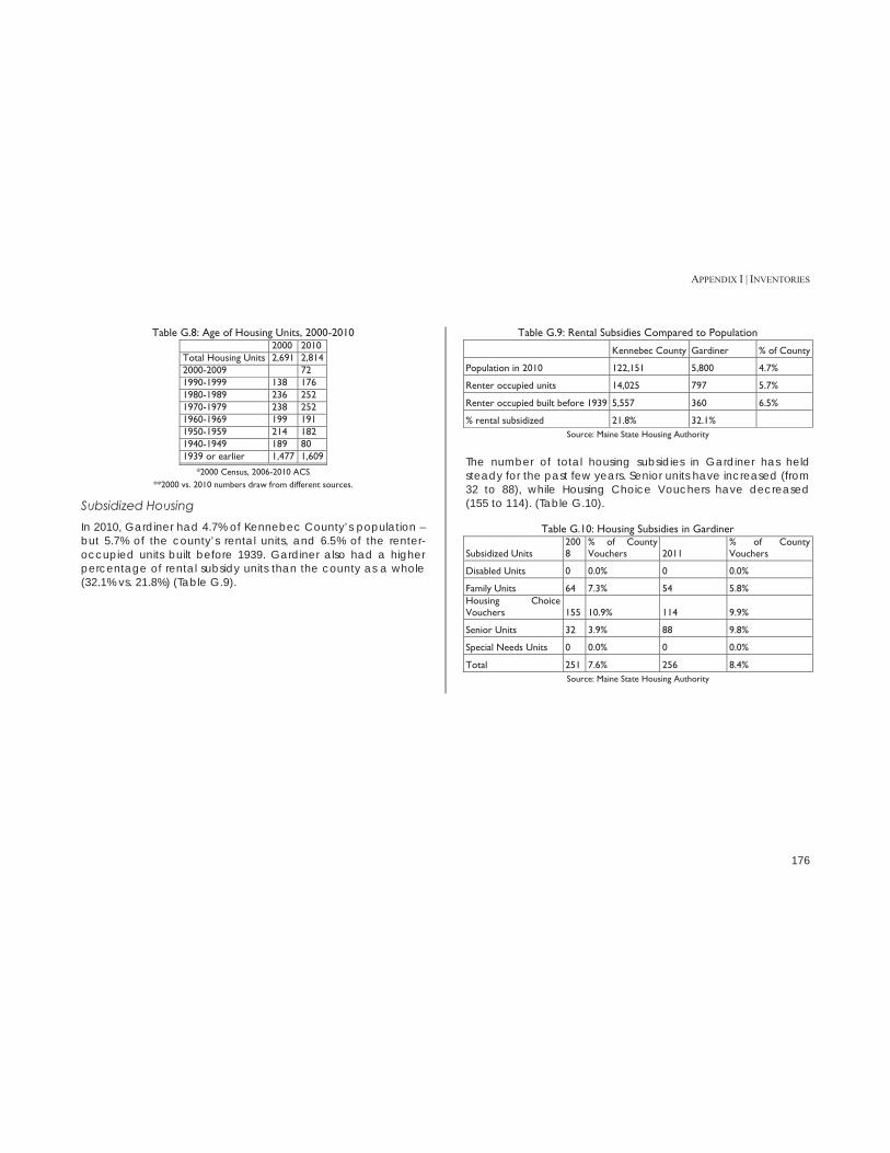
APPENDIX I | INVENTORIES
176
Table G.8: Age of Housing Units, 2000-2010
2000 2010 Total Housing Units 2,691 2,814 2000-2009 72 1990-1999 138 176 1980-1989 236 252 1970-1979 238 252 1960-1969 199 191 1950-1959 214 182 1940-1949 189 80 1939 or earlier 1,477 1,609
*2000 Census, 2006-2010 ACS **2000 vs. 2010 numbers draw from different sources.
Subsidized Housing In 2010, Gardiner had 4.7% of Kennebec County’s population – but 5.7% of the county’s rental units, and 6.5% of the renter-occupied units built before 1939. Gardiner also had a higher percentage of rental subsidy units than the county as a whole (32.1% vs. 21.8%) (Table G.9).
Table G.9: Rental Subsidies Compared to Population
Kennebec County Gardiner % of County
Population in 2010 122,151 5,800 4.7%
Renter occupied units 14,025 797 5.7%
Renter occupied built before 1939 5,557 360 6.5%
% rental subsidized 21.8% 32.1% Source: Maine State Housing Authority
The number of total housing subsidies in Gardiner has held steady for the past few years. Senior units have increased (from 32 to 88), while Housing Choice Vouchers have decreased (155 to 114). (Table G.10).
Table G.10: Housing Subsidies in Gardiner
Subsidized Units 2008
% of County Vouchers 2011
% of County Vouchers
Disabled Units 0 0.0% 0 0.0%
Family Units 64 7.3% 54 5.8% Housing Choice Vouchers 155 10.9% 114 9.9%
Senior Units 32 3.9% 88 9.8%
Special Needs Units 0 0.0% 0 0.0%
Total 251 7.6% 256 8.4% Source: Maine State Housing Authority

APPENDIX I | INVENTORIES
177
Table G.11 Subsidized Housing in Gardiner
Name Address Total Units Units with Subsidy Complex Type Units Income Based
Rent Contact
Gardiner Village
30 Adams St 24 3 Elderly 1BR: 16 2 BR: 8 x CB Mattson, Inc.
Highland Avenue Terrace
215 Highland Terrace 28 Congregate 1 BR: 20 2 BR: 8 x CB Mattson, Inc.
Meadowbrook Village
75 Adams St 24 22 Family 1 BR: 12 2 BR: 12 x CB Mattson, Inc.
Pine Ridge
241 Highland Ave 32 31 Elderly 1 BR: 16 2 BR: 16 x CB Mattson, Inc.
Riverview Terrace
3 Alexandra Road 24 24 Family 2 BR: 24 x Halsey McDonough West Hill Apts
158 West Hill Road 10 10 (Section 8) Family & Elderly n/a x Foreside Management Source: Maine State Housing Authority, Gardiner Appraisal Database, USDA MFH Rental
ForesideManagement.com

APPENDIX I | INVENTORIES
178
Vacancy Vacancy rates for both homeowners and rental units have steadily increased in Gardiner from 1990-2010. The 2010 homeowner vacancy rate (3.0%) is higher than in Kennebec County and Maine, but is still considered to be healthy. The rental vacancy rate (11%) is much higher than what is normally considered be healthy (6 to 7%).
Table G.12: Vacancy Rates, 1990-2010
1990 2000 2010
Owner Rental Owner Rental Owner Rental
Gardiner 0.8% 8.2% 2.1% 9.1% 3.0% 11.0% Kennebec County 1.2% 7.4% 1.6% 8.9% 1.9% 8.6%
Maine 1.8% 8.4% 1.7% 7.0% 2.4% 8.9% Source: US Census
The U.S. Postal Service collects quarterly vacancy data for each census tract. The two census tracts in Gardiner experienced relatively normal vacancy rates for the last quarter collected (between 6 and 7 percent), but the average number of days a residential address stays vacant is well over three years (Table G.13).
Table G.13: Residential Address Vacancies, June 2012
Total Residential Addresses
Total Vacant Residential Addresses
Residential Address Vacancy
Average Days Residential Addresses Vacant
Census Tract 110 1,850 118 6.4% 1,358
Census Tract 109 795 56 7.0% 1,274
Total 2,645 174 6.6% Source: HUD USPS Address Vacancies, Quarter 2: Ending June 30, 2012
Affordability Home Prices From 2006-2011, Gardiner’s median home price remained lower than in both the county and the state – and, as with the county and state, its median sale price decreased during the same time period. In 2011, Gardiner’s median income was $44,791, but the income needed to afford a median home price was only $30,463 (Table G.14). The drop in sale prices corresponds with an increase in the number of people who can afford a median-priced home in Gardiner (Table G.15). The American Community Survey, however, showed the median home value in Gardiner in 2011 to be $151,200 – slightly above Kennebec County’s $151,000.
Table G.14: Median Home Price, 2006-2011
Maine Kennebec County Gardiner
2006 2011 2006 2011 2006 2011 Affordability Index* 0.73 0.97 0.9 1.13 0.91 1.47
Median Income $44,488 $45,695 $41,634 $43,455 $40,436 $44,791 Affordable at Median Income $134,329 $156,432 $124,718 $145,040 $113,581 $139,536
Income Needed for Median Price $61,270 $47,321 $46,402 $38,350 $44,501 $30,463
Median Sale Price $185,000 $162,000 $139,000 $128,000 $125,000 $94,900
Source: Maine State Housing Authority **ratio of home prices that would be affordable at a household's median income to the area's
median home price
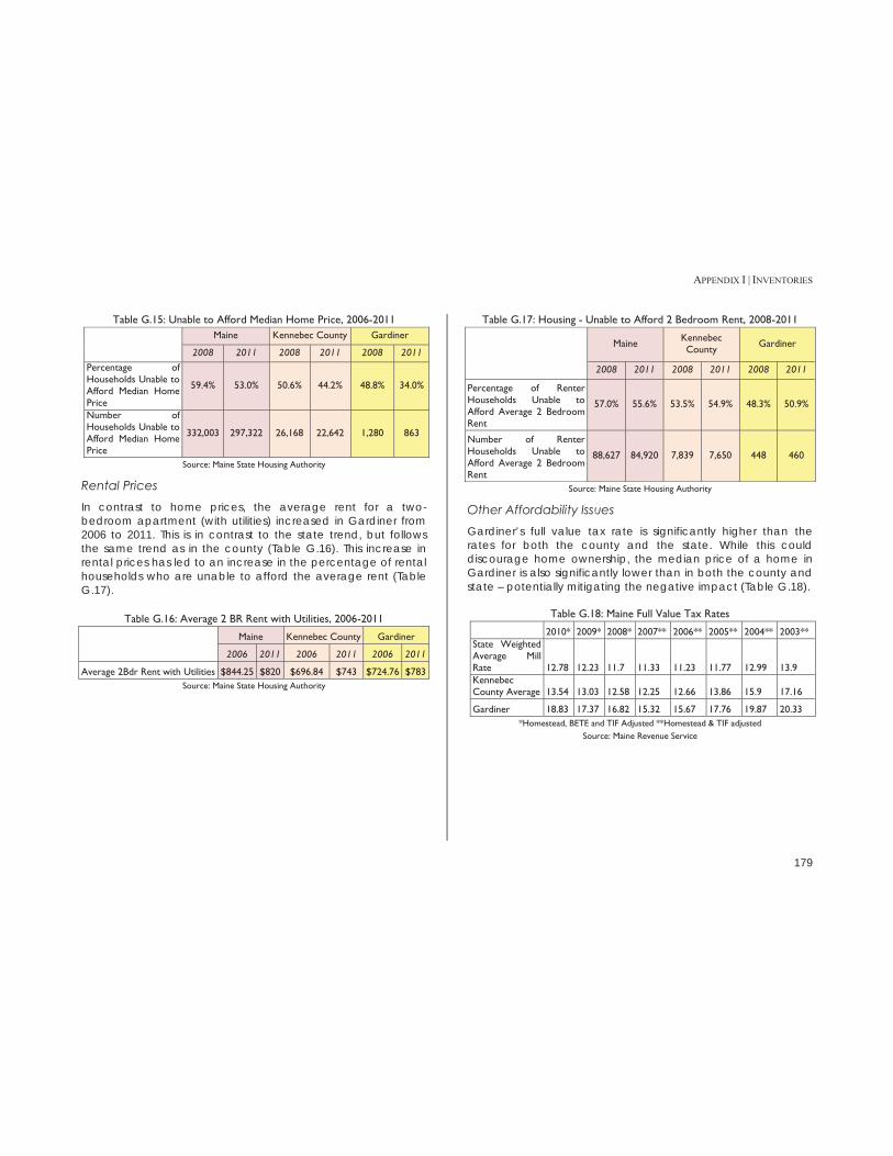
APPENDIX I | INVENTORIES
179
Table G.15: Unable to Afford Median Home Price, 2006-2011 Maine Kennebec County Gardiner
2008 2011 2008 2011 2008 2011 Percentage of Households Unable to Afford Median Home Price
59.4% 53.0% 50.6% 44.2% 48.8% 34.0%
Number of Households Unable to Afford Median Home Price
332,003 297,322 26,168 22,642 1,280 863
Source: Maine State Housing Authority
Rental Prices In contrast to home prices, the average rent for a two-bedroom apartment (with utilities) increased in Gardiner from 2006 to 2011. This is in contrast to the state trend, but follows the same trend as in the county (Table G.16). This increase in rental prices has led to an increase in the percentage of rental households who are unable to afford the average rent (Table G.17).
Table G.16: Average 2 BR Rent with Utilities, 2006-2011
Maine Kennebec County Gardiner
2006 2011 2006 2011 2006 2011
Average 2Bdr Rent with Utilities $844.25 $820 $696.84 $743 $724.76 $783 Source: Maine State Housing Authority
Table G.17: Housing - Unable to Afford 2 Bedroom Rent, 2008-2011
Maine Kennebec County Gardiner
2008 2011 2008 2011 2008 2011
Percentage of Renter Households Unable to Afford Average 2 Bedroom Rent
57.0% 55.6% 53.5% 54.9% 48.3% 50.9%
Number of Renter Households Unable to Afford Average 2 Bedroom Rent
88,627 84,920 7,839 7,650 448 460
Source: Maine State Housing Authority
Other Affordability Issues Gardiner’s full value tax rate is significantly higher than the rates for both the county and the state. While this could discourage home ownership, the median price of a home in Gardiner is also significantly lower than in both the county and state – potentially mitigating the negative impact (Table G.18).
Table G.18: Maine Full Value Tax Rates
2010* 2009* 2008* 2007** 2006** 2005** 2004** 2003** State Weighted Average Mill Rate 12.78 12.23 11.7 11.33 11.23 11.77 12.99 13.9 Kennebec County Average 13.54 13.03 12.58 12.25 12.66 13.86 15.9 17.16
Gardiner 18.83 17.37 16.82 15.32 15.67 17.76 19.87 20.33 *Homestead, BETE and TIF Adjusted **Homestead & TIF adjusted
Source: Maine Revenue Service

APPENDIX I | INVENTORIES
180
Implications 1. Over half of the City’s housing units are located in buildings that were constructed before the Second World War. Some of these structures are showing their age and need improvement. The City should consider its role in encouraging/assisting property owners to maintain and improve their properties. 2. The City has a large percentage of subsidized housing units compared to Kennebec County as a whole. The City should consider how it can work with the larger region to assure that Gardiner does not shoulder an unfair share of the burden for meeting the housing needs of the area’s low and moderate income households. 3. As the City’s population ages (see Appendix A. Population and Demographics) this may mean there will be a need for more housing appropriate for older households.

APPENDIX I | INVENTORIES
181
APPENDIX H: HISTORIC & ARCHEOLOGICAL RESOURCES Unless otherwise noted, all information is from the Maine Historic Preservation Commission, 2012.
Historic Structures The following properties are listed in the National Register of Historic Places:
Edward Arlington Robinson House, 67 Lincoln Avenue Christ Episcopal Church, 1 Dresden Avenue The Oaklands Laura Richards House, 3 Dennis Street Gardiner Railroad Station, 51 Maine Avenue
The T. W. Dick Building at the corner of Highland Avenue, Summer and Bridge streets has also been identified as eligible for listing in the Register: A comprehensive survey of Gardiner's above-ground resources needs to be conducted in order to identify other properties that may be eligible for nomination to the National Register of Historic Places.
Historic Districts Gardiner’s downtown historic district has been listed on the National Register of Historic Places since 1980 (Figure H.1)
Figure H.1 Gardiner Historic District
The Maine Historic Preservation Commission has also identified a potential historic district centered on Brunswick Avenue that appears to be eligible for listing in the Register.
Historic District Tax Incentives The properties in Gardiner’s Downtown Historic District are eligible for both federal and state tax credits for historic rehabilitation. Federal Tax Incentive Program A federal income tax credit for rehabilitation allocates a 20% credit for the certified rehabilitation of certified historic structures. Maine Tax Incentive Program In 2008, Maine increased the tax credit cap for historic properties, even those that are not eligible for federal credits.

APPENDIX I | INVENTORIES
182
There is a "per project" state credit cap of $5 million.49 Maine's State Historic Rehabilitation Tax Credit Program now includes the following features:
Substantial Rehabilitation Credit: A 25% state credit for any rehabilitation that also qualifies for the 20% federal credit. The rehabilitation must meet all of the requirements of the Federal tax incentive program.
Small Project Rehabilitation Credit: A 25% state credit
for the rehabilitation of certified historic structures with certified qualified rehabilitation expenditures of between $50,000 and $250,000. Projects utilizing this credit do not need to be eligible for the Federal tax incentive program, but the same review criteria will apply.
Affordable Housing Rehabilitation Credit Increase: The
State Substantial Rehabilitation Credit and the Small Project Rehabilitation Credit may be increased to 30% if the rehabilitation project results in the creation of a certain amount of affordable housing.
Historic Archaeological Sites To date, three historic archaeological sites are documented for the town. No professional surveys for historic archaeological sites have been conducted in Gardiner. Future archaeological surveys should focus on the identification of potentially significant resources associated with the town’s agricultural, residential, and industrial heritage, particularly those associated with the earliest Euro-American settlement of the town in the 18th and 19th centuries. 49 Accessed at http://www.state.me.us/mhpc/tax_incentives/index.html
Table H.1: Gardiner Historic Archaeological Sites (see Figure I.2)
Site Name Site number Site Type Periods of Significance National Register Status
Alexander Brown Trading Post ME 165-001
trading post 1670-1676? undetermined
F.A. Plaisted Pottery ME 165-002
industrial, pottery 1837-1890 undetermined
Gardiner's Dam #1 ME 165-003 dam, mill
Probably 3rd quarter 18th c., washed out in 1917 undetermined
Pre-Historic Archaeological Sites A limited area of the shore of Cobbossee Stream has been surveyed by professional archaeologists. Very limited professional archaeological surveying has been done along the banks of the Kennebec River. There are two known pre-historic archeological sites on the Cobbossee Stream. The banks of Cobbossee Stream and the Kennebec River, where not already surveyed, need a professional archaeological survey.
Local Historic Preservation Activities The Gardiner Main Street organization promotes “Heritage Tourism” on its website, suggesting a tour of the home of poet Edwin Arlington Robinson, buildings on the National Register of Historic Houses, and the “Yellow House” that was home to poet Laura E. Richards.50 The Gardiner Public Library also employs a part-time archivist, and maintains a town archives in its basement. The Gardiner Historic Preservation Commission is authorized to survey historic and archaeological resources, recommend preservation policies, review construction affecting historic properties and sites, review National Register nominations, recommend conservation guidelines, promote historic 50 Accessed at http://www.gardinermainstreet.org/heritage-tourism/

APPENDIX I | INVENTORIES
183
preservation programs, and submit an annual report to the Maine Historic Preservation Commission.51
Figure H.2: Archaeological Sites in Gardiner
51 Accessed at http://www.gardinermaine.com/Public_Documents/GardinerME_BComm/histpreserve
Implications 1. The City needs to continue to work with appropriate historical interests to document both historic and archeological resources. 2. There has been discussion of creating a second local historic district in the Commons/Brunswick Avenue area. The City should consider this step. 3. State and Federal tax credit programs create financial incentives for the renovation of designated historic buildings. The City should promote the use of these programs within the National Register Historic District in the Downtown to encourage better utilization of those buildings.

APPENDIX I | INVENTORIES
184
APPENDIX I: NATURAL AND MARINE RESOURCES Protected Districts Shoreland Zoning Maine requires municipalities to adopt ordinances that regulate development activity within 250 feet of a shoreline. These regulations help to protect wetlands, prevent water pollution, conserve shore cover and open space, limit flooding and protect fishing. Gardiner has four types of Shoreland Zoning districts52 53(Figure I.3):
Resource Protection: Encompasses the land areas least able to sustain development due to physical site conditions involving topography, slopes, soil types and susceptibility to erosion, drainage, and proximity to surface waters. Development of these areas will adversely affect water quality, productive wildlife habitat, biological systems or scenic and natural features. Such areas include, but are not limited to, wetlands, swamps, marshes, bogs and significant wildlife habitat. The district protects such vulnerable areas by severely restricting development.
Shoreland District: Covers land areas within 250 feet of
major water bodies which are not heavily developed yet are capable of supporting limited development. Development in these shoreland areas, due to their proximity to surface waters, requires close scrutiny in order to prevent and control water pollution, protect
52 Gardiner Maine Code: Shoreland Zoning. http://www.gardinermaine.com/Public_Documents/GardinerME_PCode/Section13ShorelandZoning4.21.10.pdf 53 Gardiner Zoning Districts: http://www.gardinermaine.com/Public_Documents/GardinerME_PCode/Section7ZoningDistricts4.21.10.pdf
drinking water supplies, minimize flood damage and conserve shore cover.
Shoreland Overlay District: This district covers land areas
within 250 feet of major water bodies which are heavily developed. These areas are primarily devoted to commercial, industrial or intensive recreational activities, or a mix of activities, including, but not limited to, the following: manufacturing, fabricating, wholesaling, warehousing, retail trade, service activities, amusement parks, and fairgrounds. Portions of the Shoreland Overlay District also include existing, dense residential development. Development within this district must consider a combination of Shoreland Zoning Performance Standards and those standards of the underlying zoning district.
Shoreland Overlay Limited Residential District: Includes
areas other than those in the Resource Protection District, Shoreland or Shoreland Overlay District. Development within this district must consider a combination of Shoreland Zoning Performance Standards and the uses and standards as required in the underlying district.
Cobbossee Corridor The Cobbossee Corridor District is located along the Cobbossee Stream in downtown Gardiner (Figure I.3). Development in this district needs to consider natural and visual resources, and use green building technologies. Two overlay districts are included in the Cobbossee Corridor: the Shoreland Overlay District and the Shoreland Overlay Limited Residential District.54 The 2005 Cobbossee Corridor Master Plan calls the Cobbossee stream the “defining feature of the 54 Gardiner Maine Zoning Districts. http://www.gardinermaine.com/Public_Documents/GardinerME_PCode/Section7ZoningDistricts4.21.10.pdf

APPENDIX I | INVENTORIES
185
Corridor, with remarkable physical characteristics that today make it a unique scenic and recreational resource.” Gardiner’s industrial past contributed to pollution of the stream, but only two dams remain today – making it easier for fish passage and stream restoration.”55
100-Year Flood Zones A significant portion of downtown Gardiner and Route 24 are in the FEMA 100-year flood plain (Figure I.2). Development in this area must meet strict standards to prevent future flooding.56 Although the rail bed prevents development directly along the river, there are many critical existing structures in the 100-year flood plain, including:
Downtown businesses along Water St, and the Arcade Parking Lot
Hannaford and parking lot Waterfront Park Rail Trail
55 Cobbossee Corridor Master Plan. http://www.gardinermaine.com/Public_Documents/GardinerME_EcDev/CobbosseeCorridor 56 Floodplain Management. http://www.gardinermaine.com/Public_Documents/GardinerME_Pcode/New%20Sect%207?textPage=1
Figure I.1: Water St, 1987 Flood
Source: Maine Emergency Management Agency
Figure I.2: Gardiner 100-Year Flood Plain
Source: FEMA

APPENDIX I | INVENTORIES
186
Figure I.3: Shoreland Districts, Wetlands & Cobbossee Corridor

APPENDIX I | INVENTORIES
187
Aquifers & At-Risk Streams The Kennebec River Aquifer runs along the Kennebec River from Downtown Gardiner to South Gardiner, parallel to Route 24 (Figure I.4). The aquifer is the water supply for the Gardiner Water District. The Gardiner Water District’s two wells are located in the Kennebec River Aquifer esker (a glacial deposit), within two separate and distinct recharge areas. The esker is narrow and close to the Kennebec River, which makes the esker vulnerable to contamination from vehicular traffic, railway traffic, or river contamination. (See Appendix F: Infrastructure for a more detailed discussion of the aquifer.) The river side of Route 24 is unlikely to be developed, but upland areas could be. Two areas of town are at risk for stream impairment from proximity to I-295.
Streams near Exit 49 on I-295, near Libby Hill (Figure J.5)
Streams near Exit 51 on I-295 in West Gardiner – while outside the city limits, these streams feed into the Cobbossee Stream. (Figure J.6)
Figure I.4: Aquifers and Wetlands

APPENDIX I | INVENTORIES
188
Figure I.5: Potentially Impaired Streams near Exit 49
Source: Maine Department of Agriculture, Conservation & Forestry
Figure I.6: Potentially Impaired Streams near Exit 51
Source: Maine Department of Agriculture, Conservation & Forestry

APPENDIX I | INVENTORIES
189
Possible Development Constraints Two developing areas of Gardiner face fairly limited restraints on future development. The Brunswick Avenue Corridor (primarily commercial use) has limited wetlands, while planning for the South Gardiner area must continue to be aware of the aquifer along the Kennebec River, as well as its Shoreland Overlay Limited Residential District (Figure I.7).

APPENDIX I | INVENTORIES
190
Figure I.7: Potential Development Constraints

APPENDIX I | INVENTORIES
191
Rare Animal and Plant Habitats Animal Locations & Habitats There are two (known) rare animals with habitats in Gardiner (Figure I.6). Species: Bald Eagle Locations: Along the Kennebec River (just south of Downtown), and along the Kennebec River in South Gardiner Species: Tidewater Mucket (freshwater mussel): Locations: Cobbossee Corridor
Plant Habitats There are four known rare or exemplary natural plant communities in Gardiner. All are located along the Kennebec River in South Gardiner (Figure I.8).
Estuary Bur-marigold Parker’s Pipewort Pygmyweed Spongy Arrowhead
Figure I.8: High Value Plant & Animal Habitats
Kennebec Riverfront – Scenic Views The stretch of Route 24 (River Road) along the Kennebec River is a striking visual resource – and due to the presence of train tracks between River Road and the river, is unlikely to be developed (Figure I.9).

APPENDIX I | INVENTORIES
192
Figure I.9: River Road Scenic Corridor

APPENDIX I | INVENTORIES
193
Marine Resources Licenses The bulk of marine licenses in Gardiner are for worm digging. Despite its inland location, Gardiner has 25 wholesale lobster supplier dealer licenses in 2011.
Table I.1: Marine Licenses 2011 COMM FISHING/CREW 1 COMM FISHING/SINGLE 1 COMMERCIAL SHELLFISH 1 LOB/CRAB NON-COMM 2 MARINE WORM DIGGING 15 RECREATIONAL SALTWATER FISHING OPERATOR 1
Source: Maine Department of Marine Resources
Table I.2: Dealer Licenses 2011 WHOLESALE W/LOBSTERS 2 WHOLESALE W/LOBSTERS, SUPP 25 MARINE WORM DEALER 2
Source: Maine Department of Marine Resources
Table I.3: Traps Fished 2011
LOB/CRAB NON-COMM 10 Source: Maine Department of Marine Resources
Table I.4: Count of Licenses
2011 HARVESTER 21 DEALER 29
Source: Maine Department of Marine Resources
Implications 1. While the location of the Hannaford store within the 100- year floodplain is problematic, the presence of the store is a significant benefit to the entire Downtown area. 2. The River Road scenic corridor from Downtown to the Richmond border and beyond is a significant resource that might be able to be better capitalized on as a community asset.

APPENDIX I | INVENTORIES
194
APPENDIX J: FISCAL Operating Revenues & Expenditures For the most recent fiscal year, over 60 percent of Gardiner’s revenues came from property taxes, with an additional 18.4% coming from charges for services (Table J.1). The expenses reflect Gardiner’s position as a service center – after education, the largest expenses were public safety and wastewater, which both serve the region, in addition to the city (Table J.2).
Table J.1: Revenues for Fiscal year Ending June 30, 2012
Revenues Amount Percent of Total
Property Taxes $7,149,291 60.8%
Charge for Services $2,161,432 18.4%
Other Taxes $855,255 7.3%
Grants not restricted to specific programs $833,131 7.1%
Operating grants and contributions $373,961 3.2%
Capital grants and contributions $190,444 1.6%
Other $188,058 1.6%
$11,751,572 Source: City of Gardiner 2012 Financial Report
Table J.2: Expenses for Fiscal Year ending June 30, 2012
Expense Amount Percent of Total
Education $3,304,432 27.6%
Public safety $1,487,466 12.4%
Wastewater $1,405,967 11.8%
Public works $1,120,442 9.4%
Ambulance $996,558 8.3%
Unclassified $995,453 8.3%
General Government $978,630 8.2%
Community services $470,084 3.9%
Minor capital outlay $440,016 3.7%
County $350,350 2.9%
Interest of debt $241,865 2.0%
Health and welfare $166,374 1.4%
$11,957,637 Source: City of Gardiner 2012 Financial Report
Tax Rate Gardiner’s local property tax rate has declined slightly over the past decade (Table J.3). However, when compared to the county and the state, Gardiner’s state equalized tax rate (which is slightly different than the local rate) stands out as significantly higher (J.4).

APPENDIX I | INVENTORIES
195
Table J.3: Local Property Tax Rate, 2000-2012
Year Tax Rate per $1,000
2000 21.3
2001 21.2
2002 23.7
2003 24.3
2004 21.8
2005 21.8
2006 21.8
2007 21.8
2008 16.9
2009 17.2
2010 19.2
2011 19.9
2012 19.9 Source: City of Gardiner Assessor’s Office
Table J.4: State, County and Local Average Mill Rate, 2003-2010
2003 2004 2005 2006 2007 2008 2009 2010 State Weighted Average Mill Rate 13.9 12.99 11.77 11.23 11.33 11.7 12.23 12.78 Kennebec County Average 17.16 15.9 13.86 12.66 12.25 12.58 13.03 13.54
GARDINER 20.33 19.87 17.76 15.67 15.32 16.82 17.37 18.83 Source: Maine Revenue Service
Service Community Comparison Maine’s service center communities are where most people in a geographic area work, shop, and access critical services (such as health care and education).57 Kennebec County’s service centers include Augusta, Farmingdale, Gardiner,
57 Accessed at http://www.maine.gov/spo/economics/release.php?id=97800
Hallowell, Oakland, Waterville, and Winslow. These areas often have higher tax rates than smaller, primarily residential towns. Gardiner’s state equalized rate is higher than in other full service communities in Kennebec County, including Augusta and Waterville. (Table J.5).
Table J.5: Comparison Mill Rates, 2003-2010
2003 2004 2005 2006 2007 2008 2009 2010
GARDINER* 20.33 19.87 17.76 15.67 15.32 16.82 17.37 18.83 WATERVILLE* 24.72 24.98 22.37 19.49 18.14 18.24 18.23 18.74
AUGUSTA* 22.15 19.92 17.04 15.93 15.79 16.09 16.28 16.77
WINSLOW* 20.94 18.86 16.99 15.56 14.88 15.2 15.1 15.22
HALLOWELL* 22.55 20.66 16.73 15.12 14.28 14.4 15.19 15
RICHMOND 15.89 14.73 12.85 11.62 11.56 11.35 12.77 14.34
READFIELD 16.58 14.69 13.68 13.18 12.41 12.56 13.33 14.22
WINTHROP 16.7 16.03 13.58 12.96 12.42 11.94 12.46 13.38
MANCHESTER 13.56 12.88 10.85 11.16 11.02 12.23 12.52 12.71 OAKLAND* 16.4 14.47 12.78 11.42 11.81 11.68 11.6 12.2
LITCHFIELD 13.9 12.46 12.57 12.23 11.07 11.23 10.97 11.56 FARMINGDALE* 13.66 15.07 13.3 10.94 10.52 10.22 10.51 11.13
FARMINGDALE 13.66 15.07 13.3 10.94 10.52 10.22 10.51 11.13
PITTSTON 13.1 11.93 10.95 9.49 9.5 9.7 9.9 10.55
WEST GARDINER 10.93 9.83 8.54 7.24 7.35 7.8 9.51 9.79 *service community
Source: Maine Revenue Service
According to the 2010 U.S. Census, Gardiner’s median home value ($146,900) is higher than the median home value of other Kennebec County “service center” communities ($139,360). Gardiner’s median household income ($47,654) is also higher than the median household income of these other communities ($42,884).

APPENDIX I | INVENTORIES
196
Debt Service Gardiner has a total bonded debt of $11,249,880, which is well shy of its debt limitation of $51,217,500. Of this, approximately 54% are general obligation bonds, 30% are Rural Development, 10% are State Revolving loans, and 6% are for a ladder truck. (Table J.6). At the current rates, the total cost of the current debt will be $14,796,677 (Table J.7).
Table J.6: Long Term Debt as of June 30, 2012
Activity Date Issued Original Amount Maturity Date Interest Rate
Balance 6-30-2012
G.O. bonds 5/25/1995 $750,000 11/1/2015 5.508-6.208% $138,000
G.O. bonds 5/27/1999 $2,096,483 11/1/2019 4.039-5.239% $838,595 IRP loan (Rural Development) 12/20/2000 $475,000 3/31/2029 1% $337,692
G.O. bonds 12/28/2004 $775,000 11/1/2019 4.099-4.295% $413,336
G.O. bonds 9/26/2007 $319,700 11/1/2027 5.9-6.0% $255,760
G.O. bonds 5/27/2010 $4,067,093 11/1/2024 2.773-5.746% $3,741,725
Ladder Truck 10/28/2010 $767,000 11/1/2025 2.124-4.267% $715,867
G.O. bonds 5/26/2011 $260,000 11/1/2039 2.02-5.52% $260,000
G.O. bonds 11/30/2011 $425,000 11/30/2015 1.890% $425,000 1997 State revolving loan 3/14/1997 $1,296,500 11/1/2007 2.950% $388,950 1999 State revolving loan 6/23/1999 $818,500 11/1/2019 2.290% $286,475 2000 State revolving loan 5/15/2000 $790,000 4/1/2020 3.200% $397,977 2004 Rural Development 9/7/2005 $1,635,000 9/7/2033 4.125% $1,250,551 2004 Rural Development 9/7/2005 $1,507,000 9/7/2031 4.125% $1,125,716 2007 Rural Development 3/23/2007 $540,900 3/23/2035 4.125% $443,989 2011 Rural Development 5/25/2011 $236,000 5/26/2040 3.750% $230,247
TOTAL $11,249,880 Source: City of Gardiner 2012 Financial Report
Table J.7: Debt Service Requirements, June 30, 2012
Principal Interest Total
2013 $844,206 $375,646 $1,219,852
2014 $846,146 $344,060 $1,190,206
2015 $848,151 $313,213 $1,161,364
2016 $850,224 $287,126 $1,137,350
2017 $711,618 $263,102 $974,720
2018-2022 $2,779,421 $1,004,771 $3,784,192
2023-2027 $1,960,740 $612,380 $2,573,120
2028-2032 $1,616,395 $287,038 $1,903,433
2033-2037 $729,027 $54,302 $783,329
2038-2040 $63,952 $5,159 $69,111
Total $14,796,677 Source: City of Gardiner 2012 Financial Report
Tax Increment Financing A TIF is a public financing tool that uses future gains in taxes to pay for current improvements. As of 2012, Gardiner had seven active TIFs, with a total assessed value of over $58 million (Table J.8). Gardiner has a 100% capture rate for new value created in TIFs, so all new funds go toward an economic development fund controlled by the City, the original taxpayer, or a combination of the two. The Credit Enhancement Agreement (CEA) is the rate at which the newly created funds go back to the original taxpayer The Libby Hill Business Park was built in 2000 (with a second phase in 2008) as a 260-acre business park on the southern edge of Gardiner, near I-295. Fifteen of the twenty-eight total
APPENDIX I | INVENTORIES
197
available lots were listed as for sale in October 2012.58 In 2010, the City of Gardiner hired the Perry & Banks marketing firm to help attract businesses to the location, which came in the form of a web presence for Libby Hill and some basic marketing material for the business park. Since then the City has augmented these marketing channels with print advertisements in MaineBiz magazine and DownEast magazine, and through sponsorship of the Maine Real Estate and Development Association (MEREDA) showcase events in Portland. A new advertising campaign in 2013 will add video production, use of Gardiner’s new City logo, and a tri-fold informational handout about Gardiner for mass distribution, and will emphasize Libby Hill as central Maine’s premier business park. The campaign will focus on residential real estate opportunities in Gardiner, which seems to have housing priced below value and historic neighborhoods in need of families with the means to maintain Gardiner’s 1800s-1900s housing stock in the Gardiner Common and “tree streets” neighborhoods along Brunswick Avenue. The Libby Hill Business Park is a designated Gardiner Enterprise Zone, which means that it qualifies for Tax Increment Financing.59 The City’s Libby Hill fund – which is supported by TIF financing and public funds – currently has a deficit of $700,000,60 in part because the City has been shifting $91,000 a year from the Libby Hill fund to the general fund to help cover other costs. In the fiscal year 2013 budget cycle, the City ended this practice and no longer transfers funds from Libby Hill to the general fund. Without further lot sales, the deficit is projected to grow to approx. $1.1 million by June 30, 2015 and then will slowly dwindle until turning into a surplus around 2024-25. The City’s recent enhanced investments in community & economic
58 Commercialiq.com, Commercial Property for Sale or Lease (search term: Libby Hill, 10/17/12). http://www.commercialiq.com 59 Libby Hill Business Park website, http://libbyhillbusinesspark.com/pdfs/LibbyHill-Profile.pdf 60 Kennebec Journal, “Councilors Look at 1.5% Tax Increase”, April 24 2012. http://www.kjonline.com/news/councilors-look-at-1_5-percent-tax-rate-increase_2012-04-24.html
development are aimed, in part, to erase the deficit and hasten the surplus.

APPENDIX I | INVENTORIES
198
Table J.8: Gardiner TIFs, 2012
Gardiner TIF Year 2011 Assessment Original Value Incremental Value
Capture Rate
Approved Capture
TIF Payment CEA % CEA Disbursement
Economic Development Funds
Harper’s 12 $2,833,400 $0 $2,833,400 1.00 $2,833,400 $56,385 34% $19,171 $37,214
Pine State Trading 9 $8,098,500 $202,100 $7,896,400 1.00 $7,896,400 $157,138 50% $78,569 $78,569
Downtown 9 $36,472,300 $23,582,600 $12,889,700 1.00 $12,889,700 $256,505 0% $0 $256,505
EJ Prescott 8 $5,296,200 $68,600 $5,227,600 1.00 $5,227,600 $104,029 50% $52,015 $52,015
EJ Prescott 8 $168,800 $65,500 $103,300 1.00 $103,300 $2,056 50% $1,028 $1,028 Associated Grocers (now Pine State) 7 $3,249,300 $26,400 $3,222,900 1.00 $3,222,900 $64,136 0% $0 $64,136
Libby Hill Area TIF 4 $2,597,300 $145,400 $2,451,900 1.00 $2,451,900 $48,793 various $8,280 $40,513
Total 57 $58,715,800 $24,090,600 $34,625,200 $34,625,200 $689,041 $159,062 $529,979 Source: City of Gardiner, 2012

APPENDIX I | INVENTORIES
199
Implications 1. The City’s tax rate may be a factor in residential development occurring outside of the City over the past 20 years. 2. While the City’s tax rate is reasonably comparable to other full-service, service-center communities in central Maine, it does not create an incentive for businesses or residential development to locate in the community. 3. The City’s existing bonded debt limits the community’s ability to undertake major capital projects that are dependent on local funding until some of the current debt is repaid.

APPENDIX I | INVENTORIES
200
APPENDIX K: TRANSPORTATION Roads & Bridges Gardiner is an “urban compact” city, which means that the city maintains state roads that go through a specific area of town (Figure K.1).
Figure K.1: Maine DOT Urban Compact
Road Classifications Gardiner has just over 60 miles of roads, over half of which are local (Table K.1). Gardiner has two roads classified as arterials (Brunswick Avenue and Cobbossee/Water Street) (Figure K.2).
Table K.1: Road Classifications in Gardiner
Classification Miles MDOT Definition
Local 36.18
Provide access to adjacent land and provide service to travel over relatively short distances
Minor Collector 0.89
Spaced consistent with population density to accommodate local roads within reasonable distance of collector roads.
Major/Urban Collector 10.51
Provide both land access and traffic circulation within urban residential neighborhoods and commercial and industrial areas in federally designated Urban Areas
Minor Arterial 7.55
A series of continuous routes that should be expected to provide for relatively high overall travel speeds with minimum interference to through movement,
Principle Arterial/Interstate 5.31 Interstate highways
Total 60.44 Source: Maine DOT

APPENDIX I | INVENTORIES
201
Figure K.2: Road Classifications Map

APPENDIX I | INVENTORIES
202
Bridges Of the eleven bridges in Gardiner, only one (Capen Road) is owned by the city. Four bridges (including Capen Road) have a federal sufficiency rating under 80 (Table K.2).
Table K.2: Bridges in Gardiner
Bridge Bridge Name Owner Year Built
Federal Sufficiency Rating
1533 RTE. 201/I-295(S.B.) MDOT 1973 98.4
6318 RTE 201/I-295(N.B.) MDOT 1973 98.1
5280 CAPEN ROAD Municipal 1951 63.5
1534 I-295 SB / COBBOSSEE STREAM MDOT 1980 94.6
6319 I95 NB/ COBBOSSEE STR. MDOT 1974 93.3
6023 ROLLING DAM 2 MDOT 1962 71.5
2605 NEW MILLS MDOT 2009 98
5070 WINTER STREET MDOT 1988 93.9
2101 BRIDGE STREET MDOT 1918 50.2
3098 MAINE AVE MDOT 1933 54
167 MAINE AVE / MCRR MDOT 1980 99 Source: Maine DOT
One-Way Streets There are two one-way streets in Gardiner61:
Westerly on Mechanic Street from the intersection of Church Street to the intersection of Brunswick Avenue.
61 One-way Streets and Alleys. http://www.gardinermaine.com/Public_Documents/GardinerME_Code/t25c5s2614 Section 2614. One-way Streets and Alleys.
Easterly on Water Street from the intersection of Bridge Street to the intersection of Church Street.
The City of Gardiner met with Maine DOT and Gardiner Main Street to discuss changing Water Street from one-way to two-way, but the cost was estimated to be between $500,000 and $600,000, with potential loss of parking on one side.62 Other issues include road widening, moving street lights, narrowing of the brick sidewalks in certain sections and widening the right-hand turn at the intersection of Water and Bridge Streets.
Traffic Volumes Traffic Counts Besides the interstate, only Brunswick Ave/Bridge Street sees more than 10,000 cars per day in Gardiner (Figure K.3). This is the same section of road that received the worst congestion score from MDOT (Figure K.4). The congestion score is determined by using the ratio of peak traffic flow to road capacity to determine travel delay.
Safety Maine DOT determines a safety score for a road by looking at crash history, pavement rutting, paved roadway width, and bridge reliability. With these factors, they found two locations in Gardiner that received an “F” (Water Street and Brunswick Ave, both leading up to the bridge), and one long stretch of Route 24/River Road that received a “C.” (Figure L.5). The “F” scores roughly correspond with the two high-crash locations in Gardiner (Figure K.6).
62 Personal Communication, 1/9/2013/

APPENDIX I | INVENTORIES
203
Figure K.3: Average Annual Daily Traffic in Gardiner

APPENDIX I | INVENTORIES
204
Figure K.4: MDOT Congestion Score

APPENDIX I | INVENTORIES
205
Figure K.5: MDOT Safety Score

APPENDIX I | INVENTORIES
206
Figure K.6: MDOT High Crash Locations

APPENDIX I | INVENTORIES
207
Public Transportation Gardiner is served by one line of the Kennebec Explorer, a regional bus operated by the Kennebec Valley Community Action Program (KVCAP). The bus stops at the Hannaford store four times a day, and connects riders to Augusta, Randolph, and Hallowell. The fare for local travel is $1.00, while intercity travel is $1.25.
Figure K.7: Kennebec Explorer Schedule (Gardiner)
Bicycle & Pedestrian Facilities Rail Trail The Kennebec River Rail Trail is a 6.5-mile public path that runs along the Kennebec River from Gardiner to Augusta. See Appendix E: Recreation & Open Space for walking facilities.
Sidewalks In 2007, the Gardiner Sidewalk Committee inventoried all of the sidewalks in Gardiner on a scale of 1-5 (1: Low Attention, 5: High Attention), and created a recommended work list for all sidewalks that scored 3.5 or higher. The committee recommended a $628,000 bond to pay for these improvements, which, while proposed, failed to pass the Gardiner City Council. Of the 61 recommended sidewalk improvements, two have been completed:
Rte 126 – West Street to Middle School New Mills Bridge to West Street Rte 126.63
Wright-Pierce worked with the City of Gardiner in 2008 to create a “bundled projects” plan, which included sidewalk improvements. The project areas focused on the downtown area, along the Cobbossee Stream. Recommended sidewalk improvements included:
Removal and Replacement of Sidewalk Surfaces Replace and Add Curbing Restore Esplanades Crosswalk Connections Repair Brick Sidewalks Traffic Control Unit Price Contract64
Rail Lines The rail line along the Kennebec River is owned by the State of Maine, but operated by the Maine Eastern Railroad company, which also operates a passenger and freight line from Brunswick to Rockland.65 (Figure K.8). While MDOT classifies this
63 Personal Communication, Gardiner Public Works. 1/21/13 64 Gardiner Bundled Projects Sidewalk Improvement, Wright-Pierce. 65 Accessed at http://www.maineasce.org/MaineRC/MaineRailroads12062012.pdf

APPENDIX I | INVENTORIES
208
as an “active” line66, there are currently no operations on the line.67 In 2008, the Maine Eastern Railroad hosted a promotional excursion from Rockland to Augusta along the Lower Road Branch in hopes of showing the possibility of passenger rail line.68 66Accessed at http://maine.sierraclub.org/Transportation_files/Draft%20state%20rail%20plan%202010.pdf 67 Personal communication, Maine DOT. 1/6/13. 68 Accessed at http://www.brunswick-station.com/Other/pph_02_08_10.pdf

APPENDIX I | INVENTORIES
209
Figure K.8: Rail Lines in Gardiner

APPENDIX I | INVENTORIES
210
Airport Gardiner is served by the Augusta State Airport (eight miles to the north), and Portland International Jetport (55 miles to the south).
Figure K.9 Transportation Overview
Source: Maine DOT
Implications 1. The Kennebec Explorer provides very limited scheduled bus service for the community. With an aging population, increasing transit options may become an important issue. 2. The opportunity for people to walk within the older, built-up portion of the City exists but the overall “walkability” within this area needs to be improved.

APPENDIX II | CAPITAL IMPROVEMENTS PROGRAM
211
APPENDIX II | CAPITAL IMPROVEMENTS PROGRAM

APPENDIX II | CAPITAL IMPROVEMENTS PROGRAM
212
APPENDIX III | COMMUNITY ACTION PROGRAM
COMMUNITY ACTION PLAN GARDINER, MAINE
January 2014

214
Project Partners and Collaborators
Gardiner City Council Thom Harnett, Mayor Chris Leake Pat Hart Richard Heath Philip Hart William Barron Robert Johnston Scott Williams
Gardiner Main Street Program Patrick Wright, Executive Director
Gardiner Board of Trade President: Steve Marson, Central Maine Pyrotechnics Vice President: Kara Wilbur, Gardiner CoLab Treasurer: Amy Rees, European Auto Service Secretary: Nate Rudy, Executive Director GBOT
Comprehensive Plan Committee Consultant, Mark Eyerman Patricia Hart, chair Debby Willis Tracy Farris Ron Trahan Kirk Mohney Pam Mitchel Dorothy Washburn
Staff: Meaghan Carlson, Gardiner Heart & Soul Coordinator Nate Rudy, Economic Development Director Scott Morelli, City Manager
Gardiner Community Advisory Team Past and Present Gail Dyer Judy Dorsey Phyllis Gardiner Patricia Hopkins Mandy Darville Ingrid Stanchfield Karen Tucker Paul Pidgeon Veronique Vendette Brian Kent Elizabeth Bryson Sarah Miller Jerry Maschino Jack Fles Jim Toman Logan Johnston Kate Willis John Shaw Melonie Coutts Amy Rees John Lawrence Connie Greenleaf Nancy Barron
The Orton Family Foundation
David Hohenshau, Foundation Staff Jane Lafleur, Consultant

215
BACKGROUND From 2011-2013, the City of Gardiner, Maine, partnered with the Gardiner Board of Trade, the Gardiner Main Street Program, and the Orton Family Foundation to carry out a Heart & Soul Planning Project. Over these two years, dozens of citizens worked to carry out the planning project and to address the core elements of Heart & Soul planning and specific outcomes for the City of Gardiner.
CORE ELEMENTS OF HEART & SOUL PLANNING
1. Developing broad community engagement including youth engagement; and those who are often under-represented or do not otherwise participate in traditional planning processes;
2. Identifying shared community values; 3. Using values to drive decision making, including using
values to evaluate potential actions and policies; 4. Developing a realization of the vision that includes but
is not limited to the update of plans, policies and bylaws; and, 5. Developing a plan to continue the work beyond the foundation’s involvement.
PROJECT OUTCOMES The Heart & Soul planning project described four project outcomes. All of the activities must lead to the creation of the following:
1. A vision and planning framework based on shared community values; 2. A Comprehensive Plan that includes recommendations for the downtown, Cobbossee Corridor, and Waterfront Park and Marina; 3. Economic development strategies and marketing messages; and, 4. A Community Cohesion and Communications Strategy that will unify disparate groups and organizations within the community.

216
PROCESS Spearheaded by the Heart & Soul project coordinator, the process involved countless volunteers, ten (10) public workshops, seven (7) Heart & Soul community events, representation at nine (9) outside community events and ninety three (93) storytelling sessions with local citizens.

217
COMMUNITY VALUES Using the results of this intensive work, eleven (11) city values were developed and adopted by the city council by resolution on October 9, 2013. Family Friendliness - We value spaces and organizations that are available to residents of all ages and income levels. Education - We value an education system that prepares students for a global environment. Connection to Nature - We value outdoor recreation opportunities, and the preservation of open space. History, Arts, & Culture - We value history while continuing to develop diverse cultural activities for residents of all ages. Strong Local Economy - We value a strong economy that welcomes businesses and entrepreneurs while maintaining the character of the community including the historic downtown. Sense of Community, Sense of Belonging - We value a community where residents are helpful, caring, and respectful of each other. Community Involvement & Volunteerism - We place high value on volunteering and civic involvement. Livability - We value preserving the character of the city while ensuring that residents of all ages and incomes have access to family support systems, transportation, and arts and culture opportunities.
Infrastructure/City Services - We value safe, well-maintained roads, sidewalks, schools, and public spaces that are accessible and clean in all seasons. Unique Physical Assets - We value the city’s unique natural and built assets that are at the heart of the community’s identity, and believe they should be available to all residents. Inclusive, Responsive Government - We value open, two way communication between residents and community decision makers.

218
HEART & SOUL PLANNING TIME LINE *collaborations with other lead organizations 2011-2012
• Orton Grant Interview - November 2011 • Grant Award Orton Community Visit - January 2012 • Storytelling Workshop and Communications Training - April
2012 • *Art Walk Values Window - May 2012 • *Ride Into Summer - May 2012 • Kickoff Committee Meeting - June 2012 • Committee & Task Force/subcommittee Meetings - Ongoing • *River Fest - June 2012 • Interview Task Force Story Sharing Training - November 2012 • Heart Bombing of Gardiner - November 2012 • Have A Go At Gardiner - December 2012 • We Are Gardiner - 2013 • *Farmer’s Market - May 2013 • Focused Discussions - April-June 2013
SUMMER 2013 EVENTS AND PRESENCE!
• Downtown HSHQ Hosted Art Walk and Walking The Beat • Heart & Soulmates of Gardiner Awards • Boys and Girls Club Keystone Club Youth Engagement Project
– RALA Presentation to Council
• *Farmer’s Market Family Fun Day • Leadership Trainings • Community Carnivals - with Marbles Voting! • *First Day of School Celebration – August 2013
FALL 2013 - WINTER 2013/2014
• Community Matters Listening Party • Comprehensive Plan Community Forum • Values Resolve Adopted by City Council – October 2013 • Heart & Soul Presentation at Blaine House Conference on
Volunteerism and Service – October 2013 • Community Actions Voting Workshops - October 2013
COMMUNITY SUMMIT and ACTION PLAN! January 18, 2014

THE ACTION PLAN The final step in the Heart & Soul process is to develop an action plan that takes the hundreds of community-generated ideas to make Gardiner a better place, and turn these into action items. As the comprehensive planning process evolved, the project partners noticed that many of the great community ideas might be led by community members, businesses and community organizations and the City could be a supporter instead of the leader. This type of collaboration and local leadership can be extremely powerful and can strengthen the City. Activities might even be spearheaded, carried out, developed or accomplished without tax payer money!
Advisory team members and Heart & Soul staff filtered, evaluated and organized hundreds of community suggested actions into eighty (80) that could be evaluated by the public. In mid-October, 2013, two community workshops were held to prioritize the community actions. The workshops were facilitated by a professional facilitator and planner. Each of the eighty community generated actions were assessed as to their impact and feasibility. The definitions of impact and feasibility are:
IMPACT - high, medium, low
Has a strong positive effect on the City of Gardiner, its citizens, and quality of life Makes a positive difference to the lifestyle, business climate or family life Addresses a need in the community Has a positive effect on Gardiner's community values
FEASIBILITY - high, medium, low
Has the potential for attracting leadership Has community support Is an easy win in the short term (or is a harder win but over a longer time) Is less expensive (or more expensive but accomplishable with fund-raising or community support) Is likely to be accomplished due to leadership, importance, volunteers, finances, need, community or stakeholder motivation

220
Each action item was presented to the participants on a projected slide with a generic photo of the concept or idea. It was read aloud by the facilitator and then participants were asked to rate the idea high, medium or low Impact and then high medium or low feasibility, using electronic key pad polling. The results of the vote were immediately projected. The items were transferred to a chart so there was a visual representation of the votes on a grid, as well as the results of the votes saved electronically. When an action item received High Impact, High Feasibility, the facilitator asked the participants who they thought might be a leader of this effort. Additional leaders or partners in these efforts were later added by Community Advisory Team members and through meetings with area organizations. This Action Plan is intended to be a living document that inspires people, ideas and action, and is refined from year to year as new projects are developed and completed projects drop off the list.
IM
PAC
T
High
Med
iu
Lo
w
Low Medium High FEASIBILITY

221
THE HEART & SOUL COMMUNITY SUMMIT
Over 100 people gathered on Saturday, January 18, 2014 in the Gardiner Area High School cafeteria for the First Annual Heart & Soul Community Summit. Over 25 organizations staffed booths and tables displaying their information. The Summit included presentations by area organizations who offered to spearhead a specific action, as well as volunteer awards by several organizations. Organizations also solicited volunteers for their organizational work as well as for the actions contained in this Action Plan. A large Community Calendar banner offered organizations the opportunity to add community events so that everyone will see what is going on in Gardiner in 2014. In the future, it is hoped that this calendar will allow for collaboration and joint planning of events to distribute the community events and activities throughout the year and to spread out volunteer service. A Heart & Soul Community Charter offered community members the opportunity to sign on to supporting the City’s values and to pledge to work together in the future.

222
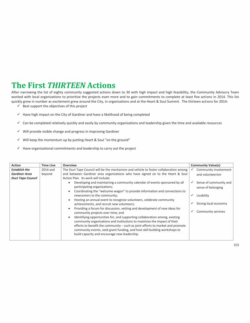
223
The First THIRTEEN Actions After narrowing the list of eighty community suggested actions down to 30 with high impact and high feasibility, the Community Advisory Team worked with local organizations to prioritize the projects even more and to gain commitments to complete at least five actions in 2014. This list quickly grew in number as excitement grew around the City, in organizations and at the Heart & Soul Summit. The thirteen actions for 2014:
Best support the objectives of this project
Have high impact on the City of Gardiner and have a likelihood of being completed
Can be completed relatively quickly and easily by community organizations and leadership given the time and available resources
Will provide visible change and progress in improving Gardiner
Will keep the momentum up by putting Heart & Soul “on the ground”
Have organizational commitments and leadership to carry out the project
Action Time Line Overview Community Value(s) Establish the Gardiner Area Duct Tape Council
2014 and beyond
The Duct Tape Council will be the mechanism and vehicle to foster collaboration among and between Gardiner area organizations who have signed on to the Heart & Soul Action Plan. Its work will include:
Developing and maintaining a community calendar of events sponsored by all participating organizations;
Coordinating the “welcome wagon” to provide information and connections to newcomers to the community;
Hosting an annual event to recognize volunteers, celebrate community achievements, and recruit new volunteers;
Providing a forum for discussion, vetting and development of new ideas for community projects over time; and
Identifying opportunities for, and supporting collaboration among, existing community organizations and institutions to maximize the impact of their efforts to benefit the community – such as joint efforts to market and promote community events, seek grant funding, and host skill building workshops to build capacity and encourage new leadership.
Community involvement and volunteerism
Sense of community and sense of belonging
Livability
Strong local economy
Community services

224
Develop and maintain a community calendar for organizational events and programming
2014 and beyond
Gardiner’s community organizations are all involved in activities and events that help strengthen the health and prosperity of the community. A collaborative Community Calendar will help organizations plan, collaborate, avoid conflicts and share volunteers and resources. Starting with a wall-sized calendar at the January Heart & Soul Summit, community organizations will be invited to add their activities and events. These will be transferred to the on-line calendar for all to see and use in the planning and programming. The new “Duct Tape Council” will take the lead with this project.
Sense of community and sense of belonging
Community involvement and volunteerism
Develop a Welcome Wagon program for new residents
2014 and beyond
Welcome Wagons help provide community information to new residents. These often include informational packets that are delivered to new homeowners and renters with organizational materials and brochures, business brochures and discount coupons, school and city information and contact information for local tradespeople and vendors such as plumbers, electricians, painters, property maintenance and others. Welcome Wagons sometimes include special events for newcomers such as monthly events at area businesses and public parks and recreation areas. The new “Duct Tape Council” will take the lead with this project.
Sense of community and sense of belonging
Community involvement and volunteerism
Livability
Family friendliness
Provide waterfront concerts
2014 and beyond
Outdoor concerts are a great way to bring people downtown and to local public parks and public places. Beginning in the summer of 2014, several organizations will collaborate to make this happen including The Gardiner Main Street Program, Johnson Hall, the Gardiner Elementary School PTA and the City of Gardiner.
Family Friendliness
Livability
Community involvement
Provide outdoor movies
2014 and beyond
Many communities have held outdoor movies in parks, Main Streets, and open spaces using a brick wall, an inflatable screen or a white sheet for the screen. People bring lawn chairs, blankets and picnics to enjoy a fun family evening together. This will be spearheaded by Johnson hall and Gardiner Elementary PTA.
Family friendliness
Strong local economy
Livability
Community involvement
Focus on local foods, farms, and food products and promote this to restaurants and the wider area
2014 and beyond
The local food and farm movement is a fast growing niche to strengthen the economy and provide healthy alternatives to community members. The Kennebec Local Food Initiative is already organized to promote this initiative but will step up its work to champion this effort, in collaboration with the Gardiner Main Street Program, the Board of Trade and local restaurants and businesses.
Strong local economy
Community involvement
Sense of community

225
Livability
Strengthen and expand the Gardiner “Buy Local” program.
2014 and beyond
Nationally, Buy Local initiatives have proven to be a strong program to strengthen area businesses, and improve local connections and identity. Several groups will be collaborating to advance this movement including the Kennebec Local Food Initiative, the Gardiner Board of Trade and the Gardiner Main Street Program.
Strong local economy
Community involvement
Sense of community
Provide more picnic tables at the waterfront
short term During 2014
The Waterfront Park currently has two picnic tables for residents and visitors. These are often full on weekends and evenings. Through donations from local businesses and residents, small grant or seed money, and collaboration with the Rotary Club and possibly the Boys Scouts and Girls Scouts, five additional picnic tables will be installed at the Waterfront Park in 2014.
Family Friendliness
Livability
Community involvement and volunteerism
Infrastructure/city services
Sense of community
Expand ice skating opportunities
medium term
Gardiner presently has a grassroots effort that clears snow near the river for informal, recreational ice skating. There is a need for more a more permanent, easier to maintain ice skating rink. The ice hockey supporters are interested in game space and practice space since they currently travel to Augusta for games and practice and times and availability are a challenge. This will be spearheaded by Gardiner Youth Hockey.
Family friendliness
Livability
Community involvement
Sense of community
Develop a Skateboard Park
medium to long term
There is no place to skateboard in Gardiner. Youth and parents have identified this need since on-street and sidewalk skateboarding are not permitted. This project will be spearheaded by a currently informal group of parents and other individuals who are very committed to creating an “activity” park that will include skateboarding. The project has evolved from a conversation between the Gardiner Police Department and the Parks and Recreation Committee to address this need.
Family friendliness
Livability
Community involvement
Sense of community
Provide affordable after school
short term-medium term and
This need was identified as a program for youth who cannot afford current programs and want expanded programming at affordable prices. This will be spearheaded by the Boys and Girls Club.
Family friendliness

226
programming and options
on-going Livability
Community involvement
Sense of community
Promote the Time Initiative of Maine
short term The Time Initiative of Maine (T.I.ME) was launched in 2008 as a local support system for individuals and groups in central Maine to share resources, seek abundance in community, and improve the quality of life for its members. Time banking is a medium of exchange for sharing skills, talents and other resources. Everyone’s time is valued equally – an hour of gardening equals an hour of child-care equals an hour of dentistry equals an hour of home repair equals an hour of teaching someone to play chess. T.I.ME will spearhead this effort.
Community involvement
Sense of community
Strong local economy
Establish a youth café with Wi-Fi
short term This need was identified for older high school students and young adults who need a place to gather, where they are welcomed and can access wi-fi. Lower cost foods and snacks might also be incorporated. The location should be accessible to youth without vehicles. Mentoring opportunities are possible as well. This will be spearheaded by Jobs for Maine Graduates, MSAD 11, and Kennebec Local Food Initiative.
Family friendliness
Livability
Community involvement
Sense of community
THE ABOVE LIST WAS DEVELOPED IN LATE 2013 THROUGH NUMEROUS COMMUNITY MEETINGS AND EVENTS. THE JANUARY 18, 2014 HEART & SOUL COMMUNITY SUMMIT RESULTED IN ORGANIZATIONAL COMMITMENTS TO THESE PROJECTS. THIS LIST IS EVOLVING AND SUBJECT TO CHANGE AND HOPEFULLY WILL GROW IN INTEREST AND COMMITMENT. ADDITIONAL ACTIONS SUGGESTED AND PRIORITIZED BY COMMUNITY MEMBERS ARE SHOWN IN THE APPENDIX AND MAY BE DEVELOPED AND IMPLEMENTED AT ANY TIME.

227

228
EVALUATING AND MONITORING OUR PROGRESS One of the outcomes of the Heart & Soul planning process has been the coordination and collaboration among community organizations. This began with the development of this Action Plan and the need was recognized even more acutely during the planning for the January 2014 Summit and the discussion of Orton Family Foundation Implementation Grants. The Community Action team recommended the formation of the Gardiner Area Duct Tape Council to collaborate, communicate, promote, lead, sustain and strengthen Gardiner.
THE DUCT TAPE COUNCIL The overall goals of the Duct Tape Council are:
1) To foster greater communication, understanding and trust among the active groups and institutions in the community -- including the schools, the city, and cultural and civic organizations -- and more effectively promote the assets that our community has to offer. 2) To strengthen collaboration between and among the existing organizations in order to maximize effective use of our collective human resources to make Gardiner the best possible place to live, work and play. 3) To maintain momentum from the Heart & Soul process beyond completion of the Orton Family Foundation grant and ensure success in implementing the community’s action plan and the related portions of the comprehensive plan. 4) To ensure that the City Council and community groups incorporate the values and principles articulated as a result of the Heart & Soul of Gardiner project into their day-to-day work.
The specific projects to be led by the Duct Tape Council include:
1) Developing and maintaining a community calendar of events sponsored by all participating organizations; 2) Coordinating the “welcome wagon” to provide information and connections to newcomers to the community; 3) Hosting an annual event to recognize volunteers, celebrate community achievements, and recruit new volunteers; 4) Providing a forum for discussion, vetting and development of new ideas for community projects over time; and 5) Identifying opportunities for, and supporting collaboration among, existing community organizations and institutions to maximize the impact of their efforts to benefit the community – such as joint efforts to market and promote community events, seek grant funding, and host skill building workshops to build capacity and encourage new leadership.

229
The make-up of the council All active community organizations and institutions are being invited to participate and to select a non-staff member of their organization to serve as a representative to this group, including Gardiner Main Street Johnson Hall Boys & Girls Club of Greater Gardiner Gardiner Public Library/Library Association Gardiner Rotary Club Gardiner Board of Trade SAD 11 and active school-related groups, including PTAs,
Music Boosters, Sports Boosters, etc. City of Gardiner Parks and Recreation Committee Gardiner Art Walk Youth sports organizations (e.g., Youth Football, Youth
Hockey, Cal Ripkin Baseball, Field Hockey, Youth Basketball, Cheerleading)
Kennebec Local Food Initiative Caring Community Gardens
Healthy Communities of the Capital Area Maine Crafts Center Jobs for Maine Graduates Kennebec Land Trust Kennebec Rail Trail Friends of Cobbossee Watershed Boy Scouts and Girl Scouts American Legion Eagles Club Elks Club Lions Club Knights of Columbus Sportsman’s Club Quimby Field Trustees

230
Responsibilities of individual members of the Council: • To come to meetings well informed about the organization they represent; • To share the results of meetings (including information they glean about other organizations) with their own
organization; • To adhere to community charter (adopted at the January summit) and to serve the community as a whole through their
participation; and • On a rotating basis, to attend Gardiner city council meetings with relevant agenda items.
Meetings: • The council will meet quarterly, for the first year, and determine the appropriate frequency thereafter. • The quarterly meetings will be facilitated by a professional facilitator to make it possible for everyone to participate fully
and on an equal footing. Leadership/coordination:
• Two individuals, working as a team, will serve as coordinators of the group. • In between meetings, the coordinators will stay in close touch with members in order to be apprised of what is going on in the community and to flag issues that need to be addressed at quarterly meetings.
Desirable qualities for the coordinators include: • an ability to listen well, to get along well with people of all backgrounds, and to inspire them to work together; • a genuinely positive attitude, enthusiasm and optimism about Gardiner; • someone who is trusted to look out for the interests of the community at large, and not simply the interests of a particular
organization or constituency; and • someone who is driven to achieve good outcomes for the community.
Resources: • An application is being submitted for an implementation grant from the Orton Family Foundation to fund the cost of a professional facilitator plus food and refreshments for the first two years. • Space for meetings will be donated.

231
Implementation Grants
Grant details: The Orton Family Foundation is offering $25,000 in follow-up implementation funds to the Gardiner Community Advisory Team, to recommend one or more projects to carry out the proposed actions from the Heart & Soul process from 2011-2014. The Community Advisory Team has requested proposals from all Gardiner Area organizations. That request for proposals and the scoring system are contained within the Appendix. Follow-up on grant progress and activities will be conducted by the Duct Tape Council.

232
APPENDIX 1: EIGHTY COMMUNITY GENERATED ACTIONS SUGGESTIONS:
To make Gardiner a great place to live IMPACT:
high, medium or low
FEASIBILITY: high, medium
or low
LEADERSHIP: Who? Which
organizations and partners?
TIME FRAME: Short - 1 year
Medium - 2-5 yrs. Long - 6-10 yrs.
Highest Priority 1 Establish a “welcome wagon” program and welcome committee to
provide information and connections for newcomers. high high The Duct Tape Council medium
6 Maintain a central directory of community activities and a complete community calendar (growwithgardiner.net).
high high The Duct Tape Council medium
12 Hold outdoor concerts on the Common. high high short
13 Hold outdoor concerts at the waterfront. high high Johnson Hall, Gardiner Main Street Program, Gardiner Elementary PTA, City of Gardiner
short
15 Hold outdoor movies. high high-medium Johnson Hall, Gardiner Elementary PTA
short
19 Develop community gardens and/or container gardens in vacant lots and other locations around the City.
high high-medium medium
24 Focus on local foods, farms, and food products and promote this to restaurants and the wider area.
high high Kennebec Local Food Initiative
medium
26 Strengthen and expand the Gardiner “Buy Local” program. high high Kennebec Local Food Initiative, Gardiner Board of Trade, Gardiner Main Street
medium
27 Undertake a marketing program to focus on what folks can buy locally.
high high Kennebec Local Food Initiative, Gardiner Board of Trade, Gardiner Main Street
medium

233
SUGGESTIONS: To make Gardiner a great place to live
IMPACT: high, medium
or low
FEASIBILITY: high, medium
or low
LEADERSHIP: Who? Which
organizations and partners?
TIME FRAME: Short - 1 year
Medium - 2-5 yrs. Long - 6-10 yrs.
28 Study development of a public transit service. high high-medium medium 30 Develop a map hand-out that identifies businesses and special
places in Gardiner. high high short
31 Install a large display map at the waterfront showing businesses and amenities.
high high short-medium
32 Establish a beautification program for downtown including flower baskets on buildings and/ or light poles.
high high short
33 Provide more picnic tables at the waterfront . high high Gardiner Rotary Club and Girl Scouts and Boy Scouts
short
34 Provide more trash cans at the waterfront . high high short 45 Establish a “Friends of Cobbossee” group. high high medium 48 Develop a youth art project under the Bridge Street bridge. high high short 40 Establish neighborhood associations to play a more active role in
the community. high high-medium medium
50 Promote the existing time bank (Time Initiative of Maine) for trading services among individuals.
high-medium high-medium
Time Initiative of Maine medium
59 Provide safe places to ride bikes. high medium-high medium 60 Develop a map with safe bike and walking trails, bike rack locations
and the connections to downtown businesses by foot or bike. high high short
61 Develop more walking trails. high high-medium medium 62 Extend the rail trail to downtown. high high medium 63 Extend the rail trail to South Gardiner. high medium-high medium 67 Build an ice skating rink. (enhance ice skating opportunities) high high Gardiner Youth Hockey medium 72 Hold more community festivals. high high medium 74 Bring public art to downtown. high medium-high short 75 Hold community art displays for local art. high high medium 77 Establish community carpentry day to help neighbors out. high medium –high medium 80 Develop multi-generational programs. high medium-high medium

234
SUGGESTIONS: To make Gardiner a great place to live
IMPACT: high, medium
or low
FEASIBILITY: high, medium
or low
LEADERSHIP: Who? Which
organizations and partners?
TIME FRAME: Short - 1 year
Medium - 2-5 yrs. Long - 6-10 yrs.
MEDIUM PRIORITY 66 Build a dog park. high medium-high medium 3 Establish a youth center or teen center. high medium medium 5 Create a central volunteer pool to reduce competition for
volunteers, and to offer volunteer opportunities to people. high medium medium
10 Establish a youth cafe with Wi-Fi. high medium Jobs for Maine Graduates, MSAD 11, Kennebec Local Food Initiative
medium
11 Develop a service-learning project for youth to develop and operate a coffee shop with community adult mentors.
high medium medium
14 Establish an outdoor market for crafts and other local goods. high-medium medium medium 18 Hold an annual winter carnival. high medium medium 21 Maintain a small park in the Cobbossee Corridor. high medium long 23 Offer an outdoor community banquet event. high medium medium-long 35 Provide more seating along Water Street eg benches or boulders high medium medium 38 Build a picnic shelter at the waterfront high medium medium 70 Expand existing playgrounds for older and younger kids. high medium medium 71 Build an amphitheater at the waterfront. high medium long term 79 Develop affordable after-school activities. high medium Boys and Girls Club medium 29 Experiment with closing Water Street on Saturdays for a multi-use
downtown market and festival. high-medium medium medium
36 Provide tide charts and information at the boat launch medium-high medium short 53 Hold a fishing tournament along the river. medium-high high-medium medium 49 Develop a community newsletter or bulletin. medium-high medium-high medium 2 Recruit community ambassadors for testimonials about living in
Gardiner for marketing program. medium- high short
54 Develop a creative image for the City that can be used to engage citizens, businesses and visitors and create a sense of pride and
medium medium medium

235
SUGGESTIONS: To make Gardiner a great place to live
IMPACT: high, medium
or low
FEASIBILITY: high, medium
or low
LEADERSHIP: Who? Which
organizations and partners?
TIME FRAME: Short - 1 year
Medium - 2-5 yrs. Long - 6-10 yrs.
community spirit. 22 Enhance the “Moving Forward with Gardiner” brand and use it in all
areas (moving forward with arts, moving forward with recreation, moving forward with local foods…).
medium high medium
43 Develop a splash park, fountains, water play area. high medium-low medium 17 Hold Saturday farmers’ market at the waterfront. high medium-low long 44 Construct a skateboarding facility. high-medium medium-low Loose coalition of
concerned parents and other Gardiner area residents
long
57 Build Gardiner as an “Arts & Crafts City”. medium medium long 58 Investigate a “Safe Routes to School” program. medium-high medium-high long 69 Build more playgrounds. medium-high medium long 73 Hold more carnivals. medium medium long 7 Develop informal, less competitive adult recreational leagues. medium medium medium 8 Develop outdoor basketball, tennis and beach volleyball courts in a
central location. medium medium-low medium
41 Develop a public swimming beach. high low long 42 Develop a public swimming pool. high low long 47 Arrange for senior pick-up and drop-offs in golf carts from parking
areas to events, shops and activities on waterfront. high medium-low long
64 Attract boaters to the waterfront with boat slips and power and water hook-ups.
high medium medium
56 Build a parking garage. high low long 78 Build a bigger, better sports complex. high low long 4 Provide kayak racks along river. medium-low medium-high medium 65 Install a fire pit in at the waterfront for bonfires in all seasons. medium low long 68 Build a roller skating rink. medium-low low long

236
SUGGESTIONS: To make Gardiner a great place to live
IMPACT: high, medium
or low
FEASIBILITY: high, medium
or low
LEADERSHIP: Who? Which
organizations and partners?
TIME FRAME: Short - 1 year
Medium - 2-5 yrs. Long - 6-10 yrs.
LOWEST PRIORITY 9 Hold public dances for teens and young adults. medium-low medium medium 16 Hold street dances. medium-low low long 20 Design, find funding and install “Welcome to Gardiner” signs. medium-low low long 55 Develop a prom project for donated gowns, tuxes/suits, hair, nails,
& make-up. low medium medium
25 Adopt a formal local-food policy. low low long 37 Develop volleyball court at the waterfront. low low long 39 Build a concrete ping pong table at the waterfront. low low long 51 Develop an exchange program for one-on-one trade and barter. low low long 52 Develop a memorial garden in the City. low low long 46 Attract a whitewater and/or river kayaking company. low-medium medium-low long 76 Hold more fireworks displays. low low long

237
Appendix 2: The Heart & Soul Implementation Grant Program
Request for Heart & Soul
Implementation Grant Proposals
January 18, 2014

238
Grant details: The Orton Family Foundation is offering $25,000 in follow-up implementation funds to the Gardiner Community Advisory Team, to recommend one or more projects to carry out the proposed actions from the Heart & Soul process from 2011-2014. A 100% CASH financial match is required for these funds, except that staff time costs are allowed as part of the CASH match. Otherwise the 1-to-1 match needs to be entirely cash, so in-kind for anything does not qualify. Where cash matches are ‘in progress’ (waiting for a grant response), Orton can provide a conditional letter of commitment for approved projects. The Orton Family Foundation will accept proposals from the CAT through April 2014. The CAT is asking for a February 15, 2014 deadline in order to ensure time for projects to develop and solidify in the community and to give the CAT adequate time to review and complete its application to the Foundation. The process for Orton’s review: Interested communities (The CAT) must first submit a letter of interest with a description of their project to their Project Manager (Dave Hohenschau) at the Foundation. If approved, a more complete proposal with a budget will be requested. Communities will receive a response from the Foundation to these proposals within 60 days. Orton’s review criteria: (1) Grant funds must be used for the purposes of implementing actions resulting from the Heart & Soul project. (2) The chosen implementation activities must have been identified during the H&S project or identified afterwards as activities that will enhance or preserve the community’s shared values. (3) Any ongoing program expenses must have a realistic plan in place for sustaining the activities beyond the Foundation’s funding. Eligible expenses may include staffing, supplies, materials, consultants, construction, and program expenses for implementation projects. The Gardiner CAT is inviting community organizations to submit a proposal for funds in accordance with the guidelines below. The CAT will evaluate all proposals submitted by the deadline and will submit a letter of interest to the Orton Family Foundation seeking funding for all of the proposals that it selects. Process:
WHO: Current and previous members of the Gardiner CAT will accept applications for funding. The selection committee is: Heart & Soul Coordinator: Meg Carlson City of Gardiner (1) Patricia Hart
Gardiner Main Street (1) Patrick Wright

239
The Gardiner Board of Trade (1) Amy Rees Nancy Barron Judith Dorsey Gail Dyer Phyllis Gardiner
Clare Marron Ingrid Stanchfield Karen Tucker Veronique Vendette Kate Willis
CAT members may NOT score or vote on applications with which they are affiliated. They must recuse themselves from voting although they may be part of the discussion of the application for informational purposes. The selection process will be chaired by a neutral facilitator. At least seven (7) members must review, score and meet to discuss all of the applications in order for the recommendation to be final. WHEN: The application deadline is February 15, 2014 at 5:00 pm EST. All applications must be submitted electronically to [email protected]. The CAT reserves the right to review the applications and recommend any or none to the Orton Family Foundation. It also reserves the right to conduct interviews, if it so desires, to provide additional insight into the proposal. Decisions will be made by March 1, 2014 and submitted to the Orton Family Foundation for approval. CONTENT: Applications may not exceed 10 pages in length including a cover sheet, if desired, and budgetary information. They should be single sided, 12 pt font and must be submitted as a single document. A PDF is preferred. CASH MATCH: A dollar-for-dollar cash match is required. A cash match means dollars available from other sources for the project, including paid staff time. Heart & Soul Implementation Grant - APPLICATION REQUIREMENTS 1. Name of project, contact person, contact address, e-mail address, website if applicable, and phone number. 2. Grant amount requested. 3. Describe the proposed project, the need for the project, and how it will work to make the City of Gardiner a stronger
community. 4. Which of the Heart & Soul values does this project address and how does it address those? 5. Was this project identified in the Heart & Soul planning process or as an outcome of that process? Describe. 6. How many people will benefit from this project both directly and indirectly? 7. How will community members be involved in this project during planning, implementation and/or after it is over?

240
8. Is there a plan to continue or fund the project in future years? If so, please describe. 9. Identify the organizations that have committed to this project and their level of commitment. 10. What is the budget for the project? Identify available funds from other sources, whether pledged or in hand, and how the
money will be used. Describe the cash match. 11. What is the time line for this project? 12. How will you evaluate the success of this project? 13. Add any other comments you wish to make to assist in the evaluation of this request.
Heart & Soul Implementation Grant Scoring Project Name: ______________________________________________________ Reviewer: _________________________________________________________ Total Project Cost $____________ Grant request amount: $________________
Are there matching cash funds available for this project? Yes ______ N0 ______ How much and from where? Are they pledged or in hand?

APPENDIX III | COMMUNITY ACTION PROGRAM
241
Maximum Points
Points Awarde
d Need
How great is the need for this project in the community? How many people will directly benefit from this project? How many people will indirectly benefit from this project?
20
Impact Does the project have a lasting positive impact in terms of furthering Gardiner’s community values? Does the project have a lasting positive impact on the citizens of Gardiner? Does the project result from the Heart & Soul planning phase?
20
Feasibility Is there a commitment by one or more organizations and/or a group of individuals to carry out the
project? Do the organization(s) and/or individuals have a track record for accomplishing projects? Is it a one-shot deal or will it require sustained, repeated financial support? Is Heart & Soul implementation funding essential to this project? Is all the funding for the project in place, or committed, so that success is likely? Will there be a future cost to Gardiner for upkeep and renovations? If so, has that been considered in
the proposal and are there plans to cover those costs?
20
Participation How easy is it for local Gardiner citizens and organizations to participate in this project during
planning, implementation or after it is completed (e.g. proximity, cost, hands-on nature of project)? Is this the first attempt at this project or is this a repeat? (First attempt scores higher) Will/could this project evolve into other opportunities for community involvement? Is there a local Gardiner person or organization leading this effort? Does the project have the support of local organizations, the community and/or the City of Gardiner?
20

APPENDIX III | COMMUNITY ACTION PROGRAM
242
Project quality Are there evaluation criteria in place for monitoring the effectiveness of the project? How will the
project be evaluated? Will evaluation reports be available to the committee? Is the project a definable, concrete initiative so that the Gardiner CAT will know where its funds are
going? Is the project well planned and well thought out?
20
SUBTOTAL
100 points maximum
Extra Points: What values score does this project receive? VALUES SCORE How many community values does this project address? 0 to 55 points Rank each Value 1-5 where 5 = Value is extremely supported by proposed project 4 = Value is highly supported by the proposed project 3 = value is moderately supported by the proposed project 2 = value is s somewhat supported by the proposed project 1 = value is slightly supported by the proposed project 0 = Value is not supported by the proposed project. ______ Family Friendliness ______ Education ______ Connection to Nature ______ History, Arts, & Culture ______ Strong Local Economy ______ Sense of Community, Sense of Belonging ______ Community Involvement & Volunteerism ______ Livability ______ Infrastructure/City Services ______ Unique Physical Assets ______ Inclusive, Responsive Government ______ Maximum 55 Extra Points
55 points maximum
TOTAL POINTS 155
APPENDIX III | COMMUNITY ACTION PROGRAM
243
For more information, please visit the websites of the Heart & Soul project partners including:
The City of Gardiner at www.gardinermaine.com and www.growwithgardiner.net The Gardiner Main Street Program at www.gardinermainstreet.org The Gardiner Board of Trade at www.gardinermaine.com The Orton Family Foundation at www.orton.org

APPENDIX III | COMMUNITY ACTION PROGRAM
244

APPENDIX IV |
245
APPENDIX IV | OVERVIEW OF PUBLIC INVOLVEMENT The City of Gardiner’s Comprehensive Plan was developed as part of the City’s Heart & Soul (H&S) Planning Process. Gardiner Heart & Soul is a partnership of the City of Gardiner, the Gardiner Board of Trade, Gardiner Main Street, and the Orton Family Foundation. The Heart & Soul process included a wide range of community activities over a two-year period. A summary of the overall process is included in the introduction to the Community Action Plan (see Appendix III) which is a companion document to the Comprehensive Plan. A number of the H&S activities contributed to the development of the plan. The following sections provide an overview of those key community activities: 1. Storytelling – H&S volunteers conducted approximately 100 in-depth one-on-one interviews with members of the community. The interviews focused on what people value about the community. The results of the interviews were processed and eleven community values were identified. The eleven values dealt with the following topics:
Family friendliness Education Connection to nature History, arts, and culture Strong local economy Sense of community, sense of belonging Community involvement and volunteerism Livability Infrastructure/City services Unique physical assets Inclusive, responsive government
2. We Are Gardiner Community Event – The H&S program held a half-day community workshop to test the values developed through the storytelling and to explore the community’s vision related to those values. The event was attended by over 120 people. During We Are Gardiner, small discussion groups identified aspects of a vision for Gardiner associated with each of the values. 3. Community Vision – Using the feedback from We Are Gardiner, the Comprehensive Plan Committee developed a Community Vision (see Chapter 4) that incorporated key ideas from the small groups. 4. Focused Discussions – Based on the Vision and the feedback, the Comprehensive Plan Committee identified seven focus areas that seemed to be key topics that the Comprehensive Plan needed to address. The seven focus areas were:
Downtown

APPENDIX IV |
246
The Waterfront and the Kennebec River The Cobbossee Corridor Economic Development The Brunswick Avenue Corridor Recreation, Sports, and Entertainment Population and Demographics
The Comprehensive Plan Committee hosted an hour and a half to two-hour focused discussion on each topic. The format for the seven sessions was similar. Participants were presented with some brief background information about the topic including relevant portions of the community vision and then were asked to brainstorm ideas for what the City and larger community could do to make Gardiner better with respect to that topic. The ideas were recorded on a flip chart and were transcribed and organized into themes following each session. Attendance at each of the focused discussions was typically around 40 to 50 with 70 to 80 people participating in the Downtown and Brunswick Ave discussions. The Comprehensive Plan Committee used the themes that emerged from the focused discussions to begin developing the concepts that became the objectives and actions that are reflected in Chapters 5 and 6. 5. Community Forum – The Comprehensive Plan Committee held a community forum to test some of the key policy directions that were developing based on the themes that emerged from the We Are Gardiner communityevent. The forum was attended by approximately 80-85 people. The participants worked in small groups and reviewed twenty-one key concepts. After discussing the concepts, the small groups voted on giving each concept a “thumbs up” or a “thumbs down”. Individuals could also indicate that they were not sure or still had questions about a concept. The results from the small groups were combined to get an overall sense of the larger group. The Comprehensive Plan Committee used the feedback from the forum to refine a number of concepts and to drop a couple of ideas from consideration. 6. Workshop on the Draft Policies – The Comprehensive Plan Committee held a public workshop on the draft policies focusing on the land use chapter and the Future Land Use Plan. The workshop was broadly publicized. The City mailed notices of the workshop to approximately 500 property owners whose property is located in areas where the Futrure Land Use Plan could result in future changes in the City’s Land Use Ordinance. The workshop was attended by approximately 50 people including members of the City Council and Planning Board. As a result of the feedback at the workshop, the Comprehensive Plan Committee made a number of revisions to the draft of the Comprehensive Plan. In addition to these specific activities to involve the public in the H&S and comprehensive planning process, the meetings of the committee were scheduled directly before the meetings of the H&S Community Action Team. As a result, some of the people involved in other aspects of the H&S process came early and participated in the Comprehensive Plan Committee’s discussions.