city of whyalla - mt laura reserve native vegetation … of...native vegetation management plan for...
TRANSCRIPT
City of Whyalla
Mount Laura Conservation Reserve
Native Vegetation Management Plan
As part of the Application to clear native vegetation (Industrial / Residential DPAR)
Assessed /Compiled by: December 2007 Larry Bebbington Habitat & Land Management Consultant Port Lincoln 5606

FINAL DRAFT
© L. Bebbington – Habitat & Land Management Consultant – 86845065- [email protected]
2
Document Information Job/Project Title:
Native Vegetation Management Plan for vegetation clearance offset
Title: Mount Laura Conservation Reserve Native Vegetation Management Plan
Client Organisation:
Corporation of the City of Whyalla
Document ID: 282A MEIMP/CoW/07 Date: December 2007 Revision Status: Final DRAFT Assessor: Larry Bebbington Current Document Approval: Stewart Payne – Group Manager Development Services
This work is copyright. Apart from any use permitted under the Copyright Act, no part may be reproduced by any process,
or any other exclusive right exercised, without the permission of:
Larry A. Bebbington
P.O. Box 1235 North Shields South Australia 5607
Index

FINAL DRAFT
© L. Bebbington – Habitat & Land Management Consultant – 86845065- [email protected]
3
1.0 – Background………………………………………………………………..4 1.1- Ownership Details………………………………………………………….5 Map 1 – 1:50 000 of Land under application………………………………….5 Map 2 – Aerial Overview ………………………………………………………..6 1.2 – Property Description……………………………………………………….7 1.3 – Native vegetation…………………………………………………………..7 1.3.1 – Pre European…………………………………………………….7,8 1.3.2 – Current Plant Associations……………………………………9,10 Table 1 – Native Vegetation Recorded………………………………………11,12 Table 2 – Weeds Recorded……………………………………………………12 Map 3 – Aerial - Vegetation Communities ……………………………………13 1.3.3 – Rare Plant Species……………………………………………..14 1.3.4 – Remnancy Data………………………………………………..14 1.4 – Fauna and Habitat Values……………………………………………. .14,15 Table 2 – Native Fauna Recorded……………………………………………..16 1.5 – Summary of Conservation Values……………………………………….17 2.0 – Set Aside……………………………………………………………. …….17 2.1 – General Threats & Management Actions……………………………….17 Map 4 -Condition of Vegetation………………………………………………..18 Map 5 - Mt Laura Cons Reserve Threats & Actions………………………… 19 3.0 – Action Plans…………………………………………………………………20 3.1 – Vehicle Access……………………………….………………… 20,21 3.1.2- Recreational Off-Road Vehicle Access Area………………..21,22 3.2 – Pest Plants & Animals…………………………………………..22,23 3.3 – Erosion Control………………………………………………….23,24 3.4 – Revegetation Works………………………………………………..24 2.4 – Action Time Tables…………………………………………………………25 2.5 – Cost Estimates / Schedules……………………………………… …..26-28 - Estimated 5 year budget……………………………………………………29 3.0 – Monitoring, Adaptation and Review……………………………………….30 Appendix 1 – Site Photographs………………………………………………31-35 Background

FINAL DRAFT
© L. Bebbington – Habitat & Land Management Consultant – 86845065- [email protected]
4
The area identified as suitable for a trade off / SEB area for proposed clearance identified in the City of Whyalla DPAR (May 2007) was assessed during the PAR rezoning surveys by Larry Bebbington (Accredited NVC Assessor). Conditional consent was granted by the Native Vegetation Council on 21st August 2007 to adopt the concept of using the 1800ha Mt Laura Conservation Reserve as a credit bank to offset clearance identified in the clearance proposal presented to the Native Vegetation Council (Berri - 2cnd August 2007). Conditional consent involved utilising Regulations 5 1 (ab) and (d) for the Whyalla Industrial Park and areas identified in the City of Whyalla DPAR and the set aside of land subtracted from the Mt Laura “credit bank” at the appropriate approved set aside ratio. The Mt Laura set aside area is classified as (i) Remnant – more or less intact in structure, composition and diversity. Conditional consent was granted by the NVC to allow continuing public use of the Mt Laura set aside reserve by community groups such as Orienteers, Bushwalking Groups and the Whyalla 4WD Club. Community usage will follow guidelines proposed in the form of a MOU which will be approved by all parties. Community groups operating under an MOU will abide by the conditions of consent as set by the NVC and by the requirements of the approved Native Vegetation Management Plan (NVMP). Compliance will be policed by authorised officers of the City of Whyalla’s Environment Unit. The area proposed for trade off is located on Lot 2 DP 56203 Hundred of Cultana and covers an area of approximately 1800 Ha which adjoins the Whyalla Conservation Park in the north, the Lincoln Highway to the east and the Iron Knob Road in the south. See topo map below for GPS points. 1.0 – Ownership Details The proposed conservation reserve falls within a proposed Conservation Zone (PAR May 2007) on Allotment 2 of Deposited Plan 56203, Hundred of Cultana, Certificate of Title Volume 5852 Folio 784 owned by the Corporation of the City of Whyalla. Map 1 – 1:50000 topographical of Set Aside Area

FINAL DRAFT
© L. Bebbington – Habitat & Land Management Consultant – 86845065- [email protected]
5
Map 2 – Overview of Mt Laura Conservation Res. and Industrial

FINAL DRAFT
© L. Bebbington – Habitat & Land Management Consultant – 86845065- [email protected]
6
1.2 – Property Description and Land Use

FINAL DRAFT
© L. Bebbington – Habitat & Land Management Consultant – 86845065- [email protected]
7
The landforms vary from outwash plains to the north and east and incorporate rocky rounded hills in the south west section which range in height from 100 to 180m at Mount Laura. Mt Laura and surrounding hills are dominated by feldspar rich coarse Arkose sandstone.The foothills and outwash plains contain numerous drainage depressions and ephemeral watercourses which predominately flow to the east across the outwash plains. Historically the area was utilised for limited stock grazing followed by the purchase of the land by BHP as a buffer zone and a stormwater harvesting project for re-use in the smelter. BHP installed the Barson Water Catchment system between 1937-38 which consisted of large scale herringbone patterned drainage lines in the southern section of the proposed set aside area. Ownership of Allotment 2 was transferred to the Corporation of the City of Whyalla in 2003 by Onesteel as the company rationalised their assets. During the period of BHP ownership the proposed conservation area was utilised by off road vehicles (ORV’s) which has left a legacy of eroding tracks predominately in the south western area. Unrestricted vehicular access will be addressed as part of the overall management plan for the area. The sandy clays over rubble on slopes and outwash plains are prone to erosion following disturbance and/or during high intensity short duration rainfall events in the summer periods. No fire history is available for the area. 1.3– Native Vegetation 1.3.1– Pre European vegetation Pre-European vegetation associations would not have been dissimilar to existing associations found within the site today. Following settlement clearance and disturbances have been restricted to stormwater drainage systems and the network of ORV tracks which have confined impacts and have not altered the overall plant associations or the biodiversity of the area on a landscape scale. The BHP Barson Water Catchment Scheme (1938) impacted on Low Open Woodland in the lower southern sections of the proposed set aside and today the Chenopod Low Shrubland that has regenerated does not represent the historical plant communities. Pre-European plant associations did not include dense infestations of Wards Weed or weed species such as Carrion Flower. Historical plant communities would have consisted of:

FINAL DRAFT
© L. Bebbington – Habitat & Land Management Consultant – 86845065- [email protected]
8
Acacia papyrocarpa (Western Myall) Low Open Woodland +/- Myoporum platycarpum with Chenopod shrubs such as Atriplex vesicaria (Bladder Salt Bush), Maireana sedifolia (blue bush), Maireana pyramidata (Blackbush), Scaevola spinescens (Spiny Fanflower),Lycium australe (Native Boxthorn), Senna artemisioides (Desert Senna), Eremophila scoparia (Broom Emu Bush), Sida corrugata (dwarf sida), Austrostipa nitida (Balcarra Speargrass), Austrodanthonia caespitosa (Common Wallaby Grass) and emergent Myoporum montanum (Native Myrtle), Alectryon oleifolium (Bullock Bush). Casuarina pauper (Black Oak) Low Open Woodland +/- Eremophila scoparia (Broom Emu Bush), Senna artemisioides (Desert Senna), Myoporum montanum (Native Myrtle). The understorey may have consisted of Maireana sedifolia (Blue Bush), Atriplex vesicaria (Bladder Salt bush), Scaevola spinescens (Spiny Fan Flower), Lycium australe (Native boxthorn), Austrostipa nitida (Balcarra speargrass), Sida intricata (Twiggy Sida), Zygophyllum aurantiacum (Soapbush). Myoporum platycarpum (False Sandalwood) Low Open Woodland +/- with Chenopod shrubs such as Atriplex vesicaria (Bladder Salt Bush), Maireana sedifolia (blue bush), Maireana pyramidata (Blackbush), Scaevola spinescens (Spiny Fanflower),Lycium australe (Native Boxthorn), Senna artemisioides (Desert Senna), Eremophila scoparia (Broom Emu Bush), Sida corrugata (dwarf sida), Austrostipa nitida (Balcarra Speargrass), Austrodanthonia caespitosa (Common Wallaby Grass) and emergent Myoporum montanum (Native Myrtle), Alectryon oleifolium (Bullock Bush). Maireana sedifolia (Blue bush)/ Atriplex vesicaria (Bladder Salt Bush) Chenopod Low Shrubland(5) +/- Mid Dense to Dense Maireana pyramidata (Black Bluebush), Eremophila scoparia (Silver Leaf Emu Bush), Eremophila longifolia ((Weeping Emu Bush), Dodonaea viscosa (Narrow Leaf Hop Bush), Santalum acuminatum (Quandong). The Sparse to Mid-Dense Understorey: Lycium australe (Native Boxthorn), Scaevola spinescens (Spiny Fan Flower), Euphorbia tannensis ssp eremophila (Desert Spurge) Enchylaena tomentosa (Ruby Saltbush), Sclerolaena diacantha (Grey bindii), Solanum ellipticum (Velvet Potato Bush), Austrostipa nitida (Spear Grass), Austrodanthonia caespitosa (Common Wallaby Grass), Sida intricata( (Twiggy Sida), Sarcozona praecox (Noon Flower), Ptilotus obovatus (Cotton Bush). Eremophila scoparia (Broom Emu Bush) / Senna artemisioides complex (Desert Senna) Tall Shubland +/- Acacia ligulata (Umbrella wattle), Myoporum platycarpum (False Sandalwood), Santalum acuminatum (Quandong), Dodonaea viscosa ssp angustissima (Narrow Leaf Hop Bush), Dodonaea lobulata (Lobed Leaf Hop Bush). The understorey would have consisted of Mid-Dense Maireana pyramidata (Blackbush), Scaevola spinescens (Spiny Fan Flower), Maireana sedifolia (Bluebush), Atriplex vesicaria (Bladder Saltbush), Enchylaena tomentosa (Ruby Saltbush), Austrostipa nitida (Balcarra speargrass), Austrostipa scabra ssp. scabra (Rough Speargrass), Sida intricata (Twiggy Sida).

FINAL DRAFT
© L. Bebbington – Habitat & Land Management Consultant – 86845065- [email protected]
9
1.3.2 – Current Plant Associations The following plant communities and species have been recorded and mapped on site. The species list (53sp.) is not exhaustive but highlights that the area contains more or less intact plant communities and diversity and the opportune faunal list indicates that biodiversity values are high. The dominant plant communities consist of: Maireana sedifolia (Blue bush)/ Atriplex vesicaria (Bladder Salt Bush) Chenopod Low Shrubland(5) STATUS R (Neagle 1995) +/- Mid Dense to Dense Maireana pyramidata (Black Bluebush), Eremophila scoparia (Silver Leaf Emu Bush), Eremophila longifolia ((Weeping Emu Bush), Dodonaea viscosa (Narrow Leaf Hop Bush), Santalum acuminatum (Quandong). The Sparse to Mid-Dense Understorey consists of: Lycium australe (Native Boxthorn), Scaevola spinescens (Spiny Fan Flower), Euphorbia tannensis ssp eremophila (Desert Spurge) Enchylaena tomentosa (Ruby Saltbush), Sclerolaena diacantha (Grey bindii), Solanum ellipticum (Velvet Potato Bush), Austrostipa nitida (Spear Grass), Austrodanthonia caespitosa (Common Wallaby Grass), Sida intricata( (Twiggy Sida), Sarcozona praecox (Noon Flower), Ptilotus obovatus (Cotton Bush). Overall the condition class of the Chenopod Low Shrublands within the trade off area is classified as MNeagle1995 and the HSR Score B375. Weed invasion is relatively low with the exception of Wards Weed which becomes Dense in areas containing sparse shrubland. Orbea variegata (Carrion Flower) is scattered throughout chenopod communities and densities vary from Sparse to Mid-Dense (C. Garrett pers. com). Acacia papyrocarpa (Western Myall) Low Open Woodland STATUS RARE Regionally (Neagle 1995) +/- Myoporum platycarpum with semi-succulent shrubs such as Atriplex vesicaria (Bladder Salt Bush), Maireana sedifolia (blue bush), Maireana pyramidata (Blackbush), Scaevola spinescens (Spiny Fanflower),Lycium australe (Native Boxthorn), Senna artemisioides (Desert Senna), Eremophila scoparia (Broom Emu Bush), Sida corrugata (dwarf sida), Austrostipa nitida (Balcarra Speargrass), Austrodanthonia caespitosa (Common Wallaby Grass) and emergent Myoporum montanum (Native Myrtle), Alectryon oleifolium (Bullock Bush). The condition class of the Western Myall Low Open Woodland within the trade off area is classified as S2 Neagle1995 and the HSR Score A400 ,particularly along drainage lines or ephemeral watercourses. Casuarina pauper (Black Oak) Low Open Woodland STATUS RARERegionally
(Neagle1995) +/- Eremophila scoparia (Broom Emu Bush), Senna artemisioides (Desert Senna), Myoporum montanum (Native Myrtle). The understorey consists of Maireana sedifolia (Blue Bush), Atriplex vesicaria (Bladder Salt bush), Scaevola spinescens (Spiny Fan Flower), Lycium australe (Native boxthorn), Austrostipa nitida (Balcarra speargrass), Sida intricata (Twiggy Sida), Zygophyllum aurantiacum (Soapbush). The condition class of Black Oak Open Woodland in the north west is considered to be S2 Neagle1995 .The HSR Score of the Black Oak woodland is considered to be A400 as this
FINAL DRAFT
© L. Bebbington – Habitat & Land Management Consultant – 86845065- [email protected]
10
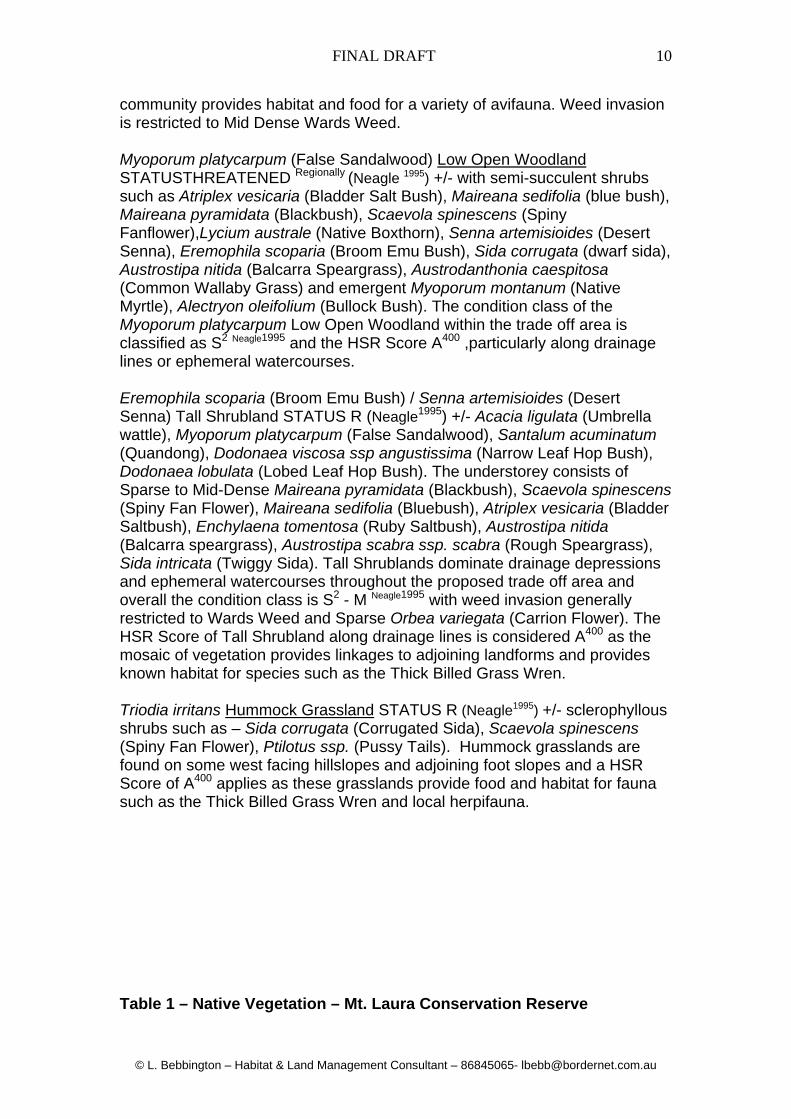
community provides habitat and food for a variety of avifauna. Weed invasion is restricted to Mid Dense Wards Weed. Myoporum platycarpum (False Sandalwood) Low Open Woodland STATUSTHREATENED Regionally (Neagle 1995) +/- with semi-succulent shrubs such as Atriplex vesicaria (Bladder Salt Bush), Maireana sedifolia (blue bush), Maireana pyramidata (Blackbush), Scaevola spinescens (Spiny Fanflower),Lycium australe (Native Boxthorn), Senna artemisioides (Desert Senna), Eremophila scoparia (Broom Emu Bush), Sida corrugata (dwarf sida), Austrostipa nitida (Balcarra Speargrass), Austrodanthonia caespitosa (Common Wallaby Grass) and emergent Myoporum montanum (Native Myrtle), Alectryon oleifolium (Bullock Bush). The condition class of the Myoporum platycarpum Low Open Woodland within the trade off area is classified as S2 Neagle1995 and the HSR Score A400 ,particularly along drainage lines or ephemeral watercourses. Eremophila scoparia (Broom Emu Bush) / Senna artemisioides (Desert Senna) Tall Shrubland STATUS R (Neagle1995) +/- Acacia ligulata (Umbrella wattle), Myoporum platycarpum (False Sandalwood), Santalum acuminatum (Quandong), Dodonaea viscosa ssp angustissima (Narrow Leaf Hop Bush), Dodonaea lobulata (Lobed Leaf Hop Bush). The understorey consists of Sparse to Mid-Dense Maireana pyramidata (Blackbush), Scaevola spinescens (Spiny Fan Flower), Maireana sedifolia (Bluebush), Atriplex vesicaria (Bladder Saltbush), Enchylaena tomentosa (Ruby Saltbush), Austrostipa nitida (Balcarra speargrass), Austrostipa scabra ssp. scabra (Rough Speargrass), Sida intricata (Twiggy Sida). Tall Shrublands dominate drainage depressions and ephemeral watercourses throughout the proposed trade off area and overall the condition class is S2 - M Neagle1995 with weed invasion generally restricted to Wards Weed and Sparse Orbea variegata (Carrion Flower). The HSR Score of Tall Shrubland along drainage lines is considered A400 as the mosaic of vegetation provides linkages to adjoining landforms and provides known habitat for species such as the Thick Billed Grass Wren. Triodia irritans Hummock Grassland STATUS R (Neagle1995) +/- sclerophyllous shrubs such as – Sida corrugata (Corrugated Sida), Scaevola spinescens (Spiny Fan Flower), Ptilotus ssp. (Pussy Tails). Hummock grasslands are found on some west facing hillslopes and adjoining foot slopes and a HSR Score of A400 applies as these grasslands provide food and habitat for fauna such as the Thick Billed Grass Wren and local herpifauna. Table 1 – Native Vegetation – Mt. Laura Conservation Reserve

FINAL DRAFT
© L. Bebbington – Habitat & Land Management Consultant – 86845065- [email protected]
11
Species Name Common Name STATUS Density
AUS SA EP Acacia ligulata Umbrella wattle MD-D Acacia oswaldii Oswald’s wattle MD
Acacia papyrocarpa Western Myall MD-D Alectryon oleifolium Bullock Bush MD-D Amyema quandang Grey Mistletoe VS
Arabidella trisecta Shrubby cress S Atriplex holocarpa Pop saltbush MD Atriplex spongiosa Pop saltbush R S Atriplex vesicaria bladder saltbush MD-D Austrodanthonia caespitosa
Common wallaby grass
S
Austrodanthonia setacea v setacea
Small flowered wallaby grass
S-MD
Austrostipa elegantissima Elegant spear grass S Austrostipa nitida Balcarra spear grass MD
Austrostipa scabra ssp scabra
Rough spear grass S-MD
Chamaesyce (ft. Euphorbia) drummondii
Caustic weed MD
Chenopodium desertorum Desert Goosefoot S
Chloris truncata Windmill grass VS Convolvulus remotus Common bindweed MD Dissocarpus biflorus Twin Horns MD
Dissocarpus paradoxus Ball bindyi S Enchylaena tomentosa Ruby Saltbush MD Erodiophyllum elderi Hard Heads VS Erodium cygnorum Wild Geranium MD Eremophila longifolia Weeping emu bush S
Eremophila scoparia Broom Emu Bush MD Exocarpus aphyllus Native Cherry VS
Gunniopsis kochii Pigface S Lycium australe Native boxthorn S-MD
Maireana appressa Appressed Blue Bush S
Maireana georgei Satiny Blue Bush S
Maireana pyramidata Sago Bush S-MD Maireana pentatropis bluebush S
Maireana sedifolia Pearl blue bush MD-D Myoporum montanum Native Myrtle S Myoporum platycarpum False Sandalwood S-MD Rhagodia parabolica Mealy saltbush VS1
Rhagodia ulicina Intricate saltbush S-MD Rhagodia spinescens Spiny saltbush S-MD Salsola kali Buckbush S Sclerostegia obliquicuspis Bindyi S Senna artemisioides Desert Senna MD Senna artemisioides f. coriacea
Desert senna MD

FINAL DRAFT
© L. Bebbington – Habitat & Land Management Consultant – 86845065- [email protected]
12
Sida calyxhymenia Tall sida MD-D Sida fibulifera Pin Sida K MD Sida intricata Twiggy sida MD Solanum ellipticum Velvet potato bush S
Tetragonia tetragonoides Dryland spinach S Triodia irritans Spinifex MD-D Vittadinia cuneata Woolly new Holland
daisy S-MD
Zygophyllum aurantiacum Soapbush S Zygophyllum apiculatum Common twin leaf MD Zygophyllum billardieri (inland form)
Coast twinleaf MD
Zygophyllum crenatum Lobed twin leaf S
Table 2 – Introduced Plants Recorded
Species Name Common Name DensityAcetosa vesicaria Hop Bush VS Asphodelus fistulosus Wild Onion S Brassica tournefortii Wild radish VS Carrichtera annua Wards Weed D Cucumis myriocarpus Prickly Paddy Melon VS Echium plantagineum Salvation Jane VS-S Euphorbia terracina False Caper VS Hordeum leporinum Barley Grass VS Marrubium Vulgare Horehound VS Opuntia sp. Prickly Pear VS Orbea variegata Carrion Flower S Salvia verbenaca Wild Sage VS
Map 3 – Vegetation Communities Conservation Reserve

FINAL DRAFT
© L. Bebbington – Habitat & Land Management Consultant – 86845065- [email protected]
13
1.3.3 – Rare Plant Species or Communities

FINAL DRAFT
© L. Bebbington – Habitat & Land Management Consultant – 86845065- [email protected]
14
Atriplex spongiosa is classified as Rare on Eyre Peninsula (although it is relatively common in adjoining Gardiner Torrens region) and Sida fibulifera status is classified as unknownK. Extensive botanical surveys may identify several other plant species of significance within the proposed conservation area. Acacia papyrocarpa (Western Myall) Low Open Woodland is classified as RARE regionally and is well represented in the proposed conservation area. Furthermore significant numbers of seedlings have germinated post 2007 autumn rains (160mm 24 hours) which should survive to maturity given the low number of herbivores and rabbits in the area. Casuarina pauper (Black Oak) Low Open Woodland is classified as RARE regionally and is well represented in the western and northern areas of the proposed conservation area. Myoporum platycarpum (False Sandalwood) Low Open Woodland is classified as THREATENED regionally but is relatively common within the site. As with A. papyrocarpa significant numbers of seedlings have germinated post 2007 rains and the majority should reach maturity. There is a high probability that Pterostylis sp. Eyre peninsula R. Bates 19474 which is flagged under the EPBC Act 1999 as VulnerableAUS,SA exist within the Mt Laura reserve due to suitable rocky habitat existing across much of the site. 1.3.4 – Remnancy Data The Hundred of Cultana contains 91.7% remnant vegetation of which only 3.8% (462ha) is protected. The Whyalla Association contains 95.9% vegetation in the association. The inclusion of the Mt Laura Conservation reserve as an extension of the boundary of the Whyalla Conservation Park would effectively double the size of the Conservation Park. 1.4 – Fauna and Wildlife Habitat Values Due to the landforms and overall intactness and diversity of plant communities the proposed Mt Laura Conservation Reserve contains a mosaic of different habitats for a range of native fauna. Habitats range from large rock outcrops, hillslopes with broken rubble and Hummock grasslands, tall shrublands in steep gullies, clearings containing native tussock grasslands, low open woodland with tree hollows, drainage depressions with dense perennial shrubs and exposed rock and saltbush plains with native grassland and emergent low trees.
FINAL DRAFT
© L. Bebbington – Habitat & Land Management Consultant – 86845065- [email protected]
15
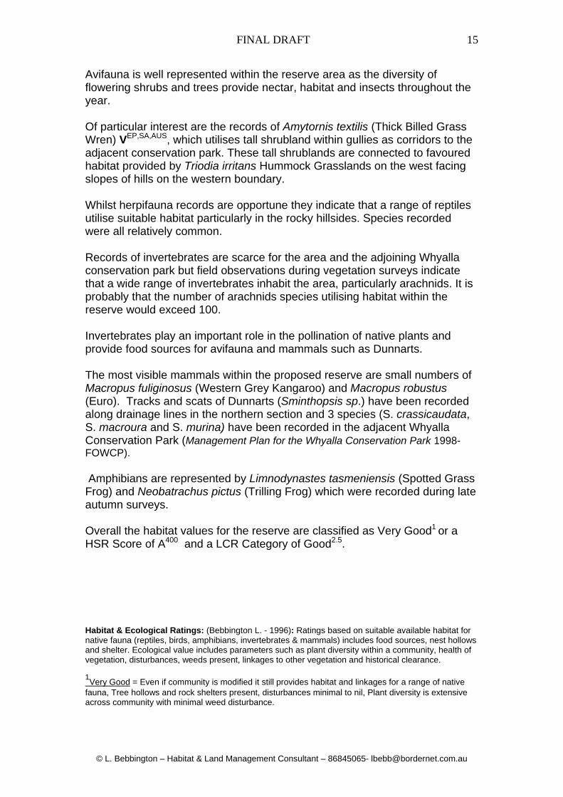
Avifauna is well represented within the reserve area as the diversity of flowering shrubs and trees provide nectar, habitat and insects throughout the year. Of particular interest are the records of Amytornis textilis (Thick Billed Grass Wren) VEP,SA,AUS, which utilises tall shrubland within gullies as corridors to the adjacent conservation park. These tall shrublands are connected to favoured habitat provided by Triodia irritans Hummock Grasslands on the west facing slopes of hills on the western boundary. Whilst herpifauna records are opportune they indicate that a range of reptiles utilise suitable habitat particularly in the rocky hillsides. Species recorded were all relatively common. Records of invertebrates are scarce for the area and the adjoining Whyalla conservation park but field observations during vegetation surveys indicate that a wide range of invertebrates inhabit the area, particularly arachnids. It is probably that the number of arachnids species utilising habitat within the reserve would exceed 100. Invertebrates play an important role in the pollination of native plants and provide food sources for avifauna and mammals such as Dunnarts. The most visible mammals within the proposed reserve are small numbers of Macropus fuliginosus (Western Grey Kangaroo) and Macropus robustus (Euro). Tracks and scats of Dunnarts (Sminthopsis sp.) have been recorded along drainage lines in the northern section and 3 species (S. crassicaudata, S. macroura and S. murina) have been recorded in the adjacent Whyalla Conservation Park (Management Plan for the Whyalla Conservation Park 1998- FOWCP). Amphibians are represented by Limnodynastes tasmeniensis (Spotted Grass Frog) and Neobatrachus pictus (Trilling Frog) which were recorded during late autumn surveys. Overall the habitat values for the reserve are classified as Very Good1 or a HSR Score of A400 and a LCR Category of Good2.5. Habitat & Ecological Ratings: (Bebbington L. - 1996): Ratings based on suitable available habitat for native fauna (reptiles, birds, amphibians, invertebrates & mammals) includes food sources, nest hollows and shelter. Ecological value includes parameters such as plant diversity within a community, health of vegetation, disturbances, weeds present, linkages to other vegetation and historical clearance. 1Very Good = Even if community is modified it still provides habitat and linkages for a range of native
fauna, Tree hollows and rock shelters present, disturbances minimal to nil, Plant diversity is extensive across community with minimal weed disturbance.

FINAL DRAFT
© L. Bebbington – Habitat & Land Management Consultant – 86845065- [email protected]
16
Table 2 - Native Fauna Recorded
Scientific Name
Common Name
STATUS
AUS SA EP Acanthagenys rufogularis Spiny Cheeked Honeyeater Acanthiza apicalis Inland thornbill Acanthiza chrysorrhoa Yellow rumped thornbill Acanthiza uropygialis Chestnut rumped thornbill Amytomis textilis Thick Billed Grass Wren V V V Anthochaera carunculate Red wattle bird Aphelocephela leucopsis Southern Whiteface Aquila audax Wedge-tailed Eagle Ardea novaehollandiae White faced heron Artamus cyanopterus Dusky wood swallow Cacatua roseicapilla Galah Coracina novaehollandiae Black Faced Cuckoo Shrike Corvus coronoides Australian Raven Colluricincla harmonica Grey shrike thrush Craticus torquatus Grey Butcherbird Epthianura albifrons White fronted chat Falco berigora Brown falcon Falco cenchroides Nankeen Kestrel Gymnorhina tibicen Australian magpie Lichenostomus virescens Singing Honeyeater Malurus leucopteris White Winged Fairy wren Malurus lamberti Variegated Wren Melanodryas cucullata Hooded Robin O Northiella haematogaster Blue bonnet O Ocyphaps lophotes Crested Pigeon Oreoica gutturalis Crested Bellbird U Phylidonyris albifrons White fronted honeyeater O Pomatostomus superciliosus White Browed Babbler Rhipidura leucophrys Willie wagtail Zosterops lateralis Silvereye Ctenophorus fionni Peninsula dragon Ctenotus uber Spotted Ctenotus Ctenotus robustus Striped skink Pogona barbata Eastern bearded Dragon Pseudonaja textilis Eastern Brown Snake Tachydosaurus rugosa Sleepy Lizard Tympanocryptis adelaidensis Prickly dragon Lymnodynastes tasmeniensis
Spotted grass frog
Neobatrachus pictus Trilling frog Macropus fuliginosus Western Grey kangaroo Macropus robustus Euro Oryctolagus cuniculus rabbit Vulpes vulpes fox Felis catus cat

FINAL DRAFT
© L. Bebbington – Habitat & Land Management Consultant – 86845065- [email protected]
17
1.5 Summary of Conservation Values In summary the conservation value of the Mt Laura set aside area exceeds the values of the areas under application through the DPAR process. Environmental parameters supporting the HSR Scores include:
Overall intactness of vegetation communities Linkages to adjoining vegetation communities to maintain gene pools
and provide wildlife corridors Mosaic and diversity of habitat supporting a good representation of
native fauna Presence of Rare and Threatened plant communities and species
which are poorly conserved within the region Natural regeneration of native vegetation within all vegetation
communities Linkages to adjoining pastoral properties and the Whyalla
Conservation Park which support similar vegetation communities Weed infestations (discounting Wards Weed) which are manageable
under a long term planned strategy 2.0 – Action Plan for Native Vegetation 2.1 – Set Asides The vegetation communities within the set aside area are classified as: (i) Remnant – a native plant community that is more or less intact in structure, composition and diversity. The management objective is to protect and actively conserve undisturbed areas. Areas with vehicle tracks will be actively restored by restricting access and rehabilitation. Natural regeneration will be the main objective in rehabilitated areas (see management actions). The City of Whyalla will place the 1800ha Mt Laura Conservation Reserve under a Heritage Agreement with the Native Vegetation Council if the NVC agree that it is of a high biodiversity value. 2.2 – General Threats and Management Actions The following threats are the most common within the reserve:
Fragmentation (minor) due to unrestricted vehicle access along unauthorised tracks.
Unauthorised 4wd training area. Pest plants and animals Erosion triggered by vehicle access on hillslopes and drainage
channels. Altered water regimes exacerbating erosion potential of area via old
BHP diversion drains.
FINAL DRAFT
© L. Bebbington – Habitat & Land Management Consultant – 86845065- [email protected]
18
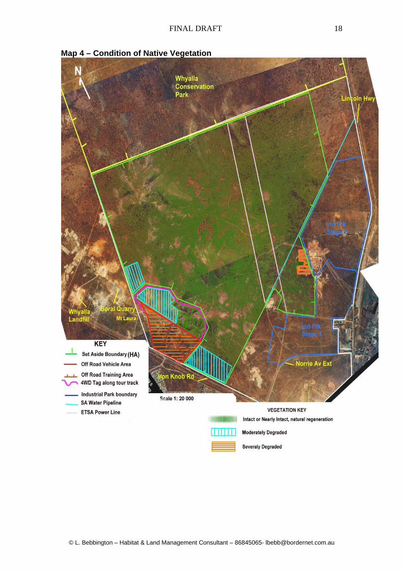
Map 4 – Condition of Native Vegetation
FINAL DRAFT
© L. Bebbington – Habitat & Land Management Consultant – 86845065- [email protected]
19
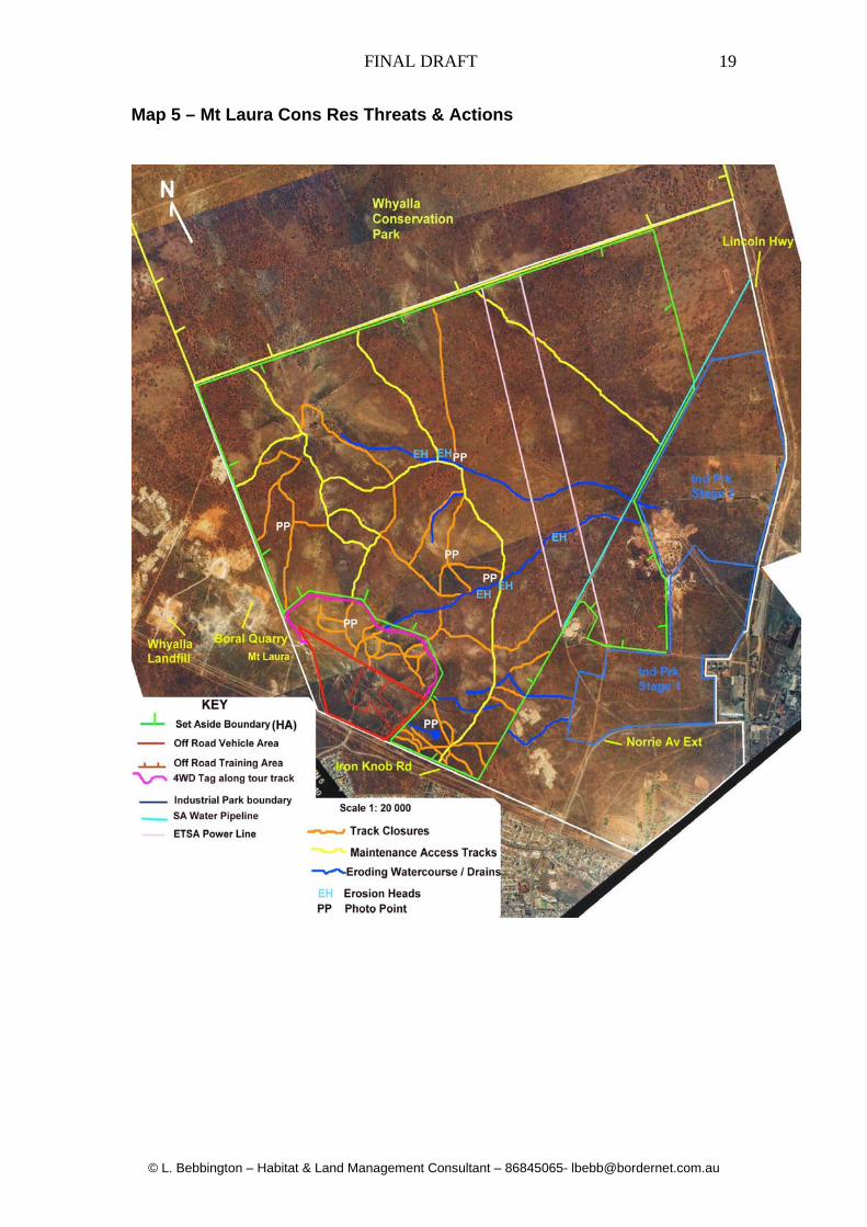
Map 5 – Mt Laura Cons Res Threats & Actions

FINAL DRAFT
© L. Bebbington – Habitat & Land Management Consultant – 86845065- [email protected]
20
3.0 – Management Actions 3.1 – Vehicular Access As indicated on Map 5 (page 19) the proposed reserve has a history (>25 years) of unrestricted ORV access. BHP (followed by Onesteel) did not monitor or attempt to police public access and as a result the general public assume that they have the right of entry and are not responsible for their actions. Approximately 50-60% of the tracks indicated on the aerial photograph (Map 5 p. 8) consist of narrow two wheel tracks with a very narrow impact footprint. However approximately 30% of the remainder are on hillslopes and a significant number have rill and gully erosion on the lower sections following the last 160mm storm event. The City of Whyalla is well aware of the difficulties involved with restricting and policing ORV access and is endeavouring to establish protocols and educate the public regarding access, public liability and conservation. The City of Whyalla will notify the public via the local media that unrestricted access will not be allowed and access violations will be policed by the full time employees under council by laws. Tracks identified on Map 5 to be retained will be used as access tracks for maintenance and long term may be used as public access routes. These tracks are predominately located on the plain or on the lower most slopes of adjoining hills, which ensures low impacts and maintenance requirements. Fencing of the reserve is not only cost prohibitive (24+km or >$72,000) but is not feasible as has been shown in the adjacent Whyalla Conservation Park. The City of Whyalla will adopt the same methods as the Friends of the Whyalla Conservation Park in that signs will be erected on all boundaries and within the proposed reserve identifying the area as a conservation reserve and notifying the public about access and fines for access violations. Existing tracks identified for closure will be rehabilitated by ripping and benching and access will be restricted by the erection of steel barriers. Initially members of the public may drive around barriers, however if they are fined under local government legislation this behaviour will cease within a short time frame. Small erosion heads on tracks identified for closure will be rehabilitated and backfilled prior to barrier erection. Approximately 20kms of track has been identified for closure with approximately 5kms requiring ripping and minor erosion control works. Ripping works on hill slopes will be conducted across slope for the width of the track with a toothed 4.5tonne excavator bucket at 20m intervals to divert water into adjacent vegetation and dissipate the erosive energy of flows downslope on bare soil.

FINAL DRAFT
© L. Bebbington – Habitat & Land Management Consultant – 86845065- [email protected]
21
Discussions with the local dirt bike club members have commence to establish an understanding that the City of Whyalla as the new landholder is concerned about conservation impacts, public liability and maintenance of the reserve area. The City of Whyalla is currently negotiating a change in land use with the Crown to establish a motorcycle off-road park in disused borrow pits adjacent to the current landfill site. 3.1.2 – Recreational Off-Road Vehicle Access and Training Area The Whyalla 4wd Club and any accredited 4wd training operators will be required to enter into a MOU for usage under a “user maintains” principle (see Appendix 1 MOU Whyalla 4WD Club Inc.). Initially a 15 ha degraded area which is currently used by off-road vehicles was identified and suggested as an of-road training area under the initial submission submitted to the NVC on 2cnd August 2007. Following extensive consultation with the Whyalla 4WD Club the City of Whyalla can see merit in increasing this area to c.100ha and entering into a leasing agreement with the 4WD Club, who would manage the area under an MOU. The initial 15ha area identified on Map 5 as the 4wd training area is located within a small gully system with minimal vegetation cover and is criss-crossed with numerous tracks up the gully faces. If the 4wd club and training operator wish to continue using this area as they have in the past, the MOU will ensure that they are responsible for public liability and for the maintenance of tracks used for events. The proposed 100ha area will not be incorporated under the Heritage Agreement for the Mt Laura set aside. To compensate for the exclusion of the 100ha off-road area the City of Whyalla has included an additional parcel of land adjacent to the Industrial Park under the Heritage Agreement (see Map 5 p19) The 15ha training site is located within a large degraded gully (HSR Score D325 & an LCR Rating of 2) which falls to the east for a length of approximately 700m. The Whyalla 4WD Club accredited trainers requested the use of the full extent of the gully to ensure that all aspects of competency training were available. The lower gully tracks run parallel to the slope and provide terrain for competency training in across slope driving and recovery techniques. Following on-site inspections involving all parties and the vegetation assessor, this proposal was considered to be worth considering due to the degraded nature of the site and the fact that the concept contained potential negative impacts within a relatively small area. The “training” area of the proposed off-road vehicle site constitutes approximately 30% of the overall off-road area. The Whyalla 4WD Club Inc. are involved in annual 4WD “tag along” tours of the Eyre Peninsula and regularly conduct similar tours along the hilltop track on the northern boundary of the proposed off-road site.

FINAL DRAFT
© L. Bebbington – Habitat & Land Management Consultant – 86845065- [email protected]
22
These tours are family orientated and are basically organised to highlight the features of the Whyalla region from the numerous vantage points on hilltops. The hilltop tracks consist predominately of a rubble base over sheet rock and consequently have a low erosion potential. The City of Whyalla has agreed to incorporate the northern hilltop and the western return track into the off-road area primarily to reduce impacts in other sections of the set aside area of higher conservation value. Other tracks within the proposed off-road area that contain eroded topsoil or are located in ephemeral watercourses will be closed to all vehicles and rehabilitated (see Map 5 19). The Whyalla 4WD Club have commenced negotiations with the City of Whyalla to adopt part of the north west section of the off-road area as a conservation project. Activities such as weed removal, track rehabilitation, small scale erosion control and fauna monitoring are some of the proposed activities . The boundaries of the proposed off-road vehicle area will be clearly signposted with steel marker posts at regular intervals to delineate tracks that can be used under the 4WD Club permit system established under the MOU. Coloured marker systems linked to signage and access mapping will clearly indicate track closures and rehabilitation. Fencing of the boundaries of the off-road area is cost prohibitive and extremely difficult due to the steep and rocky terrain. 3.2 – Pest Plants and Animals The most dominant environmental weed within the area is Wards Weed which ranges from Dense in disturbed areas to Sparse to Mid-Dense in Chenopod shrubland. This weed is now naturalised across the region and control is not possible. Carrion Flower (Orbea variegata) has a widespread distribution across the proposed reserve area but at this stage its density is classified as Sparse. This environmental weed is already being monitored by the FOWCP and control by targeted spot spraying using a minimum disturbance approach will be implemented using recognised control methods. Control programs will link with the FOWCP monitoring and mapping programs to implement a targeted approach. Salvation Jane (Echium plantagineum) is currently restricted to northern eroding drainage channels and outbreaks will be hand sprayed with Glyphosate with follow up monitoring at monthly intervals.

FINAL DRAFT
© L. Bebbington – Habitat & Land Management Consultant – 86845065- [email protected]
23
Prickly Pear (Opuntia sp.) are found in several locations which have been logged on GPS and will be hand pulled (small plants) and disposed of in an appropriate manner. Ongoing monitoring / control of Prickly Pear and other Opuntia species will be part of the weed program using recognised herbicide injections for large plants and hand digging for small plants. 12 large cat / fox traps have been purchased by the City of Whyalla and trapping programs have been implemented and will be ongoing throughout the set aside area and the adjoining refuse tip area. Trapping and destruction of trapped animals will comply with the Prevention of Cruelty to Animals Act 1979 and the Natural Resources Act 2004. Initially fox baiting programs were recommended for the set aside area, but community feedback during the consultation period of the Vegetation Management Plan indicated that members of the public regularly walked dogs in sections of the set aside areas. Rabbits numbers are generally low in the set aside area but sporadic increases in populations can dramatically impact on seedling regeneration. The City of Whyalla Environment Unit is concerned about off target damage to non-targeted species using poisoned oats, explosives or ripping of warrens. Staff of the Environment Unit will establish a data base of rabbit activity and warren locations which will be monitored regularly to ascertain presence absence of rabbits. Active warrens will be targeted for cat / fox trapping as both species utilise warrens for shelter / breeding and rely on rabbits as a food source. The Environment Unit is establishing a program to systematically locate warrens and to implement controls on active warrens as they are located and mapped. The Environment Unit is establishing a supervised rabbit control program with the Whyalla Ferret Club under a MOU agreement which has proved successful in other regions. This technique does not impact on off-target species and leaves warrens intact for utilisation by native fauna. If Ferrets escape during hunting procedures it is extremely unlikely that they will survive in the wild in the arid lands as they are prone to heat stress even in controlled environments in captivity. Link www.safa.com.au 3.3 – Erosion Control During high intensity short duration storm events sandy clays on hillslopes and within watercourses in the Whyalla region are prone to various forms of natural erosion over time. Factors such as high usage of tracks coupled with improper driving techniques eg. wheel spin and bogging, exacerbate and trigger new forms of erosion events in terrain not naturally prone to erosion. Directly linked to erosion is the infestation and spread of weeds which favour disturbed ground and seed can be transported over considerable distances during peak storm events and deposited in sediment on the flood plain.
FINAL DRAFT
© L. Bebbington – Habitat & Land Management Consultant – 86845065- [email protected]
24
As previously mentioned erosion of tracks will be addressed during track closure and rationalisation by a variety of methods including: backfilling with rubble, multiple diversion drains and contour ripping / banking. Large erosion heads in old BHP diversion drains will be rehabilitated with corrective battering followed by armouring with A34 geotextile overlain with graded rip rap. Upstream and downstream sections of eroded drains adjacent to rehabilitated erosion heads will be protected by energy dissipating structures (grade control structures) constructed of graded rip rap over A34 geo textile. These works will be supervised by Larry Bebbington who is a practicing erosion control contractor (International Erosion Control Association - IECA) who has successfully implemented these techniques in other areas for various agencies. As the old diversion drains are no longer required by Onesteel wherever possible they will be breached and rehabilitated to reduce the amount of run off collected and discharged into downstream environs. Two old BHP retention dams will be cleaned of silt and utilised to reduce the amount of stormwater run-off entering urban environments downstream along McBryde Tce. Due to the scale of the area and erosion problems erosion control requirements will be assessed and prioritised based on parameters such as: likelihood of accelerated upslope migration, downstream / downslope issues associated with environment and infrastructure and danger to workers and community members utilising area. Following assessment and prioritisation procedures erosion works will be scheduled into a works program budget over the following 5 years. 3.4 Revegetation Works The main objective of the Mt Laura set aside is to actively conserve existing plant communities and allow natural regeneration to occur over time in disturbed areas. Natural regeneration following summer rains in 2006-07 has been significant and this highlights the fact that natural processes coupled with weed control strategies, erosion control and restricted access will be the most suitable approach. Following specific assessments of sites requiring rehabilitation works small scale direct seeding may be conducted in areas disturbed during works. Small scale direct seeding utilising species such as Acacia ligulata and Senna artemisioides may also be required to “fill in” gaps caused by vehicle tracks which fragment shrubland in gullies utilised as wildlife corridors. Rabbit control is extremely important over the next 2 years to ensure that regenerated seedlings reach maturity.

2.4 – Action Timetables ACTION Seasonal
Timing
YEAR 1 2 3 4 5 Ongoing
Public Awareness Immediately following approval from NVC
x x x x x Updates will be available on the City of Whyalla website and ongoing media release of events will be released in the local media. Community involvement in monitoring and small scale management programs will be ongoing.
MOU’s x MOU’s for major users such as the Whyalla 4WD Club Inc will be ratified and implemented immediately following approvals from the NVC. Community groups such as orienteer groups will be incorporated under the user permit system and formal MOU’s to a lesser degree.
Track Closure / Repair
Spring Summer
x x x x x Track closure will commence following the ratifying of the HA and community awareness campaigns. Track rehabilitation will commence in 2008 (budget dependant) and will be ongoing but reducing over following 5 years.
Pest Plant & Animal Winter Spring
x x x x x Initial assessments and mapping of weeds. Implementation of weed control strategies linked to existing programs. Weed control will be ongoing. Cat / Fox trapping implemented in Summer 2007 – ongoing. Rabbit control programs implemented and ongoing as opportune distribution mapping compiled.
Erosion Control Spring Summer
x x x x x Erosion control assessments and prioritisation will be implemented in 2008 following ratifying of HA. Prioritised erosion control will be implemented late 2008 and reducing over next 5 years.
Monitoring & Review
Change of seasons x 4
x x x x x Monitoring will commence following identification of sites and installation of photo points. Monitored sites will be entered into data base for compliance reporting.
Reporting to NVC x x x x x Annual

2.5 ACTION Plant / Rates Hours Sub-
Total Contractor
Supervision TOTAL SCHEDULE
Hours S-Total Signage 100 signs @ $50ea 5000 1st Year – immediately
following public announcement of conservation reserve
100 Steel posts @ $50ea
5000
Erecting with Bobcat @ $65/hr
16 1040 8 680
11040 680 11720
Track Closure Access Barriers 1500 1st year – following notification Ripping and benching hill tracks and gully tracks to divert run off across slope into vegetation and to restrict access
Bobcat @ $65/hr 24 1560 8 680 Ripping tracks – 4.5t excavator @ $86/hr
150 12,900 1st & 2cnd year – maintenance thereafter
Erosion repairs – 4.5t excavator @ $86/hr
150 12,900 1st & 2cnd year- maintenance thereafter
Rubble 200t @15.50 3100 100 8500 31960 9180 41140
Stormwater Retention
25t excavator @ $137.50 /hr
32 4400 1st & 2cnd year – maintenance 3rd year
Utilise and enlarge existing dams to pond water, reduce velocities and volumes entering downstream urban environs
100t 600/900mm rock at $21/t plus cartage
2441 16 1360
6841 1360 8201
Cost Estimates / Schedules for Mt Laura Conservation Area Management – 2008-2013
FINAL DRAFT
© L. Bebbington – Habitat & Land Management Consultant – 86845065- [email protected]
27
ACTION Plant / Rates Hours Sub-Total
Contractor Supervision
TOTAL SCHEDULE
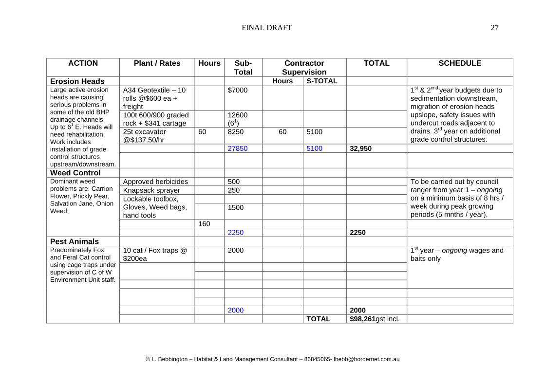
Erosion Heads Hours S-TOTAL Large active erosion heads are causing serious problems in some of the old BHP drainage channels. Up to 61 E. Heads will need rehabilitation. Work includes installation of grade control structures upstream/downstream.
A34 Geotextile – 10 rolls @$600 ea + freight
$7000 1st & 2cnd year budgets due to sedimentation downstream, migration of erosion heads upslope, safety issues with undercut roads adjacent to drains. 3rd year on additional grade control structures.
100t 600/900 graded rock + $341 cartage
12600 (61)
25t excavator @$137.50/hr
60 8250 60 5100
27850 5100 32,950
Weed Control Dominant weed problems are: Carrion Flower, Prickly Pear, Salvation Jane, Onion Weed.
Approved herbicides 500 To be carried out by council ranger from year 1 – ongoing on a minimum basis of 8 hrs / week during peak growing periods (5 mnths / year).
Knapsack sprayer 250 Lockable toolbox, Gloves, Weed bags, hand tools
1500
160 2250 2250
Pest Animals Predominately Fox and Feral Cat control using cage traps under supervision of C of W Environment Unit staff.
10 cat / Fox traps @ $200ea
2000 1st year – ongoing wages and baits only
2000 2000 TOTAL $98,261gst incl.
FINAL DRAFT
© L. Bebbington – Habitat & Land Management Consultant – 86845065- [email protected]
28
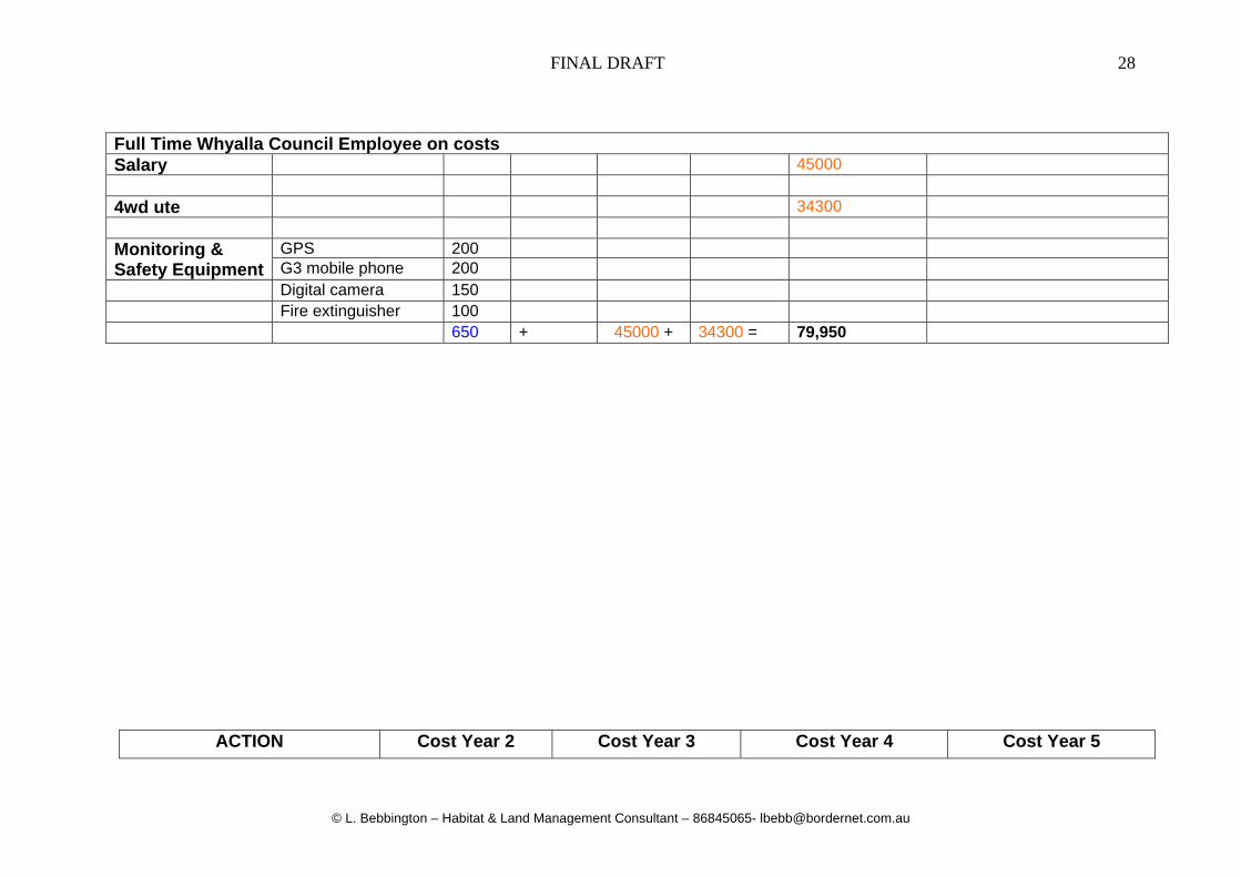
Full Time Whyalla Council Employee on costs Salary 45000 4wd ute 34300 Monitoring & Safety Equipment
GPS 200 G3 mobile phone 200
Digital camera 150 Fire extinguisher 100 650 + 45000 + 34300 = 79,950
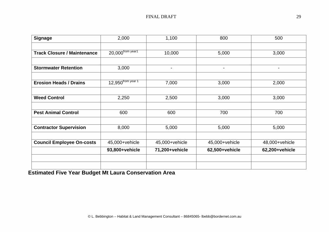
ACTION Cost Year 2 Cost Year 3 Cost Year 4 Cost Year 5
FINAL DRAFT
© L. Bebbington – Habitat & Land Management Consultant – 86845065- [email protected]
29
Estimated Five Year Budget Mt Laura Conservation Area
Signage 2,000 1,100 800 500
Track Closure / Maintenance 20,000from year1 10,000 5,000 3,000
Stormwater Retention 3,000 - - -
Erosion Heads / Drains 12,950from year 1 7,000 3,000 2,000
Weed Control 2,250 2,500 3,000 3,000
Pest Animal Control 600 600 700 700
Contractor Supervision 8,000 5,000 5,000 5,000
Council Employee On-costs 45,000+vehicle 45,000+vehicle 45,000+vehicle 48,000+vehicle
93,800+vehicle 71,200+vehicle 62,500+vehicle 62,200+vehicle

3.0 – Monitoring, Adaptation and Review for Compliance The following monitoring and adaptive review programs and procedures will be adopted within the first 6 months following the ratifying of the HA and approvals by the NVC and will be ongoing. These monitoring procedures will be implemented to measure success of outcomes, monitor success of techniques and to adapt methods / techniques for greater success.
Install and GPS photographic monitoring points within the most degraded areas to monitor change and compliance.
Maintain a photographic record at the change of each season or following a major natural event.
Establish a data base with progress sheets to maintain records of rehabilitation works and to achieve better outcomes through adaptive management.
Using NVC checklist monitor the “net environmental gain” from parameters such as track closures, erosion control or natural regeneration. Maintain a flora and fauna Checklist as a component of the monitoring program.
Compile and submit annual report to NVC as part of approval and compliance requirements.

FINAL DRAFT
© L. Bebbington – Habitat & Land Management Consultant – 86845065- [email protected]
31
APPENDIX 1 – Site Photographs of Mt Laura Conservation Reserve *Note these photographs were taken in Autumn 2006 following a lengthy drought period.
Photo 1 General from SA Water Pipeline facing Wild Dog Hill (WCP) to the NW
Photo 2 – Western Myall / False Sandal wood Northern boundary

FINAL DRAFT
© L. Bebbington – Habitat & Land Management Consultant – 86845065- [email protected]
32
Photo 3 – Bullock Bush / W. Myall NW boundary
Photo 4 – Ac. ligulata / Senna tall shrubland with ORV tracks on hill SE section

FINAL DRAFT
© L. Bebbington – Habitat & Land Management Consultant – 86845065- [email protected]
33
Photo 5 – Cental hills area facing NE – tall shrublands in gullies
Photo 6 – western hill faces with Triodia and tall shrublands

FINAL DRAFT
© L. Bebbington – Habitat & Land Management Consultant – 86845065- [email protected]
34
Photo 7 Erosion on steep track in 4WD Training Area
Photo 8 Typical steep hill track and erosion 4WD Training Area

FINAL DRAFT
© L. Bebbington – Habitat & Land Management Consultant – 86845065- [email protected]
35
Photo 9 SW section of 4WD Training Area
Photo 19 Facing NE from Ridge Top “Tag Along Tours” track into set aside