native vegetation information - delwp · native vegetation website accessing native vegetation data...
TRANSCRIPT
www.dse.vic.gov.au
Native vegetation information
Native Vegetation Website Information sheet No. 2
Introduction
The main source of descriptive information for
native vegetation types (Ecological Vegetation
Classes (EVCs), EVC groupings etc.) for Victoria is
the native vegetation web page on the Department of
Sustainability and Environment (DSE) website
(www.dse.vic.gov.au >conservation and environment
> native vegetation information). This Information
Sheet outlines the main types of native vegetation
information available and how to access this data via
the website.
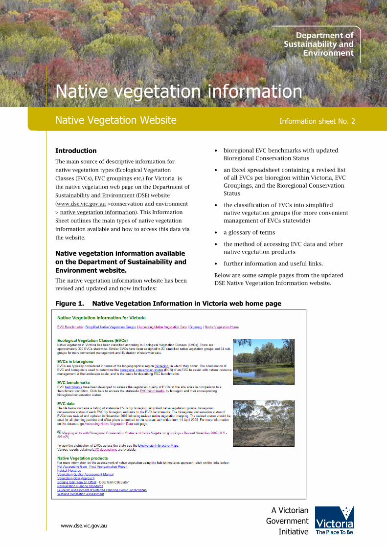
Native vegetation information available
on the Department of Sustainability and
Environment website.
The native vegetation information website has been
revised and updated and now includes:
• bioregional EVC benchmarks with updated
Bioregional Conservation Status
• an Excel spreadsheet containing a revised list
of all EVCs per bioregion within Victoria, EVC
Groupings, and the Bioregional Conservation
Status
• the classification of EVCs into simplified
native vegetation groups (for more convenient
management of EVCs statewide)
• a glossary of terms
• the method of accessing EVC data and other
native vegetation products
• further information and useful links.
Below are some sample pages from the updated
DSE Native Vegetation Information website.
Figure 1. Native Vegetation Information in Victoria web home page
A Victorian
Government
Initiative
Native Vegetation Website
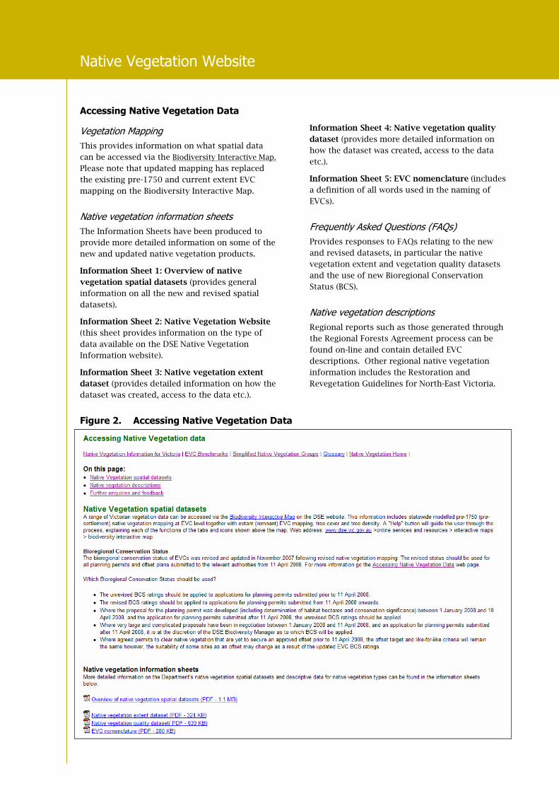
Accessing Native Vegetation Data
Vegetation Mapping
This provides information on what spatial data
can be accessed via the Biodiversity Interactive Map.
Please note that updated mapping has replaced
the existing pre-1750 and current extent EVC
mapping on the Biodiversity Interactive Map.
Native vegetation information sheets
The Information Sheets have been produced to
provide more detailed information on some of the
new and updated native vegetation products.
Information Sheet 1: Overview of native
vegetation spatial datasets (provides general
information on all the new and revised spatial
datasets).
Information Sheet 2: Native Vegetation Website
(this sheet provides information on the type of
data available on the DSE Native Vegetation
Information website).
Information Sheet 3: Native vegetation extent
dataset (provides detailed information on how the
dataset was created, access to the data etc.).
Information Sheet 4: Native vegetation quality
dataset (provides more detailed information on
how the dataset was created, access to the data
etc.).
Information Sheet 5: EVC nomenclature (includes
a definition of all words used in the naming of
EVCs).
Frequently Asked Questions (FAQs)
Provides responses to FAQs relating to the new
and revised datasets, in particular the native
vegetation extent and vegetation quality datasets
and the use of new Bioregional Conservation
Status (BCS).
Native vegetation descriptions
Regional reports such as those generated through
the Regional Forests Agreement process can be
found on-line and contain detailed EVC
descriptions. Other regional native vegetation
information includes the Restoration and
Revegetation Guidelines for North-East Victoria.
Figure 2. Accessing Native Vegetation Data

Native Vegetation Website
Victorian Bioregions
Bioregions are a landscape-scale approach to classifying the environment using a range of attributes such as
climate, geomorphology, geology, soils and vegetation. There are 28 bioregions identified within Victoria.
Native Vegetation Website
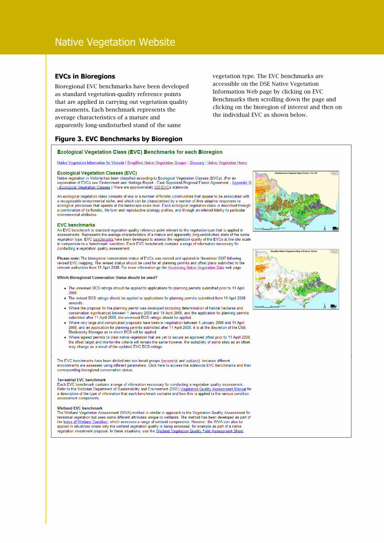
EVCs in Bioregions
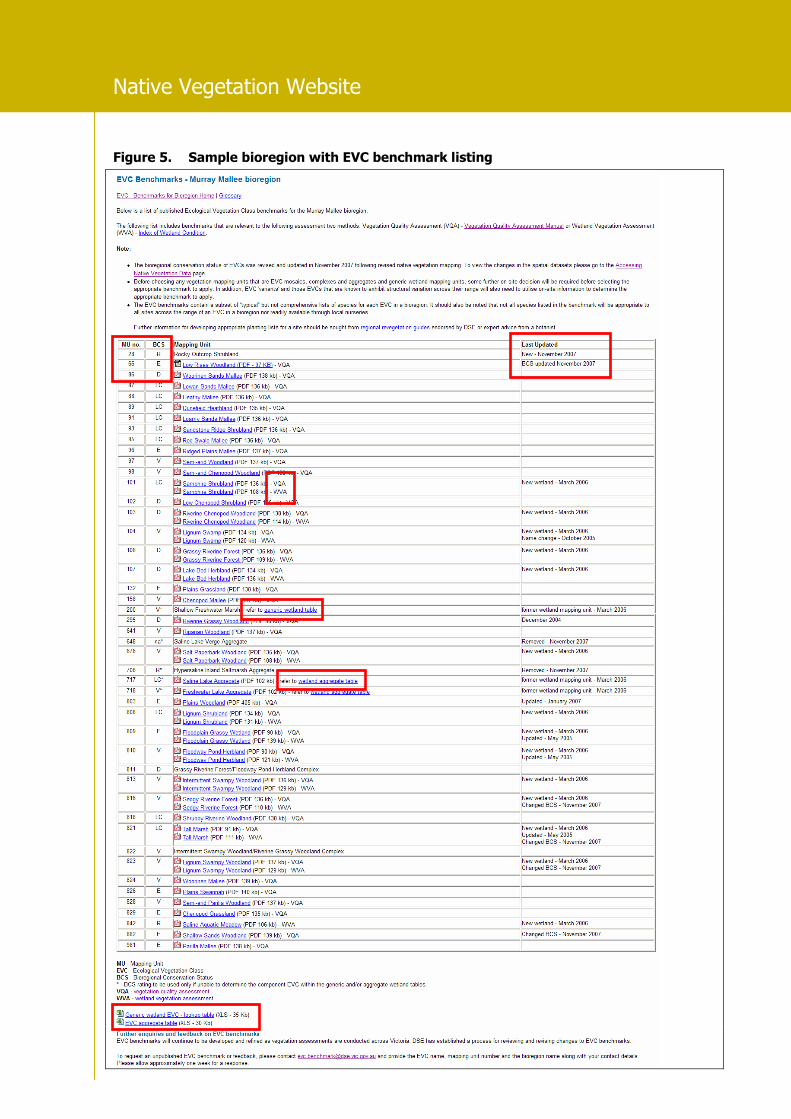
Bioregional EVC benchmarks have been developed
as standard vegetation-quality reference points
that are applied in carrying out vegetation quality
assessments. Each benchmark represents the
average characteristics of a mature and
apparently long-undisturbed stand of the same
vegetation type. The EVC benchmarks are
accessible on the DSE Native Vegetation
Information Web page by clicking on EVC
Benchmarks then scrolling down the page and
clicking on the bioregion of interest and then on
the individual EVC as shown below.
Figure 3. EVC Benchmarks by Bioregion
Native Vegetation Website
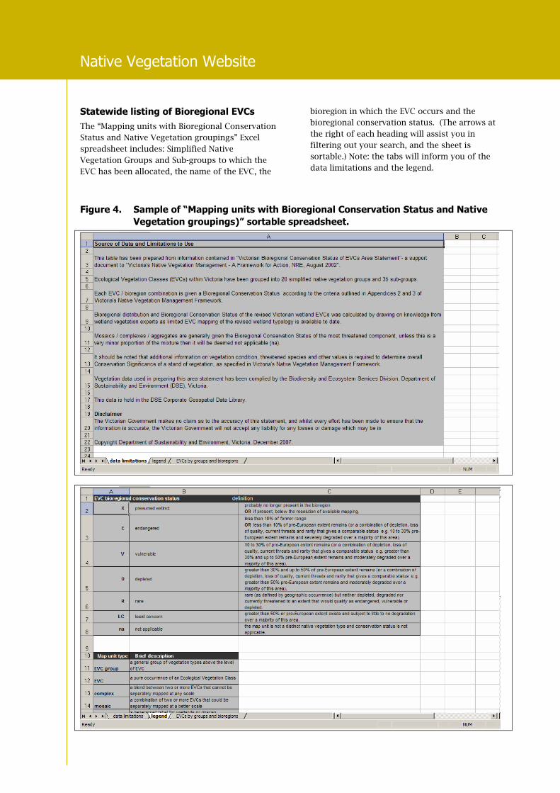
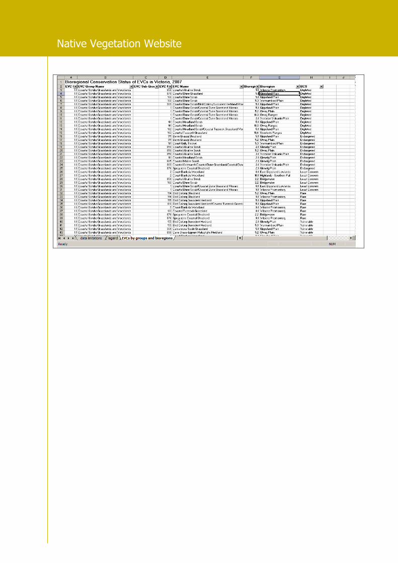
Statewide listing of Bioregional EVCs
The “Mapping units with Bioregional Conservation
Status and Native Vegetation groupings” Excel
spreadsheet includes: Simplified Native
Vegetation Groups and Sub-groups to which the
EVC has been allocated, the name of the EVC, the
bioregion in which the EVC occurs and the
bioregional conservation status. (The arrows at
the right of each heading will assist you in
filtering out your search, and the sheet is
sortable.) Note: the tabs will inform you of the
data limitations and the legend.
Figure 4. Sample of “Mapping units with Bioregional Conservation Status and Native
Vegetation groupings)” sortable spreadsheet.
Native Vegetation Website
Native Vegetation Website
Figure 5. Sample bioregion with EVC benchmark listing

Native Vegetation Website
Explanation of terms in Bioregional EVC
benchmark table
Mapping Unit number (MU)
Is the EVC mapping unit number used across the
state of Victoria.
Bioregional Conservation Status (BCS)
Is the conservation status for the EVC mapped in
the bioregion.
Last updated
From time to time, bioregional EVC benchmarks
are updated following feedback from users. The
right-hand column entitled “Last Update” in the
bioregional EVC benchmark table will give the
type of update (eg. ‘name change’ and the date it
was updated) or the date when a new bioregional
EVC benchmark is published.
“Vegetation Quality Assessment” (VQA) and “Wetland Vegetation Assessment” (WVA)
In the EVC benchmark table for each bioregion,
EVC benchmarks have a “VQA” and/or a “WVA”
benchmark. The “VQA” or Vegetation Quality
Assessment benchmark is used for the Habitat
Hectare method of assessing native vegetation
quality. The “WVA”, or Wetland Vegetation
Assessment, is a method that has been developed
as part of the Index of Wetland Condition. See
“Index of Wetland Condition” section below for
more details.
Generic wetland mapping units
A general wetland mapping unit was used for
unclassified wetlands in early EVC mapping
projects prior to the revision of the Victorian EVC
wetland typology. These generic wetland mapping
units are linked to a look-up-table of relevant new
and revised wetland EVCs which enables the user
to choose the appropriate wetland EVC.
EVC wetland aggregate
Similarly, there is a look-up table for wetland
aggregate EVCs. The term ‘aggregate’ is applied
to an EVC mapping label where the EVC
represents a generalised label for wetlands
occurring within a given ecological context (e.g.
saline, brackish or freshwater lakes; billabongs;
mineralised drainage-lines on grey-clay basalt
derived soils). While the range of EVCs, which can
be variously expressed in these situations, can be
determined, the scale and intricacy can be
prohibitive to resolution of the component EVCs,
especially for the purpose of broader-scale
mapping.
Figure 6. Sample Vegetation Quality Assessment (VQA) EVC benchmark
Native Vegetation Website
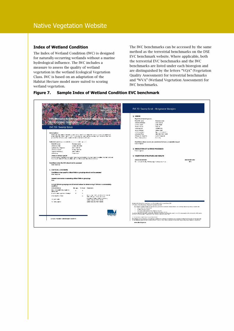
Index of Wetland Condition
The Index of Wetland Condition (IWC) is designed
for naturally-occurring wetlands without a marine
hydrological influence. The IWC includes a
measure to assess the quality of wetland
vegetation in the wetland Ecological Vegetation
Class. IWC is based on an adaptation of the
Habitat Hectare model more suited to scoring
wetland vegetation.
The IWC benchmarks can be accessed by the same
method as the terrestrial benchmarks on the DSE
EVC benchmark website. Where applicable, both
the terrestrial EVC benchmarks and the IWC
benchmarks are listed under each bioregion and
are distinguished by the letters “VQA” (Vegetation
Quality Assessment) for terrestrial benchmarks
and “WVA” (Wetland Vegetation Assessment) for
IWC benchmarks.
Figure 7. Sample Index of Wetland Condition EVC benchmark
Native Vegetation Website
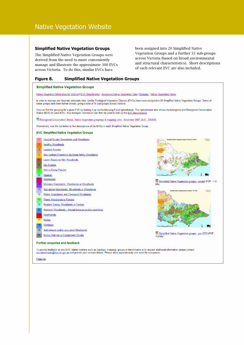
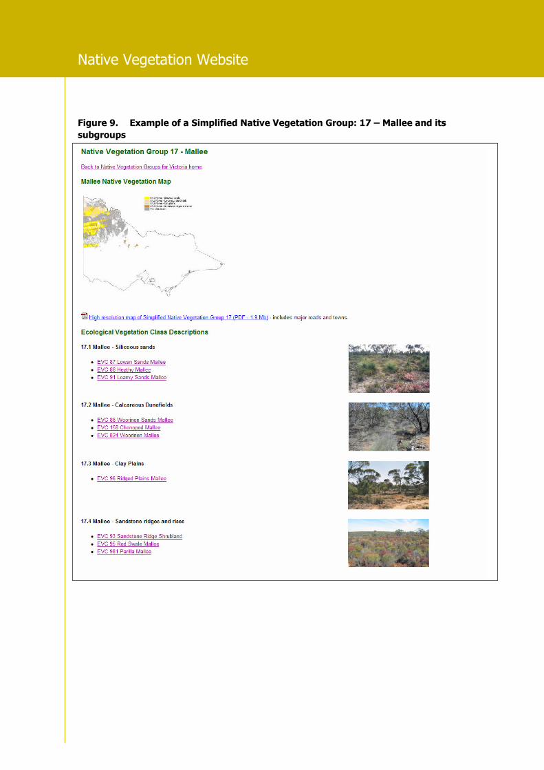
Simplified Native Vegetation Groups
The Simplified Native Vegetation Groups were
derived from the need to more conveniently
manage and illustrate the approximate 300 EVCs
across Victoria. To do this, similar EVCs have
been assigned into 20 Simplified Native
Vegetation Groups and a further 35 sub-groups
across Victoria (based on broad environmental
and structural characteristics). Short descriptions
of each relevant EVC are also included.
Figure 8. Simplified Native Vegetation Groups
Native Vegetation Website
Figure 9. Example of a Simplified Native Vegetation Group: 17 – Mallee and its
subgroups

Native Vegetation Website
Published by the Victorian Government Department of Sustainability and Environment Melbourne, December 2007 © The State of Victoria Department of Sustainability and Environment 2007
This publication is copyright. No part may be reproduced by any process except in accordance with the provisions of the Copyright Act 1968. Authorised by the Victorian Government, 8 Nicholson Street, East Melbourne.
ISBN 978-1-74208-225-7 For more information contact the DSE Customer Service Centre 136 186
This publication may be of assistance to you but the State of Victoria and its employees do not guarantee that the publication is without flaw of any kind or is wholly appropriate for your particular purposes and therefore disclaims all liability for any error, loss or other consequence which may arise from you relying on any information
in this publication.
www.dse.vic.gov.au
Figure 10. Example of Simplified Native Vegetation Sub-groups: 17.1 – Mallee – Siliceous
sands, 17.2 – Mallee – Calcareous dunefields, 17.3 – Mallee – Clay plains and
17.4 – Mallee – Sandstone ridges and rises
Curation of Vegetation Data
All descriptive, ecological and floristic
information relating to native vegetation in
Victoria is curated internally in the ‘Victorian
Vegetation Information System’ (VicVIS) database.
The database is curated by the Native Vegetation
Management Section and any enquiries regarding
EVC typology or mapping data can be directed by
email to [email protected].