civil engineering university of porto faculty of engineering
TRANSCRIPT
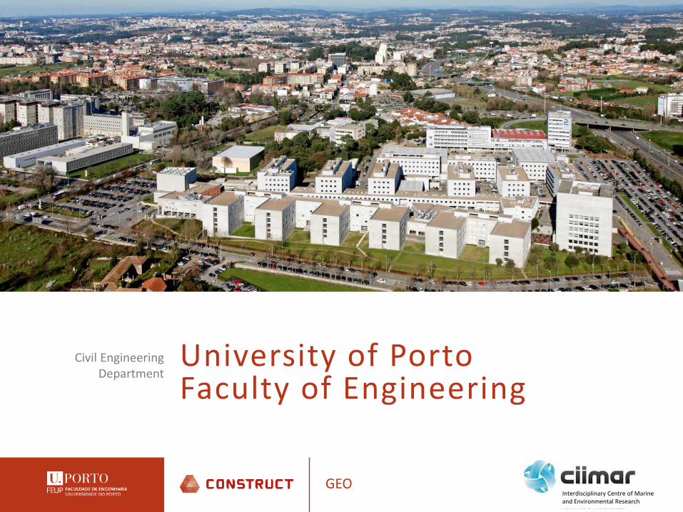
University of PortoFaculty of Engineering
Civil Engineering Department
GEOInterdisciplinary Centre of Marine and Environmental Research

University of Porto
GEO
Foundation: 1911
3 campus
14 Faculties
1 Business School
Interdisciplinary Centre of Marine and Environmental Research

University of Porto
GEOInterdisciplinary Centre of Marine and Environmental Research

University of Porto
GEO
2365 Teaching staff and researchers (2015)82% Teaching staff and researchers have PhD1577 Non teaching staff
Interdisciplinary Centre of Marine and Environmental Research

University of Porto
GEOInterdisciplinary Centre of Marine and Environmental Research

University of Porto
GEO
• International cooperation
Interdisciplinary Centre of Marine and Environmental Research

University of Porto
GEO
• International cooperation
Interdisciplinary Centre of Marine and Environmental Research

University of Porto
GEOInterdisciplinary Centre of Marine and Environmental Research
Rankings in the Civil Engineering area – UPorto position
at World level at European level at National level
NTU (2015) 59 14 2
QS (2015) 51-100 15-33 1
1º
51º
101º
151º2010 2011 2012 2013 2014 2015
UPo
rto
posit
ion
NTU Ranking
world level european level national level
1º
51º
101º
151º
201º2012 2013 2014 2015
UPo
rto
posit
ion
QS Ranking
world level european level national level
University of Porto
GEOInterdisciplinary Centre of Marine and Environmental Research
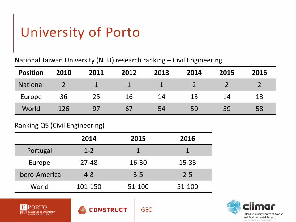
National Taiwan University (NTU) research ranking – Civil Engineering
Position 2010 2011 2012 2013 2014 2015 2016
National 2 1 1 1 2 2 2
Europe 36 25 16 14 13 14 13
World 126 97 67 54 50 59 58
Ranking QS (Civil Engineering)
2014 2015 2016
Portugal 1-2 1 1
Europe 27-48 16-30 15-33
Ibero-America 4-8 3-5 2-5
World 101-150 51-100 51-100

Faculty of Engineering – Dept. Civil Eng.
GEO
• 89 faculty members• Around 1100 students (1027 +74 +9 +11)
– Undergraduates: ≈ 1050 – PhD students: ≈ 85
• Research groups– Structural Concrete and Materials Testing– Earthquake and Structural Engineering– Vibrations and Structural Monitoring– Geotechnics– Physics of Constructions– Management, Quality and Technology– Modelling of coastal management
Interdisciplinary Centre of Marine and Environmental Research

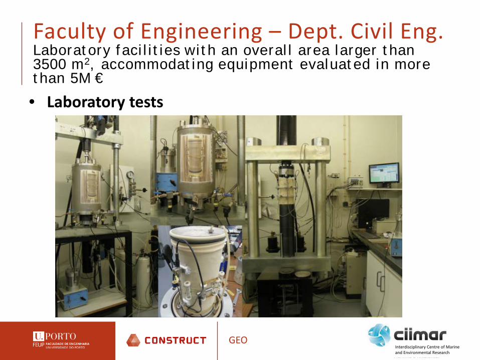
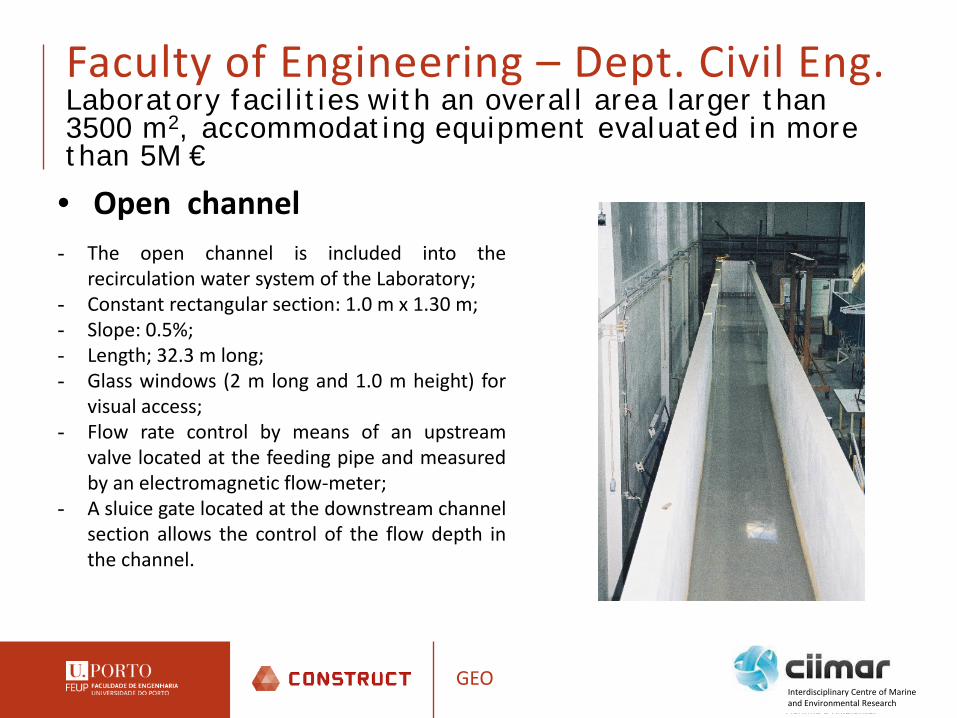
Faculty of Engineering – Dept. Civil Eng.Laboratory facilities with an overall area larger than 3500 m2, accommodating equipment evaluated in more than 5M €
GEO
• In situ tests
Interdisciplinary Centre of Marine and Environmental Research
Faculty of Engineering – Dept. Civil Eng.Laboratory facilities with an overall area larger than 3500 m2, accommodating equipment evaluated in more than 5M €
GEO
• Laboratory tests
Interdisciplinary Centre of Marine and Environmental Research

Faculty of Engineering – Dept. Civil Eng.Laboratory facilities with an overall area larger than 3500 m2, accommodating equipment evaluated in more than 5M €
GEO
• Laboratory tests
Interdisciplinary Centre of Marine and Environmental Research
Faculty of Engineering – Dept. Civil Eng.Laboratory facilities with an overall area larger than 3500 m2, accommodating equipment evaluated in more than 5M €
GEO
• Open channel- The open channel is included into the
recirculation water system of the Laboratory;- Constant rectangular section: 1.0 m x 1.30 m;- Slope: 0.5%;- Length; 32.3 m long;- Glass windows (2 m long and 1.0 m height) for
visual access;- Flow rate control by means of an upstream
valve located at the feeding pipe and measuredby an electromagnetic flow-meter;
- A sluice gate located at the downstream channelsection allows the control of the flow depth inthe channel.
Interdisciplinary Centre of Marine and Environmental Research
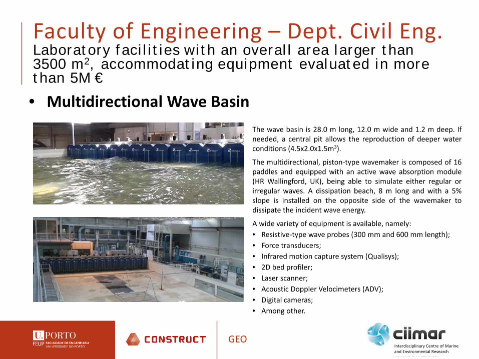
Faculty of Engineering – Dept. Civil Eng.Laboratory facilities with an overall area larger than 3500 m2, accommodating equipment evaluated in more than 5M €
GEO
• Multidirectional Wave BasinThe wave basin is 28.0 m long, 12.0 m wide and 1.2 m deep. Ifneeded, a central pit allows the reproduction of deeper waterconditions (4.5x2.0x1.5m3).
The multidirectional, piston-type wavemaker is composed of 16paddles and equipped with an active wave absorption module(HR Wallingford, UK), being able to simulate either regular orirregular waves. A dissipation beach, 8 m long and with a 5%slope is installed on the opposite side of the wavemaker todissipate the incident wave energy.
A wide variety of equipment is available, namely:• Resistive-type wave probes (300 mm and 600 mm length);• Force transducers;• Infrared motion capture system (Qualisys);• 2D bed profiler;• Laser scanner;• Acoustic Doppler Velocimeters (ADV);• Digital cameras;• Among other.
Interdisciplinary Centre of Marine and Environmental Research

GEO
CONSTRUCT - Institute of R&D in Structures and Construction organized in 6 research groups.
Interdisciplinary Centre of Marine and Environmental Research
Team:45 integrated members, 8 Post-doc and 69 PhD students
Research outcomes from 2008 to 2015111 PhD thesis569 papers (404 in ISI journals)6 patents60 research projects 45 organised conferences
Only in 201518 PhD thesis120 papers (85 in ISI journals)
LABEST – Laboratory of concrete technology and structural behaviourLESE – Laboratory of earhquake and structural engineeringVIBEST – Laboratory of vibrations and monitoringGEO – GeotechnicsLFC – Laboratory of Building physicsGEQUALTEC – Management and technology of building construction

CONSTRUCT - GEO
• Solid background and international recognition in the areas:
Lab and field characterization of natural soils, earthfill, tailings and soil-cement-lime mixtures, in monotonic, cyclic and dynamic conditions
Numerical modelling of geotechnical structures Characterization of geosynthetics and studies of reinforced earthworks
• High quality applied research consultancy:
Research projects and high-level consultancy link the group to relevant national and international partners
GEO
CONSTRUCT - Institute of R&D in Structures and Construction
Interdisciplinary Centre of Marine and Environmental Research

CIIMAR is a leading research and advanced training institution of the UPorto, working on thefrontier of knowledge and innovation. The centre develops transdisciplinary and transnationalresearch, promotes technological development and innovation and supports public policies andgovernance for sustainable development.The aim is to contribute to the knowledge of the ocean and coastal areas as a basis for thesustainable management and exploitation of resources.
GEOInterdisciplinary Centre of Marine and Environmental Research
• 460 researchers (215 PhD/144 ETI)• Annually production of 375 ISI publications (60% Q1)• 120 PhD and MSc thesis in european and national training programmes• Funding from regional and national agencies (ON2, FCT, QREN, Ciencia Viva), from EU
programms (H2020, INTERREG, EEA Grants). • It has been recently granted with 5 H2020 projects related with blue growth.
CIIMAR expertise is framed in priority areas of the Portuguese National Strategy for R&I for Smart Specialisation, articulating national and regional levels, particularly in the areas of Economy of the Sea, Water and Environment, and Agro-Food.

Recent research projects
GEO
1) NATURAL SOILS BEHAVIOUR AND MODELLING - Experimental characterization and modeling of
geomechanical behaviour of sensitive or non-textbook soils (ex. residual soils). Management of
sampling quality on natural soils using in situ and laboratory seismic waves velocities. Dynamic
properties in residual soils from granite: strain-rate, frequency & time effects. FCT 2005-2008 (90k
euros)
2) SOIL-CEMENT - Characterisation and constitutive modelling of cyclic and dynamic behaviour of
soil-cement mixtures for application in infrastructures for transportation. FCT 2010-2013. (175K
euros)
3) LIQUEFACT - Liquefaction Assessment Protocols to Protect Critical Infrastriuvctures against
Earthqueke Damage; and, Assessment and mitigation of liquefaction potential across Europe: a
holistic approach to protect structures / infrastructures for improved resilience to earthquake-
induced liquefaction disasters (http://www.liquefact.eu/) Horizon 2020. 2016-2020 (5M euros)
Interdisciplinary Centre of Marine and Environmental Research
Recent research projects
GEO
4) MORPHEUS - River bed MORPHology and Erosion studies.
This project is dedicated to study the fundamentals of sediment transport proposing a
combined theoretical and experimental approach.
Involving 3 major universities it aims also to strength the cooperation between the participating
institutions. FCT 2016-2019. (200K euros).
5) HYDRALAB+ Adapting to climate change: Advanced network of environmental hydraulic
institutes in Europe. A multi-disciplinary approach will be used to prepare environmental
hydraulic modelling for the upcoming urgent technical challenges associated with adaptations
for climate change. The issues associated with climate change impacts on rivers and coasts are
significant enough to ask the scientific community to which we open up our facilities to focus
their research efforts on adaptations for climate change (10M euros).
Interdisciplinary Centre of Marine and Environmental Research

ASSESSMENT AND MITIGATION OF LIQUEFACTION POTENTIAL ACROSS EUROPEA holistic approach to protect structures / infrastructures for improved resilience to earthquake-induced liquefaction disasters
LIQUEFACTION RISK ASSESSMENTH2020 LIQUEFACTRIA - Research and Innovation actionContract Number: 700748
GEOInterdisciplinary Centre of Marine and Environmental Research
Main objectives: Identify causes of earthquake induced
liquefaction disasters; Implement practical mitigation
strategies to reduce the consequences of liquefaction;
Development of more appropriate techniques tailored to each specific scenario

ASSESSMENT AND MITIGATION OF LIQUEFACTION POTENTIAL ACROSS EUROPEA holistic approach to protect structures / infrastructures for improved resilience to earthquake-induced liquefaction disasters
LIQUEFACTION RISK ASSESSMENTH2020 LIQUEFACTRIA - Research and Innovation actionContract Number: 700748
GEOInterdisciplinary Centre of Marine and Environmental Research
Development of liquefaction mitigation planning software
Estimating liquefaction demand
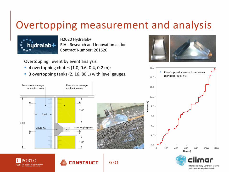
Overtopping: event by event analysis 4 overtopping chutes (1.0, 0.6, 0.4, 0.2 m); 3 overtopping tanks (2, 16, 80 L) with level gauges.
0.0
2.0
4.0
6.0
8.0
10.0
12.0
14.0
16.0
0 200 400 600 800 1000 1200Vo
lum
e (L
)Time (s)
Overtopped volume time series (UPORTO results)
Overtopping measurement and analysis
Overtopping tank
4.00
2.00
1.00
1.40
Rear slope damageevaluation area
Chute #1
Front slope damageevaluation area
1
2
1
2
H2020 Hydralab+RIA - Research and Innovation actionContract Number: 261520
GEOInterdisciplinary Centre of Marine and Environmental Research
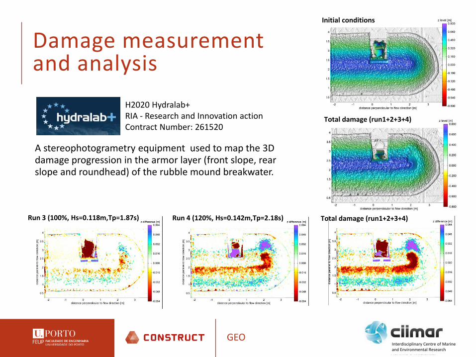
A stereophotogrametry equipment used to map the 3D damage progression in the armor layer (front slope, rear slope and roundhead) of the rubble mound breakwater.
Damage measurement and analysis
Run 3 (100%, Hs=0.118m,Tp=1.87s) Run 4 (120%, Hs=0.142m,Tp=2.18s) Total damage (run1+2+3+4)
H2020 Hydralab+RIA - Research and Innovation actionContract Number: 261520
Total damage (run1+2+3+4)
Initial conditions
GEOInterdisciplinary Centre of Marine and Environmental Research

UPorto possible contribution to DERELE
GEO
Case study in PortugalMondego river is a Portuguese river with origin in Estrela mountains that flows through a
narrow valley until Coimbra town, where the river valley consists of a vast alluvial plain,
and reaches the Atlantic ocean near the town of Figueira da Foz. Due to a very irregular
hydrological regime, the Mondego river basin, with 6671 km2, was subject to periodic
flooding.
Interdisciplinary Centre of Marine and Environmental Research

UPorto possible contribution to DERELE
GEO
Case study in PortugalThe Mondego plain leveesare part of the Mondegoriver regulation project,implemented on the 80’s oflast century.
This project included theconstruction of three damsand fluvial regularizationalong approximately 36km .
Interdisciplinary Centre of Marine and Environmental Research

UPorto possible contribution to DERELE
GEO
Typical cross section of the regulated river bedCase study in Portugal
• The main channel was designed for a flood of 340 m3/s (at Coimbra).• The two side channels were designed for a flood of 1200 m3/s (at Coimbra) - modified
100-year flood.• The levees along the main channel have lateral fuse-plug weirs to permit controlled
flooding.• The maximum registered flood in Coimbra was 2457 m3/s, in 1962.• In 2001 the levees have broken, by overtopping (for a flood of 1990 m3/s at Coimbra).
• The bottom width varies from 88 to 142.2 m;• The maximum depth is approximately 6.5 m. • The height of the levees varies from 2.7 to
4.6 m; • Levees are protected by vegetation except on
the curves (rockfill was used in this case).
Interdisciplinary Centre of Marine and Environmental Research
UPorto possible contribution to DERELE
GEO
Possible tasks• Identification and characterization of levees in Portugal and collection and
synthetization of data to further analysis of floods impact.• Geo-mechanical characterization of existing levees which combines geophysical
testing and specially devised CPTu• Installation of the monitoring system in the case study selected levee• Acquisition and statistical treatment of the data from monitoring systems• Contribution on numerical approaches for predicting the achievement of
possible ultimate limit states (loss of strength because of full saturation, critical hydraulic conditions, internal erosion, etc.)
• Development of experimental approaches for predicting the achievement of possible ultimate limit states (e.g. overtopping) using 2D and 3D levees’ scale models
• Development of expeditious and economical methodologies for the reinforcement of existing levees
Interdisciplinary Centre of Marine and Environmental Research

DeReLe possible H2020 calls
GEOInterdisciplinary Centre of Marine and Environmental Research
CIP-01-2016-2017: Prevention, detection, response and mitigation of the combination of physical and cyber threats to the critical infrastructure of Europe. Deadline: 24/8/2017
SMEInst-11-2016-2017 - Boosting the potential of small businesses in the areas of climate action, environment, resource efficiency and raw materialsDeadline: 8/11/2017
PowerWaterPrize-01-2017 - Inducement prize: Zero Power Water Infrastructure MonitoringDeadline: 11/9/2018

KIC Climate
GEOInterdisciplinary Centre of Marine and Environmental Research
(http://www.climate-kic.org/partners)
Core Partners: Deltares, Ferrovial, Imperial College, KLM, INRA (Institut national de la recherché agronomique), DTU, TUDelft, Utrecht Uni., Veolia, etc… and ASTER (Italy) (www.aster.it)
ASTER is the consortium among the Emilia-Romagna Regional Government, the six Universities, the National Research Centres located in the region – the National Research Council (CNR) and the Italian National Agency for New Technologies, Energy and Sustainable Economic Development (ENEA) – the Regional Union of Chambers of Commerce and the regional Entrepreneurial Associations.http://www.climate-kic.org/partners/aster/
One of the projects is about floods:https://dailyplanet.climate-kic.org/open-innovation-challenge-finds-solutions-reduce-glasgows-flood-risk/