class diagram abstractclass key -...
TRANSCRIPT

CoClassInterfaceDInterfaceB
Types of Classes
An abstract class cannot be used to create new objects but is a specification for instances of subclasses (through type inheritance.)
A CoClass can directly create objects by declaring a new object .
A Class cannot directly create objects, but objects of this class can be created as a property of another class or instantiated by objects from another class.
Types of Relationships
Associations represent relationships between classes. They have defined multiplicities at both ends.
Type inheritance defines specialized classes of objects which share properties and methods with the superclass and have additional properties and methods. Note that interfaces in superclasses are not duplicated in subclasses.
Instantiation specifies that one object from one class has a method with which it creates an object from another class.
Composition is a relationship in which objects from the 'whole' class control the lifetime of objects from the 'part' class.
An N-ary association specifies that more than two classes are associated . A diamond is placed at the intersection of the association branches .
A Multiplicity is a constraint on the number of objects that can be associated with another object. Association and composition relationships have multiplicities on both sides. This is the notation for multiplicities:
1 - One and only one (if none shown, '1' is implied)
0..1 - Zero or one
M..N - From M to N (positive integers)
* or 0..* - From zero to any positive integer
1..* - From one to any positive integer
Class Diagram Key
enumeration firstValue - firstEnumeration secondValue - secondEnumeration
AbstractClass
Type inheritance
Instantiation
Association
Composition
1..* Multiplicity
Interface of interestInterfaceA(Optional)InterfaceB
Interface of interest
InterfaceGInterfaceM
Outbound Interface
Inbound Interface
Special Interfaces (Optional) represents interfaces that are inherited by some subclasses but not all . The subclasses list the optional interfaces they implement.
(Instance) represents interfaces that are only on specific instances of the class.
(<classname>) indicates the name of the helper class required to support this event interface in Visual Basic.
Interface key
Property GetProperty PutProperty Get/PutProperty Put by ReferenceMethod
(<classname>)InterfaceO
Structure key <<Struct>>
firstMember: TypesecondMember: Type
ClassInterface of interest
ESRI® ArcGIS® 10 Copyright © 1999-2010 ESRI. All rights reserved. ESRI, ArcGIS, ArcObjects, and ArcMap are trademarks, registered trademarks, or service marks of
ESRI in the United States, the European Community, or certain other jurisdictions.
Page
MapIMap
GraphicSnapIGraphicSnap : IUnknown
Name: String
SnapX (in Shape: IGeometry, in Tolerance: Double): Boolean
SnapY (in Shape: IGeometry, in Tolerance: Double): Boolean
IPageLayoutSnap : IGraphicSnap
PageLayout: IPageLayoutesriSystem.IPersist
IGraphicSnap
IPageLayoutSnap
RulerSettingsIRulerSettings : IUnknown
SmallestDivision: DoubleesriSystem.IPersistesriSystem.IPersistStream
IRulerSettings
GridSnap
GuideSnap
MarginSnap
RulerSnap
SnapGrid
esriSystem.IPersistesriSystem.IPersistStream
ISnapGrid : IUnknown
HorizontalSpacing: DoubleIsVisible: BooleanVerticalSpacing: Double
Draw (in Display: IDisplay, in Page: IPage)
ISnapGrid
*
Layer in Carto Layers
0..*
*
*
*
esriSystem.IPersist
SpatialBookmarkISpatialBookmark
esriSystem.IPersistStream
ISpatialBookmark : IUnknown
BookmarkType: StringName: String
ZoomTo (in Map: IMap)
FeatureBookmarkIFeatureBookmark IFeatureBookmark : ISpatialBookmark
FeatureClass: IFeatureClassFeatureId: Long
Draw (in Display: IDisplay)Flash (in Display: IDisplay)PanTo (in Display: IDisplay)
AOIBookmarkIAOIBookmark IAOIBookmark : ISpatialBookmark
Location: IEnvelope
esriSystem.IPersistesriSystem.IPersistStream
esriSystem.IPropertySupport
IFrameProperties : IUnknown
Background: IBackgroundBorder: IBorderShadow: IShadow
IPage
IPageEvents
IFrameProperties
IPageEvents : IUnknown
PageColorChangedPageMarginsChangedPageSizeChangedPageUnitsChanged
esriSystem.IClone
esriDisplay.IConnectionPointContainer
IMapEvents : IUnknown
FeatureClassChanged (in oldClass: IFeatureClass, in newClass: IFeatureClass)
VersionChanged (in oldVersion: IVersion, in newVersion: IVersion)
IMap : IUnknown
ActiveGraphicsLayer: ILayerAnnotationEngine: IAnnotateMapAreaOfInterest: IEnvelopeBarriers (pExtent: IEnvelope):
IBarrierCollectionBasicGraphicsLayer: IGraphicsLayerClipBorder: IBorderClipGeometry: IGeometryDescription: StringDistanceUnits: esriUnitsExpanded: BooleanFeatureSelection: ISelectionIsFramed: BooleanLayer (in Index: Long): ILayerLayerCount: LongLayers (in uid: IUID, in recursive: Boolean):
IEnumLayerMapScale: DoubleMapSurround (in Index: Long): IMapSurroundMapSurroundCount: LongMapUnits: esriUnitsName: StringReferenceScale: DoubleSelectionCount: LongSpatialReference: ISpatialReferenceSpatialReferenceLocked: BooleanUseSymbolLevels: Boolean
AddLayer (in Layer: ILayer)AddLayers (in Layers: IEnumLayer, in
autoArrange: Boolean)AddMapSurround (in MapSurround:
IMapSurround)ClearLayersClearMapSurroundsClearSelectionComputeDistance (in p1: IPoint, in p2: IPoint):
DoubleCreateMapSurround (in clsid: IUID, in
optionalStyle: IMapSurround): IMapSurround
DelayDrawing (in delay: Boolean)DelayEvents (in delay: Boolean)DeleteLayer (in Layer: ILayer)DeleteMapSurround (in MapSurround:
IMapSurround)GetPageSize (out widthInches: Double, out
heightInches: Double)MoveLayer (in Layer: ILayer, in toIndex: Long)RecalcFullExtentSelectByShape (in Shape: IGeometry, in env:
ISelectionEnvironment, in justOne: Boolean)
SelectFeature (in Layer: ILayer, in Feature: IFeature)
SetPageSize (in widthInches: Double, in heightInches: Double)
BarrierCollectionIBarrierCollection IBarrierCollection : IUnknown
Count: Long
Add (in Barriers: IGeometryCollection, in Weight: esriBasicOverposterWeight)
ClearQueryItem (in Index: Long, out barrier:
IGeometryCollection, out Weight: esriBasicOverposterWeight)
*
IMapEvents(MapEvents)
IActiveView
IActiveViewEvents
IBasicMap2esriDisplay.IConnectionPointContainer
esriDisplay.IDisplayAdminesriDisplay.IDisplayEvents
IGraphicsContainerIGraphicsContainerSelect
ILayerMasking
IMapAdminIMapAdmin2IMapAdmin3
IMapBarriers
IMapBookmarks
IMapCacheIMapGeographicTransformations
IMapLayersIMapOverposter
IMxdContents
esriSystem.IPersistesriSystem.IPersistStream
IRelationshipClassCollectionISelectionEvents
IStandaloneTableCollectionITableCollection
esriDisplay.ITransformEventsIViewManagerIViewRefresh
OverposterProperties in Carto Annotation /Labeling
PageLayout
IActiveView
esriDisplay.IDisplayAdmin
esriSystem.IPersistesriSystem.IPersistStream
IGraphicsContainerSelect : IUnknown
DominantElement: IElementElementSelectionCount: LongSelectedElements: IEnumElementSelectionBounds (in Display: IDisplay):
IEnvelope
ElementSelected (in Element: IElement): Boolean
SelectAllElementsSelectedElement (in Index: Long): IElementSelectElement (in Element: IElement)SelectElements (in Elements: IEnumElement)SelectionTracker (in Index: Long):
ISelectionTrackerUnselectAllElementsUnselectElement (in Element: IElement)UnselectElements (in Elements:
IEnumElement)
IGraphicsContainer
IGraphicsContainerSelect
IGraphicSnapEnvironment : IUnknown
SnapAgent (in Index: Long): IGraphicSnapSnapAgentCount: LongSnapAgentOrder: IArraySnapTolerance: Double
AddSnapAgent (in SnapAgent: IGraphicSnap)ClearSnapAgentsDeleteSnapAgent (in SnapAgent:
IGraphicSnap)SnapShape (in Shape: IGeometry)
IGraphicSnapEnvironment
esriDisplay.IConnectionPointContainer
IViewManager
IGraphicsContainer : IUnknown
AddElement (in Element: IElement, in zorder: Long)
AddElements (in Elements: IElementCollection, in zorder: Long)
BringForward (in Elements: IEnumElement)BringToFront (in Elements: IEnumElement)DeleteAllElementsDeleteElement (in Element: IElement)FindFrame (in frameObject: Variant):
IFrameElementGetElementOrder (in Elements:
IEnumElement): VariantLocateElements (in point: IPoint, in Tolerance:
Double): IEnumElementLocateElementsByEnvelope (in envelope:
IEnvelope): IEnumElementMoveElementFromGroup (in group:
IGroupElement, in Element: IElement, in zorder: Long)
MoveElementToGroup (in Element: IElement, in group: IGroupElement)
Next: IElementPutElementOrder (in order: Variant)ResetSendBackward (in Elements: IEnumElement)SendToBack (in Elements: IEnumElement)UpdateElement (in Element: IElement)
MxDocumentin ArcMapUI
IActiveViewEvents
IMxdContents
IPageLayout
IPageLayout3
IViewRefresh
MapSelection
esriGeodatabase.IEnumFeatureesriGeodatabase.IEnumFeatureSetup
ISelection ISelection : IUnknown
CanClear: BooleanCanCopy: BooleanCanCut: BooleanCanPaste: BooleanCanSelectAll: BooleanClearCopyCutDraw (in Display: IDisplay, in
CancelTracker: ITrackCancel)PasteSelectAll
Map Surround in Carto Map Elements
MapDocumentIMapDocument IMapDocument : IUnknown
ActiveView: IActiveViewDocumentFilename: StringDocumentType: esriMapDocumentTypeDocumentVersion:
esriMapDocumentVersionInfoIsMapDocument (in sDocument: String):
BooleanIsPasswordProtected (in sDocument:
String): BooleanIsPresent (in sDocument: String): BooleanIsReadOnly (in sDocument: String):
BooleanIsRestricted (in sDocument: String):
BooleanLayer (in mapIndex: Long, in layerIndex:
Long): ILayerMap (in mapIndex: Long): IMapMapCount: LongPageLayout: IPageLayoutPrinter: IPrinterThumbnail: IPictureUsesRelativePaths: Boolean
CloseGetVersionInfo (versionInfoMissing:
Boolean, lMajor: Long, lMinor: Long, lRevision: Long, lBuild: Long)
New (in sDocument: String)Open (in sDocument: String, in
bsPassword: String)ReplaceContents (in pObject:
IMxdContents)Save (in bUseRelativePaths: Boolean, in
bCreateThumnbail: Boolean)SaveAs (in sDocument: String, in
bUseRelativePaths: Boolean, in bCreateThumnbail: Boolean)
SetActiveView (in pActiveView: IActiveView)
esriSystem.IDocumentVersion
Map Frame in Carto Map Elements
*
Element in Carto Map Elements
*
CompositeGraphicsLayer in Carto Layers
IPageLayout3 : IUnknown
AlignToMargins: BooleanContentProvider: IUnknownDelayEvents: BooleanHorizontalSnapGuides: ISnapGuidesPage: IPagePrinter: IPrinterRulerSettings: IRulerSettingsSnapGrid: ISnapGridVerticalSnapGuides: ISnapGuidesZoomPercent: Double
ClearContentFocusNextMapFrameFocusPreviousMapFrameReplaceMaps (in maps: IMaps)ZoomToPercent (in percent: Long)ZoomToWholeZoomToWidth
IPageLayout2
IDynamicMap
IDynamicMapEvents(DynamicMapEvents)
IBasicMap
IActiveViewEvents : IUnknown
AfterDraw (in Display: IDisplay, in phase: esriViewDrawPhase)
AfterItemDraw (in Index: Integer, in Display: IDisplay, phase: esriDrawPhase)
ContentsChangedContentsClearedFocusMapChangedItemAdded (in Item: Variant)ItemDeleted (in Item: Variant)ItemReordered (in Item: Variant, in toIndex:
Long)SelectionChangedSpatialReferenceChangedViewRefreshed (in view: IActiveView, in
phase: esriViewDrawPhase, in Data: Variant, in envelope: IEnvelope)
IPageEvents
esriDisplay.ITransformEventsISelectionEvents
IMapBookmarks2
IActiveView : IUnknown
ExportFrame: tagRECTExtent: IEnvelopeExtentStack: IExtentStackFocusMap: IMapFullExtent: IEnvelopeGraphicsContainer: IGraphicsContainerIsMapActivated: BooleanScreenCacheID (in phase:
esriViewDrawPhase, in Data: IUnknown): Integer
ScreenDisplay: IScreenDisplaySelection: ISelectionShowRulers: BooleanShowScrollBars: BooleanShowSelection: BooleanTipText (in x: Double, in y: Double): String
Activate (hWnd: OLE_HANDLE)ClearContentsChangedDeactivateDraw (in hDC: OLE_HANDLE, in
TrackCancel: ITrackCancel)GetContextMenu (in x: Double, in y:
Double, out clsidMenu: IUID)HitTestMap (in Location: IPoint): IMapIsActive: BooleanOnMessage (in msg: Unsigned Long, in
wParam: UINT_PTR, in lParam: LONG_PTR)
Output (in hDC: OLE_HANDLE, in Dpi: Long, in pixelBounds: tagRECT, in VisibleBounds: IEnvelope, in TrackCancel: ITrackCancel)
PartialRefresh (in phase: esriViewDrawPhase, in Data: IUnknown, in envelope: IEnvelope)
PrinterChanged (in Printer: IPrinter)Refresh
ChangeDatabaseVersionIChangeDatabaseVersion IChangeDatabaseVersion : IUnknown
Execute (in pFrom: IVersion, in pTo: IVersion, in pMap: IBasicMap): ISet
Interfaces Enumerations
ISupportErrorInfo
MapReaderIMapReader IMapReader : IUnknown
AccessInternalObjects: BooleanDocumentInfo: IPropertySetMap (in Index: Long): IMapMapCount: LongPageLayout: IPageLayoutThumbnail: IPictureDisp
CloseOpen (in FilePath: String)
*
IMapAdmin4
IPageLayoutExtensions
IEnumLayer : IUnknown
Next: ILayerReset
IEnumMap : IUnknown
Next: IMapReset
IBasicMapIdentifyObject : IUnknown
BasicMap: IBasicMap
IContextAnalyzer : IUnknown
Priority: Long
GetContextMenu (in contextObject: IUnknown, out clsidMenu: IUID)
IEnumMapSurround : IUnknown
Next: IMapSurroundReset
IEnumSpatialBookmark : IUnknown
Next: ISpatialBookmarkReset
IExtentStack : IUnknown
Count: LongItem (in Index: Long): IEnvelope
CanRedo: BooleanCanUndo: BooleanDo (in Extent: IEnvelope)RedoResetUndo
IMaps : IUnknown
Count: LongItem (in Index: Long): IMap
Create: IMapRemove (in Map: IMap)RemoveAt (in Index: Long)Reset
IMapEvents2 : IUnknown
ActiveGraphicsLayerChanged (in oldGraphicsLayer: IGraphicsLayer, in newGraphicsLayer: IGraphicsLayer)
TableChanged (in oldTable: ITable, in newTable: ITable)
IMapEvents3 : IUnknown
BeginBuildCache (in Map: IMap)EndBuildCache (in Map: IMap)
IMaps2 : IUnknown
Count: LongItem (in Index: Long): IMap
Create: IMapMoveItem (in pMap: IMap, in toIndex: Long)Remove (in Map: IMap)RemoveAt (in Index: Long)Reset
IPushPin : ISpatialBookmark
Location: IPointMarkerSymbol: IMarkerSymbolMaxLabelWidthPts: DoubleTextSymbol: ITextSymbol
Draw (in Display: IDisplay)Flash (in Display: IDisplay)
IRotateOperation : IOperation
ActiveView: IActiveViewName: StringPreviousRotation: DoubleRefresh: BooleanRotation: Double
ITOCClass : IUnknown
Description: StringLabel: StringSymbolPatchImage (in fileType: String):
String
ITOCGroup : IUnknown
Classes: IArrayHeading: String
IKmlConversion : IUnknown
GetLayerIDListFromMap (in pMap: IMap): IArray
GetLayerIDListFromMapServer (in pMapServer: IMapServer): IArray
LayerToArray (in pLayer: ILayer, in pQueryFilter: IQueryFilter, in pKmlParameters: IPropertySet): BYTE
LayerToFile (in pLayer: ILayer, in pQueryFilter: IQueryFilter, in pKmlParameters: IPropertySet, in Filename: String)
MapServerMapToArray (in pMapServer: IMapServer, in pQueryFilter: IQueryFilter, in pKmlParameters: IPropertySet, in pLayerIDs: String): BYTE
MapServerMapToFile (in pMapServer: IMapServer, in pQueryFilter: IQueryFilter, in pKmlParameters: IPropertySet, in pLayerIDs: String, in Filename: String)
MapToArray (in pMap: IMap, in pQueryFilter: IQueryFilter, in pKmlParameters: IPropertySet, in pLayerIDs: String): BYTE
MapToFile (in pMap: IMap, in pQueryFilter: IQueryFilter, in pKmlParameters: IPropertySet, in pLayerIDs: String, in Filename: String)
ILevelMasking
IMapBarriers2
ExportInfoGeneratorIExportInfoGenerator
IFeatureExportInfoGenerator IFeatureExportInfoGenerator : IUnknown
HotlinkContainer: IHotlinkContainerHyperlinkContainer: IHyperlinkContainerLayerFields: ILayerFields
AddFeatureAttribute (in Display: IDisplay, in FieldType: esriFieldType, in FieldName: String, in fieldValue: String)
BeginFeature (in Feature: IFeature, in Display: IDisplay)
BeginFeatureAttributes (in Display: IDisplay)
EndFeature (in Display: IDisplay)EndFeatureAttributes (in Display: IDisplay)GenerateFeatureInfo (in Feature: IFeature,
in Display: IDisplay)GenerateHyperlinkInfo (in Feature:
IFeature, in Display: IDisplay)PrepareExportFilter (in fc: IFeatureClass,
Filter: IQueryFilter)
IExportInfoGenerator : IUnknown
BeginGroup (in pDisplay: IDisplay, in Comment: String)
BeginLayer (in pDisplay: IDisplay, in Comment: String)
BeginLayerWithName (in pDisplay: IDisplay, in pLayer: ILayer)
BeginLayerWithNameAndPhase (in pDisplay: IDisplay, in pLayer: ILayer, in viewDrawPhase: esriViewDrawPhase)
BeginMap (in pDisplay: IDisplay, in hDC: OLE_HANDLE, in pMap: IMap)
BeginPageLayout (in hDC: OLE_HANDLE, in FocusMap: Long)
BeginText (in pDisplay: IDisplay, in Type: Long, in Kerning: Long, in Tracking: Double, in WidthScale: Double, in WordSpace: Double, in LineLeading: Double, in Text: String)
EndGroup (in pDisplay: IDisplay)EndLayer (in pDisplay: IDisplay)EndMap (in hDC: OLE_HANDLE)EndPageLayout (in hDC: OLE_HANDLE)EndText (in pDisplay: IDisplay)SetCmykColor (in pDisplay: IDisplay, in
cmykColor: OLE_COLOR, SpotColor: Boolean, ColorType: Long)
IPage : IUnknown
Background: IBackgroundBackgroundColor: IColorBorder: IBorderDelayEvents: BooleanFormID: esriPageFormIDIsPrintableAreaVisible: BooleanOrientation: IntegerPageToPrinterMapping:
esriPageToPrinterMappingPrintableBounds: IEnvelopeStretchGraphicsWithPage: BooleanUnits: esriUnits
DrawBackground (in Display: IDisplay)DrawBorder (in Display: IDisplay)DrawPaper (in Display: IDisplay, in
eraseColor: IColor)DrawPrintableArea (in Display: IDisplay)GetDeviceBounds (in Printer: IPrinter, in
currentPage: Integer, in Overlap: Double, in Resolution: Integer, in deviceBounds: IEnvelope)
GetPageBounds (in Printer: IPrinter, in currentPage: Integer, in Overlap: Double, in pageBounds: IEnvelope)
PrinterChanged (in Printer: IPrinter)PrinterPageCount (in Printer: IPrinter, in
Overlap: Double, out PageCount: Integer)
PutCustomSize (in Width: Double, in Height: Double)
QuerySize (out Width: Double, out Height: Double)
SnapGuides
esriSystem.IPersistesriSystem.IPersistStream
ISnapGuides ISnapGuides : IUnknown
AreVisible: BooleanDrawLevel: esriViewDrawPhaseGuide (in idx: Long): DoubleGuideCount: Long
AddGuide (in pos: Double)Draw (in Display: IDisplay, in IsHorizontal:
Boolean)DrawHighlight (in Display: IDisplay, in
IsHorizontal: Boolean)RemoveAllGuidesRemoveGuide (in idx: Long)
esriMapDocumentType0 - esriMapDocumentTypeMxd1 - esriMapDocumentTypePmf2 - esriMapDocumentTypeLyr3 - esriMapDocumentTypeUnknown
esriMapDocumentVersionInfo0 - esriMapDocumentVersionInfoSuccess1 - esriMapDocumentVersionInfoFail2 - esriMapDocumentVersionInfoUnknown
esriBufferSpatialReferenceType0 - esriMapSpatialReference1 - esriFeatureClassSpatialReference2 - esriFeatureOptimizedSpatialReference3 - esriFeatureSetOptimizedSpatialReference4 - esriOtherSpatialReference
esriMapCacheUpdateMode0 - esriMapCacheUpdateRecreateMissing1 - esriMapCacheUpdateRecreateAll2 - esriMapCacheUpdateDelete
esriPageFormID0 - esriPageFormLetter1 - esriPageFormLegal2 - esriPageFormTabloid3 - esriPageFormC4 - esriPageFormD5 - esriPageFormE6 - esriPageFormA57 - esriPageFormA48 - esriPageFormA39 - esriPageFormA210 - esriPageFormA111 - esriPageFormA012 - esriPageFormCUSTOM13 - esriPageFormSameAsPrinter
esriPageToPrinterMapping0 - esriPageMappingCrop1 - esriPageMappingScale2 - esriPageMappingTile
esriSelectionResultEnum0 - esriSelectionResultNew1 - esriSelectionResultAdd2 - esriSelectionResultSubtract3 - esriSelectionResultAnd4 - esriSelectionResultXOR
esriValueRepresentations0 - esriValueRepUnknown1 - esriValueRepRadius2 - esriValueRepArea3 - esriValueRepDistance4 - esriValueRepWidth
esriMappingMsgCodeEnum103000 - esriMappingMsgCode_LayerDrawBegin103001 - esriMappingMsgCode_LayerDrawEnd103002 - esriMappingMsgCode_GroupLayerDrawBegin103003 - esriMappingMsgCode_GroupLayerDrawEnd103004 - esriMappingMsgCode_GeographyDrawBegin103005 - esriMappingMsgCode_GeographyDrawEnd103006 - esriMappingMsgCode_AnnotationDrawBegin103007 - esriMappingMsgCode_AnnotationDrawEnd103008 - esriMappingMsgCode_SelectionDrawBegin103009 - esriMappingMsgCode_SelectionDrawEnd103010 - esriMappingMsgCode_GraphicSelectionDrawBegin103011 - esriMappingMsgCode_GraphicSelectionDrawEnd103012 - esriMappingMsgCode_CustomDrawBegin103013 - esriMappingMsgCode_CustomDrawEnd103014 - esriMappingMsgCode_GraphicDrawBegin103015 - esriMappingMsgCode_GraphicDrawEnd103016 - esriMappingMsgCode_LabelingBegin103017 - esriMappingMsgCode_LabelingEnd103018 - esriMappingMsgCode_LabelingLayers103019 - esriMappingMsgCode_FeatureCount103020 - esriMappingMsgCode_GraphicCount103021 - esriMappingMsgCode_ExecutingQuery103022 - esriMappingMsgCode_DrawingAsMaskingLayer103023 - esriMappingMsgCode_SymbolDrawTime103024 - esriMappingMsgCode_Rendering103800 - esriMappingMsgCode_LayerDrawingError
esriViewDrawPhase0 - esriViewNone1 - esriViewBackground2 - esriViewGeography4 - esriViewGeoSelection8 - esriViewGraphics16 - esriViewGraphicSelection32 - esriViewForeground64 - esriViewInitialized255 - esriViewAll
esriExtentTypeEnum0 - esriExtentDefault0 - esriAutoExtentNone1 - esriExtentScale1 - esriAutoExtentScale2 - esriExtentBounds2 - esriAutoExtentBounds3 - esriAutoExtentMarginPercent4 - esriAutoExtentMarginMapUnits5 - esriAutoExtentMarginPageUnits6 - esriExtentPageIndex
DocumentInfoIDocumentInfo2 : IUnknown
Author: StringCategory: StringComments: StringCredits: StringDateExported: VariantDatePrinted: VariantDateSaved: VariantDocumentTitle: StringFolder: StringHyperlinkBase: StringKeywords: StringName: StringPath: StringRelativePaths: BooleanSavePreview: BooleanSubject: String
IDocumentInfoIDocumentInfo2
MSDHelperIMSDHelper IMSDHelper : IUnknown
CloseGetDataset (in layerPath: String): StringGetLayerDisplayName (in layerPath:
String): StringGetLayers (in mapPath: String):
IStringArrayGetLayerType (in layerPath: String): StringGetMapDisplayName (in mapPath: String):
StringGetMaps: IStringArrayGetSubLayers (in layerPath: String):
IStringArrayGetWorkspaceConnectionStringFromLayer
(in layerPath: String): StringGetWorkspaceFactoryType (in layerPath:
String): StringIsActiveMap (in mapPath: String): BooleanIsLayerValid (in layerPath: String): BooleanOpen (in Path: String)PutWorkspaceConnectionStringInLayer (in
layerPath: String, in workspaceConnectionString: String, in validate: Boolean)
ReplaceAll (in mapPath: String, in oldWorkspaceConnectionString: String, in newWorkspaceConnectionString: String, in validate: Boolean)
Save (in relativePath: Boolean)SaveAs (in Path: String, in relativePath:
Boolean)
PrintAndExportIPrintAndExport IPrintAndExport : IUnknown
PageCount (in ActiveView: IActiveView): Long
PageRow (in ActiveView: IActiveView, in PageName: String): IRow
PrinterNames: IEnumBSTR
Export (in pActiveView: IActiveView, in pExport: IExport, in Resolution: Double, in clip2GraphicExtent: Boolean, in pTrackCancel: ITrackCancel)
ExportPages (in pActiveView: IActiveView, in pPDFExport: IExportPDF, in Options: IPrintAndExportPageOptions, in Resolution: Double, in pTrackCancel: ITrackCancel)
Print (in pActiveView: IActiveView, in pPrinter: IPrinter, in pPage: IPage, in PageID: Long, in resRatio: Long, in pTrackCancel: ITrackCancel)
PrintPages (in pActiveView: IActiveView, in pPrinter: IPrinter, in pPage: IPage, in Options: IPrintAndExportPageOptions, in resRatio: Long, in pTrackCancel: ITrackCancel)
DataSourceHelperIDataSourceHelperLayer
IDataSourceHelperMap
IDataSourceHelperMapDocument
IDataSourceHelperStandaloneTable
IDataSourceHelperLayer : IUnknown
FindAndReplaceWorkspaceNamePath (in pLayer: ILayer, in oldWorkspaceName: String, in newWorkspaceName: String, in validate: Boolean)
ReplaceName (in pLayer: ILayer, in pName: IName, in validate: Boolean)
IDataSourceHelperMap : IUnknown
FindAndReplaceWorkspaceNamePath (in pBasicMap: IBasicMap, in oldWorkspaceName: String, in newWorkspaceName: String, in validate: Boolean)
Repair (in pBasicMap: IBasicMap, in pDataLayer: IDataLayer, in pName: IName, in validate: Boolean)
ReplaceWorkspaceName (in pBasicMap: IBasicMap, in pOldWorkspaceName: IWorkspaceName, in pNewWorkspaceName: IWorkspaceName, in validate: Boolean)
IDataSourceHelperMapDocument : IUnknown
FindAndReplaceWorkspaceNamePath (in pMapDocument: IMapDocument, in oldWorkspaceName: String, in newWorkspaceName: String, in validate: Boolean)
Repair (in pMapDocument: IMapDocument, in pDataLayer: IDataLayer, in pName: IName, in validate: Boolean)
ReplaceWorkspaceName (in pMapDocument: IMapDocument, in pOldWorkspaceName: IWorkspaceName, in pNewWorkspaceName: IWorkspaceName, in validate: Boolean)
IDataSourceHelperStandaloneTable : IUnknown
FindAndReplaceWorkspaceNamePath (in pStandaloneTable: IStandaloneTable, in oldWorkspaceName: String, in newWorkspaceName: String, in validate: Boolean)
ReplaceName (in pStandaloneTable: IStandaloneTable, in pName: IName, in validate: Boolean)
IMapLayers2IMapClipOptions
IMapAutoExtentOptionsIMapTimeDisplay
IDocumentInfoIDocumentInfo2
IDocumentPreview
esriDisplay.IConnectionPointContainer
SymbolShadowISymbolShadow : IShadow
CornerRounding: IntegerFillSymbol: IFillSymbol
IShadow : IUnknown
HorizontalSpacing: DoubleName: StringVerticalSpacing: Double
Draw (in Display: IDisplay, in Geometry: IGeometry)
GetGeometry (in Display: IDisplay, in Shape: IGeometry): IGeometry
QueryBounds (in Display: IDisplay, in Geometry: IGeometry, in Bounds: IEnvelope)
ISymbolShadow
IShadow
Geometry in Geometry
PolygonElementIPolygonElement
IElementEditVertices
IPolygonElement : IUnknown
IElementEditVertices : IUnknown
MovingVertices: Boolean
GetMoveVerticesSelectionTracker: ISelectionTracker
RectangleElementIRectangleElement IRectangleElement : IUnknown
EllipseElementIEllipseElement IEllipseElement : IUnknown
*
CircleElementICircleElement : IUnknownICircleElement
LineElementILineElement : IUnknown
Symbol: ILineSymbol
IElementEditVertices : IUnknown
MovingVertices: Boolean
GetMoveVerticesSelectionTracker: ISelectionTracker
IElementEditVertices
ILineElement
*
MultiPatchElement
FrameElementIGraphicElement : IUnknown
SpatialReference: ISpatialReference
IGraphicElement
FrameElementBaseIFrameElement : IUnknown
Background: IBackgroundBorder: IBorderDraftMode: BooleanObject: VariantThumbnail: OLE_HANDLE
IFrameElement
IFrameProperties : IUnknown
Background: IBackgroundBorder: IBorderShadow: IShadow
IFrameDraw : IUnknown
DrawBackground (in Display: IDisplay, in CancelTracker: ITrackCancel)
DrawDraftMode (in Display: IDisplay, in CancelTracker: ITrackCancel)
DrawForeground (in Display: IDisplay, in CancelTracker: ITrackCancel)
IFrameDraw
IFrameProperties
Element
IElementProperties
IElement
esriSystem.IClone
esriSystem.IPersistesriSystem.IPersistStream
IPropertySupport
IBoundsProperties
FillShapeElementIFillShapeElement : IUnknown
Symbol: IFillSymbol
IFillShapeElementGroupElementIGroupElement : IUnknown
Element (in Index: Long): IElementElementCount: LongElements: IEnumElement
AddElement (in Element: IElement)ClearElementsDeleteElement (in Element: IElement)
IGroupElement
IFrameDrawIFrameElement
IFrameProperties
MarkerElementIMarkerElement : IUnknown
Symbol: IMarkerSymbol
IMarkerElement
IElementProperties3
Text3DElementIText3DElement IText3DElement : IUnknown
Alignment: esriT3DAlignmentAnchorPoint: IPointAxisRotation: esriT3DRotationAxisBoldFont: BooleanDepth: DoubleFontName: StringHeight: DoubleItalicFont: BooleanJustification: esriT3DJustificationOrientationPlane: esriT3DOrientationPlaneRotationAngle: DoubleSurface: IFunctionalSurfaceText: StringZAxisScale: Double
Update: Boolean
TextElement
IElementEditVertices
ITextElement : IUnknown
ScaleText: BooleanSymbol: ITextSymbolText: String
ITextElement
IGroupSymbolElement
IElementEditCalloutISymbolCollectionElement
IMultiPartTextElement
*
JpgPictureElement
PngPictureElement
TifPictureElement
EmfPictureElement
BmpPictureElement
GifPictureElement
InkGraphic
IElementShutdownIInkGraphic IInkGraphic : IUnknown
Color: LongInkGeometry: IUnknownInkType: ESRITPCPenTypeTag: VariantTipType: ESRITPCStylusTypeWidth: Long
Recognize: StringUpdateRecognitionResult (in
newResultText: String)
ParagraphTextElement
IColumnProperties : IUnknown
Count: LongGap: Double
IMarginProperties : IUnknown
Margin: Double
IParagraphTextElement
IColumnProperties
esriDisplay.IMarginProperties
IFrameProperties
IElementEditVerticesIGroupSymbolElement
ISymbolCollectionElement
IElementEditCallout
ITextElement ITextElement : IUnknown
ScaleText: BooleanSymbol: ITextSymbolText: String
MapFrame
IActiveViewEvents
esriDisplay.IDisplayAdmin
ITransformEvents
IMapGrids : IUnknown
MapGrid (in Index: Long): IMapGridMapGridCount: Long
AddMapGrid (in MapGrid: IMapGrid)ClearMapGridsDeleteMapGrid (in MapGrid: IMapGrid)
IMapGrids
IMapFrameEvents
IGraphicsComposite
IMapFrame
IMapFrameEvents : IUnknown
MapFrameResized
esriDisplay.IConnectionPointContainer
IGraphicsContainerProperty
IMapFrame : IFrameElement
Container: IGraphicsContainerExtentType: esriExtentTypeEnumLocatorRectangleCount: LongMap: IMapMapBounds: IEnvelopeMapScale: Double
AddLocatorRectangle (in locator: ILocatorRectangle)
CreateSurroundFrame (in clsid: IUID, in optionalStyle: IMapSurround): IMapSurroundFrame
LocatorRectangle (in Index: Long): ILocatorRectangle
RemoveAllLocatorRectanglesRemoveLocatorRectangle (in locator:
ILocatorRectangle)
esriDisplay.IDisplayEvents
MapSurroundFrameIMapSurroundFrame : IFrameElement
MapFrame: IMapFrameMapSurround: IMapSurround
IMapSurroundFrame
IGraphicsComposite
IMapSurroundEventsIMapFrameEvents
ITransformEvents
esriSystem.ISupportErrorInfo
IGroupElement2
IGraphicsContainerProperty
IndexGridIIndexGrid : IMapGrid
ColumnCount: LongRowCount: LongXLabel (in column: Long): StringYLabel (in Row: Long): String
QueryCellExtent (in Row: Long, in column: Long, in pMapFrame: IMapFrame, Extent: IEnvelope)
IIndexGrid
MeasuredGridIMeasuredGrid : IUnknown
FixedOrigin: BooleanUnits: esriUnitsXIntervalSize: DoubleXOrigin: DoubleYIntervalSize: DoubleYOrigin: Double
IProjectedGrid : IUnknown
SpatialReference: ISpatialReference
IProjectedGrid
IMeasuredGrid
CustomOverlayGridICustomOverlayGrid : IMapGrid
DataSource: IFeatureClassLabelField: String
ICustomOverlayGrid
MgrsGrid
IGridLadderLabels
IMgrsGrid IMgrsGrid : IUnknown
GridSquareBoundarySymbol: ILineSymbolGridSquareLabelColor: IColorGridSquareLabelFont: IFontDispGridSquareLabelSize: DoubleGridSquareLabelStyle:
esriGridSquareLabelStyleEnumInteriorTickLength: DoubleInteriorTickSymbol: ILineSymbolShowGridSquareIdentifiers: Boolean
IGridLadderLabels : IUnknown
LadderLabelColor: IColorLadderLabelColumnCount: LongLadderLabelFont: IFontDispLadderLabelRowCount: LongLadderLabelSize: DoubleShowLadderLabels: BooleanShowOuterLabelsOnly: Boolean
CustomOverlayGridFactoryin CartoUI
GraticuleFactoryin CartoUI
MGRSGridFactoryin CartoUI
IndexGridFactoryin CartoUI
MeasuredGridFactoryin CartoUI
Graticule
IMeasuredGrid : IUnknown
FixedOrigin: BooleanUnits: esriUnitsXIntervalSize: DoubleXOrigin: DoubleYIntervalSize: DoubleYOrigin: Double
IMeasuredGrid
IGraticule
IGridAxisTicksIGridHatch
IGridInteriorLabels
IGraticule : IMapGrid
AutoInterval: Boolean
AddElement (in Label: String, in Location: Double, in isLatitude: Boolean, in LabelSymbol: ITextSymbol)
RemoveElement (in Label: String)
MapGridIMapGrid
esriSystem.IPersist
esriSystem.IClone
esriSystem.IPersistStream
IGraphicsComposite
SymbolBorderISymbolBorder : IBorder
CornerRounding: IntegerLineSymbol: ILineSymbol
IBorder : IUnknown
Gap: DoubleName: String
Draw (in Display: IDisplay, in Geometry: IGeometry)
GetGeometry (in Display: IDisplay, in Shape: IGeometry): IGeometry
QueryBounds (in Display: IDisplay, in Geometry: IGeometry, in Bounds: IEnvelope)
IBorder
ISymbolBorder
FrameDecorationIFrameDecoration : IUnknown
Color: IColorCornerRounding: IntegerHorizontalSpacing: DoubleName: StringVerticalSpacing: Double
Draw (in Display: IDisplay, in Geometry: IGeometry)
GetGeometry (in Display: IDisplay, in Shape: IGeometry): IGeometry
QueryBounds (in Display: IDisplay, in Geometry: IGeometry, in Bounds: IEnvelope)
IFrameDecoration
esriSystem.IClone
esriSystem.IPersistesriSystem.IPersistStream
IGraphicsComposite
esriSystem.IXMLSerialize
ElementCollectionIElementCollection : IUnknown
Count: Long
Add (in Element: IElement, in LinkedFeatureID: Long)
ClearQueryItem (in Index: Long, out Element:
IElement, out LinkedFeatureID: Long)Remove (in Element: IElement)
IElementCollection
esriSystem.IPersistesriSystem.IPersistStream
IElementCollection2
GraphicElementIGraphicElement : IUnknown
SpatialReference: ISpatialReferenceesriSystem.IXMLSerialize(optional)
IGraphicElement
GraphicElementsIGraphicElements
esriSystem.IPersistesriSystem.IPersistStreamesriSystem.IXMLSerialize
IGraphicElements : IUnknown
Count: LongElement (in Index: Long): IGraphicElement
Add (in Element: IGraphicElement)Insert (in Index: Long, in Element:
IGraphicElement)Remove (in Index: Long)RemoveAll
CoClassInterfaceDInterfaceB
Types of Classes
An abstract class cannot be used to create new objects but is a specification for instances of subclasses (through type inheritance.)
A CoClass can directly create objects by declaring a new object .
A Class cannot directly create objects, but objects of this class can be created as a property of another class or instantiated by objects from another class.
Types of Relationships
Associations represent relationships between classes. They have defined multiplicities at both ends.
Type inheritance defines specialized classes of objects which share properties and methods with the superclass and have additional properties and methods. Note that interfaces in superclasses are not duplicated in subclasses.
Instantiation specifies that one object from one class has a method with which it creates an object from another class.
Composition is a relationship in which objects from the 'whole' class control the lifetime of objects from the 'part' class.
An N-ary association specifies that more than two classes are associated . A diamond is placed at the intersection of the association branches .
A Multiplicity is a constraint on the number of objects that can be associated with another object. Association and composition relationships have multiplicities on both sides. This is the notation for multiplicities:
1 - One and only one (if none shown, '1' is implied)
0..1 - Zero or one
M..N - From M to N (positive integers)
* or 0..* - From zero to any positive integer
1..* - From one to any positive integer
Class Diagram Key
enumeration firstValue - firstEnumeration secondValue - secondEnumeration
AbstractClass
Type inheritance
Instantiation
Association
Composition
1..* Multiplicity
Interface of interestInterfaceA(Optional)InterfaceB
Interface of interest
InterfaceGInterfaceM
Outbound Interface
Inbound Interface
Special Interfaces (Optional) represents interfaces that are inherited by some subclasses but not all . The subclasses list the optional interfaces they implement.
(Instance) represents interfaces that are only on specific instances of the class.
(<classname>) indicates the name of the helper class required to support this event interface in Visual Basic.
Interface key
Property GetProperty PutProperty Get/PutProperty Put by ReferenceMethod
(<classname>)InterfaceO
Structure key <<Struct>>
firstMember: TypesecondMember: Type
ClassInterface of interest
ESRI® ArcGIS® 10 Copyright © 1999-2010 ESRI. All rights reserved. ESRI, ArcGIS, ArcObjects, and ArcMap are trademarks, registered trademarks, or service marks of
ESRI in the United States, the European Community, or certain other jurisdictions.
AlternatingScaleBar HollowScaleBar
DoubleAlternatingScaleBar
SteppedScaleLine
OverviewIOverview2
ScaleLineIScaleLine IScaleLine : IUnknown
LineSymbol: ILineSymbol
DoubleFillScaleBarIDoubleFillScaleBar : IUnknown
FillSymbol1: IFillSymbolFillSymbol2: IFillSymbol
IDoubleFillScaleBar
MapInsetIMapInset2
SingleDivisionScaleBarISingleFillScaleBar : IUnknown
FillSymbol: IFillSymbol
ISingleFillScaleBar
ScaleBar
IScaleMarks : IUnknown
DivisionMarkHeight: DoubleDivisionMarkSymbol: ILineSymbolMarkFrequency: esriScaleBarFrequencyMarkPosition: esriVertPosEnumSubdivisionMarkHeight: DoubleSubdivisionMarkSymbol: ILineSymbol
IScaleBar
IScaleMarks
IScaleBar : IMapSurround
BarColor: IColorBarHeight: DoubleDivision: DoubleDivisions: IntegerDivisionsBeforeZero: IntegerLabelFrequency: esriScaleBarFrequencyLabelGap: DoubleLabelPosition: esriVertPosEnumLabelSymbol: ITextSymbolNumberFormat: INumberFormatResizeHint: esriScaleBarResizeHintSubdivisions: IntegerUnitLabel: StringUnitLabelGap: DoubleUnitLabelPosition: esriScaleBarPosUnitLabelSymbol: ITextSymbolUnits: esriUnits
UseMapSettings
IPropertySupport
IGraphicsComposite
MapSurround
esriSystem.IClone
esriSystem.IPersistesriSystem.IPersistStream
IMapSurround
IMapSurroundEvents
IBoundsProperties : IUnknown
FixedAspectRatio: BooleanFixedSize: Boolean
IBoundsProperties
IMapSurroundEvents : IUnknown
AfterDraw (in Display: IDisplay)BeforeDraw (in Display: IDisplay)ContentsChanged
ITransformEvents
IOverview
IQuerySize
LocatorRectangle
IFramePropertiesIGraphicsComposite
ILocatorRectangle
esriSystem.IPersistesriSystem.IPersistStream
ILocatorRectangle : IUnknown
Background: IBackgroundBorder: IBorderLeaderSymbol: ISymbolMapFrame: IMapFrameShowLeader: Boolean
Draw (in Display: IDisplay, in Parent: IMapFrame)
QueryBounds (in Display: IDisplay, in Parent: IMapFrame, in Bounds: IEnvelope)
SimpleElementSelection
esriDisplay.IConnectionPointContainer
IEnumElement
IGraphicsContainerProperty
ISelectionISelectionEvents
IEnumElement : IUnknown
Next: IElementReset
ISelection : IUnknown
CanClear: BooleanCanCopy: BooleanCanCut: BooleanCanPaste: BooleanCanSelectAll: BooleanClearCopyCutDraw (in Display: IDisplay, in
CancelTracker: ITrackCancel)PasteSelectAll
FormattedGridLabelIFormattedGridLabel : IUnknown
Format: INumberFormat
IFormattedGridLabel
ContinuousTabStyle
ButtonTabStyle
RoundedTabStyle
BackgroundTabStyleIBackgroundTabStyle IBackgroundTabStyle : IUnknown
BackgroundType: esriBackgroundTabType
MixedFontGridLabel
IFormattedGridLabel : IUnknown
Format: INumberFormatIFormattedGridLabel
IMixedFontGridLabel
CornerGridLabelICornerGridLabel
IPrincipalDigitsGridLabel IPrincipalDigitsGridLabel : IUnknown
BaseDigitCount: LongEastingSuffix: StringNorthingSuffix: StringPrincipalDigitCount: LongSmallLabelColor: IColorSmallLabelFont: IFontDispSmallLabelSize: DoubleUnitSuffix: String
IMixedFontGridLabel : IUnknown
NumGroupedDigits: IntegerSecondaryColor: IColorSecondaryFont: IFontDisp
ICornerGridLabel : IUnknown
CornerLabel (in corner: esriGridCornerEnum): Boolean
CornerValue (in corner: esriGridCornerEnum, in axis: esriGridAxisEnum): Double
DMSGridLabel
IDMSGridLabel
IDMSGridLabel3
GridLabel
esriSystem.IPersistStream
IGridLabelIGridLabelExport
esriSystem.IPersist
IGridLabel2
IDMSGridLabel3 : IUnknown
AbbreviateLabels: BooleanLabelType: esriDMSGridLabelTypeLatLonFormat: ILatLonFormatMinutesColor: IColorMinutesFont: IFontDispMinutesFontSize: DoubleSecondsColor: IColorSecondsFont: IFontDispSecondsFontSize: DoubleShowMinusSign: BooleanShowZeroMinutes: BooleanShowZeroSeconds: Boolean
IDMSGridLabel2IMixedFontGridLabel2
LegendClassFormatILegendClassFormat : IUnknown
AreaPatch: IAreaPatchDescriptionSymbol: ITextSymbolLabelSymbol: ITextSymbolLinePatch: ILinePatchPatchHeight: DoublePatchWidth: Double
ILegendClassFormat
NestedLegendItemINestedLegendItem : IUnknown
AutoLayout: BooleanHorizontalAlignment:
esriTextHorizontalAlignmentLabelEnds: BooleanLeaderOverhang: DoubleLeaderSymbol: ILineSymbolOutlineSymbol: IFillSymbolShowOutlines: Boolean
IHorizontalLegendItem : IUnknown
Arrangement: esriLegendItemArrangement
INestedLegendItem
IHorizontalLegendItem
HorizontalLegendItemIHorizontalLegendItem IHorizontalLegendItem : IUnknown
Arrangement: esriLegendItemArrangement
VerticalLegendItemIVerticalLegendItem IVerticalLegendItem : IUnknown
Arrangement: esriLegendItemArrangement
HorizontalBarLegendItemIHorizontalBarLegendItem : IUnknown
AngleAbove: DoubleAngleBelow: Double
IVerticalLegendItem : IUnknown
Arrangement: esriLegendItemArrangement
IHorizontalBarLegendItem
IVerticalLegendItem
*
LegendItem
esriSystem.IClone
esriSystem.IPersistesriSystem.IPersistStream
ILegendItem
esriSystem.IPersistesriSystem.IPersistStream
esriSystem.IXMLSerialize
ILegendItem3 : IUnknown
CanDisplay (in Layer: ILayer): BooleanColumns: IntegerGraphics: IEnumElementGroupIndex: LongHeadingSymbol: ITextSymbolHeight: DoubleKeepTogether: BooleanLayer: ILayerLayerNameSymbol: ITextSymbolLegendClassFormat: ILegendClassFormatName: StringNewColumn: BooleanReferenceScaleRatio: DoubleShowDescriptions: BooleanShowHeading: BooleanShowLabels: BooleanShowLayerName: BooleanWidth: Double
ChangeFlowDirection (RightToLeft: Boolean)
CreateGraphics (in Display: IDisplay, in LegendFormat: ILegendFormat)
ILegendItem3
SymbolBackgroundISymbolBackground : IBackground
CornerRounding: IntegerFillSymbol: IFillSymbol
IBackground : IUnknown
Gap: DoubleName: String
Draw (in Display: IDisplay, in Geometry: IGeometry)
GetGeometry (in Display: IDisplay, in Shape: IGeometry): IGeometry
QueryBounds (in Display: IDisplay, in Geometry: IGeometry, in Bounds: IEnvelope)
IBackground
ISymbolBackground
ScaleText
esriSystem.IPropertySupport
IScaleText2
MapTitle
esriDisplay.ITransformEvents
IGraphicsComposite
MarkerNorthArrowIMarkerNorthArrow IMarkerNorthArrow : IUnknown
MarkerSymbol: IMarkerSymbol
INorthArrow : IMapSurround
Angle: DoubleCalibrationAngle: DoubleColor: IColorReferenceLocation: IPointSize: Double
INorthArrowIGraphicsComposite
esriSystem.IPropertySupportesriDisplay.ITransformEvents
Legend
IActiveViewEvents
IGraphicsCompositeIPropertySupport
IReadingDirection : IUnknown
RightToLeft: Boolean
ILegend2
IReadingDirection
esriDisplay.IConnectionPointContainer
esriDisplay.ITransformEvents
LegendFormat
esriSystem.IClone
ILegendFormat
ILegendLayout : IUnknown
ScaleGraphicsOnResize: Boolean
ILegendLayout
ILegendFormat : IUnknown
DefaultAreaPatch: IAreaPatchDefaultLinePatch: ILinePatchDefaultPatchHeight: DoubleDefaultPatchWidth: DoubleGroupGap: DoubleHeadingGap: DoubleHorizontalItemGap: DoubleHorizontalPatchGap: DoubleLayerNameGap: DoubleShowTitle: BooleanTextGap: DoubleTitleGap: DoubleTitlePosition: esriRectanglePositionTitleSymbol: ITextSymbolVerticalItemGap: DoubleVerticalPatchGap: Double
Scale (in xScale: Double, in yScale: Double)
esriSystem.IPersist
esriSystem.IPersistStream
AreaPatchIAreaPatch : IUnknownIAreaPatch
LinePatchILinePatch : IUnknownILinePatch
PatchIPatch : IUnknown
Geometry: IGeometryName: StringPreserveAspectRatio: Boolean
get_Geometry (in Bounds: IEnvelope): IGeometry
esriSystem.IPersistesriSystem.IPersistStream
IPatch
esriSystem.ICloneesriSystem.IXMLSerialize
0..*
0..*
0..*
0..*
CalibratedMapGridBorderICalibratedMapGridBorder : IUnknown
Alternating: BooleanBackgroundColor: IColorBorderWidth: DoubleForegroundColor: IColorInterval: Double
ICalibratedMapGridBorder
MapGridBorder
esriSystem.IPersistStream
IMapGridBorder : IUnknown
DisplayName: StringWidth: Double
Draw (in Display: IDisplay, in frameGeometry: IGeometry, in mapGeometry: IGeometry)
IMapGridBorder
IGraphicsCompositeesriSystem.IPersist
SimpleMapGridBorderISimpleMapGridBorder : IUnknown
LineSymbol: ILineSymbol
ISimpleMapGridBorder
esriAnchorPointEnum0 - esriTopLeftCorner1 - esriTopMidPoint2 - esriTopRightCorner3 - esriLeftMidPoint4 - esriCenterPoint5 - esriRightMidPoint6 - esriBottomLeftCorner7 - esriBottomMidPoint8 - esriBottomRightCorner
esriBackgroundTabType0 - esriBackgroundTabRound1 - esriBackgroundTabRectangle2 - esriBackgroundTabRoundedRectangle
esriDMSGridLabelType0 - esriDMSGridLabelStandard1 - esriDMSGridLabelStacked2 - esriDMSGridLabelDD3 - esriDMSGridLabelDM4 - esriDMSGridLabelDS
esriGridAxisEnum0 - esriGridAxisNone1 - esriGridAxisTop2 - esriGridAxisBottom3 - esriGridAxisLeft4 - esriGridAxisRight
esriGridCornerEnum0 - esriGridCornerLowerLeft1 - esriGridCornerLowerRight2 - esriGridCornerUpperLeft3 - esriGridCornerUpperRight
esriGridSquareLabelStyleEnum0 - esriGridSquareLabelCorners1 - esriGridSquareLabelCenter
esriHorzPosEnum0 - esriBefore1 - esriLeft2 - esriCenter3 - esriRight4 - esriAfter
esriRectanglePosition1 - esriTopSide2 - esriBottomSide3 - esriLeftSide4 - esriRightSide
esriScaleBarFrequency0 - esriScaleBarNone1 - esriScaleBarOne2 - esriScaleBarMajorDivisions3 - esriScaleBarDivisions4 - esriScaleBarDivisionsAndFirstMidpoint5 - esriScaleBarDivisionsAndFirstSubdivisions6 - esriScaleBarDivisionsAndSubdivisions
esriScaleBarPos0 - esriScaleBarAbove1 - esriScaleBarBeforeLabels2 - esriScaleBarAfterLabels3 - esriScaleBarBeforeBar4 - esriScaleBarAfterBar5 - esriScaleBarBelow
esriSymbolOverrideEnum1 - esriSymbolOverrideXOffset2 - esriSymbolOverrideYOffset4 - esriSymbolOverrideHorzAlignment8 - esriSymbolOverrideVertAlignment16 - esriSymbolOverrideFlipAngle64 - esriSymbolOverrideSize128 - esriSymbolOverrideColor512 - esriSymbolOverrideCharSpacing1024 - esriSymbolOverrideCharWidth2048 - esriSymbolOverrideWordSpacing4096 - esriSymbolOverrideLeading8192 - esriSymbolOverrideBold16384 - esriSymbolOverrideItalic32768 - esriSymbolOverrideUnderline65536 - esriSymbolOverrideBackground131072 - esriSymbolOverrideFontName
esriSymbolRotationType0 - esriRotateSymbolGeographic1 - esriRotateSymbolArithmetic
ESRITPCPenType0 - ETPC_Pen1 - ETPC_Highlighter
ESRITPCStylusType0 - ETPC_Ball1 - ETPC_Chisel
esriVertPosEnum0 - esriAbove1 - esriTop2 - esriOn3 - esriBottom4 - esriBelow
IMapSurroundFactory : IUnknown
Name: String
Create (in Map: IMap): IMapSurround
IOleFrame : IUnknown
OleClientItem
CreateOleClientItem (oleDocument: Any)EditEditProperties: BooleanHideOpen
IPictureNorthArrow : IUnknown
Picture: IPicture
ICompositeMapSurround : IUnknown
Elements (in Display: IDisplay, in Bounds: IEnvelope): IEnumElement
IElementEditVerticesOperation : IElementOperation
Geometry: IGeometry
IElementOperation : IEditOperation
Elements: IEnumElementName: String
Enumerations
Interfaces
*
PageLayout in Carto Map and Page Layout
CompositeGraphicsLayer in Carto Layers
AnnotationFeature
esriT3DAlignment0 - esriT3DAlignHorizontal1 - esriT3DAlignVertical
esriT3DJustification0 - esriT3DJustifyLeft1 - esriT3DJustifyCenter2 - esriT3DJustifyRight
esriT3DOrientationPlane0 - esriT3DPlaneXY1 - esriT3DPlaneXZ2 - esriT3DPlaneYZ
esriT3DRotationAxis0 - esriT3DRotateAxisX1 - esriT3DRotateAxisY2 - esriT3DRotateAxisZ
0..*
0..*
*
*
IMapGrid : IUnknown
Border: IMapGridBorderExteriorWidth (in pDisplay: IDisplay, in
pMapFrame: IMapFrame): DoubleLabelFormat: IGridLabelLineSymbol: ILineSymbolName: StringSubTickCount: IntegerSubTickLength: DoubleSubTickLineSymbol: ILineSymbolTickLength: DoubleTickLineSymbol: ILineSymbolTickMarkSymbol: IMarkerSymbolVisible: Boolean
Draw (in Display: IDisplay, in pMapFrame: IMapFrame)
GenerateGraphics (in pMapFrame: IMapFrame, in GraphicsContainer: IGraphicsContainer)
PrepareForOutput (in hDC: OLE_HANDLE, in Dpi: Long, in pixelBounds: tagRECT, in pMapFrame: IMapFrame)
QueryLabelVisibility (leftVis: Boolean, topVis: Boolean, rightVis: Boolean, bottomVis: Boolean)
QuerySubTickVisibility (leftVis: Boolean, topVis: Boolean, rightVis: Boolean, bottomVis: Boolean)
QueryTickVisibility (leftVis: Boolean, topVis: Boolean, rightVis: Boolean, bottomVis: Boolean)
SetDefaults (in pMapFrame: IMapFrame)SetLabelVisibility (in leftVis: Boolean, in
topVis: Boolean, in rightVis: Boolean, in bottomVis: Boolean)
SetSubTickVisibility (in leftVis: Boolean, in topVis: Boolean, in rightVis: Boolean, in bottomVis: Boolean)
SetTickVisibility (in leftVis: Boolean, in topVis: Boolean, in rightVis: Boolean, in bottomVis: Boolean)
IElement : IUnknown
Geometry: IGeometryLocked: BooleanSelectionTracker: ISelectionTracker
Activate (in Display: IDisplay)DeactivateDraw (in Display: IDisplay, in TrackCancel:
ITrackCancel)HitTest (in x: Double, in y: Double, in
Tolerance: Double): BooleanQueryBounds (in Display: IDisplay, in
Bounds: IEnvelope)QueryOutline (in Display: IDisplay, in
Outline: IPolygon)
esriScaleTextStyleEnum0 - esriScaleTextAbsolute1 - esriScaleTextRelative2 - esriScaleTextCustom
0..*
Map in Carto Map and Page Layout
0..1
ISymbolCollectionElement : IUnknown
AnchorPoint: IPointBackground: ITextBackgroundBold: BooleanCharacterSpacing: DoubleCharacterWidth: DoubleColor: IColorFlipAngle: DoubleFontName: StringGeometry: IGeometryHorizontalAlignment:
esriTextHorizontalAlignmentItalic: BooleanLeading: DoubleOverriddenProperties: LongOverriddenPropertiesExclusionMask: LongSharedSymbol (in SymbolID: Long):
ISymbolSize: DoubleSymbolID: LongText: StringTextPath: ITextPathUnderline: BooleanVerticalAlignment:
esriTextVerticalAlignmentWordSpacing: DoubleXOffset: DoubleYOffset: Double
DrawESRIAnno (in stream: IStream, in SymbolCollection: ISymbolCollection, in spatialRef: ISpatialReference, in Display: IDisplay)
ExportToESRIAnno (in stream: IStream)GetSharedSymbol: ISymbolImportFromESRIAnno (in stream: IStream,
in SpatialReference: ISpatialReference, in SymbolCollection: ISymbolCollection)
IElementEditVerticesIGroupSymbolElement
IElementEditCalloutISymbolCollectionElement
IMultiPartTextElement
PMFTitleTextElement
IPMFTitleTextElement : IUnknown
ITextElement : IUnknown
ScaleText: BooleanSymbol: ITextSymbolText: String
IPMFTitleTextElement
ITextElement
ITransform2D : IUnknownMove (dx: Double, dy: Double)MoveVector (v: ILine)Rotate (Origin: IPoint, rotationAngle: Double)Scale (Origin: IPoint, sx: Double, sy: Double)Transform (direction: esriTransformDirection,
transformation: ITransformation)
esriGeometry.ITransform2D
IElementProperties2
PictureElementBase
IFrameElementIFrameProperties
IOlePictureElement : IUnknown
ImportPicture (in pictureDisp: IPictureDisp)
IPictureElement4
IOlePictureElement
IFrameDraw
IPictureElement2
IMapInset2 : IUnknown
Description: StringFullExtent: IEnvelopeIsLive: BooleanMapBounds: IEnvelopeReferenceScale: DoubleUsingZoomScale: BooleanVisibleBounds: IEnvelopeZoomPercent: DoubleZoomScale: Double
CalculateVisibleBoundsGetDeviceFrame (out Left: Long, out top:
Long, out Right: Long, out bottom: Long)SetDeviceFrame (in Left: Long, in top:
Long, in Right: Long, in bottom: Long)
IMapInset
IOverview2 : IMapSurround
AoiFillSymbol: IFillSymbolBackgroundColor: IColorOverlayGridLabelSymbol: ITextSymbolOverlayGridLayer: ILayer
SetOverlayGridCell (in gridLayerFid: Long)UpdateDisplay (in windowWidth: Long, in
windowHeight: Long)
IElementProperties3 : IUnknown
AnchorPoint: esriAnchorPointEnumAutoTransform: BooleanCustomProperty: VariantName: StringReferenceScale: DoubleSpatialReference: ISpatialReferenceType: String
CanRotate: Boolean
IGraphicsComposite : IUnknown
Graphics (in Display: IDisplay, in Data: IUnknown): IEnumElement
IGraphicsComposite : IUnknown
Graphics (in Display: IDisplay, in Data: IUnknown): IEnumElement
IGraphicsComposite : IUnknown
Graphics (in Display: IDisplay, in Data: IUnknown): IEnumElement
IGraphicsComposite : IUnknown
Graphics (in Display: IDisplay, in Data: IUnknown): IEnumElement
Jp2PictureElement
esriSystem.IXMLSerialize
esriSystem.IXMLSerialize
IMapSurround : IUnknown
Icon: OLE_HANDLEMap: IMapName: String
DelayEvents (in delay: Boolean)Draw (in Display: IDisplay, in TrackCancel:
ITrackCancel, in Bounds: IEnvelope)FitToBounds (in Display: IDisplay, in
Bounds: IEnvelope, out changed: Boolean)
QueryBounds (in Display: IDisplay, in oldBounds: IEnvelope, newBounds: IEnvelope)
Refresh
IScaleText2 : IMapSurround
Format: StringMapUnitLabel: StringMapUnits: esriUnitsNumberFormat: INumberFormatPageUnitLabel: StringPageUnits: esriUnitsSeparator: StringStyle: esriScaleTextStyleEnumSymbol: ITextSymbolText: String
IScaleText
IReferenceSystem
ILayerEffectsILegendItem2
ILegend2 : IUnknown
AutoAdd: BooleanAutoReorder: BooleanAutoVisibility: BooleanDefaultLegendItem (in Layer: ILayer):
ILegendItemFlowRight: BooleanFormat: ILegendFormatIcon: OLE_HANDLEItem (in Index: Long): ILegendItemItemCount: LongMap: IMapName: StringScaleSymbols: BooleanTitle: String
AddItem (in Item: ILegendItem)AdjustColumns (in Columns: Long)ClearItemsDelayEvents (in delay: Boolean)Draw (in Display: IDisplay, in TrackCancel:
ITrackCancel, in Bounds: IEnvelope)FitToBounds (in Display: IDisplay, in
Bounds: IEnvelope, out changed: Boolean)
InsertItem (in Index: Long, in Item: ILegendItem)
QueryBounds (in Display: IDisplay, in oldBounds: IEnvelope, newBounds: IEnvelope)
RefreshRemoveItem (in Index: Long)
ILegend
esriSystem.IXMLVersionSupport
IGridLabel2 : IUnknown
Applies (in grid: IMapGrid): BooleanColor: IColorDisplayName: StringEditObject: IUnknownFont: IFontDispFontSize: DoubleLabelAlignment (in axis:
esriGridAxisEnum): BooleanLabelOffset: Double
Draw (in LabelValue: Double, in Location: IPoint, in axis: esriGridAxisEnum, in Display: IDisplay)
Preview (in hDC: OLE_HANDLE, in rectangle: tagRECT)
QueryTextExtent (in LabelValue: Double, in Location: IPoint, in axis: esriGridAxisEnum, in Display: IDisplay, Extent: IEnvelope)
IndexGridTabStyleIIndexGridTabStyle IIndexGridTabStyle : IUnknown
ForegroundColor: IColorOutlineColor: IColorThickness: Double
PrepareDraw (in LabelValue: String, in tabWidthPage: Double, in axis: esriGridAxisEnum)
esriScaleBarResizeHint0 - esriScaleBarFixed1 - esriScaleBarAutoDivision2 - esriScaleBarAutoDivisions3 - esriScaleBarAutoDivisionAndDivisions
IPictureElement4 : IUnknown
Filter: StringHandle: OLE_HANDLEIsVector: BooleanMaintainAspectRatio: BooleanPath: StringPictureAspectRatio: DoublePictureDescription: StringSavePictureInDocument: Boolean
ImportPictureFromFile (in Name: String)QueryIntrinsicSize (widthPoints: Double,
heightPoints: Double)
IPictureElement3
IPictureElement
PictureElement
IXMLSerialize
ILocatorRectangle2
esriSystem.IPersist
esriSystem.IPersistStream
esriSystem.IGeoDataset
LayerILayer
IPublishLayer : IUnknown
DataDetails (in bsPadding: String): StringDataValid: BooleanPublishingDescription: StringSupportsPublishing: Boolean
PrepareForPublishing
IPublishLayer(optional)
*Map in Carto Map
*ILayerGeneralProperties : IUnknown
LastMaximumScale: DoubleLastMinimumScale: DoubleLayerDescription: String
ILayerGeneralProperties(optional)
esriDisplay.IMapLevel
GroupLayer
ILayerEvents : IUnknown
VisibilityChanged (in currentState: Boolean)
ILayerEvents(LayerEventsHelper)
esriDisplay.IConnectionPointContainerIGroupLayer : ILayer
Expanded: Boolean
Add (in Layer: ILayer)ClearDelete (in Layer: ILayer)
IGroupLayer
ILayer2
ISymbolLevelsISymbolLevels : IUnknown
UseSymbolLevels: Boolean
ILayerExtensions : IUnknown
Extension (in Index: Long): IUnknownExtensionCount: Long
AddExtension (in ext: IUnknown)RemoveExtension (in Index: Long)
ILayerExtensions
DataLayerIDataLayer2 : IUnknown
DataSourceName: INameDataSourceSupported (in Name: IName):
BooleanRelativeBase: String
Connect (in pOptRepairName: IName): Boolean
DisconnectInWorkspace (in Workspace: IWorkspace):
Boolean
ILayerPosition : IUnknown
LayerWeight: Double
ILayerInfo : IUnknown
LargeImage: OLE_HANDLELargeSelectedImage: OLE_HANDLESmallImage: OLE_HANDLESmallSelectedImage: OLE_HANDLE
IDataLayer2
IDataLayer
ILayerInfo
ILayerPosition
TopologyLayer
ILayerEffectsILegendInfo
esriDisplay.IDisplayFilterManagerILayerDrawingProperties
esriDisplay.IDisplayAdmin
ITopologyErrorSelection : IUnknown
RuleType (in Index: Long): esriTopologyRuleType
RuleTypeCount: LongSelectable (in Index: Long): BooleanSelectErrors: BooleanSelectExceptions: Boolean
ITopologyLayer : IUnknown
Renderer (in Index: esriTopologyRenderer): IFeatureRenderer
Topology: ITopology
ITopologyLayer
ITopologyErrorSelection
IMSMapLayer in Carto IMS
esriDisplay.IDisplayAdmin2
esriDisplay.IDisplayAdmin
IIdentify
CompositeDataLayer
ICompositeLayer : IUnknown
Count: LongLayer (in Index: Long): ILayer
ICompositeLayer
ILayerPosition : IUnknown
LayerWeight: Double
ILayerInfo : IUnknown
LargeImage: OLE_HANDLELargeSelectedImage: OLE_HANDLESmallImage: OLE_HANDLESmallSelectedImage: OLE_HANDLE
ILayerInfo
ILayerPosition
IIdentify2 : IUnknown
Scale: Double
Identify (in pGeom: IGeometry, in pTrackCancel: ITrackCancel): IArray
IIdentify2
ILayerDrawingProperties ILayerDrawingProperties : IUnknown
DrawingPropsDirty: Boolean
esriSystem.IPersistStream
HyperlinkIHyperlink IHyperlink : IUnknown
FeatureId: LongLink: StringLinkType: esriHyperlinkType
Jump
IPersistStream : IPersist
GetSizeMax (out pcbSize: _ULARGE_INTEGER)
IsDirtyLoad (in pstm: IStream)Save (in pstm: IStream, in fClearDirty: Long)
esriDisplay.IDisplayAdmin
esriDisplay.IConnectionPointContainer
RouteLayerExtension in Location
DisplayLayer
ILayerExtensions
IIdentify
ILayerEffects ILayerEffects : IUnknown
Brightness: IntegerContrast: IntegerSupportsBrightnessChange: BooleanSupportsContrastChange: BooleanSupportsInteractive: BooleanSupportsTransparency: BooleanTransparency: Integer
ILayerExtensions : IUnknown
Extension (in Index: Long): IUnknownExtensionCount: Long
AddExtension (in ext: IUnknown)RemoveExtension (in Index: Long)
IIdentify : IUnknown
Identify (in pGeom: IGeometry): IArray
HatchLayerExtension in Location
esriGeoDatabase.IDatasetesriGeoDatabase.IClass
TableLayeresriGeoDatabase.ITable
esriGeoDatabase.ITableFields
ITableSelection ITableSelection : IUnknown
SelectionSet: ISelectionSet
AddRow (in Row: IRow)ClearSelectionChangedSelectRows (in Filter: IQueryFilter, in Method:
esriSelectionResultEnum, in justOne: Boolean)
IAttributeTable IAttributeTable : IUnknown
AttributeTable: ITable
ILayerFields ILayerFields : IUnknown
Field (in Index: Long): IFieldFieldCount: LongFieldInfo (in Index: Long): IFieldInfo
FindField (in FieldName: String): Long
IDisplayRelationshipClass
IDisplayTable
ILayerDrawingProperties ILayerDrawingProperties : IUnknown
DrawingPropsDirty: Boolean
ITable : IClass
CreateRow: IRowCreateRowBuffer: IRowBufferDeleteSearchedRows (in QueryFilter:
IQueryFilter)GetRow (in OID: Long): IRowGetRows (in oids: Variant, in Recycling:
Boolean): ICursorInsert (in useBuffering: Boolean): ICursorRowCount (in QueryFilter: IQueryFilter):
LongSearch (in QueryFilter: IQueryFilter, in
Recycling: Boolean): ICursorSelect (in QueryFilter: IQueryFilter, in
selType: esriSelectionType, in selOption: esriSelectionOption, in selectionContainer: IWorkspace): ISelectionSet
Update (in QueryFilter: IQueryFilter, in Recycling: Boolean): ICursor
UpdateSearchedRows (in QueryFilter: IQueryFilter, in buffer: IRowBuffer)
ITableFields : IUnknown
Field (in Index: Long): IFieldFieldCount: LongFieldInfo (in Index: Long): IFieldInfo
FindField (in FieldName: String): Long
IRelationshipClassCollectionEditIRelationshipClassCollection
*
FeatureRenderer in Carto Renderers
AnnotateLayer-PropertiesCollection in
Carto Renderers
FeatureLayer
ILegendInfo : IUnknown
LegendGroup (Index: Long): ILegendGroupLegendGroupCount: LongLegendItem: ILegendItemSymbolsAreGraduated: Boolean
ILayerEvents : IUnknown
VisibilityChanged (in currentState: Boolean)
IFeatureLayerSelectionEvents : IUnknown
FeatureLayerSelectionChanged
ILegendInfo
ILayerEvents(LayerEventsHelper)
IGeoFeatureLayer
IFeatureLayerSelectionEvents
IGeoFeatureLayer : IFeatureLayer
AnnotationProperties: IAnnotateLayerPropertiesCollection
AnnotationPropertiesID: IUIDCurrentMapLevel: LongDisplayAnnotation: BooleanDisplayFeatureClass: IFeatureClassExclusionSet: IFeatureIDSetRenderer: IFeatureRendererRendererPropertyPageClassID: IUID
SearchDisplayFeatures (in queryFilter: IQueryFilter, in recycling: Boolean): IFeatureCursor
DimensionLayerIDimensionLayer : IUnknown
ILayerEvents : IUnknown
VisibilityChanged (in currentState: Boolean)
IFeatureLayerSelectionEvents : IUnknown
FeatureLayerSelectionChanged
ISymbolLevels ISymbolLevels : IUnknown
UseSymbolLevels: Boolean
DummyGraduatedMarkerLayerILayer
ILegendInfo
DummyLayerILayer
ILegendInfo
FeatureLayerBaseIFeatureLayer2 : IUnknown
DataSourceType: StringDisplayField: StringFeatureClass: IFeatureClassScaleSymbols: BooleanSelectable: BooleanShapeType: esriGeometryType
ExpandRegionForSymbols (in Display: IDisplay, in region: IGeometry)
Search (in queryFilter: IQueryFilter, in recycling: Boolean): IFeatureCursor
IFeatureLayerDefinition : IUnknown
DefinitionExpression: StringDefinitionSelectionSet: ISelectionSetRelationshipClass: IRelationshipClass
CreateSelectionLayer (in LayerName: String, in useCurrentSelection: Boolean, in joinTableNames: String, in Expression: String): IFeatureLayer
IFeatureSelection : IUnknown
BufferDistance: DoubleCombinationMethod:
esriSelectionResultEnumSelectionColor: IColorSelectionSet: ISelectionSetSelectionSymbol: ISymbolSetSelectionSymbol: Boolean
Add (in Feature: IFeature)ClearSelectFeatures (in Filter: IQueryFilter, in
Method: esriSelectionResultEnum, in justOne: Boolean)
SelectionChanged
IHotlinkContainer : IUnknown
HotlinkField: StringHotlinkType: esriHyperlinkType
IIdentify2 : IUnknown
Scale: Double
Identify (in pGeom: IGeometry, in pTrackCancel: ITrackCancel): IArray
IMapLevel : IUnknown
MapLevel: Long
IFeatureLayer2
IFeatureLayerDefinition
IFeatureSelection
IFind
IHotlinkContainer
IHotlinkMacroIHyperlinkContainer
IIdentify2
ILayer2
esriDisplay.IMapLevel
esriDataSourcesRaster.IRasterDataManagementEvents
RasterLayer
esriDisplay.IDisplayAdmin2 IDisplayAdmin2 : IUnknown
DoesBlending: BooleanRequiresBanding: BooleanUsesFilter: Boolean
ILayerEvents(LayerEventsHelper)
ILayerEvents : IUnknown
VisibilityChanged (in currentState: Boolean)
ILegendInfo ILegendInfo : IUnknown
LegendGroup (Index: Long): ILegendGroupLegendGroupCount: LongLegendItem: ILegendItemSymbolsAreGraduated: Boolean
esriGeodatabase.IObjectClass
IRasterLayer IRasterLayer : ILayer
BandCount: LongColumnCount: LongDataFrameExtent: IEnvelopeDisplayResolutionFactor: LongFilePath: StringPrimaryField: LongPyramidPresent: BooleanRaster: IRasterRenderer: IRasterRendererRowCount: LongShowResolution: BooleanVisibleExtent: IEnvelope
CreateFromDataset (in RasterDataset: IRasterDataset)
CreateFromFilePath (in FilePath: String)CreateFromRaster (in Raster: IRaster)
IGeoReference
IGeoReferenceEvents : IUnknown
GeoReferenceModifiedGeoReferenceReset
IGeoReferenceEvents(GeoReferenceEvents)
IGeoReference : IUnknown
CanGeoRef: Boolean
FlipMirrorPointsTransform (in inPoints: IPointCollection,
in isForward: Boolean): IPointCollectionRectify (in fullpath: String, in Format: String)RegisterReScale (in xScale: Double, in yScale:
Double)ResetRotate (in ipPivotPoint: IPoint, in Angle:
Double)Shift (in deltaX: Double, in deltaY: Double)TwoPointsAdjust (in fromPoints:
IPointCollection, in toPoints: IPointCollection)
Warp (in fromPoints: IPointCollection, in toPoints: IPointCollection, in order: Long)
IRasterSpatialSelection
IDisplayTable : IUnknown
DisplaySelectionSet: ISelectionSetDisplayTable: ITable
SearchDisplayTable (in pQueryFilter: IQueryFilter, in recycling: Boolean): ICursor
SelectDisplayTable (in pQueryFilter: IQueryFilter, in selType: esriSelectionType, in selOption: esriSelectionOption, in pSelWorkspace: IWorkspace): ISelectionSet
FDOGraphicsLayerFactoryIAnnotationLayerFactory
IFDOGraphicsLayerFactory
IAnnotationLayerFactory : IUnknown
CreateAnnotationLayer (in Workspace: IFeatureWorkspace, in FeatureDataset: IFeatureDataset, in annotationClassName: String, in pGeometryDef: IGeometryDef, in pAssociatedFeatureClass: IFeatureClass, in annoLayerProps: IAnnotateLayerPropertiesCollection, in ReferenceScale: IGraphicsLayerScale, in SymbolCollection: ISymbolCollection, in AutoCreate: Boolean, in UpdateOnShapeChange: Boolean, in RequireSymbolID: Boolean, in AllowSymbolOverrides: Boolean, in OverposterProperties: IOverposterProperties, in configKeyword: String): IAnnotationLayer
FindAnnotationFeatureClassNames (in Workspace: IFeatureWorkspace): IEnumBSTR
OpenAnnotationLayer (in Workspace: IFeatureWorkspace, in FeatureDataset: IFeatureDataset, in annotationClassName: String): IAnnotationLayer
LayerFactoryHelperILayerFactoryHelper ILayerFactoryHelper : IUnknown
CreateLayersFromName (in Name: IName): IEnumLayer
GraphicsLayerScale
esriSystem.ICloneIGraphicsLayerScale
esriSystem.IPersistesriSystem.IPersistStream
IGraphicsLayerScale : IUnknown
ReferenceScale: DoubleUnits: esriUnits
MapServerLayer in Carto Map Server
GroupLayerFactoryILayerFactory ILayerFactory : IUnknown
CanCreate (in inputObject: IUnknown): Boolean
LayerCategory: StringPublicName: String
Create (in inputObject: IUnknown): IEnumLayer
LoadLayers: IEnumLayer
EnumerationsICoverageAnnotationLayerFactory : IUnknown
CreateAnnotationLayer (in pAnnotationWorkspace: IFeatureWorkspace, in pFeatureDataset: IFeatureDataset, in annotationLayerName: String): ILayer
FindAnnotationLayerNames (in pAnnotationWorkspace: IFeatureWorkspace): IEnumBSTR
OpenAnnotationLayer (in pAnnotationWorkspace: IFeatureWorkspace, in pFeatureDataset: IFeatureDataset, in annotationLayerName: String): ILayer
IDataLayerExtension : IUnknown
RelativeBase: String
Connect (in pOptRepairName: IName): Boolean
ILayerExtensionDraw : IUnknown
AfterLayerDraw (in pLayer: ILayer, in DrawPhase: esriDrawPhase, in pDisplay: IDisplay, in pTrackCancel: ITrackCancel)
BeforeLayerDraw (in pLayer: ILayer, in DrawPhase: esriDrawPhase, in pDisplay: IDisplay, in pTrackCancel: ITrackCancel)
ILayerExtensionInvalidate : IUnknown
InvalidateVisibleExtent: Boolean
ILayerPropertySheet : IUnknown
ShowPropertySheet: Boolean
ISelectionLayerDefinition : IUnknown
CreateSelectionLayer (in LayerName: String, in useCurrentSelection: Boolean, in joinTableNames: String, in Expression: String): IFeatureLayer
Interfaces
ESRI® ArcGIS® 10 Copyright © 1999-2010 ESRI. All rights reserved. ESRI, ArcGIS, ArcObjects, and ArcMap are trademarks, registered trademarks, or service marks of
ESRI in the United States, the European Community, or certain other jurisdictions.
esriDataSourcesFile.ICadDrawingLayersesriDataSourcesFile.ICadTransformations
CadLayer
ICad3DRenderMode : IUnknown
Cad3DRenderMode: esriCad3DRenderMode
ICadLayer : ILayer
CadDrawingDataset: ICadDrawingDatasetFilePath: StringIs2d: BooleanIs3d: BooleanIsAutoCad: BooleanIsDgn: Boolean
ICadLayer
ICad3DRenderMode
FDOGraphicsLayerIFDOGraphicsLayer2
IFDOAttributeConversion : IUnknown
SetupAttributeConversion2 (in numAttributes: Long, in inputCols: Variant, in outputCols: Variant)
IFDOAttributeConversion
IFDOGraphicsLayerRead : IUnknown
NextGraphic: IElement
GenerateGraphics (in box: IEnvelope, in Display: IDisplay, in pTrackCancel: ITrackCancel, in useGroupSymbolElement: Boolean): IEnumElement
NextFeatureAndGraphic (out Feature: IFeature, out Element: IElement)
StartGeneratingGraphics (in box: IEnvelope, in Display: IDisplay, in withAttributes: Boolean, in useGroupSymbolElement: Boolean, in selectedRecordsOnly: Boolean)
IAnnotationLayer : IUnknown
AddErrorInfo (out errors: String): StringDrawUnplacedAnnotation: BooleanUnplacedAnnotationColor: IColor
BeginAddElementsDoAddElements (in pElements:
IElementCollection, in zorder: Long)DoAddFeature (in pFeature: IFeature, in
pElement: IElement, in zorder: Long, in AnnotationClassID: Long, in Status: esriAnnotationStatus)
DoAddNullElement (in FeatureId: Long, in AnnotationClassID: Long, in Status: esriAnnotationStatus)
EndAddElementsSetupAttributeConversion (in
numAttributes: Long, in inputCols: Long, in outputCols: Long)
IAnnotationLayer
IFDOGraphicsLayerRead
IFDOGraphicsLayer2 : IUnknown
BeginAddElementsDoAddElements (in pElements:
IElementCollection, in zorder: Long)DoAddFeature (in pFeature: IFeature, in
pElement: IElement, in zorder: Long)DoAddNullElement (in FeatureId: Long)EndAddElementsSetupAttributeConversion (in
numAttributes: Long, in inputCols: Long, in outputCols: Long)
IGraphicsContainer
IGraphicsLayerIBarrierProperties
IBarrierProperties2
CoClassInterfaceDInterfaceB
Types of Classes
An abstract class cannot be used to create new objects but is a specification for instances of subclasses (through type inheritance.)
A CoClass can directly create objects by declaring a new object .
A Class cannot directly create objects, but objects of this class can be created as a property of another class or instantiated by objects from another class.
Types of Relationships
Associations represent relationships between classes. They have defined multiplicities at both ends.
Type inheritance defines specialized classes of objects which share properties and methods with the superclass and have additional properties and methods. Note that interfaces in superclasses are not duplicated in subclasses.
Instantiation specifies that one object from one class has a method with which it creates an object from another class.
Composition is a relationship in which objects from the 'whole' class control the lifetime of objects from the 'part' class.
An N-ary association specifies that more than two classes are associated . A diamond is placed at the intersection of the association branches .
A Multiplicity is a constraint on the number of objects that can be associated with another object. Association and composition relationships have multiplicities on both sides. This is the notation for multiplicities:
1 - One and only one (if none shown, '1' is implied)
0..1 - Zero or one
M..N - From M to N (positive integers)
* or 0..* - From zero to any positive integer
1..* - From one to any positive integer
Class Diagram Key
enumeration firstValue - firstEnumeration secondValue - secondEnumeration
AbstractClass
Type inheritance
Instantiation
Association
Composition
1..* Multiplicity
Interface of interestInterfaceA(Optional)InterfaceB
Interface of interest
InterfaceGInterfaceM
Outbound Interface
Inbound Interface
Special Interfaces (Optional) represents interfaces that are inherited by some subclasses but not all . The subclasses list the optional interfaces they implement.
(Instance) represents interfaces that are only on specific instances of the class.
(<classname>) indicates the name of the helper class required to support this event interface in Visual Basic.
Interface key
Property GetProperty PutProperty Get/PutProperty Put by ReferenceMethod
(<classname>)InterfaceO
Structure key <<Struct>>
firstMember: TypesecondMember: Type
ClassInterface of interest
ILayerMasking
esriDisplay.IDisplayFilterManager
ITemporaryLayer(optional)
esriGeoDatabase.IObjectClassSchemaEventsesriSystem.IPropertySupport
ITableDefinitionIFeatureLayer
ILayerSymbologyExtents
ILayer2esriDisplay.IDisplayAdmin2
RasterCatalogLayerIRasterCatalogLayer : ILayer
CatalogTable: IRasterCatalogTableDisplayRasters: LongPrimaryField: LongRenderer: IRasterRendererSymbol: ISymbol
Create (in pCatalog: IRasterCatalogTable)
IRasterCatalogLayerILayerEvents
(LayerEventsHelper)
IRasterCatalogDisplayProps : IUnknown
DelayDraw: LongDisplayRasters: LongDrawRastersOnly: BooleanRedrawDisplay: BooleanResamplingType: rstResamplingTypesSymbol: ISymbolTransitionScale: DoubleUseScale: Boolean
ILayerDrawingProperties
ILegendInfo ILegendInfo : IUnknown
LegendGroup (Index: Long): ILegendGroupLegendGroupCount: LongLegendItem: ILegendItemSymbolsAreGraduated: Boolean
ILayerDrawingProperties : IUnknown
DrawingPropsDirty: Boolean
IRasterCatalogDisplayProps
ILayerEvents(LayerEventsHelper)
IFDOGraphicsLayerISecureLayer
IGraphicsContainerSelectIOverflowGraphicsContainer
esriGeoDatabase.IObjectClassEventsIDrawAnnotationGeometry
ILayerDrawingPhase
ICompositeLayer2ICompositeLayer
IFDOGraphicsContainerIInteractiveSearch
ISymbolSubstitutionesriDisplay.ITransformEvents
ISelectionEvents
FDOGraphicsSublayer
esriDisplay.IDisplayAdminesriSystem.IGeoDataset
ILayer
ILayerDrawingPhaseesriSystem.IPersist
esriSystem.IPersistStream
IAnnotationSublayer : IUnknown
AnnotationClassID: LongParent: IAnnotationLayer
IAnnotationSublayer
ILayerGeneralProperties : IUnknown
LastMaximumScale: DoubleLastMinimumScale: DoubleLayerDescription: String
ILayerGeneralProperties
esriDataSourcesFile.ICadDrawingLayersesriDataSourcesFile.ICadTransformations
CadFeatureLayerIFeatureLayerExtendedDefinition IFeatureLayerExtendedDefinition : IUnknown
ExtendedDefinitionExpression: String
IGeoFeatureLayer IGeoFeatureLayer : IFeatureLayer
AnnotationProperties: IAnnotateLayerPropertiesCollection
AnnotationPropertiesID: IUIDCurrentMapLevel: LongDisplayAnnotation: BooleanDisplayFeatureClass: IFeatureClassExclusionSet: IFeatureIDSetRenderer: IFeatureRendererRendererPropertyPageClassID: IUID
SearchDisplayFeatures (in queryFilter: IQueryFilter, in recycling: Boolean): IFeatureCursor
ILegendInfo ILegendInfo : IUnknown
LegendGroup (Index: Long): ILegendGroupLegendGroupCount: LongLegendItem: ILegendItemSymbolsAreGraduated: Boolean
ISymbolLevels
ISecureLayer
CoverageAnnotationLayer
IBarrierPropertiesIBarrierProperties2
ICoverageAnnotationLayerICoverageAnnotationLayer2
ICoverageAnnotationLayerWriteICoverageAnnotationSel
IDrawAnnotationGeometryIInteractiveSearch
ILayerDrawingPhaseISecureLayer
ICoverageAnnotationLayer2 : IUnknown
ArrowSymbol: ILineSymbolFont (in SymbolNumber: Long): IFontDispFontColor (in SymbolNumber: Long): IColorLevelCount: LongLevelNumber (in Index: Long): LongLevelVisibility (in LevelNumber: Long):
BooleanNextGraphic: IElementSymbolCount: LongSymbolNumber (in Index: Long): LongTextSymbol (in SymbolNumber: Long):
ITextSymbol
GenerateGraphics (in box: IEnvelope, in Display: IDisplay, in useGroupSymbolElement: Boolean): IEnumElement
NextFeatureAndGraphic (out Feature: IFeature, out Element: IElement)
StartGeneratingGraphics (in box: IEnvelope, in Display: IDisplay, in withAttributes: Boolean, in useGroupSymbolElement: Boolean)
GdbRasterCatalogLayer
IRasterCatalogDisplayProps : IUnknown
DelayDraw: LongDisplayRasters: LongDrawRastersOnly: BooleanRedrawDisplay: BooleanResamplingType: rstResamplingTypesSymbol: ISymbolTransitionScale: DoubleUseScale: Boolean
IDisplayAdmin2IGdbRasterCatalogLayer
IGeoFeatureLayerILayerEvents
(LayerEventsHelper)
ILegendInfo
IRasterCatalogDisplayProps
IRasterDataManagementEventsISecureLayer
ISymbolLevels
IFeatureLayerDefinition2
ITemporaryLayer
RasterRenderer in Carto Renderers
RasterRenderer in Carto Renderers
RasterRenderer in Carto Renderers
*
StandaloneTable
IAttributeTableesriGeoDatabase.IClass
esriDisplay.IConnectionPointContainer
IDataLayer
IDataLayer2esriGeoDatabase.IDatasetIDisplayRelationshipClass
esriSystem.IPersistStreamIRelationshipClassCollection
IRelationshipClassCollectionEditISelectionEvents
IStandaloneTable
esriGeoDatabase.ITable
ITableDefinitionesriGeoDatabase.ITableFields
ITableSelection
IStandaloneTable : IUnknown
DisplayField: StringName: StringTable: ITableValid: Boolean
ITable : IClass
CreateRow: IRowCreateRowBuffer: IRowBufferDeleteSearchedRows (in QueryFilter:
IQueryFilter)GetRow (in OID: Long): IRowGetRows (in oids: Variant, in Recycling:
Boolean): ICursorInsert (in useBuffering: Boolean): ICursorRowCount (in QueryFilter: IQueryFilter):
LongSearch (in QueryFilter: IQueryFilter, in
Recycling: Boolean): ICursorSelect (in QueryFilter: IQueryFilter, in
selType: esriSelectionType, in selOption: esriSelectionOption, in selectionContainer: IWorkspace): ISelectionSet
Update (in QueryFilter: IQueryFilter, in Recycling: Boolean): ICursor
UpdateSearchedRows (in QueryFilter: IQueryFilter, in buffer: IRowBuffer)
esriSystem.IPersist
IDisplayTable
esriGeoDatabase.IObjectClassSchemaEvents
GraphicsSubLayer
IGraphicsLayerScaleILayer
ILayerEvents(LayerEventsHelper)
ILayerGeneralProperties
IGraphicsContainer
IGraphicsLayerIBarrierProperties
IBarrierProperties2
IGraphicsContainer : IUnknown
AddElement (in Element: IElement, in zorder: Long)
AddElements (in Elements: IElementCollection, in zorder: Long)
BringForward (in Elements: IEnumElement)BringToFront (in Elements: IEnumElement)DeleteAllElementsDeleteElement (in Element: IElement)FindFrame (in frameObject: Variant):
IFrameElementGetElementOrder (in Elements:
IEnumElement): VariantLocateElements (in point: IPoint, in
Tolerance: Double): IEnumElementLocateElementsByEnvelope (in envelope:
IEnvelope): IEnumElementMoveElementFromGroup (in group:
IGroupElement, in Element: IElement, in zorder: Long)
MoveElementToGroup (in Element: IElement, in group: IGroupElement)
Next: IElementPutElementOrder (in order: Variant)ResetSendBackward (in Elements:
IEnumElement)SendToBack (in Elements: IEnumElement)UpdateElement (in Element: IElement)
esriDisplay.IConnectionPointContainer
CompositeGraphicsLayer
IGraphicsLayerScale
ICompositeGraphicsLayer2
ICompositeLayer : IUnknown
Count: LongLayer (in Index: Long): ILayer
ICompositeLayer
esriDisplay.IConnectionPointContainer
ISelectionEvents
IOverflowGraphicsContainerIGraphicsContainerSelect
esriGeoDatabase.IGeoDatasetSchemaEdit
ICompositeGraphicsLayer
IGraphicsContainer : IUnknown
AddElement (in Element: IElement, in zorder: Long)
AddElements (in Elements: IElementCollection, in zorder: Long)
BringForward (in Elements: IEnumElement)BringToFront (in Elements: IEnumElement)DeleteAllElementsDeleteElement (in Element: IElement)FindFrame (in frameObject: Variant):
IFrameElementGetElementOrder (in Elements:
IEnumElement): VariantLocateElements (in point: IPoint, in
Tolerance: Double): IEnumElementLocateElementsByEnvelope (in envelope:
IEnvelope): IEnumElementMoveElementFromGroup (in group:
IGroupElement, in Element: IElement, in zorder: Long)
MoveElementToGroup (in Element: IElement, in group: IGroupElement)
Next: IElementPutElementOrder (in order: Variant)ResetSendBackward (in Elements:
IEnumElement)SendToBack (in Elements: IEnumElement)UpdateElement (in Element: IElement)
IGraphicsContainer
IGraphicsLayer
IBarrierPropertiesIBarrierProperties2
IGraphicsLayer : IUnknown
AssociatedLayer: ILayerUseAssociatedLayerVisibility: Boolean
Activate (in containerScreen: IScreenDisplay)Deactivate
IGraphicsContainerEvents
*NetworkLayer
IDatasetIDisplayFilterManager
IIdentify2ILayer2
ILayerDrawingPropertiesILayerEvents
ILegendInfoIMapLevel
INetworkLayer
INetworkRendererCollection
IPropertySupport
INetworkRendererCollection : IUnknown
Count: LongVisible (in Index: Long): Boolean
Add (in Renderer: INetworkRenderer)Insert (in Renderer: INetworkRenderer, in
Index: Long)Next: INetworkRendererRemove (in Renderer: INetworkRenderer)RemoveAllReset
INetworkLayer : IUnknown
DisplayAttribute: StringNetworkDataset: INetworkDatasetScaleSymbols: Boolean
ExpandRegionForSymbols (in Display: IDisplay, in region: IGeometry)
SearchLocatedNetworkElements (in sourceName: String, in Geometry: IGeometry): IEnumLocatedNetworkElement
ILayer : IUnknown
AreaOfInterest: IEnvelopeCached: BooleanMaximumScale: DoubleMinimumScale: DoubleName: StringShowTips: BooleanSpatialReference: ISpatialReferenceSupportedDrawPhases: LongTipText (in x: Double, in y: Double, in
Tolerance: Double): StringValid: BooleanVisible: Boolean
Draw (in DrawPhase: esriDrawPhase, in Display: IDisplay, in TrackCancel: ITrackCancel)
ILayer2 : IUnknown
AreaOfInterest: IEnvelopeCached: BooleanMaximumScale: DoubleMinimumScale: DoubleName: StringScaleRangeReadOnly: BooleanShowTips: BooleanSpatialReference: ISpatialReferenceSupportedDrawPhases: LongTipText (in x: Double, in y: Double, in
Tolerance: Double): StringValid: BooleanVisible: Boolean
Draw (in DrawPhase: esriDrawPhase, in Display: IDisplay, in TrackCancel: ITrackCancel)
IFind : IUnknown
FindDisplayField: StringFindFields: Variant
Find (in Search: String, in Contains: Boolean, in Fields: Variant, in TrackCancel: ITrackCancel): IArray
IObjectClass : IClass
AliasName: StringObjectClassID: LongRelationshipClasses (in Role: esriRelRole):
IEnumRelationshipClass
IRasterSpatialSelection : IUnknown
MaskRasterDataset: IRasterDataset
DrawSpatialSelection (pDisplay: IDisplay, pTrackCancel: ITrackCancel)
Init (in bInit: Boolean, in FileFullName: String, in FileFormat: esriRasterSelectionMaskFileFormat)
MaskDrawPolyRect (in TrackCancel: ITrackCancel, in vRects: Variant, in op: esriRasterSelectionMaskOp)
MaskReadBitmap (in TrackCancel: ITrackCancel, in pRect: tagRECT, in vBytes: Variant, in byBits: Boolean)
MaskWriteBitmap (in TrackCancel: ITrackCancel, in pRect: tagRECT, in op: esriRasterSelectionMaskOp, in vBytes: Variant, in byBits: Boolean)
ICompositeGraphicsLayer : IGraphicsLayer
AddLayer (in LayerName: String, in FeatureLayer: IFeatureLayer): IGraphicsLayer
DeleteLayer (in LayerName: String)FindLayer (in LayerName: String):
IGraphicsLayer
ICompositeGraphicsLayer2 : ICompositeGraphicsLayer
DrawDefault (in DrawPhase: esriDrawPhase, in Display: IDisplay, in TrackCancel: ITrackCancel)
ILayerEffects
ILayerInfo
IDefinitionExpressionEvents(DefinitionExpressionEvents)
IGeoReference
IGeoReference
ILayerInfo
IDefinitionExpressionEvents(DefinitionExpressionEvents)
FeatureLayerFactoryILayerFactory ILayerFactory : IUnknown
CanCreate (in inputObject: IUnknown): Boolean
LayerCategory: StringPublicName: String
Create (in inputObject: IUnknown): IEnumLayer
LoadLayers: IEnumLayer
EngineCoverageAnnotationLayerFactory
ICoverageAnnotationLayerFactoryILayerFactory ILayerFactory : IUnknown
CanCreate (in inputObject: IUnknown): Boolean
LayerCategory: StringPublicName: String
Create (in inputObject: IUnknown): IEnumLayer
LoadLayers: IEnumLayer
EngineNetworkLayerFactoryILayerFactory ILayerFactory : IUnknown
CanCreate (in inputObject: IUnknown): Boolean
LayerCategory: StringPublicName: String
Create (in inputObject: IUnknown): IEnumLayer
LoadLayers: IEnumLayer
RasterCatalogLayerFactoryILayerFactory ILayerFactory : IUnknown
CanCreate (in inputObject: IUnknown): Boolean
LayerCategory: StringPublicName: String
Create (in inputObject: IUnknown): IEnumLayer
LoadLayers: IEnumLayer
RasterLayerFactoryILayerFactory ILayerFactory : IUnknown
CanCreate (in inputObject: IUnknown): Boolean
LayerCategory: StringPublicName: String
Create (in inputObject: IUnknown): IEnumLayer
LoadLayers: IEnumLayer
EngineTopologyLayerFactoryILayerFactory ILayerFactory : IUnknown
CanCreate (in inputObject: IUnknown): Boolean
LayerCategory: StringPublicName: String
Create (in inputObject: IUnknown): IEnumLayer
LoadLayers: IEnumLayer
IGdbRasterCatalogLayer : IUnknown
DrawSelectedRasters: BooleanRenderers: IArrayRendererUsage: Boolean
ChooseRenderer (in pRaster: IRaster): IRasterRenderer
Setup (in pTable: ITable): Boolean
TerrainLayer
IDisplayFilterManagerITerrainLayer ITerrainLayer : ILayer
AnalysisToolsResolution: DoubleAutoLOR: BooleanCurrentResolution: DoubleDisplayField: StringLockCurrentSurface: BooleanPointBudget: LongPyramidHonored: BooleanRendererCount: LongScaleSymbols: BooleanShowResolution: BooleanTargetResolution: DoubleTerrain: ITerrainUseOverviewTerrain: BooleanUsePointBudget: Boolean
AddRenderer (in pRenderer: ITinRenderer)ClearRenderersDeleteRenderer (in pRenderer:
ITinRenderer)GetCurrentSurface: ISurfaceGetRenderer (in Index: Long): ITinRendererInsertRenderer (in pRenderer:
ITinRenderer, in Index: Long)
TinLayer
esriGeoDatabase.ITableFields
ILayerEvents : IUnknown
VisibilityChanged (in currentState: Boolean)
ILayerEvents(LayerEventsHelper)
ITinLayer : ILayer
Dataset: ITinDisplayField: StringRendererCount: LongScaleSymbols: Boolean
AddRenderer (in Renderer: ITinRenderer)ClearRenderersDeleteRenderer (in Renderer: ITinRenderer)GetRenderer (in Index: Long): ITinRendererInsertRenderer (in Renderer: ITinRenderer, in
Index: Long)
ITinLayer
ILayerFields : IUnknown
Field (in Index: Long): IFieldFieldCount: LongFieldInfo (in Index: Long): IFieldInfo
FindField (in FieldName: String): Long
ILayerFields
ILegendInfo : IUnknown
LegendGroup (Index: Long): ILegendGroupLegendGroupCount: LongLegendItem: ILegendItemSymbolsAreGraduated: Boolean
ILegendInfo
ILayerDrawingProperties ILayerDrawingProperties : IUnknown
DrawingPropsDirty: Boolean
esriDisplay.IDisplayFilterManager
TinRenderer in Carto Renderers
*
ITinLayer2 : ITinLayer
ZFactor: Double
ITinLayer2
*
NetworkRenderer in Carto Renderers
*
ILayerSymbologyExtents
EngineCadFeatureLayerFactoryILayerFactory ILayerFactory : IUnknown
CanCreate (in inputObject: IUnknown): Boolean
LayerCategory: StringPublicName: String
Create (in inputObject: IUnknown): IEnumLayer
LoadLayers: IEnumLayer
EngineCadLayerFactoryILayerFactory ILayerFactory : IUnknown
CanCreate (in inputObject: IUnknown): Boolean
LayerCategory: StringPublicName: String
Create (in inputObject: IUnknown): IEnumLayer
LoadLayers: IEnumLayer
TinLayerFactoryILayerFactory ILayerFactory : IUnknown
CanCreate (in inputObject: IUnknown): Boolean
LayerCategory: StringPublicName: String
Create (in inputObject: IUnknown): IEnumLayer
LoadLayers: IEnumLayer
TerrainLayerFactoryILayerFactory ILayerFactory : IUnknown
CanCreate (in inputObject: IUnknown): Boolean
LayerCategory: StringPublicName: String
Create (in inputObject: IUnknown): IEnumLayer
LoadLayers: IEnumLayer
NetCDFLayerFactoryILayerFactory ILayerFactory : IUnknown
CanCreate (in inputObject: IUnknown): Boolean
LayerCategory: StringPublicName: String
Create (in inputObject: IUnknown): IEnumLayer
LoadLayers: IEnumLayer
NetCDFTableFactoryITableFactory ITableFactory : IUnknown
CanCreate (in inputObject: IUnknown): Boolean
PublicName: StringTableCategory: String
Create (in inputObject: IUnknown): IEnumTable
LoadTables: IEnumTable
Table in Geodatabase
IDynamicLayer : IUnknown
DynamicLayerDirty (in DynamicDrawPhase: esriDynamicDrawPhase): Boolean
DynamicRecompileRate: Long
DrawDynamicLayer (in DynamicDrawPhase: esriDynamicDrawPhase, in Display: IDisplay, in DynamicDisplay: IDynamicDisplay)
LayerFileILayerFile ILayerFile : IUnknown
Filename: StringIsLayerFile (in sFile: String): BooleanIsPresent (in sFile: String): BooleanIsReadOnly (in sFile: String): BooleanLayer: ILayerThumbnail: IPicture
CloseNew (in sFile: String)Open (in sFile: String)ReplaceContents (in pLayer: ILayer)SaveSaveAs (in sFile: String)
1..1
ServerLayerExtension
esriSystem.IPersistesriSystem.IPersistStream
IServerLayerExtension IServerLayerExtension : IUnknown
ServerProperties: IPropertySet
0..1
0..1
0..1
CadastralFabricLayerFactoryILayerFactory ILayerFactory : IUnknown
CanCreate (in inputObject: IUnknown): Boolean
LayerCategory: StringPublicName: String
Create (in inputObject: IUnknown): IEnumLayer
LoadLayers: IEnumLayer
CadastralFabricLayerICadastralFabricLayer
ICadastralFabricLayerEvents(CadastralFabricLayerEventsHelper)
ICadastralFabricSelection
ICompositeLayerICompositeLayer2
IDataLayerIDataLayer2
IIdentify
ILayerEffectsILayerExtensions
ILayerInfo
ICadastralFabricLayer : IUnknown
CadastralFabric: ICadastralFabricCadastralSubLayer (in LayerType:
esriCadastralFabricRenderer): IFeatureLayer
SearchCadastralFeatures (in queryFilter: IQueryFilter, in CadastralFeature: esriCadastralFeature): IFeatureIDSet
ICadastralFabricSelection : IUnknown
ControlPointSet: IFeatureIDSetControlPointSymbol: ISimpleMarkerSymbolParcelSet (in ParcelType:
esriCadastralParcelType): IFeatureIDSetParcelSymbol (in ParcelType:
esriCadastralParcelType): ISimpleFillSymbol
ClearControlPointsInJobListClearParcelsInJobList (in ParcelType:
esriCadastralParcelType)ClearSelection (in CadastralFeature:
esriCadastralFeature)SelectCadastralFeatures (in queryFilter:
IQueryFilter, in CadastralFeature: esriCadastralFeature, in XORToExistingSelection: Boolean)
NITFGraphicsLayer
ILayerDrawingPropertiesILayerInfo
ILayerPosition
INITFGraphicsLayer INITFGraphicsLayer : ILayer
Add (in pGeometry: IGeometry, in pSymbol: ISymbol, in Size: Long)
Create (in Name: String, in x: Long, in y: Long, in pExtent: IEnvelope, in dx: Double, in dy: Double, in pXf: IGeodataXform, in CGM: String)
WMSMapLayer in Carto Mobile, Image, WMS,
and WCS Servers
IDimensionLayer
ISecureLayer
ILayerEvents(LayerEventsHelper)
IFeatureLayerSelectionEvents
IBarrierPropertiesIBarrierProperties2
ILevelMasking
IHTMLPopupInfo : IUnknown
HTMLHideFieldNameColumn: BooleanHTMLOutput (in pFeature: IFeature): StringHTMLPopupEnabled: BooleanHTMLPresentationStyle:
esriHTMLPopupStyleHTMLRedirectField: StringHTMLRedirectFieldPrefix: StringHTMLRedirectFieldSuffix: StringHTMLUseCodedDomainValues: BooleanHTMLXSLStylesheet: String
IHTMLPopupInfo
ILayer2
esriDisplay.IConnectionPointContainer
ILegendInfo
esriDisplay.IConnectionPointContainerITerrainEditEvents
IDocumentVersion
esriDisplay.IConnectionPointContainer
esriGeodatabase.ITableCapabilities
RasterLayerExport
IRasterLayerExport IRasterLayerExport : IUnknown
Extent: IEnvelopeForce2RGB: BooleanRasterLayer: IRasterLayerSpatialReference: ISpatialReference
Export (in pWorkspace: IWorkspace, in newname: String, in Format: String): IRasterDataset
SetSize (in cx: Long, in cy: Long)
IRasterLayerExport2 : IRasterLayerExport
StorageDef: IRasterStorageDef
IRasterLayerExport2
ILayer2
EngineCadAnnotationLayerFactoryILayerFactory ILayerFactory : IUnknown
CanCreate (in inputObject: IUnknown): Boolean
LayerCategory: StringPublicName: String
Create (in inputObject: IUnknown): IEnumLayer
LoadLayers: IEnumLayer
CadAnnotationLayer
IGeoReference
esriDataSourcesFile.ICadDrawingLayersesriDataSourcesFile.ICadTransformations
ICadDrawingLayers : IUnknown
DrawingLayerCount: LongDrawingLayerName (in index: Long): StringDrawingLayerVisible (in index: Long):
BooleanOriginalDrawingLayerVisible (in index:
Long): Boolean
IHTMLPopupIdentify : IUnknown
HTMLPopupEnabled: BooleanHTMLPresentationStyle:
esriHTMLPopupStyle
HTMLIdentify (in pPoint: IPoint, in Tolerance: Double): String
HTMLTipText (in pPoint: IPoint, in Tolerance: Double): String
IHTMLPopupIdentify
esriLayerSelectionMethod0 - esriLayerSelectIntersect1 - esriLayerSelectWithinADistance2 - esriLayerSelectCompletelyContains3 - esriLayerSelectCompletelyWithin4 - esriLayerSelectHaveTheirCenterIn5 - esriLayerSelectShareALineSegmentWith6 - esriLayerSelectBoundaryTouches7 - esriLayerSelectAreIdenticalTo8 - esriLayerSelectCrossedByTheOutlineOf9 - esriLayerSelectContains10 - esriLayerSelectContainedBy
esriSymbolSubstituteType0 - esriSymbolSubstituteNone1 - esriSymbolSubstituteColor2 - esriSymbolSubstituteIndividualSubordinate3 - esriSymbolSubstituteIndividualDominant
esriHyperlinkType0 - esriHyperlinkTypeDocument1 - esriHyperlinkTypeURL2 - esriHyperlinkTypeMacro3 - esriHyperlinkTypeScript
esriRasterLayerError-2147217152 - E_RASTERLAYER_UNKNOWN_ERROR
esriRasterPyramidOptEnum0 - esriRasterPyramidAlwaysPrompt1 - esriRasterPyramidAlwaysBuild2 - esriRasterPyramidNeverBuild
wmsError-2147220991 - WMS_E_SRS_NOTUNSUPPORTED-2147220990 -WMS_E_IMAGEFORMAT_NOTUNSUPPORTED-2147220989 - WMS_E_INVALIDURL-2147220988 - WMS_E_SERVICE_EXCEPTION
esriHTMLPopupStyle0 - esriHTMLPopupStyleTwoColumnTable1 - esriHTMLPopupStyleRedirectedHTML2 - esriHTMLPopupStyleXSLStylesheet
CadastralFabricSubLayerICadastralFabricSubLayer ICadastralFabricSubLayer : IUnknown
CadastralFabric: ICadastralFabricCadastralTableType:
esriCadastralFabricTable
BasemapSubLayerIBasemapSubLayer
(optional) ICompositeLayer(optional) ICompositeLayer2
(optional) IDataLayer(optional) IDataLayer2
(optional) esriGeodatabase.IGeoDataset(optional) IIdentify
(optional) IIdentify2(optional) ILayer2
ILayerGeneralProperties(optional) ILayerInfo
ILayerSymbologyExtents(optional) ILegendInfo
ILayerEffectDIMILayerEffects
BasemapLayerBaseIBasemapLayer : IUnknown
Shaders: IArrayOfIShader
CanDraw: BooleanFindLayerWrapper (in pLayer: ILayer):
IBasemapSubLayerGetConversionStatus (in Layer: ILayer):
esriConversionStatusGetLayerWrapper (in Layer: ILayer):
IBasemapSubLayerHasSufficientMemory (in
numberOfAdditionalBasemapLayers: Long): Boolean
InvalidateCacheNotifyLayerChanged (in Layer: ILayer, in
eventHint: esriLayerEventHint, in eventParam: IVariantArray)
NotifyMapPropertiesChanged (in pMap: IMap, in reconvertAll: Boolean)
IBasemapLayer
HotLinkExpressionParserIAnnotationExpressionParser
IAnnotationExpressionParser2ICodedValueAttributes
HotLinkExpressionPropertiesIClone
IHotLinkExpressionPropertiesIPersist
IPersistStream
HotLinkJScriptEngineIAnnotationExpressionEngine
ICodedValueAttributesIPersist
IPersistStream
HotLinkVBScriptEngineIAnnotationExpressionEngine
ICodedValueAttributesIPersist
IPersistStream
DisplayExpressionPropertiesIClone
IDisplayExpressionPropertiesIPersist
IPersistStream
EditTemplateIEditTemplate
esriSystem.IPersistesriSystem.IPersistStream
IEditTemplate : IUnknown
CreateCount: LongDefaultValue (in Field: String): VariantDescription: StringLayer: ILayerName: StringTags: StringTool: GUID
ClearDefaultValuesSetDefaultValue (in Field: String, in Value:
Variant, in initDefaultValues: Boolean)SetDefaultValues (in Feature: IFeature)
EditTemplateFactoryIEditTemplateFactory IEditTemplateFactory : IUnknown
Create (in Name: String, in Layer: ILayer): IEditTemplate
EditTemplateManagerIEditTemplateManager
esriSystem.IPersistesriSystem.IPersistStream
IEditTemplateManager : IUnknown
Count: LongEditTemplate (in Index: Long):
IEditTemplate
0..1
*
RasterBasemapLayerFactoryIRasterBasemapLayerFactory IRasterBasemapLayerFactory : IUnknown
Create (in Layer: IRasterLayer): IRasterBasemapLayer
CreateFromMosaicLayer (in Layer: IMosaicLayer): IRasterBasemapLayer
RasterBasemapLayer
ILayer2ILayerEffects
ILayerInfo
IRasterBasemapLayer IRasterBasemapLayer : IUnknown
MosaicLayer: IMosaicLayerRasterLayer: IRasterLayerTransparency: Integer
HasMosaicLayer: Boolean
BasemapLayer
ICompositeLayeresriDisplay.IConnectionPointContainer
esriDisplay.IDisplayAdminesriDisplay.IDisplayAdmin2
IGroupLayerIIdentify
IIdentify2ILayerExtensions
ILayerInfoILayerMaskingILayerPosition
ILayerSymbologyExtentsILevelMasking
ICompositeLayer : IUnknown
Count: LongLayer (in Index: Long): ILayer
IGroupLayer : ILayer
Expanded: Boolean
Add (in Layer: ILayer)ClearDelete (in Layer: ILayer)
ArrayOfIShaderIArrayOfIShader
esriSystem.IPersistesriSystem.IPersistStreamesriSystem.IXMLSerialize
esriSystem.IXMLVersionSupport
IArrayOfIShader : IUnknown
Count: LongElement (in Index: Long): IShader
Add (in IShaderParam: IShader)Insert (in Index: Long, in IShaderParam:
IShader)Remove (in Index: Long)RemoveAll
IBasemapSubLayer : IUnknown
Layer: ILayer
GetConversionStatus: esriConversionStatus
0..*
MosaicLayer
IAttributeTableesriSystem.IClassID
ICompositeLayer2IConnectionPointContainer
IDataLayerIDataLayer2
IDatasetIDisplayFilterManager
ILayer2ILayerEffects
ILayerExtensions
ILayerMaskingILayerSymbologyExtents
IMosaicLayer
IRasterDataManagementEventsISupportErrorInfo
ITableDefinition
ITimeData
ITimeDataDisplayITimeTableDefinition
esriGeodatabase.IWorkspaceEditEvents
IMosaicLayer : IUnknown
BoundaryLayer: IFeatureLayerFilePath: StringFootprintLayer: IFeatureLayerMosaicDataset: IMosaicDatasetPreviewLayer: IImageServerLayerSeamlineLayer: IFeatureLayer
CreateFromFilePath (in FilePath: String)CreateFromMosaicDataset (in
MosaicDataset: IMosaicDataset)
ITimeData : IUnknown
SupportsTime: BooleanTimeReference: ITimeReferenceUseTime: Boolean
GetFullTimeExtent: ITimeExtent
ITimeDataDisplay : IUnknown
TimeDataCumulative: BooleanTimeInterval: DoubleTimeIntervalUnits: esriTimeUnitsTimeOffset: DoubleTimeOffsetUnits: esriTimeUnits
IHotlinkExpression : IUnknown
ExpressionProperties: IHotLinkExpressionProperties
ExecuteExpression (in pObject: IObject): String
IHotlinkExpression
IHTMLPopupInfo2
IHTMLPopupIdentify2
IDisplayStringIIdentifyDisplay
IOrderedLayerFieldsIWorkspaceEvents
IOrderedLayerFields
FieldInfoSetIFieldInfoSet IFieldInfoSet : IUnknown
Count: LongFieldInfo (in Index: Long): IFieldInfoFieldName (in Index: Long): String
Add (in FieldName: String, in FieldInfo: IFieldInfo)
ClearFind (in FieldName: String): IFieldInfoRemove (in FieldName: String)
ITimeDataITimeDataDisplay
ITimeDimensionDefinitionITimeDisplayTable
ITimeTableDefinition
ITimeDataITimeDataDisplay
ITimeDimensionDefinitionITimeDisplayTable
ITimeTableDefinition
IRasterCatalogDisplayProps2
ITimeDataITimeDataDisplay
ITimeDimensionDefinitionITimeDisplayTable
ITimeTableDefinition
esriDisplay.IDisplayFilterManager
ITimeDataITimeDataDisplay
ITimeDataCustomUI
IRasterCatalogDisplayProps2
ITimeData
ITimeDimensionDefinitionILayerDrawSetup
ITimeDataDisplay
IRasterLayerExport3
ITimeDataITimeDataDisplay
ITimeDimensionDefinitionITimeDisplayTable
ITimeTableDefinitionIDisplayString
ITerrainLayer2ILayerDrawSetup
IWorkspaceEvents2IWorkspaceEvents

TinRenderer
CoClassInterfaceDInterfaceB
Types of Classes
An abstract class cannot be used to create new objects but is a specification for instances of subclasses (through type inheritance.)
A CoClass can directly create objects by declaring a new object .
A Class cannot directly create objects, but objects of this class can be created as a property of another class or instantiated by objects from another class.
Types of Relationships
Associations represent relationships between classes. They have defined multiplicities at both ends.
Type inheritance defines specialized classes of objects which share properties and methods with the superclass and have additional properties and methods. Note that interfaces in superclasses are not duplicated in subclasses.
Instantiation specifies that one object from one class has a method with which it creates an object from another class.
Composition is a relationship in which objects from the 'whole' class control the lifetime of objects from the 'part' class.
An N-ary association specifies that more than two classes are associated . A diamond is placed at the intersection of the association branches .
A Multiplicity is a constraint on the number of objects that can be associated with another object. Association and composition relationships have multiplicities on both sides. This is the notation for multiplicities:
1 - One and only one (if none shown, '1' is implied)
0..1 - Zero or one
M..N - From M to N (positive integers)
* or 0..* - From zero to any positive integer
1..* - From one to any positive integer
Class Diagram Key
enumeration firstValue - firstEnumeration secondValue - secondEnumeration
AbstractClass
Type inheritance
Instantiation
Association
Composition
1..* Multiplicity
Interface of interestInterfaceA(Optional)InterfaceB
Interface of interest
InterfaceGInterfaceM
Outbound Interface
Inbound Interface
Special Interfaces (Optional) represents interfaces that are inherited by some subclasses but not all . The subclasses list the optional interfaces they implement.
(Instance) represents interfaces that are only on specific instances of the class.
(<classname>) indicates the name of the helper class required to support this event interface in Visual Basic.
Interface key
Property GetProperty PutProperty Get/PutProperty Put by ReferenceMethod
(<classname>)InterfaceO
Structure key <<Struct>>
firstMember: TypesecondMember: Type
ClassInterface of interest
ESRI® ArcGIS® 10 Copyright © 1999-2010 ESRI. All rights reserved. ESRI, ArcGIS, ArcObjects, and ArcMap are trademarks, registered trademarks, or service marks of
ESRI in the United States, the European Community, or certain other jurisdictions.
esriRasterSelectionMaskFileFormat0 - esriMaskTiffUncompress1 - esriMaskImagineUncompress
esriRasterSelectionMaskOp0 - esriRasterSelectionMaskSET1 - esriRasterSelectionMaskCLEAR2 - esriRasterSelectionMaskINVERT3 - esriRasterSelectionMaskCOPY4 - esriRasterSelectionMaskAND
esriRasterStretchStatsTypeEnum0 - esriRasterStretchStats_AreaOfView1 - esriRasterStretchStats_Dataset2 - esriRasterStretchStats_GlobalStats
esriRasterRenderingModeEnum0 - esriRasterRenderingBlockMode1 - esriRasterRenderingTopToBottomMode2 - esriRasterRenderingFullMode
Enumerations InterfacesIBufferProcessingSymbology : IUnknown
ColorRamp: IColorRamp
IEnumRasterUniqueValueColor : IUnknown
DoubleKey: DoublenClasses: LongStringKey: String
Next (out Index: Long)Resetset_Class (iClass: Long)
IFeatureLayerSymbology : IUnknown
CanSymbolize (in FeatureLayer: IFeatureLayer): Boolean
Priority: Double
Symbolize (in FeatureLayer: IFeatureLayer)
IRasterStretch : IUnknown
Background: BooleanBackgroundColor: IColorBackgroundValues: DoubleInvert: BooleanStandardDeviationsParam: DoubleStretchType: esriRasterStretchTypesEnum
TinLayer in Carto Layers
ITinRendererILegendInfo
esriSystem.IPersistesriSystem.IPersistStream
TinBreaklineRendererITinUniqueValueRenderer ITinUniqueValueRenderer : IUnknown
ColorScheme: StringDefaultLabel: StringDefaultSymbol: ISymbolDescription (in Value: String): StringHeading (in Value: String): StringLabel (in Value: String): StringLookupStyleset: StringReferenceValue (in Value: String): StringSymbol (in Value: String): ISymbolUseDefaultSymbol: BooleanValue (in Index: Long): StringValueCount: Long
AddReferenceValue (in Value: String, in refValue: String)
AddValue (in Value: String, in Heading: String, in Symbol: ISymbol)
RemoveAllValuesRemoveValue (in Value: String)
TinEdgeRendererITinSingleSymbolRenderer : IUnknown
Description: StringLabel: StringSymbol: ISymbol
IPropertySupportITinSingleSymbolRenderer
TinNodeElevationRenderer
IClassBreaksUIPropertiesIDataSampling
ITinColorRampRenderer ITinColorRampRenderer : IUnknown
Break (in Index: Long): DoubleBreakCount: LongDescription (in Index: Long): StringLabel (in Index: Long): StringMinimumBreak: DoubleSortClassesAscending: BooleanSymbol (in Index: Long): ISymbol
TinNodeValueRendererITinUniqueValueRenderer ITinUniqueValueRenderer : IUnknown
ColorScheme: StringDefaultLabel: StringDefaultSymbol: ISymbolDescription (in Value: String): StringHeading (in Value: String): StringLabel (in Value: String): StringLookupStyleset: StringReferenceValue (in Value: String): StringSymbol (in Value: String): ISymbolUseDefaultSymbol: BooleanValue (in Index: Long): StringValueCount: Long
AddReferenceValue (in Value: String, in refValue: String)
AddValue (in Value: String, in Heading: String, in Symbol: ISymbol)
RemoveAllValuesRemoveValue (in Value: String)
TinNodeRendererITinSingleSymbolRenderer : IUnknown
Description: StringLabel: StringSymbol: ISymbol
IPropertySupportITinSingleSymbolRenderer
IPropertySupportITinIllumination
TinFaceRendererITinSingleSymbolRenderer : IUnknown
Description: StringLabel: StringSymbol: ISymbol
ITinIllumination
TinFaceValueRendererITinUniqueValueRenderer : IUnknown
ColorScheme: StringDefaultLabel: StringDefaultSymbol: ISymbolDescription (in Value: String): StringHeading (in Value: String): StringLabel (in Value: String): StringLookupStyleset: StringReferenceValue (in Value: String): StringSymbol (in Value: String): ISymbolUseDefaultSymbol: BooleanValue (in Index: Long): StringValueCount: Long
AddReferenceValue (in Value: String, in refValue: String)
AddValue (in Value: String, in Heading: String, in Symbol: ISymbol)
RemoveAllValuesRemoveValue (in Value: String)
ITinUniqueValueRenderer
IClassBreaksUIPropertiesIDataSamplingITinIllumination
TinSlopeRendererITinColorRampRenderer : IUnknown
Break (in Index: Long): DoubleBreakCount: LongDescription (in Index: Long): StringLabel (in Index: Long): StringMinimumBreak: DoubleSortClassesAscending: BooleanSymbol (in Index: Long): ISymbol
IClassBreaksUIPropertiesIDataSamplingITinIllumination
TinAspectRendererITinColorRampRenderer : IUnknown
Break (in Index: Long): DoubleBreakCount: LongDescription (in Index: Long): StringLabel (in Index: Long): StringMinimumBreak: DoubleSortClassesAscending: BooleanSymbol (in Index: Long): ISymbol
IClassBreaksUIPropertiesIDataSamplingITinIllumination
TinElevationRendererITinColorRampRenderer : IUnknown
Break (in Index: Long): DoubleBreakCount: LongDescription (in Index: Long): StringLabel (in Index: Long): StringMinimumBreak: DoubleSortClassesAscending: BooleanSymbol (in Index: Long): ISymbol
ITinColorRampRenderer
RasterRendererIRasterRenderer
IDisplayAdminIIdentify
ILegendInfoesriSystem.IPersist
esriSystem.IPersistStream
IRasterDisplayProps IRasterDisplayProps : IUnknown
BrightnessValue: LongContrastValue: LongNoDataColor: IColorTransparencyValue: Long
IRasterRenderer : IUnknown
DisplayResolutionFactor: LongRaster: IRasterResamplingType: rstResamplingTypesUpdated: Boolean
CanRender (in Raster: IRaster): BooleanCopy (in pSource: IRasterRenderer)Draw (in Raster: IRaster, in DrawPhase:
esriDrawPhase, in pDisplay: IDisplay, in pTrackCancel: ITrackCancel)
Update
RasterRendererMakerDefaultIRasterRendererMaker
IRasterRendererMaker2
IRasterRendererMaker : IUnknown
Priority: Long
CreateDefaultRasterRenderer (in pRaster: IRaster): IRasterRenderer
IRasterRendererMaker2 : IUnknown
CreateDefaultRasterRenderer (in pRasterDataset: IRasterDataset): IRasterRenderer
RasterCatalogRendererPickerDefaultIRasterCatalogRendererPicker IRasterCatalogRendererPicker : IUnknown
AllAvailableRenderersCLSID: StringDefaultUseRenderersCLSID: StringPriority: Long
Pick (in pRenderers: IArray, in pRasterDataset: IRasterDataset): IRasterRenderer
RasterUniqueValueRendererIRasterUniqueValueRenderer
IRasterRendererClassInfo
IRasterUniqueValueRenderer : IUnknown
ClassCount (in iHeading: Long): LongColorScheme: StringDefaultLabel: StringDefaultSymbol: ISymbolDescription (in iHeading: Long, in iClass:
Long): StringField: StringHeading (in iHeading: Long): StringHeadingCount: LongLabel (in iHeading: Long, in iClass: Long):
StringSymbol (in iHeading: Long, in iClass: Long):
ISymbolUseDefaultSymbol: BooleanValue (in iHeading: Long, in iClass: Long, in
iValue: Long): VariantValueCount (in iHeading: Long, in iClass:
Long): Long
AddValue (in iHeading: Long, in iClass: Long, in Value: Variant)
RemoveValues (in iHeading: Long, in iClass: Long)
IRasterRendererClassInfo : IUnknown
ClassCount: LongClassificationField: StringIsNumericClasses: BooleanNormalizationField: String
QueryNumberClass (in ClassIndex: Long, out MinValue: Double, out maxValue: Double, out outValue: Long)
QueryStringClass (in ClassIndex: Long, out inValue: String, out outValue: Long)
RasterClassifyColorRampRendererIRasterClassifyColorRampRenderer
IRasterClassifyUIProperties
IRasterDataExclusion
IRasterClassifyColorRampRenderer : IUnknown
Break (in Index: Long): DoubleClassCount: LongClassField: StringDescription (in Index: Long): StringLabel (in Index: Long): StringNormField: StringSortClassesAscending: BooleanSymbol (in Index: Long): ISymbol
IRasterClassifyUIProperties : IUnknown
ClassificationMethod: IUIDColorRamp: StringDeviationInterval: DoubleNumberFormat: INumberFormatShowClassGaps: Boolean
IRasterDataExclusion : IUnknown
ExcludeColor: IColorExcludeDescription: StringExcludeLabel: StringExcludeRanges: VariantExcludeShowClass: BooleanExcludeValues: Variant
IRasterRendererClassInfo IRasterRendererClassInfo : IUnknown
ClassCount: LongClassificationField: StringIsNumericClasses: BooleanNormalizationField: String
QueryNumberClass (in ClassIndex: Long, out MinValue: Double, out maxValue: Double, out outValue: Long)
QueryStringClass (in ClassIndex: Long, out inValue: String, out outValue: Long)
RasterStretchColorRampRendererIRasterStretchColorRampRenderer IRasterStretchColorRampRenderer : IUnknown
BandIndex: LongColorRamp: IColorRampColorScheme: StringLabelHigh: StringLabelLow: StringLabelMedium: String
ResetLabels
IRasterRendererClassInfo
IRasterStretchMinMax IRasterStretchMinMax : IUnknown
CustomStretchMax: DoubleCustomStretchMin: DoubleStretchMax: DoubleStretchMin: DoubleUseCustomStretchMinMax: Boolean
IRasterStretch2 IRasterStretch2 : IUnknown
Background: BooleanBackgroundColor: IColorBackgroundValue: VariantInvert: BooleanSpecificationHistogram: IArrayStandardDeviationsParam: DoubleStretchStats: IArrayStretchStatsType: esriRasterStretchStatsTypeEnum
StretchType: esriRasterStretchTypesEnum
IRasterRendererClassInfo : IUnknown
ClassCount: LongClassificationField: StringIsNumericClasses: BooleanNormalizationField: String
QueryNumberClass (in ClassIndex: Long, out MinValue: Double, out maxValue: Double, out outValue: Long)
QueryStringClass (in ClassIndex: Long, out inValue: String, out outValue: Long)
IRasterRenderer2 : IUnknown
AdaptRaster (in pRaster: IRaster)RecreateRaster (in pDataset:
IRasterDataset, in pRaster: IRaster)
IRasterRenderer2
IRasterRendererInfo
RasterColormapRendererIRasterRendererClassInfo IRasterRendererClassInfo : IUnknown
ClassCount: LongClassificationField: StringIsNumericClasses: BooleanNormalizationField: String
QueryNumberClass (in ClassIndex: Long, out MinValue: Double, out maxValue: Double, out outValue: Long)
QueryStringClass (in ClassIndex: Long, out inValue: String, out outValue: Long)
IRasterRendererUniqueValuesIRasterRendererColorRamp
IRasterRendererUniqueValuesIRasterRendererColorRamp
IColorChannelMappingIRasterRendererColorRamp
RasterLayer in Carto Layers
*
FeatureLayer in Carto Layers
BiUniqueValueRendererIBivariateRenderer : IUnknown
MainRenderer: IFeatureRendererVariationRenderer: IFeatureRenderer
CreateLegend
IBivariateRenderer
ScaleDependentRendererIScaleDependentRenderer IScaleDependentRenderer : IUnknown
Break (in Index: Long): DoubleRenderer (in Index: Long): IUnknownRendererCount: Long
AddRenderer (in Renderer: IFeatureRenderer)
MoveRenderer (in Renderer: IFeatureRenderer, in toIndex: Long)
RemoveRenderer (in Renderer: IFeatureRenderer)
LegendClassILegendClass
esriSystem.IPersistesriSystem.IPersistStream
ILegendClass : IUnknown
Description: StringFormat: ILegendClassFormatLabel: StringSymbol: ISymbol
*
LegendGroupILegendGroup
esriSystem.IPersistesriSystem.IPersistStream
ILegendGroup : IUnknown
Class (in Index: Long): ILegendClassClassCount: LongEditable: BooleanHeading: StringVisible: Boolean
AddClass (in LegendClass: ILegendClass)ClearClassesInsertClass (in Index: Long, in LegendClass:
ILegendClass)RemoveClass (in Index: Long)
ClassBreaksRenderer
IDataExclusion : IUnknown
ExclusionClause: StringExclusionDescription: StringExclusionLabel: StringExclusionSymbol: ISymbolShowExclusionClass: Boolean
IRotationRenderer : IUnknown
RotationField: StringRotationType: esriSymbolRotationType
IClassBreaksRenderer
IClassBreaksUIProperties
IDataExclusion
IDataSampling
ILevelRenderer
IRotationRenderer
IClassBreaksRenderer : IUnknown
BackgroundSymbol: IFillSymbolBreak (in Index: Long): DoubleBreakCount: LongDescription (in Index: Long): StringField: StringLabel (in Index: Long): StringMinimumBreak: DoubleNormField: StringSortClassesAscending: BooleanSymbol (in Index: Long): ISymbol
IClassBreaksUIProperties : IUnknown
ColorRamp: StringDeviationInterval: DoubleLowBreak (in Index: Long): DoubleMethod: IUIDNumberFormat: INumberFormatShowClassGaps: Boolean
ILevelRenderer : IUnknown
CurrentDrawLevel: LongLevelArray: Variant
IDataNormalization
IBarrierProperties2
ILookupSymbol
DotDensityRenderer
IDataExclusion
IRendererFields
IDotDensityRenderer : IUnknown
ColorScheme: StringControlLayer: IFeatureLayerDotDensitySymbol: IDotDensityFillSymbolDotValue: DoubleMaintainSize: Boolean
CreateLegend
IDotDensityRenderer
IDotDensityUIRenderer : IUnknown
MaxDensity: DoubleMaxDensityArea: DoubleMeanArea: DoubleMeanDensity: DoubleMinDensity: DoubleMinDensityArea: Double
IDotDensityUIRenderer
ProportionalSymbolRenderer
IBarrierProperties2IDataExclusion
IDataNormalization
IProportionalSymbolRenderer : IUnknown
BackgroundSymbol: IFillSymbolField: StringFlanneryCompensation: BooleanLegendSymbolCount: LongMaxDataValue: DoubleMinDataValue: DoubleMinSymbol: ISymbolNormField: StringValueRepresentation:
esriValueRepresentationsValueUnit: esriUnits
CreateLegendSymbols
IProportionalSymbolRenderer
IRotationRenderer : IUnknown
RotationField: StringRotationType: esriSymbolRotationType
IRotationRenderer
UniqueValueRendererIUniqueValueRenderer IUniqueValueRenderer : IUnknown
ColorScheme: StringDefaultLabel: StringDefaultSymbol: ISymbolDescription (in Value: String): StringField (in Index: Long): StringFieldCount: LongFieldDelimiter: StringFieldType (in Index: Long): BooleanHeading (in Value: String): StringLabel (in Value: String): StringLookupStyleset: StringReferenceValue (in Value: String): StringSymbol (in Value: String): ISymbolUseDefaultSymbol: BooleanValue (in Index: Long): StringValueCount: Long
AddReferenceValue (in Value: String, in refValue: String)
AddValue (in Value: String, Heading: String, in Symbol: ISymbol)
RemoveAllValuesRemoveValue (in Value: String)
ILookupSymbol : IUnknown
LookupSymbol (in firstPass: Boolean, in Feature: IFeature): ISymbol
ResetLookupSymbol (in Symbol: ISymbol)
ILevelRenderer
IRotationRenderer
ILookupSymbol
ITransparencyRenderer : IUnknown
TransparencyField: StringITransparencyRendererIRendererClasses IRendererClasses : IUnknown
Class (in Index: Long): StringClassCount: LongWhereClause (in Index: Long, in Table:
ITable): String IRendererClasses IRendererClasses : IUnknown
Class (in Index: Long): StringClassCount: LongWhereClause (in Index: Long, in Table:
ITable): String
FeatureRendererIFeatureRenderer
esriSystem.IPersistesriSystem.IPersistStream
ILegendInfo ILegendInfo : IUnknown
LegendGroup (Index: Long): ILegendGroupLegendGroupCount: LongLegendItem: ILegendItemSymbolsAreGraduated: Boolean
ChartRenderer
IDataExclusion
IDataNormalization : IUnknown
NormalizationField: StringNormalizationFieldAlias: StringNormalizationTotal: DoubleNormalizationType: esriDataNormalization
IIdentify : IUnknown
Identify (in pGeom: IGeometry): IArray
IPieChartRenderer : IUnknown
FlanneryCompensation: BooleanMinSize: DoubleMinValue: DoubleProportionalBySum: BooleanProportionalField: StringProportionalFieldAlias: String
IChartRenderer
IDataNormalization
IIdentify
IPieChartRenderer
IRendererFields
IChartRenderer : IUnknown
BaseSymbol: ISymbolChartSymbol: IChartSymbolColorScheme: StringFieldTotal (in Index: Long): DoubleLabel: StringUseOverposter: Boolean
CreateLegend
IBarrierProperties2IBasicOverposterEvents
IRendererFields : IUnknown
Field (in Index: Long): StringFieldAlias (in Index: Long): StringFieldCount: Long
AddField (in Name: String, in alias: String)ClearFieldsDeleteField (in Name: String)
LegendGroupsILegendGroups
esriSystem.IPersistesriSystem.IPersistStreamesriSystem.IXMLSerialize
ILegendGroups : IUnknown
Count: LongElement (in Index: Long): ILegendGroup
Add (in LegendGroup: ILegendGroup)Insert (in Index: Long, in LegendGroup:
ILegendGroup)Remove (in Index: Long)RemoveAll
*
LegendClassesILegendClasses
esriSystem.IPersistesriSystem.IPersistStreamesriSystem.IXMLSerialize
ILegendClasses : IUnknown
Count: LongElement (in Index: Long): ILegendClass
Add (in LegendClass: ILegendClass)Insert (in Index: Long, in LegendClass:
ILegendClass)Remove (in Index: Long)RemoveAll
*
esriSystem.IXMLSerialize
TIN and Terrain Rendering
Raster Rendering
Feature Rendering
ColorRampSymbol
IColorRampSymbol IColorRampSymbol : IFillSymbol
ColorRamp: IColorRampColorRampInLegendGroup: IColorRampInvert: BooleanLegendClassIndex: LongLegendGroup: ILegendGroup
ColorSymbol
IColorSymbol
esriDisplay.IMapLevel
IColorSymbol : IFillSymbol
esriDisplay.IFillSymbol
esriDisplay.IMapLevel
IFillSymbol : IUnknown
Color: IColorOutline: ILineSymbol
esriDisplay.IFillSymbol IFillSymbol : IUnknown
Color: IColorOutline: ILineSymbol
RasterRGBSymbol
IColorSymbol
esriDisplay.IFillSymbol
esriDisplay.IMapLevel
IColorSymbol : IFillSymbol
IFillSymbol : IUnknown
Color: IColorOutline: ILineSymbol
esriSystem.IPropertySupport
esriSystem.IPropertySupport
esriSystem.IPropertySupport
esriDataNormalization0 - esriNormalizeByField1 - esriNormalizeByLog2 - esriNormalizeByPercentOfTotal3 - esriNormalizeByArea4 - esriNormalizeByNothing
esriDataSampling0 - esriAllRecords1 - esriRandomRecords2 - esriEveryNthRecord
DefaultNetworkLayerSymbologyINetworkLayerSymbology INetworkLayerSymbology : IUnknown
CanSymbolize (in Layer: INetworkLayer): Boolean
Priority: Double
Symbolize (in Layer: INetworkLayer)
Symbol in Display
NetworkLayer in Carto Layers
*
*
Network Rendering
ITinRenderer : IUnknown
Name: StringTin: ITinVisible: Boolean
CanRender: BooleanCopy (in pSource: ITinRenderer)Draw (in DrawPhase: esriDrawPhase, in
Display: IDisplay, in aSpatialReference: ISpatialReference, in TrackCancel: ITrackCancel)
CalcRendererValues
ICalcRendererValues ICalcRendererValues : IUnknown
CalcMinMax (out MinValue: Double, out maxValue: Double)
GetFieldTotals: VariantSetData (in Layer: IFeatureLayer, in Renderer:
IFeatureRenderer)SetDirtySetMinMax (MinValue: Double, maxValue:
Double)
BasicTableHistogramIBasicHistogram : IUnknown
CustomMax: DoubleCustomMin: Double
GetHistogram (out doubleArrayValues: Variant, out longArrayFrequencies: Variant): Boolean
InvalidateResetCustomMinMax
IBasicHistogramIDataNormalization
esriSystem.IStatisticsResults
ITableHistogram
ICalcRendererValues2 : ICalcRendererValues
CalcMinMaxExt (in positiveValuesOnly: Boolean, out MinValue: Double, out maxValue: Double)
ICalcRendererValues2
RepresentationRenderer
IDataLayer
ILevelRendererIRendererClasses
IRepresentationRenderer IRepresentationRenderer : IUnknown
DrawInvalidRule: BooleanDrawInvisible: BooleanInvalidRuleColor: IColorInvisibleColor: IColorRepresentationClass: IRepresentationClass
SimpleRenderer
ILookupSymbol
IRotationRenderer : IUnknown
RotationField: StringRotationType: esriSymbolRotationType
ITransparencyRenderer : IUnknown
TransparencyField: String
ISimpleRenderer
IDisplayAdmin
ILevelRenderer
IRotationRenderer
ITransparencyRenderer
ISimpleRenderer : IUnknown
Description: StringLabel: StringSymbol: ISymbol
ILevelRenderer : IUnknown
CurrentDrawLevel: LongLevelArray: Variant
IDisplayAdmin : IUnknown
UsesFilter: Boolean
IRotationRenderer2
RepresentationClass in Geodatabase
1..0
IGlobeRasterStretch
RasterExporterIRasterExporter IRasterExporter : IUnknown
RasterRenderer: IRasterRenderer
ExportToBytes (in pRaster: IRaster, in Format: String): BYTE
IHillShadeInfo
IHillShadeInfo
TerrainDirtyAreaRenderer
IPropertySupportITerrainRenderer
ITinSingleSymbolRenderer
ITerrainRenderer : ITinRenderer
Terrain: ITerrain
TerrainLayer in Carto Layers
*
ILayerSymbologyExtents
IIdentify
IXMLVersionSupportIXMLSerialize
esriSystem.IXMLVersionSupportesriSystem.IXMLSerialize
IXMLVersionSupportIXMLSerialize
ILookupSymbol
RasterDiscreteColorRendererIRasterDiscreteColorRenderer IRasterDiscreteColorRenderer : IUnknown
Colormap: IRasterColormapNumColors: Long
RepresentationLegendClass
ILegendClassIRepresentationLegendClass IRepresentationLegendClass : IUnknown
RepresentationClass: IRepresentationClassRuleID: Long
IExportSupport
ITinSingleSymbolRenderer
ITinColorRampRenderer
ITinColorRampRenderer
IDataNormalization : IUnknown
NormalizationField: StringNormalizationFieldAlias: StringNormalizationTotal: DoubleNormalizationType: esriDataNormalization
IDataSampling : IUnknown
MaxSampleSize: LongSamplingMethod: esriDataSampling
IDataExclusion2
IDataExclusion2
IDataExclusion2
IDataExclusion2
RasterRGBRenderer
IRasterRGBRenderer
IRasterStretch2
IRasterRGBRenderer : IUnknown
BlueBandIndex: LongGreenBandIndex: LongRedBandIndex: LongUseBlueBand: BooleanUseGreenBand: BooleanUseRedBand: Boolean
QueryBandIndices (out redIndex: Long, out greenIndex: Long, out blueIndex: Long)
SetBandIndices (in redIndex: Long, in greenIndex: Long, in blueIndex: Long)
IRasterStretch2 : IUnknown
Background: BooleanBackgroundColor: IColorBackgroundValue: VariantInvert: BooleanSpecificationHistogram: IArrayStandardDeviationsParam: DoubleStretchStats: IArrayStretchStatsType:
esriRasterStretchStatsTypeEnumStretchType: esriRasterStretchTypesEnum
IColorChannelMappingIGlobeRasterStretch
IRasterStretch3 : IUnknown
GammaValue: VariantUseGamma: Boolean
IRasterStretch3
IRasterStretch
IRasterRGBRenderer2 : IRasterRGBRenderer
AlphaBandIndex: LongUseAlphaBand: Boolean
IRasterRGBRenderer2
IRasterStretch3 : IUnknown
GammaValue: VariantUseGamma: Boolean
IRasterStretch3
IRasterStretch
ITerrainRenderer
ITerrainRenderer
ITerrainRenderer
ITerrainRenderer
ITerrainRendererITerrainRenderer
esriSystem.IXMLVersionSupport
esriSystem.IXMLSerialize
esriSystem.IXMLVersionSupport
IDisplayTableExchange
IRasterRendererColorRamp
esriSystem.IXMLSerialize
esriSystem.IXMLSerialize
esriSystem.IXMLSerialize
esriSystem.IXMLSerialize
esriDisplay.IDisplayAdmin
IFeatureRenderer : IUnknown
ExclusionSet: IFeatureIDSetRenderPhase (in DrawPhase:
esriDrawPhase): BooleanSymbolByFeature (in Feature: IFeature):
ISymbol
CanRender (in featClass: IFeatureClass, in Display: IDisplay): Boolean
Draw (in Cursor: IFeatureCursor, in DrawPhase: esriDrawPhase, in Display: IDisplay, in TrackCancel: ITrackCancel)
PrepareFilter (in fc: IFeatureClass, in queryFilter: IQueryFilter)
TerrainPointUniqueValueRenderer
ITerrainAttributeRenderer
ITerrainRenderer
ITerrainRenderer2 ITerrainRenderer2 : ITerrainRenderer
AreaOfInterest: IEnvelopeResolution: Double
ITerrainRenderer : ITinRenderer
Terrain: ITerrain
TerrainPointAttributeRenderer
IClassBreaksUIProperties
IPropertySupportITerrainAttributeRenderer
ITerrainRenderer
ITerrainRenderer2
ITinColorRampRenderer
ITerrainRenderer2 : ITerrainRenderer
AreaOfInterest: IEnvelopeResolution: Double
ITerrainRenderer : ITinRenderer
Terrain: ITerrain
TinContourRenderer
IMultiResolutionRenderer
ITinContourRenderer ITinContourRenderer : IUnknown
ContourDescription: StringcontourInterval: DoubleContourLabel: StringContourSymbol: ISymbolIndexContourDescription: StringindexContourFactor: LongIndexContourLabel: StringIndexContourSymbol: ISymbolreferenceContourHeight: Double
NetworkRendererINetworkRenderer INetworkRenderer : IUnknown
Name: StringRendererType: esriNetworkRendererTypeRenderPhase (DrawPhase:
esriDrawPhase): Boolean
CanRender (in Layer: INetworkLayer, in Display: IDisplay): Boolean
Draw (in Layer: INetworkLayer, in DrawPhase: esriDrawPhase, in Display: IDisplay, in TrackCancel: ITrackCancel)
ILegendInfoesriSystem.IPersist
esriSystem.IPersistStream
esriSystem.IPropertySupport
SimpleNetworkRenderer
INetworkEdgeRenderer
ISimpleNetworkRenderer
INetworkEdgeRenderer : IUnknown
ArrowAttributeName: StringArrowSymbol (in symbolType:
esriNetworkArrowSymbolType): ISymbolArrowType: esriNetworkArrowType
ISimpleNetworkRenderer : IUnknown
Description: StringLabel: StringSymbol: ISymbol
INetworkEdgeRenderer2 : INetworkEdgeRenderer
ShowArrows (in symbolType: esriNetworkArrowSymbolType): Boolean
INetworkEdgeRenderer2
NetworkDirtyAreaRendererISimpleNetworkRenderer ISimpleNetworkRenderer : IUnknown
Description: StringLabel: StringSymbol: ISymbol
NetworkTrafficRendererIClassBreaksRenderer IClassBreaksRenderer : IUnknown
BackgroundSymbol: IFillSymbolBreak (in Index: Long): DoubleBreakCount: LongDescription (in Index: Long): StringField: StringLabel (in Index: Long): StringMinimumBreak: DoubleNormField: StringSortClassesAscending: BooleanSymbol (in Index: Long): ISymbol
esriRasterTransparencyStateEnum0 - esriRasterTransparencyStateOpaque1 - esriRasterTransparencyStateAlpha2 - esriRasterTransparencyStateMask
esriTopologyRenderer0 - esriTRAreaErrors1 - esriTRLineErrors2 - esriTRPointErrors3 - esriTRAreaExceptions4 - esriTRLineExceptions5 - esriTRPointExceptions6 - esriTRDirtyAreas
esriRasterStretchTypesEnum0 - esriRasterStretch_NONE1 - esriRasterStretch_DefaultFromSource2 - esriRasterStretch_Custom3 - esriRasterStretch_StandardDeviations4 - esriRasterStretch_HistogramEqualize5 - esriRasterStretch_MinimumMaximum6 - esriRasterStretch_HistogramSpecification7 - esriRasterStretch_PercentMinimumMaximum8 - esriRasterStretch_Count
TerrainPointElevationRenderer
IClassBreaksUIProperties
ITerrainRenderer
ITerrainRenderer2
ITinColorRampRendererITinIllumination
ITerrainRenderer2 : ITerrainRenderer
AreaOfInterest: IEnvelopeResolution: Double
ITerrainRenderer : ITinRenderer
Terrain: ITerrain
IRotationRenderer2ISizeRenderer
ILookupLegendClass
IColorRampSymbol2
IRotationRenderer2
IRasterStretchAdvancedLabels
IDataExclusion2ILookupLegendClass
INetworkSourceRenderer
IPropertySupportISizeRenderer
IRotationRenderer2ISizeRenderer
ILookupLegendClass

OverposterProperties
IOverposterOptions : IUnknown
EnableDrawUnplaced: BooleanEnableLabelCache: BooleanInvertedLabelTolerance: DoubleRotateLabelWithDataFrame: BooleanUnplacedLabelColor: IColor
StackLabel (in Layerprops: ILabelEngineLayerProperties, in forceStack: Boolean, in labelIn: String, out stacked: Boolean, out labelOut: String)
TranslateLabel (in Layerprops: ILabelEngineLayerProperties, in labelIn: String, out translated: Boolean, out labelOut: String)
IOverposterProperties : IUnknown
AnnotateFeatureID: IUIDAnnotateMapID: IUIDFeatureLayerPropertiesID: IUIDLabelStyleID: IUIDName: String
esriSystem.IClone
IOverposterProperties
esriSystem.IPersistStream
IOverposterOptions
IOverposterOptions2 : IUnknown
PauseLabeling: Boolean
IOverposterProperties2
IOverposterOptions2 : IUnknown
PauseLabeling: Boolean
IOverposterOptions2
AnnotateLayerProperties
ILabelEngineLayerProperties2 : IUnknown
AnnotationClassID: LongBasicOverposterLayerProperties:
IBasicOverposterLayerPropertiesExpression: StringExpressionParser: IAnnotationExpressionEngineIsExpressionSimple: BooleanOffset: DoubleOverposterLayerProperties:
IOverposterLayerPropertiesSymbol: ITextSymbolSymbolID: Long
AnnotationVBScriptEngine
AnnotationJScriptEngine
ICodedValueAttributesesriSystem.IPersistStream
FeatureLayer in Carto Layers
MaplexLabelEngineLayerProperties
MaplexDictionaryEntry
esriSystem.ICloneIMaplexDictionaryEntry
esriSystem.IPersistesriSystem.IPersistStream
IMaplexDictionaryEntry : IUnknown
Abbreviation: StringText: StringType: esriMaplexAbbrevType
IAnnotateProperties
esriSystem.IClone
esriSystem.IPersistStream
IAnnotateLayerTransformationProperties : IUnknown
Bounds: IEnvelopeReferenceScale: DoubleScaleRatio: DoubleUnits: esriUnits
IAnnotateLayerProperties : IUnknown
AddUnplacedToGraphicsContainer: BooleanAnnotationMaximumScale: DoubleAnnotationMinimumScale: DoubleClass: StringCreateUnplacedElements: BooleanDisplayAnnotation: BooleanExtent: IEnvelope
FeatureLinked: BooleanGraphicsContainer: IGraphicsContainerLabelWhichFeatures: esriLabelWhichFeatures
UseOutput: BooleanWhereClause: String
ILabelEngineLayerProperties2
IAnnotateLayerTransformationProperties
IAnnotateLayerProperties
LabelEngineLayerProperties
AnnotateFeature
IAnnotateFeatureIAnnotateFeature2 IAnnotateFeature2 : IUnknown
Label (in overposterProps: IOverposterProperties, in annoLayerProps: IAnnotateLayerProperties, in Feature: IFeature, in Display: IDisplay, in pSpatialRef: ISpatialReference, in barrierColl: IBarrierCollection, out placedElement: IElement, out unplacedElement: IElement)
LabelStyle
esriSystem.IClone
ILabelStyleILabelStyle2
esriSystem.IPersistesriSystem.IPersistStream
ILabelStyle2 : IUnknown
BasicOverposterLayerProperties: IBasicOverposterLayerProperties
OverposterLayerProperties: IOverposterLayerProperties
Symbol: ITextSymbol
MaplexLabelStackingProperties
esriSystem.ICloneIMaplexLabelStackingProperties
esriSystem.IPersistesriSystem.IPersistStream
IMaplexLabelStackingProperties : IUnknown
MaximumNumberOfCharsPerLine: LongMaximumNumberOfLines: LongMinimumNumberOfCharsPerLine: LongSeparatorCount: LongStackJustification: esriMaplexStackingJustification
AddSeparator (in Separator: String, in Visible: Boolean, in splitForced: Boolean, in splitAfter: Boolean)
ClearSeparatorsQuerySeparator (in Index: Long, out Separator:
String, out Visible: Boolean, out splitForced: Boolean, out splitAfter: Boolean)
MaplexOffsetAlongLineProperties
esriSystem.ICloneIMaplexOffsetAlongLineProperties
esriSystem.IPersistesriSystem.IPersistStream
IMaplexOffsetAlongLineProperties : IUnknown
Distance: DoubleDistanceUnit: esriMaplexUnitLabelAnchorPoint: esriMaplexLabelAnchorPoint
PlacementMethod: esriMaplexOffsetAlongLineMethod
Tolerance: DoubleUseLineDirection: Boolean
MaplexOverposterLayerProperties
esriSystem.IClone
IMaplexOverposterLayerProperties
esriSystem.IPersistesriSystem.IPersistStream
IMaplexOverposterLayerProperties : IUnknown
AlignLabelToLineDirection: BooleanAllowAsymmetricOverrun: BooleanBackgroundLabel: BooleanCanAbbreviateLabel: BooleanCanOverrunFeature: BooleanCanPlaceLabelOutsidePolygon: BooleanCanReduceFontSize: BooleanCanRemoveOverlappingLabel: BooleanCanShiftPointLabel: BooleanCanStackLabel: BooleanCanTruncateLabel: BooleanConstrainOffset: esriMaplexConstrainOffsetDictionaryName: StringEnablePointPlacementPriorities: BooleanFeatureBuffer: LongFeatureType: esriBasicOverposterFeatureType
FeatureWeight: LongFontHeightReductionLimit: DoubleFontHeightReductionStep: DoubleFontWidthReductionLimit: DoubleFontWidthReductionStep: DoubleGraticuleAlignment: BooleanIsStreetPlacement: BooleanLabelBuffer: LongLabelPriority: LongLabelStackingProperties:
IMaplexLabelStackingPropertiesLandParcelPlacement: BooleanLinePlacementMethod:
esriMaplexLinePlacementMethodMaximumCharacterSpacing: DoubleMaximumLabelOverrun: DoubleMaximumWordSpacing: DoubleMinimumEndOfStreetClearance: DoubleMinimumRepetitionInterval: DoubleMinimumSizeForLabeling: DoubleNeverRemoveLabel: BooleanOffsetAlongLineProperties:
IMaplexOffsetAlongLinePropertiesPointPlacementMethod:
esriMaplexPointPlacementMethodPointPlacementPriorities:
IPointPlacementPrioritiesPolygonBoundaryWeight: LongPolygonPlacementMethod:
esriMaplexPolygonPlacementMethodPreferHorizontalPlacement: BooleanPreferredEndOfStreetClearance: DoublePrimaryOffset: DoublePrimaryOffsetUnit: esriMaplexUnitRepeatLabel: BooleanRotationProperties: IMaplexRotationProperties
SecondaryOffset: DoubleSpreadCharacters: BooleanSpreadWords: BooleanThinDuplicateLabels: BooleanThinningDistance: Double
MaplexRotationProperties
esriSystem.ICloneIMaplexRotationProperties
esriSystem.IPersistesriSystem.IPersistStream
IMaplexRotationProperties : IUnknown
AlignLabelToAngle: BooleanEnable: BooleanPerpendicularToAngle: BooleanRotationField: StringRotationType: esriLabelRotationType
LineLabelPlacementPrioritiesILineLabelPlacementPriorities ILineLabelPlacementPriorities : IUnknown
AboveAfter: LongAboveAlong: LongAboveBefore: LongAboveEnd: LongAboveStart: LongBelowAfter: LongBelowAlong: LongBelowBefore: LongBelowEnd: LongBelowStart: LongCenterAfter: LongCenterAlong: LongCenterBefore: LongCenterEnd: LongCenterStart: Long
LineLabelPosition ILineLabelPosition : IUnknown
Above: BooleanAtEnd: BooleanAtStart: BooleanBelow: BooleanHorizontal: BooleanInLine: BooleanLeft: BooleanOffset: DoubleOnTop: BooleanParallel: BooleanPerpendicular: BooleanProduceCurvedLabels: BooleanRight: Boolean
ILineLabelPosition
PointPlacementPriorities IPointPlacementPriorities : IUnknown
AboveCenter: LongAboveLeft: LongAboveRight: LongBelowCenter: LongBelowLeft: LongBelowRight: LongCenterLeft: LongCenterRight: Long
IPointPlacementPriorities BasicOverposterLayerProperties
IBasicOverposterLayerPropertiesIBasicOverposterLayerProperties2IBasicOverposterLayerProperties3
IBasicOverposterLayerProperties4
esriSystem.IClone
IOverposterLayerProperties2
esriSystem.IPersistesriSystem.IPersistStream
IBasicOverposterLayerProperties4 : IUnknown
BufferRatio: DoubleFeatureType: esriBasicOverposterFeatureType
FeatureWeight: esriBasicOverposterWeightGenerateUnplacedLabels: BooleanLabelWeight: esriBasicOverposterWeightLineLabelPlacementPriorities:
ILineLabelPlacementPrioritiesLineLabelPosition: ILineLabelPositionLineOffset: DoubleMaxDistanceFromTarget: DoubleNumLabelsOption: esriBasicNumLabelsOption
PerpendicularToAngle: BooleanPlaceOnlyInsidePolygon: BooleanPointPlacementAngles: VariantPointPlacementMethod:
esriOverposterPointPlacementMethodPointPlacementOnTop: BooleanPointPlacementPriorities: IPointPlacementPriorities
PolygonPlacementMethod: esriOverposterPolygonPlacementMethod
RotationField: StringRotationType: esriLabelRotationType
FeatureClassExtension in Geodatabase
IAnnoClassAdmin2IAnnoClassAdmin
AnnotationFeatureClassExtension
esriGeodatabase.IConfirmSendRelatedObjectEvents
IAnnoClass
IAnnotationClassExtension
IAnnoClassAdmin3 IAnnoClassAdmin3 : IUnknown
AllowSymbolOverrides: BooleanAnnoProperties: IAnnotateLayerPropertiesCollection
AutoCreate: BooleanOverposterProperties: IOverposterPropertiesReferenceScale: DoubleReferenceScaleUnits: esriUnitsRequireSymbolID: BooleanSymbolCollection: ISymbolCollectionUpdateOnShapeChange: Boolean
UpdateFieldIndexesUpdateProperties
IAnnotationClassExtension : IAnnoClass
AllowSymbolOverrides: BooleanAnnotationClassIDFieldIndex: LongAutoCreate: BooleanDisplay: IDisplayLinkedFeatureClass: IFeatureClassOverposterProperties: IOverposterProperties
RequireSymbolID: BooleanStatusFieldIndex: LongUpdateOnShapeChange: Boolean
SynchronizeAttributes (in pTextElement: ITextElement, in pAnnoFeature: IAnnotationFeature)
SymbolCollectionin Display
Map in Carto Map Elements
AnnotationExpressionParser
IAnnotationExpressionParserIAnnotationExpressionParser2
ICodedValueAttributes
IAnnotationExpressionParser : IUnknown
Attribute (in Index: Long): StringAttributeCount: LongExpression: String
FindLabel (in Feature: IFeature): StringLastError (number: Long, line: Long,
Description: String)
BasicOverposterProperties
MaplexDictionary
esriSystem.IClone
IMaplexDictionary
esriSystem.IPersistesriSystem.IPersistStream
IMaplexDictionary : IUnknown
EntryCount: LongName: String
AddEntry (in dicEntry: IMaplexDictionaryEntry)
ClearGetEntry (in Index: Long): IMaplexDictionaryEntry
AnnotationFeatureClassDescription
IOverposterLayerProperties2 : IUnknown
HasFeatureWeight: BooleanIsBarrier: BooleanPlaceLabels: BooleanPlaceSymbols: BooleanTagUnplaced: Boolean
IOverposterLayerProperties
IOverposterLayerProperties2 IOverposterLayerProperties2 : IUnknown
HasFeatureWeight: BooleanIsBarrier: BooleanPlaceLabels: BooleanPlaceSymbols: BooleanTagUnplaced: Boolean
IOverposterLayerProperties
esriSystem.ICloneesriSystem.IPersist
esriSystem.IPersistStream
esriSystem.ICloneesriSystem.IPersist
esriSystem.IPersistStream
esriSystem.ICloneesriSystem.IPersist
esriSystem.IPersistStream
ILabelEngineLayerProperties
esriSystem.IPersist
AnnotationExpressionEngineIAnnotationExpressionEngine
esriSystem.IPersist
esriSystem.ISupportErrorInfoesriGeodatabase.IPersistCustomFeaturesExtension
FeatureClassDescription in Geodatabase
BasicOverposter
IBasicOverposterEventsesriDisplay.IConnectionPointContainer
IOverposterIOverposter2IOverposter3
esriSystem.IPersistesriSystem.IPersistStream
BasicPlacedObject
IPlacedObjectIPlacedObject2
IPlacedObject3 IPlacedObject3 : IUnknown
Angle: DoubleAreaCentroid: WKSPointClassIndex: LongControlShape: IGeometryControlShapeEndPoint: WKSPointFeatureId: LongLabel: StringLabelHeight: DoubleLabelInsidePolygon: BooleanLabelWidth: DoubleObjectType: esriPlacedObjectTypePlacementCode: esriPlacementCodePlacementMessage: String
AnnotateMap
IAnnotateMapIAnnotateMap2
IAnnotationErrorEventsesriDisplay.IConnectionPointContainer
esriSystem.IPersistesriSystem.IPersistStream
esriSystem.ISupportErrorInfo
AnnotateMapPropertiesIAnnotateMapProperties
IAnnotatePropertiesesriSystem.IClone
esriSystem.IPersistesriSystem.IPersistStream
IAnnotateMapProperties : IAnnotateProperties
AnnotateLayerPropertiesCollection: IAnnotateLayerPropertiesCollection
MaplexDictionaries
esriSystem.IClone
IMaplexDictionaries
esriSystem.IPersistesriSystem.IPersistStream
IMaplexDictionaries : IUnknown
DictionaryCount: Long
AddDictionary (in dictionary: IMaplexDictionary)
ClearGetDictionary (in Index: Long): IMaplexDictionary
RemoveDictionary (in Index: Long)
MaplexOverposterPropertiesIMaplexOverposterProperties IMaplexOverposterProperties : IUnknown
AllowBorderOverlap: BooleanConnectionType: esriMaplexConnectionType
Dictionaries: IMaplexDictionariesEnableConnection: BooleanLabelLargestPolygon: BooleanPlacementQuality: esriMaplexPlacementQuality
esriSystem.ISupportErrorInfoILicensedComponent
MaplexAnnotationPropertiesConverterIAnnotationPropertiesConverter IAnnotationPropertiesConverter : IUnknown
CanConvert (in sourceAnnotationPropertiesID: IUID, in destinationAnnotationPropertiesID: IUID): Boolean
Convert (in Type: esriGeometryType, in DisplayTransformation: IDisplayTransformation, in sourceAnnotationPropertiesID: IUID, in sourceProps: IAnnotateLayerPropertiesCollection, in destinationAnnotationPropertiesID: IUID): IAnnotateLayerPropertiesCollection
Feature in Geodatabase
AnnotationElementIAnnotationElement
AnnotationFeatureIAnnotationFeature2
IAnnotationFeatureIAnnotationFeature2 : IUnknown
Annotation: IElementAnnotationClassID: LongLinkedFeatureID: LongStatus: esriAnnotationStatus
GraphicElement in Carto Map Elements
esriSystem.ISupportErrorInfoesriDisplay.IConnectionPointContainer
Enumerations
ESRI® ArcGIS® 10 Copyright © 1999-2010 ESRI. All rights reserved. ESRI, ArcGIS, ArcObjects, and ArcMap are trademarks, registered trademarks, or service marks of
ESRI in the United States, the European Community, or certain other jurisdictions.
ConvertFDOAnnoToCoverageAnnoIConvertFDOAnnoToCoverageAnno IConvertFDOAnnoToCoverageAnno : IUnknown
CancelTracker: ITrackCancelConvertOnlySelectedSet: BooleanCoverageAnnotationLayer:
ICoverageAnnotationLayerDisplay: IDisplayErrorsConverting: BooleanFDOGraphicsLayer: IFDOGraphicsLayerFeaturesConverted: Long
ConvertAnnotation
AnnotateLayerPropertiesCollection
esriSystem.IPersistStream
IAnnotateLayerPropertiesCollection2 : IUnknown
Count: LongProperties (in ID: Long): IAnnotateLayerProperties
Add (in Item: IAnnotateLayerProperties): Long
ClearQueryItem (in Index: Long, out Item:
IAnnotateLayerProperties, out ID: Long)Remove (in ID: Long)Replace (in ID: Long, in
pAnnotateLayerProperties: IAnnotateLayerProperties)
Sort
IAnnotateLayerPropertiesCollection2IAnnotateLayerPropertiesCollection
esriSystem.IClone
*
IOverposter3 : IUnknown
Capabilities (in Layer: ILayer): esriOverposterCaps
NumberOfPlacedLabels: LongNumberOfUnplacedLabels: LongNumClasses: Long
AddBarriers (in Weight: esriBasicOverposterWeight, in Barriers: IGeometryCollection)
AddClass (in props: IOverposterLayerProperties): Long
AddCurvedLabel (in ClassIndex: Long, in Label: String, in widths: Variant, in ascents: Variant, in descents: Variant, in fontHeight: Double, in fontDescent: Double, in ControlShape: IGeometry, in FeatureId: Long, in Symbol: ISymbol)
AddLabel (in ClassIndex: Long, in Label: String, in Width: Double, in Height: Double, in ControlShape: IGeometry, in FeatureId: Long, in Symbol: ISymbol)
AddLabel2 (in ClassIndex: Long, in Label: String, in Width: Double, in Height: Double, in ControlShape: IGeometry, in FeatureId: Long, in Symbol: ISymbol, in Angle: Double)
AddSymbol (in ClassIndex: Long, in Symbol: ISymbol, in Geometry: IGeometry, in FeatureId: Long)
Initialize (in Extent: IEnvelope, in Display: IDisplay, in pOverposterProps: IOverposterProperties)
InsertClass (in Index: Long, in props: IOverposterLayerProperties)
NextPlaced (Object: IPlacedObject, in TrackCancel: ITrackCancel, in StepProgressor: IStepProgressor)
NextUnplaced (out Object: IPlacedObject)NextUnused (out Object: IPlacedObject)PlaceObjectsReleaseResourcesRemoveClass (in ClassIndex: Long)ResetClasses
IAnnotateMap2 : IUnknown
FeatureLayerPropertiesID: IUIDName: StringOverposterPropertiesID: IUID
Draw (in Display: IDisplay, in overposterProps: IOverposterProperties, in annoMapCmdProps: IAnnotateMapProperties, in Map: IMap, in TrackCancel: ITrackCancel)
Label (in overposterProps: IOverposterProperties, in annoMapCmdProps: IAnnotateMapProperties, in Map: IMap, in TrackCancel: ITrackCancel)
IAnnoClass : IUnknown
AnnoProperties: IAnnotateLayerPropertiesCollection
ElementFieldIndex: LongFeatureClass: IFeatureClassFeatureIDFieldIndex: LongReferenceScale: DoubleReferenceScaleUnits: esriUnitsSymbol (in SymbolID: Long): ISymbolSymbolCollection: ISymbolCollectionVersion: Integer
Draw (in annoFeature: IAnnotationFeature, in Display: IDisplay, in Symbol: ISymbol)
ConvertLabelsToAnnotationIConvertLabelsToAnnotation IConvertLabelsToAnnotation : IUnknown
AnnoLayers: IEnumLayerErrorInfo: String
AddFeatureLayer (in pFeatureLayer: IFeatureLayer, in annoLayerName: String, in pFeatureWorkspace: IFeatureWorkspace, in pFeatureDataset: IFeatureDataset, in FeatureLinked: Boolean, in appendMode: Boolean, in RequireSymbolID: Boolean, in AutoCreate: Boolean, in autoUpdate: Boolean, in configKeyword: String)
ConvertLabelsInitialize (in pMap: IMap, in storageType:
esriAnnotationStorageType, in whichFeatures: esriLabelWhichFeatures, in generateUnplacedAnnotation: Boolean, in pTrackCancel: ITrackCancel, in pAnnotationErrorEvents: IAnnotationErrorEvents)
esriMaplexStackingJustification0 - esriMaplexChooseBestJustification1 - esriMaplexConstrainJustificationLeftOrRight2 - esriMaplexConstrainJustificationLeft3 - esriMaplexConstrainJustificationRight4 - esriMaplexConstrainJustificationCenter
esriMaplexUnit0 - esriMaplexUnitMap1 - esriMaplexUnitMM2 - esriMaplexUnitInch3 - esriMaplexUnitPoint4 - esriMaplexUnitPercentage
esriMaplexPointPlacementMethod0 - esriMaplexAroundPoint1 - esriMaplexCenteredOnPoint2 - esriMaplexNorthOfPoint3 - esriMaplexNortheastOfPoint4 - esriMaplexEastOfPoint5 - esriMaplexSoutheastOfPoint6 - esriMaplexSouthOfPoint7 - esriMaplexSouthwestOfPoint8 - esriMaplexWestOfPoint9 - esriMaplexNorthwestOfPoint
esriMaplexPolygonPlacementMethod0 - esriMaplexHorizontalInPolygon1 - esriMaplexStraightInPolygon2 - esriMaplexCurvedInPolygon3 - esriMaplexHorizontalAroundPolygon4 - esriMaplexRepeatAlongBoundary5 - esriMaplexCurvedAroundPolygon
esriMaplexPlacementQuality1 - esriMaplexPlacementQualityLow2 - esriMaplexPlacementQualityMedium3 - esriMaplexPlacementQualityHigh
esriMaplexOffsetAlongLineMethod0 - esriMaplexBestPositionAlongLine1 - esriMaplexBeforeStartOfLine2 - esriMaplexAlongLineFromStart3 - esriMaplexAlongLineFromEnd4 - esriMaplexAfterEndOfLine
esriMaplexLabelAnchorPoint0 - esriMaplexCenterOfLabel1 - esriMaplexNearestSideOfLabel2 - esriMaplexFurthestSideOfLabel
esriMaplexLinePlacementMethod0 - esriMaplexCenteredHorizontalOnLine1 - esriMaplexCenteredStraightOnLine2 - esriMaplexCenteredCurvedOnLine3 - esriMaplexCenteredPerpendicularOnLine4 - esriMaplexOffsetHorizontalFromLine5 - esriMaplexOffsetStraightFromLine6 - esriMaplexOffsetCurvedFromLine7 - esriMaplexOffsetPerpendicularFromLine
esriMaplexLineFeatureType0 - esriMaplexLineFeature1 - esriMaplexStreetFeature2 - esriMaplexStreetAddressRange3 - esriMaplexContourFeature4 - esriMaplexRiverFeature
esriMaplexConnectionType0 - esriMaplexMinimizeLabels1 - esriMaplexUnambiguous
esriMaplexConstrainOffset0 - esriMaplexNoConstraint1 - esriMaplexAboveLine2 - esriMaplexBelowLine3 - esriMaplexLeftOfLine4 - esriMaplexRightOfLine
esriMaplexAnchorPointType0 - esriMaplexGeometricCenter1 - esriMaplexErodedCenter2 - esriMaplexPerimeter3 - esriMaplexUnclippedGeometricCenter
esriMaplexContourAlignmentType0 - esriMaplexUphillAlignment1 - esriMaplexPageAlignment
esriMaplexContourLadderType0 - esriMaplexNoLadder1 - esriMaplexStraightLadder2 - esriMaplexCurvedLadder
esriMaplexGraticuleAlignmentType0 - esriMaplexGAStraight1 - esriMaplexGAStraightNoFlip2 - esriMaplexGACurved3 - esriMaplexGACurvedNoFlip
esriMaplexAbbrevType0 - esriMaplexAbbrevTypeTranslation1 - esriMaplexAbbrevTypeKeyword2 - esriMaplexAbbrevTypeEnding
esriLabelEnvLabelStyleMethod0 - esriUseFeatureLayerLabelStyle1 - esriChooseLabelStyle
esriLabelEnvPlacement0 - esriPlaceWhereClick1 - esriCalculateBestPlacement
esriLabelRotationType0 - esriRotateLabelGeographic1 - esriRotateLabelArithmetic2 - esriRotateLabelRadians3 - esriRotateLabelAV3
esriLabelWhichFeatures0 - esriAllFeatures1 - esriVisibleFeatures2 - esriSelectedFeatures
esriLegendItemArrangement0 - esriPatchLabelDescription1 - esriPatchDescriptionLabel2 - esriLabelPatchDescription3 - esriLabelDescriptionPatch4 - esriDescriptionPatchLabel5 - esriDescriptionLabelPatch
esriBasicOverposterWeight0 - esriNoWeight1 - esriLowWeight2 - esriMediumWeight3 - esriHighWeight
annoError-2147220991 - ANNO_E_UNSUPPORTED_VERSION-2147220990 - ANNO_E_NULL_NOT_SUPPORTED-2147220989 - ANNO_E_FONT_NOT_FOUND-2147220988 - ANNO_E_INVALID_FONT_SIZE-2147220987 - ANNO_E_INVALID_ANGLE-2147220986 - ANNO_E_NO_SYM_OVERRIDE-2147220985 - ANNO_E_INVALID_SYM_ID
esriAnnotationStatus0 - esriAnnoStatusPlaced1 - esriAnnoStatusUnplaced
esriBasicNumLabelsOption0 - esriNoLabelRestrictions1 - esriOneLabelPerName2 - esriOneLabelPerShape3 - esriOneLabelPerPart
esriBasicOverposterFeatureType0 - esriOverposterPoint1 - esriOverposterPolyline2 - esriOverposterPolygon
esriAnnotationStorageType0 - esriMapAnnotation1 - esriDatabaseAnnotation
MaplexLabelStyle
esriSystem.ICloneILabelStyle
ILabelStyle2
IMaplexLabelStyle
esriSystem.IPersistesriSystem.IPersistStream
ILabelStyle2 : IUnknown
BasicOverposterLayerProperties: IBasicOverposterLayerProperties
OverposterLayerProperties: IOverposterLayerProperties
Symbol: ITextSymbol
IMaplexLabelStyle : IUnknown
IMaplexOverposterLayerProperties2 : IUnknown
CanFlipStackedStreetLabel: BooleanCanPlaceLabelOnTopOfFeature: BooleanCanReduceLeading: BooleanContourAlignmentType:
esriMaplexContourAlignmentTypeContourLadderType:
esriMaplexContourLadderTypeContourMaximumAngle: LongEnablePolygonFixedPosition: BooleanEnableSecondaryOffset: BooleanGraticuleAlignmentType:
esriMaplexGraticuleAlignmentTypeIsLabelBufferHardConstraint: BooleanIsMinimumSizeBasedOnArea: BooleanIsOffsetFromFeatureGeometry: BooleanLineFeatureType: esriMaplexLineFeatureType
MaximumLabelOverrunUnit: esriMaplexUnitMinimumFeatureSizeUnit: esriMaplexUnitPolygonAnchorPointType:
esriMaplexAnchorPointTypePolygonExternalZones (in zone:
esriMaplexZoneIdentifier): LongPolygonFeatureType:
esriMaplexPolygonFeatureTypePolygonInternalZones (in zone:
esriMaplexZoneIdentifier): LongRepetitionIntervalUnit: esriMaplexUnitSecondaryOffsetMaximum: DoubleSecondaryOffsetMinimum: DoubleStrategyPriority (in strategy:
esriMaplexStrategyIdentifier): LongThinningDistanceUnit: esriMaplexUnit
IMaplexOverposterLayerProperties2
IMaplexRotationProperties2 : IUnknown
AdditionalAngle: LongAlignmentType:
esriMaplexRotationAlignmentType
IMaplexRotationProperties2
IAnnotationClassExtension2 : IUnknown
Display (in pElement: IElement): IDisplay
IAnnotationClassExtension2
CoClassInterfaceDInterfaceB
Types of Classes
An abstract class cannot be used to create new objects but is a specification for instances of subclasses (through type inheritance.)
A CoClass can directly create objects by declaring a new object .
A Class cannot directly create objects, but objects of this class can be created as a property of another class or instantiated by objects from another class.
Types of Relationships
Associations represent relationships between classes. They have defined multiplicities at both ends.
Type inheritance defines specialized classes of objects which share properties and methods with the superclass and have additional properties and methods. Note that interfaces in superclasses are not duplicated in subclasses.
Instantiation specifies that one object from one class has a method with which it creates an object from another class.
Composition is a relationship in which objects from the 'whole' class control the lifetime of objects from the 'part' class.
An N-ary association specifies that more than two classes are associated . A diamond is placed at the intersection of the association branches .
A Multiplicity is a constraint on the number of objects that can be associated with another object. Association and composition relationships have multiplicities on both sides. This is the notation for multiplicities:
1 - One and only one (if none shown, '1' is implied)
0..1 - Zero or one
M..N - From M to N (positive integers)
* or 0..* - From zero to any positive integer
1..* - From one to any positive integer
Class Diagram Key
enumeration firstValue - firstEnumeration secondValue - secondEnumeration
AbstractClass
Type inheritance
Instantiation
Association
Composition
1..* Multiplicity
Interface of interestInterfaceA(Optional)InterfaceB
Interface of interest
InterfaceGInterfaceM
Outbound Interface
Inbound Interface
Special Interfaces (Optional) represents interfaces that are inherited by some subclasses but not all . The subclasses list the optional interfaces they implement.
(Instance) represents interfaces that are only on specific instances of the class.
(<classname>) indicates the name of the helper class required to support this event interface in Visual Basic.
Interface key
Property GetProperty PutProperty Get/PutProperty Put by ReferenceMethod
(<classname>)InterfaceO
Structure key <<Struct>>
firstMember: TypesecondMember: Type
ClassInterface of interest
ISupportErrorInfo
IAnnotationExpressionEngine : IUnknown
AppendCode: StringName: String
CreateFunction (in Name: String, in Parameters: String, in Expression: String): String
SetCode (in fullCode: String, in runFunction: String): IAnnotationExpressionParser
SetExpression (in preCode: String, in Expression: String): IAnnotationExpressionParser
esriPlacedObjectType0 - esriPlacedLabel1 - esriPlacedSymbol
esriOverposterCaps0 - esriCanPlaceLabels1 - esriCanPlaceSymbols2 - esriCanAddBarriers
esriOverposterPointPlacementMethod0 - esriAroundPoint1 - esriOnTopPoint2 - esriSpecifiedAngles3 - esriRotationField
esriOverposterPolygonPlacementMethod0 - esriAlwaysHorizontal1 - esriAlwaysStraight2 - esriMixedStrategy
esriMaplexPolygonPlacementMethod0 - esriMaplexHorizontalInPolygon1 - esriMaplexStraightInPolygon2 - esriMaplexCurvedInPolygon3 - esriMaplexHorizontalAroundPolygon4 - esriMaplexRepeatAlongBoundary5 - esriMaplexCurvedAroundPolygon
esriMaplexRotationAlignmentType0 - esriMaplexRotationAlignmentStraight1 - esriMaplexRotationAlignmentHorizontal2 - esriMaplexRotationAlignmentPerpendicular
esriMaplexStrategyIdentifier0 - esriMaplexStrategyStacking1 - esriMaplexStrategyOverrun2 - esriMaplexStrategyFontCompression3 - esriMaplexStrategyFontReduction4 - esriMaplexStrategyAbbreviation
esriMaplexZoneIdentifier0 - esriMaplexAboveLeft1 - esriMaplexAboveCenter2 - esriMaplexAboveRight3 - esriMaplexCenterRight4 - esriMaplexBelowRight5 - esriMaplexBelowCenter6 - esriMaplexBelowLeft7 - esriMaplexCenterLeft8 - esriMaplexCenter
esriPlacementCode0 - esriPlacementOk1 - esriPlacementUnplaced2 - esriPlacementSystemError
IOverposter4 : IUnknown
AddClass (in props: IOverposterLayerProperties, Symbol: ITextSymbol): Long
IOverposter4
IMaplexOverposterLayerProperties3ILicensedComponent
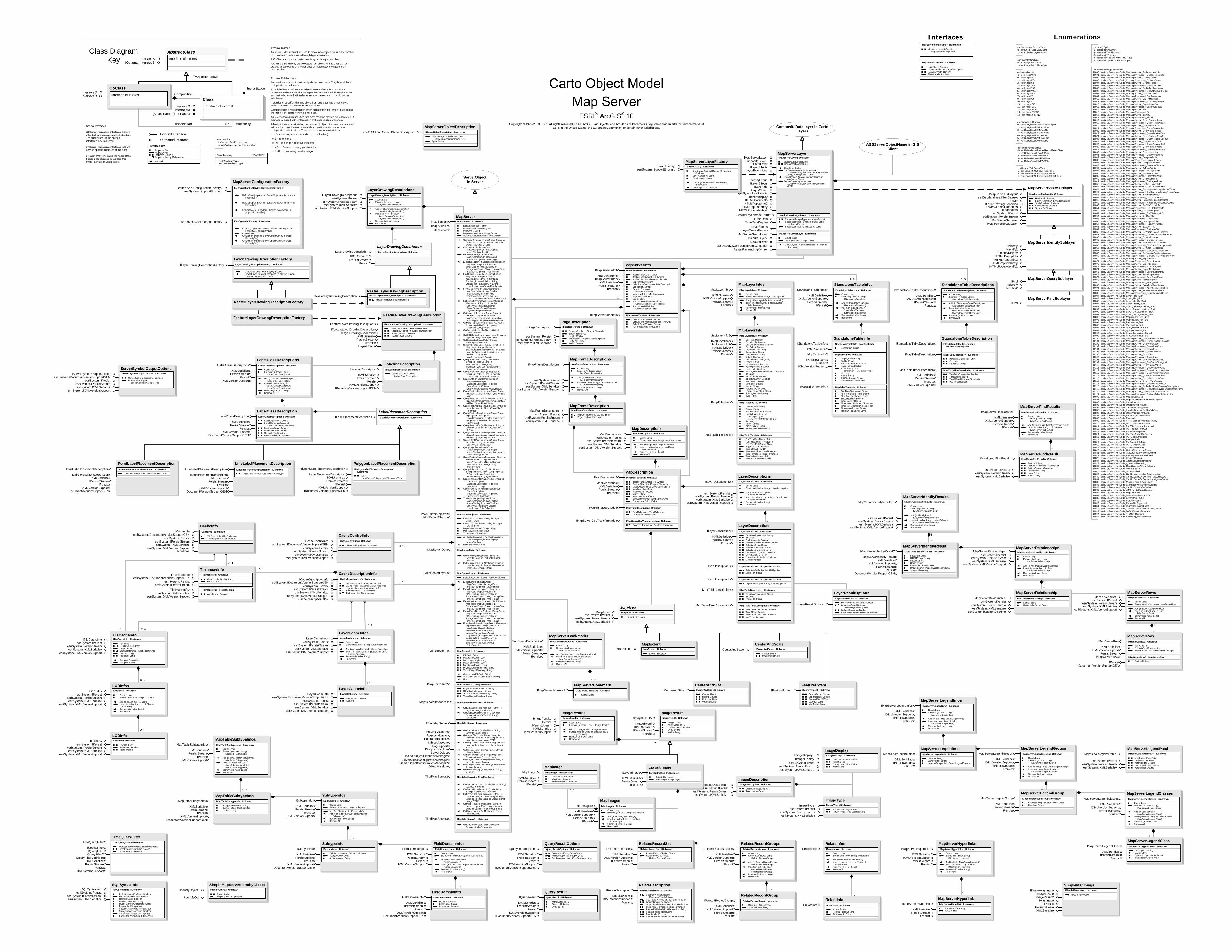
StandaloneTableInfoIStandaloneTableInfo : IMapTableInfo
Description: String
IStandaloneTableInfo
IXMLSerialize
IMapTableInfo : IUnknown
DisplayField: StringFields: IFieldsHasAttachments: BooleanHasSubtype: BooleanHTMLPopupType:
esriServerHTMLPopupTypeID: LongName: StringOIDFieldName: StringRelateInfos: IRelateInfos
IMapTableInfo
IPersistStreamIPersist
IXMLVersionSupport
IMapTableTimeInfo : IUnknown
EndTimeFieldName: StringFullTimeExtent: ITimeExtentStartTimeFieldName: StringSupportsTime: BooleanTimeInterval: DoubleTimeIntervalUnits: esriTimeUnitsTimeReference: ITimeReferenceTimeValueFormat: StringTrackIDFieldName: String
IMapTableTimeInfo
RelateDescriptionIRelateDescription : IUnknown
GeometryResultOptions: IGeometryResultOptions
GeoTransformation: IGeoTransformationIncludeGeometry: BooleanOutputSpatialReference: ISpatialReferenceOutputTimeReference: ITimeReferenceRelatedTableDefinitionExpression: StringRelatedTableFields: StringRelationshipID: LongResultFormat: esriRelateResultFormat
IRelateDescription
IXMLSerializeIXMLVersionSupport
IPersist
LabelClassDescriptionILabelClassDescription : IUnknown
LabelExpression: StringLabelPlacementDescription:
ILabelPlacementDescriptionMaximumScale: DoubleMinimumScale: DoubleSymbol: ITextSymbolUseCodedValue: Boolean
ILabelClassDescription
IXMLSerializeIPersistStream
IPersistIXMLVersionSupport
IDocumentVersionSupportGEN
ESRI® ArcGIS® 10 Copyright © 1999-2010 ESRI. All rights reserved. ESRI, ArcGIS, ArcObjects, and ArcMap are trademarks, registered trademarks, or service marks of
ESRI in the United States, the European Community, or certain other jurisdictions.
CoClassInterfaceDInterfaceB
Types of Classes
An abstract class cannot be used to create new objects but is a specification for instances of subclasses (through type inheritance.)
A CoClass can directly create objects by declaring a new object .
A Class cannot directly create objects, but objects of this class can be created as a property of another class or instantiated by objects from another class.
Types of Relationships
Associations represent relationships between classes. They have defined multiplicities at both ends.
Type inheritance defines specialized classes of objects which share properties and methods with the superclass and have additional properties and methods. Note that interfaces in superclasses are not duplicated in subclasses.
Instantiation specifies that one object from one class has a method with which it creates an object from another class.
Composition is a relationship in which objects from the 'whole' class control the lifetime of objects from the 'part' class.
An N-ary association specifies that more than two classes are associated . A diamond is placed at the intersection of the association branches .
A Multiplicity is a constraint on the number of objects that can be associated with another object. Association and composition relationships have multiplicities on both sides. This is the notation for multiplicities:
1 - One and only one (if none shown, '1' is implied)
0..1 - Zero or one
M..N - From M to N (positive integers)
* or 0..* - From zero to any positive integer
1..* - From one to any positive integer
Class Diagram Key
enumeration firstValue - firstEnumeration secondValue - secondEnumeration
AbstractClass
Type inheritance
Instantiation
Association
Composition
1..* Multiplicity
Interface of interestInterfaceA(Optional)InterfaceB
Interface of interest
InterfaceGInterfaceM
Outbound Interface
Inbound Interface
Special Interfaces (Optional) represents interfaces that are inherited by some subclasses but not all . The subclasses list the optional interfaces they implement.
(Instance) represents interfaces that are only on specific instances of the class.
(<classname>) indicates the name of the helper class required to support this event interface in Visual Basic.
Interface key
Property GetProperty PutProperty Get/PutProperty Put by ReferenceMethod
(<classname>)InterfaceO
Structure key <<Struct>>
firstMember: TypesecondMember: Type
ClassInterface of interest
esriIdentifyOption-1 - esriIdentifyAllLayers-2 - esriIdentifyVisibleLayers-3 - esriIdentifyTopmost-4 - esriIdentifyTopOneWithHTMLPopup-5 - esriIdentifyVisibleWithHTMLPopup
MapDescriptionIMapDescription2 : IUnknown
BackgroundSymbol: IFillSymbolCustomGraphics: IGraphicElementsLayerDescriptions: ILayerDescriptionsMapArea: IMapAreaMapRotation: DoubleName: StringSelectionColor: IColorSpatialReference: ISpatialReferenceTransparentColor: IColor
IMapDescription2
IMapDescriptionIXMLSerialize
IPersistStreamIPersist
IMapTimeDescription : IUnknown
TimeReference: ITimeReferenceTimeValue: ITimeValue
IMapTimeDescription
IMapServerGeoTransformation : IUnknown
GeoTransformation: IGeoTransformation
IMapServerGeoTransformation
MapServerInfoIMapServerInfo3 : IUnknown
BackgroundColor: IColorBackgroundSymbol: IFillSymbolBookmarks: IMapServerBookmarksCopyrightText: StringDefaultMapDescription: IMapDescriptionDescription: StringExtent: IEnvelopeFullExtent: IEnvelopeMapLayerInfos: IMapLayerInfosMapUnits: esriUnitsName: StringStandaloneTableDescriptions:
IStandaloneTableDescriptionsStandaloneTableInfos:
IStandaloneTableInfos
IMapServerInfo3
IMapServerInfoIMapServerInfo2
IXMLSerializeIPersistStream
IPersist
IMapServerTimeInfo : IUnknown
DefaultTimeInterval: DoubleDefaultTimeIntervalUnits: esriTimeUnitsDefaultTimeWindow: DoubleFullTimeExtent: ITimeExtent
IMapServerTimeInfo
StandaloneTableDescriptionIStandaloneTableDescription :
IMapTableDescriptionIStandaloneTableDescription
IXMLSerialize
IMapTableDescription : IUnknown
DefinitionExpression: StringID: LongSourceID: String
IMapTableDescription
IPersistStreamIPersist
IXMLVersionSupport
IMapTableTimeDescription : IUnknown
TimeDataCumulative: BooleanTimeOffset: DoubleTimeOffsetUnits: esriTimeUnitsUseTime: Boolean
IMapTableTimeDescription*
StandaloneTableInfosIStandaloneTableInfos : IUnknown
Count: LongElement (in Index: Long):
IStandaloneTableInfo
Add (in StandaloneTableInfo: IStandaloneTableInfo)
Insert (in Index: Long, in StandaloneTableInfo: IStandaloneTableInfo)
Remove (in Index: Long)RemoveAll
IStandaloneTableInfos
IXMLSerializeIXMLVersionSupport
IPersistStreamIPersist
*
LayoutImageILayoutImage : IImageResult
Extent: IEnvelopeMapImages: IMapImages
ILayoutImage
IXMLSerializeIPersistStream
IPersist
MapImagesIMapImages : IUnknown
Count: LongElement (in Index: Long): IMapImage
Add (in mapImg: IMapImage)Insert (in Index: Long, in mapImg:
IMapImage)Remove (in Index: Long)RemoveAll
IMapImages
IXMLSerializeIXMLVersionSupport
IPersistStreamIPersist
MapImageIMapImage : IImageResult
MapExtent: IEnvelopeMapScale: DoubleVisibleLayers: ILongArray
IMapImage
IXMLSerializeIPersistStream
IPersist
MapServerFindResultsIMapServerFindResults : IUnknown
Count: LongElement (in Index: Long):
IMapServerFindResult
Add (in findResult: IMapServerFindResult)Insert (in Index: Long, in findResult:
IMapServerFindResult)Remove (in Index: Long)RemoveAll
IMapServerFindResults
IXMLSerializeIXMLVersionSupport
IPersistStreamIPersist
QueryResultOptionsIQueryResultOptions : IUnknown
Format: esriQueryResultFormatFormatProperties: IPropertySetGeoTransformation: IGeoTransformation
IQueryResultOptions
IXMLSerializeIPersistStream
IPersistIXMLVersionSupport
IDocumentVersionSupportGEN
RelatedRecordSetIRelatedRecordSet : IUnknown
RelatedRecordFields: IFieldsRelatedRecordGroups:
IRelatedRecordGroups
IRelatedRecordSet
IXMLSerializeIXMLVersionSupport
IPersistStreamIPersist
RelatedRecordGroupIRelatedRecordGroup : IUnknown
Records: IRecordArraySourceRowID: Long
IRelatedRecordGroup
IXMLSerializeIXMLVersionSupport
IPersistStreamIPersist
RelatedRecordGroupsIRelatedRecordGroups : IUnknown
Count: LongElement (in Index: Long):
IRelatedRecordGroup
Add (in RelatedRecordGroup: IRelatedRecordGroup)
Insert (in Index: Long, in RelatedRecordGroup: IRelatedRecordGroup)
Remove (in Index: Long)RemoveAll
IRelatedRecordGroups
IXMLSerializeIXMLVersionSupport
IPersistStreamIPersist
ILayerEvents(LayerEventsHelper)
MapServerLayerFactoryILayerFactory ILayerFactory : IUnknown
CanCreate (in inputObject: IUnknown): Boolean
LayerCategory: StringPublicName: String
Create (in inputObject: IUnknown): IEnumLayer
LoadLayers: IEnumLayer
esriSystem.ISupportErrorInfo
MapServerLayer
ICompositeLayer2IDataLayer
ILayerEffectsILayerInfo
ILayerStatus
IMapServerLayer IMapServerLayer : IUnknown
BackgroundColor: IColorTransparentColor: IColor
ClearDrawCacheGetConnectionInfo (out soName:
IAGSServerObjectName, out docLocation: String, out MapName: String)
LocalConnect (in docLocation: String, in MapName: String)
ServerConnect (in soName: IAGSServerObjectName, in MapName: String)
ILayerEffectsILayerExtensions
ILayerSymbologyExtents
CompositeDataLayer in Carto Layers
EnumerationsInterfaces
1..*
CenterAndSizeICenterAndSize : IUnknown
Center: IPointHeight: DoubleUnits: esriUnitsWidth: Double
ICenterAndSize
MapExtentIMapExtent IMapExtent : IUnknown
Extent: IEnvelope
CenterAndScaleICenterAndScale ICenterAndScale : IUnknown
Center: IPointMapScale: Double
FeatureExtentIFeatureExtent IFeatureExtent : IUnknown
DefaultScale: DoubleExpandRatio: DoubleFeatureIDs: IFIDSetLayerID: LongMapName: String
AGSServerObjectName in GIS Client
MapServerFindSublayerIFind
MapServerBasicSublayer
esriGeodatabase.IGeoDatasetILayer
ILayerGeneralPropertiesILegendInfo
IMapServerSublayer2
esriSystem.IPersistesriSystem.IPersistStream
MapServerQuerySublayerIFind
IIdentifyIIdentify2
FeatureLayerDrawingDescriptionFactory
IMapServerSublayerIMapServerGroupLayer
IMapServerSublayer2 : IUnknown
HasLabels: BooleanLayerDescription: ILayerDescriptionScaleSymbols: BooleanShowLabels: BooleanSourceID: String
RasterLayerDrawingDescriptionFactory
MapServerObjectDescriptionesriGISClient.IServerObjectDescription IServerObjectDescription : IUnknown
ClientProxyCLSID (in connType: esriAGSConnectionType): IUID
Type: String
ServerObjectin Server
ISecureLayer2ISecureLayer
LayerDrawingDescriptionFactoryILayerDrawingDescriptionFactory ILayerDrawingDescriptionFactory : IUnknown
CanCreate (in pLayer: ILayer): BooleanCreateLayerDrawingDescription (in pLayer: ILayer):
ILayerDrawingDescription
MapDescriptionsIMapDescriptions
esriSystem.IPersistesriSystem.IPersistStreamesriSystem.IXMLSerialize
IMapDescriptions : IUnknown
Count: LongElement (in Index: Long): IMapDescription
Add (in mapDesc: IMapDescription)Insert (in Index: Long, in mapDesc:
IMapDescription)Remove (in Index: Long)RemoveAll
esriSystem.IXMLVersionSupport
MapServerConfigurationFactory
esriServer.IConfigurationFactory IConfigurationFactory : IUnknown
OnAdd (in pAdmin: IServerObjectAdmin, in pProps: IPropertySet): IPropertySet
OnRemoveOnStart (in pAdmin: IServerObjectAdmin, in props:
IPropertySet)OnStop (in pAdmin: IServerObjectAdmin, in props:
IPropertySet)
IConfigurationFactory2 : IConfigurationFactory
BeforeStart (in pAdmin: IServerObjectAdmin, in props: IPropertySet)
BeforeStop (in pAdmin: IServerObjectAdmin, in props: IPropertySet)
OnRemoveEx (in pAdmin: IServerObjectAdmin, in props: IPropertySet)
esriServer.IConfigurationFactory2esriSystem.ISupportErrorInfo
IRasterResamplingControlesriDisplay.IConnectionPointContainer
IIdentifyGroup
IMapServerGroupLayer : IUnknown
Count: LongLayer (in Index: Long): ILayer
ShowLayers (in show: Boolean, in layerIds: ILongArray)
IMapServerGroupLayer
1..*
LayerResultOptionsILayerResultOptions : IUnknown
FormatValuesInResults: BooleanGeometryResultOptions:
IGeometryResultOptionsIncludeGeometry: BooleanReturnFieldNamesInResults: Boolean
ILayerResultOptions
TimeQueryFilterITimeQueryFilter : IUnknown
OutputTimeReference: ITimeReferenceTimeRelation: esriTimeRelationTimeValue: ITimeValue
ITimeQueryFilter
ISpatialFilterIQueryFilter
IQueryFilter2IQueryFilterDefinition
IXMLSerializeIPersistStream
IPersistIXMLVersionSupport
MapServerFindResultIMapServerFindResult IMapServerFindResult : IUnknown
FeatureId: LongFeatureProperties: IPropertySetFeatureShape: IGeometryFieldName: StringLayerID: LongValue: String
esriSystem.IPersistesriSystem.IPersistStreamesriSystem.IXMLSerialize
SQLSyntaxInfoISQLSyntaxInfo ISQLSyntaxInfo : IUnknown
DelimitedIdentifierCase: BooleanFunctionNames: IPropertySetIdentifierCase: BooleanInvalidCharacters: StringInvalidStartingCharacters: StringKeywords: IStringArraySpecialCharacters: IPropertySetStringComparisonCase: BooleanSupportedClauses: IStringArraySupportedPredicates: IStringArray
esriSystem.IPersistesriSystem.IPersistStreamesriSystem.IXMLSerialize
MapServerBookmarksIMapServerBookmarks : IUnknown
Count: LongElement (in Index: Long):
IMapServerBookmark
Add (in bookmark: IMapServerBookmark)Insert (in Index: Long, in bookmark:
IMapServerBookmark)Remove (in Index: Long)RemoveAll
IMapServerBookmarks
IXMLSerializeIXMLVersionSupport
IPersistStreamIPersist
MapServerBookmarkIMapServerBookmark : IUnknown
Name: String
IMapServerBookmark
MapLayerInfosIMapLayerInfos : IUnknown
Count: LongElement (in Index: Long): IMapLayerInfo
Add (in MapLayerInfo: IMapLayerInfo)Insert (in Index: Long, in MapLayerInfo:
IMapLayerInfo)Remove (in Index: Long)RemoveAll
IMapLayerInfos
IXMLSerializeIXMLVersionSupport
IPersistStreamIPersist
*
StandaloneTableDescriptionsIStandaloneTableDescriptions : IUnknown
Count: LongElement (in Index: Long):
IStandaloneTableDescription
Add (in StandaloneTableDescription: IStandaloneTableDescription)
Insert (in Index: Long, in StandaloneTableDescription: IStandaloneTableDescription)
Remove (in Index: Long)RemoveAll
IStandaloneTableDescriptions
IXMLSerializeIXMLVersionSupport
IPersistStreamIPersist
1..*
1..*
MapAreaIMapArea : IUnknown
Extent: IEnvelope
IMapAreaesriSystem.IPersist
esriSystem.IPersistStreamesriSystem.IXMLSerialize
LayerDescriptionsILayerDescriptions ILayerDescriptions : IUnknown
Count: LongElement (in Index: Long): ILayerDescription
Add (in LayerDescription: ILayerDescription)
Insert (in Index: Long, in LayerDescription: ILayerDescription)
Remove (in Index: Long)RemoveAll
esriSystem.IPersistesriSystem.IPersistStreamesriSystem.IXMLSerialize
esriSystem.IXMLVersionSupport
SimpleMapServerIdentifyObject
IIdentifyObj
IIdentifyObject IIdentifyObject : IUnknown
Name: StringPropertySet: IPropertySet
PageDescriptionIPageDescription IPageDescription : IUnknown
CustomGraphics: IGraphicElementsExtent: IEnvelopeHeight: DoubleMapFrames: IMapFrameDescriptionsUnits: esriUnitsWidth: Double
esriSystem.IPersistesriSystem.IPersistStreamesriSystem.IXMLSerialize
esriSystem.IPersist
MapFrameDescriptionsIMapFrameDescriptions IMapFrameDescriptions : IUnknown
Count: LongElement (in Index: Long):
IMapFrameDescription
Add (in mapFrameDesc: IMapFrameDescription)
Insert (in Index: Long, in mapFrameDesc: IMapFrameDescription)
Remove (in Index: Long)RemoveAll
esriSystem.IPersistStreamesriSystem.IXMLSerialize
esriSystem.IXMLVersionSupport
MapFrameDescriptionIMapFrameDescription
esriSystem.IPersistesriSystem.IPersistStreamesriSystem.IXMLSerialize
IMapFrameDescription : IUnknown
MapDescription: IMapDescriptionPageLocation: IEnvelope
1..*
*
1..0 1..0
ImageDisplay
IImageDisplayesriSystem.IPersist
esriSystem.IPersistStreamesriSystem.IXMLSerialize
IImageDisplay2 : IUnknown
TransparentColor: IColor
DeviceResolution: DoubleHeight: Long
Width: Long
IImageDisplay2
ImageTypeIImageType IImageType : IUnknown
Format: esriImageFormatReturnType: esriImageReturnType
esriSystem.IPersistesriSystem.IPersistStreamesriSystem.IXMLSerialize
ImageDescriptionIImageDescription IImageDescription : IUnknown
Display: IImageDisplayType: IImageType
esriSystem.IPersistesriSystem.IPersistStreamesriSystem.IXMLSerialize
IServiceLayerImageFormat : IUnknown
RequestedImageType: esriImageFormatSupportedImageFormat (in Index: Long):
esriImageFormatSupportedImageFormatCount: Long
IServiceLayerImageFormat
IMapServerIdentifyObject : IUnknown
MapServerIdentifyResult: IMapServerIdentifyResult
IMapServerSublayer : IUnknown
HasLabels: BooleanLayerDescription: ILayerDescriptionScaleSymbols: BooleanShowLabels: Boolean
*
*
*
LayerDescriptionILayerDescription : IUnknown
DefinitionExpression: StringID: LongScaleSymbols: BooleanSelectionBufferDistance: DoubleSelectionColor: IColorSelectionFeatures: IFIDSetSelectionSymbol: ISymbolSetSelectionSymbol: BooleanShowLabels: BooleanShowSelectionBuffer: BooleanVisible: Boolean
ILayerDescription
IXMLSerializeIPersistStream
IPersist
ILayerDescription2 : ILayerDescription
SelectionBufferSymbol: IFillSymbolSourceID: String
ILayerDescription2
ILayerDescription3 : ILayerDescription2
LayerResultOptions: ILayerResultOptions
ILayerDescription3
IMapTableDescription : IUnknown
DefinitionExpression: StringID: LongSourceID: String
IMapTableDescription
IMapTableTimeDescription : IUnknown
TimeDataCumulative: BooleanTimeOffset: DoubleTimeOffsetUnits: esriTimeUnitsUseTime: Boolean
IMapTableTimeDescription
esriImageReturnType0 - esriImageReturnURL1 - esriImageReturnMimeData
esriCachedMapServiceType0 - esriSingleFusedMapCache1 - esriIndividualLayerCaches
esriRelateResultFormat0 - esriRelateResultRelatedRecordSetAsObject1 - esriRelateResultJsonAsMime2 - esriRelateResultJsonAsURL3 - esriRelateResultAMFAsMime4 - esriRelateResultAMFAsURL
esriQueryResultFormat0 - esriQueryResultRecordSetAsObject1 - esriQueryResultKMLAsMime2 - esriQueryResultKMLAsURL3 - esriQueryResultJsonAsMime4 - esriQueryResultJsonAsURL5 - esriQueryResultAMFAsMime6 - esriQueryResultAMFAsURL
esriServerHTMLPopupType0 - esriServerHTMLPopupTypeNone1 - esriServerHTMLPopupTypeAsURL2 - esriServerHTMLPopupTypeAsHTMLText
CacheControlInfoICacheControlInfo
esriSystem.IDocumentVersionSupportGENICacheControlInfo : IUnknown
ClientCachingAllowed: BooleanesriSystem.IPersist
esriSystem.IPersistStreamesriSystem.IXMLSerialize
esriSystem.IXMLVersionSupport
TileImageInfoITileImageInfo
ITileImageInfo2
ITileImageInfo : IUnknown
CompressionQuality: LongFormat: String
ITileImageInfo2 : ITileImageInfo
Antialiasing: Boolean
esriSystem.IDocumentVersionSupportGENesriSystem.IPersist
esriSystem.IPersistStream
esriSystem.IXMLSerializeesriSystem.IXMLVersionSupport
0..*
0..*
LayerCacheInfosILayerCacheInfos ILayerCacheInfos : IUnknown
Count: LongElement (in Index: Long): ILayerCacheInfo
Add (in pLayerCacheInfo: ILayerCacheInfo)Insert (in Index: Long, in pLayerCacheInfo:
ILayerCacheInfo)Remove (in Index: Long)RemoveAll
esriSystem.IPersistesriSystem.IPersistStreamesriSystem.IXMLSerialize
esriSystem.IXMLVersionSupport
LayerCacheInfoILayerCacheInfo ILayerCacheInfo : IUnknown
HasCache: BooleanID: Long
esriSystem.IDocumentVersionSupportGENesriSystem.IPersist
esriSystem.IPersistStreamesriSystem.IXMLSerialize
esriSystem.IXMLVersionSupport
0..*
0..1
0..1
0..1
TileCacheInfoITileCacheInfo ITileCacheInfo : IUnknown
Dpi: LongLODInfos: ILODInfosOrigin: IPointSpatialReference: ISpatialReferenceTileCols: LongTileRows: Long
ComputeResolutionsComputeScales
esriSystem.IPersistesriSystem.IPersistStreamesriSystem.IXMLSerialize
esriSystem.IXMLVersionSupport
LODInfosILODInfos
esriSystem.IPersistesriSystem.IPersistStreamesriSystem.IXMLSerialize
esriSystem.IXMLVersionSupport
ILODInfos : IUnknown
Count: LongElement (in Index: Long): ILODInfo
Add (in pLODInfo: ILODInfo)Insert (in Index: Long, in pLODInfo:
ILODInfo)Remove (in Index: Long)RemoveAll
LODInfoILODInfo ILODInfo : IUnknown
LevelID: LongResolution: DoubleScale: Double
esriSystem.IPersistesriSystem.IPersistStreamesriSystem.IXMLSerialize
esriSystem.IXMLVersionSupport
0..1
0..*
0..10..1
*
PolygonLabelPlacementDescriptionIPolygonLabelPlacementDescription :
IUnknown
Type: esriServerPolygonLabelPlacementType
IPolygonLabelPlacementDescription
ILabelPlacementDescriptionIXMLSerialize
IPersistStreamIPersist
IXMLVersionSupportIDocumentVersionSupportGEN
LineLabelPlacementDescriptionILineLabelPlacementDescription : IUnknown
Type: esriServerLineLabelPlacementType
ILineLabelPlacementDescription
ILabelPlacementDescriptionIXMLSerialize
IPersistStreamIPersist
IXMLVersionSupportIDocumentVersionSupportGEN
PointLabelPlacementDescriptionIPointLabelPlacementDescription : IUnknown
Type: esriServerPointLabelPlacementType
IPointLabelPlacementDescription
ILabelPlacementDescriptionIXMLSerialize
IPersistStreamIPersist
IXMLVersionSupportIDocumentVersionSupportGEN
LabelPlacementDescriptionILabelPlacementDescription : IUnknownILabelPlacementDescription
LabelingDescriptionILabelingDescription : IUnknown
LabelClassDescriptions: ILabelClassDescriptions
ILabelingDescription
IXMLSerializeIPersistStream
IPersistIXMLVersionSupport
IDocumentVersionSupportGEN
FeatureLayerDrawingDescription
IFeatureLayerDrawingDescription2 : IUnknown
FeatureRenderer: IFeatureRendererLabelingDescription: ILabelingDescriptionScaleSymbols: BooleanSourceLayerID: Long
IFeatureLayerDrawingDescription2
IFeatureLayerDrawingDescriptionILayerDrawingDescription
IXMLSerializeIPersistStream
IPersistILayerEffects
RasterLayerDrawingDescriptionIRasterLayerDrawingDescription IRasterLayerDrawingDescription : IUnknown
RasterRenderer: IRasterRenderer
LayerDrawingDescription
IXMLSerializeIPersistStream
IPersist
ILayerDrawingDescription : IUnknownILayerDrawingDescription
esriImageFormat-1 - esriImageNone0 - esriImageBMP1 - esriImageJPG2 - esriImageDIB3 - esriImageTIFF4 - esriImagePNG5 - esriImagePNG246 - esriImageEMF7 - esriImagePS8 - esriImagePDF9 - esriImageAI10 - esriImageGIF11 - esriImageSVG12 - esriImageSVGZ13 - esriImagePNG3214 - esriImageJPGPNG
MapLayerInfoIMapLayerInfo3 : IUnknown
CanFind: BooleanCanIdentify: BooleanCanScaleSymbols: BooleanCanSelect: BooleanCopyrightText: StringDescription: StringDisplayField: StringExtent: IEnvelopeFieldAliases: IStringArrayFields: IFieldsHasAttributes: BooleanHasHyperlinks: BooleanHasLabels: BooleanHasLayerDrawingDescription: BooleanID: LongIsComposite: BooleanIsFeatureLayer: BooleanMaxScale: DoubleMinScale: DoubleName: StringParentLayerID: LongSourceDescription: StringSubLayers: ILongArrayType: String
IMapLayerInfo3
IMapLayerInfoIMapLayerInfo2
IXMLSerializeIPersistStream
IPersist
IMapTableInfo : IUnknown
DisplayField: StringFields: IFieldsHasAttachments: BooleanHasSubtype: BooleanHTMLPopupType:
esriServerHTMLPopupTypeID: LongName: StringOIDFieldName: StringRelateInfos: IRelateInfos
IMapTableInfo
IMapTableTimeInfo : IUnknown
EndTimeFieldName: StringFullTimeExtent: ITimeExtentStartTimeFieldName: StringSupportsTime: BooleanTimeInterval: DoubleTimeIntervalUnits: esriTimeUnitsTimeReference: ITimeReferenceTimeValueFormat: StringTrackIDFieldName: String
IMapTableTimeInfo
FieldDomainInfoIFieldDomainInfo : IUnknown
Domain: IDomainFieldName: StringIsInherited: Boolean
IFieldDomainInfo
IXMLSerializeIPersistStream
IPersistIXMLVersionSupport
IDocumentVersionSupportGEN
SubtypeInfoISubtypeInfo : IUnknown
FieldDomainInfos: IFieldDomainInfosSubtypeCode: LongSubtypeName: String
ISubtypeInfo
IXMLSerializeIPersistStream
IPersistIXMLVersionSupport
IDocumentVersionSupportGEN
MapTableSubtypeInfoIMapTableSubtypeInfo : IUnknown
SubtypeFieldName: StringSubtypeInfos: ISubtypeInfosTableID: Long
IMapTableSubtypeInfo
IXMLSerializeIPersistStream
IPersistIXMLVersionSupport
IDocumentVersionSupportGEN
MapTableSubtypeInfosIMapTableSubtypeInfos : IUnknown
Count: LongElement (in Index: Long):
IMapTableSubtypeInfo
Add (in pMapTableSubtypeInfo: IMapTableSubtypeInfo)
Insert (in Index: Long, in pMapTableSubtypeInfo: IMapTableSubtypeInfo)
Remove (in Index: Long)RemoveAll
IMapTableSubtypeInfos
IXMLSerializeIPersistStream
IPersistIXMLVersionSupport
1..*
MapServerLegendPatchIMapServerLegendPatch IMapServerLegendPatch : IUnknown
AreaPatch: IAreaPatchLinePatch: ILinePatchPatchHeight: DoublePatchResolution: DoublePatchWidth: Double
esriSystem.IPersistesriSystem.IPersistStreamesriSystem.IXMLSerialize
MapServerLegendInfoIMapServerLegendInfo : IUnknown
LayerID: LongLayerName: StringLegendGroups: IMapServerLegendGroups
IMapServerLegendInfo
IXMLSerializeIPersistStream
IPersist
*
MapServerLegendGroupIMapServerLegendGroup : IUnknown
Classes: IMapServerLegendClassesHeading: String
IMapServerLegendGroup
IXMLSerializeIPersistStream
IPersist
MapServerLegendGroupsIMapServerLegendGroups : IUnknown
Count: LongElement (in Index: Long):
IMapServerLegendGroup
Add (in group: IMapServerLegendGroup)Insert (in Index: Long, in group:
IMapServerLegendGroup)Remove (in Index: Long)RemoveAll
IMapServerLegendGroups
IXMLSerializeIXMLVersionSupport
IPersistStreamIPersist
1..*MapServerLegendClassesIMapServerLegendClasses : IUnknown
Count: LongElement (in Index: Long):
IMapServerLegendClass
Add (in LegendClass: IMapServerLegendClass)
Insert (in Index: Long, in LegendClass: IMapServerLegendClass)
Remove (in Index: Long)RemoveAll
IMapServerLegendClasses
IXMLSerializeIXMLVersionSupport
IPersistStreamIPersist
MapServerLegendClassIMapServerLegendClass : IUnknown
Description: StringLabel: StringSymbolImage: IImageResultTransparentColor: IColor
IMapServerLegendClass
IXMLSerializeIPersistStream
IPersist
1..*
MapServerLegendInfosIMapServerLegendInfos : IUnknown
Count: LongElement (in Index: Long):
IMapServerLegendInfo
Add (in info: IMapServerLegendInfo)Insert (in Index: Long, in info:
IMapServerLegendInfo)Remove (in Index: Long)RemoveAll
IMapServerLegendInfos
IXMLSerializeIXMLVersionSupport
IPersistStreamIPersist
MapServerRowIMapServerRow : IUnknown
Name: StringPropertySet: IPropertySetRelatedRows: IMapServerRelationships
IMapServerRow
IXMLSerializeIXMLVersionSupport
IPersistStreamIMapServerRow2 : IMapServerRow
FeatureId: Long
IMapServerRow2
IPersistIDocumentVersionSupportGEN
MapServerIdentifyResultIMapServerIdentifyResult2 : IUnknown
FeatureId: LongHTMLPopup: StringLayerID: LongName: StringProperties: IPropertySetRelatedRows: IMapServerRelationshipsShape: IGeometry
IMapServerIdentifyResult2
IMapServerIdentifyResultIXMLSerialize
IXMLVersionSupportIPersistStream
IPersistIDocumentVersionSupportGEN
esriSystem.IPersistesriSystem.IPersistStreamesriSystem.IXMLSerialize
esriSystem.IXMLVersionSupport
MapServerRelationshipsIMapServerRelationships IMapServerRelationships : IUnknown
Count: LongElement (in Index: Long):
IMapServerRelationship
Add (in rel: IMapServerRelationship)Insert (in Index: Long, in Row:
IMapServerRelationship)Remove (in Index: Long)RemoveAll
MapServerRelationshipIMapServerRelationship IMapServerRelationship : IUnknown
Name: StringRows: IMapServerRows
esriSystem.IPersistesriSystem.IPersistStreamesriSystem.IXMLSerialize
esriSystem.ISupportErrorInfo
MapServerRowsIMapServerRows IMapServerRows : IUnknown
Count: LongElement (in Index: Long): IMapServerRow
Add (in Row: IMapServerRow)Insert (in Index: Long, in Row:
IMapServerRow)Remove (in Index: Long)RemoveAll
esriSystem.IPersistesriSystem.IPersistStreamesriSystem.IXMLSerialize
esriSystem.IXMLVersionSupport
MapServerIdentifyResultsIMapServerIdentifyResults IMapServerIdentifyResults : IUnknown
Count: LongElement (in Index: Long):
IMapServerIdentifyResult
Add (in identifyResult: IMapServerIdentifyResult)
Insert (in Index: Long, in identifyResult: IMapServerIdentifyResult)
Remove (in Index: Long)RemoveAll
esriSystem.IPersistesriSystem.IPersistStreamesriSystem.IXMLSerialize
esriSystem.IXMLVersionSupport
1
*
*
1
*
1
MapServerHyperlinksIMapServerHyperlinks : IUnknown
Count: LongElement (in Index: Long):
IMapServerHyperlink
Add (in Link: IMapServerHyperlink)Insert (in Index: Long, in Link:
IMapServerHyperlink)Remove (in Index: Long)RemoveAll
IMapServerHyperlinks
IXMLSerializeIXMLVersionSupport
IPersistStreamIPersist
MapServerHyperlinkIMapServerHyperlink : IUnknown
Location: IGeometryURL: String
IMapServerHyperlink
IXMLSerializeIPersistStream
IPersist
*
RelateInfosIRelateInfos : IUnknown
Count: LongElement (in Index: Long): IRelateInfo
Add (in RelateInfo: IRelateInfo)Insert (in Index: Long, in RelateInfo:
IRelateInfo)Remove (in Index: Long)RemoveAll
IRelateInfos
RelateInfoIRelateInfo : IUnknown
Name: StringRelatedTableID: LongRelationshipID: Long
IRelateInfo
*
FieldDomainInfosIFieldDomainInfos : IUnknown
Count: LongElement (in Index: Long): IFieldDomainInfo
Add (in pFieldDomainInfo: IFieldDomainInfo)
Insert (in Index: Long, in pFieldDomainInfo: IFieldDomainInfo)
Remove (in Index: Long)RemoveAll
IFieldDomainInfos
IXMLSerializeIPersistStream
IPersistIXMLVersionSupport
SubtypeInfosISubtypeInfos : IUnknown
Count: LongElement (in Index: Long): ISubtypeInfo
Add (in pSubtypeInfo: ISubtypeInfo)Insert (in Index: Long, in pSubtypeInfo:
ISubtypeInfo)Remove (in Index: Long)RemoveAll
ISubtypeInfos
IXMLSerializeIPersistStream
IPersistIXMLVersionSupport
LabelClassDescriptionsILabelClassDescriptions : IUnknown
Count: LongElement (in Index: Long):
ILabelClassDescription
Add (in pLabelClassDescription: ILabelClassDescription)
Insert (in Index: Long, in pLabelClassDescription: ILabelClassDescription)
Remove (in Index: Long)RemoveAll
ILabelClassDescriptions
IXMLSerializeIPersistStream
IPersistIXMLVersionSupport
1..*
1..*
MapServer
IMapServerObjects2 : IUnknown
Layer (in MapName: String, in LayerID: Long): ILayer
LayerID (in MapName: String, in pLayer: ILayer): Long
Map (in MapName: String): IMapPageLayout: IPageLayoutThumbnail: IPictureDisp
ApplyMapDescription (in MapDescription: IMapDescription, in mapDisplay: IImageDisplay)
RefreshServerObjects
IMapServerObjects2
IMapServerData : IUnknown
GetFeature (in MapName: String, in LayerID: Long, in FeatureId: Long): IFeature
GetFeatureValue (in MapName: String, in LayerID: Long, in Feature: IFeature, in FieldName: String): String
IMapServerData
IMapServerLayout
IMapServerInit : IUnknown
FilePath: StringMaxBufferCount: LongMaxImageHeight: LongMaxImageWidth: LongMaxRecordCount: LongPhysicalOutputDirectory: StringVirtualOutputDirectory: String
Connect (in FilePath: String)StartWithData (in pDataset: IDataset)Stop
IMapServerInit
IMapServerInit2 : IMapServerInit
PhysicalCacheDirectory: StringSOMCacheDirectory: StringSOMVirtualCacheDirectory: StringVirtualCacheDirectory: String
IMapServerInit2
ITiledMapServer
ITiledMapServer2
ITiledMapServer3 : IUnknown
GetCacheStorageInfo (in MapName: String): ICacheStorageInfo
ITiledMapServer3
IMapServerObjects
IObjectConstructIRequestHandler
IRequestHandler2IObjectActivate
ILogSupportISupportErrorInfo
IServerObjectIServerObjectExtensionManager
IServerObjectConfigurationManagerIServerObjectConfigurationManager2
IObjectValidate
IMapServerDataAccess : IUnknown
GetDataSource (in MapName: String, in LayerID: Long): IUnknown
GetDisplayDataSource (in MapName: String, in LayerOrTableID: Long): IUnknown
IMapServerDataAccess
IMapServer3 : IUnknown
DefaultMapName: StringDocumentInfo: IPropertySetMapCount: LongMapName (in Index: Long): StringServiceConfigurationInfo: IPropertySet
ComputeDistance (in MapName: String, in fromPoint: IPoint, in toPoint: IPoint, in Units: esriUnits): Double
ComputeScale (in mapDesc: IMapDescription, in mapDisplay: IImageDisplay): Double
ExportMapImage (in mapDesc: IMapDescription, in imageDesc: IImageDescription): IMapImage
ExportScaleBar (in Scalebar: IScaleBar, in mapDesc: IMapDescription, in pMapDisplay: IImageDisplay, in BackgroundColor: IColor, in imageDesc: IImageDescription): IImageResult
Find (in mapDesc: IMapDescription, in MapImage: IImageDisplay, in searchString: String, in Contains: Boolean, in searchFields: String, in Option: esriFindOption, in layerIds: ILongArray): IMapServerFindResults
FromMapPoints (in MapDescription: IMapDescription, in mapDisplay: IImageDisplay, in mapPoints: IPointCollection, screenXValues: ILongArray, screenYValues: ILongArray)
GetDefaultLayerDrawingDescriptions (in MapName: String, in pLayerIDs: ILongArray, in outputOptions: IServerSymbolOutputOptions): ILayerDrawingDescriptions
GetLegendInfo (in MapName: String, in layerIds: ILongArray, in patch: IMapServerLegendPatch, in imgType: IImageType): IMapServerLegendInfos
GetMapTableSubtypeInfos (in MapName: String, in pTableIDs: ILongArray): IMapTableSubtypeInfos
GetServerInfo (in MapName: String): IMapServerInfo
GetSQLSyntaxInfo (in MapName: String, in LayerID: Long): ISQLSyntaxInfo
GetSupportedImageReturnTypes: esriImageReturnType
Identify (in mapDesc: IMapDescription, in MapImage: IImageDisplay, in searchShape: IGeometry, in Tolerance: Long, in Option: esriIdentifyOption, in layerIds: ILongArray): IMapServerIdentifyResults
QueryAttachmentData (in MapName: String, in TableID: Long, in attachmentIDs: ILongArray, in TransportType: esriTransportType): IAttachmentDataArray
QueryAttachmentInfos (in MapName: String, in TableID: Long, in rowIDs: ILongArray): IAttachmentInfoArray
QueryData (in MapName: String, in pMapTableDescription: IMapTableDescription, in Filter: IQueryFilter, in Options: IQueryResultOptions): IQueryResult
QueryFeatureCount (in MapName: String, in LayerID: Long, in Filter: IQueryFilter): Long
QueryFeatureCount2 (in MapName: String, in pLayerDescription: ILayerDescription, in Filter: IQueryFilter): Long
QueryFeatureData (in MapName: String, in LayerID: Long, in Filter: IQueryFilter): IRecordSet
QueryFeatureData2 (in MapName: String, in pLayerDesciscription: ILayerDescription, in Filter: IQueryFilter, in Options: IQueryResultOptions): IQueryResult
QueryFeatureIDs (in MapName: String, in LayerID: Long, in Filter: IQueryFilter): IFIDSet
QueryFeatureIDs2 (in MapName: String, in pLayerDesciscription: ILayerDescription, in Filter: IQueryFilter): IFIDSet
QueryHTMLPopups (in MapName: String, in TableID: Long, in pRowIDs: ILongArray): IStringArray
QueryHyperlinks (in mapDesc: IMapDescription, in MapImage: IImageDisplay, in layerIds: ILongArray): IMapServerHyperlinks
QueryRasterValue (in MapName: String, in sourceTableID: Long, in rowIDs: ILongArray, in FieldName: String, in rasterValueType: IImageType): IImageResults
QueryRelatedRecords (in MapName: String, in sourceTable: Long, in pFIDs: IFIDSet, in RelateDescription: IRelateDescription): IQueryResult
QueryRowCount (in MapName: String, in pTableDescription: IMapTableDescription, in pFilter: IQueryFilter): Long
QueryRowIDs (in MapName: String, in pTableDescription: IMapTableDescription, in pFilter: IQueryFilter): ILongArray
ToMapPoints (in MapDescription: IMapDescription, in mapDisplay: IImageDisplay, in screenXValues: ILongArray, in screenYValues: ILongArray): IPointCollection
IMapServer2IMapServer
IMapServer3
IMapServerLayout : IUnknown
DefaultPageDescription: IPageDescription
ExportLayout (in pageDesc: IPageDescription, in imageDesc: IImageDescription): ILayoutImage
ExportLegend (in Legend: ILegend, in mapDesc: IMapDescription, in pMapDisplay: IImageDisplay, in BackgroundColor: IColor, in imageDesc: IImageDescription): IImageResult
ExportNorthArrow (in arrow: INorthArrow, in mapDesc: IMapDescription, in BackgroundColor: IColor, in imageDesc: IImageDescription): IImageResult
ExportScaleBar (in Scalebar: IScaleBar, in mapDesc: IMapDescription, in pMapDisplay: IImageDisplay, in BackgroundColor: IColor, in imageDesc: IImageDescription): IImageResult
FromPagePoints (in pageExtent: IEnvelope, in pageDisplay: IImageDisplay, in pagePoints: IPointCollection, screenXValues: ILongArray, screenYValues: ILongArray)
ToPagePoints (in pageExtent: IEnvelope, in pageDisplay: IImageDisplay, in screenXValues: ILongArray, in screenYValues: ILongArray): IPointCollection
ITiledMapServer : IUnknown
GetCacheName (in MapName: String, in LayerID: Long): String
GetLayerTile (in MapName: String, in LayerID: Long, in Level: Long, in Row: Long, in column: Long): BYTE
GetMapTile (in MapName: String, in Level: Long, in Row: Long, in column: Long): BYTE
GetTileCacheInfo (in MapName: String): ITileCacheInfo
GetVirtualCacheDirectory (in MapName: String, in LayerID: Long): String
HasLayerCache (in MapName: String, in LayerID: Long): Boolean
HasSingleFusedMapCache (in MapName: String): Boolean
IsFixedScaleMap (in MapName: String): Boolean
ITiledMapServer2 : ITiledMapServer
GetCacheControlInfo (in MapName: String): ICacheControlInfo
GetCacheDescriptionInfo (in MapName: String): ICacheDescriptionInfo
GetLayerTileEx (in MapName: String, in LayerID: Long, in Level: Long, in Row: Long, in column: Long, in CacheFormat: Long): BYTE
GetMapTileEx (in MapName: String, in Level: Long, in Row: Long, in column: Long, in CacheFormat: Long): BYTE
GetTileImageInfo (in MapName: String): ITileImageInfo
QueryResultIQueryResult
IXMLSerializeIPersistStream
IPersistIXMLVersionSupport
IDocumentVersionSupportGEN
IQueryResult : IUnknown
MimeData: BYTEObject: IUnknownURL: String
esriMapServerMsgCodeEnum10000 - esriMapServerMsgCode_MessageArrival_GetDocumentInfo10001 - esriMapServerMsgCode_MessageProcessed_GetDocumentInfo10002 - esriMapServerMsgCode_MessageArrival_GetMapCount10003 - esriMapServerMsgCode_MessageProcessed_GetMapCount10004 - esriMapServerMsgCode_MessageArrival_GetMapName10005 - esriMapServerMsgCode_MessageProcessed_GetMapName10006 - esriMapServerMsgCode_MessageArrival_GetDefaultMapName10007 - esriMapServerMsgCode_MessageProcessed_GetDefaultMapName10008 - esriMapServerMsgCode_MessageArrival_GetServerInfo10009 - esriMapServerMsgCode_MessageProcessed_GetServerInfo10010 - esriMapServerMsgCode_MessageArrival_ExportMapImage10011 - esriMapServerMsgCode_MessageProcessed_ExportMapImage10012 - esriMapServerMsgCode_MessageArrival_ExportScaleBar10013 - esriMapServerMsgCode_MessageProcessed_ExportScaleBar10014 - esriMapServerMsgCode_MessageArrival_Find10015 - esriMapServerMsgCode_MessageProcessed_Find10016 - esriMapServerMsgCode_MessageArrival_Identify10017 - esriMapServerMsgCode_MessageProcessed_Identify10018 - esriMapServerMsgCode_MessageArrival_QueryFeatureCount10019 - esriMapServerMsgCode_MessageProcessed_QueryFatureCount10020 - esriMapServerMsgCode_MessageArrival_QueryFeatureIDs10021 - esriMapServerMsgCode_MessageProcessed_QueryFeatureIDs10022 - esriMapServerMsgCode_MessageArrival_QueryFeatureData10023 - esriMapServerMsgCode_MessageProcessed_QueryFeatureData10024 - esriMapServerMsgCode_MessageArrival_QueryFeatureCount210025 - esriMapServerMsgCode_MessageProcessed_QueryFeatureCount210026 - esriMapServerMsgCode_MessageArrival_QueryFeatureIDs210027 - esriMapServerMsgCode_MessageProcessed_QueryFeatureIDs210028 - esriMapServerMsgCode_MessageArrival_QueryFeatureData210029 - esriMapServerMsgCode_MessageProcessed_QueryFeatureData210030 - esriMapServerMsgCode_MessageArrival_QueryHyperlinks10031 - esriMapServerMsgCode_MessageProcessed_QueryHyperlinks10032 - esriMapServerMsgCode_MessageArrival_ComputeScale10033 - esriMapServerMsgCode_MessageProcessed_ComputeScale10034 - esriMapServerMsgCode_MessageArrival_ComputeDistance10035 - esriMapServerMsgCode_MessageProcessed_ComputeDistance10036 - esriMapServerMsgCode_MessageArrival_ToMapPoints10037 - esriMapServerMsgCode_MessageProcessed_ToMapPoints10038 - esriMapServerMsgCode_MessageArrival_FromMapPoints10039 - esriMapServerMsgCode_MessageProcessed_FromMapPoints10040 - esriMapServerMsgCode_MessageArrival_GetLegendInfo10041 - esriMapServerMsgCode_MessageProcessed_GetLegendInfo10042 - esriMapServerMsgCode_MessageArrival_GetSQLSyntaxInfo10043 - esriMapServerMsgCode_MessageProcessed_GetSQLSyntaxInfo10044 - esriMapServerMsgCode_MessageArrival_GetSupportedImageReturnTypes10045 - esriMapServerMsgCode_MessageProcessed_GetSupportedImageReturnTypes10046 - esriMapServerMsgCode_MessageArrival_IsFixedScaleMap10047 - esriMapServerMsgCode_MessageProcessed_IsFixedScaleMap10048 - esriMapServerMsgCode_MessageArrival_HasSingleFusedMapCache10049 - esriMapServerMsgCode_MessageProcessed_HasSingleFusedMapCache10050 - esriMapServerMsgCode_MessageArrival_GetTileCacheInfo10051 - esriMapServerMsgCode_MessageProcessed_GetTileCacheInfo10052 - esriMapServerMsgCode_MessageArrival_GetTileImageInfo10053 - esriMapServerMsgCode_MessageProcessed_GetTileImageInfo10054 - esriMapServerMsgCode_MessageArrival_GetMapTile10055 - esriMapServerMsgCode_MessageProcessed_GetMapTile10056 - esriMapServerMsgCode_MessageArrival_HasLayerCache10057 - esriMapServerMsgCode_MessageProcessed_HasLayerCache10058 - esriMapServerMsgCode_MessageArrival_getLayerTile10059 - esriMapServerMsgCode_MessageProcessed_GetLayerTile10060 - esriMapServerMsgCode_MessageArrival_GetVirtualCacheDirectory10061 - esriMapServerMsgCode_MessageProcessed_GetVirtualCacheDirectory10062 - esriMapServerMsgCode_MessageArrival_GetCacheName10063 - esriMapServerMsgCode_MessageProcessed_GetCacheName10064 - esriMapServerMsgCode_MessageArrival_GetCacheDescriptionInfo10065 - esriMapServerMsgCode_MessageProcessed_GetCacheDescriptionInfo10066 - esriMapServerMsgCode_MessageArrival_GetCacheControlInfo10067 - esriMapServerMsgCode_MessageProcessed_GetCacheControlInfo10068 - esriMapServerMsgCode_MessageArrival_GetServiceConfigurationInfo10069 - esriMapServerMsgCode_MessageProcessed_GetServiceConfigurationInfo10070 - esriMapServerMsgCode_MessageArrival_ExportLayout10071 - esriMapServerMsgCode_MessageProcessed_ExportLayout10072 - esriMapServerMsgCode_MessageArrival_ExportLegend10073 - esriMapServerMsgCode_MessageProcessed_ExportLegend10074 - esriMapServerMsgCode_MessageArrival_ExportNorthArrow10075 - esriMapServerMsgCode_MessageProcessed_ExportNorthArrow10076 - esriMapServerMsgCode_MessageArrival_FromPagePoints10077 - esriMapServerMsgCode_MessageProcessed_FromPagePoints10078 - esriMapServerMsgCode_MessageArrival_ToPagePoints10079 - esriMapServerMsgCode_MessageProcessed_ToPagePoints10080 - esriMapServerMsgCode_MessageArrival_ApplyMapDescription10081 - esriMapServerMsgCode_MessageProcessed_ApplyMapDescription10082 - esriMapServerMsgCode_MessageArrival_RefreshServerObjecs10083 - esriMapServerMsgCode_MessageProcessed_RefreshServerObjecs10084 - esriMapServerMsgCode_Layer_Find_Start10085 - esriMapServerMsgCode_Layer_Find_End10086 - esriMapServerMsgCode_Layer_Identify_Start10087 - esriMapServerMsgCode_Layer_Identify_End10088 - esriMapServerMsgCode_Layer_QueryHyperlinks_Start10089 - esriMapServerMsgCode_Layer_QueryHyperlinks_End10090 - esriMapServerMsgCode_Layer_GetLegendInfo_Start10091 - esriMapServerMsgCode_Layer_GetLegendInfo_End10092 - esriMapServerMsgCode_MapReaderOpen_Start10093 - esriMapServerMsgCode_MapReaderOpen_End10094 - esriMapServerMsgCode_Preparation_Start10095 - esriMapServerMsgCode_Preparation_End10096 - esriMapServerMsgCode_QueryOperation_Start10097 - esriMapServerMsgCode_QueryOperation_End10098 - esriMapServerMsgCode_ImageGeneration_Started10099 - esriMapServerMsgCode_ImageGeneration_End10100 - esriMapServerMsgCode_MessageArrival_QueryRelatedRecords10101 - esriMapServerMsgCode_MessageProcessed_QueryRelatedRecords10102 - esriMapServerMsgCode_MessageArrival_QueryRowCount10103 - esriMapServerMsgCode_MessageProcessed_QueryRowCount10104 - esriMapServerMsgCode_MessageArrival_QueryRowIDs10105 - esriMapServerMsgCode_MessageProcessed_QueryRowIDs10106 - esriMapServerMsgCode_MessageArrival_QueryData10107 - esriMapServerMsgCode_MessageProcessed_QueryData10108 - esriMapServerMsgCode_MessageArrival_GetCacheStorageInfo10109 - esriMapServerMsgCode_MessageProcessed_GetCacheStorageInfo10110 - esriMapServerMsgCode_MessageArrival_QueryRasterValue10111 - esriMapServerMsgCode_MessageProcessed_QueryRasterValue10112 - esriMapServerMsgCode_MessageProcessed_QueryAttachmentInfos10113 - esriMapServerMsgCode_MessageProcessed_QueryAttachmentData10114 - esriMapServerMsgCode_MessageArrival_QueryAttachmentInfos10115 - esriMapServerMsgCode_MessageArrival_QueryAttachmentData10116 - esriMapServerMsgCode_MessageArrival_QueryHTMLPopups10117 - esriMapServerMsgCode_MessageProcessed_QueryHTMLPopups10118 - esriMapServerMsgCode_MessageArrival_GetDefaultLayerDrawingDescriptions10119 - esriMapServerMsgCode_MessageProcessed_GetDefaultLayerDrawingDescriptions10120 - esriMapServerMsgCode_MessageArrival_GetMapTableSubtypeInfos10121 - esriMapServerMsgCode_MessageProcessed_GetMapTableSubtypeInfos10800 - esriMapServerMsgCode_MapServerFailed10801 - esriMapServerMsgCode_MapServerStartedWithInvalidLayers10802 - esriMapServerMsgCode_InvalidLicense10803 - esriMapServerMsgCode_UnsupportedRequest10804 - esriMapServerMsgCode_CapabilityUnsupported10805 - esriMapServerMsgCode_InvisibleOrInvalidFieldInSubField10806 - esriMapServerMsgCode_DisconnectedFromData10807 - esriMapServerMsgCode_SecureLayersEmbedded10808 - esriMapServerMsgCode_FileInvalid10809 - esriMapServerMsgCode_FileReadableByArcReaderOnly10810 - esriMapServerMsgCode_PMFUnservableReason10811 - esriMapServerMsgCode_PMFFilePasswordProtexted10812 - esriMapServerMsgCode_PMFFileHasTimeOut10813 - esriMapServerMsgCode_PMFReadMapError10814 - esriMapServerMsgCode_PMFFileCanNotBeOpened10815 - esriMapServerMsgCode_PMFGlobeEmbedded10816 - esriMapServerMsgCode_FileOpenFailed10817 - esriMapServerMsgCode_PMFInvalidFileType10818 - esriMapServerMsgCode_PMFUnknownError10819 - esriMapServerMsgCode_MissingParameter10820 - esriMapServerMsgCode_OutputDirectoryNotFound10821 - esriMapServerMsgCode_OutputDirectoryAccessDenied10822 - esriMapServerMsgCode_PropertyFilePathUndefined10823 - esriMapServerMsgCode_IsCacheMissing10824 - esriMapServerMsgCode_CacheOnDemandMissing10825 - esriMapServerMsgCode_IgnoreCacheMissing10826 - esriMapServerMsgCode_ClientCachingAllowedMissing10827 - esriMapServerMsgCode_OnStartFailed10828 - esriMapServerMsgCode_OnStopFailed10829 - esriMapServerMsgCode_CanNotIgnorecacheIfDisconnected10830 - esriMapServerMsgCode_CanNotCacheOnDemandIfDisconnected10831 - esriMapServerMsgCode_CanNotCacheOnDemandAndIgnoreCache10832 - esriMapServerMsgCode_MissingServerEnvironment10833 - esriMapServerMsgCode_LackingServerAdminPrevileges10834 - esriMapServerMsgCode_CanNotConnectToCache10835 - esriMapServerMsgCode_WMSNeedsOutputDirectory10836 - esriMapServerMsgCode_MapNotFound10837 - esriMapServerMsgCode_GeneralGeoDatabaseError10838 - esriMapServerMsgCode_LayerIDNotFound10839 - esriMapServerMsgCode_FieldNotFound10840 - esriMapServerMsgCode_FormatNotSupported10841 - esriMapServerMsgCode_ImageGenerationFailed10842 - esriMapServerMsgCode_TableHasNoOIDHenceQueryFailed10843 - esriMapServerMsgCode_DefaultSymbolGenerated10844 - esriMapServerMsgCode_TooManyDomains10845 - esriMapServerMsgCode_SymbologyNotConverted
LayerDrawingDescriptionsILayerDrawingDescriptions
esriSystem.IPersistesriSystem.IPersistStreamesriSystem.IXMLSerialize
esriSystem.IXMLVersionSupport
ILayerDrawingDescriptions : IUnknown
Count: LongElement (in Index: Long):
ILayerDrawingDescription
Add (in pLayerDrawingDescription: ILayerDrawingDescription)
Insert (in Index: Long, in pLayerDrawingDescription: ILayerDrawingDescription)
Remove (in Index: Long)RemoveAll
*
ServerSymbolOutputOptions
esriSystem.IDocumentVersionSupportGENesriSystem.IPersist
esriSystem.IPersistStream
IServerSymbolOutputOptions
esriSystem.IXMLSerializeesriSystem.IXMLVersionSupport
IServerSymbolOutputOptions : IUnknown
ConvertLabelExpressions: BooleanPictureOutputType:
esriServerPictureOutputType
ImageResultsIImageResults
IPersistIPersistStreamIXMLSerialize
IXMLVersionSupport
IImageResults : IUnknown
Count: LongElement (in Index: Long): IImageResult2
Add (in pImageResult: IImageResult2)Insert (in Index: Long, in pImageResult:
IImageResult2)Remove (in Index: Long)RemoveAll
ImageResultIImageResult2
IImageResultIXMLSerialize
IPersistStreamIPersist
IImageResult : IUnknown
Height: LongMimeData: BYTEReferenceDPI: DoubleURL: StringWidth: Long
*
SimpleMapImage
IImageResultIImageResult2
IMapImageIPersist
IPersistStream
ISimpleMapImage
IXMLSerialize
ISimpleMapImage : IUnknown
Extent: IEnvelope
CacheDescriptionInfoICacheDescriptionInfo ICacheDescriptionInfo : IUnknown
CacheControlInfo: ICacheControlInfoCacheType: esriCachedMapServiceTypeLayerCacheInfos: ILayerCacheInfosTileCacheInfo: ITileCacheInfoTileImageInfo: ITileImageInfo
esriSystem.IDocumentVersionSupportGENesriSystem.IPersist
esriSystem.IPersistStreamesriSystem.IXMLSerialize
esriSystem.IXMLVersionSupportICacheDescriptionInfo2
CacheInfoICacheInfo ICacheInfo : IUnknown
TileCacheInfo: ITileCacheInfoTileImageInfo: ITileImageInfo
esriSystem.IDocumentVersionSupportGENesriSystem.IPersist
esriSystem.IPersistStreamesriSystem.IXMLSerialize
esriSystem.IXMLVersionSupportICacheInfo2
ILayerDrawingProperties
MapServerIdentifySublayerIIdentify
IIdentify2IIdentifyDisplay
IHTMLPopupInfoIHTMLPopupInfo2
IHTMLPopupIdentifyIHTMLPopupIdentify2
IIdentifyDisplayIHTMLPopupInfo
IHTMLPopupInfo2IHTMLPopupIdentify
IHTMLPopupIdentify2
ITimeDataITimeDataDisplay

DataObjectsIDataObjects
IPersistIPersistStreamIXMLSerialize
IXMLVersionSupport
ESRI® ArcGIS® 10 Copyright © 1999-2010 ESRI. All rights reserved. ESRI, ArcGIS, ArcObjects, and ArcMap are trademarks, registered trademarks, or service marks of
ESRI in the United States, the European Community, or certain other jurisdictions.
CoClassInterfaceDInterfaceB
Types of Classes
An abstract class cannot be used to create new objects but is a specification for instances of subclasses (through type inheritance.)
A CoClass can directly create objects by declaring a new object .
A Class cannot directly create objects, but objects of this class can be created as a property of another class or instantiated by objects from another class.
Types of Relationships
Associations represent relationships between classes. They have defined multiplicities at both ends.
Type inheritance defines specialized classes of objects which share properties and methods with the superclass and have additional properties and methods. Note that interfaces in superclasses are not duplicated in subclasses.
Instantiation specifies that one object from one class has a method with which it creates an object from another class.
Composition is a relationship in which objects from the 'whole' class control the lifetime of objects from the 'part' class.
An N-ary association specifies that more than two classes are associated . A diamond is placed at the intersection of the association branches .
A Multiplicity is a constraint on the number of objects that can be associated with another object. Association and composition relationships have multiplicities on both sides. This is the notation for multiplicities:
1 - One and only one (if none shown, '1' is implied)
0..1 - Zero or one
M..N - From M to N (positive integers)
* or 0..* - From zero to any positive integer
1..* - From one to any positive integer
Class Diagram Key
enumeration firstValue - firstEnumeration secondValue - secondEnumeration
AbstractClass
Type inheritance
Instantiation
Association
Composition
1..* Multiplicity
Interface of interestInterfaceA(Optional)InterfaceB
Interface of interest
InterfaceGInterfaceM
Outbound Interface
Inbound Interface
Special Interfaces (Optional) represents interfaces that are inherited by some subclasses but not all . The subclasses list the optional interfaces they implement.
(Instance) represents interfaces that are only on specific instances of the class.
(<classname>) indicates the name of the helper class required to support this event interface in Visual Basic.
Interface key
Property GetProperty PutProperty Get/PutProperty Put by ReferenceMethod
(<classname>)InterfaceO
Structure key <<Struct>>
firstMember: TypesecondMember: Type
ClassInterface of interest
DataObjectTable
*DataObject
IXMLSerializeIPersistStream
IPersistIXMLVersionSupport
ServiceData
IXMLSerializeIPersistStream
IPersist
GraphicFeature
IXMLSerializeIPersistStream
IPersistIXMLVersionSupport
*
*
*
*
PropertyInfo
IXMLSerializeIXMLVersionSupport
IPersistStreamIPersist
IPropertyInfo : IUnknown
AliasName: StringDomain: IDomainEditable: BooleanIsNullable: BooleanLength: LongName: StringType: esriFieldType
IPropertyInfo
*
IXMLSerializeIPersistStream
IPersistIXMLVersionSupport
*
DataObjectGroups
DataObjectGroup
GraphicFeatureServer
IServerObjectExtensionIObjectConstruct
IObjectActivateISupportErrorInfo
TableEditResult
EditResult
IEditResult : IUnknown
Code: LongDescription: StringGlobalID: StringOID: LongSucceeded: Boolean
IEditResult
*
IDataObjectGroup : IUnknown
DataObjectArray: IDataObjectArrayGroupID: Long
IDataObjectGroup
IDataObjectEx : IUnknown
Properties: IPropertySet
IDataObjectEx
IGraphicFeature : IDataObjectEx
Geometry: IGeometry
IGraphicFeature
ServiceDataOptions
IXMLSerializeIPersistStream
IPersist
IServiceDataOptions
IServiceData
ITableEditResult : IUnknown
AddResults: IEditResultsDeleteResults: IEditResultsLayerOrTableID: LongUpdateResults: IEditResults
ITableEditResult
GFSReplicationAgent
IReplicationAgentCancelControl
IFeatureProgress
IGFSReplicationAgent : IUnknown
CreateReplica (in srcGFS: IGraphicFeatureServer, in destWorkspace: IWorkspace, in replicaName: String, in desc: IGFSReplicaDescription, in repOptions: IGPReplicaOptions, in layerFolder: String)
SynchronizeReplica (in trgGFS: IGraphicFeatureServer, in srcWorkspace: IWorkspace, in replicaName: String, in dir: esriReplicaSynchronizeDirection)
IGFSReplicationAgent
IReplicationAgentCancelControl : IUnknown
CancelTracker: ITrackCancel
IFeatureProgress : IUnknown
FeatureClassName: StringIsCancelled: BooleanMaxFeatures: LongMinFeatures: LongPosition: LongStepValue: Long
Step
IDataObjects : IUnknown
DataObjectArray: IDataObjectArraySpatialReference: ISpatialReferenceTimeReference: ITimeReference
DataObjectTypeIDataObjectType : IUnknown
Name: StringPropDomains: IPropertySetTemplates: ITemplateInfosTypeID: Variant
IDataObjectGroups : IUnknown
DataObjectGroupArray: IDataObjectGroupArray
SpatialReference: ISpatialReferenceTimeReference: ITimeReference
IDataObjectGroups
IGraphicFeatureServerReplication : IUnknown
Replicas: IGPReplicas
AlterReplica (in Replica: IGPReplica)CreateReplica (in replicaName: String, in
replicaDescription: IGFSReplicaDescription, in repOptions: IGPReplicaOptions, in exportOptions: IGDSExportOptions, in TransportType: esriGDSTransportType): IGDSData
ExportReplicaDataChanges (in replicaName: String, in Options: IGDSExportOptions, in TransportType: esriGDSTransportType): IGDSData
ImportReplicaDataChanges (in sourceType: esriGDSReplicaImportSource, in reconcilePolicy: esriReplicaReconcilePolicyType, in Data: IGDSData): Boolean
UnregisterReplica (in replicaName: String)
IGraphicFeatureServerReplication
IMapTableTimeInfo : IUnknown
EndTimeFieldName: StringFullTimeExtent: ITimeExtentStartTimeFieldName: StringSupportsTime: BooleanTimeInterval: DoubleTimeIntervalUnits: esriTimeUnitsTimeReference: ITimeReferenceTimeValueFormat: StringTrackIDFieldName: String
IMapTableTimeInfo
IDataObjectTable
IGraphicFeatureServer
IDataObjectTable : IUnknown
CopyrightText: StringDescription: StringDisplayPropName: StringGlobalIDPropName: StringHasAttachments: BooleanHTMLPopupType:
esriServerHTMLPopupTypeID: LongName: StringOIDPropName: StringPropertyInfos: IPropertyInfosRelations: IRelateInfosTemplates: ITemplateInfosTypeIDPropName: StringTypes: IDataObjectTypes
IServiceDataOptions : IUnknown
ETag: StringFormat: StringProperties: IPropertySetTransportType: esriTransportType
IServiceData : IUnknown
EmbeddedData: BYTENotModified: BooleanObject: IUnknownResponseETag: StringServiceDataOptions: IServiceDataOptionsURI: String
DataObjectTypesIDataObjectTypes
IPersistIPersistStreamIXMLSerialize
IXMLVersionSupport
IDataObjectTypes : IUnknown
Count: LongElement (in Index: Long): IDataObjectType
Add (in DataObjectType: IDataObjectType)Insert (in Index: Long, in DataObjectType:
IDataObjectType)Remove (in Index: Long)RemoveAll
IDataObjectTypeIPersist
IPersistStreamIXMLSerialize
IXMLVersionSupport
DataObjectGroupArrayIDataObjectGroupArray
IPersistIPersistStreamIXMLSerialize
IDataObjectGroupArray : IUnknown
Count: LongElement (in Index: Long):
IDataObjectGroup
Add (in DataObjectGroup: IDataObjectGroup)
Insert (in Index: Long, in DataObjectGroup: IDataObjectGroup)
Remove (in Index: Long)RemoveAll
DataObjectArrayIDataObjectArray
IPersistIPersistStreamIXMLSerialize
IXMLVersionSupport
IDataObjectArray : IUnknown
Count: LongElement (in Index: Long): IDataObjectEx
Add (in DataObject: IDataObjectEx)Insert (in Index: Long, in DataObject:
IDataObjectEx)Remove (in Index: Long)RemoveAll
DataObjectTablesIDataObjectTables
IPersistIPersistStreamIXMLSerialize
IXMLVersionSupport
IDataObjectTables : IUnknown
Count: LongElement (in Index: Long): IDataObjectTable
Add (in DataObjectTable: IDataObjectTable)
Insert (in Index: Long, in DataObjectTable: IDataObjectTable)
Remove (in Index: Long)RemoveAll
IRequestHandlerIRequestHandler2
EditResultsIEditResults
IPersistIPersistStreamIXMLSerialize
IEditResults : IUnknown
Count: LongElement (in Index: Long): IEditResult
Add (in EditResult: IEditResult)Insert (in Index: Long, in EditResult:
IEditResult)Remove (in Index: Long)RemoveAll
TableEditResults
IPersistIPersistStream
ITableEditResults
IXMLSerialize
ITableEditResults : IUnknown
Count: LongElement (in Index: Long): ITableEditResult
Add (in TableEditResult: ITableEditResult)Insert (in Index: Long, in TableEditResult:
ITableEditResult)Remove (in Index: Long)RemoveAll
TableEdits
IPersistIPersistStream
ITableEdits
IXMLSerialize
ITableEdits : IUnknown
Count: LongElement (in Index: Long): ITableEdit
Add (in TableEdit: ITableEdit)Insert (in Index: Long, in TableEdit:
ITableEdit)Remove (in Index: Long)RemoveAll
TableEditITableEdit : IUnknown
Adds: IDataObjectsDeletes: ILongArrayLayerOrTableID: LongUpdates: IDataObjects
ITableEdit
*
*
*
IGraphicFeatureServer : IUnknown
Add (in LayerOrTableID: Long, in DataObjects: IDataObjects): IEditResults
AddAttachments (in LayerOrTableID: Long, in attachmentDataArray: IAttachmentDataArray): IEditResults
ApplyEdits (in TableEdits: ITableEdits): ITableEditResults
Delete (in LayerOrTableID: Long, in DefinitionExpression: String, in queryFilter: IQueryFilter)
DeleteAttachments (in LayerOrTableID: Long, in idsOfAttachmentsToDelete: ILongArray): IEditResults
DeleteByID (in LayerOrTableID: Long, in idsOfObjectsToDelete: ILongArray): IEditResults
GetCount (in LayerOrTableID: Long, in DefinitionExpression: String, in queryFilter: IQueryFilter): Long
GetLayers (in symbolOutputOptions: IServerSymbolOutputOptions): IGraphicFeatureLayers
GetServiceObjectCount (in layerOrTableDescriptions: IGFSTableDescriptions, in Geometry: IGeometry): Long
GetTables (in symbolOutputOptions: IServerSymbolOutputOptions, in ignoreLayers: Boolean): IDataObjectTables
Query (in LayerOrTableID: Long, in DefinitionExpression: String, in queryFilter: IQueryFilter, in ServiceDataOptions: IServiceDataOptions): IServiceData
QueryAttachmentData (in LayerOrTableID: Long, in attachmentIDs: ILongArray, in TransportType: esriTransportType): IAttachmentDataArray
QueryAttachmentInfos (in LayerOrTableID: Long, in objectIDs: ILongArray): IAttachmentInfoArray
QueryFromService (in layerOrTableDescriptions: IGFSTableDescriptions, in Geometry: IGeometry, in outSR: ISpatialReference, in outTR: ITimeReference, in ServiceDataOptions: IServiceDataOptions): IServiceData
QueryHTMLPopups (in LayerOrTableID: Long, in objectIDs: ILongArray): IStringArray
QueryIDs (in LayerOrTableID: Long, in DefinitionExpression: String, in queryFilter: IQueryFilter): ILongArray
QueryRelatedObjects (in sourceLayerOrTableID: Long, in objectIDsInSource: ILongArray, in RelationshipID: Long, in targetDefinitionExpression: String, in targetTableProps: String, in groupBySourceOIDs: Boolean, in outSR: ISpatialReference, in outTR: ITimeReference, in ServiceDataOptions: IServiceDataOptions): IServiceData
Update (in LayerOrTableID: Long, in DataObjects: IDataObjects): IEditResults
UpdateAttachments (in LayerOrTableID: Long, in attachmentDataArray: IAttachmentDataArray): IEditResults
DomainInfoIDomainInfo
esriSystem.IPersistesriSystem.IPersistStreamesriSystem.IXMLSerialize
esriSystem.IXMLVersionSupport
IDomainInfo : IUnknown
Domain: IDomainInherited: Boolean
GraphicFeaturesIGraphicFeatures
esriSystem.IPersistesriSystem.IPersistStreamesriSystem.IXMLSerialize
esriSystem.IXMLVersionSupport
IGraphicFeatures : IUnknown
Count: LongElement (in Index: Long): IGraphicFeature
Add (in Feature: IGraphicFeature)Insert (in Index: Long, in Feature:
IGraphicFeature)Remove (in Index: Long)RemoveAll
*
GraphicFeatureLayersIGraphicFeatureLayers
esriSystem.IPersistesriSystem.IPersistStreamesriSystem.IXMLSerialize
esriSystem.IXMLVersionSupport
IGraphicFeatureLayers : IUnknown
Count: LongElement (in Index: Long):
IGraphicFeatureLayer
Add (in GraphicFeatureLayer: IGraphicFeatureLayer)
Insert (in Index: Long, in GraphicFeatureLayer: IGraphicFeatureLayer)
Remove (in Index: Long)RemoveAll
PropertyInfosIPersist
esriSystem.IPersistStreamesriSystem.IPropertyInfosesriSystem.IXMLSerialize
esriSystem.IXMLVersionSupport
IPropertyInfos : IUnknown
Count: LongElement (in Index: Long): IPropertyInfo
Add (in PropertyInfo: IPropertyInfo)Insert (in Index: Long, in PropertyInfo:
IPropertyInfo)Remove (in Index: Long)RemoveAll
GraphicFeatureLayerIGraphicFeatureLayer IGraphicFeatureLayer : IDataObjectTable
GeometryFieldName: StringGeometryType: esriGeometryTypeLayerDrawingDescription:
IFeatureLayerDrawingDescriptionMaxScale: DoubleMinScale: DoubleSpatialExtent: IEnvelopeSpatialReference: ISpatialReference
GraphicFeatureServerObjectDescriptionIServerObjectDescription IServerObjectDescription : IUnknown
ClientProxyCLSID (in connType: esriAGSConnectionType): IUID
Type: String
GFLayerTableDataMappingsIGFLayerTableDataMappings
esriSystem.IPersistesriSystem.IPersistStreamesriSystem.IXMLSerialize
esriSystem.IXMLVersionSupport
IGFLayerTableDataMappings : IUnknown
Count: LongElement (in Index: Long):
IGFLayerTableDataMapping
Add (in GFLayerTableDataMapping: IGFLayerTableDataMapping)
Insert (in Index: Long, in GFLayerTableDataMapping: IGFLayerTableDataMapping)
Remove (in Index: Long)RemoveAll
GFLayerTableDataMappingIGFLayerTableDataMapping
esriSystem.IPersistesriSystem.IPersistStream
esriSystem.ISupportErrorInfoesriSystem.IXMLSerialize
esriSystem.IXMLVersionSupport
IGFLayerTableDataMapping : IUnknown
DatasetName: StringLayerOrTableName: String
LayerTablesAndDataMappingsILayerTablesAndDataMappings
ISupportErrorInfoILayerTablesAndDataMappings : IUnknown
GFLayerTableDataMappings: IGFLayerTableDataMappings
Layers: IEnumLayer
*
GFSTableDescriptionIGFSTableDescription : IUnknown
DefinitionExpression: StringID: Long
IGFSTableDescription
GFSReplicaDescription
IGFSReplicaDescription : IUnknown
ModelType: esriReplicaModelTypeQueryGeometry: IGeometrySingleGeneration: BooleanTableDescriptions: IGFSTableDescriptions
IGFSReplicaDescription
GFSTableDescriptionsIGFSTableDescriptions
esriSystem.IPersistesriSystem.IPersistStreamesriSystem.IXMLSerialize
esriSystem.IXMLVersionSupport
IGFSTableDescriptions : IUnknown
Count: LongElement (in Index: Long):
IGFSTableDescription
Add (in TableDescription: IGFSTableDescription)
Insert (in Index: Long, in TableDescription: IGFSTableDescription)
Remove (in Index: Long)RemoveAll
*
TemplateInfos
esriSystem.IPersistesriSystem.IPersistStream
ITemplateInfosesriSystem.IXMLSerialize
esriSystem.IXMLVersionSupport
ITemplateInfos : IUnknown
Count: LongElement (in Index: Long): ITemplateInfo
Add (in TemplateInfo: ITemplateInfo)Insert (in Index: Long, in TemplateInfo:
ITemplateInfo)Remove (in Index: Long)RemoveAll
TemplateInfoITemplateInfo
esriSystem.IXMLSerializeesriSystem.IPersistStream
esriSystem.IPersistesriSystem.IXMLVersionSupport
ITemplateInfo : IUnknown
DefaultTool: esriFeatureEditToolDescription: StringName: StringPrototype: IDataObjectEx

esriSystem.ISupportErrorInfo
ILayerGeneralPropertiesILayerSymbologyExtents
IPublishLayer
esriSystem.ILogSupportesriSystem.IObjectActivate
esriSystem.IObjectConstructesriServer.IServerObjectExtension
esriSystem.ISupportErrorInfo
esriSystem.ISupportErrorInfo
ESRI® ArcGIS® 10 Copyright © 1999-2010 ESRI. All rights reserved. ESRI, ArcGIS, ArcObjects, and ArcMap are trademarks, registered trademarks, or service marks of ESRI in the United States, the European
Community, or certain other jurisdictions.
CoClassInterfaceDInterfaceB
Types of Classes
An abstract class cannot be used to create new objects but is a specification for instances of subclasses (through type inheritance.)
A CoClass can directly create objects by declaring a new object .
A Class cannot directly create objects, but objects of this class can be created as a property of another class or instantiated by objects from another class.
Types of Relationships
Associations represent relationships between classes. They have defined multiplicities at both ends.
Type inheritance defines specialized classes of objects which share properties and methods with the superclass and have additional properties and methods. Note that interfaces in superclasses are not duplicated in subclasses.
Instantiation specifies that one object from one class has a method with which it creates an object from another class.
Composition is a relationship in which objects from the 'whole' class control the lifetime of objects from the 'part' class.
An N-ary association specifies that more than two classes are associated . A diamond is placed at the intersection of the association branches .
A Multiplicity is a constraint on the number of objects that can be associated with another object. Association and composition relationships have multiplicities on both sides. This is the notation for multiplicities:
1 - One and only one (if none shown, '1' is implied)
0..1 - Zero or one
M..N - From M to N (positive integers)
* or 0..* - From zero to any positive integer
1..* - From one to any positive integer
Class Diagram Key
enumeration firstValue - firstEnumeration secondValue - secondEnumeration
AbstractClass
Type inheritance
Instantiation
Association
Composition
1..* Multiplicity
Interface of interestInterfaceA(Optional)InterfaceB
Interface of interest
InterfaceGInterfaceM
Outbound Interface
Inbound Interface
Special Interfaces (Optional) represents interfaces that are inherited by some subclasses but not all . The subclasses list the optional interfaces they implement.
(Instance) represents interfaces that are only on specific instances of the class.
(<classname>) indicates the name of the helper class required to support this event interface in Visual Basic.
Interface key
Property GetProperty PutProperty Get/PutProperty Put by ReferenceMethod
(<classname>)InterfaceO
Structure key <<Struct>>
firstMember: TypesecondMember: Type
ClassInterface of interest
ServerObjectExtension in Server
MobileServerObjectDescriptionesriGISClient.IServerObjectDescription IServerObjectDescription : IUnknown
ClientProxyCLSID (in connType: esriAGSConnectionType): IUID
Type: String
MobileServer
esriSystem.ILogSupportIMobileServer
esriSystem.IObjectConstructesriSystem.IRequestHandler
esriSystem.IRequestHandler2esriServer.IServerObjectExtension
esriSystem.ISupportErrorInfo
IMobileServer : IUnknown
WMSImageServer
WMSServer
WMSServerBaseIWMSServer IWMSServer : IUnknown
Data (in Capabilities: String, in request: String, out pMimeType: String): BYTE
GetToPost (in sGet: String): StringSetParameters (in Name: String, in Value:
String)
ServerObjectExtension in Server
WMSMapLayer
ICompositeLayer2IDataLayer
IDataLayer2IIdentifyGroupILayerEffects
ILayerExtensions
ILayerStatusILayerSymbologyExtents
IWMSMapLayer IWMSMapLayer : IUnknown
BackgroundColor: IColorServerSupportsTransparency: BooleanTransparentBackground: BooleanWMSServiceDescription:
IWMSServiceDescription
ClearDrawCache
ILayerStatus : IUnknown
StepProgressor: IStepProgressor
WMSLayer
IIdentifyILayer
ILayerEvents(LayerEventsHelper)
IWMSLayer
WMSGroupLayer
ICompositeLayerICompositeLayer2
esriDisplay.IConnectionPointContaineresriGeodatabase.IGeoDataset
IIdentifyIIdentify2
IIdentifyGroupILayer
ILayer2ILayerDrawingProperties
ILayerEvents(LayerEventsHelper)
ILayerGeneralPropertiesILayerPosition
esriSystem.IPersistesriSystem.IPersistStream
IPublishLayer
IWMSGroupLayer IWMSGroupLayer : IUnknown
Count: LongExpanded: BooleanLayer (in Index: Long): ILayerWMSServiceDescription:
IWMSServiceDescription
Add (in WMSLayer: ILayer)ClearCreateWMSGroupLayer (in groupName:
String): IWMSGroupLayerCreateWMSGroupLayers (in
WMSGroupLayerDescription: IWMSLayerDescription): IWMSGroupLayer
CreateWMSLayer (in pWMSLayerDescription: IWMSLayerDescription): IWMSLayer
Delete (in pWMSLayer: ILayer)InsertLayer (in WMSLayer: ILayer, in
insertPosition: Long)InsertLayers (in WMSLayers: IEnumLayer,
in insertPosition: Long)MoveLayer (in WMSLayer: ILayer, in
toPosition: Long)
*
*
ILayerEvents(LayerEventsHelper)
EngineWMSMapLayerFactoryILayerFactory
esriSystem.ISupportErrorInfoILayerFactory : IUnknown
CanCreate (in inputObject: IUnknown): Boolean
LayerCategory: StringPublicName: String
Create (in inputObject: IUnknown): IEnumLayer
LoadLayers: IEnumLayer
IWMSGroupLayerISecureLayer
ISecureLayer2
WCSLayerFactoryILayerFactory ILayerFactory : IUnknown
CanCreate (in inputObject: IUnknown): Boolean
LayerCategory: StringPublicName: String
Create (in inputObject: IUnknown): IEnumLayer
LoadLayers: IEnumLayer
WCSImageServer
WCSServer
esriSystem.ILogSupportesriSystem.IObjectConstruct
esriServer.IServerObjectExtension
WCSServerBaseIWCSServer IWCSServer : IUnknown
Data (in sRequest: String, out pMimeType: String): BYTE
SetParameters (in Name: String, in Value: String)
ServerObjectExtension in Server
Mobile Server
WCS Server
WMS Server
Image Server
ImageServerLayerFactoryILayerFactory ILayerFactory : IUnknown
CanCreate (in inputObject: IUnknown): Boolean
LayerCategory: StringPublicName: String
Create (in inputObject: IUnknown): IEnumLayer
LoadLayers: IEnumLayer
RasterRenderer in Carto Rendering
ImageServerIImageServer
IImageServerInit
esriSystem.ILogSupportesriSystem.IObjectActivate
esriSystem.IObjectConstructesriSystem.IRequestHandler
esriSystem.IRequestHandler2
esriServer.IServerObjectesriServer.IServerObjectExtensionManager
IImageServer : IUnknown
ServiceInfo: IImageServiceInfoVersion: Single
ExportImage (in pImageDescription: IGeoImageDescription, in pImageType: IImageType): IImageResult
GetImage (in pImageDescription: IGeoImageDescription): BYTE
ImageServerConfigurationFactory
esriServer.IConfigurationFactory IConfigurationFactory : IUnknown
OnAdd (in pAdmin: IServerObjectAdmin, in pProps: IPropertySet): IPropertySet
OnRemoveOnStart (in pAdmin: IServerObjectAdmin, in
props: IPropertySet)OnStop (in pAdmin: IServerObjectAdmin, in
props: IPropertySet)
ImageServerObjectDescriptionesriGISClient.IServerObjectDescription IServerObjectDescription : IUnknown
ClientProxyCLSID (in connType: esriAGSConnectionType): IUID
Type: String
IImageServerInit : IUnknown
ImageDataSourceName: IName
Initialize (FullName: String)InitializeFromDataset (pDataset:
IRasterDataset)InitializeFromServiceURL (ServiceURL:
String)
AISRequestIAISRequest IAISRequest : IUnknown
Arguments: IStringArrayGeoImageDescription:
IGeoImageDescriptionName: String
ServerObject in Server
0..1
Enumerations
IPluginImageLayer : IUnknown
ImageDataSourceName: IName
Interfaces
Enumerations
Enumerations
WCSLayer
ILayerILayerInfo
esriSystem.IPersistesriSystem.IPersistStream
IWCSLayer : IUnknown
CoverageName: StringResamplingType: rstResamplingTypesServiceURL: StringTimeout: LongVersion: String
Create (in ServiceURL: String, in CoverageName: String, in serviceVersion: String)
Refresh
esriDisplay.IDisplayAdmin2 IDisplayAdmin2 : IUnknown
DoesBlending: BooleanRequiresBanding: BooleanUsesFilter: Boolean
IRasterLayer IRasterLayer : ILayer
BandCount: LongColumnCount: LongDataFrameExtent: IEnvelopeDisplayResolutionFactor: LongFilePath: StringPrimaryField: LongPyramidPresent: BooleanRaster: IRasterRenderer: IRasterRendererRowCount: LongShowResolution: BooleanVisibleExtent: IEnvelope
CreateFromDataset (in RasterDataset: IRasterDataset)
CreateFromFilePath (in FilePath: String)CreateFromRaster (in Raster: IRaster)
IWCSLayer
IDatasetIDisplayAdmin2
ILayerDrawingProperties
IRasterDataManagementEvents
DisplayLayer in Carto Layers
IWMSLayer2 : IUnknown
Style: IWMSLayerStyleDescriptionWMSLayerDescription:
IWMSLayerDescriptionWMSServiceDescription:
IWMSServiceDescription
IWMSLayer : IUnknown
WMSLayerDescription: IWMSLayerDescription
WMSServiceDescription: IWMSServiceDescription
IWMSLayer
esriWCSServerMessageCodeEnum81001 - esriWCSServerMessageCode_ImageServerWCSFailed81002 - esriWCSServerMessageCode_ImageServerWCSNotLicensed81003 - esriWCSServerMessageCode_ImageServerWCSStarted81004 - esriWCSServerMessageCode_ImageServerWCSInitialized81010 - esriWCSServerMessageCode_ImageServerWCSGetData81012 - esriWCSServerMessageCode_ImageServerWCSGetCapabilities81014 - esriWCSServerMessageCode_ImageServerWCSDescribeCoverage81016 - esriWCSServerMessageCode_ImageServerWCSGetCoverage81020 - esriWCSServerMessageCode_ImageServerWCSUnknownRequest81030 - esriWCSServerMessageCode_ImageServerWCSParseKVP81031 - esriWCSServerMessageCode_ImageServerWCSParseXML81032 - esriWCSServerMessageCode_ImageServerWCSParseKVP1181033 - esriWCSServerMessageCode_ImageServerWCSParseXML1181034 - esriWCSServerMessageCode_ImageServerWCSParseWriteData81040 - esriWCSServerMessageCode_ImageServerWCSInvalidCRS81041 - esriWCSServerMessageCode_ImageServerWCSInvalidDataset81042 - esriWCSServerMessageCode_ImageServerWCSInvalidLayer81043 - esriWCSServerMessageCode_ImageServerWCSAISInitialized81044 - esriWCSServerMessageCode_ImageServerWCSDatasetInitialized81045 - esriWCSServerMessageCode_ImageServerWCSWrongPixelType91001 - esriWCSServerMessageCode_GeoDataServerWCSFailed91002 - esriWCSServerMessageCode_GeoDataServerWCSNotLicensed91003 - esriWCSServerMessageCode_GeoDataServerWCSStarted91004 - esriWCSServerMessageCode_GeoDataServerWCSInitialized91010 - esriWCSServerMessageCode_GeoDataServerWCSGetData91012 - esriWCSServerMessageCode_GeoDataServerWCSGetCapabilities91014 - esriWCSServerMessageCode_GeoDataServerWCSDescribeCoverage91016 - esriWCSServerMessageCode_GeoDataServerWCSGetCoverage91020 - esriWCSServerMessageCode_GeoDataServerWCSUnknownRequest91030 - esriWCSServerMessageCode_GeoDataServerWCSParseKVP91031 - esriWCSServerMessageCode_GeoDataServerWCSParseXML91032 - esriWCSServerMessageCode_GeoDataServerWCSParseKVP1191033 - esriWCSServerMessageCode_GeoDataServerWCSParseXML1191034 - esriWCSServerMessageCode_GeoDataServerWCSParseWriteData91040 - esriWCSServerMessageCode_GeoDataServerWCSInvalidCRS91041 - esriWCSServerMessageCode_GeoDataServerWCSInvalidDataset91042 - esriWCSServerMessageCode_GeoDataServerWCSInvalidLayer91043 - esriWCSServerMessageCode_GeoDataServerWCSAISInitialized91044 - esriWCSServerMessageCode_GeoDataServerWCSDatasetInitialized91045 - esriWCSServerMessageCode_GeoDataServerWCSWrongPixelType15001 - esriWCSServerMessageCode_MapServerWCSFailed15002 - esriWCSServerMessageCode_MapServerWCSNotLicensed15003 - esriWCSServerMessageCode_MapServerWCSStarted15004 - esriWCSServerMessageCode_MapServerWCSInitialized15010 - esriWCSServerMessageCode_MapServerWCSGetData15012 - esriWCSServerMessageCode_MapServerWCSGetCapabilities15014 - esriWCSServerMessageCode_MapServerWCSDescribeCoverage15016 - esriWCSServerMessageCode_MapServerWCSGetCoverage15020 - esriWCSServerMessageCode_MapServerWCSUnknownRequest15030 - esriWCSServerMessageCode_MapServerWCSParseKVP15031 - esriWCSServerMessageCode_MapServerWCSParseXML15032 - esriWCSServerMessageCode_MapServerWCSParseKVP1115033 - esriWCSServerMessageCode_MapServerWCSParseXML1115034 - esriWCSServerMessageCode_MapServerWCSParseWriteData15040 - esriWCSServerMessageCode_MapServerWCSInvalidCRS15041 - esriWCSServerMessageCode_MapServerWCSInvalidDataset15042 - esriWCSServerMessageCode_MapServerWCSInvalidLayer15043 - esriWCSServerMessageCode_MapServerWCSAISInitialized15044 - esriWCSServerMessageCode_MapServerWCSDatasetInitialized15045 - esriWCSServerMessageCode_MapServerWCSWrongPixelType
Enumerations
esriWMSServerMessageCodeEnum16000 - esriWMSServerMessageCode_Debug16001 - esriWMSServerMessageCode_NotLicensed16002 - esriWMSServerMessageCode_ConstructStarted16003 - esriWMSServerMessageCode_ConstructEnded16004 - esriWMSServerMessageCode_InvalidPointer16005 - esriWMSServerMessageCode_CanNotReadPrecookingFile16006 - esriWMSServerMessageCode_CanNotParseSLD16007 - esriWMSServerMessageCode_RequestNotRecognized16008 - esriWMSServerMessageCode_UnknownInternalError82001 - esriWMSServerMessageCode_ImageServerWMSFailed82002 - esriWMSServerMessageCode_ImageServerNotLicensed82003 - esriWMSServerMessageCode_ImageServerWMSStarted82004 - esriWMSServerMessageCode_ImageServerWMSDebug82005 - esriWMSServerMessageCode_ImageServerWMSGetToPost82006 - esriWMSServerMessageCode_ImageServerWMSGetData82010 - esriWMSServerMessageCode_ImageServerWMSGetCapabilities82012 - esriWMSServerMessageCode_ImageServerWMSGetMap82020 - esriWMSServerMessageCode_ImageServerWMSUnknownRequest
esriSystem.IPersistesriSystem.IPersistStreamesriSystem.IXMLSerialize
esriSystem.IXMLVersionSupport
esriDisplay.IConnectionPointContainer
esriSystem.ISupportErrorInfo
IConfigurationFactory2 : IConfigurationFactory
BeforeStart (in pAdmin: IServerObjectAdmin, in props: IPropertySet)
BeforeStop (in pAdmin: IServerObjectAdmin, in props: IPropertySet)
OnRemoveEx (in pAdmin: IServerObjectAdmin, in props: IPropertySet)
esriServer.IConfigurationFactory2
ImageServiceInfoIImageServiceInfo
esriSystem.IPersistesriSystem.IPersistStreamesriSystem.IXMLSerialize
esriSystem.IXMLVersionSupport
IImageServiceInfo : IUnknown
BandCount: LongCopyrightText: StringDefaultServiceProperties: StringDescription: StringExtent: IEnvelopeMaximumPixelSize: DoubleMaxNCols: LongMaxNRows: LongMinimumPixelSize: DoubleName: StringNoData: VariantPixelType: rstPixelTypeServiceDataType:
esriImageServiceDataTypeServiceSourceType:
esriImageServiceSourceTypeSpatialReference: ISpatialReference
GetPixelSize (out pDx: Double, out pDy: Double)
GetStatistics (in iBand: Long, out pMin: Double, out pMax: Double, out pMean: Double, out pStdv: Double)
esriImageServerError-2147216896 - E_IMAGESERVER_NO_AIS_CONNECTION-2147216895 - E_IMAGESERVER_FAILED_TO_GETIMAGE-2147216894 - E_IMAGESERVER_UNSUPPORTED_OPERATION-2147216893 - E_IMAGESERVER_UNSUPPORTED_REQUEST-2147216892 - E_IMAGESERVER_UNSUPPORTED_FORMAT-2147216891 - E_IMAGESERVER_NO_FILE-2147216890 - E_IMAGESERVER_JPIP_NOT_LICENSED
esriImageServiceDataType0 - esriImageServiceDataTypeGeneric1 - esriImageServiceDataTypeRGB2 - esriImageServiceDataTypeElevation3 - esriImageServiceDataTypeThematic4 - esriImageServiceDataTypeProcessed
esriImageServiceSourceType0 - esriImageServiceSourceTypeDataset1 - esriImageServiceSourceTypeLayer2 - esriImageServiceSourceTypeCatalog3 - esriImageServiceSourceTypeMosaicDataset
MobileLayerInfosIMobileLayerInfos
IPersistIPersistStreamIXMLSerialize
IXMLVersionSupport
IMobileLayerInfos : IUnknown
Count: LongElement (in Index: Long): IMobileLayerInfo
Add (in MobileLayerInfo: IMobileLayerInfo)Insert (in Index: Long, in MobileLayerInfo:
IMobileLayerInfo)Remove (in Index: Long)RemoveAll
MobileMapInfoIMobileMapInfo
IPersistIPersistStreamIXMLSerialize
IXMLVersionSupport
IMobileMapInfo : IUnknown
Description: StringExtent: IEnvelopeFullExtent: IEnvelopeMobileLayerInfos: IMobileLayerInfosName: StringSpatialReference: ISpatialReferenceUnits: esriUnits
MobileSyncIMobileSync2
IMobileSync : IUnknown
ExecuteRequest (in pRequestStream: IMemoryBlobStream, out ppResponse: IMemoryBlobStream)
Init (in pMap: IMap, in pProps: IPropertySet)
esriSystem.ISupportErrorInfo
IMobileSync
MobileLayerInfoIMobileLayerInfo
IPersistIPersistStreamIXMLSerialize
IXMLVersionSupport
IMobileLayerInfo : IUnknown
DataType: StringDescription: StringDisplayField: StringExtent: IEnvelopeFeatureClassName: StringFeatureDatasetName: StringFieldAliases: IStringArrayFields: IFieldsGeometryType: esriGeometryTypeID: LongIsAnnotationLayer: BooleanIsComposite: BooleanIsFeatureLayer: BooleanIsRasterLayer: BooleanMaxScale: DoubleMinScale: DoubleName: StringType: String
*
JPIPServerIJPIPServer
esriSystem.ILogSupportesriSystem.IObjectConstruct
esriSystem.IServerObjectExtensionesriSystem.ISupportErrorInfo
IJPIPServer : IUnknown
URL: String
IImageServer3 : IImageServer2
Fields: IFieldsMetadata: String
Download (in pFIDs: IFIDSet, in pGeometry: IGeometry, in Format: String): IImageServerDownloadResults
GenerateServiceInfo (in pRenderingRule: IRenderingRule): IImageServiceInfo
GetCatalogItemCount (in pFilter: IQueryFilter): Long
GetCatalogItemIDs (in pFilter: IQueryFilter): IFIDSet
GetCatalogItems (in pFilter: IQueryFilter): IRecordSet
GetFile (in pFile: IImageServerDownloadResult): String
GetNativePixelBlock (in RID: Long, in IID: Long, in tx: Long, in ty: Long, in Level: Long): BYTE
GetNativeRasterInfo (in RID: Long): IRasterInfos
GetPixelBlock (in RID: Long, in tx: Long, in ty: Long, in Level: Long): BYTE
GetRasterInfo (in RID: Long): IRasterInfoGetRasterMetadata (in RID: Long): StringGetThumbnail (in RID: Long): IImageResultIdentify (in pLocation: IGeometry, in
pMosaicRule: IMosaicRule, pCellsize: IPoint): IImageServerIdentifyResult
IImageServerDownloadResult : IUnknown
FileSize: UINT64RasterIDs: ILongArrayURI: String
IImageServerDownloadResults : IUnknown
Count: LongElement (in Index: Long):
IImageServerDownloadResult
Add (in pDownloadResult: IImageServerDownloadResult)
Insert (in Index: Long, in pDownloadResult: IImageServerDownloadResult)
Remove (in Index: Long)RemoveAll
ImageServerDownloadResultsIImageServerDownloadResults
IPersistIPersistStreamIXMLSerialize
IXMLVersionSupport
IImageServerDownloadResults : IUnknown
Count: LongElement (in Index: Long):
IImageServerDownloadResult
Add (in pDownloadResult: IImageServerDownloadResult)
Insert (in Index: Long, in pDownloadResult: IImageServerDownloadResult)
Remove (in Index: Long)RemoveAll
ImageServerDownloadResultIImageServerDownloadResult
IPersistIPersistStreamIXMLSerialize
IXMLVersionSupport
IImageServerDownloadResult : IUnknown
FileSize: UINT64RasterIDs: ILongArrayURI: String
ImageServerIdentifyResultIImageServerIdentifyResult
IImageServerIdentifyResultEdit
IPersistIPersistStreamIXMLSerialize
IXMLVersionSupport
IImageServerIdentifyResult : IUnknown
CatalogItems: IRecordSetCatalogItemVisibilities: IDoubleArrayLocation: IPointName: StringProperties: IPropertySetValue: String
IImageServerIdentifyResultEdit : IImageServerIdentifyResult
CatalogItems: IRecordSetCatalogItemVisibilities: IDoubleArrayLocation: IPointName: StringProperties: IPropertySetValue: String
*
esriImageServerMessageCodeEnum80001 - esriImageServerMessageCode_ImageServerFailed80002 - esriImageServerMessageCode_ImageServerNotLicensed80003 - esriImageServerMessageCode_ImageServerStarted80004 - esriImageServerMessageCode_ImageServerDebug80005 - esriImageServerMessageCode_ImageServerConfig80006 - esriImageServerMessageCode_ImageServerUnknownRequest80007 - esriImageServerMessageCode_CapabilityUnsupported80010 - esriImageServerMessageCode_ImageServerGetVersion80012 - esriImageServerMessageCode_ImageServerGetServiceInfo80014 - esriImageServerMessageCode_ImageServerGetImage80016 - esriImageServerMessageCode_ImageServerExportImage80017 - esriImageServerMessageCode_ImageServerExportMapImage80018 - esriImageServerMessageCode_ImageServerExecuteAISRequest80019 - esriImageServerMessageCode_ImageServerGetPixelBlock80020 - esriImageServerMessageCode_ImageServerMosaic80021 - esriImageServerMessageCode_ImageServerStart80022 - esriImageServerMessageCode_ImageServerStop
esriMobileServerMessageCodeEnum11001 - esriMobileServerMessageCode_MissingParameter11002 - esriMobileServerMessageCode_InvalidParameter11003 - esriMobileServerMessageCode_NotLicensed11004 - esriMobileServerMessageCode_ImportFromMemoryFailure11005 - esriMobileServerMessageCode_InvalidServerObject11006 - esriMobileServerMessageCode_ObjectInitializationFailure11007 - esriMobileServerMessageCode_ErrorProcessingRequest11008 - esriMobileServerMessageCode_FindFailure11009 - esriMobileServerMessageCode_GetBinaryFailure11010 - esriMobileServerMessageCode_AttachToMemoryFailure11011 - esriMobileServerMessageCode_ConstructStart11012 - esriMobileServerMessageCode_ConstructFinish11013 - esriMobileServerMessageCode_ExtInitSuccess11014 - esriMobileServerMessageCode_ExtInitFailure11015 - esriMobileServerMessageCode_SchemaLayerExtractFail11016 - esriMobileServerMessageCode_InvalidRequest11017 - esriMobileServerMessageCode_GetSchemaRequestError11018 - esriMobileServerMessageCode_RequestReadFailure11019 - esriMobileServerMessageCode_InvalidClientChecksum11020 - esriMobileServerMessageCode_FatalServerError11021 - esriMobileServerMessageCode_UnsupportedRequestName11022 - esriMobileServerMessageCode_DBFieldMappingMismatch11023 - esriMobileServerMessageCode_UseOfInvalidPointer11024 - esriMobileServerMessageCode_NoExistingChecksumForVersion11025 - esriMobileServerMessageCode_SettingDefaultClientVersion11026 - esriMobileServerMessageCode_ClientServerVersions11027 - esriMobileServerMessageCode_ClientVersionUnderBaseline11028 - esriMobileServerMessageCode_ClientVersionReduction11029 - esriMobileServerMessageCode_FlushUpdatesFailure11030 - esriMobileServerMessageCode_GetFeatureCountFailure11031 - esriMobileServerMessageCode_GetFeaturesFailure11032 - esriMobileServerMessageCode_DownloadFeaturesFailure11033 - esriMobileServerMessageCode_GetRasterTilesFailure11034 - esriMobileServerMessageCode_CreateVersionFailure11035 - esriMobileServerMessageCode_CloseVersionFailure11036 - esriMobileServerMessageCode_UploadFeaturesFailure11037 - esriMobileServerMessageCode_ServerVersionReduction11038 - esriMobileServerMessageCode_SpatialReferenceDefault11039 - esriMobileServerMessageCode_InvalidProperty11040 - esriMobileServerMessageCode_ExtractFeaturesFailure11042 - esriMobileServerMessageCode_UnderlyingError11043 - esriMobileServerMessageCode_DeleteCountMismatch11044 - esriMobileServerMessageCode_InvalidLayerIndex11045 - esriMobileServerMessageCode_InvalidFeatureLayer11046 - esriMobileServerMessageCode_FailedToGetFeatureCursor11047 - esriMobileServerMessageCode_FailedRetrievingSyncItems11048 - esriMobileServerMessageCode_InvalidRasterLayer11049 - esriMobileServerMessageCode_InvalidLayerCount11050 - esriMobileServerMessageCode_LayerNotEditable11051 - esriMobileServerMessageCode_FailedToGetVersionFeatureClass11052 - esriMobileServerMessageCode_InvalidWorkspaceIndex11053 - esriMobileServerMessageCode_InvalidVersionedWorkspace11054 - esriMobileServerMessageCode_VersionAlreadyExists11055 - esriMobileServerMessageCode_InvalidParentVersion11056 - esriMobileServerMessageCode_FailedToCreateVersion11057 - esriMobileServerMessageCode_InvalidChildVersion11058 - esriMobileServerMessageCode_FailedToStartEditingWorkspace11059 - esriMobileServerMessageCode_RequestedVersionNotFound11060 - esriMobileServerMessageCode_InvalidDecomposedQuery11061 - esriMobileServerMessageCode_FailedToCompressToJPEG11062 - esriMobileServerMessageCode_FileNotFound11063 - esriMobileServerMessageCode_FileAccessDenied11064 - esriMobileServerMessageCode_FileInvalid11065 - esriMobileServerMessageCode_DirectoryNotFound11066 - esriMobileServerMessageCode_DirectoryAccessDenied11067 - esriMobileServerMessageCode_DirectoryInvalid11068 - esriMobileServerMessageCode_FileInvalidOrAccessDenied11069 - esriMobileServerMessageCode_DirectoryInvalidOrAccessDenied11070 - esriMobileServerMessageCode_InvalidServerEnvironment11071 - esriMobileServerMessageCode_InvalidURLUseMIME11072 - esriMobileServerMessageCode_ExportMapImageFailed11073 - esriMobileServerMessageCode_PrepareMapServerFailed11074 - esriMobileServerMessageCode_InvalidWorkspace11075 - esriMobileServerMessageCode_DownloadAttachmentsFailure11076 - esriMobileServerMessageCode_NoOutputDirectory11077 - esriMobileServerMessageCode_InvalidExtentType11078 - esriMobileServerMessageCode_NoRasterSupport11900 - esriMobileServerMessageCode_MobileSyncDebug
IMobileSync2 : IMobileSync
GetMobileMapInfo (out ppResponse: IMobileMapInfo)
InitFromMapServer (in pMapServer: IMapServer, in pProps: IPropertySet)
RenderingRule
ICloneIPersist
IPersistStream
IRenderingRule
IXMLSerializeIXMLVersionSupport
IRenderingRule : IUnknown
Arguments: IRasterFunctionArgumentsDescription: StringFunction: IRasterFunctionName: StringRenderer: IRasterRendererVariableName: String
MosaicRule
IClone
IMosaicRuleIPersist
IPersistStreamIXMLSerialize
IXMLVersionSupport
IMosaicRule : IUnknown
Ascending: BooleanFIDs: IFIDSetLockRasterID: StringMosaicMethod: esriMosaicMethodMosaicOperatorType:
rstMosaicOperatorTypeOrderByBaseValue: VariantOrderByFieldName: StringTimeValue: ITimeValueViewpoint: IPointWhereClause: String
GeoImageDescription
IGeoImageDescription IGeoImageDescription : IUnknown
BandSelection: ILongArrayCompression: StringCompressionQuality: LongExtent: IEnvelopeHeight: LongInterpolation: rstResamplingTypesMosaicProperties: StringNoData: VariantPixelType: rstPixelTypeSpatialReference: ISpatialReferenceViewpointProperties: StringWidth: Long
esriSystem.IPersistesriSystem.IPersistStreamesriSystem.IXMLSerialize
esriSystem.IXMLVersionSupport
IGeoImageDescription2 : IGeoImageDescription
BSQ: BooleanMosaicRule: IMosaicRuleRenderingRule: IRenderingRule
IGeoImageDescription20..1
0..1
MosaicLODInfoHelperIMosaicLODInfoHelper IMosaicLODInfoHelper : IUnknown
LODInfos: IMosaicLODInfosSpatialReference: ISpatialReference
Load (in pLODs: IDoubleArray, in asMapScale: Boolean)
LoadFromTable (in pTable: ITable, in LODFieldName: String, in asMapScale: Boolean)
RenderedRaster
IGeoDatasetIRaster
IRasterBandCollectionIRasterProps
IRenderedRaster
IRenderedRaster2
ISaveAsISaveAs2
IRenderedRaster : IUnknown
ForceRGB: BooleanFullName: INameLayer: ILayer
Init (in LayerFile: String)
IRenderedRaster2 : IRenderedRaster
Raster: IRasterRenderer: IRasterRendererRGB32: Boolean
ImageQueryFilter
IClone
IImageQueryFilterIPersist
IPersistStreamIQueryFilter
IQueryFilter2IQueryFilterDefinition
IQueryFilterDefinition2ISpatialFilter
ISupportErrorInfoITimeQueryFilter
IXMLSerializeIXMLVersionSupport
IImageQueryFilter : IUnknown
PixelSize: IPoint
IImageServer2IImageServer3
IImageServerInit2
IImageServerObjects
ImageServerLayer
IAttributeTableIClass
IConnectionPointContainerIDataLayer
IDataLayer2IDataset
IDefinitionExpressionEventsIDisplayAdmin
IDisplayAdmin2IDisplayTable
IFeatureLayer
IFeatureLayerDefinitionIFeatureLayerSelectionEvents
IFeatureSelectionIGeoDataset
IIdentifyIIdentifyDisplay
IImageServerLayer
IImageServerLayer2
IISLFootprintDisplayPropsILayer
ILayerDrawingPropertiesILayerEffectsILayerEvents
ILayerExtensionsILayerFields
ILayerGeneralPropertiesILayerInfo
ILayerPositionILegendInfo
IPersistVariantIPublishLayer
IRasterDataManagementEvents
IRasterLayer
ISecureLayerISecureLayer2
ITableITableCapabilities
ITableDefinitionITableFields
ITableSelectionITimeData
ITimeDataDisplayITimeTableDefinition
IImageServerLayer : ILayer
Compression: StringCompressionQuality: LongDataFrameExtent: IEnvelopeDataSource: IUnknownRaster: IRasterRenderer: IRasterRendererServiceInfo: IImageServiceInfoServiceURL: StringShowResolution: BooleanVisibleExtent: IEnvelope
Initialize (in ServiceURL: String)
IImageServerLayer2 : IUnknown
IsDataSourceAIS: BooleanMosaicProperties: StringServiceInfo: StringServiceProperties: StringViewpointProperties: String
GetImageMetadata (in levelOfDetail: String): String
GetMetaData (in requestString: String): String
GetProperty (in Name: String): String
IRasterLayer : ILayer
BandCount: LongColumnCount: LongDataFrameExtent: IEnvelopeDisplayResolutionFactor: LongFilePath: StringPrimaryField: LongPyramidPresent: BooleanRaster: IRasterRenderer: IRasterRendererRowCount: LongShowResolution: BooleanVisibleExtent: IEnvelope
CreateFromDataset (in RasterDataset: IRasterDataset)
CreateFromFilePath (in FilePath: String)CreateFromRaster (in Raster: IRaster)
IImageServiceInfo2
esriSystem.IDocumentVersionSupportGEN
esriSystem.IWebRequestHandler
esriSystem.IWebRequestHandler
IServiceLayerImageFormatITimeDataDisplay
ITimeData
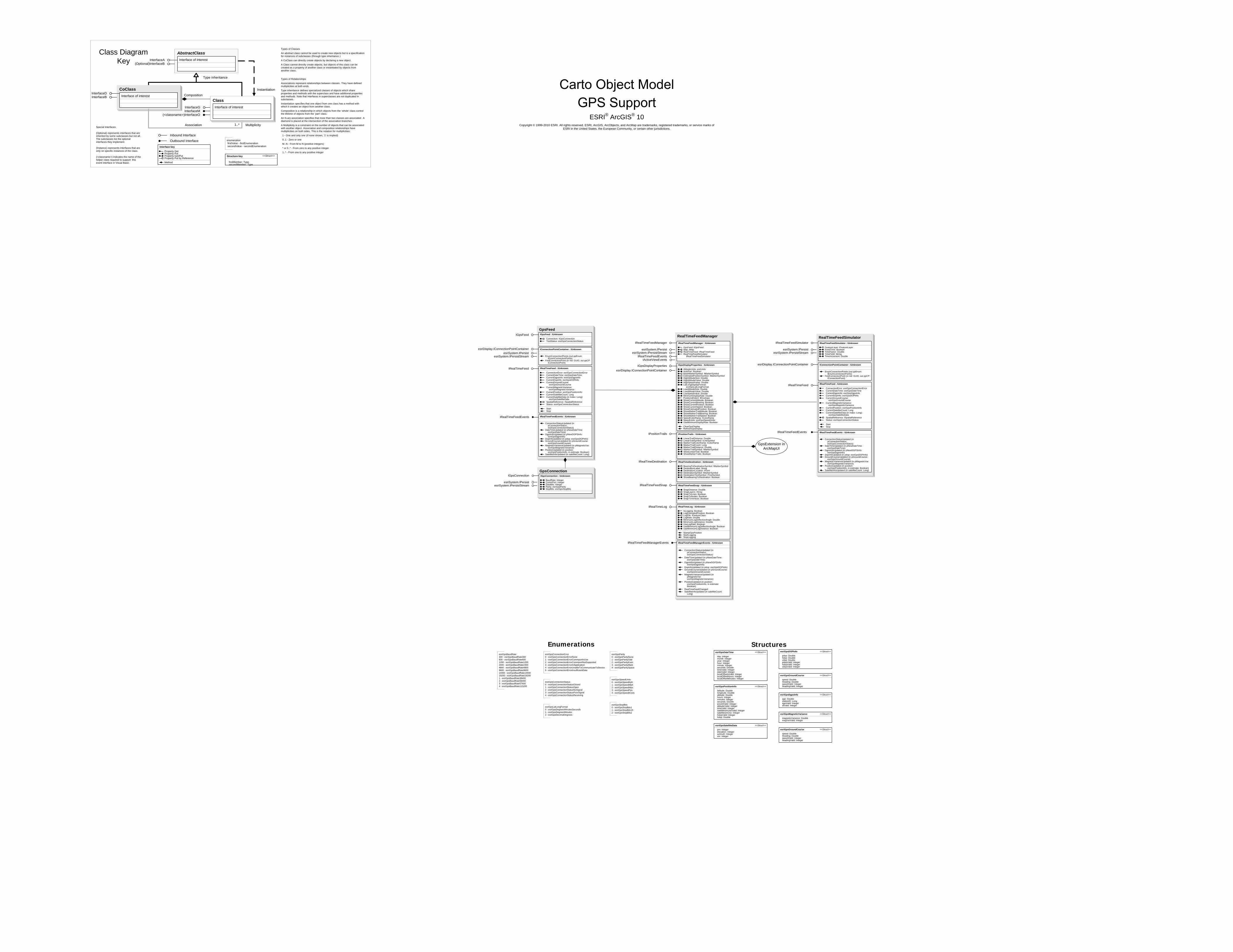
GpsFeedIGpsFeed
esriSystem.IPersistesriSystem.IPersistStream
GpsConnectionIGpsConnection IGpsConnection : IUnknown
BaudRate: IntegerCommPort: IntegerDataBits: IntegerParity: esriGpsParityStopBits: esriGpsStopBits
esriSystem.IPersistesriSystem.IPersistStream
RealTimeFeedManager
IRealTimeFeedManager IRealTimeFeedManager : IUnknown
GpsFeed: IGpsFeedMap: IMapRealTimeFeed: IRealTimeFeedRealTimeFeedSimulator:
IRealTimeFeedSimulator
esriSystem.IPersistesriSystem.IPersistStream
IGpsDisplayProperties
IPositionTrails IPositionTrails : IUnknown
LinearTrailDistance: DoubleLinearTrailSymbol: ILineSymbolMarkerTrailColorRamp: IColorRampMarkerTrailCount: LongMarkerTrailDistance: DoubleMarkerTrailSymbol: IMarkerSymbolShowLinearTrail: BooleanShowMarkerTrails: Boolean
IRealTimeDestination IRealTimeDestination : IUnknown
BearingToDestinationSymbol: IMarkerSymbolDestinationLabel: StringDestinationLocation: IPointDestinationSymbol: IMarkerSymbolDestinationTextSymbol: ITextSymbolShowBearingToDestination: Boolean
IRealTimeFeedEvents
IRealTimeFeedSnap IRealTimeFeedSnap : IUnknown
SnapDistance: DoubleSnapLayers: IArraySnapToLines: BooleanSnapToNodes: BooleanSnapToVertices: Boolean
IRealTimeLog
RealTimeFeedSimulatorIRealTimeFeedSimulator IRealTimeFeedSimulator : IUnknown
FeatureLayer: IFeatureLayerFixedTime: BooleanTimeFactor: DoubleTimeField: StringTimeIncrement: Double
esriSystem.IPersistesriSystem.IPersistStream
esriDisplay.IConnectionPointContainer IConnectionPointContainer : IUnknown
EnumConnectionPoints (out ppEnum: IEnumConnectionPoints)
FindConnectionPoint (in riid: GUID, out ppCP: IConnectionPoint)
IRealTimeFeed
IRealTimeFeedEvents IRealTimeFeedEvents : IUnknown
ConnectionStatusUpdated (in pConnectionStatus: esriGpsConnectionStatus)
DateTimeUpdated (in pNewDateTime: esriGpsDateTime)
DgpsInfoUpdated (in pNewDGPSInfo: esriGpsDgpsInfo)
DopInfoUpdated (in pdop: esriGpsDOPInfo)GroundCourseUpdated (in pGroundCourse:
esriGpsGroundCourse)MagneticVarianceUpdated (in pMagneticVar:
esriGpsMagneticVariance)PositionUpdated (in position:
esriGpsPositionInfo, in estimate: Boolean)SatelliteInfoUpdated (in satelliteCount: Long)
IRealTimeLog : IUnknown
IsLogging: BooleanLogEstimatedPosition: BooleanLogFile: IFeatureClassLogRate: DoubleMinimumLogDeflectionAngle: DoubleMinimumLogDistance: DoubleUseLogRate: BooleanUseMinimumLogDeflectionAngle: BooleanUseMinimumLogDistance: Boolean
StampGpsPositionStartLoggingStopLogging
IGpsDisplayProperties : IUnknown
AltitudeUnits: esriUnitsAutoPan: BooleanBaseMarkerSymbol: IMarkerSymbolEstimatedPositionSymbol: IMarkerSymbolHighAltitudeSize: DoubleHighAltitudeValue: DoubleHighSpeedValue: DoubleLatLongDisplayFormat:
esriGpsLatLongFormatLowAltitudeSize: DoubleLowAltitudeValue: DoubleLowSpeedValue: DoubleMinimumDisplayRate: DoublePositionsExtent: IEnvelopeShowCurrentAltitude: BooleanShowCurrentBearing: BooleanShowCurrentPosition: BooleanShowCurrentSpeed: BooleanShowEstimatedPosition: BooleanShowMarkerTrailAltitude: BooleanShowMarkerTrailBearing: BooleanShowMarkerTrailSpeed: BooleanSpeedColorRamp: IColorRampSpeedUnits: esriGpsSpeedUnitsUseMinimumDisplayRate: Boolean
ClearGpsDisplayRefreshGpsDisplay
IRealTimeFeedManagerEvents
IActiveViewEvents
GpsExtension in ArcMapUI
Structures
esriGpsSatelliteData <<Struct>>
prn: Integerelevation: Integerazimuth: Integersnr: Integer
esriGpsDgpsInfo <<Struct>>
age: DoublestationID: LongageValid: IntegeridValid: Integer
esriGpsDOPInfo <<Struct>>
pdop: Doublehdop: Doublevdop: DoublepdopValid: IntegerhdopValid: IntegervdopValid: Integer
esriGpsGroundCourse <<Struct>>
speed: DoubleHeading: DoublespeedValid: IntegerheadingValid: Integer
esriGpsMagneticVariance <<Struct>>
magneticVariance: DoublemagVarValid: Integer
esriGpsDateTime <<Struct>>
day: Integermonth: Integeryear: Integerhour: Integerminute: Integerseconds: DoubletimeValid: IntegerdateValid: IntegerlocalOffsetsValid: IntegerlocalOffsetHours: IntegerlocalOffsetMinutes: Integer
esriGpsPositionInfo <<Struct>>
latitude: Doublelongitude: Doublealtitude: Doublehours: Integerminutes: Integerseconds: Doublepos2dValid: IntegeraltitudeValid: IntegertimeValid: IntegersatellitesInUseValid: IntegersatellitesInUse: IntegerhdopValid: Integerhdop: Double
esriGpsGroundCourse <<Struct>>
speed: DoubleHeading: DoublespeedValid: IntegerheadingValid: Integer
IRealTimeFeed : IUnknown
ConnectionError: esriGpsConnectionErrorCurrentDateTime: esriGpsDateTimeCurrentDgpsInfo: esriGpsDgpsInfoCurrentDopInfo: esriGpsDOPInfoCurrentGroundCourse:
esriGpsGroundCourseCurrentMagneticVariance:
esriGpsMagneticVarianceCurrentPosition: esriGpsPositionInfoCurrentSatelliteCount: LongCurrentSatelliteData (in Index: Long):
esriGpsSatelliteDataSpatialReference: ISpatialReferenceStatus: esriGpsConnectionStatus
StartStop
IRealTimeFeedManagerEvents : IUnknown
ConnectionStatusUpdated (in pConnectionStatus: esriGpsConnectionStatus)
DateTimeUpdated (in pNewDateTime: esriGpsDateTime)
DgpsInfoUpdated (in pNewDGPSInfo: esriGpsDgpsInfo)
DopInfoUpdated (in pdop: esriGpsDOPInfo)GroundCourseUpdated (in pGroundCourse:
esriGpsGroundCourse)MagneticVarianceUpdated (in
pMagneticVar: esriGpsMagneticVariance)
PositionUpdated (in position: esriGpsPositionInfo, in estimate: Boolean)
RealTimeFeedChangedSatelliteInfoUpdated (in satelliteCount:
Long)
IGpsFeed : IUnknown
Connection: IGpsConnectionTestStatus: esriGpsConnectionStatus
IRealTimeFeedEvents IRealTimeFeedEvents : IUnknown
ConnectionStatusUpdated (in pConnectionStatus: esriGpsConnectionStatus)
DateTimeUpdated (in pNewDateTime: esriGpsDateTime)
DgpsInfoUpdated (in pNewDGPSInfo: esriGpsDgpsInfo)
DopInfoUpdated (in pdop: esriGpsDOPInfo)GroundCourseUpdated (in pGroundCourse:
esriGpsGroundCourse)MagneticVarianceUpdated (in pMagneticVar:
esriGpsMagneticVariance)PositionUpdated (in position:
esriGpsPositionInfo, in estimate: Boolean)SatelliteInfoUpdated (in satelliteCount: Long)
IRealTimeFeed IRealTimeFeed : IUnknown
ConnectionError: esriGpsConnectionErrorCurrentDateTime: esriGpsDateTimeCurrentDgpsInfo: esriGpsDgpsInfoCurrentDopInfo: esriGpsDOPInfoCurrentGroundCourse:
esriGpsGroundCourseCurrentMagneticVariance:
esriGpsMagneticVarianceCurrentPosition: esriGpsPositionInfoCurrentSatelliteCount: LongCurrentSatelliteData (in Index: Long):
esriGpsSatelliteDataSpatialReference: ISpatialReferenceStatus: esriGpsConnectionStatus
StartStop
esriDisplay.IConnectionPointContainer IConnectionPointContainer : IUnknown
EnumConnectionPoints (out ppEnum: IEnumConnectionPoints)
FindConnectionPoint (in riid: GUID, out ppCP: IConnectionPoint)
esriDisplay.IConnectionPointContainer
ESRI® ArcGIS® 10 Copyright © 1999-2010 ESRI. All rights reserved. ESRI, ArcGIS, ArcObjects, and ArcMap are trademarks, registered trademarks, or service marks of
ESRI in the United States, the European Community, or certain other jurisdictions.
CoClassInterfaceDInterfaceB
Types of Classes
An abstract class cannot be used to create new objects but is a specification for instances of subclasses (through type inheritance.)
A CoClass can directly create objects by declaring a new object .
A Class cannot directly create objects, but objects of this class can be created as a property of another class or instantiated by objects from another class.
Types of Relationships
Associations represent relationships between classes. They have defined multiplicities at both ends.
Type inheritance defines specialized classes of objects which share properties and methods with the superclass and have additional properties and methods. Note that interfaces in superclasses are not duplicated in subclasses.
Instantiation specifies that one object from one class has a method with which it creates an object from another class.
Composition is a relationship in which objects from the 'whole' class control the lifetime of objects from the 'part' class.
An N-ary association specifies that more than two classes are associated . A diamond is placed at the intersection of the association branches .
A Multiplicity is a constraint on the number of objects that can be associated with another object. Association and composition relationships have multiplicities on both sides. This is the notation for multiplicities:
1 - One and only one (if none shown, '1' is implied)
0..1 - Zero or one
M..N - From M to N (positive integers)
* or 0..* - From zero to any positive integer
1..* - From one to any positive integer
Class Diagram Key
enumeration firstValue - firstEnumeration secondValue - secondEnumeration
AbstractClass
Type inheritance
Instantiation
Association
Composition
1..* Multiplicity
Interface of interestInterfaceA(Optional)InterfaceB
Interface of interest
InterfaceGInterfaceM
Outbound Interface
Inbound Interface
Special Interfaces (Optional) represents interfaces that are inherited by some subclasses but not all . The subclasses list the optional interfaces they implement.
(Instance) represents interfaces that are only on specific instances of the class.
(<classname>) indicates the name of the helper class required to support this event interface in Visual Basic.
Interface key
Property GetProperty PutProperty Get/PutProperty Put by ReferenceMethod
(<classname>)InterfaceO
Structure key <<Struct>>
firstMember: TypesecondMember: Type
ClassInterface of interest
esriGpsConnectionError0 - esriGpsConnectionErrorNone1 - esriGpsConnectionErrorCommportInUse2 - esriGpsConnectionErrorCommportNotSupported3 - esriGpsConnectionErrorInApplication4 - esriGpsConnectionErrorUnableToCommunicateToDevice5 - esriGpsConnectionErrorInsufficientData
esriGpsConnectionStatus0 - esriGpsConnectionStatusClosed1 - esriGpsConnectionStatusOpen2 - esriGpsConnectionStatusNoSignal3 - esriGpsConnectionStatusPoorSignal4 - esriGpsConnectionStatusReceiving
esriGpsLatLongFormat0 - esriGpsDegreesMinutesSeconds1 - esriGpsDegreesMinutes2 - esriGpsDecimalDegrees
esriGpsParity0 - esriGpsParityNone1 - esriGpsParityOdd2 - esriGpsParityEven3 - esriGpsParityMark4 - esriGpsParitySpace
esriGpsSpeedUnits0 - esriGpsSpeedKph1 - esriGpsSpeedMph2 - esriGpsSpeedMps3 - esriGpsSpeedFps4 - esriGpsSpeedKnots
esriGpsStopBits0 - esriGpsStopBits11 - esriGpsStopBits152 - esriGpsStopBits2
EnumerationsesriGpsBaudRate300 - esriGpsBaudRate300600 - esriGpsBaudRate6001200 - esriGpsBaudRate12002400 - esriGpsBaudRate24004800 - esriGpsBaudRate48009600 - esriGpsBaudRate960014400 - esriGpsBaudRate1440019200 - esriGpsBaudRate192001 - esriGpsBaudRate384002 - esriGpsBaudRate560003 - esriGpsBaudRate576004 - esriGpsBaudRate115200
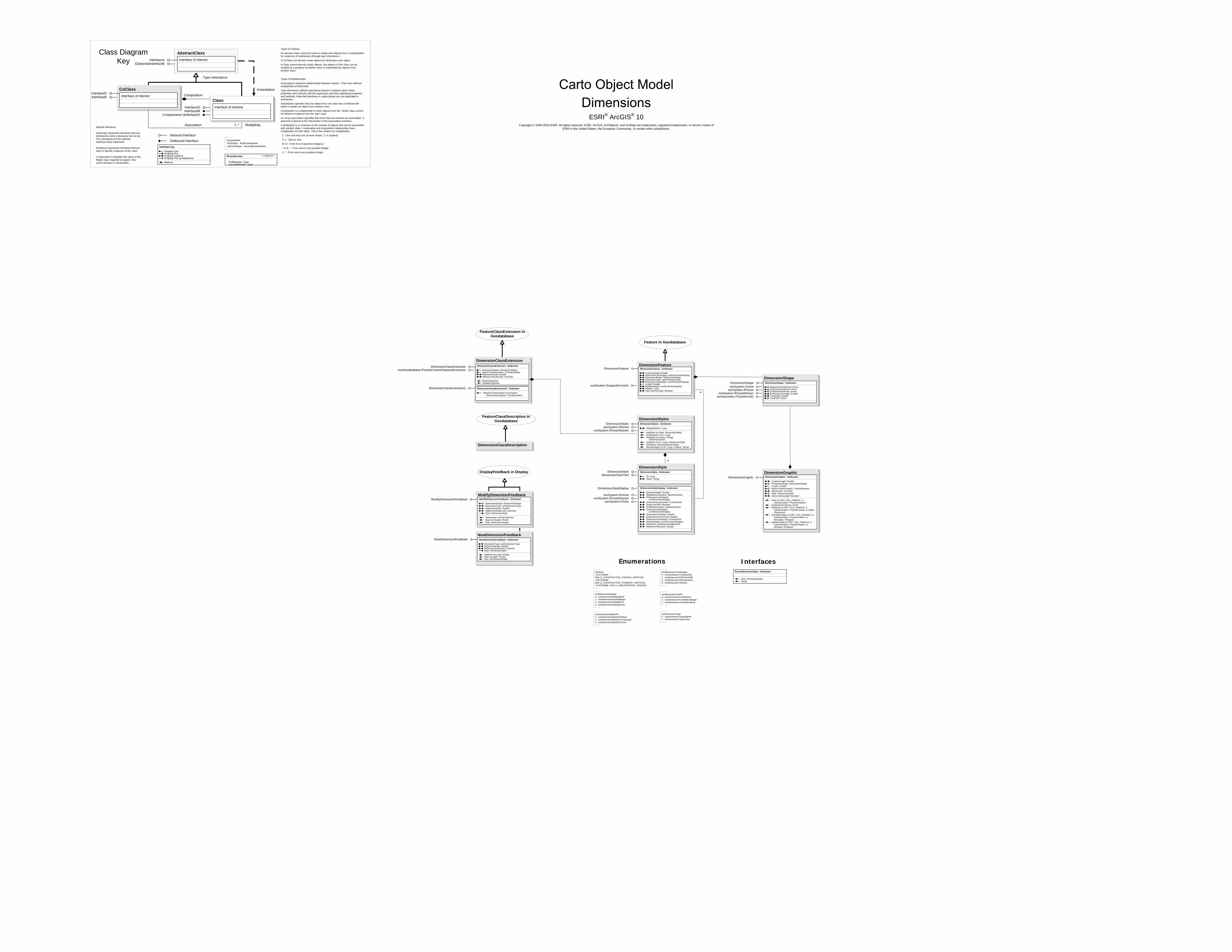
ESRI® ArcGIS® 10 Copyright © 1999-2010 ESRI. All rights reserved. ESRI, ArcGIS, ArcObjects, and ArcMap are trademarks, registered trademarks, or service marks of
ESRI in the United States, the European Community, or certain other jurisdictions.
DimensionGraphic
DimensionFeature
Feature in Geodatabase
IDimensionFeature IDimensionFeature : IUnknown
CustomLength: DoubleDimensionLineDisplay: esriDimensionDisplayDimensionShape: IDimensionShapeDimensionType: esriDimensionTypeExtensionLineDisplay: esriDimensionDisplayLength: DoubleMarkerDisplay: esriDimensionDisplayStyleID: LongUseCustomLength: Boolean
DimensionShapeIDimensionShape IDimensionShape : IUnknown
BeginDimensionPoint: IPointDimensionLinePoint: IPointEndDimensionPoint: IPointExtensionLineAngle: DoubleTextAngle: DoubleTextPoint: IPoint
esriSystem.IClone
FeatureClassExtension in Geodatabase
DimensionClassDescription
DimensionClassExtensionIDimensionClassExtension IDimensionClassExtension : IUnknown
DimensionStyles: IDimensionStylesNativeTransformation: ITransformationReferenceScale: DoubleReferenceScaleUnits: esriUnits
ResetPropertiesUpdateProperties
ModifyDimensionFeedbackIModifyDimensionFeedback
DisplayFeedback in Display
DimensionStyles
esriSystem.IPersistesriSystem.IPersistStream
IDimensionStyles : IUnknown
DefaultStyleID: Long
AddStyle (in Style: IDimensionStyle)DeleteStyle (in ID: Long)FindStyle (in Name: String):
IDimensionStyleGetStyle (in ID: Long): IDimensionStyleGetStyles: IEnumDimensionStyleRenameStyle (in ID: Long, in Name: String)
NewDimensionFeedbackINewDimensionFeedback INewDimensionFeedback : IUnknown
DimensionType: esriDimensionTypeReferenceScale: DoubleReferenceScaleUnits: esriUnitsStyle: IDimensionStyle
AddPoint (in point: IPoint)Start (in begin: IPoint)Stop: IDimensionShape
esriSystem.IClone
IDimensionStyle
IDimensionStyleDisplay
IDimensionStyleText
esriSystem.IPersistesriSystem.IPersistStream
DimensionStyleIDimensionStyle : IUnknown
ID: LongName: String
IDimensionStyleDisplay : IUnknown
BaselineHeight: DoubleBeginMarkerSymbol: IMarkerSymbolDimensionLineDisplay:
esriDimensionDisplayDimensionLineSymbol: ILineSymbolDrawLineOnFit: BooleanEndMarkerSymbol: IMarkerSymbolExtensionLineDisplay:
esriDimensionDisplayExtensionLineOffset: DoubleExtensionLineOvershot: DoubleExtensionLineSymbol: ILineSymbolMarkerDisplay: esriDimensionDisplayMarkerFit: esriDimensionMarkerFitMarkerFitTolerance: Double
IDimensionGraphic
* esriSystem.IPersistesriSystem.IPersistStream
esriGeometry.ITransform2D
IDimensionStyles
esriSystem.ISupportErrorInfo
esriGeodatabase.IPersistCustomFeaturesExtension
FeatureClassDescription in Geodatabase
dimError-2147220991 -DIM_E_CONSTRUCTOR_TOOFEW_VERTICES-2147220990 -DIM_E_CONSTRUCTOR_TOOMANY_VERTICES-2147220989 - DIM_E_UNSUPPORTED_VERSION
esriDimensionDisplay0 - esriDimensionDisplayBoth1 - esriDimensionDisplayBegin2 - esriDimensionDisplayEnd3 - esriDimensionDisplayNone
esriDimensionMarkerFit0 - esriDimensionMarkerFitNone1 - esriDimensionMarkerFitTolerance2 - esriDimensionMarkerFitText
esriDimensionTextDisplay0 - esriDimensionTDValueOnly1 - esriDimensionTDPrefixSuffix2 - esriDimensionTDExpression3 - esriDimensionTDNone
esriDimensionTextFit0 - esriDimensionTextFitNone1 - esriDimensionTextFitMoveBegin2 - esriDimensionTextFitMoveEnd
esriDimensionType0 - esriDimensionTypeAligned1 - esriDimensionTypeLinear
EnumerationsIEnumDimensionStyle : IUnknown
Next: IDimensionStyleReset
Interfaces*
IModifyDimensionFeedback : IUnknown
DimensionShape: IDimensionShapeDimensionType: esriDimensionTypeReferenceScale: DoubleReferenceScaleUnits: esriUnitsStyle: IDimensionStyle
GetHandles: IPointCollectionStart (in Handle: IPoint)Stop: IDimensionShape
IDimensionGraphic : IUnknown
CustomLength: DoubleDimensionShape: IDimensionShapeLength: DoubleNativeTransformation: ITransformationNativeUnits: esriUnitsStyle: IDimensionStyleUseCustomLength: Boolean
Draw (in hDC: OLE_HANDLE, in transformation: ITransformation)
GetDefaultTextPoint: IPointGetMask (in hDC: OLE_HANDLE, in
transformation: ITransformation, in Mask: IGeometry)
QueryBoundary (in hDC: OLE_HANDLE, in transformation: ITransformation, in Boundary: IPolygon)
UpdateShape (in hDC: OLE_HANDLE, in transformation: ITransformation, in pFeature: IFeature)
IDimensionClassExtension2 : IUnknown
NativeTransformation (in pGraphic: IDimensionGraphic): ITransformation
IDimensionClassExtension2
CoClassInterfaceDInterfaceB
Types of Classes
An abstract class cannot be used to create new objects but is a specification for instances of subclasses (through type inheritance.)
A CoClass can directly create objects by declaring a new object .
A Class cannot directly create objects, but objects of this class can be created as a property of another class or instantiated by objects from another class.
Types of Relationships
Associations represent relationships between classes. They have defined multiplicities at both ends.
Type inheritance defines specialized classes of objects which share properties and methods with the superclass and have additional properties and methods. Note that interfaces in superclasses are not duplicated in subclasses.
Instantiation specifies that one object from one class has a method with which it creates an object from another class.
Composition is a relationship in which objects from the 'whole' class control the lifetime of objects from the 'part' class.
An N-ary association specifies that more than two classes are associated . A diamond is placed at the intersection of the association branches .
A Multiplicity is a constraint on the number of objects that can be associated with another object. Association and composition relationships have multiplicities on both sides. This is the notation for multiplicities:
1 - One and only one (if none shown, '1' is implied)
0..1 - Zero or one
M..N - From M to N (positive integers)
* or 0..* - From zero to any positive integer
1..* - From one to any positive integer
Class Diagram Key
enumeration firstValue - firstEnumeration secondValue - secondEnumeration
AbstractClass
Type inheritance
Instantiation
Association
Composition
1..* Multiplicity
Interface of interestInterfaceA(Optional)InterfaceB
Interface of interest
InterfaceGInterfaceM
Outbound Interface
Inbound Interface
Special Interfaces (Optional) represents interfaces that are inherited by some subclasses but not all . The subclasses list the optional interfaces they implement.
(Instance) represents interfaces that are only on specific instances of the class.
(<classname>) indicates the name of the helper class required to support this event interface in Visual Basic.
Interface key
Property GetProperty PutProperty Get/PutProperty Put by ReferenceMethod
(<classname>)InterfaceO
Structure key <<Struct>>
firstMember: TypesecondMember: Type
ClassInterface of interest
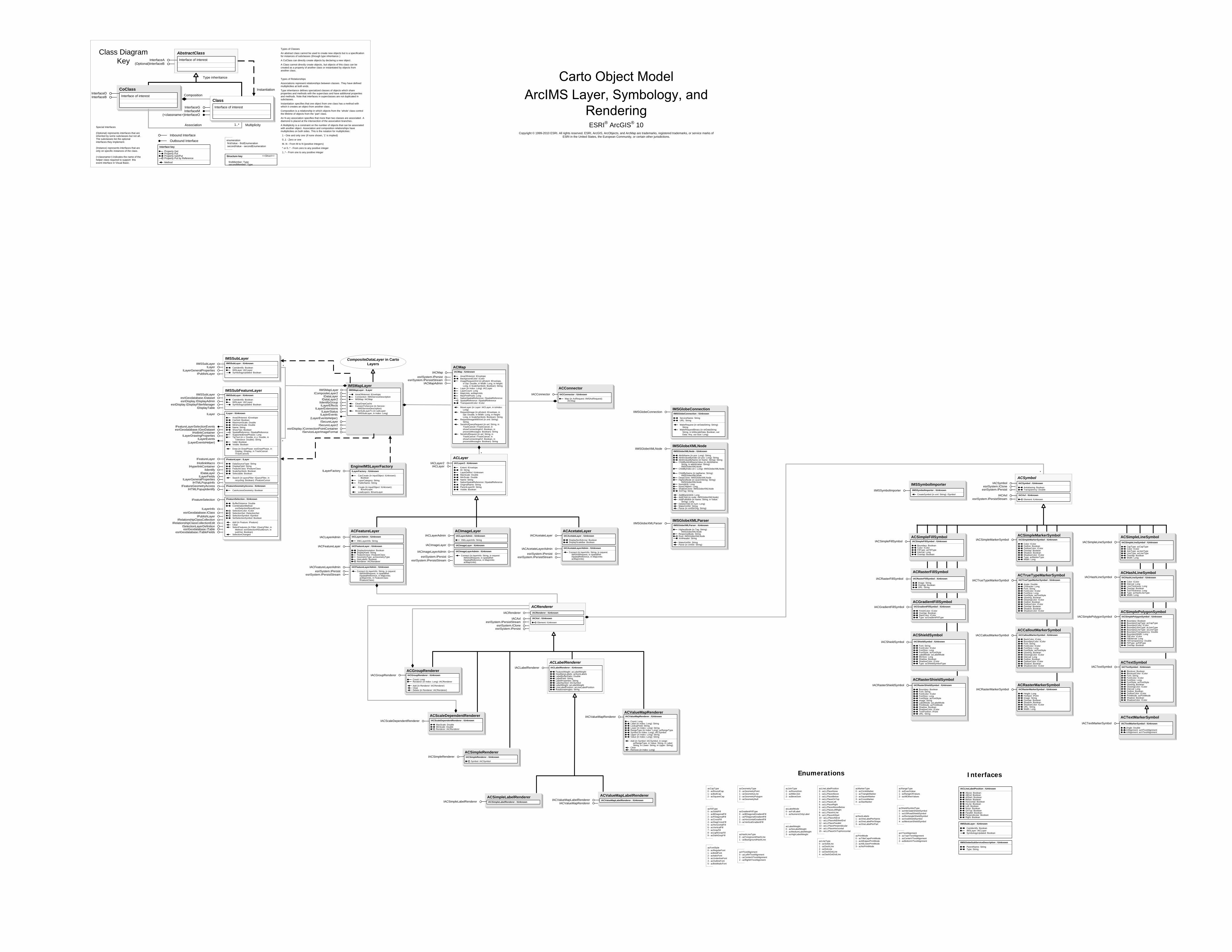
ACValueMapRenderer
esriSystem.IPersistesriSystem.IPersistStream
esriSystem.IPersistesriSystem.IPersistStream
CompositeDataLayer in Carto Layers
IMSMapLayer
ACMapIACMap
ACImageLayer
IACImageLayer
IACImageLayerAdmin
IACImageLayer : IUnknown
IACImageLayerAdmin : IUnknown
Connect (in layerInfo: String, in request: IIMSAxlRequest, in spatialRef: ISpatialReference, in MapUnits: acMapUnits)
IACLayerAdmin : IUnknown
XMLLayerInfo: String
ACFeatureLayer
IACFeatureLayer
IACFeatureLayerAdmin
IACLayerAdmin
esriSystem.IPersistesriSystem.IPersistStream
IACFeatureLayer : IUnknown
DisplayAnnotation: BooleanDisplayField: StringFeatureClass: IFeatureClassGeometryType: acGeometryTypeHasLabels: BooleanRenderer: IACRenderer
IACFeatureLayerAdmin : IUnknown
Connect (in layerInfo: String, in request: IIMSAxlRequest, in spatialRef: ISpatialReference, in MapUnits: acMapUnits, in FeatureClass: IFeatureClass)
IACLayerAdmin : IUnknown
XMLLayerInfo: String
IACLayerAdminACAcetateLayer
IACAcetateLayer
IACAcetateLayerAdmin
esriSystem.IPersistesriSystem.IPersistStream
IACAcetateLayer : IUnknown
DisplayNorthArrow: BooleanDisplayScaleBar: Boolean
IACAcetateLayerAdmin : IUnknown
Connect (in layerInfo: String, in request: IIMSAxlRequest, in spatialRef: ISpatialReference, in MapUnits: acMapUnits)
ACLabelRenderer
ACScaleDependentRenderer
ACSimpleRenderer
IACLabelRenderer : IUnknown
FeatureWeight: acLabelWeightHowManyLabels: acNumLabelsLabelBufferRatio: DoubleLabelField: StringLabelProperties: StringLabelSymbol: IACSymbolLabelWeight: acLabelWeightLineLabelPosition: acLineLabelPositionRotationalAngles: String
IACScaleDependentRenderer : IUnknown
MaxScale: DoubleMinScale: DoubleRenderer: IACRenderer
IACSimpleRenderer : IUnknown
Symbol: IACSymbol
IACScaleDependentRenderer
IACSimpleRenderer
IACLabelRenderer
IACValueMapRenderer
ACGroupRendererIACGroupRenderer IACGroupRenderer : IUnknown
Count: LongRenderer (in Index: Long): IACRenderer
Add (in Renderer: IACRenderer)ClearDelete (in Renderer: IACRenderer)
esriSystem.ICloneesriSystem.IPersist
esriSystem.IPersistStream
ACRendererIACRenderer : IUnknown
IACAxl : IUnknown
Element: IUnknown
IACRenderer
IACAxl
ACSimpleLabelRendererIACSimpleLabelRenderer : IUnknown
ACValueMapLabelRendererIACValueMapLabelRenderer : IUnknownIACValueMapLabelRendererIACSimpleLabelRenderer
IMSGlobeConnectionIIMSGlobeConnection
IMSGlobeXMLNodeIIMSGlobeXMLNode
IIMSGlobeXMLNode : IUnknown
AttribName (in pos: Long): StringAttribValueByIndex (in pos: Long): StringAttribValueByName (in Name: String): StringChildByAttribNameValue (in AttribName:
String, in atttribValue: String): IIMSGlobeXMLNode
ChildByIndex (in i: Long): IIMSGlobeXMLNode
ChildByName (in tagName: String): IIMSGlobeXMLNode
DeepClone: IIMSGlobeXMLNodeHighestNode (in searchString: String):
IIMSGlobeXMLNodeNumAttrib: LongNumChildren: LongShallowClone: IIMSGlobeXMLNodeXmlTag: String
AddBlankAttrib: LongAddChild (in node: IIMSGlobeXMLNode)AddFullAttrib (in Name: String, in Value:
String): LongDeleteChild (in num: Long)MakeXmlStr: StringParse (in xmlStrOrig: String)
IMSGlobeXMLParserIIMSGlobeXMLParser
IIMSGlobeXMLParser : IUnknown
HighestNode (in Tag: String): IIMSGlobeXMLNode
ResponseBody: StringRoot: IIMSGlobeXMLNodeXmlHeader: String
MakeXmlStr: StringParse (in xmlStr: String)
IACValueMapRenderer
IACValueMapRenderer : IUnknown
Count: LongLabel (in Index: Long): StringLookupField: StringLower (in Index: Long): StringRangeType (in Index: Long): acRangeTypeSymbol (in Index: Long): IACSymbolUpper (in Index: Long): StringValue (in Index: Long): String
Add (in Symbol: IACSymbol, in range: acRangeType, in Value: String, in Label: String, in Lower: String, in Upper: String)
ClearRemove (in Index: Long)
IIMSMapLayer
*
IACMapAdmin
ICompositeLayer2IDataLayer
IDataLayer2IIdentifyGroupILayerEffects
ILayerExtensionsILayerStatus
ESRI® ArcGIS® 10 Copyright © 1999-2010 ESRI. All rights reserved. ESRI, ArcGIS, ArcObjects, and ArcMap are trademarks, registered trademarks, or service marks of
ESRI in the United States, the European Community, or certain other jurisdictions.
ACSimplePolygonSymbolIACSimplePolygonSymbol : IUnknown
Boundary: BooleanBoundaryCapType: acCapTypeBoundaryColor: IColorBoundaryJoinType: acJoinTypeBoundaryLineType: acLineTypeBoundaryTransparency: DoubleBoundaryWidth: LongFillColor: IColorFillInterval: LongFillTransparency: DoubleFillType: acFillTypeOverlap: Boolean
ACHashLineSymbolIACHashLineSymbol : IUnknown
Color: IColorInterval: LongLineThickness: LongOverlap: BooleanTickThickness: LongType: acHashLineTypeWidth: Long
ACSimpleLineSymbolIACSimpleLineSymbol : IUnknown
CapType: acCapTypeColor: IColorJoinType: acJoinTypeLineType: acLineTypeOverlap: BooleanWidth: Long
ACRasterMarkerSymbolIACRasterMarkerSymbol : IUnknown
Height: LongHotSpot: IPointImage: StringOverlap: BooleanShadow: BooleanShadowColor: IColorURL: StringWidth: Long
ACCalloutMarkerSymbolIACCalloutMarkerSymbol : IUnknown
BackColor: IColorBoundaryColor: IColorFont: StringFontColor: IColorFontSize: LongFontStyle: acFontStyleGlowing: BooleanGlowingColor: IColorInterval: LongOutline: BooleanOutlineColor: IColorShadow: BooleanShadowColor: IColor
ACTrueTypeMarkerSymbolIACTrueTypeMarkerSymbol : IUnknown
Angle: DoubleCharacter: LongFont: StringFontColor: IColorFontSize: LongFontStyle: acFontStyleGlowing: BooleanGlowingColor: IColorOutline: BooleanOutlineColor: IColorOverlap: BooleanShadow: BooleanShadowColor: IColor
ACSimpleMarkerSymbolIACSimpleMarkerSymbol : IUnknown
Color: IColorOutline: BooleanOutlineColor: IColorOverlap: BooleanShadow: BooleanShadowColor: IColorType: acMarkerTypeWidth: Long
ACSimpleFillSymbolIACSimpleFillSymbol : IUnknown
Boundary: BooleanColor: IColorFillType: acFillTypeInterval: LongOverlap: Boolean
ACRasterFillSymbolIACRasterFillSymbol : IUnknown
Image: StringOverlap: BooleanURL: String
ACGradientFillSymbolIACGradientFillSymbol : IUnknown
FinishColor: IColorOverlap: BooleanStartColor: IColorType: acGradientFillType
ACRasterShieldSymbolIACRasterShieldSymbol : IUnknown
Boundary: BooleanFont: StringFontColor: IColorFontSize: LongFontStyle: acFontStyleImage: StringLabelMode: acLabelModePrintMode: acPrintModeShadow: BooleanShadowColor: IColorTextPosition: IPointURL: String
ACShieldSymbolIACShieldSymbol : IUnknown
Font: StringFontColor: IColorFontSize: LongFontStyle: acFontStyleLabelMode: acLabelModeMinSize: LongShadow: BooleanShadowColor: IColorType: acShieldSymbolType
IACGradientFillSymbol
IACShieldSymbol
IACRasterShieldSymbol
IACSimpleFillSymbol
IACRasterFillSymbol
IACSimpleMarkerSymbol
IACRasterMarkerSymbol
IACCalloutMarkerSymbol
IACTrueTypeMarkerSymbol
IACSimpleLineSymbol
IACSimplePolygonSymbol
IACHashLineSymbol
IMSSymbolImporterIIMSSymbolImporter : IUnknown
CreateSymbol (in xml: String): ISymbolIIMSSymbolImporter
ACSymbolIACSymbol : IUnknown
Antialiasing: BooleanTransparency: Double
IACAxl : IUnknown
Element: IUnknown
IACAxl
IACSymbolesriSystem.IClone
esriSystem.IPersist
esriSystem.IPersistStream
ACTextMarkerSymbolIACTextMarkerSymbol : IUnknown
Angle: DoubleHAlignment: acHTextAlignmentVAlignment: acVTextAlignment
IACTextMarkerSymbol
ACTextSymbolIACTextSymbol : IUnknown
Blockout: BooleanBlockoutColor: IColorFont: StringFontColor: IColorFontSize: LongFontStyle: acFontStyleGlowing: BooleanGlowingColor: IColorInterval: LongOutline: BooleanOutlineColor: IColorPrintMode: acPrintModeShadow: BooleanShadowColor: IColor
IACTextSymbol
IACLineLabelPosition : IUnknown
Above: BooleanAtEnd: BooleanAtStart: BooleanBelow: BooleanHorizontal: BooleanInLine: BooleanLeft: BooleanNone: BooleanOnTop: BooleanParallel: BooleanPerpendicular: BooleanRight: Boolean
IIMSSubLayer : IUnknown
CanIdentify: BooleanIMSLayer: IACLayerSymbologyUpdated: Boolean
Enumerations Interfaces
IIMSGlobeSubServiceDescription : IUnknown
ParentName: StringType: String
acGeometryType0 - acGeometryPoint1 - acGeometryLine2 - acGeometryPolygon3 - acGeometryNull
acGradientFillType0 - acBDiagonalGradientFill1 - acFDiagonalGradientFill2 - acHorizontalGradientFill3 - acVerticalGradientFill
acHashLineType0 - acForegroundHashLine1 - acBackgroundHashLine
acHTextAlignment0 - acLeftHTextAlignment1 - acCenterHTextAlignment2 - acRightHTextAlignment
acCapType0 - acRoundCap1 - acButtCap2 - acSquareCap
acFillType0 - acSolidFill1 - acBDiagonalFill2 - acFDiagonalFill3 - acCrossFill4 - acDiagCrossFill5 - acHorizontalFill6 - acVerticalFill7 - acGrayFill8 - acLightGrayFill9 - acDarkGrayFill
acFontStyle0 - acRegularFont1 - acBoldFont2 - acItalicFont3 - acUnderlineFont4 - acOutlineFont5 - acBoldItalicFont
acJoinType0 - acRoundJoin1 - acMiterJoin2 - acBevelJoin
acLabelMode0 - acFullLabel1 - acNumericOnlyLabel
acLabelWeight0 - acNoLabelWeight2 - acMediumLabelWeight3 - acHighLabelWeight
acLineLabelPosition0 - acLLPlaceNone1 - acLLPlaceAbove2 - acLLPlaceBelow3 - acLLPlaceOnTop4 - acLLPlaceLeft5 - acLLPlaceRight6 - acLLPlaceAboveBelow7 - acLLPlaceLeftRight8 - acLLPlaceInLine9 - acLLPlaceAtStart10 - acLLPlaceAtEnd11 - acLLPlaceAtEitherEnd12 - acLLPlaceParallel13 - acLLPlacePerpendicular14 - acLLPlaceHorizontal15 - acLLPlaceOnTopHorizontal
acLineType0 - acSolidLine1 - acDashLine2 - acDotLine3 - acDashDotLine4 - acDashDotDotLine
acNumLabels1 - acOneLabelPerName2 - acOneLabelPerShape3 - acOneLabelPerPart
acPrintMode0 - acTitleCapsPrintMode1 - acAllUpperPrintMode2 - acAllLowerPrintMode3 - acNoPrintMode
acMarkerType0 - acCircleMarker1 - acTriangleMarker2 - acSquareMarker3 - acCrossMarker4 - acStarMarker
acRangeType0 - acExactValue1 - acRangeOfValues2 - acAllOtherValues
acShieldSymbolType0 - acInterstateShieldSymbol1 - acUSRoadShieldSymbol2 - acRectangleShieldSymbol3 - acOvalShieldSymbol4 - acMexicanShieldSymbol
acVTextAlignment0 - acTopVTextAlignment1 - acCenterVTextAlignment2 - acBottomVTextAlignment
*
CoClassInterfaceDInterfaceB
Types of Classes
An abstract class cannot be used to create new objects but is a specification for instances of subclasses (through type inheritance.)
A CoClass can directly create objects by declaring a new object .
A Class cannot directly create objects, but objects of this class can be created as a property of another class or instantiated by objects from another class.
Types of Relationships
Associations represent relationships between classes. They have defined multiplicities at both ends.
Type inheritance defines specialized classes of objects which share properties and methods with the superclass and have additional properties and methods. Note that interfaces in superclasses are not duplicated in subclasses.
Instantiation specifies that one object from one class has a method with which it creates an object from another class.
Composition is a relationship in which objects from the 'whole' class control the lifetime of objects from the 'part' class.
An N-ary association specifies that more than two classes are associated . A diamond is placed at the intersection of the association branches .
A Multiplicity is a constraint on the number of objects that can be associated with another object. Association and composition relationships have multiplicities on both sides. This is the notation for multiplicities:
1 - One and only one (if none shown, '1' is implied)
0..1 - Zero or one
M..N - From M to N (positive integers)
* or 0..* - From zero to any positive integer
1..* - From one to any positive integer
Class Diagram Key
enumeration firstValue - firstEnumeration secondValue - secondEnumeration
AbstractClass
Type inheritance
Instantiation
Association
Composition
1..* Multiplicity
Interface of interestInterfaceA(Optional)InterfaceB
Interface of interest
InterfaceGInterfaceM
Outbound Interface
Inbound Interface
Special Interfaces (Optional) represents interfaces that are inherited by some subclasses but not all . The subclasses list the optional interfaces they implement.
(Instance) represents interfaces that are only on specific instances of the class.
(<classname>) indicates the name of the helper class required to support this event interface in Visual Basic.
Interface key
Property GetProperty PutProperty Get/PutProperty Put by ReferenceMethod
(<classname>)InterfaceO
Structure key <<Struct>>
firstMember: TypesecondMember: Type
ClassInterface of interest
IACMap : IUnknown
AreaOfInterest: IEnvelopeBackgroundColor: IColorImageRequestXml (in pExtent: IEnvelope,
in Dpi: Double, in Width: Long, in Height: Long, in ScaleSymbols: Boolean): String
Layer (in Index: Long): IACLayerLayerCount: LongMapUnits: acMapUnitsMaxPrintPixels: LongNativeSpatialReference: ISpatialReferenceSpatialReference: ISpatialReferenceTransparentColor: IColor
MoveLayer (in Layer: IACLayer, in toIndex: Long)
RequestImage (in pExtent: IEnvelope, in Dpi: Double, in Width: Long, in Height: Long, in ScaleSymbols: Boolean): String
RequestImageWithXml (in xml: String): String
SendAxlQueryRequest (in axl: String, in TrackCancel: ITrackCancel, in showConnectingAVI: Boolean, in processMessages: Boolean): String
SendAxlRequest (in axl: String, in TrackCancel: ITrackCancel, in showConnectingAVI: Boolean, in processMessages: Boolean): String
IMSSubLayerIIMSSubLayer
ILayerILayerGeneralProperties
IPublishLayer
IIMSSubLayer : IUnknown
CanIdentify: BooleanIMSLayer: IACLayerSymbologyUpdated: Boolean
*
*
ILayerEvents(LayerEventsHelper)
EngineIMSLayerFactoryILayerFactory ILayerFactory : IUnknown
CanCreate (in inputObject: IUnknown): Boolean
LayerCategory: StringPublicName: String
Create (in inputObject: IUnknown): IEnumLayer
LoadLayers: IEnumLayer
ACConnectorIACConnector : IUnknown
Map (in AxlRequest: IIMSAxlRequest): IACMap
IACConnector
IIMSGlobeConnection : IUnknown
ServiceName: StringURL: String
MakeRequest (in strDataString: String): String
MakeRequestBinary (in strDataString: String, in bAllocateData: Boolean, out Data: Any, out Size: Long)
ACLayerIACLayer2 IACLayer2 : IUnknown
Extent: IEnvelopeID: StringLayerDefAxl: IUnknownMaxScale: DoubleMinScale: DoubleName: StringNativeSpatialReference: ISpatialReferenceOriginalName: StringParentLayerID: StringVisible: Boolean
IACLayer
ISecureLayerISecureLayer2
IMSSubFeatureLayer
esriGeodatabase.IClass
IDataLayer
esriGeodatabase.IDatasetesriDisplay.IDisplayAdmin
esriDisplay.IDisplayFilterManagerIDisplayTable
IFeatureGeometryAccess
IFeatureLayer
IFeatureLayerSelectionEvents
IFeatureSelection
esriGeodatabase.IGeoDatasetIHotlinkContainer
IHotlinkMacroIHyperlinkContainer
IIdentify
IIMSSubLayer
ILayer
ILayerDrawingPropertiesILayerEvents
(LayerEventsHelper)
ILayerFieldsILayerGeneralProperties
ILayerInfo
IPublishLayerIRelationshipClassCollection
IRelationshipClassCollectionEditISelectionLayerDefinitionesriGeodatabase.ITable
esriGeodatabase.ITableFields
IIMSSubLayer : IUnknown
CanIdentify: BooleanIMSLayer: IACLayerSymbologyUpdated: Boolean
ILayer : IUnknown
AreaOfInterest: IEnvelopeCached: BooleanMaximumScale: DoubleMinimumScale: DoubleName: StringShowTips: BooleanSpatialReference: ISpatialReferenceSupportedDrawPhases: LongTipText (in x: Double, in y: Double, in
Tolerance: Double): StringValid: BooleanVisible: Boolean
Draw (in DrawPhase: esriDrawPhase, in Display: IDisplay, in TrackCancel: ITrackCancel)
IFeatureLayer : ILayer
DataSourceType: StringDisplayField: StringFeatureClass: IFeatureClassScaleSymbols: BooleanSelectable: Boolean
Search (in queryFilter: IQueryFilter, in recycling: Boolean): IFeatureCursor
IFeatureGeometryAccess : IUnknown
CanAccessGeometry: Boolean
IFeatureSelection : IUnknown
BufferDistance: DoubleCombinationMethod:
esriSelectionResultEnumSelectionColor: IColorSelectionSet: ISelectionSetSelectionSymbol: ISymbolSetSelectionSymbol: Boolean
Add (in Feature: IFeature)ClearSelectFeatures (in Filter: IQueryFilter, in
Method: esriSelectionResultEnum, in justOne: Boolean)
SelectionChanged
IHTMLPopupInfo
esriDisplay.IConnectionPointContainer
IHTMLPopupIdentify
IIMSMapLayer : ILayer
AreaOfInterest: IEnvelopeConnection: IIMSServiceDescriptionIMSMap: IACMap
ClearDrawCacheConnectToService (in Service:
IIMSServiceDescription)MoveSubLayerTo (in subLayer:
IIMSSubLayer, in Index: Long)
IServiceLayerImageFormat

FeatureCursorBuffer
IBufferProcessingParameterIFeatureCursorBuffer
IFeatureCursorBuffer2
FeatureCache
IFeatureCacheIFeatureCache2 IFeatureCache2 : IUnknown
Count: LongFeature (in Index: Long): IFeature
AddFeatures (in fclass: IFeatureClass, in Clip: IEnvelope)
AddLayers (in Layers: IEnumLayer, in Clip: IEnvelope)
Contains (in point: IPoint): BooleanInitialize (in point: IPoint, in Size: Double)
FeatureFindDataIFeatureFindData2
IFindObjIFeatureFindData2 : IUnknown
Feature: IFeatureLayer: ILayer
FeatureIDSetIFeatureIDSet
esriSystem.IPersistesriSystem.IPersistStream
IFeatureIDSet : IUnknown
Contains (in FID: Long): BooleanCount: LongMembers: Variant
Add (in FID: Long)ClearRemove (in FID: Long)
FeatureIndex
IFeatureIndexIFeatureIndex2
IIndexQueryIIndexQuery2
IFeatureIndex2 : IUnknown
FeatureClass: IFeatureClassFeatureCursor: IFeatureCursorOutputSpatialReference (in FieldName:
String): ISpatialReference
Index (in pTrackCancel: ITrackCancel, in pQueryingGeometryFullExtent: IEnvelope)
LabelEnvironmentILabelEnvironment ILabelEnvironment : IUnknown
LabelStyle: ILabelStyleLabelStyleMethod:
esriLabelEnvLabelStyleMethodPlacement: esriLabelEnvPlacement
SelectionEnvironment
esriSystem.IPersistesriSystem.IPersistStream
ISelectionEnvironment : IUnknown
AreaSearchDistance: DoubleAreaSelectionMethod: esriSpatialRelEnumCombinationMethod:
esriSelectionResultEnumDefaultColor: IColorLinearSearchDistance: DoubleLinearSelectionMethod: esriSpatialRelEnumPointSearchDistance: DoublePointSelectionMethod: esriSpatialRelEnumSearchTolerance: Long
ISelectionEnvironmentLayer : IUnknown
ClearInvisibleLayers: Boolean
ISelectionEnvironmentStorage : IUnknown
SaveSelections: Boolean
ISelectionEnvironmentThreshold : IUnknown
ShowSelectionWarning: BooleanWarningThreshold: Long
ISelectionEnvironment
ISelectionEnvironmentLayer
ISelectionEnvironmentStorage
ISelectionEnvironmentThreshold
GraphicSnapEnvironmentIGraphicSnapEnvironment
esriSystem.IPersistesriSystem.IPersistStream
IGraphicSnapEnvironment : IUnknown
SnapAgent (in Index: Long): IGraphicSnapSnapAgentCount: LongSnapAgentOrder: IArraySnapTolerance: Double
AddSnapAgent (in SnapAgent: IGraphicSnap)
ClearSnapAgentsDeleteSnapAgent (in SnapAgent:
IGraphicSnap)SnapShape (in Shape: IGeometry)
RasterIdentifyObjIIdentifyObj
IRasterIdentifyObj
IRasterIdentifyObj2
IIdentifyObj : IUnknown
hWnd: OLE_HANDLELayer: ILayerName: String
CanIdentify (in pLayer: ILayer): BooleanFlash (in pDisplay: IScreenDisplay)PopUpMenu (in x: Long, in y: Long)
IRasterIdentifyObj : IUnknown
Location: IPointMapTip: StringName: String
InsertPropAndValue (in Property: String, in Value: String)
IRasterIdentifyObj2 : IUnknown
GetPropAndValues (in Index: Long, out Property: String, out Value: String)
RasterLayer in Carto Layers
RasterDefaultsEnvIRasterDefaultsEnv
IRasterDefaultsEnv2
IRasterDefaultsEnv3
IRasterDefaultsEnv : IUnknown
Format (in i: Long): IRasterFormatInfoNumFormats: LongPyramidCreateOpt:
esriRasterPyramidOptEnumUseExtChecking: Boolean
Query3BandRGB (out redIndex: Long, out greenIndex: Long, out blueIndex: Long)
Query4BandRGB (out redIndex: Long, out greenIndex: Long, out blueIndex: Long)
Set3BandRGB (in redIndex: Long, in greenIndex: Long, in blueIndex: Long)
Set4BandRGB (in redIndex: Long, in greenIndex: Long, in blueIndex: Long)
IRasterDefaultsEnv2 : IRasterDefaultsEnv
MaxTableSize: LongProxyFilePath: StringRenderingMode:
esriRasterRenderingModeEnumResampling: rstResamplingTypes
UpdateAll
RasterFormatInfoIRasterFormatInfo IRasterFormatInfo : IUnknown
ActiveBrowse: BooleanDefaultExts: StringFormatName: String
Environment and Feature Management
ESRI® ArcGIS® 10 Copyright © 1999-2010 ESRI. All rights reserved. ESRI, ArcGIS, ArcObjects, and ArcMap are trademarks, registered trademarks, or service marks of
ESRI in the United States, the European Community, or certain other jurisdictions.
ColorRampStyleGalleryClass
ColorStyleGalleryClass
FillSymbolStyleGalleryClass
LineSymbolStyleGalleryClass
LegendItemStyleGalleryClass
MarkerSymbolStyleGalleryClass
NorthArrowStyleGalleryClass
ScalebarStyleGalleryClass
ShadowStyleGalleryClass
LabelStyleGalleryClass
ScaleTextStyleGalleryClass
BorderStyleGalleryClass
BackGroundStyleGalleryClass
AreaPatchStyleGalleryClass
LinePatchStyleGalleryClass
TextSymbolStyleGalleryClass
StyleGalleryClass
BasicGeoprocessorIBasicGeoprocessor IBasicGeoprocessor : IUnknown
CancelTracker: ITrackCancelSpatialReference: ISpatialReference
Clip (in inputTable: ITable, in useSelectedInput: Boolean, in clipTable: ITable, in useSelectedClip: Boolean, in Tolerance: Double, in outputName: IFeatureClassName): IFeatureClass
Dissolve (in inputTable: ITable, in useSelected: Boolean, in dissolveField: String, in summaryFields: String, in outputName: IDatasetName): ITable
Intersect (in inputTable: ITable, in useSelectedInput: Boolean, in overlayTable: ITable, in useSelectedOverlay: Boolean, in Tolerance: Double, in outputName: IFeatureClassName): IFeatureClass
Merge (in tables: IArray, in fieldsTable: ITable, in outputName: IFeatureClassName): IFeatureClass
Union (in inputTable: ITable, in useSelectedInput: Boolean, in overlayTable: ITable, in useSelectedOverlay: Boolean, in Tolerance: Double, in outputName: IFeatureClassName): IFeatureClass
InvalidAreaesriGeodatabase.IInvalidArea
IInvalidArea2
IInvalidArea3
IInvalidArea : IUnknown
Display: IScreenDisplay
Add (in thing: IUnknown)Invalidate (screenCache: Integer)
IInvalidArea2 : IInvalidArea
AddFeature (in Feature: IFeature, in Symbol: ISymbol)
IInvalidArea3 : IInvalidArea2
InvalidateEx (in screenCache: Integer, in symSizePoints: Double)
Style Gallery Classes
CoClassInterfaceDInterfaceB
Types of Classes
An abstract class cannot be used to create new objects but is a specification for instances of subclasses (through type inheritance.)
A CoClass can directly create objects by declaring a new object .
A Class cannot directly create objects, but objects of this class can be created as a property of another class or instantiated by objects from another class.
Types of Relationships
Associations represent relationships between classes. They have defined multiplicities at both ends.
Type inheritance defines specialized classes of objects which share properties and methods with the superclass and have additional properties and methods. Note that interfaces in superclasses are not duplicated in subclasses.
Instantiation specifies that one object from one class has a method with which it creates an object from another class.
Composition is a relationship in which objects from the 'whole' class control the lifetime of objects from the 'part' class.
An N-ary association specifies that more than two classes are associated . A diamond is placed at the intersection of the association branches .
A Multiplicity is a constraint on the number of objects that can be associated with another object. Association and composition relationships have multiplicities on both sides. This is the notation for multiplicities:
1 - One and only one (if none shown, '1' is implied)
0..1 - Zero or one
M..N - From M to N (positive integers)
* or 0..* - From zero to any positive integer
1..* - From one to any positive integer
Class Diagram Key
enumeration firstValue - firstEnumeration secondValue - secondEnumeration
AbstractClass
Type inheritance
Instantiation
Association
Composition
1..* Multiplicity
Interface of interestInterfaceA(Optional)InterfaceB
Interface of interest
InterfaceGInterfaceM
Outbound Interface
Inbound Interface
Special Interfaces (Optional) represents interfaces that are inherited by some subclasses but not all . The subclasses list the optional interfaces they implement.
(Instance) represents interfaces that are only on specific instances of the class.
(<classname>) indicates the name of the helper class required to support this event interface in Visual Basic.
Interface key
Property GetProperty PutProperty Get/PutProperty Put by ReferenceMethod
(<classname>)InterfaceO
Structure key <<Struct>>
firstMember: TypesecondMember: Type
ClassInterface of interest
SimpleWMSIdentifyObjectIIdentifyObj
IIdentifyObjectIIdentifyObj : IUnknown
hWnd: OLE_HANDLELayer: ILayerName: String
CanIdentify (in pLayer: ILayer): BooleanFlash (in pDisplay: IScreenDisplay)PopUpMenu (in x: Long, in y: Long)
WMSMapLayer in Carto Layers
IFeatureCursorBuffer2 : IUnknown
BufferedGeometry: IEnumGeometryBufferSpatialReference: ISpatialReferenceCancelTrack: ITrackCancelDataFrameSpatialReference:
ISpatialReferenceDissolve: BooleanFeatureCursor: IFeatureCursorFieldDistance: StringPolygonBufferType: esriBufferTypeRingDistance (in numberOfRings: Long):
DoubleSourceSpatialReference: ISpatialReferenceSpatialReference: ISpatialReferenceTargetSpatialReference: ISpatialReferenceUnits (in MapUnits: esriUnits): esriUnitsValueDistance: Double
Buffer (in pNewLocationName: IFeatureClassName)
BufferToGraphics (in pCompositeGraphicsLayer: ICompositeGraphicsLayer)
GraphicsLayer2 (in pGraphicsLayer: IGraphicsLayer, in Selected: Boolean, out pSelectedElements: Long, out bHasPolygons: Boolean)
MaplexLabelStyleGalleryClass
RepresentationMarkerStyleGalleryClass
RepresentationRuleStyleGalleryClass
IRasterDefaultsEnv3 : IRasterDefaultsEnv2
AssumeHomogeneousCatalog: BooleanFavorWorldFile: BooleanMaximumBuildAttributeTableSize: Long
ServerStyleGallery in Display StyleGallery in Framework
1..* 1..*
Dynamic Display
IRasterDefaultsEnv4 : IRasterDefaultsEnv3
AskSubdatasetSelection: BooleanDisplayWithContrastStretch: BooleanMaximumRastersColorMatching: Long
IRasterDefaultsEnv4
DynamicGlyph
DynamicDisplay
Map in Carto Map and Page Layout
DynamicCacheLayerManagerIDynamicCacheLayerManager
DynamicGlyphFactoryesriDisplay.IDynamicGlyphFactory
esriDisplay.IDynamicGlyphFactory2
IDynamicGlyphFactory : IUnknown
DynamicGlyph (in groupId: Long, in GlyphType: esriDynamicGlyphType, in index: Long): IDynamicGlyph
CreateDynamicGlyph (in Symbol: ISymbol): IDynamicGlyph
CreateDynamicGlyphFromFile (in GlyphType: esriDynamicGlyphType, in fileName: String, in transparencyColor: IColor): IDynamicGlyph
DeleteDynamicGlyph (in glyph: IDynamicGlyph)
Init (in ScreenDisplay: IScreenDisplay)LoadDynamicGlyphsGroup (in fileName:
String): LongUnloadDynamicGlyphsGroup (in groupId:
Long)
IDynamicGlyphFactory2 : IDynamicGlyphFactory
CreateDynamicGlyphFromBitmap (in GlyphType: esriDynamicGlyphType, in hBmp: OLE_HANDLE, in preserveAlphaChannel: Boolean, in transparencyColor: IColor): IDynamicGlyph
GetCreatedDynamicGlyphSize (in GlyphType: esriDynamicGlyphType, sizeX: Long, sizeY: Long)
SetCreatedDynamicGlyphSize (in GlyphType: esriDynamicGlyphType, in sizeX: Long, in sizeY: Long)
IActiveViewEvents IActiveViewEvents : IUnknown
AfterDraw (in Display: IDisplay, in phase: esriViewDrawPhase)
AfterItemDraw (in Index: Integer, in Display: IDisplay, phase: esriDrawPhase)
ContentsChangedContentsClearedFocusMapChangedItemAdded (in Item: Variant)ItemDeleted (in Item: Variant)ItemReordered (in Item: Variant, in toIndex:
Long)SelectionChangedSpatialReferenceChangedViewRefreshed (in view: IActiveView, in
phase: esriViewDrawPhase, in Data: Variant, in envelope: IEnvelope)
DynamicDisplayBase in Display
DynamicGlyphBase in Display
esriBufferType0 - esriBufferAll1 - esriBufferOutside2 - esriBufferInside3 - esriBufferOutsideIncludeInside4 - esriBufferInsideExcludeRing
esriCad3DRenderMode0 - esriCad3DRenderWireFrame1 - esriCad3DRenderFlatFilled2 - esriCad3DRenderHiddenLine3 - esriCad3DRenderFlatShaded4 - esriCad3DRenderGouraudShaded
esriFindOption-1 - esriFindAllLayers-2 - esriFindVisibleLayersIEditOperation : IOperation
IFeatureFindData : IUnknown
ActiveView: IActiveViewFeature: IFeatureLayer: ILayer
IFindObject : IFindObj
FID: Long
IGeoRefSaveAsDlg : IUnknown
CanSaveAs (in pLayer: ILayer): BooleanDoSaveAs (in pLayer: ILayer)
IMXFeatureFindData : IUnknown
ActiveView: IActiveView
EnumerationsInterfaces
IMapIdentifyObject : IUnknown
Map: IMap
IEnumLocatedNetworkElement : IUnknown
NetworkDataset: INetworkDataset
Next (elementGeometry: IGeometry, ElementType: esriNetworkElementType): Long
ResetINetworkIdentifyObj : IUnknown
ElementID: LongElementType: esriNetworkElementTypeNetworkName: StringShape: IGeometry
IDataBrowser : IUnknown
Databases: IEnumWorkspaceDatasets (in Workspace: IWorkspace):
IEnumDatasetFeatureClasses (in Dataset: IDataset):
IEnumFeatureClassWorkspaces (in Path: String):
IEnumWorkspace
IStyleGalleryClass2 : IUnknown
Description: StringDisplayName: StringItemClass: GUIDName: StringNewObject (in newType: String): IUnknownNewObjectTypes: IEnumBSTRPreviewRatio: Double
EditProperties (in galleryItem: IUnknown, in listener: IComPropertySheetEvents, in hWnd: OLE_HANDLE, out ok: Boolean)
Preview (in galleryItem: IUnknown, in hDC: OLE_HANDLE, in rectangle: tagRECT)
esriDisplay.IStyleGalleryClass2esriDisplay.IStyleGalleryClass
IWMSIdentifyObject
IFindObject
IIdentifyObjWindow : IUnknown
UseWindow: Boolean
esriIdentifyOption-1 - esriIdentifyAllLayers-2 - esriIdentifyVisibleLayers-3 - esriIdentifyTopmost-4 - esriIdentifyTopOneWithHTMLPopup-5 - esriIdentifyVisibleWithHTMLPopup
DynamicHitIDynamicHit IDynamicHit : IUnknown
NameCount: LongObject: IUnknownObjectID: LongOwner: IUnknownParentID: Long
IDynamicCacheLayerManager : IUnknown
AlwaysDrawCoarsestLevel: BooleanCacheable: BooleanConsolidatedGroupLayer: BooleanDetailsThreshold: DoubleFolderName: StringFolderPath: StringFormat: StringMaxCacheScale: DoubleProgressiveDrawingLevels: LongProgressiveFetchingLevels: LongStrictOnDemandMode: Boolean
Connect (in newFolderPath: String, in newFolderName: String)
DeleteInit (in Map: IMap, in Layer: ILayer)Invalidate (in Extent: IEnvelope, in
doubleBuffer: Boolean)Update (in Extent: IEnvelope, in
fromMapScale: Double, in targetMapScale: Double, in updateMode: esriMapCacheUpdateMode)
MapCacheExporterJobIClone
IPersistIPersistStream
IServerThreadedJobIThreadedJob
MapCacheExporter
IEnumThreadedJobsIMapCacheExporter IMapCacheExporter : IUnknown
Dataframe: StringHost: StringService: StringTargetCachePath: String
Export (in pLevels: ILongArray, in pGeometry: IGeometry, in numThreads: Long, in pTrackCancel: ITrackCancel, in pCacheStorageInfo: ICacheStorageInfo, in Overwrite: Boolean)
Import (in pLevels: ILongArray, in pGeometry: IGeometry, in numThreads: Long, in pTrackCancel: ITrackCancel, in Overwrite: Boolean)
MapCacheStorageFormatConvertor
IEnumThreadedJobsIMapCacheStorageFormatConvertor IMapCacheStorageFormatConvertor : IUnknown
CacheExtent: IEnvelopeCompressedCachePath: StringDataframe: StringHost: StringPacketSize: LongService: StringTileCachePath: String
Compress (in numThreads: Long, in LayerName: String, in pTrackCancel: ITrackCancel, in Overwrite: Boolean)
Decompress (in numThreads: Long, in LayerName: String, in pTrackCancel: ITrackCancel, in Overwrite: Boolean)
CacheRasterDatasetNameIClassID
IDatasetNameIMetadata
IMetadataEditIName
INativeTypeInfoIPersist
IPersistStream
CacheDatasetInfoICacheDatasetInfo
IPersistIPersistStreamIXMLSerialize
IXMLVersionSupport
ICacheControlInfo : IUnknown
ClientCachingAllowed: Boolean
CacheStorageInfoICacheStorageInfo
IPersistIPersistStreamIXMLSerialize
IXMLVersionSupport
ICacheStorageInfo : IUnknown
PacketSize: LongStorageFormat:
esriMapCacheStorageFormat
ConvertCacheStorageFormatJobIClone
IPersistIPersistStream
IServerThreadedJobIThreadedJob
QueryByLayerIQueryByLayer IQueryByLayer : IUnknown
BufferDistance: DoubleBufferUnits: esriUnitsByLayer: IFeatureLayerFromLayer: IFeatureLayerLayerSelectionMethod:
esriLayerSelectionMethodResultType: esriSelectionResultEnumUseSelectedFeatures: Boolean
Select: ISelectionSet
RasterThumbnailBuilder
ICloneIPersist
IPersistStream
IRasterThumbnailBuilder
IRenderedThumbnailBuilder
IRasterThumbnailBuilder : IUnknown
ThumbnailFormat: String
BuildThumbnail (in pItemURI: IItemURI, in pRaster: IRaster): BYTE
RasterServiceHelperIRasterServiceHelper IRasterServiceHelper : IUnknown
Open (in pName: IName): IRasterDatasetOpenFromFile (in urlString: String):
IRasterDataset
TilesTableITilesTable ITilesTable : IUnknown
CloseCreate (in levelCacheDir: String, in Format:
String, in txStart: Long, in txEnd: Long, in tyStart: Long, in tyEnd: Long)
Delete (in levelCacheDir: String, in Format: String, in ty: Long, in tx: Long)
Exists (in layerCacheDir: String, in ty: Long, in tx: Long): Boolean
GetOffset (in ty: Long, in tx: Long): LongGetTileCount: LongInsertTile (in ty: Long, in tx: Long, in
pStream: IStream): LongIsLocked: BooleanOpen (in levelCacheDir: String, in ty: Long,
in tx: Long, in forReadOnly: Boolean)QueryTile (in ty: Long, in tx: Long): IStreamUpdateTile (in ty: Long, in tx: Long, in
pStream: IStream)
IDynamicCacheLayerManager2
FieldInfo
esriGeodatabase.IFieldInfo
esriGeoDatabase.IFieldInfo3
esriSystem.IPersistesriSystem.IPersistStream
IFieldInfo3 : IUnknown
Alias: StringAsString (in Value: Variant): StringHighlight: BooleanNumberFormat: INumberFormatReadonly: BooleanValueAsRatio: BooleanVisible: Boolean
esriGeodatabase.IFieldInfo2
IRasterDefaultsEnv5IRasterDefaultsEnv6IRasterDefaultsEnv7