coal south of mancos, montezuma county, colo. · coal south of mancos, montezuma county, colo. by...
TRANSCRIPT

COAL SOUTH OF MANCOS, MONTEZUMA COUNTY, COLO.
By A. J. COLLIER.
INTRODUCTION.
There are two coal-bearing formations near Mancos, Colo., the Dakota sandstone, in the lowlands north of the town, which yields a very impure coal of bituminous rank, and the middle formation of the Mesaverde group, which caps the high points to the south and yields a coal of somewhat lower rank than the Dakota coal, though relatively pure and much esteemed >as a fuel.
FIGURE 42. Map of Colorado showing the location of the coal field south of Mancos, Montezuma County, and coal-mining centers in adjacent counties.
In the summer of 19i4 an examination was made of the coal beds of the Mesaverde group in Weber and Menefee mountains and the high ridge between East Canyon and Cherry Creek. (See index map, fig. 42, and PI. XXXIV.) The field work on which this report is based was in charge of the writer, assisted by 0. B. Hopkins. While it was in progress C. E. Lesher visited the party for a week and con tributed valuable assistance and advice.
The writer wishes to acknowledge the assistance gained from the publications on the general geology of this region here mentioned*
293

294 CONTRIBUTIONS TO ECONOMIC GEOLOGY, 1918, PART II.
W. H. Holmes, 1 of the Hayden Survey, named and described the Mesa- verde formation, and C. B. Chittenden and A. D. Wilson,2 of the Hay- den Survey, published a topographic map showing the outline of the Mesa Verde. Whitman Cross 3 described in detail and named the other formations exposed in the region east and north of Mancos. J. A. TafF 4 visitedth is field in 1906 and mapped the coal beds on the north end of Menefee Mountain, and M. A. Pishel 5 in 1913 surveyed and mapped the south line of sections of T. 35 N., K. 13 W., and fractional T. 34 N., R. 13 W., north of the Ute line, which are included in this report.
TOPOGRAPHY.
The lands herein described include the northern edge of the high escarpment of the Mesa -Verde. They are cut by the canyons of
FIGURE 43. General view of the mountain tops near Mancos, Colo,, looking north from T. 24 N., R. 13 W. The Point Lookout is the lowest sandstone shown; immediately above it is the Speacer coal group.
Mancos, Weber, East, and Cnerry creeks, from 500 to 1,000 feet deep, which widen to the north and merge with the lowlands near Mancos but become narrow to, the south. Weber and Menefee Mountains are between these canyons. They are capped by the sandstones of the Mesaverde group and are usually bounded by sandstone cliffs 200 feet or more in height, so that they are accessible only by a few rough trails. A conception of the ruggedness of the topography may be gained from the profile and section along the line A-B, Plate XXXIV, and figure 43. The summits are much dissected by erosion and of small extent. Furthermore, they are covered with a dense growth of piiion, juniper, scrub oak, and other brush, which makes progress difficult.
i Geological report on the San Juan district: U. S. Geol. and Geog. Survey Terr. Ninth Ann. Kept., pp. 237-276,1875.
' U. S. Geol. and Geog. Survey Terr., Atlas of Colorado, pi. 9,1877. 3 U. S. Geol. Survey Geol. Atlas, La Plata folio (No. 60), 1899. < The Durango coal district, Colo.: U. S. Geol. Survey Bull. 316, pp. 321-337,1907. 6 Unpublished material in files of U. S. Geol. Survey.

U. S. GEOLOGICAL SURVEY BULLETIN 691 PLATE XXXIV
M^X^-^^zy K NK^XXX"' $^^^Jl2^S\^ix^^ ;;n^t^r ^^y^^XxXx^^1?o i J ^ mrvfefimVQI^VvC ^-5y« I?/C ] : ' ' X^^fc^-X??-^-'/'. --. .OO /-J IV
^<i\W^3 ^ \t ^ t
»N ' V':W V> ^ :4A ^:\N
ir^oKxSi.^c
\^</> v > » l s» </">kx\ .^ /-b//?f Lookout sandstone
Pi or in texfj
Govt. corner found
Section' a/on^ line ~ A B
^ MAP SHOWING THE EXPOSURES OF COAL OF MESA VERDE AGE NEAR MANCOS. COLO.

COAL SOUTH OF MANGOS, COLO. 295
FIELD WORK.
Owing to defective land surveys or perhaps to the destruction of > monuments marking the corners, the township plats could not be
used as base maps, and therefore a base line was measured near the center of the field, and from it triangulation was carried to all parts of the district surveyed. Stadia traversing 'was done along some of the coal outcrops, but that method was found to be not very satis factory because the dense growth of pinon and small brush made it impossible to obtain long sights. The outcrops were located mainly by triangulation.
Residents of T. 35 N., R. 13 W., report that the township has been thoroughly searched, but only one interior corner, that of sees. 8, 9, 16, and 17 has been found. The results of the present examination show no additional interior corners. On the north line of the town ship the north quarter corner of sec. 3 and the north quarter corner of sec. 2 were found, but the distance between them is about 4,850 feet instead of 5,280 feet, as reported in the field notes, and the distance between the north quarter corner of sec. 2 and the northeast corner of the township is about 7,550 feet instead of 7,920 feet, the correct distance. On the east line of the township three corners were found, and it is thought that all the others could be found in their correct positions if search were made for them. The south quarter corners of sees. 32 and 35 have been found at about the right distances from the southwest corner of the township.
No corners were found, on the west line of the township, but the northwest corner of sec. 24, T. 35 N., R. 14 W., is in place in the position noted on Plate XXXIV. The subdivision lines for T. 35 N. ; R. 13 W., on the accompanying map are arbitrarily drawn, the dis tances between the known corners being divided proportionately. Before the lands can be satisfactorily transferred a resurvey by the General Land Office will be required.
STRATIGRAPHY.
CRETACEOUS SYSTEM.
Except for the gravel and a small area of igneous rocks in the "blow out" in sec. 24, T. 35 N., R. 14 W., the Mancos shale and Mesaverde group both of Upper Cretaceous age, are the only rocks that crop out within the district here described.
MANCOS SHALE.
The Mancos shale, approximately 2,000 feet thick, is at the base of the geologic column as exposed in the district covered by the accompanying map (PI.XXXIV). Themainbody of this formation is a homogeneous shale, but 50 or 60 feet below its contact with the Mesaverde group it contains thin beds of sandstone, making it difficult in many places

296 CONTBIBUTIONS TO ECONOMIC GEOLOGY, 1918, PART II.
to determine its upper limit with exactness. The relation of the Mancos shale to the overlying formation is shown in Plate XXXIV.
MESAVERDE GEOUP. *
The rocks of Mesaverde age, which overlie the Mancos shale, are from 1,000 to 1,200 feet thick in the vicinity of Mancos. They are described by Holmes as composed of a massive sandstone at the base, . called the "Lower Escarpment," a middle coal-bearing group, and , a massive sandstone at the top, called the "Upper Escarpment." * In this report the rocks of Mesaverde age are called the Mesaverde group, because they are composed of three distinct formations, ! herein named CM House sandstone, Menefee formation, and Point Lookout sandstone. The Cliff House sandstone is the youngest and the Point Lookout sandstone the oldest.
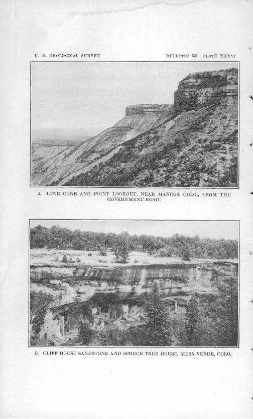
Point Lookout sandstone. The lower massive sandstone of the -t Mesayerde group is from 250 to 300 feet thick and forms the cliffs which border Menefee and Weber mountains and make them inacces sible at many places. (See Pis. XXXV and XXXVI, A.) As this sandstone can be seen to the best advantage in the imposing cliffs at Point Lookout, about 1\ miles southwest of Mancos, it is here called the Point Lookout sandstone. ^
Menefee formation. Above the Point Lookout sandstone is a formation approximately 400 feet thick, made up of sandstone, shale, and coal beds, called "Middle Coal Group" by Holmes. It is roughly estimated to contain 55 per cent of shale, 42 per cent of sandstone, and from 2 to 3 per cent of coal in many beds which vary greatly in thickness from place to place. This mass of sandstone, shale, and coal ip here called the Menefee formation, from the mountain in which coal is being actively mined at the present time. Its general appear- * ance on ° the mountain tops is well shown in figure 43. The great variety in its beds from place to place, which is due to variations in the conditions which prevailed during their deposition, is shown by the four sections of Plate XXXVII. Section 1, measured northeast of the Fielding mine, shows throughout comparatively thin beds of shale and sandstone with many small beds of more or less impure -4 coal, whereas sections 2 and 3, measured in the southwestern part of the district, show in then- lower parts from 100 to 200 feet of sand stone with little shale. The sandstone is in many places 'cross- bedded and is represented only a short distance away by shale. The shale and coal beds had in some places been cut away by erosion before the deposition of the overlying sandstone, so that there are * slight unconformities at the contact. Such unconformities are found in river deltas and flood plains which have been partly submerged or raised above water level at different periods while they were being deposited. Although the coal beds in this district vary greatly in

U. S. GEOLOGICAL SURVEY BULLETIN" GDI PLATE XXXV
A. VIEW UP WEBER CANYON, COLO., FROM ITS JUNCTION WITH MANGOS - : . CANYON.
B. VIEW DOWN MANCOS CANYON, COLO., FROM WATERS RANCH, AT THE JUNCTION OF WEBER AND MANCOS CANYONS.
C. NORTH END OF WEBER MOUNTAIN, COLO., FROM THE LOWER SLOPE OF MENEFEE MOUNTAIN.
U. S. GEOLOGICAL SURVEY BULLETIN fi91 PLATE XXXVI
A. LONE CONE AND POINT LOOKOUT, NEAR MANGOS, COLO., FROM THE "* GOVERNMENT ROAD.
S. CLIFF HOUSE SANDSTONE AND SPRUCE TREE HOUSE, MESA VERDE, COLO.

COAL SOUTH OF MANGOS, COLO. 297
distribution and no one bed can be traced for a great distance, there are three groups of beds that can be recognized with some cer tainty. The lowest of these, called the Spencer or A coal group, contains from one to four beds of comparatively pure coal in about 60 feet, of strata immediately above the Point Lookout sandstone. The B coal group includes a number of thin beds' of more or less impure coal in the 140 feet of strata above the Spencer group. It will be seen from the sections in Plate XXXVII that the thick sand stone in the southern part of the district is in the B group.
Group C comprises a number of very lenticular beds of coal which in places are as pure as those in the Spencer group. They occur in the upper 200 feet of the Menefee formation, which at the places where the coal is found is composed mainly of dark shale.
Cliff House sandstone. The upper formation of the Mesaverde group is somewhat variable in character, and as it is in many places partly eroded and is nowhere in the district here described covered by overlying formations, its whole thickness can not be determined. On the southwest side of Mesa Verde this formation, composed of hard sandstone, is very prominent and forms the "Upper Escarp ment" of Holmes. In the area here described, however, it is too friable to form cliffs, though it still contains many thin beds of sand stone which have produced the level surfaces of the mesas and the steeper slopes above the Menefee formation. As this sandstone is most strikingly exposed in the canyons about the cliff houses of the Mesa Verde National Park, which were built along a shaly parting in it, it is here named the Cliff House sandstone. It is illustrated in Plate XXXVI, B. Some idea of the total thickness of this sandstone may be obtained in the national park, at Echo Cliff, in which a sheer face of more than 400 feet of sandstone is exposed.
QUATERNARY (?) SYSTEM.
GRAVEL. » _
Several small mesas in T. 3-5 N., R. 13 W., and the edge of the larger mesa in fractional T. 34 N., R. 13 W., north of the Ute Reservation, are remnants df a plain of late Tertiary or early Quaternary age. Pebbles and boulders washed down from the mountains on the north are occasionally found on the surface of the small mesas and are so abundant in the large area near the southeast corner of T. 35 N., R. 13 W., and T. 34 N., R. 13 W., as to form a layer of gravel several feet in thickness. Along Mancos River there is gravel of recent age washed down from the La Plata Mountains.
IGNEOUS ROCKS.
One of the most interesting geologic features of this district is a stock of igneous rock, called locally a "blow out," in.sec. 24, T. 35 N.,
. 21544° 19 Bull. 691 20

298 CONTRIBUTIONS TO ECONOMIC GEOLOGY, 1918, PART II.
K. 14 W., which was intruded in the Mancos shale probably in late Tertiary or early Quaternary time. It appears to be the neck of a volcano 'whose activity was short lived.
Apparently this intrusion did not disturb the position of the rocks far from its center, and no evidences of it were found in the coal beds immediately to the east.
STRUCTURE. v
The formations have a uniformly low dip to the south, as is best * shown on the map by the altitude above sea level of the top of the Point Lookout sandstone at the places where it has been determined. At the Spencer mine, for example, its altitude is 8,150 feet, and at a point in sec. 35, T. 35 N., R. 13 W., about 5 miles to the south, it is 7,350 feet a difference of 900 feet, which is equivalent to a slope of 3.4 feet in 100 feet, or about 2°. ^
COAL BEDS.
The coal beds here described are all in the Menefee formation, whose stratigraphic diversity is shown on Plate XXXV. As can be seen from an inspection of the stratigraphic columns, correlation of the individual beds for long distances without continuous exposures is impossible, but there are groups of beds which can be recognized with some degree of certainty.
SPENCER COAL (GROUP A).
The Spencer group of coal beds, which lies immediately above the Point Lookout sandstone and includes about 60 feet of beds, is the most persistent and easily identified. In every place where this group is exposed and can be examined from one to three beds of coal over 14 inches thick are found. This group of coal beds has been traced westward along the north edge of the Mesa Verde to the Jackson mine, a distance of 20 miles, and southwestward along the wall of Man- cos Canyon for 15 miles or more. . In no place has it proved to be abso lutely destitute of coal. As it is the lowest group of coal beds left on these mountain tops, it is necessarily the most extensive and the least affected by exposure to the atmosphere. '
Measurements of the coal beds of this group and the distance above the Point Lookout sandstone wherever it was determined are pre sented graphically in sections 1 to 56, Plate XXXVIII, and their locations are shown by the same figures on the map (PI. XXXIV). The extreme variability of the coal beds of the group is shown by these sections.
At several places no coal bed more than 14 inches thick was found in the Spencer group. At these places either the coal is thin or absent or it is so covered, burned, or eroded that it could not be s.een. All localities at which coal was found in this group are indicated on the map to make the record complete.

U. S. GEOLOGICAL SURVEY BULLETIN 691 PLATE XXXVII
, 350 feet.EXPLANATION
Coal Bony coal Bone Shale Sandstone Burnt coal
'Group C
Spencer or
\
Group B
up of coal beds
Point . ££ Lookout iii sandstoneT,36fU?.13W. T.35N.-R.14W. T.35 N.>R. 13W. T.35-1*»'R. 13 W.
-" " '"" " "~ Sec.25vS.>4sec.35 Sec.36 Sec.27
SECTIONS OF THE LOWER PART OF THE MENEFEE FORMATION, SHOWINGITS VARIABILITY.

COAL SOUTH OF MANGOS, COLO. 299
Sections of coal beds of the Spencer coal group not shown on Plate XXX VIII.
Locality 4, NW. J sec. 24, T. 35 N., R. 13 W.
Ft. in. Goal....................... 10
Concealed mostly shale.......... 20Sandstone, Point Lookout. -
20 10
Locality 7, SE. J sec. 36, T. 35 N., R. 13 W.
Ft. in. Sandstone...................... 15
Coal, probably burned...... 1 ±Shale, carbonaceous............. 2
Coal........................ 6Shale....................... 1 6Bone........................ 1
Shale, carbonaceous r............ 10Sandstone, Point Lookout.
. . . 31±
Locality 13, SW. sec. 33, T. 35,N., R. 13 W.
Ft. in.
..................... 1 9
Locality 33, SW. J NW. J sec. 14, T. 35 N., R. 13 W.
Ft. in. Coal......!..*.....'......... 1 '8+
Shale.......................... 10Sandstone, Point Lookout.
11 8+
Locality 34, SE. \ NE. \ sec. 23, T. 35 N., R. 13 W.
The position of the coal is represented by a clinker bed.
Locality 35, NE. 1 sec. 27, T. 35 N., R. 13 W.
The stratigraphic position of this sec tion is somewhat uncertain. It is placed in the Spencer group on the writer's judgment.
Shale. . Ft. in. Coal...........:........... 1 1Coal, bony, several inches.
Shale.
Locality 39, SE. i sec. 30, T. 35 N., R. 13 W.
Ft. in. Sandstone...................... 15
Coal....................... 4Shale........................... 6
Coal....................... 11
22 3
Locality 43, NE i sec. 31, T. 35 N., R. 13 W.
Shale........:............Coal, somewhat bony.
Shale.
Ft. in.10
1 .1
11 1
. Locality 44, SW. J sec. 32, T. 35 N., R. 13 W.
Upper part of Spencer coal group. Shale.. . Feet.
Coal, bony.................. 2Shale'.
Locality 62, SW. \ NE. \ sec. 25, T. 35 N., R. 12 W.
Shale.Coal..................
Shale.......................Coal.................
Shale.....................Coal........:........
Shale.....................Sandstone, Point Lookout.
Ft. in.1 1 5
439 '"
.1 8 5
52 1
Locality 77, NE. 1 sec. 1, T. 35 N.,'R. 13 W.
This section includes the lower part of group B and ,is omitted from Plate XXXVIII on account of the imperfect exposure of the important bed of group Anear the bottom of the column.
Ft. in. Coal..................... .4
Share......................... 5Coal..................... 11
Shale......................... 6Coal, bony............... 4
Shale......................... 8 'Coal..................... 8Bone.................... ^Coal..................... 7£
Shale......................... 16Sandstone.................... 15 Shale....!.................... 20
Coal, impure............. 1 3Bone..................... 4
Shale, partly concealed........ 35Coal...................... 3±
Shale......................... 11Sandstone, Point Lookout.
123.±
300 CONTRIBUTIONS TO ECONOMIC GEOLOGY, 1918, PART II.
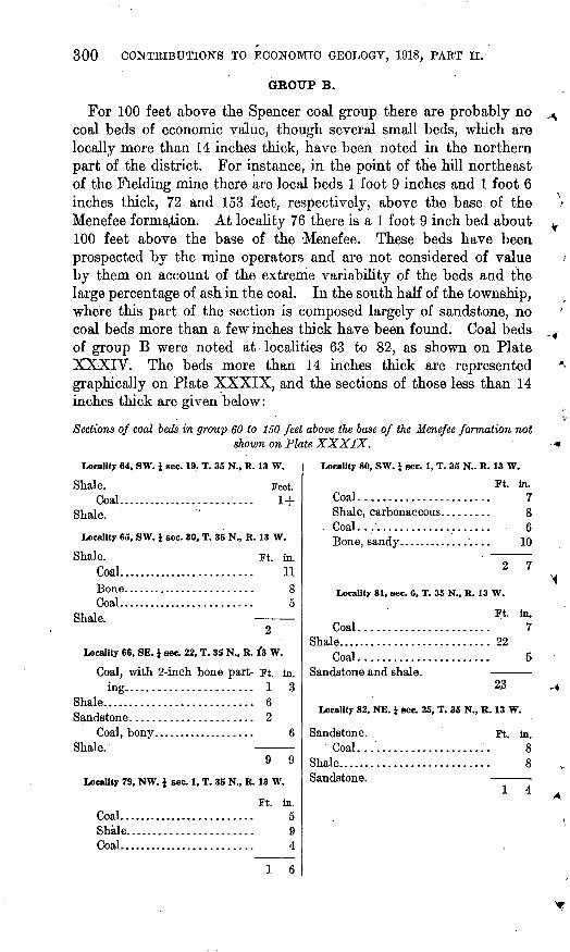
GROUP B.
For 100 feet above the Spencer coal group there are probably no coal beds of economic value, though several small beds, which are locally more than 14 inches thick, have been noted in the northern part of the district. For instance, in the point of the hill northeast of the Fielding mine there are local beds 1 foot 9 inches and 1 foot 6 inches thick, 72 and 153 feet, respectively, above the base of the Menefee formation. At locality 76 there is a 1 foot 9 inch bed about 100 feet above the base of the Menefee. These beds have been prospected by the mine operators and are not considered of value by them on account of the extreme variability of the beds and the large percentage of ash in the coal. In the south half of the township, where this part of the section is composed largely of sandstone, no coal beds more than a few inches thick have been found. Coal beds of group B were noted at localities 63 to 82, as shown on Plate XXXIV. The beds more than 14 inches, thick are represented graphically on Plate XXXIX, and the sections of those less than 14 inches thick are given below:
Sections of coal beds in group 60 to 150 feet above the base of the Menefee formation notshown on Plate XXXIX.
Locality 64, SW. J sec. 19, T. 35 N., R. 13 W.
Shale. Feet. Coal......................... 1+
Shale.
Locality 65, SW. 1 sec. 30, T. 35 N., R. 13 W.
Shale. Ft. in.Coal......................... 11Bone........................ 8Coal......................... 5
Shale. 2
Locality 66, SE. } sec. 22, T. 35 N., R. 1*3 W.
Coal, with 2-inch bone part- Ft. in. ing....................... 1 3
Shale........................... 6Sandstone...................... 2
Coal, bony................... 6Shale.
Locality 79, NW. J sec. 1, T. 35 N., R. 13 W.
Coal.. Shale. Coal..
Ft. in. 5
1 6
Locality 80, SW. i sec. 1, T. 35 N.. R. 13 W.
Ft. in.Coal....................... 7Shale, carbonaceous......... 8
, Coal...'.................... 6Bone, sandy................. 10
2 7
Locality 81, sec. 6, T. 35 N., R. 13 W.
Coal.. Shale......
Coal..Sandstone and shale.
Ft. in. 7
225
23
Locality 82, NE. i sec. 25, T. 35 N., R. 13 W.
Sandstone.Coal..
Shale......Sandstone.
Ft. in. 8
1 4

U. 8. GEOLOGICAL SURVEY
14 15 16 17Ft in, .Ft in. :,,FL in, feFt in. -.Ft in.. Ft in. Ft. in. Q Ft in,
BULLETIN 691 PLATE XXXVHI
29
5 6.
.3042 45 46
Ft. in. t.:.:.vjFt. in. ih. R. in. Ft. in. Ft. in.
EXPLANATIONBony Csrionaceous Sandy
Cdal' icoai Bone .shale Shale< 'shale . Sandstone
Vertical scale
in, lFt inr"R im,,/Fl '0{.«t 'In,
Ft. In. hHFt. tn. l==jFt. in. {=|Ft in. F::::::v| Ft. in.
M2 10
Letters indicate parts of beds included in samples for analysis
a. Locality 1, analysis 20268b. Locality 20, analysis 20500c. Locality 20, analyses 20498 and 4225d. Locality 21, analysis 20499 and ash test 1e. Locality 25, analysis 3991f. Locality 20, ash tests 2 and 3
f. Locality 38, ash test 4. Locality 17, ash test 5"i Locality 14, ash test 7
SECTIONS OF MESA VERDE COAL BEDS, GROUP A, NEAR MANCOS. COLO.
COAL SOUTH OF MANCOS, COLO. 301
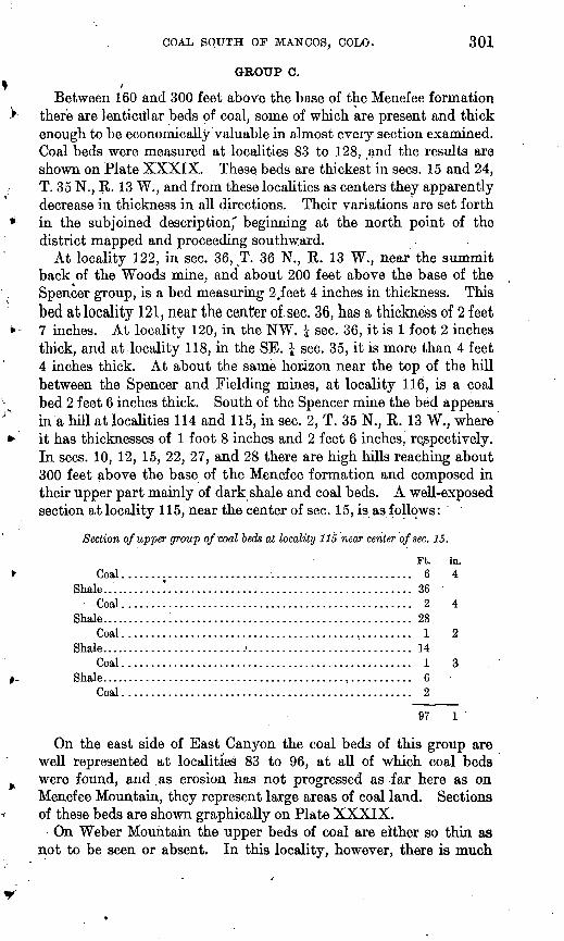
GROUP C./
Between 160 and 300 feet above the base of the Menefee formation there are lenticular beds of coal, some of which are present and thick enough to be economically valuable in almost every section examined. Coal beds were measured at localities 83 to 128, ,and the results are shown on Plate XXXIX. These beds are thickest in sees. 15 and 24, T. 35 N., R. 13 W., and from these localities as centers they apparently decrease in thickness in all directions. Their variations are set forth in the subjoined description," beginning at the north point of the district mapped and proceeding southward.
At locality 122, in sec. 36, T. 36 N., R. 13 W., near the summit back of the Woods mine, and about 200 feet above the base of the Spencer group, is a bed measuring 2,feet 4 inches in thickness. This bed at locality 121, near the center of sec. 36, has a thickness of 2 feet7 inches. At locality 120, in the NW. J sec. 36, it is 1 foot 2 inches thick, and at locality 118, in the SE. | sec. 35, it is more than 4 feet 4 inches thick. At about the same horizon near the top of the hill between the Spencer and Fielding mines, at locality 116, is a coal bed 2 feet 6 inches thick. South of the Spencer mine the bed appears in'a hill at localities 114 and 115, in sec. 2, T. 35 N., R. 13 W., where it has thicknesses of 1 foot 8 inches and 2 feet 6 inches, respectively. In sees. 10, 12, 15, 22, 27, and 28 there are high hills reaching about 300 feet above the base of the Menefee formation and composed in their upper part mainly of dark shale and coal beds. A well-exposed section at locality 115, near the center of sec. 15, is as follows:
Section of upper group of coal beds at locality 115 near center of sec. 15.
Coal. .............................Shale ...........!......................
Coal ..............................Shale..................................
Coal ..............................Shale..........................'........
Coal ..............................Shale ..................................
Coal ..............................
Ft.. ..................... 6..................... 36..................... 2..................... 28..................... 1..................... 14..................... 1..................... 6..................... 2
in. 4
4
?,
97 1
On the east side of East Canyon the coal beds of this group are well represented at localities 83 to 96, at all of which coal beds were found, and .as erosion has not progressed as far here as on Menefee Mountain, they represent large areas of coal land. Sections of these beds are shown graphically on Plate XXXIX.
On Weber Mountain the upper beds of coal are either so thin as not to be seen or absent. In this locality, however, there is much

302 CONTRIBUTIONS TO ECONOMIC GEOLOGY, 1918, PART II.
black shale similar to that in sees. 15 and 25, but a careful search failed to discover any beds of coal more than 20 inches thick.
The following sections measured in group C , are not shown on 4 Plate XXXIX, as they represent coal beds less than 14 inches thick:
Sections of coal beds in group C not shown on Plate XXXIX.
Locality 106, NW.} SE. i sec. 15, T. 35 N., R. 13 W.
Shale.Coal....................
Shale.
Locality 76, NE. J SW. J sec. 36, T. 36 N.,
Coal......................Shale and sandstone. ...........
Coal......................Shale and sandstone. ...........
Locality 92, SW. i SW. J sec. 35, T. 35 N.,
Shale. Coal. ......................Shale, carbonaceous, with
thin layers of coal. .......Coal. ..........!...........Coal, bony. ................Coal.......................
Shale.
Locality 95, NW. J NE. J sec. 8, T. 35 N.,
Shale. Coai.......................Shale.......................
Coal.......................Shale.......................Coal. ......................
Shale.
Locality 96, SE. J NW. i sec. 8, T. 35 N.,
Shale. Coal.......................Bone........................Shale.......................Bone........................
Shale.
R. 13 W.
Ft. in. 2
118 11
111
234 11
R. 13 W.
Ft. in. 6
6 9
.4 6
2 7
R. 13 W.
Ft. in. 5
1 3 8
34
2 11
R. 13 W.
Ft. in- 9 3 8
1
2 8
Ft. in. 1 7
Locality 109, SW. i NE. i sec. 15, T. 35 N., R. 13 W.
Shale. Ft. in.
Coal....................... 10Shale...........,............../ 6
Coal........................ 1 3
Locality 119, NE. J SE.J sec. 2, T. 35 N., R. 13 W.[This exposure is not good, but it may be the
same bed as that exposed at locality 118.]Ft. in.
Coal....................... 5Shale........................ 9Coal....................... 4
Locality 120, SE. i NW. J sec. 36, T. 36 N., R. 13 W.
Shale. Ft. in.Coal....................... 1 2
Shale........................... 7Sandstone....:................. 37
Coal....................... 4Shale.
45 6
Locality 128, NE. 1 sec. 31, T. 35 N., R. 13 W. Shale. Ft. to-
Coal, somewhat impure...... 1 5Shale.Interval, not well exposed but
mainly shale and sandstone.... 90±Sandstone.
Coal....................... 5Bone........................ 11
Shale. 92±
At locality 117, in the SE. \ sec. 35, T. 36 N., R. 13 W., and locality 127, in the NE. \ sec. 25, T. 35 N., R. 14 W., evidence of a burned bed was seen,but.the original thickness of the coal could not be deter- mined,' and at locality 126, in the SW. i sec. 19, T. 35 N., R. 13 W., only a few inches of bony coal is exposed.

U. S. GEOLOGICAL SURVEY BULLETIN 691 PLATE XXXIX
68 69. 70 71 72 73 74 75 78 83 84 85 66 .87 88 89 91 .93 94 _.98 -99. JOQ 101 ln.-:^FL in. |.:.; ::7fFL> t^Ft in. t^Ft in.-. ^Ft In. ^Ft in; yFt fa fey Ft.in, '^.Ft In, yFL in- ^FL in. ^FL in, ^Ft fn. ^.Fljn.; .^Ft In, ^Ft-ftu. ^Fi irr.-.^Ft. In. ^F.t; in. ttFt ini^FL-.In.: ^FC In, ^
i '°' 1 't
I 10
5
103 104 105 107 108 110
107 A
w. Carbonaceous Coat coal Bone. state Shale shale Sandstone'.
_ Letters indicate parts of beds included in samples.for analysis
'k. Locality 103, ash test 61. Locality 73, ash test 8
.m. Locality .74..ash test 9
SECTIONS OF MESA VERDE COAL BEDS, GROUPS B AND C, NEAR MANGOS, COLO.

COAL SOUTH OP'MANGOS, COLO. . 303
GENERAL CHARACTER.
The coal beds are nearly all less than 6 feet thick. Except for their thinness the beds composing the Spencer group are all workable and can be more or less easily mined. Most of them have shale both above and below them, and in some mines the roof shows evidences of movement, such as slickensiding. In such places an abundant use of timber will be required. The Spencer bed at the Spencer mine is exceptional on account of the hard sandstone floor and the appar ent grading of the sand into the coal at the base. The Peacock bed at the same mine is also peculiar in that it has a hard sandstone roof and requires no timber. Neither of these peculiarities were recog nized elsewhere in the district mapped, but it must be remembered that most of the observations here reported were made at prospects. In some places, as, for example, at localities 42 and 48 (see PI. XXXVIII), coal beds are separated by only a few feet of shale, and it will be difficult to extract all the coal.
The coal beds in group B usually have harder rocks above and below them than those in the Spencer group, but they are thinner, and so far as the coal in them has been tested it is very impure. For this reason they will probably not be mined until the beds of the other groups are exhausted.
The beds of group C are associated with shale and are believed to be very lenticular. Their lenticularity is shown by the fact that on Menefee Mountain there are in many places six beds of coal in the group, whereas on Weber Mountain only one bed over 14 inches thick was found. One of the exposures of coal of this group has a meas ured thickness of 9 feet and is the largest coal bed in this region.
As the coal beds lie nearly flat they may be mined at many places by stripping, but owing to the long-continued action of the atmosphere the coal thus obtained will have lost a great deal of its heat efficiency. At the mines now in operation no coal within 50 feet of the outcropis sold.
CHARACTER OF THE COAL.
APPEARANCE AND GENERAL CHARACTER.
The coal usually has a bright luster and gives a dark-brown streak. It breaks into roughly cubical blocks, but in none of the mines yet opened are the joints of sufficient importance to control operations, the entries being driven without reference to them.
The coal is bituminous and of about the same rank as the better coals of southeastern Illinois, western Kentucky, Ohio, and south eastern Kansas. It is decidedly better than the coal mined in Iowa and most of Illinois. 1 Analysis shows that it is comparatively pure, and where mined it contains from 5 to 10 per cent of moisture and
! Ashley, G. H., oral communication.

304 CONTRIBUTIONS TO ECONOMIC GEOLOGY, 1918, PAET II.
4.5 to 9 per cent of ash, and its hea,t efficiency ranges from 10,300 to 12,900 British thermal units, 1 the latter figure being more nearly the true one for the unweathered coal. All the samples analyzed by the Bureau of Mines were taken from the Spencer group, and the coals of the higher group might possibly show a slightly lower heat effi- ciency.
CHEMICAL COMPOSITION,
SAMPLES.
Four samples were taken in the summer of 19.14 in accordance with the regular method prescribed by the United States Geological Survey, and were subjected to complete analysis, showing their prox imate and ultimate constituents and their calorific values. These samples are described below:
Laboratory No. 20500 was collected by 0. B. Hopkins and A. J. Collier from the Spencer bed at the Spencer mine, locality 20, in the SW. \ sec. 3, T. 35 N., K. 13 W., from a right entry 500 feet from the mouth of the mine. It represents 3 feet 1 inch of clean coal, below which is 6 inches of bone that was not included.
Laboratory No. 20498 was collected by 0. B. Hopkins and A. J. Collier from the Peacock bed at the Spencer mine, locality 20, in the SW. j sec. 3, T. 35 N., R. 13 W., from a north entry 700 feet from the mouth of the mine and represents 2 feet 4 inches of coal, the whole thickness of the bed at the point where the sample was taken.
Laboratory No. 20499 was collected by 0. B. Hopkins at the Fielding mine, locality 22, in the IfW. J sec. 2, T. 35 N., R. 13 W., from a right entry 400 feet from the mouth of the mine. It repre sents what is thought to be the Spencer bed, which has a thickness of 2 feet 9 inches at that place. .
Laboratory No. 20268 was collected by A. J. Collier at the Hauert mine, locality 1, in the SW. J sec. 7, T. 35 N., R. 12 W., 60 feet west of the mine mouth, and represents the lower bench, 5 feet 3£ inches of coal, including 3 inches of bony coal and half an inch of shale part ing. The sample was taken near the outcrop, and the mine had not been worked for nearly two years. About 6 inches of coal was stripped off the face before sampling, but notwithstanding that pre caution the sample had been somewhat affected by the atmosphere.
The analyses were made .at the Pittsburgh laboratory -of the Bureau of Mines.
The analyses of the samples described below, taken near Mancos, were given by Taff: 2
Laboratory No. 4225 was collected by J. H. Gardner from the Peacock bed at the Spencer mine, at a point where the thickness ofthe coal is 3 feet.
'_____________________________________1 A British thermal unit is the amount of heat required to raise 1 pound of water 1° Fahrenheit.2 Taff, J. A., The Durango coal district, Colo.: U. S. Geol. Survey Bull. 316, p. 326,1907.

COAL, SbUTH OF MANCOS-, COLO. 305
Laboratory No. 3991 was collected by Carl D. Smith from the Wood mine. The part of the bed sampled had a thickness of 4 feet 4 inches; a 5-inch shale parting was not included.
The samples were carefully taken, according to much the same rules as are at present prescribed, and represent the whole of the beds sampled. They were analyzed at the United States fuel-testing plant at St. Louis.
ANALYSES.
The following table includes analyses of the samples collected near Mancos and also, for comparison, analyses of coal from productive mines of neighboring counties with which the Mancos coal must ultimately compete should shipping facilities be developed. The mines represented are the Hesperus and the Porter, of La Plata County; the Sunlight and the Vulcan, of Garfield County; and theCameo, of Mesa County. (For locations, see index map, fig. 42.) No analysis of coal from the Crested Butte region is given because the coal there ranges from subbituminous to anthracite.
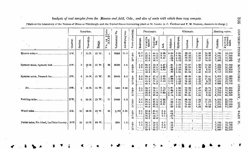
Analysis of coal samples from the Mancos coalfield, Colo., and also of coals with which these may compete.
[Made at the laboratory of the Bureau of Mines at Pittsburgh and the United States fuel-testing plant at Si-. Louis; A. C. Fieldner and F. M. Stanton, chemists in charge.]
Hauert mine o..... .....................
Spencer mine, Peacock beu. ............
Do.................................
Wood mine. ..........................
Porter mine, No. 3 bed, La Plata County .
Location.
J3033o1
sw.
sw.
sw.
sw.
NW.
NE.
NW.
g538
02
7
3
3
2
2
36
35
I I
35 N.
35 N.
35 N.
35 N.
35 N.
36 N.
35 N.
8,§
12 W.
13 W.
13 W.
13 W.
13 W.
13 W.
1O W.
No. on Plate XXXIV.
1
20
20
20
21
25
Laboratory No.
20268
20500
20498
4225
20499
3,991
2092
Air-drying loss.
11.5
4.6
6.2
2.00
3.2
2.50
1.3
Form of analysis.
A B C D
A B C D
A B C D
A B C D
A B C D
A B C D
A B C D
Proximate.
'S S
15.7 4.8
7.0 2.5
8.5 2.4
5.4 3.5
5.5 2.4
6.1 3.7
2.7 1.5
<D
31.7 35.8 37.6 41.6
38.3 40.2 41.2 43.3
39.241.8 42.9 45.5
38.7 39.5 4Q.9 43.6
38.4 39.6 40.6 44.8
35.9 36.8 38.242.0
36.1 36.5 37.1 39.8
11
44.5 50.3 52.8 58.4
50.2 52.6 54.0 56.7
47.0 50.1 51.3 54.5
50.1 51.1 53.0 46.4
47.3 48.9 50.0 55.2
49.4 50.7 52.758.0
54.5 55.2 56.0 60.2
Ultimate.
4
8.06 9.10 9.57
4.47 4.68 4.80
5.33.5.68 5.82
5.75 5.87 6.08
8.85 9.15 9.37
8.6 8.8 9.1-
6 6 6
7 8 9
3
"302
0.58 .65 .69.76
.61
.64
.66
.69
..89 1.06 1.08 1.15
1.01 1.03 1.07 1.14
.77
.80
.81
.89
.63
.64
.67<
.74
.53
.54
.54
.58
oUi
TJ
W
5.65 4.95 4.63 5.12
5.70 5.44 5.29 5.56
5.97 5.62 5.49 5.83
5.80 5.69 5.50 5.86
5.59 5.41 5.27 5.81
a o SC3 O
59.59 67.30 70.72 78.20
72.57 16.05 78.01 81.94
69.99 74.60 76. 46. 81.19
72.26 73. 73 76.41 81.36
69.92 72.26 74.00 81.65
f-t
1.19 1.34 1.42 1.57
1.33 1.39 1.43 1.50
1.31 1.40 1.43 1.52
1.47 1.50 1.55 1.66
1.33 1.37 1.41 1.56
ito .ft0
24.93 16.66 12.97 14.35
15.32 11.80 9.81
10.31
16.41 11,64 9.72
10.31
13.71 12.18 9.39 9.98
13.5411. or9.14
10.09
........
Heating value.
"3
O
5,705 6,445 6,770 7,490
7,185 7,530 7,725 8,115
6,975 7,435 7,620 8.090
7,170 7,315 7,580 8,075
6,970 7,205 7,375 8,140
7, 730 7,830 7,945 8.540
British thermal units.
10, 270 11, 600 12, 196 13,480
12, 940 13, 550 13, 910 14, 610
12, 560 13, 390 13,720 14, 570
12,906 13, 163 13, 650 14,530
12, 550 12, 970 13, 280 14, 650
13, 010 14, 100 14, 310 15. 370
COo05
* V » * t

Hesperus mine, Hesperus, La Plata County.
Vulcan mine, New Castle, Garfleld County.
SW. 14
33
1
34
35N.
7S.
6S.
10 S.
11 W.
89 W.
91 W.
98 W.
3573
4034
12327
28919
2.3
3.0
3.6
1.9
A B C D
A B C D
A B C D
A B C D
5.6 3.3
5.32.4
7.1 3.6
7.1 5.3
36.2 37.1 38.4 40.8
36.3 37.4 38.3 42.3
40.8 42.3 43.9 46.5
36.8 37.5 39.6 43.8
52.5 53.8 55.6 59.2
39.6 51.1 52.4 57.8
46.9 48.7 50.5 53.5
47.2 48.1 50.8 56.2
5.695.82 6.02
8.79 9.06 9.28
5.19 5.38 5.59
8.89 9.06 9.57
.64 .66 .68 .-72
.76
.78
.80
.88
.45
.47
.48
.51
.57
.58
.61
.67
5.46 5.32 5.12 5.45
5.26 5.08 4.93 5.44
5.65 5.45 5.23 5.54
5.42 5.31 4.99 5.52
72.70 74.41 76.97 81.90
67.76 69.86 71.57 78.89
70.77 73.41 76.20 80.71
67.64 68.95 72.85 80.56
1.37 1.40 1.45 1.54
1.58 1.63 1.67 1.84
1.56 1.62'
1.68 1.87
1.40 1.43 1.51 1.67
14.14 12.39 9.76
10.39
15.85 13.59 11.75 12.95
16.38 13.67 10.82 11.46
16.00 14.67 10.47 11.58
7,290 7,460 7,715 8,210
6,900 7,115 7,290 8,035
7,010 7,275 7,550 7,995
6,610 6,735 7,115 7,870
13,120 13,430 13, 890 14, 780
12,420 12,810 13, 120 14,470
12, 620 13,090 13, 590 14,400
Q 11,890 O 12, 120 > 12,810 tr! 14,160 ^
0/-I
a Weathered coal. , G
coO

308 CONTRIBUTIONS TO ECONOMIC GEOLOGY, 1918, PART II.
ASH DETERMINATIONS.
Some of the specimens were tested in the field for air-drying loss and ash by means of a small portable outfit devised by C. E. Lesher.1 Much of this work was done in camp by J. C. Brittain. These sam ples do not represent whole beds but usually only the parts of beds in regard to the character of which there was doubt. No. 1 is a specimen of lump coal from the Fielding mine, locality 21, in the NW. i sec. 2, T. 35 N., R. 13 W., taken from a wagon load on its way to Mancos; Nos. 2 and 3 are specimens of bone from the base of the Spencer bed at the Spencer mine, locality 20, in the SW. I sec. 3, T. 35 N., R. 13 W.; No. 4 was taken at locality 38, in sec. 19, T. 35 N., R. 13 W., and represents an 18-inch bed which is the only bed of the Spencer group found in that place; No. 5 represents a bony layer at the base of the Spencer bed at locality 18, in sec. 15, T. 35 N., R. 13 W.; No. 6 represents a bony layer in the middle of a bed 150 feet above the base of. the Menefee formation at locality 70, in sec. 28, T. 35 N., R. 13 W.; No. 7 represents the Spencer bed at locality 15, in sec. 33, T. 35 N., R. 13 W.; No. 8 represents a bed of coal 130 feet above the base of the Menefee at locality 73, hi sec. 35, T. 36 N., R. 13 W.; No. 9 represents the upper bed at locality 74, in sec. 35, T. 36 N., R. 13 W. The results of these tests show that the Mesaverde coals of this area are fairly pure; that even many of the layers of bone thrown out in mining contain less than 33 per cent of ash, and that the coal produced and put on the market will carry only from 5 to 10 per cent of ash.
Ash tests on coal samples from the region south of Mancos. [Made by O. B. Hopkins and J. C. Brittain.]
ofc
1
2
3
4
5
6
7
8
9
103
*V
|E22
21
21
38
17
103
14
73
74
3
i&
NW.
SW.
SW.
NW.
SW.
NE.
NW.
SW.
SE.
_o
. W
2
3
3
19
15
28
33
35
35
.g£jfc
a
1o
EH
35
35
35
35
35
35
35
36
36
P
1aTMirt13
13
13
13
13
13
13
13
13
Material sampled.
Sample taken at random fromlarge lump of coal on load from
Fielding mine.Bone from base of Spencer bed at
Spencer mine; sandy coal.Bone from base of Spencer bed at
Spencer mine; sandy coal. One foot 6-inch bed of coal; the
only bed of the Spencer groupfound at this place.
Bony layer at base of the largest bed of the Spencer group.
Lusterless brownish-black boneparting in bed 150 feet abovebase of Menefee formation.
Four-foot bed of coal of Spencergroup.
Impure bed of coal 1 foot 6 inchesto 2 feet thick, 1^0 feet above the base of the Menefee formation.
Eighteen-inch bed of coal. 165 feet above the base of the Menefeeformation.
w0
W>£
' - §
Ȥ. %^
<
3
4
3
15
8
9
11
16
25
-W
a<o
W P;
1
7
19
39
7
56
37
5
12
20
Color of ash.
Brownish gray.
Do.
Yellowish gray.
Light gray.
Do.
Yellowish gray.
Dark gray.
Yellow.
1 Lesher, C. E., Field apparatus for determining ash in coal: U. S. Geol. Survey Bull. 621, pp. 1-12,1915.
COAL SOUTH OF MANGOS, COLO. 309
DEVELOPMENT.
This area is a small part of a Tery large coal field in southwestern Colorado and northwestern New Mexico, all of which is poorly supplied with railrqad transportation. At the present time the narrow-gage Rio Grande Southern Railroad is the only means of egress, and coal can not be shipped from this field in competition with other fields on the main lines of travel. The population of five counties in this part of Colorado, as given by the census of 1910, was only 25,000, most of which was near the mining towns Durango, Telluride, and Silverton, and the earlier developed and more easily accessible mines about Hesperus, Porter, and Durango furnish most of the coal 'that can be consumed in the region. Near Mancos, how ever, there are two mines which supply the local demand with a production of not more-than 10 tons a d&j, and from, which some coal has been shipped on the railroad to other places, in competition with that from the older mines.
The Spencer mine has been in operation for about 15 years. Here three beds of coal have been worked to some extent, though at the present time only two beds the Peacock and the Spencer are being mined. The Spencer bed the middle one of the three was first opened and is the thickest. It lies above a massive sandstone 35 feet thick, to which it is said to be "frozen," the sand being mixed with the coal in the lower part, forming an impure hard layer referred to as bone. An attempt was made at one time to cut out this bone with a coal-punching machine, but it was unsuccessful on account of the hardness of the bony layer. Mining at present is done by hand in the bone or the softer coal above it, and the coal is loosened with small charges of powder. The good coal ranges from 2 to 3£ feet in thickness. The roof is shale, which shows some evidence of movement, such as slickensiding.
The Peacock bed of coal is immediately below the 35-foot sand stone and in contact with it, so that its roof is a smooth, hard sand stone, requiring very few timbers. Its floor is a hard shale. It ranges in thickness from 2 feet 4 inches to 3 feet 2 inches, as far as it has been developed, but it is reported to be thinner to the southeast. The workings consist of an entry almost immediately below the open ing on the Spencer bed. The workings on this bed have extended to the south, reaching the surface on the other side of the hill at a distance of about 900 feet.
This mine is equipped with a track about a quarter of a mile long at the level of the mine, an incline letting the cars down about 600 feet, and a track nearly 2 miles long to the town of Mancos. On the upper level the cars are drawn by bur"ros and on the lower by horses.

310 CONTRIBUTIONS TO ECONOMIC GEOLOGY, 1918, PART II.
The Fielding mine, owned by George Spencer, who opened the Spencer mine, is in the NW. J sec. 2, T. 35 N., R. 13 W. It° was opened some years later than the Spencer mine and has not been developed as extensively. At this mine only one bed, probably the Spencer bed, has been developed. The thickness of the coal is variable, and at one place the bed is worthless on account of clay partings. Its average thickness is not far from 2 feet 8 inches. The floor is sandy shale, and the roof is shale showing the same evidences of move ment as that over the Spencer bed, already described. What corre sponds to the upper bed of coal at the Spencer mine is partly exposed in the hillside above the Fielding mine and is said to have shown a thickness of 1 foot 8 inches where it was opened in searching for the larger bed. The Peacock bed has not been found at this place and is probably not present, but the ground has not been thoroughly tested. The mine is equipped with an inclined track on which the mine cars are lowered down the hill about 600 feet, where the coal is loaded into wagons and hauled to Mancos.
Several years ago an attempt was made to operate the Wood mine, in the NE. 1 sec. 36, T. 34 N., R. 13 W., but work was suspended before any coal was produced. The developments consist of an 80-foot drift on the coal bed and a trail up the mountain side to the mine. The coal bed is somewhat thicker than that at the Spencer and Fielding mines, measuring slightly more than 4 feet.
The Hauert mine, in the SE. J sec. 7 and the SW. J sec. 8, T. 35 N., R. 12 W., is practically,a prospect, though it was opened several years ago and has supplied coal to the surrounding neighborhood. It is an interesting fact, however, that in 1914 Mr. Hauert hauled the coal for his own use from Hesperus rather than mine it from.this prospectand transport it down the hill. The thickest bed of coal in the Spencer group to be opened for mining anywhere in this area is at this mine. It contains 6 feet 4 inches of clear coal. A. drift 60 feet in length and a steep roadway up over the Point Lookout sandstone constitute the developments at the present tune.