coastal area plan€¦ · most waterfowl and shorebirds found in north america, such as ducks,...
TRANSCRIPT

COASTAL AREA PLAN
OF THE
VENTURA COUNTY GENERAL PLAN
APPENDICES
VENTURA COUNTY BOARD OF SUPERVISORS CALIFORNIA COASTAL COMMISSION
Adopted - November 18,1980Amended - March 30, 1982Amended - June 20, 1989Amended - Dec. 5, 2000 & Nov. 20, 2001
Conditionally Certified - August 20,1981Certified - June 18, 1982Certified - October 10 & 12, 1989Certified - January 11, 2002
1e27-1.02
CONTENTS
PAGE
Appendix 1 Statewide Interpretive Guidelines for Wetlandsand other Wet, Environmentally Sensitive Habitats (1981) ...................................1
Appendix 2 Archaeological Guidelines (1980)........................ ................ .................................. 65
Appendix 3 Paleontological Guidelines (1980) ......... .............. ....... .............. ... ....... ..... ..............91
Appendix 4 Guidelines for the Implementation of the California LandConservation Act of 1965 (2000) ........ ......... ........................ ... ..... ......... ......... ........ 103
Appendix 5 California Department of Navigation and OceanDevelopment (DNOD) Survey of Ventura County Beaches (1977) .......................123
Appendix 6 Policy for Location of On Shore Oil Facilties (1968) .............................................131
1e27-1.02 ii
APPENDIX 1
STATEWIDE INTERPRETIVE GUIDELINES FORWETLANDS AND OTHER WET, ENVIRONMENTALLY
SENSITIVE HABITATS (1981)
1e27-1.02 1

(This Page Intentionally Left Blank)
1e27-1.02 2

STATEWIDE INTERPRETIVE GUIDELINE
FOR
WETLDS AN OTHR WET ENVIRONMNTALLY SENSITIVE HAITAT ARS
Adopted February 4 J 1981California Coastal Commssion
l'
:1

r:.",
STATEWIDE INTERPRETIVE GUIDELINE FOR WETLASAN OTHR WET ENVIRONMENTALLY SENSITIVE HAITAT ARAS
TABLE OF CONTENTS
Page No.
1 . INTRODUCTION 1
A. What are ''Wet lands"B. How the Coastal Act Protects WetlandsC. Use of the Guideline and Its Relationship to LCPs
1
23
II. WHT AR "ENVIRONMNTALLY SENSITIVE HAITAT ARAS"? 3
A. ''Wetlands''B. "Estuaries"C. "Streams" and "Rivers"D. "Lakes"E. "Open Coastal Waters" and "Coastal Waters"F. "Riparian Habitats"
445
55
5
IlL. WHN 1:S DEVELOPMENT PERMITTED IN AN ENVIRONMNTALLY SENSITIVEHAITAT ARA? 5
A. Requirements for All Development Proposals in EnvironmentallySensitive Habitat Areas 6B. Requirements for Additional Project Information 6
IV. DEVELOPMENTS PERM TIED IN WETLS AND ESTUARIES 9
A. Developments and Activities Permtted in Wetlands andEstuaries 9B. Special Limitations on Deve lopment in Those Coastal Wet lands
Identified by the Department of Fish and Game 12C. Restoration Projects Permtted in Section 30233 13D. Requirements for Al 1 Permitted Development 14E. Provisions Applicable to Proposed Development in Wetlands
and Estuaries Within Port Jurisdictions 18
V. DEVELOPMENTS PERMTTED IN OPEN COASTAL WATERS AN LAKS 18
A. Developments and Activities Permtted in Open Coastal Watersand Lakes 18B. Requirements for Al 1 Permitted Developments 19
VI. DEVELOPMENTS PERMTTED IN STREAM AN RIVERS 19
A. Permitted Developments in Streams andRivers
B. Requirements for Development1919
4

(continued)
VII. STANDARDS FOR SITING DEVELOPMENT ADJACENT TO ENVIRONMNTALLYSENSITIVE HAITAT ARAS
20
A. Criteria for Reviewing Proposed Development Adjacent toEnvironmntally Sensitive Habitat Areas
B. Criteria for Estab lishing Buffer Areas
A. Identification of Degraded WetlandsB. Requirements Applicable to All Restoration ProjectsC. Requirements Applicable to Restoration of Degraded
in Conjunction with Boating FacilitiesD. Requirements Applicable to Restoration of Degraded
Using Projects Other Than Boating Facilities
2021
23
2425
Wet lands
26Wetlands
26
VIII. RESTORATION AN MAINTENANCE OF WETLA HABITAT ARAS
APPENDICES
A. Applicable Coastal Act PoliciesB. Resources Agency Wet land Po licyC. Sumary of Federal and State Regulatory Involvement Regarding
Development in Wetlands and Other Wet Environmentally SensitiveHabitat Areas
D. Technical Criteria for Identifying and Mapping Wetlands and OtherWet Environmentally Sensitive Habitat Areas
E. Glossary of Term
5 i

-1- ,. .. .
STATEWIDE INTRPRETIVE GUIDELINE FOR WETLADS AND OTHER WET ENVIVIRONMNTALLYSENSITIVE HAITAT ARS
I . INTRODUCTION
The commssion adopted this guideline as a decision of the Commission afterreceiving extensive public testimony and comments and holding ten publichearings at numerous locations in the coastal zone. In addition, the RegionalCommssions provided valuable comments and information as a result of anapproximately equal numer of hearings which they held. Guidelines should beviewed as a tool in reviewing coastal permit applications and LCPs for wetlandsand adjacent areas. The commssion intends local governments to use theguideline when developing LCPs but believes that more flexibility may beappropriate in an LCP than in an individual permt decision. Guidelines ofnecessity must focus on issues primarily of statewide concern. The LCPs willfocus in depth on regional wetlands issues. For example, the Humboldt CountyNorthcoast Area Land Use Plan addressed farmed wetlands in detail, a subjectonly footnoted in this guideline. It adopted explicit criteria for identifyingfarmed wetlands and designated the areas exclusive agriculture. The Commssioncertified the LUP as consistent with the policies of Chapter 3, even though suchspecific criteria are not contained or endorsed in this guideline. This exampleillustrates that the guideline is a valuable tool, but only a tool, to be usedin conjunction with permt and planning decisions.
A. What Are IIWet lands"?
The Coastal Act defines wetlands as land IIwhich may be covered periodicallyor permanently with shallow water." Wetland areas, such as marshes, mudflatsand lagoons, serve many functions: to absorb pollutants and storm energy; toserve as nutrient sources and genetic reservoirs; and to provide some of theworld i s richest wildlife habitats.
Wetlands are highly diverse and productive. The combination of shallow anddeep water, and the variety of vegetation and substrates produce far greaterpossibilities for wildlife feeding, nesting and resting than is £ound in lessdiverse areas. Individual wetlands may be inhabited by hundreds of species ofbirds, mamals, fish and smaller organisms. Abundant microorganisms serve asfood for crabs, clams, oysters, and mussels which live in the tidal flats.
Wetlands i natural abundance draws people for recreation such as clamng,bird watching and fishing. Fish such as the king and silver salmon andsteelhead trout live much of their lives in the ocean but return to freshwaterto spawn. Commrcially important fish such as herring, anchovy and Cali forniahalibut are also found in California i s estuaries.
Food for ocean fauna is supplied from California i s coastal estuaries.Estuarine productivity therfore contributes to a complex ocean food web. Forexample, a significant amount of the net areal primary productivity of theTijuana Estuary is exported in the form of dissolved carbon which can be takenup and used by oysters, bacteria and phytoplankton, which may in turn be eatenby other creatures. Perhaps more importantly, estuaries provide habitat fororganisms to use that food, therefore making these habitats important for man,
for example i as aquaculture sites.£);:

-2-
Migratory animals feed and rest in California i s coastal wetlands in largeenough numbers to make the wetlands invaluable habitat areas. Most waterfowland shorebirds found in North America, such as ducks, geese, sandpipers, anddunlines, are migratory. They nest in Alaska or Canada in the sumer, andwinter in the U. S. or points south. During the fall and spring migrations,millions of these birds move along well-defined routes called flyways. TheCali fornia coast, part of the Pacific Flyways, was assigned third highestpriority (out of a total of 33 areas nationally) for wintering habitatpreservation by the U.S. Fish and Wildli fe Service.
Wetlands also serve as rich laboratories for ecological studies.
B. How the Coastal Act Protects Wetlands
Since wetlands are so valuable from both an economic and biologicstandpoint, the California Coastal Act, and many other Federal and statestatutes and regulations, mandates governmental regulation of these areas.
Section 30001 of the Coastal Act states (in part) that the Legislature finds anddeclares as follows: that the California coastal zone is a distinct andvaluable resource and exists as a delicately balanced ecosystem; that thepermanent protection of the state's natural resources is of paramount concern topresent and future residents of the state and the nation; and that it isnecessary to protect the ecological balance of the coa~tal zone and prevent itsdeterioration and destruction. Therefore, the Act requires that thebiological productivity and the quality of coastal waters, streams, wetlands,estuaries, and lakes be maintained and, where feasible, restored. Sections ofthe Act provide general policies for development in and adjacent to wetlands,and s peci fic po licies for prot ect ing t hes e areas.
In order to apply COdstal Act policies on wetlands to specific areas anddevelopments, the Commission has adopted this interpretive guideline. The
guideline integrates ecological concepts and policies found in many sections ofthe Act into a consistent whole, explains policies for protecting naturalresources, defines technical terms, and facilitates application of the policiesby the State and regional commssions. Since many of the natural resourcepolicies in the Coast~l Act overlap, this guideline distinguishß the relativeimportance of the policies and their interrelationships. Statutory provisionswhich govern all environmentally sensitive habitat areas are laid out andspecific development standards and criteria are explained for particular habitatareas (e.g., wetlands, estuaries, open coastal waters, lakes and streams).
Wetlands are not isolated, independently functioning systems, and theydepend upon and are highly influenced by their surroundings. Therefore, theguideline includes standards for the review and evaluation of proposed projectsadjacent to environmentally sensitive habitat areas.
The State Department of fish and Game is the authorized, custodian ofCalifornia's fish and wildlife resources and serves as the Commission 'sprincipal consultant on all matters related to these resources. Thisresponsibility includes but is not limited to: determination of project impacts;adequacy of technical data; and identification of appropriate mitigation orrestoration measures for affected habitat.
7

-3-
C. Use of the Guideline and Its Relationship to LCPs
This guideline is meant to assist the public and the Commssions inapplying Coastal Act policies for wet environmntally sensitive habitat areasand is in no way meant to supersede those policies. The guideline should beviewed as a tool in reviewing coastal permt applications and LCPs for wetlandsand adjacent areas as exlained abve.
The question of the relationship between interpretive guidelines and LocalCoastal Program (LCPs) has been hotly debated and underscores the importance ofdeveloping a comprehensive, consistent approach to these valuable coastal areas,but the LCPs (such as Humldt County examle discussed above) become thestandard of review after certification. This guideline is a decision of theCommssion, and therefore, it does serve as a tool or guide to local governmentsin preparing their LCPs. as specified in Section 30625 (c) of the Act and inSection 00113 of the LCP Reguations.
II. WHT AR "ENVRONMALY SENSITIVE HABITAT ARAS"?
The Coastal Act defines "environmntally sensitive area" in Section 30107.Sas follows:
" i Environmntally sensi ti ve area i means anyarea in which plant or animal life or theirhabitats are either rare or especially valuablebecause of their special nature or role in anecosystem and which could be easily disturbedor degraded by hum activities anddevelopments. "
The term "environmentally sensitive habitat area" is also used in Section30240 of the Coastal Act. The two term are synonymous.
The Comssion generally considers wetlands, estuaries, stream, riparianhabitats, lakes and portons of open coastal waters to be environmntallysensitive habitat areas because of the especially valuable role of these habitatareas in mantaing the natural ecological functioning of many coastal habitatareas and because these areas are easily degraded by hum developments. Inacting on an application for developmet one of these areas, the Commssionconsiders all relevant inormtion. The fOllOWing specific policies apply tothese habitat areas: Sections 30230; 30231; 30233; and 30236. Section 30240, amore general policy, also applies, but the more specific language in the formersections is controlling where conflicts exist with general provisions of Section30240 (e.g., port facilities may be pertted in wetlands under Section 30233even though they may not be resource dependent). This guideline addresses wetenvironmntally sensitive habitat areas only. The discussion in this sectionand in section VII is not intended to describe or include all environmentallysensitive habitat areas which may fall under Section 30240 of the Coastal Act.
.8

-4-
As stated in the "INTRODUCTION," wetlands are not isolated, independentlyfunctioning system. Rather, they depend upon and are highly influenced bytheir associated watersheds and upland transition areas. Therefore, when theCommssion determnes that any adjacent area is necessary to mantain thefunctional capacity of the wetland, the Commssion will require that ths areabe protected aganst any significant disruption of habitat values consistentwi th Section 30240 (a) . These areas may be protected either by inclusion in abuffer area subject to land use restrictions or through provision of a bufferarea around the ecological related adjacent area itself, or through other means.Section VII of this . guideline discusses the use of buffers.
A. "Wetlands"
The Coastal Act defines "wetland" in Section 30121 as follows:
" 'Wetland' mean lands wi thin the coastal zone which maybe covered periodically or permently with shallow waterand include saltwater marshes, freshwater marshes, open orclosed brackish water marshes, swams, mudflats and fens." .
This is the defintion upon which the Commssion relies to identify"wetlads. " The definition refers to lands "... which may be periodically orpermently covered with shallow water ..." However, due to highly variableenvironmtal conditions along the lengt of the California coast, wetlands mayinclude a variety of different types of habitat areas. For ths reason, somewetlands may not be readily identifiable by simle means. In such cases, theCommssion also will rely on the presence of hydrophytes and/or the presence ofhydric soils as evidence that an area may be periodically or permently coveredwith shallow water. These are useful indicators of wetland conditions, bit thepresence or absence of hydric soils and/or hydrophytes alone are not necessarilydetei:native when the Comssion identifies wetlands under the Coastal Act. Inthe past, the Comssion has considered all relevant informtion in maing suchdetei:nations and -relied upon the advice and judgement of exerts be~orereaching its ow independent conclusion as to whether a particular area will beconsidered wetland. under the Coastal Act. The Commssion intends to continue tofollow this policy., The discussion in "APPENIX 0" provides more detail andfurer guidance on wetland identif ication.
B. "Estuaries"
An "estua" is a coastal water body usually sem-enclosed by land, butwhich has open, partially obstructed, or intermttent exchange with the oceanand in which ocean water is at least occasionally diluted by fresh water ruofffrom the land. The salinity may be periodically increased above the open ocean
by evaporation. In general, the bondary between "wetland" and "estuary" is theline of exrem low water (see Appendix 0 for a more complete discussion ofwetland/ estuary boundaries).
9
-5-
C. "Stream" and "Rivers"
A "stream or a "river" is a natural watercourse as designated by a solidline or dash and three dots syol shown on the United States Geological Surveymap most recently published, or any well-defined channel with distinguishablebed and bank that shows evidence of having contained flowing water as indicatedby scour or deposit of rock, sand, gravel, soil, or debris.
D. "Lakes"
A "lake" is a confined, perennial water body mapped by the United StatesGeologic Surey on the most current 7.5 minute quadrangle series.
E. "Open Coastal Waters" and "Coastal Waters"
The term "open coastal waters" or "coastal waters" refer to the open oceanoverlying the continental shelf and its associated coastline. Salinities exceed30 pars per thousand with little or no dilution except opposite mouths ofestuaries (see Appendix D).
Some portons of open coastal waters, generally areas without especially.significant plat or animl life, may not be considered environmntallysensitive habitat areas. Environmntally sensitive habitat areas within opencoastal waters may include "Areas of Special Biological Significance.' asidentified by the State Water Resources Control Board, habitats of rare orendangered plant and anl species, nearshora reefs, rocky intertdal areas(such as tidepools), and kelp beds.
E' . "Riparian Habitats"
A "riparian habitat" is an area of riparian vegetation. ThiS vegetation isan association of plant species which grows adjacent to freshwater watercourses,including perenial and intermttent stream, lakes, and other bodies of freshwater (see Appendix D).
III. WH IS DEVOPME PERM'r IN AN ENRONMTALY SESITIV HAITATAR?
"Development" is defined in Section 30106 of the Coastal Act, and includesthe placement of fill; construction or alteration of any structure or facility¡discharge of any waste material; dredging or extraction of any materials; changein the density or intensity of use of land; remval or harvest of major vegeta-tion except for agricultural puroses ¡ and other alterations to the land andwater in the coastal zone (see Appendix A).
10

-6-
A. Reqrements For All Development Proposals in Environmentally SensitiveHabi tat Areas
Under the Coastal Act, there are two basic steps in determning ifdevelopment is permtted in an environmentally sensitive habitat area. First,the type of development proposed must be a permtted use under the applicablesection of the Coastal Act. For exale, any development proposed in a wetlandmust be specifically described in Section 30233(a) of the Act. The permitteddevelopments allowed in each type of environmntally sensitve habitat area arediscussed in subeqent sections. Additional permtted developments inenvironmntally sensitive habitat areas are projects which depend on the naturalresources in that habitat area añd therefore reqre a site in that particuartype of environmentally sensitive habitat .area in order to function.
Second, any permtted use must also meet all general requirements. Forexamle, before development could be approved in a wetland, the Commssion mustfind that there is no feasible, less environmntally daging alternative, thatfeasible mitigation measures have been provided to minimze adverseenvironmental effects, and that the fuctional capacity of the wetland ismaintained or enhanced. These reqirements are discussed in subseqentsections.
B. Reqrements for Additional Project Informtion.
To meet L~e statutory requremnts of Sections 30230, 30231, 30233, 30236,and 30240 of the Coastal Act, an applicant for a permt to develop within ornear an environmentally sensitive habitat area may be reqred to submitsupplemental informtion, including any or all of the maps described below.The size of the study area will depend upon natural topoQraphic features,location of existing development, and potential biological significance ofadjacent lands. In undeveloped areas, the reqired study area may extend 500feet or lIre around the environmntally sensitive habitat area, but the 500 footdistance is not an absolute standard. It is recommended that this informtionbe developed before the application comes before the Commssion, but theCommssion may reqire additional informtion as a part of its permit process.
When there is a dispute over the adeqcy of the informtion, the Commssionwill request the State Deparent of Fish and Gam to review the material andsubmit written comnts to the Comssion. A qualified private professionalacceptable to the applicant may be emloyed by the Commssion to assist in thisreview or to provide additional informtion. The Comssion may reqre theapplicant to reimse it for any reasonable exenes incurred in providingadditional informtion or in the review of the applicant i s informtion.
1 . Maps
a. Topographic base map. The base map should be at a scale suf-ficiently large to permt clear and accurate depiction of vegeta-tive associations and soil tyes in relation to any and allproposed development (normlly the scale reqired will be 1"=200').Contour intervals should be five feet, and the map should contain anort arrow, graphic bar scale, and a citation for the sourceof the base map (including the date). The map should show thefollowing informtion:
1.1

-7-
1 ) Boundary lines of the applicant i s property and adjacentproperty, including assessor i s parcel numrs, as well as theboudaries of any tidelands, submerged lands or public trustlands.
2) Nams and locations of adjacent or nearby roads, streets orhighways, and other important geographic, topographic andphysical features.
3) Location and elevation of any levees, dikes or floodcontrol chanels.
4) Location, s;ize and invert elevation of any culverts or tide
gates.
b. Inundation map. For nontidal wetlands, a map should beprepared indicating permnent or seasonal patterns of inundation(including souces) in a year of norml rainf alL.
c. Veaetation map. Location and names of plant species (e. g.,Salicornia virginica) and vegetation associations ( e. g. ,saltmrsh) . This map should be prepared by a qualif ied ecologistor botanist based upon the technical criteria provided in AppendixD.
c. Soils map. If no soil surey is available, a soils map shouldbe prepared by a qualified soils scientist, and should shoW thelocation of soil types and include a physical description of theircharacteristics based upon the technical criteria provided inAppendix D.
2. Supplemntal informtion
A report should be prepared which demnstrates thaë all of thecriteria for development in environmentally sensitive habitat areashave been met. The report should investigate physical andbiological features exsting in the habitat area and evaluate theimact of the development on the existing ecosystem. Theinformtion should be prepared by an ecologist or professionalenvironmtal scientist with expertise in ~~e ecosystem in which
. the development is proposed. For exle, in preparing such areport for a proposed development in a salt marsh, the expertise ofa qualified wetland ecologist, botanist, ornithologist,hydrologist, soil scientist or other technical professional may berequired. The report should be based on an on-site investigation,in addition to a review of the existing informtion on the area,and should be SUfficiently detailed to enable the Commssion todetermne potential imediate and long range impacts of theproposed project.
12~

-8-
The report should describe and analyze the following:
a. Present extent of the habitat, and if available, maps,photographs. or drawings showing historical extent of the habitatarea.
b. Previous and existing ecological conditions.
1) The life history, ecology and habitatrequirements of the relevant resources, such as plants, fishand wil~life, in sufficient detail to permt a biologistfamiliar with simlar systems to infer functionalre lationships (the maps described in above may supp ly part 0 fthis information).
2) Restoration potentials.
c. Present and potential adverse physical and biological impactson the ecosystem.
d. Alternatives to the proposed development, including differentprojects and off-site alternatives.
e. Mitigation measures, including restoration measures andproposed buffer areas (see pp. 14-17 and pp. 20-23).
f. If the project includes dredging,explain the following:
1) The purpose of the dredging.
2) The existing and proposed depths.
3) The volume (cubic yards) and area (acres or squarefeet) to be dredged.
4) Location of dredging (e.g., estuaries, open coastalwaters or stream).
5) The location of proposed spoil disposal.
6) The grain size distribution of spoils.
7) The occurrence of any pol lutants in the dredge spoils.
g. If the project includes filling, identify the type of fillmaterial to be used, including pilings or other structures, andspecify the proposed location for the placement of the fill, thequantity to be used and the surface area to be covered.
13

-9-
h. If the project includes diking, identify on a mapthe location, size (length, top and base width, depth andelevation of the proposed dike(s)) as well as the location, sizeand invert elevation of any existing or proposed culverts ortide gates.
i. If the project is adjacent to a wetland and may cause mudwaves, a report shall be prepared by a qualified geotechnicalengineer wnich explains ways to prevent or mitigate the problem.
j. Benchmark and survey data used to locate the project,the lines of highest tidal action, mean hign tide, or otherreference points applicable to the particular project.
k. Other governmental approvals required and obtained.
Indicate tne pub lic not ice number of Army Corps of Engineerspermt if applicable.
Any maps or technical data submitted by the applicant will be subject to re-view by the State Department of Fish and Game, the State Lands Commission, orother applicable agencies who may submit comments to the Commssion.
iv. DEVELOPMENTS PERMTTED IN WETLS AN ESTUARIES
Of all the environmentally sens~t~ve habitat areas mentioned specifically ~nthe Coastal Act, wetlands and estuaries are afforded the most stringent pro-tection. In order to approve a project involving the diking, filling1, ordredging of a wetland or estuary, the Commssion must first find that the pro-ject is one of the specific, enumerated uses set forth in Section 30233 of theAct (these developments and activities are listed in section A. and B. be-low). The Commssion must then find that the project meets all _threerequirements of Section 30233 of the Act (see pp. 14-17). In addition,permtted development in these areas must meet the requirements of otherapplicable provisions of the Coastal Act.
A. Developments and Activities Permitted in Wetlands and Estuaries
i. Port facilities.
2. Energy facilities.
i The Coastal Act defines "fill" as ". . . earth or any other substances or
material, including pilings placed for the purposes of erecting structuresthereon, placed in a submerged areall (Section 30108.2).
14

-10-
3. Coastal-dependent industrial facilities2, such as commercialfishing facilities.
4. Maintenance of existing or restoration of previously dredged depthsin navigation channe ls, turning basins, vessel berthing and mooringareas, and boat launching ramps.
5. Incidental public service purposes which temporarily impact theresources of the area, which include, but are not limited to, buryingcables and pipes, inspection of piers, and maintenance of existingintake and out fall lines (roads do not qual i fy) 3 .
6. Restoration projects.4
(continued on next page)
2 For the purposes of this guideline, a coastal-dependent industrial facility
is one which requires a site on, or adjacent to, the sea to function. See alsoSect ions 30260 through 30264.
3 When no other alternative exists, and when consistent with the other pro-
visions of this section, limited expansion of roadbeds and bridges necessary tomaintain existing traffic capacity may be permtted. Activities described inthe Comssion i s Guideline on Exclusions from Permit Requirements applicab le toroads also should be consulted.
4 Restoration projects allowable under Section 30233 are discussed in detail
on pp. 13-14.
15

-11-
7. Nature study, aquaculture, 5 or similar resource-dependentactivities6
8. In wetland areas, only entrance channels for new or expanded boatingfacilities7 may be constructed, except that in a degradedwetland,8 other boating facilities may be permitted according to therequirements of Section 30411 discussed on pp. 23-27.
9. New or expanded boating facilities in estuaries. 9
5 Aquaculture is not defined in the Coastal Act. The definition contained ~n
Public Resources Code, Division 1, Chapter 4, Section 828 will be used for thepurposes of this guideline. II . . i aquaculture i means the culture andhusbandry of aquatic organisms, including, but not limited to, fish, shellfish,mollusks, crustaceans, kelp and algae. Aquaculture shall not mean the cultureand husbandry of commrcially utilized inland crops, including, but not limitedto, rice, watercress, and bean sprouts." Aquaculture activities could only besited in a wetland or estuary if they depended upon the resources of the. wetlandor estuary to be able to function at all. Support facilities which could belocated on upland sites (e. g. , parking lot s, buildings) would not be permittedin the wetland or estuary. This requirement is not intended to discourageaquaculture projects or to prohibit vertical access. The Coastal Act encouragesaquaculture.
6 For the purposes of this guideline, similar resource-dependent activities
include scientific research, hunting and fishing (where otherwise permtted). Inaddition, when wetlands are seasonally farmed, the continued use of agricultureis allowed. Expanding farmng operations into non-farmed wetlands by diking orotherwse altering the functional capacity of the wetland is not permitted.Farm-related structures (including barns, sheds, and farm-owne~ occupied .housing) necessary for the continuance of the existing operation of thé farmedwetlands may be located on an existing farmed wetland parcel, only if noalternative upland location is available for such purpose and the structures aresited and designed to minimze the adverse environmental effects on the farmedwetland. Clustering and other construction techniques to minimize both the landarea covered by such structures and the amount of fill necessary to protect suchstructures will be required.
7 Boating facilities include, but are not limited to, boat landings, boat
launching ramps, and marinas.
8 The term "degraded wetland" (emphasis added) is discussed on pp. 24-25.
9 The list of developments permitted in wetlands and estuaries is the same
except that new or expanded boating facilities are permitted in estuaries butare not permtted in wetlands.
is

-12-
B. Special Limtations on Development in Those Coastal Wetlands Identifiedby the Departent of Fish and Game.
Pursuant to Section 30233(c) of the Act, the type and amount of developmentin the coastal wetlands identif ied by the Deparnt of Fish and Game is evenmore limited than those developments set fort in section A. above.
Not all coastal wetlands are identified by the Departmnt of Fish and Game;rather, only 19 are identified for acqsition puroses in their report,"Acqsition Priorities for the Coastal Wetlands of California." However, theDepartent of Fish and Game may identify additional coastal wetlands pursuant toSection 30233(c). If the Departent elects to identify additional wetlandspursuant to Section 30233(c), the Commssion recommnds that the Departentdevelop stadads and procedues for doing so. Wetlands not identified by theDepartnt of Fish and Gam are still protected by the Coastal Act, becausedevelopment in any wetland as defined in the Coastal Act (see section II. A.,above) IIst meet the requiremnts of Section 30233 and other applicable sectionsof the Act. The coastal wetlands identified for acquisition puroses to dateare as follows:
1. Lake Earl
2. Ten Mile River3. Big River4. Bodega Bays. Estero Amricano6. Estero de San Antonio7. Pescadero Marsh8. Elkhorn Slough9. Morro Bay
10. Santa Maria River
11. Carpenteria Marsh12. Upper Newport Bay13. Aqua Hedionda Lagoon14. Batiquitos Lagoon15. San Elijo Lagoon16. San Diequito Lagoon17. Los Penasquitos Lagoon18. South San Diego Bay19. Tijuaa River
Development permtted in the wetland portions of those areas named above islim ted to the following:
'1. Very minor in~idental public facilities which temrarily imactthe resources of the area, such as the inspection of piers, and themantence of existing intake and outfall lines (see footnote #3).
2. Wetland restoration.
3. Nature study.
4. Commrcial fishing facilities in Bodega Bay (the meaning of thisphrase is furer defined in Section 30233(c)).
s. Development in already developed pars of south San Diego Bay.
17

-13-
C. Restoration Projects Permitted in Section 30233
Restoration projects which are a permitted deve lopment in Section 30233(a) (7) are publicly or privately financed projects in which restoration is thesole purpose of the project. The Commission found in its decision on the ChulaVista LCP that projects which provide mitigation .for non- permitted developmentmay not be broadly construed to be restoration projects in order to avoid thestrict limitations of permitted uses in Section 30233.
Restoration projects may include some fill for non-permtted uses if thewetlands are small, extremely isolated and incapable of being restored. Thislimted exception to Section 30233 is based on the Commission's growingexperience with wetlands restoration. Small extremely isolated wetland parcelsthat are incapable of being restored to biologically productive systems may befilled and developed for uses not ordinarily allowed only if such actionsestablish stable and logical boundaries between urban and wetland areas and ifthe applicant provides funds sufficient to accomplish an approved restorationprogram in the same general region. All the following criteria must besatisfied before this exception is granted:
1. The wetland to be filled is so small (e. g., less than 1 acre) andso isolated (i.e., not contiguous or adjacent to a larger wetland)that it is not capable of recovering and maintaining a high level ofbiological productivity without major restoration activities.
2. The wetland must not provide significant habitat value to wetlandfish and wildlife species, and must not be used by any species whichis rare or endangered. (For example, such a parcel would usually becompletely surrounded by commercial, residential, or industrialdevelopment which are incompatible with the existence of the wetlandas a significant habitat area).
3. Restoration of another wetland to mit~gate for fill can mostfeasibly be achieved in conjunction with filling a small wetland.
4. Restoration of a parcel to mitigate for the fill (see pp. 14-17for details about required mitigation) must occur at a site which isnext to a larger, contiguous wetland area providing significanthabitat value to fish and wildlife which would benefit from theaddition of more area. In addition, such restoration must occur inthe same general region (e.g., within the general area surrounding thesame stream, lake or estuary where the fill occurred).
5. The Department of Fish and Game and the U.S. Fish and WildlifeService have determned that the proposed restoration project can besuccessfully carried out.
1$

-14-
Additional flexibility will be allowed for restoration projects located inwetlands which are degraded (as that term is used in Section 30411 of theCoastal Act). Section Vill discusses the requirements of such projects.
D. Requirements for All Permitted Development
Any proposed project. which is a permtted development must also meet thethree statutory requirements enumerated below, in the sequence shown:
1. Diking, filling or dredging of a wetland or estuary will onlybe permtted if there is no feasiblelO less environmentallydamging alternative (Section 30233(a)). The Commssion may requirethe applicant to submit any or all of the information described insection III. B. above.
2. If there is no feasible less environmentally damaging alternative,feasible mitigation measures must be provided to minimize adverseenvironmental effects.
a. If the project involves dredging, mitigation measures mustinclude at least the following (Section 30233(b)):
1) Dredging and spoils disposal must be planned and carriedout to avoid significant disruptionll to wetlandhabitats and to water circulation.
2) Limitations may be imposed on the timing of the oper-ation, the type of operation, the quantity of dredged mater-ial removed, and the location of the spoil site.
3) Dredge spoils suitable for beach replenishment shall,where feasible, be transported to appropriate beaches or intosuitable longshore current systems.
10 "Feasible" is defined in Section 30108 of the Act to mean "... capable of
being accomplished in a successful manner within a reasonable period of time,taking into account economic, environmental, social, and technological factors. IIA feasible less environmentally damaging alternative may involve a location forthe proposed development which is off the project site on lands not owned by theapplicant. Feasible under the Coastal Act is not confined to economicconsiderations. Environmental, social and technological factors also shall beconsidered in any determnation of feasibility.
11 To avoid significant disruption to wetland habitats and to water
circulation the functional capacity of a wetland or estuary must be maintained.Functional capacity is discussed on page 17.
19.

-15-
4) Other mitigation measures may include opening up areas totidal action, remving dikes, improving tidal flushing, orother restoration measures.
The Executive Director or the Commssion may request theDepartmnt of Fish and Gam to review dredging plans fordevelopments in or adjacent to wetlands or estuaries. TheDepartnt may recommend measures to mitigate disruptions tohabi tats or to water circulation.
b. If the project involves diing or filling of a wetland, re-
qured minimu mitigation measures are the following: 12
1) If an appropriate restoration site is available, theapplicant shall submit a detailed restoration plan whichincludes provisions for purchase and restoration of an
equivalent area of equal or greater biologicalproductivity 13 and dedication of the land to a publicagency or otherwise permnently restricts its use for openspace purses. The site shall be purchased before the dikeor fill development may proceed.
2) The applicant may, in some cases, be permtted to open
eqivalent areas to tidal action 14 or provide other soucesof surface water. This method of mitigation would beappropriate if the applicant already owed filled, dikedareas which themelves were not environmntally sensitivehabitat areas but would become so, if such areas were openedto tidal action or provided with other sources of surfacewater.
12 Mitigation measures shall not be required for temporary or short-term fill
or diing, if and only if a bond or other evidence of financial responsibilityis provided to assure that restoration will be accomplished in the shorte~tfeasible time. For the puroses of this guideline, short-term generally meansthat the fill or dies would be remved imdiately upon completion of theconstructon of the project necessitatig the short-term fill or aiing (Section30607.1) .
13 For an area to be of "eqal or greater biological productivity," it must
provide eqivalent or greater habitat values to the sam type and variety ofplant and animl species which use the area affected by the proposal.14 "Openng up eqivalent areas to tidal action" means to permently open to
tidal acton formr intertidal wetlands capable of providin~ eqal or greaterbiological productivity. Mitigation measures should restore areas which are nolonger functioning in a manner beneficial to wetland species. For examle,returng a diked-off, formrly saltwater, but presently freshwater marsh totidal action would not constitute mitigation. However, improving tidal flushing
by remving tide gates, digging tidal chanels and clearing culverts mightqualify, if the Commssion determnes that such actions would restore an area toeql or greater habitat value than the area lost,.
20

-16-
3) However, if no appropriate restoration sites underoptions 1 and 2 are available, the applicant shall pay anin-lieu fee of sufficient value to an appropriate publicagency for the purchase and restoration of an area ofequivalent productive value, or equivalent surface area.
This third option would be allowed only if the applicant isunable to find a willing seller of a potential restorationsite. The public agency may also face difficulties inacquiring appropriate sites even though it has the ability tocondemn property. Thus, the in-lieu fee shall reflect theadditional costs of acquisition, including litigation, as
well as the cost of restoration. If the public agency i srestoration project is not already approved by theCommssion, the public agency may need to be aco-applicant for a coastal development permit to provideadequate assurance that conditions can be imposed to assurethat the purchase of the mitigation site shall occur prior toissuance of the permit. In addition, such restoration mustoccur in the same general region (e. g., within the samestream, lake, or estuary where the fill occurred).
A preferred restoration program would remove fill from a formerlyproductive wetland or estuary which is now biologicallyunproductive dry land and would establish a tidal- prism necessaryto assure adequate flushing. Few if any restoration projects havebeen implemented for a sufficient length of time to provide much
guidance as to the long-term restorability of such areas. Sincesuch projects necessarily involve many uncertainties, restorationshould preceed the diking or filling project. At a minumum, thepermt will be conditioned to assure that restoration will occursimultaneously with project construction. Restoration andmanagement plans shall be submitted with the permit application.
The restoration plan should generally state when restoration workwill comence and termnate, should include detailed diagramsdrawn to scale showing any alterations to natural -landforms" andshould include a list of plant species to be used as well as themethod of plant introduction (i.e., seeding, natural succession,vegetative transplanting, etc.).
The management plan wöuld constitute an agreement between theapplicant and the Commssion to guarantee the wetland is restoredto the extent established under stated management objectives andwithin a specified time frame.
The plan should describe the applicant i s responsibilities inmaintaining the restored area to assure the C~mmssion that theproject will be successful. The management plan should generallyinclude provisions for a monitoring program and for making anynecessary repairs or modifications to the mitigation site.
~

-17-
The applicant should periodically submit reports on the projectwhich give informtion on the following:
- distribution and type of vegetation established
- benthic invertebrate abundace
bird useage and establishmnt of endangered species
- fish and other vertebrate abudace
3. Diking, filling or dredging of a wetland or estuary must maintainor enhance the funtional capacity of the wetland or estuary (Section30233(c) J. Fuctional capacity means the ability of the wetland orestuary to be self-sustaining and to maintain natural speciesdiversity 15. In order to establish that the functional capacity isbeing maintained, the applicant IIst demnstrate all of the following:
a. That the pr~ject does not alter presently occuring plant andaniml populations in the ecosystem in a maner that would imairthe long-term stability of the ecosystem; i. e., natural speciesdiversity, abundance and comosition are essentially unchanged asa result of the project.
b. That the project does not harm or destroy a species or habitatthat is rare or endangered.
c. That the project does not har a species or habitat that isessential to the natural biological functioning of the wetland orestuar .
d. That the project does not significantly reduce consumtive(e.g., fiShing, aquculture and hunting) or nonconsumtive (e.g.,water quality and research opportunty) values of the wetland orestuarine ecosystem.
15 The intention here is to convey the imrtance of not only how many species
there are but also the size of their populations (abudace) and the relativeimprtance of the different species to the whole system (compsition). It cannotbe overemphasized that the presence of a species by itself is an inadequateindicator of the condition of a natural system. In a "healthy" wetlandecosystem, the absolute nuer of individuals of a species and the relativenumer compared to other species will depend on the size of'°the organism and itsplace in the food web (what it feeds on, what feeds on it, and what competeswith it for the sam food or other resources). Major changes in absolute orrelative numers of some species will have far-reaching consequences for thewhole ecosystem because of their interactions wiL~ other species.
2'",. ...

-18-
E. Provisions Applicable to Proposed Development in Wetlands andEstuaries Wi thin Port Jurisdictions
Development within those portions of the Ports of Hueneme, Long Beach, LosAngeles, and San Diego Unified Port District lying within the coastal zone isgenerally governed by the provisions contained in Chapter 8 of the Coastal Act.However, wetlands and estuaries which have been identified on the Commssion ISPort Jurisdiction Maps (adopted by the Commssion on April 6, 1977 pursuant toSection 30710) are not governed by the provisions of Chapter 8, but instead aresubject to Chapter 3 policies of the Coastal Act as described above in thissection (Section 30700).
Chapter 8 treats all other "water areas" (term used in this Chapter only)without regard to whether such areas may be considered "wetland, II "estuary" or"open coastal waters" as described in ths guideline.
The diing, filling or dredging of any water area wi thin one of these portsis limted by the following sections of the Coastal Act: 30705, 30706 and 30708(these sections are provided in full in Appendix A). The diing, filling ordredging of any wetlands or estuaries lying within any port or harbor districtor authority not namd in Chapter 8 (e. g., Humldt Bay Harbor, Recreation andConservation District and Moss Landing Harbor District) is subject to Chapter 3polictes of the Coastal Act as described abve in this section.
V. DEVOPMETS PERM'rED IN OPEN COASTAL W1TER AN LAS
Section 30233 lists the types of developments for which diing, filling ordredgig may be permtted in open coastal waters and lakes. This Section alsostates requiremnts for determning when those developments are permtted. Thetypes of development identified below are the only ones that are permtted inopen coastal waters and lakes, and may only be permtted if consistent with thedevelopment reqremnts for these habitat areas.
A. Developments and Activities Permtted in Open Coastal Waters and~1. All developments allowed in wetlands and estuaries described asItem 1-7 (section IV. A).
2. New or expanded boating facilities.
3 . In portions of open coastal waters that are not environmntallysensitive habitat areas,16 sand or gravel may be extracted.
16 It shall be the responsibility of the permt applicant to provide evidence
that the area is not an environmentally senitive habitat area. The ExecutiveDirector or the Commssion will usually reqre an applicant for a permt toextract minerals from open coastal waters to submit supplemental informtion.
2" ," ~.,'

-19-
B. Requirements for All Permitted Developments
Any proposed project which first is a permtted development as listed abovemust also meet the two statutory requirements enumerated below in the sequenceshown.
1. Diking, filling or dredging of open coastal waters or lakes willonly be permtted if there is no feasible less environmentally damagingalternative (Section 30233(a)).
2. I f there is no feasib le less environmental ly damaging al t ernati ve,
feasible mitigation measures must be provided to minimize adverseenvironmental effects (Section 30233( a)) .
VI. DEVELOPMENTS PERMTTED IN STREAM AND RIVERS
Sections 30236 and 30233 of the Coastal Act list all permitted developmentsin streams and rivers, including dams, channelizations, or other substantialalterations17.
A. Permitted Developments in Streams and Rivers
1. Necessary water supply projects.
2. Flood control projects.
3. Developments where the primary function is the improvementof fish and wildlife habitat.
4. New or expanded boating facilities.
B. Requirements for All Development
Any proposed project which is a permitted development must also meet thefollowing statutory requirements:
1. All channelizations, dams, or other substantial alterationsof rivers and streams shall incorporate the best mitigationmeasures feasible to minimize adverse environmental effects.
17 Substantial alterations shall include channelizations, dams, or comparable
projects which significantly disrupt the habitat value of a particular river orstream. A development which does not significantly disrupt the habitat value ofa particular river or stream is one which maintains or enhances the functionalc~pacity of that river or stream. Roads and bridges necessary to cross streamsand rivers may be permitted if there is no feasible less environmentallydamging alternative and if feasible mitigation measures have been provided tominimize adverse environmental effects.
21

-20-
2. Flood control projects shall be subject to both of thefollowing conditions (Section 30236):
a. The project must be necessary for public safety orto protect existing deve lopment.
b. There must be no other feasible method forprotecting existing structures in the floodplain.
3. Boating facilities constructed in stream are subject to thesame requirements as boating facilities constructed elsewhere.
VII. STANDARS FOR SITING DEVLOPMENT ADJACENT TO ENVIRONMNTALLY SENSITIVEHAITAT ARAS
The general policies for development adjacent18 to environmentallysensitive habitat areas appear in Section 30240(b) of the Coastal Act:
"Development in areas adjacent to environmentallysensitive habitat areas and parks and recreation areasshall be sited and designed to prevent impacts which wouldsignificantly degrade such areas, and shall be compatiblewith the conti.nuance of such habitat areas." ( emphasi.sadded )
A. Criteria for Reviewing Proposed Development Adjacent to EnvironmentallySensitive Habitat Areas
As with development located in environmentally sensi.ti.ve habitat areas, thekey standard for evaluating development adjacent to such areas is the extent towhich the proposed development maintains the functional capacity of such areas(the standards to evaluate whether the functional capacity is being maintainedare 19cated on page 17). A development which does not significantly degrade anenvironmentally sensitive habitat area will maintain the functional capacity ofthat area. The type of proposed development, the particulars of its design,location in relation to the habitat area, and other relevant factors all affectthe determnation of functional capacity.
18 Adjacent means situated near or next to, adjoining, abutt,ing or juxtaposed
to an environmentally sensitive habitat area. This will usually mean that anydevelopment proposed in an undeveloped area within a distance of up to 500 feetfrom an environmentally sensitive habitat area will be considered to be adjacentto that habitat area. In developed areas factors such as the nature, locationand extent of existing development will be taken into consideration.
25

-21-
Accordingly, the Commssion may set limits and conditions to developmentadjacent to environmntally sensitive habitat areas based upon any or all of thefollowing sections of the Coastal Act: 30230; 30231; 30233; 30236; anã 30240.The Comssion has reqred the following types of mitigation measures:setbcks; buffer strips; noise barriers; landscape plans; pervious surfacingwith drainage control measures to direct storm ru-off away from environmentallysensitive habitat areas; buffer areas in permnent open space; land dedicationfor erosion control; and wetlad restoration, including off-site drainageimprovements. This section only discusses the requiemnts for establishing thewidth of bufer areas. It does not discuss any other measures as noted abovewhich may also be necessar and more appropriate to ensure that the developmentis compatible with the continuace of the habitat area.
B. Criteria for Establishing Buffer Areas
A bufer area provides essential open space between the development and theenvironmentally sensitive habitat area. The exstance of this open spaceensures that the type and scale of development proposed will not significantlydegrade the habitat area (as required by Section 30240). Therefore, developmentallowed in a bufer area is limted to access paths, fences necessary to protectthe habitat area, and simlar uses which have either beneficial effects or atleast no significant adverse effects on the environmntally sensitive habitatarea. A buffer area is not itself a par of the environmentaly sensitivehabitat area, but a "buffer'. or "screen'. that protects the habitat area fromadverse environmntal imacts caused by the development.
A buffer area should be established for each development adjacent toenvironmntally sensitive habitat areas based on the standads enumerated below.The width of a bufer area will vary depending upon the analysis. The buferarea should be a minimu of 100 feet for small projects on existing lots (suchas one single famly home or one commrcial office building) unless theapplicant can demnstrate that 100 feet is unecessary to protect the resourcesof the habitat area. If the project involves sustantial improvements orincreased hum imcts, such as a subdivision, a much wider buffer area shouldbe reqired. For this reason the guideline does not recommend a uniform width.The appropriate width will vary with the analysis based upon the standads.
For a wetland, the bufer area should be measured from the landward edge ofthe wetland (Appendix D). For a stream or river, the buffer area should bemeasured landwd from the landward edge of riparian vegetation or from the topedge of the bank (e. g., in channalized stream). Maps and supplemntalinformtion may be reqred to determe these boundaries. Standads fordetermning the appropriate width of the buffer area are as follows:
1. Biological significance of adjacent lands. Lands adjacent to awetland, stream, or riparian habitat area vary in' the degree to which
fthey are functionally related to these habitat areas. That is,functional relationships may exist if species associated with suchareas spend a significant portion of their life cycle on adjacentlands. The degree of significance would depend upon the haitatreqiremnts of the species in the habitat area (e. g., nesting,
28
-22-
feeding, breeding or resting). This determnation requires theexpertise of an ecologist, wildlife biologist, ornithologist orbotanist who is famliar with the particular type of habitat involved.Where a significant functional relationship exists, the landsupporting this relationship should also be considered to be part ofthe environmentally sensitive habitat area, and the buffer area shouldbe measured from the edge of these lands and be sufficient ly wide toprotect these functional relationships. Where no significantfunctional relationships exist, the buffer should be extended from theedge of the~etland, stream or riparian habitat (for example) which isadjacent to the proposed development (as opposed to the adjacent areawhich is significantly related ecologically).
2. Sensitivity of species to disturbance. The width of the bufferarea should be based, in part, on the distance necessary to ensurethat the most sensitive species of plants and animals will not bedisturb~d significant ly by the permttted development. Such adetermnation should be based on the following:
a. Nesting, feeding, breeding, resting or other habitatrequirements of both resident and migratory fish and wildlifespecies.
b. An assessment of the short-term and long-term adaptibility ofvarious species to human disturbance.
3. Susceptibility of parcel to erosion. The width of the bufferarea should be based, in part, on an assessment of the slope, soils,impervious surface coverage, runoff characteristics, and vegetativecover of the parcel and to what degree the development will changethe potential for erosion. A sufficient buffer to allow for theinterception of any additional material eroded as a result of theproposed development should be provided.
4. Use of natural topographic features to locate devëlopment. Hillsand bluffs adjacent to environmentally sensitive habitat areas shouldbe used, where feasible, to buffer habitat areas. Where otherwisepermtted, development should be located on the sides of hills awayfrom environmentally sensitive habitat areas. Simlarly, bluff facesshould not be developed, but should be included in the buffer area.
5. Use of existing cultural features to locate buffer zones.Cultural features, (e.g., roads and dikes) should be used, wherefeasible, to buffer habitat areas. Where feasible, developmentshould be located on the side of roads, dikes, irrigation canals,flood control channels, etc., away from the environmentally sensitivehabitat area.
21

-23-
6. Lot configuration and location of existinq'development. Where anexisting subdivision or, other development is largely built-out andthe wildings are a uniform distance from a habitat area, at leastthat same distance will be required as a buffer area for any newdevelopment permtted. However, if that distance is less than100 feet, additional mitigation measures (e. g., planting of nativevegetation which grows locally) should be provided to ensureaddi tional protection. Where development is proposed in an areawhich is largely undeveloped, the widest and most protective bufferarea feasible should be required.
7 . Tye and scale of development proposed. The type and scale ofthe proposed development will, to a large degree, determne the sizeof the buffer area necessar to protect the environmtally sensi ti vehaMtat area. For examle, due to domestic pets, hum use andvandalism, residential developments may not be as compatible as lightindustrial developments adjacent to wetlands, and may thereforerequire wider bufer areas. However, such' evaluations should be madeon a case-by-case basis depending upon the resources involved, andthe type and density of development on adjacent lands.
VIII. RESTORATION AN MAINANCE OF WELAD HAITAT AREAS
Originally there were approxitely 300 ,000 acres of coastal wetlands inCalifornia¡ now there are about 79,000 acres (excludig San Francisco Bay). Inaddition to those acres lost, many wetlands have been severely altered throughfilling and/or sedintation. The Coastal Comssion encourages public agenciesand landoers to work towards restoration and enhancement of these alteredwetlands.
Restoration of habitat areas is strongly encouraged in the Coastal Act. TheLegislature found that the protection, maintenance, and, where feasible,enhancemnt and restoration of natural resources is a basic goal of the Act(Section 30001.5). Section 30230 requires that marine resources be maintained,enhanced, and restored where feasible¡ that special protection be given to areasand species of special biological or economc significance¡ and that uses of themarine environmt be carried out in a maer that will sustain the biologicalproductivity 19 of coastal waters and will maintain "healthy populations,,20of all species of marine organsms. Section 30231 reqires that the biologicalproductivity and the qulity of coastal waters, stream, wetlands, estuaries,and lakes appropriate to mantai lIoptimu populationsii21 of marine organisms
19 In general, biological productivity means the amount of organic material
produced per unit tim. For the puroses of this guideline,. the concept ofbiological productivity also includes the degree to which a' paricular habitatarea is being used by fish and wildlife species. Thus, an area supportng morespecies of fish and wildlife would be considered more productive than an areasupporting fewer species, all other factors (e. g., the amunt of vegetativecover, the presence or ahs ence of endangered species, etc.) being equal.
20&21 These phrases refer generally to the maintenance of natural species
diversity, abudace, and compsiton.
28

-24-
be maintained and where feasible restored, through, amng other means,encouraging waste water reclamtion, maintaining natural vegetation buffer areasthat protect riparian habitats, and minizing alteration of natural stream.
Section iv C previously discussed "restoration puroses," a permtted use inSection 30233 (a) (7). Projects which qulify for consideration as a "restoration
purose" will be solely restoration projects, including only those permtteduses listed in Section 30233 (a) . Such projects may be carried out on wetlandswhich have not been deterned to be degraded by the Department of Fish andGame. It is anticipated that public or private agencies performing restorationof wetland habitat areas by restoring, tidal action, removing fill, establishingappropriate contours, and performng other simlar activities will be permttedunder Section 30233.
This section discusses a second alternative approach to wetland restoration,applicable only to wetlands formlly determned by the Department of Fish andGame to be degraded and in need of major restoration activities, according tothe procedues and reqremnts of Section 30411. By including Section 30411 inthe Coastal Act, the Legislature provided the Commssion and the Departnt witha means to encourage landowers and public agencies to develop restorationprojects which can be implemnted with public or pricate funds. Restorationprojects under this approach may include uses that are not permitted in Section30233 if the project meets all of the other reqrements of Section 30233 and30411.
The Comssion has closely examned the relationship of the two alternativeapproaches to restoration. The Coastal Act expressly distinguishes degradedfrom non-degraded wetlads. The imprtce of the distinction is related to theflexibility in consideration of permtted uses. Thus, Section 30233 allows theComssion to consider seven enumrated permtted uses in all wetlands withoutthe madatory involvemnt of the Deparnt of Fish and Game. Section 30233expressly allows only one additional use, a boating facility, in wetlands whichthe Deparnt has determned to be degraded and in need of major restoration.In maing this determation, the Departent must consider all "feasible ways"other than a boating facility to accomplish restoration of degraded wetlands.The Commssion interprets the boating facilities reference in Section30233 (a) (3) to include the "other feasible ways" of restoration which theDeparnt must consider in Section 30411 (b) (3) . The remainder of this Sectionaddresses the requiremnts of Section 30411.
A. Identification of Degraded Wetlands
The Departnt of Fish and Gam must identify degraded wetlands.Generally, coastal wetlands are considered degraded if they were formerly tidalbut their present rêsouce value has been greatly imaired because they arepresently diked or otherwise modified and, as a result, tidal influence has
ceased or is greatly diminished. The Department has not yet transmitted to theCommssion its criteria or procedures for identifying degraded wetlands, but L~eCommssion considers the following factors relevant to determning whether ornot a particular wetland is degraded.
1. Amount and elevation of filled areas.
2£)

-25-
2. Numer and location of dikes and other artificial imediments totidal action and freshwater flow and the ease of remving them toaiiow tidal action to resum.
3. Degree of topographic alterations to the wetland and associatedareas.
4. Water quality.
5 . Substrate quality.
6. Dsgree of encroachmt from adjacent urban land uses.
7. Comparison of historical environmntal conditions with curentcondi tions, including changes in both the physical and biologicalenvironmnt.
8. Consideration of cuent altered wetland conditions and theircurrent contribution to costal wetland wildlif e resources withrelation to potential restoration measures.
9. Chemical cycling capabilities of the wetland including water
qulity enancemnt, nutrient acculation, nutrient recycling,etc.
As par of this identification process, the extent of wetlands on the sitemust be identified with precision.
B. Reqirements Applicable tc All Restoration Projects
Under the Act, the Deparnt of Fish and Gam, in consultation with theComssion and the Departmt of Boating and Waterways, is responsible foridentifying those degraded wetlands which can most feasibly be restored in (a).If the Departmnt undertakes a study, it shall include facts supporting thefollowing deternations:
(1) The wetland is so severely degraded and its natural processes are sosubtantially impaired that it is not capable of recovering andmaintaining a high level of biological productivity without majorrestoration activities.
(2) Restoration of the wetlands' natural values, including its biologicalproductivity and wil41ife habitat. features, can most feasibly achievedand mantained in conjunction with a boating facility.
(3) There are no other feasible ways22 besides a boating facility torestore the wetland.
22 "Other feasible ways" includes only less environmentally damgingalternative restoration projects; but may include uses not permtted in Section30233(a) (3) according to priorities discussed herein.
3Ö

-26-
C. Requirements applicable to Restoration of Degraded Wetlands inConjunction with boating Facilities
Section 30411 explicitly provides for the construction of boating facilitieswhen this is the most feasible and least environmentally damaging means torestore a particular degraded wetland. Recognition of boating facilities as ause in Section 30411 is consistent with the Coastal Act: s emphasis on promotingrecreational use of the shoreline (see Section 30224). The specificrequirements for boating facilities are discussed in overlapping portions ofSections 30233 and 30411 as follows:
1. At least 75% of the degraded wetland area shouid be restored andmaintained as a highly productive wetland in conjunction with theboating facilities project (Section 30411(b)(2)).
2. The size of the wetland area used for the boating facilities, includingberthing space, turning basins, necessary navigation channels, and anynecessary support service facilities, cannot be greater than 25 percentof the total area to be restored (Section 30233(a)(3)).
D. Requirements Applicable to Restoration of Degraded Wetlands UsingProjects Other Than Boating Facilities
Section 30411 does not explicitly identify the other types of restorationprojects. However, such projects are encouraged if they promote the restorationof degraded areas and if boating facilities are not feasible. An example wouldinclude flood control projects undertaken by a public agency. Such projects maybe permtted under Section 30411 if they restore channel depths, are designed toenhance the functional capacity of the wet land area, and are the leastenvironmentally damaging alternative to achieve restoration.
Boating facilities may be compatible with a wetland ecologically if theyprovide increased tidal flushing and deep-water habitat, but nonetheless it maynot be physically or economically feasible to locate such facilities in aparticular wetland. On the other hand, boating facilities may be feasible,. butmay be more environmentally damaging than other feasible means; For ~ample,they may displace scarce intertidal habitats, introduce toxic substances, ordamage natural estuarine channels by causing excessive scouring due to increasedcurrent velocities. --
According to Section 30411, at least 75 percent of a degraded wetland areamust be restored in conjunction with a boating facility, and Section 30233requires that a boating facility cannot exceed 25 percent of the wet land area tobe restored. However, this may still result in the net loss of 20 percent ofthe wetland area. The Coastal Act allows this tradeoff because additionalboating facilities in the coastal zone are a preferred coastal recreation useand the Coastal Act explicit ly provides for this type of wet land restorationproject. Projects permtted under Section 30411 other than boating facilitiesshould result in no net loss of the acreage of wetland habitat located on thesite as a minimum. However, projects which result in a net increase in wetlandhabitat areas are greatly preferred in light of Coastal Act policies on wet landrestoration and Sertate Concurrent Resolution 29 which calls for an increase inwetlands by 50% over the next 20 years. For example, .it has been the
3 ~..,

-27-
Commssion's experience in reviewing vegetation and soils information availablefor degraded wetlands in Southern California that sometimes wetland and uplandsites are intermixed on a parcel. Since Section 30411 discusses percentage ofwetland area as the standard of review for required restoration, the Commissionwill consider restoration plans which consolidate the upland and wetlandportions on a site in order to restore a wetland area the same size or larger asthe total numer of acres of degraded wet land existing on the site.
The first priority for restoration projects is restoration as permittedunder Sect ion 30233( a) ( 7). Other preferred options include restoration inconjunction with visitor serving commercial recreational facilities designed toincrease public opportunities for 'coastal recreation. Thus, the priority forprojects used to restore degraded wetlands under the Coastal Act in a list areas follows;
1. "Restoration purposes" under 30233( a)( n .
2. Boating facilities, if they meet all of the tests of section C. (above).
3. Visitor serving commrcial recreational facilities and other priorityuses designed to enhance public opportunities for coastal recreation.
4. Private residential, general industrial, or general commercialdeve lopment .
The Coastal Act does not require the Department of Fish and Game toundertake studies which would set the process described in this section ~nmotion. Likewise, the Commssion has the independent authority and obligationunder Section 30233 to approve, condition or deny projects which the Departmentmay have recommnded as appropriate under the requirements of Section 30411.This section is, however, included to describe, clarify, and encourage, publicand private agencies to formlate innovative restoration projects to accomplishthe legislative goals and objectives described earlier.
3g

APPENDIX A. APPLICABE COASTAL ACT POLICIES
I. Coastal Act Definitions
Section
30101.30106.30107.30107. 5
3010S.3010S.230121.
C, .c.
"Coastal-dependent development or use"" Development""Energy facility""Environmentally sensitive area""Feasible"" Fil""Wetland"
SECt '30101,
"(loastal-depeiiduiit devalopiieiit or use" mennsany dovelopiieiit or use which requires a siteon, or 611jacent to, the Bea to be able tofiuictJoli ut all.
SEC. jOlO~
"DeveloplieiiL" means, on land, iii or under
waLer, tlie pLacement. 01' erection of anysolid malerial or structure; discharge ordisposal of clllY dredged inatel'al or of anygaseous, liquid, solid, 01' theniial waste¡gl'wlLlig, removIng, ,drodging, nilrdng, 01'
exti'acl:on of ar\y materi.als¡ charige in the
dens1 ty or lliteiisLt.y of use of land, including,but. not limited t.o, subdivision pursuant. t.o
the Subdlvlsion Map Act (commencing withSectlon 66~10 01' t.he Chverriiiient: Code), and anyOllie!' iUyJ slon of land, including lot splits,except: where the land division is broughtaLouL in coiinect:.toii wit.h the purehase of suchland liy a publlc agency fOl' public recreat.onaluse; chaiigtl in the iiitensity 01' use of water,
01' of access thereto ¡ const.ruction, recon-strl.ctLon, demoHt.on, or alteration of theaha of aiiy structure, inC'Judlng any f.acllityof aiiy I'd vaLe, puhlic, or mmi1cipal ut.ility;and Lhe removal or harvesting of maJor vegetat:onother t.han for agricultural purposes, kelphul"vestliig, aiid tiiiber operaUons which arelri lH:col'llance w11:h a timber harvest. Liig planBuliiiU.ted . purnuant. t.o t.he provisions of theZ'IJerg-Ncjedly lihresl: Pracl: ce Act of 1973(coiiineiidlig wUh SecUon h5U).
As ußeù in t.us section, "struct.ure" iiicludes,but 15 nol: limlted to, aiiy building, road, pipe,
flume, coiidiilt, siphon, aqueduct, telephone 1111'6,
a"ril oleeLl'lc:al powor transmLasloli and dlst.rlbul:ioll1 J lie.

1. (cant.)
SEC, 1010'1.
"Il.iiergy facIlity" means any puuli.c or pri vaLeprocessing, producing, general:iig. sloriiig.LransiulLt:lig, or rocoveriiig facllity foreleetri clly. nutural gas. pet.rolelUß, coal,
or other source of energy.
S EG . jOl O'i-
"Eiivlroruiieiit.ally sensit.ve area" means anyarea in which plant. or aidmal life or theirIUihl t.ats are eit.her rare or especially valualileheeuuse of their special nat.ure or role in anecosystem and wlilch could he easily ùist.urhedor degraded hy IllL'lan act.:Lvities aiid developiiieiil:s.~.;;~SlX:. 10100.
"i.'easlhlo" means capaule of beIng accomplished111 a successfu marer wit.hin a reasonableperiod of time, taking iiito account. econumic,
eiivlroiiiiienLal, social. a il I tec:hnologlcal
l"acLclls.
SEC. :)()lOa, i.
"Fni II means eart.h or 81\ other subst.ance or
material. iiicluding pUings placed for the pm'-poses of erect.ing structures thereon. placed ina submerged area.
SEC, 10121
"Wetlaiid" means lands wit.hJ n the coast.ol zoiie whichmay he covered periodically or ptll'llanenUy wit.hshallow wat.er and incluùe sal t.wâl.er llar:ihes. fresh-water miir~hes, open or close.l brackish wat.er iiiu.shes,m.iomps, mudflat.fl, and fens.

(J.~
II. Coastal Act Policies for the Location of New Boating Facilities
Section
3024. Recreational boating use; encouragement;facilities.
S1!G. '3()¿?I..
Jrieroased rocreat.orial boat.rig use of eoa::t.alwaters shalL be onc:ouraged, in aC(;Ordliiieu \-lILhthis dlvlsloii, by dcvolopirig dry slor'age at'eus,
Incl'easliig public Huinchlng tac111L1es, pro-v'lilllig adilllioiiul berLhing space iii ex.1 st.iighui'\iorH, .1 Iiiiil.rig lion-wuLer'-depciileIiL i aiii u:iesl-hat. eoiigouL access cOl'l'ldoi'S aiid (ii'ecliideiJoatilig siipiiort. l'acUlt.us, (li'Ovlililig harbors of"üluge, flld hy IH'ovldlng 1'01' iiew LuaUrig
fadl i LI.(:f. 1.11 liaLul'al hal'Lors, 1I0W proLected watul,ar'uas, mid 111 ar.Has dredged from dry laud.
iii

III. Coastal Act Policies for Water and Marine Resources an EnvironmentalySensitive Habitat Areas
Section
30230.30231.30233.30236.30240.
~.0'
Marine resources; maintenance.Biological productivity; waste water.Diing, fUling or dredging.Water supply an flood control.Environmentally sensitive habitat areas;adj acent development.
Sl!:. 'l02'30!
Miil'rit3 l'eSOUl'ees sliall be maintaiiied, enhanced,and where feaSible. restored. Special protect.ionsliall be gi veii to areas and spedes of spedalbiological or econol/dc sigrdficance. Uses of themarine envh'OrulIent. shall be carried out in amanlier t.hat wUl sustain the biological producti vi tyof coastal waters and that will liaiiitaJn healthypopulat.ions of all species of marine organismsadequat.e for long-term comiiercial, recreational.sCieiit:flc, and educational purposes.
SEU. )0211 l
'111e biological product! vity and the quality orcoaslal waters, streams, wet.lands, est.uaries,and lakes appropriate to maintain optimum popu-lations of' marine orgarsßls and for t.he protectlonpr hWlian health shall be malntatned and, wherefeasible, restored through, among other means, ,mhdmlz1rig adverse et fects of wasle water dis-charges aiid eiit.ra1iiinent, controlling nmoff,preveiiting de(llel:on of ground water suppHesand substanti a 1 :lntei.f'erence wIth surface waternow, eneouraglng waste water i'eclarnatlon,maintaining nalui'al vegetation buffer areas thatprotect. r.parlan habitats, and mIni mizing altei'-at:lon of natural streams.
siic. '302'l 3.
iv
(a) '11le dUd,lig, lUliiig, or dredging 0 l openeOBsLal waters, weL.lands, estuaries, and lakessllall he peiiliH.l:ed In accordaiice willi otherLlppUculilo JH'ovlfljons of' tiils division, where
there is no feasIble less environinentally damag-ing altCl'liat.lvt3, o/Id where fe3sible mlt.lgaUoniiúl1SlirOS Iia ve booii provided to m:Jniinl ze advei...."envl t'O uiiúii I: 11 I eff(~ct8. and shall be ) liiiledIll" ('"l'I,.I.,.lili,'

III. (cont. )
c. .-~~.
Ci ) New or expanded port, energy, aud coasLal-dependent indust.rial facl1:lUes, inc1 udliig com-iierclcil fishIng faciUt:l,es.
(2) Maiiital.nlng existing, or restoriiig .prev10usly di'edged, depths In existing iiavlgatlonaichaiuwls, turiiing basiiis, vessel berthing andiiood ng areus, and boat 111uiiching ramps.
(:) In wetland areas only, entrance chalUlelsfor now or expanded boat.Llg facilit:l.es; and in a
dograded wetlariù, identified by the Departiierit ,of 1"J.sh and Gnmepursuant to subdivision (ll) 01SecL.I.on )OI..U, for boating facilities if, in
corijullction wlth such boating facilities, a sub-sti:;il.lal poi'lion of the degraded wetland 1sresl.ored ollil mal nLai ned as a biologicall y pro-ductlV'e welland; prov.ided, however, that In noeveiil. iiha 11 L1le sl ze of UiO wetland area usedfor such liating facility, including berthingspace, I:urnl.ng bafJlns, necessary navigatIonchannel 3, and any nocessary support servlcef8c111t1es, he griiiiter than 25 percenl. of thetotal ti~itland areu to be restored.
,
(Ji) In open coastal waters, other Uian wet--lands inclUlJlng streams, estuaries, iiliiJ .lalws,.new 01' expaliiJed liooLliig racil iUes.
(5) lncidental pub.lic servce purposes,inclUding, but not limited to, burying cablesand pipes or Inspection of piers and mainten-ance of existing intake ami outfall lines.
(6) Mineral oxliraction, includl ng sand .for l'est.ol'iig beaches, except ;in envlroriinentallysensi t1 va area s.
('1) Restoration purpses.(~) Nature study, aquaculture, or similar
resource-dependent activities.
(h) Ol'edghig and spoils dlsp05nl shall beplalUied and carried out to avoid sl gniticantdisruptiou to iiarine and wildlife habitats andwate.' circulaLlon. Dredge spoils suitable forLeach replenislunent should be transported rorsuch pm'poses to appropriate beaches or iutosuiLabl e longsliore current systems.
(c) In addition to the other provisions orLliis section, diking, filling, or dredglng in .existing est.uaries and wetlands shall maintainor eiihance the functional capacity of the wetlandor estuary. Aiiy a1 teratlon of coastal wetlandsiùentif! cd Ly the ~pai'tment of Fish and Game,including, but 1I0t limited to, the 19 coastalwetlands ideiitU'ied in its report entitled,"Acquisition Pl'oritiea for the Coastal Wetlaudsor Cali1'oriua", shall be limited to very iii.noriucidental public facilities, restorative measures,riature study, commercial fishing facilities inIhdega Day, and dúvelopment in already developedparts of south San Diego Bay, if otherwise in8ccordaiice with this division.
f1br the purposes of this section, "commercialflshiiig l'acll:lties in Bodega &y" meallS that
no less thnii 00 percent of all boatlnR facilUiesprol.losed to be developed or improved. wheresuch improveiient wOlÙd create addl tional berthsin fudega Bay. shall be designed and us~d forconviierclal fl sir! nR act! vi ti es.
SIW, '302'3(,.
CharileU zati OilS, dama, or othor BubstauLtalulteratiolls ot' r.Lvers and streams aha1l incor-porate the best miti~ation measures .feasible,aUlI ba Hnd.ted to (1) necessary water supplyproJects. (2) l'ooil control projects where nool.her method 1'01' protecting eXIstiiig structures1 ri the flood pl nin is feasible slid where suelilllotei:l.lon 13 uecess8ry 1'01' publ: c saf'ety orto protoct e:dsLI.rig development, or U)i1eve:lopiieIiLs uliel'e the pl'.liiary ruiioL1011 1.3
Lbe '1l1pr'UVelil()lil of risli and wllil1Jtu Iiiibltat.

III. (cant.)
SEC, 1021iO.
(a) Envlroniienta1ly Bensitive habitat areasshall be prot.ect.ed against any significant ùi.s-rupl:on of habitat vaueB, and orny uses dependenton siich i'esources shall be allowed wHhin suchareas.
(b) Development in areas adjacent to eiiviron-mentally sensitive habit.at areas and parks andrecreation areas Bhall be sited and designed toprevent impacts which would significantly degradesuch areas, and shall be compatible with the can-Unuance of BUch habitat areas.
SJt::. '30255.
t...Ó)
Coastal-dependent developments shall havepl'l.orl ty over other developments on or neart.he shoreline. Except as provided elsewhereiii thIs di viBlon, coastal-dependent develop-in~nts shall not be sited in a wetland.
~ appropriate. coast.al-related develop-~ t:liould h!accoiiuodated wi thin reaBonalùer)rox.IiUy to !i coastal-dependent ~ theysupport. (Amended by Oa1. Slats. 1979, eh. 1090.)
Vl .
Si!:r.. 'lltJ)'l.h.
Where any dllw iiiiù fll I development. is permi. l.eiJin wßUsnJs in coni"oiiiilty \d.th this division,~i1 t:lgat.J 011 measureS shall inc) ude, at a liunlml1m,e:Hlier aequifllLion of tiquivalerit areas of equalor greater bi oiog! eii I producti vi ty or opordng upo'Julvcilenl: areas to tidal action; prOVided, how-ever, that if no appropriate restoration site1.5 avaUaLle, aii ili-lieu fee sufficient to IJl'Ovidean ai'ea of' equivaleiit pi'Oductlve value or surfaceareas ::hall be dedicated to an appropriatepublic agency, or Buch replacement site shallbe purchased beroi'e the dike or fill developiient.lIay proceed. Such iiiUgation measures shall notbo required fol' temporary or shorlrtenn fill ordl.Hng; pl'vJùed, tliat a bond or other evidenceof rJlIandal respolislbHity ia provided to assuret.liiL l'üst.ol'atlon wlll be accoinplished in theBllortcBt feas.LLle time.

iv. Coastal Act Policies for Wetland Mana~ement Pro~ams Invoivin~ Other State A~encies
Section
30411. Deparment of Fish an Game; Fishand Game Commssion; managementprograms; wetlans.
SEC. 30/111.
(a) 111e Department. of FIsh and Garnc andthe lI'sh and Game Conunission are the principalstate agencies responsible for the est.ablish-ment. and control of wildlife and fisherymanageineiit programs and neither the coiiuiiissionnor any regional coiimission shall est.ablish01' impose aiiy cont.rols with respect the'reto
that dupUcale or exceed reguatory control seslalillshed by such ageiicies pursuant. tospecltlc st.at.utory req\tlrement.s or authorlzaUon.
(b) '111e Oeparlment of Fish and Gaiie, inconsultalion wUh the conuissioii aiid t.he Depart-iient of Nav1.gation and Oceaii Development. maystudy degraded wetlaiids and idelit:fy thosewhich can most feasibly be restored in COIl-
.1uriction with developiieiit. of a boatlug facilityas provided 111 suhclivlaion (a) of Sect.oii 30233.Any such study shall include consideration of011 of the follouliig:
(1) Whether the wetland is so severelydegraded and its natural processes so sub-stantially impaired that it. is mt capable ofrecovering and mailitsin1.ng s ldgh level ofbiological pl'ducti-vt.y wHhout major reslorationacllv.l ties.
(2) Whether a substantial porUon of thedegraded wetl and. but in m event less than
'75 percent., can be restored and iiainlaluedas a It.Lglùy productl va wetland in coiijuncUoHwHit a boatJng facilities project.
(3) Wlietlier retltoration of the wetland'anatural values. iw:luding it.a biologicalprotlncti vlty Hud wildlife habitat features.c:aii most t.easlbly he achieved and rnaliitalnedj ri conJunction w~ th a boat.iiig facUlty 01'whetlici' there 81'0 other fesslhle ways t.oaelt I eve such val uas.
~CD-
vii

iv. (cont.)
(c) The Legislature finds imd declares th¡it salt wateror bmckish water aquaculture is 11 cOllstal-depelldel1t iisewhich should be encourtiged to augment rood supplies¿¡id to further the policies set forth in Clwp/er 4(commencÍ1lg with Section 825) of Division 1. TheDcpiirtment of Fish and Ganu~ 111!1Y ideiitify COfISt:U sitesit deems iippropriate for aquaculture facilities. Such sitesshclll be identified in corlunctioii with the apprOprltitelocid CO:1Stid program prepared pursuant to this division.
The commission, and where IlpproprÙite, localgovernments shalL, consistent with tbe coastal planningrequirements of this division, provide for as numy cocistalsites identified by the Department of Fish fmd Cimie Jòrsuch lIses as are coiisirtent with the policies of Chapter 3(commencÙig with Section 302(0) of this division.
...~G
vi ij

v. Coastal Act Policies Governig Ports
Section
30700.30705.30706.30708.
30710.
~.¡.~£
Ports included.Diing, filling or dredging water areas.Fill.Location, design an construction ofport related developments.Jurisdictional map of port.
SEC. 'jú'lOO ,
Fbr purposes of this division, notwithstandingany ot.her provisions of tlus division except. asspecifically slated iu thls chapter, tlus chapt.ershall goverii those poi-tiona of the Ports of I hieiieine ,Long Beach, Los Angeles, am San Diego UnifiedPort. Distdct, locat.ed wit.hin the coastal zoneexcluding any weUand, est.uary, or exlat.ingrecreaUoll area iiidicated in Part iv of the coast.alplan, are cont.aiiied within this chapter.
SEG, 10'/05.
(a) Wat.er areas may be diked, filled, or dredgeclw1um conslslient. with a certified port master planonly for the followiiig;
(1) Such const.ruction, deeperdng, wideiung,lengt.heulug, or mailit.enance of ship chamiel approaches,ship chaiiiels, tw'iung basins, berthing areas, andfacUlties as ai'e requh'ed for t.he safety and thetlcconinodation of commerce and vessels to be servedby port. fac111 t. es.
(2) New 01' expanded facilities or waterfront) and nir port-related facilities.
(3) New or expauded conunerclal flsh:Lng facili-ties 01' recreational boating facUiUes.
. (I.) Incldent.al public service purposes, in-c:liidlng, but. lOt limlted to, burying caWes orplpea or inspocUon of piers aiid malntell8.nce ofexislijng intake and outfall lines.
(5) MJ,nel'al ext.racUori, iucludlng sand forrestodrig beaches, except in biologically sensl-live areas.
(6) Ilestoratton purposes or creation of newIiahltat. aroas.

V. (cont.)
~.,.t.,.
(,1) Naturo .study. inarlciiture, or siinllarresoul'ce-dependent activLties.
(0) Mhxw fill for improving shorelineappearance or pulJlic access to tlie wat.er.
(IJ) 'Uie design and location or iie,w or ex-panded facilities shall, to the ext.ent practicalJl e,take advantage of exist.ng water depths. watel'cll'cula i:ion, siltat.on patterlls, and means avall-able to reduce controllable BedJinentatJon so asto dlliiLnlBh the need for future dredging.
(c) Dredging Bhall be plaruied, scheduled, andcari'led oui: t.o minimize disrupt.ion t.o fish andlJird breedIng and migrations. mar.Lue haLitats.
and \"at.er clrculaUon. ßottOIl sediiient.s 01'sedimonl: eliitriat.e shall be analyzed for toxi-cauls prlor t.o dredghig or inLnlng, and wherewater quality standards are met, dredge BPOUSmay be deposited in open coaBtal walei' sHesdeslgriatedto 1i.fIlLmize potenti aJ adverse im-
pacls on iim-Jne organLsms, 01' in coiiflned coast.alwatel's deslgriaLed as fill sites by Llie masl:er
plan where sucli spoil can Le isolated and con-taIned, or in fill basins on upland sHeB.Ili'edgù material Bhall rot be ti'ansported fromcoastal wattn.s lnto ~stuarine 01' fi'esh waterareas for dLsposal.
(b) 'nie nature, localion, and extent or anyfill. including the disposal of dredge spollswithin an area designated for fill. shall minimizehaiiiiful effects to coastal resources. such aswaler (IUality, fish or wildlife resources, recrea-tional rasourc:es, or sand transport sysl:ems, audshall mlni.mlze reducLlons of the volume, surfaceai'ea, or circulation of wate...
(c) '11le flU is constructed in accordaiice withSOluid sa reLy standarda whi ch m.ll afford reasonabl eprol:ectiou to pei'soiis and property against thehazards of unslable geologic or soU conditions0"1' of flood 01' sl:onn waters.
(d) '11le flll is consistenL wllh navigationalsafety.
SEC. 10'/013.
SEC. 30706,
All pOl'L-relaLed developments shall he locat.ed.des igncd, and constructed 60 as to i
(a) Minimize substantial adverse eliv.il'n-mental J mpacts.
(h) Minimize pot.eiitial traft'c eoul'lictsbetween ve38~ls.
(c) Cllve highest priorHy to the use ot'ex. stlng land space within harLirs for portpurposes, ineluding, but not limited to, iiavi-gatloual taclli ties. alipping industries. Budnecessary support. and access facilities.
(d) Pl'ovl.de for other Lenef'cial uses con-stsl:eiit wi th the public trust, inCluding, but.not lImited to. recreation and wlldli.fe habitatiises, to the extent. feasible.
((1) Erwouragn rail service to port areasaiid muIUcOlnpany use or rac:1ttles.
In ad(lltion to the other provisions of thls chapter,the policies contained in tlds section shall governfilling seaward of the mean ldgh tide line withinthe jur.sdiction of ports:
(a) 'l'he water area to be filled shall be theinirilmiiii necessary to achieve the purpose of theflU.

..w"
v. ( cant. )
s~~c. )0'710.
Wlthin 90 days aft.er January 1, 1977, the com-mission shall, afler public hearing, adopt, certify,alli file with each port. goverrung body a map delin-eat.ng the present. legal geogi'aphical bowldariesof' each port.'s jurisdlct.on within the coast.al zone.'l'ho Coiiuiiission shall, within fiuch 9O-day period,adopt. and certify after public hearing, a map delin-eating boundaries of any wetland, est.uary, or:cx:st.ng recreat.ion arca indicated in Part iv ofthc coastal plan wi thin the geographical boundariesof each port..
'-,

Section
VI. Post-LOP Certification Pennt an Appeal Jurisdiction
30519. Termination of development reviewauthority; exceptions
30603. Appeals after certification of localprogram; grunds; standard of review;finalty of acts
.~-,,
xii
SEC. ~0519
(a) Except for appeals to the commssion, asprovided in Section 30603, after a local coastal pro-gram, or any portion thereOf, has been certified and allimplementing actions within the area affectedhave become effective, the development reviewa\lthori ty provided for in Chapter 7 (conuencingwi th Section 3060) shal no longer Qe exercisedby the regiona convssion or by the coninissionwhere there j s no regiona conmssion over anynew development proposed within the area to whichsuch certified local coastal program, or any
portion thereof, applies and shall at that time bedelegated to the local governent that is imple-menting such local coastal program or any portionthereof.
(b) Subdivision (a) shall not apply to anydevelopment proposed or undertaken on any tidelands,submerged lands, or on public trust lands, whetherfilled or unilled, lying within the coastal zone,nor shal it apply to any development proposed orundertaken within ports covered by Chapter 8
(commencing with Section 3070) or within anystate wuversity or college wiUdn the coastalzone I however, this section shal apply to aiiydevelopment proposed or undertaken by a port orharbor district or authority on lands or waters
graned by the Legislature to a local goverr:mentwhose certified local coastal program includes thespecific development plans for such district orauthority.
VI . ( cont. )
cmn. JQ(¡()J.
.~..
(a) After certlflcatiori 0 f Us local coastalprograin, un acUon taken by a local guveriunent011 a coastal duvelopineiit penult application iiaylie appealed to tho coiiniissioii for aiiy ot' the1'oJ lowl.ng:
(1) lJevelopinenta approved lJy the local govul'h-iiant IJol:ween the Bea and the tlrst public roadpal'allo.liig the sea 01' wlthi.n :300 feut of the
J nl and extent 01' ar~ beach 01' 0 l' the meaii hIghLidu IJ.ne of the sea where thoro is JlO beach,L-ihlehovel' is the great.er dl:ILance.
(2) DeveloIJrneriLs approved by Lhe ) oeai !,'O\rdrn-iient IiL included wlUlln pfli'agl'aph (1) of Urissuhdlvlsl.on 10caLed on tidulaiids, Duhinerged lands,
I'lililLc Lrust lands. w1thl.li lOO l'eet ot' any weLland,ùßLual'Y, stream. OJ: within JO l'eeL of the tup ofthe f:eaLlal'lj face ot' any coast.al bluff.
(:J) fuvelopiienL:i approved lJy the local b'llVUl'lt-moiit. not Jiic1uded w1thin varagraph (1) or (2) oft.hls suhdl:\rls.lon located J n a semiiU ve coastalreDOUt'Ce al\38 if the allegation on appeal 1s LliutLhe development is Jot in cOJlronli:lty w.ith tholniiiLolieiitlng actlOJlB of the ctll't.fled local coastal
progi'aii.
(i.) Any development approved by a coaat:a!eoiiiity that ia not designated as the prlnclfltllponiii ttell use lUuter thü zOi"llng ordinance or zonIngell.strict iiap approved pursuant: t.o C:haptel' 6 (COIl~
mew:lng wJ Ui Sect. ton ~5().
( 5) Any development wid ch conetitut es ama.10r public wries project or a ma.jor energyfacillty.
( b) '1116 f'oundS tor an appeal pursuant topara.graph (1 of subdvision (a) shall belimJted to Lhe followlng:
(1) '111e developuieut faUs to provide adeiiuatephysical access 01' puliic or private couunercJ a1uae or :lnLei.feres with such uses.
(2) 'U1e dovtilopiienl. fails to protectpublic views from any public road 'or from arecreational arca to. and along, the coast.
(3) 111e development is. not compatible wit.hthe eatubl1shed physical scale or the aren.
(4) 1116 development may signLl:cantlyalter existing nat.ural landfonns.
(5) '1116 development does not comply ,dthahorelJne erusJon and geologic aetbaclerequt reiieiit.s.
(c) 'rhe standard of review for aiiy develop-ment reviewed pursuant to subdivision (a)(3)shall be in coritonnlty with the implementingactions of the certifiod local coaBtal program.
Such actioii shall become final aner the10th wurlung day. uriless an appeal is fUedwithin that time.
xiii,

VII. Development Authorized Without a Coastal DevelQ.ment Permit
Section
30610. Development authorized without permit SEC. )0610 .
.~
.m
Not.wi thst.anlH iig any provision in Uiia ill vision Lo
the contrary, iio coast.al development. penult shall berequirei! pursuant. to this chapter for the followingt.ypca of development. and in the following areas:
(a) Improv.eiieril:s to existing single-familyl'esldencesj provided, however, that. the commissionshall speclfy, by l'egulatlon, those classes ofdevelopmcliL which involve a risk of adverse environ-ment.al eUecL and shall require that.. a coastaldevelopment. penult be obt.ained wider this chapt.et'.
i! Jiiprovement.ê 12 any struct.ure ~ !lJ! Idn~le-fomny residence .Q J! public ~facility; provided. however. ~ ~ conulssion.e specl ry. Èl ~1atlon ~ ~ .2iiiprovemerit.s 1i il irivol ~e J! ~ .Qadvorse environment.al ~ il adverselyaffect. public access. .2.i ,involve J! chaiigein ~ ooiit.rary 12 aay wIley 9. .t division,Any improvement. .. specified ÈI ~ commission
.! require J! coastal development. pennit.
~ 1£ Maintenance dredging of existing navigationchannels or iioving dredged material from suchchannels t.o a disposal area outside the coastalzone, pursuaiit t.o a pennit from the Urdted Stat.es
Army Corps of Enghieers.
.(lLçi.l nepalr or inat"nt.enance activities that. donot result in an addition to, or enlargement orexpansion of, the ohject of such repair or main-tenance ad:.lvlties¡ provided, however, that: ifthe commission deLennines that cert.ain extra-ordluary meLhods or .l'epair and maitit:enance thaI:invol ve a risk or substantial adverse environ-meut.al impact., it shall, by regtation, requireI:lat. a periiH be obt.ained wuler thi s chapter.
Y. .

VII. (cant. )
~-J~
LdUù Aiiy category or develoriiieiit., or OilY cat.e-gory or developmeiit. wUhin a spet:llcally definedgeographic area, that. the cOlI.nl.sslon, .aflor public hearing, and by t.woUilrds vot.e ofits appointed members, has dos(:l'becJ or ideiit.I.f1edali i wl.t.h respect. to which the COIlUIiI.osloli has
rouiid that t.here :1,8 no pot.entlal for any slgn.l.f-ican!. adverse effect., eit.her ind.Lvhlually or
cUII111ntl voly. on coast.al rosni rces or on publio
aC:C09S t.0i or along, the coast and that such ex-cliislori w.11 iit impair the .abillty of local .
goveriiiient to prepare a local coastol progi'ain.
.( 111e:l nst.al1at1ell. tcstJ iig. am' placementin flei-vico or the replacement or ally necessary:utllity connection between an exiBtllig servlcefacU.ity and allY development. approved lmrsl1alit
to l.lls dlvl.sioni provitled, that !.he COIIUlilssloll
may, where necessary, require roo soiiahl e condl t.onsLo nll,Ugate any adverse iinpacts on coiist.al resources,inclutll.rig scenlc reBourceB.
1i 1. replaoement .! any' st.rtlcture.otli~ l! .9 public ~ facUity. dtwl.oyedÈ. iiatural dlsaster, .§ replacement.structure .: conform .! applleable exisl.nl(zoiil ng requl rements. .! !i il the ~ .!
.i ~ dest.royed st.'uet.ure. .! .! exceedel tIier .Y .! area. helghl., !! ~ or !!deal:royeël sl.rucl:ure .! .m2 t.han .10 poreent'L
.r l! be sUed in the .! 10cal:lon .2U~ iiffe/:ted property J! t.he dèsl:royed flt.l'UGt.ure,
.i il .! .. 8ubd.L vision. "IIBt.Ul'ald.l sust.er'" ~ any 8:1.t.uoUon in !i !l .!.Q forces whlch destroyed ~,at.l'ucture 1&~ repll1ceil ~ beyond the c()~it.rol of jl
QJ01' .
xv
~ ~ !! .! aulidlv1810n. "bullt" ~~ 1nterlor .£ volume .ä measured .fthe 6xt.erlOI' surface or the Bl.nicturjhlil~O"ii; cãiGtš: i 979, Oh. 919.)

APPENIX B. RESOURCE AGENCY WELAD POLICY
(Issued on Septemer 19, 1977 by Huey D. Johnson, Secretary for Resources)
Policy for the Preservation of Wetlands in Perpetuity
The need to raise thinking, and action to the ecosystem level is especiallyevident as it relates to proposed construction projects on wetlands of thestate.
The value of marshlands and other wetlands to the economy and to the overalllong texm qulity of life, has been described by many, including Gosselink,Odu, and Pope (1973) In "The Value of the Tidal Marsh"; the Bay Conservationand Development Commssion (BCDC) in "The San Francisco Bay Plan"; and the De-partent of Fish and Game in "The Fish and Wildlife Plan." In spite of theseand other efforts, filling and other destruction of the State i s wetlands hascontinued at an alarmng rate. Most of San Francisco Bay's wetlands are notprotected by BCDC. But, before the Commssion cam into existance, over 225square miles of Bay wetlands had been filled or destroyed. Still not all of theBay's wetlands are protected. Over 40,000 acres are not in the Commssion' sjurisdiction.
Portions of other imortant wetlands still exist along the coast, its es-tuaries, the Sacramento-San Joaqun Delta, and along several natural bodies ofwater including Clear Lake, the Colorado River, and others. Many of thesewetlands are not under permt authority and sometims federal authority (Corpsof Engineers) exists over specific projects and areas.
It is the puose of this merandu to establish a basid wetlands policy tobe observed by all Departmnts, Boards, and Commssions of the Resources Agencywhen developing projects or when authorizing or inluencing private or publicprojects and permt actions taken by other authorities including federal, state,and local agencies.
Resouces Aqency Basic Wetlands Protection Policy
It is the basic policy of the Resource Agency that this Agency and its De-parent, Boards and Commssions will !! authorize or approve projects thatfill or otherwise haxm or destrO¥ coastal, estuarine, or inland wetlands.
Exceptions to this pollcy may be granted provided that the following con-dition are met:
1 . The proposed project imst be water dependent or an essential trans-
portation, water conveyance or utility project.
2. There imst be no feasible, less environmentally daging alternativelocation for the ty of project being considered.
4,a

3. The public trust nnst not be adversely affected.
4. Adeqate compensation for project-caused losses shall be a par of theproject. Compensation, to be considered adeqate, nnst meet the fololowingcriteria:
a. The compenation "measures nnst be in writing in the form of eitherconditions on a permt or an agreement signed by the applicant and theDepartent of Fish and Game or the Resources Agency.
b. The comined long-term "wetlands habitat value" of the landsinvolved (including project and mitigation lands) nnst not be lessafter project completion that the comined "wetlands habitat value"that exists under pre-projectconditions.
ii
49

APPENDIX C. SUMRY OF FEDERA AND STATE REGULATORY INVOLVEMENT REGARDINGDEVELOPMENT IN WETLADS AND OTHER WET ENVIRONMNTALLYSENSITIVE HAITAT ARAS
Dredging. filling, or otherwise altering wetlands or associated habitatareas, including estuaries, lakes, stream or open coastal waters. is subject tothe regulatory requirements of a number of federal and state agencies. In ad-dition to any permts required by local governments, the Army Corps of Engineers(COE), the California Coastal Commssion (CCC), the California State Departmentof Fish and Game (DFG) , the State Water Resources Control Board (SWRCB). theRegional Water Quality Control Board (RWQCB), and, in some instances, the StateLands Commssion (SLC) , have regulatory authority in such areas. The followingis a discussion of the regulatory involvement of these and other agencies thatissue or provide official commnts on permts for alterations of wetlands andassociated habitat areas. This is not meant to be an all-encompassing analysisof agencies i regulations. but an overview of those agencies that are invo 1 ved inpermt processes for these areas. This discussion is intended as an overviewfor general information. For further information regarding the specificresponsibilities and duties of the agencies, please refer to the references thatare cited in the discussion, or contact the agencies direct ly.
1. Federal Permits
Under Section 404 of the Clean Water Act of 1972, also called the FederalWater Pollution Control Act Amendments of 1972, and Section 10 of the Rivers andHarbors Act of 1899, the Arm Corp of Engineers (COE) is the principal federalagency involved in regulating development in wetlands and associated habitatareas. A COE 404 permt is required for any operation that would dischargedredged or fill material into any waters öf the United States. A Section 10permt is required for any operation that would excavate in, or locate astructure in. navigable waters or any operation that would transport dredgedmaterial for the purposes of dumping it into ocean waters (see COE publication"U.S. Army Corp of Engineers Permt Program, A Guide for Applicants," EP1145~2-1. November 1, 1977). The COE has issued regulations for processingpermits and has developed policies to protect wetlands (COE, "Permits forActivities in Navigable Waters," Federal Register. VoL. 40, No. 144, Part iv,July 25. 1975) (33 C.F.R. Parts 320-324). In general. the COE will only issue apermt for altering a wetland for water dependent activities, and only if suchactivities have mitigatible adverse environmental impacts (see also articie byLance Wood and John Hill "Wetlands Protection: The Regulatory Role of the U.S.Army Corps of Engineers,1I Coastal Zone Management Journal, VoL. 4, 1978, pp.371-407). Furthermore, applicants for COE 404 and Section 10 permits mustinclude in their application a certification of consistency with the CaliforniaCoastal Management Program (see section II below).
Pursuant to Section 404 (b) (1) of the Clean Water Act of 1972, the U.S.Environmental Protection Agency (EPA) in conjunction with the COE has developed
guidelines for regulating the discharge of dredged or fill material into watersof the U.S. (EPA, "Discharge of Dredged or Fill Material,lI Federal Register,Vol. 40, No. 173, Part II, September 5. 1975). These guidelines, which arecurrently being revised, provide the basis on which the COE acts in issuingSection 404 permts. (IlPermits for Discharges of Dredged or Fill Materialll 33C.F.R. Part 323).
5(ì

The COE may override the guidelines if navigation or anchorage requires.Neverteless, EPA may prohibit or restrict any discharges of dredged or fillmaterial after public notice, opportunity for public hearing, and consultationwith the COE, if such discharges might have an unacceptable adverse impact on amuicipal water supply, wildlife, recreation area, or shellfish beds and fisheryareas, including breeding and spawnng grounds. EPA has issued a pamhlet "AGuide to the Dredge or Fill Program" which explains these regulations (issuedJuly, 1979 by the Office of Water Planning and Standards WH585, Washington, D.C.20460) . EPA has also issued a statement to establish EPA policy to preservewetland ecosystems and to protect them from destruction through waste water ornonpoint source discharges (EPA, "Protection of Nation's Wetlands PolicyStatemnt," Federal Register, Vol. 30, No. 84, May 2, 1973) EPA Regulations, 40C.F.R. Part 230).
In addition to EPA, a numer of federal agencies, most imortantly the U.S.Fish and Wildlife Service (FWS) and the National Marine Fisheries Service(NMS), strongly inluence the COE permt process. Pursuant to the Clean WaterAct of 1972 and the Fish and Wildlife Coordination Act, the FWS and the NMFSreview and comment on permt applications to federal agencies, including COESection 404 permts, to protect fish and wildlife resources and to mitigateproject imacts (FW, "Review of Fish and Wildlife Aspects of Proposals in orAffecting Navigale Waters, n Federal Register, Vol. 40, No. 231, Part iV,Decemer 1, 1975) (16 U.S.C. 662). The 1977 Amndments to the Clean Water Actparticularly emhasize that the FWS review, comment, and provide technicalassistace, primrily through the National Wetland Inventory. In response tothe President's Water Policy Message of June 6, 1978 and the President's WaterPolicy Memrandum dated July 12, 1978, the Deparnt of Coimrce and theDepartnt of Interior (of which the FWS is a part) have recently promugated
guidelines to standardize agency procedures and interagency relationships in theanalysis of the imacts of federally-approved, water-related projects uponwildlife resources (Deparnt of Interior, Departent of Coimrce "Fish andWildlfe Coordination Act; Notice of Proposed Rule-mang," Federal Register,Vol. 44, No. 98, Part V, May 18, 1979). The FW and the NMFS, in preparingcomnts, and the COE, in reviewng comnts, also rely on the policy directionof the following federal statutes: the Endangered Species Act of 1973, theMarine Protection, Research, and Sanctuaries Act of 1972, the NationalEnvironmntal Protection Act of 1969, the Estuary Protection Act, the WatershedProtection Act, and others.
ExeC\tive Order 11990 (Protection of Wetlands) and Executive Order 11988(Floodplain Maagement) provide furher guidance to federal agencies. TheDepartent of Interior has issued interim guidelines for complying with theseOrders (Deparent of Interior., "Protection Procedures Interim Guidelines, IIFederal Register, Vol. 43, No. 112, Part IV, June 7, 1978). By affecting thedecisions of agencies wi thin the Departnt of Interior, including the FWS,these guidelines furer influence the COE permt process.
II. Federai-State Interaction
Pursuant to regulations adopted by the Office of Coastal Zone Management(OCZM) under the Federal Coastal Zone Maagement Açt (CZM), applicants for COE404 and Section 10 permts must include in their application a certification of
ii
51-

, ' ,
consistency with the California Coastal Managemnt Program. This certification,and accompanying data and analysis, must also be submitted to the CoastalCommssion for review and concurrence. The federal agency may not issue thepermt until the Commssion reviews and concus in the applicant i s consistencycertif ication. This requirement is in addition to those described in SectionIII, below, for coastal permts, although the standard of review will besubstantially the same.
In addition, pursuant to the Fish and Wildlife Coordination Act, the COEmust give full consideration to commnts submitted by the California StateDepartmnt of Fish and Game. As the principal state agency responsible forprotecting fish, wildlfe and other natural living resources, the DFG influencesCOE permt decisions in order to protect these resources. The DFG has drawn onthe policy direction of the California Coastal Act of 1976, the CalifornaEndangered Species Act, ~~e California Environmntal Quality Act, and otherstat~ laws in maing comnts to the COE. The DFG has also relied consistentlyon the pollcy direction of the Resources Agency Wetland Policy issued by theSecretary for Resources, Huey Johnson, on Septemer 19, 1977, which calls forthe preservtion of wetlands in perpetuity (see Appendix B for complete text).
III. State Permts
At the state level, the California Coastal Commssion is the principalagency involved in reguating development in the coastal zone, includingdevelopment in wetlands and associated habitat areas located in this zone. TheCalifornia Coastal Act of 1976 is the law that guides the CCC in theirregulatory decisions, generally actions on coastal development permts.Statewide interpretive guidelines promugated by the CCC provide furter
guidance to the public and to permt applicants. Such guidelines describe theCoastal Act policies dealing with wetlands and associated habitat areas andexplain how the Commssion has previously interpreted relevant Coastal Actsections. In addition, the Commssion takes under advisement the ResourcesAgency Basic Wetlands Protection Pollcy. The Commssion also receives andconsiders coments from state and federal agencies, including the DFG and theFW, and from other public and private groups; however, the final decision bythe Comssion must be based on the Coastal Act.
In addition to the review and commnt role of the DFG on COE Section 404 andSection 10 permts and on CCC coastal development permts, the DFG regulatessuction dredging and stream flow alterations, including wetland alterations,under Sections 1601 and 1603 of the Fish and Gam Code. Although the docuntrequired under these sections of the law is not termd a permt, it is illegalif such an arrangemnt is not obtained before commcement of a project. UnderSenate Concurrent Resolution No. 28 (Septemer 13, 1979), the DFG has beenreqested to propose plans to protect, preserve, restore, acqre and maagewetlands. The findings and declarations of this Resolution. and of Chapter 7,Section 5811 of the Public Resources COde, furer guide the DFG in theirregulatory and advisory responsibilities.
iii
5~,

, ,
The State Water Resouces Control Board and the Regional Water QualityControl Boards issue several different permts that may be reqired in order toalter a wetland or associated habitat area. The SWRCB issues permts toappropriate water and water diversion permts; water quality must be protectedin order for these to be issued. The RWQCB issues National Pollution DischargeElimnation System Elimnation Discharge permts for any pollutant that might bedischarged into navigable waters, and issues waste discharge permts for anydevelopment or operation affecting groundwater "qUality, including erosion fromsoil disturbances and drainage from agricultural operations. Both the SWRCB andthe RWQB may receive comments from federal and other state agencies.
The State Lads Commssion becomes involved in the permtting process when aproject is proposed on lad that is owed by the State. The SLC reviews theseprojects for environmtal assessment and considers the comments made ~ otheragencies before issuing a permt, lease or other docuent.
iv. SumIn sumry, any development in the coastal zone in or affecting a wetland
or associated habitat area will require permts or agreements from at least thefollowing agecies:
1. U.S. Ar Corps of Engineers Section 404 and Section 10 permts;
2. California Coastal Commssion coastal development perm t, and a CoastalCommssion consistency certification concurrence or consistencydetermation;
3. California Department of Fish and Game 1601-1603 agreement;
4. State Water Resource Control Board (permt depends on the operation);and
5. Regional Water Quality Control Board (permt depends on the operation).
A permt from the California State Lands Commssion may also be requred.-
The permt reqirements for each agency are the result of federal or statestatutes. Federal and state agencies interact in the issuance of permts byreceiving- and issuing- commnts. The decision to issue a permt ~ a parcularagency ca be either the sole responsibility of that agency (e.g., a SLepei:t), or it can be a shared responsibility (e.g-., a Section 404, which thoughissued ~ the COE, imt be consistent with guidelines issued by EPA and FWS, andwith the Californa Coastal Mangement Program).
iv
53'

. ' .
APPENIX D. TECHNICAL CRITERIA FOR IDENTIFYING AND MAPING WETLADS AND OTHERWE ENRONM ALY SENSITIVE HABITAT ARAS
The purose of ths discussion is to provide guidance in the practical ap-plication of the definition of "wetland" contained in the Coastal Act. TheCoastal Act defintion of ''wetland'' is set fort in Section 3 0 121 of the Act whichstates:
SEC. 30121
"Wetland" means lands within the coastal zone whichmay be covered periodically or permnently withshallow water and include saltwater marshes,freshwater marshes, open or closed brackish watermarshes, swamps, mudflats, and fens.
This is the definition upon which the Commssion relies to identify"wetlands. II The definition refers to lands ". . . which may be periodically orpermnently covered with shallow water. . . ." However, due to highly variableenvironmntal conditions along the lengt of the California coast, wetlands mayinclude a variety of different types of habitat areas. For this reason, somewetlands may not be readily identifiable by simple means. In such cases, theCommssion will also rely on the presence of hydrophytes and/or the presence ofhydric soils. The rationale for this in general is that wetlands are lands wheresaturation with water is the dominant factor determning the nature of soildevelopment and the types of plant and anl commties living in the soil andon its surace. For this reason, the single feature that most wetlands share issoil or substrate that is at least periodically saturated with or covered bywater, and this is the feature used to describe wetlands in the Coastal Act. Thewater creates severe physiological problem for all plants and animls exceptthose that are adapted for life in water or in saturated soil, and therefore onlyplants adapted to these wet conditions (hydrophytes) could thrive in these wet(hydric) soils. Thus, the presence or absence of hydrophytes and hydric soilsmae excellent physical paramters upon which to judge the exstence of wetlandhabitat areas for the puroses of the Coastal Act, but they are not the solecriteria. In some cases, proper identification of wetlands will require theskills of a qualified professional.
The United States Fish and Wildlife Service has officially adopted a wetlandclassification system* which defines and classifies wetland habitats in theseter. Contained in the classification system are specific biological criteriafor identifying wetlands and estaliShing their upland limts. Since the wetlanddefintion used in the classification system is based upon a feature identical tothat contained in the Coastal Act definitions, i.e., soil or substrate that is atleast periodically saturated or covered by water, the Commssion will use the
* "Classification of Wetlands and Deep-Water Habitats of the United States." ByLewis M. Cowardin, et aI, United States Departent of the Interior, Fish andWildlife Service, Decemer 1979.
54., ..,

, ' ,
classification system as a guide in wetland identification. Applying the same setof biological criteria consistently should help avoid confusion and assurecertainty in the regulatory process. This appendix discusses the adapation ofthis classification system to the Coastal Act definition of "wetland" and otherterm used in the Act, and will form the basis of the Commssion' s review ofproposals to dike, fill or dredge wetlands, estuaries or other wet habitat areas.
I. U. S. Fish and Wildlife Classification System: Upland/Wetland/Deep-waterHabi tat Distinction
The United States Fish and Wildlife Service classification is hierarchical,progressing from systems and subsystems, at the most general levels, to classes,subclasses, and dominance types. The term. "system" refers here to a complex ofwetland and deep-water habitats that share the influence of one or more dominanthydrologic, geomrphologic, chemcal, or biological factors.
The Service provides general definitions of wetland and deep-water habitat anddesignates the boundary between wetland and deep-water habitat and the uplandlimt of a wetland. The following are the Services' definitions of wetland anddeep-water habitats:
A. Wetlands
"Wetlands are lands transitional between ter-restrial and aquatic system where the watertable is usually at or near the surface or the landis covered by shallow water. For puroses ofthis classification, wetlands IDst have one or moreof the following three attributes: (1) atleast periodically, the land supportspredomnantly hydrophytes; (2) the substrate ispredominantly undrained hydric soil; and (3) thesubstrate is nonsoil and is satùrated with water or.covered by shallow water at some tim during the
growing season of each year.
Wetlands as defined here include lands that areidentified under other categories in someland-use classifications. For exle,wetlands and farmands are not necessarily ex-clusi ve. Many areas that we def ine as wetlandsare farmd during dr periods, but if they arenot tilled or planted to crops, a practice thatdestroys the natural vegetation, they will supporthydrophytes. *
* For the purses of identifying wetlands using the techniCal criteria con-tained in this guideline, one lited exception will be made. That is, drainageditches as defined herein will not be considered wetiands under the Coastal Act.A drainage ditch shall be defined as a narrow (usually less than S-feet wide),made nontidal ditch excavated from dr land.
ii;j5,( .

¡ , .
Drained hydric soils that are now incapableof supporting hydrophytes because of achange in water regime are not consideredwetlands by our definition. These drainedhydric soils furnish a valuable record ofhistoric wetlands, as well as an indicationof areas that may be suitable for restora-tion.
The upland limt of wetland is designated as( 1) the boundary between land withpredominantly hydrophytic cover and landwith predominantly mesophytic or xerophyticcover 1 (2) the boundary between soil that ispredominantly hydric and soil that ispredominantly nonhydric1 or (3) in the caseof wetlands without vegetation or soil, theboudary between land that is flooded 'orsaturated at some tim each year and landthat is not."
Wetlands should be identifed and mapped only after a site surey by a
qualif ied botanst, ecologist, or a soil scientist (See section III. B. of theguideline for a list of requred informtion) *.
B. Deepwater Habitats
"Deepwater habitats are permently floodedlands lying below the deepwater boundary ofwetlands. Deepwater habitatsinclude environmnts where surface wateris permnent and often deep, so thatwater, rather than air, is the principalmedium within which the dominant organismslive, whether or not they are attached tothe substrate. As in wetlands, thedomnant plants are hydrophytes 1 however,the substrates are considered nonsoilbecause the water is too deep to supportemrgent vegetation (U. s. SoilConseration Service, Soil Surey Staff1975) ."
* Furer details regarding the standards and criteria for mapping wetlandsusing the Service's classification system may be found in the following, "MappingConventions of the National Wetland Inventory," (undated), published by theU.S.F.W.S. The docuent may be obtained from the U .S.F.W.S., Regional WetlandCoordinator, Region 1, Portland, Oregon.
'iii56

"The boundary between wetland and deep-waterhabitat in the Marine and Estuarine Systems(i.e., areas subject to tidal influence.)coincides with the elevation of the extremelow-water of spring tide (ELWS); permnentlyflooded areas are considered deep-waterhabi tats in these system. The bondarybetween wetland and deep-water habitat inthe Riverine, Lacustrine and PalustrineSystems lies at a depth of 2m (6.6 ft.)below low-water; however, if emergents,shrus or trees grow beyond this depth atany ti, their deep-water edge is theboundary. "
II. Wetland/Estuary jOpen Coastal Water Distinction
For the puroses of mapping Hwetlands" under the Coastal Act's defintion ofwetlands, and of mapping the other wet environmntally sensitive habitat areasreferred to in the Act, including "estuaries," "stream," "riparian habitats,""lakes" and "open coastal water," certain adapations of this classification systemwill be made. The following is a discussion of these adaptations.
"Wetland," as defined in Section 30121 of the Coastal Act, refers to landcovered by "shallow water," and the examles given in this section include fresh,salt and brackish water marshes, mudflats and fens. A distinction between "wet-land" and the other habitat areas in the Act, for examle, "estuary," must be madebecause the Act's policies apply differently to these areas, and because the Actdoes not define som of these term (such as "estuary"). A reasonable distic-tion can be made between "wetland" and "estuar" on the basis of an interpretationof the phrase "shallow water." Using the service' s classification. system, "shallowwater" would be water that is abve the boundary of deep-water haitat, whichwould be the line of extrem low-water of spring tide * for areas subject totidal influence and 2 meters for non-tidal areas. Therefore, wetland begins atextrem lowwater of spring tide and "estuary" or "open coastal water" is anytingdeeper. The Coastal Act definition of "wetlands" would include the wetland areasof Estuarine, Palustrine, and Lacustrine ecological systems defined by the Fishand Wildlif e classification system.
.. While the Servce's classification system uses "extreme low-water ofspring tide" as the datum to distinguish between "shallow-water" and "dee9-waterhabitat," such datum is not readily available for the California coast.Therefore, the lowest historic tide recorded on the nearest available tidal benchmark established by the U. S. National Ocean Surey should be used as the datum.
Data for such bench marks are published separately for éach station inloose-leaf form by the National Ocean Surey, Tideland Water Levels, Datum andInformtion Branch, (C23), Riverdale, Me 20840. These compilations include thedescription of all bench marks at each tide station (for ready identification onthe ground), and their elevations abve tbe basic hydrographic or chart datum forthe area, which is mean lower low-water on the Pacific coast. The date and lengthof the tidal series on which the bench-mark elevations are based are also given.
iV57

For the purposes of the Coastal Act. an "estuary" is a coastal water body usu-ally semi-enclosed by land, but which has open, partially obstructed. orintermttent exchange with the open ocean and in which ocean water is at leastoccassionally diluted by fresh water runoff from the land. The salinity may beperiodically increased above that of the open ocean by evaporation.
"Open coastal water" or "coastal water" as used in the Act refers to the openocean overlying the continental shelf and its associated coastline with extensivewave action. Salinities exceed 3"0 parts per thousand with little or no dilutionexcept opposite mouths of estuaries.
III. Wetland/Riparian Area Distinction
For the purpose of interpreting Coastal Act policies, another important dis-tinction is between. IIwetlandn and "riparian habitat. n While the Service's clas-sification system includes riparian areas as a kind of wetland. the intent of theCoastal Act was to distinguish these two areas. "Riparian habitat" in the CoastalAct refers to riparian vegetation and the animal species that require or utilizethese plants. The geographic extent of a riparian habitat would be the extent ofthe riparian vegetation. As used in the Coastal Act i "riparian habitat" wouldinclude the IIwetlandlt areas associated with Palustrine ecological systems asdefined by the Fish and Wildlife Service classication system.
Unfortunately, a complete and universally acceptable definition of riparianvegetation has not yet been deve loped, so determning the geographic extent ofsuch vegetation is rather difficult. The special case of determning consistentboundaries of riparian vegetation along watercourses throughout California isparticularly difficult. In Southern California these boundaries are usually ob-vious; the riparian vegetation grows ~ediately adjacent to watercourses and onlyextends a short distance away from the watercourse. In Northern California, how-ever. the boundaries are much less distinct; vegetation that occurs alongside astream may also be found on hillsides and far away from a watercourse.
For the purposes of this guideline. riparian vegetation is defined as thatassociation of plant species which grows adjacent to freshwater watercourses.including perennial and intermttent streams. lakes, and other rreshwater .bodies.Riparian plant species and wetland plant species either require or tolerate ahigher level of soil moisture than dryer upland vegetation. and are thereforegenerally considered hydrophytic. However. riparian vegetation may bedistinguished from wetland vegetation by the different kinds of plant species. Atthe end of this appendix. lists are provided of some wetland hydrophytes andriparian hydrophytes. These lists are partial. but give a general indication ofthe representative plant species in these habitat areas and should be sufficientto generally distinguish between the two types of plant communities.
The upland limit of a riparian habitat. as with the upland limit of vegetatedwetlands. is determned by the extent of vegetative cover. . .The upland limit ofriparian habitat is where riparian hydrophytes are no longer predominant.
~8

As with wetlands. riparian habitats should be identified and mapped only aftera site survey by a qualified botanist, freshwater ecologist, or soil scientist. *
(See pp. 6-9 of the guideline for a list of information which may be required ofthe applicant).
iV. Vernal Pools
Senate Bill No. 1699 (Wilson) was approved by the Governor on September 13,1980 and the Bill added Section 30607.5 to the Public Resources Code to read:
30607.5. Within the City of San Diego. the commssion shall not imposeor adopt any requirements in conflict with the provisions of the planfor the protection of vernal pools approved and adopted by the City ofSan Diego on June 17, 1980, .following consultation with state andfederal agencies, and approved and adopted by the United States ArmyCorps of Engineers in coordination with the United States Fish andWildlife Service.
The Commssion shall adhere to Section 30607.5 of the Public Resources Code in allpermt and planning matters involving vernal pools within the City of San Diego.
All vernal poo ls located within the city of San Diego in the coastal zone aredepicted on a map attached as Exhibit 1 to a letter from Commssion staff to Mr.James Gleason. City of San Diego (4/29/80). While "vernal pool" is a poorlydefined regional term. all information available to the commssion suggests thatall vernal pools in the coastal zone are located in the City of San Diego. It isimportant to point out, however, that vernal pools are distinct from vernal pondsand vernal lakes, which exist in other parts of the coastal zone (e.g. Oso FlacoLakes in San Luis Obispo County). The commssion generally considers thesehabitat areas to be wetla~ds for the purposes of the Coastal Act, and thereforeall applicable sections of the Coastal Act will be applied to these areas.
*Identific~tion of riparian habitat areas in Northern California presents
peculiar difficulties. While in Southern California riparian vetetation generallyoccurs in a narrow band along stream and rivers, along the major rivers inNorthern California it may be found in broad floodplains, abandoned river channelsand the bottom adjacent to the channels. In forested areas, the overs
tory of
riparian vegetation may remain similar to the adjacent forest but the understorymay contain a variety of plant species adapted to moist or wet substrates. Forexample, salmonberry, bayberry, willow, twinberry and lady fern, may all be morecommon in the understory of riparian habitat areas than in other types of foresthabitat areas.
vi
59
V. Representative Plant Species Ln Wetlands and Riparian Habitat Areas
This is a list of "representative" species that can be expecte~the various habitat areas indicated. Not all of them will be foundof the State, and there are numerous others that could be included.list should suffice to generally distinguish between these types ofcommnities.
A. Salt Marsh
Pickleweed (Salicornia virginica)Glasswort (S. subterminalis)Saltgrass (ñistichlis spicata)Cordgrass (Spartina foliosa)Jaumea (Jaumea carnosa)Saltwort (Batis maritima)Alkali heath (Frankenia grandifolia)Salt cedar (Monanthochloe littoral is )Arrow grass (Triglochin maritimum)Sea-blite (Suaeda californica var pubescens)Marsh rosemary (Limonium californicum var mexicanum)Gum plant (Grindelia stricta)Salt Marsh fleabane (Pluchea purpurescens)
B. Freshwater Marsh
Cattails (Typha spp.)Bulrushes (Scirpus spp.)Sedges (Carex spp.)Rushes (Juncus spp.)Spikerush (Heleochais palustris)Pondweeds (Potamogeton spp.)Smartweeds (Polygonum Q . )Water lilies (Nuphar spp.)Buttercup (Ranunculus aquatilis)Water-cress (Nasturtium officinale)Bur-reed (Sparganium eurycarpum)Water parsley (Venanthe sarmentosa)Naiads (Na . )
C. Brackish Marsh
Alkali bulrush (Scirpus robustus)Rush (Juncus balticus)Brass buttons (Cotula coronopifolia)Fat-hen (Atriplex patula var hastata)Olney's bulrush (ScLrpus olneyi)Common tule (Scirpus acutus)Commn reed (Phragmites communis)
vii
60
" .. I
to be found inin all areasHowever, this
plant

i : i.'
D. Riparian
Willows (Salix' spp. )Cottonwoods (Populus spp.)Red alder (~ rubra)Box elder (!£ negudo)Sycamre (Platanus racemsa)Blackberry' (Rub vi tifolia)So. Black walnut (Juqlans californica) (So. Calif.)Californa Bay (Umbelularia californicu) (So. Calif.)Bracken fern (Pteris aquilinum) (Cen. Calif.)Current (Ribes spp.)Twinberr (Lonicera involucrata) (No. Calif.)Lady fern (Athyrium. felix-femna)Salmnberr (No. Calif.)Bayberry (No. Calif.)
E. Vernal Pools
Dowingia (Dowinqia sp.)Meadow-foxtail (Alopecus howellii)Hair Grass (Deschamsia dathonioides)Qullwort (Isoetes sp.)Meadow-foam (Lianthes sp.)Pogogye (Poqogye sp.)Flowerinq Quillwort (Lilaea scilloides)Crytantha (Crytantha sp.)Loosestrife (Lytru hyssopifolium)Skunweed (Navarretia sp.)Button-celery (Eryqium sp.)OrCltt-graas (Orcuttia sp.)Water-starort (Calli triche sp.)Waterwrt (Elatine sp.)Woolly-heads (Psilocarpus sp.)Brodiaea (Brodiaea sp.)Tillaea (Crassula aquatica)
viii
'61

... 0: i
APPENDIX E. GLOSSARY OF TERM
Aquaculture
" i aquaculture' means the culture and husbandry of aquatic organisms,
including. but not limited to: fish. shellfish, mollusks. crustaceans. kelpand algae. Aquaculture shall not mean the culture and husbandry ofcommercially utilized inland crops, including. but not limited to: rice,watercress and bean sprouts.1I (Public Resources Code, Division 1, Chapter 4.Section 828) (See also footnote #5 on page 11).
Biological productivity
Biological productivity generally refers to the amount of organ~c materialproduced per unit time (see also footnote 19 on page 23)
"Coastal-dependent development or use"
(see APPENDIX A (Section 30101))
Coastal-dependent industrial facility
A coastal-dependent industrial facility is one which requires a site on, oradjacent to, open coastal waters to function.
II Deve lo pment
"
(see APPENDIX A (Section 30106))
"Energy facility"
(see APPENDIX A (Section 30107))
"Environmentally sensitive area"
(see APPENDIX A (Section 30107.5))
Estuary
As estuary is a coastal. water body usually semi-enclosed by land, but whichhas open, partially obstructed, or intermttent exchange with the ocean and inwhich ocean water is at least occasionally diluted by fresh water runoff fromthe land (see also page 4 and APPENDIX D).
"Feasible"
(see APPENDIX A (Section 30108))
62
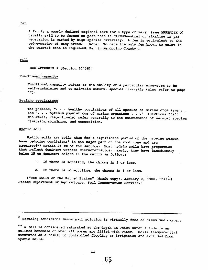
Fen
A fen is a poorly defined regional term for a type of marsh (see APPENDIX D)usually. said to be formed on peat that is circueutral or alkaline in pH ivegetation is marked by high species diversity. A fen is ~uivalent to thesedge-meadow of many areas. (Note: To date the only fen known to exist inthe coastal zone is Inglenook Fen in Mendocino County).
Fill
(see APPENDIX A (Section 30108) )
Fuctional capacity
Functional capacity refers to the ability of a particular ecosystem to beself-sustaining and to maintain natural species diversity (also refer to page17) .
Healthy populations
The phrases, ". . . healthy populations of all species of marine organismsand ". . . optium populations of marine organisms . . ." (Sections 30230and 30231, respectively) refer generally to the mantenance of natural speciesdiversity, abdance, and composition.
Hydric soil
Hydric soils are soils that for a significant period of the growing seasonhave reducing conditions* in the major part of the root zone and aresaturated** withn 25 em of the suface. Most hydric soils have propertiesthat reflect domiriant wetness characteristics, namly, they have imediatelybelow 25 em dominant colors in the matrix as follows:
1 . If there is mottling, the chroma is 2 or less.
2 . If there is no mottling, the chroma is 1 or less.
("Wet Soils of the United States" (draft copy), January 9, 1980, UnitedStates Departent of Agriculture, Soil Conservation Service.)
* .Reducing conditions mean soil solution is virtually free of dissolved oxygen.
** A soil is considered saturated at the depth at which water stands in anunlined borehole or when all pores are filled with water. Soils (temporarily)saturated as a result of controlled flooding or irrigation are excluded fromhydric soils.
ii63
ì

Hydrophytic plant
Any plant growing in water or on a substrate that is' at least periodicallydeficient in oxygen as a result of excessive water content (i. e., plantstypically found in wet habitats).
.= ~ ,-
.. . \.
Lake
A lake is a confined, perennial water body mapped by the United StatesGeologic Survey on the 7.5 quadrangle series, or identified in a local coastalprogram.
Mesophytic plant
Any plant growing where moisture and aeration conditions lie betweenextremes (i.e., plants typically found in habitats with average moistureconditions, not usually dry or wet).
Optimum populations
(see definition of "healthy populations" above)
Riparian habitat
A riparian habitat is an area of riparian vegetation and associated animalspecies. This vegetation is an association of plant species which growadjacent to freshwater watercourses, including perennial and intermttentstreams, lakes, and other bodies of fresh water (see also APPENDIX D) ~
River or Stream
A "river or stream" is a natural watercourse as designated by a solid line ordash and three dots symbol shown on the United States Geological Survey mapmost recent ly published, or any well-defined channel with distinguishable bedand bank that shows evidence of having contained flowing water as indicated byscour or deposit of rock, sand, gravel, soil, or debris.
Vernal pool
A vernal pool may be defined generally as ". . . a small depression, usuallyunderlain by some subsurface layer which prohibits drainage into the ,lowersoils profile, in which, during the rainy season, water may stand 'for periodsof time sufficient to prohibit zonal vegetation from developing. The habitatis intermdiate in duration or inundation between marshes (never or onlyrarely dry) and most zonal comnities (never or only rarely submerged)."("The Vegetation of Vernal Pools:' A Survey." By Robert F. Holland,Department of Agronomy & Range Science, University of California, Davis.Published in, Vernal Pools: Their Ecology and Conservation. A SymposiumSponsored by the Institute of Ecology, University of California, Davis, May1-2, 1976).
Wet land
(see APPENDICES A and D (Section 30121))
Xerophytic plant
Any plant growing in a habitat in which an appreciable portion of the rootingmedium dries to the wilting coefficient at frequent intervals (i.e., plants
typically found in very dry habitats.)
':.64

APPENDIX 2
ARCHAEOLOGICAL GUIDELINES (1980)
1e27-1.02 65

(This Page Intentionally Left Blank)
1e27-1.02 66

California Archaeological Site Survey
Regional :Q~Iiç~c~~ Coas Coun2S
Cabrllo College. 6500 SOQuel Orie~tos Ca 95003 (401 42s~a2.94, ,
s. '''.lCts. """1's.u CLILS_1'. ~..SA _TO!oN""1VSA.. l.S lUPO
Dear Planers, Agencies, and Consultants,
This letter is intended to answer a numer of inquiries ~e hay,e hadconcer~ing the nature and .function of ~~e Californza ArcnaeologicalSi te Surey, Regional Office i 1. The Regional Office is the archivalrepository for archaeological data from the seven counties listed inthe letterhead. We maintain data on both archaeological site sureyreports and reports on archaeological work done in the area includingboth positive and negative data. We are a part of the State ãistoricPreservation Office and subject to directives from that agency. Thearchival data is utilized in the course of 1) scientific research2) project planing, and 3) review. Access is to qualified re-searchers who meet the recuirements as ~rescribe¿ bv the State ãistoric
-Preservation Office (Access Policy enclosed) .
Scientific research includes g=aduate and undergraduate scholasticprojects, data searches for academic projects, and various studiesL~at will cont=ibute to knowledge of historic and prehistoric archae-ology not directly related to project planning.
project planning is associated wi~~ cul~ural resource management (Ci~)as' concerns California Environmental Quality Act requirements.Planners who are involved in preparing E. I . R. sand E. I . S . s retainprofessional consultants in the course of meeting C.E.Q.A.' data re-quirements. Cultural resources is one of the ccm~onents ot suchreports that are handled by professional archaeologists. Thearchaeologist would normally research the archival records prior tofield work as we have the most complete files available. The sub-sequent report would be sent to t.~e Regional Office by the -consultantto maL~ tain the archives as well as being part of the E. I . R. IE . I . S .Thus, valuable information is supplied to both planers now and tofuture researchers on particular areas. Planers can subt inwri ting, the proj ect description and the Regional Office 'will makerecomendations concernL~g the need for an archaeological cons~ltant.We also provide a list of professional archaeological consultants(Consultants List enclosed) .The review process concerns only archaeological com~onents and canbe generally divided into ~AO categories, impact statement reviewwhich is involved with identifying omissions and inadequacies asconcerned with the archaeological com~onent of im~act statements,and assessment of adequacy of archaeological professional reports.
As a Regional Office the ?ublic we serve includes city, county, state,and federal governent agencies, private ¿evelopers, consulting fi~s,professional archaeologists, academc institutions and occasionally,local businesses i groups or L~dividuals. Most often services a=ehanåle¿ by ?hone for professional. researche=s ',.ith credentials onfile or by letter for OL~er categories of research.
'~L 6 7

Page 2
A modest fee is charged for project planning research which enablesthe Regional Office to employ persons with ~~e sufficient archaeologicalbackground necessar¡ to the efficient ongoing mai~tainance of thearGbival repository. The fee st--ucture is S2S for the first hourand S2S for each additional hour or portion thereos. There is a lOçper page charge for xerox copies.
The existance of the Regional Office archives provides an unprece-dented oppor~~~ity for public involva~ent and contribution to asci~~tific approach of gathering archaeological data. Maintainanceof such an archives insures that the data generated by localarchaeologists is not lost in various governmental offices butaccures to t.'ie. scientific and general good. We are happy to answerany inquiries on how the office may be of ser~ice to you or to yourorganiza tion.
Sincerely,
).ßC /. .'" ~ -i1 /.l- ,tL1.¿
Rob Edwards - Regional Officer
enclosures
68

"'
sun 01' C.lfOll'lA-nt! iieoURC5 ÄGëN ECMUHO G. lieWN JI_ C_fi"-,~I~)\~.OFF1C: OF HlSiORIC PRESERV Å TIOND6'ARTMET OF PARKS ANO REOTICNPOST OlflCI !Ox 2i~
UC1Ul1O. CAfO:lNIA 95111
( 916) 44,-8co6!'.:rch 27 t 1980
Subject: P~licy concerning Ar~~eological ~ite DesigntionDate Erieetive: lßY 31, 1980
There ia a need ~ithin California (or a common understanding cet~een agencies, andbet~een agencies and archeologists, in dealing ~ith archeological sites. The Officeof Historic Preservation ha& developed a progrm to rill this need. In co-operntion~ith the archeological commnity and the Regiona Offices of the California Archeo-logical Site Survey, ~e hBve maintained and up-grded a cocprehensive Gtatewideinventc:- of archeological sites. In co-operation with ~~e archeologica cOQ:nityand the Regiona Offices, ~e have begu to develop Regional Overviews and p~~~ngdocuents to aseist planners and arch~ologists in their decisions concerning ~~eséValUI;U! .
The succe~e of both these progrms is dependent on the co-operation' an¿ effort ofyou ~nd your agency or fir~, ~hother you are an &r~heologist, planner, engineer,or agencJ official. There ar~ t~o thing~ which can be done to assist tliis effort:(1) cooperate ~ith the Regiona Office by supplying him with infor--ation. ThisOffice is ~~e pri:ary coordinating body for archeological infor=ation in that re-spec"ti"le region. Decisions i:de by the Regiona Of'fice and the Of~ice of Histori::Preser"lation are cased on thia archeologica informtion. (2) ~ all r~ports subjec~to environoental review, ba sure that all archeological sites are referred to bya trinomial designation. This enõUr~e tht the recorded histor¡ of a site is ~eni~to account. In addition the Regional Oftica ~ill be aware of the site; thisOffice ~ill be aware of tha sit~ and; thiø informtion ~ill be incorporated intofuture decisions concerning the archcolog¡ of the region. .
!n accor~1ce with these concerns, I will need a trinomial designtion for allareheological sites included in the follow~ng documents; (1) Requests for Determin-ations of eligibility, (2) :tominatior.s for inclusion on the rlational Register ofHistoric Places or aa a State Historic Land%rk, (3) Applications for Grnnts-ia-Aidfunds, whe~ applicable.
Processing of these docuents will be delayed if si te trino~ials are not included.Thank you for your co~pera tion.
Sincerely,
~VV\~Dr. Knox MellonState Historic Preservation C~!icer 69Attach:~nts: Regional Officer List
Criteria for Evaluati~n of Archeological Site Sur"le~ Records

s'!.;.r! c: l:.;L¡:O~;:';.
C . ":iC! 0:- ~!S70P.tC ?R~~!!': :.:O~
POL¡C! ON AC:!SS TO ;~C:_~0LOGrC.~ S:~! l!C~1DS
! :oiio~~g ~div~duals ara aualizie¿ co ~~c=i7e a=c~aeological si:e:ord daca:
A. ?~ofessional arc~aeologi~cs ~aeci~s sc~n¿ar¿s speci=ia¿ by:he ~aeional :ark Servce. and scudenes conciucein~ scienei£icr as earch.
(: ?la~.ers ~ploye¿ by gove~~enc agencies for pu=?cses ot ?ra-~~~~nary project invesi:i~acions.
C. Ouali£ied c~lc~=al =asour:e ~nag~rs e!i!, loy e¿ ~... . '~ov.:==:n:
aganc~as or PUQ lie u:i¡i~ï com;anias.
D. .. - ., . -" .'-Wl~e:"s a:.._ :.aen=:.:!.a~ arc~aeclogical si:as.
~~. ese ~¿i~i¿uals ~iil =aceive :~e ¿aca necessary co ==ei= =esearc~ c~l~:h che: ex;i:-ess apprci;al of che ap-;:'c?ri~i:e ~egi'J:¡al O:ficar. rhe Regiona~ficars ~~:l ~a~cain current tis~s ~: i:¿ivi¿uals ~ho are allo~e¿ accessche sica =ec~=as.
__.'" ~rder co proeac: C¿li:or:ia i s arc~aeologicai ~a::ouri:es, :ncsê recei"7~:.z,e sica record ¿aca ~s~ sign a doc~enc oi confi¿encialicy prohibii:i:gie disi:ribucion of s?ecific sica loca:ion i:ior.~ion in pub l~c ¿oc~encs. ~i:hin ~bei= insci:u:i~n O~ ag~~cy ~~~houc ?rio~ consent of :he ~e~ional'ficar o~ S~sce ~iscoric ?=asa~:ac~cn Officer.
~. ~e ae;iycal af=!cars ~ave :~a a~:ho=i:y c: ¿:=: ac:ass ~c a~c~~:c¡osi:al.:a =acor¿ ¿Á:a :or =aUSê.J= suc~ a den~al:
- .... '._~e :c~.~~~~g =aas~ns ---_.c;- :~ns~i:~ca s=oun¿s
tack of p~oo: of ?~o?e= ~ua11=i=aeic=s.
::iaå.eauace jusci.::.cacion :0 =ace:,"ie 3.uc:h ':4S:.a (:a.~~. s~:~n::..:i:research or s~ec1=i: ~~ojec: ~¡=~n~g is no~ i:vol~e¿).
C.
D.
:rav~ous abusa of c~nii¿en:ial~:y 0: recor¿s.
Failu=e Co provi¿e ~egio~~i Officerscompleca si:e =acor¿s r:=ul:~g ::-c~an ikves~i¡a~i~ns.
.i:h ~~i::=n =;?C~S an¿~ r¡".7.~t:S
... ... .::e~~ r~c~nna~3sancs
\. ~e Rasio~al O::icars ~iii :o"~ar¿ :~ c~e S:a~a ~is~o ric ?~asê~;acion Of:~ca=.o la~ar chën La days af~ar ~: ~¿~~i¿~i ~~ ==t~sa~ si:a ~~cor¿ ¿a:a, ~haa=e an¿
.. .. . .. .. ..æ. =: :._:..æ = :.c:! ~: :~a . .. .... .. _..
~¡:l~~:~_, anc :~= ==~s~~¡ :~~ :=s ac:~c=.
;.-: -:"'e F..:g::cn.s: C:::':::$ .:a: :::a:-;: .1 !'a.:s:=,.a~l: :::.. . .. - .
=~:=== s:~=:a=: :~= ==~::~;. . . . ...~:= racor~ :a:a 3aa=~~ . == ~:~=_:. _~_ ~ora ~~~æ~si~a =2saa~==
. -~ a ==.: :-:l:
.... .. . .... ..qti.:.:::.=~ L~s~~:~:io= or ag~~c:.
70

California Archaeological Site Survey
'D/~~~n,~.,~\ 1f 1(\~~~~~L~,~~~~.A'Y¡~;l~~;l Y ~ JI~ ~"~Central C.oastCountie.s
Cabril10 College. 6500 Soquel DriveAptos. Ca 95003 (4QSI 425-6294
SAN FRANCISCO
SAN MAnoSANTA CRUZ
SANTA CLARA
SAN UN'TOMONTEREY
SAN LUIS OBISPO
June l, 1980
To whom it may concern:
One of the original functions of the Regional Centers was the coordinationof archaeologists for the Society for California Archaeology. The' RegionalOffice continues .to receive requests for a list of firms and individualswho do this type of consulting for this area.
We have prepared the following list following State Historic PreservationOffice policy of using names from two groups who have prepared broaderlists, one statewide, one nationwide. These lists are a state listing ofConsul tants by Society for California Archaeology, and a national, some-what more rigorous "certification" by the Society of Professional Archaeo-logist (SOPA). These are based on the 1980 Directories on file here.
he following list is provided with no evaluation. It is merely a list of1. inimally qualified consultants and/or firms from the above Directoriesho have agreed to meet minimum requirements regarding data access andhave asked to be listed at this Regional Office. This list should notbe construed as an enàorsement for those listed.
ARCHAOLOGICAL CONSULT&~TS
SOFA Certification and SCA listing SCA listing onlyArchaeological Consulting Archaeological Co"nsul tants627 Baumann 1464 LaPlayaCastroville, Ca. 95012 San Francisco, Ca. 94122(408) 633-2157 (415) 673-6023 X 198Basin Research Associates4001 Fruitvale Ave.Oakland, Ca. 94602(415) 531-6074
Archaeological P lanningCollaborative1050 Northgate Dr. #554San Rafael, Ca. 94902(415) 479-3370
Archaeological ResourceManagement496 N. Fifth St.San Jose, Ca. 95112(408) 295-1373
Chavez, Inc.457 Edgewood Dr.Mill Valley, Ca. 94991(415) 388-3688
Robert L. Hoover1144 Buchon St.San Luis Obispo, Ca.(805) 544-0176
Greenwood and Associates725 Jacon WayPacific Palisades, Ca. 90272(213) 454-3091
SOPA listing only
Westec, Inc. (Bill Breec)180 E. Main St., Suite 150Tustin, Ca. 92680
Ann S. Peak & Associates8l67A Belvedere Ave.Sacramento, Ca. 95826
,:.' 1 OVER

Sc.~ 1is~i;iq onl v
Vance G. aenteMar a:il¿enia. Smi t."-äistorical Consul cants8 West S treatSan Rafael, Ca. 94901(41.5) 456-4837
Heritage ?esearch Associates1504 Grove St.3erkeley, Ca. 94709~a:yanne =azio (408) 353-3529
oi::. (415) 526-7109
~ '-:t. _.

/
,
RmIOlfAL OrriCZc.urrORlIA ARCHELCY S IT!: SURVEOFFICE OF HISTORIC PREVATION
PO Box 2390Sacraento Caifornia 95811
January 1980
Coordinator: ~illiam C. Seidel(916) 445-8006
RmIONAL OITiCZ comlTrr
Mr. Rob Edw.dsCabillo College6500 Soquel DriveAntos CA 9500;( 408) 425-6294
Monterey, San Benito, Santa ClaraSanta Cruz, San Mateo, andSa Fracisco, San Luis Obis~o
Dr. Mark Ko'ttaCalifornia State University, Chico.Chico ~ 95926( 916) 895-6192
Siskiyou, Modoc, Trinity, ShataLassen, Tehama, Glenn, ButteP1w:s
Dr. Dudle,. VarnerCalifornia S ta to Uni versi ty, FresnoFresno CA 92740 .(209) 487-2018
Fresno, !Cgs, ~.adera, Tulare
Mr. Jay Van ~erlhof
Imerial Valley College Museum442 Main St~etEl Centro CA 92243(714) 352-1667
Imperial
-Los Angeles,Archeological S~rvey
UniversitJ' ot Calitornia,Los Angeles CA 9024(213) 825-7411 Call: Martin. Rosen
Dr. Phil 'J1. eArcheological Research Uni tUniversity ot Caifornia RiversideRi veraide CA 92521(714) 787-3885
Riverside, !ayo, Mono
Mr. Jerad JohnonCaiforna ,State University SacramentoSacraento CA 95819( 916) 454-070 Ca: Maryane Russo
Amador t El Dorado, SacraentoPlacer, Nevada, Sier:, Yuba,Colus, Sutter, Yolo, Solano
13

"
EEG¡O~I;'!. OIT!CZ
~:. Gerald. A. ~cit.\iSaa Bc~~r~inQ County Museum2':J4 O:in~ ':ree uae~edlan~. C~ 92373(71i.) 792-l334
Dr. L. La:~j LeachSan Oieg~ S ta te ani ver3i tySan Diego~ C~ 92.1,('¡4-) ZeS-63C C~ii: Mr. UndeNcod
Dr. David A. :~ci~ickscnCali!o~ia State Cûiie~e, Sonoma~or.r.er~ ~~r~ CA 94926(707) i:6~+-238i
Or. Leu K. ~a~t~nCali!o~ia State Colle;e,. Stanislaus~~lcc~ CA 95380(209) 533-2127 or 633-2;C7
Or. aobcrt S~~i:r=nn~ker3iieid Coll~ge~801 ?a~crama Ori~e~ker3!i !ld ~ 93305(305 J 395-4231
Dr. ~i~aei A. Gl~~ßo~üniv~rsitj Qf Caiito~ia. Santa Sar~rsSanta Ear~ara C~ 931C6CeC5J 961-2054 or 961-2257
74
1
~tmTI!3
San ëCr:.:~ino
" S.:'t 0 i e go
eel trorte, E~bQiè.t. :1en:ici=o.." .Sor.::i:, lAke, ;"1""'~da. C.:nl::-.: Costa, i-::.-: anc. ~rapa
5.'\n :o~c.ui;:, Calivl!rar., A,l;ii;tTUQ¡~e. ~4ri posa, Her~ed. ancoS t~.saus
,:'e r:
S4r. t:. - E.:ara.

'-
CALIFORNIA ARCHAEOLOGICAL SITES SURVEYOFFICE OF HISTORIC PP~SERVATION
Criteria for the Eval~ation of Archaeological Site SurveyRecords Submitted for Inclusion in the Statewide Survey
Each archaeological site record shall be reviewed and evaluated using~he following criterions to insure the accuracy and completeness ofthe survey's data. Site surey records which do not provide the.required inio=mation should be returned to their preparator forcorrection or attachment of supplemental information. (In thecase of previously recorded site survey records, Regional Officeswill be responsible for updating any inadequate records they mayhave in their files.)
A complete archaeological site surey record has th=ee parts: 1)a site survey recorñ form; 2) a detail(ed) site sketch map and; 3)a site location map xerox copy of a portion of the appropriate USGS~~adr~~gle ~ap showing the location of the site (as recorded bythe site recorder). Zach site survey record must contain all itscomponents before it will be accepted for inclusion as part of thesur-vey data. An exception to the above statement will be madewhenever an aggregate of 5i tes are reported for a small geographicarea during a systematic =econnaissance.
The information categories listed below do not address all categoriesof inforoation which may be required to meet academic research needs.The Office of Historic Preservation wishes to stress tha.t tl:esecriterions represe~t the minimal iDfo~ation necessary to propermanagement and protection of the state's archaeological properties.Office of Historic ?rese~ration w9uld recommend that in lieu of aregio~al site sur-Tey record form, if such a form does not exist,that the site surey record form currently in use by the Departmentof Parks and Recreation be utilized to record archaeological properti~s.
I. Site Surey Form - This form must provide response spaces for thefollowing categories of information.
A. Official Site Trinomial - Should be placed in upperright hand corner of form.
B. Site Locational Information1. Rec~angular System of Survey References -
TOw~ship, Range, Quanåran~s of a section to thenearest 1/16 of the section, and section.
2. Universal T=anverse ~ercator Grid References -One UTM reference point must be given for allsi tes covering an area of less than 10 acres.Sites covering an area of 10 acres or moremust have a UTM reference nrint for each corneralong its bo~~dary. Full ÛTM reference pointcoordinates must be given.
..\i-, ;)

..1"-::-
;. Verbal Desc=i~tio~ - This sec~io: scould ~ro~dea mental =ap to ~one tryi=g to =elocate - thesite. Re!erences to siioWldi!g lard.arks uidftpe~ent~ modern featues should be provided
~ conjunction with i~ro~atioIl conce~i:g t~ei=direction ~d distance f=om the site.
C. Contou: Elevat.ion
!). Ownershi'O1. Owner i s name (In the case of nublic ownership,
the agencj havi=g =esponsibility for the landshould be ~iven).
2. Owner' s add~ess
E. Ee£erence to Systematic Su-~ey (i~ applicable).1. Name ot project2. Date survey...as conducted
i . Descri~tion of Site1. Site å~entions2. Est~ated su=face a=aa of site;. Es~imated or ~own depth of deposit, i!
annl icab 1 e .4. CõDdition of site i.e., ~dist~bed,
parially destroyed, etc. .;. Site attributes i..e., midde:Îo.a.bitatioii
debris, lithic scatte=s, ete.6. Te~~o~l ülace~ent of site7. Cuitural place~ent at site
I!. Are~aeological Site Sketc~ Maps - ~~etc~ =a~s shcui~ ~r~vide aclear ~ictue of the site i 9 ~~!ace ~~iiestatic~s and thei=relatiõ~ship to each other a.nd the su==ounci -5 e~~i=o~ent.~e follo~~ ~o~ation should be provided cri all skatc~ ~a?s:
1. Site ni.be=2. Lagend.; . Scale4 . ~rorth arrcw5. Exact ~easur~ments oe'twee: key !eat~es
of t~~ site a~d its e~vi=c~~ent; these:easure:ents aaould ~clu¿e horizontaldist~ces and co~pass òeari~gs.
III.3ite Location ~Ân - '!his can should be a xerox üortion of aUSGS Quadra:gle f1ap upon whlc= the prcpertj locåtion has òeen~ar~ed. ~re!eraòle seals for site location is 1:2~,OOCj cow-ever, 1 :62,500 scale ca~s ~il~ sU£tice when ths fo=:er is ~ot. -So vailable.
'le follo..i:g re!;=e~ce ';~fo=:!::tic~ s1:ould. be pro7i.:e¿:
7B

-;-
1. Site nUJber2. 11ap name and scale;. North arrow4. It an symbols are used, provide key
or legend.
77

ALP ANNUAL CONFERENCE
MARCH, 1980AS ILOMA , CA
TYPES OF ~~Ca;EOLOGICAL REPORTS
PLANNERS CAN EXPECT A."lD í'¡AYS
TO REVIEW A."lD EVALUATE TEE'1
BY
JACQUELYN M. COOPER
REGIONAL OFFICE
. CENTRA COAST COUNTIES
CABRILLO COLLEGE
APTOS i CA
".' nLU

~o~arè the end of the las~ Ice Açe, the ances~ors of the California
Indians lef~ Asia, c=ossed the 3erinç Straits ; n~o ~or~~ ~~erica, and
filtered souL~ L~to Califor~ia. The pervasive mountain rar.ges and lack
of navi;a~le rivers encouraged isolatior. and diversification ~üong the
a~o=iginal groups resultL,g in extremely different physical charater-
is~ics and great variation in cultural evolution. The variation rançe
for California In¿ians included some of the tallest and some of ~~e
shortest indians on ~~e continent. They spoke 135 different dialects
from 21 linguistic subdivisions of i basic language groups. The s~ory
of human occupation in the central coast counties goes back at least
10 i 000 years, ~~d constit~tes an impo=tant se~ent of the total
his~ory of ~ank~ nd.
As a si~gular species, we are all products of history. Kncwle¿;e
of our past is necessary to successfully planr.ing and shaping our
future. California i s history is well preserved in t~~ts and ?ho~o-
;raphs, out, L~e 10, 000 years oefore ~~at requires e~?ertise and
patience in gle~~inq data from ~~e deposits of h~an occ~?ation.
In recen~ years, a growi ng concern for ?reserjati~n of the past
has produced laws and reçulaticns pertaining to ?ro~ection ~,¿ pre-
se:v~tion of ~~lt~ral resources on ~~e local, state, and federal levels.
Ccrr~unities are conce~e¿ wit~ local his~ory i . . .coun~~es are concernecwi~~ ~'e varying co~?onents of prehistory and historical con~~~ti and
state ~~¿ na~ional level soverr~ents are concerned with ~=eserTi=g
the ric= ¿eversity of cultures that have existed on the Nor~h ~~erican
C~n~inent . The Na~icnal E~viro~~a~tal Quality Act of 1970 designates
~~e inclusion of an arc~eological evaluation to assist in indenifying
~~e L~?ac~s a project ~ill have on ~~e environment, ?a~icula=ly.
when Federal :~~ds are involved. The California Envi=on=en~al Quality
Act (based on NE~A) has brought concerns for such resources to the
attention of state, regional, and lccal planners, even when Federal
funds are not involved. Oiffi~ulties arise when the ?lanners i who as
~e all ~~ow, are a~?ected to be all things to all ?eo?le i have t~ ¿eal
with archaeological or other cultural =esources i~ a ?rofessional
manner. wnat I hope to do is to lift the 7eil of archaeological ~yste=:
just a little, and sho~ ~ha~ the archaeological cO~üunity ( in cor.junctic~
with planners) have developed as basic ~eeds fer reports.
7,9

Page ¿
. There are several types of reports that can be expecteå when an
archaeologist is required to evaluate a proj ect for cultural resources.
The following is a basic list of archaeological report types that a
planner might a~ticipate. Each is åiscussed followed by suggesteå
means of review and evaluation by non-arGhaeológist staff.
ARCHAEOLOGICAL REPORT TYPES
l. Literature/archival search and research
2. Preliminary or intensive fiela reconnaissance
3. Subsurface/secondary testing anà evaluation of significance
4. Mitigation plans anà procedures
1. Literature/archival search and research
This type of report provides background information. on a particular
area without field reconnaissance. A planner or private property ow~er
can contact the Regional Office for a check on a particular parcel.
There is a fee for any project specific planning use. The minim~~
scope of information that one could expect from the ~egional Office
includes:-known sites on specific parcel-list of previous s~rveys on parcel, ~~ any-the probability of finàing sites, i.e., the sensitivity on t~eparcel .-recommenåations for further research, if needeå
If there are historic resources concerned with a p~rcel, archival
searches of historic r~construction coula be quite involved. Thiscould include tracing ownership, structural changes and archi tectualuniqueness. Archival research can vary greatly åepen¿ing on the
nature of the proj ect and the parcel. There are research proj ects
where the archival research can be the end proàuct such as in the
preparation of a sensitivity map or if a negative survey report has
already been completed for a project area. An example woulà be a .
3ay Area County Parks ~~d Recreation Department which advertised a
scope of work for 9 parks. A check of the Regional Office records
showed that 3 had been sureyed and paid for by the s~~e Parks Dept.
wi thin the previous 2 to 3 years.Access to Regional Office data is according to statewi¿e access
policy of the State Historic Preservation Office (SHPO).
80

: .;':c ..
:rvI~.yí~ALüATICN OF .l!;tCHIVAL S~CE:
The evaluation of ~~e archival =esea=~~ data should center on its.. i, - . ; - . - 1 ; .. ;: ..- -,.; -=.. ~.._~c_us~veness ana _~s u~~__~y .or ~ne s~e___~c ?ro~ec~. The::e area numer of archives ~~at have a variety of data in content and incompleteness. Any archival search which does not i~clude use of ~he
ap?ropiate Regional Office and any historic research that' does notuse local historical sources should not be considered adequate.
~e?orts dealL~g wi~ prehistoric resources should include:
-~egional Office a=chives search-local historic maps such as Sanbor~-published histories or a local historic archives suchas the San Jose ñistorical Museum-inventories of local, state, or :ederal, on recoçnized historicsi tes
Regional Office ~l has National Register sites mapped. Those of
you who have checked t~e published list ~'ow that cost are ¿eliberatelv
vague in giving locations.
The use of sapO and/or Parks and Recreations De?art:e~t files as
an archival search are not sufficient for t~o =easons:
1) SEPO ¿ces not have the stazf to do more ~~an file data;there is no ; nåaxinq .
2) Sacramento ãoes not =ecei7e data from Regional Officesmore than 2 to 4 times a year, so these tiles are ~otcurrent.
2. P=elioinari or intensive field reconnaissance
There are sevp-ral dif=er~~t types of archaeological field :e-
co~'aissance procedures (~i~q, and Leonard, 19ï3). They i~cl~¿s:
?relimnarv Field ~ecofu'aiss~'ce: ~elatively superficial in-spection of impact area. Some of the following tec~H,i~es
are used and the report should include an ex?lanation of why
a particular technique wa~, used.
a. Uncontrolled Intuitive ~econ.~aissance. . A. "s'Oot-check"of ~robable areas for hum~~ habitation cased on suchcriteria as slope, access to ~earest water, etc.
b. Controlled !nt~i tive Recon.~aissance. Check of areas~'own to ce probable ones for cul tu=al resources basedon settlement ?atter~ data.
c. Controlled Sample ~econ.~aissance.ified random sample of an a=ea.
S~~ey ot a strat-
81

.. ..': '-
Intensive Field Reconnaissance: Comprehensive inspection of all
surfaces.a. General Surface Reconnaissance. Inspection of all
visible surfaces that can be reasonably be expectedto contain resources.
b. Controlled Sample Reconnaissance. Inspection of allvisible surfaces that can be reasonably be expected tocontain archaeological resources over a large area.
c. Complete Reconnaissance. An investigation of everyvisible surface of a project area.
d. Subsurface Reconnaissance. Exploration of subsurfaceby means of test units i auger boring or mechanizedcutting.
Mixed Strategy Reconnaissance: Utilizing different approaches
in àifferent parts of the study. The various types of. surveys
should be specified and the reasons for utilizing tha~ justifie¿.
The preliminary or .intensive field reconnaissance report is àe-
signed to provide practical information on archaeological resources
in the early stages of planning at a minimum cost.
REVIEW/EVALUATION OF PRELL~INARY OR INTE~SIVE FIELD RECONNAISSANCE
The preliminary archaeological reconnaissance report must be
prepared by a qualified professional archaeologist (See Qualifications
Section). The report should incluàe the following _informat. .on:-explana tion' of why the proj ect was performed-archival/recoràs check at appropriate Regional Office-description of project area including USGS quaå map-detailed description of methodology, findings, and recommendations-list of persons involved in' each stage of project-statement of authors qualificationsWhen a report lacks ~~e above information or is not very specific
about information, it is possible to request an evaluation of the
report or the qualifications of the consultant by the Regional Office
or the State Historic Preservation Office.
3. SUbsurface/seconàary testing and evaluation of significance
\ihen an archaeological site is located during a surveyor is known
to exist on a parcel, the permit process usually requires determination
of the site boundries, ~~e nature, composition, .the signiiicance or the
resource, and recommendations for mitigation. c~ ,,"(. ¡;

Seco~da.-y ~esting c~~ ~e avoided on a project when i~ can be documented
~hat there will be no impact on ~~e resou:ce. Suc~ documentation might
L~clu¿e placing the resourcs as ;art of an open space, scenic, or
archaeological easa~ent 0: ~~rough a deed rest=iction. wnen L:?a~ on
a resource cannot be avoided, secondary test; ng will ~e necsssar¡ to
for.ing a mitigation plan.
types of investigations:
l. coundrv Location. Tec~~iques include:-Detailed surface a~amination and ma~oina.-Systematic surface collection and ma9piñg.-Syst~~atic auger samplL~g or other su~surface testL~qof site peripheries.-Chemical analysis and testing.
Secondary testing includes the following
2. Subsurface Testing. 2and excavation of t=st units toprovide inio~a~ion on ~~e composition and integrity oft~e resource wi L~ minimum ¿istur=ance to the s i ~e.Secondary tesing reports will include the following:
-?reparation (and review) of a research design ?riorto :fieldwork.-GaL~erL~g data related to the research design suestions.-Detailed analysis of gathered aa~a.-?rovisions for curation of gathered data.-?reoaration of re~or~ outlinina al: o:ocsdures, including:
:Description añd discussion ~ of ~~ë ¿at a .-Stata~a~t of the significancs of t~e resource. (see below)-Discussion of projec~ alternatives.-Conclusions ~~d specific =ecornenda~ions.
The ¿ete~ination of Significance requires detailed knowledge o~'
-Time period (s) ¿urinq which t~e site was occ~?ie¿ ~nd~~e contents of L~e sits.-?revious archaeological research in the ~deiate areaand in ~~e general vicinity of ~he rasource~-The na~~e of the archaeological recor~ as it sur~ivesin ~~e ?~oject area, general vicin~~y, ~ld ~~e region.
-Researc~ questions which are or ~ay ~e applicable ~o thesite.-Current legislation, quiåelines, and ?rofessionalpractices which pertain ~o ~~e estimation of significance.
The significance of some sites is ve~¡ obvious as in an elaborate
Chumash rock ar~ site. O~~ers will ~e more diffic~l t to ¿ete~i~e.
Some have been damaged to ~he ~~tent that significance that was
~~ere is lost. The ¿egree of significance will have to ~e ¿ete~ine¿
and doc~ente¿ ~~ough research anå archaeological testing.
63

Page 6
Traits which may ~e used to åetermine significance are:
-Research Potential - The åegree to which the site is importantto history or prehistory as åetermined in context with otherresearch questions.
-Integritv - The intact condition of the resource helps determineintegrity as does the interelationships of the components of thesi tee E~en minor disturbance results in the great loss of in-formation.
-Temporal Affiliation - Some time periods are more significantthan others. A general rule is that a site increases in sig-nificance as it increases in age.
-Relative Scarci tv - Some types of sites are extra~ely rareand significance increases in proportion to relative scarcity.
-Community Sianificance - A site which is a ma~er of a inter-. ~related group of sites will have greater significance, just asthe pages of a book are considered more signigicant togetherrather than individually.-Legal Significance - A site which is eligible for the NationalRegister of Historic Places is afforded specific legal protections.Other Federal, state, and local laws, regulations, and ordinancesapply specifically or in general to archaeological resources.
-Ethnic Significance - This applies to an archaeological sitewhich has religious, mythological, social, historical, orother special importance to a discrete population.
~-VIEW/EVALUATION OF SECONDARY TESTING
Secondary testing reports are at t.-ie level of "technical reports".
An agency or firm should, whenever possible, have a professional re-
view the report for them. This can be done in a .,¡ariety of ways.Santa Cruz County in the past (1972 - 1979) has had a professional
archaeological advisor. It is possible to ask sapo or the Regional
Offices to review the report on a tL~e available basis for agencies
who do not have for.al relations with a Regional Office. But, the
review may not be completed in time to be relevant.
4. Mitigation Plans and Procedures
The mitigation plan is a for.al document specifying how an
archaeological resource will be handled, given the impacts of a pro-
ject. The mitigation plan will specify in detail the steps which will
be taken to preserve the site or to mitigate damage which cannot be
avoided.
0"Õ '-:to

?age
As t~e ?ublic has become increasingly aware 0 t t~e value of
arc~aeological inior.ation, the field of cultural resource managQÜent
has evolved from ~~?loratory excavation to a general att~~pt to "?ro-tec~ this ncn-:enewable resource whenever ?ossible. The mitigation
plan is now one of ~~e primazy tools for the ?rotec~ion of significant
arc~aeological sites which are ~~=eatened by adverse ?rojec~ iQpacts.
In a~ost all cases t~is can be done wi~~out stoppi~g the project.
This åoc~üent would be ?reparaed by .a professional archaeologist and
submitted for review to the appropriate requlato~i agencies, ~~e
aegional Office, and to ~~e S~ate ãistoric Preservation Office.
Some a~amples of specific ~itiqation tec~~iques include:
-~elocation of projec~ im?ac~s. A ~inor :eèesign of the projectcan often avoid impact on an archaeological :esource. ~~iscould be aone through inclusion of open space, landscaping,or covering ~~e site with a layer of fill and asphalt to createa parki.l'lq lot.
-3urial of ~~e site.sufficientlv thick tobe placed o~ top.
A site may be covered wi~~ a layer of fillinsula~e it from Lüpac~. St:~c~ures could
-Archaeological salvage. tihen a proj ec~ ~?act cail~ot be avoidedand ~~e Lü?acts will be ~~t=ame, it may be neces sary to conduc~a larce scale archaeoloaical salvaae oceration. This is seldomdone ånd a poor alternative bot~ f=om the archaeological pointof view as well as from a fiscal ?oin~ of 7iew.
QUALI:IC~T!ON FOR ARC~~OLOG!C~ CONSu~T~~S
!n order to maintaL~ high professional standards and continuity
within ~~e ¿iscipline of ar=ha~olo~l, it is essential that-mi~~al
~alificat~ons for arc~aeological consultants be established ~~d
pra.cticed. The current accepted stan¿ards are those existing for '-':c'-...-
Society of Professional Archaeologist, the Society for Califor~ia
Archae~loqy, arid the Department of the Interior, as fou~d in 36 DFR 66
and in 36 DFR 65. The minimal professional qualifications i~ archaeo-
logy are:1. A postgraduate degree in Archaeology, .~~th=opology, 0= a
closely relateå field wi~ a specialization in Archae~logy iexcept where an equi7al~~cy to such a ¿eq=ee car. be doc~ente¿.
2. Demonstrated ability to carry research to completion, usuallyevidenced by t~eiy completion of ~~eses, research reports,or sL~ilar documents.
6~e:'0.;)

Page 8
3. At least 16 months of professional experience and/orspecializeã training in archaeological field, laboratoryor library research, admini.stration, or ~anaga~ent, in-cluãing at least 4 months experience anã/or specializeãtraining in the kind of activity the individual proposesto practice.
4. Demonstrate connection with an institution or organizationwith facilities for storage and care of archaeologicaldata and materials.
REIEW AND EVALUATION OF QUALIFICATIONS FOR CONSULTANTS
When considering an archaeological consultant, one important
way to evaluate them is through their associateion with one of two
organizations: l) The Society of Professional Archaeologist anà
2) The Society for California Archaeology. A listing with ai therorganization indicat~s a minL~um level. of training and experienèe.
If they are not listed by these organizations, you may want to make
a àirect inquiry to the organizations, or the Regional Office or
SñPO, to see if the. consultant does meet minL~al stan~ar¿s. Apexcellant a~am?le is a local collector in the Monterey/Pacific Grove
area who has trieà to ào archaeological consulting. This has causeã_
considerable bureaucratic time delays in .dealing with inaãequate
reports, àelays anà adài tional cost for the app licant.
86

~E:~~CZS
3reschini i G. åi:iave:sat iT.
1979
~~chaeoloaical Ove:view 0= t~e Cent=alCoas~ Co~~ties Drait
E¿...ar¿s i ~ob1979
Recommèn¿ations for Procedures and Gui¿elinesArchaeoloaical Consultant Qualifications.Prepared for Santa Cla=a County
1979 The California Di=ectory of Arc~aeologicii. Consultants. The Society for CaliforniaArchaeology .
197ó Directory of Professional Archaeologist i4th E¿ition. Society of ProfessionalArchaeologist.
'0 ,.o.

3ARl\.OLOCA INVESTIGATIONS AT OIARMlliE COUN PARI" IN ni SANTA MONICAMOUNTAINS, LOS ANGELES COUNTY. CALIFORNIA.
The Northridge Archaeological Research Center will soon begin a series ofarchaeological investigations in the upper reaches of Encinal Canyon, on thesouthern flank: of the Santa Monica Mountais near the Ventura. County line.These investigations \rill focus on a group of roc~shelters and open-air siteslocated withi the bowidaries of the Cou:ity Park. All si tes with in the Parkwill be located, mapped, and samled, but excavation will be limited to oulyone, or possibly two, small areaS. primar¡ interest centers around a slU"tll,widecorated rockshelter, LA-472, which has a deep (70 cm), stratified shellmidden, ø:d has yielded a large qucmU ty of beads and faunal remains. Thisshelter has also produced a lirnte~ oCcupational assemblage lilcludL~g millingequipment, flake tools, and projectile points \"ith associated debitage. Afew worked pieces of bone and marine shells have been fowid (pierced bird claw,shark centrome ring, worked cOlriries an abalone shell). n..o hearths, and anumber of other features, have also been lOCated at LA-472.
At ths tim, at least three addtional archaeological si tes are Imown to exist\' thi the Park boundaries, onlr two of which are recorded localities. All 10-caliti~s yielding archaeological materials will be recorded ~~d mappedr and sur-f ace s~~led whenever possible.
OUr pd.ncipal research efforts will be di.recteù at .developing a basic understand-ing of the prehistoric subsistance and settlement patterns represented at tiiesesi tes. The following speeific research projects will be tiiclrtakeu:
1. Definition and demonstr.ation of internal (verticle and horizontal) stratigraphywithin the IA-472 midde deposit.
2. Identification of microfaual and microfloral materials (floatation of hearthmaterials).
3. CharacteI'ization of the natural environment includig floral, faunal and lith-ological units in the vicinity of the sites.
4. Identification of the sources of 1he lithic artifact materials recovered fromthe tites in Encinal Canyon drainage.
S. Development of a moel which describes the Late Horizon exchange system opera-ting in the Encinal draiage, and the prodcts involved in- the system.
Persons interested in participat.ig in the NAR project, or who have research in-terests in this area, are encouraged to contact the project director, John Rom~ii,at the Research Center at Cal S'tate Northridge - phone (213) 885-3575, or writeto the NARC c/o the Departmn1: of Anthropology, CSUN.
Work is scheduled to begin in early Januar and c:ntinæ for approxteiy tt110months. Pield \..0 rk: and laboratory "".ark will rw concurrently, and all recoveredmaterials ¡-¡ll re stored at the CSUN Research Center until other ar~ngem-n ts
are made with the Couty Park for a permanant display ::d inter._pretive center.
'\Di'lector \Northridge ArChaeOl0:J' ieal \
Research Center
Decembe 18 t 1979--88

.2
STATEMENT CONCER~ING THE CONDUCT OF ARCHAEOLOGYWITHIN THE GREATER LOS ANGELES-VENTURA COUNTY AREA
(CHUMASH .~rD GABRIELINO CULTURE AREAS).
In order to foster cooperation and communication between
archaeologists and Native Americans, representatives of several
local Indian organzations and the Northridge Archaeological
Research Center at C.S.U.N. are requesting that all archaeolo-
gists conducting field research or contract work in the Los
Angeles and Ventur~ County areas (i. e., the Southern Chumash
and Gabrielino culture areas) kindly notify the Research Center
and the Candelaria P~erican Indian Council. Whenever possible,
notification of pending fieldwork should be made at the beginning
of a project, not during or after the fieldwork has been completed.
Archaeologists and researchers are requested to follow a
simple set of recommended procedures outlined below. These
procedures apply to all projects involving prehistoric, proto-_
historic and/or early historic archaeological sites.
1. Before a project begins field operations, notify the
nearest Native American organization with jurisdiction
in the area in question. In the LA-VEN area contact
ei ther Candelaria or Charles Cooke 0 f Newbury Park.
2. At the same time, or before, notify in writing the
local research facilities and primary researchers in
the area. A simple notice or form letter sh~uld be
sent to the follovring: IT .C.L.A. Archaeological Survey i
C.S.U.N. Northridge Archaeological Research Center,Pacific Coast Archaeological Society, Ventura County
Archaeological Society, S. C .A. Distric t iTII Coordinator,and other appropriate groups, units, and instit~tions.
3. If you plan to do any type of digging or excavation,plan to have a Na ti ve American Monitor on-site wheneversuch work is being done. Candelaria Council can arrange
to have one or more Indian Monitors on-5i tB to 0 bserveand aid the work ~uring excavation of auger holes, test
89

pi ts, trenches, or exposures. Monitors mayor may nottake ~art in actual excavation (digging), depending on
the individual involved, and the particular situation.
4. Human burials should not be removed from the groundwithout specific authorization from Native American
religious authorities contacted through the Native
American( s) working at the si tee Burials removed
from sites, and any other human bones recovered during
excavations, should be analyz3d as quickly and thoroughly
as possible, and reburied by religiOUS authorities as
soon as fea~ible. The local office of the County Cor-
oner should also be informed when burials are located.
5. Power equipment, such as backhoes, bulldozers, ortrenchers, should not be used on identified, known, or
recorded archaeological deposi ts, except as a means of
removing or moving non-cuI tura~ deposits such as fill,
paving, and overburden. All excavation should be done
by hand, and all excavated material should be screened
wi th 1/8 inch mesh or finer screen.
6. Copies of all notes, records, maps, and manuscriptsshould be made available to interested archaeologists
and Native Americans involved in the area. Collections
should be processed and stored in the area of origin
whenever possible. Arrangements can be made to process
and store some collections at the Muse~ of An~hropology,
Northridge Archaeological Research Center, C.S. U.N.
Research materials are also available at other insti tu-
tions (documents and collections at IT.G.L.A., C.S.U.
Long Beach, C.S.U. Dominguez Hills, C.S.U. Los Angeles,
Cal Poly Pomona, Ventura College, Pierce College, Moor-
park College, etc etera) .7. All contacts and consultations should be adequately docu-
mented with copies provided to all involved parties.
8. Native American Monitors, tribal elders, and religious
authorities should be permitted ready access to any and
all aboriginal materials collected during a project.
Northridge Archaeological Research Center, C. S. U.N.November 1979
9'0

APPENDIX 3
PALEONTOLOGICAL GUIDELINES (1980)
1e27-1.02 91

(This Page Intentionally Left Blank)
1e27-1.02 92

t ~G. /~~~ .,~Yeo.r ~o-\A eV"(slA :
£i è:/0 ~ a.",~~
CC~I ~ -F -c.o. V"' \: ~ ~l~~~~Li lo~ -lt'Jq~a.(~.. r1f:'L$ )
ai '-'" d Orc..-l~
~
r;' bc~~";c.u..¡,-i.. .rc.'dL-5 ~
~~.
-i lc. r- "Ck ~~~.,' l-
-i&."3.~-.~L~
\'" L~..~J e-4,,)- l~ c. c.~~ ~ - .c~ l'~ ~
$O,i-i~ .
~~4 ¡~-l + C lL~C\-L
v~l. ?~ , - '
NATURAL HISTORY MUSEUM LOS .ANGELES COUNiYLos Angeles County Museum of Natural History · 90 Exposition Boulevard · Los Angeles, California 9007 . tel (213) 744-3414George c. Page Museum · Hancock Park · 5801 Wilshire Boulevard · Los Angeles, Caliornia 90036 · tel (213) 933-7451
93

':~,,;
;....
IAHP l7
¿;"(ritr t!7- f rY L i ç: ,C;.~..-.1 ~'- ?.. - 7Y"i I. t ,.. '-I"\.",U~qet~nes,C. Paleontolo~1cal
The attached Paleontological Site Map (Figure AHP-2) indicates _.!.(.ci;.l-lC'S -dr¿~ lmown to contain fossils. Hoi¡iever) other l,c8t4~y~'-':-~
also have. rossils. The following guidelines are intended toprovide the necessary degree of specificity required ~or adraft EIR, depend~ upon iocation.
/ 1"..'1. .There are four (4 T classifications of paleontologicalsignificance:i. Known Sites (Numerical Identifica tlon) This designa-
tio~nc~i~~o oclcctc~ known paleontological sites. Forv-: ...rT projects that contain a numbered s:ite~ plans to
...,~~// preserve or excavate the site prior- to .constructIon. ..è'-:- should be made as a de'finite, impact :Ls indicated." '
..
,\.''f~;-
2. Hlf5h Possibility - This designation represents the highestprobability that paleontological material will be found.For all proj ects located in ~he immediate .icinity of a
. known fossil producingjunit,.) one of" the "f.oiim.¡ing \'¡llbe required: ~ L .- . . , .-------.__.._----.. '. .' .
a) A full paleontological evaluation ~ill be re-quired unless a statement to the contrary can beobtained from the. Los Angeles County NaturalHistory Museum.' .
C:;-r t' .:r_: .
\=0..:\.. ",., ."_..
'!
or
.".i .;'\r 'í.~" ,.. ..
b) A trained technician is retained £or monitoring ofexcavations. v.
. 0 i-3. Low Possibility (, ~-shaded areas or map and not
vicini ty of a known site) - Thi s des1gnation represents_ a!._~~_~. .9f.__s..sg-lment) rock units \"ihich hær-e riot l?een knmlin. ,4-
.~--_. . to produce fossils. If fossils are unear-thraur.ir:g -:~çconstruction or site investigations, the Los Agei~~County Natural History Museum should be contacted. Inmost cases~ the following statement wiii suffice:
11 According to the Paleontological Sites Map ~ based on
data from the Los Angeles County Natural HistoryMuseum, the propo~ed proj ect lies in an area of lowprobability that paiéontologlcal sites wiii be found.Hm.¡ever, ..if. r-~ss;tls, are ~èartE)during any phase ofconstruction the Los Angeles County Natural HistoryMuseum will be contacted and given ample time toevaluate and excavate if the Museum desires. If
J,i _\",A\" ..,-C,-\J \;'\ "\ L'- .
94

~ '..~ AHP 19 ,~. No Possibilit~ (Shaded areas or map) - This designation
represents areas or igneous or metamorphi~rock and thechance of' finding fossils is almost non-existing. Inmost cas~s~ the following statement will sufrice:
.if According to the 'Paleontological Sites Map, basedon data rrom the Los Angeles County Natural HistoryMuseum, the proposed proj ect Ii es in an area of almost
. no probability.that paleontological sites will bediscovered .~nd, therefore~ no signiticant impact is
. indicated'" .- ~ . ..
c.1\
.'
When a rull paleontological evaluation is required, the"Recommended. Guid.elines for Preparation of Archaeological
,. Impact Evaluåt;1ons" (s'ee page AHP3) are recommended to be. . followed _ where applicable.
it an ErR is required: a professionál paleontol~gi~tl o~geologist with ,paleontological training and a Bachelors orMasters degree must be used. Acceptable salvage can beaccomplished by-aerson properly trained in paleontology.Faculty, staff and 'advanced students in geology andpaleontology at USC, UCLA, Cal State Los Angeles, Cal StateLong Beach, ~ the County Museum~can usually accomplish the. latter,. or di.rect you to someone who can~ \. . .
- . .:" ~ 1 i /'\ -f. ' A i r t" . -Mitit;ation Neasures -. )C", ..¡'c. wv,."r:-,".. \.\;.,,-Yl.:,!~ i~I1e''¿~'.'jl"'" ..':~( .D~.
3.
, -Ih the event that. s,y ar~ha.eolOglCal mater. als are disc07'ered during the co~se of ~he planned deve opment of theproperty, the U A Archaeological Surv . should be notif d
. of the discove ' es so that their valu may be adeq/atei .assessed, and a 'reasonable period of time permitted fotheir excav ion.. ;. - -. _ _. .
2. .When a Cu tural/Historical Monume t is impacted, tdevelope can offer the necessar. funds to ãiiow ~eCultur Her:ltage B~ard :o,mav the monument, if/t isdesira ie.r" tE-Cl,'""\.t:-" \ c(\~_ _~~en known¡;i t;: :re in~oived or when the ErR states thereis a good chance of discovering finds, the developer/land-owner should budget funds to assist 1n on-site inspectionsduring grading, salvage, etc. of specimens.
1.
~ . Submittal to designated museums, . scientific personnel, etc.by developers/landowners copies of grading plans, si temaps, pertinent sections of geologic reports made for s1 te,pertinent sections of EIR relating to paleontologicalresources and salvage, and grading schedules.
5. On-s1 te inspector is present at proJ ect at all times oforiginal cutting of originally undisturbed fossil-bearingsoil or rock units. Inspector may mark fossil materials
95.

I AHP . 20
",
and divert construction equipment from them~ may collectmaterials which he physically can, may call in volunteersalvage crews ~ paid salvage crews, or museum collectingcrews and equipment. '
6. Designated museum and/or scientific personnel may inspectconstruction site at any time, and may salvage and collectfossil materials, may bring volunteer/paid collectingcrews and' collecting equipment onto site, and may assistpaid on-site inspector in collecting fossil mat.erials.
7. S (.1 e 1\ +1-r ~ ~ Pe' '. t'" r -i ~J., ~ ., '.,' " ('. I. '. '. . Ii \ -~'- . \. L \Y~.~1 . q.y--; \'Ç\S) 6'':.0- U \ 'l-V i-ier-S Ð-t
'. cc...'-.\-.iil~_; h\ Cl-l'_~'. b~~&¡"YL " ~ ~~ç~.__.L . 7\ 'f' ~'~.'~' -p \~'\."":" \:. .c:. . .... .\ .'-\:'".. .1 v.-t.~,. ~.'-~ \c.¡lll'rl- n Y7'.h t . e' f '\ ( ... ,., '.. '.:.' .'..l ., r...\ " I. o.--c.u; ~I./"_~. i A~ I" ~~\1cn\ ? rrl;_~!€. ..~'-. ,0 ~. .... . . . . ¿.'~'t.v..=.t.'d~h\-cL,- c~.-i' ,.: 'L.' '~_'(.~J'. :. .. , .'. . "-.~"'.-e-l'.\...'~vl."h..tè "\t- a:~i-..t 'I.J ~: l~r,r-;.:v..~.~3~t-
L~¡'",\. 5,.e 'n,',¿ .' I.",. - _' I .' . ("i. ....~-l',..,d.\/ ~ . . .... I. . .,... .... '.... C,-\\-o.\"i\..Q.V" .4.cce.-f~L\(,,. '\-2
t(~ .Anlf;:,~-;,.,~_t..: t\:~::~..~t~L:-t-, cf/\lf't'.." " .... ~'-l1.. "- "" \ -' .' l' '.1 . '.' I ~ l l'- -.. --' ",;-., c.~~ ,-_A~sc r:'i,-~A~"~.. a r
!
~l ,. i. :_"':":i ~';"'(l, ..i ,-: ~.1 -.
C .. ., I; ..t:. i . r C +- ,.....~ t". _. . '.. .. ':... , "....
References
1. UCLA-Archaeological Survey
2.- Los Angeles City Municipal Arts Department'V'f.
3. I Lawrence G. Barnes, ..~oovcie. tc Curator, Vertebrate Pal~ontology~,· Los .An~elesi COUI:tty; .!:atural History r.1useum.. ";iOO'F'~,'pcSt'-7'" .~:.\;/I!,
\-o-~ to:...n.~,('.:. \_~..\\. CtOo 0:+.. ..4. "Simplified Map of Earth Materia 1 s", Plate VI, Seismic Safety
Analys1s,L_Ç,!tY_-9-r__L9.~ Angale~, J. II. Wjgp-"lns r.oinpany-'for theCity of Los Angeles, April i9'l0.
96

.._---- .'-'. . . -- .~_. ..----_._.
Natural History MuseumLos Angeles County
Nay 9, 1975
Ì¡!:. P.o cert Su ttD.ndpp-i'~er.t of City PLi.n.""i"'cRoom 655, Ci ti fu200 l!or.." 3-pri-"g Strse-r::S" ll"ogeles,Califor:..:: 90012
.~~ :,",:..~...",""Dear Mr. Su-tii: . ~::~~~
."" ".
" I ai retu to" yi.. the city cap w.th our localties ;:i:1"ksd. "These lo~alties havs nirs loch' can be ci"ted in corrspcndenca a.d~porta. ~per co:ridaraticn ca.t be given to paleow..logy .~m~!l +11..only ~~~o~tion at ha is a map lot~ so please realze that aloca.i"t wi-i.ti'in e. project a.-ea only indicatas tht core a;ttention l!-.tb~ given to .geology an possibleI.J.i.;es of fossil in the Yic-in.;t;. _.P.:!)rojei:t O~ terrai unerlain by- unstubed. set',,""enta-y rock. ~7 havean iJaot en fossil resou.-ces, a'ld m'.ls-t be covered in an Fm. negativedec h ";3. t10:l can be ac-oeptad iJieIl t.lie u:erlyi ca:èeria. is artioi3.
fill, --g:!iOU3 or metaIo:rmc rocks (e:cludi tufs), or if. no cuttior trencn.; ng is i.i:e:oed a."1 no ki-w fossil deposits ar bu--ed. Ira .projact i;olves cutti... o-r aedien"tarj' rock, pa.-tculßrlY it +.-iisrock 13 pota:itial:r fossil-bea...g, then l!nitori~ of' e:=avations
sbuld 'b a:-r;ed. Const-l""g geologists aluld. be contact..d re3~;""gtha Latu-- of unerlyi rock lmts.
If I had to rn probab.;lity s1tui:icns for fossil discoverles,i t ~cld be ti;
E2 possibiity: prject overlies igno\1 (ex:lu~ "t:fs) or'~t.,;o:ih~ c rock, or ar..""cia. fill.
Low l)ossibili"t: project oyerl:ies a seíÌ.;~n-W4J rock ll-"Ït "rcb.
has cot been k!~ü to produce fossils. .A i:eun s;"uld be contacted if'"!~ossils a.-e uia.--ed.
Giles W. Mead. DirédorC. F. Geliñng, Assisfan"¡ Director
Leon G. Arnold. Assisf~rir Director 97lc~ Angeles County ~..1us€".um of Natural HiõtOl"1 "Ex~csi¡'on Perk · 900 Exposi'ien Boulevard. Los Angeles, Cdifornia 90~07 · t~leFhone 7¿6 0410

.""-- ._..~:~
I.ir. Hoberl Sutton -2- i,ray 9, 1975
High possibility: project overlies
aLor kr..wn sites ar iii the vicinity.for I!mtori of e::avatioI".ß.
a kcwn .fossil-pr;ch.lc~ u: tTechncian should be ret;:-i:--"d
Y..wn sites: plan should be made to preserve or excavate the siteprior to construction.
.. _.rl'. ...~.
Acceptable ErR' 5 are prepard by professiona finn 'Wo retai apal eo.ntolo.gs t or geologjst with paleontological tr~i rii "'g, an ê. Bachelorsor N.asters da~ee. They should be reviewed by tr""-1-"ed speci.alists inpalaon"tlozy. .!\cceptable sal "tage .cao be accompli3hed ÌJj. a. person propi:r1.ïtraied in paleontology; Facul ty, 'i:rtaf:f., an ad"vl'"'l"ed stuents in g~logyan paleontology at UCL.;, use, CaL State Loa _~ele:3, Cal. State longBeach, or the Ccu:i: Mueum CeU usualy accoi:l: the b.tter'l or d-i.'c"tyou to some person wh can.
,.-L-;":.~
Enlosed is an outi of'. procedus .tht should cover al:L pointsin a bythetical project "tt might ha~"e ma.. probabili.ty of dest:ry-
i. fossil resoures. i-iot al projects requie al the s"tps listed.The most im~~t point is to get enñ;:r.gered fossil resources into apublic i:eum as per the spiri:t of EPA.
I would like to aik. th"t w"e be retud a. copy of ths map.. 'tle arbei. iasked.to provide t. sam . data by the va.-rou8 e:ner;ng, flood.control, . ~ sam tation of:fices.'
...
SiIcerely- f
La-.iie G. BaesAssociate CL-atorVer..brate Palaontology
IGB:mbEnclosu.-es: OUtlin, map of' ci1:
98

Vertebrate Paleontologic Resources of Los Angeles Countv
August 8~ 1977
Los Angeles County is one of the richest areas in the world for both fossilmarine vertebrates (fishes, sharks, seals, sea lions, porpoises and whales) , andland vertebråtes from rocks deposited over the last 25 million years (Miocene,Pliocene 'and" Pleistocene). Within the County is one of the richest and mostfamous fossil deposits .in the i;.¡prld, Rancho La Brea.Although Racho La Breahas been highly publicized, there are many other areas of Los Angeles Countywhich contain equally important fossil occurrences, many of which have beendestroyed or are now in danger of destruction.
Tue richness of fossils in Los Angeles County is due to several major seri~sof events in the geologic history of the area. During ~liocene and Pliocene time(25-5 million years ago) most of what is now the greater Los Angeles basin andthe surrounding hills (Santa Monic~ Mountains, Repetto Hills, San Jose Hills,Puente Eiiis~ Palos Verdes Hills, the San Fernando Valley, the S~iÌ Hills, SantaSuzana Mountains, the Santa Clarita Valley and mountains surrounãing) were allsubmerged below the Pacific Ocean. Thousands of feet of sands, muds and 0 ther1!terials were deposited o.n the ocean bottom over this entire area and milli.ons.of fish. sharks, marine. Irarals and shore birds were burried in these depositsas they died and sank to the bottom. Through time, many of these specim':!nsbecame fossilized.
What is no~.¡ the eastern end of the Santa Clarita Valley and the SoledadCanyon area was a large valley in which ~vas deposited over 10 ~ooo feet ofterrastrlal sediments. Many laud animals became burried in these sediments and.some became fossilized.
The area along Interstate 5 south of Gorman and most of the western ~ntelopeValley were bath inland valleys in which thousands of feet of sedioents weredepos i ted.
During Pleistocene (Ice Age) times~ forces within the earth elevated muchof this area above the ocean and formed hills and mountains wnere the oceanbottom and valleys once existed. Erosion cut down through th~se older seàimentsas they- were being uplifted to foro the ter=ain we see today. '
Consequently, there are over 1,100 known vertebrate fossil localities withinthe County, mostly in the hills. There localities are scattered within 69ï squaremiles (17% of the County) of hilly terrain which contain fossil producing rockformtions. In addition, the entire floor of the Los 1L~gëies basin. San FernandoValley and Antelope Valley are mantled with Quaternary sediments sim~lar to thoseat Rancho La Brea. Approximately 90 square miles of the 687 square miles offossiliferous terrain has already been completely graded and built on, mostlyin the last 10 to 20 years. Of the remining 600+ square miles. much is ~iliediate danger. particularly areas surrounding the Santa Clari.ta Valley, thi=western Santa Monica Mountains and the Puente Hills.
59-:

~
8
G
Page 2
In contrast to archeologic sites, paleontologic sites are not necessarilydestroyed by grading and construction if several simple precautions are taken.In fact, grading opens new rock exposures and thus increases the potential fordiscovery of new and often very well preserved fossil specimens. However, oncedestroyed, -a fossil site is lost to everyone for all time. In this day whenman has presumbly risen to an advanced state, there is no ~~cuse to willinglydestroy what nature may have preserved for 25 million years.
The necessary steps to evaluate and preserve, if necessary, a fossil siteare as follows.
1. Consultation i.ith geologists, paleontologists, museum. etc. for evaluationof known paleontological resources, their relative value. and. a plan forsalvage. systematic collecting or prese~iation, all to be included in EIR.
2. Ir deemed necessary in step I. site survey of project by trained person(s)who include(s) observable paleontological resources in environmental impactreport (EIR).
3. Review action by governing agency (state. county, etc.) to assure that theabove has been done.
Budgating of. funds by developer/land owner to assist in on-site inspectionduring grading, salvage, etc. of specimens.
5. Inclusion on grading plans of instructions to notify, assist. and cooperatewith scientific personnel to effect salyage of fossi~s.1 .Notification of designated museums. scientific personnel, etc. by governingagency, in advance of pending construction sites.
7. Submittal to designated museums. scientific personnel, etc. by developers/land owners copies of grading plans, site maps. pertinent sections ofgeologic reports made for site. pertinent sections of ErR relating to paleon-tological resources and salvage, and grading schedules.
8. Notification of EIR writing co~pany. designated scienti£ic sa~vage personnel,and museum, of comnencement oÎ-grading rrior to actual star~. If startingaay is imnent, but not set, then notification should be made.
9. On-site inspection by person(s) approved of by designated musaum(s) and! orscientific personnel. Said person(s) paid on hourly or daily basis bydeveloper/land owner as per item 4. above, and wages, conditions. individualto be negotiated by developer/and owner and ELR ~Liting company.
10. On-site inspector is present at project at all times of original cutting.of originally undisturbed fossil-bearing soil or rock units. Inspector maymark fossil materials and divert construction equipment from them, may collectmaterials which he physically can. may call in volunteer salvage crsff. paidsalvage crews. or museum collecting .crews and equipment.
11. Desig~ated museum and/or scientific personnel may inspect constr~ction siteat any time. and may salvage and collect fossil materials. ~y bring voluntee~.paid collecting crews and collecting equipment onto site~ and may assist paidon-site inspector in collecting fossil materials.
. .'~
100

"
..
Page 3
12. Designated museum and/or scientific per~onnel may challenge qualificationsor credibility of paid. on-site paleontological inspector.
13. All fossil materials removed from construction site are to be deposited inthe systematic collection of an es tablished research oriented museum, withno sal~ price to the museum placed on the specimens.
~\
10:
(This Page Intentionally Left Blank)
1e27-1.02 102

APPENDIX 4
GUIDELINES FOR THE IMPLEMENTATION OF THECALIFORNIA LAND CONSERVATION ACT OF 1965 (1989)
1e27-1.02 103

(This Page Intentionally Left Blank)
1e27-f.02 104

ADOPTED ON NOVEMBER 23, 1999
GUIDELINES FOR IMPLEMENTATION OF THECALIFORNIA LAND CONSERVATION ACT (LCA) OF 1965
(THE WILLIAMSON ACT); AND ADMINISTRATION OF THE LCAPROGRAM, AGRICULTURAL PRESERVES (AGPs), FARMLAND
SECURITY ZONE AREAS (FSZAs), AND LCA AND FSZlLCACONTRACTS (10- AND 20-YEAR)
WHEREAS, the California State Legislature enacted the California Land ConservationAct (LCA) of 1965 (the Williamson Act);
WHEREAS, in 1969, the Board of Supervisors adopted a resolution, pursuant to theprovisions of the Government Code, Chapter 7, Section 51231, to implement the WiliamsonAct through LCA Program and Guidelines for the unincorporated areas of the County;
WHEREAS, the State periodically amends, revises, and adds sections to theGovernment Code (Chapter 7, Sections 51200 et seq.), and the Revenue and Taxation Code,that directly affect the Ventura County LCA Program;
WHEREAS. in 1998 and 1999, the State Legislature enacted Article 7 (GovernmentCode, new Section 51296 and revisions to Sections 51200 et seq.) with provisions for 20-yearLCA contracts within Farmland Security Zones (FSZlLCAs) in established AgriculturalPreserves (AGPs), to encourage the creation of longer term voluntary contracts;
WHEREAS, the Land ConservationlWillamson Act authorizes Counties to establish,expand and disestablish Agricultural Preserves (AGPs), Farmland Security Zones areas(FSZAs); and enter into or nonrenew, and cancel (if findings can be made) LCA and FSZlLCAcontracts for land within AGPs and FSZAs; and to adopt by resolution rules governing theadministration of the LCA Program, AGPs, FSZAs, and LCA and FSZlLCA Contracts (e.g.,procedures for initiating, filing, and processing applications for AGPs/FSZs and LCA Contractsand discretionary permits on LCA-contracted land); and
WHEREAS, pursuant to the Government Code, Chapter 7, Section 51239, the Board ofSupervisors appointed an advisory board, Ventura County Agricultural Põlicy AdvisoryCommittee (A PAC) , to advise the Board of Supervisors on the AGPs, FSZAs, and LCA andFSZlLCA Contracts - proposed and entered into pursuant to the LandConservationlWllamson Act, General Plan and the Guidelines - and on any related mattersand entitlements on contracted land;
WHEREAS, Ventura County is one of the principal agricultural counties in the State andplays an important role in providing for the basic needs, food supply/demand, and theeconomy of the County, State, and Nation;
WHEREAS, the preservation of the limited supply of agricultural lands in Ventura Countyis in the best interest of the public; promotes the general welfare; helps maintain and protectthe direct, indirect, and imputed agricultural economy of the County; and helps assureproducton of and adequate supply of food, fiber, and ornamental crops to meet thesupply/demand at the local, national, and global levels;
1e27-1.02 105

NOW, THEREFORE, BE IT RESOLVED, by the Board of Supervisors of the County ofVentura that these provisions wil govern the administration of the Ventura County LCAProgram, AGPs, FSZAs. and LCA and FSZlLCA Contracts, including entitlements, divisions ofland, and annexations within existing and proposed AGP/FSZAs, and any LCA and FSZlLCAcontracts.
AND BE IT FURTHER RESOLVED, that the revised LCA Guidelines attached heretoshall supersede and replace all Board Resolutions adopted prior to the adoption of theseGuidelines and shall apply to all new and proposed AGPs, FSZAs, and LCA and FSZlLCAcontracts and proposals for entitlements on the existing LCA- and FSZlLCA-contracted land, inthe unincorporated areas of Ventura County.
INTENTThe purpose and intent of the Ventura County LCA Program is to: help preserve the limitedand diminishing supply of agricultural land in the County; encourage production of food, fiber,and ornamental crops and commodities for local, regional, State, national and internationalmarkets; to discourage premature conversion of agricultural land to nonagricultural land uses;and help to preserve and promote commercial agricultural industry and the direct, indirect andimputed effect on the Countywide and State economy.
The County establishes and expands Agricultural Preserves (AGPs) and Farmland SecurityZone areas (FSZAs) and enters into Land Conservation Act (LCA) ten-year (LCA) and twenty-year (FSZlLCA) contracts based on its desire to discourage the premature conversion ofagricultural land to nonagricultural uses; to promote preservation of its agricultural resourcesand commercial production of food and fiber; and to encourage economic sustainabilty ofCounty's agricultural industry and operations.
The County's specific intent to enter into LCA and FSZlLCA contracts with landowners ofeligible properties is to preserve and promote bona fide commercial agricultural operationswhich rely on an optimal combination of soils, climate, water, topography, lot size for viableproduction, and geographic configuration. The County intends to encourage protection of theareas of the County which contain such favorable combinations. In addition, the County'sintent is to allow compatible uses in agricultural areas which do not hinder or compromise theexisting or potential agricultural productivity of agricultural land.
The Willamson Act allows contracts for open space. However, the Ventura County LCAProgram is intended for "agricultural" contracts only. Pursuant to the Guidelines the land mustbe utilized for bona fide commercial agricultural production of plant and animal food, fiber,and/or ornamental crops to qualify for LCA and FSZlLCA Contracts.
HISTORY AND BACKGROUND SUMMARY
The California Land Conservation Act of 1965, also known as the Willamson Act, was adoptedby the State Legislature in 1965 and was first implemented in Ventura County in 1969 throughthe Land Conservation Act (LCA) Program. The State continues to amend, revise, and add
1e27-1.02 106
sections to the Government Code1 and Revenue and Taxation Code, that directly affect theLand Conservation Act Program.
The Willamson Act authorizes counties to establish/expand AGPs and FSZAs by resolutions;and enter into LCA and FSZlLCA Contracts after review and approval during public hearings.
In 1969, the Ventura County Board of Supervisors adopted "Guidelines for Implementation ofthe Land Conservation Act of 1965/ the Willamson Act" (Guidelines). These Guidelines andsubsequent revisions established criteria for eligibility for AGPs and LCA Contracts in theunincorporated areas of the County.
In 1984, the Board adopted the previous revision of the Guidelines and a resolutionestablishing an Agricultural Preserve designation for all areas designated "Agriculture" in theVentura County General Plan. However, some of these areas are not located within theestablished numbered preserves and were not assigned individual numbers. Therefore, theunnumbered areas located in the "Agricultural" designated areas are referred to as the "defacto" Agricultural Preserves for the purposes of identification and the LCA Program. The "defacto" AGPs are assigned numbers in conjunction with applications for new LCA contractswithin these AGPs.
In September of 1998, a new section was added to the Government Code2 with provisions for20-year (FSZlLCA) contracts to encourage the creation of longer term voluntary contracts.Pursuant to the Code3 the Legislature finds and declares that it is desirable to expand optionsavailable to landowners for the preservation of agricultural land. The Farmland Security Zone(FSZ) legislation authorizes agricultural
landowners to petition the County Board ofSupervisors to rescind the existing ten-year (LCA) Contracts and simultaneously re-enter intotwenty-year (FSZlLCA) contracts -- if all criteria are met and the propert is designated asFarmland Security Zone (FSZ) for the duration of the twenty-year FSZlLCA Contracts.
An LCA Contract within an FSZ zone shall be for an initial term of no less than twenty (20)years. Pursuant to the Government Code provisions LCA and FSZlLCA Contracts are self-renewing contracts. The added tax reduction incentives and protection provisions makeFSZlLCA Contracts a more powerful tool for long term protection of farmlands in the County.
Owners of eligible agricultural properties located in the unincorporated areas of the Countyenter into LCA and FSZlLCA Contracts with the County to restrict the use of their land to along-term, commercial agricultural production. Land uses accessory to agriculture are subjectto the provisions of and consistency with the Ventura County General Plan/Area Plans, ZoningOrdinance, "A-En (Agricultural Exclusive, 40-acre minimum) and "C-A" (Coastal Agricultural)zones. In exchange, participants in the LCA Program receive reduced property taxes for theduration of the LCA or FSZlLCA Contracts.
1 Chapter 7, Articles 1-7, Sections 51200 et seq.2 Chapter 7, Article 7, Section 512963
Ibid.
1e27-1.02 107

REVIEW AND APPROVAL
All requests for new LCA Contracts, Rescissions/Re-entries, portion Nonrenewals andCancellations were reviewed by the Ventura County Agricultural Policy Advisory Committee(A PAC). This Committee recommends approval or denial of requests for AGPs, FSZAs, LCAand FSZlLCA Contracts, Rescissioris/Re-entries, Cancellations, portion Nonrenewals, to thePlanning Commission and the Board of Supervisors. The Committee also reviews proposalsfor entitlements on contracted land and makes recommendations to the appropriate levels ofreview and approval.
The final decision regarding approval or denial of proposed AGPs, FSZs, LCA and FSZlLCAContracts Rescissions/Re-entries, Cancellations, and portion Nonrenewals is made by theVentura County Board of Supervisors. The Board-approved and recordedLCA and FSZlLCAContracts take effect on January 1 of the fOllowing year. All LCA and FSZlLCAContractsautomatically renew each year on the anniversary date. Therefore, unless other action istaken, the LCA and FSZlLCA Contracts are always in the first year of the self renewing ten- ortwenty-year LCA or FSZlLCA Contract.
CONFORMANCE WITH STATE LAW AND COUNTYORDINANCE AND RESOLUTIONS
All applications for the establishment or termination of AGPs, FSZs, LCA and FSZlLCA,associated Zone changes, and entitlements on contracted land shall be made and decided inaccordance with the requirements of the Land Conservation Act of 1965 (Government CodeSections 51200 et seq.), applicable County ordinances and resolutions, and the currentCounty LCA Guidelines as amended. The findings of the Ventura County Agricultural PolicyAdvisory Committee shall also be considered in processing such applications.
All new LCA Contracts, Rescissions/Re-entries, portion Nonrenewals, and discretionarypermits for LCA-contracted land must meet criteria pursuant to the current Guidelines. Alldiscretionary permits for properties subject to LCA and FSZlLCA Contracts, must be reviewedto determine consistency with LCA Contracts, or mitigation actions (e.g., Rescission/Re-entry,portion or entire contract Nonrenewals).
These Guidelines shall be interpreted in a manner consistent with the overall intent expressedabove. If any provision herein is found to be invalid, it shall not invalidate the remainingprovisions.
GENERAL POLICIES
PROPERTY OWNER INITIATED AGPs, FSZAs, LCA AND FSZlLCA CONTRACTS
AGPs and FSZAs may be established or expanded, LCA and FSZlLCA contracts maybe entered into and Zone Changes in conjunction with LCAs may be processed by theCounty upon the written request of any property owner whose land is eligible for,entrance into the LCA Program. Applications for such actions may be obtained from thePlanning Division.
1e27-1.02 108

DEADLINE FOR FILING
Applications for the establishment or expansion of AGPs and FSZAs. and the executionof a LCA and FSZlLCA contracts, and/or associated entitlements, must be filed withthe Planning Division by JUNE 1 preceding the JANUARY 1 lien date on which the LCAand FSZlLCA contracts would become effective. Applications accepted after thisdeadline may not be processed in time for the recordation prior to January 1 lien datedue to incompleteness, contingencies, review, and public hearings scheduling.
PROPERTY TAX REDUCTION
Under the Tax Code provisions for 10-year (LCA) contracts, the property tax reductionrate fluctuates from 25% to a maximum of 30% for eligible land utilzed for agriculturalproduction.
Under the provisions for 20-year (FSZlLCA) contracts, the property tax reduction isguaranteed to be 35% for eligible land.4 (The structures are excluded from the propertytax reduction calculation.)
Pursuant to the Government Code, notwithstanding any other provision of law, anyspecial tax approved by the voters for urban-related services on or after January 1,1999. on the land or any living improvement shall be levied at a reduced rate unless thetax directly benefits the land or the living improvements.s Landowners of propertiessubject to FSZlLCA contracts are guaranteed 35% property tax reduction on qualifyingland utilized for agricultural production (structures are excluded).
SELF-RENEWING CONTRACTS
The initial term for Contracts shall be for no less than 10 years for LCA Contracts and20 years for FSZlLCA Contracts. Unless a Notice of Nonrenewal (for entire or portionof LCA or FSZlLCA Contract) is filed, pursuant to Section 51245, a year is addedautomatically to the initial term on an anniversary date.6
NONRENEWALS
If either the property owner or the County desires to nonrenew an LCA or FSZlLCAContract a Notice of Nonrenewal form, all required materials, and-processing fees mustbe filed by applicable deadlines for processing and recording prior to the lien date.
Nonrenewals for entire and portions of LCA and FSZlLCA contracts shall be pursuantto the Government Code provisions.
Portion Nonrenewals are subject to the agency and public review process. In addition,the remainder of the LCA Contract must be found to be consistent with the LCAGuidelines. All Portion Nonrenewals must be approved by the Board of Supervisors.
All Notices of Nonrenewal and associated documents must be complete pursuant toreview, processed, and recorded prior to the next lien date to take effect.
4 Revenue and Taxation Code, Section 423.45 Section 51296 of the Government Code6 Government Code, Chapter 7, Section 51296, (4)
1e27-1.02 109

CANCELLATIONS
Landowners may petition the Board of Supervisors for cancellation of the entire or aportion of a contract pursuant to the Government Code. 7 The applications are usuallyfied in conjunction with entitlements. However, the Board cannot approve suchproposals if all required findings for cancellations and alternative uses cannot be madepursuant to the Code.
. If a portion cancellation request is filed, the Board must make findings regardingcompliance of the remainder of the contract with the Code and LCA Guidelines.
RESCISSIONS/RE-ENTRIES
Rescissions of existing LCA Contracts are processed in conjunction with andcontingent on simultaneous Re-entries into new LCA Contracts pursuant to theGovernment Code provisions. This is the intended method for adding non-contractedland to the existing LCA Contract. The resulting Contract boundaries must be incompliance with the current Code provisions and LCA Guidelines criteria and shall notbe for less acreage than originally contracted for.
CONSISTENCY OF ENTITLEMENTS WITH GUIDELINES
Whenever a land use entitlement including, but not limited to, zone changes,subdivisions and conditional use permits is requested for land subject to LCA orFSZlLCA contracts, or about to enter a contract, the entitlement should not beapproved unless it is consistent with the provisions of the Guidelines and the "A-E" or"C-A" zone. Entitlement requests which are inconsistent with these Guidelines could beapproved after expiration of contracts.
No entitlement, subdivision, Rescission/Re-entry, Notice of Nonrenewal, or Cancellationshall be approved which would result in the creation of LCA or FSZlLCA contracts. orlots within LCA contracts which do not meet the standards for an LCA or FSZlLCAcontract pursuant to these provisions.
LCA CONTRACTS WHICH BECOME INCONSISTENT WITH GUIDELINES
When changes in agricultural uses on a contract result in uses, parcel sizes or zoningdensities which are inconsistent with these Guidelines, making the land ineligible forLCA or FSZlLCA contracts, the County shall record a Notice of Nonrenewal for thatcontract.
AGRICULTURAL USES NOT QUALIFYING LAND FOR LCA CONTRACTS
Uses which produce plant and/or animal products for commercial purposes, but whichare not dependent on the soils, topography, water or climate at the site nor particularlydependent upon the parcel size or configuration shall not serve to qualify land for LCAor FSZlLCA contracts.
7 .Government Code, Chapter 7, Section 51280 et seq.
1e27-1.02 110

Examples of such uses are greenhouses and hot houses where the ground has beencovered with relatively fixed structures and improvements such as potting benches andhard surfaced flooring, poultry, worm, algae, fur and fish farms, and feed lots. Suchuses may nevertheless be located on "marginal" land in a LCA contract pursuant to the"A-E" or "C-A" zone.
ESTABLISHMENT OF COMPATIBLE USES IN LCA CONTRACTS
In addition to the agricultural land uses and production which would qualify land forLCA and FSZlLCA contracts, other "compatible" agricultural or agriculturally relateduses may also be allowed on LCA- and FSZlLCA-contracted land, provided they arelocated on "marginal" land and would not compromise, hinder or reduce the existing orpotential agricultural productivity of the land. "Compatible" uses are those which areconsistent with the Ventura County Zoning Ordinance and permitted, or conditionally,permitted in the "A-E" or "C-A" zones, and the provisions of the Codes.
AMENDMENTS TO EXISTING CONTRACTS AND SALE OF NONCONFORMING LOTS
Land which produces agricultural crops and/or animal products for commercialpurposes, but which would not by itself qualify for a LCA contract, may be added to anexisting contiguous contract -- provided the lands under consideration are owned by thesame owner and together comply with the provisions of these Guidelines.
Based on past practice, legal and nonconforming lots are sold independently of eachother to different owners and create nonconforming and ilegal remnants of theContracts (and sometimes ilegal lots). Therefore, the County reserves the right toreview and approve reject these proposals based on the input from the APAC. Thesedecisions could be appealed to the Planning Director, Planning Commission, andBoard of Supervisors. (See CHART I for other alternatives.)
"A-E"l'C-A" ZONING AND DENSITIES
The "A-E" and the "C-A" zoning densities for contracted land wil conform with theapplicable densities. The zoning density for land currently under contract, or beingconsidered for a contract, should not be less than the current status on the land norshould it be less than that which would be applied to the land in cõnsideration of itsability to accommodate residential uses. Land being considered for contracts must bezoned Agricultural-Exclusive ("A-E"), or Coastal Agricultural ("C-A") in Coastal Zones,before it can be approved for a LCA or FSZlLCA contract. All land within contracts mustbe zoned Agricultural Exclusive ("A-E"), or Coastal Agricultural ("C-A") if it is within theCoastal Zone.
All Zone Change request for eligible properties are filed in conjunction with applicationsfor and are contingent on approval of the contracts.
8 Government Code, Chapter 7, Section 51238 et seq.
1e27-1.02 111

ZONE DENSITIES ON UNPROVEN LAND
In cases where the viability of a given agricultural product or an area is unproven orwhere the soils, topography, climate, water or other factors associated with landproposed for entrance into the LCA program are marginal, a zone density lower thanthat which is normally allowed shall be considered. See Chart II, Tables 1 and 2-Animal Husbandry/Grazing Contracts and Animal Husbandry Unit Equivalency Guide.
REQUIREMENTS FOR MIXED AGRICULTURAL USES
If the land under consideration is comprised of a mixture of agricultural uses, theAgricultural Policy Advisory Committee shall use its discretion to review andrecommend the appropriate minimum parcel size, AGP, and zoning density for LCAand FSZlLCA contracts, zone change, and/or develop conditions for subdivision andother discretionary entitlement requests.
RIGHT TO REJECT APPLICATIONS
The County reserves the right to reject any application for an AGP, FSZ, LCA andFSZlLCA contracts, and associated entitlements.
CITY PROTESTS
If any City protests the execution of a contract covering land within one (1) mile of itsboundaries,9 the committee may recommend denial or approval of the contract basedon facts and review of the protests.
EMINENT DOMAIN
It wil be the policy of Ventura County, in administering Government Code, Chapter 7,Sections 51290 through 51295, to maintain the integrity of existing AGPs.
ENFORCING COMPLIANCE WITH THE LCA PROGRAM
The County wil ensure that the land owners of existing and proposed LCA andFSZlLCA contracts adhere to the specific requirements, purposes and intent of the LCAProgram as expressed in the LCA and FSZlLCA applications and contract, the "A-E"(Agricultural-Exclusive) or the "C-A" (Coastal Agricultural) zone, the Willamson Act, andthe current LCA Guidelines, by diligently employing all legal means available to bringabout compliance with the LCA Program.
"T -P" ZONE, LCA AND FSZlLCA CONTRACTS
Proposals for rezoning - of land under a LCA contract from "A-E" (AgriculturalExclusive) to the "T-P" (Timberland Preserve) zone; or from "T-P" to "A-E" inconjunction with LCA or FSZlLCA contract proposals; and/or nonrenewals of TPZcontracts and associated proposals for zone changes - shall be consistent with theGeneral Plan, Zoning Ordinance, Guidelines, and the provisions of the GovernmentCode. Proposals for immediate zone change for land subject to TPZ contracts are filedin conjunction with a cancellation request (check regarding fees).
9 Prior to January 1, 1991, pursuant to the Government Code. Chapter 7, Section 51243.5, the cities had to be
notified, and all protests by the cities had to be fied formally to preserve the rights of cities to decide status ofLCAs upon annexation
1e27-t.02 112

ELIGIBILITY CRITERIA
INTRODUCTION
The eligibility of agricultural land proposed AGPs, FSZAs, and LCA and FSZlLCAcontracts shall be determined pursuant to the requirements of the current CaliforniaGovernment Code/Wiliamson Act; 10 the Ventura County General Plan and ZoningOrdinance' "A-E" or "C-A" zoning; the current LCA Guidelines; and the findings of theVentura County LCA Program, Agricultural Policy Advisory Committee (A PAC) ,
Planning Commission, and the Board of Supervisors.
Unless otherwise provided, the more specifically defined or restrictive of the abovereferenced regulations shall apply.
To qualify for a Land Conservation Act Contract and Rescission/Re-entry, all eligibilityrequirements' and criteria for the ten- or twenty-year LCA contracts, AgriculturalPreserve, and the Farmland Security Zone must be met.
MINIMUM SIZE AGRICULTURAL PRESERVE (AGP)
Pursuant to the State law, an AGP shall consist of no less than 100 acres. The law11
provides that two or more parcels may be combined to meet the minimum AGP sizerequirement. Eligible properties proposed for a LCA and/or FSZlLCA contract mustbe contiguous or subject to the same ownership. The land may be also be adjacent toor located in the existing AGP or a "de facto" AGP. The owners may request toestablish a separate AGP for eligible land located outside of the existing AGPs andover 100 acres in size. The entire proposed contract boundary shall be containedwithin the same AGP.
The LCA Guidelines require that any Zone Changes to "A-E" or "C-A" are filed inconjunction with contract proposals; are consistent with the General Plan; and arecontingent on approval of the contract. (See "A-E"I"C-A" Zoning and Densities policyabove).
Pursuant to the State law, an AGP may contain land other than agricultural land, butthe use of any land not subject to an existing contract and located within the said AGP,shall within two years of the effective date of any contract on land be restricted by
. 12zoning.
SUBSTANDARD SIZE PRESERVES (AGPs)
The County may establish substandard size AGPs. less than 100 acres in size, if itfinds that the smaller size AGP is necessary due to the unique characteristics of theagricultural enterprises in the area and that these AGPs are consistent with the GeneralPlan.13 Any owner of agricultural land which cannot conform with these provisions due
10 California Government Code, Chapter 7, Agricultural Land11 California Government Code, Section 5123012 California Government Code, Section 5123013
Ibid.
1e27-1.02 113

to site- or location- specific characteristics may request the establishment ofsubstandard AGPs contingent review and findings of consistency with the WillamsonAct, County's General Plan, and LCA Guidelines.
NONCONFORMING PRESERVES
Whenever an existing AGP is reduced in size to less than the minimum_required, it shallbe deemed a "nonconforming preserve," but shall continue with the same status as anyother agricultural preserve.
FARMLAND SECURITY ZONES AREAS (FSZAs)
Pursuant to the Government Code. applications for twenty-year LCA contracts must befiled in conjunction with a request for a "Farmland Security Zone" areas (FSZAs) withinan existing agricultural preserve (AGP).
Prior to approving Rescission/Re-entry, the Board of Supervisors shall create an FSZAwithin an AGP pursuant to the requirements of the Government Code.14 In addition:
. Any land located within a city-specific sphere of influence shall not be included in anFSZ, unless the creation of the FSZ has been expressly approved by resolution bythe city with jurisdiction within the sphere.
. If more than one landowner of contiguous properties requests the creation of anFSZ, the County shall place all contiguous properties in the same FSZ
. No land shall be included in an FSZ unless expressly requested by the landowner.
. No state or local agency shall require any land to be placed in an FSZ LCA contractas a condition of the issuance of any entitlement to use, or the approval of alegislative or adjudicative act involving the planning, use, or development of realproperty, or a change of organization or reorganization.
. No FSZlLCA contract shall be executed as a condition of an entitlement to useissued by an agency of the United States government.
Upon termination of a FSZlLCA Contract, the FSZ shall simultaneously be terminatedand revert to the underlying AGP.
SUB.;STANDARD SIZE CONTRACTS
A lot, of over 10 acres in size. that does not meet the minimum AGP size. lot size,and/or percentage of utilzation criteria, may be considered for a LCA contract if itmeets the following criteria:
1) meets all other requirements of these Guidelines,
2) is designated "Agriculture" in the General Plan.
14 Ibid,
1e27-1.02 114

3) is located in the existing AGP, and
4) the Agricultural Policy Advisory Committee (APAC) determines that the lot is utilzedfor commercial agricultural production.
The Board of Supervisors can approve or deny these proposals based onrecommendations of the LCA Program, APAC, and the Planning Commission.
MINIMUM LOT SIZE
All eligible agricultural land must meet the production-specific applicable MINIMUM LOTSIZE identified in CHART i and must meet all other applicable requirements.
MINIMUM PERCENTAGE OF LOT UTILIZATION
One aim of the County's LCA program is to promote the full utilzation of all, potentiallyuseable land under contract. To be eligible for, consideration for LCA and FSZlLCAcontracts, the lot size-specific percentages of land area must be planted or grazed andmay also include compatible agricultural use. Land which meets the minimumrequirements may nevertheless be required to fully develop all potentially useable landas a condition of entering into a contract.
GENERAL CRITERIA
(1) Irrigated Plant Products (criteria a, b, and c must be met):
a. The land must be producing plant products for commercial purposes at a
level equal to no less than 85 percent of the level of production of likeproducts under comparable conditions for three (3) of the previous five(5) years or be planted to as yet non-bearing fruit or nut trees, vines,bushes or crops which have a non-bearing period of less than five (5)years;
b. The land must be irrigated; and
c. The land must have grossed no less than $200 per- acre per year for at
least three (3) of the previous five (5) years, or reasonably be expectedto gross no less than $200 per acre per year for three (3) out of five (5)years when the bearing period begins; or
(2) Non-irrgated plant products (criteria a and b must be met):
a. The land must be cultivated and producing plant products for commercialpurposes at a level equal to no less than 85 percent of the level ofproduction of like products under comparable conditions for three (3) ofthe previous five (5) years or be planted to as yet non-bearing fruit or nuttrees, vines, bushes or crops which have a non-bearing period of lessthan five (5) years; and
1e27-1.02 115
b. The land must have grossed no less than $50 per acre per year for at
least three (3) of the previous f five (5) years, or reasonably be expectedto gross no less than $50 per acre per year for three (3) out of five (5)years when the bearing period begins; or
(3) Animal Products (criteria a, band c must be met):
a. The land must have supported twenty (20) animal units per year (as
defined in CHART I and as determined by Head-Day-Taxes, paid by theowner or operator, and other evidence such as rent receipts as may berequired) for the previous five (5) years and be reasonably expected tocontinue to support such animals on a bona fide commercial basis (Thesellng of a substantial number of animals or their food or fiber productsannually shall constitute raising animals on a commercial basis.); and
b. The land must be fenced or otherwise bounded by barriers so as to
contain the animals; and
c. There shall be adequate corrals and facilties as appropriate for animal
husbandry of specific breeds and grazing of livestock.
FSZAs and FSZlLCAs ADDITIONAL ELIGIBILITY CRITERIA
FSZAs and FSZlLCA contracts must be consistent with all provisions of the LCAGuidelines and Government Code. The COde,15 specifies that eligible properties shallbe located in the areas predominantly designated on the Important Farmland Seriesmaps as:
(1)
(2)
(3)
(4)
(5)
Prime farmland
Farmland of Statewide significance
Unique farmland
Farmland of local importance
Or the land shall qualify if it is predominantly prime agricultural land asdefined in the Government Code 16
The Federal Important Farmlands Inventory (IFI) system generally evaluates farmlandbased on its productive capabilties and soil conditions. The system recognizes thatland in Ventura County is among the most productive agricultural lands in the nation.However, under the previous classification system, there was almost no "Prime" land inthe County. Therefore, the classification system was revised.
"Prime farmland" and "Farmland of Statewide Importance" in the County were identifiedby the Department of Conservation in cooperation with the United States Department of
15 Government Code, Chapter 7, Section 5129616 There are no provisions in the Code to allow FSZlLCA Contract for Grazing Land as classified in
the Important Farmlands Inventory.
1e27-1.02 116

Agnculture, Soil Conservation Service. The "Unique Farmland" and "Farmland of LocalImportance" in the County are identified by local advisory committees composed ofmembers of the agncultural community, citizen groups, and concerned public agencies.
ANNEXATIONS OF LAND SUBJECT TO FSZlLCAs
Notwithstanding any provision of the Cortese-Knox Local Government ReorganizationAct of 1985, a Local Agency Formation Commission (LAFCO) shall not approve achange of organization or reorganization that would result in the annexation of landwithin a designated FSZAs to a city. However, this provision shall not apply under anyof the following circumstances:
(1) If the FSZA is located within a designated, delineated area that has beenapproved by the voters as a limit for existing and future urban facilities, utilties,and services.
(2) If annexation of a parcel or a portion of a parcel is necessa~ for the location ofa public improvement, as defined in the Government Code, except, asprovided18 for as follows:
. Notwithstanding Article 5 (commencing with Section 53090) of Chapter 1 of
Division 2 of Title 5, a school distnct shall not render inapplicable a countyzoning ordinance to the use of land by the school distnct if the land is withina designated FSZA; or
. Notwithstanding any provision of law, a school district shall not acquire anyland that is within a designated FSZA.
(3) If the landowner consents to the annexation.
(4) Dunng the three-year penod preceding the termination of FSZlLCA contract.
Notwithstanding any provision of the Cortese-Knox Local Government ReorganizationAct of 1985 (Division 3 commencing with Section 56000) a LAFCO shall not approve achange of organization or reorganization that would result in the annexation of landwithin a designated FSZ(A) to a special distnct that provides sewers, nonagnciilturalwater, or streets and roads, unless the facilities or services provided by the specialdistnct benefit land uses that are allowed under the contract and the landownerconsents to the change of organization or reorganization. However, this provision shallnot apply dunng the three-year penod preceding the termination of FSZlLCA Contracts.
APPLICATION REQUIREMENTS
AGP, FSZA, LCA AND FSZlLCA CONTRACT APPLICATION CONTENTS
Applications for AGP, FSZA, LCA and FSZlLCA contracts shall provide for the identification ofall information necessary to determine the eligibility of land for entrance into the LCA Program;
17 Government Code, Chapter 7, Section 51290.518 Government Code, Chapter 7, Section 512996
1e27-1.02 117

and any other information that might be deemed appropriate to satisfy the requirements of theState laws, County ordinances and resolutions, and the LCA Guidelines.
OWNERS' SIGNATURES
All pers0'1s, corporations, associations, partnerships, or other entities (except public utilitiesand public entities) having any right, or title or interest of any kind (except easement interest)in or affecting the surface use (extending to two hundred (200) feet below the surface) of thepropert, proposed for LCA or FSZlLCA contracts, are required to sign the contract asOWNERS. The Board of Supervisors may excuse some of these landowners signatures atthe time the contract is approved when it has been determined that such interests wil nothave a substantial impact on the land. Such signatures shall also be required for the filng of aNotice of Nonrenewal or a request for Cancellation unless excused by the Board ofSupervisors.
OWNERSHIP REPORTS
One of the following reports shall be filed with an application for LCA or FSZlLCA contract:title report, preliminary title policy, or lot book report. The report submitted must have beenissued no later than sixty (60) days preceding the date of application. It must provideinformation regarding current ownership, legal.description, trust deed beneficiaries, presentholders of any right, title or interest in or affecting the surface use of the property (extendingto two hundred (200) feet below the surface), including the recorded fee ownership and allencumbrances and liens.
The applicant must notify the Planning Director in writing of any change in the ownership ofthe property up to and including the date of the public hearing to determine whether theCounty wil execute an LCA and/or FSZlLCA contract. Such information shall also be requiredfor the filing of a Notice of Nonrenewal (entire or portion of contracts), Rescissions/Re-entries,or a request for Cancellation.
REVIEW BY THE VENTURA COUNTY APAC AND PLANNING COMMISSION
All applications for AGPs, FSZAs within AGPs, LCA and FSZlLCA contracts, andentitlements associated with land subject to LCA and FSZlLCA contracts, or being ,considered for one shall be reviewed by the Ventura County Agricultural Policy AdvisoryCommittee.19 The Planning Commission shall make recommendations to the Board ofSupervisors which may approve or disapprove the subject request.
PUBLIC NOTICE
The legal notice requirements for entitlements and zone changes shall apply to the processingof AGP, FSZ, LCA and FSZlLCA contract, and entitlements.
19 Established as Ventura County Agricultural Advisory Committee by the Board of Supervisors by Resolution dated
August 31, 1976 and restructured on August 30, 1983, and in June 1996 as the Ventura County AgriculturalPolicy Advisory Committee (APAC). This Committee shall be .....responsible for reviewing, processing andmaking recommendations to the Planning Commission and Board of Supervisors relative to agricultural mattersand shall specifically review and make recommendations on all applications for Land Conservation Act contractsand attendant entitlements."1e27-1.02 118

CHART I
MINIMUM UTILIZATION OF LAND FOR LCA AND FSZlLCA CONTRACTS
A minimum percentage of the land must be utilzed for agricultural operations. The minimumpercentage re"quirement varies with the size of each LEGAL LOT size as follows:
UTILIZATION PERCENTAGE UTILIZATION PERCENTAGELEGAL LOT SIZE FOR 10-YEAR CONTRACTS FOR 20-YEAR CONTRACTS
10 TO 15 ACRES 90% 90%
15.1 TO 25 ACRES 75% 80%
25.1 TO 40 ACRES 65% 75%
OVER 40 ACRES 50% 70%
GRAZING - aO-ACRE MIN 75% NO GRAZING CONTRACTS
AREA-SPECIFIC CONTRACTS
An area-specific LCA Contract may be requested and approved on a case-by-casebasis for discrete areas20 within legal lots that meet all other requirements and criteria ofthe Government Code and the LCA Guidelines; and are consistent with the General Planand Zoning Ordinance.
Approval or Denial of area-specific contract applications is based on the reviewingagency analysis and recommendation of the APAC and/or the Planning Commission tothe Board of Supervisors. Decisions at the Planning Director level may be appealed tothe Planning Commission; decisions at the Planning Commission level may be appealedto the Board of Supervisors.
A legal description must be prepared by a licensed land survey engineer for an area-specific contract.
EXCLUDED AREA CONTRACTS
When there is a ready distinction between utilzed, unutilized,- and/or underutilizedportions of land being considered for an LCA contract, these areas may - be excluded
from the contract. Approval for the excluded-area contracts is on a case-by-caseanalysis by the reviewing agencies.
Approval or Denial of excluded-area contract applications is based on the reviewing
agency analysis and recommendation of the APAC and/or the Planning Commission tothe Board of Supervisors. Decisions at the Planning Director level may be appealed tothe Planning Commission; decisions at the Planning Commission level may be appealedto the Board of Supervisors.
A legal description must be prepared by a licensed land survey engineer for anexcluded-area contract.
20 Concentrated areas of agricultural production surrounded by nonagricultural uses, or eligible agricultural areas
separated by topographical features, within legal lot.
1e27-1.02 119
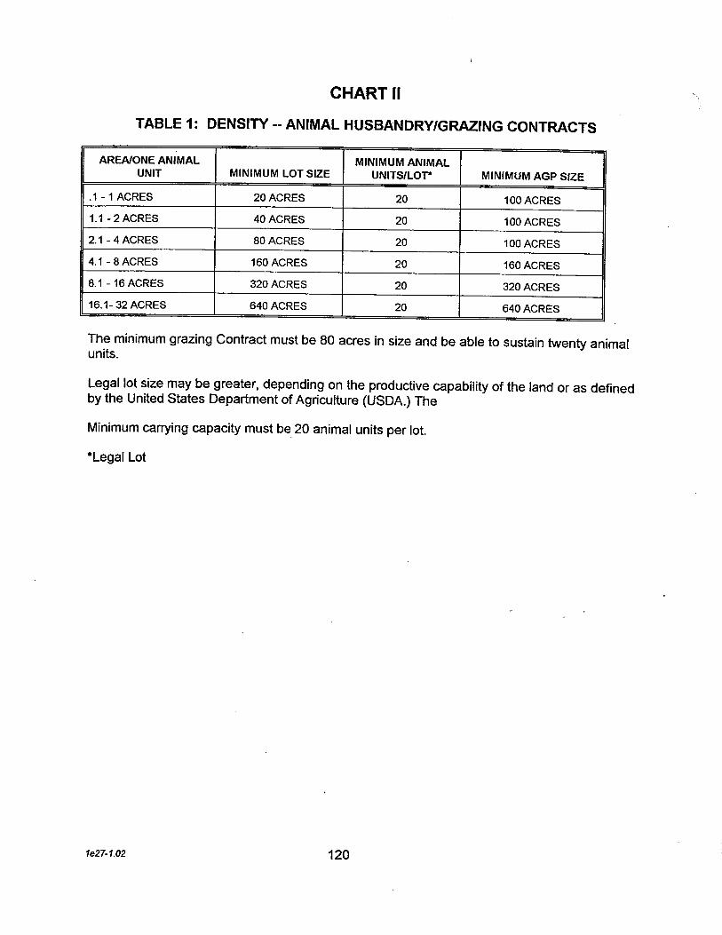
CHART II
TABLE 1: DENSITY -- ANIMAL HUSBANDRY/GRAING CONTRACTS
AREA/ONE ANIMAL MINIMUM ANIMALMINIMUM AGP SIZE JUNIT MINIMUM LOT SIZE UNITS/LOT*
,1 - 1 ACRES 20 ACRES 20 100 ACRES
1.1 - 2 ACRES 40 ACRES 20 100 ACRES
2.1 - 4 ACRES 80 ACRES 20 100 ACRES
4,1 - 8 ACRES 160 ACRES 20 160 ACRES
8.1 - 16 ACRES 320 ACRES 20 320 ACRES
16.1- 32 ACRES 640 ACRES 20 640 ACRES
The minimum grazing Contract must be 80 acres in size and be able to sustain twenty animalunits.
Legal lot size may be greater, depending on the productive capabilty of the land or as definedby the United States Department of Agriculture (USDA.) The
Minimum carring capacity must be_ 20 animal units per lot.
*Legal Lot
1e27-1.02 120

TABLE 2: ANIMAL HUSBANDRY UNIT EQUIVALENCY GUIDE
REQUIREMENTS PER LEGAL LOT
TYPES OF AGRICULTURAL ANIMALS ANIMAL UNIT 20-ANIMALFACTOR EQUIVALENCY
ALPACAS 0.50 40
BISON, BUFFALO, BEEFALO 1.00 20
BOVINE (COW, COW WITH CALF, BULL, OXEN) 1.00 20
CHICKENS (HEN, ROOSTER) 0.10 200
DEER 0,50 40
DUCKS 0.10 200 .
EMUS 0.30 67
EQUINE (INCLUDING DONKEYS, BURROS, AND MULES)
SMALL - UNDER 36 INCHES. 0.30 67MEDIUM - 36 TO 38 INCHES. 0.50 40LARGE - OVER 58 INCHES. 1.00 20
GOATS 0.20 100
GEESE 0.16 125
GUINEA FOWL 0,50 40
HOGS/SWINE 0.50 40
LLAMAS 1.00 20
OSTRICHES, RHEAS 0,50 40
PEAFOWL 0.50 40
PHEASANTS 0.16 125
PIGEONS/SQUABS/QUAIL 0.10 200
PYGMY GOATS 0.25 - 80 ,-
RABBITS 0.05 400
SHEEP 0,20 100
TURKEYS 0.16 125
Other animal categories shall be considered on a case-by-case basis and as included in theamendments to the Ventura County Zoning Ordinance.
*at the wither
1e27-1.02 121

(This Page Intentionally Left Blank)
1e27-1.02 122

APPENDIX 5CALIFORNIA DEPARTMENT OF NAVIGATION AND
OCEAN DEVELOPMENT (DNOD) SURVEY OFVENTURA COUNTY BEACHES (1977)
1e27-1.02 123

(This Page Intentionally Left Blank)
1e27-1.02 124

\
i~;i;i~~1:1:1.1.1::~.:::~..=.......~........_.........-........._.........................................................-..=::......................-_.........................:=::........-......--.............-...........--...._.....-..~_..._-........-_..¡1itr.l!i55.l
..... ..... -..........................._....................................._.---..............:::tttttt........-_.._..........----::~.......-_................._..::.:.::+.uui:.........--£e5........=.~....=._-rJ....----ll--._..-----._.=--------...--.-------..nnu:nii-_..--..---.--..-._----H1HLH!:tnr:::':1;II:U+:' li l:tt
Nan sa en ca be wi. of ro bI by wavb1ufwi ia cu in fac. Freuent
Ro pol ot ro wi namJsa en COe beh tied by_ subjlO dam_ dut hi ,,"wa co. "---------------------------------,
Nan san bell wilh oKsh robaed by ro revetmt of 'reeayemb8nl an ralkoad, FreaysublO tIng,
----~bebåëkëdbv-tišši~ëC----------J.~-to dam during high wave cond~ions, 'l .---------------------------------- -Ro po en Ofe ro ref will /.,. "co en sand bell. Eroionenel ho en moel, ,:.~ . "_________________________~ ______J\
Wid sa beac baed byro.niled hihway fiR. Sad befor by highway fi ec as a gron.
---------~--------------------------f . y:'
Nan sa en coe beac willoffsh ro baed by ro seawa.hos, an pa feçli Watesepage 10 bell ir irialed fie x
---------------------------------- ~:
N~ sa en c: be baedby ro nitmnt an coete seawa.Ro su to damag du higwave coa fro wave ovpp.
~- _L_..SCONEIiU
----~~~šM~Kh:~-----~~~ ro baed by lo coe . '(en ro nienl pa faies an .----~~--------------~--~,'
. SHEUE CODITI .. --- ~ ...-_.COCA _.. --. ---- E -- ....;0..:... --:::O::;'.o;::~:~ -.. D STAa.. OO
sæ OF CAFORNIA THE RESOURCES AGENCY IlDEPARENT OF NAVIGATION & OC DEVLOPMENT
.."
125
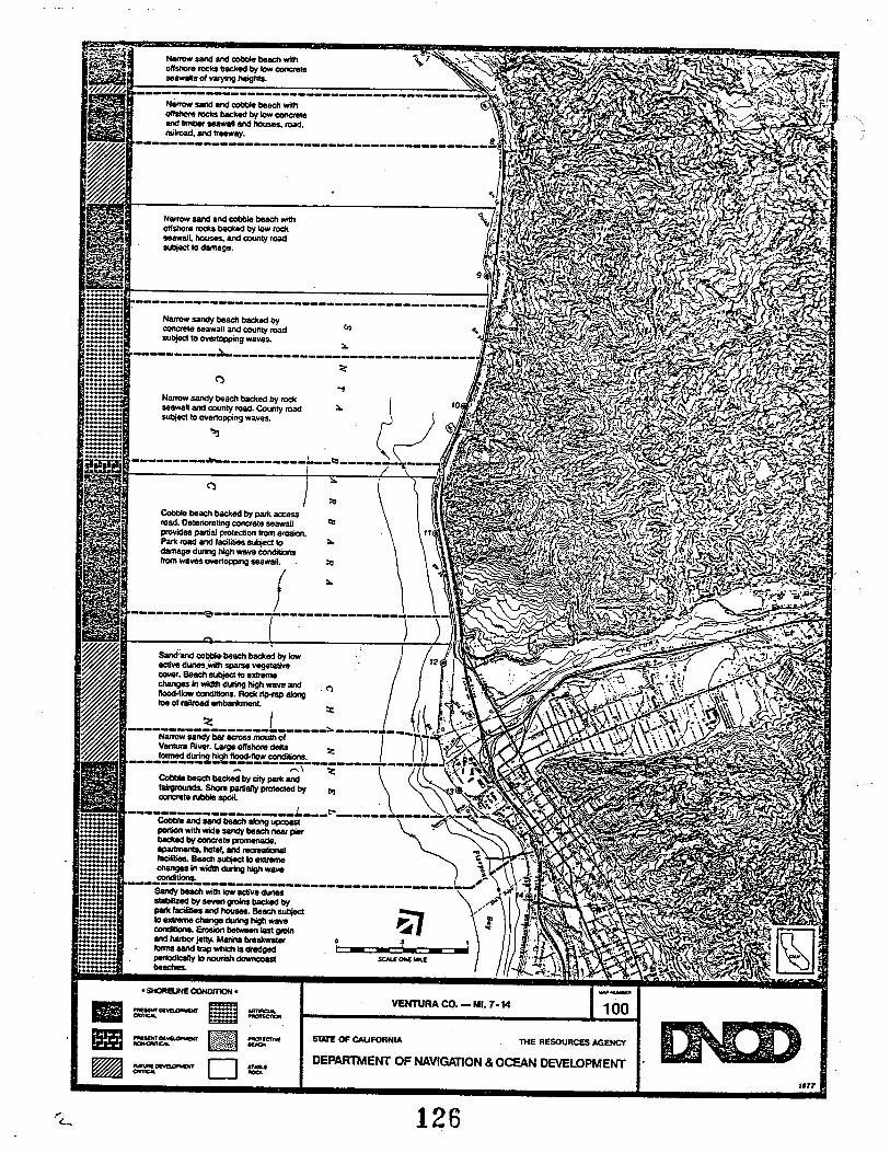
.....-.....-........?.:..::=.......-................ËË-mgOO.......b:æ::::::mE..-
~:
Nan sa an _ beac wiOfshr. ro b8ed by low roseawal. ho an coty rosulO damage,
Na sand an _ beac wioflS/. ro baed by lo cotese_1I 01 va Il,---~~::::~:~:;---------------------~~~=:ro=ik=d ~~~ ~\., ra,ani-ay. 8 ,\
-------------------------------------------,' ~ -
Jr1-,;
------------------------------------------Nar sand beac baed bycot. seawall an conty rodsubj 10 ovrt wav...
c.
:.----------~-----------------------------~
('""
Nar say beac baced by ro iseawan an coty ro. Conty road:" )suec 10 OVeroppng waves. r --~ i' \\---------~-------------~-------.---
i
)(' :.
~Co beach baed by pa acssroad, O.I.riling cor.l. seawal
prvi paal protecon fr .roio.Pat ro an lacili subj toda dur hig Wl condfr wave ..nop seawal.
f:. \---------e-------------------___~_____
ti
:.
~
Saan cobl beach baced by lo ' 12lI dunj"il sp velico. Beac su 10 .xt..c: in wld dur hih wae an . C"ftlo co, Ro ri a/
Na sand ba &c mo 01 /) 'L "Venhl Ri. La oi de:i " ..----~~'2!:~~~-~.;------------7t- .' ..,~ ,
Coa be&e ~ byci pa'; \:i \ ~~,,:'~ )~Ia Sh paaR prteced by ti 3 .~ "cot. ru sp , ~ '\ ~
--------------______L___~____________ ~ ~ ~ - ~~Co an sa be alo up \.' .,po with wi sa beac near pir \.~'ba by co.te pr,ap ho an i-ali .'l- Be au to __ 0: -ch In wi du hih wa "\ ,f\coti ,- \), . '"
---æ~~~5~------------~-------~-/: ""~-~' 4 ~. .to ex ch du hi wav ~.:' ~ 'co Er be la gi - i'an Iw je~ ~a br_atar ... ': ~ -. . " ,Io sa ti wI is dn - - i. - .. .,~. " ipe to no __ $C ON .. L ..: \be ,,~... '. SHBJE COIT . --
""-- VENRA CO. - MI. 7-14 100II =-- ~mi =~- i(~¥.rtttl~~-D
'~
S' OF CAFORNIA llE RESOURC AGENC ~~l-l1C......""
DEPARENT OF NAVIGATION & OCE DEVLOPMENT
"77
126

._..-.........
g!mll:.:!!!i:æ:r.::==:...._'i::::::.......'i.....'i..._.'i........'i.....
...~
Sa beac wi lo aciv dustallied by se gr baed bypa lacinies an hose BeaclUto._ cI du high wavecoilio. Ero betwn las gran ha je, Mari lJakwalerlos sand trp whic is dreedpeiclly to no doncasbeacS.
. SHELE CODITIO . VENRA CO. - MI. 15.22I"SE DEl... ~~~-
D .877
---.crOf
Il US1Te OF CAFORNIA THE RESOURCes AGENCYMlsv DEELQlNr-- -..-fU OE'4~N1'.. ....""
DEPARENT OF NAVIGATION & OCE DEVOPMENT
127 '...

~::::EE....._... ::::::.::::::::::::::::..-..--:::::==................:::~..............::.::.~"..........................ff1iü:....~:::::::::::::::::..........................šUh1::::::::i~..................." .........._........ ..................i::r::.:+:::......%...................................:::.+:+:..... t:........
1:::::.+:.................õ..................-...............~ ifftliæ ----------~.........--...........-......l................ ....... .......--.-..................:mæ..................................l...............-_........l.........l..........................t.......... ::::...........l......l::.......l........,.n:::::...-_.....................::i~-.-._-.........--, ........--..............t........::::::.....~:::i:::........--_._.-_.....-'--................._..---:i:i:,u'"_................_........_..........-.-....................-!E:......-....:::.i--._-........-.......--..---mm:i=_.lllill1m --------------------------------...-.......-........imnm........_...........
II.~.~
Wid sa _wi lO aciv dubaed by ho, Beac slUzed byChnn Is no je.
"
Wide sa beac wi ac dunebaced by perk faclites, apnlS,an inUSli tr Beac periiclyno_ wi sand drge at ChanneIsan Ha sa lr, Subjec toextem ch In with, Par lacililiessu to damege during high wavecoti
~I ¡
- ~Ii - -.-$C ON "'a.E
--------------------------------
Wi sa beac with na migfl"!du baed by navallacil anpe la. Periicly nori bydI at Cha Isla Har satr. Beii SUIO extme ctng
Na sa beac fo ~th ro grons ba by nafacit Se ro subjlOdaag,
. SHEU CODmON' VENRA CO. - ML 22-28----- ~~E.¡~¡",,,,:
....,.....:~:~:€::.;!.¡.:
D 'an
--..!C"'
ST OF CAI'RNIA....-- THE RESOURCE AGENCY-.._1l..- ST..""DEPARENT OF NAVIGATION & OC DEVLOPMENT

, ll:iir.~1~1.1'II~IIljll:J!IIC~~li11¡lilll.11.'.'.~.ili:.~h1.111111.11'1.111111I11I1II1.111111.I.I'~I I:'IIIljI,1Ii1 .!111:1:11
i.iil..i..~........................................r.r.i~~
lll~r...::::.......:::~....I.
...~
I¡.- - --
5CE ON ..
,..
.."t
Na sa beac baed by loii dunes an navalfacili. BesulO extem chs in.wibe noshl pe. :i
C'
..Sa spwi na s!rp or lo dusa baced by naal facit an rosewal.
"l
..
C'Sa beac be by lo nadun Slp an lago Rma raeen by aro
o\.l .----------------------------------------~ .
..
Ro sho wi oflsl ro ~Ir ro prtr. an smalpo beecs bac by ro ruemtikmnlol hillay. Frentalid Embkm maed by spdu ov seew ed. Z---------------------------------------------
WI sa an co beac wih loii dune baed by pai facliH"ig sa dune aginsl Sleep
ine al do and 01beac. Park ia suecl to ci.
. SHOReiNE COOt .
l' DEWLClNTCA_ ~~~-D
VENRA CO. - MI. 29-36-....oc"" Ilsi OF CAFORNIA TlE RESOURCE AGENCYI'NT~'_01"_ -lcr..DEPARENT OF NAVIGATION & OCE DEVLOPMENT~or~rCA_ ....""
'577
123,.
,,'

:n!::!~:.........-..-.::.--.-
:.~~'C..::
!~t:~¡¡ml~t........t..._..::H:=äiiËfft...................-....t........:¡H:-::::...-....t.............-.._......::::::::gËËË!............................::::::-.::....... ,.:::':::$..........
!ir::1ñi::::::::................:!~.. .
Ro pani ., onshre ros baced by ro rubb --: .emnkm of higway. Coete seawaR at severalIoiio.
-------------------------------Narr sand beach wi shrtinffecive coel8 grns and rocyprottions baced by highwayemankment. Wave eroson at base 01higway embankment with roc rip-rapprotecion alfrequet lotion whembankmen li no prtecve beac.
~t-- _ L _ ..5C1E ON MI
Say beac baed by I1wayemankmenl an lo b1n with /lesbuUt along bech and embankment.Hos subje to damage during highwave cotions.
---~y~~~~i;hig~y----------embenkml paital proteced by ro---~~---------------------Sand bell baed by lo blull antiay wi hoses an coinimscosted on bell and in lac 01bluf. Subj to dae dung high---~~~~----------------Na sa beach baed by ergbluf wi freque slide Hose atba 01 bi su to dae durnghih wav coti.
VEN \-41.------------------------~ -\ '\
~
Sand beac ba by narow beal bas of ating din with mansm sl Higay cu aJ nawcaia be at bas 01 slee moutan, Cr dea sulo C'8C an er coti
------------------------------Narr ro an sa beac baedby ro wava cu din 01 cota ter.Ho bul al to 01 di.----------------------------
..mi~
/f.
Sand poet beac _ ropots wi oIa ro baed byerod din wi ti on lop, Hoeson beac at ba 01 diff suje todaag dung I1 wave coti.
. SHE CODIT .------ ~ Mf-iCI~ IITtC'..~-~,-----_OC D~Sl OF CAFORNIA ~~THE RESOURCES AGENCY
DEPARENT OF NAVIGATION & OCEA DEVLOPMENT
fi"
130

APPENDIX 6
POLICY FOR LOCATION OF ON SHOREOIL FACILITIES (1968)
1e27-1.02 131

(This Page Intentionally Left Blank)
1e27-1.02 132

/'
..\
STATEMENT OF POLICYFOR LOCAïlON OF
OlN SHOlRfE(ÖJ~L ---fAC~L~TUfES
-
"AN 16, 1968
VENTURA. COUNTY. PLANNING. DEPARTMENT- --
- --
183

VENTURA COUNTY BOARD OF SUPER VISORS
Mr. Howard F. Robinson, ChairmanMr. John T. ConlanMr. Ralph R. BennettMr. Joseph N. AppJetonMr. Thomas E. Laubacher
First District
Second District
Third DistrictFourth DistrictFilth District
Mr. Loren W. Enoch, County Executive
VENTURA COUNTY PLANNING COMMISSION
Mr. J. N. Sweetland, ChairmanMr. Stanley Bunce, Vice-ChairmanMr. Scot ty HarrisMr. John RushMr. Alan Robertson
VENTURA COUNTY PLANNING DEPARTMENT
Mr. George H. Allen, i\cting Planning DirectorMrs. Dorothy M. Rogers, Project ManagerMr. Karel Dekker, Senior Planner
The Ventura County Board of Supervisors adopted the Statement ofPolicy for Location of Onshore Oil Facilities on February 20, 1968.
13.1

A C KNOWLEDGMEN TS
The time and coordinated effort toward the design of this
policy by the following people is greatly appreciated.
Mr. B. B. Haggard, Ventura County Fire ChiefMr. Fritz Huntsinger, Vetco Offshore Industries, Inc.
Mr. Henry W. Wright, Western Oil and Gas AssociationMr. William B. Price, Mobil Oil CorporationMr. G. L. Laurent, Standard Oil Company of CalifQr-niaMr. Frank R. Davis, Phillips Petroleum Company, .Mr. A. W. Williams, Shell Oil CompanyMr. Gene Grüfin, Union Oil Company of California
Mr. Gerald C. Lafferty, Planning Director, City of VenturaMr. Jerry Draggoo, City of Oxnard Planning DepartmentMr.!. H. Housley, City Engineer, City of Port Hueneme
Mrs. K. Duane Lyders, League of Women VotersMr. E. D. Marsliall, Sierra ClubMr. Jack Morgan, Calüornia Coastal Conservation CommitteeMr. Ron Hertel, Commissioner, Ventura Port District
135

CONTENTS
Page
Introduction 1
Characteristics of theOnshore Facilities 2
Examples of Existing OnshoreFacilities in Santa Barbaraand Ventura Counties 3
Potential for Facilities and LandRequirements 5
Existing Conditions in VenturaCounty 6
Locational Criteria and Policy Map. 8
Development Conditions
Recommendation
Policy Map
136

STA TEMENT OF POLICY FOR THE LOCA TION OF ONSHOREOIL FACILITIES IN VENTURA COUNTY IN SUPPOR T OF
OFFSHORE OIL EXTRACTION OPERATIONS
INTRODUCTION
The petroleum industry has contributed significantly to the growth of
Ventura County for several decades. In conjunction with the industry program
for exploration in coastal waters, the L'lmediate need to plan for supporting
onshore oil facilities is apparent. The purpose of this policy is to guide the
location of onshore oil and gas handling facilities in Ventura County into areas
located to serve the industry as well as protect natural scenic resources and
other urban surroundings.
The production potential of Federal leases on the Outer Continental
Shelf beyond the three mile limit will require processing, storage and marine
shipping facilities. The very nature of the entire operation indicates its
orientation to the coastline. The importance of preserving this natural
resource along the 43 miles of its length in Ventura County should be considl?red
on an equal basis with the policy for the location of onshore oil facilities. Areas
best suited for potential residential and recreational use are of prime concern
and should be protected by the policy.
137

Page 2.
CHARACTERISTICS OF THE ONSHORE FACILITIES
For clarification, the different tyes of onshore facilities are
described as follows:
1. Oil, Gas and Water Separation Plant
This facility splits the normal oil well production stream into the
separate components of oil, gas, water and sand. The facility consists
primarily of pressure vessels, storage tanks. heating equipment and
measuring equipment. .
2. Gas Processing Facility
This facility is used to extract liquid natural gasoline and! or propane
and butane from natural gas. The facility consists primarily of pressur
vessels, compressors. heating equipment. heat exchangers and pressure
storage tanks.
3. Tank Farm
The tank farm consists of various numbers and sizes of crude oil,
storage tanks. It is used to store clean crude oil prior to its shipment to
a refinery. Shipment may be by truc k. tank ship or pipeline. The size of
the tank farm is dictated primarily by the method of transportation, i. e.,
tank ship transportation requires more storage than pipeline shipment.
4. Marine Terminal
The marine terminal is used to load crude oil onto a tank ship from
the tank farm. It consists of either a wharf or an oUshore mooring for
securing the tank ship during loading. Pipelines run from the tank farm ~v
the wharf or mooring.
138

Page 3.
EXA MPLES OF EXISTING ONSHORE FACILITIES INSANTA BARBARA AND VENTtJRA COUNTIES
Phillips Petroleum Plant - Ventura County (under construction)
The nature of the proposed Phillips Petroleum Plant is to separate
gas, water and oil brought in by an underground pipeline from offshore
drilling areas. Compressors are to be enclosed in buildings and equipped
with mufflers. .A 54-foot high, 140-foot diameter storage tank, above-
ground pipelines. fencing. security lighting, and office buildings are some
of the items to be constructed on the site. This plant is expected to set a
high standard for site development and to be a model for other,uses of this
type which are similarly located.
Chanslor- Western - Ventura County
The existing oil facility located in the vicinity of Sea Cliff contains a
diversification of processing activities and is a detraction from the scenic
coastal highway. The scarred blackened hillsides and exposed equipment
are incompatible with the surroundings. Ventura CouIltyls coast~ine is
marred by this character of site development. If natural scenic values
had been protected or ü a huffer belt had been required at the time of
construction. this existing plant would be less objectionable.
Union Oil Company - Citv of Ventura
This facility is a tank farm located adjacent to the Ventura Marina.
The tanks are painted light green and a minimum amount of landscaping
is apparent. However. the facility does fit into its surroundings without
being obtrusive.
139
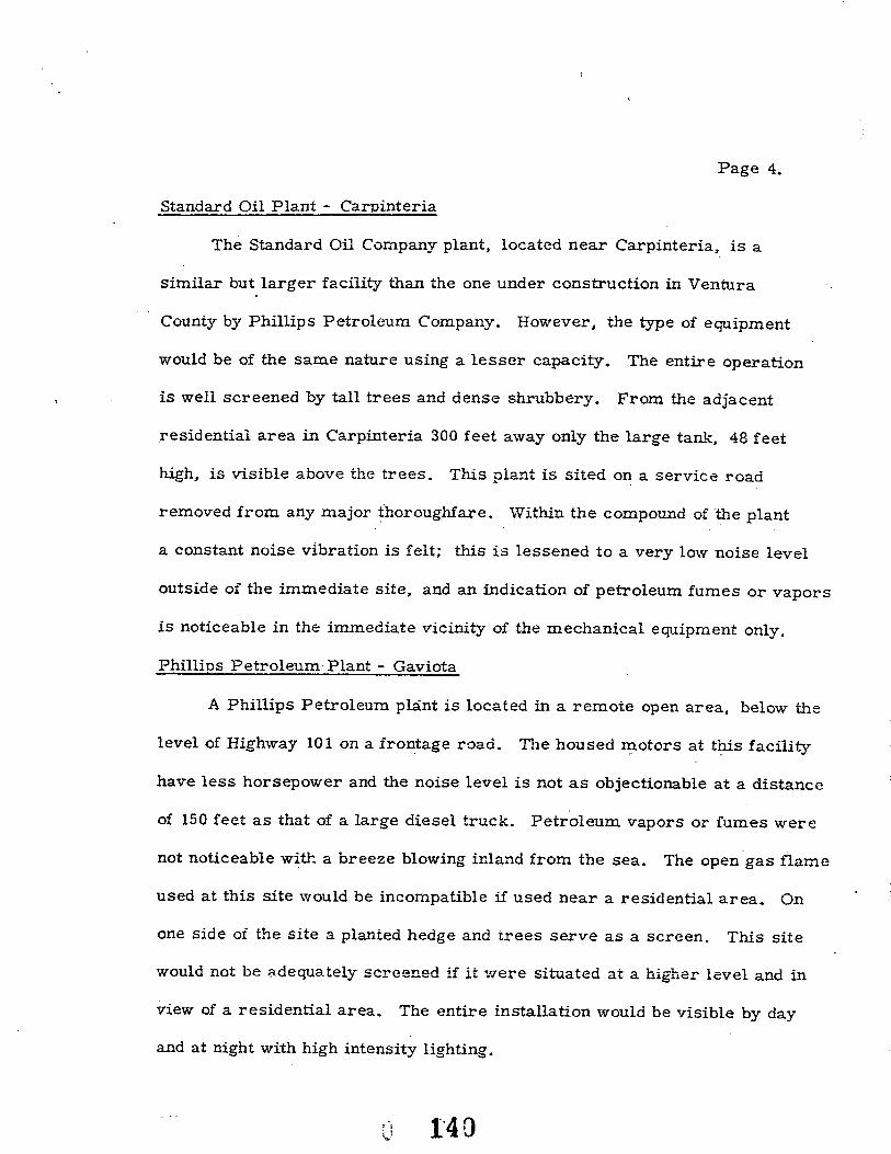
Page 4.
Standard Oil Plant - Carpinteria
The Standard Oil Company plant, located near Carpinteria, is a
similar but larger facility than the one under construction in Ventura
County by Phillips Petroleum Company. However. the type of equipment
would be of the same nature using a lesser capacity. The entire operation
is well screened by tall trees and dense shrubbery. From the adjacent
residential area in Carpinteria 300 feet away only the large tan.l-, 48 feet
hih, is visible above the trees. This pla."1t is sited o~ a service road
removed from any major thoroughfare. Within the compound of the plant
a constant noise vibration is felt; this is lessened to a very low noise level
outside of the immediate site, and an indication of petroleum fumes or vapors
is noticeable in the immediate vicinity of the mechanical equipment only.
Phillins Petroleum Plant - Gaviota
A Phillips Petroleum plãnt is located in a remote open area, below the
level of Highway 101 on a frontage road. The housed rrotors at ttis facility
have less horsepower and the noise level is not as objectionable at a distance
of 150 feet as that of a large diesel truck. Petroleum vapors or fumes were- .not noticeable witi a breeze blowing inland from the sea. The open gas flame
used at this site would be incompatible ü used near a residential area. On
one side of the site a planted hedge and trees serve as a screen. This site
would not be ~dequately screened if it v/ere situated at a higher level and in
view of a residential area. The entire installation would be visible by day
and at night with high intensity lighting.
1'40: !\:1

Page 5.
POTENTIAL FOR FACILITIES ..\ND LAND REOUllEll¡IENTS
The four different types of facilities - - separation plants, gas
processing facility, tank farm and marine terminal - - will be needed
and applications for locating such uses can be anticipated. Such uses
are industrial in nature and would generally be considered Conditionally
Permitted Uses in an M- 3 zoning district. Changes of zone and/ or
conditional use hearings would be necessary prior to the location of the
types oI- facilitie s described.
Representatives of the industry hav'e indicated that not more than
ten firms would be interesteà in constructing onshore facilities. The.
e.xtent of the constrction would naturally depend upon the amount of
petroleum found as a result of àrilling experience. _A need for oil refin-
eries is not anticipated.
A s indicated by industry representatives, the minimum amount of
land required for an onshore oil facility would be approximately 10 acres,
plus underground easements for pipelines to the sea. The ma.ximum
acreage to be required '.l-'-ould be 40 acres. Such a large site coulà possibly
serve a combined operation of tank farm and marine terminaL.
These land requirement iactors should be considered when an applica-
tion for a facility is reviewed. If the facility is proposed to be located in
an area where landscaping or bUÌier belts are required, enough land shouLd
be provided tQ Qffe;ctively serve 'UòSe ends.
1"1' :~.L

P ag e 6.
EXISTING CONDITIONS IN VENTURA COUNTY
Locations of Existing Oil Operations
Existing oil field activity in the North Coastal area extends from
approximately one half mile south of Punta Gorda to the Ventura River
and several miles inland. At certain points oil facilities are located
adjacent to Highway 101 and in other areas they can be found in barrancas
and scattered within the surrounding hills. The recentiy approved facility
for the Phillips Petroleum Company is now under construction 1000 feet
north of La Conchita Del Mar, fronting on the highway.
In the southern half of the Coastal area, the existing oil facilities
are located to the east of the City of Ventura and on both sides of Harbor
Boulevard to the Channel Islands Harbor. Oil and gas wells are scattered
in this area with a concentration in the vicinity of McGrath Lake. Part of
this land along the beach front is proposed for an addition to McGrath State
Beach Par k.
Existing facilities in bóth L"ie North and South Coastal areas contain
various types of activities from oil wells to large tank farms.
GENEIUd.. COASTAL CHARACTERISTICS AND LOCA TION POTENTL~L
North Coast
The North Coastal part of the County from the Santa Barbara County
line to the Ventura River has extremely rugged and steep terrain. Small,
::eparated areas of land with less than a 30 percent slope can be found
\vithin this mountainous area. Two larger areas are also evident, one
near the Santa Barbara County line and the other on the Taylor Ranch,
north of the Ventura R~ver. .Appro:dmately 75 percent oj' the land is
r4Z.

Page 7.
undeveloped although many oil wells and roads exist in the hills and canyons.
All bnd north of the Ventura River is presently under County jurisdiction.
Three smnn parks oi less than five acres each are located on the
beach. The Emma Wood Park, consisting oÎ 14 acres, is included in tl:e
Regional Parks Plan. .Also included in the Parks Plan is a proposed 150
acre park located on the high slopes east of La Conchita Del Mar.
Of the four existing residential areas, Rincon Point, Sea Cifff and
Solimar are widely spaced along the beach front. La Conchita Del Mar is
the only area located east of Highway 101. All oi these residential areas
are limited in the amount of developable land available Ior future growth.
The new freeway alignment for Highway 101 will lessen the amount
of developable land on the coastal shelf. This part of Highway 101 is
classifieà as a scenic highway.
South Coast
The South Coastal area is mainly fiooà plain \vith mountainous areas
south of Point Mugu. From the Ventura River to Point Mugu the land is
highly developed including two large Naval installations, Port Hueneme
Naval Reservation and Point Mugu Naval Air Staiion; also n:vo st ate parks,
McGrath State Beach Park and Point Mugu State Park. ::lost of the land is
under the jurisdiction of the Cities of Ventura, Oxnard or Port Hueneme;
less than 20 percent is under County jurisdiction. The balance is controlled
by the State of Caliornia or the United States Navy.
The Cities of Ventura, Oxnard and Port Hueneme are linked by Harbor
Boulevard, which is proposed as a scenic high\vay.
143

Page 8.LOCATIONAL CRITERIA AND POLICY MAP
A Policy Map has been prepared for the purpose of plannig general
locations for onshore oil facilities 'primarily in the North Coast area.
The Policy Map should be used in conjunction with the locational criteria
in considerin an application for a zone change and conditional use permit.
1. All land located between the new right-oi-way for Highway 101 and
the sea should be considered for residential or recreational use.
This land should not be included as a potential area for the siting of
any oil facilities.
2. Each application to construct a facility between the new right- of-way
for Highway 101 and the hills or in the hills area, as designated on
the Policy Map, should be in the form of a change of zone to be
approved in conjunction with a conditional use permit.
3.The location of facilities on the landward side of the new Highway 10 i
right- of-way are encouraged to use the canyons and barrancas within
the area generally designated as llexistig oil activity area" on the
Policy Map. Extensive landscaping should not be required in such
canyons and barrancas.
4. Facilities located outside the area generally designated as "existing
oil activity area" on the Policy Map should be located a minimum
distance oI 1, 000 feet from any potential residential area on the
landwarà side of the new Highway 101 right-of-way.
5. Facilities to be located within the general confines of the''existing
oil activity area II and adjacent to a potential residential area should
have a 150 foot setback from the common intervening property line,
except for uses such as administrative or similar activities.
. .14.1

Page 9.
6. The grouping of facilities should be encouraged on the landward
side of the new Highway 101 right- of-way adjacent to existing
facilities, so as to maximize the scenic highway designation of
Highway 101 and to permit the full utilization of the coastal area
for all types of private and public uses. The approval of a facility
in such an area should require extensive landscaping.
7. In the South Coastal area possible sites for onshore oil facilities
within the County jurisdiction are limited. However, the land
within the oil activity area and adjacent to an existing industrial
facility should be considered.
8. The Cities of Ventura, Oxnard and Port Hueneme should establish
their own locational criteria and land adjacent to the Port Hueneme
Harbor or in industrial districts may be desirable for processing
facilitie s.
145

DEVELOPMENT CONDITIONS
A set of standard conditions as follows should be attached to
the approval of an application, plus any specific conditions whichmay be applicable to a pertinent application:
1. The compatibility of each facility shall be considered from thestandpoint of noise, vibration, odor, air pollution, visibility,lighting, traffic, grading, flood and erosion control, land andwater pollution, public safety and its impact on potential
development of surrounding areas.
?-. All structures shall be painted in blending colors or camouflaged.This may be altered where the structures are not exposed topublic view or whe"re other locational factors apply, subject to the
approval of the Planning Director.
3. All entrance gates fronting on a public road shall be architecturallv: . . oJdesigned and constructed of masçmry.
4. All lighting shall be shielded so as not to shine on adjacent properties.Visible gas flares are not permitted.
5. Petroleum odors or vapors shall not be allowed to emanate Îromthe installation.
6. The permit area shall be completely surrounded by a two (2) inchmesh chain link fence constructed to a height of not less than six (6)Ïeet and containing no openings except those actually required for
ingress, egress and emergency, as shown on the plot plan.
7. No parking space shall be located within ten ( 10) feet of ~ vehicularentrance to the property. All parking areas shall be surfaced withasphaltic concrete and shall be suitably marked, outlining individualparking spaces and traffic flow.
8. There shall be no ingress or egress to the property except as shownon the plot plan. That the width and improvement of any suchentrance shall be as required by and in accordance with the speciìi-cations of the Department of Public Works.
Q~ . All asphaltic dil~es, berms and bank stabilizers shall be paintedwith a colored emulsion coating to blend with the landscaping,except in locations not exposed to public view.
l46

10. Prior to construction the permittee shall submit a drainage andgrading plan to the Subdivision Engineering Division of theDepartment of Public Works for processing and approvaL.
11. 1Hl debris from clearirg of the site shall be disposed of oÎf thesite and shall not be deposited in any flood control channel ornatural water course.
12. Prior to construction, the permittee shall submit plans to theDepartment of Public Works for its approval of the location, typeand adequacy of water lines, including fire suppression waterrequirements of the Ventura County Fire Department.
13. Provisions for fire prevention and fire suppression shall be inaccordance with the Ventura County Fire Protection District
Ordinance No.6 and approved by the Ventura County Fire ChieI.
14. Sewage and wast~ disposal shall be only by means of a systemapproved by the Ventura County Health Department.
15. Prior to any construction the permittee shall inquire oÌ the Ventura
County Health Department if the land for which a permit is issued,or any portion thereof, is located within a critical watershed areaso designated by Ordinance No. 693 or any amendment thereto. Ifthe land is located in such a critical watershed area, the proposedsewage disposal system shall be as approved by the Ventura CountyHealth Departinent as required by said Ordinance.
16. All rules and regulations of the Los Angeles Air Pollution Control
district and the Ventura County Health Department shall be includedin regard to air, water, discharge, amount of gaseous substances,dust or smoke as a part of the applied conditions.
17. The exercise of any right granted by this permit shall conform inall respects to the regulations and requirements of the CaliforniaState Regional Water Quality Control Board No.4.
18. The Southern Pacific Railroad shall be consulted regarding easementacross their railroad line.
19. The applicant shall be required to use the latest Ìunctional soundproofing equipment to i.nsu r0 thot t,he operation is quiet.
20. No normal operational vibration shall be permitted which is discerniblE:at or beyond the zoning district boundary \vhen the use or activity isin customary operation.
147

21. Prior to construction a zone clearance shall be obtained fromthe Ventura County Planning Department and a building permitshall be obtained from the Department of Building and Safety.
22. ini requirements of any law or agency of the State, VenturaCounty, and any other governmental entity shall be met.
23, Necessary oil and gas lines coming in from offshore shall beburied under the beach, freeway and railroad so that there willbe no change in present beach use, view or contour.
,
24. A landscaping plan shall be submitted with the site plan wheroethe location is within public view.
25. Prior to the approval of a final grading plan, a geology report,
prepared by a qualified geologist, shall be submitted to theDepartment of Public Works for review.
RECOMMENDA TION
IT is RECOMMENDED THA T:
The Locational Criteria, Policy Map, and Development Conditions
be adopted as policy for guiding the location of onshore oil facilities in
Ventura County.
148