coastalgeomorphology - inflibnetshodhganga.inflibnet.ac.in/bitstream/10603/7485/9/09...the survey of...
TRANSCRIPT
47
3Coastal Geomorphology
The Kachchh coast
Geomorphology is the science of studying the external landscape architecture of
earth’s crust, which stands as a testimony not only to the palaeo-morphotectonic and
morphodynamic activities but, for the present day geological processes as well. The
coast forms a transition zone between the land and a major water body or a space
wherein terrestrial environment influences the marine and vice versa (Carter, 1988).
The coast is classified either based on origin of the landforms (e.g. Emerging,
Submerging, Outbuilding and Eroding coasts of Valentin, (1952) referred to in
English by Holmes, 1978) or based on the form of the landscape (e.g. Deltas, Reefs,
Mountain, Headland and bays, etc. of Inman and Nordstrom, 1971). Ahmad (1972)
has classified the Kachchh coast as a ‘submergent (estuarine) coast’. Kar (1993)
divided the Kachchh coast in to five segments based on the style of landforms viz.,
deltaic coast, irregular coast, straightened coast, spits and cuspate foreland complex,
and mudflat coast (Figure 3.1). As mentioned by Firth (2000), none of the
classification of the coasts mentioned above is ideal, and to understand the true nature
of a coast both, genetic as well as descriptive terms are required. Depending upon the

Late Quaternary Morphodynamic ………..W. India Chapter 3
48
need, especially for coastal management purpose different schemes of classification
have been employed.
One of such commonly adopted scheme in India is proposed by Nayak (2000;
2002) which has used the scale of mapping as base to group the geomorphic forms in
to the Level-I, Level-II and Level-III categories with increasing scale. Accordingly,
the Level-I features include vegetated and non-vegetated coastal areas, water bodies,
shore land and other man made features whereas, the Level-II includes all major
landforms in its descriptive sense like mangroves plantation, mudflats, sand, bays,
lagoon, delta plain, back swamps, coastal dunes and ridges, etc. The Level-III specify
Figure 3.1: Regional geomorphic setup of the Kachchh coastline (After Kar,1993).

Late Quaternary Morphodynamic ………..W. India Chapter 3
49
the features at much higher scale like intertidal zone, high tide and low tide lines,
spits, bar, chennier, tidal channel, dense and sparse vegetated areas, etc. For the
present study author has largely used the descriptive terms which either depict the
sediment nature or the style of geomorphic unit.
The coastal geomorphic system is a most sensitive system that always tries to
be in equilibrium with its environment either by deposition of sediments or by
erosion of the once formed landscape. Both, the depositional as well as erosional
features thus provide an insight on the coastal response to eustatic and/or tectonic
changes in the region (Carter and Woodroffe, 1994). The dynamic nature of coastline
gets readily reflected in its geomorphic variants at higher temporal scale. However,
appreciation of the control of lithology, structure, active systems that either input
sediments or provide conveyer system for the same and also the accommodation
space that provides sinks and sub-sinks to the sediments, comes from a better
understanding of the present day geomorphic scenario at spatial scale. It is therefore
necessary to identify, understand and document various geomorphic forms in the
study area. This chapter deals with the description, mapping and field documentation
of various coastal geomorphological assemblages along the southern and
southwestern coast of Kachchh. The area comprises of an interesting assemblage of
palaeo and neo coastal landforms which include spits, beaches, bars, creeks, beach
ridges, swales, raised mudflats, saline flats, non-saline flats, stabilized and active
dunes, chennier ridge/chennier plain, mangrove swamps, tidal channels, tidal flats,
etc.

Late Quaternary Morphodynamic ………..W. India Chapter 3
50
METHODOLOGY
The Survey of India topographic maps, other than field investigations, are very useful
to depict the primary and basic information of geomorphic and tectonic elements of
this terrain. These maps show a variety of landmarks and landscape information both,
natural and man made. The 1:250,000 scale maps provide regional geomorphologic
setting and other relevant information such as spot height, transportation network,
important localities etc. of the area. The 1:50,000 scale maps are very useful in the
identification and analysis of local ambiguities of the area. The primary database of
the study area has been generated with the help of Survey of India topographic maps
on 1:250,000 and 1:50,000 scales. The SRTM (Shuttle Radar Topography Mission)
derived Digital Elevation Model (DEM) was studied at various scales with various
views (orientations). The SRTM data for topographic information are acquired by the
National Geospatial-Intelligence Agency (NGA) and the National Aeronautics and
Space Administration (NASA) utilizing a radar system that flew onboard the Space
Shuttle Endeavour in February 2000. SRTM derived DEM is available with WGS84
datum and EGM96 geoid model at Three arc-second (~270’) for all the areas between
60º North and 56º South latitudes. SRTM is widely used for topographical, structural
and coastal landform studies on regional scale (Simard et. al, 2008; Kumar et. al.,
2010). Map-Info professional GIS (Geographic Information System) software was
used to prepare first generation geomorphological maps based on the satellite data
(Landsat and Google Earth), which were refined using more advanced graphic
software like the CorelDraw version 13. GIS software is widely used for preparing
Late Quaternary Morphodynamic ………..W. India Chapter 3
51
coastal geomorphic map since it allows to see various type of datasets in a single
window. Scanned toposheet and high resolution google earth images of the study area
were georefferenced by using Map Info Professional version 10 and then various
geomorphic maps were prepared for different segment of the study area. The various
geomorphic units identified and mapped are defined as under.
Sandy Beach
Komar (1976) defined beach as the zone in which coastal sediments are affected by
wave processes, but commonly the deposition of sediments along the shoreline are
referred to as the beaches (Reineck and Singh, 1980). In the study area beaches are
present for about a length of 110 kilometers in a linear form from Modwa to Jakhau
in the western part of study area. Whereas, these have a very limited extent like a
pocket beach in eastern most part of study area from Randh Bandar up to Kandla. In
general, majority of beaches are curved in outline from Modwa to Layza and many
of them are made up of a series of regularly spaced curved features between Modwa
and Navinal area. Minor geomorphic units of any beach like runnel, ridge, trough,
bar, etc. can be seen associated with the beaches of study area (Figure 3.2).
A marked landward ridge which forms the landward limit of wave swash is
referred to as the berm. Berm is prominently visible near Raval Pir location. Also it
has been observed all along the beaches between Modwa and Jakhau. In general,
beach morphology of the study area is highly dynamic and changes with wave
energy, sediments supply, longshore currents and substrate physiography. This gets

Late Quaternary Morphodynamic ………..W. India Chapter 3
52
manifested by change in the width of this zone, beach angle and patches of inliers of
older rocks. Beaches of study area contain mostly sand to medium gravel size clasts
those are mainly detrital. The beach deposits are also characterized by low angle
planner and trough cross stratification along with the biogenic structures mainly
related to the skolithoes and glossofungite ichnofacies. The surface structures like
various types of ripples and rill marks also occur.
Beach Ridges
Sandy beach ridges mark the position of former shorelines, forming where sand have
been stacked up by wave action along a prograding coast. Beach ridge is the most
common and extensively used term in the coastal geomorphology with reference to
its use as palaeo sea level indicator. Johnson (1919) introduced this term for the
Figure 3.2: A beach of Dhrabudi near Mandvi showing intertidal zone withforeshore ridge and runnel system.

Late Quaternary Morphodynamic ………..W. India Chapter 3
53
ridges constructed by waves along the successive shore position. Otvos (2000) has
redefined the beach ridges as “stabilized, relict, intertidal and supratidal aeolian or
wave built shore ridges that may consist either siliciclastic or calcareous clastic
matter of wide range from fine sand to cobble and boulders”. Such type of sandy
ridges and swales are found on Modwa coast and are linked with progradation by
Shukla et al. 2008 (Figure 3.3). Chenniers are low and long ridges of sand surrounded
by low lying mudflats. Chenniers ridges and modified chennier plains are also
available around Navinal to Mundra area.
Swales are a long, narrow, generally shallow, trough like elongated depression
between two successive beach ridges, and are roughly aligned with the coastline.
They form small valley (depressions) between two successive beach ridges. Generally
Figure 3.3: Geomorphic set up of Modwa and adjoining coastal areas.
Late Quaternary Morphodynamic ………..W. India Chapter 3
54
the swales are filled up with the subtidal or supratidal sand. Swales are present along
the coastline between Mandvi and Modwa area. A beach ridge that is no longer under
the influence of sea wave due to a relative drop of sea level or progradation at the
beach ridge base is called palaeo beach ridge. Paleobeach ridges are also identified in
the Bhada-Mundra segments of study area .
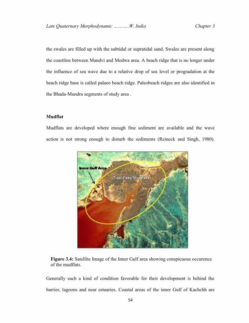
Mudflat
Mudflats are developed where enough fine sediment are available and the wave
action is not strong enough to disturb the sediments (Reineck and Singh, 1980).
Generally such a kind of condition favorable for their development is behind the
barrier, lagoons and near estuaries. Coastal areas of the inner Gulf of Kachchh are
Figure 3.4: Satellite Image of the Inner Gulf area showing conspicuous occurenceof the mudflats.
Late Quaternary Morphodynamic ………..W. India Chapter 3
55
very much suitable sites for the deposition of mudflats (Figure 3.4) because of the
availability of sediments (mostly suspended very fine grained), low wave velocity
and flat gradient.
The striking features of the mudflats are tidal channels developed within them
which are branched towards the landward side. These channels are formed due to
fluctuation in the tidal currents where the current velocity reaches up to 30-50 cm/sec
small current ripples are also produced.
The mudflats which are not in connection with the active tidal processes and
are flanking the active mudflats are termed as paleo mudflats. This unit is also
remarkable in the study area.
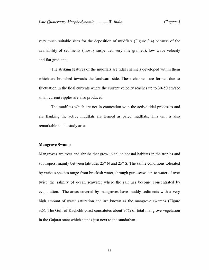
Mangrove Swamp
Mangroves are trees and shrubs that grow in saline coastal habitats in the tropics and
subtropics, mainly between latitudes 25° N and 25° S. The saline conditions tolerated
by various species range from brackish water, through pure seawater to water of over
twice the salinity of ocean seawater where the salt has become concentrated by
evaporation. The areas covered by mangroves have muddy sediments with a very
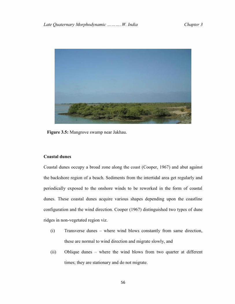
high amount of water saturation and are known as the mangrove swamps (Figure
3.5). The Gulf of Kachchh coast constitutes about 96% of total mangrove vegetation
in the Gujarat state which stands just next to the sundarban.
Late Quaternary Morphodynamic ………..W. India Chapter 3
56
Coastal dunes
Coastal dunes occupy a broad zone along the coast (Cooper, 1967) and abut against
the backshore region of a beach. Sediments from the intertidal area get regularly and
periodically exposed to the onshore winds to be reworked in the form of coastal
dunes. These coastal dunes acquire various shapes depending upon the coastline
configuration and the wind direction. Cooper (1967) distinguished two types of dune
ridges in non-vegetated region viz.
(i) Transverse dunes – where wind blows constantly from same direction,
these are normal to wind direction and migrate slowly, and
(ii) Oblique dunes – where the wind blows from two quarter at different
times; they are stationary and do not migrate.
Figure 3.5: Mangrove swamp near Jakhau.
Late Quaternary Morphodynamic ………..W. India Chapter 3
57
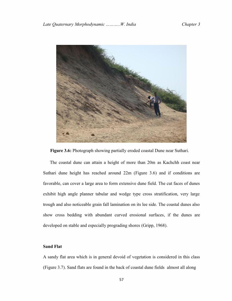
The coastal dune can attain a height of more than 20m as Kachchh coast near
Suthari dune height has reached around 22m (Figure 3.6) and if conditions are
favorable, can cover a large area to form extensive dune field. The cut faces of dunes
exhibit high angle planner tabular and wedge type cross stratification, very large
trough and also noticeable grain fall lamination on its lee side. The coastal dunes also
show cross bedding with abundant curved erosional surfaces, if the dunes are
developed on stable and especially prograding shores (Gripp, 1968).
Sand Flat
A sandy flat area which is in general devoid of vegetation is considered in this class
(Figure 3.7). Sand flats are found in the back of coastal dune fields almost all along
Figure 3.6: Photograph showing partially eroded coastal Dune near Suthari.

Late Quaternary Morphodynamic ………..W. India Chapter 3
58
the study area. This forms a transition zone between the shore area and the coastal
plain and gets inundated during monsoon time.
Tidal Creek
A tidal creek is the portion of a stream that is affected by ebb and flow of ocean tides.
Thus this portion of the stream has variable salinity and electrical conductivity over
the tidal cycle. No. of creeks are presents between Vandh and Kandla area. There is a
network of creeks and marshy tidal flats in the interior part of the Gulf of Kachchh.
The creek system consists of three main creeks namely Nakti, Kandla and Hansthal in
the inner gulf region.
Figure 3.7: Photograph showing barren saline sand flat near Modwa.
Late Quaternary Morphodynamic ………..W. India Chapter 3
59
Coastal Alluvial Plain
An alluvial plain is relatively flat landform created by the deposition of sediment over
a long period of time by one or more rivers coming from highland regions. A coastal
plain is an area of flat, low-lying land adjacent to a seacoast and separated from the
interior highland by a distinct topographic break.
The coastline of Gulf of Kachchh has been divided into four major segments on
the basis of ongoing processes and landforms developed therein (Prizomwala et al.
2010);
1. The straight sandy segment between Jakhau and Mandvi.
2. Crescent sand ridges and mudflat segment between Mandvi and Mundra.
3. Wide mudflat dominated segment between Mundra and Vadinar.
4. Narrow mud/sand flats and rocky cliff segment between Vadinar and Okha.
The present study is confined on the northern coast of the Gulf of Kachchh that
extends between Jakhau and Kandla. This part of the coastline of the Kachchh
exhibits three distinct depositional energy domains that have unique
geomorphological attributes. The northwestern part of coastline between Jakhau and
Bhada is relatively straight. Then Bhada to Mundra is a mix coast having both sandy
and muddy features in equal amount. Last segment has been marked between Mundra
and Kandla as a tide dominated coast. All three segments are described systematically
as follows.
Late Quaternary Morphodynamic ………..W. India Chapter 3
60
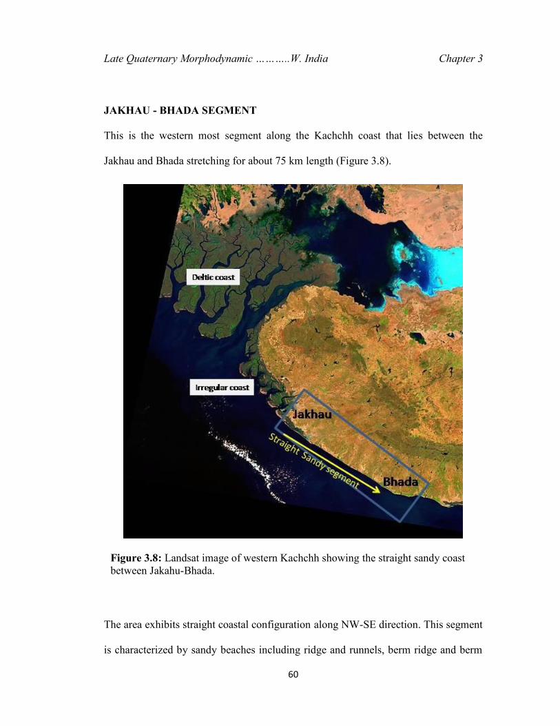
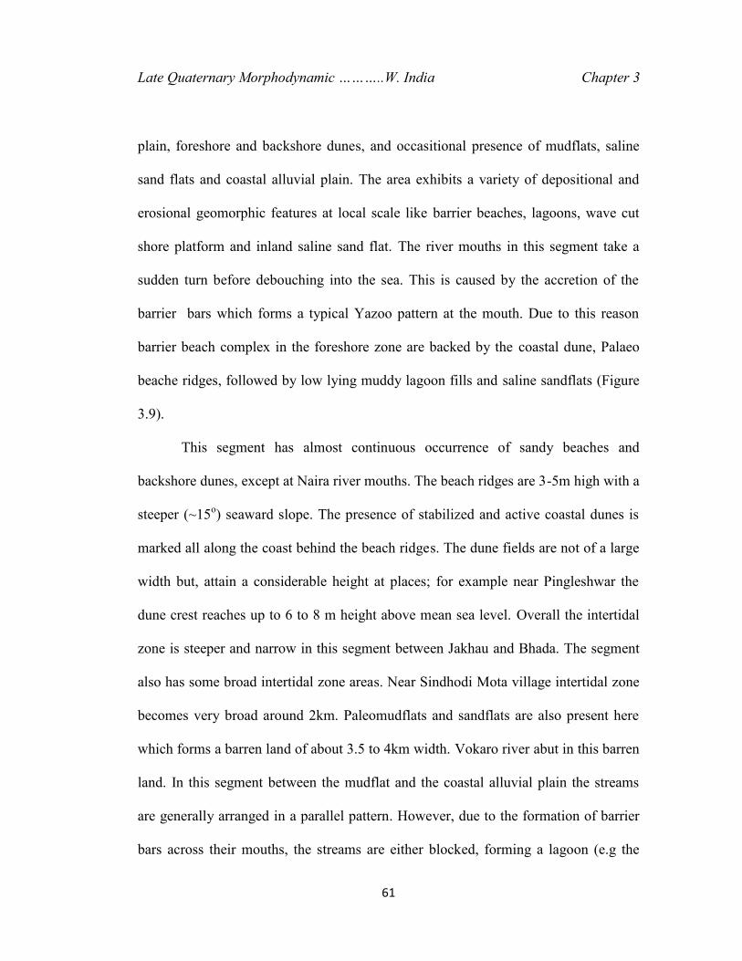
JAKHAU - BHADA SEGMENT
This is the western most segment along the Kachchh coast that lies between the
Jakhau and Bhada stretching for about 75 km length (Figure 3.8).
The area exhibits straight coastal configuration along NW-SE direction. This segment
is characterized by sandy beaches including ridge and runnels, berm ridge and berm
Figure 3.8: Landsat image of western Kachchh showing the straight sandy coastbetween Jakahu-Bhada.
Late Quaternary Morphodynamic ………..W. India Chapter 3
61
plain, foreshore and backshore dunes, and occasitional presence of mudflats, saline
sand flats and coastal alluvial plain. The area exhibits a variety of depositional and
erosional geomorphic features at local scale like barrier beaches, lagoons, wave cut
shore platform and inland saline sand flat. The river mouths in this segment take a
sudden turn before debouching into the sea. This is caused by the accretion of the
barrier bars which forms a typical Yazoo pattern at the mouth. Due to this reason
barrier beach complex in the foreshore zone are backed by the coastal dune, Palaeo
beache ridges, followed by low lying muddy lagoon fills and saline sandflats (Figure
3.9).
This segment has almost continuous occurrence of sandy beaches and
backshore dunes, except at Naira river mouths. The beach ridges are 3-5m high with a
steeper (~15o) seaward slope. The presence of stabilized and active coastal dunes is
marked all along the coast behind the beach ridges. The dune fields are not of a large
width but, attain a considerable height at places; for example near Pingleshwar the
dune crest reaches up to 6 to 8 m height above mean sea level. Overall the intertidal
zone is steeper and narrow in this segment between Jakhau and Bhada. The segment
also has some broad intertidal zone areas. Near Sindhodi Mota village intertidal zone
becomes very broad around 2km. Paleomudflats and sandflats are also present here
which forms a barren land of about 3.5 to 4km width. Vokaro river abut in this barren
land. In this segment between the mudflat and the coastal alluvial plain the streams
are generally arranged in a parallel pattern. However, due to the formation of barrier
bars across their mouths, the streams are either blocked, forming a lagoon (e.g the
Late Quaternary Morphodynamic ………..W. India Chapter 3
62
Kankawatl river to the south of Sandhan, Figure 3.9), or flow parallel to the barrier to
find an opening into the sea (e.g. the Suthriwali river near Suthari). The entrenchment
of many streams by about 2-3m in this zone suggests a gentle warping that led to the
recession of the sea (Biswas, 1974) and formation of the parallel drainage pattern.
Naira river is the major river of this segment. It flows in NE-SW direction along a
fault called Naira river fault (NRF). Suthriwali and Bandhawali cheli, these two rivers
also abut against a mudflat and are not in a contact with the Gulf due to the presence
of 8m high beach ridges (Figure 3.9).
Rocks are available only between Suthri to Khuada coastline in this segment
but those can be seen only during low tide. Here coastal alluvial plain is absent and
paleo mudflat and sandflat become wider. Near Khuada sandy beach ridge and
stabilized dunes make a significant height of around 16m. Kankawati river terminates
against these barriers. A set of 2 or 3 shore parallel beach ridges with stabilized dune
runs continuously up to Bhada, attaining height of about 23m near Dharmasala
village. Chok, Sai and Vengdi are the other major streams of this segment. Chok and
Sai river act as a tidal rivers during high tide in rainy season. Except rainy season,
they remain disconnected from the gulf due to less surface runoff since Kachchh
region falls under the arid climate zone. Several small streams are also present
between Sai and Vengdi river, with NE-SW orientation. These streams are originating
from saline sandflats and finish in the same sandflats. From the mouth of Sai river the
beach ridge becomes wider around 400m between Dharmsala and Bhada.
63
Figure 3.9: Map of Jakhau-Bhada segment showing various coastal geomorphic units.

Late Quaternary Morphodynamic ………..W. India Chapter 3
64
This segment is mainly characterized by wave dominated land forms. Also the
occurrences of tertiary rock right up to the coast. The surface of exposed Tertiary
rocks is a peneplained erosional surface known as the early Quaternary planation
surface (Biswas, 1974). The coast Khuada to Bhada is located over the N-S trending
zone of a subsurface structural high termed as the Median high (Figure 3.1). Figure
3.10 depicts some field views showing characteristic features of this segment.
BHADA - MUNDRA SEGMENT
This coastal segment is about 40 km in length and has a presence of features like 20-
50 m wide beaches, about 50-200 m wide coastal dunes and a number of coastal
streams. The coastline is composed of minor cuspets along the seaward margin of the
beach, beach cusps of 30 to 70 m average length along the berm outline and sand
waves of 500-700 m length, which includes all the minor features between the berm
with foredune and the low-tide level. Dolan et al. (1974) defined these features as
hierarchical, produced by superposition of processes with different scales of motion.
A noticeable increase in steepness of beach angle is observed at places like Chhachhi
having beach angle around 18-20o. This segment has a presence of most famous
beach for tourism along Kachchh coast. Mandvi is a famous ancient port town for its
small-shipping industry situated on the bank of River Rukmavati.

Late Quaternary Morphodynamic ………..W. India Chapter 3
65
(a) (b)
(c) (d)
(e) (f)
Figure 3.10: Field photographs from Jakhau-Bhada segment showing(a) General landward view from pingleshwar dune ridge, showing barren salinesandflat, (b) 8o to 10o slope of the beach of Pingleshwar with active foredunes, (c)Oyster and barnacle shaded rocks exposed during low tide near Jakhau, (d)Degraded mangrove swamp near Jakhau, (e) river blockage and formation oflagoon due to beach ridges near sandhan, (f) stacking of dune over an olderbeach ridge on Sandhan coast.

Late Quaternary Morphodynamic ………..W. India Chapter 3
66
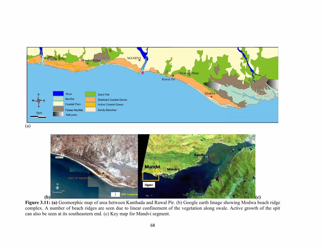
Historical monument like Vijay Vilas palace is also situated on the coast of
this segment. The coast of Mandvi contains widest dune complex (250-300m) in the
study area, having stabilized as well as active dunes (Figure 3.11a). The Bhada–
Mundra segment displays a distinctly different geomorphic setup compared with the
previous Jakhau – Bhada segment. The main distinguishing characteristics of this
coastal segment are wavy outline of the coastline, wide intertidal mudflat zone with
extensive mangroves, sandy landforms like sand ridges, spits and bars, and a well-
developed coastal alluvial plain (Figure 3.11 and 3.12). The usual landform sequence
from the low tide region to the coastal alluvial plain are two to three sets of ridges and
runnels, beaches with 5o to 8° average slope, berm and berm plain, about 2 to 3 m
high paleo-mudflats, 4 to 6 m high coastal dunes with 22°-24° landward slope and
10°-12° seaward slope, mudflats with tidal creeks, the saline sand flat and the coastal
alluvial plain. The coastline shows well-developed beachridge complex near Modwa.
The beaches display gentle seaward slope with a moderately broad zone of active
foreshore dunes. The dunes are partially stabilized on the landward side. Numerous
crab holes were noted with associated mounds of loose excavated sand, the hole to
mound distance being 20 to 22 cm almost everywhere. These holes, perhaps,
contribute to the erosion of the foreshore slope during high tides as water gushes
through the holes at high pressure, it erodes more sand than elsewhere, and leads to
collapsing of the burrows and then slope failure. A number of major rivers viz.,
Kharod, Rukmavati , Khari , Nagwanti, Phot and Bhukhi, enter to the sea along this
segment. An active spit growth can be seen to the east of Modwa (Figure 3.11b). The

Late Quaternary Morphodynamic ………..W. India Chapter 3
67
coastline near Mandvi is also characterized by a well-developed ridge and runnel
system. Overall, the segment shows active progradation and aggradation as the
dominant process. However, the sediments become progressively finer toward the
east as evidenced by the replacement of sandy beaches with muddy coast. The
Kharod river is one of the major river of this segment. It flows mostly through pre-
Quaternary rocks except in the vicinity of the coast where it flows through alluvial
deposits for a few kilometres, forming a narrow estuarine mouth before meeting the
sea. The coastal dune field is narrowing down toward the east. The paleomudflats
comprise mostly organic rich clays with intervening layers of silt. The organic rich
clays show internal laminations, whereas the sandy silts show trough cross-
stratification at places. Sandy beaches with berm plain are found to be well developed
east of Mandvi town and are presently undergoing erosion all along its length as can
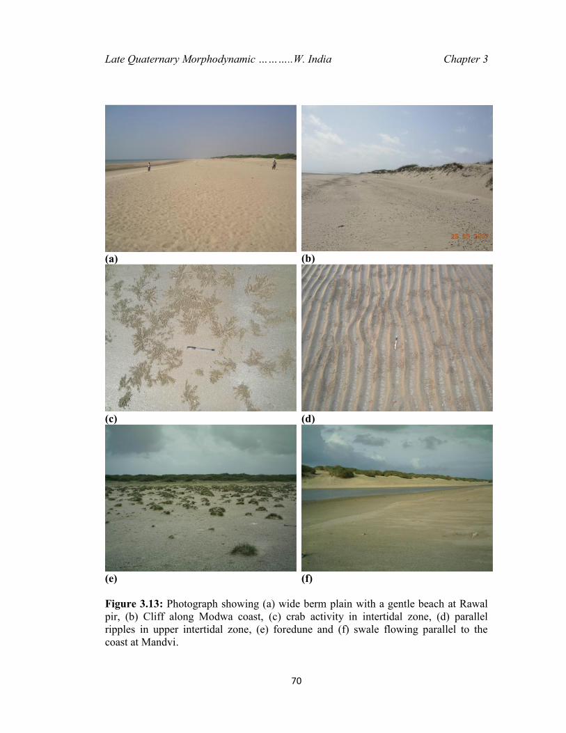
be seen in the form of cliffs developed in the backshore dunes (Figure 3.13). The 2–
3m high cliff exposes mainly coarse sand and show horizontally stratified and cross-
stratified layers. Further east, the coast shows an increasing extent of intertidal
mudflats that become widest near Mundra (Figure 3.12).
The mangroves also show increasing abundance along this direction. The
coastal zone near Mundra is characterised by a wide zone of mudflats containing
scattered sand units like chenniers, sand ridges and beaches.
68
(a)
(b) (c)Figure 3.11: (a) Geomorphic map of area between Kanthada and Rawal Pir. (b) Google earth Image showing Modwa beach ridgecomplex. A number of beach ridges are seen due to linear confinement of the vegetation along swale. Active growth of the spitcan also be seen at its southeastern end. (c) Key map for Mandvi segment.

69
Figure 3.12: Geomorphic units of the coast around Navinal to Mundra.
Late Quaternary Morphodynamic ………..W. India Chapter 3
70
(a) (b)
(c) (d)
(e) (f)
Figure 3.13: Photograph showing (a) wide berm plain with a gentle beach at Rawalpir, (b) Cliff along Modwa coast, (c) crab activity in intertidal zone, (d) parallelripples in upper intertidal zone, (e) foredune and (f) swale flowing parallel to thecoast at Mandvi.
Late Quaternary Morphodynamic ………..W. India Chapter 3
71
The area around old Mundra port has extensive paleo mudflats and stumps of dead
mangroves. The mangroves around this port are also undergoing rapid degradation. A
new port has been constructed in the last decade, Adani Port, which is located about
3–4 km further south along the Navinal Creek. The total distance from this port to the
oldest abandoned port is about 12 km, which points to high amount of siltation. The
NW-SE oriented straight coastal outline of the Jakhau-Bhada segments takes an east
ward turn of 23° in Bhada-Mundra coastal segment. As a result the waves, normal to
the straight coast segment, impinge against the bent coastline at an angle 40o to 50o.
Wave action, along with a strong eastward longshore drift is responsible for
the gradual development and subsequent decay of a number of spits and sandy ridges
from the headland, while wave refraction at the tip of the spit produces complex
recurvatures. It can also be obsereved in satellite images in the form of the truncated
spits and hook remnants, with 3 to 7 m high sand ridges (chennier) and dunes over
the mudflats (e.g. Dhoa Reserve Forest) which indicate a gradual shifting of the spit-
building activity from ENE to WSW. The best example is the Rawal Pir-Modwa spit
whose western end near Rawal Pir is at present under an erosional phase, whereas a
new spit is gradually emerging at Modwa. The present fulcrum of the spit lies at
Modwa. The alignment of the older spit remnants is intersected by that of the newer
shore lines at an angle of about 45 ° or more. Ones It is quite likely that under the
attack of the dominant waves the older spits are also being displaced landward. Their
juxtaposition near Mundra could be a major reason for the cuspate foreland
Late Quaternary Morphodynamic ………..W. India Chapter 3
72
formation. Characteristically, all the major tidal creeks of the Mundra region take a
southeastward bend to meet the sea (e.g. Baradl Mata creek and Kotdi creek).
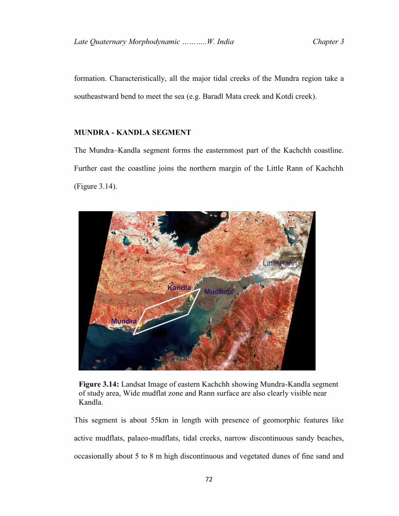
MUNDRA - KANDLA SEGMENT
The Mundra–Kandla segment forms the easternmost part of the Kachchh coastline.
Further east the coastline joins the northern margin of the Little Rann of Kachchh
(Figure 3.14).
This segment is about 55km in length with presence of geomorphic features like
active mudflats, palaeo-mudflats, tidal creeks, narrow discontinuous sandy beaches,
occasionally about 5 to 8 m high discontinuous and vegetated dunes of fine sand and
Figure 3.14: Landsat Image of eastern Kachchh showing Mundra-Kandla segmentof study area, Wide mudflat zone and Rann surface are also clearly visible nearKandla.
Late Quaternary Morphodynamic ………..W. India Chapter 3
73
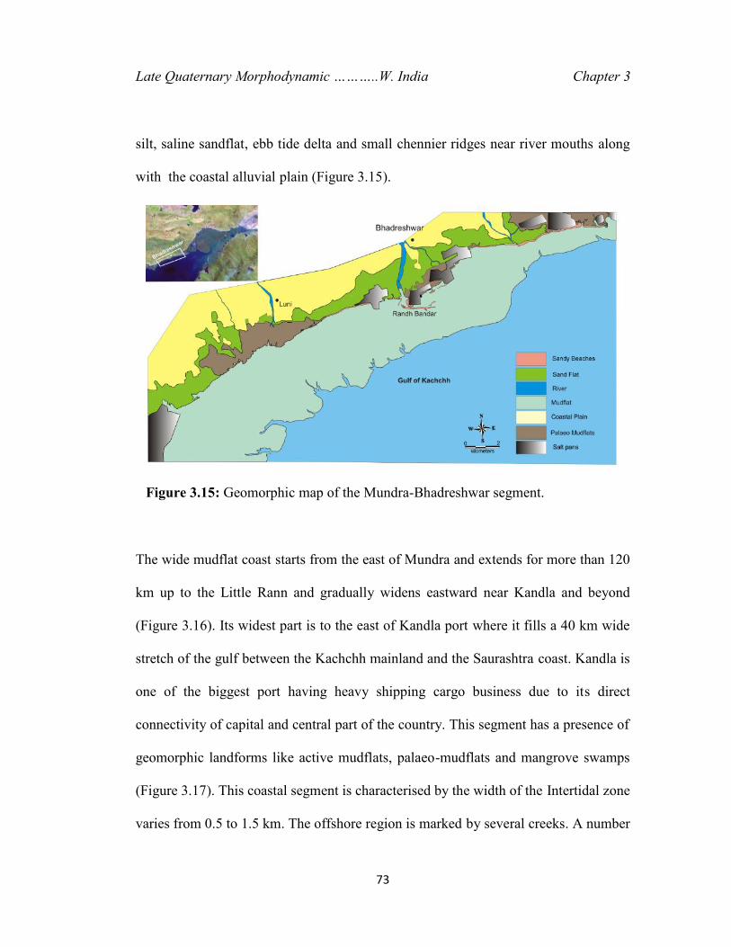
silt, saline sandflat, ebb tide delta and small chennier ridges near river mouths along
with the coastal alluvial plain (Figure 3.15).
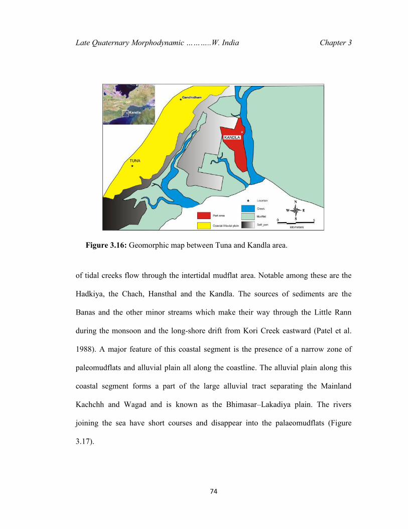
The wide mudflat coast starts from the east of Mundra and extends for more than 120
km up to the Little Rann and gradually widens eastward near Kandla and beyond
(Figure 3.16). Its widest part is to the east of Kandla port where it fills a 40 km wide
stretch of the gulf between the Kachchh mainland and the Saurashtra coast. Kandla is
one of the biggest port having heavy shipping cargo business due to its direct
connectivity of capital and central part of the country. This segment has a presence of
geomorphic landforms like active mudflats, palaeo-mudflats and mangrove swamps
(Figure 3.17). This coastal segment is characterised by the width of the Intertidal zone
varies from 0.5 to 1.5 km. The offshore region is marked by several creeks. A number
Figure 3.15: Geomorphic map of the Mundra-Bhadreshwar segment.
Late Quaternary Morphodynamic ………..W. India Chapter 3
74
of tidal creeks flow through the intertidal mudflat area. Notable among these are the
Hadkiya, the Chach, Hansthal and the Kandla. The sources of sediments are the
Banas and the other minor streams which make their way through the Little Rann
during the monsoon and the long-shore drift from Kori Creek eastward (Patel et al.
1988). A major feature of this coastal segment is the presence of a narrow zone of
paleomudflats and alluvial plain all along the coastline. The alluvial plain along this
coastal segment forms a part of the large alluvial tract separating the Mainland
Kachchh and Wagad and is known as the Bhimasar–Lakadiya plain. The rivers
joining the sea have short courses and disappear into the palaeomudflats (Figure
3.17).
Figure 3.16: Geomorphic map between Tuna and Kandla area.

75
Figure 3.17: Geomorphic map of the headward of the Gulf of Kachchh.
Late Quaternary Morphodynamic ………..W. India Chapter 3
76
The palaeomudflats gradually rise above the intertidal flats and merge into the
alluvial plain further inland. Coastal dunes occur as small scattered patches along the
coastline. The palaeomudflats dominantly comprise internally laminated tidal clays.
A four-layered sediment succession is reported from the adjacent Little Rann of
Kachchh (Gupta, 1975). The Little Rann is known to have been affected by a slow
upheaval through the Quaternary that caused the gulf to recede (Biswas, 1974).