code update packet #188 - portland, oregon
TRANSCRIPT
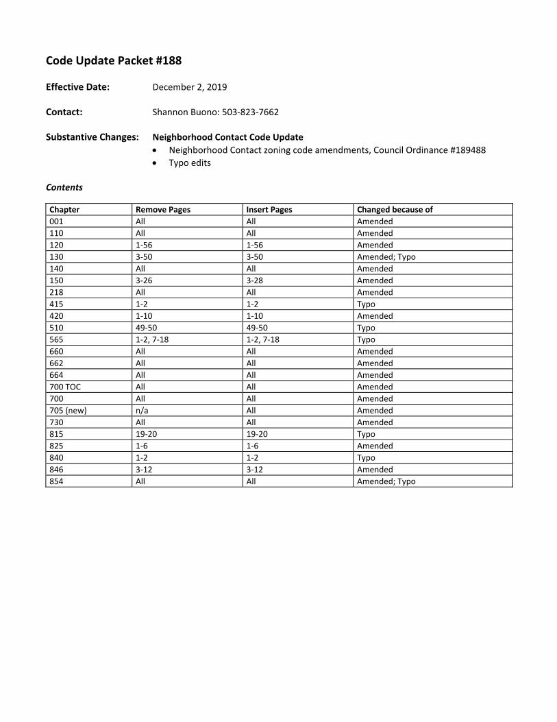
Code Update Packet #188
Effective Date: December 2, 2019
Contact: Shannon Buono: 503‐823‐7662
Substantive Changes: Neighborhood Contact Code Update
Neighborhood Contact zoning code amendments, Council Ordinance #189488
Typo edits Contents
Chapter Remove Pages Insert Pages Changed because of
001 All All Amended
110 All All Amended
120 1‐56 1‐56 Amended 130 3‐50 3‐50 Amended; Typo 140 All All Amended 150 3‐26 3‐28 Amended 218 All All Amended 415 1‐2 1‐2 Typo
420 1‐10 1‐10 Amended 510 49‐50 49‐50 Typo
565 1‐2, 7‐18 1‐2, 7‐18 Typo
660 All All Amended 662 All All Amended 664 All All Amended 700 TOC All All Amended 700 All All Amended 705 (new) n/a All Amended 730 All All Amended 815 19‐20 19‐20 Typo
825 1‐6 1‐6 Amended 840 1‐2 1‐2 Typo
846 3‐12 3‐12 Amended 854 All All Amended; Typo


12/2/19
Title 33, Planning and Zoning
List of Chapters
Introduction How to Use This Document 10 Legal Framework and Relationships
Base Zones 100 Open Space Zone 110 Single‐Dwelling Residential Zones 120 Multi‐Dwelling Residential Zones 130 Commercial/Mixed Use Zones 140 Employment and Industrial Zones 150 Campus Institutional Zones
Additional Use & Development Regulations 203 Accessory Home Occupations 205 Accessory Dwelling Units 207 Accessory Short‐Term Rentals 209 Aviation 218 Community Design Standards 219 Convenience Stores 224 Drive‐Through Facilities 229 Elderly and Disabled High Density Housing 236 Floating Structures 237 Food Production and Distribution 239 Group Living 243 Helicopter Landing Facilities 245 Inclusionary Housing 248 Landscaping and Screening 251 Manufactured Housing and Manufactured Dwelling Parks 254 Mining and Waste‐Related 258 Nonconforming Situations 262 Off‐Site Impacts 266 Parking and Loading 270 Planned Developments 272 Major Public Trail 274 Radio Frequency Transmission Facilities 279 Recreational Fields for Organized Sports 281 Schools and School Sites 284 Self‐Service Storage 285 Short Term Housing and Mass Shelters 288 Special Street Setbacks 293 Superblocks 296 Temporary Activities
299 Wind Turbines
300s Reserved
Overlay Zones 400 Aircraft Landing Overlay Zone 405 Alternative Design Density Overlay Zone 410 Buffer Zone 415 Centers Main Street Overlay Zone 420 Design Overlay Zone 430 Environmental Zone 435 Future Urban Zone 440 Greenway Overlay Zones 445 Historic Resource Overlay Zone 465 Pleasant Valley Natural Resources Overlay Zone 470 Portland International Airport Noise Impact Zone 471 Prime Industrial Overlay Zone 480 Scenic Resource Zone
Plan Districts 500 Plan Districts In General 505 Albina Community Plan District 508 Cascade Station/Portland International Center (CS/PIC) Plan District 510 Central City Plan District 515 Columbia South Shore Plan District 520 Division Street Plan District 521 East Corridor Plan District 526 Gateway Plan District 530 Glendoveer Plan District 531 Guild’s Lake Industrial Sanctuary Plan District 532 Hayden Island Plan District 533 Healy Heights Plan District 534 Hillsdale Plan District 536 Hollywood Plan District 537 Johnson Creek Basin Plan District 538 Kenton Plan District 540 Laurelhurst‐Eastmoreland Plan District 545 Lombard Street Plan District
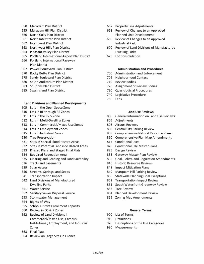
12/2/19
550 Macadam Plan District 555 Marquam Hill Plan District 560 North Cully Plan District 561 North Interstate Plan District 562 Northwest Plan District 563 Northwest Hills Plan District 564 Pleasant Valley Plan District 565 Portland International Airport Plan District 566 Portland International Raceway Plan District 567 Powell Boulevard Plan District 570 Rocky Butte Plan District 575 Sandy Boulevard Plan District 580 South Auditorium Plan District 583 St. Johns Plan District 585 Swan Island Plan District Land Divisions and Planned Developments
605 Lots in the Open Space Zone 610 Lots in RF through R5 Zones 611 Lots in the R2.5 Zone 612 Lots in Multi‐Dwelling Zones 613 Lots in Commercial/Mixed Use Zones 614 Lots in Employment Zones 615 Lots in Industrial Zones 630 Tree Preservation 631 Sites in Special Flood Hazard Areas 632 Sites in Potential Landslide Hazard Areas 633 Phased Plans and Staged Final Plats 634 Required Recreation Area 635 Clearing and Grading and Land Suitability 636 Tracts and Easements 639 Solar Access 640 Streams, Springs, and Seeps 641 Transportation Impact 642 Land Divisions of Manufactured Dwelling Parks 651 Water Service 652 Sanitary Sewer Disposal Service 653 Stormwater Management 654 Rights‐of‐Way 655 School District Enrollment Capacity 660 Review in OS & R Zones 662 Review of Land Divisions in
Commercial/Mixed Use, Campus Institutional, Employment, and Industrial Zones
663 Final Plats 664 Review on Large Sites in I Zones
667 Property Line Adjustments 668 Review of Changes to an Approved Planned Unit Development 669 Review of Changes to an Approved Industrial Park 670 Review of Land Divisions of Manufactured Dwelling Parks 675 Lot Consolidation
Administration and Procedures 700 Administration and Enforcement 705 Neighborhood Contact 710 Review Bodies 720 Assignment of Review Bodies 730 Quasi‐Judicial Procedures 740 Legislative Procedure 750 Fees
Land Use Reviews 800 General Information on Land Use Reviews 805 Adjustments 806 Airport Reviews 808 Central City Parking Review 809 Comprehensive Natural Resource Plans 810 Comprehensive Plan Map Amendments 815 Conditional Uses 820 Conditional Use Master Plans 825 Design Review 833 Gateway Master Plan Review 835 Goal, Policy, and Regulation Amendments 846 Historic Resource Reviews 848 Impact Mitigation Plans 849 Marquam Hill Parking Review 850 Statewide Planning Goal Exceptions 852 Transportation Impact Review 851 South Waterfront Greenway Review 853 Tree Review 854 Planned Development Review 855 Zoning Map Amendments
General Terms 900 List of Terms 910 Definitions 920 Descriptions of the Use Categories 930 Measurements
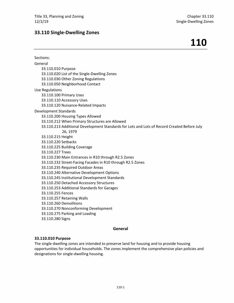
Title 33, Planning and Zoning Chapter 33.110 12/2/19 Single‐Dwelling Zones
110‐1
33.110 Single‐Dwelling Zones
110
Sections:
General 33.110.010 Purpose 33.110.020 List of the Single‐Dwelling Zones 33.110.030 Other Zoning Regulations 33.110.050 Neighborhood Contact
Use Regulations 33.110.100 Primary Uses 33.110.110 Accessory Uses 33.110.120 Nuisance‐Related Impacts
Development Standards 33.110.200 Housing Types Allowed 33.110.212 When Primary Structures are Allowed 33.110.213 Additional Development Standards for Lots and Lots of Record Created Before July 26, 1979 33.110.215 Height 33.110.220 Setbacks 33.110.225 Building Coverage 33.110.227 Trees 33.110.230 Main Entrances in R10 through R2.5 Zones 33.110.232 Street‐Facing Facades in R10 through R2.5 Zones 33.110.235 Required Outdoor Areas 33.110.240 Alternative Development Options 33.110.245 Institutional Development Standards 33.110.250 Detached Accessory Structures 33.110.253 Additional Standards for Garages 33.110.255 Fences 33.110.257 Retaining Walls 33.110.260 Demolitions 33.110.270 Nonconforming Development 33.110.275 Parking and Loading 33.110.280 Signs
General
33.110.010 Purpose The single‐dwelling zones are intended to preserve land for housing and to provide housing opportunities for individual households. The zones implement the comprehensive plan policies and designations for single‐dwelling housing.

Chapter 33.110 Title 33, Planning and Zoning Single‐Dwelling Zones 12/2/19
110‐2
A. Use regulations. The use regulations are intended to create, maintain and promote single‐dwelling neighborhoods. They allow for some non‐household living uses but not to such an extent as to sacrifice the overall image and character of the single‐dwelling neighborhood.
B. Development standards. The development standards preserve the character of neighborhoods by providing six different zones with different densities and development standards. The development standards work together to promote desirable residential areas by addressing aesthetically pleasing environments, safety, privacy, energy conservation, and recreational opportunities. The site development standards allow for flexibility of development while maintaining compatibility within the City's various neighborhoods. In addition, the regulations provide certainty to property owners, developers, and neighbors about the limits of what is allowed. The development standards are generally written for houses on flat, regularly shaped lots. Other situations are addressed through special regulations or exceptions.
33.110.020 List of the Single‐Dwelling Zones The full names, short names, and map symbols of the single‐dwelling residential zones are listed below. When this Title refers to the single‐dwelling zones, it is referring to the six zones listed here. When this Title refers to the residential zones, or R zones, it is referring to both the single‐dwelling zones in this chapter and the multi‐dwelling zones in Chapter 33.120. The Residential Farm/Forest zone is intended to generally be an agricultural zone, but has been named Residential Farm/Forest to allow for ease of reference.
Full Name Short Name/Map Symbol
Residential Farm/Forest RF
Residential 20,000 R20
Residential 10,000 R10
Residential 7,000 R7
Residential 5,000 R5
Residential 2,500 R2.5
33.110.030 Other Zoning Regulations The regulations in this chapter state the allowed uses and development standards for the base zones. Sites with overlay zones, plan districts, or designated historical landmarks are subject to additional regulations. The Official Zoning Maps indicate which sites are subject to these additional regulations. Specific uses or development types may also be subject to regulations in the 200s series of chapters.
33.110.050 Neighborhood Contact Neighborhood contact is a set of outreach steps that must be taken before certain developments can be submitted for approval. Neighborhood contact is required as follows:
A. Neighborhood contact I.
1. Neighborhood contact I requirements. When proposed development will add at least 10,000 square feet and not more than 25,000 square feet of net building area to a site, the neighborhood contact steps of 33.705.020.A., Neighborhood contact I are required. All the steps in 33.705.020.A. must be completed before an application for a building permit can be submitted.
Title 33, Planning and Zoning Chapter 33.110 12/2/19 Single‐Dwelling Zones
110‐3
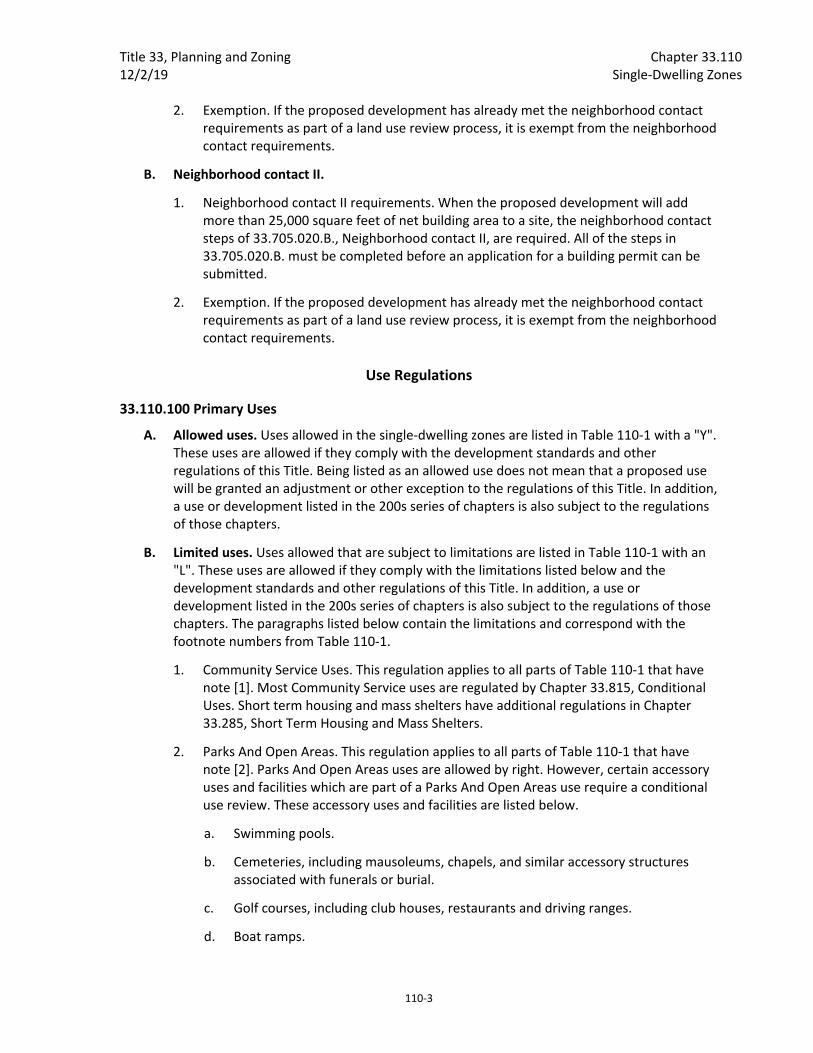
2. Exemption. If the proposed development has already met the neighborhood contact requirements as part of a land use review process, it is exempt from the neighborhood contact requirements.
B. Neighborhood contact II.
1. Neighborhood contact II requirements. When the proposed development will add more than 25,000 square feet of net building area to a site, the neighborhood contact steps of 33.705.020.B., Neighborhood contact II, are required. All of the steps in 33.705.020.B. must be completed before an application for a building permit can be submitted.
2. Exemption. If the proposed development has already met the neighborhood contact requirements as part of a land use review process, it is exempt from the neighborhood contact requirements.
Use Regulations
33.110.100 Primary Uses
A. Allowed uses. Uses allowed in the single‐dwelling zones are listed in Table 110‐1 with a "Y". These uses are allowed if they comply with the development standards and other regulations of this Title. Being listed as an allowed use does not mean that a proposed use will be granted an adjustment or other exception to the regulations of this Title. In addition, a use or development listed in the 200s series of chapters is also subject to the regulations of those chapters.
B. Limited uses. Uses allowed that are subject to limitations are listed in Table 110‐1 with an "L". These uses are allowed if they comply with the limitations listed below and the development standards and other regulations of this Title. In addition, a use or development listed in the 200s series of chapters is also subject to the regulations of those chapters. The paragraphs listed below contain the limitations and correspond with the footnote numbers from Table 110‐1.
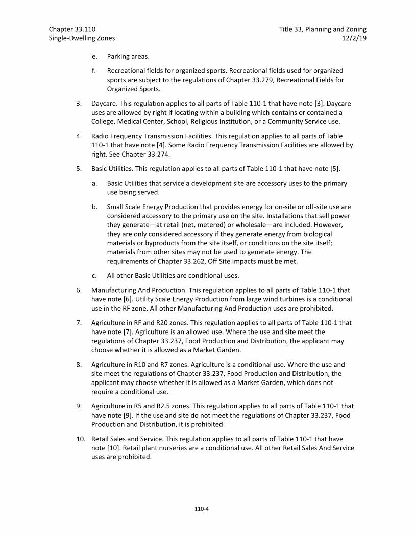
1. Community Service Uses. This regulation applies to all parts of Table 110‐1 that have note [1]. Most Community Service uses are regulated by Chapter 33.815, Conditional Uses. Short term housing and mass shelters have additional regulations in Chapter 33.285, Short Term Housing and Mass Shelters.
2. Parks And Open Areas. This regulation applies to all parts of Table 110‐1 that have note [2]. Parks And Open Areas uses are allowed by right. However, certain accessory uses and facilities which are part of a Parks And Open Areas use require a conditional use review. These accessory uses and facilities are listed below.
a. Swimming pools.
b. Cemeteries, including mausoleums, chapels, and similar accessory structures associated with funerals or burial.
c. Golf courses, including club houses, restaurants and driving ranges.
d. Boat ramps.
Chapter 33.110 Title 33, Planning and Zoning Single‐Dwelling Zones 12/2/19
110‐4
e. Parking areas.
f. Recreational fields for organized sports. Recreational fields used for organized sports are subject to the regulations of Chapter 33.279, Recreational Fields for Organized Sports.
3. Daycare. This regulation applies to all parts of Table 110‐1 that have note [3]. Daycare uses are allowed by right if locating within a building which contains or contained a College, Medical Center, School, Religious Institution, or a Community Service use.
4. Radio Frequency Transmission Facilities. This regulation applies to all parts of Table 110‐1 that have note [4]. Some Radio Frequency Transmission Facilities are allowed by right. See Chapter 33.274.
5. Basic Utilities. This regulation applies to all parts of Table 110‐1 that have note [5].
a. Basic Utilities that service a development site are accessory uses to the primary use being served.
b. Small Scale Energy Production that provides energy for on‐site or off‐site use are considered accessory to the primary use on the site. Installations that sell power they generate—at retail (net, metered) or wholesale—are included. However, they are only considered accessory if they generate energy from biological materials or byproducts from the site itself, or conditions on the site itself; materials from other sites may not be used to generate energy. The requirements of Chapter 33.262, Off Site Impacts must be met.
c. All other Basic Utilities are conditional uses.
6. Manufacturing And Production. This regulation applies to all parts of Table 110‐1 that have note [6]. Utility Scale Energy Production from large wind turbines is a conditional use in the RF zone. All other Manufacturing And Production uses are prohibited.
7. Agriculture in RF and R20 zones. This regulation applies to all parts of Table 110‐1 that have note [7]. Agriculture is an allowed use. Where the use and site meet the regulations of Chapter 33.237, Food Production and Distribution, the applicant may choose whether it is allowed as a Market Garden.
8. Agriculture in R10 and R7 zones. Agriculture is a conditional use. Where the use and site meet the regulations of Chapter 33.237, Food Production and Distribution, the applicant may choose whether it is allowed as a Market Garden, which does not require a conditional use.
9. Agriculture in R5 and R2.5 zones. This regulation applies to all parts of Table 110‐1 that have note [9]. If the use and site do not meet the regulations of Chapter 33.237, Food Production and Distribution, it is prohibited.
10. Retail Sales and Service. This regulation applies to all parts of Table 110‐1 that have note [10]. Retail plant nurseries are a conditional use. All other Retail Sales And Service uses are prohibited.
Title 33, Planning and Zoning Chapter 33.110 12/2/19 Single‐Dwelling Zones
110‐5
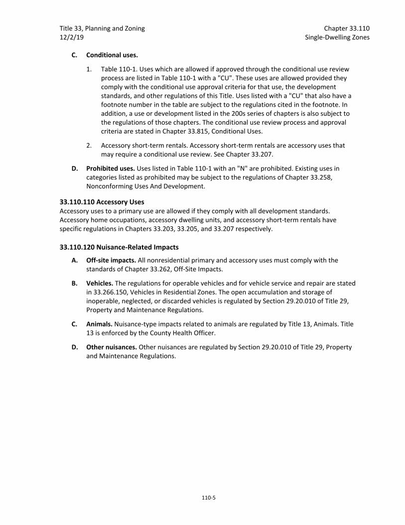
C. Conditional uses.
1. Table 110‐1. Uses which are allowed if approved through the conditional use review process are listed in Table 110‐1 with a "CU". These uses are allowed provided they comply with the conditional use approval criteria for that use, the development standards, and other regulations of this Title. Uses listed with a "CU" that also have a footnote number in the table are subject to the regulations cited in the footnote. In addition, a use or development listed in the 200s series of chapters is also subject to the regulations of those chapters. The conditional use review process and approval criteria are stated in Chapter 33.815, Conditional Uses.
2. Accessory short‐term rentals. Accessory short‐term rentals are accessory uses that may require a conditional use review. See Chapter 33.207.
D. Prohibited uses. Uses listed in Table 110‐1 with an "N" are prohibited. Existing uses in categories listed as prohibited may be subject to the regulations of Chapter 33.258, Nonconforming Uses And Development.
33.110.110 Accessory Uses Accessory uses to a primary use are allowed if they comply with all development standards. Accessory home occupations, accessory dwelling units, and accessory short‐term rentals have specific regulations in Chapters 33.203, 33.205, and 33.207 respectively.
33.110.120 Nuisance‐Related Impacts
A. Off‐site impacts. All nonresidential primary and accessory uses must comply with the standards of Chapter 33.262, Off‐Site Impacts.
B. Vehicles. The regulations for operable vehicles and for vehicle service and repair are stated in 33.266.150, Vehicles in Residential Zones. The open accumulation and storage of inoperable, neglected, or discarded vehicles is regulated by Section 29.20.010 of Title 29, Property and Maintenance Regulations.
C. Animals. Nuisance‐type impacts related to animals are regulated by Title 13, Animals. Title 13 is enforced by the County Health Officer.
D. Other nuisances. Other nuisances are regulated by Section 29.20.010 of Title 29, Property and Maintenance Regulations.

Chapter 33.110 Title 33, Planning and Zoning Single‐Dwelling Zones 12/2/19
110‐6
Table 110‐1 Single‐Dwelling Zone Primary Uses
Use Categories
RF
R20
R10
R7
R5
R2.5
Residential Categories
Household Living Y Y Y Y Y Y
Group Living CU CU CU CU CU CU
Commercial Categories
Retail Sales And Service CU [10] CU [10] CU [10] CU [10] CU [10] CU [10]
Office N N N N N N
Quick Vehicle Servicing N N N N N N
Vehicle Repair N N N N N N
Commercial Parking N N N N N N
Self‐Service Storage N N N N N N
Commercial Outdoor Recreation N N N N N N
Major Event Entertainment N N N N N N
Industrial Categories
Manufacturing And Production CU [6] N N N N N
Warehouse And Freight Movement
N N N N N N
Wholesale Sales N N N N N N
Industrial Service N N N N N N
Bulk Fossil Fuel Terminal N N N N N N
Railroad Yards N N N N N N
Waste‐Related N N N N N N
Y = Yes, Allowed CU = Conditional Use Review Required
L = Allowed, But Special Limitations N = No, Prohibited
Notes:
The use categories are described in Chapter 33.920.
Regulations that correspond to the bracketed numbers [ ] are stated in 33.110.100.B.
Specific uses and developments may also be subject to regulations in the 200s series of chapters.

Title 33, Planning and Zoning Chapter 33.110 12/2/19 Single‐Dwelling Zones
110‐7
Table 110‐1 Single‐Dwelling Zone Primary Uses
Use Categories
RF
R20
R10
R7
R5
R2.5
Institutional Categories
Basic Utilities L/CU [5] L/CU [5] L/CU [5] L/CU [5] L/CU [5] L/CU [5]
Community Service CU [1] CU [1] CU [1] CU [1] CU [1] CU [1]
Parks And Open Areas L/CU [2] L/CU [2] L/CU [2] L/CU [2] L/CU [2] L/CU [2]
Schools CU CU CU CU CU CU
Colleges CU CU CU CU CU CU
Medical Centers CU CU CU CU CU CU
Religious Institutions CU CU CU CU CU CU
Daycare L/CU [3] L/CU [3] L/CU [3] L/CU [3] L/CU [3] L/CU [3]
Other Categories
Agriculture L [7] L [7] L/CU [8] L/CU [8] L [9] L [9]
Aviation And Surface Passenger Terminals
CU
N
N
N
N
N
Detention Facilities N N N N N N
Mining CU N N N N N
Radio Frequency Transmission Facilities
L/CU [4] L/CU [4] L/CU [4] L/CU [4] L/CU [4] L/CU [4]
Railroad Lines And Utility Corridors
CU CU CU CU CU CU
Y = Yes, Allowed CU = Conditional Use Review Required
L = Allowed, But Special Limitations N = No, Prohibited
Notes:
The use categories are described in Chapter 33.920.
Regulations that correspond to the bracketed numbers [ ] are stated in 33.110.100.B.
Specific uses and developments may also be subject to regulations in the 200s series of chapters.
Development Standards
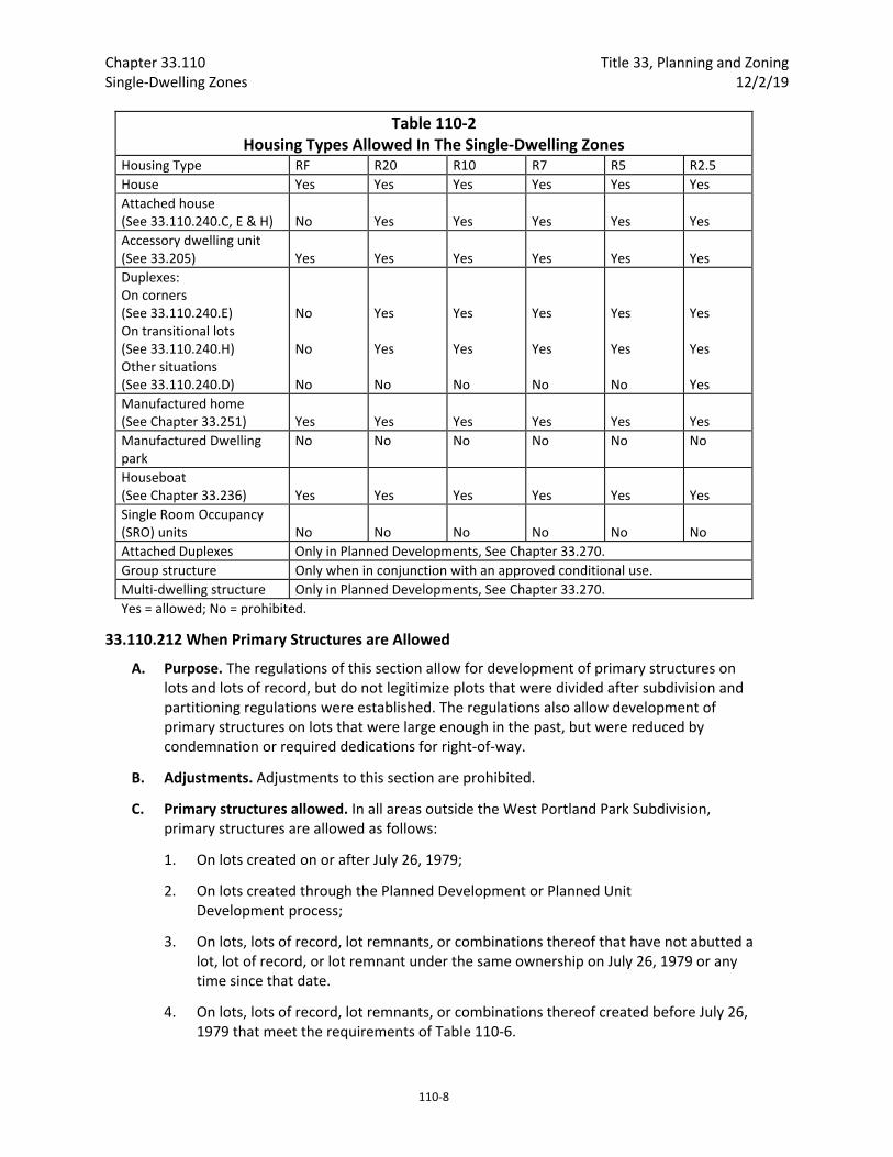
33.110.200 Housing Types Allowed
A. Purpose. Housing types are limited in the single‐dwelling zones to maintain the overall image and character of the City's single‐dwelling neighborhoods. However, the regulations allow options to increase housing variety and opportunities, and to promote affordable and energy‐efficient housing.
B. Housing types. The kinds of housing types allowed in the single‐dwelling zones are stated in Table 110‐2.
Chapter 33.110 Title 33, Planning and Zoning Single‐Dwelling Zones 12/2/19
110‐8
Table 110‐2 Housing Types Allowed In The Single‐Dwelling Zones
Housing Type RF R20 R10 R7 R5 R2.5
House Yes Yes Yes Yes Yes Yes
Attached house (See 33.110.240.C, E & H)
No
Yes
Yes
Yes
Yes
Yes
Accessory dwelling unit (See 33.205)
Yes
Yes
Yes
Yes
Yes
Yes
Duplexes: On corners (See 33.110.240.E) On transitional lots (See 33.110.240.H) Other situations (See 33.110.240.D)
No No No
Yes Yes No
Yes Yes No
Yes Yes No
Yes Yes No
Yes Yes Yes
Manufactured home (See Chapter 33.251)
Yes
Yes
Yes
Yes
Yes
Yes
Manufactured Dwelling park
No No No No No No
Houseboat (See Chapter 33.236)
Yes
Yes
Yes
Yes
Yes
Yes
Single Room Occupancy (SRO) units
No
No
No
No
No
No
Attached Duplexes Only in Planned Developments, See Chapter 33.270.
Group structure Only when in conjunction with an approved conditional use.
Multi‐dwelling structure Only in Planned Developments, See Chapter 33.270.
Yes = allowed; No = prohibited.
33.110.212 When Primary Structures are Allowed
A. Purpose. The regulations of this section allow for development of primary structures on lots and lots of record, but do not legitimize plots that were divided after subdivision and partitioning regulations were established. The regulations also allow development of primary structures on lots that were large enough in the past, but were reduced by condemnation or required dedications for right‐of‐way.
B. Adjustments. Adjustments to this section are prohibited.
C. Primary structures allowed. In all areas outside the West Portland Park Subdivision, primary structures are allowed as follows:
1. On lots created on or after July 26, 1979;
2. On lots created through the Planned Development or Planned Unit Development process;
3. On lots, lots of record, lot remnants, or combinations thereof that have not abutted a lot, lot of record, or lot remnant under the same ownership on July 26, 1979 or any time since that date.
4. On lots, lots of record, lot remnants, or combinations thereof created before July 26, 1979 that meet the requirements of Table 110‐6.

Title 33, Planning and Zoning Chapter 33.110 12/2/19 Single‐Dwelling Zones
110‐9
5. Primary structures are allowed on lots, lots of record, lot remnants, and combinations thereof that did meet the requirements of Table 110‐6 in the past but were reduced below those requirements solely because of condemnation or required dedication by a public agency for right‐of‐way.
6. On lots, lots of record, lot remnants, and combinations thereof zoned R20 that met the requirements of Table 110‐6 in the past but no longer meet the requirements solely due to a zone change effective on May 24, 2018.
D. Regulations for West Portland Park. In the West Portland Park subdivision, primary structures are allowed as follows:
1. On lots created on or after July 26, 1979;
2. On lots, lots of record, lot remnants, or combinations thereof that have not abutted a lot, lot of record, or lot remnant under the same ownership on July 26, 1979 or any time since that date;
3. On lots, lots of record, lot remnants, or combinations thereof created before July 26, 1979, that meet the requirements of this paragraph. The requirements are:
a. R7 zone. In the R7 zone, the lot, lot of record, lot remnant or combinations thereof must be at least 7,000 square feet in area;
b. R5 zone. In the R5 zone, the lot, lot of record, lot remnant or combinations thereof must be at least 5,000 square feet in area; or
c. R2.5 zone. In the R2.5 zone, the lot, lot of record, lot remnant or combinations thereof must meet the requirements of Table 110‐6;
4. Primary structures are allowed on lots, lots of record, lot remnants and combinations thereof that did meet the requirements of D.3, above, in the past but were reduced below those requirements solely because of condemnation or required dedication by a public agency for right‐of‐way.
E. Plots. Primary structures are prohibited on plots that are not lots, lots of record, lot remnants or tracts.
F. Nonconforming situations. Existing development and residential densities that do not conform to the requirements of this chapter may be subject to the regulations of Chapter 33.258, Nonconforming Situations. Chapter 33.258 also includes regulations regarding damage to or destruction of nonconforming situations.

Chapter 33.110 Title 33, Planning and Zoning Single‐Dwelling Zones 12/2/19
110‐10
Table 110‐6 Minimum Lot Dimension Standards for Lots, Adjusted Lots, Lots of Record, and Lot
Remnants Created Prior to July 26, 1979 RF through R7 Zones
Lots, including Adjusted Lots [1] 36 feet wide and meets the minimum lot area requirement of Table 610‐2. [4]
Lot Remnants
Lots of Record
R5 Zone
Lots, including Adjusted Lots [1, 3]
If the lot has had a dwelling unit on it in the last five years or is in an environmental zone [2]
3000 sq. ft. and 36 ft. wide [4]
If the lot has not had a dwelling unit on it within the last five years and is not in an environmental zone
2400 sq. ft. and 25 ft. wide [4]
If the lot was approved through a property line adjustment under 33.667.300.A.4.
1600 sq. ft. and 36 ft. wide [4]
Lot Remnants [3] 3000 sq. ft. and 36 ft. wide [4]
Lots of Record [1, 3] 3000 sq. ft. and 36 ft. wide [4]
R2.5 Zone
Lots, including Adjusted Lots [1] 1600 sq. ft. Lot Remnants
Lots of Record
Notes: [1] If the property is both an adjusted lot and a lot of record, the site may meet the standards for adjusted lots. [2] Primary structures are allowed if the site has had a dwelling unit on it within the last five years that has been demolished as a public nuisance under the provisions of Chapter 29.40.030 or 29.60.080. The site is exempt from minimum lot dimension standards. [3] Primary structures are allowed on a site if it has been under a separate tax account number from abutting lots or lots of record on April 24, 2010 or an application was filed with the City before April 24, 2010 authorizing a separate tax account and the site has been under separate tax account from abutting lots or lots of record by April 24, 2011. The site is exempt from minimum lot dimension standards. [4] Lot width for a flag lot is measured at the midpoint of the flag portion of the lot.
33.110.213 Additional Development Standards for Lots and Lots of Record Created Before July 26, 1979
A. Purpose. These standards increase the compatibility of new houses on small and narrow lots.
B. Where these regulations apply.
1. RF through R7 zones. These regulations apply in the RF through R7 zones, if the lot, lot of record, or combination of lots or lots of record is less than 36 feet wide and has not abutted any lot or lot of record owned by the same family or business on July 26, 1979, or any time since that date.

Title 33, Planning and Zoning Chapter 33.110 12/2/19 Single‐Dwelling Zones
110‐11
2. R5 zone. In the R5 zone, these regulations apply to lots, lots of record, or combinations of lots or lots of record that were created before July 26, 1979 and are:
a. Less than 3,000 square feet in area; or
b. Less than 36 feet wide.
3. R2.5 zone. In the R2.5 zone, these regulations apply to lots, lots of record, or combinations of lots or lots of record that were created before July 26, 1979 and are less than 1,600 square feet in area.
4. Planned unit developments. Lots in planned unit developments are exempt from the requirements of this section.
C. Standards. Modifications to the standards of this subsection may be requested through Design Review. Adjustments are prohibited. The standards are:
1. Maximum height. The maximum height allowed for all primary structures is 1.5 times the width of the structure, up to the maximum height limit listed in Table 110‐3;
2. Maximum building coverage. The maximum combined building coverage for structures on lots, adjusted lots, and lots of record in the R5 zone that have not had a dwelling unit on it in the last five years, and is not in an environmental zone is 40 percent.
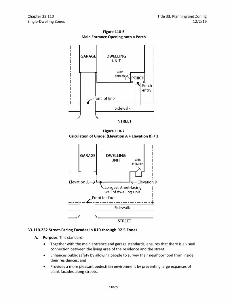
3. Main entrance. The main entrance that meets Subsection 33.110.230.C, Main entrances in R10 through R2.5 Zones, must be within 4 feet of grade. For the purposes of this requirement, grade is the average grade measured along the foundation of the longest street‐facing wall of the dwelling unit. See Figure 110‐7;
4. Garage door. In addition to meeting the requirements of 33.110.253.E, if the garage door is part of the street‐facing facade, it may not be more than 8 feet wide. If there is more than one garage door, the combined width may not be more than 8 feet;
5. No parking required. No off‐street parking is required;
6. Exterior finish materials. The standards of this paragraph must be met on all building facades.
a. Plain concrete block, plain concrete, corrugated metal, plywood, composite materials manufactured from wood or other products, and sheet pressboard may not be used as exterior finish material, except as secondary finishes if they cover no more than 10 percent of each facade.
b. Composite boards manufactured from wood or other products, such as hardboard or hardplank, may be used when the board product is less than 6 inches wide;
c. Where wood products are used for siding, the siding must be shingles, or horizontal siding, not shakes;
d. Where horizontal siding is used, it must be shiplap or clapboard siding composed of boards with a reveal of 6 inches or less, or vinyl or aluminum siding which is in a clapboard or shiplap pattern where the boards in the pattern are 6 inches or less in width;
Chapter 33.110 Title 33, Planning and Zoning Single‐Dwelling Zones 12/2/19
110‐12
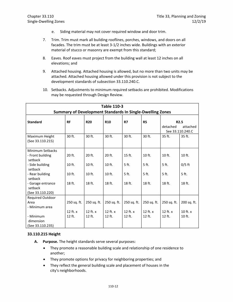
e. Siding material may not cover required window and door trim.
7. Trim. Trim must mark all building rooflines, porches, windows, and doors on all facades. The trim must be at least 3‐1/2 inches wide. Buildings with an exterior material of stucco or masonry are exempt from this standard;
8. Eaves. Roof eaves must project from the building wall at least 12 inches on all elevations; and
9. Attached housing. Attached housing is allowed, but no more than two units may be attached. Attached housing allowed under this provision is not subject to the development standards of subsection 33.110.240.C.
10. Setbacks. Adjustments to minimum required setbacks are prohibited. Modifications may be requested through Design Review.
Table 110‐3 Summary of Development Standards In Single‐Dwelling Zones
Standard
RF
R20
R10
R7
R5
R2.5
detached attached See 33.110.240.C
Maximum Height (See 33.110.215)
30 ft.
30 ft.
30 ft.
30 ft. 30 ft. 35 ft. 35 ft.
Minimum Setbacks ‐ Front building setback ‐ Side building setback ‐ Rear building setback ‐ Garage entrance setback (See 33.110.220)
20 ft. 10 ft. 10 ft. 18 ft.
20 ft. 10 ft. 10 ft. 18 ft.
20 ft. 10 ft. 10 ft. 18 ft.
15 ft. 5 ft. 5 ft. 18 ft.
10 ft. 5 ft. 5 ft. 18 ft.
10 ft. 5 ft. 5 ft. 18 ft.
10 ft. 0/5 ft 5 ft. 18 ft.
Required Outdoor Area ‐ Minimum area ‐ Minimum dimension (See 33.110.235)
250 sq. ft. 12 ft. x 12 ft.
250 sq. ft. 12 ft. x 12 ft.
250 sq. ft. 12 ft. x 12 ft.
250 sq. ft. 12 ft. x 12 ft.
250 sq. ft. 12 ft. x 12 ft.
250 sq. ft. 12 ft. x 12 ft.
200 sq. ft. 10 ft. x 10 ft.
33.110.215 Height
A. Purpose. The height standards serve several purposes:
They promote a reasonable building scale and relationship of one residence to another;
They promote options for privacy for neighboring properties; and
They reflect the general building scale and placement of houses in the city's neighborhoods.
Title 33, Planning and Zoning Chapter 33.110 12/2/19 Single‐Dwelling Zones
110‐13
B. Maximum height.
1. Generally. The maximum height allowed for all structures is stated in Table 110‐3. The maximum height standard for institutional uses is stated in 33.110.245, Institutional Development Standards. The maximum height standards for detached accessory structures are stated in 33.110.250, Detached Accessory Structures.
2. Exceptions.
a. R10‐R5 zones. The maximum height for all primary structures on new narrow lots in the R10 to R5 zones is 1.2 times the width of the structure, up to the maximum height limit listed in Table 110‐3; and
b. R2.5 zone. The maximum height for all primary structures on new narrow lots in the R2.5 zone is 1.5 times the width of the new structure, up to the maximum height limit listed in Table 110‐3.
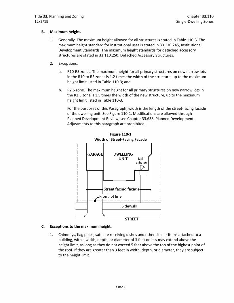
For the purposes of this Paragraph, width is the length of the street‐facing facade of the dwelling unit. See Figure 110‐1. Modifications are allowed through Planned Development Review, see Chapter 33.638, Planned Development. Adjustments to this paragraph are prohibited.
Figure 110‐1 Width of Street‐Facing Facade
C. Exceptions to the maximum height.
1. Chimneys, flag poles, satellite receiving dishes and other similar items attached to a building, with a width, depth, or diameter of 3 feet or less may extend above the height limit, as long as they do not exceed 5 feet above the top of the highest point of the roof. If they are greater than 3 feet in width, depth, or diameter, they are subject to the height limit.

Chapter 33.110 Title 33, Planning and Zoning Single‐Dwelling Zones 12/2/19
110‐14
2. Farm buildings associated with an agricultural use, such as silos and barns are exempt from the height limit as long as they are set back from all lot lines, at least one foot for every foot in height.
3. Antennas, utility power poles, and public safety facilities are exempt from the height limit.
4. Small wind turbines are subject to the standards of Chapter 33.299.
5. Roof mounted solar panels are not included in height calculations, and may exceed the maximum height limit if the following are met;
a. For flat roofs or the horizontal portion of mansard roofs, they may extend up to 5 feet above the top of the highest point of the roof.
b. For pitched, hipped or gambrel roofs, they must be mounted no more than 12 inches from the surface of the roof at any point, and may not extend above the ridgeline of the roof. The 12 inches is measured from the upper side of the solar panel.
D. Alternative height limits for steeply sloping lots.
1. Downhill slope from street. On lots that slope downhill from the street with an average slope of 20 percent or greater, the height limit is the higher of either 23 feet above the average grade of the street, or the normal height limit calculated as stated in Chapter 33.930, Measurements. In addition, the alternative height and setback standards of Subsection 33.110.220.D apply.
2. Uphill slope from the street. On lots that slope uphill from the street with an average slope of 20 percent or greater the alternative height and setback standards of Subsection 33.110.220.D apply.
33.110.220 Setbacks
A. Purpose. The setback regulations for buildings and garage entrances serve several purposes:
They maintain light, air, separation for fire protection, and access for fire fighting;
They reflect the general building scale and placement of houses in the city's neighborhoods;
They promote a reasonable physical relationship between residences;
They promote options for privacy for neighboring properties;
They require larger front setbacks than side and rear setbacks to promote open, visually pleasing front yards;
They provide adequate flexibility to site a building so that it may be compatible with the neighborhood, fit the topography of the site, allow for required outdoor areas, and allow for architectural diversity; and
They provide room for a car to park in front of a garage door without overhanging the street or sidewalk, and they enhance driver visibility when backing onto the street.
B. Required setbacks. The required setbacks for buildings and garage entrances are stated in Table 110‐3. The walls of the garage structure are subject to the front, side, and rear

Title 33, Planning and Zoning Chapter 33.110 12/2/19 Single‐Dwelling Zones
110‐15
building setbacks stated in Table 110‐3. The minimum setbacks for institutional uses are stated in 33.110.245. Other setbacks may apply to specific types of development or situations.
C. Extensions into required building setbacks.
1. The following features of a building may extend into a required building setback up to 20 percent of the depth of the setback. However, the feature must be at least three feet from a lot line:
a. Eaves, chimneys, fireplace inserts and vents, mechanical equipment, and fire escapes;
b. Water collection cisterns and stormwater planters that do not meet the standard of Paragraph C.2;
c. Decks, stairways, wheelchair ramps and uncovered balconies that do not meet the standards of Paragraph C.2; and
d. Bays and bay windows that meet the following requirements:
(1) Each bay and bay window may be up to 12 feet long, but the total area of all bays and bay windows on a building facade cannot be more than 30 percent of the area of the facade;
(2) At least 30 percent of the area of each bay which faces the property line requiring the setback must be glazing or glass block;
(3) Bays and bay windows must cantilever beyond the foundation of the building; and
(4) The bay may not include any doors.
2. The following minor features of a building may extend into the entire required building setbacks:
a. Utility connections attached to the building that are required to provide services such as water, electricity, and other similar utility services;
b. Gutters and downspouts that drain stormwater off a roof of the structure;
c. Stormwater planters that are no more than 2‐1/2 feet above the ground;
d. Water collection cisterns that are 6 feet or less in height;
e. Attached decks, stairs and ramps that are no more than 2‐1/2 feet above the ground. However, stairways and wheelchair ramps that lead to one entrance on the street‐facing façade of a building are allowed to extend into the required setback from a street lot line regardless of height above ground; and
f. On lots that slope down from the street, vehicular or pedestrian entry bridges that are no more than 2‐1/2 feet above the average sidewalk elevation.
3. Detached accessory structures. The setback standards for detached accessory structures including detached mechanical equipment are stated in 33.110.250. Fences

Chapter 33.110 Title 33, Planning and Zoning Single‐Dwelling Zones 12/2/19
110‐16
are addressed in 33.110.255. Detached accessory dwelling units are addressed in Chapter 33.205.
D. Exceptions to the required setbacks.
1. Setback averaging. The front building setback, garage entrance setback, and the setback of decks, balconies, and porches may be reduced to the average of the respective setbacks on the abutting lots. See Chapter 33.930, Measurements, for more information.
2. Flag lots. The lot in front of a flag lot may reduce its side building setback along the flag pole lot line to 3 feet. Eaves may be within 2 feet of the flag pole lot line. All other setback requirements remain the same.
3. Environmental zone. The front building and garage entrance setback may be reduced to zero where any portion of the site is in an environmental overlay zone. Where a side lot line is also a street lot line the side building and garage entrance setback may be reduced to zero. All other provisions of this Title apply to the building and garage entrance.
4. Steeply sloping lots. This provision applies to lots which slope up or down from the street with an average slope of 20 percent or greater. See Chapter 33.930, Measurements, for more information on how to measure average slope.
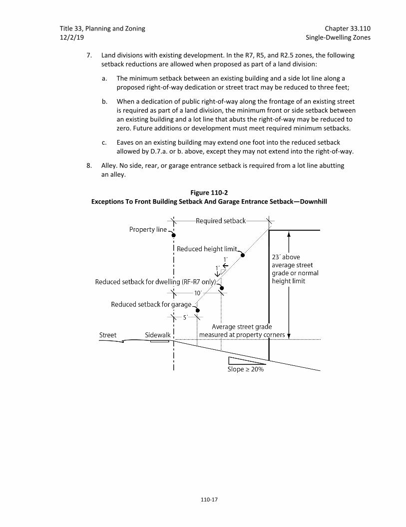
a. In the RF, R20, R10, and R7 zones, the front building setback for the dwelling may be reduced to 10 feet. However, the height limitations of subparagraph c. below apply. See Figures 110‐2 and 110‐3.
b. In all single‐dwelling residential zones, the front building setback for the garage wall and/or the garage entrance setback may be reduced to five feet. However, the height limitations of c. below apply. See Figures 110‐2 and 110‐3.
c. Height limitation. The height limit in the area of the reduced setback is lowered one foot for every foot of reduced setback. See Figures 110‐2 and 110‐3.
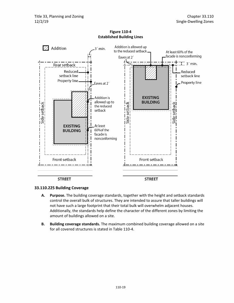
5. Established building lines. The front, side, or rear building setback for the primary structure may be reduced for sites with existing nonconforming development in a required setback. The reduction is allowed if the width of the portion of the existing wall of the primary structure within the required setback is at least 60 percent of the width of the respective facade of the existing primary structure. The building line created by the nonconforming wall serves as the reduced setback line. Eaves associated with the nonconforming wall may extend the same distance into the reduced setback as the existing eave. However, side or rear setbacks may not be reduced to less than 3 feet in depth and eaves may not project closer than 2 feet to the side or rear property line. See Figure 110‐4. This reduced setback applies to new development that is no higher than the existing nonconforming wall. For example, a second story could not be placed up to the reduced setback line if the existing nonconforming wall is only one story high.
6. Split zoning. No setbacks are required from an internal lot line that is also a zoning line on sites with split zoning.
Title 33, Planning and Zoning Chapter 33.110 12/2/19 Single‐Dwelling Zones
110‐17
7. Land divisions with existing development. In the R7, R5, and R2.5 zones, the following setback reductions are allowed when proposed as part of a land division:
a. The minimum setback between an existing building and a side lot line along a proposed right‐of‐way dedication or street tract may be reduced to three feet;
b. When a dedication of public right‐of‐way along the frontage of an existing street is required as part of a land division, the minimum front or side setback between an existing building and a lot line that abuts the right‐of‐way may be reduced to zero. Future additions or development must meet required minimum setbacks.
c. Eaves on an existing building may extend one foot into the reduced setback allowed by D.7.a. or b. above, except they may not extend into the right‐of‐way.
8. Alley. No side, rear, or garage entrance setback is required from a lot line abutting an alley.
Figure 110‐2 Exceptions To Front Building Setback And Garage Entrance Setback—Downhill

Chapter 33.110 Title 33, Planning and Zoning Single‐Dwelling Zones 12/2/19
110‐18
Figure 110‐3 Exceptions To Front Building Setback And Garage Entrance Setback—Uphill
Title 33, Planning and Zoning Chapter 33.110 12/2/19 Single‐Dwelling Zones
110‐19
Figure 110‐4 Established Building Lines
33.110.225 Building Coverage
A. Purpose. The building coverage standards, together with the height and setback standards control the overall bulk of structures. They are intended to assure that taller buildings will not have such a large footprint that their total bulk will overwhelm adjacent houses. Additionally, the standards help define the character of the different zones by limiting the amount of buildings allowed on a site.
B. Building coverage standards. The maximum combined building coverage allowed on a site for all covered structures is stated in Table 110‐4.

Chapter 33.110 Title 33, Planning and Zoning Single‐Dwelling Zones 12/2/19
110‐20
Table 110‐4 Maximum Building Coverage Allowed in the RF through R2.5 Zones [1]
Lot Size Maximum Building Coverage
Less than 3,000 sq. ft. 50% of lot area
3,000 sq. ft or more but less than 5,000 sq. ft. 1,500 sq. ft. + 37.5% of lot area over 3,000 sq. ft.
5,000 sq. ft. or more but less than 20,000 sq. ft. 2,250 sq. ft + 15% of lot area over 5,000 sq. ft.
20,000 sq. ft. or more 4,500 sq. ft. + 7.5% of lot area over 20,000 sq. ft.
Notes: [1] Group Living uses are subject to the maximum building coverage for institutional development stated in Table 110‐5.
33.110.227 Trees Requirements for street trees and for on‐site tree preservation, protection, and overall tree density are specified in Title 11, Trees. See Chapter 11.50, Trees in Development Situations.
33.110.230 Main Entrances in R10 through R2.5 Zones
A. Purpose. These standards:
Together with the street‐facing facade and garage standards, ensure that there is a physical and visual connection between the living area of the residence and the street;
Enhance public safety for residents and visitors and provide opportunities for community interaction;
Ensure that the pedestrian entrance is visible or clearly identifiable from the street by its orientation or articulation; and
Ensure that pedestrians can easily find the main entrance, and so establish how to enter the residence.
Ensure a connection to the public realm for development on lots fronting both private and public streets by making the pedestrian entrance visible or clearly identifiable from the public street.
B. Where these standards apply.
1. The standards of Subsection C apply to houses, attached houses, manufactured homes, and duplexes in the R10 through R2.5 zones;
2. The standard of Subsection D applies to attached houses on new narrow lots.
3. Where a proposal is for an alteration or addition to existing development, the standards of this section apply only to the portion being altered or added;
4. On sites with frontage on both a private street and a public street, the standards apply to the site frontage on the public street. On all other sites with more than one street frontage, the applicant may choose on which frontage to meet the standards.
5. Development on flag lots or on lots that slope up or down from the street with an average slope of 20 percent or more is exempt from these standards; and
6. Subdivisions and PUDs that received preliminary plan approval between September 9, 1990, and September 9, 1995, are exempt from these standards.

Title 33, Planning and Zoning Chapter 33.110 12/2/19 Single‐Dwelling Zones
110‐21
C. Location. At least one main entrance for each structure must:
1. Be within 8 feet of the longest street‐facing wall of the dwelling unit; and
2. Either:
a. Face the street. See Figure 110‐5;
b. Be at an angle of up to 45 degrees from the street; or
c. Open onto a porch. See Figure 110‐6. The porch must:
(1) Be at least 25 square feet in area;
(2) Have at least one entrance facing the street; and
(3) Have a roof that is:
No more than 12 feet above the floor of the porch; and
At least 30 percent solid. This standard may be met by having 30 percent of the porch area covered with a solid roof, or by having the entire area covered with a trellis or other open material if no more than 70 percent of the area of the material is open.
D. Distance from grade. The main entrance that meets Subsection .C, above, must be within 4 feet of grade. For the purposes of this Subsection, grade is the average grade measured along the foundation of the longest street‐facing wall of the dwelling unit. See Figure 110‐7. Modifications to this standard are allowed through Planned Development Review. See Chapter 33.638, Planned Development. Adjustments are prohibited.
Figure 110‐5 Main Entrance Facing the Street
Chapter 33.110 Title 33, Planning and Zoning Single‐Dwelling Zones 12/2/19
110‐22
Figure 110‐6 Main Entrance Opening onto a Porch
Figure 110‐7 Calculation of Grade: (Elevation A + Elevation B) / 2
33.110.232 Street‐Facing Facades in R10 through R2.5 Zones
A. Purpose. This standard:
Together with the main entrance and garage standards, ensures that there is a visual connection between the living area of the residence and the street;
Enhances public safety by allowing people to survey their neighborhood from inside their residences; and
Provides a more pleasant pedestrian environment by preventing large expanses of blank facades along streets.

Title 33, Planning and Zoning Chapter 33.110 12/2/19 Single‐Dwelling Zones
110‐23
B. Where this standard applies. The standard of this section applies to houses, attached houses, manufactured homes, and duplexes in the R10 through R2.5 zones. Where a proposal is for an alteration or addition to existing development, the applicant may choose to apply the standard either to the portion being altered or added, or to the entire street‐facing facade. Development on flag lots or on lots that slope up or down from the street with an average slope of 20 percent or more are exempt from this standard. In addition, subdivisions and PUDs that received preliminary plan approval between September 9, 1990, and September 9, 1995, are exempt from this standard.
C. The standard. At least 15 percent of the area of each facade that faces a street lot line must be windows or main entrance doors. Windows used to meet this standard must allow views from the building to the street. Glass block does not meet this standard. Windows in garage doors do not count toward meeting this standard, but windows in garage walls do count toward meeting this standard. To count toward meeting this standard, a door must be at the main entrance and facing a street lot line.
33.110.235 Required Outdoor Areas
A. Purpose. The required outdoor areas standards assure opportunities in the single‐dwelling zones for outdoor relaxation or recreation. The standards work with the maximum building coverage standards to ensure that some of the land not covered by buildings is of an adequate size and shape to be usable for outdoor recreation or relaxation. The location requirements provide options for private or semiprivate areas. The requirement of a required outdoor area serves in lieu of a large rear setback requirement and is an important aspect in addressing the livability of a residential structure.
B. Required outdoor area sizes. The minimum sizes of required outdoor areas per dwelling unit are stated in Table 110‐3. The shape of the outdoor area must be such that a square of the stated dimension will fit entirely in the outdoor area.
C. Requirements.
1. The required outdoor area must be a contiguous area and may be on the ground or above ground.
2. The area must be surfaced with lawn, pavers, decking, or sport court paving which allows the area to be used for recreational purposes. User amenities, such as tables, benches, trees, planter boxes, garden plots, drinking fountains, spas, or pools may be placed in the outdoor area. It may be covered, such as a covered patio, but it may not be fully enclosed.
3. General landscaped areas which are included as part of the required outdoor area may extend into the required side and rear building setback, but the required outdoor area may not be located in the front building setback.
33.110.240 Alternative Development Options
A. Purpose. The alternative development options allow for variety in development standards while maintaining the overall character of a single‐dwelling neighborhood. These options have several public benefits:
Chapter 33.110 Title 33, Planning and Zoning Single‐Dwelling Zones 12/2/19
110‐24
They allow for development that is sensitive to the environment, especially in hilly areas and areas with water features and natural drainageways;
They allow for the preservation of open and natural areas;
They promote better site layout and opportunities for private recreational areas;
They promote opportunities for affordable housing;
They promote energy‐efficient development;
They allow for the provision of alternative structure types where density standards are met; and
They reduce the impact that new development may have on surrounding residential development.
B. General requirements for all alternative development options. The alternative development options listed in this section are allowed by right unless specifically stated otherwise. The project must comply with all of the applicable development standards of this section. The project must also conform with all other development standards of the base zone unless those standards are superseded by the standards in this section.
C. Attached housing. Attached housing allows for more efficient use of land and for energy‐conserving housing.
1. R20 through R5 zones.
a. Lot dimensions. Each attached house must be on a lot that complies with the lot dimension standards for new lots in the base zone stated in Chapter 33.610, Lots in RF through R5 Zones.
b. Building setbacks.
(1) Interior (noncorner) lots. On interior lots the side building setback on the side containing the common wall is reduced to zero. The reduced setback applies to all buildings on the lot and extends along the full length of the lot line that contains the common or abutting wall. The side building setback on the side opposite the common wall must be double the side setback standard of the base zone.
(2) Corner lots. On corner lots either the rear setback or nonstreet side setback may be reduced to zero. However, the remaining nonstreet setback must comply with the requirements for a standard rear setback.
c. Number of units. Two attached houses may have a common wall. Structures made up of three or more attached houses are prohibited unless approved as a Planned Development.
d. Landscape standards. The following landscape standards must be met on lots in the R10 through R5 zones that do not meet the minimum lot width standard of 33.610.200.D.1, and were created by a land division submitted after July 1, 2002. Modification of these standards is allowed through Planned Development Review. See Chapter 33.638, Planned Development. Adjustments are prohibited.
Title 33, Planning and Zoning Chapter 33.110 12/2/19 Single‐Dwelling Zones
110‐25
(1) All street‐facing facades must have landscaping along the foundation. There must be at least one three‐gallon shrub for every 3 lineal feet of foundation; and
(2) Sixty percent of the area between the front lot line and the front building line must be landscaped. At a minimum, the required landscaped area must be planted with ground cover. Up to one‐third of the required landscaped area may be for recreational use, or for use by pedestrians. Examples include walkways, play areas, or patios.
2. R2.5 zone.
a. Density and lot size. The density and minimum lot dimension standards are stated in Chapter 33.611, Lots in the R2.5 Zone, apply.
b. Number of units. Up to eight attached houses may have common walls. Structures made up of nine or more attached houses are prohibited.
c. Building setbacks.
(1) Perimeter building setbacks. The front, side, and rear building setbacks around the perimeter of an attached housing project are those of the base zone.
(2) Interior building setbacks. The side building setback on the side containing the common wall is reduced to zero. The reduced setback extends along the full length of the lot line that contains the common or abutting wall.
(3) Corner lots. On corner lots either the rear setback or nonstreet side setback may be reduced to zero. However, the remaining nonstreet setback must comply with the requirements for a standard rear setback.
d. Landscape standards. The following landscape standards must be met on lots in the R2.5 zone that do not meet the minimum lot width standard of 33.611.200.C.1, and were created by a land division submitted after July 1, 2002. Modification of these standards is allowed through Planned Development Review. See Chapter 33.638, Planned Development. Adjustments are prohibited:
(1) All street‐facing facades must have landscaping along the foundation. There must be at least one three‐gallon shrub for every 3 lineal feet of foundation; and
(2) Sixty percent of the area between the front lot line and the front building line must be landscaped. At a minimum, the required landscaped area must be planted with ground cover. Up to one‐third of the required landscaped area may be for recreational use, or for use by pedestrians. Examples include walkways, play areas, or patios.

Chapter 33.110 Title 33, Planning and Zoning Single‐Dwelling Zones 12/2/19
110‐26
D. Duplex in R2.5 zone. Duplexes are allowed in the R2.5 zone if the following are met:
1. Density. A maximum density of 1 unit per 2,500 square feet of site area is allowed. Density for this standard is calculated before public right‐of‐way dedications are made;
2. Development standards. Duplexes must comply with the height, building setback, building coverage, and required outdoor area requirements of the base zone, overlay zone, or plan district; and
3. Front facade. Fire escapes, or exterior stairs that provide access to an upper level are not allowed on the front facade of the building.
E. Duplexes and attached houses on corners. This provision allows new duplexes and attached houses in locations where their appearance and impact will be compatible with the surrounding houses. Duplexes and attached houses on corner lots can be designed so each unit is oriented towards a different street. This gives the structure the overall appearance of a house when viewed from either street.
1. Qualifying situations. This provision applies to corner lots in the R20 through R2.5 zones.
2. Density. One extra dwelling unit is allowed up to a maximum of two units.
3. Lot dimension regulations. Lots in the R20 through R2.5 zones must meet the lot dimension regulations of this section. Adjustments are prohibited.
a. In the R20 through R7 zones:
(1) Duplexes. Lots for duplexes must meet the minimum lot dimension standards for new lots in the base zone.
(2) Attached houses. Where attached houses are proposed, the original lot, before division for the attached house proposal, must meet the minimum lot dimension standards for new lots in the base zone. The new lots created for the attached houses must meet the minimum lot dimension standards stated in Chapter 33.611, Lots in the R2.5 Zone.
(3) Attached houses as a result of a Property Line Adjustment. Attached houses are allowed on adjusted lots that are a result of a Property Line Adjustment.
b. In the R5 zone:
(1) Duplexes. Lots for duplexes must be at least 4,500 square feet in area.
(2) Attached houses as a result of a land division. Where attached houses are proposed, the original lot, before division for the attached house proposal, must be at least 4,500 square feet. The new lots created for the attached houses must meet the minimum lot dimension standards stated in Chapter 33.611, Lots in the R2.5 Zone.
(3) Attached houses as a result of a Property Line Adjustment. Attached houses are allowed on adjusted lots that are a result of a Property Line Adjustment.
Title 33, Planning and Zoning Chapter 33.110 12/2/19 Single‐Dwelling Zones
110‐27
c. In the R2.5 zone:
(1) Duplexes. Lots for duplexes must be at least 3,000 square feet in area.
(2) Attached houses as a result of a land division. Where attached houses are proposed, the original lot, before division for the attached house proposal, must be at least 3,000 square feet. There are no minimum lot dimension standards for the new lots.
(3) Attached houses as a result of a Property Line Adjustment. Attached houses are allowed on adjusted lots that are a result of a Property Line Adjustment.
4. Development standards. Both units of the duplex or attached houses must meet the following standards to ensure that the two units have compatible elements. Adjustments to this paragraph are prohibited, but modifications may be requested through Design Review. The standards are:
a. Entrances. Each of the units must have its address and main entrance oriented towards a separate street frontage. Where an existing house is being converted to two units, one main entrance with internal access to both units is allowed;
b. Height. If attached housing is proposed, the height of the two units must be within four feet of each other; and
c. On both units:
(1) Exterior finish materials. The exterior finish material must be the same, or visually match in type, size and placement.
(2) Roof pitch. The predominant roof pitch must be the same.
(3) Eaves. Roof eaves must project the same distance from the building wall.
(4) Trim. Trim must be the same in type, size and location.
(5) Windows. Windows must match in proportion and orientation.
F. Flag lot development standards. The development standards for flag lots include specific screening and setback requirements to protect the privacy of abutting residences. The following standards apply to development on flag lots:
1. Setbacks. Flag lots have required building setbacks that are the same along all lot lines. The required setbacks are:
Zone Setback
RF, R20, R10 15 feet
R7, R5, R2.5 10 feet
2. Landscaped buffer area. In the R7 through R2.5 zones, on lots that are 10,000 square feet or less in area, a landscaped area is required around the perimeter of the flag lot to buffer the flag portion from surrounding lots. The pole and the lot lines that are internal to the original land division site, or adjacent to an alley, are exempt from this requirement. The landscaped area must be at least 5 feet deep and be landscaped to at least the L3 standard. It may be reduced where the pole portion meets the flag portion to accommodate a 9‐foot driveway. See Figure 110‐9.
Chapter 33.110 Title 33, Planning and Zoning Single‐Dwelling Zones 12/2/19
110‐28
3. Building coverage. Only the area of the flag portion of the flag lot is considered when calculating building coverage. The area of the pole portion of the lot is not included.
4. Required outdoor area. The required outdoor area may not extend into the required landscaped buffer area required by F.2.
5. Detached accessory structures. Detached accessory structures may project into the flag lot setbacks as allowed in 33.110.250. However, these structures may not extend into the landscaped buffer area required by F.2.
G. Planned development. See Chapter 33.270, Planned Developments.
H. Transitional sites. The transitional site standards allow for a transition of development intensities between nonresidential and single‐dwelling zones. A stepped increase in density is allowed on single‐dwelling zoned lots that are adjacent to most commercial/mixed use, employment, industrial, or campus institutional zones. The transitional site provisions promote additional housing opportunities in a way that has minimal impacts on built‐up single‐dwelling neighborhoods.
1. Qualifying situations. The transitional site regulations apply only to sites in the R20 through R2.5 zones that have a side lot line that abuts a lot in the CM2, CM3, CE, CX, E, I, or CI zones. The side lot line of the residential site must abut the lot in a nonresidential zone for more than 50 percent of the residential site's length. The residential site must comply with the minimum lot dimension standards in the applicable base zone listed in Chapters 33.610 and 33.611.
2. Density. The site may have one dwelling unit more than the density allowed by 33.610.100.C.1 and 33.611.100.C.1.
3. Housing types allowed. The site may contain a duplex or be divided for attached houses.
4. Standards for attached housing projects. New lots created for attached houses must meet the minimum lot dimension standards stated in Chapter 33.611, Lots in the R2.5 Zone. Development must meet the site development regulations for attached houses in the R2.5 zone.

Title 33, Planning and Zoning Chapter 33.110 12/2/19 Single‐Dwelling Zones
110‐29
Figure 110‐9 Flag Lot Description and Buffer
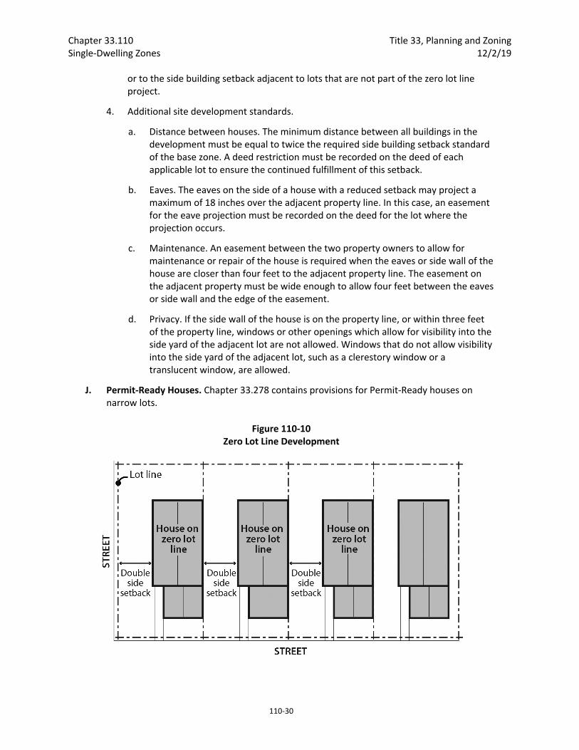
I. Zero lot line. A zero lot line development is where houses in a development on a common street frontage are shifted to one side of their lot. See Figure 110‐10. This provides for greater usable yard space on each lot. These developments require that the planning for all of the house locations be done at the same time. Because the exact location of each house is predetermined, greater flexibility in site development standards is possible while assuring that the single‐dwelling character is maintained.
1. Qualifying situations. Zero lot line developments are allowed for houses in the R20 through R2.5 zones.
2. Procedure. Zero lot line developments are allowed by right. Restrictions which assure the minimum distance between houses, and any required easements, must be recorded on the deeds of the applicable lots. Proof of such recording must be submitted as part of the building permit application.
3. Building setbacks. The side building setback on one side of the house may be reduced to zero. This reduction does not apply to the side building setback adjacent to a street,
Chapter 33.110 Title 33, Planning and Zoning Single‐Dwelling Zones 12/2/19
110‐30
or to the side building setback adjacent to lots that are not part of the zero lot line project.
4. Additional site development standards.
a. Distance between houses. The minimum distance between all buildings in the development must be equal to twice the required side building setback standard of the base zone. A deed restriction must be recorded on the deed of each applicable lot to ensure the continued fulfillment of this setback.
b. Eaves. The eaves on the side of a house with a reduced setback may project a maximum of 18 inches over the adjacent property line. In this case, an easement for the eave projection must be recorded on the deed for the lot where the projection occurs.
c. Maintenance. An easement between the two property owners to allow for maintenance or repair of the house is required when the eaves or side wall of the house are closer than four feet to the adjacent property line. The easement on the adjacent property must be wide enough to allow four feet between the eaves or side wall and the edge of the easement.
d. Privacy. If the side wall of the house is on the property line, or within three feet of the property line, windows or other openings which allow for visibility into the side yard of the adjacent lot are not allowed. Windows that do not allow visibility into the side yard of the adjacent lot, such as a clerestory window or a translucent window, are allowed.
J. Permit‐Ready Houses. Chapter 33.278 contains provisions for Permit‐Ready houses on narrow lots.
Figure 110‐10 Zero Lot Line Development
Title 33, Planning and Zoning Chapter 33.110 12/2/19 Single‐Dwelling Zones
110‐31
33.110.245 Institutional Development Standards
A. Purpose. The general base zone development standards are designed for residential buildings. Different development standards are needed for institutional uses which may be allowed in single‐dwelling zones. The intent is to maintain compatibility with and limit the negative impacts on surrounding residential areas.
B. Use categories to which these standards apply. The standards of this section apply to uses in the institutional group of use categories, whether allowed by right, allowed with limitations, or subject to a conditional use review. The standards apply to new development, exterior alterations, and conversions to institutional uses. Recreational fields used for organized sports on a school, school site, or in a park, are subject to Chapter 33.279, Recreational Fields for Organized Sports.
C. The standards.
1. The development standards are stated in Table 110‐5. If not addressed in this section, the regular base zone development standards apply.
2. Setbacks on a transit street or in a Pedestrian District.
a. Purpose. The purpose of these regulations is to reduce reliance on the automobile and encourage pedestrians and transit riders by ensuring safe and convenient pedestrian access to buildings.
b. Building setbacks on a transit street or in a Pedestrian District. Buildings on a transit street or in a Pedestrian District must meet the provisions of 33.120.220.C.
c. Conflicts.
(1) If the depth of the minimum building setback or buffering standards conflicts with the maximum building setback standard, the depth of the maximum building setback standard supersedes the depth of the minimum building setback and buffering standards.
(2) If the depth of the minimum setback standard for detached accessory structures conflicts with the depth of the minimum buffering standard, the depth of the minimum buffering standard supersedes the depth of the minimum setback standard for detached accessory structures.
d. Exception. Development that is not subject to conditional use review under Section 33.815.040 is exempt from the maximum transit street setback requirement.
3. Exterior storage. Exterior storage of materials or equipment is prohibited.
4. Outdoor activity facilities. Except as specified in paragraph C.5. below, outdoor activity facilities, such as swimming pools, basketball courts, tennis courts, or baseball diamonds must be set back 50 feet from abutting R‐zoned properties. Playground facilities must be set back 25 feet from abutting R‐zoned properties if not illuminated, and 50 feet if illuminated. Where the outdoor activity facility abuts R‐zoned properties in School uses, the required setback is reduced to zero.
Chapter 33.110 Title 33, Planning and Zoning Single‐Dwelling Zones 12/2/19
110‐32
5. Recreational fields for organized sports. Recreational fields used for organized sports on a school, school site, or in a park, are subject to Chapter 33.279, Recreational Fields for Organized Sports.
6. Mechanical equipment. Mechanical equipment located on the ground, such as heating or cooling equipment, pumps, or generators must be screened from the street and any abutting residential zones by walls, fences, or vegetation. Screening must comply with at least the L2 or F2 standards of Chapter 33.248, Landscaping and Screening, and be tall enough to screen the equipment. Mechanical equipment placed on roofs must be screened in one of the following ways, if the equipment is within 50 feet of an R zone:
a. A parapet along facades facing the R zone that is as tall as the tallest part of the equipment;
b. A screen around the equipment that is as tall as the tallest part of the equipment; or
c. The equipment is set back from roof edges facing the R zone 3 feet for each foot of height of the equipment.
7. Electrical substations. In addition to the standards in Table 110‐5, the entire perimeter of electrical substations, including the street lot line (except for the access point), must be landscaped to the L3 standards stated in Chapter 33.248. This landscaping must be planted on the outside of any security fence. Electrical substations that are in a fully enclosed building are exempt from this requirement.
8. Grassy areas. Grassy play areas, golf courses, cemeteries, and natural areas are not subject to the L3 landscaping standard of Table 110‐5 and are exempt from the setback standard of Paragraph 4, above.
9. Garbage and recycling collection areas. All exterior garbage cans. Garbage collection areas, and recycling collection areas must be screened from the street and any adjacent properties. Trash receptacles for pedestrian use are exempt. Screening must comply with at least the L3 or F2 standards of Chapter 33.248, Landscaping and Screening. See Section 17.102.270, Business and Multifamily Complexes Required to Recycle, of the Portland City Code for additional requirements for recycling areas.
10. Pedestrian standards. The on‐site pedestrian circulation system must meet the standards of Section 33.120.255, Pedestrian Standards.
Table 110‐5 Institutional Development Standards [1]
Minimum Site Area for New Uses
10,000 sq. ft.
Maximum Floor Area Ratio [2] 0.5 to 1
Maximum Height [3] 50 ft.

Title 33, Planning and Zoning Chapter 33.110 12/2/19 Single‐Dwelling Zones
110‐33
Minimum Building Setbacks [2]
1 ft. back for every 2 ft. of bldg. height, but in no case less than 15 ft.
Maximum Building Setback Transit Street or Pedestrian District [7]
20 ft. or per CU/IMP review
Maximum Building Coverage [2] 50% of site area
Minimum Landscaped Area [2,4] 25% of site area to the L1 standard
Buffering from Abutting Residential Zone [5] 15 ft. to L3 standard
Buffering Across a Street from a Residential Zone [5] 15 ft. to L1 standard
Setbacks for All Detached Accessory Structures Except Fences [6]
10 ft.
Parking and Loading See Chapter 33.266, Parking And Loading
Signs See Title 32, Signs and Related Regulations
Notes: [1] The standards of this table are minimums or maximums as indicated. Compliance with the conditional use approval criteria might preclude development to the maximum intensity permitted by these standards. [2] For campus‐type developments, the entire campus is treated as one site. Setbacks are only measured from the perimeter of the site. The setbacks in this table only supersede the setbacks required in Table 110‐3. The normal regulations for projections into setbacks and for detached accessory structures still apply. [3] Towers and spires with a footprint of 200 square feet or less may exceed the height limit, but still must meet the setback standard. Elevator mechanical equipment that is set back at least 15 feet from all roof edges on street facing facades may extend up to 16 feet above the height limit. Other mechanical equipment and stairwell enclosures that provide rooftop access when these cumulatively cover no more than 10 percent of the roof area and are set back at least 15 feet from all roof edges on street facing facades may extend up to 10 feet above the height limit. [4] Any required landscaping, such as for required setbacks or parking lots, applies towards the landscaped area standard. [5] Surface parking lots are subject to the parking lot setback and landscaping standards stated in Chapter 33.266, Parking And Loading. [6] Setbacks for structures that are accessory to recreational fields for organized sports on a school, school site, or in a park, are stated in Chapter 33.279, Recreational Fields for Organized Sports. [7] The maximum building setbacks are described in 33.110.245.C.
33.110.250 Detached Accessory Structures
A. Purpose. This section regulates detached structures that are incidental to primary buildings to prevent them from becoming the predominant element of the site. The standards limit the height and bulk of the structures, promote compatibility of design for larger structures, provide for necessary access around larger structures, help maintain privacy to abutting lots, and maintain open front setbacks.
Chapter 33.110 Title 33, Planning and Zoning Single‐Dwelling Zones 12/2/19
110‐34
B. General standards.
1. The regulations of this section apply to all detached accessory structures. Farm structures associated with an agricultural use such as barns and silos are exempt from these standards as long as they are set back from all lot lines at least one foot for every foot in height. Additional regulations for accessory dwelling units are stated in Chapter 33.205.
2. Detached accessory structures are allowed on a lot only in conjunction with a primary building, and may not exist on a lot prior to the construction of the primary structure, except as allowed by Paragraph B.3, below.
3. A detached accessory structure that becomes the only structure on a lot as the result of a land division, a property line adjustment, a separation of ownership, or a demolition of the primary structure may remain on the lot if the owner has executed a covenant with the City that meets the requirements of Section 33.700.060.
a. For a land division, the covenant must require the owner to remove the accessory structure if, within two years of final plat approval, a primary structure has not been built and received final inspection. The covenant must be executed with the City prior to final plat approval.
b. For a property line adjustment or a separation of ownership, the covenant must require the owner to remove the accessory structure if a primary structure has not been built and received final inspection within two years. The two years begins on the date the letter from BDS confirming the property line adjustment or separation of ownership is mailed. The covenant must be executed with the City before the final letter from BDS is issued.
c. For a demolition of a primary structure, the covenant must require the owner to remove the accessory structure if a new primary structure has not been built and received final inspection within two years. The two years begins on the date of the final inspection of the demolition. The covenant must be executed with the City prior to the issuance of the demolition permit.
C. Detached covered accessory structures. Detached covered accessory structures are items such as garages, carports, greenhouses, artist’s studios, guest houses, accessory dwelling units, storage buildings, wood sheds, water collection cisterns, and covered decks or patios. The following standards apply to all detached covered accessory structures. Garages are also subject to the standards of 33.110.253.
1. Height. The maximum height allowed for all detached covered accessory structures is 20 feet.
2. Setbacks. Except as follows, detached covered accessory structures are subject to required building setbacks. See the additional regulations for garages in 33.110.253.
a. Water collection cisterns that are 6 feet or less in height are allowed in side and rear setbacks.

Title 33, Planning and Zoning Chapter 33.110 12/2/19 Single‐Dwelling Zones
110‐35
b. In the R7, R5 and R2.5 zones, detached covered accessory structures other than water collection cisterns are allowed in the side and rear building setbacks if all of the following are met:
(1) The structure is at least 40 feet from a front lot line, and if on a corner lot, at least 20 feet from a side street lot line;
(2) The structure has dimensions that do not exceed 24 feet by 24 feet, excluding eaves;
(3) If more than one structure is within the setback, the combined length of all structures in the setback adjacent to each property line is no more than 24 feet;
(4) The structure is no more than 15 feet high, and the walls of the structure are no more than 10 feet high, excluding the portion of the wall within a gable;
(5) The portion of the structure within the setback must be screened from adjoining lots by a fence or landscaping, unless it is enclosed within the setback by a wall. Screening is not required for enclosed structures. Screening must comply with the L3 or F2 standards of Chapter 33.248, Landscaping and Screening;
(6) Walls located within the setback do not have doors or windows facing the adjacent lot line;
(7) The structure does not have a rooftop deck; and
(8) Dormers are set back at least 5 feet from the side and rear lot lines.
3. Building coverage. The following additional building coverage standards apply to detached covered accessory structures:
a. The combined building coverage of all detached covered accessory structures may not exceed 15 percent of the total area of the site; and
b. The building coverage of a detached covered accessory structure may not be greater than the building coverage of the primary structure.
4. Additional development standards for detached covered accessory structures. The following additional standards apply to detached covered accessory structures that are more than 15 feet high. Additions to existing structures that do not meet a standard are exempt from that standard.
a. Exterior finish materials. The exterior finish materials on the detached covered accessory structure must meet one of the following:
(1) The exterior finish material must be the same or visually match in type, size and placement, the exterior finish material of the primary structure; or
(2) Siding must be made from wood, composite boards, vinyl or aluminum products, and the siding must be composed in a shingle pattern, or in a horizontal clapboard or shiplap pattern. The boards in the pattern must be 6 inches or less in width.
Chapter 33.110 Title 33, Planning and Zoning Single‐Dwelling Zones 12/2/19
110‐36
b. Roof Pitch. The roof pitch of the detached covered accessory structure must meet one of the following:
(1) The predominant roof pitch must be the same as the predominant roof pitch of the primary structure; or
(2) The roof pitch must be at least 6/12.
c. Trim. The trim on the detached covered accessory structure must meet one of the following:
(1) The trim must be the same in type, size, and location as the trim used on the primary structure; or
(2) The trim around all windows and doors must be at least 3 ½ inches wide.
d. Windows. The windows on all street facing facades of the detached covered accessory structure must meet one of the following:
(1) The windows must match those on the street facing façade of the primary structure in orientation (horizontal or vertical); or
(2) Each window must be square or vertical – at least as tall as it is wide.
e. Eaves. The eaves on the detached covered accessory structure must meet one of the following:
(1) The eaves must project from the building walls the same distance as the eaves on the primary structure;
(2) The eaves must project from the building walls at least 1 foot on all elevations; or
(3) If the primary structure has no eaves, no eaves are required.
D. Detached uncovered vertical structures. Detached uncovered vertical structures are items such as flag poles, trellises, arbors and other garden structures, play structures, antennas, satellite receiving dishes, and lamp posts. The following standards apply to detached uncovered vertical structures. Fences are addressed in 33.110.255:
1. Height. Except as follows, the maximum height allowed for all detached uncovered vertical structures is 20 feet:
a. Antennas, utility power poles, and public safety facilities are exempt from the height limit.
b. Flagpoles are subject to the height limit of the base zone for primary structures.
c. Detached small wind turbines are subject to the standards of 33.299, Wind Turbines.
2. Setbacks. Except as follows, detached uncovered vertical structures are subject to required building setbacks:

Title 33, Planning and Zoning Chapter 33.110 12/2/19 Single‐Dwelling Zones
110‐37
a. Detached uncovered vertical structures that are no larger than 3 feet in width, depth, or diameter and no taller than 8 feet are allowed in required building setbacks.
b. A single arbor structure that is up to 6 feet wide, up to 3 feet deep, and up to 8 feet tall is allowed in the front setback. The arbor must allow for pedestrian access under its span.
c. Flagpoles are allowed in required building setbacks.
d. In the R7, R5, and R2.5 zones, detached uncovered vertical structures that exceed the allowances of Subparagraph 2.a are allowed in side and rear setbacks if all of the following are met:
(1) The structure is at least 40 feet from a front lot line, and if on a corner lot, at least 20 feet from a side street lot line;
(2) The structure has dimensions that do not exceed 24 feet by 24 feet;
(3) The structure is no more than 10 feet high;
(4) The portion of the structure within the setback must be screened from adjoining lots by a fence or landscaping, unless it is enclosed within the setback by a wall. Screening is not required for enclosed structures. Screening must comply with the L3 or F2 standards of Chapter 33.248, Landscaping and Screening; and
(5) The structure does not have a rooftop deck.
E. Detached uncovered horizontal structures. Uncovered horizontal structures are items such as decks, stairways, swimming pools, hot tubs, tennis courts, and boat docks not covered or enclosed. The following standards apply to detached uncovered horizontal structures.
1. Height. The maximum height allowed for all detached uncovered horizontal structures is 20 feet.
2. Setbacks. Except as follows, detached uncovered horizontal structures are subject to required buildings setbacks:
a. Detached uncovered decks, ramps, and stairways that are more than 2‐1/2 feet above the ground may extend into a required building setback up to 20 percent of the depth of the setback. However, the deck or stairway must be at least three feet from a lot line.
b. Structures that are no more than 2‐1/2 feet above the ground are allowed in required building setbacks.
F. Detached mechanical equipment. Detached mechanical equipment includes items such as heat pumps, air conditioners, emergency generators, radon mitigation components, and water pumps. Generally, detached mechanical equipment will not be attached to a building but may have components such as ventilation or electrical systems attached to the primary structure. The following standards apply to detached mechanical equipment:
Chapter 33.110 Title 33, Planning and Zoning Single‐Dwelling Zones 12/2/19
110‐38
1. Height. The maximum height allowed for all detached mechanical equipment is 20 feet.
2. Setbacks. Except as follows, detached mechanical equipment is subject to required buildings setbacks. Detached mechanical equipment is allowed in side or rear building setbacks if all of the following are met:
a. The equipment is no more than 5 feet high; and
b. The equipment is screened from adjoining lots by walls, fences or vegetation. Screening must comply with the L3 or F2 standards of Chapter 33.248, Landscaping and Screening.
33.110.253 Additional Standards for Garages
A. Purpose. These standards:
Together with the window and main entrance standards, ensure that there is a physical and visual connection between the living area of the residence and the street;
Ensure that the location and amount of the living area of the residence, as seen from the street, is more prominent than the garage;
Prevent garages from obscuring the main entrance from the street and ensure that the main entrance for pedestrians, rather than automobiles, is the prominent entrance;
Provide for a more pleasant pedestrian environment by preventing garages and vehicle areas from dominating the views of the neighborhood from the sidewalk; and
Enhance public safety by preventing garages from blocking views of the street from inside the residence.
B. Additional Regulations. The regulations of this Section apply in addition to those of 33.110.250, Accessory Structures.
C. Existing detached garages.
1. Rebuilding. A detached garage that is nonconforming due to its location in a setback, may be rebuilt on the footprint of the existing foundation, if the garage was originally constructed legally. In this case, the rebuilt garage may be no more than 15 feet high, and the garage walls may be no more than 10 feet high, excluding the portion of the wall within a gable. Decks are not allowed on the roof of the garage. The rebuilt garage is not required to comply with other standards of this chapter.
Title 33, Planning and Zoning Chapter 33.110 12/2/19 Single‐Dwelling Zones
110‐39
2. Additions. An addition may be made to an existing detached garage that is nonconforming due to its location in a setback as follows:
a. The expanded garage complies with all other standards of this chapter; or
b. The combined size of the existing foundation and the addition is no larger than 12 feet wide by 20 feet deep. In this case, the garage may be no more than 15 feet high, and the walls of the addition may be no more than 10 feet high, excluding the portion of the wall within a gable. Decks are not allowed on the roof of the garage. The expanded garage is not required to comply with other standards of this chapter.
D. Length of street‐facing garage wall.
1. Where these regulations apply. Unless exempted by Paragraph E.2, below, the regulations of this subsection apply to garages accessory to houses, attached houses, manufactured homes, and duplexes in the R10 through R2.5 zones.
2. Exemptions.
a. Garages that are accessory to development on flag lots, or development on lots which slope up or down from the street with an average slope of 20 percent or more are exempt from the standards of this subsection.
b. Garages in subdivisions and PUDs that received Preliminary Plan approval between September 9, 1990, and September 9, 1995, are exempt from the standards of this subsection.
c. On corner lots, only one street‐facing garage wall must meet the standards of this subsection.
3. Standards.
a. The length of the garage wall facing the street may be up to 50 percent of the length of the street‐facing building facade. See Figure 110‐11. For duplexes, this standard applies to the total length of the street‐facing facades. For all other lots and structures, the standards apply to the street‐facing facade of each unit.
b. Where the street‐facing facade is less than 22 feet long, an attached garage is not allowed as part of that facade.
4. Exception. Where the building is not being built on a new narrow lot, the garage wall facing the street may exceed the standards listed in Paragraph D.3 above if D.4.a and either D.4.b or c. are met. See Figure 110‐12.
a. The garage wall facing the street is no more than 12 feet long; and
b. There is interior living area above the garage. The living area must be set back no more than 4 feet from the street‐facing garage wall; or
c. There is a covered balcony above the garage that is at least the same length as the street facing garage wall, at least 6 feet deep, and accessible from the interior living area of the dwelling unit.
Chapter 33.110 Title 33, Planning and Zoning Single‐Dwelling Zones 12/2/19
110‐40
5. For new narrow lots, modifications to the standards of this subsection are allowed through Planned Development Review. See Chapter 33.638, Planned Development. Adjustments are prohibited.
E. Street lot line setbacks.
1. Where this standard applies. The standard of this paragraph applies to garages that are accessory to houses, attached houses, manufactured homes, and duplexes in the R10 through R2.5 zones. Where a proposal is for an alteration or addition to existing development, the standard applies only to the portion being altered or added.
2. Exemptions.
a. Development on flag lots or on lots which slope up or down from the street with an average slope of 20 percent or more are exempt from this standard.
b. Subdivisions and PUDs that received preliminary plan approval between September 9, 1990, and September 9, 1995, are exempt from this standard.
c. Where a lot has more than one street lot line, and there is an existing dwelling unit on the lot, this standard must be met only on the street‐facing facade on which the main entrance is located.
3. Standard. A garage wall that faces a street may be no closer to the street lot line than the longest street‐facing wall of the dwelling unit. See Figure 110‐13.
4. Exception. A street‐facing garage wall may be up to 6 feet in front of the longest street‐facing wall of the dwelling unit, if:
a. The street‐facing garage wall is 40 percent or less of the length of the building facade; and
b. There is a porch at the main entrance. The garage wall may not be closer to the street lot line than the front of the porch. See Figure 110‐14. The porch must meet the following:
(1) The porch must be at least 48 square feet in area and have minimum dimensions of 6 feet by 6 feet;
(2) The porch must have a solid roof; and
(3) The roof may not be more than 12 feet above the floor of the porch.

Title 33, Planning and Zoning Chapter 33.110 12/2/19 Single‐Dwelling Zones
110‐41
Figure 110‐11 Length of Street‐Facing Garage Wall
Figure 110‐12 Length of Street‐Facing Garage Wall Exception
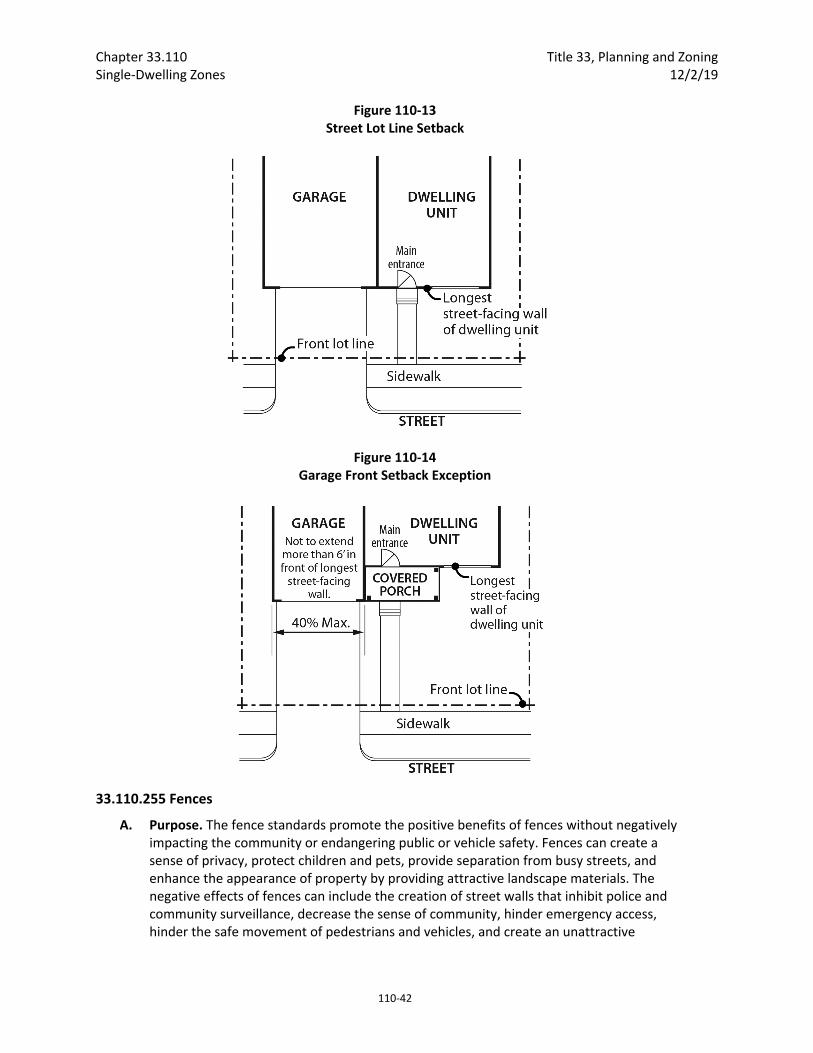
Chapter 33.110 Title 33, Planning and Zoning Single‐Dwelling Zones 12/2/19
110‐42
Figure 110‐13 Street Lot Line Setback
Figure 110‐14 Garage Front Setback Exception
33.110.255 Fences
A. Purpose. The fence standards promote the positive benefits of fences without negatively impacting the community or endangering public or vehicle safety. Fences can create a sense of privacy, protect children and pets, provide separation from busy streets, and enhance the appearance of property by providing attractive landscape materials. The negative effects of fences can include the creation of street walls that inhibit police and community surveillance, decrease the sense of community, hinder emergency access, hinder the safe movement of pedestrians and vehicles, and create an unattractive
Title 33, Planning and Zoning Chapter 33.110 12/2/19 Single‐Dwelling Zones
110‐43
appearance. These standards are intended to promote the positive aspects of fences and to limit the negative ones.
B. Types of fences. The standards apply to walls, fences, and screens of all types whether open, solid, wood, metal, wire, masonry, or other material.
C. Location and height.
1. Front building setbacks. Fences up to 3‐1/2 feet high are allowed in required front building setbacks.
2. Side and rear building setbacks.
a. Fences up to 8 feet high are allowed in required side or rear building setbacks that do not abut a pedestrian connection.
b. Fences abutting a pedestrian connection.
(1) Fences up to 8 feet high are allowed in required side or rear building setbacks that abut a pedestrian connection if the pedestrian connection is part of a right‐of‐way that is at least 30 feet wide.
(2) Fences up to 3‐1/2 feet high are allowed in required side or rear building setbacks that abut a pedestrian connection if the pedestrian connection is part of a right‐of‐way that is less than 30 feet wide.
3. Exceptions for corner lots. On corner lots, if the main entrance is on the facade facing the side street lot line, the applicant may elect to meet the following instead of C.1 and C.2. See Figure 110‐15.
a. Fences up to 3‐1/2 feet high are allowed within the first 10 feet of the side street lot line.
b. Fences up to 3‐1/2 feet high are allowed in required setbacks that abut a pedestrian connection if the pedestrian connection is part of a right‐of‐way that is less than 30 feet wide;
c. Fences up to 8 feet high are allowed in the required front building setback, outside of the area subject to 3a.
d. Fences up to 8 feet high are allowed in all other side or rear building setbacks.
4. Not in building setbacks. The height for fences that are not in required building setbacks is the same as the regular height limits of the zone.

Chapter 33.110 Title 33, Planning and Zoning Single‐Dwelling Zones 12/2/19
110‐44
Figure 110‐15 Fence Height Option on Corner Lots
D. Reference to other regulations. Electrified fences are regulated under Title 26, Electrical Regulations. The use of barbed wire is regulated under Title 24, Building Regulations.
33.110.257 Retaining Walls
A. Purpose. The standards of this section help mitigate the potential negative effects of large retaining walls. Without mitigation, such walls can create a fortress‐like appearance and be unattractive. By requiring large walls to step back from the street and provide landscaping, the wall is both articulated and visually softened.
B. Where these regulations apply.
1. Generally. These regulations apply to the portions of street‐facing retaining walls that are in required setbacks along street lot lines. Where there is no required setback, or the setback is less than 10 feet, the regulations apply to the first 10 feet from the line.
2. Exceptions. The following are not subject to the regulations of this section:
a. Retaining walls in the areas described in B.1 that are less than four feet high, as measured from the bottom of the footing.
b. Retaining walls on sites where the site slopes downward from a street in the area described in B.1.
c. Retaining walls on sites where the site slopes upward from a street and the existing slope within the area regulated by B.1 is 50 percent or more.
d. Replacing an existing retaining wall, where the replacement will not be taller or wider than the existing wall.

Title 33, Planning and Zoning Chapter 33.110 12/2/19 Single‐Dwelling Zones
110‐45
e. Retaining walls on sites where any portion of the site is in an environmental overlay zone.
C. Standards.
1. Retaining walls are limited to 4 feet in height measured from the bottom of the footing, as shown in Figure 110‐16.
2. Retaining walls must be set back at least 3 feet from other street‐facing retaining walls, as shown in Figure 110‐16. The 3 foot setback area must be landscaped to at least the L2 standard, except that trees are not required. A wall or berm may not be substituted for the shrubs.
33.110.260 Demolitions
A. Generally. Demolition on a site that requires a demolition permit is subject to the tree preservation and protection requirements of Title 11, Trees. See Chapter 11.50, Trees in Development Situations.
B. Historic resources. Demolition of historic resources is regulated by Chapter 33.445, Historic Resource Overlay Zone.
33.110.270 Nonconforming Development Existing developments that do not conform to the development standards of this chapter may be subject to the regulations of Chapter 33.258, Nonconforming Situations.
Figure 110‐16 Retaining Walls
Chapter 33.110 Title 33, Planning and Zoning Single‐Dwelling Zones 12/2/19
110‐46
33.110.275 Parking and Loading
A. Access to parking. Vehicle access to a lot must be from an alley under the following conditions. Modifications to this standard are allowed through Planned Development Review. See Chapter 33.638, Planned Development. Adjustments are prohibited.
1. The lot abuts an alley;
2. The lot was created by a land division submitted after July 1, 2002; and
3. The lot is either:
a. In the R10 through R5 zones and does not meet the minimum lot width standard of 33.610.200.D.1; or
b. In the R2.5 zone and does not meet the minimum lot width standard of 33.611.200.C.1.
B. Parking and loading. For all other parking and loading regulations, see Chapter 33.266, Parking and Loading.
33.110.280 Signs The sign regulations are stated in Title 32, Signs and Related Regulations.
(Amended by: Ord. No.165376, effective 5/29/92; Ord. No. 165594, effective 7/8/92; Ord. No. 166313, effective 4/9/93; Ord. No. 167186, effective 12/31/93; Ord. No. 167189, effective 1/14/94; Ord. No. 168698, effective 4/17/95; Ord. No. 169324, effective10/12/95; Ord. No. 170704, effective 1/1/97; Ord. No. 171219, effective 7/1/97; Ord. No. 171718, effective 11/29/97; Ord. No. 171879, effective 2/2/98; Ord. No. 173533, effective 8/2/99; Ord. No. 173593, effective 9/3/99; Ord. No. 173729, effective 9/9/99; Ord. No. 174263, effective 4/15/00; Ord. No. 174378, effective 5/26/00; Ord. No. 175204, effective 3/1/01; Ord. No. 175837, effective 9/7/01; Ord. Nos. 175965 and 176333, effective 7/1/02; Ord. No. 176469, effective 7/1/02; Ord. No. 177028, effective 12/14/02; Ord. No. 177422, effective 6/7/03; Ord. No. 177643, effective 7/10/03; Ord. No. 177701, effective 8/30/03; Ord. No. 177975, effective 11/14/03; Ord. No. 178045, effective 12/10/03; Ord. No. 178172, effective 3/5/04; Ord. No. 178509, effective 7/16/04; Ord. No. 178927, effective 12/31/04; Ord. No. 179092, effective 4/1/05; Ord. Nos. 179980 and 179994, effective 4/22/06; Ord. No. 180619, effective 12/22/06; Ord. No. 181357, effective 11/9/07; Ord. No. 182429, effective 1/16/09; Ord. No. 183598, effective 4/24/10; Ord. No. 183750, effective 6/4/10; Ord. No. 184016, effective 08/20/10; Ord. No. 184235, effective 11/26/10; Ord. No. 185412, effective 6/13/12; Ord. No. 185915; effective 5/1/13; Ord. No. 186639, effective 7/11/14; Ord. No. 186736, effective 8/29/14; Ord. No. 186053, effective 1/1/15; Ord. No. 187216, effective 7/24/15. Ord. No. 187471, effective 1/1/16; Ord. No. 188142, effective 1/13/17; Ord. No. 188259, effective 3/31/17; Ord. No. 188177, effective 5/24/18; Ord. No. 188958, effective 5/24/18; Ord. No. 189488, effective 12/2/19.)
Title 33, Planning and Zoning Chapter 33.120 12/2/19 Multi‐Dwelling Zones
120‐1
33.120 Multi‐Dwelling Zones
120
Sections:
General 33.120.010 Purpose 33.120.020 List of the Multi‐Dwelling Zones 33.120.030 Characteristics of the Zones 33.120.040 Other Zoning Regulations 33.120.050 Neighborhood Contact
Use Regulations 33.120.100 Primary Uses 33.120.110 Accessory Uses 33.120.120 Nuisance‐Related Impacts
Development Standards 33.120.200 Housing Types Allowed 33.120.205 Density 33.120.210 Development on Lots and Lots of Record 33.120.215 Height 33.120.220 Setbacks 33.120.225 Building Coverage 33.120.230 Building Length 33.120.231 Main Entrances 33.120.232 Street‐Facing Facades 33.120.235 Landscaped Areas 33.120.237 Trees 33.120.240 Required Outdoor Areas 33.120.250 Screening 33.120.255 Pedestrian Standards 33.120.260 Recycling Areas 33.120.265 Amenity Bonuses 33.120.270 Alternative Development Options 33.120.275 Development Standards for Institutions 33.120.280 Detached Accessory Structures 33.120.283 Additional Standards for Garages 33.120.285 Fences 33.120.290 Demolitions 33.120.300 Nonconforming Development 33.120.305 Parking and Loading 33.120.310 Signs 33.120.320 Inclusionary Housing
Supplemental Information Map 120‐1 Index Map for RH Areas with Maximum FAR of 4:1 Maps 120‐2 through 120‐20 RH Areas with Maximum FAR of 4:1

Chapter 33.120 Title 33, Planning and Zoning Multi‐Dwelling Zones 12/2/19
120‐2
General
33.120.010 Purpose The multi‐dwelling zones are intended to preserve land for urban housing and to provide opportunities for multi‐dwelling housing.
A. Use regulations. The use regulations are intended to create and maintain higher density residential neighborhoods. At the same time, they allow for large scale institutional campuses and other nonresidential uses but not to such an extent as to sacrifice the overall residential neighborhood image and character.
B. Development standards. The six multi‐dwelling zones are distinguished primarily by density and development standards. The development standards work together to create desirable residential areas by promoting aesthetically pleasing environments, safety, privacy, energy conservation, and recreational opportunities. The development standards generally assure that new development will be compatible with the City’s character. At the same time, the standards allow for flexibility for new development. In addition, the regulations provide certainty to property owners, developers, and neighbors about the limits of what is allowed. The development standards are generally written for development on flat, regularly shaped lots. Other situations are addressed through special standards or exceptions.
33.120.020 List of the Multi‐Dwelling Zones The full and short names of the multi‐dwelling residential zones and their map symbols are listed below. When this Title refers to the multi‐dwelling zones, it is referring to the six zones listed here. When this Title refers to the residential zones or R zones, it is referring to both the single‐dwelling zones in Chapter 33.110 and the multi‐dwelling zones in this chapter.
Full Name Short Name/Map Symbol
Residential 3,000 R3
Residential 2,000 R2
Residential 1,000 R1
High Density Residential RH
Central Residential RX
Residential Manufactured Dwelling Park RMP
33.120.030 Characteristics Of The Zones
A. R3 zone. The R3 zone is a low density multi‐dwelling zone. It allows approximately 14.5 dwelling units per acre. Density may be as high as 21 units per acre if amenity bonus provisions are used. Allowed housing is characterized by one and two story buildings and a relatively low building coverage. The major type of new development will be townhouses and small multi‐dwelling residences. This development is compatible with low and medium density single‐dwelling development. Generally, R3 zoning will be applied on large sites or groups of sites.
B. R2 zone. The R2 zone is a low density multi‐dwelling zone. It allows approximately 21.8 dwelling units per acre. Density may be as high as 32 units per acre if amenity bonus provisions are used. Allowed housing is characterized by one to three story buildings, but at a slightly larger amount of building coverage than the R3 zone. The major types of new development will be duplexes, townhouses, rowhouses and garden apartments. These

Title 33, Planning and Zoning Chapter 33.120 12/2/19 Multi‐Dwelling Zones
120‐3
housing types are intended to be compatible with adjacent houses. Generally, R2 zoning will be applied near Major City Traffic Streets, Neighborhood Collector and District Collector streets, and local streets adjacent to commercial areas and transit streets.
C. R1 zone. The R1 zone is a medium density multi‐dwelling zone. It allows approximately 43 units per acre. Density may be as high as 65 units per acre if amenity bonus provisions are used. Allowed housing is characterized by one to four story buildings and a higher percentage of building coverage than in the R2 zone. The major type of new housing development will be multi‐dwelling structures (condominiums and apartments), duplexes, townhouses, and rowhouses. Generally, R1 zoning will be applied near Neighborhood Collector and District Collector streets, and local streets adjacent to commercial areas and transit streets.
D. RH zone. The RH zone is a high density multi‐dwelling zone. Density is not regulated by a maximum number of units per acre. Rather, the maximum size of buildings and intensity of use is regulated by floor area ratio (FAR) limits and other site development standards. Generally the density will range from 80 to 125 units per acre. Allowed housing is characterized by medium to high height and a relatively high percentage of building coverage. The major types of new housing development will be low, medium, and high‐rise apartments and condominiums. Generally, RH zones will be well served by transit facilities or be near areas with supportive commercial services.
E. RX zone. The RX zone is a high density multi‐dwelling zone which allows the highest density of dwelling units of the residential zones. Density is not regulated by a maximum number of units per acre. Rather, the maximum size of buildings and intensity of use are regulated by floor area ratio (FAR) limits and other site development standards. Generally the density will be 100 or more units per acre. Allowed housing developments are characterized by a very high percentage of building coverage. The major types of new housing development will be medium and high rise apartments and condominiums, often with allowed retail, institutional, or other service oriented uses. Generally, RX zones will be located near the center of the city where transit is readily available and where commercial and employment opportunities are nearby. RX zones will usually be applied in combination with the Central City plan district.
F. RMP zone. The RMP zone is a low‐scale multi‐dwelling zone that allows manufactured dwelling parks. Allowed density may be up to 29 units per acre. Allowed housing is manufactured dwellings that are assembled off‐site. Units are generally surrounded by vehicle circulation systems, pedestrian pathways, and open area often resulting in lower building coverage than other multi‐dwelling zones. Development is compatible with low‐ and medium‐density single‐dwelling development and multi‐dwelling development. Generally, RMP zoning will be applied on large sites.
33.120.040 Other Zoning Regulations The regulations in this chapter state the allowed uses and development standards for the base zones. Sites with overlay zones, plan districts, or designated historical landmarks are subject to additional regulations. The Official Zoning Maps indicate which sites are subject to these additional regulations. Specific uses or development types may also be subject to regulations in the 200s series of chapters.
Chapter 33.120 Title 33, Planning and Zoning Multi‐Dwelling Zones 12/2/19
120‐4
33.120.050 Neighborhood Contact Neighborhood contact is a set of outreach steps that must be taken before certain developments can be submitted for approval. Neighborhood contact is required as follows:
A. Neighborhood contact I.
1. Neighborhood contact I requirements. When proposed development will add at least 10,000 square feet and not more than 25,000 square feet of net building area to a site, the neighborhood contact steps of 33.705.020.A., Neighborhood contact I, are required. All the steps in 33.705.020.A. must be completed before an application for a building permit can be submitted.
2. Exemption. If the proposed development has already met the neighborhood contact requirements as part of a land use review process, it is exempt from the neighborhood contact requirements.
B. Neighborhood contact II.
1. Neighborhood contact II requirements. When the proposed development will add more than 25,000 square feet of net building area to a site, the neighborhood contact steps of 33.705.020.B., Neighborhood contact II, are required. All of the steps in 33.705.020.B. must be completed before an application for a building permit can be submitted.
2. Exemption. If the proposed development has already met the neighborhood contact requirements as part of a land use review process, it is exempt from the neighborhood contact requirements.
Use Regulations
33.120.100 Primary Uses
A. Allowed uses. Uses allowed in the multi‐dwelling zones are listed in Table 120‐1 with a “Y”. These uses are allowed if they comply with the development standards and other regulations of this Title. Being listed as an allowed use does not mean that a proposed use will be granted an adjustment or other exception to the regulations of this Title. In addition, a use or development listed in the 200s series of chapters is also subject to the regulations of those chapters.
B. Limited uses. Uses allowed in these zones subject to limitations are listed in Table 120‐1 with an “L”. These uses are allowed if they comply with the limitations listed below and the development standards and other regulations of this Title. In addition, a use or development listed in the 200s series of chapters is also subject to the regulations of those chapters. The paragraphs listed below contain the limitations and correspond with the footnote numbers from Table 120‐1.
1. Group Living. This regulation applies to all parts of Table 120‐1 that have a [1].
a. General regulations. All Group Living uses in R3, R2, R1, RH, and RX zones, except for alternative or post incarceration facilities, are regulated as follows:
Title 33, Planning and Zoning Chapter 33.120 12/2/19 Multi‐Dwelling Zones
120‐5
(1) Seven to 15 residents. Group Living uses for 7 to 15 residents are allowed by right subject to the regulations of Chapter 33.239, Group Living.
(2) More than 15 residents. Group Living facilities for more than 15 residents are conditional uses. They are also subject to the regulations of Chapter 33.239, Group Living.
(3) Exception. Normally all residents of a structure are counted to determine whether the use is allowed or a conditional use as stated in (1) and (2) above. The only exception is residential facilities licensed by or under the authority of the state Department of Human Resources under ORS 443.400 to 443.460. In these cases, staff persons are not counted as residents to determine whether the facility meets the 15 resident cutoff, above which a conditional use is required.
b. Alternative or post incarceration facilities. Group Living uses which consist of alternative or post incarceration facilities are conditional uses regardless of size. They are also subject to the regulations of Chapter 33.239, Group Living.
2. Retail Sales And Service and Office uses in the RH zone. This regulation applies to all parts of Table 120‐1 that have a [2].
a. Purpose. Certain commercial uses are allowed as conditional uses in the RH zone to allow mixed‐use development on larger sites that are close to light rail transit facilities.
b. Regulations. Retail Sales And Service and Office uses are allowed as a conditional use if they meet the following regulations.
(1) The uses are allowed in new multi‐dwelling developments only. Conversion of existing structures is prohibited;
(2) The net building area of the uses is limited to 20 percent of the net building area of the development. Retail Sales and Service or Office uses that cumulatively are more than 20 percent of the net building area are prohibited; and
(3) The site must be located within 1,000 feet of a Transit Station.
3. Retail Sales And Service and Office uses in the RX zone. This regulation applies to all parts of Table 120‐1 that have a [3].
a. Purpose. Certain commercial uses are allowed in the RX zone to improve the economic viability of residential development by allowing mixed‐use development. At the same time, commercial uses are limited to assure that residential uses remain the dominant use in the zone.
b. Central City plan district and Gateway plan district. Retail Sales And Service and Office uses in the RX zone within the Central City plan district and the Gateway plan district are exempt from the regulations of this paragraph, and are instead subject to regulations in Chapter 33.510, Central City Plan District and Chapter 33.526, Gateway Plan District.
Chapter 33.120 Title 33, Planning and Zoning Multi‐Dwelling Zones 12/2/19
120‐6
c. Commercial uses in new multi‐dwelling development. Adjustments to the regulations of this subparagraph are prohibited.
(1) Limited uses.
If all of the Retail Sales And Service or Office uses are on the ground floor, up to 40 percent of the net building area of a new multi‐dwelling development may be in Retail Sales And Service or Office uses;
If any portion of the Retail Sales And Service or Office uses is not on the ground floor, up to 20 percent of the net building area of a new multi‐dwelling development may be in Retail Sales And Service or Office uses.
(2) Conditional uses.
If any portion of the Retail Sales And Service or Office uses is not on the ground floor, up to 40 percent of the net building area of a new multi‐dwelling development may be in Retail Sales And Service or Office uses if approved as a conditional use;
If the entire site is within 500 feet of a Transit Station, up to 50 percent of the net building area of a new multi‐dwelling development may be in Retail Sales And Service or Office uses if approved as a conditional use.
d. Commercial uses in existing multi‐dwelling development. Up to 40 percent of existing net building area in a multi‐dwelling development may be converted to Retail Sales And Service and Office uses if the following are met. Adjustments to the regulations of this subparagraph are prohibited:
(1) All of the Retail Sales And Service or Office uses must be on the ground floor; and
(2) The conversion may not result in a net loss of the square footage in residential use, or a net loss in the number of dwelling units in the development.
e. Outdoor activities. All commercial uses must be conducted entirely within fully enclosed buildings. However, incidental activities such as outdoor eating areas or outdoor sale of plants are allowed. Exterior display or storage of goods is prohibited.
f. Transfer of commercial development rights. The commercial development rights of this Paragraph may be transferred between buildings within a single new project. Transfers are subject to the following requirements:
(1) The transfer of commercial use potential to sites on the Park Block frontages is prohibited. The Park Block frontages are shown on Map 510‐14;
(2) The net building area of commercial uses does not exceed 20 percent of the project’s net building area, unless approved under the provisions of Subparagraph d. above;
(3) All residential net building area in the project must be completed and must receive a certificate of occupancy at the same time or prior to issuance of any temporary or permanent certificate of occupancy for the commercial uses; and
Title 33, Planning and Zoning Chapter 33.120 12/2/19 Multi‐Dwelling Zones
120‐7
(4) A deed restriction is created and filed for the lot containing the residential building(s) reflecting the decrease in commercial use potential. The deed restriction must comply with the requirements of 33.700.060, Covenants with the City.
4. Commercial Parking in RX. This regulation applies to all parts of Table 120‐1 that have a [4]. Outside the Central City plan district, Commercial Parking facilities in parking structures are a conditional use. Commercial Parking facilities in surface lots are prohibited. Within the Central City plan district, there are special regulations; see Chapter 33.510. Any ground floor retail requirements that result from other regulations continue to apply and are reviewed as part of the land use review process.
5. Community Service and Schools in RX. This regulation applies to all parts of Table 120‐1 that have a [5]. Short term housing and mass shelters are also regulated by Chapter 33.285, Short Term Housing and Mass Shelters.
a. Limited uses. Community Service and Schools uses are allowed in a multi‐dwelling development if all of the Community Service and Schools uses are located on the ground floor. If any portion of a Community Service or Schools use is not on the ground floor of a multi‐dwelling development, the Community Services and Schools uses are limited to 20 percent of the net building area;
b. Conditional uses. If any portion of the Community Service and Schools uses is not on the ground floor of a multi‐dwelling development and the uses exceed 20 percent of the total net building area, then a conditional use review is required.
6. Community Service in R3 through RH and RMP. This regulation applies to all parts of Table 120‐1 that have a [6]. Most Community Service uses are regulated by Chapter 33.815, Conditional Uses. Short term housing and mass shelters are regulated by Chapter 33.285, Short Term Housing and Mass Shelters.
7. Parks And Open Areas. This regulation applies to all parts of Table 120‐1 that have a [7]. Parks And Open Areas uses are allowed by right. However, certain accessory uses and facilities which are part of a Parks And Open Areas use require a conditional use review. These accessory uses and facilities are listed below.
a. Swimming pools.
b. Cemeteries, including mausoleums, chapels, and similar accessory structures associated with funerals or burial.
c. Golf courses, including club houses, restaurants, and driving ranges.
d. Boat ramps.
e. Parking areas.
f. Recreational fields for organized sports. Recreational fields used for organized sports are subject to the regulations of Chapter 33.279, Recreational Fields for Organized Sports.
8. Daycare. This regulation applies to all parts of Table 120‐1 that have a [8]. Daycare uses are allowed by right if locating within a building which currently contains or did
Chapter 33.120 Title 33, Planning and Zoning Multi‐Dwelling Zones 12/2/19
120‐8
contain a College, Medical Center, School, Religious Institution, or a Community Service use.
9. Radio Frequency Transmission Facilities. This regulation applies to all parts of Table 120‐1 that have a [9]. Some Radio Frequency Transmission Facilities are allowed by right. See Chapter 33.274.
10. Basic Utilities. These regulations apply to all parts of Table 120‐1 that have a [10].
a. Basic Utilities that serve a development site are accessory uses to the primary use being served;
b. Small Scale Energy Production that provides energy for on‐site or off‐site use are considered accessory to the primary use on the site. Installations that sell power they generate—at retail (net metered) or wholesale—are included. However, they are only considered accessory if they generate energy from biological materials or byproducts from the site itself, or conditions on the site itself; materials from other sites may not be used to generate energy. In the RX zone, up to 10 tons per week of biological materials or byproducts from other sites may be used to generate energy. The requirements of Chapter 33.262 Off Site Impacts must be met;
c. All other Basic Utilities are a conditional use except in the RX zone where all other Basic Utilities are allowed but are limited to 20 percent of the net building area on a site. If they are over 20 percent of the net building area, a conditional use review is required.
11. Agriculture. This regulation applies to all parts of Table 120‐1 that have a [11]. If the use and site do not meet the regulations of Chapter 33.237, Food Production and Distribution, it is prohibited.
12. Retail Sales and Service. This regulation applies to all parts of Table 120‐1 that have note [12]. Retail plant nurseries are a conditional use.
13. Retail Sales and Service in the RMP zone. This regulation applies to all parts of Table 120‐1 that have note [13]. Recreational vehicle parks are allowed by right in the RMP zone. All other Retail Sales And Service uses are prohibited.
C. Conditional uses.
1. Table 120‐1. Uses which are allowed if approved through the conditional use review process are listed in Table 120‐1 with a “CU”. These uses are allowed provided they comply with the conditional use approval criteria for that use, the development standards, and other regulations of this Title. Uses listed with a “CU” that also have a footnote number in the table are subject to the regulations cited in the footnote. In addition, a use or development listed in the 200s series of chapters is also subject to the regulations of those chapters. The conditional use review process and approval criteria are stated in Chapter 33.815, Conditional Uses.
2. Accessory short‐term rentals. Accessory short‐term rentals are accessory uses that may require a conditional use review. See Chapter 33.207.

Title 33, Planning and Zoning Chapter 33.120 12/2/19 Multi‐Dwelling Zones
120‐9
D. Prohibited uses. Uses listed in Table 120‐1 with an “N” are prohibited. Existing uses in categories listed as prohibited may be subject to the regulations of Chapter 33.258, Nonconforming Uses And Development.
33.120.110 Accessory Uses Uses that are accessory to a primary use are allowed if they comply with all regulations for that use and all applicable development standards. In addition, some specific accessory uses have additional requirements as indicated below.
A. Accessory home occupations, accessory dwelling units, and accessory short‐term rentals. Accessory uses to a primary use are allowed if they comply with all development standards. Accessory home occupations, accessory dwelling units, and accessory short‐term rentals have specific regulations in Chapters 33.203, 33.205, and 33.207 respectively.
B. Accessory commercial uses in the RH zone. Accessory commercial uses in multi‐dwelling buildings in the RH zone are allowed in order to provide convenient support services to the residents of the building and to encourage a reduction in auto trips. They are an incidental use to the main residential use of the site.
1. Uses allowed. Accessory commercial uses are limited to those in the Retail Sales And Service and Office use categories.
2. Structure types. Accessory commercial uses are allowed only in multi‐dwelling buildings. Uses must be located entirely within the building and have no external doors. They may be located in basements.
3. Size. The accessory commercial uses are limited to 5 percent of the overall net building area on the site.
4. Reduction in dwelling units. Development of accessory commercial uses may not result in the reduction of the number of existing dwelling units.
5. Signs. Accessory commercial uses may not have signs that are visible from the exterior of the structure.
C. Accessory auto servicing in the RH and RX zones. Parking structures which are accessory to a multi‐dwelling building may contain auto support facilities which provide services for the autos of the building’s residential tenants. They are an incidental use to the main residential use of the site.
1. Activities allowed. Accessory auto servicing is limited to fuel sales, minor repair, and washing of autos.
2. Structure types. The uses are allowed only in enclosed or underground parking structures.
3. Signs. The uses may not have signs that are visible from the exterior of the structure.
33.120.120 Nuisance‐Related Impacts
A. Off‐site impacts. All nonresidential primary and accessory uses must comply with the standards of Chapter 33.262, Off‐Site Impacts.
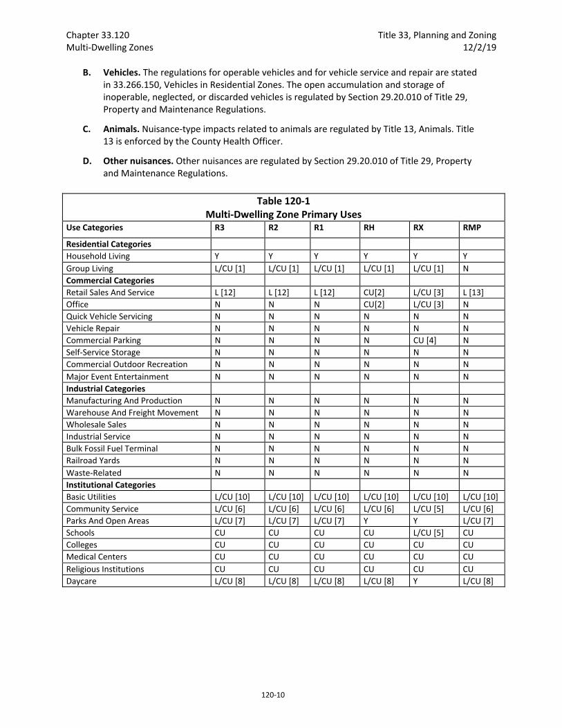
Chapter 33.120 Title 33, Planning and Zoning Multi‐Dwelling Zones 12/2/19
120‐10
B. Vehicles. The regulations for operable vehicles and for vehicle service and repair are stated in 33.266.150, Vehicles in Residential Zones. The open accumulation and storage of inoperable, neglected, or discarded vehicles is regulated by Section 29.20.010 of Title 29, Property and Maintenance Regulations.
C. Animals. Nuisance‐type impacts related to animals are regulated by Title 13, Animals. Title 13 is enforced by the County Health Officer.
D. Other nuisances. Other nuisances are regulated by Section 29.20.010 of Title 29, Property and Maintenance Regulations.
Table 120‐1 Multi‐Dwelling Zone Primary Uses
Use Categories R3 R2 R1 RH RX RMP
Residential Categories
Household Living Y Y Y Y Y Y
Group Living L/CU [1] L/CU [1] L/CU [1] L/CU [1] L/CU [1] N
Commercial Categories
Retail Sales And Service L [12] L [12] L [12] CU[2] L/CU [3] L [13]
Office N N N CU[2] L/CU [3] N
Quick Vehicle Servicing N N N N N N
Vehicle Repair N N N N N N
Commercial Parking N N N N CU [4] N
Self‐Service Storage N N N N N N
Commercial Outdoor Recreation N N N N N N
Major Event Entertainment N N N N N N
Industrial Categories
Manufacturing And Production N N N N N N
Warehouse And Freight Movement N N N N N N
Wholesale Sales N N N N N N
Industrial Service N N N N N N
Bulk Fossil Fuel Terminal N N N N N N
Railroad Yards N N N N N N
Waste‐Related N N N N N N
Institutional Categories
Basic Utilities L/CU [10] L/CU [10] L/CU [10] L/CU [10] L/CU [10] L/CU [10]
Community Service L/CU [6] L/CU [6] L/CU [6] L/CU [6] L/CU [5] L/CU [6]
Parks And Open Areas L/CU [7] L/CU [7] L/CU [7] Y Y L/CU [7]
Schools CU CU CU CU L/CU [5] CU
Colleges CU CU CU CU CU CU
Medical Centers CU CU CU CU CU CU
Religious Institutions CU CU CU CU CU CU
Daycare L/CU [8] L/CU [8] L/CU [8] L/CU [8] Y L/CU [8]
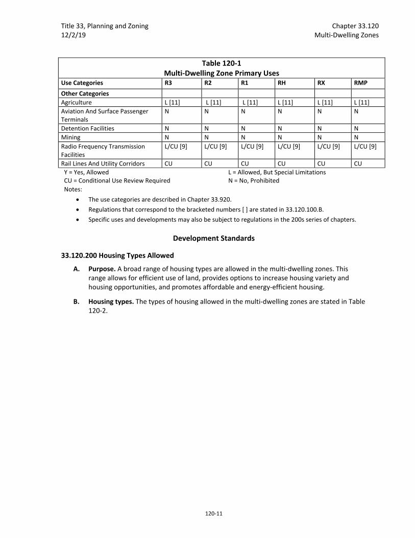
Title 33, Planning and Zoning Chapter 33.120 12/2/19 Multi‐Dwelling Zones
120‐11
Table 120‐1 Multi‐Dwelling Zone Primary Uses
Use Categories R3 R2 R1 RH RX RMP
Other Categories
Agriculture L [11] L [11] L [11] L [11] L [11] L [11]
Aviation And Surface Passenger Terminals
N N N N N N
Detention Facilities N N N N N N
Mining N N N N N N
Radio Frequency Transmission Facilities
L/CU [9] L/CU [9] L/CU [9] L/CU [9] L/CU [9] L/CU [9]
Rail Lines And Utility Corridors CU CU CU CU CU CU
Y = Yes, Allowed CU = Conditional Use Review Required
L = Allowed, But Special Limitations N = No, Prohibited
Notes:
The use categories are described in Chapter 33.920.
Regulations that correspond to the bracketed numbers [ ] are stated in 33.120.100.B.
Specific uses and developments may also be subject to regulations in the 200s series of chapters.
Development Standards
33.120.200 Housing Types Allowed
A. Purpose. A broad range of housing types are allowed in the multi‐dwelling zones. This range allows for efficient use of land, provides options to increase housing variety and housing opportunities, and promotes affordable and energy‐efficient housing.
B. Housing types. The types of housing allowed in the multi‐dwelling zones are stated in Table 120‐2.
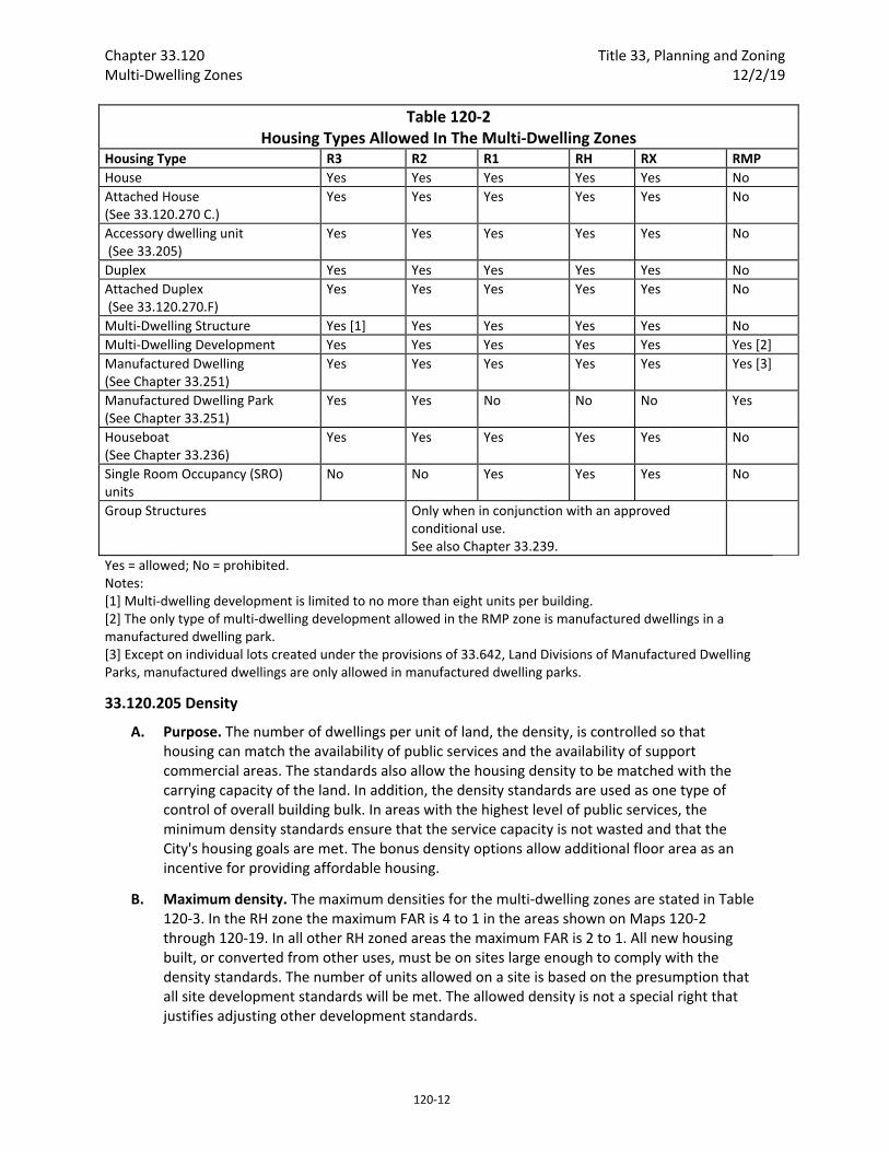
Chapter 33.120 Title 33, Planning and Zoning Multi‐Dwelling Zones 12/2/19
120‐12
Table 120‐2 Housing Types Allowed In The Multi‐Dwelling Zones
Housing Type R3 R2 R1 RH RX RMP
House Yes Yes Yes Yes Yes No
Attached House (See 33.120.270 C.)
Yes Yes Yes Yes Yes No
Accessory dwelling unit (See 33.205)
Yes Yes Yes Yes Yes No
Duplex Yes Yes Yes Yes Yes No
Attached Duplex (See 33.120.270.F)
Yes Yes Yes Yes Yes No
Multi‐Dwelling Structure Yes [1] Yes Yes Yes Yes No
Multi‐Dwelling Development Yes Yes Yes Yes Yes Yes [2]
Manufactured Dwelling (See Chapter 33.251)
Yes Yes Yes Yes Yes Yes [3]
Manufactured Dwelling Park (See Chapter 33.251)
Yes Yes No No No Yes
Houseboat (See Chapter 33.236)
Yes Yes Yes Yes Yes No
Single Room Occupancy (SRO) units
No No Yes Yes Yes No
Group Structures Only when in conjunction with an approved conditional use. See also Chapter 33.239.
Yes = allowed; No = prohibited. Notes: [1] Multi‐dwelling development is limited to no more than eight units per building. [2] The only type of multi‐dwelling development allowed in the RMP zone is manufactured dwellings in a manufactured dwelling park. [3] Except on individual lots created under the provisions of 33.642, Land Divisions of Manufactured Dwelling Parks, manufactured dwellings are only allowed in manufactured dwelling parks.
33.120.205 Density
A. Purpose. The number of dwellings per unit of land, the density, is controlled so that housing can match the availability of public services and the availability of support commercial areas. The standards also allow the housing density to be matched with the carrying capacity of the land. In addition, the density standards are used as one type of control of overall building bulk. In areas with the highest level of public services, the minimum density standards ensure that the service capacity is not wasted and that the City's housing goals are met. The bonus density options allow additional floor area as an incentive for providing affordable housing.
B. Maximum density. The maximum densities for the multi‐dwelling zones are stated in Table 120‐3. In the RH zone the maximum FAR is 4 to 1 in the areas shown on Maps 120‐2 through 120‐19. In all other RH zoned areas the maximum FAR is 2 to 1. All new housing built, or converted from other uses, must be on sites large enough to comply with the density standards. The number of units allowed on a site is based on the presumption that all site development standards will be met. The allowed density is not a special right that justifies adjusting other development standards.

Title 33, Planning and Zoning Chapter 33.120 12/2/19 Multi‐Dwelling Zones
120‐13
C. Minimum density. The minimum density requirements for the multi‐dwelling zones are stated in Table 120‐3. Land within an Environmental zone may be subtracted from the calculation of minimum density. A site that is nonconforming in minimum density may not move further out of conformance with the minimum density standard. However, units may be added to the site that bring the site closer to conformance without coming all the way into conformance.
1. In the R3, R2, and RMP zones, if maximum density is two units then minimum density is two units. If maximum density is one unit, minimum density is one unit.
2. In the R1 zone, if the site is less than 10,000 square feet in area, the minimum density is 1 unit per 2,000 square feet.
3. On sites where trees that are 12 or more inches in diameter are proposed for preservation, minimum density may be reduced as follows:
a. The maximum allowed reduction in minimum density is shown in Table 120‐5.
b. When this provision is used to reduce density, the owner must execute a covenant with the City. The covenant is not required if the site is also part of a proposed Land Division. The covenant must:
(1) Require that all trees used to reduce the minimum density be preserved for at least 10 years;
(2) Allow trees used to reduce the minimum density that die, or become diseased or dangerous to be removed and replaced within the 10 year preservation period. The trees must be determined to be dead, diseased, or dangerous by an arborist, and a Title 11 tree permit must be obtained. If a tree used to reduce the minimum density is dead, diseased, or dangerous as the result of a violation, Tree Review is required; and
(3) The covenant must meet the requirements of Section 33.700.060 and be recorded before a development permit is issued.
Table 120‐5 Reduction in Minimum Residential Density from Tree Preservation
Required Minimum Residential Density
No. of 12‐Inch Trees To Be Preserved
Reduction of Minimum Residential Density
Up to 7 units 1 1
8‐12 units 1 1
2 or more 2
13‐17 units 1 1
2 2
3 or more 3
18 or more units 1 1
2 2
3 3
4 or more 4

Chapter 33.120 Title 33, Planning and Zoning Multi‐Dwelling Zones 12/2/19
120‐14
D. Floor area ratio. The floor area ratio (FAR) states the amount of floor area allowed. There is no maximum limit on the number of dwelling units within the allowable floor area, but the units must comply with all building and housing code requirements. The FAR also includes any nonresidential uses that are allowed. Minimum density requirements may also apply.
E. Maximum increase in density or FAR. In the RH and RX zones, an increase in FAR through the use of bonuses and transfers of more than 3 to 1 is prohibited. In all other multi‐dwelling zones, an increase in the number of units through the use of bonuses, including amenity bonuses, and transfers of more than 100 percent is prohibited. The maximum allowed increase is calculated based on maximum density without inclusionary or RMP zone affordable housing bonuses.
F. Bonus density or FAR. The following density and FAR bonus options are allowed in the R3 through RMP zones. Adjustments to this Subsection, or to the amount of maximum density or floor area allowed through the bonuses in this Subsection, are prohibited. Amenity bonuses described in 33.120.265 may allow additional bonus density:
1. Inclusionary housing bonus option. The inclusionary housing bonus option applies in the R3‐RX zones.
a. Mandatory inclusionary housing. Bonus density or FAR is allowed up to the maximum with inclusionary housing bonus stated in Table 120‐3 for development that triggers the requirements of 33.245, Inclusionary Housing. To qualify for this bonus, the applicant must provide a letter from the Portland Housing Bureau certifying that the regulations of 33.245 have been met.
b. Voluntary inclusionary housing. Bonus density or FAR up to the maximum with inclusionary housing bonus stated in Table 120‐3 is allowed when one of the following voluntary bonus options is met:
(1) Bonus density or FAR is allowed for projects that voluntarily comply with the standards of 33.245.040 and 33.245.050. To qualify for this bonus, the applicant must provide a letter from the Portland Housing Bureau certifying that the regulations of 33.245 have been met. The letter is required to be submitted before a building permit can be issued for development, but is not required in order to apply for a land use review; or
(2) Bonus density or FAR is allowed in exchange for payment into the Affordable Housing Fund. For each square foot of floor area purchased a fee must be paid to the Portland Housing Bureau (PHB). For sites where density is calculated in dwelling units, the amount of floor area purchased is converted to dwelling units at a rate of 1 dwelling unit per 800 square feet. The Portland Housing Bureau collects and administers the Affordable Housing Fund, and determines the fee. PHB determines the fee per square foot and updates the fee at least every three years. The fee schedule is available from the Bureau of Development Services. To qualify for this bonus, the applicant must provide a letter from PHB documenting the amount that has been contributed. The letter is required to be submitted before a building permit can be issued for development, but is not required in order to apply for a land use review.
Title 33, Planning and Zoning Chapter 33.120 12/2/19 Multi‐Dwelling Zones
120‐15
2. RMP zone affordable housing bonus option. In the RMP zone, maximum density can be increased up to the maximum with RMP affordable housing bonus stated in Table 120‐3 when at least 50 percent of all of the dwelling units on the site are affordable to those earning no more than 60 percent of area median family income. To qualify for this bonus the applicant must provide a letter from the Portland Housing Bureau certifying that the development meets this affordability standard and any administrative requirements of the Portland Housing Bureau. The letter must be submitted before a building permit can be issues for development, but is not required in order to apply for a land use review.
G. Transfer of density or FAR. Density or FAR may be transferred from one site to another subject to the following:
1. Calculating the amount of density or FAR transferred. In the R3, R2, R1, and RMP zones, transferable density is calculated in terms of dwelling units. In the RH and RX zones, transferable density is calculated by FAR.
2. Development standards. Buildings on sites receiving transferred density or FAR must meet the development standards of the base zone, overlay zone, or plan district, except for maximum density, which is regulated by Subsection E.
3. General standards for transfers of density or FAR.
a. Except for transfers from the sites of Landmarks and transfers from sites zoned RMP, the transfers may be only between sites within a block or between sites that would be abutting except for a right‐of‐way.
b. Density or FAR from the site of a Landmark may be transferred to any site allowed by Paragraph G.4 below, within the recognized neighborhood where the Landmark is located, or to any site within two miles of the Landmark.
c. Density from a site zoned RMP may be transferred to any site allowed by Paragraph G.4.d below, that is located outside the Central City plan district.
4. Zoning.
a. RX Zone. In the RX Zone:
(1) Transfer of commercial development rights is regulated by Subparagraph 33.120.100.B.3.f;
(2) Density or FAR may be transferred from a site zoned RX to a site zoned RX, RH, CX, or EX. Density may be transferred from the site of a Landmark zoned RX to a site zoned RX, RH, C, or EX.
b. RH Zone. Density or FAR may be transferred from a site zoned RH to a site zoned RX or RH. Density may be transferred from the site of a Landmark zoned RH to a site zoned RX, RH, or EX.
c. R3, R2, and R1 Zones. Density may be transferred among sites zoned R3, R2, and R1.
Chapter 33.120 Title 33, Planning and Zoning Multi‐Dwelling Zones 12/2/19
120‐16
d. RMP zone. Density may be transferred from a site zoned RMP to a site zoned R3, R2, R1, or RH. When density will be transferred from a site zoned RMP to a site zoned RH, one dwelling unit is equal to 800 square feet of floor area.
5. Covenants. The property owner must execute a covenant with the City that is attached to and recorded with the deed of both the site transferring and the site receiving the density reflecting the respective increase and decrease of potential density. The covenant for the receiving site must meet the requirements of Section 33.700.060. The covenant for the Landmark transferring the density must meet the requirements of 33.445.610.D., Covenant.
33.120.210 Development on Lots and Lots of Record
A. Purpose. The regulations of this section require lots and lots of record to be an adequate size so that development on a site will in most cases be able to comply with all site development standards, including density. Where more than one lot is in the same ownership, these standards prevent breaking up large vacant ownerships into small lots, which are difficult to develop in conformance with the development standards. However, where more than one lot is in the same ownership, and there is existing development, allowing the ownership to be separated may increase opportunities for residential infill while preserving existing housing.
B. Where these regulations apply. These regulations apply to existing lots and lots of record in the multi‐dwelling zones. The creation of new lots is subject to the lot size standards listed in Chapter 33.612, Lots in Multi‐Dwelling Zones.
C. Ownership of multiple lots and lots of record. Where more than one abutting lot or lot of record is in the same ownership, the ownership may be separated as follows:
1. If all requirements of this Title will be met after the separation, including lot size, density, and parking, the ownership may be separated; or
2. If one or more of the lots or lots of record does not meet the lot size standards in Chapter 33.612, Lots in Multi‐Dwelling Zones, the ownership may be separated if all requirements of this paragraph are met. Such lots and lots of record are legal.
a. There is a primary use on at least one of the lots or lots of record, and the use has existed since December 31, 1980. If none of the lots or lots of record have a primary use, they may not be separated; and
b. Lots or lots of record with a primary use on at least one of them may be separated as follows:
(1) The separation must occur along the original lot lines;
(2) Lots or lots of record with primary uses on them may be separated from lots or lots of record with other primary uses; and
(3) Lots or lots of record with primary uses on them may be separated from lots or lots of record without primary uses.
Title 33, Planning and Zoning Chapter 33.120 12/2/19 Multi‐Dwelling Zones
120‐17
D. New development on standard lots and lots of record. New development on lots and lots of record that comply with the lot size standards in Chapter 33.612, Lots in Multi‐Dwelling Zones, is allowed by right subject to the development standards.
E. New development on substandard lots and lots of record. New development is allowed on lots and lots of record which do not conform to the lot size standards in Chapter 33.612, Lots in Multi‐Dwelling Zones, if both of the following are met:
1. The development is proposed for a lot or lot of record. Development on plots that are not lots or lots of record is prohibited; and
2. The lot or lot of record did not abut any property owned by the same family or business on July 26, 1979, or any time since that date, unless the ownership was separated as allowed in Subsection C, above.
33.120.215 Height
A. Purpose. The height standards serve several purposes:
They promote a reasonable building scale and relationship of one residence to another;
They promote options for privacy for neighboring properties; and
They reflect the general building scale of multi‐dwelling development in the City's neighborhoods.
B. Maximum height. The maximum heights allowed in the multi‐dwelling zones are stated in Table 120‐3. The maximum height standard for institutional uses is stated in 33.120.275, Development Standards for Institutions. The maximum height standards for detached accessory structures are stated in 33.120.280, Detached Accessory Structures.
1. In the R1 zone the maximum height is 45 feet, except on the portion of a site within 10 feet of a front property line, where the maximum height is 25 feet.
2. In the RH zone, the following maximum height limits apply:
a. Where the FAR is 2 to 1, the maximum height is 65 feet, except on the portion of a site within 10 feet of a front property line, where the maximum height is 25 feet.
b. Where the FAR is 4 to 1, the maximum height is 75 feet, except on sites within 1,000 feet of a transit station, where the maximum height is 100 feet.
C. Exceptions to the maximum height.
1. Chimneys, flag poles, satellite receiving dishes, and other similar items attached to a building, with a width, depth, or diameter of 3 feet or less may extend above the height limit, as long as they do not exceed 5 feet above the top of the highest point of the roof. If they are greater than 3 feet in width, depth, or diameter, they are subject to the height limit.
2. Rooftop mechanical equipment and stairwell enclosures that provide rooftop access may extend above the height limit as follows, provided that the equipment and enclosures are set back at least 15 feet from all roof edges on street facing facades.
Chapter 33.120 Title 33, Planning and Zoning Multi‐Dwelling Zones 12/2/19
120‐18
a. Elevator mechanical equipment may extend up to 16 feet above the height limit; and
b. Other mechanical equipment and stairwell enclosures that cumulatively cover no more than 10 percent of the roof area may extend up to 10 feet above the height limit.
3. Antennas, utility power poles, and public safety facilities are exempt from the height limit.
4. Small wind turbines are subject to the standards of Chapter 33.299.
5. Roof mounted solar panels are not included in height calculations, and may exceed the maximum height limit if the following are met:
a. For flat roofs or the horizontal portion of mansard roofs, they may extend up to 5 feet above the top of the highest point of the roof.
b. For pitched, hipped, or gambrel roofs, they must be mounted no more than 12 inches from the surface of the roof at any point, and may not extend above the ridgeline of the roof. The 12 inches is measured from the upper side of the solar panel.
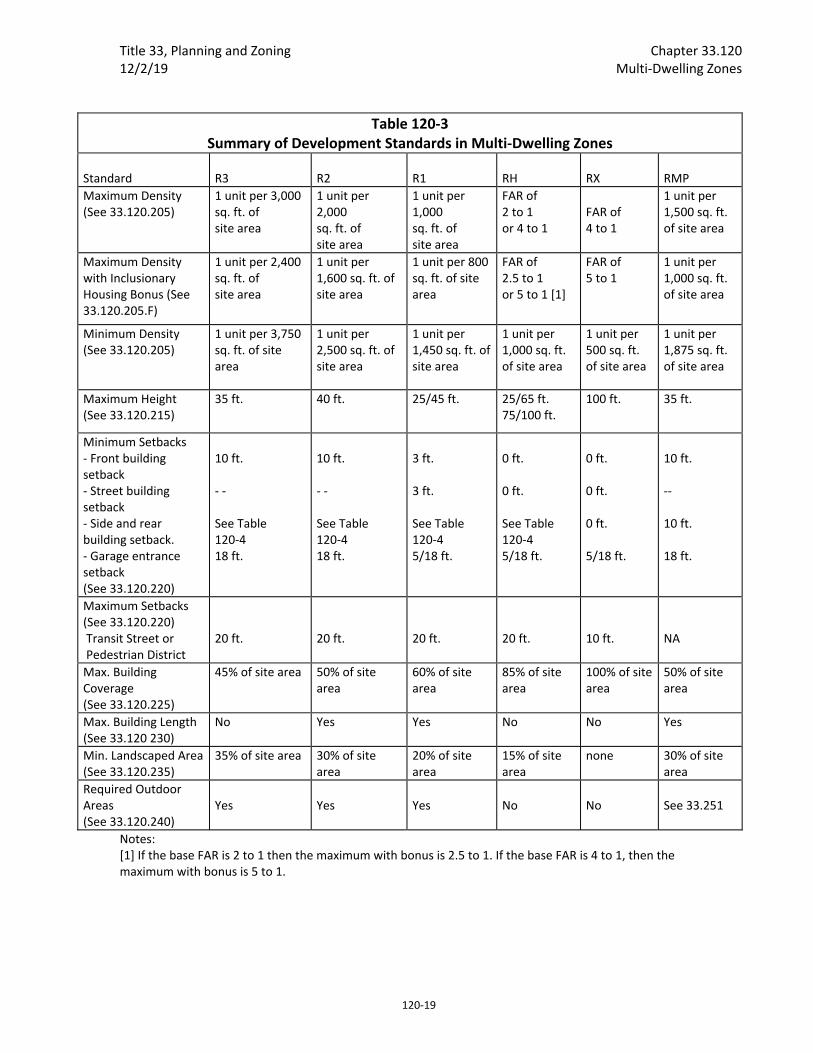
Title 33, Planning and Zoning Chapter 33.120 12/2/19 Multi‐Dwelling Zones
120‐19
Table 120‐3 Summary of Development Standards in Multi‐Dwelling Zones
Standard
R3
R2
R1
RH
RX
RMP
Maximum Density (See 33.120.205)
1 unit per 3,000 sq. ft. of site area
1 unit per 2,000 sq. ft. of site area
1 unit per 1,000 sq. ft. of site area
FAR of 2 to 1 or 4 to 1
FAR of 4 to 1
1 unit per 1,500 sq. ft. of site area
Maximum Density with Inclusionary Housing Bonus (See 33.120.205.F)
1 unit per 2,400 sq. ft. of site area
1 unit per 1,600 sq. ft. of site area
1 unit per 800 sq. ft. of site area
FAR of 2.5 to 1 or 5 to 1 [1]
FAR of 5 to 1
1 unit per 1,000 sq. ft. of site area
Minimum Density (See 33.120.205)
1 unit per 3,750 sq. ft. of site area
1 unit per 2,500 sq. ft. of site area
1 unit per 1,450 sq. ft. of site area
1 unit per 1,000 sq. ft. of site area
1 unit per 500 sq. ft. of site area
1 unit per 1,875 sq. ft. of site area
Maximum Height (See 33.120.215)
35 ft. 40 ft. 25/45 ft.
25/65 ft. 75/100 ft.
100 ft. 35 ft.
Minimum Setbacks ‐ Front building setback ‐ Street building setback ‐ Side and rear building setback. ‐ Garage entrance setback (See 33.120.220)
10 ft. ‐ ‐ See Table 120‐4 18 ft.
10 ft. ‐ ‐ See Table 120‐4 18 ft.
3 ft. 3 ft. See Table 120‐4 5/18 ft.
0 ft. 0 ft. See Table 120‐4 5/18 ft.
0 ft. 0 ft. 0 ft. 5/18 ft.
10 ft. ‐‐ 10 ft. 18 ft.
Maximum Setbacks (See 33.120.220) Transit Street or Pedestrian District
20 ft.
20 ft.
20 ft.
20 ft.
10 ft.
NA
Max. Building Coverage (See 33.120.225)
45% of site area 50% of site area
60% of site area
85% of site area
100% of site area
50% of site area
Max. Building Length (See 33.120 230)
No Yes Yes No No Yes
Min. Landscaped Area (See 33.120.235)
35% of site area 30% of site area
20% of site area
15% of site area
none 30% of site area
Required Outdoor Areas (See 33.120.240)
Yes
Yes
Yes
No
No
See 33.251
Notes: [1] If the base FAR is 2 to 1 then the maximum with bonus is 2.5 to 1. If the base FAR is 4 to 1, then the maximum with bonus is 5 to 1.

Chapter 33.120 Title 33, Planning and Zoning Multi‐Dwelling Zones 12/2/19
120‐20
Table 120‐4 Minimum Side and Rear Setbacks for R3, R2, R1, and RH Zones
If the area of the plane of the building wall is: [1]
The required side and rear setback is:
1,000 sq. ft. or less 5 ft.
1,001 to 1,300 sq. ft. 6 ft.
1,301 to 1,600 sq. ft. 7 ft.
1,601 to 1,900 sq. ft. 8 ft.
1,901 to 2,200 sq. ft 9 ft.
2,201 to 2,500 sq. ft. 10 ft.
2,501 to 2,800 sq. ft. 11 ft.
2,801 to 3,100 sq. ft. 12 ft.
3,101 to 3,400 sq. ft. 13 ft.
3,401 sq. ft. or greater 14 ft.
Note: [1] Measurement of the area of the plane of the building wall is described in Chapter 33.930, Measurements.
33.120.220 Setbacks
A. Purpose. The building setback regulations serve several purposes:
They maintain light, air, separation for fire protection, and access for fire fighting;
They reflect the general building scale and placement of multi‐dwelling development in the City's neighborhoods;
They promote a reasonable physical relationship between residences;
They promote options for privacy for neighboring properties;
They provide adequate flexibility to site a building so that it may be compatible with the neighborhood, fit the topography of the site, allow for required outdoor areas, and allow for architectural diversity;
Setback requirements along transit streets create an environment that is inviting to pedestrians and transit users; and
They provide room for a car to park in front of a garage door without overhanging the street or sidewalk, and they enhance driver visibility when backing onto the street.
B. Minimum building setbacks. The required minimum building setbacks apply to all buildings and structures on the site except as specified in this section. Where no street setback is indicated in Table 120‐3, the front, side, and rear setbacks apply. Where a street setback is indicated in Table 120‐3 it supersedes front, side, and rear setbacks if the front, side, or rear lot line is also a street lot line. Setbacks for parking areas are in Chapter 33.266.
1. Generally. The required minimum building setbacks, if any, are stated in Tables 120‐3 and 120‐4.
2. Exceptions to the required building setbacks.
a. Setback averaging. The minimum front building setback and the setback of decks, balconies, and porches may be reduced, but not increased, to the average
Title 33, Planning and Zoning Chapter 33.120 12/2/19 Multi‐Dwelling Zones
120‐21
of the respective setbacks on the abutting lots. See Chapter 33.930, Measurements, for more information.
b. Environmental zone. The required minimum front and street building setback and garage entrance setback may be reduced to zero where any portion of the site is in an environmental overlay zone. Where a side lot line is also a street lot line the side building and garage entrance setback may be reduced to zero. All other provisions of this Title apply to the building and garage entrance.
c. Split zoning. No setbacks are required from an internal lot line that is also a zoning line on sites with split zoning.
d. Alley. No side or rear building setback is required from a lot line abutting an alley.
e. Land divisions with existing development. When a dedication of public right‐of‐way along the frontage of an existing street is required as part of a land division, the minimum front or side setback between an existing building and a lot line that abuts the right‐of‐way may be reduced to zero. Eaves on an existing building may extend one foot into the reduced setback, except that they may not extend into the right‐of‐way. Future additions or development must meet required minimum setbacks.
C. Maximum building setbacks.
1. Building setbacks on a transit street or in a Pedestrian District. The required maximum building setbacks, if any, are stated in Tables 120‐3 and 120‐4, and apply only to buildings that are enclosed on all sides. The building setbacks on a transit street or in a Pedestrian District are as follows:
a. Measurement.
(1) Where an existing building is being altered, the standards apply to the ground level, street‐facing facade of the entire building. See Figures 120‐1 and 120‐2.
(2) Where there is more than one building on the site, the standards of this paragraph apply to the combined ground level, street‐facing facades of all the buildings. See Figures 120‐3 and 120‐4.
(3) For buildings where all of the floor area is in residential use, the street‐facing facade of an open porch that meets the following standards is included as part of the ground level, street‐facing facade of the building:
For houses, attached houses, manufactured homes and duplexes, the porch must be at least 25 square feet in area. For multi‐dwelling structures, the porch must be at least 9 feet wide and 7 feet deep;
The porch must have at least one entrance facing the street; and
The porch must have a roof that is:
No more than 12 feet above the floor of the porch; and
At least 30 percent solid. This standard may be met by having 30 percent of the porch area covered with a solid roof, or by having
Chapter 33.120 Title 33, Planning and Zoning Multi‐Dwelling Zones 12/2/19
120‐22
the entire area covered with a trellis or other open material if no more than 70 percent of the area of the material is open.
b. Standards. There are two standards. Subparagraphs C.1.c. and d. specify where each standard applies:
(1) Standard 1: At least 50 percent of the length of the ground level street‐facing facade of the building must be within the maximum setback;
(2) Standard 2: 100 percent of the length of the ground level street‐facing facade of the building must be within the maximum setback.
c. Outside a Pedestrian District. Where the site is not in a Pedestrian District:
(1) One transit street. Where the site is adjacent to one transit street, the standard of Standard 1 must be met on the transit street frontage;
(2) Two non‐intersecting transit streets. Where the site is adjacent to two transit streets that do not intersect:
Standard 1 must be met on the frontage of the street with the highest transit classification. If both streets have the same highest classification, the applicant may choose on which street to meet the standard;
If one of the transit streets intersects a City Walkway, Standard 1 must be met along both the street with the highest transit classification and the City Walkway;
(3) Two or more intersecting transit streets. Where the site is adjacent to two or more intersecting transit streets, Standard 2 must be met on the frontage of the street with the highest transit classification and Standard 1 must be met on an intersecting transit street. If two streets have the same highest transit classification, the applicant may choose on which street to meet the standard;
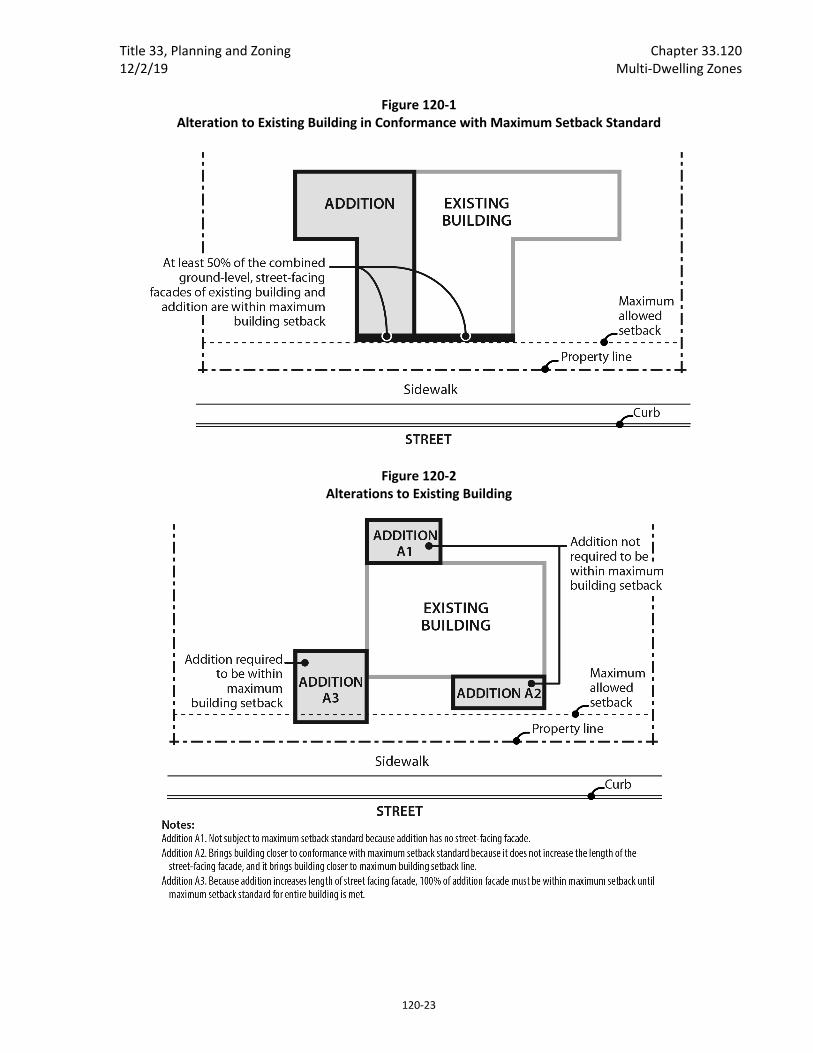
Title 33, Planning and Zoning Chapter 33.120 12/2/19 Multi‐Dwelling Zones
120‐23
Figure 120‐1 Alteration to Existing Building in Conformance with Maximum Setback Standard
Figure 120‐2 Alterations to Existing Building

Chapter 33.120 Title 33, Planning and Zoning Multi‐Dwelling Zones 12/2/19
120‐24
Figure 120‐3 Calculating Maximum Building Setback When More Than One Building On Site
Figure 120‐4 New Buildings On Sites With Buildings That Do Not Meet The Maximum Building Setback
Title 33, Planning and Zoning Chapter 33.120 12/2/19 Multi‐Dwelling Zones
120‐25
d. In a Pedestrian District. Where the site is in a Pedestrian District:
(1) One street. Where the site is adjacent to only one street, Standard 1 must be met on that street frontage;
(2) Through lot with one transit street. Where the site is a through lot and one frontage is a transit street and one is a non‐transit street, standard 1 must be met on the frontage of the transit street;
(3) Through lot with two transit streets. Where the site is a through lot and both frontages are on transit streets, Standard 1 must be met on the frontage of the street with the highest transit classification. If both streets have the same highest classification, the applicant may choose on which street to meet the standard;
(4) Through lot with no transit streets. Where the site is a through lot and neither frontage is on a transit street, Standard 1 must be met on one of the frontages. The applicant may choose on which street to meet the standard;
(5) One transit street and one intersecting non‐transit street. Where the site is adjacent to a transit street and an intersecting non‐transit street, the following standards must be met:
Standard 2 must be met on the frontage of the transit street,
Standard 1 must be met on the intersecting non‐transit street;
(6) Two or more intersecting transit streets. Where the site is adjacent to two or more intersecting transit streets, the following standards must be met on the frontage of the street with the highest transit classification and any intersecting transit street:
Standard 2 must be met on the frontage of the street with the highest transit classification. If both transit streets have the same highest classification, the applicant may choose on which street to meet the standard; and
Standard 1 must be met on an intersecting transit street;
(7) Three or more frontages, two non‐intersecting transit streets. Where the site has three or more frontages, and two of them are transit streets that do not intersect, the following standards must be met on the frontage of the street with the highest transit classification and one intersecting street:
Standard 2 must be met on the frontage of the street with the highest transit classification. If both streets have the same transit classification, the applicant may choose on which street to meet the standard; and
Standard 1 must be met on an intersecting street;
(8) Two or more frontages, no transit streets, two or more intersecting streets. Where the site has two or more frontages, none of them are transit streets, and two or more of the streets intersect, the following standards must be met on the frontage of one street and one intersecting street:
Chapter 33.120 Title 33, Planning and Zoning Multi‐Dwelling Zones 12/2/19
120‐26
Standard 2 must be met on the frontage of one street; and
Standard 1 must be met on an intersecting street.
2. Exemptions.
a. Flag lots. Flag lots are exempt from the maximum setback standards of this section.
b. Detached accessory structures. Detached accessory structures are exempt from the maximum setback standards of this section. The street‐facing facades of detached accessory structures do not count towards meeting maximum setback standards. See Figure 120‐3.
D. Extensions into required building setbacks.
1. The following features of a building may extend into a required building setback up to 20 percent of the depth of the setback. However, the feature must be at least 3 feet from a lot line, except as allowed in 33.120.270, Alternative Development Options:
a. Eaves, chimneys, fireplace inserts and vents, mechanical equipment, and fire escapes;
b. Water collection cisterns and stormwater planters that do not meet the standards of Paragraph D.2;
c. Decks, stairways, wheelchair ramps, and uncovered balconies that do not meet the standard for Paragraph D.2 below; and
d. Bays and bay windows that meet the following requirements:
(1) Each bay and bay window may be up to 12 feet long, but the total area of all bays and bay windows on a building facade cannot be more than 30 percent of the area of the facade;
(2) At least 30 percent of the area of the bay which faces the property line requiring the setback must be glazing or glass block;
(3) Bays and bay windows must cantilever beyond the foundation of the building; and
(4) The bay may not include any doors.
2. The following minor features may extend into entire required building setbacks:
a. Utility connections attached to the building that are required to provide services, such as water electricity and other similar utility services;
b. Gutters and downspouts that drain stormwater off a roof of the structure;
c. Stormwater planters that are no more than 2‐1/2 feet above the ground;
d. Water collection cisterns that are 6 feet or less in height;
Title 33, Planning and Zoning Chapter 33.120 12/2/19 Multi‐Dwelling Zones
120‐27
e. Attached decks, stairs, and ramps that are no more than 2‐1/2 feet above the ground. However, stairways and wheelchair ramps that lead to one entrance on the street‐facing facade of a building are allowed to extend into the required street setbacks regardless of height above ground; and
f. On lots that slope down from the street, vehicular or pedestrian entry bridges that are no more than 2‐1/2 feet above the average sidewalk elevation.
3. Detached accessory structures. The setback standards for detached accessory structures including detached mechanical equipment are stated in 33.120.280 below. Fences are addressed in 33.120.285, below. Detached accessory dwelling units are addressed in Chapter 33.205.
E. Garage entrance and structured parking setback.
1. Garage entrance setback. The garage entrance setback is stated in Table 120‐3. See Chapter 33.910, Definitions, for a description. The walls of the garage structure are subject to 33.120.283 and the applicable front, side, or rear building setbacks.
a. In R1, RH, and RX zones, the garage entrance must be either 5 feet or closer to the street lot line, or 18 feet or farther from the street lot line. If the garage entrance is located within 5 feet of the front lot line, it may not be closer to the lot line than the front facade of the residential portion of the building.
b. Exceptions.
(1) The garage entrance setback may be reduced to the average of the garage entrance setbacks on abutting lots. See Chapter 33.930, Measurements, for more information.
(2) No setback is required from a lot line abutting an alley. However, the Bureau of Transportation may require the garage entrance to be set back to ensure adequate turning radius into the garage.
2. Setbacks for structured parking. Structured parking that allows exiting in a forward motion is subject to the setback requirements for buildings. Structured parking that does not allow exiting in a forward motion is subject to the garage entrance setback standard stated in Table 120‐3.
33.120.225 Building Coverage
A. Purpose. The building coverage standards, along with the height and setback standards, limit the overall bulk of structures. They assure that larger buildings will not have a footprint that overwhelms adjacent development. The standards help define the character of the different zones by determining how built‐up a neighborhood appears.
B. Maximum building coverage. The maximum building coverages for all covered structures on the site are stated in Table 120‐3.
33.120.230 Building Length
A. Purpose. The maximum building length standard, along with the height and setback standard, limits the amount of bulk that can be placed close to the street. The standard

Chapter 33.120 Title 33, Planning and Zoning Multi‐Dwelling Zones 12/2/19
120‐28
assures that long building walls close to streets will be broken up into separate buildings. This will provide a feeling of transition from lower density development and help create the desired character of development in these zones.
B. Maximum building length. In R2, R1, and RMP, the maximum building length for the portion of buildings located within 30 feet of a street lot line is 100 feet. Manufactured dwelling parks are exempt from this standard.
33.120.231 Main Entrances
A. Purpose. The main entrance standards:
Together with the window and garage standards, ensure that there is a physical and visual connection between the living area of the residence and the street;
Enhance public safety for residents and visitors and provide opportunities for community interaction;
Ensure that the pedestrian entrance is visible or clearly identifiable from the street by its orientation or articulation; and
Ensure that pedestrians can easily find the main entrance, and so establish how to enter the residence.
Ensure a connection to the public realm for development on lots fronting both private and public streets by making the pedestrian entrance visible or clearly identifiable from the public street.
B. Where these standards apply.
1. The standards of this section apply to houses, attached houses, manufactured homes on individual lots, and duplexes in the multi‐dwelling zones.
2. Where a proposal is for an alteration or addition to existing development, the standards apply only to the portion being altered or added.
3. On sites with frontage on both a private street and a public street, the standards apply to the site frontage on the public street. On all other sites with more than one street frontage, the applicant may choose on which frontage to meet the standards.
4. Development on flag lots or on lots which slope up or down from the street with an average slope of 20 percent or more are exempt from these standards.
5. Subdivisions and PUDs that received preliminary plan approval between September 9, 1990, and September 9, 1995, are exempt from this standard.
C. Location. At least one main entrance for each structure must:
1. Be within 8 feet of the longest street‐facing wall of the dwelling unit; and
2. Either:
a. Face the street. See Figure 120‐5;
b. Be at an angle of up to 45 degrees from the street; or
c. Open onto a porch. See Figure 120‐6. The porch must:

Title 33, Planning and Zoning Chapter 33.120 12/2/19 Multi‐Dwelling Zones
120‐29
(1) Be at least 25 square feet in area;
(2) Have at least one entrance facing the street; and
(3) Have a roof that is:
No more than 12 feet above the floor of the porch; and
At least 30 percent solid. This standard may be met by having 30 percent of the porch area covered with a solid roof, or by having the entire area covered with a trellis or other open material if no more than 70 percent of the area of the material is open.
33.120.232 Street‐Facing Facades
A. Purpose. These standards:
Together with the main entrance and garage standards, ensure that there is a visual connection between the living area of the residence and the street;
Enhance public safety by allowing people to survey their neighborhood from inside their residences; and
Provide a more pleasant pedestrian environment by preventing large expanses of blank facades along streets.
B. Where these standards apply. The standards of this section apply to the street‐facing facades of buildings that include any residential uses. The standards of this section do not apply in the RMP zone. Subdivisions and PUDs that received preliminary plan approval between September 9, 1990, and September 9, 1995, are exempt from Paragraph B.1, below. Where a proposal is for an alteration or addition to existing development, the applicant may choose to apply the standard either to the portion being altered or added, or to the entire street‐facing facade.
1. At least 15 percent of the area of each facade that faces a street lot line must be windows or main entrance doors. Windows used to meet this standard must allow views from the building to the street. Glass block does not meet this standard. Windows in garage doors do not count toward meeting this standard, but windows in garage walls do count toward meeting this standard. To count toward meeting this standard a door must be at the main entrance and facing the street property line. Development on flag lots or on lots which slope up or down from the street with an average slope of 20 percent or more are exempt from these standards.
2. RX zone. The portions of buildings in the RX zone that have nonresidential development are subject to the ground floor window requirements of the CX zone in 33.130.230.B.2.
3. For structures subject to ground floor window requirements, windows used to meet ground floor window requirements may also be used to meet the requirements of Paragraph B.1, above.

Chapter 33.120 Title 33, Planning and Zoning Multi‐Dwelling Zones 12/2/19
120‐30
Figure 120‐5 Main Entrance Facing the Street
Figure 120‐6 Main Entrance Opening Onto a Porch
33.120.235 Landscaped Areas
A. Purpose. The standards for landscaped areas are intended to enhance the overall appearance of residential developments and institutional campuses in multi‐dwelling zones. The landscaping improves the residential character of the area, breaks up large expanses of paved areas and structures, provides privacy to the residents, and provides separation from streets. Landscaping also helps cool the air temperature, intercept rainfall and reduce stormwater run‐off by providing a non‐paved permeable surface. Landscaping can also provide food for people and habitat for birds and other wildlife.

Title 33, Planning and Zoning Chapter 33.120 12/2/19 Multi‐Dwelling Zones
120‐31
B. Minimum landscaped areas. The required amount of landscaped area is stated in Table 120‐3. Sites developed with a house, attached house, duplex, or manufactured dwelling park are exempt from this standard. Required landscaped areas must be at ground level and must comply with at least the L1 standard in Chapter 33.248. Up to 1/3 of the required landscaped area may be for active or passive recreational use, or for use by pedestrians. Examples include walkways, play areas, plazas, picnic areas, and open recreational facilities. Remaining landscaped areas must comply with the standards in Subsection C. below. Any required landscaping, such as for required setbacks or parking lots, applies toward the minimum required landscaped area. The outdoor areas required in 33.120.240 below, also apply towards meeting the minimum landscaped area requirements of this section, if they are uncovered.
C. Landscaping standards.
1. Building setbacks. The required building setbacks must be landscaped to at least the L1 standard of Chapter 33.248, Landscaping and Screening. Detached accessory structures and other development allowed in the setbacks are exempt from this standard. Sites developed with a house, attached house or duplex are also exempt from this standard.
2. Parking areas. Perimeter and internal parking area landscaping standards are stated in Chapter 33.266, Parking And Loading.
33.120.237 Trees Requirements for street trees and for on‐site tree preservation, protection, and overall tree density are specified in Title 11, Trees. See Chapter 11.50, Trees in Development Situations.
33.120.240 Required Outdoor Areas
A. Purpose. The required outdoor areas standards assure opportunities for outdoor relaxation or recreation. The standards work with the building coverage and minimum landscaped areas standards to assure that some of the land not covered by buildings is of adequate size, shape, and location to be usable for outdoor recreation or relaxation. Required outdoor areas are an important aspect in addressing the livability of a residential property by providing outdoor living opportunities, some options for outdoor privacy, and a healthy environment.
B. Requirements.
1. Amount required. At least 48 square feet of outdoor area is required for each dwelling unit on the site. The RMP zone is exempt from the standards in this section.
2. Size, location and configuration. Required outdoor area may be provided as individual, private outdoor areas, such as patios or balconies, or as common, shared outdoor areas, such as courtyards and play areas. There also may be a combination of individual and common areas.
a. Individual unit areas. Where a separate outdoor area is provided for each individual unit, it must be designed so that a 6‐foot x 6‐foot square will fit entirely within it. The outdoor area must be directly accessible to the unit. Areas used for pedestrian circulation to more than one dwelling unit do not count
Chapter 33.120 Title 33, Planning and Zoning Multi‐Dwelling Zones 12/2/19
120‐32
towards meeting this standard of this subsection. If the area is at ground level, it may extend into the required side and rear setback, but not into the required front building setback. Covered outdoor areas are subject to Paragraph B.5 below.
b. Common areas. Where outdoor areas are common, shared areas, each must be designed so that it is at least 500 square feet in area and so that a 15‐foot x 15‐foot square will fit entirely within it.
c. Combination of individual and common areas. Where a combination of individual unit and common areas is provided, each individual area must meet B.2.a above and each common area must meet B.2.b above, providing 48 square feet of outdoor area for each dwelling unit served by the common area.
3. Surfacing materials. Required outdoor areas must be surfaced with lawn, pavers, decking, or sport court paving which allows the area to be used for active or passive recreational use.
4. User amenities. User amenities, such as tables, benches, trees, shrubs, planter boxes, garden plots, drinking fountains, spas, or pools, may be placed in the outdoor area. Common, shared outdoor areas may also be developed with amenities such as play areas, plazas, roof‐top patios, picnic areas, and open recreational facilities.
5. Enclosure. Required outdoor areas may be covered, such as a covered patio, but they may not be fully enclosed. Covered outdoor areas are subject to the setback standards of this chapter.
33.120.250 Screening
A. Purpose. The screening standards address specific unsightly features which detract from the appearance of multi‐dwelling residential areas.
B. Garbage and recycling collection areas. All exterior garbage cans, garbage collection areas, and recycling collection areas must be screened from the street and any adjacent properties. Trash receptacles for pedestrian use are exempt. Screening must comply with at least the L3 or F2 standards of Chapter 33.248, Landscaping and Screening.
C. Mechanical equipment. Mechanical equipment located on the ground, such as heating or cooling equipment, pumps, or generators must be screened from the street and any abutting residential zones by walls, fences, or vegetation. Screening must comply with at least the L2 or F2 standards of Chapter 33.248, Landscaping and Screening, and be tall enough to screen the equipment. Mechanical equipment placed on roofs must be screened in one of the following ways, if the equipment is within 50 feet of an R zone:
1. A parapet along facades facing the R zone that is as tall as the tallest part of the equipment;
2. A screen around the equipment that is as tall as the tallest part of the equipment; or
3. The equipment is set back from roof edges facing the R zone 3 feet for each foot of height of the equipment.
Title 33, Planning and Zoning Chapter 33.120 12/2/19 Multi‐Dwelling Zones
120‐33
D. Other screening requirements. The screening requirements for parking, exterior storage, and exterior display areas are stated with the regulations for those types of development.
33.120.255 Pedestrian Standards
A. Purpose. The pedestrian standards encourage a safe, attractive, and usable pedestrian circulation system in all developments. They ensure a direct pedestrian connection between abutting streets and buildings on the site, and between buildings and other activities within the site. In addition, they provide for connections between adjacent sites, where feasible. The standards promote configurations that minimize conflicts between pedestrians and vehicles. In order to facilitate additional pedestrian oriented space and less impervious surface, the standards also provide opportunities for accessways with low traffic volumes, serving a limited number of residential units, to be designed to accommodate pedestrians and vehicles within the same space when special paving treatments are used to signify their intended use by pedestrians as well as vehicles.
B. The standards. The standards of this section apply to all development except houses, attached houses, manufactured homes on individual lots, and duplexes. The standards of this section do not apply to manufactured dwelling parks. An on‐site pedestrian circulation system must be provided. The system must meet all standards of this subsection.
1. Connections. The on‐site pedestrian circulation system must provide connections as specified below:
a. Connection between streets and entrances.
(1) Sites with one street frontage.
Generally. There must be a connection between one main entrance of each building on the site and the adjacent street. The connection may not be more than 20 feet longer or 120 percent of the straight line distance, whichever is less.
Household Living. Sites where all of the floor area is in Household Living uses are only required to provide a connection to one main entrance on the site. The connection may not be more than 20 feet longer or 120 percent of the straight line distance, whichever is less.
Tree preservation. If a tree that is at least 12 inches in diameter is proposed for preservation, and the location of the tree or its root protection zone would prevent the standard of this paragraph from being met, the connection may be up to 200 percent of the straight line distance.
(2) Sites with more than one street frontage. Where the site has more than one street frontage, the following must be met:
The standard of B.1.a(1) must be met to connect the main entrance of each building on the site to the closest sidewalk or roadway if there are no sidewalks. Sites where all of the floor area is in Household Living uses are only required to provide a straight line connection to one main entrance on the site;
An additional connection, which does not have to be a straight line connection, is required between each of the other streets and a
Chapter 33.120 Title 33, Planning and Zoning Multi‐Dwelling Zones 12/2/19
120‐34
pedestrian entrance. However, if at least 50 percent of a street facing facade is within 10 feet of the street, no connection is required to that street.
b. Internal connections. On sites larger than 10,000 square feet, an internal pedestrian connection system must be provided. The system must connect all main entrances on the site that are more than 20 feet from the street, and provide connections to other areas of the site, such as parking areas, bicycle parking, recreational areas, common outdoor areas, and any pedestrian amenities.
2. Materials.
a. The circulation system must be hard‐surfaced and be at least 5 feet wide. Segments of the circulation system that provide access to no more than 4 residential units may be 3 feet wide.
b. Except as allowed in subparagraph d, below, where the system crosses driveways, parking areas, and loading areas, the system must be clearly identifiable, through the use of elevation changes, speed bumps, a different paving material, or other similar method. Striping does not meet this requirement. Elevation changes and speed bumps must be at least 4 inches high.
c. Except as allowed in subparagraph d, below, where the system is parallel and adjacent to an auto travel lane, the system must be a raised path or be separated from the auto travel lane by a raised curb, bollards, landscaping or other physical barrier. If a raised path is used it must be at least 4 inches high and the ends of the raised portions must be equipped with curb ramps. Bollard spacing must be no further apart than 5 feet on center.
d. The pedestrian circulation system may be within an auto travel lane if the auto travel lane provides access to 16 or fewer parking spaces and the entire auto travel lane is surfaced with paving blocks or bricks.
3. Lighting. The on‐site pedestrian circulation system must be lighted to a level where the system can be used at night by the employees, residents, and customers.
33.120.260 Recycling Areas Requirements for recycling areas are regulated by the Bureau of Planning and Sustainability. See Section 17.102.270, Businesses and Multifamily Complexes Required to Recycle, of the Portland City Code.
33.120.265 Amenity Bonuses
A. Purpose and description. Special amenity bonuses for increased density are intended to improve the livability of multi‐dwelling developments for their residents and to promote family oriented multi‐dwelling developments. The amenity bonuses are designed to allow additional dwelling units in a manner that is still consistent with the purposes of the multi‐dwelling zones. The bonuses are applicable to a range of development sizes. However, they are more practical or workable for larger projects. Not all bonus options will be applicable for all situations. The amenity options are designed to provide incentives, while leaving the specific choices to the developer. Some options involve providing additional
Title 33, Planning and Zoning Chapter 33.120 12/2/19 Multi‐Dwelling Zones
120‐35
features, such as children's play areas. Others require improved materials, such as additional sound insulation.
The amount of the bonus for each option is a result of balancing several factors. These include:
The likelihood that the amenity will be provided without the use of incentives;
The potential cost to the developer; and
The importance of the amenity.
B. Regulations.
1. Qualifying types of development. The amenity bonus provisions are applicable to all housing types in the R3, R2, and R1 zones.
2. Computation of the bonus. The percentages of all the bonus options included in the project are added together. The total is then applied to the allowed number of units to determine the additional units allowed. Fractions of additional units earned are not counted.
3. Maximum bonus. The maximum density increase allowed for a development is 50 percent including density increased through an inclusionary housing bonus allowed by 33.120.205.F. Increases over 50 percent are prohibited.
4. Compliance with the standards. The bonus amenity standards must be met in full to receive the bonus; exceptions are prohibited. In addition, adjustments to the development standards of the base zone, overlay zone, or plan district are prohibited if the project is to receive any density bonuses. It is the responsibility of the applicant to document that all of the amenity bonus requirements are met. Documentation is required prior to issuance of building permits for the bonus units.
5. Base zone site development standards. The additional units must comply with all applicable site development standards. Any development feature provided to comply with the requirements of the base zone, such as the required outdoor area requirement, may not be counted towards the calculation of bonus density.
6. Covenants.
a. The applicant must sign a covenant that ensures that the amenities provided to receive any bonus density will continue to be provided for the life of the project.
b. The covenant must comply with the standards in 33.700.060, Covenants with the City.
c. If the bonus density is earned through preservation of trees under Paragraph C.9, the covenant must also specify that if the trees are determined to be dead, diseased, or dangerous by an arborist, they must be removed and replaced under a tree permit in accordance with Title 11, Trees. If a tree used to earn bonus density is dead, diseased, or dangerous as the result of a violation, Tree Review is required.

Chapter 33.120 Title 33, Planning and Zoning Multi‐Dwelling Zones 12/2/19
120‐36
C. The amenity bonus options.
1. Outdoor recreation facilities. Outdoor recreational facilities may include a tennis or basketball court, ball field, swimming pool, horseshoe pit, gazebo, permanent picnic tables, and similar items. The density bonus is 2 percent for each 1/2 of 1 percent of the overall project development cost spent on outdoor recreation facilities. There is a maximum of 10 percent density increase allowed for this bonus.
2. Children's play areas. The density bonus for this amenity is 5 percent. A qualifying children's play area must comply with all of the following standards:
a. Size and layout. Each children's play area must be at least 1,000 square feet and clearly delineated. Each must be of such shape to allow a square 25 feet on a side to fit in the area. At least 400 square feet of the area must be in grass. Children's play areas must be separated from any other outdoor recreational facilities.
b. Play equipment. Each children's play area must include a play structure at least 100 square feet in area, a swing structure with at least 4 swings, and at least one of the following: a slide, permanent sand box, permanent wading pool, or other children's play equipment commonly found in a public park. Equipment must be of adequate materials to match the expected use, and manufactured to American Society for Testing and Materials (ASTM) F1487‐11 standards or other comparable standards applicable to public playground equipment.
c. Fencing. Each children's play area must be fenced along any perimeter which is within 10 feet of a street, alley, property line, or parking area.
3. Three bedroom units. A bonus of 5 percent is allowed if 10 percent of the development's units have at least 3 bedrooms. A bonus of 10 percent is allowed if 20 percent or more of the development's units have at least 3 bedrooms. If between 10 percent and 20 percent of the units have at least 3 bedrooms, then the bonus is prorated.
4. Storage areas. The density bonus for this amenity is 5 percent. The bonus is allowed if all units are provided with interior storage and additional storage for large items, as indicated below.
a. Interior storage. Interior storage areas must comply with all of the following minimum dimensions:
(1) Kitchens — 20 square feet of drawers and 50 square feet of shelf space. Shelves must have at least 12 inches of vertical clearance.
(2) Bedroom closets — 16 square feet in floor area, and one in each bedroom.
(3) Linen closet — 10 square feet of shelving, and may be located in a hallway or bathroom.
(4) Entry closet — 10 square feet of floor area.
Title 33, Planning and Zoning Chapter 33.120 12/2/19 Multi‐Dwelling Zones
120‐37
b. Storage for large items. Storage areas must be fully enclosed, be dry, and have locks if they are not located in the dwelling. They must be at least 50 square feet in floor area, and at least 7 feet high. They must be located so as to be easily accessible for large items, such as barbecues, bicycles, and sports equipment.
5. Sound insulation. The density bonus for this amenity is 10 percent. To qualify for this bonus, the interior noise levels of residential structures must be reduced in 3 ways. The reductions address noise from adjacent dwellings and from outdoors, especially from busy streets.
a. The sound insulation of all party walls, walls between corridors and units, and in floor‐ceiling assemblies must comply with a Sound Transmission Class (STC) of 55 (50 if field‐tested). STC standards are stated in the Oregon Structural Specialty Code (the Uniform Building Code as amended by the State of Oregon).
b. The STC rating on all entrance doors assemblies from interior corridors must be at least 30, as documented by acoustic laboratory tests of the doors.
c. The STC rating on all windows, skylights, and exterior doors, must be at least 35, as documented by acoustic laboratory tests.
6. Crime prevention. The density bonus for this amenity is 10 percent. The bonus is allowed if all units have security features which comply with items 1 through 6 of the Residential Security Recommendations of the Portland Police Bureau. In addition, exterior lights which comply with the lighting standards of the Crime Prevention Division of the Portland Police Bureau must be provided. Development plans must be certified by the Crime Prevention Division of the Portland Police Bureau as complying with these provisions.
7. Solar water heating. The density bonus for this amenity is 5 percent. The bonus is allowed if solar‐heated water is provided to all units. Systems may be active or passive. Systems must qualify for the Oregon State solar energy tax credit or be rated by the Solar Rating and Certification Corporation (SRRC). Applicants must provide documentation that the provisions are met.
8. Larger required outdoor areas. The density bonus for this amenity is 5 percent. To qualify for this amenity, at least 96 square feet of outdoor area is required for each dwelling unit. All other standards of 33.120.240, above, must be met.
9. Tree preservation. Development proposals that preserve more than the required number or percentage of the trees on the site may receive up to a maximum of 10 percent density bonus. The density bonus that may be received for each tree that is preserved in addition to those required to be preserved on the site is shown in Table 120‐6.
Table 120‐6 Density Bonus for Tree Preservation in Multi‐Dwelling Zones
Diameter of Tree Preserved Density Bonus
12 to 20 inches 2 percent
20 to 36 inches 3 percent
36 inches or greater 5 percent
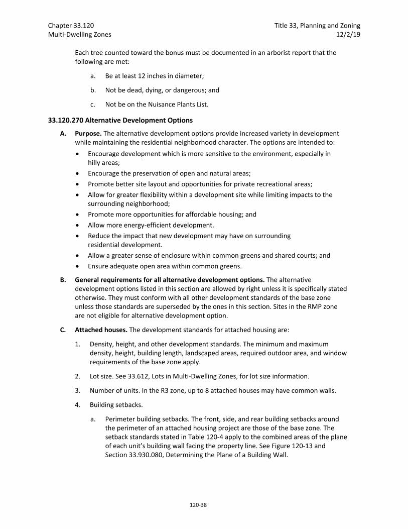
Chapter 33.120 Title 33, Planning and Zoning Multi‐Dwelling Zones 12/2/19
120‐38
Each tree counted toward the bonus must be documented in an arborist report that the following are met:
a. Be at least 12 inches in diameter;
b. Not be dead, dying, or dangerous; and
c. Not be on the Nuisance Plants List.
33.120.270 Alternative Development Options
A. Purpose. The alternative development options provide increased variety in development while maintaining the residential neighborhood character. The options are intended to:
Encourage development which is more sensitive to the environment, especially in hilly areas;
Encourage the preservation of open and natural areas;
Promote better site layout and opportunities for private recreational areas;
Allow for greater flexibility within a development site while limiting impacts to the surrounding neighborhood;
Promote more opportunities for affordable housing; and
Allow more energy‐efficient development.
Reduce the impact that new development may have on surrounding residential development.
Allow a greater sense of enclosure within common greens and shared courts; and
Ensure adequate open area within common greens.
B. General requirements for all alternative development options. The alternative development options listed in this section are allowed by right unless it is specifically stated otherwise. They must conform with all other development standards of the base zone unless those standards are superseded by the ones in this section. Sites in the RMP zone are not eligible for alternative development option.
C. Attached houses. The development standards for attached housing are:
1. Density, height, and other development standards. The minimum and maximum density, height, building length, landscaped areas, required outdoor area, and window requirements of the base zone apply.
2. Lot size. See 33.612, Lots in Multi‐Dwelling Zones, for lot size information.
3. Number of units. In the R3 zone, up to 8 attached houses may have common walls.
4. Building setbacks.
a. Perimeter building setbacks. The front, side, and rear building setbacks around the perimeter of an attached housing project are those of the base zone. The setback standards stated in Table 120‐4 apply to the combined areas of the plane of each unit’s building wall facing the property line. See Figure 120‐13 and Section 33.930.080, Determining the Plane of a Building Wall.
Title 33, Planning and Zoning Chapter 33.120 12/2/19 Multi‐Dwelling Zones
120‐39
b. Interior building setbacks. The side building setback on the side containing the common or abutting wall is reduced to zero. The reduced setback applies to all buildings on the lot and extends along the full length of the lot line that contains the common or abutting wall.
c. Corner lots. On corner lots, either the rear setback or nonstreet side setback can be reduced to zero. However, the remaining nonstreet setback must comply with the requirements for a standard rear setback.
5. Building coverage. The maximum building coverage of the base zone applies to the entire attached housing project. The maximum building coverage for an individual lot is 5 percent more than the base zone allowance.
6. Maximum building length. The maximum building length standard stated in Table 120‐3 applies to the combined length of the street‐facing facades of each unit.
7. Appearance. The intent of this standard is to prevent garages and blank walls from being the dominant front visual feature. The front facade of an attached house may not include more than 40 percent of garage wall area. For measurement information, see Chapter 33.930, Measurements.
Figure 120‐13 Measuring Setback Standard for Attached Houses and Duplexes
D. Detached houses.
1. Reduced side setbacks. For land divisions that include lots created for detached houses, where the lots are at least 25 feet wide, the detached houses may have their side setbacks reduced to 3 feet on lot lines internal to the land division site. The
Chapter 33.120 Title 33, Planning and Zoning Multi‐Dwelling Zones 12/2/19
120‐40
reduced side setbacks must be shown on the supplemental plan of the land division at the time of final plat approval. Eaves may project up to one foot into the reduced side setback. All building setbacks around the perimeter of the land division site are those of the base zone.
2. Permit‐Ready houses. Chapter 33.278 contains provisions for Permit‐Ready houses on narrow lots.
E. Additional standards for attached houses, detached houses, and duplexes accessed by common greens, shared courts, or alleys. These standards promote courtyard‐oriented housing by facilitating the use of common greens and shared courts as part of housing projects on small sites. Standards within this section also promote pedestrian‐oriented street frontages by facilitating the creation of rear alleys and allowing more efficient use of space above rear vehicle areas.
1. When these standards apply. These standards apply when the proposal includes a common green, shared court, or alley;
2. Minimum density in R2 and R1 zones. The minimum density in the R2 zone is 1 unit per 3,000 square feet. The minimum density in the R1 zone is 1 unit per 2,000 square feet;
3. Accessory structures.
a. Covered accessory structures for the common use of residents are allowed within common greens and shared courts. Covered accessory structures include gazebos, garden structures, greenhouses, picnic areas, play structures and bike parking areas;
b. Structures for recycling or waste disposal are allowed within common greens, shared courts, private alleys, or parked tracts;
4. Setbacks.
a. The front and side minimum building setbacks from common greens and shared courts are reduced to 3 feet; and
(1) Minor architectural features such as eaves, awnings, and trellises are allowed in this setback; and
(2) On corner lots where there is one street lot line on a public street and one street lot line is on the common green or shared court, up to 30 percent of the area of the building facade facing the common green or shared court may extend into this setback. At least 30 percent of the area extending into this setback must include windows or glass block. Porches are exempt from the window standard.
b. The setbacks of garage entrances accessed from a shared court must be either 5 feet or closer to the shared court property line, or 18 feet or further from the shared court property line. If the garage entrance is located within 5 feet of the shared court property line, it may not be closer to the property line than the residential portion of the building.
Title 33, Planning and Zoning Chapter 33.120 12/2/19 Multi‐Dwelling Zones
120‐41
c. For accessory structures in common greens, shared courts, private alleys, or parking tracts, the setbacks are:
(1) Adjacent to a public street. The minimum setback from a public street is 10 feet;
(2) Setback from project perimeter. If the common green, shared court, private alley, or parking tract abuts the perimeter property line of the project, the minimum setback for the accessory structure is 5 feet. The perimeter property line of the project is the boundary of the site before development;
(3) Setback from all other lot lines. The minimum setback from all other lot lines is 3 feet;
5. Maximum height.
a. In the R1 and RH zones, where the front lot line abuts a shared court:
(1) In the R1 zone, the maximum building height within 10 feet of a front property line abutting a shared court is 45 feet.
(2) In the RH zone, the maximum building height within 10 feet of a front property line abutting a shared court is 65 feet.
b. Accessory structures in common greens, shared courts, private alleys, or parking tracts may be up to 15 feet high.
6. Building coverage.
a. When a land division proposal includes common greens, shared courts, or private alleys, maximum building coverage is calculated based on the entire land division site, rather than for each lot.
(1) Buildings or structures in common greens, shared courts, private alleys, or parking tracts are included in the calculation for building coverage for the land division site;
(2) The combined building coverage of all buildings and structures in common greens or shared courts may not exceed 15 percent of the total area of the common greens or shared courts.
(3) Any amount of building coverage remaining from the calculation for the area of the common green, shared court, alley, or parking tract will be allocated evenly to all of the lots within the land division, unless a different allocation of the building is approved through the land division decision. The building coverage allocated to the lots will be in addition to the maximum allowed for each lot.
b. For attached houses, uncovered rear balconies that extend over an alley or vehicle maneuvering area between the house and rear lot line do not count toward maximum building coverage calculations.
Chapter 33.120 Title 33, Planning and Zoning Multi‐Dwelling Zones 12/2/19
120‐42
F. Attached duplexes. The attached duplex regulations allow for an alternative housing type that promotes owner‐occupied structures, the efficient use of land, and for energy‐conserving housing.
1. Lot size. Each attached duplex must be on a lot that complies with the lot size standard for new lots of the base zone.
2. Building setbacks. The setback standards stated in Table 120‐4 apply to the combined areas of the plane of each unit’s building wall facing the property line. See Figure 120‐13 and Section 33.930.080, Determining the Plane of a Building Wall.
a. Interior (non‐corner) lots. On interior lots, the side building setback on the side containing the common wall is reduced to zero.
b. Corner lots. On corner lots, either the rear setback or non‐street side setback may be reduced to zero. However, the remaining non‐street setback must comply with the requirements for a standard rear setback.
3. Number of units. A maximum of 2 units per lot and 4 units per structure is allowed.
4. Appearance. The intent of this standard is to prevent garages and blank walls from being the dominant front visual feature. The front facade of an attached duplex may not include more than 40 percent of garage wall area. For measurement information, see Chapter 33.930, Measurements.
G. Duplexes on corners. Duplexes on corners are allowed in the R3 zone on lots where only one dwelling unit would otherwise be allowed. This provision allows the construction of new duplexes in locations where their appearance and impact will be compatible with the surrounding development. Duplexes on corner lots can be designed so each unit is oriented towards a different street. This gives the duplex the overall appearance of a house when viewed from either street.
1. Qualifying situations. This provision applies to corner lots in the R3 zone. This provision applies only to new development. Conversion of existing housing is prohibited under the regulations of this subsection.
2. Density and lot size. One extra dwelling unit is allowed. The lot must comply with the minimum lot size standard for new lots in the base zone.
3. Additional site development standards. Each unit of the duplex must have its address, front door, driveway, and parking area or garage oriented to a separate street frontage.
H. Planned Development. See Chapter 33.638, Planned Development.
I. Flag lot development standards. The development standards for flag lots include specific screening and setback requirements to protect the privacy of abutting residences. The following standards apply to development on flag lots created before July 1, 2002:

Title 33, Planning and Zoning Chapter 33.120 12/2/19 Multi‐Dwelling Zones
120‐43
1. Setbacks. Flag lots have required building setbacks that are the same along all lot lines. The required setbacks are:
Zone Setback
R3, R2, R1, RH 10 feet
2. Landscaped buffer area. In the R3 through RH zones, on lots that are 10,000 square feet or less in area, a landscaped area is required around the perimeter of the flag lot to buffer the flag portion from surrounding lots. The pole and the lot line that separates the flag lot and the lot from which it was divided are exempt from this requirement. The landscaped area must be at least 3 feet deep and be landscaped to at least the L3 standard. See Figure 120‐8.
Figure 120‐8 Flag Lot Description and Buffer
33.120.275 Development Standards for Institutions
A. Purpose. The general base zone development standards in the R3 through RX zones are designed for residential buildings. Different development standards are needed for
Chapter 33.120 Title 33, Planning and Zoning Multi‐Dwelling Zones 12/2/19
120‐44
institutional uses which may be allowed in multi‐dwelling zones. The intent is to maintain compatibility with and limit the negative impacts on surrounding residential areas.
B. Use categories to which these standards apply. The standards of this section apply to uses in the institutional group of use categories in the R3 through RX zones, whether allowed by right, allowed with limitations, or subject to a conditional use review. The standards apply to new development, exterior alterations, and conversions to institutional uses. Recreational fields used for organized sports on a school, school site, or in a park, are subject to the regulations of Chapter 33.279, Recreational Fields for Organized Sports.
C. The standards.
1. The development standards are stated in Table 120‐7. If not addressed in this section, the regular base zone development standards apply.
2. Setbacks on a transit street or in a Pedestrian District. If the minimum setback conflicts with the maximum setback, the maximum setback supersedes the minimum.
3. Exterior storage. Exterior storage of materials or equipment is prohibited.
4. Outdoor activity facilities. Except as specified in paragraph C.5, below, outdoor activity facilities, such as swimming pools, basketball courts, tennis courts, or baseball diamonds must be set back 50 feet from abutting R‐zoned properties. Playground facilities must be set back 25 feet from abutting R‐zoned properties if not illuminated, and 50 feet if illuminated.
5. Recreational fields used for organized sports. Recreational fields used for organized sports on a school, school site, or in a park, are subject to Chapter 33.279, Recreational Fields for Organized Sports.
6. Electrical substations. In addition to the standards in Table 120‐7, the entire perimeter of electrical substations, including the street lot line (except for the access point), must be landscaped to the L3 standards stated in Chapter 33.248. This landscaping must be planted on the outside of any security fence. Electrical substations that are in a fully enclosed building are exempt from this requirement.
7. Grassy areas. Grassy play areas, golf courses, cemeteries, and natural areas are not subject to the high hedge buffering standard and are exempt from the setback standard of Paragraph C.2, above.
8. Access for accessory Retail Sales And Service Uses. Areas occupied by an accessory Retail Sales And Service use may have no direct access to the outside of the building. Access to the area must be from an interior space or from an exterior space that is at least 150 feet from a public right‐of‐way.
9. Exterior signage for accessory Retail Sales And Service uses is prohibited.
Title 33, Planning and Zoning Chapter 33.120 12/2/19 Multi‐Dwelling Zones
120‐45
Table 120‐7 Institutional Development Standards [1]
Minimum Site Area for New Uses
10,000 sq. ft.
Maximum Floor Area Ratio [2] 2 to 1
Maximum Height [3] 75 ft.
Minimum Building Setbacks [2] 1 ft. back for every 2 ft. of bldg. height, but in no case less than 10 ft.
Maximum Building Coverage [2] 70% of site area
Minimum Landscaped Area [2,4] 20% of site area
Buffering from Abutting Residential Zone [5] 10 ft. to L3 standard
Buffering Across a Street from a Residential Zone [5] 10 ft. to L1 standard
Setbacks for All Detached Accessory Structures Except Fences
10 ft.
Parking and Loading See Chapter 33.266, Parking And Loading
Signs See Title 32, Signs and Related Regulations
Notes: [1] The standards of this table are minimums or maximums as indicated. Compliance with the conditional use approval criteria might preclude development to the maximum intensity permitted by these standards. [2] For campus‐type developments, the entire campus is treated as one site. Setbacks are only measured from the perimeter of the site. The setbacks in this table only supersede the setbacks required in Table 120‐3. The normal regulations for projections into setbacks and for detached accessory structures still apply. [3] Towers and spires with a footprint of 200 square feet or less may exceed the height limit, but still must comply with the setback standard. [4] Any required landscaping, such as for required setbacks or parking lots, applies towards the landscaped area standard. [5] Surface parking lots are subject to the parking lot setback and landscaping standards stated in Chapter 33.266, Parking And Loading.
33.120.280 Detached Accessory Structures
A. Purpose. This section regulates detached structures that are incidental to primary buildings to prevent them from becoming the predominant element of the site. The standards limit the height and bulk of the structures and promote compatibility of design for larger structures when they are in conjunction with single‐dwelling development. The standards provide for necessary access around structures, help maintain privacy to abutting lots, and maintain open front yard areas.
B. General standards.
1. The regulations of this section apply to all accessory structures. Additional regulations for accessory dwelling units are stated in Chapter 33.205.
2. Detached accessory structures are allowed on a site only in conjunction with a primary building and may not exist on a site prior to the construction of the primary structure, except as allowed by Paragraph B.3, below.
3. A detached accessory structure that becomes the only structure on a lot as the result of a land division, a property line adjustment, a separation of ownership, or a
Chapter 33.120 Title 33, Planning and Zoning Multi‐Dwelling Zones 12/2/19
120‐46
demolition of the primary structure may remain on the lot if the owner has executed a covenant with the City that meets the requirements of Section 33.700.060.
a. For a land division, the covenant must require the owner to remove the accessory structure if, within two years of final plat approval, a primary structure has not been built and received final inspection. The covenant must be executed with the City prior to final plat approval.
b. For a property line adjustment or a separation of ownership, the covenant must require the owner to remove the accessory structure if a primary structure has not been built and received final inspection within two years. The two years begins on the date the letter from BDS confirming the property line adjustment or separation of ownership is mailed. The covenant must be executed with the City before the final letter from BDS is issued.
c. For a demolition of a primary structure, the covenant must require the owner to remove the accessory structure if a new primary structure has not been built and received final inspection within two years of the demolition of the old primary structure. The two years begins on the date of the final inspection of the demolition. The covenant must be executed with the City prior to the issuance of the demolition permit.
C. Detached covered accessory structures. Detached covered accessory structures are items such as garages, greenhouse, artist’s studios, guest houses, accessory dwelling units, laundry or community buildings, storage buildings, wood sheds, water collection cisterns, and covered decks or patios. The following standards apply to all detached covered accessory buildings. Garages are also subject to the standards of 33.120.283.
1. Height. In general, the height standard of the base zone apply to detached covered accessory structures. The maximum height allowed for detached covered structures that are accessory to a house, attached house, duplex, attached duplex or manufactured home on an individual lot is 20 feet.
2. Setbacks. Except as follows, detached covered accessory structures are subject to required building setbacks. See the additional regulations for garages in 33.120.283.
a. Water collection cisterns that are 6 feet or less in height are allowed in side and rear setbacks.
b. In the multi‐dwelling zones, detached covered accessory structures accessory to a house, attached house, duplex, attached duplex or manufactured home on an individual lot are allowed in the side and rear building setbacks, if all of the following are met:
(1) The structure is at least 40 feet from a front lot line, and if on a corner lot, at least 20 feet from a side street lot line;
(2) The structure has dimensions that do not exceed 24 feet by 24 feet, excluding eaves;

Title 33, Planning and Zoning Chapter 33.120 12/2/19 Multi‐Dwelling Zones
120‐47
(3) If more than one structure is within the setback, the combined length of all structures in the setback adjacent to each property line is no more than 24 feet;
(4) The structure is no more than 15 feet high, and the walls of the structure are no more than 10 feet high, excluding the portion of the wall within a gable;
(5) The portion of the structure within the setback must be screened from adjoining lots by a fence or landscaping, unless it is enclosed within the setback by a wall. Screening is not required for enclosed structures. Screening must comply with the L3 or F2 standards of Chapter 33.248, Landscaping and Screening;
(6) Walls located within the setback may not have doors or windows facing the adjacent lot line;
(7) The structure does not have a rooftop deck; and
(8) Dormers are set back at least 5 feet from the side and rear lot lines.
3. Building coverage. The following additional building coverage standards apply to detached covered accessory structures.
a. The combined building coverage of all detached covered accessory structures may not exceed 15 percent of the total area of the site.
b. The building coverage of a detached covered accessory structure may not be greater than the building coverage of the primary structure.
4. Additional development standards for detached covered accessory structures. The following additional standards apply to detached covered accessory structures that are more than 15 feet high, and are accessory to houses, attached houses, duplexes, attached duplexes and manufactured homes on individual lots. Additions to existing structures that do not meet a standard are exempt from that standard.
a. Exterior Finish Materials. The exterior finish materials on the detached covered accessory structure must meet one of the following:
(1) The exterior finish material must be the same or visually match in type, size and placement, the exterior finish material of the primary structure; or
(2) Siding must be made from wood, composite boards, vinyl or aluminum products, and the siding must be composed in a shingle pattern, or in a horizontal clapboard or shiplap pattern. The boards in the pattern must be 6 inches or less in width.
b. Roof Pitch. The roof pitch of the detached covered accessory structure must meet one of the following:
(1) The predominant roof pitch must be the same as the predominant roof pitch of the primary structure; or
(2) The roof must be at least 6/12.

Chapter 33.120 Title 33, Planning and Zoning Multi‐Dwelling Zones 12/2/19
120‐48
c. Trim. The trim on the detached covered accessory structure must meet one of the following:
(1) The trim must be the same in type, size, and location as the trim used on the primary structure; or
(2) The trim around all windows and doors must be at least 3 ½ inches wide.
d. Windows. The windows on all street facing facades of the detached covered accessory structure must meet one of the following:
(1) The windows must match those on the street facing façade of the primary structure in orientation (horizontal or vertical); or
(2) Each window must be square or vertical – at least as tall as it is wide.
e. Eaves. The eaves on the detached covered accessory structure must meet one of the following:
(1) The eaves must project from the building walls the same distance as the eaves on the primary structure;
(2) The eaves must project from the building walls at least 1 foot on all elevations; or
(3) If the primary structure has no eaves, no eaves are required.
D. Detached uncovered vertical structures. Vertical structures are items such as flag poles, trellises, arbors, and other garden structures, play structures, antennas, satellite receiving dishes, and lamp posts. The following standards apply to uncovered vertical structures. Fences are addressed in Section 33.120.285 below:
1. Height. Except as follows, the maximum height allowed for all detached uncovered vertical structures is the maximum height of the base zone. The maximum height allowed for detached uncovered vertical structures that are accessory to a house, attached house, duplex, attached duplex or manufactured home on an individual lot is 20 feet:
a. Antennas, utility power poles, and public safety facilities are exempt from height limits.
b. Flagpoles are subject to the height limit of the base zone for primary structures.
c. Detached small wind turbines are subject to the standards of 33.299.
2. Setbacks. Except as follows, detached uncovered vertical structures are subject to the required building setbacks:
a. Detached uncovered vertical structures that are no larger than 3 feet in width, depth, or diameter and no taller than 8 feet are allowed in required building setback.
b. A single arbor structure that is up to 6 feet wide, up to 3 feet deep, and up to 8 feet tall is allowed in a front setback. The arbor must allow for pedestrian access under its span.
Title 33, Planning and Zoning Chapter 33.120 12/2/19 Multi‐Dwelling Zones
120‐49
c. Flagpoles are allowed in required building setbacks.
d. Detached uncovered vertical structures that are accessory to a house, attached house, duplex, attached duplex, and manufactured home that exceed the allowances of Subparagraph 2.a are allowed in side and rear setbacks if all of the following are met:
(1) The structure is at least 40 feet from a front lot line, and if on a corner lot, at least 20 feet from a side street lot line;
(2) The structure has dimensions that do not exceed 24 feet by 24 feet; and
(3) The structure is no more than 10 feet high;
(4) The portion of the structure within the setback must be screened from adjoining lots by a fence or landscaping, unless it is enclosed within the setback by a wall. Screening is not required for enclosed structures. Screening must comply with the L3 or F2 standards of Chapter 33.248, Landscaping and Screening; and
(5) The structure does not have a rooftop deck.
E. Detached uncovered horizontal structures. Uncovered horizontal structures are items such as decks, stairways, swimming pools, hot tubs, tennis courts, and boat docks not covered or enclosed. The following standards apply to detached uncovered horizontal structures:
1. Height. In general, the maximum height allowed for detached uncovered vertical structures is the maximum height of the base zone. The maximum height allowed for detached uncovered vertical structures that are accessory to a house, attached house, duplex, attached duplex or manufactured home on an individual lot is 20 feet.
2. Setbacks. Except as follows, detached uncovered horizontal structures are subject to the required building setbacks:
a. Detached uncovered decks, ramps, and stairways that are more than 2‐1/2 feet above the ground may extend into a required building setback up to 20 percent of the depth of the setback. However, the deck or stairway must be at least three feet from a lot line.
b. Structures that are no more than 2‐1/2 feet above the ground are allowed in all building setbacks.
F. Detached mechanical equipment. Mechanical equipment includes items such as heat pumps, air conditioners, emergency generators, radon mitigation components, and water pumps. Generally, detached mechanical equipment will not be attached to the building but may have components such as ventilation or electrical systems attached to the primary structure. The following standards apply to detached mechanical equipment:
1. Height. In general, the maximum height allowed for detached mechanical equipment is the maximum height of the base zone. The maximum height allowed for detached mechanical equipment that is accessory to a house, attached house, duplex, attached duplex or manufactured home on an individual lot is 20 feet.
Chapter 33.120 Title 33, Planning and Zoning Multi‐Dwelling Zones 12/2/19
120‐50
2. Setbacks. Except as follows, detached mechanical equipment is subject to required building setbacks. Detached mechanical equipment accessory to a house, attached house, duplex, attached duplex or manufactured home on an individual lot is allowed in side or rear building setbacks if all of the following are met:
a. The equipment is no more than five feet high; and
b. The equipment is screened from adjoining lots by walls, fences or vegetation. Screening must comply with the L3 or F2 standards of Chapter 33.248, Landscaping and Screening.
33.120.283 Additional Standards for Garages
A. Purpose. These standards:
Together with the window and main entrance standards, ensure that there is a physical and visual connection between the living area of the residence and the street;
Ensure that the location and amount of the living area of the residence, as seen from the street, is more prominent than the garage;
Prevent garages from obscuring the main entrance from the street and ensure that the main entrance for pedestrians, rather than automobiles, is the prominent entrance;
Provide for a more pleasant pedestrian environment by preventing garages and vehicle areas from dominating the views of the neighborhood from the sidewalk; and
Enhance public safety by preventing garages from blocking views of the street from inside the residence.
B. Additional regulations. The regulations of this Section apply in addition to those of 33.120.280, Accessory Structures.
C. Existing detached garages.
1. Rebuilding. A detached garage that is nonconforming due to its location in a setback may be rebuilt on the footprint of the existing foundation, if the garage was originally constructed legally. In this case, the rebuilt garage may be no more than 15 feet high, and the garage walls may be no more than 10 feet high, excluding the portion of the wall within a gable. Decks are not allowed on the roof of the garage. The rebuilt garage is not required to comply with other standards of this chapter.
2. Additions. An addition may be made to an existing detached garage that is nonconforming due to its location in a setback as follows:
a. The expanded garage meets all other standards of this chapter; or
b. The combined size of the existing foundation and the addition is no larger than 12 feet wide by 20 feet deep. In this case, the garage is no more than 15 feet high, and the walls of the addition may be no more than 10 feet high, excluding the portion of the wall within a gable. Decks are not allowed on the roof of the garage. The expanded garage is not required to comply with other standards of this chapter.
D. Length of street‐facing garage wall.
Title 33, Planning and Zoning Chapter 33.120 12/2/19 Multi‐Dwelling Zones
120‐51
1. Where these regulations apply. The regulations of this subsection apply to garages that are accessory to houses, manufactured homes on individual lots, and duplexes in multi‐dwelling zones. Where a proposal is for an alteration or addition to existing development, the standard applies only to the portion being altered or added.
2. Exemptions.
a. Garages that are accessory to attached houses, development on flag lots, or development on lots which slope up or down from the street with an average slope of 20 percent or more are exempt from the standard of this subsection.
b. Subdivisions and PUDs that received preliminary plan approval between September 9, 1990, and September 9, 1995, are exempt from the standard of this subsection.
c. On corner lots, only one street‐facing garage wall must meet the standards of this subsection.
3. Standard. The length of the garage wall facing the street may be up to 50 percent of the length of the street‐facing building facade. See Figure 120‐9.
4. Exception. Where the street‐facing facade of the building is less than 24 feet long, the garage wall facing the street may be up to 12 feet long if there is one of the following. See Figure 120‐10.
a. Interior living area above the garage. The living area may be set back no more than 4 feet from the street‐facing garage wall, or
b. A covered balcony above the garage that is at least the same length as the street‐facing garage wall, at least 6 feet deep, and accessible from the interior living area of the dwelling unit.
E. Street lot line setbacks.
1. Where this standard applies. The standard of this paragraph applies to garages that are accessory to houses, attached houses, manufactured homes on their own lots, and duplexes in multi‐dwelling zones. Where a proposal is for an alteration or addition to existing development, the standard applies only to the portion being altered or added.
2. Exemptions.
a. Development on flag lots or on lots which slope up or down from the street with an average slope of 20 percent or more are exempt from this standard.
b. Subdivisions and PUDs that received preliminary plan approval between September 9, 1990, and September 9, 1995, are exempt from this standard.
c. Where a lot has more than one street lot line, and there is an existing dwelling unit on the lot, this standard must be met only on the street‐facing facade on which the main entrance is located.
3. Standard. A garage wall that faces a street may be no closer to the street lot line than the longest street‐facing wall of the dwelling unit. See Figure 120‐11.
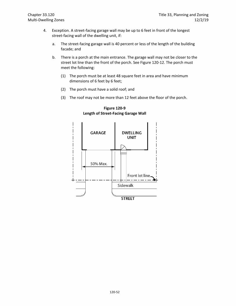
Chapter 33.120 Title 33, Planning and Zoning Multi‐Dwelling Zones 12/2/19
120‐52
4. Exception. A street‐facing garage wall may be up to 6 feet in front of the longest street‐facing wall of the dwelling unit, if:
a. The street‐facing garage wall is 40 percent or less of the length of the building facade; and
b. There is a porch at the main entrance. The garage wall may not be closer to the street lot line than the front of the porch. See Figure 120‐12. The porch must meet the following:
(1) The porch must be at least 48 square feet in area and have minimum dimensions of 6 feet by 6 feet;
(2) The porch must have a solid roof; and
(3) The roof may not be more than 12 feet above the floor of the porch.
Figure 120‐9 Length of Street‐Facing Garage Wall

Title 33, Planning and Zoning Chapter 33.120 12/2/19 Multi‐Dwelling Zones
120‐53
Figure 120‐10 Length of Street‐Facing Garage Wall Exception
Figure 120‐11 Street Lot Line Setback
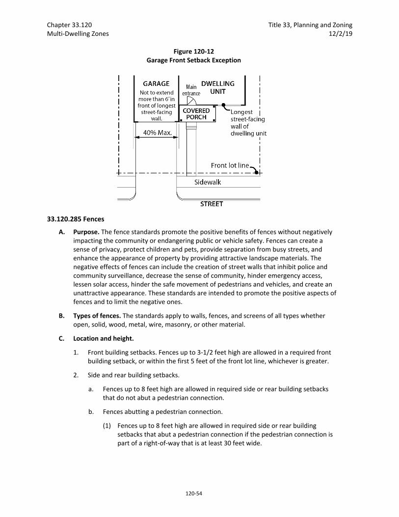
Chapter 33.120 Title 33, Planning and Zoning Multi‐Dwelling Zones 12/2/19
120‐54
Figure 120‐12 Garage Front Setback Exception
33.120.285 Fences
A. Purpose. The fence standards promote the positive benefits of fences without negatively impacting the community or endangering public or vehicle safety. Fences can create a sense of privacy, protect children and pets, provide separation from busy streets, and enhance the appearance of property by providing attractive landscape materials. The negative effects of fences can include the creation of street walls that inhibit police and community surveillance, decrease the sense of community, hinder emergency access, lessen solar access, hinder the safe movement of pedestrians and vehicles, and create an unattractive appearance. These standards are intended to promote the positive aspects of fences and to limit the negative ones.
B. Types of fences. The standards apply to walls, fences, and screens of all types whether open, solid, wood, metal, wire, masonry, or other material.
C. Location and height.
1. Front building setbacks. Fences up to 3‐1/2 feet high are allowed in a required front building setback, or within the first 5 feet of the front lot line, whichever is greater.
2. Side and rear building setbacks.
a. Fences up to 8 feet high are allowed in required side or rear building setbacks that do not abut a pedestrian connection.
b. Fences abutting a pedestrian connection.
(1) Fences up to 8 feet high are allowed in required side or rear building setbacks that abut a pedestrian connection if the pedestrian connection is part of a right‐of‐way that is at least 30 feet wide.

Title 33, Planning and Zoning Chapter 33.120 12/2/19 Multi‐Dwelling Zones
120‐55
(2) Fences up to 3‐1/2 feet high are allowed in required side or rear building setbacks that abut a pedestrian connection if the pedestrian connection is part of a right‐of‐way that is less than 30 feet wide.
3. Exception for corner lots in R3 and R2 zones. On corner lots in the R3 and R2 zones, if the main entrance is on the facade facing the side street lot line, the applicant may elect to meet the following instead of C.1. and C.2.:
a. Fences up to 3‐1/2 feet high are allowed within the first 10 feet of the side street lot line.
b. Fences up to 3‐1/2 feet high are allowed in required setbacks that abut a pedestrian connection if the pedestrian connection is part of a right‐of‐way that is less than 30 feet wide;
c. Fences up to 8 feet high are allowed in the required front building setback, outside of the area subject to 3a.
d. Fences up to 8 feet high are allowed in all other side or rear building setbacks.
4. Not in building setbacks. The height for fences that are not in required building setbacks is the same as the regular height limits of the zone.
D. Reference to other regulations. Electrified fences are regulated under Title 26, Electrical Regulations. The use of barbed wire is regulated under Title 24, Building Regulations.
33.120.290 Demolitions
A. Generally. Demolition on a site that requires a demolition permit is subject to the tree preservation and protection requirements of Title 11, Trees. See Chapter 11.50, Trees in Development Situations.
B. Historic resources. Demolition of historic resources is regulated by Chapter 33.445, Historic Resource Overlay Zone.
33.120.300 Nonconforming Development Existing developments that do not conform to the development standards of this chapter may be subject to the regulations of Chapter 33.258, Nonconforming Situations.
33.120.305 Parking and Loading The standards for the minimum required and maximum allowed number of auto parking spaces, required number of bike parking spaces, parking lot placement, parking lot setbacks and landscaping, loading areas and driveways are stated in Chapter 33.266, Parking And Loading.
33.120.310 Signs The sign regulations are stated in Title 32, Signs and Related Regulations.
33.120.320 Inclusionary Housing The regulations pertaining to inclusionary housing are stated in Chapter 33.245, Inclusionary Housing.
Chapter 33.120 Title 33, Planning and Zoning Multi‐Dwelling Zones 12/2/19
120‐56
(Amended by: Ord. No. 165376, effective 5/29/92; Ord. No. 165594, effective 7/8/92; Ord. No. 166313, effective 4/9/93; Ord. No. 166702, effective 7/30/93; Ord. No. 167054, effective 10/25/93; Ord. No. 167186, effective 12/31/93; Ord. No. 167189, effective 1/14/94; Ord. No. 168698, effective 4/17/95; Ord. No. 169535, effective 1/8/96; Ord. No. 169699, effective 2/7/96; Ord. No. 169987, effective 7/1/96; Ord. No. 170704, effective 1/1/97; Ord. No. 171081, effective 5/16/97; Ord. No. 171219, effective 7/1/97; Ord. No. 171718, effective 11/29/97; Ord. No. 171879, effective 2/2/98; Ord. No. 173533, effective 8/2/99; Ord. No. 173593, effective 9/3/99; Ord. No. 173729, effective 9/8/99; Ord. No. 174263, effective 4/15/00; Ord. No. 174378, effective 5/26/00; Ord. No. 174980, effective 11/20/00; Ord. No. 175204, effective 3/1/01; Ord. No. 175837, effective 9/7/01; Ord. No. 175966, effective 10/26/01; Ord. No. 176193, effective 2/1/02; Ord. Nos. 175965 and 176333, effective 7/1/02; Ord. No. 176469, effective 7/1/02; Ord. No. 177028, effective 12/14/02; Ord. No. 177422, effective 6/7/03; Ord. No. 177920, effective 11/8/03; Ord. No. 178423, effective 6/18/04; Ord. No. 178509, effective 7/16/04; Ord. No. 178657, effective 9/3/04; Ord. No. 178832, effective 10/21/04; Ord. No. 178927, effective 12/31/04; Ord. No. 179845, effective 1/20/06; Ord. Nos. 179980 and 179994, effective 4/22/06; Ord. No. 180619, effective 12/22/06; Ord. No. 181357, effective 11/9/07; Ord. No. 182072, effective 8/22/08; Ord. No. 182429, effective 1/16/09; Ord. No. 183269, effective 10/21/09; Ord. No. 183598, effective 4/24/10; No. 183750, effective 6/4/10; Ord. No. 184016, effective 08/20/10; Ord. No. 184524, effective 7/1/11; Ord. No. 185412, effective 6/13/12; No. 185915, effective 5/1/13; Ord. No. 186639, effective 7/11/14; Ord. No. 186736, effective 08/28/14; Ord. No. 186053, effective 1/1/15; Ord. No. 187216, effective 7/24/15; Ord. No. 187471, effective 1/1/16; Ord. No. 188077, effective 12/9/16; Ord. No. 188142, effective 1/13/17; Ord. No. 188162, effective 2/1/17; Ord. No. 188259, effective 3/31/17; Ord. No. 188177, effective 5/24/18; Ord. No. 188958, effective 5/24/18; Ord. No. 189000, effective 7/9/18; Ord. No. 189137, effective 8/22/18; Ord. No. 189488, effective 12/2/19.)
Title 33, Planning and Zoning Chapter 33.130 12/2/19 Commercial/Mixed Use Zones
130‐3
B. Commercial/Mixed Use 1 zone. The Commercial/Mixed Use 1 (CM1) zone is a small‐scale zone intended for sites in dispersed mixed use nodes within lower density residential areas, as well as on neighborhood corridors and at the edges of neighborhood centers, town centers and regional centers. The zone is also appropriate in core commercial areas of centers in locations where older commercial storefront buildings of 1 to 2 stories are predominant. This zone allows a mix of commercial and residential uses. The size of commercial uses is limited to minimize impacts on surrounding residential areas. Buildings in this zone will generally be up to three stories tall. Development is intended to be pedestrian‐oriented and compatible with the scale and characteristics of adjacent residentially zoned areas or low‐rise commercial areas.
C. Commercial/Mixed Use 2 zone. The Commercial/Mixed Use 2 (CM2) zone is a medium‐scale zone intended for sites in a variety of centers, along corridors, and in other mixed use areas that have frequent transit service. The zone allows a wide range and mix of commercial and residential uses, as well as employment uses that have limited off‐site impacts. Buildings in this zone will generally be up to four stories tall unless height and floor area bonuses are used, or plan district provisions specify other height limits. Development is intended to be pedestrian‐oriented, provide a strong relationship between buildings and sidewalks, and complement the scale of surrounding residentially zoned areas.
D. Commercial/Mixed Use 3 zone. The Commercial/Mixed Use 3 (CM3) zone is a large‐scale zone intended for sites in high‐capacity transit station areas, in town centers, along streetcar alignments, along civic corridors, and in locations close to the Central City. It is intended to be an intensely urban zone and is not appropriate for sites where adjacent properties have single‐dwelling residential zoning. The zone allows a wide range and mix of commercial and residential uses, as well as employment uses that have limited off‐site impacts. Buildings in this zone will generally be up to six stories tall unless height and floor area bonuses are used, or plan district provisions specify other height limits. Development is intended to be pedestrian‐oriented, with buildings that contribute to an urban environment with a strong street edge of buildings. The scale of development is intended to be larger than what is allowed in lower intensity commercial/mixed use and residential zones. Design review is typically required in this zone.
E. Commercial Employment zone. The Commercial Employment (CE) zone is a medium‐scale zone intended for sites along corridors with a Neighborhood Collector or higher traffic classification, especially along civic corridors that are also Major Truck Streets or Priority Truck Streets. This zone is generally not appropriate in designated centers, except on a site that is currently developed in an auto‐oriented manner and where more urban development is not yet economically feasible. The zone allows a mix of commercial uses, including auto‐accommodating development and drive‐through facilities, as well as some light manufacturing and distribution uses that have few off‐site impacts. The emphasis of this zone is on commercial and employment uses, but residential uses are also allowed. Buildings in this zone will generally be up to four stories tall. This zone is intended to allow for development with auto‐accommodating configurations, while also including pedestrian‐oriented design features that support transit and pedestrian access.
F. Central Commercial zone. The Central Commercial (CX) zone is intended to provide for commercial and mixed use development within Portland's most urban and intense areas,
Chapter 33.130 Title 33, Planning and Zoning Commercial/Mixed Use Zones 12/2/19
130‐4
specifically the Central City and the Gateway Regional Center. A broad range of uses are allowed to reflect Portland's role as a commercial, cultural, residential, and governmental center. Development is intended to be very intense with high building coverage, large buildings, and buildings placed close together. Development is intended to be pedestrian‐oriented with a strong emphasis on a safe and attractive streetscape.
33.130.040 Other Zoning Regulations The regulations in this chapter state the allowed uses and the development standards for the base zones. Sites with overlay zones, plan districts, or designated historical landmarks are subject to additional regulations. The Official Zoning Maps indicate which sites are subject to the additional regulations. Specific uses or development types may also be subject to regulations in the 200s series of chapters.
33.130.050 Neighborhood Contact Neighborhood contact is a set of outreach steps that must be taken before certain developments can be submitted for approval. Neighborhood contact is required as follows:
A. Neighborhood contact I.
1. Neighborhood contact I requirements. When proposed development will add at least 10,000 square feet and not more than 25,000 square feet of net building area to a site, the neighborhood contact steps of 33.705.020.A., Neighborhood contact I, are required. All the steps in 33.705.020.A. must be completed before an application for a building permit can be submitted.
2. Exemption. If the proposed development has already met the neighborhood contact requirements as part of a land use review process, it is exempt from the neighborhood contact requirements.
B. Neighborhood contact II.
1. Neighborhood contact II requirements. When the proposed development will add more than 25,000 square feet of net building area to a site, the neighborhood contact steps of 33.705.020.B., Neighborhood contact II, are required. All of the steps in 33.705.020.B. must be completed before an application for a building permit can be submitted.
2. Exemption. If the proposed development has already met the neighborhood contact requirements as part of a land use review process, it is exempt from the neighborhood contact requirements.
Use Regulations
33.130.100 Primary Uses
A. Allowed uses. Uses allowed in the commercial/mixed use zones are listed in Table 130‐1 with a "Y". These uses are allowed if they comply with the development standards and other regulations of this Title. Being listed as an allowed use does not mean that a proposed development will be granted an adjustment or other exception to the regulations
Title 33, Planning and Zoning Chapter 33.130 12/2/19 Commercial/Mixed Use Zones
130‐5
of this Title. In addition, a use or development listed in the 200s series of chapters is also subject to the regulations of those chapters.
B. Limited uses. Uses allowed that are subject to limitations are listed in Table 130‐1 with an "L". These uses are allowed if they comply with the limitations listed below and the development standards and other regulations of this Title. In addition, a use or development listed in the 200s series of chapters is also subject to the regulations of those chapters. The paragraphs listed below contain the limitations and correspond with the footnote numbers from Table 130‐1.
1. Group Living. This regulation applies to all parts of Table 130‐1 that have a [1].
a. General regulations. All Group Living uses, except for alternative or post incarceration facilities, are allowed by right subject to the regulations of Chapter 33.239, Group Living.
b. Alternative or post incarceration facilities. Group Living uses that consist of alternative or post incarceration facilities are conditional uses. They are also subject to the regulations of Chapter 33.239, Group Living.
2. Commercial limitations. These regulations apply to all parts of Table 130‐1 that have a [2].
a. In the CR and CM1 zones, each individual Retail Sales and Service and Office use is limited to 5,000 square feet of net building area, except that in the CM1 zone on sites that are over 40,000 square feet in size and are located on a Neighborhood Collector or higher classification traffic street, each individual Retail Sales and Service or Office use is limited to 40,000 square feet of net building area; and
b. In the CR zone, in addition to the size limitation specified in Subparagraph B.2.a., the hours when Retail Sales And Service uses can be open to the public are limited to 6:00 AM to 11:00 PM.
c. In the CM1, CM2, and CM3 zones, Quick Vehicle Servicing uses that existed on May 24, 2018 are allowed. New Quick Vehicle Servicing uses are prohibited. If a Quick Vehicle Servicing use that existed on May 24, 2018 is discontinued for 3 continuous years, reestablishment of the use is prohibited. If the Quick Vehicle Servicing use ceases operations, even if the structure or materials related to the use remain, the use as been discontinued. If the Quick Vehicle Servicing use changes to another use without obtaining all building, land use, and development permits that would have been required at the time of the change, the use has been discontinued.
3. Industrial use and size limitations. These regulations apply to all parts of Table 130‐1 that have a [3]. Utility Scale Energy Production and Industrial Service are conditional uses. All other industrial uses are allowed, and all industrial uses, including Utility Scale Energy Production and Industrial Service, are limited in size as follows. Amounts in excess of the limits are prohibited:
a. In the CM1 zone, each individual Industrial use is limited to 5,000 square feet of net building area;
Chapter 33.130 Title 33, Planning and Zoning Commercial/Mixed Use Zones 12/2/19
130‐6
b. In the CM2 and CX zones, each individual Industrial use is limited to 15,000 square feet of net building area;
c. In the CM3 zone, the total net building area of all Industrial uses on the site may not exceed the total square footage of the site; and
d. In the CE zone, each individual Industrial use is limited to 40,000 square feet of net building area.
4. Self‐Service Storage limitation. This regulation applies to all parts of Table 130‐1 that have a [4]. The limitations are stated with the special regulations for these uses in Chapter 33.284, Self‐Service Storage.
5. Exterior development limitation. This regulation applies to all parts of Table 130‐1 that have a [5]. Exterior display or storage of industrial equipment, such as tools, equipment, vehicles, products, materials, or other objects that are part of or used for the business operation is prohibited.
6. Community Services. This regulation applies to all parts of Table 130‐1 that have a [6]. Most Community Service uses are allowed by right. Short term housing and mass shelters may be allowed by right if they meet certain standards, or may be a conditional use. See Chapter 33.285, Short Term Housing and Mass Shelters.
7. Radio Frequency Transmission Facilities. This regulation applies to all parts of Table 130‐1 that have a [7]. Some Radio Frequency Transmission Facilities are allowed by right. See Chapter 33.274.
8. Basic Utilities. This regulation applies to all parts of Table 130‐1 that have an [8].
a. Public safety facilities that include Radio Frequency Transmission Facilities are a conditional use. The approval criteria are in Section 33.815.223.
b. Small Scale Energy Production that provides energy for on‐site or off‐site use are considered accessory to the primary use on the site. However, it is only considered accessory if they generate energy from biological materials or byproducts from the site itself, or conditions on the site itself; plus not more than 10 tons per week of biological material or byproducts from other sites. Installations that sell power they generate — at retail (net metered) or wholesale — are included.
c. All other Basic Utilities are allowed.
9. Commercial Parking. This regulation applies to all parts of Table 130‐1 that have a [9]. Commercial Parking is a conditional use in the CX zone except when superseded by plan district regulations. In the CM2 and CM3 zones, Commercial Parking is allowed as follows:
a. Commercial Parking is allowed by right in structured parking.
b. Commercial Parking is allowed by right on a surface parking lot legally constructed on or before May 24, 2018.
Title 33, Planning and Zoning Chapter 33.130 12/2/19 Commercial/Mixed Use Zones
130‐7
c. Commercial Parking is allowed by right on a surface parking lot legally constructed after May 24, 2018 when all of the following are met:
(1) The surface parking lot was constructed as accessory parking for other primary uses on the site;
(2) The total number of parking spaces on the site does not exceed the maximum number of parking spaces allowed for the other primary uses on the site; and
(3) Only non‐required parking spaces are used as Commercial Parking.
10. Agriculture in the CR and CM1 zones. This regulation applies to all parts of Table 130‐1 that have a [10]. If the use and site do not meet the regulations of Chapter 33.237, Food Production and Distribution, Agriculture is prohibited.
11. Agriculture in the CM2 and CX zones. This regulation applies to all parts of Table 130‐1 that have an [11]. Agriculture is a conditional use. Where the use and site meet the regulations of Chapter 33.237, Food Production and Distribution, the applicant may choose whether it is allowed as a Market Garden, which does not require a conditional use.
12. Agriculture in the CM3 and CE zones. This regulation applies to all parts of Table 130‐1 that have a [12]. Agriculture that is outdoors is a conditional use. Agriculture that is entirely indoors is allowed up to the following limits. Indoor Agriculture in excess of the following limits is prohibited. Where the use and site meet the regulations of Chapter 33.237, Food Production and Distribution, the applicant may choose whether it is allowed as a Market Garden, which does not require a conditional use:
a. In the CM3 zone, the total net building area of all indoor Agriculture per site may not exceed the total square footage of the site; and
b. In the CE zone, each indoor Agriculture use is limited to 40,000 square feet of net building area.
C. Conditional uses. Uses that are allowed if approved through the conditional use review process are listed in Table 130‐1 with a "CU". These uses are allowed provided they comply with the conditional use approval criteria for that use, the development standards, and other regulations of this Title. Uses listed with a "CU" that also have a footnote number in the table are subject to the regulations cited in the footnote. In addition, a use or development listed in the 200s series of chapters is also subject to the regulations of those chapters. The conditional use review process and approval criteria are stated in Chapter 33.815, Conditional Uses.
D. Prohibited uses. Uses listed in Table 130‐1 with an "N" are prohibited. Existing uses in categories listed as prohibited may be subject to the regulations of Chapter 33.258, Nonconforming Uses and Development.
33.130.110 Accessory Uses Uses that are accessory to a primary use are allowed if they comply with specific regulations for the accessory uses and all development standards.

Chapter 33.130 Title 33, Planning and Zoning Commercial/Mixed Use Zones 12/2/19
130‐8
33.130.130 Nuisance‐Related Impacts
A. Off‐site impacts. All nonresidential uses including their accessory uses must comply with the standards of Chapter 33.262, Off‐Site Impacts.
B. Other nuisances. Other nuisances are regulated by Title 29, Property and Maintenance Regulations.
Table 130‐1 Commercial/Mixed Use Zone Primary Uses
Use Categories CR CM1 CM2 CM3 CE CX
Residential Categories
Household Living Y Y Y Y Y Y
Group Living L/CU [1] L/CU [1] L/CU [1] L/CU [1] L/CU [1] L/CU [1]
Commercial Categories
Retail Sales And Service L [2] L [2] Y Y Y Y
Office L [2] L [2] Y Y Y Y
Quick Vehicle Servicing N L [2] L [2] L [2] Y N
Vehicle Repair N N Y Y Y L [5]
Commercial Parking N N L [9] L [9] Y CU [9]
Self‐Service Storage N N N L [4] L [4] L [4]
Commercial Outdoor Recreation N N Y Y Y Y
Major Event Entertainment N N CU CU CU Y
Industrial Categories
Manufacturing and Production N L/CU [3,5] L/CU [3,5] L/CU [3,5] L/CU [3,5] L/CU [3,5]
Warehouse and Freight Movement N N N L [3,5] L [3,5] N
Wholesale Sales N N L [3,5] L [3,5] L [3,5] L [3,5]
Industrial Service N N CU [3,5] CU [3,5] CU [3,5] CU [3,5]
Bulk Fossil Fuel Terminal N N N N N N
Railroad Yards N N N N N N
Waste‐Related N N N N N N
Institutional Categories
Basic Utilities Y/CU [8] Y/CU [8] Y/CU [8] Y/CU [8] Y/CU [8] Y/CU [8]
Community Service L/CU [6] L/CU [6] L/CU [6] L/CU [6] L/CU [6] L/CU [6]
Parks and Open Areas Y Y Y Y Y Y
Schools Y Y Y Y Y Y
Colleges N Y Y Y Y Y
Medical Centers N Y Y Y Y Y
Religious Institutions Y Y Y Y Y Y
Daycare Y Y Y Y Y Y
Title 33, Planning and Zoning Chapter 33.130 12/2/19 Commercial/Mixed Use Zones
130‐9
Table 130‐1 Commercial/Mixed Use Zone Primary Uses
Use Categories CR CM1 CM2 CM3 CE CX
Other Categories
Agriculture L [10] L [10] L/CU [11] L/CU [12] L/CU [12] L/CU [11]
Aviation and Surface Passenger Terminals
N N N N CU CU
Detention Facilities N N N CU CU CU
Mining N N N N N N
Radio Frequency Transmission Facilities N L/CU [7] L/CU [7] L/CU [7] L/CU [7] L/CU [7]
Rail Lines and Utility Corridors N CU CU CU CU CU
Y = Yes, Allowed CU = Conditional Use Review Required
L = Allowed, But Special Limitations N = No, Prohibited
Notes:
The use categories are described in Chapter 33.920.
Regulations that correspond to the bracketed numbers [ ] are stated in 33.130.100.B.
Specific uses and developments may also be subject to regulations in the 200s series of chapters.
Development Standards
33.130.200 Lot Size There is no required minimum lot size for development of land in commercial/mixed use zones. Creation of new lots is subject to the regulations of Chapter 33.613, Lots in Commercial/Mixed Use Zones.
33.130.205 Floor Area Ratio
A. Purpose. Floor area ratios (FARs) regulate the amount of use (the intensity) allowed on a site. FARs provide a means to match the potential amount of uses with the desired character of the area and the provision of public services. FARs also work with the height, setback, and building coverage standards to control the overall bulk of development. The bonus FAR options allow additional floor area as an incentive for providing affordable housing.
B. FAR standard. The maximum floor area ratios are stated in Table 130‐2 and apply to all uses and development. Additional floor area may be allowed through bonus options, as described in Section 33.130.212, or transferred from historic resources per Subsection C. Except in the CR zone, floor area for structured parking, up to a maximum FAR of 0.5 to 1, is not calculated as part of the FAR for the site. Adjustments to the maximum floor area ratios are prohibited.
C. Transfer of floor area from historic resources. Floor area ratios may be transferred from a site that contains a historic resource, as follows:
1. Sending sites. Sites eligible to transfer floor area must contain:
a. A Historic or Conservation landmark; or
b. A contributing resource in a Historic District or a Conservation District.
Chapter 33.130 Title 33, Planning and Zoning Commercial/Mixed Use Zones 12/2/19
130‐10
2. Receiving site. The transfer must be to a site that is zoned CM1, CM2, CM3, CE or CX. Transferring to a site that is zoned CR is prohibited. The receiving site must be within the same recognized neighborhood as the sending site, or within two miles of the transfer site, and must not be within a Historic or Conservation District.
3. Maximum increase in FAR in the CM1, CM2, CM3, and CE zones. In the CM1, CM2, CM3, and CE zones, the total FAR on the receiving site may not exceed the maximum FAR with bonuses identified on Table 130‐3. This total FAR includes FAR transferred from historic resources, and any additional FAR allowed at the receiving site from bonus options, or from other transfers. In addition, an increase on the receiving site of more than the following due to a historic resource transfer is prohibited:
a. 0.5 to 1 in the CM1 zone;
b. 0.75 to 1 in the CM2 zone;
c. 1 to 1 in the CM3 zone;
d. 0.5 to 1 in the CE zone.
4. Maximum increase in FAR in the CX zone. In the CX zone, an increase in FAR on the receiving site of more than 3 to 1 is prohibited. The total increased FAR includes FAR transferred from historic resources, and additional FAR allowed at the receiving site from bonus provisions, or from other transfers;
5. Development standards. The building on the receiving site must meet the development standards of the base zone, overlay zone, and plan district except floor area ratio, which is regulated by Paragraphs C.2 and C.3 above;
6. The property owner must execute a covenant with the City that is attached to and recorded with the deed of both the site transferring and the site receiving the density. The covenant must reflect the respective increase and decrease of potential density. The covenant for the receiving site must meet the requirements of Section 33.700.060, Covenants with the City. The covenant for the historic resource transferring the density must meet the requirements of 33.445.610.D, Covenant.
33.130.207 Minimum Density
A. Purpose. The minimum density standards ensure that the service capacity is not wasted and that the City's housing goals are met.
B. Minimum Density. The minimum density requirements for the CM2 and CM3 zones are stated in Table 130‐2. Minimum density applies to new development when at least one dwelling unit is proposed. Land within an Environmental zone may be subtracted from the calculation of minimum density.
33.130.210 Height
A. Purpose. The height limits are intended to control the overall scale of buildings. The height limits in the CR and CM1 zones allow buildings that are in scale with low rise residential areas. The height limits in the CM2 and CE zones allow for a greater building height at a scale that can accommodate the growth intended for centers and corridors, while relating to the low‐ to mid‐rise scale of neighborhood residential areas. The CM3 zone allows the

Title 33, Planning and Zoning Chapter 33.130 12/2/19 Commercial/Mixed Use Zones
130‐11
tallest buildings outside the Central City and Gateway plan districts, consistent with its intended role in accommodating higher‐density development in areas well served by transit and other services. The CX zone allows the tallest buildings in the commercial/mixed use zones, consistent with its intended role in accommodating high‐density development in the Central City and the Gateway plan districts.
In some situations, step downs in maximum height provide a transition in scale to adjacent lower‐scale residential areas, and preserve opportunities for light, air and privacy. Exceptions to height limit standards accommodate minor projections that do not significantly increase the visual scale of buildings; provide flexibility in the height of parapets and railings to facilitate rooftop outdoor spaces and equipment screening; and accommodate ground‐floor spaces with high ceilings to encourage ground‐floor commercial uses, mechanical parking, and other uses that benefit from high ceilings.
B. Height standard.
1. Base height. The base height standards for all structures, except detached accessory structures, are stated in Table 130‐2. The height standards for detached accessory structures are stated in 33.130.265, Detached Accessory Structures.
2. Step‐down height. In the following situations, the base height is reduced, or stepped‐down. Stepped‐down height is not required in the CR zone:
a. Step‐down adjacent to residential zones. The following step‐down height limits apply within 25 feet of sites zoned residential. Sites with property lines that abut residential zones for less than a 5‐foot length are exempt from these standards:
(1) On the portion of the site within 25 feet of a site zoned RF through R2.5, the step‐down height limit is 35 feet. See Figure 130‐1.
(2) On the portion of the site within 25 feet of a site zoned R3 — R1 or RMP, the step‐down height limit is 45 feet. See Figure 130‐1.
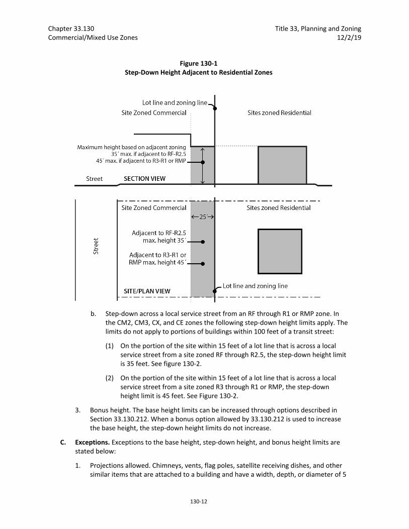
Chapter 33.130 Title 33, Planning and Zoning Commercial/Mixed Use Zones 12/2/19
130‐12
Figure 130‐1 Step‐Down Height Adjacent to Residential Zones
b. Step‐down across a local service street from an RF through R1 or RMP zone. In the CM2, CM3, CX, and CE zones the following step‐down height limits apply. The limits do not apply to portions of buildings within 100 feet of a transit street:
(1) On the portion of the site within 15 feet of a lot line that is across a local service street from a site zoned RF through R2.5, the step‐down height limit is 35 feet. See figure 130‐2.
(2) On the portion of the site within 15 feet of a lot line that is across a local service street from a site zoned R3 through R1 or RMP, the step‐down height limit is 45 feet. See Figure 130‐2.
3. Bonus height. The base height limits can be increased through options described in Section 33.130.212. When a bonus option allowed by 33.130.212 is used to increase the base height, the step‐down height limits do not increase.
C. Exceptions. Exceptions to the base height, step‐down height, and bonus height limits are stated below:
1. Projections allowed. Chimneys, vents, flag poles, satellite receiving dishes, and other similar items that are attached to a building and have a width, depth, or diameter of 5
Title 33, Planning and Zoning Chapter 33.130 12/2/19 Commercial/Mixed Use Zones
130‐13
feet or less may extend 10 feet above the height limits, or 5 feet above the highest point of the roof, whichever is greater. Items that are greater than 5 feet in width, depth, or diameter are not allowed to project above the base, step‐down, or bonus height limits.
2. Parapets and railings. In the CM1, CM2, CM3, CE and CX zones, parapets and rooftop railings may extend 4 feet above the height limits.
3. Walls and fences. In the CM1, CM2, CM3, CE and CX zones, walls or fences located between individual rooftop decks may extend 6 feet above the height limits if the visual screen is set back at least 4 feet from the edges of the roof.
4. Rooftop equipment. In the CM1, CM2, CM3, CE and CX zones, rooftop mechanical equipment and stairwell enclosures that provide rooftop access may extend above the height limits as follows, provided that the equipment and enclosures are set back at least 15 feet from all roof edges on street facing facades:
a. Elevator mechanical equipment and stairwell enclosures may extend up to 16 feet above the height limits; and
b. Other mechanical equipment that cumulatively cover no more than 10 percent of the roof area may extend up to 10 feet above the height limits.
5. Antennas and mounting devices, utility power poles, and public safety facilities are exempt from the height limits.
6. Small wind turbines are subject to the standards of Chapter 33.299.
7. Roof mounted solar panels are not included in height calculations and may exceed the maximum height limits if the following are met:
a. For flat roofs or the horizontal portion of mansard roofs, the solar panel may extend up to 5 feet above the top of the highest point of the roof; and
b. For pitched, shed, hipped, or gambrel roofs, the solar panel must be mounted no more than 12 inches from the surface of the roof at any point, and may not extend above the ridgeline of the roof. The 12 inches is measured from the upper side of the solar panel.
8. High ceilings. In the CM1, CM2, CM3, CE and CX zones outside the Central City plan district, base height, step‐down height, and bonus height may be increased by 5 feet when at least 75 percent of the ground floor has at least 15 feet between the floor and the bottom of the structure above. The bottom of the structure above includes supporting beams.

Chapter 33.130 Title 33, Planning and Zoning Commercial/Mixed Use Zones 12/2/19
130‐14
Table 130‐2 Summary of Development Standards in Commercial/Mixed Use Zones
Standards CR CM1 CM2 CM3 CE CX
Maximum FAR (see 33.130.205 and 33.130.212)
1 to 1 [1] 1.5 to 1 2.5 to 1 3 to 1 2.5 to 1 4 to 1
‐ Bonus FAR (see 33.130.212) NA See Table 130‐3
See Table 130‐3
See Table 130‐3
See Table 130‐3
See Table 130‐3
Minimum Density (see 33.130.207) NA NA 1 unit per 1,450 sq. ft. of site area
1 unit per 1,000 sq. ft. of site area
NA NA
Base Height (see 33.130.210.B.1) 30 ft. 35 ft. 45 ft. 65 ft. 45 ft. 75 ft.
Step‐down Height (see 33.130.210.B.2) ‐ Within 25 ft. of lot line abutting RF‐R2.5 zones ‐ Within 25 ft. of lot line abutting R3, R2, R1, RMP Zones ‐ Within 15 ft. of lot line across a local service street from RF – R2.5 Zones ‐ Within 15 ft. of lot line across a local service street from R3, R2, R1, RMP Zones
NA 35 ft.
35 ft.
35 ft.
35 ft.
35 ft.
NA NA 45 ft. 45 ft. 45 ft. 45 ft.
NA 35 ft. 35 ft. 35 ft. 35 ft. 35 ft.
NA NA 45 ft. 45 ft. 45 ft. 45 ft.
‐ Bonus Height (see 33.130.212) NA NA See Table 130‐3
See Table 130‐3
See Table 130‐3
See Table 130‐3
Min. Building Setbacks (see 33.130.215.B) ‐ Street Lot Line ‐ Street Lot Line abutting selected Civic Corridors ‐ Street Lot Line across a local street from an RF – R1 or RMP Zone.
none
none
none
none
none
none
10 ft. 10 ft. 10 ft. 10 ft. 10 ft. 10 ft.
none none 5 or 10 ft. 5 or 10 ft. 5 or 10 ft.
5 or 10 ft.
Min. Building Setbacks (see 33.130.215.B) ‐ Lot Line Abutting OS, RX, C, E, or I Zoned Lot ‐ Lot Line Abutting RF – RH or RMP Zoned Lot
none
none
none
none
none
none
10 ft. 10 ft. 10 ft. 10 ft. 10 ft. 10 ft.
Max. Building Setbacks (see 33.130.215.C) ‐ Street Lot Line ‐ Street Lot Line Abutting Selected Civic Corridors
10 ft. 20 ft.
10 ft. 20 ft.
10 ft. 20 ft.
10 ft. 20 ft.
10 ft. 20 ft.
10 ft. 20 ft.
Max. Building Coverage (% of site area) ‐ Inner Pattern Area ‐ Eastern, Western, and River Pattern Areas (see 33.130.220)
85% 75%
85% 75%
100% 85%
100% 85%
85% 75%
100% 100%
Min. Landscaped Area (% of site area) (see 33.130.225)
15% 15% 15% 15% 15% None
Landscape Buffer Abutting an RF ‐ RH or RMP Zoned Lot (see 33.130.215.B)
10 ft. @ L3
10 ft. @ L3
10 ft. @ L3 10 ft. @ L3 10 ft. @ L3
10 ft. @ L3
Required Residential Outdoor Area (see 33.130.228)
Yes Yes Yes Yes Yes No
Ground Floor Window Standards (see 33.130.230.B)
Yes Yes Yes Yes Yes Yes
Notes: [1] On sites that do not have a Retail Sales And Service or Office use, maximum density for Household Living is 1 unit per 2,500 square feet of site area.
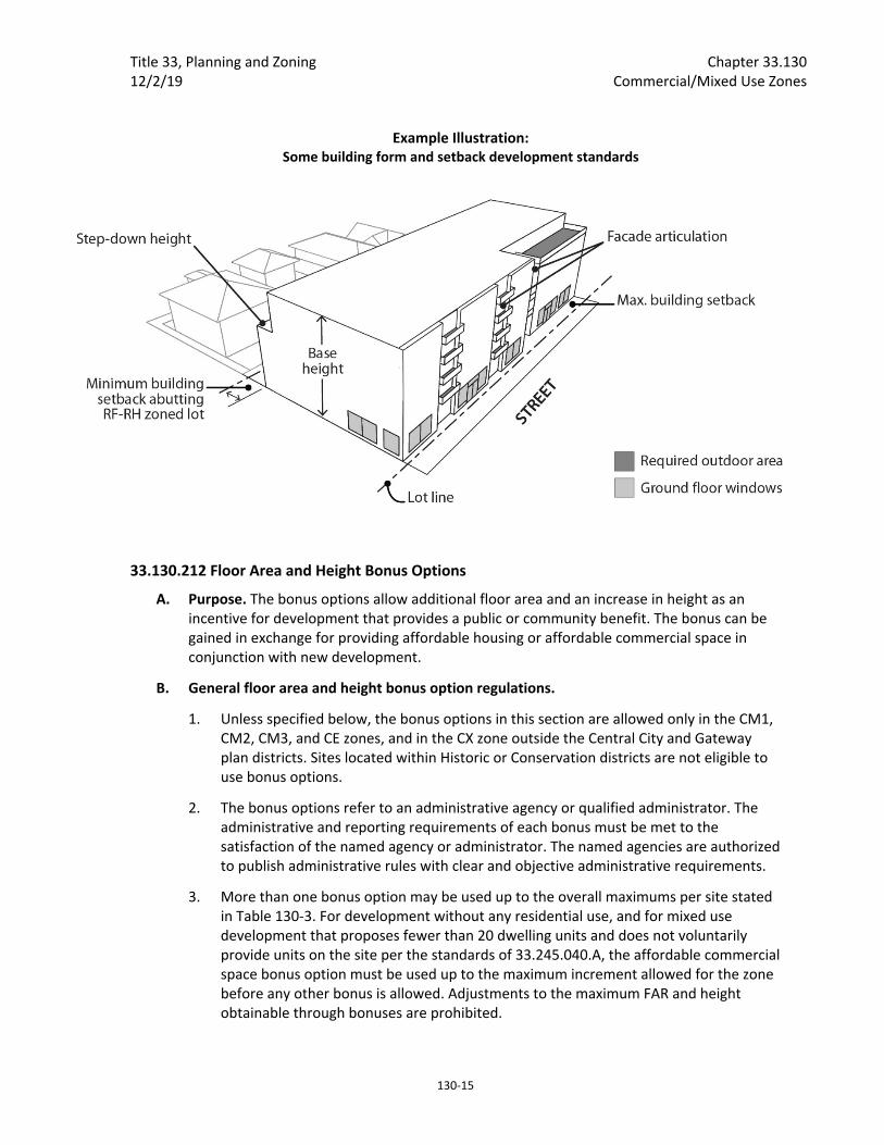
Title 33, Planning and Zoning Chapter 33.130 12/2/19 Commercial/Mixed Use Zones
130‐15
33.130.212 Floor Area and Height Bonus Options
A. Purpose. The bonus options allow additional floor area and an increase in height as an incentive for development that provides a public or community benefit. The bonus can be gained in exchange for providing affordable housing or affordable commercial space in conjunction with new development.
B. General floor area and height bonus option regulations.
1. Unless specified below, the bonus options in this section are allowed only in the CM1, CM2, CM3, and CE zones, and in the CX zone outside the Central City and Gateway plan districts. Sites located within Historic or Conservation districts are not eligible to use bonus options.
2. The bonus options refer to an administrative agency or qualified administrator. The administrative and reporting requirements of each bonus must be met to the satisfaction of the named agency or administrator. The named agencies are authorized to publish administrative rules with clear and objective administrative requirements.
3. More than one bonus option may be used up to the overall maximums per site stated in Table 130‐3. For development without any residential use, and for mixed use development that proposes fewer than 20 dwelling units and does not voluntarily provide units on the site per the standards of 33.245.040.A, the affordable commercial space bonus option must be used up to the maximum increment allowed for the zone before any other bonus is allowed. Adjustments to the maximum FAR and height obtainable through bonuses are prohibited.
Example Illustration: Some building form and setback development standards
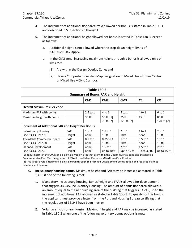
Chapter 33.130 Title 33, Planning and Zoning Commercial/Mixed Use Zones 12/2/19
130‐16
4. The increment of additional floor area ratio allowed per bonus is stated in Table 130‐3 and described in Subsections C though E.
5. The increment of additional height allowed per bonus is stated in Table 130‐3, except as follows:
a. Additional height is not allowed where the step‐down height limits of 33.130.210.B.2 apply.
b. In the CM2 zone, increasing maximum height through a bonus is allowed only on sites that:
(1) Are within the Design Overlay Zone; and
(2) Have a Comprehensive Plan Map designation of Mixed Use – Urban Center or Mixed Use – Civic Corridor.
Table 130‐3 Summary of Bonus FAR and Height
CM1 CM2 CM3 CE CX
Overall Maximums Per Zone
Maximum FAR with bonus 2.5 to 1 4 to 1 5 to 1 4 to 1 6 to 1
Maximum height with bonus 35 ft. 55 ft. [1] 75 ft. [2]
75 ft. 120 ft. [2]
45 ft. 85 ft. 120 ft. [2]
Increment of Additional FAR and Height Per Bonus
Inclusionary Housing (see 33.130.212.C)
FAR Height
1 to 1 none
1.5 to 1 10 ft.
2 to 1 10 ft.
1 to 1 none
2 to 1 10 ft.
Affordable Commercial Space (see 33.130.212.D)
FAR Height
0.5 to 1 none
0.75 to 1 10 ft.
1 to 1 10 ft.
0.5 to 1 none
1 to 1 10 ft.
Planned Development (see 33.130.212.E)
FAR Height
none none
1.5 to 1 up to 30 ft.
2 to 1 up to 55 ft.
1.5 to 1 up to 30 ft.
2 to 1 up to 45 ft.
[1] Bonus height in the CM2 zone is only allowed on sites that are within the Design Overlay Zone and that have a Comprehensive Plan Map designation of Mixed Use–Urban Center or Mixed Use–Civic Corridor. [2] This larger overall maximum is only allowed through the Planned Development bonus option and required Planned Development Review.
C. Inclusionary housing bonus. Maximum height and FAR may be increased as stated in Table 130‐3 if one of the following is met:
1. Mandatory inclusionary housing. Bonus height and FAR is allowed for development that triggers 33.245, Inclusionary Housing. The amount of bonus floor area allowed is an amount equal to the net building area of the building that triggers 33.245, up to the increment of additional FAR allowed as stated in Table 130‐3. To qualify for this bonus, the applicant must provide a letter from the Portland Housing Bureau certifying that the regulations of 33.245 have been met; or
2. Voluntary inclusionary housing. Maximum height and FAR may be increased as stated in Table 130‐3 when one of the following voluntary bonus options is met:
Title 33, Planning and Zoning Chapter 33.130 12/2/19 Commercial/Mixed Use Zones
130‐17
a. Bonus height and FAR is allowed for projects the voluntarily comply with the standards of 33.245.040 and 33.245.050. The amount of bonus floor area allowed is an amount equal to the net building area of the building that complies with 33.245.040 and .050, up to the increment of additional FAR allowed as stated in Table 130‐3. To qualify for this bonus, the applicant must provide a letter from the Portland Housing Bureau certifying that the regulations of 33.245 have been met. The letter is required to be submitted before a building permit can be issued for development, but is not required in order to apply for a land use review; or
b. Bonus height and FAR is allowed in exchange for payment into the Affordable Housing Fund. For each square foot of floor area purchased a fee must be paid to the Portland Housing Bureau (PHB). The Portland Housing Bureau collects and administers the Affordable Housing Fund, and determines the fee. PHB determines the fee per square foot and updates the fee at least every three years. The fee schedule is available from the Bureau of Development Services. To qualify for this bonus, the applicant must provide a letter from PHB documenting the amount that has been contributed. The letter is required to be submitted before a building permit can be issued for development, but is not required in order to apply for a land use review.
D. Affordable commercial space bonus. Proposals that provide on‐site affordable commercial space, or pay into the Affordable Commercial Space Fund, may increase maximum height and FAR if all of the following are met. Floor area may be increased by 2 square feet for each square foot of on‐site affordable commercial space provided, up to the maximum stated in Table 130‐3. Floor area may be increased by 1 square foot for each square foot purchased through the Affordable Commercial Space Fund, up to the maximum stated in Table 130‐3:
1. The applicant must submit with the development application a letter from the Portland Development Commission certifying that any program administrative requirements have been met; and
2. The property owner must execute a covenant with the City that complies with the requirements of Section 33.700.060. The covenant must ensure that floor area built as a result of this bonus will meet the administrative requirements of the Portland Development Commission or qualified administrator.
E. Planned Development bonus. Proposals that provide a combination of affordable housing, a publicly accessible plaza or park, and energy efficient buildings may increase maximum height and FAR as stated in Table 130‐3 if approved through a Planned Development Review and Design Review (see Chapter 33.270 and Chapter 33.854). The site must be at least two acres in size to be eligible for this bonus.
33.130.215 Setbacks
A. Purpose. The required building setbacks promote streetscapes that are consistent with the desired character of the different commercial/mixed use zones. The setbacks promote buildings close to the sidewalk to reinforce a pedestrian orientation and built‐up streetscape. The setback requirements for areas that abut residential zones promote
Chapter 33.130 Title 33, Planning and Zoning Commercial/Mixed Use Zones 12/2/19
130‐18
commercial/mixed use development that will maintain light, air, and the potential for privacy for adjacent residential zones.
The front setback requirements for Civic Corridors in Eastern and Western pattern areas provide opportunities for additional pedestrian space and separation from the vehicle traffic along these major streets to create an environment for building users and pedestrians that is less impacted by close proximity to traffic, and provide opportunities for front landscaping reflective of the vegetated characteristics of these neighborhood pattern areas.
The minimum building setbacks along local service streets adjacent to residential zones work together with requirements for step downs in building height (33.130.210.B.2.b.) to ensure that there is a transition in street frontage characteristics to lower scale residential zones. In these situations, the building setback regulations promote street frontages with landscaping and residential uses to provide a transition and a cohesive street environment with similar street frontage characteristics on both sides of the street, and limit exterior display and storage to minimize impacts to nearby residentially‐zoned areas.
B. Minimum building setbacks. Minimum required building setbacks are listed below and summarized in Table 130‐2. Unless otherwise specified in this section, the minimum required setbacks apply to all buildings and structures on a site. Setbacks for exterior development are stated in 33.130.245, and setbacks for parking areas are stated in Chapter 33.266, Parking, Loading and Transportation and Parking Demand Management.
1. Required setbacks from a street lot line. Unless as specified below, there is no minimum required setback from a street lot line:
a. The minimum setback required from a street lot line adjacent to a Civic Corridor shown on Map 130‐1 is 10 feet.
b. The following minimum setbacks are required from a street lot line on the portion of the site that is across a local service street from an RF through R1 or RMP zone. The setbacks do not apply in the CR or CM1 zones, or on or within 100 feet of a transit street:
(1) Buildings that are entirely in a residential use, and portions of buildings with dwelling units on the ground floor, must be setback 5 feet from a street lot line facing an RF through R1 or RMP zone. The setback must be landscaped to at least the L1 standard. Vehicle access is not allowed through the setback unless the local service street facing the residential zone is the only frontage for the site. Up to one third of the setback area can be hard surfaced for pedestrian or bicycle access. Exterior display and storage is not allowed within the setback.
(2) All other buildings must be setback 10 feet from a street lot line facing an RF through R1 or RMP zone. The setback must be landscaped to at least the L1 standard. Vehicle access is not allowed through the setback unless the local service street facing the residential zone is the only frontage for the site. Up to one third of the setback area can be hard surfaced for pedestrian or bicycle access. Exterior display and storage is not allowed within the setback. See Figure 130‐2.
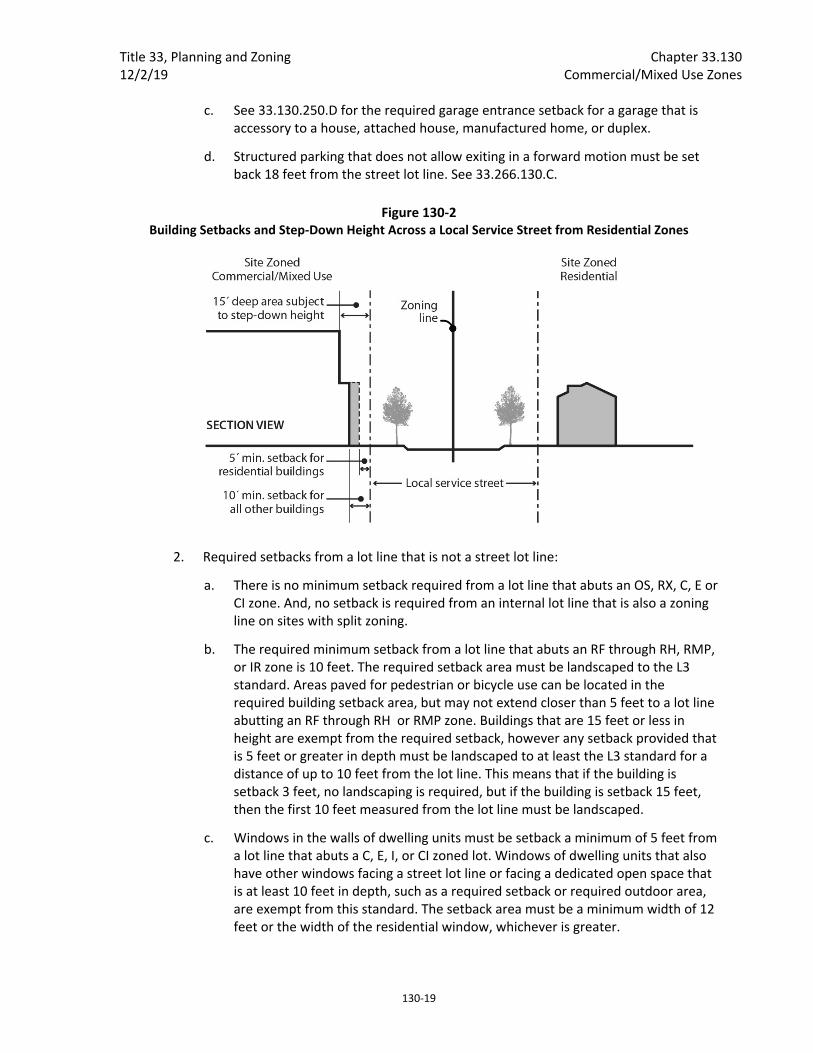
Title 33, Planning and Zoning Chapter 33.130 12/2/19 Commercial/Mixed Use Zones
130‐19
c. See 33.130.250.D for the required garage entrance setback for a garage that is accessory to a house, attached house, manufactured home, or duplex.
d. Structured parking that does not allow exiting in a forward motion must be set back 18 feet from the street lot line. See 33.266.130.C.
Figure 130‐2 Building Setbacks and Step‐Down Height Across a Local Service Street from Residential Zones
2. Required setbacks from a lot line that is not a street lot line:
a. There is no minimum setback required from a lot line that abuts an OS, RX, C, E or CI zone. And, no setback is required from an internal lot line that is also a zoning line on sites with split zoning.
b. The required minimum setback from a lot line that abuts an RF through RH, RMP, or IR zone is 10 feet. The required setback area must be landscaped to the L3 standard. Areas paved for pedestrian or bicycle use can be located in the required building setback area, but may not extend closer than 5 feet to a lot line abutting an RF through RH or RMP zone. Buildings that are 15 feet or less in height are exempt from the required setback, however any setback provided that is 5 feet or greater in depth must be landscaped to at least the L3 standard for a distance of up to 10 feet from the lot line. This means that if the building is setback 3 feet, no landscaping is required, but if the building is setback 15 feet, then the first 10 feet measured from the lot line must be landscaped.
c. Windows in the walls of dwelling units must be setback a minimum of 5 feet from a lot line that abuts a C, E, I, or CI zoned lot. Windows of dwelling units that also have other windows facing a street lot line or facing a dedicated open space that is at least 10 feet in depth, such as a required setback or required outdoor area, are exempt from this standard. The setback area must be a minimum width of 12 feet or the width of the residential window, whichever is greater.
Chapter 33.130 Title 33, Planning and Zoning Commercial/Mixed Use Zones 12/2/19
130‐20
3. Extensions into required building setbacks and buffering requirements of Table 130‐2.
a. The following features of a building may extend into a required building setback up to 20 percent of the depth of the setback. However, except for building eaves and stormwater planters, they may not extend closer than 5 feet to a lot line abutting an RF – RH or RMP zoned lot.
(1) Eaves, chimneys, fireplace inserts and vents, mechanical equipment, fire escapes, water collection cisterns and stormwater planters;
(2) Stairways and wheelchair ramps that do not meet the standard of Subparagraph B.3.b below; and
(3) Bays and bay windows may extend into a street setback, but not a required setback abutting an RF – RH or RMP zoned lot, and also must meet the following requirements:
Each bay and bay window may be up to 12 feet long, but the total area of all bays and bay windows on a building facade cannot be more than 30 percent of the area of the facade;
At least 30 percent of the area of the bay which faces the street lot line requiring the setback must be glazing or glass block;
Bays and bay windows must cantilever beyond the foundation of the building; and
The bay may not include any doors.
b. The following minor features of a building are allowed to fully extend into required building setbacks, but may not extend closer than 5 feet to a lot line abutting an RF – RH or RMP zoned lot.
(1) Uncovered decks, stairways, and wheelchair ramps with surfaces that are no more than 2‐1/2 feet above the ground;
(2) On lots that slope down from the street, vehicular and pedestrian entry bridges with surfaces that are no more than 2‐1/2 feet above the average sidewalk elevation; and
(3) Canopies, marquees, awnings, and similar features may fully extend into a street setback.
c. Uncovered decks are allowed to fully extend into required street setbacks.
4. Detached accessory structures. For sites entirely in residential use, detached accessory structures are subject to the multi‐dwelling zone standards of Section 33.120.280. The setback standards for detached accessory structures are stated in 33.130.265 below. Fences are addressed in 33.130.270 below.
C. Maximum building setbacks. Except as stated in Subsection E., the maximum building setback standards are stated below.
Title 33, Planning and Zoning Chapter 33.130 12/2/19 Commercial/Mixed Use Zones
130‐21
1. Maximum setback standards. Unless otherwise specified, the maximum a building can be set back from a street lot line is 10 feet, except on Civic Corridors shown on Map 130‐1, where the maximum set back is 20 feet. At least 50 percent of the length of the ground level street‐facing facade of the building must meet the maximum setback standard.
2. Applying the standard.
a. Where an existing building is being altered, the standards apply to the ground level, street‐facing facade of the entire building. See Figures 130‐3 and 130‐4.
b. Where there is more than one building on the site, the standards of this paragraph apply to the combined ground level, street‐facing facades of all of the buildings. See Figures 130‐5 and 130‐6.
c. In the CR, CM1, CM2, CM3, and CX zones, and in the CE zone within a Pedestrian District, if the site has street lot lines on three or more streets, the maximum setback standard only applies to two of the streets. When this occurs, the standard must be applied to the streets with the highest transit street classifications. If the site is a through lot, the maximum setback standard only applies to the street with the highest transit street classification. If multiple streets have the same highest transit street classification, the applicant may choose which street or streets to apply the standard.
d. In the CE zone outside of pedestrian districts, the maximum setback standard only applies to transit streets unless the site does not have a street lot line on a transit street. If the site does not have a street lot line on a transit street, then the maximum setback standard applies to one street, and if there is more than one street, the applicant may choose which street to apply the standard. If the site has street lot lines on three or more transit streets, the maximum setback standard applies only to two of the streets. When this occurs, the standard must be applied to the streets with the highest transit classification. If multiple transit streets have the same highest street classification, the applicant may choose which streets to apply the standard.
e. For buildings where all of the floor area is in residential use, the street‐facing facade of an open porch that meets the following standards is included as part of the ground level, street‐facing facade of the building:
(1) For houses, attached houses, manufactured homes and duplexes, the porch must be at least 25 square feet in area. For multi‐dwelling structures, the porch must be at least 9 feet wide and 7 feet deep;
(2) The porch must have at least one entrance facing the street; and
(3) The porch must have a roof that is no more than 12 feet above the floor of the porch and at least 30 percent solid. This standard may be met by having 30 percent of the porch area covered with a solid roof, or by having the entire area covered with a trellis or other open material if no more than 70 percent of the area of the material is open.
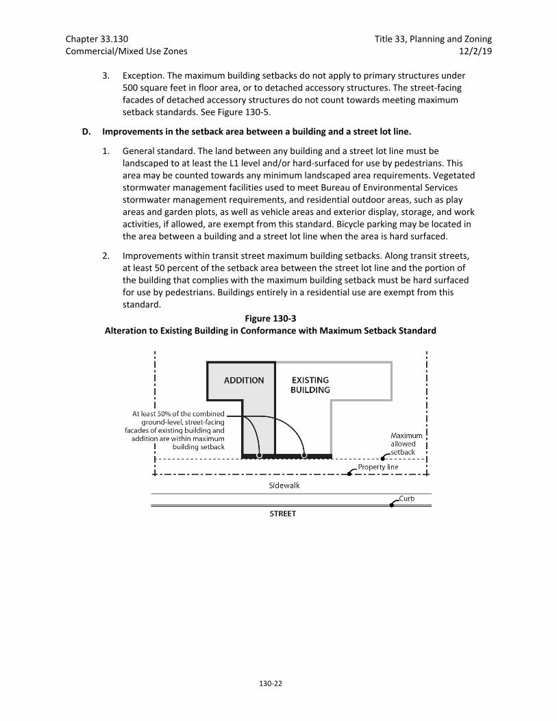
Chapter 33.130 Title 33, Planning and Zoning Commercial/Mixed Use Zones 12/2/19
130‐22
3. Exception. The maximum building setbacks do not apply to primary structures under 500 square feet in floor area, or to detached accessory structures. The street‐facing facades of detached accessory structures do not count towards meeting maximum setback standards. See Figure 130‐5.
D. Improvements in the setback area between a building and a street lot line.
1. General standard. The land between any building and a street lot line must be landscaped to at least the L1 level and/or hard‐surfaced for use by pedestrians. This area may be counted towards any minimum landscaped area requirements. Vegetated stormwater management facilities used to meet Bureau of Environmental Services stormwater management requirements, and residential outdoor areas, such as play areas and garden plots, as well as vehicle areas and exterior display, storage, and work activities, if allowed, are exempt from this standard. Bicycle parking may be located in the area between a building and a street lot line when the area is hard surfaced.
2. Improvements within transit street maximum building setbacks. Along transit streets, at least 50 percent of the setback area between the street lot line and the portion of the building that complies with the maximum building setback must be hard surfaced for use by pedestrians. Buildings entirely in a residential use are exempt from this standard.
Figure 130‐3 Alteration to Existing Building in Conformance with Maximum Setback Standard
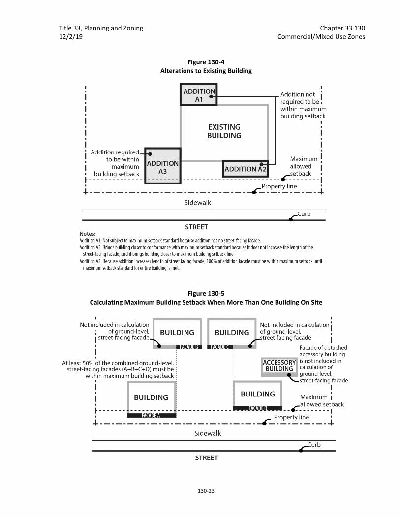
Title 33, Planning and Zoning Chapter 33.130 12/2/19 Commercial/Mixed Use Zones
130‐23
Figure 130‐4 Alterations to Existing Building
Figure 130‐5 Calculating Maximum Building Setback When More Than One Building On Site

Chapter 33.130 Title 33, Planning and Zoning Commercial/Mixed Use Zones 12/2/19
130‐24
Figure 130‐6 New Buildings on Sites with Buildings That Do Not Meet the Maximum Building Setback
E. Alternative maximum building setback for large retailers.
1. Purpose. The intent of the regulations is to allow deeper street setbacks for very large retail stores locating along transit streets or in Pedestrian Districts in exchange for a pedestrian and transit‐friendly main street type of development. These large retail sites can still be transit‐supportive and pedestrian‐friendly by placing smaller buildings close to the street and by creating an internal circulation system that is similar to streets in order to separate the parking area into blocks. The intent is to encourage development that will, over time, form a pedestrian‐friendly main street along the perimeter of the parking blocks and provide connectivity within the site and to adjacent streets and uses.
2. Regulation. Sites that have at least one building with at least 60,000 square feet of floor area in Retail Sales and Service use are exempt from the maximum setback requirement of Table 130‐2 and the vehicle area frontage limitations of 33.266.130.C.3 if all of the requirements of this paragraph are met. For sites with frontage on more than one transit street or more than one street in a Pedestrian District, this exemption may be used only along one transit street frontage or frontage along a street in a Pedestrian District.
a. Other buildings on the site have ground level walls within the maximum setback for at least 25 percent of the frontage on a transit street or street in a Pedestrian District. These buildings must be constructed before or at the same time as the large retail store;

Title 33, Planning and Zoning Chapter 33.130 12/2/19 Commercial/Mixed Use Zones
130‐25
b. Internal circulation system. An internal circulation system that meets the following standards must be provided:
(1) Internal accessways that are similar to streets must divide the site into parking areas that are no greater than 55,000 square feet;
(2) These accessways must connect to the transit street, or street in a Pedestrian District, at least every 250 feet;
(3) Each internal accessway must have at least one auto travel lane, curbs, and unobstructed sidewalks on both sides and one of the following must be met:
The sidewalks must be at least 10 feet wide and planted with trees a maximum of 30 feet on center. Trees must be planted in the center of unpaved tree wells at least 18 square feet, with a minimum dimension of 3 feet. The unpaved area may be covered with a tree grate. Tree wells must be adjacent to the curb, and must be located so there is at least 6 feet of unobstructed sidewalk; or
The sidewalks must be at least 6 feet wide. There must be a planting strip at least 4 feet wide. The planting strip must be between the curb and the sidewalk, and be landscaped to at least the L1 standard, except that trees cannot be grouped.
(4) Along each internal accessway that intersects a transit street, parking must be provided between both sidewalks and the auto travel lanes except for within 75 feet of the transit street intersection, measured from the street lot line, where parking is not allowed;
(5) Curb extensions that are at least the full depth of the parking must be provided, as shown in Figure 130‐7, at the intersections of internal accessways that have parking; and
(6) The internal accessways are excluded from the portion of the parking and loading area used to calculate required interior landscaping.
c. Connections between sites. This standard applies to all commercial, office, or institutional development that is adjacent to sites either developed for Commercial or Institutional use, or zoned C, E, I, CI, or IR. The system must connect the buildings on the site to these adjacent sites.
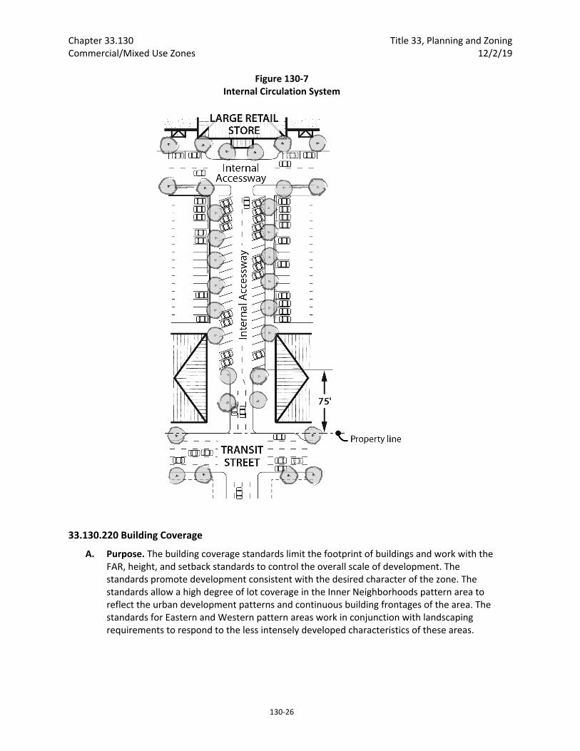
Chapter 33.130 Title 33, Planning and Zoning Commercial/Mixed Use Zones 12/2/19
130‐26
Figure 130‐7 Internal Circulation System
33.130.220 Building Coverage
A. Purpose. The building coverage standards limit the footprint of buildings and work with the FAR, height, and setback standards to control the overall scale of development. The standards promote development consistent with the desired character of the zone. The standards allow a high degree of lot coverage in the Inner Neighborhoods pattern area to reflect the urban development patterns and continuous building frontages of the area. The standards for Eastern and Western pattern areas work in conjunction with landscaping requirements to respond to the less intensely developed characteristics of these areas.
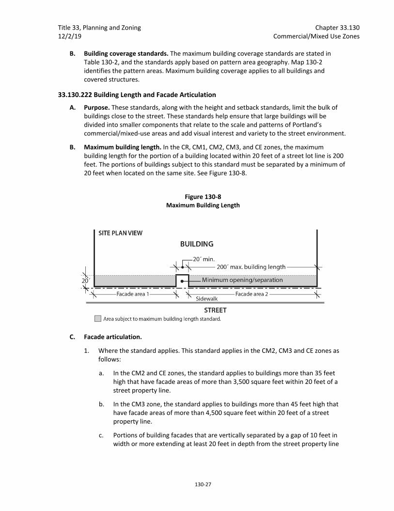
Title 33, Planning and Zoning Chapter 33.130 12/2/19 Commercial/Mixed Use Zones
130‐27
B. Building coverage standards. The maximum building coverage standards are stated in Table 130‐2, and the standards apply based on pattern area geography. Map 130‐2 identifies the pattern areas. Maximum building coverage applies to all buildings and covered structures.
33.130.222 Building Length and Facade Articulation
A. Purpose. These standards, along with the height and setback standards, limit the bulk of buildings close to the street. These standards help ensure that large buildings will be divided into smaller components that relate to the scale and patterns of Portland’s commercial/mixed‐use areas and add visual interest and variety to the street environment.
B. Maximum building length. In the CR, CM1, CM2, CM3, and CE zones, the maximum building length for the portion of a building located within 20 feet of a street lot line is 200 feet. The portions of buildings subject to this standard must be separated by a minimum of 20 feet when located on the same site. See Figure 130‐8.
Figure 130‐8 Maximum Building Length
C. Facade articulation.
1. Where the standard applies. This standard applies in the CM2, CM3 and CE zones as follows:
a. In the CM2 and CE zones, the standard applies to buildings more than 35 feet high that have facade areas of more than 3,500 square feet within 20 feet of a street property line.
b. In the CM3 zone, the standard applies to buildings more than 45 feet high that have facade areas of more than 4,500 square feet within 20 feet of a street property line.
c. Portions of building facades that are vertically separated by a gap of 10 feet in width or more extending at least 20 feet in depth from the street property line

Chapter 33.130 Title 33, Planning and Zoning Commercial/Mixed Use Zones 12/2/19
130‐28
are considered to be separate facades areas for the purposes of the facade area measurements. See Figure 130‐9.
2. The standard. At least 25 percent of the facade within 20 feet of a street lot line must be divided into facade planes that are off‐set by at least 2 feet in depth from the rest of the facade. Facade area used to meet the facade articulation standard may be recessed behind or project out from the primary facade plane, but projections into street right‐of‐way do not count toward meeting this standard. See Figure 130‐10.
Figure 130‐9 Facade Articulation
Figure 130‐10 Facade Articulation
33.130.225 Landscaped Areas
A. Purpose. Landscaping is required in some zones because it is attractive and it helps to soften the effects of built and paved areas. Landscaping also helps cool the air temperature, intercept rainfall and reduce stormwater runoff by providing unpaved permeable surface. Landscaping can also provide food for people and habitat for birds and other wildlife. As an alternative to conventional landscaping, a range of urban green

Title 33, Planning and Zoning Chapter 33.130 12/2/19 Commercial/Mixed Use Zones
130‐29
options are provided in the CM2 and CM3 zones in the Inner Neighborhoods pattern area to reflect this area’s more urban development patterns and historic storefront commercial characteristics. Landscaping is required for all commercial/mixed use‐zoned lands abutting R zoned lands and as screening for parking lots (see Chapter 33.216) to provide buffering and promote livability.
B. Minimum landscaped area. The minimum amount of required landscaped area is stated in Table 130‐2. Any required landscaping, such as for required setbacks or parking lots, applies towards meeting the minimum amount of required landscaped area. Sites developed with a house, attached house or duplex are exempt from the required minimum landscaped area standard. The required landscape area must meet one of the following:
1. Unless allowed by Paragraph B.2., required landscaped areas must:
a. Be at ground level, except when in raised planters that are used to meet minimum Bureau of Environmental Services stormwater management requirements; and
b. Comply with at least the L1 standard described in Chapter 33.248, Landscaping and Screening, or be a vegetated stormwater management facility that meets minimum Bureau of Environmental Services stormwater management requirements. However, up to one‐third of the required landscaped area may be improved for active or passive recreational use, or for use by pedestrians. Examples of active or passive recreational use include walkways, play areas, plazas, picnic areas, garden plots, and unenclosed recreational facilities.
2. Urban green alternative landscaped area. In the CM2 and CM3 zones in the Inner pattern area shown on Map 130‐2, one or more of the following may be used to meet the required landscape area:
a. Ecoroof. An ecoroof area may apply toward meeting the required landscaped area standard at a ratio of 4 square feet of ecoroof area for every 1 square foot of required landscaped area. The ecoroof area must be approved by the Bureau of Environmental Services as being in compliance with the Stormwater Management Manual.
b. Large trees. The minimum required landscaped area may be reduced to 10 percent of site area when the site includes an area with minimum dimensions of 30 feet by 30 feet planted with at least one large‐canopy tree. An existing large‐canopy tree can be used to meet this requirement, subject to the Tree Protection Specifications of Title 11 (Section 11.60.030). Large canopy trees are defined in Section 33.248.030, Plant Materials. At least 50 percent of the ground area within this space must planted with ground cover plants and the remainder may be hard‐surfaced for use by pedestrians.
c. Raised landscaped areas. Landscaped areas raised above ground level may be used to meet the minimum landscaped area standard when landscaped to at least the L1 standard and soil depth is a minimum of 30 inches.

Chapter 33.130 Title 33, Planning and Zoning Commercial/Mixed Use Zones 12/2/19
130‐30
d. Pervious pavement. Up to 50 percent of the required landscaped area may be improved for pedestrian use, such as walkways and plazas, if the area is surfaced with pervious pavement approved by the Bureau of Environmental Services as being in compliance with the Stormwater Management Manual. If this provision is used, no impervious surfaces can be counted toward meeting the minimum landscaped area standard.
33.130.227 Trees Requirements for street trees and for on‐site tree preservation, protection, and overall tree density are specified in Title 11. See Chapter 11.50, Trees in Development Situations.
33.130.228 Required Outdoor Areas
A. Purpose. The required outdoor areas standards ensure opportunities for residents to have on‐site access to outdoor space for recreation, relaxation, natural area, or growing food. Required outdoor areas are an important aspect for addressing the livability of a property with residential units by providing residents with opportunities for outdoor activities, some options for outdoor privacy, and a healthy environment. These standards also allow for outdoor area requirements to be met by indoor community facilities that provide opportunities for recreation or gathering.
B. Requirements.
1. Amount required:
a. On sites that are up to 20,000 square feet in total area, at least 36 square feet of outdoor area is required for each dwelling unit on the site;
b. For sites that are more than 20,000 square feet in total area, at least 48 square feet of outdoor area is required for each dwelling unit on the site.
2. Size, location and configuration. Required outdoor area may be provided as individual, private outdoor areas, such as patios or balconies, or as common, shared areas, such as outdoor courtyards and play areas, or indoor recreational facilities or community rooms. There also may be a combination of individual and common areas.
a. Individual unit areas. Where a separate outdoor area is provided for each individual unit, it must be designed so that a 4‐foot by 6‐foot dimension will fit entirely within it. The outdoor area must be directly accessible to the unit. Balconies that extend over street right‐of‐way count towards meeting this standard. Areas used for pedestrian circulation to more than one dwelling unit do not count towards meeting the required outdoor area. If the area is at ground level it may extend up to 5 feet into a required front setback, and may extend into required side and rear setbacks as long as the area is not closer than 5 feet to a lot line abutting an RF through RH zoned lot.
b. Common areas. There are two types of common area:
(1) Outdoor common area. Where outdoor areas are common, shared areas, each area must be designed so that it is at least 500 square feet in area and so that a 20‐foot by 20‐foot square will fit entirely within it.

Title 33, Planning and Zoning Chapter 33.130 12/2/19 Commercial/Mixed Use Zones
130‐31
(2) Indoor common area. Where an indoor common area is provided, it must be an indoor recreational facility or an indoor tenant community room. Indoor common areas that are not recreational facilities or community rooms, such as lobbies, hallways, laundry facilities, storage rooms, and vehicle or bicycle facilities, cannot be used to meet this requirement.
c. Combination of individual and common areas. Where a combination of individual unit and common areas is provided, each individual area must meet Subparagraph B.2.a and each common area must meet B.2.b above, and together must provide a total amount of space equivalent to the combined amount of outdoor area required for each dwelling unit.
3. Surfacing materials. Required outdoor areas must be surfaced with lawn, pavers, decking, or sport court paving which allows the area to be used for active or passive recreational use.
4. User amenities. User amenities, such as tables, benches, trees, shrubs, planter boxes, garden plots, drinking fountains, spas, or pools, may be placed in the outdoor area. Common, shared outdoor areas may also be developed with amenities such as play areas, plazas, roof‐top patios, picnic areas, and open recreational facilities.
33.130.230 Windows
A. Windows in street‐facing facades.
1. Purpose. This standard:
Ensures that there is a visual connection between the living area of the residence and the street;
Enhances public safety by allowing people to survey their neighborhood from inside their residences; and
Provides a more pleasant pedestrian environment by preventing large expanses of blank facades along streets.
2. Where this standard applies. This standard applies to street‐facing facades of buildings. Where a proposal is for an alteration or addition to existing development, the applicant may choose to apply the standard either to the portion being altered or added, or to the entire street‐facing facade.
3. Windows in street‐facing facades. At least 15 percent of the area of each facade that faces a street lot line must be windows or main entrance doors. Windows used to meet this standard must allow views from the building to the street. Glass block does not meet this standard. Windows in garage doors do not count toward meeting this standard, but windows in garage walls do count toward meeting this standard. To count toward meeting this standard a door must be at the main entrance and face the street lot line. For structures subject to ground floor window requirements, windows used to meet ground floor window requirements may also be used to meet this standard.
4. Exemption. Development on flag lots or on lots that slope up or down from the street with an average slope of 20 percent or more are exempt from this standard.
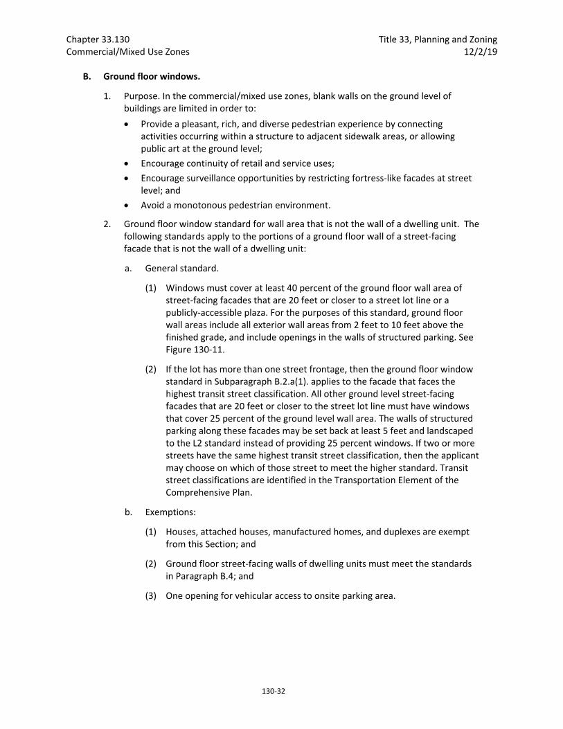
Chapter 33.130 Title 33, Planning and Zoning Commercial/Mixed Use Zones 12/2/19
130‐32
B. Ground floor windows.
1. Purpose. In the commercial/mixed use zones, blank walls on the ground level of buildings are limited in order to:
Provide a pleasant, rich, and diverse pedestrian experience by connecting activities occurring within a structure to adjacent sidewalk areas, or allowing public art at the ground level;
Encourage continuity of retail and service uses;
Encourage surveillance opportunities by restricting fortress‐like facades at street level; and
Avoid a monotonous pedestrian environment.
2. Ground floor window standard for wall area that is not the wall of a dwelling unit. The following standards apply to the portions of a ground floor wall of a street‐facing facade that is not the wall of a dwelling unit:
a. General standard.
(1) Windows must cover at least 40 percent of the ground floor wall area of street‐facing facades that are 20 feet or closer to a street lot line or a publicly‐accessible plaza. For the purposes of this standard, ground floor wall areas include all exterior wall areas from 2 feet to 10 feet above the finished grade, and include openings in the walls of structured parking. See Figure 130‐11.
(2) If the lot has more than one street frontage, then the ground floor window standard in Subparagraph B.2.a(1). applies to the facade that faces the highest transit street classification. All other ground level street‐facing facades that are 20 feet or closer to the street lot line must have windows that cover 25 percent of the ground level wall area. The walls of structured parking along these facades may be set back at least 5 feet and landscaped to the L2 standard instead of providing 25 percent windows. If two or more streets have the same highest transit street classification, then the applicant may choose on which of those street to meet the higher standard. Transit street classifications are identified in the Transportation Element of the Comprehensive Plan.
b. Exemptions:
(1) Houses, attached houses, manufactured homes, and duplexes are exempt from this Section; and
(2) Ground floor street‐facing walls of dwelling units must meet the standards in Paragraph B.4; and
(3) One opening for vehicular access to onsite parking area.

Title 33, Planning and Zoning Chapter 33.130 12/2/19 Commercial/Mixed Use Zones
130‐33
3. Qualifying window features. Required ground floor window areas must be windows that allow views into working areas, lobbies, residential units or residential building common areas; glazing in pedestrian entrances; or display windows that are at least 24 inches deep set into a wall. Windows into storage areas, vehicle parking areas, mechanical and utility areas, garbage and recycling areas, and display cases attached to outside walls do not qualify. Windows into bicycle parking areas are allowed to qualify for up to 25 percent of the ground floor windows coverage requirement. Except for the windows of residential units and clerestory windows located above doors or other windows, the bottom of qualifying windows must be no more than 4 feet above the adjacent exterior grade.
4. Ground floor window and frontage standards for dwelling units. The ground floor wall area of street‐facing facades of dwelling units that are 20 feet or closer to a street lot line must meet at least one of the following standards:
a. Flexible ground floor design. The ground floor window standard of Subparagraph B.2.a(1) must be met, and the ground level of the building must be designed and constructed as follows:
(1) The distance from the finished floor to the bottom of the ceiling structure above must be at least 12 feet. The bottom of the structure above includes supporting beams;
(2) The area meeting this standard must be at least 25 feet deep, measured from the street‐facing facade; and
(3) Each unit must include a front entrance that is located at the level of the finished grade and can be accessed without steps.
b. Front setback.
Figure 130‐11 Ground Floor Windows

Chapter 33.130 Title 33, Planning and Zoning Commercial/Mixed Use Zones 12/2/19
130‐34
(1) The portions of the building with residential dwelling units on the ground‐floor must be set back at least 5 feet from the street lot line. The setback must be landscaped to at least the L1 level and/or hard‐surfaced for use by pedestrians; and
(2) Windows must cover at least 25 percent of the ground level wall area of the portion of the building with residential dwelling units on the ground‐floor.
c. Raised ground floor.
(1) The portion of the building with residential dwelling units on the ground‐floor must have the finished floor of each residential unit at least 2 feet above the grade of the closest adjoining sidewalk.
(2) Window must cover at least 25 percent of the ground level wall area of the portion of the building with residential dwelling units on the ground‐floor.

Title 33, Planning and Zoning Chapter 33.130 12/2/19 Commercial/Mixed Use Zones
130‐35
5. Exception for Public Art. Outside the Central City, public art may be used to meet up to one half of the required window coverage of the ground floor window provision. Covenants for the public art will be required, following the regulations of Section 33.700.060, Covenants with the City, to ensure the installation, preservation, maintenance, and replacement of the public art. To qualify for this exception, documentation of approval by the Regional Arts and Culture Council must be provided prior to approval of the building permit.
33.130.235 Screening
A. Purpose. The screening standards address specific unsightly features which detract from the appearance of commercial/mixed use areas.
B. Garbage and recycling collection areas. All exterior garbage cans, garbage collection areas, and recycling collection areas must be screened from the street and any adjacent properties. Trash receptacles for pedestrian use are exempt. Screening must comply with at least the L3 or F2 standards of Chapter 33.248, Landscaping and Screening.
Figure 130‐12 Ground Floor Window Options for Dwelling Units

Chapter 33.130 Title 33, Planning and Zoning Commercial/Mixed Use Zones 12/2/19
130‐36
C. Mechanical equipment. Mechanical equipment located on the ground, such as heating or cooling equipment, pumps, or generators must be screened from the street and any abutting residential zones by walls, fences, or vegetation. Screening must comply with at least the L2 or F2 standards of Chapter 33.248, Landscaping and Screening, and be tall enough to screen the equipment. Mechanical equipment placed on roofs must be screened in one of the following ways, if the equipment is within 50 feet of an R zone:
1. A parapet along facades facing the R zone that is as tall as the tallest part of the equipment;
2. A screen around the equipment that is as tall as the tallest part of the equipment; or
3. The equipment is set back from roof edges facing the R zone 3 feet for each foot of height of the equipment.
D. Other screening requirements. The screening requirements for parking, exterior storage, and exterior display areas are stated with the regulations for those types of development.
33.130.240 Pedestrian Standards
A. Purpose. The pedestrian standards encourage a safe, attractive, and usable pedestrian circulation system in all developments. They ensure a direct pedestrian connection between abutting streets and buildings on the site, and between buildings and other activities within the site. In addition, they provide for connections between adjacent sites, where feasible.
B. The standards. The standards of this Section apply to all development except houses, attached houses, and duplexes. An on‐site pedestrian circulation system must be provided. The system must meet all standards of this Subsection.
1. Connections. The on‐site pedestrian circulation system must provide connections as specified below:
a. Connection between streets and entrances.
(1) Sites with one street frontage.
Generally. There must be a connection between one main entrance of each building on the site and the adjacent street. The connection may not be more than 20 feet longer or 120 percent of the straight line distance, whichever is less. Buildings separated from the street by other buildings are exempt from this standard.
Household Living. Sites where all of the floor area is in Household Living uses are only required to provide a connection to one main entrance on the site. The connection may not be more than 20 feet longer or 120 percent of the straight line distance, whichever is less.
Tree preservation. If a tree that is at least 12 inches in diameter is proposed for preservation, and the location of the tree or its root protection zone would prevent the standard of this paragraph from being met, the connection may be up to 200 percent of the straight line distance.
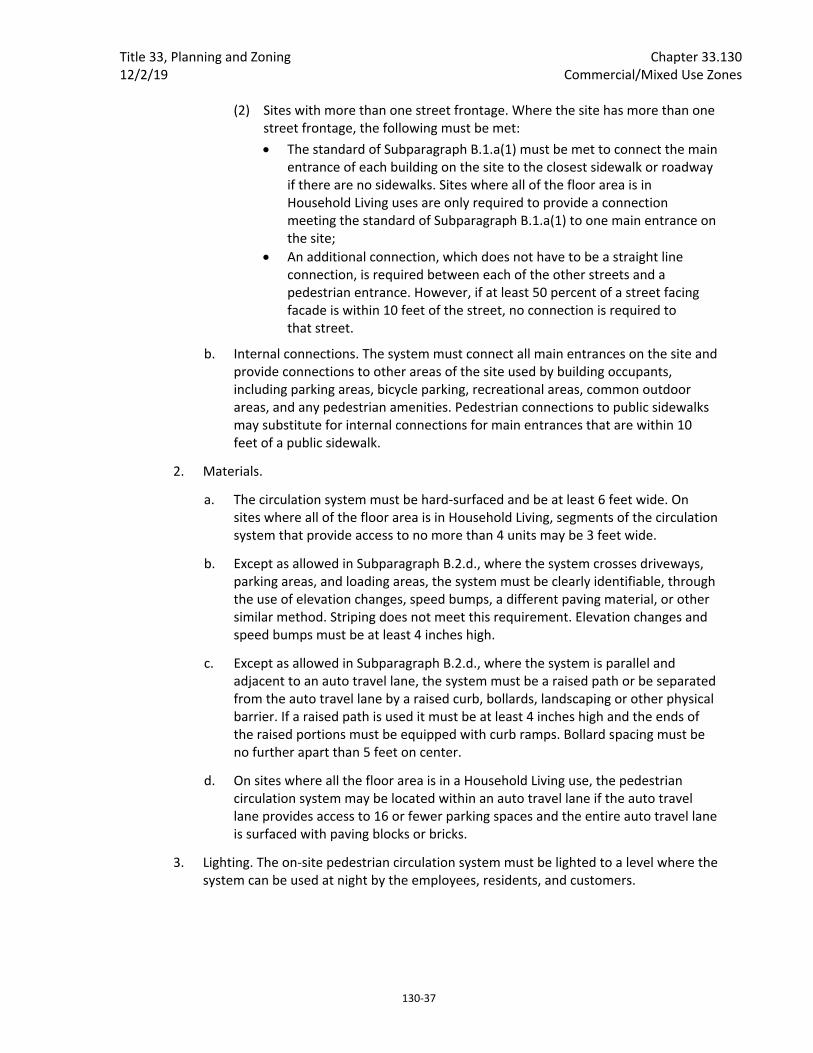
Title 33, Planning and Zoning Chapter 33.130 12/2/19 Commercial/Mixed Use Zones
130‐37
(2) Sites with more than one street frontage. Where the site has more than one street frontage, the following must be met:
The standard of Subparagraph B.1.a(1) must be met to connect the main entrance of each building on the site to the closest sidewalk or roadway if there are no sidewalks. Sites where all of the floor area is in Household Living uses are only required to provide a connection meeting the standard of Subparagraph B.1.a(1) to one main entrance on the site;
An additional connection, which does not have to be a straight line connection, is required between each of the other streets and a pedestrian entrance. However, if at least 50 percent of a street facing facade is within 10 feet of the street, no connection is required to that street.
b. Internal connections. The system must connect all main entrances on the site and provide connections to other areas of the site used by building occupants, including parking areas, bicycle parking, recreational areas, common outdoor areas, and any pedestrian amenities. Pedestrian connections to public sidewalks may substitute for internal connections for main entrances that are within 10 feet of a public sidewalk.
2. Materials.
a. The circulation system must be hard‐surfaced and be at least 6 feet wide. On sites where all of the floor area is in Household Living, segments of the circulation system that provide access to no more than 4 units may be 3 feet wide.
b. Except as allowed in Subparagraph B.2.d., where the system crosses driveways, parking areas, and loading areas, the system must be clearly identifiable, through the use of elevation changes, speed bumps, a different paving material, or other similar method. Striping does not meet this requirement. Elevation changes and speed bumps must be at least 4 inches high.
c. Except as allowed in Subparagraph B.2.d., where the system is parallel and adjacent to an auto travel lane, the system must be a raised path or be separated from the auto travel lane by a raised curb, bollards, landscaping or other physical barrier. If a raised path is used it must be at least 4 inches high and the ends of the raised portions must be equipped with curb ramps. Bollard spacing must be no further apart than 5 feet on center.
d. On sites where all the floor area is in a Household Living use, the pedestrian circulation system may be located within an auto travel lane if the auto travel lane provides access to 16 or fewer parking spaces and the entire auto travel lane is surfaced with paving blocks or bricks.
3. Lighting. The on‐site pedestrian circulation system must be lighted to a level where the system can be used at night by the employees, residents, and customers.
Chapter 33.130 Title 33, Planning and Zoning Commercial/Mixed Use Zones 12/2/19
130‐38
33.130.242 Transit Street Main Entrance
A. Purpose. Locating the main entrance to a use on a transit street provides convenient pedestrian access between the use and public sidewalks and transit facilities, and so promotes walking and the use of transit.
B. Applicability.
1. Generally. All sites with at least one frontage on a transit street, and where any of the floor area on the site is in nonresidential uses, or residential use in a multi‐dwelling structure, must meet the following standards. If the site has frontage on more than one transit street, the standards of Subsection C, below, must be met on at least one of the transit streets;
2. Houses, attached houses, manufactured homes, and duplexes. Houses, attached houses, manufactured homes, and duplexes must meet the standards of 33.130.250.B, Residential Main Entrance, instead of the requirements of this section.
C. Location. For portions of a building within the maximum building setback, at least one main entrance for each nonresidential tenant space on the ground floor, and one main entrance to a multi‐dwelling structure must meet the standards of this section. The ground floor is the lowest floor of the building that is within four feet of the adjacent transit street grade. The main entrance must:
1. Be within 25 feet of the transit street;
2. Allow pedestrians to both enter and exit the building; and
3. Meet one of the following:
a. Face the transit street;
b. Be at an angle of up to 45 degrees from the transit street, measured from the street property line, as shown in Figure 130‐13; or
c. If it is an entrance to a multi‐dwelling structure:
(1) Face a courtyard at least 15 feet in width that is adjacent to the transit street and that is landscaped to at least the L1 level, or hard‐surfaced for use by pedestrians; and
(2) Be within 50 feet of the transit street.
D. Distance between entrances. For portions of a building subject to the maximum building setback, a minimum of one entrance is required for every 200 feet of building length.
E. Unlocked during regular business hours. Each main entrance to nonresidential uses that meets the standards of Subsection C and D must be unlocked during regular business hours.

Title 33, Planning and Zoning Chapter 33.130 12/2/19 Commercial/Mixed Use Zones
130‐39
Figure 130‐13 Transit Street Main Entrance
33.130.245 Exterior Display, Storage, and Work Activities
A. Purpose. The standards of this section are intended to assure that exterior display, storage, and work activities:
Will be consistent with the desired character of the zone;
Will not be a detriment to the overall appearance of a commercial/mixed use area;
Will not have adverse impacts on adjacent properties, especially those zoned residential; and
Will not have an adverse impact on the environment.
B. Exterior display.
1. CR zone. Exterior display of goods is not allowed.
2. CM1, CM2, CM3, and CX zones. Exterior display of goods is allowed except for the display of motor vehicles, recreational vehicles, motor vehicle parts and supplies, building materials, and the display of goods associated with an industrial use.
3. CE zone. Exterior display of goods is allowed except for the display of goods associated with industrial uses. Exterior display areas for motor vehicles and trailers must be set back at least 5 feet from street lot lines and be landscaped to at least the L1 standard.
4. Exterior display landscape screening abutting R zones. Exterior display areas must be set back at least 5 feet from lot lines abutting R zones and be landscaped to at least the L3 standard.

Chapter 33.130 Title 33, Planning and Zoning Commercial/Mixed Use Zones 12/2/19
130‐40
C. Exterior storage.
1. Exterior storage is not allowed in the CR, CM1, CM2, CM3, and CX zones.
2. Exterior storage is allowed in the CE zone if the storage area complies with the standards of this paragraph. Exterior storage is limited to 20 percent of the site area for all uses except lumber yards and other building material stores. All exterior storage areas must be set back 5 feet from nonstreet lot lines and 10 feet from street lot lines, with the setback area landscaped to at least the L3 standard.
D. Exterior work activities. Exterior work activities are prohibited in the commercial/mixed use zones except for the propagation and sale of plants, sales of motor vehicle fuels, and car washes, which are allowed. Exterior work activities related to sales of motor vehicle fuels and car washes are not allowed within 25 feet of a lot line that abuts a residential zone.
E. Other exterior activities. The following exterior activities are allowed in the commercial/mixed use zones: outdoor eating areas, entertainment and recreation activities that are commonly performed outside, and outdoor markets and vendor stalls.
F. Paving. All exterior display and storage areas, except for plant nurseries, must be paved.
33.130.250 General Requirements for Houses, Attached Houses, Manufactured Homes, and Duplexes
A. Generally. Except as specified in this section, all development—residential, mixed‐use, and nonresidential—must meet the other development standards for the zone such as height, setbacks, and building coverage.
B. Residential main entrance.
1. Purpose. These standards:
Together with the window and garage standards, ensure that there is a physical and visual connection between the living area of the residence and the street;
Enhance public safety for residents and visitors and provide opportunities for community interaction;
Ensure that the pedestrian entrance is visible or clearly identifiable from the street by its orientation or articulation; and
Ensure that pedestrians can easily find the main entrance, and so establish how to enter the residence;
Ensure a connection to the public realm for development of lots fronting both private and public streets by making the pedestrian entrance visible or clearly identifiable from the public street.
2. Where these standards apply.
a. The standards of this subsection apply to houses, attached houses, manufactured homes, and duplexes in the commercial/mixed use zones.
Title 33, Planning and Zoning Chapter 33.130 12/2/19 Commercial/Mixed Use Zones
130‐41
b. Where a proposal is for an alteration or addition to existing development, the standards of this section apply only to the portion being altered or added.
c. On sites with frontage on both a private street and a public street, the standards apply to the site frontage on the public street. On all other sites with more than one street lot line, the applicant may choose on which frontage to meet the standards.
d. Development on flag lots or on lots which slope up or down from the street with an average slope of 20 percent or more are exempt from these standards.
3. Location. At least one main entrance for each structure must:
a. Be within 8 feet of the longest street‐facing wall of the structure; and
b. Either:
(1) Face the street, See Figure 130‐14;
(2) Be at an angle of up to 45 degrees from the street; or
(3) Open onto a porch. See Figure 130‐15. The porch must:
Be at least 25 square feet in area;
Have at least one entrance facing the street; and
Have a roof that is: ‐ No more than 12 feet above the floor of the porch; and ‐ At least 30 percent solid. This standard may be met by having 30
percent of the porch area covered with a solid roof, or by having the entire area covered with lattice or other open material if no more than 70 percent of the area of the material is open.
4. Duplexes on corner lots. Where a duplex is on a corner lot, the requirements of Paragraph C.3, above, must be met for both dwelling units. Both main entrances may face the same street.
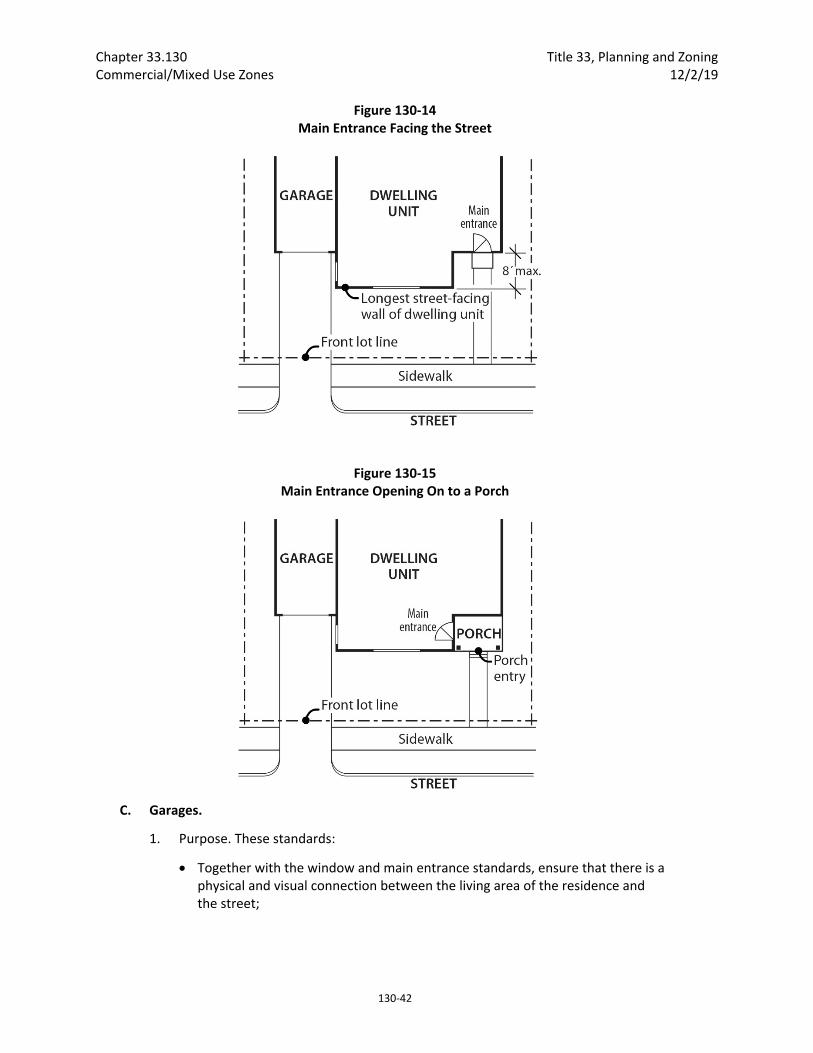
Chapter 33.130 Title 33, Planning and Zoning Commercial/Mixed Use Zones 12/2/19
130‐42
Figure 130‐14 Main Entrance Facing the Street
Figure 130‐15 Main Entrance Opening On to a Porch
C. Garages.
1. Purpose. These standards:
Together with the window and main entrance standards, ensure that there is a physical and visual connection between the living area of the residence and the street;
Title 33, Planning and Zoning Chapter 33.130 12/2/19 Commercial/Mixed Use Zones
130‐43
Ensure that the location and amount of the living area of the residence, as seen from the street, is more prominent than the garage;
Prevent garages from obscuring the main entrance from the street and ensure that the main entrance for pedestrians, rather than automobiles, is the prominent entrance;
Provide for a more pleasant pedestrian environment by preventing garages and vehicle areas from dominating the views of the neighborhood from the sidewalk;
Enhance public safety by preventing garages from blocking views of the street from inside the residence;
Prevent cars from overhanging the street or sidewalk; and
Provide for adequate visibility for a driver backing out of a garage.
2. Where these standards apply. The requirements of Paragraphs D.3, D.4 and D.5, below, apply to houses, attached houses, manufactured homes, and duplexes. The requirements of Paragraphs D.4 and D.5, below, also apply to garages that are accessory to attached houses. When a proposal is for an alteration or addition to existing development, the standards of this section apply only to the portion being altered or added. Development on flag lots or on lots which slope up or down from the street with an average slope of 20 percent or more are exempt from these standards.
3. Length of street‐facing garage wall.
a. The length of the garage wall facing the street may be up to 50 percent of the length of the street‐facing building facade. See Figure 130‐16. For duplexes, this standard applies to the total length of the street‐facing facades. For all other lots and structures, the standards apply to the street‐facing facade of each unit.
b. Where the street‐facing facade is less than 22 feet long, an attached garage facing the street is not allowed as part of that facade.
4. Street lot line setbacks.
a. Generally. A garage wall that faces a street may be no closer to the street lot line than the longest street‐facing wall of the dwelling unit. See Figure 130‐17.
b. Exception. A street‐facing garage wall may be up to 6 feet in front of the longest street‐facing wall of the dwelling unit, if:
(1) The street‐facing garage wall is 40 percent or less of the length of the building facade; and
(2) There is a porch at the main entrance. The garage wall may not be closer to the street lot line than the front of the porch. See Figure 130‐18. The porch must meet the following:
The porch must be at least 48 square feet in area and have minimum dimensions of 6 feet by 6 feet;
The porch must have a solid roof; and
The roof may not be more than 12 feet above the floor of the porch.

Chapter 33.130 Title 33, Planning and Zoning Commercial/Mixed Use Zones 12/2/19
130‐44
c. Exemption. Where a lot has more than one street lot line, and there is an existing dwelling unit on the lot, this standard must be met only on the street‐facing facade on which the main entrance is located.
5. Garage entrance setback. The garage entrance must be either 5 feet or closer to the street property line, or 18 feet or farther from the street property line. If the garage entrance is located within 5 feet of the front property line, it may be no closer to the street lot line than the longest street‐facing wall of the dwelling unit.
Figure 130‐16 Length of Street Facing Garage Wall
Figure 130‐17 Street Lot Line Setback

Title 33, Planning and Zoning Chapter 33.130 12/2/19 Commercial/Mixed Use Zones
130‐45
Figure 130‐18 Garage Front Setback Exception
33.130.255 Trucks and Equipment
A. Purpose. The parking and storage of trucks and equipment is regulated to ensure that it will be consistent with the desired character of the commercial/mixed use zones and to limit adverse effects on adjacent residential lands.
B. Truck and equipment parking standards. The standards for truck and equipment parking apply to business vehicles that are parked regularly at a site. The regulations do not apply to pick‐up and delivery activities, to the use of vehicles during construction, or to services at the site which occur on an intermittent and short term basis. The truck categories are defined in Chapter 33.910.
1. Light trucks. The parking of passenger vehicles, light trucks, and similar equipment is allowed in all commercial/mixed use zone areas that comply with the development standards for parking areas.
2. Medium trucks. The parking of pickup trucks in the medium truck category is allowed in all commercial/mixed use zones. The parking of all other medium trucks and similar equipment is allowed only in the CE and CM3 zone. Truck parking areas must comply with the development standards for auto parking areas.
3. Heavy trucks. The parking of heavy trucks and similar equipment is not allowed in any commercial/mixed use zone.
Chapter 33.130 Title 33, Planning and Zoning Commercial/Mixed Use Zones 12/2/19
130‐46
33.130.260 Drive‐Through Facilities
A. Purpose. The drive‐through facility regulations support the desired character of the commercial/mixed use zones that are intended to be pedestrian‐oriented, while allowing the continuation and improvement of existing drive‐through facilities in some of these zones. In zones intended for auto‐accommodating development, these regulations allow for drive‐through facilities, while limiting the impacts from drive‐through facilities on adjacent residential zones, such as noise and air pollution from idling cars.
B. CR and CX zones. Drive‐through facilities are prohibited in the CR and CX zones.
C. CM1, CM2, and CM3 zones. The following regulations apply to drive‐through facilities in the CM1, CM2 and CM3 zones:
1 New drive‐through facilities are prohibited; and
2. Existing drive‐through facilities are allowed. Existing facilities can be rebuilt, expanded, or relocated on the site. The standards for drive‐through facilities are stated in Chapter 33.224, Drive‐Through Facilities. If the use with the drive‐through facility is discontinued for 3 continuous years, reestablishment of the drive‐through facility is prohibited. If the use ceases operation, even if the structure or materials related to the use remain, the use has been discontinued. A list of the standard evidence that can be provided to prove that the use has been maintained over time can be found in Subsection 33.258.038.B. If the applicant provides standard evidence from the list, the Director of BDS will determine if the evidence is satisfactory. If the applicant provides evidence other than the standard evidence listed, a Determination of Legal Nonconforming Status is required.
D. CE zone.
1. New drive‐through facilities are prohibited except for drive‐through facilities associated with Quick Vehicle Servicing uses. Drive‐through facilities are not allowed within 25 feet of a lot line that abuts a residential zone. The standards for drive‐through facilities are stated in Chapter 33.224, Drive‐Through Facilities.; and
2. Existing drive‐through facilities are allowed. Existing facilities can be rebuilt, expanded, or relocated on the site. The standards for drive‐through facilities are stated in Chapter 33.224, Drive‐Through Facilities. If the use with the drive‐through facility is discontinued for 3 continuous years, reestablishment of the drive‐through facility is prohibited. If the use ceases operation, even if the structure or materials related to the use remain, the use has been discontinued. A list of the standard evidence that can be provided to prove that the use has been maintained over time can be found in Subsection 33.258.038.B. If the applicant provides standard evidence from the list, the Director of BDS will determine if the evidence is satisfactory. If the applicant provides evidence other than the standard evidence listed, a Determination of Legal Nonconforming Status is required.
33.130.265 Detached Accessory Structures
A. Purpose. These standards are intended to maintain separation and privacy to abutting residential zoned lots from nonresidential development.

Title 33, Planning and Zoning Chapter 33.130 12/2/19 Commercial/Mixed Use Zones
130‐47
B. General standards.
1. The regulations of this section apply only to detached accessory structures on sites with non‐residential uses. For sites where all of the floor area is in residential use, detached accessory structures are subject to the standards of Section 33.120.280. Detached garages are also subject to the standards of 33.130.250, General Requirements for Residential and Mixed Use Developments.
2. The height and building coverage standards of the base zone apply to detached accessory structures.
C. Setbacks.
1. Uncovered accessory structures. Uncovered accessory structures such as flag poles, lamp posts, signs, antennas and dishes, mechanical equipment, uncovered decks, play structures, and tennis courts are allowed in a required setback, but can be no closer than 5 feet to a lot line abutting an RF through RH zoned lot.
2. Covered structures.
a. Covered structures such as storage buildings, greenhouses, and work sheds are subject to the setbacks for buildings.
b. Water cisterns that are 6 feet or less in height are allowed in side and rear setbacks, including setbacks for abutting a residential zone.
c. See Section 33.130.250, General Requirements for Residential and Mixed‐Use Developments, for additional requirements for garages that are accessory to residential development.
33.130.270 Fences
A. Purpose. The fence regulations promote the positive benefits of fences without negatively impacting the community or endangering public or vehicle safety. Fences near streets are kept low in order to allow visibility into and out of the site and to ensure visibility for motorists. Fences in any required side or rear setback are limited in height so as to not conflict with the purpose for the setback.
B. Types of fences. The standards apply to walls, fences, and screens of all types whether open, solid, wood, metal, wire, masonry, or other material.
C. Location and heights.
1. Fences abutting street lot lines and pedestrian connections. Within 10 feet of a street lot line or lot line that abuts a pedestrian connection, fences that meet the following standards are allowed:
a. Fences that are more than 50 percent sight‐obscuring may be up to 3‐1/2 feet high.
b. Fences that are 50 percent or less sight‐obscuring may be up to 8 feet high.
Chapter 33.130 Title 33, Planning and Zoning Commercial/Mixed Use Zones 12/2/19
130‐48
2. Fences abutting other lot lines. Fences up to 8 feet high are allowed in required building setbacks along all other lot lines.
3. Fences in all other locations. The height for fences in locations other than described in Paragraphs C.1 and C.2 is the same as the regular height limits of the zone.
D. Reference to other regulations. Electrified fences are regulated under Title 26, Electrical Regulations. The use of barbed wire is regulated under Title 24, Building Regulations.
33.130.275 Demolitions
A. Generally. Demolition on a site that requires a demolition permit is subject to the tree preservation and protection requirements of Title 11, Trees. See Chapter 11.50, Trees in Development Situations.
B. Historic resources. Demolition of historic resources is regulated by Chapter 33.445, Historic Resource Overlay Zone.
C. CX zone landscaping. In the CX zone, sites must be landscaped within 6 months of the demolition of buildings unless there is an approved development for the site. Approved development means a project approved through design review. The landscaping must meet at least the L1 standard of Chapter 33.248, Landscaping and Screening, except that no shrubs or trees are required.
33.130.285 Nonconforming Development Existing development that does not conform to the development standards of this chapter may be subject to the regulations of Chapter 33.258, Nonconforming Situations.
33.130.290 Parking, Loading, and Transportation and Parking Demand Management The standards pertaining to the minimum required and maximum allowed number of auto parking spaces, minimum required number of bicycle parking spaces, parking lot placement, parking lot setbacks and landscaping, and requirements for transportation demand management are stated in Chapter 33.266, Parking, Loading, and Transportation Demand Management.
33.130.292 Street and Pedestrian Connections
A. Large site pedestrian connectivity.
1. Purpose. The large site pedestrian connectivity standard implements regional pedestrian and bicycle connectivity standards. The standard enhances direct movement by pedestrians and bicycles between destinations and increases the convenience of travelling by foot or bike. The standard also protects public health and safety by ensuring safe movement and access through a large site. The standard provides flexibility for locating the pedestrian connection in a manner that addresses site constraints such as existing development.
2. When does the standard apply. The large site pedestrian connectivity standard applies to new development and major remodeling on sites that are more than 5 acres in size.
3. Standard. If the site does not have pedestrian connections at least every 330 feet as measured from the centerline of each connection, then dedication of ROW for pedestrian connections is required.

Title 33, Planning and Zoning Chapter 33.130 12/2/19 Commercial/Mixed Use Zones
130‐49
4. Exemptions. Dedication of right‐of‐way for pedestrian connections is not required in:
a. The Central City plan district; and
b. Areas of a site that are in the Environmental Protection overlay zone, the Environmental Conservation overlay zone, or have slopes with an average slope of 20 percent or greater. This means that if the 330 feet interval falls in one of these areas, that pedestrian connection is not required.
5. Pedestrian connection alignment, width and design. The Bureau of Transportation must approve the alignment of the pedestrian connections. The final alignment must ensure that pedestrian connections are located at least 200 feet apart. The Bureau of Transportation must also approve the width of, and configuration of element within, the pedestrian connections.
B. Additional requirements for street and pedestrian/bicycle connections are regulated by the Bureau of Transportation. See Section 17.88.040, Through Streets, of the Portland City Code.
33.130.295 Signs The sign regulations are stated in Title 32, Signs and Related Regulations.
33.130.305 Superblock Requirements Development in the CM2, CM3, CE, and CX zones which are on land that includes vacated rights‐of‐way may be subject to the superblock standards of Chapter 33.293, Superblocks.
33.130.310 Recycling Areas Requirements for recycling areas are regulated by the Bureau of Planning and Sustainability. See Section 17.102.270, Businesses and Multifamily Complexes Required to Recycle, of the Portland City Code.
(Amended by: Ord. No. 165594, effective 7/8/92; Ord. No. 167186, effective 12/31/93; Ord. No. 167189, effective 1/14/94; Ord. No. 169099, effective 8/18/95; Ord. No. 169535, effective 1/8/96; Ord. No. 169987, effective 7/1/96; Ord. No. 170704, effective 1/1/97; Ord. No. 171219, effective 7/1/97; Ord. No. 171718, effective 11/29/97; Ord. No. 173533, effective 8/2/99; Ord. No. 173593, effective 9/3/99; Ord. No. 173729, effective 9/8/99; Ord. No. 174263, effective 4/15/00; Ord. No. 174980, effective 11/20/00; Ord. No. 175204, effective 3/1/01; Ord. No. 175837, effective 9/7/01; Ord. No. 175966, effective 10/26/01; Ord. Nos. 175965 and 176333, effective 7/1/02; Ord. No. 176469, effective 7/1/02; Ord. No. 177028, effective 12/14/02; Ord. No. 177422, effective 6/7/03; Ord. No. 177404, effective 7/1/03; Ord. No. 178172, effective 3/5/04; Ord. No.178509, effective 7/16/04; Ord. No. 179092, effective 4/1/05; Ord. No. 179845, effective 1/20/06; Ord. Nos. 179980 and 179994, effective 4/22/06; Ord. No. 180619, effective 12/22/06; Ord. No. 181357, effective 11/9/07; Ord. No. 182429, effective 1/16/09; Ord. No. 183598, effective 4/24/10; Ord. No. 184016, effective 08/20/10; Ord. No. 184524, effective 7/1/11; Ord. No. 185412; effective 6/13/12; Ord. No. 185915, effective 5/1/13; Ord. No. 185974, effective 5/10/13; Ord. No. 186639, effective 7/11/14; Ord. No. 186053, effective 1/1/15; Ord. No. 187216, effective 7/24/15; Ord. No. 187471, effective 1/1/16; Ord. No. 188142, effective 1/13/17; Ord. No. 188177, effective 5/24/18; Ord. No. 188958, effective 5/24/18; Ord. No. 189137, effective 08/22/18; Ord. No. 189488, effective 12/2/19.)


Title 33, Planning and Zoning Chapter 33.140 12/2/19 Employment and Industrial Zones
140‐1
33.140 Employment and Industrial Zones
140
Sections:
General 33.140.010 General Purpose of the Zones 33.140.020 List of the Employment and Industrial Zones 33.140.030 Characteristics of the Zones 33.140.040 Other Zoning Regulations 33.140.050 Neighborhood Contact in EG and I Zones 33.140.055 Neighborhood Contact in EX Zone
Use Regulations 33.140.100 Primary Uses 33.140.110 Accessory Uses 33.140.130 Nuisance‐Related Impacts 33.140.140 On‐Site Waste Disposal
Site Development Standards 33.140.200 Lot Size 33.140.205 Floor Area Ratio 33.140.210 Height 33.140.215 Setbacks 33.140.220 Building Coverage 33.140.225 Landscaped Areas 33.140.227 Trees 33.140.230 Ground Floor Windows in the EX Zones 33.140.235 Screening 33.140.240 Pedestrian Standards 33.140.242 Transit Street Main Entrance 33.140.245 Exterior Display, Storage, and Work Activities 33.140.250 Trucks and Equipment 33.140.255 Drive‐Through Facilities 33.140.265 Residential Development 33.140.270 Detached Accessory Structures 33.140.275 Fences 33.140.280 Demolitions 33.140.290 Nonconforming Development 33.140.295 Parking and Loading 33.140.300 Signs 33.140.310 Superblock Requirements 33.140.315 Recycling Areas 33.140.320 Inclusionary Housing
Chapter 33.140 Title 33, Planning and Zoning Employment and Industrial Zones 12/2/19
140‐2
General
33.140.010 General Purpose of the Zones The employment and industrial zones are for areas of the City that are reserved for industrial uses and for areas that have a mix of uses with a strong industrial orientation. The zones reflect the diversity of industrial and business areas in the City. The zones differ in the mix of allowed uses, the allowed intensity of development, and the development standards. The regulations promote areas which consist of uses and developments which will support the economic viability of the specific zoning district and of the City. The regulations protect the health, safety and welfare of the public, address area character, and address environmental concerns. In addition, the regulations provide certainty to property owners, developers, and neighbors about the limits of what is allowed.
33.140.020 List of the Employment and Industrial Zones The full and short names of the employment and industrial zones and their map symbols are listed below. When this Title refers to the employment or E zones it is referring to the first three listed. When this Title refers to the industrial or I zones, it is referring to the last three listed.
Full Name Short Name/Map Symbol
General Employment 1 EG1
General Employment 2 EG2
Central Employment EX
General Industrial 1 IG1
General Industrial 2 IG2
Heavy Industrial IH
33.140.030 Characteristics of the Zones
A. General Employment. The General Employment zones implement the Mixed Employment map designation of the Comprehensive Plan. The zones allow a wide range of employment opportunities without potential conflicts from interspersed residential uses. The emphasis of the zones is on industrial, industrially‐related, and office uses, typically in a low‐rise, flex‐space development pattern. Retail uses are allowed but limited in intensity to maintain adequate employment development opportunities. The development standards for each zone are intended to allow new development which is similar in character to existing development. The intent is to promote viable and attractive industrial/commercial areas.
1. General Employment 1. EG1 areas generally have smaller lots and a grid block pattern. The area is mostly developed, with sites having high building coverages and buildings which are usually close to the street. EG1 zoned lands will tend to be on strips or small areas.
2. General Employment 2. EG2 areas have larger lots and an irregular or large block pattern. The area is less developed, with sites having medium and low building coverages and buildings which are usually set back from the street. EG2 zoned lands will generally be on larger areas than those zoned EG1.
B. Central Employment. This zone implements the Central Employment map designation of the Comprehensive Plan. The zone allows mixed‐uses and is intended for areas in the center of the City that have predominantly industrial type development. The intent of the zone is to allow industrial and commercial uses which need a central location. Residential uses are allowed, but are not intended to predominate or set development standards for
Title 33, Planning and Zoning Chapter 33.140 12/2/19 Employment and Industrial Zones
140‐3
other uses in the area. The development standards are intended to allow new development which is similar in character to existing development.
C. General Industrial. The General Industrial zones are two of the three zones that implement the Industrial Sanctuary map designation of the Comprehensive Plan. The zones provide areas where most industrial uses may locate, while other uses are restricted to prevent potential conflicts and to preserve land for industry. The development standards for each zone are intended to allow new development which is similar in character to existing development. The intent is to promote viable and attractive industrial areas.
1. General Industrial 1. IG1 areas generally have smaller lots and a grid block pattern. The area is mostly developed, with sites having high building coverages and buildings which are usually close to the street. IG1 areas tend to be the City's older industrial areas.
2. General Industrial 2. IG2 areas generally have larger lots and an irregular or large block pattern. The area is less developed, with sites having medium and low building coverages and buildings which are usually set back from the street.
D. Heavy Industrial. This zone is one of the three zones that implement the Industrial Sanctuary map designation of the Comprehensive Plan. The zone provides areas where all kinds of industries may locate including those not desirable in other zones due to their objectionable impacts or appearance. The development standards are the minimum necessary to assure safe, functional, efficient, and environmentally sound development.
33.140.040 Other Zoning Regulations The regulations in this chapter state the allowed uses and the development standards for the base zones. Sites in overlay zones or plan districts and designated historical landmarks are subject to additional regulations which supersede those of this Chapter. The Official Zoning Maps indicated which sites are subject to the additional regulations. Specific uses or development types may also be subject to regulations in the 200s series of chapters.
33.140.050 Neighborhood Contact in EG and I Zones
A. Purpose. Neighborhood contact is required when a new storage structure for any type of fuel will be built on a Bulk Fossil Fuel Terminal because of the impacts that fuel projects can have on the surrounding community.
B. Neighborhood contact requirement. Proposals meeting the following conditions are subject to the neighborhood contact steps of 33.705.020.B., Neighborhood contact II. All of the steps in 33.705.020.B must be completed before an application for a building permit can be submitted.
1. The proposed development has not been subject to a land use review; and
2. The proposed development includes at least one new structure for the storage of any type of fuel.
33.140.055 Neighborhood Contact in EX Zone Neighborhood contact is a set of outreach steps that must be taken before certain developments can be submitted for approval. Neighborhood contact is required as follows:
Chapter 33.140 Title 33, Planning and Zoning Employment and Industrial Zones 12/2/19
140‐4
A. Neighborhood contact I.
1. Neighborhood contact I requirements. When proposed development will add at least 10,000 square feet and not more than 25,000 square feet of net building area to a site, the neighborhood contact steps of 33.705.020.A., Neighborhood contact I, are required. All the steps in 33.705.020.A. must be completed before an application for a building permit can be submitted.
2. Exemption. If the proposed development has already met the neighborhood contact requirements as part of a land use review process, it is exempt from the neighborhood contact requirements.
B. Neighborhood contact II.
1. Neighborhood contact II requirements. When the proposed development will add more than 25,000 square feet of net building area to a site, the neighborhood contact steps of 33.705.020.B., Neighborhood contact II, are required. All of the steps in 33.705.020.B. must be completed before an application for a building permit can be submitted.
2. Exemption. If the proposed development has already met the neighborhood contact requirements as part of a land use review process, it is exempt from the neighborhood contact requirements.
Use Regulations
33.140.100 Primary Uses
A. Allowed uses. Uses allowed in the employment and industrial zones are listed in Table 140‐1 with a "Y". These uses are allowed if they comply with the development standards and other regulations of this Title. Being listed as an allowed use does not mean that a proposed development will be granted an adjustment or other exception to the regulations of this Title. In addition, a use or development listed in the 200s series of chapters is also subject to the regulations of those chapters.
B. Limited uses. Uses allowed that are subject to limitations are listed in Table 140‐1 with an "L". These uses are allowed if they comply with the limitations listed below and the development standards and other regulations of this Title. In addition, a use or development listed in the 200s series of chapters is also subject to the regulations of those chapters. The paragraphs listed below contain the limitations and correspond with the footnote numbers from Table 140‐1.
1. Household Living uses in I zones. This regulation applies to all parts of Table 140‐1 that have a [1]. Household Living in houseboats and houseboat moorages in I zones are regulated by Chapter 33.236, Floating Structures. Household Living in other structures is prohibited.
2. Group Living. This regulation applies to all parts of Table 140‐1 that have a [2].
a. General regulations. All Group Living uses except for alternative or post incarceration facilities, are allowed by right subject to the regulations of Chapter 33.239, Group Living.

Title 33, Planning and Zoning Chapter 33.140 12/2/19 Employment and Industrial Zones
140‐5
b. Alternative or post incarceration facilities. Group Living uses which consist of alternative or post incarceration facilities are conditional uses. They are also subject to the regulations of Chapter 33.239, Group Living.
3. EG Retail Sales And Service limitation. The following regulations apply to all parts of Table 140‐1 that have a [3].
a. Limited uses. Except for sites with historic landmarks, the net building area plus any exterior display, storage, work and other exterior activity area for Retail Sales And Service uses is limited to 20,000 square feet or the square footage of the site area, whichever is less. On sites with historic landmarks, the net building area plus any exterior display, storage, work and other exterior activity area for Retail Sales And Service uses is limited to 20,000 square feet or twice the total square footage of the site area, whichever is less.
b. Conditional uses. Retail Sales And Service uses that exceed the area limits in Subparagraph B.3.a. are a conditional use.
4. IG1 commercial limitation. This regulation applies to all parts of Table 140‐1 that have a [4].
a. Limited uses. One Retail Sales And Service or Office use is allowed per site. The square footage of net building area plus the exterior display, storage, work and other exterior activity area may be up to 3,000 square feet.
b. Conditional uses.
(1) More than one Retail Sales And Service or Office Use on a site is a conditional use.
(2) Any Retail Sales And Service or Office Use where the net building area plus the exterior display, storage, work and other exterior activity area is more than 3,000 square feet is a conditional use.
c. Prohibited uses.
(1) Except for sites with a historic landmark, the net building area of all the Retail Sales And Service and Office uses on a site plus the exterior display, storage exterior display, storage, work and other exterior activity area, taken together, may not exceed 20,000 square feet or the square footage of the site area, whichever is less. Retail Sales And Service and Office uses that exceed these area limits are prohibited.
(2) For sites with a historic landmark, the net building area of all the Retail Sales And Service and Office uses on a site plus the exterior display, storage, work and other exterior activity area, taken together, may not exceed 60,000 square feet or twice the square footage of the site area, whichever is less. Retail Sales And Service and Office uses that exceed these area limits are prohibited.
5. IG2 commercial limitation. This regulation applies to all parts of Table 140‐1 that have a [5].
Chapter 33.140 Title 33, Planning and Zoning Employment and Industrial Zones 12/2/19
140‐6
a. Limited uses. Up to four Retail Sales And Service or Office uses are allowed per site. The square footage of the net building area plus the exterior display, storage, work and other exterior activity area may be up to 3,000 square feet per use.
b. Conditional uses.
(1) More than four Retail Sales And Service or Office uses on a site is a conditional use.
(2) Any Retail Sales And Service or Office use where the net building area plus the exterior display, storage, work and other exterior activity area is more than 3,000 square feet is a conditional use.
c. Prohibited uses.
(1) Except for sites with a historic landmark, the net building area of all the Retail Sales And Service and Office uses on a site plus the exterior display, storage, work and other exterior activity area, taken together, may not exceed 20,000 square feet or the square footage of the site area, whichever is less. Retail Sales And Service and Office uses that exceed these area limits are prohibited.
(2) For sites with a historic landmark, the net building area of all the Retail Sales And Service and Office uses on a site plus the exterior display, storage, work and other exterior activity area, taken together, may not exceed 60,000 square feet or twice the square footage of site area, whichever is less. Retail Sales And Service and Office uses that exceed these area limits are prohibited.
6. IH commercial limitation. This regulation applies to all parts of Table 140‐1 that have a [6].
a. Limited uses. Up to four Retail Sales And Service or Office uses are allowed per site. The square footage of the net building area plus the exterior display, storage, work and other exterior activity area may be up to 3,000 square feet per use.
b. Conditional uses.
(1) More than four Retail Sales And Service or Office use on a site is a conditional use.
(2) Any Retail Sales And Service or Office use where the net building area plus the exterior display, work and other exterior activity storage area is more than 3,000 square feet is a conditional use.
c. Prohibited uses.
(1) Except for sites with a historic landmark, the net building area of all the Retail Sales And Service and Office uses on a site plus the exterior display, storage, work and other exterior activity area, taken together, may not exceed 12,000 square feet or the square footage of the site area, whichever

Title 33, Planning and Zoning Chapter 33.140 12/2/19 Employment and Industrial Zones
140‐7
is less. Retail Sales And Service and Office uses that exceed these area limits are prohibited.
(2) For sites with a historic landmark, the net building area of all the Retail Sales And Service and Office uses on a site plus the exterior display, storage, work and other exterior activity area, taken together, may not exceed 25,000 square feet or twice the square footage of site area, whichever is less. Retail Sales And Service and Office uses that exceed these area limits are prohibited.
7. Self‐Service Storage limitation. This regulation applies to all parts of Table 140‐1 that have a [7]. The limitations are stated with the special regulations for these uses in Chapter 33.284, Self‐Service Storage.
8. Waste‐Related limitation. This regulation applies to all parts of Table 140‐1 that have a [8]. All Waste‐Related uses are conditional uses, unless they meet all of the following conditions in which case they are allowed by right.
a. The use must be approved by Metro under their authority as prescribed in ORS 268.317;
b. Metro’s approval of the use must include a mitigation plan. The requirements for the mitigation plan must be approved by the City Council through an intergovernmental agreement with Metro, adopted prior to Metro’s approval of the use; and
c. The location of the use must be in conformance with Metro’s Regional Solid Waste Management Plan.
9. Community Service uses in EG zones. This regulation applies to all parts of Table 140‐1 that have a [9]. Most Community Service uses are allowed by right. Short term housing and mass shelters are regulated by Chapter 33.285, Short Term Housing and Mass Shelters.
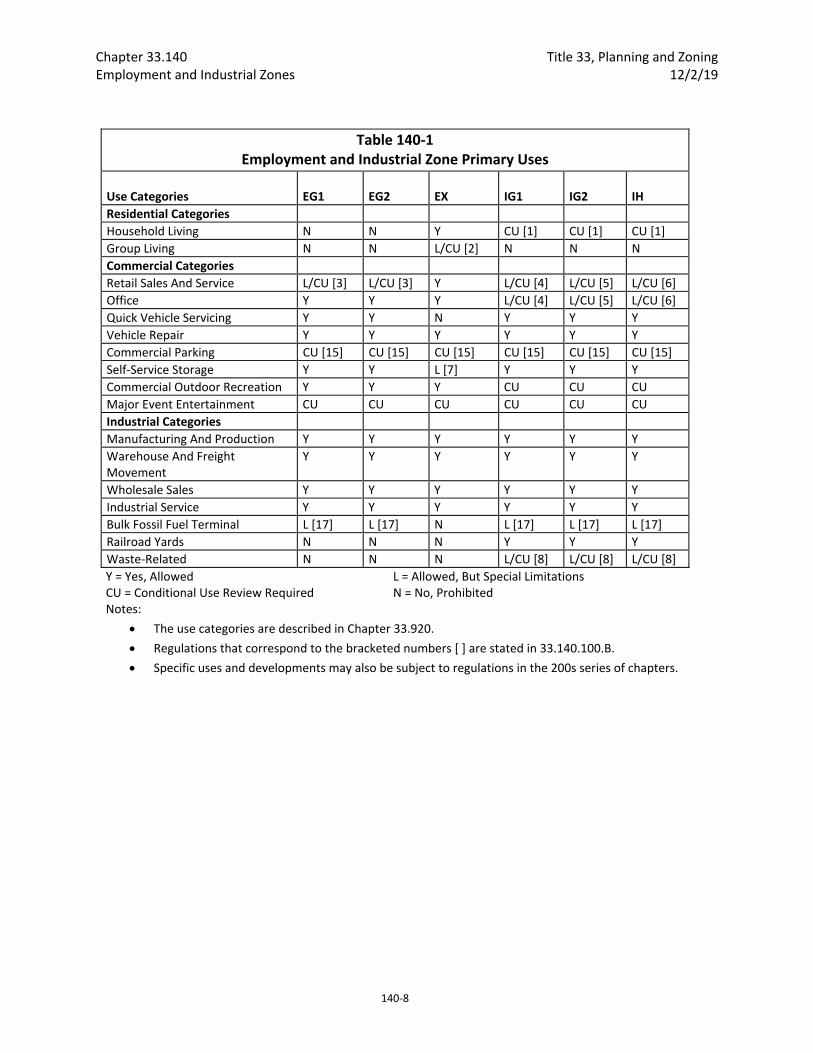
Chapter 33.140 Title 33, Planning and Zoning Employment and Industrial Zones 12/2/19
140‐8
Table 140‐1 Employment and Industrial Zone Primary Uses
Use Categories
EG1
EG2
EX
IG1
IG2
IH
Residential Categories
Household Living N N Y CU [1] CU [1] CU [1]
Group Living N N L/CU [2] N N N
Commercial Categories
Retail Sales And Service L/CU [3] L/CU [3] Y L/CU [4] L/CU [5] L/CU [6]
Office Y Y Y L/CU [4] L/CU [5] L/CU [6]
Quick Vehicle Servicing Y Y N Y Y Y
Vehicle Repair Y Y Y Y Y Y
Commercial Parking CU [15] CU [15] CU [15] CU [15] CU [15] CU [15]
Self‐Service Storage Y Y L [7] Y Y Y
Commercial Outdoor Recreation Y Y Y CU CU CU
Major Event Entertainment CU CU CU CU CU CU
Industrial Categories
Manufacturing And Production Y Y Y Y Y Y
Warehouse And Freight Movement
Y Y Y Y Y Y
Wholesale Sales Y Y Y Y Y Y
Industrial Service Y Y Y Y Y Y
Bulk Fossil Fuel Terminal L [17] L [17] N L [17] L [17] L [17]
Railroad Yards N N N Y Y Y
Waste‐Related N N N L/CU [8] L/CU [8] L/CU [8]
Y = Yes, Allowed CU = Conditional Use Review Required
L = Allowed, But Special Limitations N = No, Prohibited
Notes:
The use categories are described in Chapter 33.920.
Regulations that correspond to the bracketed numbers [ ] are stated in 33.140.100.B.
Specific uses and developments may also be subject to regulations in the 200s series of chapters.

Title 33, Planning and Zoning Chapter 33.140 12/2/19 Employment and Industrial Zones
140‐9
Table 140‐1 Employment and Industrial Zone Primary Uses
Use Categories
EG1
EG2
EX
IG1
IG2
IH
Institutional Categories
Basic Utilities Y/CU [12] Y/CU [12] Y/CU [12] Y/CU [13] Y/CU [13]
Y/CU 13]
Community Service L/CU [9] L/CU [9] L/CU [10] L/CU [11] L/CU [11] L/CU [11]
Parks And Open Areas Y Y Y Y Y Y
Schools Y Y Y N N N
Colleges Y Y Y N N N
Medical Centers Y Y Y N N N
Religious Institutions Y Y Y N N N
Daycare Y Y Y L/CU [11] L/CU 11] L/CU 11]
Other Categories
Agriculture L [16] L [16] L [16] L [16] L [16] L [16]
Aviation And Surface Passenger Terminals
CU
CU
CU
CU
CU
CU
Detention Facilities CU CU CU CU CU CU
Mining N N N CU CU CU
Radio Frequency Transmission Facilities
L/CU [14] L/CU [14] L/CU [14] L/CU [14] L/CU 14] L/CU 14]
Rail Lines And Utility Corridors Y Y Y Y Y Y
Y = Yes, Allowed CU = Conditional Use Review Required
L = Allowed, But Special Limitations N = No, Prohibited
Notes:
The use categories are described in Chapter 33.920.
Regulations that correspond to the bracketed numbers [ ] are stated in 33.140.100.B.
Specific uses and developments may also be subject to regulations in the 200s series of chapters.
10. Community Service in the EX zone. This regulation applies to all parts of Table 140‐1 that have a [10]. Most Community Service uses are allowed by right. Short term housing and mass shelters are regulated by Chapter 33.285, Short Term Housing and Mass Shelters.
11. Community Service and Daycare limitations in I zones. This regulation applies to all parts of Table 140‐1 that have a [11]. Community Service uses or Daycare uses up to 3,000 square feet of net building area are allowed. Community Service uses or Daycare uses larger than 3,000 square feet of net building area are a conditional use. Short term housing and mass shelters of any size are prohibited.
12. Basic Utilities in E zones. This regulation applies to all parts of Table 140‐1 that have a [12]. Public safety facilities that include Radio Frequency Transmission Facilities are subject to the regulations of Chapter 33.274. All other Basic Utilities are allowed.
13. Basic Utilities in I zones. This regulation applies to all parts of Table 140‐1 that have a [13]. Public safety facilities that include Radio Frequency Transmission Facilities are subject to the regulations of Chapter 33.274. Public safety facilities which have more

Chapter 33.140 Title 33, Planning and Zoning Employment and Industrial Zones 12/2/19
140‐10
than 3,000 square feet of floor area are a conditional use. The approval criteria are in Section 33.815.223. All other Basic Utilities are allowed.
14. Radio Frequency Transmission Facilities. This regulation applies to all parts of Table 140‐1 that have a [14]. Some Radio Frequency Transmission Facilities are allowed by right. See Chapter 33.274.
15. Commercial Parking. This regulation applies to all parts of Table 140‐1 that have a [15]. Except where plan district provisions supersede these regulations, Commercial Parking is a conditional use in the E and I zones. Within plan districts, there may be special regulations.
16. Agriculture. This regulation applies to all parts of Table 140‐1 that have a [16]. Agriculture is an allowed use. Where the use and site meet the regulations of Chapter 33.237, Food Production and Distribution, the applicant may choose whether it is allowed as a Market Garden.
17. Bulk Fossil Fuel Terminals. This regulation applies to all parts of Table 140‐1 that have a [17].
a. Existing Bulk Fossil Fuel Terminals. Bulk Fossil Fuel Terminals that existed on January 13, 2017 are allowed, but the total amount of fossil fuel that can be stored on the site in storage tanks is limited to the fossil fuel storage tank capacity that existed on January 13, 2017. Total fossil fuel storage tank capacity on the site in excess of the capacity that existed on January 13, 2017 is prohibited. Storing coal on the site is prohibited.
b. New Bulk Fossil Fuel Terminals are prohibited.
C. Conditional uses. Uses which are allowed if approved through the conditional use review process are listed in Table 140‐1 with a "CU". These uses are allowed provided they comply with the conditional use approval criteria for that use, the development standards, and other regulations of this Title. Uses listed with a "CU" that also have a footnote number in the table are subject to the regulations cited in the footnote. In addition, a use or development listed in the 200s series of chapters is also subject to the regulations of those chapters. The conditional use review process and approval criteria are stated in Chapter 33.815, Conditional Uses.
D. Prohibited uses. Uses listed in Table 140‐1 with an "N" are prohibited. Existing uses in categories listed as prohibited may be subject to the regulations of Chapter 33.258, Nonconforming Uses and Development.
33.140.110 Accessory Uses. Uses that are accessory to a primary use are allowed if they comply with specific regulations for the accessory uses and all development standards.
33.140.130 Nuisance‐Related Impacts
A. Off‐site impacts. All nonresidential uses including their accessory uses must comply with the standards of Chapter 33.262, Off‐Site Impacts.
B. Other nuisances. Other nuisances are regulated by Title 29, Property and Maintenance Regulations.

Title 33, Planning and Zoning Chapter 33.140 12/2/19 Employment and Industrial Zones
140‐11
33.140.140 On‐Site Waste Disposal On‐site disposal of solid wastes generated by a use is subject to the same regulations as for uses in the Waste‐Related use category. See Table 140‐1.
Development Standards
33.140.200 Lot Size Lot size regulations are in Chapters 33.614 and 33.615.
33.140.205 Floor Area Ratio
A. Purpose. Floor area ratios (FARs) regulate the amount of use (the intensity) allowed on a site. FARs provide a means to match the potential amount of uses with the desired character of the area and the provision of public services. FARs also work with the height, setback, and building coverage standards to control the overall bulk of development.
B. The floor area standards. The FARs are stated in Table 140‐2. The FAR standards of plan districts supersede the FAR standards of this chapter.
C. Bonus FAR. In the EX zone, bonus FAR is allowed as follows. Sites in the other employment and industrial zones are not eligible to use the bonus options. Adjustments to this Subsection, or to the maximum floor area allowed through the following bonuses, are prohibited:
1. Mandatory inclusionary housing. Bonus FAR is allowed up to the maximum FAR with inclusionary housing bonus stated in Table 140‐2 for development that triggers the requirements of 33.245, Inclusionary Housing. The amount of bonus floor area allowed is an amount equal to the net building area of the building that triggers 33.245, up to the maximum FAR with bonus stated in Table 140‐2. To qualify for this bonus, the applicant must provide a letter from the Portland Housing Bureau certifying that the regulations of 33.245 have been met.
2. Voluntary inclusionary housing. Bonus FAR up to the maximum FAR with inclusionary housing bonus stated in Table 140‐2 is allowed when one of the following is met:
a. Bonus FAR is allowed for projects that voluntarily comply with the standards of 33.245.040 and 33.245.050. The amount of bonus floor area allowed is an amount equal to the net building area of the building that complies with 33.245.040 and .050, up to the maximum FAR with bonus stated in Table 140‐2. To qualify for this bonus, the applicant must provide a letter from the Portland Housing Bureau certifying that the regulations of 33.245 have been met. The letter is required to be submitted before a building permit can be issued for development, but is not required in order to apply for a land use review; or
b. Bonus FAR is allowed in exchange for payment into the Affordable Housing Fund. For each square foot of floor area purchased a fee must be paid to the Portland Housing Bureau (PHB). The Portland Housing Bureau collects and administers the Affordable Housing Fund, and determines the fee. PHB determines the fee per square foot and updates the fee at least every three years. The fee schedule is available from the Bureau of Development Services. To qualify for this bonus, the
Chapter 33.140 Title 33, Planning and Zoning Employment and Industrial Zones 12/2/19
140‐12
applicant must provide a letter from PHB documenting the amount that has been contributed. The letter is required to be submitted before a building permit can be issued for development, but is not required in order to apply for a land use review.
D. Transfer of FAR from Landmarks in the EX Zone. Floor area ratios may be transferred from a site zoned EX that contains a Landmark as follows:
1. Maximum increase in FAR. An increase in FAR on the receiving site of more than 3 to 1 is prohibited. The total increased FAR includes FAR transferred from Landmarks, and additional FAR allowed at the receiving site from bonus provisions, or from other transfers.
2. Development standards. The building on the receiving site must meet the development standards of the base zone, overlay zone, and plan district except floor area ratio, which is regulated by Subsection C;
3. Receiving site. The transfer must be to a site that is:
a. Zoned C or EX; and
b. Within the recognized neighborhood where the Landmark is located, or to any site within two miles of the Landmark; and
4. The property owner executes a covenant with the City that is attached to and recorded with the deed of both the site transferring and the site receiving the density reflecting the respective increase and decrease of potential density. The covenant for the receiving site must meet the requirements of Section 33.700.060, Covenants with the City. The covenant for the Landmark transferring the density must meet the requirements of 33.445.610.D., Covenant.
E. Transfer of FAR from Landmarks in the EG Zones. Floor area ratios may be transferred from a site zoned EG1 or EG2 that contains a Landmark as follows:
1. Maximum increase in FAR. An increase in FAR on the receiving site of more than 3 to 1 is prohibited. The total increased FAR includes FAR transferred from Landmarks, and additional FAR allowed at the receiving site from bonus provisions, or from other transfers.
2. Development standards. The building on the receiving site must meet the development standards of the base zone, overlay zone, and plan district except floor area ratio, which is regulated by Subsection C;
3. Receiving site. The transfer must be to a site that is:
a. Zoned EG1 or EG2; and
b. Within the recognized neighborhood where the Landmark is located, or to any site within two miles of the Landmark; and
4. The property owner executes a covenant with the City that is attached to and recorded with the deed of both the site transferring and the site receiving the density reflecting the respective increase and decrease of potential density. The covenant
Title 33, Planning and Zoning Chapter 33.140 12/2/19 Employment and Industrial Zones
140‐13
must meet the requirements of Section 33.700.060, Covenants with the City. The covenant for the Landmark transferring the density must meet the requirements of 33.445.610.D., Covenant.
33.140.210 Height
A. Purpose. The height standards work with the FAR, building setback, and building coverage standards to control the overall bulk and intensity of an area. The EG1 zone height limit is the same as the General Commercial zone because the EG1 zone often functions as a transition zone between industrial and residential or commercial zones. The EX zone height limit reflects its use in intense urban areas and the range of uses that are allowed. The other zones do not have height limits because tall buildings in these areas have traditionally not been a problem.
B. The height standard. The height limits for all structures, except detached accessory structures, are stated in Table 140‐2. The height standards for detached accessory structures are stated in 33.140.270. Exceptions to the maximum height standard are stated below.
1. Projections allowed. Chimneys, flag poles, satellite receiving dishes, and other similar items attached to a building, with a width, depth, or diameter of 5 feet or less may rise 10 feet above the height limit, or 5 feet above the highest point of the roof, whichever is greater. If they are greater than 5 feet in width, depth, or diameter, they are subject to the height limit.
2. Parapets and rooftop railings may extend 4 feet above the height limit.
3. Rooftop mechanical equipment and stairwell enclosures that provide rooftop access may extend above the height limit as follows, provided that the equipment and enclosures are set back at least 15 feet from all roof edges on street facing facades:
a. Elevator mechanical equipment may extend up to 16 feet above the height limit; and
b. Other mechanical equipment and stairwell enclosures that cumulatively cover no more than 10 percent of the roof area may extend up to 10 feet above the height limit.
4. Antennas, utility power poles, and public safety facilities are exempt from the height limit.
5. Small wind turbines are subject to the standards of Chapter 33.299.
6. Roof mounted solar panels are not included in height calculations, and may exceed the maximum height limit if the following are met:
a. For flat roofs or the horizontal portion of mansard roofs, they may extend up to 5 feet above the top of the highest point of the roof.
b. For pitched, hipped, or gambrel roofs, they must be mounted no more than 12 inches from the surface of the roof at any point, and may not extend above the ridgeline of the roof. The 12 inches is measured from the upper side of the solar panel.
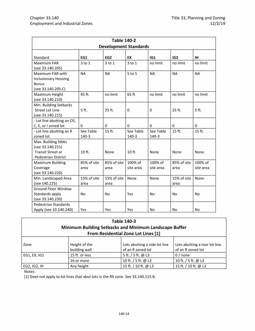
Chapter 33.140 Title 33, Planning and Zoning Employment and Industrial Zones 12/2/19
140‐14
Table 140‐2 Development Standards
Standard
EG1
EG2
EX
IG1
IG2
IH
Maximum FAR (see 33.140.205)
3 to 1 3 to 1 3 to 1 no limit no limit no limit
Maximum FAR with Inclusionary Housing Bonus (see 33.140.205.C)
NA NA 5 to 1 NA NA NA
Maximum Height (see 33.140.210)
45 ft. no limit 65 ft no limit no limit no limit
Min. Building Setbacks Street Lot Line (see 33.140.215)
5 ft.
25 ft.
0
0
25 ft.
5 ft.
‐ Lot line abutting an OS, C, E, or I zoned lot
0
0
0
0
0
0
‐ Lot line abutting an R zoned lot
See Table 140‐3
15 ft. See Table 140‐3
See Table 140‐3
15 ft. 15 ft.
Max. Building Stbks (see 33.140.215) Transit Street or Pedestrian District
10 ft.
None
10 ft.
None
None
None
Maximum Building Coverage (see 33.140.220)
85% of site area
85% of site area
100% of site area
100% of site area
85% of site area
100% of site area
Min. Landscaped Area (see 140.225)
15% of site area
15% of site area
None None 15% of site area
None
Ground Floor Window Standards apply (see 33.140.230)
No
No
Yes
No
No
No
Pedestrian Standards Apply (see 33.140.240)
Yes
Yes
Yes
No
No
No
Table 140‐3 Minimum Building Setbacks and Minimum Landscape Buffer
From Residential Zone Lot Lines [1] Zone
Height of the building wall
Lots abutting a side lot line of an R zoned lot
Lots abutting a rear lot line of an R zoned lot
EG1, EX, IG1 15 ft. or less 5 ft. / 5 ft. @ L3 0 / none
16 or more 10 ft. / 5 ft. @ L3 10 ft. / 5 ft. @ L3
EG2, IG2, IH Any height 15 ft. / 10 ft. @ L3 15 ft. / 10 ft. @ L3
Notes: [1] Does not apply to lot lines that abut lots in the RX zone. See 33.140.215.B.

Title 33, Planning and Zoning Chapter 33.140 12/2/19 Employment and Industrial Zones
140‐15
33.140.215 Setbacks
A. Purpose. The setback standards promote different streetscapes. The EG2 and IG2 zone setbacks promote a spacious style of development. The EG1, IG1, and EX zone setbacks reflect the generally built‐up character of these areas. The IH zone requires only a minimal setback to separate uses from the street. The setback standards are also intended to ensure that development will preserve light, air, and privacy for abutting residential zones. In the EG1 and EX zones, the setback requirements along transit streets and in Pedestrian Districts create an environment that is inviting to pedestrians and transit users.
B. Minimum building setbacks. The setback standards apply to all buildings and structures on the site except as specified in this section. Setbacks for exterior development are stated in 33.140.245 below, and for parking areas in Chapter 33.266.
1. Generally. The required building setbacks are stated in Table 140‐2.
2. Lot line abutting R‐zoned lot, except RX. Building setbacks and required landscape buffering on lot lines that abut lots in residential zones, except RX, are stated in Table 140‐3. Required landscaped areas must comply with at least the L3 standard as stated in Chapter 33.248, Landscaping and Screening. Landscaping is not required where buildings abut a lot line.
3. Exceptions to the building setbacks.
a. Setback averaging. Outside of Pedestrian Districts and along non‐transit streets, the street setback from a street lot line for buildings, decks, balconies, and porches may be reduced to the average of the existing respective setbacks on abutting lots. See Chapter 33.930, Measurements, for more information.
b. Split zoning. No setbacks are required from an internal lot line that is also a zoning line on sites with split zoning.
4. Extensions into required building setbacks.
a. The following features of a building may extend into a required building setback up to 20 percent of the depth of the setback. However, except for building eaves, they may not project into the landscape buffer required by Paragraph B.2.
(1) Eaves, chimneys, fireplace inserts and vents, mechanical equipment, fire escapes, water collection cisterns, and planters;
(2) Decks, stairways, wheelchair ramps, and uncovered balconies not meeting the standard of subparagraph B.4.b.; and
(3) Bays and bay windows extending into the setback also must meet the following requirements:
Each bay and bay window may be up to 12 feet long, but the total area of all bays and bay windows on a building facade cannot be more than 30 percent of the area of the facade;
At least 30 percent of the area of the bay which faces the property line requiring the setback must be glazing or glass block;

Chapter 33.140 Title 33, Planning and Zoning Employment and Industrial Zones 12/2/19
140‐16
Bays and bay windows must cantilever beyond the foundation of the building; and
The bay may not include any doors.
b. The following minor features of a building are allowed to extend into required building setbacks but may not project into the landscaped buffer required by Paragraph B.2:
(1) Canopies, marquees, awnings, and similar features may fully extend into a street setback;
(2) Uncovered stairways and wheelchair ramps that lead to one entrance on the street‐facing facade of a building may fully extend into a street setback;
(3) Uncovered decks, stairways, and wheelchair ramps that are no more than 2‐1/2 feet above the ground may fully extend into a required building setback; and
(4) On lots that slope down from the street, vehicular and pedestrian entry bridges that are no more than 2‐1/2 feet above the average sidewalk elevation may fully extend into a required building setback.
5. Detached accessory structures. For sites entirely in residential use, detached accessory structures are subject to the multi‐dwelling zone standards of 33.120.280. The setback standards for detached accessory structures are stated in 33.140.270 below. Fences are addressed in 33.140.275 below.
C. Maximum building setbacks.
1. Building setbacks on a transit street or in a Pedestrian District. The maximum setback standards of this paragraph apply to buildings that are enclosed on all sides.
a. Where these standards apply. Except as provided in Subsection D. below, these setback standards apply to sites in the EG1 and EX zones.
b. Measurement.
(1) Where an existing building is being altered, the standards of this paragraph apply to the ground level, street‐facing facade of the entire building. See Figures 140‐1 and 140‐2.
(2) Where there is more than one building on the site, the standards of this paragraph apply to the combined ground level, street‐facing facades of all of the buildings on the site. See Figures 140‐3 and 140‐4.
(3) For buildings where all of the floor area is in residential use, the street‐facing facade of an open porch that meets the following standards is included as part of the ground level, street‐facing facade of the building:
For houses, attached houses, manufactured homes and duplexes, the porch must be at least 25 square feet in area. For multi‐dwelling structures, the porch must be at least 9 feet wide and 7 feet deep;
The porch must have at least one entrance facing the street; and
Title 33, Planning and Zoning Chapter 33.140 12/2/19 Employment and Industrial Zones
140‐17
The porch must have a roof that is:
No more than 12 feet above the floor of the porch; and
At least 30 percent solid. This standard may be met by having 30 percent of the porch area covered with a solid roof, or by having the entire area covered with a trellis or other open material if no more than 70 percent of the area of the material is open.
c. Standards. There are two standards. Subparagraphs C.1.d. and e. specify where each standard applies:
(1) Standard 1: At least 50 percent of the length of the ground level street‐facing facade of the building must be within the maximum setback;
(2) Standard 2: 100 percent of the length of the ground level street‐facing facade of the building must be within the maximum setback;
d. Outside a Pedestrian district. Where the site is not in a Pedestrian District:
(1) One transit street. Where the site is adjacent to one transit street, the standard of Standard 1 must be met on the transit street frontage;
(2) Two non‐intersecting transit streets. Where the site is adjacent to two transit streets that do not intersect:
Standard 1 must be met on the frontage of the transit street with the highest classification. If both streets have the same classification, the applicant may choose which street;
If one of the transit streets intersects a City Walkway, Standard 1 must be met along both the transit street with the highest classification and the City Walkway;
(3) Two or more intersecting transit streets. Where the site is adjacent to two or more intersecting transit streets, Standard 2 must be met on the frontage of the transit street with the highest classification and Standard 1 must be met on an intersecting transit street. If two streets have the same highest classification, the applicant may choose which street.
e. In a Pedestrian District. Where the site is in a Pedestrian District:
(1) One street. Where the site is adjacent to only one street, Standard 1 must be met on that street frontage;
(2) Through lot with one transit street. Where the site is a through lot and one frontage is a transit street and one is a non‐transit street, Standard 1 must be met on the frontage of the transit street;
(3) Through lot with two transit streets. Where the site is a through lot and both frontages are on transit streets, Standard 1 must be met on the frontage of the transit street with the highest classification. If both streets have the same classification, the applicant may choose which street;
(4) Through lot with no transit streets. Where the site is a through lot and neither frontage is on a transit street, Standard 1 must be met on one of
Chapter 33.140 Title 33, Planning and Zoning Employment and Industrial Zones 12/2/19
140‐18
the frontages. The applicant may choose on which street to meet the standard;
(5) One transit street and one intersecting non‐transit street. Where the site is adjacent to a transit street and an intersecting non‐transit street, the following standards must be met:
Standard 2 must be met on the frontage of the transit street,
Standard 1 must be met on the intersecting non‐transit street;
(6) Two or more intersecting transit streets. Where the site is adjacent to two or more intersecting transit streets, the following standards must be met on the frontage of the transit street with the highest classification and any intersecting transit street:
Standard 2 must be met on the frontage of the transit street with the highest classification. If both transit streets have the same classification, the applicant may choose which street; and
Standard 1 must be met on an intersecting transit street;
(7) Three or more frontages, two non‐intersecting transit streets. Where the site has three or more frontages, and two or them are transit streets that do not intersect, the following standards must be met on the frontage of the transit street with the highest classification and one intersecting street:
Standard 2 must be met on the frontage of the transit street with the highest classification. If both transit streets have the same classification, the applicant may choose which street; and
Standard 1 must be met on an intersecting street;
(8) Two or more frontages, no transit streets, two or more intersecting streets. Where the site has two or more frontages, none of them are transit streets, and two or more of the streets intersect, the following standards must be met on the frontage of one street and one intersecting street:
Standard 2 must be met on the frontage of one street; and
Standard 1 must be met on an intersecting street.
2. Exemption. The maximum building setbacks do not apply to primary structures under 500 square feet in floor area, or to detached accessory structures. The street‐facing facades of detached accessory structures do not count towards meeting maximum setback standards. See Figure 140‐3.

Title 33, Planning and Zoning Chapter 33.140 12/2/19 Employment and Industrial Zones
140‐19
Figure 140‐1 Alteration to Existing Building in Conformance with Maximum Setback Standard
Figure 140‐2 Alterations to Existing Building
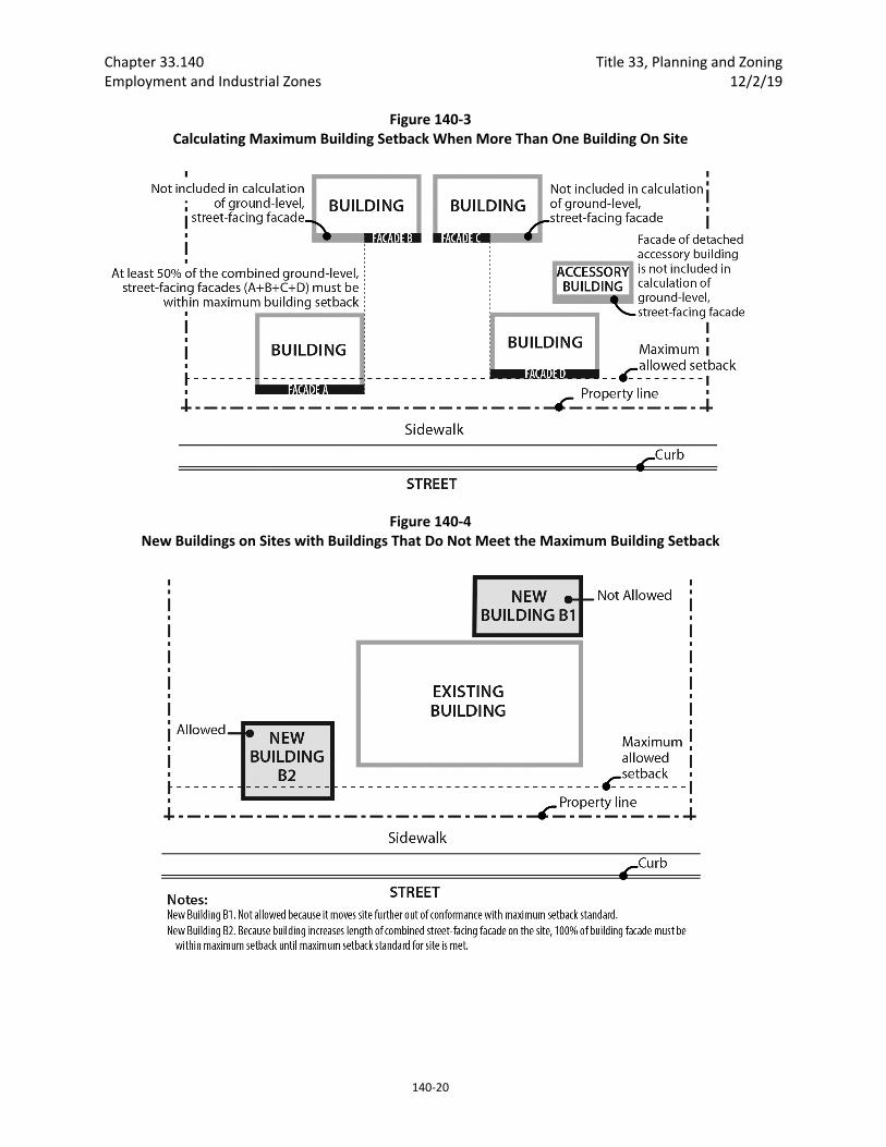
Chapter 33.140 Title 33, Planning and Zoning Employment and Industrial Zones 12/2/19
140‐20
Figure 140‐3 Calculating Maximum Building Setback When More Than One Building On Site
Figure 140‐4 New Buildings on Sites with Buildings That Do Not Meet the Maximum Building Setback
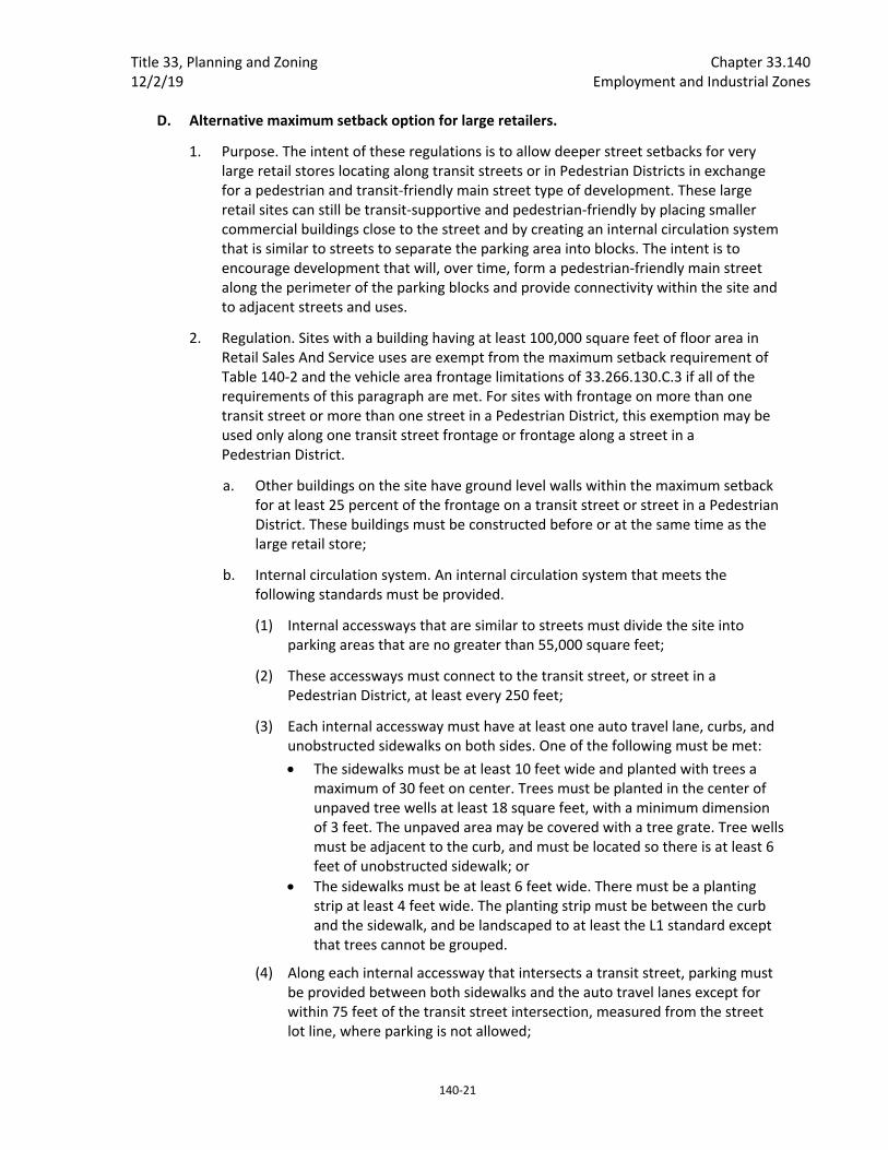
Title 33, Planning and Zoning Chapter 33.140 12/2/19 Employment and Industrial Zones
140‐21
D. Alternative maximum setback option for large retailers.
1. Purpose. The intent of these regulations is to allow deeper street setbacks for very large retail stores locating along transit streets or in Pedestrian Districts in exchange for a pedestrian and transit‐friendly main street type of development. These large retail sites can still be transit‐supportive and pedestrian‐friendly by placing smaller commercial buildings close to the street and by creating an internal circulation system that is similar to streets to separate the parking area into blocks. The intent is to encourage development that will, over time, form a pedestrian‐friendly main street along the perimeter of the parking blocks and provide connectivity within the site and to adjacent streets and uses.
2. Regulation. Sites with a building having at least 100,000 square feet of floor area in Retail Sales And Service uses are exempt from the maximum setback requirement of Table 140‐2 and the vehicle area frontage limitations of 33.266.130.C.3 if all of the requirements of this paragraph are met. For sites with frontage on more than one transit street or more than one street in a Pedestrian District, this exemption may be used only along one transit street frontage or frontage along a street in a Pedestrian District.
a. Other buildings on the site have ground level walls within the maximum setback for at least 25 percent of the frontage on a transit street or street in a Pedestrian District. These buildings must be constructed before or at the same time as the large retail store;
b. Internal circulation system. An internal circulation system that meets the following standards must be provided.
(1) Internal accessways that are similar to streets must divide the site into parking areas that are no greater than 55,000 square feet;
(2) These accessways must connect to the transit street, or street in a Pedestrian District, at least every 250 feet;
(3) Each internal accessway must have at least one auto travel lane, curbs, and unobstructed sidewalks on both sides. One of the following must be met:
The sidewalks must be at least 10 feet wide and planted with trees a maximum of 30 feet on center. Trees must be planted in the center of unpaved tree wells at least 18 square feet, with a minimum dimension of 3 feet. The unpaved area may be covered with a tree grate. Tree wells must be adjacent to the curb, and must be located so there is at least 6 feet of unobstructed sidewalk; or
The sidewalks must be at least 6 feet wide. There must be a planting strip at least 4 feet wide. The planting strip must be between the curb and the sidewalk, and be landscaped to at least the L1 standard except that trees cannot be grouped.
(4) Along each internal accessway that intersects a transit street, parking must be provided between both sidewalks and the auto travel lanes except for within 75 feet of the transit street intersection, measured from the street lot line, where parking is not allowed;

Chapter 33.140 Title 33, Planning and Zoning Employment and Industrial Zones 12/2/19
140‐22
(5) Curb extensions that are at least the full depth of the parking must be provided, as shown in Figure 140‐5, at the intersections of internal accessways that have parking; and
(6) The internal accessways are excluded from the portion of the parking and loading area used to calculate required interior landscaping.
c. Connections between sites. This standard applies to all commercial, office, or institutional development that is adjacent to sites either developed for commercial, office, or institutional use, or zoned C, E, or I. The system must connect the buildings on the site to these adjacent sites.
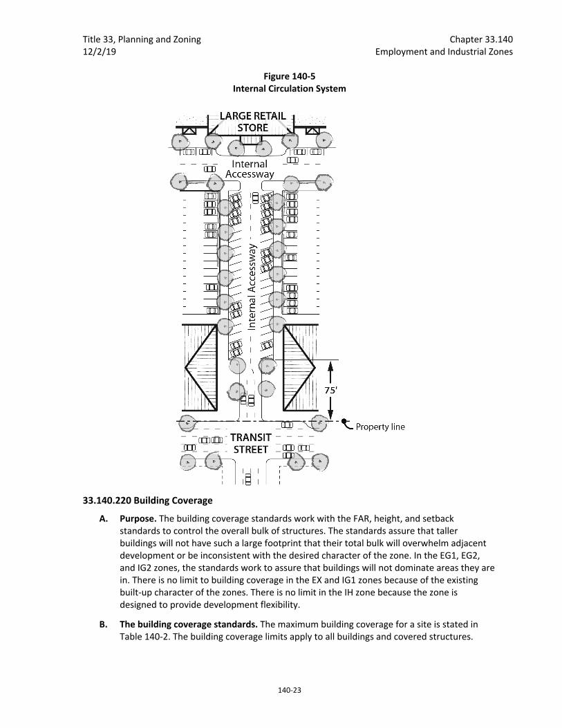
Title 33, Planning and Zoning Chapter 33.140 12/2/19 Employment and Industrial Zones
140‐23
Figure 140‐5 Internal Circulation System
33.140.220 Building Coverage
A. Purpose. The building coverage standards work with the FAR, height, and setback standards to control the overall bulk of structures. The standards assure that taller buildings will not have such a large footprint that their total bulk will overwhelm adjacent development or be inconsistent with the desired character of the zone. In the EG1, EG2, and IG2 zones, the standards work to assure that buildings will not dominate areas they are in. There is no limit to building coverage in the EX and IG1 zones because of the existing built‐up character of the zones. There is no limit in the IH zone because the zone is designed to provide development flexibility.
B. The building coverage standards. The maximum building coverage for a site is stated in Table 140‐2. The building coverage limits apply to all buildings and covered structures.
Chapter 33.140 Title 33, Planning and Zoning Employment and Industrial Zones 12/2/19
140‐24
33.140.225 Landscaped Areas
A. Purpose. Landscaping is required to help soften the effects of built and paved areas. Landscaping also helps cool the air temperature, intercept rainfall and reduce stormwater runoff by providing non‐paved permeable surface. Landscaping can also provide food for people and habitat for birds and other wildlife. Landscaping is required for all employment and industrially zoned lands abutting R‐zoned lands to provide buffering and promote the livability of the residential lands.
B. Minimum landscaped area standard. The required amounts of landscaped areas are stated in Table 140‐2. Required landscaped areas must be at ground level and comply with at least the L1 standard as stated in Chapter 33.248, Landscaping and Screening. However, up to one‐third of the required landscaped area may be improved for active or passive recreational use, or for use by pedestrians. Examples include walkways, play areas, plazas, picnic areas, and unenclosed recreational facilities. Any required landscaping, such as for required setbacks or parking lots, applies towards the landscaped area standard.
33.140.227 Trees Requirements for street trees and for on‐site tree preservation, protection, and overall tree density are in Title 11, Trees. See Chapter 11.50, Trees in Development Situations.
33.140.230 Ground Floor Windows in the EX Zone
A. Purpose. In the EX zone, blank walls on the ground level of buildings are limited in order to:
Provide a pleasant, rich, and diverse pedestrian experience by connecting activities occurring within a structure to adjacent sidewalk areas, or allowing public art at the ground level;
Encourage continuity of retail and service uses;
Encourage surveillance opportunities by restricting fortress‐like facades at street level; and
Avoid a monotonous pedestrian environment.
B. Required amounts of window area. In the EX zone, all exterior walls on the ground level which are 20 feet or closer to a street lot line, sidewalk, plaza, or other public open space or right‐of‐way must have windows. The windows must be at least 50 percent of the length and 25 percent of the ground level wall area. Ground level wall areas include all exterior wall areas up to 9 feet above the finished grade. The requirement does not apply to the walls of residential units, and does not apply to the walls of parking structures when set back at least 5 feet and landscaped to at least the L2 standard.
C. Qualifying window features. Required window areas must be either windows that allow views into working areas or lobbies, pedestrian entrances, or display windows set into the wall. Display cases attached to the outside wall do not qualify. The bottom of the windows must be no more than 4 feet above the adjacent exterior grade.
D. Exceptions for Public Arts. Outside of the Central City plan district, public art is allowed instead of meeting the ground floor window provision. Covenants for the public art will be required, following the regulations of Section 33.700.060, Covenants with the City, to ensure the installation, preservation, maintenance, and replacement of the public art. To
Title 33, Planning and Zoning Chapter 33.140 12/2/19 Employment and Industrial Zones
140‐25
qualify for this exception, documentation of approval by the Regional Arts and Culture Council must be provided prior to approval of the building permit.
33.140.235 Screening
A. Purpose. The screening standards address specific unsightly features which detract from the appearance of an area.
B. Garbage and recycling collection areas. In all zones except the IH zone, exterior garbage cans, garbage collection areas, and recycling collection areas must be screened from the street and any adjacent properties. Screening must comply with at least the L3 or F2 standards of Chapter 33.248, Landscaping and Screening.
C. Mechanical equipment. Mechanical equipment located on the ground, such as heating or cooling equipment, pumps, or generators, must be screened from the street and any abutting residential zones by walls, fences, or vegetation. Screening must comply with at least the L2 or F2 standards of Chapter 33.248, Landscaping and Screening, and be tall enough to screen the equipment. Mechanical equipment placed on roofs must be screened in one of the following ways, if the equipment is within 50 feet of an R zone:
1. A parapet along facades facing the R zone that is as tall as the tallest part of the equipment;
2. A screen around the equipment that is as tall as the tallest part of the equipment; or
3. The equipment is set back from roof edges facing the R zone 3 feet for each foot of height of the equipment.
D. Other screening requirements. The screening requirements for parking, exterior storage, and exterior display areas are stated with the regulations for those types of development.
33.140.240 Pedestrian Standards
A. Purpose. The pedestrian standards encourage a safe, attractive, and usable pedestrian circulation system in developments in the employment zones. They ensure a direct pedestrian connection between abutting streets and buildings on the site, and between buildings and other activities within the site. In addition, they provide for connections between adjacent sites, where feasible.
B. The standards. The standards of this section apply to all development in the EG1, EG2, and EX zones except houses, attached houses, and duplexes. An on‐site pedestrian circulation system must be provided. The system must meet all standards of this subsection.
1. Connections. The on‐site pedestrian circulation system must provide connections as specified below:
a. Connection between streets and entrances.
(1) Sites with one street frontage.
Generally. There must be a connection between one main entrance of each building on the site and the adjacent street. The connection may

Chapter 33.140 Title 33, Planning and Zoning Employment and Industrial Zones 12/2/19
140‐26
not be more than 20 feet longer or 120 percent of the straight line distance, whichever is less.
Household Living. Sites where all of the floor area is in Household Living uses are only required to provide a connection to one main entrance on the site. The connection may not be more than 20 feet longer or 120 percent of the straight line distance, whichever is less.
Tree preservation. If a tree that is at least 12 inches in diameter is proposed for preservation, and the location of the tree or its root protection zone would prevent the standard of this paragraph from being met, the connection may be up to 200 percent of the straight line distance.
(2) Sites with more than one street frontage. Where the site has more than one street frontage, the following must be met:
The standard of B.1.a(1) must be met to connect the main entrance of each building on the site to the closest sidewalk or roadway if there are no sidewalks. Sites where all of the floor area is in Household Living uses are only required to provide a connection meeting the standard of B.1.a(1) to one main entrance on the site;
An additional connection, which does not have to be a straight line connection, is required between each of the other streets and a pedestrian entrance. However, if at least 50 percent of a street facing facade is within 10 feet of the street, no connection is required to that street.
b. Internal connections. The system must connect all main entrances on the site, and provide connections to other areas of the site, such as parking areas, bicycle parking, recreational areas, common outdoor areas, and any pedestrian amenities.
2. Materials.
a. The circulation system must be hard‐surfaced, and be at least 6 feet wide.
b. Where the system crosses driveways, parking areas, and loading areas, the system must be clearly identifiable, through the use of elevation changes, speed bumps, a different paving material, or other similar method. Striping does not meet this requirement. Elevation changes and speed bumps must be at least 4 inches high.
c. Where the system is parallel and adjacent to an auto travel lane, the system must be a raised path or be separated from the auto travel lane by a raised curb, bollards, landscaping or other physical barrier. If a raised path is used it must be at least 4 inches high and the ends of the raised portions must be equipped with curb ramps. Bollard spacing must be no further apart than 5 feet on center.
3. Lighting. The on‐site pedestrian circulation system must be lighted to a level where the system can be used at night by the employees, residents, and customers.
4. EG1 and EX zones. The land between a building and a street lot line must be landscaped to at least the L1 level and/or hard‐surfaced for use by pedestrians. This
Title 33, Planning and Zoning Chapter 33.140 12/2/19 Employment and Industrial Zones
140‐27
area may be counted towards any minimum landscaped area requirements. Vehicle areas and exterior display, storage, and work activities, if allowed, are exempt from this standard. Bicycle parking may be located in the area between a building and a street lot line when the area is hard‐surfaced.
33.140.242 Transit Street Main Entrance
A. Purpose. Locating the main entrance to a use on a transit street provides convenient pedestrian access between the use and public sidewalks and transit facilities, and so promotes walking and the use of transit.
B. Applicability.
1. Generally. In the EX and EG1 zones, all sites with at least one frontage on a transit street, and where any of the floor area on the site is in nonresidential uses, must meet the following standards for the nonresidential uses. If the site has frontage on more than one transit street, the standards of Subsection C, below, must be met on at least one of the transit streets;
2. Houses, attached houses, manufactured homes, and duplexes. Houses, attached houses, manufactured homes, and duplexes must meet the standards of subsection 33.140.265.D, Residential Main Entrance, instead of the requirements of this section.
C. Location. For the portion of buildings that conform to the maximum building setback, at least one main entrance for each nonresidential tenant space on the ground floor must meet the standards of this section. The ground floor is the lowest floor of the building that is within four feet of the adjacent transit street grade. The main entrance must:
1. Be within 25 feet of the transit street;
2. Allow pedestrians to both enter and exit the building; and
3. Either:
a. Face the transit street; or
b. Be at an angle of up to 45 degrees from the transit street, measured from the street property line, as shown in Figure 140‐6.
D. Unlocked during regular business hours. The main entrance that meets the standards of Subsection C must be unlocked during regular business hours.

Chapter 33.140 Title 33, Planning and Zoning Employment and Industrial Zones 12/2/19
140‐28
Figure 140‐6 Transit Street Main Entrance
33.140.245 Exterior Display, Storage, and Work Activities
A. Purpose. The exterior development standards of this section are intended to assure that exterior display, storage, and work activities:
Will be consistent with the desired character of the zone;
Will not be a detriment to the overall appearance of an employment or industrial area, and exterior activities in the EG1 zone will be limited to a similar level as exterior activities in the Commercial Employment zone;
Will not have adverse impacts on adjacent properties, especially those zoned residential; and
Will not have an adverse impact on the environment.
B. Exterior display.
1. Employment zones. Exterior display of goods is allowed as follows. The setback and landscaping standards for exterior display areas are stated in Table 140‐4:
a. Exterior display of goods is allowed in the EG1 zone except for uses in the Industrial categories. Exterior display of goods is not allowed for uses in the Industrial categories in the EG1 zone.
b. Exterior display of goods is allowed in the EG2 zone.
c. Exterior display of goods is allowed in the EX zone except for the display of motor vehicles, recreational vehicles, motor vehicle parts and supplies, building materials, and goods associated with an industrial use.

Title 33, Planning and Zoning Chapter 33.140 12/2/19 Employment and Industrial Zones
140‐29
2. Industrial zones. Exterior display of goods is allowed in the I zones. The setback and landscaping standards for exterior display areas are stated in Table 140‐4.
C. Exterior storage.
1. Employment zones. Exterior storage is allowed in the EG1 zones but is limited to 20 percent of the site area for all uses except lumber yards and other building material stores. Exterior storage is allowed in the EG2 zones. Exterior storage is not allowed in the EX zones. The setback and landscaping standards for exterior storage areas are stated in Table 140‐4.
2. Industrial zones. Exterior storage is allowed in the I zones. The setback and landscaping standards for exterior storage areas area stated in Table 140‐4.
D. Exterior work activities. Exterior work activities are allowed in the industrial zones but not the employment zones. The setback and landscaping standards for exterior activity areas are stated in Table 140‐4.
E. Other exterior activities. Outdoor eating areas are allowed as an exterior activity in the employment and industrial zones.
F. Paving. All exterior development areas in the EG1, EX, and IG1 zones must be paved.
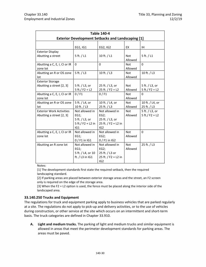
Chapter 33.140 Title 33, Planning and Zoning Employment and Industrial Zones 12/2/19
140‐30
Table 140‐4 Exterior Development Setbacks and Landscaping [1]
EG1, IG1
EG2, IG2
EX
IH
Exterior Display Abutting a street
5 ft. / L1
10 ft. / L1
Not Allowed
5 ft. / L1
Abutting a C, E, I, CI or IR zone lot
0 0 Not Allowed
0
Abutting an R or OS zone lot
5 ft. / L3 10 ft. / L3 Not Allowed
10 ft. / L3
Exterior Storage Abutting a street [2, 3]
5 ft. / L3, or 5 ft./ F2 + L2
25 ft. / L3, or 25 ft. / F2 + L2
Not Allowed
5 ft. / L3, or 5 ft./ F2 + L2
Abutting a C, E, I, CI or IR zone lot
0 / F1 0 / F1 Not Allowed
0
Abutting an R or OS zone lot
5 ft. / L4, or 10 ft. / L3
10 ft. / L4, or 25 ft. / L3
Not Allowed
10 ft. / L4, or 25 ft. / L3
Exterior Work Activities Abutting a street [2, 3]
Not allowed in EG1; 5 ft. / L3, or 5 ft./ F2 + L2 in IG1
Not allowed in EG2; 25 ft. / L3, or 25 ft. / F2 + L2 in IG2
Not Allowed
5 ft. / L3, or 5 ft./ F2 + L2
Abutting a C, E, I, CI or IR zone lot
Not allowed in EG1; 0 / F1 in IG1
Not allowed in EG2; 0 / F1 in IG2
Not Allowed
0
Abutting an R zone lot Not allowed in EG1; 5 ft. / L4, or 10 ft. / L3 in IG1
Not allowed in EG2; 25 ft. / L3 or 25 ft. / F2 + L2 in IG2
Not Allowed
25 ft. / L3
Notes: [1] The development standards first state the required setback, then the required landscaping standard. [2] If parking areas are placed between exterior storage areas and the street, an F2 screen only is required on the edge of the storage area. [3] When the F2 + L2 option is used, the fence must be placed along the interior side of the landscaped area.
33.140.250 Trucks and Equipment The regulations for truck and equipment parking apply to business vehicles that are parked regularly at a site. The regulations do not apply to pick‐up and delivery activities, or to the use of vehicles during construction, or other service at the site which occurs on an intermittent and short‐term basis. The truck categories are defined in Chapter 33.910.
A. Light and medium trucks. The parking of light and medium trucks and similar equipment is allowed in areas that meet the perimeter development standards for parking areas. The areas must be paved.
Title 33, Planning and Zoning Chapter 33.140 12/2/19 Employment and Industrial Zones
140‐31
B. Heavy trucks. The parking of heavy trucks and similar equipment is allowed in zones that allow exterior storage. The development standards for exterior storage must be met in the area where the heavy trucks and similar equipment are parked.
33.140.255 Drive‐Through Facilities Drive‐through facilities are allowed in the zones which are intended for auto‐ accommodating development. They are not consistent with or supportive of areas where the desired character is pedestrian‐oriented development. The standards for drive‐through facilities are stated in Chapter 33.224, Drive‐Through Facilities.
A. EG and I zones. Drive‐through facilities are allowed in the EG and I zones.
B. EX zone. Drive‐through facilities are prohibited in the EX zone.
33.140.265 Residential Development When allowed, residential development is subject to the following development standards:
A. Generally. Except as specified in this section, base zone development standards continue to apply;
B. Existing buildings. Residential uses in existing buildings have no density limit within the building;
C. New development. Residential uses in new development are subject to the development standards of the EX zone, except as specified in this section;
D. Residential main entrance.
1. Purpose. The main entrance standards serve several purposes:
The main entrance standards, together with the window and garage standards ensure that there is a physical and visual connection between the living area of the residence and the street;
They enhance public safety for residents and visitors and provide opportunities for community interaction;
They ensure that the pedestrian entrance is visible or clearly identifiable from the street by its orientation or articulation; and
They ensure that pedestrians can easily find the main entrance, and so establish how to enter the residence.
Ensure a connection to the public realm for development on lots fronting both private and public streets by making the pedestrian entrance visible or clearly identifiable from the public street.
2. Where these standards apply.
a. The standards of this subsection apply to houses, attached houses, manufactured homes, and duplexes in the employment and industrial zones.
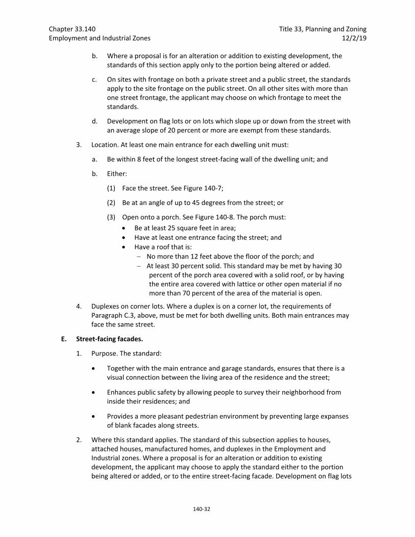
Chapter 33.140 Title 33, Planning and Zoning Employment and Industrial Zones 12/2/19
140‐32
b. Where a proposal is for an alteration or addition to existing development, the standards of this section apply only to the portion being altered or added.
c. On sites with frontage on both a private street and a public street, the standards apply to the site frontage on the public street. On all other sites with more than one street frontage, the applicant may choose on which frontage to meet the standards.
d. Development on flag lots or on lots which slope up or down from the street with an average slope of 20 percent or more are exempt from these standards.
3. Location. At least one main entrance for each dwelling unit must:
a. Be within 8 feet of the longest street‐facing wall of the dwelling unit; and
b. Either:
(1) Face the street. See Figure 140‐7;
(2) Be at an angle of up to 45 degrees from the street; or
(3) Open onto a porch. See Figure 140‐8. The porch must:
Be at least 25 square feet in area;
Have at least one entrance facing the street; and
Have a roof that is:
No more than 12 feet above the floor of the porch; and
At least 30 percent solid. This standard may be met by having 30 percent of the porch area covered with a solid roof, or by having the entire area covered with lattice or other open material if no more than 70 percent of the area of the material is open.
4. Duplexes on corner lots. Where a duplex is on a corner lot, the requirements of Paragraph C.3, above, must be met for both dwelling units. Both main entrances may face the same street.
E. Street‐facing facades.
1. Purpose. The standard:
Together with the main entrance and garage standards, ensures that there is a visual connection between the living area of the residence and the street;
Enhances public safety by allowing people to survey their neighborhood from inside their residences; and
Provides a more pleasant pedestrian environment by preventing large expanses of blank facades along streets.
2. Where this standard applies. The standard of this subsection applies to houses, attached houses, manufactured homes, and duplexes in the Employment and Industrial zones. Where a proposal is for an alteration or addition to existing development, the applicant may choose to apply the standard either to the portion being altered or added, or to the entire street‐facing facade. Development on flag lots
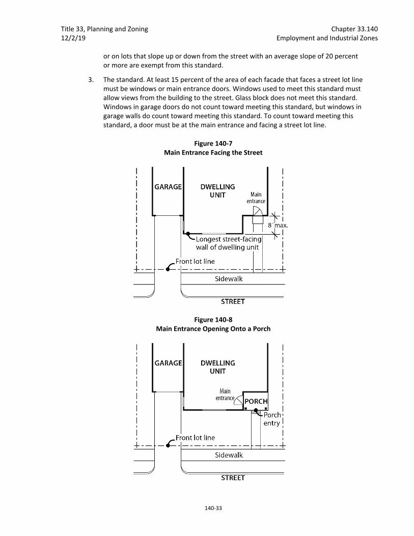
Title 33, Planning and Zoning Chapter 33.140 12/2/19 Employment and Industrial Zones
140‐33
or on lots that slope up or down from the street with an average slope of 20 percent or more are exempt from this standard.
3. The standard. At least 15 percent of the area of each facade that faces a street lot line must be windows or main entrance doors. Windows used to meet this standard must allow views from the building to the street. Glass block does not meet this standard. Windows in garage doors do not count toward meeting this standard, but windows in garage walls do count toward meeting this standard. To count toward meeting this standard, a door must be at the main entrance and facing a street lot line.
Figure 140‐7 Main Entrance Facing the Street
Figure 140‐8 Main Entrance Opening Onto a Porch
Chapter 33.140 Title 33, Planning and Zoning Employment and Industrial Zones 12/2/19
140‐34
F. Garages.
1. Purpose. These standards:
Together with the window and main entrance standards, ensure that there is a physical and visual connection between the living area of the residence and the street;
Ensure that the location and amount of the living area of the residence, as seen from the street, is more prominent than the garage;
Prevent garages from obscuring the main entrance from the street and ensure that the main entrance for pedestrians, rather than automobiles, is the prominent entrance;
Provide for a more pleasant pedestrian environment by preventing garages and vehicle areas from dominating the views of the neighborhood from the sidewalk; and
Enhance public safety by preventing garages from blocking views of the street from inside the residence.
2. Where these standards apply. The requirements of Paragraphs F.3 and F.4, below, apply to houses, manufactured homes, and duplexes. The requirements of Paragraph F.4, below, also apply to garages that are accessory to attached houses. When a proposal is for an alteration or addition to existing development, the standards of this section apply only to the portion being altered or added. Development on flag lots or on lots which slope up or down from the street with an average slope of 20 percent or more are exempt from these standards.
3. Length of street‐facing garage wall.
a. Generally. The length of the garage wall facing the street may be up to 50 percent of the length of the street‐facing building facade. See Figure 140‐9. On corner lots, only one street‐facing garage wall must meet this standard.
b. Exception. Where the street‐facing facade of the building is less than 24 feet long, the garage wall facing the street may be up to 12 feet long if there is one of the following. See Figure 140‐10.
(1) Interior living area above the garage. The living area must be set back no more than 4 feet from the street‐facing garage wall, or
(2) A covered balcony above the garage that is:
At least the same length as the street‐facing garage wall;
At least 6 feet deep; and
Accessible from the interior living area of the dwelling unit.
4. Street lot line setbacks.
a. Generally. A garage wall that faces a street may be no closer to the street lot line than the longest street‐facing wall of the dwelling unit. See Figure 140‐11.
Title 33, Planning and Zoning Chapter 33.140 12/2/19 Employment and Industrial Zones
140‐35
b. Exception. A street‐facing garage wall may be up to 6 feet in front of the longest street‐facing wall of the dwelling unit, if:
(1) The street‐facing garage wall is 40 percent or less of the length of the building facade; and
(2) There is a porch at the main entrance. The garage wall may not be closer to the street lot line than the front of the porch. See Figure 140‐12. The porch must meet the following:
The porch must be at least 48 square feet in area and have minimum dimensions of 6 feet by 6 feet;
The porch must have a solid roof; and
The roof may not be more than 12 feet above the floor of the porch.
c. Exemption. Where a lot has more than one street lot line, and there is an existing dwelling unit on the lot, this standard must be met only on the street‐facing facade on which the main entrance is located.
33.140.270 Detached Accessory Structures
A. Purpose. These standards are intended to maintain separation and privacy to abutting residential lots from nonresidential development.
B. General standards.
1. The regulations of this section apply to detached accessory structures on sites with non‐residential uses. For sites where all of the floor area is in residential use, detached accessory structures are subject to the standards of Section 33.120.280. Detached garages that are accessory to residential development are also subject to the standards of 33.140.265, Residential Development.
2. Unless stated in this section, the height and building coverage standards of the base zone apply to detached accessory structures.
C. Setbacks.
1. Uncovered accessory structures. Uncovered accessory structures, such as flag poles, lamp posts, signs, antennas and dishes, mechanical equipment, uncovered decks, play structures, and tennis courts, are allowed in a street setback, but not in a required setback from an abutting residential zone.
2. Covered structures.
a. Covered structures, such as storage buildings, greenhouses, work shed, covered decks, and covered recreational structures, are subject to the setbacks for buildings.
b. Water cisterns that are 6 feet or less in height are allowed in side and rear setbacks, including setbacks abutting a residential zone.
c. See Section 33.140.265, Residential Development, for additional requirements for garages that are accessory to residential development.
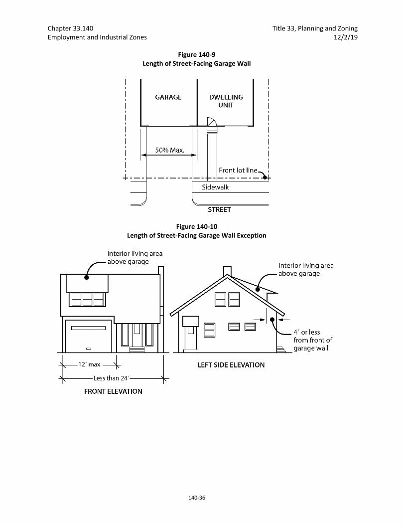
Chapter 33.140 Title 33, Planning and Zoning Employment and Industrial Zones 12/2/19
140‐36
Figure 140‐9 Length of Street‐Facing Garage Wall
Figure 140‐10 Length of Street‐Facing Garage Wall Exception
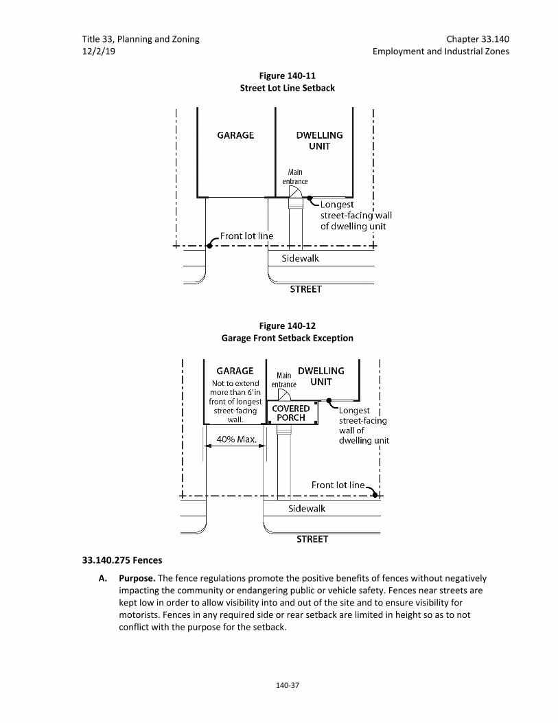
Title 33, Planning and Zoning Chapter 33.140 12/2/19 Employment and Industrial Zones
140‐37
Figure 140‐11 Street Lot Line Setback
Figure 140‐12 Garage Front Setback Exception
33.140.275 Fences
A. Purpose. The fence regulations promote the positive benefits of fences without negatively impacting the community or endangering public or vehicle safety. Fences near streets are kept low in order to allow visibility into and out of the site and to ensure visibility for motorists. Fences in any required side or rear setback are limited in height so as to not conflict with the purpose for the setback.
Chapter 33.140 Title 33, Planning and Zoning Employment and Industrial Zones 12/2/19
140‐38
B. Types of fences. The standards apply to walls, fences, and screens of all types whether open, solid, wood, metal, wire, masonry, or other material.
C. Location and heights.
1. Fences along street lot lines, including pedestrian connections.
a. EG1, IG1 and IH zones. In EG1, IG1, and IH zones, fences up to 3‐1/2 feet high are allowed in a required street building setback, including setbacks from pedestrian connections.
b. EG2, EX and IG2 zones. In EG2, EX and IG2 zones, within 10 feet of a street lot line, fences that meet the following standards are allowed:
(1) Fences that are more than 50 percent sight‐obscuring may be up to 3‐1/2 feet high;
(2) Fences that are 50 percent or less sight‐obscuring may be up to 8 feet high.
c. EG2 and IG2 zones. In EG2 and IG2 zones, fences that are more than 50 percent sight‐obscuring may be up to 8 feet high within the street building setback if they are more than 10 feet from the lot line.
2. Fences along other lot lines. Fences up to 8 feet high are allowed in required building setbacks along all other lot lines.
3. Fences in all other locations. The height for fences in locations other than described in Paragraphs C.1 and 2 is the same as the regular height limits of the zone.
D. Reference to other regulations. Electrified fences are regulated under Title 26, Electrical Regulations. The use of barbed wire is regulated under Title 24, Building Regulations.
33.140.280 Demolitions
A. Generally. Demolition on a site that requires a demolition permit is subject to the tree preservation and protection requirements of Title 11, Trees. See Chapter 11.50, Trees in Development Situations.
B. Historic resources. Demolitions of historic resources is regulated by Chapter 33.445, Historic Resource Overlay Zone.
33.140.290 Nonconforming Development Existing development that does not conform to the development standards of this chapter may be subject to the regulations of Chapter 33.258, Nonconforming Situations.
33.140.295 Parking and Loading The standards pertaining to the minimum required and maximum allowed number of auto parking spaces, minimum required number of bicycle parking spaces, parking lot placement, parking lot setbacks and landscaping, and loading areas are stated in Chapter 33.266, Parking And Loading.
33.140.300 Signs The sign regulations are stated in Title 32, Signs and Related Regulations.
Title 33, Planning and Zoning Chapter 33.140 12/2/19 Employment and Industrial Zones
140‐39
33.140.310 Superblock Requirements Developments in the EX zone which are on land that includes vacated rights‐of‐way may be subject to the superblock standards of Chapter 33.293, Superblocks.
33.140.315 Recycling Areas Requirements for recycling areas are regulated by the Bureau of Planning and Sustainability. See Section 17.102.270, Businesses and Multifamily Complexes Required to Recycle, of the Portland City Code.
33.140.320 Inclusionary Housing The standards pertaining to inclusionary housing are stated in Chapter 33.245, Inclusionary Housing.
(Amended by: Ord. No. 165376, effective 5/29/92; Ord. No. 165594, effective 7/8/92; Ord. No. 166920, effective 10/1/93; Ord. No. 167186, effective 12/31/93; Ord. No. 167189, effective 1/14/94; Ord. No. 169535, effective 1/8/96; Ord. No. 169987, effective 7/1/96; Ord. No. 170704, effective 1/1/97; Ord. No. 171219, effective 7/1/97; Ord. No. 171718, effective 11/29/97; Ord. No. 173259, effective 5/14/99; Ord. No. 173593, effective 9/3/99; Ord. No. 173729, effective 9/8/99; Ord. No. 174263, effective 4/15/00; Ord. No. 174980, effective 11/20/00; Ord. No. 175204, effective 3/1/01; Ord. No. 175837, effective 9/7/01; Ord. No. 175966, effective 10/26/01; Ord. Nos. 175965 and 176333, effective 7/1/02; Ord. No. 176469, effective 7/1/02; Ord. No. 177028, effective 12/14/02; Ord. No. 177422, effective 6/7/03; Ord. No. 177404, effective 7/1/03; Ord. No. 178172, effective 3/5/04; Ord. No. 178509, effective 7/16/04; Ord. No. 178832, effective 10/21/04; Ord. Nos. 179980 and 179994, effective 4/22/06; Ord. No. 180619, effective 12/22/06; Ord. No. 181357, effective 11/9/07; Ord. No. 182429, effective 1/16/09; Ord. No. 183598, effective 4/24/10; Ord. No. 184524, effective 7/1/11; Ord. No. 185412, effective 6/13/12; Ord. No. 185915, effective 5/1/13; Ord. No. 185974, effective 5/10/13; Ord. No. 186639, effective 7/11/14; Ord. No. 186053, effective 1/1/15; Ord. No. 187216, effective 7/24/15; Ord. No. 187471, effective 1/1/16; Ord. No. 188077, effective 12/9/16; Ord. No. 188142, effective 1/13/17; Ord. No 188162, effective 2/1/17; Ord. No. 188177, effective 5/24/18; Ord. No. 188958, effective 5/24/18; Ord. No. 189000, effective 7/9/18; Ord. No. 189488, effective 12/2/19.)

Chapter 33.140 Title 33, Planning and Zoning Employment and Industrial Zones 12/2/19
140‐40
Title 33, Planning and Zoning Chapter 33.150 12/2/19 Campus Institutional Zones
150‐3
designated as District Collector streets, Transit Access Streets, or streets of higher classification The IR zone will be applied only when it is accompanied by the “d” Design Review overlay zone.
33.150.040 Other Zoning Regulations The regulations in this chapter state the allowed uses and the development standards for the base zones. Sites with overlay zones, plan districts, or designated historical landmarks are subject to additional regulations. The Official Zoning Maps indicate which sites are subject to the additional regulations. Specific uses or development types may also be subject to regulations in the 200s series of chapters.
33.150.050 Where This Chapter Does Not Apply The regulations in this chapter do not apply to sites with a College or Medical Center use that are continuing to develop under an approved conditional use, conditional use master plan, or impact mitigation plan as allowed by 33.700.110.B.2.b. and 33.700.110.B.4. According to 33.700.110.B.2.b. and 33.700.110.B.4., Colleges and Medical Centers in the CI1 and CI2 zones that were approved conditional uses under prior regulations can continue to develop under the approved conditional use master plan or impact mitigation plan, and the base zone regulations that were in effect at the time the conditional use application was deemed complete, until the conditional use, conditional use masterplan, or impact mitigation plan expires, or December 31, 2023, whichever comes first. In this case, the regulations of this chapter do not apply to development on the site.
33.150.060 Neighborhood Contact and Outreach
A. Purpose. The requirements of this section promote ongoing communication between campus institutions and other uses and the surrounding communities. In addition to neighborhood contact, Colleges and Medical Centers are required to annually update the community on campus operations and development proposals. The annual meeting allows neighbors and campus administrators the opportunity to discuss and resolve potential impacts or conflicts. While the comments from the community are not binding, a collaborative approach is encouraged.
B. Neighborhood contact. Neighborhood contact is a set of outreach steps that must be taken before certain developments can be submitted for approval. Neighborhood contact is required as follows:
1. Neighborhood contact I.
a. Neighborhood contact I requirements. When proposed development will add at least 10,000 square feet and not more than 25,000 square feet of net building area to a site, the neighborhood contact steps of 33.705.020.A., Neighborhood contact I, are required. All the steps in 33.705.020.A. must be completed before an application for a building permit can be submitted.
b. Exemption. If the proposed development has already met the neighborhood contact requirements as part of a land use review process, it is exempt from the neighborhood contact requirements.
2. Neighborhood contact II.
a. Neighborhood contact II requirements. When the proposed development will add more than 25,000 square feet of net building area to a site, the neighborhood contact steps of 33.705.020.B., Neighborhood contact II, are required. All of the steps
Chapter 33.150 Title 33, Planning and Zoning Campus Institutional Zones 12/2/19
150‐4
in 33.705.020.B. must be completed before an application for a building permit can be submitted.
b. Exemption. If the proposed development has already met the neighborhood contact requirements as part of a land use review process, it is exempt from the neighborhood contact requirements.
C. Annual meeting. Colleges and Medical Centers must conduct at least one community meeting per year. The annual community meeting is intended to ensure that the College or Medical Center updates the community at least once a year regarding future development and other potential changes that could affect the surrounding area, and to provide a forum for discussion of a Good Neighbor Agreement:
1. The following information must be provided during the meeting:
a. The status of and any updates to the College’s or Medical Center’s Transportation and Parking Demand Management Plan, Transportation Impact Analysis, and related mitigation measures;
b. Development that is anticipated to take place on the site during the next 12 months;
c. Potential impacts of other on‐site activities that could affect the surrounding neighborhood; and
d. Updated contact information for the College or Medical Center;
2. The College or Medical Center must send notice of the meeting to the neighborhood association and business association for the area at least 30 days before the meeting. Notice must be by registered or certified mail, and must include the following:
a. The purpose of the meeting;
b. Information on how to contact the institution regarding details about this meeting;
c. The date, time, and location of the meeting.
3. A copy of the notification, the mailing list, and registered or certified mail receipt must be retained by the College or Medical Center for at least 5 years and must be available for inspection by City staff upon request.
Use Regulations
33.150.100 Primary Uses
A. Allowed uses. Uses allowed in the campus institutional zones are listed in Table 150‐1 with a "Y". These uses are allowed if they comply with the development standards and other regulations of this Title. Being listed as an allowed use does not mean that a proposed development will be granted an adjustment or other exception to the regulations of this Title. In addition, a use or development listed in the 200s series of chapters is also subject to the regulations of those chapters.
B. Limited uses. Uses allowed that are subject to limitations are listed in Table 150‐1 with an "L". These uses are allowed if they comply with the limitations listed below and the development standards and other regulations of this Title. In addition, a use or development listed in the 200s series of chapters is also subject to the regulations of those chapters. The paragraphs

Title 33, Planning and Zoning Chapter 33.150 12/2/19 Campus Institutional Zones
150‐5
listed below contain the limitations and correspond with the footnote numbers from Table 150‐1.
1. Retail Sales And Service uses in the CI1 zone. This regulation applies to all parts of Table 150‐1 that have note [1]. Up to 10,000 square feet of Retail Sales And Service use per site may be allowed as a conditional use in the CI1 zone.
2. Manufacturing And Production and Industrial Service in the CI1 and CI2 zones. This regulation applies to all parts of Table 150‐1 that have note [2]. In the CI 1 and CI2 zones, up to 10,000 square feet of Manufacturing And Production use and 10,000 square feet of Industrial Service use is allowed per site. More than 10,000 square feet of Manufacturing and Production use and 10,000 square feet of Industrial Service use may be allowed as a conditional use in the CI2 zone. More than 10,000 square feet of Manufacturing and Production and Industrial Service is prohibited in the CI1 zone.
3. Basic Utilities. These regulations apply to all parts of Table 150‐1 that have note [3].
a. Basic Utilities that serve a development site are accessory uses to the primary use being served on that site.
b. Small Scale Energy Production that provides energy for on‐site or off‐site use are considered accessory to the primary use on the site. Installations that sell power they generate—at retail (net, metered) or wholesale—are included. However, they are only considered accessory if they generate energy primarily from biological materials or byproducts from the site itself, or conditions on the site itself. Not more than 10 tons per week of biological material or byproducts from other sites may be used to generate energy. Not more than 20 percent of the floor area on a site, exclusive of parking area may be devoted to small scale energy production. The requirements of Chapter 33.262, Off Site Impacts must be met.
c. All other Basic Utilities are conditional uses.
4. Community Service. This regulation applies to all parts of Table 150‐1 that have note [4]. Most Community Service uses are regulated by Chapter 33.815, Conditional Uses.
5. Parks And Open Areas. This regulation applies to all parts of Table 150‐1 that have note [5]. Parks And Open Areas uses are allowed by right. However, certain accessory uses and facilities that are part of a Parks And Open Areas use require a conditional use review. These accessory uses and facilities that require a conditional use review are listed below.
a. Swimming pools.
b. Cemeteries, including mausoleums, chapels, and similar accessory structures associated with funerals or burial.
c. Golf courses, including club houses, restaurants, and driving ranges.
d. Boat ramps.
e. Parking areas.
f. Recreational fields for organized sports. Recreational fields used for organized sports are subject to the regulations of Chapter 33.279, Recreational Fields for Organized Sports.

Chapter 33.150 Title 33, Planning and Zoning Campus Institutional Zones 12/2/19
150‐6
6. Colleges. This regulation applies to all parts of Table 150‐1 that have note [6]. Colleges are allowed by right. However, outdoor sports facilities that include more than 1,500 square feet of accessory building floor area, more than 500 linear feet of spectator seating, outdoor lighting, or voice amplification require a conditional use review.
7. Agriculture. This regulation applies to all parts of Table 150‐1 that have note [7]. If the use and site do not meet the regulations of Chapter 33.237, Food Production and Distribution, Agriculture is prohibited.
8. Radio Frequency Transmission Facilities. This regulation applies to all parts of Table 150‐1 that have an [8]. Some Radio Frequency Transmission Facilities are allowed by right. See Chapter 33.274.
9. Group Living in the IR Zone. This regulation applies to all parts of table 150‐1 that have a note [9]. Group Living facilities in the IR zone are regulated as follows:
a. Group Living facilities must be included in the mission statement of the campus’s impact mitigation plan;
b. The impact mitigation plan’s implemented mitigation measures must accommodate the impacts the Group Living facility will create; and
c. A facility located less than 150 feet from another residential zone must meet the standards for Group Living in that zone. Where two or more residential zones are within 150 feet of the Group Living development, the controlling regulations are those of the lower density zone.
10. Retail Sales And Services and Office uses in the IR zone. This regulation applies to all parts of Table 150‐1 that have a note [10].
a. Purpose. Retail Sales And Service uses are allowed as part of an institutional campus in recognition of the large size of such campuses and the needs of the people present for nearby goods and services. Office uses are allowed in recognition of the multifaceted nature of colleges and medical centers.
b. Retail Sales and Service uses allowed as accessory activities. These uses are allowed by right when the use is identified as a permitted accessory use in the institution’s approved impact mitigation plan or conditional use master plan; and
c. Retail Sales and Service and Office uses are allowed on an institutional campus as primary uses when the following regulations are met:
(1) The location is identified as a site for a primary retail, service or office use in the institution’s approved impact mitigation plan;
(2) The impact mitigation plan’s mitigation measures for commercial use at the site are met; and
(3) Retail Sales and Services uses in combination with office uses which are not listed as primary or accessory uses in the mission statement of the impact mitigation plan are limited. These uses are limited to no more than 50,000 square feet of floor area or 10 percent of the campus floor area, whichever is less. When structured parking is provided 250 square feet of parking structure floor area is included in the area subject to this floor area limitation for each required parking space. Size exceptions are prohibited.
Title 33, Planning and Zoning Chapter 33.150 12/2/19 Campus Institutional Zones
150‐7
d. Institutional Office uses allowed as accessory activities. These uses are allowed by right when the use is identified as a permitted accessory use in the institution’s approved impact mitigation plan or conditional use master plan; and
e. Institutional Office uses allowed as primary uses. Office uses related to the mission of the institution are allowed by right when all of the following are met:
(1) The amount of office space development is mitigated for at the level specified in the institution’s approved impact mitigation plan;
(2) The office uses allowed are limited to the following:
• Institutional administrative, faculty, staff, student, and educational offices;
• Blood collection facilities; • Medical office space and medical office buildings; and • Medical, scientific, educational research and development facilities and
laboratories.
(3) Limit the aggregate size of medical, scientific, educational research and development facilities and laboratories; non institution‐owned medical office buildings; and major event entertainment facilities and their associated structured parking to 30 percent or less of the campus floor area. Exceptions to the 30 percent maximum are prohibited.
11. Schools, Colleges, and Medical Centers in the IR zone. This regulation applies to all parts of Table 150‐1 that have a note [11].
a. Purpose. High Schools, Colleges, and Medical Centers located in IR Zones are limited to the large institutional campuses the IR Zone is intended to foster. The IR zone was created in recognition of the role such institutions play in meeting the needs of Portland’s citizens.
b. Regulations for institutional campuses. High Schools, Colleges, Hospitals, and Medical Centers are allowed to develop as institutional campuses when they meet the following regulations.
(1) The institution is located or is to be located on a site that is at least 5 acres in total area. Exceptions to this minimum size requirement are prohibited.
(2) The institution has an approved impact mitigation plan or conditional use master plan.
(3) Trade schools and business schools are commercial uses and are not allowed in an IR zone through a conditional use.
c. Regulations for other institutions. Schools, Colleges, Hospitals, and Medical Centers are allowed as a conditional use only.
d. Regulations for recreational fields for organized sports. Recreational fields used for organized sports on a school, school site, or in a park, are subject to the regulations of Chapter 33.279, Recreational Fields for Organized Sports.
12. Daycare in the IR zone. This regulation applies to all parts of Table 150‐1 that have a note [11]. Daycare facilities are allowed if included in the institution’s approved impact mitigation plan or conditional use master plan.
Chapter 33.150 Title 33, Planning and Zoning Campus Institutional Zones 12/2/19
150‐8
C. Conditional uses. Uses that are allowed if approved through the conditional use review process are listed in Table 150‐1 with a "CU". These uses are allowed provided they comply with the conditional use approval criteria for that use, the development standards, and other regulations of this Title. Uses listed with a "CU" that also have a footnote number in the table are subject to the regulations cited in the footnote. In addition, a use or development listed in the 200s series of chapters is also subject to the regulations of those chapters. The conditional use review process and approval criteria are stated in Chapter 33.815, Conditional Uses.
D. Prohibited uses. Uses listed in Table 150‐1 with an "N" are prohibited. Existing uses in categories listed as prohibited may be subject to the regulations of Chapter 33.258, Nonconforming Uses and Development.
33.150.110 Accessory Uses Uses that are accessory to a primary use are allowed if they comply with specific regulations for the accessory use and all applicable development standards. In addition, Retail Sales and Service, Manufacturing and Production, and Industrial Service uses that are on a site with a College or a Medical Center in a CI1 or CI2 zone that have exterior access within 150 feet of a public right‐of‐way or have exterior signage are primary uses. Retail Sales and Service, Manufacturing and Production, and Industrial Service uses that have exterior access more than 150 from a public right‐of‐way and do not have exterior signage are accessory uses.
33.150.120 Nuisance‐Related Impacts
A. Off‐site impacts. All uses, including accessory uses, must comply with the standards of Chapter 33.262, Off‐Site Impacts.
B. Other nuisances. Other nuisances are regulated by Title 29, Property and Maintenance Regulations.
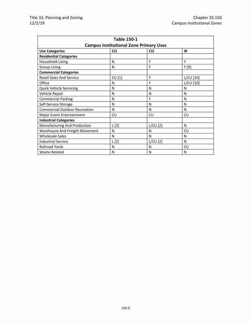
Title 33, Planning and Zoning Chapter 33.150 12/2/19 Campus Institutional Zones
150‐9
Table 150‐1 Campus Institutional Zone Primary Uses
Use Categories CI1 CI2 IR
Residential Categories
Household Living N Y Y
Group Living N Y Y [9]
Commercial Categories
Retail Sales And Service CU [1] Y L/CU [10]
Office N Y L/CU [10]
Quick Vehicle Servicing N N N
Vehicle Repair N N N
Commercial Parking N Y N
Self‐Service Storage N N N
Commercial Outdoor Recreation N N N
Major Event Entertainment CU CU CU
Industrial Categories
Manufacturing And Production L [2] L/CU [2] N
Warehouse And Freight Movement N N CU
Wholesale Sales N N N
Industrial Service L [2] L/CU [2] N
Railroad Yards N N CU
Waste‐Related N N N
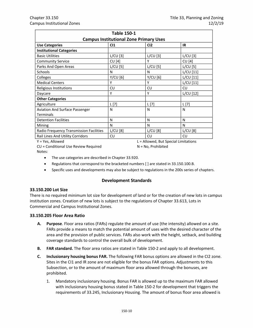
Chapter 33.150 Title 33, Planning and Zoning Campus Institutional Zones 12/2/19
150‐10
Table 150‐1 Campus Institutional Zone Primary Uses
Use Categories CI1 CI2 IR
Institutional Categories
Basic Utilities L/CU [3] L/CU [3] L/CU [3]
Community Service CU [4] Y CU [4]
Parks And Open Areas L/CU [5] L/CU [5] L/CU [5]
Schools N N L/CU [11]
Colleges Y/CU [6] Y/CU [6] L/CU [11]
Medical Centers Y Y L/CU [11]
Religious Institutions CU CU CU
Daycare Y Y L/CU [12]
Other Categories
Agriculture L [7] L [7] L [7]
Aviation And Surface Passenger Terminals
N N N
Detention Facilities N N N
Mining N N N
Radio Frequency Transmission Facilities L/CU [8] L/CU [8] L/CU [8]
Rail Lines And Utility Corridors CU CU CU
Y = Yes, Allowed CU = Conditional Use Review Required
L = Allowed, But Special Limitations N = No, Prohibited
Notes:
The use categories are described in Chapter 33.920.
Regulations that correspond to the bracketed numbers [ ] are stated in 33.150.100.B.
Specific uses and developments may also be subject to regulations in the 200s series of chapters.
Development Standards
33.150.200 Lot Size There is no required minimum lot size for development of land or for the creation of new lots in campus institution zones. Creation of new lots is subject to the regulations of Chapter 33.613, Lots in Commercial and Campus Institutional Zones.
33.150.205 Floor Area Ratio
A. Purpose. Floor area ratios (FARs) regulate the amount of use (the intensity) allowed on a site. FARs provide a means to match the potential amount of uses with the desired character of the area and the provision of public services. FARs also work with the height, setback, and building coverage standards to control the overall bulk of development.
B. FAR standard. The floor area ratios are stated in Table 150‐2 and apply to all development.
C. Inclusionary housing bonus FAR. The following FAR bonus options are allowed in the CI2 zone. Sites in the CI1 and IR zone are not eligible for the bonus FAR options. Adjustments to this Subsection, or to the amount of maximum floor area allowed through the bonuses, are prohibited.
1. Mandatory inclusionary housing. Bonus FAR is allowed up to the maximum FAR allowed with inclusionary housing bonus stated in Table 150‐2 for development that triggers the requirements of 33.245, Inclusionary Housing. The amount of bonus floor area allowed is
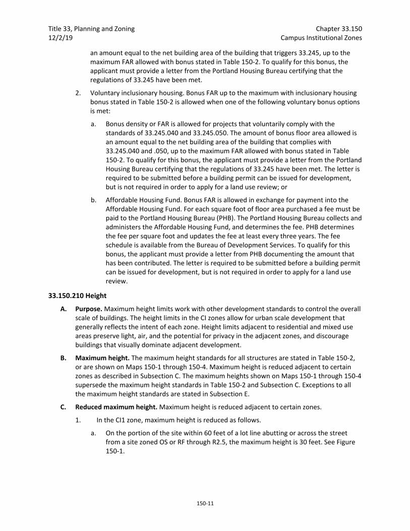
Title 33, Planning and Zoning Chapter 33.150 12/2/19 Campus Institutional Zones
150‐11
an amount equal to the net building area of the building that triggers 33.245, up to the maximum FAR allowed with bonus stated in Table 150‐2. To qualify for this bonus, the applicant must provide a letter from the Portland Housing Bureau certifying that the regulations of 33.245 have been met.
2. Voluntary inclusionary housing. Bonus FAR up to the maximum with inclusionary housing bonus stated in Table 150‐2 is allowed when one of the following voluntary bonus options is met:
a. Bonus density or FAR is allowed for projects that voluntarily comply with the standards of 33.245.040 and 33.245.050. The amount of bonus floor area allowed is an amount equal to the net building area of the building that complies with 33.245.040 and .050, up to the maximum FAR allowed with bonus stated in Table 150‐2. To qualify for this bonus, the applicant must provide a letter from the Portland Housing Bureau certifying that the regulations of 33.245 have been met. The letter is required to be submitted before a building permit can be issued for development, but is not required in order to apply for a land use review; or
b. Affordable Housing Fund. Bonus FAR is allowed in exchange for payment into the Affordable Housing Fund. For each square foot of floor area purchased a fee must be paid to the Portland Housing Bureau (PHB). The Portland Housing Bureau collects and administers the Affordable Housing Fund, and determines the fee. PHB determines the fee per square foot and updates the fee at least every three years. The fee schedule is available from the Bureau of Development Services. To qualify for this bonus, the applicant must provide a letter from PHB documenting the amount that has been contributed. The letter is required to be submitted before a building permit can be issued for development, but is not required in order to apply for a land use review.
33.150.210 Height
A. Purpose. Maximum height limits work with other development standards to control the overall scale of buildings. The height limits in the CI zones allow for urban scale development that generally reflects the intent of each zone. Height limits adjacent to residential and mixed use areas preserve light, air, and the potential for privacy in the adjacent zones, and discourage buildings that visually dominate adjacent development.
B. Maximum height. The maximum height standards for all structures are stated in Table 150‐2, or are shown on Maps 150‐1 through 150‐4. Maximum height is reduced adjacent to certain zones as described in Subsection C. The maximum heights shown on Maps 150‐1 through 150‐4 supersede the maximum height standards in Table 150‐2 and Subsection C. Exceptions to all the maximum height standards are stated in Subsection E.
C. Reduced maximum height. Maximum height is reduced adjacent to certain zones.
1. In the CI1 zone, maximum height is reduced as follows.
a. On the portion of the site within 60 feet of a lot line abutting or across the street from a site zoned OS or RF through R2.5, the maximum height is 30 feet. See Figure 150‐1.

Chapter 33.150 Title 33, Planning and Zoning Campus Institutional Zones 12/2/19
150‐12
b. On the portion of the site within 40 feet of a lot line abutting or across the street from a site zoned R3 through RMP or commercial/mixed use zones the maximum height is 45 feet. See Figure 150‐2.
2. CI2 zone.
a. Maximum height is reduced on sites in the CI2 zone that abut or are across the street from a site zoned OS, or RF through R2.5 as follows:
(1) On the portion of the site within 60 feet of a lot line abutting or across the street from a site zoned OS, or RF through R2.5, the maximum height is 30 feet. See Figure 150‐1.
(2) On the portion of the site that is more than 60 feet but within 130 feet of a lot line abutting or across the street from a site zoned OS, or RF through R2.5, the maximum height is 75 feet. See Figure 150‐1.
b. Maximum height is reduced on sites in the CI2 zone that abut or are across the street from a site zoned R3 through RMP, or commercial/mixed use zones as follows:
(1) On the portion of the site within 40 feet of a lot line abutting or across the street from a site zoned R2 through RMP, or commercial/mixed use zones, the maximum height is 45 feet. See Figure 150‐2.
(2) On the portion of the site more than 40 feet but within 110 feet of a lot line abutting or across the street from a site zoned R2 through RMP, or commercial/mixed use zones, the maximum height is 75 feet. See Figure 150‐2.
Figure 150‐1
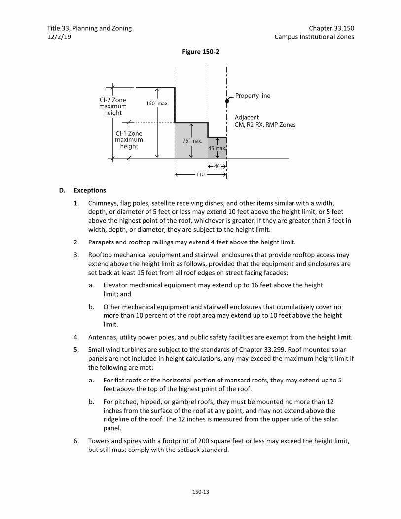
Title 33, Planning and Zoning Chapter 33.150 12/2/19 Campus Institutional Zones
150‐13
Figure 150‐2
D. Exceptions
1. Chimneys, flag poles, satellite receiving dishes, and other items similar with a width, depth, or diameter of 5 feet or less may extend 10 feet above the height limit, or 5 feet above the highest point of the roof, whichever is greater. If they are greater than 5 feet in width, depth, or diameter, they are subject to the height limit.
2. Parapets and rooftop railings may extend 4 feet above the height limit.
3. Rooftop mechanical equipment and stairwell enclosures that provide rooftop access may extend above the height limit as follows, provided that the equipment and enclosures are set back at least 15 feet from all roof edges on street facing facades:
a. Elevator mechanical equipment may extend up to 16 feet above the height limit; and
b. Other mechanical equipment and stairwell enclosures that cumulatively cover no more than 10 percent of the roof area may extend up to 10 feet above the height limit.
4. Antennas, utility power poles, and public safety facilities are exempt from the height limit.
5. Small wind turbines are subject to the standards of Chapter 33.299. Roof mounted solar panels are not included in height calculations, any may exceed the maximum height limit if the following are met:
a. For flat roofs or the horizontal portion of mansard roofs, they may extend up to 5 feet above the top of the highest point of the roof.
b. For pitched, hipped, or gambrel roofs, they must be mounted no more than 12 inches from the surface of the roof at any point, and may not extend above the ridgeline of the roof. The 12 inches is measured from the upper side of the solar panel.
6. Towers and spires with a footprint of 200 square feet or less may exceed the height limit, but still must comply with the setback standard.
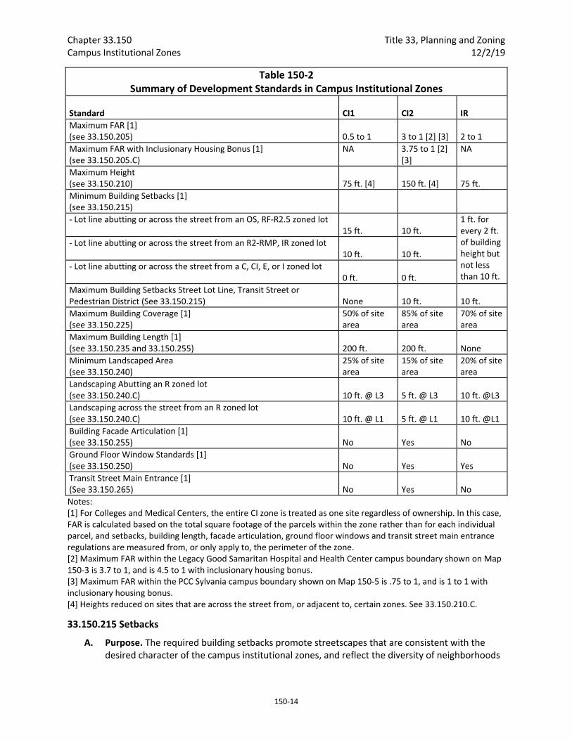
Chapter 33.150 Title 33, Planning and Zoning Campus Institutional Zones 12/2/19
150‐14
Table 150‐2 Summary of Development Standards in Campus Institutional Zones
Standard
CI1
CI2
IR
Maximum FAR [1] (see 33.150.205)
0.5 to 1
3 to 1 [2] [3]
2 to 1
Maximum FAR with Inclusionary Housing Bonus [1] (see 33.150.205.C)
NA 3.75 to 1 [2] [3]
NA
Maximum Height (see 33.150.210)
75 ft. [4]
150 ft. [4]
75 ft.
Minimum Building Setbacks [1] (see 33.150.215)
‐ Lot line abutting or across the street from an OS, RF‐R2.5 zoned lot 15 ft.
10 ft.
1 ft. for every 2 ft. of building height but not less than 10 ft.
‐ Lot line abutting or across the street from an R2‐RMP, IR zoned lot 10 ft.
10 ft.
‐ Lot line abutting or across the street from a C, CI, E, or I zoned lot 0 ft.
0 ft.
Maximum Building Setbacks Street Lot Line, Transit Street or Pedestrian District (See 33.150.215)
None
10 ft.
10 ft.
Maximum Building Coverage [1] (see 33.150.225)
50% of site area
85% of site area
70% of site area
Maximum Building Length [1] (see 33.150.235 and 33.150.255)
200 ft.
200 ft.
None
Minimum Landscaped Area (see 33.150.240)
25% of site area
15% of site area
20% of site area
Landscaping Abutting an R zoned lot (see 33.150.240.C)
10 ft. @ L3
5 ft. @ L3
10 ft. @L3
Landscaping across the street from an R zoned lot (see 33.150.240.C)
10 ft. @ L1
5 ft. @ L1
10 ft. @L1
Building Facade Articulation [1] (see 33.150.255)
No
Yes
No
Ground Floor Window Standards [1] (see 33.150.250)
No
Yes
Yes
Transit Street Main Entrance [1] (See 33.150.265)
No
Yes
No
Notes: [1] For Colleges and Medical Centers, the entire CI zone is treated as one site regardless of ownership. In this case, FAR is calculated based on the total square footage of the parcels within the zone rather than for each individual parcel, and setbacks, building length, facade articulation, ground floor windows and transit street main entrance regulations are measured from, or only apply to, the perimeter of the zone. [2] Maximum FAR within the Legacy Good Samaritan Hospital and Health Center campus boundary shown on Map 150‐3 is 3.7 to 1, and is 4.5 to 1 with inclusionary housing bonus. [3] Maximum FAR within the PCC Sylvania campus boundary shown on Map 150‐5 is .75 to 1, and is 1 to 1 with inclusionary housing bonus. [4] Heights reduced on sites that are across the street from, or adjacent to, certain zones. See 33.150.210.C.
33.150.215 Setbacks
A. Purpose. The required building setbacks promote streetscapes that are consistent with the desired character of the campus institutional zones, and reflect the diversity of neighborhoods
Title 33, Planning and Zoning Chapter 33.150 12/2/19 Campus Institutional Zones
150‐15
within which the campus institutional zones are located. In instances where a campus institutional zone abuts a residential zone, the required setbacks centers complement the residential character of surrounding neighborhood and result in development that will maintain light, air, and the potential for privacy for adjacent residential zones. In instances where a campus institutional zone abuts a mixed‐use zone, pedestrian district and/or transit street, the setback requirements promote buildings and activity that are inviting to pedestrians, and contribute to an active pedestrian environment.
B. Minimum building setbacks. The minimum building setback standards apply to all buildings and structures on the site. Minimum required building setbacks are stated in Table 150‐2, or are shown on Maps 150‐1 through 150‐5. Minimum building setbacks shown on Maps 150‐1 through 150‐‐5 supersede Table 150‐2. Exceptions to the minimum building setback standards are stated below:
1. Minor projections allowed. Minor features of a building, such as eaves, chimneys, fire escapes, water collection cisterns and planters, bay windows, uncovered stairways, wheelchair ramps, and uncovered decks or balconies, may project into a required building setback up to 20 percent of the depth of the setback. However, they may not be within 3 feet of a lot line. Bays and bay windows extending into the setback also must meet the following requirements:
a. Each bay and bay window may be up to 12 feet long, but the total area of all bays and bay windows on a building facade cannot be more than 30 percent of the area of the facade;
b. At least 30 percent of the area of the bay which faces the property line requiring the setback must be glazing or glass block;
c. Bays and bay windows must cantilever beyond the foundation of the building; and
d. The bay may not include any doors.
2. Full projection allowed. In addition to Paragraph 1 above, the following features are allowed to fully project into required building setbacks:
a. Canopies, marquees, awnings, and similar features may fully extend into a street setback;
b. Uncovered stairways and wheelchair ramps that lead to one entrance on the street‐facing facade of a building may fully extend into a street setback;
c. Uncovered decks and stairways that are no more than 2‐1/2 feet above the ground may fully extend into a required building setback; and
d. On lots that slope down from the street, vehicular and pedestrian entry bridges that are no more than 2‐1/2 feet above the average sidewalk elevation may fully extend into a required building setback.
3. Projections not allowed. Attached mechanical structures such as heat pumps, air conditioners, emergency generators, and water pumps are allowed in a street setback but not a required setback from an abutting residential zone.

Chapter 33.150 Title 33, Planning and Zoning Campus Institutional Zones 12/2/19
150‐16
C. Maximum building setbacks in the CI2 zone.
1. Where the building is within 100 feet a transit street or street lot line within a pedestrian district, the maximum the building can be set back is 10 feet. Where an existing building is being altered, the standard applies to the portion of the building being altered. If the site has street lot lines on three or more streets, the maximum setback standard only applies to two of the streets. When this occurs, the standard must be applied to the streets with the highest transit street classifications. If multiple streets have the same highest transit street classification, the applicant may choose which streets to apply the standard.
2. Exception. The maximum building setbacks do not apply to primary structures under 500 square feet in floor area, or to detached accessory structures. The street‐facing facades of detached accessory structures do not count towards meeting maximum setback standard.
D. Improvements within maximum building setbacks. At least 50 percent of the setback area between the street lot line and the portion of the building that complies with the maximum building setback must be hard surfaced for use by pedestrians. Residential buildings are exempt from this standard.
33.150.220 Building Coverage
A. Purpose. The building coverage standards limit the footprint of buildings and work with the FAR, height, and setback standards to control the overall scale of development. The standards promote development consistent with the desired character of the zone. In the CI1 zone, the standard promotes open spaces, both formal and informal, together with buildings at a scale that are compatible with surrounding single family residential development. In the CI2 zone the standards allow for buildings that represent an urban level of development and are consistent with adjacent mixed use zones.
B. Building coverage standards. The maximum building coverage covered structures are stated in Table 150‐2
33.150.235 Building Length in the CI1 Zone
A. Purpose. The maximum building length standard, along with the height and setback standard, limits the amount of bulk that can be placed close to the street. The standard assures that long building walls close to streets will be broken up into separate buildings. This will provide a feeling of transition from lower density development and help create the desired character of development in these zones.
B. Maximum building length. In the CI1 Zone, the maximum building length for the portion of buildings located within 30 feet of a street lot line is 200 feet. The portions of buildings subject to this standard must be separated by a minimum of 20 feet when located on the same site.
33.150.240 Landscaped Areas
A. Purpose. Landscaping is attractive and it helps to soften the effects of built and paved areas. Landscaping also helps cool the air temperature, intercept rainfall and reduce stormwater runoff by providing non‐paved permeable surface. Landscaping is required for all campus institutional zoned lands that abut or are across a street from residential zoned lands to provide buffering and promote the livability of the residential lands.
B. Minimum landscaped area. The required amount of landscaped areas is stated in Table 150‐2. Required landscaped areas must be at ground level and comply with at least the L1 standard as
Title 33, Planning and Zoning Chapter 33.150 12/2/19 Campus Institutional Zones
150‐17
stated in Chapter 33.248, Landscaping and Screening. However, up to one‐third of the required landscaped area may be improved for active or passive recreational use, or for use by pedestrians. Examples include walkways, play areas, plazas, picnic areas, and unenclosed recreational facilities. Any required landscaping, such as for required setbacks or parking lots, applies towards the landscaped area standard.
C. Landscaping required in minimum building setbacks. Landscaping is required in minimum building setbacks from lot lines abutting or across the street from a residential zoned lot. The depth and type of required landscaping are stated in Table 150‐2.
33.150.245 Trees Requirements for street trees and for on‐site tree preservation, protection, and overall tree density are specified in Title 11. See Chapter 11.50, Trees in Development Situations.
33.150.250 Ground Floor Windows in the CI2 Zone.
A. Purpose. In the CI2 Zone, blank walls on the ground level of buildings are limited in order to:
Provide a pleasant, rich, and diverse pedestrian experience by connecting activities occurring within a structure to adjacent sidewalk areas, or allowing public art at the ground level;
Encourage continuity of active street level uses;
Encourage surveillance opportunities by restricting fortress‐like facades at street level; and
Avoid a monotonous pedestrian environment.
B. Ground floor window standard. The following standards apply in the CI2 zone:
1. General standard.
a. Windows must cover at least 40 percent of the ground floor wall area of street‐facing facades that are 20 feet or closer to a street lot line or a publicly‐accessible plaza. For the purposes of this standard, ground floor wall areas include all exterior wall areas from 2 feet to 10 feet above the finished grade, and include openings in the walls of structured parking. See Figure 150‐3.

Chapter 33.150 Title 33, Planning and Zoning Campus Institutional Zones 12/2/19
150‐18
Figure 150‐3 Ground Floor Windows
b. If the lot has more than one street frontage, then the ground floor window standard in Subparagraph B.1.a. applies to the facade that faces the highest transit street classification. All other ground level street‐facing facades that are 20 feet or closer to the street lot line must have windows that cover 25 percent of the ground level wall area. The walls of structured parking along these facades may be set back at least 5 feet and landscaped to the L2 standard instead of providing 25 percent windows. If two or more streets have the same highest transit street classification, then the applicant may choose on which of those streets to meet the higher standard. Transit street classifications are identified in the Transportation Element of the Comprehensive Plan.
2. Exemptions:
a. Houses, attached houses, manufactured homes, and duplexes are exempt from this Section;
b. Ground floor street‐facing walls of dwelling units are exempt from Paragraph B.1., but the walls must meet one of the standards in Subsection D; and
c. If the portion of the ground floor wall area that is not a dwelling unit is less than 250 square feet in area, then it is exempt from this Section.
C. Qualifying window features. Required ground floor window areas must be windows that allow views into working areas, lobbies, residential units or residential building common areas; glazing in pedestrian entrances; or display windows that are at least 24 inches deep set into a wall. Windows into storage areas, vehicle parking areas, mechanical and utility equipment areas, garbage and recycling areas, and display cases attached to outside walls do not qualify. Windows into bicycle parking areas are allowed to qualify for up to 25 percent of the ground floor windows coverage requirement. Except for the windows of residential units and clerestory windows located above doors or other windows, the bottom of qualifying windows must be no more than 4 feet above the adjacent exterior grade.
Title 33, Planning and Zoning Chapter 33.150 12/2/19 Campus Institutional Zones
150‐19
D. Ground floor window and frontage standards for dwelling units. The ground floor wall area of street‐facing facades of dwelling units that are 20 feet or closer to a street lot line must meet at least one of the following standards:
1. Flexible ground floor design. The ground floor window standard of Subparagraph B.1.a. must be met, and the ground level of the building must be designed and constructed as follows:
a. The distance from the finished floor to the bottom of the ceiling structure above must be at least 12 feet. The bottom of the structure above includes supporting beams;
b. The area meeting this standard must be at least 25 feet deep, measured from the street‐facing facade; and
c. Each unit must include a front entrance that is located at the level of the finished grade and can be accessed without steps.
2. Front setback.
a. The portions of the building with residential dwelling units on the ground‐floor must be set back at least 5 feet from the street lot line. The setback must be landscaped to at least the L1 level and/or hard‐surfaced for use by pedestrians; and
b. Windows must cover at least 25 percent of the ground level wall area of the portion of the building with residential dwelling units on the ground‐floor.
3. Raised ground floor.
a. The portion of the building with residential dwelling units on the ground‐floor must have the finished floor of each residential unit at least 2 feet above the grade of the closest adjoining sidewalk.
b. Window must cover at least 25 percent of the ground level wall area of the portion of the building with residential dwelling units on the ground‐floor.

Chapter 33.150 Title 33, Planning and Zoning Campus Institutional Zones 12/2/19
150‐20
Figure 150‐4 Ground Floor Window Options
E. Exception for Public Art. Public art may be used to meet up to one half of the required window coverage of the ground floor window provision. Covenants for the public art will be required, following the regulations of Section 33.700.060, Covenants with the City, to ensure the installation, preservation, maintenance, and replacement of the public art. To qualify for this exception, documentation of approval by the Regional Arts and Culture Council must be provided prior to approval of the building permit.
33.150.255 Building Length and Facade Articulation in the CI2 Zone
A. Purpose. These standards, along with the height and setback standards, limit the bulk of buildings close to the street. These standards help ensure that large buildings will be divided into smaller components that relate to the scale and patterns of Portland’s commercial/mixed‐use areas and add visual interest and variety to the street environment.
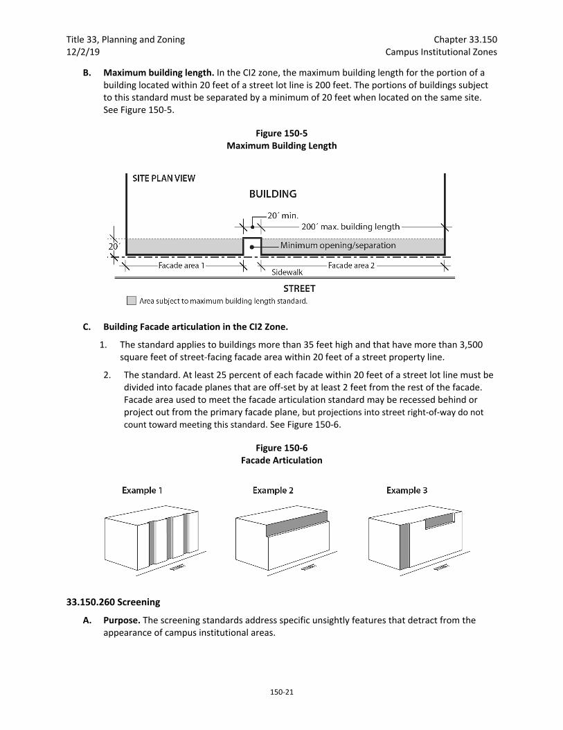
Title 33, Planning and Zoning Chapter 33.150 12/2/19 Campus Institutional Zones
150‐21
B. Maximum building length. In the CI2 zone, the maximum building length for the portion of a building located within 20 feet of a street lot line is 200 feet. The portions of buildings subject to this standard must be separated by a minimum of 20 feet when located on the same site. See Figure 150‐5.
Figure 150‐5 Maximum Building Length
C. Building Facade articulation in the CI2 Zone.
1. The standard applies to buildings more than 35 feet high and that have more than 3,500 square feet of street‐facing facade area within 20 feet of a street property line.
2. The standard. At least 25 percent of each facade within 20 feet of a street lot line must be divided into facade planes that are off‐set by at least 2 feet from the rest of the facade. Facade area used to meet the facade articulation standard may be recessed behind or project out from the primary facade plane, but projections into street right‐of‐way do not count toward meeting this standard. See Figure 150‐6.
Figure 150‐6 Facade Articulation
33.150.260 Screening
A. Purpose. The screening standards address specific unsightly features that detract from the appearance of campus institutional areas.

Chapter 33.150 Title 33, Planning and Zoning Campus Institutional Zones 12/2/19
150‐22
B. Garbage and recycling collection areas. All exterior garbage cans, garbage collection areas, and recycling collection areas must be screened from the street and any adjacent properties. Trash receptacles for pedestrian use are exempt. Screening must comply with at least the L3 or F2 standards of Chapter 33.248, Landscaping and Screening.
C. Mechanical equipment. Mechanical equipment located on the ground, such as heating or cooling equipment, pumps, or generators must be screened from the street and any abutting residential zones by walls, fences, or vegetation. Screening must comply with at least the L2 or F2 standards of Chapter 33.248, Landscaping and Screening, and be tall enough to screen the equipment. Mechanical equipment placed on roofs must be screened in one of the following ways, if the equipment is within 50 feet of an R zone:
1. A parapet along facades facing the R zone that is as tall as the tallest part of the equipment;
2. A screen around the equipment that is as tall as the tallest part of the equipment; or
3. The equipment is set back from roof edges facing the R zone 3 feet for each foot of height of the equipment.
33.150.265 Transit Street Main Entrance
A. Purpose. Locating the main entrance to a use on a transit street provides convenient pedestrian access between the use and public sidewalks and transit facilities, and so promotes walking and the use of transit.
B. Applicability.
1. Generally. All sites with at least one frontage on a transit street, and where any of the floor area on the site is in nonresidential uses, or residential use in a multi‐dwelling structure, must meet the following standards. If the site has frontage on more than one transit street, the standards of Subsection C must be met on at least one of the transit streets;
2. Houses, attached houses, manufactured homes, and duplexes. Houses, attached houses, manufactured homes, and duplexes must meet the standards of 33.130.250.C, Residential Main Entrance, instead of the requirements of this section.
C. Location. For portions of a building within the maximum building setback, at least one main entrance for each nonresidential tenant space on the ground floor, and one main entrance to a multi‐dwelling structure must meet the standards of this section. The ground floor is the lowest floor of the building that is within four feet of the adjacent transit street grade. The main entrance must:
1. Be within 25 feet of the transit street;
2. Allow pedestrians to both enter and exit the building; and
3. Meet one of the following:
a. Face the transit street;
b. Be at an angle of up to 45 degrees from the transit street, measured from the street property line, as shown in Figure 150‐7; or
c. If it is an entrance to a multi‐dwelling structure:
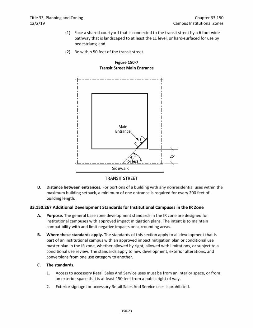
Title 33, Planning and Zoning Chapter 33.150 12/2/19 Campus Institutional Zones
150‐23
(1) Face a shared courtyard that is connected to the transit street by a 6 foot wide pathway that is landscaped to at least the L1 level, or hard‐surfaced for use by pedestrians; and
(2) Be within 50 feet of the transit street.
Figure 150‐7 Transit Street Main Entrance
D. Distance between entrances. For portions of a building with any nonresidential uses within the maximum building setback, a minimum of one entrance is required for every 200 feet of building length.
33.150.267 Additional Development Standards for Institutional Campuses in the IR Zone
A. Purpose. The general base zone development standards in the IR zone are designed for institutional campuses with approved impact mitigation plans. The intent is to maintain compatibility with and limit negative impacts on surrounding areas.
B. Where these standards apply. The standards of this section apply to all development that is part of an institutional campus with an approved impact mitigation plan or conditional use master plan in the IR zone, whether allowed by right, allowed with limitations, or subject to a conditional use review. The standards apply to new development, exterior alterations, and conversions from one use category to another.
C. The standards.
1. Access to accessory Retail Sales And Service uses must be from an interior space, or from an exterior space that is at least 150 feet from a public right of way.
2. Exterior signage for accessory Retail Sales And Service uses is prohibited.
Chapter 33.150 Title 33, Planning and Zoning Campus Institutional Zones 12/2/19
150‐24
3. The following subsections apply to development in the IR zone unless superseded by development standards in an approved impact mitigation plan or approved conditional use master plan:
a. 33.120.200 Housing Types Allowed;
b. 33.120.232 Street‐Facing Facades;
c. 33.120.240 Required Outdoor Areas; and
d. 33.120.255 Pedestrian Standards.
33.150.270 Exterior Display and Storage,
A. Purpose. The standards of this section are intended to assure that exterior display, storage, and work activities:
• Will be consistent with the desired character of the zone;
• Will not be a detriment to the overall appearance of a commercial area;
• Will not have adverse impacts on adjacent properties, especially those zoned residential; and
• Will not have an adverse impact on the environment.
B. Exterior display. Exterior display of goods is prohibited except for the display of plants and produce.
C. Exterior storage. Exterior storage is allowed when the following are met:
1. Exterior storage is limited to 10 percent of the site area; and
2. Exterior storage areas must be set back 10 feet from lot lines and the setback area must be landscaped to at least the L3 standard. Exterior storage areas located more than 100 feet from the perimeter of a College or Medical Center site are exempt from the landscape requirement. For colleges and medical centers, the entire CI zone is considered one site regardless of ownership.
D. Paving. All exterior display and storage areas, except for plant nurseries, must be paved.
33.150.275 Trucks and Equipment
A. Purpose. The parking and storage of trucks and equipment is regulated to ensure that it will be consistent with the desired character of the campus institutional zones, and to limit adverse effects on adjacent residential lands.
B. Truck and equipment parking standards. The standards for truck and equipment parking apply to business vehicles that are parked regularly at a site. The regulations do not apply to pick‐up and delivery activities, to the use of vehicles during construction, or to services at the site that occur on an intermittent and short term basis. The truck categories are defined in Chapter 33.910.
1. Light trucks. The parking of passenger vehicles, light trucks, and similar equipment is allowed in all campus institutional zone areas that comply with the development standards for auto parking areas.
2. Medium trucks. The parking of pickup trucks in the medium truck category is allowed in all campus institutional zones. The parking of all other medium trucks and similar equipment
Title 33, Planning and Zoning Chapter 33.150 12/2/19 Campus Institutional Zones
150‐25
is allowed only in the CI2 zone. Truck parking areas must comply with the development standards for auto parking areas.
3. Heavy trucks. The parking of heavy trucks and similar equipment is not allowed in any campus institutional zone.
33.150.277 Drive‐Through Facilities Drive‐through facilities are prohibited in the campus institutional zones.
33.150.280 Detached Accessory Structures
A. Purpose. These standards are intended to maintain separation and privacy for abutting residential zoned lots from nonresidential development.
B. General standards.
1. The regulations of this section apply to detached accessory structures.
2. The height and building coverage standards of the base zone apply to detached accessory structures.
C. Setbacks.
1. Uncovered accessory structures. Uncovered accessory structures such as flag poles, lamp posts, signs, antennas and dishes, mechanical equipment, uncovered decks, play structures, and tennis courts are allowed in a street setback, but not in a required setback from an abutting residential zone.
2. Covered structures.
a. Covered structures such as storage buildings, greenhouses, work shed, covered decks, and covered recreational structures are subject to the setbacks for buildings.
b. Water cisterns that are 6 feet or less in height are allowed in side and rear setbacks, including setbacks for abutting a residential zone.
33.150.285 Fences
A. Purpose. The fence regulations promote the positive benefits of fences without negatively impacting the community or endangering public or vehicle safety. Fences near streets are kept low in order to allow visibility into and out of the site and to ensure visibility for motorists. Fences in any required side or rear setback are limited in height so as to not conflict with the purpose for the setback.
B. Types of fences. The standards apply to walls, fences, and screens of all types whether open, solid, wood, metal, wire, masonry, or other material.
C. Location and heights.
1. Fences up to 8 feet high are allowed in required building setbacks except for required building setbacks along street lot lines or pedestrian connections. The following height limits apply to fences located within 10 feet of a street lot line or pedestrian connection. In the case of a college or medical center these limits apply to fences within 10 feet of all street lot lines or pedestrian connections within the zone.
Chapter 33.150 Title 33, Planning and Zoning Campus Institutional Zones 12/2/19
150‐26
a. Fences that are more than 50 percent sight‐obscuring may be up to 3‐1/2 feet high.
b. Fences that are 50 percent or less sight‐obscuring may be up to 8 feet high.
2. Fences in all other locations. The height for fences in locations other than described in Paragraphs C.1 and C.2 is the same as the regular height limits of the zone.
D. Reference to other regulations
1. Building permits. Building permits are required by BDS for certain fences pursuant to the building code.
2. Fence materials regulated by other bureaus. Electrified fences are regulated under Title 26, Electrical Regulations. The use of barbed wire is regulated under Title 24, Building Regulations.
33.150.290 Demolitions
A. Generally. Demolition on a site that requires a demolition permit is subject to the tree preservation and protection requirements of Title 11, Trees. See Chapter 11.50, Trees in Development Situations.
B. Historic resources. Demolition of a historic resource is regulated by Chapter 33.445, Historic Resource Overlay Zone.
C. Landscaping. Sites must be landscaped within 6 months of the demolition of buildings unless there is an approved development for the site. Approved development means a project approved through a land use review or building permit. The landscaping must meet at least the L1 standard of Chapter 33.248, Landscaping and Screening, except that no shrubs or trees are required.
33.150.295 Nonconforming Development Existing development that does not conform to the development standards of this chapter may be subject to the regulations of Chapter 33.258, Nonconforming Situations.
33.150.300 Parking, Loading, and Transportation and Parking Demand Management The standards pertaining to the minimum required and maximum allowed number of auto parking spaces, minimum required number of bicycle parking spaces, parking lot placement, parking lot setbacks, and landscaping are stated in Chapter 33.266, Parking, Loading, and Transportation and Parking Demand Management.
33.150.305 Signs The sign regulations are stated in Title 32, Signs and Related Regulations.
33.150.310 Superblock Requirements Development on land that includes vacated rights‐of‐way may be subject to the superblock standards of Chapter 33.293, Superblocks.
33.150.315 Recycling Areas Requirements for recycling areas are regulated by the Bureau of Planning and Sustainability. See Section 17.102.270, Businesses and Multifamily Complexes Required to Recycle, of the Portland City Code.

Title 33, Planning and Zoning Chapter 33.150 12/2/19 Campus Institutional Zones
150‐27
(Adopted by Ord. No. 188177, effective 5/24/18. Amended by Ord. No. 188958, effective 5/24/18; Ord. No. 189137, effective 8/22/18; Ord. No. 189488, effective 12/2/19.)

Chapter 33.150 Title 33, Planning and Zoning Campus Institutional Zones 12/2/19
150‐28
Title 33, Planning and Zoning Chapter 33.218 12/2/19 Community Design Standards
218‐1
33.218 Community Design Standards
218
Sections:
General 33.218.010 Purpose 33.218.015 Procedure
Standards 33.218.100 Standards for Primary and Attached Accessory Structures in Single‐Dwelling Zones 33.218.110 Standards for Primary and Attached Accessory Structures in R3, R2, R1, and
RMP Zones 33.218.120 Standards for Detached Accessory Structures in Single‐Dwelling, R3, R2, R1, and
RMP Zones 33.218.130 Standards for Exterior Alteration of Residential Structures in Single‐Dwelling, R3, R2,
R1, and RMP Zones 33.218.140 Standards for All Structures in RH, RX, C, CI, and E Zones 33.218.150 Standards for All Structures in I Zones
General
33.218.010 Purpose Design review and historic resource review ensure that development conserves and enhances the recognized special design values of a site or area, and promote the conservation, enhancement, and continued vitality of special areas of the City.
The Community Design Standards provide an alternative process to design review and historic resource review for some proposals. Where a proposal is eligible to use this chapter, the applicant may choose to go through the discretionary design review process set out in Chapter 33.825, Design Review, and Chapter 33.846, Historic Resource Reviews, or to meet the objective standards of this chapter. If the applicant chooses to meet the objective standards of this chapter, no discretionary review process is required.
The purpose of these standards is to:
A. Ensure that new development enhances the character and livability of Portland’s neighborhoods;
B. Ensure that increased density in established neighborhoods makes a positive contribution to the area's character;
C. Ensure the historic integrity of conservation landmarks and the compatibility of new development in conservation districts;
D. Enhance the character and environment for pedestrians in areas designated as design zones;
Chapter 33.218 Title 33, Planning and Zoning Community Design Standards 12/2/19
218‐2
E. Offer developers the opportunity to comply with specific objective standards as a more timely, cost effective, and more certain alternative to the design review and historic resource review process.
33.218.015 Procedure
A. Generally. This chapter provides an alternative to the design review process or historic resource review process for some proposals. Where a proposal is eligible to use this chapter, the applicant may choose to go through either the discretionary design review process set out in Chapter 33.825, Design Review, and Chapter 33.846, Historic Resource Reviews, or to meet the objective standards of this chapter. If the proposal meets the standards of this chapter, no design review or historic resource review is required. The standards determining which proposals are eligible to use this chapter are in Chapter 33.405, Alternative Design Density Overlay Zone; Chapter 33.420, Design Overlay Zone; Chapter 33.445, Historic Resource Overlay Zone; and Chapter 33.505, Albina Community Plan District.
The standards of this chapter do not apply to proposals reviewed through the discretionary design review processes set out in Chapter 33.825, Design Review, and Chapter 33.846, Historic Resource Reviews. Where a proposal is for an alteration or addition to existing development, the standards of this chapter apply only to the portion being altered or added.
B. Adjustments. Adjustments to these standards are prohibited.
C. Permit application requirements. The following information must be submitted as part of an application for a building or development permit:
1. Site plan and elevations. The site plan and elevations must include enough detail to document compliance with the standards of this chapter. The site plan and elevations must be drawn at a scale of 1/8 inch = 1 foot or larger.
2. Vicinity plan. For proposals in the Southwest Community Plan area, shown on Map 825‐4, and in conservation districts, a vicinity plan, drawn at a scale of 1 inch = 30 feet or larger, must show the following:
a. The footprint of the proposed development;
b. The lot lines of the site;
c. The footprints and front yard setbacks of all buildings on lots that abut each side of the site and are on the same street.
Standards
33.218.100 Standards for Primary and Attached Accessory Structures in Single‐Dwelling Zones The standards of this section apply to development of new primary and attached accessory structures in single‐dwelling zones.
A. Landscaping. Landscaping must be provided between structures and the street, as follows:
Title 33, Planning and Zoning Chapter 33.218 12/2/19 Community Design Standards
218‐3
1. Foundation landscaping. All street‐facing elevations must have landscaping along their foundation. The landscaped area may be along the outer edge of a porch instead of the foundation. This landscaping requirement does not apply to portions of the building facade that provide access for pedestrians or vehicles to the building. The foundation landscaping must meet the following standards:
a. The landscaped area must be at least 3 feet wide;
b. There must be at least one three‐gallon shrub for every 3 lineal feet of foundation; and
c. Ground cover plants must fully cover the remainder of the landscaped area; and
2. Front yard trees. There must be at least one tree in front of each residential structure. On corner lots, there must be one tree for each 30 feet of frontage on the side street.
B. Front setbacks in the Southwest Community Plan area and conservation districts. In the Southwest Community Plan area, shown on Map 825‐4, and in conservation districts, the setback for primary buildings is based on the setbacks of primary buildings on the lots that abut each side of the site and are on the same street. The primary structure may be no closer to the front lot line than the adjacent primary structure that is closest to the front lot line. The primary structure may be no further from the front lot line than the adjacent primary structure that is farthest from the front lot line. In any case, the structure may not be set back from the front lot line more than 25 feet.
C. Large building elevations divided into smaller areas. The front elevation of large structures must be divided into smaller areas or planes. When the front elevation of a structure is more than 500 square feet in area, the elevation must be divided into distinct planes of 500 square feet or less. For the purpose of this standard, areas of wall that are entirely separated from other wall areas by a projection, such as the porch or a roof over a porch, are also individual building wall planes. This division can by done by:
1. A porch, a dormer that is at least 4 feet wide, or a balcony that is at least 2 feet deep and is accessible from an interior room;
2. A bay window that extends at least 2 feet; or
3. Recessing a section of the facade by at least 2 feet; the recessed section must be at least 6 feet long.
D. Roofs.
1. Primary structures must have a roof that is either:
a. Sloped, with a pitch that is no flatter than 6/12 and no steeper than 12/12; or
b. No steeper than and no flatter than the pitch of the roofs of the primary structures on the lots that abut either side of the site and front onto the same street.
2. Flat roofs are allowed when the space on top of the roof is no more than 150 square feet and accessible from an interior room, or as specified in subparagraph D.1.b, above.

Chapter 33.218 Title 33, Planning and Zoning Community Design Standards 12/2/19
218‐4
E. Main entrance.
1. Location of main entrance. The main entrance of each primary structure must face the street. On corner lots the main entrance may face either of the streets or be oriented to the corner. For single dwelling, duplex, and triplex buildings that have more than one main entrance only one entrance must meet this requirement.
2. Front porch at main entrance. There must be a front porch at all main entrances that face a street. If the porch projects out from the building, it must have a roof. If the roof of a required porch is developed as a deck or balcony, it may be flat. If the main entrance is to a single dwelling, the covered area provided by the porch must be at least 48 square feet and a minimum of 8 feet wide. If the main entrance is to more than one dwelling unit, the covered area provided by the porch must be at least 63 square feet and a minimum of 9 feet wide.
3. Covered balcony. For attached houses, a covered balcony on the same facade as the main entrance may be provided instead of a front porch. The covered portion of the balcony must be at least 48 square feet and a minimum of 8 feet wide. The floor of the covered balcony must be no more than 15 feet above grade, and must be accessible from the interior living space of the house.
4. Ornamental columns. If the front porch or covered balcony at a main entrance provides columns as corner supports, the columns must be ornamental columns that meet one of the following standards. Wrought iron style porch supports do not meet this standard:
a. Large columns that are divided visually into clear areas of top, center, and bottom. Large rectilinear columns are at least 8" x 8", large rounded columns have a diameter of at least 8 inches; or
b. Groupings of 2, 3, or 4 small columns that are divided visually into clear areas of top, center, and bottom. Small rectilinear columns are at least 4" x 4", small rounded columns have a diameter of at least 4 inches.
5. Openings between porch floor and ground. Openings of more than 1 foot between the porch floor and the ground must be covered with a solid material or lattice.
F. Vehicle areas.
1. Alleys. If the site is served by an alley, access for motor vehicles must be from the alley, not from a street frontage.
2. Parking areas in the front setback. Parking areas may not be located in the front setback.
3. Vehicle areas between the porch and the street. Vehicle areas may not be located between the building’s porch or porches and an adjacent street.
4. Attached garages. When parking is provided in a garage attached to the primary structure, and garage doors face a street, the following standards must be met:
a. The garage must not be more than 40 percent of the length of the street‐facing facade or 12 feet long, whichever is greater;
Title 33, Planning and Zoning Chapter 33.218 12/2/19 Community Design Standards
218‐5
b. The front of the garage can be no closer to the front lot line than the front facade of the house;
c. Garage doors may be no more than 75 square feet in area; and
d. There may be no more than two individual garage doors.
5. Driveways. Driveways for attached houses must meet the following. See Figures 218‐1 and 218‐2 for examples of driveways that meet the standard.
a. Driveways may be paired so that there is a single curb‐cut providing access to two attached houses. The maximum width allowed for the paired driveway is 18 feet; and
b. There must be at least 18 feet between single or paired driveways. Distance between driveways is measured along the front property line.
G. Foundation material. Plain concrete block or plain concrete may be used as foundation material if the foundation material is not revealed more than 3 feet above the finished grade level adjacent to the foundation wall.
H. Exterior finish materials. The standards of this subsection must be met on all building facades.
1. Plain concrete block, plain concrete, corrugated metal, plywood, composite materials manufactured from wood or other products, and sheet pressboard may not be used as exterior finish material.
2. Composite boards manufactured from wood or other products, such as hardboard or hardplank, may be used when the board product is less than 6 inches wide.
3. Where wood products are used for siding, the siding must be shingles, or horizontal siding, not shakes.
4. Where horizontal siding is used, it must be shiplap or clapboard siding composed of boards with a reveal of 6 inches or less, or vinyl or aluminum siding that is in a clapboard or shiplap pattern where the boards in the pattern are 6 inches or less in width.
5. Siding material may not cover required window and door trim.

Chapter 33.218 Title 33, Planning and Zoning Community Design Standards 12/2/19
218‐6
Figure 218‐1 Paired Driveways for Attached Houses
I. Architectural features. Each primary structure must have one of the following features on the front street‐facing elevation:
1. Roof dormer placed a minimum of 3 feet from all the side building walls;
2. A porch roof with a gable end facing the street. The roof eaves of the porch must be the same height as the roof eaves of the building. The pitch of the porch roof must be between 6/12 and 12/12; or
3. A gable end facing the front lot line with one of the following in the gable area above the eave line:
a. A window; or
b. A trimmed vent. The trim must match the trim on the windows and the vent must be at least 4 square feet in area.
J. Windows. At least 15 percent of the area of a street‐facing facade must be windows. All street‐facing windows must meet the following. Windows in rooms with a finished floor height 4 feet or more below grade are exempt from this standard:
1. Each window must be square or vertical—at least as tall as it is wide; or
2. A horizontal window opening may be created when:
a. Two or more vertical windows are grouped together to provide a horizontal opening, and they are either all the same size, or no more than two sizes are used. Where two sizes of windows are used in a group, the smaller window size must be on the outer edges of the grouping. The windows on the outer edges of the grouping must be vertical; the center window or windows may be vertical, square, or horizontal; or
b. There is a band of individual lites across the top of the horizontal window. These small lites must be vertical and cover at least 20 percent of the total height of the window.

Title 33, Planning and Zoning Chapter 33.218 12/2/19 Community Design Standards
218‐7
Figure 218‐2 Single Driveways for Attached Houses
K. Trim. Trim must mark all building roof lines, porches, windows, and doors on all elevations. The trim must be at least 3‐1/2 inches wide. Buildings with an exterior material of stucco or masonry are exempt from this standard.
L. Exterior stairs and fire escapes. Exterior stairs, other than those leading to a main entrance, must be at least 40 feet from all streets. Fire escapes must be at least 40 feet from all streets.
M. Roof eaves. Roof eaves must project from the building wall at least 12 inches on all elevations.
N. Rooftop solar energy systems.
1. Rooftop solar energy systems must meet the following requirements:
a. On a flat roof. The solar energy system must be mounted flush or on racks, with the system or rack extending no more than 5 feet above the top of the highest point of the roof, not including the parapet. Solar energy systems must also be screened from the street by:
(1) An existing parapet along the street‐facing facade that is as tall as the tallest part of the solar energy system; or
(2) Setting the solar energy system back from the street‐facing roof edges. For each foot of height that the portion of the system projects above the parapet, or roofline when there is no parapet, the system must be set back 4 feet.
b. On a pitched roof. The plane of the system must be parallel with the roof surface, with the system no more than 12 inches from the surface of the roof at any point, and set back 3 feet from the roof edge and ridgeline.
2. Photovoltaic roofing shingles or tiles may be directly applied to the roof surface.
3. Photovoltaic glazing may be integrated into windows or skylights.

Chapter 33.218 Title 33, Planning and Zoning Community Design Standards 12/2/19
218‐8
O. Water cisterns. Above‐ground cisterns for rainwater or greywater collection meet the following:
1. Cisterns with a capacity of more than 80 gallons, or racks of cisterns with a total capacity of more than 80 gallons, may not be attached to the front facade of the primary structure; and
2. Cisterns must either:
a. Match the color of the adjacent building wall, the color of the trim, or the color of the rain gutter; or
b. Be screened by development, plantings, or fences so they are not visible from the street.
P. Additional standards for historic resources. The following standards are additional requirements for conservation districts and conservation landmarks.
1. Skylights. Skylights may not be on street‐facing elevations. On all other elevations, the glass, plastic, or other transparent material must be parallel to the slope of the roof.
2. Ornamental columns. Corners of the porch roof on street‐facing elevations must be supported with ornamental columns that meet one of the following standards. Wrought iron style porch supports do not meet this standard:
a. Large columns that are divided visually into clear areas of top, center, and bottom. Large rectilinear columns are at least 8" x 8", large rounded columns have a diameter of at least 8 inches; or
b. Groupings of 2, 3, or 4 small columns that are divided visually into clear areas of top, center, and bottom. Small rectilinear columns are at least 4" x 4", small rounded columns have a diameter of at least 4 inches.
3. Albina Community Plan area. The standards of this paragraph apply in the Albina Community Plan area, shown on Map 825‐1:
a. Floor level delineation. Each primary residential structure must reflect, on its street‐facing elevations, all floor levels in the building, including the attic. The different floor levels must be delineated through the use of porch roofs, changes in materials or texture of materials, location of pediment and roof lines, overhangs and setbacks.
b. Ground floor. The ground floor of a primary structure that is entirely above grade must be at least 2 feet above grade. Developments must meet the standards of Chapter 11, Accessibility, of the Oregon Structural Specialty Code.
4. Vertical building proportions in Eliot. In the Eliot Conservation District, the front facade of each primary structure must have vertical proportions. New development must meet one of the following standards:
a. It must be higher than it is wide; or
b. Where the size of the building requires horizontal proportions, the street‐facing elevations must be divided into visually distinct areas with vertical proportions.

Title 33, Planning and Zoning Chapter 33.218 12/2/19 Community Design Standards
218‐9
This is accomplished through setbacks, use of vertical elements such as columns or multi‐story bay windows, changes in materials or other architectural devices.
5. Historic setback pattern in Piedmont. In the Piedmont Conservation District, the front facades of primary structures must be set back exactly 25 feet from the front property line. On corner lots, this standard can be met on either frontage.
6. Woodlawn street pattern. Buildings may not be in the vacated portions of the angled street pattern in the Woodlawn Conservation District.
7. Rooftop solar energy systems.
a. Rooftop solar energy systems must not increase the footprint of the structure, must not increase the peak height of the roof, and the system must be parallel to the slope of the roof;
b. Solar energy systems may not be installed on a conservation landmark.
8. Photovoltaic glazing, roofing shingles, or tiles may not be installed on a conservation landmark.
9. Cisterns. Cisterns for rainwater or greywater collection may not be located closer to the street than the primary street‐facing building facade and they must be screened by development, plantings, or fences so they are not visible from the street.
33.218.110 Standards for Primary and Attached Accessory Structures in R3, R2, R1, and RMP Zones The standards of this section apply to development of new primary and attached accessory structures in the R3, R2, R1, and RMP zones. The addition of an attached accessory structure to a primary structure on a site where all the uses are residential, is subject to Section 33.218.130, Standards for Exterior Alteration of Residential Structures in Residential Zones.
The standards of this section can also apply to development of new structures in the RH, RX, C and E zones on sites where all the uses are residential. In this case, the applicant can choose to meet all the standards in this section or all the standards in Section 33.218.140, Standards for all Structures in the RH, RX, C and E Zones.
A. Landscaping. Landscaping must be provided between structures and the street, as follows:
1. Foundation landscaping. All street‐facing elevations must have landscaping along their foundation. The landscaped area may be along the outer edge of a porch instead of the foundation. This landscaping requirement does not apply to portions of the building facade that provide access for pedestrians or vehicles to the building. The foundation landscaping must meet the following standards:
a. The landscaped area must be at least 3 feet wide;
b. There must be at least one three‐gallon shrub for every 3 lineal feet of foundation; and
c. Ground cover plants must fully cover the remainder of the landscaped area.
2. Front yard trees. There must be at least one tree in front of each residential structure. On corner lots, there must be one tree for each 30 feet of frontage on the side street.
Chapter 33.218 Title 33, Planning and Zoning Community Design Standards 12/2/19
218‐10
B. Building setback. Primary buildings must not be set back from the front lot line more than 25 feet.
C. Residential buffer. Where a site zoned R1, RH, RX, C, or E abuts or is across a street from an RF through R2 or RMP zone, the following is required. Proposals in the Hollywood and Kenton plan districts, the Main Street Corridor Overlay Zone, and the Main Street Node Overlay Zone are exempt from this standard:
1. On sites that abut an RF through R2 or RMP zone the following must be met:
a. In the portion of the site within 25 feet of the lower density residential zone, the building height limits are those of the adjacent residential zone; and
b. A 10 foot deep area landscaped to at least the L3 standard must be provided along any lot line that abuts the lower density residential zone.
2. On sites across the street from an RF through R2 or RMP zone the following must be met:
a. On the portion of the site within 15 feet of the intervening street, the height limits are those of the lower density residential zone across the street; and
b. If the site is across a local service street from an RF through R2 or RMP zone, a 5‐foot deep area landscaped to at least the L2 standard must be provided along the property line across the local service street from the lower density residential zone. Vehicle access is not allowed through the landscaped area unless the site has frontage only on that local service street. Pedestrian and bicycle access is allowed, but may not be more than 6 feet wide.
D. Building height. Except as provided in Subsection C, above, structures in the RH, RX, and E zones may be up to 55 feet in height.
E. Large building elevations divided into smaller areas. The front elevation of large structures must be divided into smaller areas or planes. When the front elevation of a structure is more than 750 square feet in area, the elevation must be divided into distinct planes of 500 square feet or less. For the purpose of this standard, areas of wall that are entirely separated from other wall areas by a projection, such as the porch or a roof over a porch, are also individual building wall planes. This division can by done by:
1. A porch, a dormer that is at least 4 feet wide, or a balcony that is at least 2 feet deep and is accessible from an interior room;
2. A bay window that extends at least 2 feet; or
3. Recessing a section of the facade by at least 2 feet; the recessed section must be at least 6 feet long.
F. Roofs. Primary structures must have either:
1. A sloped roof with a pitch that is no flatter than 6/12 and no steeper than 12/12; or
2. A roof with a pitch of less than 6/12 if either:
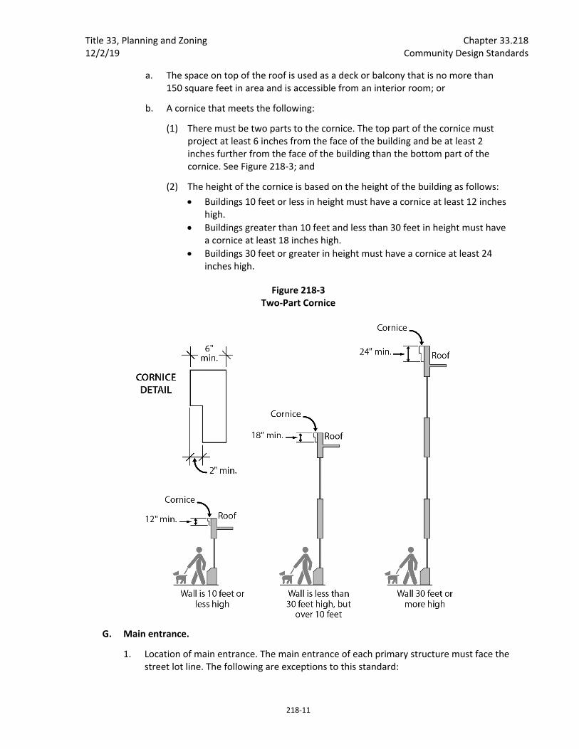
Title 33, Planning and Zoning Chapter 33.218 12/2/19 Community Design Standards
218‐11
a. The space on top of the roof is used as a deck or balcony that is no more than 150 square feet in area and is accessible from an interior room; or
b. A cornice that meets the following:
(1) There must be two parts to the cornice. The top part of the cornice must project at least 6 inches from the face of the building and be at least 2 inches further from the face of the building than the bottom part of the cornice. See Figure 218‐3; and
(2) The height of the cornice is based on the height of the building as follows:
Buildings 10 feet or less in height must have a cornice at least 12 inches high.
Buildings greater than 10 feet and less than 30 feet in height must have a cornice at least 18 inches high.
Buildings 30 feet or greater in height must have a cornice at least 24 inches high.
Figure 218‐3 Two‐Part Cornice
G. Main entrance.
1. Location of main entrance. The main entrance of each primary structure must face the street lot line. The following are exceptions to this standard:
Chapter 33.218 Title 33, Planning and Zoning Community Design Standards 12/2/19
218‐12
a. On corner lots the main entrance may face either of the streets or be oriented to the corner.
b. For buildings that have more than one main entrance, only one entrance must meet this requirement.
c. Entrances that face a shared landscaped courtyard, landscaped to at least the L1 General Landscaping standard, are exempt from this requirement.
2. Front porch at main entrance. There must be a front porch at all main entrances that face the street. If the porch projects out from the building it must have a roof. If the roof of a required porch is developed as a deck or balcony it may be flat. If the main entrance is to a single dwelling, the covered area provided by the porch must be at least 6 feet wide and 4 feet deep. If the main entrance is to more than one dwelling unit, the covered area provided by the porch must be at least 9 feet wide and 7 feet deep.
3. Covered balcony. Attached houses have the option of providing a covered balcony on the same facade as the main entrance instead of a front porch. The covered area provided by the balcony must be at least 48 square feet, a minimum of 8 feet wide and no more than 15 feet above grade. The covered balcony must be accessible from the interior living space of the house.
4. Ornamental columns. If the front porch or covered balcony at a main entrance provides columns as corner supports, the columns must be ornamental columns that meet one of the following standards. Wrought iron style porch supports do not meet this standard:
a. Large columns that are divided visually into clear areas of top, center, and bottom. Large rectilinear columns are at least 8" x 8", large rounded columns have a diameter of at least 8 inches; or
b. Groupings of 2, 3, or 4 small columns that are divided visually into clear areas of top, center, and bottom. Small rectilinear columns are at least 4" x 4", small rounded columns have a diameter of at least 4 inches.
5. Openings between porch floor and ground. Opening of more than 1 foot between the porch floor and the ground must be covered with a solid material or lattice.
H. Vehicle areas
1. Alleys. If the site is served by an alley, access for motor vehicles must be from the alley, not from a street frontage.
2. Vehicle areas between the building and the street. There are no vehicle areas allowed between the building and the street. If a site has two street lot lines, this standard must be met on both frontages. If a site has more than two street lot lines, this standard must be met on two frontages.
An exception is allowed for single dwelling developments. Each dwelling unit in a single dwelling development is allowed one 9 foot wide driveway.
Title 33, Planning and Zoning Chapter 33.218 12/2/19 Community Design Standards
218‐13
3. Parking areas in the front setback. Parking areas may not be located in the front setback.
4. Attached garages. When parking is provided in a garage attached to the primary structure and garage doors face a street the following standards must be met:
a. The garage must not be more than 40 percent of the length of the building frontage or 12 feet long, whichever is greater;
b. The front of the garage can be no closer to front lot line than the front facade of the house;
c. Garage doors that are part of the street‐facing elevations of a primary structure may be no more than 75 square feet in area; and
d. There may be no more than one garage door per 16 feet of building frontage.
5. Driveways. Driveways for attached houses must meet the following. See Figures 218‐1 and 218‐2 for examples of driveways that meet the standard.
a. Driveways may be paired so that there is a single curb‐cut providing access to two attached houses. The maximum width allowed for the paired driveway is 18 feet; and
b. There must be at least 18 feet between single or paired driveways. Distance between driveways is measured along the front property line.
I. Foundation material. Plain concrete block or plain concrete may be used as foundation material if the foundation material is not revealed more than 3 feet above the finished grade level adjacent to the foundation wall.
J. Exterior finish materials. The standards of this subsection must be met on all building facades.
1. Plain concrete block, plain concrete, corrugated metal, plywood, composite materials manufactured from wood or other products, and sheet pressboard may not be used as exterior finish material except as secondary finishes if they cover no more than 10 percent of each facade.
2. Composite boards manufactured from wood or other products, such as hardboard or hard plank, may be used when the board product is less than 6 inches wide.
3. Where wood products are used for siding, the siding must be shingles, or horizontal siding, not shakes.
4. Where horizontal siding is used, it must be shiplap or clapboard siding composed of boards with a reveal of 6 inches or less, or vinyl or aluminum siding which is in a clapboard or shiplap pattern where the boards in the pattern are 6 inches or less in width.
5. Siding material may not cover required window and door trim.

Chapter 33.218 Title 33, Planning and Zoning Community Design Standards 12/2/19
218‐14
K. Windows. Street‐facing windows must meet the following. Windows in rooms with a finished floor height 4 feet or more below grade are exempt from this standard:
1. Each window must be square or vertical;
2. A horizontal window opening may be created when:
a. Two or more vertical windows are grouped together to provide a horizontal opening, and they are either all the same size, or no more than two sizes are used. Where two sizes of windows are used in a group, the smaller window size must be on the outer edges of the grouping. The windows on the outer edges of the grouping must be vertical; the center window or windows may be vertical, square, or horizontal; or
b. There is a band of individual lites across the top of the horizontal window. These small lites must be vertical and cover at least 20 percent of the total height of the window.
3. St. Johns plan district. In the St. Johns plan district, at least 15 percent of the street facing facade must be windows. Windows used to meet this standard must allow views from the building to the street. Glass block does not meet this standard. Windows in garage doors do not count toward meeting this standard, but windows in garage walls do count toward meeting this standard. Development on flag lots or on lots that slope up or down from the street with an average slope of 20 percent or more is exempt from this standard.
L. Trim. Trim must mark all building roof lines, porches, windows and doors on all elevations. The trim must be at least 3‐1/2 inches wide. Buildings with an exterior material of stucco or masonry are exempt from this standard.
M. Roof‐mounted equipment. All roof‐mounted equipment, including satellite dishes and other communication equipment, must be screened in one of the following ways. Solar energy systems are subject to Subsection N below, and exempt from this standard:
1. A parapet as tall as the tallest part of the equipment;
2. A screen around the equipment that is as tall as the tallest part of the equipment;
3. The equipment is set back from the street‐facing perimeters of the building 4 feet for each foot of height of the equipment; or
4. If the equipment is a satellite dish or other communication equipment, it is added to the facade of a penthouse that contains mechanical equipment, is no higher than the top of the penthouse, is flush mounted, and is painted to match the facade of the penthouse.
N. Rooftop solar energy systems.
1. Rooftop solar energy systems must meet the following requirements:
a. On a flat roof. The solar energy system must be mounted flush or on racks, with the system or rack extending no more than 5 feet above the top of the highest
Title 33, Planning and Zoning Chapter 33.218 12/2/19 Community Design Standards
218‐15
point of the roof, not including the parapet. Solar energy systems must also be screened from the street by:
(1) An existing parapet along the street‐facing facade that is as tall as the tallest part of the solar energy system; or
(2) Setting the solar energy system back from the street‐facing roof edges. For each foot of height that the portion of the system projects above the parapet, or roofline when there is no parapet, the system must be set back 4 feet.
b. On a pitched roof. The plane of the system must be parallel with the roof surface, with the system no more than 12 inches from the surface of the roof at any point, and set back 3 feet from the roof edge and ridgeline.
2. Photovoltaic roofing shingles or tiles may be directly applied to the roof surface.
3. Photovoltaic glazing may be integrated into windows or skylights.
O. Exterior stairs and fire escapes. Exterior stairs, other than those leading to a main entrance, must be at least 40 feet from all streets. Fire escapes must be at least 40 feet from all streets.
P. Roof eaves. Roof eaves must project from the building wall at least 12 inches on all elevations. Buildings that take advantage of the cornice option are exempt from this standard.
Q. Water cisterns. Above‐ground cisterns for rainwater or greywater collection must meet the following:
1. Cisterns with a capacity of more than 80 gallons, or racks of cisterns with a total capacity of more than 80 gallons, may not be attached to the front facade of the primary structure; and
2. Cisterns must either:
a. Match the color of the adjacent building wall, the color of the trim, or the color of the rain gutter; or
b. Be screened by development, plantings, or fences so they are not visible from the street.
R. Additional standards for historic resources. The following standards are additional requirements for conservation districts and conservation landmarks.
1. Skylights. Skylights may not be on street‐facing elevations. On all other elevations, the glass, plastic, or other transparent material must be parallel to the slope of the roof.
2. Ornamental columns. Corners of the porch roof on street‐facing elevations must be supported with ornamental columns that meet one of the following standards. Wrought iron style porch supports do not meet this standard:
Chapter 33.218 Title 33, Planning and Zoning Community Design Standards 12/2/19
218‐16
a. Large columns that are divided visually into clear areas of top, center, and bottom. Large rectilinear columns are at least 8" x 8", large rounded columns have a diameter of at least 8 inches; or
b. Groupings of 2, 3, or 4 small columns that are divided visually into clear areas of top, center, and bottom. Small rectilinear columns are at least 4" x 4", small rounded columns have a diameter of at least 4 inches.
3. Roof dormers and gable areas in the Albina and Outer Southeast Community Plan areas. In the Albina and Outer Southeast Community Plan areas, shown on Maps 825‐1 and 825‐2, each residential structure must have one of the following for every 40 feet of length along the street‐facing elevations. Buildings with flat roofs are exempt from this standard:
a. A street‐facing roof dormer placed at least 3 feet from all side building walls; or
b. A gable end facing the front lot line with either of the following in the gable area above the eave line:
(1) A window; or
(2) A trimmed vent. The trim must match the trim on the windows and the vent must be at least 4 square feet in area.
4. Albina Community Plan area. The standards of this paragraph apply in the Albina Community Plan area, shown on Map 825‐1:
a. Floor level delineation. Each primary residential structure must reflect, on its street‐facing elevations, all floor levels in the building, including the attic. The different floor levels must be delineated through the use of porch roofs, changes in materials or texture of materials, location of pediment and roof lines, overhangs and setbacks.
b. Ground floor. The ground floor of a primary structure that is entirely above grade must be at least 2 feet above grade. Developments must meet the standards of Chapter 11, Accessibility, of the Oregon Structural Specialty Code.
5. Stone or cast stone foundations in Kenton and Mississippi. In the Kenton and Mississippi Avenue Conservation Districts, stone or cast stone must be used as a foundation material on street‐facing elevations. The stone, cast stone, or cast in place stone must be the material used between the finished building grade and the ground floor.
6. Vertical building proportions in Eliot. In the Eliot Conservation District, the front facade of each primary structure must have vertical proportions. New development must meet one of the following standards:
a. It must be higher than it is wide; or
b. Where the size of the building requires horizontal proportions, the street‐facing elevations must be divided into visually distinct areas with vertical proportions. This is accomplished through setbacks, use of vertical elements such as columns or multi‐story bay windows, changes in materials or other architectural devices.
Title 33, Planning and Zoning Chapter 33.218 12/2/19 Community Design Standards
218‐17
7. Woodlawn street pattern. Buildings may not be in the vacated portions of the angled street pattern in the Woodlawn Conservation District.
8. Rooftop solar energy systems.
a. Rooftop solar energy systems must not increase the footprint of the structure, must not increase the peak height of the roof, and the system must be parallel to the slope of the roof;
b. Solar energy systems may not be installed on a conservation landmark.
9. Cisterns. Cisterns for rainwater or greywater collection may not be located closer to the street than the primary street facing building facade and they must be screened by development, fences, or plantings so they are not visible from the street.
10. Photovoltaic glazing, roofing shingles, or tiles may not be installed on a conservation landmark.
33.218.120 Standards for Detached Accessory Structures in Single‐Dwelling, R3, R2, R1, and RMP Zones. The standards of this section are applicable to development of new detached accessory structures in single dwelling, R3, R2, R1, and RMP zones.
A. Foundation material. Plain concrete block or plain concrete may be used as foundation material if the foundation material is not revealed more than 3 feet above the finished grade level adjacent to the foundation wall.
B. Exterior finish materials. The standards of this subsection must be met on all building facades.
1. Plain concrete block, plain concrete, corrugated metal, plywood, composite materials manufactured from wood or other products, and sheet pressboard may not be used as exterior finish material.
2. Composite boards manufactured from wood or other products, such as hardboard or hardplank, may be used when the board product is less than 6 inches wide.
3. Where wood products are used for siding, the siding must be shingles, or horizontal siding, not shakes.
4. Where horizontal siding is used, it must be shiplap or clapboard siding composed of boards with a reveal 6 inches or less, or vinyl or aluminum siding that is in a clapboard or shiplap pattern where the boards in the pattern are 6 inches or less in width.
5. Siding material may not cover required window and door trim.
6. Compatible exterior finish materials. Exterior material type, size and placement on detached accessory structures must be the same as or visually match that of the primary structure. However, if the exterior finishes and materials on the primary structure do not meet the standards above then any material that meets the standards above may be used.
Chapter 33.218 Title 33, Planning and Zoning Community Design Standards 12/2/19
218‐18
C. Roof pitch. Where the accessory structure is more than 15 feet high, the roof pitch must be the same as the predominant roof slope of the primary structure.
D. Compatible trim. Trim on the accessory structure must be the same in type, size, and location as the trim that is used in the primary structure.
E. Compatible windows. Street‐facing windows must meet the following. Windows in rooms with a finished floor height 4 feet or more below grade are exempt from this standard:
1. Match those in the primary structure in proportion (relationship of width to height) and orientation (horizontal or vertical);
2. Be square or vertical—at least as tall as they are wide; or
3. A horizontal window opening may be created when:
a. Two or more vertical windows are grouped together to provide a horizontal opening, and they are either all the same size, or no more than two sizes are used. Where two sizes of windows are used in a group, the smaller window size must be on the outer edges of the grouping. The windows on the outer edges of the grouping must be vertical; the center window or windows may be vertical, square, or horizontal; or
b. There is a band of individual lites across the top of the horizontal window. These small lites must be vertical and cover at least 20 percent of the total height of the window.
F. Compatible roof eaves. Eaves must project from the building walls the same distance as the eaves on the primary structure.
G. Additional standards for large accessory structures.
1. Where these standards apply. The standards of this subsection apply to detached, accessory structures that:
a. Are more than 10 feet in height and at least one foot wide;
b. Have a street‐facing elevation more than 6 feet wide; or
c. Have a street‐facing elevation with more than 100 square feet in total surface area.
2. Setback. Large accessory structures must be set back at least 60 feet from the front lot line; and
3. Height. Large accessory structures must be no more than 25 feet in height.
H. Solar energy systems.
1. Solar energy systems on detached accessory buildings are subject to the same standards as would apply to new primary and attached accessory structures. See applicable solar standards in Sections 33.218.100 and .110.
2. Ground or pole mounted solar panels systems are subject to the following standards:
Title 33, Planning and Zoning Chapter 33.218 12/2/19 Community Design Standards
218‐19
a. The tallest part of the system may not exceed 8 feet in height;
b. The system may not be located closer to the street than the primary street‐facing building facade.
I. Water cisterns. Above‐ground cisterns for rainwater or greywater collection must meet the following:
1. Cisterns with a capacity of more than 80 gallons, or racks of cisterns with a total capacity of more than 80 gallons, may not be attached to the front facade of the primary structure; and
2. Cisterns must either:
a. Match the color of the adjacent building wall, the color of the trim, or the color of the rain gutter; or
b. Be screened by development, plantings, or fences or they are not visible from the street.
J. Additional standards for historic resources. The following standards are additional requirements for conservation districts and conservation landmarks.
1. Roof dormers. Where the structure is more than 20 feet in height, it must have a roof dormer. The dormer must be placed a minimum of 3 feet from the side building walls.
2. Columns and supporting pillars. Columns and supporting pillars on street‐facing elevations must meet one of the following standards. Wrought iron style supports do not meet this standard:
a. Large columns that are divided visually into clear areas of top, center, and bottom. Large rectilinear columns are at least 8" x 8", large rounded columns have a diameter of at least 8 inches.
b. Groupings of 2, 3 or 4 small columns that are divided visually into clear areas of top, center, and bottom. Small rectilinear columns are at least 4" x 4", small rounded columns have a diameter of at least 4 inches.
3. Woodlawn street pattern. No portion of a building may be located in the vacated portions of the angled street pattern in the Woodlawn Conservation District.
4. Cisterns. Cisterns for rainwater or greywater collection must be screened by development, fences, or plantings so they are not visible from the street.
5. Photovoltaic glazing, roofing shingles, or tiles may not be installed on a conservation landmark.
33.218.130 Standards for Exterior Alteration of Residential Structures in Single‐Dwelling, R3, R2, R1, and RMP Zones The standards of this section apply to exterior alterations of primary structures and both attached and detached accessory structures in residential zones. These standards apply to proposals where there will be only residential uses on the site.
Chapter 33.218 Title 33, Planning and Zoning Community Design Standards 12/2/19
218‐20
The standards of this section can also apply to exterior alterations in the RH, RX, C and E zones on sites where all the uses are residential. In this case, the applicant can choose to meet all the standards in this section or all the standards in Section 33.218.140, Standards for all Structures in the RH, RX, C and E Zones.
A. Foundation material. Plain concrete block or plain concrete may be used as foundation material if the foundation material is not revealed more than 3 feet above the finished grade level adjacent to the foundation wall.
B. Exterior finish materials. The standards of this subsection must be met on all building facades. The exterior finish materials on the portion of the building being altered or added must visually match the appearance of those on the existing building. However, if the existing exterior finish materials do not meet the following standards, then they must be replaced on the portion being altered or added with materials that meet the following standards.
1. Plain concrete block, plain concrete, corrugated metal, plywood, composite materials manufactured from wood or other products, and sheet pressboard may not be used as exterior finish material.
2. Composite boards manufactured from wood or other products, such as hardboard or hardplank, may be used when the board product is less than 6 inches wide.
3. Where wood products are used for siding, the siding must be shingles, or horizontal siding, not shakes.
4. Where horizontal siding is used, it must be shiplap or clapboard siding composed of boards with a reveal of 6 inches or less, or vinyl or aluminum siding that is in a clapboard or shiplap pattern where the boards in the pattern are 6 inches or less in width.
5. Siding material may not cover required window and door trim.
C. Compatible trim. Trim on edges of elements in the remodeled area must be the same in type, size, and location as the trim used on the rest of the structure.
D. Compatible windows. Street‐facing windows must meet one of the following standards. Windows in rooms with a finished floor height 4 feet or more below grade are exempt from these standards:
1. Match those in the primary structure in proportion (relationship of width to height) and orientation (horizontal or vertical); or
2. Be square or vertical—at least as tall as they are wide.
3. A horizontal window opening may be created when:
a. Two or more vertical windows are grouped together to provide a horizontal opening, and they are either all the same size, or no more than two sizes are used. Where two sizes of windows are used in a group, the smaller window size must be on the outer edges of the grouping. The windows on the outer edges of the grouping must be vertical; the center window or windows may be vertical, square, or horizontal; or
Title 33, Planning and Zoning Chapter 33.218 12/2/19 Community Design Standards
218‐21
b. There is a band of individual lites across the top of the horizontal window. These small lites must be vertical and cover no more than one‐third of the total height of the window.
E. Rooftop solar energy systems.
1. Rooftop solar energy systems must meet the following requirements:
a. On a flat roof. The solar energy system must be mounted flush or on racks, with the system or rack extending no more than 5 feet above the top of the highest point of the roof, not including the parapet. Solar energy systems must also be screened from the street by:
(1) An existing parapet along the street‐facing facade that is as tall as the tallest part of the solar energy system; or
(2) Setting the solar energy system back from the street‐facing roof edges. For each foot of height that the portion of the system projects above the parapet, or roofline when there is no parapet, the system must be set back 4 feet.
b. On a pitched roof. The plane of the system must be parallel with the roof surface, with the system no more than 12 inches from the surface of the roof at any point, and set back 3 feet from the roof edge and ridgeline.
2. Photovoltaic roofing shingles or tiles may be directly applied to the roof surface.
3. Photovoltaic glazing may be integrated into windows or skylights.
F. Water cisterns. Above‐ground cisterns for rainwater or greywater collection meet the following:
1. Cisterns with a capacity of more than 80 gallons, or racks of cisterns with a total capacity of more than 80 gallons, may not be attached to the front facade of the primary structure; and
2. Cisterns must either:
a. Match the color of the adjacent building wall, the color of the trim, or the color of the rain gutter; or
b. Be screened by development, plantings, or fences so they are not visible from the street.
G. Additional standards for historic resources. The following standards are additional requirements for conservation districts and conservation landmarks.
1. Building features to be retained. The following building features on street‐facing elevations must be retained. Building features that are not original to the building are exempt from this standard:
a. Doors;
b. Windows;
Chapter 33.218 Title 33, Planning and Zoning Community Design Standards 12/2/19
218‐22
c. Porches;
d. Balconies;
e. Bay windows; and
f. Dormers.
2. Porch enclosures. No portion of the front porch may be enclosed.
3. Columns and supporting pillars. Columns and supporting pillars on street‐facing elevations must meet one of the following standards. Wrought iron style supports do not meet this standard:
a. Large columns that are divided visually into clear areas of top, center, and bottom. Large rectilinear columns are at least 8" x 8", large rounded columns have a diameter of at least 8 inches.
b. Groupings of 2, 3 or 4 small columns that are divided visually into clear areas of top, center, and bottom. Small rectilinear columns are at least 4" x 4", small rounded columns have a diameter of at least 4 inches.
4. Historic setback pattern in Piedmont. In the Piedmont Conservation District, the front facades of primary structures in single‐dwelling zones must be set back exactly 25 feet from the front property line.
5. Woodlawn street pattern. No portion of a building may be located in the vacated portions of the angled street pattern in the Woodlawn Conservation District.
6. Rooftop solar energy systems.
a. Rooftop solar energy systems in conservation districts must not increase the footprint of the structure, must not increase the peak height of the roof, and the system must be parallel to the slope of the roof;
b. Solar energy systems may not be installed on a conservation landmark.
7. Cisterns. Cisterns for rainwater or greywater collection may not be located closer to the street than the primary street‐facing building facade and they must be screened by development, plantings, or fences so they are not visible from the street.
8. Photovoltaic glazing, roofing shingles, or tiles may not be installed on a conservation landmark.
33.218.140 Standards for All Structures in the RH, RX, C, CI, and E Zones The standards of this section apply to development of all structures in RH, RX, C, CI, and E zones. These standards also apply to exterior alterations in these zones.
Applicants for development of new structures on sites where the uses are all residential can choose to meet all the standards of this section or all the standards of Section 33.218.110. Applicants for exterior alterations on sites where the uses are all residential can choose to meet all the standards of this section or all the standards of Section 33.218.130.
Title 33, Planning and Zoning Chapter 33.218 12/2/19 Community Design Standards
218‐23
A. Building placement and the street. Landscaping, an arcade, or a hard‐surfaced expansion of the pedestrian path must be provided between a structure and the street. All street‐facing elevations must meet one of the following options.
Structures built to the street lot line are exempt from the requirements of this subsection. Where there is more than one street lot line, only those frontages where the structure is built to the street lot line are exempt from the requirements of this subsection.
1. Foundation landscaping option. All street‐facing elevations must have landscaping along their foundation. This landscaping requirement does not apply to portions of the building facade that provide access for pedestrians or vehicles to the building. The foundation landscaping must meet the following standards:
a. The landscaped area must be at least 3 feet wide;
b. There must be at least one three‐gallon shrub for every 3 lineal feet of foundation; and
c. Ground cover plants must fully cover the remainder of the landscaped area.
2. Arcade option. All street‐facing elevations must have an arcade that meets the following requirements:
a. The arcade must be at least 6 feet deep between the front elevation and the parallel building wall;
b. The arcade must consist of openings that are at least 6 feet wide and that run the full length of the street facing elevation;
c. The arcade elevation facing a street must be at least 14 feet in height and at least 25 percent solid, but no more than 50 percent solid; and
d. The arcade must be open to the air on three sides; none of the arcade's street facing or end openings may be blocked with walls, glass, lattice, glass block or any other material.
3. Hard‐surface sidewalk extension option. The area between the building and the street lot line must be hard‐surfaced for use by pedestrians as an extension of the sidewalk:
a. The building walls may be set back no more than 10 feet from the street lot line; and
b. For each 100 square feet of hard‐surface area between the building and the street lot line at least one of the following amenities must be provided. Structures built within 2 feet of the street lot line are exempt from the requirements of this subparagraph:
(1) A bench or other seating;
(2) A tree;

Chapter 33.218 Title 33, Planning and Zoning Community Design Standards 12/2/19
218‐24
(3) A landscape planter;
(4) A drinking fountain; or
(5) A kiosk.
c. Bicycle parking may be located in the area between a building and a street lot line.
B. Improvements between buildings and pedestrian oriented streets.
1. Where the ground floor of a building is in commercial or residential uses, and the building has frontage on a transit street or City Walkway, or is in a Pedestrian District, the following standards must be met. Proposals required to meet this standard are exempt from the requirements of Subsection 33.218.140.A, Building Placement and the Street:
a. A building wall that faces a transit street or City Walkway, or is in a Pedestrian District, must meet the base zone maximum street setback along 100 percent of the street lot line. Where no maximum street setback is specific in the base zone, the maximum street setback is 10 feet. Where the site has two frontages that are on a transit street or City Walkway, or is in a Pedestrian District, this standard must be met on both frontages. Where there are more than two such frontages, this standard must be met on any two frontages;
b. The area between the building and an adjacent transit street, City Walkway, or street in a Pedestrian District, must be hard‐surfaced for use by pedestrians as an extension of the sidewalk. Where the ground floor is in residential use, the area adjacent to the dwelling unit may be landscaped to an L1 standard of Chapter 33.248, Landscaping and Screening; and
c. For each 100 square feet of hard‐surface area between the building and the street lot line at least one of the following amenities must be provided. Structures built within 2 feet of the street lot line are exempt from the requirements of this subparagraph.
(1) A bench or other seating;
(2) A tree;
(3) A landscape planter;
(4) A drinking fountain; or
(5) A kiosk.
d. Bicycle parking may be located in the area between a building and a street lot line when the area is hard‐surfaced.
C. Reinforce the corner. On sites within a Pedestrian District or with at least two frontages on the corner where two City Walkways meet:
Title 33, Planning and Zoning Chapter 33.218 12/2/19 Community Design Standards
218‐25
1. The primary structures must be within 10 feet of both street lot lines. Where a site has more than one corner, this requirement must be met on only one corner;
2. At least one of the street‐facing walls must be at least 40 feet long;
3. The highest point of the building's street‐facing elevations must be within 25 feet of the corner;
4. A main entrance must be on a street‐facing wall and either at the corner, or within 25 feet of the corner; and
5. There is no parking within 40 feet of the corner.
D. Residential buffer. Where a site zoned RH, RX, CI, or E abuts or is across a street from an RF through R2 zone, the following is required. Proposals in the Hollywood, Kenton, and Sandy Boulevard plan districts are exempt from this standard:
1. On sites that abut an RF through R2 zone the following must be met:
a. In the portion of the site within 25 feet of the lower density residential zone, the building height limits are those of the adjacent residential zone; and
b. A 10‐foot deep area landscaped to at least the L3 standard must be provided along any lot line that abuts the lower density residential zone.
2. On sites across the street from an RF through R2 zone the following must be met:
a. On the portion of the site within 15 feet of the intervening street, the height limits are those of the lower density residential zone across the street; and
b. If the site is across a local service street from an RF through R2 zone, a 5‐foot deep area landscaped to at least the L2 standard must be provided along the property line across the local service street from the lower density residential zone. Vehicle access is not allowed through the landscaped area unless the site has frontage only on that local service street. Pedestrian and bicycle access is allowed, but may not be more than 6 feet wide.
E. Building height.
1. Maximum height in RH, RX, CI, C, and E zones.
a. Generally. Structures in the RH, RX, CI, C, and E zones may be up to 55 feet in height where allowed by the base zone;
b. Where a site zoned RH, RX or E abuts or is across a street from an RF through R2 zone, the maximum height is reduced as specified in Subsection D, above;
c. New and replacement antennas are exempt from this standard if the antennas are located on an existing monopole, and the antennas do not project above the height of the monopole.
2. Minimum height. In C and E zones, primary buildings must be at least 16 feet in height.
Chapter 33.218 Title 33, Planning and Zoning Community Design Standards 12/2/19
218‐26
F. Main entrance.
1. Location of main entrance. The main entrance of the primary structure must face the street lot line. Where there is more than one street lot line, the entrance may face either of them or the corner. For residential developments there are the following exceptions:
a. For buildings that have more than one main entrance only one entrance must meet this requirement.
b. Entrances that face a shared landscaped courtyard, landscaped to at least the L1 General Landscaping standard, are exempt from this requirement.
2. Front porch at main entrances to residential. There must be a front porch at the main entrance to residential portions of a development, if the main entrance faces a street. If the porch projects out from the building it must have a roof. If the roof of a required porch is developed as a deck or balcony it may be flat. If the main entrance is to a single dwelling unit, the covered area provided by the porch must be at least 6 feet wide and 4 feet deep. If the main entrance is to more than one dwelling unit, the covered area provided by the porch must be at least 9 feet wide and 7 feet deep.
G. Vehicle areas.
1. Access to vehicle areas and adjacent residential zones. Access to vehicle areas must be at least 20 feet from any adjacent residential zone.
2. Parking lot coverage. No more than 50 percent of the site may be used for vehicle areas.
3. Vehicle area screening. Where vehicle areas are across a local service street from an R1, RH, or RX zone, there must be a 6 foot wide landscaped area along the street lot line that meets the L3 standard of Chapter 33.248, Landscaping and Screening. Vehicle areas across a local service street from an RF through R2 zone are subject to the standards of Subsection D., Residential Buffer, above.
H. Foundation material. Plain concrete block or plain concrete may be used as foundation material if the foundation material is not revealed more than 3 feet above the finished grade level adjacent to the foundation wall. This subsection does not apply to sites in the EX zone within the St. Johns plan district.
I. Exterior finish materials.
1. The standards of this paragraph must be met on all building facades.
a. Plain concrete block, plain concrete, corrugated metal, plywood, composite materials manufactured from wood or other products, sheet pressboard, and horizontal shiplap or clapboard siding may not be used except as secondary finishes if they cover no more than 10 percent of each facade.
b. Exception for sites in the EX zone within the St. Johns plan district. Plain concrete block, plain concrete, and corrugated metal are permitted as exterior finish materials in the EX zone in the St. Johns plan district.

Title 33, Planning and Zoning Chapter 33.218 12/2/19 Community Design Standards
218‐27
2. Compatible exterior finish materials. Where there is an exterior alteration to an existing building, the exterior finish materials on the portion of the building being altered or added must visually match the appearance of those on the existing building. However, if the exterior finish materials on the existing building do not meet the standards of Paragraph I.1, any material that meets the standards of Paragraph I.1 may be used.
J. Roof‐mounted equipment. All roof‐mounted equipment, including satellite dishes and other communication equipment, must be screened in one of the following ways. Solar energy systems are subject to paragraph K below, and exempt from this standard:
1. A parapet as tall as the tallest part of the equipment;
2. A screen around the equipment that is as tall as the tallest part of the equipment;
3. The equipment is set back from the street‐facing perimeters of the building 4 feet for each foot of height of the equipment; or
4. If the equipment is a satellite dish or other communication equipment, it is added to the facade of a penthouse that contains mechanical equipment, is no higher than the top of the penthouse, is flush mounted, and is painted to match the facade of the penthouse.
K. Rooftop solar energy systems.
1. Rooftop solar energy systems must meet the following requirements:
a. On a flat roof. The solar energy system must be mounted flush or on racks, with the system or rack extending no more than 5 feet above the top of the highest point of the roof, not including the parapet. Solar energy systems must also be screened from the street by:
(1) An existing parapet along the street‐facing facade that is as tall as the tallest part of the solar energy system; or
(2) Setting the solar energy system back from the street‐facing roof edges. For each foot of height that the portion of the system projects above the parapet, or roofline when there is no parapet, the system must be set back 4 feet.
b. On a pitched roof. The plane of the system must be parallel with the roof surface, with the system no more than 12 inches from the surface of the roof at any point, and set back 3 feet from the roof edge and ridgeline.
2. Photovoltaic roofing shingles or tiles may be directly applied to the roof surface.
3. Photovoltaic glazing may be integrated into windows or skylights.
4. Ground pole mounted solar energy systems are subject to the following additional standard: On sites that abut an RF through R2 zone, the system must be set back one foot for every one foot of height, from the lot line abutting the RF through R2 zone.
L. Water cisterns. Above‐ground cisterns for rainwater or greywater collection meet the following:

Chapter 33.218 Title 33, Planning and Zoning Community Design Standards 12/2/19
218‐28
1. Cisterns with a capacity of more than 80 gallons, or racks of cisterns with a total capacity of more than 80 gallons, may not be attached to the front facade of the primary structure; and
2. Cisterns must either
a. Match the color of the adjacent building wall, the color of the trim, or the color of the rain gutter; or
b. Be screened by development, plantings, or fences so they are not visible from the street.
M. Ground floor windows. Street‐facing elevations must meet the Ground Floor Windows Standards of the C zone. As an alternative to providing ground floor windows, proposals in E zones may provide public art if the following conditions are met:
1. The area of the ground level wall that is covered by the art must be equal to the area of window that would have been required;
2. The artist and the specific work or works of art must be approved by the Portland Regional Arts and Cultural Council; and
3. The art must be composed of permanent materials permanently affixed to the building. Acceptable permanent materials include metal, glass, stone and fired ceramics.
N. Distinct ground floor. This standard applies to buildings that have any floor area in non‐residential uses. The ground level of the primary structure must be visually distinct from upper stories. This separation may be provided by:
1. A cornice above the ground level;
2. An arcade;
3. Changes in material or texture; or
4. A row of clerestory windows on the building's street facing elevation.
O. Roofs. Buildings must have either:
1. A sloped roof with a pitch no flatter than 6/12; or
2. A roof with a pitch of less than 6/12 and a cornice that meets the following:
a. There must be two parts to the cornice. The top part of the cornice must project at least 6 inches from the face of the building and be at least 2 inches further from the face of the building than the bottom part of the cornice. See Figure 218‐3; and
b. The height of the cornice is based on the height of the building as follows:
(1) Buildings 10 feet or less in height must have a cornice at least 12 inches high.

Title 33, Planning and Zoning Chapter 33.218 12/2/19 Community Design Standards
218‐29
(2) Buildings greater than 10 feet and less than 30 feet in height must have a cornice at least 18 inches high.
(3) Buildings 30 feet or greater in height must have a cornice at least 24 inches high.
P. Base of buildings. Buildings must have a base on all street‐facing elevations. The base must be at least 2 feet above grade and be distinguished from the rest of the building by a different color or material.
Q. Additional standards for historic resources. The following standards are additional requirements for conservation districts and conservation landmarks.
1. Zero setbacks. For structures where none of the floor area is in residential use, no setback is permitted from the street lot line. Sites that have more than one street lot line must meet this standard along two street lot lines.
2. Exterior siding.
a. Where wood products are used for siding, the siding must be shingles, or horizontal siding, not shakes.
b. Where horizontal siding is used, it must be shiplap or clapboard siding composed of wooden boards with a reveal of 3 to 6 inches, or vinyl or aluminum siding that is in a clapboard or shiplap pattern where the boards in the pattern are 6 inches or less in width.
c. The siding material may not cover the window and door trim.
3. Building features to be retained. In RH zones the following building features on street‐facing elevations must be retained. Building features that are not original to the building are exempt from this standard:
a. Entrances;
b. Front porches;
c. Balconies;
d. Bay windows; and
e. Dormers.
4. Ground level glass. All glass in ground level street‐facing windows and doors must be clear or ornamental stained glass. Restrooms may have reflective or opaque glass.
5. Clerestory windows. There must be clerestory windows above all windows and doors on the ground floor of street‐facing elevations of buildings or parts of buildings with commercial uses.
6. Parapets. Flat roofs must be surrounded by a parapet at least 18 inches in height.
7. Arched windows in Russell Street. In the Russell Street Conservation District, all top floor windows on street‐facing elevations must have an arch at the top of their window framing.

Chapter 33.218 Title 33, Planning and Zoning Community Design Standards 12/2/19
218‐30
8. Red brick in Russell Street. In the Russell Street Conservation District, street‐facing elevations must be red brick or a combination of block (basalt or cast stone) and red brick. Up to 20 percent of the facade may be stone or precast concrete.
9. Cast stone in Kenton. In the Kenton Conservation District new buildings in commercial/mixed use zones must have cast stone on their street facing elevations. At least 50 percent of the total exterior wall surface of these elevations must be cast stone.
10. Wood facades in Woodlawn. In the Woodlawn Conservation District, commercial buildings and commercial portions of mixed use buildings must have wood as their exterior finish material on their street facing elevations.
11. Facade height in Russell Street, Woodlawn, and Piedmont. In the Russell Street, Woodlawn and Piedmont Conservation Districts, the street‐facing elevations of commercial and mixed use buildings must be at least 20 feet in height.
12. Woodlawn street pattern. Buildings may not be in the vacated portions of the angled street pattern in the Woodlawn Conservation District.
13. Rooftop solar energy systems.
a. Rooftop solar energy systems in conservation districts must not increase the footprint of the structure, must not increase the peak height of the roof, and the system must be parallel to the slope of the roof;
b. Solar energy systems may not be installed on a conservation landmark.
14. Photovoltaic glazing, roofing shingles, or tiles may not be installed on a conservation landmark.
33.218.150 Standards for I Zones The standards of this section apply to development of all structures in the I zones. These standards also apply to exterior alterations in these zones.
A. Building placement and the street. Landscaping, an arcade, or a hard‐surfaced expansion of the pedestrian path must be provided between a structure and the street. All street‐facing elevations must meet one of the following options.
Structures built to the street lot line are exempt from the requirements of this subsection. Where there is more than one street lot line, only those frontages where the structure is built to the street lot line are exempt from the requirements of this paragraph.
1. Foundation landscaping option. All street‐facing elevations must have landscaping along their foundation. The landscaped area may be along the outer edge of a porch instead of the foundation. This landscaping requirement does not apply to portions of the building facade that provide access for pedestrians or vehicles to the building. The foundation landscaping must meet the following standards:
a. The landscaped area must be at least 3 feet wide;
b. There must be at least one three‐gallon shrub for every 3 lineal feet of foundation; and
Title 33, Planning and Zoning Chapter 33.218 12/2/19 Community Design Standards
218‐31
c. Ground cover plants must fully cover the remainder of the landscaped area.
2. Arcade option. All street‐facing elevations must have an arcade that meets the following requirements:
a. The arcade must be at least 6 feet deep between the front elevation and the parallel building wall;
b. The arcade must consist of openings that are at least 6 feet wide and which run the full length of the street facing elevation;
c. The arcade elevation facing a street must be at least 14 feet in height and at least 25 percent solid, but no more than 50 percent solid; and
d. The arcade must be open to the air on three sides; none of the arcade's street facing or end openings may be blocked with walls, glass, lattice, glass block or any other material.
3. Hard‐surface sidewalk extension option. The area between the building and the street lot line must be hard‐surfaced for use by pedestrians as an extension of the sidewalk.
a. The building walls may be set back no more than 10 feet from the street lot line; and
b. For each 100 square feet of hard‐surface area between the building and the street lot line at least one of the following amenities must be provided. Structures built within 2 feet of the street lot line are exempt from the requirements of this subparagraph.
(1) A bench or other seating;
(2) A tree;
(3) A landscape planter;
(4) A drinking fountain; or
(5) A kiosk.
B. Landscape coverage. On sites outside conservation districts, at least 15 percent of the total site area must be landscaped. Other required landscaping may count toward this requirement.
C. Reinforce the corner. On sites within a Pedestrian District or with at least two frontages on the corner where two City Walkways meet:
1. The primary structures must be within 10 feet of both street lot lines. Where a site has more than one corner, this requirement must be met on only one corner;
2. At least one of the street‐facing walls must be at least 40 feet long;
3. The highest point of the building's street‐facing elevations must be within 25 feet of the corner;

Chapter 33.218 Title 33, Planning and Zoning Community Design Standards 12/2/19
218‐32
4. A main entrance must be on a street‐facing wall and either at the corner, or within 25 feet of the corner; and
5. There is no parking within 40 feet of the corner.
D. Pedestrian standards. Buildings that include any non‐residential uses and are on a transit street or City Walkway, or within a Pedestrian District must meet the pedestrian standards of the Employment Zones.
E. Vehicle areas.
1. Parking between building and street. There may be only one double‐loaded aisle of parking between the building and any street.
2. Parking lot coverage. No more than 50 percent of the site may be used for vehicle areas.
F. Foundation material. Plain concrete block or plain concrete may be used as foundation material if the foundation material is not revealed more than 3 feet above the finished grade level adjacent to the foundation wall.
G. Exterior finish materials. The standards of this subsection must be met on all building facades:
1. Plain concrete block, plain concrete, corrugated metal, plywood, composite materials manufactured from wood or other products, sheet pressboard, and horizontal shiplap or clapboard siding may not be used except as secondary finishes if they cover no more than 10 percent of each facade.
2. Compatible exterior finish materials. Where there is an exterior alteration to an existing building, the exterior finish materials on the portion of the building being altered or added must visually match the appearance of those on the existing building. However, if the exterior finish materials on the existing building do not meet the standards of Paragraph G.1, any material that meets the standards of Paragraph G.1 may be used.
H. Roof‐mounted equipment. All roof‐mounted equipment, including satellite dishes and other communication equipment, must be screened in one of the following ways. Solar energy systems are subject to Subsection K below, and exempt from standard of this subsection:
1. A parapet as tall as the tallest part of the equipment;
2. A screen around the equipment that is as tall as the tallest part of the equipment;
3. The equipment is set back from the street‐facing perimeters of the building 4 feet for each foot of height of the equipment; or
4. If the equipment is a satellite dish or other communication equipment, it is added to the facade of a penthouse that contains mechanical equipment, is no higher than the top of the penthouse, is flush mounted, and is painted to match the facade of the penthouse.
Title 33, Planning and Zoning Chapter 33.218 12/2/19 Community Design Standards
218‐33
I. Rooftop solar energy systems.
1. Rooftop solar energy systems must meet the following requirements:
a. On a flat roof. The solar energy system must be mounted flush or on racks, with the system or rack extending no more than 5 feet above the top of the highest point of the roof, not including the parapet. Solar energy systems must also be screened from the street by:
(1) An existing parapet along the street‐facing facade that is as tall as the tallest part of the solar energy system; or
(2) Setting the solar energy system back from the street‐facing roof edges. For each foot of height that the portion of the system projects above the parapet, or roofline when there is no parapet, the system must be set back 4 feet.
b. On a pitched roof. The plane of the system must be parallel with the roof surface, with the system no more than 12 inches from the surface of the roof at any point, and set back 3 feet from the roof edge and ridgeline.
2. Photovoltaic roofing shingles or tiles may be directly applied to the roof surface.
3. Photovoltaic glazing may be integrated into windows or skylights.
4. Ground or pole mounted solar energy systems are subject to the following additional standards:
a. On sites that abut an RF through R2 zone, the system must be set back one food for every one foot of height, from the lot line abutting the RF through R2 zone;
b. The system may not be located closer to the street than the portion of the street‐facing facade that is closest to the street.
J. Ground floor windows. All street‐facing elevations of a development must meet the Ground Floor Windows Standards of the EX zone. As an alternative to providing ground floor windows, a project may provide public art if the following conditions are met:
1. The area of the ground level wall that is covered by the art must be equal to the area of window that would have been required;
2. The artist and the specific work or works of art must be approved by the Portland Regional Arts and Cultural Council; and
3. The art must be composed of permanent materials permanently affixed to the building. Acceptable permanent materials include metal, glass, stone and fired ceramics.
K. Large building elevations divided into smaller areas. When the front elevation of a structure is more than 1,500 square feet in area, the elevation must be divided into distinct planes of 750 square feet or less. For the purpose of this standard, areas of wall that are entirely separated from other wall areas by a projection, such as the porch or a roof over a porch, are also individual building wall planes. This division can be done by:
Chapter 33.218 Title 33, Planning and Zoning Community Design Standards 12/2/19
218‐34
1. Incorporating fascias, canopies, arcades, or other multidimensional design features to break up large wall surfaces on their street facing elevations; or
2. Setting part of the facade back at least three feet from the rest of the facade.
L. Additional standards for historic resources. The following standards are additional requirements for conservation districts and conservation landmarks.
1. Zero setbacks. No setback is permitted from the street lot line. Sites that have more than one street lot line must meet this standard along two street lot lines.
2. Distinct ground floor. The ground level of the primary structure must be visually distinct from upper stories. This separation is provided by:
a. A cornice above the ground level;
b. An arcade;
c. Changes in material or texture; or
d. A row of clerestory windows on the building's street facing elevation.
3. Ground level glass. All glass in ground level street‐facing windows and doors must be clear or ornamental stained glass. Restrooms may have reflective or opaque glass.
4. Clerestory windows. There must be clerestory windows above all windows and doors on the ground floor of street‐facing elevations of buildings or parts of buildings with commercial uses.
5. Parapets. Flat roofs must be surrounded by a parapet at least 18 inches in height.
6. Arched windows in Russell Street. In the Russell Street Conservation District, all top floor windows on street‐facing elevations must have an arch at the top of their window framing.
7. Red brick in Russell Street. In the Russell Street Conservation District, street‐facing elevations must be red brick or a combination of block (basalt or cast stone) and red brick. Up to 20 percent of the facade may be stone or precast concrete.
8. Facade height in Russell Street. In the Russell Street Conservation District, the street‐facing elevations of commercial and mixed use buildings must be at least 20 feet in height.
9. Rooftop solar energy systems.
a. Rooftop solar energy systems in conservation districts must not increase the footprint of the structure, must not increase the peak height of the roof, and the system must be parallel to the slope of the roof;
b. Solar energy systems may not be installed on a conservation landmark.
10. Photovoltaic glazing, roofing shingles, or tiles may not be installed on a conservation landmark.

Title 33, Planning and Zoning Chapter 33.218 12/2/19 Community Design Standards
218‐35
(Added by Ord. No. 171589, effective 11/1/97. Amended by: Ord. No. 174263, effective 4/15/00; Ord. No. 174325, effective 5/5/00; Ord. No. 175210, effective 1/26/01; Ord. No. 175204, effective 3/1/01; Ord. No. 175837, effective 9/7/01; Ord. Nos. 175965 and 176333, effective 7/1/02; Ord. No. 176469, effective 7/1/02; Ord. No. 177028, effective 12/14/02; Ord. No. 177422, effective 6/7/03; Ord. No. 178172, effective 3/5/04; Ord. No. 178452, effective 7/10/04; Ord. No. 181357, effective 11/9/07; Ord. No. 182429, effective 1/16/09; Ord. No. 183598, effective 4/24/10; Ord. No. 184016, effective 1/2/11; Ord. No. 184842, effective 9/2/11; Ord. No. 185915, effective 5/1/13; Ord. No. 186639, effective 7/11/14; Ord. No. 187216, effective 7/24/15; Ord. No. 188177, effective 5/24/18; Ord. No. 188958, effective 5/24/18; Ord. No. 189137, effective 8/22/18; Ord. No. 189488, effective 12/2/19.)

Chapter 33.218 Title 33, Planning and Zoning Community Design Standards 12/2/19
218‐36
Title 33, Planning and Zoning Chapter 33.415 5/24/18 Centers Main Street Overlay Zone
415‐1
33.415 Centers Main Street Overlay Zone
415
Sections:
General 33.415.010 Purpose 33.415.020 Short Name and Map Symbol 33.415.030 Where These Regulations Apply
Use Regulations 33.415.100 Prohibited Uses 33.415.200 Required Ground Floor Active Use
Development Regulations 33.415.300 Prohibited Development 33.415.310 Minimum Floor Area Ratio 33.415.320 Maximum Building Setbacks 33.415.330 Location of Vehicle Areas 33.415.340 Ground Floor Windows 33.415.350 Entrances 33.415.410 Additional Use and Development Standards in the CM1 Zone
General
33.415.010 Purpose The Centers Main Street overlay zone encourages a mix of commercial, residential and employment uses on the key main streets within town centers and neighborhood centers identified in the Comprehensive Plan. The regulations are intended to encourage a continuous area of shops and services, create a safe and pleasant pedestrian environment, minimize conflicts between vehicles and pedestrians, support hubs of community activity, and foster a dense, urban environment with development intensities that are supportive of transit.
33.415.020 Short Name and Map Symbol The Centers Main Street overlay zone is shown on the Zoning Map with an "m" map symbol.
33.415.030 Where These Regulations Apply The regulations of this chapter apply to sites in the Centers Main Street overlay zone.
Use Regulations
33.415.100 Prohibited Uses The following uses are prohibited within 100 feet of a transit street:
A. Quick Vehicle Servicing; and
B. Self‐Service Storage.

Chapter 33.415 Title 33, Planning and Zoning Centers Main Street Overlay Zone 5/24/18
415‐2
33.415.200 Required Ground Floor Active Use Within 100 feet of a transit street, at least 25 percent of the ground level floor area must be in one of the following active uses. Only uses allowed in the base zone may be chosen:
A. Retail Sales and Service;
B. Office;
C. Industrial Service;
D. Manufacturing and Production;
E. Community Service;
F. Daycare;
G. Religious Institutions;
H. Schools;
I. Colleges. If a College use is provided to meet this regulation, the floor area must be in one or more of the following functions: lobby; library; food service; theatre; meeting area; or
J. Medical Centers. If a Medical Center use is provided to meet this regulation, the floor area must be in one or more of the following functions: lobby; waiting room; food service; out‐patient clinic.
Development Regulations
33.415.300 Prohibited Development The following development is prohibited within 100 feet of a transit street:
A. Drive‐through facilities; and
B. Houses, attached houses, and duplexes.
33.415.310 Minimum Floor Area Ratio
A. In the Inner Pattern Area the minimum floor area ratio (FAR) for all new development is 0.5 to 1. Pattern areas are shown on Map 415‐1.
B. In the Eastern and Western Pattern Area the minimum floor area ratio (FAR) for all new development is 0.25 to 1. Pattern areas are shown on Map 415‐1.
33.415.320 Maximum Building Setback In the Inner Pattern Area, at least 70 percent of the length of the ground level street‐facing facade of the building must meet the maximum building setback standard of the base zone. If the site has three or more block frontages, this standard only applies to two frontages. In the case of sites with three or more block frontages, the two frontages subject to this standard are those with the highest transit street classifications. If multiple streets have the same highest transit street classification, the applicant may choose on which streets to meet the standard. Pattern areas are shown on Map 415‐1.

Title 33, Planning and Zoning Chapter 33.420 12/2/19 Design Overlay Zone
420‐1
33.420 Design Overlay Zone
420
Sections: 33.420.010 Purpose 33.420.020 Map Symbol 33.420.021 Applying the Design Overlay Zone 33.420.025 Where These Regulations Apply 33.420.130 Neighborhood Contact 33.420.041 When Design Review is Required 33.420.045 Exempt From Design Review 33.420.051 Design Guidelines 33.420.055 When Community Design Standards May Be Used 33.420.060 When Community Design Standards May Not Be Used
Map 420‐1 Design Districts and Subdistricts in the Central City and South Auditorium Plan Districts
Map 420‐2 Macadam Design District
Map 420‐3 Terwilliger Design District
Map 420‐4 Sellwood‐Moreland Design District
Map 420‐5 Marquam Hill Design District
Map 420‐6 Gateway Design District
33.420.010 Purpose The Design Overlay Zone promotes the conservation, enhancement, and continued vitality of areas of the City with special scenic, architectural, or cultural value. The Design Overlay Zone also promotes quality high‐density development adjacent to transit facilities. This is achieved through the creation of design districts and applying the Design Overlay Zone as part of community planning projects, development of design guidelines for each district, and by requiring design review or compliance with the Community Design Standards. In addition, design review or compliance with the Community Design Standards ensures that certain types of infill development will be compatible with the neighborhood and enhance the area.
33.420.020 Map Symbol The Design Overlay Zone is shown on the Official Zoning Maps with a letter "d" map symbol.
33.420.021 Applying the Design Overlay Zone The Design Overlay Zone is applied to areas where design and neighborhood character are of special concern. Application of the Design Overlay Zone must be accompanied by adoption of design guidelines, or by specifying which guidelines will be used.
Many applications of the Design Overlay Zone shown on the Official Zoning Maps are referred to as design districts. A design district may be divided into subdistricts. Subdistricts are created when an area within a design district has unique characteristics that require special consideration and additional design guidelines. The location and name of each design district and subdistrict is shown on maps 420‐1 through 420‐6 at the end of this chapter.

Chapter 33.420 Title 33, Planning and Zoning Design Overlay Zone 12/2/19
420‐2
Other applications of the Design Overlay Zone shown on the Official Zoning Maps are not specific design districts. Some are adopted as part of a community planning project, and some are applied automatically when zoning is changed to CX, CM3, EX, RX, or IR.
33.420.025 Where These Regulations Apply The regulations of this chapter apply to all design overlay zones. Design review may also be a requirement of a plan district, other overlay zone, or as a condition of approval of a quasi‐judicial decision.
33.420.030 Neighborhood Contact Neighborhood contact is a set of outreach steps that must be taken before certain developments can be submitted for approval. Neighborhood contact is required as follows:
A. When the proposed development will add at least 10,000 square feet of net building area to a site, the neighborhood contact step of 33.705.020.C., Neighborhood contact III, are required.
B. If the proposed development has already met the neighborhood contact requirements as part of a land use review process, it is exempt from the neighborhood contact requirements.
33.420.041 When Design Review is Required Unless exempted by Section 33.420.045, Exempt From Design Review, design review is required for the following:
A. New development;
B. Exterior alterations to existing development, including changes to exterior color when the existing color was specifically required by a design review approval;
C. Nonstandard improvements in the public right‐of‐way such as street lights, street furniture, planters, public art, sidewalk and street paving materials, and landscaping. Nonstandard improvements in the public right‐of‐way must receive prior approval from the City Engineer prior to applying for design review. Improvements that meet the City Engineer’s standards are exempt from design review;
D. Items identified in the Citywide Policy on Encroachments in the Public Right‐of‐Way or Title 17, Public Improvements, as requiring design review;
E. Removal of trees in the South Auditorium plan district;
F. Exterior signs larger than 32 square feet, except in the South Auditorium plan district, where all signs are subject to design review;
G. Where City Council requires design review of a proposal because it is considered to have major design significance to the City. In these instances, the City Council will provide design guidelines by which the proposal will be reviewed, and specify the review procedure;
H. Proposals using one of the provisions of the a, Alternative Design Density Overlay Zone, specified in Sections 33.405.040 through .080;

Title 33, Planning and Zoning Chapter 33.420 12/2/19 Design Overlay Zone
420‐3
I. Proposals in the Albina Community plan district using the provisions of Section 33.505.220, Parking Requirement Reduction, or Section 33.505.230, Attached Residential Infill on Vacant Lots in R5‐Zoned Areas;
J. Floating structures, except individual houseboats; and
K. In the Marquam Hill plan district, proposals to develop or improve formal open area required by Chapter 33.555. This includes designating existing open areas as formal open areas.
33.420.045 Exempt From Design Review The following items are exempt from design review:
A. If the site is a Historic or Conservation Landmark, or in a Historic or Conservation District, it is instead subject to the regulations for historic resource review as set out in Chapter 33.445, Historic Resource Overlay Zone;
B. Repair, maintenance, and replacement with comparable materials or the same color of paint;
C. Within the Terwilliger Design District, development that will not be visible from Terwilliger Boulevard;
D. Alterations to residential structures in RF through R1 zones, where the alterations are valued at $10,000 or less;
E. Skylights;
F. Development associated with Rail Lines And Utility Corridors uses;
G. Exterior activities and development for Agriculture uses;
H. Modifications to a structure to meet the Americans With Disabilities Act's requirements in C, E, I, and CI zones;
I. Development associated with Parks and Open Areas uses that do not require a conditional use review;
J. Proposals where a building or sign permit is not required;
K. Development in the IR zone, including alterations, that is not located within the boundaries of an approved Impact Mitigation Plan;
L. Parking lot landscaping that meets the development standards of this Title;
M. Rooftop mechanical equipment and associated ductwork, other than radio frequency transmission facilities, that is added to the roof of an existing building if the following are met:
1. The area where the equipment will be installed must have a pitch of 1/12 or less;
2. No more than 8 mechanical units are allowed, including both proposed and existing units;
Chapter 33.420 Title 33, Planning and Zoning Design Overlay Zone 12/2/19
420‐4
3. The proposed mechanical equipment must be set back at least 4 feet from the edge of the roof for every 1 foot of height of the equipment above the roof surface or top of parapet; and
4. The proposed equipment must have a matte finish or be painted to match the roof.
N. Rooftop vents installed on roofs if the vent and associated elements such as pipes, conduits and covers meet the following:
1. The area where the vent and associated elements will be installed must have a pitch of 1/12 or less;
2. The proposed vent and associated elements must not be more than 30 inches high and no larger than 18 inches in width, depth, or diameter;
3. The proposed vent and associated elements must be set back at least 4 feet from the edge of the rooftop for every 1 foot of height above the roof surface or top of parapet; and
4. The proposed vent and associated elements must have a matte finish or be painted to match the roof.
O. Radio frequency transmission facilities for personal wireless services that meet the following:
1. The antennas are added to the facade of an existing penthouse that contains mechanical equipment provided the antennas are no higher than the top of the penthouse, are flush mounted, and are painted to match the facade of the penthouse; and
2. Rooftop accessory equipment that is:
a. Located entirely within 5 feet of the facade of the existing penthouse, is no higher than the top of the penthouse, and is painted to match the facade of the penthouse; or
b. Entirely screened behind walls extending one side of the penthouse, provided the walls:
(1) Do not extend farther than 10 feet from the facade of the existing penthouse and are not closer than 15 feet to street facing roof edges;
(2) Are no taller than the top of the penthouse; and
(3) Are painted and textured to match the facade of the penthouse.
P. Exterior alterations to existing development and construction of detached accessory structures within the Sellwood‐Moreland Design District;
Q. Houseboats;
R. Within the Marquam Hill Design District:
1. Additions of floor area less than 25,000 square feet;

Title 33, Planning and Zoning Chapter 33.420 12/2/19 Design Overlay Zone
420‐5
2. Alterations that affect less than 50 percent of the area of a facade where the area affected is also less than 3,000 square feet;
3. Exterior improvements less than 5,000 square feet, except for exterior improvements affecting areas counting towards the formal open area requirements of Section 33.555.260; or
4. Landscaping not associated with formal open areas.
S. Awnings for each ground floor tenant, which meet the following requirements;
1. If existing awnings on the same building facade have been approved through design review, or have been placed under the provisions of this subsection, the proposed awnings must match the following elements of the existing awnings: the sectional profile, structure, degree of enclosure, and placement vertically on the building. The awning also must meet S.2.c through f, below;
2. If there are no existing awnings on the same building facade that have been approved through design review or placed using the provisions of this subsection, the proposed awnings must be a flat or shed configuration in sectional profile (see Figure 420‐1), and meet the following:
a. Awnings must project at least three feet from the building wall facade;
b. The front valance of each awning may be no more than 12 inches high. See Figure 420‐2;
c. Illumination may not be incorporated into awnings or awning structures;
d. One or more awnings may be proposed for each ground floor tenant, but the total area of awnings per ground floor tenant may not exceed 50 square feet, measured from the building elevation. See figure 420‐2;
e. Awning covers must be made of Sunbrella™, Dickson Awning Fabrics™, Para Tempotest™, or a material with equivalent characteristics in terms of: durability, texture, and no‐gloss sheen; and
f. Awnings must be at least 18 inches from all other awnings.
T. Within the St. Johns plan district, alterations to single‐dwelling detached structures;
U. Public Art as defined in Chapter 5.74;
V. Within the North Interstate plan district, alterations to detached houses and accessory structures on sites not fronting on Interstate Avenue;
W. Permitted Original Art Murals as defined in Title 4; and
X. Louvers for mechanical ventilation placed within existing ground floor window mullions, which meet the following:
1. The maximum size of each louver is 8 square feet, and the maximum height of each louver is three feet. However, in no case may a louver have a dimension different from the size of the existing window mullion opening;

Chapter 33.420 Title 33, Planning and Zoning Design Overlay Zone 12/2/19
420‐6
2. The window system containing the louver must not be higher than the bottom of the floor structure of the second story;
3. The bottom of the louvers must be at least 8 feet above adjacent grade;
4. The louvers may not project out further than the face of the window mullion;
5. The louvers must be painted to match the existing window mullion color/finish;
Y. Rooftop solar energy systems that meet the following requirements:
1. On a flat roof. The solar energy system must be mounted flush or on racks, with the system or rack extending no more than 5 feet above the top of the highest point of the roof, not including the parapet. Solar energy systems must also be screened from the street by:
a. An existing parapet along the street facing facade that is as tall as the tallest part of the solar energy system; or
b. Setting the solar energy system back from the street facing roof edges. For each foot of height that the portion of the system projects above the parapet, or roofline when there is no parapet, the system must be set back 4 feet.
2. On a pitched roof. The plane of the system must be parallel with the roof surface, with the system no more than 12 inches from the surface of the roof at any point, and set back 3 feet from the roof edge and ridgeline.
Z. Eco‐roofs installed on existing buildings when the roof is flat or surrounded by a parapet that is at least 12 inches higher than the highest part of the eco‐roof surface, and when no other exterior improvements subject to design review are proposed. Plants must be species that do not characteristically exceed 12‐inches in height at mature growth.
AA. Anemometers, which measure wind speed; and
BB. Small wind energy turbines that do not extend into a view corridor designated by the Scenic Resources Protection Plan. Wind turbines are subject to the standards of Chapter 33.299, Wind Turbines.
CC. Manufactured dwelling parks.
33.420.051 Design Guidelines Guidelines specific to a design district have been adopted for the areas shown on maps 420‐1 through 420‐3 and 420‐5 through 420‐6 at the end of this chapter. All other areas within the Design Overlay Zone use the Community Design Guidelines.

Title 33, Planning and Zoning Chapter 33.420 12/2/19 Design Overlay Zone
420‐7
Figure 420‐1 Exempt Awning Section Profile
Figure 420‐2 Exempt Awning Measurements
33.420.055 When Community Design Standards May Be Used The Community Design Standards provide an alternative process to design review for some proposals. For some proposals, the applicant may choose to go through the design review process set out in Chapter 33.825, Design Review, or to meet the objective standards of Chapter 33.218, Community Design Standards. The standards for signs are stated in Title 32, Signs and related Regulations. Proposals that do not meet the Community Design Standards — or where the applicant prefers more flexibility — must go through the design review process.
Unless excluded by 33.420.060, When Community Design Standards May Not Be Used, below, proposals that meet all of the requirements of this section may use the Community Design Standards as an alternative to design review.
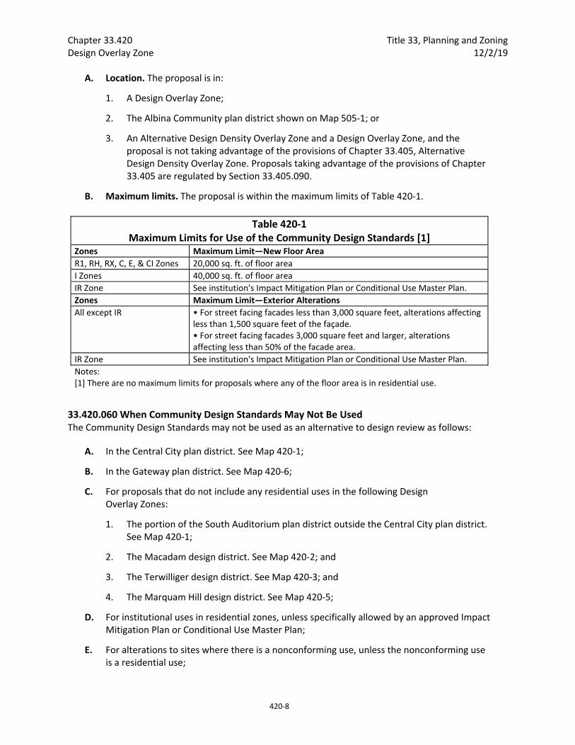
Chapter 33.420 Title 33, Planning and Zoning Design Overlay Zone 12/2/19
420‐8
A. Location. The proposal is in:
1. A Design Overlay Zone;
2. The Albina Community plan district shown on Map 505‐1; or
3. An Alternative Design Density Overlay Zone and a Design Overlay Zone, and the proposal is not taking advantage of the provisions of Chapter 33.405, Alternative Design Density Overlay Zone. Proposals taking advantage of the provisions of Chapter 33.405 are regulated by Section 33.405.090.
B. Maximum limits. The proposal is within the maximum limits of Table 420‐1.
Table 420‐1 Maximum Limits for Use of the Community Design Standards [1]
Zones Maximum Limit—New Floor Area
R1, RH, RX, C, E, & CI Zones 20,000 sq. ft. of floor area
I Zones 40,000 sq. ft. of floor area
IR Zone See institution's Impact Mitigation Plan or Conditional Use Master Plan.
Zones Maximum Limit—Exterior Alterations
All except IR • For street facing facades less than 3,000 square feet, alterations affecting less than 1,500 square feet of the façade. • For street facing facades 3,000 square feet and larger, alterations affecting less than 50% of the facade area.
IR Zone See institution's Impact Mitigation Plan or Conditional Use Master Plan.
Notes: [1] There are no maximum limits for proposals where any of the floor area is in residential use.
33.420.060 When Community Design Standards May Not Be Used The Community Design Standards may not be used as an alternative to design review as follows:
A. In the Central City plan district. See Map 420‐1;
B. In the Gateway plan district. See Map 420‐6;
C. For proposals that do not include any residential uses in the following Design Overlay Zones:
1. The portion of the South Auditorium plan district outside the Central City plan district. See Map 420‐1;
2. The Macadam design district. See Map 420‐2; and
3. The Terwilliger design district. See Map 420‐3; and
4. The Marquam Hill design district. See Map 420‐5;
D. For institutional uses in residential zones, unless specifically allowed by an approved Impact Mitigation Plan or Conditional Use Master Plan;
E. For alterations to sites where there is a nonconforming use, unless the nonconforming use is a residential use;
Title 33, Planning and Zoning Chapter 33.420 12/2/19 Design Overlay Zone
420‐9
F. For non‐residential development in the RF through R1 zones;
G. If the proposal uses Section 33.405.050, Bonus Density for Design Review;
H. In the CM3 zone within the St. Johns plan district, structures more than 45 feet in height;
I. For motor vehicle fuel sales in the 122nd Avenue subdistrict of the East Corridor plan district; and
J. In the North Interstate plan district proposals taking advantage of the additional height allowed by 33.561.210.B.2.
(Amended by: Ord. No. 163697, effective 1/1/91; Ord. No. 167054, effective 10/25/93; Ord. No. 169987, effective 7/1/96; Ord. No. 171589, effective 11/1/97; Ord. No. 171849, effective 4/1/98; Ord. No. 174263, effective 4/15/00; Ord. No. 175204, effective 3/1/01; Ord. No. 175837, effective 9/7/01; Ord. No. 176587, effective 7/20/02; Ord. No.176742, effective 7/31/02; Ord. No. 177920, effective 11/8/03; Ord. No. 178172, effective 3/5/04; Ord. Nos. 178423 and 178480, effective 6/18/04; Ord. No. 178452, effective 7/10/04; Ord. No. 178509, effective 7/16/04; Ord. No. 178946, effective 010705, Ord. Nos. 179980 and 179994, effective 4/22/06; Ord. No. 180372, effective 9/30/06; Ord. No. 181357, effective 11/9/07; Ord. No. 182072, effective 8/22/08; Ord. No. 182429, effective 1/16/09; Ord. No. 182962, effective 7/31/09; Ord. No. 183518 03/05/10; Ord. No. 183598, effective 4/24/10; Ord. No. 184842, effective 9/2/11; Ord. No. 185915, effective 5/1/13; Ord. No. 186639, effective 7/11/14; Ord. No. 187216, effective 7/24/15; Ord. No. 188259, effective 3/31/17; Ord. No. 188177, effective 5/24/18; Ord. No. 188958, effective 5/24/18; Ord. No. 189000, 7/9/18; Ord. No. 189137, effective 8/22/18; Ord. No. 189488, effective 12/2/19.)

Chapter 33.420 Title 33, Planning and Zoning Design Overlay Zone 12/2/19
420‐10

Title 33, Planning and Zoning Chapter 33.510 3/1/19 Central City Plan District
510‐49
Figure 510‐4 Public Viewpoint and View Corridor
(3) Required landscaping in subarea 1. In subarea 1, the area beginning 3 feet above the ordinary low water line must meet the following requirements:
Shrubs. At least 80 percent of the required landscaped area must be planted in shrubs;
Trees. Trees are not required, but are allowed;
Ground cover. All of the required landscaped area that is not planted with shrubs or trees must be fully covered with ground cover plants;
Plant list. Only plants listed in the South Waterfront Greenway Subarea 1 Plant list of the Portland Plant List may be planted; and
Installation of landscaping. All planting must be of a sufficient size and number to meet the coverage standards within five years. Restoration size plant material, including bare‐root, is allowed and recommended. Planting is not required to meet the size and spacing requirements of 33.248.030, Plant Materials. Planting is not allowed during the summer.
Chapter 33.510 Title 33, Planning and Zoning Central City Plan District 3/1/19
510‐50
(4) Required landscaping in subarea 2. In subarea 2 the required landscaping is:
Shrubs. At least 80 percent of the landscaped area must be planted in shrubs;
Trees. At least one tree must be planted for every 400 square feet of landscaped area. Trees may be clustered;
Ground cover. All of the landscaped area that is not planted with shrubs or trees must be fully covered with ground cover plants;
Plant list. Only plants listed in the South Waterfront Greenway Subarea 2 and 3 Plant List of the Portland Plant List may be planted. At least eight different species must be planted; and
Installation of landscaping. All planting must be of a sufficient size and number to meet the coverage standards within 5 years. Planting is not required to meet the size and spacing requirements of 33.248.030, Plant Materials.
(5) Required landscaping in subarea 3. In subarea 3, the required landscaping is:
Shrubs. At least 60 percent of the landscaped area must be planted in shrubs. At least 50 percent of the shrubs used to meet this requirement must be listed in the South Waterfront Greenway Subarea 2 and 3 Plant List of the Portland Plant List;
Trees. At least 1 tree must be planted for every 1,000 square feet of landscaped area. At least 50 percent of the trees used to meet this requirement must be listed in the South Waterfront Greenway Subarea 2 and 3 Plant List of the Portland Plant List;
Ground cover. All of the landscaped area that is not planted with shrubs or trees must be fully covered with ground cover plants. At least 50 percent of the ground cover plants must be listed in the South Waterfront Greenway Subarea 2 and 3 Plant List of the Portland Plant List;
Plant list. Except as allowed by (1), (2) and (3), only plants listed in the South Waterfront Greenway Subarea 2 and 3 Plant List of the Portland Plant List may be planted. The following plants are prohibited:
– Plants included on the Nuisance Plants List or Required Eradication List of the Portland Plant List;
– Plants included in the South Waterfront Greenway Nuisance Plants List of the Portland Plant List.
Installation of landscaping. All planting must be of a sufficient size and number to meet the coverage standards within five years. Planting is not required to meet the size and spacing requirements of 33.248.030, Plant Materials.
g. Other development. Other development is allowed within the South Waterfront Greenway Area if it meets Subparagraphs g.(1) and (2) and either g.(3) or (4).
(1) The site meets the non‐landscaped area requirements under E.5.a., above;
(2) The development does not obstruct required pedestrian connections and trails; and
Title 33, Planning and Zoning Chapter 33.565 3/1/19 Portland International Airport Plan District
565‐1
33.565 Portland International Airport Plan District
565
Sections:
General 33.565.010 Purpose 33.565.020 Where These Regulations Apply 33.565.030 Relationship to Other Regulations and Agencies
Use Regulations 33.565.100 Additional Allowed Uses in the Airport Subdistrict
Development Regulations 33.565.110 Archaeological Resource Protection
Regulations in the Airport Subdistrict 33.565.200 Supplemental Application Requirement 33.565.210 New Airport Capacity 33.565.220 Landscaping 33.565.230 Pedestrian Standards for Specified Uses 33.565.240 Transportation Impact Analysis Review 33.565.250 Development and Availability of Public Services in the SW Quadrant
Special Notification Requirements in the Airport Subdistrict 33.565.310 Mailed Public Notice for Proposed Development 33.565.320 Posted Public Notice Requirements for Land Use Reviews
Regulations in the Middle Columbia Slough Subdistrict 33.565.400 Zoning Map Amendments 33.565.410 Additional Development Standards
Environmental Overlay Zones 33.565.500 Purpose 33.565.510 Relationship to Other Environmental Regulations 33.565.520 Where and When These Regulations Apply 33.565.530 Measuring Setbacks 33.565.540 Exemptions 33.565.550 Development Standards 33.565.560 Special Procedures for Wildlife Hazard Management
Notice and Review Procedure for Permits Within Environmental Overlay Zones 33.565.600 Purpose 33.565.610 When These Regulations Apply 33.565.620 Procedure
Map 565‐1 Portland International Airport Plan District
Map 565‐2 Portland International Airport Plan District Areas of Archaeological Interest
Chapter 33.565 Title 33, Planning and Zoning Portland International Airport Plan District 3/1/19
565‐2
General
33.565.010 Purpose The regulations of this chapter implement elements of the Airport Futures Land Use Plan by addressing the social, economic, and environmental aspects of growth and development at Portland International Airport (PDX). PDX is a unique land use within the City and requires tailored regulations to address wildlife hazards and impacts to transportation and natural resources. The plan district provides flexibility to the Port of Portland—owner of PDX—to address a constantly changing aviation industry, while addressing the broader community impacts of operating an airport in an urban context.
The regulations of this plan district protect significant identified environmental resources consistent with the requirements of airport operations, while maintaining or enhancing the capacity of public and private infrastructure within and serving the district. Additionally, the regulations protect significant archaeological features of the area.
The plan district has two subdistricts: the Airport Subdistrict and the Middle Columbia Slough Subdistrict.
The Airport Subdistrict includes the airport passenger terminal, terminal roadway area, airfield, and other support facilities most of which are owned and operated by the Port of Portland. Also included are other airport‐related uses which are generally tenants of the Port. Within the Airport Subdistrict are two unmapped areas known as airside and landside (See Chapter 33.910, Definitions). Airside includes an area defined by a perimeter security fence and the airside uses associated with the airfield which includes runways, taxiways, lighting, etc. The perimeter security fence is not mapped since the fence may move over time due to federal and operational requirements. An area outside the fence—the runway protection zone—is also part of Airside. The airfield and airside uses are also treated differently due to federal regulations. Landside includes the passenger terminal, airport access roadways, parking lots, aircraft maintenance facilities, cargo hangars, maintenance buildings, fire and rescue facilities, and other similar types of development. Also within the Airport Subdistrict is the SW Quadrant Subarea, shown on Map 565‐1.
The remainder of the plan district is the Middle Columbia Slough Subdistrict. The primary purpose of the regulations for this subdistrict is to promote eco‐industrial development on sites that transition to industrial use from golf course use.
33.565.020 Where These Regulations Apply The regulations of this chapter apply to the Portland International Airport plan district. The boundaries of the plan district and subdistricts are shown on Map 565‐1 at the end of this chapter and on the Official Zoning Map.
The regulations of Sections 33.565.010 through .030 and .110 apply to the entire plan district. The regulations of Sections 33.565.100 and 200 through .240 and 33.565.310 through .320 apply only in the Airport Subdistrict. Section 33.565.250 applies only to the SW Quadrant subarea of the Airport Subdistrict. Sections 33.565.400 and .410 apply only in the Middle Columbia Slough Subdistrict. Sections 33.565.500 through .560 apply in the Environmental Overlay Zones.
Because Federal regulation preempts local rules, development in the Airside portion of the plan district — other than new runways — is not subject to the regulations of this chapter.
Title 33, Planning and Zoning Chapter 33.565 3/1/19 Portland International Airport Plan District
565‐7
includes the square footage of any floor area plus the square footage of any exterior development. See Chapter 33.806, Airport Reviews.
Special Notification Requirements in the Airport Subdistrict
33.565.310 Mailed Public Notice for Proposed Development When development is proposed within the Airport Subdistrict, all of the steps in this section must be completed before an application for a building or zoning permit is submitted.
A. Purpose. Mailed public notice informs interested neighborhood associations and district neighborhood coalitions of proposed airport development that is not subject to a land use review and provides them with an opportunity to attend a public meeting to get more information and discuss the proposed development.
B. Where and when mailed public notice is required. Proposals that were part of a land use review are exempt from the requirement of this subsection. Mailed public notice is required in the IG2 zone:
1. When the proposed development will add more than 10,000 square feet of gross building area to the site; or
2. When the value of the proposed development will exceed $612,100.
C. Requirements. The requirements for mailed public notice are:
1. The applicant must send a letter to the neighborhood associations and district neighborhood coalitions of the site or adjacent to the site, by registered or certified mail. The letter must contain, at a minimum, contact information for the applicant, the date, time and location that the project will be presented at a public meeting and a description of the proposed development, including the purpose of the project, total project square footage and project valuation. The letter must be sent at least 14 days before the public meeting where the project will be presented.
2. Copies of letters required by this section, and registered or certified mail receipts, must be submitted with the application for building or zoning permit.
33.565.320 Posted Public Notice Requirements for Land Use Reviews Posting of notice on the site is required for Type III land use reviews. The requirements for posting notices in Section 33.730.080 apply to sites in the plan district zoned IG2; however, the number and location on the site, specified in Subsection 33.730.080.A, are superseded by the requirements of this section.
A. Outdoor notices. Posted notices must be placed at the following outdoor locations:
1. At each of the two main crosswalks in the arrivals roadway area; and
2. At each of the two pedestrian bridges to the P1 parking garage.
B. Indoor notices. Posted notices must be placed at the following locations inside the terminal building and must be visible to passengers and others in the building:
1. On the second floor of the terminal at each of the two main escalators;

Chapter 33.565 Title 33, Planning and Zoning Portland International Airport Plan District 3/1/19
565‐8
2. On the second floor at each of the two circulation throats; and
3. On the first floor of the terminal at each of the two main escalators.
C. Roadway notice. One posted notice must be placed along a roadway within 800 feet of the proposed structure or development activity. If the nearest roadway is more than 800 feet from the proposed structure or development activity, the notice must be placed at the intersection closest to the proposed structure or development activity.
Regulations in the Middle Columbia Slough Subdistrict
33.565.400 Zoning Map Amendments The IG2 zone is the only zone that can be requested during a Zoning Map Amendment on the sites shown on Map 565‐4. Requesting a zone other than IG2 is prohibited. In addition, the Prime Industrial overlay zone must be applied in conjunction with the zone change to IG2.
33.565.410 Additional Development Standards
A. Purpose. The following development standards promote ecologically beneficial design by requiring buffers and plantings that provide ecological function and contribute to ecosystem services such as multi‐objective stormwater management, cleaning and cooling of air and water, wildlife habitat, biodiversity, and aesthetic values. The development standards help reduce future demands on infrastructure, and reduce adverse impacts from development both on and off‐site. The standards also buffer industrial development from abutting residential development and open space uses, and provide a pleasant work environment for employees.
B. Where the standards apply. The standards in this Section apply to development in the IG2 zone in the Golf Course/IG2 Transition Area shown on Map 565‐4.
C. Development standards.
1. Minimum landscaped area standard. At least 20 percent of site area must be landscaped. Area improved for active or passive recreational use, or for use by pedestrians, does not count toward the required landscaped area. Other required landscaping, such as setbacks and parking lot landscaping, applies toward the landscaped area standard. Area covered by an eco‐roof also applies toward the landscaped area standard.
2. Native plants. At least 75 percent of all plants planted to meet Title 33 landscaping requirements must be native plants from the Portland Plant List.
3. Vegetated setback.
a. All development must be set back 25 feet from a residential zone or open space zone. The area within the vegetated setback may be applied toward the required landscaped area standards;
b. Required plants and planting densities. One of the following standards must be met:
Title 33, Planning and Zoning Chapter 33.565 3/1/19 Portland International Airport Plan District
565‐9
(1) One tree, three shrubs, and four other ground cover plants are required to be planted for every 100 square feet of setback area. Trees may be clustered. Plants must be native plants from the Portland Plant List; or
(2) One tree and three shrubs are required to be planted for every 100 square feet of setback area, and the entire setback area must be seeded with a native grass and forb seed mix at a ratio of 30 pounds per acre. Trees may be clustered. Plants and seeds must be native plants from the Portland Plant List; and
c. One‐third of all trees planted must be native conifer trees from the Portland Plant List.
4. Exterior lighting. Exterior lights must be shielded and placed so that they do not shine upward or into environmental overlay zones, or into the vegetated setback area required by Paragraph C.3.
Environmental Overlay Zones
33.565.500 Purpose The environmental regulations in the Portland International Airport plan district work in conjunction with the standards of Chapter 33.430 to:
Protect inventoried significant natural resources and their functional values specific to the plan district, as identified in the Comprehensive Plan;
Address activities required to manage Port facilities, drainageways and wildlife on and around the airfield for public and avian safety;
Address resource mitigation and enhancement opportunities consistent with managing wildlife and vegetation on and around the airfield for public safety; and
Encourage coordination between City, county, regional, state, and federal agencies concerned with airport safety and natural resources.
Protect inventoried significant archaeological resources where those resources overlap with an environmental protection zone or environmental conservation zone.
33.565.510 Relationship to Other Environmental Regulations The regulations of Sections 33.565.510 through 33.565.620 either supplement or supersede the regulations of Chapter 33.430. Whenever a provision of this plan district conflicts with Chapter 33.430, the plan district provision supersedes.
The following sections supersede or supplement the regulations of Chapter 33.430:
Exemptions in Section 33.565.540 supplement exemptions in section 33.430.080;
Standards in Section 33.565.550 supplement or supersede standards in Sections 33.430.140 through .190;
When wildlife hazard management is proposed and an environmental review is required the procedure type specified in Subsection 33.565.560.A supersedes the procedure type specified in Section 33.430.230;
When wildlife hazard management is proposed and an environmental review is required the requirements of Subsection 33.565.560.B supersede the requirements of Subsection 33.430.240.B;

Chapter 33.565 Title 33, Planning and Zoning Portland International Airport Plan District 3/1/19
565‐10
When wildlife hazard management is proposed and an environmental review is required the approval criteria of Subsection 33.565.560.C supersede the approval criteria of Subsections 33.430.250.E through .F;
The environmental Plan Check notice and review procedures of Sections 33.565.600 through .620 supersede the notice and review procedures of Sections 33.430.410 through .430.
This chapter contains only the City’s environmental regulations. Activities that the City regulates through this chapter may also be regulated by other agencies. City approval does not imply approval by other agencies.
33.565.520 Where and When These Regulations Apply The regulations of Sections 33.565.510 through 33.565.620 apply to all environmental zones in the Portland International Airport plan district. The boundaries of this plan district and the subdistricts are shown on Map 565‐1. Unless exempted by section 33.565.540, the regulations of Sections 33.565.500 through 33.565.620 apply to the activities listed below. Items not specifically addressed in these sections must comply with the regulations of Chapter 33.430.
A. Development;
B. Removing, cutting, mowing, clearing, burning or poisoning native vegetation listed in the Portland Plant List;
C. Planting or removing nuisance plants listed in the Portland Plant List;
D. Changing topography, grading, excavating, and filling;
E. Dedications, expansions, and improvements within rights‐of‐way;
F. Road improvements; and
G. Resource enhancement.
33.565.540 Exemptions In addition to the exemptions listed in 33.430.080, the following items are exempt from both the environmental regulations of the Airport Plan District and Chapter 33.430, Environmental Zones. Other City regulations, including Title 10, Erosion Control, and Title 11, Trees, still apply:
A. When performed to comply with the FAA Part 77 Regulated Surface requirements or a FAA authorized Wildlife Hazard Management Plan:
1. Crown maintenance of trees that project above, or will upon maturity project above, the height limit delineated by the h overlay zone;
2. Crown maintenance of trees that are identified in the FAA authorized Wildlife Hazard Management Plan as attracting wildlife species of concern;
3. Mechanical removal of grasses and shrubs less than 3 feet in height;
4. Discing to reduce habitat that attracts wildlife species of concern as identified in the FAA authorized Wildlife Hazard Management Plan; and
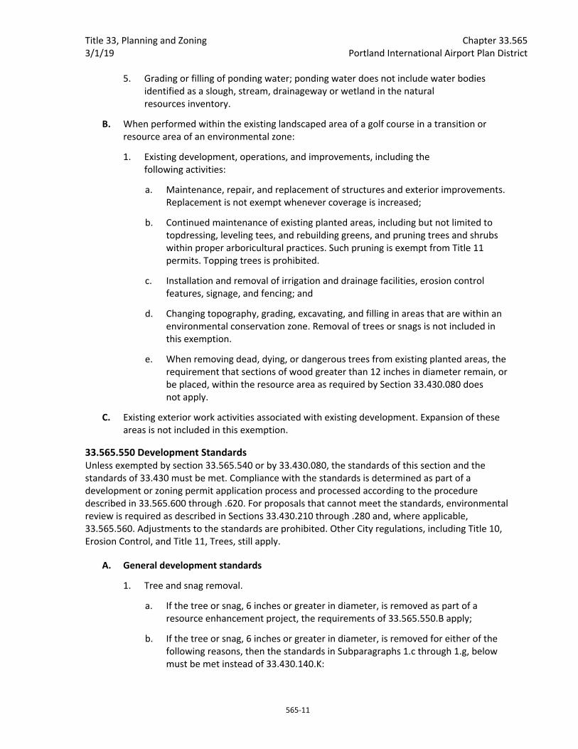
Title 33, Planning and Zoning Chapter 33.565 3/1/19 Portland International Airport Plan District
565‐11
5. Grading or filling of ponding water; ponding water does not include water bodies identified as a slough, stream, drainageway or wetland in the natural resources inventory.
B. When performed within the existing landscaped area of a golf course in a transition or resource area of an environmental zone:
1. Existing development, operations, and improvements, including the following activities:
a. Maintenance, repair, and replacement of structures and exterior improvements. Replacement is not exempt whenever coverage is increased;
b. Continued maintenance of existing planted areas, including but not limited to topdressing, leveling tees, and rebuilding greens, and pruning trees and shrubs within proper arboricultural practices. Such pruning is exempt from Title 11 permits. Topping trees is prohibited.
c. Installation and removal of irrigation and drainage facilities, erosion control features, signage, and fencing; and
d. Changing topography, grading, excavating, and filling in areas that are within an environmental conservation zone. Removal of trees or snags is not included in this exemption.
e. When removing dead, dying, or dangerous trees from existing planted areas, the requirement that sections of wood greater than 12 inches in diameter remain, or be placed, within the resource area as required by Section 33.430.080 does not apply.
C. Existing exterior work activities associated with existing development. Expansion of these areas is not included in this exemption.
33.565.550 Development Standards Unless exempted by section 33.565.540 or by 33.430.080, the standards of this section and the standards of 33.430 must be met. Compliance with the standards is determined as part of a development or zoning permit application process and processed according to the procedure described in 33.565.600 through .620. For proposals that cannot meet the standards, environmental review is required as described in Sections 33.430.210 through .280 and, where applicable, 33.565.560. Adjustments to the standards are prohibited. Other City regulations, including Title 10, Erosion Control, and Title 11, Trees, still apply.
A. General development standards
1. Tree and snag removal.
a. If the tree or snag, 6 inches or greater in diameter, is removed as part of a resource enhancement project, the requirements of 33.565.550.B apply;
b. If the tree or snag, 6 inches or greater in diameter, is removed for either of the following reasons, then the standards in Subparagraphs 1.c through 1.g, below must be met instead of 33.430.140.K:
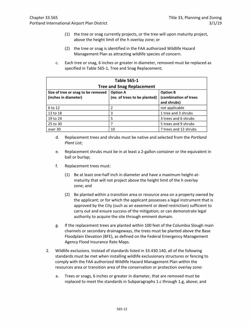
Chapter 33.565 Title 33, Planning and Zoning Portland International Airport Plan District 3/1/19
565‐12
(1) the tree or snag currently projects, or the tree will upon maturity project, above the height limit of the h overlay zone; or
(2) the tree or snag is identified in the FAA authorized Wildlife Hazard Management Plan as attracting wildlife species of concern.
c. Each tree or snag, 6 inches or greater in diameter, removed must be replaced as specified in Table 565‐1, Tree and Snag Replacement;
Table 565‐1 Tree and Snag Replacement
Size of tree or snag to be removed (inches in diameter)
Option A (no. of trees to be planted)
Option B (combination of trees and shrubs)
6 to 12 2 not applicable
13 to 18 3 1 tree and 3 shrubs
19 to 24 5 3 trees and 6 shrubs
25 to 30 7 5 trees and 9 shrubs
over 30 10 7 trees and 12 shrubs
d. Replacement trees and shrubs must be native and selected from the Portland Plant List;
e. Replacement shrubs must be in at least a 2‐gallon container or the equivalent in ball or burlap;
f. Replacement trees must:
(1) Be at least one‐half inch in diameter and have a maximum height‐at‐maturity that will not project above the height limit of the h overlay zone; and
(2) Be planted within a transition area or resource area on a property owned by the applicant; or for which the applicant possesses a legal instrument that is approved by the City (such as an easement or deed restriction) sufficient to carry out and ensure success of the mitigation; or can demonstrate legal authority to acquire the site through eminent domain.
g. If the replacement trees are planted within 100 feet of the Columbia Slough main channels or secondary drainageways, the trees must be planted above the Base Floodplain Elevation (BFE), as defined on the Federal Emergency Management Agency Flood Insurance Rate Maps.
2. Wildlife exclusions. Instead of standards listed in 33.430.140, all of the following standards must be met when installing wildlife exclusionary structures or fencing to comply with the FAA authorized Wildlife Hazard Management Plan within the resources area or transition area of the conservation or protection overlay zone:
a. Trees or snags, 6 inches or greater in diameter, that are removed must be replaced to meet the standards in Subparagraphs 1.c through 1.g, above; and
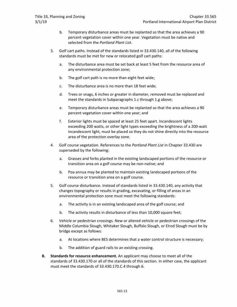
Title 33, Planning and Zoning Chapter 33.565 3/1/19 Portland International Airport Plan District
565‐13
b. Temporary disturbance areas must be replanted so that the area achieves a 90 percent vegetation cover within one year. Vegetation must be native and selected from the Portland Plant List.
3. Golf cart paths. Instead of the standards listed in 33.430.140, all of the following standards must be met for new or relocated golf cart paths:
a. The disturbance area must be set back at least 5 feet from the resource area of any environmental protection zone;
b. The golf cart path is no more than eight feet wide;
c. The disturbance area is no more than 18 feet wide;
d. Trees or snags, 6 inches or greater in diameter, removed must be replaced and meet the standards in Subparagraphs 1.c through 1.g above;
e. Temporary disturbance areas must be replanted so that the area achieves a 90 percent vegetation cover within one year; and
f. Exterior lights must be spaced at least 25 feet apart. Incandescent lights exceeding 200 watts, or other light types exceeding the brightness of a 200‐watt incandescent light, must be placed so they do not shine directly into the resource area of the protection overlay zone.
4. Golf course vegetation. References to the Portland Plant List in Chapter 33.430 are superseded by the following:
a. Grasses and forbs planted in the existing landscaped portions of the resource or transition area on a golf course may be non‐native; and
b. Poa annua may be planted to maintain existing landscaped portions of the resource or transition area on a golf course.
5. Golf course disturbance. Instead of standards listed in 33.430.140, any activity that changes topography or results in grading, excavating, or filling of areas in an environmental protection zone must meet the following standards:
a. The activity is in an existing landscaped area of the golf course; and
b. The activity results in disturbance of less than 10,000 square feet;
6. Vehicle or pedestrian crossings. New or altered vehicle or pedestrian crossings of the Middle Columbia Slough, Whitaker Slough, Buffalo Slough, or Elrod Slough must be by bridge except as follows:
a. At locations where BES determines that a water control structure is necessary;
b. The addition of guard rails to an existing crossing.
B. Standards for resource enhancement. An applicant may choose to meet all of the standards of 33.430.170 or all of the standards of this section. In either case, the applicant must meet the standards of 33.430.170.C.4 through 6.
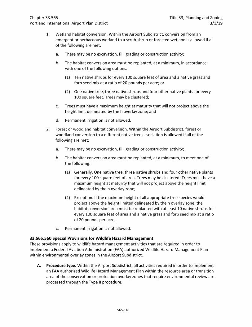
Chapter 33.565 Title 33, Planning and Zoning Portland International Airport Plan District 3/1/19
565‐14
1. Wetland habitat conversion. Within the Airport Subdistrict, conversion from an emergent or herbaceous wetland to a scrub‐shrub or forested wetland is allowed if all of the following are met:
a. There may be no excavation, fill, grading or construction activity;
b. The habitat conversion area must be replanted, at a minimum, in accordance with one of the following options:
(1) Ten native shrubs for every 100 square feet of area and a native grass and forb seed mix at a ratio of 20 pounds per acre; or
(2) One native tree, three native shrubs and four other native plants for every 100 square feet. Trees may be clustered;
c. Trees must have a maximum height at maturity that will not project above the height limit delineated by the h overlay zone; and
d. Permanent irrigation is not allowed.
2. Forest or woodland habitat conversion. Within the Airport Subdistrict, forest or woodland conversion to a different native tree association is allowed if all of the following are met:
a. There may be no excavation, fill, grading or construction activity;
b. The habitat conversion area must be replanted, at a minimum, to meet one of the following:
(1) Generally. One native tree, three native shrubs and four other native plants for every 100 square feet of area. Trees may be clustered. Trees must have a maximum height at maturity that will not project above the height limit delineated by the h overlay zone;
(2) Exception. If the maximum height of all appropriate tree species would project above the height limited delineated by the h overlay zone, the habitat conversion area must be replanted with at least 10 native shrubs for every 100 square feet of area and a native grass and forb seed mix at a ratio of 20 pounds per acre;
c. Permanent irrigation is not allowed.
33.565.560 Special Provisions for Wildlife Hazard Management These provisions apply to wildlife hazard management activities that are required in order to implement a Federal Aviation Administration (FAA) authorized Wildlife Hazard Management Plan within environmental overlay zones in the Airport Subdistrict.
A. Procedure type. Within the Airport Subdistrict, all activities required in order to implement an FAA authorized Wildlife Hazard Management Plan within the resource area or transition area of the conservation or protection overlay zones that require environmental review are processed through the Type II procedure.
Title 33, Planning and Zoning Chapter 33.565 3/1/19 Portland International Airport Plan District
565‐15
B. Application requirements. Within the Airport Subdistrict and for activities required to implement an FAA authorized Wildlife Hazard Management Plan, an alternatives analysis is not required. Specifically, instead of the supplemental narrative requirements of 33.430.230.B, the following is required:
1. Activity description. Describe the activity and why it is necessary to implement an FAA authorized Wildlife Hazard Management Plan;
2. Documentation of resources and functional values. Documentation of resources and functional values is required to determine compliance with the approval criteria. In the case of a violation, documentation of resources and functional values is used to determine the nature and scope of significant detrimental impacts.
a. Identification, by characteristics and quantity, of the resources and their functional values found on the site;
b. In the case of a violation, determination of the impact of the violation on the resources and functional values.
3. Construction management plan. Identify measures that will be taken during the activity or remediation to protect the remaining resources and functional values at and near the site and a description of how undisturbed areas will be protected. For example, describe how trees will be protected, erosion controlled, equipment controlled, and the timing of activity; and
4. Mitigation or remediation plan. The purpose of a mitigation or remediation plan is to compensate for unavoidable significant detrimental impacts that result from the chosen activity or violation as identified in the impact evaluation. A mitigation or remediation plan includes:
a. Resources and functional values to be restored, created, or enhanced on the mitigation or remediation site;
b. Documentation of coordination with appropriate local, regional, special district, state, and federal regulatory agencies;
c. Activity timetables;
d. Operations and maintenance practices;
e. Monitoring and evaluation procedures;
f. Remedial actions for unsuccessful mitigation; and
g. Information showing compliance with Section 33.248.090, Mitigation and Restoration Plantings.
C. Approval criteria. The following approval criteria apply to activities required in order to implement an FAA authorized Wildlife Hazard Management Plan within the resource area or transition area of the conservation or protection overlay zones that require environmental review. These criteria supersede the criteria in 33.430.250.E and F:
1. There will be no significant detrimental impact on resources and functional values in areas designated to be left undisturbed;
Chapter 33.565 Title 33, Planning and Zoning Portland International Airport Plan District 3/1/19
565‐16
2. The mitigation plan demonstrates that all significant detrimental impacts on resources and functional values will be compensated for;
3. Mitigation will occur within the same watershed as the proposed use or development and within the Portland city limits except when the purpose of the mitigation could be better provided elsewhere; and
4. The applicant owns the mitigation site; possesses a legal instrument that is approved by the City (such as an easement or deed restriction) sufficient to carry out and ensure the success of the mitigation program; or can demonstrate legal authority to acquire property through eminent domain.
Notice and Review Procedure for Permits Within Environmental Overlay Zones
33.565.600 Purpose The purpose of this notice and review procedure is to notify the public of the permit review process for development proposed in areas having identified significant resources and functional values.
33.565.610 When These Regulations Apply These regulations apply when a building permit or development permit application is requested within an environmental overlay zone and is subject to the Development Standards of Section 33.430.110 through .190, 33.430.405.B, or 33.430.405.C, or 33.565.510 through .580. These regulations apply instead of the regulations of 33.430.410 through .430. These regulations do not apply to building permit or development permit applications for development that has been approved through environmental review.
33.565.620 Procedure Applications for building permits or development permits as specified in Section 335.430.420 or 33.565.610 will be processed according to the following procedures:
A. Application. The applicant must submit a site plan with an application for a permit. The site plan must contain all information required by 33.430.130, Permit Application Requirements, and any additional information required for a building permit or development permit review.
B. Notice of an application.
1. Notice on website. Upon receipt of a complete application for a building or development permit, the Director of BDS will post a notice of the application on the BDS website and mail a notice of the request to all recognized organizations within 400 feet of the site. The posted notice of the application will contain at least the following information:
A statement that a building or development permit has been applied for that is subject to the Development Standards of Section 33.430.110 through .190, 33.430.405.B, 33.430.405.C, or 33.565.510 through .580.
The legal description and address of the site;
A copy of the site plan;
Title 33, Planning and Zoning Chapter 33.565 3/1/19 Portland International Airport Plan District
565‐17
The place where information on the matter may be examined and a telephone number to call; and
A statement that copies of information on the matter may be obtained for a fee equal to the City’s cost for providing the copies.
The notice will remain on the website until the permit is issued and administrative decision is made, or until the application is withdrawn.
2. E‐mailed notice to recognized neighborhood associations. At the time a notice is posted on the BDS website, the Director of BDS will e‐mail information about the internet posting to all recognized neighborhood associations and neighborhood coalition offices within 400 feet of the site. When an e‐mail address is not available, the notice will be mailed to the neighborhood association and coalition office.
C. Posting the site and marking development. The applicant must post notice information on the site and identify disturbance areas as specified below.
1. Posting notice on the site. The applicant must post public notice of the proposed activity or development following the procedure listed in 33.565.320.C. The posted notice will contain the same information as the notice posted on the internet.
2. Marking proposed development on site. Prior to inspection of the site, the applicant will mark all trees over six inches diameter to be removed on the site and the building and pavement outlines with high visibility tape. The extent of the disturbance area must be marked with orange construction fencing or similar highly visible material. For corrections to violations, the disturbance area and remediation area to be planted must be identified with high visibility tape or similar high visibility material.
D. Site inspection. A BDS inspector will inspect the site prior to issuance of the permit and will provide the Director of BDS with one of the following:
1. An inspection report that confirms the accuracy of the site plan and conformance with the applicable development standards; or
2. A check sheet identifying the deficiencies in the plan. Deficiencies must be corrected before a building permit is approved, or they may be addressed through environmental review as described in Sections 33.430.210 through 33.430.280.
E. Comments. Any interested person may comment on the permit application by writing and specifically identifying errors or non‐compliance with development standards.
F. Response to comments. If a comment is received, the Director of BDS will respond in writing or in a manner suitable to the comment. The response will specifically address each comment that concerns compliance with the development standards of Section 33.430.140 through .190 and 33.565.560 through .580. The Director of BDS will recheck permits for

Chapter 33.565 Title 33, Planning and Zoning Portland International Airport Plan District 3/1/19
565‐18
compliance with development standards and approve the permit if compliance is reaffirmed or when identified deficiencies are corrected, and when all applicable standards and regulations of the Zoning Code are met.
(Added by Ord. No. 184521, effective 5/13/11. Amended by: Ord. No. 186639, effective 7/11/14; Ord. No. 187216, effective 7/24/15; Ord. No. 188177, effective 5/24/18; Ord. No. 188958, effective 5/24/18.)
Title 33, Planning and Zoning Chapter 33.660 12/2/19 Review of Land Divisions in Open Space and Residential Zones
660‐1
33.660 Review of Land Divisions in Open Space and Residential Zones 660
Sections:
General 33.660.010 Purpose 33.660.020 Where These Regulations Apply
Review of Preliminary Plan 33.660.110 Review Procedures 33.660.120 Approval Criteria
Review of Changes to an Approved Preliminary Plan 33.660.300 When Review is Required 33.660.310 Review Procedures 33.660.320 Approval Criteria
General
33.660.010 Purpose These regulations ensure that land divisions in residential and open space zones will be processed with the appropriate level of city and public review. This chapter establishes clear procedures and approval criteria for the land division proposal.
33.660.020 Where These Regulations Apply The regulations of this chapter apply to proposals for land divisions on sites in Open Space and Residential Zones.
Review of Preliminary Plan
33.660.110 Review Procedures Procedures for review of Preliminary Plans vary with the type of land division proposal being reviewed.
A. Type III. Land divisions that include any of the following elements are processed through a Type III procedure:
1. Eleven or more lots;
2. Four or more lots, where any portion of the lots, utilities, or services are proposed within a Potential Landslide Hazard Area;
3. Environmental review;
4. A phased land division, as described in Chapter 33.633, Phased and Staged Plans;
5. Any portion of the site is in an Open Space zone.

Chapter 33.660 Title 33, Planning and Zoning Review of Land Divisions in Open Space and Residential Zones 12/2/19
660‐2
B. Type IIx. Except as provided in Subsection A, above, land division proposals that include any of the following elements are processed through a Type IIx procedure:
1. Four to ten lots;
2. Two or three lots, where any portion of the lots, utilities, or services are proposed within a Potential Landslide Hazard Area;
3. Lots, utilities, or services are proposed within a special flood hazard area; or
4. The proposal includes a concurrent land use review assigned to a Type I, Type 1x, Type II, or Type IIx procedure except environmental review. If environmental review is required, then the application is processed through a Type III procedure.
C. Type Ix. All land divisions not assigned to a Type IIx or Type III, are processed through a Type Ix procedure.
33.660.120 Approval Criteria The Preliminary Plan for a land division will be approved if the review body finds that the applicant has shown that all of the following approval criteria have been met. The approval criteria are:
A. Lots. The standards and approval criteria of Chapters 33.605 through 33.612 must be met;
B. Trees. The standards and approval criteria of Chapter 33.630, Tree Preservation, must be met;
C. Special flood hazard area. If any portion of the site contains special flood hazard area, the approval criteria of Chapter 33.631, Sites in Special Flood Hazard Areas, must be met;
D. Potential Landslide Hazard Area. If any portion of the site is in a Potential Landslide Hazard Area, the approval criteria of Chapter 33.632, Sites in Potential Landslide Hazard Areas, must be met;
E. Phased Plans and Staged Final Plat. If the Preliminary Plan will be phased or if the Final Plat will be staged, the standards of Chapter 33.633, Phased Land Divisions and Staged Final Plat, must be met;
F. Required recreation area. If 40 or more lots or dwelling units are proposed, the standards and approval criteria of Chapter 33.634, Required Recreation Areas, must be met;
G. Clearing, grading, and land suitability. The approval criteria of Chapter 33.635, Clearing, Grading, and Land Suitability must be met;
H. Tracts and easements. The standards of Chapter 33.636, Tracts and Easements must be met;
I. Solar access. If single‐dwelling detached development is proposed for the site, the approval criteria of Chapter 33.639, Solar Access, must be met;
J. Streams, springs, seeps, and wetlands. The approval criteria of Chapter 33.640, Streams, Springs, Seeps, and Wetlands must be met;
K. Transportation impacts. The approval criteria of Chapter 33.641, Transportation Impacts, must be met; and,
Title 33, Planning and Zoning Chapter 33.660 12/2/19 Review of Land Divisions in Open Space and Residential Zones
660‐3
L. Services and utilities. The regulations and criteria of Chapters 33.651 through 33.655, which address services and utilities, must be met.
Review of Changes to an Approved Preliminary Plan
33.660.300 When Review is Required Changes to an approved Preliminary Plan may be considered under the provisions of Sections 33.660.300 through 33.660.320. Some changes, listed in Section 33.663.200, may be approved as part of the Final Plat review. In addition, a decision on a Preliminary Plan may include conditions that require a different level of review for changes.
If the Final Plat differs from the approved Preliminary Plan, and the change is not one that may be approved under Section 33.663.200, and is not specifically allowed by the Preliminary Plan approval, review is required.
33.660.310 Review Procedures Procedures for review of changes to an approved Preliminary Plan vary with the type of change proposed.
A. Type Ix. Changes not listed in Subsections B or C, below, are processed through a Type Ix procedure.
B. Same procedure as was used for Preliminary Plan. The following proposals are processed through the same procedure type as was used for the Preliminary Plan approval:
1. An increase in the site area of more than 5 percent;
2. An increase in the number of lots;
3. A decrease in the number of lots by more than one lot;
4. A decrease in the area of any lot by more than 10 percent;
5. A decrease in the width or depth of any lot by more than 10 percent. Width is measured at the front setback line;
6. Changing a through street to a dead‐end street;
7. Changing a dead‐end street to a through street;
8. Deleting a street or pedestrian connection;
9. Deleting or changing a condition of the Preliminary Plan approval;
10. Changing the purpose of, or deleting, the following tracts or easements:
a. Shared parking tracts;
b. Environmental resource tracts;
c. Stormwater tracts;
d. Special flood hazard area easements or tracts;
e. Tree preservation tracts;

Chapter 33.660 Title 33, Planning and Zoning Review of Land Divisions in Open Space and Residential Zones 12/2/19
660‐4
f. Landslide hazard easements or tracts; or
g. Recreation area tracts;
11. Reducing the area or changing the location of the following tracts:
a. Environmental resource tract;
b. Special flood hazard area tract; or
c. Landslide hazard tract;
12. Decreasing the area of a recreation area tract by more than 10 percent;
13. Any change that the Director of BDS determines:
a. Is a significant change from the Preliminary Plan; or
b. Will have a significant impact on the surrounding area.
C. Changes to tree preservation requirements. Changes to tree preservation requirements are processed as described in Chapter 33.853, Tree Review.
33.660.320 Approval Criteria Changes to an approved Preliminary Plan will be approved if the review body finds that the applicant has shown that all of the following approval criteria have been met:
A. Approval criteria for changes listed in Subsection 33.660.310.B. Changes to the Preliminary Plan that are listed in Subsection 33.660.310.B must meet the approval criteria of Section 33.660.120, Approval Criteria.
B. Approval criteria for other changes. All other changes to the Preliminary Plan must meet the following approval criteria:
1. The proposed changes are not substantial enough, singly or in combination, to warrant a new review of the entire Preliminary Plan;
2. The approval criteria addressed by the approval of the Preliminary Plan can still be met, with appropriate conditions of approval.
Title 33, Planning and Zoning Chapter 33.660 12/2/19 Review of Land Divisions in Open Space and Residential Zones
660‐5
(Added by: Ord. Nos. 175965 and 176333, effective 7/1/02. Amended by: Ord. No. 177701, effective 8/30/03; Ord. No. 178509, effective 7/16/04; Ord. No. 178657, effective 9/3/04; Ord. No. 179980, effective 4/22/06; Ord. No. 181357, effective 11/9/07; Ord. No. 184235, effective 11/26/10, effective 5/13/11; Ord. No. 184524, effective 7/1/11; Ord. No. 185915, effective 5/1/13; Ord. No. 188259, effective 3/31/17; Ord. No. 188177, effective 5/24/18; Ord. No. 189488, effective 12/2/19.)

Chapter 33.660 Title 33, Planning and Zoning Review of Land Divisions in Open Space and Residential Zones 12/2/19
660‐6
Title 33, Planning and Zoning Chapter 33.662 12/2/19 Review of Land Divisions in Commercial/Mixed Use, Campus Institutional, Employment, and Industrial Zones
662‐1
33.662 Review of Land Divisions in Commercial/Mixed Use, Campus Institutional, Employment, and Industrial Zones
662
Sections:
General 33.662.010 Purpose 33.662.020 Where These Regulations Apply
Review of Preliminary Plan 33.662.110 Review Procedures 33.662.120 Approval Criteria
Review of Changes to an Approved Preliminary Plan 33.662.300 When Review is Required 33.662.310 Review Procedures 33.662.320 Approval Criteria
General
33.662.010 Purpose These regulations ensure that land divisions in non‐residential zones will be processed with the appropriate level of city and public review. This chapter establishes clear procedures and approval criteria for the land division proposal.
33.662.020 Where These Regulations Apply
A. Generally. The regulations of this chapter apply to proposals for land divisions on sites in commercial, campus institutional, employment, and industrial zones.
B. Alternative process for large sites in I zones. Sites in industrial zones that meet the minimum size requirements of this subsection are eligible to use the regulations and procedures of Chapter 33.664, Review of Land Divisions on Large Sites in Industrial Zones, instead of the regulations and procedures of this chapter. The applicant may choose which chapter to use. The minimum size thresholds for this alternative process are:
1. IG1 zone. Sites in the IG1 zone that are at least 200,000 square feet in area; and
2. IG2 and IH zones. Sites in the IG2 and IH zones that are at least 340,000 square feet in area.
Review of Preliminary Plan
33.662.110 Review Procedures Procedures for review of Preliminary Plans vary with the type of land division proposal being reviewed.

Chapter 33.662 Title 33, Planning and Zoning Review of Land Divisions in Commercial/Mixed Use, 12/2/19 Campus Institutional, Employment, and Industrial Zones
662‐2
A. Type III. Land divisions that include any of the following elements are processed through a Type III procedure:
1. Eleven or more lots, regardless of zone;
2. Four or more lots where any portion of the lots, utilities, or services are proposed within a Potential Landslide Hazard Area; or
3. Environmental review.
B. Type IIx. Except as provided in Subsection A above, land divisions that include any of the following elements are processed through a Type IIx procedure:
1. Four to ten lots;
2. Two or three lots where any portion of the lots, utilities, or services are proposed within a Potential Landslide Hazard Area;
3. Lots, utilities or services are proposed within a special flood hazard area; or
4. The proposal includes a concurrent land use review assigned to a Type I, Type 1x, Type II, or Type IIx procedure except environmental review. If environmental review is required, then the application is processed through a Type III procedure.
C. Type Ix. All land divisions not assigned to a Type IIx or Type III in Sections A and B above, are processed through a Type Ix procedure.
33.662.120 Approval Criteria The Preliminary Plan for a land division will be approved if the review body finds that the applicant has shown that all of the following approval criteria have been met. The approval criteria are:
A. Lots. The standards and approval criteria of Chapters 33.613 through 33.615 must be met;
B. Trees. The standards and approval criteria of Chapter 33.630, Tree Preservation, must be met;
C. Special flood hazard area. If any portion of the site contains special flood hazard area, the approval criteria of Chapter 33.631, Sites in Special Flood Hazard Areas, must be met;
D. Potential Landslide Hazard Area. If any portion of the site is in a Potential Landslide Hazard Area, the approval criteria of Chapter 33.632, Sites in Potential Landslide Hazard Areas, must be met;
E. Phased Plans and Staged Final Plat. If the Preliminary Plan will be phased or if the Final Plat will be staged, the standards of Chapter 33.633, Phased Land Divisions and Staged Final Plat, must be met;
F. Clearing, grading, and land suitability. The approval criteria of Chapter 33.635, Clearing, Grading, and Land Suitability must be met;
G. Tracts and easements. The standards of Chapter 33.636, Tracts and Easements must be met;
Title 33, Planning and Zoning Chapter 33.662 12/2/19 Review of Land Divisions in Commercial/Mixed Use, Campus Institutional, Employment, and Industrial Zones
662‐3
H. Solar access. If single dwelling detached development is proposed for the site, the approval criteria of Chapter 33.639, Solar Access, must be met; and
I. Streams, springs, seeps, and wetlands. The approval criteria of Chapter 33.640, Streams, Springs, Seeps, and Wetlands must be met.
J. Transportation Impacts. The approval criteria of Chapter 33.641, Transportation Impacts, must be met; and
K. Services and utilities. The regulations and criteria of Chapters 33.651 through 33.655, which address services and utilities, must be met.
Review of Changes to an Approved Preliminary Plan
33.662.300 When Review is Required Changes to an approved Preliminary Plan may be considered under the provisions of Sections 33.662.300 through 33.662.320. Some changes, listed in Section 33.663.200, may be approved as part of the Final Plat review. In addition, a decision on a Preliminary Plan may include conditions that require a different level of review for changes.
If the Final Plat differs from the approved Preliminary Plan, and the change is not one that may be approved under Section 33.663.200, and is not specifically allowed by the Preliminary Plan approval, review is required.
33.662.310 Review Procedures Procedures for review of changes to an approved Preliminary Plan vary with the type of change proposed.
A. Type Ix. Changes not listed in Subsections B or C, below, are processed through a Type Ix procedure.
B. Same procedure as was used for Preliminary Plan. The following proposals are processed through the same procedure type as was used for the Preliminary Plan approval:
1. An increase in the site area of more than 5 percent;
2. A decrease in the area of any lot by more than 10 percent;
3. Changing a through street to a dead‐end street;
4. Changing a dead‐end street to a through street;
5. Deleting a street or pedestrian connection;
6. Deleting or changing a condition of the Preliminary Plan approval;
7. Deleting any of the following:
a. Shared parking tracts;
b. Environmental resource tracts;
Chapter 33.662 Title 33, Planning and Zoning Review of Land Divisions in Commercial/Mixed Use, 12/2/19 Campus Institutional, Employment, and Industrial Zones
662‐4
c. Stormwater tracts;
d. Special flood hazard area easements or tracts;
e. Tree preservation tracts; or
f. Landslide hazard easements or tracts;
8. Reducing the area or changing the location of any of the following:
a. Environmental resource tract;
b. Special flood hazard area tract; or
c. Landslide hazard area tract.
9. Any change that the Director of BDS determines:
a. Is a significant change from the Preliminary Plan; or
b. Will have a significant impact on the surrounding area.
C. Changes to tree preservation requirements. Changes to tree preservation requirements are processed as described in Chapter 33.853, Tree Review.
33.662.320 Approval Criteria Changes to an approved Preliminary Plan will be approved if the review body finds that the applicant has shown that all of the following approval criteria have been met:
A. Approval criteria for changes listed in Subsection 33.662.310.B. Changes to the Preliminary Plan that are listed under Section 33.662.310.B must meet the approval criteria of Section 33.662.120.
B. Approval criteria for other changes. All other changes to the Preliminary Plan must meet the following approval criteria:
1. The proposed changes are not substantial enough, singly or in combination, to warrant a new review of the entire Preliminary Plan;
2. The proposed changes continue to comply with the findings made for the approval of the Preliminary Plan; and
3. The approval criteria addressed by the approval of the Preliminary Plan can still be met, with appropriate conditions of approval.
Title 33, Planning and Zoning Chapter 33.662 12/2/19 Review of Land Divisions in Commercial/Mixed Use, Campus Institutional, Employment, and Industrial Zones
662‐5
(Added by: Ord. Nos. 175965 and 176333, effective 7/1/02. Amended by: Ord. No. 178509, effective 7/16/04; Ord. No. 179980, effective 4/22/06; Ord. No. 181357, effective 11/9/07; Ord. No. 184235, effective 11/26/10, effective 5/13/11; Ord. No. 184524, effective 7/1/11; Ord. No. 185915, effective 5/1/13; Ord. No. 186053, effective 1/1/15; Ord. No. 188259, effective 3/31/17; Ord. No. 188177, effective 5/24/18; Ord. No. 188958, effective 5/24/18; Ord. No. 189488, effective 12/2/19.)

Chapter 33.662 Title 33, Planning and Zoning Review of Land Divisions in Commercial/Mixed Use, 12/2/19 Campus Institutional, Employment, and Industrial Zones
662‐6

Title 33, Planning and Zoning Chapter 33.664 12/2/19 Review of Land Divisions on Large Sites in Industrial Zones
664‐1
33.664 Review of Land Divisions on Large Sites in Industrial Zones
664
Sections:
General 33.664.010 Purpose 33.664.020 Where These Regulations Apply
Review of Preliminary Plan 33.664.110 Review Procedures 33.664.120 Approval Criteria
Review of Final Plat 33.664.210 Review Procedures 33.664.215 Voiding of Final Plat Application 33.664.220 Approval Criteria
Changes to Final Plat 33.664.610 Changes to Final Plat Before Recording 33.664.620 Changes to Final Plat After Recording
General
33.664.010 Purpose These special land division review procedures accommodate the unique needs of industrial developments on large sites. Lot dimensions and service and utility needs may vary widely among different industrial users, and the needs of industrial users are often not known until the Final Plat phase of a land division. This chapter allows applicants with larger sites to set only the basic pattern of streets and blocks during the Preliminary Plan phase, and show that it is feasible to meet service, utility, and other requirements at Final Plat. Lot lines may be created at either the Preliminary Plan phase or Final Plat phase. The Final Plat may be reviewed and recorded in several phases, as individual lot lines are drawn.
33.664.020 Where These Regulations Apply Sites in industrial zones that meet the minimum size thresholds of this section are eligible to use the regulations and procedures of this chapter. If the applicant chooses, the regulations and procedures of Chapter 33.662, Review Of Land Divisions In Commercial, Employment, and Industrial Zones, may be met instead of the regulations and procedures of this chapter. The applicant may choose which chapter to use. The minimum size thresholds for use of this chapter are:
A. IG1 zone. Sites in the IG1 zone that are at least 200,000 square feet in area; and
B. IG2 and IH zones. Sites in the IG2 and IH zones that are at least 340,000 square feet in area.
Chapter 33.664 Title 33, Planning and Zoning Review of Land Divisions on Large Sites in Industrial Zones 12/2/19
664‐2
Review of Preliminary Plan
33.664.110 Review Procedures Review of Preliminary Plans are processed through a Type III procedure.
33.664.120 Approval Criteria A Preliminary Plan for a land division will be approved if the review body finds that the applicant has shown that all of the following approval criteria have been met. The approval criteria are:
A. The applicant must show that the proposal can meet the following standards and approval criteria at the time of Final Plat. These standards and criteria do not have to be met as part of the Preliminary Plan, but the proposal must show that the standards and criteria can be met using the proposed configuration of blocks and the approaches included in the proposal:
1. Lots. The standards of Chapter 33.615 can be met using the proposed configuration of blocks;
2. Trees. The standards and approval criteria of Chapter 33.630, Tree Preservation, can be met by the proposal;
3. Special flood hazard area. If any portion of the site contains special flood hazard area, the approval criteria of Chapter 33.631, Sites in Special Flood Hazard Areas, can be met by the proposal;
4. Potential Landslide Hazard Area. If any portion of the site is in a Potential Landslide Hazard Area, the approval criteria of Chapter 33.632, Sites in Potential Landslide Hazard Areas, can be met by the proposal;
5. Services and utilities. The regulations and criteria of Chapters 33.651 through 33.654, which address services and utilities, can be met by the proposal.
B. The following standards and criteria must be met as part of the Preliminary Plan:
1. Clearing, grading, and land suitability. The approval criteria of Chapter 33.635, Clearing, Grading, and Land Suitability must be met;
2. Tracts and easements. The standards of Chapter 33.636, Tracts and Easements, must be met; and
3. Streams, springs, seeps, and wetlands. The approval criteria of Chapter 33.640, Streams, Springs, Seeps, and Wetlands must be met.
Review of Final Plat
33.664.210 Review Procedure Final Plats are reviewed through a Type Ix procedure.
33.664.215 Voiding of Final Plat Application An application for Final Plat review will be voided where:
Title 33, Planning and Zoning Chapter 33.664 12/2/19 Review of Land Divisions on Large Sites in Industrial Zones
664‐3
A. The Director of BDS sends a letter to the applicant, requesting additional information; and
B. The applicant does not provide the requested information within 180 days of the date the Director’s letter was mailed.
33.664.220 Approval Criteria These approval standards apply to land divisions where the Preliminary Plan was reviewed under the regulations of this chapter. The Final Plat for a land division will be approved if the review body finds that the applicant has shown that all of the following approval criteria have been met. The approval criteria are:
A. Conformance with Preliminary Plan. Each Final Plat must conform to the approved Preliminary Plan. Variations are allowed only as specified by the Preliminary Plan approval.
B. Conformance with requirements of this Title. Where lot lines are proposed as part of the Final Plat process:
1. The following must be met for the portion of the site where lot lines are proposed:
a. Lots. The standards of Chapter 33.615, must be met;
b. Trees. The standards and approval criteria of Chapter 33.630, Tree Preservation, must be met;
c. Special flood hazard area. If any portion of the site contains special flood hazard area, the approval criteria of Chapter 33.631, Sites in Special Flood Hazard Areas, must be met;
d. Landslide Hazard Area. If any portion of the site is in an Potential Landslide Hazard Area, the approval criteria of Chapter 33.632, Sites in Landslide Hazard Areas, must be met;
e. Clearing and grading. The approval criteria of Chapter 33.635, Clearing and Grading, must be met;
f. Tracts and easements. The standards of Chapter 33.636, Tracts and Easements, must be met;
g. Springs, streams, seeps, and wetlands. The approval criterion of Chapter 33.640, Springs, Streams, Seeps, and Wetlands must be met;
h. Transportation impacts. The approval criteria of Chapter 33.641, Transportation Impacts, must be met; and
i. Services and utilities. The regulations and criteria of Chapters 33.650 through 33.654, which address services and utilities, must be met.
2. The approval criteria of Section 33.664.120 must be met for the balance of the site, where a Final Plat has not yet been approved.
C. Conditions of approval. All conditions of approval that apply to the Final Plat must be met. All other conditions of approval remain in effect;
D. Services. All services must meet the requirements of the City Code;

Chapter 33.664 Title 33, Planning and Zoning Review of Land Divisions on Large Sites in Industrial Zones 12/2/19
664‐4
E. Dedications, Tracts, and Easements
1. Dedications. All dedications of property to the City or the public must be shown on the Final Plat, and must be made before the Final Plat is recorded; and
2. Tracts and easements.
a. All tracts and easements must be shown on the Final Plat, and the requirements of Chapter 33.636, Tracts and Easements, must be met.
b. All environmental resource tracts, special flood hazard area tracts, and landslide hazard tracts for the entire site must be met with the first Final Plat.
F. Sureties. All sureties, including performance guarantees and improvement guarantees, required by the Portland City Code must be approved by the appropriate City bureau prior to Final Plat approval; and
G. Legal Documents. Required legal documents, such as maintenance agreements, Conditions, Covenants and Restrictions (CC&Rs), and acknowledgements of tree preservation requirements or other conditions of approval, must be reviewed and approved by the Bureau of Development Services prior to Final Plat approval. These documents must also be reviewed and approved by the City Attorney prior to final plat approval or submitted on forms approved by the City Attorney. The required legal documents must be submitted to the County Recorder to be recorded with the Final Plat within 90 days of the Final Plat approval.
Changes to Final Plat
33.664.610 Changes to Final Plat Before Recording Before a Final Plat has been recorded with the County Recorder and Surveyor, changes may be processed as a new Final Plat review.
33.664.620 Changes to Final Plat After Recording After a Final Plat has been recorded with the County Recorder and Surveyor, changes are processed as a new land division.
(Added by: Ord. Nos. 175965 and 176333, effective 7/1/02. Amended by: Ord. No. 178509, effective 7/16/04; Ord. No. 181357, effective 11/9/07; Ord. No. 184235, effective 11/26/10; Ord. No. 185915, effective 5/1/13; Ord. No. 186053, effective 1/1/15; Ord. No. 188259, effective 3/31/17; Ord. No. 189488, effective 12/2/19.)

12/2/19
700s Administration and Procedures 33.700 Administration and Enforcement
33.705 Neighborhood Contact
33.710 Review Bodies
33.720 Assignment of Review Bodies
33.730 Quasi‐judicial Procedures
33.740 Legislative Procedure
33.750 Fees

Title 33, Planning and Zoning Chapter 33.700 12/2/19 Administration and Enforcement
700‐1
33.700 Administration and Enforcement
700
Sections:
Implementing the Code 33.700.005 Building Permit Required 33.700.010 Uses and Development Which Are Allowed By Right 33.700.015 Review of Land Divisions 33.700.020 Uses and Development Which Are Not Allowed By Right 33.700.030 Violations and Enforcement 33.700.040 Reconsideration of Land Use Approvals 33.700.050 Performance Guarantees 33.700.060 Covenants with the City 33.700.070 General Rules for Application of the Code Language 33.700.075 Automatic Changes to Specified Dollar Thresholds
Timeliness of Regulations 33.700.080 Regulations that Apply at the Time of an Application 33.700.090 Regulations that Apply After Approval 33.700.100 Transfer of Approval Rights 33.700.110 Prior Conditions of Land Use Approvals 33.700.115 Expiration of Tree Preservation Requirements 33.700.120 Status of Prior Revocable Permits 33.700.130 Legal Status of Lots
Implementing the Code
33.700.005 Building Permit Required New development, changes to existing development, and changes in the type or number of uses may require a permit. In addition, other land use reviews may also be required, depending upon the location, the use proposed, the site development proposed, or materials to be used on the site.
33.700.010 Uses and Development Which Are Allowed By Right Proposals for uses or developments which are allowed by right under this Title are subject to the following regulations. For the purposes of this chapter, uses and development allowed by right includes any limited uses which are not subject to a land use review.
A. Method of review. Requests for uses and development which are allowed by right are reviewed for compliance with the zoning regulations. The review is a nondiscretionary administrative review. Decisions are made by the Director of BDS and are final. The review is done in a timely manner according to general operating procedures of the Bureau of Development Services and the City.

Chapter 33.700 Title 33, Planning and Zoning Administration and Enforcement 12/2/19
700‐2
B. Applications.
1. Applications for nondiscretionary reviews are generally processed in conjunction with obtaining a building permit or a home occupation permit. Applicants must submit information showing that the proposal complies with this Title, including a site plan with the necessary level of detail.
2. The applicant has the responsibility to obtain the property owner's permission for the request.
3. Approvals of nondiscretionary reviews are based on the information submitted. If the information is incorrect, the approval may be voided.
C. Applications which will not be accepted.
1. Prohibited uses and development. Applications for uses or development which are listed as prohibited in this Title will not be accepted.
2. Reasonable use. The Director of BDS or a review body may refuse an application when the proposed structure has been clearly designed for a use or development different from that which is being proposed, and could not reasonably be expected to meet the needs of the proposed use or development. An example would be an application for the construction of a house, when the building has no kitchen or bathrooms.
3. Procedure. When an application is not accepted, the applicant may appeal the decision through the Type II procedure. The applicant's appeal will be considered an appeal of an administrative decision, and will be subject to all notice, hearing, and fee requirements for a Type II procedure. A letter requesting the appeal, showing how the application complies with the requirements of Title 33, and stating the reasons the appeal should be granted will substitute for an official appeal form.
33.700.015 Review of Land Divisions Proposals for land divisions and final plats that are subject to discretionary review under this Title require a land use review. The specific land use review is stated in the 600s series of chapters. Each land use review has specified procedures. See Chapter 33.730 for a description of the quasi‐judicial procedures.
A. Adjustment review required for existing development
1. Conforming development. If a proposed land division will cause conforming development to move out of conformance with any regulation of the zoning code, and if the regulation may be adjusted, the land division request must include a request for an adjustment. If an adjustment to the regulation is prohibited, the land division is prohibited.
2. Nonconforming development. If a proposed land division will cause nonconforming development to move further out of conformance with any regulation of the zoning code, and if the regulation may be adjusted, the land division request must include a request for an adjustment. If an adjustment to the regulation is prohibited, the land division is prohibited.

Title 33, Planning and Zoning Chapter 33.700 12/2/19 Administration and Enforcement
700‐3
B. Applications that will not be accepted. Applications for land divisions that include elements that are prohibited by this Title will not be accepted.
33.700.020 Uses and Development Which Are Not Allowed By Right Requests for uses and development which are not allowed by right require a land use review. The specific land use review is stated in the base zone or other regulations of this Title. Each land use review has specified quasi‐judicial procedures. See the 800s series of chapters for a description of the land use reviews and Chapter 33.730 for a description of the quasi‐judicial procedures.
33.700.030 Violations and Enforcement
A. Violations. It is unlawful to violate any provisions of this Title, a land use decision, or conditions of a land use approval. This applies to any person undertaking a development or land division, to the proprietor of a use or development, or to the owner of the land underlying the development or land division. For the ease of reference in this chapter, all of these persons are referred to by the term "operator."
B. Notice of violations. BDS must give written notice of any violation of this Title, land use decision, or conditions of land use approval to the operator. Failure of the operator to receive the notice of the violation does not invalidate any enforcement actions taken by the City.
C. Responsibility for enforcement. The regulations of this Title, land use decisions, and conditions of land use approvals may be enforced in one or more of the following ways:
1. By the Director of BDS pursuant to Chapter 3.30 and Title 22 of the City Code; or
2. By the Director of BDS pursuant to 33.700.040 below.
33.700.040 Reconsideration of Land Use Approvals
A. Purpose. The ability to publicly reconsider a land use approval provides an opportunity to determine if the use or development is in compliance with this Title. It also allows for clarification of prior land use approvals. As part of this reconsideration, the ability to add new conditions or even revoke the approval provides a strong enforcement mechanism for this code.
B. Situations when land use approvals may be reconsidered. All quasi‐judicial land use approvals, except plan amendments, zone changes, and land divisions, may be reconsidered. In addition, all uses that became conditional uses or nonconforming uses due to a change of zoning regulations or mapping are also eligible for reconsideration. They may be reconsidered if there is evidence of any of the following situations:
1. One or more conditions of the land use approval have not been implemented or have been violated;
2. The activities of the use, or the use itself, are substantially different or have substantially increased in intensity from what was approved. Examples of increases in intensity are: an increase in the number of members, students, employees, visitors, or vehicle trips per event, per year, or per other comparable period of time; an increase in the hours of operation; or an increase in the number of events per year; or
Chapter 33.700 Title 33, Planning and Zoning Administration and Enforcement 12/2/19
700‐4
3. The use is subject to the conditional use or nonconforming use regulations, has not been subject to a conditional use or nonconforming use review, and has substantially changed its activities or substantially increased the intensity of its operations since it became a conditional use or a nonconforming use. Examples of increases in intensity are: an increase in the number of members, students, employees, visitors, or vehicle trips per event, per year, or per other comparable period of time; an increase in the hours of operation; or an increase in the number of events per year.
C. Initiating the reconsideration. The Director of BDS may initiate a reconsideration if there is substantial evidence that one of the situations described in Subsection B. above applies to the use or development. The evidence relied on must be made part of the record. The reconsideration may be initiated anytime after 60 days have passed from the first notice of violation as described in 33.700.030.B. above.
D. Procedure for reconsideration.
1. Procedure. After initiation, the reconsideration is processed using a modified Type III procedure. An application does not have to be submitted, a pre‐application conference is not required, and a fee is not charged.
2. Review body. The review body is the same one that is assigned to hear new requests of that review type.
3. Notice.
a. Notice to the operator. The operator will be notified that the reconsideration process has been initiated. This notice will be mailed at least 30 days prior to the scheduled hearing. Written comments from the operator must be received 15 days prior to the public hearing date to be included in the staff report.
b. Additional public notice. In addition to people who are mailed notice due to the Type III procedure requirements, people who have complained in writing about the use or development are also mailed notice of the hearing.
E. Possible actions at the reconsideration hearing. Depending on the situation, the review body may take any of the actions described below. The review body may not approve a new use or one more intense than originally approved unless the possibility of this change has been stated in the public notice.
1. Uses or development which are alleged to have not fulfilled conditions or which violate conditions are subject to the following actions.
a. The review body may find that the use or development is complying with the conditions of the land use approval. In this case, the use or development is allowed to continue.
b. The review body may find that the use or development does not fully comply with the conditions of approval, but that the violations are not substantial enough to warrant revocation, and that the use can comply with the original approval criteria if the conditions are met. In this case, the review body may modify the existing conditions, add new conditions to ensure compliance with

Title 33, Planning and Zoning Chapter 33.700 12/2/19 Administration and Enforcement
700‐5
the approval criteria, and refer the case to the Code Hearings Officer for enforcement of the existing conditions.
c. The review body may revoke the land use approval if it finds that there are substantial violations of conditions or failure to implement conditions of prior land use decisions, such that the original approval criteria for the use or development are not being met.
2. Uses and development which are alleged to be different from what was approved are subject to the following actions.
a. The review body may find that the use or development is consistent with what was approved. In this case, the use or development is allowed to continue.
b. The review body may find that the use or development, including its intensity or scale, is not consistent with what was approved, but that the differences are not substantial enough to warrant revocation, and that the use or development can comply with the original approval criteria with appropriate conditions. In this case, the review body may modify the existing conditions or add new conditions to ensure compliance with the original approval criteria.
c. The review body may revoke the land use approval if it finds that the land use being conducted on the site is substantially different from what was approved, does not comply with the original approval criteria for the use, and it cannot be reasonably conditioned to come into compliance.
3. Conditional uses and nonconforming uses that have not been subject to a land use review are subject to the following actions:
a. The review body may find that the use and its activities, including its intensity, are consistent with what was on the site at the time it became a conditional or nonconforming use. In this case, the use is allowed to continue.
b. The review body may find that the use and its activities are substantially different or have substantially increased in intensity from what was on the site at the time it became a conditional use or nonconforming use. In this case, the review body may apply conditions or restrictions to ensure that the changes in activities or substantial increases in intensity comply with the current approval criteria for the use.
F. Enforcement of revocation. In the event that the land use approval is revoked, the use or development becomes illegal. The use or development must be terminated within 21 days of the date the revocation decision is filed with the City Auditor, unless the decision provides otherwise. Enforcement is the responsibility of BDS.
33.700.050 Performance Guarantees
A. Purpose. This section states the requirements for performance guarantees when they are required of an applicant by this Title or as a condition of a land use approval.
B. Types of guarantees. Guarantees by the applicant may be in the form of a performance bond payable to the City in cash, by certified check, time certificate of deposit, irrevocable

Chapter 33.700 Title 33, Planning and Zoning Administration and Enforcement 12/2/19
700‐6
letter of credit, or other form acceptable to the City. Indemnity agreements may be used by other governmental agencies. Guarantees must be accompanied by a contract. The form of the guarantee and contract must be approved by the City Attorney. The Director of BDS is authorized to accept and sign the contract for the City, and to accept the guarantee. The guarantee must be filed with the City Auditor.
C. Amount of guarantee. The amount of the performance guarantee must be equal to at least 110 percent of the estimated cost of performance. The applicant must provide written estimates by three contractors with their names and addresses. The estimates must include as separate items all materials, labor, and other costs of the required action.
D. Completion. An inspection an approval of the action or improvement covered by the performance guarantee is required before the performance guarantee is returned. The inspection is done by BDS or other appropriate City bureaus. If the action or improvement is not completed satisfactorily within the stated time limits, the City may have the necessary action or improvement completed and seek reimbursement for the work from the performance guarantee. Any remaining funds will be returned to the applicant.
33.700.060 Covenants with the City
A. Content of the covenant. A covenant required by this Title or a condition of a land use approval must state that:
1. The owner will comply with all applicable code requirements and conditions of approval; and
2. If the owner fails to perform under the covenant, the City may terminate occupancy of the site and seek all necessary injunctive relief, including seeking to prevent future occupancy of the site while a violation of the covenant exists.
3. Where the development rights of one site are dependent on the performance of conditions by the owner of another site (such as the transfer of development rights), the covenants are judicially enforceable by the owner of one site against the owner of another.
B. Adopting the covenant. The form of all covenants must be approved by the City Attorney. The covenant must run with the land. The covenant must be attached to the deed and be recorded in the appropriate records of the county in which the site is located. Proof of the recording must be made prior to the issuance of any building permits.
33.700.070 General Rules for Application of the Code Language The rules of this section apply to this Title and any conditions of a land use approval granted under this Title.
A. Reading and applying the code. Literal readings of the code language will be used. Regulations are no more or less strict than as stated. Applications of the regulations that are consistent with the rules of this section are nondiscretionary actions of the Director of BDS to implement the code. The action of the Director of BDS is final.
B. Ambiguous or unclear language. Where the language is ambiguous or unclear, the Director of BDS may issue a statement of clarification processed through a Type III procedure, or
Title 33, Planning and Zoning Chapter 33.700 12/2/19 Administration and Enforcement
700‐7
initiate an amendment to Title 33 as stated in Chapter 33.835, Goal, Policy, and Regulation Amendments.
C. Situations where the code is silent. Proposals for uses, development, or land divisions where the Code is silent or where the rules of this section do not provide a basis for concluding that the proposal is allowed are prohibited. The Planning and Sustainability Director may initiate an amendment to Title 33 to add a new use category, or make other amendments, as stated in Chapter 33.835, Goal, Policy, and Regulation Amendments.
D. Terms.
1. Defining words. Words used in the zoning code have their dictionary meaning unless they are listed in Chapter 33.910, Definitions. Words listed in the Definitions chapter have the specific meaning stated, unless the context clearly indicates another meaning.
2. Tenses and usage.
a. Words used in the singular include the plural. The reverse is also true.
b. Words used in the present tense include the future tense. The reverse is also true.
c. The words "must," "will," and "may not" are mandatory.
d. "May" is permissive.
e. "Prohibited" means that an adjustment, conditional use, or other land use review may not be requested in order to allow an exception to the regulation in question. This does not preclude requests for zone changes or Comprehensive Plan map amendments.
f. When used with numbers, “Up to x,” “Not more than x” and “a maximum of x” all include x.
3. Conjunctions. Unless the context clearly indicates otherwise, the following conjunctions have the following meanings:
a. "And" indicates that all connected items or provisions apply;
b. "Or" indicates that the connected items or provisions may apply singly or in combination;
c. "Either...or" indicates that the connected items or provisions apply singly, but not in combination.
4. Lists. Lists of items that state "including the following," "such as," or similar language are not limited to just those items. The lists are intended to provide examples, but not to be exhaustive of all possibilities.

Chapter 33.700 Title 33, Planning and Zoning Administration and Enforcement 12/2/19
700‐8
E. Hierarchy of regulations.
1. Different levels of regulations. In general, an area with base zoning, overlay zoning, or an area in a plan district is subject to all of the regulations of each. Where a land division is requested, the regulations of the 33.600s series of chapters also must be met.
When the regulations conflict, unless specifically indicated otherwise, the following rules apply:
a. The regulations in a plan district supersede regulations in overlay zones, base zones, and regulations in the 600s series of chapters;
b. The regulations in an overlay zone supersede regulations in base zones and regulations in the 600s series of chapters;
c. The regulations for plan districts and overlay zones also supersede conflicting regulations for a specific use or development stated in the 200s series of chapters; and
d. The regulations in the 200s series of chapters supersede regulations in the 600s series of chapters.
2. Regulations at the same level. When regulations at the same level conflict, those that are more specific to the situation apply. An example would be the parking space requirement for houseboats in moorages, two spaces per unit, which is stated in the Floating Structures chapter. This would supersede the standard residential requirement of one space per unit stated in the Parking chapter. When the regulations are equally specific or when it is unclear which regulation to apply, the most restrictive applies. Regulations at the same level include such situations as two different standards in a base zone or regulations from separate chapters in the 200s series of chapters.
3. Figures, tables, and maps. Where there are differences of meaning between code text and figures or tables, the code text controls. When there are differences between code text and maps, the maps control.
F. Sites in more than one zone. When a site is in more than one zone, the development standards of each zone apply to the portion of the site in that zone.
G. Applying the code to specific situations. Generally, where the code cannot list every situation or be totally definitive, it provides guidance through the use of descriptions and examples. In situations where the code provides this guidance, the descriptions and examples are used to determine the applicable regulations for the situation. If the code regulations, descriptions, and examples do not provide adequate guidance to clearly address a specific situation, the stated intent of the regulation and its relationship to other regulations and situations are considered.
H. Determining whether a land use request is quasi‐judicial or legislative. Quasi‐judicial and legislative are terms describing two different types of land use actions. In general, legislative actions involve the adoption of law or policy applicable Citywide or to a broad geographical area of the City. Quasi‐judicial actions involve the application of existing law
Title 33, Planning and Zoning Chapter 33.700 12/2/19 Administration and Enforcement
700‐9
or policy to a small area or a specific factual situation. There are different legal requirements for the processing of these two types of actions. In general, quasi‐judicial actions require greater notice and procedural protections than do legislative actions. If there are questions as to whether a specific request for a land use review is quasi‐judicial or legislative, the decision will be made by the City Attorney. The decision will be based on current law and legal precedent. Requests for decisions on this issue must be in writing and must be filed with the Director of BDS, who will forward the request to the City Attorney.
33.700.075 Automatic Changes to Specified Dollar Thresholds The sections listed below include dollar thresholds. These thresholds will be increased or decreased each year on March 1. The change will occur automatically, and the new dollar amount will be placed in the Zoning Code without being subject to the procedures for amending the Zoning Code. The change will be based on the annual national average of the Construction Cost Index (CCI), as published in the second January issue of the Engineering News‐Record.
A. The following sections are subject to this regulation. Any increase or decrease that is not a multiple of $50 will be rounded to the nearest multiple of $50:
1. 33.258.070.D.2.a;
2. 33.258.070.D.2.d(2);
3. 33.440.230.D.1;
4. 33.510.253.D.1.a;
5. 33.515.278.B.17.a(1);
6. 33.560.020
7. 33.565.310.B.2
8. Table 825‐1
9. Table 846‐1; and
10. Table 846‐3
B. The following sections are subject to this regulation. Any increase or decrease that is not a multiple of $0.10 will be rounded to the nearest multiple of $0.10:
1. 33.510.205.C.2.f.; and
2. 33.510.210.D.2.b(6)
Timeliness of Regulations
33.700.080 Regulations That Apply at the Time of an Application The regulations of this section apply to applications for land use reviews and building or development permits.
Chapter 33.700 Title 33, Planning and Zoning Administration and Enforcement 12/2/19
700‐10
A. Applications.
1. Application for land use review. Applications for land use reviews will be processed based on the regulations in effect on the date an application is filed with the City, as follows:
a. Complete at filing. If, on the date the application is filed with the City, the application contains all the information stated in 33.730.060, Application Requirements, as well as any additional information required in the pre‐application conference notes, the application will be processed based on the regulations in effect on the date the application is filed;
b. Complete within 180 days. If, on the date the application is filed with the City, the application does not contain all the information stated in Section 33.730.060, Application Requirements, as well as any additional information required in the pre‐application conference notes, but the applicant provides the information within 180 days of the date the application was filed, the application will be processed based on the regulations in effect on the date the application was filed.
2. Application for building or development permit. Applications for building or development permits will be processed based on regulations in effect on the date a complete application is filed with the City. For the purposes of this section, a complete building or development permit application contains the information necessary for BDS to determine whether the proposal conforms with all applicable use regulations and development standards.
B. Revisions to building or development permit applications. Revisions will be processed based on the regulations in effect when the original complete application was received if:
1. The use remains within the same use category as in the original application;
2. The revision does not increase the total square footage of the proposed use;
3. The original application has not expired; and
4. The revised development meets all applicable development standards.
C. Use of new regulations or mapping. Applications will not be accepted for building permits or land use reviews based on regulations or changes to zoning maps that have been approved but not yet implemented, or have been adopted but have not yet become effective. However, pre‐application conferences may be requested and held.
33.700.090 Regulations That Apply After Approval The regulations of this section apply to land use approvals that are subject to expiration as provided in 33.730.130, Expiration of an Approval.
A. Building permits. Applications for building permits for development approved by a land use decision that has not expired are subject only to the regulations in effect on the date a land use application was filed with the City, as specified in 33.700.080.A.1.
Title 33, Planning and Zoning Chapter 33.700 12/2/19 Administration and Enforcement
700‐11
B. Land divisions. Applications for Final Plat approval where the Preliminary Plan approval has not expired are subject only to the regulations in effect on the date an application for Preliminary Plan was filed with the City, as specified in 33.700.080.A.1.
33.700.100 Transfer of Approval Rights Approvals of quasi‐judicial land use reviews run with the land and are transferred with ownership. Any conditions, time limits, or restrictions apply to all subsequent operators.
33.700.110 Prior Conditions of Land Use Approvals This section addresses situations where a use, development, or land division was approved with conditions as part of a land use review under zoning or land division regulations that no longer apply to the site. Over time, there are instances when uses or development previously approved with conditions are subject to new zoning or land division regulations. This may result from a change of the content of zoning or land division regulations or from legislative zone changes including annexation rezonings.
A. Conditions of approval prior to 1981. Conditions of approval for a land use review applied for prior to 1981 no longer apply to a site, except for conditions on all types of land divisions, Planned Unit Developments (PUD), or any other quasi‐judicial review approved in association with a land division or PUD.
B. Conditions of approval after 1981. The regulations stated below apply to all prior conditions of approval for all types of land divisions, Planned Unit Developments (PUD), and any other quasi‐judicial review approved in association with a land division or PUD, and for land use reviews applied for after January 1, 1981, unless the conditions of approval or the ordinance adopting the conditions provide for their continuance.
1. Zone changes. If a site is subject to conditions as the result of a zone change, the conditions continue to apply if the site is rezoned to a comparable zone as part of an annexation rezoning or as part of a legislative remapping. The conditions of the original zone change do not apply if the site is rezoned to a noncomparable zone. Comparable zone changes are single‐dwelling to single‐dwelling, multi‐dwelling to multi‐dwelling, commercial to commercial or commercial/mixed use, employment to employment, and industrial or manufacturing to industrial zones. Also, changes from a City M3 or Multnomah County LM, M3, or M4 zone to a C, E, or I zone retain all conditions of approval on the site. Other zone changes are considered noncomparable.
2. Conditional uses.
a. An allowed conditional use. If a use was an approved conditional use under the prior regulations or had a Community Service overlay zone, and is a conditional use under the new regulations pertaining to the site, any conditions of approval continue to apply.
b. Use allowed by right. If the use is now allowed by right, the conditions of approval no longer apply, except for the following:

Chapter 33.700 Title 33, Planning and Zoning Administration and Enforcement 12/2/19
700‐12
(1) Colleges and Medical Centers in the CI1 and CI2 zones.
Conditions of approval that mandate a Transportation Demand Management plan or address parking, vehicle trips or any other transportation system related issue continue to apply until superseded by an approved Transportation Impact review;
If a College or Medical Center in a CI1 or CI2 zone was approved through a conditional use, conditional use master plan, or impact mitigation plan under the prior regulations, and the conditional use, conditional use master plan, or impact mitigation plan has not expired, the applicant can continue to develop under the approved conditional use review, the conditional use master plan, or the impact mitigation plan until the review expires, or December 31, 2023, whichever comes first. If the applicant chooses to develop under the approved conditional use, the conditional use master plan, or the impact mitigation plan, they must develop under the zoning code regulations that were in effect on the date the land use application was deemed complete. Amendments to the conditional use are prohibited.
(2) Conditions of approval continue to apply to outdoor sports facilities that are on a site with a College or Medical Center that was an approved use under the prior regulations.
c. Use no longer allowed. If the use was a conditional use without an expiration date and is no longer allowed, it becomes a nonconforming use under the new regulations, and must continue to meet the conditions as well as the nonconforming use regulations. If the use was a conditional use with an expiration date and is no longer allowed, it is subject to the same regulations as revocable permits, as stated in Paragraph 120.C.1 below.
3. Variances and adjustments. If the variance or adjustment was for development that is now allowed by right, and the development on the site conforms with the current regulations, then the prior conditions of approval no longer apply.
4. Greenway review. If a use or development is subject to conditions under a greenway review, the conditions continue to apply.
5. Other land use actions. If the use or development was approved with conditions under a review that is no longer in effect on the site (such as site review, design review, significant environmental concern review), the conditions no longer apply.
33.700.115 Expiration of Tree Preservation Requirements The regulations of this section apply to tree preservation required as a condition of a land use review or required in a tree preservation plan approved in conjunction with a land use review for sites within the City Limits. These regulations do not apply outside the City Limits. Although tree preservation requirements may expire for a site, the site is still subject to the tree requirements of this Title and Title 11, Trees.
A. Generally. Tree preservation requirements expire 10 years from the effective date of the land use approval, unless otherwise stated in the land use approval or as specified in B and C;
Title 33, Planning and Zoning Chapter 33.700 12/2/19 Administration and Enforcement
700‐13
B. Land divisions. Tree preservation requirements for land divisions expire 10 years from the date the final plat is approved, unless otherwise stated in the conditions of approval; and
C. Master plans and IMPs. Multi‐year Conditional Use Master Plans and Impact Mitigation Plans may establish an expiration date through conditions of approval.
33.700.120 Status of Prior Revocable Permits Land use revocable permits approved prior to January 1, 1991 are subject to the regulations stated below.
A. Uses that are now allowed. Revocable permits for uses that are now an allowed use are revoked and the uses are subject to the zoning regulations. Specific activities of the use which were allowed by the revocable permit but that do not conform to the code may continue and are limited by any conditions of approval from the prior revocable permit. Any other conditions of approval no longer apply.
B. Uses that are now conditional uses. Revocable permits for uses that are now regulated as a conditional use are revoked and the uses are subject to the conditional use regulations. Any conditions of approval continue to apply. Specific activities of the use that were allowed by the revocable permit but do not conform to the code may continue and are limited by any conditions of approval from the prior revocable permit.
C. Uses that are prohibited. Revocable permits for uses that are prohibited by this Title may continue under the conditions of the permit as provided below.
1. Revocable permits with a specified expiration date.
a. A revocable permit that has a specified expiration date continues to be in effect until the expiration date, the use that was approved changes, or the owner changes. Transfers of permit rights or modifications to the permit are prohibited. The holder of the revocable permit may ask to have a one‐time extension of the expiration date of up to 3 years. Approval of more than one extension is prohibited. Extensions are processed through a Type III procedure. An extension will be granted if the review body finds that all of the following approval criteria are met:
(1) The use has no adverse impacts on surrounding uses; and
(2) The extension is necessary to allow the use time to cease operation or to move to a location where the use is allowed.
b. Exception. If the revocable permit granted additional residential dwelling units, then the extra dwelling units become nonconforming residential density, and must meet nonconforming residential density regulations. In this case, any conditions of approval of the revocable permit no longer apply.
2. Revocable permits without an expiration date.
a. A revocable permit that does not have a specified expiration date continues to be in effect until the use that was approved changes or the owner changes. Extensions, transfers of permit rights, or modifications to the permit are prohibited.
Chapter 33.700 Title 33, Planning and Zoning Administration and Enforcement 12/2/19
700‐14
b. Exceptions.
(1). If the revocable permit granted additional residential dwelling units, then the extra dwelling units become nonconforming residential density and must meet nonconforming residential density regulations. In this case, any conditions of approval of the revocable permit no longer apply.
(2) If the use established by the revocable permit has been maintained over time, and the applicant can document that the use has been maintained over time using standard evidence per 33.258.038.B or through a review per 33.258.075, then the use becomes a nonconforming use and must meet nonconforming use regulations. If the use approved through the revocable permit has been discontinued for 3 consecutive years, it has not been maintained over time. The use is considered to be discontinued when the use approved ceases to operate, even if the structure or materials related to the use remain. Conditions of approval of the revocable permit continue to apply, except for any conditions that limit the transfer of ownership.
33.700.130 Legal Status of Lots
A. A lot shown on a recorded plat remains a legal lot except as follows:
1. The plat, or the individual lot or parcel lines have been vacated as provided by City Code; or
2. The lot has been further divided, or consolidated, as specified in the 600 series of chapters in this Title, or as allowed by the former Title 34.
B. Where a portion of the lot has been dedicated for public right‐of‐way, the remaining portion retains its legal status as a lot, unless it has been further altered as specified in Subsection A, above.
C. The determination that a lot has legal status does not mean that the lot may be developed, unless all requirements of this Title are met.
(Amended by: Ord. No. 163697, effective 1/1/91; Ord. No. 166702, effective 7/30/93; Ord. No. 167386, effective 2/23/94; Ord. 169535, effective 1/8/96; Ord. No. 169917, effective 3/27/96; Ord. No. 171219, effective 7/1/97; Ord. No. 174263, effective 5/14/00; Ord. No. 175837, effective 9/7/01; Ord. Nos. 175965 and 176333, effective 7/1/02; Ord. No. 176469, effective 7/1/02; Ord. No. 177368, effective 5/17/03; Ord. No. 177422, effective 6/7/03; Ord. No. 178509, effective 7/16/04; Ord. No. 178657, effective 9/3/04; Ord. No. 180619, effective 12/22/06; Ord. No. 181357, effective 11/9/07; Ord. No. 183518, effective 03/05/10; Ord. No. 183598, effective 4/24/10; Ord. No. 184521, effective 5/13/11; Ord. No. 185333, effective 5/16/12; Ord. No. 185915, effective 5/1/13; Ord. No. 186639, effective 7/11/14; Ord. No. 186053, effective 1/1/15; Ord. No. 187216, effective 7/24/15; Ord. No. 188177, effective 5/24/18; Ord. No. 188958, effective 5/24/18; Ord. No. 189000, effective 7/9/18; Ord. No. 189488, effective 12/2/19.)

Title 33, Planning and Zoning Chapter 33.705 12/2/19 Neighborhood Contact
705‐1
Chapter 33.705 Neighborhood Contact 705
Sections: 33.705.010 Purpose 33.705.020 Neighborhood Contact Steps
33.705.010 Purpose The neighborhood contact process provides an opportunity for people who live, work or otherwise pass by a development site to learn about a project before construction begins. It makes the same information accessible online to interested community members. The neighborhood contact steps provide an opportunity for members of the community to provide feedback to the property owner or developer on the design and other aspects of the development. In most cases, the neighborhood contact steps involve a sign posted on the site, but in some larger development scenarios, the property owner or developer will be required to host a public meeting. While the neighborhood contact outreach steps are required prior to submitting for a land use review or building permit, any feedback provided to the property owner or developer is informal and non‐binding. By engaging with members of the community early, prior to applying for a review or permit, the property owner or developer has an opportunity to tailor the proposal in response to community comments, ideas or concerns.
33.705.020 Neighborhood Contact Steps
A. Neighborhood contact I. Neighborhood contact I requires the following notification and posting steps:
1. Notification. The applicant must contact via email or mail the neighborhood association, district neighborhood coalition, and business association for the area, and any neighborhood association, district neighborhood coalition, or business association within 400 feet of the proposal site. The email or letter must be sent at least 35 days, but not more than one year, before applying for a land use review or building permit. A copy of the email or letter, and a list of the email or postal addresses to which the email or letter was sent, must be submitted as part of the application for a land use review or building permit. The email or letter must contain the following information:
a. The name, telephone number and email address of the applicant;
b. The address of the site of the proposed development;
c. A summary of the proposed development; and
d. A site plan that includes the proposed development.
2. Sign. The applicant must post at least one sign on the proposed development site at least 35 days, but not more than one year, before applying for a land use review or building permit.
a. A sign must be placed on each street frontage of the site. If the street frontage is over 600 feet long, a sign is required for each 600 feet or fraction thereof. Signs must be posted within 10 feet of a street lot line and must be visible to pedestrians and
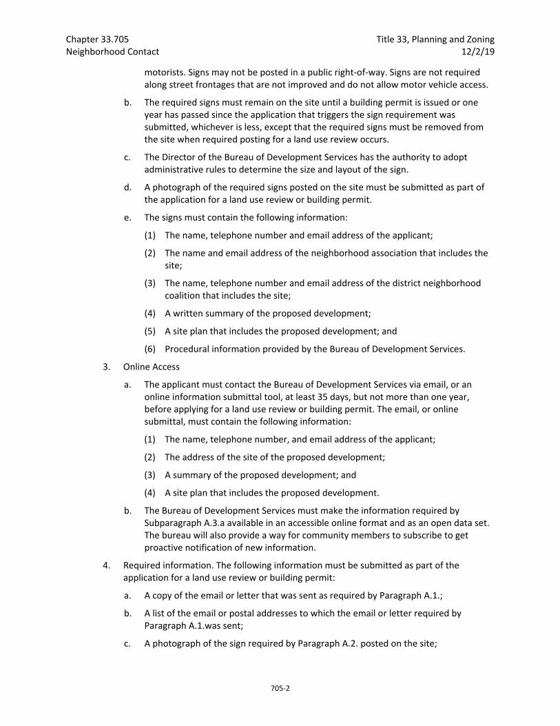
Chapter 33.705 Title 33, Planning and Zoning Neighborhood Contact 12/2/19
705‐2
motorists. Signs may not be posted in a public right‐of‐way. Signs are not required along street frontages that are not improved and do not allow motor vehicle access.
b. The required signs must remain on the site until a building permit is issued or one year has passed since the application that triggers the sign requirement was submitted, whichever is less, except that the required signs must be removed from the site when required posting for a land use review occurs.
c. The Director of the Bureau of Development Services has the authority to adopt administrative rules to determine the size and layout of the sign.
d. A photograph of the required signs posted on the site must be submitted as part of the application for a land use review or building permit.
e. The signs must contain the following information:
(1) The name, telephone number and email address of the applicant;
(2) The name and email address of the neighborhood association that includes the site;
(3) The name, telephone number and email address of the district neighborhood coalition that includes the site;
(4) A written summary of the proposed development;
(5) A site plan that includes the proposed development; and
(6) Procedural information provided by the Bureau of Development Services.
3. Online Access
a. The applicant must contact the Bureau of Development Services via email, or an online information submittal tool, at least 35 days, but not more than one year, before applying for a land use review or building permit. The email, or online submittal, must contain the following information:
(1) The name, telephone number, and email address of the applicant;
(2) The address of the site of the proposed development;
(3) A summary of the proposed development; and
(4) A site plan that includes the proposed development.
b. The Bureau of Development Services must make the information required by Subparagraph A.3.a available in an accessible online format and as an open data set. The bureau will also provide a way for community members to subscribe to get proactive notification of new information.
4. Required information. The following information must be submitted as part of the application for a land use review or building permit:
a. A copy of the email or letter that was sent as required by Paragraph A.1.;
b. A list of the email or postal addresses to which the email or letter required by Paragraph A.1.was sent;
c. A photograph of the sign required by Paragraph A.2. posted on the site;

Title 33, Planning and Zoning Chapter 33.705 12/2/19 Neighborhood Contact
705‐3
d. A signed statement certifying that the required email or letter was sent, and the required signs were posted, at least 35 days, but not more than one year, before applying for a land use review or building permit.
B. Neighborhood contact II. Neighborhood contact II requires the following meeting, notification and posting steps:
1. Notification. The applicant must contact via email or mail the neighborhood association, district neighborhood coalition, and business association for the area, and any neighborhood association, district neighborhood coalition, or business association within 400 feet of the proposal site. The email or letter must be sent at least 35 days, but not more than one year, before applying for a land use review or building permit. A copy of the email or letter, and a list of the email or postal addresses to which the email or letter was sent, must be submitted as part of the application for a land use review or building permit. The email or letter must contain the following information:
a. The name, telephone number and email address of the applicant;
b. The address of the site of the proposed development;
c. The date, time and location of the required public meeting; and
d. A summary of the proposed development; and
e. A site plan that includes the proposed development.
2. Sign. The applicant must post at least one sign on the proposed development site at least 35 days, but not more than one year, before applying for a land use review or building permit.
a. A sign must be placed on each street frontage of the site. If the street frontage is over 600 feet long, a sign is required for each 600 feet or fraction thereof. Signs must be posted within 10 feet of a street lot line and must be visible to pedestrians and motorists. Signs may not be posted in a public right‐of‐way. Signs are not required along street frontages that are not improved and do not allow motor vehicle access.
b. The required signs must remain on the site until a building permit is issued or one year has passed since the application that triggers the sign requirement was submitted, whichever is less, except that the required signs must be removed from the site when required posting for a land use review occurs.
c. The Director of the Bureau of Development Services has the authority to adopt administrative rules to determine the size and layout of the sign.
d. A photograph of the required signs posted on the site must be submitted as part of the application for a land use review or building permit.
e. The signs must contain the following information:
(1) The name, telephone number and email address of the applicant;
(2) The name and email address of the neighborhood association that includes the site;
(3) The name, telephone number and email address of the district coalition that includes the site;
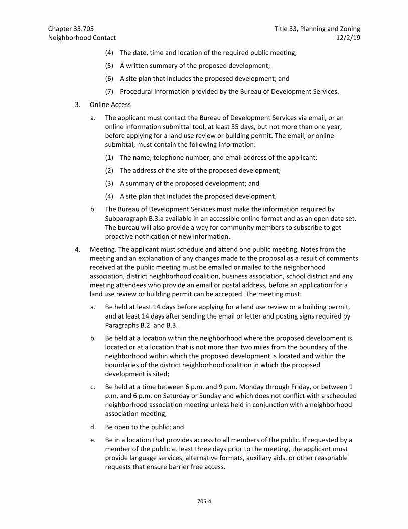
Chapter 33.705 Title 33, Planning and Zoning Neighborhood Contact 12/2/19
705‐4
(4) The date, time and location of the required public meeting;
(5) A written summary of the proposed development;
(6) A site plan that includes the proposed development; and
(7) Procedural information provided by the Bureau of Development Services.
3. Online Access
a. The applicant must contact the Bureau of Development Services via email, or an online information submittal tool, at least 35 days, but not more than one year, before applying for a land use review or building permit. The email, or online submittal, must contain the following information:
(1) The name, telephone number, and email address of the applicant;
(2) The address of the site of the proposed development;
(3) A summary of the proposed development; and
(4) A site plan that includes the proposed development.
b. The Bureau of Development Services must make the information required by Subparagraph B.3.a available in an accessible online format and as an open data set. The bureau will also provide a way for community members to subscribe to get proactive notification of new information.
4. Meeting. The applicant must schedule and attend one public meeting. Notes from the meeting and an explanation of any changes made to the proposal as a result of comments received at the public meeting must be emailed or mailed to the neighborhood association, district neighborhood coalition, business association, school district and any meeting attendees who provide an email or postal address, before an application for a land use review or building permit can be accepted. The meeting must:
a. Be held at least 14 days before applying for a land use review or a building permit, and at least 14 days after sending the email or letter and posting signs required by Paragraphs B.2. and B.3.
b. Be held at a location within the neighborhood where the proposed development is located or at a location that is not more than two miles from the boundary of the neighborhood within which the proposed development is located and within the boundaries of the district neighborhood coalition in which the proposed development is sited;
c. Be held at a time between 6 p.m. and 9 p.m. Monday through Friday, or between 1 p.m. and 6 p.m. on Saturday or Sunday and which does not conflict with a scheduled neighborhood association meeting unless held in conjunction with a neighborhood association meeting;
d. Be open to the public; and
e. Be in a location that provides access to all members of the public. If requested by a member of the public at least three days prior to the meeting, the applicant must provide language services, alternative formats, auxiliary aids, or other reasonable requests that ensure barrier free access.
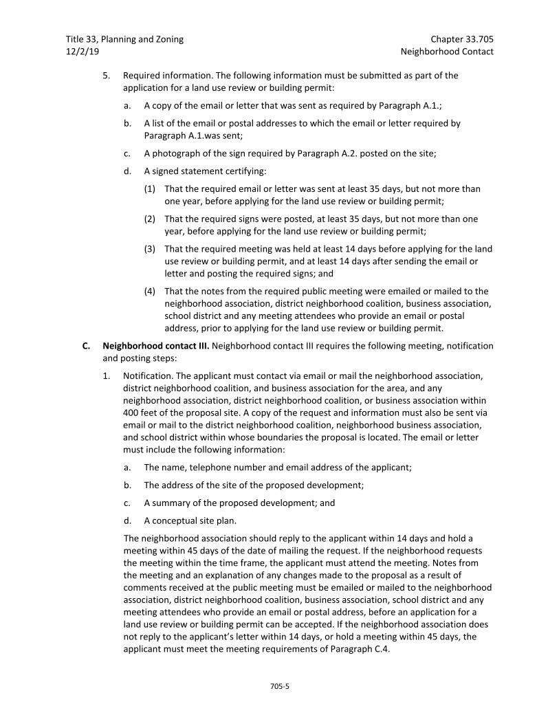
Title 33, Planning and Zoning Chapter 33.705 12/2/19 Neighborhood Contact
705‐5
5. Required information. The following information must be submitted as part of the application for a land use review or building permit:
a. A copy of the email or letter that was sent as required by Paragraph A.1.;
b. A list of the email or postal addresses to which the email or letter required by Paragraph A.1.was sent;
c. A photograph of the sign required by Paragraph A.2. posted on the site;
d. A signed statement certifying:
(1) That the required email or letter was sent at least 35 days, but not more than one year, before applying for the land use review or building permit;
(2) That the required signs were posted, at least 35 days, but not more than one year, before applying for the land use review or building permit;
(3) That the required meeting was held at least 14 days before applying for the land use review or building permit, and at least 14 days after sending the email or letter and posting the required signs; and
(4) That the notes from the required public meeting were emailed or mailed to the neighborhood association, district neighborhood coalition, business association, school district and any meeting attendees who provide an email or postal address, prior to applying for the land use review or building permit.
C. Neighborhood contact III. Neighborhood contact III requires the following meeting, notification and posting steps:
1. Notification. The applicant must contact via email or mail the neighborhood association, district neighborhood coalition, and business association for the area, and any neighborhood association, district neighborhood coalition, or business association within 400 feet of the proposal site. A copy of the request and information must also be sent via email or mail to the district neighborhood coalition, neighborhood business association, and school district within whose boundaries the proposal is located. The email or letter must include the following information:
a. The name, telephone number and email address of the applicant;
b. The address of the site of the proposed development;
c. A summary of the proposed development; and
d. A conceptual site plan.
The neighborhood association should reply to the applicant within 14 days and hold a meeting within 45 days of the date of mailing the request. If the neighborhood requests the meeting within the time frame, the applicant must attend the meeting. Notes from the meeting and an explanation of any changes made to the proposal as a result of comments received at the public meeting must be emailed or mailed to the neighborhood association, district neighborhood coalition, business association, school district and any meeting attendees who provide an email or postal address, before an application for a land use review or building permit can be accepted. If the neighborhood association does not reply to the applicant’s letter within 14 days, or hold a meeting within 45 days, the applicant must meet the meeting requirements of Paragraph C.4.
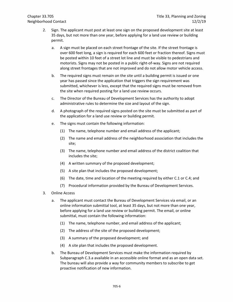
Chapter 33.705 Title 33, Planning and Zoning Neighborhood Contact 12/2/19
705‐6
2. Sign. The applicant must post at least one sign on the proposed development site at least 35 days, but not more than one year, before applying for a land use review or building permit.
a. A sign must be placed on each street frontage of the site. If the street frontage is over 600 feet long, a sign is required for each 600 feet or fraction thereof. Signs must be posted within 10 feet of a street lot line and must be visible to pedestrians and motorists. Signs may not be posted in a public right‐of‐way. Signs are not required along street frontages that are not improved and do not allow motor vehicle access.
b. The required signs must remain on the site until a building permit is issued or one year has passed since the application that triggers the sign requirement was submitted, whichever is less, except that the required signs must be removed from the site when required posting for a land use review occurs.
c. The Director of the Bureau of Development Services has the authority to adopt administrative rules to determine the size and layout of the sign.
d. A photograph of the required signs posted on the site must be submitted as part of the application for a land use review or building permit.
e. The signs must contain the following information:
(1) The name, telephone number and email address of the applicant;
(2) The name and email address of the neighborhood association that includes the site;
(3) The name, telephone number and email address of the district coalition that includes the site;
(4) A written summary of the proposed development;
(5) A site plan that includes the proposed development;
(6) The date, time and location of the meeting required by either C.1 or C.4; and
(7) Procedural information provided by the Bureau of Development Services.
3. Online Access
a. The applicant must contact the Bureau of Development Services via email, or an online information submittal tool, at least 35 days, but not more than one year, before applying for a land use review or building permit. The email, or online submittal, must contain the following information:
(1) The name, telephone number, and email address of the applicant;
(2) The address of the site of the proposed development;
(3) A summary of the proposed development; and
(4) A site plan that includes the proposed development.
b. The Bureau of Development Services must make the information required by Subparagraph C.3.a available in an accessible online format and as an open data set. The bureau will also provide a way for community members to subscribe to get proactive notification of new information.
Title 33, Planning and Zoning Chapter 33.705 12/2/19 Neighborhood Contact
705‐7
4. Meeting. If the neighborhood association does not reply to the applicant meeting request within 14 days, or hold a meeting within 45 days, the applicant must schedule and attend one public meeting. Notes from the meeting and an explanation of any changes made to the proposal as a result of comments received at the public meeting must be emailed or mailed to the neighborhood association, district neighborhood coalition, business association, school district and any meeting attendees who provide an email or postal address, before an application for a land use review or building permit can be accepted. The meeting must:
a. Be held at least 14 days before applying for a land use review or a building permit, and at least 14 days after sending the email or letter and posting signs required by Paragraphs C.1. and C.2.
b. Be held at a location within the neighborhood where the proposed development is located or at a location that is not more than two miles from the boundary of the neighborhood within which the proposed development is located and within the boundaries of the district neighborhood coalition in which the proposed development is sited;
c. Be held at a time between 6 p.m. and 9 p.m. Monday through Friday, or between 1 p.m. and 6 p.m. on Saturday or Sunday and which does not conflict with a scheduled neighborhood association meeting unless held in conjunction with a neighborhood association meeting; and
d. Be open to the public; and
e. Be in a location that provides access to all members of the public. If requested by a member of the public at least three days prior to the meeting, the applicant must provide language services, alternative formats, auxiliary aids, or other reasonable requests that ensure barrier free access.
5. Required information. The following information must be submitted as part of the application for a land use review or building permit:
a. A copy of the emails or letters that were sent as required by Paragraphs C.1. and C.4;
b. A list of the email or postal addresses to which the email or letter required by Paragraph C.1. and C.4 were sent;
c. A photograph of the sign required by Paragraph C.2. posted on the site;
d. A signed statement certifying:
(1) That the required email or letter was sent at least 35 days, but not more than one year, before applying for the land use review or building permit;
(2) That the required signs were posted, at least 35 days, but not more than one year, before applying for the land use review or building permit;
(3) That the required meeting request was sent;
(4) That the neighborhood association either did not reply or declined the request or that the neighborhood association meeting take place; and
(5) That the notes from the meeting, if one was held, were emailed or mailed to the neighborhood association, district neighborhood coalition, business association,

Chapter 33.705 Title 33, Planning and Zoning Neighborhood Contact 12/2/19
705‐8
school district and any meeting attendees who provide an email or postal address, prior to applying for the land use review or building permit.
(Adopted by Ord. No. 189488, effective 12/2/19.)
Title 33, Planning and Zoning Chapter 33.730 12/2/19 Quasi‐Judicial Procedures
730‐1
33.730 Quasi‐Judicial Procedures
730
Sections:
General 33.730.010 Purpose
Basic Procedures 33.730.013 Expedited Land Division Procedure 33.730.014 Type I Procedure 33.730.015 Type Ix Procedure 33.730.020 Type II Procedure 33.730.025 Type IIx Procedure 33.730.030 Type III Procedure 33.730.031 Type IV Procedure 33.730.040 Final Council Action Required
General Information on Procedures 33.730.042 Concurrent Reviews 33.730.050 Pre‐Application Conference 33.730.060 Application Requirements 33.730.070 Written Notice Requirements 33.730.080 Posting Requirements 33.730.090 Reports and Record Keeping 33.730.100 Public Hearing Requirements 33.730.110 Ex Parte Contact
After a Final Decision 33.730.120 Recording an Approval 33.730.130 Expiration of an Approval 33.730.140 Requests for Changes to Conditions of Approval
General
33.730.010 Purpose This chapter states the procedures and requirements for quasi‐judicial reviews. It contains the step‐by‐step processing requirements. The chapter also describes the rules of conduct for all people involved in the quasi‐judicial review process. The assignment of procedures to specific reviews is done in the chapter that establishes the review. The assignment of the review body is done in Chapter 33.720, Assignment of Review Bodies.
The regulations provide standardized methods for processing quasi‐judicial land use reviews. The requirements provide clear and consistent rules to ensure that the legal rights of individual property owners and the public are protected. The rules implement state law, including the requirement that most quasi‐judicial reviews must be completed within 120 days of filing a complete application. The Type II, Type IIx, Type III, and Type IV procedures, with their varying levels of review, provide the City with options when assigning procedures to each quasi‐judicial review in this Title. The Type I and Type Ix procedures are administrative procedures.

Chapter 33.730 Title 33, Planning and Zoning Quasi‐Judicial Procedures 12/2/19
730‐2
The Type I and Ix procedures, or limited land use review, allows local decisions to be made administratively for such reviews as minor design and historic resource cases. The Type II procedure is the shortest and simplest of the other three quasi‐judicial reviews. It is intended for reviews which involve lesser amounts of discretion, lower potential impacts, or both. The Type IIx procedure is used primarily for land divisions. It provides more time to make the administrative decision than the Type II procedure. The Type III procedure is a longer and more in‐depth review. It is intended for reviews which involve substantial discretion or high impacts. The Type IV procedure is used to review proposals to demolish certain significant historic resources.
Basic Procedures
33.730.013 Expedited Land Division Procedure The Expedited Land Division (ELD) procedure provides an alternative to the standard procedures for some land divisions. The applicant may choose to use the ELD process if the land division request meets all of the elements specified in ORS 197.360. The steps of this procedure are in ORS 197.365 through .375. The application requirements are listed in Section 33.730.060, below. Two additional steps are required for land division requests using the ELD Procedure:
A. Neighborhood contact.
1. When the ELD includes four to ten lots, the applicant is required to meet the neighborhood contact requirements specified in 33.705.020.A., Neighborhood contact I.
2. When the ELD includes eleven or more lots, the applicant is required to meet the neighborhood contact requirements specified in 33.705.020.B., Neighborhood contact II.
B. Pre‐application conference. A pre‐application conference is required for all land division requests processed through the ELD procedure. See 33.730.050, Pre‐Application Conference. The pre‐application conference must be held before applying for an ELD review.
33.730.014 Type I Procedure The Type I procedure is an administrative process with public notice but no hearing.
A. Pre‐application conferences. A pre‐application conference is not required.
B. Neighborhood Contact
1. When the proposed development associated with the land use review will result in the addition of at least 10,000 square feet and not more than 25,000 square feet of net building area to the site, the neighborhood contact steps of 33.705.020.A., Neighborhood contact I, are required. If the proposed development has already met the neighborhood contact requirements as part of a building permit process, it is exempt from the neighborhood contact requirements.
2. When the proposed development associated with the land use review will result in the addition of more than 25,000 square feet of net building area to the site, the neighborhood contact steps of 33.725.020.B., Neighborhood contact II, are required. If
Title 33, Planning and Zoning Chapter 33.730 12/2/19 Quasi‐Judicial Procedures
730‐3
the proposed development has already met the neighborhood contact requirements as part of a building permit process, it is exempt from the neighborhood contact requirements.
C. Application. The applicant must submit an application on the appropriate form and accompanied by the correct fee. The application must contain all information required by 33.730.060, Application Requirements, and any additional information required for the specific type of land use review. Type I procedures are intended for such reviews as minor historic resource cases.
D. Notice of a request. Upon receipt of a complete application, the Director of BDS will mail a notice of the request to the owner, the applicant if different, all property owners within 100 feet of the site, and to the recognized organization(s) in which the site is located. The notice will contain all information listed in 33.730.070.B, Type I and Type Ix notice of request.
E. Processing time. Upon determining that the application is complete the Director of BDS will make a decision on the case as follows:
1. The director of BDS will not make the decision until at least 14 days after the notice required by Subsection C is mailed; and
2. The Director of BDS will make the final decision on the case and mail a notice of decision within 21 days after the application is determined to be complete. The applicant may extend this time limit.
F. Administrative decision.
1. In making the decision the Director of BDS may consult with the owner, applicant, other citizens, City agencies, other public and private organizations, to solicit information relevant to the request. The decision is based on the Director of BDS’s findings. The Director of BDS’s findings are based on an evaluation of the facts, the applicable code regulations, and the applicable design guidelines.
2. The decision report will be prepared as provided in 33.730.090, Reports and Record Keeping, and must be kept with the public record of the case.
3. The decision of the Director of BDS is final.
G. Notice of decision. The Director of BDS will mail notice of the decision to the owner, the applicant if different, and to any person or organization who submitted written comments. See 33.730.070.F, Type I, Type Ix, and Type IV notice of decision.
H. Date that decision is final and effective. The decision of the BDS Director is final and effective on the day the notice of decision is mailed.
33.730.015 Type Ix Procedure The Type Ix procedure is an administrative process with public notice but no hearing.
A. Pre‐application conferences. A pre‐application conference is optional.
Chapter 33.730 Title 33, Planning and Zoning Quasi‐Judicial Procedures 12/2/19
730‐4
B. Neighborhood contact.
1. When the proposed development associated with the land use review will result in the addition of at least 10,000 square feet and not more than 25,000 square feet of net building area to the site, the neighborhood contact steps of 33.705.020.A., Neighborhood contact I, are required If the proposed development has already met the neighborhood contact requirements as part of a building permit process, it is exempt from the neighborhood contact requirements.
2. When the proposed development associated with the land use review will result in the addition of more than 25,000 square feet of net building area to the site, the neighborhood contact steps of 33.705.020.B., Neighborhood contact II, are required. If the proposed development has already met the neighborhood contact requirements as part of a building permit process, it is exempt from the neighborhood contact requirements.
C. Application. The applicant must submit an application on the appropriate form and accompanied by the correct fee. The application must contain all information required by 33.730.060, Application Requirements, and any additional information required for the specific type of land use review. Type Ix procedures are intended for such reviews as minor design cases.
D. Notice of a request. Upon receipt of a complete application, the Director of BDS will mail a notice of the request to the owner, the applicant if different, all property owners within 100 feet of the site, and to the recognized organization(s) in which the site is located. The notice will contain all information listed in 33.730.070.B, Type I and Type Ix notice of request.
E. Processing time. Upon determining that the application is complete the Director of BDS will make a decision on the case as follows:
1. The director of BDS will not make the decision until at least 30 days after the notice required by Subsection C is mailed; and
2. The Director of BDS will make the final decision on the case and mail a notice of decision within 45 days after the application is determined to be complete. The applicant may extend this time limit.
F. Administrative decision.
1. In making the decision the Director of BDS may consult with the owner, applicant, other citizens, City agencies, other public and private organizations, to solicit information relevant to the request. The decision is based on the Director of BDS’s findings. The Director of BDS’s findings are based on an evaluation of the facts, the applicable code regulations, and the applicable design guidelines.
2. The decision report will be prepared as provided in 33.730.090, Reports and Record Keeping, and must be kept with the public record of the case.
3. The decision of the Director of BDS is final.
Title 33, Planning and Zoning Chapter 33.730 12/2/19 Quasi‐Judicial Procedures
730‐5
G. Notice of decision. The Director of BDS will mail notice of the decision to the owner, the applicant if different, and to any person or organization who submitted written comments. See 33.730.070.F, Type I, Type Ix, and Type IV notice of decision.
H. Date that decision is final and effective. The decision of the BDS Director is final and effective on the day the notice of decision is mailed.
33.730.020 Type II Procedure The Type II procedure is an administrative process, with the opportunity to appeal the Director of BDS's decision to another review body.
A. Pre‐application conference. A pre‐application conference is optional unless it is a specific requirement of a review. See 33.730.050, Pre‐Application Conference.
B. Neighborhood contact.
1. When the proposed development associated with the land use review will result in the addition of at least 10,000 square feet and not more than 25,000 square feet of net building area to the site and no portion of the site is in the Design overlay zone, the neighborhood contact steps of 33.705.020.A., Neighborhood contact I, are required. If the proposed development has already met the neighborhood contact requirements as part of a building permit process, it is exempt from the neighborhood contact requirements.
2. When the proposed development associated with the land use review will result in the addition of more than 25,000 square feet of net building area to the site and no portion of the site is in the Design overlay zone, the neighborhood contact steps of 33.705.020.B., Neighborhood contact II, are required. If the proposed development has already met the neighborhood contact requirements as part of a building permit process, it is exempt from the neighborhood contact requirements.
3. When the proposed development associated with the land use review will result in the addition of more than 10,000 square feet of net building area to the site and the site is in the Design overlay zone, the neighborhood contact steps of 33.705.020.C, Neighborhood contact III, are required. If the proposed development has already met the neighborhood contact requirements as part of a building permit process, it is exempt from the neighborhood contact requirements.
C. Application. The applicant must submit an application on the appropriate form and accompanied by the correct fee. The application must contain all information required by 33.730.060, Application Requirements, and any additional information required for the specific type of land use review.
D. Preliminary notice. Upon receipt of a complete application, the Director of BDS will mail a notice of the request to the owner, the applicant if different, all property owners within 150 feet of the site when within the Urban Growth Boundary (UGB) and within 500 feet when outside the UGB, to the recognized organization(s) in which the lot is located, and to all recognized organizations within 400 feet of the lot. See 33.730.070.C, Type II and Type IIx notice of request.

Chapter 33.730 Title 33, Planning and Zoning Quasi‐Judicial Procedures 12/2/19
730‐6
E. Processing time. Upon determining that the application is complete, the Director of BDS will make a decision on the case as follows:
1. The Director of BDS will not make the decision until 21 days after the notice required by Subsection C, above, is mailed.
2. The Director of BDS will make a final decision on the case and mail a notice of decision within 28 days after the notice required by Subsection C. above is mailed. The applicant may extend this time limit.
F. Administrative decision.
1. In making the decision, the Director of BDS may consult with the owner, applicant, other citizens, City agencies, and other public and private organizations to solicit information relevant to the request. The decision is based on the Director of BDS's findings, which are based on an evaluation of the facts and the applicable code regulations.
2. The decision report will be prepared as provided in 33.730.090, Reports and Record Keeping, and must be kept with the public record of the case.
G. Notice of decision (pending appeal). The Director of BDS will mail the notice of the decision to the owner, the applicant if different, all property owners within 150 feet of the site when within the Urban Growth Boundary (UGB) and within 500 feet when outside the UGB, to the recognized organization(s) in which the site is located, to all recognized organizations within 400 feet of the site, and to any person who submitted written comments. See 33.730.070.G, Notice of Type II, Type IIx or Type III decision (pending appeal).
H. Ability to appeal. The Director of BDS's decision is final unless appealed. The decision may be appealed by the applicant, the owner, and those entitled to notice, and any person adversely affected or aggrieved by the decision. The appeal must be submitted to the Director of BDS within 14 days of the day the notice of decision is mailed. The review body for the appeal will be as stated in 33.720, Assignment of Review Bodies.
I. When no appeal is filed. If no one appeals the decision, the decision is final and effective on the day after the last day to appeal.
J. When an appeal is filed. Appeals must comply with this subsection.
1. Content of the appeal. The appeal must be submitted on forms provided by the Director of BDS. All information requested on the form must be submitted in order for the appeal form to be accepted. The appeal request must include:
The file number and land use review(s) appealed;
The appellant's name, address, signature, phone number;
A statement of which sections of the Zoning Code or which approval criteria the decision violates; and
The required fee.
2. Notification of appeal hearing. The Director of BDS will mail a copy of the appeal within 3 working days of its receipt to the applicant, unless the applicant is also the
Title 33, Planning and Zoning Chapter 33.730 12/2/19 Quasi‐Judicial Procedures
730‐7
appellant, and the owner. Within 5 working days of the receipt of the appeal, the Director of BDS will mail a notice of the appeal hearing to the owner, the applicant if different, and all persons and recognized organizations who received the notice of the decision. See 33.730.070.H, Notice of a Type II or Type III appeal hearing.
3. Scheduling of hearing. The Director of BDS will schedule a public hearing to take place at least 21 days from the mailing of the notice of appeal.
4. Submit report to review body. The Director of BDS will forward the decision report and a copy of the appeal to the review body and make the report and copy of the appeal available to the public at least 7 days prior to the date of the hearing.
5. Appeal hearing. Appeal hearings must comply with the provisions of 33.730.100, Public Hearing Requirements, and 33.730.110, Ex Parte Contact.
6. Appeal decision. The review body may adopt the decision report of the Director of BDS, modify it, or reject it based on information presented at the hearing and in the record.
a. The Hearings Officer will make a written decision in the form of a report and mail notice of the decision within 17 days of the close of the record.
b. Other review bodies. Other review bodies will make all deliberations and decisions at the hearing.
7. Amended decision report. If the review body modifies or rejects the decision report, an amended report with findings supporting the decision must be prepared. For review bodies other than the Hearings Officer, the Director of BDS will prepare the amended decision report and mail notice of the decision within 17 days of the hearing. The report must comply with 33.730.090, Reports and Record Keeping.
8. Notice of final decision. When the Hearings Officer is the review body, the Hearings Officer will mail notice of the decision. For other review bodies, the Director of BDS will mail notice of the decision. Within 17 days of the close of the record, the Hearings Officer or Director of BDS will mail notice of the review body's final decision to the applicant, owner, and to any recognized organizations or persons who responded in writing to the appeal notice, testified at the hearing, or requested notice of the decision. In the case of multiple signatures on a letter or petition, the person who submitted the letter or petition or the first signature on the petition will receive the notice. See 33.730.070 I, Notice of final decision.
9. Date that decision is final and effective. The decision of the review body is final and effective on the day the notice of decision is mailed.
10. Appeal decision final. The appeal decision of the review body is final and may not be appealed to another review body within the City.
33.730.025 Type IIx Procedure The Type IIx procedure is an administrative process, with the opportunity to appeal the Director of BDS's decision to another review body.
Chapter 33.730 Title 33, Planning and Zoning Quasi‐Judicial Procedures 12/2/19
730‐8
A. Pre‐application conference. A pre‐application conference is optional. See 33.730.050, Pre‐Application Conference.
B. Neighborhood contact.
1. The neighborhood contact steps of 33.705.020.A., Neighborhood contact I, are required when:
a. The application is for a land division that includes four to ten lots; or
b. The application is for a land use review other than a land division and the proposed development associated with the land use review will result in the addition of at least 10,000 square feet and not more than 25,000 square feet of net building area to the site. If the proposed development has already met the neighborhood contact requirements as part of a building permit process, it is exempt from the neighborhood contact requirements.
2. When the application is for a land use review other than a land division and the proposed development associated with the land use review will result in the addition of more than 25,000 square feet of net building area to the site, the neighborhood contact steps of 33.705.020.B., Neighborhood contact II, are required. If the proposed development has already met the neighborhood contact requirements as part of a building permit process, it is exempt from the neighborhood contact requirements.
C. Application. The applicant must submit an application on the appropriate form and accompanied by the correct fee. The application must contain all information required by 33.730.060, Application Requirements, and any additional information required for the specific type of land use review.
D. Preliminary notice. Upon receipt of a complete application, the Director of BDS will mail a notice of the request to the owner, the applicant if different, all property owners within 150 feet of the site when within the Urban Growth Boundary (UGB) and within 500 feet when outside the UGB, to the recognized organization(s) in which the site is located, and to all recognized organizations within 400 feet of the site. See 33.730.070 C, Type II and Type IIx notice of request.
E. Processing Time. Upon determining that the application is complete the Director of BDS will make a final decision on the case as follows:
1. The Director of BDS will not make the decision until at least 30 days after the notice required by Subsection C is mailed; and
2. The Director of BDS will make the final decision on the case and mail a notice of decision within 42 days after the application is determined to be complete. The applicant may extend this time limit.
F. Administrative decision.
1. In making the decision, the Director of BDS may consult with the owner, applicant, other citizens, City agencies, and other public and private organizations to solicit information relevant to the request. The decision is based on the Director of BDS’s

Title 33, Planning and Zoning Chapter 33.730 12/2/19 Quasi‐Judicial Procedures
730‐9
findings, which are based on an evaluation of the facts and the applicable code regulations.
2. The decision report will be prepared as provided in 33.730.090, Reports and Record Keeping, and must be kept with the public record of the case.
G. Notice of decision (pending appeal). The Director of BDS will mail a notice of the decision to the owner, the applicant if different, all property owners within 150 feet of the site when within the Urban Growth Boundary (UGB) and within 500 feet when outside the UGB, to the recognized organization(s) in which the site is located, to all recognized organizations within 400 feet of the site, and to any person who submitted written comments. See 33.730.070.G, Notice of Type II, Type IIx or Type III decision (pending appeal).
H. Ability to appeal. The Director of BDS's decision is final unless appealed. The decision may be appealed by the applicant, the owner, those entitled to notice, and any person adversely affected or aggrieved by the decision. The appeal must be submitted to the Director of BDS within 14 days of the day the notice of decision is mailed. The review body for the appeal will be as stated in 33.720, Assignment of Review Bodies.
I. When no appeal is filed. If no one appeals the decision, the decision is final and effective on the day after the last day to appeal.
J. When an appeal is filed. Appeals must comply with this subsection.
1. Content of the appeal. The appeal must be submitted on forms provided by the Director of BDS. All information requested on the form must be submitted in order for the appeal form to be accepted. The appeal request must include:
The file number and land use review(s) appealed;
The appellant's name, address, signature, and phone number;
A statement of which sections of the Zoning Code or which approval criteria the decision violates; and
The required fee.
2. Notification of appeal hearing. The Director of BDS will mail a copy of the appeal within 3 working days of its receipt to the applicant, unless the applicant is also the appellant, and the owner. Within 5 working days of the receipt of the appeal, the Director of BDS will mail a notice of the appeal hearing to the owner, the applicant if different, and all persons and recognized organizations that received the notice of the decision. See 33.730.070 H, Notice of an appeal hearing.
3. Scheduling of hearing. The Director of BDS will schedule a public hearing to take place at least 21 days from the mailing of the notice of an appeal hearing.
4. Submit report to review body. The Director of BDS will forward the decision report and a copy of the appeal to the review body and make the report and copy of the appeal available to the public at least 7 days prior to the date of the hearing.
5. Appeal hearing. Appeal hearings must comply with the provisions of 33.730.100, Public Hearing Requirements, and 33.730.110, Ex Parte Contact.

Chapter 33.730 Title 33, Planning and Zoning Quasi‐Judicial Procedures 12/2/19
730‐10
6. Appeal decision. The review body may adopt the decision report of the Director of BDS, modify it, or reject it based on information presented at the hearing and in the record.
a. The Hearings Officer will make a written decision in the form of a report and mail notice of the decision within 14 days of the close of the record.
b. Other review bodies. Other review bodies will make all deliberations and decisions at the hearing.
7. Amended decision report. If the review body modifies or rejects the decision report, an amended report with findings supporting the decision must be prepared. For review bodies other than the Hearings Officer, the Director of BDS will prepare the amended decision report and mail notice of the decision within 14 days of the hearing. The report must comply with 33.730.090, Reports and Record Keeping.
8. Notice of final decision. When the Hearings Officer is the review body, the Hearings Officer will mail notice of the decision. For other review bodies, the Director of BDS will mail notice of the decision. Within 14 days of the close of the record, the Hearings Officer or Director of BDS will mail notice of the review body's final decision to the applicant, owner, and to any recognized organizations or persons who responded in writing to the appeal notice, testified at the hearing, or requested notice of the decision. In the case of multiple signatures on a letter or petition, the person who submitted the letter or petition or the first signature on the petition will receive the notice. See 33.730.070 I, Notice of final decision.
9. Date that decision is final and effective. The decision of the review body is final and effective on the day the notice of decision is mailed.
10. Appeal decision final. The appeal decision of the review body is final and may not be appealed to another review body within the City.
33.730.030 Type III Procedure A Type III procedure requires a public hearing before an assigned review body. Subsections A through D apply to all sites. If the site is within the City of Portland, Subsections E through H also apply. If the site is in the portion of unincorporated Multnomah County that is subject to City zoning, Subsection I also applies.
A. Pre‐application conference. A pre‐application conference is required for all requests processed through a Type III procedure. See 33.730.050, Pre‐Application Conference.
B. Neighborhood contact.
1. The neighborhood contact steps of 33.705.020.A., Neighborhood contact I, are required when:
a. The application is for a land division that includes four to ten lots and does not include an environmental review; or
b. The application is for a land use review other than a land division and the proposed development associated with the land use review will result in the addition of at least 10,000 square feet and not more than 25,000 square feet of

Title 33, Planning and Zoning Chapter 33.730 12/2/19 Quasi‐Judicial Procedures
730‐11
net building area to the site and no portion of the site is in the Design overlay zone. If the proposed development has already met the neighborhood contact requirements as part of a building permit process, it is exempt from the neighborhood contact requirements.
2. The neighborhood contact steps of 33.705.020.B., Neighborhood contact II, are required when:
a. The application is for a land division that includes eleven or more lots and does not include an environmental review; or
b. The application is for a land use review other than a land division and the proposed development associated with the land use review will result in the addition of more than 25,000 square feet of net building area to the site and no portion of the site is in the Design overlay zone. If the proposed development was subject to a building permit process, it is exempt from the neighborhood contact requirements.
3. The neighborhood contact steps of 33.705.020.C., Neighborhood contact III, are required when:
a. The application is for a land division that includes an environmental review; or
b. The application is for a land use review other than a land division and the proposed development associated with the land use review will result in the addition of more than 10,000 square feet of net building area to the site and the site is in the Design overlay zone.
C. Application. The applicant must submit an application on the appropriate form and accompanied by the correct fee. The application must contain all information required by 33.730.060, Application Requirements, and any additional information required for the specific type of land use review.
D. Processing time. Upon determining that the application is complete, the Director of BDS will schedule a public hearing to take place within 51 days. The applicant may extend the time limit.
E. Notice of a request.
1. Mailed notice. At least 20 days before the scheduled hearing, the Director of BDS will mail a notice of the request to the regional transit agency, Metro, the Oregon Department of Transportation, the owner, the applicant if different, all property owners within 400 feet of the site when inside the Urban Growth Boundary (UGB) and within 500 feet when outside the UGB, to the recognized organization(s) in which the lot is located, and to all recognized organizations within 1,000 feet of the lot. See 33.730.070 D, Type III and Type IV notice of request.
2. Posting notice on the site. The applicant must place a public notice about the request on the site. The posting must meet the standards of 33.730.080 below.
Chapter 33.730 Title 33, Planning and Zoning Quasi‐Judicial Procedures 12/2/19
730‐12
F. Decision by review body if site is in City of Portland.
1. BDS recommendation. The Director of BDS will prepare a report with recommendations, and file the report with the review body and make the report available to the public at least 10 days prior to the hearing. A copy will be mailed to the applicant and to any recognized organizations whose boundaries include the site.
2. Public hearing. The public hearing will be conducted by the assigned review body. It will be held in accordance with the requirements of 33.730.100, Public Hearing Requirements.
3. Review body decision. The review body may adopt the Director of BDS's report and recommendation, modify it, or reject it based on information presented at the hearing and in the record.
a. Hearings Officer.
(1) Generally. The Hearings Officer will make a written decision in the form of a report and mail notice of the decision within 17 days of the close of the record;
(2) Comprehensive Plan Map Amendments. For Comprehensive Plan Map Amendments and land use reviews processed concurrently with Comprehensive Plan Map Amendments, the Hearings Officer will make a written recommendation in the form of a report to City Council and mail notice of the recommendation within 30 days of the close of the record.
b. Other review bodies. Other review bodies will make all deliberations and decisions at the hearing.
4. Amended decision report. If the review body modifies or rejects the Director of BDS's report, an amended report with findings supporting the decision will be prepared. For review bodies other than the Hearings Officer, the Director of BDS will prepare the amended decision report and mail notice of the decision within 17 days of the close of the record. The report must comply with 33.730.090, Reports and Record Keeping.
5. Mailed notice of decision (pending appeal). When the Hearings Officer is the review body, the Hearings Officer will mail notice of the decision. For other review bodies, the Director of BDS will mail notice of the decision. Within 17 days of the close of the record, or within 30 days for Comprehensive Plan Map Amendments and land use reviews processed concurrently with Comprehensive Plan Map Amendments, the Hearings Officer or Director of BDS will mail notice of the review body's decision (pending appeal) to the owner, the applicant if different, and all recognized organizations or persons who responded in writing to the notice of the request, testified at the hearing, or requested notice of the decision. In the case of multiple signatures on a letter or petition, the person who submitted the letter or petition or the first signature on the petition will receive the notice. See 33.730.070.G, Notice of Type II, Type IIx or Type III decision (pending appeal).
G. Ability to appeal. The review body's decision is final unless appealed. The decision may be appealed by the applicant, the owner, and those who have testified orally or in writing at

Title 33, Planning and Zoning Chapter 33.730 12/2/19 Quasi‐Judicial Procedures
730‐13
the hearing, provided that the testimony was directed to a specific approval criterion. The appeal must be submitted to the Director of BDS within 14 days of the day the notice of decision is mailed. The review body for the appeal will be the City Council.
H. When no appeal is filed. If no one appeals the decision, the decision is final and effective on the day after the last day to appeal.
I. When an appeal is filed. Appeals must comply with this subsection.
1. Content of the appeal. The appeal must be submitted on forms provided by the Director of BDS. All information requested on the form must be submitted in order for the appeal form to be accepted. The appeal request must include:
The file number and land use review(s) appealed;
The appellant's name, address, signature, phone number, and relationship to the land use action;
A statement of which sections of the Zoning Code or which approval criteria the decision violates; and
The required fee.
2. Mailed notice of the appeal hearing. The Director of BDS will mail a copy of the appeal within 3 working days of its receipt to the applicant, unless the applicant is also the appellant, and the owner. Within 5 working days of the receipt of the appeal, the Director of BDS will mail a notice of the appeal hearing to the owner, the applicant if different, the review body, and all persons and recognized organizations that received the notice of the decision. See 33.730.070.H, Notice of a Type II, Type IIx, or Type III appeal hearing. No notice of the appeal hearing is required to be posted on the site.
3. Scheduling of hearing. The City Auditor will schedule a public hearing to take place at least 21 days from the mailing of the notice of appeal.
4. Submit report to City Council. The Director of BDS will forward the appeal as filed, the review body's decision report, and a transcript if requested and paid for, to City Council at least 7 days prior to the date of the hearing.
5. Appeal hearing. Appeal hearings must comply with the provisions of 33.730.100, Public Hearing Requirements, and 33.730.110, Ex Parte Contact. Appeals heard by City Council may be heard "on the record" and must also conform to any rules of procedure adopted by Council for their use. The Director of BDS will represent the review body in appeals heard by City Council.
6. Appeal decision and findings.
a. The City Council may adopt the review body's decision report, modify it, or reject it based on information presented at the hearing and in the record. If City Council modifies or rejects the decision report, an amended report with findings supporting the decision must be prepared as provided in Subparagraph b. below. The report must comply with 33.730.090, Reports and Record Keeping.
b. The Council may make a tentative action and direct that proposed findings and a decision be prepared. If the prevailing party is represented by a land use
Chapter 33.730 Title 33, Planning and Zoning Quasi‐Judicial Procedures 12/2/19
730‐14
professional or attorney, the prevailing party must provide findings and conclusions to support the Council's decision. If the prevailing party is not represented by a planning professional or attorney, the Director of BDS will provide findings and conclusions to support the Council's decision. Prior to final Council adoption, all findings must be reviewed and approved by the City Attorney. The findings and decision must be adopted by Council vote. An additional public hearing is not required if the vote is at a subsequent public meeting. City Council decisions are in the form of an Order of the Council except when an ordinance is required due to the type of land use request (Comprehensive Plan Map amendments or Statewide Planning Goal exceptions). In these instances, the ordinance serves in lieu of the Order of Council.
7. Notice of the final decision. Within 5 days of final Council action, the City Auditor will mail the notice of final decision to the applicant, owner, and to any recognized organizations or persons who responded in writing to the appeal notice, testified at the hearing, or requested notice of the decision. In the case of multiple signatures on a letter or petition, the person who submitted the letter or petition or the first signature on the petition will receive the notice. See 33.730.070 I, Notice of final decision.
8. Date that decision is final and effective. The decision of City Council is final and effective on the day notice of decision is mailed by the City Auditor.
9. Appeal decision final. The appeal decision of City Council is final and may not be appealed to another review body in the City.
J. Decision by review body if site is not in City of Portland.
1. BDS recommendation. The Director of BDS will prepare a report with recommendations, and file the report with the review body and make the report available to the public at least 10 days prior to the hearing. A copy will be mailed to the owner, the applicant if different and to any recognized organizations whose boundaries include the site.
2. Public hearing. The public hearing will be conducted by the assigned review body. It will be held in accordance with the requirements of 33.730.100, Public Hearing Requirements.
3. Review body decision. The review body may adopt the Director of BDS’s report and recommendation, modify it, or reject it based on information presented at the hearing and in the record.
a. Hearings Officer.
(1) Generally. The Hearings Officer will make a written decision in the form of a report and mail notice of the decision within 17 days of the close of the record;
(2) Comprehensive Plan Map Amendments. For Comprehensive Plan Map Amendments and land use reviews processed concurrently with Comprehensive Plan Map Amendments, the Hearings Officer will make a
Title 33, Planning and Zoning Chapter 33.730 12/2/19 Quasi‐Judicial Procedures
730‐15
written recommendation in the form of a report to City Council and mail notice of the recommendation within 30 days of the close of the record.
b. Other review bodies. Other review bodies will make all deliberations and decisions at the hearing.
4. Amended decision report. If the review body modifies or rejects the Director of BDS’s report, an amended report with findings supporting the decision will be prepared. For review bodies other than the Hearings Officer, the Director of BDS will prepare the amended decision report and mail notice of the decision within 17 days of the close of the record. The report must comply with 33.730.090, Reports and Record Keeping.
5. Notice of final decision. When the Hearings Officer is the review body, the Hearings Officer will mail notice of the decision. For other review bodies, the Director of BDS will mail notice of the decision. Within 17 days of the close of the record, or within 30 days for Comprehensive Plan Map Amendments and land use reviews processed concurrently with Comprehensive Plan Map Amendments, the Hearings Officer or Director of BDS will mail notice of the review body’s final decision to the applicant, owner, and to any recognized organizations or persons who commented in writing, testified at the hearing, or requested notice of the decision. In the case of multiple signatures on a letter or petition, the person who submitted the letter or petition or the first signature on the petition will receive the notice. See 33.730.070.I, Notice of final decision.
6. Effective date of decision. The review body’s decision takes effect on the day the notice is mailed.
7. Decision final. The decision of the review body is final and may not be appealed to another review body within the City.
33.730.031 Type IV Procedure
A. Pre‐application conference. A pre‐application conference is required for all requests processed through a Type IV procedure. See 33.730.050, Pre‐Application Conference.
B. Application. The applicant must submit an application on the appropriate form and accompanied by the correct fee. The application must contain all information required by 33.730.060, Application Requirements, and any additional information required for the specific type of land use review.
C. Processing time. Upon determining that the application is complete, the Director of BDS will schedule a public hearing to take place within 71 days. The applicant may extend the time limit.
D. Notice of a request.
1. Mailed notice. At least 20 days before the scheduled hearing, the Director of BDS will mail a notice of the request to the regional transit agency, Metro, the Oregon Department of Transportation, the owner, the applicant if different, all property owners within 400 feet of the site when inside the Urban Growth Boundary (UGB) and within 500 feet when outside the UGB, to the recognized organization(s) in which the
Chapter 33.730 Title 33, Planning and Zoning Quasi‐Judicial Procedures 12/2/19
730‐16
lot is located, and to all recognized organizations within 1,000 feet of the lot. See 33.730.070.D, Type III and IV notice of request.
2. Posting notice on the site. The applicant must place a public notice about the request on the site. The posting must meet the standards of 33.730.080, below.
E. Advice from Historic Landmarks Commission. BDS staff will ask the Historic Landmarks Commission to review the proposal at a public meeting where members of the public may comment. The Historic Landmarks Commission may offer comments or suggestions, in the form of a letter or testimony, to the review body. Such comments or suggestions are advisory to the review body and are not a land use decision. In addition to any comments or suggestions, the Historic Landmarks Commission will forward to the review body tapes or transcripts of any public meetings at which the Historic Landmarks Commission reviewed the proposal, and any correspondence or other documents received at such meetings.
F. Decision by review body.
1. BDS recommendation. The Director of BDS will prepare a report with recommendations, and file the report with the review body and make the report available to the public at least 10 days prior to the hearing. A copy will be mailed to the owner, the applicant if different, and to any recognized organizations whose boundaries include the site.
2. Public hearing. The public hearing will be conducted by the assigned review body. It will be held in accordance with the requirements of 33.730.100, Public Hearing Requirements.
3. Review body decision.
a. The review body may adopt the Director of BDS’ report and recommendation, modify it, or reject it based on information presented at the hearing and in the record. If the review body modifies or rejects the report and recommendation, an amended report with findings supporting the decision must be prepared as provided in Subparagraph b., below. The report must comply with 33.730.090, Reports and Record Keeping.
b. The review body may make a tentative action and direct that proposed findings and a decision be prepared. If the prevailing party is represented by a land use professional or attorney, the prevailing party must provide findings and conclusions to support the review body’s decision. If the prevailing party is not represented by a planning professional or attorney, the Director of BDS will provide findings and conclusions to support the review body’s decision. Prior to final adoption, all findings must be reviewed and approved by the City Attorney. The findings and decision must be adopted by review body vote. An additional public hearing is not required if the vote is at a subsequent public meeting.
4. Notice of the final decision. Within 5 days of final review body action, the City Auditor will mail the notice of final decision to the applicant, owner, and to any recognized organizations or persons who responded in writing to the notice, testified at the hearing, or requested notice of the decision. In the case of multiple signatures on a
Title 33, Planning and Zoning Chapter 33.730 12/2/19 Quasi‐Judicial Procedures
730‐17
letter or petition, the person who submitted the letter or petition or the first signature on the petition will receive the notice. See 33.730.070.I, Notice of final decision.
5. Date that decision is final and effective. The decision of the review body is final and effective on the day the notice of decision is mailed by the City Auditor.
6. Decision final. The decision of the review body is final and may not be appealed to another review body within the City.
33.730.040 Final Council Action Required In the case of certain quasi‐judicial land use reviews, such as Comprehensive Plan Map amendments and Statewide Planning Goal exceptions, final City Council action is required in addition to the normal Type III procedure. In these cases, the initial processing of the land use review is the same except the decision of the initial review body becomes a recommendation to Council. The post‐acknowledgment procedures required by ORS 197.610 through 197.650 are followed, and the case is scheduled for a public hearing before City Council. The 120‐day review period required by ORS 227.178(1) does not apply to Comprehensive Plan Map amendments, including Statewide Planning Goal Exceptions, or to land use reviews processed concurrently with Comprehensive Plan Map amendments.
General Information on Procedures
33.730.042 Concurrent Reviews The following regulations apply to applications for more than one land use review on a site:
A. Applications for more than one land use review on a site may be consolidated into a single application package;
B. When more than one review is requested and the reviews have different procedures, the overall application is processed using the highest procedure type. A Type III procedure is the highest, followed by Type IIx, Type II, Type Ix and then Type I;
C. When three or more different kinds of land use reviews are requested, and at least three of the land use reviews are assigned to a Type II procedure, the overall application is processed using the Type IIx procedure, unless any of the reviews are assigned to a Type III procedure. If any of the reviews are assigned to a Type III procedure the overall application is processed using the Type III procedure.
D. When more than one review is requested and any of the reviews are assigned to a Type IV procedure, the reviews not subject to the Type IV procedure are reviewed as specified in Subsections B and C. The review subject to the Type IV procedure is reviewed under the provisions of 33.730.031.
E. When a land division proposal requires an adjustment, the adjustment must be processed concurrently with the land division.
33.730.050 Pre‐Application Conference
A. Purpose. The pre‐application conference informs the applicant of the substantive and procedural requirements of this Title, provides for an exchange of information regarding

Chapter 33.730 Title 33, Planning and Zoning Quasi‐Judicial Procedures 12/2/19
730‐18
applicable requirements of other City Codes, and identifies policies and regulations that create opportunities or pose significant problems for a proposal. Technical and design assistance is available at the conference which will aid in the development of an application. The pre‐application conference also informs recognized organizations about the proposal and promotes communication between the organizations and the applicant.
B. Requirements. Forms for pre‐application conferences are available from the Director of BDS. A fee is required and must be paid at the time the request for a pre‐application conference is submitted. The applicant must submit a written proposal or sketched site plan of the proposal. A pre‐application conference must be held within 42 days of receipt of a completed request form.
C. Participants. The applicant meets with BDS staff at the pre‐application conference. In addition, City urban service or technical representatives and representatives of affected recognized organizations are invited to attend.
D. Pre‐application conference recommendations. The BDS staff will mail the applicant a written summary of the pre‐application conference within 21 days of the conference. The written summary will include suggestions and information that were raised at the conference for inclusion in an application. If the approval criteria for the land use review involve a determination of adequacy of the transportation system, the Office of Transportation may require a Transportation Impact Study to be submitted with the land use application.
E. Pre‐application conference prior to application submittal. Application for a land use review may not be submitted before the required pre‐application conference is held. This allows information obtained at the conference to be incorporated in the application submittal.
F. Other pre‐application advice. An applicant may request advice from the Design Commission or Historical Landmarks Commission prior to submitting a land use request that would be heard by these commissions. These requests are known as "design advice requests". These requests do not substitute for a required pre‐application conference with the BDS staff and other City urban service or technical representatives. A fee is charged for design advice requests as stated in the Fee Schedule.
G. Time limit. A pre‐application conference is valid for one year. If more than one year has elapsed between the date of the pre‐application conference and the date the land use review application is submitted, a new pre‐application conference is required.
33.730.060 Application Requirements
A. Check for complete application.
1. Initial check. An applicant must submit a request for a land use review on the appropriate forms supplied by the Director of BDS. The Director of BDS will review the application for completeness.
2. Incomplete applications. If the Director of BDS finds that the application is not complete, the following procedures apply:
Title 33, Planning and Zoning Chapter 33.730 12/2/19 Quasi‐Judicial Procedures
730‐19
a. The Director of BDS must notify the applicant of any missing information or materials within 14 days from the date of original submittal for Type I and Type II land use review procedures, and within 21 days from the date of original submittal for all other land use review procedures;
b. The applicant has 180 days from the date of original submittal to provide the missing information or material;
c. The application will be determined complete on the date the Director of BDS receives one of the following responses from the applicant:
(1) All of the missing information;
(2) Some of the missing information and written notice from the applicant that no other information will be provided; or
(3) Written notice from the applicant that none of the missing information will be provided.
d. If none of the responses listed above in A.2.c are received within 180 days of the date of the original submittal, the application will be voided on the 181st day. The City will not refund the filing fee.
3. The 120 day limit. The 120 day processing time limit required by ORS 227.178 will begin on the day the application is determined to be complete.
B. Changes to applications. Any changes to the application which substantially alter the request must be made at least 10 days before notice of the request is mailed.
C. Required information for land use reviews except land divisions. Unless stated elsewhere in this Title, a complete application for all land use reviews except land divisions consists of all of the materials listed in this Subsection. The Director of BDS may waive items listed if they are not applicable to the specific review. The applicant is responsible for the accuracy of all information submitted with the request.
1. Two copies of the completed application form bearing an accurate legal description, tax account number(s) and location of the property. The application must include the name, address, and telephone number of the applicant, the name and addresses of all property owners if different, the signature of the applicant, and the nature of the applicant's interest in the property.
2. One copy of a written statement that includes the following items:
A complete list of all land use reviews requested;
A complete description of the proposal including existing and proposed use(s) or change(s) to the site or building(s);
A description of how all approval criteria for the land use review(s) are met. As an alternative and where appropriate, this information may be placed on the site plan; and
Additional information needed to understand the proposal, or requested at the pre‐application conference, if applicable.
Chapter 33.730 Title 33, Planning and Zoning Quasi‐Judicial Procedures 12/2/19
730‐20
3. Four copies of a site or development plan. At least one complete copy must be 8‐1/2 inches by 11 inches, suitable for photocopy reproduction. The site or development plan must be drawn accurately to scale and must show the following existing and proposed information:
All property lines with dimensions and total lot area;
North arrow and scale of drawing;
Adjacent streets, access (driveways), curbs, sidewalks, and bicycle routes;
Existing natural features such as watercourses including the ordinary high water line and top of the bank;
The location, size, and species of all trees 6 inches and larger in diameter. On sites where the development impact area option for large sites in Chapter 11.50 will be used, only trees within that area must be shown;
Trees proposed to be preserved, including protection methods meeting the requirements of Chapter 11.60, and trees proposed to be removed;
Easements and on‐site utilities;
Existing and proposed development with all dimensions;
Building elevations;
Location of adjacent buildings;
Distances of all existing and proposed development to property lines;
Types and location of vegetation, street trees, screening, fencing, and building materials;
Percentage of the site proposed for building coverage, and landscaping coverage;
Motor vehicle and pedestrian access and circulation systems, including connections off‐site;
Motor vehicle and bicycle parking areas and design, number of spaces, and loading areas;
Bus routes, stops, pullouts or other transit facilities on or within 100 feet of the site; and
Additional requirements of the specified land use review.
4. In the case of a land use review that requires a pre‐application conference, a copy of the completed pre‐application conference summary or proof of participation, if available.
5. A transportation impact study, if required by the Office of Transportation at a pre‐application conference.
6. In the case of a zone change within the boundaries of a school district that has an adopted school district facility plan that has been acknowledged by the City, the application must include verification from the school district that there is adequate enrollment capacity to serve the zone change site.
Title 33, Planning and Zoning Chapter 33.730 12/2/19 Quasi‐Judicial Procedures
730‐21
D. Required information for land divisions. Unless stated elsewhere in this Title, a complete application for a land division consists of the materials listed below. The Director of BDS may waive items listed if they are not applicable to the specific review. The applicant is responsible for the accuracy of all information submitted with the request. At least one copy of each plan/map submitted with the application must be 8 ½ by 11 inches in size, and be suitable for reproduction.
1. Preliminary Plan for all sites except those taking advantage of Chapter 33.664, Review of Large Sites in I Zones. An application for Preliminary Plan for all sites except those taking advantage of Chapter 33.644, Review of Large Sites in I Zones, must include all of the following:
a. Application form. Three copies of the completed application form bearing an accurate legal description, tax account numbers and location of the site. The application must include the name, address, telephone number, and signature of the applicant and all property owners, and the nature of the applicant's interest in the site;
b. Written statement. Two copies of a written statement that includes the following:
A complete list of all land use reviews requested;
A complete description of the proposal including site layout and circulation, natural features, existing and proposed development and uses, and changes to the site or existing buildings;
A description of how all approval criteria are met for the land division and any concurrent land use reviews;
Additional information needed to understand the proposal, or requested at the pre‐application conference;
Names and address of land division designer or engineer and surveyor;
Proposed maintenance agreements or Conditions, Covenants and Restrictions; and
If Preliminary Plan phasing is proposed, a description and timeline of each phase and timing of associated improvements;
If more than 3 lots are proposed, the proposed name of land division;
Proposed names of all streets;
A description of the type and location of any known potential geologic hazards such as liquefaction hazards, seismic hazards and faults, landfills, contamination; and
A description of past uses on the site that may affect the suitability of the site for development, such as industrial uses, landfills, railroad yards, mining, and Quick Vehicle Servicing;
c. Vicinity map. Three copies of a vicinity map. The map must cover an area extending at least 800 feet in each direction from the land division site, and show the following existing conditions for both the site and the vicinity:
Zoning and Comprehensive Plan designations;
Streets;
Transit, pedestrian, and bicycle facilities and connections; and
Chapter 33.730 Title 33, Planning and Zoning Quasi‐Judicial Procedures 12/2/19
730‐22
Water bodies, wetlands, special flood hazard areas, floodways, and potential landslide hazard areas; and
Location of utilities and services;
d. Copies of the proposed land division, drawn to scale and of a format, material, and number acceptable to the Director of BDS. The required information may be grouped on several maps. The location of items not required to be surveyed must be accurately shown on the maps. The proposed land division maps must include the following information:
(1) Base map. The following information must be on all maps:
Surveyed information:
Boundary lines of the site with dimensions and total site area;
North arrow and scale of map;
Identification as the Preliminary Plan Map
Stamp of surveyor; and
If more than 3 lots are proposed, the proposed name of land division;
Additional information:
Proposed lot layout with sizes, dimensions, and lot numbers;
Proposed tract layout with sizes, dimensions, purpose, and name;
Proposed layout and widths of all rights‐of‐way including dimensioning and roadway width;
Dimensions of proposed right‐of‐way dedications, including those to be added to existing rights‐of‐way; and
Proposed location, dimensions, and purpose of all easements;
(2) Existing conditions map. The following existing site conditions must be shown:
Surveyed information:
Ground elevations shown by contour lines at 5‐foot vertical intervals for slopes greater than 10 percent, and at 2‐foot vertical intervals for ground slopes of 10 percent or less;
Existing development, including dimensions and distances to property lines. Structures and facilities to remain must be identified;
All trees completely or partially on the site that are 6 inches or more in diameter. Trees more than 25 feet inside a tract within which all trees will be preserved do not have to be surveyed. On sites where the proposal is to preserve tree canopy under Option 5 or 6 of the Tree Preservation Standards in 33.630.100.A.5 or 6, the trees do not have to be surveyed;
Location and dimensions of existing driveways, curb cuts, and sidewalks on and abutting the site;
Seeps and springs, wetlands, watercourses, and all water bodies including the ordinary high water line and top of bank; if there is a seep or spring on the site, a wetland delineation is required to determine the
Title 33, Planning and Zoning Chapter 33.730 12/2/19 Quasi‐Judicial Procedures
730‐23
edge of the seep or spring. This delineation must be performed by an environmental scientist;
The centerline of existing drainageways, including ditches, swales, and other areas subject to wet weather inundation; and
Location of flood hazard areas, including elevations of the special flood hazard area and floodway boundaries. Sites that contain a water body not shown on the special flood hazard area maps must identify the location of the special flood hazard areas;
Additional information:
Zoning and Comprehensive Plan designations; and
Location, dimensions, and purpose of existing easements on and abutting the site;
(3) Proposed improvements map. The following proposed improvements must be shown:
Enough information to determine that minimum lot width requirements are met for each proposed lot including footprint of structures and locations of driveways if necessary;
Distances of all known proposed development to proposed lot lines;
Proposed pedestrian connections;
If proposed lots are within a special flood hazard area or landslide hazard area, proposed building locations, and
If Preliminary Plan phasing is proposed; boundaries of sequence of the proposed phasing.
Existing and proposed services and utilities; and
Preliminary Stormwater Plan that meets the requirements of the Stormwater Management Manual and the BES Sewer Design Manual. This plan must show the capacity, type, and location, as well as the land area required, of the stormwater management system and stormwater disposal facilities proposed. The plan must also provide information on the feasibility of the stormwater management system being proposed;
(4) Preliminary Clearing and Grading Plan. A Preliminary Clearing and Grading Plan that identifies all areas of clearing and grading. The plan must show the following:
Existing contours and drainage patterns;
Existing drainageways, wetlands, streams, seeps and springs, and other water bodies;
Existing trees and vegetation;
Areas of the site where fill has been placed;
Boundaries of Environmental Overlay Zones;
Proposed areas of clearing and grading, including grading and clearing for:
Rights‐of‐way;
Services and utilities; and
Chapter 33.730 Title 33, Planning and Zoning Quasi‐Judicial Procedures 12/2/19
730‐24
Structures, such as retaining walls, necessary for the construction of these elements. Proposed areas of clearing and grading for individual lots and tracts may also be shown;
Proposed contours within areas to be cleared and graded;
Proposed stormwater and sedimentation control devices to be used during construction;
Proposed stockpile areas;
Proposed trees and vegetation to be preserved;
Proposed location and material of construction fencing for proposed tree preservation tract;
Proposed location and material of construction fence;
Proposed amount (cubic yards) of soil to be disturbed; and
Proposed structures necessary to construct streets or pedestrian connections;
e. Tree information, as follows:
(1) Existing tree map and preservation plan showing the following:
Existing and proposed lots, tracts, rights‐of‐way, and utilities;
Surveyed location of all trees completely or partially on the site required to be surveyed by D.1.d(2);
The location, species and size of trees located in adjacent rights‐of‐way;
The approximate location, species, and size of trees on adjacent sites, within 15 feet of proposed or future disturbance areas;
Heritage trees on or adjacent to the site;
Tree numbers corresponding to the arborist report;
Location, type, and size of trees to be removed;
Location, type, and size of trees to be preserved and tree protection meeting the requirements of Chapter 11.60, Technical Specification; and
Existing and proposed tree preservation tracts.
(2) Tree planting information, including:
Conceptual planting plan showing general area where trees will be planted on the lots as mitigation and/or to satisfy the tree density standards of Chapter 11.50, Trees in Development Situations;
A preliminary street tree planting plan; and
(3) A written statement describing how the requirements of Chapter 33.630, Tree Preservation, are met; and
(4) A written report prepared by an arborist that includes the following:
Trees located on the development site. The information listed below must be provided for all trees required to be shown on the existing tree map, as described in e(1) above. Trees must be numbered consistent with the tree survey:
Evaluation of tree health and condition;
Title 33, Planning and Zoning Chapter 33.730 12/2/19 Quasi‐Judicial Procedures
730‐25
Identification of tree groves and Heritage Trees;
Identification of nuisance, dead, dying, and dangerous trees;
Evaluation of the suitability of each tree for preservation based on proposed or future development on the site, including consideration of grading and utility plans;
Identification of trees to be preserved and trees to be removed;
Root protection zone and tree protection methods specified for each tree to be preserved, as required by Chapter 11.60, Technical Specifications;
A discussion of activities that will be prohibited within root protection zones during construction, and any other relevant construction management needs; and
Recommendations for short or long‐term tree care.
Trees in adjacent rights‐of‐way or on adjacent sites. Trees on adjacent rights‐of‐way or on adjacent sites that may be affected by the proposed or future development on the land division or planned development site must be identified. Recommendations for tree protection and methods to limit impacts on adjacent trees must be included in the arborist report.
f. Landslide Hazard Study. If any part of the site is in a potential landslide hazard area as shown on the City’s Potential Landslide Hazard Areas Map the application must include a Landslide Hazard Study prepared by a Certified Engineering Geologist and a Geotechnical Engineer. The Landslide Hazard Study must identify landslide hazard areas within the site and identify the part or parts of the site suitable for development in terms of the risk of a landslide affecting the site, adjacent sites, and sites directly across a street or alley from the site. The Landslide Hazard Study should make recommendations for the layout and design of the land division and development. The study must provide adequate detail to show the design of all proposed structures and improvements, and must include a statement of on‐site slope stability after the proposed development is complete. The study must also include a statement of the estimated effect of the developments on stormwater and groundwater runoff as it relates to slope stability and landslide hazard, and a proposed method of control.
The study may also include
Review of aerial photography including stereo views;
Review of geologic literature or previous reports;
Site reconnaissance including mapping of observable geologic features or hazards;
Field explorations as necessary; and
Laboratory testing;
g. Final Plat staging. When the Final Plat for a land division is to be submitted in stages, the application must include the number of stages, the areas each stage includes, and the sequence and time schedule for application for Final Plat approval of the various stages.
Chapter 33.730 Title 33, Planning and Zoning Quasi‐Judicial Procedures 12/2/19
730‐26
h. Neighborhood Contact letters. Two copies of letters required by Section 33.700.025, Neighborhood Contact;
i. Pre‐application conference summary. In the case of a land division that requires a pre‐application conference, two copies of the completed pre‐application conference summary or proof of participation;
j. Transportation Impact Study. Three copies of the Transportation Impact Study, if required; and
k. When the land division site is within the boundaries of a school district that has an adopted school district facility plan that has been acknowledged by the City, and the land division will create eleven or more lots, the application must include verification from the school district that there is adequate enrollment capacity to serve the development site.
2. Preliminary Plan for Land Divisions on Large Sites in I Zones. An application for a Preliminary Plan taking advantage of Chapter 33.664, Land Divisions on Large Sites in Industrial Zones, must include all the elements listed in Paragraph D.1., above, except the lot and proposed building locations. Block pattern layout with dimensions and areas and all required tracts must be shown.
3. Final Plat. An application for a Final Plat must include all of the following:
a. Final Plat Survey. Copies of a Final Plat survey drawn to scale and of a format, material, and number acceptable to the Director of BDS. The following information must be on the Final Plat survey:
The statement: “This plat is subject to the conditions of City of Portland Case File No. LUR…”; and
Easements and tracts, including their purpose;
b. Supplemental plan. A supplemental plan, the number determined by the Director of BDS and that uses the Final Plat survey map as a base map. The supplemental plan must show how all conditions of approval that may restrict the use of all or part of the land division site are met. Such restrictions include special development standards such as special setbacks, lot coverage limitations, impervious surface limitations, access restrictions, restrictive building areas, and approved minimum or maximum densities;
c. Compliance with conditions of approval. Documentation of compliance with all conditions of the Preliminary Plan approval, including all supporting documents or drawings required by conditions of approval such as development envelopes, final tree preservation plans, mitigation plans, and final landscape / planting plans;
d. Maintenance agreements and CC&Rs. Three copies of each required maintenance agreement or Conditions, Covenants and Restrictions;
e. Performance Guarantees. One copy of each Performance Guarantee;
f. Title report. Current title report issued by a title insurance company verifying ownership and detailing any deed restrictions;

Title 33, Planning and Zoning Chapter 33.730 12/2/19 Quasi‐Judicial Procedures
730‐27
g. Service bureau requirements. Documentation of submittal of all service bureau requirements, including water system plans, final street construction plans, final sewer and storm water plans, construction management plans, final clearing and grading plans; and
h. Fees. The applicable filing fees.
4. Final Plat for Land Divisions on Large Sites in Industrial Zones. An application for a Final Plat taking advantage of Chapter 33.664, Land Divisions on large Sites in Industrial Zones, must include all the elements listed in Paragraph D.3., above, for the area being platted. The application must also include enough information for the balance of the site to show how the approval criteria will be met.
33.730.070 Written Notice Requirements
A. General information on notices. The following applies to all notices.
1. Addresses and mailing. Mailing addresses of property owners will be obtained from the latest available county real property tax records. Unless the Director of BDS or City Auditor has received a written request for notice, a person whose name and address does not appear in the tax records will not be mailed notice. The recognized organization address is the address on the most recent list published by the Office of Neighborhood Involvement.
2. The failure of a property owner to receive notice does not invalidate the land use action if the notice was sent.
3. Measurement of notice area. Measurement of the required notice area is made by drawing lines the specified distance, including intervening street widths, from and parallel to the boundary lines of the ownership that includes the lot. If the notice area includes public lands other than right‐of‐ways that do not exceed 200 feet in depth, the first nonpublic properties in the given direction are included in the notice.
B. Type I and Type Ix notice of request. The notice of request, when processed through a Type I or Type Ix procedure, will contain at least the following information:
The file number;
The name and address of the applicant and owner;
The legal description of the site;
The street address or other easily understood geographical reference to the subject property;
A map depicting the subject property in relation to surrounding properties;
The name and telephone number of the recognized organization(s) whose boundaries include the site;
A description of the proposal which could be authorized;
An explanation of the local decision‐making process for the decision being made;
A list, by commonly used citation, of the applicable criteria for the decision;

Chapter 33.730 Title 33, Planning and Zoning Quasi‐Judicial Procedures 12/2/19
730‐28
An invitation to comment, in writing, on the proposal and the place, date and time that comments are due;
A statement that issues which may provide the basis for an appeal to the Land Use Board of Appeals must be raised prior to expiration of the comment period;
A statement that issues must be raised with sufficient specificity to afford the Director of BDS an opportunity to respond to the issues;
A statement that copies of all evidence submitted by the applicant is available for review, and that copies can be obtained for a fee equal to the City’s cost for providing the copies; and
The place where information on the matter may be examined and the name of a local government representative to contact and a telephone number to call.
C. Type II and Type IIx notice of request. The notice of request, when processed through a Type II procedure and Type IIx procedure, will contain at least the following information:
The file number;
The name and address of the applicant and owner;
The legal description of the site.
The street address or other easily understood geographical reference to the subject property;
A map depicting the subject property in relation to surrounding properties;
The name and telephone number of the recognized organization(s) whose boundaries include the site;
A description of the proposal which could be authorized;
An explanation of the local decision‐making process for the decision being made;
A list, by commonly used citation, of the applicable criteria for the decision;
An invitation to comment, in writing, on the proposal and the place, date and time that comments are due;
A statement that issues which may provide the basis for an appeal to the Oregon Land Use Board of Appeals (LUBA) must be raised prior to expiration of the comment period or prior to the conclusion of the final hearing if a local appeal is requested;
A statement that issues must be raised with sufficient specificity to afford the review body an opportunity to respond to the issue;
A statement that all evidence on the matter is available for review, and that copies can be obtained for a fee equal to the City’s cost for providing the copies: and
The place where information on the matter may be examined and the name of a local government representative to contact and a telephone number to call.
D. Type III and Type IV notice of request and hearing. The notice of request and hearing, when processed through a Type III and Type IV procedure, will contain at least the following information:
The file number;
The name and address of the applicant and owner;

Title 33, Planning and Zoning Chapter 33.730 12/2/19 Quasi‐Judicial Procedures
730‐29
The legal description of the site.
The street address or other easily understood geographical reference to the subject property;
A map depicting the subject property in relation to surrounding properties;
The name and telephone number of the recognized organization(s) whose boundaries include the site;
A description of the proposal and the proposed use or uses which could be authorized;
The land use reviews requested and other land use reviews which may be considered as an option;
An explanation of the local decision‐making process for the decision being made;
The applicable comprehensive plan and code approval criteria;
The date, time and location of the hearing;
A general explanation of the requirements for submission of written and oral testimony and the procedure for conduct of the hearing;
A statement that issues which may provide the basis for an appeal to the Land Use Board of Appeals must be raised in person or by letter prior to the close of the record at or following the final evidentiary hearing;
A statement that issues must be raised with sufficient specificity to afford the review body an opportunity to respond to the issues;
A statement that a copy of the application, all evidence on the matter submitted by the applicant, and applicable criteria are available for review at no cost, and that copies can be obtained for a fee equal to the City’s cost for such services;
A statement that a copy of the Director of BDS's report will be made available at least 10 days before the hearing; and
The place where information on the matter may be examined and the name of a local government representative to contact and a telephone number to call.
E. Notice of deferral. If written or oral notice of the rescheduling of a hearing is provided during the originally scheduled hearing, no additional notice is required. The hearing must be rescheduled to a specific time and place. If notice of deferral was not made at the hearing, then re‐notification is required.
F. Type I, Type Ix and Type IV notice of decision. The notice of decision must include the following:
The file number;
The name and address of the applicant and owner;
The legal description of the site;
The street address or other easily understood geographical reference to the subject property;
A map depicting the subject property in relation to surrounding properties;
The name and telephone number of the recognized organization(s) whose boundaries include the site;
Chapter 33.730 Title 33, Planning and Zoning Quasi‐Judicial Procedures 12/2/19
730‐30
A description of the proposal, including proposed uses and land use reviews;
A description of the review body decision, the decision date, and filing date; and
A statement that the decision is final, but may be appealed to the Land Use Board of Appeals (LUBA) as specified in ORS 197.830. Among other things, ORS 197.830 requires that a petitioner at LUBA have appeared during the local proceedings (orally or in writing), and file a notice of intent to appeal with LUBA within 21 days after the decision becomes final.
G. Notice of Type II, Type IIx, or Type III decision (pending appeal). The notice of Type II, Type IIx, or Type III decision (pending appeal) will describe the land use request and decision. The notice will include the following information:
The file number;
The name and address of the applicant and owner;
The legal description of the site;
The street address or other easily understood geographical reference to the subject property;
A map depicting the subject property in relation to surrounding properties;
The name and telephone number of the recognized organization(s) whose boundaries include the site;
A description of the proposal, including proposed uses and land use reviews;
An explanation of the local decision‐making process for the decision being made;
A summary of the applicable approval criteria;
The review body’s decision, the decision date, and the filing date;
A statement that the decision is final unless appealed;
A description of the appeal process, time frame, the review body, and the fee for an appeal; and
The place where information on the matter may be examined and the name of a local government representative to contact and a telephone number to call.
H. Notice of a Type II, Type IIx, or Type III appeal hearing. If a local appeal of a Type II or Type IIx administrative or Type III decision is filed, the notice of appeal hearing will be provided in the same manner as set forth in 33.730.070.D for a Type III notice of request and hearing.
I. Notice of final Type II, Type IIx, or Type III decision following appeal. Where a Type II, Type IIx, or Type III decision is appealed, a subsequent review body decision is made, and no further local appeal is available, a notice of final decision will be sent, containing the following information:
The file number;
The name and address of the applicant, owner, and appellant (if different);
The legal description of the site;
Title 33, Planning and Zoning Chapter 33.730 12/2/19 Quasi‐Judicial Procedures
730‐31
The street address or other easily understood geographical reference to the subject property;
A map depicting the subject property in relation to surrounding properties;
The name and telephone number of the recognized organization(s) whose boundaries include the site;
A description of the proposal, including proposed uses and land use reviews;
A description of the review body decision, the decision date, and filing date; and
A statement that the decision is final, but may be appealed to the Land Use Board of Appeals (LUBA) as specified in ORS 197.830. Among other things, ORS 197.830 requires that a petitioner at LUBA have appeared during the local proceedings (orally or in writing), and file a notice of intent to appeal with LUBA within 21 days after the decision becomes final.
33.730.080 Posting Requirements Posting of notice on the site is required for land use applications processed through a Type III or Type IV procedure. The requirements for the posting of notice are stated below.
A. Number and location on the site. A posted notice must be placed on each street frontage of the site. If a street frontage is over 600 feet long, a notice is required for each 600 feet, or fraction thereof. Notices must be posted within 10 feet of a street lot line and must be visible to pedestrians and motorists. Notices may not be posted in a public right‐of‐way. Notices are not required along street frontages that are not improved and allow no motor vehicle access.
B. Placing notice. When BDS sends a confirmation of a complete application to the applicant, it will also send the following material regarding the posting notice:
The message that must be placed on the notice;
The number of notices required;
The latest date that the notice may be posted; and
A statement (to be signed and returned) to certify that the notice was posted on the site, and that a failure to post the notice constitutes an agreement by the owner to defer the 120 day process limit, and an acknowledgment that failure to post will result in the automatic postponement of the hearing date.
C. Standards and timing. The applicant must prepare the notice to BDS standards and post it on the site at least 30 days before the first scheduled evidentiary hearing before the Hearings Officer or other assigned review body. At least 14 days before the hearing, the applicant must file with BDS a signed statement affirming that the posting was made. Failure to post the notice and affirm that the posting was done will result in automatic postponement of the hearing until the property has been posted for 30 days.
D. Removal. The applicant may not remove the notice before the first evidentiary hearing before the Hearings Officer or other assigned review body. Except when final City Council action is required by section 33.730.040, the applicant must remove the posted notice within 2 weeks of the Hearings Officer’s or other assigned review body’s decision on the

Chapter 33.730 Title 33, Planning and Zoning Quasi‐Judicial Procedures 12/2/19
730‐32
request. When final council action is required by section 33.730.040, the applicant must remove the posted notice within 2 weeks of the City Council’s decision on the request.
E. Content of the notice. The posted notice must contain the following information:
The file number;
The date of the hearing;
A summary of the key items of the request;
A statement that further information is available from BDS; and,
The phone number and address of BDS.
33.730.090 Reports and Record Keeping Required reports and records must contain the information stated below.
A. Decisions. Decisions include any conditions, time limits, or other restrictions that may apply to the land use action.
B. Reports. Reports must include:
The file number;
The owner's and applicant's name and address;
The legal description and site location;
A brief description of the request;
The review body;
The relevant approval criteria;
The findings applying the facts to the criteria;
The decision; and
Any additional information relevant to the case.
C. The public record. The total public record for a case includes, but is not limited to, the application; the decision report; all additional information, correspondence and other items considered as part of the case which were not printed in the report; and the appeal report if applicable.
33.730.100 Public Hearing Requirements
A. Rules of Procedure. All public hearings must conform to the rules of procedure adopted by the review body. The rules of procedure must comply with the Oregon Public Meetings law, statutory land use hearing requirements, and this Title.
B. Initial hearing statements. At the beginning of each hearing, the review body must state:
1. That testimony can only address the applicable approval criteria;
2. The applicable approval criteria;
3. That any party can request the record be kept open for 7 days;

Title 33, Planning and Zoning Chapter 33.730 12/2/19 Quasi‐Judicial Procedures
730‐33
4. That any party is entitled to request a continuance if new information is submitted in support of the application; and
5. That in order to be able to appeal an issue to the Land Use Board of Appeals, the issue must be stated clearly and with enough detail for the review body to consider the testimony in making the decision.
C. Hearing record. Written minutes must be prepared as required by ORS 192.650. A record of all public hearings must be made and retained in written or electronic form for at least 3 years. If a case is appealed beyond the jurisdiction of the City, the record must be retained until the final disposition of the case. Verbatim transcripts will not be produced unless requested and paid for as provided by Chapter 33.750, Fees.
33.730.110 Ex parte Contact
A. Private contacts. Prior to rendering a decision, a member of a review body may not communicate, directly or indirectly, with any person interested in the outcome concerning the decision or action pending before the review body. “Person interested in the outcome” means a person who has some concern, interest in, or relationship to the decision or action pending before the review body. Should such communication occur, at the beginning of the first hearing after which the communication occurs, the member of the review body must:
1. Publicly announce the content of the communication and provide any person an opportunity to rebut the substance of the communication; and
2. If the communication was in written or tangible form, place a copy of the communication into the record.
B. BDS contact. The Director of BDS and BDS staff may communicate with applicants, owners, their representatives, citizens, City agencies and other public and private organizations as part of the processing of land use applications.
After the Final Decision
33.730.120 Recording an Approval To record a final decision for approval, the applicant pays the recording fee to the County Recorder. The County Recorder records the final decision in the appropriate county records. The decision must be recorded before the approved use is permitted, any permits are issued, or any changes to the Comprehensive Plan Map or Zoning Map are made.
33.730.130 Expiration of an Approval
A. Expiration of unused land use approvals issued prior to 1979. All unused land use approvals issued prior to 1979, except for zoning map or Comprehensive Plan map amendments, where the proposed development is not constructed or where a subdivision or partition is not recorded, are void.
B. When approved decisions expire.
1. Land use approvals, except as otherwise specified in this section, expire if:
Chapter 33.730 Title 33, Planning and Zoning Quasi‐Judicial Procedures 12/2/19
730‐34
a. Generally.
(1) Within 3 years of the date of the final decision a City permit has not been issued for approved development; or
(2) Within 3 years of the date of the final decision the approved activity has not commenced.
b. Exception. Final decisions that became effective between May 27, 2006 and December 31, 2008 or between May 16, 2009 and June 30, 2011 expire if a City permit has not been issued for approved development or the approved activity has not commenced by June 30, 2014.
2. Zoning map and Comprehensive Plan map amendments do not expire.
3. Conditional Use Master Plans, Impact Mitigation Plans, and Transportation Impact Reviews expire as specified in Chapters 33.820, 33.848, and 33.852, or in the plans themselves.
4. Multiple developments.
a. Generally. Where a site has received approval for multiple developments, and a City permit is not issued for all development within 3 years of the date of the final decision, the approval does not expire but no additional development may occur without another review. All conditions of approval continue to apply. Examples of multiple developments include phased development and multi‐building proposals.
b. Exception. On sites where the final decisions became effective between May 27, 2006 and December 31, 2008, or between May 16, 2009 and June 30, 2011, and a City permit is not issued for all development by June 30, 2014, the approval does not expire but no additional development may occur without another review. All conditions of approval continue to apply.
5. Planned Developments. Where a Planned Development (PD) has been approved, and a building permit is not issued for all development within 10 years of the date of the final decision, the approval does not expire but no additional development may occur without another review. All conditions of approval continue to apply.
6. Preliminary plans.
a. Generally. Approved preliminary plans for land divisions expire if within 3 years of the date of the final decision an application for approval of Final Plat has not been submitted.
b. Exception. Final decisions on preliminary plans that became effective between May 27, 2006 and December 31, 2008 or between May 16, 2009 and June 30, 2011 expire if an application for approval of Final Plat has not been submitted by June 30, 2014.
7. Final Plats. Final Plats expire if they are not submitted to the County Recorder to be recorded within 90 days of the final decision.
Title 33, Planning and Zoning Chapter 33.730 12/2/19 Quasi‐Judicial Procedures
730‐35
8. Large industrial sites. Where the Preliminary Plan is approved under the provisions of Chapter 33.664, Review of Land Divisions on Large Sites in Industrial Zones, the following applies:
a. Generally.
(1) The approved Preliminary Plan expires if within 3 years of the final decision an application for approval of a Final Plat for part or all of the site has not been submitted.
(2) Applications for approval of a Final Plat for the entire site must be submitted within 5 years of the date of final approval of the Preliminary Plan. Where Final Plat approval has not been requested for portions of the site within this time limit, the Preliminary Plan approval does not expire, but can no longer be used as a basis for Final Plats; all conditions continue to apply, but no new lots may be created without another Preliminary Plan Review.
b. Exception. Final decisions for Preliminary Plans that became effective between May 27, 2006 and December 31, 2008 or between May 16, 2009 and June 30, 2011 expire if an application for approval of a Final Plat for part or all of the site has not been submitted by June 30, 2014. Where Final Plat approval has not been requested for portions of the site within this time limit, the Preliminary Plan approval does not expire, but can no longer be used as a basis for Final Plats; all conditions continue to apply, but no new lots may be created without another Preliminary Plan Review.
9. Staged Final Plats. Where the Preliminary Plan is approved under the provisions of Sections 33.633.200 through .220, Staged Final Plats, the following applies:
a. Application for approval of a Final Plat for part or all of the site.
(1) Generally. The approved Preliminary Plan expires if within 3 years of the final decision an application for approval of a Final Plat for part or all of the site has not been submitted.
(2) Exception. Final decisions for Preliminary Plans that became effective between May 27, 2006 and December 31, 2008 or between May 16, 2009 and June 30, 2011 expire if an application for approval of a Final Plat for part or all of the site has not been submitted by June 30, 2014.
b. Applications for approval of a Final Plat for the entire site. Applications for approval of a Final Plat for the entire site must be submitted within 5 years of the date of submittal of the first Final Plat application. Where Final Plat approval has not been requested for portions of the site within this time limit, the Preliminary Plan approval does not expire, but can no longer be used as a basis for Final Plats; all conditions continue to apply, but no new lots may be created without another Preliminary Plan Review.
10. Land use approvals in conjunction with a land division. Land use approvals reviewed concurrently with a land division do not expire if they meet all of the following. This includes Planned Unit Developments (PUDs) and Planned Developments (PDs) reviewed in conjunction with a land division. This also includes amendments made to
Chapter 33.730 Title 33, Planning and Zoning Quasi‐Judicial Procedures 12/2/19
730‐36
land use approvals where the original approval was reviewed concurrently with a land division:
a. The decision and findings for the land division specify that the land use approval was necessary in order for the land division to be approved;
b. The final plat of the land division has not expired; and
c. Development or other improvements have been made to the site. Improvements include buildings, streets, utilities, grading, and mitigation enhancements. The improvements must have been made within 3 years of approval of the final plat. For final plats approved between May 27 2006 and December 31, 2008 or between May 16, 2009 and June 30, 2011, the improvements must have been made by June 30, 2014.
11. Land use approvals in conjunction with a Planned Unit Development (PUD) or Planned Development (PD). Land use approvals reviewed concurrently with a PUD or PD do not expire if they meet all of the following. If the PUD or PD is as described in Paragraph B.5, the land use approvals reviewed in conjunction with the PUD or PD do not expire, but no additional development may occur without another review.
Land use approvals reviewed in conjunction with a PUD or PD and a land division are subject to Paragraph B.10 rather than the regulations of this paragraph:
a. The decision and findings for the PUD or PD specify that the land use approval was necessary in order for the PUD or PD to be approved;
b. The PUD or PD has not expired;
c. Development or other improvements have been made to the site. Improvements include buildings, streets, utilities, grading, and mitigation enhancements. The improvements must have been within 3 years of final approval of the PUD or PD. For a PUD or PD receiving final approval between May 27, 2006 and December 31, 2008 or between May 16, 2009 and June 30, 2011, the improvements must have been made by June 30, 2014.
12. Expedited Land Divisions. Land Divisions reviewed through the Expedited Land Division procedure in 33.730.013, are subject to the regulations of ORS 197.365 through .375. When the regulations of ORS 197.365 through .375 conflict with the regulations of this section, the regulations in ORS supercede the regulations of this section.
C. Deferral of the expiration period. If a decision is appealed beyond the jurisdiction of the City, the expiration period will not begin until review before the court(s) or administrative agency has been completed, including proceedings on remand to the City. In this case, the expiration period will begin to run on the date of final disposition of the case (the date when an appeal may no longer be filed).
D. Expiration of adjustments approved prior to March 16, 2001. Adjustments to parking lot interior landscaping requirements approved prior to March 16, 2001 became void on March 16, 2001. Parking lot interior landscaping approved through an adjustment prior to March 16, 2001 is nonconforming development.
Title 33, Planning and Zoning Chapter 33.730 12/2/19 Quasi‐Judicial Procedures
730‐37
33.730.140 Requests for Changes to Conditions of Approval
A. Generally. Requests for changes to conditions of approval are processed using the current procedure assigned to the land use review and the current approval criteria for the original land use review, unless this Title specifies another procedure or set of approval criteria. See also Section 33.700.110, Prior Conditions of Land Use Approvals.
B. Zone changes before 1981. In the case of zone change requests filed before January 1, 1981, the Type II procedure applies.
C. Reviews no longer required. In the case of land use reviews that are no longer required by this Title, the most comparable review and procedure applies. For example, for variance requests, the procedures for adjustments apply. See also Section 33.700.110, Prior Conditions of Land Use Approvals.
D. Tree preservation. Where the only requested change is to tree preservation plans or conditions that have not expired, the change may be processed through Tree Review as described in Chapter 33.853.
(Amended by: Ord. No. 165376, effective 5/29/92; Ord. No. 167054, effective 10/25/93; Ord. No. 169324, effective 10/12/95; Ord. No. 170704, effective 1/1/97; Ord. No. 171219, effective 7/1/97; Ord. No. 174263, effective 4/15/00; Ord. Nos. 175341 and 175358, effective 3/16/01; Ord. No. 175837, effective 9/7/01; Ord. No. 175966, effective 10/26/01; Ord. No. 176114, effective 1/4/02; Ord. Nos. 175965 and 176333, effective 7/1/02; Ord. No. 176469, effective 7/1/02; Ord. No. 177422, effective 6/7/03; Ord. No. 177701, effective 8/30/03; Ord. No. 178172, effective 3/5/04; Ord. No. 178509, effective 7/16/04; Ord. No. 178657, effective 9/3/04; Ord. No. 178832, effective 10/21/04; Ord. No. 179092, effective 4/1/05; Ord. No. 179980, effective 4/22/06; Ord. No. 181357, effective 11/9/07; Ord. No. 182429, effective 1/16/09; Ord. No. 182810, effective 5/27/09; Ord. No. 183598, effective 4/24/10; Ord. No. 184235, effective 11/26/10; Ord. No. 184524, effective 7/1/11; Ord. No. 185333, effective 5/16/12; Ord. No. 185915, effective 5/1/13; Ord. No. 186639, effective 7/11/14; Ord. No. 186053, effective 1/1/15; Ord. No. 187216, effective 7/24/15; Ord. No. 188259, effective 3/31/17; Ord. No. 188177, effective 5/24/18; Ord. No. 189488, effective 12/2/19.)

Chapter 33.730 Title 33, Planning and Zoning Quasi‐Judicial Procedures 12/2/19
730‐38

Title 33, Planning and Zoning Chapter 33.815 7/9/18 Conditional Uses
815‐19
impacts on pedestrian, bicycle, and transit circulation. Evaluation factors may be balanced; a finding of failure in one or more factors may be acceptable if the failure is not a result of the proposed development, and any additional impacts on the system from the proposed development are mitigated;
2. Measures proportional to the impacts of the proposed use are proposed to mitigate on‐ and off‐site transportation impacts. Measures may include transportation improvements to on‐site circulation, public street dedication and improvement, private street improvements, intersection improvements, signal or other traffic management improvements, additional transportation and parking demand management actions, street crossing improvements, improvements to the local pedestrian and bicycle networks, and transit improvements.
3. Transportation improvements adjacent to the development and in the vicinity needed to support the development are available or will be made available when the development is complete or, if the development is phased, will be available as each phase of the development is completed.
C. City‐designated scenic resources are preserved; and
D. The proposal is for houseboats or houseboat moorages which will not interfere with industrial use of the waterway or with adjacent industrial uses.
33.815.140 Specified Mass Shelters and Group Living Uses in the C, E, and CI Zones These criteria apply to mass shelters in the C, E, and CI zones, or to Group Living uses that consist of alternative or post incarceration facilities in the C or EX zones.
A. Physical compatibility.
1. The proposal will preserve any City‐designated scenic resources; and
2. The appearance of the facility is consistent with the intent of the zone in which it will be located and with the character of the surrounding uses and development.
B. Livability. The proposal will not have significant adverse impacts on the livability of nearby residential‐zoned lands due to:
1. Noise, glare from lights, late‐night operations, odors, and litter; and
2. Privacy and safety issues.
C. Public services.
1. The proposed use is in conformance with the street designations in the Transportation Element of the Comprehensive Plan;
2. Transportation system:
a. The transportation system is capable of supporting the proposed use in addition to the existing uses in the area. Evaluation factors include safety, street capacity, level of service, connectivity, transit availability, availability of pedestrian and bicycle networks, on‐street parking impacts, access restrictions, neighborhood impacts, impacts on pedestrian, bicycle, and transit circulation. Evaluation factors

Chapter 33.815 Title 33, Planning and Zoning Conditional Uses 7/9/18
815‐20
may be balanced; a finding of failure in one or more factors may be acceptable if the failure is not a result of the proposed development, and any additional impacts on the system from the proposed development are mitigated;
b. Measures proportional to the impacts of the proposed use are proposed to mitigate on‐ and off‐site transportation impacts. Measures may include transportation improvements to on‐site circulation, public street dedication and improvement, private street improvements, intersection improvements, signal or other traffic management improvements, additional transportation and parking demand management actions, street crossing improvements, improvements to the local pedestrian and bicycle networks, and transit improvements.
c. Transportation improvements adjacent to the development and in the vicinity needed to support the development are available or will be made available when the development is complete or, if the development is phased, will be available as each phase of the development is completed.
3. Public services for water supply, police and fire protection are capable of serving the proposed use, and proposed sanitary waste disposal and stormwater disposal systems are acceptable to the Bureau of Environmental Services.
D. Area plans. The proposal is consistent with any area plans adopted by the City Council as part of the Comprehensive Plan, such as neighborhood or community plans.
33.815.200 Aviation And Surface Passenger Terminals These approval criteria allow Aviation And Surface Passenger Terminals at locations where their impacts on surrounding land uses, especially residential, are limited. The approval criteria are:
A. Commercial seaplane facilities. The approval criteria for commercial seaplane facilities are:
1. The proposal mitigates any significant off‐site impacts and nuisances of the proposal on surrounding properties, including the use of buffers and/or restricting the hours of operation; and
2. The regulations in 33.209.040, Commercial Seaplane Facilities are met.
B. Helicopter landing facilities. The approval criteria for helicopter landing facilities are stated in 33.815.210.
C. Bus, rail and ship passenger terminals.
1. Public services.
a. The proposed use is in conformance with the street designations of the Transportation Element of the Comprehensive Plan;
b. Transportation system:
(1) The transportation system is capable of supporting the proposed use in addition to the existing uses in the area. Evaluation factors include safety, street capacity, level of service, connectivity, transit availability, availability of pedestrian and bicycle networks, on‐street parking impacts, access

Title 33, Planning and Zoning Chapter 33.825 12/2/19 Design Review
825‐1
33.825 Design Review
825
Sections: 33.825.010 Purpose 33.825.025 Review Procedures 33.825.035 Factors Reviewed During Design Review 33.825.040 Modifications That Will Better Meet Design Review Requirements 33.825.055 Approval Criteria 33.825.065 Design Guidelines 33.825.075 Relationship to Other Regulations
Map 825‐1 Albina Community Plan Area
Map 825‐2 Outer Southeast Community Plan Area
Map 825‐3 Southwest Community Plan Area
33.825.010 Purpose Design review ensures that development conserves and enhances the recognized special design values of a site or area. Design review is used to ensure the conservation, enhancement, and continued vitality of the identified scenic, architectural, and cultural values of each design district or area and to promote quality development near transit facilities. Design review ensures that certain types of infill development will be compatible with the neighborhood and enhance the area. Design review is also used in certain cases to review public and private projects to ensure that they are of a high design quality.
33.825.025 Review Procedures This section lists procedures for design review for proposals in design overlay zones. These procedures also apply where design review is required by the regulations of a plan district or overlay zone, or as a condition of approval of a quasi‐judicial decision.
The procedures stated in this section supersede procedural and threshold statements in the City's adopted design guidelines documents.
Procedures for design review vary with the type of proposal being reviewed and the design district in which the site is located. Some proposals in the Central City plan district must provide a model of the approved proposal, as set out in Subsection D. When determining procedure type for exterior alterations based on project valuation, the dollar amount refers to the value of the exterior changes and any new floor area only. It does not include interior or subgrade alterations.
A. Proposals subject to design review are reviewed according to the procedure type listed in Table 825‐1. When a proposal is subject to more than one procedure type, the higher procedure type applies. For example, a proposal located in the Central City Plan District may not exceed the dollar threshold for a Type II procedure, but because it is also in the Downtown Design District and it exceeds the square footage threshold for a Type II procedure, the proposal would be subject to a Type III procedure.

Chapter 33.825 Title 33, Planning and Zoning Design Review 12/2/19
825‐2
Table 825‐1 Procedure Type for Design Review Proposals
Design Districts Proposal Threshold Procedure
Downtown Design District
New floor area > 1,000 s.f. Type III
≤ 1,000 s.f. Type II
Exterior alteration Value > $473,250 Type III
Value ≤ $473,250 Type II
River District Design District
New floor area or Exterior alteration in CX or OS zone
>1,000 s.f. and value > $473,250
Type III
≤ 1,000 s.f. or value ≤ $473,250
Type II
Gateway Design District Development proposals
Value > $2,366,000 included in a Gateway Master Plan Review
Type III
Value ≤ $2,366,000 and not part of Gateway Master Plan Review
Type II
Marquam Hill Design District
Development proposals In design overlay zones Type II Sellwood‐Moreland Design District
Terwilliger Parkway Design District
Proposals that are visible from Terwilliger Boulevard
Non single‐dwelling development
Type III
Single‐dwelling development
Type II
Central Eastside
Development proposals
Value > $2,366,000 Type III Goose Hollow Lloyd District Macadam
Value ≤ $2,366,000 Type II River District
South Waterfront
Community Plans
Albina Community Plan area, including Lower Albina
Development proposals In design overlay zones Type II
Outer Southeast Community Plan area, excluding Gateway Design District Southwest Community Plan Area, excluding Macadam & Terwilliger Design Districts
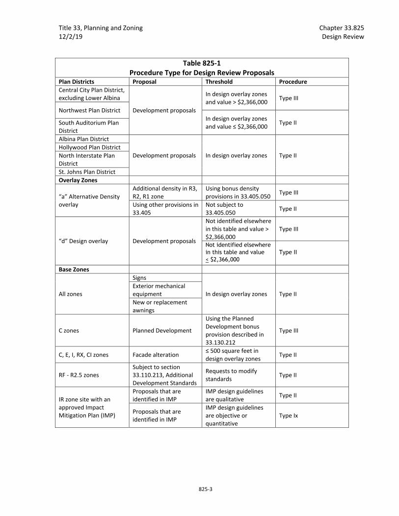
Title 33, Planning and Zoning Chapter 33.825 12/2/19 Design Review
825‐3
Table 825‐1 Procedure Type for Design Review Proposals
Plan Districts Proposal Threshold Procedure
Central City Plan District, excluding Lower Albina
Development proposals
In design overlay zones and value > $2,366,000
Type III
Northwest Plan District In design overlay zones and value ≤ $2,366,000
Type II South Auditorium Plan District
Albina Plan District
Development proposals In design overlay zones Type II Hollywood Plan District North Interstate Plan District St. Johns Plan District Overlay Zones
“a” Alternative Density overlay
Additional density in R3, R2, R1 zone
Using bonus density provisions in 33.405.050
Type III
Using other provisions in 33.405
Not subject to 33.405.050
Type II
“d” Design overlay Development proposals
Not identified elsewhere in this table and value > $2,366,000
Type III
Not identified elsewhere in this table and value < $2,366,000
Type II
Base Zones
All zones
Signs
In design overlay zones Type II Exterior mechanical equipment New or replacement awnings
C zones Planned Development
Using the Planned Development bonus provision described in 33.130.212
Type III
C, E, I, RX, CI zones Facade alteration ≤ 500 square feet in design overlay zones
Type II
RF ‐ R2.5 zones Subject to section 33.110.213, Additional Development Standards
Requests to modify standards
Type II
IR zone site with an approved Impact Mitigation Plan (IMP)
Proposals that are identified in IMP
IMP design guidelines are qualitative
Type II
Proposals that are identified in IMP
IMP design guidelines are objective or quantitative
Type Ix
Chapter 33.825 Title 33, Planning and Zoning Design Review 12/2/19
825‐4
B. Minor changes to an approved design review prior to issuance of final permit approval. Minor changes to an approved design review that was originally processed through a Type III procedure are reviewed through a Type II procedure when all of the following are met. Alterations to a structure after the final building permit approval are exempt from this regulation:
1. The original design review has not expired;
2. The building permit for the project has not received final approval;
3. The change will not modify any condition of approval. Changes to an approved exhibit are allowed; and
4. The cumulative value of the changes will not result in an increase or decrease in the original project value by more than 15 percent.
C. Phased design plans.
1. For multi‐phased projects. Applicants may submit design plans for multi‐phased projects, provided the application includes adequate information to allow review of the immediate and later phases of the project, including anticipated timelines.
2. Benefits of a phased design plan. Development in conformance with an approved phased design plan does not have to go through a separate design review for each phase.
3. Procedure. A phased design plan application is reviewed using the same procedure and with the same guidelines as a design review for a specific development.
D. Models of proposals in the Central City plan district. For proposals located in the Central City plan district shown on Map 510‐1, a three dimensional digital model of the proposal is required with an application for Design Review. This requirement applies only to new developments or changes in the bulk of existing buildings.
Before a building permit is issued, a three dimensional digital model of the proposal as approved must be submitted to the Bureau of Planning and Sustainability. The model requirements will be waived if the application does not involve a change in the bulk of buildings on a site for which the City possesses an accurate digital model.
33.825.035 Factors Reviewed During Design Review. The review may evaluate the architectural style; structure placement, dimensions, height, and bulk; lot coverage by structures; and exterior alterations of the proposal, including building materials, color, off‐street parking areas, open areas, landscaping, and tree preservation.
33.825.040 Modifications That Will Better Meet Design Review Requirements The review body may consider modification of site‐related development standards, including the sign standards of Chapters 32.32 and 32.34 of the Sign Code, as part of the design review process. The review body may not consider modifications to standards for which adjustments are prohibited. Modifications are done as part of design review and are not required to go through the adjustment process. Adjustments to use‐related development standards (such as floor area ratios, intensity of use, size of the use, number of units, or concentration of uses) are required to go through the

Title 33, Planning and Zoning Chapter 33.825 12/2/19 Design Review
825‐5
adjustment process. Modifications that are denied through design review may be requested as an adjustment through the adjustment process. The review body will approve requested modifications if it finds that the applicant has shown that the following approval criteria are met:
A. Better meets design guidelines. The resulting development will better meet the applicable design guidelines; and
B. Purpose of the standard. On balance, the proposal will be consistent with the purpose of the standard for which a modification is requested.
33.825.055 Approval Criteria A design review application will be approved if the review body finds the applicant to have shown that the proposal complies with the design guidelines for the area.
33.825.065 Design Guidelines
A. Purpose. Design guidelines are the approval criteria used to review new development and modifications to existing development. They ensure the conservation and enhancement of the special characteristics of each design district.
B. Design guidelines. Guidelines specific to a design district have been adopted for the areas shown on maps 420‐1 through 420‐3 and 420‐5 through 420‐6. Where two of the design districts shown on those maps overlap, both sets of guidelines apply.
All other areas within the Design Overlay Zone or proposals subject to design review use the Community Design Guidelines. A district's design guidelines are mandatory approval criteria used in design review procedures. The design guidelines may consist of a common set of design guidelines for the whole district and special design guidelines for subdistricts. Where subdistrict guidelines conflict with the district guidelines, the subdistrict guidelines control.
C. Waiver of design guidelines. If a design district's design guidelines document includes goals for the design district, the review body may waive one or more of the guidelines as part of the design review procedure.
33.825.075 Relationship to Other Regulations Design review approval by BDS does not imply compliance with the other requirements of the Zoning Code or other City, Regional, State, and Federal agencies.
(Amended by: Ord. No. 169987, effective 7/1/96; Ord. No. 171219, effective 7/1/97; Ord. No. 171589, effective 11/1/97; Ord. No. 174325, effective 5/5/00; Ord. No. 175204, effective 3/1/01; Ord. No. 175837, effective 9/7/01; Ord. Nos. 175965 and 176333, effective 7/1/02; Ord. No. 176469, effective 7/1/02; Ord. 176742, effective 7/31/02; Ord. No. 177701, effective 8/30/03; Ord. No. 177920, effective 11/8/03; Ord. No. 178423, effective 6/18/04; Ord. No. 178452, effective 7/10/04; Ord. No. 178509, effective 7/16/04; Ord. No. 179092, effective 4/1/05; Ord. No. 181357, effective 11/9/07; Ord. No. 182072, effective 8/22/08; Ord. No. 184016, effective date 08/20/10; Ord. No. 185915, effective 5/1/13; Ord. No. 186053, effective 1/1/15; Ord. No. 187216, effective 7/24/15;

Chapter 33.825 Title 33, Planning and Zoning Design Review 12/2/19
825‐6
Ord. No. 188259, effective 3/31/17; Ord. No. 188177, effective 5/24/18; Ord. No. 188958, effective 5/24/18; Ord. No. 189000, effective 7/9/18; Ord. No. 189488, effective 12/2/19.)
Title 33, Planning and Zoning Chapter 33.840 7/9/18 Greenway Goal Exception
840‐1
33.840 Greenway Goal Exception
840
Sections: 33.840.010 Purpose 33.840.020 When a Greenway Goal Exception is Required 33.840.040 Procedure 33.840.200 Approval Criteria
33.840.010 Purpose Statewide Planning Goal 15 requires that structures be set back from the river to protect, maintain, preserve, and enhance the natural, scenic, historic, and recreational qualities of the Willamette River Greenway. This requirement is carried out by setback standards in the Greenway and River overlay zones that limits development within or riverward of the setback to development that is river‐dependent or river‐related. A Greenway Goal Exception is required to establish development that is not river‐dependent or river‐related within or riverward of the setback. The regulations in this chapter describe the review procedure and approval criteria for a Greenway Goal Exception.
33.840.020 When A Greenway Goal Exception is Required Approval of an exception to Statewide Planning Goal 15 ‐ Willamette Greenway, is required to locate a development or right‐of‐way that is not river‐dependent or river‐related within or riverward of the greenway or river setback. A greenway goal exception is not required to add revetments to a riverbank.
33.840.040 Procedure A greenway goal exception is processed through a Type III procedure, and must be approved by City Council. See also 33.850, Statewide Planning Goal Exceptions.
33.840.200 Approval Criteria Requests for a greenway goal exception will be approved if the review body finds that the applicant has shown that all of the following approval criteria are met:
A. The proposed use is allowed in the base zone by right, with limitations, or as a conditional use;
B. The proposal will not have a significant adverse effect on identified natural resources and functional values of the site or on abutting sites or water areas;
C. The proposal will not significantly reduce lands available for river‐dependent or river‐related uses within the City;
D. The proposal will provide a significant public benefit;
E. The intensification of existing uses or change in use must be limited, to the greatest possible degree, so that such lands will remain compatible with the preservation of the natural, scenic, historical, and recreational qualities of such lands;
Chapter 33.840 Title 33, Planning and Zoning Greenway Goal Exception 7/9/18
840‐2
F. The proposal cannot reasonably be accommodated in a location that does not require a goal exception;
G. Of all other potential locations within the greenway that require a goal exception, there are none with significantly better long‐term environmental, economic, social, and energy consequences after mitigation measures;
H. The proposal is compatible with other adjacent uses, or will be so rendered through measures designed to reduce adverse impacts; and
I. Development and fills riverward of the river setback must show that there are no practical on‐site alternatives that achieve the same level of public benefit.
(Added by: Ord. No. 189000, effective 7/9/18.)

Title 33, Planning and Zoning Chapter 33.846 12/2/19 Historic Resource Reviews
846‐3
3. Owner consent.
a. For Historic Landmark or Conservation Landmark designation, the property owner must consent, in writing, to the Historic Landmark or Conservation Landmark designation;
b. For Historic District or Conservation District designation, all owners of property in the district must consent, in writing, to the Historic District or Conservation District designation at the time of designation.
33.846.040 Historic Designation Removal Review
A. Purpose. These provisions allow for the removal of the City’s historic designation when it is no longer appropriate. This review does not affect a property or district’s listing on the National Register of Historic Places.
B. Review procedure. Historic designation removal reviews are processed through a Type III procedure.
C. Approval criteria. Proposals to remove the historic designation from a historic resource will be approved if the review body finds that all of the following approval criteria are met:
1. Loss of public benefit. The benefits to the public and the property owner of retaining the historic designation no longer outweigh the benefits of removing the designation; or
2. Owner consent.
a. For Historic Landmarks or Conservation Landmarks. The property owner at the time of designation must have objected, on the record, to the historic designation.
b. For individual sites not designated as Historic Landmarks or Conservation Landmarks in Historic Districts or Conservation Districts. The property owner at the time of designation must have objected, on the record, to inclusion in the district.
33.846.050 Historic Preservation Incentive Review
A. Purpose. These provisions increase the potential for Historic Landmarks and Conservation Landmarks, and contributing structures to be used, protected, renovated, and preserved.
B. Review procedure. Historic preservation incentive reviews for sites in the RX zone are processed through a Type II procedure. Historic preservation incentive reviews for sites in all other zones are processed through a Type III procedure.
C. Approval criteria. The use of a historic preservation incentive in a Historic Landmark, Conservation Landmark, or a resource identified as contributing to the historic significance of a Historic District or a Conservation District will be approved if the review body finds that all of the following approval criteria are met:
1. Establishment of the use will not conflict with adopted provisions of neighborhood plans for the site and surrounding area;
Chapter 33.846 Title 33, Planning and Zoning Historic Resource Reviews 12/2/19
846‐4
2. If the site is in an R zone:
a. The approval criteria of Section 33.815.105, Institutional and Other Uses in R Zones, are met; and
b. Proposals on sites larger than one acre will not reduce the amount of new housing opportunity in the City. These criteria may be met by using the methods to mitigate for housing loss in Comprehensive Plan Map amendments in Subparagraph 33.810.050.A.2.c.; and
3. The regulations of 33.445.610, Historic Preservation Incentives are met.
33.846.060 Historic Resource Review
A. Purpose. Historic resource review ensures the conservation and enhancement of the special characteristics of historic resources.
B. Review procedure. Procedures for historic resource reviews are shown in Tables 846‐1 through 846‐4. When determining procedure type for exterior alterations based on project valuation, the dollar amount refers to the value of the exterior changes and any new floor area only. It does not include interior or subgrade alterations.
1. For Historic Landmarks, including those in Historic Districts or Conservation Districts, when proposals are not exempt from review as specified in Subsection 33.445.140.B, the review procedure is determined by Table 846‐1, below:

Title 33, Planning and Zoning Chapter 33.846 12/2/19 Historic Resource Reviews
846‐5
Table 846‐1 Procedure Types for proposals affecting Historic Landmarks
Proposal Zone Threshold Procedure
Alterations of a landmark‐designated interior public space
All
Project value > $473,250
Type III
Project value ≤ $473,250
Type II
Mechanical equipment All Exterior Type Ix
Awnings All New or replacement Type Ix
Signs C, E, I, RX, CI Sign area < 150 sq. ft.
Type Ix
Alteration to the exterior of a structure
C, E, I, RX, CI Affected facade area < 500 sq. ft.
Type Ix
Historic restoration RF‐RH Type I
Any other non‐exempt exterior alteration or historic restoration proposal
All
Project value > $473,250
Type III
Project value ≤ $473,250
Type II
2. For Conservation Landmarks, including those in Historic Districts or Conservation Districts, when proposals are not exempt from review as specified in Subsection 33.445.230.B, the review procedure is determined by Table 846‐2, below:
Table 846‐2 Procedure Types for proposals affecting Conservation Landmarks
Proposal Zone Threshold Procedure
Signs C, E, I, RX, CI Sign area < 150 sq. ft.
Type Ix
Alteration to the exterior of a structure
C, E, I, RX, CI Affected facade area < 500 sq. ft.
Type Ix
Historic restoration RF‐RH Type I
Any other non‐exempt exterior alteration or historic restoration proposal
All Type II
3. For Historic Districts, excluding Historic or Conservation Landmarks, when proposals are not exempt from review as specified in Subsection 33.445.320.B, the review procedure is determined by Table 846‐3, below:
Chapter 33.846 Title 33, Planning and Zoning Historic Resource Reviews 12/2/19
846‐6
Table 846‐3 Review procedures for proposals within Historic Districts
Proposal Zone Threshold Review Type
New structure
All Project value > $473,250
Type III
Project value ≤ $473,250
Type II
New accessory structure RF‐RH Type I
Signs C, E, I, RX, CI Sign area
< 150 sq. ft. Type Ix
Alteration to the exterior of a structure
C, E, I, RX, CI Affected facade area < 500 sq. ft.
Type Ix
Alteration to the exterior of a structure
RF‐RH Affected facade area < 150 sq. ft.
Type I
Historic restoration RF‐RH Type I
Any other non‐exempt exterior alteration or historic restoration proposal
All Project value > $473,250
Type III
Project value ≤ $473,250
Type II
4. For Conservation Districts, excluding Historic or Conservation Landmarks, when proposals are not exempt from review as specified in Subsection 33.445.420.B, the review procedure is determined by Table 846‐4, below:
Table 846‐4 Review procedures for proposals within Conservation Districts
Proposal Zone Threshold Review Type
New structure All Type II
New accessory structure RF‐RH Type I
Signs C, E, I, RX, CI Sign area < 150 sq. ft.
Type Ix
Alteration to the exterior of a structure
C, E, I, RX, CI Affected facade area < 500 sq. ft.
Type Ix
Alteration to the exterior of a structure
RF‐RH Affected facade area < 150 sq. ft.
Type I
Historic restoration RF‐RH Type I
Any other non‐exempt exterior alteration or historic restoration proposal
All Type II
C. Phased proposals.
1. For phased proposals. Applicants may submit design plans for a phase proposal, provided the application includes adequate information to allow review of all phases of the proposal, including anticipated timelines.
2. Benefits of a phased design plan. Development in conformance with an approved phased design plan does not have to go through a separate historic resource review for each phase.

Title 33, Planning and Zoning Chapter 33.846 12/2/19 Historic Resource Reviews
846‐7
3. Procedure. A phased design plan application is reviewed using the same procedure and with the same guidelines as a historic resource review for a specific development.
D. Models of proposals in the Central City plan district. For proposals located in the area of the Central City plan district shown on Map 510‐1, a three dimensional digital model of a proposal located in a Historic District or Conservation District is required with an application for historic resource review. This requirement applies only to new developments or changes in the bulk of existing buildings. Before a building permit is issued, a three dimensional digital model of the proposal as approved must be submitted to the Bureau of Planning and Sustainability. The model requirements will be waived if the application does not involve a change in the bulk of buildings on a site for which the City possesses an accurate digital model.
E. Approval criteria outside the Central City plan district. Outside the Central City plan district, requests for historic resource review will be approved if the review body finds that the applicant has shown that all of the approval criteria have been met. Conflicts among guidelines and criteria are resolved as specified in Paragraph E.4, below. The approval criteria for historic resource review outside the Central City plan district are as follows:
1. Historic Districts. When historic resource review is required for any resource in a Historic District, including Historic Landmarks and Conservation Landmarks, the approval criteria are:
a. Historic Districts with district‐specific guidelines. Historic Districts may have guidelines that are specific to the district, such as the King’s Hill Historic District Guidelines. When historic resource review is required in such districts, the guidelines specific to the district are the approval criteria;
b. Historic Districts without district‐specific guidelines. Where there are no guidelines that are specific to the Historic District, the criteria in Section 33.846.060.G are the approval criteria; or
c. Alphabet Historic District. In the Alphabet Historic District, the approval criteria are the Community Design Guidelines and the Historic Alphabet District Community Design Guidelines Addendum.
2. Conservation Districts. When historic resource review is required for any resource in a Conservation District, including Historic Landmarks and Conservation Landmarks, the approval criteria are:
a. Conservation Districts with district‐specific guidelines. Conservation Districts may have guidelines that are specific to the district. When historic resource review is required in such districts, the guidelines specific to the district are the approval criteria; or
b. Conservation Districts without district‐specific guidelines. Where there are no guidelines that are specific to the Conservation District, the Community Design Guidelines are the approval criteria;
3. Historic Landmarks and Conservation Landmarks located outside of Historic Districts or Conservation Districts. When historic resource review of a Historic Landmark or
Chapter 33.846 Title 33, Planning and Zoning Historic Resource Reviews 12/2/19
846‐8
Conservation Landmark located outside of a Historic District or Conservation District is required, the criteria in 33.846.060.G are the approval criteria.
4. Conflicts among guidelines and criteria. When a criterion in Section 33.846.060.G conflicts with any guideline, the criterion in Section 33.846.060.G supersedes the guideline.
F. Approval criteria in the Central City plan district. In the Central City plan district, requests for historic resource review will be approved if the review body finds that the applicant has shown that all of the approval criteria have been met. Conflicts among guidelines and criteria are resolved as specified in Paragraph F.5, below. The approval criteria for historic resource review in the Central City plan district are as follows:
1. Historic Districts. When historic resource review is required for any resource in a Historic District, including Historic Landmarks and Conservation Landmarks, the approval criteria are:
a. Historic Districts with district‐specific guidelines. Historic Districts may have guidelines that are specific to the district, such as the NW 13th Avenue Historic District Design Guidelines. When historic resource review is required in such districts, the approval criteria are the Central City Fundamental Design Guidelines and the guidelines specific to the Historic District. If the resource is a Historic Landmark or Conservation Landmark, the criteria in Section 33.846.060.G must also be met;
b. Historic Districts without district‐specific guidelines.
(1) Where there are no guidelines that are specific to the Historic District and the site is also in a subdistrict of the Central City plan district that has subdistrict design guidelines, the approval criteria are the Central City Fundamental Design Guidelines and the subdistrict design guidelines. If the resource is a Historic Landmark or Conservation Landmark, the criteria in Section 33.846.060.G must also be met;
(2) Where there are no guidelines that are specific to the Historic District and the site is in a subdistrict of the Central City plan district that does not have subdistrict design guidelines, the approval criteria are the Central City Fundamental Design Guidelines and the criteria in Section 33.846.060.G;
c. Alphabet Historic District. In the portion of the Alphabet Historic District within the Central City plan district, when historic resource review is required for any resource, including Historic Landmarks and Conservation Landmarks, the approval criteria are the Central City Fundamental Design Guidelines and the Historic Alphabet District Community Design Guidelines Addendum. If the resource is a Historic Landmark or Conservation Landmark, the criteria in Section 33.846.060.G must also be met;
d. Irvington Historic District. In the portion of the Irvington Historic District within the Central City plan district, when historic resource review is required for any resource, including Historic Landmarks and Conservation Landmarks, the approval criteria are the Central City Fundamental Design Guidelines, the design

Title 33, Planning and Zoning Chapter 33.846 12/2/19 Historic Resource Reviews
846‐9
guidelines for the Lloyd District subdistrict of the Central City plan district, and the criteria in Subsection 33.846.060.G;
2. Russell Street Conservation District. When historic resource review is required for any resource in the Russell Street Conservation District, including Historic Landmarks and Conservation Landmarks, the approval criteria are the Community Design Guidelines. If the resource is a Historic Landmark or Conservation Landmark, the criteria in Section 33.846.060.G must also be met;
3. Historic Landmarks and Conservation Landmarks located outside of Historic Districts and Conservation Districts. When historic resource review of a Historic Landmark or Conservation Landmark located outside of Historic Districts and Conservation Districts is required, the approval criteria are:
a. Subdistricts with design guidelines. If the resource is in a subdistrict of the Central City plan district that has subdistrict design guidelines, the approval criteria are the Central City Fundamental Design Guidelines, the subdistrict design guidelines and the criteria in 33.846.060.G;
b. Subdistricts without design guidelines. If the resource is in a subdistrict of the Central City plan district that does not have subdistrict design guidelines, the approval criteria are the Central City Fundamental Design Guidelines and the criteria in Section 33.846.060.G;
4. Specified sites along N. Broadway. When historic resource review is required for a historic resource on a site in the CXd zone, and the site fronts on and is within 300 feet of N. Broadway between N. Interstate and N. Wheeler streets, the approval criteria are the Central City Fundamental Design Guidelines and the Special Design Guidelines for the Design Zone of the Lloyd District of the Central City Plan District. If the resource is a Historic Landmark or Conservation Landmark, the criteria in Section 33.846.060.G must also be met.
5. Conflicts among guidelines and criteria. Conflicts among guidelines and criteria are resolved as specified in this paragraph.
a. When a criterion in Section 33.846.060.G conflicts with any other guideline, the criterion in Section 33.846.060.G supersedes the other guideline.
b. When a guideline that is specific to a historic district, such as one of the NW 13th Avenue Historic District Design Guidelines, conflicts with one of the Central City Fundamental Guidelines or with a subdistrict design guideline, such as one of the River District Design Guidelines, the guideline specific to the historic district supersedes the Central City Fundamental Guideline and the subdistrict guideline.
c. When a subdistrict design guideline, such as one of the Goose Hollow District Design Guidelines, conflicts with one of the Central City Fundamental Design Guidelines, the subdistrict guideline supersedes the Central City Fundamental Guideline.
d. When a guideline from the Historic Alphabet District Addendum to the Community Design Guidelines conflicts with one of the Central City Fundamental

Chapter 33.846 Title 33, Planning and Zoning Historic Resource Reviews 12/2/19
846‐10
Design Guidelines, the Alphabet District Guideline supersedes the Central City Fundamental Guideline.
e. When a Lloyd District Design Guideline conflicts with a Central City Fundamental Design Guideline, the Lloyd District Guideline supersedes the Central City Fundamental Guideline.
G. Other approval criteria. Requests for historic resource review will be approved if the review body finds that the applicant has shown that all of the applicable approval criteria have been met. The approval criteria are:
1. Historic character. The historic character of the property will be retained and preserved. Removal of historic materials or alteration of features and spaces that contribute to the property's historic significance will be avoided;
2. Record of its time. The historic resource will remain a physical record of its time, place, and use. Changes that create a false sense of historic development, such as adding conjectural features or architectural elements from other buildings will be avoided;
3. Historic changes. Most properties change over time. Those changes that have acquired historic significance will be preserved;
4. Historic features. Generally, deteriorated historic features will be repaired rather than replaced. Where the severity of deterioration requires replacement, the new feature will match the old in design, color, texture, and other visual qualities and, where practical, in materials. Replacement of missing features must be substantiated by documentary, physical, or pictorial evidence;
5. Historic materials. Historic materials will be protected. Chemical or physical treatments, such as sandblasting, that cause damage to historic materials will not be used;
6. Archaeological resources. Significant archaeological resources affected by a proposal will be protected and preserved to the extent practical. When such resources are disturbed, mitigation measures will be undertaken;
7. Differentiate new from old. New additions, exterior alterations, or related new construction will not destroy historic materials that characterize a property. New work will be differentiated from the old;
8. Architectural compatibility. New additions, exterior alterations, or related new construction will be compatible with the resource's massing, size, scale, and architectural features. When retrofitting buildings or sites to improve accessibility for persons with disabilities, design solutions will not compromise the architectural integrity of the historic resource;
9. Preserve the form and integrity of historic resources. New additions and adjacent or related new construction will be undertaken in such a manner that if removed in the future, the essential form and integrity of the historic resource and its environment would be unimpaired; and

Title 33, Planning and Zoning Chapter 33.846 12/2/19 Historic Resource Reviews
846‐11
10. Hierarchy of compatibility. Exterior alterations and additions will be designed to be compatible primarily with the original resource, secondarily with adjacent properties, and finally, if located within a Historic or Conservation District, with the rest of the district. Where practical, compatibility will be pursued on all three levels.
33.846.070 Modifications Considered During Historic Resource Review The approval criteria for modifications considered during historic resource review are:
A. Better meets historic resource review approval criteria. The resulting development will better meet the approval criteria for historic resource review than would a design that meets the standard being modified; and
B. Purpose of the standard.
1. The resulting development will meet the purpose of the standard being modified; or
2. The preservation of the character of the historic resource is more important than meeting the purpose of the standard for which a modification has been requested.
33.846.080 Demolition Review
A. Purpose. Demolition review protects resources that have been individually listed in the National Register of Historic Places or are identified as contributing to the historic significance of a Historic District. It also protects Historic Landmarks and Conservation Landmarks that have taken advantage of an incentive for historic preservation and historic resources that have a preservation agreement. Demolition review recognizes that historic resources are irreplaceable assets that preserve our heritage, beautify the city, enhance civic identity, and promote economic vitality.
B. Review procedure. Demolition reviews are processed through a Type IV procedure.
C. Approval criteria. Proposals to demolish a historic resource will be approved if the review body finds that one of the following approval criteria is met:
1. Denial of a demolition permit would effectively deprive the owner of all reasonable economic use of the site; or
2. Demolition of the resource has been evaluated against and, on balance, has been found supportive of the goals and policies of the Comprehensive Plan, and any relevant area plans. The evaluation may consider factors such as:
a. The merits of demolition;
b. The merits of development that could replace the demolished resource, either as specifically proposed for the site or as allowed under the existing zoning;
c. The effect demolition of the resources would have on the area’s desired character;
d. The effect that redevelopment on the site would have on the area’s desired character;

Chapter 33.846 Title 33, Planning and Zoning Historic Resource Reviews 12/2/19
846‐12
e. The merits of preserving the resource, taking into consideration the purposes described in Subsection A; and
f. Any proposed mitigation for the demolition.
(Added by: Ord. No. 169987, effective 7/1/96. Amended by: Ord. No. 171589, effective 11/1/97; Ord. No. 175204, effective 3/1/01; Ord. Nos. 175965 and 176333, effective 7/1/02; Ord. No. 176587, effective 7/20/02; Ord. No. 178509, effective 7/16/04; Ord. No. 178657, effective 9/3/04; Ord. No. 178832, effective 10/21/04; Ord. No. 179980, effective 4/22/06; Ord. No. 180619, effective 12/22/06; Ord. No. 181357, effective 11/9/07; Ord. No. 182429, effective 1/16/09; Ord. No. 183598, effective 4/24/10; Ord. No. 184016, effective 1/2/11; Ord. No. 185915, effective 5/1/13; Ord. No. 187216, effective 7/24/15; Ord. No. 188177, effective 5/24/18; Ord. No. 188958, effective 5/24/18; Ord. No. 189000, effective 7/9/18; Ord. No. 189488, effective 12/2/19.)
Title 33, Planning and Zoning Chapter 33.854 12/2/19 Planned Development Review
854‐1
33.854 Planned Development Review 854 Sections:
General 33.854.010 Purpose
Review of Planned Development 33.854.200 Review Procedures 33.854.250 Supplemental Application Requirements 33.854.300 Approval Criteria in General 33.854.310 Approval Criteria for Planned Developments In All Zones 33.854.320 Additional Approval Criteria for Modifications of Development Standards 33.854.330 Commercial Uses in Residential Zones 33.854.340 Proposals Without a Land Division
Changes to an Approved Planned Development 33.854.500 Types of Changes 33.854.510 Review Procedure 33.854.520 Approval Criteria
General
33.854.010 Purpose These regulations assign Planned Development Reviews to an appropriate procedure type. The approval criteria ensure that innovative and creative development is encouraged when it is well designed and integrated into the neighborhood.
Review of Planned Development
33.854.200 Review Procedures
A. Concurrent reviews. When land use reviews in addition to Planned Development Review are requested or required, all of the reviews must be processed concurrently, except for Design Review for buildings within a Planned Development site when the Planned Development bonus is being utilized (See 33.130.212.E). In this case, Design Review may be processed after the Planned Development Review.
B. Planned Development bonus. Proposals that are using the commercial/mixed use zones Planned Development bonus (See 33.130.212.E) are processed through a Type III procedure.
C. All other Planned Development Reviews.
1. Review in conjunction with a land division. When a Planned Development is requested in conjunction with a land division, the review will be processed as follows:
Chapter 33.854 Title 33, Planning and Zoning Planned Development Review 12/2/19
854‐2
a. Type III review. Proposals in the RF through R2.5 zones that include attached duplexes, multi‐dwelling structures, or multi‐dwelling development are processed through a Type III procedure.
b. Type IIx review. All other proposals are processed through the Type IIx procedure.
2. Review not in conjunction with a land division. When a Planned Development is not in conjunction with a land division, the review will be processed as follows:
a. Type III. Planned Developments that include any of the following elements are processed through a Type III procedure:
(1) Attached duplexes, multi‐dwelling structures, or multi‐dwelling development in the RF through R2.5 zones;
(2) Eleven or more units;
(3) Four or more units where any building location, utility, or service is proposed within a Potential Landslide Hazard Area;
(4) Environmental review;
(5) Any portion of the site is in an Open Space zone.
b. Type IIx. All other proposals not assigned to a Type III in Subparagraph C.2.a. are processed through a Type IIx procedure.
33.854.250 Supplemental Application Requirements In addition to the application requirements of Section 33.730.060.D, the following information is required for a Planned Development application:
A. Supplemental application requirements for Planned Developments in commercial/mixed use zones that are proposing additional height or FAR through the Planned Development bonus (See 33.270.100.I):
1. The boundaries of the area to be included in the Planned Development. The area must include all contiguous lots that are owned by the same person, partnership, association, or corporation. This also includes lots that are in common ownership but are separated by a shared right‐of‐way;
2. An urban design and development framework plan showing:
a. The location of existing and proposed structures;
b. Proposed land uses including areas with active ground floor uses;
c. A three dimensional massing diagram that identifies the maximum proposed building envelope for each building site, including maximum proposed building dimensions, height, and floor area allocations;
d. Sections, sectional elevations, and perspectives that illustrate the relationship of existing and proposed development on the site to the urban form of the surrounding neighborhood in terms of building height and massing;
Title 33, Planning and Zoning Chapter 33.854 12/2/19 Planned Development Review
854‐3
e. The allocation of any required affordable housing if there will be more than one building;
f. The location, design and programming of plazas, parks or open areas; and
g. Relationships and transitions to adjacent properties and the neighborhood;
3. A transportation and circulation plan showing:
a. Proposed pedestrian, bicycle, and vehicle circulation system that meet City of Portland connectivity standards, including locations where the circulation system connects to public right‐of‐way outside of the site,
b. Transit service lines and stops within and immediately adjacent to the site;
c. Locations of right‐of‐way to be vacated or dedicated within the site; and
d. Vehicle and bicycle parking and any parking access points;
4. Transportation and parking demand management strategies;
5. If the proposed Planned Development involves the transfer of floor area, information about the location of the receiving and sending lots, the ownership of the lots, and amount of floor area to be transferred and retained at each lot must be included;
6. A stormwater management plan;
7. A phasing plan including proposed development phases, probable sequence for proposed developments, estimated dates, and interim uses of property awaiting development; and
8. A Project narrative describing how the proposal meets applicable design guidelines.
B. Supplemental application requirements for all other Planned Developments:
1. Photographs that show the characteristics of surrounding neighborhood; and
2. Either B2.a. or B.2.b., must be submitted with the application:
a. Proposed building elevations and locations with enough detail to show that all of the approval criteria are met; or
b. Proposed standards regulating setbacks, building coverage, landscaping, vehicle areas, materials, and design of structures. The proposed standards must be clear and objective, and specific enough to show how all of the approval criteria are met. Proposed standards may not conflict with the regulations of this Title, except where a modification is requested as part of the Planned Development application. If approved, the standards will apply, in addition to regulations of this Title to all development on the site.
33.854.300 Approval Criteria in General The approval criteria for Planned Developments are stated below. Planned Developments in all zones must meet the criteria in Section 33.854.310. Some proposals must also meet additional approval criteria, as follows:

Chapter 33.854 Title 33, Planning and Zoning Planned Development Review 12/2/19
854‐4
A. Proposals to modify site‐related development standards must meet the criteria in Section 33.854.320.
B. Proposals for commercial uses in residential zones must meet the criteria in Section 33.854.330.
C. Proposals that do not include a land division must meet the criteria in Section 33.854.340. Proposals that are only using the commercial/mixed use zones Planned Development bonus (See 33.270.100.I) are not required to meet the criteria in Section 33.854.340.
A request for a Planned Development will be approved if the review body finds that the applicant has shown that all of the relevant approval criteria have been met.
33.854.310 Approval Criteria for Planned Developments in All Zones Criteria A through F apply to proposals for additional height or FAR in the CM2, CM3, CE, and CX zones that are taking advantage of 33.270.100.I. If the Planned Development is not proposing additional height or FAR as allowed by 33.270.100.I, then only criteria E and F apply.
A. Urban design and development framework.
1. The proposed overall scheme and site plan provide a framework for development that meets applicable Community Design Guidelines and will result in development that complements the surrounding area;
2. Scale and massing of the development addresses the context of the area, including historic resources, and provides appropriate scale and massing transitions to the adjacent uses and development specifically at the edges of the Master Plan area;
3. Proposed plazas, parks, or open areas are well located to serve the site and public, and are designed to address safety and comfort of users; and
4. The site plan promotes active ground floor uses on key streets to serve the development and surrounding neighborhood; and
B. Transportation system. The transportation and circulation system provides multimodal connections that support the development of the site, and limit impacts to adjacent neighborhoods.
C. Stormwater Management. The Planned Development meets the requirements of the Stormwater Management Manual or describes a phased approach to meet the requirements.
D. Phasing Plan. The Planned Development establishes coordinated phasing of development that demonstrates how the site will be developed over time and how any required development elements will be met.
E. Configure the site and development to visually integrate both the natural and built features of the site and the natural and built features of the surrounding area. Aspects to be considered include:
1. Orienting the site and development to the public realm, while limiting less active uses of the site such as parking and storage areas along the public realm;
Title 33, Planning and Zoning Chapter 33.854 12/2/19 Planned Development Review
854‐5
2. Preservation of natural features on the site, such as stands of trees, water features or topographical elements;
3. Inclusion of architectural features that complement positive characteristics of surrounding development, such as similar building scale and style, building materials, setbacks, and landscaping;
4. Mitigation of differences in appearance through means such as setbacks, screening, landscaping, and other design features;
5. Minimizing potential negative effects on surrounding residential uses; and
6. Preservation of any City‐designated scenic resources; and
F. Provide adequate open area on sites zoned RF through R2.5 where proposed development includes attached houses, duplexes, attached duplexes, or multi‐dwelling structures. Open area does not include vehicle areas.
33.854.320 Additional Approval Criteria for Modifications of Site‐Related Development Standards The following criteria apply to modifications of site‐related development standards, including parking standards. These modifications are done as part of a Planned Development review and do not have to go through the adjustment process. Modifications to development standards for which adjustments are prohibited may not be considered. The modification will be approved if the following approval criteria are met:
A. Better meets approval criteria. The resulting development will better meet the applicable approval criteria of Section 33.854.310; and
B. Purpose of the standard. On balance, the proposal will be consistent with the purpose of the standards for which a modification is requested.
33.854.330 Commercial Uses in Residential Zones. The approval criteria of this section apply to proposals for commercial uses in Residential Zones. The approval criteria are:
A. The area surrounding the proposed location of the commercial uses is deficient in support commercial opportunities;
B. The proposed commercial development and uses will be primarily for the service and convenience of residents of the neighborhood; and
C. The proposed commercial development and uses must be consistent with the purpose and regulations of the CN1 zone.
33.854.340 Proposals Without a Land Division The approval criteria of this section apply to Planned Developments that do not include a land division, except Planned Developments that are only using the commercial/mixed use zones Planned Development bonus. The approval criteria are:
A. Services.
Chapter 33.854 Title 33, Planning and Zoning Planned Development Review 12/2/19
854‐6
1. The proposed use must be in conformance with the Arterial Streets Classifications and Policies of the Transportation Element of the Comprehensive Plan;
2. The approval criteria of Section 33.654.110, Connectivity and Location of Rights‐of‐Way, must be met;
3. The standards of Section 33.651.020, Water Service Standards, must be met;
4. The standard of Section 33.652.020, Sanitary Sewer Disposal Service Standard, must be met;
5. The standard of Section 33.655.100, School District Enrollment Capacity Standard, must be met; and
6. The application must show that a stormwater management system can be designed that will provide adequate capacity for the expected amount of stormwater.
B. Tree preservation. The proposal must meet the requirements of Chapter 33.630, Tree Preservation.
C. Flood hazard areas.
1. RF through R2.5 zones. In the RF through R2.5 zones, all proposed building locations must be outside of the flood hazard area.
2. R1 through IR, C, E, and I zones. In the R1 through IR, C, E, and I zones, all proposed building locations must be outside of the flood hazard area where possible. Where it is not possible to have all building locations outside of the flood hazard area, all proposed building locations must be configured to reduce the impact of flooding and to provide the greatest protection for development from flooding. Proposed building locations must be clustered on the highest ground and near the highest point of access, and they must be configured in a manner that will minimize obstruction of floodwaters.
D. Landslide hazard areas. Buildings, services and utilities should be located on the safest part of the site so that the risk of a landslide affecting the site, adjacent sites, and sites directly across a street or alley from the site, is reasonably limited.
Determination of whether the proposed layout and design reasonably limits the risk of a landslide will include evaluation of the Landslide Hazard Study and will take into consideration accepted industry standards for factor of safety. Alternative development options including alternative housing types and reduced density may be required in order to limit the risk to a reasonable level.
E. Clearing, grading, and land suitability.
1. Existing contours and drainage patterns of the site must be left intact wherever practicable. Where alteration to existing drainage patterns is proposed, it must not adversely impact adjacent properties by significantly increasing volume of runoff or erosion;
2. Clearing and grading should be sufficient for construction of development shown on the Clearing and Grading Plan;

Title 33, Planning and Zoning Chapter 33.854 12/2/19 Planned Development Review
854‐7
3. Clearing and grading should be limited to areas of the site that are reasonably necessary for construction of development shown on the Clearing and Grading Plan;
4. Topsoil must be preserved on site to the extent practicable for use on the site after grading is complete;
5. Soil stockpiles must be on the site and located in areas designated for clearing and grading, if practicable;
6. The limits of disturbance and tree protection measures shown on the Preliminary Clearing and Grading Plan must be adequate to protect trees shown to be retained on the tree preservation plan; and
7. Where geologic conditions or historic uses of the site indicate that a hazard may exist, the applicant must show that the site is suitable for the proposed development. The applicant may be required to make specific improvements in order to make the site suitable for the intended uses and the provision of services and utilities.
F. Streams, springs, seeps, and wetlands.
1. If there is a stream, spring, seep, or wetland outside of an Environmental Overlay Zone on the site, then the stream, spring, seep, or wetland must be preserved in an easement. The edges of the easement must be at least 15 feet from the edges of the stream, spring, seep, or wetland. The edges of a seep, spring, or wetland are determined through a wetland delineation, performed by an environmental scientist, and approved by BDS. For seeps and springs, if one or more wetland characteristics are absent from the resource, the delineation will be based on the wetland characteristics present. The edges of a stream are defined as the top‐of‐bank where the edge of the stream, spring, seep, or wetland is less than 15 feet from the edge of the site, the easement boundary will be located along the edge of the site.
2. The following development, improvements, and activities are allowed in the easement:
a. Disturbance associated with discharging stormwater to the stream channel, if BES has determined that the site’s storm water cannot discharge to a storm sewer and BDS has determined that on‐site infiltration is not an option;
b. Removal of non‐native invasive species with hand held equipment;
c. Planting of native vegetation listed on the Portland Plant List when planted with hand held equipment;
d. Erosion control measures allowed by Title 10 of Portland City Code;
e. Construction of required driveway connections or required connections to services when there is no practicable alternative to locating the driveway or service connections within the easement; and
f. Maintenance and repair of existing utilities, services, and driveways;
3. Public or private rights of way may cross the seep, spring, stream, or wetland easement if the following approval criteria are met:

Chapter 33.854 Title 33, Planning and Zoning Planned Development Review 12/2/19
854‐8
a. There is no reasonable alternative location for the right‐of‐way;
b. The applicant has demonstrated that it is possible to construct street improvements within the right‐of‐way that will meet all of the following:
(1) The street improvements will not impede the flow of the stream, spring, or seep;
(2) The street improvements will impact the slope, width, and depth of the stream channel, spring, seep, or wetland to the minimum extent practicable; and
(3) The street improvements will not impede fish passage in a stream, spring, or seep that has been identified by the Oregon Department of Fish and Wildlife as fish‐bearing.
4. Minimum density is waived in order to better meet the standards of paragraphs F.1‐F.3, above.
G. Transportation impacts.
1. The transportation system must be capable of supporting the proposed development in addition to the existing uses in the area. Evaluation factors include: safety, street capacity level of service, connectivity, transit availability, availability of pedestrian and bicycle networks, on‐street parking impacts, access restrictions, neighborhood impacts, impacts on pedestrian, bicycle, and transit circulation. Evaluation factors should be balanced; a finding of failure in one or more factors may be acceptable if the failure is not a result of the proposed development, and any additional impacts on the system from the proposed development are mitigated as required by criterion G.2;
2. Measures proportional to the impacts of the proposed use are proposed to mitigate on‐ and off‐site transportation impacts. Measures may include: transportation improvements to on‐site circulation, public street dedication and improvement or private street improvements, intersection improvements, transportation and parking demand management actions, street crossing improvements, improvements to the local pedestrian and bicycle networks, and transit stop improvements;
3. Transportation improvements adjacent to the development and in the vicinity needed to support the development are available or will be made available when the development is complete or, if the development is phased, will be available as each phase of the development is completed;
Changes to an Approved Planned Development
33.854.500 Types of Changes There are three types of changes; major, minor, and administrative.
A. Major change. A major change is one that will have significant impacts on the development in the PD, or on the site surrounding the PD. Major changes include:
1. An increase in the site area of more than 5 percent;
Title 33, Planning and Zoning Chapter 33.854 12/2/19 Planned Development Review
854‐9
2. Changes to the building heights or floor area allocations of more than 10 percent;
3. In residential zones:
a. An increase in density, including the number of housing units;
b. A change in the mix of single‐dwelling and multi‐dwelling structures; and
c. An increase in the amount of land in nonresidential uses;
4. A reduction in the amount of open space;
5. In commercial/mixed use zones:
a. Changes to building locations or required plaza or park locations;
b. A decrease in the amount or location of required affordable housing; and
c. Changes to the location of additional height;
6. Deleting or changing the purpose of flood hazard or landslide hazard easements; or
7. Changes to the vehicular system which result in a significant change in the amount or location of streets and shared driveways, common parking areas, circulation patterns, and access to the PD; or
8. Changes in the amount of parking by more than 20 percent.
B. Minor change. A minor change is a change that is neither major nor administrative.
C. Administrative change. An administrative change is a change to an element of a Planned Development that:
1. Is consistent with all conditions of the Planned Development approval and the conditions of any concurrent approval;
2. Meets all development standards not modified by the Planned Development; and
3. Does not change any quantity, dimension or area identified in the approved plans or narrative by more than 5 percent.
33.854.510 Review Procedures Requests for changes to an approved PD are processed as follows:
A. Major changes. Major changes are processed as follows:
1. If the original PD application was processed through a Type III procedure then the change is processed through a Type III procedure;
2. If the original PD application was processed through a Type IIx procedure then the change is processed through a Type IIx procedure.
B. Minor changes. Minor changes are processed through a Type IIx procedure.
C. Administrative changes. Administrative changes are allowed without a land use review.

Chapter 33.854 Title 33, Planning and Zoning Planned Development Review 12/2/19
854‐10
33.854.520 Approval Criteria The approval criteria for changes to a Planned Development are those used for approval of the original planned development application.
(Added by: Ord. Nos. 175965 and 176333, effective 7/1/02. Amended by: Ord. No. 178657, effective 9/3/04; Ord. No. 181357, effective 11/9/07; Ord. No. 182429, effective 1/16/09; Ord. No. 186053, effective 1/1/15; Ord. No. 188259, effective 3/3/31; Ord. No. 188177, effective 5/24/18; Ord. No. 188958, effective 5/24/18; Ord. No. 189488, effective 12/2/19.)