committee: date: classification: agenda item number ... · beth eite title: town planning...
TRANSCRIPT

Committee: [Strategic] Development
Date: 13th March 2014
Classification: Unrestricted
Agenda Item Number:
Report of: Director of Development and Renewal Case Officer: Beth Eite
Title: Town Planning Application Ref No: PA/13/1455 and PA/13/1456 Ward: Millwall (February 2002 onwards)
1. APPLICATION DETAILS Location: Land bounded by Park Place, Westferry Road & Heron
Quay Road (Newfoundland), London, E14 4JB Existing Use: Car park Proposal: Erection of a 58 storey and linked 2 storey building
with 3 basement levels to comprise of 568 residential units (use class C3), 7 ancillary guest units (use class C3), flexible retail use (use class A1-A4), car and cycle parking, pedestrian bridge, alterations to deck, landscaping, alterations to highways and other works incidental to the proposal.
Drawing Nos/Documents: Full Planning Permission 0000 rev 01, 1130 rev 13, 1121 rev 04, 1122 rev 04, 1123 rev 04, 1300 rev 13, 1301 rev 16, 1302 rev 13, 1303 rev 13, 1304 rev 13, 1305 rev 13, 1306 rev 12, 1307 rev 12, 1308 rev 13, 1309 rev 12, 1310 rev 12, 1311 rev 04, 1211 rev 20, 1212 rev 23, 1213 rev 17, 1214 rev 13, 1221 rev 05, 1222 rev 06, 1223 rev 05, 1244 rev 06, 1225 rev 05, 1226 rev 04, 0001 rev 03, 0002 rev 02, 0003 rev 02, 0004 rev 02, 0005 rev 02, 0006 rev 02, 0007 rev 02,1101 rev 05, 1102 rev 05, 1103 rev 05, 1104 rev 05, 1105 rev 05, 1106 rev 05, 1107 rev 05, 1201 rev 15, 1202 rev 15, 1203 rev 09 and 1204 rev 10. (lifetime homes / wheelchair housing) 810-70107 AT9 & 10, 810-70102 AT3, 810-70103 AT4, 810-70105 AT7, 810-70108AT11, 810-70101 AT2, 810-70101 AT2, 810-70106 AT5, 810-70115 AT5, 810-70109 AT12, 810-70110 AT12, 810-70112 AT15, 810-70111 AT14, 810-70200 AT14, 810-70104 AT6, 810-70201 AT6, 810-70100 AT1, 810-70202 AT1, Listed building consent: 1230 rev 02, 1231 rev 02, 1232 rev 02, 1233 rev 02, 1234 rev 02, 1235 rev 02, 1236 rev 03, 1237 rev 02 and 1238 rev 02.
Applicant: South Quay Properties Limited Ownership: Canary Wharf Limited, National Grid, Canal and River
Trust, London Underground Limited, Hibernia Limited, CWCB Investments, Morgan Stanley UK Group, Tube
2
Lines Ltd, Gort Ltd. Historic Building: Grade I listed dock wall. Conservation Area: N/A 2. EXECUTIVE SUMMARY 2.1 2.2 2.3 2.4 2.5 2.6 2.7 2.8
The Local Planning Authority has considered the particular circumstances of this application against the Council’s approved planning policies contained in the London Borough of Tower Hamlets adopted Core Strategy (2010) and Managing Development Document 2013 as well as the London Plan (2011) and the National Planning Policy Framework and has found that: The site is within a preferred office location, however there has been sufficient evidence submitted to demonstrate the construction of an employment led-development on this site is not viable. Through the provision of a new residential led mixed use development, the scheme will maximise the use of previously developed land, and will significantly contribute towards creating a sustainable residential environment and towards local and London-wide housing targets. It would form a positive addition to London’s skyline, without causing detriment to local or strategic views and would enhance the character of the immediate area by virtue of its high quality design. The density of the scheme would not result in significantly adverse impacts typically associated with overdevelopment and there would be no significant impact upon the amenities of the neighbouring occupants in terms of loss of light, overshadowing, loss of privacy or increased sense of enclosure. The high quality of accommodation provided, along with internal and external amenity spaces would provide an acceptable living environment for the future occupiers of the site. The development, in combination with the off-site affordable housing developments would provide a suitable mix of housing types and tenure including an acceptable provision of affordable housing. In light of the viability constraints of the site the development is maximising the affordable housing potential of the scheme and the provision of the affordable housing ‘off-site’ is considered to result in a better overall outcome than providing it on site. Transport matters, including parking, access and servicing are acceptable and it is not considered that there would be any significant detrimental impact upon the surrounding highways network as a result of this development. A suitable strategy for minimising carbon dioxide emissions from the development has been proposed, landscaping and biodiversity features are also proposed which seeks to ensures the development is environmentally sustainable. The proposed development will provide appropriate mitigation measures through a legal agreement which will contribute towards the provision of affordable housing, health facilities, open space, transportation improvements, education facilities and employment opportunities for residents.
3. RECOMMENDATION 3.1 That the Strategic Development Committee resolve to GRANT planning permission and
listed building consent subject to: A. Any direction by The London Mayor B The prior completion of a legal agreement to secure the following planning obligations:
3
3.2 3.3
Financial Obligations a) A contribution of £10,485 towards enterprise & employment for the end user phase. b) A contribution of £180,656 towards enterprise and employment training for the construction phase. c) A contribution of £121,830 towards community facilities including libraries and Idea stores d) A contribution of £454,329 towards leisure facilities. e) A contribution of £126,157 to mitigate against the demand of the additional population on educational facilities. f) A contribution of £631,616 towards health facilities. g) A contribution of £701,131 towards public open space. h) A contribution of £14,310 towards sustainable transport. i) A contribution of £149,814 towards streetscene and built environment, including highways improvements. j) A contribution of £144,000 towards TfL London Buses.
k) £185,977 in accordance with the Crossrail SPG requirement. l) A contribution of £50,686 towards S106 monitoring fee (2%) Total: £2,770,991 Non-Financial Obligations a) A minimum of 45% affordable housing which equates to 856 habitable rooms across three offsite donor sites comprising Burdett Road, Barchester Street, and Lovegrove Walk and a cash payment in-lieu of on site intermediate housing, in the following split: • 75% Social Target Rent • 25% Intermediate Housing (which is secured as a cash payment of £7,490,000 in-lieu of the intermediate housing which would have been provided onsite). b) Employment and Training Strategy including an apprenticeships programme to be
agreed with the Council c) Access to employment (20% Local Procurement; 20% Local Labour in Construction; 20% end phase local jobs) d) On Street Parking Permit-free development e) Electric Vehicle Charging Points f) Travel Plan g) Code of Construction Practice

4
h) Real Time Departure Screen within the development i) Conversion works to Lovegrove Walk properties in order to provide 115 habitable room rooms of social rented affordable housing to commence within 30 days of the grant of permission and for all the properties to be available to occupy no later than 1 year from the grant of planning permission for Newfoundland for a minimum period of 5 years from the date of completion of the conversion works.
j) Requirement to deliver the equivalent amount or greater of social rent affordable housing delivered at Lovegrove Walk within the Millwall, Blackwall or Cubitt Town Ward prior to the Lovegrove Walk units being unavailable for affordable housing due to being required for the Woodwharf development
k) Obtain grant of planning permission for Burdett Road in order to secure 175 habitable rooms of social rented housing prior to Newfoundland works go beyond secant piling.
l) No to permit more than 50% occupation of Newfoundland site until the Lovegrove Walk properties have been provided and either Burdett Road or Barchester Street are completed and ready for occupation.
m) Planning application to be submitted to the Council for 83 Barchester Street to secure a minimum of 352 habitable rooms for social rent affordable housing within 6 months of the grant of planning permission for Newfoundland. Not to occupy more than 90% of Newfoundland until all affordable housing across all the donor sites are completed ready for occupation.
n) In the event that the Burdett Road or Barchester Street developments do not secure or complete ready for occupation 527 habitable rooms of affordable housing on the two donor sites then the developer will deposit with the Council a sum equivalent to the value of 1.3 times the cost of delivering the social rent affordable housing habitable rooms and the developer is required to deliver the requisite number of habitable rooms not provided within the donor site/s through a revised scheme or by finding alternative sites in order to deliver the habitable rooms prior to the refund of any sum paid to the Council.
o) Any other planning obligation(s) considered necessary by the Corporate Director Development & Renewal
3.4 That the Corporate Director Development & Renewal is delegated power to negotiate the
legal agreement indicated above acting within normal delegated authority. 3.5 That the Corporate Director Development & Renewal is delegated power to impose
conditions and informatives on the planning permission to secure the following matters:

5
CONDITIONS & INFORMATIVES on FULL PLANNING PERMISSION 3.6 3.7 3.8 3.9
Prior to Commencement’ Conditions: 1. Construction management plan 2. Risk Assessment 3. Feasibility for transportation by water 4. Survey of the waterway wall 5. Surface water drainage scheme 6. Ground water contamination 7. Details of agreement with London Underground Ltd regarding construction and
protection of the Jubilee line tracks and tunnels Prior to completion of superstructure works conditions:
8. Crane heights / aircraft obstacle lighting 9. Secured by design measures 10. External materials 11. Biodiversity enhancement measures. 12. Public realm / landscaping details 13. Odour mitigation for A3 use 14. CCTV and lighting plan 15. Wind mitigation measures
Prior to Occupation’ Conditions:
16. Contaminated land 17. Access strategy 18. Delivery and servicing plan 19. Code for sustainable homes 20. Verification report on groundwater conditions 21. Quality of the residential corridors 22. Content of the window displays
‘Compliance’ Conditions –
23. Permission valid for 3yrs 24. Hours of use of A3 restaurant 25. Development in accordance with approved plans 26. Energy 27. Heat network 28. Renewable energy 29. Electric vehicle charging points 30. Ancillary gym 31. Ancillary serviced rooms 32. Cycle parking 33. Lifetime homes 34. Information display boards in reception area 35. Hours of construction 36. Hours of construction for piling operations 37. No penetrative foundation design or as otherwise agreed.
3.10 Any other conditions(s) considered necessary by the Corporate Director Development & Renewal
3.11 Informatives:
• S106 planning obligation provided • Consent under s57 of the Town and Country Planning Act 1990. • Advertisement consent required for signage

6
• Details regarding how to discharge surface water drainage condition. • Requirement for a s278 agreement.
3.12
CONDITIONS & INFORMATIVES on LISTED BUILDING CONSENT
1) Time limit 2) Compliance with the plans 3) Watching brief 4) Nothing to be fixed to the dock wall 5) All new work to match the existing historic wall.
3.13 Any other informative(s) considered necessary by the Corporate Director Development &
Renewal 3.14
That, if within 3 months of the date of this committee the legal agreement has not been completed, the Corporate Director Development & Renewal is delegated power to refuse planning permission.
4 PROPOSAL AND LOCATION DETAILS Site and Surroundings 4.1 The application site is located to the north of the Isle of Dogs, east of the River Thames and
west of the main Canary Wharf cluster. It is approximately 100m south of Westferry Circus and is bounded to the north by Park Place and to the west by Westferry Road. It is 0.48ha and is currently hardstanding, used as a car park.
4.2 To the north of the site is a five to eight storey office building at 15 Westferry Circus, also to the north is a vacant site at 1 Park Place. There is a current application on this site for a multi-storey office development. To the east is the end of the middle dock which means the site is in a visually prominent location when viewed from the east.
4.3
The site is located within the Canary Wharf Preferred Office Location, where office development is focused as well as supporting uses such as gyms, hotels and restaurants. It is also within the Canary Wharf major centre within the town centre hierarchy. The site lies within Flood Zone 3, the River Thames is approximately 150m to the east. There is a grade I listed dock wall adjacent to the site. The nearest conservation area is West India Dock 300m to the north.
4.4 The site has a Public Transport Accessibility Level of 5 which is ‘very good’. It is approximately a five minute walk to Heron Quay DLR station and 10 minutes to Canary Wharf. A number of bus routes pass the site, the D7, D3, 135 and N550 run along Westferry Road and the D8 runs along Marsh Wall.
Proposal 4.5
The application proposes the erection of a 58 storey (plus plant) residential-led mixed use building. The total height would be 226m (Above Ordnance Datum) and would comprise of the following:
• 568 private residential units (Use Class C3) with 7 ancillary guest units.
• 1,412sqm (GEA)of class A1 – A4 floorspace
• A triple basement level with 71 car parking spaces, 615 cycle parking spaces and 10 motorcycle spaces.

7
4.6 4.7 4.8 4.9 4.10 4.11
The proposal mainly consists of two diamond shaped buildings, the main 58 storey tower and a smaller, two storey building located to the north of the tower. The first floor of this building would contain a restaurant, a roof terrace is provided above this. At ground floor level the building would be cut away to provide a service access to both buildings and an entrance to the car park. Within the main tower at ground floor, alongside the main residential reception there are a number of retail units proposed. These are small units which facilitate an active frontage. A diamond shaped canopy is provided over the main set-down and pick-up area to the south eastof the building. At level 24 a health club for the residents is provided. The layout of the floors provides between 8 – 13 flats off a single core, duplex flats and larger penthouse suits are provided on floors 55-57. The mix of units are 70 x studios, 272 x 1 beds, 204 x 2 bed units and 22 x 3 bed units. A bridge is proposed linking the site to the Mackenzie Walk, allowing resident’s pedestrian access to the Canary Wharf complex without having to either go south along Bank Street or north to Westferry Circus. The site is being proposed in conjunction with three other off-site housing ‘donor sites’ sites which are all owned by the developer and will provide the off-site affordable housing for the site; 307 Burdett Road, 83 Barchester Street and Lovegrove Walk. 307 Burdett Road is reported separately on this agenda for approval of 42 units of social rented affordable housing. 83 Barchester Street is currently subject to pre-application discussions and Lovegrove Walk is a turning off Prestons Road which currently comprises a mix of flats and houses, 20 of which are offered at social rent as part of this proposal. This is explained further in the housing section of the report. The application also seeks Listed Building consent for works to the listed dock wall which officers are minded to grant.
5 Relevant Planning History 5.1
An application (PA/08/00598) for the following development was approved on 19th November 2008: Erection of a 37 storey tower and a part 4/5 storey podium comprising a 150 bedroom Hotel (Class C1) and 78 serviced apartments (Sui Generis), together with ancillary restaurant facilities and servicing and parking areas including a drop off facility; provision of 1,300sqm of retail units (Class A1 to A4) at ground and basement level, a 1,580sqm restaurant (Class A3) at first floor level and 2,310sqm of education and training use (Class D1) at second and part third floor level; construction of basement for retail units (Class A1 to A4) and plant; construction of subterranean pedestrian link to the Jubilee Place retail mall and the Jubilee Line Station; provision of a new publicly accessible open space, dockside walkway and landscaping together with other works incidental to the application. This application has not been pursued as it was found by the applicant to be commercially unviable. This permission has established the principle for a tall building on this site, though it should be noted that the use of the site was an appropriate use within the Preferred Office Location.
6. POLICY FRAMEWORK 6.1 For details of the status of relevant policies see the front sheet for “Planning Applications for
Determination” agenda items. The following policies are relevant to the application:

8
Core Strategy Development Plan Document 2010 (CS) Policies: SP01 Refocusing on our town centres SP02 Urban living for everyone SP03 Creating healthy and liveable neighbourhoods SP04 Creating a green and blue grid SP05 Dealing with waste SP06 Delivering successful employment hubs SP07 Improving education and skills SP08 Making connected places SP09 Creating attractive and safe streets and spaces SP10 Creating distinct and durable places SP11 Working towards a zero-carbon borough SP12 Delivering Placemaking SP13 Planning Obligations Annexe 9: Canary Wharf Vision, Priorities and Principles Managing Development Document (2013)
Allocations: Proposals: Flood risk area
Activity Area Policies: DM2 Protecting Local Shops DM3 Delivering Homes DM4 Housing Standards and amenity space DM8 Community Infrastructure DM9 Improving Air Quality DM10 Delivering Open space DM11 Living Buildings and Biodiversity DM12 Water spaces DM13 Sustainable Drainage DM14 Managing Waste DM15 Local Job Creation and Investment DM16 Office locations DM20 Supporting a Sustainable Transport Network DM21 Sustainable Transport of Freight DM22 Parking DM23 Streets and Public Realm DM24 Place Sensitive Design DM25 Amenity DM26 Building Heights DM27 Heritage and Historic Environment DM28 World Heritage Sites DM29 Zero-Carbon & Climate Change DM30 Contaminated Land Supplementary Planning Guidance/Documents Planning Obligations SPD 2012 Spatial Development Strategy for Greater London (London Plan 2011) 2.1 London 2.9 Inner London 2.10 Central Area Zone 2.13 Opportunity Areas 2.14 Areas for Regeneration 2.15 Town Centres

9
3.1 Ensuring Equal Life Chances for All 3.2 Improving Health and Addressing Health Inequalities 3.3 Increasing Housing Supply 3.4 Optimising Housing Potential 3.5 Quality and Design of Housing Developments 3.6 Children and Young People’s Play and Informal Recreation Facilities 3.7 Large Residential Developments 3.8 Housing Choice 3.9 Mixed and Balanced Communities 3.10 Definition of Affordable Housing 3.11 Affordable Housing Targets 3.12 Negotiating Affordable Housing on Individual Private Residential and
Mixed Use Schemes 3.13 Affordable Housing Thresholds 3.14 Existing Housing 3.16 Protection and Enhancement of Social Infrastructure 3.17
4.2 4.3 4.5 4.7
Health and Social Care Facilities Offices Mixed use development and offices London’s visitor infrastructure Retail and town centre development
4.12 Improving Opportunities for All 5.1 Climate Change Mitigation 5.2 Minimising Carbon Dioxide Emissions 5.3 Sustainable Design and Construction 5.5 Decentralised Energy Networks 5.6 Decentralised Energy in Development Proposals 5.7 Renewable Energy 5.9 Overheating and Cooling 5.10 Urban Greening 5.11 Green Roofs and Development Site Environs 5.12 Flood Risk Management 5.13 Sustainable Drainage 5.14 Water Quality and Wastewater Infrastructure 5.15 Water Use and Supplies 5.22 Hazardous Substances and Installations 6.1 Strategic Approach to Integrating Transport and Development 6.3 Assessing the Effects of Development on Transport Capacity 6.6 Aviation 6.9 Cycling 6.10 Walking 6.12 Road Network Capacity 6.13 Parking 7.1 Building London’s Neighbourhoods and Communities 7.2 An Inclusive Environment 7.3 Designing Out Crime 7.4 Local Character 7.5 Public Realm 7.6
7.8 Architecture Heritage assets and archaeology
7.7 Location and Design of Tall and Large Buildings 7.9 Access to Nature and Biodiversity 7.14 Improving Air Quality 7.15
7.17 Reducing Noise and Enhancing Soundscapes Metropolitan Open Land
7.19 Biodiversity and Access to Nature
10
London Plan Supplementary Planning Guidance/Documents London Housing Design Guide 2010
Housing Supplementary Planning Guidance Nov 2012 London View Management Framework 2012 Land for Transport Functions 2007 East London Green Grid Framework 2008 Sustainable Design & Construction 2006 Accessible London: Achieving an Inclusive Environment 2004 Shaping Neighbourhoods: Children and Young People’s Play and
Informal Recreation 2012 All London Green Grid 2012 Housing 2012 London World Heritage Sites – Guidance on Settings 2012 Government Planning Policy Guidance/Statements The National Planning Policy Framework 2012 (NPPF) Community Plan The following Community Plan objectives relate to the application: A better place for living safely A better place for living well A better place for creating and sharing prosperity A better place for learning, achievement and leisure A better place for excellent public services 7. CONSULTATION RESPONSE 7.1 The views of the Directorate of Development and Renewal are expressed in the MATERIAL
PLANNING CONSIDERATIONS section below: 7.2 The following were consulted and made comments regarding the application: LBTH Biodiversity Officer 7.3 7.4 7.5 7.6 7.7
The application site includes a small part of Middle Dock, which is within a Site of Borough Grade 2 Importance for Nature Conservation. The ES identifies that there could be a temporary short-term local adverse impact of minor significance on the aquatic habitats of the SINC during construction. The application site contains a few trees and areas of ornamental planting which are of some minor value as wildlife habitat. The ES identifies that the loss of this habitat would be a temporary short-term local adverse impact of minor significance. The proposed new landscaping would be of similar value to the existing landscaping, so would mitigate its loss in the longer term. Overall, there would be no significant long-term impacts on ecology. However, planning policy (including policy DM11) seeks biodiversity gains from new developments, and there is no indication of any such gain from the current proposals. No positive effects are mentioned in the ES, and I can find no reference to biodiversity enhancements in any of the application documents. The applicant should be asked to provide details of how the development will enhance biodiversity. Policy DM11 seeks green roofs or other elements of living buildings in all new developments. The current proposals do not appear to include any green elements on the building. A biodiverse green roof would be the best means to provide biodiversity enhancements. (Officer response: An update to the ES has provided more details about the biodiversity enhancements which focus around timber cladding that would be structured around the

11
columns supporting the deck area and the pedestrian bridge which would provide a suitable substrate for growth of algae, mosses and surface dwelling higher plants and a micro-habitat for aquatic invertebrates. A condition would be placed on the approval requiring these biodiversity measures to be incorporated into the scheme, which the biodiversity officer has confirmed is an acceptable approach.)
LBTH energy officer 7.8 7.9 7.10 7.11 7.12 7.13 7.14
The Energy Strategy (13.06.2013) follows the Mayor’s energy hierarchy. The development would make use of energy efficiency and passive measures to reduce energy demand (Be Lean). The integration of communal heating system, incorporating a Combined Heat and Power (CHP) engine to provide hotwater and space heating requirements for all of the site uses is in accordance with policy 5.6 of the London Plan. The sizing of the CHP includes capacity to supply all of the hotwater requirements of the development as well as a proportion of the space heating requirements. The anticipated CO2 emission reductions from the CHP system (Be Clean) are 35%. The current proposals for delivering the space heating and hotwater are considered acceptable; however an appropriately worded condition should be applied to any permission to ensure the development includes a CHP ~375kWe upon completion and prior to occupation of the development. A ~17kWp photovoltaic array is proposed to provide a source of on-site renewable energy (Be Green). The technologies employed would result in a <1% carbon savings over the regulated energy baseline. Through the maximisation of the communal system to deliver space heating and hot water it is acknowledged that achieving a 20% reduction in CO2 emissions through renewable energy technologies is technically challenging and not feasible for all developments. Whilst the proposed development is not meeting Core Strategy Policy SP11, the Sustainable Development Team support the application as the applicant has demonstrated that the design has followed the energy hierarchy and sought to integrate renewable energy technologies where feasible. The total anticipated CO2 savings from the developments are ~35%, through a combination of energy efficiency measures, a CHP power system and renewable energy technologies. The CO2 savings are in accordance with Policy DM29 requirements and are supported by the sustainable development team. It is recommended that the energy strategy is secured by Condition and delivered in accordance with the submitted Energy Statement. In terms of sustainability, the submitted information commits to achieving a Code for Sustainable Homes Level 4 rating and a pre-assessment has been submitted to demonstrate how this level is deliverable for the residential units to achieve a score of 70.01%. It is recommended that achievement of the Code Level 4 rating is secured through an appropriately worded Condition with the final certificate submitted to the Council within 6 months of occupation. This is to ensure the highest levels of sustainable design and construction in accordance with Policy 5.3 of the London Plan 2011 and Policy DM29 of the London Borough of Tower Hamlets Managing Development Document (2013). (Officer response: It should be noted that the application has been determined in accordance with the 35% reduction in CO2 emissions above Building regulations 2010, rather than the current policy requirement of 50%. This is because the application was submitted in July 2013, several months before the 50% reduction became a policy requirement.)
LBTH Environmental Health (Contaminated land) 7.15
I note from our records that the site and surrounding area have been subjected to former industrial uses, which have the potential to contaminate the area. I have also reviewed the

12
7.16
following document submitted in support of the application: • Waterman Energy, Environment and Design Ltd (June 2013) Environment Statement (Chapter 11) NFL-P.05 at Newfoundland, Canary Wharf. Document Reference: EED13208.R.3.2.2.TC CONDITION Please can you condition this application to ensure the developer carries out the outstanding works. (Officer response: The condition is included with the recommendation.)
LBTH Environmental Health (Noise and Vibration) 7.17
• Construction Noise using BS5228 & Vibration levels (PPV) set @ 1mm/sec or 3mm/sec for residential/Commercial buildings respectfully.
• BS 4142 - Plant Noise - to meet L90-10dB(A). • Glazing Specification to meet BS8233 internal noise levels of the *good* standard
interms of Road traffic noise and Rail Noise (DLR) for all habitable rooms/floors/facades in the scheme.
• Details of the A3 use and the odour/noise mitigation will be needed, to meet DEFRA guidance so the there is no nuisance to future residents.
EH is happy for planning permission to be considered with the above points stated and noted. (Officer response: Noted and relevant conditions attached.)
LBTH Access officer 7.18 7.19 7.20 7.21 7.22
I have some concerns regarding the public realm surfacing which it appears to be proposed will be the same colour but different sized paving – will this provide enough visual information for people with visual impairments – particularly where flush junctions are proposed between different surfaces. (Officer response: The developer has confirmed that they will consider using contrasting colours / tones for the surfaces and this would be detailed at condition stage.)
I am concerned regarding the 3 steps to the entrance on Westferry Road – what are the travel distances to the nearest accessible entrances? If suitably graded routes cannot be provided could a short rise platform lift be provided? (Officer response: The stepped entrance at the western side of the building is an emergency access only; both main entrances are to the east of the building. In an emergency, if a wheelchair user was to leave the building via this route then they would need to travel along the side of the building to the area where level access can be provided.)
There only appears to be external seating provided at each end of the buildings – however it is also mentioned that ‘benches will be provided every 50m’ – the latter should be provided. (Officer response: It is not possible to provide benches every 50m due to the narrow gap between the building and the dock on the eastern side and the location of the loading bay on the western side. Benches are proposed within the amenity spaces and at the southern end of the building which is considered acceptable)
I assume that appropriate tactile paving will be provided (they should note that ‘DDA compliant tactile blister paving’ is not a correct reference or term) (Officer response: Details of the tactile paving would be secured at condition stage)
I am pleased to note the provision of revolving drum doors rather than the standard revolving doors – although it should be noted that these can still present a difficulty for people with visual
13
7.23 7.24 7.25 7.26 7.27 7.28 7.29 7.30 7.31
impairments. (Officer response: The drum doors would activate on approach automatically and so it is not considered that these would case any more difficulty than standard automatic sliding doors.)
There is no mention of electric car charging or storage/charging points for electric scooters – has this been considered? (Officer response: Electric charging points are to be requested by condition. A storage / charging space for an electric scooter can be accommodated within the basement level which could be accessed from the goods lift. Further details design of this would be requested by condition.)
There is no mention of accessible sanitary facilities within the interior of the retail units (5.4). (Officer response: Prior to the fit out of these units details of the accessible WC would be requested by condition.)
There is also no mention of accessible facilities within the health/leisure – we will need to see the detail of this and it should be accessible and inclusive (Officer response: These details would be requested by condition.)
All community and amenity facilities should be fully accessible and this should include the bin store, letter boxes etc. (Officer response: Noted) I note that some units appear to have sliding doors to some rooms – these can be difficult for some disabled people to use e.g. wheelchair users and people with poor manual dexterity – can the applicant confirm that this has been considered? (Officer response: Consideration has been given to this point, the developer has provided commentary on the sliding door arrangement saying that high quality doors will be installed which can be opened in a single touch. Given that this is a 100% private housing scheme, if the doors did not suit an individual’s needs there would be the opportunity to adapt these doors.) There are no indications on the drawings of the hoist route from bedroom to bathroom (as required by Lifetime Homes Standards) (Officer response: Hoist routes are not indicated on the drawings because the ceilings will be detailed s that they can be adapted to take spot loads for a static ceiling-mounted hoist where required by a resident. This may be any one of the bedrooms within a unit, and in the case of the units with larger bedrooms, from a number of possible bed locations within that room. A static hoist can be also be provided within the bathroom. The access officer has confirmed that this is acceptable.)
I have concerns regarding the ‘easy adaptation’ proposals as I do not believe that some of them are ‘easy’ or ‘cost effective’ e.g rearrangement of sanitary fittings and moving the island in the kitchen by 300mm (why is this not located here from the outset in all units)? Even where residents need to organise their own adaptations this may require funding from the limited Disabled Facilities Grant funds so we need to ensure genuinely easy/cost effective adaptation. (Officer response: Amendments have been provided showing where easier adaptations will be accommodated including relocating the wheelchair charging space and allowing potential additional openings in existing bathrooms. Given the market value of these flats it is unlikely that the residents would be eligible for a disabled facilities grant and therefore the costs of the adaptations would be borne by the individual and not the Local Authority)
Are level entry showers to be provided as the drawings appear to show step-in shower trays? (Officer response: The architect has confirmed this is the case.)
Have drainage gulleys and capped electrical supplies also been provided to facilitate the installation of level entry showers?
14
7.32 7.33 7.34
(Officer response: The architect has confirmed this is the case.)
Can the applicant confirm that there are flush/level thresholds to the patios (and also to any community/amenity facilities e.g. bin store)? (Officer response: The architect has confirmed this is the case.) Windows should be openable from a seated position. Controls should be located no higher than 1000mm above finished floor level and should be suitable for use by people with limited manual dexterity (Officer response: The architect has confirmed this is the case.) We need to see the proposed position of the future lifts for the penthouse units and the applicant need to ensure that the stairs are capable of taking a stair lift if required. (Officer response: The penthouse units are all on one level so no stair lift is required.)
LBTH Highways 7.35 7.36 7.37 7.38
The site is bounded to the west by public highway (Westferry Road), which experiences relatively high flows of traffic, especially at peak times. The site is in a highly accessible location with a Public Transport Accessibility Level (PTAL) of 5, where 1 represents the lowest accessibility level and 6 the highest. Only a tiny sliver is in PTAL 4, according to LBTH’s calculations, which are based on TfL’s latest information and methodology. Highways requires a car-and-permit free agreement for all residential units, to limit the impact of this very large development, and also to provide an incentive to use sustainable modes of transport. A gym is proposed as ancillary to the other uses and I would thus expect and require that a condition is applied that it is for the use of residents and workers based in the development, only. This is to limit the impact of visitors arriving by taxi (for which there is little or no space available, once delivery vehicles are taken into consideration) and being dropped off by car. Whilst the applicant has taken pains to produce effective and detailed plans and strategies in support of their proposals, Highways objects to the development because of its oversupply of on-site parking which far exceeds LBTH standards, and its lack of sustainable alternatives (ie car-club availability). Highways is concerned that the shared space for servicing vehicles with cars queuing to enter, and also cars exiting, could have a material impact on the safety of the public Highway through queues developing to turn into the site. This could be mitigated by reducing the parking space numbers considerably. (Officer response: The above comments were made on the basis that 124 parking spaces were being provided. The applicant has now confirmed that 71 spaces will be provided which is a ratio of 0.12 as opposed to 0.22 as previously. The highways officer has confirmed that this provision is acceptable.) PEDESTRIANS AND CYCLISTS The cycle parking proposals which show a mixture of semi-vertical and Sheffield-type stands are acceptable; provision for commercial and residential uses should be secure in separate spaces; I welcome the visitor cycle parking at ground level employing Sheffield-type stands. Should the application be approved, all spaces should be conditioned to be retained and maintained for the use of the development’s residents, workers and visitors to the same. I welcome the provision of a pedestrian audit (PERS) in the TA. Necessary improvements should be secured through a s106 agreement; the PERS audit identifies a number of nearby locations where conditions for pedestrians are sub-optimal. (Officer response: The majority of the pedestrian environments which are sub-optimal are a substantial distance from the site, mainly to the south. The lack of a crossover in the entrance to Park Place is identified and this will be provided as part of the access to the basement car park for the site. Other upgrade works to footway around the site would be included in the landscaping works and agreed through a s278 agreement with the highways authority.)
15
7.39 7.40 7.41 7.42 7.43 7.44 7.45 7.46
The applicant has indicated in Drawing TA-GF-CYC that crossings will be provided to allow cyclists to cross over to/from the north bound lanes of Westferry Road. These are welcomed in principle, however these plans are illustrative and must be finalised through discussion with Highways Infrastructure prior to implementation, through a s278 legal agreement. I welcome the provision of two cycle lifts to take cyclists to the basement. To ensure that cyclists are deterred from accessing the site (from the north) using the servicing/car lift area, a new cycle dropped kerb will be provided just to the south of the area, to enter the site. Appropriate reinforcement of this should be provided to residents and workers through a dual Travel Plan. (Officer response: The travel plan would be secured through the s106 agreement and the works to the highways to allow the cycle dropped curb and pedestrian crossings would be secured within the s278 agreement.) CAR PARKING Turning to car parking, no car club spaces are proposed, despite extensive discussions and encouragement to that end. The TA does not consider the need for additional car club capacity or indeed where such vehicles could be located. This should be addressed as a means of reducing on site parking. 124 basement car parking spaces are proposed for the residential use. This equates to .22 spaces per dwelling and represents an increase of two on the number proposed (and opposed by me) at Pre-app level. Whilst both figures are within the London Plan maximum, this exceeds the Tower Hamlets parking standard for areas with a high PTAL of 5 to 6, where up to 0.1 spaces per 1 to 2 bedroom dwelling would be expected, totalling a maximum 61 spaces. In addition, the latest 2011 census data reveals that car ownership in the postcode area of this site (E14 4) is one of the lowest in the Tower Hamlets area with average car ownership of only 0.24 cars per household. Furthermore, the LBTH MDD standards are very recently tested at EIP and approved by an Inspector (more recently than the LP ones) and evidence supporting the use of our standards was tested. Highways rejects the applicant’s justifications for securing 124 spaces. The applicant states that if on site parking provision were for disabled users only this would not meet ‘other essential needs’. The applicant should clarify what this means; I suggest a modified market model is employed that better matches policy, infrastructure and current car ownership levels in the area. It is not a consideration for Highways that there is a market expectation for 124 spaces, and it is noted that there are no close, recent residential developments nearby to justify it either. Unless the quantum is reduced to a maximum of 71 spaces, ideally including 2 car club spaces (on-site or within 250m) then Highways cannot support this application. Reduced parking would not only assist in encouraging the use of more sustainable modes but will also lead to lower vehicular trip generation in the peak periods, which would help to minimise traffic impact of the proposals on the strategic highway network, including Westferry Circus and the Limehouse Link tunnel. If as the applicant states, prospective residents will require vehicles for occasional use; consideration should be given to increasing car club provision in this area. Currently, it is noted that there are six car clubs within 500 metres of the site. (Officer response: The applicant has confirmed that other essential needs relates to maintenance spaces. Having said this, the level of car parking has now been reduced to 71 which the highways team have agreed is acceptable.) MODELLING TfL considers that the residential trip rate assessment is acceptable and is therefore agreed. The mode split assessment should however, be derived from the 2011 census data rather than TRAVL as it is expected to be more representative of the Tower Hamlets area. Highways asks that this is revised accordingly. The predicted level of vehicular trip generation appears to be

16
7.47 7.48 7.49 7.50 7.51
relatively low when compared to other recent developments in the Canary Wharf area. (Officer response: The 2011 data for Millwall ward shows the percentage of trips in a car of van is 10.4% of all trips to work. The TRAVL data shows a lower figure of 8.4% but includes all peak hour trips rather than just trips to work. This lower figure is considered to be more accurate because Newfoundland is located in a higher PTAL area than the majority of Millwall Ward and the car ownership ratio is lower than the ward average. TfL have agreed with this position) ACCESS TO SERVICING, BASEMENT PARKING & CAR DROP-OFF FACILITY Autotracking of a 10m length rigid van is shown egressing Westferry Road and turning into the open servicing area in front of the north west building. Although the van ‘clears’ the most westerly of the three spaces indicated for deliveries, it runs very close to the building or at least the kerb just in front of it. Autotracks as shown do not depict the wider track representing wing mirrors, which project some 30-50cm from HGVs. The track for a refuse vehicle is similar but there is no overrunning fortunately. A 16.5m articulated vehicle (the largest that would be expected to serve this development) is supplied: it would effectively block the servicing area to any other vehicles or impede their progress, which is of some concern. Another major concern is the need for service vehicles to cross the tracks of cars entering and exiting the car lifts (each is one-way only). This has been alleviated somewhat by accumulated assurances over management of the area, and decent autotracking, however it is still not best practice design to mix the three operations in a limited space. I consider that the only way to materially address the possibility of vehicles queuing back onto Westferry Road at the northern entrance is to reduce the number of residential vehicular trips, which in turn would be effected by reducing car parking spaces. (Officer response: The number of parking spaces has been reduced accordingly) I note there is a new car-drop off facility, which is off the public highway and will be managed by the developer – this is acceptable and welcomed. I note there is a Goods lift but details of where refuse storage bins will be placed adjacent to the service bay(s) to ensure the refuse vehicle does not have to take the space for too long has not been provided. (Officer response: An area adjacent to the service bay can accommodate up to 30 x 1,100l Euro bins. This is the maximum amount of refuse which would be collected at any one time. In anticipation of a refuse collection the bins would be moved to ground level via the goods lift which can accommodate two bins at one time. A refuse management strategy would be secured by condition to ensure this is suitably managed an does not impact negatively on highway safety or the appearance of the area.) Should the case officer be minded to recommend this application for approval, this should be subject to conditions requiring detail on servicing management (in a Servicing Management Plan), which I would expect to detail the location of CCTV camera and/or a FM booth overlooking the vehicular access/servicing area. Further detail will be required about how this area will be managed to ensure the safety of highway users (and also vehicles entering and exiting the site). (Officer response: Noted and conditions included in the recommendation which will address all of the above details) CONSTRUCTION LOGISTICS A CMP condition should be applied in the event the application is approved. S106 & s278 These instruments should be used to secure improvements and alterations to the highway and public realm necessary to support the development and its servicing arrangements (this includes new and widened crossovers). (Officer response: The items outlined above will be secured through either the s106 agreement or the s278 agreement as appropriate)

17
LBTH Enterprise and Employment 7.52 7.53 7.54 7.55 7.56
Proposed employment/enterprise contributions at construction phase: The developer should exercise reasonable endeavours to ensure that 20% of the construction phase workforce will be local residents of Tower Hamlets. We will support the developer in achieving this target through providing suitable candidates through the Skillsmatch Construction Services. To ensure local businesses benefit from this development we expect that 20% goods/services procured during the construction phase should be achieved by businesses in Tower Hamlets. We will support the developer to achieve their target through ensuring they work closely with the council to access businesses on the approved list, and via the East London Business Place. The Council will seek to secure a financial contribution of £180,656 to support and/or provide the training and skills needs of local residents in accessing the job opportunities created through the construction phase of all new development. This contribution will be used by the Council to provide and procure the support necessary for local people who have been out of employment and/or do not have the skills set required for the jobs created. Proposed employment/enterprise contributions at end-use phase: The council seeks a monetary contribution of £10,485 towards the training and development of unemployed residents in Tower Hamlets to access either: i) jobs within the A1-A4 uses in the end-phase ii) jobs or training within employment sectors relating to the final development Monitoring for all obligations will be discussed and agreed with the developer prior to commencement of works. Due to the scale of this development, we would also be keen to secure apprenticeships where appropriate, during the construction or end-phase where possible. The provision of this is supported through the SPD. (Officer response The financial contributions and reasonable endeavours to ensure 20% of local labour in construction and end user phases of the development will be secured through the legal agreement.)
LBTH Waste department 7.57
As there will be an internal management system to manage waste, moving all streams of waste from the basement to ground level - there are no objections to the process. I would like to look at the practicalities of the system i.e. how many bins will be moved, how large is the elevator, can the area where bins will be stored awaiting collection (on ground level) hold the number of bins, is this area accessible without any difficulty by our vehicle and will the bins be within 10 metre pull/drag distance? (Officer response: An area adjacent to the service bay can accommodate up to 30 x 1,100l Euro bins. This is the maximum amount of refuse which would be collected at any one time and would be within 10m of the collection point. In anticipation of a refuse collection the bins would be moved to ground level via the goods lift which can accommodate two bins at one time. A refuse management strategy would be secured by condition to ensure this is suitably managed an does not impact negatively on highway safety or the appearance of the area.)
LBTH Housing
7.58
Newfoundland is the principle application site, the applicant proposes to deliver the affordable housing element off- site at Burdett Road, Barchester Street along with a cash contribution in-lieu of the intermediate housing which amounts to a total 45% affordable housing. Lovegrove Walk will provide 20 homes for temporary accommodation which will be utilised for homeless
18
7.59 7.60 7.61 7.62 7.63 7.64 7.65 7.66
families. These homes are to be demolished at some point in the future and the applicant will replace these as permanent affordable housing in Blackwall and Millwall Wards. The Council’s Managing Development Document at DM3 requires developments to maximise affordable housing on-site. Affordable Housing offsite will be considered where it can demonstrate that it is not practical to provide affordable housing on-site.
a) To ensure mixed and balanced communities it does not result in too much of any one type of housing in one local area.
b) It can provide a minimum of 50% affordable housing overall. c) It can provide a better outcome for all of the sites including a higher level of social
rented family homes and d) It can provide a better outcome for all of the sites including a higher level of social
rented family homes and e) Future residents living on all sites use and benefit from the same level and quality of
services. The applicant submitted a viability toolkit as part of the planning process, this was tested by the Council’s viability consultants who concluded that the scheme could provide a maximum of 6% affordable on-site with a 70:30 split between rented and intermediate housing. The offsite 100% affordable housing site at Burdett Road is providing 76% family sized units against our policy target of 45% family units overall on one site. There are 5 x 1 beds, 5 x 2 beds, 30 x 3 beds and 2 x 4 beds, 42 units in total. This development will also deliver one 3 bed and one 1 bed wheelchair accessible units which is welcomed and the Lettings Team have confirmed that there is a need for these units in this location. The larger family 3 beds five person units consecutively from the second to fifth floor do not appear to have separate kitchen. The bedrooms in the two four bed duplex units are situated at lower canal side level it is unclear how defensible space will be provided. (Officer response: The majority of the three bed units do have a separate kitchen, however 5 of the 30 do have a combined living room / kitchen. This is no longer a policy requirement and it is not considered a reason to refuse the application. The lower ground floor of the building is actually 1m above the level of the two path and a 0.8m wall is proposed in front of the amenity space for these flats, this would mean it is 1.8m above the level of the tow path which should be sufficient to provide defensible space for the occupants of this site.) The scheme would also deliver a 10% quantum of wheelchair family accessible units which is policy compliant. The Burdett Road site is providing a children’s indoor play facility at ground floor street level. All other outside amenity space for different age groups is situated at roof level; we would like to see further details design on this amenity space proposal. (Officer response: Noted and details of the child play space is requested via condition.) The offsite at Lovegrove walk which forms part of the Wood Wharf development will be offered to Council as part of this application until Wood Wharf site is redeveloped. This current temporary offer of accommodation provides 6 three beds, 13 four beds, 1 five bed. These units are considered to be very well suited to families, the Councils Housing Options team have been working closely with the developer to ensure early occupation of these units to provide much needed temporary accommodation for larger homeless families. These units are to let at social target rents. Barchester Street is proposing to deliver 352 affordable habitable rooms as part of the offsite contribution for Newfoundland. These units will all be let at social targets rents. This scheme is currently being considered as part of the Council’s planning process, but for the purposes of this application this site will be linked when it comes forward.
19
7.67 7.68 7.69 7.70
A commuted sum of £7,490,000, in-lieu of the intermediate housing provision which equates to £35,000, per habitable rooms for 214 habitable rooms. In this instance it has been considered appropriate to allow a cash-in-lieu payment for intermediate housing rather than requiring it to be delivered on-site due to the high values of units within the Newfoundland Tower. As a result, it is felt that the affordability of the intermediate units on this site is questionable and providing cash payment would result in a better outcome. This cash contribution could be invested to cross-subsidise future affordable housing delivery in the Borough. It is understood that the applicant has been in dialogue with a local preferred partner who has good track record of managing affordable housing in the area. On balance given the total provision of offsite affordable housing which includes the windfall site contributes to 45% affordable housing by habitable rooms, these will be delivered at social target a rent which is considered acceptable.
7.71 PCT have confirmed the HUDU model requires: A Capital Planning Contribution £631,616 A Revenue Planning Contribution £2,422,627 (OFFICER COMMENT: Planning obligations have been negotiated which meets the request for capital contributions. Revenue contributions are not sought as the contribution is only required to accommodate a 3 year funding gap prior to the onset of national funding which is based on population data.)
Canal and River Trust 7.72 7.73 7.74 7.75
Animation of the dockspace The provision of moorings within the dock would be supported as it would increase the activity of the dockspace. Sustainability and ecology It may be effective to use the dock water to cool the building. The ES acknowledges that the development will overshadow the waterspace and as such the dock would significantly benefit from ecological enhancements to mitigate this and we would request a contribution or works in kind to provide appropriate environmental enhancements. Surface water drainage This will be drained into the dock but will need to be in agreement with the ‘utilities team’ via condition. Landscaping Consultation regarding the landscaping should occur with the Canal and Rivers Trust, particularly in relation to the existing deck area within the dock. (Officer response: Outline details of the ecological enhancement have been provided, however further details would be requested via condition. This condition, along with the landscaping condition would be discharged in consultation with the Canal and River’s Trust.)
English Heritage 7.76
English Heritage are broadly content with the proposed application. The impact on views, including the London View Management Framework views from the World Heritage Site at Greenwich have been studies and it is considered acceptable.
20
7.77 The works to the grade I listed wall are acceptable subject to a details watching brief and methodology demonstrating how the Grade I listed dock wall will be secured and protected during excavation and construction of the basement. (Officer response: The above comments are noted and the conditions requested in relation to the grade I listed wall have been included within the recommendation for the listed building consent.)
Environment Agency 7.78 Having received the confirmation that the Sequential Test has been passed and the updated
FRA which has confirmed the feasibility to raise the defence level to 6.2m AOD as required by Thames Estuary 2100 plan. We have no further flood risk related conditions to request however we do request that a number of conditions relating to groundwater protection be placed on any planning permission granted. (Officer response: The requested condition has been attached as detailed above in section 3 of this report)
Greater London Authority (GLA) 7.79 7.80 7.81 7.82
The GLA have provided a stage I response which is summarised as follows: Housing Officer’s accept that an off-site arrangement is appropriate for affordable rent in this instance. It is however not clear that the Burdett Road site is suitable for this purpose, or that 100% affordable rent at target rent levels meets the London Plan objectives for maximising affordable housing and mixed and balanced communities. The applicant will also need to test the viability to demonstrate the maximum reasonable amount of affordable housing. (Officer response: The viability has been rigorously tested and found that 6% is viable if delivered on-site. The developer has however offered a number of other development sites which can provide affordable housing. These would be delivered as social target rent in accordance with the Council’s priorities but at a number which is significantly greater than the viability can provide. Officer’s are therefore satisfied that the development is delivering the maximum levels of affordable housing. The acceptability of Burdett Road, and the other donor sites, for affordable housing is discussed in detail in the main body of the report.) Urban Design and Access The appearance of the tower is high quality and changes to the ground floor layout are supported. The design team should however reconsider the landing of the external structure and its integration with the rest of the structural form of the building. (Officer response: Amendments have been made to the ground floor of the tower which include the removal of the small retail units along the western side and a re-alignment of the exoskeleton structure in order to enable it is meet the ground in a more successful manner.) Transport The proposals are general acceptable subject to a number of transport provisions being secured either by planning conditions or section 106 legal agreement. The applicant should consider reducing the parking levels proposed for the residential use, increase the car club provision and pay a contribution towards bus capacity and Crossrail. Further clarification is needed with regards to details of the piled foundations before the scheme is referred back to the Mayor at stage II. (Officer response: The parking levels have been substantially reduced. The applicant is working closely with London Underground regarding the piled foundations over the Jubilee Line tunnel. A contribution has been secured in the s106 towards bus capacity and the developer will be required to pay a circa £2.6 million pounds in Crossrail contributions as a CIL payment))

21
7.83
Energy The approach is generally acceptable as a 35% reduction in carbon emissions relative to part L of Building Regulations 2010 is proposed. A condition suggesting future connection to a District Heat Network should this become available should be included. (Officer response: Noted)
London City Airport 7.84 London City Airport raises no safeguarding objection to the proposed development on the basis
of the following: • The response applies to the complete structure operating at a maximum height of
218.2m AOD. In the event that cranage or construction equipment is required at a higher elevation than that, then their use must be subject to separate consultation with the airport.
• The developer must provide to LCY a construction programme and methodology before work commences on-site to be approved by the airport with regard to safeguarding.
(OFFICER COMMENT: An appropriately worded condition has been included with Section 3 of this report).
London Fire and Emergency Planning Authority 7.85 The Brigade is unable to make meaningful observations on the development at this stage but
the developer will need to consider access and water supplies. It would be incumbent on the developer to ensure that adequate water is available for fixed water installations as well as for firefighting use. The developer must also consider the sighting of wet riser inlets. These specific matters will be discussed further at the Building Control Stage. (Officer response: Noted, the development will need to comply with the relevant building regulations with regards to fire safety.)
National Air Traffic Services Ltd (NATS) 7.86 No objections. Transport for London (TfL) 7.87 7.88 7.89 7.90 7.91
Car parking 124 basement level car parking spaces are proposed. 2011 census data reveals that car ownership in this postcode is one of the lowest in the borough with an average of 0.24 spaces per household. TfL does not consider that there is any particular justification for the quantum proposed and request that it is reduced accordingly. Consideration should be given to increased car club provision in this area. The applicant has stated that if on-site parking provision is provided only for disabled users this would not meet other ‘essential needs’, clarification is required on this matter. 20% of the car parking spaces shall be provided with electric vehicle charging points with a further 2% with passive provision. The development should be secured as permit free. (Officer response: The applicant is now proposing 71 spaces which is considered appropriate. The request for a car club space was made at the time of there being an overprovision of car parking spaces as a way to help reduce the reliance on private car trips from the site. Now less
22
7.92 7.93 7.94 7.95 7.96 7.97 7.98 7.99 7.100 7.101 7.102
car parking has been proposed it is not considered necessary to make the development acceptable. It should be noted that there are already 6 car club spaces within 500m of the site. The electric charging points will be secured by condition and the development will be secured as permit free within the legal agreement.) Cycle parking 629 visitor cycle parking spaces (including 14 visitor spaces) are proposed in line with London Plan policies. 14 spaces are also proposed for staff and visitors to the retail use in line with policies. (Officer response: Noted) Trip generation and Mode share The trip rate is acceptable but the Mode split should be derived from the 2011 census data. The trip generation appears to be relatively low when compared with other recent developments in the Canary Wharf area. Although the quantum of predicted trips from this scheme alone is expected to be minimal, the cumulative impact of development on the Isle of Dogs is expected to be considerable. The modelling of the roundabout and junctions need to be validated. (Officer response: The developer has confirmed that the model has been validated. TfL have reviewed the response provided by the developers transport consultant in relation to the trip generation and mode share and are satisfied that the appropriate rates have been factored in to the VISSIM models for predicting additional traffic arising from the development) Buses There will be additional pressure on the bus network and as such £144,000 is requested to increase bus capacity on routes D3, D7 and 135. (Officer response: The applicant has agreed to the above contribution.) London underground and Docklands Light Railway There is currently not capacity on the DLR or Jubilee line for the additional journeys created by this developments and other locally. However with the opening of Crossrail in 2018 there is predicted to be sufficient capacity on local public transport services. The developer should commit to installing real-time DLR departure screens in communal areas. (Officer response: The applicant has agreed to the above request and is secured in the s106 agreement. A CIL payment towards Crossrail will become payable on commencement of development.) Details of the design and construction shall be secured by condition in order in order to ensure the proposal is not detrimental to the tunnels and track assets. (Officer response: The applicant is in discussions directly with LUL in regard to the above point and details of an agreement will be requested by condition.) Taxis. The drop-off area on Bank Street is acceptable. (Officer response: Noted) Travel Plan, Servicing and Construction TfL welcomes the submission of a residential travel plan and delivery and service plan. The final construction logistics plan should be secured by condition. (Officer response: Agreed)

23
British Broadcasting Corporation (BBC) 7.103 No comments received. Association of Island Communities 7.104 No comments received. London Borough of Greenwich 7.105 No objection 7.106 7.107 7.108 7.109 7.110 7.111 7.112
Secured by design officer The design is acceptable in principle though the following recommendations have been made:
• All points / routes of access should ideally have two check of access fob controls. (Officer response: A condition requesting details of how the development will meet the objectives of secured by design would be placed on any approval. This would enable the developer to provide confirmation of this at the detailed design stage.) • The roof access should be secure (Officer response: A condition requesting details of how the development will meet the objectives of secured by design would be placed on any approval. This would enable the developer to provide confirmation of this at the detailed design stage.) • The car park design should respond to the Safer Parking and Park Mark scheme. (Officer response: These standards apply to publicly accessible car parks, details of CCTV and lighting for the basement levels would however be requested by condition.) • Bicycle parking should be arranged in caged zones if possible, made from two layers of
weldmesh and fitted with access control. (Officer response: As above, CCTV and lighting would be requested via condition and controlled fob access would only be possible into the basement. Given these security measures, it is not considered necessary to install caged zones to the cycle parking.) • Vertical section of apartments to be proved to enable risk assessment of unwanted
access / climb ability possibilities. (Officer response: The floor to ceiling heights are 3.37m and the balustrade height of each balcony is 1.3m. This therefore leaves a distance of over 2m between the top of the balustrade and the underside of the balcony above, this is considered sufficient to prevent climbing of the outside of the building.) • Bollards should be located along the pavement on Westferry Road to prevent vehicular
impact with ground floor columns. (Officer response: In order to allow unimpeded pedestrian access around the building, particularly for wheelchair users and the visually impaired it is important not to include street furniture hazards, it may be possible to include some form of vehicular barrier within the landscaping proposals and as such, would be included in the details requested within the landscaping condition.) • The extent of sacrificial structure to the ground floor to be established (in the event of a
bomb blast how many of the columns could be lost without building collapse) (Officer response: The structural integrity of the building would be considered at building control stage.)
Thames Water 7.113 7.114
The applicant should ensure that storm water flows are attenuated or regulated into the receiving public network through on or off site storage. Petrol oil interceptors should be fitted in all car parking facilities.

24
7.115 7.116 7.117 7.118 7.119
Fat traps on all catering established for all catering establishments. A piling method statement is also requested via condition to ensure there is no damage to subsurface water infrastructure. An informative regarding water pressure is also suggested. (Officer comment: The requested conditions have been attached as well as an informative relating to the drainage strategy) Port of London Authority No objection to the proposed scheme, however given the proximity to Canary Wharf pier the mode split for ‘other transport’ methods at 2.3% is disappointing and should be reviewed. Specific measures to increase river transport should be set. It is stated in the construction logistics plan that the West India Middle Dock is not accessible by the large barges required for the movement of bulk excavation material. However, the 2008 application made reference to river barges being used wherever feasible. It is recommended that a condition is placed on any grant of planning permission requiring the applicant to look at this matter in more detail. (Officer response: The applicant has revised the mode split within their transport assessment which predicts that river travel will increase to 2.7% over 5 years which will be achieved by incorporating additional measures within the Travel Plan such as providing information on the Riverboat service to new residents. The developer has also confirmed acceptance of a condition requiring the use of river transport for construction purposes to be further investigated.)
8. LOCAL REPRESENTATION 8.1 8.2
A total of 4,557 neighbouring properties within the area shown on the map appended to this report were notified about the application and invited to comment. The application has also been publicised in East End Life and on site. This was done twice, in July 2013 and December 2013, following an number of scheme amendments. The number of representations received from neighbours and local groups in response to notification and publicity of the application as submitted and amended were as follows:
No of individual
responses: 11 Objecting: 7 Supporting: 4 Neither: 0
No of petitions received:
None
8.4 8.5
The density is inappropriate and will lead to a deterioration in light levels and air quality. (Officer response: Density is only one indicator of whether a proposal represents and over-development of a site. It is acknowledged that the density for this scheme is substantially higher than the suggested maximum within the London Plan, however, as discussed within the ‘Density’ section of the report, it is not considered that the development exhibits other signs of over-development and therefore the density is acceptable. The daylight and sunlight effects have been examined and have been found to be satisfactory and the erection of a residential tower is not considered to have any significant effects on air quality) The construction period will be long and disruptive. (Officer response: A condition would be placed on any approval requiring a construction management plan to be developed and submitted to the council prior to the commencement of

25
8.6 8.7
works which would seek to minimise the disruption during the construction period.) There is insufficient infrastructure to cope with this scale of development in terms of roads, transportation and schools. (Officer response: Full contributions are being made by the developer in terms of education and health care facilities and as requested by TfL for public transport improvements.) The height and scale is not in accordance with Tower Hamlets planning guidelines. (Officer response: A thorough consideration of the height of the building within the context of the surrounding developments is provided within the ‘Design’ section of the report. It is considered that the scale of the building is acceptable and would be in keeping with the height of other recently consented developments such as City Pride and Hertsmere House which are at the end of the south and north dock respectively.)
9. MATERIAL PLANNING CONSIDERATIONS 9.1 The main planning issues raised by this application that the committee are requested to
consider are: • General Principles / Land use • Design • Housing • Amenity • Transport • Energy and Sustainability (biodiversity) • Environmental considerations • Development Viability
General Principles 9.2 9.3 9.4 9.5 9.6
At National level, the National Planning Policy Framework (NPPF - 2012) promotes a presumption in favour of sustainable development, through the effective use of land driven by a plan-led system, to ensure the delivery of sustainable economic, social and environmental benefits. The NPPF promotes the efficient use of land with high density, mixed-use development and encourages the use of previously developed, vacant and underutilised sites to achieve National housing targets. Local Authorities are also expected to boost significantly the supply of housing and housing applications should be considered in the context of the presumption in favour of sustainable development. Policy SP06 of the Core Strategy (2010) designates the Canary Wharf area as a Preferred Office Location (POL) and seeks to focus larger floor-plate offices and intensify floorspace in this area. The Policy states that POL’s are not appropriate for residential development. Managing Development Document (MDD) policies provide more detail on how to implement the Core Strategy policies. Policy DM16 of the MDD (2013) states that development resulting in the net loss of office floorspace in Preferred Office Locations will not be supported. In relation to employment land designations (such as the Core Strategy POL’s), paragraphs 18 to 22 of the NPPF are particularly relevant. Paragraphs 18 to 21 confirm the importance of the planning system in building a strong competitive economy with the requirement for local authorities to plan positively to meet the needs of business. Paragraph 22 however states that planning policies should avoid the long term protection

26
9.7 9.8 9.9 9.10 9.11 9.12 9.13
of sites allocated for employment use where there is no reasonable prospect of a site being used for that purpose. Land allocations should be regularly reviewed. Where there is no reasonable prospect of a site being used for the allocated employment use, applications for alternative uses of land or buildings should be treated on their merits having regard to market signals and the relative need for different land uses to support sustainable local communities. After 27 March 2013, the NPPF required that due weight to be given to relevant policies in existing plans is according to their degree of consistency with the NPPF. The closer the policies in the plan are to the policies in the NPPF, the greater the weight that can be given to those policies. Since the MDD was found sound by an Inspector and adopted in April 2013 it has not been necessary to review this document. However, a ‘consistency’ review of the Core Strategy (2010) has been undertaken since it was adopted prior to the publication of the NPPF. In respect of policy SP06, the published statement of conformity states that the policy is in full compliance with the NPPF. However, the Statement comments that: [the] Council will consider planning applications for vacant employment sites in Preferred Office Locations on an individual basis, taking into account the suite of policies (including Core Strategy SP06.2, NPPF paragraphs 18-22, Managing Development Document policy DM16), in order to effectively assess the prospect of an employment use coming forward on that site. The site’s existing use is as a car park and whilst there is a planning permission for a hotel use on the site (which would be in accordance with policy SP06 as an ancillary function to the office location), this has not been implemented and the applicant states that this scheme is unviable and will not come forward. The applicant has submitted a report which evaluated the viability of hotels and offices on the site which concludes that there is sufficient hotel and office stock in the pipeline to cater for existing and future demand within the Canary Wharf / Docklands area. The proposal is for a residential-led mixed-use development with retail / restaurant uses at ground and first floor and residential above. Consequently it is a departure from the Development Plan in respect of Core Strategy policy SP06, in particular by failing to deliver large floor-plate offices in this location and by providing a significant residential component. The Council commissioned Jones Lang LaSalle (JLL) to appraise the evidence in the form of a report prepared by CBRE. The scope of their review covers four main points:
• To provide a general overview of the current supply and demand of hotel and office floorspace within central/east London and specifically within the Canary Wharf Preferred Office Location.
• To assess the viability for hotel or office use on the site. • To review the robustness of the information provided by CBRE in its Newfoundland
Options Assessment including whether the assumptions and findings are reasonable.
• To conclude whether residential use in this location, as proposed by the CWG (Canary Wharf Group), would in principle be an appropriate and acceptable land use.
The main conclusions of the report are that the supply of office development within Tower Hamlets generally is significantly outstripping demand, between 2011 and 2031 it is anticipated that the demand for office supply within the borough will be 440,123sqm but there is almost 2million sqm in the pipeline (1,959,312sqm). Within the docklands specifically there is 21.5million sqft of office space in the pipeline but only 1.7million sqft of demand. It is acknowledged that not all of the floor area quoted above will be developed, however
27
9.14 9.15 9.16 9.17 9.18 9.19 9.20
even if this is the case, supply is likely to outstrip demand beyond the period of the Local Plan (up to 2015). There are site specific constraints in this case which make the prospect of the delivery of a large floorplate office here unlikely too, regardless of the supply and demand argument. Firstly, there are significant construction constraints to this site due to the Jubilee Line underground tunnels running directly beneath the site, this makes the construction of the building very expensive as standard foundations / construction methods cannot be used, this reduces the viability of the scheme. Secondly, the site is too small to allow a large pre-let, floorplates of more then 20,00sqft is required to allow a pre-let but the site is only able to provide 18,750sqm of floorspace. Without a pre-let it is not viable to construct the building. The site is unlikely to be required for a pre-let as there are many existing office consents in better locations around the Canary Wharf estate. The site is somewhat divorced from the main Canary Wharf estate by being located at a lower level and positioned at the western extent of the site. The pedestrian link proposed between the site and Mackenzie Walk will assist in providing easier access to the main Canary Wharf activity area, however it is agreed that there are more attractive sites for office occupiers. For example, 1 Park Place, is located immediately to the north of the Newfoundland site, however as it is able to provide pedestrian access directly from West India Avenue and servicing access from Cooks Close (road running directly beneath West India Avenue), and is a larger site capable of achieving the 20,000sqft per floor it is a significantly more viable site for office development than Newfoundland. The JLL report investigates whether an office occupier which does not need such large floorplates would be attracted to the site and outlines which each type of office occupier would discount this site, either due to viability or location. A number of traditional office sectors such as legal and other professional services generally remain within the City of London or the West End, the Canary Wharf market is dominated by the finance and banking sector and these occupiers demand large floorplates. The TMT (Telecommunications Media & Technology) sector is growing within the docklands locality but the following is said about this in the JLL report: “The strongest sectors have been the insurance sector and the TMT sector. We agree that these sectors would not consider the Newfoundland site as a relocation alternative. Large insurance occupiers are very locational sensitive to EC3 postcode in the City, and TMT occupiers prefer a generally a ‘live, work and play’ environment and eastern Canary Wharf would be regarded as too sterile. We know that the Canary Wharf Group is considering promoting Wood Wharf to the east of the current estate as a destination for the TMT sector. This is reliant upon a more mixed use masterplan than currently consented. It does inevitably mean that the eastern side of the estate, including Newfoundland, will not be promoted for, nor attractive to the TMT growth sector at the current time”. Hotel A hotel use is a use which would support the strategic function of the POL and would be acceptable in policy terms as set out in policy DM16. However there is less demand for hotels than there used to be, as the office market in Canary Wharf relies on the banking and financial services sector. This has been supressed since the economic downturn and is not returning to pre-2008 levels unlike other office sectors. The reduced demand for office space in Canary Wharf has a knock-on effect on the hotel sector which mainly caters for corporate clients. Hotel up-take in Canary Wharf at the weekend is historically low. The 2008 hotel consent was for a 5* hotel which would not be viable on this site due to

28
9.21 9.22 9.23 9.24 9.25 9.26
the high construction cost per room. A budget hotel would be able to accommodate more rooms per floor and would therefore be more viable but given the other competing hotels in the locality, coupled with the reduced demand for bed spaces, a large number of budget hotel rooms on this site the viability would be marginal. The employment associated with a budget hotel is also significantly less than with a hotel at the upper end of the market. Conclusion Policy SP06 does state that housing is not appropriate in a POL, however this is not necessarily because it is not a compatible use but that the spatial plan chooses to give priority to new office space in these areas and locating housing elsewhere. The NPPF and the consistency review of the Local Plan do allow a consideration of uses of individual sites within the POL where they are currently vacant. In this case, the site is in use as a car park so there would be no loss of office floorspace. Given the specific constraints highlighted above and the oversupply generally of offices and hotel accommodation within the docklands it is considered acceptable to consider alternative uses on this site. Housing Given the conclusions set out above, and the need to boost housing supply significantly (NPPF chapter 6, London Plan policy 3.3 and Local Plan policy SP02 all advocate this), it is considered that in principle, the redevelopment of this site for housing purposes is acceptable. Seven serviced rooms are provided on the second floor of the development, these are for essentially guest apartments for those visiting residents of the building. These are too small to be individual C3 residential units and a condition would be placed on any approval to ensure that these could not be let independently from the residential units. On this basis it is considered that these are ancillary to the main residential use of the building and are acceptable. Restaurant and retail A 933sqm restaurant and bar is proposed on the first floor of the main building and within the annex building. At ground floor level a 102sqm retail units is located at the northern end of the main building. The site is located within the Canary Wharf major centre where a mix of units is expected to assist in the creation of vibrant centres which offer a diversity of choice. Policy DM1 states that A3-A5 uses will be directed to the CAZ and town centres providing there is not an overconcentration of uses in that area. In the case of this development there is not considered to be an overconcentration of A3 uses in this location as other night time uses are a significant distance away within the main Canary Wharf estate or further to the south along Westferry Road. It is considered that subject to conditions regarding ventilation and hours of opening to protect amenity, a restaurant and retail use within the building would create a vibrant mix of uses, along with the main residential element, which would be a positive enhancement to what is currently an underused car-park.
9.27
Design The main attributes of the scheme design is the presence of a tall tower (226m) which is characterised by a diamond grid exoskeleton design and based on a diamond shaped floor plan. The structure would be clad in a light gold / Champagne finish, the balconies would
29
9.28 9.29 9.30 9.31 9.32 9.33 9.34
be in-set within the structure which provides both structural support and privacy between balconies. A second diamond shaped two storey building is located to the north west of the site, at ground floor this provides the space for the car lift and the loading bay and above is a restaurant which links through to a restaurant on the first floor of the main building. A part diamond shaped canopy would overhang the main entrance and drop-off zone to the east of the building, off Bank Street. The development is sited at the western end of the middle dock, the height and scale of the development is a reflection on the other tall buildings which have been consented at the end of the docks. Hertsmere House is at the end of the north dock and is 242m, the recently consented City Pride scheme is at the end of the south dock and is 239m in height. The building has a north-south axis, allowing the broad side to face the dock. This has the advantage of not having a large proportion of single aspect north facing flats and enables the best use of the sites shape which is basically rectangular. An area of landscaping is provided to the north of the site and also within the deck area which extends over the dock. A pedestrian bridge linking the Newfoundland site to Mackenzie Walk is also proposed at the northern end of the site. Design policies The NPPF promotes high quality and inclusive design for all development, optimising the potential of sites to accommodate development, whilst responding to local character. CABE’s guidance “By Design (Urban Design in the Planning System: Towards Better Practice) (2000)” lists seven criteria by which to assess urban design principles (character, continuity and enclosure, quality of the public realm, ease of movement, legibility, adaptability and diversity). Chapter 7 of the London Plan places an emphasis on robust design in new development. Policy 7.4 specifically seeks high quality urban design having regard to the local character, pattern and grain of the existing spaces and streets. Policy 7.6 seeks highest architectural quality, enhanced public realm, materials that complement the local character, quality adaptable space and optimising the potential of the site. Core Strategy policy SP10 and Policy DM23 and DM24 of the MDD seek to ensure that buildings and neighbourhoods promote good design principles to create buildings, spaces and places that are high-quality, sustainable, accessible, attractive, durable and well-integrated with their surrounds. Specific guidance is given in the London Plan and Managing Development Document in relation to tall buildings. The criteria set out by both documents can be summarised as follows: • Be limited to areas in the CAZ, opportunity areas, intensification areas and within access to good public transport. • Within the Tower Hamlets Activity Area developments are required to demonstrate how they respond to the difference in scale of buildings between the Canary Wharf centre and the surrounding residential areas. • Relate well to the form, proportion, composition, scale and character of surrounding buildings, urban grain and public realm (including waterspaces) and improve the legibility of the areas. • Should incorporate the highest standards of design and architectural quality, making a positive contribution to the skyline when perceived from all angles during both the day and night. Developments should also assist in consolidating existing clusters. • Should not adversely impact upon heritage assets or strategic and local views. • Present a human scale at street level and enhance permeability of the site where

30
possible. • Provide high quality private and communal amenity spaces for residents. • Provide public access to the upper floors where possible. • Not adversely affect biodiversity or microclimates.
9.35 9.36
Canary Wharf and the north of Isle of Dogs in general are recognised as a key location for high density development and iconic tall buildings, reflecting its status as an important commercial/corporate hub in London. A larger scale of development has extended beyond the original commercial cluster in recent years to include new high density mixed-use and residential developments, particularly to the south, east and west of Canary Wharf. Higher density residential developments have replaced older low density commercial buildings (which traditionally bounded Canary Wharf) and have started to change the skyline around Canary Wharf. These new buildings have started to form new clusters/landmarks which define the transition between the commercial heart of Canary Wharf and the more residential aspects to the south. The siting of a tall building in this location is considered acceptable in policy terms as DM26 directs tall buildings to preferred office locations and the CAZ. In streetscene terms it would be in keeping with the surrounding scale of development, particularly given its location at the end of the middle dock which allows a sense of space to be created around the building. A similar consideration has been given to Columbus Tower and City Pride which are located at the end of the north and south dock respectively. The Newfoundland tower would be 16m shorter than Columbus tower and 13m shorter than City Pride. The consent for the hotel scheme, seen on the diagram below was 150m in height. The diagram below shows the height of buildings around the site, some of which are consented (Riverside South / Columbus Tower / City Pride) and other are already part of the Canary Wharf skyline (One Canada Square and Landmark)
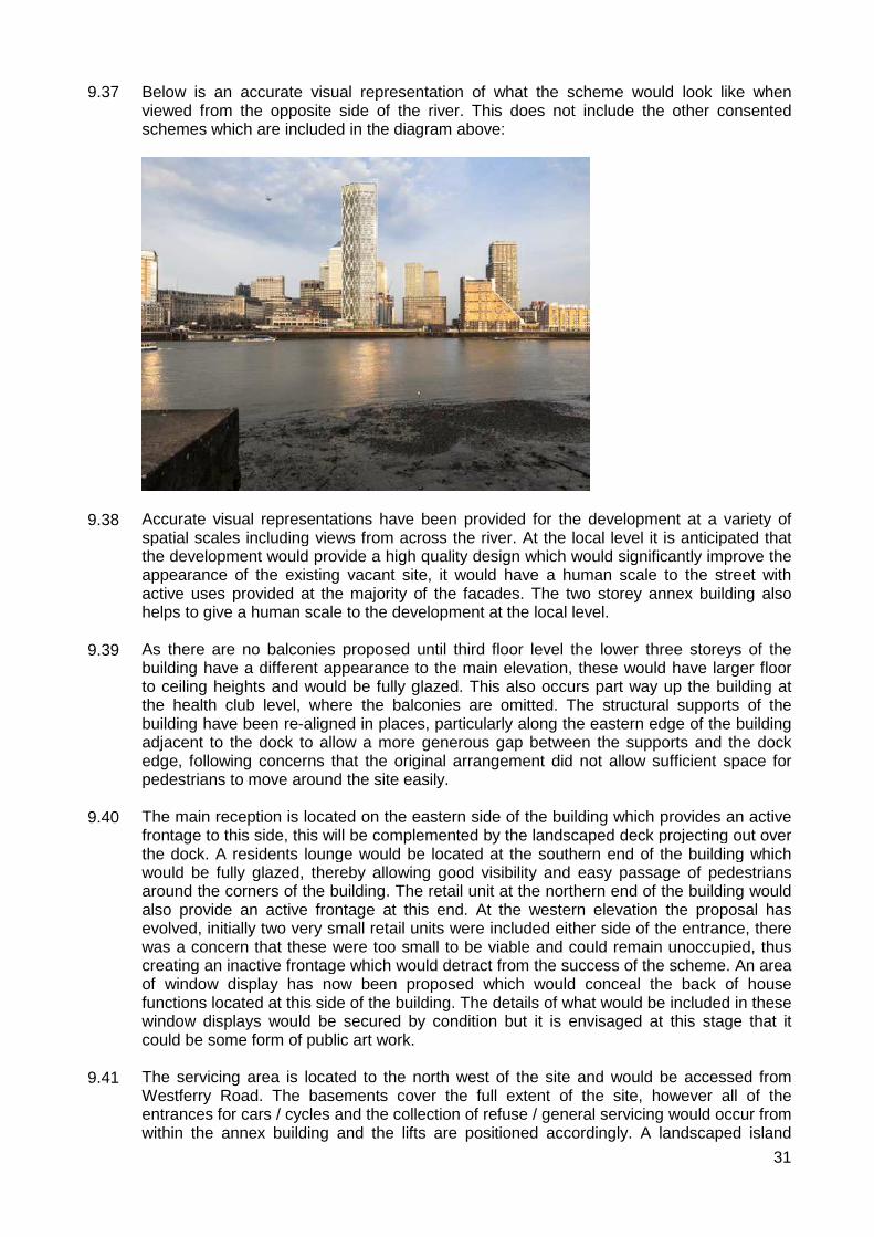
31
9.37 9.38 9.39 9.40 9.41
Below is an accurate visual representation of what the scheme would look like when viewed from the opposite side of the river. This does not include the other consented schemes which are included in the diagram above:
Accurate visual representations have been provided for the development at a variety of spatial scales including views from across the river. At the local level it is anticipated that the development would provide a high quality design which would significantly improve the appearance of the existing vacant site, it would have a human scale to the street with active uses provided at the majority of the facades. The two storey annex building also helps to give a human scale to the development at the local level. As there are no balconies proposed until third floor level the lower three storeys of the building have a different appearance to the main elevation, these would have larger floor to ceiling heights and would be fully glazed. This also occurs part way up the building at the health club level, where the balconies are omitted. The structural supports of the building have been re-aligned in places, particularly along the eastern edge of the building adjacent to the dock to allow a more generous gap between the supports and the dock edge, following concerns that the original arrangement did not allow sufficient space for pedestrians to move around the site easily. The main reception is located on the eastern side of the building which provides an active frontage to this side, this will be complemented by the landscaped deck projecting out over the dock. A residents lounge would be located at the southern end of the building which would be fully glazed, thereby allowing good visibility and easy passage of pedestrians around the corners of the building. The retail unit at the northern end of the building would also provide an active frontage at this end. At the western elevation the proposal has evolved, initially two very small retail units were included either side of the entrance, there was a concern that these were too small to be viable and could remain unoccupied, thus creating an inactive frontage which would detract from the success of the scheme. An area of window display has now been proposed which would conceal the back of house functions located at this side of the building. The details of what would be included in these window displays would be secured by condition but it is envisaged at this stage that it could be some form of public art work. The servicing area is located to the north west of the site and would be accessed from Westferry Road. The basements cover the full extent of the site, however all of the entrances for cars / cycles and the collection of refuse / general servicing would occur from within the annex building and the lifts are positioned accordingly. A landscaped island

32
9.43 9.44 9.45 9.46 9.47 9.48 9.49 9.50 9.51 9.52
between Westferry Road and the servicing area of the building is proposed, this would help to screen this back of house section from the public highway.
Strategic views. Assessment point 5A.1 of the Draft Revised London View Management Framework is relevant to the application (relating to the view from the General Wolfe Statue in Greenwich Park overlooking Maritime Greenwich World Heritage Site). The management framework suggests that this view would benefit from “further, incremental consolidation of the cluster of tall buildings on the Isle of Dogs however any consolidation of clustering of taller buildings on the Isle of Dogs needs to consider how the significance of the axis view from the Royal Observatory towards Queen Mary’s House could be appreciated.” The townscape and visual assessment which form part of the Environmental Assessment demonstrates how this development would assist with the consolidation of the cluster in the context of the existing buildings with planning consent on the Isle of Dogs. The townscape assessment also produces a number of views from strategic locations round London, including from London Bridge, Stave Hill (Southwalk), Mudchute Park and Meridian Gardens (adjacent to the O2 arena, North Greenwich). The townscape conclusions suggest that the proposed development would be visible but there would be no significant impact on the setting of the view or the Outstanding Universal Value of the World Heritage Site. The GLA nor the Councils Design and conservation do not raise any objections in this respect. Heritage & Conservation The NPPF sets out the Government’s objectives in respect of conserving and enhancing the historic environments. Policies 7.3, 7.4, 7.8, 7.9 and 7.10 of the London Plan (2011) and the London World Heritage Sites – Guidance on Settings SPG. Policies SP10 and SP12 of the CS and policies DM24, DM26, DM27 and DM28 of the MDD seek to protect the character, appearance and setting of heritage assets and the historic environment, including World Heritage Sites. London Plan (2011) policies 7.11 and 7.12, policy SP10 of the Core Strategy Development Plan Document (2010) and policies DM26 and DM28 of the Managing Development Document seek to ensure large scale buildings are appropriately located and of a high standard of design whilst also seeking to protect and enhance regional and locally important views. It is considered that the proposed development safeguards local and strategic views, and for the reasons stated in the above paragraphs, it would not have a negative impact on the setting of the Greenwich Naval College (World Heritage Site). It is considered that whilst the proposal is visible from the nearest conservation areas (Narrow Street and West India Dock), it is sufficiently distant, as to not have a material impact on their character and appearance. The dock wall, immediately adjacent to the application site is Grade I listed and there is a separate listed building consent (PA/13/1456) which has been submitted to apply to undertake works to this wall. There is no separate report for these works, consideration is given to the acceptability of the listed building consent within this document and the relevant conditions are listed above. The new pedestrian bridge and replacement deck area over the dock would be separated from the dock wall with a soft joint and will be structurally independent of it. The listed

33
9.53 9.54 9.55
building consent is for the removal of the existing deck and the 1980’s section of dock wall which is above the existing quay wall level and is located at the southern end of the site. This 1980’s wall involved the removal of a 7.2m length of the original granite dock wall coping stones, these would be reinstated as part of this application. Subject to a number of conditions, including an archaeological watching brief, English Heritage have raised no objection to the proposal and have agreed that listed building consent can be granted for these works. Conservation officers also agree that consent should be granted for these works. Microclimate Tall buildings can have an impact upon the microclimate, particularly in relation to wind. Where strong winds occur as a result of a tall building it can have detrimental impacts upon the comfort and safety of pedestrians and cyclists. It can also render landscaped areas unsuitable for their intended purpose. The environmental statement accompanying the planning application has carried out wind tunnel testing in accordance with the widely accepted Lawson Comfort Criteria. The criteria reflects the fact that sedentary activities such as sitting requires a low wind speed for a reasonable level of comfort whereas for more transient activities such as walking, pedestrians can tolerate stronger winds. Three assessments have been done for comparison purposes; existing site conditions with existing surrounding site conditions; the development with existing surrounding site conditions and the development with cumulative schemes. The figures arrived at have been done so without taking account of any landscaping within the site so are ‘worst-case scenarios’. The assessment groups the areas around the side into five different categories; ground level entrances; pedestrian thoroughfares; pedestrian drop-off areas; ground level amenity spaces and roof terraces/ balconies.
• Ground level entrances – the predicted wind conditions are anticipated to be suitable for standing / entrance use. As such no mitigation measures are required in order to make the conditions around the entrances acceptable.
• Pedestrian thoroughfares – Of the nine receptors tested, five show that the wind conditions would be improved, within the windiest season conditions along Westferry Road and Bank street would be suitable for standing / entrance use and in the summer would be suitable for sitting or standing. Of the four receptors which show windier conditions than currently these are still suitable for leisure walking which is acceptable for the anticipate use. One receptor (on the pedestrian bridge) would have the highest level of wind and would be uncomfortable for people using the bridge. Once the Park Place development is constructed this would block some of the wind blowing across the middle dock and make it suitable for business walking (the next lowest category), however, if this development does not come forward then wind mitigation will be required on the pedestrian bridge and an indicative plan showing the location of a wind screen has been provided. Further details of this would be secured by condition.)
• Pedestrian drop-off zones – One receptor within the drop-off areas shows that it would be suitable for leisure walking which is one category windier than desired. It is recommended that landscaping along the southern edge of the canopy be secured by condition in order to reduce the wind at this location to standing / entrance use.
• Ground level amenity space – Both the amenity area over the dock and to the north of the site show the wind levels to be one category winder than desired for the intended use i.e. standing rather than sitting. The applicant has suggested that the installation of appropriate landscaping would provide suitable mitigation and this would be tested at the detailed design stage through an appropriately worded landscaping condition.
• Roof terraces and balconies – The first floor roof terrace and balconies were

34
9.56 9.57
suitable for sitting, even during the windiest season. As such, no mitigation is required for these.
Secured by design. Policy 7.3 of the London Plan seeks to ensure that developments are designed in such a way as to minimise opportunities for crime and anti-social behaviour. The built form should deter criminal opportunism and provide residents with an increased sense of security. The Crime Prevention Design Advisor has reviewed the proposal and is satisfied that the measures put in place such as key fob access, CCTV, lighting and on-site security are sufficient to ensure the occupants of the units would be sufficiently secure. The detailed design of these would be secured through condition. There are no recessed areas around the building and access into the basement for cars and bicycles would be restricted to residents only. Whilst the use of bollards outside the entrance to the building are suggested in order to prevent a hostile vehicle attack there are concerns regarding what implications these may have for visually impaired pedestrians and the general appearance of the development. As such, it is recommended that measures to prevent direct vehicle access to the building are incorporated into the landscaping and will be secured by condition.
Density 9.58 9.59
Policy 3.3 of the London Plan (2011) seeks to increase London's supply of housing, requiring Boroughs to meet and exceed housing targets, and for new developments to offer a range of housing choices, in terms of the mix of housing sizes and types and provide better quality accommodation for Londoners. By identifying the Isle of Dogs as an Opportunity Area, the London Plan envisages that in excess of 10,000 residential units will be forthcoming over the Plan period. Policy SP02 of the CS seeks to deliver 43,275 new homes (equating to 2,885 per year) from 2010 to 2025 in line with the housing targets set out in the London Plan. Appendix 2 of the Council’s adopted Core Strategy reviews the delivery programme of new housing investment and seeks to provide within the Plan period (2010-2025) a new housing allocation of 4,190 new homes for Cubitt Town, 2,640 new homes for Canary Wharf and 6,150 new homes for Millwall; a total of 12,980 new units across all three “Places” as defined by the Core Strategy and exceeds the overall London Plan target for the Isle of Dogs Opportunity Area.
9.60 Policies 3.4 of the London Plan (2011) and SP02 of the Core Strategy (2010) seek to ensure new housing developments optimise the use of land by relating the distribution and density levels of housing to public transport accessibility levels and the wider accessibility of the immediate location.
9.61 The site has a “very good” public transport accessibility level (PTAL 5). For central
locations with a PTAL of 5, both London Plan (Policy 3.4, Table 3.2) and LBTH Core Strategy seek to provide a density of between 650 and 1,100 habitable rooms per hectare. The proposed residential density is 2,738 habitable rooms per hectare or 1,183 units per hectare. It is acknowledged that this figure is significantly in excess of the London Plan density ranges. However, the intent of the London Plan and Council’s MDD is to optimise the intensity of use compatible with local context, good design principles and public transport capacity. In order to aid comparisons, the recently approved City Pride scheme accommodated a density of 5,803 habitable rooms per hectare and 2,935 units per hectare.
9.62 The scheme incorporates an element of public open space at ground floor level, has a roof
35
top amenity area (on the annex building) and provides internal amenity space. The scheme also provides a substantial set of planning obligations towards transport infrastructure, public realm and connectivity to improve sustainable travel options, education provision, health care improvements and other community facilities in order to fully mitigate the impacts of this scheme on the wider environment.
9.63 9.64 9.65 9.66 9.67 9.68
Further advice on the proper application of residential densities can be found in the London Plan Supplementary Planning Guidance entitled “Housing” (November 2012). There is a useful quote in the SPG which reads as follows: “On the other hand, the actual density calculation of an acceptable development (in terms of units or habitable rooms per hectare) is a product of all the relevant design and management factors; if they are all met, the resultant figure is what it is and is arguably irrelevant. Anyone grappling with the thorny issue of density tends to go round in circles – moving between these two extreme positions”. The SPG advises that development outside the London Plan density ranges will require particularly clear demonstration of exceptional circumstances (taking account of relevant London Plan policies) and it states that unless significant reasons to justify exceeding the top of the appropriate range can be demonstrated rigorously, they should normally be resisted and it recognises that making decisions on housing density requires making a sensitive balance which takes account of a wide range of complex factors. The slender form of the tower is an expression of its residential use and it is articulated through the diamond grid exoskeleton structure and thus it represents a high quality design that it is required to justify the high density of the scheme. There is also significant pressure placed on the Isle of Dogs Opportunity Area, by both the London Plan at a strategic level, and the Core Strategy at a local level to provide housing where limited number sites are available. In this instance, the relatively small site area will undoubtedly produce high density levels, however this has to be weighed up against the pressure to provide housing. Officers consider that this development offers a significant contribution to that housing need, and together with the high quality design and acceptable amenity impacts, the proposal has demonstrated that exceptional circumstances exits to justify the high density levels. The SPG outlines the different aspects of density which should be rigorously tested, these include the proposed dwelling mix, design and quality, physical access to services, long term management of communal areas and the wider context of the proposal including its contribution to local “place shaping”. It also refers to the need to take account of its impact in terms of design (exemplary), massing, scale and character in relation to nearby uses whilst requiring an assessment of the capacity of existing local amenities, infrastructure and services to support the development. Whilst it is fully acknowledged that developments should be considered on their own merits and the acceptability of residential densities need to take account of a wide variety of factors, approval of schemes in excess of the London Plan density ranges is not an out of the ordinary occurrence in Tower Hamlets, bearing in mind the Borough’s growth agenda (in terms of additional housing and affordable housing). Most cases are required to be considered “in the balance” with not all density criteria being fully satisfied. Your officers continually monitor and review planning permissions to determine and manage the housing growth agenda and also use this monitoring information to inform the Council’s Planning for Population Change and Growth Model, which underpins the on-going Infrastructure Delivery Plan and identifies infrastructure requirements to support the level of housing growth envisaged by the London Plan and the Core Strategy. It is important to note that the applicant has met all the S.106 planning obligations required by the Planning Obligations SPD and the development itself provides sufficient child play space and generally complies with other aspects of the London Plan’s Housing Supplementary Planning Guidance in terms of unit sizes and private and communal
36
9.69 9.70 9.71 9.72 9.73 9.74 9.75
amenity space. To conclude, density figures only serve as an indication of the likely impact of a development and as discussed in later sections of this report, the development does not present any serious concerns in respect of overdevelopment and on balance, promotes high standards of residential quality and placemaking. As such, a density which exceeds the recommended guidance would be acceptable in this location and assists in the delivery of housing targets outlined above. This is further supported by the site’s designation within the Tower Hamlets Activity Area, of which encourage high density development in central locations. It is therefore considered that the proposal maximises the intensity of use on the site and is supported by national, regional and local planning policy, and complies with Policy 3.4 the London Plan (2011) and Policy SP02 of the Core Strategy (2010) which seek to ensure the use of land is appropriately optimised in order to create sustainable places. Impact upon local infrastructure / facilities Local Schools
The Council is taking a positive approach to planning for the social and physical infrastructure necessary to support the growth in homes and jobs across the Borough over the next 15 years and beyond, through its Local Development Framework. The Inspector, in his report into the Managing Development Document, supported all of the Council’s site allocations for infrastructure provision. This will enable the delivery of a range of infrastructure including new primary and secondary schools, health facilities, local parks and IDEA Stores. This includes the allocation of private development sites for 2 new secondary schools and a minimum of 5 new primary schools. These allocations will complement the Council’s proposals to expand its existing school estate and use of its own land to provide new school places. In a number of cases your officers are in discussion opportunities for new educational facilities on sites not explicitly allocated for such a purpose but could well contribute positively towards a mixed use solutions and complement formal allocated school sites. The approach to planning for school places and other infrastructure takes into account committed and potential development as well as demographic projections. This information is kept under continual review to ensure that the correct type and amount of infrastructure is provided. The Managing Development Document also includes site allocations in the Isle of Dogs for a new Health Facility and IDEA Store and requires the provision of new areas of open space, public realm improvements, new connections and transport improvements. Work on the site allocations has been integrated into the Council’s processes for negotiating and securing planning obligations. This ensures that all development contributes to infrastructure provision, either as part of the development proposals/allocations themselves or through planning obligations. Clearly, the identification of new school sites (both primary and secondary)is required to take into account the locations most likely to generate the extra pupils, given that new housing rather than local population growth is the main source (around two thirds) of the increasing numbers. It is also common ground that taking into account schemes already in the development pipeline, the majority of new housing over the plan period is likely to be in the east of the borough, rather than the west. Moreover, around two thirds of existing secondary school places are presently also in the western part of the Borough. Consequently, the need is clearly greater and more urgent in the east, including the Isle of
37
9.76 9.77 9.78 9.79 9.80 9.81 9.82 9.83
Dogs.
Turning to the likely level of need over the Core Strategy period (2010 to 2025), the Council’s estimates of new secondary school places are partly based on an average scale of new housing delivery (about 4,300 per year) that significantly exceeds not only the number of units delivered over the last few years but also more importantly, the strategic requirements of the London Plan (around 2,900 per year).
The development is likely to generate 7 primary school places and 1 secondary school place. This is a very low provision given the scale of the development, but this is due to the large number of studio and 1 bed units and because it is a solely private scheme generates a lower child yield. The impact of the development in terms of school yield should be considered in light of the off-site affordable housing schemes which are associated with this development. The Lovegrove Walk units are already existing houses and would therefore already be generating a child yield, these have therefore been discounted from the overall total. The child yield from Burdett Road would be 22 primary school children and 13 secondary school children, a full s106 package is proposed to mitigate against the additional child yield for this development and is reported separately on this agenda. Barchester Street is only indicative at this stage and the child yield with be dependent on the mix of units. An indicative mix (based on an indicative total unit number) which would allow for a fully policy compliant level of social rented housing across all three sites would be 49 x 1 beds, 40 x 2 beds, 18 x 3 beds and 11 x 4 beds, this would generate a yield of 37 children of primary school age and 18 secondary school children. Within the proposed s106 agreement for Newfoundland there would be a requirement for the development on Barchester Street to meet the relevant financial contributions set out within the planning obligations SPD. Health facilities. The development is expected to accommodate an additional 954 residents, who would potentially require health care services offered by the Tower Hamlets PCT. The NHS is currently undertaking an ambitious programme to develop health and wellbeing centres across Tower Hamlets to meet the needs of the rapidly growing population. To accommodate the additional population growth from this and other sites a new ‘service hub’ is being planned at Wood Wharf. The financial contribution from this development would go towards the long lease or fit out costs of the Wood Wharf service hub or as otherwise identified by Tower Hamlets PCT. Open space Policy 7.18 of the London Plan supports the creation of new open space in London to ensure satisfactory levels of local provision to address areas of deficiency. London Plan Policy 7.5 seeks to ensure that London’s public spaces are secure, accessible, inclusive, connected, easy to understand and maintain, relate to local context, and incorporate the highest quality design, landscaping, planting, street furniture and surfaces and the development proposals will accord with the objectives of this policy. Policies SP02, SP04 and SP12 of the CS promote the good design of public spaces and the provision of green spaces. It is calculated that 954 people will live in the proposed development with approximately 73 employees for the commercial use. Based on the occupant and employee yield of the development, the proposal would normally be expected to deliver approximately 1.16 hectares of public open space which is clearly not possible on such a small site (bearing in

38
9.84 9.85
mind the requirement to deliver additional housing units within the Borough and on the Isle of Dogs in particular.). Notwithstanding this, the scheme would deliver approximately 1000sqm of public open space around the site including the soft landscaped area over the dock and to the north of the main building and the area to the north of the annex building between the subject site and 1 Park Place. This would provide an attractive public realm and an element of leisure space where seating is provided. It would also complement the existing open spaces within the vicinity of the application site including the various green spaces within the Canary Wharf estate and Lenaton Steps / Sir John McDougal gardens to the south. Irrespective of this, the proposed level of open space would fall below LBTH’s standard of 12sqm per occupant (in order to achieve 1.2 ha per 1,000 residents as set out in the LBTH 2006 Open Space Strategy) and would only provide approximately 1sqm per person. Accordingly, the applicant has agreed to a financial contribution of £701,131 to mitigate this impact, which would be in compliance with the Planning Obligations SPD requirement. It is considered that the scheme benefits outweigh the shortfall in open space per head of population. The submitted public realm and landscape strategy have provided officers with sufficient comfort that the quality of open space that would be provided within the development would be of a high standard and a financial contribution toward public open space serves to mitigate against this shortfall. Accordingly, it is considered that the proposal is acceptable in this regard.
9.86 9.87 9.88 9.89
Housing The Newfoundland scheme does not propose to include any affordable housing on site. In lieu of this, three sites owned by the applicant are proposed as donor sites for the affordable housing, and a cash in-lieu payment of £7,490,000 is also proposed towards intermediate housing. The four sites together are linked regarding the provision of affordable housing and dwelling mix The three sites are 307 Burdett Road, 83 Barchester Street and Lovegrove Walk (all E14 postcodes). 307 Burdett Road has a current extant planning permission for 56 units in a mixed tenure scheme. Reported separately on this agenda is an application to vary this permission to allow 42 units (but greater number of habitable rooms) along with various external alterations and the provision of all of these as social rented units. 83 Barchester Street is a site which does not yet have a planning permission for redevelopment. It is a vacant employment site adjacent to the Limehouse Cut, close to Langdon Park. There have been pre-application discussions with officer’s regarding the potential of this site to deliver affordable housing and a scheme has been worked up to show that 352 habitable can realistically be accommodated on this site without significantly impacting on neighbouring residents whilst still providing sufficient amenity space. Lovegrove Walk is a cul-de-sac off Prestons Road which contains a number of houses and flats. 20 of these (equivalent to 115 habitable rooms) are in the ownership of the developer and are offered for affordable housing to the Council on a minimum term of 5 years. These properties fall within the development parameters for Wood Wharf and cannot therefore be provided in perpetuity. These would provide a valuable resource for homeless families on a short term basis. Prior to these units being required by the developer for the redevelopment of the Wood Wharf sutea replacement equivalent of this mix of units is to be provided elsewhere within Millwall or Blackwall and Cubitt Town wards.

39
9.99 9.100 9.101 9.102 9.103
The diagram below shows the geographical position of each of the sites:
It is proposed that the private residential accommodation will be within the high rise, high density tower at the Newfoundland site and the Burdett Road / Barchester Street and Lovegrove Walk sites would be lower density schemes with a focus on affordable family accommodation. The London Plan has a number of policies which seek to guide the provision of affordable housing in London. Policy 3.9 seeks to encourage mixed and balanced communities with mixed tenures promoted across London and that there should be no segregation of London’s population by tenure. Policy 3.11 identifies that there is a strategic priority for affordable family housing and that boroughs should set their own overall targets for affordable housing provision over the plan period which can be expressed in absolute terms or as a percentage. Policy 3.12 is considered to be of particular relevance as it provides guidance on negotiating affordable housing provision on individual sites. The policy requires that the maximum reasonable amount should be secured on sites having regard to: � Current and future requirements for affordable housing at local and regional levels � Affordable housing targets � The need to encourage rather than restrain development � The need to promote mixed and balanced communities � The size and type of affordable housing needed in particular locations and � The specific circumstances of the site. The supporting text to the policy encourages developers to engage with an affordable housing provider to progress a scheme. Borough’s should take a reasonable and flexible approach to affordable housing delivery as overall, residential development should be encouraged rather than restrained. The GLA development control toolkit is an acceptable way of evaluating whether a scheme is providing the maximum reasonable amount of affordable housing. Paragraph 3.12 of the London Plan states that affordable housing is normally required on-

40
9.104 9.105 9.106 9.107 9.108 9.109
site. However, in exceptional circumstances it may be provided off-site on an identified alternative site where it is possible to: a) Secure a higher level of provision b) Better address priority needs, especially for affordable family housing c) Secure a more balanced community d) Better sustain strategically important clusters of economic activities, especially in parts of the CAZ and the north of the Isle of Dogs where it might be part of a land ‘swap’ or ‘housing credit’. The issue of affordable housing and off-site provision is similarly dealt with in the Councils policies. Policy SP02 of the Core Strategy sets an overall target of 50% of all homes to be affordable by 2025 which will be achieved by requiring 35%-50% affordable homes on sites providing 10 units or more (subject to viability). The Managing Development Document requires developments to maximise affordable housing on-site. Off-site affordable housing will be considered where it can be demonstrated that: a) It is not practical to provide affordable housing on-site b) To ensure mixed and balanced communities it does not result in too much of any one type of housing in one local area. c) It can provide a minimum of 50% affordable housing overall d) It can provide a better outcome for all of the sites including a higher level of social rented family homes and e) Future residents living on all sites use and benefit from the same level and quality of local services. Assessment against policy In summary, when considering national, regional and local policies off-site affordable housing is only acceptable in exceptional circumstances, if it is to be accepted it should provide a higher quantum than if it were on-site, should not undermine the objectives of providing a mixed and balanced community, should better address a priority need i.e. affordable family homes and would not reduce future residents access to services and amenities which would be available to residents of the private housing site. The affordable housing offer in this instance should be considered in light of the viability of the scheme. A viability toolkit has been submitted which has been rigorously investigated by the Council’s viability consultant. The maximum affordable housing which the scheme can viably deliver on-site would be 6% with a 70:30 split between social rent and intermediate housing. Whilst the values of the private market units within the Newfoundland scheme would under normal circumstances create a viable scheme, the cost of construction is abnormally high in this case. The position of the Jubilee line underneath the site, combined with the shape of the site leading to the north and south ends being a significant distance from the structural core means that traditional methods of construction would not be possible on site. The diagrid structure around the building not only provides an attractive external appearance but is a structural solution which effectively braces the building in position externally, rather than using traditional concrete columns through the centre of the building. In conjunction with the work around the viability the Council’s consultant and officers have investigated whether this is the only solution for constructing the building over the Jubilee line tunnels and it is concluded that this is the only realistic construction solution for this scale of building. The Council’s consultant has confirmed that the construction costs, whilst at the upper end of what would be expected for a building of this nature, are reasonable. Members are therefore requested to view the housing offer in light of this agreed viability position.

41
9.110 9.111 9.112 9.113 9.114 9.115 9.116
Quantum of affordable housing The policy requires a minimum of 50% affordable housing to be provided when off-site affordable housing is offered. This however is subject to viability as set out in part 3a of the Core Strategy. The London Plan and NPPF also emphasis that development should not be constrained by planning obligations. Paragraph 173 of the NPPF states that “the sites and scale of development identified in the plan should not be subject to such a scale of obligations and policy burdens that their ability to be developed viably is threatened.” Policy 3.12 of the London Plan is clear that viability is a consideration when negotiating affordable housing “negotiations on sites should take account of their individual circumstances including development viability” and the need to encourage rather than restrain development. A viability toolkit has been submitted with the scheme and this has been independently reviewed by Deloitte. The review of the toolkit concluded that the site could viably provide 6% affordable housing on-site. This would be a total of 180 habitable rooms within a scheme of 1,314. The 6% is based on a 70:30 split between social rent and intermediate housing which would effectively mean 126 social rented habitable rooms and 54 intermediate habitable rooms. For information and by way of example, 126 habitable rooms would allow for 31 family sized units or 63 x 1 bed units. It is within this context that the affordable housing offer needs to be considered. A breakdown of the affordable housing offer is shown below: Lovegrove Walk: 115 habitable rooms / 20 units in a mix of 6 x 3 bed, 13 x 4 bed and 1 x 5 bed. These units would be available for a minimum period of five years as they form part of the Wood Wharf redevelopment proposals. There are some internal works which need to happen (and do not require planning permission) to these properties before they are ready for occupation and the developer has agreed to commence this work within 30 days of the date of permission and will be available for occupation within a year of the grant of permission (or sooner if the works are completed before this time). The Council’s housing team have indicated that these family sized houses would provide much needed temporary accommodation for homeless families. Once the Wood Wharf redevelopment commences at this part of the site, the developer will be obligated to find a suitable alternative provision of equal quality, size and amenity for these 20 units elsewhere within Millwall Ward or Blackwall and Cubitt Town Wards. This will be secured within the s106 agreement. Further consideration of why these wards have been chosen is to be found within the ‘mixed and balanced communities’ section below.

42
9.117 9.118
Below is a picture of the Lovegrove Walk properties (after the garages are converted to habitable rooms:
These houses will have conversion works to allow the garages to be used as habitable rooms to create four bedroom units, others will remain as three bed units. There are also a number of flats within Lovegrove Walk which will be given over to affordable housing, these are a mix of 1 x 5 bed, 6 x 4 beds and 6 x 3 beds. Below are indicative floorplans:
These are considered to be very well suited to family housing and would be provide good quality accommodation for the future occupants of the site. All of the units meet the minimum London Plan space standards and have access to private amenity space. A number of the units also have a dedicated parking space. The Housing Options team within the Council have been working closely with the developer to ensure these properties are delivered at a size and layout which is needed. This means the properties can be quickly and efficiently let to families in need of this accommodation following the grant of

43
9.119 9.120 9.121 9.122 9.123
planning permission. Whilst this is only provided as temporary accommodation the quality and relative ease of delivery is a significant advantage of this proposal and their provision is very much supported by the Housing Options team. Through the s106 agreement the Council will have control over the re-provision of this housing once the Lovegrove Walk properties are acquired for the Wood Wharf re-development. The developer is required to find alternative provision for this number and mix of units within Millwall Ward or Blackwall and Cubitt Town Ward (an explanation for why these wards have been chosen is included in the ‘mixed and balanced communities’ section of the report.) 307 Burdett Road: 175 habitable rooms / 42 units in a mix of 5 x 1 beds, 5 x 2 beds, 30 x 3 beds and 2 x 4 beds. These would all be provided at social target rent. This application is a minor material amendment of an appeal decision, granted in May 2011, this therefore expires on 17th May 2014. In order to keep this permission the developer is intending to submit all pre-commencement conditions and commence works on site prior to the 17th May. Following the implementation of the application, as secured within the s106 agreement, this development will be completed and available for occupation before 50% occupation of Newfoundland is allowed (or should Barchester Street come forward first 50% occupation of Newfoundland should be allowed on this basis) 83 Barchester Street: This could provide 352 habitable rooms in a mix that will best respond to the Council’s identified need. All homes would be provided at social target rent and a scheme has been put forward which demonstrates that the site is flexible enough to accommodate a range of unit sizes from 1 to 4 bed units. Following the submission of a planning application a detailed discussion on the best outcome for this site will be undertaken with the affordable housing team. Officer’s are satisfied that this site could deliver the policy compliant levels of family housing (45% of all the social rented properties) if this is agreed to be the best outcome for the development, taking into consideration the management requirements of an RP and the types of housing which are in greatest need. Details on daylight and sunlight to neighbouring properties, location and provision of child play space and impact upon the conservation area / heritage value of the existing buildings have been provided. Officer’s are satisfied that a development of this scale could feasibly be delivered on this site. Below is an indicative floor plan showing the layout of the units and the location of amenity space and car parking.
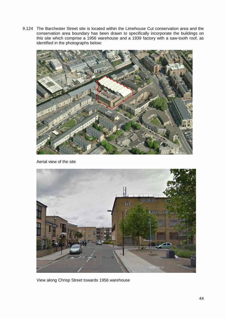
44
9.124
The Barchester Street site is located within the Limehouse Cut conservation area and the conservation area boundary has been drawn to specifically incorporate the buildings on this site which comprise a 1956 warehouse and a 1939 factory with a saw-tooth roof, as identified in the photographs below:
Aerial view of the site
View along Chrisp Street towards 1956 warehouse
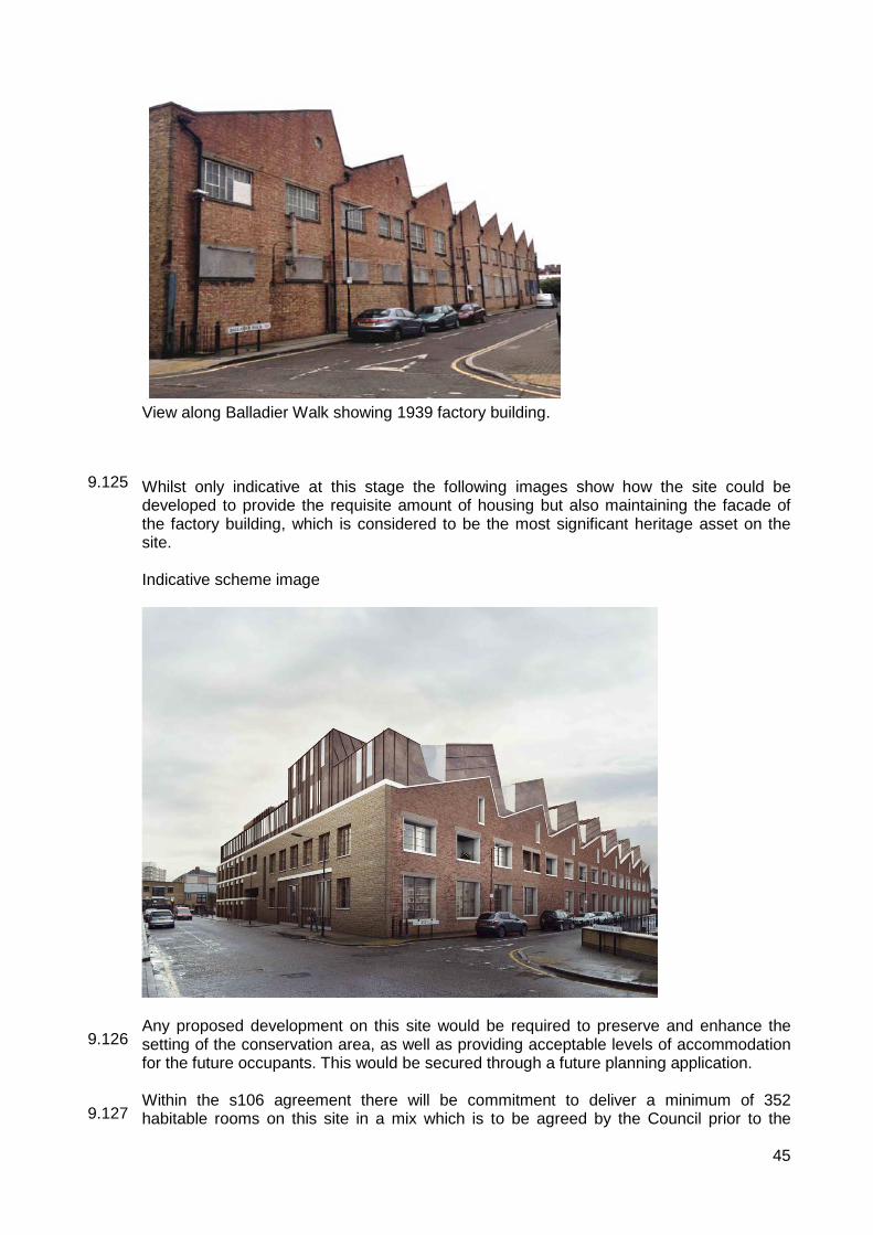
45
9.125 9.126 9.127
View along Balladier Walk showing 1939 factory building. Whilst only indicative at this stage the following images show how the site could be developed to provide the requisite amount of housing but also maintaining the facade of the factory building, which is considered to be the most significant heritage asset on the site. Indicative scheme image
Any proposed development on this site would be required to preserve and enhance the setting of the conservation area, as well as providing acceptable levels of accommodation for the future occupants. This would be secured through a future planning application. Within the s106 agreement there will be commitment to deliver a minimum of 352 habitable rooms on this site in a mix which is to be agreed by the Council prior to the

46
9.128 9.129 9.130 9.131 9.132 9.133
submission of the planning application. The developer commits to submitting a planning application for the Barchester site within six months of the date of the permission being granted for Newfoundland. If the Barchester site is not completed and disposed of to an RP before the Newfoundland works are complete there is also a clause within the s106 agreement which prevents the occupation of the final 10% of Newfoundland. As an additional incentive for the developer to deliver the affordable housing at Barchester Street, the developer has agreed to a penalty cash fall-back clause which would involve the depositing of funds at 1.3 times the value of providing all the habitable rooms for Burdett Road and/or Barchester Street on-site. This is in addition to them still being required to deliver the affordable housing at Barchester Street or an alternative site only if there are unforeseen circumstances outside the control of the applicant which prevents the re-development of Barchester Street. Officer’s consider that the depositing of funds at 1.3 times the cost of actually delivering the units would prove to be an incentive for the developer to achieve timely delivery of the affordable housing. The deposited funds would be refundable on delivery of all the affordable housing. Cash payment Cash payment in-lieu of intermediate housing on-site: £7,490,000 which will be index linked from the date of the agreement which equates to £35,000 for 214 habitable rooms. In this instance it has been considered appropriate to allow a cash-in-lieu payment for intermediate housing rather than requiring it to be delivered on-site due to the high value of units within the Newfoundland tower. The average sale cost per unit is estimated to be close to £700,000 with even the smaller 1 bed units on the lower floors of the development expected to achieve prices in excess of £300,000. In addition to the relatively high price of the units, the service charges for the all of the facilities offered within the building (such as the swimming pool and gym) are anticipated to be higher than average. As a result, the affordability of the intermediate units on this site is questionable and officers consider that providing a cash payment would result in a better outcome. A figure of £35,000 per habitable rooms has been proposed for the intermediate housing and £55,000 per habitable room for the social housing (if there are unforeseen circumstances which prevent the delivery of any of the donor sites). The reason for the difference in these figures is that the cost to the developer of delivering a social rented units is higher than a shared ownership unit as there is a higher revenue generated from an intermediate unit than social rented units. The £7,490,000 would be secured within the s106 agreement and can be spent by the Council on affordable housing projects. Summary The combination of the above equates to 856 affordable habitable rooms, the split would be 25:75 in favour of social rent. The percentage of habitable rooms as affordable needs to be seen as an aggregate across Newfoundland, Burdett Road and Barchester Street as Burdett Road and Barchester Street would, if developed independently, have been required to provide their own contribution to affordable housing. The number of habitable rooms across all three sites is 1,841. However a number of units within Newfoundland are significantly over-sized, thus skewing the affordable housing percentage when considered against the floor area of private to affordable. In order to redress this balance, a figure of 1,923 habitable rooms across all three sites has been agreed. This creates a total of 45% affordable housing by habitable room (including the in lieu payment for the intermediate affordable housing). In terms of quantum of affordable housing this is indisputably a better outcome than if the affordable housing were to be delivered on-site as this would be 180 rooms on site compared to 856 if delivered off-site.
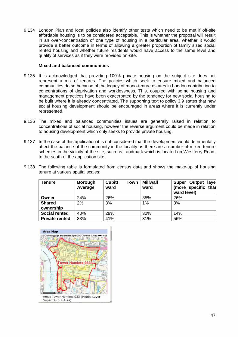
47
9.134 9.135 9.136 9.137 9.138
London Plan and local policies also identify other tests which need to be met if off-site affordable housing is to be considered acceptable. This is whether the proposal will result in an over-concentration of one type of housing in a particular area, whether it would provide a better outcome in terms of allowing a greater proportion of family sized social rented housing and whether future residents would have access to the same level and quality of services as if they were provided on-site. Mixed and balanced communities It is acknowledged that providing 100% private housing on the subject site does not represent a mix of tenures. The policies which seek to ensure mixed and balanced communities do so because of the legacy of mono-tenure estates in London contributing to concentrations of deprivation and worklessness. This, coupled with some housing and management practices have been exacerbated by the tendency for new social housing to be built where it is already concentrated. The supporting text to policy 3.9 states that new social housing development should be encouraged in areas where it is currently under represented. The mixed and balanced communities issues are generally raised in relation to concentrations of social housing, however the reverse argument could be made in relation to housing development which only seeks to provide private housing. In the case of this application it is not considered that the development would detrimentally affect the balance of the community in the locality as there are a number of mixed tenure schemes in the vicinity of the site, such as Landmark which is located on Westferry Road, to the south of the application site. The following table is formulated from census data and shows the make-up of housing tenure at various spatial scales: Tenure Borough
Average Cubitt Town ward
Millwall ward
Super Output layer (more specific than ward level)
Owner 24% 26% 35% 26% Shared ownership
2% 3% 1% 3%
Social rented 40% 29% 32% 14% Private rented 33% 41% 31% 56%

48
9.139 9.140 9.141 9.142
The above table shows that there is a significantly higher than borough average number portion of households which privately rent, and a lower proportion compared to the borough average for social rented properties. It cannot be determined whether the units within the Newfoundland development would be owner / occupied or predominantly let for private rent. The tables below explain how this development would change the make-up of the area if the total market units were to be owner/occupier and also if they were to be private rented flats: Tenure If total market
housing were owner/occupied
If total market housing were to be private rented
Borough average
Owner 38% 22% 24% Shared ownership
3% 3% 2%
Social rented 12% 12% 40% Private rented 47% 63% 33%
Under both scenarios the type of housing tenure within this localised area is not representative of the borough average, however given the nature of the location being within close proximity to Canary Wharf major commercial centre and the lack of any established social housing estates within the defined area it is not unexpected that the number of social rented units are underrepresented within the table. The provision of social rented units off-site would allow for a better quality provision of family sized rented units in a less dense form of development where suitable outdoor spaces can be provided for child play space. The converse argument also needs to be considered in terms of the impact of having 100% affordable housing sites on the mix and balance of the existing surrounding communities. There is a separate application for 307 Burdett Road, within which an analysis of the socio-economic make-up of the area is carried out. It is considered useful to include the same analysis within this report for consistency. Separate consideration of the appropriateness of 83 Barchester Street and Lovegrove Walk for affordable housing schemes are also included below: 307 Burdett Road. The site is located within Limehouse Ward approximately 1km to the north of the Newfoundland site. The tables below show the housing by type in this area within the following spatial scales (ward, middle super output and lower super output):

49
9.143 9.144 9.145 9.146 9.147 9.148
Existing housing by tenure Tenure Borough
Average Limehouse ward
Middle super output area
Lower-super output area
Owner 24% 26% 19% 18% Shared ownership
2% 2% 2% 6%
Social rented 40% 41% 52% 44% Private rented 33% 30% 25% 32%
Changes to percentages if development is constructed at 100% social rented housing: Tenure Borough
Average Limehouse ward
Middle super output area
Lower-super output area
Owner 24% 26% 19% 17% Shared ownership
2% 2% 2% 6%
Social rented 40% 42% 52% 46% Private rented 33% 30% 25% 30%
As anticipated the greatest difference is experienced within the lower super output area as this only represents 1,146 households. At ward level and middle super output level (which is 3,207 homes) the addition of 42 social rented homes does not significantly alter the level of social housing in the area. It should also be noted that this is an area of significant change and the proportion of social housing in the area has significantly reduced since the 2001 census. In 2001, Limehouse ward was made up of 54% social housing, with the immediate area around the Burdett Road site comprising 71% social rented units (against a borough average of 53%). From the above table it can be seen that this is changing and the area and it is becoming more mixed, with a greater proportion of private rented accommodation and an increase in shared ownership units too. The introduction of 42 additional social rented units would not disproportionately affect the levels of social housing in the area, though consideration would need to be given to future 100% social housing schemes to ensure the income of private housing in the area is not being reversed and the balanced skewed towards social housing again in this area. It is considered, on balance, that the relatively small scale of this development would not adversely affect the mix of the area. Ability to provide a better environment for families in social rented accommodation. Part 3a(iv) of policy DM3 outlines that one of the advantages of providing off-site affordable accommodation is that this can often be a better way to provide family size accommodation suitable for social rented tenants. The Newfoundland site is a small site with very limited opportunities for external play space which would not necessarily be well suited to families with multiple children. There are also a limited number of open spaces in close proximity to the Newfoundland site which would allow space for older children to play, for example, ball courts / kick-about areas. There is an ‘amenity floor’ provided within the development but this provides for a gym and swimming pool and is likely to incur significant service charges and would not be accessible for the social rented families. Overall, given the high density nature of the site and the ability to only provide one tower with limited amenity spaces, the off-site provision of family units within 307 Burdett Road, where sufficient amenity space can be provided, is a better outcome.

50
9.149 9.150 9.151
83 Barchester Street This site is within the East India and Lansbury Ward and is approximately 1.5km north east of the application site. As discussed above, it is anticipated that this site can reasonably be expected to accommodate up to 352 habitable rooms, subject to the submission of a detailed planning application. As per 307 Burdett Road, an assessment of the current tenure types has been undertaken to assess whether this development would contribute to a mixed and balanced community within the local context. As a visual aid, the maps below outline the areas that have been assessed:
Existing housing by tenure Tenure Borough
Average East India & Lansbury ward
Middle super output area
Lower-super output area
Owner 24% 18% 15% 11% Shared ownership
2% 3% 2% 5%
Social rented 40% 57% 60% 67% Private rented 33% 21% 22% 16%
Changes to percentages if development is constructed at 100% social rented housing: Tenure Borough
Average East India & Lansbury ward
Middle super output area
Lower-super output area
Owner 24% 18% 15% 10% Shared ownership
2% 3% 2% 4%
Social rented 40% 58% 62% 71% Private rented 33% 20% 21% 14%
As can be seen above, the area does have a higher than average level of social housing and within the immediate vicinity of the site the level of social housing would change from 67% to 71% were this development constructed. At ward level the social housing would be increased by 1%. As per Burdett Road, the area has changed significantly since 2001 and the levels of social housing have reduced proportionately. At ward level the social housing in 2001 made up 69% of the housing stock, whereas this is now 58%, at the lower super output area level 84% of housing was social rented in 2001 so there is evidence that the area is becoming more mixed and balanced by virtue of the number of private schemes which have come forward since 2001. A balanced view needs to be taken on this proposal, in light of the viability position of Newfoundland. Whilst Barchester Street is located within an area with higher than average

51
9.152 9.153 9.154 9.155 9.156
social housing, these 352 habitable rooms are outside of the scope of what is viable as a result of the private housing scheme. This would provide much needed additional housing stock for those on the Council’s waiting list and this is a significant benefit of the scheme which needs to be weighed against any concern arising from whether this is undermining the objectives of creating a mixed and balanced community. Access to social infrastructure. The developer has undertaken a study into the social infrastructure surrounding the three off-site locations to understand whether the occupants would have the same access to services and social infrastructure as the residents of Newfoundland would. Clearly Newfoundland and its proximity to the Canary Wharf major centre and its excellent transport links would not be possible to replicate elsewhere in the borough. However, it does not necessarily follow that the facilities within the Canary Wharf centre would be preferable for all residents to facilities which are of a more local nature elsewhere in the borough. In terms of health care facilities, there are two GP surgeries within 500m of Burdett Road and one within 500m of Barchester Street which are all accepting new patients and have less than the recommended capacity of 1,800 patients per doctor. In terms of education, there are nine primary schools and one secondary school within the Poplar area. These would be the same schools which children from the Newfoundland development would access but are towards the north of Poplar so are more easily accessible for the occupants of both Barchester Street and Burdett Road. The occupants of the Burdett Road site would have access to eight public open spaces within 800m of the site including Mile End Park (in the case of Burdett Road), and this is considered to provide a better access to open space than Newfoundland. Finally, in terms of general accessibility, both Newfoundland and Burdett Road have a public transport accessibility level of 5, so there are no advantages, transport-wise of the Newfoundland development over the site at 307 Burdett Road. Barchester Street, however is less accessible to public transport, having a PTAL of 3. The nearest station is Langdon Park on the DLR and bus routes 309 which runs along Upper North Street to the west and D8 which runs along Morris Road to the east. Lovegrove Walk. These are not new houses, they are not currently occupied and are being converted from private houses to affordable ones, they are located 1.1km to the east of the site. Lovegrove Walk is the Blackwall and Cubitt Town ward, which generally has a relatively high proportion of private housing compared to social housing. The same exercise has been carried out for assessing the acceptability of off-site housing in this location as was undertaken for Barchester Street and Burdett Road.
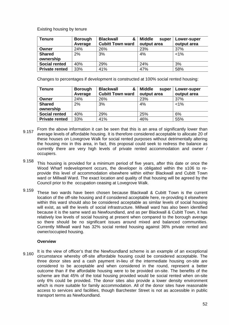
52
9.157 9.158 9.159 9.160
Existing housing by tenure Tenure Borough
Average Blackwall & Cubitt Town ward
Middle super output area
Lower-super output area
Owner 24% 26% 23% 37% Shared ownership
2% 3% 4% <1%
Social rented 40% 29% 24% 3% Private rented 33% 41% 47% 58%
Changes to percentages if development is constructed at 100% social rented housing: Tenure Borough
Average Blackwall & Cubitt Town ward
Middle super output area
Lower-super output area
Owner 24% 26% 23% 37% Shared ownership
2% 3% 4% <1%
Social rented 40% 29% 25% 6% Private rented 33% 41% 46% 55%
From the above information it can be seen that this is an area of significantly lower than average levels of affordable housing. It is therefore considered acceptable to allocate 20 of these houses on Lovegrove Walk for social rented purposes without detrimentally altering the housing mix in this area, in fact, this proposal could seek to redress the balance as currently there are very high levels of private rented accommodation and owner / occupiers. This housing is provided for a minimum period of five years, after this date or once the Wood Wharf redevelopment occurs, the developer is obligated within the s106 to re-provide this level of accommodation elsewhere within either Blackwall and Cubitt Town ward or Millwall Ward. The exact location and quality of that housing will be agreed by the Council prior to the occupation ceasing at Lovegrove Walk. These two wards have been chosen because Blackwall & Cubitt Town is the current location of the off-site housing and if considered acceptable here, re-providing it elsewhere within this ward should also be considered acceptable as similar levels of social housing will exist, as will the levels of social infrastructure. Millwall ward has also been identified because it is the same ward as Newfoundland, and as per Blackwall & Cubitt Town, it has relatively low levels of social housing at present when compared to the borough average so there should be no significant issues around mixed and balanced communities. Currently Millwall ward has 32% social rented housing against 36% private rented and owner/occupied housing. Overview It is the view of officer’s that the Newfoundland scheme is an example of an exceptional circumstance whereby off-site affordable housing could be considered acceptable. The three donor sites and a cash payment in-lieu of the intermediate housing on-site are considered to be acceptable and when considered in the round, represent a better outcome than if the affordable housing were to be provided on-site. The benefits of the scheme are that 45% of the total housing provided would be social rented when on-site only 6% could be provided. The donor sites also provide a lower density environment which is more suitable for family accommodation. All of the donor sites have reasonable access to services and facilities, though Barchester Street is not as accessible in public transport terms as Newfoundland.

53
9.161 9.162 9.163 9.164 9.165 9.166 9.167 9.168 9.169
The benefits of providing this quantum of affordable housing should be weighed against disadvantage of providing 100% social housing on each site and what impact this would have in terms of delivering a mixed and balanced community. It is acknowledged that the area around Barchester Street and Burdett Road is changing, as between 2001 and 2011 there has been a shift towards private rented accommodation and owner occupiers, away from the high levels of social housing. The schemes as individual developments do not significantly alter the proportion of social rented accommodation at ward level and it is only at the very local level that the developments change the proportion of affordable housing. To date there have not been many examples of off-site affordable housing being accepted in the borough and one example is Thomas Road and Dollar Bay. Officers are mindful of this when considering these applications and consideration is given to the cumulative effect. Were this scheme to be approved it would not necessarily mean other future applications would be suitable for off-site affordable housing and each proposal would be assessed on its own merits, taking into account the cumulative impact of previously consented off-site schemes including the location of the donor sites. Housing Mix Pursuant to Policy 3.8 of the London Plan, new residential development should offer genuine housing choice, in particular a range of housing size and type. Policy SP02 of the Core Strategy also seeks to secure a mixture of small and large housing, requiring an overall target of 30% of all new housing to be of a size suitable for families (three-bed plus) including 45% of new rented homes to be for families. Policy DM3 (part 7) of the MDD requires a balance of housing types including family homes. Specific guidance is provided on particular housing types and is based on the Councils most up to date Strategic Housing Market Assessment (2009). If the committee decides that the principle of providing the affordable housing arising from the Newfoundland development across the three sites explained above, is acceptable, the Committee also needs to determine whether the proposed dwelling mix for Newfoundland, Burdett Road and Lovegrove Walk s satisfactory. Policy SP02 of the Core Strategy requires 30% of all units to be family sized and within the social rented tenure 45% should have three or more bedrooms. The mix of units for Barchester Street would be considered in detail at the time of submission, though from the detailed pre-application discussions which have occurred officer’s are confident that the scheme provides sufficient flexibility to accommodate a range of unit sizes, including family homes. The combined mix of units for Lovegrove Walk and Burdett Road are 5 x 1 beds (8%), 5 x 2 (8%) beds, 36 x 3 beds (58%), 15 x 4 beds (24%) and 1 x 5 bed (2%). This is 52 family units in total or 84%. This is significantly in excess of the 45% policy target and this gives flexibility to the Barchester Street site to provide a greater proportion of smaller units within the social rented tenure. Whilst this is still subject to further discussion the provision of smaller units at Barchester Street would assist an RP to manage this number of affordable homes and would reduce the child yield and associated requirement for play space which is an advantage to this site which needs to be delivered within the constraints of the heritage assets. Ultimately, agreeing the best mix on this site, in association with the housing team and an RP will ensure the scheme is achievable and deliverable. The combination of all four sites are not likely to meet the 30% family units across all tenures due to an overprovision of smaller units within the private accommodation. The current proportion of family units within Newfoundland, Burdett Road and Lovegrove Walk

54
9.172 9.173 9.174 9.175 9.176
Quality of accommodation provided The GLA produced a supplementary planning guidance note on housing in November 2012. Part 2 of the document provides advice on the quality expected from new housing developments with the aim of ensuring it is “fit for purpose in the long term, comfortable, safe, accessible, environmentally sustainable and spacious enough to accommodate the changing needs of occupants throughout their lifetime”. The document reflects the policies within the London Plan but provides more specific advice on a number of aspects including the design of open space, approaches to dwellings, circulation spaces, internal space standards and layouts, the need for sufficient privacy and dual aspect units. Internal space standards / layout Each of the units meets the London Plans space standards and is therefore acceptable in this respect. The studio units are between 37sqm and 44sqm, one bedroom units are between 51sqm and 69sqm, the two bedroom flats are between 73sqm and 105sqm. The three bedroom units are 140sqm and are all dual aspect. Levels 55-57 contain two x 3 bed flats each, which are 370sqm each and would form the penthouses. The figures shown above all meet the minimum London Plan standards and in some cases significantly exceed these figures. There is no policy placing a maximum floor area on unit types and in this case the layout of the building, with the long narrow core and external bracing means that whilst some units are large in floor area, it can be difficult to ensure each habitable room has a window. The layout of the building ensures that there are no single aspect north facing flats. Whilst the majority of units are single aspect they all face either east or west so suitable levels of sunlight would be available either in the morning or in the evening. The majority of flats have their own private amenity space in the form of a balcony, these vary between 3.6sqm and 8.4sqm with approximately 40sqm provided for each of the penthouses. There are four studio units which do not have a balcony and there are 28 x 2 bedroom units which do not have any private outdoor space. The 2 bedroom units are approximately 96sqm which is 26sqm larger than the minimum standard, as
9.170 9.171
is 12% family sized units. However, given that it is within the affordable sector that there is the greatest need for family sized units it is considered, on balance that the development with the donor sites overall provides sufficient family sized units and the lack of three bed or greater properties within the private tenure would not be sufficient reason to refuse the application. Within policy DM3 of the MDD a more comprehensive breakdown of the number of expected mix of units is provided. Within the private tenure a suggested mixed, based on the most up-to-date housing needs assessment is 50% 1 beds, 30% 2 beds and 20% larger units. In this case there is a higher proportion of studio’s and 1 bed units (60%) and 2 beds (36% of the total). Given the high density nature of the site and general lack of outdoor amenity space it is considered acceptable that a higher than recommended level of smaller units is provided within Newfoundland. For the social rented units the breakdown for unit sizes is recommended as follows: 30% 1 beds, 25% 2 beds and 45% larger units. This policy will be taken into account when considering the best mix for Barchester Street and for the overall affordable housing package being delivered as part of Newfoundland, in light of what will already have been secured for Burdett Road and Lovegrove Walk.

55
9.177 9.178 9.179 9.180 9.181 9.182
such it is considered that the amenity provided for the residents of these units would still be good and no objection is raised to this. The four studio units which do not have any private outdoor space are 37sqm which just meets the minimum space standards so it is unfortunate that the occupants would not have access to a private outdoor space, however on balance, given that there would still be access to the rooftop amenity space on the annex building and the leisure centre, that this only represents a very small proportion (<1% of the total units) and these units are only intended to accommodate one person, it is considered that this is not a reason to refuse the application. Wheelchair housing 10% of all new housing should be adaptable for wheelchair users. This includes incorporating a variety of measures such as wider corridors, turning circles within living rooms and access to two different lifts. A total of 66 units (16 x 1 bed, 16 x 2 bed and 34 x 3beds) are proposed as wheelchair accessible and drawings have been shown to demonstrate how they can be adapted. This is in excess of the 10% requirement. Lifetime homes. All of the flats are designed to lifetime homes standards and a condition would be placed on any approval to ensure this remains the case. GLA design standards The development is in full compliance with 60 of the 70 design standards. Six are not relevant for this type of development, which leave four of the criteria which are not in compliance. Two of these are a ‘good practice’ criteria and two are ‘baseline conditions’. The first good practice criteria which is not met is providing natural light and ventilation to the corridor, the second is providing more than 20% glazing to habitable room floor area. The baseline criteria is the provision of more than eight flats per core and the development failing to meet the mix of unit sizes set out within the borough’s targets. Issues surrounding the mix of units is discussed above. The layout of the corridors also needs consideration. It is a baseline requirement that internal corridors are naturally lit and ventilated, a good practice criteria suggests that no more than 8 apartments per core. In this case the internal corridors would be ventilated but would not be naturally lit, there would also be an average of 11 apartments per core. Given the relatively large and deep footprint of the building it is difficult to achieve natural light into the corridors and if this were to be achieved it would potentially reduce the number of windows to the flats or reduce the number of dual aspect units, neither solution is particularly desirable. This is proposed as a high quality residential building and subject to further details regarding the quality of the internal corridor space being provided by condition it is considered that this would provide a suitable living environment for the future occupants of the site. In terms of providing 20% glazing to floor area for each habitable room, this has been possible in all but 16 habitable rooms. The building provides 1,314 habitable rooms so 1% of the habitable rooms would not meet this criteria. This is mainly as a result of the exoskeleton of the building and the structural supports which cross the windows at certain points and also because of overly large habitable rooms in some cases which extend quite deep into the building. Given that this is a ’good practice’ criteria and that it is a very small proportion of the habitable rooms which have less than 20% glazing to floor area it is considered acceptable in this case. Equally, the provision of more than the recommended number of doors per core is not considered to be significantly detrimental to the quality of the living environment. Due to the relatively large number of smaller units within the scheme there is proportionately

56
more flats per core than if it were to be a greater mix of smaller units and family sized units so the number of residents per core would be similar if the number of doors were reduce but the unit mix changed. The flat entrances have been grouped with three or four at each end and two or four in the centre, this is considered to assist with the sense of community and security.
9.183 9.184 9.185 9.186 9.187 9.188 9.189 9.190
Amenity space For all major developments it is anticipated that areas of public open space and communal amenity spaces are provided in addition to the requirement for private amenity space. Private amenity space is a set figure which is determined by the size of the dwelling. Policy DM4 of the MDD sets out that a minimum of 5sqm is required for 1-2 person dwellings with an extra 1sqm provided for each additional occupant. Communal open space is calculated by the number of dwellings. 50sqm is required for the first 10 units with an additional 1sqm required for each additional unit. Public open space is determined by the number of residents anticipated from the development, the planning obligations SPD sets out that 12sqm of public open space should be provided per resident, otherwise a financial contribution towards the provision of new space or the enhancement of existing spaces. Play space for children is also required for all major developments, the quantum of which is determined by the child yield of the development. Policy 3.6 of the London Plan as well as the ‘Children and Young People’s play and information recreation SPG provide guidance on acceptable levels and quality of children’s play space The residential and child yield figures are shown below and are based on the Council’s planning for population change and growth model. Type of amenity Total required Total provided Child play space (private)
0-3 years 190sqm 319qsm 4-10 years 80sqm
11-15 years 10sqm Communal Space 608sqm 260sqm
+869sqm for gym and health centre = 1,129sqm.
Public open space 11,280sqm 1100sqm Child play space Policy 3.6 of the London Plan relates to ‘children and young people’s play and informal recreation facilities’. There is also a supplementary planning guidance which was produced by the GLA in September 2012 which accompanies this policy. A good quality playable space should provide all children “safe access to physically accessible and inclusive facilities that are stimulating and fun”. Wherever possible, play spaces should incorporate trees and greenery to allow children access to nature. It should also be inclusive for children with disabilities. Table 4.3 of the SPG sets out the types of appropriate play provision for children. For children under 5 the play space should be within 100m of their dwelling and should have age appropriate equipment, it should also incorporate areas of informal play. For children 5 to 10 years old, again age appropriate equipment and areas of informal play should be included, as well as kickabout areas and potentially skate/bike parks. For

57
9.191 9.192 9.193 1.194
young people 12+ designated recreation spaces are suggested, for example a ball court/skate park/youth shelters. These areas should be available within 800m of their homes. The amenity strategy The amenity strategy for the development focuses around the annex building and the health club / swimming pool on the 24th floor. The annex building contains an indoor children’s play space on the first floor which is 120sqm in area and indicatively contains features such as playable walls and moveable planes. Above this, on the roof of the annex building a part children’s play space, part general communal amenity space is provided. The area for general amenity is divided into an internal seating area and outdoor terrace with the children’s area being outdoors but part covered by a canopy. Playable floors are suggested as an element of ‘play’ within this area. Further details about the design of the play space and the equipment proposed would be secured by condition to ensure this provides a suitable environment for children of different ages and provides a safe environment for them to play, including provision for adults who would be supervising the children. It is noted within the London Plan SPG there is a requirement for ‘kickabout areas’ for children 12+, however this development, due to the large number of studio and 1 bed units, and that it is all market housing, generates a child yield of just one child between the ages of 11-15. On this basis it is considered that it would be unreasonable to expect an area of open space be devoted to this type of play area when it would only be used by a very limited number of children (perhaps as low as one). Overall, the development provides a policy compliant amount of communal amenity space and child play space. The child play space provides a good differentiation of uses and the use of internal and external space would allow for play to occur during all weather conditions. Subject to a condition requesting details of the type of play equipment it is considered that the play strategy is acceptable for the development. Public open space cannot be accommodated on site to the degree that is required but a financial contribution is offered by the applicant to provide additional open spaces or to upgrade existing spaces in the borough, in accordance with the planning obligations SPD.
9.195 9.196 9.197 9.198 9.199
Impact upon neighbouring amenities Policy SP10 of the CS seeks to protect residential amenity and policy DM25 of the MDD requires development to ensure it does not result in the loss of privacy, unreasonable overlooking, or unacceptable increase in sense of enclosure, or loss of outlook. Daylight and sunlight Guidance relating to daylight and sunlight is contained in the Building Research Establishment (BRE) handbook ‘Site Layout Planning for Daylight and Sunlight’ (2011). Core Strategy Policy SP10 and Policy DM25 of the draft MDD (2012) seek to protect amenity, by ensuring development does not result in an unacceptable material deterioration of the sunlight and daylight conditions of surrounding development. Policy DM25 also seeks to ensure adequate levels of light for new residential developments. The Environmental Statement considers the impacts of the development with respect to daylight and sunlight and has been independently reviewed by a specialist consultant. For calculating daylight to neighbouring properties, affected by a proposed

58
9.200 9.201 9.202 9.203 9.204
development, the primary assessment is the vertical sky component (VSC) method of assessment together with the no sky line (NSL) assessment where internal room layouts are known or can reasonably be assumed. The 2011 BRE guide emphasises the VSC assessment as the primary method of assessment. British Standard 8206 recommends ADF values for new residential dwellings, these being: • >2% for kitchens; • >1.5% for living rooms; and • >1% for bedrooms. Vertical sky component Within the Environmental Statement there is a detailed section on the impact the proposed scheme will have on the surrounding properties. 1,341 windows were tested in regards to VSC, these are within the following properties:
• Anchorage Point (230m south west of the site • 1-9 Chandlers Mews (220m south west of the site • Cascades (150m south west of the site) • 22-28 Marsh Wall – Block 1 (180m south of the site) • 22-28 Marsh Wall – Block 2 (200m south of the site) • 22-28 Marsh Wall – Block 3 (210m south of the site) • 25 Westferry Road (275m south of the site) • Waterman Building (300m south of the site) • Jefferson Building (280m south of the site) • 4 Manilla Street (320m south of the site) • 6 Manilla Street (320m south of the site) • Quayside House (140m south west of the site) • Berkley Tower & Hanover House (140m north west of the site).
The results show that for all of the neighbouring properties with the exception of Berkeley Tower and Hanover House, all properties meet the required standard for VSC. At these properties there are two windows on the second floor and two windows on the third floor that experience a reduction in VSC of more than 20%. On each floor one window experiences a reduction of around 23% and one of around 32%. The actual reduction is around 1.7% VSC but existing VSC levels are very low. The ADF for the rooms that these windows serve will be left at 1.1% on the second floor and 1.2% on the third floor. Therefore, these rooms are poorly lit at present and the light will be reduced further. However, only two rooms in a fairly large building are affected and it is material that the rooms concerned have two other windows that suffer no reduction in light. On balance therefore this is not sufficiently materially adverse impact to justify refusal of planning consent. The City Pride scheme would be the closest to the application site and is residential in use, however this has not been assessed within the ES because development has not yet commenced. The loss of VSC for the closest block of Landmark (10m south of City Pride) shows a reduction of c5% VSC which is well within the BRE guidelines. Whilst City Pride is closer to the application site it is the narrow side of the building which faces towards Newfoundland. As such the loss of light to the habitable rooms within City Pride would unlikely to be significantly if Newfoundland is constructed. Sunlight The BRE guidelines state that sunlight tests should be applied to all main habitable rooms which have a window which faces within 90 degrees of due south. Bedrooms and kitchens are less important, although care should be taken not too block too much

59
9.205 9.206 9.207 9.208 9.209 9.210 9.211 9.212
sunlight. In this case 626 windows have been tested. There are currently 186 windows which do not get the amount of sunlight hours suggested by the BRE guidelines. The results show a negligible change as a result of this development. Overshadowing to gardens and open space The BRE guidelines recommend that at least 50% of the area of all amenity spaces should receive at least 2 hours of sunlight on 21st March. If, as a result of a new development an existing amenity area does not meet the above criteria and the area which can receive 2 hours of sunlight on 21st March is less than 0.8 times is former value, then the loss of light to be noticeable. There are no nearby amenity spaces which will be overshadowed by the development, however consideration has been given to the overshadowing to the adjacent dock. The ES provided drawings showing the passage of shadow on three key dates through the year and the assessment of the permanent shadow on 21 March cast onto the West India Middle Dock. The report shows that whilst there will be some additional shadowing on the Dock at the end of the day in June, this will only be from around 5.00pm to dusk and there will be little material effect during the rest of the day. In addition, when compared against the cumulative assessment of all neighbouring proposed developments, the shadowing on the Dock caused by the Newfoundland scheme will be negligible. The amenity spaces proposed as part of the development have also been tested, these areas will received more than 2 hours sunlight with less than 50% overshadowed. This meets the BRE tests and is therefore considered acceptable. Daylight and sunlight to proposed dwellings. Average Daylight Factor is used to calculate whether proposed dwellings will receive sufficient daylight. Open plan living / kitchen / dining rooms should be 2%, living rooms should be 1.5% and bedrooms should be 1%. For the larger one beds, the two and the three bed units 99.5% of the rooms pass this criteria. There are 21 studio units and smaller one bed units which do not achieve the 2% daylight figure, this is mainly due to the presence of overhanging balcony of the unit above. The 21 failures range from 1.26% to 1.99%, with only three units failing to achieve the 1.5% required for living rooms. Given the need for balconies to provide private amenity space, and the small level of failure overall, it is considered that the development would provide s suitable level of daylight to the future occupants of the proposed development. The sunlight levels have also been tested for the proposed development, 134 rooms face within 90 degrees of due south and as such have been tested. 124 (93%) of these rooms fully comply with the Annual Probable Sunlight Hours (APSH). The failure of the 10 rooms is due to the presence of balconies, as above, it is considered that the requirement for an element of private open space outweighs the minor infringement of sunlight available to these properties. Privacy / sense of enclosure. The nearest residential properties are 140m away (120m if City Pride is constructed.). Given the distance and the general scale of the surrounding developments which have been consented in the locality, it is not considered that there would be any loss of privacy or sense of enclosure / overbearing created by this development. Overall the impact upon surrounding residential occupants is considered acceptable

60
and would not materially affect their current levels of amenity in accordance with policy DM25 of the MDD
Transport, Connectivity and Accessibility
9.213 The NPPF and Policy 6.1 of the London Plan 2011 seek to promote sustainable modes of
transport and accessibility, and reduce the need to travel by car. Policy 6.3 also requires transport demand generated by new development to be within the relative capacity of the existing highway network.
9.214 Core Strategy policies SP08 and SP09, together with policy DM20 of the MDD seek to
deliver an accessible, efficient and sustainable transport network, ensuring new development has no adverse impact on safety and road network capacity, requires the assessment of traffic generation impacts and also seeks to prioritise and encourage improvements to the pedestrian environment.
9.215 As detailed earlier in this report, the site has a good public transport accessibility level
(PTAL) of 5 (1 being poor and 6 being excellent). It is approximately a 5minuite walk to Canary Wharf DLR station and 2minuites on to the Jubilee Line station. A number of bus routes pass the site, the D7, D3, 135 and N550 run along Westferry Road and the D8 runs along Marsh Wall.
Highways 9.216 9.217
The application proposes a triple level basement which would include 71 parking spaces, 615 cycle parking spaces, a refuse area and a portion of the plant. The access to the basement is via a car lift within the annex building, there would be two lifts, one for going down and one for coming up. The car lift would be accessed from Wesfterry Road but is 21m back from the road junction allowing vehicles to pull fully off the road whilst waiting for the car lift. The loading area is also proposed along the western side of the annex building and the same access would be used for service vehicles as cars to the basement. Refuse would be taken up to street level using a goods lift. This same lift is proposed for cycle access to the basement, along with a second lift if this one is in use further within the building (within the main lift core). The submitted Transport Assessment demonstrates that the development would result in 25 additional car trips in the am peak and 22 in the pm peak. This was based on the inclusion of 124 parking spaces, the proposal now includes 71 which is 57% less. If this data is extrapolated to the trip generation figures it would be assumed the trip rate would be reduced to 11 in the am peak and 9 within the pm peak. The majority of trips would be generated either to the DLR or to the Jubilee Line or would be carried out on foot (289 out of 389 in the am peak and 255 out of 344 in the pm peak). The existing highway network in the vicinity of the site operates within capacity and this assessment shows that the development proposals can be accommodated on the surrounding highway network which have been accepted by both TfL and LBH Highways.
Servicing and Deliveries 9.218 9.219
London Plan Policy 6.13 states that developments need to take into account business delivery and servicing. The servicing of the development is proposed to be carried out from a dedicated servicing bay to the west of the site, off Westferry Road. This servicing bay is wide enough to accommodate two servicing vehicles at one time i.e. a refuse vehicles and delivery vehicle. This would not hinder the exit from the residents car lift as the ingress and egress from this is to the north of the servicing site. All refuse would be contained within the basement until the refuse vehicle arrives. Across
61
the day the site would generate 69 two way servicing trips. Whilst this is a significant number of vehicle movements it is anticipated that a total of only 12 would occur within the am peak and four are scheduled for the pm peak these will be managed by the development so they occur across the day as per the other Canary Wharf developments. As such it is considered that this indicative strategy is acceptable, subject to further details being required at condition stage.
Car Parking 9.220 9.221 9.222
Policies 6.13 of the London Plan and policy SP09 of the CS and Policy DM22 of the MDD seek to encourage sustainable non-car modes of transport and to limit car use by restricting car parking provision. The parking levels for this site should be less than 0.1 for one and two bedroom units and 0.2 for three bedrooms or larger. This equates to a total maximum parking of 59. Within the London Plan policy 6.13 sets out more generous parking standards of 1.5-1 space per three bed units and less than 1 space per 1 or 2 bed unit. For a development of this size the parking could be up to 568 parking spaces. These figures are caveated, in that in areas of good public transport developments would be expected to provide less than 1 space per unit. The development proposes 71 spaces. Whilst this is in excess of the LBTH policy standard it is well within the London Plan standard. The applicant has provided further justification for the higher parking levels, in that the type of accommodation that this development will provide for will lend itself to only occasional car use during the week and more frequent use at the weekends. There is also a value attached to car parking spaces which, given the viability issues with developing this site, will assist in allowing the development to come forward. The Council’s highways officer recommended that a compromised provision of 71 car parking spaces be provided and the applicant has agreed to this, moving from a position of 124 at initial submission stage.
9.223 9.224
Given the likely nature of the use of the cars within this development, the viability issues and the London Plan policy being no more specific than providing less than one space per unit, it is considered that the car parking provision for this development is acceptable. Only two of the 71 spaces are dedicated wheelchair spaces but the car parking would all be valet parking in car stackers so all occupants – whether able-bodied or in a wheelchair would drop the car in a valet drop-off zone for parking by an employee. The majority of vehicles which are adapted for wheelchair users can still be valet parked, however for those that cannot be valet parked there would be two standard accessible space provided within the basement level.
9.225 9.226 9.227
The development would be secured as a permit free development, meaning that none of the residents would be able to apply for a parking permit for the surrounding streets. A travel plan would also be secured for the development which would encourage residents and visitors to utilise sustainable forms of transport. 20% of the car parking spaces would be provided with electric vehicle charging points and 20% would be supplied with passive provision as per the London Plan standard. This would be secured by condition.
Provision for Cyclists 9.228
A total of 643 cycle parking spaces are provided for this development. 615 are allocated to the residents of the block and are located within the three basement levels. These are accessed via two goods lifts, one within the annex building whilst closest to the street and

62
9.229
one within the main lift core. It is expected that cyclists would use the first goods lift the majority of the same unless it is being used for moving the refuse to ground level. 14 sheffield cycle stands are provided at ground floor level, this meets the policy requirement of 14 spaces for visitors and 14 spaces for staff for the retail and restaurant use as one Sheffield stand provides parking to two bicycles. The majority of these visitors spaces would be located underneath the canopy of the building which means they would be shielded from inclement weather. Details of where shower and changing facilities for staff would be accommodated would be requested by condition. Overall the level of cycle parking is considered acceptable and it is suitably accessible for future residents of the site.
Public Transport Improvements Docklands Light Railway
9.230 9.231
Transport for London have requested that information display boards or appropriate alternative real time information displays within the reception areas of the proposed development be secured as this will assist the delivery of the travel plan mode share targets. This has been included within the s106 agreement. No financial contributions have been requested towards increased capacity of the DLR or underground network.
Crossrail
9.232 The development will be required to make a contribution of approximately £2,427,250
towards the Mayor of London’s Community Infrastructure Levy (CIL) which pools funds to help meet the cost of delivering Crossrail across London. CIL takes precedence over the Mayor of London’s Crossrail SPG contribution, as the overall figure is higher, the s106 agreement would include the SPG contribution which is £185,977. This will act as a credit towards the CIL payment.
Buses
9.233 TfL estimates that the development will have an impact upon the bus capacity within the
Isle of Dogs which is currently nearly at capacity. As a result TfL have requested £144,000 towards improving the bus services which serve the site, which the applicant has agreed to.
Pedestrian Environment 9.234 9.235 9.236
The development will add a significant number of additional pedestrian trips locally, either accessing surrounding public transport nodes or walking directly to the Canary Wharf area. A Pedestrian Environment Review System (PERS) audit has been carried out of the surrounding area. Generally the surrounding routes were found to be good with high quality materials used, crossing were well maintained and clean and there is a good provision of CCTV and lighting. Where measures for improvement were identified these were a significant distance from the site, to the south along Westferry Road. It is not considered necessary to expect this development to fund these improvements as there are only minimal pedestrian movements expected southwards from the scheme, as set out above, the majority of pedestrians would walk in the direction of Canary Wharf for its offices, shops and transport nodes. A pedestrian bridge is proposed to link the site to Mackenzie Walk which would improve

63
the pedestrian environment and create easier access to Canary Wharf. The same bridge is shown on the plans for 1 Park Place (PA/13/2344), so this will come forward if either development is approved.
Inclusive Access
9.237 Policy 7.2 of the London Plan (2011) Policy SP10 of the CS and Policy DM23 of the MDD
seek to ensure that developments are accessible, usable and permeable for all users and that a development can be used easily by as many people as possible without undue effort, separation or special treatment.
9.238 9.239 9.240
A growing awareness of the importance of creating environments that are accessible for all people has led the Council to emphasise the importance of ‘inclusive design’. It is considered that the proposed development has generally been designed with the principles of inclusive design in mind. The main entrances to the building are on the eastern side as it is anticipated that the majority of people will arrive from this direction. The approaches to the site are all level and the proposed landscaping would be formed of high quality pavement sets and slabs. General street furniture around the site has been designed so as ensure it does not create a hazard. For example, the cycle parking stands have been placed in a clear line within the same plane as the structural columns. There is a pinch point of the development on the eastern elevation between the structural column and the dock edge. The distance between the column and the building here is 1.2m which is sufficient to allow a wheelchair user / person with pushchair to pass but only one at a time. Given that this is only for a very short distance i.e. the length of a column this is not considered to be a reason to refuse the scheme. Equally if a person were to approach the building from the north they would likely use the entrance to the north so the pedestrian traffic along this section would be limited.
9.241 The use of tactile paving assists with visually impaired people when walking across the shared drop-off space and delineating where the pavement finishes and highway begins along Bank Street and Westferry Road. Further details of the hard landscaping would be requested via condition to ensure it is suitably accessible for all.
Energy & Sustainability 9.242 At a National level, the NPPF encourage developments to incorporate renewable energy
and to promote energy efficiency.
9.243
The London Plan sets out the Mayor of London’s energy hierarchy which is to: • Use Less Energy (Be Lean); • Supply Energy Efficiently (Be Clean); and • Use Renewable Energy (Be Green)
9.244 At the time of submission the London Plan 2011 also includes the target to achieve a minimum 25% reduction in CO2 emissions above the Building Regulations 2010 through the cumulative steps of the Energy Hierarchy (Policy 5.2). Since 1st October 2013 this target has been increased to 40%. In addition to this the MDD policy has increased the CO2 emissions savings target to 50% above Building Regulations 2010. Given that the application was submitted in July 2013 it is considered reasonable to relate the 25% / 35% target to this development. From the comments below it is also clear that the development is achieving the 35% target but would be subject to a cash-in lieu carbon off-set payment to meet the 50% target. The viability of the scheme is already compromised to the extraordinary construction costs so the carbon off-set payment could

64
be difficult to achieve.
9.245 The information provided in the submitted energy strategy is principally in accordance with adopted the climate change policies. Policy SO3 of the Core Strategy (2010) seeks to incorporate the principle of sustainable development, including limiting carbon emissions from development, delivering decentralised energy and renewable energy technologies and minimising the use of natural resources. The London Borough of Tower Hamlets Core Strategy Policy SP11 requires all new developments to provide a 20% reduction of carbon dioxide emissions through on-site renewable energy generation.
9.246 9.247 9.248 9.249 9.250 9.251
Policy DM29 within the Managing Development Document requires developments minimise CO2 emissions above the Building Regulations 2010 through the cumulative steps of the Energy Hierarchy. Policy DM29 also requires sustainable design assessment tools to be used to ensure the development has maximised use of climate change mitigation measures. At present the current interpretation of this policy is to require all residential development to achieve Code for Sustainable Homes Level 4. The development would make use of energy efficiency and passive measures to reduce energy demand (Be Lean). The integration of communal heating system, incorporating a Combined Heat and Power (CHP) engine to provide hotwater and space heating requirements for all of the site uses is in accordance with policy 5.6 of the London Plan. The sizing of the CHP includes capacity to supply all of the hotwater requirements of the development as well as a proportion of the space heating requirements. This should be sized to ~375kWe in order to meet this demand and this will be required by condition. The anticipated CO2 emission reductions from the CHP system (Be Clean) are 35%. A ~17kWp photovoltaic array is proposed to provide a source of on-site renewable energy (Be Green). The technologies employed would result in a <1% carbon savings over the regulated energy baseline. Through the maximisation of the communal system to deliver space heating and hot water it is acknowledged that achieving a 20% reduction in CO2 emissions through renewable energy technologies is technically challenging and not feasible for all developments. Whilst the proposed development is not meeting Core Strategy Policy SP11, the Sustainable Development Team support the application as the applicant has demonstrated that the design has followed the energy hierarchy and sought to integrate renewable energy technologies where feasible. The GLA in their stage I response is generally supportive of the climate change mitigation which is proposed but have recommended a condition which seeks to ensure the development is capable of connection to a District Heat Network should one become available. The development will also achieve the code for sustainable homes level 4 which is in accordance with adopted policy DM29. In conclusion, it is considered that the development is acceptable and provides a sufficient level of climate change mitigation and relevant conditions are included within the recommendation.
Environmental Considerations 9.252
Air quality Policy SP03 of the Core Strategy suggests air quality improvements will be addressed by continuing to promote the use of public transport and reduce reliance on private motor vehicles and introducing a ‘clear zone’ in the borough. Policy DM9 also seeks to improve air quality within the Borough, and outlines that a number of measures would contribute to this such as reducing vehicles traffic levels, controlling how construction is carried out,

65
9.253 9.254 9.255 9.256 9.257 9.258 9.259
reducing carbon emissions and greening the public realm. In this case the construction phase of the development has the potential to impact upon air quality through the creation of construction dust and from construction vehicles emissions. The environmental statement indicates mitigation measures can be implemented to ensure these impacts are minimised, for example ensuring wheels are washed as they leave the construction site, using water sprays to supress the dust and ensuring all vehicles turn off engines and do not sit idling. A construction and environmental management plan is to be requested by condition which would include details of all the measures required to reduce the impact upon In terms of the completed development, the environmental statement shows that there will be a negligible impact upon air quality. The development provides a minimal level of car parking, placing a reliance on more sustainable methods of transport. The use of a combined heat and power plant helps to reduce carbon emissions and the soft landscaping around the site and ecological improvements within the dock would assist with urban greening. Noise and vibration. Policy DM25 of the MDD seeks to ensure development protects, and where possible enhances the amenity of surrounding existing and future residents by not creating unacceptable levels of noise, vibration or odour during the construction and life of the development. This is echoed within policy 7.15 of the London Plan which seeks to minimise the existing and potential adverse impacts of noise on, from, within or in the vicinity of development proposals. The environmental statement identifies that the measures within the construction and environmental management plan would be sufficient to mitigate against the construction noise created by the development There is not considered to be any significant noise and disturbance generated by the proposed development at completion stage which would impact upon the amenities of any surrounding residents. For the future residents of the block the glazing to each of the residential units would be requested to meet the ‘good’ standard within BS8233 to ensure the internal noise levels were acceptable. This would be secured by condition. The noise to the external amenity area on the annex roof and the balconies on the lower floors of the building would not meet the World Health Organisation (WHO) guidelines for external spaces as they would be exposed to a noise level higher than recommended within the guidelines. These guidelines recommend that an external amenity space should not be exposed to noise levels exceeding 55dB, however in this case the noise survey shows that background noise levels at this location during the daytime range from 59dB to 67dB. This is not uncommon for an urban environment and it is considered that the benefit having an outdoor space provides outweighs the concerns regarding the noise to this space. These are all private units and it would be the choice of the occupier whether this represented an environment which was too noisy. Measures to mitigate against odour from the A3 restaurant use would be required through condition. Ventilation ducts have been indicatively shown on the western side of the annex building.
9.260
Contaminated land In accordance with the requirements of the NPPF and policy DM30 of the MDD, the application has been accompanied by an Environmental Statement which assesses the
66
likely contamination of the site. 9.261
The Council’s Environmental Health Officer has reviewed the documentation, and noted that further characterisation of the risks are necessary via a detailed site investigation. A condition to secure further exploratory works and remediation has been requested
9.262 Council records show that the site and surrounding area have been subjected to former industrial uses which have the potential to contaminate the area. As ground works and soft landscaping are proposed and therefore a potential pathway for contaminants may exist and will need further characterisation to determine associated impacts which will be conditioned accordingly.
Flood Risk 9.263 The NPPF, policy 5.12 of the London Plan, and policy SP04 of CS relate to the need to
consider flood risk at all stages in the planning process. 9.264 The development falls within Flood Risk Zone 3. The application is supported by a flood
risk assessment and describes various potential flood mitigation options. 9.265 9.266 9.267 9.268 9.269 9.270
The Application Site lies within Flood Zone 3 as shown on the EA Flood Map. This zone comprises of land assessed as having a 1% (1 in 100) or greater chance of river flooding of 0.5% (1 in 200) annual chance of tidal flooding. There are raised man-made flood defences along this stretch of the River Thames that protect the site against tidal flooding which has a 0.1% annual probability of occurring up to the year 2030. The site is protected by raised flood defences along the River Thames. In addition to this the non-vulnerable uses are located at ground and basement level with the more vulnerable uses i.e. residential located on the upper floors of the building. There proposed development would raise the ground level which would provide additional floor protection, the piles for the pedestrian bridge and the deck over the dock would utilise existing ones so there would be no additional water displacement. The creation of a basement behind the dock wall would reduce the loading on this wall, thus improving its stability, this is countered by the removal of the higher sections of dock wall resulting in an overall negligible effect on flooding. There is no soft landscaping on the site, whereas the development proposes elements of soft landscaping on the deck and to the north of the site which would assist in reducing surface run-off. The existing drainage system surrounding the site is sufficient to cope with foul and surface water drainage, though the development would require the diversion of a Thames Water foul sewer. This has been agreed separately between the applicant and Thames Water. In addition Thames Water Utilities Limited (TWUL) is implementing a series of measures to increase capacity and deal with waste water (e.g. including Thames Tunnel).
9.271 Subject to the inclusion of conditions as per the recommendation of the Environment
Agency, it is considered that the proposed development by virtue of the proposed flood mitigation strategy complies with the NPPF, Policy 5.12 of the London Plan and Policy SP04 of the CS.
9.272
Building over the dock Policy 7.30 of the London Plan provides guidance on London’s canals, rivers and

67
9.273 9.274 9.275 9.276
waterspaces. Development within or alongside London’s docks should protect and promote the vitality, attractiveness and historical interest of London’s remaining docks by preventing their partial or complete in-filling, promoting their use for mooring vessels, encouraging the sensitive use of natural landscaping and materials in and around dock areas and promoting their use for recreation and transport. In this case there is an existing deck area which extends into the dock which is a legacy of a previous development. This proposal reduces the amount of waterspace which would be covered by the deck area by 82sqm (the existing deck covered 456sqm of waterspace whereas the proposed deck is 374sqm). The area covered by the pedestrian bridge is 110sqm so overall the development is covering an additional 28sqm of the waterspace. The deck space provides an area of amenity space for the development and contributes to the quality of the public realm around the site, biodiversity enhancements are also proposed to the underside of the deck to improve ecology within the dock. The pedestrian bridge provides an important link to the east and is key to the success of the scheme. Given the benefits of the deck space over the dock for ecology and landscaping and the pedestrian bridge for access it is considered, on balance, that the infilling of 28sqm of the dock is acceptable and would not lead to a detrimental loss of the waterspace. It should be noted that the redevelopment of 1 Park Place (office development to the north currently under consideration - PA/13/2344) would also utilise the same pedestrian bridge and therefore the loss of the dock space could be considered in light of both developments and the benefits it can provide for the office and the residential development.
Biodiversity 9.277 The London Biodiversity Action Plan (2008), policy 7.19 of the London Plan, policy SP04
CS and policy DM11 of the MDD seek to protect and enhance biodiversity value through the design of open space and buildings and by ensuring that development protects and enhances areas of biodiversity value in order to achieve a net gain in biodiversity. Policy DM11 of the MDD also requires elements of living buildings.
9.278 9.279 9.280
The application site includes a small part of Middle Dock, which is within a Site of Borough Grade 2 Importance for Nature Conservation. The ES identifies that there could be a temporary short-term local adverse impact of minor significance on the aquatic habitats of the SINC during construction. The application site contains a few trees and areas of ornamental planting which are of some minor value as wildlife habitat. The ES identifies that the loss of this habitat would be a temporary short-term local adverse impact of minor significance. The proposed new landscaping would be of similar value to the existing landscaping, so would mitigate its loss in the longer term. Overall, there would be no significant long-term impacts on ecology.
Policy DM11 requires not only there to be a negligible effect on ecology and biodiversity but fir there to be enhancements made. The landscaping around the site would counteract the impact upon the SINC during construction but further enhancement measure are requirement to ensure the overall impact of the development is beneficial.
The ES addendum identifies additional enhancement measures which would be included within the development. These relate to the deck over the dock and the pedestrian bridge. Timber cladding would be structured around the columns supporting the deck and pedestrian bridge, these would provide a substrate suitable for the growth of algae, mosses and surface dwelling higher plants and a micro habitat for aquatic invertebrates.

68
This in turn would provide a foraging resource for birds. The details design of these enhancement measures would be secured by condition, subject to these measures being implemented it is considered that the long term effects on biodiversity and ecology will be beneficial.
Health Considerations 9.281 Policy 3.2 of the London Plan seeks to improve health and address health inequalities
having regard to the health impacts of development proposals as a mechanism for ensuring that new developments promote public health within the borough.
9.282 Policy SP03 of the Core Strategy seeks to deliver healthy and liveable neighbourhoods
that promote active and healthy lifestyles, and enhance people’s wider health and well-being.
9.283 Part 1 of Policy SP03 in particular seeks to support opportunities for healthy and active
lifestyles through: • Working with NHS Tower Hamlets to improve healthy and active lifestyles. • Providing high-quality walking and cycling routes. • Providing excellent access to leisure and recreation facilities. • Seeking to reduce the over-concentration of any use type where this detracts from the ability to adopt healthy lifestyles. • Promoting and supporting local food-growing and urban agriculture.
9.284 The applicant has agreed to a financial contribution of £631,616 to be pooled to allow for
expenditure on health care provision within the Borough. 9.285 The application will also propose public open spaces within the site which are to be
delivered. This will also contribute to facilitating healthy and active lifestyles for the future occupiers of the development and existing residents nearby. This new open space will complement the surrounding area by introducing a new public square and route through to existing public open space.
9.286 It is therefore considered that the financial contribution towards healthcare and new open
space will meet the objectives of London Plan Policy 3.2 and Policy SP03 of the Council’s Core Strategy which seek the provision of health facilities and opportunities for healthy and active lifestyles.
Planning Obligations and CIL 9.287 Planning Obligations Section 106 Head of Terms for the proposed development at the City
Pride site, based on the priorities set out inthe adopted Tower Hamlets Planning Obligations SPD (January 2012).
9.288 The NPPF requires that planning obligations must be: (a) Necessary to make the development acceptable in planning terms; (b) Directly related to the development; and (c) Are fairly and reasonably related in scale and kind to the development.
9.289 Regulation 122 of CIL Regulations 2010 brings the above policy tests into law, requiring that
planning obligations can only constitute a reason for granting planning permission where they meet such tests.
9.290 Securing appropriate planning contributions is further supported policy SP13 in the CS which

69
seek to negotiate planning obligations through their deliverance in kind or through financial contributions to mitigate the impacts of a development.
9.291 The Council’s Supplementary Planning Document on Planning Obligations was adopted in
January 2012. This SPD provides the Council’s guidance on the policy concerning planning obligations set out in policy SP13 of the adopted Core Strategy. The document also set out the Borough’s key priorities being: • Affordable Housing • Employment, Skills, Training and Enterprise • Community Facilities • Education The Borough’s other priorities include: • Public Realm • Health • Sustainable Transport • Environmental Sustainability
9.292 9.293
In order to ensure that the proposed development was deliverable and viable, a financial appraisal was submitted by the applicants. This was independently assessed on behalf of the Council, and through the course of negotiations the proportion of affordable housing has been secured at 45% affordable housing based on a social rent to intermediate split of 75% and 25% respectively (across the Newfoundland, Burdett Road, Barchster Street, Lovegrove Walk and cash in-lieu payment). The independent advice concluded that 6% affordable housing based on a policy compliant split of 70:30 social rent: intermediate housing. Officers are satisfied that the scheme viability has been appropriately and robustly tested. It is therefore considered that affordable housing and financial obligations have been maximised in accordance with London Plan (2011), Core Strategy (2010), Managing Development Document and Planning Obligations SPD (2012).
9.294 Also factored into this was financial contributions in full accordance with the planning obligations SPD, a total of £2,585,014. The development would also be subject to a CIL payment of approximately £2,427,250.
9.295 The applicant is able to meet the Planning Obligation SPD and other requests for financial contributions as set out below:
a) A contribution of £10,485 towards enterprise & employment for the end user phase. b) A contribution of £180,656 towards enterprise and employment training for the
construction phase. c) A contribution of £121,830 towards community facilities including libraries and Idea
stores d) A contribution of £454,329 towards leisure facilities. e) A contribution of £126,157 to mitigate against the demand of the additional population
on educational facilities. f) A contribution of £631,616 towards health facilities. g) A contribution of £701,131 towards public open space. h) A contribution of £14,310 towards sustainable transport. i) A contribution of £149,814 towards streetscene and built environment, including
highways improvements. j) A contribution of £144,000 towards TfL London Buses. k) A contribution of £185,977 towards Crossrail l) A contribution of £50,686 towards S106 monitoring fee (2%)

70
There are a number of non-financial heads of terms in addition to the financial ones. These are detailed in section 3 of the report.
9.296 9.297 9.298 9.299 9.300 9.301 9.302 9.303 9.304
Localism Finance Considerations Section 70(2) of the Town and Country Planning Act 1990 (as amended) provides: In dealing with such an application the authority shall have regard to: a) The provisions of the development plan, so far as material to the application; b) Any local finance considerations, so far as material to the application; and c) Any other material consideration. Section 70(4) defines “local finance consideration” as: a) A grant or other financial assistance that has been, or will or could be, provided to a relevant authority by a Minister of the Crown; or b) Sums that a relevant authority has received, or will or could receive, in payment of Community Infrastructure Levy. In this context “grants” might include the Government’s “New Homes Bonus” - a grant paid by central government to local councils for increasing the number of homes and their use: These issues now need to be treated as material planning considerations when determining planning applications or planning appeals. Officers are satisfied that the current report to Committee has had regard to the provision of the development plan. The proposed S.106 package has been detailed in full which complies with the relevant statutory tests, adequately mitigates the impact of the development and provides necessary infrastructure improvements. As regards Community Infrastructure Levy considerations, following the publication of the Inspector’s Report into the Examination in Public in respect of the London Mayor’s Community Infrastructure Levy, Members are reminded that that the London mayoral CIL became operational from 1 April 2012 and will be payable on this scheme. The likely CIL payment associated with this development would be in the region of £2,427,250. With regards to the New Home Bonus. The New Homes Bonus was introduced by the Coalition Government during 2010 as an incentive to local authorities to encourage housing development. The initiative provides un-ring-fenced finance to support local infrastructure development. The New Homes Bonus is based on actual council tax data which is ratified by the CLG, with additional information from empty homes and additional social housing included as part of the final calculation. It is calculated as a proportion of the Council tax that each unit would generate over a rolling six year period. Using the DCLG’s New Homes Bonus Calculator, and assuming that the scheme is implemented/occupied without any variations or amendments, this development is likely to generate approximately £811,571 in the first year and a total payment £4,869,427 over 6 years. There is no policy or legislative requirement to discount the new homes bonus against the s.106 contributions, and therefore this initiative does not affect the financial viability of the scheme.
Human Rights Considerations 9.305 In determining this application the Council is required to have regard to the provisions of the
Human Rights Act 1998. In the determination of a planning application the following are

71
particularly highlighted to Members:- 9.306 Section 6 of the Human Rights Act 1998 prohibits authorities (including the Council as local
planning authority) from acting in a way which is incompatible with the European Convention on Human Rights. "Convention" here means the European Convention on Human Rights, certain parts of which were incorporated into English law under the Human Rights Act 1998. Various Convention rights are likely to be relevant, including:- • Entitlement to a fair and public hearing within a reasonable time by an independent and impartial tribunal established by law in the determination of a person's civil and political rights (Convention Article 6). This includes property rights and can include opportunities to be heard in the consultation process; • Rights to respect for private and family life and home. Such rights may be restricted if the infringement is legitimate and fair and proportionate in the public interest (Convention Article 8); and • Peaceful enjoyment of possessions (including property). This does not impair the right to enforce such laws as the State deems necessary to control the use of property in accordance with the general interest (First Protocol, Article 1). The European Court has recognised that "regard must be had to the fair balance that has to be struck between the competing interests of the individual and of the community as a whole".
9.307 This report has outlined the consultation that has been undertaken on the planning
application and the opportunities for people to make representations to the Council as local planning authority.
9.308 Members need to satisfy themselves that the measures which are proposed to be taken to
minimise, inter alia, the adverse effects of noise, construction and general disturbance are acceptable and that any potential interference with Article 8 rights will be legitimate and justified.
9.309 Both public and private interests are to be taken into account in the exercise of the Council's
planning authority's powers and duties. Any interference with a Convention right must be necessary and proportionate.
9.310 Members must, therefore, carefully consider the balance to be struck between individual
rights and the wider public interest. 9.311 As set out above, it is necessary, having regard to the Human Rights Act 1998, to take into
account any interference with private property rights protected by the European Convention on Human Rights and ensure that the interference is proportionate and in the public interest.
9.312 In this context, the balance to be struck between individual rights and the wider public interest has been carefully considered. Officers consider that any interference with Convention rights is justified. Officers have also taken into account the mitigation measures governed by planning conditions and the associated section 106 agreement to be entered into.
Equalities Act Considerations 9.313 The Equality Act 2010 provides protection from discrimination in respect of certain protected
characteristics, namely: age, disability, gender reassignment, pregnancy and maternity, race, religion or beliefs and sex and sexual orientation. It places the Council under a legal duty to have due regard to the advancement of equality in the exercise of its powers including planning powers. Officers have taken this into account in the assessment of the application and the Committee must be mindful of this duty inter alia when determining all planning applications. In particular the Committee must pay due regard to the need to:
72
1. eliminate discrimination, harassment, victimisation and any other conduct that is prohibited by or under the Act; 2. advance equality of opportunity between persons who share a relevant protected characteristic and persons who do not share it; and 3. foster good relations between persons who share a relevant protected characteristic and persons who do not share it.
9.314 The contributions towards various community assets/improvements and infrastructure
improvements addresses, in the short-medium term, the potential perceived and real impacts of the construction workforce on the local communities, and in the longer term support community wellbeing and social cohesion.
9.315 Furthermore, the requirement to use local labour and services during construction enables
local people to take advantage of employment opportunities. 9.316 The community related uses and contributions (which will be accessible by all), such as the
improved public open spaces, play areas and youth club, help mitigate the impact of real or perceived inequalities, and will be used to promote social cohesion by ensuring that sports and leisure facilities provide opportunities for the wider community.
9.317 The contributions to affordable housing support community wellbeing and social cohesion. 10 Conclusions 10.1 10.2
The proposed development would form an integral part of the cluster of buildings to the north of the Isle of Dogs, it would provide a high quality, well designed mixed use scheme including much needed market housing, when combined with the affordable housing offer at 307 Burdett Road, 83 Barchester Street and Lovegrove Walk the development also proposes and acceptable level and quality of affordable housing. The proposals comply with the national, London and local policies and would include contributions to local facilities and infrastructure to mitigate the impact of development. All other relevant policies and considerations have been taken into account. Planning permission should be granted and the details of the decision are set out in the RECOMMENDATION at the beginning of this report.

73
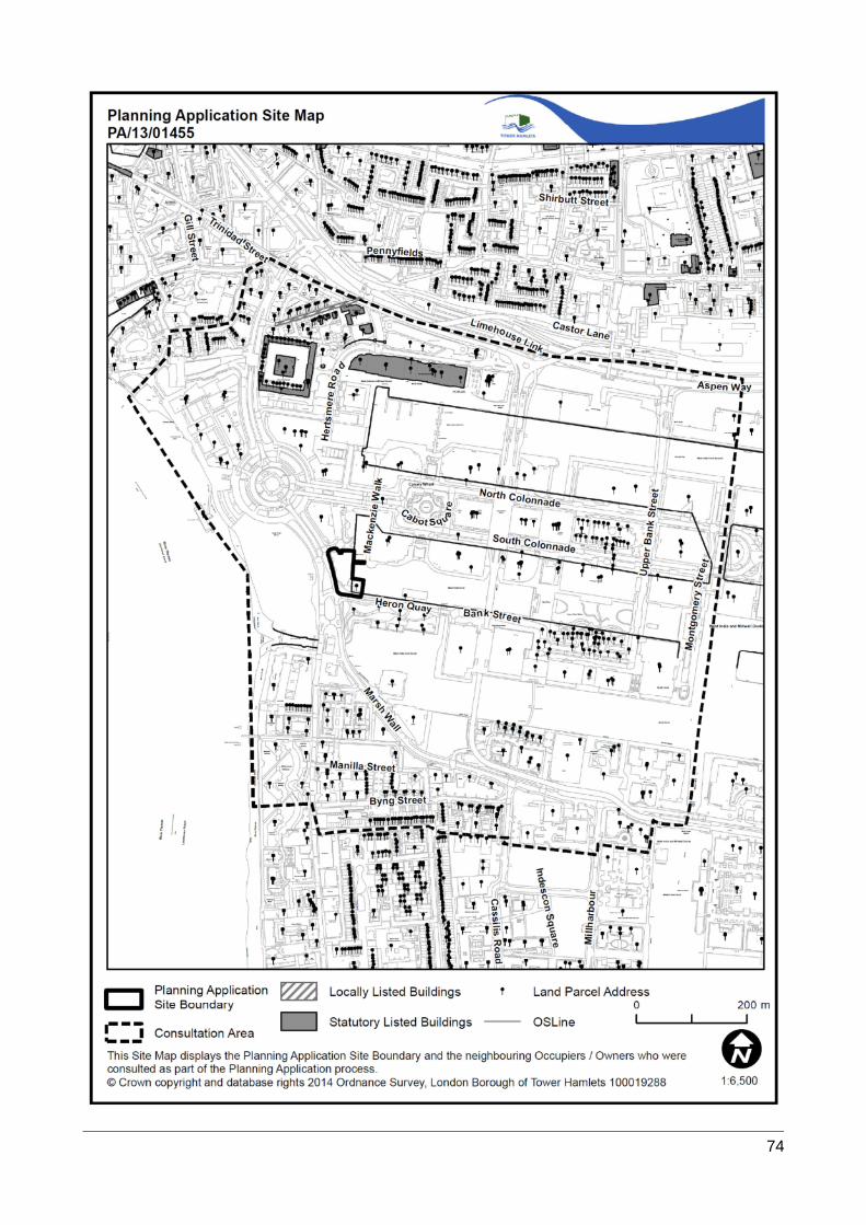
74

75