community form addresses the determinants of albany’s ... form.pdfthe physical form and appearance...
TRANSCRIPT
33
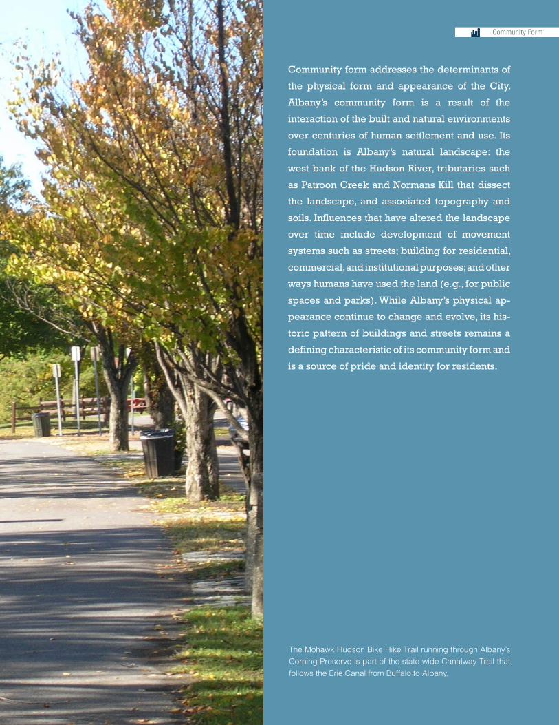
Community form addresses the determinants of
the physical form and appearance of the City.
Albany’s community form is a result of the
interaction of the built and natural environments
over centuries of human settlement and use. Its
foundation is Albany’s natural landscape: the
west bank of the Hudson River, tributaries such
as Patroon Creek and Normans Kill that dissect
the landscape, and associated topography and
soils. Influences that have altered the landscape
over time include development of movement
systems such as streets; building for residential,
commercial, and institutional purposes; and other
ways humans have used the land (e.g., for public
spaces and parks). While Albany’s physical ap-
pearance continue to change and evolve, its his-
toric pattern of buildings and streets remains a
defining characteristic of its community form and
is a source of pride and identity for residents.
Community Form
The Mohawk Hudson Bike Hike Trail running through Albany’s Corning Preserve is part of the state-wide Canalway Trail that follows the Erie Canal from Buffalo to Albany.

34 Albany 2030 Comprehensive Plan for the City of Albany
35
Sustainability Building Blocks: The Comprehensive Plan Systems
Community Form
Economy
Social
Transportation
Natural Resources
Housing and Neighborhoods
Utilities and Infrastructure
Institutions
Systems Interrelationships3.1 Community FormThe key components of Albany’s community form system are land use patterns, urban design, and architectural character.
Community form addresses the determinants of the physical form and appearance of the City. Albany’s community form is a result of the interaction of the built and natural environments over centuries of human settlement and use. Its foundation is Albany’s natural landscape: the west bank of the Hudson River, tributaries such as Patroon Creek and Normans Kill that dissect the landscape, and associated topography and soils. In-fluences that have altered the landscape over time include development of movement systems such as streets; building for residential, commercial, and institutional purposes; and other ways humans have used the land (e.g., for public spaces and parks). While Al-bany’s physical appearance continue to change and evolve, its historic pattern of build-ings and streets remains a defining characteristic of its community form and is a source of pride and identity for residents.
LAND USE PATTERNAlbany’s land use pattern refers to the spatial distribution across the City of the ways resi-dents, businesses, institutions, and others use the land. The broad categories of use that make up this pattern include residential, commercial, industrial, mixed-use, institutional, infrastructure (e.g., transportation facilities), and recreation and open space.
Goal:
Promote development of a balanced future land use pattern that supports realization of the Albany 2030 Vision Statement (safe, livable neighborhoods; a model educational system; a vibrant urban center; multi-modal transportation; a green city; and a prosper-ous economy).
Strategies and Actions:
LU-1 Use the Land Use Framework Map to guide land use decisions.
LU-2 Land-use transportation connection.
LU-3 Vacant and abandoned properties reuse.
LU-4 Remediate brownfields to restore vacant, contaminated properties.
Community Form Key Issues
• Vacant and abandoned properties in the City impact adjacent property values and contribute to overall neighborhood blight.
• The City’s zoning ordinance does not adequately address design guidelines for new development or redevelopment.
• The waterfront is disconnected from the downtown core and neighborhoods.
• Existing land development and building codes do not encourage adaptive reuse of existing structures.
• The City’s existing land use GIS data needs to be updated for accuracy and more detailed land use information.

36 Albany 2030 Comprehensive Plan for the City of Albany
LU-1 Strategy: Use the Land Use Framework Map (see Map 1) as a guide for policy, decision-making, and action. (Interrelated Strategies: Community Form LU-2, UD-1, UD-2, UD-3; Economy INV-1, INV-2; Social CHR-2; Transportation MM-1, MM-2, TR-2; Natu-ral Resources WW-3, NH-2; Housing and Neighborhoods HDC-2, HDC-6, HDC-8, NS-1, NS-2; Utilities and Infrastructure EN-3)
Actions:
a. Update the City’s existing land use data for use in Comprehensive Plan implementa-tion. The City’s GIS parcel layer has incomplete land use data for some parcels. The data should be updated to provide the most accurate and current depiction of existing land use.
b. Revise the zoning ordinance and map to be consistent with the land use framework map and related strategies and actions. This may include creation of new zoning or overlay districts, density evaluation and adjustment to bring about desired community vision, elimination of existing zoning districts that are obsolete or ineffective, and re-zoning of areas of the City to existing or new districts. Form-based codes should be considered.
c. Establish criteria to guide land use decision-making (e.g., fiscal costs/benefits and impacts on the tax base; coordination with transportation investments; provision of needed neighborhood services).
d. The land use map should take into account changing land patterns due to climate change (i.e. updated FEMA maps, waterfront areas, areas prone to flooding).
e. Assess areas vulnerable to climate change and incentive development away from flood plains and other vulnerable areas.
LU-2 Strategy: Land-use transportation connection
Connect land use patterns and the transportation network to maximize transportation efficiency and reduce automobile dependency (Interrelated Strategies: Community Form LU-1, UD-1, UD-3; Economy INV-1; Social CHR-5; Transportation MM-2, TR-2; Natural Resources AQ-1; Housing and Neighborhoods HDC-2, NS-2; Utilities and Infrastructure EN-3; Institutions RP-2)
a. Use zoning to promote mixed use development in neighborhood commercial centers, the downtown, and along transit corridors.
b. Prioritize land use investments (i.e., vacant and abandoned properties acquisition and redevelopment) along transit corridors.
37
§̈¦87
§̈¦87
§̈¦87
§̈¦87
§̈¦87
§̈¦87
UV155
UV85
UV85
UV5
UV20
UV9W
§̈¦90
§̈¦90
§̈¦90 §̈¦90
§̈¦90
§̈¦787
§̈¦787
Central Ave
Central Ave
Washington Ave
Washington Ave
Clinton Ave
State St
Delaware
Ave
New Scotland Ave
Western AveWestern Ave
N Pearl St
Green St
New Scot
land R
d
Mann
ing B
lvd
S Pearl St
S Ma
nning
Blvd
Pine St
Lark
St
Southern Blvd
Madison Ave
Madison Ave
Loudon Rd
Bend
er Av
e
West Hill
WhitehallDelaware Area
West End
Helderberg South End
Second Avenue
Park South
Mansion
Plymouth
Mt. Hope
Washington Square
Pine Hills
No. Albany / Shaker Park
Arbor Hill
Upper Washington Ave.
MelroseBeverwyck
Buckingham Pond / Crestwood
Shaker / Bishop's Gate
New Scotland / Woodlawn
New Albany
Hudson Park
Center Square
Manning Boulevard
Ten Broeck Triangle
Historic Pastures
Campus
Dunes
Capital Hills at Albany
Pine Bush Preserve
Pine Bush Preserve
Pine Bush Preserve
Pine Bush Preserve
Normanskill Farm
Washington Park
Tivoli Preserve
Lincoln Park
Erastus CorningRiverfront Preserve
Albany H.S.
AbrookinVo-TechCenter
Albany Academyfor Boys & Girls
Albany PreparatoryCharter School
Albany LeadershipCharter High School
for Girls
Albany MedicalCollege
Eagle PointE.S.
New School ofRadio and Television
MontessoriMagnet School
Albany Schoolof HumanitiesMyers
M.S.
Bishop Maginn H.S.
Albany FreeSchools
AchievementAcademy
Charter School
Albany CommunityCharter School
Doane StuartSchool
Giffen MemorialE.S.
North AlbanyAcademy
Henry JohnsonCharter School
Mildred EllyBusiness School
Green Tech HighCharter School
KIPP
Hackett M.S.
Thomas O’Brian Academy of
Sci/Tech
Arbor HillE.S.
Adult Learning Center
SheridanPrepatoryAcademy
Brighter ChoiceCharter Schools
HudsonValleyCommunity
College
Pine HillsE.S.
Schuyler AchievmentAcademy
New ScotlandE.S.
MaimonidesHebrew
Day School
Holy CrossSchool
Blessed SacramentSchool
DelawareCommunity
School
Academy of the Holy Names
St. Catherineof Siena
St CasimirRegionalSchool
SunshineSchool
LasalleSchool
St. Peter’sHospital
AlbanyMemorialHospital
AlbanyMedicalCenter VA
Hospital
Maria College
University Heights:The Sage CollegesAlbany Law School
Albany College of PharmacyAlbany Medical Center
College of Saint Rose
SUNY Albany
SUNY AlbanyDowntown Campus
Hud
son
Riv
er
Krum KillPatroon Creek
Normans Kill
COLONIE
BETHLEHEM
GUILDERLAND
NEW SCOTLAND
Menands
RensselaerCounty
0 0.4 0.8 1.2 1.60.2Miles $
Data Sources: City of Albany GIS
Activity Nodes and Corridors
Local Activity Nodes (Neighborhood Commercial Nodes, Parks, Schools)Mixed-Use Corridor
Employment/Education Activity CenterRegional Activity Center
Land Uses
Commercial
Downtown CoreMixed Use
NeighborhoodIndustrialInstitutional/PublicPark/Preservation/Open Space
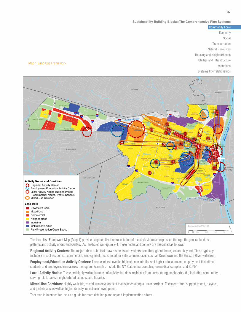
Map 1 Land Use Framework
The Land Use Framework Map (Map 1) provides a generalized representation of the city’s vision as expressed through the general land use patterns and activity nodes and centers. As illustrated on Figure 2-1, these nodes and centers are described as follows:
Regional Activity Centers: The major urban hubs that draw residents and visitors from throughout the region and beyond. These typically include a mix of residential, commercial, employment, recreational, or entertainment uses, such as Downtown and the Hudson River waterfront.
Employment/Education Activity Centers: These centers have the highest concentrations of higher education and employment that attract students and employees from across the region. Examples include the NY State office complex, the medical complex, and SUNY.
Local Activity Nodes: These are highly walkable nodes of activity that draw residents from surrounding neighborhoods, including community-serving retail, parks, neighborhood schools, and libraries.
Mixed-Use Corridors: Highly walkable, mixed-use development that extends along a linear corridor. These corridors support transit, bicycles, and pedestrians as well as higher density, mixed-use development.
This map is intended for use as a guide for more detailed planning and Implementation efforts.
Sustainability Building Blocks: The Comprehensive Plan Systems
Community Form
Economy
Social
Transportation
Natural Resources
Housing and Neighborhoods
Utilities and Infrastructure
Institutions
Systems Interrelationships
38 Albany 2030 Comprehensive Plan for the City of Albany
LU-3 Strategy: Vacant and abandoned properties reuse
Gain control of vacant and abandoned properties to implement the land use frame-work.(Interrelated Strategies: Community Form ARCH-2; Social PS-1, AC-6; Hous-ing and Neighborhoods HDC-9, NI-1)
Actions:
a. Prioritize vacant and abandoned property acquisition and redevelopment to imple-ment the land use framework and connect land use and transportation networks. In addition to the assessment criteria outlined in the City’s Neighborhood Revitalization Strategic Plan, the following criteria should be prioritized:
• A critical mass of properties located in neighborhoods with excessive vacant and abandoned properties that are experiencing public and/or private reinvestment.
• Properties located along existing and proposed transit routes.
• Properties located in neighborhood commercial areas identified on the land use framework map.
• Properties located in regional destination areas as identified on the land use frame-work map (downtown, waterfront).
b. Target priority properties as outlined in existing City of Albany vacant and abandoned property strategy reports.
LU-4 Strategy: Remediate brownfields to restore vacant, contaminated properties
Pursue brownfields and land recycling programs to restore properties to the highest and best land use. (Interrelated Strategies: Community Form ARCH-3; Natural Resources WW-4, TS-2)
Actions:
a. Complete a Pre-Nomination Study under the New York State Brownfield Opportunity Areas (BOA) program to inventory potential brownfield redevelopment sites through-out the City, in coordination with the land use framework map (Strategy LU-1) above.4
BEST PRACTICES: BALTIMORE, MD STRATEGIES FOR REUSE OF VACANT BUILDINGS
As a result of decades of popula-tion decline and industrial job loss, there are nearly 16,000 vacant and boarded up buildings in the City of Baltimore. The City’s “From Vacant to Value” program encour-ages the redevelopment of targeted properties and buildings. Using GIS, Baltimore divided vacancies by location: without development demand (65%); with development demand (31%); and emerging markets (4%). Strategies to reduce vacancy include: 1) streamline the disposition process; 2) streamline code enforcement (for properties on transitional blocks); 3) facilitate investment in emerging markets near areas of strengths; 4) offer targeted incentives for homebuyers; 5) support large-scale development in distressed areas with little market demand); 6) maintain, clear, hold, and identify non-housing units in distressed areas (includes demoli-tion, land banking, and marketing to create long-term value). Using these strategies, Baltimore is in the process of consolidating city departments, increasing access to auctions, and reducing further blight in stable and transitional areas.
http://static.baltimorehousing.org/pdf/vacants_to_value.pdf
In 2006, the U.S. Conference of Mayors completed a study: “Combating Problems of Vacant and Abandoned Properties” which sum-marizes best practices in 27 cities.
www.usmayors.org/bestpractices/vacantproperties06.pdf
4 The City has received grant funding from the New York State Department of State to prepare the Pre-Nomination Study in conjunction with the Comprehensive Plan. This funding is being used to develop a brownfield assessment (see Appendix A) that identifies and prioritizes potential brownfields sites for redevelopment.

39
b. Use the results of the Pre-Nomination Study to move key clusters of brownfield and underutilized lands through subsequent stages of the BOA process (Step Two – Nom-ination, Step Three – Implementation Strategy), with the objective of redeveloping targeted sites for productive uses.
URBAN DESIGNAlbany’s urban design character is defined by the arrangement, appearance, func-tionality and interconnections of its buildings, street and sidewalk network, and public spaces.
Goal:
Promote development patterns that include walkable streets, compact, mixed use devel-opment, public spaces, and context sensitivity to historic design and development.
Strategies and Actions:
UD-1 Create design guidelines and a design review process.
UD-2 Improve waterfront and downtown connections.
UD-3 Create multi-modal design guidelines.
UD-1 Strategy: Create design guidelines and a design review process.
Use zoning and development guidelines as a tool to create incentives for achieving de-sired development patterns. The City currently has a Traditional Neighborhood Design (TND) overlay district that provides limited design direction only to specified residential districts and to all neighborhood commercial districts. This tool should be revised and expanded citywide with context-specific guidelines. (Interrelated Strategies: Community Form UD-3; Transportation MM-2, TR-2; Housing and Neighborhoods HDC-8, NI-2, NS-2; Utilities and Infrastructure EN-3, SW-4)
Action:
a. Apply additional design standards in areas not included in the TND overlay or within a historic district, such as the Harriman Campus development opportunity site and the waterfront districts. Standards will need to be tailored to the unique areas and should be flexible and based on context sensitivity.
b. Create Transit Oriented Development (TOD) overlay districts along existing and pro-posed transit corridors to encourage mixed use development with higher densities, reduced parking, and walkable streets. Work with community stakeholders to deter-mine the appropriate density levels and mix of uses as well as appropriate locations for TOD.
BEST PRACTICES: OMAHA, NE URBAN DESIGN GUIDELINES AND ROANOKE, VA RESIDENTIAL PAT-TERN BOOK
Omaha developed a set of design guidelines for its eight urban design overlay districts. While most of the guidelines apply to commercial areas throughout the City, there are specific sections where the stan-dards differ. In addition, the guide-lines provide photos to illustrate the intent and desired result of each of the standards.
http://www.cityofomaha.org/plan-ning/urbanplanning/images/stories/UD_pdfs/Urban%20Design%20Handbook%20V1.1.pdf
In 2008, Roanoke, Virginia adopted a residential pattern book to pre-serve and enhance the character and quality of its residential neighbor-hoods. It serves as an aid for new construction and renovation of existing buildings. The pattern book provides a dictionary of archi-tectural styles found in different neighborhoods (e.g., downtown, suburban areas) and illustrates the characteristics of each housing type. Recommendations for appropriate renovations, materials, paint colors, new construction and additions, landscape, and “green buildings” practices that will improve and maintain the character of each neighborhood are included.
http://www.roanokeva.gov/
Sustainability Building Blocks: The Comprehensive Plan Systems
Community Form
Economy
Social
Transportation
Natural Resources
Housing and Neighborhoods
Utilities and Infrastructure
Institutions
Systems Interrelationships

40 Albany 2030 Comprehensive Plan for the City of Albany
c. Develop a design guidelines manual including pattern books for each City neigh-borhood, or other appropriate contextual breakdown, and include community input regarding design quality. Use existing neighborhood plans and conduct visual prefer-ence sessions with community stakeholders to confirm design preferences. Design guidelines should be paired with development incentives.
d. Create development incentives to influence the use and application of the design guidelines manual. Incentives need to be tailored for specific locations and markets and must be considered only after considerable community dialogue, and dialogue specifically with developers, about what would be effective. Incentives may include the following:
• Density, height, and Floor Area Ratio (FAR) bonuses, depending on the district and neighborhood agreement on density limits
• Parking reductions based on availability of on-street parking and transit
• Mix of uses based on neighborhood input
• Permit and fee waivers, depending on the intensity of development
• Fast track permitting depending on the intensity, type and location of development
e. Create a Design Review Board to review projects for consistency with comprehensive plan goals, design guidelines and context sensitivity. The Design Review Board can be an advisory board that makes recommendations to appropriate boards, councils and commissions on development proposals that meet designated thresholds. The Design Review Board may consist of elected officials, City staff, a professional archi-tect, and a historic preservationist.
Albany has changed dramatically over time, most notably with the evo-lution of the Empire State Plaza site. Albany 2030 will ensure that ongoing development will make sense for the City’s future.
Image | Evan Wolff, Parsons The New School for Design, School of Constructed Environments, 3rd Year Master of Architecture Student
41
UD-2 Strategy: Improve waterfront and downtown connections.
Improve connections between the downtown and the Hudson River waterfront and pro-vide waterfront amenities. (Interrelated Strategies: Economy INV-2; Transportation MM-2; Natural Resources WW-5)
Actions:
a. Update the Local Waterfront Revitalization Program (LWRP) to address access to the waterfront from downtown and adjacent neighborhoods5. Key components of the updated plan should include:
• Conceptual land use and development plans for key sites along the waterfront.
• Potential long term approach for removing or spanning portions of I-787 to allow for direct pedestrian and vehicular connections to the waterfront.
• Short term access improvements at key locations between downtown and the water-front, such as Corning Preserve and Riverfront Park.
• Improved transit connections to the waterfront, including water-based modes.
• Plan for development activity, such as new housing, restaurants, and water recre-ation in key locations that will bring more activity to the waterfront, including negotia-tions with New York State.
• Plan for the potential impacts of climate change, including the rise of the Hudson River, particularly during extreme storm events.
UD-3 Strategy: Create multi-modal design guidelines.
Use urban design standards and guidelines as a way to support alternative modes of transportation (pedestrian, bicycle, transit and alternative fuel vehicles). (Interrelated Strategies: Community Form LU-2, UD-1; Economy INV-1; Social CHR-2, PS-2, Trans-portation MM-1, MM-2, TR-1, VEH-4; Utilities and Infrastructure EN-3)
Actions:
a. Allow for mixed-use, compact development to minimize distances and accommodate walking, biking, and transit connections between neighborhoods, jobs, school, and commercial activity.
b. Require build-to lines, which are flexible based on scalable indicators such as build-ing height, right-of-way and sidewalk width, along transit corridors, downtown, in neighborhood commercial areas, the waterfront, and other areas as appropriate to enhance the pedestrian experience.
Sustainability Building Blocks: The Comprehensive Plan Systems
Community Form
Economy
Social
Transportation
Natural Resources
Housing and Neighborhoods
Utilities and Infrastructure
Institutions
Systems Interrelationships
5 The City has received grant funding from the New York State Department of State to update the LWRP in coordination with the Comprehensive Plan.

42 Albany 2030 Comprehensive Plan for the City of Albany
c. Require parking to be located behind or to the side of buildings where feasible to enhance the pedestrian experience. Where it is not feasible to locate parking behind buildings, require decorative screening.
d. Require alternative transportation amenities and parking (e.g. bike racks, shower and changing facilities, bike lockers, bus shelters, crosswalks) for projects that meet des-ignated thresholds.
e. Require electric vehicle and compressed natural gas (CNG) infrastructure for projects that meet designated thresholds.
ARCHITECTURAL CHARACTERAlbany’s architectural character is defined by its historic buildings and neighborhoods as well as the integrated design of modern architectural styles.
Goals:
Capitalize on diverse architectural and neighborhood-specific character to maintain and revitalize neighborhoods.
Preserve and restore existing buildings that are vacant or underutilized through adaptive reuse while allowing for new development and new architecture.
Strategies and Actions:
ARCH-1 Create a historic preservation plan.
ARCH-2 Vacant and abandoned properties reuse.
ARCH-3 Adaptively reuse historic and non-historic structures in brownfields remediation projects.
ARCH-1 Strategy: Develop a historic preservation plan.
Pursue a plan for historic preservation that balances the preservation of designated his-toric resources and historic districts with the rehabilitation of non-designated buildings and new construction. (Interrelated Strategies: Community Form ARCH-2; Economy INV-2; Housing and Neighborhoods NI-2)
a. Maintain an inventory of all designated and non-designated historic buildings in the City and catalogue architecture and neighborhood typologies. Evaluate existing his-toric districts, and through public engagement consider the feasibility of new or ex-panded districts.
BEST PRACTICES: HISTORIC BUILDING CODES, NEW JERSEY REHAB SUBCODE
In many states, building codes are designed solely for new construc-tion leading to expensive retrofits for existing buildings. In an effort to reduce barriers to building renova-tion and adaptive reuse, New Jersey adopted a “rehab Code” in 1999. The code requires structural and safety regulations that work with an existing building’s height, area, and fire resistance ratings. In the first year of implementation, the amount of money dedicated to renovation in New Jersey increased by 41%. The code has resulted in reduced costs for building owners and increased historic preservation efforts in many older cities across the state.
http://www.state.nj.us/dca/divisions/codes/offices/rehab.html

43
b. Create development incentives for preserving historic buildings and facades and en-suring architectural compatibility between new and existing development. Incentives need to be tailored for specific locations and must be considered after considerable community dialogue, discussions with the Historic Resources Commission, and dia-logue with developers, and other stakeholders about the effectiveness of incentives. Incentives may include the following:
• Density, height, and Floor Area Ratio (FAR) bonuses, depending on the district and neighborhood agreement on density limits
• Parking reductions and waivers
• Permit and fee waivers
• Relaxation of certain building code requirements that do not fit within the framework of the historic structure, taking into consideration safety concerns.
• Adoption of a Rehabilitation or Historic Building Code that allows restoration or re-habilitation a historic structure to be made without conformance to all of the require-ments of the uniform building code when authorized by the building official.
• Promote the use of existing resources such as historic tax credits and the promote creation of new financial incentives to encourage.
• Promote and uphold the city’s designation as “Certified Local Government” as per New York State Office of Parks, Recreation and Historic Preservation.
Sustainability Building Blocks: The Comprehensive Plan Systems
Community Form
Economy
Social
Transportation
Natural Resources
Housing and Neighborhoods
Utilities and Infrastructure
Institutions
Systems Interrelationships
Guided by Albany’s abandoned property strategies, vacant and underutilized property on Clinton Avenue in Arbor HIll were renovated with Federal Neighborhood Stabiliza-tion Program Funds.
44 Albany 2030 Comprehensive Plan for the City of Albany
ARCH-2 Strategy: Vacant and abandoned properties reuse.
Gain control of vacant and abandoned properties to adaptively reuse or redevelop both historic and non-historic structures. (Interrelated Strategies: Community Form LU-3; So-cial PS-1, AC-6.b.; Housing and Neighborhoods NI-1)
Actions:
a. Incorporate architectural guidelines as part of a vacant and abandoned properties reuse program for both public and private development. Guidelines should adhere to historic district standards where applicable. When existing structures are not located within a historic district, guidelines should focus on enhancing the existing architec-tural character and the character of the surrounding neighborhood through quality architectural design.
b. Investigate models for a revised Rehabilitation Building Code that allows flexibility in restoration or rehabilitation of existing structures to encourage reuse.
ARCH-3 Strategy: Adaptively reuse historic and non-historic structures in brownfields remediation projects.
Pursue brownfields and land recycling programs to adaptively reuse historic and non-historic structures. (Interrelated Strategies: Community Form LU-4, Natural Resources WW-4, TS-2)
Actions:
a. Use the brownfield program to fund projects in neighborhoods with a high level of ar-chitectural and/or historic character and with a large number of vacant or abandoned properties.
b. Prioritize funding for brownfield projects to favor projects that reuse existing structures and/or incorporate quality architecture and design guidelines.