community redevelopment plan
TRANSCRIPT
COMMUNITY REDEVELOPMENT PLAN
PREPARED FOR MARTIN COUNTY
ADOPTED: DECEMBER 19, 2000 REVISED: October 2009

I N T R O D U C T I O N

Introduction
HOBE SOUND COMMUNITY REDEVELOPMENT PLAN
ACKNOWLEDGEMENTS
The development of a Community Redevelopment Plan relieson a collaborative process that draws on the abilities andknowledge of many people. Martin County, the Hobe SoundNeighborhood Advisory Committee, and Glatting JacksonKercher Anglin Lopez Rinehart, Inc. formed the project teamfor the Hobe Sound Community Redevelopment Plan. Ourthanks go to those who participated in determining the direction and content of the plan during work sessions andpublic meetings, and to all that gave their time and support inthe interest of building a better community.
Martin County Board of County CommissionersMarshal L. Wilcox, ChairmanDennis Armstrong, Vice ChairmanElmira R. GaineyJanet K. GettigDonna Sutter Melzer
Hobe Sound Neighborhood Advisory CommitteeThe Neighborhood Advisory Committee (NAC) is made up ofresidents, business owners or their agents, appointed by theCommunity Redevelopment Agency to act in an advisory capacityfor specific redevelopment target areas.The members of the NAC are:Bert Krebs, Chair Kathy Spurgeon, Co-ChairAdrian Reed, Secretary Jack S. CoxRon MancusoGilbert MillerJoanne Weidman
Martin County StaffRuss Blackburn, County Administrator
Growth Management:Nicki van Vonno, AICP, Growth Management DirectorRobert Franke, AICP, Community Development AdministratorHank Woollard, Community Development-Senior Planner Katrena Hanks, Community Development-Associate PlannerSteve Heuchert, Comprehensive Planning-Senior Planner
Public ServicesGary Roberts, Transportation Administrator

Table of ContentsACKNOWLEDGEMENTS
INTRODUCTIONVISION FOR A SUSTAINABLE MARTIN COUNTY 1PURPOSE OF THE COMMUNITY REDEVELOPMENT PLAN 1THE COMMUNITY REDEVELOPMENT PLAN PROCESS 3SOUTH MARTIN COUNTY VISIONING CHARRETTE (1995) 4HOBE SOUND COMMUNITY REDEVELOPMENT PLANNING PROCESS 5HOW TO USE THIS DOCUMENT 7
EXISTING CONDITIONS 8 STUDY AREA 8HISTORY AND COMMUNITY CHARACTER 9 HOBE SOUND GROWTH PATTERNS 10NEIGHBORHOODS 11COMMUNITY FACILITIES 13PARKS 14ENVIRONMENTAL 15COMMERCIAL DISTRICTS/TOWN CENTER 16MOBILITY 17INFRASTRUCTURE 19LAND USE MAP 20
DESIGN PRINCIPLES 21
CONTEXTUAL SITE ANALYSIS 23ILLUSTRATIVE PLAN 23
Goal: Neighborhood Infill 24Goal: Focus Commercial Development in Town Center 26Goal: Enhance Community Connections 27
VISION PLAN 28PROJECTS 291. DESIGN GUIDELINES 322. OVERLAY ZONING 333. BRIDGE ROAD "MAIN STREET" 334. US-1 DESIGN CONCEPTS 375. GATEWAYS 396. HOUSING DEVELOPMENT INITIATIVES 417. MASTER UTILITY PLANNING 438. COMPREHENSIVE SIDEWALKS WITHIN THE HOBE SOUND CRA 449. BANNER LAKE SQUARE 45
IMPLEMENTATION 46IMPLEMENTATION PLAN 46FUNDING 47REQUIRED CONTENTS OF A COMMUNITY REDEVELOPMENT PLAN 48HOBE SOUND COMMUNITY REDEVELOPMENT PLAN (CHARACTER BOARD)
APPENDICES (AVAILABLE SEPARATELY)
Page 1
Introduction
INTRODUCTION
Vision for a Sustainable Martin CountyThis plan for the redevelopment of Hobe Sound is an exten-sion of the "2020 Vision for a Sustainable Martin County".The key elements of this Vision are:
· Preserve wetland and critical uplands
· Preserve and strengthen agriculture
· Contain development through application of the Urban Services Boundary (USB)
· Create livable communities to include:
· Vibrant city, town and village centers that serve surrounding neighborhoods
· Strong neighborhoods
· Extensive system of local streets, sidewalks and bikeways
· Strategically located, high quality schools, libraries, post offices and other public buildings
· Functional and attractive infrastructure
· Extensive system of parks, greenways and open spaces
· Strong development standards, re: density, height, aesthetics
In order to further the goal of creating livable communities,Martin County has initiated a community redevelopmentplanning process for targeted communities within the County. The Hobe Sound Neighborhood Planning Area follows theCommunity Redevelopment Plan format established by the State of Florida and the Small Area Planning Processestablished by the County.
Purpose of the Community Redevelopment PlanThe Community Redevelopment Plan (CRP) is one of thechief mechanisms to implement the objectives of the "2020Vision for a Sustainable Martin County". The purpose of aCommunity Redevelopment Plan is to create a framework toprioritize neighborhood redevelopment needs and to create an action plan to correct deficiencies and deteriorating conditions. As part of the process of developing the CRP,Martin County has placed particular emphasis on solicitingextensive input and participation from the residents of thecommunities for which the CRPs are being created.
Each CRP describes a preferred area-wide vision. The CRP then identifies those tools and strategies that will benecessary to achieve the area vision. The CRP must conformto state regulations governing community redevelopmentagencies and the County's Comprehensive GrowthManagement Plan (CGMP). Once adopted, these CRPs are incorporated, as addenda, into the County's CGMP.
The CGMP is specifically intended to guide future develop-ment and to manage growth. The overarching objectives ofMartin County's plan is to maintain quality residential andnon-residential development, conserve natural resources,enhance economic growth and ensure the prudent investmentof County resources. As is evident from the accompanyingchart, the County has employed a number of tools in additionto the CRP to achieve the CGMP goals and policies.
The Capital Improvement Program is a plan of priorities forthe County's future capital investments. These investmentsare intended to achieve the CGMP objectives.
Zoning and Land Development Regulations (LDRs) areemployed to control or shape growth. In addition, the Planincludes a description of Individual Projects the Countyshould implement to further its vision for sustainability.
HOBE SOUND COMMUNITY REDEVELOPMENT PLAN

The Community Redevelopment Plan ProcessThe five-step process to develop a CommunityRedevelopment Plan is as follows:
1. Establishing a Finding of Necessity.
2. Defining a Community Redevelopment Area (CRA).
3. Establishing a Community Redevelopment Agency.
4. Preparing a Community Redevelopment Plan.
5. Establishing a Redevelopment Trust Fund.
1. Establishing Finding of Necessity:The Finding of Necessity establishes those conditions thatsubstantially impair the sound growth of the proposedCommunity Redevelopment Area.
2. Defining a Community Redevelopment Area:The CRA is that area defined by legal description in whichall of the future redevelopment projects will be located. Itis also the area that will fund the Redevelopment TrustFund through the tax increment process.
3. Establishing a Community Redevelopment Agency:Among other duties, the Redevelopment Agency will beresponsible for implementing the CommunityRedevelopment Plan and administering the Trust Fund.The Community Redevelopment Agency is establishedthrough local ordinance.
4. Preparing a Community Redevelopment Plan:The Hobe Sound Community Redevelopment Plan identi-fies the improvements that will revitalize the CRA. Theprojects contained in the Hobe Sound CommunityRedevelopment Plan are specific and are conceptuallydescribed in the plan.
5. Establishing a Redevelopment Trust Fund:The Redevelopment Trust Fund receives the tax incrementfunds as they are generated each year. The CommunityRedevelopment Agency administers the RedevelopmentTrust Fund.
Steps 1, 2, 3, and 5 are complete. This report is the productof step #4.
HOBE SOUND COMMUNITY REDEVELOPMENT PLAN
Introduction
Page 3

Page 2
Introduction
HOBE SOUND COMMUNITY REDEVELOPMENT PLAN
Rel
atio
nshi
p of
Hob
e So
und
CR
Ato
Cou
nty-
Wid
e Vi
sion

South Martin County Visioning Charrette (1995)Between October 28 and November 4, 1994, Martin County,the Treasure Coast Regional Planning Council and the SouthFlorida Water Management District (SFWMD) conducted a series of planning workshops, presentations and work sessions to examine future development of the 90,000 acresin the Hobe Sound area. The process concluded with theissuance of the South Martin County Charrette Report (dated March 14, 1995). The Charrette Report defined theplanning issue of focus as follows:
In South Martin County, most undeveloped lands are environmentally sensitive. The Charrette focused on theAtlantic Coastal Ridge. Much of the study area is a wet natural system that functions as the headwaters of the NorthFork of the Loxahatchee and South Fork of the Saint LucieRivers. Substantial portions of this area have future land usemap designations that allow urban or suburban development.Existing urban development is located in a narrow strip alongthe US-1 corridor. Although infill development opportunitiesare readily available, growth has occurred as isolated devel-opment instead of being encouraged to create compact towns.
The Report evaluated planning issues throughout SouthMartin County and presented a series of recommendations to resolve identified concerns. The Report included the following recommendations for Hobe Sound:
1. The Hobe Sound area should function as a Town.
2. Residential infill should be encouraged particularly in Zeus Park and Banner Lake.
3. Locate the County Library in a prominent location within the existing Hobe Sound neighborhoods.
4. Encourage redevelopment of Bridge Road as a traditional Main Street.
5. Prepare a plan for the train station district.
6. Limit commercial development to Town and Neighborhood Centers.
7. US-1 in Hobe Sound should be designed as an urban boulevard.
8. A1A should remain a 2-lane road.
9. A 4-way stop sign should be placed at Bridge Road and Lares Avenue.
10.Bridge Road and A1A intersection should be designed as a 4-way stop, roundabout, or traffic light.
These recommendations formed the foundation for the HobeSound Community Redevelopment Plan planning process.
The Charrette Report was the starting point for the discussions and deliberations that occurred during theVisioning/Consensus Workshop that was conducted in conjunction with the Hobe Sound CommunityRedevelopment Plan.
HOBE SOUND COMMUNITY REDEVELOPMENT PLAN
Introduction
Page 4

Hobe Sound Community RedevelopmentPlanning ProcessThe Hobe Sound Community Redevelopment Plan is specifically intended to conceptually provide the following:
· A synthesis of the comments presented by the residents of Hobe Sound regarding its community qualities including its residential neighborhoods, its commercial areas, its village center, its schools, recreation facilities, transportation network and its open spaces
· An emphasis on local place making and image creation
· An appreciation on natural resources
A recognition of regional context and environment
· A plan for pedestrian, bicycle and vehicular accessibility
· A program of community growth guided by the principles of the "2020 Vision for a Sustainable Martin County"
· Broad opportunities for community participation
· Emphasis on quality of lifestyle, health, safety and a sense of neighborhood
· A plan that conforms to State Planning statutes and the County's Community Redevelopment Ordinance (#517)
The Plan was developed in a series of steps, described below, based on a process developed by the Hobe SoundNeighborhood Advisory Committee (NAC) and the County'sGrowth Management Department staff.
Task 1: Resource AssessmentThe process started with the collection of available data onexisting community conditions. This assessment included the development of a conceptual site analysis of variouscharacteristics of Hobe Sound including the character of the
area's commercial, public and residential buildings andspaces. In addition, the location and type of community facilities were mapped. Land use patterns and environmentalareas were illustrated. Growth patterns were identified. Theassessment of these characteristics led to the identification of the opportunities for and constraints to redevelopment ofthe Hobe Sound community.
Task 2: Visioning/Consensus WorkshopThis step was undertaken over a concentrated four-day period that began with a public "kick-off" meeting with themembers of the Hobe Sound NAC and residents fromthroughout the community. The objective of this meeting wasto obtain residents' opinions regarding critical communityissues and valued features of Hobe Sound. An intensivedesign workshop was conducted over the course of the ensu-ing three days, during which a detailed set of redevelopment
strategies were examined and concept sketches illustratingrevitalization plans were prepared. These plans and strategieswere presented to the members of the NAC and residents ofHobe Sound during a public meeting held on the evening ofthe fourth day of the Workshop.
Task 3: Refined VisionThis plan is the product of Task 3 and it represents the synthesis of the public input obtained during theVisioning/Consensus Workshop and the plans and strategiesproposed in the course of that event. The Plan includes:
· An existing conditions report
· Contextual Site Analysis
· Vision Plan
· Prioritization of Projects and Programs
· An Action Plan
Task 4: Presentation of the PlanOnce the Plan document is completed it will be presented ata variety of meetings for review and, ultimately, adoption.The Plan will be presented to the Neighborhood AdvisoryCommittee; the Community Planning Group (comprised ofCounty staff); the Martin County Community RedevelopmentAgency; the Local Planning Agency; the County's GrowthManagement Department; and to the Martin County Board ofCounty Commissioners for adoption.
ScheduleAs is evident from the accompanying schedule, ResourceAssessment for the Hobe Sound CRA Plan, Task 1, began inearly December 1999. Task 2, the Consensus/VisioningWorkshop was held between January 22 and January 27,2000. The Draft Plan was submitted to the County onFebruary 18, 2000 and the various reviews and presentationsoccurred between February and early September, 2000.
HOBE SOUND COMMUNITY REDEVELOPMENT PLAN
Introduction
Page 5

HOBE SOUND COMMUNITY REDEVELOPMENT PLAN
Introduction
Page 6

How to Use This DocumentThe Hobe Sound Community Redevelopment Plan is organized into four main sections; the Existing Conditions;Design Principles; Contextual Site Analysis; and the HobeSound Vision Plan. The supporting Appendices include the outline of the Required Contents of a CommunityRedevelopment Plan as dictated by Florida Statues, severalmemoranda describing in detail the analysis of key projects,and a graphic summary of the Discovery Workshop wheremany of the projects and design ideas were developed.
Existing ConditionsThis section summarizes the background resource assessment and analysis that took place in preparation for the Visioning/Consensus Workshop and provides the basisfor the recommendations of the Community RedevelopmentPlan. This section includes a summary evaluation of existingneighborhood conditions and needs related to infrastructureand public facilities deficiencies, land use, and mobilityissues based on existing data, interviews and public comments.
Urban Design PrinciplesThis section describes the Principles of Sustainability adopt-ed by Martin County and the basic design principles that willguide the design of projects as well as form a framework thatorganizes the Community Redevelopment Plan.
Contextual Site AnalysisThe Vision Plan illustrates the initiatives of the redevelop-ment approach with design description and detail. This section includes the following:
· Redevelopment Goals and Objectives - outlining the goals and objectives that will guide the implementation of the Community Redevelopment Plan and the prioritization of projects
· Project and Program Descriptions - a detailed outline and description of the identified projects and actions that define the Community Redevelopment Plan. Each project description includes conceptual cost, funding sources, intent, and illustrated design concepts
· Character Board - a collage of images from Hobe Sound and other comparable locations, as well as design character drawings that help visualize the intended look and character of Hobe Sound. This Board will be a useful reference tool for the community as specific projects are being designed and implemented
Vision PlanThis section provides a detailed description of projects andfunding sources for each. Each project is ranked in order ofurgency ranging from immediate to long term and ongoingefforts. Recommendations for the implementation of projectsor programs and the time frame for redevelopment is alsoincluded in this section. The Implementation Plan includesfunding alternatives, staffing considerations, and general program development guidelines. This section includes adescription of the required contents of the CRA Plan and adetailed description of the support information necessary tosatisfy Florida Statutes Chapter 163, Part III for a CRA Plan.
AppendicesThe appendices provide additional technical support and summarize specific meetings and workshops. The appendices include:
The resolution passed by the Martin County Board of County Commisioners adopting the CRA Plan
A legal description of the bounderies of the Hobe Sound CRA
Publicly funded projects designed to accomplish the objectives of the CRA Plan
A transportation memoranda describing critical transportation issues in Hobe Sound and outlining recommended strategies to address these issues
Attendance sheet from Consensus/Visioning Workshop
Tax increment financing projections based on the redevelopment potential of the Hobe Sound CRA
A description of Community Policing Initiatives
HOBE SOUND COMMUNITY REDEVELOPMENT PLAN
Introduction
Page 7

EXISTING CONDITIONS

EXISTING CONDITIONS
Study AreaThe accompanying map reveals that the Hobe SoundRedevelopment Area extends along the east and west sides of US-1 from Osprey Road to Dharyls Street. The CRA alsogenerally includes the area encompassed by US-1 on thewest, A1A on the east, Dharyls Street to the north and BridgeRoad to the south. The CRA also includes the area boundedby Bridge Road to the north, Lantana Avenue and BannerLake to the west, the Intracoastal Waterway to the east andthe Eaglewood Golf Course and US-1 to the south.
The community elements that were examined as part of theexisting conditions assessment and which are described in thefollowing sections, include:
· History and Community Character
· County-wide Growth Patterns
· Various Land Use Characteristics including:
· Neighborhoods
· Community Facilities
· Parks
· Environment
· Commercial Districts/Town Center
· Mobility
· Infrastructure
The background data collected and the findings that wereidentified through the assessment of existing conditionsdescribed in this section served as the basis for the SiteAnalysis performed by the Glatting Jackson Kercher Anglin Lopez Rinehart project team. This analysis describesopportunities and constraints for redevelopment and responseto various community issues and serves as the basis for thedesign solutions and character sketches that follow.
HOBE SOUND COMMUNITY REDEVELOPMENT PLAN
Existing Conditions
Page 8
Hobe Sound Community Redevelopment Plan Study Area

History and Community Character1
In 1815 King Fernando of Spain conveyed a Royal Grant toDon Eusebio Gomez of 21,000 acres of land in south Florida.The landholding contained all of Jupiter Island and the areathat became Hobe Sound.
In the 1880s the Indian River Association, Ltd. acquired the Gomez Grant and a subsidiary of the company, the Pine Apple and Cocoanut Grove Association, platted a large subdivision in 1893 opening a series of lots west of the Indian River and on Jupiter Island. Pineapple cultivation was the primary agricultural product of the area.
In 1913, the Indian River Association, Ltd. spent approxi-mately $150,000 building roads, a steel bridge link to Jupiter Island and other improvements in a failed effort tocreate a large subdivision at Hobe Sound. Ultimately, onlythe Hobe Sound subdivision, a small development containingeight blocks, was opened south of Bridge Road and east ofDixie Highway.
In 1920, the population of Hobe Sound was 229. For a briefperiod the community became the site of two ambitiousdevelopment schemes, Picture City and Olympia. PictureCity tried to market Martin County as a movie-making center on the East Coast. The name was emblazonedthroughout the area including the Hobe Sound Company's
water tower. However, plans to create a movie studio, hotelsand businesses in Picture City never materialized.
The Olympia Improvement Company was somewhat moresuccessful than the Picture City Corporation, developing aplan for building sites south of Bridge Road that radiated inan elliptical pattern around the circular green, Zeus Park. The plan approximated the shape of a Greek Olympic arena.
The development concept included plans for apartment houses and hotels that were never constructed. However, atown hall (later the Hobe Sound Elementary School, presently known as the Apollo School) and approximately 20 dwellings were built.
The Olympia 3 subdivision, also opened in the early 1920s,was a significantly smaller development west of US-1 andsouth of Bridge Road. This subdivision was bordered byBanner Lake, which has become the name of this neighbor-hood, and consisted of small wood frame dwellings primarilyfor African-American laborers who worked for the railroadand wealthy residents on Jupiter Island.
Despite their ultimate collapse, the Picture City and Olympia subdivisions set the early development patterns of Hobe Sound and growth did begin to occur slowly. By the 1940s, the population of the area reached 874.
During World War II the U.S. Army built Camp Murphy, asignal corps base approximately four miles south of BridgeRoad and west of US-1. The camp, which opened in 1942,was home to 854 officers and 5,753 enlisted men who trainedat the base during its two-year existence. In November 1944,the camp was closed but many of the buildings that wereconstructed there have been scattered throughout the Countyand are being used as boat manufacturing facilities, homes,commercial buildings and, as with the Hobe Sound CivicCenter, as community centers.
Some of the vestiges of old Hobe Sound still remain today,such as the Apollo School, the Post Office,which had servedas the Hobe Sound Library and is currently used as a privateoffice, and the old train station which has also been refur-bished for use as an office and relocated west of Hobe Sound.
HOBE SOUND COMMUNITY REDEVELOPMENT PLAN
Existing Conditions
Page 9
1Source: History of Martin County, 1975 by the Martin County Historical Society, FloridaClassics Library. History of Martin County, compiled by Janet Hutchinson, Florida ClassicsLibrary, 1987.
Olympia - Olympia BeachPostcard - Old Hobe Sound
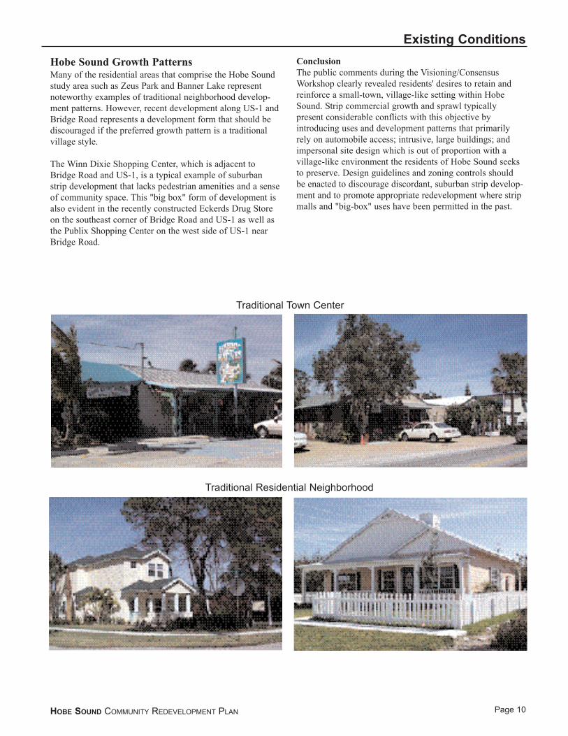
Hobe Sound Growth PatternsMany of the residential areas that comprise the Hobe Soundstudy area such as Zeus Park and Banner Lake representnoteworthy examples of traditional neighborhood develop-ment patterns. However, recent development along US-1 andBridge Road represents a development form that should bediscouraged if the preferred growth pattern is a traditionalvillage style.
The Winn Dixie Shopping Center, which is adjacent toBridge Road and US-1, is a typical example of suburbanstrip development that lacks pedestrian amenities and a senseof community space. This "big box" form of development isalso evident in the recently constructed Eckerds Drug Storeon the southeast corner of Bridge Road and US-1 as well asthe Publix Shopping Center on the west side of US-1 nearBridge Road.
ConclusionThe public comments during the Visioning/ConsensusWorkshop clearly revealed residents' desires to retain andreinforce a small-town, village-like setting within HobeSound. Strip commercial growth and sprawl typically present considerable conflicts with this objective by introducing uses and development patterns that primarilyrely on automobile access; intrusive, large buildings; andimpersonal site design which is out of proportion with a village-like environment the residents of Hobe Sound seeksto preserve. Design guidelines and zoning controls should be enacted to discourage discordant, suburban strip develop-ment and to promote appropriate redevelopment where stripmalls and "big-box" uses have been permitted in the past.
HOBE SOUND COMMUNITY REDEVELOPMENT PLAN
Existing Conditions
Page 10
Traditional Residential Neighborhood
Traditional Town Center

NeighborhoodsThe predominant land use within the study area is residential.There are three distinct neighborhoods south of Bridge Road:the Banner Lake neighborhood (west of US-1); Zeus Park(between US-1 and A1A); and the neighborhoods in thevicinity of Greenfield Park along the Intracoastal Waterway.In addition, there are a series of identifiable neighborhoodareas north of Bridge Road between US-1 and A1A. Each ofthese neighborhoods exhibit distinct infill opportunities.
Banner LakeBanner Lake has a traditional grid pattern of development.Small, single family dwellings are the primary land use. A600'± wide commercial strip that extends along the entireeastern boundary of the neighborhood buffers the area fromcommercial activity along US-1. The neighborhood is servedby the Banner Lake Park, which is slated for improvementsin the County's FY 2000 Capital Improvement Program.Three churches are located within the neighborhood and anhistoric cemetery is located at the southeastern corner of thearea. The South Martin Regional Utility System2 is presentlyinstalling a sanitary sewer line extension to serve this area.This project is being funded through a Small CitiesCommunity Development Block Grant. Residents of theBanner Lake neighborhood are predominantly lower incomeand many of the homes suffer from deferred maintenance.Many of the neighborhood roadways are in need of repair.
Zeus ParkThis neighborhood is characterized by an unusual develop-ment pattern that mirrors a Greek Olympic arena with streetsradiating eastward from the circular green known as ZeusPark. Streets throughout the neighborhood (such as Olympus,Mercury, Adonis, Hercules, Athena, Venus) are named afterthe planets in the solar system and Greek gods and goddesses.This unusual neighborhood is immediately adjacent to theBridge Road commercial area and the shops and businessesalong A1A.
Buildings and residences throughout the neighborhood areconstructed in a wide, but compatible variety of architecturalstyles. Many buildings, such as the Apollo School and theHobe Sound Civic Center recall the history of Hobe Sound.
In addition to the passive recreation area of Zeus Park andthe Hobe Sound Civic Center, the neighborhood is immedi-ately adjacent to the County's J.V. Reed Park which has anumber of active recreation fields. Although sidewalks havedeteriorated along many of the streets in the neighborhood,the area has a distinct and inviting pedestrian quality. Housesin the area are relatively affordable but are well maintained.Roadways and infrastructure within the area appears to beadequate to meet current needs. There are numerous vacantlots scattered throughout this neighborhood but many arepresently under construction for single family homes.Virtually all vacant lots within this neighborhood are expected to be developed within the next 3 to 5 years.
Old Hobe SoundResidential development in this area tends to have a mixedcharacter. Larger, single-family homes have been constructedon large lots that front on Laurel Lane. A compact develop-ment pattern with smaller, single-family homes lining windingstreets characterizes the southerly portion of this neighbor-hood. Limited industrial and commercial uses have been constructed on the lots located between Shell Avenue andA1A. In addition, an Assisted Care Living Facility (ACLF) isproposed for construction on Shell Avenue with access fromBridge Road.
US-1 NeighborhoodsThere are a variety of residential neighborhoods that front onthe east/west roadways that run perpendicular to US-1 andA1A between Bridge Road and Washington Street. Mobilehomes and small dwelling units predominate in this area. The residents appear to be lower income and many of theresidences require structural and cosmetic maintenance.
Many of the roadways that bisect this area, such as RobynStreet, Edwyn Street, Algozzini Place, Byrd Street, PageStreet, Seagrape Way and London Street, have outlets only onA1A. There are virtually no north/south connections. As aconsequence, residents of this area are forced to use eitherUS-1 or A1A in order to access any of Hobe Sound's commu-nity facilities or retail services. There is a sidewalk that runsalong US-1, however it lacks suitable amenities to shadepedestrians. The pedestrian trail along A1A, however, doesappear to have strong potential as the spine of a north/southalternative to automobile use.
ConclusionThere are clear opportunities for infill development through-out the residential neighborhoods within the study area. Such infill development will continue to reinforce the villageatmosphere of Hobe Sound and will provide a market for theexpansion of the commercial/retail and residential area alongBridge Road.
There is a lack of suitable pedestrian, vehicular or bicycleconnections among the various neighborhoods within thestudy area. Such connections would provide alternativeroutes for local traffic minimizing the need to use US-1,A1A, Gomez Avenue or Bridge Road.
Efforts should be made to ensure compatibility between retail and commercial development on Bridge Road and the residential and village character that the community seeks to promote. These efforts should include the enactmentof overlay zoning controls that encourage compact commer-cial growth and mixed use development. In addition, thecommunity should adopt design standards that help preservethe intimate street scale and pedestrian environment of a traditional village commercial center.
HOBE SOUND COMMUNITY REDEVELOPMENT PLAN
Existing Conditions
Page 112The Jupiter Island municipal system

Page 12
Existing Conditions
HOBE SOUND COMMUNITY REDEVELOPMENT PLAN
Residential Infill
Compatability withcommercial development
Lack of connections betweenneighborhoods
Residential Infill
Neighborhoods
Old Hobe Sound
Zeus Park Neighborhood
Banner Lake
US-1 / A1ANeighborhood

Community FacilitiesCommunity buildings define the civic architecture of a community. The recently constructed Library and Post Officebuildings are located in the northerly reaches of the HobeSound study area. The Hobe Sound Elementary School islocated just outside the study area at the intersection of Bridge Road and Gomez Avenue. The Hobe Sound CivicCenter area is located on Olympus Street [Hercules Avenue]within the Zeus Park neighborhood. In addition, the office of the Property Appraiser and the office for Driver’sLicensing is located in the Winn Dixie Plaza.
ConclusionThere is a clear need to create and improve connections to the Hobe Sound Library, Post Office and the ElementarySchool to enable residents to access these facilities withoutthe necessity of resorting to using their automobiles. An integrated overall system of bike paths and pedestrianways are needed to create connections to these facilities from residential areas. In addition, efforts should be made to
locate civic uses and create public spaces within the TownCenter. Methods to implement these strategies are illustratedand described in the Vision Plan and Action Plan sections ofthis document.
HOBE SOUND COMMUNITY REDEVELOPMENT PLAN
Existing Conditions
Page 13
Community Facilities
Improved connections toLibrary/ Post Office
Improved connections toElementary School
Locating new civic user in“downtown” Hobe Sound
Winn-Dixie Plaza

ParksParks and open spaces often tend to be public gatheringpoints and offer social connections that link the communitytogether as well as offer recreational opportunities. There are a variety of such park and recreation spaces within andadjacent to the Hobe Sound study area. Facilities within thestudy area include:
· South County Park (Washington St. and A1A) - soccer, football, softball, and baseball fields
· Pettway Park (Pettway Street) - playground and basketball court
· Zeus Park (Olympus St. and Zeus Cres.) - bike paths, fitness trail, and playground
· J.V. Reed Park (Hercules St.) - tennis, handball, baseball, softball, basketball, soccer, and bike path access
· Banner Lake Park (Lantana Ave.) - canoe launch, fishing pier, and picnic sites
· Hobe Sound Beach on Jupiter Island - beach, fishing, bike path access, and picnic facilities
· Greenfield Park (Indian River Drive) - fishing access, pier, and picnic sites
· That portion of the Intracoastal Waterway which abuts the southeasterly reaches of the study area
Facilities and amenities within immediate proximity to the study area include:
· Johnathan Dickinson State Park
· Ridgeway Park
· Greenway along Bridge Road east of A1Aleading to Jupiter Island
HOBE SOUND COMMUNITY REDEVELOPMENT PLAN
Existing Conditions
Page 14
Improved connections toSouth County Ballpark
Need for new parks?Improved connections toexisting parks?
J.V. Reed ParkImprovements (CIP Project)
Banner Lake Parkimprovements(CIP Project)
Parks and Open Spaces
Pettway Park
Hobe Sound Beach
Greenfield Park
Hobe SoundElementary Park
Zeus park

EnvironmentalMuch of the sense of community character that is stronglyevident in Hobe Sound is closely related to the natural sys-tems that comprise its environment. The IntracoastalWaterway and the Atlantic Ocean bound the Hobe Soundstudy area to the east and the Atlantic Coastal Ridge, whichmarks the position of the historic Atlantic coastline3, bordersthe area to the west. The South Martin Charrette Reportincludes three significant recommendations with respect toprotecting these sensitive natural systems:
· The Atlantic Coastal Ridge Area Ecosystem should be preserved.4
· Public access to this natural area should be encouraged, but controlled so that such access creates no threat to the eco-system.
· Development of rural villages, small self-contained urban settlements, adjacent to these natural areas should be allowed. [Such development would be outside the area of focus for the present study.]
ConclusionThe "small-town" character and extensive environmentalamenities that are characteristic of Hobe Sound make thecommunity an attractive location. New growth that willinevitably occur must be carefully guided to ensure that itdoes not threaten these attributes. To that end, infill develop-ment that encourages growth where settlement has alreadyoccurred should be promoted. Such effort would serve to protect sensitive environmental areas while promoting sustainable village centers, achieving the recommendations of the South Martin Charrette Report. This developmentwould also support the County's policy to prohibit any wetland impacts related to development.
HOBE SOUND COMMUNITY REDEVELOPMENT PLAN
Existing Conditions
Page 15
3Martin County Comprehensive Growth Management Plan, Chapter 9, Conservation and Open Space Element
4A large portion of this area has already been purchased by the County and the State of Florida to ensure its preservation.
Protect existing resources
Stormwater management
Public Access to Natural Systems
Rural Village
Environmental Factors
Page 16
Existing Conditions
HOBE SOUND COMMUNITY REDEVELOPMENT PLAN
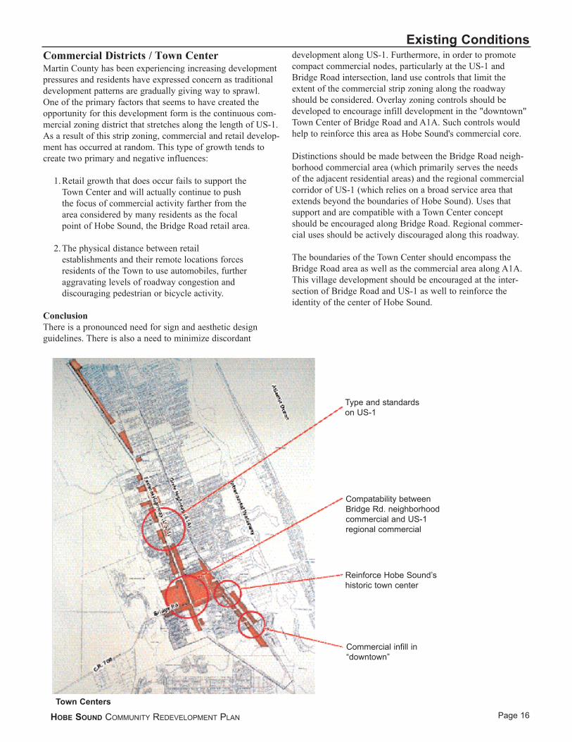
Commercial Districts / Town CenterMartin County has been experiencing increasing developmentpressures and residents have expressed concern as traditionaldevelopment patterns are gradually giving way to sprawl. One of the primary factors that seems to have created theopportunity for this development form is the continuous com-mercial zoning district that stretches along the length of US-1.As a result of this strip zoning, commercial and retail develop-ment has occurred at random. This type of growth tends tocreate two primary and negative influences:
1. Retail growth that does occur fails to support the Town Center and will actually continue to push the focus of commercial activity farther from the area considered by many residents as the focal point of Hobe Sound, the Bridge Road retail area.
2. The physical distance between retail establishments and their remote locations forces residents of the Town to use automobiles, further aggravating levels of roadway congestion and discouraging pedestrian or bicycle activity.
ConclusionThere is a pronounced need for sign and aesthetic designguidelines. There is also a need to minimize discordant
development along US-1. Furthermore, in order to promotecompact commercial nodes, particularly at the US-1 andBridge Road intersection, land use controls that limit theextent of the commercial strip zoning along the roadwayshould be considered. Overlay zoning controls should bedeveloped to encourage infill development in the "downtown"Town Center of Bridge Road and A1A. Such controls wouldhelp to reinforce this area as Hobe Sound's commercial core.
Distinctions should be made between the Bridge Road neigh-borhood commercial area (which primarily serves the needs of the adjacent residential areas) and the regional commercialcorridor of US-1 (which relies on a broad service area thatextends beyond the boundaries of Hobe Sound). Uses that support and are compatible with a Town Center conceptshould be encouraged along Bridge Road. Regional commer-cial uses should be actively discouraged along this roadway.
The boundaries of the Town Center should encompass theBridge Road area as well as the commercial area along A1A.This village development should be encouraged at the inter-section of Bridge Road and US-1 as well to reinforce the identity of the center of Hobe Sound.
Type and standardson US-1
Compatability betweenBridge Rd. neighborhoodcommercial and US-1regional commercial
Reinforce Hobe Sound’shistoric town center
Commercial infill in“downtown”
Town Centers

MobilityHobe Sound is primarily a "bedroom" community.Employment opportunities within the community are limited. Most of the residents commute to their jobs and must travel some distance to community and recreational facilities and essential retail services. Furthermore, BridgeRoad is one of the few access points to Jupiter Island and the beachfront area along the Atlantic Ocean. Consequently, a well-connected roadway system is critical to Hobe Sound'sresidents. These factors, together with the linear developmentpattern that characterizes the community place a strongemphasis on roadway access, not only for automobiles butalso for alternative transportation means such as bicycles andpedestrian activity.
An examination of the community's street network reveals avariety of mobility issues:
· There is an absence of north/south connections between and within the various neighborhoods within the study area. This forces residents to use Gomez, CR A1A or US-1 as their primary inter-community access-ways.
Even though intermittent sidewalks are provided and a mix of land uses are present, community residents choose not to use Bridge Road as a pedestrian way. The discontinuity of the sidewalks force pedestrians into the street for short segments, and the high vehicular speeds discourage pedestrians from walking between areas located directly across the street.
Exceptionally wide cross-sections, such as the four-lane section on the northern end of US-1, discourage pedestrian activity. Streets that are wider than necessary become formidable barriers for pedestrians, especially if the roadways allow fast-moving traffic. The appearance of roadways in the study area does not convey a "neighbor-hood" feel; the openness of the cross-sections, lack of roadside landscaping, and absence of any vertical elements such as street trees or buildings close to the street invite speeding and detract from the pedestrian environment.
HOBE SOUND COMMUNITY REDEVELOPMENT PLAN
Existing Conditions
Page 17
Lack of north/southconnections
Planned improvements toUS-1
Bridge Rd./A1A Intersection
Bridge Rd. Streetscape(CIP Project)
Lack of connectionsUS-1
Traffic Issues

· A lack of additional connections or network is apparent. There are distinct neighborhoods within the study area that are only connected by one or two roadways; even these connections are in jeopardy of closing.
· The 2020 Regional Transportation Plan includes a proposal to widen the section of US-1 that extends through Hobe Sound to six lanes. These future highway plans, such as the US-1 widening plans will affect not just the issue of capacity on US-1 but the future direction of growth in Hobe Sound. This roadway presently creates a considerable obstacle to connections between retail areas and residential neighborhoods on the east and west sides of US-1. A typical rural section of US-1 includes four 12-foot lanes and a 20-foot median. Widening the roadway by an additional 24 feet (two additional lanes) will make east/west connections far more difficult and severely jeopardize the potential for future pedestrian crossings.
ConclusionBased on the foregoing descriptions of mobility issues, the major transportation objectives for the neighborhoodplanning area include:
· Slowing traffic to a speed appropriate in neighborhoods
· Connecting neighborhoods throughout the community and enhance pedestrian/bike mobility and safety
· Improving the visual character of roadways
· Providing ample and efficient places to park
· Ensuring that all County and State planning and transportation policy documents are consistent with the expressed desires of the community regarding roadway design standards and inter-community connections
HOBE SOUND COMMUNITY REDEVELOPMENT PLAN
Existing Conditions
Page 18

InfrastructureDuring the course of the workshops and design sessions, the residents of Hobe Sound frequently expressed concerns relating to roadway capacity and traffic issues. These con-cerns relate to the intersection of Bridge Road and US-1 andthe Bridge Road/A1A intersection. Bridge Road is the soleeast/west connector through Hobe Sound and serves as thecommunity's Main Street commercial corridor as well as the primary regional connection from Jupiter Island to I-95,approximately seven miles to the west. Residents of the community have expressed concerns that increasing through traffic along Bridge Road is resulting in unaccept-able congestion at the A1A and US-1 intersections. In addi-tion, residents have expressed concern about the speed ofvehicles traveling along Bridge Road and the potential forpedestrian/vehicular safety conflicts.
The availability of sewer and domestic and fire water serviceneeds is also a concern for the residents of Hobe Sound.Within the past year the South Martin Regional Utilitiesassumed responsibility to operate the sanitary sewer andwater systems that serve the community. The Utility Directorindicated that the previous operator had not prepared servicearea maps for the region. These maps are now being devel-oped, however, as a result of the lack of available mappedinformation, the extent of the area served by sewer and waterlines can only be estimated.
According to the Utility Director, all of the parcels south ofBridge Road presently have domestic water service, but onlyabout 60% of the area is served by water service for fire pre-vention. The only portion of Hobe Sound south of BridgeRoad served by sewer lines is the Banner Lake area and only80% of that neighborhood has access to sewer lines.
Approximately 75% of the study area north of Bridge Roadis served by domestic water lines. Only 40% of the studyarea north of Bridge Road is connected to sewer lines andonly 30% of this area is served by water lines for fire service.This information indicates a significant need for sewer andwater service expansion in Hobe Sound.
ConclusionsThere is a clear need to extend water and sewer lines to servethe needs of the residential and commercial areas of HobeSound. Significant portions of the community are presentlyun-served by water lines for fire emergencies, presenting aconsiderable health and safety threat.
In addition to the need to extend utilities, the community’spedestrian and vehicular traffic issues must be addressed.There is a need to clearly define and differentiate roadwayand pedestrian space, particularly along Bridge Road. Toenhance pedestrian safety, there is a need to lower andenforce posted speeds, an objective that could be achieved ifappropriate traffic calming measures were included in
streetscape plans and roadway improvements along BridgeRoad. There is also a need to improve the visual character of the roadways, complete and enhance pedestrian/bicycle facilities, and provide additional vehicle and bicycle connections throughout the community to respond to theroadway traffic concerns.
HOBE SOUND COMMUNITY REDEVELOPMENT PLAN
Existing Conditions
Page 19

Land UseThe land use pattern of the Hobe Sound CRA illustrates theimportance of US-1 and Bridge Road as the community’s twoprimary interconnecting roadways. US-1 provides primarynorth/south connections while Bridge Road provides animportant link to the Hobe Sound Beach, a major amenity.
These roadways are also important as the prinicpal locationfor the community’s commercial actvity, which providesessential services to the adjacent residential areas.
HOBE SOUND COMMUNITY REDEVELOPMENT PLAN
Existing Conditions
Page 20
Hobe Sound Land Use MapCommercialResidentialParks and Recreation

D E S I G N P R I N C I P L E S

DESIGN PRINCIPLES
The evaluation of Existing Conditions and the Site Analysiswas predicated upon and guided by the Martin CountyPrinciples of Sustainability. The County adopted thesePrinciples to maintain quality residential and non-residentialdevelopment, preserve natural resources and protect naturalsystems, enhance economic development and prudently allocate financial resources. These principles are:
Environment1. Conserve & recycle precious community resources.
2. Use resources efficiently.
3. Protect & enhance natural resources.
Land Use4. Foster community belonging, unique sense of
community identity.
5. Encourage compact, mixed-use, residential, commercial, institutional pedestrian-oriented development.
6. Encourage redevelopment & infill development within the Urban Services Boundery (USB)[A growth management tool which limits development to those areas where urban public facilities and services are available].
7. Protect & enhance existing neighborhoods.
8. Emphasize quality design, aesthetics of built environment.
9. Create walkable neighborhoods with amenities, for new and existing communities.
10. Maintain an open space network with linkages to neighborhood parks, recreation areas, and natural areas.
11. Integrate open spaces, conservation areas, multi-modal transportation into neighborhoods.
12. Protect & celebrate community heritage & historically significant facilities.
13. Encourage traditional communities, integrate gated communities.
14. Preserve & promote agricultural areas.
15. Use advanced production systems.
16. Maintain a clearly defined edge between urban & rural areas.
17. Recognize and plan for potential natural disasters.
Transportation18. Provide a highly connected street network
comprised of small narrow roads & redesign
existing arterials, design new collectors to be grand public spaces.
19. Provide multi-modal transportation alternatives/choices including transit, trails, bikeways & sidewalks.
20. Use advanced transportation systems.
When applied to the Hobe Sound issues the County'sPrinciples of Sustainability were synthesized into the following six Urban Design Principles that were specifically used to guide the design process and provide the framework for this Plan:
NeighborhoodsNeighborhoods are a Community's essential social unit.Neighborhoods provide the foundation of a sense of community providing places for people to live and socialize.
Community Parks and Open SpacesParks and open spaces provide public space and recreationalopportunities that link the community together. Public spacesand parks should provide places for gatherings, festivals andother public events. Parks should enhance and reflect localenvironmental features and have strong, accessible connec-tions to surrounding neighborhoods.
Street NetworkStreets and roadways connect the various elements of a com-munity together for pedestrians, cyclists and automobiles.Streets represent over 80% of public space in communitiesand strongly influence how people view their community.Streets should reflect local character and scale and convey a positive impression of the community. Great streets balance the needs of the automobile with the pedestrian,using buildings and street trees to create an enjoyable space.
Community BuildingsCommunity buildings, city halls, schools and places of worship define the civic architecture of a community andconvey community identity and community pride and shouldbe centralized in the community.
Town CentersTown centers provide the places to work, shop and socialize.Places for these activities are essential to community life andto a civic identity.
EnvironmentThe natural environment, lakes, rivers, wetlands, and wildlife are the distinctive ecological features that make communities unique and enhance the quality of life its residents experience.
HOBE SOUND COMMUNITY REDEVELOPMENT PLAN
Design Principles
Page 21

C O N T E X T U A LS I T E A N A L Y S I S

Page 22
Contextual Site Analysis
HOBE SOUND COMMUNITY REDEVELOPMENT PLAN

CONTEXTUAL SITE ANALYSIS
Illustrative PlanThe assessment of Existing Conditions and the ContextualSite Analysis, when coupled with the public input receivedduring the Visioning/Consensus Workshop, suggest a seriesof goals and actions that should be undertaken based on identified opportunities and constraints to achieve a preferredfuture vision of Hobe Sound. These opportunities, goals, andactions are specifically developed in accordance with theDesign Principles set forth in Section 3 and create the elements of the Hobe Sound Vision.
HOBE SOUND COMMUNITY REDEVELOPMENT PLAN
Contextual Site Analysis
Page 23

Goal: Neighborhood InfillHobe Sound is fortunate to have many neighborhoods that have been developed in traditional patterns. Many communities throughout the country are seeking to replicate these patterns. Future growth in the Town should be shaped to be consistent with this pattern. Consequently,neighborhood infill should be strongly encouraged. Infilldevelopment would also offer a preferred alternative topotential development of the natural areas that border Hobe Sound and significantly contribute to the community's quality of life. Public improvements should support andenhance neighborhood identity.
Strategies/ActionsThe following actions should be undertaken to achieve theforegoing goal:
· Create Hobe Sound Gateways that reinforce neighborhood identity
· Create a plan for new neighborhood streets and squares that provide public gathering points and support the social connections of neighborhood These new streets would gradually be established as future private-sector redevelopment occurs.
· Develop incentives that encourage private-sector sponsored infill development, such as expedited project review or reduced property taxes for the initial years of the investment
· Target housing improvement funds (low cost loans and direct grants) for new construction or rehabilitation of housing units within existing neighborhoods
HOBE SOUND COMMUNITY REDEVELOPMENT PLAN
Contextual Site Analysis
Page 24
Creation of Streets and Blocksto Organize New Development
Extend Bridge Road as “Main Street”(Westward across US-1 to Lantana)
Renovation ofApollo School
ResidentialInfill
Mixed-UseRedevelopment
Build on HistoricCharacter(1920’s Streetlights)
Creation of NewNeighborhoodParks and Squares
Residential Infill
Page 25
Contextual Site Analysis
HOBE SOUND COMMUNITY REDEVELOPMENT PLAN
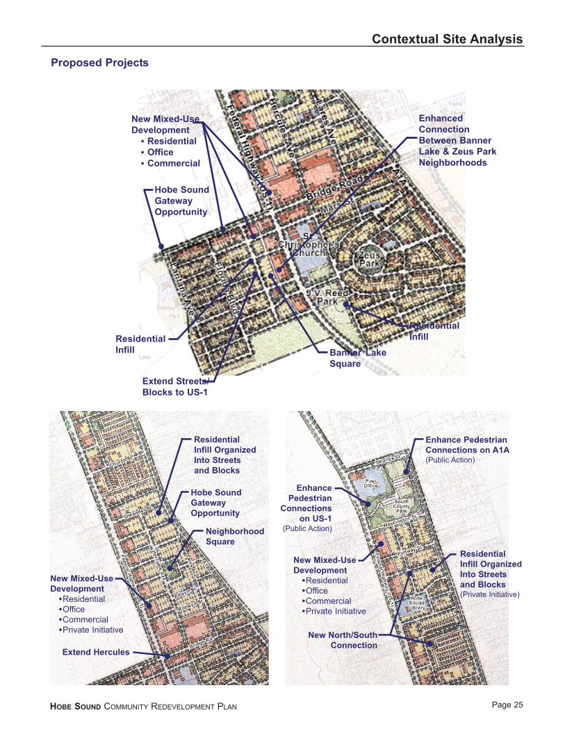
New Mixed-UseDevelopment
ResidentialOfficeCommercialPrivate Initiative
ResidentialInfill OrganizedInto Streetsand Blocks(Private Initiative)
Enhance PedestrianConnections on A1A(Public Action)
Enhance Pedestrian
Connections on US-1
(Public Action)
New North/SouthConnection
ResidentialInfill OrganizedInto Streetsand Blocks
Hobe SoundGatewayOpportunity
NeighborhoodSquare
Extend Hercules
New Mixed-UseDevelopment
ResidentialOfficeCommercialPrivate Initiative
Hobe SoundGatewayOpportunity
New Mixed-Use Development
ResidentialOfficeCommercial
ResidentialInfill
Extend Streets/Blocks to US-1
Banner LakeSquare
ResidentialInfill
EnhancedConnectionBetween BannerLake & Zeus ParkNeighborhoods
Proposed Projects

Page 26
Contextual Site AnalysisGoal: Focus Commercial Development in TownCenterTraditionally, village centers include a mix of retail, serviceand residential within an area that can be easily traversed onfoot, and the "Main Street" fronts two walls of buildings. TheBridge Road (between Lares Avenue and CR A1A) and A1A(between Bridge Road and Gleason Street) commercial areasprovide for an essential mix of retail uses that form a desirableMain Street, Village setting. Efforts should be made to encour-age compatible growth within these areas to continue to builda compact and identifiable "Town Center" and Main Street forHobe Sound. Land use regulations should be activelyemployed that differentiate between regional commercialgrowth, which should be directed to US-1, and retail activitythat would enhance, and thus should be encouraged to locatewithin, the Bridge Road Town Center commercial district.Public improvements should specifically support and enhance the pedestrian qualities of the Bridge Road TownCenter district.
Strategies/Actions· Pursue streetscape improvements that enhance the
pedestrian environment and create a Main Street along Bridge Road
· Create town center overlay district zoning controls that encourages pedestrian scale commercial development that is consistent with a "village center" concept
· Encourage compatible mixed-use development along Bridge Road and A1A through permissive zoning and incentives. Add parking to serve new development
· Establish design standards to guide development within the Bridge Road Main Street area
· Extend the Town Center development pattern on Bridge Road westward across US-1 to provide a pattern of retail growth adjacent to the Banner Lake neighborhood and north and south within the immediate vicinity of the Bridge Road/US-1 intersection
· Enhance the Bridge Road/US-1 intersection by providing such improvements as sidewalks, street trees, crosswalks and pedestrian lighting
· Build on the Historic Character of Hobe Sound using this as a theme for future development
This could be accomplished through the development and implementation of design standards that reflect this character.
HOBE SOUND COMMUNITY REDEVELOPMENT PLAN
Town Centers
Establish DesignStandards for NewDevelopment (Protectingthe Historic Character ofHobe Sound)
Bridge Road Streetscape(Lantana to A1A)
Locate New Civic/PublicUses in Town Center
Encourage Mixed-UseRedevelopment(Incentives/OverlayZoning District)
EncourageRedevelopmentof Bridge Roadas “Main Street”

Goal: Enhance Community ConnectionsCreate an overall network of interconnected roadways leading from neighborhoods throughout the Hobe SoundStudy area to community facilities and commercial areas.These interconnections will enable residents' access through-out the community while avoiding the necessity to use majorregional arterials such as US-1. These connections will bedesigned for pedestrian and bicycle accessibility and offersuitable alternatives to automobile use.
Strategies/Actions· Guide redevelopment into connected streets
and blocks
· Connect Banner Lake neighborhood to US-1/Zeus Park
· Enhance Pedestrian/Bike connections on A1Aand US-1
· Ensure that all roadway improvement plansincorporate bike- and pedestrian-ways
HOBE SOUND COMMUNITY REDEVELOPMENT PLAN
Contextual Site Analysis
Page 27
Neighborhood connections to facilities
Enhanced Pedestrian/BikeConnections along A1A,US-1, through Neighborhoods
Creation of HobeSound Gateways
Enhanced Ped/BikeCrossing at Bridge Rd./A1A
Extend Connections fromBanner Lake Neighborhood
to US-1/Zeus Park
EnhancedPedestrian/BikeConnections at
Bridge Rd./US-1
Creation ofHobe Sound
Gateways

V I S I O N P L A N

VISION PLAN
Public ProjectsThe following projects have been proposed in order toaccomplish the Hobe Sound CRA Plan Vision:
1. Design Guidelines
2. Overlay Zoning
3. Bridge Road "Main Street"
4. US-1 Design Concepts
5. Gateways
6. Housing Development Initiatives
7. Master Utility Plan
8. Comprehensive Sidewalks within the Hobe Sound Community Redevelopment Area
9. Banner Lake Square
These projects are described in the following sections.
HOBE SOUND COMMUNITY REDEVELOPMENT PLAN
Vision Plan
Page 28

Design Guidelines
Cost:$30,000 - $50,000
Funding Sources:General Fund
Time Frame:1-2 years
The purpose of design standards or a "pattern book" is to provide architectural and community guidelines to support a consistent direction for redevelopment. In Hobe Sound,these guidelines should include site-planning issues (build-ings up close to the street, parking in back, designs that allowmixed use, etc.) as well as architectural standards. Both newdevelopment and renovations/alterations to existing proper-ties should conform to guidelines that promote an urbandevelopment pattern and compliment the village character.
What are design guidelines?Design guidelines are recommendations for the improvementof visual quality. They are an analysis of what is specialabout an area, developed into a plan toward enhancing thosequalities. Guidelines are:
An identification of the most characteristic design elements-those qualities which people would like to keep and reinforce,minimum standards of compatibility.
What guidelines can and cannot accomplish:
Guidelines can:· Reinforce the unique character of an area.
· Protect the value of public and private investment, which otherwise might be threatened by the conse-quences of poorly managed growth.
· Improve the quality of the built environment.
· Indicate which approach to design a community encourages.
· Serve as a tool for designers and their clients to use in making preliminary design decisions.
· Provide an objective basis for the decisions of a design review board or architectural reviewcommittee.
· Increase the level of public awareness of design issues and options.
Guidelines cannot:· Limit growth or regulate where growth takes place.
Design guidelines address only the visual impact of growth.
· Guarantee that all new construction will be compat-ible with the district setting. Design guidelines ulti-mately can only guide; the final results are in the hands of the property owners.
· Serve the same legal purpose as a design review ordinance. A design review ordinance is a law, but design guidelines are not.
Evolution of Design GuidelinesStage 1. At this simplest level, design guidelines are an ideabook of design considerations and their use is voluntary.
Stage 2. At this stage, a community group such as a designtask force, neighborhood advisory group, or Chamber ofCommerce endorses suggestions made in the guidelines. Thestrongest endorsement comes from local government and theNAC. Voluntary guidelines require active promotion of theiruse in order to gain public acceptance and cooperation.
Stage 3. Communities, whose commitment extends beyondendorsement and advocacy to providing on-going designassistance and financial incentive programs to property own-ers, have used design guidelines at this stage as an effectiveredevelopment tool. A quick-start improvement program cancause positive results that will illustrate the value of qualitydesign over random growth.
Stage 4. Usually, after successfully completing five to tengood projects based on use of the guidelines, the communitylooks for a means of protecting these investments by movingthe guidelines from a less dependable voluntary use, to alevel of required compliance. One way to encourage compli-ance with design guidelines is to include them as part of anordinance that authorizes a review board to delay, but not todeny, issuance of a building permit when a proposed projectdoes not meet guideline standards. An example of this typeof requirement is an ordinance that gives a review board theright to delay a permit by 30 to 180 days, during which timethe developer is encouraged to modify his design. It isimportant to note that guidelines, which have evolved beyondvoluntary use, should be refined and adjusted for use as acompanion guide to the ordinance.
Stage 5. At this highest stage, compliance with design guidelines can be made compulsory-required by an ordinancethat also establishes enforcement mechanisms. This may beaccomplished by amending a zoning ordinance, or by creat-ing an entirely new ordinance. In both instances, develop-ment proposals are reviewed by a board that approvesissuance of a building permit only when the guidelines havebeen satisfactorily met.
All these stages of design guideline administration have beensuccessfully used in communities throughout Florida and thenation. Although Hobe Sound's citizens may find that
HOBE SOUND COMMUNITY REDEVELOPMENT PLAN
Vision Plan
Page 29

full compliance is not absolutely essential to their redevelopment efforts, it may ultimately be desirable because it offers the best opportunity for ensuring qualitydesign in the community.
Suggested Guideline ApproachThe following is an outline of an effective process for a community to use to formulate design guidelines:
1. Select an approach: Identify the status of redevelopment efforts in the district and determine how the guidelines willbe initially used (voluntary, incentive review or design review ordinance).
2. Establish a task force: Identify role of the task force; deter mine goals and objectives for guidelines, and conduct a sidewalk survey to note common elements, patterns, periods of construction, architectural style, and building conditions.
3. Develop an inventory of area architectural characteristics that might include the following:
· Record and note observations
· Photograph individual buildings (assemble and mount photos by block)
· Evaluate historic photographs, traditional development patterns, etc.
· Outline common elements noted in the surveys
· Determine important visual characteristics
4. Financial Incentive Program: The subcommittee or task force should review successful programs from other communities. The next step is to develop procedures for review board and criteria for disbursement of funds.
Finally, the task force recommends that the CRA adopt the grant package and funding to the level suggested.
5. Public Meeting Series: Develop a consensus among property owners regarding important characteristics.Select elements that the guidelines should address:
· Develop actual guidelines;
· Adopt the illustrated guidelines;
· Finalize details of grant program; and
· Develop implementation plan that includes design review committee training, promotion plan for program, program administration, etc.
ConclusionsMost communities rely upon assistance in this process fromplanning/design consultants who are experienced in develop-ing design guidelines and grant programs and are skilled inbuilding consensus among property owners.
Property owners within a redevelopment district must agreethat the "whole is greater than the parts." Developing adesign guidelines program for private property requires adynamic and carefully constructed public education programto build support for these changes:
· Communities that do not have a high level of design awareness or history of design controls generally chose to begin their programs with voluntary guide-lines with some financial incentive program. Carrots work better than sticks in these situations!
· Allow a period of 3 -6 months to accomplish the task of developing the guidelines, and to organize the grant program and administrative matters.
HOBE SOUND COMMUNITY REDEVELOPMENT PLAN
Vision Plan
Page 30
Historic Apollo Schoolhouse
Roofline& Cornice
Window Detail& Visibility
Entry/PedimentArticulation& Detail
3 FacadeMaterials
Verti
cal M
assi
ngSc
ales
the
Build
ing
to th
e Pe
dest
rian
Hor
izon
tal M
assi
ng -
Top
Hea
vy
Steep Roofline with PoorlyProportional Cornice, No Detail
Limited WindowDetail or EntryArticulation
Only 2 FacadeMaterials
Horizontal Massing - 1 PlaneToo Much Glass

· Guidelines should be included as a part of an overall redevelopment scheme, not as an end in itself.
· Community support is vitally important, as is active and creative promotion of the program.
· Guidelines are a very successful tool to manage growth and encourage reinvestment.
· This is a good time for the Martin County CRA to consider such a project for Hobe Sound.
HOBE SOUND COMMUNITY REDEVELOPMENT PLAN
Vision Plan
Page 31
Preferred Examples
[Roof and entryway articulation, high level of storefront transparency, intimate pedestrian scale, buildingsclose to sidewalk]

Overlay Zoning
Cost:By Staff
Funding Sources:General Fund
Time Frame:1-2 years
Overlay zoning is a commonly used redevelopment tool. Thisapproach imposes a different set of development standardswithin the boundaries of the Neighborhood Planning Area.The standards may be more restrictive, as with architecturaldesign, to preserve and enhance the character of theNeighborhood Planning Area. They may also be less restric-tive as they relate to such things as parking or building set-back requirements. These standards serve as incentives forprivate reinvestment in that they not only help to guaranteethe look and feel of an area but also allow greater flexibilityin the development of a property. Overlay Zoning is crucialto the success of all redevelopment efforts within theNeighborhood Planning Areas.
The Overlay Zoning will be in place in both the CommunityRedevelopment Area (CRA) and the Neighborhood PlanningArea (NPA). The NPA is a preliminary planning area. TheCRA is a refinement of these boundaries creating a focus for redevelopment efforts to address the most pronouncedcommunity needs. However, the NPA remains an integralpart of the redevelopment of Hobe Sound.
HOBE SOUND COMMUNITY REDEVELOPMENT PLAN
Vision Plan
Page 32

Page 33
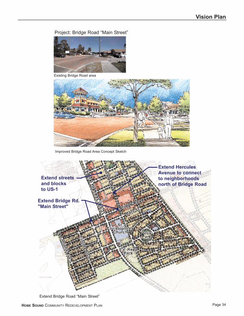
Vision PlanBridge Road "Main Street"
Cost:$385,0005
Funding Sources:Bonding/repaymentSpecial assessmentGeneral Fund
Timeframe: 5 - 10 years
Hobe Sound's public and commercial spaces along BridgeRoad and A1A are extremely important assets that define thevillage character and offer community-gathering spaces.Improving connections between these activity centers andabutting residential areas will greatly enhance the vitality ofthe area. However, there are a series of additional actions thatcan be taken to strengthen and further develop this commer-cial area as Hobe Sound's “Main Street”.
Traditional town centers include a mix of retail, service andresidential uses within in an area that can be easily traversedon foot. Typically two walls of buildings line the "MainStreet". To achieve this comfortable, compact town center inHobe Sound, the density of uses needs to be increasedthrough in-fill development.
Bridge Road connects US-1 and A1A and forms the "MainStreet" of Hobe Sound. While at first glance this corridorcontains many of the positive characteristics desired in andalong a Main Street, future development along the roadwaymay work against this image. This is likely to occur if, forexample, development along the roadway is permitted to takethe form of strip malls set back from the roadway and frontedby expansive parking lots. Properly designed streetscapeimprovements, including street trees, sidewalks and a modi-fied layout for the existing on-street parking could signifi-cantly enhance the pedestrian environment of this commercial area.
The existing streetscape west of Lares Avenue should beextended westward towards Banner Lake Park and eastwardto A1A. Extending the streetscape will beautify the corridor and clearly define the sidewalk for pedestrians.
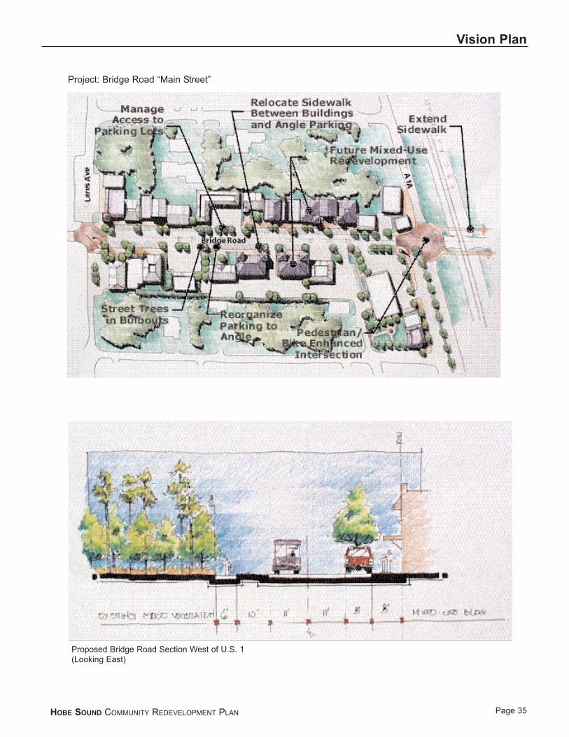
Currently, pedestrians stand on an undefined or non-existentsidewalk between parked cars and Bridge Road traffic. Thebulb-outs (strategically placed extensions of the landscapedsections into the paved way intended to calm traffic and create protected pedestrian crossings and parking aisles), proposed for installation as part of the streetscape improve-ments, will create islands of safety for pedestrians wishing to
cross Bridge Road at mid-block. Angled parking in front ofthe storefronts will maintain access while allowing customersto back onto Bridge Road in a safer manner. This parkinglayout re-arrangement will also permit sidewalks to beinstalled at the front building line.6
In the future, as traffic warrants, signalizing the intersectionat Lares Avenue would allow pedestrians and traffic to crossBridge Road in a safe manner.
It is also recommended that Bridge Road remain a two-laneroadway. A roadway with a larger cross-section will onlyresult in separating the uses and pedestrians of downtown.
The community can immediately begin to focus attention on the Bridge Road commercial area as a public gathering space. This could be accomplished by planning special outdoor public events and holiday celebrations to highlightthe community businesses and reinforce the district as the Main Street.
ImplementationThe Bridge Road Main Street redevelopment can be achieved through a combination of public and private investment over time. Martin County can boost investor confidence by proceeding with the construction of theplanned Bridge Road streetscape improvements. The County should also establish design guidelines for thearea, and should consider a grant assistance program as anincentive to façade improvements. Private entrepreneursshould be encouraged to upgrade the appearance and conditions of existing properties and respond to marketplacedemands through infill business development.
HOBE SOUND COMMUNITY REDEVELOPMENT PLAN
5Infrastructure costs to be determined. Estimate does not include assessmentof access easements for sidewalk installation along store fronts.
6This proposal will require access easements from existing propertyowners and should be a standard requirement for future developmentthat will be proposed within the Main Street area. This concept is appli-cable to those buildings that are presently located close to the street.Parcels where buildings have been set back from the street will have toawait redevelopment before this concept can be applied.
HOBE SOUND COMMUNITY REDEVELOPMENT PLAN
Vision Plan
Page 34
Project: Bridge Road “Main Street”
Existing Bridge Road area
Improved Bridge Road Area Concept Sketch
Extend Bridge Road “Main Street”
Extend HerculesAvenue to connectto neighborhoodsnorth of Bridge Road
Extend streetsand blocksto US-1
Extend Bridge Rd."Main Street"
Page 35
Vision Plan
HOBE SOUND COMMUNITY REDEVELOPMENT PLAN
Project: Bridge Road “Main Street”
Proposed Bridge Road Section West of U.S. 1(Looking East)

Page 36
Vision Plan
HOBE SOUND COMMUNITY REDEVELOPMENT PLAN
Project: Bridge Road “Main Street”
Existing Bridge Road Section
Existing Bridge Road Proposed Section

US-1 Design Concepts
Cost:$3,500,000
Funding Sources:CIP/Grants
Timeframe: 5 - 10 years
US-1 operates at an acceptable level of service while man-aging to serve as the main north-south thoroughfare in HobeSound. The calculated Average Annual Daily Traffic(AADT) volume along this roadway is 22,839 (1999 data).This volume is lower than the Level of Service (LOS) Bminimum volume of 23,500 for a four-lane divided Class Iroadway. In 2021, US-1 is projected to have an AADT of42,800 and is expected to operate at an LOS C.7 Based onthis data it appears that the designed rural section is morethan adequate to accommodate the traffic generated by sur-rounding built-out commercial and residential land uses.Therefore, capacity is not the issue driving the proposedwidening of US-1 in this area to 6 lanes. In the absence ofthis operational argument, it is recommended that US-1remain a four lane rural section.
Where necessary, such as at the intersection of Bridge Road,additional lanes have been constructed to handle the turningmovements. A four lane rural section, with landscapedmedian (median curbed), 8-10 foot multi-use paths, andstreet trees located 20 feet from the edge of pavement wouldserve the current and future needs of the residents in theneighborhood, while offering an aesthetically pleasing corri-dor. Curbing the median creates an opportunity for land-scaping. The large amount of right-of-way on the east andwest sides of the roadway (up to 30 feet) would permit theinstallation of street trees without the high expense ofinstalling a curb and gutter.
This proposal is not consistent with the current 2020Transportation Improvement Plan, the FDOT roadwayimprovement plans for this corridor or the County's GrowthManagement Plans. If this recommendation is accepted,these documents and plans will need to be modified so thatall of the planning documents that relate to Hobe Sound andthe US-1 corridor in the community are consistent.
HOBE SOUND COMMUNITY REDEVELOPMENT PLAN
Vision Plan
Page 37
7Hobe Sound Transportation Memorandum, February 17, 2000, revised4/12/2000, p. 3

Page 38
Vision Plan
HOBE SOUND COMMUNITY REDEVELOPMENT PLAN
Proposed US-1 Section
Existing US-1 Section

Gateways
Cost:$110,000 each
Funding Sources:General Fund
Timeframe: 1 - 5 yearsThere is a need to develop measures to identify the edges of the Hobe Sound Town Center. At the present time it is difficult for travelers in the vicinity of the community todetect when they have entered Hobe Sound, where it startsand how far it extents. A clear sense of identity is obviouslyan important element of a sense of place. One way to createidentity is to develop gateways that announce the border ofthe community and invite people to visit and experienceHobe Sound.
The proposed project envisions the creation of a signaturegateway to be located at the strategic intersection of BridgeRoad and Lantana Avenue where all traffic from the westfunnels into Hobe Sound. The design of this gateway replicates the base of the historic streetlights that presentlyline A1A and incorporates this design into a community welcome sign. Sidewalks, street trees and crosswalk pavement complete the entryway design establishing a clear demarcation point for the entry to the community.
The plan illustrates an additional community gateway at theLares Avenue/A1A entrance point as traffic heads into theBridge Road Main Street from the north. This treatmentshould be replicated at other key entrance points and thegateway element should be employed as a design theme thatcan be carried out for streetlights and key signposts through-out the Hobe Sound Town Center.
The proposed gateway design should also be replicated atkey entry points to the north and west of the community.
HOBE SOUND COMMUNITY REDEVELOPMENT PLAN
Vision Plan
Page 39
Existing Bridge Road Looking East towards US-1
Proposed Bridge Road Looking East towards US-1

Page 40
Vision Plan
HOBE SOUND COMMUNITY REDEVELOPMENT PLAN
Project: Lares Avenue/ A1A Gateway
Existing A1A/ Lares Avenue looking south towards Bridge Road
Proposed A1A/ Lares Avenue looking south towards Bridge Road

Housing Development Initiatives
Cost:To be determined as appropriate strategies are implemented
Funding Sources:GrantsPrivate investment
Time Frame:On going
Although opportunities for in-fill single family developmentexist throughout Hobe Sound, it is important to focus government and community-based housing initiatives in districts where housing quality is poorest and barriers to private market investment are greatest. The Banner Lakeneighborhood south of Bridge Road, as well as the neighbor-hood areas between US-1 and A1A, stands out as primary target areas for such efforts.
StrategiesThe following strategies provide options for achieving thecommunity's housing objective through a community-basedapproach that builds on the strengths of the districts as cohesive, traditionally designed neighborhoods. In keepingwith overall community objectives as expressed through theCommunity Redevelopment Planning process, these strategiesemphasize construction of new single family in-fill houses,rehabilitation of existing homes and enforcement of Countyzoning and building codes as the primary housing improve-ment goals for the target areas.
Strategy 1:Develop a County-based package of incentives specificallyfocused on encouraging single family residential developmentand rehabilitation in the targeted neighborhoods.
· Continue to seek Community Development Block Grant funds to offset sanitary sewer and potable water connection fees for existing and new income-eligible, single family homeowners in the neighborhood
· Target impact fee credit, discount or loan programs or new single family home construction in the neighborhood
· Target first-time homebuyer education and training programs for families purchasing homes in the neighborhood
Strategy 2:Continue focusing County SHIP (State Housing InitiativePartnership) funds in redevelopment areas. Focus CommunityDevelopment Corporation, County and other housing develop-ment initiatives and investment into areas of the targeted
neighborhoods where the impact of new residential develop-ment will be maximized.
· Focus housing rehabilitation resources on existing homes in the same areas to further concentrate and maximize reinvestment in the neighborhood
Strategy 3:Focus public capital investment, such as CommunityDevelopment Block Grant funds, on improvements that support and reinforce the single-family character of the target areas.
· Complete installation of sanitary sewer, potable water and stormwater facilities within the neighborhoods
· Develop and implement a program to improve existing streets throughout the neighborhoods
· Develop and implement a program to construct sidewalks throughout the neighborhoods, with priority focus on providing connections to parks, schools, commercial areas and other community facilities
· Establish finance mechanisms such as municipal services taxing units to pay for installation of streetlights and other unfunded facilities throughout the neighborhood
· Continue the citizen involvement process that allows neighborhood residents to select and prioritize needed capital improvements
Strategy 4:Focus County code enforcement activity in the target areas toimprove neighborhood appearance, safety and marketability.
· Continue to educate property owners about housing maintenance requirements and code enforcement procedures and priorities
· Focus "code sweeps" through the targeted neighbor-hoods to identify significant health, safety and maintenance violations
· Continue to provide rehabilitation assistance to truly needy homeowners and hardship cases in conjunc-tion with the State Housing Initiative Partnership (SHIP)
· Organize neighborhood code enforcement teams comprised of existing staff members who will focus their time to monitor nuisances, zoning and building code violations within the target areas
HOBE SOUND COMMUNITY REDEVELOPMENT PLAN
Vision Plan
Page 41

Strategy 5:Initiate outreach to homebuilders to evaluate market feasibility and identify additional development incentives.
· Contact builders of single family homes to determine what conditions and incentives it will take to attract them to build in the target areas, such as:
· Infrastructure improvements
· Fee waivers
· Pre-sold/financed homes
· Crime & safety improvements
HOBE SOUND COMMUNITY REDEVELOPMENT PLAN
Vision Plan
Page 42

Master Utility Planning
Cost:$100,000 - $300,000
Funding Sources:GrantsSpecial District FundsGeneral Fund
Time Frame:1-2 years
In order to accommodate infill and mixed use developmentcontemplated in this Plan, a long-range plan should be developed for utility, stormwater management and infrastructure improvements and expansion in the HobeSound Redevelopment Area. The need for utility planning is particularly pronounced in view of the large portions of the community that do not have access to sewer lines andthat are un-served by lines for both potable water as well as emergency fire service.
HOBE SOUND COMMUNITY REDEVELOPMENT PLAN
Vision Plan
Page 43

Comprehensive Sidewalks Within the HobeSound CRA
Cost:$550,000*
Funding Sources:Grant Funds, Tax Increment and District Funds
Time-Frame:HS-NAC Will Develop Phasing Program and Prioritize Needand Locations
In order to develop connections throughout the community, a complete pedestrian and bicycle system of connected recreational trails, bike lanes and paths and sidewalks shouldbe developed. The system should include the improvementand completion of sidewalks on major thoroughfares and the addition of bicycle lanes on key road connections.Implementation of this project could be assigned to theMetropolitan Planning Organization Bicycle/PedestrianCommittee in conjunction with the members of the HobeSound Neighborhood Advisory Committee.
This system should be implemented over time since many of the improvements can be included as part of other Countyand State projects such as road or park improvements. The costs noted above are for the planning phase only.Implementation costs will be projected based on the bikeway plan.
*Note: Sidewalk improvements for CR A1A, Lares Ave. to Rohl Way ($56,000) and US-1 to Diane St. ($22,615) are scheculed for completion prior to the end of FY 2000.
HOBE SOUND COMMUNITY REDEVELOPMENT PLAN
Vision Plan
Page 44

Banner Lake Square
Cost:$91,000 (Signal/intersection improvements only)
Funding Sources:BondingGeneral Fund
Timeframe: Two of the primary redevelopment issues raised during theVisioning/Consensus Workshop included the creation of con-nections to neighborhoods and residential infill opportunities.Both of these issues are clearly evident in the southerly por-tion of the study area. At the present time, US-1 creates aconsiderable barrier preventing east-west connectionsbetween the primary neighborhood areas along Bridge Road,Zeus Park and Banner Lake, inhibiting infill developmentthat might otherwise be fostered. The proposed program isdesigned to resolve this physical disconnect between thecommunity's residential areas.
The plan proposes a full, four-way, signalized intersectionand the extension of S. E. Olympus Avenue across US-1. Theplan also envisions new mixed-use commercial developmentalong the west side of US-1 transitioning into and extendingthe traditional residential development pattern that character-izes the Banner Lake neighborhood.
The commercial activity that is envisioned in conjunctionwith this new development would be an extension of theBridge Road Main Street concept from A1A west across US-1 up to Lantana Avenue. Pedestrian and bicycle accessand crosswalks with appropriate landscaping and amenitiesare integral elements of this infill development plan. Zoningcontrols should be instituted that would permit mixed-usedevelopment. This would help to create a vital environmentthat extends the Hobe Sound Town Center onto US-1 and is a form of growth that is entirely compatible with the BannerLake residential neighborhood.
Changes in existing land use patterns to enable the extensionof the Bridge Road Main Street concept across US-1 willrequire that this area be rezoned to permit mixed-use com-mercial development. These changes will necessitate modifi-cations to the County's land use management plan and relatedzoning standards.
HOBE SOUND COMMUNITY REDEVELOPMENT PLAN
Vision Plan
Page 45
Present Condition
Proposed "Banner Lake Square"
Project "Banner Lake Square"

I M P L E M E N T A T I O N
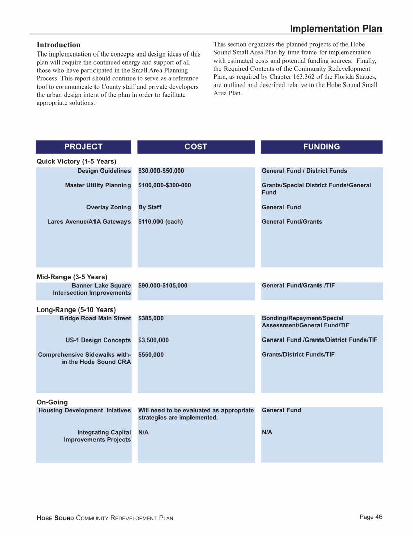
HOBE SOUND COMMUNITY REDEVELOPMENT PLAN
Implementation Plan
Page 46
Design Guidelines
Master Utility Planning
Overlay Zoning
Lares Avenue/A1A Gateways
$30,000-$50,000
$100,000-$300-000
By Staff
$110,000 (each)
General Fund / District Funds
Grants/Special District Funds/GeneralFund
General Fund
General Fund/Grants
Banner Lake SquareIntersection Improvements
$90,000-$105,000 General Fund/Grants /TIF
Bridge Road Main Street
US-1 Design Concepts
Comprehensive Sidewalks with-in the Hode Sound CRA
$385,000
$3,500,000
$550,000
Bonding/Repayment/SpecialAssessment/General Fund/TIF
General Fund /Grants/District Funds/TIF
Grants/District Funds/TIF
Housing Development Iniatives
Integrating CapitalImprovements Projects
Will need to be evaluated as appropriatestrategies are implemented.
N/A
General Fund
N/A
IntroductionThe implementation of the concepts and design ideas of thisplan will require the continued energy and support of allthose who have participated in the Small Area PlanningProcess. This report should continue to serve as a referencetool to communicate to County staff and private developersthe urban design intent of the plan in order to facilitate appropriate solutions.
This section organizes the planned projects of the HobeSound Small Area Plan by time frame for implementationwith estimated costs and potential funding sources. Finally,the Required Contents of the Community RedevelopmentPlan, as required by Chapter 163.362 of the Florida Statues,are outlined and described relative to the Hobe Sound SmallArea Plan.
Quick Victory (1-5 Years)
Mid-Range (3-5 Years)
Long-Range (5-10 Years)
On-Going
PROJECT COST FUNDING

FundingThere are two basic approaches to funding public improve-ments in CRA areas described here as "pay as you go", or"borrowing". The "pay as you go" approach assumes fundsfor improvements are generated over time through a varietyof methods including property taxes, sales taxes, specialassessments, impact fees, grants, tax increment financing, etc.These revenue sources are generated from within the specificCRA area over time allowing projects to be implementedonly as funds are available and not requiring the CRA to takeon any debt. The "borrowing" approach is just that, bonds orloans that are taken on by the CRA to implement projects.These bonds allow the CRA to implement projects quickerthan any other "pay as you go" funding approaches wouldallow, creating a catalyst for private redevelopment. Bothapproaches should be utilized throughout the redevelopmentprocess depending on the most appropriate way to fund par-ticular projects, available funding sources, and the CRA'sdesired funding approach.The following is a partial list ofpotential funding methods:
Pay As You Go:• Property Taxes (District Funds)• Sales and Use Tax• Real Estate Transfer Tax• Tax Increment Financing• Special Assessments District• Business Improvement District• Benefit Assessment District• User Charges• Reserves• Mitigation Financing• Negotiated Exaction or Impact Fees (hookups,
systems development of capital fees)• Grants• Public-Private Ventures
Borrowing:• General Obligation Bonds - Limited or Unlimited Tax• Revenue Bonds (or "rate-supported" bonds)• Taxable Bonds• Tax Increment Financing Bonds• Lease Purchase and Certificates• Revolving Loans• Bond Banks• Industrial Development Bonds
HOBE SOUND COMMUNITY REDEVELOPMENT PLAN
Implementation Plan
Page 47
Whether or not identified as a funding source elsewhere in this plan and under the provisions of State Statute 163.370, Tax Increment Financing and/or any other combination of legally available funds may be used to fund projects and the future maintenance of projects which are in compliance with the Community Redevelopment Plan.

Page 48
Implementation Plan
HOBE SOUND COMMUNITY REDEVELOPMENT PLAN
Required Contents of a Community RedevelopmentPlanChapter 163.362 of the Florida Statutes lists the mandatoryrequirements of a Community Redevelopment Plan. The following section specifically addresses each of the require-ments of Chapter 163.362, as well as the Martin CountyCommunity Redevelopment Ordinance 517. (This plan goesbeyond the requirements of Chapter 163.362 with the detailcontained in the body of the plan.) In order to satisfy therequirements of Florida Statutes Chapter 163.362 and Martin County Ordinance 517 every CommunityRedevelopment Plan shall:
1. Contain a legal description of the boundaries of the CRA and the reasons for establishing such boundaries in the plan.
The Hobe Sound Redevelopment Area includes the area outlined in Exhibit 1 and contains approximately 1,068 acres. The legal description for the area follows as Exhibit 2.
The boundaries established for the Hobe Sound Redevelopment Area are based upon Resolution #97.6.11 passed by the Martin County Board of County Commissioners, declaring a Finding of Necessity. The Finding of Necessity established that present conditions within the identified redevelopment area constitute an economic and social liability. The finding of Necessity is supported by substantial evidence satisfying the requirements of Florida Statute 163.335.
2. Show a diagram and in general terms:a. The approximate amount of open space
to be provided and the street layout.
Exhibit 3 illustrates the Hobe Sound Redevelopment Plan, outlining proposed parks, recreation areas, streets, public utilities and pubic improvements. The approximate amount of open space currently contained in the Hobe Sound Redevelopment Area is 265 - 320 acres, or 25%-30%. Following the completion of identified projects in the Hobe Sound Redevelopment Plan, the amount of open space will be 265-320 acres. This amount meets the County’s current level of service identified in the Comprehensive Growth Management Plan.
b. Limitations on the type, size, height, number and proposed use of buildings.
Limitations on the type, size, height, number, and proposed use of buildings shall conform to the Zoning and Land Use regulations of Martin County. However, the Hobe Sound Redevelopment Plan has identified
that design standards should be developed to include site planning issues as well as architectural standards to promote a development pattern that compliments Hobe Sound's village character.
c. The approximate number of dwelling units.
Based upon information supplied by Martin County, the approximate number of dwelling units in the Hobe Sound Redevelopment Area is 720.
d. Such property as is intended for use as public parks, recreation areas, streets, public utilities and public improvements of any nature.
Exhibit 3 illustrates the Hobe Sound Redevelopment Plan, outlining proposed parks, recreation areas, streets, public utilities, and public improvements. Exhibit 4 is a list of projects identified in the Hobe Sound Redevelopment Plan and the estimated cost of each project.
3 . If the redevelopment area contains low ormoderate income housing, contain a neighborhood impact element which describes in detail the impact of the redevelopment upon the residents of the redevelopment area and the surrounding areas in terms of relocation, traffic circula-tion, environmental quality, availability of community facilities, effect on school popula-tion, and other matters affecting the physical and social quality of the neighborhood.
It is anticipated that no relocation will occur during the course of implementing the Hobe Sound Redevelopment Plan. Public infrastructure projects will potentially involve business establishments as well as residential house holds, but relocation is not expected to be necessary.
4. Identify specifically any publicly funded capital projects to be undertaken within the CRA.
Exhibit 5 outlines all publicly funded capital projects to be undertaken within the Hobe Sound CRA
5. Contain adequate safeguards that the work of the redevelopment plan will be carried out pursuant to the plan.The Community Redevelopment Agency will
Page 49
Implementation Plan
HOBE SOUND COMMUNITY REDEVELOPMENT PLAN
carry out the work of redevelopment. The redevelopment process has been established consistent with Chapter 163, Part III., Community Redevelopment of the Florida Statues. It is the intent of the Martin County Board of County Commissioners to comply with those requirements as established in Chapter 163, Part III, of the Florida Statutes.
6. Provide for the retention of controls and the establishment of any restrictions or covenants running with land sold or leased for private use for such periods of time and under such conditions as the governing body deems necessary to effectuate the purposes of this park.
This provision of a Community Redevelopment Plan will be satisfied on an individual basis as each project is carried through final documentation or design.
7. Provide assurances that there will be replacement housing for the relocation of persons temporarily or permanently displaced from housing facilities within the CRA.
If, as a result of implementation of projects contained within the Hobe Sound Redevelopment Plan relocation of persons becomes necessary on either a temporary or permanent basis, the Community Redevelopment Agency will be responsible for the provision of replacement housing for those affected persons consistent with applicable State Guidelines.
8. Provide an element of residential use in the redevelopment area if such use exists in the area prior to the adoption of the plan or if the plan is intended to remedy a shortage of housing affordable to residents of low ormoderate income, including the elderly or if the plan is not intended to remedy such shortage, the reasons therefor.
Creating strategies for maintaining and attracting safe, decent and affordable housing is an essential element of the Hobe Sound Redevelopment Plan. The Banner Lake neighborhood south of Bridge Road and the neighborhood areas between US-1 and A1Astand out as primary target areas for such efforts. These initiatives should be coordinated through the State Housing Initiative Partnership (SHIP).
9. Contain a detailed statement of the projected costs of the redevelopment, including the amount to be expended on publicly funded capital projects in the Community Redevelopment Area and any indebtedness of the Community Redevelopment Agency, the County or the Municipality proposed to be incurred for such redevelopment if such indebtedness is to be repaid with increment revenues.
The Hobe Sound Community Redevelopment Plan includes a detailed list of projects identified in the Hobe Sound Redevelopment Plan and the estimated cost of each project.
10.Provide a time certain for completing all redevelopment if financed by increment revenues. Such time certain shall occur no later than 30 years after the fiscal year in which the plan is approved or adopted.
It is anticipated that increment revenues to pay for the projected costs of redevelopment will require no more than 30 years after adoption of the Hobe Sound Redevelopment Plan for funding.
