community redevelopment plan update
TRANSCRIPT

Prepared for the English Avenue Neighborhood Association and the Atlanta Development AuthorityPrepared by Urban Collage, Inc. and Contente Terry in association with Market + Main and Grice & Associates September 2006
COMMUNITY REDEVELOPMENT PLAN UPDATE

Acknowledgement
Atlanta City CouncilLisa Borders, President
Carla SmithKwanza HallIvory Young, Jr.Cleta WinslowNatalyn ArchibingAnn FauverHoward ShookClair MullerFelicia MooreJim MaddoxJoyce ShepardCeasar MitchellMary NorwoodH. Lamar Willis
Department of Planning and Community DevelopmentSteve Cover, Commissioner
Bureau of PlanningAlice Wakefi eld, DirectorGarnett BrownMichele McIntosh-Ross
Atlanta Development Authority
English Avenue Neighborhood AssociationReverend Howard Beckham, PresidentState Representative Able Mable Thomas, 1st Vice PresidentDot Stephens, 2nd Vice PresidentAndrea Ashmore, SecretarySam Daniel, TreasurerTracy Bates, Assistant Treasurer
Consultant Team Urban Collage, Inc.Contente TerryGrice & AssociatesMarket + Main
Shirley FranklinMayor, City of Atlanta
ACKNOWLEDGEMENTENGLISH AVENUE COMMUNITY REDEVELOPMENT PLAN UPDATE
SEPTEMBER 2006 1
This planning document represents the culmination of a comprehensive planning process for the English Avenue community under the guidance of the English Avenue Neighborhood Association in partnership with the City of Atlanta and the Atlanta Development Authority.
Table of Contents
TABLE OF CONTENTSENGLISH AVENUE COMMUNITY REDEVELOPMENT PLAN UPDATE
CHAPTER ONE: PLAN OVERVIEW .................................3
1.1 Redevelopment Plan Update Overview ...............41.2 Study Area and Context .............................................51.3 English Avenue Historical Background .................61.4 Planning Process ...........................................................71.5 Previous Planning Efforts ...........................................81.6 Goals and Objectives ...................................................9
CHAPTER TWO: ISSUES AND OPPORTUNITIES ..........11
2.1 Existing Land Use ........................................................122.2 Current 15-Year CDP Land Use ...............................122.3 Existing Zoning ............................................................152.4 Building Conditions ....................................................152.5 Building Occupancy ...................................................162.6 Transportation and Circulation ..............................202.7 Urban Design Issues ...................................................242.8 Development Opportunities ...................................242.9 Market/ Demographic Overview ...........................27
CHAPTER THREE: DEVELOPMENT FRAMEWORK .......29
3.1 Visioning .........................................................................303.2 Development Framework Plan ..............................313.3 Development Projects ..............................................31 Project Area 1: Hollowell as “front door” .............33 Project Area 2: Industrial Expansion and New Housing .........................................................34 Project Area 3: Townhomes and Single-Family Infi ll along North Avenue ........................35 Project Area 4: Neighborhood Commercial .......36 Project Area 5: Density “Cross Section” and Greenspace at North Avenue and North side Drive ......................................................37 Project Area 6: Institutional Expansion and Single-Family Infi ll .....................................38 Project Area 7: Multifamily Renovation, Townhomes and Single-Family ............39 Project Area 8: Townhomes and Single-Family Infi ll .................................................................40 Project Area 9: Proctor Village ................................41 Project Area 10: Small-scale Simpson Mixed- Use ..................................................................423.4 Zoning Recommendations ......................................433.5 CDP Land Use Recommendations ........................463.6 Transportation Recommendations ......................46
CHAPTER 4: ACTION PLAN ............................................52
4.1 Guiding Principles of Implementation ...................53 Revising the Regulatory Framework ...................53 Neighborhood Conservation and Revitalization ............................... 53 Community Based Implementation ......53 Establishing Partnerships ..........................54 Targeted Phasing Strategy ........................55 Establish Design Guidelines .....................55
4.3 Development Cost ........................................................554.4 Transportation Cost ......................................................55
APPENDIX: .....................................................................69
Appendix A: Public Participation Materials
2SEPTEMBER 2006

PLAN OVERVIEWENGLISH AVENUE COMMUNITY REDEVELOPMENT PLAN UPDATE
SEPTEMBER 2006
Chapter One:Plan Overview
1.1 Redevelopment Plan Update Overview .........4
1.2 Study Area Context ................................................5
1.3 English Avenue History .........................................6
1.4 Planning Process .....................................................7
1.5 Previous Planning Efforts .....................................8
1.6 Goals and Objectives .............................................9
3

PLAN OVERVIEWENGLISH AVENUE COMMUNITY REDEVELOPMENT PLAN UPDATE
SEPTEMBER 2006 4
1. 1 Redevelopment Plan Update OverviewThis plan builds upon the previously adopted Community Redevelopment Plan (1998) that represents the countless hours of dedication and commitment of community stakeholders to capture a comprehensive approach towards reinvestment in the English Avenue Community. Since the development and adoption of the 1998 plan, increased speculation in English Avenue has been generated due to a resurgence of development and growth in the area. The English Avenue N e i g h b o r h o o d A s s o c i a t i o n (EANA) along with the Atlanta D e v e l o p m e n t A u t h o r i t y recognizes this increased interest and wants to be in the forefront of mobilizing and empowering the community stakeholders with a comprehensive vision and i m p l e m e n t a t i o n strategies towards development by being proactive versus reactive.
A u t h o r i t y and Scope of Redevelopment PowersThe English Avenue C o m m u n i t y Redevelopment Plan (CRP) Update is a comprehensive document defi ning the offi cial public policy guidelines of the City of Atlanta for conduct of public and private redevelopment actions in compliance with the Redevelopment Powers Law (O.C.G.A. Section 36-44) of the State of Georgia. This plan fulfi lls the requirement of providing a “written plan of redevelopment.” Furthermore,
the existing condition analyses contained in Part 2 provides full documentation as to the area’s qualifi cation for designation as a redevelopment area (i.e., specifi c fi ndings of slum and blight). Upon its adoption by resolution of the City Council and approval by the Mayor of Atlanta, this plan will serve as confi rmation that the English Avenue study area is appropriate for urban redevelopment initiatives because of blight, distress and impaired development.
Further, this plan, as required by law, establishes that the “rehabilitation, conservation, or r e d e v e l o p m e n t , or a combination thereof, of such area or areas is necessary in the interest of public health, safety, morals, or welfare of the residents of the municipality or county.” This plan thus becomes the basis on which the City of Atlanta may exercise its urban r e d e v e l o p m e n t powers in accordance with the Redevelopment Powers Law and other related legislation and a d m i n i s t r a t i v e regulations of the State of Georgia.
The update of the English Avenue C o m m u n i t y R e d e v e l o p m e n t Plan (CRP) attempts to tell the story of the English Avenue community that
describes its physical attributes and constraints; outlines its public participation process, describes goals and objectives that help drive this planning effort; lays out the issues and opportunities that serve as the foundation for change; enunciates the framework for future development and spells out the implementation strategy to support policy and development.
Figure 1.1 Study Area/ NPUs, Westside TAD

PLAN OVERVIEWENGLISH AVENUE COMMUNITY REDEVELOPMENT PLAN UPDATE
SEPTEMBER 2006 5
1.2 Study Area and Context
The English Avenue neighborhood is a community with rich heritage and lasting capital vested in it’s people. It is located northwest of Atlanta’s Downtown Business District and in close proximity to the major Georgia tourism and special event attractions including the Georgia Aquarium and the future home of the World of Coke, the Georgia Dome and Georgia World Congress Center. Northside Drive, which bisects the English Avenue n e i g h b o r h o o d , is a regional arterial providing access to the major educational i n s t i t u t i o n s s u r r o u n d i n g the community including Georgia Institute of Technology and the Atlanta University Center institutions. The recently c o n s t r u c t e d Atlantic Station, is a major employment and economic generator within two miles of the study area.
For the purposes of this CRP update planning effort the study area captures the 1998 plan boundary (consisting of the offi cial neighborhood boundary; Norfolk Southern rail corridor to the east, Donald Lee Hollowell to the north, Joseph E. Lowery Boulevard to the west and Simpson Street to the south) but also includes the industrial area north of Donald Lee Hollowell to Marietta Street and extends to the Norfolk Southern rail line on the north and east.
English Avenue is located in the Neighborhood Planning
Unit (NPU)-L , the City of Atlanta Westside Tax Allocation District and Renewal Community area (formerly the Atlanta Empowerment Zone). It is affectionately called the “Westside” by long-term residents.
The existing development pattern within English Avenue includes a concentration of industrial land uses adjacent to
the Norfolk Southern Railroad. Residential dwellings in various styles and density are in the core of the neighborhood while neighborhood commercial services (retail, offi ce and institutional uses) are sprinkled along major corridors including Donald Lee Hollowell, Simpson Street, Northside Drive and Joseph E. Lowery Boulevard. The public facilities and institutions in English Avenue consist of the English Avenue Pre-K program housed in the former English Avenue Primary School. The English Avenue Elementary school has been closed for years and is being considered for redevelopment. The Salvation Army Boys and Girls Club located on Donald Lee Hollowell serves much of the English Avenue youth
community. Additionally, Greater Vine City Opportunities Program, Inc. founded by State Representative “Able” Mable Thomas operates a neighborhood driven serviced based organization which designs and implements programs to provide alternative activities to youth that are consistently exposed to negative behaviors. Thereby,the program offers a holistic approach to the general community by integrating parent involvement with youth social, cultural and leadership development. These activities include
Figure 1.2English Avenue CRP Update Study Area

PLAN OVERVIEWENGLISH AVENUE COMMUNITY REDEVELOPMENT PLAN UPDATE
SEPTEMBER 2006
Saturday Enrichment Programs, After School Tutorials, Girls to Womanhood Rites of Passage Programs, Creative Arts and Dance Initiatives and an annual Christmas Party and Easter Egg Hunt for needy families throughout the Westside neighborhoods.
The Metro Point Lofts along Marietta Street and the Gateway Apartments along Northside Drive are recently developed multifamily residential communities that have contributed to the increased residential population of English Avenue. Prior to this new development, the last multifamily new construction in English Avenue occurred in the 1970s.
Georgia Tech has expanded its campus to North Avenue and Northside Drive with the construction of new research facilities. The Georgia World Congress Center has increased its parking capacity through the construction of new surface parking adjacent to North Yards Business Park and Herndon Homes, an Atlanta Housing Authority property.
The neighborhoods surrounding the English Avenue community include Vine City to the south, Georgia Tech to the east, Home Park to the north and Washington Park to the west.
1.3 English Avenue Historical Background
English Avenue bears the name of James W. English, a former mayor of Atlanta (January,1881 – January, 1883), banker, brick company owner, and decorated soldier post-Civil War. In the 1891 the undeveloped settlement, known today as English Avenue was purchased by the mayor’s son, James W. English, Jr. and developed as a white working-class neighborhood. The main street through the center of the neighborhood also bears the English family name.
The construction of trolley lines and the Southern railroad heavily infl uenced the development of English Avenue. By 1912, the area was serviced by the Atlanta and Chattahoochee Railway Company Trolley’s. One extended from Jones Avenue to Gray Street (Northside Drive), to Kennedy Street to English Avenue. The second line ran down Martin Luther King Jr. Drive to Ashby Street, ending on Bankhead Highway (Donald E. Hollowell). The new trolley and rail lines defi ned residential development patterns racially. By 1924, whites resided predominantly within the area bounded by the two trolley lines and black residents lived in the areas outside the trolley lines. During the same time period, the Southern Railway tracks served as a distinct northeastern barrier to blacks and continued to be a racial dividing line through the 1970s which was
6
Donald Lee Hollowell Retail
also the center of employment and industry for local residents which included metal manufacturing, oil, steel, supplies, mattresses, wastepaper baling, a lumberyard, and a freight station.
The period following the Atlanta fi re of 1917 that destroyed much of the old Forth Ward, resulted in a rapid increase of African Americans moving west along Simpson Road and Bankhead Highway (Donald Lee Hollowell). Along with the trolley and rail lines, Simpson Road served as a physical dividing line between black and white residential communities therefore attempts by African Americans between the 1920s and 1940s to move north of Simpson Road resulted in violence and bombings. With Atlanta Housing Authority opening Herndon Homes, a 200 unit p u b l i c h o u s i n g complex in the eastern s e c t i o n of English A v e n u e , the African A m e r i c a n population increased in the community. Named after Alonzo Herndon, a prominent black Atlantan and business owner who established the Atlanta Life Insurance Company, Herndon Homes is one of two remaining 100% public housing complexes in proximity to English Avenue that have yet to convert to mixed-income redevelopment in the last 10 years.
Historically the thriving commercial centers for English Avenue were located in the heart of the neighborhood and on the fringes of the community. The corner of Kennedy Street and James P. Brawley was the home of barber and beauty shops, restaurants and convenience shopping which local residents frequented. Donald Lee Hollowell (formally Bankhead Highway), was a United States cross-country automobile highway c o n n e c t i n g Wa s h i n g t o n and San Diego and was in its splendor during the 1960’s. In the early 1970’s when s u b u r b a n growth and a
Simpson Road Retail

PLAN OVERVIEWENGLISH AVENUE COMMUNITY REDEVELOPMENT PLAN UPDATE
SEPTEMBER 2006
decrease in population began to drain the area’s vitality, many longtime businesses closed and were replaced by low-rent businesses. With reinvestment occurring along the corridor including the renovation of the historic Carnegie Library, proposed redevelopment of the English Avenue School and warehouse conversions occurring to the north, there is a resurgence of development interest in the area.
In addition, Simpson Road named for Leonard Christopher Simpson, Atlanta’s fi rst lawyer, is known as another prominent street for African American businesses, restaurants and shops during its heyday during the 1950s and 1960s. Small-scale strip centers, abandoned brick commercial fronts, newly constructed single-family adjacent to substandard housing represents the current fabric of the corridor, but a resurgence of increased investment through public and private resources is on the rise along Simpson Road.
English Avenue is home to two historic school sites, Craddock Elementary School and English Avenue Elementary School. Craddock was Atlanta’s fi rst brick school built exclusively for African American students, while English Avenue Elementary (constructed in 1910) catered only to white students until about 1940. In addition, numerous faith-based Institutions have made a home in English Avenue with the most prominent churches with large facilities and community outreach and development services being Antioch Baptist Church North, Lindsay Street Baptist Church, Pilgrim Baptist Church, and Springfi eld Baptist Church. One institutional structure that serves as a historic marker in the community is the abandoned St. Mark sanctuary with its granite façade and historic architectural detail located in the center of the neighborhood at the corner of James P. Brawley A v e n u e (Chestnut Street) and K e n n e d y Street.
Community Development Corporations (CDCs) and public and private partners have made a presence in English Avenue. Antioch Baptist Church and Bethursday Development Corporation are committed to the revitalization efforts in the community. In 2005, they opened Gateway Apartments,
the fi rst new construction m i x e d - u s e r e s i d e n t i a l developments in English Avenue. Future development plans include a mixed-use concept along N o r t h s i d e Drive with c o m m e r c i a l s p a c e s clustered along N o r t h s i d e Drive, several housing unit types approaching the interior of the community with openspace amenities in transitional areas.
The English Avenue CDC in conjunction with Lindsay Street Baptist Church is serving English Avenue as the neighborhood community developer spearheading affordable residential development and renovation projects. English Avenue CDC in partnership with ANDP is embarking on a phased approach to revitalize and reinvigorate the Proctor Village apartments and the northeast corner of Simpson Road and Joseph E. Lowery Boulevard to bring approximately 200 new residential units and 30,000 s.f. of retail to the community.
The English Avenue Neighborhood Association (EANA) has contributed to the community pride and civic involvement amongst residents with its founding in 1995. In 2006, Reverend Howard Beckham, EANA President and Pastor of New Jerusalem Baptist Church in conjunction with the English Avenue Resource Center, lead efforts to provide job training, free meals and clothes to neighborhood residents, and vouchers for numerous social service programs offered throughout the City of Atlanta. The EANA Public Safety Committee is making great strides towards reducing crime and creating a safe and walkable community with the induction of the Sector Program and partnerships with the adjacent Vine City neighborhood, Department of Justice Project Safe Neighborhoods, City of Atlanta Offi ce of Weed and Seed , the Atlanta Police Department, Georgia Tech and Spelman College.
Georgia Institute of Technology and the Institute Partnership work closely with English Avenue’s various neighborhood organizations to help provide resources to improve and empower the neighborhood through community initiatives
English Avenue School
7
Gateway Apartments

PLAN OVERVIEWENGLISH AVENUE COMMUNITY REDEVELOPMENT PLAN UPDATE
SEPTEMBER 2006
and public safety and neighborhood revitalization efforts.
1.4 Planning Process
The English Avenue CRP Update evolved over three phases beginning in the fall of 2005. The Planning Team, led by Urban Collage, Inc. in collaboration with Contente Terry, Market + Main and Grice and Associates, Inc. aimed at assembling an accurate picture of the existing conditions and developing an approach for redevelopment and growth based on community consensus for the study area. The Project Management Team met with the Planning Team regularly to review the planning products and to keep the project on schedule. Throughout the process a Steering Committee met with the Planning Team regularly and was kept abreast and solicited for guidance on development projects and recommendations. The centerpiece of public involvement initiatives included fi ve public meetings designed to facilitate a community-wide vision and consensus points , receive validation and information sharing. The planning process included:
Phase 1 - Inventory and AssessmentThe initial phase of work consisted of documenting and cataloging the existing physical and economic conditions. In addition, the Planning Team conducted a series of stakeholder interviews to help formulate an accurate picture of the existing conditions, issues and forces affecting the area. A detailed, parallel assessment of transportation and circulation patterns was carried out along with an independent market analysis. This background information is summarized on the following pages.
Phase 2 – Project Defi nitionThe second phase of work built on the existing conditions assessment and engaged the community in the possibilities during a visioning workshop. Here, the community participated in a collaborative visioning and design session that addressed concerns of land use, housing revitalization, potential development areas, commercial needs, linkages, open space, transportation access and design standards. A Framework Plan and Circulation / Open Space Plan were created with supporting illustrations to graphically represent the recommendations defi ned during the visioning workshop. In addition, the Steering Committee participated in a bus tour of the community to collectively visit potential development sites and validate proposed concepts and recommendations.
8
Steering Committee
Name Representing
James Arpad Property Owner
Tracy Bates English Avenue CDC
Rev. Howard Beckham English Avenue Neighborhood Association
Garnett Brown COA Bureau of Planning
Greg Crawford Faith Based Institution
J. Daniels Property Owner
Mary Darian Property Owner
Annette Diop Property Owner
Steve Frair Business Owner
Sarah Franklin Resident
Greg Hawthorne Vine City Health and Housing Ministry
Timothy Holdroyd Property Owner
Bob Jones Bethursday /Antioch Baptist Church North
Scott Levitan Georgia Tech
Zachery McGee Faith Based Institution
Edward Melton Business Owner
Michele McIntosh Ross City of Atlanta Bureau of Planning
Frances President Resident
James Robertson Property Owner
Dorothy Stephens Resident
Tarnace Watkins Atlanta Development Authority
“Able” Mable Thomas State Representative/ Resident
Tonya M. Williams Property Owner
Ivory Young City Council Member District 3
Public Meetings
Event Date
Public Kick Off October 22, 2005
Visioning Work Shop December 10, 2005
Enlglish Avenue “Envision” Bus Tour February 11, 2006
Preliminary Draft Plan March 25, 2006
Draft Recommendations May 20, 2006
Final Presentation June 24, 2006
Figure 1.3Public Participation

PLAN OVERVIEWENGLISH AVENUE COMMUNITY REDEVELOPMENT PLAN UPDATE
SEPTEMBER 2006
Phase 3 - Action PlanThe fi nal phase of the planning process included developing an implementation schedule for the development projects, transportation recommendations, and zoning recommendations describing the phased development approach, cost, responsible parties, and funding sources. An ad hoc committee of the Steering Committee worked with the Planning Team to generate Design Guidelines to encourage consistent development character throughout the community.
1.5 Previous Planning Efforts
A number of recent planning initiatives exhibit policies and goals that support and strengthen the development of the English Avenue CRP Update Study Area.
Simpson Road Redevelopment Plan Update (2006) The plan focuses on rehabilitation of the Simpson Road corridor from Northside Drive to Hamilton E. Holmes Drive. The improvements targeted include preserving the existing single family fabric, a diversity of new housing options, retail and mixed use development fronting Simpson Road and roadway improvements that are pedestrian oriented.
Atlanta Beltline Redevelopment Plan (2004-2005) The Atlanta Development Authority conducted a study examining how a possible Tax Allocation District could fi nance transit and greenway improvements along the newly proposed Beltline route along abandoned railroad corridors that ring the City. The Beltline Redevelopment study analyzed the viability of a Beltline Tax Allocation District and its possible use as a catalyst for Economic growth. The Beltline’s proximity to English Avenue may become an asset with proposed transit improvements and connections to Donald Lee Hollowell and Simpson Road, improvements to Maddox Park, renovations to an abandoned railroad corridor and the new Westside Park. As a result of the, a Tax Allocation District was passed by the Atlanta City Council, Fulton County and Atlanta Public Schools.
Inner Core Transit Study (2004-2005) MARTA conducted a study of the opportunities for the extension of the current system, new routes which would incorporate the BeltLine route and the C-Line route. Many of the proposed Beltline options pass through the western and central portions of Upper Westside. The study plans to locate a preferred alternate location for the proposed expansion.
Northside Drive Corridor Study (2005) The City of Atlanta has done a study which investigates Northside
Drive from I-20 to I- 75. The study includes plans to improve transportation, land use, zoning, real estate development, and increase the employment rate within the Corridor.
Upper Westside Livable Centers Initiative (2005) The City of Atlanta Bureau of Planning has done a study in which they explore the possibilities for improvement in transportation, zoning, urban design as well as public and private investments. The study covers a two square mile area within the Northwest quadrant of the city of Atlanta.
Northwest Connectivity Study (2005) The Georgia Regional Transportation Authority (GRTA) explored several opportunities for enhancing the current transportation connections between several activity centers including Midtown Atlanta, Cumberland Galleria area and Town Center on the north. The study also focused on principal Highways such as Marietta Boulevard, Atlanta Road, Bolton Road, South Cobb Parkway, and Northside Drive.
Donald L. Hollowell Parkway Redevelopment Plan (2004) This study encompasses Donald L. Hollowell Parkway for a 6 mile stretch from Stiff street (to the east of the Bankhead MARTA station) west to the Chattahoochee River. The plan calls for mercantile nodes along the stretch of Donald L. Hollowell Parkway, and includes improvements and expansions to the current transportation and environmental controls. All of which will spark the economic growth and development of the community.
Vine City Redevelopment Plan (September 2004) The Vine City Civic Association commissioned a plan to address Land Use and Development, Economic Empowerment, Housing, Historic and Natural Resources, Traffi c and Transportation, Community facilities/ Social Services, and Urban Design with the development of neighborhood specifi c design guidelines. The Redevelopment Plan and Zoning Plan were adopted by the Atlanta City Council in 2004.
Georgia Tech Master Plan (2004) The Georgia Tech Campus is undergoing a major expansion that includes the creation of several new buildings along Marietta Street and North Avenue. The expansion of the campus will provide 24 hour activity including research facilities and incubators.
1.6 Goals and Objectives
During the vision and goal-setting process, participants were encouraged to express a wide-ranging list of community-wide goals.
Land Use
9

PLAN OVERVIEWENGLISH AVENUE COMMUNITY REDEVELOPMENT PLAN UPDATE
SEPTEMBER 2006
Goal: Ensure appropriate future development patterns.
Objective #1: Identify short-term and long-term solutions for blighted vacant lots
Objective #2: Promote mixed-use and live/ work development along the periphery of the neighborhood.
Objective #3: Defi ne Design standards for future development.
Objective #4: Increase the percentage of green space in the community.
Housing
Goal: Promote diverse and quality housing types for ex-isting and new residents.
Objective #1: Maintain and preserve the residential charac-ter of the neighborhood.
Objective #2: Increase code enforcement and hold inactive absentee landlords accountable.
Objective #3: Increase home ownership and improve rental opportunities.
Objective #4: Promote a mixed-income community.
Objective #5: Identify opportunities to build quality afford-able single family housing for existing and new residents
Objective #6: Aggressively pursue funds for owner occu-pied home rehabilitation throughout the community.
Economic Development
Goal: Promote economic development opportunities.
Objective #1: Increase employment opportunities for local residents in new and existing businesses located in the community.
Objective #2: Defi ne and attract new neighborhood retail development opportunities at appropriate nodes and along peripheral corridors of the neighborhood.
Objective #3: Utilize the Westside Tax Allocation District and other future public funding sources for development and housing rehabilitation.
Public Facilities and Natural Resources
Goal: Create quality community facilities in the neighbor-hood
Objective #1: Build a new recreational facility with multi-generational programs, resources and amenities.
Objective #2: Develop well maintained public parks and public spaces within the neighborhood.
Objective #3: Identify connections to the BeltLine that will support neighborhood stability and economic growth.
Circulation and Infrastructure
Goal: Increase the effi ciency, attractiveness, and safety of the circulation system and infrastructure.
Objective #1: Enhance the pedestrian environment with the installation of street lighting and sidewalks.
Objective #2: Increase connectivity and reduce opportuni-ties for cut through traffi c on minor arterials
Objective #3: Cleanup existing alleyway and develop cre-ative and functional alternative uses for them.
Objective #4: Identify and install community gateways.
Objective #5: Reduce the number of reoccurring fl ood ar-eas.
Public Safety
Goal: Promote a neighborhood that is clean, well main-tained, and free of crime and substance abuse.
Objective #1: Develop and implement beautifi cation pro-grams to enhance the character of the neighborhood.Objective #2: Reduce the overall crime rate.
Objective #3: Better promote and utilize existing social ser-vice and self-help programs in the community.
Objective #4: Investigate the installation of a City of Atlanta Police Precinct in the neighborhood.
Objective #5: Further develop the collaboration between the English Avenue Neighborhood Association, residents and the City of Atlanta Police Department.
10

ISSUES AND OPPORTUNITIESENGLISH AVENUE COMMUNITY REDEVELOPMENT PLAN UPDATE
SEPTEMBER 2006
Chapter Two:Issues and Opportunities
2.1 Existing Land Use .................................................12
2.2 Current 15-Year CDP Land Use ........................12
2.3 Existing Zoning .....................................................15
2.4 Building Conditions .............................................15
2.5 Building Occupancy ............................................16
2.6 Transportation and Circulation .......................20
2.7 Urban Design Issues ...........................................24
2.8 Development Opportunities ...........................24
2.9 Market/ Demographic Overview ...................27
11

ISSUES AND OPPORTUNITIESENGLISH AVENUE COMMUNITY REDEVELOPMENT PLAN UPDATE
SEPTEMBER 2006 12
2.1 Existing Land Use
The inventory of existing physical conditions paints a descriptive picture of the current utilization of existing properties within the English Avenue study area. The analysis utilized a Geographic Information System derived from the City of Atlanta as well as information provided by fi eld surveys conducted by the planning team and interns from the Spelman College/Project Safe Neighborhood Initiative. The purpose of gathering the existing physical conditions is to ensure that future development builds upon and addresses existing issues as well as provides a picture of the area from which to begin discussion and ultimately build consensus during the visioning workshop.
English Avenue CRP Update Study Area has a total land area of 397 acres of land with 1659 parcels and 981 structures compared to the 270 acres, 1478 parcels surveyed in the 1998 CRP (data obtained from the Georgia Tech 1995 Survey). Per the existing conditions assessment, the most prevalent land use is residential in various degrees of density. Single family housing accounts for 19% (33% in 1998) of the land area mostly concentrated in the core of the neighborhood (south of Donald Lee Hollowell, east of Lindsay Street, north of Simpson Road and west of Walnut Street.) Low density residential consisting of duplexes and 4 to 6 unit brick structures makes up 6% of land area scattered through out the neighborhood. Several aging medium density residential structures are located along the periphery of the neighborhood including the Atlanta Housing Authority’s Herndon Homes. The Metro Point Lofts on Marietta Street and the Gateway Apartments on Northside Drive are the only high density re s i d e n t i a l
developments in the study area. Compared to the 1995 Georgia Tech Survey, the percentage of land area designated for residential development has decreased by 21%.
Land Use
Acres Parcels % Land Area
Vacant 75.6 534 19%
Single Family 73.4 622 19%
Parking 39.4 141 10%
Open Space 2.3 3 1%
Offi ce/ Institution 55.4 73 14%
Mixed use 2.1 4 1%
Med Den. Res 20.0 19 5%
Low Den. Res 24.0 139 6%
Low Den. Com 17.9 73 5%
Industrial 65.5 41 17%
High Den. Res 21.0 10 5%
TOTAL 396.6 1659 100%
Total structures 981
The Industrial properties including Better Brands, Georgia Power and an abundance of auto repair shops, production facilities and salvage yards, comprise of 17% of the study area. The Georgia Tech technology center, North Yards Business Park and several faith-based institutions contribute to the 14% of the land area currently utilized as offi ce/ institutional.
Despite the current utilization of developed land in the English Avenue study area, an astonishing 19% of the land area is vacant land scattered throughout the community. The percentage of vacant land has decreased by 4% since the 1995 Georgia Tech Survey.
2.2 Current 15-Year Land Use
The City of Atlanta utilizes a 15-year land use policy to guide future growth and development in the City while protecting an promoting the quality of life for its residents. These policies are created and updated to ensure that the land resources in the City can accommodate development patterns that promote housing, natural resources and public spaces, and economic development that is consistent to the goals and objects of the City.
The Study Area current 15-year land use is illustrated in Figure (2.2). The land uses within the core of the study area contains a variety of residential categories with single family residential dominating and low density residential along Lowery Boulevard and medium density residential scattered along the periphery of the single-family areas. Mixed use developments concentrated along the railroad corridors, along Northside Drive and north of Donald Lee Hollowell. Simpson Road includes low density commercial with a mixture of different uses along the corridor.
Existing Land Use Statistics

ISSUES AND OPPORTUNITIESENGLISH AVENUE COMMUNITY REDEVELOPMENT PLAN UPDATE
SEPTEMBER 2006
Figure 2.1: English Avenue Existing Land Use
13

ISSUES AND OPPORTUNITIESENGLISH AVENUE COMMUNITY REDEVELOPMENT PLAN UPDATE
SEPTEMBER 2006
Figure 2.2English Avenue CDP 15-year Land Use
14

ISSUES AND OPPORTUNITIESENGLISH AVENUE COMMUNITY REDEVELOPMENT PLAN UPDATE
SEPTEMBER 2006
2.3 Existing Zoning
Over the past 5 years, the English Avenue CRP Study Area has seen dramatic improvement along the corridors that form a fringe around the neighborhood. Unfortunately, the core has seen little improvement and in fact has actually experienced widespread disinvestment.
This plan is an opportunity to implement a vision through updated land use, design guidelines and zoning controls for the area. Neighboring communities have recently undertaken the same process of planning and zoning enforcement such as Downtown and Vine City. It is vital to this area of the City to continue to establish policy that promotes change that is enforceable and predictable.
Zoning updates and changes are needed for all properties within the Study Area so as to ensure a consistent quality of development for the entire area. The following is a baseline analysis of the existing zoning in the Study Area:
The core of English Avenue is single-family residential. This area is predominantly zoned R4-A (Single-Family Residential) with scattered areas of R5 (Single-Family and Duplex) and RG-3 (Multifamily Residential) and RG-4 (Multifamily Residential). In most instances, single-family homes line narrow streets with narrow and often shallow lots. On-street parking characterizes much of the parking provisions for the single-family homes. Multi-family structures are primarily older in age and 2-3 stories in height. There is a need to strengthen the building inventory and housing stock with upgrades, renovations and preservation.
Simpson Road forms the southern boundary of the study area. The corridor is characterized by very low density commercial and single-family structures that are predominantly older in age and in poor condition. The corridor is ripe for reinvestment and redevelopment and provides an ideal opportunity for neighborhood commercial uses and retail to parallel single-family residential.
Northside Drive and Marietta Street form the corridor to the east and north that frame in the remainder of the study area. These corridors have experienced the greatest amount of change and investment in the past 5 years. The corridor is characterized primarily by I-1 (Light Industrial) and I-2 (Heavy Industrial) uses in addition to C-1 (Commercial Business), C-2 (Commercial Service) and C-3 commercial uses and RG-3 (Multifamily Residential) and RG-4 (Multifamily Residential) apartment complexes. Georgia Tech has built a new institutional facility and several new multi-family developments have recently been constructed as well. Otherwise, the corridor is still made up
15
of older structures and low-density developments on these major corridors. In addition, the Northside Drive Corridor Study, Vine City Redevelopment Plan and Upper Westside LCI Plan have all called for the densifi cation and improved development along Northside Drive and the future land use and zoning of this plan must look to continue that planning.
The current conventional zoning districts of the English Avenue area do not successfully equip the City of Atlanta or the English Avenue neighborhood to implement the vision for future development. Conventional zoning districts allow for the status quo and do not incentivize nor regulate development to achieve what is envisioned by the community and this planning process. New zoning must be adopted for this area to fully achieve land use and development goals and objectives and to fully implement the vision as articulated by the neighborhood through this vital planning process.
2.4 Building Conditions
An assessment of the physical condition of structures within the Study Area was conducted to provide an overview of physical stability of the existing buildings. The physical condition assessment was based on the overall observation of the exterior during a fi eld survey without taking into account interior renovations or unseen probabilities. The buildings for this study were evaluated based on four categories following within the following guidelines:
Standard: Building in sound condition or requires only minor repairs such as painting and landscaping.
Substandard: Building requires some level of general repair (i.e. renovation cost $5,000 - $15,000 for a single-family house)
Deteriorated: Building requires major repairs such as a new roof, foundation, siding or windows (more than three identifi ed problems; renovation cost $15,000 - $45,000)
Dilapidated: Building needs extensive rehabilitation and may require demolition (renovation cost is greater than $45,000)
According to the building condition assessment, 37% of the structures are in standard condition while 29% require minimal repair and/or facade improvements. In addition, 28% of the structures are classifi ed as “deteriorated” thus requiring signifi cant levels of rehabilitation while 6% are potential public safety hazards or “dilapidated”. In conclusion, 63% of the structures require some level of rehabilitation

ISSUES AND OPPORTUNITIESENGLISH AVENUE COMMUNITY REDEVELOPMENT PLAN UPDATE
SEPTEMBER 2006 16
and this assessment identifi es properties contributing to “Development Opportunities” and helps quantify the magnitude of rehabilitation assistance needed to stabilize the neighborhood.
2.5 Building Occupancy
Each parcel containing a structure within the Study Area was checked for signs of occupancy based on visual evidence of habitation. The following designations were used to evaluate building occupancy:
Occupied: This designation is based on clear evidence of habitation with indicators that include a well-maintained yard, cars parked the driveway, curtains in the windows, the presence of children’s play equipment, the presence of mail, newspapers, etc. Commercial/ Industrial structures were assessed based on signs of business, employees and cars in the parking lots.
Unoccupied: This designation is based on clear evidence of the lack of legitimate occupants including a for-sale or for-rent dwelling or structure, missing or broken doors or windows, clear abandonment, being boarded up, etc.
Partially Occupied: This designation was applicable only to buildings designed to house two or more tenants such as duplexes and commercial structures. As above, it is based on evidence of habilitation by legitimate occupants and uses the same criteria.
The existing occupancy assessment yielded 83% occupied structures in English Avenue. Over 16% of the structures appear to be unoccupied or partially occupied which contribute to the sense of overall neglect and disinvestment in the community.
Existing Building Conditions Statistics
Existing Building Occupancy Statistics
Dilapidated Structure
Unoccupied Structures

ISSUES AND OPPORTUNITIESENGLISH AVENUE COMMUNITY REDEVELOPMENT PLAN UPDATE
SEPTEMBER 2006 17
Figure 2.3English Avenue Existing Zoning
Source: City of Atlanta Bureau of Planning

ISSUES AND OPPORTUNITIESENGLISH AVENUE COMMUNITY REDEVELOPMENT PLAN UPDATE
SEPTEMBER 2006
Figure 2.4English Avenue Existing Building Condition
18

ISSUES AND OPPORTUNITIESENGLISH AVENUE COMMUNITY REDEVELOPMENT PLAN UPDATE
SEPTEMBER 2006 19
Figure 2.5English Avenue Existing Building Occupancy

ISSUES AND OPPORTUNITIESENGLISH AVENUE COMMUNITY REDEVELOPMENT PLAN UPDATE
SEPTEMBER 2006 20
2.6 Transportation and Circulation
RoadwaysThe existing transportation system within the English Avenue study area includes a network of state and local roadways serving residential, business and regional transportation needs.
The dominant roadway in the study area is Northside Drive (US-19/SR-9), a principal arterial which runs along the east side of the study area from north to south. Northside Drive is a six-lane roadway with dedicated left turn lanes at intersections. Northside Drive is a major regional arterial, and a large portion of the traffi c along the corridor is regional pass-through traffi c. The other principal arterial in the study area is Donald Lee Hollowell Parkway (US-78/278 /SR-8), formerly Bankhead Highway, Donald Lee Hollowell Parkway is a four-lane roadway. Joseph E. Lowery Boulevard, formerly Ashby Street, is a minor arterial and the western boundary of the study area. There are two collector roads in the area, Simpson Street and James P. Brawly Drive. Simpson Street, which forms the southern boundary of the study area, separates the English Avenue neighborhood from the Vine City neighborhood is a four-lane roadway. James P. Brawley Drive is an interior local two-lane street that roughly divides English Avenue in half on a north south axis.
Roadway Level of Service is an engineering construct to explain the quality of vehicular movement on a road using a letter grade ranging from A to F, where A is the least congested and F is the most congested. Level of Service (LOS) on arterials and collectors in the English Avenue study area is generally “D” or better with some intersection delay on Northside Dr., and Donald Lee Hollowell Pkwy. during normal peak period traffi c. Northside Dr. also has some event traffi c from the Georgia World Congress Center, Georgia Dome, the Atlanta Aquarium, and events held at the Georgia Institute of Technology. Traffi c volumes on interior local streets are generally low (<1000 ADT). The arterials in the English Avenue Study Area currently operate at relatively high levels of service and have the capacity for additional traffi c volumes associated with higher level of development. Interior streets have limited capacity and would best serve lower density residential use.
Many streets internal to the neighborhood are narrow (<=24’) with limited right-of-way. Generally, on-street parking on internal streets is permitted. Streetlights are present but have limited illumination and there are no pedestrian lights. There are a number of missing street signs, and no monumentation, entry markers or gateways identifying the neighborhood. Traffi c controls within the neighborhood are limited to stop signs. There are no
existing traffi c calming installations but the narrowness of the streets, on street parking, limited set backs, and neighborhood activity generally keep vehicles moving slowly through the neighborhood.
Street ConditionGenerally, the streets are in fair or better condition; some are unpaved, contain potholes and lack striping. Many streets are incomplete (don’t carry through between other existing streets) or have reduced curbs, due to resurfacing without milling off excess pavement at the curbline. Unpaved or incomplete streets include:
• Meldrum St. from Walnut St. to Sunset Ave. is unpaved• Vine St. from Meldrum St. to Kennedy St. is unpaved• Lindsay Pl. NW is unpaved Oliver St. to Lindsay St.• Pelham St.. NW is unpaved west of Lowery Blvd. to east of Lindsay St.
Pedestrian FacilitiesPerimeter arterials and collectors; Northside Drive, Donald Lee Hollowell Parkway, Lowery Boulevard, and Simpson Street, have sidewalks and painted pedestrian crosswalks at crossings, and signalized intersections have pedestrian signals. Although there are areas where the sidewalk system is relatively complete, the English Avenue neighborhood has an incomplete sidewalk grid. Internal to the neighborhood there are many segments of missing sidewalk. Many sidewalks are in poor condition, overgrown, or covered in leaves and debris. Sidewalks are generally narrow (<=4’), and there are no formal walking trails or paths. There are no pedestrian lights, benches, or other pedestrian amenities. Some private alleyways are used as short cuts by pedestrians.
Due to the generally narrow rights of way for internal streets (<=30 ft.), opportunities for improved streetscape are limited. Some of the better opportunities for continuous
Unpaved Road: Vine Street

ISSUES AND OPPORTUNITIESENGLISH AVENUE COMMUNITY REDEVELOPMENT PLAN UPDATE
SEPTEMBER 2006
Figure 2.6 Pedestrian vs. Vehicle Crashes
21

ISSUES AND OPPORTUNITIESENGLISH AVENUE COMMUNITY REDEVELOPMENT PLAN UPDATE
SEPTEMBER 2006
streetscape appear to be on Kennedy St., James P. Brawley Drive, and North Ave. There are large electrical transmission line poles on James P. Brawley Drive that may somewhat limit improved streetscape opportunity. Perimeter arterials have more available right of way for streetscaping.
Pedestrian safety issues for the English Avenue neighborhood can be seen in Figure 2.6. Serious pedestrian accidents including one fatality, tend to occur on arterials along the perimeter of the neighborhood, with the majority occurring on the western half of Simpson St.
Bicycle Facilities, Trails and Greenways There are currently no bicycle facilities within or near the English Avenue study area. Bike lanes are being created on Ivan Allen Boulevard as it is extended to the west from Luckie Street to Northside Drive, just east of the study area at Simpson Street. The City of Atlanta has plans for a West End Rail Multi-Use Trail that will start to the west of the study area on Simpson Street and run south and east to Pryor Road. There may be a potential to connect from the bike lanes on Ivan Allen to the Westside Trail through or near the English Avenue study area. The PATH Foundation has plans for a Westside Trail. The abandoned section of former CSX rail line that runs through the English Avenue neighborhood might be an ideal trail or greenway.
Transit Transit service in the English Avenue study area is provided by the Metropolitan Atlanta Rapid Transit Authority (MARTA). There are no transit shelters or other transit stop amenities in the neighborhood. A map of transit services in and near the English Avenue study area provides weekday operating statistics for transit routes serving the English Avenue neighborhood.
The English Avenue neighborhood lies roughly one half mile to the east of the proposed alignment of the Atlanta Beltline. The Beltline Redevelopment Plan, recently approved by the City of Atlanta, Fulton County and the Atlanta School Board, consists of a 22 mile loop of parks paths, and transit along with signifi cant proposed mixed-use redevelopment on under-utilized adjacent land. Proposed Beltline redevelopment areas have been concentrated into 12 “Nodes”, one of which is centered on Simpson Street. The Beltline Project will include signifi cant investment in transit, with a proposed fi xed-guideway transit system along the BeltLine loop, and potentially a new infi ll MARTA Station at Simpson Street. Increased vehicular traffi c from potential redevelopment at the
22
Simpson Street node is projected to increase vehicular traffi c on Simpson Street between 8% and 18%, and on Joseph Lowery Blvd. between 4% and 16%. Development along the BeltLine, and additional development along Northside Drive, will encourage additional transit services to be provided in the area.
Vehicular Crash AnalysisVehicular crashes in the English Avenue study area were researched using GDOT crash records from 2000 through 2002. Crash rates were calculated for key intersections in the study area, and crash rates were determined for road segments.
Intersections with signifi cant crash occurrences (crashes in 2000, 2001, 2002) include:
• Northside Drive at: Lambert St./North Ave. (48, 46, 47) Simpson St. (27, 30, 17) Kennedy St. (14, 13, 16) Hollowell Parkway( 9 , 11 , 9)
• Simpson Street at Lowery Boulevard (30, 21, 22)• Hollowell Parkway at Lowery Boulevard (26, 25, 28)
Road segments with signifi cant crash occurrences (crashes in 2000, 2001, 2002) include:
• Simpson Street from Lowery Boulevard to Northside Drive (96, 83, 78)• Northside Drive from North Avenue to Simpson Street (84, 81, 68)• Hollowell Parkway from Lowery Boulevard to Northside Drive(60, 50, 52)• Marietta Street from Lowery Boulevard to Northside Drive(50, 53, 59)
RouteRoute Rail Service Hours
Frequency (Minutes)
Name Stations From: To: Peak Base Night11 English
AvenueFive Points 5:00 A.M. 11:30 P.M.
20 40 40
51 Simpson/ AUC
Vine City (W2) 5:00 A.M 11:30 P.M.
West Lake (W4) 25 25 25
52 Knight Park Bankhead (P4) 5:20 A.M 11:30 P.M.
Vine City (W2) 60 60 60
98 West End/Arts Center
West End (S2) 6:30 A.M. 8:30 P.M.
Arts Center (N5) 40 40 40
MARTA Bus Weekday Operating Statistics

ISSUES AND OPPORTUNITIESENGLISH AVENUE COMMUNITY REDEVELOPMENT PLAN UPDATE
SEPTEMBER 2006
Figure 2.7MARTA Bus Routes
23

ISSUES AND OPPORTUNITIESENGLISH AVENUE COMMUNITY REDEVELOPMENT PLAN UPDATE
SEPTEMBER 2006 24
2.7 Urban Design Issues
The English Avenue CRP Study Area contains two predominant land patterns within the study area. The interior of the neighborhood consists mostly of small blocks, narrow streets, (craftsman-style) single family homes and large tree canopies. Conversely, the periphery of the neighborhood to the north, east and south is made up of large institutional, industrial and low-density commercial parcels. The interior small-block grid is fairly regular, but has a handful of connectivity issues including dead-end streets,
a b r u p t jogs and “unofficial” streets (i.e. alleys that p r o v i d e access but are not “ o f f i c i a l ” streets).
There are significant a m o u n t s of grade
change as well as an abandoned rail line that can be found passing over several of the main east-west streets. A signifi cant amount of vehicular traffi c exists along Northside Drive (to the east) and fair amounts along Simpson Road and Hollowell Parkway (to the south and north, respectively). The main vehicular intersections are all along Northside Drive – at Hollowell Parkway, North Avenue and Simpson Road (also “gateways” to the study area). There is a lot of pedestrian traffi c within the neighborhoods, but many of the pedestrian facilities such as sidewalks are either absent, in poor condition or extremely narrow. Immediately to the east of the neighborhood are impressive views to downtown Atlanta.
2.8 Development Opportunities
In order to identify potential development opportunities
Abandoned Alley
within the study area, existing conditions maps such as Building Conditions, Building Occupancy and Land Use were compared against each other, existing (underway) development projects were highlighted and under utilized land parcels were identifi ed. Overall, the interior of the neighborhood consists of an extremely high amount of vacant land/ buildings, indicating opportunities for parcel consolidation (and redevelopment) and infi ll housing. The fringe of the neighborhood along Hollowell Parkway, Northside Drive and Simpson Road contain many large low-density commercial, institutional, industrial and vacant land areas.
While many of these parcels present themselves as long-term expansion areas for institutions such as Georgia Institute of Technology and Georgia World Congress Center, others are ideal for large, mixed-use and mid- to high-density residential developments. There is also a smattering of vacant historic structures throughout the study area which could be appropriate for adaptive rehabilitation.
Lack of Pedestrian Facilities
Vacant Lot
Saint Mark A.M.E. Church

ISSUES AND OPPORTUNITIESENGLISH AVENUE COMMUNITY REDEVELOPMENT PLAN UPDATE
SEPTEMBER 2006 25
Figure 2.8Urban Design Issues

ISSUES AND OPPORTUNITIESENGLISH AVENUE COMMUNITY REDEVELOPMENT PLAN UPDATE
SEPTEMBER 2006
Figure 2.9Development Opportunities
26

ISSUES AND OPPORTUNITIESENGLISH AVENUE COMMUNITY REDEVELOPMENT PLAN UPDATE
SEPTEMBER 2006 27
2.9 Market/ DemographicOverview
The study area is located on the western-most edge of intown Atlanta adjacent to Midtown West, Atlantic Station, and the Upper Westside area. These areas have been experiencing redevelopment through infi ll, adaptive re-use, and large-scale construction as development efforts have moved from the eastern and central parts of town into the Westside. Developers are even more attracted to the Westside because of the increasing land costs in Midtown and Downtown area. The activity from entities such as Georgia Tech and developments including the Georgia Dome, Georgia World Congress Center, North Yards Business Park, the Georgia Aquarium and Atlantic Station continue to draw attention to this Corridor.
There have been major investments made by the Atlanta Development Authority and Atlanta Housing Authority to transform large areas around English Avenue into new mixed-use developments. Antioch Baptist Church’ Bethursday Development Corporation and the Atlanta University Center have also taken the initiative to attract new development into the area. Offi ce and business park demands are increasing due to signifi cant new investment occurring along the corridor. This development trend is expected to continue due to the on-going development of the Atlantic Station and future development by Georgia Tech, the World of Coke and other major land holders.
According to the Northside Drive Corridor Study (2004), the Atlantic Station development is expected to bring some 1.7 million square feet of new destination retail into the area. As a result of the addition of Atlantic Station, retail development is increasing, and it is expected to attract regional shopping as well as many residential projects creating an increase in the demand for neighborhood shopping centers. Based on the demographic and economic characteristics illustrated in the following table, it is clear that this building market pressure has not quite infi ltrated the English Avenue study area.
The diversity of the City of Atlanta and its recent growth trends refl ect a growing population of young, single, well educated, moderate income renters, to the well established base of low income, older homeowners and renters who have lived in the area for a long time. Despite these growth trends in the City, the immediate core of English Avenue has decreased in population, but the greater neighborhood is showing slight signs of improvement with loss rates stabilizing and even starting to turn positive. Over the past 20 years, English Avenue has been experiencing a consistent decline in their total population; this decline
is predicted to continue for many years to come. The 1998 English Avenue CRP reported a steady decline in population from 1950 - 1980 (2507, 3322, 3396, and 3151 respectfully). In 1990 there was a total population of 4,850 which has declined by 15.3 % in the year 2000 to a total population 4,109. Population projections show that there may be an additional decrease of approximately 2.3 % by the year 2010. The household group with the lowest average household income was those headed by individuals under 25 years of age (78% reported income under $10,000) as described in the 1998 plan. In 2005 48% of all household have a yearly income of less than 15,000, compared to the City of Atlanta’s 23.5 %. Nearly half of all English Avenue residents are living in poverty compared to 93% as published in the previous English Avenue CRP. The income characteristics of both individuals and households paint a bleak picture for the community. A greater number of businesses and more owner-occupied housing are both obvious needs in the study area as well.
Changes that would increase private development in the study area will involve needing to create more diversifi ed residential and commercial products to help attract new residents and employees to the area. Detailed statistics are shown in Figure 2.10.
Georgia Tech Research Facility
Atlantic Station

ISSUES AND OPPORTUNITIESENGLISH AVENUE COMMUNITY REDEVELOPMENT PLAN UPDATE
SEPTEMBER 2006
Figure 2.10 Demographic Overview Comparison
28

DEVELOPMENT FRAMEWORKENGLISH AVENUE COMMUNITY REDEVELOPMENT PLAN UPDATE
SEPTEMBER 2006
Chapter Three:Development Framework
3.1 Visioning ....................................................................30
3.2 Development Framework Plan ..........................31
3.3 Development Projects ..........................................31
3.4 Zoning Recommendations .................................43
3.5 CDP Land Use Recommendations ....................46
3.6 Transportation Recommendations ..................46
29
DEVELOPMENT FRAMEWORKENGLISH AVENUE COMMUNITY REDEVELOPMENT PLAN UPDATE
SEPTEMBER 2006
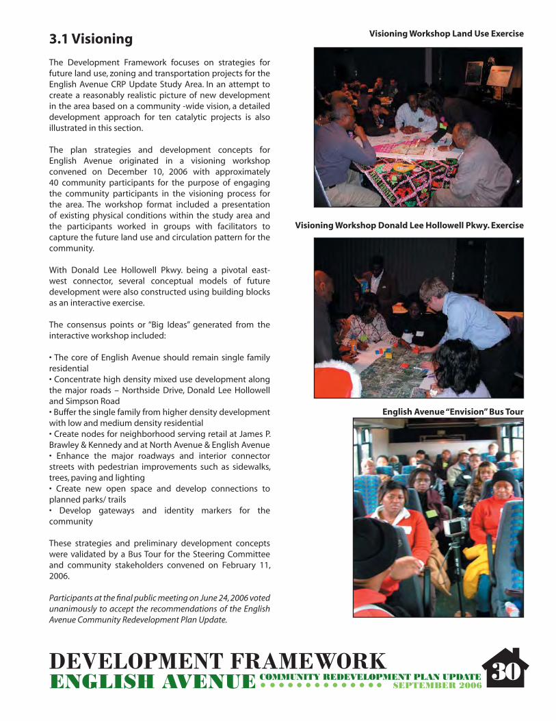
3.1 Visioning
The Development Framework focuses on strategies for future land use, zoning and transportation projects for the English Avenue CRP Update Study Area. In an attempt to create a reasonably realistic picture of new development in the area based on a community -wide vision, a detailed development approach for ten catalytic projects is also illustrated in this section.
The plan strategies and development concepts for English Avenue originated in a visioning workshop convened on December 10, 2006 with approximately 40 community participants for the purpose of engaging the community participants in the visioning process for the area. The workshop format included a presentation of existing physical conditions within the study area and the participants worked in groups with facilitators to capture the future land use and circulation pattern for the community.
With Donald Lee Hollowell Pkwy. being a pivotal east-west connector, several conceptual models of future development were also constructed using building blocks as an interactive exercise.
The consensus points or “Big Ideas” generated from the interactive workshop included:
• The core of English Avenue should remain single family residential • Concentrate high density mixed use development along the major roads – Northside Drive, Donald Lee Hollowell and Simpson Road• Buffer the single family from higher density development with low and medium density residential• Create nodes for neighborhood serving retail at James P. Brawley & Kennedy and at North Avenue & English Avenue• Enhance the major roadways and interior connector streets with pedestrian improvements such as sidewalks, trees, paving and lighting• Create new open space and develop connections to planned parks/ trails• Develop gateways and identity markers for the community
These strategies and preliminary development concepts were validated by a Bus Tour for the Steering Committee and community stakeholders convened on February 11, 2006.
Participants at the fi nal public meeting on June 24, 2006 voted unanimously to accept the recommendations of the English Avenue Community Redevelopment Plan Update.
30
Visioning Workshop Land Use Exercise
English Avenue “Envision” Bus Tour
Visioning Workshop Donald Lee Hollowell Pkwy. Exercise

DEVELOPMENT FRAMEWORKENGLISH AVENUE COMMUNITY REDEVELOPMENT PLAN UPDATE
SEPTEMBER 2006
3.2 Future Land Use/ Development Framework Plan
The Development Framework Plan or Future Land Use plan refl ects the overall theme for future development envisioned in the English Avenue study area. It incorporates both the community’s vision as well as the planning team’s analysis of market demand and development potential in this area. The ten land use categories that describe these future uses are consistent with those contained in the current City of Atlanta Comprehensive Development Plan (CDP) 15-Year Land Use Plan, including:
• Single-Family Residential • Low density Residential • Low-Density Residential • Medium-Density Residential • High-Density Residential • Low-Density Commercial • Medium-Density Commercial • Mixed-Use( mix of uses in single building)• Industrial • Institutional• Green Space The future land use pattern within the study area recommends preserving the interior residential blocks for a variety of quality housing products while encouraging the vitality of higher density mixed use development along the periphery of the study area along major arterials. The plan introduces opportunities for increase open space and recreational facilities in addition to trails and greenway connections to open spaces adjacent to the community. Neighborhood servicing retail node are encouraged in the interior of the neighborhood. These retail options provide alternatives for local residents that will not compete with regional serving retail proposed on the fringes of the community.
3.3 Development Projects
All projects, concepts and ideas as contained herein are designed to fulfi ll the vision, goals and objectives as discussed previously in this report. The following ten development project concepts are rooted in an understanding of the current real estate market for the English Avenue area and Atlanta’s Downtown.
The development projects outlined in this section are conceptual development plans for specifi c target areas that possess a great opportunity for reinvestment due to location and visibility or level of deterioration/ lack of investment. In addition, several projects consist of plans currently being pursued for development by key stakeholders .
31
Medium Density Commercial• 4-6 stories• goods and services • malls, mid-rise offi ce buildings, mid/high-rise shopping centers
Mixed-Use • number of stories vary• a mix of uses in a single building (residential use is 20% of building)• apartment building with a drug store on the bottom fl oor
Industrial • number of stories vary• mainly manufacturing, production and processing uses, trucking facility, factory, power plant, junk yard, distribution center
Institutional • number of stories vary• civic or service-related uses• health care providers, hospital, city hall, community center, school, library, police station, post offi ce, etc.
Green Space •property that is intentionally being used as open space• park, plaza, recreational fi eld, garden, trail, golf course, nature preserve, etc.
Single-Family Residential• 1-2 stories• one unit per lot• detached homes
Low-Density Residential • 1-3 stories• up to 12 units per acre• duplexes, triplexes, townhomes
Medium-Density Residential • 2-4 stories• 12-36 units per acre• apartments, condominiums, lofts, senior/assisted living facilities
High-Density Residential • 5-12 stories• 36-72 units per acre• apartments, condos, senior/assisted living towers
Low-Density Commercial • 1-3 stories• goods and services • retail, restaurants, laundry, drug store, grocery store, gas station, coffee shop, bank, auto repair shop, etc.

DEVELOPMENT FRAMEWORKENGLISH AVENUE COMMUNITY REDEVELOPMENT PLAN UPDATE
SEPTEMBER 2006
Figure 3.1 Future Development Framework
32
POTENTIAL DEVELOPMENT PROJECTENGLISH AVENUE COMMUNITY REDEVELOPMENT PLAN UPDATE
SEPTEMBER 200633
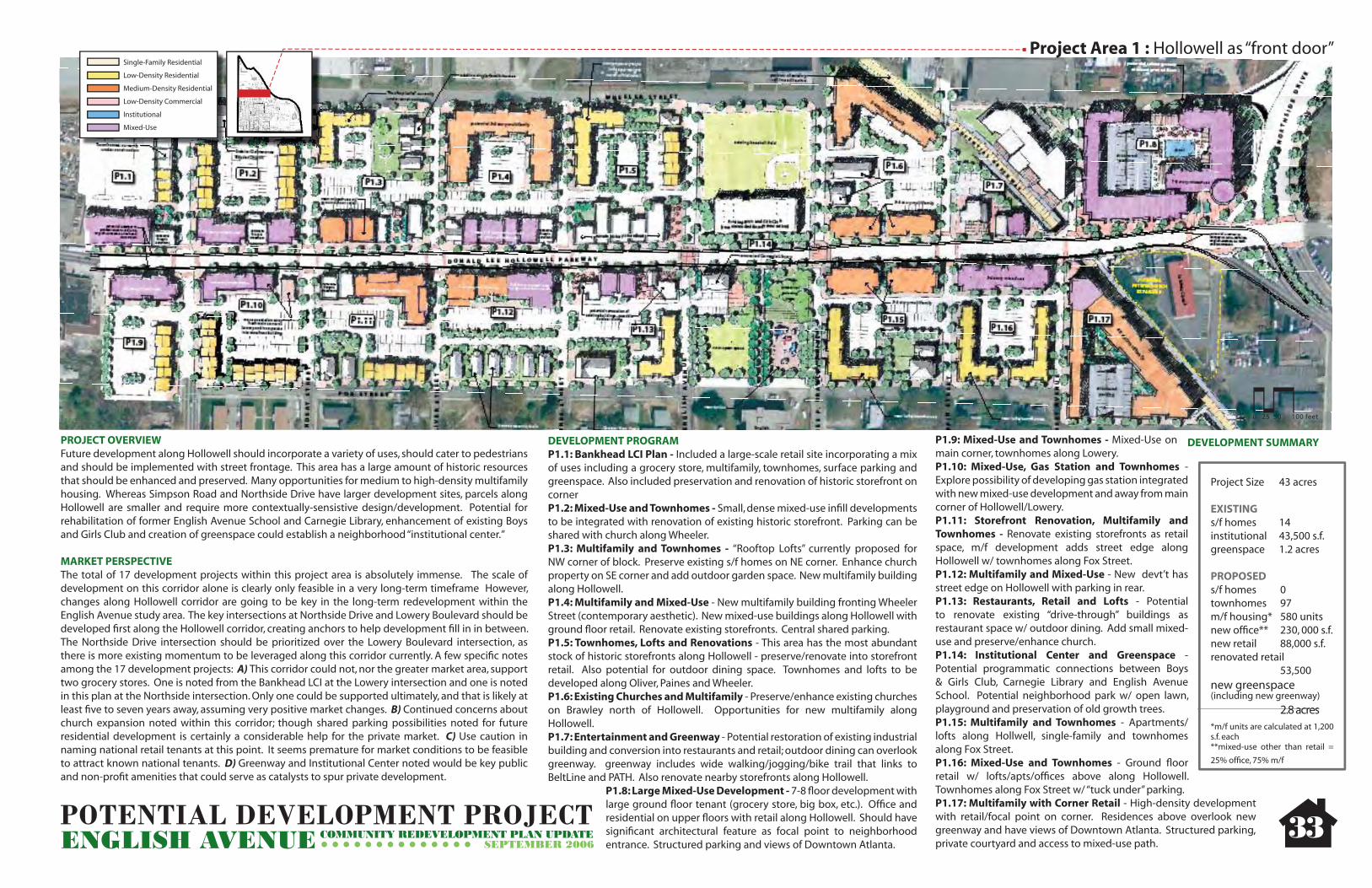
0 25 50 100 feet
PROJECT OVERVIEWFuture development along Hollowell should incorporate a variety of uses, should cater to pedestrians and should be implemented with street frontage. This area has a large amount of historic resources that should be enhanced and preserved. Many opportunities for medium to high-density multifamily housing. Whereas Simpson Road and Northside Drive have larger development sites, parcels along Hollowell are smaller and require more contextually-sensistive design/development. Potential for rehabilitation of former English Avenue School and Carnegie Library, enhancement of existing Boys and Girls Club and creation of greenspace could establish a neighborhood “institutional center.”
MARKET PERSPECTIVEThe total of 17 development projects within this project area is absolutely immense. The scale of development on this corridor alone is clearly only feasible in a very long-term timeframe However, changes along Hollowell corridor are going to be key in the long-term redevelopment within the English Avenue study area. The key intersections at Northside Drive and Lowery Boulevard should be developed fi rst along the Hollowell corridor, creating anchors to help development fi ll in in between. The Northside Drive intersection should be prioritized over the Lowery Boulevard intersection, as there is more existing momentum to be leveraged along this corridor currently. A few specifi c notes among the 17 development projects: A) This corridor could not, nor the greater market area, support two grocery stores. One is noted from the Bankhead LCI at the Lowery intersection and one is noted in this plan at the Northside intersection. Only one could be supported ultimately, and that is likely at least fi ve to seven years away, assuming very positive market changes. B) Continued concerns about church expansion noted within this corridor; though shared parking possibilities noted for future residential development is certainly a considerable help for the private market. C) Use caution in naming national retail tenants at this point. It seems premature for market conditions to be feasible to attract known national tenants. D) Greenway and Institutional Center noted would be key public and non-profi t amenities that could serve as catalysts to spur private development.
DEVELOPMENT SUMMARY
Project Area 1 : Hollowell as “front door”
DEVELOPMENT PROGRAMP1.1: Bankhead LCI Plan - Included a large-scale retail site incorporating a mix of uses including a grocery store, multifamily, townhomes, surface parking and greenspace. Also included preservation and renovation of historic storefront on cornerP1.2: Mixed-Use and Townhomes - Small, dense mixed-use infi ll developments to be integrated with renovation of existing historic storefront. Parking can be shared with church along Wheeler.P1.3: Multifamily and Townhomes - “Rooftop Lofts” currently proposed for NW corner of block. Preserve existing s/f homes on NE corner. Enhance church property on SE corner and add outdoor garden space. New multifamily building along Hollowell.P1.4: Multifamily and Mixed-Use - New multifamily building fronting Wheeler Street (contemporary aesthetic). New mixed-use buildings along Hollowell with ground fl oor retail. Renovate existing storefronts. Central shared parking.P1.5: Townhomes, Lofts and Renovations - This area has the most abundant stock of historic storefronts along Hollowell - preserve/renovate into storefront retail. Also potential for outdoor dining space. Townhomes and lofts to be developed along Oliver, Paines and Wheeler.P1.6: Existing Churches and Multifamily - Preserve/enhance existing churches on Brawley north of Hollowell. Opportunities for new multifamily along Hollowell.P1.7: Entertainment and Greenway - Potential restoration of existing industrial building and conversion into restaurants and retail; outdoor dining can overlook greenway. greenway includes wide walking/jogging/bike trail that links to BeltLine and PATH. Also renovate nearby storefronts along Hollowell.
P1.8: Large Mixed-Use Development - 7-8 fl oor development with large ground fl oor tenant (grocery store, big box, etc.). Offi ce and residential on upper fl oors with retail along Hollowell. Should have signifi cant architectural feature as focal point to neighborhood entrance. Structured parking and views of Downtown Atlanta.
P1.9: Mixed-Use and Townhomes - Mixed-Use on main corner, townhomes along Lowery. P1.10: Mixed-Use, Gas Station and Townhomes - Explore possibility of developing gas station integrated with new mixed-use development and away from main corner of Hollowell/Lowery.P1.11: Storefront Renovation, Multifamily and Townhomes - Renovate existing storefronts as retail space, m/f development adds street edge along Hollowell w/ townhomes along Fox Street. P1.12: Multifamily and Mixed-Use - New devt’t has street edge on Hollowell with parking in rear.P1.13: Restaurants, Retail and Lofts - Potential to renovate existing “drive-through” buildings as restaurant space w/ outdoor dining. Add small mixed-use and preserve/enhance church.P1.14: Institutional Center and Greenspace - Potential programmatic connections between Boys & Girls Club, Carnegie Library and English Avenue School. Potential neighborhood park w/ open lawn, playground and preservation of old growth trees.P1.15: Multifamily and Townhomes - Apartments/lofts along Hollwell, single-family and townhomes along Fox Street.P1.16: Mixed-Use and Townhomes - Ground fl oor retail w/ lofts/apts/offi ces above along Hollowell. Townhomes along Fox Street w/ “tuck under” parking.P1.17: Multifamily with Corner Retail - High-density development with retail/focal point on corner. Residences above overlook new greenway and have views of Downtown Atlanta. Structured parking, private courtyard and access to mixed-use path.
Project Size 43 acres
EXISTINGs/f homes 14institutional 43,500 s.f.greenspace 1.2 acres
PROPOSEDs/f homes 0townhomes 97m/f housing* 580 unitsnew offi ce** 230, 000 s.f.new retail 88,000 s.f.renovated retail 53,500new greenspace (including new greenway) 2.8 acres*m/f units are calculated at 1,200 s.f. each**mixed-use other than retail =
25% offi ce, 75% m/f
Single-Family Residential
Low-Density Residential
Medium-Density Residential
Low-Density Commercial
Institutional
Mixed-Use
LEGEND

POTENTIAL DEVELOPMENT PROJECTENGLISH AVENUE COMMUNITY REDEVELOPMENT PLAN UPDATE
SEPTEMBER 200634
PROJECT OVERVIEWExpansion plans for Lindsay Street Baptist Church include relocated parking, conversion of old sanctuary into communtiy-outreach facility and further establishment of presence at corner of Lindsay Street and North Avenue. Church plans are in conjunction with development of potential multifamily/senior housing and townhomes on existing vacant/parking parcels owned by church. Also potential to establish townhomes along Lowery to enhance presence of street and hide new parking.
MARKET PERSPECTIVEExpansion of church facilities is a point of concern, as outlined earlier. Providing senior and/or assisted living housing is a feasible product for this area. It has a growing demand, and is eligible for mixed fi nancing.
DEVELOPMENT PROGRAMP2.1: New Senior Housing and Townhomes - Future land use allows medium-density residential (multifamily) in this area. Potential for up to 4 stories of senior housing to be developed in conjunction with church expansions on land mostly owned by church. These facilities can be programmatically linked with church functions and efforts. Townhomes on SE corner provide scale/height transition between multifamily and single-family. P2.2: Expanded Parking Lot and New Townhomes - In an effort to provide more parking and better access to the main sanctuary, Lindsay Street Baptist Church can expand parking to the south along Lindsay Street. New townhomes can be developed along Lowery to enhance street presence and hide new parking.
**In addition, Beutell Street has potential to be extended west towards Lowery to provide better east-west access to neighborhood via Kennedy Street. This also provides additional ingress and egress points to new parking. **NW and SE corners of Lindsay Street and North Avenue interseciton have potential for long-term church facility expansion.
DEVELOPMENT SUMMARY
Project Size 5.4 acres
EXISTINGinstitutional 26,000 s.f.
PROPOSED townhomes 21m/f (senior) units 100
Project Area 2 : Institutional Expansion and New Housing
0 25 50 100 feet
Single-Family Residential
Low-Density Residential
Medium-Density Residential
Low-Density Commercial
Institutional
Mixed-Use
LEGEND

POTENTIAL DEVELOPMENT PROJECTENGLISH AVENUE COMMUNITY REDEVELOPMENT PLAN UPDATE
SEPTEMBER 200635
PROJECT OVERVIEWNew single-family homes respect scale and architectural character of existing homes. Go hand-in-hand with renovation of existing homes. Vacant parcels can also be consolidated and developed as townhomes to enhance presence of North Avenue as a main entry to neighborhood.
MARKET PERSPECTIVEIncreasing density with townhomes is good for local market. Oftentimes, townhomes are also a product that appeals to a different demographic than single-family homes. This is a project that should be considered for the long-term. This kind of infi ll redevelopment will begin to naturally occur when there is enough market pressure on the edges of the neighborhood to increase demand and price points for interior neighborhood locations. Notation of objective to make North Avenue more of main entry to neighborhood is imperative; this would allow the opportunity for the “known” North Avenue in the eastern and central parts of the City to bridge an association with this western portion.
DEVELOPMENT PROGRAMP3.1: New Townhomes - Potential for consolidation of neighboring deteriorated/dilapidated single-family parcels into larger parcels for townhome development fronting North Avenue. 3 story buildings that utilize alley access where possible. P3.2: Single-Family Infi ll - In areas where single-family homes are stable and in good condition, allow only single-family infi ll. Consider renovation of select deteriorated homes in conjunction with new infi ll. Scale, character and orientation of new homes to respect that of existing homes (see design guidelines).
DEVELOPMENT SUMMARY
Project Size 12.9 acres
EXISTINGs/f homes 29
PROPOSED s/f homes 38 townhomes 30
0 25 50 100 feet
Project Area 3: Townhomes and Single-Family Infi ll along North Avenue
Single-Family Residential
Low-Density Residential
Medium-Density Residential
Low-Density Commercial
Institutional
Mixed-Use
LEGEND

POTENTIAL DEVELOPMENT PROJECTENGLISH AVENUE COMMUNITY REDEVELOPMENT PLAN UPDATE
SEPTEMBER 200636
PROJECT OVERVIEWThe residents of English Avenue have made neighborhood-oriented businesses a priority. With this in mind, the intersection of Kennedy and Brawley has great potential to act as a center for small-scale, neighborhood-oriented goods and services. The 2-story historic structure on the NW corner is an opportunity for rehabilitation and extablishment of such types of uses. Additionally, the historic church “shell” on the SE corner has potential to be integrated into a new neighborhood commericial development. Streetscape improvements and on-street parking here will be key in “jump-starting” this node.
MARKET PERSPECTIVEThe diversifi cation of uses in this project area will be important in the long-term for neighborhood-scale services. As the neighborhood redevelops, it will be a key amenity to have small-scale commercial uses within walking distance to residential. With that said, this is another project area that should be viewed as longer-term. This kind of development will follow as the residential product in the study area transitions and increases in price point. This kind of redevelopment is easily ten or more years away.
DEVELOPMENT PROGRAMP4.1: Single-Family Infi ll - New single-family homes to respect scale and character of existing (see design guidelines).P4.2: Multifamily - Small m/f or low-density residential possible. 4 units in 2 stories w/ rear shared parking.P4.3: New Mixed-Use - New development to follow rehab of existing mixed-use building immediately east. 2-stories w/ 3 lofts on top fl oor and 3,500 sq.ft. retail on ground fl oor. Shared surface + on-street parking.P4.4: Mixed-Use - Potential to integrate existing facade into new commercial building. 10,000 sq.ft. in 1 fl oor - combination of loft housing and small retail. Shared surface parking in rear.
DEVELOPMENT SUMMARY
Project Size 2.3 acres
EXISTINGs/f homes 1retail 2,000 s.f. (+/-)
PROPOSED s/f homes 2 m/f units* 11 new retail 1,200 s.f.renovated retail 4,000 s.f.*includes new m/u building
Project Area 4 : Neighborhood Commercial
0 25 50 100 feet
Single-Family Residential
Low-Density Residential
Medium-Density Residential
Low-Density Commercial
Institutional
Mixed-Use
LEGEND

POTENTIAL DEVELOPMENT PROJECTENGLISH AVENUE COMMUNITY REDEVELOPMENT PLAN UPDATE
SEPTEMBER 200637
Northyards Site
PROJECT OVERVIEWBethursday Development Corporation currently developing plans to “bookend” frontage on Northside Drive in conjunction with Gateway Apartments on south end. Includes High-Density Mixed-Use development along Northside Drive transitioning down to single-family towards the interior of the neighborhood. Incorporates a large amount of new housing, a new community center and a large park with outdoor amphitheatre, children’s playground, jogging trails, open space and a north-south connection to the greenway.
MARKET PERSPECTIVEThis development project is “on the books” and underway. The increased scale on Northside Drive is important and will signifi cantly help the market pressure build throughout the rest of the study area, if done well. The central portion of this project, with the community center and open space, will be an asset, but its quality and long-term maintenance will play a critical role in “making or breaking” further development in the area. The townhomes along Elm Street will provide a nice and marketable transition to the surrounding single-family uses. It will be critical for this development package to begin at its orientation to North Avenue and Northside Drive, instead of being oriented internal to the neighborhood. If it begins at this important intersection, it should be rated as one of the key priority projects for the study area in the short-term.
DEVELOPMENT SUMMARY
Project Size 19.5 acres
EXISTINGinstitutional 2,000 s.f.s/f homes 4
PROPOSED new retail 49,000 s.f.renovated m/f 8 units(Hudgins building)
m/f units 400 unitstownhomes 55 offi ce 86,000 s.f.institutional 70,000 s.f.public greenspace 6.5 acres private greenspace 1.2 acres
Project Area 5 : Density “Cross Section” and Greenspace at North Avenue and Northside Drive
0 25 50 100 feet
DEVELOPMENT PROGRAMP5.1: New Townhomes - New townhomes provide “density transition” between high-density development along Northside Drive and single-family towards the interior of the neighborhood. Alley-access with mix of ground fl oor parking and detached garages.P5.2: Multifamily along North Avenue - In continuing to enhance the gateway to English Avenue via North Avenue, development of multifamily should be 5-6 stories with shared structured parking. Main views to adjacent greenspace and partial views of Downtown Atlanta.P5.3: Community Center - 4 story community center programmatically linked with Antioch Baptist Church. Shared parking deck across the street, immediate access to large greenspace, trails and tot lot. P5.4: Mixed-Use along Northside Drive - Dense development very appropriate for this rapidly-developing corridor. 8 stories with good mix of retail, offi ce and residential spaces. Great views of Downtown Atlanta. Structured parking, interior courtyard/pool/amenity spaces.
English Avenue Park - Potential large new park to be developed in conjunction with future Bethursday development. Wide range of uses including large open lawns, paved plazas, bike/walking/jogging trails, tree-lined sidewalks, a large tot lot and an outdoor amphitheatre.
Single-Family Residential
Low-Density Residential
Medium-Density Residential
Low-Density Commercial
Institutional
Mixed-Use
LEGEND
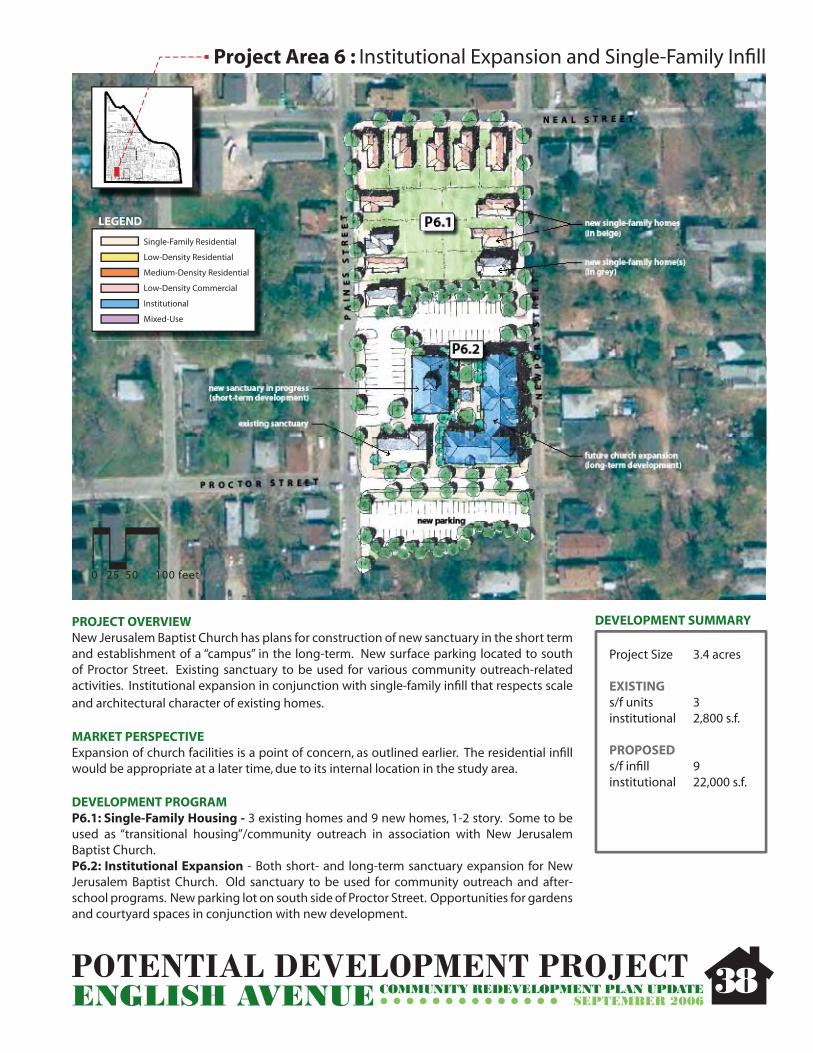
POTENTIAL DEVELOPMENT PROJECTENGLISH AVENUE COMMUNITY REDEVELOPMENT PLAN UPDATE
SEPTEMBER 2006
PROJECT OVERVIEWNew Jerusalem Baptist Church has plans for construction of new sanctuary in the short term and establishment of a “campus” in the long-term. New surface parking located to south of Proctor Street. Existing sanctuary to be used for various community outreach-related activities. Institutional expansion in conjunction with single-family infi ll that respects scale and architectural character of existing homes.
MARKET PERSPECTIVEExpansion of church facilities is a point of concern, as outlined earlier. The residential infi ll would be appropriate at a later time, due to its internal location in the study area.
DEVELOPMENT PROGRAMP6.1: Single-Family Housing - 3 existing homes and 9 new homes, 1-2 story. Some to be used as “transitional housing”/community outreach in association with New Jerusalem Baptist Church.P6.2: Institutional Expansion - Both short- and long-term sanctuary expansion for New Jerusalem Baptist Church. Old sanctuary to be used for community outreach and after-school programs. New parking lot on south side of Proctor Street. Opportunities for gardens and courtyard spaces in conjunction with new development.
DEVELOPMENT SUMMARY
Project Size 3.4 acres
EXISTINGs/f units 3institutional 2,800 s.f.
PROPOSEDs/f infi ll 9institutional 22,000 s.f.
Project Area 6 : Institutional Expansion and Single-Family Infi ll
Single-Family Residential
Low-Density Residential
Medium-Density Residential
Low-Density Commercial
Institutional
Mixed-Use
LEGEND
0 25 50 100 feet
38

POTENTIAL DEVELOPMENT PROJECTENGLISH AVENUE COMMUNITY REDEVELOPMENT PLAN UPDATE
SEPTEMBER 2006
PROJECT OVERVIEWPotential for some existing multifamily structures to be renovated into affordable “for sale” units. Potential for existing vacant and underutilized parcels to be consolidated and developed as new townhomes. Some deteriorated multifamily structures and single-family homes can be replaced with new single-family homes.
MARKET PERSPECTIVESignifi cant improvements would have to be made to existing multifamily to provide acompetitive product. Additionally, the ideal would be to renovate and offer this product asmixed-income instead of solely affordable. Making a transition to more owner-occupiedresidential product in the neighborhood would be a positive. This renovation and infi ll would be appropriate at a later time, due to its internal location in the study area.
DEVELOPMENT PROGRAMP7.1, P7.2, P7.3: Existing Multifamily Renovations - Potential renovations/conversions into affordable “for sale” units with possible painted brick facades, new roofs, new exterior lighting. Potential consolidation or expansion into larger units. Add defi ned parking areas with shade trees, landscaping, sidewalks, courtyard/garden spaces where possible.P7.4: Single-Family Infi ll - New 1-2 story homes in accordance with scale and character of existing homes (see design guidelines). Driveways along side of houses (some shared). Badly deteriorated multifamily can be demolished and subdivided for future single-family homes.
DEVELOPMENT SUMMARY
Project Size 6.6 acres
EXISTINGs/f units 22
PROPOSEDs/f infi ll 10renovated m/f 43 units (+/-)
Project Area 7 : Multifamily Renovation, Townhomes and Single-Family
0 25 50 100 feet
39
Single-Family Residential
Low-Density Residential
Medium-Density Residential
Low-Density Commercial
Institutional
Mixed-Use
LEGEND

POTENTIAL DEVELOPMENT PROJECTENGLISH AVENUE COMMUNITY REDEVELOPMENT PLAN UPDATE
SEPTEMBER 2006
PROJECT OVERVIEWExisting vacant lots and dilapidated homes can be consolidated and redeveloped as new townhomes. Also opportunities for single-family infi ll. Transition from the Bethursday development to the east down to townhomes, then down again to single-family homes.
MARKET PERSPECTIVEThis residential infi ll of single-family homes and townhomes would be appropriate at a later time, due to its internal location in the study area.
DEVELOPMENT PROGRAMP8.1: Single-Family Infi ll - Multiple infi ll opportunities along Elm Street for 1-2 story single-family. Potential for alley access unlikely. Shared driveways should be utilized where possible.P8.2: Townhomes - Potential for variety of townhome units along Elm and Vine Streets.Topographical challenges and limited (narrow) road capacities may make new development diffi cult. New townhomes should include a variety of styles; parapet buildings along Vine Street appropriate across from future Bethursday development, craftsman-style on Elm Street. Alley access should be utilized; detached (rear) garages may be appropriate on deep land parcels.
DEVELOPMENT SUMMARY
Project Size 5.9 acres
EXISTINGs/f units 8 institutional 2,500 s.f.
PROPOSEDs/f infi ll 8 townhomes 28
Project Area 8 : Townhomes and Single-Family Infi ll
0 25 50 100 feet
40
Single-Family Residential
Low-Density Residential
Medium-Density Residential
Low-Density Commercial
Institutional
Mixed-Use
LEGEND

POTENTIAL DEVELOPMENT PROJECTENGLISH AVENUE COMMUNITY REDEVELOPMENT PLAN UPDATE
SEPTEMBER 2006
PROJECT OVERVIEWShort-term plans to develop townhomes and a mixed-use building on currently-owned parcels. Long-term plans to continue townhomes along edges of block and develop a mixed-use building (with major retail anchor) at corner of Lowery and Simpson. Long-term plans contingent upon future land aquisition.
MARKET PERSPECTIVEThis development is also underway and located at another key intersection, Simpson Street and Joseph L. Lowery Boulevard. The increased scale on both Lowery and Simpson is important and will markedly help the market pressure build throughout the rest of the study area, if done well. Getting as much of a presence at this intersection as quickly as feasible is crucial. While the small-scale mixed-use building of three-stories and some townhomes is defi nitely an asset, the scale at the corner is what will really push this development up to a notable level, in market terms. With an orientation towards this important intersection, this project should be rated as one of the key priority projects for the study area in the short-term.
DEVELOPMENT PROGRAMP9.1: New Townhomes - Townhomes to be built in multiple phases. Interior units front on central courtyard/garden space.P9.2: Mixed-Use along Simpson - 4-6 stories on corner, 3 stories further east. Site topography allows subgrade parking for residential units. Ground fl oor retail, for-sale condominiums and lofts appropriate. SE corner of block has drainage issues - consider usage as greenspace/water retention.
DEVELOPMENT SUMMARY
Project Size 6.2 acres
EXISTINGno existing structures to remain in long-term vision
PROPOSEDtownhomes 75m/f units 100 (+/-)retail 30,000 s.f.greenspace 0.75 acres
Project Area 9 : Proctor Village
0 25 50 100 feet
41
Single-Family Residential
Low-Density Residential
Medium-Density Residential
Low-Density Commercial
Institutional
Mixed-Use
LEGEND

POTENTIAL DEVELOPMENT PROJECTENGLISH AVENUE COMMUNITY REDEVELOPMENT PLAN UPDATE
SEPTEMBER 2006
PROJECT OVERVIEWNew ground-fl oor retail with possible residential and/or offi ce above. Potential 3-5 story buildings with neighborhood retail. Can act as anchor to developing and enhancing Brawley Street as main north-south connector. Since Jones Avenue must stay single-family/low-density residential (as per framework plan/community input), developing mixed-use in cretain parcels along Simpson will be tricky.
MARKET PERSPECTIVEThis development project can make a notable statement on Simpson Street. However, the progress of the plans and development initiatives included in the Vine City Redevelopment Plan will clearly have a signifi cant impact on what happens here as well. The small-scale mixed-use is a good project to continue development along Simpson Street once Proctor Village is at least partially occupied. While this project should be viewed at an intermediate timeline, the 44,000 square feet of commercial space is quite large. Most likely it will have to be split into two phases, with the residential and commercial building being the fi rst one built. The second mixed-use building would probably fall into a longer-term timeline, given the likely absorption rates from Proctor Village, the development of the fi rst mixed-use building at this location, and the development on the Vine City side of Simpson Street.
DEVELOPMENT PROGRAMP10.1: Townhomes - Townhomes front Newport and Brawley while hiding surface parking. Rear (fi rst fl oor) garage access and shared guest parking. P10.2: Mixed-Use - 3-story mixed-use development along Simpson with rear surface parking. Opportunity to consolidatemultiple parcels into a single (deeper) parcel allows accommodation of parking requirements, which yields more dense development.P10.3: Single-Family Infi ll - New homes to match scale and character of existing homes (see design guidelines).P10.4: Mixed-Use - (2 story) Shallow parcel depth creates a challenge for accommodating needed parking for new commercial space. Limited amount of parking eliminates possibility of continuous street edge along Simpson.
DEVELOPMENT SUMMARY
Project Size 4.7 acres
EXISTINGs/f homes 6
PROPOSEDs/f homes 2townhomes 75m/f units 44 unitsoffi ce 17,500 s.f.retail 7,200 s.f.
Project Area10 : Small-scale Simpson mixed-use
0 25 50 100 feet
42
Single-Family Residential
Low-Density Residential
Medium-Density Residential
Low-Density Commercial
Institutional
Mixed-Use
LEGEND

DEVELOPMENT FRAMEWORKENGLISH AVENUE COMMUNITY REDEVELOPMENT PLAN UPDATE
SEPTEMBER 2006 43
3.4 Zoning Recommendations
The zoning recommendations of this document are solely and singularly designed to implement the fi nal plan created by the community through this process. The recommended zoning and even land uses are the agent to implement the plan generated by the months of meetings, ideation and involvement. Thusly, this plan incorporates the wishes of the community and the overall vision and direction established by this Redevelopment Plan update process.
The existing study area is made up entirely of the conventional zoning districts of R, RG, I and C districts. All future rezoning should be consistent with City of Atlanta Urban Design Standards. To ensure that all future development meets these standards, and to avoid lengthy rezoning processes in the future, it is the desire of the City to rezone these remaining conventional zoning areas to the new Quality of Life Zoning Districts. All existing RG, I and C districts are to be rezoned to the new LW, MR or MRC zoning districts and the existing R districts will look to utilize ongoing and upcoming infi ll housing revisions completed by the City of Atlanta to ensure that these districts can grow into the future while preserving the single-family characteristics of the neighborhood that exist today.
In addition to the conventional zoning districts being supplanted by the new Quality of Life districts and the R single-family district at the core getting updated in the future to address infi ll housing issues, some additional urban design elements are to be attached to these districts to ensure that the specifi c design details of this Redevelopment Plan are addressed and implemented through future development as part of the zoning. The recommended zoning districts for the English Avenue Redevelopment Plan Area and the additional urban design elements described in detail in the Appendix are as
follows:
R4A - Single Family Residential DistrictAllows for single family detached residential uses. Intended for more urban, in-town neighborhood with smaller lots and smaller setbacks. This district is located at the core of the neighborhood and constitutes the existing single-family detached residential community.
Conditions:• Rear alley parking shall utilized wherever possible• Driveways, where necessary, shall be limited to the width of one car• Main entries shall be linked to the street fronting sidewalk• Utilities and all associate components shall be screened from the public right-of-way• Large old growth trees shall be preserved• Lots shall be between 40 and 55 feet in width• New homes shall have spacious front porches• Windows shall be vertically proportioned on the walls of the house• Chimneys shall be constructed of brick• Crawlspaces underneath homes shall be concealed• Roofs shall incorporate craftsman details including hips, gables, exposed beams, dormers, brackets, exposed rafter tails, gable vents and similar architectural details• All fl oors located above the fi rst fl oor shall be set back and recessed from the fi rst fl oor• Columns shall be proportional to the building structure• Vinyl and aluminum materials shall be prohibited
MR2 - Townhome DistrictCreates an environment for attached residential uses in the form of town houses or town homes. Units can be attached side to side to provide for a row or continuous building frontage of attached residential uses. This townhome district is to be used on the periphery of the single-family
DIMENSIONS R4A MR2 MR5B LW NC MRC1 MRC2 OI
Residential FAR (max) 0.5 0.348 3.2 0.5 1.5 0.696 1.5 3.2
Non-Residential FAR (max) None None 5%* 1.196 1.5 1.5 2.5 3
Building Height (max) 35’ 35’ 35’ ** 35’ ** 35’ ** 35’ ** 52’ ** None
Front Yard/Supplemental Zone (min) 35’ 5’ or 9’ 5’ or 9’ 5’ or 9’ 0’ or 5’ 0’ or 5’ 0’ or 5’ 50’
Side Yard (min) 7’ 0’ or 10’ 0’ or 15’ 7’ or 20’ 0’ or 20’ 0’ or 20’ 0’ or 20’ 15’
Rear Yard (min) 15’ 10’ 15’ 7’ or 20’ 0’ or 20’ 0’ or 20’ 0’ or 20’ 25’
Sidewalk (min) 5’ 11’ or 15’ 11’ or 15’ 11’ or 15’ 15’ 15’ 15’ None
Lot Coverage (max) 50% None None 85% None 85% 85% None
Zoning Chart

DEVELOPMENT FRAMEWORKENGLISH AVENUE COMMUNITY REDEVELOPMENT PLAN UPDATE
SEPTEMBER 2006 44
core and will serve as both a buffer between the mixed use edges and as another option for housing types in the community which will serve to enable various stages of life and incomes to live in the neighborhood.
Conditions:• New townhomes shall be similar in architecture to any adjacent single family homes including elements such as pitched roofs, eclectic facades, wood porches, wood or hardiplank siding, parapet roofs, large windows and fenestration and other similar architectural elements
MR4 & 5 - Multi-family DistrictThis district accommodates a higher density residential in the form of 4-5 fl oor residential buildings with multiple units. This refl ects the multi-family buildings found in many historic intown neighborhoods that are not so tall that they overshadow the neighborhood. This district is primarily on the western edge of the neighborhood and will serve as a way to have higher density residential uses that provide housing options for residents but in a way that respects the fabric of the community and is in proportionate scale to the existing built environment of the community.
Conditions:• Structured parking shall be integrated into the primary structures• Multi-family developments shall be similar in architecture to any adjacent single family homes including elements such as wood porches, balconies, pitched roofs, brick facades and double hung windows and other similar architectural elements
NC - Neighborhood Commercial DistrictCreates and preserves a district intended to provide limited retail uses to an adjacent neighborhood. By limiting the residential and commercial uses to small amounts, this district enables small nodes to exist in the middle of the neighborhood without generating outside traffi c into the neighborhood. The NC districts will be located at the very center of the neighborhood at 2 separate nodes as a way to maintain the existing historic nodes and to allow these to redevelop and grow in the future in a way that is compatible with the adjacent single-family environment.
Conditions:• The design, details and materials of new Neighborhood Commercial buildings shall be compatible with adjacent structures in terms of both scale and building materials
MRC - Mixed Use DistrictA district which enables both residential and non-residential uses to be built in the same building or in different buildings on the same site. This would allow for ground
fl oor retail or offi ce uses with residential units located above. These districts are good buffers for neighborhoods and allow for redevelopment opportunities on the edges of neighborhoods and also along corridors. The MRC districts constitute the Simpson, Hollowell, Northside Drive and Marietta Street corridors. These corridors are highly traffi cked and as such they can accommodate the higher density of uses from both a road capacity and a building footprint perspective. The MRC districts will create a buffered edge around the neighborhood and will provide excellent opportunities for jobs and services for the adjacent English Avenue neighborhood.
Conditions:• Contrasting building heights and roof lines shall be provided to create horizontal “breaks” along and between buildings• Parking areas and service areas shall be located away from the view of primary streets and accessed via alleys or side streets• Setbacks of new buildings shall be aligned with adjacent buildings (when adjacent buildings are between 15 and 25 feet from the street curb) to create a defi ned street edge• Distinctive architectural elements shall be provided for buildings located on street corners• Developments located on Northside Drive, Hollowell and Simpson Road shall utilize steel, glass and brick in their building materials
LW - Live Work DistrictA district intended for historically industrial areas which allows for a new mixed use environment. This district allows for a residential and commercial environment similar to the MRC districts with the single exception that this district allows for light industrial uses common in older industrial uses to continue only at limited sizes. The Live Work district is intended to capture the area north of Hollowell and allow it to transition from an Industrial environment to one of light industrial with accessory residential opportunities such as those found in other similar artist and skilled manufacturer communities in the City of Atlanta.
OI - Offi ce & Institutional DistrictThis district accommodates singularly offi ce and institutional uses. New residential development is prohibited as this district is intended solely to permit these non-residential uses to exist in offi ce park and institutional campuses kinds of places. This district is located east of Northside Drive and north of North Avenue. The OI district will preserve the ability of the Georgia Institute of Technology and associated uses to provide institutional and academic uses in the area.
I2 - Industrial District

DEVELOPMENT FRAMEWORKENGLISH AVENUE COMMUNITY REDEVELOPMENT PLAN UPDATE
SEPTEMBER 2006 45
Figure 3.2 Zoning Recommendations

DEVELOPMENT FRAMEWORKENGLISH AVENUE COMMUNITY REDEVELOPMENT PLAN UPDATE
SEPTEMBER 2006 46
This district is for the sole purposes of light and heavy Industrial and Manufacturing uses. Because these districts allow for labor and resource intensive uses, new residential development is not permitted in these districts so as to keep this intrusive district separate from residential uses. The remaining Industrial district is isolated to the northern edge of the district and is a result of the Upper Westside LCI Study done by the City of Atlanta immediately prior to the initiation of this English Avenue Redevelopment Plan update.
Special consideration is given to existing properties with a higher density use other than what is proposed in this plan. The lower density designation for these properties is in accordance to the vision created by the neighborhood at a series of public meetings. At the time of this plan, these properties had no plans for future uses, changes or improvements. However, should these properties in the future provide plans for changes or improvements that include preserving the existing higher density and use then those plans would be favorably considered by the neighborhood so long as those plans are consistent with the design standards and overall intent of this Redevelopment Plan.
3.5 CDP Land Use Recommendations
As the process of updating and renewing the existing conventional zoning districts takes place, it is essential to create the compatible Land Use Map that allows for the proposed zoning to be implemented. This map is also necessary to indicate those things that cannot be achieved through zoning such as the location of institutional or educational uses and the location for open space or public space properties within the Study Area. Otherwise, it is expected that the Land Uses would refl ect the mid-rise mixed use and residential developments that are rapidly defi ning the properties in the area.
The following additional policy statements are to be added to the NPU-L section of the Land Use Policy Chapter in the updated Comprehensive Development Plan in order to establish via policy the expressed intent of this community and this plan:
• Encourage incorporation of greenspace within the neighborhood core
• Encourage walkable, pedestrian friendly developments and connects
• Encourage connectivity on the interior and exterior of the
neighborhood
• Provide additional opportunities for open spaces to compliment existing and new development in the neighborhood
• Encourage a scale of new development that is compatible with the existing neighborhood
• Preserve the existing scale and character of the neighborhood core
• Provide convenient and improved transit options for the neighborhood
• Encourage mixed use development along Hollowell, Northside Drive, and Simpson Road
• Encourage a mixed-income community to allow for a diversity of ages and incomes
• Encourage utility and infrastructure uses to be physically and aesthetically improved
• Encourage large scale development to be environmentally sustainable within the neighborhood
3.6 Transportation Recommendations
The team has developed transportation recommendations based on a though assessment of the English Avenue Study Area that address the goals and objectives of the Community Redevelopment Plan.
Safety RecommendationsThese projects are needed to address existing areas where vehicular or pedestrian safety concerns have been identifi ed.
• Improved pedestrian crossings with pedestrian refuges along Simpson near Griffi n Street and Sciple Street, and improved crosswalks at major cross streets. Improved access management will help reduce confl ict points and improve operations and safety. Better defi ned driveways and possibly restricting turn movements will reduce potential confl ict points and improve safety and operations.
• Narrowing Simpson Street from Northside Drive to Lowery Boulevard to a 3 lane facility within existing right of way, and addition of 5’ bike lanes on either side, with either painted median two-way-left-turn-lane or hard median except at major intersections, and restriction of driveways
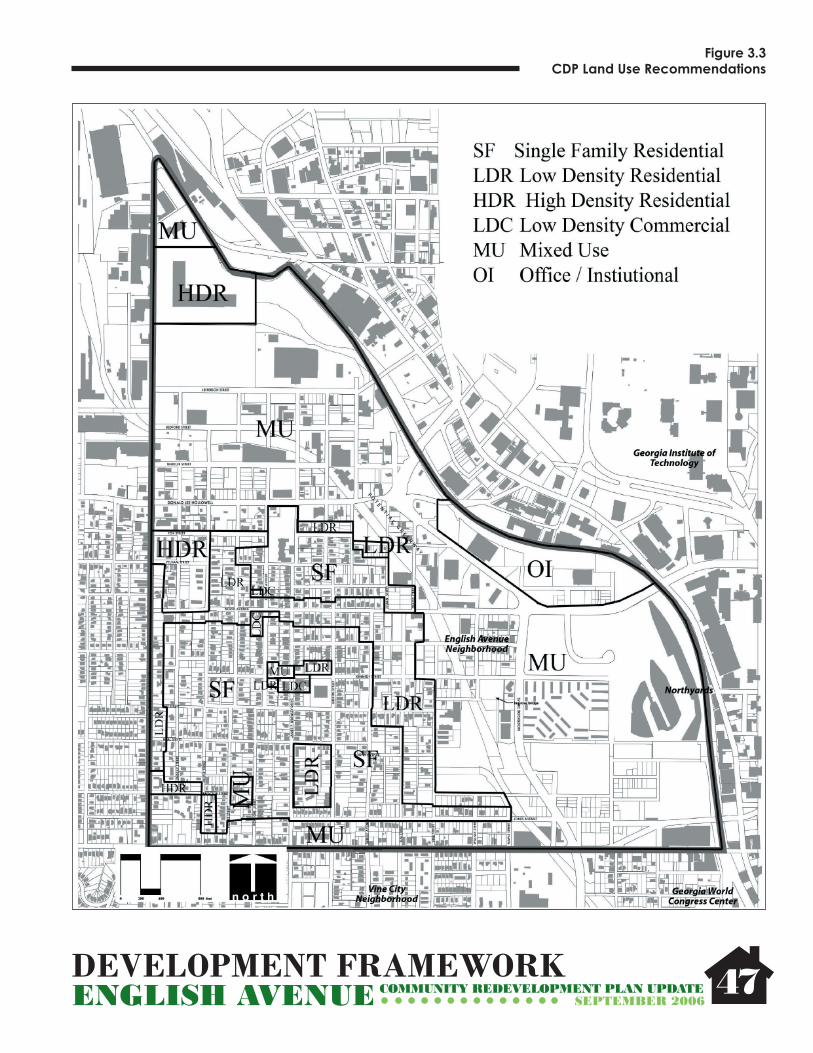
DEVELOPMENT FRAMEWORKENGLISH AVENUE COMMUNITY REDEVELOPMENT PLAN UPDATE
SEPTEMBER 2006
Figure 3.3 CDP Land Use Recommendations
47

DEVELOPMENT FRAMEWORKENGLISH AVENUE COMMUNITY REDEVELOPMENT PLAN UPDATE
SEPTEMBER 2006 48
Figure 3.4 Transportation Recommendations

DEVELOPMENT FRAMEWORKENGLISH AVENUE COMMUNITY REDEVELOPMENT PLAN UPDATE
SEPTEMBER 2006
to right-turn only movements from the taper of the existing Ivan Allen Boulevard project at Northside Drive to Lowery Boulevard (formerly Ashby Road). Narrowing Simpson Street to 3 lanes reduces the number of travel lanes pedestrians have to cross, thereby improving safety, and allows for the addition of bike lanes and a raised concrete median at selected locations which may also be designed as pedestrian refuges. Simpson Street has relatively low volumes for a 4 lane collector, and D.L. Hollowell Parkway (former Bankhead Highway); a principal arterial and state highway route paralleling Simpson Street less than a mile to the north, is scheduled to be completed as a 4 lane road from Northside Drive to I-285W which should divert some current through traffi c on Simpson.
Simpson Street narrows to 3 lanes west of Lowery and a 3 lane section will provide improved lane continuity. Current Average Daily Traffi c (ADT) on Simpson is just under 8,000 according to GDOT traffi c count data. Peak hour level of service is currently acceptable and anticipated to remain so
49
both by ARC 2030 model projects and as projected in the BeltLine Study looking at traffi c impacts associated with BeltLine development.
• Improve pedestrian crossings at intersection of Lowery Boulevard and Simpson Street. This is an area of fairly heavy pedestrian travel to adjacent businesses, between neighborhoods, and to access transit stops.
• Conduct a focused study for a new signalized intersection at the intersection of Simpson and Sciple Terrace.
Roadway and Operations Recommendations
• Recommend improved traffi c signal systems on perimeter streets – Simpson Street, D. L. Hollowell Parkway, and Lowery Boulevard should all have signal system upgrade, mast arm installation to replace span wire, fi ber installation, and signal coordination. This will improve reliability, safety and effi ciency of vehicular operations.
• Support a detailed traffi c analysis of one-way operations of Vine Street and Elm Street to consider switching direction of one-way operations.
• Support additional study of safety of current operations on several narrow streets: Sunset Avenue, Elm Street, Western Avenue, Vine Street, and Jett Street between Vine Street and Northside Drive to evaluate restricting operations to one-way travel, parking restrictions, or the feasibility of widening.
• Consider operational improvement project on Vine Street to allow two-way operations between Simpson Road and Kennedy St., to provide better access and circulation to the neighborhood adjacent to areas planned for higher density mixed use. This would require additional right of way, some minor realignment, and may have implications for drainage structures and utility relocation.
• Ensure that all public streets in neighborhood are paved and in acceptable condition.
Transit Recommendations
Although the English Avenue neighborhood is well served by existing MARTA bus routes, there is a lack of transit amenities at stop locations. Amenities such as concrete pads, improved pedestrian access and ramps, bus shelters, lighting, route and schedule information, benches and trash cans will improve the image and utility of transit stops and the comfort of transit patrons.
• Place transit shelters at selected bus stops along perimeter
Simpson Street Profi le B
Simpson Street Profi le A

DEVELOPMENT FRAMEWORKENGLISH AVENUE COMMUNITY REDEVELOPMENT PLAN UPDATE
SEPTEMBER 2006
streets, within the neighborhood near the small commercial area along Kennedy and North Ave at Brawley, and near the proposed institutional development area along D.L. Hollowell Parkway. Try to integrate shelters and stops within or adjacent to proposed redevelopment. Recommended transit shelter locations:
Intersection of James P. Brawley Drive and Simpson StreetIntersection of Joseph E. Lowery Boulevard and Simpson StreetIntersection of Joseph E. Lowery Boulevard and North Avenue Intersection of Donald L. Hollowell Parkway and James P. Brawley DriveIntersection of James P. Brawley Drive and Kennedy StreetIntersection of James P. Brawley Drive and Jones Avenue
• Support study of feasibility of fi xed guideway transit on D.L. Hollowell Parkway in association with proposed development.
Bicycle Recommendations
There are currently no bicycle facilities in the English Avenue neighborhood. Addition of bike lanes, multi-purpose trails on greenways, and bike routes will provide additional transportation options for both utilitarian and recreational use, and is consistent with the desire of the neighborhood to establish a better pedestrian and bicycling environment.
• Install multi-use trail/greenway along abandoned rail right of way if available or obtainable. This would allow construction of a multi-use trail with limited access and some grade separation from vehicular traffi c.
• Install bike lanes along Simpson Street from Ivan Allen Boulevard taper at Northside Drive to Lowery Boulevard (see description under safety project above) The Simpson Road Corridor Redevelopment Plan recommends extending bike lanes along Simpson Road from Lowery Boulevard about a half mile to the west, to the existing MARTA tracks, where the BeltLine development node is proposed.
• Designation of Jones Avenue, Proctor Street, and Griffi n Street as bike routes with “Share the Road” signs or route markings This will provide internal circulation and connection to bicycle facilities outside the neighborhood.
Pedestrian Recommendations
The existing sidewalk system in the English Avenue neighborhood is discontinuous with many gaps in coverage. In addition, the sidewalks are often in need of repair or maintenance. Although there are generally painted crosswalks at major intersections, and pedestrian signals
50
at signalized intersections, many of the crosswalks could be better signed or otherwise improved. A functioning sidewalk network promotes a walking community, reduces vehicular and pedestrian incidents, and increases the health and public safety of the community.
• Ensure that all existing sidewalks are safe and in good repair.
• Encourage property owners to properly maintain sidewalks. • Establish local funding source to subsidize neighborhood sidewalk repair and construction on private property.
• Require all new development to include preservation of good-quality existing sidewalks, repair of sub-standard sidewalks, or construction of new sidewalks. New sidewalks shall be a minimum of fi ve (5) feet wide unless adjacent block faces have existing sidewalks with a consistent narrower profi le, in which case new sidewalks can match the profi le of the existing sidewalks for consistency with the historic context of the neighborhood
• Recommend improving perimeter street sidewalks and crosswalks and providing Americans with Disabilities Act (ADA) ramps as necessary.
• Work with English Avenue Neighborhood Association (EANA) to sponsor a sidewalk maintenance program to provide trash/brush pick up and minor repair within the English Avenue neighborhood.
• Recommend 5 ft. sidewalks internal to the neighborhood on North Ave., Kennedy St., Brawley Drive, English Avenue and Vine Street, and on north-south connections across Simpson at signals/major crossings consistent with safety recommendations addressed earlier. Focusing pedestrian improvements on these locations will provide a limited but complete pedestrian system on major pedestrian routes and from most redevelopment areas.
• Recommend that Standard City of Atlanta streetlights be installed at 100’ Intervals that do not deter pedestrian mobility and are concurrent with all sidewalk and streetscape projects.
Recommended sidewalk improvement locations:Both sides of Vine Street between Simpson Street and Kennedy StreetBoth sides of James P. Brawley Drive between Simpson Street and Jefferson StreetBoth sides of North Avenue from Northside Drive to Joseph E. Lowery Boulevard

DEVELOPMENT FRAMEWORKENGLISH AVENUE COMMUNITY REDEVELOPMENT PLAN UPDATE
SEPTEMBER 2006
Both sides of English Avenue from Jett Street to Jefferson StreetBoth sides of Kennedy Street from Northside Drive to Oliver StreetBoth Sides of Jones Avenue from J. P. Brawley Drive to Northside DriveBoth Sides of Sunset Avenue from Simpson Street to Kennedy Street. Refer to Existing Conditions Sidewalks map for additional sidewalks that need repair. Figure 3.5
Sidewalk Conditions
51

ACTION PLANENGLISH AVENUE COMMUNITY REDEVELOPMENT PLAN UPDATE
SEPTEMBER 2006
Chapter Four:Action Plan
4.1 Guiding Principles of Implementation ...........53
4.2 Development Cost .................................................55
4.3 Transportation Cost ...............................................55
52

ACTION PLANENGLISH AVENUE COMMUNITY REDEVELOPMENT PLAN UPDATE
SEPTEMBER 2006
4.1 Guiding Principles of Implementation
The following implementation principles are shaped by a philosophy that protects and respects the community’s goals, encourages sensitive use of redevelopment powers, and maintains an approach to public and private partnerships.
Principal #1: Revising the Regulatory FrameworkIncorporate Land Use recommendations into the City of Atlanta Comprehensive Development Plan (CDP) and make appropriate revisions to existing zoning to support planned development. The Zoning recommendations and CDP Land Use recommendations are highlighted in the previous section of the report.
Principle #2: Neighborhood Conservation and RevitalizationNeighborhood preservation and infi ll is a key component of the plan recommendations to preserve affordable in-town living options in a residential neighborhood setting. Despite its development history, market pressures, existing social climate and active development in the surrounding context reinvestment in English Avenue is slow coming. With the abundance of development opportunities such as vacant land, under utilized, land and dilapidated structures, the plan recommends aggressive measures to preserving English Avenue through a variety of key implementation strategies:
• Code Enforcement: While over 63% of the structures in the neighborhood are in less than standard condition, much of the community’s structures require immediate attention. It will be critical for the City’s code enforcement division to provide immediate and concentrated code enforcement to address the most serious cases affecting public health and safety. This effort must precede infi ll housing construction in order to ensure a receptive market to incoming residents.
• Housing Rehabilitation: Code enforcement often places fi nancial stress on the property owner. Financial assistance can provide homeowners the necessary tools to bring their homes up to code and to improve the overall aesthetics of the neighborhood. Resources can be provided in a variety of formats such as: outright grants; deferred payment loans (in which funds are paid back when and if the house is sold); low-interest loans (in which funds are paid back on a regular payment schedule but at below market rates). Grant funds will be particularly important in the case of long-time residents that do not have the means to obtain loans or are in danger of being priced out of the community. In the case of loans, the ability for the public-sector to recoup funds
53
provides for the ability to roll monies into subsequent target areas. Money to fund such rehab programs is often diffi cult to come by but may be provided from the City’s CDBG allotment or from existing rehab programs already offered by the City. In addition, non-profi t CDCs (such as English Avenue CDC and Bethursday Development Corporation are sometimes able to secure capital resources to operate their own rehab program.
• Acquisition of Vacant Lots: The nearly 20% of vacant Land in English Avenue creates an unsightly character that often times stunts a neighborhood’s ability to revitalize. The ability to quickly gain sight control of these properties will be important in the effort to provide immediate “clean and green” improvements as well as keep property costs at a reasonable level. The Fulton County Land Bank Authority is a resource at acquiring vacant lots in addition to private sector developers and the local CDCs.
• Infi ll Construction: Once acquired, construction of infi ll homes can greatly improve the overall health of a neighborhood. This plan has developed a set of design guidelines with residential development housing standards to serve as guiding principles for constructing historically and architecturally compatible structures.
• Historic Designation: Considering a local historic designation for the English Avenue community through the assistance of the Urban Design Commission is an option for preserving the architectural character of existing historic structures and leveraging resources for rehabilitation and preservation efforts.
Principle #3: Community-Based ImplementationTo ensure that the revitalization of the area is in keeping with the goals and objectives of the community, its residents, businesses and community organizations must be empowered to guide the redevelopment process. This can be achieved in several ways:
• A process for community-based review of projects should be established and honored by fi rst involving the English Avenue Neighborhood Association (EANA). As the primary implementation entity of the redevelopment plan, the EANA Land Use and Development Committee will review development projects of all scale and provide recommendation to the EANA membership at-large for support being that the projects are consistent with the overall vision of the community.
• Local Community Development Corporations (CDCs) should play a signifi cant role in most redevelopment efforts. The plan contains signifi cant residential, institutional and economic development opportunities and it will be key for the English Avenue CDC and Bethursday Development

ACTION PLANENGLISH AVENUE COMMUNITY REDEVELOPMENT PLAN UPDATE
SEPTEMBER 2006
Corporation to play key roles in implementation, ensuring the vision is accomplished and allowing existing residents, property owners and businesses to share in the economic return of new investments.
• Existing property owners should be given opportunities to participate in redevelopment projects that conform to plan objectives. This can be accomplished through equity partnerships with new developers or through assistance from various implementing agencies.
Principle #4: Establishing PartnershipsRedevelopment efforts will require a full and effective partnership among three sectors: public-sector development assistance agencies (e.g., City of Atlanta, ADA, etc.), community organizations, and private-sector lenders, investors and developers. It will be critical for this three-way partnership to act in accordance with each other and in a mutually benefi cial manner. As much as possible, a wide variety of public and private sector partners must be brought together to accomplish the plan’s goals.
City of Atlanta ImplementationAs a publicly sponsored redevelopment program, the implementation of this plan will be subject to all formal decision-making powers of the Mayor and City Council of the City of Atlanta. On-going powers will include review and approvals for: property acquisitions requiring the use of the City’s eminent domain power; condemnation procedures; redevelopment plan amendments or variations; and capital funding requests. Furthermore, the City of Atlanta will provide on-going staff resources for: in house planning activities; technical assistance to community groups; support for various regulatory enhancements (rezoning, enterprise zones, etc.); grants and fund-raising; code-enforcement; and public improvements. As a matter of policy, the City of Atlanta will pursue redevelopment actions which are predicated upon creating a favorable climate for private reinvestment. It is critical to understand that public resources to support redevelopment are very limited and will be used selectively.
Atlanta Development Authority (ADA) ADA will likely continue to serve as the City’s designated administrative and professional Community Redevelopment Agency. It will play a catalytic, proactive role in public and private reinvestment initiatives. ADA’s most important functions will include, among others: public property acquisition and private land assembly assistance; provision of relocation assistance where required; pre-qualifi cation and designation of redevelopers; execution of property disposition and land development agreements; review and enforcement of redevelopment project controls; coordination of public improvements; development assistance and incentives; fi nancing mechanisms and
54
support; technical support and capacity-building support for community based development organizations; and general proactive leadership for implementation. Of critical importance will be ADA’s commitment to operate in concert with City initiatives and in accordance with community-based objectives. In that regard, it will be incumbent upon ADA to seek formal approval from the EANA and NPU-L in administering detailed public sector funding initiatives. This includes, but is not limited to, the distribution of Tax Allocation District Neighborhood funds to specifi c projects and/or community organizations.
Other Public or Quasi-Public AgenciesIn addition to the entities listed above, there are several other agencies that will play critical roles throughout implementation including: The Atlanta Neighborhood Development Partnership (technical and development assistance), Fulton County Land Bank Authority (tax delinquent property), Urban Residential Development Corporation (non-profi t development), Urban Design Commission, English Avenue CDC, Bethursday Development Corporation, The Atlanta Board of Education (school renovations/ disposition), Georgia Institute of Technology, PATH Foundation (Greenway System), and the Georgia World Congress Center.
Community PartnersEnglish Avenue Neighborhood AssociationAs the leadership of the English Avenue Community, the English Avenue Neighborhood Association shall be the steward of the English Avenue Community Redevelopment Plan. In practice the neighborhood association shall serve in the following capacities to realize the goals and objectives as established by the Community Redevelopment planning process: • Garnering community consensus for desired projects; • Approving redevelopment plan amendments (should they be required in the future); • Initiating a formal community review mechanism for redevelopment projects; • Reviewing and approving all rezoning requests with support from NPU-L; • Taking the lead in English Avenue Community governance and advocacy; • Setting community policy at the neighborhood level; • Initiating grass-roots participation in volunteer revitalization efforts (e.g., neighborhood clean-ups, public safety initiatives, etc.);• Disseminating information to neighborhood residents, businesses and institutions;• Making formal recommendations to NPU-L with regards to other neighborhood specifi c issues.Neighborhood Planning Unit –L (NPU-L)As a City of Atlanta recognized advisory system, NPU-L will be responsible for: coordinating communication

ACTION PLANENGLISH AVENUE COMMUNITY REDEVELOPMENT PLAN UPDATE
SEPTEMBER 2006
on those appropriate neighborhood issues under their responsibility as outlined in the City Charter; make formal recommendations to the City on rezoning requests; identifying representatives to attend ADA meetings; and general coordination and communication affecting its constituent neighborhoods.
Community Development Corporations (CDC’s)English Avenue CDC and Bethursday Development Corporation are currently the local conduits for developing affordable housing and small-business opportunities in the community. As the local CDC these organizations are responsible for cosponsoring local, state and federal grant applications; property acquisition; new housing development; housing rehabilitation; economic development projects; property management services; project management and creating development partnerships with the private sector. It is important that they build upon the goals and policies developed by the community through this redevelopment process.
Other Community-based OrganizationsIn addition to the NPU, the English Avenue Neighborhood Association and the local CDC’s there may be many other community-based interests that will play a part in the revitalization of the community including faith-based service providers, community non-profi ts , and others. It is important that the CDC’s continue to build on their capacity to implement large scaled projects independently and in partnership with private sector organizations.
Principle #5: Targeted Phasing StrategyIt is important to recognize that while all the projects have a signifi cant impact in English Avenue, it will take many years to implement these projects and complete full build out of the recommended development. Therefore transportation projects have been divided into three distinct phases based on a variety of factors such as current or likely funding available, implementation activities currently underway, importance to the community, available market, proximity to other projects, etc. Due to the complexity and scope of many of the projects, activities may begin in one phase and not be completed until the subsequent phase. In addition, a number of projects are ongoing and not associated with any phase.
In order to maximize the impact of revitalization efforts, actions taken by community organizations, implementation agencies (e.g, City of Atlanta, Atlanta Development Authority, etc,) and the private sector must support one another and be targeted to specifi c areas. This will best be achieved by adhering to the following strategies:• Identify priority areas for neighborhood improvement, assuming coordinated and targeted rehabilitation, new
55
construction and public improvement projects carried out in three to four-block areas in order to make a signifi cant difference and then move on to the next project.• Implementation agencies, community-based organizations and private redevelopers should work in collaboration, rather than at cross-purposes. Where possible, available resources should be combined and partnerships should be encouraged to maximize the leveraging of public resources.
Principal #6 Establish Design GuidelinesThe English Avenue Redevelopment Plan is intended to provide a blueprint for revitalization efforts within the community. The following pages provide a concise set of design guidelines in support of the vision, goals and projects contained within the plan. The importance of these guidelines is two-fold. First, the long-term success and sustainability of the area will rely upon new investment that capitalizes on the single-family character, history and legacy of English Avenue. Encouraging a consistent character of development will provide sustained marketability and, ultimately, economic health. Second, and perhaps more importantly, these guidelines will help improve the visual character and “livability” for existing residents of English Avenue.
It should be noted, however, that these guidelines are not intended to create infl exible restrictions or economic hardships. Rather, they are meant to provide a useful tool for developers, homeowners and decision-makers in the effort to encourage development that is compatible with the historic character of the English Avenue community.
The Design Guidelines established for the English Avenue community are on the following pages.
4.2 Development Cost
As the available funding mechanisms and partnerships were described in the previous section it is even more critical to ensure implementation of the English Avenue Development Projects by developing the cost analysis. The following tables describe the build-out of the (10) development projects described in Chapter 3 and an associated 2006 cost for construction/ development (Figure 4.1, page 64).
4.3 Transportation Cost
The Action Plan outlines capital improvement projects, a phased approach for over the next 15 years and funding sources to achieve the overall vision for the redevelopment plan. These projects are listed and described in Figure 4.2., page 65.

DESIGN GUIDELINESENGLISH AVENUE COMMUNITY REDEVELOPMENT PLAN UPDATE
Single-Family ResidentialSITE PLANNING 56
All new residential buildings should be of historically compatible design in terms of overall scale, architectural style, details and materials.
SEPTEMBER 2006
Utility meters should be screened from the public right-of-way.
Main entries should be directly linked to the public sidewalk via a
paved walkway (where possible).
To the extent possible, new developments should seek to
preserve large old-growth trees.
Parking pads and bump-outs in front yards are discouraged. The use of rear alleyways should be utilized
where ever possible.
Multiple adjacent vacant lots targeted for infi ll housing should be reconfi gured to be consistent with existing lots in terms of size and proportion where ever possible. Lot widths should be at least 40’ but no more than 55’.
Front setbacks of infi ll housing units should be aligned with adjacent
units where ever possible.
Where alleys or rear access is not possible, driveways should be
limited to the width of one car.
Uniform setback lines along single-family streets should be maintained where ever possible.
SINGLE-FAMILY INFILLSINGLE-FAMILY INFILL

DESIGN GUIDELINESENGLISH AVENUE COMMUNITY REDEVELOPMENT PLAN UPDATE
Single-Family ResidentialBUILDING DETAILS 57
New homes should make use of “roomy” front porches, vertically proportioned windows and main entries linked with sidewalks via paved walkways. Brick chimneys are preferable. Crawlspaces under homes should be enclosed.
SEPTEMBER 2006
Roofs of new infi ll housing units should be of simple form and consistent with existing historic housing. They should incorporate craftsman details such as hips, gables, exposed beams and dormers. Second-story rooms should be set back/recessed from fi rst fl oor. The use of brackets, exposed rafter tails, cedar shake, gable vents or other architectural details is encouraged.
Windows should be of vertical proportions (double-hung windows). Appropriate additional architectural detail is encouraged such as bay windows. The use of decorative-only shutters is not historically-compatible and, therefore, discouraged.
Front porches should be included as a design feature as frequently as possible. Columns should be proportional to building structure.
The use of vinyl and aluminum siding is strongly discouraged.
Parking pads located in the front of homes are discouraged. Wherever possible, rear alley access and side driveways should be utilized.
side driveway
bay window

DESIGN GUIDELINESENGLISH AVENUE COMMUNITY REDEVELOPMENT PLAN UPDATE
Low-Density Residential
58
Townhomes should be architecturally compatible with nearby single-family homes and the overall character of the neighborhood core. Parking should be located in the rear of the structure .
Townhomes, lofts and live-work units of a more contemporary aesthetic may be appropriate for areas on the periphery of the neighborhood core: Travis Street, Northside Drive, Simpson Street, North Ave (east of Sunset Avenue only) and Wheeler Street.
SEPTEMBER 2006
Alleys should be utilized where ever possible to hide parking and eliminate excess curb cuts along
the sidewalk
Rear garages and “tuck-under” parking are encouraged
Aesthetic of new townhomes should take architectural cues from surrounding structures. Closer to interior of neighborhood may incorporate pitched roofs, eclectic facades, porches, wood/hardiplank
siding, etc.
Architectural aesthetic of new townhomes should take cues from nearby multifamily (parapet roofs, large windows, fenestration). Note: multifamily structure in diagram
not shown.
NEW TOWNHOMESNEW TOWNHOMES

DESIGN GUIDELINESENGLISH AVENUE COMMUNITY REDEVELOPMENT PLAN UPDATE
Multifamily Residential
59
New multifamily development within close proximity of the neighborhood core should incorporate more traditional architectural elements such as wood porches and balconies, pitched roofs, brick facades and double-hung windows.
More industrial or modern multifamily buildings are appropriate for areas north of Donald Lee Hollowell Parkway.
Dumpster/waste areas should be well-screened.
Design considerations such as bicycle accommodations, good pedestrian lighting, water features and pervious surfaces should all be part of new development.
SEPTEMBER 2006
NEW NEW MULTIFAMILYMULTIFAMILY
Parking for new multifamily structures to be located in rear. For more dense development, structured parking should be
integrated into the building.
New multifamily development should incorporate new public spaces such as streetscapes, plazas and courtyards. Efforts should be made to reduce impervious surfaces. Existing overhead utility lines should also be buried as part
of new construction.

DESIGN GUIDELINESENGLISH AVENUE COMMUNITY REDEVELOPMENT PLAN UPDATE
Neighborhood Retail
60
The design, details and materials of new non-residential buildings should be compatible with existing adjacent structures in terms of both scale and building materials (such siding, brick, no more than 2 story, etc.).
All new non-residential buildings should have “street presence.” Main pedestrian entries should be oriented to the street and parking should be located in the rear.
Building facades should be articulated with canopies, porches, cornices, roof lines and window details to avoid monotonous building walls.
Active public uses such as retail shops and outdoor cafes are encouraged on the ground fl oor of buildings.
Business spaces should include large storefront windows and awnings to encourage active pedestrian use.
Business signs incorporated on building facades are recommended (rather than monument signs). Wall signs perpendicular to building face that are more visible for pedestrians are strongly recommended.
Good lighting is essential to providing a safe and successful neighborhood business.
SEPTEMBER 2006
Smaller-scale neighborhood retail development is needed to serve the residents of the community. These pedestrian-friendly amenities provide local goods and services, reduce short-distance automobile trips and create a sense of place and identity for the area. The future land use plan designates several areas that are appropriate for this type of development, including the intersections of English Avenue/North Avenue, Kennedy Street/Brawley Drive and Simpson Street/Brawley Drive.

DESIGN GUIDELINESENGLISH AVENUE COMMUNITY REDEVELOPMENT PLAN UPDATE
Mixed-Use Development
61SEPTEMBER 2006
When developing large-scale retail (grocery store, drug store, etc.), buildings should incorporate a variety of uses such as multifamily, offi ce and housing on upper fl oors.
Commercial and mixed-use development occurring along the periphery of the neighborhood (on Northside Drive, Simpson and Hollowell) is to be of a larger-scale with urban character. This development delineates the neighborhood from the surrounding areas and serves not only the residents of English Avenue, but the general public as well. A mix of uses in encouraged, where neighborhood services and larger-scale retail can co-exist. Development of this scale often requires structured parking to accommodate necessary densities and auto access.
Mixed-use development with a pedestrian-friendly ground fl oor is essential to creating an inviting, attractive and functional destination.
Parking decks and on-street (parallel) parking are essential for achieving needed density, active street life and overall urban character.
To ensure an urban character along Hollowell, Northside Drive and Simpson Road, new mixed-use should utilize appropriate building materials such as steel, glass and brick.
Surface parking should be located to the rear of buildings and should incorporate signifi cant amounts of landscaping, shade trees, sidewalks and lighting.
Shared structured parking for different tenants and uses is strongly encouraged.
Distinctive architectural treatments/massing on corner buildings.
Contrasting building heights and roof lines are encouraged to create horizontal “breaks” along
and between buildings.
Parking lots, decks, driveways and service areas should be located away from the view of primary
streets and accessed via alleys or side streets.
Setbacks of new buildings should be aligned with adjacent buildings to create a defi ned street edge
(usually no more than 25’ from curb).
NEW NEW MIXED-USEMIXED-USE“Bump-outs” should be utilized between on-street parking and on corners to ease pedestrian access.

DESIGN GUIDELINESENGLISH AVENUE COMMUNITY REDEVELOPMENT PLAN UPDATE
Public Space Standards
62SEPTEMBER 2006
Water features within new public spaces should include seat walls, a variety of hardscape materials, landscaping, shade structures and public artwork.
“Tot lots” should be incorporated into new open space and residential development. They should include appropriate pervious ground surfaces, clean, safe and functional play equipment and seating areas for parental monitoring.
“Passive” green spaces for local gathering, neighborhood events, picnics and grills are strongly encouraged. They should be well-lit, secure and provided with proper directional signage.
New greenspace can include recreational spaces (where there is room). These spaces should include good auto access, seating/shade areas and updated equipment.
Plazas should be of urban character, incorporate both pervious and impervious surfaces, include landscaping, shade structures, seating and focal points.
Where possible, public open spaces should be connected with adequate pedestrian facilities. Multi-use trails (shown here) should be a MINIMUM of 15 feet wide and striped for use by walkers, joggers and bicyclers.
Streetscape treatment along major streets is essential in reinforcing separation between pedestrian andauto zones. The nature of streetscapes may vary by street, but should have a consistently designed set of materials (benches, lights, trees, pavers, trash cans).

DESIGN GUIDELINESENGLISH AVENUE COMMUNITY REDEVELOPMENT PLAN UPDATE
Historic Preservation
The English Avenue School site is a large, signifi cant historic landmark within the neighborhood. Area stakeholders have insisted that the site be preserved, renovated and restored. The empty spaces and parking areas north of the structure are envisioned as neighborhood-oriented greenspace.
The Carnegie Library on Hollowell is one of English Avenue’s many historic treasures. Future new development around it should make every effort to improve, reuse and enhance its presence.
Potential historic marker designations could raise awareness for the neighborhood and help craft community identity.
All efforts should be made to re-use English Avenue’s existing housing stock. New infi ll housing should respect the scale and character of existing homes.
Existing historic commercial buildings such as this one at Kennedy and Brawley should be renovated to include new small-scale neighborhood stores.
Structures like this preserved church facade can be incorporated into new construction.
Historic buildings along Hollowell can be improved to enhance the street as the “front door” to the neighborhood.
63SEPTEMBER 2006
English Avenue’s historic resources are plentiful, yet underused. Streets like Northside Drive and Simpson Road will move forward with demolition of existing warehouse buildings and strip malls in order to make room for new mixed-use development. Meanwhile, historic structures along Hollowell and within the core of the neighborhood should be identifi ed, reused, remodeled, renovated and preserved. New development in these areas should be sensitive to adjacent building scales, existing historic styles and fragile historic structures.

ACTION PLANENGLISH AVENUE COMMUNITY REDEVELOPMENT PLAN UPDATE
SEPTEMBER 2006 64
Fig
ure
4.1
Red
evel
op
men
t P
roje
cts
and
Co
st S
um
mar
y
RED
EVEL
OPM
ENT
PRO
JECT
SI
TERE
SID
ENTI
AL
COM
MER
CIA
LO
FFIC
EIN
STIT
UTI
ON
AL/
CULT
URA
LCO
ST
Proj
ect A
rea
Num
ber
Nam
e
Site Area
Renovated Single Family
New Single Family (Attached or Detached)
Renovated/Converted Multifamily
New Multifamily Loft/Apt./Condo
New Town Homes
Total New/Rennovated Housing units
Renovated Storefront Retail/Entertainment
New Storefront Retail
Renovated Office Space
New Office Space
Total New/ Renovated Office Space
Renovated Institutional/Cultural Space
New Institutional/Cultural Space
Total New/ Renovated Institutional/Cultural Space
Greenspace
Total Estimated Development Cost
(Acr
es)
(Uni
ts)
(Uni
ts)
(Uni
ts)
(Uni
ts)
(Uni
ts)
(Uni
ts)
(Squ
are
feet
)(S
quar
e fe
et)
(Squ
are
feet
)(S
quar
e fe
et)
(Squ
are
feet
)(S
quar
e fe
et)
(Squ
are
feet
)(S
quar
e fe
et)
(Acr
es)
(Dol
lars
)
1H
ollo
wel
l Cor
rido
r as
"Fro
nt
Doo
r"43
00
058
097
253
,500
88,0
000
230,
000
371,
500
00
02.
8$1
03,3
08,8
64
2In
tatu
tion
al E
xpan
sion
and
N
ew H
ousi
ng
5.4
00
010
021
121
00
00
00
00
0.0
$11,
088,
000
3To
wnh
omes
and
Sin
gle-
Fa
mily
Infi
ll A
long
N
orth
side
Ave
nue
12.9
038
00
3068
00
00
00
00
0.0
$10,
680,
000
4N
eigh
borh
ood
Com
mer
cial
2.
30
20
110
134,
000
1,20
00
05,
200
00
00.
0$1
,728
,000
5D
ensi
ty "C
ross
Sec
tion
" and
G
reen
Spa
ce A
long
Nor
th
Ave
nue
19.5
00
840
055
463
049
,000
086
,000
135,
000
070
,000
70,0
007.
7$6
4,24
1,00
1
6In
stat
utio
nal E
xpan
sion
and
Si
ngle
Fam
ily In
fill
3.4
09
00
09
00
00
00
22,0
0022
,000
0.0
$3,8
20,0
00
7M
utif
amily
Ren
ovat
ion,
To
wnh
omes
and
Sin
gle
Fam
ily6.
60
1043
00
530
00
00
00
00.
0$3
,950
,000
8Lo
w D
ensi
ty R
esid
enti
al a
nd
Sing
le F
amily
5.
90
80
028
360
00
00
00
00.
0$5
,024
,000
9Pr
octo
r Vill
iage
6.
20
00
100
7517
50
30,0
000
030
,000
00
00.
75$2
1,60
0,09
8
10Sm
all S
cale
Sim
pson
Mix
ed
Use
4.7
02
044
7512
10
7,20
00
17,5
0024
,700
00
00.
0$1
6,62
0,00
0
109.
90
6951
1,23
538
11,
061
57,5
0017
5,40
00
333,
500
566,
400
092
,000
92,0
0011
.3$2
42,0
59,9
63
Not
es:
1) D
evel
opm
ent C
ost a
re e
stim
ates
onl
y an
d w
ill b
e co
nfirm
ed d
urin
g im
plem
enta
tion:
New
Sin
gle-
Fam
ily D
etac
hed
@ $
100/
squa
re fo
ot (a
ssum
e av
erag
e un
it si
ze o
f 180
0 sf
)
New
Tow
nhom
e @
$80
/squ
are
foot
(ass
ume
aver
age
unit
size
of 1
600
sf)
New
Mul
ti-Fa
mily
/con
do @
$70
/squ
are
foot
(ass
ume
aver
age
unit
size
120
0 sf
- in
clus
ive
of c
omm
on s
pace
)
New
Com
mer
cial
(offi
ce o
r ret
ail)
@ $
120/
squa
re fo
ot
New
Inst
itutio
nal @
$10
0/sq
uare
foot
New
Indu
stria
l @ $
60/s
quar
e fo
ot
2) D
evel
opm
ent C
ost d
o no
t inc
lude
acq
uisi
tion
cost
.
3) R
ehab
Cos
t are
est
imat
es o
nly
and
will
be
conf
irmed
dur
ing
impl
emen
tatio
n:
Reha
b Si
ngle
-Fam
ily D
etac
hed
@ $
75,0
00 p
er u
nit (
maj
or re
hab)
and
$25
,000
per
uni
t (m
inor
reha
b)
Mul
tifam
ily R
ehab
@ $
50,0
00 p
er u
nit (
maj
or re
hab)
and
$15
,000
per
uni
t (m
inor
reha
b)
Non
-res
iden
tial R
ehab
@ $
75 p
er s
quar
e fo
ot
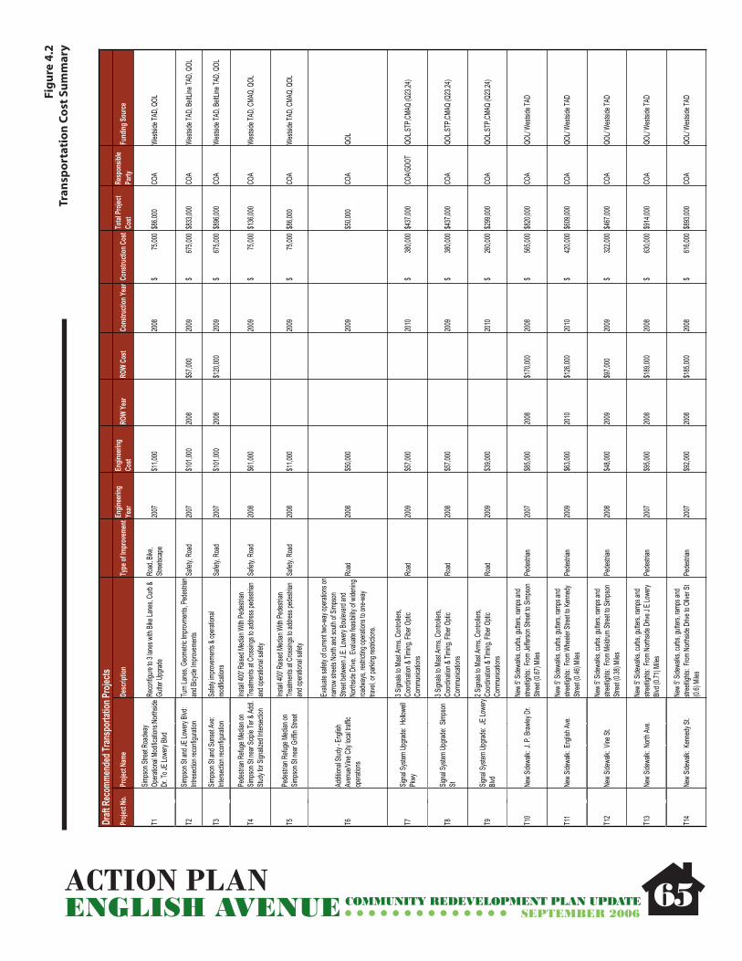
ACTION PLANENGLISH AVENUE COMMUNITY REDEVELOPMENT PLAN UPDATE
SEPTEMBER 2006
Fig
ure
4.2
Tran
spo
rtat
ion
Co
st S
um
mar
y
65
Draft
Rec
omme
nded
Tran
spor
tation
Proje
ctsPr
oject
No.
Proje
ct Na
meDe
scrip
tion
Type
of Im
prov
emen
tEngin
eerin
gYe
arEn
ginee
ring
Cost
ROW
Year
ROW
Cost
Cons
tructi
on Ye
ar C
onstr
uctio
n Cos
t Total
Proje
ct Co
stRe
spon
sible
Party
Fund
ing So
urce
T1Sim
pson
Stree
t Roa
dway
Op
eratio
nal M
odific
ation
s:Nort
hside
Dr
. To J
E Low
ery Bl
vd
Reco
nfigu
re to
3 lan
es w
ith Bi
ke La
nes,
Curb
& Gu
tter U
pgrad
eRo
ad, B
ike,
Stree
tscap
e20
07$1
1,000
20
08 $
75,00
0 $8
6,000
CO
AWe
stside
TAD,
QOL
T2Sim
pson
St an
d JE L
owery
Blvd
:Int
resec
tion r
econ
figura
tion
Turn
Lane
s, Ge
ometr
ic Im
provm
ents,
Pede
strian
an
d Bicy
cle Im
prove
ments
Safet
y, Ro
ad20
07$1
01,00
0 20
08$5
7,000
20
09 $
6
75,00
0 $8
33,00
0 CO
AWe
stside
TAD,
BeltL
ine TA
D, Q
OL
T3Sim
pson
St an
d Sun
set A
ve:
Inters
ectio
n rec
onfig
uratio
nSa
fety i
mprov
emen
ts & o
perat
ional
modif
icatio
nsSa
fety,
Road
2007
$101
,000
2008
$120
,000
2009
$
675
,000
$896
,000
COA
Wests
ide TA
D, Be
ltLine
TAD,
QOL
T4Pe
destr
ian R
efuge
Med
ian on
Sim
pson
St ne
ar Sc
iple T
er & A
ddl.
Study
for S
ignali
zed I
nterse
ction
Instal
l 400
' Rais
ed M
edian
With
Pede
strian
Tre
atmen
ts at
Cros
sings
to ad
dress
pede
strian
an
d ope
ration
al sa
fety
Safet
y, Ro
ad20
08$6
1,000
20
09 $
75,00
0 $1
36,00
0 CO
AWe
stside
TAD,
CMA
Q, Q
OL
T5Pe
destr
ian R
efuge
Med
ian on
Sim
pson
St ne
ar Gr
iffin S
treet
Instal
l 400
' Rais
ed M
edian
With
Pede
strian
Tre
atmen
ts at
Cros
sings
to ad
dress
pede
strian
an
d ope
ration
al sa
fety
Safet
y, Ro
ad20
08$1
1,000
20
09 $
75,00
0 $8
6,000
CO
AWe
stside
TAD,
CMA
Q, Q
OL
T6Ad
dition
al Stu
dy - E
nglish
Av
enue
/Vine
City
loca
l traff
ic op
eratio
ns
Evalu
ate sa
fety o
f curr
ent tw
o-way
opera
tions
on
narro
w str
eets
North
and s
outh
of Sim
pson
Str
eet b
etwee
n J.E.
Lowe
ry Bo
uleva
rd an
d No
rthsid
e Driv
e. Ev
aluate
feas
ibility
of w
idenin
g roa
dway
s, res
trictin
g ope
ration
s to o
ne-w
ay
trave
l, or p
arking
restr
iction
s.
Road
2008
$50,0
00
2009
$50,0
00
COA
QOL
T7Sig
nal S
ystem
Upg
rade:
Holl
owell
Pk
wy
3 Sign
als to
Mas
t Arm
s, Co
ntroll
ers,
Coord
inatio
n & Ti
ming
, Fibe
r Opti
c Co
mmun
icatio
nsRo
ad20
09$5
7,000
20
10 $
3
80,00
0 $4
37,00
0 CO
A/GDO
TQO
L,STP
,CMA
Q (Q
23,24
)
T8Sig
nal S
ystem
Upg
rade:
Simp
son
St
3 Sign
als to
Mas
t Arm
s, Co
ntroll
ers,
Coord
inatio
n & Ti
ming
, Fibe
r Opti
c Co
mmun
icatio
nsRo
ad20
08$5
7,000
20
09 $
3
80,00
0 $4
37,00
0 CO
AQO
L,STP
,CMA
Q (Q
23,24
)
T9Sig
nal S
ystem
Upg
rade:
JE Lo
wery
Blvd
2 Sign
als to
Mas
t Arm
s, Co
ntroll
ers,
Coord
inatio
n & Ti
ming
, Fibe
r Opti
c Co
mmun
icatio
nsRo
ad20
09$3
9,000
20
10 $
2
60,00
0 $2
99,00
0 CO
AQO
L,STP
,CMA
Q (Q
23,24
)
T10
New
Sidew
alk: J
. P. B
rawley
Dr.
New
5' Sid
ewalk
s, cu
rbs, g
utters
, ramp
s and
str
eetlig
hts: F
rom Je
fferso
n Stre
et to
Simps
on
Stree
t (0.67
) Mile
sPe
destr
ian20
07$8
5,000
20
08$1
70,00
0 20
08 $
5
65,00
0 $8
20,00
0 CO
AQO
L/ We
stside
TAD
T11
New
Sidew
alk: E
nglish
Ave.
New
5' Sid
ewalk
s, cu
rbs, g
utters
, ramp
s and
str
eetlig
hts: F
rom W
heele
r Stre
et to
Kenn
edy
Stree
t (0.46
) Mile
sPe
destr
ian20
09$6
3,000
20
10$1
26,00
0 20
10 $
4
20,00
0 $6
09,00
0 CO
AQO
L/ We
stside
TAD
T12
New
Sidew
alk: V
ine St
.Ne
w 5'
Sidew
alks,
curbs
, gutt
ers, ra
mps a
nd
stree
tlights
: From
Meld
rum St
reet to
Simp
son
Stree
t (0.38
) Mile
sPe
destr
ian20
08$4
8,000
20
09$9
7,000
20
09 $
3
22,00
0 $4
67,00
0 CO
AQO
L/ We
stside
TAD
T13
New
Sidew
alk: N
orth A
ve.
New
5' Sid
ewalk
s, cu
rbs, g
utters
, ramp
s and
str
eetlig
hts: F
rom N
orths
ide D
rive J
E Lo
wery
Blvd (
0.71)
Miles
Pede
strian
2007
$95,0
00
2008
$189
,000
2008
$
630
,000
$914
,000
COA
QOL/
Wests
ide TA
D
T14
New
Sidew
alk: K
enne
dy St
.Ne
w 5'
Sidew
alks,
curbs
, gutt
ers, ra
mps a
nd
stree
tlights
: From
Nort
hside
Driv
e to O
liver S
t(0.
6) Mi
lesPe
destr
ian20
07$9
2,000
20
08$1
85,00
0 20
08 $
6
16,00
0 $8
93,00
0 CO
AQO
L/ We
stside
TAD

ACTION PLANENGLISH AVENUE COMMUNITY REDEVELOPMENT PLAN UPDATE
SEPTEMBER 2006
Reco
mmen
ded T
ransp
ortat
ion Pr
ojects
Proje
ct No
.Pr
oject
Name
Desc
riptio
nTy
pe of
Impr
ovem
entEn
ginee
ring
Year
Engin
eerin
gCo
stRO
W Ye
arRO
W Co
stCo
nstru
ction
Year
Con
struc
tion C
ost
Total
Proje
ct Co
stRe
spon
sible
Party
Fund
ing So
urce
T19
New
Sidew
alk: J
ones
Ave
New
5' Sid
ewalk
s, cu
rbs, g
utters
, ramp
s and
str
eetlig
hts: F
rom D
L Holl
owell
Pkwy
Simp
son
Stree
t (0.53
Mile
s)Pe
destr
ian20
06$7
3,000
20
07$1
45,00
0 20
07 $
4
84,00
0 $7
02,00
0 CO
AQO
L/ We
stside
TAD
T20
New
Sidew
alk: S
unse
t Ave
.Ne
w 5'
Sidew
alks,
curbs
, gutt
ers, ra
mps a
nd
stree
tlights
: From
Simp
son S
treet
to Ke
nned
y Str
eet (0
.46 M
iles)
Pede
strian
2009
$63,0
00
2010
$126
,000
2010
$
420
,000
$609
,000
COA
QOL/
Wests
ide TA
D
T16
Engli
sh Av
enue
Nort
h - G
WCC
Gree
nway
Cons
truct
Mult i
use p
ath on
1.35
mile
secti
on
throu
gh ne
ighbo
rhood
Bike/P
ed20
10$2
93,00
0 20
11 $
1,9
50,00
0 $2
,243,0
00
COA/
PATH
/ Pr
ivate
COA/P
ATH/
Priva
te
T17
Instal
l Upg
raded
Tran
sit Am
enitie
s at
Key I
nterse
ction
sCo
ncret
e Pad
, Tran
sit Sh
elter,
Ligh
ting,
Map,
Trash
rece
ptacle
at 5
key i
nterse
ction
s: Tr
ansit
2007
$23,0
00
2008
$
150
,000
$173
,000
COA/M
ARTA
MART
A/ QO
L/Priv
ate
· Inte
rsecti
on of
Jame
s P. B
rawley
Driv
e and
Simp
son S
treet
· Inte
rsecti
on of
Jose
ph E.
Lowe
ry Bo
uleva
rd an
d Sim
pson
Stree
t· I
nterse
ction
of Jo
seph
E. Lo
wery
Boule
vard
and N
orth A
venu
e· I
nterse
ction
of D
onald
L. H
ollow
ell Pa
rkway
and J
ames
P. Br
awley
Driv
e· I
nterse
ction
of Ja
mes P
. Braw
ley D
rive a
nd Ke
nned
y Stre
et· I
nterse
ction
of Ja
mes P
. Braw
ley D
rive a
nd Jo
nes A
venu
e
T18
Upgra
de M
eldrum
St.
Upgra
de, p
ave a
nd ad
d side
walks
from
Suns
et Av
e. to
Walnu
t St.
Road
, Ped
estria
n20
09$1
24,00
0 20
10 $
8
28,00
0 $9
52,00
0 CO
AQO
L/ We
stside
TAD
T21
Sidew
alk R
epair
Prog
ram
Repa
ir sub
-stan
dard
exist
ing si
dewa
lks in
the
Engli
sh Av
enue
Neig
hborh
ood.
Proje
ct se
lectio
n an
d prio
ritiza
tion t
o be a
t the d
iscret
ion of
En
glish
Aven
ue N
eighb
orhoo
d Ass
ociat
ion.
Pede
strian
2008
$24,0
00
2009
$
160
,000
$184
,000
COA
QOL/
Wests
ide TA
D/Pr
ivate
66

ACTION PLANENGLISH AVENUE COMMUNITY REDEVELOPMENT PLAN UPDATE
SEPTEMBER 2006 67
Reco
mm
ende
d Tr
ansp
orta
tion
Proj
ects
per
tinen
t to
Engl
ish A
venu
e fro
m o
ther
Rec
ent P
lanni
ng E
fforts
Proj
ect N
o.Pr
ojec
t Nam
eDe
scrip
tion
Type
of I
mpr
ovem
ent
Tota
l Pro
ject
Cost
Resp
onsib
lePa
rtyFu
ndin
g So
urce
From
Upp
er W
est S
ide L
CI
UWS-
P2No
rthsid
e Driv
e Stre
etsca
peSi
dewa
lks, s
treet
furnit
ure,
stree
t ligh
ting,
curb
s, ra
mps,
and s
treet
trees
. Fro
m Si
mpso
n to
Bish
opSt
reets
cape
2009
$
3,5
85,68
9 20
10 $
9,9
45,21
2 $1
3,530
,900
DPW
/BOP
QOL/L
CI
UWS-
P3Do
nald
Lee H
ollow
ell S
treets
cape
Side
walks
, stre
et fur
nitur
e, str
eet li
ghtin
g, cu
rbs,
ramp
s, an
d stre
et tre
es fr
om N
orths
ide D
rive t
o Ma
rietta
Bou
levar
dSt
reets
cape
2009
$
1,6
09,08
0 20
10 $
4
32,32
0 $6
,072,0
00
DPW
/BOP
QOL/L
CI
UWS-
P-13
Engli
sh A
venu
e Nor
th - G
WCC
Gr
eenw
ay
Remo
ve ex
isting
rail b
ridge
s, cle
ar ov
ergr
owth,
an
d gra
ding t
o lev
el gr
eenw
ay. B
uild a
conc
rete
multi-
use p
ath w
ith en
tranc
es, b
ound
ary f
ence
s, lig
hting
, and
sign
s. Fr
om Lo
wery
Boule
vard
so
uthea
st to
North
side D
rive.
Cor
resp
onds
with
T1
6
Bicy
cle/P
edes
trian
2012
$
1,5
59,09
4 20
13 $
4,3
24,28
1 $5
,883,3
75
Bethu
rsday
,De
velop
ment/
PATH
Wes
tside
TAD
UWS-
P14
Lowe
ry St
reets
cape
Side
walks
, stre
et fur
nitur
e, str
eet li
ghtin
g, cu
rbs,
ramp
s, an
d stre
et tre
es. F
rom
DLH
to W
. Ma
rietta
Stre
et.St
reets
cape
2010
$
5
51,59
8 20
11 $
1,5
29,90
3 $2
,081,5
00
DPW
/BOP
QOL B
onds
/ LCI
UWS-
I3DL
H &
Lowe
ry Bo
uleva
rdInt
erse
ction
proje
ct to
includ
e geo
metric
im
prov
emen
t, utili
ty po
le re
locati
ons.
Inter
secti
on20
09 $
75
,000
2010
$
500
,000
5750
00DP
W/B
OPLC
I, COA
CIP
,QOL
UWS-
IR-1
Do
nald
Lee H
ollow
ell P
kwy C
orrid
or
(nea
r Nor
thside
Driv
e inte
rsecti
on)
Impr
oved
Roa
dway
Alon
g Don
ald Le
e Holl
owell
Pa
rkway
from
the r
ailro
ad tr
ack g
oing e
ast to
No
rthsid
e Driv
e. Ro
adwa
y imp
rove
ment
proje
ct inc
lude c
apac
ity im
prov
emen
t, geo
metric
im
prov
emen
t at th
e inte
rsecti
on of
Don
ald Le
e Ho
llowe
ll & N
orths
ide D
rive.
2009
2010
Road
2009
$
1
40,00
0 20
10 $
3
00,00
0 44
0,000
GDOT
/DPW
/BO
PLC
I, COA
CIP
,QOL
UWS-
IR-2
Dona
ld Le
e Holl
owell
Par
kway
Co
rrido
r (we
stern
secti
on)
Impr
oved
Roa
dway
Alon
g Don
ald Le
e Holl
owell
Pa
rkway
betw
een M
ariet
ta Bo
uleva
rd an
d Jo
seph
Lowe
ry Bo
uleva
rd. R
oadw
ay
impr
ovem
ent p
rojec
t to in
clude
drain
age s
ystem
im
prov
emen
t, roa
dway
capa
city i
mpro
veme
nt.
2009
2010
(Now
Pro
gram
med)
Road
2009
$
2
80,00
0 20
10 $
9
00,00
0 $
1
,180,0
00 D
PW/B
OPLC
I, COA
CIP
,QOL
UWS-
IR-3
Lowe
ry Bo
uleva
rd C
orrid
or
Impr
oved
Roa
dway
Alon
g Low
ery
Boule
vard
from
Don
ald Le
e Ho
llowe
ll Pkw
y to J
effer
son S
treet.
IR-3
I Low
ery B
oulev
ard C
orrid
or Im
prov
ed
Road
way A
long L
ower
y Bou
levar
d fro
m Do
nald
Lee H
ollow
ell P
kwy t
o Jeff
erso
n Stre
et.Ro
ad20
10 $
190
,000
2011
$
540
,000
$
54
0,000
DPW
/BOP
LCI, C
OA C
IP,Q
OL
UWS
- X-1
3Lo
wery
& DL
H St
reet
Cros
sing
Crea
te a p
edes
trian c
ross
ing in
cludin
g strip
ing,
ramp
s, an
d sign
aliza
tion.
Pede
strian
2011
$
13,00
0 20
12 $
1
17,00
0 $
130,0
00 D
PW/B
OPCO
A/QO
L/LCI
UWS
- X-1
4DL
H &
Engli
sh A
venu
e Stre
et Cr
ossin
gCr
eate
a ped
estria
n cro
ssing
inclu
ding s
triping
, ra
mps,
and s
ignali
zatio
n.Pe
destr
ian20
11 $
11
,000
2012
$
99
,000
$
11
0,000
DPW
/BOP
COA/
QOL/L
CI
UWS
- X-1
5No
rthsid
e Dr.a
nd N
orth
Ave.
Cros
sing
Crea
te a p
edes
trian c
ross
ing in
cludin
g strip
ing,
ramp
s, an
d sign
aliza
tion.
Pede
strian
2012
$
13,00
0 20
13 $
1
17,00
0 $
130,0
00 D
PW/B
OPCO
A/QO
L/LCI

ACTION PLANENGLISH AVENUE COMMUNITY REDEVELOPMENT PLAN UPDATE
SEPTEMBER 2006
Projec
t No.
Projec
t Nam
eDe
scrip
tion
Type
of Im
prove
ment
Total
Proje
ct Co
stRe
spon
sible
Party
Fund
ing So
urce
From
Bank
head
LCI
BH-T6
Pede
strian
Facili
ties - L
owery
Bo
ulevar
d - Fr
om Je
fferso
n St to
Fo
x St
Pede
strian
2007
$
47,76
3 20
08 $
20
,592
2008
/09 $
5
96,31
3 31
8,419
$
COA
LCI /
Wests
ide TA
D
BH- T
8Lo
wery
Boule
vard &
DL Ho
llowell
Parkw
ay Pe
destr
ian Cr
ossing
Pede
strian
2011
$
13,00
0 NA
NA20
12 $
1
17,00
0 13
0,000
$
COA
LCI/T
E
T-10
Bike L
anes
- DL H
ollowe
ll - Fro
m Lo
wery
Blvd t
o Finle
y Ave
- 1,40
0 lfBic
ycle
2007
$
23,04
0 NA
NA20
09 $
1
73,59
8 19
9,638
$
COA
QOL/T
E
From
North
side D
rive T
ransp
ortati
on St
udy:
NS-20
Wide
n Roa
d to in
clude
6 lan
es,
media
n and
wide
r sidw
walks
Marie
tta St
reet to
Kenn
edy S
treet
Road
/Pede
strian
Long
1,8
46,40
0$
GDOT
COA/L
CI/Sta
te/Fe
deral
NS-21
North
side D
r. & DL
Hollow
ell:Int
ersect
ion Pr
ojects
Road
/Pede
strian
Short
23
0,800
$
COA/G
DOT
Tip/GD
OT
NS-25
North
side D
r. & No
rth Av
e. Int
ersect
ion Pr
ojects
Road
/Pede
strian
Short
/Med
ium
585,0
00$
CO
A/GDO
TSta
te/Fe
deral
NS-26
Wide
n Roa
d to in
clude
6 lan
es,
media
n and
wide
r sidw
walks
Kenn
edy S
treet
to Ma
ple St
reet
Road
/Pede
strian
Long
1,7
48,24
0$
State/
Fede
ralSta
te/Fe
deral
NS-28
North
side D
r & Si
mpson
- Cros
swalk
imp
rovem
ents
Pede
strian
Short
10
,000
$
COA
COA
68

PLAN OVERVIEWENGLISH AVENUE COMMUNITY REDEVELOPMENT PLAN UPDATE
SEPTEMBER 2006
Appendix A:Public Participation Materials
Steering Committee Meeting Minutes
Public Meeting Sign-In Sheets
69

English Avenue Community Redevelopment Plan Update Steering Committee Meeting Monday, October 17, 2005 6:00PM-7:00PM Lindsay Street Baptist Church 550 Lindsay Street Atlanta, GA 30314
MEETING MINUTES Attendance J. Wesley Daniels Ivory Young Ms. Dorothy Stephens Rev. Howard Beckham Gregg Hawthorne Mary Darian "Able" Mable Thomas Annett Diop Sarah Franklin Emelda Santiago James Robertson Scott Levitan Bob Jones Tracy Bates Steve Frair Zachery McGee James Jennings Timothy Holdroyd Contente Terry Matt Cherry
Purpose of the meeting This meeting was convened of residents, property owners, business owners and institutional representatives that comprise of the English Avenue Steering Committee. The purpose of this meeting was to kick off the planning process, inform the steering committee of their role and responsibilities, provide an overview of the planning process and schedule, and engage in a discussion regarding the planning efforts goals & objects. Purpose of Steering Committee The Steering Committee is designed to serve as the sounding board for the redevelopment planning effort. All findings and recommendations will be presented to the committee prior to public meetings. The committee will provide valuable input to the planning team during this process. The steering committee requested a copy of the 1998 English Avenue Plan for each committee member. Also, it was suggested that copies of all previous plans should be made available to committee members. Contente Terry agreed to have a hard copy of the planning efforts affecting English Avenue on hand in her office for anyone that is interested in reviewing them. Public Involvement Committee In an effort to ensure that the community is notified of all public forums, committee members were asked to serve on a Public Involvement Committee. The role of the Public Involvement Committee will include assisting with the distribution of mail notices, creating a phone tree, door to door solicitation, catering and signage. Mable Thomas and Ivory Young offered $100 each for every public meeting. The members of the Public Involvement Committee consist of: James Robertson, Zachery McGee, Steve Frair and Mable Thomas. It was suggested that EANA inquire about the use of the On Call machine from Vine City to assist with distributing information in the community.

Committee Chairperson The Steering Committee appointed Bob Jones with Bethursday CDC to serve as the Steering Committee Chair for this planning effort. The role and responsibility of Chair is to serve as the voice of the Steering Committee in public forums and to keep order at the Steering Committee meetings. Contente Terry will be responsible for Steering Committee meeting minutes. Project Schedule The Project Schedule was distributed to the committee members for review and comment. Draft Goals & Objectives The committee was engaged in a detailed conversation regarding goals and objects for the CRP. These Goals & Objectives will be used to guide the plan recommendations. The goals & objectives were identified in the areas of land use and development, transportation & circulation, safety, community facilities and recreation and housing. The draft goals & objectives will be further defined by the planning team and presented at the public kick-off meeting for review and comment. Neighborhood Issues & Stakeholder Interviews The planning team will conduct a series of one-on-one stakeholder interviews over the next weeks to gain a perspective of current and planned projects in the area and to document key issues and visions of community stakeholders. Property owners, residents, social service organizations and institutions, business owners will be contacted for interviews. An offer was also extended to the Steering Committee members to schedule interviews. Kick-Off Meeting Overview The public Kick-Off meeting is scheduled for October 22, 2005 at 9:00AM at Lindsay Street Baptist Church. The purpose of this meeting is to introduce the planning team, the purpose of the redevelopment plan update, provide examples of redevelopment plans in the local area, present the project schedule and public participation process and conduct exercises for feedback on community character and goals & objectives.
The committee suggested that each planning team firm provide a general overview of their organization, previous projects and role in this process during the presentation. Next Steering Committee Meeting The next meeting is scheduled for November 14th at 6:00 at Lindsay Street Baptist Church. Action Items
• Provide a copy of the 1998 English Avenue plan to all Steering Committee meetings by the next meeting.
• Check on the availability and cost of the On Call Machine in Vine City for use by the Public Involvement Committee.
Please direct any changes of the English Avenue Steering Committee Meeting Minutes to Contente Terry 404.551.4249 or at [email protected]

1 of 3
English Avenue Community Redevelopment Plan Update Steering Committee Meeting Monday, November 28, 2005 6:00PM-8:00PM Lindsay Street Baptist Church 550 Lindsay Street Atlanta, GA 30314
MEETING MINUTES Attendance Tracy Bates Gregg Hawthorne Nasrah Annor Steve Noble, Grice &
Associates Rev. Beckham Timothy Holdroyd Michele McIntosh Ross, City
of Atlanta Aaron Fortner, Market & Main
Garnett Brown, City of Atlanta
Edward Milton James Arpad Jonathan Gelber, Grice & Associates
J. Daniels Frances President Contente Terry, Project Manager
Steve Frair Mable Thomas Matt Cherry, Urban Collage
Objective This meeting was convened of residents, property owners, business owners and institutional representatives that comprise of the English Avenue Steering Committee. The purpose of this meeting was to review existing conditions analysis obtained by the planning team in preparation for the December 10th public workshop. Results of the Kick-Off Meeting The Kick-off meeting held on October 22nd had 60 neighborhood residents and property owners in attendance. At the meeting, the planning team discussed the purpose of the redevelopment plan update, project schedule and public participation process. The attendees participated in a visual character survey and provide input on the Goals and Objectives established by the steering committee. The Visual Character Survey contained a series of photographs in categories consisting of single family, low density and medium density residential; open space and public facilities, commercial/ retail and mixed use; street character and identity markers. The participants were asked to place green dots on those images that they thought were appropriate for the area and a red dot on those that were inappropriate for the area. The results of the visual character boards were presented to the Steering Committee. Some members felt that there was a lack of diversity of images and recommended creating a new survey which the planning team agreed to look into. Goals & Objectives Overview At the October 17th Steering Committee Meeting, the committee drafted goals and objects for the CRP to guide the plan recommendations. The goals & objectives were identified in the areas of land use and development, transportation & circulation, safety, community facilities and recreation and housing and were further defined by the planning team and presented at the public kick-off meeting for review and comment.

2 of 3
The following were comments given by the steering committee upon review: • Address infill housing on vacant lots and the desire to develop live work units in the
neighborhood; • Include a desired percentage of open space designated for the neighborhood; • Include the Westside TAD as an implementation tool; • Address connections to the Beltline in Public Facilities & Natural Resource; • Include a police precinct to address public safety in the neighborhood; • Address after school programs and a possible partnership with APS.
Inventory & Assessment Results The planning team presented the existing conditions assessment of the English Avenue Neighborhood which is summarized as follows: Demographics
• The demographic analysis included 2005 statistics of a demographic comparison within ½ mile and mile radius of the center of the neighborhood, City of Atlanta and Atlanta MSA;
• 20% of housing stock lost from 1990- 2000; • The population is projected to continue to decrease until 2010; • 32+% of population under the age of 18; • Unemployment rate in English avenue are is 11% compared to the City of Atlanta at
4%. Transportation & Circulation
• Through a series of study area visits, the planning team assessed the condition of the streets and sidewalks of the area which are in relatively good condition;
• The street network is in a grid formation with good connects east, west and north, south;
• High traffic volumes are along the major arterials (Northside Drive and Simpson); • The team also documented the crash incidents on a map as well; • The steering committee recommended obtaining information on sewer capacity to
assist with identifying future development areas. •
Existing Physical Conditions The physical conditions of the neighborhood were assessed by a windshield survey conducted by the planning team with the assistance of Project Safe Neighborhood Students from Spelman College.
• Approximately 400 acres of land within the study area which includes 1659 parcels; • The community is comprised of mostly single family dwellings and vacant land (19%
each); industrial property (17%); Office/ Institutional property (14%); Low Density Commercial (5%); and an astonishing 1% open space;
• 37% of structures within the neighborhood are in standard condition (needing minimal to no repair, mostly cosmetic); 29% substandard requiring some level of repair; 28% Deteriorated, requiring significant repair; 6% dilapidated structures that are usually public safety hazards;
• 83% of the structures in the neighborhood are occupied; 1% partially occupied; 15% unoccupied.
Urban Design Analysis The planning team assessed the pedestrian and vehicular connectivity, view points due to changes in the topography, potential gateways due to major entry points into the neighborhood. These assessments were documents on an Urban Design Map.
3 of 3
Development Opportunities The planning team graphically represented the major development opportunities in the area which include Antioch Church development sites along Northside Drive, Proctor Village Redevelopment, and Georgia Tech’s future expansion area. Additional development opportunities include all vacant land, dilapidated structures and surface parking lots within the study area. The data collected and all illustrations will be provided to the steering committee in a report at a later date. Workshop Overview – December 10, 2005 at 9:00AM The public workshop will be held at 440 Northside Drive and hosted by Bethursday CDC. All steering committee members are encouraged to attend and spread the word about the event. An On Call machine will be used to advertise the meeting to all listed phone numbers in the area along with mailed notifications and yard signs throughout the neighborhood.
Next Steering Committee Meeting The next meeting is scheduled for December 19th at 6:00 at Lindsay Street Baptist Church. Please direct any changes of the English Avenue Steering Committee Meeting Minutes to Contente Terry 404.551.4249 or at [email protected]

1 of 2
English Avenue Community Redevelopment Plan Update Steering Committee Meeting Monday, December 19, 2005 6:00PM-7:00PM Lindsay Street Baptist Church 550 Lindsay Street Atlanta, GA 30314
MEETING MINUTES Attendance Tracy Bates Steve Frair Michelle McIntosh Ross, City of
Atlanta Oscar Clemons Frances President Garnett Brown, City of Atlanta Annette Diop James Robertson Matt Cherry, Urban Collage Scott Levitan Tonya Williams Contente Terry, Project
Manager J. Daniels Mable Thomas Rev. Zachery McGee Dorothy Stephens Annor Nasrah Edward Melton
Objective This meeting of the Steering Committee was convened to review the Development Framework Plan and Circulation Framework Plan developed from the December 10, 2005 Public Workshop. Framework Plan Presentation Contente Terry provided the Steering Committee with copies of the Development Framework Plan and Circulation Framework Plan to review during the presentation. The major development concepts are as follows:
• Mixed use and higher density development is proposed north of Hollowell, along Northside Drive and along Simpson;
• Preserve the residential core of the community with single family and low density residential;
• Proposed medium density residential assists with the transition from higher density development to the single family core;
• Neighborhood serving retail concentrated at the intersection of Kennedy & James P. Brawley and North Avenue & English.
Project Areas were identified by the participants at the December 10th Workshop that included (8) proposed residential, mixed use, institutional and commercial development projects along with (4) existing development projects. The Circulation Framework Plan emphasizes:
• Major streetscape improvements along Northside Drive, Simpson, Lowery, Kennedy, North Avenue, and James P. Brawley.
• Consideration to changing the direction of the existing one way pairs (Elm Street and Vine Street).
• Potential extension of Kennedy Street to the west to connect to Lowery.
2 of 2
• Potential pedestrian connections to the Georgia Tech eco-commons along Northside Drive.
• A greenway connection along the abandoned railroad right of way that will connect to the BeltLine and Maddox Park.
Next Steps The planning team will finalize the Framework Plans per the comments received by the Steering Committee. Development Concept Drawings will be created and presented for comments and zoning recommendations will follow once the development framework plan is finalized. Next Meetings The next Steering Committee meeting will convene on January 17th @ 6PM Lindsay Street Baptist Church. Please direct any changes of the English Avenue Steering Committee Meeting Minutes to Contente Terry 404.551.4249 or at [email protected]

1 of 2
English Avenue Community Redevelopment Plan Update Steering Committee Meeting Tuesday, January 17, 2006 6:00PM-8:00PM Lindsay Street Baptist Church 550 Lindsay Street Atlanta, GA 30314
MEETING MINUTES Attendance Tracy Bates Annor Nasrah Matt Cherry, Urban Collage Rev. Howard Beckham Frances President Stan Harvey, Urban Collage James Arpad James Robertson Mary Darian Tonya Williams Scott Levitan Mable Thomas Bob Jones Contente Terry, Project Manager
Objective This meeting of the Steering Committee was called to order by Chairman Bob Jones and was convened to review the Development Framework Plan and Circulation Framework Plan developed from the December 10th, 2006 Public Workshop. Framework Plan Presentation (map dated January 17, 2006) Contente Terry provided the Steering Committee with copies of the Development Framework Plan and Circulation Framework Plan to review during the presentation. The major development concepts are as follows:
• Mixed use and higher density development is proposed north of Hollowell, along Northside Drive and along Simpson;
• Preserve the residential core of the community with single family and low density residential;
• Proposed medium density residential assists with the transition from higher density development to the single family core;
• Neighborhood serving retail concentrated at the intersection of Kennedy & James P. Brawley and North Avenue & English.
Project Areas were identified by the participants at the December 10th Workshop that included (8) proposed residential, mixed use, institutional and commercial development projects along with (4) existing development projects. The planning team will provide concept drawings for three of the proposed project areas at the next meeting. The Circulation Framework Plan emphasizes:
• Major streetscape improvements along Northside Drive, Simpson, Lowery, Kennedy, North Avenue, James P. Brawley.
• Consideration to changing the direction of the existing one way pairs (Elm Street and Vine Street).
• Potential extension to Kennedy Street on the west to connect to Lowery. • Potential pedestrian connections to the Georgia Tech eco-commons along
Northside Drive.

2 of 2
• A greenway connection along the abandoned railroad right of way that will connect to the BeltLine and Maddox Park.
Discussion
• Proposed mixed use development on Simpson should protect single family residential along Jones Avenue. The zoning recommendations should reference this.
• Due to the amount of stable single family residential on the back side of Simpson Road, this zoning should look at this and make recommendations block by block.
• Buffer the single family from mixed use development with a transition of various densities of residential (medium density and low density).
• There is a concern that the steering committee does not have enough resident participation.
*Note that the revised Framework Plan dated January 17, 2006 per comments received from the Steering Committee on December 19th 2005. Next Meetings Steering Committee January 31st @ 6PM Lindsay Street Baptist Church February 7th @ 6PM Lindsay Street Baptist Church February 21st @ 6PM Lindsay Street Baptist Church March 7th @ 6PM Lindsay Street Baptist Church Draft Plan Public Meeting February 11th @ 9AM – 11Am Lindsay Street Baptist Church Please direct any changes of the English Avenue Steering Committee Meeting Minutes to Contente Terry 404.551.4249 or at [email protected]

1 of 2
English Avenue Community Redevelopment Plan Update Steering Committee Meeting Tuesday, January 31, 2006 6:00PM-8:00PM Lindsay Street Baptist Church 550 Lindsay Street Atlanta, GA 30314
MEETING MINUTES Attendance Tracy Bates Edward Melton Matt Cherry, Urban Collage Rev. Howard Beckham Frances President Stan Harvey, Urban Collage J. Daniels Tonya Williams Sarah Franklin Oscar Clemons Tim Holdroyd Carmen Clemons Bob Jones Contente Terry, Project Manager
Objective This meeting of the Steering Committee was called to order by Chairman Bob Jones and was convened to review the revised Framework Plan and discuss the approach for the “Envision” Bus Tour. “Envision” Bus Tour The Steering Committee expressed the importance of convening a bus tour to further discuss the issues of the community and have more detailed discussions regarding proposed development plan. Frances President and Contente Terry are coordinating the tour for February 11th at 9AM – 11AM. Everyone will meet at Lindsay Street Baptist Church. A tour map and other materials will be provided to assist with the facilitation of the tour. Development Concept Presentation (map dated January 31, 2006) Contente Terry provided a brief overview of the revised Development Framework Plan. Matt Cherry presented the concept drawings described as follows: Project #5 Neighborhood Commercial: This project area is comprised of property located at the intersection of James P. Brawley and Kennedy Street. This proposed development site would be in scale of the structures along North Avenue with complementary architectural character and serve as the new home for neighborhood service retail in English Avenue. The reuse of existing buildings and their facades is encouraged. Project #8 Simpson Mixed Use: Potential 3-5 story mixed use development bounded by Simpson, Newport, Jones and Griffin Streets. This development would complement mixed use development proposed on the Vine City side of Simpson and with possible retail on the ground floor with residential units above. Project #7 Low/ Medium Density Residential: This project converts existing vacant lots and dilapidated housing into a new town home development. This project area is bounded by Vine, John, Sunset and Jones.

2 of 2
Discussion
• The Georgia Tech expansion property along North Avenue and the North Yards Business Park land use should be considered as medium density commercial versus mixed use & institutional. These properties can not have a residential use as dictated by a previous agreement.
• The Georgia World Congress Center property south of Herndon Homes and North of Simpson should be institutional and not mixed use.
• The planning team will make these changes accordingly and provide copies at the next meeting.
Next Meetings The next Steering Committee Meeting will convene on February 21, 2006 at Lindsay Street Baptist Church at 6PM. Please direct any changes of the English Avenue Steering Committee Meeting Minutes to Contente Terry 404.551.4249 or at [email protected]

1 of 3
English Avenue Community Redevelopment Plan Update Steering Committee Meeting Tuesday, February 21, 2006 6:00PM-8:00PM Lindsay Street Baptist Church 550 Lindsay Street Atlanta, GA 30314
MEETING MINUTES Attendance Tracy Bates Ivory Young Michele McIntosh Ross, City of
Atlanta Greg Crawford Sarah Franklin Tonya Williams Mary Darian Bob Jones Stephen Cansby Scott Levitan Frances President Contente Terry, Project
Manager Steve Frair Mable Thomas Matt Cherry, Urban Collage Annor Nasrah James Arpad
Objective This meeting of the Steering Committee was called to order by Chairman Bob Jones and was convened to review and provide a summary of the “Envision” Bus Tour, an overview of the Framework Plan and proposed project concept illustrations. “Envision” Bus Tour Summary A bus tour that was open to the greater English Avenue community was held on February 11th and attended by 31 residents, property owners and institutional representatives. Due to the vast turn out and limited seating, only 25 participated in the 3-hour tour. A tour rout map, exiting conditions maps, a Draft framework plan were provided to help orient the participants and to receive comments. The tour was coordinated and co-facilitated by Frances President and Content Terry. The participants were asked to submit comment forms and to complete a questionnaire at the conclusion of the tour and the following comments were recorded: I understand the purpose of the tour. 12 Strongly Agree 3 Somewhat Agree I gained good information about my neighborhood. 12 Strongly Agree 3 Somewhat Agree I learned a lot about the redevelopment plan and process. 11 Strongly Agree 3 Somewhat Agree 1 Don’t Agree Facilitators listened to what I had to say. 10 Strongly Agree 5 Somewhat Agree I will become more active in the English Avenue Neighborhood Association. 11 Strongly Agree 3 Somewhat Agree

2 of 3
I would like to serve on a committee of the neighborhood association. 6 Yes 3 No Proposed Project Concept Drawing Presentation Contente Terry provided a brief overview of the Framework Plan:
• Mixed use and higher density development is proposed north of Hollowell, along Northside Drive and along Simpson;
• Preserve the residential core of the community with single family and low density residential;
• Proposed medium density residential assists with the transition from higher density development to the single family core;
• Neighborhood serving retail concentrated at the intersection of Kennedy & James P. Brawley and North Avenue & English.
• A new Open Space is proposed at Maple and Simpson. The neighborhood is negotiating with Georgia Power to develop this property into a linear park.
• Additional open space opportunities have been included in association with Bethursday CDC development to include a 3-acre park.
Matt Cherry presented the concept drawings described as follows: Project #7 Low/ Medium Density Residential:
• This project area is comprised of property bounded by Vine, Jones, Sunset and John. • The big idea for this project area is that it is residential development that will serve as
a buffer between the high density mixed use development to the east and single family to the west. This proposed development project will transition from low density residential to single family.
• It is suggested that acquisition of vacant land should occur in mass. • This plan is also an opportunity to identify structures to be demolished and TAD funds
maybe allocated to execute. • It was agreed that changing the direction of Vine Street from north to south is not
appropriate due to development patterns and current traffic flow. Project #A Bethursday Development:
• This project area is bounded by North Ave, Northside Drive, Kennedy and Elm and is representative of a typical mixed use development which includes medium density and low density residential development, retail and mixed use development.
• A 3-acre active and passive open space is proposed that could connect to the PATH Foundations proposed greenway trail along the abandoned railroad right of way.
• The concept proposes a significant entrance into English Avenue at North Avenue and Northside Drive.
Project #8 Simpson Mixed Use
• The Simpson Mixed Use project proposes frontage on Simpson with ground floor retail with residential above.
• The back side of the development would protect existing single family homes along Jones Avenue. Although the land use plan reflects mixed use the zoning code would emphasize the preservation of the single family and a transition area.
All previously discussed concept drawings were also displayed reflecting comments received from the steering committee in previous meetings. *Note that this project numbers and name reflect the revised Framework Plan dated February 21, 2006 per comments received during the “Envision” Bus Tour on February 11th.

3 of 3
Next Meetings Steering Committee March 7th @ 6PM Lindsay Street Baptist Church March 21st @ 6PM Lindsay Street Baptist Church April 4th @ 6PM Lindsay Street Baptist Church April 18th @ 6PM Lindsay Street Baptist Church Draft Plan Public Meeting March 25th @ 9AM – 11Am Lindsay Street Baptist Church Final Plan Public Meeting April 29th @ 9AM – 11Am Lindsay Street Baptist Church Please direct any changes of the English Avenue Steering Committee Meeting Minutes to Contente Terry 404.551.4249 or at [email protected]

1 of 2
English Avenue Community Redevelopment Plan Update Steering Committee Meeting Tuesday, March 7, 2006 6:00PM-8:00PM Lindsay Street Baptist Church 550 Lindsay Street Atlanta, GA 30314
MEETING MINUTES Attendance Tracy Bates Gregg Hawthorne Michele McIntosh Ross, City
of Atlanta Matt Cherry, Urban Collage
Oscar Clemons Sarah Franklin Tonya Williams James Robertson Carmen Clemons Bob Jones Tarnace Watkins, ADA Dorthy Anderson Rev. Howard Beckham
Frances President Alliece Johnson Hines
Steve Frair Mable Thomas Edward Melton Annette Diop James Arpad Contente Terry, Project
Manager
Objective This meeting of the Steering Committee was called to order by Chairman Bob Jones and was convened to review the concept drawings for proposed development projects, distribute sample design guidelines for the committee to review and provide comments at the next Steering Committee meeting. Proposed Project Concept Drawing Presentation Contente Terry provided a brief overview of the Framework Plan highlighting the big ideas:
• Mixed use and higher density development is proposed north of Hollowell, along Northside Drive and along Simpson;
• Preserve the residential core of the community with single family and low density residential;
• Proposed medium density residential assists with the transition from higher density development to the single family core;
• Neighborhood serving retail concentrated at the intersection of Kennedy & James P. Brawley and North Avenue & English.
Matt Cherry presented the concept drawings described as follows: Project #4 Single Family Infill and Townhomes:
• This project area is comprised of property along North Avenue that is proposed for low density residential development fronting North Avenue and Single Family infill on the back due to its direct connection to downtown. The committee had a discussion on the density of this development concept and the integration of some single family development in conjunction with town homes. It was decide that the low density land use should remain which supports both types of development.
Project #B Lindsay Street Church Expansion:
• This project area is comprised of the existing Lindsay Street Baptist Church property and future development areas.

2 of 2
• The plan proposes an expansion of the church with reorienting the existing parking along with an integration of new senior housing into to residential core along Lindsay Street on the Heritage Sanctuary parking lot.
Project #C New Jerusalem Baptist Church Expansion
• This project area is comprised of the existing sanctuary of the church including parking and additional acquired property.
• The church has plans to build a new sanctuary and develop additional parking. • The old sanctuary will be converted into a community use which will offer support to
the community. • Infill development is proposed to the north of the church along with the rehabilitation
of existing housing stock that can be used for additional outreach services and housing in English Avenue.
All previously discussed concept drawings were also displayed reflecting comments received from the steering committee in previous meetings. *Note that this project numbers and name reflect the revised Framework Plan dated February 21, 2006. Design Guidelines A sample design guideline package (Vine City Redevelopment Plan Design Guidelines) was distributed to the committee to review and provide written comments to the planning team at the next Steering Committee Meeting. The purpose of developing design guidelines is to provide developers with a framework and a list of standards that reflect the community’s vision for future development character. The guidelines generated in this process will also be reflected in the zoning as well as provide the EANA Land Use and Development Committee with architectural and design framework when reviewing development proposals. Next Steering Committee Meeting The next meeting is scheduled for Tuesday, March 21st at 6:00 at Lindsay Street Baptist Church to review the remaining project concept drawing and discuss design guidelines. Please direct any changes of the English Avenue Steering Committee Meeting Minutes to Contente Terry 404.551.4249 or at [email protected]

1 of 3
English Avenue Community Redevelopment Plan Update Steering Committee Meeting Tuesday, March 21, 2006 6:00PM-8:00PM Lindsay Street Baptist Church 550 Lindsay Street Atlanta, GA 30314
MEETING MINUTES Attendance Tracy Bates Gregg Hawthorne Sarah Franklin Rev. Anthony Johnson Greg Crawford Timothy Holdroyd Michele McIntosh Ross, City
of Atlanta Dorthy Anderson Mary Darian Bob Jones James Arpad Contente Terry, Project
Manager J. Daniels Frances President Tonya Williams Matt Cherry, Urban Collage Steve Frair Mable Thomas Tarnace Watkins, ADA Tatianna Francis, PSN Intern
Objective This meeting of the Steering Committee was called to order by Chairman Bob Jones and was convened to review the remaining concept drawings for proposed development projects, receive comments from the committee regarding design guidelines and provide the agenda items and structure for the upcoming Public Meeting scheduled for March 25, 2006. Proposed Project Concept Drawing Presentation Matt Cherry presented the remaining three concept drawings described as follows: Project #7 Low Density Residential:
• This project area is comprised of existing multi-family 2-story developments that are perfect candidates for rehabilitation for rental or fro sale units depending on the market. Unlike previous concept plans, the planning team is proposing that this project area consider policy recommendations for multi-family rehabilitation and maintenance versus site planning for redevelopment which can be reflected in the zoning recommendations.
• Maintaining these structures will add to the diversity of housing types in English Avenue.
• The concept shows opportunities for single family infill on vacant lots that is integrated into the existing single family fabric of the project area.
Project #9 Proctor Village:
• This project area is comprised of the existing unoccupied Proctor Village apartments including frontage along Simpson and Lowery.
• Currently English Avenue CDC in collaboration with ANDP are pursuing the development of this project area as a town home development in the rear of the project area with a mixed use component along Simpson Road.
• Structured parking is proposed behind the mixed use structures due to the grade change.
• Also as a result of the grade change in the project area, a retention pond maybe considered specifically in areas prone to flooding.

2 of 3
• ANDP is providing financial capacity to the project and the project has a phased development approach.
Project #1 Hollowell (Front Door for Neighborhood)
• The Hollowell project area consists of frontage along Donald Lee Hollowell from Northside Drive to Lowery.
• This corridor is considered to have a historic nature that is pedestrian oriented. • The steering committee had a detailed discussion regarding the existing gas station
site and had mixed reviews of a future location for this type of development. Suggestions included developing a gas station mid-block versus on the corner of a major intersection. The committee requested some feedback from the planning team on traffic conditions to determine if this concept is warranted.
• Where appropriate, existing store fronts on Howell & Lindsay should be maintained and rehabilitated.
• Policy recommendations were also suggested by the committee: 1) Integrate environmental concerns into the built environment (i.e. brown
fields); 2) Multifamily development is encouraged to provide a diversity of housing
types the community; 3) Preserve historic structures along Hollowell (design guidelines should include
recommended uses and character elements) • Fox Street has new single family construction therefore town home development may
not be appropriate. • The concept drawing identifies the Carnegie Library, English Avenue School and the
Boys & Girls club as a major institutional/ community use that has an integrated and shared institutional and recreational space.
All previously discussed concept drawings were also displayed reflecting comments received from the steering committee in previous meetings. These illustrations will be presented at the March 27th Public Meeting for comment from the general public. *Note that this project numbers and name reflect the revised Framework Plan dated March 13, 2006. Design Guidelines A brief discussion was held on design guidelines using a sample package as a framework. In an effort to provide further opportunity to further develop the design guidelines, the Steering Committee was asked to convene as a subcommittee to review the samples provided and provide comments to the planning team by the next Steering Committee meeting. Frances President agreed to organize this subcommittee. Public Meeting – March 25, 2006 at 9:00AM – 11:00AM The public meeting will be held at Lindsay Street Baptist Church in the Heritage Building and hosted by Lindsay Street Baptist Church. The meeting will consist of a brief overview of the project purpose and schedule including a review of the existing conditions analysis. The planning team will present an overview of the Development Framework Plan (future land use plan) and circulation Framework Plan. The meeting will conclude with a presentation of the potential development projects which the general public will have an opportunity to provide comments. All steering committee members are encouraged to attend and spread the word about the event. Yard signs were distributed throughout the neighborhood advertising the meeting and three Steering Committee members were provided yard signs to display on their property.

3 of 3
Next Steering Committee Meeting The next meeting is scheduled for Tuesday, April 4th at 6:00 at Lindsay Street Baptist Church to review zoning recommendations. Please direct any changes of the English Avenue Steering Committee Meeting Minutes to Contente Terry 404.551.4249 or at [email protected]

1 of 1
English Avenue Community Redevelopment Plan Update Steering Committee Meeting Tuesday, April 18, 2006 6:00PM-7:30PM Lindsay Street Baptist Church 550 Lindsay Street Atlanta, GA 30314
MEETING MINUTES Attendance Tracy Bates Frances President Oscar Clemons Aaron Fortner, Market +
Main Annette Diop Steve Frair Carmen Clemons Contente Terry, Project
Manager Rev. Howard Beckham
Tarnace Watkins James Arpad
Scott Levitan Tonya Williams Edward Milton Bob Jones Mary Darian Matt Cherry, Urban Collage
Objective This meeting of the Steering Committee was called to order by Chairman Bob Jones and was convened to present preliminary CDP land use and zoning recommendations for comment by the committee. CDP Land Use Discussion
• 10 policy statements were generated at the last steering committee meeting and presented at this time. These statements will service as guiding principals for the City in reference to English Avenue.
• The committee suggested adding langue to encourage economic sensitive development specifically for larger scale development where applicable.
Zoning Strategies
• A zoning strategy handout was distributed defining the quality of life districts versus the current zoning classifications in the neighborhood.
• There was discussion regarding the appropriateness of MRC2 for the property north of Herndon Homes and the new Georgia Tech site. Aaron believes that the classification is appropriate and will confirm with the City.
• There was discussion regarding the appropriate density for Northside Drive (MRC2 or MRC3. The committee agreed that MRC3 is appropriate but a height restriction is needed.
• At the net meeting, Aaron will provide a matrix of allowable uses Please direct any changes of the English Avenue Steering Committee Meeting Minutes to Contente Terry 404.551.4249 or at [email protected]

1 of 1
English Avenue Community Redevelopment Plan Update Steering Committee Meeting Tuesday, May 2, 2006 6:00PM-7:30PM Lindsay Street Baptist Church 550 Lindsay Street Atlanta, GA 30314
MEETING MINUTES Attendance Tracy Bates Jason Frair Contente Terry, Project
Manager
Annette Diop Steve Frair Aaron Fortner, Market + Main
Rev. Howard Beckham
Tarnace Watkins
Edward Milton James Arpad Bob Jones Dorthy Anderson
Objective This meeting of the Steering Committee was called to order by Chairman Bob Jones and was convened to present preliminary CDP land use and zoning recommendations for comment by the committee.
• The City of Atlanta is walking all recently competed plans through zoning in September 2006. English Avenue is on schedule for this mass rezoning process.
• The City is recommending using the Quality Of Life Districts for the zoning.
Zoning Strategies • Use MRC2 for Northside Drive and Upper Westside as articulated in previous plans. • Add language in CDP that higher density development along Northside Drive be
considered on a case by case. • Make sure zoning is consistent with Framework plan and CDP land use
recommendations. • A copy of allowable uses was provided to the committee to help facilitate the
discussion. Please direct any changes of the English Avenue Steering Committee Meeting Minutes to Contente Terry 404.551.4249 or at [email protected]

1 of 1
English Avenue Community Redevelopment Plan Update Steering Committee Meeting Tuesday, May 16, 2006 6:00PM-7:30PM Lindsay Street Baptist Church 550 Lindsay Street Atlanta, GA 30314
MEETING MINUTES Attendance Tracy Bates Frances President Aaron Woodhouse Aaron Fortner, Market +
Main Annette Diop Mable Thomas Matilda X Rev. Howard Beckham
Tarnace Watkins Juanita Wallace
J. Daniels Tonya Williams Contente Terry, Project Manager
Bob Jones Alliece Johnson Matt Cherry, Urban Collage
Objective This meeting of the Steering Committee was called to order by Chairman Bob Jones and was convened to present zoning recommendations and transportation recommendations for comment by the committee. Zoning • With review of the land use and zoning recommendations, the plans did not reflect the
discussion regarding single family on Jones. Those changes will be incorporated. Transportation
• The committee agreed that sidewalk improvements be illustrated and programmed for Jones, Sunset (south of North Ave.), and Jett (west of Vine Street.)
• Add a line item to include a study for Vine Street and English Avenue to alternate the
direction.
• Add a line item to include installation and repair of sidewalk throughout the neighborhood.
Please direct any changes of the English Avenue Steering Committee Meeting Minutes to Contente Terry 404.551.4249 or at [email protected]

1 of 1
English Avenue Community Redevelopment Plan Update Steering Committee Meeting Tuesday, May 30, 2006 6:00PM-7:30PM Lindsay Street Baptist Church 550 Lindsay Street Atlanta, GA 30314
MEETING MINUTES Attendance Tracy Bates Gregg Hawthorne Steve Frair Aaron Fortner, Market +
Main Annette Diop Frances President Pamela Flores Mary Darian James Arpad Jason Frair J. Daniels Tonya Williams Michele McIntosh Ross, City
of Atlanta
Bob Jones Oscar Clemons Contente Terry, Project Manager
Objective This meeting of the Steering Committee was called to order by Chairman Bob Jones and was convened to provide comments on the final zoning recommendations and review the draft plan. All steering committee members in attendance received a copy of the document to review. Zoning • The original recommendation for MR4B does not allow for stacked flats (1.49 FAR; 52ft) ,
therefore Aaron recommended changing the zoning to MR5B to accommodate the recommended use as articulated in the plan. This designation allows for staked flats (3.2 FAR, with 3 floor max height condition). The committee agreed with the recommendation change.
• Due to numerous concerns regarding existing multi-family properties being down zoned, Aaron agreed to develop language to support rehabilitation or redevelopment of these properties at this higher density so long as the plans (when presented to EANA) reflect the general vision of the community.
Draft Plan Contente provided all members a copy of the draft plan and briefly walked the committee through the plan elements. June 6th is the deadline for steering committee members to submit comments in writing to Contente. Please direct any changes of the English Avenue Steering Committee Meeting Minutes to Contente Terry 404.551.4249 or at [email protected]

1 of 1
English Avenue Community Redevelopment Plan Update Steering Committee Meeting Tuesday, August 15, 2006 6:00PM-7:30PM Lindsay Street Baptist Church 550 Lindsay Street Atlanta, GA 30314
MEETING MINUTES Attendance Tracy Bates Gregg Hawthorne Alliece Hines Annette Diop Frances President Michele McIntosh Ross, City
of Atlanta Mary Darian Mable Thomas Contente Terry, Project
Manager
J. Daniels Tonya Williams Aaron Fortner Bob Jones Ivory Young
Objective This meeting of the Steering Committee was called to order by Chairman Bob Jones and was convened to receive final comments on the draft plan. Steering Committee received copies of the draft plan prior to the meeting and those members unable to pick up a copy of the draft received a copy at the meeting. Comments • Mable Thomas submitted comments in writing and the committee reviewed and
accepted her comments regarding the cover, introduction of English Avenue and Historical Context.
• Tonya Williams and Greg Hawthorne provided corrections to the spelling of their names. • There was discussion regarding the Goals and Objects. The comments included
language on home rehabilitation. • Francis President had concerns that the Ad Hoc Design Guideline Committee’s
comments were not completely included in the document. Contente agrees to get a copy of her comments from Urban Collage to confirm.
Approval of Plan by Steering Committee The steering committee accepted and approved the draft plan and recommended that it be presented at the September NPU meeting. Tonya Williams, NPU-L Land Use and Zoning Committee Chair confirmed that the plan is ready to present directly to the NPU and will not have to go before her committee. Next Step The final draft will be presented at the September 12th NPU-L meeting. Contente will obtain the zoning, CDP and public hearing schedule and forward to committee members. Please direct any changes of the English Avenue Steering Committee Meeting Minutes to Contente Terry 404.551.4249 or at [email protected]


