community risk assessment report - radar.org.za informal settlement, paarl... · days of field work...
TRANSCRIPT

1
Community Risk Assessment Report
Fairyland Informal Settlement
August 2013
A consolidation of reports submitted by participants attending the short course
Community Risk Assessment: Focus on Informal Settlements
Facilitated by the Disaster Mitigation for Sustainable Livelihoods Programme
Stellenbosch University

2
Disaster Mitigation for Sustainable Livelihoods Programme (DiMP)
Department of Geography & Environmental Studies
University of Stellenbosch
August 2013
This report has been made available to the community leaders of Fairyland, the Councillor of
Ward 13 in which Fairyland is situated, Drakenstein Municipality, the local office of the
Western Cape Department of Health, the local office of the Provincial Department of Social
Welfare, Drakenstein Fire Services, Butterfly House, and various other role players.
For a copy of this report please contact Patricia Zweig of the Disaster Mitigation for
Sustainable Livelihoods Programme at Stellenbosch University on 021-808-9282 or email

3
Acknowledgements
The Disaster Mitigation for Sustainable Livelihoods Programme would like to thank
members of the Fairyland informal settlement community who participated in and
contributed to this risk assessment. They are:
Sitembele Beukes Rode
Nomfemela Phatilizwe
Zeka Sizuzile
Cacisa Mdlike
Zandiswa Nofemela
Portia Mtelekiso
Nosakhiwo Sigayi
Makhenke Krenya
Katriena ‘Whitey’ Santa
Cherldene Williams
Zolile Majaja
Noxolo Makaba
Kelly April
Cucamile Gwadela
Anna Kok
Busiwe Ntise
Lerato Mntwana
We are also indebted to several key role-players who contributed to the planning of the
assessment, or provided valuable additional information about the Fairyland community.
Mr Vuyani ‘Madiba’ Makhara, Leader of the Fairyland Steering Committee
Mr Warren Scholtz, Disaster Manager, Drakenstein Municipality
Ms Janine Bauer, Cape Winelands District Disaster Management, who first identified
Fairyland as a high-risk community
Ward Councillor, Mrs Sudah Ross
We are particularly grateful to Maria von Backström of Butterfly House, Ricardo Morrie of
the Cape Winelands Department of Health and Moira Benjamin and Washied Louw from the
Department of Social Welfare who attended the community discussion session, providing
much needed information and enlightenment to members of the Fairyland community.

4
Contents Acknowledgements...................................................................................................................... 3 Contents ...................................................................................................................................... 4 Table of figures ............................................................................................................................ 5 Executive Summary ...................................................................................................................... 6 1. Introduction ......................................................................................................................... 8 2. Methodology ........................................................................................................................ 9
2.1 Desk top study ........................................................................................................................ 9 2.2 Scoping exercise ...................................................................................................................... 9 2.3 Field Assessment Methods ..................................................................................................... 9 2.4 Community Risk Assessment .................................................................................................. 9 2.5 Limitations of the study ........................................................................................................ 11 2.6 Ethical Considerations ........................................................................................................... 11
3. Fairyland in context ............................................................................................................ 13 3.1 Introduction to Fairyland ...................................................................................................... 14 3.2 Demographics ..................................................................................................................... 15 3.3 Leadership ........................................................................................................................... 15 3.4 Housing ............................................................................................................................... 15 3.5 Basic Services ...................................................................................................................... 16 3.6 Livelihoods ......................................................................................................................... 17
4. Community Risk Assessment of Fairyland ............................................................................ 18 4.1 Description of Priority Risks ................................................................................................ 18 4.1.1 Crime ................................................................................................................................... 18 4.1.2 Environmental health hazards ............................................................................................ 22 4.1.3 Fire ...................................................................................................................................... 30 4.1.4 Flooding............................................................................................................................... 31 4.1.5 Traffic accidents .................................................................................................................. 32 4.1.6 Other issues raised .............................................................................................................. 32 4.2 Spatial analysis ...................................................................................................................... 33 4.3 Coping and adaptation strategies ......................................................................................... 34 4.3.1 Crime ................................................................................................................................... 34 4.3.2 Environmental Health ......................................................................................................... 34 4.4 Support from government and other formal structures ...................................................... 35 4.5 Future risks ............................................................................................................................ 36
5. Recommendations .............................................................................................................. 37 6. Concluding remarks ............................................................................................................ 37 7. References ......................................................................................................................... 38 8. Time Series Photographs of Fairyland settlement ................................................................ 39
Fairyland 2003 ............................................................................................................................... 40 Fairyland 2005 ............................................................................................................................... 41 Fairyland 2009 ............................................................................................................................... 42 Fairyland 2010 ............................................................................................................................... 43
5
Table of figures
Figure 1: Drakenstein Municipality ....................................................................................................... 13
Figure 2: Informal meat seller ............................................................................................................... 17
Figure 3: Evidence of 'cleaning of toilets' during transect walk ........................................................... 22
Figure 4: Vandalised toilets ................................................................................................................... 23
Figure 5: Container toilet block............................................................................................................. 23
Figure 6: Polluted canal on northern boundary .................................................................................... 24
Figure 7: Example of typical refuse collection point ................................ Error! Bookmark not defined.
Figure 8: Solid waste service provider .................................................................................................. 26
Figure 9: Manhole covers protruding above street level ..................................................................... 31
Figure 10: Excavation ditch ................................................................................................................... 31
Figure 11: Settlement map drawn by community members ................................................................ 33

6
Executive Summary
The South African Disaster Management Act and National Disaster Management Framework
call for increased efforts to reduce risks developmentally. Disaster risk refers to the chance
of hardship or loss resulting from the interaction between natural or other hazards and
vulnerable households exposed to them. Disaster risk reduction refers to all policies, actions
and initiatives that minimise vulnerabilities and disaster risks, including prevention,
mitigation and preparedness. The South African National Disaster Management Framework
explicitly states that “Disaster risk assessment efforts must actively include the participation
of vulnerable communities and households” (RSA, 2005: 2.1.4).
A community risk assessment is a fundamental step to inform development measures
grounded on local risk dynamics with a view to ensuring the sustainability of interventions
and service delivery programmes. Participatory risk assessment is a methodology that has
been developed to engage communities, using highly participatory approaches in a bottom-
up fashion. It provides insights into how risks are generated and can be reduced. In
employing participatory methods a community risk assessment (CRA) has, as its key tenet, a
concern to put local communities at the forefront of the risk and vulnerability identification
process, thereby allowing ownership and control of the assessment by local residents
themselves. In this way a CRA helps to create a framework for a reciprocal exchange of
information and strategies between local authorities, key role players and local community
members.
The Fairyland informal settlement in Paarl was selected for a Community Risk Assessment
short course training exercise after it was identified by Disaster Management as a high risk
area. Conducted bi-annually by the Disaster Mitigation for Sustainable Livelihoods
Programme (DiMP) these short courses are intended to train disaster management staff,
humanitarian aid workers, community NGOs and researchers in participatory research
methods to undertake a community-led risk assessment in accordance with the principles of
Community-based Disaster Risk Management (CBDRM).
A preliminary scoping of Fairyland was undertaken over several months between April and
June 2013 by a Stellenbosch University Disaster Risk Studies coordinator. The community
risk assessment followed in July 2013, beginning with classroom-based lectures and training
at the University and culminating in the field trip to Fairyland on 15 and 16 July, facilitated
by the Disaster Mitigation for Sustainable Livelihoods Programme (DiMP) from Stellenbosch
University.
The purpose of the assessment was essentially three-fold:
To empower the Fairyland community volunteers by involving them in a risk
assessment of their own living environment (CBDRM)

7
To provide a risk assessment report to the Drakenstein Municipality and local
community leaders, to be shared with service delivery and government stakeholders
with a view to ensuring effective disaster risk management/disaster risk reduction
To enhance the field research capacity and community engagement skills of the
short course participants.
The short course participants spent two days in Fairyland where they collaborated with
community members, employing simple risk assessment tools in the co-production of
knowledge, to conduct a risk assessment. During the assessment the priority hazards, as
they are perceived by local community members, were identified and described, while
historical information was collected to enable the drafting of a brief settlement history. The
assessment included free-hand community-mapping of the settlement as well as the use of
GPS instruments to record the location of high risk areas, community resources and disaster
events.
On completion of the assignment, the short course participants were tasked to compile
reports based on their findings. This report is derived from a consolidation of these reports,
together with notes and observations made by the DiMP facilitators. It includes detailed
information on the hazards identified by Fairyland community members, their perceptions
of the root causes of these hazards, temporal trends and historical changes, recording the
physical transformation of the settlement over time. The participants also provided
recommendations for the reduction of risk based on their research findings to inform future
risk reduction initiatives in the area.

8
1. Introduction
The South African Disaster Management Act (2003) and the National Disaster Management
Framework (2005) call for increased efforts to reduce risks developmentally. Disaster risk
refers to the chance of hardship or loss resulting from the interaction between natural or
other hazards and vulnerable households exposed to them. Disaster risk reduction refers to
all policies, actions and initiatives that minimise vulnerabilities and disaster risks, including
prevention, mitigation and preparedness. These may typically involve urban planning,
education, health and other social vulnerability reduction measures. Closer cooperation and
confidence-building between at-risk communities and local authority representatives can
improve municipal service delivery as well as strengthen local responsibility for recurrent
risks. Many risks are strongly rooted in social and economic vulnerability along with
unstable sources of livelihood.
A community risk assessment is a fundamental step for informing development measures
that are grounded on local risk dynamics with a view to ensuring the sustainability of
interventions and service delivery programmes. The key tenet of a community risk
assessment is a concern to put local communities at the forefront of risk and vulnerability
identification, thereby allowing ownership and control of the continued risk assessment
process by the local people themselves. In this way a CRA creates a framework for a
reciprocal exchange of information and strategies between key service providers,
development practitioners and local community members. Anderson and Woodrow (1998:
14) suggest that by assessing its own capacities a community can build community cohesion
through joint action.
The Fairyland informal settlement in Paarl was selected for a Community Risk Assessment
short course training exercise after it was identified by Disaster Management as a high risk
area. Conducted bi-annually by the Disaster Mitigation for Sustainable Livelihoods
Programme these short courses are intended to train disaster management staff,
humanitarian aid workers, community NGOs and researchers in participatory research
methods to undertake a community-led risk assessment in accordance with the principles of
Community-based Disaster Risk Management (CBDRM).
The purpose of the assessment was essentially three-fold:
To empower the Fairyland community volunteers by involving them in a risk
assessment of their own living environment (CBDRM)
To provide a risk assessment report to the Drakenstein Municipality and local
community leaders, to be shared with service delivery, local government and other
stakeholders with a view to ensuring effective disaster risk management/disaster risk
reduction
To enhance the field research capacity and community engagement skills of the
short course participants.
9
2. Methodology
Risk analysis is the process employed to determine the nature and extent of risk by
analysing potential hazards and evaluating existing conditions of vulnerability/capacity that
could pose a potential threat or harm to people, property, livelihoods and the environment
on which they depend [ISDR, 2004]. A participatory risk assessment conducted in
collaboration with local community volunteers, can inform a richer and more insightful
analysis, allowing for the co-production and sharing of knowledge and the generation of
deeper and more nuanced understandings of the local risk and vulnerability profile.
The risk assessment of the Fairyland informal settlement comprised several preliminary
steps. These included a desktop study, a scoping survey of Fairyland and meetings with
grassroots community leaders to ensure their acceptance of and buy-in to the proposed
assessment process. This was followed by a two-day community risk assessment. These
steps are described in more detail below.
2.1 Desk top study
Background information about the settlement, although limited, was compiled from
municipal planning documents and a review of media and NGO reports. This enabled a more
informed understanding of the area in which the risk assessment was to be undertaken,
suggesting additional information to be sought during field work.
2.2 Scoping exercise
A preliminary scoping exercise is an essential part of the Community Risk Assessment
process. Critically it involves consultation with a range of stakeholders, from local
authorities, essential services, to local community leaders and organisations. It also requires
a preliminary physical survey of the proposed assessment area. These tasks were
undertaken between April and June 2013 by a Disaster Risk Studies coordinator from
Stellenbosch University.
2.3 Field Assessment Methods
The field assessment was carried out in July 2013, beginning with classroom-based lectures
and training for the short course participants at the university and culminating in the two-
days of field work in Fairyland informal settlement working with community volunteers on
15 and 16 July 2013. This was facilitated by the Disaster Mitigation for Sustainable
Livelihoods Programme (DiMP) from Stellenbosch University.
2.4 Community Risk Assessment
Community risk assessment is a methodology that has been specifically designed to engage
communities developmentally, using highly participatory tools and methods. It provides
insights into how local risks are generated and can be reduced. It is an approach that aims to
empower the community concerned by involving them in defining problems, in decision-
making, implementation of appropriate activities and evaluation of results and

10
interventions. A Community Risk Assessment can be adapted and applied in numerous
contexts, for a wide range of risks but is always underpinned by a commitment to
participatory engagement with at-risk communities and relevant stakeholders. It
acknowledges that risk reduction efforts will necessarily vary from one community to
another given their unique historical, socio-economic and physical attributes.
In the Western Cape context it is generally poor marginalised households living in informal
dwellings and low-cost housing that are most vulnerable to fires, severe weather events and
seasonal flooding, especially when they are located in risk-prone and ecologically-fragile
areas. Government departments and local authorities have been hard-pressed to keep pace
with rapidly growing and often unplanned demands for service provision – including the
maintenance and expansion of essential public infrastructure and services. The rapidly
growing community of Fairyland is a classic example of this kind of challenge.
Community-based disaster risk management (CBDRM) is an approach that aims to reduce
local disaster risks through the application of participatory assessment and planning
methods, aiming to strengthen people’s capacities to manage specific disaster risks. The
CBDRM approach allows a wide group of stakeholders, including residents, civil society
organisations and local government role players to jointly understand the disaster risk
profile in a particular community.
The Community Risk Assessment comprises three phases:
Preparatory groundwork to determine the scope of the risk context and existing risk
reduction initiatives
Conducting a Community Risk Assessment with the community
Generating appropriate information for the generation of integrated disaster risk
reduction plans and appropriate interventions and solutions.
The participatory methods used in the CRA included the following:
Hazard identification by local residents to identify the most prevalent hazards
affecting their households or the community as a whole
Hazard Prioritisation in which the hazards identified are clustered into common
general themes. Community members then vote for the hazards they feel are most
critical
Problem Tree - a flow diagram showing the relationship between different aspects
of an issue or a problem. It helps to analyze the situation by identifying the major
problems and the causes and also clarifies the contents of the problems as well as
their potential impacts
Seasonal Calendar - A tool that is used to identify periods of stress or particular
vulnerability and focus on seasonal risks such as floods, social and economic
problems or processes
11
Risk History Table - This helps to build a sense of change over time and to show how
developmental or demographic changes within and around the community may have
increased or reduced specific risks
Venn Diagram - Illustrates significant relationships the community has with
organizations and role players both within and outside the community, identifying
their perceived importance and effectiveness to the community
Community Mapping - this identifies the spatial extent of hazards and high-risk
areas, including the location of local community resources and the sites of previous
disaster events
Transect Walk - this involves traversing the settlement extensively from one side to
the other together with community members, interviewing other community
members and recording their comments, taking field notes of observations and
recording important landmarks and salient features.
2.5 Limitations of the study
It is important to acknowledge several limitations of this Community Risk Assessment:
Ideally a risk assessment should be conducted over three or more field days to
enable a thorough assessment of all hazard types. As this was essentially a training
exercise with an allocated time frame it was not possible to conduct a full
assessment. This CRA therefore represents an abbreviated assessment process.
The assessment was conducted on week days when many of the economically active
residents were at work and their opinions may therefore not be adequately
represented in the findings.
The discussion session scheduled with stakeholders was poorly attended. As no
sectors from the Drakenstein Municipality were represented many of the issues
raised by the assessment could not be addressed.
2.6 Ethical Considerations
Several ethical issues had to be considered when undertaking this assessment:
To avoid the creation of expectations the purpose of the survey was clearly
communicated to community members and no development interventions were
promised;
Anonymity was guaranteed;
Community members volunteered their time;
An assurance was made that the assessment findings would be transparently
communicated to key stakeholders, including Fairyland community leaders, the
Ward Councillor, Drakenstein Municipality, service providers and local NGOs;
Permission was sought before photographs were taken;
12
The short course participants, mostly non- South Africans, were briefed on their
positionality while sensitivity to cultural difference was stressed in lectures
preceding the fieldwork;
To accommodate languages spoken in the settlement, each team was accompanied
by a Xhosa-speaking facilitator and someone able to communicate in Afrikaans.

13
3. Fairyland in context
Fairyland is located in the Drakenstein Municipality in the Western Cape. Covering an area
of 1,538 km², physically Drakenstein is the second largest municipality in the Western Cape
after the City of Cape Town, comprising the towns of Paarl, Wellington, Saron, Gouda, and
Hermon. Currently home to over 250 000 people according to the most recent census data,
it is also the most populated of the five local municipalities that constitute the Cape
Winelands District Municipality, almost half of which reside in the Paarl area.
Drakenstein is a strong regional economic centre, largely focused on agriculture, tourism,
and light manufacturing industries, but also having a strong business services base. The
agriculture and manufacturing sectors employ the largest number of people. During the
period 2001 and 2009 Drakenstein recorded positive economic growth.
The waiting list for state-built low-cost housing is around 36 000 units. This need for housing
is being driven both by the natural internal growth of the existing population and by the
constant in-migration of people from other areas seeking work. The increasing number of
farm labourers traditionally accommodated on farms who are now being evicted is also
driving the need for state-built low-cost housing.
Figure 1: Drakenstein Municipality
Source:http://www.drakenstein.gov.za/PublishingImages/MAP.GIF

14
3.1 Introduction to Fairyland
Fairyland is an informal settlement located in Ward 13 of the Drakenstein Municipality. It is
situated on the Bo Dal Josaphat Road, off Jan Van Riebeek Drive, the major route between
Paarl and Wellington. As most of the major industries in Paarl are situated in the vicinity of
Jan Van Riebeek Drive, with the main industrial area located in Dal Josaphat, Fairyland
continues to attract job-seekers needing a place to live. Today it is located next to
Milkytown and Smartietown, two areas, once informal, which have been provided with
state-built housing over recent years. Fairyland also lies adjacent to a large municipal
graveyard, now in an advanced state of disrepair.
The exact establishment date of the settlement is uncertain. According to community
members the original name of the settlement was Kakiehuis, which subsequently changed
to Kuzakwaziwana in 1991, only later becoming known as Fairyland. An elder from the
community explained that the name Fairyland was derived from the physical appearance of
the land. Sheep and cattle grazed peacefully on a wetland area across which a stream
flowed – a veritable paradise. Community members described how people were in the habit
of ‘helping themselves to livestock’, so that despairing farmers gradually moved off the
neighbouring land.
Fairyland was only officially recognised as a settlement by the Municipality in 1997.
However, by 1999 there were already reportedly 3 356 people living there and, according to
the Provincial Human Development Index in that year, it ranked 27th lowest out of 647
Western Cape communities (SDF, 2010: 43)1.
Many of the original residents of Fairyland were evicted farm workers. As a result of post-
1994 agricultural policy reforms thousands of farm labourers across South Africa lost their
homes on farms, some of them long-term or multi-generational families who, with nowhere
else to go, ended up in informal communities such as Fairlyand2.
The earliest inhabitants of Fairyland were not provided with services and reportedly initially
drew fresh water from the existing stream. Later rudimentary services were provided by the
local authorities, consisting of single ablution units and communal water points, while
drainage channels were provided to channel stormwater. The standing water that collected
in these channels posed not only a public health risk but also a drowning hazard to children.
Fairyland was originally spatially divided into residential blocks, providing access routes for
emergency vehicles while also functioning to contain the rapid spread of fire. This was
important as, according to the local disaster manager, many large scale fires in the early
days of the settlement destroyed numerous dwellings on each occasion. 1 Four indicators were used to generate this index, namely – income, employment status, literacy and water
supply. The sum of these four indicators provides the composite index, with an index of 0 equal to a best case scenario and an index of 1 the worst. The PHDI attempts to identify communities in terms of their poverty and vulnerability with those high on the list being the most poor and vulnerable. 2 Similar risk assessments undertaken by DiMP over the last two years in several other Wineland informal
settlements bear witness to this trend.
15
A vibrant and busy community developed in those early years. This was to change markedly
with the influx of people from the Eastern Cape and foreign countries such as Somalia,
Nigeria and Zimbabwe (DM, pers. comm., 2013) causing densification of the settlement, and
exceeding the capacity of the basic services that had been provided.
The nearby settlements of Milkytown and Smartietown grew fairly rapidly, particularly
between 1998 and 2002. A cursory review of historical aerial photographs suggests that the
provision of state-built housing in the area may have prompted much of the influx of new
settlement dwellers. The formalisation of informal areas leads to de-densification of the
formalised area and the marginalisation of those who do not receive houses, who must find
alternative accommodation. This usually results in the densification or expansion of nearby
informal areas and the arrival of newcomers hoping to receive housing.
3.2 Demographics
Today Fairyland houses around 600-650 dwellings, with an average household size of 5-6
people. This suggests a population that continues to number over 3000 people despite the
provision of state-built housing in adjacent areas. While the majority of inhabitants are
isiXhosa-speakers, many speak Afrikaans.
According to community members there is a sizable ‘absent’ population. This is a reference
to people, reportedly from areas as far away as Kraaifontein, who do not actually reside in
the settlement but who construct dwellings there in order to claim a place on the housing
waiting list. The housing list is reportedly fraught with queue jumping and has been the
source of much antagonism among community members.
3.3 Leadership
Today Fairyland has a grassroots community leadership structure, referred to as the
Steering Committee, which liaises with the Ward Councillor. Although it was not possible to
ascertain how representative this committee is of the whole Fairyland community, it
appears to be constituted principally of long-standing members of the Fairyland community,
defending the interests of those who feel challenged by the competing interests of new-
comers. There is also a Ward Committee that works with the politically-elected Ward
Councillor around general issues such as housing. The local councillor is Mrs Soudah Ross, a
long-time resident of the area, although not of Fairyland, is a backyard shack dweller whose
house was recently burnt to the ground by rampant Fairyland residents.
3.4 Housing
In an interview the Ward councillor explained that in the 1990s the municipality issued
permits to local residents, which placed them in the queue for the provision of state
housing. Although many houses have been built in recent years, many more people have
subsequently settled in the community. Today many of the original permit-holders are still
waiting to receive houses, while many more recent residents, who were not recorded in the
original survey, have moved into new homes. This has prompted allegations of corruption in

16
the allocation process from aggrieved long-term residents of Fairyland – many of them now
very elderly and frail.
There are currently plans to construct 259 state-built houses for Fairyland residents who are
still on the waiting list. In preparation for the proposed housing the Drakenstein
Municipality has commenced with the grading of roads and the provision of municipal
services.
The reality is, however, that the proposed new houses will only accommodate
approximately a third of those residing in Fairyland today. Thus, provision will have to be
made for the many households who will not receive houses, anticipating the densification
hat will inevitably follow.
3.5 Basic Services
Over time Fairyland has gradually been provided with basic services.
The first ablution facilities were reportedly those located near the entrance to the
settlement, consisting of several rows of single unit toilets and large concrete wash
basins provided with taps. These were later followed by the ‘container block’ toilets
on the opposite boundary adjacent to the drainage canal. These enclosed ‘corridors’
of toilets are made of corrugated iron, divided by partitions and provided with
wooden floors. Several communal stand pipes are provided outside the blocks.
Solid waste collection has been outsourced by the municipality to a private
contractor who has in turn sub-contracted to several smaller contractors.
Groenewald Clinic is situated about two kilometres from Fairyland.
Although there are currently no registered crèches in the settlement, informal child
minding services do exist.
There are several primary schools in the near vicinity
High schools are located some distance from the settlement necessitating long
travelling distances. The nearest high school, New Orleans High School, sets high
standards which deters most prospective Fairyland scholars, while Mbekweni High
School is located far from the settlement, necessitating the use of public transport or
a dangerous walking route notorious for muggings and attacks.
Given the burgeoning number of youths living in the settlement a critical factor is the
absence of nearby skills training facility, limiting their employability and prospects
for future employment.
The nearest SASSA grant collection office is in Paarl, quite a distance to travel for
those who are elderly or sick, while transport is unaffordable for those who are
unemployed.
17
Recently a Thusong Service Centre has opened closer to the settlement.
The nearest police station is in nearby Allendale.
The settlement boasts a community hall with modest facilities. This was the target of
constant vandalism until community members began voluntarily guarding the
building. In response to this community-led initiative the municipality is now
employing one of the community volunteers as a full-time caretaker.
3.6 Livelihoods
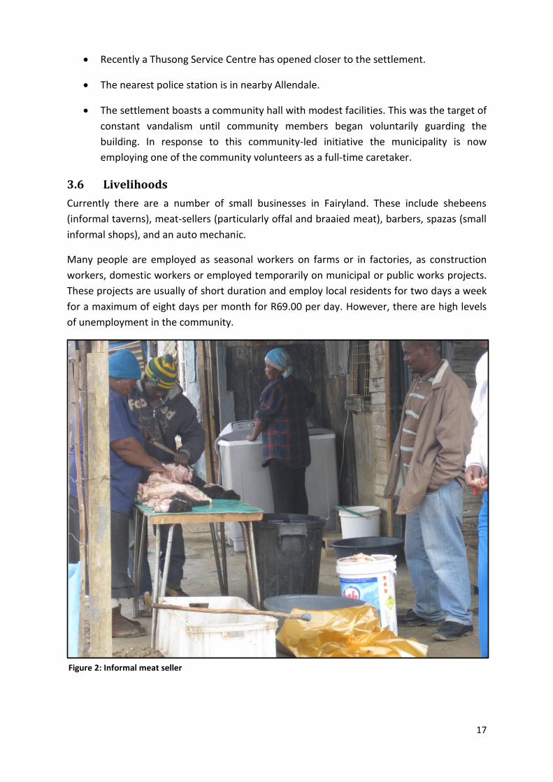
Currently there are a number of small businesses in Fairyland. These include shebeens
(informal taverns), meat-sellers (particularly offal and braaied meat), barbers, spazas (small
informal shops), and an auto mechanic.
Many people are employed as seasonal workers on farms or in factories, as construction
workers, domestic workers or employed temporarily on municipal or public works projects.
These projects are usually of short duration and employ local residents for two days a week
for a maximum of eight days per month for R69.00 per day. However, there are high levels
of unemployment in the community.
Figure 2: Informal meat seller
18
4. Community Risk Assessment of Fairyland
This section describes the findings of the two-day Community Risk Assessment (CRA)
undertaken by the trainees to determine the nature of everyday risks of informal settlement
dwellers living in Fairyland.
4.1 Description of Priority Risks
A wide range of everyday settlement hazards was identified by community members. These
were then categorised into key hazard themes3. In this way, for example, drug and alcohol
abuse and child abduction, which were frequently mentioned, were categorised as crime.
The five key hazards identified in this way were:
Crime
Poor environmental health
Fire
Flooding
Traffic accidents
The brevity of the assessment regrettably did not allow for an in-depth analysis of each of
these hazards. Thus, during a hazard prioritisation exercise conducted with community
members, environmental health and crime were ranked as the two most concerning issues,
with environmental health considered by the majority to be the most critical. These two
hazards became the main focus of the assessment that followed.
4.1.1 Crime
Crime is endemic in the settlement, with robbery occurring frequently and the perpetrators
usually well known to residents. (Youth were identified as the most common perpetrators of
crime). Murders are also fairly common and community members were able to point out
particular hot spots in this regard. Drug and alcohol abuse are significant issues in the
community – prevalent drugs include Mandrax, Crystal Meth (Tik) and Dagga. People
complained about the long operating hours of shebeens, which cause them and school
children in particular, sleepless nights. The abduction and abuse of children was frequently
mentioned although details were not supplied and the subject seemed somewhat taboo.
The police are reportedly slow to respond to call-outs while residents, fearful of violent
reprisals, do not lay charges as they do not want to testify in court. There are no regular
police patrols, although it was reported that police do conduct raids on selected shebeens
3 Interestingly, many hazards identified were cross-cutting, but were generally related to the community’s
primary concern for the safety of the children.

19
(informal drinking taverns), suggesting that some shebeen owners are above the law.
Community members also expressed their dissatisfaction with the use of police sirens
during patrols, which they believe alerts criminals, sending them into hiding.
Community members explained that crime incidents tend to occur at predictable times so
that they can anticipate this and are accordingly more vigilant at these times. For example,
crime is particularly prevalent during the Easter and Christmas periods when people receive
bonuses and become targets for criminals. Crime is also worse over the weekends after
wages have been received and when there is more drinking. Criminals are active during the
early morning hours, targeting particular routes or places. They prey on early commuters
making their way in the dark to the railway station or other public transport hubs. They also
lie in wait for learners walking long routes to school and on people fetching water to
prepare their lunch boxes, particularly during the busy fruit picking season.
Crime hot spots and dangerous areas in the settlement were pointed out during the
community mapping exercise. These included ablution facilities, dumping sites, certain
shops and shebeens within the settlement, but also included areas outside the settlement,
such as in and around the cemetery. It is common for criminals loiter near local shops
observing when goods are purchased then following the customer and robbing them. A
community member described the activities of delinquent youths at night that lead local
residents to anticipate crime. She explained how a group of youths will light a fire and stand
around it singing and drinking throughout the night “in order to mobilize themselves to
attack people who go to community toilets at night”. People within the community seldom
use the ablutions at night and generally do not venture outside their houses after dark in
the evening.
The crime patterns that have been revealed, in terms of where and when they happen,
could be used to inform better police patrolling or the organisation of local neighbourhood
patrols for effectively reducing the risk of crime. The prevailing tendency in Fairyland for the
community to take justice into their own hands i.e. employing mob justice to deal with
suspected criminals is concerning. Described frequently, it appears to have become ‘the way
crime is dealt with’ in answer to the lack of adequate policing and requires further research.
Many factors contribute to the increasing risk of crime in the settlement. Compounded with
high rates of unemployment, the presence of illegal taverns, the lack of recreational
facilities for the youth, the presence of local drug lords, as well inadequate policing services
were cited as aggravating the risk of crime.
20
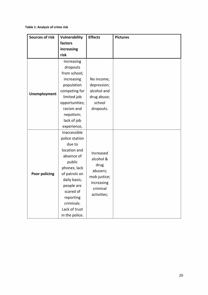
Table 1: Analysis of crime risk
Sources of risk Vulnerability
factors
increasing
risk
Effects Pictures
Unemployment
Increasing
dropouts
from school;
increasing
population
competing for
limited job
opportunities;
racism and
nepotism;
lack of job
experience,
No income;
depression;
alcohol and
drug abuse;
school
dropouts.
Poor policing
Inaccessible
police station
due to
location and
absence of
public
phones; lack
of patrols on
daily basis;
people are
scared of
reporting
criminals.
Lack of trust
in the police.
Increased
alcohol &
drug
abusers;
mob justice;
increasing
criminal
activities;

21
Alcohol
Availability of
illegal
taverns;
increasing
numbers of
unemployed
youngsters;
increasing
school
dropouts; lack
of
recreational
facilities
Deteriorating
conditions of
health;
increased
household
economic
costs;
aggravates
domestic
violence
Drug abuse
(Mandrax,
Dagga & Tik)
Lack of daily
patrols;
people scared
to report drug
dealers.
Lack of trust
in police;
Lack of
recreational
facilities
Deteriorating
conditions of
health;
increased
household
economic
costs;
aggravates
domestic
violence

22
4.1.2 Environmental health hazards
Environmental health was identified as the primary hazard by the majority of residents
attending the workshop. Unsanitary conditions have both a direct impact on people’s
everyday lives and on the longer term health of the community posing significant health
hazards that should be of concern to the local authorities. Children in particular are at risk of
the longer-term effects of polluted urban environments on their lives (Sanderson, 2000).
Access to clean water in the settlement has become critical for several reasons. Firstly,
water points once scattered across the settlement were removed last year during the
course of infrastructure upgrading and have not been replaced. The only remaining fresh
water points are situated at the public ablution blocks which are generally unsanitary,
located next to toilets. Leaking toilets and water run-off from the communal taps, especially
where basins have been vandalised, means that polluted water collects in the public
ablution areas. Household water supply for food preparation and drinking is sourced from
these heavily polluted areas, increasing the risk of contamination and disease for Fairyland
residents, many of whom are already living with compromised immune systems due to their
economic circumstances, i.e. poor nutrition and sub-standard living conditions.
The seriousness of the sanitation problem has gradually increased over time due to the
growing numbers of people living in the settlement and associated with this the inadequate
provision of toilets catering to this growth, lack of designated and contained dumping sites,
uncollected solid waste, illegal dumping of waste (including not only general household
waste but also human excrement), and standing grey water throughout the settlement,
especially in trenches created in the course of infrastructure development.
The toilet blocks were found to be in a disgusting condition, despite the presence on each
occasion of cleaning teams. During a transect walk one such cleaning team was observed to
merely scrape collected rubbish ( including human waste) under the fence surrounding the
toilet block and into the street (See Figure 3 below).
Figure 3: Evidence of 'cleaning of toilets' during transect walk

23
The majority of toilets are in an advanced state of disrepair, either choked with waste that
cannot be flushed away, with broken or even smashed toilet bowls, many with cisterns and
pipes removed, and even doors and partitioning walls missing. Moreover, the flushing
system no longer functions even in the remaining working toilets, necessitating the fetching
of water from one the few remaining communal taps, a task which it can be assumed most
people do not bother with, contributing to the precarious state of these facilities.
The neglected maintenance and repair of the toilet facilities and the absence of drains
leaves residents with little alternative but to discard of human waste in public spaces, either
scattered openly in the streets, thrown into the canal, or collected in bags and left at the
waste collection points.
Vandalism is clearly a major problem, perpetrated by the few to the detriment of the whole
community. Damage to critical facilities is inadequately monitored and infrequently repaired
so that toilet facilities and fresh water taps are slowly being reduced in number, while the
number of users continues to grow.
As criminals are known to frequent the ablution facilities at night, most people avoid using
them, making use of buckets in their dwellings to collect night soil. The location of the
toilets and taps on the periphery of the settlement, far away from many of the centrally-
situated dwellings, and closest to the ‘border‘ area where many of the criminal elements
and newcomers are said to live, puts users at risk even during daylight hours, particularly
women and children. Some households have safeguarded themselves by controlling access
to a particular toilet, using padlocks to keep others out, thereby ensuring that hygienic
Figure 4: Vandalised toilets
Figure 5: Container toilet block

24
conditions are maintained. However, this strategy prevents many others from accessing
these toilets.
Community members are well aware of the environmental health challenges posed by the
lack of sanitation facilities, poor drainage, lack of clean water, open garbage areas,
overcrowded living conditions, standing water, etc . Poor management and maintenance of
the communal ablution facilities is driving up the health risk of the community, posing the
threat of disease outbreaks which could potentially have wide-spread ramifications.
Another hazardous area flagged by community members was the canal situated on the
northern boundary. Possibly a vestige of the same stream that once provided a source of
fresh water to the earliest residents in the settlement, today it poses a major health risk.
Now used as a convenient dumping site it has a bad smell, especially in the hot summer
months, but nevertheless attracts children who frequent the area as a favourite play place.
Children were seen jumping across the filthy canal and sifting through discarded items of
refuse. Community members reported that the nearby shops use known to use the canal as
a dumping place, while a dead dog was observed lying next to the canal.
Community members explained that stagnant pools of dirty water and broken blocked
sanitation systems pose a serious problem throughout the calendar year. While in winter,
Figure 6: Polluted canal on northern boundary

25
heavy rainfall causes standing water to become mixed with polluted run-off from the
ablution areas, in the hot summer months the smell becomes unbearable.
Solid waste collection in the settlement is reportedly erratic, collected from several
collection points scattered around the settlement such as the one illustrated in Figure 7
below. However, neither refuse skips nor other robust containers generally used for the
containment of waste in other informal settlements are provided in Fairyland, nor are there
any drains for the disposal of grey water and liquid waste. Refuse bags awaiting collection in
the streets consequently attract dogs and vermin that tear open the bags, causing waste to
spread around. Currently garbage remains in the collection area for several days, increasing
the health hazard to the community. According to settlement residents, young children,
especially those who are hungry and unattended, often feed themselves from the piles of
garbage4, while human waste is often thrown out into the street5.
The service provider for solid waste collection does not appear to be sufficiently resourced
to meet the needs of this growing community, having inadequate collection equipment and
insufficient staff. Interviewed on site in Fairyland, the contractor explained that due to the
condition of the roads he is unable to use a larger truck but instead has to resort to using
one small vehicle (See Figure 8 below). He also described how challenging it was trying to
4 Similar behaviour by young children was observed during a CRA undertaken in Sweet Home Farm in the Cape
Metro. 5 It was noted that excrement, presumably night soil, was being indiscriminately disposed of throughout the
settlement.
Figure 7: Example of typical refuse collection point

26
keeping pace with waste collection over an area that covers three wards. This brings into
question the suitability of the current contractor for the task in hand, or perhaps the need
for the contracting of additional contractors.
The community feel that the currently outsourced waste collection service could feasibly be
provided by local community members themselves, who could coordinate more effective
community-led disposal practices to improve general environmental health. This would
provide much needed employment while perhaps ensuring that the needs of the
community were being overseen by local residents themselves who have a more informed
understanding of local requirements and workable practices.
During a transect walk numerous factors contributing to the increase in environmental
health risk were identified. These are described in more detail in the table below.
Figure 8: Solid waste service provider

27
Table 2: Analysis of environmental health risks
Sources of risks Vulnerability factors increasing risk Effects Pictures
Grey Standing
water
Delayed infrastructural development;
leaking water pipes, lack of drainage
or stormwater channels
Creates unsanitary conditions; causes skin
rashes among children; results in bad smell;
potential for water-borne diseases

28
Broken and
blocked sanitation
systems
Unsustainable population growth;
Poor maintenance of toilet facilities,
inadequate supply of toilet facilities to
meet increasing need;
Vandalism of facilities;
Indiscriminate human waste disposal
Contamination of the environment;
High risk of communicable diseases;
High immune deficiency levels means
increased susceptibility to inopportune
infections

29
Uncollected solid
waste
Inadequate designated dumping sites;
Unsanitary household practices –
night soil disposal;
Long distance to the dumping sites;
Waste not securely contained;
Unsupervised children play with
waste;
Vermin and dogs feed off waste ;
Waste dumping sites also crime hot
spots;
Contamination of the environment;
Bad smell,
Increased number of diseases;
Breeding grounds for vectors – flies
Attracts vermin
Unsanitary
practices
Poor knowledge of risks associated
with unsanitary practices;
Dumping of human waste in street or
behind broken toilets;
Inadequate public awareness drives
up risk for others
Fresh water points only in toilet areas
Contamination of the environment;
Water collection next to dirty toilets places
people at risk of disease;
Poor management of facilities;
Potential for disease outbreaks

30
4.1.3 Fire
Increasing population density in the settlement is heightening the risk of fire for several
reasons. Firstly, densification has reduced the spacing between dwellings, facilitating the
rapid spread of fire should one break out. Secondly, those not provided with electricity are
connecting illegally to dwellings that are, driving up the risk of short circuiting and sparks
that can cause fires.
In the early days the settlement was spatially divided into blocks, with spaces created
between each block to allow access for emergency vehicles and for the purpose of fire
containment. According to the local disaster manager, the early days of the settlement saw
many large scale fires that destroyed hundreds of households on each occasion. Indeed,
local community members described several fatal fire events, some having occurred fairly
recently, though smaller in scale.
Legal electricity supply has been provided in the form of electricity connection boxes
located on street poles, with each box intended to provide electricity to four dwellings.
However, the charred and blackened connection points observed in boxes with open covers
during the transect walk, suggests that as the settlement has densified more and more
households have connected to the existing supply, overloading the system and causing
short circuits that have ‘fried’ many connection points. It was evident that multiple
households are now connecting to the remaining working connection points, seriously
overloading their capacity and posing a high risk of fire.
It was reported by community members that electrocution occurs fairly regularly in the
settlement. (Recently a child died when touching an exposed cable). Residents expressed
concern about community members who do not ensure that wires are properly insulated or
joined, with the result that the lives of others are threatened. During windy conditions
community members described how flimsy electrical connections are often torn apart
causing wires to fall to the ground. Unsuspecting pedestrians, especially at night, can
unwittingly tread on live wires lying across their paths. Electrical wires in dwellings often
double as washing lines posing the threat of electrical shocks.
Residents are constrained in their ability to fight fire due to the lack of available water
points. According to residents, although the fire service often arrives fairly quickly, they
frequently did not carry enough water, and are also constrained by the lack of an easily
accessible local supply. Residents therefore usually attempt to fight fire by fetching water
from the ablution blocks located on the periphery of the settlement, generally situated at a
distance from their dwellings.
The on-going development of road infrastructure, a protracted project that has been
abandoned on several occasions, has constrained access for emergency vehicles, with deep
channels having been excavated and large manholes now raised above the surface of the
roads making them impassable (See Figure 9 below).

31
According to the Drakenstein disaster manager a central fire point has now been established
in a local resident’s home, which is equipped with basic fire fighting equipment. However
community members claimed no knowledge of this when interviewed. Fire hydrants have
apparently also been installed recently to enable the fire service to respond more effectively
to fires.
4.1.4 Flooding
Flooding was identified as a hazard by some residents, occurring generally after heavy
winter rainfall. Recent densification has reduced the run-off area between dwellings,
illustrated by the pools of water observed between dwellings and along narrow pathways in
the settlement. It is also results from leakage into dwellings due to the use of inferior
construction materials. This has been aggravated by excavations for infrastructure
upgrading. The initial contractors went into liquidation, resulting in abandoned excavations
across the settlement that now collect rainfall.
Figure 9: Manhole covers protruding above street level
Figure 10: Excavation ditch

32
4.1.5 Traffic accidents
The frequency of traffic accidents both along the busy perimeter roads, such as Bo Dal
Josafat Road, and within the settlement is of grave concern to community members. A
traffic accident within the settlement recently caused the paralysis of a young child.
It is alarming that despite the poor condition of the roads within the settlement accidents
continue to happen on these quieter internal roads, suggesting that once the road
infrastructure is completed the problem will be further aggravated.
Community members believe that the construction of speed bumps in strategic hot-spots
would significantly reduce speeding and the risk of accidents in and around the settlement.
4.1.6 Other issues raised
According to several sources many Fairyland dwellers suffer from TB or HIV/AIDS. Butterfly
House, a non-profit organisation established to provide hospice and social support to poor
communities in the area, has since 2008 been active in Fairyland where they have
established a community centre. The centre provides home-based care for those affected by
and infected with HIV/AIDS, providing support particularly to vulnerable children and
orphans.
In the course of their work with local communities, Butterfly House has identified several
other critical community needs. For example, as a result of poor income levels, and the
seasonality of available work, food insecurity is significant as are high levels of child abuse
and neglect. It is disturbing to note that, despite the poor conditions, many disabled and
sickly people, as well as aged residents are living in the settlement6.
A negative consequence of the infrastructural upgrade are the dozens of manhole covers
left unsecured, which pose a significant hazard to children, while an elderly gentleman, who
had suffered from a stroke, when visited in his home was found to be precariously perched
on the edge of an embankment created as a consequence of the road excavations. His lack
of mobility prevented him from negotiating the narrow ledge left outside his door in order
to get around and he had become physically unable to leave his house.
Most of the hazards identified in Fairyland are underlain by deeper socio-economic
problems. The high rate of crime and substance abuse for example is often associated with
growing levels of unemployment. Newcomers to the settlement, among them many foreign
migrants unable to find work, are reportedly selling drugs for a livelihood which is in turn
creating simmering social frictions. Another rankling issue is the illegal purchasing of RDP
houses by outsiders. In times of desperate economic need local beneficiaries resort to
selling their houses and relocating to the informal area, where never again eligible to
receive a housing subsidy, while others still awaiting houses see outsiders moving into their
long-awaited formal homes.
6 This is a common finding in all recent CRAs conducted in the Winelands and differs markedly from the younger
demographic profile generally found in the Cape Metro

33
4.2 Spatial analysis The spatial pattern of Fairyland settlement has changed significantly overtime due to the
continued influx of people to the settlement, and driven by housing projects and industrial
development in and around the settlement. Recent spatial changes in the area are
identifiable in the Time Series images contained in the appendix to this report and clearly
illustrate the process of densification and expansion of the settlement.
Between 1998 and 2002, the settlements of Smartytown and Milkytown were established
on the eastern side of Fairyland as families expanded and people from the Eastern Cape as
well as foreign migrants increasingly arrived in the area. According to longer term residents
of Fairyland, this influx was particularly marked during 1998 and 1999.
In response to this rapid population growth electricity and public toilets were installed in
1998, with standpipes provided in 1999. During 2003 to 2007, a primary school was built
nearby and several informal crèches were established. It was in this period that the
container toilets were introduced and Butterfly House, an arm of the Drakenstein Hospice
located in Paarl, opened its doors to provide social services to the community, including
early childhood development initiatives, a soup kitchen and other critically-needed services.
Between 2009 and 2012 the first RDP houses were built in Milkytown and Smartietown,
while many more spaza shops began operating in Fairyland after the influx of migrants
during this period.
A community mapping exercise and a transact walk were also employed to understand the
spatial patterns of risks affecting communities in Fairyland. This is captured in the image
below that was drawn by the community members themselves.
Figure 11: Settlement map drawn by community members
34
4.3 Coping and adaptation strategies
4.3.1 Crime
Fairyland residents have generally adapted to living with high levels of crime and have
developed a heightened sense of awareness in this regard. For example, although not
always possible, walking in a group rather than alone offers some safeguard against
criminals, while residents seldom go out during the night in order to avoid crime. Avoidance
of recognised hot-spots is also practiced, although it was reported that criminals tend to
loiter near local shops frequented by residents making this impossible at times. Many
households keep dogs to protect themselves and their properties, although even this is not
considered an effective strategy against determined criminals, while dogs are seldom
adequately contained within the perimeter of a household to act as an effective deterrent.
The apparent lack of community cohesion in Fairyland significantly limits opportunity for the
establishment of community-based crime prevention initiatives. The mobilizing of a locally-
recognised crime management group such as a community police forum could be a first step
in the effective reduction of criminal activity and the high crime risk. However, such
collaboration requires the support and guidance of the local South African Police Services
branch. Workshop sessions revealed that the community generally does not trust the local
police force and does not have a strong relationship with the local police station. This could
be overcome with the organisation of a regular community crime forum attended by the
local police and municipal law enforcement officers.
Members of the community noted the increasing prevalence of mob justice in the
settlement in response to criminal activities. This can have fatal consequences for anyone
suspected of committing a crime in the community. One community member emotionally
described how her brother was accused of robbery in a case of mistaken identity and was
nearly killed by a community mob. It was clear from group discussions that this method of
justice is becoming increasingly acceptable to community members who, in fear of
retribution from criminals as well as perceived police duplicity, will not lay charges against
the perpetrators of crime preferring to maintain a low profile.
4.3.2 Environmental Health
In terms of the lack of access to water, some people practice rain water harvesting from the
roofs of their houses, which may be present another form environmental health risk since
the roofs are generally made of plastic and corrosive materials.
In order to improve air circulation in crowded or damp dwellings, some households have
attempted to create air vents in their dwellings.
Many households concerned with hygiene store their household waste in their own rubbish
bins, although this was not observed in the majority of dwellings.

35
During rainy season when the pooling of standing water serious affects many households,
some residents dig drainage channels in an attempt to drain standing water away from their
homes. Residents on the eastern boundary, for example, were observed to be redirecting
water into the cemetery, the only available open land. Over time this is causing damage to
the graves.
Fairyland Community has access to one local clinic which, according to the community
members, is overcrowded. It was reported that “you go to the clinic by seven in the morning
but you end up coming back at four in the evening”. Due to this situation, people reportedly
tend to bribe nurses to access health care services.
The presence of many unrestrained dogs was noted during the transect walk of the
settlement. A community member reported that a small child was recently bitten by one
such stray dog. This situation constitutes another major hazard and should be monitored,
particularly as local dogs can be assumed to be unvaccinated. It is suggested that a state
veterinary service should visit the settlement to survey the situation first hand.
4.4 Support from government and other formal structures
Residents of Fairyland have limited access to formal structures such as municipal service
providers, social services, health services, the police, as well as NGOs. The risk assessment
revealed that this is generally the result of ignorance about who to approach and where
they can be found. It also stems from a lack of self-esteem and a fear of the authorities.
Although representatives from local authority sectors and interest groups were invited to
attend the brief discussion in Fairyland on Tuesday 16 July 2013 that concluded the risk
assessment process, only three role players attended. Failure to attend the session
constitutes a lost opportunity for stakeholders and residents alike to share information and
build stronger, mutually beneficial relationships. In recent Community Risk Assessments
conducted in the Cape metro similar scheduled discussion sessions have allowed for a
neutral, apolitical platform for service providers and communities to develop shared
understandings and discuss possible solutions to settlement-based problems.
The Department of Social Development, Butterfly house (a local NGO), and the district
Public Health Department attended the session, and were able to provide advice and
critically-needed information to the community members present and those who asked for
specific information.
At the conclusion of the session Social Development was requested by the community
members present to run an outreach program in the community hall, providing information
for community members on the services available to them.
Butterfly house promised to continue to assist in the provision of Community Home Based
Care (CBHC) and to explore the possibility of the continuation of the soup kitchen, recently
discontinued due to lack of continued funding, as it became evident that this had become a
critical resource to many Fairyland dwellers, especially for the children and the elderly.

36
The Public Health department agreed to forward specific concerns around the public health
issues raised on behalf of the community to the departments concerned.
Due to the lack of local authority representatives and the absence of the local Ward
Councillor, regrettably many other critical issues could not be discussed during the open
forum.
4.5 Future risks
The continued arrival of people seeking employment opportunities in the nearby industrial
and farming areas will continue to contribute to the increasing density of informal housing,
despite the provision of additional housing in the future. This will predictably exacerbate
existing risks and see the development of others, including the potential for civil unrest
around lack of basic services and repeated xenophobic attacks7.
The lack of outreach programmes concerning child safety, which is of great concern to most
community members, as well as the non-existence of designated playing areas for children,
will increase incidents of child abuse and child injuries.
Lack of transparency in the allocation of new state-built housing may generate unrest in the
future.
The materials currently used by residents in the construction of their dwellings are highly
flammable. This, and the continued densification of the settlement as newcomers continue
to settle there, will continue to influence the impact of shack fires, even if the response time
and effectiveness of the fire services improves. This situation will be aggravated by
continued reliance by many households on illegal electricity connections and inadequate
maintenance of existing electricity infrastructure.
The canal situated on the northern side of the settlement is now heavily polluted and poses
a serious risk public health hazard. The area could be creatively converted into an attractive
community recreational area, with fencing along the canal to prevent children from
accessing the water’s edge.
7 Several Xenophobic attacks were reported in Fairyland during the nationwide wave of xenophobic violence
that occurred during 2008.

37
5. Recommendations
The participants and community members drafted the following recommendations to
inform effective risk reduction:
Lack of community cohesion prevents or obstructs participatory decision-making to
drive appropriate development interventions. In this regard the assessment failed to
identify a community-based structure representative of the whole Fairyland
community. Such a recognised negotiating forum acting on behalf of the community
can effectively aid in the management of crime and the monitoring of communal
ablution facilities. The development of such a body could perhaps be facilitated by a
neutral entity such as an NGO or faith-based organisation.
Improved municipal monitoring of basic service providers and more regular repair of
community sanitation and ablution facilities are essential in order to address some
of the sub-optimal environmental health conditions identified during this assessment
and prevent the risk of future disease outbreaks.
The South African Police Service should schedule community workshops to address
the high crime rate and associated mob justice that currently prevails in the
settlement. Such an initiative can encourage community participation and support,
providing an opportunity to build a culture of trust between the police and the
Fairyland community
The relationship between the ward councillor and the residents of Fairyland requires
significant strengthening. Regular community meetings can provide an opportunity
for greater transparency and regular feedback, while also providing an open forum in
which to discuss and clarify key issues
Education programs and information sessions are required to equip community
members who have low levels of education with knowledge to address life issues.
6. Concluding remarks
The findings presented in this report are intended as a guide in addressing the issues
identified in the Fairyland assessment in order to prevent and mitigate everyday hazards
and to reduce community vulnerability. The South African Disaster Management Act 57
(2002) requires Disaster Management Centres to coordinate effective disaster management
in their areas of jurisdiction. It is therefore imperative that local and district-level Disaster
Management initiate and co-ordinate disaster risk reduction initiatives that can
simultaneously build capacity among the communities. There is a critical need to nurture
and strengthen relationships between all stakeholders and role players concerned underlain
by a shared understanding of local issues in order to ensure community buy-in and support.

38
7. References
Published documents
Anderson, M. and Woodrow, P. (1998) ‘Rising from the Ashes: Development Strategies in Times of Disaster’. Intermediate Technology Publications, London.
Barnes, J. 2012. Development of a prototype water pollution risk rating system for informal settlements along the Upper Berg River. Accessed at http://hdl.handle.net/10019.1/83264
Drakenstein Municipality. State of the Environment Report 2011. (Hard copy provided by
Municipality upon request).
Drakenstein Municipality. Memorandum of the Town Planning Committee. 1 June 1998.
Drakenstein Municipality. Integrated Development Plan 2012 - 2017. Accessed at http://www.drakenstein.gov.za/Administration/Pages/DMSeedFund.aspx.
Drakenstein Municipality. Spatial Development Framework
Holloway A., Roomaney, R., Pharaoh, R., Solomon, FJ. & Cousins, D. 2008. Weathering the
Storm: Participatory Risk Assessment for informal settlements. Disaster Mitigation for
Sustainable Livelihoods Programme, University of Cape Town.
Jackson,VA., Paulse, AN., van Stormbroek, T. Odendaal, JP & Khan, W. 2007. Investigation into metal contamination of the Berg River, Western Cape, South Africa. In Water SA Vol. 33 No. 2 April 2007. Pelling, M. 2003. The vulnerability of cities: natural disasters and social resilience. Earthscan. Sanderson, D. 2000. Cities, disasters and livelihoods.Environment and Urbanization 12(19).
Interviews conducted
Scholtz, Warren – Drakenstein Disaster Manager
Ross, Soudah. – Councillor for Ward 13
Vuyani Makhara (Madiba) - Fairyland grassroots leader and member of the steering
committee
Butterfly House Centre, Fairyland
Various members of the Fairyland Community
39
8. Time Series Photographs of Fairyland settlement
The following pages contain Google Earth images of the Fairyland settlement area, captured
between 2003 and 2010. They illustrate considerable changes in spatial development over a
brief seven-year period. Temporal changes, such as increasing settlement density and the
peripheral development of state-built housing, are of particular interest.

40
Fairyland 2003

41
Fairyland 2005
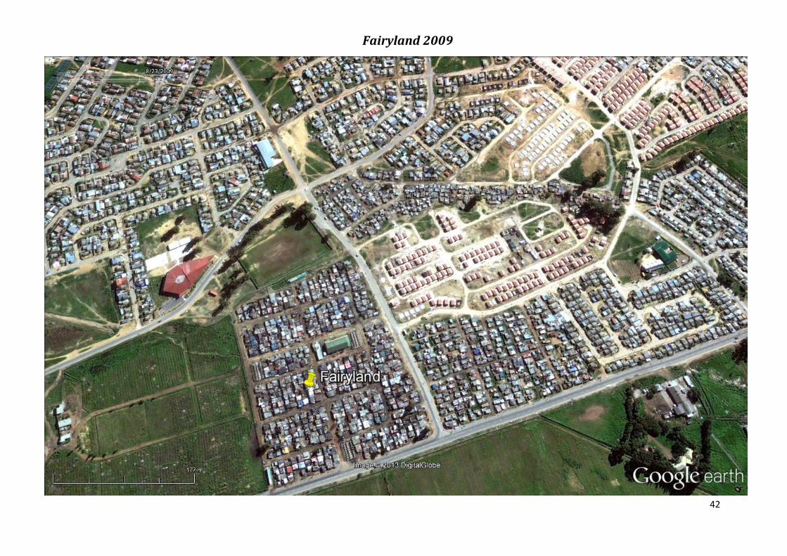
42
Fairyland 2009

43
Fairyland 2010