company profile - tatweer-abudhabi.ae · company profile pre-qualification document ... (abu dhabi...
TRANSCRIPT

C O M P A N Y P R O F I L E
PRE-QUALIFICATION DOCUMENT
Expert in the fields of:
● Electrical Resistivity Tomography (ERT) ● Multi-Channel Analysis of Surface Waves (MASW) ● Seismic
Refraction ● Seismic Downhole ● Seismic Crosshole ● Ground Penetrating Radar(GPR) ● Potential
Fields Gravity & Magnetic Methods of Investigation ● Topographic Survey● Consultancy in Airborne
Geophysical exploration for Environmental Studies and Groundwater Exploration.
Page 2
Dear Valued Customer,
Tatweer for geophysical studies and consulting (TGSC) is based in Abu Dhabi and fully supported by Khalifa
Fund for Enterprise Development. TGSC is heavily engaged in the on-site geophysical consultant/contractor and
offers the complete range of geophysical services; we have specialists in Engineering Geophysics using different
geophysical methods of investigation such as Electrical Resistivity Tomography (ERT), Gravity, Magnetic, Electro
Magnetic (EM), Ground Penetration Radar (GPR), Multichannel Analysis of Surface Wave (MASW), Seismic
Refraction, Seismic Downhole, Seismic Cross-hole and Topographic Surveying.
Additionally, we provide a range of near-surface (environmental) geophysics consulting services. For more
information about our company's services, herewith attached is our company profile for your consideration and
perusal.
For and on behalf of Tatweer for Geophysical Studies and Consulting
General Manager.
Eng. Mohammed Mahmoud Al Marzouqi

Page 3
Index
1. COMPANY INTRODUCTION: ...........................................................................................................................4
2. GEOPHYSICAL SERVICES: ................................................................................................................................4
2.1. ELECTRICAL RESISTIVITY TOMOGRAPHY (ERT) AND IMAGING ...............................................................4
2.2. SEISMIC SHEAR WAVE VELOCITY MEASUREMENTS UTILIZING MULTI ANALYSIS SURFACE WAVES
(MASW)...............................................................................................................................................................8
2.3. SEISMIC REFRACTION .......................................................................................................................... 12
2.4 SEISMIC DOWNHOLE TESTING ............................................................................................................ 16
2.5 GROUND PENETRATING RADAR (GPR) ................................................................................................ 19
2.6 GRAVITY AND MAGNETIC SURVEYS ..................................................................................................... 22
2.7 GRAVITY SURVEYS................................................................................................................................ 22
2.8 GPS AND TOTAL STATION TOPOGRAPHIC SURVEYS ............................................................................ 24
Our Land Surveying Services will include: ............................................................................................................. 24
2.9 CONSULTING SERVICES WILL INCLUDE ................................................................................................ 24
3. GROUND WATER EXPLORATION.................................................................................................................. 25
4. GEOPHYSICAL EQUIPMENT AND SOFTWARE’S: .......................................................................................... 29
5. TABLE OF CONTENTS OF QHSE MANUAL: ................................................................................................... 30
6. LIST OF PROJECTS COMPLETED BY TATWEER:............................................................................................. 32
7. LIST OF PROJECTS SUPERVISED BY THE TECHNICAL MANAGER OF TATWEER: ........................................... 34
Groundwater assessment project Abu Dhabi ............................................................................................................. 34
8. REGISTRATION, CERTIFICATES AND TRADE LICENSE: .................................................................................. 38
9. STRUCTURAL ORGANIZATION: .................................................................................................................... 42
10. LIST OF KEY PERSONNEL & QUALIFICATION: ............................................................................................. 43

Page 4
1. COMPANY INTRODUCTION:
Tatweer for geophysical studies and consulting (TGSC) embraces the vision of becoming the leader in
geophysical activities in its markets of operation. Our mission is to provide reliable, timely, accurate, cost
effective and quality specialized geophysical and geological engineering services that meet customer’s
expectations.
(TGSC) company based in Abu Dhabi city and fully supported by Khalifa Fund Enterprise development and will
provide specialized geophysical, geological engineering services and consulting including the quality control of
projects and supervising special studies.
2. GEOPHYSICAL SERVICES:
TGSC providing the following technical services throughout the UAE and Gulf Cooperation Council GCC states:
1.1. Electrical Resistivity Tomography (ERT)
1.2. Seismic Shear Wave Velocity Tests utilizing Multi Analysis Surface Waves (MASW)
1.3. Seismic Refraction
1.4. Seismic Downhole Testing
1.5. Seismic Crosshole Testing
1.6. Ground Penetration Radar (GPR) for subsurface Scanning
1.7. Gravity & Magnetic Surveying
1.8. Topographic Surveying
1.9. Consultancy in Airborne Geophysical Magnetic, Electromagnetic, Radiometric Survey for Environmental
Studies and groundwater exploration.
2.1. ELECTRICAL RESISTIVITY TOMOGRAPHY (ERT) AND IMAGING
Resistivity geophysical surveys measure variations in the electrical resistivity of the ground, the idea of ERT
technique is to pass a current of known voltage into the subsurface to be imaged through two current electrodes,
and then using a second pair of potential electrodes, measure the potential drop induced by the differential
response of earth materials to the penetrating current. The survey data will be processed to produce graphic
depth sections of the thickness and resistivity of subsurface electrical layers. The resistivity sections are
correlated with ground interfaces such as soil and fill layers or soil-bedrock interfaces, to provide engineers with
detailed information on subsurface ground conditions.
Page 5
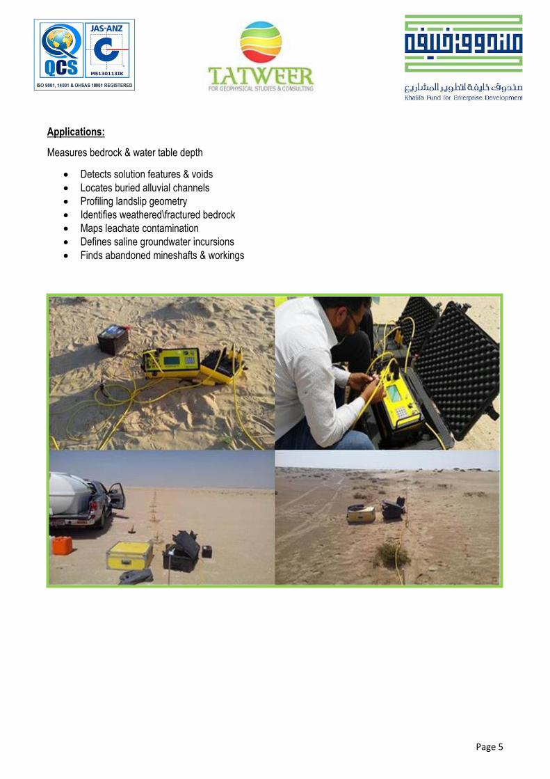
Applications:
Measures bedrock & water table depth
Detects solution features & voids
Locates buried alluvial channels
Profiling landslip geometry
Identifies weathered\fractured bedrock
Maps leachate contamination
Defines saline groundwater incursions
Finds abandoned mineshafts & workings

Page 6
Interpreted by : Dr. M. Hassouneh
CONTRACTOR:CLIENT:PROJECT: CONSULTANTS
CONSTRUCTION OF POLICE
OFFICERS VILLAS & ROAD
NETWORK IN MBZ CITY ABU
DHABI, UAE.
Data Collected by:Eng. Umair Saleem
July 15, 2014
Re
du
ce
d L
eve
l
(m)
Distance
(m)
Groundwater
Table
Highly Weathered,
Fractured Bedrocks
BH-03
Examples:
2D Electrical Resistivity Inverted Section surveyed at Construction & Maintenance of Officer Villas Abu Dhabi/ Mussafah, UAE, July-2014.
2D Electrical Resistivity Inverted Section surveyed at Al Maktoum Airport-Dubai, UAE, in May 2014.

Page 7
3D Electrical Resistivity Inverted Sections Surveyed at Plot No. 18-06-137-199 in Hai Qesaidah, Al Ain, for Her Highness Sheika Salama Bint Zayed Al Nahyan – June 2015.
The final report includes subsurface apparent resistivity values from profile stations. Results may be plotted as profile lines or contour maps (Isopleths resistivity map), or in other presentations according to the clients' needs.

Page 8
2.2. SEISMIC SHEAR WAVE VELOCITY MEASUREMENTS UTILIZING MULTI ANALYSIS SURFACE WAVES (MASW)
MASW is a seismic method that uses the dispersive nature of surface waves to map the values of shear wave
velocities (Vs) in the subsurface. Shear wave velocity is a function of the elastic properties of the soil and rock
and is directly related to the hardness (N-values) and stiffness of the materials. In particular, MASW is used in
geotechnical for the measurement of shear-wave velocity and dynamic properties, identification of subsurface
material boundaries and spatial variations of shear-wave velocity for site classification.
Applications:
Used to map soil and sediment thickness and elevation of subsurface interfaces, such as top of bedrock
and stiffness.
Used to determine shear wave velocity or density of subsurface material, and the presence and location
of voids and karst features.
Site Classification.

Page 9

Page 10
Examples:
Shear wave velocity (Vs) map obtained from active MASW profile carried out along road 1- Secure-Officer Villas
project, showing unique signatures of extremely low shear wave velocity values along the road at approximate
depths between 2.5m and 5.2 m. Very strong near-surface shear-wave velocity contrasts related to very loose fill
materials and highly fractured bedrocks.
The boring log indicated very loose sand at a depth between 3m and 8m with SPT results between 5% and 8% which is corresponding to S-wave velocity value of less than 150 m/s. It is very high risky loose layer for future roads construction.
Page 11
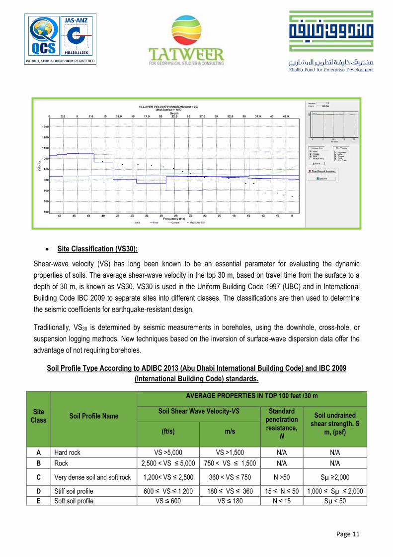
Site Classification (VS30):
Shear-wave velocity (VS) has long been known to be an essential parameter for evaluating the dynamic
properties of soils. The average shear-wave velocity in the top 30 m, based on travel time from the surface to a
depth of 30 m, is known as VS30. VS30 is used in the Uniform Building Code 1997 (UBC) and in International
Building Code IBC 2009 to separate sites into different classes. The classifications are then used to determine
the seismic coefficients for earthquake-resistant design.
Traditionally, VS30 is determined by seismic measurements in boreholes, using the downhole, cross-hole, or
suspension logging methods. New techniques based on the inversion of surface-wave dispersion data offer the
advantage of not requiring boreholes.
Soil Profile Type According to ADIBC 2013 (Abu Dhabi International Building Code) and IBC 2009
(International Building Code) standards.
Site Class
Soil Profile Name
AVERAGE PROPERTIES IN TOP 100 feet /30 m
Soil Shear Wave Velocity-VS Standard penetration resistance,
N
Soil undrained shear strength, S
m, (psf) (ft/s) m/s
A Hard rock VS >5,000 VS >1,500 N/A N/A
B Rock 2,500 < VS ≤ 5,000 750 < VS ≤ 1,500 N/A N/A
C Very dense soil and soft rock 1,200< VS ≤ 2,500 360 < VS ≤ 750 N >50 Sµ ≥2,000
D Stiff soil profile 600 ≤ VS ≤ 1,200 180 ≤ VS ≤ 360 15 ≤ N ≤ 50 1,000 ≤ Sµ ≤ 2,000
E Soft soil profile VS ≤ 600 VS ≤ 180 N < 15 Sµ < 50

Page 12
2.3. SEISMIC REFRACTION
Seismic refraction is a valuable tool for mapping bedrock and fractures. It is usually more cost-effective and gives
better coverage than drilling alone. The seismic refraction method utilizes sound waves. Sound travels at
different velocities though different materials and is refracted at layer interfaces. A seismic wave is usually
generated using a sledge hammer, a specially designed seismic gun that employs a blank shotgun shell, or a
seismic weight drop tool. The wave's travel time from the sound source to refracting layers, along those layers
and back to detectors (called geophones) is precisely measured. From the time-distance relationships,
subsurface layer velocities and thicknesses can be calculated. Fracture zones can often be
Detected because they usually have a lower seismic velocity than solid bedrock. The velocity of sound through
water saturated material is about 1524 m per second while the velocity though crystalline bedrock generally
ranges from 3660 to 5500 m per second. By calculating the velocity of sound along the bedrock surface, low
velocity zones, which may represent fractures, can be delineated.
Our system utilizes up to 24 geophones at one time. The geophones can be linearly spaced any distance apart,
but most often are spaced 10 to 50 feet apart. In general the greater the expected bedrock depth, the greater the
geophone spacing. Shorter spacing and sometimes radial patterns are used in fracture zone detection studies.
Final results are provided to the client in a full report which includes tables of subsurface depths and elevations,
and cross-section profiles. Results are also available as bedrock contour maps and on computer disks.

Page 13
Applications:
Measures Bedrock Depth & Overburden Thickness
Fractures zones in bedrock
Bedrock contour mapping
Determines Rippability Parameters
Locates Geological Structures
Defines Ancient Landfill Sites
Depth to water table
Examples: Refraction method using multi-channel geophone array, the signal returns to the surface by refraction
at subsurface interface.

Page 14
Seismic Refraction and Assessment of Rock Quality:
Seismic refraction most commonly employed where velocities increase suddenly with depth, e.g. determining
depth to bedrock. From the estimated layer velocities estimates of rock strength and excavation difficulty can be
made. Rippability is ease with which ground can be excavated with a mechanical digger, varies with tractor size
and power. In 1958, the Caterpillar Tractor Company began using seismic velocities from refraction experiments
to estimate rippability. Rippability for various common rocks as shown in the figures below.
Rippability is Ease with which Ground can be excavated with a Mechanical Digger, Varies with Tractor Size and Power.

Page 15
Bedrock surface utilize the Seismic Refraction method of investigation. Low velocity layer is correlates
with unconsolidated materials and high velocity layer correlates very well with very hard bedrock

Page 16
2.4 SEISMIC DOWNHOLE TESTING
The seismic Downhole method provides a designer with information pertinent to the seismic wave velocities of
the materials). The P-wave and S-wave velocities are directly related to the important geotechnical elastic
constants of Poisson’s ratio, shear modulus, bulk modulus, and Young’s modulus. Accurate in-situ P-wave and
S-wave velocity profiles are essential in geotechnical foundation designs. These parameters are used in both
analyses of soil behaviour under both static and dynamic loads where the elastic constants are input variables
into the models defining the different states of deformations such as elastic, elastic-plastic, and failure. Another
important use of estimated shear wave velocities in geotechnical design is in the liquefaction assessment of soils.
The Downhole Test is a method which determines soil stiffness properties by analysing direct compressional and
shear waves along a borehole down to about 30 m. The aim of the downhole testing is to derive elastic rock
properties such as Poisson’s ratio or Young’s modulus. Shear waves have to be generated at surface. A shear
wave source (sledge hammer hit sidewise) is used at surface and a coupled receiver system is moved in the
borehole. Travel times of the seismic waves are analysed and seismic velocity is calculated. Shear wave velocity
can be transformed to soil stiffness. The measurements can be performed below and above the groundwater
table. A grouted casing (e.g. PVC) with a diameter between 3 and 6 inch needs to be prepared.
Downhole Field Arrangement

Page 17
Impulse Seismic Source (Produces P- and S-Wave Trains)

Page 18
The Downhole test requires a surface source capable to generate S- and P-waves and a borehole receiver with a
multi-directional sensor array. S- and P-wave velocities are measured and the dynamic soil parameters (shear
and Young’s modulus) are calculated, sledge hammer (equipped with a trigger element) and a wooden beam can
serve as source if the survey depth is limited.

Page 19
2.5 GROUND PENETRATING RADAR (GPR)
Ground probing radar also known as ground penetration radar (GPR) is a high resolution, field-portable
geophysical method that produces graphic sections of subsurface structure. Typical site investigation
applications include the accurate location of voids and buried obstructions; mapping subsurface soil and rock
interfaces and defining buried archaeological structures. Ground probing radar can also identify ancient landfill
sites and detect buried hazardous waste. Ground radar surveys are non-destructive and non-intrusive, revealing
detailed information on subsurface ground conditions and can be used for the targeting of expensive drilling
operations. On sensitive sites where intrusive investigations are not permissible, a ground radar survey will
provide valuable information about the site. Survey results are presented in an easy to understand engineering
compatible CAD format.
General GPR field survey procedures

Page 20
Exploration depth can be limited by soil or water with high conductivity. Detectability depends upon a dielectric contrast between the subsurface feature and the surrounding material.
Applications
Detects buried voids & cavities, archaeology, unmarked graves
Determines depth of bedrock and overburden thickness
Finds buried underground storage tanks (USTs) and drums
Locates buried foundations and other obstructions
Maps boundaries of closed landfills
Tracks non-metallic sewer lines
Defines position of pits, ditches and graves
Example of processed GPR profile over underground fire fighter pipe line-Qasr Al Sarab-2013
Jet Fuel Pipeline (16 inch ) in Dubai\EPPCO House
Novenber 2012
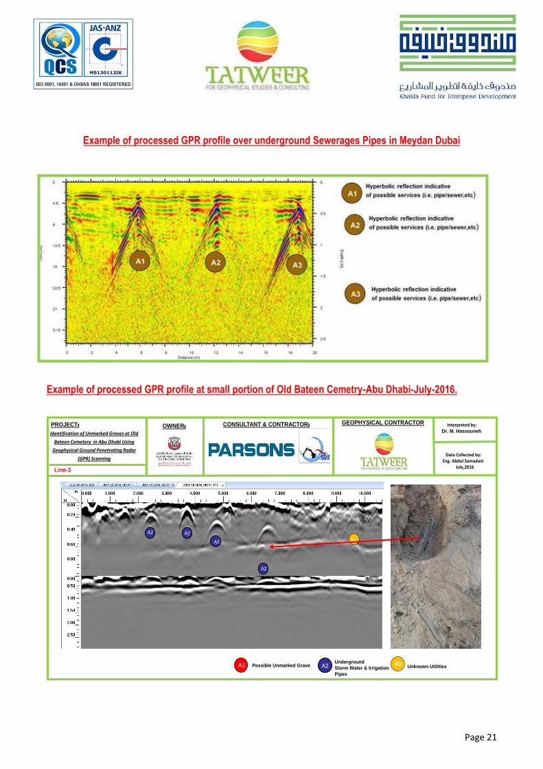
Page 21
Interpreted by:Dr. M. Hassouneh
Data Collected by:Eng. Abdul Samadani
July,2016
PROJECT: GEOPHYSICAL CONTRACTOROWNER: CONSULTANT & CONTRACTOR:
Identification of Unmarked Graves at Old
Bateen Cemetery in Abu Dhabi Using
Geophysical Ground Penetrating Radar
(GPR) Scanning
Line-3
Underground
Storm Water & Irrigation
Pipes
Possible Unmarked Grave Unknown Utilities A3A2A1
A2 A2
A3A2
A2
Example of processed GPR profile over underground Sewerages Pipes in Meydan Dubai
Example of processed GPR profile at small portion of Old Bateen Cemetry-Abu Dhabi-July-2016.

Page 22
2.6 GRAVITY AND MAGNETIC SURVEYS
Magnetic geophysical surveys measure small, localized variations in the Earth's magnetic field. The magnetic
property of naturally occurring materials such as magnetic ore bodies and basic igneous rocks allows them to be
identified and mapped by magnetic surveys. Strong local magnetic fields or anomalies are also produced by
buried steel objects. Magnetometer surveys find unmarked graves, archaeology underground storage tanks,
drums, piles and reinforced concrete foundations by detecting the magnetic anomalies they produce.
Total field aeromagnetic anomaly map of the southern part of Jordan shows 4 major fault zones: Disi-Mudawara (DM),
Quwaira (QW), Ma’an (MA) and Wadi Araba (WA); Contour Interval = 30 nT.
Applications:
Finding buried steel tanks and waste drums
Detecting iron and steel obstructions
Locating unmarked mineshafts
Accurately mapping archaeological features and unmarked graves
Mapping basic igneous intrusive & faults
Evaluating the size and shape of ore bodies
2.7 GRAVITY SURVEYS
Gravity surveys can provide useful information where other methods do not work. For example, gravity may be
used to map bedrock topography under a landfill, where seismic refraction is limited. Gravity can also be used to
map lateral lithological changes, and faults. Gravity is the attraction between masses. The strength of this force is

Page 23
a result of the mass and distance separating the objects. Gravity surveys are relatively slow and expensive.
Detectability varies with target size, depth and density contrast. Interpretation of data often requires control data
from drilling, outcrops, or other sources. Detailed surface topographic survey data is also required.
(A): CG-5 Autograv Gravity Meter (B): Gravity Anomaly Map-Al Sirhan Area-Jordan
Gravity equipment and sample of gravity anomaly map published by Tatweer Technical Manager, Jordan, 2003.
A gravimeter is used to measure the earth's gravitational attraction at various points over the area of interest. Gravity anomalies are due to differences in density of underlying materials. Gravity anomalies are extremely small relative to the total field and are usually measured in micro-Gals (one micro-Gal is about 1 billionth of the earth's total gravitational field). The equipment used in a gravity survey is extremely delicate and precise. Data interpretation is time consuming even with the use of sophisticated computer programs.
Applications:
Bedrock topography under landfills
Mapping large metallic mineral deposits
Locating subsurface caverns
Locating contacts between geologic units of differing mass and density
Results are presented in a full report which includes profiles or a contour map and gravity data tables.
Page 24
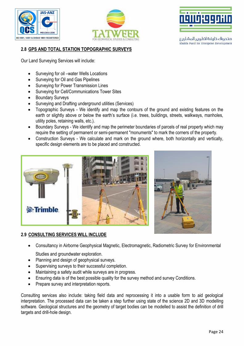
2.8 GPS AND TOTAL STATION TOPOGRAPHIC SURVEYS
Our Land Surveying Services will include:
Surveying for oil –water Wells Locations
Surveying for Oil and Gas Pipelines
Surveying for Power Transmission Lines
Surveying for Cell/Communications Tower Sites
Boundary Surveys
Surveying and Drafting underground utilities (Services)
Topographic Surveys - We identify and map the contours of the ground and existing features on the earth or slightly above or below the earth’s surface (i.e. trees, buildings, streets, walkways, manholes, utility poles, retaining walls, etc.).
Boundary Surveys - We identify and map the perimeter boundaries of parcels of real property which may require the setting of permanent or semi-permanent "monuments" to mark the corners of the property.
Construction Surveys - We calculate and mark on the ground where, both horizontally and vertically, specific design elements are to be placed and constructed.
2.9 CONSULTING SERVICES WILL INCLUDE
Consultancy in Airborne Geophysical Magnetic, Electromagnetic, Radiometric Survey for Environmental
Studies and groundwater exploration.
Planning and design of geophysical surveys.
Supervising surveys to their successful completion.
Maintaining a safety audit while surveys are in progress.
Ensuring data is of the best possible quality for the survey method and survey Conditions.
Prepare survey and interpretation reports. Consulting services also include: taking field data and reprocessing it into a usable form to aid geological interpretation. The processed data can be taken a step further using state of the science 2D and 3D modelling software. Geological structures and the geometry of target bodies can be modelled to assist the definition of drill targets and drill-hole design.
Page 25
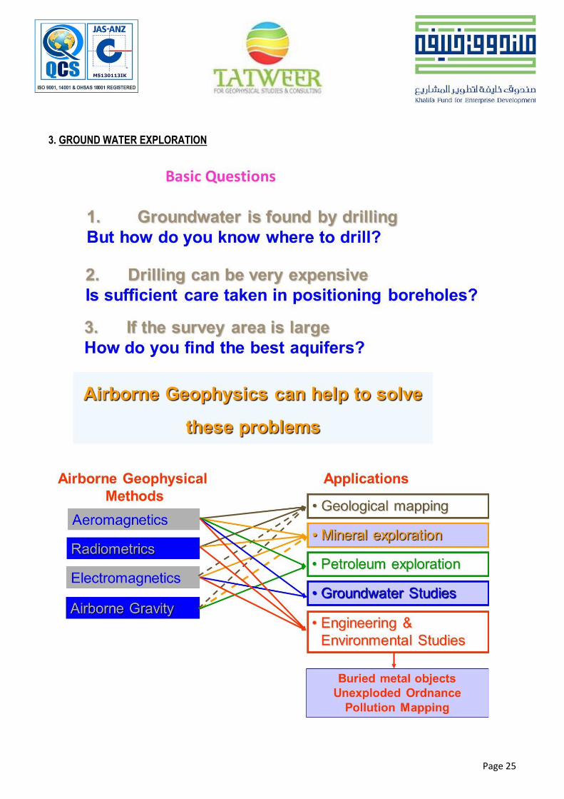
3. GROUND WATER EXPLORATION

Page 26

Page 27

Page 28

Page 29
4. GEOPHYSICAL EQUIPMENT AND SOFTWARE’S:
Serial No. Equipment Description Make Location Number of Equipment
1 Superstring 56 R8/IP AGE USA 1
2 Geode 24 channel Geometrics USA 2
3 GPR Dual Frequency 300-800 MHz GSSI USA 1
4 Downhole Seismic Triaxial Geophone Geostuff USA 1
5 GPS Trimble USA 1
Serial No. Software Description Make Location
1 Earth imager TM 2D & 3D AGE USA
2 SurfSeis V 4.0-2D Kansas USA
3 Geoscanners-GPR-SOFT Sweden Sweden
4 Gred3D 2D V.2 USGS USA

Page 30
QUALITY, HEALTH, SAFETY AND ENVIRONMENT
MANAGEMENT SYSTEM PROCEDURES
This QHSE Procedures has been prepared in accordance with the requirement of ISO 9001:2008, ISO
14001:2004 & OHSAS 18001:2007. Responsibility for preparation, review & approval is given in the first
section of each procedure.
5. TABLE OF CONTENTS OF QHSE MANUAL:

Page 31

Page 32
6. LIST OF PROJECTS COMPLETED BY TATWEER:
S. No. Project Name Client Name Geophysical
Techniques
Reports
Submittal Dates
1 Technical report on geophysical surveys at the main access bridge from Abu Dhabi to Al Maria island along 10th street.
ADM
Multi-Channel Analysis Of
Surface Waves (MASW-2D) &
GPR
January 2013
2 Geophysical Investigation Dry Duck, Dubai
Material Lab Dubai
Multi-Channel
Analysis Of
Surface Waves
(MASW-2D)
May 2013
3 Downhole tests in Dubai, UAE. Matrix Lab Dubai Downhole
Seismic Test May 2013
4 Geophysical Study At Suweihan, Al Ain, UAE.
Al Suweidi Engineering Consultants
Bureau
Multi-Channel Analysis Of
Surface Waves (MASW-2D)
June 2013
5 Down-hole Seismic Test at Dubai Lagoon
Matrix Lab Dubai Downhole Test June 2013
6 Down-hole Seismic Reports Qatar Industrial
Lab Downhole Test June 2013
7 Down-hole Seismic Test at Dubai Marina Matrix Lab Dubai Downhole test June 2013
8 Down-hole Seismic Test at Dubai Lagoon Dubai UAE.
Matrix Lab Dubai Downhole Test July 2013
9 Geophysical Investigation At Proposed Poultry Farm Plot # 59-04-801-253 Al Jeeah Al Ain, UAE.
Arco Engineering Consulting
Engineers LLC
Multi-Channel Analysis Of
Surface Waves (MASW-2D)
July 2013
10 Underground Utility Detection Over A Small Portion Of The Natural Protected Area
Meydan Group Round
Penetration Radar (GPR)
July 2013
11 Detection of leakage along the fire fighting pipe at qaser al sarab hotel near Hameem Abu Dhabi, UAE.
Al Jaber Engineering &
Contracting (ALEC)
Round Penetration Radar
(GPR) Sept 2013

Page 33
12 Abu Dhabi International Airport Terminal 1 Arrivals Hall and Tunnel Construction
Al Jaber Engineering &
Contracting (ALEC)
Round Penetration Radar (GPR)
October 2013
13 Construction Of Midfield Terminal Building
Material Lab Dubai Electrical Resistivity Tomography (ERT)
October 2013
14 Geophysical Investigation Works at Corniche Road Subsidence
Khalaf Sultan General Contracting
Est.
Ground Penetration Radar (GPR) &
Electrical Resistivity Tomography (ERT)
October 2013
15 Identification Of Unmarked Graves At Al Corniche Cemetery
Corniche Hospital Ground Penetration
Radar (GPR) November 2013
16 Underground Utility Detection at AUH Airport
Alemco-Al Jaber Ground Penetration
Radar (GPR) December 2013
17 Non-invasive geophysical testing for all soil types, including residual soils and fractured soft rock.
Pioneer Partners International
(MASW-2D) & Electrical
Resistivity Tomography
(ERT)
December 2013
18 Al Maktoum Intl.Site Invesgn Package-1
Dubai Aviation Engineering
Projects
(MASW-2D) & Electrical Resistivity Tomography (ERT)
April 2014
19
Geophysical investigation at proposed residential complex at plot no. 71-03-050-2, Makhoola, Remah, Al Ain, UAE
Musanda Multi-Channel Analysis
Of Surface Waves (MASW-2D)
February 2015
20
Geophysical investigation of proposed construction of commercial real estate car wash, plot no. 63-01-094-016, Al Salamat 1, Al Ain, UAE.
Al Bahir Consultant Engineering
Multi-Channel Analysis Of Surface Waves
(MASW-2D) February 2015
21
Geophysical investigation at proposed expansion of al mirfa hotel, plot no. P120, area 2, Al Mirfa City, Western Region, Abu Dhabi, UAE
Graham Jones
Alewan Eng Consultant
Multi-Channel Analysis Of Surface Waves
(MASW-2D)
February 2015
22
Geophysical Investigation of Proposed Al Wajeha Al Bahria Mixed Use Project in Plot No. P512 (Block-C), Al-Marfa, Western Region, Abu Dhabi, UAE
NTCC MASW February 2015
23 Geophysical survey work for the mosque, plot no. 1001, Liwa, Western Region, Abu Dhabi, UAE
Black Series
Multi-Channel Analysis
Of Surface Waves
(MASW-2D)
March 2015

Page 34
24
Geophysical investigation of proposed construction of dual road between sarooj & sanaiya area, Al Ain, UAE.
Halcrow Multi-Channel Analysis Of
Surface Waves (MASW-2D)
March 2015
25 Roads subsidence in Sector F-2, Mafqar City
Al Jaber Multi-Channel Analysis Of
Surface Waves (MASW-2D) August 2015
26 Construction of company camp and warehouse
AAM Multi-Channel Analysis Of
Surface Waves (MASW-2D) August, 2015
27 قابر أعمال الحفر والتجهيز والدفن في م
مدينة أبو ظبي )مقبرة بني ياس
مباني االبداع للمقاوالت والصيانة
العامةTopographic Survey Ongoing
7. LIST OF PROJECTS SUPERVISED BY THE TECHNICAL MANAGER OF TATWEER:
S. No. Project Name Client / Consultant Geophysical
Techniques & Geophysical Contractor
Report Submittal
Dates
1 Groundwater assessment project Abu Dhabi
The Office Of H. H. The President Of The UAE
Department Of Water Resources Studies-Abu
Dhabi 2004-2006
2
Geophysical investigation report for two cavities area Project expansion of Abu Dhabi International airport
Scadia Parsons ERT-Baynunah
Laboratories March 2008
3
Geophysical investigation Report Electrical resistivity tomography investigations, Al Falah community development project
Al Dar Properties\Fluor, Langan
15 Reports ERT-Capital Surveys
January 2010 to July
2010
4 Abu dhabi medical rehabilitation centre Khalifa city A, Abu Dhabi, UAE
Tilke & Partners W.L.L. ERT-Capital Surveys January
2011
5 Proposed UAE University Campus Infrastructure Development, Al Ain UAE
Aecom ERT-Capital Surveys March 2011
6 Geophysical Investigating At Gulf Rubber Factory, Al Ain, UAE
Orion Contracting ERT-Capital Surveys March 2011

Page 35
7 Proposed residential compound Infrastructure Development, Al Ain, UAE
Tmkn Properties\Alfara’a
ERT-Capital Surveys April 2011
8 Wahat Al Nakheel Hotel Apartments, Al Ain, UAE
Tmkn Properties \ Alfara’a
ERT-Capital Surveys May 2011
9 Villa Construction Development at Khalifa City “B” Abu Dhabi, UAE
Mr. Ismael al zarouni \ Shankland Cox
ERT-Capital Surveys May 2011
10 Clinical Hospital, Al Falah, Abu Dhabi
Abu Dhabi Health Services Company (SEHA)\ Astorino
ERT-Capital Surveys June 2011
11 Geophysical electrical resistivity tomography (ERT) for al Khabisi site
Abu Dhabi Health Services Company (SEHA)\ Astorino
ERT-Capital Surveys July 2011
12 Villa Construction Development, Khalifa City “B” Abu Dhabi, UAE
Mr. Khamis Al Rumaithy ERT-Capital Surveys August 2011
13 Proposed Clinical Hospital Construction, Khalifa City B
Abu Dhabi Health Services Company (SEHA)\ Astorino
ERT-Capital Surveys October 2011
14
Land electrical resistivity tomography (ERT) Investigations along deep tunnel sewer Construction
Adssc\Samsung C & T Corporation
ERT-Capital Surveys October
2011
15 Ert Survey Analysis Along Marine Tunnel System
Adssc\Samsung C & T Corporation
Marine ERT-Capital Surveys
October 2011
16 Al Sowwah island roads, bridges and infrastructure Al Sowwah island, UAE
Mubadala real estate & hospitality \ Ws Atkins &
partners overseas ERT-Capital Surveys
October 2011
17 Construction Works Associated with Al Waha Land Industrial Park Musafah, Abu Dhabi, UAE.
Al Waha Land ERT- Aces\Dubai Branch March 2012
18 Technical geophysical investigation under villa settlement
Crown Prince Muhammed Bin Zayed
MASW & GPR- ACES\Dubai branch
March 2012
19 Technical Investigation Under the Private Villa Depression, Al Ain, UAE
Nael General Contract.
EST.
GPR- Aces\Dubai Branch April 2012

Page 36
20 Technical Investigation at the Unknown Obstruction, NDRC-Liwa Road, Abu Dhabi, UAE
Nael & Bin Harmal Hydroexport Est.
ERT & GPR- ACES\Dubai branch
April 2012
21 Proposed Police School project in Al Foah Al Ain, UAE
Abu Dhabi Police Department \ APG Arch. & Planning
Group
MASW- Aces\Dubai Branch
June 2012
22 Identification of Unmarked graves at Al Bateen Cemetery
Parson GPR- ACES\Dubai branch July 2012
23 Shopping and Residential Complex in Al Ain Downtown, Al-Ain, UAE
General Authority of Islamic Affairs &
Endowment\ Granada Archt. & Consulting
Engineers
ERT & MASW- Aces\Dubai Branch
September 2012
24
Subsurface Investigation Using Ground Penetrating Radar To Assess Proposed Paid Parking Development Site For Possible Unmarked Graves Across Al Ziani Cemetry, Abu Dhabi City, UAE
Abu Dhabi General Transport Company
(Dot) GPR- ACES\Dubai branch
September 2012
25 Proposed Abu Dhabi Future School Program Phase IV Al- Neima- Al Ain, UAE
Aecom Middle East
ltd.
MASW- ACES\Dubai branch
October, 2012
26 Proposed construction of the royal hospital at al salam street in Al Ain, UAE
Cities Building
Construction co.
MASW- ACES\Dubai branch
October, 2012
27
Exact Demarcation for several types of the underground utilities located along the proposed trenches for installing electrical cable at terminal 1 of Eppco House
Consilium GPR- ACES\Dubai branch November
2012
28
Construction Works Associated with Rehabilitation and replacement of VC Sewer Lines Musafah Industrial Area, Abu Dhabi
Tamas Projects
MASW & ERT- ACES\Dubai branch
November 2012
29
Geophysical investigation for Proposed Abu Dhabi future school program phase iv- Salamat Al Ain, UAE
Aecom Middle East ltd.
MASW- ACES\Dubai branch
November 2012

Page 37
30 Proposed EAI Head Quarter site, Abu Dhabi, UAE
Elite Design & Engineering
Consultancy L.L.C ERT- Aces\Dubai Branch
December 2012
31
Geophysical investigation for Proposed Abu Dhabi education council School – phase 4 at al Shawamekh, Abu Dhabi, UAE
Keo International Consultants
ERT- ACES\Dubai branch December
2012
32
Proposed GTC 422/2011: Consultancy services for water security mega reservoirs at um-salal (prps-2), thumaimah-prps-5 and rawdat rashid (prps-3) sites Doha, state of Qatar
Qatar General Electricity and Water Corporation/ Hyder Consulting Middle
East Limited
MASW-Aces\Dubai Branch March 2013
33 Al Hayir Clinic Hospital Construction, Al Ain, UAE.
HDP Overseas Ltd ERT-Capital Surveys March 213
34
Installation, Testing And Commissioning Of 33/11kv Substation At Port Of Fujiarah, UAE
Fewa \ Emirates Trading Agency LLC
(power project division)
ERT- Aces\Dubai Branch April 2013

Page 38
8. REGISTRATION, CERTIFICATES AND TRADE LICENSE:

Page 39

Page 40

Page 41

9. STRUCTURAL ORGANIZATION:
TECHNICAL MANAGER Dr. Mohammed Hassouneh
SENIOR CONSULTING ENG. Eng. Mohammed Jaradat
SENIOR CONSULTING SEISMOLOGICAL
Eng. Omar Mayyas
PROJECT MANAGER Eng. Waseem Khan
Raza
GENERAL MANAGER Mohamed Mahmoud
Almarzouqi
OFFICE ADMIN. & HSE Ali Hassouneh
ASSISTANT MANAGER Eng. Nisha Nair
GEOPHYSICAL DEPARTMENT
GEOTECHNICAL DEPARTMENT
GEOLOGICAL ENG. Bijeesh Kolangara
GEOLOGICAL ENG. Abdul Samadani
GEOLOGICAL ENG. Sohail Khrushid
GEODETIC ENG. Eng. Feliciano Tadifa
SURVEYOR Moideen Kootteeri
ASSISTANT SURVEYOR Jaison Yesudasan
DRAFTSMAN Jeffrey Geronimo

10. LIST OF KEY PERSONNEL & QUALIFICATION:
S.No.
Staff Name
Qualifications
Experience
Designation
1 Dr. Mohammed Hassouneh PhD, MSC Geophysical Engineering
31 Technical Manager
2 Eng. Mohammed Jaradat MSc Geophysical Engineering 38 Part time Senior Consulting Engineer
3 Eng. Mohammed Waseem MSc Applied Geophysics 7 Projects Manager
4 Eng. Abdul Samadani MSc Applied Geophysics 3 Processing Engineer
5 Eng. Bijeesh Kolangara MSc Applied Geophysics 5 Site Engineer
6 Eng. Sohail Khurshid MSc Applied Geophysics 2 Site Engineer
7 Eng. Nisha Nair MSc Applied Marine Geophysics 6 Data Processing Engineer
8 Feliciano A. Tadifa, Jr BSc in Geodetic Engineering 10 Topographic Survey Engineer
9 Moideen Kootteri Diploma in Surveying 7 Surveyor
10 Jeffrey Geronimo Diploma in Computer Science 7 IT & Draftsman
11 Ali Hassouneh BSc in Business Administration 1 Administrative Supervisor
12 Jason Secondary School 3 Surveyor Assistance
13 Khan Ali Rahman Secondary School 2 Helper
14 Mohammad Khader Secondary School 10 Helper
15 Eshtiaq Ahmad Secondary School 8 Technician
16 Mohd Matloob Diploma in Accounting 2 Accountant

Page 44

Page 45
Curriculum Vitae (CV)
Dr. Mohammed Hassouneh
Personal Information
Nationality: Jordanian
Place & Date of Birth: Jordan Sahab, May 18, 1959
Marital Status: Married
Visa Status: Residence Visa
Driving License: UAE, USA and Germany
Languages: Arabic, English & German
Education
1978-1982: Damascus University, Damascus (Syria) Bachelor of Science degree in Applied Geophysics
1994-1996: University of Arizona, Tucson (USA)Master of Science degree in Geological and Geophysical Engineering Master Thesis:
Structure of the Lisan Peninsula of the Dead Sea basin from gravity analysis.
1999-2003: Würzburg University, Würzburg (Germany)
Post Graduate Studies: Geophysics
Dr. Thesis (Applied Geophysics):
Interpretation of potential fields by modern data processing and 3-dimensional modelling of the
Dead Sea Pull-Apart basin/ Jordan Rift Valley (JRV).
Professional Experience & Responsibilities
Tatweer for Geophysical Studies and Consulting
Technical Manager
May 2013-Present
Human resources, equipment resources management and planning.
Budgeting and forecast.
Analyzing, evaluating and processing all geophysical field data collected.
Making study and recommendations.
Coordinating with various customer companies
Reporting all geophysical & surveying projects.

Page 46
Regional Manager of the Centre of Excellence for Geophysical Studies-Arab Centre-Dubai-UAE October 2012-May 2013 Geophysical Projects Manager, Arab Centre for Engineering Studies November, 2011-October, 2012 Head of Geophysics Department, Capital Surveys for Engineering Studies and Topographic
Surveying-DELMA GROUP, Abu Dhabi-UAE
June 2009-November 2011
Manager of Geophysics & Surveying Department, Baynunah Laboratories, Abu Dhabi-UAE
May 2007- May 2009
Hydro-geophysicist at Department of Atmospheric Studies, Ministry of Presidential Affairs,
Abu Dhabi, UAE
July 2005 – July 2006
The Office of H. H. The President of the UAE
Geophysical Expert
January 2004–May 2005
Investigation of ground water basins using geophysical resistivity and electromagnetic methods to delineate the boundary between the fresh water and saline water
Development of water resources.
Delineation of shallow water basins.
Calculation of surface water potentiality.
Ministry of Energy and Mineral Resources, Seismological Observatory and Geophysical
Studies Division
1984 – 1999
Supervising geophysical team at the gravity survey at several location at HKJ.
Processing and interpretation geophysical data, gravity, magnetic, radiation, resistivity, induce polarization, and refraction seismic using modern American, Canadian and German processing techniques.
Conducting microgravity, refraction seismic and resistivity tomography surveys to locate the shallow subsurface cavities (sinkholes) and soft materials in the Jordan Rift Valley (JRV).
Drawing different geophysical maps by Geosoft and Surfer mapping systems.
Environmental and hydro-geological studies in the Jordan Rift Valley (JRV).

Page 47
Royal Jordanian Geographic Centre, (Geodesy Institute), Amman, Jordan Geophysicist 1982 – 1984
Geophysical and geological studies for military purposes.
Teaching general geophysics at geodesy Institute.
Building new DTM (Digital Terrain Model) along the Rift Valley and Red sea.
Publications
Three (3) Geophysical MASW reports for Qatar general electricity and water corporation (Kahramaa) at Mega reservoirs projects in Doha, State Of Qatar
Marine geophysical report along the deep tunnel route – Musafah-Abu Dhabi, 2011
SIX (6) Geophysical ERT Reports for cavity detection and geotechnical features of concern investigations at Al Falah community development Project at Villages 1, 2, 3, 4, 5 and in the Town centre.
Geophysical ERT Report at Khalifa B site MFW-19, PLOT 80-82
Geophysical ERT Report at Rotana Hotel Chalets, AL Ain City
Geophysical ERT Report at Al Habtoor Showroom, AL Ain City
Active Faults and Paleoseismicity of Aqaba-Wadi Araba Region, September 2009.
Structure of the Dead Sea Pull-Apart Basin from Gravity Analysis. (Journal of geophysical research, vol. 98, No. B12, Pages, 877-894, Dec 10, 1993).
Anatomy of the Dead Sea transform: Does it reflect continuous changes in plate motion, (Geology: October 1999; v.27; no. 10; p. 887-890).
Generalized interpretation of the aeromagnetic data of Jordan (open report; 1998, NRA library).
Microgravity studies for Dike-18 in the Lisan Peninsula of the DSB, open report; 1993 NRA & Potash Arab Company.
High resolution gravity survey in Wadi Araba (Bir-Madhkour), Joint project with GFZ Potsdam. 2002. (Under publication).
Geophysical studies in Wadi Abu Khusheibeh for gold exploration, open report 2000.
Small-scale gravity modelling of upper crustal structures in the Wadi Araba Valley along the Dead Sea Transform, 2006 G-cubed, AGU, an electronic journal of Earth sciences
Professional Technicians Societies
Emirates Society of Geosciences (ESG)
Society of Exploration Geophysicists, Tulsa Oklahoma. USA.
Jordanian Engineering Association
Jordanian Geologists Association
American Geophysical Union
Americans school graduates Association

Page 48
Training Courses & Workshops
The United States of America
Training course on gravity reduction, processing and interpretation. United State Geological Survey (USGS), Tucson Office, Arizona. July 1988-August 1988.
Training course on geophysical exploration for oil & Gas. USA, Woods Hole. February 1993-May 1993.
Workshop on joint gravity project of the Dead Sea rift between Jordan, USA, Woods Hole USGS office. 19-31 July 1998.
Academic studies for Master of Science, geophysical and geological Engineering, The University of Arizona, Tucson, January 1994-November 1995.
Mid-winter community Seminar held at Harvard University, Boston, and the National Council for International Visitors & the Agency for International Development, December 1994.
Canada
Training course in Scintrex Ltd. Maintenance of Automated Gravity meters CG-3 and
using Geosoft package for drawing different geophysical & geological mapping. Toronto.
January 1990-February 1990.
Russia
United Nation fellowship courses on geological professions at G. V. Plekhanov Mining
Institute, Electromagnetic and Resistivity methods of exploration geophysics N2.
Leningrad, 15 October 1988 till 1 February 1989.
Germany
Training course in 3D modeling program IGMAS, at Institute of geology, geophysics and geo-informatics, Free University, winter semester, 2000/ 2001, Berlin.
Workshop on Magneto-Telluric (MT) & Electro-Magnetic (EM) studies in the Jordan Rift Valley, Wadi Araba fault. Potsdam, June 26- June 30, 2002.
Workshop on gravity processing of the gravity data collected in the Jordan Rift Valley (JRV). Free University, Berlin, July 1-5, 2002.
Egypt
Third international training workshop on gravimetric. 23rd Nov. – 5 th Dec. Cairo, 1996.

Page 49
Jordan
Training course on Uranium Exploration in Cooperation with IAEA and NRA in the period from 13-24 March 1988.
Training course on an executive Administration at Institute of Public Administration (JIPA), in the period from 13 of March-29 of June 1999.
Long Range Career Interest
Integration of Geophysics and Seismology.
Computer applications in Earth Sciences. Mathematical Geology.
Primary Areas of Technical Expertise
Near Surface Geophysics, GIS, Tectono-physics, Computer Applications, Potential Field Theory
Modelling and Simulation, Research planning and consulting.
Hardware & Software
Earth imager 2D & 3D for Resistivity data processing and Interpretation
SeisImager for seismic data processing and analysis
Surfseis for seismic data processing and analysis
Trimble 5700 & 5800 DGPS System
UNIX and Linux operating systems.
Scintrex Autograv (CG3), Lacoste and Romberg Model G&D gravimeters.
Proton Precession Magnetometer Model G-856.
Refraction Seismic (Bison instruments, Geopro Model 8012A).
Earth resistivity meter model 2350B and new Syscal Pro.
DGPS, Ashtech Z-Surveyor and Winprism Ashtech Processing Software
USGS Package for gravity reduction, modeling and mapping.
Geosoft 2D Mapping System.
PROMAX for Seismic Interpretation.
IGMAS 3-D German modelling program.
Golden software’s, Surfer, Grapher and Map viewer.
Page 50
Mohamed Wahid Abdel Salam Al Ali Personal Information
Nationality: Jordanian
Place & Date of Birth: Jordan, May 4, 1950
Marital Status: Married
Visa Status: Residence Visa
Languages: Arabic, English, Turkish
Education
High School Certificate Irbid Secondary School, Jordan – 1968.
Master Degree in Geophysical Engineering / University of Istanbul, Turkey (1976).
Training Courses
Seismic Field operations and processing & interpretation / General Institute for Gas and Oil Exploration – Baghdad 1981.
Seismic Processing & Interpretation / at CGG processing centre - Massy – France 1982.
Electromagnetic Methods of Exploration geophysics/Leningrad Mining Institute former Soviet Union 1984>
Engineering Seismology course held in Division of Experimental Engineering/ Department of Health and Environmental Sciences – Rome/Italy 1987.
Digital Signal Processing at Science and Technology University / Jordan 1992.
Several Training Courses in Administrative Development, Evaluation of Institutional Productivity, Management and Personality, and Higher Level Management for Varied Periods during the Years 1990-1993.
Onsite Inspection course and first laptop exercise at CTBTO /Vienna- 1999.
UAE Water Resources at Ajman Science and Technology University 2003.
Very Short Courses in Computer, and Well Logging, and Engineering Seismology.
Professional Experience & Responsibilities
76-78 Geophysical Engineer (NRA)
78-83 Member of the National Team for Oil Exploration (NRA)
83-87 Senior Engineer, Water and Mining Exploration (NRA)
87-95 Head of the National Jordan Seismological Observatory (NRA)
95-98 Director of the Department of the Geophysics and Technical Services (NRA)
98-2001 Unit Head Review, Fusion and Technical Services to State Signatories at CTBTO ( United Nations, Vienna, Austria)
98-2001 Director at the NRA
2001-2002 Consultant to the Director General of the NRA

Page 51
2002-2003 Consultant to the Director of the Jordan Nuclear Authority
2003-2005 Consultant at the Office of the Late His Highness, Sheik Zayed Ben Sultan, for the Earth Sciences, UAE
2005- 2007 Chairman of the Water Resources Research Department at the Ministry of Presidential Affairs, UAE
2007- 30 August 2009 Establishing and Running the National Centre for Meteorology and Seismology, UAE
Publication Reports & Articles
Several un-published specialized technical reports (due to governmental work rules).
The editor for the periodical bulletin "Earthquakes in Jordan and adjacent areas" 28 volumes.
Several specialized scientific papers ambulated to local and international conferences and workshops.
Affiliation
Member of Jordan Engineering Association.
Member of the Egyptian Seismology Association.
Member of the IASPEI Committee for Developing Countries.
Member of the Jordanian Building Codes Committee.
Member of Many Organizing Committees for Local, Regional and International Conferences and Workshops.
Specialty & Areas of Interest
Earthquake Engineering and Engineering Seismology
Exploration ( water, mining, gas and oil)
Environmental issues (Radiation safety, Disposal of hazardous chemicals and Medical waste), Water pollution
Archaeological excavation studies (geophysical – GPR )
Mission
Assessment in Establishing the National Seismological Centres in Syria and Yemen
Scientific Mission for evaluating the Earthquake effect and future potentiality of future earthquake risk after the 1992 Cairo Earthquake
Representative for the sixth Region (from Morocco to Iran) for the International Seismological Centre, New Berry, United Kingdom.
To Kazakhstan, to USA, to Mexico, to Jordan and to Israel, representing the countries and the organizations were I was working for.

Page 52
Muhammad Waseem Khan Raza Personal Information
Nationality: Pakistani
Place & Date of Birth: Pakistan, December 22, 1982
Marital Status: Married
Visa Status: Residence Visa
Driving License: UAE, Driving License
Language: English, Urdu, Panjabi
Education
M. Sc. (Geophysics) - 2005-2007 from Quaid-e-Azam University Islamabad, Pakistan.
B. Sc. (Math (A & B), physics) - 2002-2004 from Punjab University Lahore, Pakistan.
HSSC (Pre-Engineering.) - 1999-2001 Federal Board Islamabad, Pakistan.
SSC (Science) - 1997-1999 Federal Board Islamabad, Pakistan
Professional Experience & Responsibilities
Tatweer for Geophysical Study & Consulting Abu Dhabi, UAE. Project Manager October 2013 to date
Overall Project manager of all Geophysical shallow survey.
Shallow Geophysical Data acquisition, processing, interpretation & reporting, Inquires, Quotations, Technical proposal, Invoices, BOQ, coordination and management.
Coordination with client and contactor for Geophysical shallow survey.
Arab Centre for Engineering Study (ACES) Dubai, UAE. Senior Geophysical Engineer March 2011 to September 2013
Data acquisition and 2D Processing of MASW (Multichannel Analysis of Surface Waves) using Geode instrument and Seismodule Controller, Surfseis3.06 software to describe Subsurface Utilities.
Data acquisition and 2D Processing of ERT (Electrical Resistivity Tomography) using super String instrument and AGI, RES 2Dinversion Software to describe Subsurface Utilities.
Data acquisition, 2D Processing and Interpretation of GPR (Ground Penetration Radar) using instrument (GSSI RIS-3000, 200 MHz) and Reflex win Software to describe Subsurface Utilities.
Data acquisition of refraction survey for P waves using Seismodule control and SeisImager Software.

Page 53
Data acquisition and processing of Calliper logging in borehole using Win Logger Software (RG LOG) to describe borehole Depth, diameter and caved zones.
Data acquisition and processing of Electrical logging in borehole using Win Logger Software (RG LOG) to describe borehole Depth, Resistivity and Natural Gamma.
Data acquisition of Suspension P-S Velocity logging in borehole using Digital Suspension logger Software to measure P and S waves velocity profiles to describe soil and rock properties such as shear modulus, bulk modulus, compressibility, and Poisson’s ratio.
Data acquisition and processing of down hole and up hole Seismic Survey in borehole for P and S waves using Seismodule control and SeisImager Software.
Data acquisition of Full Waveform Sonic Sonde (FWVS6295) for shear waves and compressional waves in borehole using Win Logger Software.
Data acquisition of Vibration monitor during construction and drilling using ABEM Vibraloc instrument and Vibraloc Pc software.
Data acquisition for Images of the borehole wall with Acoustic televiewer instrument using HIRAT Software.
Clients and consultant dealing.
Capital Surveys Abu Dhabi, UAE. Geophysical Engineer December 2008 to March 2011
Data acquisition and 2D Processing of ERT (Electrical Resistivity Tomography) using super String instrument and AGI, RES 2Dinversion Software to describe Subsurface Cavities.
Data acquisition, 2D Processing and Interpretation of GPR (Ground Penetration Radar) using instrument (GSSI RIS-3000, 200 MHz) and Reflex win Software.
Data acquisition of MASW (Multichannel Analysis of Surface Waves) using Geode instrument and Seismodule Controller Software.
Data acquisition of marine survey for utilities detection using Side Scan Sonar instrument and Hypack, Edge Tech Software.
Preparing borehole logs at Geotechnical sites.
Line Quality Control.
Reporting of field work and dealing with consultant.
FUGRO Middle East, Abu Dhabi, UAE. Geophysical Engineer May 2008 to September 2008
Data acquisition of ERT (Electrical Resistivity Tomography) using Super Sting, IRIS (Syscal) instruments and AGI, Electre III, Electre II Software’s.
Processing and Modelling of ERT data using RES 2Dinversion and Prosys II Software’s.
Data acquisition of GPR (Ground Penetration Radar) instrument.
Data acquisition of MASW (Multichannel Analysis of Surface Waves) using Geode instrument and Seismodule Controller software.

Page 54
GEO TECH Consultancy Services Islamabad, Pakistan. Geophysicist January 2007 to May 2008
Team Leader.
Soil Investigations of Towers.
Soil Investigations of Buildings.
Worked in the field as well as in the office.
Prepared the daily reports of soil investigation of towers and buildings.
Dealing with Consultants.
Professional Trainings
1 Month videos/Software Training Programs on Seismic 2D & 3D from Petro Research & training Institute, OGCL Islamabad, Pakistan.
Geological field trips in different areas of Pakistan (Khewra Gorge, Nilawahan Gorge, Nammal, Swat) during M.sc Study from Quaid-e-Azam University Islambad, Pakistan.
Seismology Study trip for one day at Tabala Dam, Pakistan.
One Month Training of hydrologist included (Data acquisition of Step Draw down Test for tube wells, Survey of Tube Wells, Intake Points, and Reservoirs) from National Engineering Corporation Islamabad, Pakistan.
One week Training on Geographic Information System (GIS) from Capital Surveys Abu Dhabi, UAE.
Two Day training on Line Side Person In charge (LPIC) from Serco Metro Dubai.
Certificates
IMS (Integrated Management System) from Maxllence Abu Dhabi, UAE.
Diploma in IT ADVANCE from Super Tech Rawalpindi, Pakistan.
NEBOSH International General Course (Health and Safety) still studying From Mirdif Institution Dubai.
Membership
Emirates Society of Geosciences (ESG).
Computer Skills
Seismic Software, Microsoft office and Internet

Page 55
Sohail Khurshid
Personal Information
Nationality: Pakistani
Place & Date of Birth: Pakistan, August 8, 1989
Marital Status: Married
Visa Status: Residence Visa
Driving License: UAE, Driving License
Language: English, Urdu, Panjabi
Education
M.Sc. (Geophysics) – 2012 Quaid-I-Azam University, Islamabad Pakistan
BSc (Math, Physics) – 2010 Govt. Gordon College, Rawalpindi, Pakistan
Professional Work Experience & Responsibilities
Tatweer for Geophysical Studies & Consulting Geophysicist. September 1, 2014 up to date
Al Hai & Al Mukaddam for Geotechnical Works 2013
Techniques Used
GPR , CG-5(Gravity Survey),Electrical resistivity tomography (ERT) & Multi-Channel Analysis of
Surface Waves (MASW) Survey:
Instrument & Software’s Used
GEODE of GEOMETRIC & CG-5(Gravity Survey).
Seismodule Controller
Seisimager
Areas of Interest
Seismic Exploration (Acquisition, Processing & Interpretation)
Well Logging
Engineering Geophysics

Page 56
Bijeesh Kolangara Mohanan
Personal Information
Nationality: Indian
Place & Date of Birth: India, March 13, 1989
Marital Status: Single
Visa Status: Residence Visa
Languages: English, Hindi, Malayalam, Tamil, Telugu
Education
M.Sc. Applied Geophysics - 2009-2011 - Manonmaniam Sundaranar University, Tamil Nadu, India Academic Project: “MAGNETIC DATA SURVEY WITH TIME SERIES ANALYSIS” Carried out at: National geophysical research institute Hyderabad Highlights: Field research was carried out in Geo magnetism in and around Hyderabad city.
B.Sc. Geology - 2006-2009 - Christ College, Kerala, India
XII- Science - 2004-2006
X - 2003-2004 Professional Work Experience & Responsibilities
Tatweer for Geophysical Studies and Consulting Geophysical Engineer June, 2014 up to date
Carrying out MASW, GPR, ERT and Seismic Downhole surveys and Processing of the collected data.
Vertex International Pvt. Ltd, Delhi Exploration Geophysicist May 2013- May 2014
Carrying out Magnetic survey at Uganda, Africa for Gold Mine using proton procession Magnetometer and geological mapping
Spectra Geo services, Hyderabad Junior Geophysicist August 2011 – April 2013
Carried out Magnetic survey at Rwanda, Africa for Gold Mine using proton procession Magnetometer.

Page 57
Carried out magnetic and Resistivity survey at Muscat, Oman for Chromite mine using PPM and DDR3
Technical Proficiency (Software, Instrument & Devices)
Surfer
Grapher
Surfseis
Res2dInv
Microsoft office
IPI2 win
GPS- Garmin
GPS- Trimble TSC3
Proton precession magnetometer
Resistivity meter- Super Sting, AGI
Multichannel Analysis of Surface Waves-Geometrics
Ground Penetrating Radar-Utility Scan DF-652
Seminars & Workshops Attended
Attended a one day work shop on “Personality Development and Leader ship Qualities”, conducted in Manonmaniam Sundaranar University, Tirunelveli.
Attended the 4th session of the International Conference of IAG Working Group on Geomorphologic Hazards, Kanyakumari
Field Training
Resistivity sounding and profiling around the University Campus (2010)
Conducted Magnetic Survey around the University Campus (2010)
Visited Conducted the Tsunami affected areas around Kanyakumari region as a part of International Conference on Geomorphologic Hazards held at Kanyakumari (2010)
Visited the Shankar Cement factory and sample collection ( 2010)
Study of beach and beach profile characteristics in Manapad, Tamil Nadu. (2010)

Page 58
Jeffrey Geronimo
Personal Information
Nationality: Filipino
Place & Date of Birth: Philippines, March 18, 1981
Marital Status: Single
Visa Status: Residence Visa
Language: English, Tagalog
Education
Bachelor of Science in Computer Science – 1998-2002, Philippines
Professional Work Experience & Responsibilities
Tatweer for Geophysical Studies & Consulting IT/Draftsman September, 2014 up to present
Preparing Geophysical survey coordinates in AutoCAD & Google earth.
Preparing & organizing Geophysical & Geotechnical reports and other documents needed for the projects.
Handling company statement of accounts such as invoice, LPO’s, quotations and statement of bills.
Perform other duties as assigned.
Al Sahraa Metal Industries AutoCAD Draftsman Dec. 2013 to June, 2014
Preparing detail fabrication drawing’s for production.
Preparing Material Purchase Request (MRP)
Issuing Fabrication Work Order as per Detailed Fabrication drawing
Developed scheduling system, formulated production plans that optimized output against service targets.
Attends to site visits if required. Floats enquiries for all supply items in company’s scope & sub-contract items.
Managing Production to increase the quality as per Issued drawings.

Page 59
Salem Saleh Al Hareth Establishment AutoCAD Draftsman Feb, 2013 to June, 2013
Responsible for the AutoCAD drafting of the structural design drawing.
Prepared detailed drawings of bored pile and schedule.
Assist the Project Manager including submission of bid documents and other required inputs of drawing.
Prepared shop drawings, and detailed drawings as required for the ongoing project.
Prepared as-built plans.
Help maintain the overall office drawings, filing the bid plans and electronic file.
Issue drawings and documents as directed by Project Manager and Senior Cost Engineer.
Perform other duties as assigned.
ROHM Electronics Phil. INC AutoCAD Operator & Quality Control Oct, 2004 to Feb, 2013
Provides design of the project in a short period of time, Convert sketches or specification of the project or product from an engineer or other designer into detailed 2D or 3D CAD drawing
Performs product component inspections in accordance with specifications and SOP's. Samples, inspects, and releases components and IC’s as per SOP's and specifications. Monitors various stages of processing along with the appropriate paperwork in compliance with specifications. Maintains raw materials, in-process and finished goods retain storage areas. May conduct simple testing in accordance with defined standard operating procedures.
Skills
Wide knowledge with the use of computer such as computer repair, networking, graphics design & MS office application, Proficient in latest Autodesk AutoCAD (AutoCAD 2007 or higher) & Micro station v8/v8i, Knowledge in 2D & 3D structural drawing, drafting design, ability to read and understand constructional plans, floor plan, color rendering etc.

Page 60
Moideen Kootteri
Personal Information
Nationality: Indian
Place & Date of Birth: Kerala, India, May 25, 1977
Marital Status: Married
Visa Status: Residence Visa
Driving License: UAE Driving License
Language: Arabic, English, Hindi & Malayalam
Education
Bachelor of Commerce – April 1998
National Trade Certificate for 2years Training in Surveyor – July. 1999 to 2001
Professional Work Experience & Responsibilities
Tatweer for Geophysical Studies & Consulting GPS Land Surveyor July 2013 up to date
Perform and conduct various surveying functions including Topographic Surveys and Construction Surveys.
Conduct and supervised field surveys associated with land surveys.
Conducting land topographical Surveys.
Processing top data using TGO,TBC Software
Calibrating GPS instruments. Baynunah Laboratories GPS Land Surveyor 2007 – 2011 Al Ashfaq Gen.Tra. Co.Estabishment (Contractor for ADCO) GPS Land Surveyor 2011 – 2013
Training & Seminars Attended
Participated in the Trimble Express Seminar on surveying and practical field session on Trimble Monitoring, GNSS, Robotic Total Station, Integrated Surveying, 3D Scanning and infrastructure.
Attended the training program on ADCO Permit to Work (JP/JO) conducted by Emirates ERM Risk Management & Consultancy

Page 61
Abdul Samadani
Personal Information
Nationality: India
Place & Date of Birth: India, November 11, 1989
Marital Status: Single
Language: English, Malayalam, Tamil and Arabic
Education
(M Sc.) Master of Science in Marine Geophysics Cochin University of Science and Technology, 2014
(B Sc.) Bachelor of Science in Physics Calicut University, 2012
Plus Two, Kerala State Board, 2008
S.S.L.C, Kerala State Board, 2006
Professional Work Experience & Responsibilities
Participate in SPG 10th Bineal conference at cochin
Conducted electrical resistivity survey in vypin area, Cochin, Kerala to estimate salt water intrusion
Proactive team worker with good Leadership skills
Good communication and interpersonal skills
Problem solving/lateral thinking skills
Project Work
Estimation of shear wave velocity using Multichannel Analysis of Surface Wave (MASW) method in Ahmedabad. Gujarat, India.
Description : Site characterization for engineering purposes
Technologies : SEISMIC METHOD
Duration : 4months
Computer Proficiency
Software known: SURFSEIS, GEOPSY, IP2WIN, SEISAN
MS Office (WordTM , ExcelTM , PowerPointTM)
Basics of hardware
Internet
Operating system: windows Xp, Windows 7, Windows 8 and Linux
Programming languages: python, mat lab

Page 62
Nisha Nair
Personal Information
Nationality: India
Place & Date of Birth: India, August 30, 1988
Marital Status: Single
Language: English, Hindi, Malayalam, Tamil
Education
M.Sc. Degree in Applied Geophysics Monanmaniam Sundaranar University, Tamil Nadu, India
B.Sc. Degree in Geology Christ College, Calicut University, Kerala, India
Professional Work Experience & Responsibilities
Consultant Geophysicist, Somehsa Marine Geosciences
Shallow seismic sub-bottom profiler, side scan sonar, Multi-beam, single beam bathymetry data processing, interpretation and reporting for evaluation of seabed and sub seabed geological hazards.
Preparation of Reports – a) Rig Leg Penetration Analyses (LPA) reports based on site-specific borehole data and geology of the site b) Site Confidence Assessment (JSC) reports for Jack up Rig based on the geology of the site, nearby boreholes and rig move information. Have prepared several LPA and JSC reports for Gulf of Thailand including major fields like Erawan, Satun, Funan, Banpot, Plamuk, Yala, Pla Daeng, Platong concession areas, operating under Chevron Thailand Exploration and Production Ltd and Chevron Offshore Thailand Ltd (CTEP and COTL).
Suggestion to the client regarding confirmatory borehole based on geophysical data and soil strength.
Handling Geophysical and Geotechnical data in database including data entry in access and GINT database.
Preparation of different plots and templates in Microsoft excel for better understanding and easier analysis.
Preparation of boring logs using geotechnical database system (GINT).
Familiar with Platform pile drivability basics and various soil testing methods (Atterberg limits).

Page 63
Professional Trainings
Participated in a workshop titled “3-D Seismic Interpretation Techniques” taught by Dr. Alistair R Brown, conducted in Bangkok by Somehsa Marine Geosciences, during August 2011.
Have completed eight online courses from ESRI on ArcGIS 9.2 tools and data.
Attended the 4th session of the International Conference of IAG Working Group on Geomorphologic Hazards, Kanyakumari (2010)
Conducted Resistivity Sounding, Profiling and Magnetic Surveys around the University Campus (2010).
Analysis and interpretation of magnetic characteristics of lake sediments of Pune as dissertation project.
Geophysical Software Experience
TRITON ISIS
Winpics
Delphmap
SeisImager
Arc Map 9.2
Auto desk Map
Curve Unscan
gINT
Grapher
Membership in Professional Bodies
Society of Exploration Geophysicists (SEG)
Computer Proficiency
Windows Operating System (XP/Vista/7)
Microsoft Office Applications (Word, Excel, PowerPoint, Access)
Database gINT.

Page 64
Feliciano Tadifa Jr.
Personal Information
Nationality: Filipino
Place & Date of Birth: Philippines, September 8, 1979
Marital Status: Married
Languages: Tagalog, English
Education
Cagayan De Oro College, Carmen Cagayan De Oro City, Philippines – 2002 Bachelor of Science in Geodetic Engineering
Professional & Work Experiences
Tatweer for Geophysical Studies & Consulting Geodetic Engineer – 2016
Perform and conduct various surveying functions including Topographic Surveys and Construction Surveys.
Conducting land topographical Surveys.
Processing top data using TGO,TBC Software
Calibrating GPS instruments
National Commission on Indigenous Peoples Engineer II – 2015
To conduct and/or supervise the actual ground surveys to determine the metes and bounds of Ancestral Domain using Total Station instrument (Nikon, Trimble, Sokkia).
To conduct Control Points surveys using GPS Instrument (Trimble, Sokkia, South) for the references of the AD areas.
To supervise the installation of Control Monuments and Ancestral Domain Boundary Monuments.
To gather accurate data from the field and perform data computation and GPS processing for submittal of survey returns to central office.
Conduct research of maps, plans and other relevant data’s pertaining to the Ancestral Domain area to be surveyed for reference purposes.
To perform plotting of maps generated in computer aided design.
Responsible in the conduct of Mission Planning, Reconnaissance pertaining to the AD Areas.

Page 65
Responsible in preparation of Project Completion Report.
Facilitate in organizing the Indigenous Peoples for FBI/FPIC activities.
Responsible in making the Work and Financial Plan of ancestral domain area projects.
Responsible in the coordination of the government lined agencies, non-government organization and stakeholders who may be affected or may not be affected of the AD project area.
Responsible in the review of documents submitted for the application of Certificate of Ancestral Domain Title.
Caraga State University Part Time Lecturer – 2013
To conduct lectures and Laboratories on the following subjects; Higher Surveying, Practical Astronomy, Geodetic Astronomy and Safety Management.
Giving out periodical and laboratory tests and examinations on the students.
Giving out subject grades on the students based on the exam results and laboratory performances and others.
National Commission on Indigenous People Engineer I – 2009
To conduct and execute actual ground surveys to determine the metes and bounds of Ancestral Domain using Total Station instrument (Nikon, Trimble, Sokkia).
To conduct Control Points surveys using GPS Instrument (Trimble, Sokkia, South) for the references of the AD areas.
To supervise the installation of Control Monuments and Ancestral Domain Boundary Monuments.
To gather accurate data from the field and perform data computation and GPS processing for submittal of survey returns to central office
Conduct research of maps, plans and other relevant data’s pertaining to the Ancestral Domain area to be surveyed for reference purposes.
To perform plotting of maps generated in computer aided design.
To assist in the conduct of Mission planning and Reconnaissance pertaining to the AD Areas.
Assist in facilitation in organizing the Indigenous Peoples for FBI/FPIC activities.
Responsible in making the Work and Financial Plan of ancestral domain area projects.

Page 66
National Commission on Indigenous Peoples Engineer II – 2005
Assist in the conduct of actual ground surveys to determine the metes and bounds of Ancestral Domain using Total Station instrument (Nikon, Trimble, Sokkia).
To conduct Control Points surveys using GPS Instrument (Trimble, Sokkia, South) for the references of the AD areas.
To supervise the installation of Control Monuments and Ancestral Domain Boundary Monuments.
To gather accurate data from the field and perform data computation and GPS post-processing for submittal of survey returns to central office for approval.
Conduct research of maps, plans and other relevant data’s pertaining to the Ancestral Domain area to be surveyed for reference purposes.
To perform plotting of maps generated in computer aided design.
To assist in the conduct of Mission planning and Reconnaissance pertaining to the AD Areas.
Assist in making the Work and Financial Plan of ancestral domain area projects.
Community Environment & Natural Resources Office Engineer I – 2004
Conduct Cadastral Project surveys.
Data Recording and Computations of the data gathered in the field for the attachment in the survey returns.
To review the Technical Description of the Land Titles to be applied.
To execute relocation as per order by the court.
Responsible in the order and maintenance of the survey equipment’s.
To perform plotting of maps generated in computer aided design.
Responsible to do progress reports of the cadastral projects.
Community Environment & Natural Resources Office Survey Aide – 2003
Responsible in setting and manipulation of the survey instrument on the grounds to determine the metes and bounds of Cadastral Projects.
Responsible in data recording and computations to determine the accuracy of the Traverse and Technical Descriptions.
Page 67
Tadifa Surveying Services Instrument Man – 2002
Responsible in setting and manipulating the survey instrument for Subdivision, Relocation, Consolidation, Topographic surveys, data recording and data computations.
Professional Trainings
Defining the Role of Geodetic Engineers in Mindanao Super Region
Field Workers Training on Facilitating The ADSDPP Formulation
Indigenous Moral Recovery Program
GIS Training on CADC mapping
CAD Training
Skills Proficiency
Computer Literate (Microsoft Office, Excel, Powerpoint, GPS Processing using Trinble Geomatics
Office, Basic Autocad Land Desk Top, GIS using Arcview).
Ali Hassouneh
Personal Information
Nationality: Jordanian
Place & Date of Birth: June 13, 1993
Marital Status: Single
Visa Status: Residence Visa
Language: English, Arabic
Education
Bachelor of Management Information System / MIS.
Communication skill Course.
High School – Literary Path.
Professional Work Experience and Responsibility
Tatweer for Geophysical Studies & Consulting Administrative Supervisor – 2014 to Present.