compiled 2030 regional transportation plan for ......2030 regional transportation plan for...
TRANSCRIPT
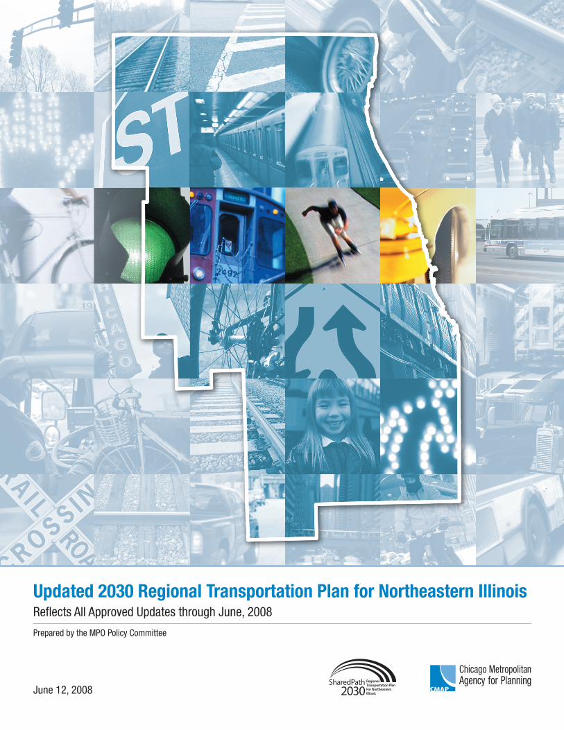
Updated 2030 Regional Transportation Plan for Northeastern IllinoisReflects All Approved Updates through June, 2008
Prepared by the MPO Policy Committee
June 12, 2008

This page is intentionally blank.
2030 REGIONAL TRANSPORTATION PLAN FOR NORTHEASTERN ILLINOIS
THIS COMPILED DOCUMENT REFLECTS:
2030 REGIONAL TRANSPORTATION PLAN 2006 UPDATE 2007 UPDATE 2008 UPDATE NO. 1 (APPROVED MARCH, 2008) 2008 UPDATE NO. 2 (APPROVED JUNE 12, 2008)
Approved by
The Board of the Chicago Metropolitan Agency for Planning
June 11, 2008
Approved by
The MPO Policy Committee
June 12, 2008
Chicago Metropolitan Agency for Planning 233 South Wacker Drive Suite 800 Chicago, Illinois 60606 312-454-0400 http://www.cmap.illinois.gov

This page is intentionally blank.
Table of Contents
EXECUTIVE SUMMARY ......................................................................................1 Planning process......................................................................................................................................... 1 Participation and involvement .................................................................................................................... 1 Regional transportation concerns ............................................................................................................... 3 Regional outlook ........................................................................................................................................ 3 Plan recommendations................................................................................................................................ 4
CHAPTER 1. POLICY ENVIRONMENT ...............................................................5 1.1.1 Intent and Scope ......................................................................................................................... 5 1.1.2 Constraints.................................................................................................................................. 7
Financial resources ................................................................................................................................. 7 Air Quality.............................................................................................................................................. 8
1.2 Regional transportation challenges and concerns ............................................................................... 9 1.2.1 Mobility and Accessibility........................................................................................................ 10 1.2.2 Commercial Goods Movement................................................................................................. 10 1.2.3 Land Use and Transportation Relationships ............................................................................. 11 1.2.4 Community Planning................................................................................................................ 12 1.2.5 Social Equity ............................................................................................................................ 13 1.2.6 Natural Environment ................................................................................................................ 13 1.2.7 Congestion Management .......................................................................................................... 15 1.2.8 Public Health and Safety .......................................................................................................... 16 1.2.9 Transportation Security ............................................................................................................ 17 1.2.10 Economic Development............................................................................................................ 17
1.3 The 2040 Regional Framework Plan ................................................................................................ 18 1.4 Goals for future transportation system development ........................................................................ 19
1.4.1 Goal: Maintain the Integrity of the Existing Transportation System........................................ 20 1.4.1.1 Maintenance, reconstruction and replacement objectives..................................................... 20 1.4.1.2 Congestion management objectives...................................................................................... 21
1.4.2 Goal: Improve Transportation System Performance ................................................................ 22 1.4.2.1 Transportation system efficiency objectives......................................................................... 22 1.4.2.2 Transportation and land use interaction objectives............................................................... 22 1.4.2.3 Transportation mobility and accessibility objectives............................................................ 23 1.4.2.4 Commercial goods movement objectives ............................................................................. 24
1.4.3 Goal: Employ Transportation to Sustain the Region’s Vision and Values ............................... 24 1.4.3.1 Transportation and natural environment objectives.............................................................. 25 1.4.3.2 Transportation and economic development objectives......................................................... 26 1.4.3.3 Transportation and social equity objectives.......................................................................... 27 1.4.3.4 Transportation and community development objectives ...................................................... 28 1.4.3.5 Transportation and public health and safety objectives ........................................................ 29 1.4.3.6 Transportation security objectives ........................................................................................ 29
CHAPTER 2. REGIONAL ASSESSMENT..........................................................31 2.1 Defining the transportation system................................................................................................... 31 2.2 Future Regional Scenarios................................................................................................................ 32
2.2.1 Socioeconomic Inputs............................................................................................................... 33 2.2.1.1 Low-income households....................................................................................................... 34 2.2.1.2 Minority population.............................................................................................................. 35
2.2.2 Transportation System Commitments ...................................................................................... 37 2.2.3 Alternative Future Transportation Systems .............................................................................. 38 2.2.4 Measuring Transportation Benefits .......................................................................................... 43
2.2.4.1 Transportation system performance...................................................................................... 44
Transportation system supply measures ........................................................................................... 44 Tripmaking behavior ........................................................................................................................ 45 Transportation system demand......................................................................................................... 45 Transportation system costs.............................................................................................................. 45 Natural environment sensitivity........................................................................................................ 46
2.2.4.2 Evaluation of transportation system performance ................................................................ 46 2.2.4.3 Traveler mobility and accessibility....................................................................................... 48
Use of transportation modes ............................................................................................................. 48 Access to transit................................................................................................................................ 48 Evaluation of “Use of transportation modes and Access to transit” ................................................. 49 Access to jobs ................................................................................................................................... 58 Work commute times........................................................................................................................ 58 Evaluation of “Work commute times and Access to jobs”............................................................... 58
2.2.4.4 Socioeconomic and land use implications ............................................................................ 61
CHAPTER 3. REGIONAL TRANSPORTATION STRATEGY RECOMMENDATIONS.......................................................................................64 3.1 Community and Economic Development Strategies ........................................................................ 65
Context-sensitive solutions............................................................................................................... 67 3.2 Environmental Strategies.................................................................................................................. 68 3.3 Congestion Management .................................................................................................................. 69
3.3.1 Congestion Management: Performance Measures.................................................................... 70 3.3.2 Congestion Management: Management and Operation Strategies ........................................... 71
3.3.2.1 Maintenance and Reconstruction.......................................................................................... 77 Major highways ................................................................................................................................ 78 Rail transit ........................................................................................................................................ 79
3.3.2.2 Transportation System Safety............................................................................................... 80 3.3.2.3 Transportation System Security............................................................................................ 85 3.3.2.4 Rail, Highway and Intermodal Freight ................................................................................. 86 3.3.2.5 Intelligent Transportation Systems (ITS).............................................................................. 87 3.3.2.6 Transit Service Coordination................................................................................................ 88
CHAPTER 4. REGIONAL TRANSPORTATION CAPITAL OVERVIEW .............90 Regional Transportation Capital Priorities ............................................................................................... 90 4.1 Project Planning Status................................................................................................................. 90 4.1.1 Long term (project planning > 10 years) .................................................................................. 91 4.1.2 Medium term (project planning 5-10 years): ............................................................................ 91 4.1.3 Short term (project planning 1-5 years) .................................................................................... 91 4.2 Regional Investment ..................................................................................................................... 92 4.2.1 Management recommendations ................................................................................................ 94 4.2.2 Committed recommendations................................................................................................... 94 4.2.3 Strategic recommendations....................................................................................................... 94 4.2.4 System recommendations ......................................................................................................... 94 4.2.5 Project recommendations.......................................................................................................... 94 4.2.6 Corridor recommendations ....................................................................................................... 94 4.3 Regional Plan Consistency ........................................................................................................... 94 4.4 Public Priority............................................................................................................................... 95
CHAPTER 5. STRATEGIC REGIONAL SYSTEMS............................................96 5.1 Regional Arterials......................................................................................................................... 98 5.1.1 Arterial improvements and capacity expansion........................................................................ 99 5.1.2 Arterial extensions, bypasses and major collectors ................................................................ 100 5.1.3 New arterial bridges, grade separations, interchanges and advanced intersection design ...... 100 5.1.4 Designated Strategic Regional Arterials (SRAs).................................................................... 101 5.1.4.1 New segments for study.......................................................................................................... 102
5.2 Regional Transit ......................................................................................................................... 104 5.2.1 Transit Supportive Land Use .................................................................................................. 105 5.2.2 Private Providers..................................................................................................................... 106 5.2.3 Bus Rapid Transit ................................................................................................................... 108 5.2.3.1 Central Area Bus Rapid Transit System ................................................................................. 110 5.2.3.2 DuPage “J” Line Bus Rapid Transit Line............................................................................... 111 5.2.3.3 Cermak Road Bus Rapid Transit Line.................................................................................... 113 5.2.3.4 Golf Road Bus Rapid Transit Line ......................................................................................... 115 5.2.3.5 Ogden Avenue Transitway ..................................................................................................... 116 5.2.4 Priority Arterial Transit .......................................................................................................... 117 5.2.4.1 PARTNER Program: Pace Arterial Rapid Transit Network for the Region Program ........... 117 5.2.4.2 CTA Neighborhood Express Bus Service............................................................................... 119 5.2.4.3 Pace Express Bus Transit System........................................................................................... 120 5.2.4.4 Transit Signal Priority System................................................................................................ 122 5.3 Regional Freight ......................................................................................................................... 123 5.3.1 Freight Supportive Land Use and Economic Development.................................................... 123 5.3.2 Freight Corridors (CREATE) ................................................................................................. 125 5.3.3 National Highway System Intermodal Connectors................................................................. 126 5.4 Pedestrian and Bicycle................................................................................................................ 127
CHAPTER 6. MAJOR CAPITAL RECOMMENDATIONS .................................130 6.1 Chicago Transit Hub................................................................................................................... 130 6.1.1 Circle Line .............................................................................................................................. 130 6.1.2 West Loop Transportation Center........................................................................................... 133 6.1.3 Express Airport Train Service ................................................................................................ 135 6.2 Improvements to Existing Facilities ........................................................................................... 137 6.2.1 Passenger Rail Upgrades and Extensions ............................................................................... 137 6.2.1.1 Rapid Transit Upgrades and Extensions ................................................................................. 137 6.2.1.1.1 Brown Line Rehabilitation ................................................................................................. 138 6.2.1.1.2 Blue Line Douglas Branch Rehabilitation .......................................................................... 139 6.2.1.1.3 Green Line Enhancements.................................................................................................. 140 6.2.1.1.4 Orange Line Extension ....................................................................................................... 142 6.2.1.1.5 Yellow Line Enhancements and Extension ........................................................................ 144 6.2.1.1.6 Blue Line West Extension .................................................................................................. 146 6.2.1.1.7 Red Line Extension ............................................................................................................ 148 6.2.1.2 Existing Commuter Rail Upgrades and Extensions................................................................ 150 6.2.1.2.1 Union Pacific North............................................................................................................ 150 6.2.1.2.2 Heritage Corridor................................................................................................................ 151 6.2.1.2.3 Rock Island......................................................................................................................... 153 6.2.1.2.4 SouthWest Service.............................................................................................................. 156 6.2.1.2.5 Metra Electric ..................................................................................................................... 158 6.2.1.2.6 North Central Service ......................................................................................................... 161 6.2.1.2.7 Milwaukee District West .................................................................................................... 162 6.2.1.2.8 Milwaukee District North ................................................................................................... 164 6.2.1.2.9 Union Pacific Northwest..................................................................................................... 166 6.2.1.2.10 BNSF Railway................................................................................................................ 168 6.2.1.2.11 Union Pacific West ......................................................................................................... 170 6.2.2 Improving Existing Major Highways ..................................................................................... 173 6.2.2.1 I-90/94 .................................................................................................................................... 174 6.2.2.2 I-80/94 .................................................................................................................................... 175 6.2.2.3 I-190 ....................................................................................................................................... 176 6.2.2.4 I-90 (Northwest Tollway) ....................................................................................................... 177 6.2.2.5 I-88 (East-West Tollway) ....................................................................................................... 180 6.2.2.6 I-294/94 (Tri-State Tollway) .................................................................................................. 183 6.2.2.7 IL394 ...................................................................................................................................... 185 6.2.2.8 I-57 ......................................................................................................................................... 187
6.2.2.9 I-80 ......................................................................................................................................... 189 6.2.2.10 I-55 ..................................................................................................................................... 191 6.2.2.11 Elgin-O’Hare Expressway Expansion ................................................................................ 194 6.2.2.12 I-290 High-Occupancy-Vehicle Lanes ............................................................................... 196 6.2.2.13 I-355 (Veterans Memorial Tollway)................................................................................... 199 6.3 Expanding the transportation system to manage growth and change ......................................... 201 6.3.1 New transportation to serve the region’s major employment centers..................................... 201 6.3.1.1 SouthEast Service ................................................................................................................... 201 6.3.1.2 Elgin-O’Hare Expressway Extension and West O’Hare Bypass............................................ 204 6.3.1.3 Suburban Transit Access Route (STAR Line)........................................................................ 208 6.3.2 New Transportation Corridors................................................................................................ 211 6.3.2.1 Mid-City Transitway .............................................................................................................. 212 6.3.2.2 McHenry-Lake Corridor......................................................................................................... 214 6.3.2.3 Central Lake County Corridor ................................................................................................ 216 6.3.2.4 I-355 Extension....................................................................................................................... 218 6.3.2.5 South Suburban Corridor........................................................................................................ 220 6.3.2.6 I-57/IL394 Connector ............................................................................................................. 222 6.3.2.7 Illiana...................................................................................................................................... 223 6.3.2.8 Prairie Parkway....................................................................................................................... 225
CHAPTER 7. IMPLEMENTATION OF THE 2030 REGIONAL TRANSPORTATION PLAN ..............................................................................227
7.1 Project Planning Status............................................................................................................... 227 7.1.1 Short term ............................................................................................................................... 227 7.1.2 Medium term .......................................................................................................................... 229 7.1.3 Long term ............................................................................................................................... 231 7.2 Regional Investment ................................................................................................................... 233 7.2.1 Management Recommendations............................................................................................. 233 7.2.2 Strategic Recommendations ................................................................................................... 234 7.2.3 Committed Recommendations................................................................................................ 235 7.2.4 System Recommendations...................................................................................................... 236 7.2.5 Project Recommendations ...................................................................................................... 238 7.2.6 Corridor Recommendations.................................................................................................... 239 7.3 Public Priority............................................................................................................................. 241 7.3.1 New Start Authorizations ....................................................................................................... 241 7.3.2 Illinois Tollway....................................................................................................................... 242 7.4 Air Quality Conformity .............................................................................................................. 243 7.5 Public Engagement ..................................................................................................................... 245 7.5.1 More and better integrated public transit ................................................................................ 247 7.5.2 Better land use and transportation integration ........................................................................ 247 7.5.3 Improved traffic congestion management .............................................................................. 247 7.5.4 More bicycle and pedestrian options ...................................................................................... 247 7.5.5 Improved freight management................................................................................................ 247 7.5.6 Services and Safety................................................................................................................. 248
Table of Figures
Figure 1 : Service-Intensive Scenario........................................................................................................... 39 Figure 2: System-Intensive Scenario ............................................................................................................ 40 Figure 3: System-Additions Scenario........................................................................................................... 41 Figure 4: System Expansion Scenario .......................................................................................................... 42 Figure 5: 2030 RTP Update Financial Allocation ........................................................................................ 93 Figure 6: Potential SRA Additions............................................................................................................. 103 Figure 7: Central Area Bus Rapid Transit .................................................................................................. 110 Figure 8: DuPage "J" Bus Rapid Transit Line............................................................................................ 111 Figure 9: Cermak Road Bus Rapid Transit Line ........................................................................................ 113 Figure 10: Golf Road Bus Rapid Transit Line............................................................................................ 115 Figure 11: Ogden Avenue Transitway........................................................................................................ 116 Figure 12: Pace Arterial Rapid Transit Network System ........................................................................... 117 Figure 13: CTA Neighborhood Express Bus Service ................................................................................. 119 Figure 14: Pace Express Bus System ......................................................................................................... 120 Figure 15: Pace Transit Signal Priority System.......................................................................................... 122 Figure 16: CREATE Corridors................................................................................................................... 125 Figure 17: NHS Connectors ....................................................................................................................... 127 Figure 18: Circle Line ................................................................................................................................ 130 Figure 19: West Loop Transportation Center ............................................................................................. 133 Figure 20: Express Airport Train Service................................................................................................... 135 Figure 21: Brown Line Rehabilitation........................................................................................................ 138 Figure 22: Blue Line Douglas Branch Rehabilitation................................................................................. 139 Figure 23: Green Line Enhancements ........................................................................................................ 140 Figure 24: Orange Line Extension.............................................................................................................. 142 Figure 25: Yellow Line Enhancements and Extension............................................................................... 144 Figure 26: Blue Line West Extension......................................................................................................... 146 Figure 27: Red Line Extension................................................................................................................... 148 Figure 28: Union Pacific North Improvements .......................................................................................... 150 Figure 29: Heritage Corridor Improvements .............................................................................................. 151 Figure 30: Rock Island Improvements and Extension................................................................................ 153 Figure 31: SouthWest Service Improvements and Extension..................................................................... 156 Figure 32: Metra Electric Improvements and Extension ............................................................................ 158 Figure 33: North Central Service Improvements........................................................................................ 161 Figure 34: Milwaukee District West........................................................................................................... 162 Figure 35: Milwaukee District North Improvements and Extension.......................................................... 164 Figure 36: Union Pacific Northwest Improvements and Extension ........................................................... 166 Figure 37: BNSF Railway Extension ......................................................................................................... 168 Figure 38: Union Pacific West Improvements ........................................................................................... 170 Figure 39: I90/94 Improvements ................................................................................................................ 174 Figure 40: I-80/94 Improvements............................................................................................................... 175 Figure 41: I-190 Improvements.................................................................................................................. 176 Figure 42: I-90 (Northwest Tollway) Improvements ................................................................................. 177 Figure 43: I-88 (East-West Tollway) Improvements.................................................................................. 180 Figure 44: I-294/94 (Tri-State Tollway) Improvements............................................................................. 183 Figure 45: IL394 Improvements................................................................................................................. 185 Figure 46: I-57 Improvements.................................................................................................................... 187 Figure 47: I-80 Improvements.................................................................................................................... 189 Figure 48: I-55 Improvements.................................................................................................................... 191 Figure 49: Elgin-O’Hare Expressway Expansion....................................................................................... 194 Figure 50: I-290 High Occupancy Vehicle Lanes ...................................................................................... 196 Figure 51: I-355 (Veterans Memorial Tollway) Improvements ................................................................. 199 Figure 52: SouthEast Service ................................................................................................................... 201 Figure 53: Elgin-O’Hare Expressway and West O’Hare Bypass ............................................................... 204 Figure 54: Suburban Transit Access Route (STAR Line) .......................................................................... 208 Figure 55: Mid-City Transitway................................................................................................................. 212
Figure 56: McHenry-Lake Corridor ........................................................................................................... 214 Figure 57: Central Lake County Corridor .................................................................................................. 216 Figure 58: I-355 Extension......................................................................................................................... 218 Figure 59: South Suburban Corridor .......................................................................................................... 220 Figure 60: I-57/IL394 Connector ............................................................................................................... 222 Figure 61: Illiana Corridor.......................................................................................................................... 223 Figure 62: Prairie Parkway......................................................................................................................... 225 Figure 63: Short Term Project Planning Status .......................................................................................... 227 Figure 64: Medium Term Project Planning Status ..................................................................................... 229 Figure 65: Long Term Project Planning Status .......................................................................................... 231 Figure 66: Regional Investment Management Recommendations ............................................................. 233 Figure 67: Regional Investment Committed Recommendations ................................................................ 235 Figure 68: Regional Investment System Recommendations ...................................................................... 236 Figure 69: Regional Investment Project Recommendations....................................................................... 238 Figure 70: Regional Investment Corridor Recommendations .................................................................... 239 Figure 71: New Start authorizations........................................................................................................... 241 Figure 72: Illinois Tollway Projects ........................................................................................................... 242 Figure 73: Air Quality Conformity Projects ............................................................................................... 243 Figure 74: Workshop Participant Priorities ................................................................................................ 246
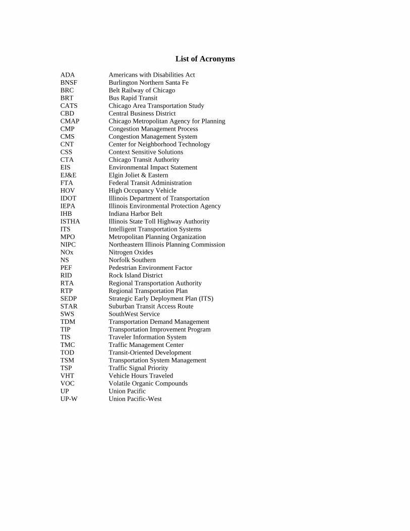
List of Acronyms ADA Americans with Disabilities Act BNSF Burlington Northern Santa Fe BRC Belt Railway of Chicago BRT Bus Rapid Transit CATS Chicago Area Transportation Study CBD Central Business District CMAP Chicago Metropolitan Agency for Planning CMP Congestion Management Process CMS Congestion Management System CNT Center for Neighborhood Technology CSS Context Sensitive Solutions CTA Chicago Transit Authority EIS Environmental Impact Statement EJ&E Elgin Joliet & Eastern FTA Federal Transit Administration HOV High Occupancy Vehicle IDOT Illinois Department of Transportation IEPA Illinois Environmental Protection Agency IHB Indiana Harbor Belt ISTHA Illinois State Toll Highway Authority ITS Intelligent Transportation Systems MPO Metropolitan Planning Organization NIPC Northeastern Illinois Planning Commission NOx Nitrogen Oxides NS Norfolk Southern PEF Pedestrian Environment Factor RID Rock Island District RTA Regional Transportation Authority RTP Regional Transportation Plan SEDP Strategic Early Deployment Plan (ITS) STAR Suburban Transit Access Route SWS SouthWest Service TDM Transportation Demand Management TIP Transportation Improvement Program TIS Traveler Information System TMC Traffic Management Center TOD Transit-Oriented Development TSM Transportation System Management TSP Traffic Signal Priority VHT Vehicle Hours Traveled VOC Volatile Organic Compounds UP Union Pacific UP-W Union Pacific-West

2030 Regional Transportation Plan for Executive Summary Northeastern Illinois, June 12, 2008 page 1
EXECUTIVE SUMMARY
The Chicago region continues to grow and change. To prepare for the future, the Metropolitan Planning Organization Policy Committee has prepared this 2030 Regional Transportation Plan for Northeastern Illinois (2030 RTP). The 2030 RTP identifies emerging transportation challenges and their possible solutions, and provides a guide for long-term transportation investment in the region. The recommendations appearing in the 2030 RTP are financially attainable and help meet the region’s air quality goals.
To integrate planning for transportation and land use, the Chicago Metropolitan Agency for Planning (CMAP) has been created by merging the staffs of the Chicago Area Transportation Study (CATS) and the Northeastern Illinois Planning Commission (NIPC). The creation of this agency was proposed through state legislation (House Bill 3121), unanimously approved by the Illinois General Assembly as the Regional Planning Act, and signed into law in August 2005. CMAP serves the counties of Cook, DuPage, Kane, Kendall, Lake, McHenry, and Will.
In its enabling legislation, CMAP is directed to produce a regional comprehensive plan that integrates land use and transportation. The first version of such an integrated plan is programmed for completion in 2010. That regional comprehensive plan will function as the regional transportation plan for the Chicago region, complying with all federal guidelines governing such documents, and will have a horizon year of 2040.
Planning process
The 2030 RTP was developed through a public planning process called Shared Path 2030 that began in June 2001 and continued through the RTP’s adoption in October 2003, with successive updates in 2006, 2007, and 2008. Shared Path 2030 included transportation policy development, technical evaluation and public outreach focusing on: evaluating mobility and accessibility, transportation management and operations, commercial goods movement, bicycle and pedestrian travel and the natural environment.
Participation and involvement
Participants in Shared Path 2030 included elected officials, regional and local planning agencies, civic and advocacy organizations, transportation implementers and providers and residents of the region. Shared Path 2030 benefited greatly from direct involvement by elected officials. Members of Congress, members of the Illinois General Assembly, as well as elected county and municipal officials provided valued input and leadership.
Shared Path 2030 also benefited from the regional planning efforts undertaken by other agencies as well as private civic and advocacy organizations. The Northeastern Illinois Planning Commission (NIPC, a predecessor to the Chicago Metropolitan Agency for Planning [CMAP]), through its Common Ground planning process, substantiated many of the broad policy goals that appear in the 2030 RTP. Chicago Metropolis 2020 raised the challenge of more closely linking regional land use and transportation planning. The Center for Neighborhood Technology (CNT), through their Connecting Communities
2030 Regional Transportation Plan for Executive Summary Northeastern Illinois, June 12, 2008 page 2
outreach provided effective communication of transportation concerns at a community level.
Shared Path 2030 also benefited from several subregional and strategic transportation plans. Pace’s Vision 2020 Plan, the freight rail industry’s CREATE plan and several county-level subregional plans were excellent sources of information and provided examples of transportation solutions to be considered regionwide.
Perhaps most of all, Shared Path 2030 benefited from the direct involvement of many residents of the region. Making long-range planning interesting and relevant to someone who simply wants to “get there” is a challenge. In addition to two sets of traditional community meetings, Shared Path 2030 included focused outreach among community leaders in minority and low-income neighborhoods, an expanded presence on the World Wide Web and a direct telephone hotline. Production of two widely aired videos describing the transportation planning process and the RTP recommendations resulted in several hundred residents taking the time to register their opinions regarding the region’s transportation future. Each comment received was made available to all Shared Path 2030 participants.
During the public input phase for the update of the capital program, seven workshops were conducted throughout the region that utilized a specialized public engagement tool referred to as “TransopolySM”. The tool allowed workshop participants to simulate transportation decision-making processes concerning the use of limited funds for capital projects. The public outreach process also included a survey that was available to a larger regional audience. The public involvement process demonstrated strong support for the RTP and, in particular, for three specific themes: more and better integrated public transit; better land use and transportation integration; and improved transportation congestion management. Reports of and material used in the public involvement process and results are posted on theCMAP Web site http://www.cmap.illinois.gov.
CMAP is committed to maintaining an active and effective public involvement process, both for the development of long-range planning documents and for other activities. CMAP’s Public Participation Plan was adopted in June, 2007. The agency has formed a Citizen’s Advisory Committee, which is tasked with providing guidance on the Public Participation Plan and CMAP’s overall general outreach and engagement strategies, as well as conveying regional residents’ perspectives to the CMAP Board. In addition to the Citizen’s Advisory Committee, the Council of Mayors structure, a new committee comprised of county officials, and general outreach activities will be used to obtain input from the public and agency partners regarding all aspects of planning and programming. While CATS and NIPC have employed the World Wide Web and state of the art engagement tools and visioning techniques in the recent 2030 RTP, 2040 Framework Plan and Common Ground processes, CMAP is committed to building on these tools and techniques for the coming plan development efforts.
CMAP has improved upon past CATS and NIPC communication processes by establishing working committees in key areas of regional concern, which mirror Congressional intentions for broader input to the transportation planning process. CMAP’s working committees will give regular feedback on CMAP plans, programs and
2030 Regional Transportation Plan for Executive Summary Northeastern Illinois, June 12, 2008 page 3
initiatives, as well as help identify additional relevant stakeholders and interested parties for all critical endeavors. The working committees are:
• Land Use
• Economic & Community Development
• Environment & Natural Resources
• Housing
• Human Services
• Transportation
These groups will be an integral part of the four year effort to produce the region’s first Integrated Land Use and Transportation Plan, scheduled for completion in 2010.
Regional transportation concerns
The 2030 RTP identifies a number of regional concerns that can be addressed through future transportation investment. Primary among these is maintaining and improving the integrity of our existing transportation system. This not only includes keeping our substantial investment in transportation infrastructure in good repair, but adapts and expands it to address the changing personal mobility, land use and travel patterns that accompany growth.
In addition, the 2030 RTP recognizes the role transportation investment patterns play in the long-term sustainability of the region. Promoting economic and community development, ensuring compatibility with local planning efforts, addressing social equity concerns and protecting our natural environment can be achieved through careful and deliberate consideration of each improvement made to our transportation system.
Regional outlook
During the period of 1970 to 2000, the region’s population grew by 1.1 million people. It is estimated that between 2000 and 2030, the region’s population will grow by another 1.8 million persons, significantly faster than in previous decades. CMAP anticipates that this growth will occur both in mature and established areas as well as on the urban fringe. In addition to increased demand for transportation service, the very nature of the population’s transportation needs will also change. While managing the increased strain on already congested portions of the transportation system, future transportation resources must also address public health and safety concerns as well as long-term environmental and community sustainability. The 2030 RTP addresses these issues with a balance of capital recommendations and non-capital strategies.
2030 Regional Transportation Plan for Executive Summary Northeastern Illinois, June 12, 2008 page 4
Plan recommendations
The 2030 RTP includes a set of strategic and capital recommendations intended to both accommodate and manage growth. Shared Path 2030 estimates that $65.0 Billion will be available for maintaining and improving the region’s transportation system for the planning period, from 2004 to 2030. Of that, an estimated $47 Billion will be needed to maintain the existing transportation system in a state of good repair. The 2030 RTP recommends that $5 Billion be allocated for strategic improvement to the region’s “shared-use” system comprised primarily of arterial, bus, truck, bicycle and pedestrian facilities; and that $ 12.9 Billion be allocated to expanding the region’s major highway and rail network. Nearly $20 Billion, however, in major capital needs were identified during Shared Path 2030. The 2030 RTP provides guidance for identifying, refining and advancing the proposals with the greatest merit.
2030 Regional Transportation Plan for Chapter 1: Policy Environment Northeastern Illinois, June 12, 2008 page 5
CHAPTER 1. POLICY ENVIRONMENT
This Regional Transportation Plan (RTP) provides public policy direction and guidance for the continued development of a safe, efficient multimodal surface transportation system in northeastern Illinois.
The RTP represents the consensus of the Board of Chicago Metropolitan Agency for Planning (CMAP) and the MPO Policy Committee. The MPO Policy Committee is designated by the Governor of Illinois, in consultation with local elected officials, as the Metropolitan Planning Organization (MPO) for Northeastern Illinois.1
The RTP’s policy direction takes a variety of forms: broadly defined regional transportation strategies, specific guidance for transportation project implementers and a set of major capital investments to pursue in the coming decades.
Developing the 2030 RTP was a two-year project. The planning process, called Shared Path 2030, began in June 2001 and was completed in autumn 2003 to comply with federal transportation planning requirements.2 An update to the capital element and strategic systems portions of the 2030 RTP was adopted in October 2006 in order to comply with air quality conformity regulations. The policy, goals, objectives and strategies portions of the document were updated in 2007 to comply with the requirements and guidance of SAFETEA-LU. Further updates were undertaken at the beginning of 2008. The combined document of the original 2030 RTP with the revisions made through the 2006 and 2007 updates fulfilled SAFETEA-LU provisions for long-range transportation planning.
1.1 INTENT, SCOPE AND CONSTRAINTS
1.1.1 Intent and Scope
As a region, we engage in comprehensive regional planning because we believe our travel behavior is inextricably linked with urban life and that public planning decisions can alter our living, working and travel choices in complex and compound ways.
Shared Path 2030 begins with the simplest but most comprehensive statement of intent. The region’s transportation plan should:
• Promote efficient travel behavior and accommodate it.
• Promote an efficient urban economy and sustain it.
The transportation system is conventionally regarded as a “public good.” Most of the region’s transportation infrastructure is publicly owned across many government jurisdictions. Privately held or operated transportation infrastructure and service is typically franchised or regulated to
1 Northeastern Illinois, in this case, includes the Counties of Cook, DuPage, Kane, Kendall, Lake, McHenry and Will, plus a portion of GrundyKendall County. 2 The RTP is being prepared to meet federal transportation funding requirements, specifically, “to encourage and promote the safe and efficient management, operation and development of surface transportation systems that will serve the mobility needs of people and freight and foster economic growth and development within and through [the] urbanized area.” 23.USC.134.
2030 Regional Transportation Plan for Chapter 1: Policy Environment Northeastern Illinois, June 12, 2008 page 6
avoid service duplication and to ensure uniform capacity. Nonetheless, nearly all of the decisions regarding the transportation system’s use are privately made. Thus, while decisions regarding transportation supply occur in the public domain, their success is dependent to a significant extent on the personal travel choices of individuals and the travel needs of businesses.3
Managing the long-term balance of transportation supply and demand in northeastern Illinois is an ongoing activity that occurs in a number of federal, state and local settings. This RTP is bounded by the geographic scale, time frame, transportation supply and travel demand characteristics that we feel are most responsive to public policy at the metropolitan level.
The RTP’s recommendations are made at the “regional level” because the effects of local transportation decisions are so intertwined as to require consolidated and coordinated action to achieve change. The RTP provides an opportunity to merge and overlay the effects of local transportation in a context that clarifies the comprehensive decisions that need to be made and the overall ends they are intended to achieve.
The RTP’s time frame is “long-range.”4 Its focus is on making changes that will likely take many years to bring about. Resources and needs to the year 2030 were projected with confidence during the Shared Path 2030 process, and these projections are used in the RTP to devise policy and investment strategies that are specific enough to help achieve regional goals, but also flexible enough to accommodate changes in our region’s socioeconomic landscape.5 The RTP is updated every four years to ensure that the understanding and interpretation of needs, problems, and available solutions is current and correct.
The RTP is principally concerned with “regular daily travel.” It accounts for a broad spectrum of socioeconomic activity’s effect on the performance of our transportation system. Most specifically, the RTP assesses the demands placed on our transportation system by the workers and businesses that sustain our region’s economic health. The plan also, however, assesses the need to preserve and improve the community and environmental attributes which provide the bases for our region’s quality of life.
Within this framework, long-term transportation needs are identified and a set of policy goals and objectives are established to guide transportation policy and investment decisions. These result in the following types of recommendations:
• Regional policy strategies expressed in terms of economic, community, environmental, and transportation management and operational objectives that will benefit from a consistent treatment regionwide.
• General implementation guidance for arterial, transit, bicycle, pedestrian and freight facilities, with an emphasis on integrating multimodal features of the transportation system and providing greater flexibility and choice in its use.
3 An estimated 13% of the demand for highway lane capacity in northeastern Illinois comes from commercial vehicles. 4 Short-range capital budgeting is accomplished through CATS’ the Transportation Improvement Program (TIP). 5 It should be noted that inclusion of a new South Suburban Airport was assumed in all Shared Path 2030 evaluations at the request of both the City of Chicago and the State of Illinois. Planning for the airport itself occurs at the discretion of the State of Illinois.

2030 Regional Transportation Plan for Chapter 1: Policy Environment Northeastern Illinois, June 12, 2008 page 7
• Specific capital investment recommendations for the continued development of the region’s major highway and rail infrastructure.6
1.1.2 Constraints
There are also limits that constrain pursuit of our goals:
• Federal transportation planning rules require that the RTP demonstrate consistency between proposed transportation investments and projected transportation revenues,7 and
• Federal air quality regulations require that the RTP and Transportation Improvement Program (TIP), together, demonstrate “conformity” with State air quality goals.8
Financial resources
The RTP’s recommendations are held in check by reckoning a projection of reasonable future financial resources against our desire to pursue and achieve certain goals.
Shared Path 2030 employed a set of assumptions to estimate revenues available for maintaining and expanding the capital elements of the region’s transportation system. Balancing these projections against the estimated cost of implementing the plan’s recommendations has functioned as the principal constraint on pursuing an otherwise very long list of desired capital improvements in the plan.9
The principal financial forecasting assumptions10 employed by Shared Path 2030 are that:
• State motor fuel taxes and vehicle registration fees are assumed to increase in the future as they have increased historically. This includes a periodic generation of new capital funds as was accomplished in past years with Operation GreenLight11 and Illinois FIRST.
• Sales tax revenue will increase proportionally to forecasted growth in households.
• Federal legislation authorizing major urban transportation improvements will continue to be enacted, specifically the provisions that guarantee full funding and stable, fixed percentage allocations to the states.
6 While Shared Path 2030 accounts for the effects generated by the region’s aviation activity and commercial goods movements, planning for airports and freight facilities themselves is not an implementation element of this plan. The RTP also includes policy guidance and strategy recommendations for encouraging bicycle and pedestrian travel but, again, making project recommendations for specific “non-motorized” improvements is not an implementation element of the plan. 7 23.USC.134 in lieu of SAFETEA-LU regulations. 8 40.CFR.93. 9 It is important to note that in spite of this constraint, there is a recognized value in illustrating the gap between our transportation needs and an otherwise conservative estimate of the financial resources available to meet them. An important purpose of highlighting this fiscal constraint is to demonstrate the importance of attaining new and additional financial resources for transportation system maintenance, improvement and expansion. 10 CATS, Report to the Regional Transportation Plan Committee on Projected Transportation System Revenues and Expenses, 1997. Report revised 2000. Projections revised ongoing based on TIP. 11 CATS, Operation GreenLight, 1st Annual Report, 1990, p. ii-iii.
2030 Regional Transportation Plan for Chapter 1: Policy Environment Northeastern Illinois, June 12, 2008 page 8
• The existing toll highway system and some new facilities will be financially self-supporting.12
• The CMAP Board has agreed to champion the long-recognized need for additional transportation resources by sponsoring development of a long-range transportation financial plan. The RTP acknowledges that new financial resources may require new legal and institutional arrangements for implementation.
For the period 2004-2030, these assumptions result in an estimated $65.0 Billion being available for capital maintenance and expansion of the transportation system.13
Air Quality
Ground level ozone poses a significant health risk to our region and the US EPA has determined that the region is in non-attainment for the national ambient air quality standards for ozone. This pollutant is formed primarily by the reaction of volatile organic compounds (VOC) and oxides of nitrogen (NOx) in sunlight. Because of this relationship, the Illinois Environmental Protection Agency (IEPA) has established “mobile-source budgets” for these two pollutants.14 The RTP and TIP, together, must demonstrate that motor vehicle emissions do not exceed 127.42 tons per day of VOC and 280.40 tons per day of NOx in the years beyond 2007 based on a one-hour standard. These one-hour budgets are being used as an interim standard until IEPA produces (and USEPA finds adequate) 8-hour ozone budgets. The 8-hour pollutant budgets are expected in the fall of 2007, while the RTP’s capital element update, adopted in the fall of 2006, used the above interim 1-hour budgets. The principal contribution the RTP makes to meeting ozone standards is by managing VMT growth and providing greater choice among travel modes and facilities, as well as reducing vehicular delays during travel.
Additionally, USEPA has determined that the region is in non-attainment of the annual standard for fine particulate matter, sized at 2.5 micrometers or less (PM2.5). PM2.5 is a health hazard. PM2.5 is generated directly from combustion, and from photochemical reactions involving VOC, NOx, SOx (Oxides of Sulfur) and other combustion by-products. The RTP and TIP contribute to PM2.5 attainment by reducing vehicle miles of travel (VMT), particularly truck VMT, and by reducing delay, especially for diesel trucks, buses and locomotives. The budgets for PM2.5, are due from IEPA in April, 2008. The RTP and the region’s TIP will have to meet these budgets in the subsequent air quality conformity analyses.
12 Shared Path 2030 assumes that construction of some new facilities (both highway and transit) will be financed with user-generated revenues. This might include, but is by no means limited to, traditional tax, toll and fare arrangements. 13 These funding sources, depending on their point of collection, can be identified as “highway” or “transit” revenues. In this exercise, approximately $36.9 B will be available from traditional highway sources and $24.4 B will be available from traditional transit sources. It is important to remember that this distinction is largely statutory and does not necessarily imply that all of the funds be directed exclusively back to their source (though some must). In allocating these revenues, the RTP emphasizes improvements serving a variety of travel needs, providing transportation choice and supporting regional goals. 14 IEPA, Revision to the State Implementation Plan for the Chicago Ozone Nonattainment Area: Motor Vehicle Emissions Budgets Using Mobile6, March 2003.
2030 Regional Transportation Plan for Chapter 1: Policy Environment Northeastern Illinois, June 12, 2008 page 9
1.2 REGIONAL TRANSPORTATION CHALLENGES AND CONCERNS
Regional transportation planning has historically focused on providing guidance for implementing high-capacity, high-speed, long-distance transportation infrastructure. Similarly, the traditional view of regional transportation policy assumed that local transportation improvements would logically extend from this regional system. In recent years, we have come to realize that success in meeting regional objectives is significantly dependent on coordinated pursuit of development strategies at all levels of government. The land use, trip-making and traffic management practices that establish local transportation conditions also define the premise for large-scale transportation improvements. This increased interplay of transportation decisions has resulted in more comprehensive transportation planning discussions which help to ensure consistency between efforts throughout the region in a variety of planning areas, including land use, economic development, natural resources, housing, and human services. These, in turn, have broadened Shared Path 2030’s definition of “transportation need,” as well as the methods used to assess them and the range of available solutions.
Shared Path 2030 employed a broad-based approach to determining the transportation needs upon which to predicate the RTP’s official set of “goals.” Basic urban planning themes called “Concept Scenarios” were composed from a combination of technical evaluation, policy research and participant dialogue.15 These investigations provided a base of information upon which to more succinctly state a perceived problem or concern in regional terms. Thus, many concept scenarios were introduced as smaller-scale stand-alone planning issues. Examining them early during Shared Path 2030 provided the opportunity to elevate their regional credibility and provided a context within which meaningful regional transportation goals could be stated. The Concept Scenario investigations included these topics:
• Mobility and accessibility
• Commercial goods movement
• Land use and transportation relationships
• Community planning
• Social equity
• Natural environment
• Transportation management and operations
• Public health and safety
Please note that during the policy update to the RTP, the topic of “Transportation management and operations” was renamed “Congestion management.” In addition, two topics were added to the 2007 update due to guidance contained in SAFETEA-LU.
• Transportation security
15 CATS, Shared Path 2030 Process Documentation, Concept Scenario Investigation.
2030 Regional Transportation Plan for Chapter 1: Policy Environment Northeastern Illinois, June 12, 2008 page 10
• Economic development
The following transportation planning “problem statements” emerged following about 12 months of these investigations. They constitute the bounds on evaluating transportation goals and objectives appearing in the 2030 RTP. These problem statements have been enhanced for the 2007 update to highlight CMAP’s new responsibilities and activities.
1.2.1 Mobility and Accessibility
Regional transportation policies, systems and projects affect mobility and accessibility for the region’s residents and travelers.
For purposes of Shared Path 2030, the following definitions were used.
• Mobility: Socioeconomic and demographic attributes of persons that define the ease with which they can use the transportation system. For example, factors such as income, age and physical capability define a person's mobility.
• Accessibility: Transportation system attributes that define the ease with which persons can link their activities. For example, factors such as transit frequency and highway congestion define the transportation system’s accessibility.
Shared Path 2030 provided an opportunity to develop and refine a set of transportation mobility and accessibility measures used to evaluate the effects of different transportation strategies.16 A set of these mobility and accessibility measures were incorporated into the quantitative evaluation scheme developed for studying future regional scenarios and evaluating the RTP recommendations.
1.2.2 Commercial Goods Movement
Efficient movement of goods requires strategic improvements to the existing transportation system as well as more thorough incorporation into the comprehensive transportation planning process.
Many regional planning concerns relate, at least indirectly, to a concern over commercial goods and their role in the health of the regional economy. They indicate that we should consider goods movement needs as part of general transportation system development in order to sustain our regional health. This is of particular concern in northeastern Illinois in terms of preserving and promoting our national and international freight prominence.17
A set of comprehensive freight system proposals18 was made during Shared Path 2030 for improvement of commercial goods movement in the region. Some of the proposals provided broad policy objectives to be applied regionwide; others reflect specific guidance for making strategic improvements to the region’s truck and freight rail systems.
16 For a more thorough discussion of this topic see CATS, Shared Path 2030 Process Documentation, Concept Scenario Investigation. 17 Chicago is the third largest port in the world after Hong Kong and Singapore. 18 Originating with CATS’ Intermodal Advisory Task Force.
2030 Regional Transportation Plan for Chapter 1: Policy Environment Northeastern Illinois, June 12, 2008 page 11
In addition, an ongoing theme throughout these discussions was that greater planning coordination between and among private freight operators and public agencies is necessary to sustain the region’s preeminence as a global freight center.
1.2.3 Land Use and Transportation Relationships
The transportation system can be used to promote efficient land use and transportation and land use need to be mutually supportive.
The 2040 Regional Framework Plan19 was developed by NIPC (CMAP’s predecessor) in concert with the transportation planning process. The Framework Plan envisions a region with development focused on centers, ranging from the global center in the Chicago Central Area, to metropolitan, community, and town centers, and hamlets in rural areas, all developed with housing and jobs to minimize travel distances. The 2040 Regional Framework Plan envisions metropolitan centers linked to each other with “transportation corridors.” In addition, a large part of the region would be maintained as “green areas.”
The Regional Framework Plan was developed to guide the region’s future land use and development by coordinating local land-use planning and the regional, state, and federal decisions that shape land development. The plan defines seventeen implementation strategies that include approaches to compact, mixed-use development and redevelopment; jobs and housing balance; transit-oriented development; preservation of biodiversity, water resources, and farmland; and economic vitality.
CMAP will also create a comprehensive plan, as required by the Regional Planning Act, to articulate a vision for the region's future and the strategies necessary to realize that vision. This plan will fully integrate land use and transportation, as well as consider other important regional issues. The plan will use scenario modeling and evaluation to strengthen the functional links between land use and transportation planning, with a comprehensive range of regional issues such as health, economic development, education, environment, and water supply. Land use and environmental systems closely interact and require close coordination within analyses and decision-making processes. Because these issues cut across political boundaries, CMAP will facilitate planning processes and partnerships that cut across jurisdictions. Long-range planning that integrates land use and transportation will facilitate coordinated efforts and goals across all levels of government including federal, state, regional, county, and local levels. Initial stages in the development of a regional comprehensive plan are underway, with adoption anticipated in fall of 2010.
CMAP continues its function of preparing forecasts of households and employment under various regional scenarios. This includes incorporating the land use plans of local communities and the counties, as well as quantifying the socioeconomic implications of RTP policies and the 2040 Regional Framework Plan. The RTP and Regional Framework Plan are intended to be mutually supportive.
19 The web address for the 2040 Regional Framework Plan is www.nipc.org/2040
2030 Regional Transportation Plan for Chapter 1: Policy Environment Northeastern Illinois, June 12, 2008 page 12
1.2.4 Community Planning
Regional transportation policy affects the success of community planning efforts. Coordinated community planning can support regional goals.
Defining and improving the links between community planning and regional planning continued throughout Shared Path 2030. Transportation planning occurs on many different levels and for many different reasons. The resulting transportation projects range in size and impact from large to small, regional to local. It is not sufficient to merely recognize that all transportation projects have a continuum of regional to local implications.
Some parity of concern for smaller-scale transportation solutions that, in aggregate, provide regional benefits has a place in regional planning. It has always been easier to visualize the potential local impacts of a major regional facility than to identify the regional implications of collective smaller-scale investments.
Shared Path 2030 recognized that some local issues are so widespread that, once discerned, they can logically be elevated to regional consideration. At the regional level, we have the ability to consider solutions to widespread local problems by creative interpretation of regional "systems" and "strategies" and by giving thoughtful consideration to which transportation policies and proposals have "regional significance."
CMAP intends to develop a process to identify projects that have regional importance. By reviewing municipal and county plans, CMAP can work with communities to better understand the impacts of their land-use decisions, especially in terms of developments and other projects of regional significance. Often local choices have a significant impact on neighboring communities or facilities, and CMAP will provide the regional context in which local decisions should be made.
A regional planning approach that respects community context and environmental assets in its recommendations can provide the means to resolve potential conflicts between regional imperatives and community concerns.20
CMAP’s research will also focus on best practices in northeastern Illinois and around the nation and world. The issues that each community faces are not unique. Although there are no one-size-fits-all solutions, the region can learn from its neighbors and others who face similar challenges. CMAP will develop a system for monitoring progress toward implementation of the regional framework as we strive to build and maintain vibrant communities. Developing a regional reporting framework with accountability measures and other indicators will help gauge the success of implementation strategies.
CMAP has developed tools to help communities implement the Regional Framework Plan and has begun to provide technical assistance to help them make more informed land-use decisions through coordinated planning. CMAP will focus on communication, outreach, and engagement efforts that are key to ensuring coordination between regional and local planning.
20 These are the basic principles of emerging federal and state guidance under the heading “context sensitive solutions” as applied to transportation facilities.
2030 Regional Transportation Plan for Chapter 1: Policy Environment Northeastern Illinois, June 12, 2008 page 13
1.2.5 Social Equity
Communities that are traditionally under-served and under-represented need special consideration in regional transportation decisions.
Environmental justice addresses questions of distributive fairness in public decisions. Transportation decisions, inasmuch as they affect allocation of public goods, often raise questions relating to the "equity" of their benefits and the burdens or "externalities" they may produce.21 The variability in burdens and benefits resulting from transportation decisions are often obvious, but their full impact is difficult to account for completely.
General guidelines22 for evaluating environmental justice in regional transportation planning suggest the inclusion of both a regional profile identifying the locations of minority and/or low income populations as well as an analytical process for assessing regional benefits and burdens for different socioeconomic groups.
In addition to assessing these regional profiles, additional strategic attention to transportation equity for seniors and people with disabilities affords independence, freedom of movement, and self-determination. Directing our attention to the special mobility needs of these communities allows disadvantaged persons to assert a level of dignity in an otherwise difficult part of urban living. A Human Services Transportation Plan (HSTP) for the seven-county region is being developed by the Regional Transportation Authority (RTA) in cooperation with the MPO. (See RTA’s web site at http://hstp.rtachicago.com for current updates to HSTP including public meeting dates and results.) Known as “Connecting Communities through Coordination”, this planning effort will identify and recommend regional and local strategies that encourage the most effective use of available transportation services to enhance mobility for the region’s older adults, persons with disabilities and individuals with lower incomes. Projects for FTA sections: 5310 (Elderly Individuals and Individuals with Disabilities), 5316 (Job Access/Reverse Commute), and 5317 (transportation component of the New Freedom Initiative) will be derived from the HSTP. Starting in FY07 they will be listed in the region’s Transportation Improvement Program (TIP). Past Job Access/Reverse Commute projects have been listed in the TIP and annual listing of awarded and obligated projects.
Shared Path 2030 included a stratification by race/ethnicity and income of the mobility/accessibility measures used in plan evaluation and provides support for developing regional strategies to address the needs of seniors and persons with disabilities.
1.2.6 Natural Environment
Regional transportation decisions should support quality and sustainability of the natural environment.
21 Apgar, William C. and James H. Brown, Microeconomics and Public Policy, Scott Foresman, 1987. Equity = The fairness or equality of the distribution of the economic system's goods and wealth. Externality = The unintended social effects, desirable or undesirable, of production or consumption. 22 FHWA/FTA Memorandum, “Implementing Title VI Requirements in Metropolitan and Statewide Planning,” October 7, 1999.
2030 Regional Transportation Plan for Chapter 1: Policy Environment Northeastern Illinois, June 12, 2008 page 14
Transportation greatly affects the quality of our natural resources and environment. In both urban and rural areas of northeastern Illinois, transportation projects can improve access to natural areas, but can also degrade them with congestion and pollution. Mitigation of environmental impacts that arise from transportation projects must be well thought out and be an outcome of an interactive communication process that gives all stakeholders a voice in the decision-making process. National, state, and local environmental protection regulations are met, in part, through environmental mitigation activities. The SAFETEA-LU planning regulations define environmental mitigation activities to “mean strategies, policies, programs, actions, and activities that, over time, will serve to avoid, minimize, or compensate for (by replacing or providing substitute resources) the impacts to or disruption of elements of the human and natural environment associated with the implementation of a long-range statewide transportation plan or metropolitan transportation plan. The human and natural environment includes, for example, neighborhoods and communities, homes and businesses, cultural resources, parks and recreation areas, wetlands and water sources, forested and other natural areas, agricultural areas, endangered and threatened species, and the ambient air. The environmental mitigation strategies and activities are intended to be regional in scope, and may not necessarily address potential project-level impacts.” 23
A robust context-sensitive solutions process can give early, though not necessarily complete, consideration to biodiversity and other environmental impacts of proposed transportation projects. As planning, design and construction of major transportation projects is subject to rigorous environmental regulation public and private organizations can also participate in of an interactive communication process to assist with promoting not only the preservation of high-quality natural areas in the region that remain unprotected by legislation or regulation, but in enhancing and protecting natural resources that include ground and surface water and terrestrial resources.24
Shared Path 2030 recognizes the need to protect environmental resources while improving safety, mobility and accessibility for the region. The generalized alignments of 2030 RTP capital recommendations have been overlaid on a map of the region’s sensitive natural resources. This overlay identified potential concerns about the impact of transportation system proposals on sensitive areas. These concerns, which are included with each project in the capital element of this plan, serve as a preliminary guide in identifying the scope and scale of further study, and will be thoroughly addressed during project development and design phases.
Shared Path 2030, in coordination with the 2040 Regional Framework Plan developed a set of regional strategies consistent with adopted regional policies on environmental preservation and enhancement. (See Section 1.4.3.1)
NIPC, as a partner in Shared Path 2030, led in preparing a set of natural environment measures that were used in evaluating future regional scenarios. This also resulted in a graphical base of important environmental resources being included on the RTP map. The following documents were used as resources during the development of the 2030 RTP:
• Habitat Conservation Plan for Hines Emerald Dragonfly (and other species) 23 The web address for the SAFETEA-LU Planning Regulations is http://a257.g.akamaitech.net/7/257/2422/01jan2007/edocket.access.gpo.gov/2007/07-493.htm 24 Chicago Wilderness, Biodiversity Recovery Plan, 1999.
2030 Regional Transportation Plan for Chapter 1: Policy Environment Northeastern Illinois, June 12, 2008 page 15
• Groundwater Protection Areas
• Regional Greenways and Trails Plan
• State Archeological and Historical Files
• State Wildlife Conservation Plan
• National Wetland Inventory
• County ADID maps- Kane, Lake, McHenry
• County Resource Management plans
• Nature Conservancy
• Chicago Wilderness Green Infrastructure Plans
• Local Green Infrastructure Plans
• Watershed Plans
• U.S. Fish and Wildlife Priority Species for Conservation
• Chicago Wilderness Biodiversity Recovery Plan
• Chicago Wilderness Wetland Conservation Strategy
1.2.7 Congestion Management
Technological advances offer great potential to improve traveler information and facility operation. Regional transportation policy should consider the opportunities presented by management and operations planning.
Introducing advanced management and operations techniques can greatly enhance the performance of our transportation system. Shared Path 2030 seeks to expand the deployment of these innovations in the region. Indeed, SAFETEA-LU requires that northeastern Illinois develop a “Congestion Management Process” providing effective management and operation of the system “through the use of travel demand reduction and operational management strategies.”25 To comply with SAFETEA-LU, the congestion management process will address federally funded highway projects resulting in significant increases in carrying capacity for single-occupant vehicles.26
The magnitude of organizational arrangements and institutions that are required to manage our current system demonstrates the need to consider the management of our transportation system at the regional level. Given the system’s complexity, such management requires the use of
25 SAFETEA-LU, Public Law 109-59 Sec. 3005, amending 49 USC 5303 (k) (3), and Sec 6001, amending 23 USC 134 (k) (3) 26 Ibid., amending (m)(1).
2030 Regional Transportation Plan for Chapter 1: Policy Environment Northeastern Illinois, June 12, 2008 page 16
performance measures to monitor the deployment of management and operations strategies and to ensure their effectiveness.
An important reason for elevating management and operations in regional planning is the recognition that systemic improvements may arise as much from the consistent application of many small-scale strategies as from the results of some major capital projects.
Emphasizing management and operations during long-range transportation planning serves as a link between the broad regional objectives supporting strong and equitable regional economic development and those addressing local context-sensitive solutions.
Shared Path 2030 developed a set of regional management and operations strategies to support both maintaining and improving the performance of the existing transportation system as well as guiding the performance expectations of its capital recommendations.
1.2.8 Public Health and Safety
Regional transportation policy should address public health and safety in ways beyond the traditional acknowledgement of vehicular safety and air quality concerns.
Promotion of transportation safety has been a paramount consideration of federal and state transportation regulation and enforcement for many years. Transportation crashes are a leading cause of early death. More broadly, transportation crashes result in large personal losses because of injuries and property damage. Tertiary losses to the region include economic effects and significant disruptions to the transportation system. Crashes and their severity are a function of human factors, (such as behavior, reaction time, and vision), environmental factors (roadway geometry, weather), vehicle characteristics (handling, crash-worthiness), and exposure rates. Many of these factors are out of the control of the RTP. However, transportation providers can respond with information systems to identify risks, exposure, and crash rates to prioritize and implement countermeasures. These countermeasures, as identified for roadways in the Illinois Comprehensive Highway Safety Plan, may include engineering improvements to operate roadways more safely for motorized and non-motorized users, traffic regulations and their enforcement, and education/outreach to encourage safe behavior by users of the transportation system. In addition, transportation and land use can be planned together to reduce risk exposure by encouraging modes of travel which are less likely to cause crashes (e.g., transit) and safely facilitating non-motorized travel. Community planning can encourage less motor-vehicle miles of travel (VMT), safe travel choices and behavior, and can reduce exposure to risk.
Similarly, Shared Path 2030 proceeded during a resurgence of interest in the ways that transportation systems are designed, managed and operated and their contribution toward the broader definition of public health and safety. This includes not only new approaches to long-range emphases on vehicular safety, but also an expanded emphasis on the safety of bicyclists and pedestrians. The role transportation policy plays in promoting a healthy and active lifestyle was also investigated. The region is planning, facilitating and funding more opportunities for bicycle and pedestrian travel. As an alternative to automobile and transit travel, this increased emphasis on non-motorized travel provides both air quality benefits and promotes physical activity within people’s daily routine as a health benefit.
2030 Regional Transportation Plan for Chapter 1: Policy Environment Northeastern Illinois, June 12, 2008 page 17
1.2.9 Transportation Security
Regional transportation policy needs to respond to security threats. Threat assessments of transportation facilities should evaluate their vulnerabilities and risks, to prioritize physical security improvements. As noted by the Mineta Transportation Institute in a report for the FHWA, “Physical security by itself does not prevent terrorism, but good security can displace the risk, pushing terrorists toward still vulnerable but less lucrative targets where their actions are likely to cause fewer casualties.”27 Remote monitoring technology should be deployed to deter, detect, and respond to specific security threats if possible. Should an incident occur, related to the transportation system or not, the transportation system response should be coordinated among agencies to minimize casualties and disruption. Evacuation procedures should assure the evacuation of vulnerable users, which may include children, the disabled, those without access to cars, and the elderly, depending on the incident. Communications plans should be in place to assure that coordinated actions are taken by the public and response personnel, to prevent panic, and to keep in place those not at risk. In addition, advance system planning should assure a variety of transportation choices so that the system is robust to any incident. Design and construction of transportation facilities may accommodate security needs by, for example, blast-resistant construction and increased vehicle stand-off distances for vulnerable structures. 28
1.2.10 Economic Development
Regional transportation planning should support economic development goals and efforts.
The northeastern Illinois regional economy is changing rapidly and dramatically. Industries that were once the backbone of many communities are on the wane and the opportunities for new paths of growth are not always clear or easy to begin. In the face of such change the role of economic development in transportation planning is crucial and needs to be structured, systematic and fully integrated into the transportation planning process.
Transportation planning should align with all economic development regional goals and focus on strengthening the economy in a global climate and developing partnerships across governmental agencies, the private sector and the community at large. The process should also facilitate job creation and support initiatives designed to encourage private enterprise.
In determining the importance of economic development in transportation, it is necessary to outline the assumptions of the process, its impact on the regional economy and identify a role for transportation planning agencies such as CMAP. Transportation planning must focus on factors internal to the workings of the regional economy and ensure that all policies strive for a strong return on infrastructure developments. The role of transportation planning to the economy is to consider changes in the economy and develop strategies that encourage equitable development in transportation, new infrastructure designed to assist and retain a vibrant economy, and a strong, accountable, and transparent process.
The ideas and principles outlined in the plan arm the region with information, data and processes that can be used to better assess and encourage regional growth and development. For example,
27 Protecting Public Surface Transportation Against Terrorism and Serious Crime: An Executive Overview Mineta Transportation Institute, October 2001, p. 7. 28 Ibid., ff.
2030 Regional Transportation Plan for Chapter 1: Policy Environment Northeastern Illinois, June 12, 2008 page 18
flow of freight in northeastern Illinois must be assessed, measured and evaluated in order to identify its value and impact on the region. In the area of goods movements, CMAP can track industry trends, develop and promote best practices, benchmark costs and conditions, provide training and technical assistance, and facilitate regional discussions to support the efforts of our economic-development partners.
The process of collaboration and partnership has been a long term challenge for the region. To demonstrate the new approach to involvement, over 120 business and community leaders attended a CMAP economic and community development summit on August 17, 2006, to provide input in helping to define CMAP’s role in this focus area. The primary feedback from participants was that CMAP should focus on its data analysis tools and resources to link transportation, land use, and economic development for improved planning and decision making. Finally, the committee structure at CMAP will guide and lead the agency’s innovative approach to ensure that economic development is fully integrated into the transportation planning process.
1.3 THE 2040 REGIONAL FRAMEWORK PLAN
In September 2006, the 2040 Regional Framework Plan was adopted by the CMAP Board to guide the region’s integrated approach to regional planning. The Regional Framework Plan was prepared by the Northeastern Illinois Planning Commission in concert with the Chicago Area Transportation Study and CATS’ development of the first 2030 Regional Transportation Plan. The Regional Framework Plan basic recommendations provide the vision for transportation improvements and activities in the RTP. The RTP supports the approach and recommendations of the 2040 Regional Framework Plan. The 2040 Plan identifies a regional planning framework that includes the elements of Centers, Corridors and Green Areas.
Centers are defined as compact, mixed-use, economically vibrant places interconnected by multiple modes of transportation, and nearly three hundred centers are identified throughout the region. The 2040 Plan recommends that regional population and employment growth be directed to centers, with more compact development and a greater mix of land uses. Centers are recommended to provide a variety of housing types and affordability, encourage diversity among their residents, and feature high standards of livability. The 2040 Plan recognizes the critical role of transportation in facilitating the development of centers through concepts such as Transit Oriented Development (TOD).
Corridors are transportation links between centers. The 2040 Plan recommends multi-modal options in all transportation corridors, supporting the principle of “shared use” facilities that specifically encourages and accommodates safe and efficient use by pedestrians, bicycles, buses, autos, and trucks. In particular, the 2040 Plan supports provision of additional transit options for intersuburban or reverse commutes, consideration of commercial goods movement throughout the region, planning for appropriate land uses near to transportation corridors, and concepts such as Context Sensitive Solutions (CSS) to better integrate transportation improvements in corridors with the communities that they serve.
Green areas include agriculture, water resources, open space, and greenways. The 2040 Plan calls for the protection of existing green areas and the development of new green areas to conserve natural resources and farmland, maintain biodiversity, and provide additional
2030 Regional Transportation Plan for Chapter 1: Policy Environment Northeastern Illinois, June 12, 2008 page 19
recreational opportunities. The 2040 Plan recommends that transportation improvements preserve or enhance existing or planned green areas.
1.4 GOALS FOR FUTURE TRANSPORTATION SYSTEM DEVELOPMENT
The RTP’s long-term goal statements discern the general intent behind all subsequent elements of the plan. Because CMAP’s work is comprehensive,29 the goals have considerable overlap and reflect a broad spectrum of preferences.30 In addition, because we are establishing policy direction for government agencies, the goals speak to institutional influences on society.31 In order to allow the RTP’s goals to remain paramount while considering the remainder of the plan, Shared Path 2030 reduced them to three overarching statements:
• Maintain the integrity of the existing transportation system.
• Improve transportation system performance.
• Employ transportation to sustain the region’s vision and values.
Goals are supported by specific "objectives" intended to clarify their intent.32 There is inevitably some degree of overlap and potential conflict when elaborating how the objectives should be pursued. Acknowledging these overlaps and working to resolve them became important as Shared Path 2030 refined proposed transportation improvements to enjoy broader support.33 Resolution of these objectives continues during all phases of project development and implementation.
These goals have been further strengthened by the development of the 2040 Regional Framework Plan. The goals and objectives identified within the 2040 Plan are consistent with the RTP goals. Furthermore, if the environmental and natural sustainability goals and objectives
29 Planning practice draws a distinction between two planning approaches. Comprehensive planning is “vision”-based, institution-oriented and is intended to resist “reaction” to short-term pressures in favor of maintaining the integrity of long-term goals. Strategic planning is “action”-based, business-oriented and encourages quick changes in strategy to achieve a narrower set of objectives. Long-range goals and objectives usually follow the comprehensive model. Some participants suggested a more strategic planning approach in which goals would be more specific regarding their ends (e.g., provide more transit, reduce auto travel, add bike lanes). 30 Preferences are revealed in two important ways: 1) Stated preference = the objective of public involvement is provide a continuous dialogue between transportation users, operators, planners and policy makers. 2) Revealed behavior = the objective of transportation surveying and forecasting is to provide information on actual/estimated transportation decisions in response to changes in the urban economy. 31 Institutional influences = establish a “division of labor” for addressing large social questions. Though often viewed as unwieldy and bureaucratic, institutions provide a buffer against the vagaries of politics and the market. 32 In a "textbook" rational-comprehensive planning model, "objectives" are "quantified standards" which articulate the "criteria" by which "alternatives" are "evaluated.” It is widely recognized that this strict interpretation of decision-making oversimplifies the task at hand, thus the more general treatment of "objectives" in regional planning work. In this context, while regional objectives might give specific examples of approaches or outcomes, they will typically not provide a direct and decisive link to a specific standard of performance. 33 For example, while rebuilding a rapid transit line may, on its face, appear to be a maintenance project (goal 1), it may garner broader support from the plan by identifying ways in which it will improve the level of transportation service (goal 2) and improve air quality and economic development (goal 3). Another example: an expressway reconstruction project (maintenance) may include introduction of ITS strategies (improvement) and correct some safety deficiency associated with the original design (public health and safety).
2030 Regional Transportation Plan for Chapter 1: Policy Environment Northeastern Illinois, June 12, 2008 page 20
are to be realized, they must be considered and integrated throughout all goals and objectives in this section.
The RTP objectives are organized in terms of the opportunities they provide to introduce the challenges and concerns revealed in Shared Path 2030 into future transportation policy and implementation work. To clarify these opportunities, the plan’s objectives are stated such that they identify the development stage at which they become important.
• Develop a transportation system that… (carried out at the broadest policy levels, such as legislation, taxation, budgeting and regulation).
• Promote transportation proposals that… (carried out when establishing priorities for capital programs)
• Encourage project implementation that… (carried out during project design, environmental review, and community plan development).
1.4.1 Goal: Maintain the Integrity of the Existing Transportation System
Northeastern Illinois’ surface transportation infrastructure is the product of more than a century of public investment decisions and actions. A long history of societal ideals and visions has produced a stable and functional regional transportation system. Both because of its history and functionality, our transportation system is a strong part of our regional identity and should be respected as such. Diverse elements from multi-lane highways to sidewalks, from airports to rail passenger depots, are assets that we must protect and use effectively. In this spirit, the RTP places the highest priority on maintaining existing transportation system integrity by giving careful consideration to reconstruction and replacement decisions. This includes maximizing the performance of existing and new transportation infrastructure and service efficiency through effective transportation management and operations practice.
Specific objectives include the opportunity to reconstruct and replace facilities in a way that accounts for new travel needs and preferences. In some cases this may include capacity additions that accommodate forecast demand increases. Other strategies will include capital, management and operations techniques that improve the availability of highway as well as transit choices.
1.4.1.1 Maintenance, reconstruction and replacement objectives
Develop a transportation system that:
• maximizes the performance of existing transportation facilities.
Promote transportation proposals that:
• improve the performance of existing transportation facilities.
• preserve the level of service offered by the existing transportation system.
Encourage project implementation that:
2030 Regional Transportation Plan for Chapter 1: Policy Environment Northeastern Illinois, June 12, 2008 page 21
• improves connections between existing transportation facilities.
• improves accessibility to surrounding land uses.
• manages access to nearby land uses.
• mitigates conflicts between rail and highway systems.
1.4.1.2 Congestion management objectives
Develop a transportation system that:
• improves transportation system information available to travelers and system operators.
• facilitates management and operations communications abilities and real-time decision making.
• reduces non-recurring delay by reducing the number and duration of highway incidents and improves transit system on-time performance.
• reduces recurring delay through access and speed management, value pricing, improved design, and incentives encouraging alternate modes of travel
Promote transportation proposals that:
• reduce highway congestion.
• improve system reliability.
• provide improved transportation management capabilities.
• maximize performance benefits through intensive management.
• increase person throughput in congested corridors by increasing vehicle occupancy, providing transit options, and encouraging transit use.
• increase the share of trips made by walking, bicycling, and transit.
• improve coordination and connectivity between and among different modes.
• support regional or local efforts to balance the location of jobs, services, and housing to reduce travel distances.
Encourage project implementation that:
• provides for intensive facility management and operations capabilities.
• provides for coordinated management with other existing and planned transportation facilities.
• facilitates safe travel and reduces the number and severity of crashes.
2030 Regional Transportation Plan for Chapter 1: Policy Environment Northeastern Illinois, June 12, 2008 page 22
• preserves the integrity of the transportation system by considering access of nearby land uses to the facility.
• implements the regional transportation and land use plans and programs efficiently.
• improves ability to manage freight.
• improves compliance with speed, right-of-way and safety regulations.
1.4.2 Goal: Improve Transportation System Performance
While stable and functional, it is clear that our current transportation system presents immediate challenges for its users and operators. Along with our concern for maintaining the integrity of the existing transportation system, we seek ways to improve the system's future performance.
1.4.2.1 Transportation system efficiency objectives
Develop a transportation system that:
• balances allocation of financial resources among transportation modes and improvement strategies.
• addresses transportation solutions across a variety of travel needs.
• maximizes the efficient use of existing infrastructure.
Promote transportation proposals that:
• reduce highway congestion.
• increase the availability of public transit.
• encourage walking and bicycling for transportation.
• support regional or local efforts to balance the location of jobs, services, and housing to reduce travel distances.
Encourage project implementation that:
• enhances the facility’s multimodal potential.
• maximizes the operational effectiveness of capital improvements.
• supports the location of appropriate land uses near to the facility.
1.4.2.2 Transportation and land use interaction objectives
Develop a transportation system that:
• promotes a local balance of jobs and housing.
2030 Regional Transportation Plan for Chapter 1: Policy Environment Northeastern Illinois, June 12, 2008 page 23
• facilitates efficient and sustainable management of land resources.
• supports the goals and objectives of regional land use policies.
• supports the implementation of the recommendations for centers, corridors, and green areas in the 2040 Regional Framework Plan.
Promote transportation proposals that:
• promote consistency with regional and local planned growth patterns.
• are coordinated with regional and local development plans.
• provide access to centers identified in the 2040 Regional Framework Plan.
• encourage compact and efficient mixed-use developments.
• improve access from residential areas to local employment centers or public transit facilities.
Encourage project implementation that:
• supports industrial/commercial development with appropriate multimodal freight access.
• facilitates preservation of historical, cultural and agricultural resources.
• provides efficient access to existing and anticipated land uses.
• supports land use mixes that foster efficient and healthy travel behavior.
• supports Transit Oriented Development (TOD) principles.
• respects nearby land uses through Context Sensitive Solutions (CSS) principles.
1.4.2.3 Transportation mobility and accessibility objectives
Develop a transportation system that:
• offers travelers a choice of transportation modes.
• fosters affordable travel.
• fosters short travel times.
• provides transportation options for disadvantaged populations.
Promote transportation proposals that:
• increase access to job opportunities.
• provide efficient modal alternatives for short trips.
• reduce traffic congestion.
2030 Regional Transportation Plan for Chapter 1: Policy Environment Northeastern Illinois, June 12, 2008 page 24
Encourage project implementation that:
• coordinates transit access to job locations.
• includes multimodal travel options.
• encourages coordination of transportation services for disadvantaged populations.
1.4.2.4 Commercial goods movement objectives
Develop a transportation system that:
• facilitates efficient movement of commercial goods.
• enhances the region’s eminence in the national and global freight economy.
• stimulates commercial and industrial development that promotes local balance of housing and jobs.
Promote transportation proposals that:
• support commercial land use in close proximity to existing major highway and rail facilities.
• improve strategic freight connections.
• maintain and promote the value of existing public and private investments in freight transportation.
• support planned economic development patterns that enhance efficient commercial goods traffic.
Encourage project implementation that:
• promotes safety at interfaces of the rail and highway system.
• mitigates the negative effects of freight facilities on neighboring residential communities.
• minimizes freight contributions to traffic congestion, air pollution, infrastructure maintenance and safety problems.
• fosters efficient freight connections among rail, truck and port systems.
• facilitates safe and efficient truck operation.
1.4.3 Goal: Employ Transportation to Sustain the Region’s Vision and Values
We anticipate continued regional growth and change. New investment should shape the transportation system in support of an evolving vision for the region's future economic and social development. We must respect the natural ecology of the region by conserving our land, air and water resources. We are concerned about transportation’s role in the long-term sustainability of the natural environment as it relates to ecological concerns ranging from global climate change
2030 Regional Transportation Plan for Chapter 1: Policy Environment Northeastern Illinois, June 12, 2008 page 25
to natural beauty. We should design local community transportation systems to enhance the quality of life of residents.
One important way to highlight these concerns is to carefully consider the relationship between transportation and regional growth. This can include large-scale regional strategies that promote growth potential at existing centers of development with an emphasis on those areas that are in need of reinvestment. While local communities engage in land use planning and zoning control to promote economic and community development, the historical footprints of the real estate market may better characterize long-term regional development patterns.
The vision of CMAP is to provide the framework that will help the region connect its land use to its transportation systems, preserve its environment, and sustain its economic prosperity. Taking a new integrated and collaborative approach to regional planning and decision-making will create a more comprehensive framework, with more focused implementation on the local level. During 2007 and future years, CMAP will improve its capacity to understand and communicate the significant impacts that land use and transportation decisions have on each other and on housing, economic and community development, and natural resources. This process will result in the adoption of an integrated comprehensive plan in 2010.
1.4.3.1 Transportation and natural environment objectives
Develop a transportation system that:
• helps improve air quality.
• helps improve water quality, quantity and sustainability.
• promotes and protects biodiversity.
• reduces air pollution from mobile sources.
• promotes planning for a sustainable water supply.
• encourages the sustainability and connectivity of natural, environmental and ecological systems
• fosters community by avoiding fragmentation of related land uses and cultural resources.
Promote transportation proposals that:
• encourage reduced energy consumption.
• improve air quality in areas with high point-source emissions.34
• include elements that mitigate environmental problems including offsetting carbon emissions.
• provide opportunities to improve air, water and terrestrial environmental quality. 34 This is intended to compensate for point-source “credits” that may have been acquired through a pollution control offset program.
2030 Regional Transportation Plan for Chapter 1: Policy Environment Northeastern Illinois, June 12, 2008 page 26
• enhance green areas identified in the 2040 Regional Framework Plan.
Encourage project implementation that:
• employs Context Sensitive Solutions (CSS) with regard to cultural, historical and natural environmental features.
• avoids wetland impacts and promotes wetland protection
• protects and enhances natural groundwater recharge and water quality.
• promotes effective stormwater management.
• utilizes the “state of the practice” methods for including environmental values and sustainability into decision-making.
• promotes farmland preservation.
• enhances greenways, trails and open space.
• includes natural landscaping and buffers to further sustainability of environmental and natural resources.
• recognizes that environmental mitigation is necessary to restore and maintain the environmental functions affected by the plan’s implementation.
• helps protect threatened and endangered species and promotes biodiversity.
• is consistent with federal, state, regional and locally adopted environmental protection and preservation plans.
1.4.3.2 Transportation and economic development objectives
Develop a transportation system that:
• enhances the region’s business environment.
• promotes the region’s position as a national and global transportation hub.
• enhances commercial and industrial strength for the long-term benefit of the region.
• supports a balance of jobs, services, and housing within communities.
• supports economic reinvestment in communities with disadvantaged populations.
Promote transportation proposals that:
• provide multimodal ground access to the region’s major airports, rail terminals and ports at navigable waterways.
2030 Regional Transportation Plan for Chapter 1: Policy Environment Northeastern Illinois, June 12, 2008 page 27
• improve multimodal service to the Chicago Central Business District (CBD) and other employment concentrations.
• provide multimodal access to industrial and commercial areas.
• provide multimodal access to centers identified in the 2040 Regional Framework Plan.
• provide multimodal connections between affordable housing locations and appropriate jobs and services.
• support the strategic needs of commercial goods shippers and carriers.
• support planned economic development patterns and activities.
• facilitate the staging of development and integrate with existing infrastructure or road networks
Encourage project implementation that:
• accommodates forecast demand.
• provides for improved level of transportation service for workers and businesses.
• considers access to job centers and links between residential and employment areas.
• brings together the public and private sectors to diversify and strengthen regional economies.
1.4.3.3 Transportation and social equity objectives
Develop a transportation system that:
• provides travel benefits to persons of all ages, abilities, incomes, races and/or ethnicity.
• avoids placing disproportionate burdens on minority or low-income populations.
• reduces dependence on personal transportation assets.35
Promote transportation projects that:
• provide improved transportation choices to economically disadvantaged persons.
• stimulate balanced and sustainable development in communities with concentrations of disadvantaged residents.
• support programs providing financial incentives to low-income persons residing in communities that provide a wider variety of transportation choices.
• are consistent with the policies put forth in the region’s Human Services Transportation Plan (HSTP), which is currently underway36
35 I.e., the necessity of owning and maintaining an automobile.
2030 Regional Transportation Plan for Chapter 1: Policy Environment Northeastern Illinois, June 12, 2008 page 28
• support efforts to develop affordable housing opportunities.
• support links from disadvantaged communities to jobs and services.
• encourages coordination of transportation services for disadvantaged populations.
Encourage project implementation that:
• balances project burdens among all who benefit.
• minimizes or mitigates project burdens on disadvantaged populations.
• employs context-sensitive solutions with regard to promoting local community quality.
• provides early, continuous and extended outreach efforts that reach a variety of constituents with attention given to engaging nontraditional stakeholders such as disadvantaged populations.
1.4.3.4 Transportation and community development objectives
Develop a transportation system that:
• promotes balanced land use within and among local communities.
• Promotes sustainable community quality of life.
Promote transportation projects that:
• provide access to centers identified in the 2040 Regional Framework Plan.
• facilitate locally planned land use patterns.
Encourage project implementation that:
• is consistent with community development goals.
• maximizes the local value of regional transportation improvements to support community residential, commercial and industrial development.
• is consistent with official historic, cultural or agricultural preservation plans.
• respects community preferences through Context Sensitive Solutions (CSS) principles.
36 The Human Services Transportation Plan (HSTP) for the 7 county region is a federal requirement under the transportation reauthorization act, SAFETEA-LU. The website address is http://hstp.rtachicago.com/. Projects for FTA sections 5310 (Elderly Individuals and Individuals with Disabilities), 5316 (Job Access/Reverse Commute), and 5317 (New Freedom Initiative) must be derived from the HSTP starting in FY07.The Regional Transportation Authority (RTA) has begun the process of developing this plan. The completion of the HSTP is anticipated to be in July of 2007. Public meetings were held in April, 2007. It is intended that the HSTP will be a policy document that will help the region address various needs and gaps in services, in a manner that is consistent with the goals of the RTA’s strategic plan and the 2030 RTP. The HSTP is being developed in cooperation with the MPO/CMAP.
2030 Regional Transportation Plan for Chapter 1: Policy Environment Northeastern Illinois, June 12, 2008 page 29
• engages all members of local communities in outreach efforts related to transportation improvements.
1.4.3.5 Transportation and public health and safety objectives
Develop a transportation system that:
• provides safe travel facilities and services.
• promotes safer travel choices.
• promotes curbs to unsafe behavior and vehicle operations.
• provides mechanisms to reduce risk exposure.
• promotes transit agencies’ System Safety Program Plans.
• promotes established public health objectives.
• promotes healthy and active traveling habits.
Promote transportation projects that:
• facilitate safe travel.
• implement the Illinois Comprehensive Highway Safety Plan.
Encourage project implementation that:
• maximizes the safety and security of all travelers.
• minimizes project-related air, water and noise pollution.
• maximizes the safety and security of adjacent populations.
• facilitates walking and bicycling for transportation.
1.4.3.6 Transportation security objectives
Develop a transportation system that:
• addresses vulnerabilities, and is secured appropriately.
• is monitored to deter, detect, and respond to specific security threats
• coordinates security and emergency preparedness programs across transportation modes and jurisdictions
• can be employed to respond to incidents robustly, including evacuation of vulnerable populations, minimizing casualties and disruption.
2030 Regional Transportation Plan for Chapter 1: Policy Environment Northeastern Illinois, June 12, 2008 page 30
Promote transportation projects that:
• provide monitoring capabilities for the security of the transportation system.
• provide communications infrastructure for incident detection and coordinated response.
Encourage project implementation that:
• improves the security of vulnerable structures.
• provides incident detection and communications infrastructure.
2030 Regional Transportation Plan for Chapter 2: Regional Assessment Northeastern Illinois, June 12, 2008 page 31
CHAPTER 2. REGIONAL ASSESSMENT
Shared Path 2030 included a technical evaluation of the transportation system and its performance under a set of “future regional scenarios.”
2.1 DEFINING THE TRANSPORTATION SYSTEM
Shared Path 2030 defined the transportation system in terms of the intent, scope and constraints of the RTP outlined above. This established the bounds for assessing the interaction and balance of transportation functions offered by a variety of physical transportation facilities and management/operation strategies.37
Shared Path 2030 considered a wide variety of regional transportation strategies, system management and operation options, and physical changes to existing surface transportation facilities. These were solicited from participants and the public. More than 300 policy and infrastructure proposals oriented toward achieving the plan’s goals and objectives were received. Proposals were initially cataloged based on whether they would involve physical changes to the transportation system. Proposals involving community, environmental, and management and operations strategies were incorporated to complement a set of “future regional scenarios” developed from the transportation system proposals. Strengthening the relationship between these proposals and the RTP’s goals and objectives was the subject of public outreach workshops held regionwide.38
Many of the proposals called for large capital projects that would affect the performance of the region's entire existing major highway and rail system. Even though large-scale capital construction projects are typically associated with a particular geographic location, they are anticipated to provide new service and accessibility patterns to large numbers of travelers regionwide. In addition, major capital proposals usually employed some sort of “access control” (e.g., freeway or passenger rail design) as a means to move larger numbers of travelers longer distances.
Major highways are most familiar in terms of permitting unrestricted auto use by reducing or eliminating conflicts and hazards associated with access/egress to adjacent land uses, slower traffic, and at-grade intersections. Design options for access-controlled major highways also permit priority treatment for carpool, bus, tolls and trucks. Right-of-way treatments may also provide separate bicycle and pedestrian accommodations. Proposals were evaluated in which existing major highways were expanded or newly constructed.
Rail facilities are most familiar in terms of permitting large volumes of people and goods to travel using comparatively fewer vehicles than a major highway.39 Passenger rail service 37 While many transportation functions were considered in Shared Path 2030’s assessment of the regional transportation system, evaluation measures were defined in terms of the policy direction the RTP is permitted or intended to provide. This involves primarily the publicly owned surface transportation system that is used on a daily basis by residents to travel within the region. It should be noted that inclusion of a new South Suburban Airport was assumed in all Shared Path 2030 evaluations at the request of both the City of Chicago and the State of Illinois. Planning for the airport itself occurs at the discretion of the State of Illinois. 38 Public outreach conducted during July and August 2002. 39 Passenger rail options include light and heavy designs. Light design includes trolley or bus-like vehicles operating singly or coupled into small sets. Light design often shares right-of-way with the highway system. Heavy
2030 Regional Transportation Plan for Chapter 2: Regional Assessment Northeastern Illinois, June 12, 2008 page 32
requires constant and thorough management of track and signal systems, rolling stock and support facilities. In addition, rail infrastructure capacity often must be managed and operated to serve both passenger and freight movements. Proposals were evaluated in which existing major passenger rail (including a new mode called “Bus Rapid Transit”) facilities were upgraded, expanded or newly constructed. Proposals to improve the passenger level of service by reconfiguring rail yards and stations as well as improving rail access and operational performance were also evaluated.40
Also proposed were sets of smaller-scale improvements to the region's arterial, bus, bicycle, pedestrian and freight systems that would demonstrate a regional benefit if consistently applied over a large area. Most of the smaller-scale proposals occur on “shared-use facilities” (i.e., arterial streets that serve autos, buses, bicycles, pedestrians and trucks) that inevitably sacrifice some travel time performance for increased accessibility and flexibility in use.
Arterial streets compose most of the region’s surface transportation infrastructure and pose special design challenges because they serve both motorized and non-motorized traffic as well as provide direct access to adjacent land uses. Typically, design attention is paid to intersections, structures (bridges and grade-separations) and vehicle traffic control. Specific design options also are available for carpool, bus (including in-way Bus Rapid Transit), trucks, bicycles and pedestrians. Proposals were evaluated for introducing new express and local bus service, maintaining, redesigning and/or expanding arterial facilities, introducing dedicated and shared bicycle/pedestrian facilities and introducing grade separations and bypasses to reduce conflicts and improve the context between and among highway, rail, bicycle and pedestrian facilities.
Also evaluated were proposals for improving connections and coordination among these major projects, and arterial and local community strategies. Proposals included improved or new highway interchanges, transit stations, carpool and transit parking and intermodal facilities for transferring freight between and among modes.
2.2 FUTURE REGIONAL SCENARIOS
Shared Path 2030 developed the RTP’s policy guidance in the form of goals and objectives simultaneous to the development of transportation project, system and strategy proposals. Interweaving these discussions (often involving the same participants) had the benefit of making it clear that no single planning goal or transportation proposal could escape the influence of another. This also made clear the need to measure and evaluate the implications of both planning policy and transportation improvements under a set of unified regional alternatives, combining policy goals and transportation proposals in a way that the evaluation measures could reflect the success of achieving general thematic ends.
design includes train-like vehicles that operate on exclusive rail right-of-way, may run on elevated tracks or subways and may involve sharing facilities with several operators, both freight and passenger. 40 While Shared Path 2030 supported regional strategies for improved commercial goods movement, specific proposals for improving freight operations were not evaluated against the same mobility and accessibility standards as person travel.
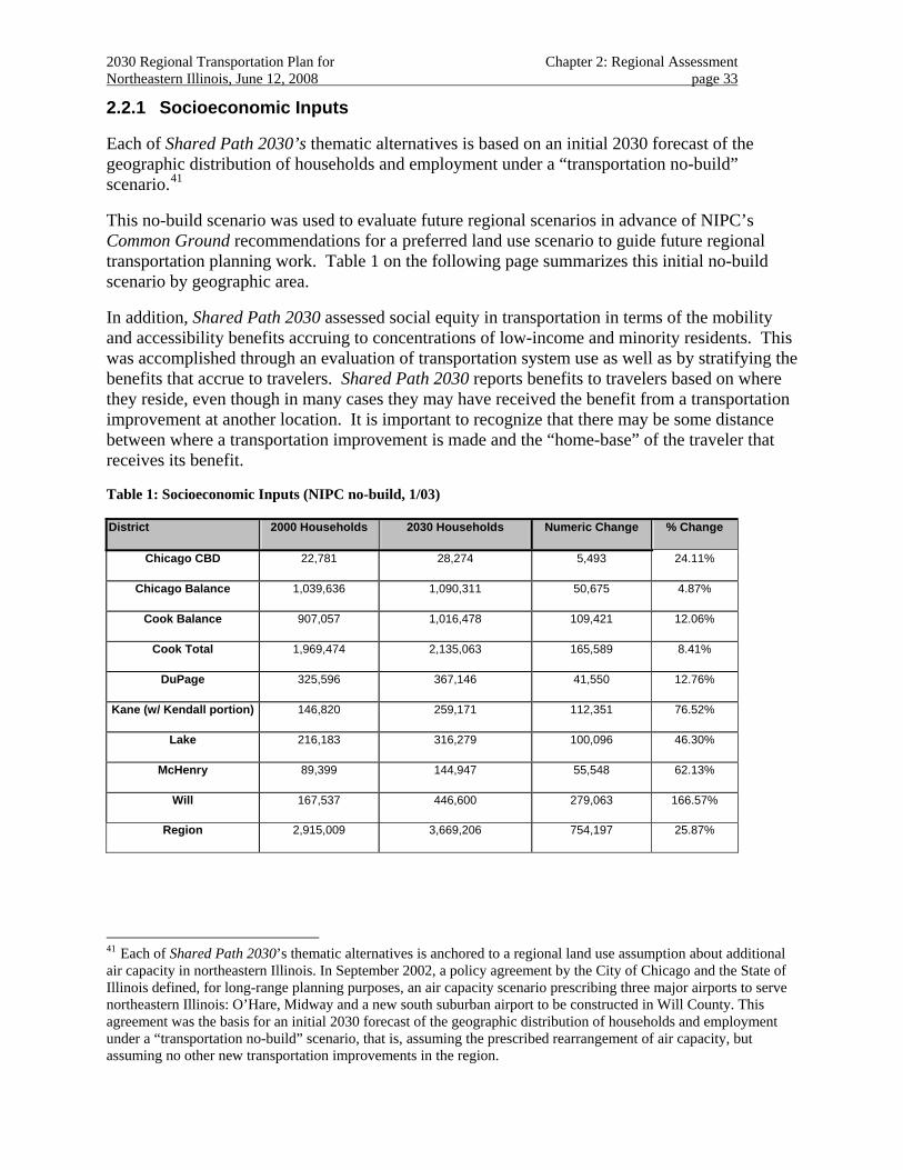
2030 Regional Transportation Plan for Chapter 2: Regional Assessment Northeastern Illinois, June 12, 2008 page 33
2.2.1 Socioeconomic Inputs
Each of Shared Path 2030’s thematic alternatives is based on an initial 2030 forecast of the geographic distribution of households and employment under a “transportation no-build” scenario.41
This no-build scenario was used to evaluate future regional scenarios in advance of NIPC’s Common Ground recommendations for a preferred land use scenario to guide future regional transportation planning work. Table 1 on the following page summarizes this initial no-build scenario by geographic area.
In addition, Shared Path 2030 assessed social equity in transportation in terms of the mobility and accessibility benefits accruing to concentrations of low-income and minority residents. This was accomplished through an evaluation of transportation system use as well as by stratifying the benefits that accrue to travelers. Shared Path 2030 reports benefits to travelers based on where they reside, even though in many cases they may have received the benefit from a transportation improvement at another location. It is important to recognize that there may be some distance between where a transportation improvement is made and the “home-base” of the traveler that receives its benefit.
Table 1: Socioeconomic Inputs (NIPC no-build, 1/03)
District 2000 Households 2030 Households Numeric Change % Change
Chicago CBD 22,781 28,274 5,493 24.11%
Chicago Balance 1,039,636 1,090,311 50,675 4.87%
Cook Balance 907,057 1,016,478 109,421 12.06%
Cook Total 1,969,474 2,135,063 165,589 8.41%
DuPage 325,596 367,146 41,550 12.76%
Kane (w/ Kendall portion) 146,820 259,171 112,351 76.52%
Lake 216,183 316,279 100,096 46.30%
McHenry 89,399 144,947 55,548 62.13%
Will 167,537 446,600 279,063 166.57%
Region 2,915,009 3,669,206 754,197 25.87%
41 Each of Shared Path 2030’s thematic alternatives is anchored to a regional land use assumption about additional air capacity in northeastern Illinois. In September 2002, a policy agreement by the City of Chicago and the State of Illinois defined, for long-range planning purposes, an air capacity scenario prescribing three major airports to serve northeastern Illinois: O’Hare, Midway and a new south suburban airport to be constructed in Will County. This agreement was the basis for an initial 2030 forecast of the geographic distribution of households and employment under a “transportation no-build” scenario, that is, assuming the prescribed rearrangement of air capacity, but assuming no other new transportation improvements in the region.
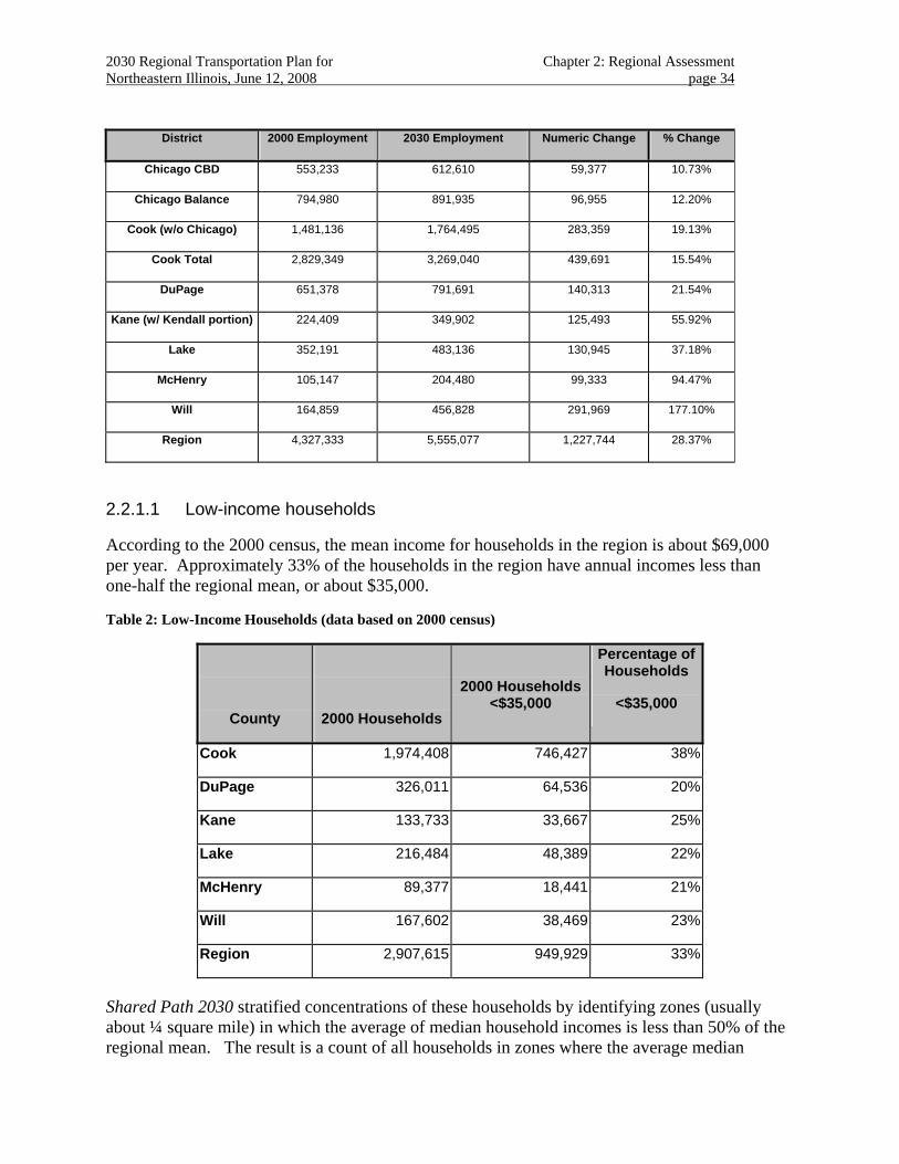
2030 Regional Transportation Plan for Chapter 2: Regional Assessment Northeastern Illinois, June 12, 2008 page 34
District 2000 Employment 2030 Employment Numeric Change % Change
Chicago CBD 553,233 612,610 59,377 10.73%
Chicago Balance 794,980 891,935 96,955 12.20%
Cook (w/o Chicago) 1,481,136 1,764,495 283,359 19.13%
Cook Total 2,829,349 3,269,040 439,691 15.54%
DuPage 651,378 791,691 140,313 21.54%
Kane (w/ Kendall portion) 224,409 349,902 125,493 55.92%
Lake 352,191 483,136 130,945 37.18%
McHenry 105,147 204,480 99,333 94.47%
Will 164,859 456,828 291,969 177.10%
Region 4,327,333 5,555,077 1,227,744 28.37%
2.2.1.1 Low-income households
According to the 2000 census, the mean income for households in the region is about $69,000 per year. Approximately 33% of the households in the region have annual incomes less than one-half the regional mean, or about $35,000.
Table 2: Low-Income Households (data based on 2000 census)
County
2000 Households
2000 Households<$35,000
Percentage of Households
<$35,000
Cook 1,974,408 746,427 38%
DuPage 326,011 64,536 20%
Kane 133,733 33,667 25%
Lake 216,484 48,389 22%
McHenry 89,377 18,441 21%
Will 167,602 38,469 23%
Region 2,907,615 949,929 33%
Shared Path 2030 stratified concentrations of these households by identifying zones (usually about ¼ square mile) in which the average of median household incomes is less than 50% of the regional mean. The result is a count of all households in zones where the average median
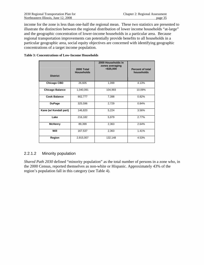
2030 Regional Transportation Plan for Chapter 2: Regional Assessment Northeastern Illinois, June 12, 2008 page 35
income for the zone is less than one-half the regional mean. These two statistics are presented to illustrate the distinction between the regional distribution of lower income households “at-large” and the geographic concentration of lower-income households in a particular area. Because regional transportation improvements can potentially provide benefits to all households in a particular geographic area, social equity objectives are concerned with identifying geographic concentrations of a target income population.
Table 3: Concentrations of Low-Income Households
District
2000 Total Households
2000 Households in zones averaging
<$35,000
Percent of total households
Chicago CBD 26,605 1,099 4.13%
Chicago Balance 1,040,091 104,993 10.09%
Cook Balance 902,777 7,398 0.82%
DuPage 325,596 2,729 0.84%
Kane (w/ Kendall part) 146,820 5,224 3.56%
Lake 216,182 5,979 2.77%
McHenry 89,399 2,363 2.64%
Will 167,537 2,363 1.41%
Region 2,915,007 132,148 4.53%
2.2.1.2 Minority population
Shared Path 2030 defined “minority population” as the total number of persons in a zone who, in the 2000 Census, reported themselves as non-white or Hispanic. Approximately 43% of the region’s population fall in this category (see Table 4).
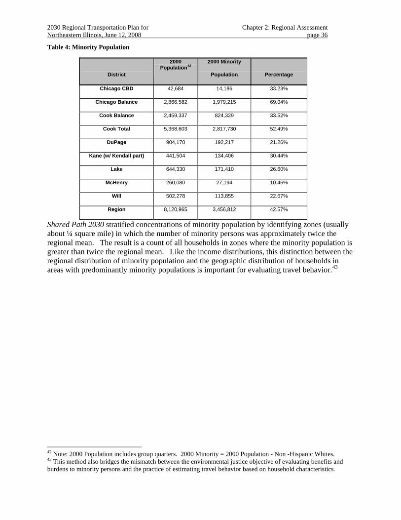
2030 Regional Transportation Plan for Chapter 2: Regional Assessment Northeastern Illinois, June 12, 2008 page 36
Table 4: Minority Population
District
2000 Population42
2000 Minority
Population
Percentage
Chicago CBD 42,684 14,186 33.23%
Chicago Balance 2,866,582 1,979,215 69.04%
Cook Balance 2,459,337 824,329 33.52%
Cook Total 5,368,603 2,817,730 52.49%
DuPage 904,170 192,217 21.26%
Kane (w/ Kendall part) 441,504 134,406 30.44%
Lake 644,330 171,410 26.60%
McHenry 260,080 27,194 10.46%
Will 502,278 113,855 22.67%
Region 8,120,965 3,456,812 42.57%
Shared Path 2030 stratified concentrations of minority population by identifying zones (usually about ¼ square mile) in which the number of minority persons was approximately twice the regional mean. The result is a count of all households in zones where the minority population is greater than twice the regional mean. Like the income distributions, this distinction between the regional distribution of minority population and the geographic distribution of households in areas with predominantly minority populations is important for evaluating travel behavior.43
42 Note: 2000 Population includes group quarters. 2000 Minority = 2000 Population - Non -Hispanic Whites. 43 This method also bridges the mismatch between the environmental justice objective of evaluating benefits and burdens to minority persons and the practice of estimating travel behavior based on household characteristics.
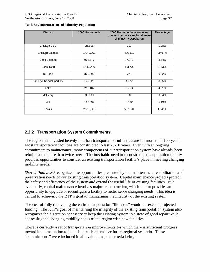
2030 Regional Transportation Plan for Chapter 2: Regional Assessment Northeastern Illinois, June 12, 2008 page 37
Table 5: Concentrations of Minority Population
District 2000 Households 2000 Households in zones w/ greater than twice regional mean
of minority population
Percentage
Chicago CBD 26,605 319 1.20%
Chicago Balance 1,040,091 406,319 39.07%
Cook Balance 902,777 77,071 8.54%
Cook Total 1,969,473 483,709 24.56%
DuPage 325,596 725 0.22%
Kane (w/ Kendall portion) 146,820 4,777 3.25%
Lake 216,182 9,753 4.51%
McHenry 89,399 38 0.04%
Will 167,537 8,592 5.13%
Totals 2,915,007 507,594 17.41%
2.2.2 Transportation System Commitments
The region has invested heavily in urban transportation infrastructure for more than 100 years. Most transportation facilities are constructed to last 20-50 years. Even with an ongoing commitment to maintenance, many components of our transportation system have already been rebuilt, some more than twice over. The inevitable need to reconstruct a transportation facility provides opportunities to consider an existing transportation facility’s place in meeting changing mobility needs.
Shared Path 2030 recognized the opportunities presented by the maintenance, rehabilitation and preservation needs of our existing transportation system. Capital maintenance projects protect the safety and efficiency of the system and extend the useful life of existing facilities. But eventually, capital maintenance involves major reconstruction, which in turn provides an opportunity to upgrade or reconfigure a facility to better serve changing needs. This idea is central to achieving the RTP’s goal of maintaining the integrity of the existing system.
The cost of fully renovating the entire transportation “like new” would far exceed projected funding. The RTP’s goal of maintaining the integrity of the existing transportation system also recognizes the discretion necessary to keep the existing system in a state of good repair while addressing the changing mobility needs of the region with new facilities.
There is currently a set of transportation improvements for which there is sufficient progress toward implementation to include in each alternative future regional scenario. These “commitments” were included in all evaluations, the criteria being:
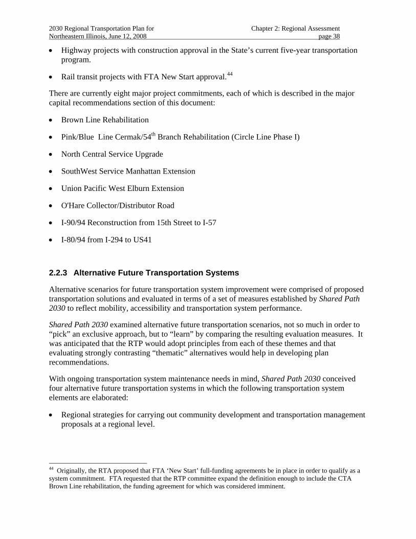
2030 Regional Transportation Plan for Chapter 2: Regional Assessment Northeastern Illinois, June 12, 2008 page 38
• Highway projects with construction approval in the State’s current five-year transportation program.
• Rail transit projects with FTA New Start approval.44
There are currently eight major project commitments, each of which is described in the major capital recommendations section of this document:
• Brown Line Rehabilitation
• Pink/Blue Line Cermak/54th Branch Rehabilitation (Circle Line Phase I)
• North Central Service Upgrade
• SouthWest Service Manhattan Extension
• Union Pacific West Elburn Extension
• O'Hare Collector/Distributor Road
• I-90/94 Reconstruction from 15th Street to I-57
• I-80/94 from I-294 to US41
2.2.3 Alternative Future Transportation Systems
Alternative scenarios for future transportation system improvement were comprised of proposed transportation solutions and evaluated in terms of a set of measures established by Shared Path 2030 to reflect mobility, accessibility and transportation system performance.
Shared Path 2030 examined alternative future transportation scenarios, not so much in order to “pick” an exclusive approach, but to “learn” by comparing the resulting evaluation measures. It was anticipated that the RTP would adopt principles from each of these themes and that evaluating strongly contrasting “thematic” alternatives would help in developing plan recommendations.
With ongoing transportation system maintenance needs in mind, Shared Path 2030 conceived four alternative future transportation systems in which the following transportation system elements are elaborated:
• Regional strategies for carrying out community development and transportation management proposals at a regional level.
44 Originally, the RTA proposed that FTA ‘New Start’ full-funding agreements be in place in order to qualify as a system commitment. FTA requested that the RTP committee expand the definition enough to include the CTA Brown Line rehabilitation, the funding agreement for which was considered imminent.
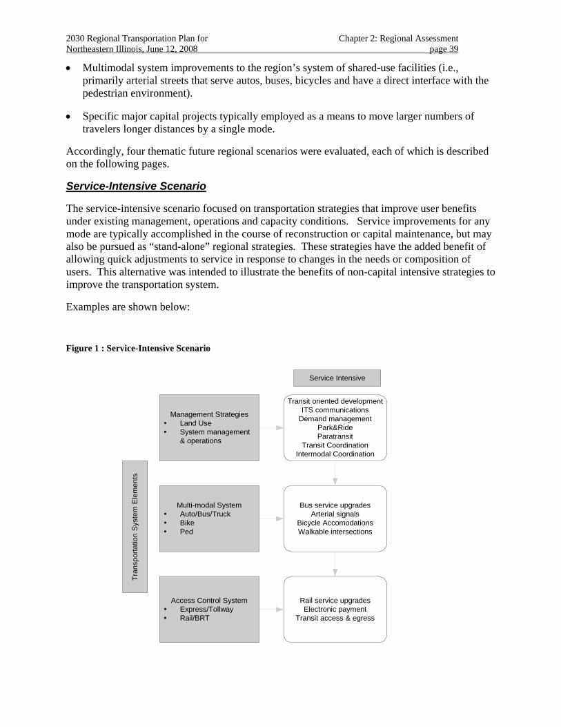
2030 Regional Transportation Plan for Chapter 2: Regional Assessment Northeastern Illinois, June 12, 2008 page 39
• Multimodal system improvements to the region’s system of shared-use facilities (i.e., primarily arterial streets that serve autos, buses, bicycles and have a direct interface with the pedestrian environment).
• Specific major capital projects typically employed as a means to move larger numbers of travelers longer distances by a single mode.
Accordingly, four thematic future regional scenarios were evaluated, each of which is described on the following pages.
Service-Intensive Scenario
The service-intensive scenario focused on transportation strategies that improve user benefits under existing management, operations and capacity conditions. Service improvements for any mode are typically accomplished in the course of reconstruction or capital maintenance, but may also be pursued as “stand-alone” regional strategies. These strategies have the added benefit of allowing quick adjustments to service in response to changes in the needs or composition of users. This alternative was intended to illustrate the benefits of non-capital intensive strategies to improve the transportation system.
Examples are shown below:
Figure 1 : Service-Intensive Scenario
Tran
spor
tatio
n S
yste
m E
lem
ents
Multi-modal SystemAuto/Bus/TruckBikePed
Management StrategiesLand UseSystem management& operations
Access Control SystemExpress/TollwayRail/BRT
Service Intensive
Transit oriented developmentITS communications
Demand managementPark&RideParatransit
Transit CoordinationIntermodal Coordination
Rail service upgradesElectronic payment
Transit access & egress
Bus service upgradesArterial signals
Bicycle AccomodationsWalkable intersections
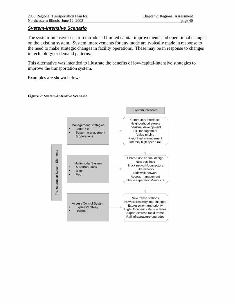
2030 Regional Transportation Plan for Chapter 2: Regional Assessment Northeastern Illinois, June 12, 2008 page 40
System-Intensive Scenario
The system-intensive scenario introduced limited capital improvements and operational changes on the existing system. System improvements for any mode are typically made in response to the need to make strategic changes in facility operations. These may be in response to changes in technology or demand patterns.
This alternative was intended to illustrate the benefits of low-capital-intensive strategies to improve the transportation system.
Examples are shown below:
Figure 2: System-Intensive Scenario
Tran
spor
tatio
n S
yste
m E
lem
ents
Multi-modal SystemAuto/Bus/TruckBikePed
Management StrategiesLand UseSystem management& operations
Access Control SystemExpress/TollwayRail/BRT
System Intensive
Community interfacesNeighborhood streetsIndustrial development
ITS managementValue pricing
Freight rail managementIntercity high speed rail
Shared use arterial designNew bus lines
Truck network/connectorsBike network
Sidewalk networkAccess management
Grade separations/viaducts
New transit stationsNew expressway interchanges
Expressway ramp priorityHigh Occupancy Vehicle lanes
Airport express rapid transitRail infrastracture upgrades
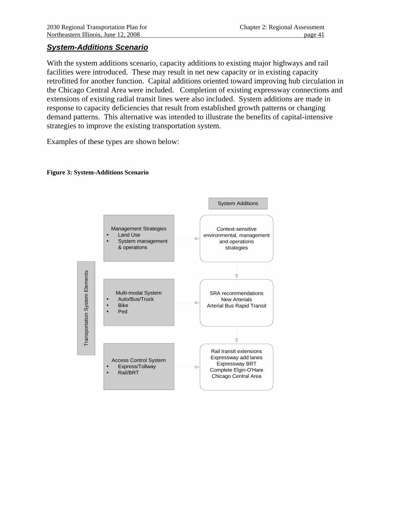
2030 Regional Transportation Plan for Chapter 2: Regional Assessment Northeastern Illinois, June 12, 2008 page 41
System-Additions Scenario
With the system additions scenario, capacity additions to existing major highways and rail facilities were introduced. These may result in net new capacity or in existing capacity retrofitted for another function. Capital additions oriented toward improving hub circulation in the Chicago Central Area were included. Completion of existing expressway connections and extensions of existing radial transit lines were also included. System additions are made in response to capacity deficiencies that result from established growth patterns or changing demand patterns. This alternative was intended to illustrate the benefits of capital-intensive strategies to improve the existing transportation system.
Examples of these types are shown below:
Figure 3: System-Additions Scenario
Tran
spor
tatio
n S
yste
m E
lem
ents
Multi-modal SystemAuto/Bus/TruckBikePed
Management StrategiesLand UseSystem management& operations
Access Control SystemExpress/TollwayRail/BRT
System Additions
Context-sensitiveenvironmental, management
and operationsstrategies
SRA recommendationsNew Arterials
Arterial Bus Rapid Transit
Rail transit extensionsExpressway add lanes
Expressway BRTComplete Elgin-O'HareChicago Central Area
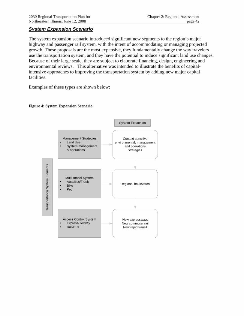
2030 Regional Transportation Plan for Chapter 2: Regional Assessment Northeastern Illinois, June 12, 2008 page 42
System Expansion Scenario
The system expansion scenario introduced significant new segments to the region’s major highway and passenger rail system, with the intent of accommodating or managing projected growth. These proposals are the most expensive, they fundamentally change the way travelers use the transportation system, and they have the potential to induce significant land use changes. Because of their large scale, they are subject to elaborate financing, design, engineering and environmental reviews. This alternative was intended to illustrate the benefits of capital-intensive approaches to improving the transportation system by adding new major capital facilities.
Examples of these types are shown below:
Figure 4: System Expansion Scenario
Tran
spor
tatio
n S
yste
m E
lem
ents
Multi-modal SystemAuto/Bus/TruckBikePed
Management StrategiesLand UseSystem management& operations
Access Control SystemExpress/TollwayRail/BRT
System Expansion
Context-sensitiveenvironmental, management
and operationsstrategies
Regional boulevards
New expresswaysNew commuter railNew rapid transit
2030 Regional Transportation Plan for Chapter 2: Regional Assessment Northeastern Illinois, June 12, 2008 page 43
2.2.4 Measuring Transportation Benefits
A technical evaluation of the transportation system is intended to help examine the effects of proposed transportation improvements on each other, as well as their combined contribution toward the plan’s goals and objectives.
To begin, a general "sketch" analysis of each major capital project was performed in support of assembling the network alternatives. This consisted of developing and preparing the necessary data needed to represent each project in a regional travel demand analysis. This provided a first round of "cause-effect" results45 that allowed each proposal’s “champion”46 the opportunity to refine the proposal for placement in one of the four thematic alternative future regional scenarios.
The analysis used economic, statistical and engineering methods to evaluate the alternatives based on fundamental principles that illustrate rational behavior.47
Shared Path 2030 included two types of technical evaluation:
• An assessment of transportation system supply, demand and effects.
• An assessment of traveler mobility and accessibility.
45 While of intense interest to project sponsors, project measures themselves become problematic because they seem to encourage evaluating projects in a vacuum. Project level performance is highly dependent on regional context; attempting to discern the performance of a single project when tested as part of a regional scenario leads to confusion and misinterpretation. In the final 2020 RTP discussions, projects were being "sized-up" in terms of their final demand rather than in light of their effect on system performance or underlying assumptions. All RTP projects proceeding toward implementation are subjected to further demand analysis as part of special project studies, sub-area implementation plans and design/environmental studies. It is at these later stages of intense scrutiny that proposals are given operational and contextual consideration that has the greatest effect on demand. For each network proposal, 2030 no-build trip tables based on the existing transportation system were assigned over a network, with a single network proposal coded. The principal measure derived was “number of trips served,” a partial indicator of benefit. Number of trips served reflects the total travelers using a facility because, all other things equal, there is no better alternative route. A full assessment of benefit requires a system measure to reflect advantages accrued by other users who may enjoy more choices and lower costs as a result of introducing a new facility that they, themselves, do not actually use. 46 “Proposal Champions” are Shared Path 2030 participants that agreed to provide details about and argue for inclusion of the proposal in the RTP. 47 Rational = maximizing benefits of an action subject to constraints. Defining some of the evaluation terms at the outset allows transportation evaluation measures to be more succinctly discussed. Some basic definitions are offered below. It is not the intent to over-simplify the decisions at hand or over-rationalize the techniques used. Agreeing on the use of these words, however, provides useful shorthand when discussing larger public policy concerns. • Utility — the value derived from making a transaction. In transportation, utility is typically associated with
engaging in some activity after completing a trip. • Cost — constraints on utility. In transportation, needing to travel is typically considered a cost. • Benefits — utility gains. • Burdens — utility losses. • Efficiency - benefits are maximized and burdens are minimized subject to costs. • Equity — benefits accrue and burdens are mitigated according to a prescribed fairness standard. • Externalities — benefits/burdens that result from, but are not directly attributable to, the utility being evaluated.
2030 Regional Transportation Plan for Chapter 2: Regional Assessment Northeastern Illinois, June 12, 2008 page 44
The evaluation measures themselves played a variety of roles in the plan development process, but primarily they were intended to improve understanding of how the transportation system works and illustrate the relative contributions of the various transportation proposals to achieving the plan’s goals and objectives.
2.2.4.1 Transportation system performance
An important element of a transportation system’s success is the efficiency with which it functions as a unified whole. It is therefore important that some evaluation measures reflect the effects of transportation decisions on the performance of the entire system.48 These system measures result from an assessment of an equilibrium between travel supply and demand.
Transportation system supply measures
Walkable miles
Tripmaking that can be satisfied by non-motorized means is, in part, a function of the overall pedestrian environment in an area. Alternatives including regional and project-level strategies that called for improved pedestrian and bicycling environments resulted in a higher “pedestrian environment factor” (PEF49) applied to the affected areas. To facilitate comparing this measure to other transportation system supply measures, the PEF for each zone is divided by the standard Chicago “8 blocks per mile.”.
Highway lane miles
Demand for auto and truck travel is, in part, a function of the overall capacity offered by the highway system. While the actual capacity of a highway facility varies by its design, tabulating highway lane miles provides a quick comparison of highway supply in each scenario.
Daily transit service hours
Demand for travel by public transit is a function not only of physical facilities, but also the frequency and speed of service offered by transit providers. The level of transit service varies across the day, with both supply and demand peaking during the traditional morning and afternoon rush. To facilitate comparing this measure to other transportation system supply measures, the peak period transit service levels have been expanded to a daily measure of service hours.
48 While evaluating user benefits is important to assessing the equity and efficiency of improvements to the mobility and accessibility of individuals, system performance measures are intended to be of greatest use at the regional level. Thus, system performance measures typically take the form of a single value that can be fairly attributed to the entire region. 49 PEF is presently defined as the average number of local blocks in a zone.
2030 Regional Transportation Plan for Chapter 2: Regional Assessment Northeastern Illinois, June 12, 2008 page 45
Tripmaking behavior
The number, mode and purpose of trips affect system performance. The travel demand analysis calculates trips generated based on household composition (e.g., adults, workers, children and auto ownership) and employment. In addition, the location and “pedestrian environment” of households will affect the number and purpose of trips made.
Shared Path 2030 anticipated that a denser arrangement of socioeconomic activity50 generating fewer motorized trips, shorter trip lengths and providing good transit options makes less costly demands on the transportation system.
Transportation system demand
Trip lengths, mode and route choice affect system performance. Person-miles traveled and person-hours traveled are tabulated from transportation network demand statistics that respond to variations in these components of travel demand.
Miles and hours traveled are affected primarily by congestion on the demand side and the introduction of new or expanded system capacity on the supply side. To a lesser extent, these network statistics are affected by marginal changes in the pattern or density of development.
Shared Path 2030 anticipated that reduced miles and hours of travel are associated with lower energy costs, less pollution and more efficient use of the transportation system. Congestion affects both travel time and route choice. High VHT (vehicle hours traveled) due to recurring congestion also affects overall system performance. Future estimates of tripmaking, trip lengths, mode choice and network performance are also significantly affected by link-level congestion.
Shared Path 2030 anticipated that reduced traffic congestion is associated with reduced fuel51 consumption, less pollution and more efficient use of the transportation system.
Transportation system costs
Energy costs
Energy consumption is associated with both the type of transportation supply and level of demand. Energy costs are calculated by applying energy consumption statistics to travel demand model results. Included are fuel costs estimated by current prices and consumption rates. Current nominal assumptions regarding energy costs are held constant and applied to changed transportation variables.
Shared Path 2030 anticipated that lower energy costs are associated with more efficient use of the transportation system.
Capital construction and maintenance costs
50 A regional measure of socioeconomic concentration is summarized here as “% trips in Chicago” in order to give an overall indication of the level of regional decentralization being fostered by the transportation system. This is different and does not undermine RTP strategies in support of compact development patterns region-wide. 51 Including electricity.
2030 Regional Transportation Plan for Chapter 2: Regional Assessment Northeastern Illinois, June 12, 2008 page 46
Capital costs represent a constraint on the plan’s recommendations. The estimates are made on a unit cost basis for the capital proposal as initially proposed. This provides only the most general indicator of the financial costs associated with each alternative. Further refinement of recommended proposals, including unforeseen right-of-way, community and environmental mitigation costs, can significantly affect the final capital cost of an individual proposal.
In this case, Shared Path 2030 anticipated that capital investment in the transportation system should be commensurate with other system benefits.
Natural environment sensitivity
The methodology for analyzing 2030 project proposals employed a composite natural resource score based on the degree and type of natural resources present within the project zone of analysis. The composite score made the comparison of projects and alternatives possible.52
The natural resource categories used in this evaluation were included based on their importance to protecting the region’s water resources, natural areas, and farmlands and were only tabulated for proposed major capital projects. Therefore, there is no composite score reported for the non-capital-intensive alternatives nor for the existing transportation system. These categories are broad-ranging and their selection was based, in part, on the availability of reliable information at the regional scale.
Shared Path 2030 anticipated that higher composite natural resources scores indicate a greater likely need for avoidance or mitigation of natural resource impacts.
2.2.4.2 Evaluation of transportation system performance
Table 6 on the next page provides a regional overview of the transportation system supply, demand and effects under each thematic alternative.
52 NIPC, Natural Resource Impact Analysis: Summary of Natural Resource Features of Projects Proposed for the 2030 RTP, Draft, 2003.
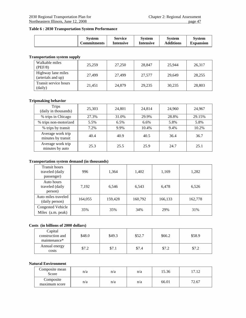
2030 Regional Transportation Plan for Chapter 2: Regional Assessment Northeastern Illinois, June 12, 2008 page 47
Table 6 : 2030 Transportation System Performance
System Commitments
Service Intensive
System Intensive
System Additions
System Expansion
Transportation system supply
Walkable miles (PEF/8) 25,259 27,250 28,847 25,944 26,317
Highway lane miles (arterials and up) 27,499 27,499 27,577 29,649 28,255
Transit service hours (daily) 21,451 24,879 29,235 30,235 28,803
Tripmaking behavior
Trips (daily in thousands) 25,303 24,801 24,814 24,960 24,967
% trips in Chicago 27.3% 31.0% 29.9% 28.8% 29.15% % trips non-motorized 5.5% 6.5% 6.6% 5.8% 5.8%
% trips by transit 7.2% 9.9% 10.4% 9.4% 10.2% Average work trip minutes by transit 40.4 40.9 40.5 36.4 36.7
Average work trip minutes by auto 25.3 25.5 25.9 24.7 25.1
Transportation system demand (in thousands)
Transit hours traveled (daily
passenger) 996 1,364 1,402 1,169 1,282
Auto hours traveled (daily
person) 7,192 6,546 6,543 6,478 6,526
Auto miles traveled (daily person) 164,055 159,428 160,792 166,133 162,778
Congested Vehicle Miles (a.m. peak)
35% 35% 34% 29% 31%
Costs (in billions of 2000 dollars)
Capital construction and
maintenance* $48.0 $49.3 $52.7 $66.2 $58.9
Annual energy costs $7.2 $7.1 $7.4 $7.2 $7.2
Natural Environment
Composite mean Score n/a n/a n/a 15.36 17.12
Composite maximum score n/a n/a n/a 66.01 72.67
2030 Regional Transportation Plan for Chapter 2: Regional Assessment Northeastern Illinois, June 12, 2008 page 48
2.2.4.3 Traveler mobility and accessibility
An important element of a transportation system’s success is the “level of service” it offers its users. “Level of service” is defined as the mobility the system engenders and the accessibility it provides to travelers in the region. In order to evaluate the regional equity and comparative effectiveness of mobility and accessibility improvements, these measures are stratified (i.e., classified, aggregated) into the following discrete groups:
• Subregional geography53
• Minority population (by residence)
• Household income (by residence)
The mobility and accessibility measures expected to respond to the RTP recommendations include:
• Use of transportation modes
• Access to transit
• Access to jobs
• Work commute times
Use of transportation modes
A person’s decision regarding travel mode typically includes an assessment of the different costs associated with the modes available.
Mode use measures are most often expressed as the number of trips made by auto, transit or non-motorized means. It is frequently reported as a percentage of total trips made by a particular mode.
Auto and transit trips are estimated by comparing the relative generalized costs of making a trip by each mode. The costs are estimated under the different thematic future alternatives, each with a different set of policy and network assumptions.
Shared Path 2030 anticipated that a wider range of choices among modes confers a benefit (i.e., having more choices available reflects better mobility and accessibility).
Access to transit
A traveler’s proximity to major rail transit facilities is associated with having greater mode choice to more destination opportunities in the region.
The part of the trip each traveler needs to make in order to reach a rail passenger station is called the “access leg.” The principal ways to access rail transit are by walking, biking, bus or auto. 53 The subregional geography stratification consists of the traditional Chicago/County breakdowns. Separate stratification for assessing mobility and accessibility are also reported for high-demand multimodal corridors.
2030 Regional Transportation Plan for Chapter 2: Regional Assessment Northeastern Illinois, June 12, 2008 page 49
The decision to use rail transit is very heavily weighted in terms of the time, costs and mode of access, including parking costs/capacity and the time spent waiting for the train.
Accessibility to rail transit will change as new facilities are introduced. Introducing transit-oriented development will improve the opportunity to choose transit as an alternate mode for more travelers. In the case of auto access to transit, accessibility will also change with prevailing highway congestion.
Shared Path 2030 anticipated that easier accessibility to transit stations confers a benefit to residential or employment locations.
Evaluation of “Use of transportation modes and Access to transit”
Tables 7-12 on the following pages show the mode choice and access to transit effects by trip purpose for each future regional alternative by geography, race/ethnicity and income level.
Note that measures are reported based on the traveler’s “home-base” even though they may have received the benefit of a transportation improvement elsewhere.
By subregional geography
Tables 7 and 8 stratify the evaluation results by county. The Chicago Central Business District (CBD), balance of Chicago and balance of Cook County are reported separately.
Work trips
Work trips are based at the traveler’s home location and include short diversions (e.g., errands, drop-off/pick-up and park and ride) along the way.
All trips
The tabulation of all trips is based at the traveler’s home location, if referenced, but also includes non-home-based trips.
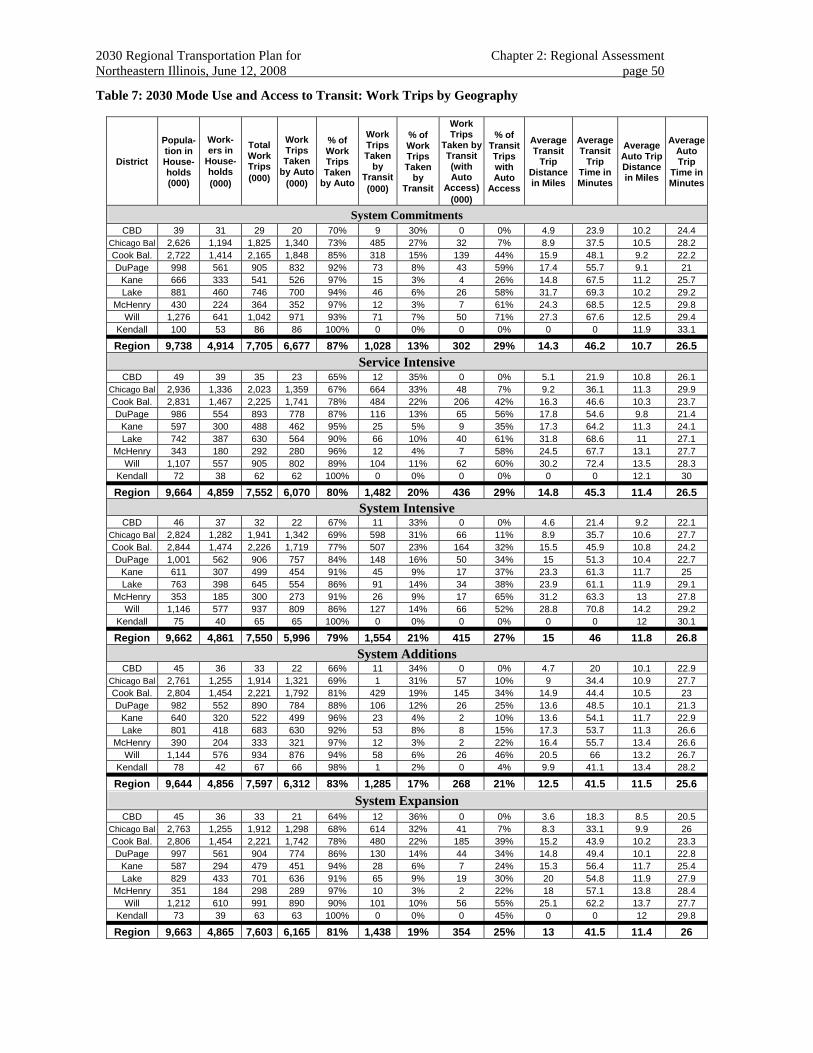
2030 Regional Transportation Plan for Chapter 2: Regional Assessment Northeastern Illinois, June 12, 2008 page 50
Table 7: 2030 Mode Use and Access to Transit: Work Trips by Geography
District
Popula-tion in House-holds (000)
Work-ers in
House-holds (000)
Total Work Trips (000)
Work Trips Taken
by Auto (000)
% of Work Trips Taken
by Auto
Work Trips Taken
by Transit(000)
% of Work Trips Taken
by Transit
Work Trips
Taken by Transit (with Auto
Access)(000)
% of Transit Trips with Auto
Access
Average Transit
Trip Distance in Miles
Average Transit
Trip Time in Minutes
Average Auto Trip Distance in Miles
Average Auto Trip
Time in Minutes
System Commitments CBD 39 31 29 20 70% 9 30% 0 0% 4.9 23.9 10.2 24.4
Chicago Bal 2,626 1,194 1,825 1,340 73% 485 27% 32 7% 8.9 37.5 10.5 28.2 Cook Bal. 2,722 1,414 2,165 1,848 85% 318 15% 139 44% 15.9 48.1 9.2 22.2 DuPage 998 561 905 832 92% 73 8% 43 59% 17.4 55.7 9.1 21
Kane 666 333 541 526 97% 15 3% 4 26% 14.8 67.5 11.2 25.7 Lake 881 460 746 700 94% 46 6% 26 58% 31.7 69.3 10.2 29.2
McHenry 430 224 364 352 97% 12 3% 7 61% 24.3 68.5 12.5 29.8 Will 1,276 641 1,042 971 93% 71 7% 50 71% 27.3 67.6 12.5 29.4
Kendall 100 53 86 86 100% 0 0% 0 0% 0 0 11.9 33.1
Region 9,738 4,914 7,705 6,677 87% 1,028 13% 302 29% 14.3 46.2 10.7 26.5 Service Intensive
CBD 49 39 35 23 65% 12 35% 0 0% 5.1 21.9 10.8 26.1 Chicago Bal 2,936 1,336 2,023 1,359 67% 664 33% 48 7% 9.2 36.1 11.3 29.9 Cook Bal. 2,831 1,467 2,225 1,741 78% 484 22% 206 42% 16.3 46.6 10.3 23.7 DuPage 986 554 893 778 87% 116 13% 65 56% 17.8 54.6 9.8 21.4
Kane 597 300 488 462 95% 25 5% 9 35% 17.3 64.2 11.3 24.1 Lake 742 387 630 564 90% 66 10% 40 61% 31.8 68.6 11 27.1
McHenry 343 180 292 280 96% 12 4% 7 58% 24.5 67.7 13.1 27.7 Will 1,107 557 905 802 89% 104 11% 62 60% 30.2 72.4 13.5 28.3
Kendall 72 38 62 62 100% 0 0% 0 0% 0 0 12.1 30
Region 9,664 4,859 7,552 6,070 80% 1,482 20% 436 29% 14.8 45.3 11.4 26.5 System Intensive
CBD 46 37 32 22 67% 11 33% 0 0% 4.6 21.4 9.2 22.1 Chicago Bal 2,824 1,282 1,941 1,342 69% 598 31% 66 11% 8.9 35.7 10.6 27.7 Cook Bal. 2,844 1,474 2,226 1,719 77% 507 23% 164 32% 15.5 45.9 10.8 24.2 DuPage 1,001 562 906 757 84% 148 16% 50 34% 15 51.3 10.4 22.7
Kane 611 307 499 454 91% 45 9% 17 37% 23.3 61.3 11.7 25 Lake 763 398 645 554 86% 91 14% 34 38% 23.9 61.1 11.9 29.1
McHenry 353 185 300 273 91% 26 9% 17 65% 31.2 63.3 13 27.8 Will 1,146 577 937 809 86% 127 14% 66 52% 28.8 70.8 14.2 29.2
Kendall 75 40 65 65 100% 0 0% 0 0% 0 0 12 30.1
Region 9,662 4,861 7,550 5,996 79% 1,554 21% 415 27% 15 46 11.8 26.8 System Additions
CBD 45 36 33 22 66% 11 34% 0 0% 4.7 20 10.1 22.9 Chicago Bal 2,761 1,255 1,914 1,321 69% 1 31% 57 10% 9 34.4 10.9 27.7 Cook Bal. 2,804 1,454 2,221 1,792 81% 429 19% 145 34% 14.9 44.4 10.5 23 DuPage 982 552 890 784 88% 106 12% 26 25% 13.6 48.5 10.1 21.3
Kane 640 320 522 499 96% 23 4% 2 10% 13.6 54.1 11.7 22.9 Lake 801 418 683 630 92% 53 8% 8 15% 17.3 53.7 11.3 26.6
McHenry 390 204 333 321 97% 12 3% 2 22% 16.4 55.7 13.4 26.6 Will 1,144 576 934 876 94% 58 6% 26 46% 20.5 66 13.2 26.7
Kendall 78 42 67 66 98% 1 2% 0 4% 9.9 41.1 13.4 28.2
Region 9,644 4,856 7,597 6,312 83% 1,285 17% 268 21% 12.5 41.5 11.5 25.6 System Expansion
CBD 45 36 33 21 64% 12 36% 0 0% 3.6 18.3 8.5 20.5 Chicago Bal 2,763 1,255 1,912 1,298 68% 614 32% 41 7% 8.3 33.1 9.9 26 Cook Bal. 2,806 1,454 2,221 1,742 78% 480 22% 185 39% 15.2 43.9 10.2 23.3 DuPage 997 561 904 774 86% 130 14% 44 34% 14.8 49.4 10.1 22.8
Kane 587 294 479 451 94% 28 6% 7 24% 15.3 56.4 11.7 25.4 Lake 829 433 701 636 91% 65 9% 19 30% 20 54.8 11.9 27.9
McHenry 351 184 298 289 97% 10 3% 2 22% 18 57.1 13.8 28.4 Will 1,212 610 991 890 90% 101 10% 56 55% 25.1 62.2 13.7 27.7
Kendall 73 39 63 63 100% 0 0% 0 45% 0 0 12 29.8
Region 9,663 4,865 7,603 6,165 81% 1,438 19% 354 25% 13 41.5 11.4 26
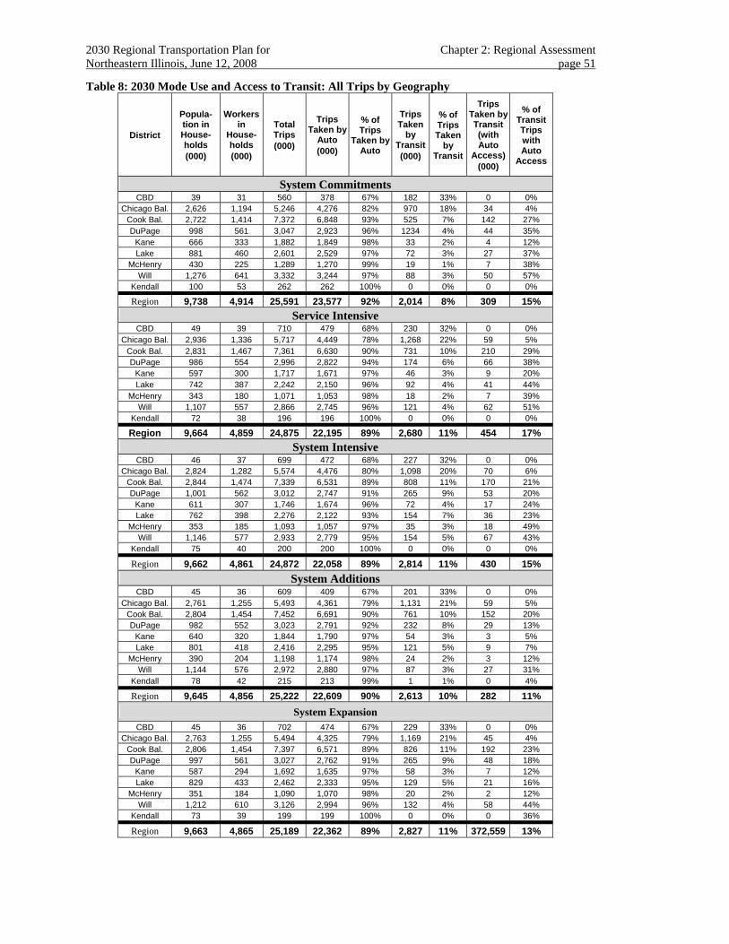
2030 Regional Transportation Plan for Chapter 2: Regional Assessment Northeastern Illinois, June 12, 2008 page 51
Table 8: 2030 Mode Use and Access to Transit: All Trips by Geography
District
Popula-tion in House-holds (000)
Workers in
House-holds (000)
Total Trips (000)
Trips Taken by
Auto (000)
% of Trips
Taken by Auto
Trips Taken
by Transit(000)
% of Trips Taken
by Transit
Trips Taken by Transit (with Auto
Access)(000)
% of Transit Trips with Auto
Access
System Commitments CBD 39 31 560 378 67% 182 33% 0 0%
Chicago Bal. 2,626 1,194 5,246 4,276 82% 970 18% 34 4% Cook Bal. 2,722 1,414 7,372 6,848 93% 525 7% 142 27% DuPage 998 561 3,047 2,923 96% 1234 4% 44 35%
Kane 666 333 1,882 1,849 98% 33 2% 4 12% Lake 881 460 2,601 2,529 97% 72 3% 27 37%
McHenry 430 225 1,289 1,270 99% 19 1% 7 38% Will 1,276 641 3,332 3,244 97% 88 3% 50 57%
Kendall 100 53 262 262 100% 0 0% 0 0%
Region 9,738 4,914 25,591 23,577 92% 2,014 8% 309 15% Service Intensive
CBD 49 39 710 479 68% 230 32% 0 0% Chicago Bal. 2,936 1,336 5,717 4,449 78% 1,268 22% 59 5%
Cook Bal. 2,831 1,467 7,361 6,630 90% 731 10% 210 29% DuPage 986 554 2,996 2,822 94% 174 6% 66 38%
Kane 597 300 1,717 1,671 97% 46 3% 9 20% Lake 742 387 2,242 2,150 96% 92 4% 41 44%
McHenry 343 180 1,071 1,053 98% 18 2% 7 39% Will 1,107 557 2,866 2,745 96% 121 4% 62 51%
Kendall 72 38 196 196 100% 0 0% 0 0%
Region 9,664 4,859 24,875 22,195 89% 2,680 11% 454 17% System Intensive
CBD 46 37 699 472 68% 227 32% 0 0% Chicago Bal. 2,824 1,282 5,574 4,476 80% 1,098 20% 70 6%
Cook Bal. 2,844 1,474 7,339 6,531 89% 808 11% 170 21% DuPage 1,001 562 3,012 2,747 91% 265 9% 53 20%
Kane 611 307 1,746 1,674 96% 72 4% 17 24% Lake 762 398 2,276 2,122 93% 154 7% 36 23%
McHenry 353 185 1,093 1,057 97% 35 3% 18 49% Will 1,146 577 2,933 2,779 95% 154 5% 67 43%
Kendall 75 40 200 200 100% 0 0% 0 0%
Region 9,662 4,861 24,872 22,058 89% 2,814 11% 430 15% System Additions
CBD 45 36 609 409 67% 201 33% 0 0% Chicago Bal. 2,761 1,255 5,493 4,361 79% 1,131 21% 59 5%
Cook Bal. 2,804 1,454 7,452 6,691 90% 761 10% 152 20% DuPage 982 552 3,023 2,791 92% 232 8% 29 13%
Kane 640 320 1,844 1,790 97% 54 3% 3 5% Lake 801 418 2,416 2,295 95% 121 5% 9 7%
McHenry 390 204 1,198 1,174 98% 24 2% 3 12% Will 1,144 576 2,972 2,880 97% 87 3% 27 31%
Kendall 78 42 215 213 99% 1 1% 0 4%
Region 9,645 4,856 25,222 22,609 90% 2,613 10% 282 11% System Expansion
CBD 45 36 702 474 67% 229 33% 0 0% Chicago Bal. 2,763 1,255 5,494 4,325 79% 1,169 21% 45 4%
Cook Bal. 2,806 1,454 7,397 6,571 89% 826 11% 192 23% DuPage 997 561 3,027 2,762 91% 265 9% 48 18%
Kane 587 294 1,692 1,635 97% 58 3% 7 12% Lake 829 433 2,462 2,333 95% 129 5% 21 16%
McHenry 351 184 1,090 1,070 98% 20 2% 2 12% Will 1,212 610 3,126 2,994 96% 132 4% 58 44%
Kendall 73 39 199 199 100% 0 0% 0 36%
Region 9,663 4,865 25,189 22,362 89% 2,827 11% 372,559 13%
2030 Regional Transportation Plan for Chapter 2: Regional Assessment Northeastern Illinois, June 12, 2008 page 52
By race/ethnicity
Tables 9 and 10 stratify the evaluation results by minority race or ethnicity concentrations within an analysis zone.
Shared Path 2030 defined “minority population” as the total number of persons in a zone who reported themselves in the 2000 Census as non-white or Hispanic.
Work trips
Work trips are based at the traveler’s home location and include short diversions (e.g., errands, drop-off/pick-up and park and ride) along the way.
All trips
The tabulation of all trips is based at the traveler’s home location, if referenced, but also includes non-home-based trips.
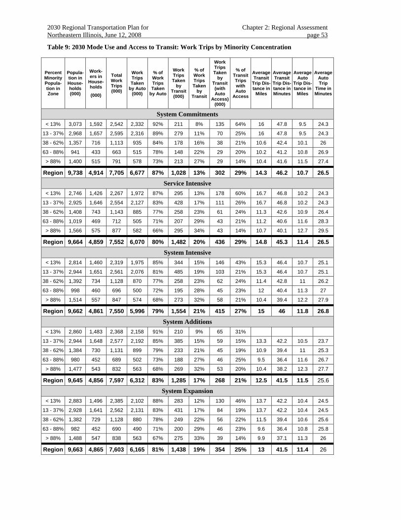
2030 Regional Transportation Plan for Chapter 2: Regional Assessment Northeastern Illinois, June 12, 2008 page 53
Table 9: 2030 Mode Use and Access to Transit: Work Trips by Minority Concentration
Percent Minority Popula-tion in Zone
Popula-tion in House-holds (000)
Work-ers in
House-holds
(000)
Total Work Trips (000)
Work Trips Taken
by Auto (000)
% of Work Trips Taken
by Auto
Work Trips Taken
by Transit (000)
% of Work Trips Taken
by Transit
Work Trips Taken
by Transit (with Auto
Access) (000)
% of Transit Trips with Auto
Access
Average Transit
Trip Dis-tance in
Miles
Average Transit
Trip Dis-tance in Minutes
Average Auto
Trip Dis-tance in
Miles
Average Auto Trip
Time in Minutes
System Commitments < 13% 3,073 1,592 2,542 2,332 92% 211 8% 135 64% 16 47.8 9.5 24.3
13 - 37% 2,968 1,657 2,595 2,316 89% 279 11% 70 25% 16 47.8 9.5 24.3
38 - 62% 1,357 716 1,113 935 84% 178 16% 38 21% 10.6 42.4 10.1 26
63 - 88% 941 433 663 515 78% 148 22% 29 20% 10.2 41.2 10.8 26.9
> 88% 1,400 515 791 578 73% 213 27% 29 14% 10.4 41.6 11.5 27.4
Region 9,738 4,914 7,705 6,677 87% 1,028 13% 302 29% 14.3 46.2 10.7 26.5
Service Intensive < 13% 2,746 1,426 2,267 1,972 87% 295 13% 178 60% 16.7 46.8 10.2 24.3
13 - 37% 2,925 1,646 2,554 2,127 83% 428 17% 111 26% 16.7 46.8 10.2 24.3
38 - 62% 1,408 743 1,143 885 77% 258 23% 61 24% 11.3 42.6 10.9 26.4
63 - 88% 1,019 469 712 505 71% 207 29% 43 21% 11.2 40.6 11.6 28.3
> 88% 1,566 575 877 582 66% 295 34% 43 14% 10.7 40.1 12.7 29.5
Region 9,664 4,859 7,552 6,070 80% 1,482 20% 436 29% 14.8 45.3 11.4 26.5
System Intensive < 13% 2,814 1,460 2,319 1,975 85% 344 15% 146 43% 15.3 46.4 10.7 25.1
13 - 37% 2,944 1,651 2,561 2,076 81% 485 19% 103 21% 15.3 46.4 10.7 25.1
38 - 62% 1,392 734 1,128 870 77% 258 23% 62 24% 11.4 42.8 11 26.2
63 - 88% 998 460 696 500 72% 195 28% 45 23% 12 40.4 11.3 27
> 88% 1,514 557 847 574 68% 273 32% 58 21% 10.4 39.4 12.2 27.9
Region 9,662 4,861 7,550 5,996 79% 1,554 21% 415 27% 15 46 11.8 26.8
System Additions < 13% 2,860 1,483 2,368 2,158 91% 210 9% 65 31%
13 - 37% 2,944 1,648 2,577 2,192 85% 385 15% 59 15% 13.3 42.2 10.5 23.7
38 - 62% 1,384 730 1,131 899 79% 233 21% 45 19% 10.9 39.4 11 25.3
63 - 88% 980 452 689 502 73% 188 27% 46 25% 9.5 36.4 11.6 26.7
> 88% 1,477 543 832 563 68% 269 32% 53 20% 10.4 38.2 12.3 27.7
Region 9,645 4,856 7,597 6,312 83% 1,285 17% 268 21% 12.5 41.5 11.5 25.6
System Expansion < 13% 2,883 1,496 2,385 2,102 88% 283 12% 130 46% 13.7 42.2 10.4 24.5
13 - 37% 2,928 1,641 2,562 2,131 83% 431 17% 84 19% 13.7 42.2 10.4 24.5
38 - 62% 1,382 729 1,128 880 78% 249 22% 56 22% 11.5 39.4 10.6 25.6
63 - 88% 982 452 690 490 71% 200 29% 46 23% 9.6 36.4 10.8 25.8
> 88% 1,488 547 838 563 67% 275 33% 39 14% 9.9 37.1 11.3 26
Region 9,663 4,865 7,603 6,165 81% 1,438 19% 354 25% 13 41.5 11.4 26
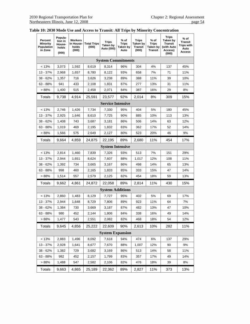
2030 Regional Transportation Plan for Chapter 2: Regional Assessment Northeastern Illinois, June 12, 2008 page 54
Table 10: 2030 Mode Use and Access to Transit: All Trips by Minority Concentration
Percent Minority
Population in Zone
Popula-tion in House-holds
(000)
Workers in House-
holds (000)
Total Trips (000)
Trips Taken by
Auto (000)
% of Trips
Taken by Auto
Trips Taken by Transit (000)
% of Trips
Taken by Transit
Trips Taken by Transit
(with Auto Access)
(000)
% of Transit
Trips with Auto
Access
System Commitments < 13% 3,073 1,592 8,619 8,314 96% 304 4% 137 45%
13 - 37% 2,968 1,657 8,780 8,122 93% 658 7% 71 11%
38 - 62% 1,357 716 3,626 3,238 89% 388 11% 39 10%
63 - 88% 941 433 2,108 1,831 87% 277 13% 31 11%
> 88% 1,400 515 2,458 2,071 84% 387 16% 29 8%
Totals 9,738 4,914 25,591 23,577 92% 2,014 8% 309 15%
Service Intensive < 13% 2,746 1,426 7,734 7,330 95% 404 5% 180 45%
13 - 37% 2,925 1,646 8,610 7,725 90% 885 10% 113 13%
38 - 62% 1,408 743 3,687 3,181 86% 506 14% 63 12%
63 - 88% 1,019 469 2,195 1,832 83% 362 17% 52 14%
> 88% 1,566 575 2,649 2,127 80% 523 20% 46 9%
Totals 9,664 4,859 24,875 22,195 89% 2,680 11% 454 17%
System Intensive < 13% 2,814 1,460 7,839 7,326 93% 513 7% 151 29%
13 - 37% 2,944 1,651 8,624 7,607 88% 1,017 12% 108 11%
38 - 62% 1,392 734 3,665 3,167 86% 498 14% 65 13%
63 - 88% 998 460 2,165 1,833 85% 333 15% 47 14%
> 88% 1,514 557 2,579 2,125 82% 454 18% 59 13%
Totals 9,662 4,861 24,872 22,058 89% 2,814 11% 430 15%
System Additions < 13% 2,860 1,483 8,129 7,727 95% 402 5% 69 17%
13 - 37% 2,944 1,648 8,729 7,806 89% 923 11% 64 7%
38 - 62% 1,384 730 3,669 3,187 87% 482 13% 47 10%
63 - 88% 980 452 2,144 1,806 84% 338 16% 49 14%
> 88% 1,477 543 2,551 2,082 82% 468 18% 54 12%
Totals 9,645 4,856 25,222 22,609 90% 2,613 10% 282 11%
System Expansion < 13% 2,883 1,496 8,092 7,618 94% 474 6% 137 29%
13 - 37% 2,928 1,641 8,677 7,670 88% 1,007 12% 90 9%
38 - 62% 1,382 729 3,682 3,169 86% 513 14% 58 11%
63 - 88% 982 452 2,157 1,799 83% 357 17% 49 14%
> 88% 1,488 547 2,582 2,106 82% 476 18% 39 8%
Totals 9,663 4,865 25,189 22,362 89% 2,827 11% 373 13%
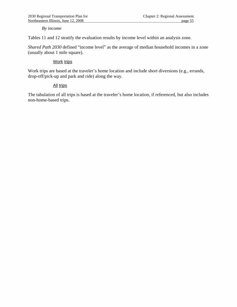
2030 Regional Transportation Plan for Chapter 2: Regional Assessment Northeastern Illinois, June 12, 2008 page 55
By income
Tables 11 and 12 stratify the evaluation results by income level within an analysis zone.
Shared Path 2030 defined “income level” as the average of median household incomes in a zone (usually about 1 mile square).
Work trips
Work trips are based at the traveler’s home location and include short diversions (e.g., errands, drop-off/pick-up and park and ride) along the way.
All trips
The tabulation of all trips is based at the traveler’s home location, if referenced, but also includes non-home-based trips.
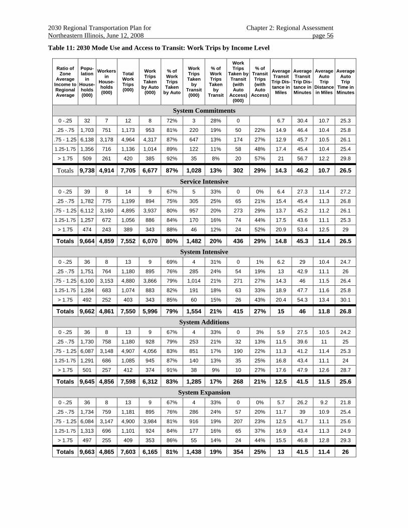
2030 Regional Transportation Plan for Chapter 2: Regional Assessment Northeastern Illinois, June 12, 2008 page 56
Table 11: 2030 Mode Use and Access to Transit: Work Trips by Income Level
Ratio of Zone
Average Income to Regional Average
Popu-lation
in House-holds (000)
Workers in
House-holds (000)
Total Work Trips (000)
Work Trips Taken
by Auto (000)
% of Work Trips Taken
by Auto
Work Trips Taken
by Transit (000)
% of Work Trips Taken
by Transit
Work Trips
Taken by Transit (with Auto
Access) (000)
% of Transit Trips (with Auto
Access)
Average Transit
Trip Dis-tance in
Miles
Average Transit
Trip Dis-tance in Minutes
Average Auto Trip
Distance in Miles
Average Auto Trip
Time in Minutes
System Commitments 0 -.25 32 7 12 8 72% 3 28% 0 6.7 30.4 10.7 25.3
.25 -.75 1,703 751 1,173 953 81% 220 19% 50 22% 14.9 46.4 10.4 25.8
.75 - 1.25 6,138 3,178 4,964 4,317 87% 647 13% 174 27% 12.9 45.7 10.5 26.1
1.25-1.75 1,356 716 1,136 1,014 89% 122 11% 58 48% 17.4 45.4 10.4 25.4
> 1.75 509 261 420 385 92% 35 8% 20 57% 21 56.7 12.2 29.8
Totals 9,738 4,914 7,705 6,677 87% 1,028 13% 302 29% 14.3 46.2 10.7 26.5
Service Intensive 0 -.25 39 8 14 9 67% 5 33% 0 0% 6.4 27.3 11.4 27.2
.25 -.75 1,782 775 1,199 894 75% 305 25% 65 21% 15.4 45.4 11.3 26.8
.75 - 1.25 6,112 3,160 4,895 3,937 80% 957 20% 273 29% 13.7 45.2 11.2 26.1
1.25-1.75 1,257 672 1,056 886 84% 170 16% 74 44% 17.5 43.6 11.1 25.3
> 1.75 474 243 389 343 88% 46 12% 24 52% 20.9 53.4 12.5 29
Totals 9,664 4,859 7,552 6,070 80% 1,482 20% 436 29% 14.8 45.3 11.4 26.5
System Intensive 0 -.25 36 8 13 9 69% 4 31% 0 1% 6.2 29 10.4 24.7
.25 -.75 1,751 764 1,180 895 76% 285 24% 54 19% 13 42.9 11.1 26
.75 - 1.25 6,100 3,153 4,880 3,866 79% 1,014 21% 271 27% 14.3 46 11.5 26.4
1.25-1.75 1,284 683 1,074 883 82% 191 18% 63 33% 18.9 47.7 11.6 25.8
> 1.75 492 252 403 343 85% 60 15% 26 43% 20.4 54.3 13.4 30.1
Totals 9,662 4,861 7,550 5,996 79% 1,554 21% 415 27% 15 46 11.8 26.8
System Additions 0 -.25 36 8 13 9 67% 4 33% 0 3% 5.9 27.5 10.5 24.2
.25 -.75 1,730 758 1,180 928 79% 253 21% 32 13% 11.5 39.6 11 25
.75 - 1.25 6,087 3,148 4,907 4,056 83% 851 17% 190 22% 11.3 41.2 11.4 25.3
1.25-1.75 1,291 686 1,085 945 87% 140 13% 35 25% 16.8 43.4 11.1 24
> 1.75 501 257 412 374 91% 38 9% 10 27% 17.6 47.9 12.6 28.7
Totals 9,645 4,856 7,598 6,312 83% 1,285 17% 268 21% 12.5 41.5 11.5 25.6
System Expansion 0 -.25 36 8 13 9 67% 4 33% 0 0% 5.7 26.2 9.2 21.8
.25 -.75 1,734 759 1,181 895 76% 286 24% 57 20% 11.7 39 10.9 25.4
.75 - 1.25 6,084 3,147 4,900 3,984 81% 916 19% 207 23% 12.5 41.7 11.1 25.6
1.25-1.75 1,313 696 1,101 924 84% 177 16% 65 37% 16.9 43.4 11.3 24.9
> 1.75 497 255 409 353 86% 55 14% 24 44% 15.5 46.8 12.8 29.3
Totals 9,663 4,865 7,603 6,165 81% 1,438 19% 354 25% 13 41.5 11.4 26
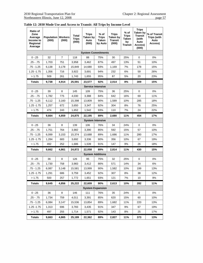
2030 Regional Transportation Plan for Chapter 2: Regional Assessment Northeastern Illinois, June 12, 2008 page 57
Table 12: 2030 Mode Use and Access to Transit: All Trips by Income Level
Ratio of Zone
Average Income to Regional Average
Population (000)
Workers (000)
Total Trips (000)
Trips Taken by
Auto (000)
% of Trips Taken
by Auto
Trips Taken by Transit (000)
% of Trips Taken
by Transit
Trips Taken by Transit (with Auto
Access) (000)
% of Transit Trips (with
Auto Access)
System Commitments
0 -.25 32 7 118 88 75% 30 25% 0 0%
.25 - .75 1,703 751 3,958 3,462 87% 497 13% 51 10%
.75 - 1.25 6,138 3,178 15,849 14,680 93% 1,169 7% 178 15%
1.25 -1.75 1,356 716 3,922 3,691 94% 232 6% 59 26%
> 1.75 509 261 1,743 1,655 95% 87 5% 20 23%
Totals 9,738 4,914 25,591 23,577 92% 2,014 8% 309 15%
Service Intensive
0 -.25 39 8 145 109 75% 36 25% 0 0%
.25 - .75 1,782 775 4,030 3,388 84% 642 16% 69 11%
.75 - 1.25 6,112 3,160 15,398 13,809 90% 1,589 10% 285 18%
1.25 -1.75 1,257 672 3,650 3,347 92% 304 8% 76 25%
> 1.75 474 243 1,652 1,542 93% 110 7% 24 22%
Totals 9,664 4,859 24,875 22,195 89% 2,680 11% 454 17%
System Intensive
0 -.25 36 8 139 106 76% 34 24% 0 0%
.25 - .75 1,751 764 3,982 3,390 85% 592 15% 57 10%
.75 - 1.25 6,099 3,153 15,374 13,688 89% 1,686 11% 280 17%
1.25 -1.75 1,284 683 3,692 3,336 90% 356 10% 67 19%
> 1.75 492 252 1,686 1,539 91% 147 9% 26 18%
Totals 9,662 4,861 24,872 22,058 89% 2,814 11% 430 15%
System Additions
0 -.25 36 8 126 95 75% 32 25% 0 0%
.25 - .75 1,730 758 3,983 3,412 86% 571 14% 34 6%
.75 - 1.25 6,087 3,148 15,581 13,999 90% 1,582 10% 199 13%
1.25 -1.75 1,291 686 3,759 3,452 92% 307 8% 38 12%
> 1.75 500 257 1,772 1,651 93% 121 7% 10 9%
Totals 9,645 4,856 25,222 22,609 90% 2,613 10% 282 11%
System Expansion
0 -.25 36 8 146 111 76% 35 24% 0 0%
.25 - .75 1,734 759 4,011 3,391 85% 620 15% 60 10%
.75 - 1.25 6,084 3,147 15,536 13,854 89% 1,682 11% 220 13%
1.25 -1.75 1,313 696 3,783 3,435 91% 347 9% 67 19%
> 1.75 497 255 1,714 1,571 92% 143 8% 25 17%
Totals 9,663 4,865 25,189 22,362 89% 2,827 11% 373 13%
2030 Regional Transportation Plan for Chapter 2: Regional Assessment Northeastern Illinois, June 12, 2008 page 58
Access to jobs
A traveler’s ability to reach a variety of destinations within a reasonable travel time is another aspect of mobility and accessibility, this relating to the overall volume of economic opportunity available in the region.
Access to jobs is defined as the total number of jobs available within a threshold travel time, distance or generalized cost of one’s residence.
Forecasted travel times, distances or generalized costs will vary according to different transportation strategies and physical improvements. Employment density and location will vary with socioeconomic scenario.
Shared Path 2030 anticipated that greater availability to all jobs within proximity to residential location is a benefit.
Work commute times
A traveler’s ability to reach work within a reasonable travel time is also a measure of accessibility, this relating both to choice of mode available and employment location.
Work commute time is determined by an equilibrium assessment of household and job locations available, and the desire by workers to minimize the time, distance and cost of the work trip.
Forecasted travel times, distances or generalized costs will vary according to different transportation strategies and physical improvements. Employment density and location will vary with socioeconomic scenario.
Shared Path 2030 anticipated that shorter work commute times are a benefit.54
Evaluation of “Work commute times and Access to jobs”
The following several tables show work commute times and access to job effects by trip purpose for each future regional alternative by geography, race/ethnicity and income level.
Note that measures are reported based on the traveler’s “home-base” even though they may have received the benefit of a transportation improvement elsewhere.
By subregional geography and race/ethnicity and income
Table 13 (on the next two pages) combines the geographic, race/ethnicity and income stratifications. A threshold travel time of 60 minutes was selected for these tables.55
54 The travel models optimize travel choices and do not account for imposed imbalances such as limited suitable job opportunities that require onerous reverse commutes for transit captives or third-shift conflicts with bus-operating schedules. 55 These data may be more thoroughly presented as continuous travel time distributions for each stratification. Reviewers comment, however, that these distributions are difficult to interpret.
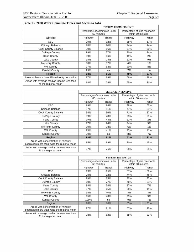
2030 Regional Transportation Plan for Chapter 2: Regional Assessment Northeastern Illinois, June 12, 2008 page 59
Table 13: 2030 Work Commute Times and Access to Jobs SYSTEM COMMITMENTS
Percentage of commutes under 60 minutes
Percentage of jobs reachable within 60 minutes
District Highway Transit Highway Transit CBD 99% 92% 85% 57%
Chicago Balance 98% 90% 74% 44% Cook County Balance 99% 86% 67% 30%
DuPage County 99% 77% 70% 24% Kane County 99% 46% 19% 2% Lake County 98% 24% 21% 9%
McHenry County 98% 32% 4% 1% Will County 97% 53% 20% 8%
Kendall County 99% na 7% na Region 98% 81% 49% 27%
Areas with more than 88% minority population 97% 89% 66% 38% Areas with average median income less than
½ the regional mean 98% 75% 55% 30%
SERVICE INTENSIVE Percentage of commutes under
60 minutes Percentage of jobs reachable
within 60 minutes Highway Transit Highway Transit
CBD 99% 94% 88% 65% Chicago Balance 97% 91% 77% 51%
Cook County Balance 94% 86% 71% 37% DuPage County 99% 78% 73% 29%
Kane County 99% 44% 22% 2% Lake County 97% 24% 24% 9%
McHenry County 99% 38% 6% 1% Will County 95% 41% 23% 11%
Kendall County 99% na 8% na Region 98% 81% 52% 33%
Areas with concentration of minority population more than twice the regional mean 95% 89% 70% 45%
Areas with average median income less than ½ the regional mean 97% 76% 58% 35%
SYSTEM INTENSIVE Percentage of commutes under
60 minutes Percentage of jobs reachable
within 60 minutes Highway Transit Highway Transit
CBD 99% 95% 87% 58% Chicago Balance 98% 92% 74% 45%
Cook County Balance 99% 85% 72% 35% DuPage County 99% 77% 78% 31%
Kane County 98% 54% 27% 7% Lake County 97% 45% 28% 11%
McHenry County 98% 40% 8% 3% Will County 95% 43% 23% 9%
Kendall County 100% na 9% na Region 98% 80% 53% 31%
Areas with concentration of minority population more than twice the regional mean 97% 91% 67% 40%
Areas with average median income less than ½ the regional mean 98% 82% 58% 32%
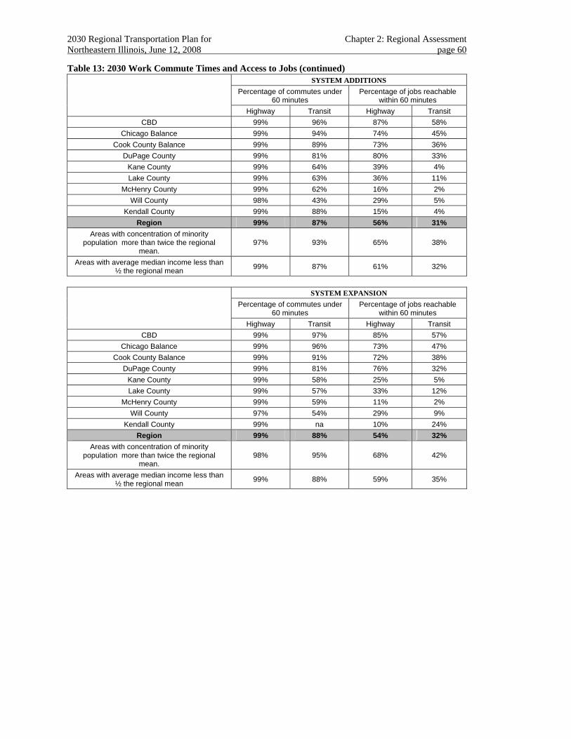
2030 Regional Transportation Plan for Chapter 2: Regional Assessment Northeastern Illinois, June 12, 2008 page 60
Table 13: 2030 Work Commute Times and Access to Jobs (continued) SYSTEM ADDITIONS Percentage of commutes under
60 minutes Percentage of jobs reachable
within 60 minutes Highway Transit Highway Transit
CBD 99% 96% 87% 58% Chicago Balance 99% 94% 74% 45%
Cook County Balance 99% 89% 73% 36% DuPage County 99% 81% 80% 33%
Kane County 99% 64% 39% 4% Lake County 99% 63% 36% 11%
McHenry County 99% 62% 16% 2% Will County 98% 43% 29% 5%
Kendall County 99% 88% 15% 4% Region 99% 87% 56% 31%
Areas with concentration of minority population more than twice the regional
mean. 97% 93% 65% 38%
Areas with average median income less than ½ the regional mean 99% 87% 61% 32%
SYSTEM EXPANSION Percentage of commutes under
60 minutes Percentage of jobs reachable
within 60 minutes Highway Transit Highway Transit
CBD 99% 97% 85% 57% Chicago Balance 99% 96% 73% 47%
Cook County Balance 99% 91% 72% 38% DuPage County 99% 81% 76% 32%
Kane County 99% 58% 25% 5% Lake County 99% 57% 33% 12%
McHenry County 99% 59% 11% 2% Will County 97% 54% 29% 9%
Kendall County 99% na 10% 24% Region 99% 88% 54% 32%
Areas with concentration of minority population more than twice the regional
mean. 98% 95% 68% 42%
Areas with average median income less than ½ the regional mean 99% 88% 59% 35%
2030 Regional Transportation Plan for Chapter 2: Regional Assessment Northeastern Illinois, June 12, 2008 page 61
2.2.4.4 Socioeconomic and land use implications
Shared Path 2030 employed an analysis method that included feedback of transportation costs as a measure of accessibility to reallocate the geographic distribution of households and jobs in the region.
While not a comprehensive reflection of all of the determinants of land use, the method does provide an indicator of how socioeconomic patterns might be affected under each thematic alternative.
For each of the alternative regional scenarios, the regional distribution of households and jobs varied geographically in response to the accessibility offered by transportation alternatives, as shown in Table 14.
The economic benefits of Chicago’s CBD notwithstanding, Shared Path 2030 anticipated that a transportation system which induces a greater number households to locate close to a greater number of jobs indicates a more efficient transportation system.
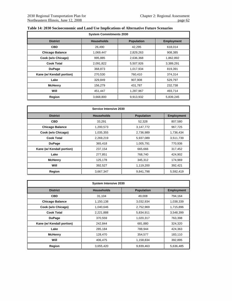
2030 Regional Transportation Plan for Chapter 2: Regional Assessment Northeastern Illinois, June 12, 2008 page 62
Table 14: 2030 Socioeconomic and Land Use Implications of Alternative Future Scenarios System Commitments 2030
District Households Population Employment
CBD 26,490 42,295 618,014
Chicago Balance 1,069,447 2,829,263 908,385
Cook (w/o Chicago) 995,885 2,636,368 1,862,892
Cook Total 2,091,822 5,507,926 3,389,291
DuPage 368,873 1,017,934 819,391
Kane (w/ Kendall portion) 270,530 760,410 374,314
Lake 329,849 907,908 529,797
McHenry 156,279 431,787 232,738
Will 451,447 1,287,967 493,714
Region 3,668,800 9,913,932 5,839,245
Service Intensive 2030
District Households Population Employment
CBD 33,291 52,328 807,580
Chicago Balance 1,200,573 3,147,772 967,725
Cook (w/o Chicago) 1,035,355 2,736,989 1,736,434
Cook Total 2,269,219 5,937,089 3,511,739
DuPage 365,418 1,005,791 770,936
Kane (w/ Kendall portion) 237,154 665,666 317,452
Lake 277,851 768,740 424,902
McHenry 125,178 345,312 174,969
Will 392,527 1,119,200 392,421
Region 3,667,347 9,841,798 5,592,419
System Intensive 2030
District Households Population Employment
CBD 31,104 49,008 794,164
Chicago Balance 1,150,138 3,032,934 1,038,339
Cook (w/o Chicago) 1,040,646 2,752,969 1,715,896
Cook Total 2,221,888 5,834,911 3,548,399
DuPage 370,559 1,020,317 763,398
Kane (w/ Kendall portion) 242,844 681,880 324,320
Lake 285,184 788,944 424,363
McHenry 128,470 354,577 183,110
Will 406,475 1,158,834 392,895
Region 3,655,420 9,839,463 5,636,485
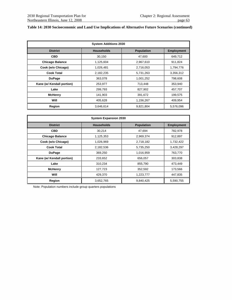
2030 Regional Transportation Plan for Chapter 2: Regional Assessment Northeastern Illinois, June 12, 2008 page 63
Table 14: 2030 Socioeconomic and Land Use Implications of Alternative Future Scenarios (continued)
System Additions 2030
District Households Population Employment
CBD 30,150 47,600 649,712
Chicago Balance 1,125,604 2,967,610 911,824
Cook (w/o Chicago) 1,026,481 2,716,053 1,794,776
Cook Total 2,182,235 5,731,263 3,356,312
DuPage 363,078 1,001,252 798,608
Kane (w/ Kendall portion) 253,977 713,448 353,940
Lake 299,793 827,902 457,707
McHenry 141,903 391,672 199,575
Will 405,628 1,156,267 409,954
Region 3,646,614 9,821,804 5,576,096
System Expansion 2030
District Households Population Employment
CBD 30,214 47,694 782,978
Chicago Balance 1,125,353 2,969,374 912,897
Cook (w/o Chicago) 1,026,969 2,718,182 1,732,422
Cook Total 2,182,536 5,735,250 3,428,297
DuPage 369,250 1,016,959 763,770
Kane (w/ Kendall portion) 233,652 656,057 303,838
Lake 310,234 855,790 473,449
McHenry 127,723 352,592 173,566
Will 429,370 1,223,777 447,835
Region 3,652,765 9,840,425 5,590,755
Note: Population numbers include group quarters populations
2030 Regional Transportation Plan for Chapter 3: Regional Transportation Strategy Northeastern Illinois, June 12, 2008 page 64
CHAPTER 3. REGIONAL TRANSPORTATION STRATEGY RECOMMENDATIONS
The set of future alternative regional scenarios illustrate the land use and transportation effects of four different themes reflecting a broad array of land use, management and operations, system improvement and capital-intensive strategies. It was anticipated that the plan’s recommendations would be drawn from each of these alternatives.
The transportation system, mobility and accessibility measures associated with each thematic alternative show, in aggregate, benefits to the region. Non-capital-intensive approaches improve mobility and accessibility by improving the performance of the existing system in established parts of the region. Capital-intensive approaches also improve performance of the existing system, particularly with regard to reduction in traffic congestion as well as providing new transit choices in developing areas. In all cases, community development and effective management and operations strategies can be employed to increase non-motorized tripmaking. The intent of the RTP is to promote the most appropriate and effective strategies, systems and major capital projects from each alternative, combined in such a way to achieve the plan’s goal in an efficient and fair manner.
The 2030 RTP includes three types of recommendations:
• Regional transportation strategies
• Strategic regional systems
• Major capital projects
Regional transportation strategies should be applied consistently by all jurisdictions in order to benefit from scale economies as well as to provide efficient, safe and predictable travel choices. Strategic regional systems provide guidance to transportation implementers and operators in preparing their ongoing modal (e.g., arterial, transit, bicycle, pedestrian and freight) programs to improve and expand the region’s transportation system. Major capital projects represent the largest discretionary set of recommendations in the RTP. They include large-scale passenger rail and major highway proposals for which detailed alternatives evaluations should be conducted, thorough context-sensitive design and management and operation plans prepared, and reliable funding secured.
In congested areas, the transportation system should provide a rich choice of system elements and strong connections among them. Shared Path 2030’s task was to develop a balanced multimodal transportation plan. Fortunately, the region has maintained a commitment to this balance for decades. Effective coordination of major highway and transit improvements in particular has established a model for further integration of all forms of travel.
In addition, the RTP recommends that, regardless of the pace at which any regional strategy, strategic system or major capital project develops, the perspectives of multimodal balance and regional socioeconomic equity be maintained. Shared Path 2030 has sought to demonstrate that maintaining and improving the region’s entire transportation system is integrally linked to the mobility and accessibility of the region’s entire population.
2030 Regional Transportation Plan for Chapter 3: Regional Transportation Strategy Northeastern Illinois, June 12, 2008 page 65
The future regional scenarios identified two types of regional strategies:
• Community and environmental strategies.
• Transportation management and operations strategies.
While regional strategies cover a larger geography, they are typically deployed in smaller increments, need regular updating and can be abandoned/remedied if necessary. A certain level of policy commitment must be maintained, however, even after the necessary institutions for implementing a strategy are in place. Evolving goals, varied success and uncertain funding can seriously hinder the success of a regional transportation strategy that requires broad implementation to be effective. While the RTP has historically endorsed community planning, environmental protection and sound transportation management, it does not typically allocate a specific amount of the projected transportation revenues to these strategies.56
Regional strategies were most intensively evaluated in the service-intensive and system-intensive alternatives evaluation. Increased attention to the relationship between transportation and community development, as well as intensive transportation system management and operation, was found to reduce the overall volume of tripmaking, increase non-motorized trips, have a centralizing effect on land use development and increase transit mode choice.
The RTP provides the necessary institutional commitment to maintaining regional transportation strategies over many years. It also provides a statement of regional intent and provides general guidance, delegating the exact specification of such strategies to legislative initiatives, intergovernmental agreements, transportation improvement programming (TIP), and local planning, zoning and capital programming efforts.
3.1 COMMUNITY AND ECONOMIC DEVELOPMENT STRATEGIES Community development and economic development strategies consist of implementing “context-sensitive” transportation solutions that promote local community quality, individuality, and economic development. As a regional planning strategy, the RTP also places special emphasis on “transit-oriented development” patterns (TOD).
Promoting community and economic development strategies supports the RTP’s goal to sustain the region’s vision and values, specifically with regard to objectives promoting economic development, social equity, community development and public health and safety.
State, county and local governments regularly engage in efforts to define, improve and protect community quality. The level and intensity of this activity is different for each jurisdiction, but often results in spillover effects to surrounding areas.
Most local governments also independently prepare comprehensive plans and nearly all enforce zoning, subdivision and building ordinances in an effort to promote or preserve local objectives. The transportation effects of community development, however, often cross municipal boundaries. 56 For example, the 2000 Edition of the 2020 RTP estimated that approximately $80 million of the $136 million cost of implementing the Strategic Early Deployment Plan could be available by 2020. This value was not counted against the projected 2020 revenues available for capital construction and maintenance (p.91).
2030 Regional Transportation Plan for Chapter 3: Regional Transportation Strategy Northeastern Illinois, June 12, 2008 page 66
The RTP encourages community development efforts that:
• Employ land use planning, zoning and economic development resources to balance the location of jobs, services and housing within a community to reduce travel distances.
• Arrange land uses in ways that foster efficient57 and healthy travel behavior.
• Permit development concurrent with anticipated transportation supply.
• Arrange land use to support use of existing transit infrastructure and introduction of new and expanded transit service.
• Encourage development or redevelopment that minimizes the impacts of traffic noise.
• Plan and design major land uses58 to allow for convenient and safe access by all travel modes.59
• Allocate land use for commercial and industrial development adjacent to major highways.
• Allocate land use for residential development within walking or bicycling distance to local employment centers or public transit.
• Preserve anticipated transportation rights-of-way.60
• Resolve potential transportation interaction with official historic, cultural and/or agricultural preservation plans.
• Are consistent with the recommendations and strategies of the 2040 Regional Framework Plan.
Economic development efforts also affect the regional transportation system. The RTP encourages economic development efforts that:
• Finance transportation projects that update and maintain infrastructure.
• Take advantage of the existing infrastructure.
• Stimulate private sector activity in the planning process.
• Strengthen partnerships across governmental agencies, community stakeholders and the private sector.
• Recognize the regional nature of economic development and advance strategies that address challenges and opportunities throughout the regional economy.
57 Specifically, the reduction of auto use for very short trips. 58 Employment centers, commercial facilities, and multi-use activity centers that generate and attract thousands of daily trips and establish noticeable peaks in demand. 59 Pedestrians, bicycles, autos and freight. 60 Through the coordination of transportation planning and land development activities.
2030 Regional Transportation Plan for Chapter 3: Regional Transportation Strategy Northeastern Illinois, June 12, 2008 page 67
• Carefully and objectively analyze the structure of the region in order to identify comparative advantages, critical industries, workforce needs and emerging prospects for development and growth.
• Make sensible investment in the public transportation infrastructure as a way to spur regional economic development and growth.
• Strive for a strong and sustainable return on investment from any transportation economic development initiative.
For its part, the RTP’s strategy is that:
• A variety of transportation choices will be offered to all communities at an appropriate level of service.61
• Transportation improvements and community development activities will be coordinated62 to offer efficient63 transportation service.
• Transportation improvements should support the functions of existing and planned adjacent land uses.
• Transportation improvements should be designed, managed and operated to encourage compact, sustainable land development.64
• Plans and designs for transportation improvements should be sensitive to community context.65
• Transportation improvements should be consistent with official historic, cultural and/or agricultural plans.
Context-sensitive solutions
The RTP recommends sensitivity to the effects transportation facilities have on the environment and communities. An interdisciplinary approach to planning and design incorporates the viewpoints of various agencies, stakeholders, and others who have roles or areas of concern in the transportation project allowing for better coordination and resolution of competing interests. New and better ways of planning and designing transportation facilities are evolving based on growing interest in better integrating these facilities into the communities they serve over the long term.
Most communities host transportation facilities that serve a regional function. The process of planning, designing, constructing and improving these facilities should involve early and
61 Variety=alternative to private auto. Appropriate=demonstrating a balanced cost/benefit ratio. 62 individually and through intergovernmental agreements 63 With regard to transit: emphasizing minimal out-of-vehicle and wait time. 64 One useful method is transit-oriented development in the near vicinity of commuter rail or rapid transit stations. 65 For new construction as well as rehabilitation and improvement projects, through a collaborative interdisciplinary process that integrates and balances community, aesthetic and environmental values with traditional transportation safety and performance goals.
2030 Regional Transportation Plan for Chapter 3: Regional Transportation Strategy Northeastern Illinois, June 12, 2008 page 68
intensive involvement with the full range of stakeholders to preserve and enhance the human and natural environment in the project area.
Important principles of context-sensitive solutions include66:
• Strike a balance between cost, safety, mobility, community needs, and the environment.
• Involve stakeholders in the decision-making process early and continuously, throughout the development of the project.
• Address all appropriate modes of transportation in the plan and design of the project, including motor vehicle, mass transit, pedestrians and bicyclists.
• Use all appropriate disciplines to help plan for and design the project.
• Apply the flexibility inherent in the design standards to fit the project into its surroundings.
• Incorporate aesthetics as part of basic “good design.”
3.2 ENVIRONMENTAL STRATEGIES The RTP recognizes that maintaining and improving the transportation system provides opportunities to improve environmental quality and achieve sustainability through an enhanced awareness of environmental carrying capacity of ecosystems in infrastructure development and through the use of ecological principles in decision making. The RTP recommends that project implementers prioritize environmental stewardship in their efforts to improve safety, mobility and accessibility for the region. To assist in identifying environmental issues, a map of capital element projects showing environmentally sensitive areas has been prepared and is posted at http://www.sp2030.com/sensitive_areas.pdf, and was used to develop specific lists of concerns for these projects. The RTP recommends thorough investigations of these concerns during project development and design phases to avoid, minimize, and mitigate effects.
Much of the environmental impact of transportation is governed by national, state and local environmental protection regulations. For example, demonstrating that the RTP helps reduce air pollution is a significant federal regulatory obligation. The major capital projects recommended in the 2030 RTP, in a coordinated analysis with the current TIP, must demonstrate that changes in estimated mobile source emissions resulting from transportation improvements conform within a “pollutant budget” established by the Illinois Environmental Protection Agency (IEPA).
In addition, CMAP has established regional policies that recast many environmental protection requirements into opportunities to enhance environmental quality. The RTP embraces the recommendations for the treatment of green areas contained in the 2040 Regional Framework Plan, in addition to specific policies intended to:
• Protect natural groundwater recharge.
• Promote effective stormwater management.
66 Context Sensitive Solutions: Detailed Guidelines for Practice. Illinois Department of Transportation.
2030 Regional Transportation Plan for Chapter 3: Regional Transportation Strategy Northeastern Illinois, June 12, 2008 page 69
• Reduce alteration of natural hydrological patterns.
• Reduce deterioration of water quality.
• Enhance transportation rights-of-way with connections to greenways, trails and open space.
• Promote multimodal access to greenways, land trails and water trails.
• Include natural landscaping.67
• Reduce deterioration of habitat quality.
• Help protect threatened and endangered species.
• Promote wetland protection by avoidance, or the use of large wetland mitigation banks located within the affected watersheds and connected hydrologically with the surrounding landscape.
• Ensure consistency with federal, state, regional and locally adopted environmental protection and preservation plans.
• Plan, design and construct transportation improvements in accordance with CMAP’s model ordinances regarding a) soil erosion and sediment control, b) floodplain management, c) stormwater drainage and detention and d) stream, lake and wetland protection.
• Preserve farmland.
• Protect and enhance biodiversity
• Ensure that transportation facilities use Context Sensitive Solutions (CSS) principles in relation to the protection and connectivity of natural resources.
3.3 CONGESTION MANAGEMENT The Congestion Management Process (formerly Congestion Management System) is set forth in the document “Congestion Management System for Northeastern Illinois,” approved by the Policy Committee in 1997. Updates were promulgated in subsequent years, including 2002 and, most recently, in 2006.
The RTP’s goal of improving transportation system performance recognizes the need to manage both highway and transit congestion.
The RTP supports the ongoing development and implementation of the region’s principal congestion management outline, the Congestion Management Process (CMP) for Northeastern Illinois.68 Specifically, the following CMS elements support the RTP’s objective of improving transportation system efficiency. Significant efforts have been put into development of a draft
67 Design transportation landscaping to enhance biodiversity, improve water quality, better manage stormwater and appear natural. 68 CATS, Congestion Management System for Northeastern Illinois, May 2002.
2030 Regional Transportation Plan for Chapter 3: Regional Transportation Strategy Northeastern Illinois, June 12, 2008 page 70
Management and Operations plan that will inform the federally required Congestion Management Process.
Congestion management helps improve the transportation system through a range of strategies including not only the obvious traffic improvements, such as signal timing, but also strategies that have many other impacts as well. For example, making the transportation system safe, secure, and functional for all users also helps to make the system operate better. Likewise, improved communications help system managers respond to conditions more quickly, reducing travel delay, and provides better information to users.
To develop and implement the congestion management process and its component management and operations strategies, CMAP will partner with IDOT, counties, transit agencies, municipalities (including the City of Chicago), civic and advocacy groups, academic institutions, the planning and engineering communities, U.S. DOT, and other groups.
3.3.1 Congestion Management: Performance Measures The RTP recommends that the Congestion Management Process investigate, and implement as appropriate, the following potential performance measures. The Congestion Management Process will adopt or modify specific targets for each performance measure with additional transportation provider, stakeholder, and public involvement.
(a) Customer satisfaction of traveling public: measure improvement on customer surveys.69
(b) Extent of congestion: measure reduced growth rate of spatial and temporal congestion.
(c) Highway travel time reliability: improve highway travel time reliability.
(d) Transit service reliability: improve transit on-time performance.
(e) Non-recurring travel delay: reduce non-recurring travel delay.
(f) Incident duration: reduce mean time of incident duration on transit services and arterial and expressway facilities.
(g) Speed compliance: reduce incidence of speeding on selected collector, arterial and expressway corridors (to reduce crash rates and severity and to smooth traffic flow).
(h) Crash rates: reduce the crash rates, focusing on serious and fatal crashes, for travel in motor vehicles, bicycling, and walking.
(i) Mode share: increase mode shares of trips using transit, walking, and bicycling for work and non-work purposes.
(j) Toll and fare pre-payment: increase the proportion of tolls and transit fares using pre-pay technologies.
(k) Trip lengths: reduce average trip distances for work trip and non-work trip purposes.
69 For example, IDOT regularly conducts a “Motorist Opinion Survey.”
2030 Regional Transportation Plan for Chapter 3: Regional Transportation Strategy Northeastern Illinois, June 12, 2008 page 71
(l) Transit service: increase the proportion of the population within ¼ mile of full-service transit.
(m) Enhancements: complete substantial additional portions of the Northeastern Illinois Greenways and Trails Plan.
(n) Bikeways: increase the mileage of City of Chicago and suburban bikeways, including off-street multi-use path and on-street bike lanes and marked routes.
(o) Safe routes to school: increase the proportion of primary schools with approved school travel plans.
(p) Value pricing: broaden deployment of value pricing to larger portions of the highway system.
(q) ITS: increase proportion of expressways and arterials subject to surveillance to determine congestion, travel times, and to detect incidents.
(r) Expressway incident management: broaden coverage of highway incident response vehicles to remainder of the expressways and tollways within the Chicago urbanized area.
(s) Arterial incident management: develop and implement arterial incident management plans for selected arterial corridors.
(t) Arterial access management: develop and implement access management plans for selected regional arterial corridors.
(u) Bicycle and pedestrian accommodations: increase the proportion of highway construction projects that include appropriate bicycle and pedestrian accommodations as part of highway construction activities.
(v) Bus rapid transit: implement transit signal priority on selected regional arterial corridors.
(w) Walkability: Increase the proportion of new development and re-development that is walkable.
3.3.2 Congestion Management: Management and Operation Strategies The CMS’s “Congestion Mitigation Handbook,” provides an overview of strategies to respond to congestion. Most of these strategies are focused on management and operations. The Handbook provides “guidelines on identifying and analyzing strategies and on conducting post-implementation evaluations. The handbook includes an overview of alternative strategies, detailed descriptions of individual strategies,” and other materials.70 The RTP continues to recommend the following strategies for consideration and implementation as appropriate, within the framework of the Congestion Management Process. The strategies include both prima facie operating improvements as well as the provision of capital to improve management and operations. 70 CATS. Congestion Management System for Northeastern Illinois. 1997.
2030 Regional Transportation Plan for Chapter 3: Regional Transportation Strategy Northeastern Illinois, June 12, 2008 page 72
Travel Demand Management:
TDM strategies reduce the demand for peak-period single-occupant vehicle travel.71 These strategies are intended to better manage the demand placed on a fixed transportation supply. The strategies are aimed primarily at encouraging alternatives to traveling alone by auto, with emphasis on more efficient travel planning and private vehicle use. The intended benefit is to contribute to reduced congestion and auto emissions. These strategies are typically voluntary in nature, and often rely on market-based or employer incentives to increase participation.
• Ridesharing Programs. Ridesharing can reduce congestion by reducing the number of vehicle trips, in turn leading to reductions in VMT.
• Car Sharing Programs. Car sharing reduces VMT by reducing vehicle ownership; cars are available when needed, but discretionary trips may be more likely made by transit or non-motorized modes.
• Alternative Work Arrangements. Alternative work arrangements reduce VMT by providing work sites closer to homes, or by spreading traffic to non-peak periods.
• Transit and Rideshare Incentives. Economic incentives for transit and ridesharing can reduce the costs of these modes, encourage their use, and thus reduce VMT.
• Parking Management. Parking management manages the cost of parking, reduces its availability, provides information regarding availability, so as to reduce travel demand and reduce excess VMT searching for parking spaces.
• Guaranteed Ride Home Programs. Guaranteed ride home programs reduce VMT through increased transit use by assuring transit users a way home should they need to travel when transit is not available.
Transportation System Management (see also Strategic Regional Arterial System in Section 3.2, Strategic Systems)
TSM is the application of construction, operational and institutional techniques to make the most productive and cost-effective use of existing transportation facilities and services. TSM can be applied through the retrofitting of existing facilities, and/or as part of new or reconstructed facilities.
Roadway management systems include traffic operations centers, roadside equipment and in-vehicle systems. Benefits include increased accessibility, improved safety, greater reliability, improved operating conditions for transit and safety vehicles, and reduction of both recurring and non-recurring congestion.
TSM strategies include upgrading technologies on transit vehicles at stations and at management centers. Benefits include improved public information and increased safety.
71 For example: parking management, HOV parking, rideshare Programs, employer tax incentives, flex-time and telecommute work options.
2030 Regional Transportation Plan for Chapter 3: Regional Transportation Strategy Northeastern Illinois, June 12, 2008 page 73
• Traffic Signal Improvements. Traffic signal improvements improve traffic flow and/or provide priority or preemption capabilities. Traffic signals need to be optimized for traffic flow at individual sites while maintaining local access. Traffic signals are coordinated to provide smoother flow for vehicle platoons and reduce crashes. Priority is sometimes given to transit or other vehicles, allowing longer green times to accommodate transit schedules. Preemption is given to emergency vehicle needs or to clear railroad grade crossings.
• Geometric improvements. Geometric improvements are “physical improvements that may involve adjustment to the number or arrangement of travel lanes at intersections or on limited segments of a roadway.” Intersection improvements include restriping, channelization, adding turn lanes, installing traffic islands, modifying the intersection angle, and changing corner radii (increasing or decreasing). Segment improvements may include expressway auxiliary lanes, passing lanes, truck climbing lanes, bus turnout lanes, widened shoulders, one-way couplets, medians, and reversible lanes. Geometric improvements generally smooth traffic flow and/or reduce crashes.
• Time of day restrictions. Time of day restrictions move travel demand to off peak periods or, in the case of parking restrictions, increase peak-period travel capacity.
• Ramp metering. Ramp meters are used to assure that merging traffic does not exceed the merge area or weave area’s capacity to absorb that traffic at a point. Ramp meters spread out the entering vehicles. Ramp meters are also used to control overall flow to assure that downstream traffic flow is maintained.
• Commercial Vehicle Improvements. Geometric, sign and signal improvements focused on commercial vehicle traffic can smooth traffic flow and reduce crashes (see freight strategic system).
• Construction Management. Enhanced construction management reduces the duration and scope of delay resulting from project construction.
Encourage High-Occupancy Vehicle Use
• HOV Priority Systems. High-Occupancy Vehicle priorities reduce delay for vehicles with multiple occupants, so they encourage carpooling and vanpooling, thereby increasing person throughput for a given capacity and reducing VMT.
• HOV Support Services. HOV support services include preferential parking, park-and-ride facilities, and other services to make carpooling easier, thus reducing VMT and increasing person throughput.
Public Transit Capital Improvements (see also Strategic Regional Transit System)
• Exclusive Right-of-way Facilities. Exclusive right-of-way facilities reduce conflicts between public transit and other transportation system users. Examples include rail facilities, busways, bus bypasses of signal queues, or bus lanes on roadways.
2030 Regional Transportation Plan for Chapter 3: Regional Transportation Strategy Northeastern Illinois, June 12, 2008 page 74
• Fleet Improvements. Fleet improvements include modernized vehicles for quicker passenger loading and unloading, improved communications equipment, improved maintenance profiles, and faster fare collection, all to improve system efficiency and effectiveness.
• Transit support facilities. Transit support facilities, such as new or modernized yards or maintenance facilities, can improve efficiency. Other support facilities, like shelters and park-and-ride lots, make transit use more convenient and comfortable, thus encouraging transit use and reducing VMT.
Public Transportation Operational Improvements (see also Strategic Regional Transit System)
• Transit Service Improvements. Transit service improvements include route changes, frequency, hours of operation, and schedule coordination. Such improvements can reduce travel times and increase transit ridership, reducing VMT.
• Transit Marketing and Information. Transit marketing and information is the provision of information to the public, along with the use of information to better manage and coordinate transit operations. Such coordination may include schedule, fare, and customer information coordination. Providing and using this information can reduce transit travel times and attract new transit riders.
• Fare Incentives. Fare incentives can be structured to encourage transit use, reduce the cost of fare collection, and encourage off-peak travel or travel by students or seniors, attracting new riders and reducing VMT.
• Traffic Operations for Transit. Operations favorable to transit include signal priority for transit, queue bypass, bus stops, and off-street turn-around facilities. Such operations can improve transit travel times and operations efficiencies.
Encourage Use of Non-Motorized Modes (see also Pedestrian and Bicycle Strategic Regional System)
• Bike/Ped Infrastructure Improvements. Infrastructure improvements include facilities for bicyclists and pedestrians to travel along and across transportation facilities and elsewhere. Providing safe and comfortable walking and bicycling infrastructure encourages transit use and reduces VMT.
• Bike/Ped Support Services. Bike/Ped Support services, such as bicycle parking, pedestrian signals, benches, and bike route maps, encourage walking and bicycling, encourage transit use, and reduce VMT.
Congestion Pricing
• Road User Fees. Road user fees are charges for vehicles to use a particular road or enter a designated area. These fees can be targeted by time of day, at points of operations problems, or upstream of bottlenecks or other areas of congestion. Such fees can be used to smooth traffic flow, improve reliability, or reduce VMT.
2030 Regional Transportation Plan for Chapter 3: Regional Transportation Strategy Northeastern Illinois, June 12, 2008 page 75
• Parking Fees. Parking fees can be increased for parkers, perhaps only in peak periods, to discourage driving to or through congested areas, thus reducing congestion and VMT.
Growth Management72
• Compact Development. Compact development provides for shorter travel distances and encourages transit and non-motorized modes, reducing VMT.
• Redevelopment and Infill. Redevelopment and infill allow existing infrastructure to be used, often in areas that are amenable to transit and non-motorized transportation.
• The Location-Efficient Mortgage. Location-efficient mortgages are a financial incentive linking potential transportation cost savings inherent in transit-oriented neighborhoods to improved mortgage financing opportunities and/or terms. This may encourage homeownership in transit-oriented neighborhoods.
• Mixed-Use Development. Mixed-use developments reduce the distance between origins and destinations, thereby increasing transit and non-motorized trips.
• Jobs-Housing Balance. A jobs-housing balance approach would, for each subregion, balance the number of jobs and dwelling units by income range, reducing VMT by reducing the need to commute great distances.
• Corridor Land Use and Transportation Coordination. Corridor focused land use and transportation coordination is a mechanism for local governments to cooperatively plan land development to improve traffic operations (e. g, providing local connectivity to keep local traffic off arterial roads).
Access Management
• Driveway Management. Driveway management, including regulations and engineering improvements to reduce the number of driveways for development, share driveways among developments, access from sidestreets or alleys, reduces arterial travel delay and reduces crashes.
• Median Management. Medians, with strategic placement of median break, control development access and left turn delay. Medians reduce arterial delay and reduce crashes.
• Frontage Roads. Providing land access with frontage roads instead of arterials may reduce arterial delay and crashes.
Incident Management
• Incident Detection/Verification. Rapid incident detection, by service patrols, travel time inspection, incident reports, and cameras, can reduce the delay and secondary crashes associated with the incident.
72 Some of the “growth management” strategies are not strictly management and operations, but are included here for completeness regarding the Congestion Management Process.
2030 Regional Transportation Plan for Chapter 3: Regional Transportation Strategy Northeastern Illinois, June 12, 2008 page 76
• Incident Response. Rapid incident response reduces delay and secondary crashes. Advance planning for incident scenarios with response plans assist in this, with adequate and appropriate response vehicles and personnel.
• Incident Clearance. Rapid incident clearance reduces delay and secondary crashes.
• Incident Information/Routing. Incident information can provide guidance to those affected by an incident. Travelers approaching an incident can be guided away from the incident. These strategies can reduce delay and secondary crashes.
Intelligent Transportation Systems
• Advanced Traffic Management Systems. Advanced traffic management systems, usually focused on a traffic management center, integrates incident management and transportation system management strategies to reduce delay and crashes and improve reliability.
• Advanced Traveler Information Systems. Advanced traveler information systems collect, compile, process, and disseminate real time information, pre-trip or en route, about travel times, schedules, incidents, to enhance travel choice and reduce travel times and improve reliability.
• Advanced Public Transportation Systems. Advanced public transportation systems include a variety of technologies to improve transit system performance and usability. Examples include electronic fare collection and transit vehicle tracking, which can provide user and management information to improve reliability.
• Commercial Vehicle Operations. Commercial vehicle operations techniques improve freight operations and efficiency through such systems as weigh-in-motion, credentialing, and navigation.
• Advanced Vehicle Control Systems. Advanced vehicle control systems provide informational, navigation or control technologies to, for example, prevent operation by impaired drivers, provide routing assistance, and alert operators to maintenance requirements.
Capacity Expansion
• Expressway Lanes. Additional expressway lanes can provide safer operations, less delay, and improved reliability. Auxiliary lanes smooth traffic flow by facilitating conflicting maneuvers away from mainline lanes. Additional expressway through lanes may provide better lane balance.
• Arterial Lane Additions. Arterial lane additions may have beneficial effects on safety and travel time if planned properly, so care should be exercised to assure impact on signal cycle lengths and delay as well as multi-modal impacts.
In addition to the long-standing strategies listed above, Shared Path 2030 explored in greater depth management and operations strategies of interest to process stakeholders. Introducing
2030 Regional Transportation Plan for Chapter 3: Regional Transportation Strategy Northeastern Illinois, June 12, 2008 page 77
such capital-oriented and non-capital-oriented management and operations strategies is supported by the following RTP objectives:
• Maintenance, reconstruction and replacement
• Congestion Management Process
• Transportation and land use interaction
The RTP recommends enhancing implementation of all capital projects by identifying the multimodal corridor to be influenced by a set of associated management and operations strategies. These strategies are intended to ensure efficient coordination of capital construction, service provision and effects on local development patterns. The following subsections provide more information and analysis of strategies in the following areas:
• Maintenance and reconstruction
• Transportation system safety
• Transportation system security
• Rail, highway and intermodal freight
• Intelligent transportation systems
• Transit service coordination
3.3.2.1 Maintenance73 and Reconstruction The RTP’s goal of maintaining the integrity of the existing transportation system network asserts an ongoing commitment to keep existing transportation infrastructure in a state of good repair. Most major transportation facilities are completely reconstructed over the course of 20-50 years. Large-scale maintenance and reconstruction of major facilities provides an opportunity to improve not only the transportation function, but also the community presence of transportation infrastructure at a local and regional level.
Maintenance and reconstruction of all transportation facilities should employ management and operations strategies that improve performance with emphasis on improving safety and operations, as well as better integrating these with other transportation facilities and functions.74 Maintenance and reconstruction projects should also include upgrades to existing infrastructure using new technologies, updated operating procedures and improved materials.
To assure financing of capital and operational costs, CMAP and partner agencies will develop a financial plan. The plan will include strategies to increase revenues, control expenditures, and 73 The RTP’s definition of “maintenance” is explicated in its goal “Maintain the integrity of the existing transportation system.” This a more profound definition than “day-to-day maintenance” which includes pavement repair, snow removal, landscape care, etc. 74 This does not include capacity additions intended primarily to accommodate excess highway demand. Proposals of this type that add lanes to expressways and tollways are considered separately as major capital projects that are specifically identified.
2030 Regional Transportation Plan for Chapter 3: Regional Transportation Strategy Northeastern Illinois, June 12, 2008 page 78
preserve the existing transportation system and explore the potential for public-private partnerships. Costs for system preservation were estimated with the development of the original RTP, and have been recently updated and posted.75 These estimates, as well as capital development estimates, need to be updated as part of the regional financial plan to support the region’s next comprehensive planning effort.
The RTP also provides specific guidance for maintenance and reconstruction of major highway and rail facilities.
Major highways
The RTP recommends the following strategies be considered in maintaining and reconstructing major highways.
Auxiliary lanes
Auxiliary lanes are operational improvements that can involve limited lane additions, but do not result in a change in the basic cross-section of the facility.
The RTP supports introducing auxiliary lanes as part of the design for reconstruction projects to accommodate current safety standards and improve traffic operations.
Interchanges
New or reconfigured interchanges can improve regional accessibility as well as performance of both the expressway and local road system.
The RTP supports introducing or modifying interchanges between arterials and major highways to provide safer and more efficient access to the expressway system. These improvements should be fully coordinated with the plans and policies of adjacent and affected jurisdictions.
The RTP supports introducing or modifying interchanges between major highways76 to manage congestion or facilitate moving large volumes of regional traffic more efficiently.
The RTP also supports introducing interchange management improvements as an efficient way to give priority to preferred classes of vehicles on the entire access-control system.77
Intelligent Transportation Systems (ITS)
Extensive deployment of highway-based elements of ITS communications and management strategies can be achieved during major highway maintenance and reconstruction. In addition, interjurisidictional coordination and information, particularly ITS traffic management centers and rapid response incident management, can be used to maintain regional mobility during major maintenance and reconstruction work.
75 See http://www.cmap.illinois.gov/sp2030/sp2030main.aspx 76 I.e., a major interchange between one expressway/tollway and another expressway/tollway. 77 Transit and carpool priorities can discourage single-occupant vehicles. Commercial vehicle priorities can reduce conflicts between trucks and autos. Value pricing priorities can equilibrate costs and benefits to classes of users.
2030 Regional Transportation Plan for Chapter 3: Regional Transportation Strategy Northeastern Illinois, June 12, 2008 page 79
The RTP supports inclusion of current and anticipated ITS technology78 as part of highway maintenance and reconstruction projects.
Community Interfaces
Major highway reconstruction provides an opportunity to improve the appearance and character as well as mitigate any negative externalities of a facility from the perspective of the community through which it passes.
The RTP supports coordination with local communities on concerns such as safety, pedestrian facilities, access to transit service, siting of support facilities, and right-of-way treatments when preparing for and during maintenance and reconstruction projects.
Rail transit
The RTP identifies the following strategies in maintaining and reconstructing passenger rail facilities.
Track and Signal
Track and signal improvements are critical to efficient train (freight and passenger) operation, allowing for more trains and permitting higher speeds.
The RTP supports including improved track and signal systems during maintenance and reconstruction projects.
Grade Separations
Grade separations can be introduced to overcome conflicts between and among passenger and freight rail operations as well as between rail and highway facilities. New grade separations at key locations will reduce travel time for both rail and highway traffic and improve safety for pedestrians, cyclists, rail and highway travelers.
The RTP supports introducing grade separations at locations where safety and efficiency can benefit. These improvements should be fully coordinated with the plans and policies of adjacent and affected jurisdictions.
Yards
Rail yards may be relocated and/or consolidated to reduce operational conflicts. This includes necessary track relocation as well as additional and reconfigured crossovers. Rail yards may also be expanded and modernized to permit storage of additional trains and requisite maintenance facilities.
The RTP supports improving rail yards in these ways to support improved operations or expanded capacity. These improvements should be fully coordinated with the plans and policies of adjacent and affected jurisdictions. 78 For example, variable message signs, traffic and pavement condition surveillance monitors, communication towers, ramp meters, toll collection, hazard alerts and advanced truck credentialing contribute to efficient highway operations.
2030 Regional Transportation Plan for Chapter 3: Regional Transportation Strategy Northeastern Illinois, June 12, 2008 page 80
Intelligent Transportation Systems (ITS)
Extensive deployment of transit-based elements of ITS communications and management strategies can be achieved during major rail maintenance and reconstruction.
The RTP supports inclusion of current ITS technology79 as part of rail transit maintenance and reconstruction projects.
3.3.2.2 Transportation System Safety
The RTP’s goal of sustaining the region recognizes the need to promote public safety. This includes not only developing a transportation system that provides for safe and secure travel by all modes, but also making the transportation system an integral part of the overall safety and security of the region.80
Promoting transportation safety is primarily focused on reducing injuries and loss of life associated with travel. However, the RTP also acknowledges secondary and tertiary effects of crashes. Thus, implementing effective strategies to reduce crash risk and exposure will also reduce the economic losses and significant transportation system disruptions that result from crashes.
Federal and state law significantly governs travel safety, including the design and operation of transportation facilities; vehicle design and operation; and human behavior. In addition, safety is the subject of intense public education efforts.81 Federal requirements also stipulate that the metropolitan transportation planning process consider projects and strategies that increase the safety and security of the transportation system for motorized and non-motorized users.82 Safety planning for Shared Path 2030 involved numerous stakeholder groups and processes. This helped to identify strategies to improve transportation system safety. Stakeholder groups and processes are listed in the Appendix.
With regard to highway safety, operational improvements to highways and streets should increase the ability to operate a vehicle safely. The smoothed flow of traffic and the control of conflict points, common in many projects, are principally intended to reduce the possibility of crashes.83 The RTP also supports the increasing focus promoting bicyclist and pedestrian travel along and across transportation facilities, safely.84
The RTP acknowledges the regulated aspects of transportation safety. The RTP also acknowledges the Illinois Comprehensive Highway Safety Plan and transit agencies’ System Safety Program Plans. The RTP supports implementation of the strategies identified in these
79 For example, travel information kiosks, active transit station signs, vehicle tracking, signal preemption and electronic fare collection. 80 The role transportation plays in promoting public security is also the subject of regulation enabling specific research in this area. Growing concern over transportation system security indicates that direct federal and state control over transportation system safety and emergency preparedness will continue to increase (23USC403 (a)). 81 23USC402 (a). 82 23USC134 (f). 83 Recent major highway reconstruction projects on I-290 and I-90/94 included facilities redesigned to greatly enhance safe vehicle operation. 84 USDOT, 2002 Certification Review of Transportation Planning in Northeastern Illinois.
2030 Regional Transportation Plan for Chapter 3: Regional Transportation Strategy Northeastern Illinois, June 12, 2008 page 81
plans, as well as other strategies to improve safety. Strategies of note recommended by the RTP include:
• Developing safety information systems to facilitate better decisions about safety. Such systems should improve the quality and timeliness of crash data; identify and integrate all crash databases for easy user access; involve stakeholders appropriately; and facilitate the selection of appropriate crash countermeasures. Mobile capture and reporting of crash reports is an important initiative in this information system, and is recommended by the RTP.
• Improving highway-rail crossing safety. Such improvements may include grade separations to eliminate conflicts,85 improved sight distances, improved crossing control devices and operations (including coordination with highway traffic control devices upstream and downstream), and continued efforts to educate the public about rail safety and enforce safety rules.86 Closing of railroad crossings may be an option when they facilitate only minimal auto and truck traffic and when the closure would not cause longer travel distances or degradations in level of service; if a highway crossing is closed, maintaining safe pedestrian crossings at or near the closed highway crossing is recommended in urban and suburban areas.87
• Increase intersection safety by such strategies as improved signal conspicuity and enforcement, including expanded red-light running cameras; improved sign visibility through better retro-reflectivity or illumination; improved sight distances at intersection approaches; improved access management near intersections; and improved designs.
• Increase safety of large truck operations; identifying and addressing truck accident locations and operators with poor safety experience, enhancing related law enforcement, and providing real-time congestion information to truck operators to warn of impending backups.88 Additional strategies to improve large truck safety include separated truckways and encouraging trucks’ use of freeways and tollways instead of arterial alternatives.
• Reduce roadway departure by improving highway signs and markings; apply forgiving roadway design concepts on high-speed highways;89 and maintain low vehicle operating speeds in urban and suburban environments with roadside hazards through engineering, education, and enforcement.
• Improve the safety of vulnerable users (bicyclists, pedestrians, and motorcyclists). Strategies specifically applicable to motorcyclist safety include identifying and addressing areas with disproportionate crash rates; reduce motorcycle crashes resulting from errors by other drivers; reduce excessive motorcycle speeds; implement comprehensive motorcycle rider education programs for novice and experienced riders; consider special needs of motorcycles
85 Twenty-five railroad grade separations are identified in the CREATE program, included as a central element of the 2030 RTP’s Strategic Regional Freight System. 86 For example, IDOT, Illinois Comprehensive Highway Safety Plan, 2005, p. 26. 87 U.S. DOT. Secretary’s Action Plan: Highway-Rail Crossing Safety and Trespass Prevention. 88 IDOT, Illinois Comprehensive Highway Safety Plan, 2005, p. 37 89 IDOT, Illinois Comprehensive Highway Safety Plan, 2005, pp. 40-41.
2030 Regional Transportation Plan for Chapter 3: Regional Transportation Strategy Northeastern Illinois, June 12, 2008 page 82
in highway design; and pursue motorcycle helmet laws.90 Strategies to improve bicycle and pedestrian safety include provision of sidewalks, bike lanes, and wide, paved shoulders; maintaining low vehicle speeds on urban and suburban streets and arterials; develop off-system trails. In addition, education and enforcement to promote right-of-way laws may help.91. Additional pedestrian safety strategies have already been adopted with the 2030 RTP Capital Element’s Strategic Bicycle and Pedestrian System.92
• Special attention to correcting and avoiding hazards created by vehicular traffic in community settings and on shared-use facilities.
• Special attention to ensuring the safety of children, seniors and persons with disabilities while using or adjacent to transportation facilities.
Many of the RTP’s goals can be achieved by a commitment to pursuing the system maintenance strategies recommended in this plan. In terms of placing the proper emphasis on maintenance and reconstruction activities, the RTP recommends that highest priority be given to promoting the physical safety of all persons using and adjacent to the facility being improved.
The design-oriented details of transportation safety are refined through the project programming phases. Many projects intended to increase capacity, reduce congestion or provide alternative travel choices have safety benefits that cannot easily be isolated from the total project cost and benefit.93 Safety issues are also considered at a local level. In most cases, these local solutions focus on specific problems and are typically not indicative of any systemwide or long-term safety deficiency.
Because safety improvements are heavily regulated and are achieved primarily through rapidly changing technology and design solutions, preparing long-range forecasts of the safety implications of the plan’s recommendation is difficult.94 The RTP recognizes that all major capital and reconstruction projects appearing in this plan will be required to address current safety standards in their design based on individual project studies. In addition to the regulated emphases on vehicle and facility safety, the RTP also recommends the safety strategies discussed in the following sections.
90 IDOT, Illinois Comprehensive Highway Safety Plan, 2005, pp. 49-50, and Association of State Highway and Transportation Officials Strategic Highway Safety Plan, Goal 11: Improving Motorcycle Safety and Increasing Motorcycle Awareness. http://safety.transportation.org/elements.aspx?cid=VEH&gid=11 91 Additional understanding and perhaps strengthening pedestrian right-of-way is required. Illinois Vehicle Code (625 ILCS 5/) clarifies who must yield right-of-way (not who has right-of-way); however, much of this information has not made it into the popular summary, Illinois Rules of the Road, (http://www.cyberdriveillinois.com/publications/pdf_publications/dsd_a11212.pdf) so appropriate right-of-way knowledge has not entered the conscious of drivers or pedestrians. 92 Chicago Area Transportation Study, 2030 Regional Transportation Plan for Northeastern Illinois, Major Capital Update. October, 2006. http://www.sp2030.com/2030_RTP_Capital_Element_Update.pdf pp. 55-57. 93 Almost all TIP projects have multiple work types, and the explicit safety work types (like barrier, guardrail, shoulder, skidproofing) are usually a fairly minor part of the overall scope of the project. 94 Most approaches reviewed correlate forecasted congestion levels to a probability that some conflict in traffic will cause a crash. This does not seem useful or appropriate here.
2030 Regional Transportation Plan for Chapter 3: Regional Transportation Strategy Northeastern Illinois, June 12, 2008 page 83
Safe Routes to School95
A key element to meeting the RTP’s goal of promoting healthy and active lifestyles is embodied in a national movement promoted as “Safe Routes to School.” Community and government officials can work together to make streets safer for pedestrians and bicyclists along school routes, while encouraging both parents and their children to enjoy the health and community benefits of walking and biking.
The overall objective of “Safe Routes to School” programs is to make walking or biking to school a safe and valued activity for children. Transportation management and operations strategies can focus on changes to the pedestrian and bicycle environment to promote safety, such as crosswalks, expanded sidewalks, traffic calming, and bicycle lanes and paths.
The RTP recognizes that these types of management and operations approaches are most effective when combined with enforcement, encouragement and education, and dedicated funding.
Safety for seniors and persons with disabilities
For traveling seniors and persons with disabilities, the effort required to piece together transit services from public and private providers into a complete trip is often a serious challenge. In addition, there is an increasing need for programs to improve driving skills and roadway design toward the special needs of a growing population of seniors.
Strategies to support safe travel for seniors and people with disabilities are supported by RTP goals to improve system performance and sustain the region’s visions and values. This goal has special meaning for seniors and people with disabilities who face unique transportation challenges that might otherwise go unnoticed. Given variations in geographic location, income and physical health, the transportation needs of the region’s senior and disabled residents vary greatly. Thus, it is appropriate that the RTP promote safety strategies for seniors and persons with disabilities in the course of providing regular transportation improvements and services.
Strategies for improving transportation safety for seniors and persons with disabilities require particular attention to design details that contribute to their safety.96 With regard to access to public transportation, transportation providers have established programs for complying with requirements of the Americans with Disabilities Act (ADA), which contributes greatly to improved transportation safety for all persons.
95 STPP, Safe Routes to School, 2002 Summary, www.transact.org. See also the IL SRTS website: http://www.dot.il.gov/saferoutes/saferouteshome.aspx and the National Center for Safe Routes to Schools:(http://www.saferoutesinfo.org/resources/index.cfm). 96 For example, research conducted by the Federal Highway Administration for the study called "Traffic Operations Control for Older Drivers" indicates that crashes experienced by elderly drivers seem to happen disproportionately while turning left or right at intersections, as compared to their middle-aged counterparts. According to the Federal Highway Administration's Highway Design Handbook for Older Drivers and Pedestrians (FHWA-RD-01-103), the 65 and older age group, which numbered 34.7 million in the United States in 2000, will grow to more than 36 million by 2005 and will exceed 50 million by 2020, accounting for roughly one-fifth of the population of driving age in this country. In effect, if design is controlled by even 85th percentile performance requirements, the “design driver” of the early 21st century will be an individual over the age of 65.
2030 Regional Transportation Plan for Chapter 3: Regional Transportation Strategy Northeastern Illinois, June 12, 2008 page 84
Transit vehicles are subject to specific design requirements that are implemented as older vehicles are replaced. The RTP further recommends that specific attention be given to meeting the accessibility and safety needs of seniors and persons with disabilities in the design and placement of bus shelters. Passenger rail stations present special obstacles to implementing the ADA requirements. Stations are not replaced as frequently as rail cars or buses, and in most cases were constructed many years ago. Passenger rail providers have developed "key station" plans identifying stations to be retrofitted first.97 As stations are rebuilt, they are built to ADA accessibility standards.
With regard to implementing specific arterial improvements in support of seniors and persons with disabilities, the RTP recommends that roadway project planning follow expanded design guidelines oriented to the special needs of seniors and persons with disabilities to the extent possible through improvements to roadway geometry98 and driver information.99
In addition, an increasing number of seniors and people with disabilities will no longer feel comfortable or be able to travel by auto or transit. These residents require alternative community designs and options for non-motorized travel modes to maintain personal mobility. In recognition of this, increased accessibility, even if personal mobility becomes a limiting factor, is a key component to a good quality of life. This need will be increasingly evident as the population in need continues to grow. Developing coordinated local transportation systems with an emphasis on meeting special needs is an essential element to ensuring the safety, well-being, mobility and vitality of seniors and people with disabilities.
Shared-use design and pedestrian safety
When programming funds for arterial improvements, special attention should be paid to addressing locations where pedestrian injuries and fatalities frequently occur.
Roadway improvement funds should be devoted to improving pedestrian safety where necessary. In addition, discretionary transportation funds should be directed toward providing a variety of safe and convenient pedestrian options.
Shared-use arterial design should include safe and inviting sidewalks and crosswalks for pedestrians. Other examples include traffic calming techniques to slow down automobiles in key places and allow the streets to be used safely by pedestrians.
The RTP recommends that transportation and land use can be planned together to reduce risk exposure by encouraging modes of travel less likely to cause crashes (e.g., transit) and by safely facilitating non-motorized travel. This implies short block lengths to provide a thick network of routes to minimize detours in walking and bicycling routes. Work and non-work destinations, as well as fast and frequent transit service, should be close to residences. This also implies sufficient density to support transit and commercial activity.
97 Metra, Key Station Accessibility Plan, July 1992. CTA, Chicago Transit Authority Rail Plan to Meet Requirements under ADA, July, 1992. 98 This eases driving through adjustments to distances and angles. Special attention to at-grade intersections, interchanges, construction and work zones, roadway curvature and passing zones and highway-rail grade crossings. 99 Provided to the driver by signalization, signage and pavement markings.
2030 Regional Transportation Plan for Chapter 3: Regional Transportation Strategy Northeastern Illinois, June 12, 2008 page 85
The RTP also recommends safety through community design practices to encourage less motor-vehicle miles of travel, safe travel choices and behavior, as well as reduce exposure to risk. This implies interesting, vibrant streets close to residences. In addition, commercial activity should front the sidewalk, with zero-lot-line or minimal setbacks, all so that walking, bicycling, and transit convenience and activity is maximized.100
3.3.2.3 Transportation System Security
The region’s transportation system is vital to the welfare of our residents. In addition, the system provides several unique corridors for commercial goods and passenger transportation that are important for the country. Therefore, the security of the system must be addressed.
The RTP supports coordinated responses now under way to address identified security threats. These responses include the following:
• Overarching goals in the “Illinois State Transportation Plan.”101
• Detailed Illinois Terrorism Task Force work to develop and implement the state’s terrorism preparedness strategy. The Illinois Terrorism Task Force meets monthly, following secure procedures. The MPO/CMAP staff, as well as member agencies, participates in these efforts. Staff provides data and analysis as requested. The Task Force has a number of standing committees, including ones for Transportation and for Communications.102 Work included developing and implementing an evacuation plan and alternate routes plan for the City of Chicago Central Business District, developing a contra-flow evacuation plan on primary interstates in the Chicagoland area, with a travel demand management annex; a bridge recovery program to reduce disruption by providing timely structural evaluations; and a Bridge Security Program, including lighting, cameras and fencing; transit security; inland waterway and port security; and traffic management equipment, as well as developing communications procedures for emergency situations.103
• Regional traffic management centers, including, as a good practice, the Chicago Office of Emergency Management and Communications, which brings surveillance and emergency response together with traffic management and representation by all city departments for coordinated incident response under executive direction.
100 Northern and Western European countries that have combined safe non-motorized travel facilities with land use and design to promote walking, bicycling, and transit have overall traffic death rates per population as that are as little as 41% of U.S. rates (e.g., 14.9 deaths per hundred thousand people in the U.S., and 6.1 deaths per hundred thousand in the U.K. and the Netherlands). See Chicago Area Transportation Study, Soles and Spokes Plan Task 2 Final Report. October, 2004, pp. 1-3. See http://cmap.illinois.gov/bikeped/ssplandocs.aspx 101 Illinois Department of Transportation, Illinois State Transportation Plan. 2005 p. 35. 102 Information about the Illinois Terrorism Task Force, including a full list of membership and committees, is at http://www.ready.illinois.gov/ittf/default.htm 103 Illinois Terrorism Task Force. 2005 Annual Report of March, 2006 and 2006 Annual report dated March 2007. (see website at http://www.ready.illinois.gov/ittf/default.htm. The ITTF has standing focus areas of Transportation, Communications, Training , Public Information, Crisis/Prevention, Bioterrorism, Volunteers and Donations, Information Technology, Elected Officials, Fire Mutual Aid, Law Enforcement Mutual Aid and Science & Technology. The MPO/CMAP is listed as CATS in the ITTF documents for 2006 and before.
2030 Regional Transportation Plan for Chapter 3: Regional Transportation Strategy Northeastern Illinois, June 12, 2008 page 86
• Transit agency development of a System Security Program Plan. Integrated transit security program plans have been developed by the region’s transit operating agencies and are being implemented. Each agency is responsible for implementing the plan with current or newly identified funds through the Transportation Improvement Program.
In addition, the RTP acknowledges that additional work has taken place and will take place to address security by transportation providers and public safety offices of governments at all levels, but that much of this work must not be documented publicly. It is known that this work includes a vulnerability assessment of transportation infrastructure which will serve as a basis for developing a work plan for security. The RTP supports efforts to disperse threat risk to less important, less vulnerable targets and to design and construct transportation facilities to accommodate security needs.
The RTP supports efforts to deploy Intelligent Transportation System infrastructure to facilitate security by deterring, detecting, and responding to specific security threats, and by providing information to decision-makers and response personnel.
The RTP promotes strategies to coordinate incident response to minimize casualties and disruption. Evacuation procedures should assure the evacuation of vulnerable users. Communications plans should be in place to assure that coordinated actions are taken by the public and response personnel.
The RTP promotes multiple routes and modes being available. This facilitates a robust response to incidents.
3.3.2.4 Rail, Highway and Intermodal Freight
The RTP’s goal of sustaining the region recognizes the need to promote economic development. This includes making the efficient movement of commercial goods a priority for ongoing transportation system development.
The flow of commercial goods over the freight transportation system is of intense federal and state interest.104 Commerce is regulated, and the freight system employs fee and financing methods different from the transportation system at large. In addition, most of the region’s freight facilities are privately owned.
This poses unique challenges to fully incorporating freight concerns in the metropolitan planning process. Both public and private sectors engage in freight planning. The public process entails lengthy timelines and extensive public involvement, while the private process is based on market trends, is limited to business and industry transactions and occurs in a short time frame.105
Class I railroads (including Metra), in cooperation with the City of Chicago and the State of Illinois, have prepared a long-range strategic plan to improve the performance of freight infrastructure and coordination of freight rail operations in the region. This plan, the Chicago 104 The Chicago region is the largest intermodal freight processing center in the world with more than 6 major rail companies operating 21 intermodal freight hubs, many of which are located in the region’s south corridor. CATS, Chicago’s Intermodal Freight System: A vital global crossroad. Tri-fold brochure, 2003. 105 USDOT encourages that these planning processes be integrated so that the freight contributions to the economic health of regions receive parity with personal mobility concerns. (USDOT, The Freight Story, November 2002).
2030 Regional Transportation Plan for Chapter 3: Regional Transportation Strategy Northeastern Illinois, June 12, 2008 page 87
Region Environmental and Transportation Efficiency Program (CREATE) identifies many public benefits, including reduced conflict with arterial and passenger rail traffic, improved community interfaces with railroad facilities and the potential for greater economic development regionwide.106
The RTP supports freight strategies that demonstrate a benefit to the region’s economic health overall. The strategies embraced, like the RTP’s community and environmental strategies, involve consistent and ongoing efforts to improve coordination among freight system owners and operators and those concerned with the economic benefits an efficient freight system can provide. In northeastern Illinois, reconciling and coordinating the strategic plans developed under private business models and by various civic and advocacy groups will require both policy coordination by public agencies as well as an investment in technical planning resources to support improved freight decision-making.
3.3.2.5 Intelligent Transportation Systems (ITS)
The RTP’s goal of improving transportation system performance recognizes the need to enhance the efficiency of traveler decisions and transportation management and operations. Technological advances provide an opportunity to dramatically improve the collection, organization and dissemination of information in support of improved real-time decision-making.
ITS is a collective name for technology enhancements that improve transportation management and information exchange. ITS allows transportation providers to offer an improved range of services and aids travelers in making more informed travel decisions. Improved transportation safety and security is made possible due to real-time monitoring capabilities and faster response to incidents.
The RTP supports the ongoing development and implementation of the region’s principal ITS blueprint, the Strategic Early Deployment Plan for Northeastern Illinois (SEDP).107 The SEDP includes a “Regional Intelligent Transportation Systems (ITS) Architecture,” a 15-year guide for transportation technology integration in northeastern Illinois. This “Architecture” is primarily an implementation plan for integrating communications between transportation system managers and operators and is further integrated into implementation of the multi-state Gary-Chicago-Milwaukee ITS corridor.
The regional ITS architecture also contains guidance on enhancing safety and security efforts. This is the product of outreach with emergency response staff from the counties and City of Chicago, including city and county emergency operations centers. Discussions have included how ITS can help emergency responders communicate with transportation implementers to jointly improve system operations, particularly during emergencies.
The RTP’s goal of improving the transportation system with ITS supports:
106 CREATE Plan, 2003. 107 CATS, Strategic Early Deployment Plan for Northeastern Illinois, June 1999.
2030 Regional Transportation Plan for Chapter 3: Regional Transportation Strategy Northeastern Illinois, June 12, 2008 page 88
• A system of regional traffic management centers that will coordinate communication and operations for the entire freeway, tollway, arterial and rail transit system. These traffic management centers serve as “information hubs” for each transportation operator.108
• A regional and multi-state communications system that provides real-time travel condition and emergency management information to transportation agencies, emergency response providers and the general public.109 This includes a communications infrastructure that will provide electronic links to travelers, emergency responders, transportation/emergency response operations centers, roadside equipment and vehicles.110
3.3.2.6 Transit Service Coordination
The RTP’s goal of improving transportation system performance recognizes the need to enhance transit service coordination between and among transit providers.
“User-friendliness” is a critical element to making transit a meaningful choice for travelers. Often, adjustments to service or additional traveler information at key junctions can make transit use more appealing.
The RTP supports the ongoing development and implementation of a regional transit coordination plan.111 Specifically, the following service coordination elements support the RTP’s objective of improving transportation system efficiency:
• Providing real-time transit service information to travelers.
• Enhancing the physical layout of transit stations and transfer links.
• Improving and integrating transit schedules and itineraries.
108 Many agencies have either already established, or are in the process of establishing their own transportation management centers (TMCs). Examples include IDOT’s Traffic Systems Center, Metra’s Consolidated Control Facility, ISTHA’s Traffic and Incident Management Center, the Illinois Transit Hub, Chicago Traffic Management Center, and other county and regional management centers. 109 Gateway Traveler Information System (TIS). The Gateway TIS is a distributed system with regional hubs in Illinois, Wisconsin and Indiana that collects and distributes transportation data. The Gateway TIS will integrate existing management centers, such as the IDOT Traffic System Center, IDOT Emergency Traffic Patrol, IDOT Communications Center, and ISTHA Traffic and Incident Management Center. It is designed for future connections with the Illinois Transit Hub, Chicago Traffic Management Center, and other county and regional management centers. 110 The Illinois Integrated Network for Operations Program (I2NFO: I2NFO builds on the extensive ITS project and facility deployment within the region over the past 40 years and allows for the capturing of key advantages in operations management now becoming possible due to emerging technologies such as digital mapping, location devices and wireless communication. Combined with existing and planned regional ITS monitoring capabilities, I2NFO will create an information structure capable of meeting the needs and expectations of operators and travelers in Northeastern Illinois. I2NFO would be the program by which operators enhance and expand physical facilities. Provision of field measuring devices would be accelerated through the deployment of additional capital facilities and technologies as well as the development of active (real time) transportation system and software development. I2NFO will integrate transportation agencies’ Traffic Management Centers to coordinate the transportation planning for the Northeastern Illinois Region. 111 The Regional Transportation Authority is preparing this plan.
2030 Regional Transportation Plan for Chapter 3: Regional Transportation Strategy Northeastern Illinois, June 12, 2008 page 89
• Facilitating fare payment and collection, especially for patrons of multiple operators.
The RTP acknowledges the comprehensive regional planning process currently underway by the Regional Transportation Authority to develop the region’s first Human Services Transportation Plan. The RTP anticipates that this plan will provide policy guidance and strategies for the region that support the goals of the RTP. In particular the RTP supports initiatives that will enable elderly individuals, individuals with disabilities, and low-income individuals to increase their mobility, gain increased access to jobs, medical facilities, and other services through increased coordination of services, reducing gaps in services, and planning for future increases in demand.
2030 Regional Transportation Plan for Chapter 4: Capital Overview Northeastern Illinois, June 12, 2008 page 90
CHAPTER 4. REGIONAL TRANSPORTATION CAPITAL OVERVIEW
A number of important regional transportation events highlight the 2030 RTP update period 2003-2006. In addition to Congress passing the new federal transportation authorization, transportation agencies in the Chicago region completed a number of significant major capital transportation improvements that were committed for construction in the original 2030 RTP.
Major capital improvements completed during the 2003-2006 period include several major highway upgrades and the introduction of new rail transit choices for the region’s travelers. In particular, the I-80/94 (Kingery) reconstruction and widening is nearing completion and the I-90/94 (Dan Ryan) reconstruction is now underway. The Illinois Tollway installed several Open Road Tolling plazas that significantly improve travel times on the tollway system. Rail transit for the region’s travelers was also improved with the introduction of two Metra (commuter rail extensions (SouthWest Service to Manhattan and Union Pacific West to Elburn) and the completion of Chicago Transit Authority’s (CTA) Blue Line rehabilitation with introduction of the Pink Line on the rehabilitated Paulina Connector. Both Metra and CTA were able to improve service on current lines as a result of operations improvements made possible by these projects.
During the update period, many RTP project champions and implementing agencies also continued to develop and refine RTP proposals; a prerequisite to beginning construction. In particular, the Illinois Tollway prepared an improvement program and financial plan that guides Tollway improvements over ten years. Metra, CTA and the Illinois Department of Transportation (IDOT) received authorization in SAFETEA-LU to evaluate several RTP proposals in order to qualify for future federal funding.
As the metropolitan area continues to grow and change, Kendall County officially joined the region’s transportation planning process in 2005. Also in 2005, transportation partners in the region welcomed completion of the 2040 Regional Framework Plan, the region’s first comprehensive regional plan in over 30 years.
Finally, and perhaps most significantly, the Illinois Legislature has undertaken to reform regional planning in the Chicago metropolitan area. With creation of the Chicago Metropolitan Agency for Planning (CMAP), the functions of two long-standing cooperative partners in regional planning, the Northeast Illinois Planning Commission (NIPC) and the Chicago Area Transportation Study (CATS) are merged.
Regional Transportation Capital Priorities
To the extent that transportation improvements are publicly funded, their schedule demonstrates accountability to public preferences. The RTP includes several indicators of a transportation proposal’s relative importance: (1) Project Planning Status; (2) Regional Investment Category; (3) Regional Plan Consistency, and (4) Public Priority
4.1 Project Planning Status
Capital project development is a long and complicated process. It is often quite late in a proposal’s development that sufficient engineering and design information is available to meaningfully identify the resources needed to successfully construct the project. The 2030 RTP
2030 Regional Transportation Plan for Chapter 4: Capital Overview Northeastern Illinois, June 12, 2008 page 91
provides an estimate of the time likely needed to complete the project planning process for each major capital proposal.
4.1.1 Long term (project planning > 10 years)
For complex proposals112, basic general planning tasks are underway at least a decade before the project is opened for service. These include:
• Establishing the proposal’s “purpose and need” in order to proceed with alternatives analyses and environmental evaluations.
• Evaluating in detail the proposal’s consistency with local, regional and state plans and programs.
• Establishing formal public involvement mechanisms that sustain community interest in the proposal.
4.1.2 Medium term (project planning 5-10 years):
Once a proposal’s purpose and need, regional context and stakeholder participation mechanisms are established, 113 typical tasks accomplished in the medium term include:
• Evaluating “alternative” improvements in order to discern the cost effectiveness of the proposal.
• Evaluating social and natural resource implications in order to identify the need to avoid or mitigate environmental effects of the proposal.
• Preparing a financial plan identifying the capital resources necessary to construct, manage and operate the improvement.
• Securing needed public rights-of-way
4.1.3 Short term (project planning 1-5 years)
Major capital projects for which a preferred alternative has been identified are eligible for the capital programming process.114
Typical tasks occurring in the short term include:
• Project engineering and design to provide detailed information needed to build the project.
112 Examples of such complex projects include the Chicago Transit Hub and New Transportation Corridor
proposals.
113 Basic general planning may be accomplished in a shorter time frame for less complex proposals, such as proposals to complete or improve existing facilities. Planning for more complex 2030 RTP proposals that were once priorities but have been deferred may also be updated in this shorter time frame.
114 Few major capital projects can be entirely conceived and implemented in this short a time frame.
2030 Regional Transportation Plan for Chapter 4: Capital Overview Northeastern Illinois, June 12, 2008 page 92
• Making financial arrangements to pay for construction, management and operation of the facility.
4.2 Regional Investment
Future estimated funds for capital construction of transportation projects are allocated to 2030 RTP investment categories. Major capital proposals are then assigned to these investment categories in order to demonstrate consistency with estimated revenues available for constructing transportation improvements. The allocations are based on an “investment strategy” approach that is discerned by an assessment of the certainty115 with which the proposal supports the region’s goals.
The original 2030 RTP 116 estimated that $62.3B (billion) will be available to maintain and improve the transportation system during the planning time frame. This estimate was based on continued availability of traditional transportation revenues: primarily funds from existing federal programs, bonds supported by toll revenues and periodic special state-level infrastructure programs. At the time of its adoption, the 2030 RTP acknowledged that the estimated cost of constructing all of its capital recommendations exceeded this amount. Fiscal constraint was demonstrated by allowing longer-range proposals to assume “placeholder” status until more information regarding possible financial resources, feasibility and transportation need became available.117
The 2030 RTP Update, to take advantage of opportunities to advance proposals included in the current federal transportation authorization118 is increasing its estimate of available funds to $65.0B. The Board of the Chicago Metropolitan Agency for Planning (CMAP) has agreed to champion the long recognized need for additional transportation financial resources by sponsoring development of a long range transportation financial plan.119 It is anticipated that this financial plan will tie the estimate of additional transportation resources to the following:
• Cost savings through improved system coordination, management and operations.
• Public/private innovative financing.120
• Additional bond financing for new major transportation capital projects.
• Increased transportation taxes, tolls and user fees.
115 Certainty is based, in part, on the extent to which the proposal, in its current state of planning, can provide
sufficiently detailed information to reliably estimate construction costs and the risk associated with the planning assumptions upon which it is based.
116 The original 2030 RTP was adopted in October, 2003.
117 Development of the 2030 RTP was hampered by an overdue federal authorization.
118 SAFETEA_LU http://www.fhwa.dot.gov/legsregs/legislat.html
119 http://www.rpbchicago.org/docs/Files/PlanPriorities_minutes_2-8-06.pdf, http://www.fhwa.dot.gov/planning/fcindex.htm
120 http://www.fhwa.dot.gov/ppp/index.htm
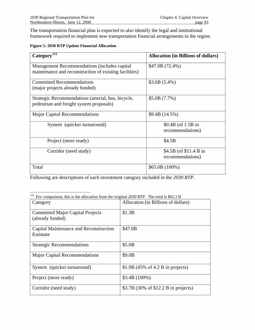
2030 Regional Transportation Plan for Chapter 4: Capital Overview Northeastern Illinois, June 12, 2008 page 93
The transportation financial plan is expected to also identify the legal and institutional framework required to implement new transportation financial arrangements in the region.
Figure 5: 2030 RTP Update Financial Allocation
Category121 Allocation (in Billions of dollars)
Management Recommendations (includes capital maintenance and reconstruction of existing facilities)
$47.0B (72.4%)
Committed Recommendations (major projects already funded)
$3.6B (5.4%)
Strategic Recommendations (arterial, bus, bicycle, pedestrian and freight system proposals)
$5.0B (7.7%)
Major Capital Recommendations $9.4B (14.5%)
System (quicker turnaround) $0.4B (of 1.5B in recommendations)
Project (more ready) $4.5B
Corridor (need study) $4.5B (of $11.4 B in recommendations)
Total $65.0B (100%)
Following are descriptions of each investment category included in the 2030 RTP.
121 For comparison, this is the allocation from the original 2030 RTP. The total is $62.3 B Category Allocation (in Billions of dollars)
Committed Major Capital Projects (already funded)
$1.3B
Capital Maintenance and Reconstruction Estimate
$47.0B
Strategic Recommendations $5.0B
Major Capital Recommendations $9.0B
System (quicker turnaround) $1.9B (45% of 4.2 B in projects)
Project (more ready) $3.4B (100%)
Corridor (need study) $3.7B (30% of $12.2 B in projects)
2030 Regional Transportation Plan for Chapter 4: Capital Overview Northeastern Illinois, June 12, 2008 page 94
4.2.1 Management recommendations
Capital construction of major capital projects in this category is substantially complete. Continued success, however, is dependent on attention to the 2030 RTP’s strategic guidance. Funding for this ongoing management is typically accomplished through the capital programming process.
4.2.2 Committed recommendations
Planning, design and engineering for major capital projects in this category is complete, construction is fully funded, and all necessary permits and approvals are in place. Funding for construction of the entire improvement is identified in the current capital program.
4.2.3 Strategic recommendations
Proposals that substantially benefit multi-modal auto, transit122, bicycle, pedestrian and commercial vehicle travel are promoted by the 2030 RTP. This category is reserved for pursuing improvements planned and designed to be consistent with the 2030 RTP’s recommended Strategic Regional Systems as guidance for the planning and design of “shared use facilities”.123 Funding is typically accomplished through the regular capital programming process.
4.2.4 System recommendations
Proposals to upgrade and enhance existing major facilities usually have a short turnaround and may be accomplished in phases as part of reconstruction or in coordination with other major capital projects. Financing is typically accomplished in combination with funds identified with ongoing capital maintenance and reconstruction.
4.2.5 Project recommendations
Proposals for which the preferred mode, alignment and service pattern of a new facility has been identified may proceed with specific project design and engineering. At this point, likely funding sources can be identified, but sufficient funds for construction have not been secured.
4.2.6 Corridor recommendations
Proposals for which a general travel need and initial transportation solution have been identified are included in this category. Evaluation of the cost effectiveness of alternative solutions is still needed. Because a preferred alternative is not sufficiently refined, cost estimates are preliminary and funding sources are not definitive.
4.3 Regional Plan Consistency
There are numerous strategic, subregional, corridor and project-level transportation plans and planning processes at work in the region. The original 2030 RTP includes comprehensive and 122 Bus Rapid Transit (BRT) proposals were included in the original 2030 RTP as major capital recommendations.
To take advantage of the flexibility offered by this emerging transit mode, the 2030 RTP Update includes BRT proposals as strategic recommendations.
123 The 2030 RTP does not specifically identify facilities in this category.
2030 Regional Transportation Plan for Chapter 4: Capital Overview Northeastern Illinois, June 12, 2008 page 95
strategic guidance intended to support these ongoing efforts. There are also numerous neighborhood, community and county level land use plans and planning processes at work in the region. The 2040 Regional Framework Plan124 includes comprehensive and strategic guidance intended to support these ongoing efforts.
Each of the RTP’s capital recommendations provides an assessment of the proposal’s function within and contribution toward achieving regional goals.
4.4 Public Priority
In addition to a proposal’s project planning status, investment category and regional plan consistency, the 2030 RTP recognizes the regional vision and transportation preferences voiced by an engaged public and their elected leadership. In many cases, these preferences cannot be easily reduced to simple assessments of a project’s readiness for construction, financial status or contribution toward meeting specific planning objectives, but rather are the product of a complex and delicately balanced public dialogue about how best to promote the region’s goals.
Included are priorities established for 2030 RTP proposals by virtue of financial authorizations originating with Congress or the State Legislature.125 In addition, the 2030 RTP major capital element includes recognition by the Board of the Chicago Metropolitan Agency for Planning (CMAP) of the need for additional transportation revenues to sustain the region’s long-range planning goals.
Finally, the results of a public engagement process focused on long range planning showed strong support for the themes presented in the 2030 RTP. Three of the seven themes were identified as the most important issues for the region based upon findings from planning workshops and an on-line survey126:
• More and better integrated public transit
• Better land use and transportation integration
• Improved transportation congestion management
124 http://www.nipc.org/2040/
125 These include SAFETEA-LU earmarks and ISTHA’s bond program. 126 CMAP, Regional Report for the Public Involvement Process for the 2030 RTP Update, July 2006.
2030 Regional Transportation Plan for Chapter 5: Strategic Regional Systems Northeastern Illinois, June 12, 2008 page 96
CHAPTER 5. STRATEGIC REGIONAL SYSTEMS
Strategic Regional Systems (SRS) are organized around particular transportation functions. The RTP recommends allocating $5B of forecast revenue for use among the strategic regional systems, the fundamental guidance being that facilities and services are designed and implemented to improve the performance of a unified multimodal transportation system.
The 2030 RTP organizes its Strategic Regional Systems by mode in order to develop specific guidance regarding implementation of particular types of improvements. These include improvements oriented toward arterials, bus transit, trucks and intermodal freight, and bicycle and pedestrian facilities.127
These systems are the product of scenario evaluations included with the original RTP. Increased attention to transportation system management and operations, intensive expansion of the arterial and bus transit system and limited strategic capital additions to the expressway and passenger rail system were found to increase transit mode choice and contribute to managing traffic congestion.
The 2040 Regional Framework Plan emphasizes the need for multimodal corridors around the region128 and multimodal transportation is one of the most enduring topics in the RTP. In addition, the emergence of “context-sensitive” transportation solutions indicates a priority for sharpening and expanding the considerations given to improving existing “shared-use” transportation facilities. The RTP recommends that transportation implementers and providers give priority to ensuring that individual highway and transit programs improve the multimodal integrity of the transportation system, especially with regard to promoting safety for all travelers. Important features of a strong multimodal transportation system include:
• Coordination of service between and among travel modes.
• Project design that promotes “choice” between and among travel modes.
Making a distinction among specific transportation functions helps recast the RTP’s strategy-driven goals and objectives so that they address the improvement programs developed by traditional transportation implementers and providers. It is important, however, to recognize that the RTP’s recommendations for each of these strategic systems are embodied in the principles of a “shared-use” transportation system.
Ongoing programs to improve and expand the region’s arterial system can also benefit from a set of strategic recommendations to be considered when preparing project designs for local consideration. The additional challenge with improving arterials, of course, arises from their use by multiple travel modes and their integral role in anchoring community land use.
The RTP identifies four strategic transportation systems by travel mode:
• Arterial 127 A strategic regional expressway system (SRES) was originally included in this set to provide guidance for
expressway reconstruction projects. This guidance will now be included in the plan’s discussion of maintenance and reconstruction priorities.
128 NIPC, p. 59
2030 Regional Transportation Plan for Chapter 5: Strategic Regional Systems Northeastern Illinois, June 12, 2008 page 97
• Transit
• Bicycle and Pedestrian
• Freight
A shared-use facility is one that, through construction or design, specifically encourages and accommodates safe and efficient use by pedestrians, bicycles, buses, autos and trucks. While the primary function remains movement of people and goods, shared-use design encourages safe, comfortable and convenient use by all.129
Modern mobility expectations make designing the ideal “shared-use” facility very challenging. Travelers have grown accustomed to having a wide variety of often far-flung destinations from which to choose.130 Even at compact urban land densities, attention to accommodating all modes in a facility’s design can meet this expectation. The challenge is to maintain this level of mobility and accessibility while offering a richer set of travel choices.
Improvements pursued under each of the four strategic regional systems (arterials, transit, bicycle and pedestrian and freight) should subscribe to the following principles of “shared-use” in their design and implementation:131
• Safety is paramount.
• The purpose of the facility is to move people and goods.
• The accommodation of pedestrians and bicyclists is as important as the safe accommodation of vehicles.132
• Community use requires small-scale design considerations.133
• Convenient pedestrian access to buses encourages transit use.134
• Offering priority in traffic to transit vehicles encourages transit use.
• Accommodating commercial vehicles maintains economic development potential.
129 Examples of accommodation and encouragement include sidewalks, easy transit access for pedestrians, bike
lanes/paths, vehicle traffic separation and truck or bus priorities.
130 This implies that a good deal of existing miles traveled is discretionary. 131 Loosely adapted from: The Regional Road Corridor Design Guidelines assembled by the Region of Ottawa-
Carleton (2000).
132 Pedestrians and bicyclists are more vulnerable to injury when in close proximity to vehicles. Vehicle and roadway safety design standards are heavily documented, replete with warrants and rules. Shared Path 2030 avoids repetition of established practice, instead emphasizing policy direction over which we have some discretion.
133 Community use implies shorter and more discretionary trips. For short trips, efficiently overcoming distance obstacles is a greater challenge.
134 The land use should come to the bus, or the bus should go to the land use.
2030 Regional Transportation Plan for Chapter 5: Strategic Regional Systems Northeastern Illinois, June 12, 2008 page 98
These principles also provide an opportunity to achieve the RTP’s objective of efficient transportation and land use interaction. The RTP recommends that any planning and design studies contain a strong land use component so that transportation improvements are sensitive to the context of the community they serve and that land development patterns support the function of the transportation system.
The RTP also recommends that all transportation project implementers meet federal guidelines135 with regard to context sensitivity:
• Officially adopt a policy commitment to implementing context sensitive solutions.
• Document a transparent procedure for demonstrating how context sensitive solutions will be considered for all projects including how early, continuous and iterative public involvement will be sustained.
• Train technical staff from planning, environment, design, ROW, operations and maintenance in context-sensitive solutions including a mechanism for sustaining interdisciplinary team involvement from project beginning to end.
The RTP recommends that added priority in planning and implementing transportation projects be given to addressing 2040 Regional Framework Plan objectives and original RTP community and environmental strategies with emphasis on the role arterial development plays in converting undeveloped land to urban use, preserving and enhancing scenic landscapes and historic neighborhoods and promoting bicycle and pedestrian access to public transit. 136
5.1 Regional Arterials137
The 2040 Regional Framework Plan recognizes that land use plays a role in the performance of adjacent arterials. The 2040 Regional Framework Plan recommends vehicle access management to reduce congestion and improve safety. In addition, arterial intersection design 135 http://www.dot.il.gov/css/cssguide.pdf
136 IDOT/CSS. Page1.
137 The 2010 Transportation System Development (TSD) Plan, adopted in 1989, introduced a Strategic Regional Arterial (SRA) System intended to advance a comprehensively developed design concept, conduct community-based studies for arterial improvements on specific routes and help prioritize arterial improvements regionwide. The recommendations from individual studies focus on improvements to relieve bottlenecks at intersections, provide alternatives to on-street parking, and improve low structural clearances. In developing parts of the region, expansions of existing roads, new construction and corridor traffic management strategies were recommended to accommodate growing traffic and serve major trip generators. Right-of-way preservation, signal coordination, new turn lanes and medians provide for better traffic control and access on suburban arterials. In rural areas, preserving through-movement of traffic so as not to disrupt the character of the area is the priority. The ability to preserve right-of-way and control access are used to minimize disruption and provide for future needs. Strong land development policy is critical to preserving the integrity of the strategic regional arterials in suburban and rural areas. The 2010 TSD Plan’s SRA System comprised a designated subset (about 1,400 miles) of the existing arterial network. Spacing ranged from about three miles in the more densely developed areas to eight miles in the rural areas. This designated subset of arterials provided the base upon which to conduct detailed community-based studies over a period of about 10 years. These studies were still underway during Destination 2020, but are now, by and large, completed. At this point, the designation of a particular part of this “system” has diminished. During Destination 2020, comments and concerns often focused on an arterial’s “designation” as an SRA, rather than any solutions that intensive planning and design studies could offer.
2030 Regional Transportation Plan for Chapter 5: Strategic Regional Systems Northeastern Illinois, June 12, 2008 page 99
with generous pedestrian and bicycle accommodation and safer intersections will enable people to walk or bicycle between adjacent uses.138
The 2030 RTP recommends strategies that improve the performance of arterial roads with emphasis on providing congestion relief and better integrating the region’s transportation system.
These strategies are supported by the following RTP objectives:
• Management and operations
• System efficiency
• Economic development
• Community development
The RTP recommends that shared-use principles be applied in maintaining and improving the region’s major arterials to the extent practicable. The RTP further encourages the full integration of land use planning, design and control of arterial design in rapidly growing or redeveloping areas of the region.
The 2030 RTP provides specific guidance to implementers when programming the following types of arterial projects:
• Arterial improvements and capacity expansion
• Arterial extensions, bypasses and major collectors
• New arterial bridges, grade separations and interchanges
• Designated Strategic Regional Arterials (SRAs)
5.1.1 Arterial improvements and capacity expansion
For facilities that currently provide regional accessibility, but also provide direct access to existing adjacent land uses, the 2030 RTP recommends that the following strategies be considered to maximize the effect of capacity additions:
• Discourage access permits for individual driveways and entrances in favor of providing consolidated entrances or frontage roads.
• Provide tight intersection designs with minimum curb-to-curb cross sections to reduce signal cycle lengths.
• Dual left turn bays should be avoided
• Narrower lanes should be used when appropriate to promote shared-use.
138 NIPC, 2040 Regional Framework Plan, June 29, 2005, p. 50.
2030 Regional Transportation Plan for Chapter 5: Strategic Regional Systems Northeastern Illinois, June 12, 2008 page 100
• Roundabouts should be employed as an alternative to conventional intersections where appropriate.139
• Limit introduction of new traffic signals.
• Provide transit accommodation and priority.
• Provide safe and comfortable accommodation for pedestrian and bicycle travel.
5.1.2 Arterial extensions, bypasses and major collectors
For facilities that are intended to contribute to regional accessibility, but that will also provide new opportunities for land development, the 2030 RTP recommends that the following strategies be considered to maximize the effect of capacity additions:
• Adopt a comprehensive design that coordinates access to individual land uses with the need to optimize the flow of traffic on the new facility.
• Limit introduction of new traffic signals.
• Roundabouts should be employed as an alternative to conventional intersections where forecast traffic volumes are appropriate.
• To the extent feasible, a grid system of streets should be maintained to provide land access and provide alternative arterial routes.
• Provide transit accommodation and priority.
• Provide safe and comfortable accommodation for pedestrian and bicycle travel.
5.1.3 New arterial bridges, grade separations, interchanges and advanced intersection design
The RTP recognizes that new or reconstructed arterial structures such as bridges, grade separations and interchanges can be as costly and have right-of-way requirements comparable to
139 Insurance Institute for Highway Safety :
http://www.iihs.org/research/qanda/roundabouts.html WisDOT site with design information and summaries of how they work: http://www.dot.wisconsin.gov/safety/motorist/roaddesign/roundabout.htm Turner-Fairbank Highway Research Center (somewhat out of date and now being revised): http://www.tfhrc.gov/safety/00068.htm
Transportation Research Board. National Roundabout Conference 2005 Proceedings. Transportation Research Circular E-C083. December, 2005. http://onlinepubs.trb.org/onlinepubs/circulars/ec083.pdf (To view and print the papers/presentations referenced in this report, click on the appropriate link within the "bookmarks" tab of this PDF, which acts as a table of contents. Use your browser's "Back" button after viewing an associated document to return to the bookmarks in the table of contents.)
2030 Regional Transportation Plan for Chapter 5: Strategic Regional Systems Northeastern Illinois, June 12, 2008 page 101
some major capital projects. Because of this, new arterial structures often give rise to the type of community and environmental concerns that are associated with major capital investments.
New arterial structures, however, also offer opportunities to improve accessibility to the entire transportation system as well as to serve local land use goals and address environmental concerns. Introducing new arterial structures at strategic locations may stand as a viable alternative to constructing larger and more costly capital facilities.
The RTP supports implementation of new arterial structures identified and programmed by counties and municipalities through sub-area and corridor evaluations. These facilities should provide safe and comfortable accommodation for pedestrian and bicycle travel.
The RTP supports introducing new arterial structures that are fully coordinated with adjacent and affected jurisdictions. Specifically:
• River (or other natural feature) crossings in order to relieve congestion or provide improved accessibility.
• Rail – arterial grade separations in order to reduce conflicts and improve safety.140
• Arterial – arterial grade separations in order to improve traffic flow and reduce congestion.
• Bicycle and pedestrian grade separations in order to provide improved access and promote safety.
• Expressway and tollway interchanges in order to improve accessibility and support efficient economic development. This should be accomplished in coordination with local land use plans that recognize the intended role of expressways and tollways to provide long distance regional travel. 141
• Roundabouts may be employed to improve intersection operations where appropriate.
5.1.4 Designated Strategic Regional Arterials (SRAs)
Multi-year planning and design studies have been completed on the portion of the region’s arterial system that was originally designated as a “system of Strategic Regional Arterials (SRA),” part of the 2010 Transportation System Development Plan for Northeastern Illinois.142
The SRA Design Concept Report,143 originally prepared to guide the multi-year SRA studies, may now be augmented with specific recommendations as endorsed by the City of Chicago and
140 The conflict between freight and commuter rail traffic and vehicular traffic at heavily used at-grade crossings
creates delays for both highway and rail traffic. In some communities, these delays have a significant impact on local traffic and create major safety concerns as crossings are blocked for long periods of time.
141 At present, a significant number of tollway interchanges are configured in a manner that only allows traffic to enter and exit from one direction. This creates a situation where traffic must travel significant distances from their origins and destinations to reach the tollway, placing a significant burden on local roadways.
142 CATS, Transportation System Development Plan, 1989.
2030 Regional Transportation Plan for Chapter 5: Strategic Regional Systems Northeastern Illinois, June 12, 2008 page 102
the Councils of Mayors. The specific recommendations appear in the final edition of each study report.144
Each of these studies was conducted with the participation of state, regional and local agencies, overseen by a steering committee comprised of government and citizen members, with most of the recommendations being approved by local government resolution. This process has helped establish a consistent and logical connection for programming arterial improvements based on sound and participatory planning principles.
These studies provided valuable guidance for improving the individual facilities themselves, but also created a large local literature of arterial concepts that can now be transferred to other appropriate arterial settings. 145
5.1.4.1 New segments for study
A legacy of these original SRA designations is this "pre-phase one" planning and design study of the route that includes local community involvement.
As the region grows, counties and communities continue to request SRA designation. Discussion of the merits of such studies originates with the City of Chicago, the counties and/or appropriate Council(s) of Mayors.
In the original 2030 RTP, a number of new sections were proposed as additions to the designated SRA system. Some of these were already under study, others should be further evaluated in their subregional context before proceeding with detailed evaluations.146
The 2030 RTP recommends that preliminary evaluations be conducted to determine the potential for these routes to be developed in close accordance to the RTP’s regional strategies and shared-use principles. The evaluations may be prepared in the context of sub-regional (e.g., county) transportation plan or as a corridor study of one or more individual routes. This provides an opportunity to integrate the land use plans and transportation improvements consistent with the shared-use guidance promoted by the 2030 RTP.
The preliminary evaluations should identify the regional significance of the route, the level of support for intensive management and an inventory of community and environmental concerns along the route.
143 IDOT, SRA Design Concept Report, 1991.
144 These reports were published individually. CATS is a repository for the entire set.
145 Many of these studies, however, are now out-of-date. Evaluation of current conditions should be added to any report recommendations being cited.
146 The Will County routes are acknowledged in response to dramatic 2030 growth forecast by the Northeastern Illinois Planning Commission in this area and the planning opportunities offered by the proposed South Suburban Airport and redevelopment of the Joliet Arsenal site. Today, this area remains quite rural, but the transportation and land use pressures that urban growth brings are evident only a few miles away.
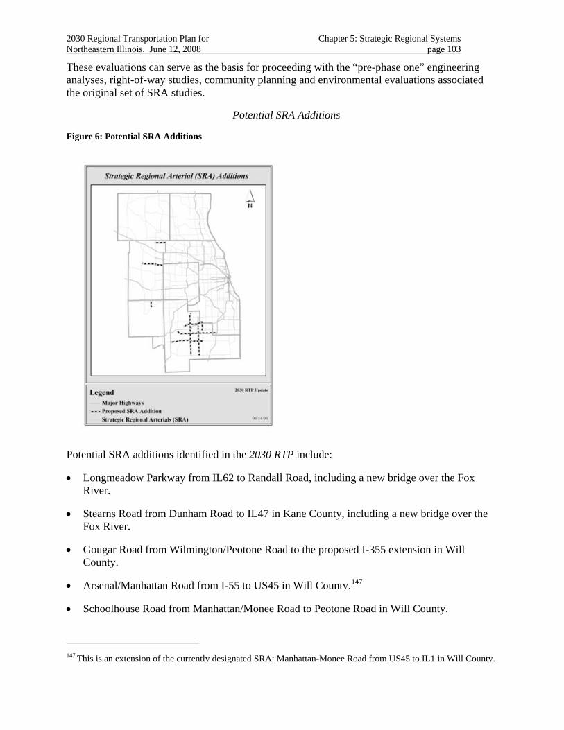
2030 Regional Transportation Plan for Chapter 5: Strategic Regional Systems Northeastern Illinois, June 12, 2008 page 103
These evaluations can serve as the basis for proceeding with the “pre-phase one” engineering analyses, right-of-way studies, community planning and environmental evaluations associated the original set of SRA studies.
Potential SRA Additions
Figure 6: Potential SRA Additions
Potential SRA additions identified in the 2030 RTP include:
• Longmeadow Parkway from IL62 to Randall Road, including a new bridge over the Fox River.
• Stearns Road from Dunham Road to IL47 in Kane County, including a new bridge over the Fox River.
• Gougar Road from Wilmington/Peotone Road to the proposed I-355 extension in Will County.
• Arsenal/Manhattan Road from I-55 to US45 in Will County.147
• Schoolhouse Road from Manhattan/Monee Road to Peotone Road in Will County.
147 This is an extension of the currently designated SRA: Manhattan-Monee Road from US45 to IL1 in Will County.
2030 Regional Transportation Plan for Chapter 5: Strategic Regional Systems Northeastern Illinois, June 12, 2008 page 104
• US6/Wolf Road from Collins Road to Wolf Road and 159th Street to 187th Street in Will County.
• Orchard Road from US30 to IL71
Officially adding a proposed route to the region’s SRA system would follow completion of studies supporting such a designation and endorsement by the appropriate county and/or Council(s) of Mayors. Adding the route to the 2030 RTP is by Policy Committee approval.
Throughout the evaluation and study process, early and continuous involvement of affected communities should be pursued consistent with the 2040 Framework Plan and the RTP’s support for principles of “context-sensitive solutions.”
5.2 Regional Transit148
The RTP supports transportation strategies that improve the performance of existing transit services and better integrate use of the public transit system.
This is supported by the following RTP objectives:
• Management and operations
• System efficiency
• Economic development
• Community development
• Social equity
The RTP recommends these strategic improvements to the region’s transit system:
• Traffic signal priority systems for transit vehicles region-wide.
• Additional service on existing bus and rail routes, particularly oriented toward off-peak and reverse commute travel.
• Additional transfer capacity and improved coordination at connection points with high demand.
• Additional park-and-ride facilities to encourage increased transit use.
• New bus and paratransit services that provide public transit service to currently unserved areas.
148 A Strategic Regional Transit (SRT) system was introduced in the 2020 RTP. The SRT system was defined as an
“integrated network of existing high capacity rail and bus services vital for mobility, congestion relief and economic development.” The SRT concept was modeled after the RTP’s SRA system, an element of Operation GreenLight. The SRA system institutionalized itself largely because of IDOT’s commitment to fund 10 years of planning studies of each SRA route. The 2020 RTP declared that this would occur for the SRT system, but there is no supporting documentation for this.
2030 Regional Transportation Plan for Chapter 5: Strategic Regional Systems Northeastern Illinois, June 12, 2008 page 105
• Bus routes with limited stops that run longer distances.149
• Community circulators that allow an alternative to short auto trips.
• Short rail extensions and additional sidings intended to improve the efficiency of existing rail operations.
• Other intersection operations improvements such as queue bypass and far-side bus stops as appropriate.
• Improved water transport routes to serve passengers and goods.150
The RTP recognizes that additional high-quality bus service has the potential to be a cost-effective way to increase the transit options available regionwide.
Extensive bus route systems are proposed in a number of local, subregional and transit operator plans and programs. The system-intensive alternative included the service levels indicated by proposals for a network of express routes (i.e., limited-stop) serving the city of Chicago and the Pace Vision 2020 expanded regional network of local, feeder and express bus routes.
5.2.1 Transit Supportive Land Use
The 2040 Regional Framework Plan acknowledges that transit is a key link between land use and transportation. When public transportation is available, communities and transportation providers should work to make it convenient and attractive for commuters by increasing access to transit.151 In addition, walking and bicycling can be important modes of access for many transit services, so such non-motorized access needs to be accommodated for both bus and rail station.152
The 2040 Regional Framework Plan recommends increased transit service for areas that are not currently served.153 2040 Regional Framework Plan also recommends increased transit service for reverse commuters. New options are needed to provide a variety of transit choices for connections between the Framework Plan’s designated centers.154
149 Skip-stop routes reduce in-vehicle time. Longer bus routes can reduce the need for transfers.
150 Examples of improved water transit include options such as water taxis, commuter ferries, cruise lines and tour boats. Terminals or docking points should be located at important centers or corridor junctions to make them easily accessible and attractive to passengers. NIPC, p. 51 and p. 53.
151 NIPC, p. 69.
152 Accessible routes must be provided to bus transit stops. Key rail stations must also be fully accessible.
153 NIPC, p. 53.
154 NIPC. p. 50.
2030 Regional Transportation Plan for Chapter 5: Strategic Regional Systems Northeastern Illinois, June 12, 2008 page 106
The 2030 RTP recommends the following land use strategies as integral elements of the Strategic Regional Transit System155:
• Minimize distances between buildings and transit stops. This may be accomplished by putting parking areas to the rear or beside buildings, rather than in front of them. Building setbacks should be minimal.
• Provide short walkways connecting buildings and transit stops.
• Encourage compact, higher density development centered on the transit service.
• Interconnect streets and sidewalks leading to the transit service. Provide direct lines of travel to transit service, without back-tracking.
• Require travel demand reduction strategies to be implemented as part of conditional use or planned developments. Promote transit access in development reviews.
• Facilitate mixed use developments.
• Provide for transit users’ needs by creating service-oriented hubs.
• Provide transportation centers in appropriate locations.
• Specific ways to integrate the transit service into the community will depend on the context. Consult appropriate transit agency guidance.
• Require attractive landscaping and street environments.
• Provide links with surrounding services and institutions.
• Facilitate a mix of housing types.
• Create a “sense of place.”
Paratransit operations also suggest attention to transit supportive land use solutions. Integrating extensive paratransit service into conventional transit operations includes providing accessibility riders with special needs at regular locations. Improving accessibility to all of its current and future bus stops and stations should include attention to ADA considerations regarding bus stop accessibility.
5.2.2 Private Providers156
The Chicago Region’s Private Providers are a resource that augments the role of traditional public transit providers. Funding, operating costs, and sources of capital differ widely between
155 Pace Suburban Bus Service, Pace Development Guidelines, Revised November, 1999; Metra/NIPC, Land Use in
Commuter Rail Station Areas: Guidelines for Communities, 1991; and S.B. Friedman & Co., Approaches to Residential Development in Station Areas, prepared for Metra, 2000.
156 Private Provider Alternatives for Public Transportation Deficiencies, prepared by CATS’ Private Provider Task Force 05-05.
2030 Regional Transportation Plan for Chapter 5: Strategic Regional Systems Northeastern Illinois, June 12, 2008 page 107
public and private entities. Private Providers operate in an open and competitive market157. The prevailing business model is based on the premise that fees and services must be acceptable to customers or the provider will be replaced by a more efficient and service-friendly competitor.
The 2030 RTP recommends that, when appropriate, private services may be contracted to provide or to supplement traditional public transit, perhaps with a performance-based public subsidy. By partnering with competitive contractors, public transit providers can ensure the mobility of low income riders, so they may obtain and maintain jobs.
The 2030 RTP recommends that private provider resources be utilized for:
• School Bus Service
• Community Transit
• Paratransit
• Shuttle Service
• Subscription Bus Service
• Charter Service
• Limousine/Taxi
• Corporate Internal Shuttle
• Interstate Coach
• Van Service
Public transit authorities often resort to increased fares and reduced service levels in response to rising costs. Converting elements of the public transit systems to competitive contracting may save costs.158 Public-private partnerships can offer public transportation entities the flexibility they require to offer full service and improved timetable packages that its ridership demands and needs.
157 Government regulations and franchise limitations on private providers exist primarily for the purpose of
maintaining public safety. These have the effect of placing some bounds on entry to the private provider market.
158 A few in the U.S. are: San Diego: converted 37% of its bus system to competitive contracting since 1979. It now operates more than 100 buses with no public employee layoffs. The program showed 34% less cost below present, publicly funded, operating costs. Las Vegas: converted entire fleet of publicly operated system to competitive contracting. Cost per vehicle hour dropped by 33.3% (inflation adjusted). This is the lowest unit cost of the largest 50 public transit system. Denver: A 1988 Colorado state law required a partial conversion (20%) of Denver’s Regional Transportation District. The success of the program has prompted DRT to expand competitive contracting to 25% or more than 180 buses. Indianapolis: competitively contracts 70% of its bus system. Cost per hour savings show a drop 22% with service levels increased by 38%. Indianapolis: competitively contracts 70% of its bus system. Cost per hour savings of 22% with service levels increased by 38%.
2030 Regional Transportation Plan for Chapter 5: Strategic Regional Systems Northeastern Illinois, June 12, 2008 page 108
Private Providers can be used to promote better service levels, flexible scheduling and to stabilize fares. Further, private providers are ideal for augmenting public transit service to students, seniors and persons with disabilities, providing transit choices to underserved areas and non peak service.
5.2.3 Bus Rapid Transit
Bus Rapid Transit (BRT) is a flexible rubber-tired rapid-transit mode that combines stations, vehicles, services, running ways and intelligent transportation system elements into an integrated system with strong positive identity that evokes a unique image. BRT applications are designed to be appropriate to the market they serve and their physical surroundings, and can be incrementally implemented in a variety of environments.159
Although the infrastructure, vehicle and operation characteristics of individual BRT systems vary, the objectives of BRT reflect that it is a high-quality transit service:
• Reduce transit travel time
• Increase transit reliability
• Increase frequency to reduce waiting time
• Improve transit connections
• Enhance system identity to easy system use by increasing system recognition
• Increase accessibility through low floor vehicles, enhanced infrastructure and quality up-to-date information
• Enhance transit safety and security
These objectives are achieved through the combination of the following specialized elements of BRT:
• Specialized or exclusive running way
• Specialized Vehicles
• Flexible Service
• Flexible Route structure
• Efficient Fare collection
• Intelligent Transportation Systems Integration:
o Automatic Vehicle Location (AVL) combined with traffic management systems,
o Transit Signal Priority (TSP), signal coordination 159 Transportation Cooperative Research Program (TCRP), Report 90, Bus Rapid Transit, Vol. I, 2003.

2030 Regional Transportation Plan for Chapter 5: Strategic Regional Systems Northeastern Illinois, June 12, 2008 page 109
o Transit supportive services (information systems: web site, maps, real-time information system, on-board announcements)
• Identity branding of infrastructure and vehicle
One of the advantages of BRT is that it can be tailored to serve the local demand and to fit in the local transportation context. A low-cost, mixed traffic BRT system running on arterial streets would have some of the elements of the above list, while a full BRT on its own exclusive running way serving high demand will have all these features. The challenge is to develop a BRT project without sacrificing the quality and the system efficiencies gained in combining these features.
Because BRT is a rubber-tired operation it can be developed incrementally in terms of time and space:
• An initial investment phase would put some of the key features in place, start operation to reap benefits early while additional features are implemented. As demand grows, additional features can be added to increase capacity, and to maintain travel time and reliability.
• BRT can be developed by sections. An initial investment phase could open on a short section to reap early benefits while additional sections could be connected later. Furthermore, higher cost elements, such as dedicated running way, can be implemented on part of the route, only where it is needed.
Distinguishing features of BRT service include the design of the guideway and passenger facilities as well as the style and appearance of the vehicles themselves.
Vehicles designed especially for the service may feature low floors and comfortable interiors that allow for easier boarding, alighting and fare collection. Landscaping, and other amenities along the guideway can contribute to the overall attractiveness of the service.
BRT typically incorporates limited stopping patterns, off-board fare payments, level boarding, high-quality passenger facilities, real-time passenger information systems, pedestrian and bicycle access enhancements, park-and-ride or kiss-and-ride facilities where applicable, links to connector and circulator bus service and highly recognizable facilities, signage and vehicle graphics.
BRT stations may be comprised of a mix of “superstops,” community transportation centers and regional transportation centers. “Superstops” will be located where a connector bus route links to the BRT. These stops will include enclosed heated shelters with passenger information, including real-time information on the arrival of the next bus. Most BRT stations will be of the “superstop” type.
Intelligent Transportation System benefits are central to successful BRT design. These include transit signal priority, automatic vehicle location, electronic fare collection (to reduce dwell times at stops), transfer connection protection (to reduce transfer wait times) and facility monitoring and security systems.
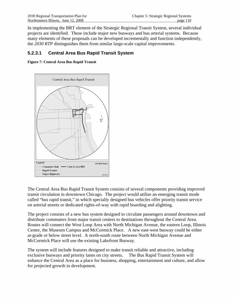
2030 Regional Transportation Plan for Chapter 5: Strategic Regional Systems Northeastern Illinois, June 12, 2008 page 110
In implementing the BRT element of the Strategic Regional Transit System, several individual projects are identified. These include major new busways and bus arterial systems. Because many elements of these proposals can be developed incrementally and function independently, the 2030 RTP distinguishes them from similar large-scale capital improvements.
5.2.3.1 Central Area Bus Rapid Transit System
Figure 7: Central Area Bus Rapid Transit
The Central Area Bus Rapid Transit System consists of several components providing improved transit circulation in downtown Chicago. The project would utilize an emerging transit mode called “bus rapid transit,” in which specially designed bus vehicles offer priority transit service on arterial streets or dedicated rights-of-way with rapid boarding and alighting.
The project consists of a new bus system designed to circulate passengers around downtown and distribute commuters from major transit centers to destinations throughout the Central Area. Routes will connect the West Loop Area with North Michigan Avenue, the eastern Loop, Illinois Center, the Museum Campus and McCormick Place. A new east-west busway could be either at-grade or below street level. A north-south route between North Michigan Avenue and McCormick Place will use the existing Lakefront Busway.
The system will include features designed to make transit reliable and attractive, including exclusive busways and priority lanes on city streets. The Bus Rapid Transit System will enhance the Central Area as a place for business, shopping, entertainment and culture, and allow for projected growth in development.
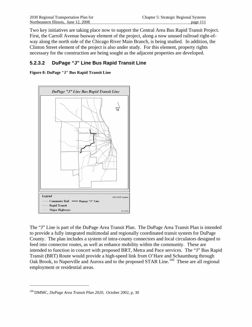
2030 Regional Transportation Plan for Chapter 5: Strategic Regional Systems Northeastern Illinois, June 12, 2008 page 111
Two key initiatives are taking place now to support the Central Area Bus Rapid Transit Project. First, the Carroll Avenue busway element of the project, along a now unused railroad right-of-way along the north side of the Chicago River Main Branch, is being studied. In addition, the Clinton Street element of the project is also under study. For this element, property rights necessary for the construction are being sought as the adjacent properties are developed.
5.2.3.2 DuPage “J” Line Bus Rapid Transit Line
Figure 8: DuPage "J" Bus Rapid Transit Line
The “J” Line is part of the DuPage Area Transit Plan. The DuPage Area Transit Plan is intended to provide a fully integrated multimodal and regionally coordinated transit system for DuPage County. The plan includes a system of intra-county connectors and local circulators designed to feed into connector routes, as well as enhance mobility within the community. These are intended to function in concert with proposed BRT, Metra and Pace services. The “J” Bus Rapid Transit (BRT) Route would provide a high-speed link from O’Hare and Schaumburg through Oak Brook, to Naperville and Aurora and to the proposed STAR Line.160 These are all regional employment or residential areas.
160 DMMC, DuPage Area Transit Plan 2020, October 2002, p. 30

2030 Regional Transportation Plan for Chapter 5: Strategic Regional Systems Northeastern Illinois, June 12, 2008 page 112
The line would operate initially in priority lanes on surface streets and employ a variety of new techniques and technologies to speed service. However, at full operation, the “J” route will provide high-speed service operating on an exclusive busway.
Community transportation centers may serve several transit routes. They will typically include all passenger amenities and be located at rail stations, community downtowns, shopping centers and other major activity centers. Community transportation centers might be appropriate in downtown Naperville, Yorktown Shopping Center and at the connection of the BRT with the Outer Circumferential Service on the EJ&E.
Regional transportation centers accommodate a large number of travelers and higher bus volume and frequency. A regional transportation center might be located at a major employment center or retail destination. A connection to regional transit routes such as the Cermak Road BRT or the Northwest Transit Corridor would be established here, as well as connections to community services. These centers would contain all passenger amenities and also retail or service activities. Regional transportation centers might be appropriate in locations such as Oak Brook or Schaumburg.
The “J” route is anticipated to become part of a larger suburban BRT network161
161 Pace is working with DuPage County on implementing the “J” line.
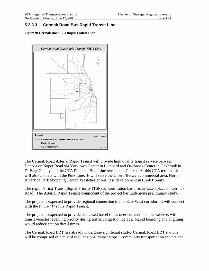
2030 Regional Transportation Plan for Chapter 5: Strategic Regional Systems Northeastern Illinois, June 12, 2008 page 113
5.2.3.3 Cermak Road Bus Rapid Transit Line
Figure 9: Cermak Road Bus Rapid Transit Line
The Cermak Road Arterial Rapid Transit will provide high quality transit service between Danada on Naper Road via Yorktown Center in Lombard and Oakbrook Center in Oakbrook in DuPage County and the CTA Pink and Blue Line terminal in Cicero. At this CTA terminal it will also connect with the Pink Line. It will serve the Cicero/Berwyn commercial area, North Riverside Park Shopping Center, Westchester business development in Cook County.
The region’s first Transit Signal Priority (TSP) demonstration has already taken place on Cermak Road. The Arterial Rapid Transit component of the project has undergone preliminary study.
The project is expected to provide regional connection in this East-West corridor. It will connect with the future “J” route Rapid Transit.
The project is expected to provide decreased travel times over conventional bus service, with transit vehicles receiving priority during traffic congestion delays. Rapid boarding and alighting would reduce station dwell times.
The Cermak Road BRT has already undergone significant study. Cermak Road BRT stations will be comprised of a mix of regular stops, “super stops,” community transportation centers and
2030 Regional Transportation Plan for Chapter 5: Strategic Regional Systems Northeastern Illinois, June 12, 2008 page 114
regional transportation centers. Numerous enhancements are planned for these stations to improve passenger information and comfort.
A test of transit system priority (TSP) has taken place in the corridor. TSP gives transit vehicles priority at intersections by granting an early green phase or an extended green phase to approaching buses. TSP should be incorporated with emergency signal priority programs. Other ITS features expected to be incorporated with the Cermak BRT service include automatic vehicle location, electronic fare collection (to reduce dwell times at stops), transfer connection protection (to reduce transfer wait times), real time passenger information (to help patrons plan their itinerary) and facility monitoring and security systems.
The Cermak Road BRT service would enhance service to the 54th/Cermak (Pink Line) rapid transit service now being implemented. The service would also feed and complement a proposed "J-Line" BRT service to Schaumburg, O'Hare and Naperville, as well as an extension to the Forest Park rapid transit service at Oak Brook.
This proposal is also being evaluated in the Cook DuPage multimodal corridor study.
The project crosses Salt Creek in DuPage County adjacent to York Woods and Fullersburg Woods on Salt Creek, properties of the Forest Preserve District of DuPage County. The project also crosses the Des Plaines River and adjacent forest preserves in Cook County.
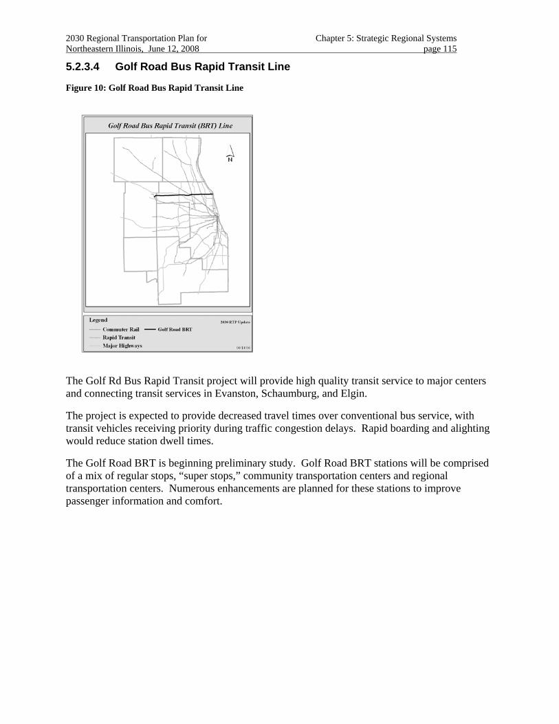
2030 Regional Transportation Plan for Chapter 5: Strategic Regional Systems Northeastern Illinois, June 12, 2008 page 115
5.2.3.4 Golf Road Bus Rapid Transit Line
Figure 10: Golf Road Bus Rapid Transit Line
The Golf Rd Bus Rapid Transit project will provide high quality transit service to major centers and connecting transit services in Evanston, Schaumburg, and Elgin.
The project is expected to provide decreased travel times over conventional bus service, with transit vehicles receiving priority during traffic congestion delays. Rapid boarding and alighting would reduce station dwell times.
The Golf Road BRT is beginning preliminary study. Golf Road BRT stations will be comprised of a mix of regular stops, “super stops,” community transportation centers and regional transportation centers. Numerous enhancements are planned for these stations to improve passenger information and comfort.
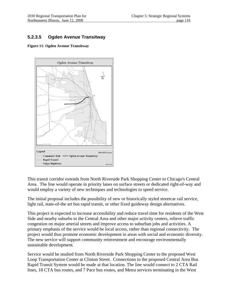
2030 Regional Transportation Plan for Chapter 5: Strategic Regional Systems Northeastern Illinois, June 12, 2008 page 116
5.2.3.5 Ogden Avenue Transitway
Figure 11: Ogden Avenue Transitway
This transit corridor extends from North Riverside Park Shopping Center to Chicago's Central Area. The line would operate in priority lanes on surface streets or dedicated right-of-way and would employ a variety of new techniques and technologies to speed service.
The initial proposal includes the possibility of new or historically styled streetcar rail service, light rail, state-of-the art bus rapid transit, or other fixed guideway design alternatives.
This project is expected to increase accessibility and reduce travel time for residents of the West Side and nearby suburbs to the Central Area and other major activity centers, relieve traffic congestion on major arterial streets and improve access to suburban jobs and activities. A primary emphasis of the service would be local access, rather than regional connectivity. The project would thus promote economic development in areas with social and economic diversity. The new service will support community reinvestment and encourage environmentally sustainable development.
Service would be studied from North Riverside Park Shopping Center to the proposed West Loop Transportation Center at Clinton Street. Connections to the proposed Central Area Bus Rapid Transit System would be made at that location. The line would connect to 2 CTA Rail lines, 18 CTA bus routes, and 7 Pace bus routes, and Metra services terminating in the West
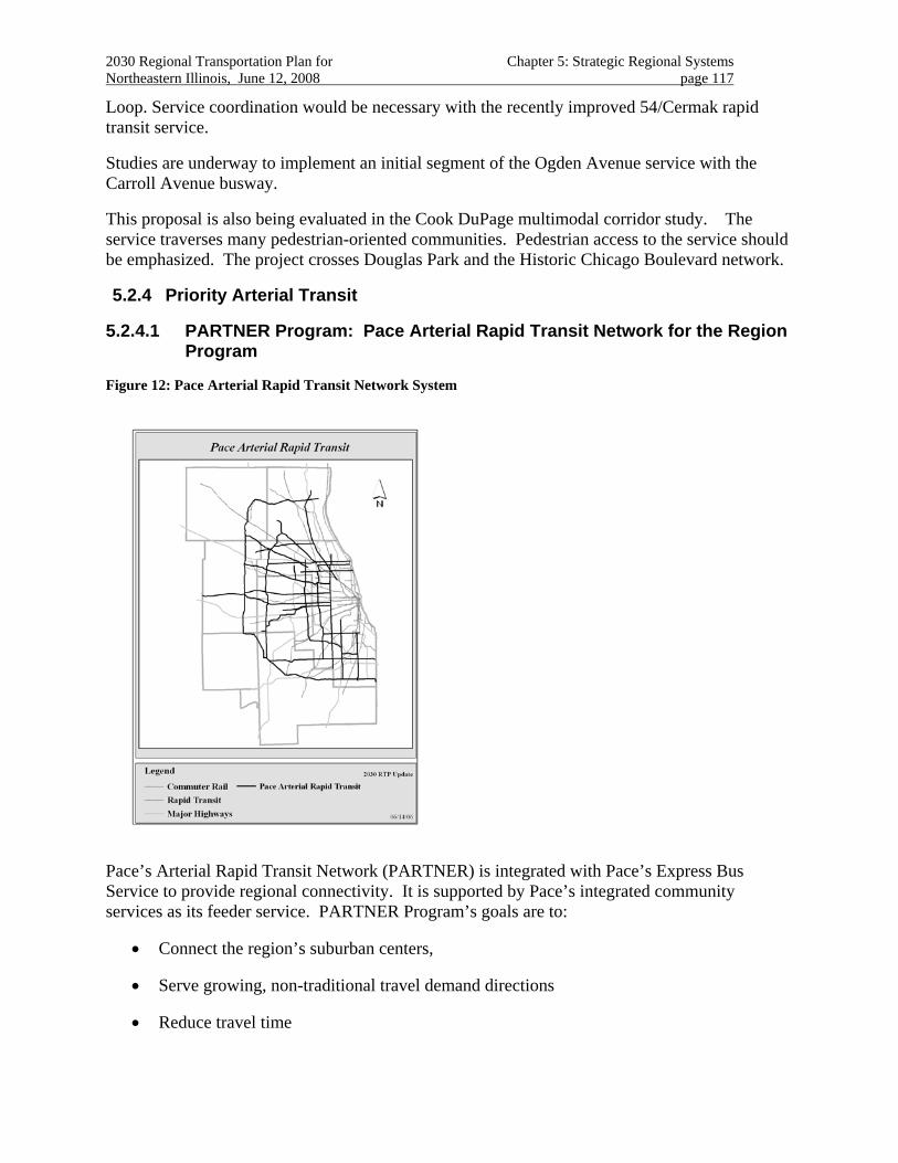
2030 Regional Transportation Plan for Chapter 5: Strategic Regional Systems Northeastern Illinois, June 12, 2008 page 117
Loop. Service coordination would be necessary with the recently improved 54/Cermak rapid transit service.
Studies are underway to implement an initial segment of the Ogden Avenue service with the Carroll Avenue busway.
This proposal is also being evaluated in the Cook DuPage multimodal corridor study. The service traverses many pedestrian-oriented communities. Pedestrian access to the service should be emphasized. The project crosses Douglas Park and the Historic Chicago Boulevard network.
5.2.4 Priority Arterial Transit
5.2.4.1 PARTNER Program: Pace Arterial Rapid Transit Network for the Region Program
Figure 12: Pace Arterial Rapid Transit Network System
Pace’s Arterial Rapid Transit Network (PARTNER) is integrated with Pace’s Express Bus Service to provide regional connectivity. It is supported by Pace’s integrated community services as its feeder service. PARTNER Program’s goals are to:
• Connect the region’s suburban centers,
• Serve growing, non-traditional travel demand directions
• Reduce travel time
2030 Regional Transportation Plan for Chapter 5: Strategic Regional Systems Northeastern Illinois, June 12, 2008 page 118
• Improve reliability
• Improve frequency
• Simplify transit usage in the suburbs
The advantages of an Arterial Rapid Transit Network are that it:
1. Reaches the maximum number of people in the region,
2. Takes the shortest time to implement out of all rapid transit options, and
3. Takes the least amount of capital expenses to implement out of all rapid transit options.
The PARTNER Program is currently under development. It is planned to:
• Operate on arterial street in mixed traffic with short sections of bus-only lanes and queue bypass lanes where necessary to help buses get through congested road sections,
• Branded modular station that will include specially designed bus pole, information kiosk (including system map, schedules and real-time information display), shelter, bench – subject to space availability.
• Low floor buses
• Corridor-based, simple route structure that provide regional connectivity
• ITS systems:
• Automatic Vehicle Location system combined with dynamic traffic management,
• Transit signal coordination and Transit Signal Priority
• Transit supportive services, such as information systems: web site, maps, real-time information system, on-board station announcer
• Identity branding of infrastructure and vehicle
The PARTNER program will provide improved transit service to major centers and connecting transit services throughout the region. The services will serve major regional centers and transit connections.
The system is expected to provide decreased travel times over conventional bus service, with transit vehicles receiving priority during traffic congestion delays. Rapid boarding and alighting would reduce dwell times.
Evaluation of this program is underway.
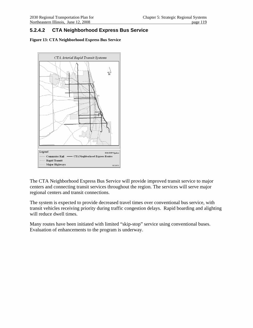
2030 Regional Transportation Plan for Chapter 5: Strategic Regional Systems Northeastern Illinois, June 12, 2008 page 119
5.2.4.2 CTA Neighborhood Express Bus Service
Figure 13: CTA Neighborhood Express Bus Service
The CTA Neighborhood Express Bus Service will provide improved transit service to major centers and connecting transit services throughout the region. The services will serve major regional centers and transit connections.
The system is expected to provide decreased travel times over conventional bus service, with transit vehicles receiving priority during traffic congestion delays. Rapid boarding and alighting will reduce dwell times.
Many routes have been initiated with limited “skip-stop” service using conventional buses. Evaluation of enhancements to the program is underway.
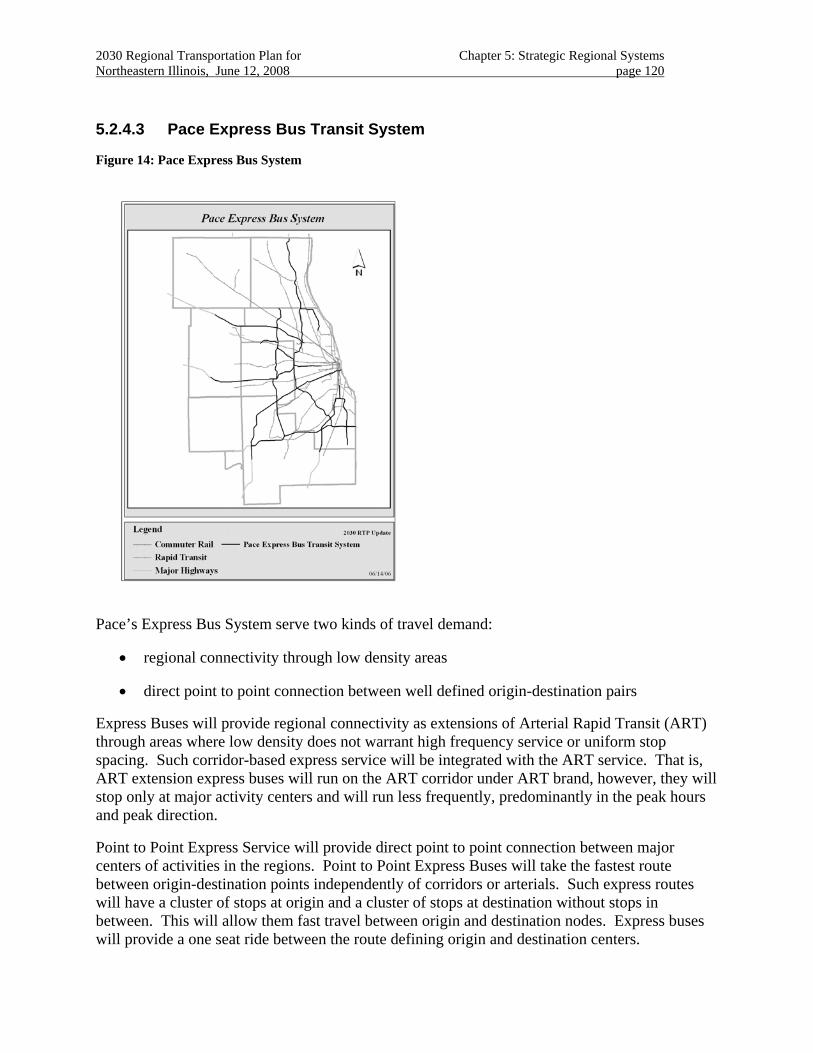
2030 Regional Transportation Plan for Chapter 5: Strategic Regional Systems Northeastern Illinois, June 12, 2008 page 120
5.2.4.3 Pace Express Bus Transit System
Figure 14: Pace Express Bus System
Pace’s Express Bus System serve two kinds of travel demand:
• regional connectivity through low density areas
• direct point to point connection between well defined origin-destination pairs
Express Buses will provide regional connectivity as extensions of Arterial Rapid Transit (ART) through areas where low density does not warrant high frequency service or uniform stop spacing. Such corridor-based express service will be integrated with the ART service. That is, ART extension express buses will run on the ART corridor under ART brand, however, they will stop only at major activity centers and will run less frequently, predominantly in the peak hours and peak direction.
Point to Point Express Service will provide direct point to point connection between major centers of activities in the regions. Point to Point Express Buses will take the fastest route between origin-destination points independently of corridors or arterials. Such express routes will have a cluster of stops at origin and a cluster of stops at destination without stops in between. This will allow them fast travel between origin and destination nodes. Express buses will provide a one seat ride between the route defining origin and destination centers.
2030 Regional Transportation Plan for Chapter 5: Strategic Regional Systems Northeastern Illinois, June 12, 2008 page 121
Because Point to Point Express buses will take the shortest-time route between origin and destination it is proposed that they utilize expressways, tollways, and highways, including shoulder-riding priority where safe and appropriate.
Park-and-ride facilities are important components of the Express Bus Service. Pace is in the process of evaluating the need for new park-and-ride facility location and the quality of amenities at these facilities. Express Bus Service is likely to be supported by real-time information systems.
The infrastructure needs of Pace’s Express Bus System may include:
• Station for the Corridor-based ART Extension Express Service
• Express stops for Point to Point Express Service
• Park-and-ride facilities
• Real time information systems at all Express bus stations and stops, as well as at Park-and-ride facilities
The Express Bus Services are expected to provide regional connectivity as extensions of Pace’s ART Network, reduce congestion and improve air quality through the Point to Point Express Service; as well as reduced travel time and provide high quality of service.
Evaluation of the program is underway.
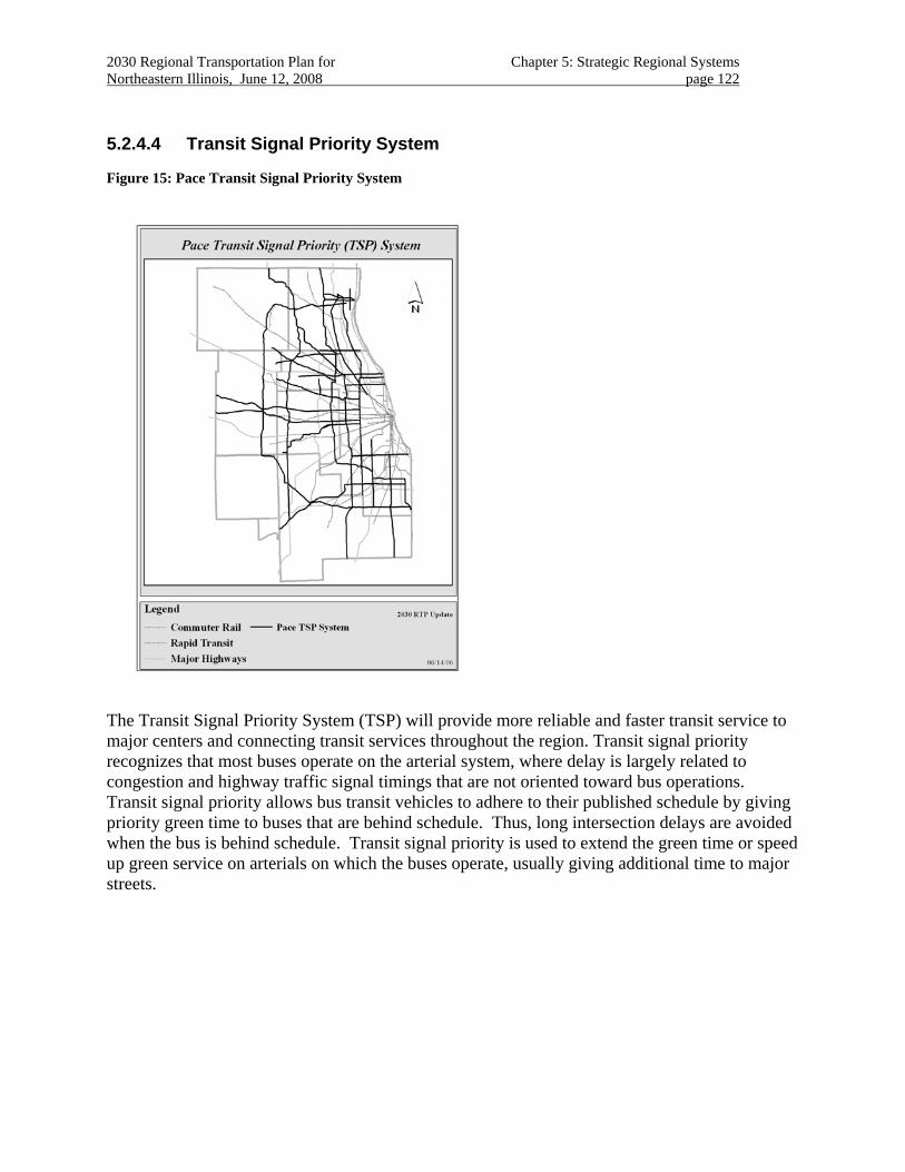
2030 Regional Transportation Plan for Chapter 5: Strategic Regional Systems Northeastern Illinois, June 12, 2008 page 122
5.2.4.4 Transit Signal Priority System
Figure 15: Pace Transit Signal Priority System
The Transit Signal Priority System (TSP) will provide more reliable and faster transit service to major centers and connecting transit services throughout the region. Transit signal priority recognizes that most buses operate on the arterial system, where delay is largely related to congestion and highway traffic signal timings that are not oriented toward bus operations. Transit signal priority allows bus transit vehicles to adhere to their published schedule by giving priority green time to buses that are behind schedule. Thus, long intersection delays are avoided when the bus is behind schedule. Transit signal priority is used to extend the green time or speed up green service on arterials on which the buses operate, usually giving additional time to major streets.
2030 Regional Transportation Plan for Chapter 5: Strategic Regional Systems Northeastern Illinois, June 12, 2008 page 123
5.3 Regional Freight
5.3.1 Freight Supportive Land Use and Economic Development
The 2040 Regional Framework Plan recognizes the pressing needs of commercial goods movements in the region and advocates a commitment to improving the performance of the region’s freight system.162
Regional transportation strategies improve the performance of existing freight operations with emphasis on streamlining intermodal transfers and commercial goods delivery.
By providing multimodal transportation options to more industrial and commercial businesses, the economic benefits to the region from its position as the nation’s freight transportation hub can be maintained and enhanced.
Strategic freight improvements are supported by the following RTP objectives:
• Maintenance, reconstruction and replacement
• Management and operations
• System efficiency
• Transportation and land use interaction
• Commercial goods movement
• Public health and safety163
• Economic development
• Social equity
Public and private freight partners should improve information management and sharing, where appropriate, to increase system efficiency and freight rail capacity utilization. The 2030 RTP also supports improved asset and real estate management practices by and among regional freight system stakeholders. This includes regular participation in multi-state planning and management endeavors.164
The following strategies may be achieved through the provision of new capital assets, along with the modernization and improved utilization of existing assets.
162 NIPC, p. 57.
163 Air quality can be improved by reducing truck interference with automobile traffic.
164 Such as the Upper Midwest Corridor study and the tri-state G-C-M Corridor CVS program.
2030 Regional Transportation Plan for Chapter 5: Strategic Regional Systems Northeastern Illinois, June 12, 2008 page 124
• Coordinate freight rail operations with commuter rail service and infrastructure projects.165 This includes providing additional capacity on new or restored rail sections to permit additional train movement with modernized train control systems that permit bi-directional operation.
• Where heavy conflicts occur between commuter services and crossing freight services, provide rail-to-rail grade separations.
• Reduce rail/highway grade crossings conflicts by providing grade separations and at-grade safety improvements.166
• Mitigate negative community effects caused by train noise and blocked crossings.
• Establish highway system truck priorities during capital construction and reconstruction projects.
• Promote truck-specific treatments aimed at improving safety and efficiency of commercial goods movement during project development.167 Study the feasibility of truck-only corridors to facilitate commercial goods movement where appropriate.
• Correct severe bottlenecks in locations that impede freight mobility and cause inefficient routing. This includes mitigating inefficiencies caused by vehicle weight restrictions and viaduct clearance limitations in locations requiring truck access.
• Promote continued improvement of “intermodal connector” facilities.168
• Promote context-sensitive geometric improvements to improve truck turning movements such as recessed stop bars and right-aligning left turn lanes.
• Provide “freight-friendly” installations such as truck-only electronic toll collection, pre-clearance and credentialing, information and advisory systems, and truck storage lanes that improve operations safety.
• Promote value pricing initiatives to encourage efficient utilization of highway facilities for freight operations.
165 When rail improvements are made on behalf of commuter rail users, the evaluation of costs and benefits should
include the impact on rail freight operations. Likewise, when freight rail improvements are made, the impacts on commuter services should be considered.
166 A set of strategic improvements is available from CATS Intermodal Advisory Task Force. It calls for a minimum of 50 grade separations to completed within 10 years and provides other specific guidance.
167 Establishing dedicated corridors between the region’s major freight facilities may be an appropriate solution. See IATF discussions of the Chicago Gateway proposal.
168 These contribute to the region’s position as “gateway” to national and international goods markets by improving approximately 55 miles of highway that have been identified as “intermodal” connectors. These connectors are specifically designed for heavy truck use and are not intended to function as “shared-use” facilities.
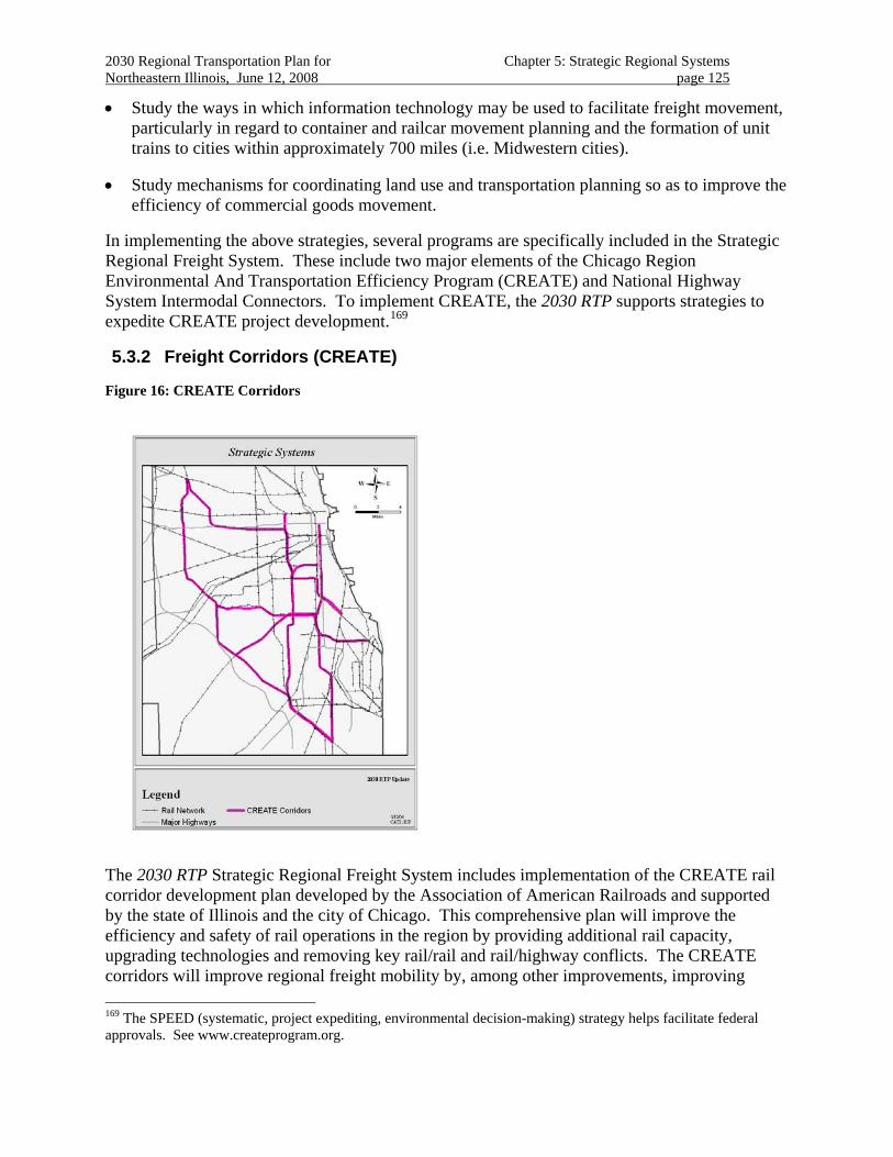
2030 Regional Transportation Plan for Chapter 5: Strategic Regional Systems Northeastern Illinois, June 12, 2008 page 125
• Study the ways in which information technology may be used to facilitate freight movement, particularly in regard to container and railcar movement planning and the formation of unit trains to cities within approximately 700 miles (i.e. Midwestern cities).
• Study mechanisms for coordinating land use and transportation planning so as to improve the efficiency of commercial goods movement.
In implementing the above strategies, several programs are specifically included in the Strategic Regional Freight System. These include two major elements of the Chicago Region Environmental And Transportation Efficiency Program (CREATE) and National Highway System Intermodal Connectors. To implement CREATE, the 2030 RTP supports strategies to expedite CREATE project development.169
5.3.2 Freight Corridors (CREATE)
Figure 16: CREATE Corridors
The 2030 RTP Strategic Regional Freight System includes implementation of the CREATE rail corridor development plan developed by the Association of American Railroads and supported by the state of Illinois and the city of Chicago. This comprehensive plan will improve the efficiency and safety of rail operations in the region by providing additional rail capacity, upgrading technologies and removing key rail/rail and rail/highway conflicts. The CREATE corridors will improve regional freight mobility by, among other improvements, improving 169 The SPEED (systematic, project expediting, environmental decision-making) strategy helps facilitate federal approvals. See www.createprogram.org.
2030 Regional Transportation Plan for Chapter 5: Strategic Regional Systems Northeastern Illinois, June 12, 2008 page 126
corridor rail connections, signaling, additional mainline track, crossovers, and interlockings. In addition, new rail flyovers are an integral element of the corridors program, designed to reduce conflicts between rail corridors.
The CREATE corridors program includes four freight corridors. In addition, a passenger corridor is included in the CREATE program that, through strategies like rail-to-rail grade separations, will reduce conflicts between freight and passenger operations, reduce delay, and improve the reliability of each service. One intent of the RTP strategic regional freight system is to improve freight infrastructure to facilitate additional and more reliable passenger service on the Passenger Corridor.
Preliminary engineering has commenced for the CREATE Corridors. The corridors will be implemented with a set of improvements with independent utility. These improvements can be developed and implemented as discrete projects as laid out in the SPEED strategy. Together, these projects will provide corridor improvements for commercial goods movements to and through the metropolitan area.
The RTP’s Strategic Regional Freight System also includes the CREATE Program’s system of highway-rail grade separations. These railroad grade separations will improve highway travel time reliability, reduce conflicts between road users and rail freight operations, improve the flexibility of rail freight operations, and improve safety. In implementing railroad grade separations, community concerns regarding roadway access, non-motorized travel needs, and transit access should be considered.
It is anticipated that these and other grade separations may be implemented as independent projects and in support of other transportation system development and community economic development initiatives.
Among the CREATE highway-rail grade separations identified, the Grand Avenue grade separation in Franklin Park is now under construction. In addition, projects at Belmont (Downers Grove), 130th/Torrence (Chicago), and Roosevelt/Kautz (West Chicago), among others, are in advanced stages of engineering.
5.3.3 National Highway System Intermodal Connectors
The RTP supports implementation of improved freight connectivity, consistent with demonstrated freight needs, on the approved list of the National Highway System’s Intermodal Connectors. The RTP calls for consideration of freight needs and the implementation of strategies to accommodate freight movements along these connectors, as the included streets are maintained, rehabilitated, and reconstructed in the course of the region’s ongoing highway maintenance activities. Community concerns about these accommodations should be addressed where appropriate.
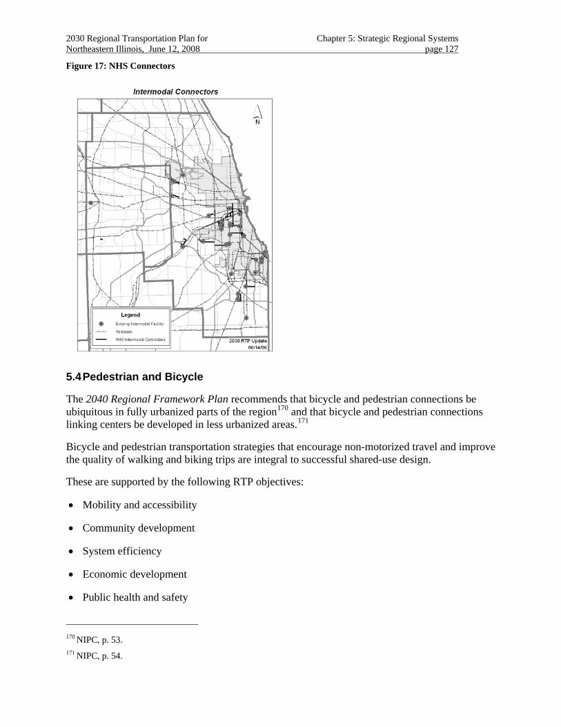
2030 Regional Transportation Plan for Chapter 5: Strategic Regional Systems Northeastern Illinois, June 12, 2008 page 127
Figure 17: NHS Connectors
5.4 Pedestrian and Bicycle
The 2040 Regional Framework Plan recommends that bicycle and pedestrian connections be ubiquitous in fully urbanized parts of the region170 and that bicycle and pedestrian connections linking centers be developed in less urbanized areas.171
Bicycle and pedestrian transportation strategies that encourage non-motorized travel and improve the quality of walking and biking trips are integral to successful shared-use design.
These are supported by the following RTP objectives:
• Mobility and accessibility
• Community development
• System efficiency
• Economic development
• Public health and safety
170 NIPC, p. 53.
171 NIPC, p. 54.
2030 Regional Transportation Plan for Chapter 5: Strategic Regional Systems Northeastern Illinois, June 12, 2008 page 128
The 2030 RTP acknowledges federal guidance to give due consideration to bicycle and pedestrian facilities improvements when improving or constructing transportation facilities.172
Non-motorized travel makes up a significant portion of overall travel demand, both in terms of a singular mode choice and as a means for reaching transit. In addition, non-motorized travel is often the preferred means of travel for children, seniors and persons with disabilities.
The RTP recommends strategic improvements to shared-use facilities that foster “routine accommodation” of pedestrian and bicycle design in all transportation projects and services.173 This includes pursuing improvements that support bicycle and pedestrian access to transit and providing bicycle and pedestrian travel information and promotion as part of larger management and operation strategies applied to the entire transportation system.
The RTP also acknowledges NIPC’s Regional Greenways Plan174 and the comprehensive regional bicycle and pedestrian planning process currently underway, called Soles and Spokes, which includes a regional inventory of county and local pedestrian and bicycle plans and strategies. The RTP anticipates Soles and Spokes’ contribution to regional mobility and accessibility through additional strategic guidance in support of routine accommodation, shared use and dedicated bicycle and pedestrian facilities.
The RTP recommends that project implementers consider a facility’s potential use by bicycle and pedestrian travelers and make appropriate design accommodations using flexibility included in most highway design manuals.
The 2030 RTP acknowledges the FHWA’s designation of Illinois and Chicago as a focus state and city, respectively, for pedestrian safety on account of the large number of pedestrian crashes here. In addition, safety for bicyclists needs to be addressed in the transportation system. Consequently, the RTP recommends strategies for reducing pedestrian and bicycle crashes175. The RTP recommends that pedestrian and bicycle safety be addressed in project design by considering the following during the design of transportation facilities:
• Excessive roadway speeds and capacity should be controlled. Speeds in areas where pedestrian and bicycle travel is common should be maintained at rates safe for non-motorized travel.
• Sidewalks should be provided in developed areas and areas expected to be developed by the highway facility’s design year. Sidewalks should be separated from moving traffic by a buffer consisting of a landscaped parkway or a street furniture area. On-street parking can be used to provide an additional pedestrian safety buffer. In rural areas, a paved shoulder of appropriate width may be used as an alternative to the sidewalk.
172 23 USC 217 (g)
173 Level of service guidance applied during roadway engineering and land development should be employed. Appropriate MUTCD and AASHTO references are available.
174 NIPC, Regional Greenways Plan update, 1997.
175 FHWA, Designing Streets for Pedestrian Safety, CATS Soles and Spokes Workshop, June, 2006.
2030 Regional Transportation Plan for Chapter 5: Strategic Regional Systems Northeastern Illinois, June 12, 2008 page 129
• Landscaped medians with pedestrian crossings should be provided on multi-lane roads. The safety of such crossings can be improved even more with advance stop bars.
• Pedestrian exposure to fast-moving traffic should be reduced by minimizing the crossing distance at intersections. This can be accomplished through minimizing curve radii, providing pedestrian refuge islands between turning and through lanes, providing pedestrian median refuges, and/or curb bump-outs. If a safe intersection crossing cannot be provided, grade-separated or mid-block/median protected crossing treatments should be provided.
• Signals should be timed appropriately for pedestrian and bicycle crossings, and should consider the needs of elderly and disabled pedestrians. Innovations such as pedestrian count-down signals and leading pedestrian intervals should be implemented where appropriate. Protected/permitted left turns should be controlled or prohibited where such turns are presenting a hazard to pedestrian crossings; rather, protected left turn phases are preferred. In addition, well-designed experiments to accommodate pedestrians and traffic flow safely with innovative signals, beacons, and signal timing are encouraged.
• Appropriate illumination of pedestrian crossings for night-time travel is recommended.
• The safety of locations where pedestrian crashes are concentrated (“hot spots”) should be improved so as to reduce crashes and encourage non-motorized travel.
• The locations of safe pedestrian crossings should be marked to attract drivers’ attention and to attract crossing pedestrians.
• Bicycle travel should be accommodated with bicycle facilities. An appropriate bicycle facility type should be provided based on adjacent land use, then highway speed and access controlled appropriate through design for that facility.
The 2030 RTP also acknowledges the requirements of the Americans with Disabilities Act for accessible routes to such facilities as stores, public buildings, parks, schools and transit. The 2030 RTP recommends that all public rights-of-way comply with the Revised Draft Guidelines for Accessible Public Rights-of-Way,176 or subsequent guidance posted by the U.S. Access Board, as feasible.
176 http://www.access-board.gov/prowac/draft.htm
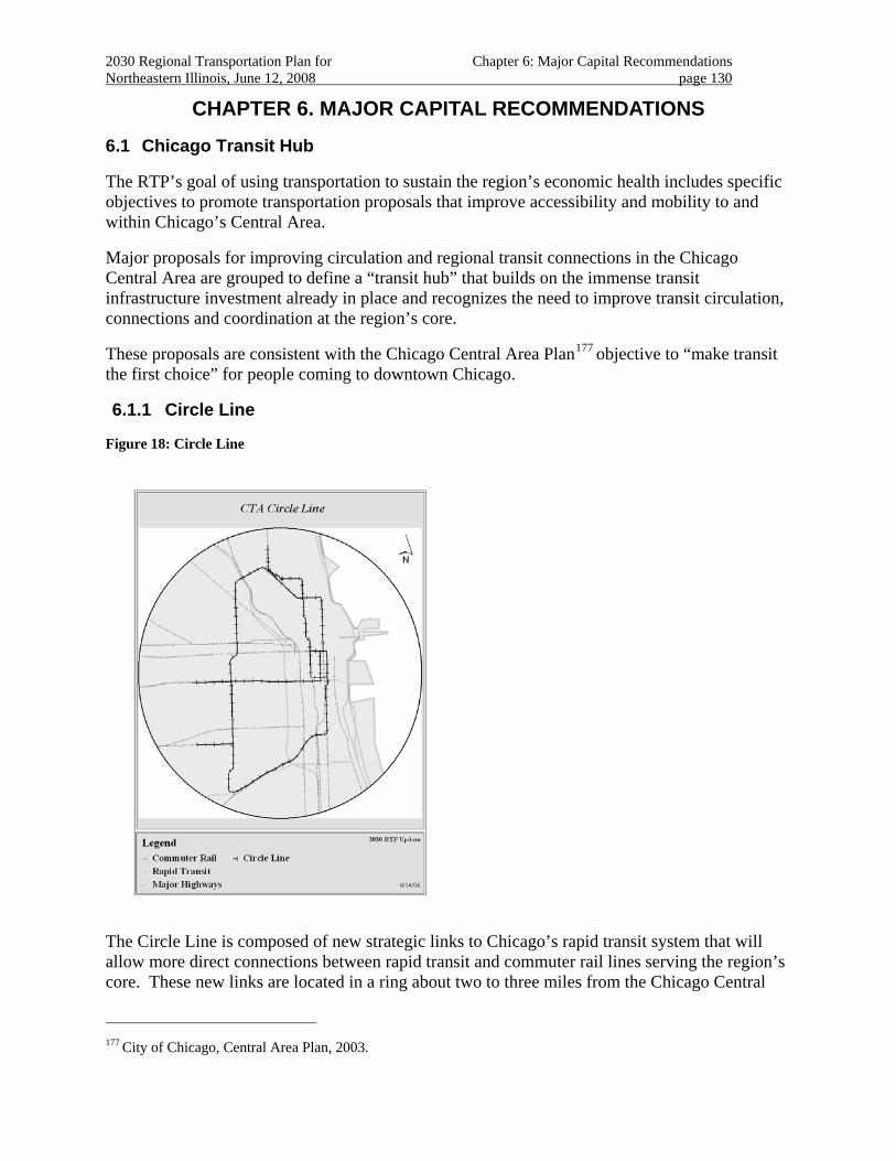
2030 Regional Transportation Plan for Chapter 6: Major Capital Recommendations Northeastern Illinois, June 12, 2008 page 130
CHAPTER 6. MAJOR CAPITAL RECOMMENDATIONS
6.1 Chicago Transit Hub
The RTP’s goal of using transportation to sustain the region’s economic health includes specific objectives to promote transportation proposals that improve accessibility and mobility to and within Chicago’s Central Area.
Major proposals for improving circulation and regional transit connections in the Chicago Central Area are grouped to define a “transit hub” that builds on the immense transit infrastructure investment already in place and recognizes the need to improve transit circulation, connections and coordination at the region’s core.
These proposals are consistent with the Chicago Central Area Plan177 objective to “make transit the first choice” for people coming to downtown Chicago.
6.1.1 Circle Line
Figure 18: Circle Line
The Circle Line is composed of new strategic links to Chicago’s rapid transit system that will allow more direct connections between rapid transit and commuter rail lines serving the region’s core. These new links are located in a ring about two to three miles from the Chicago Central
177 City of Chicago, Central Area Plan, 2003.
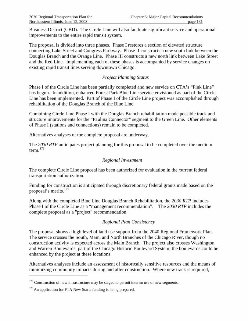
2030 Regional Transportation Plan for Chapter 6: Major Capital Recommendations Northeastern Illinois, June 12, 2008 page 131
Business District (CBD). The Circle Line will also facilitate significant service and operational improvements to the entire rapid transit system.
The proposal is divided into three phases. Phase I restores a section of elevated structure connecting Lake Street and Congress Parkway. Phase II constructs a new south link between the Douglas Branch and the Orange Line. Phase III constructs a new north link between Lake Street and the Red Line. Implementing each of these phases is accompanied by service changes on existing rapid transit lines serving downtown Chicago.
Project Planning Status
Phase I of the Circle Line has been partially completed and new service on CTA’s “Pink Line” has begun. In addition, enhanced Forest Park Blue Line service envisioned as part of the Circle Line has been implemented. Part of Phase I of the Circle Line project was accomplished through rehabilitation of the Douglas Branch of the Blue Line.
Combining Circle Line Phase I with the Douglas Branch rehabilitation made possible track and structure improvements for the “Paulina Connector” segment to the Green Line. Other elements of Phase I (stations and connections) remain to be completed.
Alternatives analyses of the complete proposal are underway.
The 2030 RTP anticipates project planning for this proposal to be completed over the medium term.178
Regional Investment
The complete Circle Line proposal has been authorized for evaluation in the current federal transportation authorization.
Funding for construction is anticipated through discretionary federal grants made based on the proposal’s merits.179
Along with the completed Blue Line Douglas Branch Rehabilitation, the 2030 RTP includes Phase I of the Circle Line as a “management recommendation”. The 2030 RTP includes the complete proposal as a "project" recommendation.
Regional Plan Consistency
The proposal shows a high level of land use support from the 2040 Regional Framework Plan. The service crosses the South, Main, and North Branches of the Chicago River, though no construction activity is expected across the Main Branch. The project also crosses Washington and Warren Boulevards, part of the Chicago Historic Boulevard System; the boulevards could be enhanced by the project at these locations.
Alternatives analyses include an assessment of historically sensitive resources and the means of minimizing community impacts during and after construction. Where new track is required, 178 Construction of new infrastructure may be staged to permit interim use of new segments.
179 An application for FTA New Starts funding is being prepared.
2030 Regional Transportation Plan for Chapter 6: Major Capital Recommendations Northeastern Illinois, June 12, 2008 page 132
subway alignments are under consideration to minimize negative community impacts. Station location should ensure context sensitivity180.
Continued implementation of the Circle Line will improve transit access to employment centers in Chicago's expanded Central Area allowing for new transit-oriented commercial, retail and residential development to be concentrated along existing, but underutilized urban infrastructure. This investment is expected to encourage redevelopment in a mature part of the region. Station and facility design include safe, convenient and comfortable pedestrian access to the proposed transit service.
The 2030 RTP includes strategies for effective management and operation of the transportation system.
When complete, the Circle Line will promote service coordination of the region’s extensive commuter rail and rapid transit system. New linkages will improve security and incident response capabilities by increasing the operating flexibility of the existing rail network. The project will also provide for passenger safety and accessibility, as well as provide enhanced management communications and control of passenger rail operations.
This proposal is included in regional analyses that demonstrate 2030 RTP fiscal constraint and conformity with state air quality plans.
Public Priority
The complete Circle Line proposal has been authorized for evaluation in the current federal transportation authorization.
180 The proposed re-built station at Ashland/Archer and additional station at Chinatown-Wentworth provides an
opportunity to enhance access to the proposed Chicago River South Branch recreational trail.
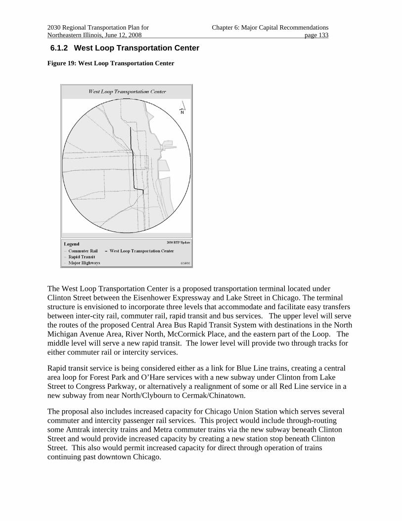
2030 Regional Transportation Plan for Chapter 6: Major Capital Recommendations Northeastern Illinois, June 12, 2008 page 133
6.1.2 West Loop Transportation Center
Figure 19: West Loop Transportation Center
The West Loop Transportation Center is a proposed transportation terminal located under Clinton Street between the Eisenhower Expressway and Lake Street in Chicago. The terminal structure is envisioned to incorporate three levels that accommodate and facilitate easy transfers between inter-city rail, commuter rail, rapid transit and bus services. The upper level will serve the routes of the proposed Central Area Bus Rapid Transit System with destinations in the North Michigan Avenue Area, River North, McCormick Place, and the eastern part of the Loop. The middle level will serve a new rapid transit. The lower level will provide two through tracks for either commuter rail or intercity services.
Rapid transit service is being considered either as a link for Blue Line trains, creating a central area loop for Forest Park and O’Hare services with a new subway under Clinton from Lake Street to Congress Parkway, or alternatively a realignment of some or all Red Line service in a new subway from near North/Clybourn to Cermak/Chinatown.
The proposal also includes increased capacity for Chicago Union Station which serves several commuter and intercity passenger rail services. This project would include through-routing some Amtrak intercity trains and Metra commuter trains via the new subway beneath Clinton Street and would provide increased capacity by creating a new station stop beneath Clinton Street. This also would permit increased capacity for direct through operation of trains continuing past downtown Chicago.
2030 Regional Transportation Plan for Chapter 6: Major Capital Recommendations Northeastern Illinois, June 12, 2008 page 134
Project Planning Status
Negotiations for easements that will accommodate a guideway leading to the lower level of the proposed terminal are underway. The 2030 RTP anticipates project planning for this proposal to be completed over the long term.
Regional Investment
A funding source for construction of this project has not been identified. The 2030 RTP includes this proposal as a "corridor" recommendation.
Regional Plan Consistency
The project shows a high level of land use support from the 2040 Regional Framework Plan. The proposal is also included in Chicago’s Central Area Plan181.
The West Loop Transportation Center responds to growth in the West Loop Area and will provide services needed to maintain the vitality and growth of Chicago’s downtown. The project also addresses the need for improved circulation of passengers from major commuter and intercity rail services in the West Loop to other parts of Chicago’s Central Area.
A main focus of the project is to facilitate access to additional development west of the historic core of Chicago. The project will encourage redevelopment of areas with established infrastructure networks. Development in the corridor, however, is advancing upon right-of-way needed to effectively implement this project.
The 2030 RTP includes strategies that address effective management and operation of the transportation system.
181 City of Chicago, Central Area Plan, 2003.
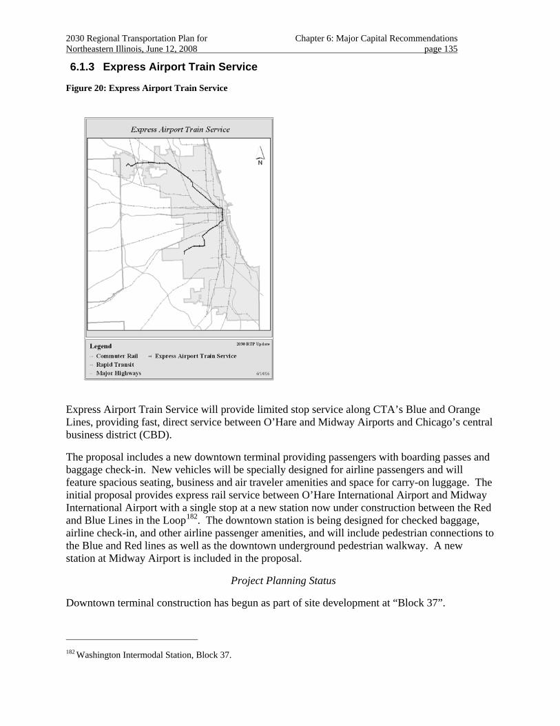
2030 Regional Transportation Plan for Chapter 6: Major Capital Recommendations Northeastern Illinois, June 12, 2008 page 135
6.1.3 Express Airport Train Service
Figure 20: Express Airport Train Service
Express Airport Train Service will provide limited stop service along CTA’s Blue and Orange Lines, providing fast, direct service between O’Hare and Midway Airports and Chicago’s central business district (CBD).
The proposal includes a new downtown terminal providing passengers with boarding passes and baggage check-in. New vehicles will be specially designed for airline passengers and will feature spacious seating, business and air traveler amenities and space for carry-on luggage. The initial proposal provides express rail service between O’Hare International Airport and Midway International Airport with a single stop at a new station now under construction between the Red and Blue Lines in the Loop182. The downtown station is being designed for checked baggage, airline check-in, and other airline passenger amenities, and will include pedestrian connections to the Blue and Red lines as well as the downtown underground pedestrian walkway. A new station at Midway Airport is included in the proposal.
Project Planning Status
Downtown terminal construction has begun as part of site development at “Block 37”.
182 Washington Intermodal Station, Block 37.
2030 Regional Transportation Plan for Chapter 6: Major Capital Recommendations Northeastern Illinois, June 12, 2008 page 136
The remainder of the project is still in the early planning stages. Current activities include preliminary evaluations along the entire route. The alignment is expected to follow existing transit routes. The 2030 RTP anticipates project planning for this proposal to be completed over the medium term.
Regional Investment
It is anticipated that the project’s completion will be accomplished through innovative private sector participation in the design, construction, operation and financing of the project. Funding for construction of this project is expected to derive from a specially prepared financial plan that identifies new revenue sources. The 2030 RTP includes this proposal as a "corridor" recommendation.
Regional Plan Consistency
The project shows a high level of land use support from the 2040 Regional Framework Plan. The service crosses the Des Plaines River, the Chicago River, and some Cook County forest preserves, such as Schiller Woods, but construction activities are not projected at these locations to implement the service.
The proposal’s objective is to provide a reliable transportation connection from downtown to both major airports. Increased traffic makes the expressways less reliable for airport travelers. The proposal uses existing rights-of-way, minimizing acquisition and impacts on existing land uses.
The 2030 RTP includes strategies for effective management and operation of the transportation system.
New tracks will be constructed on the existing CTA Blue and Orange Lines to allow the express trains to bypass local service, thereby reducing travel times. The complete project includes upgrades to track and signal systems along the Blue, Red and Orange Lines improving operations for existing local service as well as the new express service.
The project will enhance multi-modal connectivity of the transit system. Enhanced rapid transit service to the region’s major airports provides competitive travel times when compared to congested highway conditions and may help mitigate ground-access congestion associated with anticipated growth in air travel demand.
The project will enhance rapid transit system management and operation by providing strategic track connections, crossovers, and passing tracks to add flexibility, improve reliability, and enhance speed of service. Expanded service leverages existing yards, maintenance facilities, and track infrastructure.
The project is also expected to incorporate enhanced rail control technologies including centralized traffic control, computer aided dispatching, and improved communications and signaling to be managed from a centralized control facility.
The project may also provide enhanced goods movement. The project is being designed so as not to preclude freight service between both airports via downtown, providing a reliable, non-highway route for time-sensitive air freight parcels.
2030 Regional Transportation Plan for Chapter 6: Major Capital Recommendations Northeastern Illinois, June 12, 2008 page 137
This proposal is included in regional analyses that demonstrate 2030 RTP fiscal constraint and conformity with state air quality plans.
6.2 Improvements to Existing Facilities
The RTP’s goal of maintaining and improving the existing transportation system recognizes the need to promote transportation proposals that improve the performance of existing transportation facilities, preserve the level of service offered by the existing transportation system and provide improved transportation system management.
Changes in travel behavior place new demands on existing facilities that may not have been anticipated. In most cases, regional growth is forecast along existing transportation corridors. Part of this growth can be accommodated by increased multimodal capacity along existing transportation facilities.
In all facility improvements, opportunities to improve facility management and operations should be intensively pursued, particularly through technological advances.
6.2.1 Passenger Rail Upgrades and Extensions
Improving and extending service on the region’s rapid transit and commuter rail system serves travelers throughout the region. The region’s passenger rail transit system has helped define the focus of commercial and employment location in northeastern Illinois. The passenger rail system also provides access to these centers from many stations in the region.
Passenger rail upgrades and extensions support increased accessibility to the region’s centers with the added advantage that, regionwide, residential and commercial growth or redevelopment is encouraged around rail stations. Upgrades and extensions can also be used to enhance operations by providing additional flexibility or eliminating bottlenecks.
Improving and extending the region’s rail transit system is important to ensuring that our investment continues to serve the changing needs of the region’s travelers.
6.2.1.1 Rapid Transit Upgrades and Extensions
Chicago’s rapid transit system has developed over the past century to efficiently serve the transportation needs of the region’s most densely developed communities. Elevated, subway and expressway median heavy rail passenger service provides high accessibility to city neighborhoods, employment centers and airports.
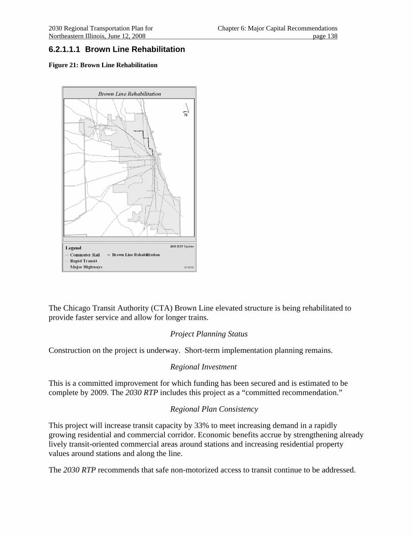
2030 Regional Transportation Plan for Chapter 6: Major Capital Recommendations Northeastern Illinois, June 12, 2008 page 138
6.2.1.1.1 Brown Line Rehabilitation
Figure 21: Brown Line Rehabilitation
The Chicago Transit Authority (CTA) Brown Line elevated structure is being rehabilitated to provide faster service and allow for longer trains.
Project Planning Status
Construction on the project is underway. Short-term implementation planning remains.
Regional Investment
This is a committed improvement for which funding has been secured and is estimated to be complete by 2009. The 2030 RTP includes this project as a “committed recommendation.”
Regional Plan Consistency
This project will increase transit capacity by 33% to meet increasing demand in a rapidly growing residential and commercial corridor. Economic benefits accrue by strengthening already lively transit-oriented commercial areas around stations and increasing residential property values around stations and along the line.
The 2030 RTP recommends that safe non-motorized access to transit continue to be addressed.
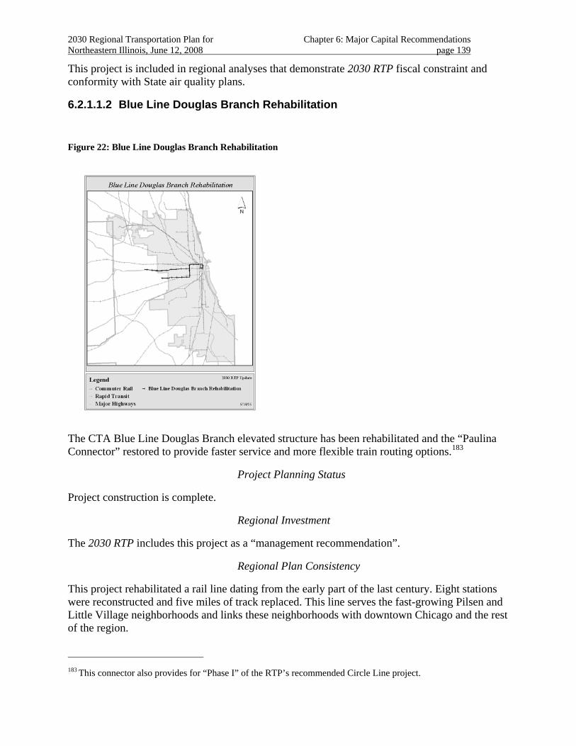
2030 Regional Transportation Plan for Chapter 6: Major Capital Recommendations Northeastern Illinois, June 12, 2008 page 139
This project is included in regional analyses that demonstrate 2030 RTP fiscal constraint and conformity with State air quality plans.
6.2.1.1.2 Blue Line Douglas Branch Rehabilitation
Figure 22: Blue Line Douglas Branch Rehabilitation
The CTA Blue Line Douglas Branch elevated structure has been rehabilitated and the “Paulina Connector” restored to provide faster service and more flexible train routing options.183
Project Planning Status
Project construction is complete.
Regional Investment
The 2030 RTP includes this project as a “management recommendation”.
Regional Plan Consistency
This project rehabilitated a rail line dating from the early part of the last century. Eight stations were reconstructed and five miles of track replaced. This line serves the fast-growing Pilsen and Little Village neighborhoods and links these neighborhoods with downtown Chicago and the rest of the region.
183 This connector also provides for “Phase I” of the RTP’s recommended Circle Line project.
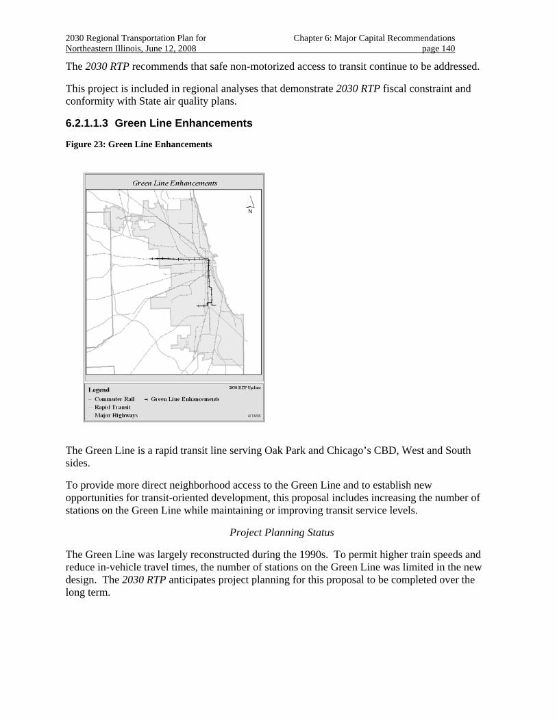
2030 Regional Transportation Plan for Chapter 6: Major Capital Recommendations Northeastern Illinois, June 12, 2008 page 140
The 2030 RTP recommends that safe non-motorized access to transit continue to be addressed.
This project is included in regional analyses that demonstrate 2030 RTP fiscal constraint and conformity with State air quality plans.
6.2.1.1.3 Green Line Enhancements
Figure 23: Green Line Enhancements
The Green Line is a rapid transit line serving Oak Park and Chicago’s CBD, West and South sides.
To provide more direct neighborhood access to the Green Line and to establish new opportunities for transit-oriented development, this proposal includes increasing the number of stations on the Green Line while maintaining or improving transit service levels.
Project Planning Status
The Green Line was largely reconstructed during the 1990s. To permit higher train speeds and reduce in-vehicle travel times, the number of stations on the Green Line was limited in the new design. The 2030 RTP anticipates project planning for this proposal to be completed over the long term.
2030 Regional Transportation Plan for Chapter 6: Major Capital Recommendations Northeastern Illinois, June 12, 2008 page 141
Regional Investment
The 2030 RTP includes this proposal as a “management recommendation”.184
Regional Plan Consistency
The proposal shows a high level of land use support in the 2040 Regional Framework Plan. The project is adjacent to locations on the North and South branches of the Chicago River in the Loop area. The Green Line also crosses several of Chicago’s historic boulevards.
The proposal provides additional transportation choices for community residents and business. Improved accessibility to existing transit services will support economic and community development objectives.
Because the area is redeveloping, rights-of-way for new stations should be identified to preserve needed land and plan for appropriate community interfaces.
Consideration of new station locations should include thorough assessment of both transit service coordination and local land use conditions. The service should support existing and planned adjacent land uses. The service should be coordinated with economic and community development activities to offer efficient transportation service.
The 2030 RTP includes strategies for effectively managing and operating the transportation system.
Community involvement that establishes support for a new station location should include an examination of current service pattern needs. New station locations should be implemented to complement the operating advantages gained by the major investment already in place. The travel time improvements resulting from this capital investment should be preserved by maintaining adequate distance between stations. These improved travel times are key to maintaining and increasing ridership. Maintaining some distance between stations also more clearly defines opportunities for transit-oriented development.
Pedestrian safety and accessible routes to transit should be accommodated in station plans. Service coordination, including connecting bus service and coordination with parallel service should also be addressed.
This proposal should be included in evaluations conducted for other plan recommendations in the southern Chicago and the south suburbs multimodal corridor.
184 This indicates that major construction (having occurred during the 1990s) is substantially complete, and that new
station planning should be consistent with the 2030 RTP strategic guidance.
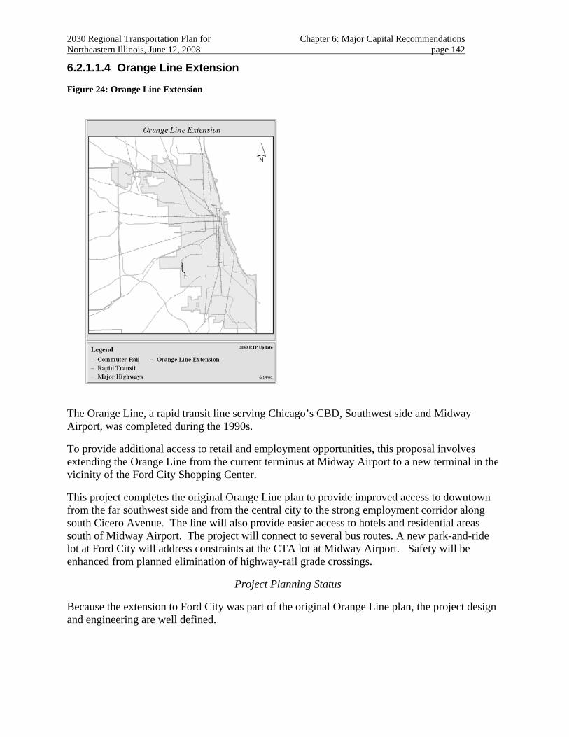
2030 Regional Transportation Plan for Chapter 6: Major Capital Recommendations Northeastern Illinois, June 12, 2008 page 142
6.2.1.1.4 Orange Line Extension
Figure 24: Orange Line Extension
The Orange Line, a rapid transit line serving Chicago’s CBD, Southwest side and Midway Airport, was completed during the 1990s.
To provide additional access to retail and employment opportunities, this proposal involves extending the Orange Line from the current terminus at Midway Airport to a new terminal in the vicinity of the Ford City Shopping Center.
This project completes the original Orange Line plan to provide improved access to downtown from the far southwest side and from the central city to the strong employment corridor along south Cicero Avenue. The line will also provide easier access to hotels and residential areas south of Midway Airport. The project will connect to several bus routes. A new park-and-ride lot at Ford City will address constraints at the CTA lot at Midway Airport. Safety will be enhanced from planned elimination of highway-rail grade crossings.
Project Planning Status
Because the extension to Ford City was part of the original Orange Line plan, the project design and engineering are well defined.
2030 Regional Transportation Plan for Chapter 6: Major Capital Recommendations Northeastern Illinois, June 12, 2008 page 143
Analyses of alternatives are underway. As the project is expected to use the Belt Railway Corridor, several competing right-of-way needs are being addressed as part of the ongoing right-of-way acquisition process.
Complementary transportation improvements (the CREATE Belt Corridor, the Express Airport Transit Service Project) are currently under evaluation.
The 2030 RTP anticipates project planning for this proposal to be completed over the medium term.
Regional Investment
Funds have been programmed for right-of-way acquisition.
Funding for construction is anticipated through discretionary federal grants made based on the proposal’s merits.
The 2030 RTP includes the proposal as a “project recommendation”.
Regional Plan Consistency
The project shows a high level of land use support from the 2040 Regional Framework Plan. The Orange Line Extension will support existing land uses and encourage compact land development. Growth and development in the corridor, however, is advancing upon right-of-way needed for the Orange Line Extension.
The project is being coordinated with ongoing community and transportation development activities, including the airport.
The 2030 RTP includes strategies for effective management and operation of the transportation system.
This proposal is included in regional analyses that demonstrate 2030 RTP fiscal constraint and conformity with state air quality plans.
Public Priority
Evaluation of the proposal has been authorized by the current federal authorization
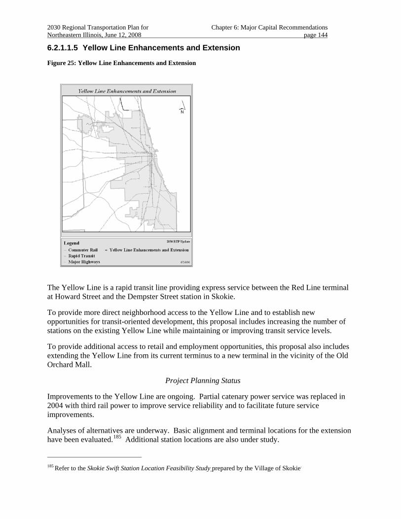
2030 Regional Transportation Plan for Chapter 6: Major Capital Recommendations Northeastern Illinois, June 12, 2008 page 144
6.2.1.1.5 Yellow Line Enhancements and Extension
Figure 25: Yellow Line Enhancements and Extension
The Yellow Line is a rapid transit line providing express service between the Red Line terminal at Howard Street and the Dempster Street station in Skokie.
To provide more direct neighborhood access to the Yellow Line and to establish new opportunities for transit-oriented development, this proposal includes increasing the number of stations on the existing Yellow Line while maintaining or improving transit service levels.
To provide additional access to retail and employment opportunities, this proposal also includes extending the Yellow Line from its current terminus to a new terminal in the vicinity of the Old Orchard Mall.
Project Planning Status
Improvements to the Yellow Line are ongoing. Partial catenary power service was replaced in 2004 with third rail power to improve service reliability and to facilitate future service improvements.
Analyses of alternatives are underway. Basic alignment and terminal locations for the extension have been evaluated.185 Additional station locations are also under study.
185 Refer to the Skokie Swift Station Location Feasibility Study prepared by the Village of Skokie.
2030 Regional Transportation Plan for Chapter 6: Major Capital Recommendations Northeastern Illinois, June 12, 2008 page 145
Adjacent communities are evaluating bicycle access improvements along the former Skokie Valley route north and south of the project; coordination with this improvement is anticipated.
The 2030 RTP anticipates project planning for this proposal to be completed over the medium term.
Regional Investment
The proposal to construct a new station at Oakton is included in the current Transportation Improvement Program (TIP). Funding for pedestrian access for the new station is being sought.
Funding for construction is anticipated through discretionary federal grants made based on the proposal’s merits.
The 2030 RTP includes the proposal as a “project recommendation.”
Regional Plan Consistency
The project shows a high level of land use support from the 2040 Regional Framework Plan. The project terminus is adjacent to Harms Woods, a property of the Forest Preserve District of Cook County.
The Yellow Line enhancement and extension project will provide additional access and mobility for the north suburbs by extending the line to Old Orchard Rd. and adding a new station at Oakton. Other new station locations are being evaluated. Extending the service to Old Orchard Rd. will provide new transit access to a major activity center. 186
The proposed alignment is in an existing railroad/utility corridor, minimizing acquisition and impacts on existing land uses.
By extending the line north to Old Orchard Mall and providing an infill station at Oakton, this project will provide new opportunities for reverse-commute transit travel to retail shopping and jobs. Also, the project will enhance prospects for significant transit-oriented infill development in the Village of Skokie. Connections can be made to several existing bus routes.
The 2030 RTP includes strategies for effective management and operation of the transportation system.
The project is expected to enhance multi-modal connectivity, resulting in increased transit ridership with faster transit travel times and direct access to new markets for traditional and reverse commute trips. Proximity of the terminal location to Niles North High School should be developed as an opportunity for improved transit access for staff and students. Outstanding community concerns regarding local traffic impacts should be resolved.
This proposal is included in regional analyses that demonstrate 2030 RTP fiscal constraint and conformity with state air quality plans.
186 The project is expected to encourage transit oriented development adjacent to the existing Dempster station as
well as the Oakton Station/Downtown Science and Technology Area.
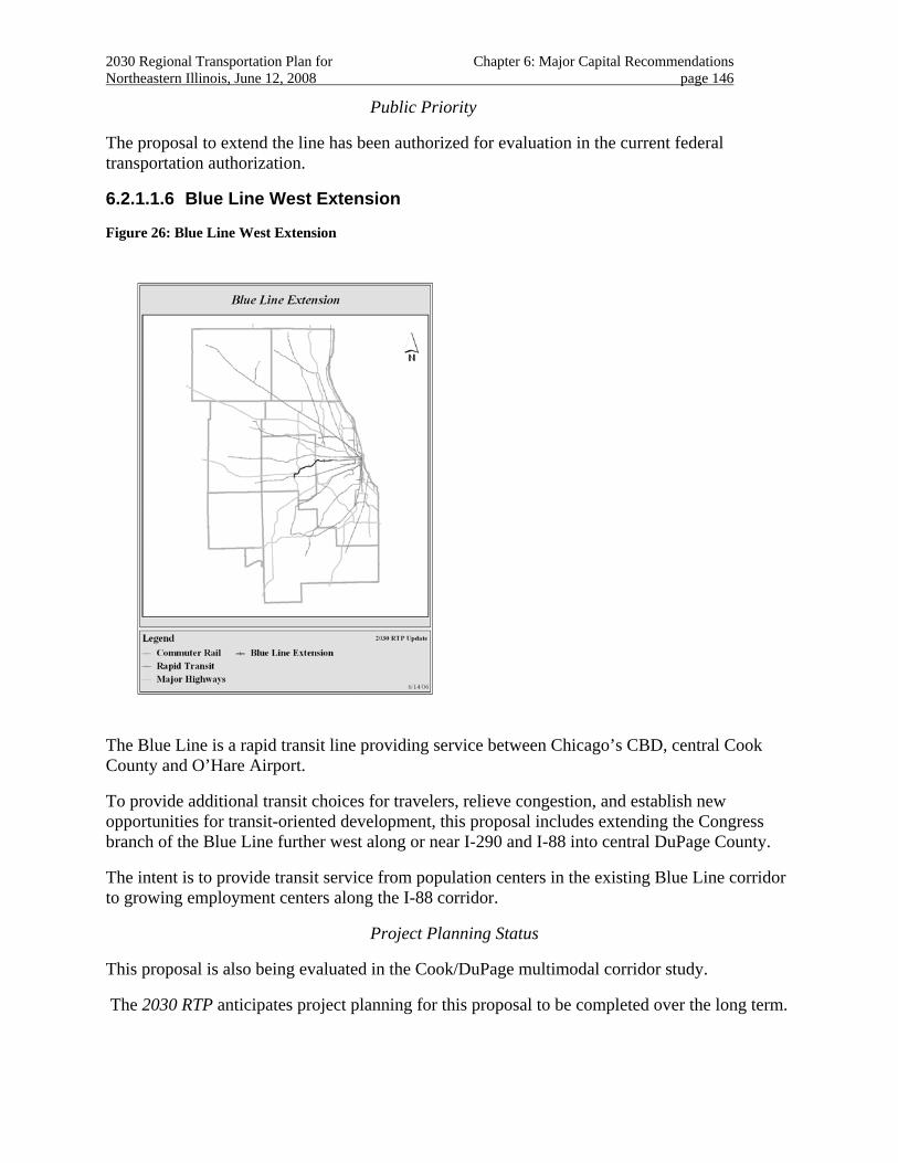
2030 Regional Transportation Plan for Chapter 6: Major Capital Recommendations Northeastern Illinois, June 12, 2008 page 146
Public Priority
The proposal to extend the line has been authorized for evaluation in the current federal transportation authorization.
6.2.1.1.6 Blue Line West Extension
Figure 26: Blue Line West Extension
The Blue Line is a rapid transit line providing service between Chicago’s CBD, central Cook County and O’Hare Airport.
To provide additional transit choices for travelers, relieve congestion, and establish new opportunities for transit-oriented development, this proposal includes extending the Congress branch of the Blue Line further west along or near I-290 and I-88 into central DuPage County.
The intent is to provide transit service from population centers in the existing Blue Line corridor to growing employment centers along the I-88 corridor.
Project Planning Status
This proposal is also being evaluated in the Cook/DuPage multimodal corridor study.
The 2030 RTP anticipates project planning for this proposal to be completed over the long term.
2030 Regional Transportation Plan for Chapter 6: Major Capital Recommendations Northeastern Illinois, June 12, 2008 page 147
Regional Investment
Funds for construction of the project have not been identified.
The 2030 RTP includes the Blue Line West Extension as a “corridor recommendation”.
Regional Plan Consistency
The project shows a high level of land use support from the 2040 Regional Framework Plan. The project crosses the Des Plaines River in Cook County and Salt Creek in DuPage County. The project is adjacent to York Woods and Fullersburg Woods at Salt Creek, properties of the Forest Preserve District of DuPage County. The project may also abut Morton Arboretum in Lisle, which contains communities of threatened and endangered species.
The proposal is anticipated to strengthen existing land use patterns by encouraging redevelopment of areas with established infrastructure. The proposal is to improve transportation choices for a densely developed sector of the region. The project will provide additional transit options in a congested highway corridor. In addition to improved connectivity to the Chicago Central Area, the service would provide reverse, suburb to suburb and non-work rapid transit options to the western suburbs.
Because the area is redeveloping, right-of-way needs for new stations should be identified to preserve needed land and plan for appropriate community interfaces.
The 2030 RTP provides guidance for effective management and operation of the region’s transportation system.
Planning for this service should be coordinated with the RTP’s recommendations for the I-290 and I-88 corridors in western Cook and DuPage Counties. Right-of-way needs for multiple transportation improvements will require elaborate coordination.
While the proposal extends as far as Lisle187, an initial strategic extension to Oak Brook may take advantage of existing development patterns. The remainder of the corridor should be accompanied by aggressive transit-oriented development.
In addition, the extension overlaps a portion of the DuPage “J-Line” proposal and the I-290 HOV proposal. Preferred modal staging and logical termini should be resolved during further corridor evaluations. In this evaluation it should be considered that the "J-Line" and other bus transit and high-occupancy vehicle proposals could establish or demonstrate a market sufficient to justify a heavy or light rail investment along this route in the future. Additional connectivity would be provided via the DuPage “J” Line and Cermak BRT services.
Additional features of the project consistent with strategic guidance (non-motorized access, ITS, access for people with disabilities, safety, service integration) and other management and operations strategies should be evaluated.
For rapid transit service to be viable over large distances within a suburban context, consideration should be given to accommodating express service along the line188.
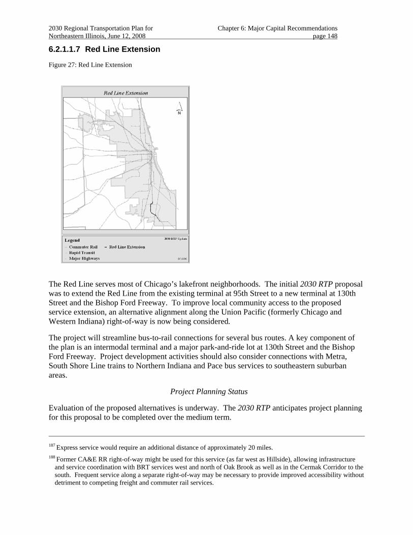
2030 Regional Transportation Plan for Chapter 6: Major Capital Recommendations Northeastern Illinois, June 12, 2008 page 148
6.2.1.1.7 Red Line Extension
Figure 27: Red Line Extension
The Red Line serves most of Chicago’s lakefront neighborhoods. The initial 2030 RTP proposal was to extend the Red Line from the existing terminal at 95th Street to a new terminal at 130th Street and the Bishop Ford Freeway. To improve local community access to the proposed service extension, an alternative alignment along the Union Pacific (formerly Chicago and Western Indiana) right-of-way is now being considered.
The project will streamline bus-to-rail connections for several bus routes. A key component of the plan is an intermodal terminal and a major park-and-ride lot at 130th Street and the Bishop Ford Freeway. Project development activities should also consider connections with Metra, South Shore Line trains to Northern Indiana and Pace bus services to southeastern suburban areas.
Project Planning Status
Evaluation of the proposed alternatives is underway. The 2030 RTP anticipates project planning for this proposal to be completed over the medium term.
187 Express service would require an additional distance of approximately 20 miles.
188 Former CA&E RR right-of-way might be used for this service (as far west as Hillside), allowing infrastructure and service coordination with BRT services west and north of Oak Brook as well as in the Cermak Corridor to the south. Frequent service along a separate right-of-way may be necessary to provide improved accessibility without detriment to competing freight and commuter rail services.
2030 Regional Transportation Plan for Chapter 6: Major Capital Recommendations Northeastern Illinois, June 12, 2008 page 149
Regional Investment
Funding for construction is anticipated through discretionary federal grants made based on the proposal’s merits.
The 2030 RTP includes the Red Line Extension as a “project recommendation”.
Regional Plan Consistency
The project shows a high level of land use support from the 2040 Regional Framework Plan. Environmental effects are expected to vary by alignment.
The extension is proposed to increase accessibility for residents of Chicago's Far South side and Southern suburbs. It is also expected to relieve congestion, reduce travel time and improve access to jobs for lower-income residents. The proposal should also promote economic development on Chicago's south side and in suburban areas.
The project will provide direct access to CTA rail transit for commute and other trip needs, linking economically disadvantaged communities to jobs in Chicago’s Central Area and the Lake Calumet industrial area. The project will be a catalyst for the growth of employment in the far south of Chicago and nearby suburbs and, by providing an attractive alternative to auto travel, is expected to help manage congestion on the Bishop Ford and Dan Ryan Expressways.
The 2030 RTP includes strategies for effective management and operation of the transportation system.
The service improvement will be complemented by the rehabilitation of the Red Line from Cermak/Chinatown to 95th St., now under construction.
The project will enhance multi-modal connectivity and is expected to result in increased transit ridership.
Provisions for improvements to bicycle and pedestrian access are being planned, especially as a gateway for the Lake Calumet area.
This proposal should be included in evaluations conducted for other plan recommendations in the Southern Chicago and the South Suburbs multimodal corridor.
This proposal is included in regional analyses that demonstrate 2030 RTP fiscal constraint and conformity with state air quality plans.
Public Priority
The Red Line extension project has been authorized for evaluation in the current federal authorization.
Public outreach has revealed strong local support for the proposed alignment that directly serves existing neighborhoods.
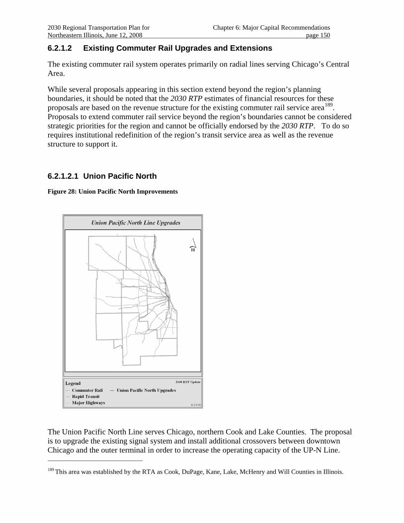
2030 Regional Transportation Plan for Chapter 6: Major Capital Recommendations Northeastern Illinois, June 12, 2008 page 150
6.2.1.2 Existing Commuter Rail Upgrades and Extensions
The existing commuter rail system operates primarily on radial lines serving Chicago’s Central Area.
While several proposals appearing in this section extend beyond the region’s planning boundaries, it should be noted that the 2030 RTP estimates of financial resources for these proposals are based on the revenue structure for the existing commuter rail service area189. Proposals to extend commuter rail service beyond the region’s boundaries cannot be considered strategic priorities for the region and cannot be officially endorsed by the 2030 RTP. To do so requires institutional redefinition of the region’s transit service area as well as the revenue structure to support it.
6.2.1.2.1 Union Pacific North
Figure 28: Union Pacific North Improvements
The Union Pacific North Line serves Chicago, northern Cook and Lake Counties. The proposal is to upgrade the existing signal system and install additional crossovers between downtown Chicago and the outer terminal in order to increase the operating capacity of the UP-N Line. 189 This area was established by the RTA as Cook, DuPage, Kane, Lake, McHenry and Will Counties in Illinois.
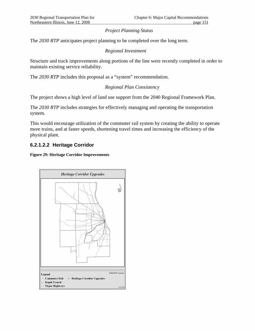
2030 Regional Transportation Plan for Chapter 6: Major Capital Recommendations Northeastern Illinois, June 12, 2008 page 151
Project Planning Status
The 2030 RTP anticipates project planning to be completed over the long term.
Regional Investment
Structure and track improvements along portions of the line were recently completed in order to maintain existing service reliability.
The 2030 RTP includes this proposal as a “system” recommendation.
Regional Plan Consistency
The project shows a high level of land use support from the 2040 Regional Framework Plan.
The 2030 RTP includes strategies for effectively managing and operating the transportation system.
This would encourage utilization of the commuter rail system by creating the ability to operate more trains, and at faster speeds, shortening travel times and increasing the efficiency of the physical plant.
6.2.1.2.2 Heritage Corridor
Figure 29: Heritage Corridor Improvements
2030 Regional Transportation Plan for Chapter 6: Major Capital Recommendations Northeastern Illinois, June 12, 2008 page 152
The Heritage Corridor is a 38-mile commuter rail line serving communities in southwest Cook and northwest Will County. The Heritage Corridor project will provide full-service commuter rail operations on the Heritage corridor to serve Chicago, Summit, Justice, Willow Springs, Lemont, Lockport, Romeoville, and Joliet. The line, which also serves interregional passenger rail and a busy freight service, currently has limited service.
The proposal is to upgrade infrastructure and service levels and to add stations. Expanded service will include improved peak and off-peak service frequencies as well as weekend service. The improvements are also expected to reduce passenger delays by resolving freight conflicts and expanding service to additional stations.
Project Planning Status
The 2030 RTP anticipates project planning for this proposal to be completed over the long term.
Regional Investment
No funds have been identified for this or associated interregional high-speed rail proposals. Improvements to this corridor associated with the CREATE190 program are not fully funded.
The 2030 RTP includes this proposal as a “corridor recommendation”.191
Regional Plan Consistency
The project shows a high level of land use support from the 2040 Regional Framework Plan. The project will result in expanded access to transit service that is expected to increase transit ridership.
The 2030 RTP includes strategies for effective management and operation of the transportation system.
Service coordination between all 2030 RTP proposals in this corridor should be resolved. In addition, an interregional high-speed rail corridor serving Chicago has been proposed for this corridor. The CREATE Project also recommends freight improvements along this line.
190 http://www.createprogram.org/
191 Corridor recommendation, rather than System recommendation, because long term priorities for the facility have not been resolved.

2030 Regional Transportation Plan for Chapter 6: Major Capital Recommendations Northeastern Illinois, June 12, 2008 page 153
6.2.1.2.3 Rock Island
Figure 30: Rock Island Improvements and Extension
The Rock Island District (RID) Line currently operates between LaSalle Street Station in downtown Chicago and Joliet Union Station. The initial proposal is to upgrade infrastructure and service levels. An extension to Minooka is also proposed to provide transit access to jobs.
The upgrade proposal includes adding a third track to the nine-mile double-track portion (between Gresham Junction and a point north of 16th Street Junction) of the Rock Island District (RID) Line, north from Gresham, where the Beverly Branch trains connect with the RID Main Line. The additional track will accommodate future expansion of RID service, the proposed SouthEast Service and the eventual connection of the SouthWest Service with LaSalle Street Station.
The project will also include related bi-directional signals and centralized traffic control to integrate with existing RID operations, plus several new or rehabbed bridges over city streets. Ancillary benefits include freeing up capacity at Chicago Union Station.
Another significant Rock Island District upgrade proposal includes the 47th Street Yard improvements that will expand and modernize the operations facilities between 47th and 51st Streets that serve as storage and maintenance facilities for all trains using the line. This yard expansion also offers the potential to implement express or limited-stop service.
2030 Regional Transportation Plan for Chapter 6: Major Capital Recommendations Northeastern Illinois, June 12, 2008 page 154
The proposed extensions include several options to provide passenger rail service west of Joliet. Due to the significant residential growth in Will, Kendall, and Grundy Counties, the 2030 RTP initially recommends an extension of the Rock Island District Line from Joliet to Minooka.
The proposed routing would travel west from Joliet along the former Rock Island (now CSX) tracks to near the intersection with the Elgin Joliet and Eastern (EJ&E) tracks in Minooka on the border of Will, Kendall, and Grundy Counties. The initial proposed extension would stretch 10 miles beyond the current terminus. It would bring commuter rail service to the communities of Rockdale, Channahon, and Minooka, as well as southwestern Joliet and other surrounding communities.
An additional proposal extends passenger service beyond the metropolitan region as far as Peru, Illinois192.
Project Planning Status
Construction of some improvements to the existing Rock Island District infrastructure is underway. While some of the upgrades will likely be completed in the short term, the 2030 RTP anticipates project planning for this proposal to be completed over the long term.
Regional Investment
Several of the RID upgrade projects are currently programmed for construction in the TIP. Completion of the RID Triple Track and 47th Street Yard Expansion project and other elements of the upgrade project is presently contingent on additional funding for the CREATE program.
Funding for an evaluation of the proposal to extend service beyond the metropolitan region is included in the current federal authorization.
Funding for construction of the extension proposals has not been identified.
The 2030 RTP includes Rock Island District improvements east of Joliet as “system recommendations”; the proposed extensions are included as a “corridor recommendation”.
Regional Plan Consistency
The project shows a high level of land use support from the 2040 Regional Framework Plan.
The existing Rock Island District service is near protected natural areas and streams, including Hickory Creek in Will County, and Tinley Creek, Calumet Woods and the Calumet Sag Channel. The proposed improvements do not occur directly in these areas.
The proposed extension is located in lower Des Plaines River Watershed and DuPage River Watershed, both classified as very high priority for protection and restoration.193 The project
192 The Illinois Valley Passenger Rail project was authorized for evaluation by SAFETEA-LU.
193 Major watershed boundaries are from the United States Geological Survey, with watershed classifications from the Biodiversity Recovery Plan, 1999. The priority watersheds are classified as very high priority for protection and/or restoration; high priority for protection and/or restoration; rehabilitation; or enhancement. For the purposes of this summary, watersheds were noted only if they fell into the high or very high priority categories.
2030 Regional Transportation Plan for Chapter 6: Major Capital Recommendations Northeastern Illinois, June 12, 2008 page 155
crosses the Des Plaines and DuPage Rivers, which are designated “C” quality streams with opportunities for restoration to a higher quality stream,194 and is near concentrations of wooded and agricultural lands in southwest Will County.
The upgrade project supports existing land uses and compact development. An additional station at 35th Street will encourage transit use to destinations in a redeveloping area of Chicago. Improved community interfaces and equitable service to low-income and minority communities are included in the proposal.
The 2030 RTP includes strategies for effective management and operation of the transportation system.
In addition, the RID upgrades support other 2030 RTP major capital recommendations.
Safety is addressed by raising structures to increase clearance. Community interfaces are addressed by new crossing signals. Currently programmed improvements include pedestrian safety and retaining wall rehabilitation.
In addition, coordination with other transit and freight improvements is integral to the project. A grade separation being planned in coordination with the CREATE program over the Norfolk Southern railway at Englewood (63rd Street) is particularly important.
194 Stream Classifications are from the Biological Stream Characterization developed by the Illinois Department of
Natural Resources and the Illinois Environmental Protection Agency. The streams included in this project are those streams that have the richest concentrations of biodiversity: A, B, and C quality streams. “A” quality streams are identified as Unique Aquatic Resources and “B” quality streams are identified as Highly Valued Aquatic Resources. These two classifications are for streams with the richest concentrations of biodiversity. “C” quality streams are identified as Moderate Aquatic Resources, which are more degraded streams that have opportunities for restoration to higher quality.
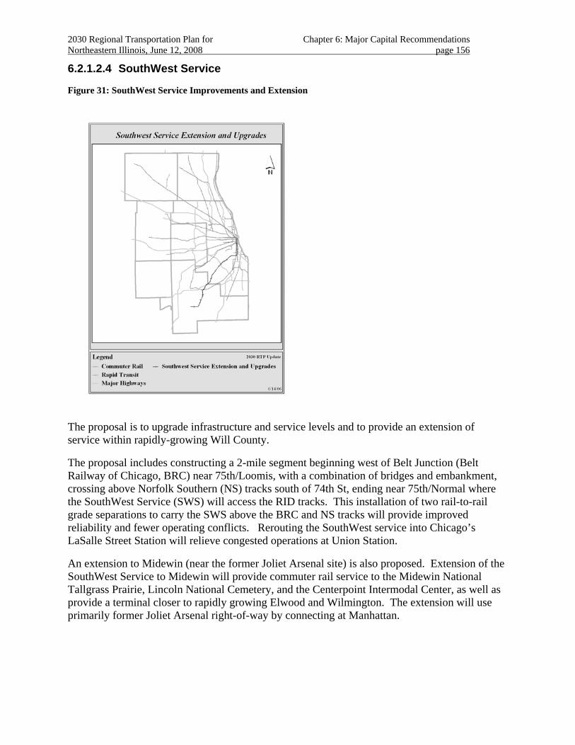
2030 Regional Transportation Plan for Chapter 6: Major Capital Recommendations Northeastern Illinois, June 12, 2008 page 156
6.2.1.2.4 SouthWest Service
Figure 31: SouthWest Service Improvements and Extension
The proposal is to upgrade infrastructure and service levels and to provide an extension of service within rapidly-growing Will County.
The proposal includes constructing a 2-mile segment beginning west of Belt Junction (Belt Railway of Chicago, BRC) near 75th/Loomis, with a combination of bridges and embankment, crossing above Norfolk Southern (NS) tracks south of 74th St, ending near 75th/Normal where the SouthWest Service (SWS) will access the RID tracks. This installation of two rail-to-rail grade separations to carry the SWS above the BRC and NS tracks will provide improved reliability and fewer operating conflicts. Rerouting the SouthWest service into Chicago’s LaSalle Street Station will relieve congested operations at Union Station.
An extension to Midewin (near the former Joliet Arsenal site) is also proposed. Extension of the SouthWest Service to Midewin will provide commuter rail service to the Midewin National Tallgrass Prairie, Lincoln National Cemetery, and the Centerpoint Intermodal Center, as well as provide a terminal closer to rapidly growing Elwood and Wilmington. The extension will use primarily former Joliet Arsenal right-of-way by connecting at Manhattan.
2030 Regional Transportation Plan for Chapter 6: Major Capital Recommendations Northeastern Illinois, June 12, 2008 page 157
Project Planning Status
The SouthWest Service extension to Manhattan opened for service in January, 2006. New stations in Palos Heights, New Lenox and Manhattan are also in service. Other station reconstruction and parking projects associated with the improved service are proceeding to completion.
The 2030 RTP anticipates project planning for upgrades related to the CREATE Program’s Passenger Corridor to be completed in the short term. Further planning, particularly for extension proposals, will be completed over the long term.
Investment category
Further progress toward completing the proposed upgrades to existing service is contingent on funding through the CREATE program. Funds for construction of the extension have not been identified.
The 2030 RTP includes the recently completed Manhattan extension service as a “management” recommendation; the remainder of the proposed upgrade as a “system recommendation”; and extension of the line to Midewin as a “corridor” recommendation.
Regional Plan consistency
The project shows a high level of land use support from the 2040 Regional Framework Plan. The proposed extension to Midewin is within the north border of Midewin National Tall Grass Prairie in southwest Will County and crosses the Prairie Creek System in central Will County. The proposed extension is within the Lower Des Plaines River Watershed, classified as high priority for protection and/or restoration. The project would also affect agricultural land in central Will County. Evaluating of the proposal to extend the service to Midewin will need to be especially sensitive to concerns regarding the environmental and safety implications of its proximity to a nature preserve.
The upgrade proposal encourages redevelopment in established urban areas and supports the functions of adjacent land uses.195 The new service also provides for additional transportation choices in areas with little or no rail service.
Particularly for the corridor surrounding the newly opened service, community development practices should continue to foster transit oriented development.
The 2030 RTP includes strategies for effective management and operation of the transportation system.
New rail-to-rail grade separations will improve operations and eliminate delays caused by freight interference. The new routing will also allow SWS trains to terminate at the less congested LaSalle Street Station in downtown Chicago. Full service includes rerouting increasing train frequency and providing additional parking.
195 An example of these can be seen in Orland Park’s plans to provide a transit-oriented development near the
Orland Park 143rd Street Station.
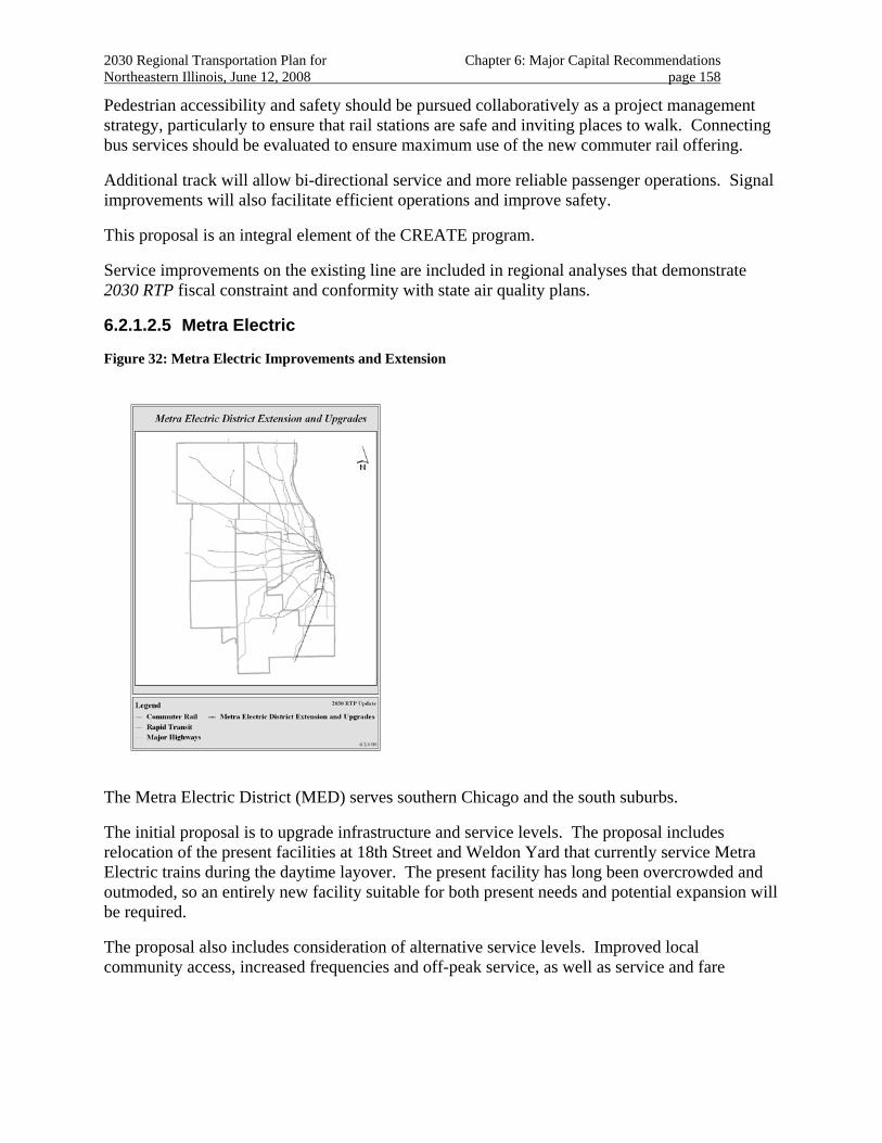
2030 Regional Transportation Plan for Chapter 6: Major Capital Recommendations Northeastern Illinois, June 12, 2008 page 158
Pedestrian accessibility and safety should be pursued collaboratively as a project management strategy, particularly to ensure that rail stations are safe and inviting places to walk. Connecting bus services should be evaluated to ensure maximum use of the new commuter rail offering.
Additional track will allow bi-directional service and more reliable passenger operations. Signal improvements will also facilitate efficient operations and improve safety.
This proposal is an integral element of the CREATE program.
Service improvements on the existing line are included in regional analyses that demonstrate 2030 RTP fiscal constraint and conformity with state air quality plans.
6.2.1.2.5 Metra Electric
Figure 32: Metra Electric Improvements and Extension
The Metra Electric District (MED) serves southern Chicago and the south suburbs.
The initial proposal is to upgrade infrastructure and service levels. The proposal includes relocation of the present facilities at 18th Street and Weldon Yard that currently service Metra Electric trains during the daytime layover. The present facility has long been overcrowded and outmoded, so an entirely new facility suitable for both present needs and potential expansion will be required.
The proposal also includes consideration of alternative service levels. Improved local community access, increased frequencies and off-peak service, as well as service and fare
2030 Regional Transportation Plan for Chapter 6: Major Capital Recommendations Northeastern Illinois, June 12, 2008 page 159
coordination with other transit services are expected to increase demand and better serve local needs.196
An 8-mile extension of the Metra Electric District line between University Park and the proposed South Suburban Airport is also recommended. This improvement is expected to provide transit access to jobs at and near the airport, plus express passenger transport to and from downtown Chicago and intermediate locations. An extension to Kankakee is also proposed.197
Project Planning Status
The 2030 RTP Update anticipates infrastructure upgrade projects to be completed in the short-term through regular capital programming activities.198
An evaluation of service and facility alternatives for potential commuter rail service to the proposed South Suburban Airport (SSA) has been completed.199 The study evaluated several service alternatives. Further detailed evaluation and selection of a preferred alternative will likely occur as part of further airport development plans.200
Inter-regional rail service to Kankakee has been proposed for this line and is under study by Will and Kankakee Counties.
The 2030 RTP anticipates that planning for completion of the extension project will be depend on the development schedule for the South Suburban Airport. Planning for substantial investment will occur in the long term.
Regional Investment
Funds for construction of the upgrades or extensions have not been identified.
Funds to conduct an evaluation of a proposed extension to the SSA are included in the current federal transportation authorization.
An extension of existing service into Kankakee County will necessitate development of new financial and institutional mechanisms.
The 2030 RTP includes the proposed upgrades as “system recommendations”
196 Examples are elaborated in the “Gray Line Proposal” submitted during Shared Path 2030 public outreach.
197 An evaluation of this proposal is being undertaken by Will and Kankakee Counties.
198 For example, station and viaduct improvements are being developed and additional major station improvements have recently been completed or are underway at South Shore, South Chicago, and in Hyde Park.
199 The extension would use CN Railroad right-of-way, joining the existing MED at University Park with stations in Monee and the SSA terminal. The service would run between the new airport and downtown Chicago at the Van Buren Street or Millennium Stations. Continued study should be consistent with strategic guidance; interim solutions, including bus shuttle services, should be explored to demonstrate demand. In addition, SSA development should be flexible enough to accommodate either stub or through transit service at the terminal.
200 Several variations exist for proposals to extend service to the proposed South Suburban Airport (SSA) and beyond including an extension of current service, shuttle service using new technologies, and incorporation of interstate high-speed rail.
2030 Regional Transportation Plan for Chapter 6: Major Capital Recommendations Northeastern Illinois, June 12, 2008 page 160
The 2030 RTP Update includes the extension proposal as a “corridor recommendation”.
Regional Plan Consistency
The project shows a high level of land use support from the 2040 Regional Framework Plan. Extending this line has moderate natural resource impact potential due to its location in agricultural areas in south Cook and northeast Will counties.
Increased accessibility of this line from downtown Chicago to South Chicago and Blue Island is expected to reduce traffic congestion as well as promote local neighborhood economic development.
The upgrade proposal supports existing land uses and compact development and improves mobility and accessibility for low-income and minority communities.
Providing transportation choices for future airport employees and patrons will be key to the proposed extension’s success. The proposed extension will provide needed transit access to jobs at and near the proposed new airport, and passenger transport to/from the Chicago central area and intermediate locations.
The 2030 RTP includes strategies for effective management and operation of the transportation system. The infrastructure upgrade project will provide the necessary shops to properly maintain rolling stock.
Coordination with other transit improvements is integral to the project. 201 This proposal should be included in evaluations conducted for other plan recommendations in the southern Chicago and the south suburbs multimodal corridor.
201 Further planning hinges on a decision regarding high-speed intercity rail service between St. Louis and Chicago high-speed-
rail route serving the SSA. This corridor also currently serves Amtrak and freight service south to Kankakee and beyond.
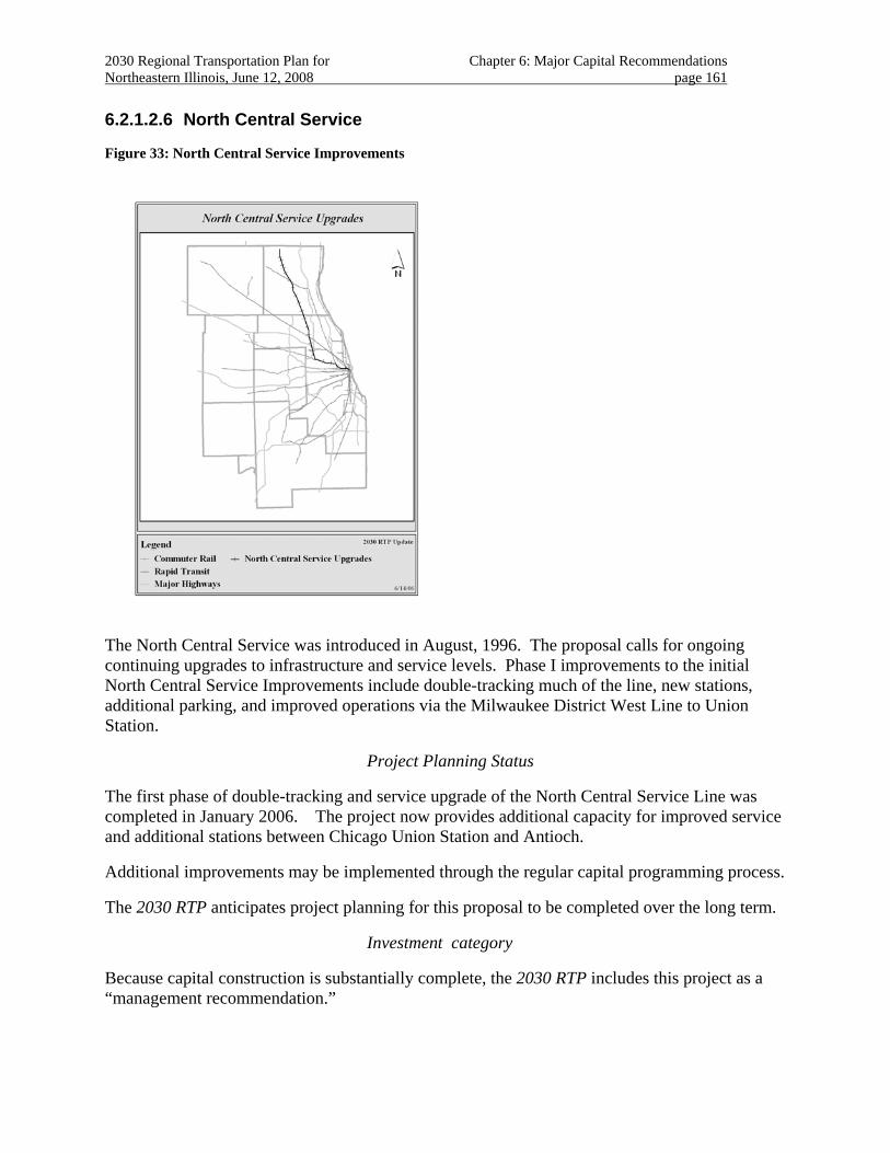
2030 Regional Transportation Plan for Chapter 6: Major Capital Recommendations Northeastern Illinois, June 12, 2008 page 161
6.2.1.2.6 North Central Service
Figure 33: North Central Service Improvements
The North Central Service was introduced in August, 1996. The proposal calls for ongoing continuing upgrades to infrastructure and service levels. Phase I improvements to the initial North Central Service Improvements include double-tracking much of the line, new stations, additional parking, and improved operations via the Milwaukee District West Line to Union Station.
Project Planning Status
The first phase of double-tracking and service upgrade of the North Central Service Line was completed in January 2006. The project now provides additional capacity for improved service and additional stations between Chicago Union Station and Antioch.
Additional improvements may be implemented through the regular capital programming process.
The 2030 RTP anticipates project planning for this proposal to be completed over the long term.
Investment category
Because capital construction is substantially complete, the 2030 RTP includes this project as a “management recommendation.”
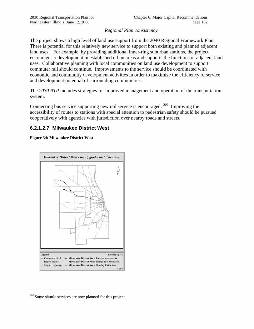
2030 Regional Transportation Plan for Chapter 6: Major Capital Recommendations Northeastern Illinois, June 12, 2008 page 162
Regional Plan consistency
The project shows a high level of land use support from the 2040 Regional Framework Plan. There is potential for this relatively new service to support both existing and planned adjacent land uses. For example, by providing additional inner-ring suburban stations, the project encourages redevelopment in established urban areas and supports the functions of adjacent land uses. Collaborative planning with local communities on land use development to support commuter rail should continue. Improvements to the service should be coordinated with economic and community development activities in order to maximize the efficiency of service and development potential of surrounding communities.
The 2030 RTP includes strategies for improved management and operation of the transportation system.
Connecting bus service supporting new rail service is encouraged. 202 Improving the accessibility of routes to stations with special attention to pedestrian safety should be pursued cooperatively with agencies with jurisdiction over nearby roads and streets.
6.2.1.2.7 Milwaukee District West
Figure 34: Milwaukee District West
202 Some shuttle services are now planned for this project.
2030 Regional Transportation Plan for Chapter 6: Major Capital Recommendations Northeastern Illinois, June 12, 2008 page 163
The Milwaukee District-West line currently provides service between Elgin (Big Timber Road) and downtown Chicago. The initial proposal includes a new 11-mile extension to the Milwaukee District-West Line between Elgin in Kane County and rapidly growing Huntley in McHenry County with a corridor continuing to Marengo and Rockford. An extension to Hampshire in Kane County along a different route is also proposed.
The extension to Huntley is proposed to connect at Almora and use right-of-way of the parallel Union Pacific Belvidere Subdivision tracks.203 The extension to Hampshire would use the IC&E right-of-way by connecting at Elgin/Big Timber 204. Extending this service as far as Rockford has also been proposed.205
Project Planning Status
A Phase I Feasibility Study (to Huntley or Marengo) is underway.
The 2030 RTP anticipates project planning for this proposal to be completed over the long term.
Investment Category
The extensions206 have been authorized for evaluation in the current federal authorization.
Funding for construction has not been identified for any of the proposed extensions. An extension of existing service to Rockford will necessitate development of new financial and institutional mechanisms.
The 2030 RTP includes the Milwaukee District West extensions as “corridor recommendations”.
Regional Plan Consistency
The project shows a high level of land use support from the 2040 Regional Framework Plan.
The project is located within agricultural areas in southwest McHenry County and northern Kane County. The project also passes within the Kishwaukee Creek Watershed, classified as very high priority for protection and/or restoration. The project crosses the north branch of Kishwaukee Creek, an “A” quality stream identified as a unique aquatic resource.
In recent years, significant residential growth has been occurring in this area. Forecasts indicate that this trend will continue.
203 This former Chicago and North Western Railway line was the first railroad in the region (chartered in 1836),
reaching Elgin in 1850 and Belvidere in 1852. The existing single-track lightly utilized freight line turns northwest at this point.
204 Formerly the IMRL, CP.
205 An evaluation of this proposal is being undertaken by the Rockford Area Transportation Study, the Metropolitan Planning Organization for the Rockford area.
206 Extensions specifically include the Rockford proposal.
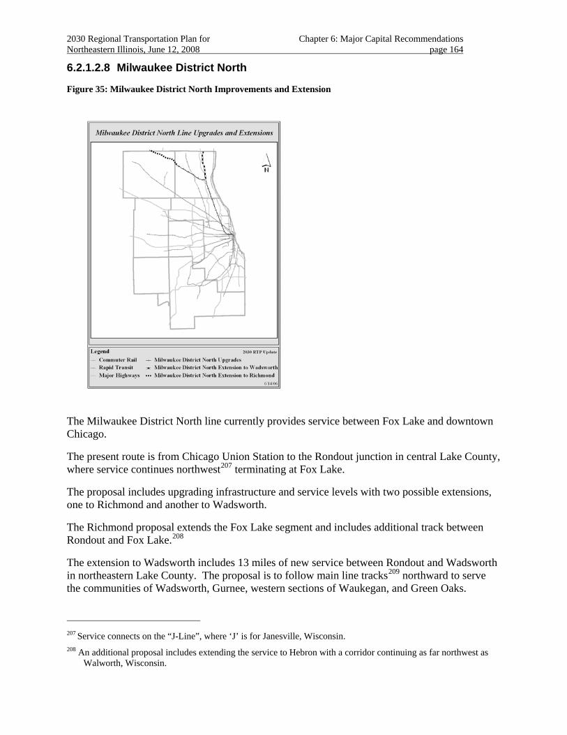
2030 Regional Transportation Plan for Chapter 6: Major Capital Recommendations Northeastern Illinois, June 12, 2008 page 164
6.2.1.2.8 Milwaukee District North
Figure 35: Milwaukee District North Improvements and Extension
The Milwaukee District North line currently provides service between Fox Lake and downtown Chicago.
The present route is from Chicago Union Station to the Rondout junction in central Lake County, where service continues northwest207 terminating at Fox Lake.
The proposal includes upgrading infrastructure and service levels with two possible extensions, one to Richmond and another to Wadsworth.
The Richmond proposal extends the Fox Lake segment and includes additional track between Rondout and Fox Lake.208
The extension to Wadsworth includes 13 miles of new service between Rondout and Wadsworth in northeastern Lake County. The proposal is to follow main line tracks209 northward to serve the communities of Wadsworth, Gurnee, western sections of Waukegan, and Green Oaks.
207 Service connects on the “J-Line”, where ‘J’ is for Janesville, Wisconsin.
208 An additional proposal includes extending the service to Hebron with a corridor continuing as far northwest as Walworth, Wisconsin.
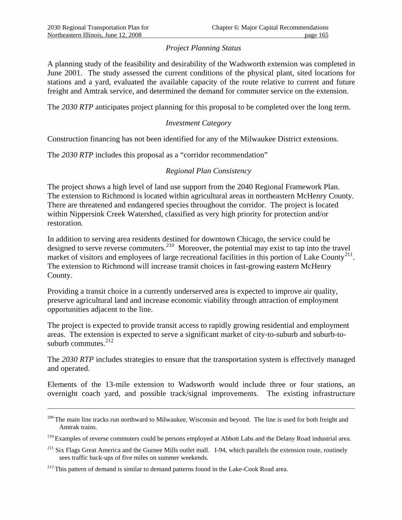
2030 Regional Transportation Plan for Chapter 6: Major Capital Recommendations Northeastern Illinois, June 12, 2008 page 165
Project Planning Status
A planning study of the feasibility and desirability of the Wadsworth extension was completed in June 2001. The study assessed the current conditions of the physical plant, sited locations for stations and a yard, evaluated the available capacity of the route relative to current and future freight and Amtrak service, and determined the demand for commuter service on the extension.
The 2030 RTP anticipates project planning for this proposal to be completed over the long term.
Investment Category
Construction financing has not been identified for any of the Milwaukee District extensions.
The 2030 RTP includes this proposal as a “corridor recommendation”
Regional Plan Consistency
The project shows a high level of land use support from the 2040 Regional Framework Plan. The extension to Richmond is located within agricultural areas in northeastern McHenry County. There are threatened and endangered species throughout the corridor. The project is located within Nippersink Creek Watershed, classified as very high priority for protection and/or restoration.
In addition to serving area residents destined for downtown Chicago, the service could be designed to serve reverse commuters.210 Moreover, the potential may exist to tap into the travel market of visitors and employees of large recreational facilities in this portion of Lake County211. The extension to Richmond will increase transit choices in fast-growing eastern McHenry County.
Providing a transit choice in a currently underserved area is expected to improve air quality, preserve agricultural land and increase economic viability through attraction of employment opportunities adjacent to the line.
The project is expected to provide transit access to rapidly growing residential and employment areas. The extension is expected to serve a significant market of city-to-suburb and suburb-to-suburb commutes.212
The 2030 RTP includes strategies to ensure that the transportation system is effectively managed and operated.
Elements of the 13-mile extension to Wadsworth would include three or four stations, an overnight coach yard, and possible track/signal improvements. The existing infrastructure
209 The main line tracks run northward to Milwaukee, Wisconsin and beyond. The line is used for both freight and
Amtrak trains.
210 Examples of reverse commuters could be persons employed at Abbott Labs and the Delany Road industrial area.
211 Six Flags Great America and the Gurnee Mills outlet mall. I-94, which parallels the extension route, routinely sees traffic back-ups of five miles on summer weekends.
212 This pattern of demand is similar to demand patterns found in the Lake-Cook Road area.
2030 Regional Transportation Plan for Chapter 6: Major Capital Recommendations Northeastern Illinois, June 12, 2008 page 166
already includes bi-directional signaling and Centralized Traffic Control, but track capacity will require close scrutiny.
6.2.1.2.9 Union Pacific Northwest
Figure 36: Union Pacific Northwest Improvements and Extension
The Union Pacific Northwest (UP-NW) Line is the region’s longest commuter rail line, extending from Chicago to Harvard with a seven-mile branch to McHenry.
Two improvements are proposed on the UP-Northwest: infrastructure upgrades and an extension to Johnsburg213. The upgrades include improvements to the existing signal system and additional crossovers and other track improvements to increase the operating capacity and reliability. The extension to Johnsburg will allow improved operations on the entire line. New yards are planned for the Woodstock and Johnsburg areas.
Project Planning Status
Alternatives analyses are underway for the entire proposal.214
The 2030 RTP anticipates project planning for this proposal to be completed over the medium term.
213 The original 2030 RTP proposal extended the service to Richmond.
214 “Metra UP-Northwest Line Core Capacity Upgrades” including an extension to the McHenry Branch as far as Johnsburg.
2030 Regional Transportation Plan for Chapter 6: Major Capital Recommendations Northeastern Illinois, June 12, 2008 page 167
Investment Category
Funding for construction is anticipated through discretionary federal grants made based on the proposal’s merits.215
The 2030 RTP includes this proposal as “project” recommendation.
Regional Plan Consistency
The project shows a high level of land use support from the 2040 Regional Framework Plan. The project is located within the Upper and Middle Fox River Watersheds, classified as very high priority for protection and/or restoration. The project is also adjacent to and crosses the Nippersink Creek and Boone Creek systems in northeast McHenry County.
The project is within or adjacent to threatened and endangered species communities and is located within agricultural land in central and north McHenry County.
This commuter rail line serves more population and jobs than any other corridor in the region. There are substantial employment centers near the UP-NW Line route and many areas are expected to experience significant growth in the number of jobs. 216 Population and employment forecasts indicate a potential increase in demand for commuter rail service.217 The UP-Northwest proposal supports transportation choice. More communities will benefit from transit service. Faster speeds, shorter travel times and increased efficiency of the physical plant are expected to increase overall ridership.
In addition, the UP-Northwest improvements will support the functions of existing and planned adjacent land uses.218 Improved transit service in Cook and McHenry Counties will encourage compact land development.
Community interfaces, particularly along the rail extension to Johnsburg, should be improved as the proposal is developed.
The 2030 RTP includes strategies for ensuring that the transportation system is effectively managed and operated. The new rail yards will permit greater train capacity and consolidation of maintenance operations.
Pedestrian and bicycle access needs and transit service coordination should be addressed as the proposal is further developed. Pedestrian and bicycle transportation needs, particularly
215 An application for FTA New Starts funding is being prepared.
216 For example, the Palatine/Barrington area is projected to grow by nearly 28 percent in employment by 2030 and the Des Plaines/Mt. Prospect/Arlington Heights area is expected to add more than 8,000 jobs during the same period. The proposed improvements would address this job growth by improving access to major businesses in the corridor including Ameritech, GE Capital, Motorola, Affinia Corporation, Northern Illinois Medical Center, Northwest Community Hospital and United Parcel Service.
217 The increase in demand is anticipated in this corridor due to the an expected employment increase of more than 60 percent by 2030.
218 Several communities along the UP-Northwest corridor are pursuing infill development that will complement the improved service.
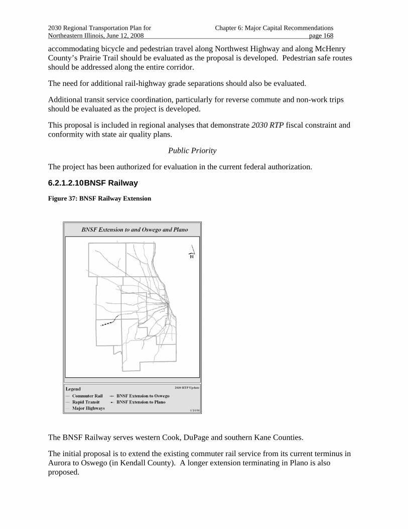
2030 Regional Transportation Plan for Chapter 6: Major Capital Recommendations Northeastern Illinois, June 12, 2008 page 168
accommodating bicycle and pedestrian travel along Northwest Highway and along McHenry County’s Prairie Trail should be evaluated as the proposal is developed. Pedestrian safe routes should be addressed along the entire corridor.
The need for additional rail-highway grade separations should also be evaluated.
Additional transit service coordination, particularly for reverse commute and non-work trips should be evaluated as the project is developed.
This proposal is included in regional analyses that demonstrate 2030 RTP fiscal constraint and conformity with state air quality plans.
Public Priority
The project has been authorized for evaluation in the current federal authorization.
6.2.1.2.10 BNSF Railway
Figure 37: BNSF Railway Extension
The BNSF Railway serves western Cook, DuPage and southern Kane Counties.
The initial proposal is to extend the existing commuter rail service from its current terminus in Aurora to Oswego (in Kendall County). A longer extension terminating in Plano is also proposed.
2030 Regional Transportation Plan for Chapter 6: Major Capital Recommendations Northeastern Illinois, June 12, 2008 page 169
A new equipment storage/maintenance facility near the new western terminus of the line is also proposed.
Project Planning Status
In August 2002, a study was completed that contained several components, including demand assessment and financial feasibility for the extension as well as a bus alternative.219
The current federal authorization specifically exempts this proposal from additional planning evaluation requirements.
The 2030 RTP anticipates that project planning for will occur in the medium term.
Investment Category
Funding for construction is anticipated through discretionary federal grants.
New institutional financing arrangements will be needed to extend commuter rail to the proposed locations.
The 2030 RTP includes the initial extension from Aurora to Oswego as a “project recommendation” with the remainder of the corridor to Plano included as a “corridor recommendation.”
Regional Plan Consistency
The project shows a high level of land use support from the 2040 Regional Framework Plan. The project is located within the Lower Fox River Watershed and is classified as very high priority for protection and/or restoration. The project crosses Blackberry Creek, a “C” quality stream identified as having opportunities for restoration to a higher quality.
The extension of rail service will serve new and planned residential and commercial developments in the outlying counties. The proposal offers the opportunity to extend commuter rail service using existing right-of-way to communities in the fast growing regions of Oswego and Montgomery.
This extension brings an existing commuter rail service closer to potential riders’ residences. Commuters are currently forecast to travel from more than 20 miles to reach the existing station in Aurora.
The 2030 RTP includes strategies for effective management and operation of the transportation system. Efficiency of freight operations on the BNSF should be maintained.
This proposal is included in regional analyses that demonstrate 2030 RTP fiscal constraint and conformity with state air quality plans.
Public Priority
The project has been authorized for evaluation in the current federal authorization. 219 An interim bus service is already in place from Aurora to Oswego.
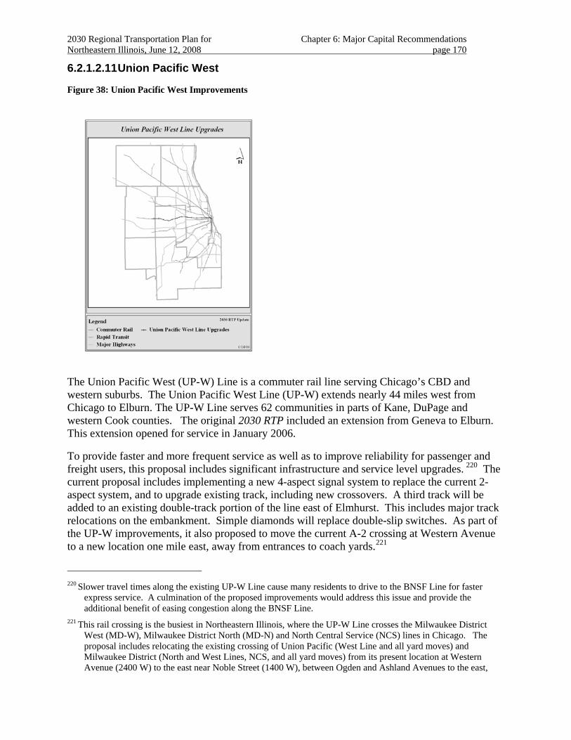
2030 Regional Transportation Plan for Chapter 6: Major Capital Recommendations Northeastern Illinois, June 12, 2008 page 170
6.2.1.2.11 Union Pacific West
Figure 38: Union Pacific West Improvements
The Union Pacific West (UP-W) Line is a commuter rail line serving Chicago’s CBD and western suburbs. The Union Pacific West Line (UP-W) extends nearly 44 miles west from Chicago to Elburn. The UP-W Line serves 62 communities in parts of Kane, DuPage and western Cook counties. The original 2030 RTP included an extension from Geneva to Elburn. This extension opened for service in January 2006.
To provide faster and more frequent service as well as to improve reliability for passenger and freight users, this proposal includes significant infrastructure and service level upgrades. 220 The current proposal includes implementing a new 4-aspect signal system to replace the current 2-aspect system, and to upgrade existing track, including new crossovers. A third track will be added to an existing double-track portion of the line east of Elmhurst. This includes major track relocations on the embankment. Simple diamonds will replace double-slip switches. As part of the UP-W improvements, it also proposed to move the current A-2 crossing at Western Avenue to a new location one mile east, away from entrances to coach yards.221
220 Slower travel times along the existing UP-W Line cause many residents to drive to the BNSF Line for faster
express service. A culmination of the proposed improvements would address this issue and provide the additional benefit of easing congestion along the BNSF Line.
221 This rail crossing is the busiest in Northeastern Illinois, where the UP-W Line crosses the Milwaukee District West (MD-W), Milwaukee District North (MD-N) and North Central Service (NCS) lines in Chicago. The proposal includes relocating the existing crossing of Union Pacific (West Line and all yard moves) and Milwaukee District (North and West Lines, NCS, and all yard moves) from its present location at Western Avenue (2400 W) to the east near Noble Street (1400 W), between Ogden and Ashland Avenues to the east,
2030 Regional Transportation Plan for Chapter 6: Major Capital Recommendations Northeastern Illinois, June 12, 2008 page 171
An additional proposal includes consolidation of the M-19A/California Avenue Yard.
Project Planning Status
The extension from Geneva to Elburn opened for service in January, 2006.
Alternatives analyses for the proposed core capacity upgrade to the entire line are underway.
The 2030 RTP anticipates project planning for this proposal to be completed over the medium term.
Investment Category
Funding for construction is anticipated through discretionary federal grants made based on the proposal’s merits.222
Several CREATE program grade separations are integral to the project223.
The 2030 RTP includes the completed extension to Elburn as a “management recommendation” and the remaining upgrade proposal as a “system recommendation.”
Regional Plan Consistency
The project shows a high level of land use support from the 2040 Regional Framework Plan. This project is located within the Middle Des Plaines River and Middle Fox River Watersheds, classified as very high priority for protection and/or restoration.
The UP-W has served adjacent communities for most of their history. The passenger service shares the right-of-way with significant freight traffic. Improvements are primarily along existing right of way. Project development should include addressing community and environmental strategies in the corridor224.
There is an increasing demand for service in this region due to substantial residential growth225.
The UP-West track and signal improvements will support the functions of existing and planned adjacent land uses. Improved transit service in western Cook, DuPage, and Kane Counties will
away from entrances to the two coach yards. Improved operating efficiencies will enable both revenue and deadhead trains to move through the new crossing point at increased speeds and reduced operating costs, resulting from using simple diamond crossings rather than double-slip switches.
222 An application for FTA New Starts funding is being prepared.
223 Rail-highway grade separations are under consideration. At a minimum, grade separations at 25th Avenue and 1st Avenue should be considered by this project.
224 Consideration should specifically be given to rehabilitation of aging community infrastructure along the right-of-way.
225 For example, the Elburn area is projected to grow by more than 650 percent between 2000-2030 and the Winfield/West Chicago area is expected to grow by more than 150 percent in that same time frame. Employment in this segment is anticipated to increase more than 100 percent, and the UP-W Line improvements will provide better access to major businesses in the corridor including General Mills, DuPage Airport, Fermilab, Navistar and the future DuPage Technology Park.
2030 Regional Transportation Plan for Chapter 6: Major Capital Recommendations Northeastern Illinois, June 12, 2008 page 172
encourage compact land development. Several communities along the corridor are pursuing infill development that will complement the improved service.
These improvements will also enhance the potential for reverse-commuting along the UP-W Line.
The proposal is included for evaluation in the Cook/DuPage Corridor Study. Initial evaluation of this proposal indicates that it serves a discrete travel market and is not a likely alternative to other improvements proposed in the corridor.
The 2030 RTP includes strategies for effective management and operation of the transportation system.
The UP-West Core Capacity upgrade improves transportation choices for the corridor’s travelers. More trains with faster, more reliable service are envisioned.
The M-19A/California Avenue Yard is expected to significantly improve operations by locating a new locomotive facility adjacent to the coach yard used by all Union Pacific train equipment. Also, a new and modern maintenance facility (including an environment-friendly paint shop) will replace the existing one, and the yard will be expanded with wider track spacing for efficiency and safety. Improved operating efficiencies will enable trains to be recycled (cleaning, routine maintenance, and fueling) and available for next runs more quickly. Reduced operating costs will save funds to be used elsewhere on the system. These operations improvements will enable both revenue and deadhead trains to move through the new crossing point at increased speeds. This is expected to reduce operating costs.
The complete proposal will address a facility in need of substantial maintenance in many areas226. This provides the opportunity for improved community interfaces, rail-highway grade separations, accommodation of pedestrian and bicycle travel needs, and transit service. The proposal offers an opportunity to improve pedestrian and bicycle transportation accommodations, particularly for seniors and people with disabilities227.
The project includes improving the efficiency and safety through rail signal upgrades, additional track, and new cross-overs. Doing so will increase the line's capacity, speed and reliability. By eliminating the existing bottleneck between River Forest and Elmhurst, fewer freight trains will be required to stand.
The proposal offers an opportunity to improve transit service coordination, particularly for reverse commute and non-work trips. In addition, several station and parking improvements along the corridor should be coordinated.
This proposal is included in regional analyses that demonstrate 2030 RTP fiscal constraint and conformity with state air quality plans.
226 Such areas could particularly include poor and minority areas.
227 In particular, a pedestrian-bicycle facility planned by Northlake between Northlake and Elmhurst along the UP rail right-of-way under I-290 and I-294 should be facilitated by the project. In addition, some pedestrian-car crash clusters appear near Metra stations that need to be addressed cooperatively with local communities.
2030 Regional Transportation Plan for Chapter 6: Major Capital Recommendations Northeastern Illinois, June 12, 2008 page 173
Public Priority
The project has been authorized for evaluation in the current federal authorization
6.2.2 Improving Existing Major Highways
Northeastern Illinois’ major highway system significantly contributes to mobility and accessibility within the region. Highway accessibility to the region’s multiple commercial centers from all points provides a sustaining advantage in both goods movement and employment opportunities.
The RTP supports increased multimodal capacity to the region’s existing commercial centers. In growing parts of the region, additional major highway capacity is recommended as part of multimodal traffic congestion management.
In mature parts of the region, additional major highway capacity may also require special attention to mitigating community and environmental impacts. These projects also present an opportunity to enhance the quality of existing communities by close coordination with community planning efforts.
In growing areas, highway capacity additions are often designed for conventional unrestricted use focusing on highway users. The RTP recommends, however, that design of conventional lane additions incorporate intensive management, operations and design strategies to optimize long-term multimodal operations, particularly with regard to accommodating bus and truck priorities.
Transportation management techniques should be included in the engineering studies for highway capacity additions. To reduce travel demand, priority treatments for transit and carpools should also be considered in project studies. Value pricing and electronic toll collection should be considered on toll facilities to reduce peak congestion. Other strategies that reduce single occupant vehicle travel should also be considered. In addition, transportation system management strategies such as improved and expanded ramp metering and collector-distributor and other auxiliary lanes should be considered to smooth traffic flow and improve safety, while simultaneously providing access from communities to the trunk lines of the highway system.
The RTP recommends that bicycle and pedestrian travel be accommodated along and across highway corridors, so that the expressway and tollway systems do not act as a barrier to non-motorized travel. Consideration of non-motorized access to transit stations and bus services is particularly important. The RTP also recommends that walking and bicycling needs that will come with future urbanization be considered in provision of accommodations along highway corridors in growing areas.
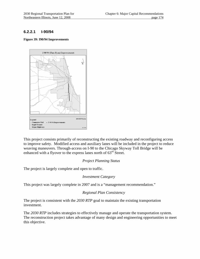
2030 Regional Transportation Plan for Chapter 6: Major Capital Recommendations Northeastern Illinois, June 12, 2008 page 174
6.2.2.1 I-90/94
Figure 39: I90/94 Improvements
This project consists primarily of reconstructing the existing roadway and reconfiguring access to improve safety. Modified access and auxiliary lanes will be included in the project to reduce weaving maneuvers. Through-access on I-90 to the Chicago Skyway Toll Bridge will be enhanced with a flyover to the express lanes north of 63rd Street.
Project Planning Status
The project is largely complete and open to traffic.
Investment Category
This project was largely complete in 2007 and is a “management recommendation.”
Regional Plan Consistency
The project is consistent with the 2030 RTP goal to maintain the existing transportation investment.
The 2030 RTP includes strategies to effectively manage and operate the transportation system. The reconstruction project takes advantage of many design and engineering opportunities to meet this objective.
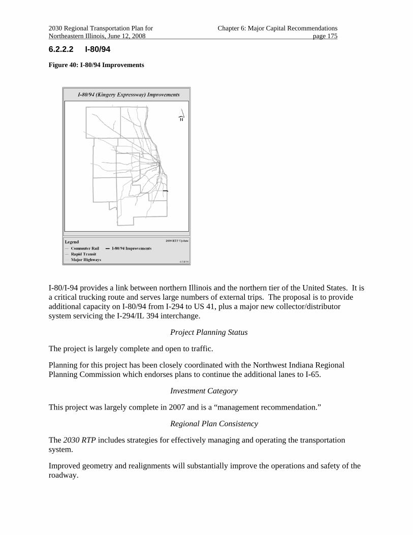
2030 Regional Transportation Plan for Chapter 6: Major Capital Recommendations Northeastern Illinois, June 12, 2008 page 175
6.2.2.2 I-80/94
Figure 40: I-80/94 Improvements
I-80/I-94 provides a link between northern Illinois and the northern tier of the United States. It is a critical trucking route and serves large numbers of external trips. The proposal is to provide additional capacity on I-80/94 from I-294 to US 41, plus a major new collector/distributor system servicing the I-294/IL 394 interchange.
Project Planning Status
The project is largely complete and open to traffic.
Planning for this project has been closely coordinated with the Northwest Indiana Regional Planning Commission which endorses plans to continue the additional lanes to I-65.
Investment Category
This project was largely complete in 2007 and is a “management recommendation.”
Regional Plan Consistency
The 2030 RTP includes strategies for effectively managing and operating the transportation system.
Improved geometry and realignments will substantially improve the operations and safety of the roadway.
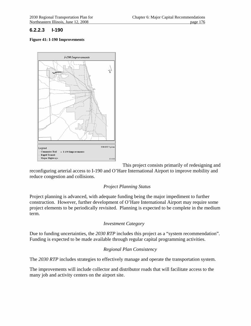
2030 Regional Transportation Plan for Chapter 6: Major Capital Recommendations Northeastern Illinois, June 12, 2008 page 176
6.2.2.3 I-190
Figure 41: I-190 Improvements
This project consists primarily of redesigning and reconfiguring arterial access to I-190 and O’Hare International Airport to improve mobility and reduce congestion and collisions.
Project Planning Status
Project planning is advanced, with adequate funding being the major impediment to further construction. However, further development of O’Hare International Airport may require some project elements to be periodically revisited. Planning is expected to be complete in the medium term.
Investment Category
Due to funding uncertainties, the 2030 RTP includes this project as a “system recommendation”. Funding is expected to be made available through regular capital programming activities.
Regional Plan Consistency
The 2030 RTP includes strategies to effectively manage and operate the transportation system.
The improvements will include collector and distributor roads that will facilitate access to the many job and activity centers on the airport site.
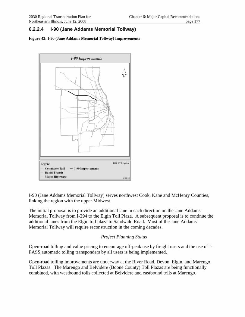
2030 Regional Transportation Plan for Chapter 6: Major Capital Recommendations Northeastern Illinois, June 12, 2008 page 177
6.2.2.4 I-90 (Jane Addams Memorial Tollway)
Figure 42: I-90 (Jane Addams Memorial Tollway) Improvements
I-90 (Jane Addams Memorial Tollway) serves northwest Cook, Kane and McHenry Counties, linking the region with the upper Midwest.
The initial proposal is to provide an additional lane in each direction on the Jane Addams Memorial Tollway from I-294 to the Elgin Toll Plaza. A subsequent proposal is to continue the additional lanes from the Elgin toll plaza to Sandwald Road. Most of the Jane Addams Memorial Tollway will require reconstruction in the coming decades.
Project Planning Status
Open-road tolling and value pricing to encourage off-peak use by freight users and the use of I-PASS automatic tolling transponders by all users is being implemented.
Open-road tolling improvements are underway at the River Road, Devon, Elgin, and Marengo Toll Plazas. The Marengo and Belvidere (Boone County) Toll Plazas are being functionally combined, with westbound tolls collected at Belvidere and eastbound tolls at Marengo.
2030 Regional Transportation Plan for Chapter 6: Major Capital Recommendations Northeastern Illinois, June 12, 2008 page 178
Reconstruction with additional capacity from the Elgin Toll Plaza to Randall Road has been completed. All remaining segments west to Sandwald Road are being studied.
In addition, sections of I-90 away from the region’s most developed areas, from I-39’s junction with I-90 in Rockford to Madison, Wisconsin are scheduled for additional lanes between now and 2011.
The 2030 RTP anticipates project planning for this proposal to be completed over the medium term.
Regional Investment
The project is included in the 2030 RTP as a “system recommendation.”
Regional Plan consistency
The project shows a high level of land use support from the 2040 Regional Framework Plan. The section from I-294 to Elgin crosses the Fox River in northern Kane County, which is a “C” quality stream, identified as having opportunities for restoration to higher quality stream. The project is adjacent to the south border of the Max McGraw Wildlife Foundation property east of the Fox River and is adjacent to three major Cook County Forest Preserve District properties: Poplar Creek, Paul Douglas and Ned Brown forest preserves. The project also passes through a concentration of streams and palustrine wetlands (i.e., wetlands not associated with rivers or streams).
The section of the project west of Elgin is located within the Kishwaukee River Watershed in the northwestern area of the region; the area is classified as very high priority for protection and/or restoration. The project crosses Eakin Creek in north Kane County, which is part of the Kishwaukee River System and classified as a “B” quality stream, a highly valued aquatic resource. The project also passes through a concentration of threatened and endangered species near Sandwald Road.
I-90 links Chicago and O'Hare Airport with the Schaumburg and Elgin areas. Population and employment are at high densities in much of the corridor, and continue to grow. The eastern section of this project coincides with the proposed STAR (Suburban Transit Access Route) line transit service.
The 2030 RTP includes strategies to effectively manage and operate the transportation system.
I-90 accommodates a large volume of external trips, serving travel to Rockford, northwestern Illinois and south-central Wisconsin. Additional lanes on the Tollway will help accommodate continued growth in the region as well as increasing external demand.
New and expanded interchanges should be considered to keep pace with community and economic development.
2030 Regional Transportation Plan for Chapter 6: Major Capital Recommendations Northeastern Illinois, June 12, 2008 page 179
Several reconfigured and expanded auxiliary lanes may be appropriate to improve traffic flow as well as highway safety.228
Safe walking and bicycling access across I-90 from adjoining neighborhoods and comprehensive complementary bus services to proposed transit services should be provided. The transit service and highway improvements may prove to be complementary, particularly if priority treatments for transit and carpools are included in the project design studies. Dedicated access for transit and carpools should be evaluated in project studies.
The project will improve highway safety and accessibility for major residential and employment centers, including Chicago O’Hare International Airport. Open road tolling is expected to reduce congestion, air-pollution, and improve efficiency of freight movement.
Additional evaluation of transit needs, non-motorized crossings of the Tollway, and transportation management strategies, such as HOV preferences should be pursued. Non-motorized transportation, additional access interchanges, auxiliary lanes, and service coordination should be included in coordination with complementary transportation proposals229.
This proposal is included in regional analyses that demonstrate 2030 RTP fiscal constraint and conformity with state air quality plans.
Public Priority
The proposal is included in Illinois Tollway’s “Open Roads for a Faster Future” under the auspices of the State of Illinois
228 Careful planning and engineering are necessary to assure that any additional lanes on the Jane Addams Memorial
Tollway do not create a lane balance problem at the interchange with the Kennedy Expressway, Tri-State Tollway, and I-190. Additional attention should be paid to assure that the project takes into account a possible West O'Hare Bypass and western terminal for O'Hare
229 Such proposals particularly include the STAR line, the O’Hare Bypass, the I-294 (Tri-State) widening and the planned Bessie Coleman Drive extension.
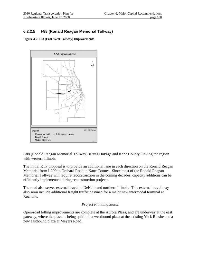
2030 Regional Transportation Plan for Chapter 6: Major Capital Recommendations Northeastern Illinois, June 12, 2008 page 180
6.2.2.5 I-88 (Ronald Reagan Memorial Tollway)
Figure 43: I-88 (East-West Tollway) Improvements
I-88 (Ronald Reagan Memorial Tollway) serves DuPage and Kane County, linking the region with western Illinois.
The initial RTP proposal is to provide an additional lane in each direction on the Ronald Reagan Memorial from I-290 to Orchard Road in Kane County. Since most of the Ronald Reagan Memorial Tollway will require reconstruction in the coming decades, capacity additions can be efficiently implemented during reconstruction projects.
The road also serves external travel to DeKalb and northern Illinois. This external travel may also soon include additional freight traffic destined for a major new intermodal terminal at Rochelle.
Project Planning Status
Open-road tolling improvements are complete at the Aurora Plaza, and are underway at the east gateway, where the plaza is being split into a westbound plaza at the existing York Rd site and a new eastbound plaza at Meyers Road.
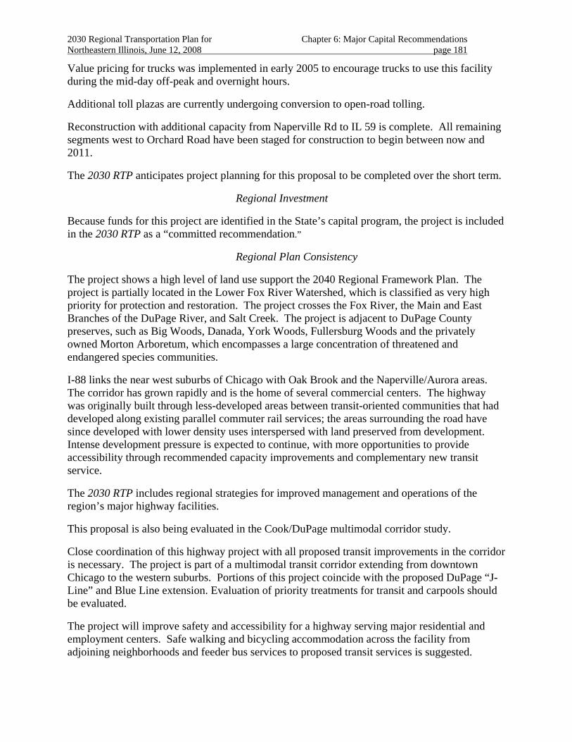
2030 Regional Transportation Plan for Chapter 6: Major Capital Recommendations Northeastern Illinois, June 12, 2008 page 181
Value pricing for trucks was implemented in early 2005 to encourage trucks to use this facility during the mid-day off-peak and overnight hours.
Additional toll plazas are currently undergoing conversion to open-road tolling.
Reconstruction with additional capacity from Naperville Rd to IL 59 is complete. All remaining segments west to Orchard Road have been staged for construction to begin between now and 2011.
The 2030 RTP anticipates project planning for this proposal to be completed over the short term.
Regional Investment
Because funds for this project are identified in the State’s capital program, the project is included in the 2030 RTP as a “committed recommendation.”
Regional Plan Consistency
The project shows a high level of land use support the 2040 Regional Framework Plan. The project is partially located in the Lower Fox River Watershed, which is classified as very high priority for protection and restoration. The project crosses the Fox River, the Main and East Branches of the DuPage River, and Salt Creek. The project is adjacent to DuPage County preserves, such as Big Woods, Danada, York Woods, Fullersburg Woods and the privately owned Morton Arboretum, which encompasses a large concentration of threatened and endangered species communities.
I-88 links the near west suburbs of Chicago with Oak Brook and the Naperville/Aurora areas. The corridor has grown rapidly and is the home of several commercial centers. The highway was originally built through less-developed areas between transit-oriented communities that had developed along existing parallel commuter rail services; the areas surrounding the road have since developed with lower density uses interspersed with land preserved from development. Intense development pressure is expected to continue, with more opportunities to provide accessibility through recommended capacity improvements and complementary new transit service.
The 2030 RTP includes regional strategies for improved management and operations of the region’s major highway facilities.
This proposal is also being evaluated in the Cook/DuPage multimodal corridor study.
Close coordination of this highway project with all proposed transit improvements in the corridor is necessary. The project is part of a multimodal transit corridor extending from downtown Chicago to the western suburbs. Portions of this project coincide with the proposed DuPage “J-Line” and Blue Line extension. Evaluation of priority treatments for transit and carpools should be evaluated.
The project will improve safety and accessibility for a highway serving major residential and employment centers. Safe walking and bicycling accommodation across the facility from adjoining neighborhoods and feeder bus services to proposed transit services is suggested.
2030 Regional Transportation Plan for Chapter 6: Major Capital Recommendations Northeastern Illinois, June 12, 2008 page 182
Bicycle and pedestrian accommodation across the corridor should be pursued.230 In addition, several reconfigured and expanded auxiliary lanes and interchanges may be appropriate to improve traffic flow and community access, as well as highway safety.231
The proposal includes open-road tolling and value pricing to encourage off-peak use by freight users and the use of automatic tolling transponders by non-freight users. Open road tolling is expected to reduce congestion, air-pollution and efficiently move freight. Value pricing should also be studied as an integral part of the project to reduce congestion and increase accessibility.232
This proposal is included in regional analyses that demonstrate 2030 RTP fiscal constraint and conformity with state air quality plans.
Public Priority
The proposal is included in Illinois Tollway’s “Open Roads for a Faster Future” under the auspices of the State of Illinois
230 The Tollway is including bicycle accommodation evaluation in the Tollway’s development of improvements
along I-88.
231 Attention should be paid to ensure that additional lanes and interchanges on I-88 do not exacerbate the lane balance problem at the I-290/I-294 interchange that the Hillside Bottleneck project was designed to alleviate.
232 Consistent with the Tollway’s efforts to implement value pricing are ITS improvements such as I-Pass, integration into the Gary-Chicago-Milwaukee ITS corridor, and open-road tolling.
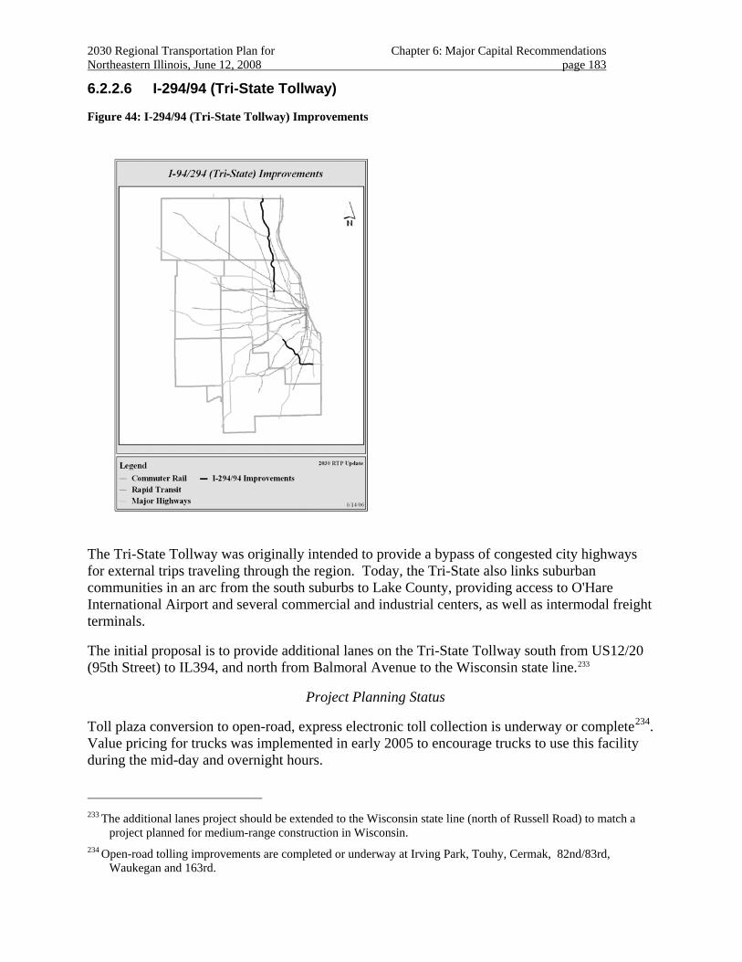
2030 Regional Transportation Plan for Chapter 6: Major Capital Recommendations Northeastern Illinois, June 12, 2008 page 183
6.2.2.6 I-294/94 (Tri-State Tollway)
Figure 44: I-294/94 (Tri-State Tollway) Improvements
The Tri-State Tollway was originally intended to provide a bypass of congested city highways for external trips traveling through the region. Today, the Tri-State also links suburban communities in an arc from the south suburbs to Lake County, providing access to O'Hare International Airport and several commercial and industrial centers, as well as intermodal freight terminals.
The initial proposal is to provide additional lanes on the Tri-State Tollway south from US12/20 (95th Street) to IL394, and north from Balmoral Avenue to the Wisconsin state line.233
Project Planning Status
Toll plaza conversion to open-road, express electronic toll collection is underway or complete234. Value pricing for trucks was implemented in early 2005 to encourage trucks to use this facility during the mid-day and overnight hours.
233 The additional lanes project should be extended to the Wisconsin state line (north of Russell Road) to match a
project planned for medium-range construction in Wisconsin.
234 Open-road tolling improvements are completed or underway at Irving Park, Touhy, Cermak, 82nd/83rd, Waukegan and 163rd.
2030 Regional Transportation Plan for Chapter 6: Major Capital Recommendations Northeastern Illinois, June 12, 2008 page 184
The additional lanes from IL22 to the Edens Spur are already completed.
The 2030 RTP anticipates project planning for this proposal to be completed over the short term. Construction is underway and is expected to be complete by 2010.
Regional Investment
Because funds for this project are identified in the State’s capital program, the project is included in the 2030 RTP as a “committed recommendation.”
Regional Plan Consistency
The project shows a high level of land use support from the 2040 Regional Framework Plan. The northern section of the project (IL137 to IL173) is located in a watershed classified as high priority for restoration and crosses Mill Creek and segments of the Des Plaines River, which are classified as moderate aquatic resources. The project also passes through woodlands and is in an area of concentrated wetlands. The central section of the project is adjacent to and passes through numerous preserves in south Lake County and north Cook County, such as Old School, Potowatomi Woods and Schiller Woods adjacent to the Des Plaines River. The project crosses the West Fork of the North Branch of the Chicago River and is in an area with a concentration of threatened and endangered species in southern Lake County. The southern section of the project crosses Stony Creek, Calumet Sag Channel, Thorn Creek and the Thorn Creek Forest Preserve within a concentration of threatened and endangered species communities in south Cook County. The I-294 project is adjacent to numerous forest preserves and a planned interchange at I-57.
The southern portion of the proposal should be included in evaluations conducted for other plan recommendations in the southern Chicago and the south suburbs multimodal corridor.
The 2030 RTP includes strategies for effectively managing and operating the transportation system.
Electronic toll collection is a key part of management strategies proposed for the facility. Electronic toll collection can be used to implement value pricing in addition to expediting toll collection and reducing congestion associated with toll collection. As the Tri-State Tollway is an important national freight route, implementation of electronic toll collection truck lanes or express lanes serving all traffic is important in managing congestion on the road. Improvements include open-road tolling and value pricing is expected to encourage off-peak use by freight users and the use of I-PASS automatic tolling transponders by all users. Open road tolling is expected to reduce congestion, air-pollution, and efficiently move freight.
Most of the Tri-State Tollway will require restoration or reconstruction in the coming decades, so reconstruction projects may provide opportunities to efficiently add capacity. In addition, a project to add capacity and improve operations on I-80 east of IL394 and at the interchange of I-94 complements the south segment of I-294 capacity improvements.
Several reconfigured and expanded auxiliary lanes and interchanges may be appropriate to improve traffic flow as well as highway safety. In particular, completion of a full interchange between I-294 and I-57 is expected to improve the accessibility of the south and southwest suburbs.
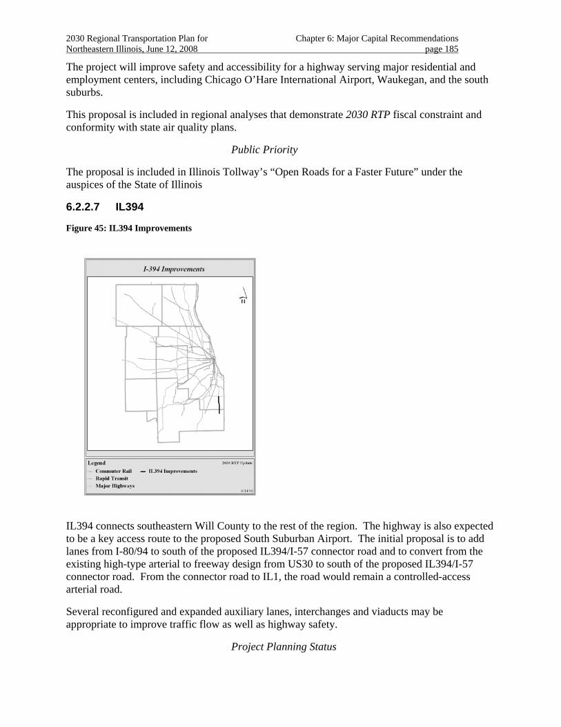
2030 Regional Transportation Plan for Chapter 6: Major Capital Recommendations Northeastern Illinois, June 12, 2008 page 185
The project will improve safety and accessibility for a highway serving major residential and employment centers, including Chicago O’Hare International Airport, Waukegan, and the south suburbs.
This proposal is included in regional analyses that demonstrate 2030 RTP fiscal constraint and conformity with state air quality plans.
Public Priority
The proposal is included in Illinois Tollway’s “Open Roads for a Faster Future” under the auspices of the State of Illinois
6.2.2.7 IL394
Figure 45: IL394 Improvements
IL394 connects southeastern Will County to the rest of the region. The highway is also expected to be a key access route to the proposed South Suburban Airport. The initial proposal is to add lanes from I-80/94 to south of the proposed IL394/I-57 connector road and to convert from the existing high-type arterial to freeway design from US30 to south of the proposed IL394/I-57 connector road. From the connector road to IL1, the road would remain a controlled-access arterial road.
Several reconfigured and expanded auxiliary lanes, interchanges and viaducts may be appropriate to improve traffic flow as well as highway safety.
Project Planning Status
2030 Regional Transportation Plan for Chapter 6: Major Capital Recommendations Northeastern Illinois, June 12, 2008 page 186
A phase-I engineering study for the project has been completed.
The 2030 RTP anticipates project planning for this proposal to be completed over the long term.
Regional Investment
Funding for the project has not been identified.
Because the proposed improvements are expected to be implemented through the normal programming process, the 2030 RTP includes this proposal as a “system recommendation”.
Regional Plan consistency
The project shows a high level of land use support from the 2040 Regional Framework Plan. The project passes through the Thorn Creek Forest Preserve and Thorn Creek in south Cook County, the location of numerous communities of threatened and endangered species and a concentration of palustrine wetlands. The project also crosses agricultural areas in south Cook County.
IL 394 will help provide access to the South Suburban Airport. This proposal should be included in evaluations conducted for other plan recommendations in the southern Chicago and the south suburbs multimodal corridor.
The 2030 RTP includes strategies for effectively managing and operating the transportation system.
Progress on complementary transportation improvements, such as the I-57/IL394 Connector and the Illiana Expressway, will affect the implementation of this project. 235
Management and operations strategies such as travel demand management, HOV priority treatments, transit coordination, and ITS strategies should be evaluated.
235 The right of way for the Connector Road was removed from the South Suburban Airport footprint.
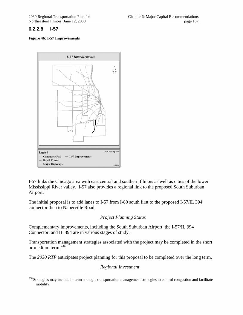
2030 Regional Transportation Plan for Chapter 6: Major Capital Recommendations Northeastern Illinois, June 12, 2008 page 187
6.2.2.8 I-57
Figure 46: I-57 Improvements
I-57 links the Chicago area with east central and southern Illinois as well as cities of the lower Mississippi River valley. I-57 also provides a regional link to the proposed South Suburban Airport.
The initial proposal is to add lanes to I-57 from I-80 south first to the proposed I-57/IL 394 connector then to Naperville Road.
Project Planning Status
Complementary improvements, including the South Suburban Airport, the I-57/IL 394 Connector, and IL 394 are in various stages of study.
Transportation management strategies associated with the project may be completed in the short or medium term.236
The 2030 RTP anticipates project planning for this proposal to be completed over the long term.
Regional Investment 236 Strategies may include interim strategic transportation management strategies to control congestion and facilitate
mobility.
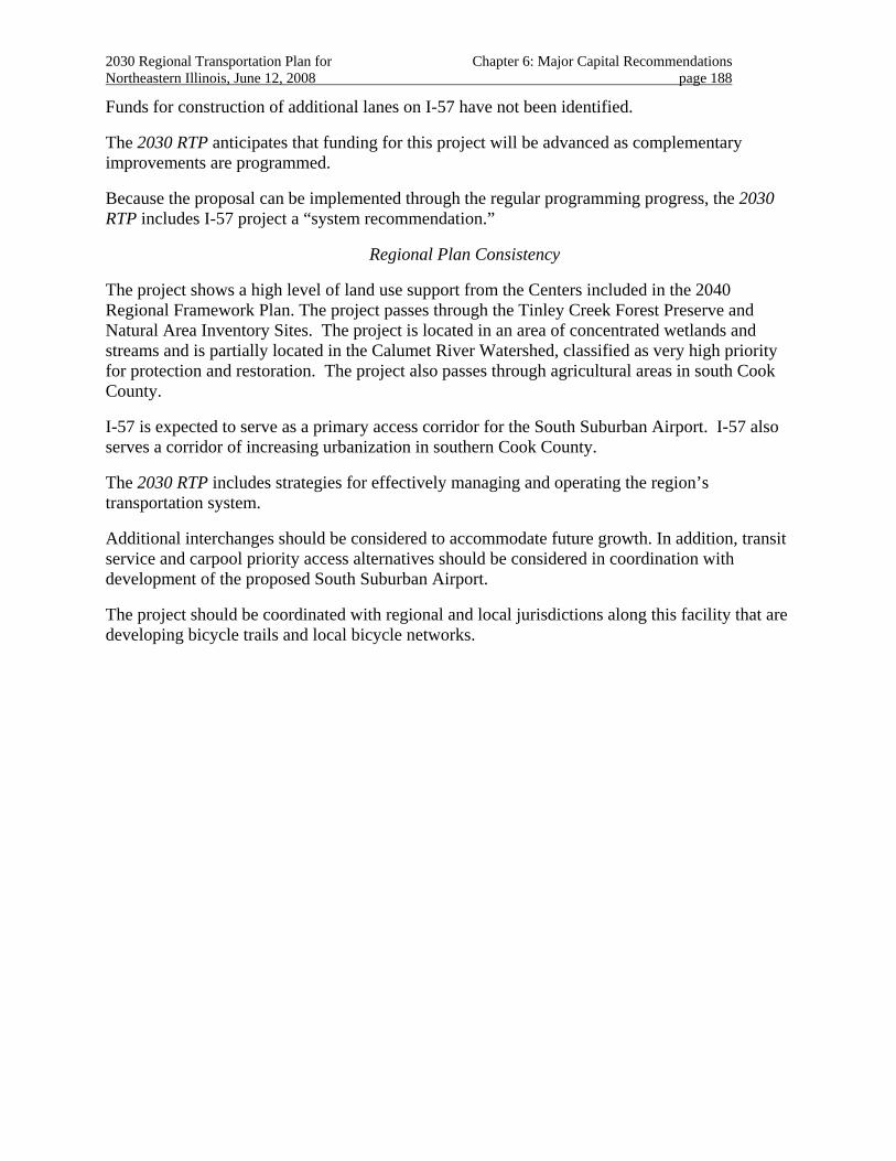
2030 Regional Transportation Plan for Chapter 6: Major Capital Recommendations Northeastern Illinois, June 12, 2008 page 188
Funds for construction of additional lanes on I-57 have not been identified.
The 2030 RTP anticipates that funding for this project will be advanced as complementary improvements are programmed.
Because the proposal can be implemented through the regular programming progress, the 2030 RTP includes I-57 project a “system recommendation.”
Regional Plan Consistency
The project shows a high level of land use support from the Centers included in the 2040 Regional Framework Plan. The project passes through the Tinley Creek Forest Preserve and Natural Area Inventory Sites. The project is located in an area of concentrated wetlands and streams and is partially located in the Calumet River Watershed, classified as very high priority for protection and restoration. The project also passes through agricultural areas in south Cook County.
I-57 is expected to serve as a primary access corridor for the South Suburban Airport. I-57 also serves a corridor of increasing urbanization in southern Cook County.
The 2030 RTP includes strategies for effectively managing and operating the region’s transportation system.
Additional interchanges should be considered to accommodate future growth. In addition, transit service and carpool priority access alternatives should be considered in coordination with development of the proposed South Suburban Airport.
The project should be coordinated with regional and local jurisdictions along this facility that are developing bicycle trails and local bicycle networks.
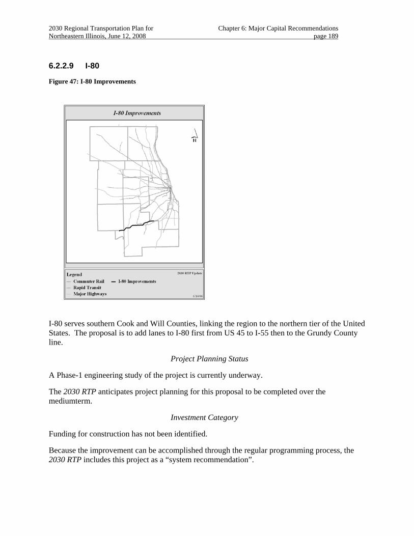
2030 Regional Transportation Plan for Chapter 6: Major Capital Recommendations Northeastern Illinois, June 12, 2008 page 189
6.2.2.9 I-80
Figure 47: I-80 Improvements
I-80 serves southern Cook and Will Counties, linking the region to the northern tier of the United States. The proposal is to add lanes to I-80 first from US 45 to I-55 then to the Grundy County line.
Project Planning Status
A Phase-1 engineering study of the project is currently underway.
The 2030 RTP anticipates project planning for this proposal to be completed over the mediumterm.
Investment Category
Funding for construction has not been identified.
Because the improvement can be accomplished through the regular programming process, the 2030 RTP includes this project as a “system recommendation”.
2030 Regional Transportation Plan for Chapter 6: Major Capital Recommendations Northeastern Illinois, June 12, 2008 page 190
Regional Plan Consistency
The project shows a high level of land use support from the 2040 Regional Framework Plan.
The section of I-80 from I-55 to US45 crosses the Des Plaines River in Joliet, the Marley Creek System in eastern Will County near Frankfort, and the Hickory Creek System in central Will County. The project is located in the Lower Des Plaines Watershed in central and eastern Will County, which is identified as very high priority for protection and/or restoration. It is also adjacent to Higginbotham Woods, a property of the Forest Preserve District of Will County. The section of I-80 from I-55 to the Will County line is located in a watershed classified as high priority for restoration. The project crosses the DuPage River, a “B” quality stream, identified as a highly valued aquatic resource at the border between Will and Kendall counties.
The project also passes through Joliet. Attention to and coordination with local development and redevelopment goals is recommended. Rapid growth in the project area should be monitored to preserve necessary right of way. The project will also serve a large number of external trips. The highway is part of an important multi-state freight route.
The 2030 RTP includes regional strategies for improved management and operations of the region’s major highway facilities.
To keep pace with future community and economic development, additional interchanges may be considered on the road.237
The project should be coordinated with regional and local jurisdictions along this facility that are developing bicycle trails and local bicycle networks. The design for recent improvements238 include bicycle and pedestrian accommodation for this project.
The 2030 RTP anticipates that the planning for improvements crossing the Des Plaines River around Joliet will require a special design and engineering work, recognizing that the project239 can be staged to complement adjacent improvements.240
The 2030 RTP anticipates that additional planning will be needed to address ITS, transportation management, non-motorized transportation, coordination with local economic development goals, and environmental concerns.
This proposal is included in regional analyses that demonstrate 2030 RTP fiscal constraint and conformity with state air quality plans.
The 2030 RTP anticipates that completion of the I-80 project will become a priority as completion of the I-355 construction draws near. 237 A link to the proposed extension of I-355 near New Lenox may be considered.
238 Such improvements include US 45 past the proposed I-355 interchange to near US 30, and improvements also in Grundy County.
239 The section from U.S. 30 to U.S. 45 should be strategically implemented first with the I-355 extension.
240 The I-355 extension will feed into I-80 north of New Lenox. I-355 is in the early stages of construction.
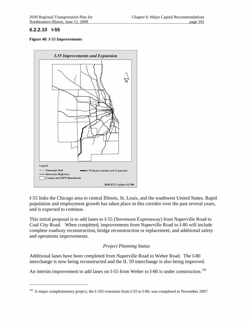
2030 Regional Transportation Plan for Chapter 6: Major Capital Recommendations Northeastern Illinois, June 12, 2008 page 191
6.2.2.10 I-55
Figure 48: I-55 Improvements
I-55 links the Chicago area to central Illinois, St. Louis, and the southwest United States. Rapid population and employment growth has taken place in this corridor over the past several years, and is expected to continue.
This initial proposal is to add lanes to I-55 (Stevenson Expressway) from Naperville Road to Coal City Road. When completed, improvements from Naperville Road to I-80 will include complete roadway reconstruction, bridge reconstruction or replacement, and additional safety and operations improvements.
Project Planning Status
Additional lanes have been completed from Naperville Road to Weber Road. The I-80 interchange is now being reconstructed and the IL 59 interchange is also being improved.
An interim improvement to add lanes on I-55 from Weber to I-80 is under construction.241
241 A major complementary project, the I-355 extension from I-55 to I-80, was completed in November 2007.
2030 Regional Transportation Plan for Chapter 6: Major Capital Recommendations Northeastern Illinois, June 12, 2008 page 192
Improvements at Arsenal Road242 remain in the multi-year state highway program.
A study has commenced on I-55 from River Road to Coal City Road in the Wilmington area of southern Will County.243 Additional warehousing and industrial development expected in this area are focusing attention on I-55 operations and capacity. The study’s primary focus is the rehabilitation and reconfiguration of the interchanges; one of the existing interchanges has obsolete designs, including a U-turn in the freeway median. The need for additional lanes will also be evaluated.
The 2030 RTP anticipates that Arsenal Road and I-55 interim improvements, including additional lanes from Weber Road to I-80 will be completed in the short term. Project planning for the Wilmington area project will be completed in the medium term. The remainder of the proposal is anticipated to be completed in the long term.
Investment Category
The 2030 RTP includes the completed section from Naperville Road to Weber Road as a “management recommendation.”
The 2030 RTP includes I-55 interim improvements, including additional lanes, from Weber Road to I-80 as a “committed recommendation”.
Interim improvements, including additional lanes, are included in the current TIP.
Successive improvements are included as “system recommendations” that can be funded through the regular programming process.
Regional Plan consistency
The project shows a high level of land use support from the 2040 Regional Framework Plan.
The project crosses the DuPage River System in west central Will County, and north through the Lily Cache Creek System. The south segment of the interim improvement borders the DuPage River Watershed, which is identified as high priority for protection and/or restoration. The interim project is adjacent to Hammel Woods, a property of the Forest Preserve District of Will County that abuts the DuPage River. The north section of the interim project also borders a concentration of lakes and wetlands associated with the Lake Renwick Heron Rookery. The north section of the project area includes records of threatened and endangered species.
South of I-80, I-55 crosses the Des Plaines and Kankakee Rivers, both designated “C” streams, more degraded but which have opportunities for restoration to higher quality.244 The Des Plaines Watershed, through which I-55 passes from I-80 to near Arsenal Road, has been identified as high-priority for protection or restoration. 245 In the area of the former Joliet Arsenal, the road passes through the Grant Creek watershed, an “Enhancement” watershed that is severely
242 An improvement to facilitate additional freight traffic from Deer Run is being planned. 243 http://i-55wilmingtonstudy.com/index.aspx 244 Northeastern Illinois Planning Commission. 1997. Northeastern Illinois Greenways and Trails Plan. 245 Northeastern Illinois Planning Commission. 1999. Biodiversity Recovery Plan. pp 81-82.
2030 Regional Transportation Plan for Chapter 6: Major Capital Recommendations Northeastern Illinois, June 12, 2008 page 193
degraded.246 From north of River Road to the Grundy County line, I-55 passes through the Kankakee River and Upper Illinois River Watersheds, both identified as being very high priorities for protection and restoration. 247
The project will also pass through or near the Des Plaines Fish and Wildlife Area and the Midewin National Tallgrass Prairie, an important area under development for the region.
Continued planning to complete this proposal should address access concerns raised by adjacent communities.248
The 2030 RTP includes strategies for effective management and operations of the region’s transportation system.
Reconfigured and expanded auxiliary lanes, interchanges and viaducts may be appropriate to improve traffic flow and community access, as well as highway safety. In addition, freight accommodations need particular attention in this corridor because of unusually high truck volumes. The facility serves one of the region's important industrial and transportation corridors. Warehouse, freight and intermodal facilities exist or are planned throughout the corridor.
The project should be coordinated with regional and local jurisdictions along this facility that are developing bicycle trails and local bicycle networks.
Transportation management strategies249, including travel demand management, incident management250, and Intelligent Transportation System infrastructure251 should be evaluated. 252
Interim improvements now underway, including additional lanes from Naperville Road south to I-80, are included in regional analyses that demonstrate 2030 RTP fiscal constraint and conformity with state air quality plans. In addition, Wilmington area improvements, including rehabilitation and reconfiguration of interchanges and additional lanes on I-55, are also included in regional analyses that demonstrate 2030 RTP fiscal constraint and conformity with state air quality plans.
246 Ibid. 247 Ibid. 248 Considerations for the project must ultimately be given to environmental issues, to the manner in which
pedestrian and bicycling circulation are designed at road crossings, and to accommodating and perhaps providing access to future uses of the EJ&E right-of-way under I-55, including the STAR Line. Concerns addressed by project documentation to date include noise pollution, ambient lighting, barrier medians, and, in the ultimate plan, sufficient shoulders.
249 In addition, future uses of the EJ&E right-of-way, including the STAR line and a potential truck-way that will need access to I-55, need to be considered.
250 One particular need is for traveler information to inform traveler route choice through variable message signs at approaches to the I-55/I-80 and I-355/I-55 interchanges. Another option to improve freeway operations is to expand the IDOT “Minute-Man” operation to the area to quickly clear incidents and reduce congestion.
251 Key focus areas for Intelligent Transportation System design that need to be addressed in preliminary engineering are communications infrastructure and roadside equipment (traffic monitoring equipment [typically loops], variable message signs, and cameras).
252 Examples includes ramp metering with HOV queue by-pass and implementing Intelligent Transportation System strategies (see section 3.3.2)
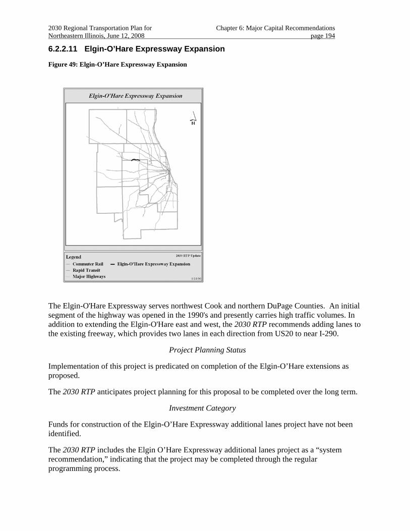
2030 Regional Transportation Plan for Chapter 6: Major Capital Recommendations Northeastern Illinois, June 12, 2008 page 194
6.2.2.11 Elgin-O’Hare Expressway Expansion
Figure 49: Elgin-O’Hare Expressway Expansion
The Elgin-O'Hare Expressway serves northwest Cook and northern DuPage Counties. An initial segment of the highway was opened in the 1990's and presently carries high traffic volumes. In addition to extending the Elgin-O'Hare east and west, the 2030 RTP recommends adding lanes to the existing freeway, which provides two lanes in each direction from US20 to near I-290.
Project Planning Status
Implementation of this project is predicated on completion of the Elgin-O’Hare extensions as proposed.
The 2030 RTP anticipates project planning for this proposal to be completed over the long term.
Investment Category
Funds for construction of the Elgin-O’Hare Expressway additional lanes project have not been identified.
The 2030 RTP includes the Elgin O’Hare Expressway additional lanes project as a “system recommendation,” indicating that the project may be completed through the regular programming process.
2030 Regional Transportation Plan for Chapter 6: Major Capital Recommendations Northeastern Illinois, June 12, 2008 page 195
Regional Plan Consistency
The project shows a high level of land use support from the 2040 Regional Framework Plan.
The project should be coordinated with regional and local jurisdictions along this facility that are developing bicycle trails and local bicycle networks. As this road passes through residential developments and near transit services, improved non-motorized access along and across the expressway should be considered. In addition, the RTP recommends consideration of priority treatments for carpools and transit vehicles where appropriate.
The 2030 RTP includes strategies for effectively managing and operating the region’s transportation system.
The 2030 RTP recommends attention to safety improvements at specific locations.253 Interim capital and management solutions should be developed to address safety concerns at the eastern end of the existing facility.
In addition, the RTP recommends consideration of priority treatments for carpools and transit vehicles where appropriate.
253 The terminus for the freeway was established west of Rohlwing Road pending final alignments for the east
extension over I-290 to O’Hare. Consequently, unusual geometry and signalization occurs. Thus, over two years (2000-2001), about 170 crashes occurred at the intersection and its approaches, with 23 injuries. Study is recommended to improve the operations and safety of the roadway at its eastern terminus on an interim basis; innovative geometric and operations treatments to reduce conflict points are specifically recommended. Interim and spot transportation management improvements to improve traffic flow at the Rohlwing Road terminal intersection should be considered. In particular, study is recommended to improve the operations and safety of the roadway at its eastern terminus on an interim basis; innovative geometric and operations treatments (e.g., with a split intersection) to reduce conflict points are specifically recommended. Implementing a freeway to freeway interchange option with I-290 should be studied.
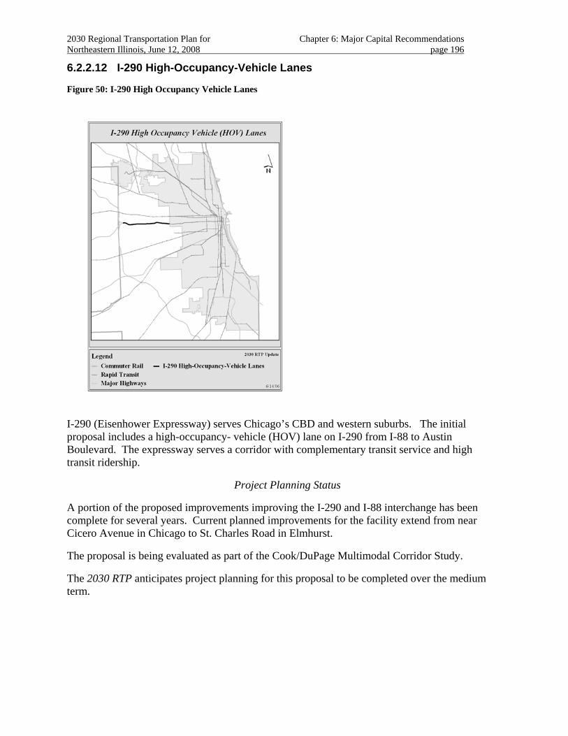
2030 Regional Transportation Plan for Chapter 6: Major Capital Recommendations Northeastern Illinois, June 12, 2008 page 196
6.2.2.12 I-290 High-Occupancy-Vehicle Lanes
Figure 50: I-290 High Occupancy Vehicle Lanes
I-290 (Eisenhower Expressway) serves Chicago’s CBD and western suburbs. The initial proposal includes a high-occupancy- vehicle (HOV) lane on I-290 from I-88 to Austin Boulevard. The expressway serves a corridor with complementary transit service and high transit ridership.
Project Planning Status
A portion of the proposed improvements improving the I-290 and I-88 interchange has been complete for several years. Current planned improvements for the facility extend from near Cicero Avenue in Chicago to St. Charles Road in Elmhurst.
The proposal is being evaluated as part of the Cook/DuPage Multimodal Corridor Study.
The 2030 RTP anticipates project planning for this proposal to be completed over the medium term.
2030 Regional Transportation Plan for Chapter 6: Major Capital Recommendations Northeastern Illinois, June 12, 2008 page 197
Regional Investment
The 2030 RTP includes the completed portion of the project at the I-290 /I-88 interchange as a “management recommendation” indicating an ongoing commitment to effective management and operation of the facility.254
Funds to evaluate and plan for the “Oak Park Cap” are included in the current federal authorization.
No funds have been identified for construction of this project.255
Safety improvements to the recently completed I-290/I-88 project should be addressed as a “management recommendation.” The 2030 RTP includes completion of the entire I-290 HOV Facility as a corridor recommendation.
Regional Plan Consistency
The project shows a high level of land use support from the 2040 Regional Framework Plan. The project crosses the Des Plaines River and terminates near historic Columbus Park, where adjacent auxiliary lanes and interchange improvements are planned. The project is also near the Gunderson Historic District.
The proposal is included for evaluation in the Cook/DuPage Multimodal Corridor Study. Continued evaluation of this proposal should include mass transit needs, non-motorized transportation, and the “Oak Park Cap” proposal.256 Economic development, including transit-oriented developments being planned in Maywood and Hillside, should be evaluated. Historic concerns, including Columbus Park, the Gunderson Historic District, and other sites should also be considered.
Because this is an intensively developed transportation corridor, securing rights-of-way for future multi-modal improvements should be a priority.
The 2030 RTP includes strategies for effectively managing and operating the region’s transportation system.
The I-290 High-Occupancy Vehicle (HOV) Facility is intended to provide increased through person-travel capacity in a congested travel corridor by providing capacity for transit and other high-occupancy vehicles.
254 The section of the freeway adjacent to Hillside was recently improved with alignment changes and resurfacing.
However, the existing pavement in this section will need to be reconstructed; upon reconstruction, the superelevation needs to be fixed to improve highway safety so that the road slopes into the curves, rather than away from the curves.
255 The traffic management requirements of HOV suggest that continued evaluation should also include the possibility of toll collection to finance project.
256 The Oak Park Cap proposal itself, included in SAFETEA-LU, needs to be addressed. The Cap includes access to transit, non-motorized facilities, additional local road connectivity, air pollution control, and open space. Alternative proposals for the Cap have been developed.
2030 Regional Transportation Plan for Chapter 6: Major Capital Recommendations Northeastern Illinois, June 12, 2008 page 198
The corridor has long been congested, partly because of a lane imbalance at both project termini. In addition, increasing numbers of trips along the corridor are not CBD-oriented, making them less amenable to diversion to existing transit.
Substantially reducing congestion along I-290 is unlikely. Therefore, priority lanes are proposed as an efficient and cost-effective solution to managing high demand. Priority access lanes are well-suited for transit service and carpools for dispersed suburban destinations. The priority lanes should be designed to complement existing and proposed transit service in the corridor.
By restricting travel to transit and other high-occupancy vehicles, the proposed I-290 HOV Facility should be intensively managed to operate at significantly higher speeds than adjacent multi-use lanes, thereby encouraging travel by these more efficient modes.
Geometric improvements are also planned for the existing facility to improve safety and operations.
Evaluation of the proposal should also consider objectives to ameliorate the environmental and community impact the freeway has had on the adjacent communities, and supports planned development centers in Maywood and Hillside. 257
This project parallels the Blue Line Forest Park Branch, which is also proposed to be extended in the 2030 RTP and whose service is integrated into the “Circle Line” proposal. Several other transit services are also in the project corridor. The RTP recommends updating the status of each of these interrelated proposals in individual corridor project studies. For existing and future transit services, non-motorized access to transit should be improved.258 Particular attention should be paid to providing safe walking and bicycling access across the I-290 corridor from adjoining neighborhoods and feeder bus services to existing and proposed transit services.
This proposal is heavily dependent on effective transportation management techniques, particularly the management of the facility to maintain high speeds and support transit operations.259
257 Including the “Oak Park Cap.
258 The Northeastern Illinois Greenways and Trails Plan includes the eastern part of the corridor as a trail improvement; part of this facility is included in the Oak Park Cap proposal.
259 A number of issues have been raised that need to be addressed by project engineering, consistent with 2030 RTP strategic guidance. These include: Transit service, an integral element of the corridor, needs to be addressed, including defining right-of-way for an eventual Blue Line extension through the corridor. Service frequency on the existing Forest Park Branch of the Blue Line doubled in 2006. In addition, if as intended, fixed-route bus service is established as an interim measure in the HOV lanes, station stops for such a service need to be provided. The specifics of transportation management techniques to be included in the project need to be addressed. In particular, the intent is to provide a facility that will operate at high speed to facilitate transit and high-occupancy vehicle service and to encourage the efficient use of the facility and services. Restrictions (2+, 3+, 4+) should be managed to maintain these high speeds. Consideration should also be given to adding a “value pricing” provision for the facility, again actively managed to control facility speed, but also to finance the project improvements. Lastly, ITS strategies for the project need to be clarified, with roadside equipment and communications needs addressed in project engineering. ITS strategies will be critical in effective implementation of other transportation management strategies.
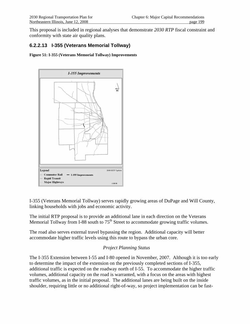
2030 Regional Transportation Plan for Chapter 6: Major Capital Recommendations Northeastern Illinois, June 12, 2008 page 199
This proposal is included in regional analyses that demonstrate 2030 RTP fiscal constraint and conformity with state air quality plans.
6.2.2.13 I-355 (Veterans Memorial Tollway)
Figure 51: I-355 (Veterans Memorial Tollway) Improvements
I-355 (Veterans Memorial Tollway) serves rapidly growing areas of DuPage and Will County, linking households with jobs and economic activity.
The initial RTP proposal is to provide an additional lane in each direction on the Veterans Memorial Tollway from I-88 south to 75th Street to accommodate growing traffic volumes.
The road also serves external travel bypassing the region. Additional capacity will better accommodate higher traffic levels using this route to bypass the urban core.
Project Planning Status
The I-355 Extension between I-55 and I-80 opened in November, 2007. Although it is too early to determine the impact of the extension on the previously completed sections of I-355, additional traffic is expected on the roadway north of I-55. To accommodate the higher traffic volumes, additional capacity on the road is warranted, with a focus on the areas with highest traffic volumes, as in the initial proposal. The additional lanes are being built on the inside shoulder, requiring little or no additional right-of-way, so project implementation can be fast-
2030 Regional Transportation Plan for Chapter 6: Major Capital Recommendations Northeastern Illinois, June 12, 2008 page 200
tracked. Construction is expected to begin in 2008. Thus, the project planning status is “short term.”
Construction is enabled by the Illinois Tollway’s additional financial capacity.
Regional Investment
Because funds for this project are identified in the Illinois Tollway’s Congestion-Relief Program, the project is included in the 2030 RTP as a “committed recommendation.”
Regional Plan Consistency
The project shows a high level of land use support the 2040 Regional Framework Plan. The project links a substantial employment center along I-88 with new and existing residential areas to the south. The initial proposal is completely within developed lands.
The 2030 RTP includes regional strategies for improved management and operations of the region’s major highway facilities.
This proposal is included in regional analyses that demonstrate 2030 RTP fiscal constraint and conformity with state air quality plans.
Public Priority
The proposal is included in Illinois Tollway’s Congestion Relief Program under the auspices of the State of Illinois
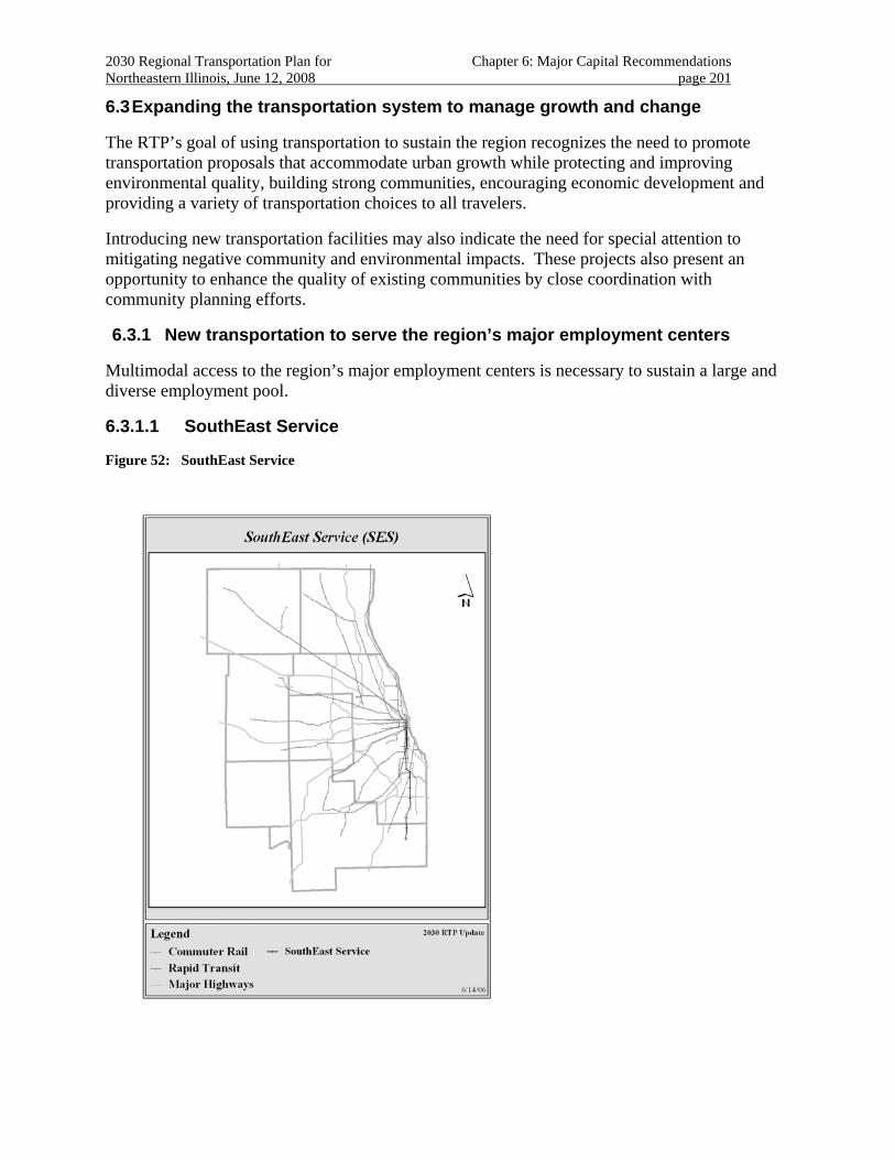
2030 Regional Transportation Plan for Chapter 6: Major Capital Recommendations Northeastern Illinois, June 12, 2008 page 201
6.3 Expanding the transportation system to manage growth and change
The RTP’s goal of using transportation to sustain the region recognizes the need to promote transportation proposals that accommodate urban growth while protecting and improving environmental quality, building strong communities, encouraging economic development and providing a variety of transportation choices to all travelers.
Introducing new transportation facilities may also indicate the need for special attention to mitigating negative community and environmental impacts. These projects also present an opportunity to enhance the quality of existing communities by close coordination with community planning efforts.
6.3.1 New transportation to serve the region’s major employment centers
Multimodal access to the region’s major employment centers is necessary to sustain a large and diverse employment pool.
6.3.1.1 SouthEast Service
Figure 52: SouthEast Service
2030 Regional Transportation Plan for Chapter 6: Major Capital Recommendations Northeastern Illinois, June 12, 2008 page 202
The proposal is to introduce a new commuter rail line serving Chicago, southern Cook and northeastern Will County.
The initial proposal is for a new 33-mile commuter rail line between the Chicago CBD and southern Cook/northeastern Will County suburbs. The proposed route runs north from Crete using primarily UP/CSX right-of-way, joining the Metra Rock Island District at Gresham to LaSalle Street Station.
Project Planning Status
Initial feasibility studies for the SouthEast Service Line are complete. 260 Several communities along the proposed line have evaluated station sites for the proposed service261.
Alternatives analyses are currently underway.
Complementary transportation improvements are being evaluated for the Red Line Extension and freight improvements associated with the CREATE Program.
The 2030 RTP anticipates project planning for this proposal to be completed over the medium term.
Regional Investment
Funding for construction is anticipated through discretionary federal grants made based on the proposal’s merits.262
The 2030 RTP includes the proposal as a “project recommendation.”
Regional Plan Consistency
The project shows a high level of land use support from the 2040 Regional Framework Plan. The project crosses streams and wetlands associated with Thorn Creek, Butterfield Creek and Plum Creek in the southern Cook/northern Will County segment of the project. The project is adjacent to Thorn Creek Forest Preserve properties in southern Cook County.
The project is expected to provide additional transit access to jobs from underserved areas and promote local economic development.263
260 A 1999 study by ICF Kaiser. The SouthEast Service Operations Study for the proposed rail line was completed
in February 2005 by CANAC for Metra.
261 The South Suburban Commuter Rail Corridor Land Use & Local Financing Study was completed for each proposed station site in December 2004 by Wilbur Smith Associates, consultant team for the South Suburban Mayors and Managers Association and the Village of South Holland.
262 An application for FTA New Starts funding is being prepared.
263 The project will encourage economic development in a part of the region that has lagged behind other areas of the region. The SouthEast Service is to provide a commuter rail alternative along the Metra Rock Island and Union Pacific/CSX right-of-way from Chicago south through such towns as Dolton, Thornton, Chicago Heights, Crete, and Beecher.
2030 Regional Transportation Plan for Chapter 6: Major Capital Recommendations Northeastern Illinois, June 12, 2008 page 203
The project supports adopted community and environmental strategies by providing additional transportation choices for communities. The proposal is supportive of local land use strategies. This new line would provide commuting opportunities for a fast growing, underserved corridor of the south suburbs.
The 2030 RTP includes strategies for effectively managing and operating the transportation system.
Alternatives evaluations include consideration of several choices of right-of-way and service patterns, including evaluating the potential to provide local community access along the entire route. The project should be closely coordinated with the proposals to extend the Red Line (rapid transit) and upgrades to the Rock Island District and SouthWest Service in this area.
These evaluations should also include examination of providing more frequent service and station locations within Chicago. Commuter parking, linkages to other transit services and non-motorized access to stations are also important to making the line a success.
Management and operations planning should include evaluating opportunities to reduce or eliminate conflicts with freight operations along the line. The project should be closely coordinated with strategic plans for freight rail improvements in the region. The UP/CSX line has been identified as a strategic rail freight corridor for the region by the rail freight industry.
This proposal should be included in evaluations conducted for other plan recommendations in the southern Chicago and the south suburbs multimodal corridor.
Project studies should proceed to address strategic guidance, including possible South Suburban Airport (SSA) access, freight accommodation, economic development, and non-motorized access to transit stations.
The project should also be coordinated with other transportation proposals, including the CTA Red Line Extension and potential high-speed intercity rail alternatives.
This proposal is included in regional analyses that demonstrate 2030 RTP fiscal constraint and conformity with state air quality plans.
Public Priority
The project has been authorized for evaluation in the current federal authorization
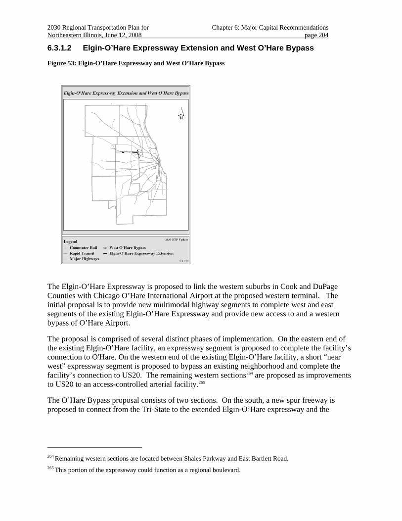
2030 Regional Transportation Plan for Chapter 6: Major Capital Recommendations Northeastern Illinois, June 12, 2008 page 204
6.3.1.2 Elgin-O’Hare Expressway Extension and West O’Hare Bypass
Figure 53: Elgin-O’Hare Expressway and West O’Hare Bypass
The Elgin-O’Hare Expressway is proposed to link the western suburbs in Cook and DuPage Counties with Chicago O’Hare International Airport at the proposed western terminal. The initial proposal is to provide new multimodal highway segments to complete west and east segments of the existing Elgin-O’Hare Expressway and provide new access to and a western bypass of O’Hare Airport.
The proposal is comprised of several distinct phases of implementation. On the eastern end of the existing Elgin-O’Hare facility, an expressway segment is proposed to complete the facility’s connection to O'Hare. On the western end of the existing Elgin-O’Hare facility, a short “near west” expressway segment is proposed to bypass an existing neighborhood and complete the facility’s connection to US20. The remaining western sections264 are proposed as improvements to US20 to an access-controlled arterial facility.265
The O’Hare Bypass proposal consists of two sections. On the south, a new spur freeway is proposed to connect from the Tri-State to the extended Elgin-O’Hare expressway and the
264 Remaining western sections are located between Shales Parkway and East Bartlett Road.
265 This portion of the expressway could function as a regional boulevard.
2030 Regional Transportation Plan for Chapter 6: Major Capital Recommendations Northeastern Illinois, June 12, 2008 page 205
planned O’Hare western terminal.266 On the north, a new connection will link the proposed western terminal with the Northwest Tollway.
Project Planning Status
Rights-of-way needed for the new facility have been evaluated, but are subject to ongoing development pressure.267 Large tracts of right-of-way have been acquired for the project.
The 2030 RTP anticipates project planning for the Elgin-O’Hare east extension project to be completed in the medium term, the west extension268 in the long term.
The 2030 RTP anticipates project planning for the O’Hare Bypass south of Thorndale to be completed in the medium term and north of Thorndale in long term.
The 2030 RTP anticipates that the two elements of the O’Hare Bypass project will be designed and implemented separately. 269
Investment Category
The Elgin-O’Hare extension proposal has been authorized to proceed in the current federal authorization.270 Increasing needs for expressway improvement resources will likely require an expressway solution to the Elgin-O’Hare East Extension to be tolled.271
Funds for construction of the O’Hare Bypass have not been identified.
The south leg of the Bypass is included in the Illinois Tollway Plan “Open Road’s for a Faster Future”.
The 2030 RTP includes the Elgin-O’Hare extension as a “corridor recommendation”.
266 The O’Hare Bypass is anticipated to be east of York Road as it passes airport property. This is a modification of
the original 2030 RTP proposal made to be consistent with the recently adopted plan by the Illinois Tollway.
267 Right-of-way acquisition has been on-going for the Elgin-O’Hare extensions. The required right-of-way is more fully acquired for the east than the west extensions. Right-of-way for the O’Hare Bypass has been set aside within Chicago O’Hare International Airport, east of York Road. No substantial right-of-way north or south of the O’Hare Airport boundary however, has been acquired for the project. This right-of way is now being studied.
268 The western section includes arterial improvements to Lake Street west of the second Lake Street crossing.
269 The O’Hare Bypass design concept, scope, and alignment south of Thorndale Avenue/Elgin-O’Hare Extension have been established. This is not the case however, north of Thorndale. The selection of an arterial solution as the preferred alternative is most likely in this corridor. Additional study of operations and alignments by an agency conversant with advanced arterial design is necessary for the north section. For the Elgin-O’Hare extensions, the alignment and logical termini have been established. However, staff understands that the design concept and scope in the initial proposal are being reviewed; an arterial solution in the acquired right-of-way may be proposed.
270 SAFETEA-LU has earmarked $140,000,000 for the Elgin-O’Hare Extension. 271 As of April, 2008, the addition of a project in the Wilmington area on I-55 to the fiscally constrained plan requires that alternative revenues be found for new highway corridors such as the Elgin-O’Hare. Current estimates indicate the need for such additional toll revenues to fund any such new expressway.
2030 Regional Transportation Plan for Chapter 6: Major Capital Recommendations Northeastern Illinois, June 12, 2008 page 206
The 2030 RTP includes the O’Hare Bypass south of Thorndale Avenue as a “project recommendation” and north of Thorndale, the project as a “corridor recommendation.”
Regional Plan Consistency
The project shows a high level of land use support from the 2040 Regional Framework Plan. The eastern section of the Elgin-O'Hare project crosses Salt Creek, Salt Creek Marsh and other properties of the Forest Preserve District of DuPage County. The O'Hare Bypass section may affect a concentration of palustrine wetlands in northeast DuPage County. The bypass may also pass through Silver Creek Forest Preserve, a property of the Forest Preserve District of DuPage County, in the northeast section of the county. The western section of the Elgin-O'Hare Expressway project may affect the numerous wetlands associated with the West Branch of the DuPage River on the north border of DuPage County. The project passes through an area that includes threatened and endangered species.
The area surrounding O'Hare includes mature residential and business communities. Attention should be paid to mitigating the impacts of the road on adjacent residents and businesses, strengthening economic development potential and providing for regional travel needs.
The project should also include close coordination with proposed airside and terminal capacity improvements at O'Hare International Airport.
The 2030 RTP includes strategies for effectively managing and operating the transportation system.
The facility is expected to provide a western access point to O’Hare’s passenger terminals, helping manage congestion at the eastern access of the airport. The O’Hare Bypass is ultimately intended to provide a new connection between I-294 and I-90.
For the O’Hare Bypass south of Thorndale, the Tollway proposal includes management and operations strategies consistent with 2030 RTP guidance.272
Several proposals for transit service in the corridor overlap portions of the proposed Elgin-O'Hare Expressway, including the DuPage “J” line transit service and possible elements of the STAR Line. The Elgin-O'Hare Expressway should be planned for multimodal use, including consideration of substantial local and regional transit service options.273
272 The project will address the following strategies, among others: context-sensitive solutions; toll revenue
financing, using value pricing to maximize efficiency; local advisory councils to serve as a forum for community interaction; the Tollway working with others to leverage and enhance required environmental mitigation into substantial improvements; incident detection and management, highway dynamic message signs, real-time traffic information, and other intelligent transportation system strategies. Progress is expected to continue south of Thorndale. North of Thorndale, how RTP strategies will be addressed should be the subject of further study. In particular, if an arterial solution is proposed, advanced arterial intersection strategies, that accommodate multi-modal travel while reducing delay, should be explored.
273 To accommodate multimodal travel, Thorndale Avenue might be considered as a multimodal boulevard as an interim step until full funding is available for the expressway and rail service. An expedited boulevard treatment could quickly meet some of the demand for east-west travel in DuPage County. In addition, widely spaced east- and west-bound road segments would facilitate innovative treatments of left-turn vehicles to reduce signal delay, while avoiding or delaying the expense of grade-separating the roadway. A right-of-way up to
2030 Regional Transportation Plan for Chapter 6: Major Capital Recommendations Northeastern Illinois, June 12, 2008 page 207
This section of the Elgin O'Hare passes through a major industrial and commercial goods distribution center for the region. Freight access management and operations will be important considerations in facility design. In addition, there are existing residential communities adjacent to the corridor that should be considered in mitigating the impacts of the project. Arterial designs should include signal improvements and access control.274
Pedestrian and bicycle accommodations and priority facilities for transit service would improve travel options for residents, employees and other corridor users. The safe accommodation of pedestrians and bicycles adjacent to the facility and at arterial connections should be included in the project design as appropriate. Particular attention should be paid to non-motorized access to rail stations and bus services.
The 2030 RTP recommends that improvements to the existing Elgin O’Hare sections provide a freeway-to-freeway connection between the Elgin-O’Hare and I-290. However, to the east, while the initial proposal remains a freeway, study of the project should continue, including the possibility for an arterial solution that addresses transit and community development.275 The 2030 RTP also recommends that further development of the Elgin-O’Hare proposal include consideration of the “J” Line Bus Rapid Transit and potential STAR Line alternatives and extensions.276
This proposal is included in regional analyses that demonstrate 2030 RTP fiscal constraint and conformity with state air quality plans.277
several hundred feet wide exists to accommodate this interim step. It will also provide a substantial part of the right-of-way for final construction. The Elgin-O'Hare is proposed to feed into a western bypass of O'Hare International Airport.
274 Access control can be enhanced by "backage roads" (access facilities set behind adjacent developments to reduce traffic conflicts near the arterial facility and to preserve right-of-way options adjacent to the arterial facility) and requirements that adjacent developments include motorized and non-motorized access to adjoining land uses, rather than relying strictly on arterial access.
275 For such an arterial solution, innovative accommodations of left-turn movements away from congested intersections should be studied to reduce through-movement delay. A “regional boulevard” concept was introduced during the original Shared Path 2030 process.
276 Additional study of the east extension of Elgin-O’Hare should determine how to accommodate future transit service envisioned through the DuPage “J” BRT Line or potential future rail service in the right-of-way. For the east extension, outstanding community concerns regarding the project, including the provision of DuPage “J” BRT service, should be addressed. In addition, design deficiencies that may contribute to the large number of crashes at the Rohlwing / Thorndale intersection need to be remedied.
277 Since 2006, additional lanes on Elmhurst Road have been modeled in lieu of a fully-funded O’Hare Bypass north of Thorndale Avenue.
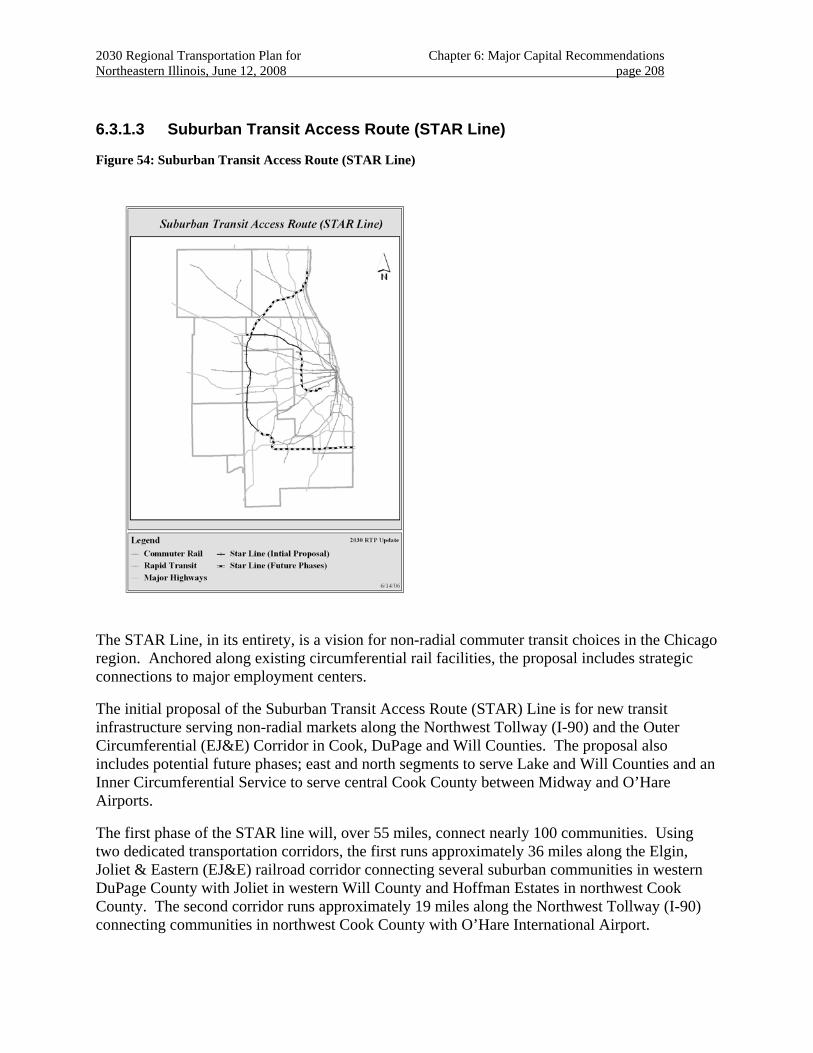
2030 Regional Transportation Plan for Chapter 6: Major Capital Recommendations Northeastern Illinois, June 12, 2008 page 208
6.3.1.3 Suburban Transit Access Route (STAR Line)
Figure 54: Suburban Transit Access Route (STAR Line)
The STAR Line, in its entirety, is a vision for non-radial commuter transit choices in the Chicago region. Anchored along existing circumferential rail facilities, the proposal includes strategic connections to major employment centers.
The initial proposal of the Suburban Transit Access Route (STAR) Line is for new transit infrastructure serving non-radial markets along the Northwest Tollway (I-90) and the Outer Circumferential (EJ&E) Corridor in Cook, DuPage and Will Counties. The proposal also includes potential future phases; east and north segments to serve Lake and Will Counties and an Inner Circumferential Service to serve central Cook County between Midway and O’Hare Airports.
The first phase of the STAR line will, over 55 miles, connect nearly 100 communities. Using two dedicated transportation corridors, the first runs approximately 36 miles along the Elgin, Joliet & Eastern (EJ&E) railroad corridor connecting several suburban communities in western DuPage County with Joliet in western Will County and Hoffman Estates in northwest Cook County. The second corridor runs approximately 19 miles along the Northwest Tollway (I-90) connecting communities in northwest Cook County with O’Hare International Airport.
2030 Regional Transportation Plan for Chapter 6: Major Capital Recommendations Northeastern Illinois, June 12, 2008 page 209
Project Planning Status
A feasibility study covering the I-90 (Northwest Tollway) portion of the project indicated significant potential for transit ridership in the corridor.278 A feasibility study for the Inner Circumferential Rail Line is also complete.279
Following an evaluation of alternatives, the initial O’Hare to Joliet portion of the STAR Line was endorsed by local and regional agencies as the preferred initial segment employing commuter rail-style service using the Northwest Tollway (I-90) from O’Hare to Hoffman Estates and the Elgin Joliet & Eastern (EJ&E) freight rail line from Hoffman Estates to Joliet. Planning for these future phases of the STAR Line will continue, and should be evaluated for coordination opportunities with other proposed commuter rail improvements.
Corridor-level planning studies have been completed. Early environmental studies, alternatives analyses, and feasibility studies are underway. Complementary projects, including reconstructing and expanding the Northwest Tollway are also being evaluated.
Further alternatives analyses of this initial segment are also being conducted.280
The 2030 RTP anticipates project planning for the initial proposal to be completed in the medium term. The 2030 RTP anticipates project planning for completion of the remainder of the STAR Line proposal over the long term.281
Investment Category
Funding for construction of the initial proposal is anticipated through discretionary federal grants made based on the proposal’s merits.282 Funding for construction of the remaining extensions has not been identified.
278 RTA, Northwest Corridor Feasibility Study, 2000.
279 This feasibility study was completed in April 1999 by Metra and STV, Inc. Several communities along the proposed line selected preferred station sites during that study. A preferred alignment has also been selected. The Inner Circumferential Commuter Rail Service Land Use & Community Planning Study was completed for each proposed station site in April 2003 by Parsons Brinckerhoff Quade & Douglas, consultant team for the North Central Council of Mayors and West Central Municipal Conference. The Design Set of Circumferential Rail Alternatives report was completed in March 2005 by the Parsons Brinckerhoff Quade & Douglas, consultant team for Metra. The CREATE Project (not funded) also recommends many improvements to the IHB Railroad. There is no known timeframe as to when this project would be completed.
280 While the initial proposal is for access to the O'Hare intermodal station in Rosemont, access to the proposed west terminal for O'Hare is also expected to be studied as an alternative. Western access would allow access both to a CTA connection at the proposed new western terminal and the proposed STAR Line. The Inner Circumferential line has been identified as a possible future phase of the STAR line. Alternative access to O'Hare is under evaluation.
281 For each station proposed by communities along the potential extensions, the STAR Line Potential Future Phases Land Use & Community Planning Study is in the process of being completed by S.B. Friedman & Company, consultant team for the Will County Governmental League and the City of Joliet. The Outer Circumferential Commuter Rail Feasibility Study was completed in April 1999 by TY Lin International. There is no known time frame as to when this project would be completed.
282 An application for FTA New Starts funding is being prepared.
2030 Regional Transportation Plan for Chapter 6: Major Capital Recommendations Northeastern Illinois, June 12, 2008 page 210
The 2030 RTP includes the initial phase of the STAR Line as a “project recommendation” and the remaining phases of the STAR Line as “corridor recommendations”.
Regional Plan Consistency
The project shows a high level of land use support from the 2040 Regional Framework Plan.283
In Lake County, the STAR Line project is within the Lake Michigan Watershed, identified as very high priority for protection and/or restoration. The project traverses forest preserves including Old School, McArthur Woods, Cuba Marsh and others, most of which contain threatened and endangered species communities. The project crosses major river and stream systems including the Des Plaines River.
The STAR Line project is also adjacent to three major properties of the Forest Preserve District of north Cook County including Poplar Creek, Paul Douglas and Ned Brown Forest Preserves. The STAR Line project traverses Crab Tree Forest Preserve. The project passes through a concentration of streams and palustrine wetlands associated with the Poplar Creek and Spring Creek Systems and a concentration of threatened and endangered species along the north border of the Ned Brown Forest Preserve and the Crab Tree Nature Center.
In DuPage County, the project traverses major forest preserves, including Pratts Wayne Woods and West Chicago Prairie. The project crosses or is adjacent to major streams including segments of the DuPage River System and Waubonsee Creek. The corridor also abuts the Fermi National Accelerator Laboratory (Fermilab).284
In Will and south Cook County, the project traverses major forest preserves including Higinbotham Woods, Hickory Creek, Butterfield Creek and Thorn Creek. The project crosses or is adjacent to major streams including the Wolf Creek System, the West Branch of the DuPage River, the Des Plaines River and the Hickory Creek system in Will County, and the Butterfield and Thorn Creek systems in south Cook County. The project is within both DuPage River and Lower Des Plaines River Watersheds, which have been identified as high priority and very high priority for protection and/or restoration.
The portion of this proposal east of Joliet should be included in evaluations conducted for other plan recommendations in the southern Chicago and the south suburbs multimodal corridor.
The project will provide transportation choices for major regional activity centers. Portions of the project will encourage development in areas of existing infrastructure.285 Planning 283 Some work has been already been completed in regards to addressing land use around the proposed STAR Line
stations. For example, Parsons Brinckerhoff conducted a prototyping study in 2002 along the Northwest Corridor (O’Hare to Hoffman Estates) for about half of the stations designed to provide general characteristics for these stations. S.B. Friedman & Company completed the STAR Line Phase 1 – EJ&E Portion Land Use & Community Planning Study for each proposed stations site on March 29, 2005 for the Will County Governmental League and the City of Joliet. The Outer Circumferential Commuter Rail Feasibility Study was completed in April 1999 by TY LIN INTERNATIONAL BASCOR. The STAR Line Feasibility Study was completed in 2003 for Metra. Metra is currently performing an Alternatives Analysis for this project.
284 Cooperation between U.S. Department of Energy and project developers is suggested.
285 Additionally, the service corridor of the proposed STAR Line, and the lines with which it would integrate, link the most populated areas in our region. Areas with major hospitals, colleges and universities, and business and
2030 Regional Transportation Plan for Chapter 6: Major Capital Recommendations Northeastern Illinois, June 12, 2008 page 211
evaluations should address supportive land use strategies and non-motorized access to transit in the corridor.
The benefits are expected to include increased accessibility to communities for non-radial travel as well as improved mobility within the corridors. This will provide improved access to jobs and major activity centers which is expected to spur economic development along the project corridor, particularly at station locations.
The STAR Line is the first of its kind proposed to link growing suburban centers with major business, educational and employment opportunities. The proposal is intended to provide a reliable transit alternative to driving.
The 2030 RTP includes strategies for effective management and operation of the transportation system.
Close coordination with plans to reconstruct and widen the Northwest Tollway is important. Particular attention should be paid to providing safe walking and bicycling access along and across I-90 from adjoining neighborhoods and feeder bus services to proposed transit services. Opportunities for transit-oriented development should be explored at proposed stations to strengthen the transit service.
Management and operations planning should include evaluating opportunities to reduce or eliminate conflicts with freight operations along the line. The project should be closely coordinated with strategic plans for freight rail improvements in the region.
The Inner Circumferential (IHB) portion of the STAR Line has been identified as a strategic rail freight corridor for the region by the rail freight industry. Compatibility with adjacent freight operations should be evaluated.
Project development should be accommodated by related highway improvements, including the Northwest Tollway and the Elgin-O’Hare Expressway.
This proposal is included in regional analyses that demonstrate 2030 RTP fiscal constraint and conformity with state air quality plans.
Public Priority
Funding for alternatives analyses of the initial phase of the STAR Line is included in the current federal authorization.
6.3.2 New Transportation Corridors
Identifying new transportation corridors are a means of planning for and managing the pattern of new urban development or redevelopment. The region is expected to gain nearly two million
employment centers will benefit, including key job centers along the Northwest tollway such as Motorola's campus in Schaumburg and Sears' campus at Prairie Stone in Hoffman Estates. Through the STAR Line, Metra would establish key rail connections through the northwest, west and southwest suburbs and even offer an important base for extending suburban rail service in the future. The potential exists to extend service in later phases east from Joliet, north from Prairie Stone at Hoffman Estates, north and south along the Illinois Route 53/Interstate 290 corridor and to link O'Hare and Midway airports.
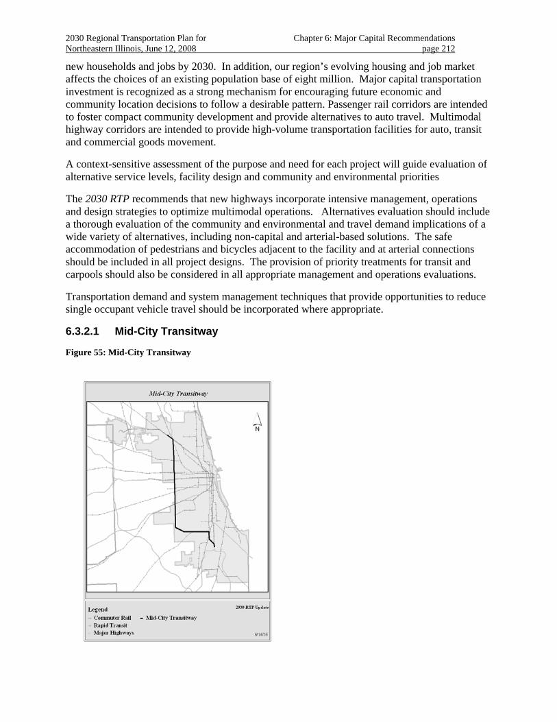
2030 Regional Transportation Plan for Chapter 6: Major Capital Recommendations Northeastern Illinois, June 12, 2008 page 212
new households and jobs by 2030. In addition, our region’s evolving housing and job market affects the choices of an existing population base of eight million. Major capital transportation investment is recognized as a strong mechanism for encouraging future economic and community location decisions to follow a desirable pattern. Passenger rail corridors are intended to foster compact community development and provide alternatives to auto travel. Multimodal highway corridors are intended to provide high-volume transportation facilities for auto, transit and commercial goods movement.
A context-sensitive assessment of the purpose and need for each project will guide evaluation of alternative service levels, facility design and community and environmental priorities
The 2030 RTP recommends that new highways incorporate intensive management, operations and design strategies to optimize multimodal operations. Alternatives evaluation should include a thorough evaluation of the community and environmental and travel demand implications of a wide variety of alternatives, including non-capital and arterial-based solutions. The safe accommodation of pedestrians and bicycles adjacent to the facility and at arterial connections should be included in all project designs. The provision of priority treatments for transit and carpools should also be considered in all appropriate management and operations evaluations.
Transportation demand and system management techniques that provide opportunities to reduce single occupant vehicle travel should be incorporated where appropriate.
6.3.2.1 Mid-City Transitway
Figure 55: Mid-City Transitway
2030 Regional Transportation Plan for Chapter 6: Major Capital Recommendations Northeastern Illinois, June 12, 2008 page 213
This 21-mile circumferential corridor extends from the Jefferson Park station on the CTA Blue Line south to Midway Airport on the Union Pacific and Belt Railway right-of-way and then southeast and east along the Belt Railway right-of-way to the 87th Street station on the CTA Red Line.
Project Planning Status
Alternative services and alignments are being evaluated, including bus rapid transit, light rail, heavy rail and priority for commercial goods movement. Evaluation of alternatives includes a dedicated bus and commercial vehicle facility or providing transit priority on existing streets. Complementary freight transportation proposals (including CREATE), are also being evaluated.
The 2030 RTP anticipates project planning for this proposal to be completed over them long term.
Investment Category
Funds for construction of this project have not been identified.
The 2030 RTP includes the Mid-City Transitway as a “corridor recommendation”.
Regional Plan Consistency
The project shows a high level of land use support from the 2040 Regional Framework Plan. The project is expected to enhance economic development opportunities in existing industrial corridors along the route as well as new opportunities for retail, hotel and other commercial uses. Substantial property along the right-of-way is available for redevelopment. Identifying and acquiring right-of-way should be a priority so that community interface and economic development objectives are addressed.286 Special attention should be given to potential for the line to be a catalyst for new major development in the vicinity of proposed stations. Efforts should be made to mitigate possible negative impacts during both the construction and operations phases of the line.
The proposal is intended to provide improved north-south transit access to the west, and improved east-west transit access to the south. The project will have a positive overall benefit to the communities through which it passes, and will be compatible with existing and proposed land uses. New transit service will connect with more than 25 bus routes, several commuter rail lines and most rapid transit routes. This is expected to reduce transit travel times between Chicago neighborhoods, especially between the northwest and southwest sides and between the Midway Airport area and the southeast and far south sides. The reductions in travel time are expected to have a considerable impact on reducing reliance on autos, thereby resulting in improved air quality.
The 2030 RTP includes strategies for effective management and operation of the transportation system.
286 By providing for improved public transportation, the Mid-City Transitway would complement investments in
over twenty Tax Increment Financing (TIF) districts and five industrial corridors located adjacent to the proposed alignment.
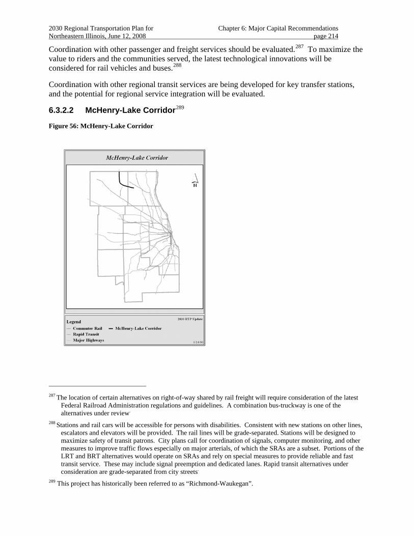
2030 Regional Transportation Plan for Chapter 6: Major Capital Recommendations Northeastern Illinois, June 12, 2008 page 214
Coordination with other passenger and freight services should be evaluated.287 To maximize the value to riders and the communities served, the latest technological innovations will be considered for rail vehicles and buses.288
Coordination with other regional transit services are being developed for key transfer stations, and the potential for regional service integration will be evaluated.
6.3.2.2 McHenry-Lake Corridor289
Figure 56: McHenry-Lake Corridor
287 The location of certain alternatives on right-of-way shared by rail freight will require consideration of the latest
Federal Railroad Administration regulations and guidelines. A combination bus-truckway is one of the alternatives under review.
288 Stations and rail cars will be accessible for persons with disabilities. Consistent with new stations on other lines, escalators and elevators will be provided. The rail lines will be grade-separated. Stations will be designed to maximize safety of transit patrons. City plans call for coordination of signals, computer monitoring, and other measures to improve traffic flows especially on major arterials, of which the SRAs are a subset. Portions of the LRT and BRT alternatives would operate on SRAs and rely on special measures to provide reliable and fast transit service. These may include signal preemption and dedicated lanes. Rapid transit alternatives under consideration are grade-separated from city streets.
289 This project has historically been referred to as “Richmond-Waukegan”.
2030 Regional Transportation Plan for Chapter 6: Major Capital Recommendations Northeastern Illinois, June 12, 2008 page 215
The initial proposal is to provide a fully access-controlled highway from the terminus of the US12 freeway at the Wisconsin border to the IL120 north extension near Wilson/Fairfield Road.
Project Planning Status
This proposal is substantiated by resolution of the Illinois General assembly in 1993 authorizing its study and evaluation by the Illinois State Toll Highway Authority.
Several arterial bypasses of corridor communities290 are being planned. These bypasses meet objectives independent of the complete proposal.
The 2030 RTP recognizes that the objectives of this proposal may be met by interim or alternative improvements.
The 2030 RTP anticipates project planning for this proposal to be completed over the long term.
Regional Investment
Funding for construction of this project has not been identified.
The 2030 RTP includes the McHenry-Lake Corridor as a “corridor recommendation”
Regional Plan consistency
The proposal is intended to provide increased highway accessibility to western Lake and eastern McHenry Counties.291 Recent development in this corridor has been rapid. Introduction of additional highway capacity in the corridor is constrained by sensitive environmental features292.
The project is located in the Upper Fox River and Nippersink Creek Watershed, identified as very high priority for protection and/or restoration. The project has high concentrations of palustrine wetlands, streams, and lakes including the Fox River, Chain of Lakes, Volo Bog and Nippersink Creek which contain woodlands and a large number of threatened and endangered species communities. The project is also adjacent to Glacial Park, a McHenry County Conservation District property that also encompasses a high concentration of threatened and endangered species communities. Attention to protecting these unique resources in the project development process is recommended.
Consideration of non-motorized travel along and across the entire proposed facility is recommended.
The 2030 RTP includes regional management and operations strategies for new multimodal highways.
290 The corridor communities include Richmond and McHenry.
291 Interim improvements to meet accessibility and mobility needs pending long-term project development are suggested. Interim improvements may include bypasses of McHenry and Richmond that are consistent with long-term development of a through facility.
292 Examples of sensitive environmental features include places like Glacial Park and Volo Bog.
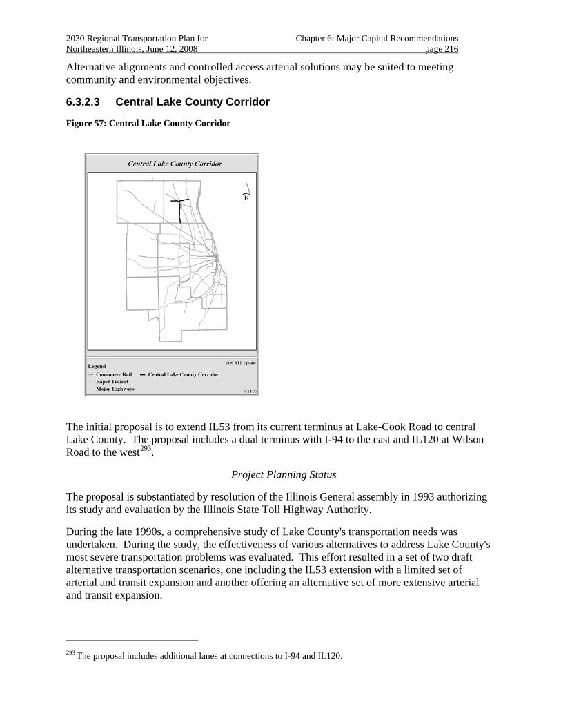
2030 Regional Transportation Plan for Chapter 6: Major Capital Recommendations Northeastern Illinois, June 12, 2008 page 216
Alternative alignments and controlled access arterial solutions may be suited to meeting community and environmental objectives.
6.3.2.3 Central Lake County Corridor
Figure 57: Central Lake County Corridor
The initial proposal is to extend IL53 from its current terminus at Lake-Cook Road to central Lake County. The proposal includes a dual terminus with I-94 to the east and IL120 at Wilson Road to the west293.
Project Planning Status
The proposal is substantiated by resolution of the Illinois General assembly in 1993 authorizing its study and evaluation by the Illinois State Toll Highway Authority.
During the late 1990s, a comprehensive study of Lake County's transportation needs was undertaken. During the study, the effectiveness of various alternatives to address Lake County's most severe transportation problems was evaluated. This effort resulted in a set of two draft alternative transportation scenarios, one including the IL53 extension with a limited set of arterial and transit expansion and another offering an alternative set of more extensive arterial and transit expansion.
293 The proposal includes additional lanes at connections to I-94 and IL120.
2030 Regional Transportation Plan for Chapter 6: Major Capital Recommendations Northeastern Illinois, June 12, 2008 page 217
Evaluation of a proposal to implement the dual terminus (a.k.a. “IL120 bypass) segment of the initial proposal is underway. The 2030 RTP recognizes that implementation of this portion of the project may function both as an interim improvement to the complete proposal and as an alternative to the complete proposal with independent utility to local communities.
The 2030 RTP anticipates project planning for the IL120 portion of the proposal to be completed in the medium term. Planning for the remaining improvements in the corridor is anticipated to be complete in the long term.
Regional Investment
Funding for construction of the project has not been identified.
The 2030 RTP includes the Central Lake County proposal as a “corridor recommendation.”
Regional Plan Consistency
The project showed a high level of land use support from the 2040 Regional Framework Plan. The project crosses areas dense with wetlands, rivers and streams, including the Mill Creek System, the Des Plaines River, Indian Creek and Buffalo Creek in the north-south segment. The project also passes through concentrations of threatened and endangered species especially dense in the east-west segments of the project. The project has been identified as potentially needing extensive environmental mitigation.
Rapid development in the Central Lake County Corridor has been occurring for decades. The RTP recognizes concerns raised regarding the compatibility of established communities with the traffic and development effects associated with a conventional expressway facility. The proposal is expected to intensify development patterns throughout the county.
Special attention to non-motorized travel along and across the facility is recommended, in addition to the consideration of express transit service along the corridor.
The 2030 RTP includes strategies for effective management and operation of the transportation summary.
The proposal is intended to provide improved accessibility for Central Lake County. The current terminus of Route 53 at Lake Cook Road diverts travelers from and through Lake County onto local roadways. While an initial proposal exists to construct a major highway facility, alternatives are still being considered. The 2030 RTP recognizes an alternative proposal, with less limited-access freeway, that includes more extensive arterial and transit expansion. In particular, addressing environmental concerns, ITS, non-motorized transportation, and transit are all important as further studies move forward.
The IL120 Bypass proposal is included in regional analyses that demonstrate 2030 RTP fiscal constraint and conformity with state air quality plans.
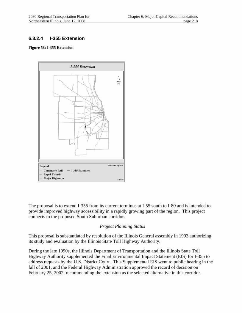
2030 Regional Transportation Plan for Chapter 6: Major Capital Recommendations Northeastern Illinois, June 12, 2008 page 218
6.3.2.4 I-355 Extension
Figure 58: I-355 Extension
The proposal is to extend I-355 from its current terminus at I-55 south to I-80 and is intended to provide improved highway accessibility in a rapidly growing part of the region. This project connects to the proposed South Suburban corridor.
Project Planning Status
This proposal is substantiated by resolution of the Illinois General assembly in 1993 authorizing its study and evaluation by the Illinois State Toll Highway Authority.
During the late 1990s, the Illinois Department of Transportation and the Illinois State Toll Highway Authority supplemented the Final Environmental Impact Statement (EIS) for I-355 to address requests by the U.S. District Court. This Supplemental EIS went to public hearing in the fall of 2001, and the Federal Highway Administration approved the record of decision on February 25, 2002, recommending the extension as the selected alternative in this corridor.
2030 Regional Transportation Plan for Chapter 6: Major Capital Recommendations Northeastern Illinois, June 12, 2008 page 219
The I-355 Extension, between the current I-355 terminus at I-55 and I-80, is largely complete and is open to traffic. 294
Regional Investment
The project remains in the RTP as a management recommendation.
Regional Plan Consistency
The project showed a high level of land use support from the Centers included in the 2040 Regional Framework Plan. The project passes through wooded and agricultural areas in northeast Will County. The project also passes through Keepataw Woods and Black Partridge, near concentrations of threatened and endangered species along Will County’s northern border with Cook County. The project crosses stream systems associated with the Des Plaines River including Spring Creek and is located in the Lower Des Plaines River Watershed, in an area considered very high priority for protection and/or restoration.
The 2030 RTP recommends that local communities remain active in managing project construction through the local advisory council process.
The 2030 RTP includes strategies for effective management and operation of the transportation system.
The project is designed with Open-Road Tolling, and will employ value pricing.
The project will address needs of non-motorized travel along and across the corridor. 295 Special attention to non-motorized travel along and across the facility is recommended, along with the consideration of express transit service.
This proposal is included in regional analyses that demonstrate 2030 RTP fiscal constraint and conformity with state air quality plans.
Public Priority
The proposal is included in Illinois Tollway’s “Open Roads for a Faster Future” under the auspices of the State of Illinois
294 Current activities include right-of-way preparation and preliminary construction activities for the mile-long
bridge over the Des Plaines Valley. Local road run-arounds are also being prepared to maintain traffic during construction.
295 The Tollway is providing right-of-way and grading for an adjacent bicycle trail, which is being developed through adjacent communities and counties.
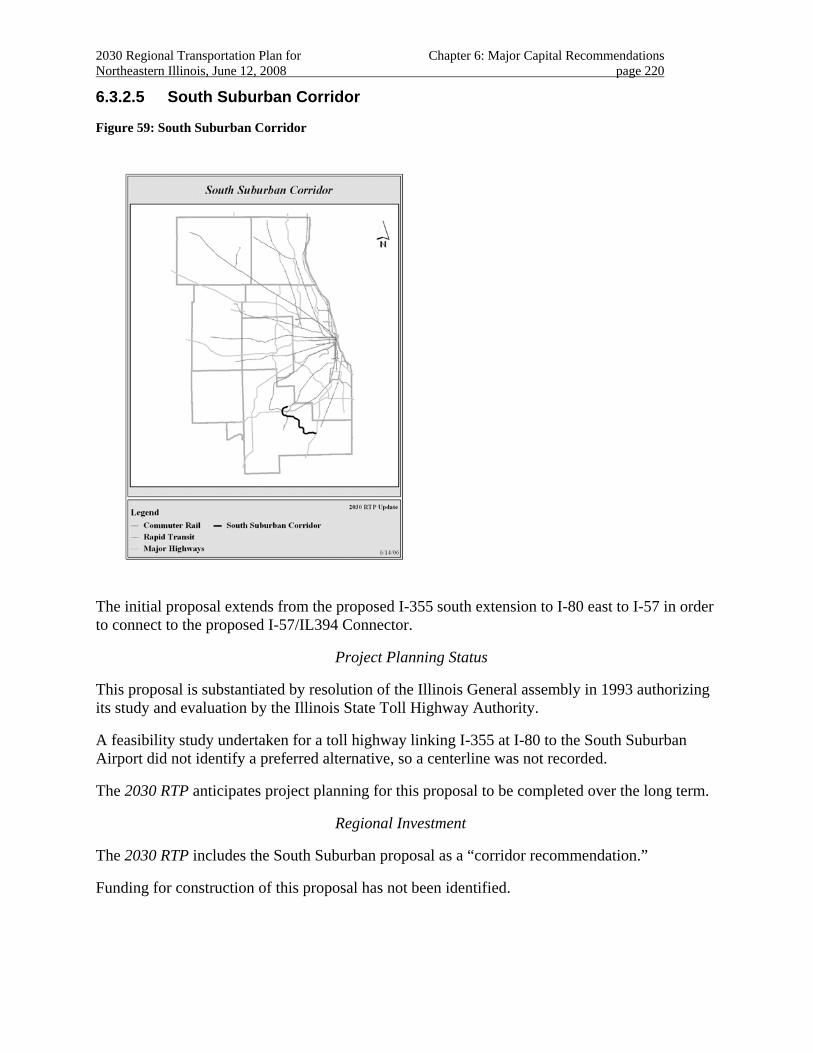
2030 Regional Transportation Plan for Chapter 6: Major Capital Recommendations Northeastern Illinois, June 12, 2008 page 220
6.3.2.5 South Suburban Corridor
Figure 59: South Suburban Corridor
The initial proposal extends from the proposed I-355 south extension to I-80 east to I-57 in order to connect to the proposed I-57/IL394 Connector.
Project Planning Status
This proposal is substantiated by resolution of the Illinois General assembly in 1993 authorizing its study and evaluation by the Illinois State Toll Highway Authority.
A feasibility study undertaken for a toll highway linking I-355 at I-80 to the South Suburban Airport did not identify a preferred alternative, so a centerline was not recorded.
The 2030 RTP anticipates project planning for this proposal to be completed over the long term.
Regional Investment
The 2030 RTP includes the South Suburban proposal as a “corridor recommendation.”
Funding for construction of this proposal has not been identified.
2030 Regional Transportation Plan for Chapter 6: Major Capital Recommendations Northeastern Illinois, June 12, 2008 page 221
Regional Plan Consistency
The project showed a high level of land use support from the 2040 Regional Framework Plan. The project crosses and abuts Hickory Creek and the Forked Creek System, which are “B” quality streams in central Will County; Jackson Creek, a “B” quality stream; and Manhattan Creek, an “A” quality stream.
The South Suburban Corridor is to address accessibility in an arc from I-80 to I-57 in a rapidly developing part of Will County.
The proposal is intended to provide improved highway accessibility for rapidly growing northern Will County. Right-of-way preservation should be considered for the project, owing to the rapid development occurring in the area. Alternative systems of arterial improvements should be considered during project evaluation.
Additional corridor study is necessary to reserve right of way for future improvements. 296
This proposal should be included in evaluations conducted for other plan recommendations in the southern Chicago and the south suburbs multimodal corridor.
The project is within the Lower Des Plaines River Watershed in northeastern and south Will County, identified as very high and high priority for protection and/or restoration, and the Kankakee Watershed in south Will County, considered very high priority for protection and/or restoration.
The 2030 RTP includes strategies for effective management and operation of the transportation system.
Special attention to non-motorized travel along and across the facility is recommended, along with the consideration of express transit service.
Controlled access arterial solutions297 should be considered to provide additional feasible alternatives.298
Implementation of interim or alternative improvements that have independent utility to local communities should be considered.
296 Given the fast pace of development now occurring, many of the corridors identified in the 1990’s feasibility work
are now being built upon.
297 Such solutions should be consistent with a “regional boulevard” framework.
298 The intent of such a boulevard would be to provide arterial access, with provision for advanced transportation management strategies to reduce delay, plus non-motorized and transit accommodation.
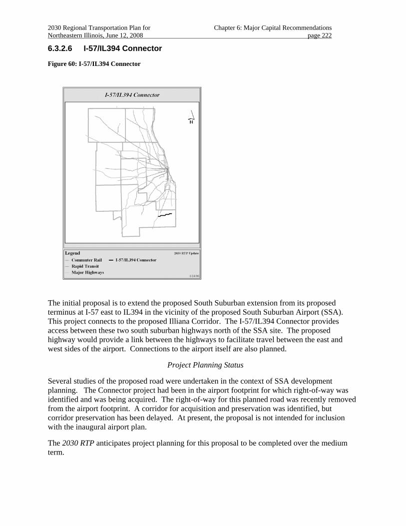
2030 Regional Transportation Plan for Chapter 6: Major Capital Recommendations Northeastern Illinois, June 12, 2008 page 222
6.3.2.6 I-57/IL394 Connector
Figure 60: I-57/IL394 Connector
The initial proposal is to extend the proposed South Suburban extension from its proposed terminus at I-57 east to IL394 in the vicinity of the proposed South Suburban Airport (SSA). This project connects to the proposed Illiana Corridor. The I-57/IL394 Connector provides access between these two south suburban highways north of the SSA site. The proposed highway would provide a link between the highways to facilitate travel between the east and west sides of the airport. Connections to the airport itself are also planned.
Project Planning Status
Several studies of the proposed road were undertaken in the context of SSA development planning. The Connector project had been in the airport footprint for which right-of-way was identified and was being acquired. The right-of-way for this planned road was recently removed from the airport footprint. A corridor for acquisition and preservation was identified, but corridor preservation has been delayed. At present, the proposal is not intended for inclusion with the inaugural airport plan.
The 2030 RTP anticipates project planning for this proposal to be completed over the medium term.
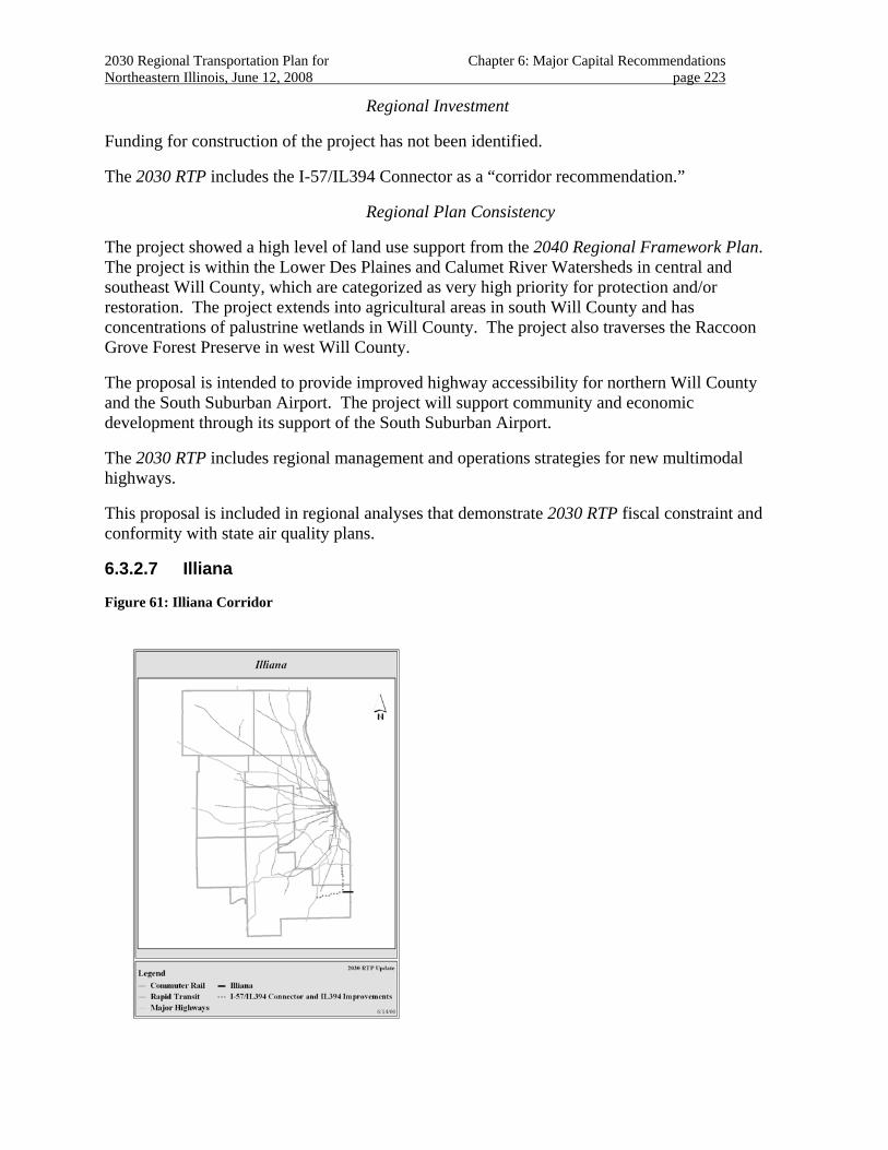
2030 Regional Transportation Plan for Chapter 6: Major Capital Recommendations Northeastern Illinois, June 12, 2008 page 223
Regional Investment
Funding for construction of the project has not been identified.
The 2030 RTP includes the I-57/IL394 Connector as a “corridor recommendation.”
Regional Plan Consistency
The project showed a high level of land use support from the 2040 Regional Framework Plan. The project is within the Lower Des Plaines and Calumet River Watersheds in central and southeast Will County, which are categorized as very high priority for protection and/or restoration. The project extends into agricultural areas in south Will County and has concentrations of palustrine wetlands in Will County. The project also traverses the Raccoon Grove Forest Preserve in west Will County.
The proposal is intended to provide improved highway accessibility for northern Will County and the South Suburban Airport. The project will support community and economic development through its support of the South Suburban Airport.
The 2030 RTP includes regional management and operations strategies for new multimodal highways.
This proposal is included in regional analyses that demonstrate 2030 RTP fiscal constraint and conformity with state air quality plans.
6.3.2.7 Illiana
Figure 61: Illiana Corridor
2030 Regional Transportation Plan for Chapter 6: Major Capital Recommendations Northeastern Illinois, June 12, 2008 page 224
The initial proposal is to extend the proposed I-57/IL394 Connector from its proposed terminus at IL394 east to I-65 in Indiana.
Project Planning Status
The Indiana portion of the facility is under consideration for inclusion in the long-range transportation plan by the Northwest Indiana Regional Planning Commission.
Initial feasibility studies of the Indiana proposal are underway.
The 2030 RTP anticipates project planning for this proposal to be completed over the long term.
Regional Investment
Funding for construction of this project in Illinois has not been identified.
The State of Indiana is considering financing construction of the facility using proceeds from its lease of the Indiana Toll Road.
The 2030 RTP includes the Illiana project a “corridor recommendation”.
Regional Plan Consistency
The project crosses Plum Creek System in four places, and is identified as a “C” quality stream. The project also passes Goodenow Grove, a Will County forest preserve that includes a high concentration of threatened and endangered species communities.
The proposal is intended to provide improved highway accessibility for northern Will County and provide a suitable freight route in the area. The project is to provide better access between the two states, and to distribute through traffic to freeway facilities, relieving arterials primarily in Indiana. The project may also strengthen the proposed South Suburban Airport in Illinois by improving highway access to the site. The project may support community and economic development through its support of the South Suburban Airport.
This proposal should be included in evaluations conducted for other plan recommendations in the southern Chicago and the south suburbs multimodal corridor.
The 2030 RTP includes regional management and operations strategies for new multimodal highways.
This proposal is included in regional analyses that demonstrate 2030 RTP fiscal constraint and conformity with state air quality plans.
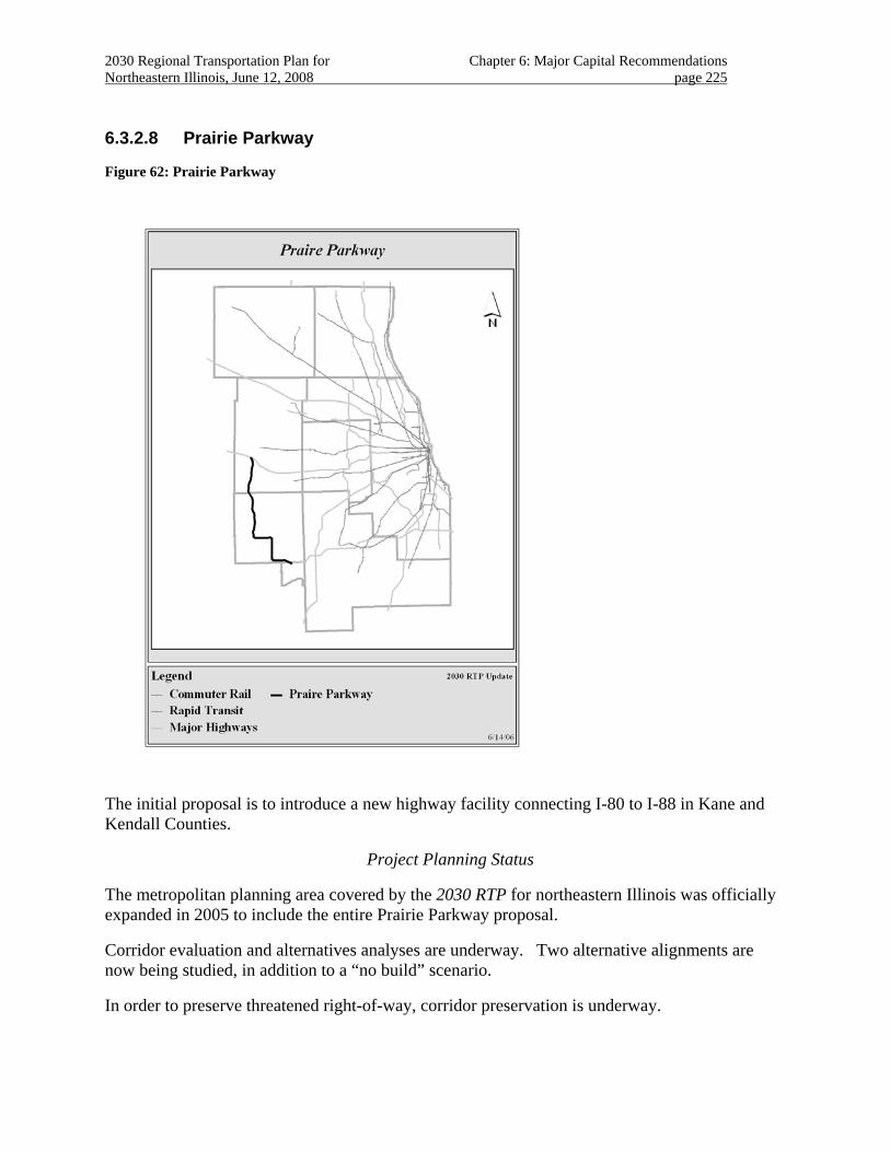
2030 Regional Transportation Plan for Chapter 6: Major Capital Recommendations Northeastern Illinois, June 12, 2008 page 225
6.3.2.8 Prairie Parkway
Figure 62: Prairie Parkway
The initial proposal is to introduce a new highway facility connecting I-80 to I-88 in Kane and Kendall Counties.
Project Planning Status
The metropolitan planning area covered by the 2030 RTP for northeastern Illinois was officially expanded in 2005 to include the entire Prairie Parkway proposal.
Corridor evaluation and alternatives analyses are underway. Two alternative alignments are now being studied, in addition to a “no build” scenario.
In order to preserve threatened right-of-way, corridor preservation is underway.
2030 Regional Transportation Plan for Chapter 6: Major Capital Recommendations Northeastern Illinois, June 12, 2008 page 226
The 2030 RTP anticipates project planning for this proposal to be completed over the medium term.
Regional Investment
Evaluation of an “I–80 to I–88 North-South Connector in Illinois is included in the current federal authorization.299
The 2030 RTP includes the Prairie Parkway proposal as a “corridor recommendation.”
Regional Plan Consistency
The project is in a watershed identified as very high priority for protection and/restoration in Kane and Kendall Counties. The project also traverses prime farmland. Consideration of farmland protection is recommended.
The area is rapidly developing with rapid residential and commercial growth. The proposal is to provide improved access between Grundy, Kendall and Southern Kane Counties.
The project is being developed to minimize potential environmental and development impacts.
The RTP recommends that alignment, staging and facility alternatives be considered in the study to address community and environmental concerns.
Early centerlines have been modified to reduce the impacts of the highway on sensitive areas. The cross section includes extensive roadside swales and marshes to manage roadway runoff. The project includes a generous median and careful roadside planning to provide a safe facility for travel.
Local communities are being consulted regarding access issues, particularly regarding community public safety needs. Supportive land use decisions (e.g., school siting to minimize the impact of the road on school travel) are also being evaluated. Improvements to local and arterial streets are planned as part of the improvement to maintain access.
Other transportation improvements are included in preliminary plans. These include traffic management and travel demand techniques, bicycle trails, expanded bus service, and reserving a right-of-way for a future transit improvement.
This proposal is included in regional analyses that demonstrate 2030 RTP fiscal constraint and conformity with state air quality plans.
Public Priority
Funding for evaluation and partial construction of the Prairie Parkway is included in the current federal authorization.
299 The current federal authorization is $152,000,000.
2030 Regional Transportation Plan for Chapter 7: Implementation Northeastern Illinois, June 12, 2008 page 227
CHAPTER 7. IMPLEMENTATION OF THE 2030 REGIONAL TRANSPORTATION PLAN
As outlined in Chapter 4, the capital element is organized around an assessment of each project’s priority for implementation. These are:
• Project Planning Status
• Regional Investment Category
• Consistency with Regional Plans, and
• Public Priority
The following lists summarize project priorities as they appear in the preceding proposal descriptions.
7.1 Project Planning Status
7.1.1 Short term
• Brown Line Improvements
• I-294 South Improvements
• I-55 Interim Improvements
• I-355 Improvements
• SouthWest Service Improvements (CREATE Passenger Corridor)
• I-88 Improvements
• I-294/94 North Improvements
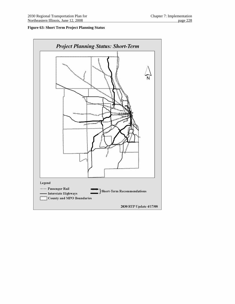
2030 Regional Transportation Plan for Chapter 7: Implementation Northeastern Illinois, June 12, 2008 page 228
Figure 63: Short Term Project Planning Status
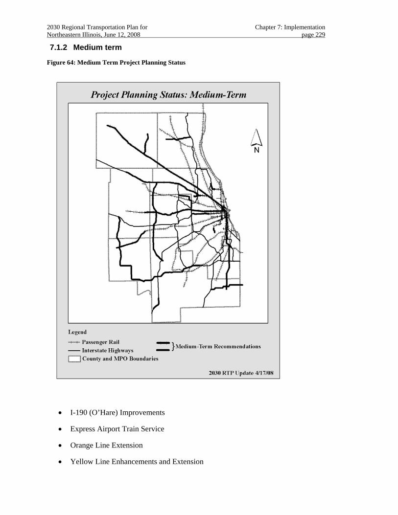
2030 Regional Transportation Plan for Chapter 7: Implementation Northeastern Illinois, June 12, 2008 page 229
7.1.2 Medium term
Figure 64: Medium Term Project Planning Status
• I-190 (O’Hare) Improvements
• Express Airport Train Service
• Orange Line Extension
• Yellow Line Enhancements and Extension
2030 Regional Transportation Plan for Chapter 7: Implementation Northeastern Illinois, June 12, 2008 page 230
• Red Line Extension
• Union Pacific Northwest Upgrade and Extension
• Union Pacific West Improvements
• I-90 Improvements
• STAR Line Phase I
• Central Lake County Corridor (IL 120 element)
• Circle Line Completion
• BNSF Railway Extension
• I-290 High Occupancy Vehicle Lanes
• SouthEast Commuter Rail Service
• I-57/IL394 Connector
• Illiana
• I-55 Improvements (North River Road to Coal City Road)
• I-80 Improvements
• Elgin-O’Hare East Extension
• O’Hare Bypass South
• Prairie Parkway
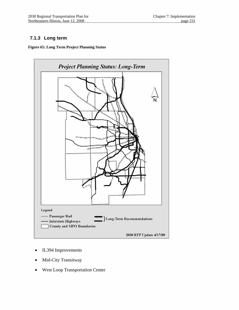
2030 Regional Transportation Plan for Chapter 7: Implementation Northeastern Illinois, June 12, 2008 page 231
7.1.3 Long term
Figure 65: Long Term Project Planning Status
• IL394 Improvements
• Mid-City Transitway
• West Loop Transportation Center
2030 Regional Transportation Plan for Chapter 7: Implementation Northeastern Illinois, June 12, 2008 page 232
• Green Line Enhancements
• Blue Line West Extension
• Union Pacific North Upgrades
• Heritage Corridor Upgrades
• Rock Island Improvements and Extension
• SouthWest Service Extension
• North Central Service Upgrade (Phase 2)
• Milwaukee District West Upgrade and Extension
• Milwaukee District North Upgrade and Extension
• I-57 Improvements
• I-55 Improvements (I-80 – North River Road)
• Elgin-O’Hare Improvements
• Elgin-O’Hare West Extension
• O’Hare Bypass North
• STAR Line Completion
• McHenry-Lake Corridor
• Central Lake County Corridor (IL 53 element)
• South Suburban Corridor
• Metra Electric Improvements and Extension
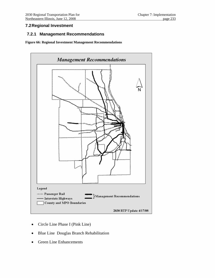
2030 Regional Transportation Plan for Chapter 7: Implementation Northeastern Illinois, June 12, 2008 page 233
7.2 Regional Investment
7.2.1 Management Recommendations
Figure 66: Regional Investment Management Recommendations
• Circle Line Phase I (Pink Line)
• Blue Line Douglas Branch Rehabilitation
• Green Line Enhancements
2030 Regional Transportation Plan for Chapter 7: Implementation Northeastern Illinois, June 12, 2008 page 234
• SouthWest Service to Manhattan
• North Central Service Upgrades
• Union Pacific West to Elburn
• I-355 Extension
• I-90/94 (Dan Ryan) Improvements
• I-80/94 (Kingery) Improvements
7.2.2 Strategic Recommendations
• Central Area Bus Rapid Transit
• DuPage “J” Bus Rapid Transit
• Cermak Road Bus Rapid Transit
• Golf Road Bus Rapid Transit
• Ogden Avenue Transitway
• Pace Arterial Rapid Transit Systems
• CTA Neighborhood Express
• Pace Express Bus Transit Systems
• CREATE Corridors
• NHS Intermodal Connectors
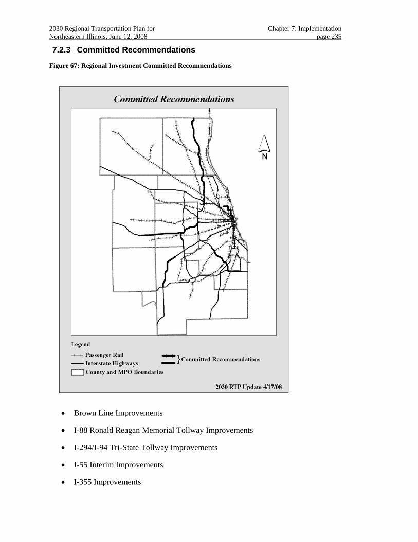
2030 Regional Transportation Plan for Chapter 7: Implementation Northeastern Illinois, June 12, 2008 page 235
7.2.3 Committed Recommendations
Figure 67: Regional Investment Committed Recommendations
• Brown Line Improvements
• I-88 Ronald Reagan Memorial Tollway Improvements
• I-294/I-94 Tri-State Tollway Improvements
• I-55 Interim Improvements
• I-355 Improvements
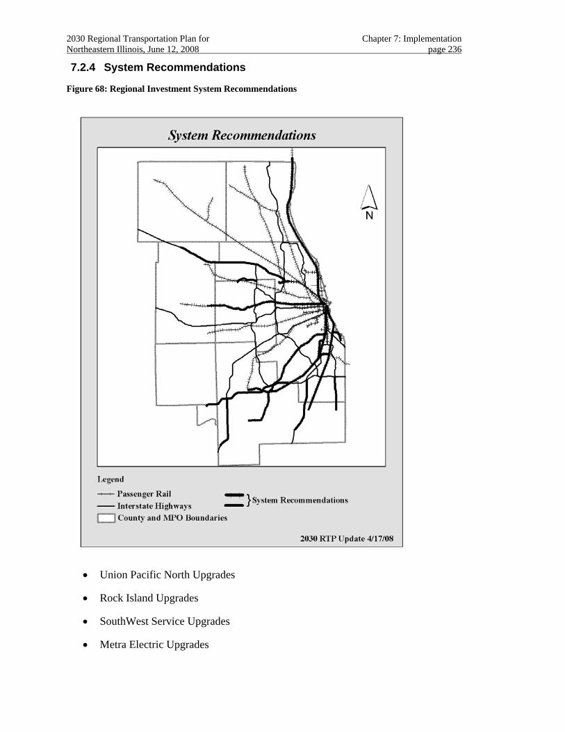
2030 Regional Transportation Plan for Chapter 7: Implementation Northeastern Illinois, June 12, 2008 page 236
7.2.4 System Recommendations
Figure 68: Regional Investment System Recommendations
• Union Pacific North Upgrades
• Rock Island Upgrades
• SouthWest Service Upgrades
• Metra Electric Upgrades
2030 Regional Transportation Plan for Chapter 7: Implementation Northeastern Illinois, June 12, 2008 page 237
• Union Pacific West Upgrades
• I-190 (O’Hare) Improvements
• IL394 Improvements
• I-57 Improvements
• I-80 Improvements
• I-90 Jane Addams Memorial Tollway Improvements
• I-55 Improvements (South)
• Elgin-O’Hare Expansion
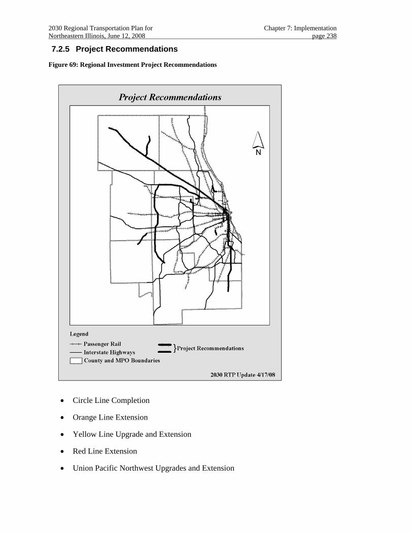
2030 Regional Transportation Plan for Chapter 7: Implementation Northeastern Illinois, June 12, 2008 page 238
7.2.5 Project Recommendations
Figure 69: Regional Investment Project Recommendations
• Circle Line Completion
• Orange Line Extension
• Yellow Line Upgrade and Extension
• Red Line Extension
• Union Pacific Northwest Upgrades and Extension
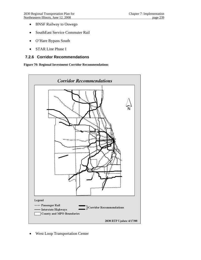
2030 Regional Transportation Plan for Chapter 7: Implementation Northeastern Illinois, June 12, 2008 page 239
• BNSF Railway to Oswego
• SouthEast Service Commuter Rail
• O’Hare Bypass South
• STAR Line Phase I
7.2.6 Corridor Recommendations
Figure 70: Regional Investment Corridor Recommendations
• West Loop Transportation Center
2030 Regional Transportation Plan for Chapter 7: Implementation Northeastern Illinois, June 12, 2008 page 240
• Express Airport Train Service
• Blue Line West Extension
• Heritage Corridor Upgrades
• Rock Island Extension
• SouthWest Service Extension
• Metra Electric Extension
• Milwaukee District West Extensions
• Milwaukee District North Extensions
• BNSF Railway to Plano
• I-290 High Occupancy Vehicle Lanes
• Elgin-O’Hare Extensions
• O’Hare Bypass North
• STAR Line Completion
• Mid-City Transitway
• McHenry-Lake Corridor
• Central Lake County Corridor
• South Suburban Corridor
• I-57/IL394 Corridor
• Illiana
• Prairie Parkway
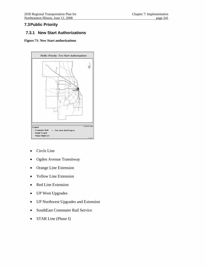
2030 Regional Transportation Plan for Chapter 7: Implementation Northeastern Illinois, June 12, 2008 page 241
7.3 Public Priority
7.3.1 New Start Authorizations
Figure 71: New Start authorizations
• Circle Line
• Ogden Avenue Transitway
• Orange Line Extension
• Yellow Line Extension
• Red Line Extension
• UP West Upgrades
• UP Northwest Upgrades and Extension
• SouthEast Commuter Rail Service
• STAR Line (Phase I)
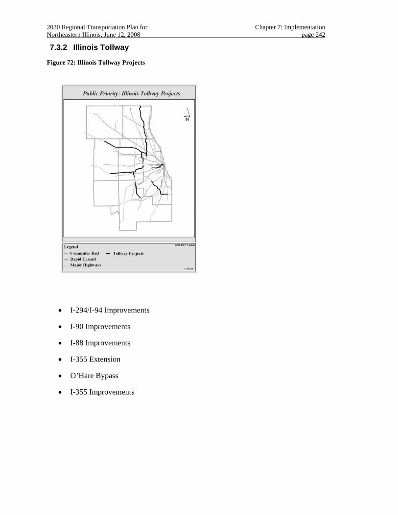
2030 Regional Transportation Plan for Chapter 7: Implementation Northeastern Illinois, June 12, 2008 page 242
7.3.2 Illinois Tollway
Figure 72: Illinois Tollway Projects
• I-294/I-94 Improvements
• I-90 Improvements
• I-88 Improvements
• I-355 Extension
• O’Hare Bypass
• I-355 Improvements
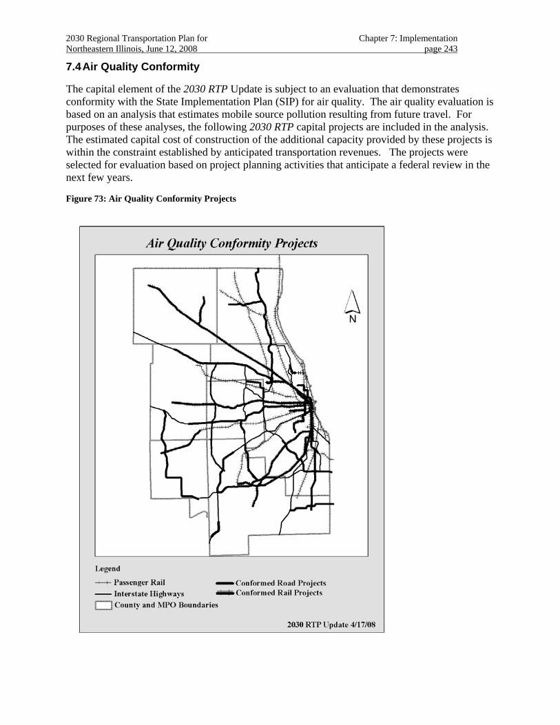
2030 Regional Transportation Plan for Chapter 7: Implementation Northeastern Illinois, June 12, 2008 page 243
7.4 Air Quality Conformity
The capital element of the 2030 RTP Update is subject to an evaluation that demonstrates conformity with the State Implementation Plan (SIP) for air quality. The air quality evaluation is based on an analysis that estimates mobile source pollution resulting from future travel. For purposes of these analyses, the following 2030 RTP capital projects are included in the analysis. The estimated capital cost of construction of the additional capacity provided by these projects is within the constraint established by anticipated transportation revenues. The projects were selected for evaluation based on project planning activities that anticipate a federal review in the next few years.
Figure 73: Air Quality Conformity Projects

2030 Regional Transportation Plan for Chapter 7: Implementation Northeastern Illinois, June 12, 2008 page 244
• Circle Line
• Express Airport Transit Service
• Brown Line Improvements
• Orange Line extension
• Red Line extension
• Yellow Line upgrade and extension
• UP West upgrade
• UP Northwest upgrade and extension
• Rock Island Upgrade
• BNSF Railway extension
• SouthWest Service (CREATE Passenger Corridor)
• I-190 upgrade
• I-80/94 Kingery Expressway upgrade
• I-90/94 Dan Ryan Expressway upgrade
• I-55 upgrade
• I-294 upgrade
• I-80 upgrade
• I-88 upgrade
• I-90 upgrade
• I-290 priority lanes
• SouthEast Service
• STAR Line (Phase I)
• I-355 extension
• I-355 Improvements
• Elgin-O’Hare extension (east)
• O’Hare Bypass, south
• Central Lake County (IL120 Bypass)
2030 Regional Transportation Plan for Chapter 7: Implementation Northeastern Illinois, June 12, 2008 page 245
• I-57/IL394 Connector
• Prairie Parkway
• Illiana Extension
7.5 Public Engagement300
Regional transportation projects result from long, complex decision making processes. Public participation is an important part of these processes. This report discusses the results of the public engagement effort focused on the 2030 Regional Transportation Plan (RTP) Update. This process involved seven workshops conducted throughout the planning region that utilized a novel public outreach tool that illustrates transportation investment decisions in the form of an engaging board game301. The tool allows workshop participants to simulate the process decision-makers use to decide on how transportation funds should be invested. The public outreach effort also involved a web-based survey that was used to reach a large regional audience.302
The results of this public engagement effort showed strong support for the themes presented in the 2030 RTP. Three of the seven themes were identified as the most important issues for the region based upon findings from gaming tool and the survey:
• More and better integrated public transit
• Better land use and transportation integration
• Improved transportation congestion management
The desire to improve the public transit system was expressed in terms of project choices from the game and the results of survey. The tool allowed for the participants to choose among numerous regional transportation projects. The project choices made by the workshop participants showed overwhelming support for the expansion of transit lines throughout the region. Of interest, strong support was present for circumferential lines (north-south) that would connect transit lines that radiate outward from downtown Chicago. Likewise, the survey showed that on a scale of 1 (not important) to 5 (very important) the participants ranked the improvement and expansion of the public transportation systems as 4.7.
300 The following section is excerpted from the draft “Regional Report for the Public Involvement Process for the
2030 Regional Transportation Plan. This independently prepared report will be made available in its entirety as part of the official record of public comment that will accompany the final adopted 2030 RTP Update.
301 TransopolySM developed by the Center for Neighborhood Technology (CNT). 302 Emails and websites were the primary means used to notify people about the workshop and internet survey. Six
hundred ninety (690) people completed the survey and one hundred fifty-two (152) people attended the workshops. Twenty workshop attendees had already filled out the online survey and were asked not to submit one a second time.
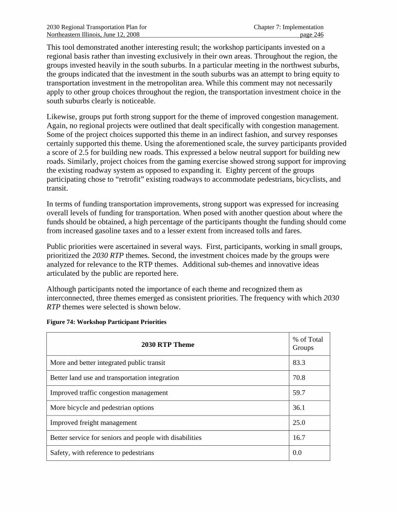
2030 Regional Transportation Plan for Chapter 7: Implementation Northeastern Illinois, June 12, 2008 page 246
This tool demonstrated another interesting result; the workshop participants invested on a regional basis rather than investing exclusively in their own areas. Throughout the region, the groups invested heavily in the south suburbs. In a particular meeting in the northwest suburbs, the groups indicated that the investment in the south suburbs was an attempt to bring equity to transportation investment in the metropolitan area. While this comment may not necessarily apply to other group choices throughout the region, the transportation investment choice in the south suburbs clearly is noticeable.
Likewise, groups put forth strong support for the theme of improved congestion management. Again, no regional projects were outlined that dealt specifically with congestion management. Some of the project choices supported this theme in an indirect fashion, and survey responses certainly supported this theme. Using the aforementioned scale, the survey participants provided a score of 2.5 for building new roads. This expressed a below neutral support for building new roads. Similarly, project choices from the gaming exercise showed strong support for improving the existing roadway system as opposed to expanding it. Eighty percent of the groups participating chose to “retrofit” existing roadways to accommodate pedestrians, bicyclists, and transit.
In terms of funding transportation improvements, strong support was expressed for increasing overall levels of funding for transportation. When posed with another question about where the funds should be obtained, a high percentage of the participants thought the funding should come from increased gasoline taxes and to a lesser extent from increased tolls and fares.
Public priorities were ascertained in several ways. First, participants, working in small groups, prioritized the 2030 RTP themes. Second, the investment choices made by the groups were analyzed for relevance to the RTP themes. Additional sub-themes and innovative ideas articulated by the public are reported here.
Although participants noted the importance of each theme and recognized them as interconnected, three themes emerged as consistent priorities. The frequency with which 2030 RTP themes were selected is shown below.
Figure 74: Workshop Participant Priorities
2030 RTP Theme % of Total Groups
More and better integrated public transit 83.3
Better land use and transportation integration 70.8
Improved traffic congestion management 59.7
More bicycle and pedestrian options 36.1
Improved freight management 25.0
Better service for seniors and people with disabilities 16.7
Safety, with reference to pedestrians 0.0
2030 Regional Transportation Plan for Chapter 7: Implementation Northeastern Illinois, June 12, 2008 page 247
Each of the themes is assessed below.
7.5.1 More and better integrated public transit
The most significant finding from the seven meetings is the strong support for transit investment throughout the region. This support was evident in the prioritization of themes and in the game investments made in all areas of the region. Every group in the region made some transit investment. Sixteen groups invested exclusively in transit. While participants ensured new transit in their own section of the region, they also invested in transit throughout the region in a pattern that coordinated and improved existing transit offerings.
7.5.2 Better land use and transportation integration
The positive response to this RTP theme was nearly as widespread, with 71% of tables selecting it, as was the first place choice. Participants faced some of the same challenges that decision makers encounter when trying to articulate the relationship between land use and transportation integration through the selection of major projects. One set of “purchases” that is illustrative of this priority, however, is the heavy emphasis on purchasing transit stations.
7.5.3 Improved traffic congestion management
Participants named congestion management as their third ranked thematic priority and addressed it with a holistic approach, using a variety of techniques. Improved transit, improved land use, safer and more abundant bicycle and pedestrian options, all of which are RTP themes in their own right, contribute to congestion management.
The most significant finding in this area is that over 80% of the tables (the highest single percentage among all choices offered) chose to invest some portion of their funds to retrofit existing arterial highways, and occasionally interstate highways, to better accommodate transit, pedestrian, and bicycle options. This result is related to the theme of land use and transit integration, since full development of multi-modal ways would require street-side reduction of existing curb cut openings to parking, improvements to transit waiting areas, dedication of areas to bicycle parking, and other similar modifications.
7.5.4 More bicycle and pedestrian options
This priority most often was expressed through the purchase of multi-modal retrofits for existing roadways. Eighty percent of the groups chose to retrofit arterial roads and occasionally expressed a desire to retrofit interstate highways. The multi-modal choice was the only “project” option available to address pedestrian and bicycle within this version of the game, and it was used creatively.
7.5.5 Improved freight management
In addition to many groups selecting freight management as one of three priorities, participants showed a good deal of knowledge of the CREATE (Chicago Region Environmental and Transportation Efficiency Program) Plan. Although the infrastructure offered for “purchase” did not include freight rail, groups applied unique and/or innovative infrastructure to express an interest in funding the CREATE Plan eleven times throughout the workshops. This included
2030 Regional Transportation Plan for Chapter 7: Implementation Northeastern Illinois, June 12, 2008 page 248
“purchasing” several grade separations for CREATE, but not applying them to specific geographies.
7.5.6 Services and Safety
Neither of these themes received emphasis as stand-alone choices when participants were limited to three thematic choices (although the survey results indicate moderate to high priority for all of the themes [see Table 3-1]). Table facilitators report that in conversation about choosing themes, frequent reference was made to these themes as outcomes to improvements in transit, land use, and bicycle/pedestrian options. In at least three instances, paratransit improvements were specified as a Regional Innovation. Eighty percent of the tables choosing to retrofit existing highways into multi-modal corridors also indicates a desire to create travel choices that could be perceived as safe, accessible, and desirable for the all ages and ability levels.
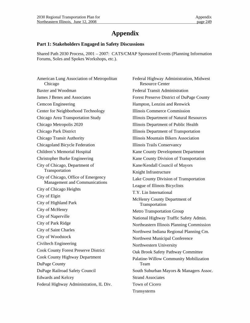
2030 Regional Transportation Plan for Appendix Northeastern Illinois, June 12, 2008 page 249
Appendix Part 1: Stakeholders Engaged in Safety Discussions
Shared Path 2030 Process, 2001 – 2007: CATS/CMAP Sponsored Events (Planning Information Forums, Soles and Spokes Workshops, etc.).
American Lung Association of Metropolitan Chicago
Baxter and Woodman James J Benes and Associates Cemcon Engineering Center for Neighborhood Technology Chicago Area Transportation Study Chicago Metropolis 2020 Chicago Park District Chicago Transit Authority Chicagoland Bicycle Federation Children’s Memorial Hospital Christopher Burke Engineering City of Chicago, Department of
Transportation City of Chicago, Office of Emergency
Management and Communications City of Chicago Heights City of Elgin City of Highland Park City of McHenry City of Naperville City of Park Ridge City of Saint Charles City of Woodstock Civiltech Engineering Cook County Forest Preserve District Cook County Highway Department DuPage County DuPage Railroad Safety Council Edwards and Kelcey Federal Highway Administration, IL Div.
Federal Highway Administration, Midwest Resource Center
Federal Transit Administration Forest Preserve District of DuPage County Hampton, Lenzini and Renwick Illinois Commerce Commission Illinois Department of Natural Resources Illinois Department of Public Health Illinois Department of Transportation Illinois Mountain Bikers Association Illinois Trails Conservancy Kane County Development Department Kane County Division of Transportation Kane/Kendall Council of Mayors Knight Infrastructure Lake County Division of Transportation League of Illinois Bicyclists T.Y. Lin International McHenry County Department of
Transportation Metro Transportation Group National Highway Traffic Safety Admin. Northeastern Illinois Planning Commission Northwest Indiana Regional Planning Cm. Northwest Municipal Conference Northwestern University Oak Brook Safety Pathway Committee Palatine-Willow Community Mobilization
Team South Suburban Mayors & Managers Assoc. Strand Associates Town of Cicero Transystems
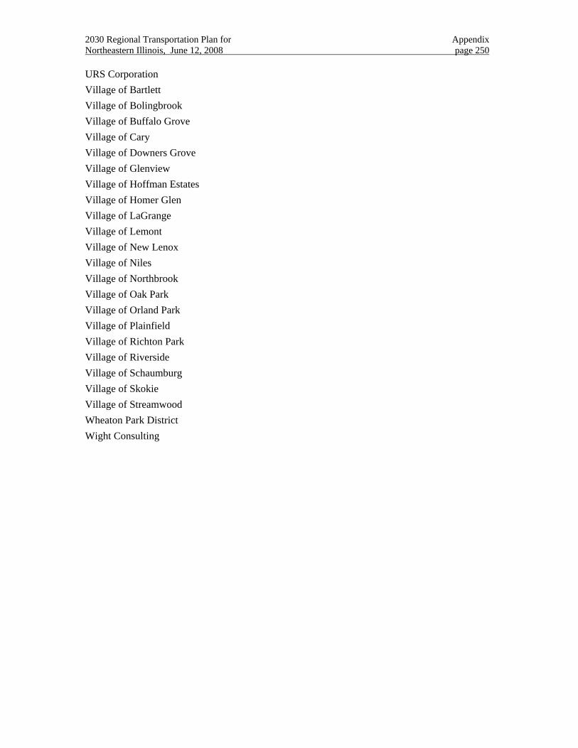
2030 Regional Transportation Plan for Appendix Northeastern Illinois, June 12, 2008 page 250
URS Corporation Village of Bartlett Village of Bolingbrook Village of Buffalo Grove Village of Cary Village of Downers Grove Village of Glenview Village of Hoffman Estates Village of Homer Glen Village of LaGrange Village of Lemont Village of New Lenox Village of Niles Village of Northbrook Village of Oak Park Village of Orland Park Village of Plainfield Village of Richton Park Village of Riverside Village of Schaumburg Village of Skokie Village of Streamwood Wheaton Park District Wight Consulting
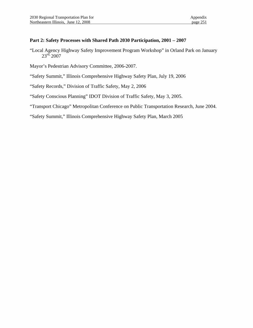
2030 Regional Transportation Plan for Appendix Northeastern Illinois, June 12, 2008 page 251
Part 2: Safety Processes with Shared Path 2030 Participation, 2001 – 2007
“Local Agency Highway Safety Improvement Program Workshop” in Orland Park on January 23rd, 2007
Mayor’s Pedestrian Advisory Committee, 2006-2007.
“Safety Summit,” Illinois Comprehensive Highway Safety Plan, July 19, 2006
“Safety Records,” Division of Traffic Safety, May 2, 2006
“Safety Conscious Planning” IDOT Division of Traffic Safety, May 3, 2005.
“Transport Chicago” Metropolitan Conference on Public Transportation Research, June 2004.
“Safety Summit,” Illinois Comprehensive Highway Safety Plan, March 2005
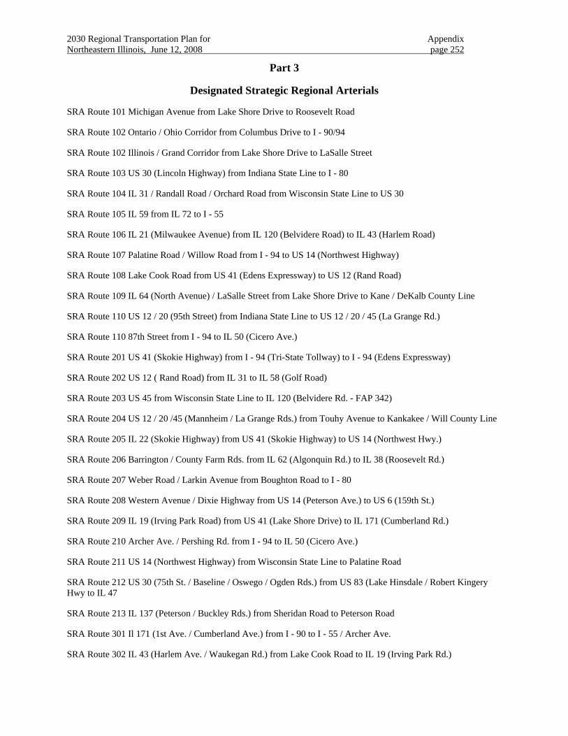
2030 Regional Transportation Plan for Appendix Northeastern Illinois, June 12, 2008 page 252
Part 3
Designated Strategic Regional Arterials
SRA Route 101 Michigan Avenue from Lake Shore Drive to Roosevelt Road
SRA Route 102 Ontario / Ohio Corridor from Columbus Drive to I - 90/94
SRA Route 102 Illinois / Grand Corridor from Lake Shore Drive to LaSalle Street
SRA Route 103 US 30 (Lincoln Highway) from Indiana State Line to I - 80
SRA Route 104 IL 31 / Randall Road / Orchard Road from Wisconsin State Line to US 30
SRA Route 105 IL 59 from IL 72 to I - 55
SRA Route 106 IL 21 (Milwaukee Avenue) from IL 120 (Belvidere Road) to IL 43 (Harlem Road)
SRA Route 107 Palatine Road / Willow Road from I - 94 to US 14 (Northwest Highway)
SRA Route 108 Lake Cook Road from US 41 (Edens Expressway) to US 12 (Rand Road)
SRA Route 109 IL 64 (North Avenue) / LaSalle Street from Lake Shore Drive to Kane / DeKalb County Line
SRA Route 110 US 12 / 20 (95th Street) from Indiana State Line to US 12 / 20 / 45 (La Grange Rd.)
SRA Route 110 87th Street from I - 94 to IL 50 (Cicero Ave.)
SRA Route 201 US 41 (Skokie Highway) from I - 94 (Tri-State Tollway) to I - 94 (Edens Expressway)
SRA Route 202 US 12 ( Rand Road) from IL 31 to IL 58 (Golf Road)
SRA Route 203 US 45 from Wisconsin State Line to IL 120 (Belvidere Rd. - FAP 342)
SRA Route 204 US 12 / 20 /45 (Mannheim / La Grange Rds.) from Touhy Avenue to Kankakee / Will County Line
SRA Route 205 IL 22 (Skokie Highway) from US 41 (Skokie Highway) to US 14 (Northwest Hwy.)
SRA Route 206 Barrington / County Farm Rds. from IL 62 (Algonquin Rd.) to IL 38 (Roosevelt Rd.)
SRA Route 207 Weber Road / Larkin Avenue from Boughton Road to I - 80
SRA Route 208 Western Avenue / Dixie Highway from US 14 (Peterson Ave.) to US 6 (159th St.)
SRA Route 209 IL 19 (Irving Park Road) from US 41 (Lake Shore Drive) to IL 171 (Cumberland Rd.)
SRA Route 210 Archer Ave. / Pershing Rd. from I - 94 to IL 50 (Cicero Ave.)
SRA Route 211 US 14 (Northwest Highway) from Wisconsin State Line to Palatine Road
SRA Route 212 US 30 (75th St. / Baseline / Oswego / Ogden Rds.) from US 83 (Lake Hinsdale / Robert Kingery Hwy to IL 47
SRA Route 213 IL 137 (Peterson / Buckley Rds.) from Sheridan Road to Peterson Road
SRA Route 301 Il 171 (1st Ave. / Cumberland Ave.) from I - 90 to I - 55 / Archer Ave.
SRA Route 302 IL 43 (Harlem Ave. / Waukegan Rd.) from Lake Cook Road to IL 19 (Irving Park Rd.)
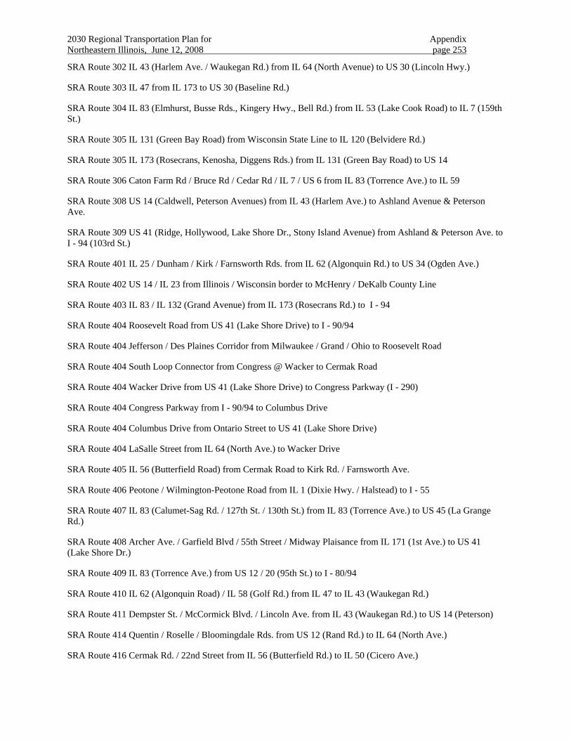
2030 Regional Transportation Plan for Appendix Northeastern Illinois, June 12, 2008 page 253
SRA Route 302 IL 43 (Harlem Ave. / Waukegan Rd.) from IL 64 (North Avenue) to US 30 (Lincoln Hwy.)
SRA Route 303 IL 47 from IL 173 to US 30 (Baseline Rd.)
SRA Route 304 IL 83 (Elmhurst, Busse Rds., Kingery Hwy., Bell Rd.) from IL 53 (Lake Cook Road) to IL 7 (159th St.)
SRA Route 305 IL 131 (Green Bay Road) from Wisconsin State Line to IL 120 (Belvidere Rd.)
SRA Route 305 IL 173 (Rosecrans, Kenosha, Diggens Rds.) from IL 131 (Green Bay Road) to US 14
SRA Route 306 Caton Farm Rd / Bruce Rd / Cedar Rd / IL 7 / US 6 from IL 83 (Torrence Ave.) to IL 59
SRA Route 308 US 14 (Caldwell, Peterson Avenues) from IL 43 (Harlem Ave.) to Ashland Avenue & Peterson Ave.
SRA Route 309 US 41 (Ridge, Hollywood, Lake Shore Dr., Stony Island Avenue) from Ashland & Peterson Ave. to I - 94 (103rd St.)
SRA Route 401 IL 25 / Dunham / Kirk / Farnsworth Rds. from IL 62 (Algonquin Rd.) to US 34 (Ogden Ave.)
SRA Route 402 US 14 / IL 23 from Illinois / Wisconsin border to McHenry / DeKalb County Line
SRA Route 403 IL 83 / IL 132 (Grand Avenue) from IL 173 (Rosecrans Rd.) to I - 94
SRA Route 404 Roosevelt Road from US 41 (Lake Shore Drive) to I - 90/94
SRA Route 404 Jefferson / Des Plaines Corridor from Milwaukee / Grand / Ohio to Roosevelt Road
SRA Route 404 South Loop Connector from Congress @ Wacker to Cermak Road
SRA Route 404 Wacker Drive from US 41 (Lake Shore Drive) to Congress Parkway (I - 290)
SRA Route 404 Congress Parkway from I - 90/94 to Columbus Drive
SRA Route 404 Columbus Drive from Ontario Street to US 41 (Lake Shore Drive)
SRA Route 404 LaSalle Street from IL 64 (North Ave.) to Wacker Drive
SRA Route 405 IL 56 (Butterfield Road) from Cermak Road to Kirk Rd. / Farnsworth Ave.
SRA Route 406 Peotone / Wilmington-Peotone Road from IL 1 (Dixie Hwy. / Halstead) to I - 55
SRA Route 407 IL 83 (Calumet-Sag Rd. / 127th St. / 130th St.) from IL 83 (Torrence Ave.) to US 45 (La Grange Rd.)
SRA Route 408 Archer Ave. / Garfield Blvd / 55th Street / Midway Plaisance from IL 171 (1st Ave.) to US 41 (Lake Shore Dr.)
SRA Route 409 IL 83 (Torrence Ave.) from US 12 / 20 (95th St.) to I - 80/94
SRA Route 410 IL 62 (Algonquin Road) / IL 58 (Golf Rd.) from IL 47 to IL 43 (Waukegan Rd.)
SRA Route 411 Dempster St. / McCormick Blvd. / Lincoln Ave. from IL 43 (Waukegan Rd.) to US 14 (Peterson)
SRA Route 414 Quentin / Roselle / Bloomingdale Rds. from US 12 (Rand Rd.) to IL 64 (North Ave.)
SRA Route 416 Cermak Rd. / 22nd Street from IL 56 (Butterfield Rd.) to IL 50 (Cicero Ave.)
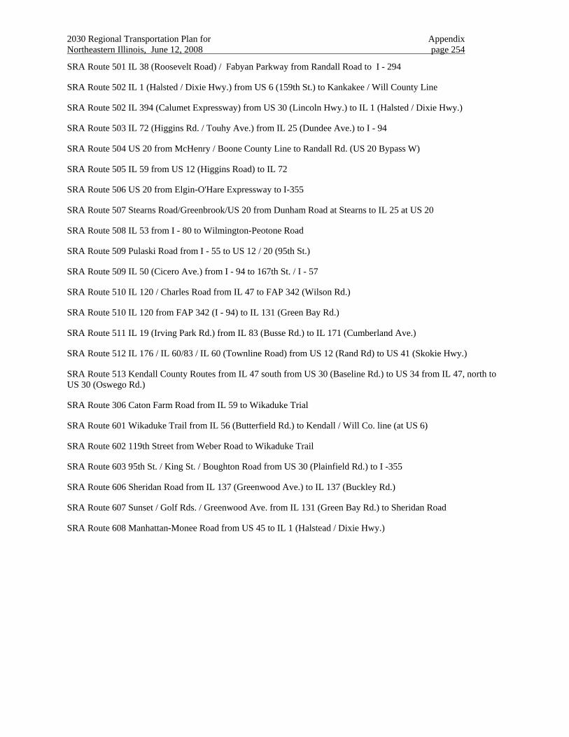
2030 Regional Transportation Plan for Appendix Northeastern Illinois, June 12, 2008 page 254
SRA Route 501 IL 38 (Roosevelt Road) / Fabyan Parkway from Randall Road to I - 294
SRA Route 502 IL 1 (Halsted / Dixie Hwy.) from US 6 (159th St.) to Kankakee / Will County Line
SRA Route 502 IL 394 (Calumet Expressway) from US 30 (Lincoln Hwy.) to IL 1 (Halsted / Dixie Hwy.)
SRA Route 503 IL 72 (Higgins Rd. / Touhy Ave.) from IL 25 (Dundee Ave.) to I - 94
SRA Route 504 US 20 from McHenry / Boone County Line to Randall Rd. (US 20 Bypass W)
SRA Route 505 IL 59 from US 12 (Higgins Road) to IL 72
SRA Route 506 US 20 from Elgin-O'Hare Expressway to I-355
SRA Route 507 Stearns Road/Greenbrook/US 20 from Dunham Road at Stearns to IL 25 at US 20
SRA Route 508 IL 53 from I - 80 to Wilmington-Peotone Road
SRA Route 509 Pulaski Road from I - 55 to US 12 / 20 (95th St.)
SRA Route 509 IL 50 (Cicero Ave.) from I - 94 to 167th St. / I - 57
SRA Route 510 IL 120 / Charles Road from IL 47 to FAP 342 (Wilson Rd.)
SRA Route 510 IL 120 from FAP 342 (I - 94) to IL 131 (Green Bay Rd.)
SRA Route 511 IL 19 (Irving Park Rd.) from IL 83 (Busse Rd.) to IL 171 (Cumberland Ave.)
SRA Route 512 IL 176 / IL 60/83 / IL 60 (Townline Road) from US 12 (Rand Rd) to US 41 (Skokie Hwy.)
SRA Route 513 Kendall County Routes from IL 47 south from US 30 (Baseline Rd.) to US 34 from IL 47, north to US 30 (Oswego Rd.)
SRA Route 306 Caton Farm Road from IL 59 to Wikaduke Trial
SRA Route 601 Wikaduke Trail from IL 56 (Butterfield Rd.) to Kendall / Will Co. line (at US 6)
SRA Route 602 119th Street from Weber Road to Wikaduke Trail
SRA Route 603 95th St. / King St. / Boughton Road from US 30 (Plainfield Rd.) to I -355
SRA Route 606 Sheridan Road from IL 137 (Greenwood Ave.) to IL 137 (Buckley Rd.)
SRA Route 607 Sunset / Golf Rds. / Greenwood Ave. from IL 131 (Green Bay Rd.) to Sheridan Road
SRA Route 608 Manhattan-Monee Road from US 45 to IL 1 (Halstead / Dixie Hwy.)