transit element of the 2030 regional transportation plan ... · pdf file2030 regional...
TRANSCRIPT
Transit Element of the 2030 Regional Transportation Plan
Technical Memorandum No. 2
PHASE 2: IDENTIFYING FUTURE TRANSIT GROWTH MARKETS
Prepared for:
Pima Association of Governments
July 2003
Prepared by:
The Transpo Group, Inc. In Association With:
George Patton – Public Transportation
Consultant Lima & Associates
AMEC, Inc.
© 2003 The Transpo Group
Table of Contents
Page EXECUTIVE SUMMARY ...................................................................................I
Transit Element Components............................................................................................................... i Overview of Technical Memorandum................................................................................................. i Key Findings ............................................................................................................................................ i
1. KEY DIRECTION FROM PHASE 1 ................................................................1 Existing Major Transit Ridership......................................................................................................... 1
2. REGIONAL TRAVEL TRENDS......................................................................4 Overview of Regional Travel Demand............................................................................................... 4 Travel Speeds .......................................................................................................................................... 4 Assessment of Regional Travel Patterns (2000 and 2030)............................................................... 5 Key Findings ......................................................................................................................................... 11
3. LAND USE DENSITIES AND DEMOGRAPHIC TRENDS.................................12 Densities and Transit Service Levels................................................................................................. 12 Population Densities in the Tucson Region .................................................................................... 12 Employment Densities ........................................................................................................................ 15 Age Densities ........................................................................................................................................ 15 Zero-Auto Ownership Densities ....................................................................................................... 18 Household Income .............................................................................................................................. 18 Key Findings ......................................................................................................................................... 18
4. TRANSIT-SUPPORTIVE DEVELOPMENT .....................................................20 Background ........................................................................................................................................... 20 Transit-Supportive Developments .................................................................................................... 20 Transit-Supportive Infill Projects in Tucson ................................................................................... 21 General Plans and other Major Guidelines ...................................................................................... 22 Rio Nuevo/Downtown Tucson ........................................................................................................ 24 University of Arizona – Comprehensive Campus Plan ................................................................. 24 Southeast Area Plan/Houghton Road.............................................................................................. 25 Transit-Supportive Corridors ............................................................................................................. 26 Pedestrian Improvements ................................................................................................................... 27 Key Findings ......................................................................................................................................... 27
5. TRANSIT MARKETS FOR PERSONS WITH DISABILITIES AND THE ELDERLY .28 Persons with Disabilities ..................................................................................................................... 28 Elderly Market ...................................................................................................................................... 30 Key Findings ......................................................................................................................................... 31
6. REGIONAL COMMUTER MARKETS ...........................................................33 Park-and-Ride Access .......................................................................................................................... 33 Rail Network for Potential Commuter Service ............................................................................... 33 Policy and Coordination Issues.......................................................................................................... 33 Key Findings ......................................................................................................................................... 35
7. INTERCITY TRANSIT ...............................................................................36 Amtrak ................................................................................................................................................... 36 Greyhound............................................................................................................................................. 36
Airport Shuttle Service ........................................................................................................................ 37 Private Van Service .............................................................................................................................. 37 Key Findings ......................................................................................................................................... 37
8. POTENTIAL HIGH CAPACITY TRANSIT CORRIDORS..................................38 Background ........................................................................................................................................... 38 Potential HCT Corridors .................................................................................................................... 38 Key Findings ......................................................................................................................................... 41
Appendix A: Regional Travel Patterns for 2000 and 2030
Figures 1. Map of 22 Analysis Zones................................................................................................................ 6 2. Zone-to-Zone Travel Patterns ........................................................................................................ 9 3A. Population Density: 2000 ............................................................................................................... 13 3B. Population Density: 2030 ............................................................................................................... 14 4A. Employment Density: 2000 ........................................................................................................... 16 4B. Employment Density: 2030 ........................................................................................................... 17 5. Transit-Supportive Development at Downtown Renton (WA) Transit Center ................... 21 6. Growth Rates at University of Arizona ....................................................................................... 25 7. ADA Eligible Riders (Source: City of Tucson)........................................................................... 30 8. Existing Rail Lines in the Tucson Region.................................................................................... 34 9. Potential Major HCT Corridors .................................................................................................... 40
Tables 1. Summary of Boarding Activity along Corridors............................................................................. 1 2. Service and Market Features for Major Transit Corridors (Top 8)............................................. 2 3. Potential HCT Corridors.................................................................................................................. 39

Phase 2: Identifying Future Transit Growth Markets July 2003
The Transpo Group i
Executive Summary This Technical Memorandum documents results of Phase 2 for the Transit Element of the Pima Association of Governments Regional Transportation Plan update for 2030. Phase 2 focuses on identifying and assessing both current and future transit markets in the Tucson region. This assessment will provide a key basis for identifying transit service and facility improvements, including potential corridors for high capacity transit (HCT) development. These improvements will be called out in the third and final phase of the Transit Element. This Executive Summary provides an overview of the Technical Memorandum’s sections as well as key findings.
Transit Element Components The Transit Element of the 2030 RTP encompasses three major phases. Phase 1 documented in Technical Memorandum 1 (March 2003) provides an inventory of existing transit services and facilities in the Tucson region. Phase 2, which is the focus of this Technical Memorandum, assesses potential transit markets and identifies areas in the region that exhibit potential for transit growth. These areas will include major corridors that are expected to experience significant growth during the 25-year horizon of the RTP. Phase 3 of the Transit Element will identify major transit improvements – service, facilities, and supporting actions – that will meet mobility needs of the region.
Overview of Technical Memorandum Following this Executive Summary, Section 1 identifies key direction from the inventory and assessment of existing transit services and facilities in the Tucson region (Phase 1 of the Transit Element). Section 2 documents key results from the review of both 2000 and 2030 travel patterns for the Tucson region. Land use and demographic characteristics for the region are called out in Section 3. These characteristics closely relate to the relative likelihood of using transit services. Section 4 identifies examples of transit supportive developments, both in the Tucson region as well as in other locations. This description also includes efforts by local jurisdictions in the region to support transit service. Section 5 addresses market needs relating to paratransit service, Section 6 calls out regional commuter markets, and Section 7 describes intercity transit services. The memorandum concludes with a presentation of potential HCT corridors in the Tucson region.
Key Findings The following are key findings relating to the assessment of potential transit markets in the Tucson region.
Direction from Inventory Assessment of Existing Transit Services and Facilities
• The major transit ridership levels on several streets in the Tucson region provide a basis for considering potential future markets and potential service improvements.
• Access to transit services and passenger amenities will be key factors in meeting needs of potential transit markets.

Phase 2: Identifying Future Transit Growth Markets July 2003
The Transpo Group ii
Assessment of Regional Travel Patterns
• Between 2000 and 2030 there will be major growth in travel demand affecting areas throughout the Tucson region. Daily vehicles miles travel are estimated to grow from 19.0 million in 2000 to 37.5 million in 2030 (based on the PAG regional travel model). These volumes include traffic on local streets.
• Southeast Tucson/Rita Ranch will emerge as a major generator of regional travel.
• Several corridors in Tucson between Downtown and Houghton Road will likely experience major growth; this will reinforce current major market demand on bus routes serving these corridors.
• Other travel corridors, expressed in terms of travel pairs, that will experience significant travel demand include:
o From NW Marana to University of Arizona;
o From SE Tucson/Rita Ranch to University of Arizona;
o From Oro Valley to Flowing Wells;
o From South Tucson area to University of Arizona;
o From SE Tucson/Rita Ranch to University of Arizona;
o From NW Marana to Tucson Airport/South Industrial Area; and
o From NW Marana to Flowing Wells.
o Downtown Tucson and University of Arizona will continue to be important attractions for work-related travel.
Land Use and Demographic Characteristics
• Due to their relatively low densities, large areas of the region will not lend themselves to regular fixed route transit solutions. However, these areas can still be served by other transit and mobility options such as demand response service, express bus service (provided park-and-ride lot capacity is available), and vanpool programs.
• Much of the region’s future employment growth will be focused along the I-10 corridor.
• While significant suburban development is planned, the triangle bounded by Downtown Tucson, Tucson Mall, and Park Place will remain the region’s urbanized core area.
• Planned revitalization efforts, such as the Rio Nuevo project, will strengthen the downtown Tucson-based market. Parking management strategies may also improve transit’s competitiveness within the downtown market.
• With its planned expansion and potential limitations on campus parking, the University of Arizona may take on an increasingly greater role as a focus for potential high capacity public transportation services in the central Tucson area.
• The pattern followed by the region’s major arterial streets facilitates the operation of public transportation services in a grid network, instead of a more radial oriented system, within the urban core.
Phase 2: Identifying Future Transit Growth Markets July 2003
The Transpo Group iii
• Following the street system, much of the region’s high-density development will follow a north-south or east-west orientation. Affected corridors include but are not limited to:
o Oracle/Stone between River Road and Downtown Tucson;
o 6th/12th Avenue between Laos transit center and Downtown Tucson; and
o Broadway/Speedway between Houghton and University of Arizona/Downtown Tucson.
• Several key demographic patterns that indicate potential transit markets are also located along these major north-south and east-west corridors.
• Given increases in land use densities within the generally central area of Tucson, significant infill will take place along the eight streets with existing high levels of transit ridership.
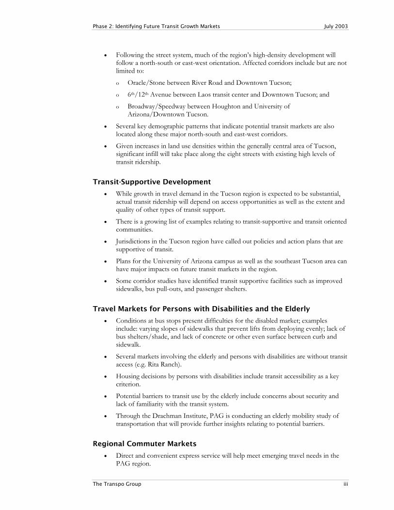
Transit-Supportive Development
• While growth in travel demand in the Tucson region is expected to be substantial, actual transit ridership will depend on access opportunities as well as the extent and quality of other types of transit support.
• There is a growing list of examples relating to transit-supportive and transit oriented communities.
• Jurisdictions in the Tucson region have called out policies and action plans that are supportive of transit.
• Plans for the University of Arizona campus as well as the southeast Tucson area can have major impacts on future transit markets in the region.
• Some corridor studies have identified transit supportive facilities such as improved sidewalks, bus pull-outs, and passenger shelters.
Travel Markets for Persons with Disabilities and the Elderly
• Conditions at bus stops present difficulties for the disabled market; examples include: varying slopes of sidewalks that prevent lifts from deploying evenly; lack of bus shelters/shade, and lack of concrete or other even surface between curb and sidewalk.
• Several markets involving the elderly and persons with disabilities are without transit access (e.g. Rita Ranch).
• Housing decisions by persons with disabilities include transit accessibility as a key criterion.
• Potential barriers to transit use by the elderly include concerns about security and lack of familiarity with the transit system.
• Through the Drachman Institute, PAG is conducting an elderly mobility study of transportation that will provide further insights relating to potential barriers.
Regional Commuter Markets
• Direct and convenient express service will help meet emerging travel needs in the PAG region.

Phase 2: Identifying Future Transit Growth Markets July 2003
The Transpo Group iv
• Any regional express service development will need to be supported by sufficient park-and-ride lot capacity and passenger amenities.
• Early planning efforts for park-and-ride lot development should include the Arizona Department of Transportation (ADOT).
• Basic rail infrastructure for commuter rail service is in place along some segments; however, any implementation of future commuter rail service will be heavily dependent on an agreement with Union Pacific Railway which owns the tracks.
Intercity Markets
• Several private carriers provide intercity services between Tucson and Phoenix and Tucson/Nogales.
• The Tucson/Nogales service has been growing rapidly through private van operations.
• Further assessment of intercity market needs will need to recognize estimated travel growth between Tucson and other cities, particularly Phoenix and Nogales.
Potential High Capacity Transit (HCT) Corridors
The results of the transit market assessment conducted in Phase 3 indicate that several potential corridors in the region are possible candidates for some form of HCT development. Selection of candidate corridors is based on review of key characteristics that that indicate potential transit use. These characteristics include existing demographics, projected land use densities, estimated travel volumes affecting general corridors, and supporting strategies that have been called out, and in some cases implemented, by local jurisdictions in the region. The following lists potential HCT corridors for the Tucson region.
1. University of Arizona/Rio Nuevo via 4th Avenue and University Boulevard
This HCT corridor would support development plans for Rio Nuevo while also supporting two major existing travel generators: Downtown Tucson and University of Arizona. Some infrastructure and vehicles operated by Old Pueblo Trolley are in place along a portion of this corridor.
2. Broadway/Speedway/6th Street (Houghton Road to Downtown Tucson/ University of Arizona)
This general east-west corridor already has two of the top eight transit corridors in terms of daily ridership. This corridor covers a wide swath since several east-west streets in the general area already exhibit high transit ridership levels. Any HCT development will likely involve one of the streets located within this overall corridor. Higher density residential developments in this corridor are expected to be even more intense by 2030. The corridor also will be affected by potential major travel growth generated by new developments in the southeast area of Tucson.
3. Campbell Avenue (Tucson Mall and University of Arizona)
Campbell Avenue is an existing major high transit ridership corridor that provides north-south access directly to the University of Arizona campus. Growth of the campus population as well as the areas to the north and west indicates Campbell Avenue as a
Phase 2: Identifying Future Transit Growth Markets July 2003
The Transpo Group v
potential HCT corridor. This corridor can be stand-alone or involve a combination east-west/north-south route between the campus and areas to the north and west.
4. Oracle/Stone (Oro Valley to Downtown Tucson)
This corridor between Downtown Tucson and Tucson Mall (this includes the Flowing Wells area) already has strong density and demographic features that could support potential HCT development. However, future travel demand could indicate HCT development between Oro Valley and Downtown Tucson.
5. 6th Avenue (Downtown Tucson to Irvington)
This corridor has existing high ridership along with current transit friendly demographics and densities. Future travel patterns indicate further potential transit demand along this corridor between the South Tucson area and Downtown Tucson.
6. I-19 (Sahuarita and Downtown Tucson)
Any HCT corridor along I-19 would involve express bus connections and associate park-and-ride lot development between Sahuarita/Green Valley and Downtown Tucson. By 2020, the Sahuarita/Green Valley area will grow as a more significant generator of total and work trips.
7. I-10 (Marana and Houghton Road)
HCT development would focus on meeting travel growth between West Marana and industrial areas in the south end of Tucson. Also, major travel demand is expected to grow between southeast Tucson and industrial areas near Tucson International Airport.
8. Houghton Road (Irvington and Broadway/Speedway Corridor)
Given growth in the southeast area of Tucson, HCT could be appropriate for Houghton Road and major east-west streets in Tucson.
9. Anklam/6th Street (Speedway and University of Arizona)
The HCT corridor would meet expected high travel demand between West Tucson and several locations in the more central area of the city, including the University of Arizona.

Phase 2: Identifying Future Transit Growth Markets July 2003
The Transpo Group 1
1. Key Direction from Phase 1 The focus of this section will be on how Transit Element/Phase 1 results provide direction for the transit market assessment.
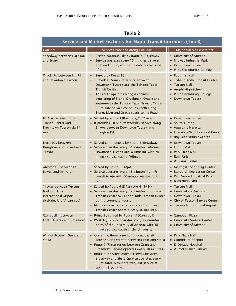
Existing Major Transit Ridership Together, the top eight transit ridership corridors account for nearly half of Sun Tran’s total boarding ridership. Table 1 identifies passenger ons and offs along the major transit corridors (Source: Sun Tran on-board passenger counts January 2001 – June 2002).
Table 1
Summary of Boarding Activity along Corridors
Daily Activity
Corridor On Off
Speedway between Stone and Harrison 4,061 3,972
Oracle Road between Tucson Mall and Downtown Tucson 3,949 4,085
6th Ave between Downtown Tucson and Laos Transit Center 3,156 3,229
Broadway between Houghton and Downtown Tucson 3,022 2,877
Alvernon between Ft Lowell and Irvington 2,109 2,054
1st Ave/University of Arizona/Park (to Tucson airport) 1,967 1,970
Campbell between Foothills area and Broadway 1,402 1,353
Wilmot Between Grant and Stella 631 634
Totals 20,297 20,175
Source: Sun Tran onboard surveys with factor applied to approximate total system ridership.
Table 2 identifies service features and major markets for each of the dominant transit corridors. Key market characteristics for each corridor are as follows:
• Speedway. University of Arizona dominates this route
• Oracle Road. Tucson Mall is the largest generator along the corridor
• 6th Avenue. Corridor anchored by Laos Transit Center and Ronstadt Transit Center. Strong passenger activity occurs throughout the corridor
• Broadway. This is the spine of Sun Tran service east of the downtown. Multiple generators and numerous transfer opportunities result in strong boarding activity.
• Alvernon. Significant transfer activity occurs at Broadway, Speedway, and Grant.
• 1st Avenue/Park. University of Arizona is the major generator along this corridor. Tucson International Airport experiences very little ridership
• Campbell Avenue. Major activities focus on the University of Arizona.
• Wilmot Road. This is a major travel corridor but most trips originate or depart from other neighborhoods.
Phase 2: Identifying Future Transit Growth Markets July 2003
The Transpo Group 2
Table 2
Service and Market Features for Major Transit Corridors (Top 8)
Corridor Services Provided Along Corridor Major Market Generators
Speedway between Harrison
and Stone
• Served continuously by Route 4 (Speedway)
• Service operates every 15 minutes between
Kolb and Stone, with 30-minute service east
of Kolb.
• University of Arizona
• Midway Industrial Park
• Downtown Tucson
• Pima Community College
Oracle Rd between Ina Rd
and Downtown Tucson
• Served by Route 16
• Provides 15-minute service between
Downtown Tucson and the Tohono Tadai
Transit Center.
• The route operates along a corridor
consisting of Stone, Drachman, Oracle and
Wetmore to the Tohono Tadai Transit Center.
• 30-minute service continues north along
Stone, River and Oracle roads to Ina Road.
• Foothills mall
• Tohono Tadai Transit Center
• Tucson Mall
• Amphi High School
• Pima Community College
• Downtown Tucson
6th Ave. between Laos
Transit Center and
Downtown Tucson via 6th
Ave
• Served by Route 8 (Broadway/S 6th Ave)
• It provides 10-minute weekday service along
6th Ave between Downtown Tucson and
Irvington Rd.
• Downtown Tucson
• South Tucson
• Veteran’s Hospital
• El Pueblo Neighborhood Center
• Roy Laos Transit Center
Broadway between
Houghton and Downtown
Tucson
• Served continuously by Route 8 (Broadway)
• Service operates every 10 minutes between
Downtown Tucson and Wilmot Rd, with 20-
minute service east of Wilmot.
• Downtown Tucson
• El Con Mall
• Park Place Mall
• Reid Park
• Williams Center
Alvernon – between Ft
Lowell and Irvington
• Served by Route 11 (Ajo)
• Service operates every 15 minutes from Ft
Lowell to Ajo with 30-minute service south of
Ajo.
• Northgate Shopping Center
• Randolph Recreation Center
• Palo Verde Industrial Park
• Butterfield Park
1st Ave. between Tucson
Mall and Tucson
International Airport
(includes U of A campus)
• Served by Route 6 (S Park Ave/N 1st St)
• Service operates every 15 minutes from Laos
Transit Center to Tohono Tadai Transit Center
during commute hours.
• Midday services and services south of Laos
Transit Center operate every 30 minutes.
• Tucson Mall
• University of Arizona
• Downtown Tucson
• City of Tucson Service Center
• Tucson International Airport.
Campbell – between
Foothills area and Broadway
• Primarily served by Route 15 (Campbell)
• Weekday service operates every 15 minutes
north of the University of Arizona with 30-
minute service south of the University.
• Campbell Plaza
• University Medical Center
• University of Arizona
Wilmot Between Grant and
Stella
• Currently, there is no continuous transit
service along Wilmot between Grant and Stella
• Route 5 (Pima) serves between Grant and
Broadway. Service operates every 30 minutes.
• Route 3 (6th Street/Wilmot) serves between
Broadway and Stella. Service operates every
30 minutes with more frequent service at
school class times.
• Park Place Mall
• Carondelet Hospital
• El Dorado Hospital
• Wilmot Branch Library

Phase 2: Identifying Future Transit Growth Markets July 2003
The Transpo Group 3
Key Findings
1. Eight streets in the Tucson region with existing major transit ridership provide a basis for considering potential future markets and potential service improvements.
2. The potential for further transit development along these major transit corridors will be dependent on several factors such land use and demographic characteristics, supporting efforts such as access to transit stops, and land use policy changes.

Phase 2: Identifying Future Transit Growth Markets July 2003
The Transpo Group 4
2. Regional Travel Trends This section identifies key regional travel characteristics as identified by PAG. A major focus is on estimated future travel patterns in the metropolitan Tucson area.
Overview of Regional Travel Demand Key information items from the PAG travel model and the 2000 U.S. Census are as follows:
• Daily number of person trips: 3.2 million for 330,000 households;
• Daily trips by transit: 54,000;
• 73.8 percent of Pima County residents commuted to work by driving alone;
• 14.8 percent carpooled to work;
• 3.6 percent worked at home;
• 2.7 percent rode a bicycle or took some other means to work;
• 2.6 percent walked to work;
• 2.5 percent rode the bus; single-digit mode shares are not unusual for communities in the western U.S.; however, these are shares for an entire region even though transit primarily serves major transportation corridors.
• From 1995 to 2000 total daily vehicle miles of travel (VMT) within the PAG region grew by 13.5 percent, while the Tucson area population increased by 10 percent; and
• During the same five-year period, only 1.1 percent additional roadway capacity was added to the mostly arterial roadway system.
• Daily vehicles miles travel are estimated to grow from 19.0 million in 2000 to 37.5 million in 2030 (based on the PAG regional travel model). These volumes include traffic on local streets.
Key trends affecting travel demand include:
• Metropolitan Tucson continues to spread out horizontally and at low densities;
• Fourteen percent of the region’s households reported having three or more vehicles in 2000;
• Nine percent of the region’s households have no vehicles available;
• Average household size continues to decline (from 3.0 per household in 1970 to 2.5 today);
• Trip rates per capita have increased (from 3 per person in 1970 to 3.5 today);
• Home to work trips account for 13 percent of all trips; and
• Non-home-based (linked) trips are growing faster than work trips.
Travel Speeds • Average home to work commute: 12 miles and 20 minutes;
• Average transit travel speed: 15 to 18 mph (operating speed is about 13.5 mph);
• Regional traffic model shows 13.1 mph as average transit speeds; and

Phase 2: Identifying Future Transit Growth Markets July 2003
The Transpo Group 5
• Mean travel to work time was 23.9 minutes;
• Longer trips (those 20 minutes or longer) are more frequent;
• For general traffic, average speed is 37.0 miles per hour.
Assessment of Regional Travel Patterns (2000 and 2030) To conduct the travel assessment the more densely populated areas of the PAG region were divided into 22 Super Zones. These super zones are aggregations of travel analysis zones that have been identified for the region by PAG. The data on travel volumes are from PAG’s regional travel forecasting model. Figure 1 identifies the 22 Super Zones. Other key points relating to the analysis zones are:
• Super zones represent major concentrations of travel (e.g., University of Arizona campus) as well as boundaries for non-Tucson jurisdictions (e.g., Oro Valley);
• Baseline (2000) and estimated future (2030) travel patterns were identified;
• Analysis was carried out for total trips and work trips;
• Relative growth in travel volumes were identified from the standpoint of productions (where trips originate) and attractions (where trips end); and
• Assessment was carried out on major origin-destination pairs to indicate potential major transit markets, including corridors for high capacity transit development.
Appendix A includes a series of graphics that show travel productions and attractions in the Tucson region for the following items - total trips (2000 and 2030) and work trips (2000 and 2030). The following sections summarize key information items relating to regional travel characteristics.
Travel Volumes for Total Trips: 2000 and 2030
Travel Productions
• By 2020, the Southeast Tucson/Rita Ranch area, which includes planned new developments in the Houghton Road area, is estimated to be a major producer of total travel in the PAG region.
• While ranked 16 of 22 in 2000 in terms of total home-based trip productions, the Southeast Tucson/Rita Ranch area will be the most significant producer of travel in the region by 2030.
• Sahuarita/Green Valley and Northwest Marana also are emerging as major producers of travel. By 2030 Sahuarita/Green Valley will be ranked fifth and Northwest Marana eighth.
• Several travel zones that are dominant in terms of trip production in 2000 will continue to be dominant in 2030. These include:
o East Tucson
o Flowing Wells
o West Tucson

I-10
OR
AC
LE
R
D
RIVER
RD
BROADWAY
BL
HO
UG
HT
ON
RD
I-10I-19
MIS
SIO
N
RD
AJO
HWY
SR
86
6T
H
A
VE
I-19
0
18
9
1
15
7
4
8
6
5
3
16
19
10
2
14
20
11
13
12
17
22
21
Source:
Pima
Association
of
Governments
1. Northwest Marana2. Continental Ranch3. Pima County North4. Oro Valley5. Canada del Oro6. Sabino Canyon7. Catalina Highway8. East Tucson9. Southeast Tucson/ Rita Ranch 10. Davis Monthan11. Central East Tucson12. Central Tucson13. Central/North Tucson14. Flowing Wells15. West Tucson16. Drexel Heights
th th17. 6 /12 Corridor18. Sahuarita/Green Valley19. TIA/SE Industrial20. South Tucson21. Downtown Tucson 22. U of A
Figure 1Travel Analysis Zones
The Transpo Group

Phase 2: Identifying Future Transit Growth Markets July 2003
The Transpo Group 7
o Drexel Heights
o South Tucson Vicinity
Travel Attractions
• By 2030, Southeast Tucson/Rita Ranch joins Central Tucson and Central/East Tucson as major attractors of total travel.
• University of Arizona campus (zone 22) will continue to be a major attractor in 2030.
• As compared to other zones, Downtown Tucson is not a major attractor in 2000 and 2030 for total trips; however, it continues to be important for work-related trips.
• Canada Del Oro is a major attractor in 2030; this indicates the importance of major resorts in attracting a variety of trips.
• Sahuarita/Green Valley becomes more important as an attractor in 2030 versus 2000.
Travel Volumes for Work Trips
Travel Productions
As is the case with total travel, Southeast Tucson/Rita Ranch is emerging as a major travel producer for work-related trips. Sahuarita/Green Valley also is emerging as major producers of work trips. Several travel zones that are dominant in terms of work-related trip production in 2000 will continue to be dominant in 2030. These include:
• Tucson East
• Flowing Wells
• West Tucson
• Drexel Heights Sahuarita/Green Valley becomes more important as a producer for work-related travel in 2030 versus 2000.
Travel Attractions
Five dominant zones are evident in 2030 for work-related attractions. These are:
• Central/East Tucson
• South Tucson Vicinity
• Flowing Wells
• Tucson Airport/South Industrial
• Southeast Tucson/Rita Ranch The zones are generally located in the City of Tucson but they also include Flowing Wells in unincorporated Pima County.

Phase 2: Identifying Future Transit Growth Markets July 2003
The Transpo Group 8
Between 2000 and 2030, Oro Valley grows in importance as a travel attractor (from a rank of 16 in 2000 to 12 in 2030).
Major Zone-to-Zone Travel Volumes
Travel demand patterns for 2030 were reviewed to determine emerging major travel volumes between analysis zones. Figure 2 illustrates some of the major zone-to-zone travel volumes projected for 2030. It should be noted that the start and finish locations of the arrows included in the figure do not necessarily denote specific activity locations in the affected zones. The following are key results from the review of zone-to-zone travel:
Total Home-Based Trips
• Southeast Tucson/Rita Ranch to East Tucson. This could serve as an emerging travel market involving new development in Southeast Tucson and existing transit markets along Speedway/Broadway in East Tucson.
• Southeast Tucson/Rita Ranch to Central-East Tucson/Central Tucson. The relatively high volume can indicate a potential emerging market between Southeast Tucson and central parts of Tucson along existing transit corridors.
• Southeast Tucson/Rita Ranch to University of Arizona. This will be a new link not currently addressed by existing transit service.
• East Tucson to Southeast Tucson/Rita Ranch. Given the high demand from Southeast Tucson to East Tucson, this can mean potential for high two-way transit volumes.
• Flowing Wells to University of Arizona. This reinforces the existing strong north-south transit corridor along Oracle/Stone.
• West Tucson to University of Arizona. This will be a new transit market not currently served by existing service except via transfers.
• South Tucson Vicinity to University of Arizona. This reinforces existing strong north-south transit corridor along 6th Avenue to Downtown Tucson and to the University of Arizona.
Home-Based Work Trips
For home-based work trips, several major productions/attraction volumes involved trips destined to the following zones:
• Central-East Tucson o For Central-East Tucson, the major origins included East Tucson and Southeast
Tucson/Rita Ranch reinforcing current east-west transit market in central Tucson.

I-10
OR
AC
LE
R
D
RIVER
RD
BROADWAY
BL
HO
UG
HT
ON
RD
I-10I-19
MIS
SIO
N
RD
AJO
HWY
SR
86
6T
H
A
VE
I-19
0
18
9
1
15
7
4
8
6
5
3
16
19
10
2
14
20
11
13
12
17
22
21
Source:
Pima
Association
of
Governments
The Transpo Group
Figure 2Major Volumes of Zone-to-Zone Travel (2030)
= TOTAL TRAVEL*
= WORK RELATED TRAVEL*
= The Travel Lines Do Not NecessarilyIndicate Specific Locations Within a Superzone
1. Northwest Marana2. Continental Ranch3. Pima County North4. Oro Valley5. Canada del Oro6. Sabino Canyon7. Catalina Highway8. East Tucson9. Southeast Tucson/ Rita Ranch 10. Davis Monthan11. Central East Tucson12. Central Tucson13. Central/North Tucson14. Flowing Wells15. West Tucson16. Drexel Heights
th th17. 6 /12 Corridor18. Sahuarita/Green Valley19. TIA/SE Industrial20. South Tucson21. Downtown Tucson 22. U of A

Phase 2: Identifying Future Transit Growth Markets July 2003
The Transpo Group 10
• Flowing Wells o Major work trip volumes affecting Flowing Wells include Northwest Marana,
Oro Valley, Canada del Oro, and West Tucson.
o The Oro Valley/Canada del Oro connection to Flowing Wells and locations to the south could reinforce a strong transit market along Oracle Road between Tucson Mall and Downtown Tucson.
• Tucson Airport/South Industrial o The volume from Southeast Tucson/Rita Ranch to Tucson Airport/South
Industrial is the second highest of the work-related travel pairs. o Sahuarita/Green Valley also is a major generator of travel to the Tucson
Airport/South Industrial area.
• South Tucson Area o Particularly high volumes are estimated from Southeast Tucson/Rita Ranch and
East Tucson. This reinforces the existing east-west transit markets in the general central Tucson area.
o High volumes from 6th/12th Corridor reinforce the existing strong transit demand along the corridor between the Laos Transit Center and Downtown Tucson.
o Sahuarita/Green Valley is a significant origin for work-related trips destined to the South Tucson area.
Major Trends Affecting University of Arizona and Downtown Tucson
Downtown Tucson and the University of Arizona will continue to be important transit destinations. Key factors affecting these locations include existing higher land use densities, parking fees, and new developments such as Rio Nuevo in the downtown area and implementation of the University of Arizona’s adopted (June 19, 2003) Comprehensive Campus Plan. A review of the regional travel data for 2030 indicated the following major findings for Downtown Tucson and University of Arizona.
Downtown Tucson
For work trips destined to Downtown Tucson in 2030, the following are important origins:
• East Tucson
• Southeast Tucson
• Central/North Tucson
• Flowing Wells
• West Tucson
• Drexel Heights
• Central Tucson
University of Arizona Campus
• East Tucson
Phase 2: Identifying Future Transit Growth Markets July 2003
The Transpo Group 11
• Central/North Tucson
• Flowing Wells
• Southeast Tucson
• West Tucson
• Drexel Heights
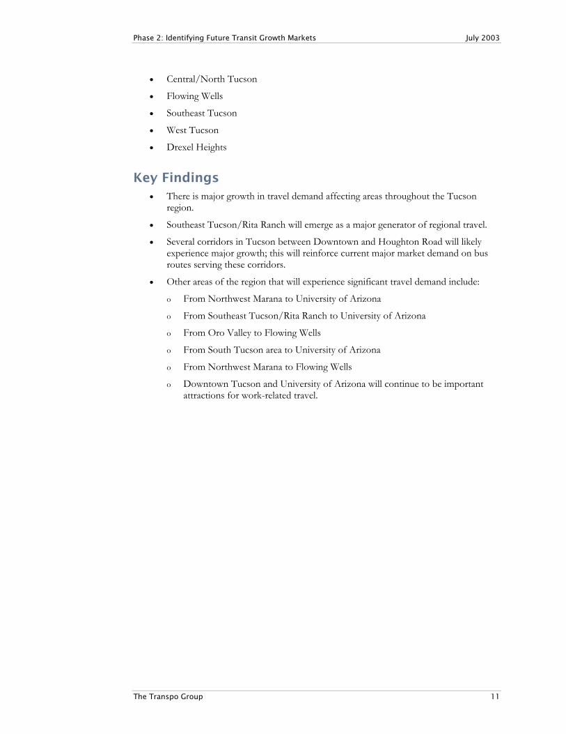
Key Findings • There is major growth in travel demand affecting areas throughout the Tucson
region.
• Southeast Tucson/Rita Ranch will emerge as a major generator of regional travel.
• Several corridors in Tucson between Downtown and Houghton Road will likely experience major growth; this will reinforce current major market demand on bus routes serving these corridors.
• Other areas of the region that will experience significant travel demand include:
o From Northwest Marana to University of Arizona
o From Southeast Tucson/Rita Ranch to University of Arizona
o From Oro Valley to Flowing Wells
o From South Tucson area to University of Arizona
o From Northwest Marana to Flowing Wells
o Downtown Tucson and University of Arizona will continue to be important attractions for work-related travel.
Phase 2: Identifying Future Transit Growth Markets July 2003
The Transpo Group 12
3. Land Use Densities and Demographic Trends
Several demographics-related items provide indications of potential transit markets. Population and employment densities are important in determining the potential for public transportation services. Other factors such as age, income, and availability of autos also influence market potential. The following are major observations relating to population and employment densities:
Densities and Transit Service Levels Research indicates the following regarding the relationship between densities and transit service levels:
• Average densities of 4 dwelling units per acre (DUA) or about 4,000 residents per square mile support minimal (60-minute frequency) fixed route service1 (since an average density is identified; actual densities can vary along the affected transit corridor);
• An average DUA of 7 supports 30-minute service2;
• An average DUA of 15 supports 15-minute service3; and
• Low density thresholds (an average of 1 to 2 dwelling units per acre) are identified with commuter rail; this mode, as well as many express bus routes, usually relies extensively on park-and-ride lot access; so, densities in the station vicinity are not important.
For light rail transit (LRT), relatively low residential densities have been called out (nine DUA) along with high employment thresholds (35 to 50 million square feet) of commercial/office4. For existing LRT systems in North America, a variety of residential and employment densities are currently being served. For any consideration of densities supporting transit, the identified thresholds relate to regular fixed route service. However, other kinds of transit service such as express bus routes can be supported with lower density developments so long as adequate access is provided through a network of park-and-ride lot lots.
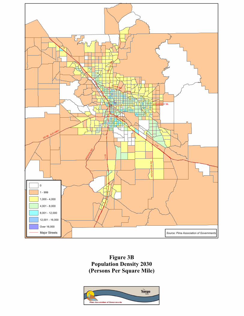
Population Densities in the Tucson Region Figure 3A shows population densities for the PAG region in 2000 while Figure 3B shows the estimated densities for 2030. Large portions of the region have residential densities that are below minimum levels to support regular fixed route transit services.
• By 2030, higher levels of population density will occur in the central part of the developed area.
1 Public Transportation and Land Use Policy; B. Pushkarev and J. Zupan (1976). 2 Public Transportation and Land Use Policy; B. Pushkarev and J. Zupan (1976). 3 Public Transportation and Land Use Policy; B. Pushkarev and J. Zupan (1976). 4 A Toolbox to Alleviate Traffic Congestion; Institute of Transportation Engineers (1989).

I-10
OR
ACLE
RD
RIVER RD
BROADWAY BL
SR 86 AJO HWY
MIS
SIO
N RD
1-19
HO
UG
HTO
N R
D
I-10
0
1 - 999
1,000 - 4,000
4,001 - 8,000
8,001 - 12,000
12,001 - 16,000
Over 16,000
Major Streets
Figure 3APopulation Density 2000
(Persons Per Square Mile)
Source: Pima Association of Governments
I-10
OR
ACLE
RD
RIVER RD
BROADWAY BL
SR 86 AJO HWY
MIS
SIO
N RD
1-19
HO
UG
HTO
N R
D
I-10
0
1 - 999
1,000 - 4,000
4,001 - 8,000
8,001 - 12,000
12,001 - 16,000
Over 16,000
Major Streets
Figure 3BPopulation Density 2030
(Persons Per Square Mile)
Source: Pima Association of Governments
Phase 2: Identifying Future Transit Growth Markets July 2003
The Transpo Group 15
• Population density patterns reinforce existing corridors as future transit markets, including the eight existing major transit corridors.
• Areas with minimal densities to support regular fixed route transit are mostly located in central parts of developed areas.
• By 2030, relatively high population densities will be evident in a large area of southeast Tucson (versus low or no densities in 2000).
• Lower density population levels (e.g., Marana and Oro Valley) can still support transit such as demand-responsive service or community circulators.
• In outlying and less dense areas, potential markets are emerging for express bus service provided sufficient and conveniently located park-and-ride capacity is located along major travel corridors.
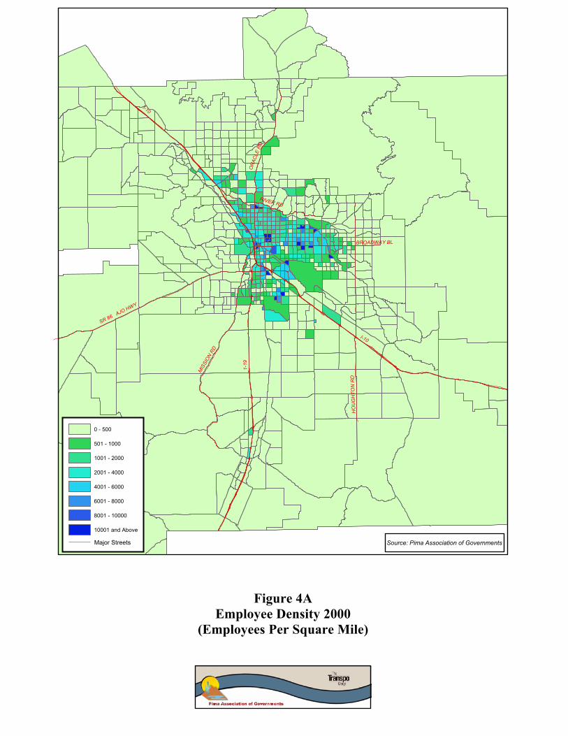
Employment Densities Figure 4A show employment densities for the PAG region in 2000 while Figure 4B shows the estimated densities for 2030.
• By 2030, higher levels of employment will be developing along the general I-10 corridor between Marana and Southeast Tucson.
• Relatively intense employment densities are identified for the Houghton Road corridor.
• Within the central-east area of Tucson, more intense employment levels are anticipated, including the Broadway Boulevard corridor.
• More intense employment activity is identified for the Oracle Road corridor through Oro Valley.
Age Densities A review of information from the 2000 U.S. Census for those aged 65 and over and under age 17 indicates the following:
• The over 65 population is widely dispersed throughout the Tucson region.
• Relatively more significant concentrations of over 65 populations are focused on Oro Valley, the City of Tucson, and Green Valley.
• Marana and areas west of Downtown Tucson have lower concentrations of elderly individuals.
• The older population is not necessarily a strong transit market. Sun Tran market survey information suggests that older individuals are more likely to be staunch non-riders than other groups.
• Only 9 percent of riders are persons 66 or over versus 29 percent who are in the 18-to-26 age group. (Source: Sun Tran Market Survey; summer 2001).
• Over time, individuals within the older population group could acquire health problems that may restrict or even preclude their ability to drive.
• In general, concentrations of youth population are focused on Sun Tran’s existing service area. The major exception is the Rita Ranch area and parts of the Marana area, which do not currently receive regular transit service.
I-10
OR
ACLE
RD
RIVER RD
BROADWAY BL
SR 86 AJO HWY
MIS
SIO
N RD
1-19
HO
UG
HTO
N R
D
I-10
0 - 500
501 - 1000
1001 - 2000
2001 - 4000
4001 - 6000
6001 - 8000
8001 - 10000
10001 and Above
Major Streets
Figure 4AEmployee Density 2000
(Employees Per Square Mile)
Source: Pima Association of Governments

I-10
OR
ACLE
RD
RIVER RD
BROADWAY BL
SR 86 AJO HWY
MIS
SIO
N RD
1-19
HO
UG
HTO
N R
D
I-10
0 - 500
501 - 1000
1001 - 2000
2001 - 4000
4001 - 6000
6001 - 8000
8001 - 10000
10001 and Above
Major Streets
Figure 4BEmployee Density 2030
(Employees Per Square Mile)
Source: Pima Association of Governments

Phase 2: Identifying Future Transit Growth Markets July 2003
The Transpo Group 18
• Concentrations of under 17 populations are focused on the 6th Avenue and Oracle Road corridors and along the 22nd and 29th Street corridors.
Zero-Auto Ownership Densities A review of 2000 U.S. Census data for zero-auto households indicates the following:
• The incidence of zero-car households is highly focused on Sun Tran’s current service area.
• The Flowing Wells area and the Near-Eastside both have significant concentrations of households without a car. These seem to correlate roughly with concentrations of persons 65 and older.
• Major exceptions to the zero auto/over 65 relationship are Oro Valley and Green Valley, which have many elderly but smaller concentrations of zero-car households.
Household Income A review of information from the 2000 U.S. Census for average household income in the PAG region indicates the following:
• In general, lower income households follow a wide north-south swath located between the Tucson International Airport area and the Flowing Wells area.
• Other pockets of low-income concentrations are located in the central and east areas of Tucson.
Key Findings • Due to their relatively low densities, large areas of the region’s future growth will
not lend themselves to regular fixed route transit solutions. However, these areas can still be served by other transit and mobility options such demand response service, express bus access provided park-and-ride lot capacity is available, and vanpool programs.
• Much of the region’s employment future growth will be focused along the I-10 corridor.
• While significant suburban development is planned, the triangle bounded by Downtown Tucson, Tucson Mall and Park Place will remain the region’s urbanized core area.
• Planned revitalization efforts, such as the Rio Nuevo project, will strengthen the Downtown Tucson-based market. Parking management strategies may also improve transit’s competitiveness within the downtown market.
• With its planned expansion and potential limitations on campus parking, the University of Arizona may take on a greater role as a focus for potential high capacity public transportation services in the central Tucson area.
• The pattern followed by the region’s major arterial streets facilitates the public transportation services operating in a grid network, instead of a more radial oriented system, within the urban core.
• Using the street system, much of the region’s high-density development will follow a north-south or east-west orientation. Affected corridors include but are not limited to:

Phase 2: Identifying Future Transit Growth Markets July 2003
The Transpo Group 19
o Oracle/Stone between River Road and Downtown Tucson; o 6th/12th Avenue between Laos transit center and Downtown Tucson; and o Broadway/Speedway between Houghton and University of Arizona/
Downtown Tucson.
• Several key demographic patterns that indicate potential transit markets are also located along these major north-south and east-west corridors.
• Significant infill will take place along the eight identified transit corridors.
Phase 2: Identifying Future Transit Growth Markets July 2003
The Transpo Group 20
4. Transit-Supportive Development This section provides direction as to location of transit-supportive activities as well as transit-related policy direction from local jurisdictions in the Tucson metropolitan area. These “supportive” items can involve a variety of methods to encourage transit use. Examples include high density housing located near transit stops and convenient pedestrian connections to transit.
Background Transit-supportive developments encourage transit use by various means including:
• Locating development at or near transit facilities;
• Connecting transit stops/stations with developments through sidewalks or paths;
• Providing parking management strategies (e.g., lower parking ratios or parking maximums);
• Locating high density developments near transit stops/stations;
• Developing a mix of land uses at or near transit stops/stations;
• Having high quality transit services and facilities that reinforce various land use and other strategies that support transit; and
• Emphasizing a safe and convenient pedestrian environment that encourages walk access to transit stops as well between various land use activities.
Other considerations relating to transit supportive development are:
• Investing in high capacity transit such as light rail transit (LRT,) bus rapid transit BRT), and trolleys may not be necessary to transit-supportive development ; several projects involving bus service have been implemented in Tucson or are in the planning stages;
• Transit supportive efforts can range from specific developments to communities (e.g., with its densities and limits on parking expansion, the University of Arizona Comprehensive Campus Plan can serve as a transit oriented community); and
• Potential examples of transit oriented communities include smaller blocks, narrower streets, wider sidewalks, shared parking, and accommodations for car sharing.
Transit-Supportive Developments During the past few years, several transit systems, local jurisdictions, state governments, and private developers have acquired hands-on experience in the planning and implementation of transit-supportive projects and strategies. Several states such as California, Washington, and New Jersey have encouraged transit-supportive development. For example, in New Jersey, transit-supportive development has been encouraged through legislation that identifies potential “transit villages” within ¼ to ½ mile of a bus, train, light rail, or ferry station. Transit village programs were established to encourage economic development, urban revitalization, and private-sector investment around transit stations. Once an area has been established as a transit village, it is eligible for state grants to implement improvements such as pedestrian amenities.
Phase 2: Identifying Future Transit Growth Markets July 2003
The Transpo Group 21
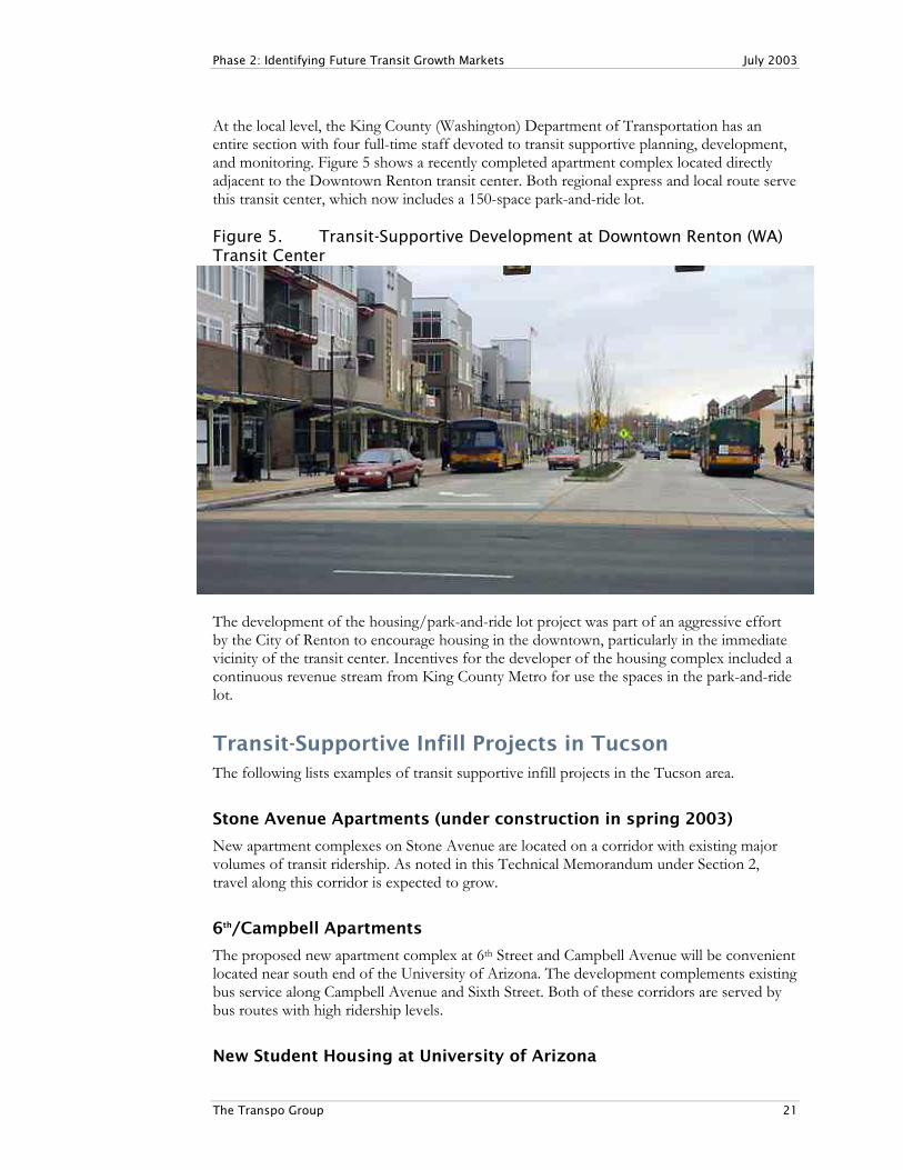
At the local level, the King County (Washington) Department of Transportation has an entire section with four full-time staff devoted to transit supportive planning, development, and monitoring. Figure 5 shows a recently completed apartment complex located directly adjacent to the Downtown Renton transit center. Both regional express and local route serve this transit center, which now includes a 150-space park-and-ride lot. Figure 5. Transit-Supportive Development at Downtown Renton (WA) Transit Center
The development of the housing/park-and-ride lot project was part of an aggressive effort by the City of Renton to encourage housing in the downtown, particularly in the immediate vicinity of the transit center. Incentives for the developer of the housing complex included a continuous revenue stream from King County Metro for use the spaces in the park-and-ride lot.
Transit-Supportive Infill Projects in Tucson The following lists examples of transit supportive infill projects in the Tucson area.
Stone Avenue Apartments (under construction in spring 2003)
New apartment complexes on Stone Avenue are located on a corridor with existing major volumes of transit ridership. As noted in this Technical Memorandum under Section 2, travel along this corridor is expected to grow.
6th/Campbell Apartments
The proposed new apartment complex at 6th Street and Campbell Avenue will be convenient located near south end of the University of Arizona. The development complements existing bus service along Campbell Avenue and Sixth Street. Both of these corridors are served by bus routes with high ridership levels.
New Student Housing at University of Arizona

Phase 2: Identifying Future Transit Growth Markets July 2003
The Transpo Group 22
As a major regional destination, the densities at the University of Arizona campus already support transit in terms of high land use densities, walking paths, subsidies for transit passes, etc. The continued development of high density housing such as the new student housing complex on Euclid Avenue provide further reinforcement of this transit support at the campus.
General Plans and other Major Guidelines In the Tucson region, several jurisdictions have included transit-supportive policies in their respective plans.
City of Tucson (General Plan, November 2001)
• Promote LU/Transportation to link downtown/4th Avenue/University of Arizona.
• Promote alternative modes of travel.
• Promote mixed-use centers to increase transit use, reduce air pollution.
• Provide convenient, comfortable, illuminated, accessible bus shelters.
• Encourage optimal availability and utilization of transit in the region.
• Provide public transit centers.
• Provide opportunities to develop multi-use corridors of sufficient intensity and diversity to support transit.
• Provide Paratransit.
• Consider incentives to reduce average length of work trips.
• Consider amendments to major streets/routes plan to address multi-modal streets.
• Strengthen pedestrian linkages to transit.
Town of Oro Valley (Transit Development Plan FY 2003-2012)
Several implementation strategies were called out in Oro Valley’s Transit Development Plan. These strategies are:
• Monitor Coyote Run ridership demand to identify improvements and/or modifications to service. Conduct annual survey to monitor service performance
• Monitor Route # 162 ridership and performance. Meet with Pima County and Sun Tran officials to discuss future changes to Route # 62 service along Oracle Road. Consider the use of smaller buses and new run times to better meet public demand.
• Meet with Arizona Department of Transportation (ADOT) staff to discuss future transit stop improvements along Oracle Road. Identify transit stops to be improved. Incorporate planned improvements into ADOT Oracle Road Corridor Study.

Phase 2: Identifying Future Transit Growth Markets July 2003
The Transpo Group 23
• Monitor progress of commercial; and industrial project development within Town limits. Meet with business managers and employees to discuss transit ridership potential and future transit service needs.
• Work with Town transportation engineers to include transit and pedestrian facilities in future roadway construction projects. Identify right-of-way needs and possible land acquisition along future fixed route transit corridors.
• Work with Town officials to pursue funding sources as recommended in the Transit Development Plan. Focus on a proposed transportation sales tax, private sector contributions, and advertising.
• Meet with private sector transit providers to identify opportunities for sharing resources (e.g. transit station) and coordinating services. Providers include airport shuttle companies, healthcare agencies, retailers with shuttle services, and major employers with shuttle services.
• Develop a set of marketing materials and methods to keep the public informed of Transit Development Plan progress (e.g. website updates, newsletters, special events, fundraising activities).
City of South Tucson (Comprehensive Plan)
• Provide bus shelters for every stop; currently there are some along 6th Avenue.
• Integrate alternate transportation uses.
• Establish historic bus connections, trolley links, and special shuttle services.
• Explore possibilities for shuttle services between social/youth programs.
Town of Marana (Transportation Plan Update: 2001-2025: Final Report)
Key transit-related recommendations include:
• Commuter express: Marana to downtown Tucson and airport area;
• Neighborhood circulator and dial-a-ride that serves in-town;
• Expanded Sun Tran service along major arterials;
• Commuter service said to have priority (particularly for Raytheon employees who commute from Continental Ranch);
• Continental Ranch route: largest commuter market and highest density residential;
• New park-and-ride lots;
• Sun Tran #103 realigned to serve as commuter route;
• Sun Tran #16 extended west to I-10 as fixed-route line;
• Long term: extend Silverbell Rd route along Twin Peaks to I-10 to a new transit center; further fixed route changes; and
• Re-route #102, 103, and 16 to serve new Orange Grove Transit Station.
Pima County (Comprehensive Plan Update 2001)
• Increase use/availability of transit to reduce air pollution.

Phase 2: Identifying Future Transit Growth Markets July 2003
The Transpo Group 24
• Provide for transit oriented developments along major streets.
• Provide viable alternatives to driving (multi-modal system).
• Promote high-density, mixed-use along transit corridors.
• Target Flowing Wells as a future growth area, supporting mixed use and other development/redevelopment opportunities.
Town of Sahuarita
• The draft General Plan calls for convenient multi-modal access to inter-modal transportation hubs.
Rio Nuevo/Downtown Tucson Within Tucson, the Rio Nuevo redevelopment effort will help support both existing and future transit service in the general downtown area. The Draft Report for the Rio Nuevo Transit Analysis calls for extending the historic trolley to serve as the primary Rio Nuevo shuttle route5. The Intermodal Depot Center will be an important focal point for intercity transit service in Downtown Tucson as well as a catalyst for high-density development. The Depot will complement potential new trolley connections between University of Arizona, Downtown Tucson, and redeveloping areas in the general Rio Nuevo area. Plans are under review of new multi-family housing in the immediate vicinity of the Intermodal Depot.
University of Arizona – Comprehensive Campus Plan There are already transit-supportive efforts at the University of Arizona through programs such as the transit bus subsidies and the Cat Tran shuttle service. The Comprehensive Campus Plan for the University of Arizona identifies anticipated growth of the campus, including the University Medical Center area through 2030 and beyond. Adopted in June 2003, the Plan identifies a significant amount of growth in student population, from 33,500 full-time equivalents under existing conditions to 40,000 through full build-out. Figure 6 identifies the growth in student population, faculty/staff, and campus parking. While student population will grow by almost 20 percent, on-campus parking will grow by only 6 percent. With the combined growth of students/faculty/staff compared to parking capacity growth, the parking to population ratio will decline from 0.31 to 0.27 spaces. Additional on-campus housing called out in the plan will help address future travel demand related to campus growth. 5 Draft Technical Memorandum: Rio Nuevo Transit Analysis; Parsons Brinckerhoff (March 2001).

Phase 2: Identifying Future Transit Growth Markets July 2003
The Transpo Group 25
Figure 6. Growth Rates at University of Arizona
This constraint on parking capacity could present opportunities for transit to take on a greater share of total travel to the campus. Other major university campuses in the U.S. have been able to achieve major growth while at the same time limiting on-campus parking growth6. Examples include:
• Colorado State University: Projected demand for parking spaces was reduced substantially in the campus planning effort; a key factor was a substantial increase in parking fees;
• The University of California, San Diego projected 13 new parking structures during a ten-year period. This was changed to 6 structures plus a transportation demand management (TDM) program. About 4,000 spaces were eliminated from the expansion effort; and
• Cornell University developed a TDM program instead of the planned construction of 3,100 new parking spaces. Only 350 spaces were eventually built during a six-year period.
Southeast Area Plan/Houghton Road As indicated in Section 3 – Regional Travel Trends, Southeast Tucson is expected to take on major importance in terms of producing person trips. The City of Tucson is involved in the planning stage of a mixed use community located along Houghton Road between Irvington and the Union Pacific tracks (Houghton Area Master Plan). The current vision for this new community includes three transit centers. One of the centers is located at a commercial center situated in the central part of the community.
6 The Road Less Traveled: Sustainable Transportation for Campuses, Planning for Higher Education,
March-May 2003 (Will Toor, Mayor of Boulder, CO).
U of A Campus Population/Parking Changes(source: Comprehensive Campus Plan)
33,500 35,00037,000
40,000
13,800 15,100 16,000 14,600
-5,000
10,00015,00020,00025,00030,00035,00040,00045,000
Existing Phase I Phase II Phase III
Student Population (FTE's) Faculty Staff (FTE's) On-Campus Parking Spaces

Phase 2: Identifying Future Transit Growth Markets July 2003
The Transpo Group 26
Transit-Supportive Corridors Several transportation corridor studies were reviewed to determine any specific action items relating to transit. Particular attention was given to any items supporting both existing and potential future transit service along the affected corridors.
Broadway Corridor
In 1990, an assessment was carried out of the Broadway Corridor from the standpoint of possible rail transit development. Key results of the study were as follows:
• Eleven alternatives were identified;
• Alternatives included “do nothing,” increased bus system, busways, and light rail;
• No “major-build” alternatives were recommended; and
• No alternative met UMTA (now FTA) thresholds for cost-effectiveness. Over time, the Broadway corridor has developed as a relatively high density area including major concentrations of retail and mixed use activities. A new office/retail building at the Williams Center is the first four-story building under construction in Tucson since the 1980s. The Broadway Corridor also has the most extensive transit priority treatment in the region. There are approximately 4½ miles of shared-use lanes. The lane is shared by buses, bicycles, and general traffic making right turns. At the east end of Broadway, the existing bus lane is located between 4th Avenue and Euclid Avenue. The lane resumes between Columbus and Camino Seco.
5th/6th Street
In the 5th/6th Street corridor study, several transit-related recommendations were called out. These recommendations are:
• The outside travel lanes of the current four-lane cross section should be converted to dedicated lanes for transit;
• Improved transit amenities such as passenger shelters, etc. at key locations were also discussed; and
• While light rail and transit oriented development were topics of serious discussion during the study process, no recommendations were made.
Stone Avenue
The Stone Avenue corridor study noted many opportunities for redevelopment of existing facilities. Several new projects have recently begun, including the expansion of Pima Community College’s downtown campus, and a new mixed use development combining retail, office, residential, and high density apartments catering to college students.

Phase 2: Identifying Future Transit Growth Markets July 2003
The Transpo Group 27
The right-of-way is typically 80 to 100 feet. There is little to no room for widening without destroying many buildings, including some of the new projects. Therefore, the study noted that widening Stone Avenue for additional transit facilities is not a feasible option.
Pedestrian Improvements During the next five years, several corridors in the Tucson area will receive major upgrades such as new vehicle lanes, curbs, drainage, sidewalks, landscaping, and lighting. Many of these projects include major sidewalk improvements, which will contribute significantly to making transit routes more accessible. Only two corridor improvements listed in the five-year TIP will include transit improvements of any significance.
• The Stone Avenue corridor improvement project between Speedway and Wetmore will include new bus shelters that are ADA accessible.
• The 5th/6th Street corridor improvement project between Craycroft and Alvernon will include transit amenities such as bus shelters and bus pull-outs.
Both existing and future transit markets are affected by access conditions that can encourage or in some cases discourage transit use. For those walking to stops (usually the majority of riders), sidewalk conditions and availability of shelters are two key physical features. In the Tucson region, a private vendor is placing several new-look passenger shelters. These shelters will include solar powered lighting as well as features that allow air circulation. The adjacent photo shows one example of recently installed shelters in the City of Tucson.
Key Findings • While growth in travel demand in the Tucson region is expected to be substantial,
actual transit ridership will depend on access conditions and the extent/quality of transit support.
• There is a growing list of examples relating to transit-supportive developments and communities.
• Jurisdictions in the Tucson region have called out policies and action plans that are supportive of transit.
• Plans for the University of Arizona campus as well as the Southeast Tucson area can have major impacts on future transit markets in the region.
• Some corridor studies have identified transit-supportive facilities such as improved sidewalks.

Phase 2: Identifying Future Transit Growth Markets July 2003
The Transpo Group 28
5. Transit Markets for Persons with Disabilities and the Elderly
This section describes two travel markets that need to be recognized by future transit development in the Tucson region. These markets involve persons with disabilities and the elderly.
Persons with Disabilities Discussions with staff at DIRECT Center for Independence indicated the following regarding the transit market for people with disabilities – for both fixed route and paratransit services. The following calls out key items from these discussions.
Fixed Route Markets
• There are many unserved markets involving persons with disabilities. Some people who moved to outlying areas in recent years now have disabilities and are stranded at home. People unexpectedly acquire disabilities and face mobility problems.
• Heavily used routes by disabled include #16 Oracle, #4 Speedway, #8 Broadway #9 Grant, and #34 Craycroft. These routes are popular because of the proximity to major shopping, medical, and employment centers. Route 61 - La Cholla is also an emerging route because of the connection to Northwest Medical Center and Foothills Mall. It should be noted that, in fall of 2003, Route 61 will be extended to the new Pima Community College North campus on Magee.
• People with disabilities want to live where there are multiple routes (e.g. at the corner of Craycroft and Grant there is an accessible apartment complex called Fountain Plaza). Multiple routes provide travel options.
• People with disabilities tend to make residential choices based on four main factors: 1) housing cost 2) housing accessibility, 3) transit accessibility, and 4) accessibility to major services such as medical, shopping and employment. Again, this is why the routes mentioned above are heavily used by disabled. The DIRECT Center maintains a list of accessible rental apartments, low-cost housing, and assisted living centers.
• There is very limited accessible taxi service in Tucson. There is no same-cost taxi service in Tucson. The Commission on Disabilities Issues (CODI) tried to garner City support for an ordinance requiring accessible and same-cost taxi service but it has not been implemented.
In terms of access to existing transit stops, the following items were noted by DIRECT staff:
• Lack of sidewalks and sidewalk connectivity from neighborhood streets to major transit routes. According to ADA eligibility requirements, neighborhood streets can serve as pedestrian access to bus stops. The lack of sidewalks does not guarantee ADA eligibility for paratransit service.
• Obstacles include poor lighting, rough pavement, parked cars in sidewalk areas, construction zones, and utility poles and signage.
• Varying heights of sidewalk are a problem as wheelchair users try to board buses.
• Varying slopes of sidewalks prevent wheelchair lifts from deploying evenly.

Phase 2: Identifying Future Transit Growth Markets July 2003
The Transpo Group 29
• No shade at bus stops is a major issue. This is especially critical for people with advanced physical disabilities.
• Bus stop pads are often not wide enough or long enough to provide complete wheelchair access to shelters and for loading onto buses as the lifts need at least five feet for deployment.
• Lack of concrete or other even surfaces between curb and sidewalk to allow proper wheelchair accessibility onto lifts.
• Some lifts on buses malfunction due to gravel being stuck in mechanism or too much weight. Lifts carry a maximum of 600 pounds total chair and passenger.
• Bus entrances are too narrow for some wheelchairs due to misplacement of handrails fareboxes, although Sun Tran has retrofitted many buses.
• Wheelchair-securing procedures and equipment are outdated on some buses, although there have been substantial improvements in recent years.
• When getting off the bus, there is the same problem of lack of sidewalks to major destinations (malls, medical plazas, shopping centers).
Paratransit Markets
Key items relating to markets for paratransit
• It is difficult to get reservations without making them more than 48 hours in advance. This indicates that the demand is greater than capacity, which can lead to a higher denial rate.
• The one-way trip policy implemented by Van Tran can be restricting since there is no guarantee of a return trip. However, riders are not obligated to accept a one-way reservation. It is their choice.
• Vehicles can sometimes be late on arrival.
• The ADA process and policy is cumbersome for some transit users.
Within the PAG region the largest concentrations of ADA eligible users are in the City of Tucson. As indicated by Figure 7, the number of eligible users generally increased between 1996 and 2001; however, in 2002 the number decreased to about 6,300. There could be several reasons for the decline, including the potential discouragement from being reauthorized due to constraints as called out above.
Figure 7 - ADA Eligible Riders (Source: City of Tucson)
01000200030004000500060007000
1996 1997 1998 1999 2000 2001 2002

Phase 2: Identifying Future Transit Growth Markets July 2003
The Transpo Group 30
Direction for Potential Improvements
The City of Tucson does not have an inventory of accessible bus stops. An inventory of accessible stops will be important to pursue since major arterials with various services, shopping, and good transit services should have accessible stops. Phase 3 of the Transit Element can call out an ongoing inventory of bus stops, including accessibility. It also can call out that, over the long term, all stops should be accessible. Low floor buses also help with accessibility and provide added benefits of easing passenger loading, speeding up dwell times, etc. These features plus improved bus stop accessibility, and other strategies can potentially shift some of the demand by persons with disabilities to fixed route service. This will provide relief for Van Tran and other paratransit service providers in the PAG region. Other strategies to address the market needs of people with disabilities could entail identifying accessible transit corridors that have high quality transit service (15 minute frequencies to better) and amenities such as passenger shelters. The identification also can include an accessible pedestrian network covering at least one block on either side, and creating more accessible housing along the corridors.
Elderly Market In addition to persons with disabilities, another important transit market involves the elderly, particularly given the attractiveness of the Tucson region as a place for retirees. As noted this Memorandum in Section 3 - Land Use Densities and Demographics, there is a relatively low rate of transit use within Tucson by persons over 65. Possible constraints to higher transit use by the elderly include:
• Some elderly are concerned about trying new things such as riding the bus;
• There may be concerns about lack of system understanding;
• There may be concerns about safety/security; and
• There is lack of amenities at some bus stops (e.g., shading). In September of 2002 the Pima Council on Aging and United Way of Tucson and Southern Arizona carried out efforts relating to transportation needs of seniors. Nine public comment meetings were held that attracted hundreds of senor and their families. A senior survey of approximately 2,000 persons was also conducted. The survey generated responses as to what seniors felt were major issues for them personally. The data indicated that the older the persons the more transportation was named as a major issue. For example, while those under 60 named transportation the ninth most important issue for them, the age 70 to 74 and 80 to 84 said it was 6th in importance. For the 85 to 89 age group transportation was noted as the fifth major issue and those 90+ named it as their second major issue7.
7 Per E-mail communication of July 7, 2003 from Sharon Gartner, United Way of Tucson and
Southern Arizona to PAG.
Phase 2: Identifying Future Transit Growth Markets July 2003
The Transpo Group 31
The senior transportation needs study also included a series of focus groups held with representatives of 41 local agencies. Key items from the focus groups included the following:
• The most critical need of seniors is transportation to the doctor and other health care appointments. Medicare HMO’s have stopped providing transportation to medical appointments.
• Transportation is a significant problem for rural residents. Although seniors are appreciative of current paratransit services, some people are turned down for service because they live too far out. There is no public transportation in Green Valley and north of Oro Valley to serve the communities of Catalina, Oracle Junction, or Saddlebrooke.
• More economical and efficient door-to-door services are needed. Seniors need safe, reliable, and adequate transportation to evening events and also a way to transport grandchildren or other minors they are raising to appointments. Seniors need a reliable paratransit service that does not require waiting long hours for pick up and delivery.
• There is a large interest in neighborhood-based volunteer services. This is mainly because seniors feel more comfortable with people they know. Northwest Interfaith Center and Catalina Helping Hands volunteers provide valuable transportation services for elderly and disabled. Replicate the “Old Fort Lowell Live-At-Home” project in as many neighborhoods as possible, including mobile home parks.
• There is a need for a policy change to support and expand volunteer activity, particularly relieving volunteers from liability when they transport seniors to appointments. By registering as volunteers, they have agency insurance coverage.
• Fixed route bus service is not a viable option for some seniors. As noted above, lack of amenities such as shade and sidewalks may be hindering greater use of fixed route service by seniors. It is often very difficult for seniors to wait for the bus for long periods of time.
• Bus drivers, van drivers, and caregivers need more education and training on how to meet the needs of the seniors they serve.
• State and local funding is needed to support a collaborative system. The City of Tucson does have an outreach effort to help familiarize all newcomers to public transit. This helps address concerns about lack of familiarity regarding public transit services. Also, an Elderly Mobility Study is being undertaken for PAG by the Drachman Institute. This study is expected to be completed by August of 2003. Potential transit service improvements (under Phase III of the Transit Element) that meet needs of senior will need to keep in mind key features of the senior travel. For example, market characteristics such as travel times are more spread out than the traditional commute- and school-related patterns. Also, there are some seniors who have physical disabilities (to the point that they cannot drive) but they do not qualify for paratransit services under the Americans with Disabilities Act.
Key Findings • Some areas of Tucson where persons with disabilities reside are not currently served
by transit.
Phase 2: Identifying Future Transit Growth Markets July 2003
The Transpo Group 32
• Access to transit is a key factor in the selection of housing locations by persons with disabilities.
• Several bus routes have particularly high use by persons with disabilities.
• Several barriers currently exist regarding the disabled markets: o For fixed route service, barriers involve access to bus stops as well as the
conditions at the bus stops; and o For paratransit service, a key barrier involves the reservations system.
• In considering potential improvements relating to service for persons with disabilities, one strategy could entail identifying accessible transit corridors that have good transit service and amenities such as passenger shelters.
• For the elderly, some barriers to public transit involved lack of familiarity with the system a well as concerns about safety/security.

Phase 2: Identifying Future Transit Growth Markets July 2003
The Transpo Group 33
6. Regional Commuter Markets Regional commuter markets can involve express bus and commuter rail services. Section 3 of this memorandum indicates potential increased demand for several corridors such as Sahuarita/Downtown Tucson, Marana/University of Arizona, and Southeast Tucson and Central Tucson. To effectively serve the market, the service needs to be quick and direct as possible, thereby attracting those riders who have a choice between taking transit and driving.
Park-and-Ride Access In addition to speed and directness of the transit service, access is an important factor in attracting markets to commuter services. Without major park-and-ride lot access that can attract users located in low density areas, any express service will not likely be effective. In addition to providing sufficient capacity, the park-and-ride lots should have amenities such as shelters and lighting as well as security features. These amenities will help prevent theft and vandalism. New park-and-ride lot capacity does not necessarily require new publicly financed construction. As is the current situation with some lots in Tucson, the capacity can be provided through lease arrangements with private landowners. Arrangements can also be made with churches since parking capacity at these locations is usually available during weekdays between early morning and early evening.
Rail Network for Potential Commuter Service More information on potential commuter rail development will be coming in Phase 3 of the Transit Element. This Phase will call out potential transit improvements. Potential service could use existing rail lines in the Tucson area. The lines are shown in Figure 8. In 1999, a consultant study of commuter rail feasibility in the Tucson region was carried out for the Town of Marana as part of its Transportation Plan development. The study called for use of existing rail lines in the region currently owned and operated by the Union Pacific Railroad. It also identified potential capital costs associated with commuter rail service.
Policy and Coordination Issues For potential commuter services, key policy areas also include developing strong groundwork for future park-and-ride lot construction. However, no efforts are underway in the Tucson for major park-and-ride lot development. A key element of any park-and-ride lot policy item is the potential role of Arizona Department of Transportation (ADOT). As is the case with transportation departments in other states, ADOT can play a significant role in the planning and location of park-and-ride lots. Substantial right-of-way may be available along I-10, I-19, and other state highways. In addition, as ADOT and other transportation agencies consider acquiring new right-of-way, park-and-ride lot requirements should be included in the process.
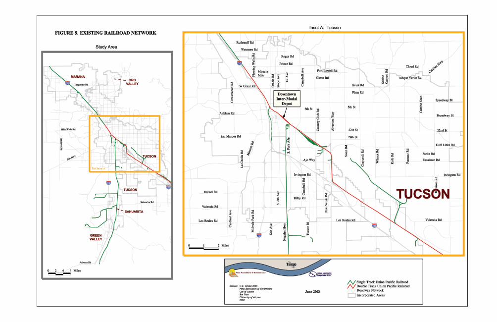
Phase 2: Identifying Future Transit Growth Markets July 2003
The Transpo Group 35
For rail service, two major policy-related items need to be addressed with regard to inter-city service. These items include:
• Amtrak Negotiations: These negotiations will be necessary to address possible Amtrak jurisdiction relating to inter-city travel within the PAG region.
• Union Pacific Negotiations: Since sharing of tracks likely will be necessary, negotiations will have to occur with the railroad. Key areas include available capacity, at grade crossings, reliability, safety, and liability issues.
Key Findings • Direct and convenient express service in outlying areas will help meet emerging
travel needs in the PAG region.
• The regional express will need to be supported by sufficient park-and-ride lot capacity.
• Early planning effort for park-and-ride lot development should include ADOT.
• Basic rail infrastructure for commuter rail service is in place along some segments.

Phase 2: Identifying Future Transit Growth Markets July 2003
The Transpo Group 36
7. Intercity Transit Intercity travel markets are currently served by Amtrak, Greyhound, airport shuttle services, and private van operators.
Amtrak Tucson is located on the Union Pacific Railroad’s “Sunset Route” mainline between Los Angeles and New Orleans. Limited (three days per week) passenger rail service is currently provided in Tucson. Tucson has had rail service since 1880; the current rail passenger station was built in 1907 and remodeled in 1941. The facility was recently purchased by the City of Tucson and is in the process of being remodeled to its original 1907 configuration. When completed, the complex will serve as Tucson’s Greyhound bus terminal in addition to the Amtrak station. Amtrak does not have a dedicated source of funding and operates with budgets approved by Congress on an annual basis. Recently, Amtrak funding has come under heightened scrutiny due to the assertion of Amtrak management that the operation will always require significant subsidies. Long distance trains have historically borne the brunt of Amtrak budget-cutting. However, Amtrak’s current president, David Gunn, recognizes the political value of operating a “national system” and has stated his intention to continue operating the Sunset Limited.8 In the past decade, several studies have been conducted by ADOT that address passenger rail service in Tucson. The Arizona Rail Passenger Feasibility Study was conducted in 1993 and the Arizona High Speed Rail Feasibility Study in 1998. Both studies recommended some form of Phoenix-Tucson rail passenger service. In addition, the 1993 study recommended Tucson-Nogales service, Phoenix-Grand Canyon excursion service, and Phoenix-area commuter service. Phoenix-Tucson service would need to operate over the congested Tucson-Picacho segment of the Union Pacific Sunset Route main line, which is single track north (railroad west) of Stockham siding (located near Prince Road). Hence, Union Pacific has been unwilling to consider additional passenger rail service on that line unless there is sufficient funding for construction of a second track and grade-crossing upgrades.
Greyhound Greyhound Line serves Tucson, with a bus terminal located between Broadway and Congress streets at the eastern edge of the downtown. Direct service is provided to Phoenix, 8 As quoted in the Houston Chronicle, January 27, 2003.
Phase 2: Identifying Future Transit Growth Markets July 2003
The Transpo Group 37
El Paso, and Nogales with nationwide connections from those locations. At present, about 36 buses per day serve the Tucson area. The overall attractiveness of Greyhound service should be enhanced when operations move to the refurbished Intermodal Depot in Downtown Tucson.
Airport Shuttle Service There are several small private companies that provide transit service between Tucson and the Sky Harbor Airport in central Phoenix. This market has been growing steadily during the past ten years due to lower airfares and more flight options out of Sky Harbor as compared to Tucson International Airport. The major airport shuttle provider is called Arizona Shuttle Service which offers hourly service all day every day. The 15-passenger vans pick up riders at three locations:
• Speedway and Craycroft in east Tucson;
• Sixth Street and Park Avenue near the University of Arizona campus; and
• Ina and I-10 in northwest Tucson. The company’s primary markets include college students, military personnel, and retirees who prefer not to drive. A one-way fare to Sky Harbor is $25.
Private Van Service According to a recent Arizona Daily Star article, there are 56 companies with 95 licensed shuttle vans providing intercity public transit service between Tucson and Nogales. The market has grown dramatically over the last decade and competition is intense, with average one-way trips costing about $5. At least nine private shuttle companies operate out of parking lots on South 6th Avenue, which has become a major corridor for inexpensive shuttle service to Nogales and well as to Phoenix. A Greyhound partner, Autobuses Crucero, also operates service between Tucson and Nogales operating over-the-road coaches between the Greyhound terminals in each city. This market is only expected to increase in future years, perhaps requiring more coordination between the public and private sectors.
Key Findings • Several private carriers provide intercity services between Tucson and Phoenix and
Tucson/Nogales.
• The Tucson/Nogales service has been growing rapidly through private van operations.
• Further assessment of intercity market needs will need to recognize estimated travel growth between Tucson and other cities, particularly Phoenix and Nogales.
• Any service development to meet future market needs will need to address policy-related issues such as Amtrak’s future and the relationship with the Union Pacific Railroad in terms of track sharing.

Phase 2: Identifying Future Transit Growth Markets July 2003
The Transpo Group 38
8. Potential High Capacity Transit Corridors
High Capacity Transit (HCT) can involve bus and rail services that, as a minimum, should provide frequent peak period service (less than 15 minutes) connected to major travel generators. HCT services can range from direct and frequent peak only express bus routes to all day service operating on fixed guideways or in exclusive transit lanes on streets. This section identifies potential HCT corridors in the Tucson region. Their selection is based on the review of travel market characteristics that were described in previous sections of this Technical Memorandum.
Background In Tucson, there is currently 10-minute peak and midday bus service operated on Route 8 on South 6th Avenue and Broadway. This service level can be regarded as an early stage in the eventual development of HCT along these corridors. However, more attention has been recently given to higher profile HCT in Tucson such as the Tucsonans for Sensible Transportation initiative for a 13-mile light rail transit (LRT) line that would operate on Broadway Boulevard and 6th Avenues as well as a 47-mile bus rapid transit (BRT) network. The results of the transit market assessment conducted in Phase 2 of the RTP Transit Element indicate that several potential corridors in the region are possible candidates for some form of HCT development. Selection of candidate corridors is based on review of several factors that indicate potential transit use. These factors include, existing demographic characteristics, projected land use densities, estimated travel volumes affecting corridors in the region, and supporting strategies that have been called out by local jurisdictions in the region. Table 3 identifies potential HCT corridors along with key information for each one. Figure 9 shows the location of these corridors. Information in Table 3 includes current ridership levels, regional travel affecting the corridor, land use densities, demographic characteristics, transit supportive measures, and other considerations.
Potential HCT Corridors 1. University of Arizona/Rio Nuevo via 4th Avenue and University
Boulevard
This HCT corridor would support development plans for Rio Nuevo while also supporting two major existing travel generators: Downtown Tucson and University of Arizona. Some infrastructure and vehicles operated by Old Pueblo Trolley are in place along a portion of this corridor.
2. Broadway/Speedway/6th Street (Houghton Road to Downtown Tucson/University of Arizona)
This general east-west corridor already has two of the top eight transit corridors in terms of daily ridership. Higher density residential development the service areas are expected to be even more intense by 2030. The corridor will be affected by potential major travel growth generated by new developments in the southeast area of Tucson.

Phase 2: Identifying Future Transit Growth Markets July 2003
The Transpo Group 39
Table 3
Residential EmploymentPolicies / Identified
Growth Areas Actions
1. U of A/Rio Nuevo v ia University Boulevard & 4th Avenue
No route serves this corridor; OPT prov ides rail serv ice along 4th Ave and University ; OPT's annual boardings were approximately 26,000 in FY 2002
Major travel growth expected between South Tucson area and U of A
Major concentrations of high density residential along corridor
High density employment in Downtown Tucson and U of A campus
Concentration of low income and 0-auto households in south end of corridor
Spec ific City of Tucson policy to promote land use/transit links affecting 4th Ave/Downtown Tucson/U of A.
New inter-modal fac ility at Tucson Deport; Rio Nuevo project underway, inc luding potential multi-family development near Tucson Depot
Existing track in place along some portions of the corridor; Old Pueblo Trolley has identified program of potential rail trolley link between U of A and Rio Nuevo.
2. Broadway / Speedway/6th St (Houghton Road and U of A/Downtown Tucson)
Ridership on routes serv ing Broadway and Speedway is among highest in region.
Major growth antic ipated between zones located along general Broadway / Speedway Corridor
Existing densities are high along the general corridor; the densities are expected to be more intensive by 2030
Employment densities are high at the west end of corridor in the v ic inity of U of A and Downtown Tucson; Broadway corridor has been developing with more intense employment and mixed use ac tiv ities.
Major concentrations of demographic groups that indicate propensity for transit.
Central area of Tucson slated for nodes of increase transit use.
Existing bus lane on Broadway Potential HCT will benefit from future development at U of A campus, inc luding possible limitations on future parking capac ity development on the campus.
3. Campbell Avenue (Tucson Mall and U of A)
Campbell Avenue ridership (Route 15) is among the top 8 transit ridership corridors.
Growth in demand north and west of U of A to the campus
High residential densities along corridor north of U of A
Serves the U of A campus which has high employment densities and Tucson Mall with major retail concentrations.
Low income in north area of route
If adopted, The U of A Campus Comprehensive Plan could have major impacts on routes serv ing the campus
Recent approval of high density housing/retail development at Campbell/6th strengthens this corridor in terms of future market potential
Potential HCT will benefit from future development at U of A campus, inc luding possible limitations on future parking capac ity development on the campus.
4. Orac le / Stone (Oro Valley to Downtown Tucson)
Ridership on Route 16 serv ing Orac le Road corridor is the highest among the top 8 major ridership corridors in Tucson.
Major growth antic ipated between zones located along the corridor; this inc ludes work-related trips between Oro Valley and Flowing Wells
High residential densities along corridor between Flowing Wells and Downtown Tucson
This corridor serves Downtown Tucson with its high density employment area.
Low income, under age 17, and zero-auto household along major portions of the corridor. The corridor has two major high schools.
Town of Oro Valley Plan calls for TOD at Orac le/1st Ave. and promotion of Orac le Rd as N/S transit corridor; recommended commuter serv ice on Orac le Rd (per TDP). Pima County identifies Flowing Wells for medium to high density urban uses.
Stone Avenue corridor improvements will inc lude new passenger shelters.
Coyote Run serv ice by Town of Oro Valley prov ides local access to potential north-south HCT corridor along Orac le Road.
5. 6th Avenue (Downtown Tucson to Irv ington)
Ridership on Route 8 serv ing this corridor is among top 8 major ridership corridors in Tucson.
Growth in demand involv ing work trips High residential densities along corridor - 2000 and 2030; will also benefit from new high density housing through the Rio Nuevo project.
This corridor serves the high density employment area in Downtown Tucson
Low income, under age 17, and zero-auto household along major portions of the corridor.
City of South Tucson calls for bus shelters at every stop.
Recent sidewalk developments along 6th Avenue prov ide enhanced pedestrian access to bus serv ice along corridor.
Laos transit center at south end of corridor is one of three major transfer locations in Tucson.
6. I-19 (between Sahuarita and Downtown Tucson)
No transit serv ice currently available
Sahuarita/Green Valley area will emerge as one of the major trip producers by 2030
Low density residential - 2000 and 2030
Generally low density employment -2000 and 2030
Over 65 population already is extensive in Green Valley area.
Draft language in Sahuarita General Plan calls for convenient multi-modal access to inter-modal transportation hubs.
Will be important to have aggressive park-and-ride lot development along I-19 for any HCT to be effective along this corridor.
7. I-10 (Marana and Houghton Road)
No transit serv ice currently available along this corridor
Major growth in demand expected between Marana and employment areas in general airport area; potential high growth estimated to occur between new developments in SE Tucson and south industrial area.
Low density residential expected in Marana through 2030; if park-and-ride lot access prov ided potential HCT development can be v iable even with low density development.
Higher density employment development identified by 2030 for general I-10 corridor.
Relatively low levels of transit propensity households in Marana
Language from Marana Transportation Plan re: park-and-ride lot developments
Marana Transportation Plan calls for expansion of commuter serv ice and development of park-and-ride lot lots.
Will be important to have aggressive park-and-ride lot development along I-10 for any HCT to be effective along this corridor.
8. Houghton Road (between Irv ington and Broadway / Speedway corridor)
No transit serv ice on this corridor Major transportation growth could occur along corridor due to developments in SE Tucson
Sporadic housing currently along the corridor; will become more intensive by 2030 if SE Tucson area develops.
Higher density employment development identified by 2030 for the Houghton Area Master Plan
New SE Tucson developments will inc lude mix of land uses as well as pedestrian amenities. Three transit centers have been identified in the concept plan.
The current Houghton Area Master Plan prov ides an opportunity to identify spec ific actions to support high capac ity or other transit improvements along this corridor.
Possible tie-in with any east-west HCT corridor to form L-shaped transit link to central Tucson area.
9. Anklam / 6th Street (between Pima College West and U of A)
Most of the corridor has transit serv ice but none west of Greasewood.
Major growth in demand expected between West Tucson and several major locations in central areas of Tucson, inc luding U of A.
Relatively high residential densities immediately west of I-10
Serves the U of A campus which has existing high employment; would also serve central Tucson that has high residential densities.
High levels of transit propensity households such as low-income and 0-auto.
Potential HCT will benefit from future development at U of A campus, inc luding possible limitations on future parking capac ity development on the campus.
Potential HCT Corridors
Potential HCT Corridor Other Considerations
Land Use Densities Transit Supportive Measures
Current Ridership Along Corridor Regional Travel Patterns Demographic Characteristics

0
18
9
1
15
7
4
8
6
5
3
16
19
10
2
14
20
11
13
12
17
2221
TheTranspoGroup
Figure 9Potential Major HCT Corridors
= UniversityofArizona/RioNuevovia4thAvenue
LEGEND
= Broadway/ Speedway/6th (HoughtonRoadandUofA/DowntownTucson)
= CampbellAvenue (Tucson Mall andU of A)
= Oracle/Stone (Oro Valley toDowntown Tucson
= 6thAvenue(DowntownTucsontoIrvington)
= I-19(between Sahuarita/Green Valleyand Downtown Tucson)
= I-10(MaranaandHoughtonRoad)
= Houghton Road (betweenIrvingtonand Broadway/Speedway/ 6th corridor
= Anklam/6th Street (betweenSpeedwayandUofA)
7
6
7
1
2
3
4
5
6
7
8
99
8
2
3
5
1
4
Phase 2: Identifying Future Transit Growth Markets July 2003
The Transpo Group 41
3. Campbell Avenue (Tucson Mall and University of Arizona)
Campbell Avenue is an existing major high transit ridership corridor that provides north-south access directly to the University of Arizona campus. Growth of the campus population as well as areas to the north and west indicates Campbell Avenue as a potential HCT corridor. This corridor can be stand-alone or involve a combination east-west/north-south route between the campus and areas to the north and west.
4. Oracle/Stone (Oro Valley to Downtown Tucson)
This corridor between Downtown Tucson and Flowing Wells already has strong density and demographics features that could support potential HCT development. However, future travel demand could indicate HCT development between Oro Valley and Downtown Tucson.
5. 6th Avenue (Downtown Tucson to Irvington)
This corridor has existing high ridership along with current transit-supportive demographics and densities. Future travel patterns indicate further potential transit demand along this corridor between the South Tucson area and Downtown Tucson.
6. I-19 (Sahuarita and Downtown Tucson)
Any HCT corridor along I-19 would involve express bus connections and associated park-and-ride lot development between Sahuarita/Green Valley and Downtown Tucson. By 2020, the Sahuarita/Green valley area will grow as a more significant generator of total and work trips.
7. I-10 (Marana and Houghton Road)
HCT development would focus on meeting travel growth between Marana and industrial areas in the south end of Tucson. Also major travel demand is expected to grow between Southeast Tucson and the industrial area near TIA.
8. Houghton Road (Irvington and Broadway/Speedway Corridor)
Given growth in the southeast area of Tucson, HCT could be appropriate for Houghton Road and major east-west streets in Tucson.
9. Anklam/6th Street (Speedway and University of Arizona)
The HCT corridor would meet expected high travel demand between West Tucson and several locations in the more central area of the city including the University of Arizona.
Key Findings • The results of the market assessment for the Tucson region indicated that there are
nine corridors that indicate potential for HCT development.
• The nine potential HCT corridors connect several communities within the Tucson region.
Phase 2: Identifying Future Transit Growth Markets July 2003
The Transpo Group 42
• Key factors used to identify potential HCT corridors include: o Current ridership levels o Regional travel affecting the corridor o Land use densities o Demographic characteristics o Transit-supportive measures, policies, and actions o Other considerations such as the University of Arizona’s Comprehensive Plan

Appendix A
Regional Travel Patterns for 2000 and 2030

Phase 2: Identifying Future Transit Growth Markets July 2003
Figure A.1.aDistribution of Total Home-Based Trip Productions (2000)
0
50000
100000
150000
200000
250000
300000
350000
East T
ucso
n
Flowing
Wells
West Tuc
son
Drexel
Heights
South
Tucso
n Vici
nity
Centra
l/Eas
t Tucs
on
Canad
a del O
ro
Centra
l/Nort
h Tucs
on
6th/12th
Corr
idor
Centra
l Tuc
son
Pima C
ounty
Nort
h
Oro Vall
ey
Sabino
Can
yon
Catalin
a High
way
U of A
SE Tucs
on/R
ita R
anch
Sahua
rita/G
reen Vall
ey
NW Mara
na
Davis
Montha
n
Contin
ental
Ran
ch
Tucso
n Aipo
rt/Sou
th Ind
ustria
l
Downto
wn Tuc
son
Dai
ly H
ome
Bas
ed P
erso
n Tr
ips
Figure A.1.b Distribution of Total Home-Based Trip Productions (2030)
0
100000
200000
300000
400000
500000
600000
SE Tucs
on/R
ita R
anch
East T
ucso
n
Drexel
Heights
West Tuc
son
Sahua
rita/ G
reen V
alley
Flowing
Wells
South
Tucso
n Vici
nity
NW Mara
na
Canad
a del O
ro
Centra
l/ Eas
t Tucs
on
Oro Vall
ey
6th/ 1
2th C
orrido
r
Centra
l/ Nort
h Tucs
on
Pima C
ounty
Nort
h
Centra
l Tuc
son
Sabino
Can
yon
Catalin
a High
way
U of A
Davis
Montha
n
Tucso
n Airp
ort/Sou
th Ind
ustria
l
Contin
ental
Ran
ch
Downto
wn Tuc
son
Dai
ly H
oe B
ased
Per
son
Trip
s

Phase 2: Identifying Future Transit Growth Markets July 2003
Figure A.2.aDistribution of Travel Attractions (2000)
0
50000
100000
150000
200000
250000
300000
350000
Centra
l Tuc
son
Flowing
Wells
U of A
South
Tucso
n Vici
nity
East T
ucso
n
Centra
l/ N
orth T
ucso
n
West Tuc
son
Canad
a del O
ro
Centra
l Tuc
son
6th/12th
Corr
idor
Drexel
Heights
Sabino
Can
yon
Pima C
ounty
Nort
h
Oro Vall
ey
Tucso
n Airp
ort/Sou
th Ind
.
Downto
wn Tuc
son
Catalin
a High
way
Sahuri
ata/ G
reen V
alley
Davis
Montha
n
SE Tucs
on/R
ita R
anch
Contin
ental
Ran
ch
NW Mara
na
Dai
ly H
ome
Bas
ed P
erso
n Tr
ips
Figure A.2.bDistribution of Travel Attractions (2030)
0
50000
100000
150000
200000
250000
300000
350000
400000
Centra
l/ Eas
t Tucs
on
Flowing
Wells
SE Tucs
on / R
ita R
anch
South
Tucso
n Vici
nity
East T
ucso
n
U of A
West Tuc
son
Canad
a del O
ro
Tucso
n Airp
ort / S
outh In
d.
Sahua
rita/ G
reen V
alley
Drexel
Heights
Centra
l/ Nort
h Tucs
on
Oro Vall
ey
Centra
l Tuc
son
6th/12th
Corr
idor
NW Mara
na
Pima C
ounty
Nort
h
Sabino
Can
yon
Downto
wn Tuc
son
Davis
Montha
n
Catalin
a High
way
Contin
ental
Ran
ch
Daily
Hom
e Ba
sed
Per
son
Trip
s

Phase 2: Identifying Future Transit Growth Markets July 2003
Figure A.3.a Distribution of Work-Related Travel Productions (2000)
0
10000
20000
30000
40000
50000
60000
70000
East T
ucso
n
Flowing
Well
s
Centra
l/ Eas
t Tucs
on
Centra
l/ Nort
h Tucs
on
West T
ucson
Canad
a del O
ro
Drexel
Heights
South
Tucs
on Vici
nity
Centra
l Tuc
son
Sabino C
anyon
Pima C
ounty
Nort
h
6th/12
th Corr
idor
Oro Vall
ey
Catalin
a High
way
SE Tucso
n/Rita
Ranc
h
U of A
Sahuari
ta/ G
reen V
alley
NW Mara
na
Davis
Montha
n
Contie
ntal R
anch
Downto
wn Tuc
son
Tucs
on A
irport
/South In
d.
Dai
ly H
ome
Bas
ed W
ork
Trip
s
Figure A.3.b Distribution of Work-Related Travel Productions (2030)
0
20000
40000
60000
80000
100000
120000
SE Tucso
n/Rita
Ranch
East Tuc
son
Flowing W
ells
West Tu
cson
Drexel H
eights
Sahuarita
/ Green V
alley
Centra
l/ Nort
h Tucs
on
Canada
del Oro
Centra
l/ East
Tucso
n
NW Maran
a
Oro Valley
South Tu
cson
Vicinit
y
Sabino C
anyon
Centra
l Tuc
son
Pima C
ounty
North
6th/12
th Corr
idor
Catalin
a High
way
Davis
Monthan
U of A
Tucso
n Airp
ort/South
Ind.
Contin
ental R
anch
Downto
wn Tuc
son
Dai
ly H
ome
Bas
ed W
ork
Trip
s

Phase 2: Identifying Future Transit Growth Markets July 2003
Figure A.4.aDistribution of Work-Related Trip Attractions (2000)
0
10000
20000
30000
40000
50000
60000
70000
80000
Centra
l/ Eas
t Tucs
on
Flowing
Wells
South
Tucso
n Vici
nity
Tucso
n Airp
ort/Sou
th Ind
.
Centra
l/ Nort
h Tucs
on
West Tuc
son
U of A
Downto
wn Tuc
son
Canad
a del O
ro
East T
ucso
n
Centra
l Tuc
son
6th/12th
Corr
idor
Sabino
Can
yon
Davis
Montha
n
Drexel
Heights
Oro Vall
ey
Pima C
ounty
Nort
h
Sahua
rita/ G
reen V
alley
SE Tucs
on/R
ita R
anch
Catalin
a High
way
Contin
ental
Ran
ch
NW Mara
na
Dai
ly H
ome
Bas
ed W
ork
Trip
s
Figure A.4.bDistribution of Work-Related Travel Attractions (2030)
0100002000030000400005000060000700008000090000
Centra
l/ Eas
t Tucs
on
South
Tucso
n Vici
nity
Flowing
Wells
Tucso
n Airp
ort/Sou
th Ind
.
SE Tucs
on / R
ita R
anch
West Tuc
son
Downto
wn Tuc
son
Canad
a del O
ro
East T
ucso
n
U of A
Centra
l/ Nort
h Tucs
on
Oro Vall
ey
Davis
Montha
n
Sahua
rita / G
reen V
alley
Drexel
Heights
Centra
l Tuc
son
6th/12th
Corr
idor
Sabino
Can
yon
Pima C
ounty
Nort
h
NW Mara
na
Contin
ental
Ran
ch
Catalin
a High
way
Daily
Hom
e Ba
sed
Wor
k Tr
ips