complete application. all requirements met
TRANSCRIPT
23 September 2019Downtown Board Meeting
Complete application. All requirements met. Cover letter dated 08/13/2019
Authorization from selectboard on 07/15/2019
Town planning process confirmed on 03/21/2018 by CCRPC
CCRPC notified on 07/16/2019 and GBIC notified on 08/08/2019.
Color photographs included
Town submitted zoning map and bylaws
Town submitted historic district map
Boundary map included. Boundary was developed by the town in
coordination with DHCD staff.
New Application
Staff RecommendationApprove application and award designation
Milton Village

23 September 2019Downtown Board Meeting
Milton Village
23 September 2019Downtown Board Meeting
Revitalization Efforts
Amended the town plan in 2019 to focus on village revitalization A landmark building in the village is currently under renovation
to accommodate upper floor residential, a ground floor cidery, and space for food trucks
Rehabbed several historic buildings including single family homes, multifamily homes, and commercial businesses
Served by municipal water and sewer Connected by sidewalks almost entirely on both sides of the
road with mid-block pedestrian crossings Served by GMT’s Milton commuter route Currently updating the unified development regulations to allow
more commercial uses and upper floor residential uses in the Main Street (M6) zoning district
Milton Village
23 September 2019Downtown Board Meeting
Photographs
Milton Village
23 September 2019Downtown Board Meeting
Photographs
Milton Village

23 September 2019Downtown Board Meeting
Photographs
Milton Village

23 September 2019Downtown Board Meeting
Photographs
Milton Village
23 September 2019Downtown Board Meeting
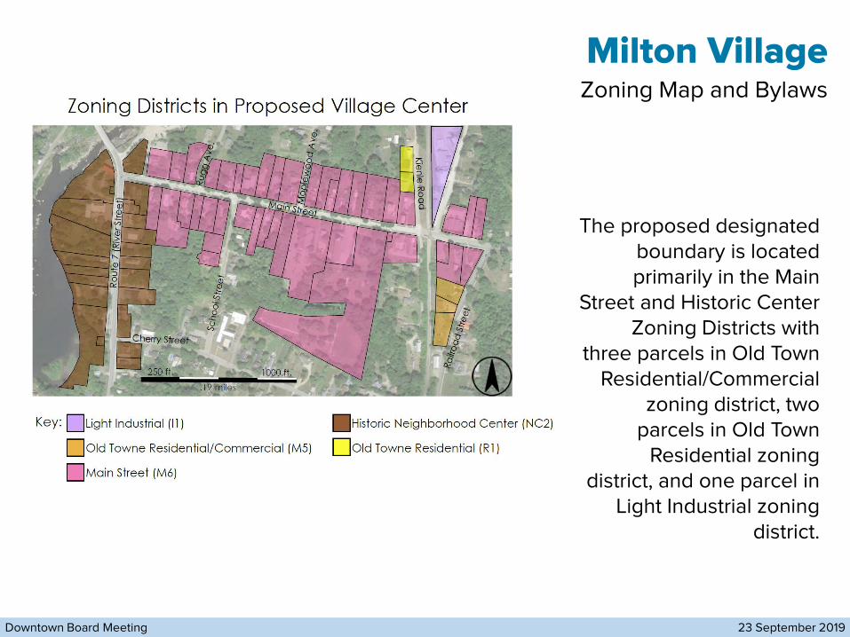
Zoning Map and Bylaws
The proposed designated boundary is located primarily in the Main
Street and Historic Center Zoning Districts with
three parcels in Old Town Residential/Commercial
zoning district, two parcels in Old Town
Residential zoning district, and one parcel in
Light Industrial zoning district.
Milton Village
23 September 2019Downtown Board Meeting
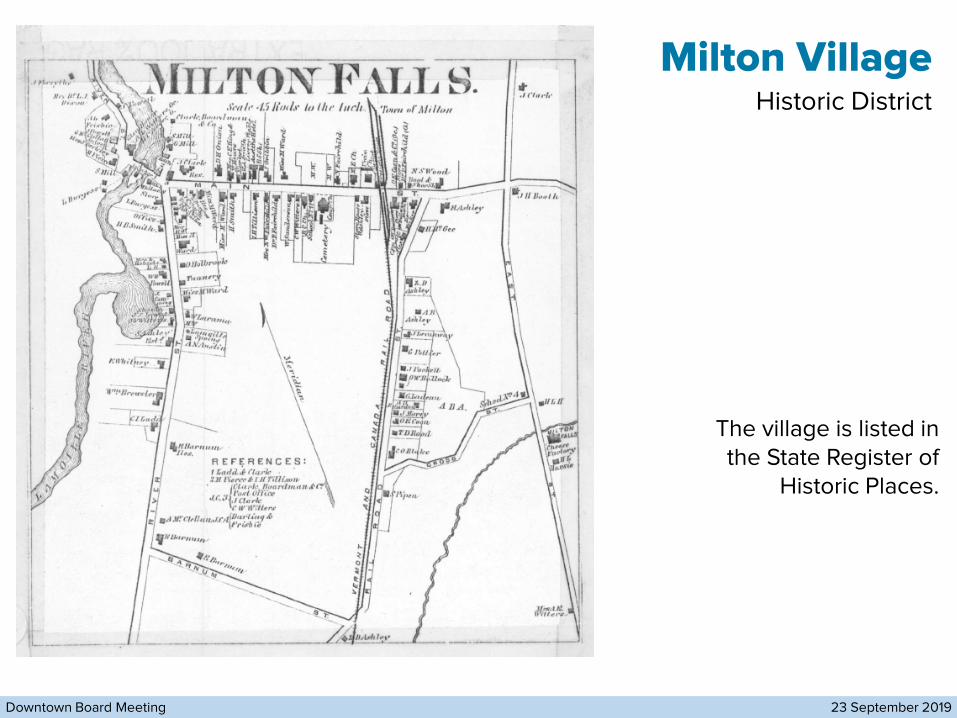
Historic District
The village is listed in the State Register of
Historic Places.
Milton Village
23 September 2019Downtown Board Meeting
Historic District
Milton Village
23 September 2019Downtown Board Meeting
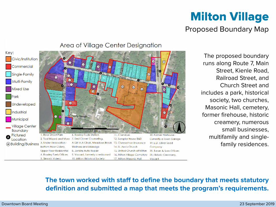
Proposed Boundary Map
The proposed boundary runs along Route 7, Main
Street, Kienle Road, Railroad Street, and
Church Street and includes a park, historical
society, two churches, Masonic Hall, cemetery,
former firehouse, historic creamery, numerous
small businesses, multifamily and single-
family residences.
The town worked with staff to define the boundary that meets statutory definition and submitted a map that meets the program’s requirements.
Milton Village
23 September 2019Downtown Board Meeting
Milton Village
23 September 2019Downtown Board Meeting
Discussion/Questions and Motion
Staff RecommendationApprove application and award designation
Milton Village
TOWN OF MILTON, VERMONT 05468
PLANNING & ZONING OFFICE • 43 BOMBARDIER ROAD • 802-893-1186
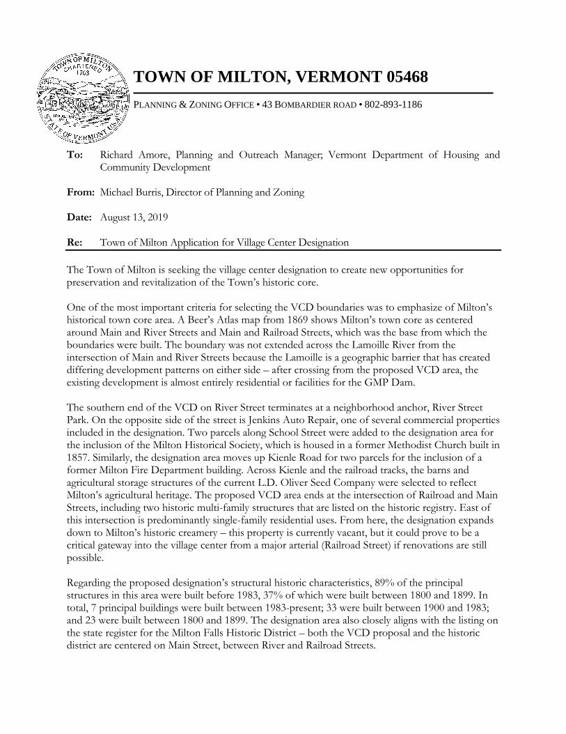
To: Richard Amore, Planning and Outreach Manager; Vermont Department of Housing and
Community Development From: Michael Burris, Director of Planning and Zoning Date: August 13, 2019 Re: Town of Milton Application for Village Center Designation
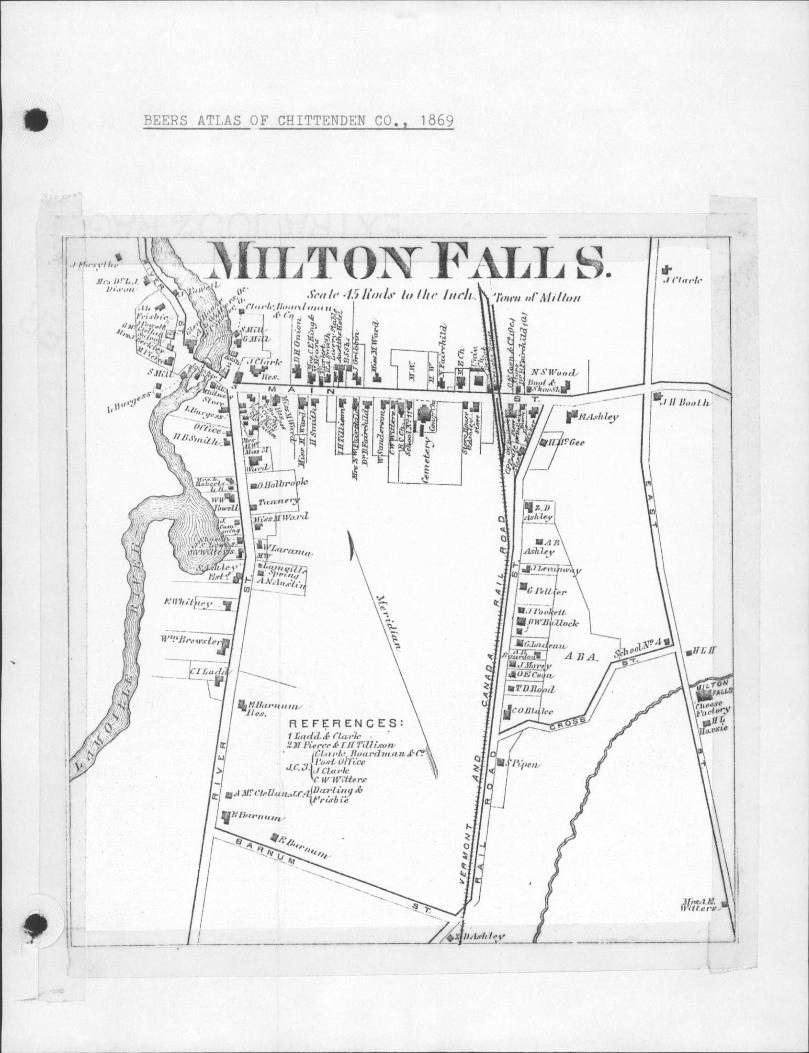
The Town of Milton is seeking the village center designation to create new opportunities for preservation and revitalization of the Town’s historic core. One of the most important criteria for selecting the VCD boundaries was to emphasize of Milton’s historical town core area. A Beer’s Atlas map from 1869 shows Milton’s town core as centered around Main and River Streets and Main and Railroad Streets, which was the base from which the boundaries were built. The boundary was not extended across the Lamoille River from the intersection of Main and River Streets because the Lamoille is a geographic barrier that has created differing development patterns on either side – after crossing from the proposed VCD area, the existing development is almost entirely residential or facilities for the GMP Dam. The southern end of the VCD on River Street terminates at a neighborhood anchor, River Street Park. On the opposite side of the street is Jenkins Auto Repair, one of several commercial properties included in the designation. Two parcels along School Street were added to the designation area for the inclusion of the Milton Historical Society, which is housed in a former Methodist Church built in 1857. Similarly, the designation area moves up Kienle Road for two parcels for the inclusion of a former Milton Fire Department building. Across Kienle and the railroad tracks, the barns and agricultural storage structures of the current L.D. Oliver Seed Company were selected to reflect Milton’s agricultural heritage. The proposed VCD area ends at the intersection of Railroad and Main Streets, including two historic multi-family structures that are listed on the historic registry. East of this intersection is predominantly single-family residential uses. From here, the designation expands down to Milton’s historic creamery – this property is currently vacant, but it could prove to be a critical gateway into the village center from a major arterial (Railroad Street) if renovations are still possible. Regarding the proposed designation’s structural historic characteristics, 89% of the principal structures in this area were built before 1983, 37% of which were built between 1800 and 1899. In total, 7 principal buildings were built between 1983-present; 33 were built between 1900 and 1983; and 23 were built between 1800 and 1899. The designation area also closely aligns with the listing on the state register for the Milton Falls Historic District – both the VCD proposal and the historic district are centered on Main Street, between River and Railroad Streets.

Since 2010, the following projects have been undertaken in the proposed village center: - 2019: 2-4 River Street is currently under renovation to accommodate upper floor residential, a bottom floor cidery, and an outdoor food truck space. - 2018: 12 River Street was renovated to accommodate office space – now occupied by an office, masseuse, and hair salon. - 2017: 26 River Street, Jenkins Advance Towing and Repair, expanded their principal building by 2,070 sq. ft. to expand operations. - 2014: 30 Main Street was converted from a single-family home to an office. - 2014: a new duplex was constructed at 12 Kienle. - 2013: 22 Main Street installed a B&B above existing garage in 2013. - 2011: 34 Main Street was converted from a single-family home to a triplex. - 2011: 69 Main Street was renovated to accommodate offices and upper-floor residential. - 2010: A new duplex was constructed at 74 Main Street.
The proposed village center area is served by municipal water and sewer and is almost entirely connected by sidewalks on at least one side of the road. Sidewalks are present on most of River Street/Route 7 on both sides of the street, with a midblock pedestrian crossing at River and Main Street to facilitate crossing River Street. The east sides of Maplewood Avenue, School Street, and Railroad Street are served by sidewalk access. Main Street is served by sidewalk access on both sides
of the street – however, its intersection at the railroad crossing contains no pedestrian infrastructure to cross on the north side of the street. A midblock crossing provides access to the south side of Main Street to cross the railroad tracks. Kienle has no sidewalk on either side, although it would only be necessary on the west side of the road as the east side abuts the railroad tracks until the road’s northward terminus.
This area of Milton is also served by GMT’s Milton commuter route, with a bus stop at Cherry and River streets, across from River Street Park, and near the intersection of Main Street and Maplewood Avenue. This is a relatively walkable area of Milton, spanning .5 miles across its diagonal, although pedestrian and bicycle improvements should be considered to expand access as the area revitalizes. The town should consider installing a midblock pedestrian crossing near Maplewood and School streets to reduce the length without a crossing to less than ¼ mile, in addition to providing better access to the Milton commuter bus stop. Similarly, the town should consider consulting VTrans in the future to install a midblock crossing at Cherry and River streets to reduce the stretch of road without a

pedestrian crossing to less than ¼ mile in a commercial corridor and facilitate access to the park and bus stop.
Milton’s Planning Commission is currently working through changes to the town’s UDR, and one priority is to support the village center by accommodating more commercial uses and upper floor residential in the M5 zoning district. It is under consideration to reduce the size of the M5 zoning district to enable the development of two distinct commercial cores in Milton; one will be centered around the village center, and the other will be centered around the downtown business district. See the map to the left for the greater context of the town core zoning districts. Reducing the size of the M5 district will decrease commercial sprawl, while encouraging the concentration of new commercial uses in a proximity to the village center that will support its revitalization. To further enable growth in the village center, it is also under consideration to allow multi-family residential in the M6 zoning district to allow for a higher population density that can support the development of small businesses.
The proposed designation area is host to a variety of cultural features and events throughout the year. The Milton Historical Society’s museum is open Saturdays from 10 a.m. to 2 p.m. from May until October, and it can be visited by appointment from November-April. The Historical Society hosts a variety of events, on average at least one per month, such as business meetings, a holiday open house, community dinner and movie night, and other such programming. St. Ann’s Church hosts community dinners, including their annual chicken barbeque event. St. Ann’s and the Milton Masonic Lodge both host exhibits during Milton’s annual, town-wide Craft Fair Day. The proposed designation area also features a stormwater awareness mural at 2-4 River Street, contributing to the area’s range of cultural and artistic features. Finally, several monuments are available for public viewing in the proposed area; a monument to Civil War soldiers is located next to the Historical Society; and there are turbines commemorating the construction of the Milton Dam at River Street Park and across from 2-4 River Street on Ice House Road (slightly outside the proposed VCD area). Historically, the area proposed to be the Village Center was an active commercial core – flooding and subsequent divestment in the 1900’s has resulted in the area’s predominantly residential character. However, there are a number of homes and other structures with historic character that remain intact. The Town of Milton has the opportunity to leverage historic resources in this neighborhood to encourage the development of small-scale, creative economy businesses, while incentivizing preservation of the structures that have created a sense of place in the neighborhood. The resources available from the VCD program would create opportunities for adaptive reuse of existing residential structures to enable greater walkability, while preserving the historical integrity of the neighborhood. In addition to this cover letter, please find the following documents included with this submission:

- Municipal resolution authorizing application - Notification to CCRPC and GBIC - Confirmation of planning process - VCD boundary and historic resources - Photographs - Municipal plan integration - Map of zoning districts in proposed designation area - Excerpts from the UDR for each zoning district in designation area - Milton Falls 1869 Beers Atlas map - Milton Falls Historic District – 1980 registry map Thank you for your consideration,
Michael Burris, Director of Planning and Zoning Milton Planning and Zoning Office 43 Bombardier Road; Milton, VT 05468 802.893.1186; [email protected]


July 19, 2019 Michael Burris, Director of Planning and Zoning Town of Milton 43 Bombardier Road Milton, VT 05468 Dear Mr. Burris, The Chittenden County Regional Planning Commission approved the 2018 Milton Comprehensive Plan and confirmed the town’s planning process on March 21, 2018 (see attached resolution). On July 15, 2019, the Town of Milton adopted amendments to the 2018 Milton Comprehensive Plan to indicate the Town of Milton’s intention to apply for Village Center Designation. CCRPC staff have reviewed the amended plan and determined that the affected section continues to meet the relevant required elements and goals and is consistent with the ECOS Regional Plan. Therefore, CCRPC’s approval of the 2018 Milton Comprehensive Plan and confirmation of Milton’s planning process are not affected by the proposed amendments. Please let me know if you need any other information or have any questions.
Sincerely,
Charlie Baker Executive Director CC (via email): Sheryl Prince, Milton Town Clerk
110 West Canal Street, Suite 202 Winooski, VT 05404-2109 802-846-4490 www.ccrpcvt.org


Single-Family
Multi-Family
Civic/Institution
Commercial
Undeveloped
Industrial
Main Street
Rout
e 7
(Ri
ver S
tre
et)
Scho
ol S
tre
et
Railr
oa
d S
tree
t
Cherry Street
Area of Village Center DesignationKey:
1
3
2
4
6
5
7
8
1312
1514
16
1. River Street Park
2. Tool Wizard and More
3. Under Renovation -
Bottom Floor Cidery,
Upper Floor Residential
4. Rowley Fuels Offices
5. Simon's Valero
6. Rowley Fuels Station
7. Red Clover Counseling,
A Girl in A Chair, Meadows Brook
Wellness and Massage
8. Jenkins Auto Repair
9. Vacant, formerly a restaurant
10. Milton Historical Society
11. IT Services
12. Sampler House B&B
13. Cheeseman Insurance
14. St. Ann's Church
15. United Church of Milton
16. Milton Village Cemetery
17. Milton Masonic Hall
Municipal
18. Former Firehouse -
Currently a Town Garage
19. L.D. Oliver Seed
Company
20. Turner & Sons Offices
21. Historic Creamery,
Vacant
10
11
19
17
Village Center Boundary
20
Rug
g A
ve.
Ma
ple
wo
od
Ave
.
Kienle
Roa
d
250 ft. 1000 ft.
.19 miles
Mixed Use
Park
1
4
2
6
13
11
PicturedLocation
#
5
7
3
8
910
12
Building/Business#
18
9
21
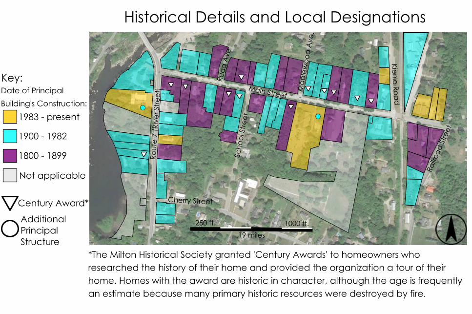
1983 - present
1900 - 1982
1800 - 1899
Not applicable
Main Street
Rout
e 7
(Ri
ver S
tre
et)
Scho
ol S
tre
et
Railr
oad
Stre
et
Cherry Street
Historical Details and Local Designations
Key:
Century Award*
Additional Principal Structure
250 ft. 1000 ft.
.19 miles
Kienle
Roa
d
Ma
ple
wo
od
Ave
.
Rug
g A
ve.
*The Milton Historical Society granted 'Century Awards' to homeowners who researched the history of their home and provided the organization a tour of their home. Homes with the award are historic in character, although the age is frequently an estimate because many primary historic resources were destroyed by fire.
Date of Principal
Building's Construction:

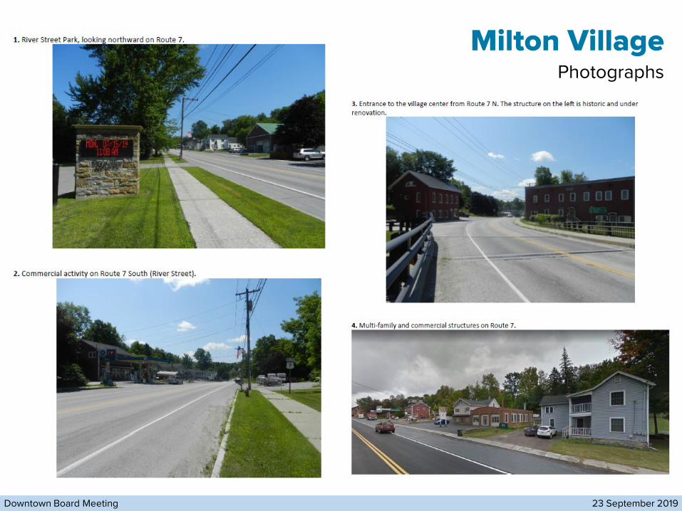
1. River Street Park, looking northward on Route 7.
2. Commercial activity on Route 7 South (River Street).
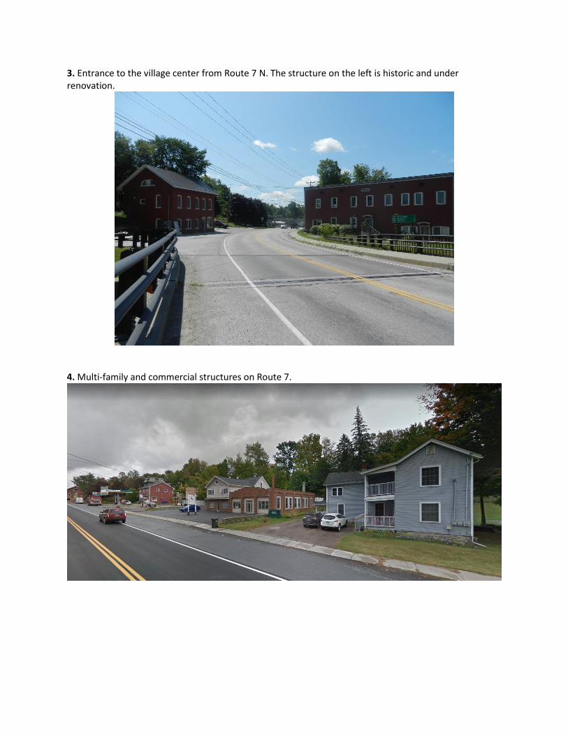
3. Entrance to the village center from Route 7 N. The structure on the left is historic and under renovation.
4. Multi-family and commercial structures on Route 7.

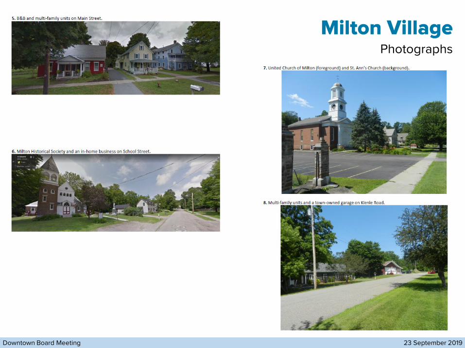
5. B&B and multi-family units on Main Street.
6. Milton Historical Society and an in-home business on School Street.
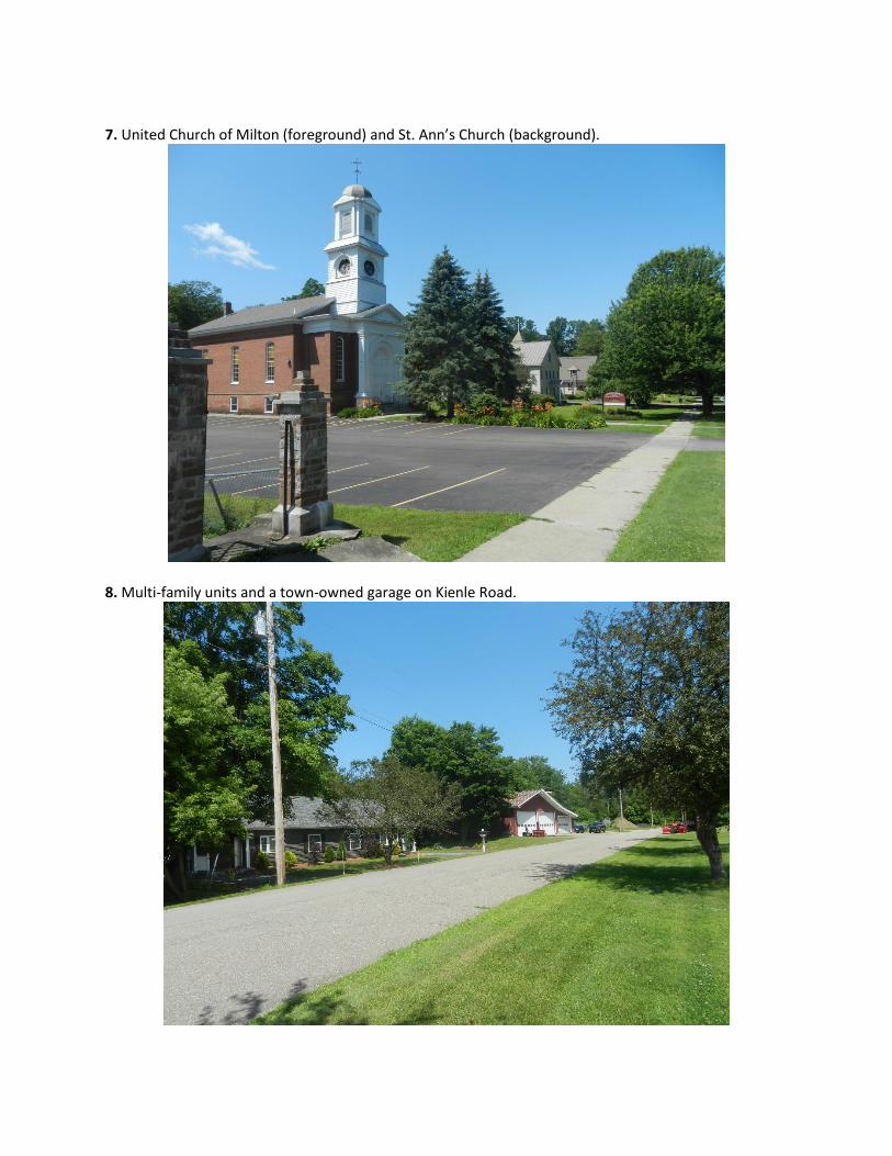
7. United Church of Milton (foreground) and St. Ann’s Church (background).
8. Multi-family units and a town-owned garage on Kienle Road.

9. LD Oliver Seed and multi-family residential units along Main Street.
10. Mixed-use building on Main Street.

11. South side of the abandoned creamery (background near the brush).
12. Multi-family units north of the abandoned creamery (obscured by the brush).

13. Entrance to the village center at the intersection of Railroad Street and Main Street.

CHAPTER 9, LAND USE AND DEVELOPMENT PATTERNS
As amended by the Milton Selectboard on July 15, 2019 Page 116 of 172
most part the area is built-out, however there will likely be infill development along the Route 7 corridor. Naturally, the vision for this sub-area is a transition between the historic portion of the Town Core and the new portion of the Town Core. This area should develop in a density that is proportional to both the new portion and the historic portion. The development patterns should reflect those of the historic pattern, while allowing for a greater range of uses than those in the Old Towne sub-area. Currently the north side of Barnum Street is zoned Old Towne Residential, while the southern side of the Barnum Street is zoned Milton Crossroad Marketplace Center (M1). The M1 is a mixed use district while R1 is not. The 2007 Route 7 Land Use Study includes a recommendation that the M1 zoning district encourage residential uses and restrict retail in order to concentrate it in DB.
9.2. Town Core – Gimlet Hill Transition Sub-area Goals
Goal 9.2.1. Promote land uses within an appropriate density that will provide for a
transition between the Old Towne sub-area and the New Downtown sub-area.
Goal 9.2.2. Maintain the residential areas within this sub-area while allowing for a mix of
uses along the Route 7 corridor.
Goal 9.2.3. Consider rezoning Barnum Street so that both the north and south side of the
street are within the same zoning district.
Old Towne Sub-Area The Old Towne sub-area located north of the Gimlet Hill Transition sub-area includes a combination of historic, residential, and limited commercial uses. This sub-area lies south of the late 1980s subdivision on Maplewood and the light industrial uses just north of Main Street. To the east this sub-group extends to the century house on the southeastern corner of East Road and Westford Road. To the south the sub-area extends to the Ritchie Avenue and Route 7 intersection, and it includes both sides of Cherry Street from Route 7 to Herrick Avenue. The sub-area also includes parcels that lie in between Railroad Street and the railroad tracks just south of Main Street. It is critical to distinguish between the residential areas within this sub-area and the commercial areas along Route 7, and Main Street. The area along Main Street is characterized by large, historic homes and beautiful trees. Threats to the beauty and character of this area are the increasing expense of maintaining the large historic homes as single family residences, and modern development patterns. The Town intends to apply for Village Center Designation (VCD) from the State of Vermont Agency of Commerce and Community Development in order to support the maintenance and revitalization of Milton’s traditional historic center. VCD will attract state funding and
TOWN OF MILTON, VERMONT 2018 COMPREHENSIVE PLAN
As amended by the Milton Selectboard on July 15, 2019
Page 117 of 172
technical assistance for businesses and historic structures in the designated area. Tax credits would help property owners finance interior and exterior renovations, which would help preserve the historic character and beauty of this area. Town leadership should consider increasing involvement in state programming to build incentives for commercial and residential development and investment in this and other Town Core planning areas through the Neighborhood Development Area, Growth Center, and New Town Center programs. Mixed use should also be permitted while protecting the historic nature of this area. Non-residential uses along Main Street should be limited to those which generate minimal amounts of traffic. It is recommended that the variety of uses permitted within the historic buildings in this area, such as residential, professional offices and institutional uses remain. These additional uses may be able to provide the income needed to preserve the historic integrity of these buildings. The 2007 Route 7 Land Use Study suggests that single family residences should be maintained but it is unclear if that is meant to be the exclusive use on Main Street. The trees along Main Street, the architecturally significant characteristics of the buildings, and the overall pattern of development should be maintained as a condition to the conversion of these buildings to more intensive uses. In addition, the visual impact of the automobile on the streetscape should be minimized by locating parking areas in rear or side yards, and by sharing parking areas and driveways. Future development is encouraged to reflect historic design patterns, particularly in the Main Street and residential sections of the sub-area. The new developments in the Old Towne area have not necessarily been based on historical patterns. River Street, which also has an historic character, could also be utilized for more intense commercial enterprises that do not detract from the aesthetic character of the area. River Street presents a challenge as it is the main travel route appropriate for commercial uses, and it also needs to function as a transition between the New Downtown and the Old Towne. The 2007 Route 7 Land Use Study suggests that this district should include commercial or retail on the first floor with residential apartments above in order to act as this transition. The abandoned creamery building is a pivotal point in the appearance of one of the town gateways. Due to the possible significance of the revitalization of this site or structure on the appearance of the town gateway, zoning in this area should be flexible enough to enable an appropriate use for the site or building, as well as for supporting uses desired for nearby parcels. There is a desire to have more of a relationship to the Lamoille River and Arrowhead Lake. The Town of Milton Road Department has discussed the relocation of the Town Garage. If this is done, it is recommended the Town work with CVPS, the owner of the surrounding land, to create a Town park along Arrowhead Lake. The CVPS River Street Park, along Route 7 near Ritchie Avenue, was established in 2009. This park features

CHAPTER 9, LAND USE AND DEVELOPMENT PATTERNS
As amended by the Milton Selectboard on July 15, 2019 Page 118 of 172
picnic tables, the Town of Milton community events marquee and a view of the Lamoille River. The establishment of a railroad station in the Main Street area should be considered if an opportunity for passenger or commuter rail arises.
9.3. Town Core – Old Towne Sub-area Goals
Goal 9.3.1. Protect the historic character of the Old Towne.
Objective 9.3.1.a. Explore the possibility of establishing an historic district and
guidelines to encourage historic and adaptive reuse strategies.
Objective 9.3.1.b. Investigate incentives for preservation and adaptive reuse of
buildings and the landscape.
Objective 9.3.1.c. Encourage new structures to respect the architectural character
of existing buildings and to fit into their surroundings.
Goal 9.3.2. Encourage commercial and retail on the first floor with residential apartments
above on River Street in order to appropriately manage this section as the transition from the New Downtown to historic Main Street.
Goal 9.3.3. Enhance streetscape elements by incorporating streetlights, street trees, and
signage.
Goal 9.3.4. Consider passenger rail service to Milton. Develop potential railroad station
locations in the Main Street area.
Goal 9.3.5. Take advantage of the scenic resources of Arrowhead Lake and the Lamoille
River.
Objective 9.3.5.a. Relocate the municipal garage and develop a public park along
Arrowhead Lake with pedestrian connections to Main Street.
Objective 9.3.5.b. Take advantage of the lake and riverfront areas for recreation
and commerce, and be sensitive to the resources.
Goal 9.3.6. Promote the development of community activities for a range of ages.
Objective 9.3.6.a. Encourage the expansion of already existing or creation of
community centers for such activities as a theater or performance space, arts facility, and community gatherings.

TOWN OF MILTON, VERMONT 2018 COMPREHENSIVE PLAN
As amended by the Milton Selectboard on July 15, 2019
Page 119 of 172
Goal 9.3.7. Encourage public green spaces and small parks throughout this area (such
as neighborhood parks as recommended in the Recreation Plan).
Checkerberry Sub-Area The Checkerberry sub-area is located along Route 7 west of the New Downtown sub-area and Gimlet Hill Transition sub-area and extends just past Racine Road. Due to a large Class II wetland located south of Route 7 and other natural resource limitations, the Checkerberry sub-area has the most limitations to development in the Town Core area; although in recent years large-scale development projects have been proposed in this area, and this is likely to continue. Reflecting its role as an important gateway into the New Downtown, uses in the Checkerberry sub-area should be mixed, and careful site planning and access control will be necessary. The accessibility provided by Route 7, the availability of municipal water and wastewater service, and the high visibility of this sub-area make it appropriate for commercial development. Careful access management, which would make use of shared and strategically placed curb cuts, will help to prevent undesirable land use patterns such as strip development. The 2007 Route 7 Land Use Study recommends encouraging commercial and retail uses along property directly abutting Route 7 in the Checkerberry district. While the 2007 Route 7 Land Use Study, along with numerous other studies, find that an exit on I-89 would be beneficial to Milton (refer to the Transportation chapter for more details), it does need to be properly planned so that commercial businesses are not competing with the New Downtown. The Study warned that: “[s]hould this major infrastructure investment take place, the Town must be prepared to manage land in the area to ensure controlled and efficient growth, balancing the potential for increased tax base with impacts on the Town Core and Route 7 corridor.” The Plan recommends five action items to properly plan for this interchange, and the Town should implement these items (these are listed under Goal 9.4.6 below).
9.4. Town Core – Checkerberry Sub-Area Goals
Goal 9.4.1. Require structures be placed close to the roads with parking areas on the
side or rear of lots to improve aesthetics and enhance pedestrian connections. These requirements should be incorporated into the Unified Development Regulations.
Goal 9.4.2. Encourage public green spaces and small parks throughout this planning
area (such as neighborhood parks as recommended in the 2007-2027 Recreation Plan).
Goal 9.4.3. Encourage mixed uses utilizing planned unit developments for uses such as
Historic Neighborhood Center (NC2)
Main Street (M6)
Main StreetRo
ute
7 (
Rive
r Str
ee
t)
Scho
ol S
tre
et
Railr
oa
d S
tree
t
Cherry Street
Zoning Districts in Proposed Village Center
Key:
Old Towne Residential/Commercial (M5)
Rug
g A
ve.
Ma
ple
wo
od
Ave
.
Kienle
Roa
d
250 ft. 1000 ft.
.19 miles
Light Industrial (I1)
Old Towne Residential (R1)

Town of Milton Unified Development Regulations • Part 2. Zoning Districts and Standards
2-16
Section 2103. Historic Neighborhood Center (NC2) District
2103.A Purpose. The purpose of the Historic Neighborhood Center District is to foster development of a compact, mixed-use cluster of neighborhood-serving businesses and upper floor housing in the historic center of the town core by:
(1) Accommodating small-scale businesses that will provide basic goods and services that residents in nearby neighborhoods can access by walking or biking.
(2) Accommodating higher-density, mixed-use development in areas that are served by public infrastructure and transit, and that is close to schools, shopping, services and public recreation facilities.
(3) Transforming Route 7 into a safe and attractive highway corridor through improved access management, streetscaping, pedestrian and bicycle facilities, lighting and signage.
(4) Bringing buildings to the street and locating parking to the side or rear of buildings to the maximum extent feasible.
(5) Avoiding and mitigating potential conflicts between land uses so that the off-site impacts of commercial uses do not adversely affect quality of life for nearby residents.
(6) Developing an interconnected network of complete streets that disperse and calm traffic, and safely accommodate pedestrians and bicyclists.
(7) Encouraging quality and efficient construction with durable, low-maintenance materials and distinctive designs that are compatible with the historic character of the district and the adjoining Main Street corridor.
2103.B Use Standards. The permitted and conditional uses in this district are listed in Section 2123. Any use not listed as permitted or conditional in Section 2123 is prohibited. In addition, the following apply to the uses allowed in this district:
(1) The applicant must obtain conditional use approval from the Development Review Board before the Zoning Administrator may issue a permit for:
(a) Construction of 4,500 square feet or more of commercial or industrial space (includes the total gross floor area of all buildings, and any outdoor storage and display areas); or
(b) A use with drive-through or drive-in service (see Section 3012).
(2) The Town of Milton will treat any solely residential building in existence prior to October 11, 2005 as a permitted use. Additional units may be developed within any solely residential building in existence prior to October 11, 2005 in accordance with the density requirements of this district provided that there will be no increase in the exterior dimensions of the building.
(3) The Town of Milton will only allow new dwelling units as a second principal use on a lot with a principal, conforming nonresidential use as follows:
(a) New residential building floor area must not exceed 80% of the building floor area.
(b) New residential building area must be located on upper floors or to the rear of the lot, whether attached to or detached from another building, to maintain commercial uses close to the street frontage.
Town of Milton Unified Development Regulations • Part 2. Zoning Districts and Standards
2-17
(4) Upper floor residential will only be allowed within mixed-use buildings where the first 30 feet (as measured from the front wall of the building into the building’s interior) of the street-facing façade on the ground level floor is designed for and occupied by commercial uses as follows:
(a) If the upper floor residential will be retirement housing, the entire ground level may be used for non-residential purposes accessory to the retirement housing such as common areas, support services or offices.
(b) The building must locate and design any under-building parking to maintain a pedestrian-oriented streetscape. Under-building parking that is not entirely below ground level along the street must be set back at least 30 feet from the building front line and screened by active uses so that parking will not be visible from the street.
2103.C Dimensional Standards. The applicant must locate and design proposed development as follows:
(1) Lot size 3,000 sf min
(2) Lot frontage 45 ft min
(3) Lot coverage 75% max (includes all impervious surfaces)
(4) Front setback 10 ft min, 30 ft max
(5) Side setback 10 ft min
(6) Rear setback 10 ft min
(7) Residential density 1 dwelling unit per 3,000 sf of lot area max
(9) Building height 45 ft max
Building Coverage 65%
2103.D Development Standards. The applicant must locate and design proposed development as
follows:
(1) New or substantially modified principal buildings must:
(a) Be compatible with the architectural form, scale, massing and materials of historic buildings found in this district and the adjoining Main Street corridor.
(b) Not be standardized franchise or corporate architectural designs.
(c) Avoid large box-like forms with continuous unrelieved surfaces by incorporating articulation to reduce buildings’ perceived bulk.
(d) Limit overall building size or design buildings with features to break up building bulk such as changes in wall plane (instead of a long flat wall), changes in roof form and height, or major full-height recesses (typically at least 8 feet deep) along the length of the building that successfully break the building into smaller discrete masses (typically not more than 40 feet wide).
(e) Have window recesses, window trim, doorways, columns, overhangs and other architectural elements with depth adequate to create shadow and architectural relief.
(f) Have facades that provide a pedestrian scale and orientation through overhangs,
Town of Milton Unified Development Regulations • Part 2. Zoning Districts and Standards
2-18
eaves, awnings, display windows and architectural ornamentation.
(g) Emphasize public building entrances with architectural and landscape treatment.
(h) Incorporate into the building facade either: (i) a storefront design with clear glass windows offering views into the building interior composing a minimum of 60% of the ground-level wall area up to 10 feet above the finished grade; or (ii) an open porch, gallery or arcade at least 6 feet deep that must extend along no less than 50% of the facade.
(2) Any land development that requires major site plan approval must:
(a) Eliminate excess paving within the minimum front yard setback (typically any paving in excess of 800 square feet unless additional pavement is necessary to provide access to pre-existing parking).
(b) Locate any new parking areas to the side or rear of the building, and eliminate or relocate pre-existing parking in front of buildings whenever feasible. Where pre-existing front parking cannot be eliminated or relocated, it must be screened from the street to the maximum extent feasible given the configuration of development and natural site conditions on the lot.
(c) Landscape the area between the street and building so that at least 20% of the ground will be covered with a mix of trees, shrubs, perennial plants and groundcovers (excluding turf grass) within 3 growing seasons.
(d) Plant or preserve at least one healthy tree within the front yard setback for each 30 feet of road frontage.
(e) Locate new or expanded outdoor storage or display areas to the side or rear of the building.
(f) Locate new loading areas or docks, vehicular or service entrances, waste collection areas, dumpsters and similar utilitarian elements to the rear or side of the building and screened from view at the front property line.
(g) Locate new mechanical equipment, electrical meter and service components, satellite dishes, heating and cooling units, ventilation equipment and similar utility devices so that they will be screened from view at the front property line to the maximum extent feasible, and if adequate screening is not possible use materials and colors that will camouflage the device.
(3) New multi-family residential buildings must:
(a) Not contain more than 15 dwelling units;
(b) Incorporate visible changes in wall plane and roof form that break up wide facades into multiple bays; and
(c) Incorporate a cornice or roof overhang.

Town of Milton Unified Development Regulations • Part 2. Zoning Districts and Standards
2-27
Section 2109. Old Towne Residential/Commercial (M5) District
2109.A Purpose. The purpose of the Old Towne Residential/Commercial District is to foster the development of compact residential neighborhoods that offer a diversity of housing and high quality of life in the town core by:
(1) Accommodating limited and small-scale businesses that will provide basic goods and services that residents in nearby neighborhoods can access by walking or biking.
(2) Accommodating residential infill in areas that are served by public infrastructure and transit, and that is close to schools, shopping, services and public recreation facilities.
(3) Avoiding and mitigating potential conflicts between land uses so that the off-site impacts of nearby commercial uses do not adversely affect residents’ quality of life.
(4) Stabilizing existing residential neighborhoods, and retaining existing and creating additional owner-occupied housing.
(5) Encouraging quality and efficient construction with durable, low-maintenance materials and distinctive designs.
2109.B Use Standards. The permitted and conditional uses in this district are listed in Section 2123. Any use not listed as permitted or conditional in Section 2123 is prohibited.
2109.C Dimensional Standards. The applicant must locate and design proposed development as follows:
(1) Lot size 10,000 sf min
(2) Lot frontage 80 ft min
(3) Lot coverage 50% max
(5) Front setback 20 ft min
(6) Side setback 10 ft min
(7) Rear setback 10 ft min
(8) Residential density 1 dwelling unit per 10,000 sf of lot area max
(9) Building coverage 40% max
(10) Building height 35 ft max

Town of Milton Unified Development Regulations • Part 2. Zoning Districts and Standards
2-28
Section 2110. Main Street (M6) District
2110.A Purpose. The purpose of the Main Street District is to foster development that maintains the character of a historic village neighborhood by:
(1) Accommodating compatible residential infill in areas that are served by public infrastructure and transit, and that is close to schools, shopping, services and public recreation facilities.
(2) Accommodating small-scale businesses and community institutions that will provide basic goods and services that residents in nearby neighborhoods can access by walking or biking.
(3) Avoiding and mitigating potential conflicts between land uses so that the off-site impacts of nearby commercial uses do not adversely affect residents’ quality of life.
(4) Maintaining Main Street as a safe and attractive corridor through improved access management, streetscaping, pedestrian and bicycle facilities, lighting and signage.
(5) Developing an interconnected network of pathways and sidewalks that safely accommodate pedestrians and bicyclists.
(6) Stabilizing existing residential neighborhoods, and retaining existing and creating additional owner-occupied housing.
(7) Bringing buildings to the street and locating parking to the side or rear of buildings to the maximum extent feasible.
(8) Encouraging quality and efficient construction with durable, low-maintenance materials and distinctive designs that are compatible with the historic character of the district.
2110.B Use Standards. The permitted and conditional uses in this district are listed in Section 2123. Any use not listed as permitted or conditional in Section 2123 is prohibited.
2110.C Dimensional Standards. The applicant must locate and design proposed development as follows:
(1) Lot size 10,000 sf min
(2) Lot frontage 80 ft min
(3) Lot coverage 55% max
(4) Front setback 20 ft min
(5) Side setback 10 ft min
(6) Rear setback 10 ft min
(7) Residential Density 1 dwelling unit per 10,000 sf of lot area max
(8) Building coverage 45% max
(9) Building height 35 ft. max

Town of Milton Unified Development Regulations • Part 2. Zoning Districts and Standards
2-30
Section 2112. Light Industrial (I1) District
2112.A Purpose. The purpose of the Light Industrial District is to strengthen the role of this area as a local employment center by:
(1) Accommodating light industrial and limited commercial uses in an area extending out from the historic town core center.
(2) Minimizing the amount and visual impact of parking located in front of buildings.
(3) Avoiding and mitigating potential conflicts between land uses so that the off-site impacts of industrial and commercial uses do not adversely affect quality of life in nearby residential neighborhoods
(4) Developing an interconnected network of complete streets and pathways that disperse and calm traffic, and safely accommodate pedestrians and bicyclists.
(5) Encouraging quality and efficient construction with durable, low-maintenance materials and distinctive designs.
2112.B Use Standards. The permitted and conditional uses in this district are listed in Section 2123. Any use not listed as permitted or conditional in Section 2123 is prohibited.
2112.C Dimensional Standards. The applicant must locate and design proposed development as follows:
(1) Lot size 20,000 sf min
(2) Lot frontage 100 ft min
(3) Lot coverage 50% max
(4) Front setback 25 ft min
(5) Side setback 25 ft min
(6) Rear setback 25 ft min
(7) Building coverage 40% max
(8) Building height 35 ft max

Town of Milton Unified Development Regulations • Part 2. Zoning Districts and Standards
2-34
Section 2115. Old Towne Residential (R1) District
2115.A Purpose. The purpose of the Old Towne Residential District is to foster the development of compact residential neighborhoods that offer higher density housing and high quality of life in the town core by:
(1) Accommodating new residential neighborhoods and infill in areas that are served by public infrastructure and transit, and that are close to schools, shopping, services and public recreation facilities.
(2) Avoiding and mitigating potential conflicts between land uses so that the off-site impacts of nearby commercial uses do not adversely affect residents’ quality of life.
(3) Stabilizing existing residential neighborhoods, and retaining existing and creating additional owner-occupied housing.
(4) Developing an interconnected network of complete streets and pathways that disperse and calm traffic, and safely accommodate pedestrians and bicyclists.
(5) Encouraging quality and efficient construction with durable, low-maintenance materials and distinctive designs.
2115.B Use Standards. The permitted and conditional uses in this district are listed in Section 2123. Any use not listed as permitted or conditional in Section 2123 is prohibited.
2115.C Dimensional Standards. The applicant must locate and design proposed development as follows:
(1) Lot size 10,000 sf min
(2) Lot frontage 80 ft min
(3) Lot coverage 55% max
(4) Front setback 20 ft min
(5) Side setback 10 ft min
(6) Rear setback 10 ft min
(7) Residential density 1 dwelling unit per 10,000 sf of lot area max
(8) Building coverage 45% max
(9) Building height 35 ft max.
BEERS ATLAS OF CHITTENDEN CO. , 1869
,/ chirl. Vat/c -/.5 Ko<Lr to (lu- Inch 'I'oiru of Milfoil
Chicle, /hum/11 m u
smili k ji.ii
<•>,[ .1 Chirle
à ir y wood. hooté y
i 11 II.,,,lh
""'¿y . .J
lOJlaVrm]
tut'" Bj/./? tis-liley
"rrtr/l ji'hre,,
'C I'M
HO l'urlirU. SU t'H-M d/nck-
>i"!'Jie I Ul'iJ.n/fro u
'pTâiulL A BA
Ijjui'jroijn,
mroihld
\iikjr
'ILudn
K o -I Wr.'-««
^mliu-nuiii. kojjui
R E F E R E N C E S : \ 1 Zadd.it Clark, • ' \ 2 31 Fierre ¿ni Tdlison
¡Chirle Ruar&man i(-C? .. ¡ I'a.et ónice
JC J \,! Ciarle V W Witte rs
f j ad lurcleuuiinkc;
i sjolki,.„„lllJ
I i'risbie
mitëîtf 1
'^xjlliLdl ley

M I L T O N F A L L S D I S T R I C T
¿/ort// kp.