comprehensive plan ordinance 3481, as amended, to …pdfs/bridle+… · plan, ordinance 3481, as...
TRANSCRIPT
1
2
3
4
5
6
7
8
9
10
11
12
13
14
15
16
17
18
19
20
21
22
23
24
25
26
27
28
29
30
31
32
33
34
35
36
37
38
39
40
41
42
ORDINANCE 0-4669
AN ORDINANCE OF THE CHY OF KIRKLAND RELATING TOCOMPREHENSIVE PLANNING AND LAND USE AND AMENDING THECOMPREHENSIVE PLAN ORDINANCE 3481, AS AMENDED, TO REPLACEEXISTING CHAPTER XV.C BRIDLE TRAILS NEIGHBORHOOD PLAN WITHA NEW BRIDLE TRAILS NEIGHBORHOOD PLAN, FILE NO. CAM 18-00082.
WHEREAS, the City Council has received a recommendationfrom the KIrkland Planning Commission and Houghton CommunityCouncil to amend certain portions of the Comprehensive Plan for theCity, Ordinance 3481, as amended, as set forth in the report andrecommendation of the Planning Commission dated November 8, 2018,and bearing KIrkland Planning and Building Department File No. CAM18-00082; and
WHEREAS, prior to making the recommendation the HoughtonCommunity Council and Planning Commission, following notice asrequired by RCW 35A.63.070, held public hearings on October 22 andOctober 25, 2018, regarding the amendment proposal and consideredthe comments received at tlie hearing; and
WHEREAS, pursuant to the State Environmental Policy Act(SEPA), there has accompanied the legislative proposal andrecommendation through the entire consideration process, a SEPAaddendum to the City of KIrkland 2015 Comprehensive Plan UpdateDraft and Final Environmental Impact Statement (EIS), issued by theresponsible official pursuant to WAC 197-11-625; and
WHEREAS, in public meeting on December 11, 2018, the CityCouncil considered the environmental documents received from theresponsible official, together with the report and recommendation of thePlanning Commission and Houghton Community Council; and
WHEREAS, RCW 36.70A.130 requires the City to review allamendments to the Comprehensive Plan concurrently and no morefrequently than once every year.
NOW, THEREFORE, the City Council of the City of KIrkland doordain as follows;
Section 1. Comprehensive Plan Text. Fioures and Tablesamended. The Comprehensive Plan existing Bridie Trails NeighborhoodPlan, Ordinance 3481, as amended, is replaced by a new Bridle TrailsNeighborhood Plan in accordance with Exhibit A attached to thisOrdinance and incorporated by reference.
Section 2. If any section, subsection, sentence, clause,phrase, part or portion of this Ordinance, including those parts adoptedby reference, is for any reason held to be invalid or unconstitutional by

r
43
44
45
46
47
48
49
50
51
52
53
54
55
56
57
58
59
60
61
62
63
64
65
66
67
any court of competent jurisdiction, such decision shall not affect thevalidity of the remaining portions of this Ordinance.
Section 3. To the extent that the subject matter of thisOrdinance is subject to the disapproval jurisdiction of the HoughtonCommunity Council as created by Ordinance 2001, the Ordinance shallbecome effective within the Houghton community either upon approvalof the Houghton Community Council, or upon failure of the CommunityCouncil to disapprove this Ordinance within 60 days of its passage.
Section 4. Except as provided in Section 3, this Ordinanceshall be in full force and effect five days from and after its passage bythe City Council and publication, pursuant to Section 1.08.017, KirklandMunicipal Code in the summary form attached to the original of thisOrdinance and by this reference approved by the City Council.
Section 5. A complete copy of this Ordinance shall becertified by the City Clerk, who shall then forward the certified copy tothe King County Department of Assessments.
Passed by majority vote of the Kirkland City Council In openmeeting this 11th day of December, 2018.
2018.
Signed in authentication thereof this 11th day of December,
Amy Walen/Mayor
Attest:
f *>/■Kathi Anderson, City Clerk
Approved as to Form:
Kevin Raymond, City Attorney
Publication Date: 12/17/2018

0-4669
Exhibit A
BRIDLE TRAILS NEIGHBORHOOD PLAN- For Otv Council Adoption December 11. 2018
1. Overview
The Bridle Trails neighborhood has a rural pastoral feel with large forested areas and an equestriancommunity character within an urban environment bordering Bridle Trails State Park. The BridleTrails shopping center provides a mix of neighborhood oriented commercial services to surroundingresidents and is an active focal point for the neighborhood. Access to the City's new greenway inSouth Rose Hill, good transit service, and vehicular access to M05 make the neighborhood aconvenient location to access the rest of the region and major job centers.
2. Vision Statement
The Bridle Trails Neighborhood is a unique, forested, equestrian - oriented community withsmall-scale housing, trails, and open space amenities that support keeping horses and protectthe quiet, wooded nature of the community. Bridie Trails State Park is a fbcai point for theneighborhood and an important factor in the neighborhood's historic devebpment Equestrianand pedestrian trails connect to the surrounding neighborhood. The private and commerdalequestrian uses in the neighborhood have been pr^rved. Where consistent with theequestrian rharacter of the neighborhood, backyard cottages and ckher compact housinghave been integrated into parts of the residential neighborhood to provide housingopportunities for muiripie generations, and allow for aging in piata, additional homeownerincome, and provide an affordaNe place to iive.
The Bridie Traiis commerdai area has been transformed into an active, attractive, mixed useresidential and commerdai village with ndghixorhood oriented businesses and gatirering places.A residential village surrounding the shopping center provides a buiit-in customer trase tosupport high-quaiity retail establishments, allowing people to walk to shops and serviceswithout getting in their cars. Nearby Snyder's Comer provides a visuai open space amenity forthe nearby mixed use neighborhood center.
A neighborhorxJ greenway provide rations for walking and biking from one part of Kirkiand toanother and to the Ctoss Kirkiand Corridor and regional ioike trails. The Hough txm Park and Rideand its dose proximity to the 1-405NE 70th Street interchange provide residents with easytransit access to numerous destinations tiiroughout the region.
The future use of the King County Transfer Station property is unknown at this time; however,the neighborhcxx! vision is for the transfisr station to dose and see the property redeveirysed fora variety of park, recreational, and pc^biy other uses.
Page 1
0-4669
Exhibit A
3. Historical context
The Bridle Trails area began to be settled In the 1860s. Some of those early settlers In theneighborhood were: Nils P. Andrews, Eric Botsford, William C. Hamley, Miles BIgelow, and JohnJehll.
Bridle Trails State Park was part of the original land grant to Washington State in 1889, and Itstimber sales were managed to support public schools. Equestrian communities formed around thestate park In the early 1900s, and It was these communities that lobbied for the public land tobecome a state park where residents could ride their horses. In the early 1930's the Commissionerof Public Lands set aside the area of the current park for park use. The state park was a focalpoint for the neighborhood, and most homes near the park had a bam and paddock to keephorses. Washington State Parks began leasing the land for park use in 1962 from the Departmentof Natural Resources, then purchased the park over the period 1972-1992. Lake WashingtonSaddle Club and Bridle Trails Park Foundation are two non-profit organizations that havebeen instrumental in sustaining the park over the years.
The residential areas that comprise the Bridle Trails neighborhood are relatively recent annexationsto Kirkland. The Houghton consolidation (including Sablewood) was annexed in 1968. BridlewoodQrde was annexed in 1969, the Central Park (now the Hunt Club) and Flying Horseshoe areas in1986, Silver Spurs and land north of NE 60"^ ST in 1988, land south of Sablewood in 1989, andBridleview in 2009.
4. Land Use
The Houghton Community Council has jurisdiction over land use decisions in the west half of theBridle Trails neighborhood.
Rgure BT-1 shows the land use districts. The policies below describe the housing types, equestrian,commercial and public facility uses allowed for each area shown on the map.
Page 2

0-4669
Exhibit A
n
n
lAND USE CODES•ivn IS IM '.flvu
iNt'i' TKi *i srsriH V
KT-^M 11 >-ri«
»nv. i sti sTiH
•nivi/SKi itj wtnr
W'.TTCsTTM
MlhllMtH V»i;» HtsjntVTlAS
tcisMr' U'.rtrsTi.i
AV v'lTN
n vRk
k' M ITT\ I M.*vr\t''. I'NIkU 1
s k"si tiiii irsNi-y. W'Tikk 1
Bridle Trails
Neighborhood
la:CO u?z CD Afice?
ryyj ncwjc r ACnfm?
FAKCELBCC:CDAIU&9
^ A PLAC.'S'ED AREA C.'UIIEER
KoccancTC conjjuxm lACCD V?E ; CDS
DfcjTr. »D?:m ackcor; aeza
Figure BT-1: Land Use Man
Page 3
0-4669
Exhibit A
Residential
The intent of the following policies is to promote a range of housing types in the Bridle Trailsneighborhood that contribute to the livabiiity of the neighborhood - including a rejuvenated Bridle TrailsShopping Center and a sustainable pattern of open space - and provide living opportunities for multiplegenerations.
Policy BT1: Retain and preserve the iow density residential and equestrian chamcter of thendghborhood while accommodating new ampaCt housing qjportijniti'es vdiere consistent withequestrian uses.
Policy BT 2: Generally soutit ofNE 6^ BT surrounding Bridie Trails State Park and east of 132^ A veNE, maintain lower density, larger iots at one dwelling units per acre capable of keeping horses.
A key goal of the Bridle Trails neighborhood is to preserve a portion of larger lots as open space inorder to keep horses and other large animals and maintain the equestrian nature of the area. TheZoning Code has minimum requirements for keeping large animals (such as outdoor paddock size).Where shared paddocks or other outdoor requirements for large animals can be met allow compacthousing and or Accessory Dwelling Units to be incorporated into the property.
Policy BT 3: In Planned Area 16, maintain a mix of iow-density development and commerdaiequestrian and recreation fadiities.
Planned Area 16 is designated as a planned area because of its approved master plan that incorporatesa mix of equestrian, residential, and tennis club uses. The master plan allows one dwelling unit peracre in the eastern portion and two dwelling units per aae in the westem portion of area, with ancillaryprivate stables and pastures and retention of the existing commerdai equestrian fadlity. Thecommerdai tennis club on NE 60"^ ST is compatible with the surrounding residential and equestrianuses. Development in this area should not be permitted to adversely affect the unique equestrian andnatural environment of the State Park and its uses by the general public.
Policy BT 4: Incorporate accessory dwelling units (ADUs) into new and existing development in singie-famiiy neighbothoods where consistent witii keeping horses and there is adequate sewer inftastructure,to expand the supply of affordabie-by-design housing.
Policy BT5: Incentivize compact housing (i.e., multi-unit or dustered housing types compatible inscaie with singie-famiiy homes that help meet the growing demand for waikabie urioan living) withinpredominately singie family neighborhoods that are in dcse proximity to tiie Bridie Trails ShoppingCenter while protecting trie area's equestrian diaracter.
Policy BT 6: Medium density residential and office uses w^ and south of Bridie Trails shotting centershould support the high quality retail uses at trie center white providing a transition between adjacentiow density residential areas and the commerdai center.
Page 4

0-4669
Exhibit A
Commercial
In order to sustain vibrant neighborhood centers, neighborhood- oriented commercial and office usesare appropriate south of NE 70*"^ St. in the vicinity of the Bridle Trails Shopping Center and south of NEyo**" St. along 116*^ Ave NE as shown on the land use map Figure BT-1.
Policy BT 7: Encourage redevelopment of the Bridle Trails Neighborhood Center into a lively, pedestrianoriented, transit-supportive, mixed use residential and commercial neighborhood center.
Three story mixed use residential and commercial development is allowed and substantial commercialuses should continue to provide shops and services to trie neighborhood. Commerdai uses should beoriented to adjacent arteriais witii wide sidewalks and pedestrian pathways should connect uses on siteand witri adjacent properties. Design Guidelines for Pedestrian Oriented Business Districts should beused witri careful attention to architectural scale, massing and upper story step backs, pedestrianorientation and connections, compatibility with surrounding residential uses and commercial usesacross NE 7(7^ St., building modulation, and use of materials to reduce the appearance ofbulk andmass.
In addition to the above standards, allow mixed use development up to five stories after the CityCouncil has approved development standards, design guidelines, and a design programencompassing aii properties witriin trie neighborhood center. These development and designguidelines should address program requirements for such items as a minimum acreage thresholdbeyond which a grocery store and master sign pian would be required, pedestrian connections,vehicular access, types and organization of uses witriin the subject property and along adjacent streets,building and massing forms, chiidren's recreation space, pubiic amenities and the additionaicriteria/performance standards iisted beiow:
• Neighborhood-serving retaii is provided and oriented to adjoining rights-of-way and internalpedestrian pairiways, witri a grocery store and mix of complementary uses such ashardware store, or drug store.
• Residential (rather trian office) should be trie predominant use on upper floors witri apercentage of affordable housing units consistent witri City standards.
• Green building standards and sustainable site standards are inciuded in deveiopment.• Taiier buiiding forms are heated away from adjoining residentiai properties• Pedestrian oriented design eiements are incorporated into the deveiopment such as piazas
to create pubiic gathering spaces with pubiic art, water features, and landscaping.• Driveways are consoiidated to minimize impacts on surrounding streets, adjacent residentiai
uses, and to foster a pedestrian oriented site design.• Parking and transportation impacts are minimized to create a pedestrian oriented
neighborhood center.• A master sign pian should be required to ensure attractive signage and wayfinding.• A gateway feature is provided at trie corner of NE 7CP' Pi. and 132"^ A ve NE.
Policy BT 8: At the Houghton Park and Ride, encourage future transit oriented deveiopment (TOD)triat includes pedestrian connections within trie site and to adjacent streets.
Poiicy BT 9: Fester equestrian and other recreation commercial facilities witriin the neighboihood.
Page 5
0-4669
Exhibit A
commercial equestrian stabies and tennis courts are located south of NE 60th Street between theBridle Trails State Park and the Bridlewood Circle area. Other commercial equestrian stables are locatedalong 116th Avenue NE. These uses are encouraged to remain.
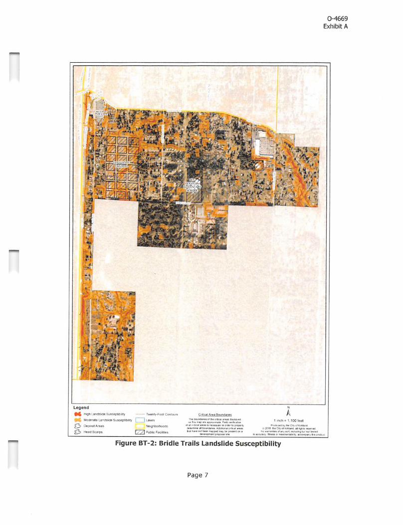
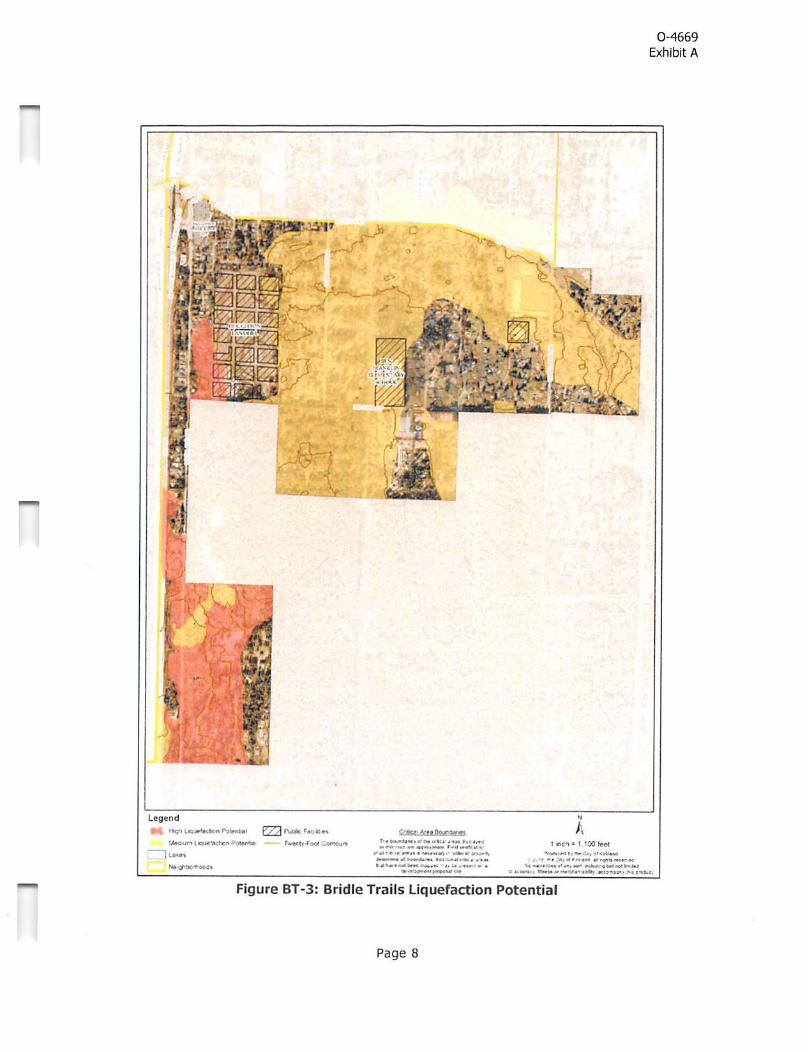
5. Natural Environment/Parks/Open Space
Rgures BT 2, BT 3 and BT 4 show the geologically hazardous areas, drainage basins and knownstreams and wetlands in the neighborhood. Yarrow Creek is a Salmonidae stream. Tbese naturalresources provide surface water, wildlife benefits and open space amenities for neighborhood andtherefore should be maintained or restored to their natural state.
Page 6
0-4669
Exhibit A
n
■ r^qjgfi-
"<4r^mrs-^. Sr '72 '
1 '^•', .fc^iS^4a3
, im\ ~:^iM- ■■5ti-- ifr7-.-rTT7~=i8Wij&ifl
i'v-v
■ .'■ ♦ . I*. >.
;«sLegend
n$n'-sndude SiAc«(W'V) ^ — fwi'itt-Poot Contoure
M «**rele laryWde SusMpltoWy i f UkwAr«a5 >«»iQPbMtieQrB
53 fy /} P|ft* faottmi
Q!j!S±^£££3SiJ^£SlM *4 ( *!•< >M«««C
» W« «fa4i«MM '«a<Mb^atM»*« • c<airi»»rw<«
j»Wi«»0 0 k»iM>Mert««• ■ »trr nf »•«■ ^4pg w 4«r M •
■ 11 uia*—! 1» vm
At inch*
*■44^(44 *1 »• e«» «f 1-t' •• bvjM Mn«M laa^n
>•< c« #>» «4i HMMlewi ► i#eM*se"4i
Figure BT-2; Bridle Trails Landslide Susceptibility
Page 7
0-4669
Exhibit A
n
n
'tiW- c- ±41 r 4 <
t<g«nd
HiQ^ yyA PuOte P<c«M»»
toM'Bcten -■ ' Tw«>iiv/e« CoA^rt
1 La««»%>4n9e'*M0«
e'*V0'li4 jr«>>iC4«« rn
•'•■•«*• *•*«« % .* MS< ■ in
<Wt v^.Tw <> .« . «ir .9 M' '•*»
I CtO" I tWfMl
'« ** .*'<'«'* A ««« K r^fl
oivr ItMH ^PW'7>**a>*T •*»♦»* 1 >S 611»H
Figure BT-3: Bridle Trails Liquefaction Potential
Page 8

nn
0-4669
Exhibit A
- -v-r i— .•'•
/i
■
4^ ̂r:
L#0»nd
r ̂)0 Yoa* r ]»d9 j
•Vstdids
. ES''-' - '■•»•
•=ji:m
' i^«
'J«A
' V
'»
Figure B
T-4: Bridle T
rails Wetlands and S
treams
Page 9

0-4669
Exhibit A
Policy BT10: Enhance and restore Yarrow Creek and wetlands in the area shown on Figure BT 4.
Policy BT 11: Encourage creation of backyard sanctuaries for wildlife habitat in upiand areasper the Washington State Department of Fish and Wildlife recommendations.
6. Parks
Figure 1 Land Use map shows the location of existing parks and open spaces in the Bridle TrailsNeighborhood. The dtywide Parks and Open Space Plan describes the ̂ ture plans for parksthroughout the dty. Prior to development of each park, a master plan process is conducted to allow forcommunity input. The objectives of the foliowing policies include promoting enhanced utilization ofexisting park and open space facilities, and improving facilities within existing open space resources.
Poiicy BT 12: Pursue acquisition of land for parks especially in the souOiem portion of theneighbothood and enhance existing paries and open space with a wide range of amenities for a diversepopulation (including kids, families, and the elderly) consistent with the Parks and Open Spacx Plan(PROS).
Policy BT 13: Support Bridle Trails State Park as a Icxal and regional open space, park and equestiianfadUty. Maintain and enhance public acc^s easements to ensure connections to the Park. Providedirectional signs to the Park and use park iconcjgraphy to establish a sense of place in tiie Bridle Trailsneighborhood.
Policy BT 14: In the future, the Gty should consider a joint agreement if tiie State seeks to sharemanagement of tiie Bridle Trails State Park.
Policy BT 15: Intrcxluoe new uses to Snyderis Comer Park to make it more useful to tiie neighborhocxland encourage enwronmental functions as interim uses in advance ofa park master plan process. Newuses could indude a community garden, gazebo (or other community amenity), ordiard, wetlandfeature, and dog park.
Policy BT 16: Promote the use of Ben Franklin El&m&ilary School and playfield as an open space,recreational fadUty and community amenity that is shared with tiie neightxyriicxxl.
The City of Kirkland has contributed towards recreational and interpretive trail improvements at BenFranklin Elementary School and has a joint-use agreement with the School District to allow use of theamenities for community use during non-schooi hours, including evenings, weekends, and summermonths. Neighborhood use of the school site should be continued to help meet the recreation needs ofthe neighborhood.
Policy BT 17: Impacts hom the King County Transfer Station and sports fields should be minimized.
Most of the approximately 25 acres encompassing the King County Transfer Station were once used asa landfill. The sports fields located to the north of the transfer station are self-contained with separateaccess roads and on-site parking. The traffic for the transfer station and sports fields should bemanaged to minimize impacts on the surrounding neighborhoods. The northeast area of the sitecontains a wooded undeveloped area appropriate for passive recreational use, such as a communitygarden and off-leash dog park.
Page 10
0-4669
Exhibit A
7. Transportation
The major east - west streets in Bridle Trails include NE 70'*' ST, which connects the west to east partof Kirkland and NE 60*'' ST (Rgure BT 5). Other important elements of the transportation systeminclude the pedestrian/bicycle overpass over 1-405, links to the County trail system that connect toSeattle and Marymoor Park in Redmond, the Cross Kirkland Corridor, and the Houghton shoppingdistrict. 116*" Avenue NE and 132'*' Avenue connects to Bellevue. The policies below are intended topromote mobility, provide people with options to access goods and services without a car, and promoteequestrian movement throughout the community.
Policy BT 18: Improve vehide, pedestrian, bicyde and equestrian mobiiity throughout theneightxDrhood, to otiier Gty and regional destinations.
Page 11

0-4569
Exhibit A
n
'»)*l
NC 'MOffT
Mf /iMbIT ifA rp*J
NC rjiu II
M ftHQ
«4Tiirin
NC Ifitvi
■£UM<P1.rni
*r«>TBffT
»^WTk5t ?
iHMrhr*JC tuT :r
% "'"vs ̂
^ ll-v.*'-
.*=«"V
i
/\
i
(1
1
*-f •..»
VV,^
\r
/JS-
\»
/'"
• Pnne<>al Arfenal Ne^h^o'noM 6ovn4aoe$ Sc^ooi
• U»fto» Artanai Faoitlws | | Lakn»Cofl«<tof Park Parcel Boun<|arHM
Ho
1 ««A« 1.100 reel
MoAMk T M Ca* <« MIM^. ̂<*f «« • »%ww «■ >711
ta'a^ •<xang %» nk ipmb>1 ■ia»s'B I W*i ^unwH
Figure BT-5: Bridle Trails Street Classifications
Page 12

0-4669
Exhibit A
Pedestrian and Bicycle System
Desired major pedestrian and bicycle pathways in the Bridle Trails Neighborhood are designated inFigures BT 6 and BT 7. The new Greenways in progress and planned shown on Figure 7 will help addto the citywide and regional pedestrian and bicycle system.
n
wmok
j ̂
CvrplM^ D'(«S«»Onlv
Bcr< 914 P-cpwefl Gfeen»»K
£*ai»iQ Tta^s ,' L«kM
td/Purm^ BcMVtvm
9 TraiwteMenScmo
IX PjJinat
A1 rooii
I «OWC!MMToVi>ri=uttr Tr«f1te Parwi
Figure BT-6: Bridle Trails Pedestrian System
Page 13

0-4669
Exhibit A
n
■W'trnr MruJuat
N*' 'MOM
wmosr: ■f'a'oa:
mnaotT
NCriTMST*«( r9^ »T »'
u» rM
.VC 616
w nirHO^
1I
^ ' .M\ ,/
s
1
;r
"^"S'sr
' "> Dssired Bika/Sharvd U8« lant
6ika/Sfia/«3 U$» Une
Cross KIrkland Corrtdo'
B 81 ^roposoQ Or»<mway8iHB Greo'nvay
ROW Closetf lo Vjhioi.f T(af«: I I Lafcninwrsiate Park
Anerial ' Cotiector Scfcc^
NMghborhood Access [yQ^ PubBc FsotttkM
^ CasiiiOo rrari9nissK)r L'do
To Bridle CrestTrail. Redmond
A1 Mfts 1.100^1
ri »• C'^ ii*«(r vw
« (M
Figure BT-7: Bridle Trails Bicycle System
Page 14

0-4669
Exhibit A
Policy BT19: Plan lor a fijture bicyde and p&iestrian Greenway along NE 60^ ST and 13(P Avenue NEto connect to the Greenway north ofNE 7^^ Place and to the ̂ uth and Nortii Rose HillNeighborhoods.
Policy BT 20: Develop bike lanes, a sid&walk, and/or multi-use path along IIB'' AveNE, between NE6CP' ST and the Bellevue dty boundary In order to provide access to toture light rail.
Policy BT 21: Design trails and streets to minimize confUds between horses and vehides whilepromoting equestrian, pedestrian and bike access.
Policy BT22: In equestrian areas, design public Improvements to reflect shared equestrian andpedestrian use of patiis, sidewalks, roadway improvements, transit connections and signage to reflectthe equestrian uses in tire nelghtrorhcxxi.
• Where possible, some separation of equestrians from bicyclists and moton'sts is desirable.• Equestrian paths should not be paved. Paths should be constructed with a specially designed,
stabilized hoof grid mix to provide appropriate footing and to retain integrity in Puget Sound'swet climate.
• Paths should be designed to accommodate horses and riders. Paths should be wide enough tosupport two-way equestrian travel and have enough vertical clearance for a horse and rider.
Policy BT 23: Preserve and enhance equestrian, pedestrian and bike access to Bridle Trails State Parkfrom the surrounding neighborhood, although bik^ are not allowed in tiie park.
Policy BT 24: Require private development projects to complete unimproved portions of tire regionalEastsrde Powerirne Corridor trail Icjcated in Bridie Trails witirin Ore Seattle Oty Light Power LineEasement or explore ways to use public funds to make Improvements to trail. Where privatedevelopment has already cxrurred, consider completing secdons tiirough the Gty's CapitalImprovement Program.
Public pedestrian and bicycle Improvements should be provided under the Seattle City Light power lineeasement when development, redevelopment or platting occurs to complete the trail system. Publicfunding should also be considered. See PROS Plan for further details. This off-street north/south trailthrough the neighborhood serves the recreational needs of the community by providing a safepedestrian, equestrian and bicycle link separated from the street system. Eventually this trail could linkup to the South Rose Hill neighborhood and trail systems in adjoining jurisdictions. The trail should beenhanced with signage and wayfinding features, providing landscaping Improvements that areconsistent with the rural nature of the area.
Page 15

0-4669
Exhibit A
8. Public Facilities
Public facilities in the neighborhood include the King County Transfer Station, Qty water tower and BenFranklin Elementary School. North of the King County Transfer Station site is the old Houghton Landfilland now Taylor Relds sports fields. The King County Solid Waste Division continually monitors thegroundwater and methane gas at the Houghton landfill to ensure it complies with Seattle-King CountyDepartment of Public Health requirements. Any permanent use for the landfill will need soilremediation. There are many homes in the neighborhood still on septic systems because of lack ofsanitary sewer infrastructure. As new development occurs the sewer mains and connections should beextended to meet current standards.
Policy BT 25: Establish guiding prindpies for the redevelopment of the King County Transfer Stadonfacoiity if it is cdc^ed:
• Public-serving open space uses should be the primary focus of any redevelopment.• Open space should include active (e.g., sports field) and passive (walking trails, dog park)
uses, along with other recreational uses (e.g., aquatic center), and should establishecological/wildlife and pedestrian connections through the former transfer station from thePark and Ride to Bridle Trails State Park.
• Non-open space/park uses may be considered, but should be compatible with the openspace character of the site.
• Any soil contamination should be remediated prior to reuse.
Policy ffT 26: The Qt/s water tower is an important public ̂diity and cpen space amenity for theneighborhood. Maintain and enhance the public pedestrian and bicyde pathway along die west side ofdie property.
Policy BT 27: Noise impacts adjacent to the Interstate 405 should be minimized with new developmentwith die use ofsound waiis, berms or otiier midgadon measures.
Page 16

n
n
n
PUBLICATION SUMMARY
OF ORDINANCE NO. 4669
AN ORDINANCE OF THE CITY OF KIRKLAND RELATING TO
COMPREHENSIVE PLANNING AND LAND USE AND AMENDING THE
COMPREHENSIVE PLAN ORDINANCE 3481, AS AMENDED, TOREPLACE EXISTING CHAPTER XV.C BRIDLE TRAILS
NEIGHBORHOOD PLAN WITH A NEW BRIDLE TRAILS
NEIGHBORHOOD PLAN, FILE NO. CAM18-00082.
SECTION 1. Provides a new Bridle Trails Neighborhood Planto replace the existing Bridle Trails Neighborhood Plan in theComprehensive Plan.
SECTION 2. Provides a severability clause for theordinance.
SECTION 3. Establishes that this ordinance, to the extent itis subject to disapproval jurisdiction, will be effective within thedisapproval jurisdiction of the Houghton Community CouncilMunicipal Corporation upon approval by the Houghton CommunityCouncil or the failure of said Community Council to disapprove thisordinance within 60 days of the date of the passage of thisordinance.
SECTION 4. Authorizes the publication of the ordinance bysummary, which summary is approved by the City Councilpursuant to Section 1.08.017 Kirkland Municipal Code andestablishes the effective date as December 22, 2017.
SECTION 5. Directs the City Clerk to certify and forward acomplete certified copy of this ordinance to the King CountyDepartment of Assessments.
The full text of this Ordinance will be mailed without chargeto any person upon request made to the City Clerk for the City ofKirkland. The Ordinance was passed by the Kirkland City Councilat its meeting on the 11th day of December, 2018.
I certify that the foregoing is a summary of Ordinance 0-4669 approved by the Kirkland City Council for summarypublication.
derson. City Clerk
Page 1 of 1
Publication Date: 12/17/2018