computer simulation of satellite data for urban expansion ... · the main factors governing...
TRANSCRIPT

Abstract— Present research work illustrates computer simulation of satellite data and with socio-economic data such as population, migration and urbanization led problems related to quality of life in Samara city and derive landscape trajectory and urban expansion. Supervised classification methodology has been employed using maximum likelihood technique in ArcGIS 10.1 Software for five different time periods Landsat satellite imageries from 1975 to 2015. Four major land cover classes were observed: water, built-up, forest and grassland by classification. Then, land cover area for all classes in different years were simulated and coupled with population data. Results show that, urban expansion and built-up area is correlated with population of samara city with high speed of economic development. The present study revealed an increase in built-up by 37.01% from 1975 to 1995, than reduce -88.83% till 2005 and an increase by 39.16% from 2005 to 2015, along with the increase in population, migration from rural areas owing to the economic growth and technological advantages associated with urbanization.
Keywords— Urban expansion; simulation; satellite data; land
use/cover; change detection; remote sensing & GIS
I. INTRODUCTION he official foundation date of Samara is 1586. That time small fortress was built at the confluence of the Volga
and Samara rivers. It was protecting the eastern borders of the Russian state from nomads. After building the quay, Samara settlement became the economic and diplomatic center of Russia. In 1780, the town became the capital of Simbirsk region. The economy of Samara was growing quickly at the end of the 19th and beginning of the 20th centuries (bread trading and milling business). The population of Samara at the beginning of the 20th century was about 100,000. It was large trade and industrial center of the Volga region of Russia [1]. During the World War II, it was chosen to be the USSR capital in case of Moscow fall. Here defense industry was
This work is financially supported by the Russian Scientific Foundation
(RSF), grant no. 14-31-00014 “Establishment of a Laboratory of Advanced Technology for Earth Remote Sensing”.
M. S. Boori is with the Samara State Aerospace University Russia, Hokkaido University, Japan and American Sentinel University Colorado, USA (Phone: 9874329875; e-mail: [email protected]).
K. Choudhary is with the Samara State Aerospace University, 34 Moskovskoye shosse, Samara, Russia (e-mail: [email protected]).
V. A. Soifer is with the Samara State Aerospace University, 34 Moskovskoye shosse, Samara - 443086, Russia (e-mail: [email protected]).
A. Sugimoto is with the Hokkaido University, Sapporo, Japan (e-mail: [email protected]).
developing fast after the World War II. Soon the city became so called “closed city” of the USSR. The spaceship of Yury Gagarin (first man in space) “Vostok” was built here. Now Samara is Russian large industrial and cultural center with multinational population and dramatic history. Samara is a large industrial center of the whole Volga river region. The city is among top Ten Russian Cities by industry volume. There are over 150 large and medium industrial plants in the city. About 25% of all bearings and 70% of all cables produced in Russia are made in Samara. It is producing various outer space vehicles and machinery, aircraft, power stations, refinery, cranes. Samara food industry is known for its chocolate, vodka “Rodnik” and “Zhiguli” beer. Samara is one of the largest transportation junctures in Russia; it is crossed by the shortest ways from central and Western Europe to Siberia, Middle Asia and Kazakhstan [1].
Urban sprawl is defined as an inefficient urban development often linked to sparse building density over rural areas [2, 3]. Only 3 present earth surfaces covered by urban area [4, 5] but due to urbanization, population growth, economic development and unplanned development are the main cause of environmental and social problems in modern cities. Urban areas are faced with distinctive, or ‘systemic’, issues arising from their unique social, environmental and economic characteristics [6]. Some glitches such as health risks including air pollution, occupational hazards, traffic injury, risks caused by dietary and social changes [7] as well as destruction of vegetation, agricultural lands, population of underground and surface water sources and climate change [8] are associated with urban expansion. These parameters are decreasing the quality of life in urban and rural societies. In developing cities, information about unplanned settlements is often unavailable. It is critically important to properly characterize urban expansion before developing a comprehensive understanding of urbanization processes [9, 10). The unplanned and uncontrolled rapid growth has resulted in serious negative effects on the urban dwellers and their environment [11]. As all over the globe cities are growing very quickly so it is necessary to protect natural resources with urban growth [12]. More than ever, it is imperative that urban planning focus on evidentiary models and valid spatial data.
Earlier studies show that urbanization happens because people move into urban areas to seek economic opportunities and to improve their standard of living. People in rural area have to depend on changeable environmental conditions and
Computer simulation of satellite data for urban expansion analysis
M.S. Boori, K. Choudhary, V.A. Soifer, and A. Sugimoto
T
INTERNATIONAL JOURNAL OF MATHEMATICS AND COMPUTERS IN SIMULATION Volume 10, 2016
ISSN: 1998-0159 142

in times of drought, flood or pestilence, survival becomes extremely problematic. This is very different in urban where all the facilities are well build to make human life more comfortable and the main attraction of urban is easy access to wealth [13, 14]. Usually land uses and urban growth in remote sensing involves the analysis of two registered, aerial or satellite multi- spectral bands from the same geographical area obtained at two different times. Such an analysis aims at identifying changes that have occurred in the same geographical area between the two times considered [15]. Satellite remote sensing is a potentially powerful means of monitoring land-use change at high temporal resolution and lower costs than those associated with the use of traditional methods [16]. Remote sensing data is very useful because of its synoptic view, repetitive coverage and real time data acquisition [17]. The digital data in the form of satellite imageries, therefore, enable to accurately compute various land cover/land use categories and help in maintaining the spatial data infrastructure which is very essential for monitoring urban expansion and land use studies [17. 18]. Land use/cover changes is a widespread and accelerating process, mainly driven by natural phenomena and anthropogenic activities, which in turn drive changes that would impact natural ecosystem [19, 20]. Understanding landscape patterns, changes and interactions between human activities and natural phenomenon are essential for proper land management and decision improvement.
To know the spatial patterns of Samara city urban growth over in a timeframe, city must be systematically mapped, monitored, and accurately assessed using satellite images with conventional ground truth verification data. This type of analysis work provides a scenario of where growth is occurring and helps to identify the environmental and natural resources threatened by such development and suggest the likely future directions and patterns of growth. The current study has three specific objectives: (1) investigate the growth pattern of Samara city during 1975 – 2015 by using remote sensing and GIS; (2) analyze the temporal and spatial characteristics of urban expansion in Samara from 1975 to 2015 and (3) detect and evaluate the land use and land cover change due to urbanization between 1975 to 2015; (4) analyze the main factors governing urbanization and land use and land cover change; (5) evaluate current local environmental and natural resource protection and development policies.
II. STUDY AREA Samara region is situated in the South-East of the Eastern
European Plain in the middle flow of the greatest European river, the Volga, which separates the region in two parts of different size, Privolzhye and Zavolzhye. Study area (fig. 1.) Samara known from 1935 to 1991 as Kuybyshev, is the sixth largest city in Russia and the administrative center of Samara Oblast. Geographical coordinates are 53°12´10´´N, 50°08´27´´E (fig. 1). The region occupies an area of 53.6 square kilometers (0.31% of the territory of Russia) and forms a part of the Volga Federal District. It is situated in its
southern part. The Volga acts as the city's western boundary; across the river are the Zhiguli Mountains, after which the local beer (Zhigulyovskoye) is named. The northern boundary is formed by the Sokolyi Hills and by the steppes in the south and east. The region stretches form 335 km from the North to the South and for 315 km from the West to the East. The land within the city boundaries covers 46,597 hectares (115,140 acres). Population: 1,164,685 (2010 Census); 1,157,880 (2002 census); 1,254,460 (1989 Census). The metropolitan area of Samara-Tolyatti-Syzran within Samara Oblast contains a population of over three million. Formerly a closed city, Samara is now a large and important social, political, economic, industrial, and cultural center in European Russia. It has a continental climate characterized by hot summers and cold winters. In this research work we use 25km2 radius from the city center of Samara.
Fig. 1 The position of Samara in Mainland Russia.
III. MATERAL AND METHODS
A. Data Landsat-TM images represent valuable and continuous
records of the earth’s surface during the last 4 decades (USGS, 2014). Moreover, the entire Landsat archive is now available free-of-charge to the scientific public, which represents a wealth of information for identifying and monitoring changes in manmade and physical environments [21, 16]. Several studies acknowledged the importance of pre-processing (i.e., data selection, co-registration, radiometric calibration and normalization) in performing accurate and reliable change detection analysis [16]. A selection of multi-sensor, multi-resolution, and multi-temporal images was used for this study [22, 18]. The specific satellite images used were Landsat MSS (Multi-Spectral Scanner) for 1975, Landsat TM (Thematic Mapper) for 1985-1995, Landsat ETM+ (Enhanced Thematic Mapper plus) for 2005 and 2015, an image captured by a different type of sensor. According to [23, 24], the time interval between images for the investigation of Land Use/Cover changes Levels I and II [25] should be between 5 and 10 years and the spatial resolution should be 10m or larger, so that the selected images and sensors comply with these criteria. Another reason for selecting these images was their availability and cloud cover.
INTERNATIONAL JOURNAL OF MATHEMATICS AND COMPUTERS IN SIMULATION Volume 10, 2016
ISSN: 1998-0159 143
All satellite and supporting data used for this study are identified in table 1.
TABLE I. Data used in this study. Data Pass &
Row Year Spatial
resolution (m) Satellite images
Landsat MSS 183/023 June 1975
79
Landsat TM 169/023 Sept. 1985
30
Landsat TM 169/023 May 1995
30
Landsat ETM+ 169/023 Aug. 2005
15-30
Landsat ETM+ 169/023 March 2015
15-30
Supporting data
Topographic map
2000 1:25000
Field data/GPS 2015 10
B. Image Preprocessing Digital image processing was manipulated by the ArcGIS
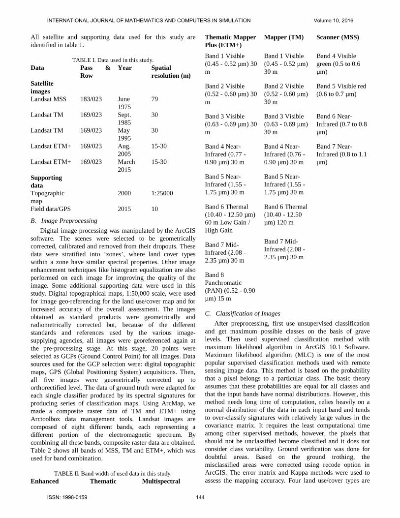
software. The scenes were selected to be geometrically corrected, calibrated and removed from their dropouts. These data were stratified into ‘zones’, where land cover types within a zone have similar spectral properties. Other image enhancement techniques like histogram equalization are also performed on each image for improving the quality of the image. Some additional supporting data were used in this study. Digital topographical maps, 1:50,000 scale, were used for image geo-referencing for the land use/cover map and for increased accuracy of the overall assessment. The images obtained as standard products were geometrically and radiometrically corrected but, because of the different standards and references used by the various image- supplying agencies, all images were georeferenced again at the pre-processing stage. At this stage, 20 points were selected as GCPs (Ground Control Point) for all images. Data sources used for the GCP selection were: digital topographic maps, GPS (Global Positioning System) acquisitions. Then, all five images were geometrically corrected up to orthorectified level. The data of ground truth were adapted for each single classifier produced by its spectral signatures for producing series of classification maps. Using ArcMap, we made a composite raster data of TM and ETM+ using Arctoolbox data management tools. Landsat images are composed of eight different bands, each representing a different portion of the electromagnetic spectrum. By combining all these bands, composite raster data are obtained. Table 2 shows all bands of MSS, TM and ETM+, which was used for band combination.
TABLE II. Band width of used data in this study. Enhanced Thematic Multispectral
Thematic Mapper Plus (ETM+)
Mapper (TM)
Scanner (MSS)
Band 1 Visible (0.45 - 0.52 µm) 30 m
Band 1 Visible (0.45 - 0.52 µm) 30 m
Band 4 Visible green (0.5 to 0.6 µm)
Band 2 Visible (0.52 - 0.60 µm) 30 m
Band 2 Visible (0.52 - 0.60 µm) 30 m
Band 5 Visible red (0.6 to 0.7 µm)
Band 3 Visible (0.63 - 0.69 µm) 30 m
Band 3 Visible (0.63 - 0.69 µm) 30 m
Band 6 Near-Infrared (0.7 to 0.8 µm)
Band 4 Near-Infrared (0.77 - 0.90 µm) 30 m
Band 4 Near-Infrared (0.76 - 0.90 µm) 30 m
Band 7 Near-Infrared (0.8 to 1.1 µm)
Band 5 Near-Infrared (1.55 - 1.75 µm) 30 m
Band 5 Near-Infrared (1.55 - 1.75 µm) 30 m
Band 6 Thermal (10.40 - 12.50 µm) 60 m Low Gain / High Gain
Band 6 Thermal (10.40 - 12.50 µm) 120 m
Band 7 Mid-Infrared (2.08 - 2.35 µm) 30 m
Band 7 Mid-Infrared (2.08 - 2.35 µm) 30 m
Band 8 Panchromatic (PAN) (0.52 - 0.90 µm) 15 m
C. Classification of Images After preprocessing, first use unsupervised classification
and get maximum possible classes on the basis of grave levels. Then used supervised classification method with maximum likelihood algorithm in ArcGIS 10.1 Software. Maximum likelihood algorithm (MLC) is one of the most popular supervised classification methods used with remote sensing image data. This method is based on the probability that a pixel belongs to a particular class. The basic theory assumes that these probabilities are equal for all classes and that the input bands have normal distributions. However, this method needs long time of computation, relies heavily on a normal distribution of the data in each input band and tends to over-classify signatures with relatively large values in the covariance matrix. It requires the least computational time among other supervised methods, however, the pixels that should not be unclassified become classified and it does not consider class variability. Ground verification was done for doubtful areas. Based on the ground trothing, the misclassified areas were corrected using recode option in ArcGIS. The error matrix and Kappa methods were used to assess the mapping accuracy. Four land use/cover types are
INTERNATIONAL JOURNAL OF MATHEMATICS AND COMPUTERS IN SIMULATION Volume 10, 2016
ISSN: 1998-0159 144

identified in the study area viz., (i) Forest (ii) Grassland (iii) Built-up (iv) Water body (table 3).
TABLE III. Description of Land Use/Cover classes.
Land use class
Description
Built-up Residential, commercial & services, industrial, transportation & roads, mixed
Forest Pine, coniferous trees, citrus orchards, Grassland Grass belt, agriculture, parks, trees, brain
land Water bodies River, permanent open water, lakes, ponds
D. Land use/cover change detection and analysis For performing land use/cover change detection, a post-
classification detection method was employed. A pixel-based comparison was used to produce change information on pixel basis and thus, interpret the changes more efficiently taking the advantage of ‘‘-from, -to’’ information. Classified image pairs of two different decade data were compared using cross-tabulation in order to determine qualitative and quantitative aspects of the changes for the period of 1975 to 2015. A change matrix [26, 27] was produced with the help of ArcGIS software. Quantitative areal data of the overall land use/cover changes as well as gains and losses in each category between 1975 and 2015 were then compiled.
Observations of the Earth from space provide objective information of human activities and utilization of the landscape. The classified images provide all the information to understand the land use and land cover of the study area. Change detection analyses describe and quantify differences between images of the same scene at different times. The classified images of the five dates can be used to calculate the area of different land covers and observe the changes that are taking place in the span of data. This analysis is very much helpful to identify various changes occurring in different classes of land use like increase in urban built-up area or decrease in vegetation land and so on [28].
E. Annual urban growth rate We use following formula to know the intensity of urban
expansion called annual urban growth rate (AGR):
where TAn+i is the total land area of the target unit to be calculated at the time point of i+n; UAn+i and UAi the urban area or built-up area in the target unit at time i+n and i, respectively and n is the interval of the calculating period (in years). Generally, the target calculating unit is set to the administrative district so as to link with administration or economic statistics. In this research, we preferred the geographical gridding unit since the administrative borders have been changed so frequently in this city. The maps were therefore gridded as 1 km×1 km units and the annual urban growth rates of each unit were then calculated. Lastly the
grid-based annual urban growth rates were clustered by using natural break method and mapped to evaluate the spatial features of the ‘expansion’.
IV. RESULTS AND DISCUSSION This work provides a methodological framework by
integrating RS-GIS, metric analysis and spatial analysis to facilitate the assessment of urbanization or urban growth and changing land use patterns. Remote sensing and GIS helped monitor urbanization process and assess the status of urban agglomeration. The temporal changes facilitate the investigation and characterization of impacts on land use/cover and surrounding environment from settlement sprawl associated with accelerating urbanization. In this study, time series data used are Landsat MSS, TM and ETM+ from 1975 to 2015. First unsupervised and later on supervised classification is done on satellite image series to analyze morphological growth. By comparing the area in square kilometer, the percentage increase in urban growth can be measured. Final maps produced are shown in Fig. 2–3. During this study, it was found that there is an increase in settlement by 6.48% (127.37 km2) from 1975 to 2015.
Fig. 2 Samara city growth in 1975, 1985, 1995, 2005 and 2015 map.
A. Land use/land cover images
The results obtained through the analysis of multi-temporal satellite imageries were diagrammatically illustrated in figs. 2–3 and data are registered in tables 4. Fig. 2 depicts total city growth status in different years. Fig. 3 depicts land use/cover change in different land use categories. Table 4 shows the land use for different purposes in Samara. This gives an idea to the planners about urban sprawl in Samara, a greater perception of problems, the available options to rectify and develop a better plan. In future analysis, a highly detailed structural analysis of the large-scale and heterogeneous inner structures of urban morphology using satellite data with higher geometric resolution (e.g., Ikonos or Quickbird) is expected to augment information for planning purposes [29]. Digital analysis techniques can be used for identification and classification of all land cover classes from other classes in an efficient manner. If large area is to be estimated, it is more effective and accurate by this technique [30]. A brief account of these results is discussed in the following paragraphs.
INTERNATIONAL JOURNAL OF MATHEMATICS AND COMPUTERS IN SIMULATION Volume 10, 2016
ISSN: 1998-0159 145

1975
1985
1995
2005
2015
Legend!( Citycenter
ClassBuilt-up
Water
Forest
Grassland 0 7.5 15 22.5 303.75
Kilometers
Fig. 3 The land use and land cover map of Samara in 1975, 1985, 1995, 2005 and 2015.
B. Land use/land cover Status Accuracy assessment of the land use/cover classification
results obtained showed an overall accuracy is more than 90% for all images. These data reveal that in 2015, about 31.38% (616.14 km2) area of Samara block was under forest, 36.85% (723.49 km2) under grassland, 8.30% (162.91 km2) under water body and 460.87% (23.47km2) under built-up land. During 1975 the area under these land categories was found about 31.81% (624.56 km2) under forest, 44.03% (864.50
km2) under grassland, 7.17% (140.85 km2) under water body and 16.99% (333.50 km2) under built-up land (table 4). First unban area was increase till 1995 then reduce but later on again increase due to increased population. Initially forest area was decreased and later on increase due to governmental protection. Grassland class cover highest area in the study area, it was increase and highest in 2005 but in last radiuses. Water class is stable with small variation (fig. 3).
TABLE IV. Land use/cover area in kilometer square Class 1975 % 1985 % 1995 % 2005 % 2015 %
Built-up 333.50 16.99 336.48 17.14 529.48 26.97 280.40 14.28 460.87 23.47Forest 624.56 31.81 673.94 34.32 462.69 23.57 600.57 30.59 616.14 31.38Grassland 864.50 44.03 792.86 40.38 628.54 32.01 928.97 47.31 723.49 36.85Water 140.85 7.17 160.13 8.16 342.70 17.45 153.47 7.82 162.91 8.30Total 1963.41 100.00 1963.41 100.00 1963.41 100.00 1963.41 100.00 1963.41 100.00
C. Land use/land cover Change Table 5 shows land use land cover change matrix from
1975 to 2015. Data registered in table 5 and fig. 4 reveal that both positive and negative changes occurred in the land use/cover pattern of the Samara block. During the last four decades the grassland in the study area has decrease from 864.50 km2 in 1975 to 723.49 km2 in 2015 which accounts for -19.49% of the total study area. The forest has slightly decreased from 624.56 km2 in 1975 to 616.14 km2 in 2015 which accounts for -1.36%. The built-up area has increased from 333.50 km2 in 1975 to 460.87 km2 in 2015 which accounts for 27.63%. The water body has been increased from 140.85 km2 in 1975 to 162.91 km2 in 2015. This increase in water body accounts for 13.54%. To understand land encroachment for different land categories during the last four decades, a change detection matrix (table 5) was prepared which reveals that:
Cross tabulation is a means to determine quantities of conversions from a particular land cover to another land cover category at a later date. The change matrices based on post classification comparison were obtained and are shown in tables 5 and fig 4. Built up area covered 333.5 km2 in 1975 and 336.59 km2 in 1985, while the grassland covered an area of 792km2 in 1985 and 629.68 km2 in 1995. 383.83km2 of the forest area which was forest in 1995 was still forest cover in 2005. From 2005 to 2015 149.10 km2 grassland and 60.50km2 forest convert in built-up. During the same period, 115.29km2 grassland had been converted to forest area (table 5).
Table 5. Land use/cover change matrix from 1975 to 2015.
INTERNATIONAL JOURNAL OF MATHEMATICS AND COMPUTERS IN SIMULATION Volume 10, 2016
ISSN: 1998-0159 146

2005-2015CLASS BUILT_UP FOREST GRASSLAND WATER Total
Built-up 245.14 5.00 18.41 10.32 278.87Forest 60.50 496.84 42.42 0.32 600.08Grassland 149.10 115.29 662.95 4.16 931.49Water 5.56 0.40 0.00 146.78 152.74Total 460.30 617.53 723.77 161.58 1963.19Change rate % 39.41 2.82 -28.69 5.47
1995-2005CLASS BUILT_UP FOREST GRASSLAND WATER Total
Built-up 216.68 88.07 224.33 1.16 530.25Forest 4.36 383.83 74.63 0.04 462.86Grassland 26.17 51.46 551.93 0.20 629.76Water 31.49 76.83 80.71 151.34 340.37Total 278.71 600.19 931.60 152.74 1963.24Change rate % -90.25 22.88 32.40 -122.84
1985-1995CLASS BUILT_UP FOREST GRASSLAND WATER Total
Built-up 227.05 15.53 52.54 42.26 337.37Forest 114.36 385.95 62.90 111.00 674.22Grassland 187.79 61.34 514.24 29.13 792.51Water 1.04 0.04 0.00 157.98 159.06Total 530.25 462.86 629.68 340.37 1963.16Change rate % 36.37 -45.66 -25.85 53.26
1975-1985CLASS BUILT_UP FOREST GRASSLAND WATER Total
Built-up 151.21 20.51 157.05 4.28 333.05Forest 31.93 526.99 60.97 4.66 624.55Grassland 145.54 120.89 573.31 24.87 864.60Water 7.92 4.89 0.92 127.14 140.87Total 336.59 673.28 792.25 160.95 1963.07Change rate % 1.05 7.23 -9.13 12.47
Figure 4 show that in 1975 to 1985, there are not any big
changes. From 1985 to 1995 there is an around 40% change, forest and grassland have negative change but built-up area was increase around 36.37%. In the year of 1995 to 2005, there is dramatic negative change in built-up area. It`s show migration of population in another places. But during this period of time forest and grassland have positive change, which show less human interferation in the area. Final in 2005 to 2015, built-up area again increase (39.41%) and that`s why grassland was reduce (-28.69%).
CLASS BUILT_UP FORESTGRASSLANDWATER
Changes 75-85 1.05 7.23 -9.13 12.47Changes 85-95 36.37 -45.66 -25.85 53.26Changes 95-05 -90.25 22.88 32.40 -122.84Changes 05-15 39.41 2.82 -28.69 5.47
Fig. 4 Diagrammatic illustration of land use/cover change in percent
during the last four decades (1995–2015) in the Samara block.
D. Main city growth and LULC change As above tables and figures show that main urban and
land use changes observed from 1985 to 2015.
No change in forest
Change from forest to others (1985-2015)
Change from others to forest (1985-2015)
No change in grassland
Change from grassland to others (1985-2015)
Change from others to grassland (1985-2015)
No change in built-up
Change from othersr to built-up (1985-2015)
Change from built-up to others (1985-2015)
No change in water
Change from water to others (1985-2015)
Change from others to water (1985-2015)
Class Area % Class Area % Class Area % Class Area %BB 219.51 65.24 FB 132.61 39.41 GB 663.89 197.31 WB 123.45 36.69BF 33.39 9.92 FF 388.63 115.50 GF 33.05 9.82 WF 11.88 3.53BG 79.67 23.68 FG 141.56 42.07 GG 92.71 27.55 WG 12.64 3.76BW 3.9 1.16 FW 11.12 3.30 GW 3.22 0.96 WW 12.15 3.61
Fig. 5 Land use/cove change detection from 1985 to 2015 in Samara.
219.51 km2 (11.18%) built-up, 388.63 km2 (19.79%) forest, 92.71 km2 (4.72%) grassland and 12.15 km2 (0.62%) water body was stable from 1985 to 2015. Maximum conversion was present in grassland to built-up area around 33.81% (663.89 km2), which is the highest in all land cover classes (fig. 5). That`s why due to urbanization grassland area was maximum affected land cover class. For built-up class 11.18% area was stable in last three decade but 1.70% forest and 4.06% grassland was regrowth within built–up area. 6.75% (132.61 km2) and 7.21% (141.56 km2) forest area was gone in built-up and grassland area respectively in last three decade. Around 6.29 % (123.45 km2) water body was converted in built-up area, it`s the Volga and Samara river basin area, Where maximum site are under construction or already built-up area.
Built-up urban area of Samara city was increased with fast economic development and deepening urbanization. The major built-up area of samara city was 271.64 km2 at the end of 1985 but become 419.26 km2 in 2015, which show an increase by 147.62 km2, an annual average expansion of 14.76 km2and an annual change rate of 5.43% in the 30 years from 1985 to 2015.
INTERNATIONAL JOURNAL OF MATHEMATICS AND COMPUTERS IN SIMULATION Volume 10, 2016
ISSN: 1998-0159 147

1985 1995
2005 2015
Fig. 6 Built-up area of Samara for 1985, 1995, 2005 and 2015.
In city growth in first decade from 1985 to 1995, built-up
area was increased with economic development. In second decade from 1995 to 2005, it was reduce dramatically (fig. 6). Finally from 2005 to 2015 urban area was again increase with high speed of economic growth. Expansion of the built-up urban area of Samara City in the different periods can be described as follows (fig. 7):
Legend!. Citycenter
Built-up_1985
Built-up_1995
Built-up_2005
Built-up_2015
0 7.5 153.75 Kilometers
Fig. 7 Samara city growth in different years from 1985 to 2015.
In 1985 – 1995, the built-up urban area of Samara city expands by 103.4 km2, at an annual average rate of 10.34 km2, and mostly expansion was in north and south part of the city and Volga River.
In 1985 – 2005, the built-up urban area of Samara city reduce by -120 km2, at an annual average rate of -12.03 km2 and mainly in the form of radiation. Specially near the city center and outer part of the city (fig. 7).
In 2005 – 2015, the built-up urban area of Samara city expands by 164.57 km2, at an annual average rate of 16.45 km2 and mainly in the form of radiation, especially in the east and south side and first time in west side of the city. There is not any city development in the north side of Volga River and city due to government protection. Here government wants to preserve north side of Volga River as a natural heritage.
E. Temporal Properties of the Urban Expansion The urban area of Samara city expanded from 333.50 km2
in 1975 to 460.87 km2 in 2015 at annual average rate of 0.69 km2/year (table 6).
TABLE VI. Growth rate of Samara area.
Year Area SqKm Growth Rate Annual GR Population (Thousands)1975 333.5 11461980 334.99 12211985 336.48 0.89 0.08 12411990 432.98 12441995 529.48 36.44 3.64 12082000 404.94 11732005 280.4 -88.83 -8.88 11402010 370.63 11642015 460.87 39.16 3.91 1173
Fig. 8 Temporal change of urban area with population.
Last four decade Samara city experienced with high, low,
positive and negative urban growth speed (fig.8). Satellite data correlate with historical maps or statistical data. From 1975 to 1985 there is small urban growth but from 1985 to 1995 a very high urban growth was fiend with 3.64 annual growth rate (table 6). Later on from 1995 to 2005, it was
INTERNATIONAL JOURNAL OF MATHEMATICS AND COMPUTERS IN SIMULATION Volume 10, 2016
ISSN: 1998-0159 148

reducing dramatically around -8.88% per year. In last city was again increase with very high speed from 2005 to 2015 with 3.91 annual growth rates.
V. DRIVING FACTORS FOR URBAN GROWTH AND LAND USE CHANGE
Urban expansion and subsequent landscape changes are governed by geographical and socio-economic factors, such as population growth, policy and economic development. In most cases, urban expansion and associated land use/cover changes resulted from a combination of following factors such as: Industrial Profile: Samara Region has highly developed industry and a diversified economy structure. Industry accounts for about 40% of the gross regional product. It includes production and processing and energy sectors. The development of the region’s economy is based on high-tech processing industries with high added value: automobile manufacture, air and spacecraft manufacture, which account for up to 35% of the total volume of shipped production of processing industries; enterprises with high degree of processing: chemical and metallurgical. The region manufactures 30% of new passenger cars made in Russia, 31% of polymer materials for floor, wall and ceiling coatings, 23% of anhydrous ammonia, 16% of sanitary products made from ceramics, 13% of ceramic floor tile, 7.7% of automobile gasoline and 9% of diesel fuel, 8.5% of plastics in primary forms, 7.3% of beer, 5.0% of confectionery products and 4% of mineral fertilizers. Mining of minerals accounts for approx. 17% of industrial production. About 99% of them are fuel and energy raw materials. Production and distribution of energy resources makes up about 11% of regional economy [1]. That`s why industry is the main cause of urban growth and land use change. Development of Agricultural Complex: The agricultural complex of Samara Region is one of the leading sectors in regional economics, having its strategic importance both in provision of food safety and in maintaining socioeconomic stability in the region. It is a diversified production and economy system of over 500 collective agricultural companies, 2.5 thousand farmer-ships, 267.2 thousands of private plots and about 1000 companies of food and processing and servicing industry. It accounts for 5-7% of the cost of the gross regional product and about 3% of the capital assets. Rural areas are inhabited by 631.6 thousand people, or 19.7% of the population of the Samara Region. Agricultural complex employs about 92 thousand people (over 6% of the regional workforce). Total land area in the Samara region is more than 4 million hectares, of which 3.8 million hectares are agricultural land (more than 7% of agricultural land in the Volga Federal District), including about 2.9 million hectares of arable land. The main agricultural productions are growing cereals, oilseeds and forage crops, potatoes, vegetables, fruits and berries, milk and meat production. Regional agribusiness produces 2% of agricultural output of the Russian Federation and 7% - of the Volga Federal
District. In 2013 agriculture in the Samara Region showed high growth rates in the main indicators among the Russian regions [1]. The volume of gross agricultural production in all categories of farms in 2013 was estimated at 69.5 billion rubles, gross agricultural production index in comparison to the level of 2012 is estimated at 108.4 % (106.2 % countrywide). So requirement and production of agriculture is second leading cause of land use change and its effect of urban growth. Transport and Communication: In 2010, the Concept of development of the regional transport and logistics system of the Samara region for 2011 – 2015 was approved. Construction of modern transport and logistics infrastructure at the junction of the main transport routes West – East and North – South in the Samara Region will allow to process export-import, domestic and international cargo flows on the basis of interaction of four transportation modes and to ensure entry into the system of handling the cargo flows of international transport corridors and the cargo flow in the direction China – Europe. In order to ensure the coherence and consistency of decision-making regarding the development of regional transport and logistics system, the Coordinating Council on the development of transport logistics cluster of the Samara region was formed under the Samara Region Government. Three major Russian gas pipelines cross the Samara region: Chelyabinsk – Petrovsk, Urengoy – Petrovsk, Urengoy – Novopskovsk, as well as oil and product pipelines included in the systems of OJSC "Transnefteprodukt" and JSC "Transneft", with the total length of over 5000 kilometers. Infrastructure of the communications industry is one of the most important resources of social and economic development as well as urban growth and effect on land use change [1]. International Trade and Foreign Investments: During the recent years, a significant number of large commercial investment projects were implemented in the region, including those involving foreign companies. Over 450 enterprises with the foreign capital participation are already operating; the largest of them are listed below: - The Russian-American enterprise "GM-AvtoVAZ" –
production of cars - the Russian-American enterprise "PES / SCC" – production
of wire harnesses for cars - the Russian-Cypriot enterprise CJSC "Acom" – production
of batteries - the Russian-German enterprise "Henkel Plastic Automotive
components" – manufacturing of plastic products - the Russian-American enterprise "Samara Optical Cable
Company" – production of cables - the Russian-Chinese-Cypriot enterprise "Tomet" –
production of fertilizers - the Russian-American enterprise LLC "Combine of
ceramic structures" – manufacturing of ceramic products - the Russian-French enterprise "Tarkett" – production of
flooring
INTERNATIONAL JOURNAL OF MATHEMATICS AND COMPUTERS IN SIMULATION Volume 10, 2016
ISSN: 1998-0159 149

- the Russian-French enterprise "Danone-Volga" – production of yogurt
- OJSC "Confectionery Association "Russia" – production of confectionery
- Branch of the Russian-British enterprise "Coca-Cola Inchcape HBO-BBC Eurasia" and the Russian-American company "Pepsi International Bottlers (Samara)" – production of soft drinks.
The foreign companies are also active in the financial
services sector. The offices of Raiffeisenbank, Citibank, Societe Generale Vostok Group and Barclays Group are operating on the territory of the region. In May 2007 an office of the European Bank for Reconstruction and Development was opened in Samara. These investments are major cause of attractions of people from surrounding and other parts of country for employment and in last its cause of urban growth and land use/cover change [1].
VI. CONCLUSION Research work examined the urban expansion of Samara
city, which is the most important historical, cultural, industrial and commercial city of Russia. Satellite data and census data were used to monitoring the dynamic phenomena of urbanization with the help of computer simulation and remote sensing and GIS technology. Samara land expansion is based on Samara and Volga River and social factors such as population growth, migration and economic development. Despite the popular belief that Samara gardens and vegetation cover were destroyed and converted to built-up areas, this study demonstrated that development occurred mainly in available open spaces in the city and remaining lands between the buildings. Conversion of vegetation and orchards to built-up area, however, has been a more recent phenomenon. The study reveals that the major land use in the study area is vegetation (forest and grassland). The area under vegetation has decreased by 7.66% (149.43 km2) due to afforestation work during 1975 to 2015. The second major category of land in the study area is built-up area which was increased by 6.48% (127.37 km2) due to conversion in forest and grassland. Thus, the present study illustrates that computer simulation and remote sensing and GIS are important technologies for temporal analysis and quantification of spatial phenomena which is otherwise not possible to attempt through conventional mapping techniques. Change detection is made possible by these technologies in less time, at low cost and with better accuracy.
ACKNOWLEDGMENT This work is financially supported by the Russian Scientific Foundation (RSF), grant no. 14-31-00014 “Establishment of a Laboratory of Advanced Technology for Earth Remote Sensing”.
REFERENCES [1] Ministry of Economic Development, Investments and Trade of the Samara
region (2015) www.economy.samregion.ru [2] L. Altieri, D. Cocchi, P. Giovanna, M. Scott, M. Ventrucci, Urban sprawl
scatterplots for Urban Morphological Zones data. Ecol. Indic. 36, 315–323, (2014).
[3] J. Xiao, Y. Shen, J. Ge, R. Tateishi, C. Tang, Y. Liang, Z. Huang, Evaluating urban expansion and land use change in Shijiazhuang, China, by using GIS and remote sensing. Landscape and Urban Planning 75, 69–80, (2006).
[4] M. Herold, N. Goldstein, K.C. Clarke, The spatio-temporal form of urban growth: Measurement, analysis and modeling. Remote Sensing of Environment, 86(3), 286–302, (2003)
[5] X. Liu, R.G.Jr. Lathrop, Urban change detection based on an artificial neural network. International Journal of Remote Sensing, 23, 2513–2518, (2002)
[6] S.E. Gill, J.F. Handley, E.A. Roland, S. Pauleit, N. Theuray, S.J. Lindley Characterizing the urban environment of UK cities and towns: a template for landscape planning. Landscape Urban Plann. 87 (3), 210–222, (2008)
[7] Li Xin-Hu, Liu Ji-Lai, V. Gibson, Y.G. Zhu, Urban sustainability and human health in China, East Asia and Southeast Asia. Environ. Sustainability 4, 436–442, (2012)
[8] N.B. Grimm, J.M. Grove, S.T.A. Pickett, C.L. Redman, Integrated approach to long-term studies of urban ecological systems. Bioscience, 50(7), 571–584, (2000)
[9] X. Xinliang, X. Min, Quantifying spatiotemporal patterns of urban expansion in China using remote sensing data. Cities 35, 104–113, (2013)
[10] M.S. Boori, V. Vozenilek, K. Choudhary, Land use/cover disturbances due to tourism in Jeseniky Mountain, Czech Republic: A remote sensing and GIS based approach. The Egyptian Journal of Remote Sensing and Space Sciences, 18(1), 17–26, (2015) Doi:10.1016/j.ejrs.2014.12.002
[11] J. Chadchan, R. Shankar, An analysis of urban growth trends in the post-economic reforms period in India. Int. J. Sustainable Built Environ. 1, 36–49, (2012)
[12] A. Latif, S.M. Sabet, Urban sprawl pattern recognition using remote sensing and GIS, case study Shiraz City, Iran. In Proceedings of urban remote sensing joint event Shanghai, China. 20–22 May, 2009,
[13] M.B.C. Soh, Crime and urbanization: revisited Malaysian case. Procedia Social Behav. Sci. 42, 291–299, (2012)
[14] M.S. Boori, V. Vozenilek, K. Choudhary, Exposer intensity, vulnerability index and landscape change assessment in Olomouc, Czech Republic, ISPRS: Int. Arch. Photogramm. Remote Sens. Spatial Inf. Sci.. Vol. XL-7/W3: 771 – 776, (2015) Doi:10.5194/isprsannals-II-8-77-2014
[15] J. Radke, S. Andra, O. Al-Kofani, B. Roysan, Image change detection algorithms: a systematic survey. IEEE Trans. Image Process. 14 (3), 291–307, (2005)
[16] M.E.Bastawesy, Hydrological Scenarios of the Renaissance Dam in Ethiopia and Its Hydro-Environmental Impact on the Nile Downstream. J. Hydro. Engin., 2014, http://dx.doi.org/10.1061/(ASCE)HE.1943-5584.0001112.
[17] M.S. Boori, K. Choudhary, A. Kupriyanoy, V. Kovelskiy, Urbanization data of Samara City, Russia. Data in Brief. 6, 885-889, (2016) Doi:10.1007/978-3-319-11463-7-2
[18] M.S. Boori, K. Choudhary, A. Kupriyanoy, V. Kovelskiy, Four decades urban growth and land use change in Samara Russia through remote sensing and GIS techniques. SPIE: Remote Sensing and Image Formation. 9817, pp. 01-07, (2015) Doi: 10.1117/12.2227992
[19] S. Mukherjee, Land use maps for conservation of ecosystems. Geog. Rev. India 3, 23–28, (1987)
[20] A. Ruiz-Luna, C.A. Berlanga-Robles, Land use, land cover changes and costal lagoon surface reduction associated with urban growth in northwest Mexico. Land. Ecol. 18, 159–171, (2003)
[21] M.G. Turner, C.L. Ruscher, Change in landscape patterns in Georgia. USA Land. Ecol. 1 (4), 251–421, (2004)
[22] G. Chander, B.L. Markham, D.L. Helder, Summary of current radiometric calibration coefficients for Landsat MSS, TM, ETM+, and EO-1 ALI sensors. Rem. Sen. Envi., 113 (5), 893–903, (2009)
INTERNATIONAL JOURNAL OF MATHEMATICS AND COMPUTERS IN SIMULATION Volume 10, 2016
ISSN: 1998-0159 150

[23] P. Gamba, F. Dell’Acqua, B.V. Dasarathy, Urban remote sensing using multiple data sets: Past, present, and future. Information Fusion, 6, 319–326, (2005)
[24] J.R. Jensen, Remote sensing of the environment: An earth resource perspective (2nd ed.). Upper Saddle River, NJ: Pearson/Prentice Hall. 2007,
[25] M.S. Boori, V. Vozenilek, Land-cover disturbances due to tourism in Jeseniky mountain region: A remote sensing and GIS based approach. SPIE Remote Sensing. 2014, Vol. 9245, 92450T: 01-11. Doi:10.1117/12.2065112
[26] P.N. Dadhich, S. Hanaoka, Markov method integration with multi-layer perceptron classifier for simulation of urban growth of Jaipur City. Selected Topics in Power Systems and Remote Sensing, pp. 118-123, (2010)
[27] C. Weng, D. Rodrigues, L. Silva, R. Ramos, A proposed methodology for understanding urban growth pattern: A case study in Siem Reap, Cambodia. Recent Research in Chemistry, Biology, Environment and Culture, pp. 217–222, (2011)
[28] M.S. Boori, A. V. Kuznetsov, K. Choudhary, A. Kupriyanoy, Satellite image analysis to evaluate the urban growth and land use changes in the city of Samara from 1975 to 2015. Computer Potics, 39(5): 818-822, (2015) Doi: 10.18287/0134-2452-2015-39-5-818-822
[29] M.S. Boori, M. Netzband, V. Vozenilek, K. Choudhary, Urban growth in last three decades in Kuala Lumpur, Malaysia IEEE: Urban Remote Sensing Event (JURSE), 2015 Joint, pp. 01–04, (2015) Doi:10.1109/JURSE.2015.7120536
[30] T. Popov, M. Ivanisvic, N. Zivak, G. Trbic, D. Djordjevic, Land use change analysis using CORINE land cover data: A case study of the Peripannonian Region in Bosnia and Herzegovina. Latest Trends in Energy, Environment and Development.. pp. 205–212, (2014)
First Author Prof. Dr. Mukesh Singh Boori is Senior Scientist in Samara State Aerospace University Russia (03/2015–Present, funded by Russian Federation), Visiting Scientist/Professor at Hokkaido University Japan (12/2015–02/2016) and Adjunct Professor in American Sentinel University Colorado USA (07/2015–Present). He was involved in European Union Project as well as Visiting Assistant Professor in Palacky University Olomouc, Czech Republic (04/2013–06/2015), Ruhr University Bochum Germany (09/2014–12/2014) and University of Leicester, UK (Honorary Fellow 2014) funded by European Union; at the same time he was Assistant Professor in JECRC University India (01/2013–06/2015). He was Scientist in Satellite Climate Studies Branch (NOAA/NASA) selected by National Research Council (NRC) Central Govt. of USA Washington DC. During that time he completed his Postdoc from University of Maryland USA (10/2012). He has done PhD (EIA & Management of Natural Resources) from Federal University – RN (UFRN) Natal –RN Brazil (08/2011) funded by Brazil–Italy Govt. fellowship. He has done Predoc (Earth & Environmental Science) from Katholieke University Leuven Belgium (08/2008) selected by Ministry of Human Resource Development (MHRD) New Delhi India and funded by Govt. of Belgium. He has done MSc (Remote sensing & GIS) from MDS University Ajmer (2004) and BSc (Bio-group) from University of Rajasthan Jaipur India (2002). In early career he was scientist in JSAC/ISRO (2006-2007) and before that Lecturer (PG) at MDS University Ajmer (2005-2007Sessions). He received international awards/fellowships from UK, USA, Brazil, Italy, Indonesia, Belgium, Czech Republic, Germany, Russia, Japan and India. He known Six Language and visit four Continents for Awards, Meetings, Trainings, Field Trips, Seminars and Conferences. He is an active Organizing Committee Member in Earth & Space Science Conferences, Co-Chaired a session and gave Conference Opening Ceremony Speech as Reynold Speaker (08/2012) at Chicago USA. He is editor and member of more than 10 International Scientific Societies / Journals / Committees (including ELSEVIER) related to Earth & Space Science; which include organize conferences. His prime research interest is “EIA and Management of Natural Resources through Remote Sensing & GIS Technology”. He has more than 60 International Publications including Books as a first author on Vulnerability, Risk Assessment and Climate Change.
INTERNATIONAL JOURNAL OF MATHEMATICS AND COMPUTERS IN SIMULATION Volume 10, 2016
ISSN: 1998-0159 151