contact information mining records curator...
TRANSCRIPT
The following file is part of the
Arizona Department of Mines and Mineral Resources Mining Collection
ACCESS STATEMENT
These digitized collections are accessible for purposes of education and research. We have indicated what we know about copyright and rights of privacy, publicity, or trademark. Due to the nature of archival collections, we are not always able to identify this information. We are eager to hear from any rights owners, so that we may obtain accurate information. Upon request, we will remove material from public view while we address a rights issue.
CONSTRAINTS STATEMENT
The Arizona Geological Survey does not claim to control all rights for all materials in its collection. These rights include, but are not limited to: copyright, privacy rights, and cultural protection rights. The User hereby assumes all responsibility for obtaining any rights to use the material in excess of “fair use.”
The Survey makes no intellectual property claims to the products created by individual authors in the manuscript collections, except when the author deeded those rights to the Survey or when those authors were employed by the State of Arizona and created intellectual products as a function of their official duties. The Survey does maintain property rights to the physical and digital representations of the works.
QUALITY STATEMENT
The Arizona Geological Survey is not responsible for the accuracy of the records, information, or opinions that may be contained in the files. The Survey collects, catalogs, and archives data on mineral properties regardless of its views of the veracity or accuracy of those data.
CONTACT INFORMATION Mining Records Curator
Arizona Geological Survey 1520 West Adams St.
Phoenix, AZ 85007 602-771-1601
http://www.azgs.az.gov [email protected]

OS/20/91
ARIZONA DEPARTMENT OF MINES AND MINERAL RESOURCES FILE DATA
PRIMARY NAME: HARGAN MINES
ALTERNATE NAMES: MCGOWAN WEBB
MARICOPA COUNTY MILS NUMBER: 429A
LOCATION: TOWNSHIP 2 S RANGE 6 W SECTION 28 QUARTER NW LATITUDE: N 33DEG 13MIN 38SEC LONGITUDE: W 112DEG 52MIN 49SEC TOPO MAP NAME: WOOLSEY PEAK - 7.5 MIN
CURRENT STATUS: EXP PROSPECT
COMMODITY: COPPER GOLD LODE SILVER
BIBLIOGRAPHY: ADMMR HARGAN MINE FILE McDONNELL JR,JOHN R.,1986,MIN INV OF WOOLSEY
PEAK WSA. USBM MLA 46-86.

MIN6 AND PROSPECT FIELD VISIT DATA S' ~ARY
Shett -1 Qf 2
----, COMMODITIES Gold --------------------------------------~--------------------
MILS ID No. "M.ari~opa 429A Date May 13, 1982 ------~---------------------ENGINEER Ken A. Phillips and Nyal Niemuth -------------------------------
INF@RMATION FROM: Visit ------------~--~------~-----------------------------
PROPERTY SUMMARY ~ L MIN~ NAME Harcan '\'J
H~g~n, Webb, McGowan -Hargan OTHER POSSIBLE NAMES McGowan-Hargan #2
.. INCLUDING ANY CLAIM NAMES NOTED
II. LOCATION: T_2_S __ R __ 6_W __ SEC(S) __ 28 ______ MINE DISTRICT ___ We_-b_b ___ _ ELEV. 1500 1 COUNTY Maricopa TOPO QUAD. Woolsey Peak DIRECTIONS See attached map
MAP ATTACHED yes -------------------------------------------- ---------- III. OWNERSHIP: NAME William R. Henkle Jr. PHONE ------------------ADDRESS: 8525 E. Hampdon #719, Denver, Colorado 80231
COMPANY NAME IF ANY: ----------------------------------------------------PERTINENT PEOPLE ------------------------------------------------------
IV. PROPERTY AND HOLDINGS: unpatented claims
V. PAST PRODUCTION - NOTED, KNOWN, PROBABLE, UNKNOWN, NONE __ m_ay_b_e_a_l_i_tt_l_e ______ _
IV. CURRENT STATUS: idle, explored underground prospect
IIV. WORKINGS: Win~~ Tunnel #1 (adjt) S40W inClined on vein 80 1 to winze 25 1 deep to drjft. Surface trench. Second inclined adit 150 1 to West on same structure is 60 1 long.
lIVe GEOLOGY AND MINERALOGY: ---DFPnSIT TYPE: Mineralization is folta ., in schist LENGTH: 100 1 exposed WIDTH: 3-6 1 (zones) VEIN STRIKE N50W Dip 400 SW HOST ROCK: Schist and Gneiss ECONOMIC MINERALS: Possibly gold Down dropped faulting to South of mineralized zone
visible in main adit (see comments) COMMENTS: Narrow mineralization 1"-6" t~1 plains of schist
I X. E QU I PM E NT ON S I G HT : __ N_o n_e_-_r_e_m_a_i n_s __ of __ m_e_c h_a_n_i _ca_l_a_rr_a_s_t r_e_w_a s_n_ot_e_d_. _________ _
6Y£~
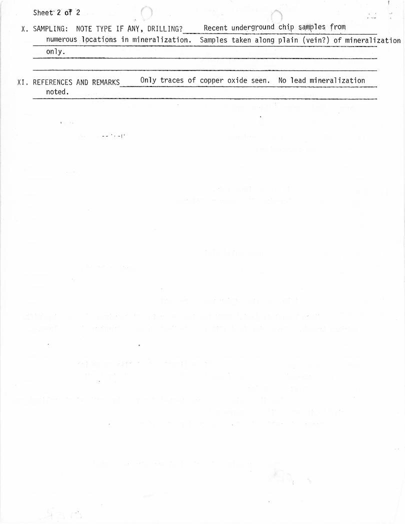
Sheet' 2 of '2
X. SAMPLING: NOTE TYPE IF ANY, . DRILLING? Recent undergrQund chip s~m~le~ fr~m numerous lpcati9ns in mineralization. Samples taken along plain (vein?) of mineralization only.
XI. REFERENCES AND REMARKS Only traces of copper oxide seen. No lead mineralization -----------------------------------------------------noted.

~ ~ ~ "
"' ~ ~ N Qt
<t-
" \~
f\
~ : I ' i I / ~ .. ~f } I , ' (Y) / fr - - --j l/.i>~ / ) '1 : li\~ / '
I ,~ ---- " / -~:::::{ - -- - ---,L: ./ I /"'-
I ' I '
" "'~ ' , I

Arizona Department of Mines and Mineral Resources
INFORMATION FROM MINE CARDS IN MUSEUM
----: --------;---- -- - -
ARIZONA MM 1425 Gold Ore MARICOPA COUNTY
WEBB MINE

DEPARTMENT dF MINERALRESOlJRCES State of Arizona
MINE OWNER'S REPORT
Date .. /l.av ........ /2?!:~ ..... . . ,. I ,
~ ~:::ti::-~:~!~.~ ' ~:~·~·~·.~~~~~··::··..~~~;~~t;~~~:.··· .... : Distance _____________ ______ . ___ ___ _____ Direction ____ ____ __ _______ ____ _____ ___ ~ Road Condition ______________ E.Q.!. ___ C _________________ ______________ __
• 3. Mining District & County: --)4/-e-~-d- - --- - ------ -- - -- ----/?)20-.~/:G--Q?_-q _______ ___________ : ________________ ______ : _______ _
:: ::::::~2:~;~~;1?:~~;;···.:.: .. ··::.· ...... :~.: .. ::::··:··..:":.'::::':.:::: Address:_13 __ ~_2 ___ ~ __ __ /{26nra--§;?----- -:-----Ph-Cl--e.L2)_;< _____ A __ rJ._~---:----------- - -- -- -- - -------
./ U 6. Operator: ______ ______ ~ ___ C_?.._£D-J;:'_------------------ -- --- _______ _ . __________________________________ _________________________________ _________________________________ _
Address: _____________ -___ ---___ --__ ---- --__ ---- -- -- ----- --- ---- ---- ---- ---- ---- ----------- ------ -_ ---- ----- ___________________________________ .. __________ .-- __________________ __________ __
7. Principal Minerals: ... C ... yc ..... 4.;,; ....... Aj ....................... : ............................................................................ .. 8. Number of Claims:-----------;----C------------------------- .-- -----.Lode _____ ________ ~~ __ __ __ .. ____________ Placer ______________________________________ _
Patented ___________________ _______________ : _____________________ -___ -- __ --- -- -------U npaten ted _______ _ v:.~:.~ ____ _______ . ___ . ___ . ___________ ." __________ __ _ " _________ . _____ .
9. Type of Surrounding Terrain: ____ _____ . ___________________ ______________________________________ __ ________________________ __ .. ________________________________________ _
.............. .................. /'ya.cLL2 .. b//.;;u:u;c,s ............ . .... .......................... .................................................................... .
10. Geology & Mineralization: ___ __ ______________ ______ _________ _________ __ ------------ .. -- ------------.--------------------------------------------------------- ------ .. --- .. -
/. J . . / . ~ " • /:,., . .. , '-:> cr,A/ .~ .-- --b1----d--Cl-r-t3-·-----·---v--:e--/.-/2-0------- .... ---.~-£.r.:-:1--~./--r.7--J---- -- -/)I- ----3- --~,, -- -d:::.----- -- --- - -----V.--.J.-):,::) .. -.6--<:.) W
c,c.</././../,' ..fl../. .cJ>:/:):f/ .... ,;';;L:::;;l..m. t'.:r:. ....~ .. S.~Q/;..?·."./ · ................................................. ..
11. Dimension & Value of Ore Body: _________ ___________________ . _____ ______ ____ _________________ ____________________________________ _______________________ ----- ___ _ I / ./ ..
------c:5~--.e.--y.---c..J.:-::-:-~. -I---- ... ---;R?_.Q-~.Cl---.,//<--./ .. -.------ ----9--c:/.--.(!.-r.r.~----. _____ ._1/_ -c.-/..-O - -~-------~-q--h.-. ---J J / --_..//
P __ 0 _ ----__ __ --- --9-)?-?-- -F-C-C--1--0. t2-L--e------ .. --0 __ b-;-o. -CJ- _n __ L ---------.~-----:/ -: ___________ ct_ -j-~ : :: . !':'- --- ----- ---- y --: i!j - -- •. --- - -- - - -- - -.
"';;"-- J_ -7-:4--I-:~ --------------------- -----:-----.. ------------ ------ .. -------. ------- --. -... -----------------,- -- ---------.------- ----------- --- -----. -----------------. ---- --- ---. -------. ----.-

12. Ore "Blocked Out" or "In Sight" : .... : ....... !2 .. Q. .. O._ .. ~._ .... _ ...... _ .. ; ....... :c.; .• ••...•••• : .. .................. .......... ...................... .
Ore Probable: ... __ .... __ .. __ C ..... __ ... ................................................................... __ ...................... __ .. .. .......... ....... ..................... __ .. .
13. Mine Workings-Amount and Condition: ..... .. ....... . __ ... __ ............................................. ... _ ............................................ ..
No. Feet Condition
Shafts ........... ~ ....... . :. . ... -..... ~~ .. ..c:::J........... . ... ....... fr-Q/..L. ..................................... -- .. --...................................... __ .. .
Raises ............. Q. .......... .
Tunne~s ........ Z-........... .. .. ....... / ... ~ .... 9............. . .......... G .. 9 ... q .. c!'.. ...... --............................................................................ . Crosscuts .... _ ............... .
Stopes_ ....................... ..
14. Water Supply: ..... _ .. £a .. /..;~ ............................ Y-1/..e.(/ ........ Jl. ./.7. .. -- ......... .L7J./../6s:/.../~ ..... -G-k;d.2 ........ . .. Ii .. d ........ /.2 . .=I.'./:nlt;:Jf····-!-<·,L .. "./e.. .. .c:~.~ ......................................... :.: ................................. : ........................ .
15. Brief History: ........................................... -- ... -.......... -- ............ -.. -- .. -- .... ... """ -- ............................. .. ........ ____ ........... ____ ............. .
f /. . L / ,.-, /.I ~.:p ' ~ ff:'~ / ) 1/ I ./ ,;/ . --. -- ... (k.,...a. ~Q': . ./.7..s .. /. cl..e.r.:-:.(lJo/..l .. {:.. .......... //- .. r.o..5; .... ~ .c. *'7"7"'''' -- ... -- ... <7-'r-.J.-- ... -- ............ ~ .Llr'.e/..r2r.-c c/ .
... S/7?--a.// ....... a.42..d. .. C/..p.L~ ......... . d.h ..... .' ... ';Y' .a.r:.c/~ .......... r..c .(~-: .<Z.Y. .. -e.-;:-::.~ .. c.I ........ 6. .. y ...... ..... : .
... cl.j.=a.s ... I.:. .. q. .................. ~ .... <.5.:*-.(;l.Ln;!2" ......... ,:,(72/:// ... --... ..... 0 .. -f?..v- ... c.).:::-.o./ ........ y ... c. .. q.r..~
... a.-Jl ... t:1 .. : ............................................... -- ............................................ -- ............ --.................. -- .. -- ........... ... ...... -- ... -- .................... .
... ... . ........ ·A/O·· ·····G.a ......... a .. r.«:...... .. 4./.···.G·.9·a.·~··7·Qf::Of?.f' ... A.t;;I<?(i:
16. Signature: ............................................................... __ .. -- ..... .......................... __ ...... __ ............... , ......... , __ ... __ ...... .. __ ................... ..
.. _ .. _------------ ....... -_ .. _------------------------------------- .. - .. .. ... .. ... ----- .. _-----_ .. -- .. -_ .. _ ...................... .. - .... _-------- -.... _---_ .... _----_ .... ----------_ .... _- _ .... - .. --- .... _- .. ------ ...... _--------_ .......... --._--------- .. .... .. ..
17. If Property for Sale, List Approximate Price and Terms: ....... ...................... __ ......... __ ........ __ ....................... __ ... __ ....... ..

DEPARTMENT OF MINERAL RESOURCES STATE OF ARIZONA
OWNERS MINE REPORT
Date January 18, 1943
1. Mine Hargan Mine
2. Mining District & County Webb Distric,t» Maricopa Co~. Location 7f miles due west of Gillespie Dam near old Agua C&lliente road~ Maricopa about 7£ mi. SW of the Arlington settlement. 3. Former name
5. Owner C ..
7. Operator C ..
9. President
11. Mine Supt.
'\
Webb Mine
E. Hargan :1,
E. Har8an
6. Address (Owner) 131+2 E., Monroe :St .. , Phoenix, Arizona
B. Address (Operator) Same
10. Gen. Mgr.
12. Mill Supt.
"l '~ \\ i I
J 3. Principal Metals "Copper 1 gold, silver y zinc ~ lead 14. Men Employed
15. Production Rate 16. Mill: Type & Cap. power arrasta
17. Power: Amt. &: Type
lB. Operations: Present None
1 9. Operations Planned Timbering 61 foot shaft SA on Lucy B Hargan iJJ (.see map) also location of faulted ore in winze tunnel No .. 1 Little Augusta#S.
~ 20. Number Claims, Title, etc. Little Augusta )
Nos" 1. 9 2, 3 y ii" ; 5, 6) I;
Lucy B,. Hargan Group Nos .. 1,2 p ],415,6,7
Recorded in Book 39» pages 257,266 2b 7 :g268,. 26 9 ~ 2~O,. III amended B-39 ,
Recorded in Book of Mines 40 Pag as, 478,,4791) 480 ~ 481 :1482 ? 483, ,48L"
21. Description: Topography & Geography Hee copy of aI)plication for a development loan lJ
Septem.ber 3~ 1936"
22. Mine Workings: Amt. & . Condition I have the key to concrete door tunnel #1 on Little AugU'staJJ5 ..
(over)

l ,
23. Geology &. Mineralization iIllS extend almost to amajo.r t .t lina, on east ends ..
24.
East of fault line is shales or 'schi'sts, west of fault line are diorites $ granit,8s ,gneissi,c rhyolite. Gold are comes in Tolcose 'Schists. Copper comes in lime formations apparently.
Ore: Positive & Probable, Ore Dumps, Tailings
Width of copper vein -shaf't 5A on Lucy B, Hargan #3 Width of copper vein shaft 6A on LUC~T B ,; Hargan f/6 Gold vein on Little Augtl'sta #5' is lenticular .. Runs '1/4" to ·three feet ..
from
14 inches, assay about 20 inches, assay
Also $3 in gold and
24~A Vein Width, Length, Value, etc.
25. Mine, Mill Equipment & Flow Sheet Have concrete mill at Webb well on Hargan millsi te ole.im. Gears and eQuipment are stored in shaft ,#1 on 1i ttle Augusta #5 .. All e Quipment was stolen spring or winter '42. Thieves burned concentrator table and wooden pulleys. Got back all but about $350 worth of stuff "
26. Road ,Conditions, Route (Good). Take new Calliente road from Yuma highway. Mine is two miles off new Calliente highwayot I use short cut marked by signs (Hargan Mine). I turn off new Calliente ' highway about 3 miles from Yuma road.
27. Water Supply Water 'Supply at my millsite at We@b Well has watered about 100 cattle during one summer and furni;shed water for a rapid 1 ,stamp mill at same time.
28. Brief History See application.
29. Special Problems, Reports Filed Lack of capital~ faulted are ledge~ No reP9rts by mining engineers ~
30. Remarks Prefer a government loan to prepare copper workings for production .. Tv.nnel j/l on Little August 1'f5 cannot be entered' without a key as it is locked . I have the key~
31. If property for sale: Price, terms and address to negotiate. Small .sum cash and 2CY/o royalty wi t h
proper bond ..
3 2. Signed .......... _ .. _. ____ 9.J,.~A.$n._9_~_.~.!.JI~.:rB.<:?_.l)..~ .. JJ.4?_Jj!~.JA?.nroe st. Phoenix, Arizona
33. Use additional sheets if necessary.

OWNER
HARGAN, C. E.
1342 E. Monroe st. Phoenix, Ariz.
GOLD, COPPER, SILVER, ZINC, LEAD
See HARGAN MINE - re sketch
MH-37 1-11-4'3
5-20-46