contact information mining records curator …docs.azgs.az.gov/onlineaccessminefiles/s-z/two... ·...
TRANSCRIPT
The following file is part of the
Arizona Department of Mines and Mineral Resources Mining Collection
ACCESS STATEMENT
These digitized collections are accessible for purposes of education and research. We have indicated what we know about copyright and rights of privacy, publicity, or trademark. Due to the nature of archival collections, we are not always able to identify this information. We are eager to hear from any rights owners, so that we may obtain accurate information. Upon request, we will remove material from public view while we address a rights issue.
CONSTRAINTS STATEMENT
The Arizona Geological Survey does not claim to control all rights for all materials in its collection. These rights include, but are not limited to: copyright, privacy rights, and cultural protection rights. The User hereby assumes all responsibility for obtaining any rights to use the material in excess of “fair use.”
The Survey makes no intellectual property claims to the products created by individual authors in the manuscript collections, except when the author deeded those rights to the Survey or when those authors were employed by the State of Arizona and created intellectual products as a function of their official duties. The Survey does maintain property rights to the physical and digital representations of the works.
QUALITY STATEMENT
The Arizona Geological Survey is not responsible for the accuracy of the records, information, or opinions that may be contained in the files. The Survey collects, catalogs, and archives data on mineral properties regardless of its views of the veracity or accuracy of those data.
CONTACT INFORMATION Mining Records Curator
Arizona Geological Survey 1520 West Adams St.
Phoenix, AZ 85007 602-771-1601
http://www.azgs.az.gov [email protected]
PRINTED: 09/05/2002
ARIZONA DEPARTMENT OF MINES AND MINERAL RESOURCES AZMILS DATA
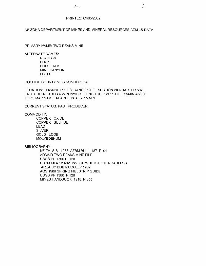
PRIMARY NAME: TWO PEAKS MINE
ALTERNATE NAMES: NORIEGA BUCK BOOTJACK MINE CANYON LOCO
COCHISE COUNTY MILS NUMBER: 543
LOCATION: TOWNSHIP 19 S RANGE 19 E SECTION 20 QUARTER NW LATITUDE: N 31 DEG 46MIN 22SEC LONGITUDE: W 110DEG 25MIN 43SEC TOPO MAP NAME: APACHE PEAK - 7.5 MIN
CURRENT STATUS: PAST PRODUCER
COMMODITY: COPPER OXIDE COPPER SULFIDE LEAD SILVER GOLD LODE MOLYBDENUM
BIBLIOGRAPHY: KEITH. S.B .. 1973. AZBM BULL. 187. P. 91 ADMMR TWO PEAKS MINE FILE USGS PP 1300 P. 128 USBM MLA 129-82 INV. OF WHETSTONE ROADLESS AREA BY BOB MCCOLL Y 1982 AGS 1988 SPRING FIELDTRIP GUIDE USGS PP 1300 P.128 MINES HANDBOOK, 1918, P 355
I I I I I
I ·It ~
I I ,
~-tLJ
I q j
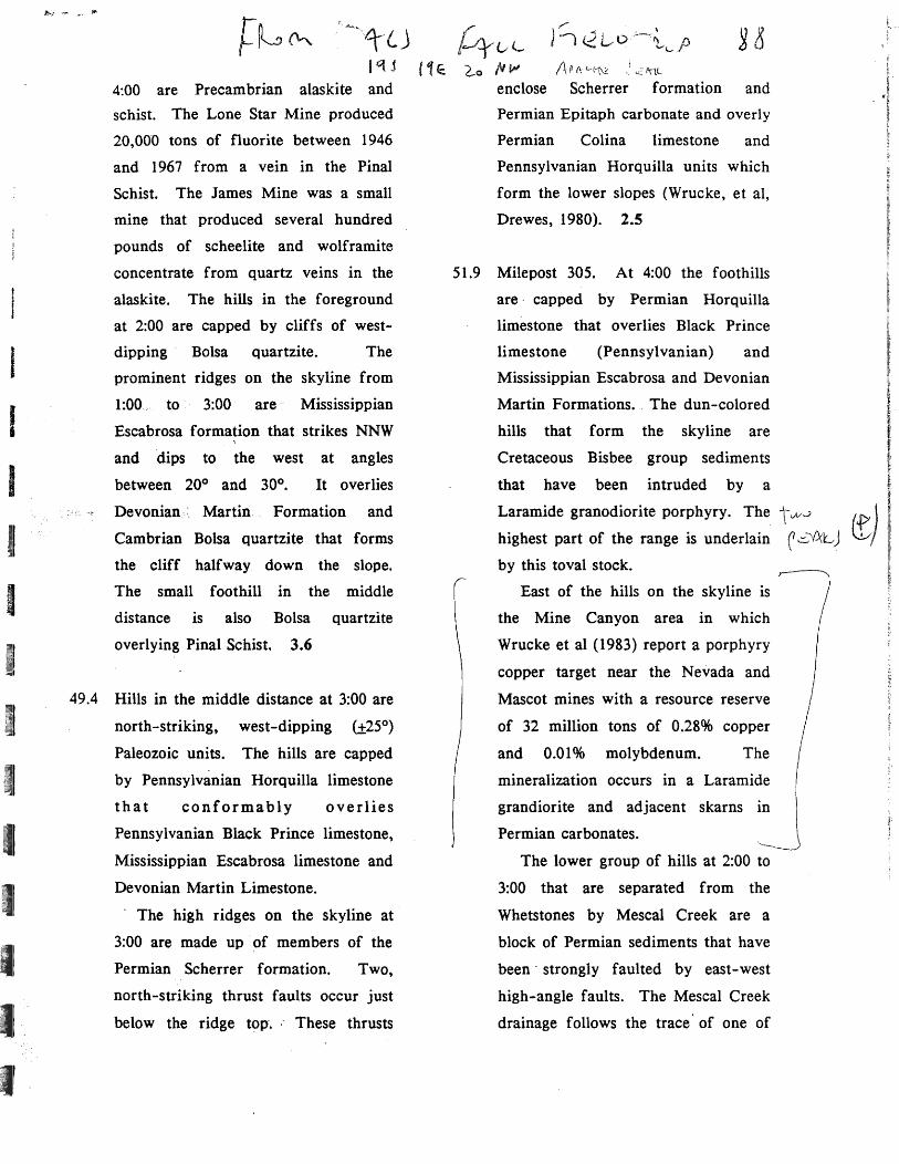
4:00 are Precambrian alaskite and
schist. The Lone Star Mine produced
20,000 tons of fluorite between 1946
and 1967 from a vein in the Pinal
Schist. The James Mine was a small
mine that produced several hundred
pounds of scheelite and wolframite
concentrate from quartz veins in the
alaskite. The hills in the foreground
at 2:00 are capped by cliffs of west
dipping Bolsa quartzite. The
prominent ridges on the skyline from
1 :00, to 3:00 are- Mississippian
Escabrosa formation that strikes NNW ,
and dips to the west at angles
between 20° and 30°. It overlies
Devonian,< Martin Formation and
Cambrian Bolsa quartzite that forms
the cliff halfway down the slope.
The small foothill in the middle
distance is also Bolsa quartzite
overlying Pinal Schist. 3.6
49.4 Hills in the middle distance at 3:00 are
north-striking, west-dipping (±25°)
Paleozoic units. The hills are capped
by Pennsylvanian Horquilla limestone
that conformably overlies
Pennsylvanian Black Prince limestone,
Mississippian Escabrosa limestone and
Devonian Martin Limestone.
. The high ridges on the skyline at
3:00 are made up of members of the
Permian Scherrer formation. Two,
north-striking thrust faults occur just
below the ridge t~P·. : These thrusts
40C l-o /II~'
enclose
,/
) I <2 Lro e~-,~<...p
1\ p (\ c..-l1;\2 "\lL
Scherrer formation and
Permian Epitaph carbonate and overly
Permian Colina limestone and
Pennsylvanian Horquilla units which
form the lower slopes (Wrucke, et ai,
Drewes, 1980). 2.5
51.9 Milepost 305. At 4:00 the foothills
are, capped by Permian Horquilla
limestone that overlies Black Prince r
limestone (Pennsylvanian) and I Mississippian Escabrosa and Devonian f r Martin Formations. _ The dun-colored I hills that form the skyline are I , Cretaceous Bisbee group sediments f
that have been intruded by a ~
Laramide granodiorite porphyry. The t vVJ ff") I highest part of the range is underlain r .::. V'X:L ) IJ..-. I by this toval stock. t
~. f. East of the hills on the skyline is ~
the Mine Canyon area in which
Wrucke et al (1983) report a porphyry
copper target near the Nevada and
Mascot mines with a resource reserve
of 32 million tons of 0.28% copper
and 0.01% molybdenum. The
mineralization occurs in a Laramide
grandiorite and adjacent skarns in
Permian carbonates.
The lower group of hills at 2:00 to
3:00 that are separated from the
Whetstones by Mescal Creek are a
block of Permian sediments that have
been' strongly faulted by east-west
high-angle faults. The Mescal Creek
drainage follows the trace' of one of

rr .- 0-,-.,
~~~ 7\ .......... L ...... 5.1&
\300 f- /2-8 Sandstone. shale, limestone, and conglomerate of
Late Cretaceous age were deposited on an unconfonnity of great local relief that had been carved into the Paleozoic rocks. Deposition of the Mesozoic strata was marine and nonmarine in a prograding delta near the margin of a shallow sea that advanced northwestward into southeastern Arizona from Mexico. The Cretaceous stratified succession is about 8800 ft thick.
The youngest Mesozoic rocks in the roadless area are granodiorite in sills and a small stock, and intrusive rhyodacite in irregular sill-like masses. These bodies were emplaced into the Paleozoic and Mesozoic strata about 74 million years ago. They are the youngest rocks in the Whetstone Mountains, other than a Tertiary(?) dike near the south end of the range, and Cenozoic gravels that crop out mainly around the base of the mountains.
The principal structural feature of the Whetstone Mountains is a southwest-dipping homocIine of Paleo- . zoic and Mesozoic strata Steep faults and thrust faults in these rocks generally have displacements of a few hundred feet or less and do not significantly disturb the homocIinal pattern of the strata The homocline and faults probably represent deformation mainly during the Laramide orogeny of Late Cretaceous and Early Tertiary age. Additional deformation probably occurred during Basin and Range faulting in the Neogene.
MINERAL RESOURCES
The Whetstone Roadless Area has a substantiated resource potential for copper, gold, silver, and quartz and a probable resource potential for lead, copper, silver, gold, molybdenum, tungsten, uranium, and gypsum. Fluorite and mercury occur in or near the area but no resource potential was identified (Wrucke and others, 1983; McColly and Scott, 1982). Mining activity in the Whetstone Mountains dates from the 1870s, but no mines have yielded ore since the 1960's.
Copper ore containing minor amounts of silver was mined from a vein deposit in quartz-rich sandstone at the Copper Plate mine in the 1950's, and the mine contains demonstrated resources of 2000-4000 tons of lowgrade copper and occurs in an area of substantiated mineral-resource potential.
Copper also is known in Mine Canyon just outside the roadless area The copper occurs in a porphyry-type deposit in granodiorite and in vein and replacement sulfide deposits in granodiorite and skarn at nearby mines. The area of the porphyry deposit as well as the
• vein deposits has substantiated mineral-resource potential, based on demonstrated resources of 32 million tons of 0.28 percent copper and 0.01 percent molybdenum (DeRuyter, 1957). Records dating from 1918 show that 128
I ..-..
mines in the vein deposits have produced at least 136,048 lbs of copper, 900,000 lbs of lead, and small amounts of silver and gold. A probable mineral-resource potential for copper, lead, silver, gold, and molybdenum exists around the area of substantiated resource potential. This determination is based on the assumption that copper mineralization extends beyond the area explored by drilling and mining, and on geophysical evidence that the granodiorite widens at depth.
Quartz was produced for smelter flux during the 1950's from the Ricketts mine, located outside the roadless area, north of Middle Canyon. Demonstrated resources of 5000-6000 tons for each vertical foot of quartz exist in that part of the quartz body that extends for a distance of 800 ft westward into the roadless area and is shown on the map as an area of substantiated quartz resource potential.
Tungsten has been mined sporadically since about 1900 from an area 1 mi north of Middle Canyon. Most of the production was from veins at the Chadwick mine outside the roadless area, although the James mine within the roadless area has recorded production. All of the ore-grade deposits were exhausted prior to 1960. and there is little promise of additional deposits near the surface. A probable resource potential for tungsten in this area is based on the possibility that tungsten veins occur at depth.
High-grade fluorspar has been produced at the Lone Star mine, on the north side of Middle Canyon. Although the mine is about 1000 ft outside the roadless area the fluorite vein system might extend into the roadless area at depth. The mine is believed to have been the largest single producer of fluorspar in Arizona Although the workings are now inaccessible, a probable mineral-resource potential for fluorite is assigned to this area
Uranium deposits occur in veins in Proterozoic quartz monzonite and alaskite on the northeastern flank of the Whetstone Mountaiits. High scintillometer readings, chemical values for uranium, and the production of uranium at the Old Windmill No.1 mine in Cottonwood Canyon indicate that additional resources exist at the mine. Demonstrated resources of 47 tons of uraniumbearing rock containing as much as 0.094 percent uranium occur at the Star No.1 (Bluestone) prospect north of Middle Canyon. However, the concentration of uranium in the mine areas and elsewhere is spotty. The northern part of the Whetstone Mountains has a probable resource potential for uranium.
Gypsum occurs in Permian sedimentary rocks near the south end of the Whetstone Mountains, outside the roadless area, and these same Pennian rocks occur within the roadless area, indicating a probable resource potential for gypsum.
A gold deposit at the Gold Crystal prospect in Middle
',.-.:;: ..
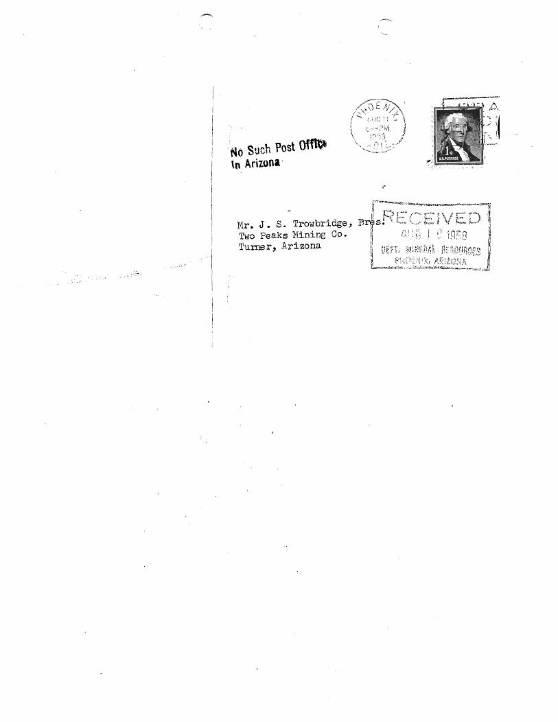
No Such Post Offb tn Arizona'
Mr. J. S. Trowbridge, Two Peaks Mining Co. Tume r, Ari zona

ARIZONA DEPARTMENT OF MINERAL RESOURCES MINERAL BUILDING, FAIRGROUNDS
PHOENIX, ARIZONA
August 11, 1958
To the Owner or Operator of the Arizona Mining Property named below:
Two Peaks ( Cochise County ) copper
(Property) (are)
We have an old listing of the above property which we would like to have
brought up to date.
Please fill out the enclosed Mine Owner's Report form with as complete detail
as possible and attach copies of reporm, maps, assay returns, shipment returns
or other data which you have not sent us before and which might interest a
prospective buyer in looking at the property.
Ene: Mine Owner's Report
TAKEN FROM THE REPORT OF THE GOVERNOR 1895
FRANK P. KNIGHT, Director.
TWO PEAKS MINE OCRISE COUNTY
VBD WR 1/28/76: The Two Peaks (Noriega, Buck & Boot Jack Claims) produced about 25 tons of copper and lead ores in 1915 (Section 20); Nevada & Mascot mine in Secs 20 and 21 produced over 1000 tons of copper ores from 1955 to 1959. The ores also contained silver, gold, tungsten and uranium.
MG WR 12/17/79: The Two Peaks mine is in the NW i Sec 20 T19S R19E (protracted) and in the Whetstone Mining District of Cochise Co. Intermittent production during the 1960's was reported by the caller for the Two Peaks.
HEM WR 4/29/88: A report on the Mine Canyon copper-molybdenum deposit was added to the Two Peaks Mine file, Cochise County. The report estimates 30 million tons of sulfide copper with an average grade of :OJ% copper. This deposit is not known to have been reported or described in the literature.

ARIZONA COPPER RESERVES
COMPILED BY
08/25/92
ARIZONA DEPARTMENT OF MINES AND MINERAL RESOURCES
PROPERTY:
TWO PEAKS
OPERATOR\OWNER:
Dugan Production P. O. Box 420 Farmington, NM 87499
LOCATION INFORMATION:
TOWNSHIP 19 S RANGE 19 E SECTION 20 COUNTY - Cochise AZMILS - 543 DESCRIPTION - 20 miles southeast of Benson, Cochise Co.
ORE TYPE AND RESERVE INFORMATION:
Sulfide - 32 MILLION TONS AT 0.28% Cu (a)
RESERVE INFO - (a) With G.Ol% Mo.
SOURCES:
U.S. Geological Survey Professional Paper 1300, p. 128. ADMMR Two Peaks file
MINE CANYON
COCHISE COUNTY, ARIZONA
MILS ;17
-;I ~_J " (f)
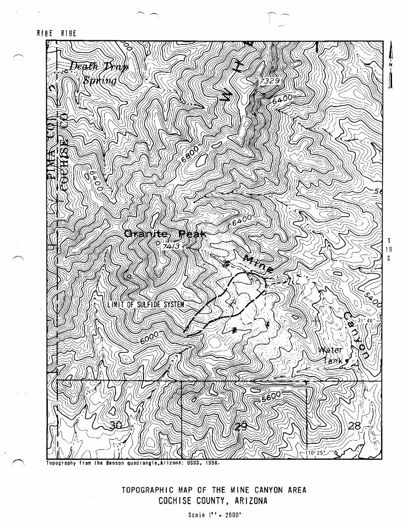
R18E R19E
TOPOGRAPHIC MAP OF THE MINE CANYON AREA COCHISE COUNTY, ARIZONA
Scale 1". 2000'
T 1 9 S

RJBE R19E ~~------------~------~~~~~~--~~~---r-r--~----'
Kb
/ /
I .. /: .c
I
\ \
t", , \ \\ I \ \ \ \', \ " ..... , .... --\ ,
, K r ) , , \1
\
"" t 'I ~ Pch , . . t . ~ , " PSU l • J \
'''\ l t , iJ
I t \ \
" Pch \1 ~ J J / " : H .1 I
\
P r "\ I I t ~ "!lIt I " ~ J \
~~ , I c~/,' t 1 '\ ..... I 1'1 iP. sA. J 'I
, I II., 'I --:-------- ..... ~ I~stl t /
, I', I I ,....,... I', I \ " " ........ \ .... , t \ I 'i' \
" '\ '\ I PI U I' I \ \ \ \ \Wb I " I \ \
\ \.. \ '/ ; \ , \ I' I , , I \ \ I I I' I, \' I I I t~_.J II" \ ,. "'"
/1/ r:t'. .JI:./~~.. . peu) ) I I I I ~ i Ps I I /
/'/ ,// /.1 / ~ : I I I ( '/ I I ( \ \ "', ~ ',\
t2J'~:-"''''''':'-'''''~~'~ .. '< ~ ',\ , ........ ,',\. \ " \
Kb .' "j)Kr)), \tau, );' . /'" ; \ ,'/
/ / / PsI I Plm I (
\ I " I I I I I \ \ , I I
I I
l' , ",
"\ " \ IPh'
\ \ \ \ \ I I \ \ \ ,
\ \ 1 I I \
, N
.. ~
T k. f (\ ( / krlr ) \ I, \ ~ ",oJ ( ,
-----.\.... 'Kia'!', \ Pch \ '\>~ ) ) Kb '\19 , I ·S
f\ II II
I I //
/" I / , J I I I
r, / ( ,-..,/ \ ) \
I r \ /"') I Kb.J \" (" I I I, '~I \ \/ aTg J
Ki
..,..--.-~
...:::- ' \ ..... " . "-
\ " . \ Kbl '\
\ \ ---.... , \ , \ I \ I I f I I
Creasey, S .• 1967, Geologic map of the Benson quad rang e, USGS map 1"470.
\.. \ i { (~ ~ , ---" , \ --l \ .... -, \
\
\ \ \ \
OTi \ " \ fie
\"-------" , , \ I \ I \ ~ \ ' \ KiP " \ \ \ \
Kb \ \ \ \
\ \ \
\ \ '
\ \ \ \ ,,/ \.. 1 Q 25' )'"
'/OT- ,'" County, Arizona:
\ Kb,g \ \
. \
I I i , 11: \".'" I j
K;b If-I , ! I ; I I
GEOLOGIC MAP OF THE MINE CANYON AREA COCHISE COUNTY, ARIZONA
Scale 1" 2000'
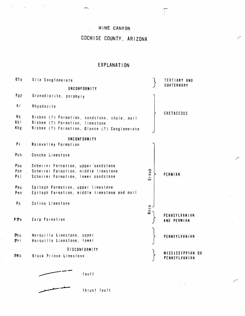
MINE CANYON
COCHISE COUNTY, ARIZONA
EXPLANATION
OTg Gi la Conglomerate
UNCONFORMITY
Kgp Granodiorite, porphyry
Kr Rhyodaci te
Kb Bisbee (?) Formation, sandstone, shale, marl Kbl Bisbee (?) Formation, limestone Kbg Bisbee (?) Formation, Glance (?) Conglomerate
UNCONFORMITY Pr Rainvalley Formation
Pch C~ncha Limestone
Psu Psm Psi
J Scherrer Formation, upper sandstone Scherrer Formation, middle limestone Scherrer Formation, lower sandstone
Peu Epitaph Formation, upper limestone Pem Epitaph Formation, middle limestone and marl
Pc
P (P e
IPhu IP hi
!PM b
Colina Limestone
Earp Formation
Horqui I la Limestone, upper Horqui I la Limestone, lower
DISCONFORMITY Black Pr ince Limestone
~-- fault
thrust fault
c::L. ::s o .....
o (..)
}
~}
} }
TERTIARY AND OUATERNARY
CRETACEOUS
PERMIAN
PENNSYLVANIAN AND PERMIAN
PENNSYLVANIAN
MISSISSIPPIAN OR PENNSYLVANIAN
,r

R1BE R19E
Kb
/ -
/ /
/ I
r, \ I II
I I /,
/" I , I I I I J I
r, / ( \ -_/ \ ) \
Kb
I r \ /'-l I Kb'! \.,. I I ~ ',I I \ I ...J
\ ~I aTg "
Creasey. S •• 1967, Geologic map
USGS map 1-470.
\ \
t",\ \ \\
" \', \ \ ..... , , .......... " .... -\ '\
, K r ) , I
\1 \
Pch ........ , I : I 1l,\ , Psul I ' \
, Pc h "'\' \ I I , \ I, I 1 I
" " I " P r '\ I " I I Pe u t
- ---) I "';J \ ,..".-".-/ I c~/,' 1 1 '\
(" I d 1'Ps~ ..J I - I I I '7 I ---------,~ I~s ~I .J /
I : I I" / " .... , ('", I \ I I , (
",,, I "i' \ " "\" I Psu I, I \ \ '\ \ 'J(b \ I " I \ \
\ \ l' ~ I, 1 \ \ \ \ \ I \ I, I \ \ I I I, I I I ,\
I I ' I ---' " -{ \ Pc \,
/,;/rt)r 1,)#: S I pe") '~) I I I J 7" " I I
/ I " I ,~' I ( I I ( I I I \\\, ~' ,\ , ,,, \. "
8]', ::- .... '.... ....... ~,:~,~ \, ~ '\ \ ", ...... ')", \ \ '\', '
Kb 'l/Krl) ,Pau I' II /J \ \ /J /
// j; ~ \ 1'-
/~/ 1/ I Ps I " Pam { r
I
1 , I , \ \ \ I I
I I \ \
'\ ,
J IPh I
f" \ IP hi
" ....... .......
[Phu
" , \ , \ \ ,
\ \
'\ \
'\
I ( P CPe \ \ \ \ \ \ I I I \ Kr U (, ~ / fI~ :'
I I \ \. K r .1....', ;' \ __ --__ ~ I, \ ...... \ ( \
J , \" ,~ 'Kb(' \ '\ ''\\ '1 "
\ , '\ \ Pch \ \ I / \.. \ i { (- / ' -........ "
I I \
Kg
---- ....... 4C_ \
-" "-\ " \ Kb I \
\ \ \. \ --........ I
\ 1 \ , , I I f 1 I
Kb
County,
, '\ --.) \ --- -, \ \ ,
\ \ OTg \ '\
\ Pc \
\ \
\ \
\ Kbg \ \
\
I 11 \; .... I
Kbl.L, I I I 1
Kbt \ ,
OTg
GEOLOGIC MAP OF THE MINE CANYON AREA COCHISE COUNTY, ARIZONA
Scale 1" 2000'
T 1 9 S
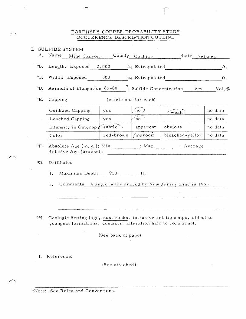
PORPHYRY COPPER PROBABILITY STUDY OCCURRENCE DESCRIPTION OUTLINE
10 SULFIDE SYSTE~1
A. N a m e _____ M.;;;.;i;;.;;1.;;..;1 c-. .. -.;C~a=n~y..;:;o..::.n=--__ C 0 unty Cae his e State Arizona
::13. Length: Exposed 2 1 000 ft; Extrapolated H. ----~--------- -----------------------
::t::. Width: Exposed 300 ft; Extrapolated fL ---------------- ------------------------::D. Azimuth of El"ongation 65 -60
o ; Sulfide Concentration loVv' VoL % -------
(circle one for each)
-
Oxidized Capping yes \
,,:::----. no .-J c~~:k~~, no d;::ltCl
Leached Capping yes vn-~'-'\ no daL-l
Intensity in Outcrop ( ,,, .. , ... , ..
obvious subtle' , apparent no data
Color red-brown (maroort bleached -yellow no data ---------
~:T. A bsolute Age (In. y. ); Min. ------- Max. Average -----Relative Age (bracket):
::c. Drillholes
1. MaxitTIum Depth 950 ft. ------------------2~ Comments 4 angle holes drjllcd by New Jerst'Y Zjnc in 196)
::~H. Geologic Setting (age, ho st rocks, intrusi ve relationships, aIdes t to
youngest forrnations, contacts, alteration halo to core zone).
(See back of page)
1. Reference:
(Sl\(> attached)
::~Note: See Rules and Conventions.
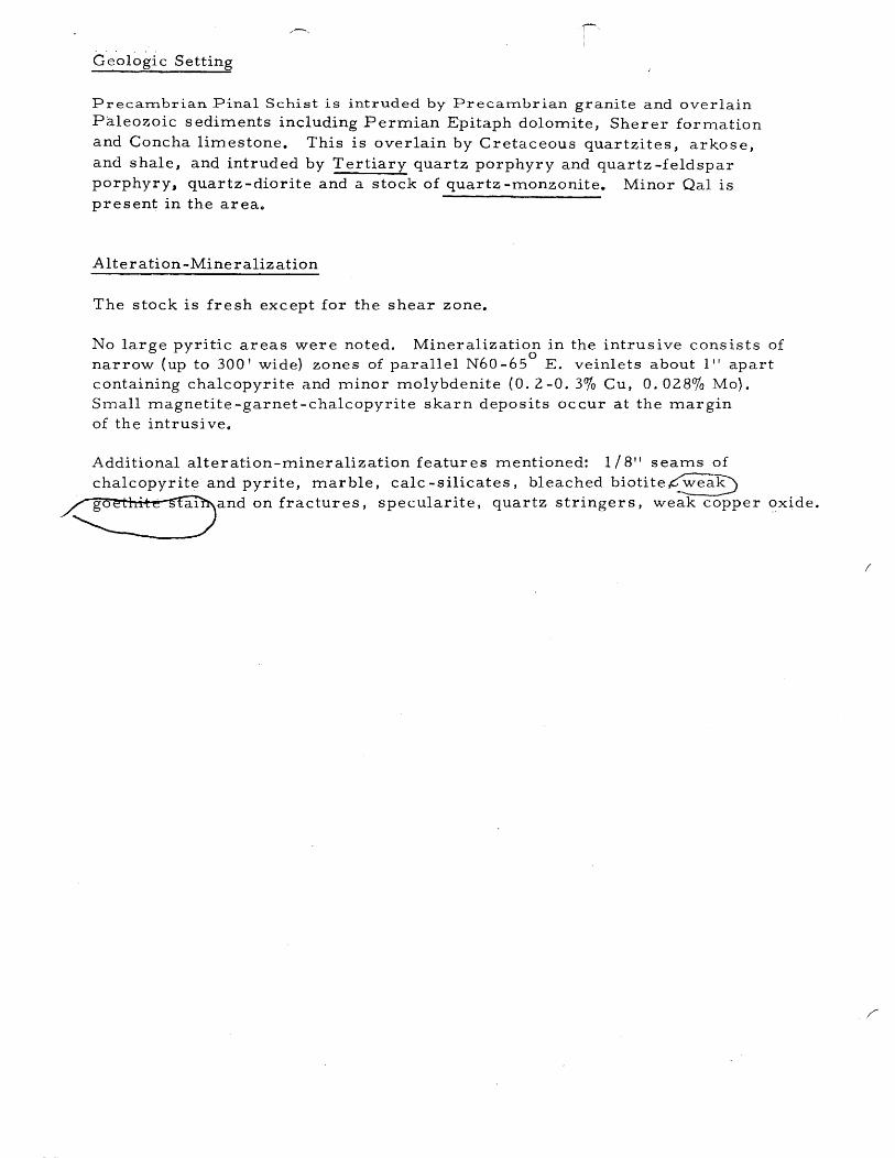
Geologic Setting
Precambrian Pinal Schist is intruded by Precambrian granite and overlain Paleozoic sediments including Permian Epitaph dolomite, Sherer formation and Concha limestone. This is overlain by Cretaceous quartzites, arkose, and shale, and intruded by Tertiary quartz porphyry and quartz -feldspar porphyry, quartz -diorite and a stock of quartz -monzonite. Minor Qal is present in the area o
Alter ation -Mine raliz ation
The stock is fresh except for the shear zone.
No large pyritic areas were noted. Mineralization in the intrus i ve cons ists of o
narrow (up to 300 I wide) zones of parallel N60 -65 E. veinlets about 1 t t apart containing chalcopyrite and minor molybdenite (0.2 -0.3% Cu, 0.028% Mo). Small magnetite-garnet-chalcopyrite skarn deposits occur at the margin of the intrusi ve o
Additional alteration-mineralization features mentioned: 1/8" seams of chalcopyrite and pyrite, marble, calc -silicates, bleached biotite ~ea0
/~~and on fractures. specularite. quartz stringers. weak copper oxide.
(

)
Sulfide Sy stem N am e_..-..;M~i~n~e~C:.:.a!'.!.n.!..ly~o~n.!.-______ _
II. Diagnostic Reconnaissance Characteristics
A. District Prospect Zoning Outside of Sulfide System
1 . Prospects / Mines Min. Diam. (M) Mines
j Metal/Type (feet) (P) Prospects Rock Types
B.
-'. ',-
Cu None
Ph-Zn V M
Ag-Au
Mn
Other
Other
Dike Swarms
Rock Types None
Length (ft. )
Width (ft. )
Azimuth (0)
Age
Spatial ReL
Contacts
Other
mportan tR eglona 1 St ruc t ures ( th 0 er th an 1 e swarms
Type tilting Normal Faulting
Length nd 10-20,000' 0
315 0 Azimuth ( ) ,:arious
Recognition outc rop pattern displacement of stra ~a Factors
Age Laramide ( ? ) Tertiary
Spatial R el. none none
Contacts not mineralized
Other 0 20 - 30 dip Southwe s
~:~ D. Other Reconnaissance: (See back of page)
Deposit Types
Skarn (Nevada M ine

Reconnaissance
A geochemical soil anomaly downstream from Mine Canyon (Granite Peak) is about 2x backgroundo
No comprehensive geologic report is available in our files.

S ulfi de Sy stem N am e_--:.;M.;;;,;l;;,.;;· n.;:.:e:;......;;C;..;:a;;;.;;n;.;..yl....0;;..;n~ _______ _
III. Center of Mineralization (zone of best copper)
A. Name Mine Canyon Deposit ------------~----~---------------------
~:~B. Copper Mineralization
Av. Rock 1. Type ~:~% Grade Type ~::Other Data
a. Primary V- 100 0.2 quartz monzonite
h. Enriched
c. Skarn ( replacement)
d. Oxide
e. Mixed
2. Current Mineral Inventory
a. Tons 30xIO- 6 ; Av. Grade __ 0_o_2 __ %; Cutoff 0., l( ?) %
b.. Other Credits ----------------------------------------------------
3. Past Production
a. Tons none Av. Grade %; Cutoff % ---------------------- ---------- --------b. Other Credits -----------------------------------------------------
C. Cover
L 100 % Expos ed at time of di scovery
2. Projected Post Mineral Cover
a.. Thickness (ft.) none ----------------------------------------------------
~:~ b. Formations --------------------------------------------------------
~:~ c. Estimated 4 elevation of base of cover to top of cc blanket (ft. )
3. Premineral Cover
a. Thicknes s (ft.) ----------------------------------------~----------
b. Formations

References
Jacobsen, H. S., 1958, Geochemical reconnaissance, Whetstone Mts. , Cochise County, Arizona: BCM-SW Rept.
Jacobsen, H. S., 1959, Granite Peak, Whetstone Mts., Cochise County, Arizona: BCM - Memo.
Mackelprang, C. E., 1969, Mine Canyon area ground magnetic survey, Cochise. County, Arizona: KEI-GDO (Nov. 14).
Mancuso, J. D., 1965, Kalaf property,· Cochise County, Arizona~ BCM-AD.
Michel, F. A., Jr., 1962, Examination of Nevada Mine area, Southern Whetstone Mts. , Arizona: BCM-SW Rept.
Phillips, J. S., 1969, Porphyry-type Cu-Mo occurrence Southern Whetstone Mts., Cochise County, Arizona: BCM-AD (Feb. 3).
Tyrell, W. W., 1957, Geology of the Whetstone Mtn. area, Cochise and Pima Counties, Arizona: Ph. D. Thesis, Yale Univ.

·., .. "-...,, ~/r«~ 71-~ .. Y-• -.' :·1
/
SUMMA~Y REPORT OF MINERALS EXAMINATION
state ___ d('(_?; _____________ county ________ ~~_6!~_~ __________________ Mineral prCc1ucts ___ ~~_A.4 ______ _ Name of proper~~; deposi t ...... ".Q./B~/rj!JJ!!/~;j$(~iJ!jlci··J;·:7;~···· Da t e examlned ___ ~--0k-----Englnee r ______ ~, _____________ V4_A ______________ Da te 0 f thlS report _____ 0 _________________ _ Reason for examination __ cll2_~ ________ ~_:dt. _____ j6_L ____ £i:-':J-----------------------------------------------------..
Engineer acoompanied by ________ .t!c0 ____ {?_!2_tff:.: _______________________ Address __ ------------------------------------------------------_ow. /-\. I I ~ ~ . - , '1 ~ .(j
L_.An t 0 f prope rty ____ /!/ ___ Le1.~ ________ 3_;2._ .... ____ tZ ____ e_ .. _____ C!a.L_m._v._~-:tJd..tit.;f)flZ-Q_.~_ .. .
Owner .. u.Jr.6. ... i;./!.s.;/; ... ,;i ... /:-1f.I2/.l2f·· .... ~.L..·Address ................................................. , ... .
Leased or optioned to_._ .. ______ ~ ________ Q_:!2£ ____ ?. ______ ... _______ AddreSS _______________ .. _______ .. ___ .. ____________________________ _
Loea tion of property (be specifio) __ .. ___ .;;[(/!._<::;? ______ i'!._?!;:. ____ 0..& ___ .:i!: __ i? ____ 't.._i!.._0 ________________ . ___________ _
.~j~-i//. ........ ~Vx~ .... T-~ .. ~ .. ~ .... !? .... , ............. . Typ~and mineralogy (brief deSCriPtlOn) ... ?"6qkr-yo..k .. 7 ... ~//.~r.4.o.d .. . le.!!.d ... .c:.ff.r.h12Q!f..$ .. ..J../} .... k£C4..ro.f..d...c...·.,.'l/.?!/J././zr;; .. f9-b.y.f/-;.aa/ ..... 1.:2 ...... .
dq..Q.'t.y::>.J"*'f.C.dZ..eof05 .... !.!:2 ..... L>ft.s;.'?. ... 409.e..J..i9.Q<::, ..... ~1"1.":..k/l..J!:.t ...... , (' !ff'vk" .. <A~ ~/'vJt("~, . . . l<tr6wn dimensions of the deposit ·f / I 'f /. . l._ . -.f
Length __ ~ ______ l!lj/.!Z ____ Width __ ~tt!Y:Ut!:1_li.pepth. ____ .{/!..2 __ .. !2!!.~~!.lJ_.
Attitude of the deposit (strike ~ dip, etc t, )'-:._:1 ___ ~_?'?'_Q __ ~_~?:~ _____ .::-:: _____ a!.:1-::Y.~._!:!:q::~:1;;~~;{~rz.. __ -;_ .............. __ ........ __ ....... _____ ........ __ ................ __ ...... ____ ...... ___ ................... ___ .. _ ......... _ .... __ ....... _ .............. _ ............................. _ ........... _ ..... _ ....... ___ .. __ .... _ ....... ____ .. ____ .... __ ........ ______________ ..... __ -_ .... .1 ................ ..
Pos sibl e ext ens ions; co r reI a tion 0 f known showings _________ ... ____ .. __ ........ __ .. ____ . __ .. __ ..... _ ....... _____ . ____ ._ .. __ ... ___ ..
~----------------- .. -----------........ ----..... -..... ----.... ---- .... ...... _--- ...................................................... _- ................ _ ......... -- ...... _- .... - .. ----- ... ---- .. ---------- ..... ----------- ...... _-- ............. ----- ...... -- .......... --- ...... ...
.......... - ...... -_ ...... _-----_ ........ -........ -... -- .......... -.. -- .... ~ .. ------ .. -.. --- .. -.. --- ... -- ... -..... -- .... -... -..... .. ---- .. -----....... -............ --- .......... _- -- .. -------------- .. -- .. -.. --- .... ~ .. --- ........ -- ...... - ................ -- .. -........ _---- ...... ...

j I 1
~
Mining and milling equipment on prope'rty _______ i1{r:J/J...~ ___ ~ _____ ·_. _______________________________________________________________ _
____________________________________________ .. ___ .. _____ _______ .. ______ .. __ .. ____ .. __ .. ______________ .• :_ ...... _ .... ~.:.4._. __ -:_ .. _____________ ...... ___ ... ___ ... ____ ...... ___ .. _ ...... __________ ............. _ ......... __ ............... ...
Paot production (if an,'l .. JJi,{;!;v .//fiLJ . .o. ... ~.J:;j: ..... ~ .. !.~ .. ~~ .. .. ~~~ .. L.~.-.I:d..~.-~ .. J.'J.L.~llX~~S'fp Pre s e~ t ,ra te 0 f p roduc t i on (i f any) ------i1~t,g./-------~-----~--------~----------------------____________ ... _. ___ ._ ..... _______ . ___ . __ _
Sampl ing' (desc ri be brie fly, 0 rat tach ske tch) _______ ~ ______ . _____________________ .. _____ . ________________________ _
" __ .... _;- ___ .... _ •• r ____ ....... ___ .. __ ................... _ ... __ .. __ .. __ ....... __ .. _ ... ... _______ .. ":" _____ .. __ ...... ~ __ .... ________ • _____ .... _ ... __ .. _ .. _ • ..... _____ .. _.-:- __ .; ___ ................ _______ . ______ ... _ .. _______________ .... ____ .... __ .... _______ ..
-~----------------.-------------------.-------------.-.---~~~~~~~:~--:~~~:~~~--~;--~~~~~:~~------------------------------------------------------------
(Subject to revision when assays are received or after engineering calculations)
Measurable _____________ : _____ ~ ____ . ________________ . ______________ tons_ .... ____ . _________ .. __ . ___ . __________________ . _____ Grade ________________ . ________ ;_. _____ .
Indica ted ____ . ____________________ . _________ . ___________ . ________ . __ tons_. __ . __ . _________ . ________________ . ____ . _______ ~ ____ Grads _____ . ____ . ____ . __________ .. _._. __
In fe rred __________ . ____ . ____ ,.' ___ .. ______ . _________ . _________ . __ . ___ tons. __ .. ___________ . ____ , .... _______ .. ,._." . "Gradf7_ .. _. ____ ~ ..
Mining me thod (ac tual 0 r sugges t ed) _______ ~ ____________ . _________ ' __ . ___________________ . _____________ ._. _______ ' ___________________________ ..
-------- .... __ .... _----,.'-- ...... ---------_ .... -- -.... ~.-- ....... ---- ...... -.. -......... -.... -..... -- .......... --.- ......... -.. -- .... -........................ _- .......................................................................... --_ ......... - ....... ---------_ ............ --
. jl .'-1., zI' J .. /--i... Milling or processing method (actual or suggested). ______ :~~-.-- . . _1df.:-::-:~;t..1:~-;'_.:f_. __ ~ ,
.~1l------.- .... -.-.-.. ----.--.. ~ ... -.. --- .. -.------------------.---------------------.--.--.----.-----...... _.------------------ ____ ._; _______ ._. __ . __ . _____ .. -..... _.-- .. _ .... . Processing tests suggested ....... _____ . __ .. _. _____ .. _________ .. _________ . ______ . ___ . _________ . __ .... _. ___ .. __ . ______ .. _______ . _______ ._ .. _._ ... _____ . ____ _
Tentative Co;;cluoi,;;n and d~ci~ion .. ~.h .. ~~'1tAt.¥!.. .... ~;~~~ ~~···Ir-····~··~··-~··~··~=~h"·j~········ t!::.:~.; ~~~~~·~~~v:::!:=~:!r:::~:~~····~~?::/~1~:~
deposi t, his impression of the owner, and any other confidential information he n:ay G~,r8
_ i'. I) <=:,}rn,~. ~. ?.'2£';:::- t:-., all.} l:,::.-.0Wi.i }.>l":J.Vi- exaurlrratrons'a:n-a--r'EfportS. Me:Y-be executed in pencil. Should be mailed within 24 hours after examination is completed.
Send original and one copy ta Washington Office.
L
Le!Jiul.1
tf",#>I·f i "",,/ /t'rmqf:'~A{I 4#:H"4Jt(",.'I" m 6 ... ".dfl
El) 4,...nl/"e I'",rl'h yr Y
~ PO"f"hyry (P",rt N,mz",,.ir<li m .t./n?" ",1""".-(fjlJlln.l,,:J,/r ..
-1 I'''''fhyry ;.' (I'"rl' /'1."Ur>"';T",~
I(J Ill'
~ " V)
"" " ... ct
, .~
INTRODTJCTION The followIng pages have been compiled for thepurpose of giving the public a brief outline of the
conditions and prospects of the TWO PEAKS MINING COMPANY· Iu this brief space we have tried
to condense matters as far as POSt51ble, doing a\vay with useless and meaniugless phras8s so often seen
in prospectuses.
YOUR QUESTIONS ANSWERED FOR YOU QII{~I,o\UOil. Whor'e 18 the property located?
A flI!W~\r. 1 n tlwWhetetone Mouutains, Coehie e County, Arizona, 20 miles west of Tombstone,
Arizolla.
Q. H ow' far is the property from a ra.ilroad '?
A. Tw(-)l va miles. connected by a good wag on road.
Q. For what amount is the Company incorporated?
A. $2,500,000, stock fully paid up and non-assessable. (One million shares, par value $2.50 per share.)
This includes the CONSOLIDATION of the various groups consisting of THIRTY-EIGHT claims,
about 750 acres.
Q. How many kinds of stock have you?
A. Only one, all common, non-preferred. There can be no freeze-cut of small stockholders, but
equal dividends to all.
-2-
1 i i
1 I

",,{,,,, "
0,HOW'NG ROAD LEAVING DEPOT GOING TO TWO PEAKS MINES. GOOD ROAD ENTIRE DISTANCE.
-3-
f'

; 7IiFi!J. _ J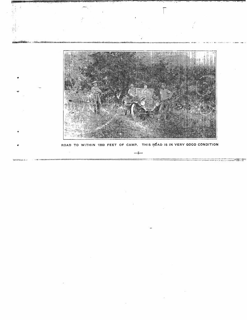
!.~.1f, or .. ,. 11.~ 1 . ~,·J._~ •. t. 'j.""'" gUt .';r~~~
ROAD TO WITHIN 1500 FEET OF CAMP. TH!S !JOAD IS IN VERY GOOD CONDITION
-5-
J .... _-
I
HISTORY The Whetstone District has been known for years to carry copper values. In years passed the
former owners were prospecting and looking for high grade ores that could be shipped without con
centrating.
In practically every place work was done, copp er values were encountered, but the owners did not
dream that this work was cutting a continuous dike of sulphide are. After years of }ndividual work
the numerous groups were consolidated into what is now the TWO. PEAKS MINING COMPANY, and
this large low-grade deposit WILL BE WORKED;
GEOLOGY Touching the western end of the property, an intrusion of granite is eX.posed, having a coarse
grained texture, the crystalline grains varying from 3 to {} mHimeters, the minerals detectable by the
eye are unstriated feldspare, quartz, biotite and occasionally crystals of amphibole. Running east the
te/ture exhibits porphyritic phases.
East of this granite intrusion is what appears to be dikes of granite-porphyry, monzonite-porphyry
and porphyry in the order named. The granite porphyry being distinguished from the granite by the
sharply bounded crystals embedded in a distinctly finer grained matrix..
-6--

'~~illllll •• IIlI!,"II,,!III, ,'I.I,@IIII, ."Il,"IIl!._.,~",'$,I., .• '.,.IIII, 1$..!l!!I".,_!JIIII!I",~, T.~.!!!!I~,.J.!!,rt<!!!".~j,I!lI!1l,.!If!l,I!!;!':!!_il!l,lIit~,£[!!II",~!,~!!!I,~1!!~!!",~"lI!!i!!!!,J!jII, •• Nf:ilil.",.W!,.,,!!\!!,["'!I1!!!!S[II!!F .•• iJIl!,IlIp-mlll!. ,~.IJIIIIIIII!'!!!IfiIIIIII~"IIIII!III!I!IIIIJ~.IIII,,~_I!.,.'!I!'!EIllliF ,!IIII. __ !!I-__ !f!III"~-IIII_!II.I!l,"~, _!II .• ,.~ __ !!I'!_'Il.!III. 1I!!,,!I!I~i!I. ~~§! .• ~, .!111!1 .. ,!!JII!_!I!';!I."'lll,,!I!I,.I!fI_ '1 -.
, ,
Killil_ili4~~~~~ii!il ~iijl"I~~ija~!l!,jiii1'\i1ii~M~ .• ~"'.o/Iili<lt~~~lP.i_"'''''''''''_rt~._~ __ """ ...... __ ,_.~""""'_~'""."."' ... """'_. ""~_"""""'"""_",,,,,,,,,,,,,,,,,,~,,,, .. ""h''''''''
SHOWING EXTENT OF DIKE SOUTH -7-
body of primary ore such as this is would indicate a nd lead one to believe that it should go down to a
great depth. Numerous illustrations of the prima ry are bodies that are developed to a considerable
C(t-'pth could be cited, but as an example of a racen t developed primary ore body, you can take the
Verde Extension. By this it Is not meant that the properties ar e similar, but is merely a comparison on depth ot
primary ores. The ores found on this pro~rty are of a lower degree of enrichment, near the surface.
The limestone outcropping on the north and as at of the property is carboniferous. The fossils
rarely appear on the weathered surfaces but some corals and crinoid fragments have been found, two
species of "Eumetria Marcyi," "Phanerotinus Paradoxus" and "Brachiopods" were found.
The thickness of the beds have not as yet been determined. The limestone shows great power for resisting erosion and stands out very prominently. The
contact is not well exposed owing to the overburden. The beds strike approximately east and west and
dip 46 degrees south. Very little development in the limestone on the TWO PEAKS property has been done. but in
workings on the Mascot claim there shows a body of sulphide ore (Boronite) with some Covalite.
This ore occurs along altered beds, where segregat ion of the garnet has taken place. The ore seems
to follow the bedding planes more of less, this bodY mentioned bas a dip south into the AMzona claim.
and in depth probably would be encountered. AJ:I intrusion of Andesite crops out on the eastern
part of the Mesca.l claim, but so far is undeveloped and cannot be connected with the ore bearing
areas. -8-
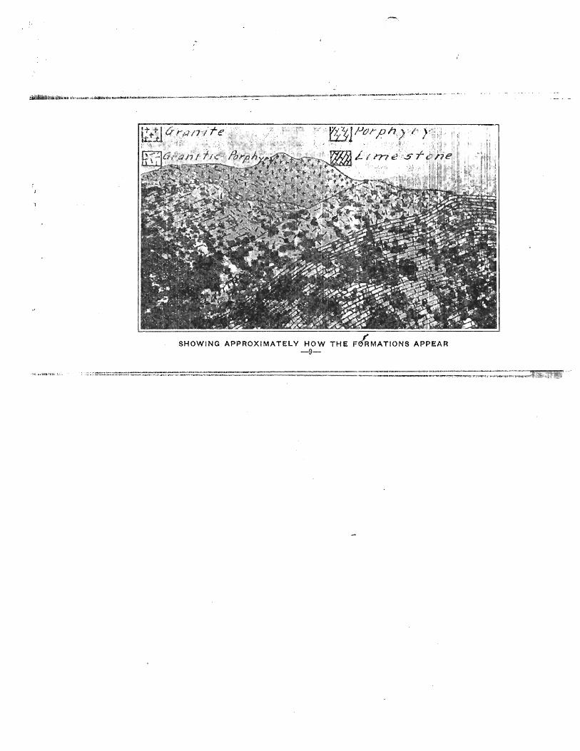
SHOWING APPROXIMATELY HOW THE F~MATIONS APPEAR -9-
s~
-
DEV'ELOPMENT Development work has been confined principally to the monzonite porphyry and porphyry dikes. On
the Arizona claim a shaft eighty-five feet was sun k cutting are from the surface averaging abou t 1. 24
per cent. South of this shaft about 150 feet, a tunne.l was started on the Arizona claim running into
the Buck. At the mouth and in for a distance Of about forty feet the ore is oxidized and some leach
iU5 has taken place. From forty feet into the face, which is 205 feet from the mouth the sulphides
were cut, the average of this distance being 1. 87 per cent copper. 'l'wenty feet from the face, short
cross-cuts· were run north and south, disclosing th e same copper values.
About 300 feet above this tunnel another tunnel was run a distance of 40 feet. The average of
this 40-foot tunnel is 2.8 per cent. One car from he re was shipped to the Douglas smelter giving an
average of 4.03 per cent copper. 200 feet above th is tunnel an open cut was run, cutting about the
same 9re.
Numerous shallow shafts and open cuts have been done along the dike, cutting the same class of sulphide ores. (Study photos and maps) .
This property without doubt is one of the big 'copper deposits of Arizona, Porphyry outcroppings I J '1. I
along the Fairbanks. White Oak, Arizona, BUCk, Thomas and Near Christmas claims stand out in many places exposing oxidized and sulphide ores. (Surfaee Oxidation).
Samples taken from these various surface crop pings run from 1.2 per cent to 2.04 per cent coppeL
It is the present intention of the company to m nlS-' shaft 500 feet on the Fairbanks claim and then
-1~-
:'1l

• !
ORE
ORE
ORE
~~ ~ ~ ~ ~ ~ ~ ~ ~ ~ ~ ~
" ~ ... '" ..,
~ ~ <:> ... ~ ~ ~ '" ... ~ <:> (;) '" .... " 0; '" " ... ,~ t\, ~ " 0) t\j "- ...:.
~ ~- ~ ~ t~ ,,~ ~ t~·~l~ ~
<:I <:> '" 'to ~ ~ '" " ... '" () ..... Ilo, "l '" "" ~ ... ... ~
~ ~ "- riJ <iJ -:.. "- ...:.. "- " Verflc at 'secfion ShdWlnf vp/ues +' ore cuT
S~e cut /II(J,.1, /5ec f,'on fh,...ou h IJ. 13, nnc;/ C.
This Cut shows the ore cut in the Buck Tunne1s. This lies in the Monzonite porphyry. Cut showing the Buck Tunnel on n(>xt page, being a section through A., B. and C.
-11-
Study the

1,
drift. into tne Buck claim, when the distance to the face of the Buck tunnel is reached, a depth of about 900 feet will be develor:ed.
Along with this \vork we expect to start cnu rn drill holes to a depth of 800 feet each with 200 foot centers. In this way the property can be prov.-'n U 1) and blocked out very quickly.
Tests have just been completed on 2.0 per cent ore from the Buck tunnel givIng a 75.0 per cent extraction by table concentration~ crushed to 20 mesh.
Oil flotation tests on the tailings from the tab Ie concentrates give a total extraction of 91 per cent.
As soon as possible the company will install a concentrator to work the low grade ore from the , ' "Buck."
The CONSOLIDATION of the various Interests' gi'y~s .the "r'WO PEAKS MINING COMPANY a very
large group. consisting in all of 3f claims compri~j ng about 7~ ACRES. Water for milling will be
developed on the ground. A great deal of timber c an be cut for mining and fuel while developing.
The officers ot the company are practical mining men. Mr. Trowbridgo has followed mining for thirty-five years. Mr. Akard has spent many years at practical minjD,g.
The management and direction or the work at the mines will be under V. G. Mellgren, B. S., E. M., mining and metallurgical engineer.
THE FINAL WORD We have tried in as few word~ as possible in t.he foregoing pages to give you an outline of what
,........12-
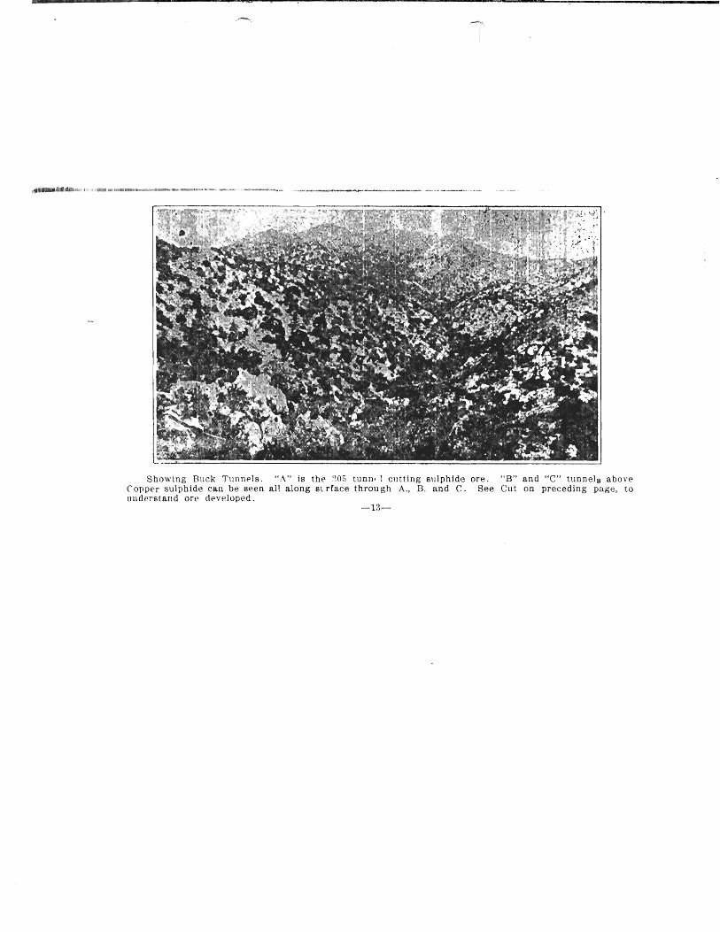
Showing Buck Tunnels. "A" is tht' ::Ofi tunn. 1 cutting sulphide ore. "B" and "e" tunnels above C'oPP€'f sulphide can be seen all along St rface through A .. B. and C. See Cut on preceding page, to lI11dprstand orp devpjoped.
-li\--
i1llr pr()~\"rfy (',llll'\h'(f> alld its prollalllp fUlun>. \V,' hav" in no way Illlsn>pr,'sf'I1J.,(j to YOIl H C'ingif'
Illi:II,)!l "\I,;;ili.:': (lIlt! Ii!"lllly bl'lit'vl~ that our prop,'!"!:> ita::; all. it' !lut llll)n', 1l!I'ril rll;Jll Wi' hav'~ slal,·d.
\., ,'.;.;,( Y';II tIl :,;llldy Illl' lllaps and gin' ('art'flll llltl'llliu)) 10 till' plt,.ro<-;r<ljdu.;, wlij(:h !Slit)'" Itp'
;.,1 :::,d Ill.' tallll' as if you yuu!"Hl'ir Wl-n> on illt, prupl rty.
\\l' would call your attl'lltiull to ('l1IS No. ri ~uld (;. ('lit No. fi is a ",'('liO[1 Illri)llglt .\. II ('
SllOWII un t'U! un ;\0, G, and JOI) call :'H't~ by ~ll"SP,(,\llS Ilw hurly of' cOJlIH'r slllphirJ .. d,'vl'joppd.
\\'p 111'\' gl)illg to put a, lilllil\'(j HHlOlIll! ,(If HI()('h Oll thl' 11I<I,!'l,!'!, 11.11.[ if y011 (j,'~,il"! to Ia.k" ;1Ih':/11
tagt' of 111\' jll'\'l:Wllt pric(1, Wl1 would advhw that Y()l1 ifllflH'diatt'ly mal«, illJllikHlic>ll 1"1/' wll1tL Ht',('h 1""1
dl'~irt' ,
To all lk~irill~ inn'stors wn wlll bp pl{'aHl'd 1.(1 hn,\'() thel!! vhdt th .. pI"I'I)I'I'I:, Jl"rslJllally, for \\"
fl't,! \I't' ('allllUl do justicn to it by dt~!:lcripliulJ. and if you haY(' ally dOl!lilH, h,\ !-i(,(·illl-; for YOllI"S·,!f
this body of copper ore cut in the upper workill g. such clouiJts will be db[JI'llc'IL II' you ('annut
come perosnally. we suggest. that wbere there Is a group of prospective investors that they s,~nd a rep
resentative to the property and we will show him over the ground and he can n;'port to you. \Ve ndy
entirely upon the merits of this property and we a 1'e at all times willing to shaw you.
All people realize that a few hundred dolla nl invested in a good copper stock at the right time
may make them independent. "We feel that TWO PEAKS is the stoek and NOW tbe TIME.
Look us up carefully, and if satisfied, invest NOW.
We have avoided all topics in this prospectu B that have no bearing on our property and have . ,r -14~-'

rcrr''''·R. ---
The CToppings shown here can be assayed anywhere and will run from 1.0 per cent to 4.0 per t'('nt. The Buck Tunnel is across the gulch 150 feet, this being the same body of o:'e.
-15--,
confined ourselves to facts, relying,' as we have sta ted before, entirely on the merits of the property itself as an inducement to investors.
If you wish to visit the property go to Huachuc a Siding, Arizona, and an auto will take you to the mines. You will be our guest~ if you wish to spend several days on the ground.
Geological phrases and detailed reports, to the average person mean little and so we have kept
a .\' as rrom t.he same as far as possible, having trie d to lay the matter belore you so as you will under-stand what we have. !
Address all communications to E. P. A. LARRIEU, Secretary TWO PEAKS MINING COMPANY, Turner. A.rizona.
-16-,/

Mouth of Buck Tunnel. The dum!) shown is all low-gra¥sulphide ore, just as it was mined. --17-
........... " ; ..... ~,

.-
i/.s O,r,.Un ~~.f DtlUnd~ I~ ,',.44 -! '4',9.1 /I ~"f4 .~._ I' 'Jo
"""",cit,, 3(11'_""'n~s (lS'40 • '.00 6 '.'0 ~ 7·i!O .~ ?Yo '. '.'f.<J i;!fD4'I-CV' . .'J'1.J, PPUI'I'Js ''''"If fI 7,"0 _._ ' '(.2.5 --.I. !I.co 9 ,.'!,r 1110·.50 lJ. .... ",r-cl"".,.411.DPII.",t/" 'i·IO flq.CO --g.Be .itIO.'iO #,II.~I) 'Ii!·'() !.}./Lt>" e",,,1 ,6.e-J' p tI un d's , 9· Iff II 1(1·66 • II· £$ 11.12. ,,, " /.1.6.5 t/1'/7t1
i",,,,,,",.t'~"t(,O·()PIIU,,,dS ",,,-ro tlli!-OO ./Z.CO iI/1-.'!o fl/~"O _"·'io
Twenry Tons or orO' ltv/'/I concenrrare ClPP/~ox/l'nal6/J' IrJro
0174 -ron oT ConcenTraTed. TI'e cost- of' trJl'171nj", rn,'//II7!7 cft-,d ha 1///172
con c e n I- ..... a I-e .5 T (') /" h e d tP,to (7 t- IN J / / he", b 0 U T 4 f1 1f.5 ,. per r I,} n ",- f 0 ,. e rn/I/l2d. By consultt'ng ThIS rapl ... IRJ()V~ yo.v can .see !'},f:> rrlpr9117 0;-'
prof/I- -,cor rnarkl'r/n!l rh~ carleen rr,,'fes
Table showing profit. on concentrating low-grade ore. By flotation of tailing this would be 16.0 per cent higher.
-18-
This,....based on tahle concentration only. f
\
\
\
# I
","].2 Li .. JlIl!!U'I!, ,I ... 7 f .}
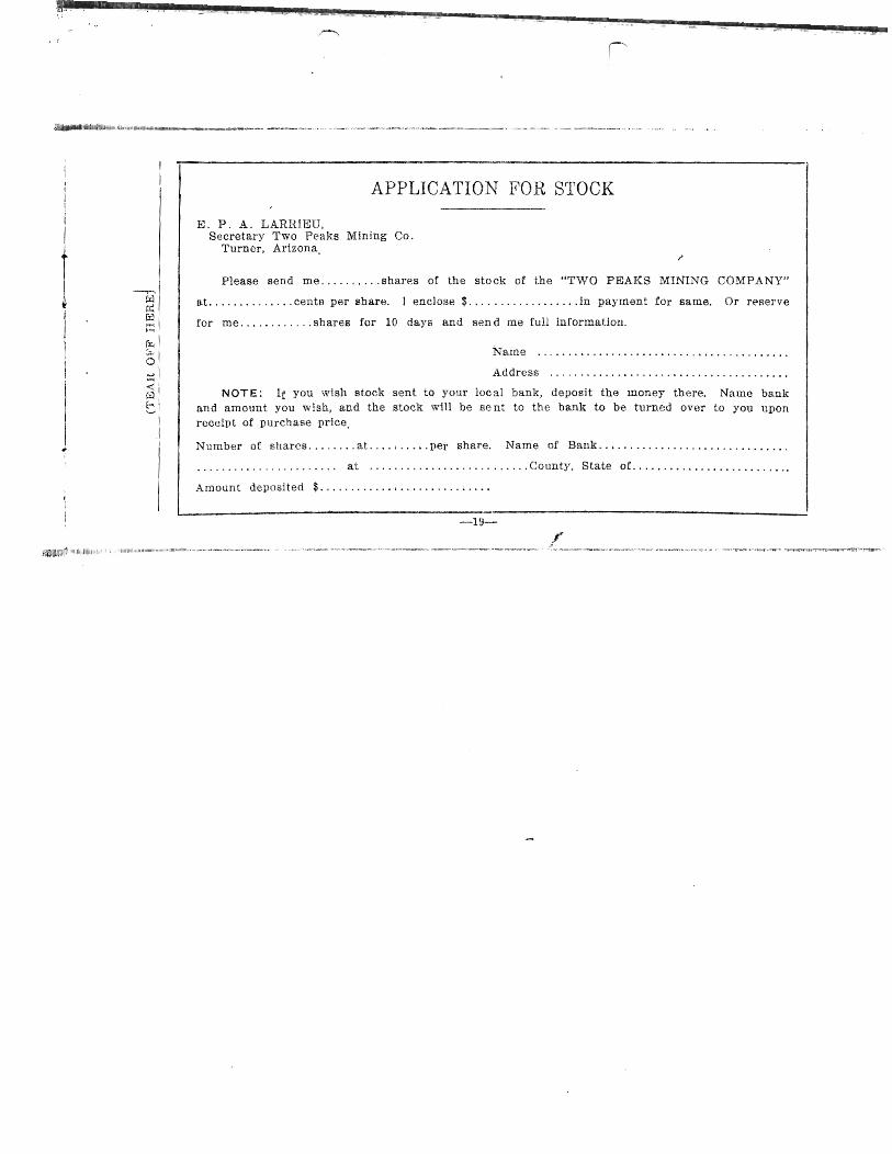
APPLICATION FOR STOCK
E. P. A. LARRIEU, Secretary Two Peaks Mining Co.
Turner, Arizona,
Please send me .......... shares of the stock of the "TWO PEAKS MINING COMPANY"
at .............. cents per share. 1 enclose $ ................•. in payment for same. Or reserve
for me ............ shares for 10 days and sen d me full information.
Nan1e ........................................ .
. A.ddress ...................................... .
NOT E: If you wish stock sent to your lac a1 banl{, deposit the lUoney there. Name bank and amount you wish, and the stock will be se nt to the bank to be turned over to you upon
receipt of purchase price,
Number of shares ........ at. ... ' .. · .. per share. Name of Bank ... , .... , ...... ·· .. · .. · .... · .. ·
, ..................... , at ........... , ....... , ...... County, State oE ............ ··············
Amount deposited $ ...........• I •••••••••• ~ • , ••
-19-
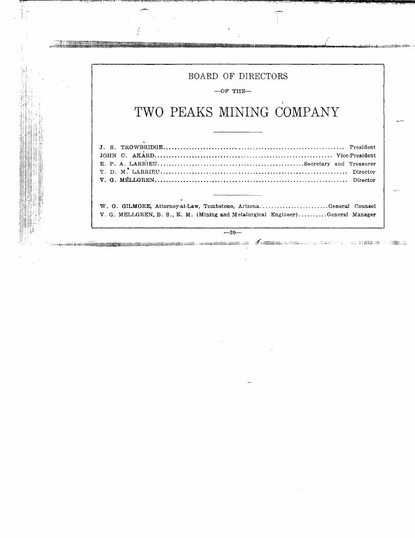
BOA.RD OF DIRECTORS
--oF'rHID-
TWO PEAKS MINING COMPANY
J. S. TROWBRIDGE ..•.•.•......••.••......•........... 0 ••••••••••• 0 •••••••••• 0... President
JOHN Co AI{ARD .•••..... o. 0 ••••••••••••••••••••••••••••• 00 ••••• 0 •••••• 0 •••••• Vice-President
E. P. A. I..ARRIEU ............ 0 ••• 0 •••••••••••••••••••••••••••••••••• Secretary and Treasurer
T. D. M.1io
LARRIEU ..•.................•......•..•... 0 • • • • • • • • • • • • • • • • • • • • • • • • • • • • •• Director
V. G. MELLGREN................................................................... Director
W. G. GILMORE, Attorney-at·Law, Tombstone, Arizona ........................ General Counsel
V. G. MELLGREN. B. So, Eo M. (Mining and Metalurgical Engineer) .......... General Manager
-20-·

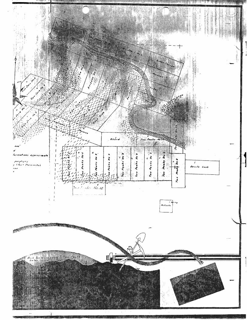
APPENDIX. ~
Since the completion of this prospectus the co mpany has purchased additional claims, the total
number now being forty, which with the mUlsite gives approximately 800 acres. "Two Peaks No. 12,"
one claim not shown on the map, lies south of "Two Peaks No.2 and No.3," being bounded on the north
by _ibem, it being a full claim running easterly an d westerly.
Attention is here called to typographical errors on page six: (testure) to (texture), (chalcolite) to
(cba.lcocite) .
NOTE-Work on the new ·double compartment shaft is now in progress.
PRESENT PRICE OF STOCK TWENTY-FIVE CENTS PER SHARE,
S11BJECT TO CHANGE WITHOUT NOTICE. NEXT BLOCK WILL BE
FIFTY CENTS PER SHARE.
/'

.j!' ._ ... t
p~ __ 4 _____ .. _'I!I!!!!!!W£i~~ .... 1.'?to«J;,"".,fJ:.'ll'.! il1tJiUiZW12!~"~W.l£f!!:2~1!XXJ.,:h . .)w!mJ~ I, ?9l,.\1. '!"~''''~(''''' I ........ t...·"_e .•. ' <,t,. . ,.,>.-L,,-« . .I.~.~""~'"'''''''~''~ '-.::.'~": .... X,- . _ "1-'<, ....... '. "., __ ~. _..,. • ....,...- ..... '!'" ¥C.~ ,e.~E ... , .... L"'w;...¥,4J.;.":'''".
t _. ___________ . __ ..... _ .... _.~_ ~-·~~--·-·- ... ·-~·"'~~~ ......... --.... ~~--_ .... --·_-·_\Ja&~i1,~~~~'tJt~Ii!~IH,\tIa~~.{~~_~~l"il;lil-&~~'.-'Il,~1<11 ... -I.,,&j>'ll;.V, ... ""~~".. _,_ ..... _ ... ~ .. > __ ,.~ ~ •••• '" ______ ~_ •
.... r-"., t:Ii .. ~
-1 , t '
I I I
(F0! • C1 t::' =~. Cl J:::' =::=::ZlOll o o o
~ o ~
~ Prospectus
~. r£ ~~ __ I'>_eaks ~
~c~i~~ng Co pany .~
~ ~
.. ~
~. ~ r: 3 z::.==ti n::x r.=:=IJ « r.:=:::::=::r.' i ~
~ Cochise County ~
11 '" Arizona D o 0
[boc:c :=::::IU:::1CL==tU::xr:c:===xrocJ] illllll££ DAII.V REVIEW, I'RINTltI'iS
l~-vvo Peal~s
Mining Company
Cochise Cou nt:;/ .t .... L. .~;", I'}" ( LL >~ J.J"""'"""
'),1/ ~.:-
-Arizona
Two Peaks i\
ACRE~A.GE
The property consists of 19 mining claims,
,mJ one mill site, aggregatiI)8 about 410 acres, ~ ~
known ~lS "The Buck" and "Two Peaks"
~inHlps, Five mining claims known as "The
>~ oriega" group, about 100 acres. Totaling
,d'out 5lO acres.
l'ITLE
The groups known as "The Buck" and
"Two Peaks" are held by deeds. "The No
l't,jgll" Sf'OUP is under a lease and bond, with
I 'ption to purchase, and all held in fee simple,
:-'.11 bjed to paramount title of the United States.
GEOLC)GY
The BUt'face of the western half of the prop
!'!'I:y is a gr'anetic formation, through which hilS
1"'I~n intruded dykes of mineralized pOf'phyry,
Cdt'ry qUJ.ntities of copper' minerals, i.n the
(, 'I'n·! of carbonates, oxides, chalcocite ana
\'II<:licopyrite. On the surface. this minerul
I,~,·d porphyry can be teaeed through the en~
lin' lengths of the "Bu~k," San~ Jose, San
.I ('~(' ~(). 2, Neat' Christmas, Two 'Peaks No. I}, and Two Peaks Numbers 1, 2 and 3, And
\\ 11(,t'l;'\'e1' exposed by development wod{
~dlOWS copper values £1'on1 a few tenths to
.L") pel' cent.
The sUl'face of the eastern half is composed
(.f limestone, andesite and poephyry. Along
t 1'1 i ~ contact is an alter'ed porphyry, highly
2
impregnated with copper. This mineralized
zone ranges in ·width fl'om u ft!W to many
feet. The limestone out cf'oppin~~ on the II>
Noriegu, Empire and Two Peaks Numbees 7,
8 ilnd 11 strikesnorfh and south and dipg
sharply west towards the pOl'phyt'Y d),kes ahove described.
The amount of work done un the "1\ol'ic
ga" group (under option) iB as follows: On ...
incline shaft 54 feet deep, one tunnel 137 ff'et,
at the end of which there is a 12 foot winze,
A crosscut 18 feet connects the shaft and
tunnel, at a distance of ]20 feet [I'om the
mouth of the tunneL At 125 feet a small
stone VVd.S cut in at the heild of a I () foot raise,
The ore in thi~ stO{W will average beitel' than
:3 p<'Jf¥cent copper, A.t the intel'scdin8 point
of the crosscut and shaft there is six fed of
(Jec assaying 5,5 pel' cent coppel', In the
winze the ore runs ,~L7S pet' Ct~nt coppel'. The 01'<' in the shaft £r'orn the sul'f .. H.'t· to \vithill <1
depth of 40 feet hilS tin JHSJ.y vdIlI!' of nCill'i}·
3 pet' cent COppt~r, Oil this gl'OUp st'n:'t'JI
rnitHH' workings exist, in \yhil'h Lliriy g(){HI
copper valut's oceul"'.
On the " Buck" gl'ou p, w hie h is () \'\'l1eJ b.'
the compan,Y, a tunnel i~ lW\V 111 c1 Jistanct' of
200 feet, with a depth of 00 f(~I'L Llhon' this
tunnel is a smillIet' tunnel in ti JisLJlll't' of
abuut 40 fed.
1 n th e rna in tun t1e I. c1 dis tallCt' of 1.10 fed

-i 0 ~
n z 0 Ln n :r :r: =n U1 III
ill Ul n -l 0 U1 C C 0 >
~----2 C -; -j -1 f11 '", I 0
:J] 7. » :»
"2 AJ N Gl
0 rrl
Z UJ >- rTJ
» 1.11 -j
~ rtt
--1
G ~ Z
)) Z·~ Nj (j1 0 :-h -~ - IJ-~~
~ P LJ )-
~ ~ ~ U1
~ rJ tJ·
] I "»
No ~':"so.c ,
1
~-'-------------------~ S).
~----- ------~------_4--' ______________ ~~ ~"?
;--?.:r" M'O P~ks NJ? 2.
r---l---'----------"'-----l
/ro/,). ?-eo OQ • 0
" ~ ...... ---------~ !'l)
~--------------,------
PolOsl
r---.--_______________ ~
g Trvo Pet' ~ /V? 9 ." a,
~2~O~~-------/-3_0_0_: __ . __ ~=2~OO~.l ___ ~,_O~O_· __ ~~1~.O~O~:--~ __ ~~~o~~_. __ _J
~~--- /SO :------~-~---~~--~/_~_o_o_,' _______ ~ ~ 2;:;.:!'o.'N,
1
frot1l the entcance, a sOLall Cl'Osscut was run,
rr'l[)nl about 160 feet from the entrance to the
IJt't'Sent fdce of the tunneL O1'e was encount
t'I,t',d thut will average up to 2 pee cent and
f't'ttcr, The ore in this tunnel is u sulphite,
},\.,)O1 the 40 foot tunnel eoppel' assa:ys run
fr()tH '* pet' cent to 23 per cent copper. A car
(If !IIi!'! on.~ was shipped to the Douglas snle1·.
I ('t' y, the retut'ns in coppet: were 4.03 per cent.
()n Two Peaks No. 12 there is a vertical
:~h.lFt 65 feet Jeep, the bottom of whieh is in
()f't". On one end of this shaft the ore is
',\, ide!' than the shaft. and has an aBsa,y value
,,1' 5.31 pel' cent copper.
II\CORP()R~\TION
'1'\.\'o Peaks 1\1ining Company is incorpor
.1 [l~J unJer' the laws of the State of Arizona
('II" 1,000,000 shares of stock at the par 'Value
,d' $2',;:)0 per shat'e, full p .. liJ and non-assess
.dde,
TREASCRY
~l'\'en huntir'ed and forty thousand shares
,.\ \(' been se(aside for the use of the treasury.
I ,\() hundred and fOf'ty thousand shiH'es of
1,\ ill('h lli1ve been placed on the market at 25
:,' )1~ pel' shill-e.
OFFICERS I
S, Tt'()\vbrid~!e, Tucnel', ArizonJ., Presi-
,I'Ilt: John C.iAkard, Bisbee, Arizona. Vice
it, ('·t,iclent; E, p, A. LalTieu. Turner. Ar-izona,
6
;l
J,,! 11 .. __ .. •• g
Secretary-'1'reasurcr; \V. G. (;ilmore, Tomb
stone, ArizonJ.,· General Counsel; Barney
Harmsen, rrom.bstone, ArizoniJ, General M an
ugar.
DIRECTC)RS
J. S. Trowbridge, John C, Akard, '1'. D. ~I . •
Lan'ieu, Barney IIarmsen. E. p, A. Lanieu,
PLAN OF DEVELC)PIvIEN'T'
This property is ideally located for its eeo
nomical development. Two hundred and
forty thousund shares of the treasury stock
are offered for sale to the public at 25 cents
per share, for the put'pose of installing an air
compressor and drills, and to meet the pay
ments on the "Nor'ie§<1" group <1S they come
due,.. The present plan of development is to
co);tinue the tunnel on the Noriega group and
crosscut the fOrD'lation the cntirewidth of the
propedy. The Buck tunnel will be driven
100 feet further, after which crosscutting to
ascertain the pt'obable width of the ore will
be commenced.
GENERAL RE~\lARKS
There are no salaried officers in the C0t11-
pany; no indebtedness. The pr'omotion stoC' k
haH been pooled fol' the period of one yCil!',
anti will not be released until such time as
the affairs of the compi:my al'e in satisfnctol'J'
\-V't}rking order, or the stock now offered fo1'
sale is sold and the money in the treasur·y.
7

--~.-"-.-.-.--.-,,,,,,,,,,---::,,:~,~,,,,-,,,,,,,,,-------~~---
Til<' (,()l1ljHn.y CDuds the fu!test investigation
i:l ,!Il its affair's, the hoohs being iIt all tinH~S
(')" II to the stoekholllers. Copies of engineer
It 1(11'18 will be furnished on request.
Y()UR ()PP()RrrUNITY
ill (11(' pl'esentaiion of thc above fads, the
, I' P,.',d.;,s ~l ini ng Company has sought to
·"ili'l:. utlt'mhellisheJ information concernin~~
j1I'(l!wdies. AU tendency to inteoduce I , (L~· descriptive t11attee uny r~flection of
'll'limism felt by officials anJ dil'edot's,
", ; ) (' t' l1 l'lJ [' b (' J .
I:', "I'y statement puhlishell in the furegoing
, i' ;fi{1t'dllS is fiusceptible of ubsolute vet'ifica
:"n, The cenb'dl iJea uf this little pam-
:,i"l in t.o present succinctly to the it'ained
, II!n~: IHJI1 ullt1 to the conser'vative i.nvesto{'
(J t h.:Ji () pportu 11 it.'\' a'\vaits those w hu pal'
uti' ili the lL.':Yl'lopnwnt of the Two Peaks
I' iH','fin;, Tlwy tlt'Iwnd rOt' their expluiiu-
, ~;o!t..'ly llPon Hlt'cit, Tht' COl1scl'vativt'
";(<.11' iH dJyitlt,d t(J submit {his Pl·OSIH.'duo;
,1 (." PiTt.
'>I' ([Il't 11<'1' infol'l1'laiion call on Of' WI·itt'
E. p, 1\. LA.HRIEC, Secretary,
'rur'nct', At'izon
./. S. \IcXEISH, C, E.,
\\', C. G[ L)'(ORE, AttOl"neYLlt Lav,',
Tombstone, Al'izOll.:J' j
~" .•. ,.,; .' ~,
!i
£