crawley local cycling and walking infrastructure plan 2020
TRANSCRIPT

1
Crawley Local Cycling and Walking Infrastructure Plan – 2020
Foreword Crawley has most of the elements to be a great town for cycling and walking: it is relatively flat, with access to shopping, employment, education and leisure facilities within a short radius of our homes and has many leafy, green avenues that could make cycling and walking particularly appealing. The other element needed is a high quality network of safe, practical and attractive cycling and walking routes for Crawley residents and visitors of most abilities that meet shorter journey needs. The Crawley Local Cycling and Walking Infrastructure Plan (LCWIP) is a practical, evidence-based plan for making that happen. The LCWIP identifies functional, direct routes and zones and outlines measures to develop these into a connected network. It will inform the new Local Plan, guiding building development, and will provide a clear rationale for investment to make our streets safe and attractive for active travel and for collaborative working with our local transport authority. It is an important contribution to New Directions for Crawley, the council’s transport and access plan, which outlines transport as the key sector contributing to the climate emergency, poor air quality and mental and physical health issues. Our LCWIP will help local residents and businesses to be central to the discussion to improve people-focused, healthy, low carbon neighbourhoods. This transformation in transport infrastructure and the resulting shift to cycling and walking will help deliver significant reductions in carbon emissions and improvements in air quality, local community health and quality of life – something of which Crawley people can be proud. Councillor Gurinder Jhans Cabinet Member for Environmental Services and Sustainability Crawley Borough Council This report is structured to make it a practical tool. Descriptions and discussion in the main body of the document are brief and the focus is on brief explanations of the process for developing the route plans, outlined proposed schemes, how the plan links to wider Crawley Borough Council activity and options for delivery. Supporting data and more detailed explanations are provided in appendices, with references.

2
Crawley LCWIP 2020 Contents Foreword
1. Cycling and walking a Vision b Why action on cycling and walking? c What is the LCWIP? d How has the LCWIP been developed?
2. LCWIP Stage 1 – Scope and governance Geographical and functional scope – governance – engagement – timescales
3. LCWIP Stage 2 – Data gathering
a Numbers and policies Cycling and walking in Crawley – public consultation – Crawley Cycle and Walking Forum data – Crawley Local Plan – Crawley Growth Programme
b Identifying route options for the LCWIP Crawley’s existing cycle network – trip generators – Propensity to Cycle Tool initial routes
4. LCWIP Stage 3 – Cycle network planning Corridors – route selection – design standards – evaluation
5. LCWIP Stage 4 – Walking zone and route planning Equalities – Walking Route Assessment Tool – walking zones – Manor Royal
6. Next steps Consultation – prioritisation – adoption and integration – early improvements – Covid-19 – monitoring

3
1 Cycling and walking a Vision As one of the original new towns, Crawley’s streets were planned around far lower car ownership than we have now. We need to build on its strengths to renew its streets and neighbourhoods, reshaping them to be healthier, safer and people-centred. We could see Crawley as a town where:
Walking and cycling become the natural first choice for accessing what we need, through improved urban design which prioritises this sort of active travel over motor vehicles
People are generally fitter mentally and physically due to greater activity levels and better air quality
Children have more safe places to play and travel independently
Local businesses benefit from easy, attractive access in a pleasant environment
Land is freed up for new homes, new business and other uses as demand for car parking goes down
Beautiful, greener, low traffic neighbourhoods improve wellbeing for all. A shift in how we get around which reduces demand for car use means Crawley is taking action on the climate emergency and improved air quality by cutting pollution and carbon emissions. A key to achieving this vision is to provide safe and attractive infrastructure for cycling and walking.
b Why action on cycling and walking? Cycling and walking instead of using motor vehicles can have a profound impact on the quality of life in Crawley. Action to increase cycling and walking will enable improvements to:
Climate emergency – cycling and walking as zero carbon transport displacing vehicles which are now the biggest single contributor to greenhouse gases
Health – physical and mental health benefits from being active, as well as improved air quality
Time savings – in urban areas, cycling is typically the quickest mode for journeys below three miles
Cost saving – personal travel cost savings and savings to the NHS from reduced demand
Safety – reduced risk to others from vehicles and cycling and walking are intrinsically safe modes of travel
Space efficiency – reduction in car parking demand and occupying less street space also frees land for uses other than storing cars
Employment – people who cycle are typically healthier, happier employees
Congestion – motor traffic reduction, cycling and walking provides flexible mobility in densely built-up areas where it is easy to stop or avoid obstructions. Local delivery by cargo bike further reduces van numbers
Public transport – Cycling and walking provide important stages to accessing public transport, making train or bus journeys viable
Local economy – people cycling and walking are more likely to shop and spend more locally. Cargo bike deliveries can be more efficient and effective, especially with e-bikes
Urban and country landscapes – more accessible, pleasant, quieter and cleaner streets and rural areas
Nature – reducing wildlife deaths and habitat destruction from traffic and roads
Sociability – walking and cycling make for easier access and direct interaction with other people.
These benefits are recognised by government, key agencies and research and professional bodies which now advocate increasing levels of cycling and walking and upgrading infrastructure to enable this. These include Public Health England and NICE (the National Institute for Health and Care Excellence), the Chartered Institute of Highways and Transportation, and Transport for New Homes. The importance of cycling and walking is made clear in the National Planning and Policy Framework (NPPF), which guides all planning authority development policy. The NPPF advises encouraging cycling and walking to promote ‘healthy and safe communities’, and that planning policies should ‘provide for high quality walking and cycling networks and supporting facilities such as cycle parking (drawing on Local Cycling and Walking Infrastructure Plans)’.

4
c What is the LCWIP? A Local Cycling and Walking Infrastructure Plan (LCWIP) is a costed plan which identifies and prioritises physical infrastructure improvements in a specified area to enable a significant increase in cycling and walking. It has been determined through a combination of:
Evidence of where people originate trips and where they need to go for different purposes
Standard assessment methods for identifying the most appropriate routes and the improvements that are needed to ensure those routes are safe and attractive for cycling and walking, and
Discussions with people who are familiar with the locations and communities. The LCWIP gives us:
A cycle network plan of preferred routes for further development based on corridors developed from origin and destination points identified with social and economic data
A walking zone and route plan for improvements. Crawley town centre was evaluated as the first core walking zone, along with a route to Crawley Leisure Park
A programme of infrastructure improvements for future investment, identified, specified and prioritised systematically with a range of evaluation tools provided through the Department for Transport (DfT)
Proposals for how it can be implemented, embedding the plan with other development plans and involving local residents and other stakeholders in taking it forward.
The LCWIP provides a key document to inform the planning authority’s Local Plan. This enables clear discussions with developers on providing safe, accessible, connected, people-centred neighbourhoods for homes and business, ensuring full linkage with the wider town cycle network and formally evaluated walking routes.
d How has the LCWIP been developed? LCWIP development guidance emerged from the government’s 2017 Cycling and Walking Investment Strategy (CWIS). Local authorities are invited to adopt a systematic, evidence-based and strategic approach to identifying cycle route and walking zone improvements for an area of the authority’s choosing. The DfT allocated funds for technical support and provided guidance to enable a number of Local Transport Authorities (LTA) to each develop an LCWIP. As a Local Transport Authority (LTA), West Sussex County Council succeeded in its bid for DfT’s technical support delivered by a range of consultants. While it planned its own LCWIP for strategic inter-urban routes across the county, including a key commuter link from Horsham to Crawley, it was unusual among LTAs in establishing a partnership programme with the districts and boroughs across the county to support each of those authorities developing their own LCWIPs within the same programme. As one of these authorities, Crawley was also unusual in adopting a whole borough network approach as the geographical scope for its LCWIP. The DfT provided a staged structure for developing the LCWIP which covers:
1 Determining scope and governance – the geographical extent of the plan and the detail into which it will go, alongside how the plan will be overseen and who will be engaged in its development
2 Data gathering – identifying information to inform the plan including policies, existing networks and trip generators both now and for the future
3 Cycle network planning – defining journey origins and destinations to establish cycle routes needed to be developed and identifying high level specifications
4 Walking zone and route planning – identifying key walking areas to be included and analysing these to establish high level improvements, along with any associated walking routes
5 Project prioritisation – evaluation of cost benefits and relative merits of developing routes and zones to enable prioritisation of schemes
6 Integration and application - to identify how the plan will inform other policies and practices, such as the Local Plan and how the LCWIP’s schemes can be implemented.

5
The Plan does not cover elements such as feasibility or pilot studies or behaviour change activity, but this sort of work is expected to be developed to complement the LCWIP. Crawley Borough Council is developing its New Directions for Crawley transport and access action plan, which will include the LCWIP.

6
2 LCWIP Stage 1 – Scope and governance Geographical and functional scope In determining the geographical scope of the LCWIP, the DfT recommends looking at the likely distance that would be travelled by bike in a single journey, which is up to about 10km (six miles) or, on average, around 30 minutes’ cycling time. This is approximately the distance across Crawley. The town centre presents an obvious location for developing a core walking zone and the Manor Royal Business Improvement District, as a large and key business district, invited focus for another. Crawley Growth Programme projects and work undertaken at Manor Royal in addressing sustainable transport, with funding potential, provided additional reasons to adopt these locations for the plan. Crawley’s neighbourhood structure also invites opportunities for well-defined walking zones and routes centred on shopping parades and associated community facilities and schools. The New Directions for Crawley transport strategy recognised the role that quieter traffic-calmed neighbourhoods could play in providing safer zones for general road cycling without special infrastructure and this idea was built into the LCWIP project as it progressed. The LCWIP could propose connecting traffic-calmed neighbourhoods with safe crossings to dividing distributor roads provided with cycle infrastructure along them. National Cycle Network routes run through Crawley, including the London to Paris NCN21 (Avenue Verte) and the NCN20 to Brighton. Housing and business sites are being developed across Crawley’s boundaries in Horsham and Mid Sussex districts. The A264 presents a barrier to commuter access for cycling between Crawley and Horsham. These all point to a need for the LCWIP to identify how priorities for different transport modes, walking and cycling network continuity and infrastructure standards are to be agreed with adjacent authorities, particularly through the planning process. Fortunately, the county partnership for the LCWIPs established by WSCC provided a common language and understanding of the approach to developing walking and cycling infrastructure by the district and borough authorities and WSCC agreed to draft a Memorandum of Understanding to facilitate this common approach. It was decided that the Crawley LCWIP should cover all the borough to provide a whole town cycle network of key routes. The town centre would be first assessed as a core walking zone, with an associated walking route, and the Manor Royal Business District subsequently assessed as time permitted. Click here for the current Cycle Crawley cycle network map, which includes Public Rights of Way, footpaths and bridleways, stations and bus stops, key destinations. Governance Crawley Borough Council’s organisation and accountability approach was considerably simpler than DfT guidance, which assumed a Local Transport Authority lead. A steering group, comprising Crawley Borough Council staff from Planning (policy and development management), Economic Development, Sustainability, Wellbeing and the Cabinet member for Environmental Services and Sustainability, along with a representative of the Crawley Cycle and Walking Forum, guided the project. The Transport Initiatives consultant supported the process with advice and technical knowledge. Crawley LCWIP proposals are to be considered by Crawley Borough Council’s Corporate Management Team and Cabinet. These proposals will be informed by a consultation programme to include a range of representative interest groups. With experience gained in implementing sustainable transport infrastructure schemes with West Sussex County Council through the Crawley Growth Programme, Crawley Borough Council aims to lead delivery of its LCWIP. The LCWIP will help deliver outcomes from the developing Climate Emergency Action Plan, the New Directions Transport and Access Plan and support the emerging Local Plan in guiding development in Crawley.

7
Engagement A public consultation was run early in the LCWIP development process, conducted largely through a survey which gained 173 survey responses, and with further interviews with local groups concerned with mobility disabilities. This sought information on local people’s experiences in walking and cycling in Crawley. The consultation identified commonly used and problematic routes and locations and particular concerns and practical issues. The survey also provided demographic information on the respondents. It was provided online and in hard copy and promoted through social media, libraries, schools, community facilities, Manor Royal Business Group and at popular locations. Crawley Cycle and Walking Forum is an advisory group of local residents and representatives of organisations including Cycling UK, Sustrans, Crawley Wheelers, British Horse Society and Wheels for Wellbeing, along with Crawley Borough Council members and invited West Sussex County Council officers. Forum members were involved in reviewing and contributing to the network planning process. Their familiarity with Crawley and activity in the town enabled them to identify additional local journey attractors and destinations. They were given training in cycle and walking route evaluation tools and were key in contributing to determining the proposed LCWIP routes. The high level results for cycle routes and the walking zone were included in public consultation on the New Directions for Crawley transport strategy document in early 2020 and public discussion will be invited on the final, costed proposals to help determine priorities. Timescales DfT current targets, outlined in the government’s Cycling and Walking Investment Strategy, are to double cycling journeys from 2018 to 2025 and to increase walking trips during that time. The Crawley LCWIP was developed at the same time as the drafting of New Directions for Crawley, a Crawley Borough Council transport strategy initiation document addressing issues and options for shifting from a car-centred to a people-centred approach to mobility and access. The LCWIP will work within the action plan emerging from the New Directions for Crawley strategy on a likely 10-year time frame (to 2030). Additionally, in informing the emerging new Local Plan, the LCWIP will guide design and access elements of new developments as they arise, enabling direct progress in routes at development site locations or through S106 or CIL funding contributions. The Local Plan will run to 2035. It is expected that the LCWIP will develop during that time. See appendix 2.2 for the agreed Scope and Governance statements for the Crawley LCWIP See appendix 2.3 for the survey questionnaire and results tables

8
3 LCWIP Stage 2 – Data gathering a Numbers and policies Cycling and walking in Crawley
% of population Cycling at least once a month – any purpose
Cycling at least three times a week for travel
Walking at least once a week – any purpose
Walking at least five times a week for travel
England 16.1 3.2 69.5 16.9
West Sussex 18.3 3.1 73.7 16.6
Crawley 15.3 2.4 64.9 16.1 Gov.uk 2017/18 tables CW0302 and CW0303
Crawley’s levels of walking and cycling are below national and county averages despite several factors which favour conditions for active travel, such as a relatively flat terrain and amenities and employment within walking and cycling distances from many people’s homes. In general, there are several factors contributing to low rates of walking and cycling. These include:
Perceptions of safety, with dominance of vehicles on routes and at key destinations
Poor journey connectivity, where routes for walking or cycling are not direct, and
Quality of the infrastructure, where surfacing is poor, space insufficient, network gaps exist or obstacles impede movement.
Busy roads make streets unattractive with noise, air pollution and increased danger. In Crawley, fast traffic and dual carriageways create ‘severance’ in several areas, cutting off walking and cycling movement ‘desire lines’ and seriously affect air quality. A large Air Quality Management Area (AQMA) is designated around Hazelwick roundabout. Provision of car parking is known to increase car use. Crawley town centre has parking provision in excess of demand and parking is readily available in other key shopping, leisure and employment locations. Crawley’s existing cycle and walking infrastructure is largely in poor condition, often with insufficient space, gaps and difficult junctions and crossings. People with disabilities are often not catered for. Improving cycling and walking infrastructure and developing transport plans aim to change these imbalances.
Manor Royal Business Improvement District is the largest employment area in the south east with a workforce of around 30,000. It commissioned a transport study in 2016, which included a survey of employees. They found:
17 per cent live within a 15-minute walk of their employment. Only between four and six per cent walk
50 per cent live within a 30-minute cycle of Manor Royal. Only three per cent cycle. (Manor Royal Transport Strategy, SDG, 2017) Gatwick Airport is also a major employer in the region with a total of 24,000. Gatwick Airport Limited undertook a wide-ranging survey of employees of all businesses on the campus in 2016 with a response of more than 5,000. This showed:
47 per cent travel less than 10 miles to the airport, 11 per cent travel less than three miles
61 per cent commute by car. Only two per cent cycle and one per cent walk. (GAL Staff Travel Survey, 2016) National statistics show that women walk more than men and cycle less. National surveys identify fears over safety as a key inhibitor to cycling. Countries with high quality infrastructure and corresponding high levels of cycling do not experience this gender differential. We can expect some degree of levelling out of this difference with better, safer infrastructure and increased numbers cycling.

9
Sustrans runs the Bike It programme in Crawley schools, supported by Crawley Borough Council. The programme encourages all modes of active travel – walking, cycling and using a scooter. Up to 15 schools participate at any one time and typically show measured increases in active travel modes of journeys to school and reduction in car use, particularly marked when the project officer is directly involved at the school. Lack of safe, local cycle infrastructure is thought to be a limiting factor in raising rates of active travel to school and embedding them in longer term practice. Public consultation The LCWIP survey brought out general issues and issues relating to specific locations. In addition to indicating participants’ favoured routes, it identified locations where some shorter term interventions could improve the existing cycle and walking networks through clearing and repair. The survey confirmed that cycling on both footways and shared paths can be a source of conflict, arising from genuine and perceived risks of collision and that better, separated cycle tracks are needed. This is borne out by the experience of Crawley Borough Council in dealing with public complaints about cycling on footways and even designated shared paths. Key issues raised in the public survey on walking and cycling included (in no particular order):
Improving surfacing
Vegetation blocking pathways
Need for segregated cycle tracks
Wider footways and cycleways
Better pedestrian crossings
Better lighting of route ways
Reduce vehicle numbers
Provision of bike storage (personal and public). Discussions with Crawley Transport Action Group, which addresses access for people with mobility disabilities, highlighted infrastructure quality issues, for example, identifying locations where recently upgraded pedestrian surfaces at crossings and junctions made wheelchair use unnecessarily unstable through poor design. Crawley Cycle and Walking Forum data Forum members CTC (now Cycling UK) and Sustrans had undertaken qualitative evaluation of existing cycle infrastructure in Crawley in 2008 and provided a report on cycle infrastructure in the Manor Royal Business District. This work generated a high level list of prioritised proposed cycle infrastructure improvement schemes, which provided the basis of discussion with West Sussex County Council and Crawley Borough Council on delivering improvements. The evolved list provided Crawley’s community input to the county council’s Walking and Cycling Strategy in 2016 and helped to inform the cycle route selection for the Crawley Growth Programme, alongside Transport Initiatives’ work following the Crawley Cycle Network Review (2017). Draft Crawley Borough Local Plan 2020-2035 (January 2020) The key policies in Crawley’s emerging Local Plan that raise the importance of mobility through cycling and walking are: Strategic Policy ST1: Development and Requirements for Sustainable Transport “Development should be located and designed so as to encourage travel via the walking and cycling network and public transport routes, while reducing dependency on travel by private motor vehicle (also see Policy CD4 and CD4b). This should include:
i. Designing developments to prioritise the needs of pedestrians, cyclists and users of public transport over ease of access by the motorist;
ii. Providing an appropriate amount and type of parking in accordance with ST2; iii. For development which generates a significant demand for travel, and/ or is likely to have other
transport implications: contributing to improved sustainable transport infrastructure, including, where appropriate, routes identified in the council’s Local Cycling and Walking Infrastructure Plan.”

10
Strategic Policy CD4(a): Effective Use of Land: Movement, Sustainability and Urban Form “Movement patterns, built form and the layout and framework of routes need to be designed and organised in a way that ensures future inhabitants are within a 10 minute radius walking distance of such rail stations or bus stops. In relation to walking and cycling, new development should:
i. Understand and respond to wider movement patterns within the borough and demonstrate how new proposals will be connected to the wider network. Schemes should be integrated with town and local centres, schools, employment areas and also to connect to the closest areas nearby where there are large zones of green open space.
ii. To encourage use of these movement corridors, new route alignments must follow desire lines as much as possible and through routes should be relatively straight where possible, providing clear legible direct linkages with adjoining areas.
iii. Be orientated to overlook these movement corridors in order to provide passive supervision and safety.”
The emerging Local Plan’s identification of development areas, existing housing and employment, amenities and transport loci informed the identification of likely journey corridors for the LCWIP. Click here for the current Crawley 2030 Local Plan map showing development areas, schools, shopping and key facilities. The Crawley 2030 Local Plan highlights current housing growth areas in:
Crawley town centre
Forge Wood neighbourhood
Kilnwood Vale (outside Crawley boundary in Horsham district)
Pease Pottage (outside Crawley boundary in Mid Sussex district). The LCWIP considers these housing areas along with the possible impact of potential future housing development in adjacent locations to the west and east of the town. Crawley Growth Programme The Crawley Growth Programme is underpinned by principles of developing sustainable transport, including by improving cycle infrastructure and access to transport interchanges. It focuses on the town centre and Manor Royal as linked employment and development areas and identified key commuter cycle routes, on a whole route basis, rather than isolated locations (as had happened in the past). The Transport for London Cycle Level of Service evaluation tool was used to assess proposed improvements to selected routes. See appendix 3a.1 for the list of current and draft Local Plan policies relating to cycling and walking in Crawley See appendix 3a.2 for prioritised cycle route proposals outlined for the Crawley Growth Programme

11
b Identifying route options for the LCWIP Crawley’s existing cycle network Crawley Borough Council commissioned a review of its existing cycle network from consultancy Transport Initiatives, which reported in the Crawley Cycle Network Review (2017). Pre-empting the LCWIP, it included:
1. Classification of tracks (paths), roads and crossings throughout the whole town through an assessment of the level of Bikeability skill (levels 1-3) required to safely use each element. This identified where safer cycling might be undertaken without improvement, where improvements could make it safe to cycle and crossings that can enable cycle connectivity
2. Analysis of ’mesh density’ of the designated cycle network to see how well it reaches people across Crawley
3. ‘Porosity’ analysis showing how permeable zoned areas across the town are for people cycling, the zones being identified by boundaries presented by primary roads, rail or other barriers, and where ‘gateways’ access is provided
4. Current and potential demand for cycling to work identified with the Propensity to Cycle Tool (PCT) using census data to identify desire-line corridors and corresponding residential areas which, with network improvements, could attract higher cycling rates
5. An audit of town centre public cycle parking. The review provided a comprehensive cycle infrastructure assessment of Crawley with data supplied in GIS formats which could inform development of LCWIP route proposals and where to target improvements for secondary cycle connectivity through and between neighbourhoods. This review enabled Transport Initiatives to draw up a list of cycle route proposals for the Crawley Growth Programme. A number of these routes were taken through to high level design proposals and costings. The Crawley Growth Programme aims to deliver one or more of these cycle schemes, which also correspond with routes identified through the LCWIP. See appendix 3b.1 for key results of the 2017 Crawley Cycle Network review, including: porosity map, mesh density map, Cycle Skills Network Audit maps Trip generators Identifying route options started with identifying the likely origins and destinations for the journeys they would serve. Trips origins are largely identified as residential areas. Census data is available aggregated into defined areas with comparable populations called Output Areas and grouped as Super Output Areas (SOA) for neighbourhood statistics. High density populations have a smaller defined SOA and lower density populations a larger SOA. As GIS mapping data, a centroid point location marker is provided for each SOA. The centroid provides a locus for mapping a residential origin. For destinations, DfT suggests looking at journey to work areas. Crawley is home to Manor Royal Business District and Gatwick Airport, as well as a large shopping centre and is therefore a major employment centre as a town with three large employment locations and several further key sites. Commuters daily leaving Crawley for work elsewhere number 19,000 and inward commuters, 43,000, with a net inward commuting population of 24,000. This means it is important to consider Crawley’s railway stations as key origins of journeys within the town, as well as destinations for leaving the town. They are important transport interchanges for multi-stage journeys, with connections with bus services and onward travel by bike and foot. Gatwick Airport Station serves the airport and Manor Royal and along with Three Bridges, also serving Manor Royal, has direct rail links to both London, Brighton and stations to Portsmouth and Southampton. Crawley Station, located by the major shopping area in the town centre, provides access to and from London and Portsmouth/Southampton. Cycle and walking access to all these stations has some serious limitations. Crawley Borough Council provided GIS data for mapping existing business sites and potential future housing and business development. Some minor mapping adjustment to SOA centroids was necessary to enable them to be used as practical point locations for trip origins. SOA centroids, current business sites and future

12
residential and business development map icons were sized to show weighting reflecting populations and workforce size. Additional destinations were identified from OS maps and local knowledge of key trip attractors. Those considered include: Key destinations
Town centre – major shopping, cafes and office area, employment and transport hub (rail and bus station)
Manor Royal Business District – key employment centre, industry and offices
County Oak – retail and business area, main recycling and waste management centre
Gatwick Airport and railway station – key employment centre and regional transport hub
Three Bridges Station – regional rail hub and Stephenson Way industrial site
The Hawth – regional theatre and arts hub between the town centre and Three Bridges
South Crawley: K2 Crawley leisure centre, football stadium, Tilgate Park, Tilgate Nature Centre and Tilgate Forest Golf Centre.
Key origins and other destinations
All neighbourhoods, notably: - Ifield and Langley Green with rugby, cricket and golf clubs, Mill Pond, temple - Forge Wood, a developing neighbourhood in the north east with limited access points
Cross-boundary developments including Kilnwood Vale, currently being developed, and Pease Pottage, approved for development
Schools, college, religious centres
Medical centres and hospital
Restaurants, pubs, hotels, supermarkets
Sports fields, green spaces and bridleways. In addition to steering group review, Cycle and Walking Forum members reviewed and agreed the list of origins and destinations, as shown on the next page.

13
Planned and Potential Residential (dwellings)

14
Propensity to Cycle Tool The Propensity to Cycle Tool (PCT) aims to identify likely route corridors where cycling has the greatest potential to grow and provides estimated figures for their use. The PCT selects census SOA centroids and links them directly to employment locations or schools as straight line corridors to indicate the basis for identifying potential routes for cycling to work or to school. The SOA data on rates of cycling are then weighted using topographical data and current cycle usage and selected targets or expectations of different policies such as the UK government target to double cycling or Dutch levels of cycling, to provide estimates of potential cycle rates associated with those routes. Since PCT analysis is based on 2011 census and travel to school data and uses only employment and school destinations, its key use is to generate corridors for comparison with the corridors drawn from the supplemented mapped data and local knowledge, to raise questions about or confirm prioritised corridors. It is not sufficient to provide the sole source of data for identifying corridors, especially in Crawley’s circumstance where the shopping centre is a key trip attractor and railway stations play roles as trip origins for major incoming commuter travel. PCT output for Crawley showing likely corridors.

15
4 LCWIP Stage 3 – Cycle network planning Development of the network plan was guided by Transport Initiatives consultancy, which also undertook on-the-ground evaluation and drafting route proposals. Additional route assessment was undertaken by the Crawley Cycle and Walking Forum and volunteers who were given technical training. Training and further guidance was provided by WSP consultants through the West Sussex County Council programme. Corridors (desire lines) Clustered SOAs (residential locations) – mapped in black dots for 2011 populations and diamonds for subsequent planned or potential future housing development and sized according to population density data – indicate trip origins. These were fairly evenly scattered across much of the borough, though less to the north where business and industrial areas are located. Employment sites – mapped in red dots for current business and diamonds for planned development and sized according to density – indicate key trip destinations. These were more clearly clustered, largely around Gatwick, Manor Royal and the town centre. Some directly south are also close to other key trip attractors, indicating a likely key corridor. Mapped origin and destination points were manually linked with straight ‘desire’ lines. Clusters, or density of the lines, along with the size of the weighted mapped SOA and employment icons, helped to indicate potentially useful routes and enabled priority corridors to be estimated; see figure 3 overleaf. Most prominent were the corridors to the employment clusters to the north and the stations, bearing out the high levels of inward and outward commuting, and to the town centre. Patterns of routing corridors from loose linear clusters of residential origin points could be identified where further points along the lines could be linked to reinforce the desirability of the corridor. It should be remembered that this mapping does not include the weighting for cycle use, which the PCT does. The PCT tool was run with the government target for doubling cycle rates, and its output was overlaid on the corridor mapping undertaken by hand. The main disconnect with the manual mapping was due to the absence of the town centre shopping area from the PCT data, the displaced location of the employment central locus (centroid) for Manor Royal along with the absence of Forge Wood (as a neighbourhood developed after the last census) and rail stations. However, it could be seen that in shifting the Manor Royal centroid to a more accurate geographical focus, that corridors had a reasonable degree of correlation and the potential for Gatwick Airport routes was confirmed. Schools identified by the PCT with cycling potential aligned well with manual corridors; see figure 4.

16
(homes)
16
Planned and Potential Residential (dwellings)

17
17

18
Route Selection Translation of corridors to route options demanded a combination of practical geography, experience, local knowledge and formal evaluation using the Route Selection Tool (RST) provided by the DfT. The practical process of identifying potential routes to match the corridor ‘desire lines’ as far as possible involved group work with maps and local experience of the streets in each area. Residential origins, or other route start and end points, were largely planned at neighbourhood shopping parades, key facilities or other routes to ensure connectivity and utility. Working within limitations of general street layouts and barriers such as railway lines or building construction, streams or protected woodland, but not by path or carriageway widths, street furniture or similar more minor elements, the emerging routes identified were:
A Gatwick Airport to town centre via Manor Royal and Northgate
B Pound Hill to Manor Royal via Forge Wood
C Copthorne to town centre via Three Bridges (limited to Pound Hill within Crawley boundary)
D Maidenbower to Manor Royal via Three Bridges
E Maidenbower to town centre via Furnace Green
F Tilgate Park to town centre via Furnace Green
G Tilgate to town centre (extended to K2)
H Pease Pottage to town centre via K2 Crawley/Tilgate (joins route G)
I Bewbush to Three Bridges via Broadfield and Tilgate Nature Centre (split around route G)
J Broadfield to town centre
K Kilnwood Vale to town centre (joins route J)
L Ifield to town centre
M Ifield Avenue to town centre
N Lowfield Heath to town centre (subsequently split into a separate route O)
P Ifield to Manor Royal via Langley Green
Q Gatwick Airport to Horley (not developed within this LCWIP)
R Worth Way (not developed within this LCWIP)
These would be translated into defined and evaluated routes with the RST. Some experience of route evaluation at Crawley Borough Council had been gained through previous use of the TfL Cycle Level of Service (CLoS) design evaluation method. This is a tool which enables assessment of aspects of a route design performance, covering safety, directness, coherence, comfort, attractiveness and adaptability. It scores factors within each of those aspects, with some critical factors which can ‘fail’ the design and recommends a minimum total score for a successful design. The RST provides a similar style of guided evaluation of an existing route against a set of design outcomes, and assesses the potential for improvements to meet the required levels of given criteria. The criteria addressed are directness, gradient, safety, connectivity, comfort and critical junctions which will impact on the ability of the route to meet the standard and the tool scores each aspect and indicates overall value of the route.

19
[Image: mapped corridors and routes]
• Broad yellow lines denote approximate corridor ‘desire’ lines drawn from the mapping process of trip attractors and statistical data • Narrow lines show the routes identified to try to meet those corridors, accounting for topography, other physical constraints and connectivity opportunities

20
The RST process requires breaking down the route into consistent links, or sections, and junctions, identified according to the characteristic of the section and evaluating each against the RST criteria. One section might be a stretch of unprotected carriageway, with a high volume of traffic (scoring low) and the next where the route transfers to an off-road, wide track (scoring high). A ‘critical’ junction could invalidate an otherwise high-scoring route. This process is undertaken through walking the proposed routes and scoring sections on site in a spreadsheet for each criterion and specified conditions. The spreadsheet provides a summary score of performance under existing conditions and for potential performance where improvements have been included. In view of the large number of routes in the draft network and the need to limit this first iteration of the Crawley LCWIP, two routes (Q and R) were omitted from the evaluation process and route C truncated to the borough boundary. The assessed routes were reviewed by Transport Initiatives who identified improvement measures at a high level and some extra route linkages to extend functionality at relevant opportunities. Final proposals were agreed through wider review by steering group members and Transport Initiatives provided outline cost estimates for each element of each route. The individual route plans for 16 routes showing the sections on which each route was evaluated. See appendix 4.1 for individual cycle route plans with section annotated with outline improvements, summary RST and outline costs.

21
Routes are summarised here for length, typical cycling time and broadly estimated costs:
Route Details
Ref Description
Length (km) and time (mins) at 9mph Estimated costs
Whole route
Est time 14.4km/h
Shared sections (Note 1)
Unique sections
(exc shared)
Spurs (Note 2)
Route shared
with
Construction ex design / mgmt. etc.
(£m)
A Gatwick Airport to town centre via Manor Royal
5.5 22 5.5 D (inc costs)
2.38
B Forge Wood/Manor Royal to Three Bridges
3.7 15 0.5 3.2 1.1 - 0.58
C Pound Hill to town centre via Three Bridges
3 12 3 D (inc costs)
2.24
D Maidenbower to Manor Royal via Three Bridges
3.2 13 0.2 3 A, C (ex costs)
1.03
E Maidenbower to Three Bridges via Furnace Green
2.3 9 2.3 F, I (inc costs
0.61
F Tilgate Park to town centre 4 16 1
3 E (ex costs)
0.4
G Tilgate/K2 Crawley to town centre
3.1 13 3.1 H, I (inc costs)
1.76
H Pease Pottage to town centre via Tilgate
4.7 19 1.6 3.1 0.5 G (ex cost)
1.9
I Bewbush to Three Bridges via Broadfield and Tilgate
7.8 32 1.7 6.1 J, G, E (ex costs)
3.2
J Broadfield to town centre via Southgate
2.5 10 2.5 K, I (inc costs)
1.07
K Kilnwood Vale to town centre
4.3 17 0.8 3.5 0.3 J (ex costs)
2.01
L Ifield to town centre 2.8 11 2.8 - 0.85
M Ifield Green to town centre 2.4 10 2.4 - 0.48
N Lowfield Heath to town centre
3.3 13 3.3 - 2.29
O Manor Royal to town ventre
2.6 11 2.6 0.4 - 1.5
P Ifield to Manor Royal via Langley Green
4.9 20 4.9 0.3 - 1.2
Q Gatwick Airport to Horley 1 4 1 1
R Worth Way 3.4 14 3.4 0.9
TOTAL 64.5 5.8 58.7 4.5 23.5 OVERALL TOTAL OF ROUTES AND SPURS:
63.2 km
NOTES
1 A few routes share some sections with other routes. In order to avoid double counting these are split into shared and unique sections above. See Links table for details.
2 Some routes have short spurs to link key destinations such as nearby schools.
Here is annex B of the DfT LCWIP guidance for details of the Route Selection Tool criteria and scoring.

22
Design standards Beyond legal requirements, standard design guidance references should ideally be agreed to ensure consistent good practice is followed in identifying options for infrastructure improvement. West Sussex County Council has adopted a set of design guidance based on Oxfordshire’s design guide. This, in turn, references the London Cycling Design Guide, the Greater Manchester Design Standards, Sustrans Design Handbook and DMRB IAN 195/16, advising that these publications should inform design where it is not detailed in the West Sussex County Council guide. The West Sussex County Council guide provided minimum standards for Crawley’s outline LCWIP proposals. The WSCC Cycling Design Guide can be found here. See appendix 4.2 for a summary of minimum cycle provision under different highway conditions.
There are choices in designing cycle routes: they may be more leisure-orientated, attractive routes away from traffic, which tend to be slower and indirect; or utility-orientated, direct routes, usually alongside road traffic and are faster and direct. It was decided that the LCWIP routes should be for utility, identifying cycling as a means of transport rather than a leisure activity. This is not least because this demands good design to provide safe infrastructure and ensures other transport users recognise the function of cycling as a transport mode requiring highway space. Historically, shared footway/cycleway tracks had been a favoured design to separate cycling from other road traffic. This can work well in rural areas with very low pedestrian use and lower concentration of cycle use. However, in urban areas with higher levels of walking and cycling traffic, sharing of the two different modes, with very different typical speeds severely reduces utility for both. Vulnerable pedestrians do not feel safe, cyclists are presented with obstacles and frequently slowed to a point where a bike’s advantage as a mode of transport is lost and there is often insufficient space. It can result in friction. For this reason, cycleway design separated from both pedestrians and motor traffic is preferred, with minimal interruption.

23
5 LCWIP Stage 4 – Walking zone and route planning The LCWIP is being developed in the context of a wider transport and access strategy for Crawley. This proposes that neighbourhoods are prioritised as ‘low traffic zones’, which cars can access but not cut through and enable attractive, safe walking within the zone. The walking zone assessment undertaken for the LCWIP provides a model for assessing conditions and measures for low traffic neighbourhoods with the potential for community use of the Walking Route Assessment Tool (WRAT) to provide a systematic approach and comparable standard. Equalities The ‘walkability’ of an area or link (access route) is of particular importance in meeting needs of people with disabilities and mobility or other needs as well as those using child buggies. Poor street design, use of barriers and street furniture can create obstacles for many people, including those referenced by the Equalities Act 2010. Walking area and route assessments can help to enable full compliance with the Act. Walking Route Assessment Tool (WRAT) WRAT, a simple assessment tool provided by DfT, enables assessment of an area or link within the zone. WRAT specified criteria address ‘walkability’ of the areas and links identified by the assessor. The tool provides an easy, guided scoring system and a traffic light, good / adequate / poor, indicator for each criterion. ‘Poor’ indicates a fail for the criterion and a score below 70 per cent is a fail for that area or link.
Core criteria Sub criteria Issues to be assessed
Attractiveness
1 Maintenance Maintenance of footways, removal of vegetation, rubbish and care of street furniture
2 Fear of crime Evidence of vandalism and how well the area is overlooked and observed
3 Traffic noise, pollution Level of traffic noise and pollution affecting the area
4 Attractiveness – other Any other issues such as lighting, excessive guardrails and bollards, refuse sacks etc.
Comfort
5 Condition How level the footways are and the quality of the surface
6 Footway width Generally over 2 metres wide is good and less than 1.5 metres not good
7 Crossing width The width of staggered crossings, specifically the width of refuges, islands and reservations
8 Footway parking How the footway is obstructed by footway parking
9 Gradient Are there significant gradients on the footway?
10 Comfort – other Other obstructions such as access gates opening onto footway, bus shelters, bins and other barriers
Directness
11 Footway provision How footways provide for pedestrian desire lines
12 Location of crossings How the crossings are located in relation to pedestrian desire lines
13 Gaps in traffic Can pedestrians crossing away from crossings find adequate gaps?
14 Crossing delay impact How staggered crossings and waiting times affect journey times
15 Green man time Length of green man time
16 Directness – other Are bus stops etc. accommodated? Is layout confusing, leading to potential severance?
Safety
17 Traffic volume How much traffic is there and how close is it to pedestrians?
18 Traffic speed How fast the traffic is moving and its proximity to pedestrians
19 Visibility How well pedestrians can see and be seen
Coherence 20 Dropped kerbs and
tactile paving
Are dropped kerbs and tactile paving correct and where they should be?

24
Walking zones The areas selected for the LCWIP for assessment as walking zones or routes were: A Crawley town centre and Crawley Leisure Park zones, with a connecting walking route B Manor Royal Business District Transport Initiatives undertook the assessment of the town centre, dividing the audit area into 28 links and six areas. Crawley town centre links or areas were classified according to WRAT criteria: 13 were Good (green) 14 were Adequate (amber), indicating improvements would be of some benefit 7 were Poor (pink), indicating a fail for the area or link. Town centre walking audit plan below shows results in links and areas classified as poor (pink), adequate (amber) or good (green) according to the WRAT scoring system.
The traffic light method shows where the town centre works well for walking and where it fails.

25
Fail areas and links
Ref. Street / area Score (/ 40) %
CWA04 Haslett Avenue West 27 67%
CWA05 Station Road, Station Way, Haslett Avenue West gyratory
27 67%
CWA09 Pegler Way 27 67%
CWA11 Crawley Leisure Park 26 65%
CWA24 College Road 25 62%
CWA30 Bank Lane 24 60%
CWA32 Cross Keys 23 57%
Despite identifying failing elements, the overall evaluation indicates a reasonably good level of walkability for the town centre. See Appendix 5.1 for the Crawley town centre core walking zone link and area WRAT scores.
Manor Royal
Time and resource limitations meant that a Manor Royal assessment has not been undertaken for the LCWIP at this stage. However, Crawley Borough Council aims to undertake the assessment, working alongside Manor Royal Business Group, to help develop the plan for the Business District. Manor Royal Business District underwent a review of the ‘grey’ street infrastructure in 2017 to develop a schedule of improvements, particularly in terms of quality and aesthetic. The LCWIP would help ensure a consistent approach across the town in terms of accessibility.

26
9 Next steps Consultation The Crawley draft LCWIP will be consulted on more widely in Crawley and the feedback will shape the final plan. The aim is to provide a means of engagement that will support future community participation in determining walking and cycling measures for Low Traffic Neighbourhoods informed by the LCWIP. Prioritisation Costed routes and walking zone measures in the final plan will be prioritised against a range of criteria, including, but not limited to, cost. Health and wellbeing will be important factors. Adoption The final LCWIP will be adopted to formally inform the Crawley Local Plan and support high quality infrastructure for active travel as the town develops. Costs The total cost of constructing the full LCWIP network with 16 routes is estimated at just under £22m excluding design, surveys, audits and project management costs.
At the time of writing, there are a number of potential sources of funding for these routes:
DfT funding through national Cycling and Walking Investment Strategy (CWIS)
The Towns Fund
Direct developer investment as part of a regeneration scheme
Section 106 and Community Infrastructure Levy (CIL) from new development
Crawley Growth Programme (extension to the existing programme)
Future High Street funds
Air quality improvement funds.
Early improvements In the short term, Crawley Borough Council aims to follow up minor maintenance measures such as clearance of vegetation, debris or litter and damaged or inappropriate street furniture, identified in the public survey and the Town Centre WRAT, including removal of incorrect or misleading signs. This can provide an immediate uplift and improved service in the existing networks. Covid-19 response Short-term measures planned in response to the Covid-19 pandemic and the need for improving street space for physical distancing and take up of active travel were guided by LCWIP development. Measures implemented through the Covid-19 active travel response will be evaluated and are likely to influence priorities developing schemes. Monitoring Crawley currently has five sets of cycle counters, two of which are positioned to evaluate cycle trips to and from Manor Royal (Northgate), one each just west (West Green) and south of the town centre (Southgate Avenue) and one running west of Three Bridges (Pound Hill). It is proposed that all newly-developed cycle routes will include a plan for monitoring and evaluating their use and effectiveness.

1
Crawley LCWIP 2020 Appendices

2
Appendix 2.2 Crawley LCWIP – Scope and governance statements – adopted 7 August 2019 1 Geographical scope The area covered by a LCWIP is not required to be the entire borough. A rule of thumb is that it could usefully address an area with a radius of 5km from a central locus. Some LCWIPs focus on particular areas or corridors, particularly within larger cities. However, it is proposed that Crawley’s LCWIP will cover the whole borough, because:
The town is a manageable size, approximating to the 5km radius from Crawley town centre, with fairly clear boundaries
There is a spread of existing cycle infrastructure across the town, of variable quality
A significant amount of work has previously been undertaken on assessing the entire existing cycle network throughout the town, and
Key areas of Manor Royal and town centre-related transport corridors have previously been evaluated and cycle schemes identified for implementation.
It is intended that the LCWIP will inform and provide detail for the Crawley Local Plan and will contribute to the town’s developing transport strategy, New Directions for Crawley. These will ensure that the LCWIP focuses on neighbourhoods, particularly in identifying walking zones and key routes. Neighbourhood walking zones should enable safe, direct and uninterrupted walking access to neighbourhood parades and schools from nearby residential areas, with accompanying road traffic management measures. This will demand extensive community engagement in each neighbourhood to achieve ownership and the best outcomes. There are potential cross-boundary considerations, which are likely to impact on the LCWIP:
1. NCN routes 20 and 21 go through Crawley, including the route known as
Avenue Verte, the London to Paris route (via Newhaven). This extends to the
north through Gatwick Airport to the borough of Reigate and Banstead
(Surrey) and some discussion with Surrey County Council may result from our
LCWIP work. Links with both authorities to look at cycle infrastructure in that
area have previously been established.
2. Cycle and walking access between Horsham and Crawley is important,
particularly for commuting to the key employment areas of Gatwick Airport
and Manor Royal. Currently there is no safe link across the A264, making this
a grossly underused route for cycling at approximately eight miles from the
centre of Horsham to Crawley town centre. Partner links with Horsham
District Council and West Sussex County Council, established through the
LCWIP process, will be pursued to enable provision of route continuity here.
3. Housing developments in neighbouring authorities (Horsham and Mid Sussex
district councils) adjoining the Crawley authority boundary will create
significant requirements for cycling and walking infrastructure for Crawley
Borough Council to ensure active travel access to employment and facilities
in Crawley. These include sites at Pease Pottage, Copthorne and west of
Ifield. The latter is a Homes England proposal for 10,000 homes.
The LCWIP needs to address cross-authority boundary developments. It will have to identify how transport mode priorities, network continuity and infrastructure standards are to be agreed with adjacent authorities, particularly through the planning process. West Sussex County Council plans to provide templates and processes for this agreement for local authorities across the county. The first stage LCWIP identifies and prioritises key cycle routes to be developed, some of which extend beyond borough boundaries. It addresses up to three key walking zones, with one linked walking route. Plans for neighbourhood walking zones will be undertaken in the next development of the LCWIP or using LCWIP tools as neighbourhood development opportunities arise. A map of the town including cycle infrastructure and public transport stops exists as a graphic image (attached) and a GIS file. This will form a key tool for initial planning.

3
Appendix 2.2 Crawley LCWIP – Scope and governance statements – adopted 7 August 2019 2 Governance The Crawley BC Sustainability Team is responsible for managing the Crawley LCWIP process. Responsible Owner for the plan is the current manager for this team and Head of Planning and Economic Development, Clem Smith. Project lead is Kay Wagland. The project team is guided by a steering group. The LCWIP Steering Group comprises:
Clem Smith – Head of Planning and Economic Development – CHAIR
Cllr Geraint Thomas – cabinet member and portfolio holder for Environment and
Sustainability (succeeded by Cllr Gurinder Jhans, January 2020)
Kay Wagland – Sustainability Officer – Project leader
Louise Skipton-Carter – Sustainability Team Manager
Richard Mosinghi – Strategic Planning Officer
Marc Robinson – Senior Planning Officer
Gordon Easden – Chair Crawley Cycle and Walking Forum
Alan Heaton – Wheels for Wellbeing Officer
Mark Strong – Transport Initiatives consultancy (advisory basis).
Proposals for the Crawley LCWIP will be recommended by Crawley Borough Council’s CMT and Cabinet and approved by Full Council. These will be informed by a consultation programme to include a range of representative interest groups. The Crawley LCWIP is part of the West Sussex County Council LCWIP programme, in which Crawley Borough Council is a partner. This programme provides organisational guidance and technical support, involving WSP consultants provided through the Department for Transport (DfT). It will need to include Crawley’s LCWIP.
Timetable The DfT-funded West Sussex County Council LCWIP programme is to be completed by the end of November 2019. The county council’s draft submission to DfT at this time will include a summary of Crawley’s prioritised cycle routes and walking zones with outline costs. Crawley Borough Council will go on to complete its LCWIP by early January 2020 to meet the timetable for delivering its transport strategy and Local Plan. Note at LCWIP publication, June 2020: Changes in DfT timetabling and requirements of local authorities participating in the West Sussex County Council programme in late 2019 along with schedules of the Crawley Transport Strategy and emerging Local Plan resulted in a shift in the Crawley LCWIP timetable to accommodate additional DfT-funded technical support and adoption of the draft Plan by Crawley Borough Council cabinet committee. The very sad and untimely death of Cllr Geraint Thomas meant his councillor role was taken up by his successor Cllr Gurinder Jhans. Cllr Thomas’ contribution was much appreciated.

4
Appendix 2.3 Crawley LCWIP – public survey questionnaire
Help to improve cycling and walking in Crawley Walking and cycling are key to the future of local transport and access, for our health and our town. You can join us in creating that future for Crawley. We’re developing Crawley’s Local Cycling and Walking Infrastructure Plan (LCWIP) to provide a clear vision for improvement. We need your experience and thoughts on how and where cycle routes and walking spaces in the town should be improved. We all know of places where walking and cycling hits problems. These might include:
Narrow pavements alongside busy traffic
Badly laid out road crossings
Overhanging vegetation
Badly parked cars
Kerbs or steep slopes
Poor visibility, hidden or dark areas
Lack of seating
Speeding traffic
Indirect or slow routes
Hold-ups by slow traffic signals
Uneven, potholed or loose surfaces
Lack of cycle parking
Puddle splashing from vehicles
Walking and cycling conflict points
There will be other issues.
Join the discussion by answering these questions and you could win one of 10 Decathlon vouchers (£25 each).
We’d really like you to be SPECIFIC and give us details, particularly ROAD NAMES or clear landmarks, telling us exactly where the problems are or your suggestions could be.
1 Where in Crawley do you find particular problems on trips where you regularly walk or cycle –
and what are those problems?
a) Your trip going from (street)
b) Going to (destination, street)
c) Types of problem
d) Problem location (street[s], landmarks)
2 Where would you like to walk or cycle, but usually avoid?
a) Your trip going from (street)
b) Going to (destination, street)
Why do you usually avoid walking or cycling this route? c) Type(s) of problem
d) Problem location (street[s], landmarks)
3 What are the top three places you’d like to see improved? Why have you chosen these?
a) Route going from (street)
b) Going to (destination, street)
c) Location[s] (street[s], landmarks)
d) What improvement[s]?
Types of improvement could include:
Separated cycle tracks
Pedestrian space with no vehicles
Reduced motor traffic
Better lighting
Changes to car parking
Protected bus stop
Improve surfacing
Widen walkway
Priority road crossing (cycling or walking)
Drop or raised surface levels eg kerb
Remove or install barriers
Directional signage
Cut back vegetation
Cycle parking
Seating You could suggest others.

5
Appendix 2.3 Crawley LCWIP – public survey: response summary The LCWIP survey ran in the early autumn of 2019 for four weeks. It was accessible online from the Crawley Borough Council website and promoted through social media and networks including the Manor Royal Business Improvement District, schools, locations including libraries, community centres, stations, Crawley Mall, Hawth theatre and K2 sports centre where paper version were available to complete and deposit. Informal meetings with two groups concerned with action for mobility for people with disabilities.
Summary of responses – surveys returned, online and paper = 168
Q1 problems where you regularly walk or cycle Total contributions = 263 The location attracting most comments was Three Bridges station area with 20 specific references.
problem references
Overhanging vegetation 60
Poor surface 54
Poor/lack of safe cycle infrastructure 41
Crossing hazard 23
Incoherent cycle infrastructure 21 Narrow footway/poor walking infrastructure 19
Footway cycling 18
Carriageway cycling hazard 16
Potholes 15
Speeding traffic 15
Heavy road traffic 12
Shared path conflict (between users) 9
Feels unsafe 9
Parked vehicles 8
Poor route markings 8 Route obstructions, including bus Stops 7
Litter/glass 6
Flooding 4
Lighting 4
Anti-social behaviour 3
Lack of bike storage 3
Incoherent walkways 3
Lack of cycle parking 3
No footway 3
Air quality 2
Faulty signals 2
Long wait at signal crossing 2
Muddy track 2
Poor/lack of signage 2
Indirect cycle route 2
Car parking 1
Poor visibility 1
Staggered crossings 1
No priority at side junctions 1
380
Q2 problems where you would like to walk or cycle but avoid Total contributions = 149 Three Bridges station and Haslett Avenue featured
heavily. Other key locations were Brighton Road,
High Street and links to Horsham.
problem references
Poor surface 19 Poor/lack of safe cycle infrastructure 18
Heavy road traffic 15
Overhanging vegetation 14
Narrow footway 12
Speeding traffic 9
Footway cycling 7
Lighting 6
Poor wheelchair infrastructure 6
Parked vehicles 5
Potholes 5
Anti-social behaviour 4
Feels unsafe 5
Steep slopes (for wheelchair) 4
Bike storage 3
Incoherent cycle infrastructure 3
Obstacles 3
Crossing hazard 2
Flooding 2
Lack of cycle parking 2
Litter/glass 2
Muddy track 2
Poor walking infrastructure 2
Crossing hazard 2
Prohibited cycling 2
Lack of drop kerb 2
156 With additional comments on:
air quality – bus infrastructure – long wait at signal crossing – poor route markings – poor signage – indirect routes – cycle/walking conflict – unsegregated cycle infrastructure – intrusive railings – noise

6
Q3 improvements you’d like to see
Contributions = 289
Improvement references
Improve surface 51
Segregated cycle track 49
Cut back vegetation 42 New cycle track / improve cycle infrastructure 37
Road crossing 29
Widen footway 28
Lighting 14
Restrict car parking 11
Improve bus stop area 8
Reduce speeds 8
Enforce no cycling 6
Safety measures 6
Bridge/crossing 6
Cut traffic 5
Cycle parking 5
Improve walking infrastructure 5
Signage 4
Cycle priority 3
Repair potholes 2
Route marking 2
Seating 2
Widen cycleway 2
Clear litter 1
Courtesy 1
Cycle parking security 1
Flood management 1
New walking infrastructure 1
Prohibit cycling 1
331
Improvement locations references
Three Bridges 54
Ifield 42
Town centre 26
Southgate 22
Pound Hill 20
Maidenbower 13
Furnace Green 12
Manor Royal 11
Broadfield 10
West Green 10
Crawley 9
Northgate 8
Tilgate 8
Bewbush 5
Gossops Green 5
Langley Green 5
Charlwood 4
Crawley Avenue 4
Worth 4
High Street 3
London Road 3
Kilnwood Vale 1
A23 1
280

7
Appendix 3a.1 Crawley LCWIP – Local Plan policies relating to cycling and walking
Adopted Local Plan – Crawley 2030 Emerging Local Plan (2020-2035 as at January 2020) Policy CH1: Neighbourhood Principle Ensuring the neighbourhood centres remain the focal point for the local community, providing facilities that meet their day-to-day needs within walking distance.
Policy CD1: Neighbourhood Principle Ensuring the neighbourhood centres remain the focal point for the local community, providing facilities that meet their day-to-day needs within walking distance.
Policy ENV1: Green Infrastructure Proposals should maximise the opportunity to maintain and extend the green infrastructure links to form a multi-functional network of open space, providing opportunities for walking and cycling, and connecting to the urban/rural fringe and the wider countryside beyond
Policy GI1: Green Infrastructure Proposals should maximise the opportunity to maintain and extend the green infrastructure links to form a multi-functional network of open space, providing opportunities for walking and cycling, and connecting to the urban/rural fringe and the wider countryside beyond
Strategic Policy CD4(a): Effective Use of Land: Movement, Sustainability and Urban Form Movement patterns, built form and the layout and framework of routes need to be designed and organised in a way that ensures future inhabitants are within a 10-minute radius walking distance of such rail stations or bus stops. In relation to walking and cycling, new development should:
i. Understand and respond to wider movement patterns within the borough and demonstrate how new proposals will be connected to the wider network. Schemes should be integrated with town and local centres, schools, employment areas and also to connect to the closest areas nearby where there are large zones of green open space.
ii. To encourage use of these movement corridors, new route alignments must follow desire lines as much as possible and through routes should be relatively straight where possible, providing clear legible direct linkages with adjoining areas.
iii. Be orientated to overlook these movement corridors in order to provide passive supervision and safety.
Policy IN3: Development and Requirements for Sustainable Transport Development should be concentrated in locations where sustainable travel patterns can be achieved through the use of the existing transport network, including public transport routes and the cycling and walking network
Strategic Policy ST1: Development and Requirements for Sustainable Transport Development should be located and designed so as to encourage travel via the walking and cycling network and public transport routes, while reducing dependency on travel by private motor vehicle (also see Policy CD4 and CD4b). This should include:
i. Designing developments to prioritise the needs of pedestrians, cyclists and users of public transport over ease of access by the motorist;
ii. Providing an appropriate amount and type of parking in accordance with ST2;

8
iii. For development which generates a significant demand for travel, and/ or is likely to have other transport implications: contributing to improved sustainable transport infrastructure, including, where appropriate, routes identified in the council’s Local Cycling and Walking Infrastructure Plan.
Policy Ch3: Normal Requirements of All New Development F Meeting the requirements necessary for their safe and proper use, in particular in regard to access, circulation and manoeuvring, vehicle and cycle parking.
Strategic Policy CD6: Normal requirements of All New Development Meet the requirements necessary for their safe and proper use, in particular with regard to access, circulation and manoeuvring, vehicle and cycle parking, loading and unloading, and the storage and collection of waste/recycling.
Policy IN4: Car and Cycle Parking Standards Development will be permitted where the proposals provide the appropriate amount of car and cycle parking to meet its needs when it is assessed against the borough council’s car and cycle parking standards.
Strategic Policy H3e: Upward Extensions vii. Cycling parking and waste/recycling storage must be adequately designed into the scheme from the start and the site will meet the requirements necessary for access, circulation and manoeuvring, loading and unloading and the collection of waste/recycling.
Policy IN5: The Location and Provision of New Infrastructure
Strategic Policy H3d: Town Centre Sites viii Cycle parking and waste/recycling storage must be adequately designed into the scheme from the start and the site will meet the requirements necessary for access, circulation and manoeuvring, loading and unloading and the collection of waste/recycling, including the servicing requirements of existing and new commercial and retail floorspace.
Policy H5: Gypsy, Traveller and Travelling Showpeople Sites Acceptable development of this site will include adequate highway and pedestrian cycle access being achieved.
Strategic Policy H3f: Conversions from Commercial/Non-Residential Uses vi. Cycle parking and waste/recycling storage must be adequately designed into the scheme from the start and the site will meet the requirements necessary for access, circulation and manoeuvring, loading and unloading and the collection of waste/recycling. Where a lower car park provision is anticipated, alternative proposals must be justified, agreed and implemented.

9
Appendix 3a.2 Crawley LCWIP – outline Crawley Growth Programme cycle route proposals – 2018

10
Appendix 3b.1 Crawley LCWIP – Crawley Cycle Network Review 2017 – i

11
Appendix 3b.1 Crawley LCWIP – Crawley Cycle Network Review 2017 – ii
Cycle Skills Needs Analysis (CSNA) Levels attributed according to Bikeability assessments. Higher levels (red/amber) indicate need for more confidence in skills for safe use

12
Appendix 4.1 Crawley LCWIP routes: whole proposed network
Route identification in brackets shows shared sections of route, costed in the unbracketed route.
The following individual routes are divided into sections for evaluation and costings.

13
Appendix 4.1 Crawley LCWIP routes: A – Gatwick Airport to town centre via Manor Royal (and Northgate)
Currently more than 14,500 Gatwick Airport employees drive to work and over half the
workforce live in Crawley. We estimate the potential for 4,800 to cycle to work. Additionally,
Gatwick Airport railway station provides access to and from London, Brighton and other
employment and residential centres. Route A is a key route for cycle access to work at Gatwick
Airport and the station for outward and inward commuting to Manor Royal and the town
centre. Safe cycle access to and from the station could generate modal shift from cars to rail.
Route A links with other proposed network routes providing connectivity across Crawley. This
was also recognised earlier through the Crawley Growth Programme, which prioritised this
route.
RST summary evaluation Key: brown = existing conditions; blue = potential with improvements
Average cycle time 22 minutes
Preliminary proposals are likely to be superseded to take into account updated design guidance and emerging plans for low traffic neighbourhoods, both with varying cost implications.
£2.38m
A – Gatwick Airport to town centre via Manor Royal

14
Appendix 4.1 Crawley LCWIP routes: B – Pound Hill to Manor Royal via Forge Wood
The railway line and Crawley Avenue are barriers to access to Manor Royal and Gatwick
Airport for the neighbourhoods of Pound Hill and Worth. Route B provides cycle access via
an underpass to Crawley Avenue, through residential streets of the new Forge Wood
neighbourhood and crosses the railway via the narrow Radford Road bridge, with protected
cycle space reducing vehicular traffic flow, to Manor Royal, joining route A for Gatwick
Airport. It also provides cycle access from Forge Wood to Three Bridges Station, joining
route C for the town centre. These neighbourhoods are shown by the PCT to be locally
major commuter trip origins.
RST summary evaluation Key: brown = existing conditions; blue = potential with improvements
Average cycle time 15 minutes
Preliminary proposals are likely to be superseded to take into account updated design guidance and emerging plans for low traffic neighbourhoods, both with varying cost implications.
£580k

15
Appendix 4.1 Crawley LCWIP routes: C – Pound Hill to town centre via Three Bridges (limited to Crawley boundary)
A route serving residential areas of Worth and Pound Hill, Worth Park Avenue had been previously improved as a shared route, but retains critical junctions at Balcombe Road, Station Hill and Hazelwick Avenue as well as interruptions along the shared path. Junction and side road treatments resolve this. From Three Bridges Station further hazardous junctions require treatment along with filtering of Gales Drive as part of potential Low Traffic Neighbourhood measures for Three Bridges centred on the schools for safe access.
RST summary evaluation Key: brown = existing conditions; blue = potential with improvements
Average cycle time 12 minutes
Preliminary proposals are likely to be superseded to take into account updated design guidance and emerging plans for low traffic neighbourhoods, both with varying cost implications.
£2.24m
town centre

16
Appendix 4.1 Crawley LCWIP routes: D – Maidenbower to Manor Royal via Three Bridges (joins routes A, C)
o Route D serves Maidenbower neighbourhood as a commuter route, where Billinton Drive presents relatively direct access to Three Bridges Station, but challenges in allocating space for cycling, particularly towards the northern end. Treatment of the station area is key for continuity and safety where motor traffic dominates and there are several critical junctions. Light segregation for on-carriageway cycling is proposed for Hazelwick Avenue, which is fast at peak times and busy at others.
RST summary evaluation Key: brown = existing conditions; blue = potential with improvements
Average cycle time 13 minutes
Preliminary proposals are likely to be superseded to take into account updated design guidance and emerging plans for low traffic neighbourhoods, both with varying cost implications.
£1.03m

17
Appendix 4.1 Crawley LCWIP routes: E – Maidenbower to Three Bridges via Furnace Green
ooAs access from Maidenbower is limited by the railway line, route E provides access to the town centre via a rail underpass by Oriel High School to Furnace Green. This is in a relatively low traffic area, but requiring route clarity and smoothing of sharp bends and obstacles. This is part of the link connecting the two NCN routes 20 and 21, which go through Crawley. The off-road track Tilgate Drive is a part of NCN20 and a popular route that needs clearing of vegetation, with measures to avoid pedestrian conflict. This route joins route F for access to The Hawth and town centre south.
RST summary evaluation Key: brown = existing conditions; blue = potential with improvements
Average cycle time 9 minutes
Preliminary proposals are likely to be superseded to take into account updated design guidance and emerging plans for low traffic neighbourhoods, both with varying cost implications.
£610k

18
o
Appendix 4.1 Crawley LCWIP routes: F – Tilgate to town centre via Furnace Green (joins route E)
Average cycle time 16 minutes
RST summary evaluation Key: brown = existing conditions; blue = potential with improvements
Route F follows the NCN20 route from Brighton across the M23, Tilgate Park and Tilgate Forest Golf Centre and on through Tilgate. The route uses Tilgate Drive (NCN20) and diverts from here to highways, serving The Hawth where a signal crossing to the busy and fast Hawth Avenue is needed. Proposals for reallocating some carriageway space at Weald Drive, a new track at the Squareabout and crossings. Traffic management may need to be addressed here and at the Three Bridges Road junction by the town centre.
Preliminary proposals are likely to be superseded to take into account updated design guidance and emerging plans for low traffic neighbourhoods, both with varying cost implications.
£390k
town centre
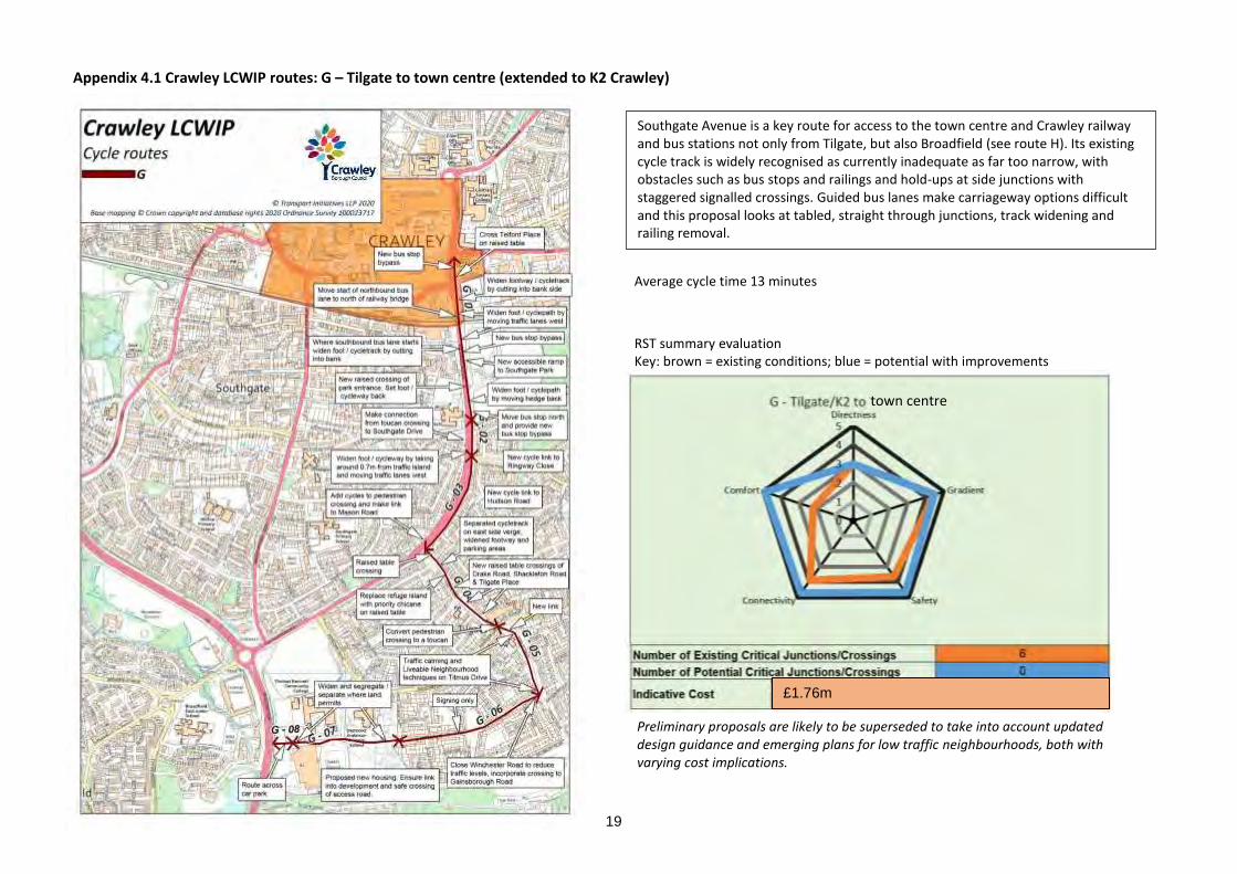
19
Appendix 4.1 Crawley LCWIP routes: G – Tilgate to town centre (extended to K2 Crawley)
Average cycle time 13 minutes
RST summary evaluation Key: brown = existing conditions; blue = potential with improvements
Southgate Avenue is a key route for access to the town centre and Crawley railway and bus stations not only from Tilgate, but also Broadfield (see route H). Its existing cycle track is widely recognised as currently inadequate as far too narrow, with obstacles such as bus stops and railings and hold-ups at side junctions with staggered signalled crossings. Guided bus lanes make carriageway options difficult and this proposal looks at tabled, straight through junctions, track widening and railing removal.
Preliminary proposals are likely to be superseded to take into account updated design guidance and emerging plans for low traffic neighbourhoods, both with varying cost implications.
£1.76m
town centre

20
Appendix 4.1 Crawley LCWIP routes: H – Pease Pottage to town centre via Tilgate (joins route G)
Average cycle time 19 minutes
RST summary evaluation Key: brown = existing conditions; blue = potential with improvements
Cycle and walking access to the new housing development east of the Pease Pottage motorway junction is challenging as motor vehicle access is currently prioritised. Conditions demand a fully separated crossing for walking and cycling, but this area is outside the Crawley boundary. Main measures proposed throughout Broadfield are critical junction treatments. Bus / Fastway lanes on Southgate Avenue require cycling on a shared track, which requires track widening and railing removal. The route is picked up at Titmus Drive, Tilgate, to the town centre by route G.
Preliminary proposals are likely to be superseded to take into account updated design guidance and emerging plans for low traffic neighbourhoods, both with varying cost implications.
£1.9m
town centre

21
Appendix 4.1 Crawley LCWIP routes: I – Bewbush to Three Bridges via Broadfield, Tilgate Nature Centre (joins routes J, G and E)
Average cycle time 32 minutes
RST summary evaluation Key: brown = existing conditions
blue = potential with improvements
Route I (west and east) forms something of a ‘south-circular’ linking up the more radial routes and taking in major destinations including K2 Crawley and Tilgate Nature Centre. The key issues for access to Three Bridges Station from the neighbourhoods in the south west are crossing the A264 Horsham Road and A23 Brighton Road. Proposed subway crossing is a significant cost. There has been some discussion of creating a route through the Network Rail site at Three Bridges, including as a facility for staff there. However, this is challenging for security reasons and may not be possible.
Preliminary proposals are likely to be superseded to take into account updated design guidance and emerging plans for low traffic neighbourhoods, both with varying cost implications.
£3.2m

22
Appendix 4.1 Crawley LCWIP routes: J – Broadfield to town centre via Southgate
Preliminary proposals are likely to be superseded to take into account updated design guidance and emerging plans for low traffic neighbourhoods, both with varying cost implications.
Average cycle time 10 minutes
RST summary evaluation Key: brown = existing conditions; blue = potential with improvements
Broadfield has several relatively fast local distributor roads including Coachmans Drive, which currently provide little space for safe cycling. Safe treatment using this direct link to the football underpass by the stadium gives access to Southgate and northward routes. The underpass needs significant improvement but is a useful safe track. Brighton Road presents particular challenges with a narrow cutting, a hill and speeding traffic through Southgate, suggesting calming and traffic limiting measures to benefit the neighbourhood, where Horsham Road and Southgate Avenue are alternative traffic routes.
£1.07m
town centre

23
Appendix 4.1 Crawley LCWIP routes: K – Kilnwood Vale and Bewbush to town centre (joins route J)
Preliminary proposals are likely to be superseded to take into account updated design guidance and emerging plans for low traffic neighbourhoods, both with varying cost implications.
Average cycle time 17 minutes
RST summary evaluation Key: brown = existing conditions; blue = potential with improvements
Kilnwood Vale is a new housing development. Many of its residents work at Manor Royal or Gatwick Airport. A bus gate provides cycle access from Illett Avenue into Bewbush, prohibiting car through traffic. Bewbush Drive is relatively direct but is a fast traffic route with a significant hill but offers a good route with treatment for safety and connectivity to neighbourhood streets. Cheals roundabout at the junction of Horsham Road and Crawley Avenue is a notorious hazard point for walking and cycling with only one crossing point. An existing crossing at Horsham Road is an opportunity to link with this across a desire line, giving access to Southgate neighbourhood to join route J to the town centre.
£2.01

24
Appendix 4.1 Crawley LCWIP routes: L – Ifield to town centre
Preliminary proposals are likely to be superseded to take into account updated design guidance and emerging plans for low traffic neighbourhoods, both with varying cost implications.
Ifield West faces access barriers to the town centre by the railway line and, particularly, Crawley Avenue. Additionally, Ifield Road, as a narrow street, busy with traffic at peak times, presents issues for safe cycling and invites traffic management to release space. Proposals consider a shuttle system. This route links two schools to West Green via a narrow underpass to Crawley Avenue and an existing off-road cycle track. This is well used as a footway and suggests opening up the underpass to provide a practical cycle facility. Feasibility and costs for this will need to be assessed separately.
Average cycle time 11 minutes
RST summary evaluation Key: brown = existing conditions; blue = potential with improvements
£853k
town centre

25
Appendix 4.1 Crawley LCWIP routes: M – Ifield Green to town centre
Preliminary proposals are likely to be superseded to take into account updated design guidance and emerging plans for low traffic neighbourhoods, both with varying cost implications.
Average cycle time 10 minutes
RST summary evaluation Key: brown = existing conditions; blue = potential with improvements
Ifield Avenue is a route to several sports facilities and a temple in Ifield Green as well as to Charlwood village and is busy at peak times. A shared cycleway/footway from Bonnetts Lane to Crawley Avenue is interrupted by frequent junctions with residential streets with vehicle priority and uncontrolled crossing refuges where vehicles also have priority at all times. A 40mph speed limit set just a few metres north of Langley Lane bridleway (route P) reinforces traffic dominance. Measures to reduce vehicle speed and provide some cycle continuity and priority is required.
£480k
town centre

26
Appendix 4.1 Crawley LCWIP routes: N – Lowfield Heath to town centre
Preliminary proposals are likely to be superseded to take into account updated design guidance and emerging plans for low traffic neighbourhoods, both with varying cost implications.
Average cycle time 13 minutes
RST summary evaluation Key: brown = existing conditions; blue = potential with improvements
Corridor mapping indicates route N as important for access to employment and shopping and follows a stretch of the A23 that is busy but not the key through traffic route, which follows Crawley Avenue. Tushmore Roundabout presents a particular challenge: while already served by toucan crossings, these mean four signal phases to continue northward. Much of the A23 London Road is dual carriageway with narrow pavements, the southern sections are single carriageway with limited footway space. Carriageway reallocation will need to be considered.
£2.29

27
Appendix 4.1 Crawley LCWIP routes: O – Manor Royal (west) to town centre
Route O is an abstract from route N, providing access between Manor Royal and the town centre and including improvements to the existing cycle tracks along Manor Royal itself and add protected space on Newton Road, to provide full connectivity. This section looks for business site entrance measures for levelling and reprioritising. The route through Northgate passes a primary school and shopping parade, suggesting a low traffic neighbourhood treatment, filtering safe streets for cycling and walking. Woodfield Road is used by police vehicles but is also a rat-run and would need careful measures for filtering vehicles.
Preliminary proposals are likely to be superseded to take into account updated design guidance and emerging plans for low traffic neighbourhoods, both with varying cost implications.
Average cycle time 4 minutes
RST summary evaluation Key: brown = existing conditions; blue = potential with improvements
£1.50m
town centre

28
Appendix 4.1 Crawley LCWIP routes: P – Ifield to Manor Royal via Langley Green
Preliminary proposals are likely to be superseded to take into account updated design guidance and emerging plans for low traffic neighbourhoods, both with varying cost implications.
Average cycle time 20 minutes
RST summary evaluation Key: brown = existing conditions; blue = potential with improvements
Route P serves Ifield and Langley Green as a partial north circular route, shown by the Crawley Cycle Network Review to be particularly lacking in cycle facilities as well as a priority corridor. Single carriageway residential streets, busy at peak times, with limited space for segregation for cycles, suggests potential for traffic management and quiet neighbourhood measures providing safer, comfortable cycling. The Langley Lane bridleway and Langley Walk are attractive features of the route, with key challenges in crossing busy roads like Ifield Avenue and avoiding conflict with vehicles at County Oak, along with safe and direct access to Manor Royal around the retail centres.
£1.21m

29
Appendix 4.2 Crawley LCWIP – minimum cycle provision under different highway conditions (West Sussex Cycling Design Guide, 2018)

30
Appendix 5.1 Crawley LCWIP – Crawley town centre walking zone – link and area scores (fails highlighted red)
Ref Street name ATTRACTIVE-NESS
COMFORT DIRECTNESS SAFETY COHER-ENCE
TOTAL
A1 A2 A3 A4 Cm1 Cm2 Cm3 Cm4 Cm5 Cm6 D1 D2 D3 D4 D5 D6 S1 S2 S3 Ch1 SCORE % Comments
CWA01 Station forecourt 2 2 2 2 2 2 1 2 2 2 2 1 2 2 2 2 1 2 2 0 35 87 Western access incoherent and missing dropped kerb crossing off Station Way
CWA02 Station Way 1 2 1 2 1 0 2 2 2 2 2 1 1 2 2 2 1 1 2 1 30 75 South side pavement west of station too narrow, poor surface and vegetation encroaching. Some missing tactile paving
CWA03 Friary Way 2 2 1 2 2 2 2 1 2 1 2 1 2 2 2 2 1 2 1 1 33 82 Market stalls, narrow pavement
CWA04 Haslett Avenue West
1 2 1 1 2 1 0 1 2 1 2 1 2 2 2 2 1 1 2 0 27 67 Missing tactile paving and dropped kerbs. Narrow crossing
CWA05 Station Road, Station Way, Haslett Avenue West gyratory
1 2 0 1 1 0 2 1 2 2 2 1 1 2 2 2 1 1 2 1 27 67 Narrow pavements in parts and incoherent in some layout
CWA06 East Park 2 2 2 1 1 1 2 2 2 2 2 1 2 2 2 2 1 2 2 0 33 82 Missing dropped kerb
CWA07 Railway footbridge and access off East Park
1 1 2 1 1 0 2 2 2 2 2 2 2 2 2 0 2 2 2 2 32 80 Steps only on footbridge
CWA08 Brighton Road 2 2 1 2 1 0 2 2 2 1 2 2 1 2 2 2 1 1 1 0 29 72 Narrow pavement on east side and missing tactiles and poor dropped kerbs with ponding
CWA09 Pegler Way 1 2 1 2 2 0 2 2 2 0 2 0 1 1 2 2 1 1 1 2 27 67 Pavement narrowed by line segregated cycle path and bus shelters and street furniture and planters
CWA10 High Street and Orchard Street
2 2 1 2 1 2 2 2 2 2 2 2 1 2 2 2 1 1 2 1 34 85 Some missing tactile paving
CWA11 Crawley Leisure Park
2 2 1 1 2 1 2 2 2 2 0 0 1 2 2 0 1 2 1 0 26 65 Large car park where the fact that people walk to and from their cars is almost totally forgotten
CWA12 Ifield Avenue 1 2 1 2 1 0 2 2 1 2 2 2 1 2 2 2 1 1 1 2 30 75 Line segregated cycle path and some vegetation encroachment severely narrows pavement
CWA13 London Road 2 2 1 1 2 2 2 2 2 1 2 1 1 2 2 2 1 1 1 2 32 80
CWA14 London Road 2 2 1 1 2 2 2 2 2 1 2 2 1 2 2 2 1 1 2 2 34 85

31
Ref Street name ATTRACTIVE-NESS
COMFORT DIRECTNESS SAFETY COHER-ENCE
TOTAL
A1 A2 A3 A4 Cm1 Cm2 Cm3 Cm4 Cm5 Cm6 D1 D2 D3 D4 D5 D6 S1 S2 S3 Ch1 SCORE % Comments
CWA15 Kilnmead 1 2 1 2 2 1 0 2 2 2 2 1 1 2 2 2 1 1 0 2 29 72 Very busy for what is primarily a residential street
CWA16 Path between Kilnmead and The Boulevard
1 0 2 2 1 1 2 2 2 2 2 2 2 2 2 2 2 2 2 2 35 87 Surface deteriorating and needs clearing of mud and leaves
CWA17 Path from east end of Northgate Road
0 0 2 2 0 0 2 2 2 2 2 2 2 2 2 0 2 2 2 2 30 75 Very narrow, muddy and literally round the houses
CWA18 Northgate Road 2 2 2 2 2 1 2 2 2 1 2 2 2 2 2 2 2 2 2 1 37 92 No tactile on west end crossing and ponding here too
CWA19 The Boulevard 2 2 2 1 2 2 2 2 2 2 2 2 2 2 2 2 1 2 2 2 38 95
CWA20 The Boulevard 2 2 1 2 0 1 2 2 2 2 2 1 1 2 1 1 1 1 2 1 29 72 Some of the paving slabs very bumpy and all are tired. Crossing by Town Hall should be on demand with no delay on call
CWA21 The Boulevard 2 2 1 2 1 2 2 2 2 1 1 2 2 2 2 2 1 2 2 0 33 82 East end access has no dropped kerbs. Pavement tired and some ponding. Wide pavement on south side only
CWA22 Parkside / Queensway
2 2 2 2 2 2 2 2 2 2 2 2 2 2 2 2 2 2 2 2 40 100
CWA23 Memorial Gardens 2 1 2 2 2 2 2 2 2 2 2 2 2 2 2 2 2 2 2 2 39 97
CWA24 College Road 1 2 0 2 1 1 2 2 2 1 2 0 0 1 1 2 1 1 1 2 25 62 Pinch points and ponding on eastern pavement. Central barrier means no gaps and crossings which do not serve all desire lines
CWA25 Haslett Avenue East 2 2 1 2 2 2 2 2 2 2 2 0 0 0 2 2 1 1 1 2 30 75 Central guardrail means no gaps and only crossing is at west end
CWA26 Retail access 2 2 1 2 2 2 2 2 2 2 2 2 2 2 2 2 1 2 1 2 37 92
CWA27 Library precinct 2 1 2 2 2 2 2 2 2 2 2 2 2 2 2 2 2 2 2 2 39 97
CWA28 Queens Square and environs off it
2 2 2 2 2 2 2 2 2 1 2 2 2 2 2 2 2 2 2 2 39 97 Little bit of ponding in older section
CWA29 The Broadway 2 2 2 2 1 2 2 1 2 1 2 2 2 2 2 2 1 2 2 2 36 90 Getting tired
CWA30 Bank Lane 2 1 2 1 1 0 2 0 2 2 0 0 2 2 2 2 1 1 1 0 24 60 Back access really without consistent provision
CWA31 The Square 2 2 2 2 1 2 2 2 1 2 2 2 2 2 2 2 2 2 2 2 38 95 Some tired bits needing repair

32
Ref Street name ATTRACTIVE-NESS
COMFORT DIRECTNESS SAFETY COHER-ENCE
TOTAL
A1 A2 A3 A4 Cm1 Cm2 Cm3 Cm4 Cm5 Cm6 D1 D2 D3 D4 D5 D6 S1 S2 S3 Ch1 SCORE % Comments
CWA32 Cross Keys 0 0 2 0 0 0 2 2 2 1 0 2 2 2 2 2 1 2 1 0 23 57 Access but publicly accessible cut through
CWA33 Ifield Road 1 2 2 2 1 2 2 2 2 2 2 2 2 2 2 2 2 2 2 2 38 95
CWA34 Church Walk 1 1 2 2 2 1 2 2 2 2 2 2 2 2 2 2 2 2 2 2 37 92