creek bottom farms
DESCRIPTION
Landscape Architecture Senior ProjectTRANSCRIPT
Creek Bottom Farms:
Preserving the rural landscape and creating a sustainable, self reliable community
by
Clayton Hunt Dent
A Senior Design Project Presented to the College of Environment and Design
University of Georgia Under the Direction of:
Donnie Longenecker, MLA, RLA, C.E.D. Instructor In partial fulfillment of the requirements for the degree of
Bachelor of Landscape Architecture
Athens, Georgia Spring, 2011

Preserving the Rural Landscape and Creating a Sustainable, Self Reliable Community
CREEK BOTTOM FARMS

Problems and Issues
• Destruction of rural and natural landscapes.• Loss of prime farmland and communities.• Failure to create livable and walkable communities.• Mass clearing and grading of land.• Loss of natural habitats, woodlands, and wetlands.• Increasing pollution and degradation of air quality.• Decreasing number of farms and dissolution of family farms.• Industrialized farming system threatens biodiversity and crop/livestock health.
Today’s world is dealing with more challenges than ever faced before. With the population booming, and food sources decreasing, issues of how and where production is going to come from are starting to arise. Living ‘green’ is a pushing point in the development of the current economy and is only a starting point for helping with land protection rights. Listed below are some of the problems and issues that are being dealt with in the development of land.
1

Problems and Issues
http://www.worldclimatereport.com/index.php/2008/01/30/what-the-future-holds-in-store/ http://planningpool.com/2011/01/redevelopment/planning-challenge-1-commercial-aggregation-subdivision-part-1/
http://project-geo.org/Spring_05/heavy_minerals/
http://www.csc.noaa.gov/crs/lca/class_groups/bl.html
2

Precedent: The Adam & Eve Concept,created by Tendaji Agro, is an agribusiness company in Tanzania. To create successful farming communities, Agro recommends using a radial plan to concentrate urban practices, livestock and crop production, and villages around a central vortex.
http://www.tendajiagro.com/ae-typical.htmlGoals include:• Stabilize regional economies by improving local infrastructure.• Guide agricultural communities towards self-sufficiency and economic growth.• Jumpstart sustainable agro-industrial production.
3

Precedent:Moshav, is an Isreali
community that uses the Adam & Eve concept to combine community living space with agricultural land. This plan creates self-sustainable communities by including government, agriculture, and family living in one biosphere. This feat is even more remarkable because it is located in a challenging political region, where the source of food and income is challenged by limited natural resources and political discord.http://www.steady-state.ca/frontpage/ecovillages.html
4

Precedent:
The Seleborn-Grange Community is a part of Serenbe’s 1,000-acre sustainable community located in southwest Fulton County, Georgia. Their plan is to preserve 70% of the original acreage by using land preservation, agriculture, energy efficiency, green building, walkability, and high density building concepts.
Farming areas
Equestrian area
Residential lots
Town center
Greenspaceand park area
Wetlands
Wildflower Meadow
http://www.serenbecommunity.com
5

Serenbe’s guiding principles include: • nature• passion• creativity• community
“A place where connections betweenpeople, nature and the arts are nourished.”
Precedent:
http://www.serenbecommunity.com
http://www.serenbecommunity.com
“A community where people authentically live, work, learn and play in celebration of life’s beauty.”
6

Guiding Concept:
• Sustainable community
• Provide family living with the natural environment
• Preserve the workable rural farmland
• Minimum impact on land
The master plan for Creek Bottom Farms embraces problems that so often destroy today’s rural natural landscapes. The main goal of this development is to preserve and protect the rural culture and prime farmland that exist, while allowing for growth and development in a safe manner. To do this, the following concepts were envisioned and developed during the stages of planning, design, and finalization of the project.
http://www.vaxd.com/VaxDbrnbspnbspTreatment/FrequentlyAskedQuestions/tabid/59/Default.aspx
7

Vision:
• 20-25 Single family homes on 5 acre lots. • All land will be kept as natural land (unchanged unless it improves
the quality of the land):• Agriculture and timber purposes• Gardens and horticulture production• Park land
• A self-funded community farmers market. • Trail systems for nature walks, jogging, and horseback riding. • Two ponds used for collecting rain water runoff and irrigating crops.• Preserve at least 50-60% of the acreage in its natural or existing
state while accommodating as many households as possible.
The defining vision for Creek Bottom Farms is to create a development that respects the natural resources and rural character of a Georgia farmstead. This will allow for the most beneficial features and programs to be included, using the most functional and well-rounded methods of development. Objectives for Creek Bottom Farms include:
8

Development Programs:
• Farmers’ Market
• Community Agriculture and Crop Farming
• Trail Systems
• Community Park and Greenspace
These programs are the systems, activities and functioning parts of the community that are included for all members of the community and surrounding areas. They will allow the community to come together, work as a group, and succeed as a cohesive community. They include: http://www.google.com/imgres?imgurl=http://alloveralbany.com/images/Farmers%2520Market
.jpg
http://www.ijams.org/go-green/greenways.html
9

Location:
Creek Bottom Farms is located in the southeastern region of the United States, in the historically agricultural state of Georgia. It rests on the eastern edge of the state next to South Carolina, the Savannah River, serving as the border line. Lincoln County is located thirty-eight miles north of the metropolitan city of Augusta and sixty miles east of Athens.
State: Georgia
County: Lincoln
Region: Southeast
10
Augusta
Athens
Atlanta

Lincoln County:Lincoln County has a population of approximately1500 people
with its city limits set in the center of the triangular-shaped county that was created in 1796 as the twenty-fourth county in Georgia.
Seven miles south of the city limits on state highway 43 is Creek Bottom Farms. Lincolnton city limits
Site location
Clarks Hill Lake
State Hwy. 43
Site
11

Site map:
The site is approximately 245 acres, includes100 acres of open pasture, 138 acres of timber land, and 6.25 acres of ponds. It is currently appraised at approximately $1,649 per acre, totaling $403,960.
Ponds
The Creek Bottom Farms site is a working cattle farm with pastures and timber land. All surrounding land is also pasture and timber.
Lloyds Creek:Runs along back property line.
Hwy 43
12
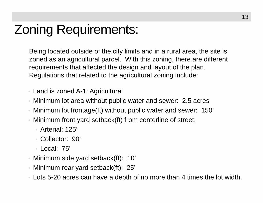
Zoning Requirements:
• Land is zoned A-1: Agricultural• Minimum lot area without public water and sewer: 2.5 acres• Minimum lot frontage(ft) without public water and sewer: 150’• Minimum front yard setback(ft) from centerline of street:
• Arterial: 125’• Collector: 90’• Local: 75’
• Minimum side yard setback(ft): 10’• Minimum rear yard setback(ft): 25’• Lots 5-20 acres can have a depth of no more than 4 times the lot width.
Being located outside of the city limits and in a rural area, the site is zoned as an agricultural parcel. With this zoning, there are different requirements that affected the design and layout of the plan. Regulations that related to the agricultural zoning include:
13

Utilities:The only utility easements include power lines that run through certain parts of the site from the highway to the west end of the property. A drilled well is located one hundred yards off of the highway. The development will have to expand on the existing power lines and will most likely require each home owner to dig their own well and install a septic system.
14

Slope Analysis:Located in the piedmont region of Georgia, the site has the characteristics of gently rolling hills. However, in certain areas, the hills become too steep to securely build structures. Steep slopes also threaten the topsoil as extensive erosion can take place. This analysis allows the design to keep development away from the steeply sloped areas of the sites.
15

Hydrology Analysis:Related to the slopes of the sites is the hydrology and stormwater runoff. This map shows how the majority of the water runs from the east side of the site, including all water from the state highway, down across the site to the west side where it is collected in Lloyd’s Creek. This analysis helped in determining the ridgeline and will help in how stormwater is being treated and dispersed into the natural waterways.
16

Soil Suitability:The soil suitability test shows two general areas that are created by the multiple types of soil on the site. The (red) non-suitable area shows the land that cannot support housing development due to its poor septic drainage and proximity to natural water sources. This affected the design by keeping housing sites from being located near any of those non-suitable areas.
17
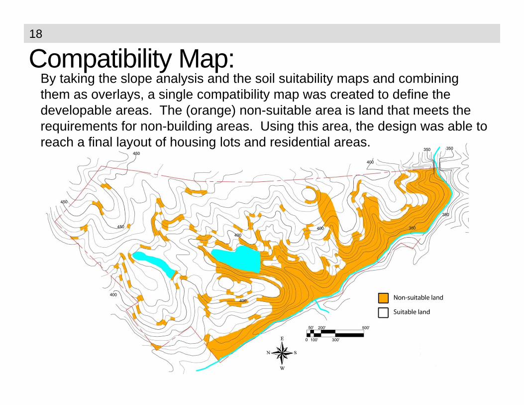
Compatibility Map:By taking the slope analysis and the soil suitability maps and combining them as overlays, a single compatibility map was created to define the developable areas. The (orange) non-suitable area is land that meets the requirements for non-building areas. Using this area, the design was able to reach a final layout of housing lots and residential areas.
18

Master Plan Concept:The original concept of Creek Bottom Farms showcases the desire to preserve the majority of the prime farmland by developing in two housing areas on the north and south ends of the property. This design isolated the housing areas, separated the south housing area from all other programs, isolated the park area, and kept most of the pasture and timber land the same. Its most positive attributes are that it drastically decreased the amount of habitat loss and limited degradation.
19

Initial Master Plan:This initial master plan concept shows the isolation of the residential lots from the rest of the site. All lots were sized at half an acre, which due to zoning ordinances on agricultural zoned land (minimum of 2.5-acre lots), the plan had to be adjusted.
20

Final Master Plan:After taking all analysis and zoning studies into account, the final master plan was created. This final plan of preserves the existing prime farmland by creating small farms on five-acre plots. All property owners will have flexibility regarding land use: including livestock, horticulture, crop production, or a mix of several niches. The plan has nice connectivity as the trail system courses through the natural layout of the land. There is a self-sufficient farmer’s market that will allow the residences of this private community to sell the natural goods that they have been able to produce. The market is located beside the main highway that carries heavy traffic from Lincolnton to Thomson, which will allow it to be viewed and accessible by passing traffic. There is also a community-shared livestock facility where patrons can transport their animals to in order to care for them. Along the western edge of the property is the creek bottom which has been left open for community hay production. This plan allows the rural character and sense of place to remain within the neighborhood. The overall natural scenery of the landscape is left in its existing state. This master plan addresses the issues that were presented earlier: as it is a walkablecommunity, it preserves the native landscape and habitats, keeps the rural feeling, helps with food and crop production, and saves the prime farmland.
21
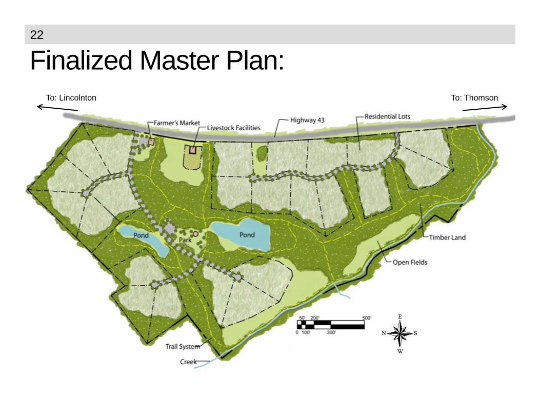
Finalized Master Plan:To: Lincolnton To: Thomson
22

LEED:
• Prerequisite 1: Erosion & sediment controlKey
• 1- Credit 4.2: Bicycle storage & changing rooms………………….…….…….1• 2 - Credit 4.3: Alternative fuel vehicles…………………………………..……....3• 3 - Credit 4.4: Parking capacity………………………………………………..….2• 4 - Credit 5.1: Protect and restore habitat…………………………………...…..1• 5 - Credit 5.2: Maximize open space………………………………………….….1• 6 - Credit 6.1: Stormwater management – quantity control………..………..…1 • 7 - Credit 7.1: Heat island effect – nonroof……………………………....……...1• 8 - Credit 8: Light pollution……………………...…………..……………………..1
Total Points = 11
With the ‘Green’ movement growing in the U.S., attention was given to LEED certification. This project takes into account the Site Selection criteria in the decision making process to accommodate as many possible LEED points in the Site Selection section for the overall site design. By reviewing the credits before the initial design is finalized, more sustainable and energy saving routes were able to be used in the design process. Below is a list of the credits that can be earned in the Creek Bottom Farms design.
23

LEED markers on Master Plan:24

Farmer’s Market Enlargement:The farmer’s market is a community program that allows a more unified environment amongst families and neighbors of the community. It gives display areas for families to show and sell their goods and provide a farm-to-table experience. This market will be self-sufficient and maintained by the neighborhood citizens.
Market Building
Green parking area
Hwy 43
25

Park Enlargement:The small park is a green space for both active and passive recreation. It has a nicely shaded outdoor areas for rest and recuperation, as well as open and sunny spaces for recreation.
Shelter area
26

Lot Enlargement:The typical
residential lot supports a single-
family home, a family garden,
open land for crop or livestock
production, and native timber land. Each lot is at least
five acres of agricultural land.
27

Planting Plan:Native plants are used to landscape the
entire residential site. Replanting of native trees for reforestation effects and native shrubs, grasses, and perennials
around the foundation of the house will be used to create a better
environment and more ecologically-friendly home. An enlarged,
rendered plan as well as a planting catalogue are included in the
next pages.
28

Enlarged Planting Plan:29

Planting Table:Residential Native Plant List
Trees
Code Qty Common Name Botantical Name Size CommentsRm 9 Red Maple Acer rubrum 15’ b&b Red fall foliageRo 4 Southern Red Oak Quercus falcata 15’ b&bSm 1 Sweetbay Magnolia Magnolia virginiana 12’ b&b Creamy white flower
Sg 3 Sweetgum Liquidambar styraciflua 15’ b&b Yellow‐purple‐red fall foliagee
Wo 5 White Oak Quercus alba 15’ b&b
Shrubs
Code Qty Common Name Botantical Name Size CommentsAn 4 Anise Tree Illicium floridanum 7 gal Evergreen, pink‐red flowers in springYa 15 Dwarf Yaupon Holly Ilex vomitoria 3 gal EvergreenGh 2 Garden Hydrangea Hydrangea macrophylla 3 gal Deciduous, white/blue flowers in springIn 22 Inkberry holly Ilex glabra 3 gal EvergreenOh 3 Oakleaf Hydrangea Hydrangea quercifolia 7 gal Deciduous, white flowers in summer. Scarlet fall colorWa 2 Southern Wax Myrtle Myrica cerifera 7 gal Semi‐evergreen, fragrantSu 14 Summersweet Clethra Clethra alnifolia 3 gal Deciduous, white flowers in late springVi 8 Virginia Sweetspire Itea virginica 3 gal Deciduous, white flower in summer
Perennials, Grasses & Groundcovers
Code Qty Common Name Botantical Name Size CommentsPa 8 Panic Grass Panicum virgatum 3 gal Bluish foliage with white flumes in summerMu 15 Pink Muhly Grass Muhlenbergia capillaris 1 gal Pink‐purple flumes in fall‐summerVe 54 Verbena Verbena canadensis 'Homestead Purple' 1 gal Deep purple floweerWP 14 Woodland Phlox Phlox divaricata 'London Grove Blue' 4” Blue flower, mix all phlox varieties
14 Woodland Phlox Phlox divaricata 'Laphamii' 4” Light Blue flower, mix all phlox varieties14 Woodland Phlox Phlox divaricata 'Plum Perfect' 4” Purple flower, mix all phlox varieties
30

Grading Plan:Engineering is a vital part of landscape architecture, and it is a key role in being able to create sustainable environments. This grading plan shows that the neighborhood roads are at a steady consistent grade. They will be installed without destroying other parts of the site and the road elevations gradually level into the those of the existing earth at safe angles and erosion prevention percentages.
31

Construction Details:The constructiondetails illustrate
specifics and details that engineer the
minute pieces and help to finalize the key aspects for a
structural design to take place.
32

Construction Details:
These details show a variety of skills from horticultural
plantings to structural and full
grade construction. These are the pieces
that make up a successful
development.
33

Final Thoughts:The Creek Bottom Farms plan addresses many issues such as preserving
the rural environment, the natural landscape, and working farmland; helps decreasing food production, create a community-based neighborhood, and help fight against pollution and improve air quality. Multiple analyses such as soil suitability, hydrology, and slope studies were combined into a compatibility map and used with zoning regulations to give an understanding of the entire site and what could be done to it. The final design concept was based on a small farm model where each property owner possesses five acres to establish his own farm whether it be livestock, crops, horticulture, or other niches. This plan addresses ethical and environmental problems and issues of current development by keeping the design eco-friendly and striving to reach LEED standards. The design helps pollution control and air quality, helps protect the natural landscape which is often clear cut and scalped to the ground. It preserves the rural sense of place that is established in a small farming community providing walkable streets where neighbors can visit but not be overcrowded as in most dense suburban subdivisions. This neighborhood helps to promote a sense of community while saving farming traditions that have been passed along through generations. Creek Bottom Farms takes pride in being a leader in the new era of green living with natural homes and rural living.
34

Preserving the Rural Landscape and Creating a Sustainable, Self Reliable Community
CREEK BOTTOM FARMS